05307c Kaleas FDO.doc (July 19, 2005) 05-3-0007c Final Decision and Order Page 1 of 31 CENTRAL PUGET SOUND GROWTH MANAGEMENT HEARINGS BOARD STATE OF WASHINGTON JOHN R. KALEAS, BRUCE W. HORST and FUTUREWISE, Petitioners, v. CITY OF NORMANDY PARK, Respondent. ) ) ) ) ) ) ) ) ) ) ) ) CPSGMHB Consolidated Case No. 05-3-0007c (Kaleas) FINAL DECISION AND ORDER SYNOPSIS As part of the GMA’s required Plan review and update requirement, the City of Normandy Park repealed its GMA Plan and adopted a new GMA Plan – its 2004 Plan Update. The Plan Update retained land use designations on the future land use map [FLUM] for low and medium residential densities. The low density designation is implemented by R-20 and R-15 zoning and permits residential densities of 2.2 and 2.9 dwelling units per acre, respectively; the medium density designation is implemented by R-12.5 zoning and permits residential densities of 3.5 dwelling units per acre. There are only 1635 acres in Normandy Park and 74% of that land is designated for low-density development and 10% for medium density development. Petitioners challenged these FLUM designations asserting that the City did not permit urban densities. This case enabled the Board to articulate the factors it would consider and weigh in determining whether a city’s designated urban densities were “appropriate urban densities.” The Board reviewed the GMA duty for a city to accommodate the 20-year growth forecast by the Office of Financial Management, and allocated by the county. The Board concluded that while accommodating the allocated growth is a major component of the GMA, the Act’s predilection for compact urban growth and its explicit goals and requirements impose a broader framework within which local governments must plan. The Board also discussed: 1) the 4 dwelling units per acre “bright line” or safe harbor as an appropriate urban density that has provided certainty and predictability to GMA planning; 2) the circumstances when lower densities are appropriate urban densities [Litowitz test] thereby providing flexibility and discretion; and 3) ensuring neighborhood vitality and character; but not perpetuating low-density sprawl.

Welcome message from author
This document is posted to help you gain knowledge. Please leave a comment to let me know what you think about it! Share it to your friends and learn new things together.
Transcript

05307c Kaleas FDO.doc (July 19, 2005) 05-3-0007c Final Decision and Order Page 1 of 31
CENTRAL PUGET SOUND GROWTH MANAGEMENT HEARINGS BOARD
STATE OF WASHINGTON
JOHN R. KALEAS, BRUCE W. HORST and FUTUREWISE, Petitioners, v. CITY OF NORMANDY PARK, Respondent.
) ) ) ) ) ) ) ) ) ) ) )
CPSGMHB Consolidated Case No. 05-3-0007c (Kaleas) FINAL DECISION AND ORDER
SYNOPSIS
As part of the GMA’s required Plan review and update requirement, the City of Normandy Park repealed its GMA Plan and adopted a new GMA Plan – its 2004 Plan Update. The Plan Update retained land use designations on the future land use map [FLUM] for low and medium residential densities. The low density designation is implemented by R-20 and R-15 zoning and permits residential densities of 2.2 and 2.9 dwelling units per acre, respectively; the medium density designation is implemented by R-12.5 zoning and permits residential densities of 3.5 dwelling units per acre. There are only 1635 acres in Normandy Park and 74% of that land is designated for low-density development and 10% for medium density development. Petitioners challenged these FLUM designations asserting that the City did not permit urban densities. This case enabled the Board to articulate the factors it would consider and weigh in determining whether a city’s designated urban densities were “appropriate urban densities.” The Board reviewed the GMA duty for a city to accommodate the 20-year growth forecast by the Office of Financial Management, and allocated by the county. The Board concluded that while accommodating the allocated growth is a major component of the GMA, the Act’s predilection for compact urban growth and its explicit goals and requirements impose a broader framework within which local governments must plan. The Board also discussed: 1) the 4 dwelling units per acre “bright line” or safe harbor as an appropriate urban density that has provided certainty and predictability to GMA planning; 2) the circumstances when lower densities are appropriate urban densities [Litowitz test] thereby providing flexibility and discretion; and 3) ensuring neighborhood vitality and character; but not perpetuating low-density sprawl.
05307c Kaleas FDO.doc (July 19, 2005) 05-3-0007c Final Decision and Order Page 2 of 31
Petitioners demonstrated, and the Board found, that there was no support in the record to merit designating 84% of the land in the City as low and medium density to provide added protection to critical areas; the City’s designations were not appropriate urban densities. The Board found noncompliance, remanded the challenged Plan update and invalidated the noncompliant Plan Update provisions.
I. BACKGROUND1
On November 9, 2004, the City of Normandy Park adopted Ordinance No. 742, hereafter the Plan Update. The notice of adoption of Ordinance No. 742 was published on November 24, 2004. Ordinance No. 742 repealed the City’s 1995 Comprehensive Plan and adopted the Plan Update and Future Land Use Map (FLUM), which designates significant portions of the City as Low and Medium Density Single Family Residential. The Low Density Single Family Residential and the Medium Density Single Family Residential designations permit residential densities of less than 4 dwelling units per acre (4 du/ac). On November 30, 2004, the City adopted Ordinance No. 743 amending the City’s zoning code, but maintaining prior residential zoning designations of R-20,2 R-15, R-12.5 and R-7.2 as implementing regulations for the Low and Medium Density Single Family Residential designations. Following these actions, the Board received two petitions for review (PFRs) challenging the City’s Plan Update. The first was filed by John R. Kaleas and Bruce W. Horst on December 1, 2004; the second was filed by Futurewise on January 21, 2005. The PFRs were timely filed. Both Petitioners assert that the Normandy Park Plan Update and FLUM do not provide for appropriate urban densities. The Board consolidated the two PFRs and held the prehearing conference (PHC) on February 3, 2005. The Board received the City’s Index prior to the PHC. The prehearing order, establishing the briefing and hearing schedule and framing the legal issues to be decided by the Board, was issued on February 4, 2005.3 There were no motions to supplement the record or dispositive motions filed in this matter. All prehearing briefs were timely filed, and are hereafter referenced as: Kaleas PHB, Futurewise PHB, Normandy Park Response, Kaleas Reply and Futurewise Reply. The Board conducted the hearing on the merits (HOM) at the Board’s offices on April 14, 2005. Board members Edward G. McGuire, presiding officer, Bruce C. Laing and Margaret A. Pageler were present for the Board. David S. Mann represented Petitioners
1 See Appendix A for the complete procedural history of this case. 2 The numerical designation is expressed in thousands of square feet. Thus R-20 means a residential lot of 20,000 square feet, etc. 3 The timeframe for filing prehearing briefs and the date of the hearing on the merits was subsequently adjusted by the Board at the request of the parties. See Appendix A.

05307c Kaleas FDO.doc (July 19, 2005) 05-3-0007c Final Decision and Order Page 3 of 31
Kaleas and Horst; John Zilavy represented Petitioner 1000 Friends. Susan Samson represented Respondent City of Normandy Park. Also in attendance were Rob Trickler and Jeremy Yates (Board externs), Petitioners John R. Kaleas and Bruce W. Horst, and Stephanie Tonellato and M. MacReynold from Normandy Park. Court reporting services were provided by Katie A. Eskew of Byers and Anderson, Inc. The HOM convened at 10:00 a.m. and adjourned at approximately 12:00 p.m. II. PRESUMPTION OF VALIDITY, BURDEN OF PROOF and STANDARD OF
REVIEW Petitioners challenge Normandy Park’s adoption of its Plan Update, as adopted by Ordinance No. 742. Pursuant to RCW 36.70A.320(1), Normandy Park’s Ordinance No. 742 is presumed valid upon adoption. The burden is on Petitioners, Kaleas, Horst and Futurewise, to demonstrate that the actions taken by Normandy Park are not in compliance with the requirements of the GMA. RCW 36.70A.320(2). Pursuant to RCW 36.70A.320(3), the Board “shall find compliance unless it determines that the action taken [by Normandy Park] is clearly erroneous in view of the entire record before the board and in light of the goals and requirements of [the GMA].” For the Board to find Normandy Park’s action clearly erroneous, the Board must be “left with the firm and definite conviction that a mistake has been made.” Dep’t of Ecology v. PUD 1, 121 Wn.2d 179, 201 (1993).
Pursuant to RCW 36.70A.3201 the Board will grant deference to King County in how it plans for growth, provided that its policy choices are consistent with the goals and requirements of the GMA. The State Supreme Court’s most recent delineation of this required deference states: “We hold that deference to county planning actions that are consistent with the goals and requirements of the GMA . . . cedes only when it is shown that a county’s planning action is in fact a ‘clearly erroneous’ application of the GMA.” Quadrant Corporation, et al., v. State of Washington Growth Management Hearings Board, [docket number 75076-9; 2005 Wash. Lexis 371 (May 5, 2005), at 12 of 15]. The Quadrant decision affirms prior State Supreme Court rulings that “Local discretion is bounded . . . by the goals and requirements of the GMA.” King County v. Central Puget Sound Growth Management Hearing Board (King County), 142 Wn.2d 543, 561, 14 P.3d 133, 142 (2000). Division II of the Court of Appeals further clarified, “Consistent with King County, and notwithstanding the ‘deference’ language of RCW 36.70A.3201, the Board acts properly when it foregoes deference to a . . . plan that is not ‘consistent’ with the requirements and goals of the GMA.” Cooper Point Association v. Thurston County, 108 Wn. App. 429, 444, 31 P.3d 28 (2001); affirmed Thurston County v. Western Washington Growth Management Hearings Board, 148 Wn2d 1, 15, 57 P.3rd 1156 (2002) and cited with approval in Quadrant, fn. 7, at 13 of 15.

05307c Kaleas FDO.doc (July 19, 2005) 05-3-0007c Final Decision and Order Page 4 of 31
The scope of the Board’s review is limited to determining whether a jurisdiction has achieved compliance with the GMA with respect to those issues presented in a timely petition for review.
III. BOARD JURISDICTION, PREFATORY NOTE and PRELIMINARY MATTERS
A. BOARD JURISDICTION
The Board finds that the Kaleas/Horst and Futurewise PFRs were timely filed, pursuant to RCW 36.70A.290(2). The Board finds that Petitioners Kaleas/Horst and Futurewise have standing to appear before the Board, pursuant to RCW 36.70A.280(2). Finally, the Board finds that, pursuant to RCW 36.70A.280(1)(a), the Board has subject matter jurisdiction over the challenged ordinance, Ordinance No. 742 – the Normandy Park Plan Update.
B. PREFATORY NOTE
Ordinance No. 742, the Plan Update (specifically, certain residential density designations), is the only matter presented for review by this Board. Ordinance No. 743, adopting implementing zones for the Plan Update designations was not directly challenged. It is not disputed that the zoning designations R-20 and R-15 implement the Plan designations for Low Density Single Family Residential; nor is it disputed that the R-12.5 zoning designation implements the Plan designation for Medium Family Residential. The GMA requires a jurisdiction’s development regulations to implement its Plan. RCW 36.70A.040, .130. However, if the challenged Plan Update designations are found to be noncompliant with the provisions of the GMA, development regulations that implement noncompliant Plan provisions are, by necessity, noncompliant with the requirements of the Act. Nonetheless, this Order focuses on whether the challenged provisions of Ordinance No. 742 – the Plan Update – comply with the GMA. In their respective PFRs, Petitioners challenge Normandy Park’s Low and Medium Single Family designations, as contained in the Plan Update, as not providing for appropriate urban densities as required by the Act.
C. PRELIMINARY MATTERS Oral Rulings at the HOM: Attached to Futurewise’s Reply brief was a copy of a King County Superior Court Order and Judgment in Viking Properties, Inc. v. Holm, dated July 8, 2004. Both Petitioners referred to this case in their reply briefs. See Kaleas Reply, at 9; and Futurewise Reply, at 19-20. Both Petitioners contend that this case illustrates that at least one court in the state has invalidated restrictive covenants requiring minimum lot sizes as violating the public policy of the state as set forth in the GMA. At the HOM the Board orally took

05307c Kaleas FDO.doc (July 19, 2005) 05-3-0007c Final Decision and Order Page 5 of 31
official notice of this decision. WAC 242-02-660(2) enables the Board to take official notice of decisions of the state courts. The Board takes official notice of the Viking Properties, Inc. v. Holm decision. The Board notes that this decision is presently on appeal before the State Supreme Court.
IV. LEGAL ISSUE AND DISCUSSION
URBAN GROWTH and APPROPRIATE URBAN DENSITIES
General Discussion
Since the December 1, 2004 Plan Update deadline has come and gone, the Board has received numerous PFRs challenging whether various cities have provided for “appropriate urban densities” as part of their respective “compliance reviews.” This rush of cases has given the Board the opportunity to consider the “appropriate urban density” question in a broader context than ever before. Consequently, this FDO articulates the factors the Board considers and weighs when an “appropriate urban density” challenge is presented. These factors provide a broader context for understanding the role urban density plays in fulfilling the mandates of the GMA. Review of these factors enables the Board to determine compliance with the Act and assess whether the local government’s decision was clearly erroneous. In short, the factors the Board considers when a PFR is filed that challenges whether a city’s urban densities are appropriate and comply with the GMA, include:
• Whether the jurisdiction is able to accommodate its share of the 20-year growth forecast by the Office of Financial Management, and allocated by the County, now and in the future;
• Whether the jurisdiction is encouraging and stimulating urban growth within its borders;
• Whether the jurisdiction is providing for compact urban growth consistent with those Goals of the Act that are typically fulfilled and furthered by providing for urban densities;
• Whether the jurisdiction has determined that its critical areas regulations do not adequately protect identified and designated critical areas;
• For those areas within the jurisdiction designated below 4 dwelling units per acre (based upon the Board’s “bright-line” or “safe harbor”) do those areas:
o Contain large scale, complex, high value critical areas that require the additional level of protection provided through lower densities than can be provided by the jurisdiction’s existing critical areas regulations [Litowitz test – hydrologically focused].
o Contain limited unique geologic or topographical features that require the additional level of protection provided through lower densities than can be
05307c Kaleas FDO.doc (July 19, 2005) 05-3-0007c Final Decision and Order Page 6 of 31
provided by the jurisdiction’s existing critical areas regulations [expansion of Litowitz test].
o Contain existing equestrian communities [Bremerton]. o Perpetuate an existing low density pattern. o Fall within a “phasing area” where the city has adopted an explicit phasing
program for the provision of urban services and facilities that limits densities until a date certain, within the Plan’s time horizon, when adequate urban services and facilities will be provided; and
• Whether the jurisdiction, as a whole, is providing for appropriate net urban densities as required by the goals and requirements of the Act, considering:
o The portion of the jurisdiction’s residential land that is designated at densities of 4 du/acre or more (in particular, the extent to which considerably higher densities are allowed and encouraged; and
o The portion of the jurisdiction’s residential land that is designated at densities less than 4 du/acre; and what portion of this land is vacant, underdeveloped and appropriate for redevelopment and infill.
The Kaleas and Futurewise PFRs
Both Petitioner Kaleas and Petitioner Futurewise challenge the City of Normandy Park’s Plan Update and FLUM as not providing for appropriate urban densities4 as required by 4 Petitioner Kaleas poses a Legal Issue related to Normandy Park’s Plan Update and its implementing zoning regulations. The issues posed are:
1. Do the City of Normandy Park’s (City) Comprehensive Plan Future Land Use Map designations of Low Density Single Family and Medium Density Single Family, as contained in Ordinance No. 742 (Plan Update), comply with the requirements of RCW 36.70A.110 and/or RCW 36.70A.020?
2. Do the City’s R-20. R-15 and R-12.5 residential zone classifications comply with RCW 36.70A.110 and/or RCW 36.70A.020?
See PHO, at 6 – Kaleas Legal Issues
1000 Friends of Washington, likewise, poses virtually the same Legal Issue:
1. Does the adoption of Ordinance 742, adopting an updated and revised comprehensive plan, fail to comply with RCW 36.70S.130, .020(1) and .110, when the updated comprehensive plan continues to allow residential development at less than four units per acre? These areas at issue are located within the urban growth area and are exclusive of environmentally sensitive systems that are large in scope, complex in structure and function and carry a high rank order value (e.g. watershed or drainage basin).
See PHO, at 6 – Futurewise Legal Issues.
05307c Kaleas FDO.doc (July 19, 2005) 05-3-0007c Final Decision and Order Page 7 of 31
the GMA, specifically in RCW 36.70A.020(1), .110 and .130. Although the stated Legal Issues focused on the residential density question, the briefing launched arguments about the GMA duty to accommodate urban growth as well as the requirement to provide for appropriate urban densities. Therefore, the Board will address these arguments in its discussion.
Applicable Law
The relevant provisions of the GMA at issue in this matter provide as follows: Normandy Park’s Plan and development regulations are to be guided by Goal 1 – “Encourage urban development in urban areas where adequate public facilities and services exist or can be provided in an efficient manner.” RCW 36.70A.020(1). The City of Normandy Park, by definition, is within an urban growth area. The UGA provisions of the Act provide: “Each urban growth area shall permit urban densities and shall include greenbelt and open space areas.” RCW 36.70A.110(1). Normandy Park, as a city within King County, was required to conduct a review and evaluation of its Plan and development regulations and revise them, as necessary, to “ensure the plan and regulations comply with the requirements [of the Act]” by December 1, 2004. RCW 36.70A.130. Ordinance No. 742 was adopted within this statutory timeframe. However, Petitioners contend that the City merely readopted allegedly noncompliant density designations in violation of the Act.
Discussion The Action Challenged: Ordinance No. 742 repealed the City of Normandy Park’s GMA Comprehensive Plan that was adopted in 1995, and adopted the City’s 2004 GMA Comprehensive Plan. This 2004 Plan Update retains the prior Plan designations of Low Density Single Family, (implemented by R-15 [2.9 du/ac] and R-20 [2.2 du/ac] zoning) and Medium Density Single Family (implemented by R-12.5 [3.5 du/ac] zoning). These designations apply to approximately 84% of the City’s land. Petitioners challenge these retained Plan and zoning designations as not providing for appropriate urban densities. The City of Normandy Park is bounded on the north by the City of Burien, on the east by the City of Sea Tac, on the south and east by the City of Des Moines and on the west by Puget Sound. The majority of the land in the City is developed and devoted to single family detached housing. Normandy Park is comprised of approximately 1635 total acres, the Low Density designation applies to approximately 1218 acres (477.2 acres @ R-20 and 740.8 acres @ R-15) and the Medium Density designation applies to approximately 162.6 acres (@ R-12.5). Together these designations account for approximately 84% of the total acres in the City. There are approximately 112 acres of

05307c Kaleas FDO.doc (July 19, 2005) 05-3-0007c Final Decision and Order Page 8 of 31
vacant land in the City, and about 98 acres are within the Low and Medium Single Family areas. See Ex. 3, City of Normandy Park 2004 Comprehensive Plan, hereafter Plan Update, at 1-7. Position of the Parties: Petitioners Kaleas and Futurewise advance the same basic line of argument in challenging the residential density designations in the City of Normandy Park’s Plan Update. Petitioners also cite extensively to prior decisions of this Board. First, Petitioners contend that according to this Board, within urban growth areas (UGAs) in the Puget Sound region, 4 du/ac is generally the minimum appropriate urban residential density constituting compact urban development as required by the Act (citations omitted). Normandy Park, a King County city within a UGA in the Puget Sound region, allows residential densities below the 4 du/acre density on approximately 84% of its land area.5 Petitioners also argue that approximately 90% of the vacant land within Normandy Park is within Low or Medium Density Single Family areas, and that Plan (and zoning) designations understate the amount of growth that could be accommodated by the City. Kaleas PHB, at 5-7; Futurewise PHB, at 6-10. Futurewise also suggests that if the City provided for appropriate urban densities at a minimum of 4 du/ac it could accommodate over 200 more dwelling units than the present Plan designations allow. Futurewise PHB, at 10. Second, Petitioners acknowledge that this Board has found that densities under 4 du/ac can be appropriate urban densities, if critical areas with specific attributes are being protected. However, Petitioners claim Normandy Park’s low densities were not established to protect such critical areas [i.e. critical areas that are large in scope, complex in their structure and function and of high rank order value (citations omitted)]. Petitioners allege that generally the critical areas found within the City can be adequately protected by the City’s existing critical areas regulations. Therefore, the added protection of a low density future land use map (FLUM) designation is not needed (citations omitted). Kaleas PHB, at 8, Futurewise PHB, at 11-12. Additionally, Futurewise contends that Normandy Park is not an equestrian community where larger urban lots may be appropriate (citations omitted). Futurewise PHB, at 12. Finally, Petitioners assert that while the GMA does provide for preserving the vitality and character of existing residential neighborhoods, it does not allow for the perpetuation of low density sprawling development patterns (citations omitted). Additionally, the GMA promotes infill development where land, especially vacant land, is served with existing facilities and services. Kaleas PHB, at 14; and Futurewise PHB, at 9-10. 5 There are approximately 1635 acres within the City. About 1380 acres are designated as low density [R-20 or 2.2 du/acre and R-15 or 2.9 du/acre] and medium density [R-12.5 or 3.5 du/acre] single family residential. See Ex. 3, Plan Update, Figure 1.4 and Table 1.1, at 1-7.
05307c Kaleas FDO.doc (July 19, 2005) 05-3-0007c Final Decision and Order Page 9 of 31
In response, the City sets the context for its argument by describing many of the physical characteristics of its setting. Normandy Park explains: 1) its present densities accommodate the growth allocated to it by the Office of Financial Management (OFM) and King County; 2) the City is a mature, built-out entity, geographically constrained by adjacent cities and Puget Sound with no land to expand into and no designated planned annexation areas; 3) within its borders are salmon bearing streams, wetlands and steep slopes or bluffs along the Sound that merit protection; 4) sewers and roads do not extend, nor is it feasible to extend them, into some of these critical areas; 5) there are numerous nonconforming lots that are more dense than the Low Density Plan designation and the R-15 zoning designation permit; and 6) the City has Neighborhood Center and Multiple Use zoning and unit lot development code provisions which permit and encourage higher density. To illustrate this last point the City notes that it is emphasizing economic development and increased density along its only arterial – First Avenue South. Normandy Park Response, at 1-2. To respond to the assertions made by Petitioners, the City counters that based upon the OFM projections, King County’s County-wide Planning Policies and allocated growth targets the City will need to accommodate 6,757 persons6 and an additional 100 dwelling units by 2020.7 The City contends that the City’s Plan Update and implementing regulations will accommodate more than the allocated population [i.e. 6,803 people] and housing target [i.e. up to 144 new dwelling units]. Therefore, the City claims that it is fulfilling its GMA obligations and it need not do more to stimulate or encourage additional growth. Id. at 3, 5, 12-16. The City also contends that its sensitive or critical areas8 and parks must be protected and must not be considered for development. Further, the City indicates that sewers and roads do not extend into some of these sensitive areas, thereby limiting their development potential. Id. at 5, 7, 9, 18-21. Additionally, the City argues it has discretion in where it locates, and how it configures, its growth. But the City acknowledges that it must provide reasonable infill and affordable housing. However, the city notes that each and every one of its land use designations need not provide for affordable housing (citations omitted). Also, the City asserts that it is not creating any new area-wide patterns of low density development, because there are no large buildable areas within the City nor are there any adjacent potential annexation areas. In essence, Normandy Park explains there is only limited vacant land within the City with any development potential. Id. at 3, 16-18. The City also 6 The 2000 U.S. Census estimated the City’s population to be 6,392 in 2000. OFM estimated the City’s 2004 population to be 2400. See Plan Update, at 1-9. 7 The King County household targets are for the timeframe 2001 to 2022. See footnote 15, infra. 8 The City identifies Walker and Miller Creek as Class 2 salmon bearing streams with associated wetlands. The City notes that 83 acres of its wetlands are ranked as Class 1 (two wetlands) and Class 2 (five wetlands). The City also considers the steep bluffs or slopes that overlook the Sound to be sensitive areas. See Ex. 3, Plan Update, at 1-3 through 1-5.
05307c Kaleas FDO.doc (July 19, 2005) 05-3-0007c Final Decision and Order Page 10 of 31
claims that existing platted lots exceed zoning lot size minimums and that provision for guest house will allow increased density. Id. at 4, 8-9, 21-22. Finally, Normandy Park argues that existing private self-imposed covenants effectively inhibit the City’s ability to increase densities in its Plan or development regulations. Id. at 4, 22-23. In reply, Petitioners counter that accommodating the allocated growth does not discharge a jurisdiction’s GMA duties. The GMA also requires jurisdictions to encourage and stimulate urban growth within urban areas where services and facilities exist. Kaleas Reply, at 4; Futurewise Reply, at 5. Further, Petitioners contend that by maintaining the Low and Medium Single Family Residential designations the City is perpetuating an existing pattern of low-density sprawl, not curbing it. Kaleas Reply, at 3; Futurewise Reply, at 6 and 18. Futurewise also notes that the existence of smaller nonconforming lots within the Low density designation and R-15 zoning, argues for, and supports, allowing higher densities in these areas. Futurewise Reply, at 15. Petitioner Kaleas claims the City has provided no basis or rationale for protecting certain critical areas through low density FLUM designations; and that there is no justification for having low densities on 84% of the land when only 6% of the land contains critical areas. Kaleas Reply, at 6. Futurewise agrees with Kaleas that the City has designated far more land at low residential densities than might be necessary to protect any qualifying critical areas. However, Futurewise does concede that it is likely some land adjacent to salmon streams and some wetlands could appropriately be designated at lower residential FLUM densities to protect those critical areas. However, Futurewise argues that the record does not show that the City has identified or delineated such qualifying critical areas. Futurewise Reply, at 9 and 15. Futurewise also contends that the City is obligated to provide sewers and roads within its city limits and that the sewer plan9 for the City indicates sewers will be provided to areas presently not sewered. Id. at 17. Petitioners also take issue with the City’s assertion that existing covenants requiring low densities inhibit the City’s ability to plan and zone for higher densities. Petitioners refer to a recent King County Superior Court decision invalidating covenants that conflict with public policies articulated in the GMA. Kaleas Reply, at 8-9; Futurewise Reply, at 19. Board Discussion: Is Normandy Park able to accommodate its allocated share of the population growth for the 20-year planning period? – Yes. By simply accommodating its allocated growth, has Normandy Park fully discharged its GMA duties? – No. If a jurisdiction’s Comprehensive Plan and implementing development regulations “include areas and densities sufficient to permit the urban growth that is projected to
9 The Southwest Suburban Sewer District provides sewer service to the City of Normandy Park. Ex. 24.
05307c Kaleas FDO.doc (July 19, 2005) 05-3-0007c Final Decision and Order Page 11 of 31
occur in the [jurisdiction] for the succeeding twenty-year period;10” has the jurisdiction fully discharged its duties and obligations under the GMA? Normandy Park argues that the answer to this question is – yes. On the other hand, Petitioners argue the answer to this question is – no. The Board agrees with Petitioners, the GMA prescribes additional duties and obligations along with accommodating growth. It is undisputed that Normandy Park’s Plan Update (and zoning) residential land use designations, even at the present densities, can accommodate the 2012 growth projected by OFM and assigned to the City by King County. In lieu of allocating a portion of the County’s projected population growth to each of its jurisdictions, King County adopts and assigns “Household Growth Targets” to be accommodated by each of its local jurisdictions. For the period 1992-2012, King County’s assigned Normandy Park a household growth target, the additional growth it was to accommodate, of an additional 135 dwelling units. Ex. 6, at 163. The County’s 2001 Buildable Land Report (BLR) indicates that in 2001 the City had already met and exceeded its 2012 household target of 135 new dwelling units.11 Ex. 6, at 163. Nonetheless, Normandy Park has an ongoing duty to accommodate growth. If the GMA was static and limited to one section that merely required local governments to meet a one-time projected 20-year growth target, arguably Normandy Park would be done with its GMA responsibilities and would not have to accommodate any further growth. But the GMA is designed to manage growth, not stop it. The GMA is dynamic, not static. The Act requires OFM to produce periodic population projections12 and it requires cities and counties to accommodate these new growth forecasts by reviewing and updating their Plans and development regulations accordingly. RCW 36.70A.130. It is significant that the same 2001 BLR that documents Normandy Park’s attainment of the 2012 household target set by the County; also identifies additional land capacity in the City enabling it to accommodate even more growth. The BLR indicates that the City still has 11713 vacant or redevelopable acres of land14 that even at existing Plan densities can accommodate an additional 170 households. Id. The Board notes that King County’s 2004 Comprehensive Plan Update assigns Normandy Park a new 2001-2022 household
10 See RCW 36.70A.110(2). 11 Note that if it had been demonstrated that the City did not, or would not, accommodate the allocated growth, the Board’s inquiry would have terminated with a finding of noncompliance and remand. 12 RCW 43.62.035 requires OFM to prepare a 20-year population projection, as required by RCW 36.70A.110, at least every five years. 13 The City’s Plan Update indicates it has approximately 107 vacant acres. See Plan Update, at 1-7. 14 Critical areas, rights-of-way and public lands excluded.

05307c Kaleas FDO.doc (July 19, 2005) 05-3-0007c Final Decision and Order Page 12 of 31
target below its capacity, but at an additional 100 households.15 As growth continues, it will be allocated and accommodated – the bar continues to be raised. RCW 36.70A.110 imposes a consistent and ongoing duty for all GMA jurisdictions, including Normandy Park, to accommodate the ensuing growth periodically projected by OFM and allocated here by King County. Simply put, so long as the state and region continue to grow, counties and cities must continue to plan for, manage, and accommodate the projected and allocated growth.16 Is Normandy Park fostering and stimulating urban growth? – No. In addition to accommodating growth, jurisdictions need to encourage growth within their respective boundaries. The City has not persuaded the Board to alter its previous interpretation of the Act, as articulated in Benaroya, et al. v. City of Redmond (Benaroya I), CPSGMHB Case No. 95-3-0072c, Finding of Compliance, (March 13, 1997), where the Board stated:
[J]ust as the GMA has required counties to alter past practices by discouraging more dense and intense development in rural areas, so, to must cities alter past practice by now actively encouraging urban growth within their corporate limits and their county-designated UGAs. . . . In view of the various provisions of the Act regarding the role of cities as the primary providers of urban governmental services, the Act’s predilection for compact urban development (footnote omitted), and the above cited provisions of Edmonds [duty to accommodate allocated population and employment growth] and Hensley II [growth accommodation duty must be reflected in land use designations and capital facility element]17, the Board agrees with the heart of Petitioners’ argument. The Board holds that the GMA imposes an affirmative duty upon cities to “give support to,” “foster” and “stimulate” urban growth throughout the jurisdictions’ UGAs within the twenty-year life of their comprehensive plans.
Benaroya I, 3/13/97 Order, at 8, (emphasis in original). 15 See 2004 King County Comprehensive Plan, at 2-7. The Board takes official notice of this recently adopted County document. 16 At theoretical “build-out,” when all developable vacant and undeveloped land is developed, a GMA jurisdiction’s “growth accommodation” obligations do not disappear, but instead are redirected toward redevelopment possibilities and opportunities. 17 See Edmonds , et al. v. Snohomish County, CPSGPHB Case No. 93-3-0005, Final Decision and Order, (Oct. 4, 1993); and Hensley v. City of Woodinville (Hensley II), CPSGMHB Case No. 96-3-0031, Final Decision and Order, (Feb. 25, 1997).
05307c Kaleas FDO.doc (July 19, 2005) 05-3-0007c Final Decision and Order Page 13 of 31
Therefore, Normandy Park may not close its eyes, or borders, to growth just because it can accommodate the growth targets it is assigned. It must also foster and stimulate urban growth within its borders – in appropriate locations and in a compact urban form. The designation of 84% of the City as low density residential and a minimal amount of land designated as multi-family residential [i.e. less than 3%, see table infra] does not suggest the City is fostering and stimulating urban growth within its borders. Indeed, the City’s requirement for large lots makes a number of existing lots that are platted at 4 du/acre nonconforming – the opposite of “encouraging” urban development. In short, even in the limited context of urban density, as discussed infra, the GMA’s explicit goals and requirements establish a broader comprehensive framework within which local governments must plan. The Board notes that the City is beginning to make an effort to “stimulate” economic development and increase density by allowing mixed uses in commercial areas at two limited “centers” along First Avenue South. This is a good first step, and an appropriate compact urban development strategy to build upon. This strategy addresses several goals of the Act. See infra. Unfortunately, only 4% (approximately 65 acres) of the City’s land area is slated for multi-family residential, mixed use or commercial development.18 Is Normandy Park providing for compact urban growth consistent with the relevant “urban density” Goals of the Act? - No. As the Board described in one of its early cases, the physical form the GMA is driving towards in its mission to curb sprawl is “a compact urban landscape.” Bremerton v. Kitsap County (Bremerton), CPSGMHB Case No. 95-3-0039, Final Decision and Order, (Oct. 9, 1995), at 29. The Board noted that the Puget Sound region is already inclined to this physical form – “This region’s far greater population density, physiography, projected growth and concentration of local governments, set it apart from other regions of the state (footnotes omitted).” Id. With the aide of the GMA, the Puget Sound region continues to be a compact urbanized area; almost 10 years of growth and development have occurred within virtually the same geographic urban area19 described in the Bremerton case. Residential development is a major component of the region’s compact urban form. Therefore, as growth continues, higher residential urban densities become a corollary to compact urban development. However, density is not necessarily an end in itself; it is a
18 See Ex. 3, Plan Update, Figure 1.4 and Table 1.1, at 1-7; and Ex. 5, First Avenue South Economic Redevelopment Plan. 19 There are approximately 6,288 square miles within the four counties comprising the CPS region. 1,035 square miles are within UGAs (16% of the land area). Incorporated CPS cities constitute about 684 square miles (11% of the land area). In 2000, 85% of the region’s population lived within the UGAs and 65% of the region’s population resided within cities. See Puget Sound Regional Council – Trends – No. D6 July 2001 and Table 1B Urban Area and Population -2000 CPSGMHB Digest of Decisions, Second Edition, 1992-2001 – [out of print]
05307c Kaleas FDO.doc (July 19, 2005) 05-3-0007c Final Decision and Order Page 14 of 31
means of achieving numerous goals articulated in the GMA – goals which are to guide the all GMA planning jurisdictions. For example, allowing higher residential densities in areas and neighborhoods where urban services and facilities already exist, or are readily available, increases service efficiencies and can lower the costs of providing urban services. The per capita costs of providing urban services tends to be lower when development is compact and at higher densities. [Goals 1 and 12 and RCW 36.70A.110 and .070(3)]. Increasing densities in urban areas prevents the inappropriate conversion of undeveloped land thereby curbing the perpetuation of sprawl. Compact urban development is the antithesis of sprawl. [Goal 2 and RCW 36.70A.110]. Higher urban densities at locations along major transportation corridors and allowing mixed uses at designated centers support transit and other alternative forms of transportation as well as encourage economic development. [Goals 3 and 5 and RCW 36.70A.070(6) and (7)]. Higher density single family and multifamily housing (apartments, cottage housing, condominiums and townhouses, etc.) adds variety to housing alternatives within urban areas and help in making housing affordable for all segments of the population. [Goal 4 and RCW 36.70A.070(4)]. Likewise, increasing the intensity and density of development in urban areas is a means of preserving our natural resource industries and historical or archaeological sites, protecting open space and the environment. [Goals 8, 9, 10 and 13 and RCW 36.70A.070(8), .050, .060, .170 and .172]. The Department of Community, Trade and Economic Development’s (CTED) publication, Urban Densities – Central Puget Sound Edition, September 2004, also notes the benefits of compact development and their relationship to the Goals of the GMA. This guidance paper from CTED explains,
Compact development is the antithesis of sprawl. Characteristics of compact communities include development that is contiguous to the existing urban areas and characterized by the coordinated provision of urban services and that includes a range of uses at urban densities, a variety of housing types, and a greater variety of housing options. There are several benefits of a more compact pattern of urban development directly related to the goals of the GMA. There is evidence that residents in more compact communities tend to drive fewer miles than those in more sprawling areas (footnote omitted). Higher urban densities also tend to reduce housing costs. More dense urban development implicitly results in smaller lot sizes for single family and multifamily housing forms. Both of these typically provide less expensive housing options. These are some of the important reason why the GMA emphasizes compact urban form as a strategy for accommodating growth. It is also why Goal 4, Housing, emphasizes provision of a variety of housing types at a range of densities. The greater

05307c Kaleas FDO.doc (July 19, 2005) 05-3-0007c Final Decision and Order Page 15 of 31
the variety of housing types, the more segments of the population are likely to find housing that suits their needs.
Ex.24, at 3. Consequently, providing for higher residential densities fulfils numerous GMA goals and requirements, provides balance among the goals and plays a pivotal role in GMA planning to create a compact urban landscape. In the present matter, Normandy Park virtually ignores the benefits of higher urban densities in fulfilling the various Goals of the Act. The Plan Update’s designation of low residential density [84%] and the miniscule portion of the City designated for higher residential density [3%] are not evidence of, nor a demonstration of the City’s fulfillment or furtherance of these “urban density” Goals of the Act. The GMA and Board basis for determining appropriate urban densities: In the following discussion, the Board discusses: 1) the “Bright Line” urban residential density (4 dwelling units per acre); 2) the “Litowitz Test” for lesser “appropriate” urban densities; 3) the Protection of Neighborhood Vitality and Character; and 4) Other Possible “density trade-offs.” 4 dwelling units per acre – the “Bright-Line” and safe harbor: Nowhere in the GMA, nor in CTED’s Guidelines20 can one find a definition of the term “urban density,” let alone a definition of “appropriate” urban density. Even though the Act does not define urban density, it requires counties, in consultation with their cities, to size, locate and designate urban growth areas (UGAs) “within which urban growth21 shall be encouraged and outside of which growth can occur only if it is not urban in nature.” RCW 36.70A.110. Significantly, as part of the UGA designation process, the GMA requires that “Each urban growth area shall permit urban densities. . .” Id. (emphasis supplied). Therefore, having a benchmark, a safe harbor or bright line to identify a baseline urban density provides a high degree of certainty and predictability in the critical process of sizing,22 locating and designating UGAs.23 This UGA designation
20 Chapter 365-195 WAC 21 “‘Urban growth’ refers to growth that makes intensive use of land for the location of buildings, structures, and impermeable surfaces to such a degree as to be incompatible with the primary use of the land for the production of food, other agricultural products, or fiber, or the extraction of mineral resources, rural uses, rural development, and natural resource lands. . .” RCW 36.70A.030(17). 22 Sizing the UGA is driven by the OFM population “range” forecasts for each county. The forecast population is then allocated among jurisdictions. The population forecast must be converted to a person per household or dwelling unit figure. This yields a household or dwelling unit count. The dwelling unit count must then be converted to a dwelling unit per acre count to determine the amount of land to accommodate the forecast population; thereby, providing the basis for sizing the residential portion of the UGA. Similar calculations, not relevant in this matter, are undertaken to determine commercial and industrial land needs for sizing the UGA.

05307c Kaleas FDO.doc (July 19, 2005) 05-3-0007c Final Decision and Order Page 16 of 31
process is a critical coordination function under the GMA. The Act directs counties to designate the UGAs. However, there are almost 90 cities located within the four Central Puget Sound counties. Thus, to avoid the “threat to the environment, sustainable economic development, and the health, safety and high quality of life enjoyed by the residents of this state24”a high degree of coordination and consultation between each county and each of its jurisdictions is required. The GMA charges the Growth Management Hearings Boards with hearing appeals of local actions and determining whether those local actions comply with the goals and requirements of the GMA. See RCW 36.70A.250 – .345. When an appeal was presented to this Board in 1995 to determine compliance with the UGA requirements of RCW 36.70A.110, it fell to the Board to interpret the Act and define necessary terms to give meaning to the legislation. Thus, to provide some predictability and certainty to the GMA planning process, and to assist in the coordination function, the Board articulated an urban residential density [defining compact urban development] for purposes of determining compliance with the requirements of the Act. That Board decision is the take off point for Petitioners’ arguments in this matter. In its 1995 Bremerton decision, the Board stated:
[T]he Board . . . adopts as a general rule a “bright line” at four net dwelling units per acre. Any residential pattern at that density, or higher, is clearly compact urban development . . .
Bremerton, at 50, (emphasis supplied). The Board’s formulation of the 4 du/ac density as an appropriate urban density has withstood the test of time. For a decade it has provided a basis for coordinated planning and the necessary certainty and predictability for GMA planning in the Central Puget Sound region. It has provided a baseline definition for appropriate urban densities for UGAs designations, comprehensive land use plans and their implementing development regulations. Significantly, although the GMA has been amended in every legislative session since its adoption in 1990, the Legislature has not seen fit to either specifically define “urban density” or otherwise modify the certainty and predictability arising from the Board’s formulation of this term. Nor have the courts altered the Board’s formulation. Consequently, the certainty and predictability that a residential density of 4 du/acre is an
23 By definition, all cities are within UGAs. RCW 36.70A.110(1). Thus, all cities shall “permit urban densities.” Also, in LMI/Chevron v. Woodway, CPSGMHB Case No. 98-3-0012, Final Decision and Order, (Jan. 8, 1998), at 23, the Board stated, “[T]he Board holds that the GMA requires every city to designate all lands within its jurisdiction at appropriate urban densities.” (Emphasis supplied). 24 See GMA’s legislative findings, RCW 36.70A.010.
05307c Kaleas FDO.doc (July 19, 2005) 05-3-0007c Final Decision and Order Page 17 of 31
“appropriate urban density” continues to be acknowledged and accepted – a safe harbor in the tumultuous sea of GMA. But there is constant tension between the need and desire for certainty and the need and desire for flexibility. It is significant that even in the Board’s 1995 Bremerton decision, the Board acknowledged the need for flexibility and recognition of local discretion. In Bremerton, the Board acknowledged that depending upon local circumstances, residential densities either higher25 or lower26 than 4 du/ac could be “appropriate” urban densities.27 The Litowitz Test: Less than a year after the Bremerton decision, the Board had the opportunity to discuss the notion of flexible, yet appropriate, urban densities when it articulated circumstances [i.e., predictability] where residential densities below 4 du/ac would be appropriate urban densities in land use plan designations. Several of the City of Federal Way’s low residential density designations, adopted to provide additional protection for the Hylebos Creek Basin, were challenged by property owners. In Litowitz v. City of Federal Way (Litowitz), CPSGMHB Case No. 96-3-0005, Final Decision and Order, (Jul. 22, 1996), the Board stated:
The GMA . . .establishe[s] a minimum level of critical areas protection, but do[es] not pre-empt a local government’s discretion to select and effect in its plan a higher level of environmental protection. The Board holds that when environmentally sensitive systems are large in scope (e.g. a watershed or drainage sub-basin), their structure and functions are complex and their rank order value is high, a local government may also choose to afford a higher level of protection by means of land use plan designations lower than 4 du/acre.
Litowitz, at 12, (emphasis in original). In Litowitz, the Board found that the City’s lower than 4 du/ac designations were appropriate urban densities, and upheld the City’s action. 25 “[Residential densities of] less than seven dwelling units per acre [are] not supportive of transit objectives.” Bremerton, at 49-50. Given that support of transit necessitates densities of 7 du/acre or more, the Board notes that it has never had case challenging urban densities along transit lines as not being appropriate urban densities. This further supports the notion of the Board’s construction as a safe harbor. 26 “[Residential densities below 4 du/ac] may be appropriate in an urban setting to avoid excessive development pressures on or near environmentally sensitive areas.” Bremerton, at 50. Also, “[Residential densities below 4 du/ac may be an appropriate urban density where there are] unique area-wide circumstances (e.g. a major equestrian facility surrounded by ‘horse-acre lots’ or large areas with very steep slopes or wetlands). . .” Bremerton, at 49. 27 The rationale articulated in Bremerton, a county case, was also applied and discussed in a subsequent city case involving densities below 4 du/ac for a specific area: Benaroya v. City of Redmond (Benaroya I), CPSGMHB Case No. 95-3-0072, Final Decision and Order, (Mar. 25, 1996); see also, Benaroya I, Finding of Compliance, (Mar. 13, 1997).
05307c Kaleas FDO.doc (July 19, 2005) 05-3-0007c Final Decision and Order Page 18 of 31
Note that jurisdictions have an explicit GMA duty to identify, designate and protect critical areas (as defined in the Act). This duty is “density blind” – critical areas must be protected whether they are found within resource lands, rural lands or urban lands, no matter the Plan or zoning “density” designation that is assigned. It is only when a determination is made that the existing critical areas regulations will not provide the needed level of protection that a jurisdiction may consider limits on urban density as an additional layer of protection to regulate critical areas. At this point, the jurisdiction is “balancing” and making trade-offs among its GMA duties. The duty and responsibility to protect critical areas is being balanced against the duty and responsibility to provide for appropriate urban densities. Since Litowitz, the Board has resolved several appeals where a plan’s residential density designations below 4 du/ac have been challenged. In each case the decision has turned on: 1) whether the basis for the jurisdiction’s lower density land use designations is to provide added protection to a large scale, complex, high rank order value environmentally sensitive system; and 2) whether the designated area is sufficiently linked to the critical area in question.28 In some cases [e.g. Litowitz and MBA/Brink], the exercise of local discretion to protect critical areas was deemed appropriate and found to be compliant with the GMA. In others [e.g. LMI/Chevron], where the Board has found noncompliance, it has concluded that the rationale for the lower residential densities was not to provide added protection to environmentally sensitive areas but to perpetuate existing low-density residential development patterns – sprawl. Protection of Neighborhood Vitality and Character: Encouraging the preservation of existing housing stock and ensuring the vitality and character of established residential neighborhoods is a clear GMA directive. RCW 36.70A.020(4) and .070(2). However, as the Board has explained,
[E]nsuring the vitality and character of neighborhoods is a legitimate city objective – indeed, it is directed by RCW 36.70A.070(2). However, the requirement to “ensure neighborhood vitality and character” is neither a mandate, nor an excuse, to freeze neighborhood densities at their pre-GMA levels. The Act clearly contemplates that infill development and increased residential densities are desirable in areas where service
28 In LMI/Chevron v. Town of Woodway (LMI/Chevron), CPSGMHB Case No. 98-3-0012, Final Decision and Order, (Jan. 8, 1999), the Board found that there was no large, high rank order critical area with complex structure and functions that justified precluding all development from 50 acres of a 60-acre subarea plan. In MBA/Brink v. Pierce County (MBA/Brink), CPSGMHB Case No. 02-3-0010, Final Decision and Order, (Feb. 2003), the Board found that there was a large, high rank order critical area with complex structure and functions [Chambers Creek] within the Parkland-Spanaway-Midland Community Plan area [12,842 total acres in the PSMC Subarea] of unincorporated Pierce County, that justified residential densities of less than 4 du/ac in three areas [1,934 acres] so designated [in the Subarea Plan and zoning]; but the Board found another five areas [ 1,089 acres] noncompliant since the isolated and sporadic critical areas within those areas could be adequately protected by existing critical areas regulations.
05307c Kaleas FDO.doc (July 19, 2005) 05-3-0007c Final Decision and Order Page 19 of 31
capability already exists, i.e., in urban areas – while also requiring that such growth be accommodated in such a way as to “ensure neighborhood vitality and character.” The Board’s conclusion that these GMA objectives are not mutually exclusive rests upon several fundamental cornerstones of the GMA – that cities are to be the focal points of new urban growth, that the Act contemplates well-furnished and well-designed compact urban development, and that the development process must be timely, predictable and equitable, to developers and residents alike. (citations omitted).
Benaroya I v. City of Redmond, CPSGMHB Case No. 95-3-0072c, Final Decision and Order, (Mar. 25, 1996), at 21, (emphasis supplied).29 The Board has also stated, “It is clear that existing housing stock and neighborhoods may be maintained and preserved, however, existing low-density patterns of development cannot be perpetuated.” MBA/Brink v. Pierce County, CPSGMHB Case No. 02-3-0010, Final Decision and Order, (Feb. 4, 2003), at 13, (emphasis supplied).30 Other Possible “Density Trade-offs”: As noted in footnote 26, supra, in the Bremerton decision the Board stated, “[Residential densities below 4 du/acre may be an appropriate urban density where there are] unique
29 It is noteworthy that in this same decision, in reviewing application of urban density provisions to a large single-ownership parcel, the Board discussed “net density” and “average net density” in deriving appropriate urban densities. The Board stated,
The Board distinguishes here between the “net density” and “average net density,” the latter of which equals the average density of a property with multiple land use designations. For example, on a 60 acre residential ownership consisting of three 20 acre portions, designated for 2 du/acre, 4 du/acre and 6 du/acre, the average density equals 4 du/acre. . . In determining whether a given property is designated by the City for an appropriate urban density, it is necessary to look at this “average net density.” . . .The Board holds that on parcels large enough to have more than one density designation, the Board will look at the average net density of that entire ownership. If the average net density of a parcel is 4 du/acre or greater, that collective designation is clearly urban, and requires no further Board inquiry. This would permit a city to have clustered heavy density on a large parcel, but still allow for lower densities elsewhere on the property for environmental reasons (e.g. a stream running through it) or for buffering of adjacent less intense land uses.
Benaroya I, at 33, (emphasis supplied). 30 In Board’s 1999 decision in LMI/Chevron, at 27-42, the Board discussed the City’s low-density residential pattern and found the City’s efforts to perpetuate historic low-density development noncompliant with the Act. Also, in Jensen v. City of Bonney Lake, CPSGMHB Case No. 04-3-0010, Final Decision and Order, (Sep. 20, 2004), the Board agreed with Petitioners that continuing the “Very Low” and “Low” residential density designations for over 50% of the City’s land area perpetuated a historical trend of sprawl; the record demonstrated that there was no “Litowitz” rationale for these designations in any of the affected areas.
05307c Kaleas FDO.doc (July 19, 2005) 05-3-0007c Final Decision and Order Page 20 of 31
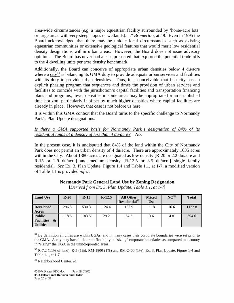
area-wide circumstances (e.g. a major equestrian facility surrounded by ‘horse-acre lots’ or large areas with very steep slopes or wetlands). . .” Bremerton, at 49. Even in 1995 the Board acknowledged that there may be unique local circumstances such as existing equestrian communities or extensive geological features that would merit low residential density designations within urban areas. However, the Board does not issue advisory opinions. The Board has never had a case presented that explored the potential trade-offs to the 4 dwelling units per acre density benchmark. Additionally, the Board can conceive of appropriate urban densities below 4 du/acre where a city31 is balancing its GMA duty to provide adequate urban services and facilities with its duty to provide urban densities. Thus, it is conceivable that if a city has an explicit phasing program that sequences and times the provision of urban services and facilities to coincide with the jurisdiction’s capital facilities and transportation financing plans and programs, lower densities in some areas may be appropriate for an established time horizon, particularly if offset by much higher densities where capital facilities are already in place. However, that case is not before us here. It is within this GMA context that the Board turns to the specific challenge to Normandy Park’s Plan Update designations. Is there a GMA supported basis for Normandy Park’s designation of 84% of its residential lands at a density of less than 4 du/acre? – No. In the present case, it is undisputed that 84% of the land within the City of Normandy Park does not permit an urban density of 4 du/acre. There are approximately 1635 acres within the City. About 1380 acres are designated as low density [R-20 or 2.2 du/acre and R-15 or 2.9 du/acre] and medium density [R-12.5 or 3.5 du/acre] single family residential. See Ex. 3, Plan Update, Figure 1.4 and Table 1.1, at 1-7, a modified version of Table 1.1 is provided infra.
Normandy Park General Land Use by Zoning Designation [Derived from Ex. 3, Plan Update, Table 1.1, at 1-7]
Land Use R-20 R-15 R-12.5 All Other
Residential32 Mixed
Use NC33 Total
Developed Acres
296.8 530.3 124.4 152.9 11.8 16.6 1132.8
Public Facilities & Utilities
118.6 183.5 29.2 54.2 3.6 4.8 394.6
31 By definition all cities are within UGAs, and in many cases their corporate boundaries were set prior to the GMA. A city may have little or no flexibility in “sizing” corporate boundaries as compared to a county in “sizing” the UGA in the unincorporated areas. 32 R-7.2 (11% of land), R-5 (1%), RM-1800 (1%) and RM-2400 (1%). Ex. 3, Plan Update, Figure 1-4 and Table 1.1, at 1-7 33 Neighborhood Center. Id.
05307c Kaleas FDO.doc (July 19, 2005) 05-3-0007c Final Decision and Order Page 21 of 31
Vacant Acres (Sensitive)34
62
(18)
27
(13)
9
(2)
5.2
(1)
1.7
(0)
2.7
(0)
107.6
(34) Total Acres
(%)
477.4
(29%)
740.8
(45%)
162.6
(10%)
212.3
(14%)
7.1 [sic 17.1]
(.5%)
24.1
(1.5%)
1635
(100%) The City states in its 2004 Plan Update that, “The 2000 Census also indicated that the city had a population density of 3.91 people per acre and a gross housing density of 1.63 residential units per acre.” Id. at 1-9, (emphasis supplied). The County’s BLR indicates that between 1996 and 2000 (clearly years governed by the GMA) the average density achieved in the City’s single-family zones was 2.2 du/acre [permit based] or 2.3 du/acre [plat based] and no multi-family development occurred. Ex.6, at 162. These low and medium residential density FLUM designations affecting 84% if the City’s land area and reported residential densities noted in the Plan and BLR are below the regionally accepted norm – 4 du/ac – for an appropriate urban density within an urban area. On their face, the low-density [R-20 and R-15] designations and the medium-density [R-12.5] designations do not comply with the goals or requirements of the Act. [RCW 36.70A.110 or .020(1).]35 However, what are the local circumstances and rationale that led the City to continue to plan for such low-density residential development? Do any of the “density trade-offs” apply; are other goals and requirements being balanced? Petitioners contend that the extensive areas affected by the low-density designations do not comport with the low-density designations recognized in Litowitz for provide additional protection for significant critical areas; and that the basis for the City’s designations is the preservation of existing neighborhoods that perpetuates low-density sprawl. Kaleas PHB, at 8-10; Futurewise PHB, at 9-12. The City argues that Miller and Walker Creeks, their associated wetlands, and the steep slopes and bluffs along the Puget Sound shoreline are critical areas that merit low-density land use designations to afford them additional protection beyond the City’s critical areas regulations. Normandy Park Response, at 5, 7, 9, 18-21. However, the Board’s review leads the Board to the following findings and conclusions:
• While there is some descriptive narrative in the Plan Update, the only quantification of the extent of the City’s sensitive areas (and indication of
34 2004 estimates of vacant acreage that is encumbered by sensitive areas including wetlands, erosion and landslide hazard areas and flood zones. Id. footnote 1. 35 Petitioners did not distinguish between the City’s three densities below 4 du/acre, they were all discussed together as allegedly noncompliant. Therefore the Board must consider them in that context.

05307c Kaleas FDO.doc (July 19, 2005) 05-3-0007c Final Decision and Order Page 22 of 31
location) is that within the City there are “eight wetlands having a total area of approximately 83 acres.” Ex. 3, Plan Update, at 1-4;
• ‘Two of these wetlands comprising about 17 acres, are designated as Class 1 wetlands, the most critical to protect. . . .One of the Class I wetlands is adjacent to Puget Sound and the other is associated with Miller Creek.” Id.
• There are five Class 5 wetlands, totaling about 65 acres [associated with Walker and Normandy Creek] and one Class 3 wetland with an area of one-half acre [adjacent to Puget Sound]; Id.
• Walker and Miller Creek are identified as Class 2 streams that run year round and are salmon bearing; Id. at 1-3;
• Erosion, landslide and seismic hazard areas are described generally, but not related to Normandy Park other than reference to “bluffs of the Puget Sound region;”36 Id.
• There are no maps displaying the location or interrelationship of these critical areas in the record. [The Board notes that there is a topographic map showing 25’ contour intervals in the 2004 Southwest Suburban Sewer District Plan. Ex.28, Figure 2.1.]
• Of the 107 vacant and undeveloped acres within the City, the City estimates that only 34 acres are encumbered by “sensitive areas.” No locations of these sensitive areas on vacant lands are provided. See Table supra.
• Further, there is little indication in the Plan Update of how much of the non-vacant land is “encumbered” by sensitive areas that are, or are not, adequately protected by existing critical areas regulations.
It is possible that the City may be have some limited locations with sensitive environmental systems that are large in scope, complex in structure and function, with high rank order values. If so, areas so identified may be afforded a higher level of protection by means of land use plan designations lower than 4 du/acre, per Litowitz. However, the City has not identified such areas. Further, Petitioners have carried their burden in showing that there is nothing in the record before the Board to lead to the conclusion that there are large scale, high rank order, complex structure and function critical areas that are present that would support the designation of over 1,380 acres of the City (84%), and over 90% of the City’s vacant land for low-density development.37 Additionally, there is nothing in the record to demonstrate that the critical areas described by the City cannot be adequately protected by its existing sensitive areas regulations. 36 The Board notes that some or all of the areas affected by steep slopes may be geologically-hazardous or critical areas because of hydrological significance or their relationship to the marine shoreline, but the City’s record lacks specifics. 37 Note that the GMA does not require or compel the redevelopment of existing developed parcels. However, the GMA does require that the plans and regulations that guide and govern new development and any redevelopment of land that occurs must provide for compact urban development at appropriate urban densities. LMI/Chevron FDO, at 37
05307c Kaleas FDO.doc (July 19, 2005) 05-3-0007c Final Decision and Order Page 23 of 31
Petitioner Kaleas suggests that the Plan Update goals and policies indicate the rationale for the low and medium density designations is a desire to preserve and maintain historic low-densities. Kaleas PHB, at 9. The Plan Update provides, “Preserve the character of existing single family neighborhoods by eliminating incompatible uses and managing transitions between various land uses.” Plan Update, Objective 1.1, at 1-14. Petitioner also cites Plan Policy 1.1.2, “Consider new development that is compatible with the existing pattern of development.” Id. Reading these Plan provisions in the context of the City’s FLUM designations, and lacking an environmental basis [i.e. Litowitz], the Board concludes that the low-density and medium density residential designations adopted in the Plan Update are intended to perpetuate the existing low-density development pattern within the City and not encourage infill development and redevelopment at appropriate urban densities. The City argued, but did not specify, that there are areas of the City that are not served by public roads and are not sewered due to steep slopes and wet areas. Normandy Park Response, at 7. Yet the Southwest Suburban Sewer District – 2004 Comprehensive Sewer Plan includes numerous sewer extension projects in several “unsewered” areas of Normandy Park. Ex. 28, at 6-1 to 6-9. Additionally, under the GMA, cities are the providers of urban services and one of the purposes of the GMA is to see that urban areas provided urban services – adequate public facilities and services. RCW 36.70A.020(1), (12) and RCW 36.70A.070(3), (6) and RCW 36.70A.210. Consequently, the GMA does not permit the Board to conclude, without more, that the lack of existing roads and sewers within the City’s limits is a basis for low-density residential designations. Further, there is no evidence of an explicit phasing or timing program for the provision of urban services and facilities. Finally, as acknowledged by the parties, the Board does not have jurisdiction to address constitutional issues, these questions are left for the courts. Likewise, the interplay between private covenants and land use regulations, which typically arise on project specific proposals, is another dispute area that the courts, not the Boards, are authorized to resolve. Based upon the Board’s discussion supra, the Board concludes, that the City of Normandy Park’s adoption of Ordinance No. 742, specifically the low-density and medium-density FLUM designations in the 2004 Plan Update, was clearly erroneous and did not comply with compliance review requirements of RCW 36.70A.130. Further, these Plan Update designations do not comply with RCW 36.70A.110 [permit urban densities] and were not guided by Goal 1 – RCW 36.70A.020(1) [encourage development in urban areas where infra structure exists]. Therefore, the Board will remand the Plan Update, directing the City of Normandy Park to comply with the goals and requirements of the Act. Having found the City’s action clearly erroneous and that the Plan Update FLUM designations for low- density and medium-density residential areas are noncompliant with the Act, the Board reminds the City that it must maintain consistency between its

05307c Kaleas FDO.doc (July 19, 2005) 05-3-0007c Final Decision and Order Page 24 of 31
Plan and implementing development regulations and ensure that the City’s development regulations implement its Plan, as required by RCW 36.70A.040 and .130. The City is reminded that the City of Normandy Park’s R-20, R-15 and R-12.5 zoning designations do not implement compliant Plan provisions – a situation prohibited by the GMA. Resolution of this defect should be completed concurrently with the City’s revisions to its Plan on remand. The Board notes that the City has suggested that much of the City, as platted, “contains a large number of small, nonconforming lots, so that its density is actually greater than what is calculable from its zoning map only, in the R-15 zone.” Normandy Park Response, at 8. If this is so, it would be appropriate for the City to redesignate these areas, as well as the medium density areas, at higher densities (i.e. 4 du/ac) to reduce the extent of nonconformity and permit appropriate urban densities.
Conclusion
The City of Normandy Park’s adoption of Ordinance No. 742, specifically the low-density and medium-density FLUM designations in the 2004 Plan Update, was clearly erroneous and did not comply with compliance review requirements of RCW 36.70A.130 and these Plan Update designations do not comply with RCW 36.70A.110 [permit urban densities] and were not guided by Goal 1 – RCW 36.70A.020(1) 38[encourage development in urban areas where infra structure exists]. Therefore, the Board will remand the Plan Update, directing the City of Normandy Park to comply with the goals and requirements of the Act.
V. REQUESTS FOR INVALIDITY
The Board has previously held that a request for invalidity is a prayer for relief and, as such, does not need to be framed in the PFR as a legal issue. See King County v. Snohomish County, CPSGMHB Case No. 03-3-0011, Final Decision and Order, (Oct. 13, 2003) at 18. Nevertheless, here, both Petitioners have framed the request for invalidity as a Legal Issue: • If noncompliance is found, then does the continued validity of the noncompliant
designations and or classifications substantially interfere with the goals of the GMA? [Kaleas]
• Does the adoption of the challenged provisions of Ordinance No. 742 substantially interfere with the goals of the Growth Management Act, thereby warranting invalidity?[1000 Friends of Washington]
See PHO, at 6.
38 As noted supra, a FLUM and zoning that make such lots nonconforming fails to “encourage urban development in urban areas” as required by RCW 36.70A.020(1).
05307c Kaleas FDO.doc (July 19, 2005) 05-3-0007c Final Decision and Order Page 25 of 31
GMA’s Invalidity Provisions
RCW 36.70A.302 provides:
(1) A board may determine that part or all of a comprehensive plan or
development regulation are invalid if the board: (a) Makes a finding of noncompliance and issues an order of
remand under RCW 36.70A.300; (b) Includes in the final order a determination, supported by
findings of fact and conclusions of law, that the continued validity of part or parts of the plan or regulation would substantially interfere with the fulfillment of the goals of this chapter; and
(c) Specifies in the final order the particular part or parts of the plan or regulation that are determined to be invalid, and the reasons for their invalidity.
(2) A determination of invalidity is prospective in effect and does not extinguish rights that vested under state or local law before receipt of the board’s order by the city or City. The determination of invalidity does not apply to a completed development permit application for a project that vested under state or local law before receipt of the board’s order by the City or city or to related construction permits for that project.
In the discussion of appropriate urban densities, supra, the Board found and concluded that the City of Normandy Park’s Plan Update FLUM designations for low-density and medium density residential uses, as adopted by Ordinance No. 742, were clearly erroneous and did not comply with the compliance review requirements of RCW 36.70A.130, the urban density requirements of RCW 36.70A.110 and its action was not guided by Goal 1 – RCW 36.70A.020(1). The Board is also remanding the Ordinance with direction to the City to comply with the requirements of the GMA. In light of these critical defects in the City’s FLUM designations as discussed, infra, the Board concludes that the continued validity of these amendments adopted by Ordinance No. 742, specifically the low-density [R-20 and R-15] and medium density [R-12.5] designations in the Plan Update would provide a basis for potential developments to vest at densities that are not appropriate urban densities. Consequently, the Board concludes that these amendments substantially interfere with encouraging development in urban areas where adequate public facilities and services exist or can be provided in an efficient manner – Goal 1 – RCW 36.70A.020(1). Therefore, the Board enters a determination of invalidity with respect to Ordinance No. 742. However, for purposes of this remand, and until the City takes legislative action to comply with the Act, the determination of invalidity shall only apply to vacant lands, undeveloped lands, underdeveloped lands and
05307c Kaleas FDO.doc (July 19, 2005) 05-3-0007c Final Decision and Order Page 26 of 31
proposals for redevelopment within the single-family [R-20 and R-15] or medium family [R-12.5] residential designations.
VI. ORDER
Based upon review of the Petitions for Review, the GMA, prior Order of this Board and the other GMHBs, case law, the briefs and exhibits submitted by the parties, having considered the arguments of the parties, and having deliberated on the matter the Board ORDERS: 1. The City of Normandy Park’s adoption of the Plan Update, in Ordinance No. 742,
specifically the low-density [R-20 and R-15] medium density [R-12.5] residential FLUM designations, was clearly erroneous and does not comply with the requirements of RCW 36.70A.110 and .130 and was not guided by Goal 1 – RCW 36.70A.020(1).
2. Further, the adoption of the low-density [R-20 and R-15] medium density [R-12.5]
residential FLUM designations, substantially interfere with the fulfillment of Goal 1 – RCW 36.70A.020(1). Therefore, the Board enters a Determination of Invalidity, as specified infra, with respect to these FLUM designations.
3. The Board remands Ordinance No. 742, the Plan Update, specifically the low-
density [R-20 and R-15] medium density [R-12.5] residential FLUM designations to the City of Normandy Park with direction to take appropriate legislative action to amend, modify or otherwise revise the low-density [R-20 and R-15] and medium density [R-12.5] residential FLUM designations to provide for appropriate urban densities required by the goals and requirements of the Act, as interpreted by the Board and set forth in this Order. The compliance schedule for the remand period is as follows:
• By no later than January 19, 2006, the City shall take appropriate
legislative action to achieve appropriate urban densities and bring its Plan Update into compliance with the goals and requirements of the GMA, as interpreted and set forth in this FDO.
• By no later than February 2, 2006, the City shall file with the Board an original and four copies of a Statement of Action Taken to Comply (SATC) with the GMA, as interpreted and set forth in this FDO. The SATC shall attach copies of legislation, with attachments, enacted in order to comply. The City shall simultaneously serve a copy of the SATC, with attachments, on Petitioners. By this same date, the City shall also file a “Remand Index,” listing the procedures (meetings, hearings etc.) occurring during the remand period and materials (documents, reports,

05307c Kaleas FDO.doc (July 19, 2005) 05-3-0007c Final Decision and Order Page 27 of 31
analysis, testimony etc.) considered during the remand period in taking the remand action.
• By no later than February 16, 2006,39 the Petitioners may file with the Board an original and four copies of Response to the City’s SATC. Petitioners shall simultaneously serve a copy of their Response to the City’s SATC on the City.
• By no later than February 23, 2006, the City may file with the Board an original and four copies of the City’s Reply to Petitioners Response, if any. The City shall simultaneously serve a copy of such Reply on Petitioners.
Pursuant to RCW 36.70A.330(1), the Board hereby schedules the Compliance Hearing in this matter for 10:00 a.m. March 2, 2006 at the Board’s offices. If the City takes legislative action to comply with the GMA prior to the January 19, 2006 deadline set forth in this Order, it may file a motion with the Board requesting an adjustment to this compliance schedule.
So ORDERED this 19thth day of July, 2005. CENTRAL PUGET SOUND GROWTH MANAGEMENT HEARINGS BOARD __________________________________________ Bruce C. Laing, FAICP Board Member
__________________________________________ Edward G. McGuire, AICP Board Member
__________________________________________
Margaret A. Pageler Board Member (See also, Concurring Opinion) 39 February 2, 2006 is also the deadline for a person to file a request to participate as a “participant” in the compliance proceeding. See RCW 36.70A.330(2). The Compliance Hearing is limited to determining whether the City’s remand actions comply with the Legal Issues addressed and remanded in this FDO.

05307c Kaleas FDO.doc (July 19, 2005) 05-3-0007c Final Decision and Order Page 28 of 31
Concurring Opinion of Board Member Pageler
I concur in the Board’s decision. I write to make three additional comments. First, when the Board set four dwelling units per acre as the base line for urban density, it did two things: it created a standard for determining the size of urban growth areas (UGAs) and it established a floor for urban residential zoning. However, for purposes of high quality of life, efficient delivery of public services, and provision of affordable housing,40 most Central Puget Sound cities have areas of residential zoning at higher densities. CTED’ Guidance Paper on urban densities in Central Puget Sound notes that many neighborhoods and small towns built before World War II were developed at 6-8 du/acre.41 In absorbing new growth, Central Puget Sound cities have used clustering, cottage housing, and other innovative techniques to increase density in single family zones while maintaining neighborhood character and quality of life. Issaquah, for example, has a Single Family Duplex zone that permits densities at 14.25 du/acre. The larger cities of the region have found that there is a market for very-high-density urban living in their downtown condos and apartments. The four dwelling units per acre base line must be seen in this broader context. The recent Board focus on the bottom range of residential zoning in a few cities shouldn’t obscure the achievement of the region in absorbing growth at much higher densities in attractive urban centers and “urban villages.” Second, Normandy Park has one transit arterial, First Avenue South, which runs the length of the city - a distance of about four miles - with frequent bus stops. Though Normandy Park has recently adopted mixed use development plans for two nodes along First Avenue South, the City’s low-density residential zoning prevails along much of the arterial. Residential zoning of at least seven units per acre is the established urban planning standard for the level of density needed to support transit services.42 Zoning at this
40 “The efficient provision of public facilities and services is a goal of the GMA, as is the encouragement of affordable housing. To achieve these and other goals, experience shows that at least 4 units per acre are required for the efficient and equitable provision of sewer service, 7 or more units per acre are required if transit service is to be economically viable, and, depending on median income, affordable housing will often require from 4-16 units per acre.” CTED, Issue Paper #10 – Urban Lands 41 CTED Growth Management Services, Urban Densities – Central Puget Sound Edition, Guidance Paper (Sept. 2004). 42 “At densities of eight units per acre and higher, neighborhoods begin to support bus and rail transit by increasing the number of transit users within walking distance of a bus station. Some areas refer to eight housing units per acre to support minimal bus service (30-minute headways), 20 units per acre to support a transit station, or 30 units per acre to support high-frequency transit service (10-minute headways).” Local

05307c Kaleas FDO.doc (July 19, 2005) 05-3-0007c Final Decision and Order Page 29 of 31
density the length of First Avenue South might allow a greater variety of single-family housing types, townhomes, duplexes, and cottage housing, as well as supporting transit service. See RCW 36.70A.020(3) and (4). Third, Normandy Park has areas of steep and unstable bluffs. According to Normandy Park’s presentation at the Hearing on the Merits, these are landslide-prone slopes where springs in the hillsides cause periodic washouts. Homes on some of these hillsides are reached only by private roads because the cost of engineering and maintaining public roads is too high to impose on the general taxpayer. Some of these areas are not yet sewered, for the same reason. CTED’s critical areas guidelines contain useful definitions for geologically hazardous areas, including bluffs such as Normandy Park’s. See WAC 365-190-080(4)(d)(ii).43 Zoning geologically hazardous areas at an urban level of 4 du/acre might not result in the efficient provision of urban services. Quite the contrary, providing police, fire, stormwater, solid waste and emergency services to more homes in hazard areas may be costly and inefficient. The critical areas would need to be mapped, using best available science, to identify their functions and values, whether as feeder bluffs to salt water beaches, as sources of cool water for streams and rivers, as eagle and hawk habitat, etc. RCW 36.70A.172(1). The City would then need to articulate why critical area protections need to be supplemented by low-density zoning designations in order to protect those functions. Note: This order constitutes a final order as specified by RCW 36.70A.300 unless a party files a motion for reconsideration pursuant to WAC 242-02-832.
Government Commission, Creating Great Neighborhoods, Density in Your Community, US EPA (Sept. 2003). 43 Landslide hazard areas may include: “ Areas with all three of the following characteristics: (A) Slopes steeper than 15%; and (B) Hillsides intersecting geologic contacts with a relatively permeable sediment overlying a relatively impermeable sediment or bedrock; and (C) Springs or ground water seepage.” Id.

05307c Kaleas FDO.doc (July 19, 2005) 05-3-0007c Final Decision and Order Page 30 of 31
APPENDIX A
Procedural Background
A. General
On December 1, 2004, the Central Puget Sound Growth Management Hearings Board (the Board) received a Petition for Review (PFR) from John R. Kaleas (Petitioner or Kaleas). The matter was assigned Case No. 043-0025, and is hereafter referred to as Kaleas v. Normandy Park. Board Member Edward G. McGuire is the presiding officer (PO) in this matter. Petitioner challenges the City of Normandy Park’s (Respondent or City) adoption of Ordinance No. 742, adopting the City’s 2004 Comprehensive Plan Update (Plan Update). The basis for the challenge is noncompliance with various provisions of the Growth Management Act (GMA or Act).
On December 6, 2004, the Board issued a Notice of Hearing in the Kaleas matter and conducted a Prehearing Conference on January 10, 2005.
On January 10, 2005, the Board issued its “Prehearing Order” in the Kaleas matter.
On January 21, 2005, the Board received a PFR from 1000 Friends of Washington (Petitioners or Futurewise44). The case was assigned CPSGMHB Case No. 05-3-0007. Edward G. McGuire is the PO in this matter. 1000 Friends also challenges the City of Normandy Park’s adoption of Ordinance No. 74245 adopting the City’s 2004 Comprehensive Plan Update. Again, the basis for the challenge is noncompliance with the Growth Management Act (GMA or Act).
On January 25, 2005 the Board issued a “Notice of Hearing and Order of Consolidation.” The board set February 3, 2005 as the date for the prehearing conference in the consolidated matter.
On February 3, 2005, the Board conducted the prehearing conference in this consolidated case. The prehearing order (PHO) was issued on February 4, 2005.
On February 11, 2005, pursuant to a request of the parties, the Board issued an “Order Rescheduling Hearing on Merits.” The Hearing on the Merits was rescheduled from April 1, 2005 to April 14, 2005.
On February 25, 2005, pursuant to a request of the parties, the Board issued an “Order Rescheduling Briefing Schedule.” An additional three days was given for filing each of the prehearing briefs.
44 The Board notes, and the parties so stipulate, that 1000 Friends of Washington has changed its name to “Future Wise.” References in future Board Orders will refer to the new name. 45 Ordinance No. 742 was adopted on November 9, 2004 and the Notice of Adoption was published on November 24, 2004.
05307c Kaleas FDO.doc (July 19, 2005) 05-3-0007c Final Decision and Order Page 31 of 31
B. Motions to Supplement the Record and Amend the Index
On January 13, 2005, the City of Normandy Park provided the Board and Petitioner Kaleas with a copy of the “Index to Record” (Index).
On January 27, 2005, the City provided a copy of the Index to Petitioner 1000 Friends of Washington or Futurewise.
There were no motions to supplement the record filed with the Board in this matter.
C. Dispositive Motions
At the time of the February 3, 2005 prehearing conference in the consolidated case, the time for filing motions by Petitioner Kaleas or the City of Normandy Park had passed. 1000 Friends and the City indicated that it was unlikely that any motions to supplement the record or dispositive motions would be filed. Nonetheless, the Board allowed either 1000 Friends or the City to file such motions, if necessary, along with the prehearing briefing. There were no dispositive motions filed with the Board in this matter.
D. Briefing and Hearing on the Merits
On March 4, 2005, the Board received “Prehearing Brief of Petitioners’ John R. Kaleas and Bruce W. Horst” (Kaleas PHB), with five attached exhibits keyed to the Index. The same day, the Board received “Futurewise Prehearing Brief” (Futurewise PHB), with two attached exhibits keyed to the Index. Both filings were timely. On March 25, 2005, the Board received “Hearing Brief of Respondent City of Normandy Park” (Normandy Park Response), with thirteen attached exhibits. The filing was timely. On April 1, 2005, the Board received “Reply Brief of Petitioners John R. Kaleas and Bruce W. Horst” (Kaleas Reply); no exhibits were attached. The Board also received “Futurewise Reply Brief” (Futurewise Reply), with one attached exhibit. On April 14, 2005, the Board held a hearing on the merits at the Board’s offices in Suite 12470, 900 4th Avenue, Seattle, Washington. Board members Edward G. McGuire, Presiding Officer, Bruce C. Laing and Margaret A. Pageler were present for the Board. Petitioner Kaleas was represented by David S. Mann; John Zilavy represented Petitioner 1000 Friends of Washington. Respondent City of Normandy Park was represented by Sue Sampson. Court reporting services were provided by Eva P. Jankovits of Byers and Anderson, Inc. The hearing convened at 10:00 a.m. and adjourned at approximately 12:00 p.m.
Related Documents