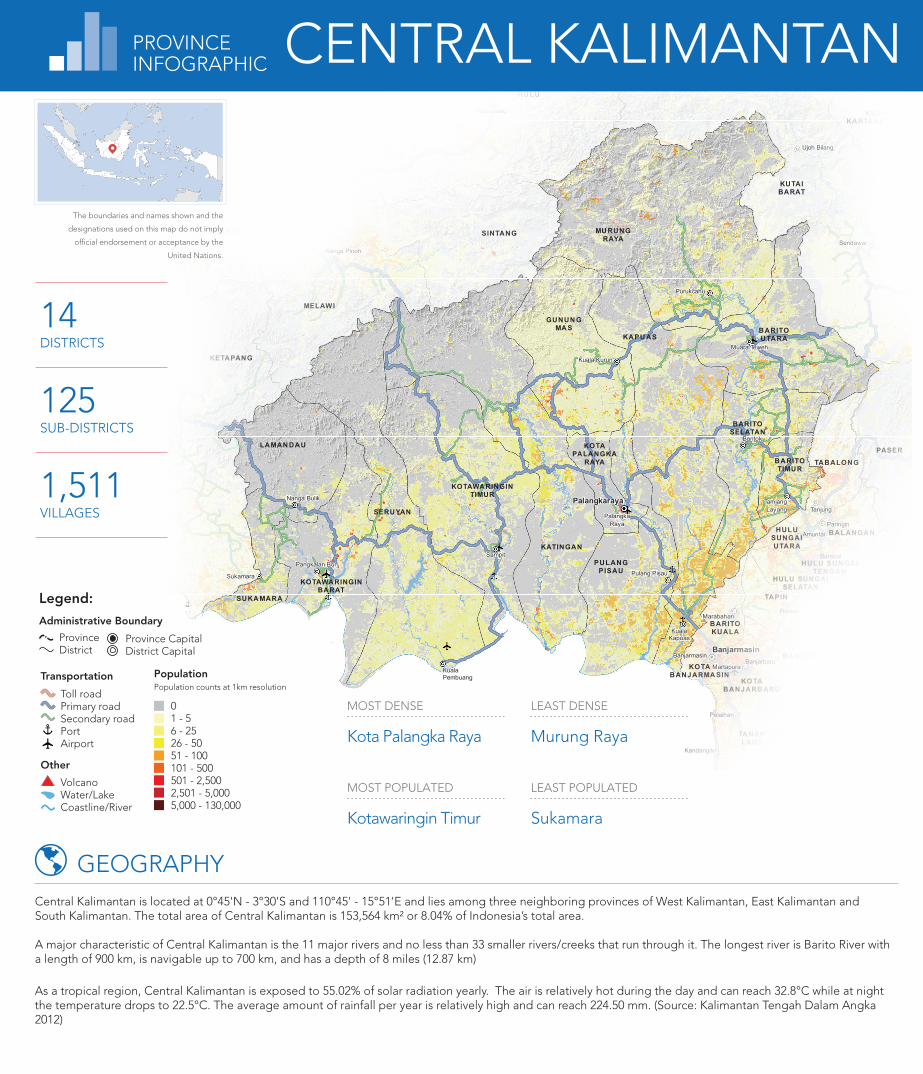
KETAPANG SINTANG KAPUAS HULU SEKADAU MELAWI KOTAWARINGIN BARAT KOTAWARINGIN TIMUR KAPUAS BARITO SELATAN BARITO UTARA SUKAMARA LAMANDAU SERUYAN KATINGAN PULANG PISAU GUNUNG MAS BARITO TIMUR MURUNG RAYA KOTA PALANGKA RAYA TANAH LAUT KOTA BARU BANJAR BARITO KUALA TAPIN HULU SUNGAI SELATAN HULU SUNGAI TENGAH HULU SUNGAI UTARA TABALONG TANAH BUMBU BALANGAN KOTA BANJARMASIN KOTA BANJARBARU PASER KUTAI BARAT KUTAI KARTANEGARA KUTAI TIMUR MALINAU Palangkaraya Banjarmasin Putussibau Sintang Nanga Pinoh Sekadau Banjarmasin Banjarbaru Martapura Marabahan Kandangan Barabai Amuntai Tanjung Pelaihari Rantau Paringin Batulicin Palangka Raya Buntok Muara Teweh Kuala Kapuas Pangkalan Bun Sampit Tamiang Layang Kuala Kurun Nanga Bulik Purukcahu Pulang Pisau Sukamara Kuala Pembuang Ujoh Bilang Sendawar 14 DISTRICTS 125 SUB-DISTRICTS 1,511 VILLAGES 0 1 - 5 6 - 25 26 - 50 51 - 100 101 - 500 501 - 2,500 2,501 - 5,000 5,000 - 130,000 Population Population counts at 1km resolution Transportation Toll road Primary road Secondary road Port Airport Province Capital District Capital Other Volcano Water/Lake Coastline/River Administrative Boundary Legend: Province District LEAST POPULATED Sukamara MOST DENSE Kota Palangka Raya MOST POPULATED Kotawaringin Timur LEAST DENSE Murung Raya Central Kalimantan is located at 0°45'N - 3°30'S and 110°45' - 15°51'E and lies among three neighboring provinces of West Kalimantan, East Kalimantan and South Kalimantan. The total area of Central Kalimantan is 153,564 km² or 8.04% of Indonesia’s total area. A major characteristic of Central Kalimantan is the 11 major rivers and no less than 33 smaller rivers/creeks that run through it. The longest river is Barito River with a length of 900 km, is navigable up to 700 km, and has a depth of 8 miles (12.87 km) As a tropical region, Central Kalimantan is exposed to 55.02% of solar radiation yearly. The air is relatively hot during the day and can reach 32.8°C while at night the temperature drops to 22.5°C. The average amount of rainfall per year is relatively high and can reach 224.50 mm. (Source: Kalimantan Tengah Dalam Angka 2012) GEOGRAPHY The boundaries and names shown and the designations used on this map do not imply official endorsement or acceptance by the United Nations. PROVINCE INFOGRAPHIC CENTRAL KALIMANTAN

Welcome message from author
This document is posted to help you gain knowledge. Please leave a comment to let me know what you think about it! Share it to your friends and learn new things together.
Transcript
SANGGAU
KETAPANG
SINTANG
KAPU ASHULU
SEKADAU
MELAWI
KOTAWARINGINBARAT
KOTAWARINGINTIMUR
KAPU AS
BARITOSELATAN
BARITOUTARA
SUKA MARA
LAMAN DAU
SERUYAN
KATINGAN
PULANGPISAU
GUNUN GMA S
BARITOTIMUR
MU RUNGRAYA
KOTAPALANGKA
RAYA
TANAHLAUT
KOTABARU
BANJAR
BARITOKUALA
TAPIN
HULU SUNGAISELATAN
HULU SUNGAITEN GAH
HULUSUNGAIUTARA
TABALONG
TANAHBUMBU
BALANGAN
KOTABANJARMA SIN
KOTABANJARB ARU
PASER
KUTAIBARAT
KUTAIKARTANEGARA
KUTAITIMUR
MA LINAU
Palangkaraya
Banjarmasin
Putussibau
Sintang
Nanga Pinoh
Sanggau
Sekadau
BanjarmasinBanjarbaru
Martapura
Marabahan
Kandangan
Barabai
Amuntai
Tanjung
Pelaihari
Rantau
Paringin
Batulicin
PalangkaRaya
Buntok
Muara Teweh
KualaKapuas
Pangkalan BunSampit
TamiangLayang
Kuala Kurun
Nanga Bulik
Purukcahu
Pulang PisauSukamara
KualaPembuang
Ujoh Bilang
Sendawar
14DISTRICTS
125SUB-DISTRICTS
1,511VILLAGES
01 - 56 - 2526 - 5051 - 100101 - 500501 - 2,5002,501 - 5,0005,000 - 130,000
PopulationPopulation counts at 1km resolution
Transportation
Toll roadPrimary roadSecondary roadPortAirport
Province CapitalDistrict Capital
Other
VolcanoWater/LakeCoastline/River
Administrative Boundary
Legend:
ProvinceDistrict
LEAST POPULATED
Sukamara
MOST DENSE
Kota Palangka Raya
MOST POPULATED
Kotawaringin Timur
LEAST DENSE
Murung Raya
Central Kalimantan is located at 0°45'N - 3°30'S and 110°45' - 15°51'E and lies among three neighboring provinces of West Kalimantan, East Kalimantan and South Kalimantan. The total area of Central Kalimantan is 153,564 km² or 8.04% of Indonesia’s total area.
A major characteristic of Central Kalimantan is the 11 major rivers and no less than 33 smaller rivers/creeks that run through it. The longest river is Barito River with a length of 900 km, is navigable up to 700 km, and has a depth of 8 miles (12.87 km)
As a tropical region, Central Kalimantan is exposed to 55.02% of solar radiation yearly. The air is relatively hot during the day and can reach 32.8°C while at night the temperature drops to 22.5°C. The average amount of rainfall per year is relatively high and can reach 224.50 mm. (Source: Kalimantan Tengah Dalam Angka 2012)
GEOGRAPHY
The boundaries and names shown and the
designations used on this map do not imply
official endorsement or acceptance by the
United Nations.
PROVINCEINFOGRAPHIC CENTRAL KALIMANTAN
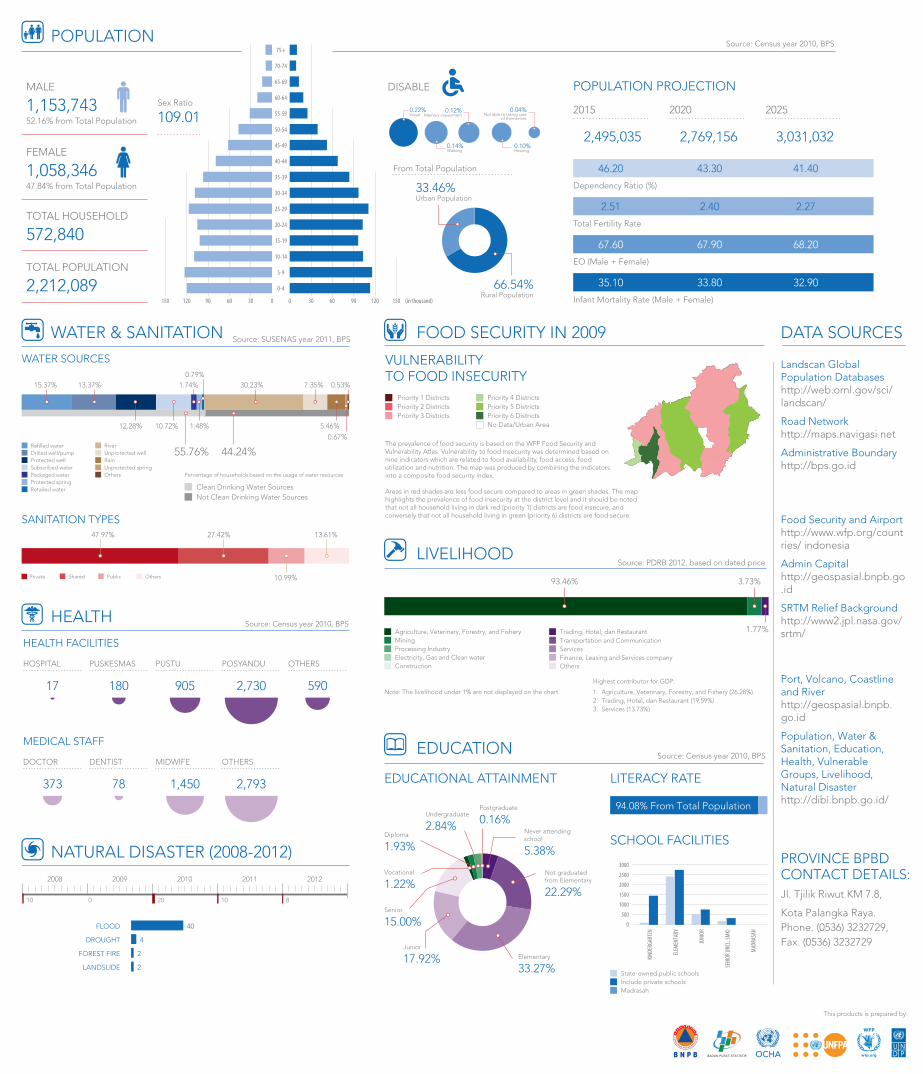
POPULATION
240-4
5-9
10-14
15-19
20-24
25-29
30-34
35-39
40-44
45-49
50-54
55-59
60-64
65-69
70-74
75+
0 30 60 90 120 1500306090120150 (in thousand)
TOTAL HOUSEHOLD
572,840
TOTAL POPULATION
2,212,089
MALE
1,153,74352.16% from Total Population
Sex Ratio
109.01
FEMALE
1,058,34647.84% from Total Population
DISABLE
33.46%Urban Population
66.54%Rural Population
2015
2,495,035
2020
2,769,156
2025
3,031,032
POPULATION PROJECTION
Total Fertility Rate
Infant Mortality Rate (Male + Female)
Dependency Ratio (%)
EO (Male + Female)
46.20
2.51
67.60
35.10
41.40
2.27
68.20
32.90
43.30
2.40
67.90
33.80
From Total Population
0.22%Visual
0.14%Walking
0.12%Memory impairment
0.10%Hearing
0.04%Not able to taking care
of themselves
WATER & SANITATION
Private Public OthersShared
HEALTH
HEALTH FACILITIES
MEDICAL STAFF
373 78 2,7931,450
DENTIST MIDWIFEDOCTOR OTHERS
PUSKESMAS PUSTUHOSPITAL POSYANDU OTHERS
180 90517 2,730 590
2008 2009 2010 2011 2012
81020010
2LANDSLIDE
4DROUGHT
2FOREST FIRE
40FLOOD
NATURAL DISASTER (2008-2012)
FOOD SECURITY IN 2009
Priority 1 DistrictsPriority 2 DistrictsPriority 3 Districts
Priority 4 DistrictsPriority 5 DistrictsPriority 6 DistrictsNo Data/Urban Area
The prevalence of food security is based on the WFP Food Security and Vulnerability Atlas. Vulnerability to food insecurity was determined based on nine indicators which are related to food availability, food access, food utilization and nutrition. The map was produced by combining the indicators into a composite food security index. Areas in red shades are less food secure compared to areas in green shades. The map highlights the prevalence of food insecurity at the district level and it should be noted that not all household living in dark red (priority 1) districts are food insecure, and conversely that not all household living in green (priority 6) districts are food secure.
VULNERABILITYTO FOOD INSECURITY
SANITATION TYPES47.97% 27.42%
10.99%
13.61%
WATER SOURCES
55.76% 44.24%
15.37%
12.28%
1.74%
10.72%
30.23%
5.46%
7.35%0.79%
13.37%
1.48%
0.67%
0.53%
Protected wellDrilled well/pump Unprotected well
River
RainUnprotected spring
Packaged waterSubscribed water
Protected springRetailed water
Refilled water
Others
Clean Drinking Water Sources Not Clean Drinking Water Sources
Percentage of households based on the usage of water resources
LIVELIHOOD
EDUCATION
EDUCATIONAL ATTAINMENT LITERACY RATE
State-owned public schoolsInclude private schoolsMadrasah
94.08% From Total Population
Senior
15.00%
Vocational
1.22%Not graduatedfrom Elementary
22.29%
Elementary
33.27%
Junior
17.92%
Diploma
1.93%
Undergraduate
2.84%
Postgraduate
0.16%Never attendingschool
5.38%
KIND
ERGA
RTEN
ELEM
ENTA
RY
JUNI
OR
SENI
OR (I
NCL.
SMK)
MAD
RASA
H
SCHOOL FACILITIES
0
500
1000
1500
2000
2500
3000
Highest contributor for GDP:
1. Agriculture, Veterinary, Forestry, and Fishery (26.28%)2. Trading, Hotel, dan Restaurant (19.59%)3. Services (13.73%)
ServicesFinance, Leasing and Services companyOthers
Transportation and CommunicationTrading, Hotel, dan Restaurant
Processing IndustryElectricity, Gas and Clean waterConstruction
MiningAgriculture, Veterinary, Forestry, and Fishery
93.46% 3.73%
Note: The livelihood under 1% are not displayed on the chart.
1.77%
Source: SUSENAS year 2011, BPS
Source: Census year 2010, BPS
Source: Census year 2010, BPS
Source: PDRB 2012, based on dated price
Source: Census year 2010, BPS
DATA SOURCES
PROVINCE BPBD CONTACT DETAILS: Jl. Tjilik Riwut KM 7.8,
Kota Palangka Raya. Phone. (0536) 3232729, Fax. (0536) 3232729
Landscan Global Population Databaseshttp://web.ornl.gov/sci/ landscan/
Road Networkhttp://maps.navigasi.net
Administrative Boundaryhttp://bps.go.id
Food Security and Airporthttp://www.wfp.org/countries/ indonesia
Admin Capitalhttp://geospasial.bnpb.go.id
SRTM Relief Backgroundhttp://www2.jpl.nasa.gov/srtm/
Port, Volcano, Coastline and Riverhttp://geospasial.bnpb.go.id
Population, Water & Sanitation, Education, Health, Vulnerable Groups, Livelihood, Natural Disasterhttp://dibi.bnpb.go.id/
This products is prepared by:
Related Documents