Centermount Coal Ltd. Bingay Main Coal Project Summary of a Project designated under the Canadian Environmental Assessment Act (2012) 16 November 2012 Submitted to: Canadian Environmental Assessment Agency 22 nd Floor, Place Bell 160 Elgin St Ottawa, ON K1A 0H3 Pursuant to: Canadian Environmental Assessment Act (2012) Submitted by: Centermount Coal Ltd. Suite 1385-1095 W. Pender St. Vancouver BC V6E 2M6

Welcome message from author
This document is posted to help you gain knowledge. Please leave a comment to let me know what you think about it! Share it to your friends and learn new things together.
Transcript

Centermount Coal Ltd.
Bingay Main Coal Project
Summary of a Project designated under the Canadian
Environmental Assessment Act (2012)
16 November 2012
Submitted to: Canadian Environmental Assessment Agency 22nd Floor, Place Bell
160 Elgin St Ottawa, ON K1A 0H3
Pursuant to: Canadian Environmental Assessment Act (2012)
Submitted by: Centermount Coal Ltd. Suite 1385-1095 W. Pender St. Vancouver BC V6E 2M6


Bingay Main Coal Project Summary – CEAA 2012
Centermount Coal Ltd. 2 16 November 2012
1 GENERAL INFORMATION AND CONTACTS
1.1 Overview
Centermount Coal proposes to develop a coal mine, with a maximum capacity of 2 million clean tonnes
per year (Mt/year), in the Elk River valley approximately 21 km north of Elkford, in the East Kootenay
portion of the Rocky Mountain coal field of southeastern British Columbia. The project is located within
the coal “Enhanced Resource Development Zone” (ERDZ) as defined in the Kootenay/Boundary Land Use
Plan and Southern Rocky Mountain Land Use Plan, and would produce high quality metallurgical (coking)
coal for the steel industry. A map showing the general location of the project is provided in Figure 1. The
coordinates for the center of the mine are latitude 50°12'03” N and longitude 114°58'49” W.
1.2 Contact Information
Proponent contact information: Centermount Coal Ltd.
Jack Austin (Chairman)
Suite 1385-1095 West Pender Street
Vancouver BC, V6E 2M6
Tel: (604) 568-3388
Fax: (604) 568-9378
Edward Nunn (P.Eng.), President of Centermount
Direct: (604) 379-6578
Email: [email protected]
Centermount has engaged Masse Environmental Consultants to coordinate the environmental assessment
process.
Consultant contact information: Masse Environmental Consultants Ltd
812 Vernon Street
Nelson, BC, V1L 4G4
Tel: (250) 352-1147
Fax: (250) 352-0422
Principle Contact : Sylvie Masse, M.Sc.,R.P.Bio
Email: [email protected]
Cell: (250) 505-3790
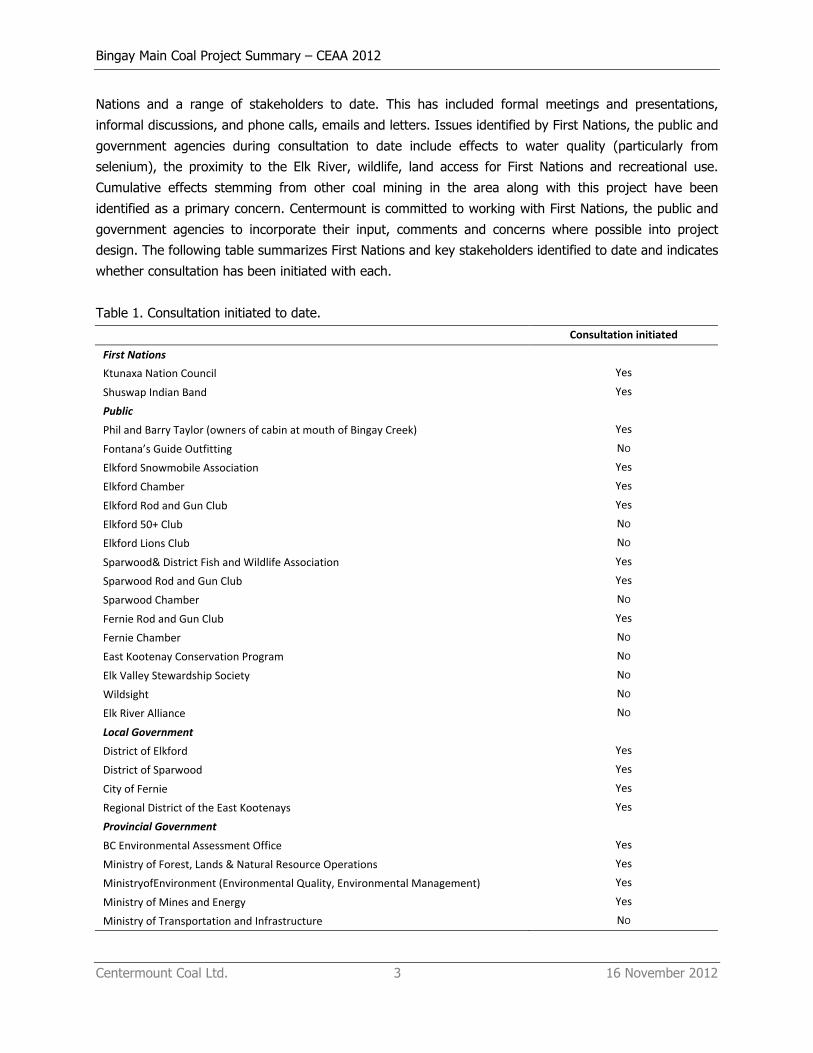
1.3 Consultation Summary
Centermount recognises that it has a responsibility to engage and consult with Aboriginal groups (First
Nations and Métis), the public, regulatory agencies, and local, provincial and federal governments
throughout the environmental assessment review process. Centermount has consulted with both First
Bingay Main Coal Project Summary – CEAA 2012
Centermount Coal Ltd. 3 16 November 2012
Nations and a range of stakeholders to date. This has included formal meetings and presentations,
informal discussions, and phone calls, emails and letters. Issues identified by First Nations, the public and
government agencies during consultation to date include effects to water quality (particularly from
selenium), the proximity to the Elk River, wildlife, land access for First Nations and recreational use.
Cumulative effects stemming from other coal mining in the area along with this project have been
identified as a primary concern. Centermount is committed to working with First Nations, the public and
government agencies to incorporate their input, comments and concerns where possible into project
design. The following table summarizes First Nations and key stakeholders identified to date and indicates
whether consultation has been initiated with each.
Table 1. Consultation initiated to date.
Consultation initiated
First Nations
Ktunaxa Nation Council Yes
Shuswap Indian Band Yes
Public
Phil and Barry Taylor (owners of cabin at mouth of Bingay Creek) Yes
Fontana’s Guide Outfitting NO
Elkford Snowmobile Association Yes
Elkford Chamber Yes
Elkford Rod and Gun Club Yes
Elkford 50+ Club NO
Elkford Lions Club NO
Sparwood& District Fish and Wildlife Association Yes
Sparwood Rod and Gun Club Yes
Sparwood Chamber NO
Fernie Rod and Gun Club Yes
Fernie Chamber NO
East Kootenay Conservation Program NO
Elk Valley Stewardship Society NO
Wildsight NO
Elk River Alliance NO
Local Government
District of Elkford Yes
District of Sparwood Yes
City of Fernie Yes
Regional District of the East Kootenays Yes
Provincial Government
BC Environmental Assessment Office Yes
Ministry of Forest, Lands & Natural Resource Operations Yes
MinistryofEnvironment (Environmental Quality, Environmental Management) Yes
Ministry of Mines and Energy Yes
Ministry of Transportation and Infrastructure NO
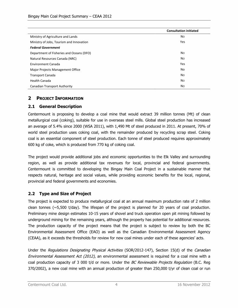
Bingay Main Coal Project Summary – CEAA 2012
Centermount Coal Ltd. 4 16 November 2012
Consultation initiated
Ministry of Agriculture and Lands NO
Ministry of Jobs, Tourism and Innovation Yes
Federal Government
Department of Fisheries and Oceans (DFO) NO
Natural Resources Canada (NRC) NO
Environment Canada Yes
Major Projects Management Office No
Transport Canada NO
Health Canada NO
Canadian Transport Authority NO
2 PROJECT INFORMATION
2.1 General Description
Centermount is proposing to develop a coal mine that would extract 39 million tonnes (Mt) of clean
metallurgical coal (coking), suitable for use in overseas steel mills. Global steel production has increased
an average of 5.4% since 2000 (WSA 2011), with 1,490 Mt of steel produced in 2011. At present, 70% of
world steel production uses coking coal, with the remainder produced by recycling scrap steel. Coking
coal is an essential component of steel production. Each tonne of steel produced requires approximately
600 kg of coke, which is produced from 770 kg of coking coal.
The project would provide additional jobs and economic opportunities to the Elk Valley and surrounding
region, as well as provide additional tax revenues for local, provincial and federal governments.
Centermount is committed to developing the Bingay Main Coal Project in a sustainable manner that
respects natural, heritage and social values, while providing economic benefits for the local, regional,
provincial and federal governments and economies.
2.2 Type and Size of Project
The project is expected to produce metallurgical coal at an annual maximum production rate of 2 million
clean tonnes (~5,500 t/day). The lifespan of the project is planned for 20 years of coal production.
Preliminary mine design estimates 10-15 years of shovel and truck operation open pit mining followed by
underground mining for the remaining years, although the property has potential for additional resources.
The production capacity of the project means that the project is subject to review by both the BC
Environmental Assessment Office (EAO) as well as the Canadian Environmental Assessment Agency
(CEAA), as it exceeds the thresholds for review for new coal mines under each of these agencies’ acts.
Under the Regulations Designating Physical Activities (SOR/2012-147), Section 15(d) of the Canadian Environmental Assessment Act (2012), an environmental assessment is required for a coal mine with a
coal production capacity of 3 000 t/d or more. Under the BC Reviewable Projects Regulation (B.C. Reg
370/2002), a new coal mine with an annual production of greater than 250,000 t/yr of clean coal or run
Bingay Main Coal Project Summary – CEAA 2012
Centermount Coal Ltd. 5 16 November 2012
of mill coal is subject to review under the BC Environmental Assessment Act. A coordinated federal and
provincial environmental assessment process is expected, whereby the same body of information is used
to address both federal and provincial requirements. In addition, the project will require several federal
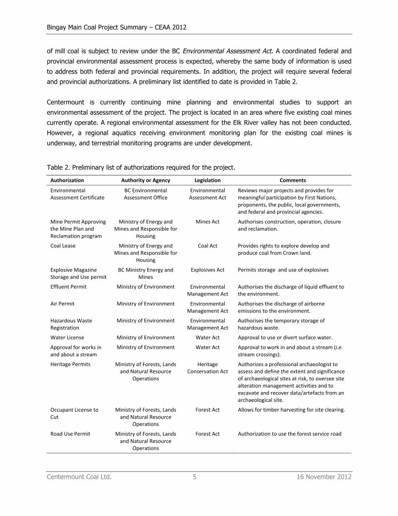
and provincial authorizations. A preliminary list identified to date is provided in Table 2.
Centermount is currently continuing mine planning and environmental studies to support an
environmental assessment of the project. The project is located in an area where five existing coal mines
currently operate. A regional environmental assessment for the Elk River valley has not been conducted.
However, a regional aquatics receiving environment monitoring plan for the existing coal mines is
underway, and terrestrial monitoring programs are under development.
Table 2. Preliminary list of authorizations required for the project.
Authorization Authority or Agency Legislation Comments
Environmental Assessment Certificate
BC Environmental Assessment Office
Environmental Assessment Act
Reviews major projects and provides for meaningful participation by First Nations, proponents, the public, local governments, and federal and provincial agencies.
Mine Permit Approving the Mine Plan and Reclamation program
Ministry of Energy and Mines and Responsible for
Housing
Mines Act Authorises construction, operation, closure and reclamation.
Coal Lease Ministry of Energy and Mines and Responsible for
Housing
Coal Act Provides rights to explore develop and produce coal from Crown land.
Explosive Magazine Storage and Use permit
BC Ministry Energy and Mines
Explosives Act Permits storage and use of explosives
Effluent Permit Ministry of Environment Environmental Management Act
Authorises the discharge of liquid effluent to the environment.
Air Permit Ministry of Environment Environmental Management Act
Authorises the discharge of airborne emissions to the environment.
Hazardous Waste Registration
Ministry of Environment Environmental Management Act
Authorises the temporary storage of hazardous waste.
Water License Ministry of Environment Water Act Approval to use or divert surface water.
Approval for works in and about a stream
Ministry of Environment Water Act Approval to work in and about a stream (i.e. stream crossings).
Heritage Permits Ministry of Forests, Lands and Natural Resource
Operations
Heritage Conservation Act
Authorizes a professional archaeologist to assess and define the extent and significance of archaeological sites at risk, to oversee site alteration management activities and to excavate and recover data/artefacts from an archaeological site.
Occupant License to Cut
Ministry of Forests, Lands and Natural Resource
Operations
Forest Act Allows for timber harvesting for site clearing.
Road Use Permit Ministry of Forests, Lands and Natural Resource
Operations
Forest Act Authorization to use the forest service road

Bingay Main Coal Project Summary – CEAA 2012
Centermount Coal Ltd. 6 16 November 2012
Authorization Authority or Agency Legislation Comments
License of Occupation Ministry of Forests, Lands and Natural Resource
Operations
Land Act Authority to occupy Crown Land (i.e. power line, rail line).
Decision Canadian Environmental Assessment Agency
Canadian Environmental Assessment Act
Decision on if the project will cause significant adverse environmental affects
Section 35(2) Authorisation
Department of Fisheries and Oceans
Fisheries Act Authorises the alteration, disturbance or destruction of fish habitat and specifies compensation for lost habitat.
Explosives User Magazine License
Natural Resources Canada Explosives Act Permits storage and use of explosives
Navigable Waters Protection Act Approval
Transport Canada Navigable Waters Protection Act
Approval for bridges across the Elk River and Fording River
2.3 Components and Activities
Major components of the project include the following:
• Open Pit: The size of the open pit area is projected to have a surface area of 93 ha and a depth
of 250-300 m. The Bingay Main coal deposit is planned to be mined using the conventional
bench-by-bench (15 metre) open-pit mining method, which includes excavation of overburden,
drilling and blasting of rock, ripping and dozing coal, loading with a hydraulic shovel and a front-
end loader, and hauling coal with 100 t capacity trucks and waste rock with 240 t capacity trucks.
The strip ratio is variable but is expected to average 6.0 bank cubic meters (BCM) per clean
mined tonne (CMT).
• Underground Mine: The underground operation would commence when the open pit operation is
phasing out. The development would be approximately within the open pit area footprint at
elevation levels between 250 m and 500 m below the surface. The structure of the deposit is
suitable for underground hydraulic mining, which uses high pressure water jet to extract coal, a
method that has been used in the Elk River valley coalfield for many years.
• Waste Rock Storage: An estimated 90,000,000 m3 of waste rock will be produced over the life of
the mine. Several waste rock storage areas totalling 320 ha have been preliminarily identified on
the property that provide sufficient storage for 100,000,000 m3 based on a 45 m final height and
2:1 slopes. The following mitigation features have been incorporated into the waste rock dump
design:
• dumps will be located on flat terrain away from existing watercourses to minimize
subsurface flow through the dumps,
• upslope diversion ditches will divert “clean” water away from the dumps,
• downslope collection ditches will collect runoff from the dumps and divert into
sedimentation ponds,

Bingay Main Coal Project Summary – CEAA 2012
Centermount Coal Ltd. 7 16 November 2012
• sedimentation ponds will be designed with a single point of discharge to allow water
treatment if required,
• bottom up approach for dump construction allows drainage/impervious layers to be
included in dumps if required,
• dumps will be temporarily and/or permanently reclaimed as mining allows.
• Surface Water Management: Surface water management features proposed for the project
include brown water collection ditches from disturbed areas on the mine site, and clean water
diversion ditches from undisturbed and upslope areas around the project into existing natural
watercourses. Sediment ponds have been identified to collect and treat surface runoff from
disturbed areas. In addition to sediment settling, chemical or biological water treatment may be
implemented prior to the release of water to the environment. Sizing of settling ponds will
depend on the drainage area that each will treat and will be determined during detailed
engineering.
• Mine Site Infrastructure: The mine is expected to require the following buildings on site: coal
preparation plant, administration building, gatehouse, services, mine dry and change room,
repair shops, security and emergency services building, fuel storage facility, and miscellaneous
storage buildings.
• Transmission Line: A 1 km transmission line is proposed to supply power to the site. The
transmission line would connect to an existing BC Hydro 138 kV transmission line on the east side
of the Elk River. A substation will be required to reduce the voltage to meet the mine’s
requirements.
• Roads: Site roads to access the mine facilities include a haul road from the pit area to the raw
coal dump, haul roads from the pit to the waste rock dumps, access roads from the existing Elk
River Forest Service Road (FSR) to mine infrastructure. All roads, with the exception of paved
aprons adjacent to some structures, would be compacted gravel suitable for heavy industrial use.
Detailed alignments of haul and access roads will be completed during the detailed design phase.
A portion of the existing Elk River FSR would need to be relocated to reduce conflicts with other
road users. This would involve new road construction around the mine site, although wherever
possible existing roads will be used and incorporated into the mine planning.
• Rail line and load out: A 27 km rail line along the east side of the Elk River to connect to the
existing CP rail at Greenhills will be used to deliver coal to markets. The rail load out will be
located north of the mine area on the west side of the Elk River. The rail line will require
crossings of the Elk River and the Fording River, as well as numerous first and second order
tributaries to the Elk River.

Bingay Main Coal Project Summary – CEAA 2012
Centermount Coal Ltd. 8 16 November 2012
Centermount is currently carrying out mine planning, consultation, engineering and environmental studies
for the project.
2.4 Emissions, Discharges and Waste
Airborne emissions associated with the project are expected to include:
• Contaminants and greenhouse gases (GHG) associated with the operation of vehicles and heavy
machinery. This includes CO2, NOX, and particulates.
• Fugitive dust emissions associated with blasting and crushing activities and road use, including
particulate matter (TSP, PM10, PM2.5).
• Methane gas associated with the coal deposit.
Liquid waste associated with the project can be divided into three main classes: wastewater associated
with sewage treatment facilities, process water, and site runoff and pit water. It is anticipated that these
will be managed as follows:
• Ground disposal of wastewater using septic field(s) is anticipated. Septic field(s) will be designed
and sized appropriately according to applicable legislation and regulations.
• Process water will be recycled or reused. The fine tailings stream would be dewatered by
pressure filters and the water recycled. No discharge of process water or tailings material to the
environment is anticipated.
• Site runoff and pit water will be diverted into several sedimentation ponds sized and designed
appropriately. Water quality will be monitored at the point of discharge prior to release into the
environment. If required, additional water treatment facilities (i.e., nitrate and/or selenium
reduction) will be added at the point of discharge to ensure water quality parameters are met.
Additional space for treatment facilities is incorporated into the mine design.
Waste rock generated by the project will be stored in temporary or permanent waste rock dumps.
Permanent waste rock dumps will be reclaimed as they are constructed. Temporary waste rock dumps
will store material that will be used to back fill the open pit once the mine is decommissioned.
Centermount is currently implementing a geochemical characterization program for the project in order to
assist in the development of waste rock management plans, and this program will be maintained during
mine operations. This may include a small test trial waste rock dump to provide information on the ability
to utilize dump construction methods (compacted lifts) to minimize water infiltration and associated metal
leaching, and to test re-vegetation trials at a pilot scale.
Solid waste streams will be segregated according to standard practices. Recyclable materials will be
separated and collected on site and shipped to the nearest suitable facility for recycling. Industrial waste
materials that can also be recycled, including lubricant, fuel, oils, and batteries will also be shipped to an
appropriate facility for disposal. Solid waste that cannot be recycled will be shipped to an appropriate
landfill.
Bingay Main Coal Project Summary – CEAA 2012
Centermount Coal Ltd. 9 16 November 2012
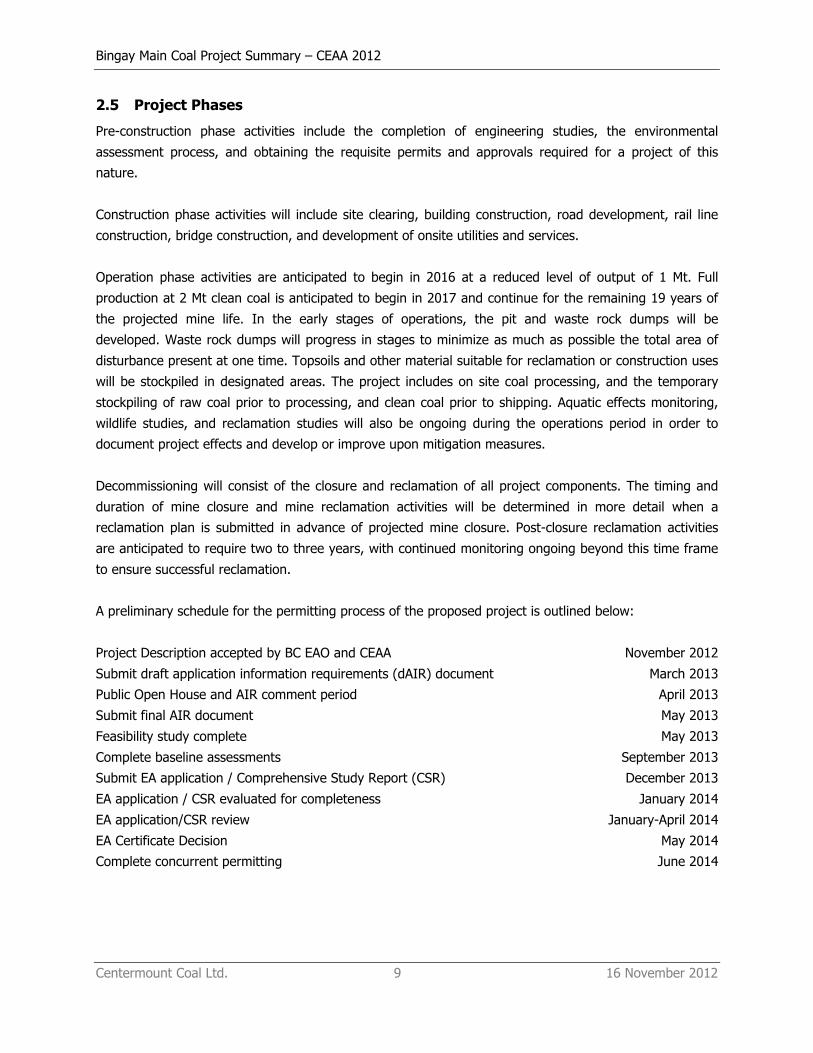
2.5 Project Phases
Pre-construction phase activities include the completion of engineering studies, the environmental
assessment process, and obtaining the requisite permits and approvals required for a project of this
nature.
Construction phase activities will include site clearing, building construction, road development, rail line
construction, bridge construction, and development of onsite utilities and services.
Operation phase activities are anticipated to begin in 2016 at a reduced level of output of 1 Mt. Full
production at 2 Mt clean coal is anticipated to begin in 2017 and continue for the remaining 19 years of
the projected mine life. In the early stages of operations, the pit and waste rock dumps will be
developed. Waste rock dumps will progress in stages to minimize as much as possible the total area of
disturbance present at one time. Topsoils and other material suitable for reclamation or construction uses
will be stockpiled in designated areas. The project includes on site coal processing, and the temporary
stockpiling of raw coal prior to processing, and clean coal prior to shipping. Aquatic effects monitoring,
wildlife studies, and reclamation studies will also be ongoing during the operations period in order to
document project effects and develop or improve upon mitigation measures.
Decommissioning will consist of the closure and reclamation of all project components. The timing and
duration of mine closure and mine reclamation activities will be determined in more detail when a
reclamation plan is submitted in advance of projected mine closure. Post-closure reclamation activities
are anticipated to require two to three years, with continued monitoring ongoing beyond this time frame
to ensure successful reclamation.
A preliminary schedule for the permitting process of the proposed project is outlined below:
Project Description accepted by BC EAO and CEAA November 2012
Submit draft application information requirements (dAIR) document March 2013
Public Open House and AIR comment period April 2013
Submit final AIR document May 2013
Feasibility study complete May 2013
Complete baseline assessments September 2013
Submit EA application / Comprehensive Study Report (CSR) December 2013
EA application / CSR evaluated for completeness January 2014
EA application/CSR review January-April 2014
EA Certificate Decision May 2014
Complete concurrent permitting June 2014
Bingay Main Coal Project Summary – CEAA 2012
Centermount Coal Ltd. 10 16 November 2012
3 PROJECT LOCATION
3.1 General
The Bingay Main property is situated in the Elk River valley in south-eastern British Columbia, Canada,
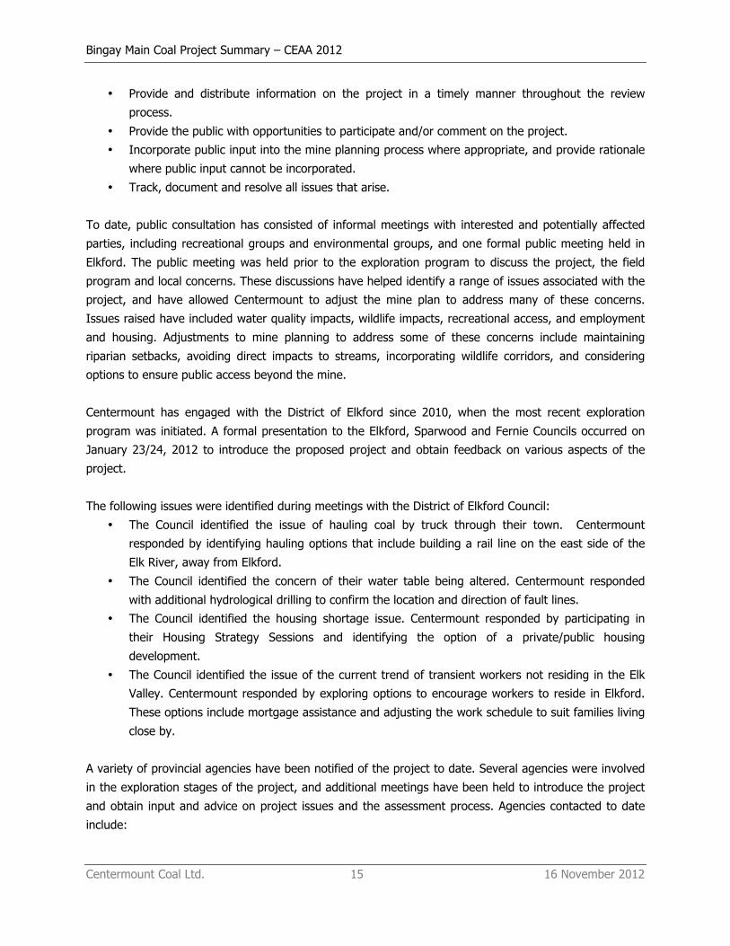
approximately 21 km north of the community of Elkford, and comprises four coal licences totalling 1,157
ha (Figure 1, Table 3). The licences are located within the area designated as a coal Enhanced Resource
Development Zone as defined in the Kootenay/Boundary Land Use Plan (KIAMC 1997) and Southern
Rocky Mountain Land Use Plan (MRSM 2003) (Figure 2). The project includes the proposed coal mine and
related appurtenances, and a 27 km rail line connecting the project to an existing CP rail line near Teck
Coal’s Greenhills operation. The coordinates for the center of the mine pit are approximately latitude
50°12'03” N and longitude 114°58'49” W. The coordinates for the start and end of the rail line are
approximately latitude 50°12'34” N and longitude 114°57'40” W and latitude 50°01'09” N and longitude
114°50'04” W respectively. Components of the project may also be located on land immediately to the
south of Bingay Main. The major shareholder of Centermount, Centerpoint Resources, currently holds the
coal licence for this property (Bingay B) (Table 4).
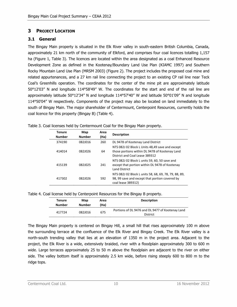
Table 3. Coal licenses held by Centermount Coal for the Bingay Main property.
Tenure Number
Map Number
Area (Ha)
Description
374190 082J016 260 DL 9478 of Kootenay Land District
414014 082J026 64 NTS 082J 02 Block L Units 48,49 save and except those portions within DL 9478 of Kootenay Land District and Coal Lease 389312
415139 082J025 241 NTS 082J 02 Block L units 59, 60, 50 save and except that portion within DL 9478 of Kootenay Land District
417302 082J026 592 NTS 082J 02 Block L units 58, 68, 69, 78, 79, 88, 89, 98, 99 save and except that portion covered by coal lease 389312)
Table 4. Coal license held by Centerpoint Resources for the Bingay B property.
Tenure Number
Map Number
Area (Ha)
Description
417724 082J016 675 Portions of DL 9476 and DL 9477 of Kootenay Land
District
The Bingay Main property is centered on Bingay Hill, a small hill that rises approximately 100 m above
the surrounding terrace at the confluence of the Elk River and Bingay Creek. The Elk River valley is a
north-south trending valley that lies at an elevation of 1350 m in the project area. Adjacent to the
project, the Elk River is a wide, extensively braided, river with a floodplain approximately 300 to 600 m
wide. Large terraces approximately 25 to 50 m above the floodplain are adjacent to the river on either
side. The valley bottom itself is approximately 2.5 km wide, before rising steeply 600 to 800 m to the
ridge tops.
Bingay Main Coal Project Summary – CEAA 2012
Centermount Coal Ltd. 11 16 November 2012
3.2 Land and Water Use
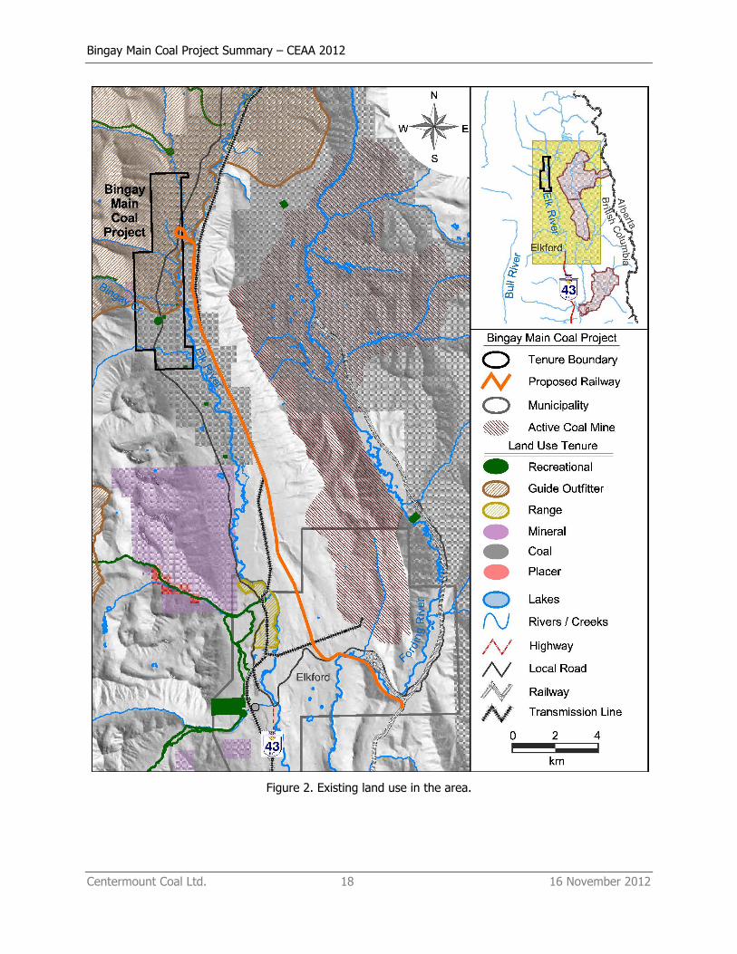
The project components are all located on provincial Crown land. The majority of the mine components,
including the pit, waste rock storage areas, coal processing plant, sedimentation ponds, water treatment
facilities, rail load out, and mine administration and maintenance buildings will be located on the west
side of the Elk River (Figure 3). The rail line will be located on the east side of the Elk River. Both sides of
the valley are readily accessible from existing forest service roads (Figure 3). The Elk River FSR is located
on the west side of the Elk River, while the Kananaskis Power Line FSR is located on the east side. A 138
kV transmission line is located on the east side of the valley and can be used to service the mine.
Elkford is the nearest permanent community to the mine site. A seasonal cabin is located at the
confluence of Bingay Creek and the Elk River adjacent to the mine site. Recreational use in the valley is
high, and several camping sites are located between the project and Elkford (Figure 2).
The project lies within the traditional territory of the Ktunaxa. The First Nations communities nearest to
the project are the St Mary’s Band near Cranbrook, 80 km to the southwest, and the Tobacco Plains Band
on the east side of the Koocanusa Reservoir, 140 km to the south.
The nearest federal lands are Banff National Park, located approximately 80 km north of the project, and
the Dominion Coal Block, located 60 km to the south near Sparwood.
4 FEDERAL INVOLVEMENT
4.1 Financial Support
Federal authorities will not be providing financial support to the proposed project.
4.2 Federal Lands
The project will not require the use of federal land. The nearest federal lands are Banff National Park,
located ~ 80 km to the north, and the Dominion Coal Block, located 60 km to the south near Sparwood.
4.3 Federal Permits and Regulatory Requirements
An environmental assessment for the project pursuant to the Canadian Environmental Assessment Act (2012) will be required. Federal approvals expected to be required include authorizations under the
Fisheries Act, a licence under the Explosives Act and approval under Navigable Waters Protection Act (Table 2).
5 PROJECT EFFECTS
5.1 Physical and Biological Setting
The project is located in the Elk River valley, a north-south trending valley that lies at an elevation of
1350 m in the project area. The valley bottom is approximately 2.5 km wide, before rising steeply 600 to

Bingay Main Coal Project Summary – CEAA 2012
Centermount Coal Ltd. 12 16 November 2012
800 m to the ridge tops. Adjacent to the project, the Elk River is a wide, extensively braided, river with a
floodplain approximately 300 to 600 m wide. Large terraces approximately 25 to 50 m above the
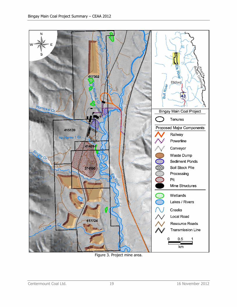
floodplain are adjacent to the river on either side. Several tributaries drain eastwards into the Elk River
across the project area. From south to north these are: Lowe Creek, Bingay Creek, No Name Creek 1,
Hornickel Creek, No Name Creek 2, and Forsyth Creek. In addition to these features, there are several
wetlands in the project area (Figure 4).
Water quality in these streams is generally good, reflecting the undeveloped nature of their watersheds.
The proposed mine has the potential to alter water quality through increased sedimentation and the
introduction of additional contaminants of concern (i.e., selenium, nutrients). Surface water treatment is
proposed for runoff from the mine site to mitigate most of the potential for water quality impacts. Mine
site drainage and diversion ditches may also alter hydrology in several of the streams, although these
effects are expected to be small as the area disturbed is typically a small fraction of the total watershed.
The project is not expected to directly affect fish habitat, except where stream crossings are required.
Fish species present include bull trout (Salvelinus confluentus), Westslope cutthroat trout (Oncorhynchus clarki lewisi), mountain whitefish (Prosopium williamsoni), Eastern brook trout (S. fontinalis) and
longnose dace (Rhinichthys cataractae).
Most of the property and surrounding areas, outside of the Elk River floodplain, have been logged and
are currently in various stages of regrowth. Dense stands of lodgepole pine (Pinus contorta) dominate the
forest cover in these areas. Mature forests are mainly associated with riparian areas along the Elk River,
Bingay Creek and other streams in the vicinity. Two biogeoclimatic units are present on the property:
montane spruce, Kootenay dry cool variant (MSdk2) and Engelmann spruce – subalpine fir dry cool
variant (ESSFdk2). The majority of the property lies within the MSdk2 zone, which extends from the river
bottom up to an elevation of ~ 1600 m along the mountain slopes to the west. The ESSFdk2 zone is
limited to the higher elevations on the western edge of the property, and will not be directly affected by
the project.
A variety of wildlife species are present in the area. The Elk River valley is an important wildlife corridor.
Moose (Alces alces), grizzly bear (Ursus arctohorribilis), black bear (Ursus americanus), deer
(Odocoileus spp.), elk (Cervus canadensis), and grey wolf (Canus lupus) have all been observed in the
area, with the highest use associated with the Elk River floodplain. The area also supports a wide range
of bird, amphibian and invertebrate species. Species at risk identified in the vicinity of the project include
badger (Taxidea taxus jeffersonii), olive sided flycatcher (Contopus cooperi), western toad (Anaxyrus boreas) and Westslope cutthroat trout.
The project will result in the permanent and/or temporary loss of terrestrial habitat during construction of
the mine pit and associated infrastructure. The majority of this loss is expected to occur in younger, seral
stage, lodgepole forest, although some mature forest may also be impacted but to a much lower extent.
Bingay Main Coal Project Summary – CEAA 2012
Centermount Coal Ltd. 13 16 November 2012
Effects of the project on wildlife include:
• Habitat loss due to the construction of the mine pit and associated infrastructure.
• Disturbance to migration movements due to mine location (noise, presence of humans, etc).
• Increased mortality due to greater rail/vehicle use.
• Increased mortality due to construction (blasting, excavation of undisturbed terrain).
• Risk to wildlife from changes in water quality, contaminant loading from dust.
5.2 Effects on Federally Legislated Species
5.2.1 Fish and Fish Habitat
The primary effects of the project on fish are anticipated to arise from the disturbance of habitat due to
stream crossings, and to changes in water quality due to the increased area of disturbance (sediment)
and the potential for leaching of trace metals (e.g. selenium) and nutrients from the waste rock. With the
exception of stream crossings, the project is not expected to result in the direct loss of fish habitat.
5.2.2 Aquatic Species at Risk
Westslope cutthroat trout is the only aquatic species identified in the Species at Risk Act that occurs
within the project area and that could potentially be affected by the project. Potential effects to
Westslope cutthroat trout include changes in habitat (primarily due to stream crossings) and changes in
water quality.
5.2.3 Migratory Birds
Migratory birds are defined in Article I of the Migratory Birds Convention Act, and include migratory game
birds, migratory insectivorous birds, and other migratory game birds. A variety of bird species that are
considered migratory have been observed in the area. Potential effects to these species include habitat
disturbance as a result of the clearing of land to accommodate project infrastructure, and changes in
uptake of various chemicals (e.g. selenium) that may result from altered water quality.
5.3 Effects on Federal Land, other Provinces, or outside of Canada
No changes to the environment as a result of the project are expected to occur on federal land or to
provinces outside of British Columbia. As the project has the potential to increase selenium, specifically,
and other contaminants of concern in the Elk River, the State of Montana is expected to have an interest
in water quality aspects of the project. The Elk River flows into Lake Koocanusa, which is partially located
in Montana, and the State of Montana is actively involved in the EA process for other proposed coal
projects in the region.
5.4 Effects on Aboriginal Peoples
The project is located within the traditional territory of the Ktunaxa Nation. The Ktunaxa are known to
hunt, fish, trap, harvest plants and carry out cultural practices within their traditional territory. There may
be adverse effects to these activities as a result of land disturbance and environmental effects associated
Bingay Main Coal Project Summary – CEAA 2012
Centermount Coal Ltd. 14 16 November 2012
with mine development. The Shuswap Indian Band, which is part of the Secwepemc Nation, has also
expressed interest in the project area.
In addition to effects on traditional land and resource use, the project could result in effects to aboriginal
socio-economic conditions, health, and heritage and archaeological resources. Specific effects of the
project on aboriginal peoples and ways of preventing or reducing those effects will be identified during
the environmental assessment process.
6 PROPONENT ENGAGEMENT AND CONSULTATION WITH ABORIGINAL PEOPLES
The two closest First Nations communities to the project site are the St. Mary’s Indian Band, and the
Tobacco Plains Band, both of which are part of the Ktunaxa Nation. The St. Mary’s Indian Band is located
on Kootenay Indian Reserve #1, at the confluence of the Kootenay River and St. Mary’s River, near the
City of Cranbrook, approximately 85 km southwest of project area. The Tobacco Plains Band is located
adjacent to the US border along the East side of Lake Koocanusa, approximately 140 km south of the
project. Centermount first informed the Ktunaxa Nation of the proposed project in March of 2010. Three
subsequent meetings have taken place with the Ktunaxa Nation in relation to the project. The Ktunaxa
have indicated that waterborne selenium issues and cumulative effects are of particular concern in the Elk
River valley.
In addition to the Ktunaxa Nation, other interests in the project area have been expressed by the
Shuswap Indian Band, which is part of the Secwepemc Nation. Meetings were held with the Shuswap
Indian Band in 2012. No issues were raised during those meetings in relation to potential effects of this
project on their traditional territory. Centermount will seek further meetings with the Shuswap Indian
Band during the environmental assessment process to better understand their interests in the project
area.
During the environmental assessment, Centermount will seek meaningful consultation with the Ktunaxa
Nation and the Shuswap Indian Band and draw on the findings of the environmental assessment studies
to identify ways of preventing or reducing adverse effects to these aboriginal groups. Consultation
activities will meet or exceed the requirements specified by the Environmental Assessment Office and the
Canadian Environmental Assessment Agency.
7 PROPONENT ENGAGEMENT AND CONSULTATION WITH THE PUBLIC AND GOVERNMENT
AGENCIES
Public consultation is an important part of both mine planning and regulatory review. A formal public
consultation and notification procedure will be developed during the review process to meet the
requirements of the provincial and federal environmental assessment processes. This will include the
following:
Bingay Main Coal Project Summary – CEAA 2012
Centermount Coal Ltd. 15 16 November 2012
• Provide and distribute information on the project in a timely manner throughout the review
process.
• Provide the public with opportunities to participate and/or comment on the project.
• Incorporate public input into the mine planning process where appropriate, and provide rationale
where public input cannot be incorporated.
• Track, document and resolve all issues that arise.
To date, public consultation has consisted of informal meetings with interested and potentially affected
parties, including recreational groups and environmental groups, and one formal public meeting held in
Elkford. The public meeting was held prior to the exploration program to discuss the project, the field
program and local concerns. These discussions have helped identify a range of issues associated with the
project, and have allowed Centermount to adjust the mine plan to address many of these concerns.
Issues raised have included water quality impacts, wildlife impacts, recreational access, and employment
and housing. Adjustments to mine planning to address some of these concerns include maintaining
riparian setbacks, avoiding direct impacts to streams, incorporating wildlife corridors, and considering
options to ensure public access beyond the mine.
Centermount has engaged with the District of Elkford since 2010, when the most recent exploration
program was initiated. A formal presentation to the Elkford, Sparwood and Fernie Councils occurred on
January 23/24, 2012 to introduce the proposed project and obtain feedback on various aspects of the
project.
The following issues were identified during meetings with the District of Elkford Council:
• The Council identified the issue of hauling coal by truck through their town. Centermount
responded by identifying hauling options that include building a rail line on the east side of the
Elk River, away from Elkford.
• The Council identified the concern of their water table being altered. Centermount responded
with additional hydrological drilling to confirm the location and direction of fault lines.
• The Council identified the housing shortage issue. Centermount responded by participating in
their Housing Strategy Sessions and identifying the option of a private/public housing
development.
• The Council identified the issue of the current trend of transient workers not residing in the Elk
Valley. Centermount responded by exploring options to encourage workers to reside in Elkford.
These options include mortgage assistance and adjusting the work schedule to suit families living
close by.
A variety of provincial agencies have been notified of the project to date. Several agencies were involved
in the exploration stages of the project, and additional meetings have been held to introduce the project
and obtain input and advice on project issues and the assessment process. Agencies contacted to date
include:

Bingay Main Coal Project Summary – CEAA 2012
Centermount Coal Ltd. 16 16 November 2012
• BC Environmental Assessment Office
• Ministry of Forest, Lands & Natural Resources Operations,
• Ministry of Environment (Environmental Quality, Environmental Management),
• Ministry of Mines and Energy.
Other agencies that will be consulted include:
• Ministry of Transportation and Infrastructure,
• Ministry of Agriculture and Lands,
• Ministry of Jobs, Tourism and Innovation.
The Canadian Environmental Assessment Agency corresponded via email and phone calls to provide
direction on the requirements of the Project Description. Other federal agencies that will be involved in
the assessment process include:
• Department of Fisheries and Oceans (DFO),
• Natural ResourcesCanada (NRC),
• Environment Canada,
• Transport Canada.
Once the project description has been formally accepted by the federal government, Centermount will
use the project description to begin formal discussions with the stakeholders regarding the project.

Bingay Main Coal Project Summary – CEAA 2012
Centermount Coal Ltd. 17 16 November 2012
Figure 1. Project location map.
Bingay Main Coal Project Summary – CEAA 2012
Centermount Coal Ltd. 18 16 November 2012
Figure 2. Existing land use in the area.
Bingay Main Coal Project Summary – CEAA 2012
Centermount Coal Ltd. 19 16 November 2012
Figure 3. Project mine area.
Bingay Main Coal Project Summary – CEAA 2012
Centermount Coal Ltd. 20 16 November 2012
Figure 4. Managed ecosystems in the region.
Bingay Main Coal Project Summary – CEAA 2012
Centermount Coal Ltd. 21 16 November 2012
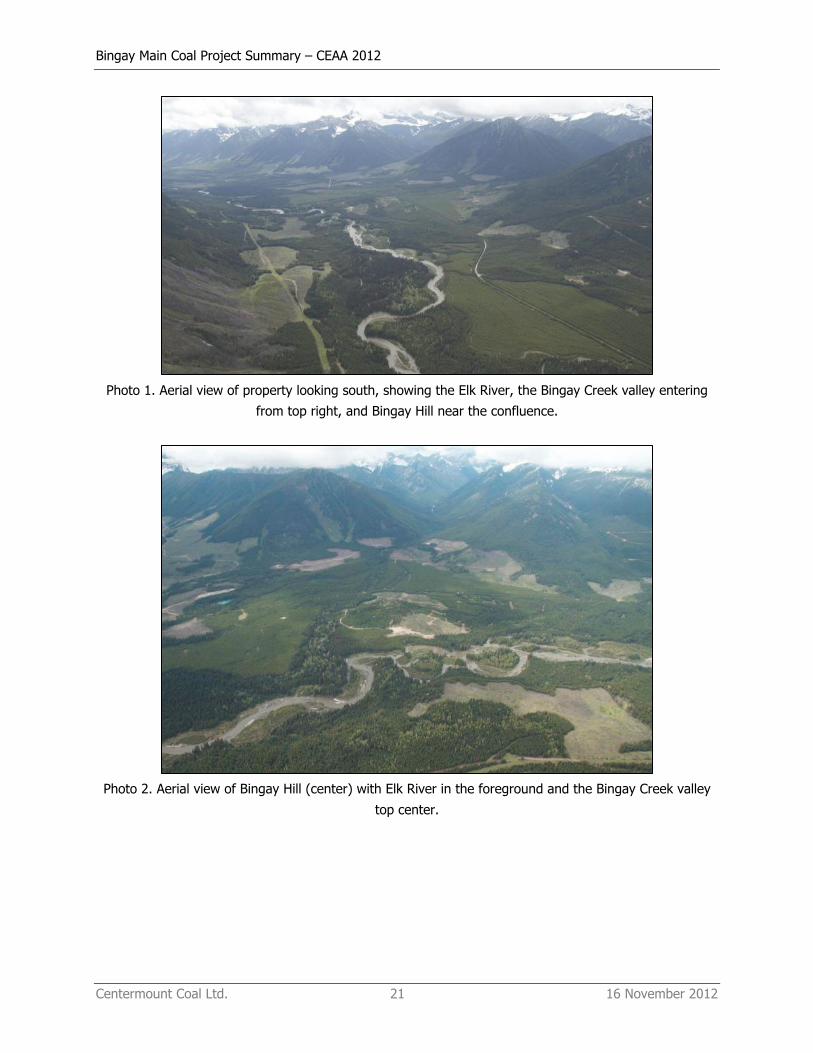
Photo 1. Aerial view of property looking south, showing the Elk River, the Bingay Creek valley entering
from top right, and Bingay Hill near the confluence.
Photo 2. Aerial view of Bingay Hill (center) with Elk River in the foreground and the Bingay Creek valley
top center.
Bingay Main Coal Project Summary – CEAA 2012
Centermount Coal Ltd. 22 16 November 2012
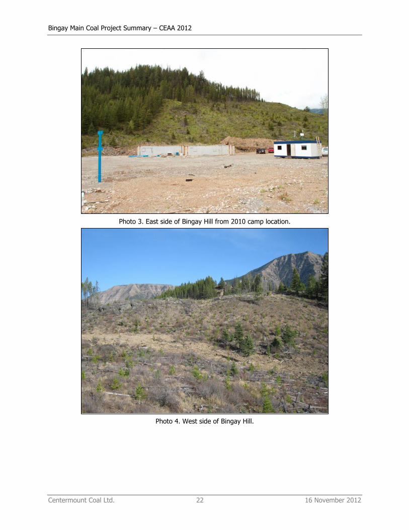
Photo 3. East side of Bingay Hill from 2010 camp location.
Photo 4. West side of Bingay Hill.
Bingay Main Coal Project Summary – CEAA 2012
Centermount Coal Ltd. 23 16 November 2012
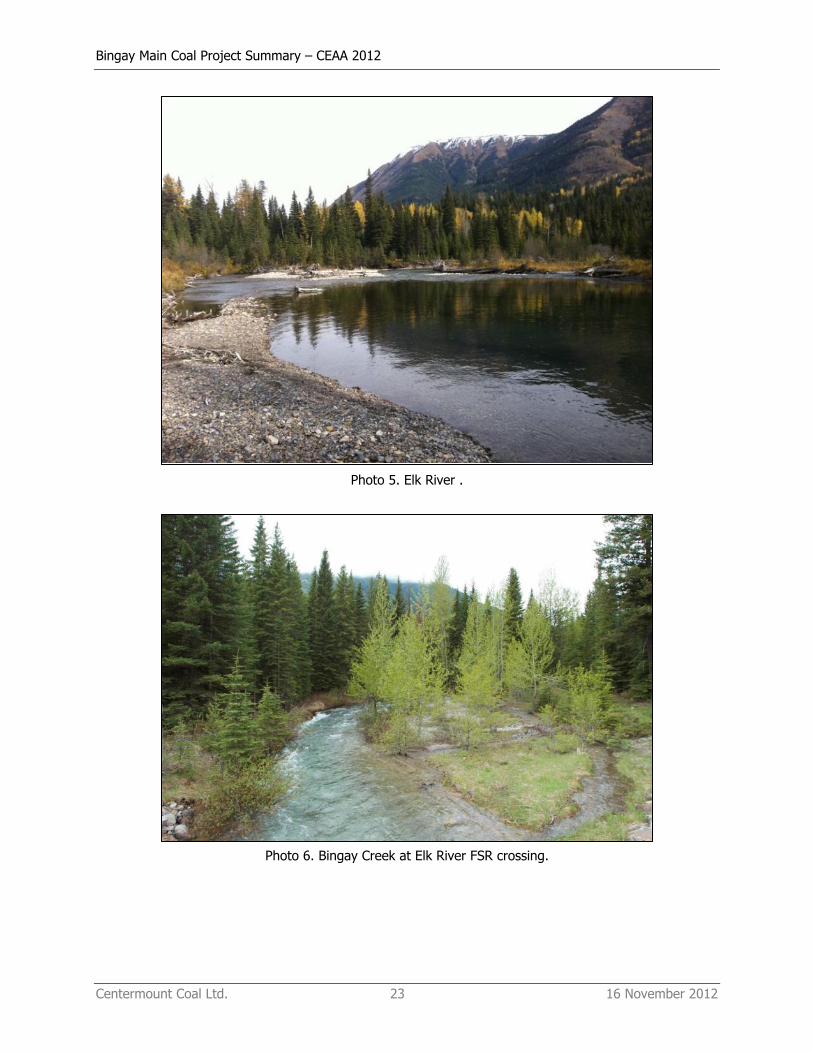
Photo 5. Elk River .
Photo 6. Bingay Creek at Elk River FSR crossing.
Bingay Main Coal Project Summary – CEAA 2012
Centermount Coal Ltd. 24 16 November 2012
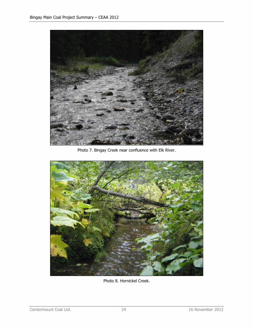
Photo 7. Bingay Creek near confluence with Elk River.
Photo 8. Hornickel Creek.

Bingay Main Coal Project Summary – CEAA 2012
Centermount Coal Ltd. 25 16 November 2012
Photo 9. No Name Creek 1.
Related Documents