1 Center for Strategic Planning and Policy Studies (formerly Center for Policy and Development Studies) College of Public Affairs and Development University of the Philippines Los Baños, College, 4031 Laguna, Philippines Telephone: (049) 536-3455 Telefax: (049) 536-3637 Homepage: https://cpaf.uplb.edu.ph/ Working Paper No. 2017-07 INSTITUTIONAL PARTNERSHIPS FOR WATER ALLOCATION DECISIONS IN MULTI-USE WATER SYSTEMS: THE CASE OF LAKE BUHI Dulce D. Elazegui, Agnes C. Rola, Chrislyn Joanna P. Faulmino, Arthur B. Estrella and Cely S. Binoya

Welcome message from author
This document is posted to help you gain knowledge. Please leave a comment to let me know what you think about it! Share it to your friends and learn new things together.
Transcript
1
Center for Strategic Planning and Policy Studies
(formerly Center for Policy and Development Studies)
College of Public Affairs and Development
University of the Philippines Los Baños,
College, 4031 Laguna, Philippines
Telephone: (049) 536-3455
Telefax: (049) 536-3637
Center for Strategic Planning and Policy Studies
(formerly Center for Policy and Development Studies)
College of Public Affairs and Development
University of the Philippines Los Baños,
College, 4031 Laguna, Philippines
Telephone: (049) 536-3455
Telefax: (049) 536-3637
Homepage: https://cpaf.uplb.edu.ph/
Working Paper No. 2017-07
INSTITUTIONAL PARTNERSHIPS FOR WATER ALLOCATION
DECISIONS IN MULTI-USE WATER SYSTEMS:
THE CASE OF LAKE BUHI
Dulce D. Elazegui, Agnes C. Rola, Chrislyn Joanna P. Faulmino,
Arthur B. Estrella and Cely S. Binoya
2
The CSPPS Working Paper series reports the results of studies by the Center
researchers and CPAf faculty, staff and students, which have not been reviewed. These
are circulated for the purpose of soliciting comments and suggestions.
The views expressed in the paper are those of the authors and do not necessarily
reflect those of CSPPS, the agency with which the authors are affiliated, and the funding
agencies, if applicable.
This publication is an output of the project entitled “Water Security under Climate
Risks: A Philippine Climate Change Adaptation Strategy for the Agriculture Sector” of
the University of the Philippines Los Banos Foundation, Inc. (UPLBFI). The project is
made possible by the generous support of the American People through the United States
Agency for International Development (USAID). The contents of this publication are the
responsibility of the authors and do not necessarily reflect the views of USAID or the
United States Government.
Please send your comments to:
The Director Center for Strategic Planning & Policy Studies (formerly CPDS)
College of Public Affairs and Development
University of the Philippines Los Baños
College, Laguna 4031
Philippines
Email: [email protected]
3
ABSTRACT
Sustaining a water resource base which provides multiple services requires
institutional innovation, particularly with the challenges posed by changing climate. The
Buhi-Barit watershed where Lake Buhi is located manifests characteristics of marginal
watershed areas in developing countries that are highly vulnerable to water stress due to
both climate risks and human activities. Based on information generated from key
informant interviews (KIIs) of stakeholder agencies, roundtable discussions, and
workshops, this chapter discusses the policy and institutional setting governing the
various uses of water in Lake Buhi. It examines the actors, processes, interests and
interaction dynamic and presents how stakeholders improved coordination among
institutions to adapt to climate-related risks in the context of competing uses of water.
Allocation of water ideally depends on the water level of the lake which from month to
month is affected by many inter-related factors. However, management of the lake has
become a compromise between irrigation, hydro-electric power generation, the fishery
sectors, and conservation/sustainability goals. As a response to this challenge,
stakeholders agreed on the need to create an independent body in the form of a watershed
management council to manage the lake and the watershed resources. For institutional
innovation such as the watershed management council, institutional arrangements and
coordination among government agencies is a big challenge. Because of the multiple uses
of Lake Buhi and policy-related issues affecting the relationship of users within the Buhi-
Barit watershed, a regular forum among the stakeholders could improve synergy among
members.
Keywords: institutional innovation, watershed management council, policy and
institutional setting
4
TABLE OF CONTENTS
Page
I. The Multiple Uses of Lake Buhi 1
II. Lake Buhi and Surrounding Watershed 1
III. Water Use and Allocation Issues 4
IV. Policy and Institutional Setting in the Watershed 5
V. Towards an Integrated Watershed Management Framework 6
VI. Conclusion and Recommendations 7
VII. References 8
List of Figures
Page
Figure 1. The multiple uses of Lake Buhi waters 2
Figure 2. Lake Buhi and the Buhi-Bait watershed, Camarines Sur, Bicol
Region, Philippines
3
Figure 3. Problem tree analysis for Lake Buhi 4
Figure 4. Buhi-Barit Watershed Institutional Landscape, Camarines Sur, Bicol
Region, Philippines
5
Figure 5. Buhi-Barit Watershed Management Framework drafted with the
assistance of BAWP
7
INSTITUTIONAL PARTNERSHIPS FOR WATER ALLOCATION DECISIONS
IN MULTI-USE WATER SYSTEMS: THE CASE OF LAKE BUHI
Dulce D. Elazegui, Agnes C. Rola, Chrislyn Joanna P. Faulmino,
Arthur B. Estrella and Cely S. Binoya
I. The Multiple Uses of Lake Buhi
Sustaining a water resource base which provides multiple services requires
institutional innovation, particularly with the challenges posed by changing climate. The
case of Lake Buhi within the Buhi-Barit sub-watershed, part of the Bicol River Basin in
the southern Luzon portion of the Philippines illustrates this perspective. The Buhi-Barit
sub-watershed manifests characteristics of marginal watershed areas in developing
countries that are highly vulnerable to water stress due to both climate risks and human
activities. The basin has experienced extensive flooding due to tropical cyclones, storm
surges, and accelerated sedimentation. Agriculture, being highly dependent on water, has
been one of the most affected sectors in the region.
This chapter discusses the policy and institutional setting governing the various
uses of water in Lake Buhi. It examines the actors, processes, interests and interaction
dynamics. It presents how stakeholders improved coordination among institutions to
adapt to climate-related risks in the context of competing uses of water.
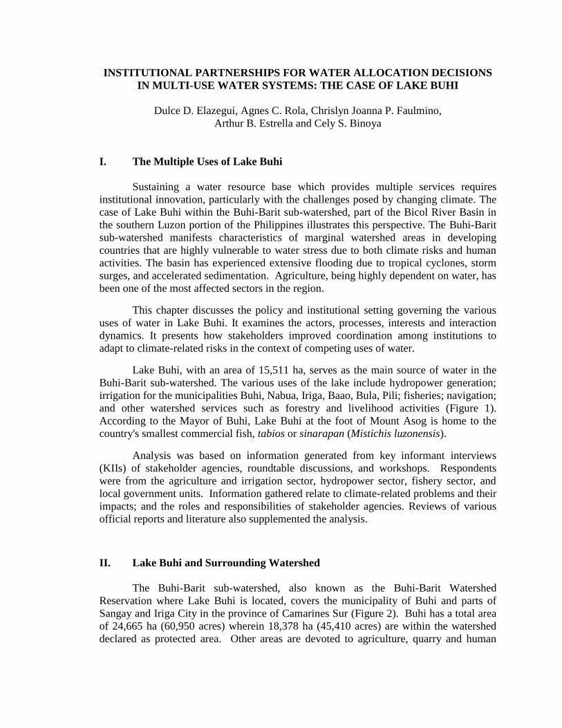
Lake Buhi, with an area of 15,511 ha, serves as the main source of water in the
Buhi-Barit sub-watershed. The various uses of the lake include hydropower generation;
irrigation for the municipalities Buhi, Nabua, Iriga, Baao, Bula, Pili; fisheries; navigation;
and other watershed services such as forestry and livelihood activities (Figure 1).
According to the Mayor of Buhi, Lake Buhi at the foot of Mount Asog is home to the
country's smallest commercial fish, tabios or sinarapan (Mistichis luzonensis).
Analysis was based on information generated from key informant interviews
(KIIs) of stakeholder agencies, roundtable discussions, and workshops. Respondents
were from the agriculture and irrigation sector, hydropower sector, fishery sector, and
local government units. Information gathered relate to climate-related problems and their
impacts; and the roles and responsibilities of stakeholder agencies. Reviews of various
official reports and literature also supplemented the analysis.
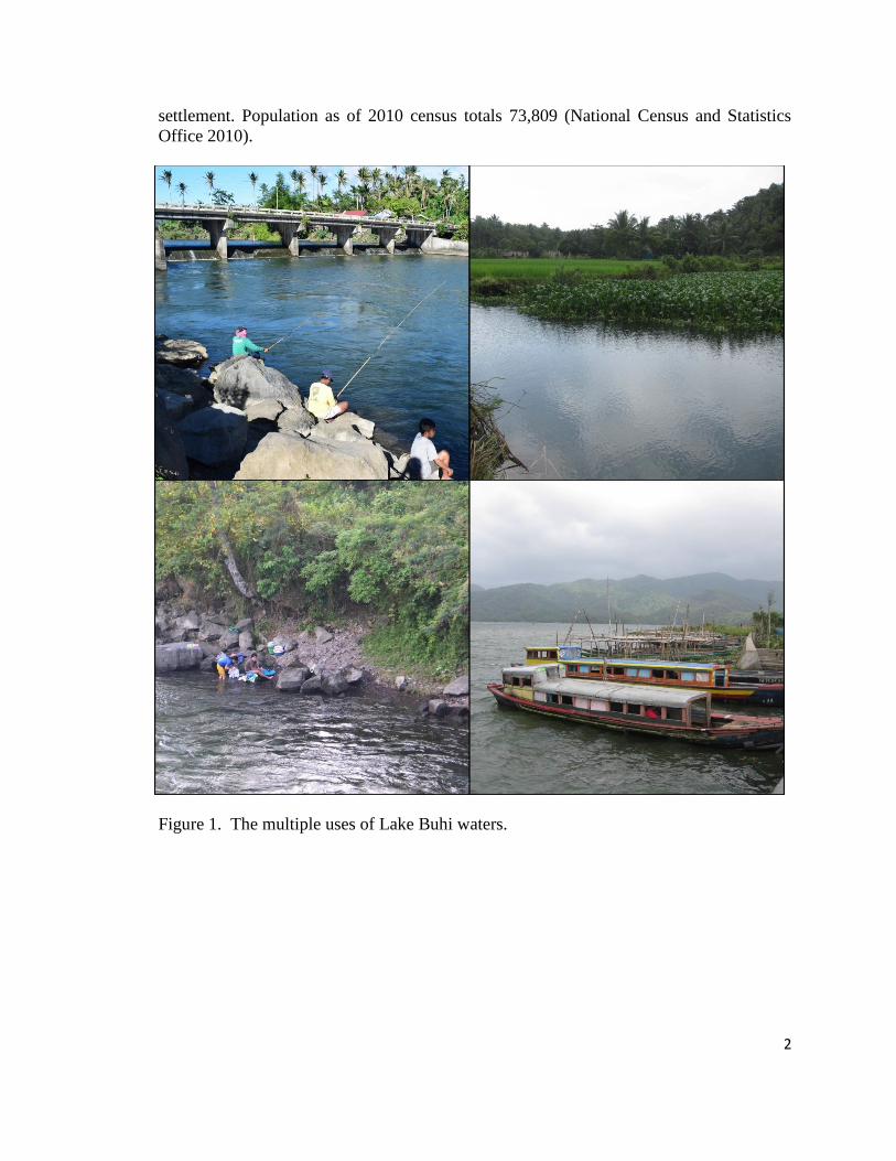
II. Lake Buhi and Surrounding Watershed
The Buhi-Barit sub-watershed, also known as the Buhi-Barit Watershed
Reservation where Lake Buhi is located, covers the municipality of Buhi and parts of
Sangay and Iriga City in the province of Camarines Sur (Figure 2). Buhi has a total area
of 24,665 ha (60,950 acres) wherein 18,378 ha (45,410 acres) are within the watershed
declared as protected area. Other areas are devoted to agriculture, quarry and human
2
settlement. Population as of 2010 census totals 73,809 (National Census and Statistics
Office 2010).
Figure 1. The multiple uses of Lake Buhi waters.
3
Figure 2. Lake Buhi and the Buhi-Barit watershed, Camarines Sur, Bicol Region,
Philippines Sources: Map of Buhi: http://buhi-sinarapan.blogspot.com/p/community-profile.html
The major climate hazards that have affected the area are dry spell and tropical
cyclone/floods which stress water resources. The recurrent tropical cyclones or
typhoons/floods, heavy or continuous rain had affected agricultural production and
incomes. Based on reports obtained from the Camarines Sur provincial agricultural
office, rice crop exposure to typhoon with 70-100 kph wind speed for 12 hours or less
could reduce yield by 10-25% depending on growth stage. Complete submergence of rice
lands in one to two days during the flowering/maturity stage could cause 15-30%
damage. Flooding for seven days during panicle initiation/booting stage with farm
completely submerged could cause up to 100% crop damage. Flooding and sedimentation
also can clog irrigation canals, affecting irrigation water intakes.
Deforestation and poor agricultural practices in the catchment area have
contributed to the sedimentation of the lake. Water hyacinth and algae and organic
materials from aquaculture operation also have reduced storage capacity of the lake.
Weather changes were also reported to have resulted in massive fish kill in the
lake. For instance, in September 1998, a long drought and week-long downpour,
accompanied by strong southwest monsoon winds triggered upwelling of decomposing
organic matter deposited in the lake. Soil erosion from adjacent agricultural land and
denuded areas destroy feeding and spawning grounds of fishes as well.
4
III. Water Use and Allocation Issues
BAWP conducted a number of meetings, key informant interviews, workshops,
trainings (on flood and drought management planning; policy analysis), and roundtable
discussions (RTDs) at the municipal (i.e., Buhi) and watershed levels (Buhi-Barit) to
identify the water-related problems to be addressed and the corresponding solutions or
actions; and how to come up with more scientific and better institutional arrangements
for improved irrigation water management.
Allocation of water ideally depends on the water level of the lake which from
month to month is affected by many inter-related factors. This includes rainfall,
streamflow, inflow and outflow, erosion and siltation attributed not only to weather
conditions but also to watershed conditions. However, over the years, management of the
lake (and other lakes in the watershed) has become a compromise between irrigation,
hydro-electric power generation, the fishery sectors, and conservation/sustainability
goals. Decisions on water allocation to irrigation and power sectors and use of the lake
for fisheries become more crucial in times of water shortage due to dry spell or drought.
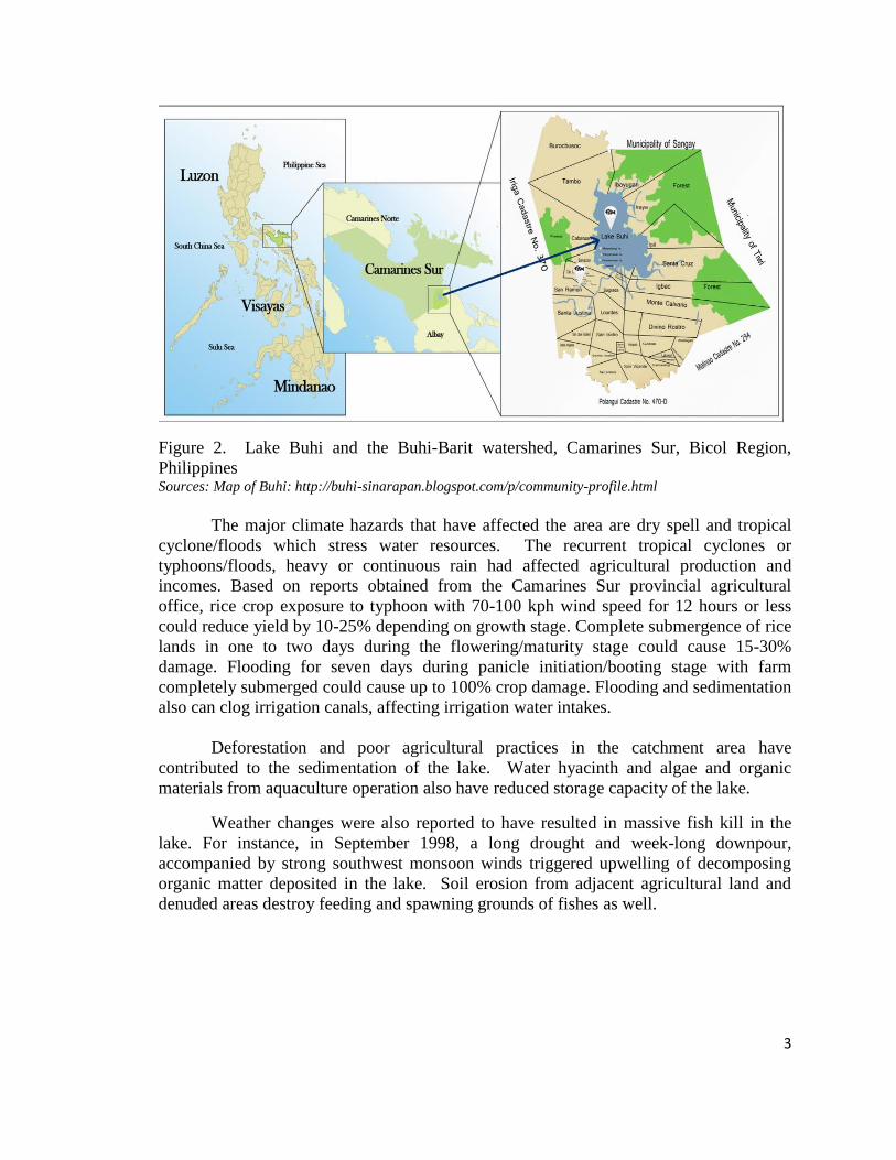
The stakeholders of Lake Buhi cited problems of unregulated water inflow due to
seasonality of lake level; and lake sedimentation due to both water-and land-based
activities. The stakeholders agreed that these issues boil down to the overuse of Lake
Buhi (Figure 3). They emphasized that bureaucracy indeed complicates the problem
concerning the multiple uses of the lake. This is attributed not only to irrigation
management but also to the management of the watershed. Solutions to deal with this go
beyond the water user agencies and require a wider institutional coordination. This
suggests that the problems concerning the lake have to be addressed from a watershed
perspective.
Figure 3. Problem tree analysis for Lake Buhi Source: BAWP Round Table Discussion on Buhi-Barit Watershed, 2 August 2013, Buhi, Camarines Sur
5
Although the National Power Corporation – Buhi-Barit Watershed Area Team
(NPC-BBWAT) has jurisdiction over the watershed and Lake Buhi, its capacity to
manage is inadequate. It admits that it cannot singly perform the various watershed
management functions due to its limited human resources. Its activities are limited to
rehabilitation (tree planting, structural) and protection of watershed (e.g., granting
clearance for selective tree cutting, small quarrying, and resort operations). An NPC-
BBWAT official even lamented the office is not involved in land use planning. The
stakeholders also agreed on the need for the creation of an independent body to manage
the lake and the watershed, (i.e., watershed management council).
There was also a consensus that the risks posed by seasonal variability and
changing climate may also necessitate an improved decision support system, i.e., a
science-based approach to arriving at decisions in allocating water to different users.
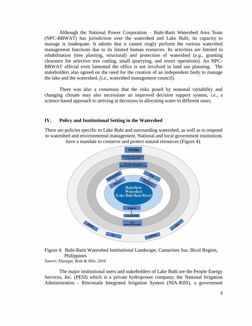
IV. Policy and Institutional Setting in the Watershed
There are policies specific to Lake Buhi and surrounding watershed, as well as to respond
to watershed and environmental management. National and local government institutions
have a mandate to conserve and protect natural resources (Figure 4).
Figure 4. Buhi-Barit Watershed Institutional Landscape, Camarines Sur, Bicol Region,
Philippines Source: Elazegui, Rola & Allis, 2016
The major institutional users and stakeholders of Lake Buhi are the People Energy
Services, Inc. (PESI) which is a private hydropower company; the National Irrigation
Administration - Rinconada Integrated Irrigation System (NIA-RIIS), a government
6
irrigation agency serving five municipalities in the province of Camarines Sur; and the
local government units (LGU) of Buhi and other municipalities in the watershed. PESI
hydropower plant used to be the Lake Buhi-Barit hydroelectric plant that started
operation in 1957 under NPC management. By the provision on privatization of the
Electric Power Industry Reform Act (EPIRA) of 2004 (RA No. 9136), the hydropower
plant was turned over to PESI in January 2005. PESI only performs power generation,
with electric cooperatives off takers (buyers).
EO No. 224 of 1987 vested NPC the powers on management, protection,
development and rehabilitation of watershed areas. These encompass jurisdiction,
control and regulation including granting of permits as well as enforcing and
administering forestry laws. NPC, having established priority rights over the use of Lake
Buhi, allowed Rinconada Integrated Irrigation Systems (RIIS) to utilize water for
irrigation. It has three river irrigation systems covering 5,000 ha. NIA and NPC forged a
Memorandum of Agreement in 1989 governing the operation of the Lake Buhi irrigation
control structure.
In compliance with the Water Code, NIA (issued in 1979) and PESI (1980) have a
water permit and therefore, the right to extract water from Lake Buhi. Meanwhile, the
Fisheries Code provides that the local government unit may use 10% of the lake surface
area for aquaculture activities like fish pens, fish cages and fish traps. The Local
Government Code of 1991 also mandates LGUs in enforcing rules and regulations
relating to agriculture and fisheries. The Sangguniang Bayan (municipal council) of Buhi
created the Lake Buhi Development Office for the management of Lake Buhi. The LGU
monitors the water level, temperature, and water quality of the lake on a daily basis but
DENR-EMB (which conducts water quality monitoring quarterly) validates the LGU
data. In 2015, Lake Buhi was declared a Water Quality Management Area (WAQMA).
Based on the Philippine Clean Water Act, DENR, through the Environmental
Management Bureau (EMB), acts as the lead agency in the implementation of WAQMA
in coordination with the LGU.
V. Towards an Integrated Watershed Management Framework
Based on the BAWP experience, technical assistance (e.g. capacity building) is
crucial in initiating efforts towards solutions to problems and issues identified by the
stakeholders themselves. Pinpointing the need for a creation of a management council,
trainings and workshops provided learning opportunities for the stakeholders.
For creating an enabling policy environment for integrated water management
(Figure 5), training on policy analysis improved knowledge of stakeholders and
policymakers in reviewing policies related to performance of watershed-related functions.
Participatory policy analysis also helped in examining and addressing conflicts or
inconsistencies in policies towards an enabling policy environment for the Council. The
participatory consultation showed that coordination among agencies is more crucial than
inconsistency or conflict in policies. The initiative of the local government executive
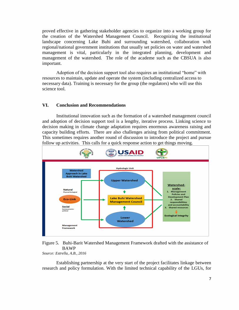
7
proved effective in gathering stakeholder agencies to organize into a working group for
the creation of the Watershed Management Council. Recognizing the institutional
landscape concerning Lake Buhi and surrounding watershed, collaboration with
regional/national government institutions that usually set policies on water and watershed
management is vital, particularly in the integrated planning, development and
management of the watershed. The role of the academe such as the CBSUA is also
important.
Adoption of the decision support tool also requires an institutional “home” with
resources to maintain, update and operate the system (including centralized access to
necessary data). Training is necessary for the group (the regulators) who will use this
science tool.
VI. Conclusion and Recommendations
Institutional innovation such as the formation of a watershed management council
and adoption of decision support tool is a lengthy, iterative process. Linking science to
decision making in climate change adaptation requires enormous awareness raising and
capacity building efforts. There are also challenges arising from political commitment.
This sometimes requires another round of discussion to introduce the project and pursue
follow up activities. This calls for a quick response action to get things moving.
Figure 5. Buhi-Barit Watershed Management Framework drafted with the assistance of
BAWP Source: Estrella, A.B., 2016
Establishing partnership at the very start of the project facilitates linkage between
research and policy formulation. With the limited technical capability of the LGUs, for
8
example, the academe (SUCs) should be tapped to sustain the innovation introduced by
the project, (e.g. the adoption of decision support tools).
In state universities and agricultural colleges across the country, creation of water
resource centers would be useful in water data generation and management to support
national level policy formulation, for instance by the NIA, NWRB and other water-
related agencies. A proposal on the establishment of a Water Resource Center for major
SUCs in the country has been submitted to the Commission on Higher Education (David
et al., 2014). This initiative can be followed up.
The adoption of decision support tools entails use of substantial information that
should be fairly acceptable to all stakeholders. For instance, with the lake water level as
yardstick in allocating water, informed decisions such as on the setting of rule curves,
will need climate information (e.g. rainfall data and streamflow). This also suggests
establishment of facilities and equipment such as rain gauges, flood warning device, and
communication facilities.
For institutional innovation such as the watershed management council,
institutional arrangements and coordination among government agencies is a big
challenge. Because of the multiple uses of Lake Buhi and policy-related issues affecting
the relationship of users within the Buhi-Barit watershed, a regular forum among the
stakeholders could improve synergy among members.
VII. References
Baroang, Kye. 2013. Proposed tools for linking climate with integrated water resources
management, Technical Workshop on Water Security Under Climate Risks: A
Philippine Climate Change Adaptation Strategy for the Agriculture Sector(Bicol
Agri-Water Project), 4-6 April 2013,Villa Caceres Hotel, Naga City, Camarines
Sur
David, Cristina C., Guillermo Q. Tabios III, Agnes C. Rola and Roger A.Luyun, Jr.2014.
Proposal For The Establishment Of The University Of The Philippines Los Baños
Water Resources Center, Submitted To The Commission On Higher
Education,Dec. 2014. Diliman,Quezon City.
Estrella, Arthur B. 2016. Lake Buhi-Barit Watershed Management Council:
Management Framework.
Final Report toTWG on the Creation of a Watershed Management Council for Lake
Buhi-Barit Presented in the Roundtable Discussion at the Watershed Level 5th
Technical Working Group Meeting Lake Buhi Resort, Buhi, Camarines Sur
October 6, 2015.
9
Elazegui, Dulce D., Rola, Agnes C. and Allis, Erica. 2016. Enhancing Institutional
Dynamics for Multiple Uses of Water amidst Climate-Related Risks: The Case of
Lake Buhi, Philippines. Lakes and Reservoirs: Research and Management, 21,
224-234. Doi: 10.1111/lre.12141
Elazegui, Dulce D., Rola, Agnes C. and Allis, Erica; Baroang, Kye and Amor Ines. 2014.
Institution, Policy and Decision-making Landscape for Agriculture and Water
Management under Climate Risks in Buhi-Barit and Quinale A Sub-watersheds,
Bicol Region.Paper based on the project entitled ‘Water Security under Climate
Risks: A Philippine Climate Change Adaptation Strategy for the Agriculture
Sector’ implemented by the University of the Philippines Los Baños Foundation,
Inc. (UPLBFI), the International Research Institute for Climate and Society (IRI)
of the Columbia University, the Department of Agriculture Regional Field Office
5, PAGASA 5 and other partners.
Ines, Amor; Han, Eunjin; Allis, Erica; and Baroang, Kye. 2016. WEAP-Bicol,
Powerpoint presentation at the BAWP 4th Technical Workshop on Models and
Tools for Water, Agriculture, and Knowledge Sharing, Feb. 17-19, 2016, Naga
City, Camarines Sur
Related Documents