JOURNAL OF GEOPHYSICAL RESEARCH, VOL. 102, NO. Bll, PAGES 24,669-24,696, NOVEMBER 10, 1997 Cenozoic geodynamics of the Ross Sea region,Antarctica: Crustal extension, intraplate strike-slipfaulting, and tectonic inheritance Francesco Salvini, 1'2 Giuliano Brancolini, 3 Martina Busetti, 3Fabrizio Storti, 4 Francesco Mazzarini, 5 and Franco Coren 3 Abstract. An integrated study of onshore andoffshore geology of theRoss Sea region (namely, Victoria Land, northof Ross Island,andthe Ross Sea,Antarctica) hasrevealed a complex, post-Eocene tectonic framework. Regional NW-SE right-lateral, strike-slip faults are the outstanding feature of thisframework andoverprint an olderMesozoic extensional event, responsible for formation of N-S basins in the Ross Sea.The Cenozoic framework includes kinematic deformation and reactivation along theNW-SE faults, including formation of pull-apart basins, both positive and negative flower structures, andpush-up ridges. N-S extensional faults arewell developed between NW-SE faults andindicate E-W extension during theCenozoic, produced by theNW-SE right-lateral strike-slip motion together with regional crustal extension. NNW-SSE compression, induced by theright- lateral, strike-slip kinematics, is indicated by locallyinverted NE-SW faults andbasins. The evolution, geometry, andlocation of theRennick Graben andtheLanterman Range fit well intothis model. Variations in thedeformational style across theregion canbe linked to corresponding variations in thebulk crustal rheology, from brittlebehavior in the west, to ductile deformation (at subseismic-scale resolution) near the Eastern Basin. A semibrittle region thatfavorsN-S clustering of Cenozoic magmatic activity lies in between. In this region, Cenozoic volcanoes develop at theintersections of theNW-SE andthemajorN-S faults. The NW-SE faultscut almost continually from the Ross Seato East Antarctica through lithospheric sectors with different rheology andthickness. At least two of the NW- SE faultscorrespond to older Paleozoic terrane boundaries in northern Victoria Land. The NW-SE faults link in the Southern Ocean with majortransform faults related to theplate motions of Australia, New Zealand, and Antarctica. 1. Introduction Many geological and geophysical investigations have been made in the last decade of the Ross Sea region of East Antarctica. The Ross Sea region includes the Ross Sea and the Transantarctic Mountains in Victoria Land noah of Ross Island andis bordered by the Southern Oceanto the north, the Wilkes Basin to the west, the Ross Ice Shelf to the south, and the Marie Byrd Land to the southeast (Figure 1). Despite these efforts thereis no generally accepted conceptual model for the Mesozoic-Cenozoic tectonic evolutionof this region, a reflection of its long-lived and complex geodynamical evolution, andof the difficulty of theAntarctic territory. A 1:1,000,000 scale tectonic map of the Ross Sea region hasbeenprepared on the basisof structural interpretations of seismic profiles as well as new and published onshore data. • Istituto Nazionale di Geofisica, Rome, Italy. 2Permanently at Dipartimento di Scienze Geologiche, Universit•t "RomaTre", Rome, Italy. 3Osservatorio Geofisico Sperimentale, Trieste, Italy. 4 Dipartimento di Scienze Geologiche, Universit•t "Roma Tre", Rome, Italy. 5 Centrodi Studioper la Geologia Strutturale e Dinarnica dell'Appennino, Comitato NazionaledelleRicerche, Pisa,Italy. Copyright 1997 bytheAmerican Geophysical Union. Paper number 97JB01643. 0148-0227/97/97JB-01643509.00 Onshore geology was studied by directinvestigations during the Italian Progetto Nazionale di Ricerca in Antartide (PNRA) 1986-1987 expedition, remote sensing geology, and morphotectonic analyses. The offshore framework has been carried out mostly by detailed tectonic analyses of the large seismic data set available in the Antarctic Offshore Seismic Stratigraphy (ANTOSTRAT) Project framework (Figures 2 and 3). Records of the tectonic activityin this regionspan the last billion years[e.g., Cooperet al., 1987; Borg and De Paolo, 1991, and references therein]. Traces and trends of almost the entireevolution of the regioncanbe foundonshore, although precise dating of the Mesozoic-Cenozoic tectonic historyis limited owing to the scarcity of post-Jurassic rocks. The Mesozoic opening of the Ross Sea providesrecordsof the evolution of the region for the 100,000,000 years[Daveyand Brancolini, 1995, and references therein]. Numerous seismic surveys have provided extensivecoverageof the Ross Sea [ANTOsTRAT Project, 1995]. The availability of Deep Sea Drilling Project (DSDP) and CenozoicInvestigations in the Western RossSea (CIROS) wells [Hayesand Frakes, 1975; Barrett, 1986, 1989] has provided dates on the sedimentary seismic sequences and, consequently, on timing of the tectonic evolution of the Ross Sea since the Cretaceous [Cooper and Davey, 1985]. Sincethe 1970s,geologists have recognized the presence of at least threeproterozoic terranes in northern Victoria Land 24,669

Welcome message from author
This document is posted to help you gain knowledge. Please leave a comment to let me know what you think about it! Share it to your friends and learn new things together.
Transcript
JOURNAL OF GEOPHYSICAL RESEARCH, VOL. 102, NO. Bll, PAGES 24,669-24,696, NOVEMBER 10, 1997
Cenozoic geodynamics of the Ross Sea region, Antarctica: Crustal extension, intraplate strike-slip faulting, and tectonic inheritance
Francesco Salvini, 1'2 Giuliano Brancolini, 3 Martina Busetti, 3 Fabrizio Storti, 4 Francesco Mazzarini, 5 and Franco Coren 3
Abstract. An integrated study of onshore and offshore geology of the Ross Sea region (namely, Victoria Land, north of Ross Island, and the Ross Sea, Antarctica) has revealed a complex, post-Eocene tectonic framework. Regional NW-SE right-lateral, strike-slip faults are the outstanding feature of this framework and overprint an older Mesozoic extensional event, responsible for formation of N-S basins in the Ross Sea. The Cenozoic framework includes kinematic deformation and reactivation along the NW-SE faults, including formation of pull-apart basins, both positive and negative flower structures, and push-up ridges. N-S extensional faults are well developed between NW-SE faults and indicate E-W extension during the Cenozoic, produced by the NW-SE right-lateral strike-slip motion together with regional crustal extension. NNW-SSE compression, induced by the right- lateral, strike-slip kinematics, is indicated by locally inverted NE-SW faults and basins. The evolution, geometry, and location of the Rennick Graben and the Lanterman Range fit well into this model. Variations in the deformational style across the region can be linked to corresponding variations in the bulk crustal rheology, from brittle behavior in the west, to ductile deformation (at subseismic-scale resolution) near the Eastern Basin. A semibrittle region that favors N-S clustering of Cenozoic magmatic activity lies in between. In this region, Cenozoic volcanoes develop at the intersections of the NW-SE and the major N-S faults. The NW-SE faults cut almost continually from the Ross Sea to East Antarctica through lithospheric sectors with different rheology and thickness. At least two of the NW- SE faults correspond to older Paleozoic terrane boundaries in northern Victoria Land. The NW-SE faults link in the Southern Ocean with major transform faults related to the plate motions of Australia, New Zealand, and Antarctica.
1. Introduction
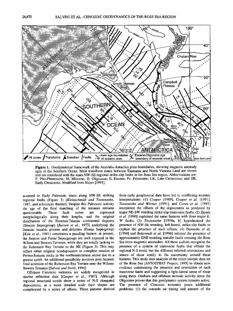
Many geological and geophysical investigations have been made in the last decade of the Ross Sea region of East Antarctica. The Ross Sea region includes the Ross Sea and the Transantarctic Mountains in Victoria Land noah of Ross
Island and is bordered by the Southern Ocean to the north, the Wilkes Basin to the west, the Ross Ice Shelf to the south, and the Marie Byrd Land to the southeast (Figure 1). Despite these efforts there is no generally accepted conceptual model for the Mesozoic-Cenozoic tectonic evolution of this region, a reflection of its long-lived and complex geodynamical evolution, and of the difficulty of the Antarctic territory.
A 1:1,000,000 scale tectonic map of the Ross Sea region has been prepared on the basis of structural interpretations of seismic profiles as well as new and published onshore data.
• Istituto Nazionale di Geofisica, Rome, Italy. 2 Permanently at Dipartimento di Scienze Geologiche, Universit•t
"Roma Tre", Rome, Italy. 3 Osservatorio Geofisico Sperimentale, Trieste, Italy. 4 Dipartimento di Scienze Geologiche, Universit•t "Roma Tre",
Rome, Italy. 5 Centro di Studio per la Geologia Strutturale e Dinarnica
dell'Appennino, Comitato Nazionale delle Ricerche, Pisa, Italy.
Copyright 1997 by the American Geophysical Union.
Paper number 97JB01643. 0148-0227/97/97JB-01643509.00
Onshore geology was studied by direct investigations during the Italian Progetto Nazionale di Ricerca in Antartide (PNRA) 1986-1987 expedition, remote sensing geology, and morphotectonic analyses. The offshore framework has been carried out mostly by detailed tectonic analyses of the large seismic data set available in the Antarctic Offshore Seismic
Stratigraphy (ANTOSTRAT) Project framework (Figures 2 and 3).
Records of the tectonic activity in this region span the last billion years [e.g., Cooper et al., 1987; Borg and De Paolo, 1991, and references therein]. Traces and trends of almost the entire evolution of the region can be found onshore, although precise dating of the Mesozoic-Cenozoic tectonic history is limited owing to the scarcity of post-Jurassic rocks. The Mesozoic opening of the Ross Sea provides records of the evolution of the region for the 100,000,000 years [Davey and Brancolini, 1995, and references therein]. Numerous seismic surveys have provided extensive coverage of the Ross Sea [ANTOsTRAT Project, 1995]. The availability of Deep Sea Drilling Project (DSDP) and Cenozoic Investigations in the Western Ross Sea (CIROS) wells [Hayes and Frakes, 1975; Barrett, 1986, 1989] has provided dates on the sedimentary seismic sequences and, consequently, on timing of the tectonic evolution of the Ross Sea since the Cretaceous
[Cooper and Davey, 1985]. Since the 1970s, geologists have recognized the presence
of at least three proterozoic terranes in northern Victoria Land
24,669
24,670 SALVINI ET AL.: CENOZOIC GEODYNAMICS OF THE ROSS SEA REGION
180 ø
o
/i !
i/
!
!
/ ! !
Campbell , ',' Plateau
!
,OUT
Chatam Rise
.50 ø
!
!
!
!
!
! !
?,• main age boundaries ,• Eocene-Oligocene age of oceanic crust boundary of oceanic crust
loss
x
Marie Byrd Land l
Figure 1. Geodynamical framework of the Australia-Antactica plate boundaries, showing magnetic anomaly ages of the Southern Ocean. Main transform zones between Tasmania and North Victoria Land are shown and are correlated with the main NW-SE regional strike-slip faults in the Ross Sea region. Abbreviations are: P, Plio-Pleistocene; M, Miocene; O, Oligocene; E, Eocene; Pc, Paleocene; LK, Late Cretaceous; and EK, Early Cretaceous. Modified from Hayes [ 1991 ].
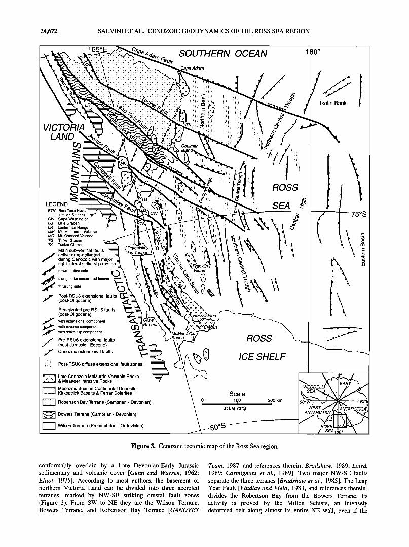
accreted in Early Paleozoic times along NW-SE striking regional faults (Figure 3) [Kleinschmidt and Tessensohn, 1987, and references therein]. Despite this Paleozoic activity the age of the final matching of the terranes remains questionable. These fault zones are expressed morphologically along their lengths, and the original distribution of the Permian-Triassic continental deposits (Beacon Supergroup) [Barrett et al., 1972] underlying the Jurassic basaltic plateau and dolerites (Ferrar Supergroup) [Kyle et al., 1981] constitutes a puzzling feature: at present, the Beacon and Ferrar Supergroups are well exposed in the Wilson and Bowers Terranes, while they are totally lacking in the Robertson Bay Terrane to the NE (Figure 3). This may reflect either original nondeposition or complete erosion of Permo-Jurassic rocks in the northeasternmost sector due to a
greater uplift. An additional possibility involves post-Jurassic final accretion of the Robertson Bay Terrane onto the Wilson- Bowers Terranes [Salvini and Storti, 1994].
Offshore Cenozoic tectonics are widely recognized in marine reflection data [Cooper et al., 1987]. Although regional structural trends show a series of N-S elongated depocenters, at a more detailed scale their shapes are complicated by a series of offsets. These patterns derived
from early geophysical data have led to conflicting tectonic interpretations: (1) Cooper [1989], Cooper et al. [1991], Tessensohn and W6rner [1991], and Coren et al. [1997] interpreted the offsets of the depocenters as produced by major NE-SW trending strike-slip transverse faults; (2) Zayatz et al. [1990] explained the same features with three major E- W faults; (3) Tessensohn [1994a, b] hypothesized the presence of NW-SE trending, left-lateral, strike-slip faults to explain the presence of such offsets; (4) Damaske et al. [1994] and Beherendt et al. [1996] inferred the presence of approximately ENE trending transfer faults crossing the Ross Sea from magnetic anomalies. All these authors recognize the presence of a system of transverse faults that offsets the regional N-S trend, but the different inferred orientations and senses of shear testify to the uncertainty around these features. This study uses analysis of the entire seismic data set of the Ross Sea [ANTOsTRAT Project, 1995] to obtain new evidence constraining the presence and orientation of such transverse faults and suggesting a right-lateral sense of shear along them. Onshore and offshore tectonic activity since the Oligocene proves that this geodynamic system remains active. The presence of Cenozoic tectonics poses additional problems: (1) the controls on timing and amount of the
SALVINI ET AL.: CENOZOIC GEODYNAMICS OF THE ROSS SEA REGION 24,671
70øS
72øS
74øS
170 ø E i
175 ø E 180 ø 175 ø W
I
I
I
I
I
I
I
I
I
I
170øW
t! 100 km • ....... • ............. t* ............. • • I! ........
',v 0 S •S •i ........ .............................. :::.:.. • i BGR (Germany)•
• • i IFP (France) ................. • • • JNOC (Japan)
MAGE (Russia) .....
OGS (Italy) USGS (U.S.A.) .................
ß
•__ ' ..........
/ -iF - - a _ /
I
70 ø S
72øS
74 ø S
76øS
;- il
Ross Ice shelf 0'•.., '&' / / c• cg i/.';' '
160 ø E 165 ø E 170 ø E 175 ø E 180 ø 175 ø W 170 ø W 165 ø W
Figure 2. Traces of the multichannel seismic lines collected in the Ross Sea and used in this study. The total seismic line is 32,422 km, and its data are available from Antarctic Seismic Data Library System for Cooperative Research [ANTOSTRAT Project, 1995].
76øS
activity of the major crustal boundaries in the Cenozoic after the completion of separation of Australia, New Zealand, and Antarctica and (2) the reasons for discontinuous distribution of volcanic products and intrusions concentrated along a N-S striking swarm in the western Ross Sea and in Victoria Land.
This paper has combined the results from geological studies in Victoria Land with seismic profiles in the Ross Sea (Figure 2) using analogies between onshore and offshore geology. In particular, the NW-SE trending regional faults onshore align well with well defined offshore NW-SE deformation belts. In most cases this tectonic activity affects sediments of probable late Cenozoic age. Moreover, the NW- SE regional fault zones align well with transform faults in the Southern Ocean created by Mesozoic spreading between the Antarctic and Australian plates (Figure 1). Our interpretation of the Cenozoic geodynamics of the Ross Sea region includes
major right-lateral transtension along NW-SE regional faults starting at about 30 Ma. This Cenozoic transtension has overprinted the older extensional features by producing right- lateral offsets of the order of tens of kilometers in preexisting N-S basins. Such basins have been reactivated as second-
order structures within the NW-SE regional fault zones, either by reactivating the existing faults or generating new ones.
2. Geological Setting of the Ross Sea Region
The Transantarctic Mountains run along the eastern coast of Victoria Land with a length of over 4500 km and have a relief of more than 4000 m. They represent one of the most impressive examples in the world of a rift shoulder [e.g., Stern and ten Brink, 1989; Fitzgerald, 1992]. The Transantarctic Mountains expose a crystalline basement un-
24,672 SALVINI ET AL.: CENOZOIC GEODYNAMICS OF THE ROSS SEA REGION
'-'•"-• •., 16•, :E,, • :•o'ere • SOUTHERN OCEAN •'8øø
:""• • .•:"LR.'. • ;•; • Iselin Bank
vICTOR ' " ' •o" "•:"•::': ' _,
LEGEND ••••:• ½•',r•:", • • .' ;•""•'"• "•'.:,".. •'"..•:• SEA BTN Baia Terra --
(Italian 8tat • CW Cape Washington -...•.:.¾:..'.:..•• •.:, • :' •'•• •.'.• • • • • • • : • LL•lint% rG•%• .. MM Mr. Melbour •o •. Ovo,or• TG Tinker Glaci TK Tucker Glaci --
during Cenozoic with major • • ß • r'ght-later•½•½ii•e•tl•pm•n• :;':"• L •%•,•o•½• •nk•;;.• • •'..•,• • • ' down-faulted side • •
--½ a,o.,str,e'a:::o,ate,as,.s t %., '.,
.f Post-RSU6 extensional faults ••:':'h • x• •••[•', TM "• • • -- k . • (post-Oligocene) •
_ (post-Oligoc•ne): • •:::•__% M • '•'•o•s'•land [ • • withextensional component -••.•e• • •__v"• • with reverse • withstrike'slipcømpønen' •' ' 3 X•qMur•• - ___ •_ • .,• • Pre-RSU6 extensional faults • .. . .•un•• H••
• (post-Jurassic-Eocene) •'•' .'• • • - • Cenozoic extensional faults ••". , •: ': • • •• ICE SHELF
• :• '..,• Post-RSU6 diffuse extensional fault zones •: '.'.• ..•- Me o WEDDELL --• s zoic Beacon Continental Deposits, ' ' ' '• W•EA'•L
I----I KirkpatrickBasalts&FerrarDolerites ß • o S•le POCk .... 0 1 O0 200 km • Robedson Bay Terrane (Cambr an- Devonian)
• Bowers Terrane (Cambrian-Devonian) • _ _
Figure 3. Cenozoic tectonic map of the Ross Sea region.
conformably overlain by a Late Devonian-Early Jurassic sedimentary and volcanic cover [Gunn and Warren, 1962; Elliot, 1975]. According to most authors, the basement of northern Victoria Land can be divided into three accreted
terranes, marked by NW-SE striking crustal fault zones (Figure 3). From SW to NE they are the Wilson Terrane, Bowers Terrane, and Robertson Bay Terrane [GANOVEX
Team, 1987, and references therein; Bradshaw, 1989; Laird, 1989; Carmignani et el., 1989]. Two major NW-SE faults separate the three terranes [Bradshaw et el., 1985]. The Leap Year Fault [Findlay and Field, 1983, and references therein] divides the Robertson Bay from the Bowers Terrane. Its activity is proved by the Millen Schists, an intensely deformed belt along almost its entire NE wall, even if the
SALVINI ET AL.: CENOZOIC GEODYNAMICS OF THE ROSS SEA REGION 24,673
schist kinematics are not fully proved as yet. The Lanterman Fault [Dow and Neall, 1974; Gibson, 1985] separates the Wilson from the Bowers Terrane. Again, the presence of this regional lineament is marked by a series of highly deformed units (Dessent Unit and Lanterman and Husky conglomerates [GANOVEX Team, 1987]), concentrated along the major counterclockwise bends of the Lanterman Fault (Figure 3). Preliminary spectral and texture analysis at the regional scale of Landsat Multi-Spectral Scanner (MSS) imagery of northern Victoria Land suggests the presence of two different crustal blocks [Fortunati et al., 1991], separated by a broad NW-SE belt between the Lanterman and Leap Year Faults. The southern block roughly coincides with the Wilson Terrane; the northern consists mainly of the Bowers and the Robertson Bay Terranes. The presence of different satellite lineament domains (in the sense of Wise et al. [1985]) and their comparison with preliminary structural data [Carmignani et al., 1989] suggest the existence of block rotations around vertical axes in the area [Mazzarini and Salvini, 1994].
The Wilson Terrane comprises large batholiths of the Cambro-Ordovician Granite Harbour granitic series [Gunn and Warren, 1962] intruded into metamorphic rocks of uncertain age but generally ascribed to the Proterozoic and the Lower Cambrian [Kleinschmidt and Tessensohn, 1987, and references therein]. The Bowers Terrane (Cambrian- Ordovician) is a narrow NW-SE striking belt, characterized by volcanic rocks and marine volcanoclastic sediments affected by low-grade metamorphism [Weaver et al., 1984]. In the Robertson Bay Terrane, widely exposed Cambrian- Early Ordovician terrigenous continental shelf sediments of low metamorphic grade [Burrett and Findlay, 1984; Wright et al., 1984] are intruded by Devonian-Carboniferous granitoids (Admiralty Intrusives) [Vetter and Tessensohn, 1987].
The Wilson Terrane and the Bowers Terrane expose one of the most outstanding morphological and geological features of the Transantarctic Mountains: the Sub-Beacon Peneplain [Gunn and Warren, 1962] (Kukri Peneplain in southern Victoria Land [Barrett et al., 1972]). It is a regional "erosional surface" overlain by a continental, shallow water sedimentary sequence (Beacon Supergroup), progressively younging from south (Devonian) to north (Triassic) [Barrett et al., 1972]. The Jurassic sequence of the Ferrar Supergroup consists of huge basaltic lava flows (Kirkpatrick Basalt, [Grindley, 1963]) and dolerite sills (Ferrar Dolerite) that overlie and intrude, respectively, the Beacon Supergroup. No outcrops of the Beacon and the Ferrar Supergroups have been found north of the Bowers Terrane-Robertson Bay Terrane boundary. Since Cenozoic time, widespread alkalic volcanic activity has affected the coastal sector of the Victoria Land and the western Ross Sea (McMurdo Volcanic rocks) [Harrington, 1958].
Paleozoic activity of the high-angle terrane boundary fault zones is widely accepted, although different kinematics have been proposed. Gair et al. [1969] and Stump et al. [1983] interpreted the Bowers Terrane as a graben in the Ross Geosyncline, the latter made up of the Wilson Terrane and the Robertson Bay Terrane. According to their interpretation, the boundary faults acted as rift shoulders. Weaver et al. [1984] and Bradshaw et al. [1985] proposed Cambro-Ordovician, right-lateral, strike-slip motion along the Leap Year Fault and the Lanterman Fault (Figure 3). Gibson [1985] suggested right-lateral transpressional motion along the Lanterman Fault. Gibson [1987], Kleinschmidt and Tessensohn [1987],
Carmignani et al., [1989], and FlOttman and Kleinschmidt [1991] alternatively proposed thrusting along both the fault zones. The occurrence of the Silurian-Devonian Borchgrevink Orogeny was hypothesized in the Robertson Bay Terrane by Findlay [1990] and in the Wilson Terrane by Giudice et al. [1991].
Post-Paleozoic activity of the NW-SE faults is still under debate. In the Lanterman Range, Cambro-Ordovician Granite Harbour Intrusives have been thrust onto the Jurassic Ferrar
Supergroup [Gibson, 1987; Roland and Tessensohn, 1987] (Figure 3). In the same area a belt of strongly folded Beacon sedimentary rocks has been recognized [Grindley and Oliver, 1983; Walker, 1983]. Deformation of the Beacon and Ferrar sequences testifies to Mesozoic or younger activity along the NW-SE Lanterman Fault, but the lack of post-Jurassic rocks hinders determination of an upper age limit for onshore tectonics. Structural data acquired during the 1986-1987 Italian PNRA expedition pointed out the presence of post- Paleozoic, right-lateral, strike-slip tectonics along NW-SE trending regional fault zones (see below).
Apatite fission track dating [Fitzgerald, 1992, and references therein] has shown that the Transantarctic Mountains experienced a strong uplift in the last 55 myr which locally exceedes 6 km, although both the rate of uplift and denudation may have varied with time. Smith and Drewry [1984] have related the Transantarctic Mountains uplift to the delayed effect of East Antarctica overriding an anomalously hot asthenosphere, formed in the Late Cretaceous under West Antarctica. Schmidt and Rowley [1986] have interpreted the Transantactic Mountains as a Jurassic rifted margin with associated major right-lateral transform faults. This was followed by Cenozoic extensional block faulting in West Antarctica, independent of the Jurassic rifting. A Jurassic extension, followed by right-lateral transtension across West Antarctica from the Late Cretaceous to the Tertiary, has been proposed by Storey and Nell [1988], Storey [1991], and Wilson [1992, 1994, 1995]. Stern and ten Brink [1989] and Bott and Stern [1992] modeled the Transantactic Mountains uplift, taking into account thermal, erosion, and end loading effects. Fitzgerald et al. [1986] and Van der Beek et al. [1994], following the Wernicke [1985] simple shear model, interpreted the Cenozoic Ross Sea thinning and coeval uplift of the Transantarctic Mountains as the result of low-angle de- tachment faulting extending into the lithosphere along a master fault dipping west under the Transantarctic Mountains. This produced the asymmetric uplift of the Transantarctic Mountains and subsidence in the Ross Sea.
The Ross Sea occupies the northern part of a wider embayment of the Antarctic continent, bounded by the Transantarctic Mountains to the west, by Marie Byrd Land to the southeast, and by the Ross Ice Shelf to the south (Figure 3). This embayment is part of a major extensional system, the West Antarctic Rift, that extends more than 3000 km across
Antarctica [Le Masurier, 1990]. This region has been interpreted as part of a failed rift system [Le Masurier, 1990; Fitzgerald et al., 1986; Behrendt et al., 1991; Tessensohn and Wgirner, 1991], although its age, nature, and relationships with the adjacent oceanic area are still under debate. According to Behrendt et al. [1992], this process relates to the presence of a wide, weak, but long-lasting mantle plume.
Geophysical investigations [Houtz and Davey, 1973; Davey, 1981; Davey et al., 1983; Hinz and Block, 1984] have shown that the Ross Sea is underlain by four major
24,674 SALVINI ET AL.: CENOZOIC GEODYNAMICS OF THE ROSS SEA REGION
165 ø E 170 ø E 175 ø E 180 ø
Cape Adare
175 ø W
Fig. 7c 72 ø S
.:.: ........... Coulman Island R O S S
76 ø s
a
Fig. 8b
Fig. 12 Fig. 13
Fig. 8c • Fig 7a pe Washington ß
,......____ ::::::::::::::::::::::::::::::::::::::::: :{ } SEA
::::::::::::::::::::::::::::::::::::::::::::::::::::::::::::::
:::::::::::::::::::::::::::::::::::::::::::::::::::::::::::::::::: Ross Island ..,-'"?',.• - 0 100
155 ø E 160 ø E 165 ø E 170 ø E 175 ø E 180 ø
20•0 km
175 ø W
72 ø S
74 ø S
76 ø S
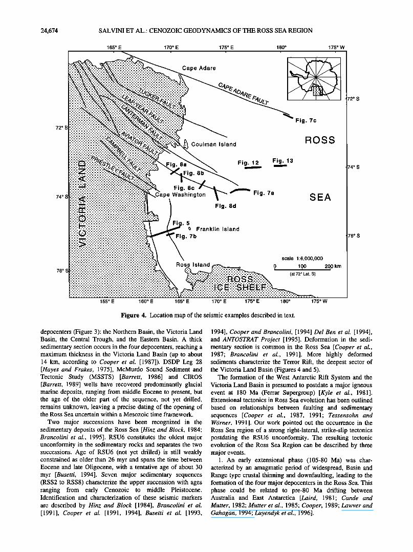
Figure 4. Location map of the seismic examples described in text.
depocenters (Figure 3): the Northern Basin, the Victoria Land Basin, the Central Trough, and the Eastern Basin. A thick sedimentary section occurs in the four depocenters, reaching a maximum thickness in the Victoria Land Basin (up to about 14 km, according to Cooper et al. [1987]). DSDP Leg 28 [Hayes and Frakes, 1975], McMurdo Sound Sediment and Tectonic Study (MSSTS) [Barrett, 1986] and CIROS [Barrett, 1989] wells have recovered predominantly glacial marine deposits, ranging from middle Eocene to present, but the age of the older part of the sequence, not yet drilled, remains unknown, leaving a precise dating of the opening of the Ross Sea uncertain within a Mesozoic time framework.
Two major successions have been recognized in the sedimentary deposits of the Ross Sea [Hinz and Block, 1984; Brancolini et al., 1995]. RSU6 constitutes the oldest major unconformity in the sedimentary rocks and separates the two successions. Age of RSU6 (not yet drilled) is still weakly constrained as older than 26 myr and spans the time between Eocene and late Oligocene, with a tentative age of about 30 myr [Busetti, 1994]. Seven major sedimentary sequences (RSS2 to RSS8) characterize the upper succession with ages ranging from early Cenozoic to middle Pleistocene. Identification and characterization of these seismic markers
are described by Hinz and Block [1984], Brancolini et al. [1991], Cooper et al. [1991, 1994], Busetti et al. [1993,
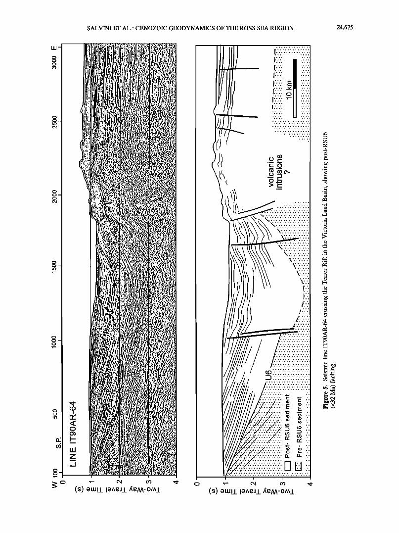
1994], Cooper and Brancolini, [1994] Del Ben et al. [1994], and ANTOSTRAT Project [1995]. Deformation in the sedi- mentary section is common in the Ross Sea [Cooper et al., 1987; Brancolini et al., 1991]. More highly deformed sediments characterize the Terror Rift, the deepest sector of the Victoria Land Basin (Figures 4 and 5).
The formation of the West Antarctic Rift System and the Victoria Land Basin is presumed to postdate a major igneous event at 180 Ma (Ferrar Supergroup) [Kyle et al., 1981]. Extensional tectonics in Ross Sea evolution has been outlined
based on relationships between faulting and sedimentary sequences [Cooper et al., 1987, 1991; Tessensohn and WOrner, 1991]. Our work pointed out the occurrence in the Ross Sea region of a strong right-lateral, strike-slip tectonics postdating the RSU6 unconformity. The resulting tectonic evolution of the Ross Sea Region can be described by three major events.
1. An early extensional phase (105-80 Ma) was char- acterized by an amagmatic period of widespread, Basin and Range type crustal thinning and downfaulting, leading to the formation of the four major depocenters in the Ross Sea. This phase could be related to pre-80 Ma drifting between Australia and East Antarctica [Laird, 1981; Cande and Mutter, 1982; Mutter et al., 1985; Cooper, 1989; Lawver and Gahagan, 1994; Luyendyk et al., 1996].
SALVINI ET AL.' CENOZOIC GEODYNAMICS OF THE ROSS SEA REGION 24,675
LU
o o
o o o
o o o
o o
o o
($) •w!/I•^e•/
I
($) •w!/I•^e•/
24,676 SALVINI ET AL.: CENOZOIC GEODYNAMICS OF THE ROSS SEA REGION
2. A late extensional phase (55 Ma to 30 Ma) was a period of more localized basin subsidence and magmatism, mainly in the western Ross Sea, together with major uplift of the Transantarctic Mountains. This phase is probably related to a reorganization of the plate framework, marked by an abrupt change in magnetic anomaly trends south of New Zealand and north of Marie Byrd Land [Stock and Molnar, 1987].
3. A transtensional phase (30 Ma to present) in which, starting from 30 Ma, the late extension is superimposed by the reactivation of inherited subcontinental-sized NW-SE
faults with right-lateral, strike-slip sense of motion. The presence of these NW-SE strike-slip faults can be traced for over 800 km from the Central High in the Ross Sea to the northern coast of the Victoria Land, where they merge with the active tranform faults of the Southern Ocean (Figure 3). The concomitance of extension and right-lateral, strike-slip faulting deeply modified the tectonic framework of the Ross Sea region in the last 30 myr by constraining the extension along relatively narrow N-S to NNW-SSE trending reactivated and newly generated basins. Magmatic activity is strongly influenced by this new tectonic regime and clusters along N-S alignments and central volcanoes.
3. Methodology
In the last 25 years, 32,422 km of multichannel seismic (MCS) data have been collected in the Ross Sea (Figure 2). The Osservatorio Geofisico Sperimentale (OGS), supported by the PNRA, has collected almost 10,000 km of MCS, gravity, and magnetic profiles [Berger et al., 1990, Brancolini et al., 1991]. Extensive MCS surveys have also been carried out by Bundesanstalt far Geowissenschaften und Rohstoffe [Hinz and Block, 1984], the U.S. Geological Survey [Cooper et al., 1987], the Russian Marine Arctic Geological Expedition (MAGE), [Zayatz et al., 1990], the Japanese National Oil Company [Sato et al., 1984], and the Institute Francais du Petrole. All of these seismic profiles are available at the OGS and have been carefully examined. Structural features in the whole sedimentary sequences have been analyzed, mapped, and then merged with the available onshore data.
Many geological investigations have been carried out in Victoria Land. Mostly, they have been focused on the Proterozoic to Early Paleozoic evolution, with particular emphasis on the Ross Orogen, Paleozoic terrane accretion, and the Cambro-Ordovician and Devonian intrusives.
Regional-scale geological maps have been compiled [Gair et al., 1969; GANOVEX Team, 1987; Carmignani et al., 1989; Pertusati and Tessensohn, 1995]. Post-Jurassic tectonic activity in Victoria Land has been documented by a number of studies [Gair, 1967; Findlay and Field, 1983; Grindley and Oliver, 1983; GANOVEX Team, 1987; Roland and Tessensohn, 1987; Carmignani et al., 1989; Giudice et al., 1991; Fitzgerald, 1992; Stump and Fitzgerald, 1992; Wilson, 1992, 1994, 1995; Salvini and Storti, 1994; Stackebrandt, 1994; Jones, 1995; Petri et al., 1995].
Onshore tectonics was studied by field surveys during the 1986-1987 PNRA expedition in the area between the Drygalski Ice Tongue and the Leap Year Fault (Figure 3). The study includes a series of measure stations of structural data, with particular emphasis on brittle deformation. These include faults, often with kinematic indicators, joint systems,
and dyke swarms. Structural data have been archived in a database, from where they have been statistically analyzed by automated methodologies that allow the identification of multiple tectonic events, together with their kinematics [Salvini and Vittori, 1982; Salvini, 1994]. Fieldwork has been integrated with a photogeological study of the same area, with particular emphasis on Cenozoic volcanics and tectonics [Salvini and Storti, 1994]. Tectonic patterns of the whole northern Victoria Land has been inferred by lineament analysis on satellite images [Mazzarini and Salvini, 1994] coupled with newly acquired data and the available bibliography.
Offshore tectonic analysis has been carried out by comparison among serial seismic profiles. Deformation zones have been identified and characterized through adjacent profiles. In particular, this study has included both the systematic comparison of structural patterns and checking of kinematic compatibility. Variations in the apparent dips of fault surfaces and apparent width of deformation zones in differently trending seismic lines have been used to infer true strike and dip of faults. The total amount of available seismic profiles and their variable orientations (Figure 2) have provided a valuable grid for this analysis.
Seismic profiles provide vertical sections of geological structures, thus emphasizing their vertical geometries (i.e., vertical throw, fold shapes) along the path. Single profiles give poor constraints on the strike of the structures. Correlation through serial seismic images partly overcomes this limitation on determining the orientation of geologic structures. This process may be ambiguous, and there might be the tendency to assume the observed features in single two-dimensional images to be approximately orthogonal to the trace of the seismic profile. Therefore particular care has been used in the choice of the correlation criteria for the
inference process. Direct correlation among single tectonic elements is poorly
constrained in regional-scale mapping, and in this study, emphasis has been placed on fault systems. In most cases the total displacement is accomplished by several anastomosing faults, whose number and throw vary along strike. According to this criterion, faults mapped in Figure 3 represent the presence of well-localized, narrow fault systems. Extensional and transtensional tectonics are, by far, the most common tectonic style in the region. In most cases, fault systems are associated with minor depocenters. Geometry and evolution of such depocenters have provided another correlation tool for tracing regional-scale faults.
The correlation among fault segments that have proved to have significant strike-slip components has required a more careful approach. In this case, kinematics of vertical displacement may vary substantially along strike with alternation of compressional and extensional features. These features commonly create negative and positive flower structures, in most cases recognized by the concentration of a strongly deformed zone with a lack of systematic regional throw across it.
Together with regional fault systems, the seismic profiles show the presence of wider zones characterized by closely spaced faults with throws comparable to the seismic resolution. No master fault systems can be recognized or correlated across adjacent profiles, although these zones have easily recognized borders. Correlation among adjacent
SALVINI ET AL.' CENOZOIC GEODYNAMICS OF THE ROSS SEA REGION 24,677
seismic images has highlighted elongated deformed regions that have been mapped and referred to in this paper as "extensional fault zones."
Analysis of ages of the sediments involved in the de- formations has allowed the recognition of two different tectonic episodes. The RSU6 unconformity is the main reference level to differentiate between them. Accordingly, faults have been classified into three groups with different ages of activity: pre-RSU6, reactivated pre-RSU6, and post- RSU6. The first group includes all deformations that are clearly truncated by the RSU6 unconformity and should therefore have an age older than 26 Ma. The second group comprises faults that show abrupt reduction in the throws across RSU6, suggesting their partial reactivation after the formation of this unconformity. The third includes faults that cut through the post-RSU6 sequence up to Pleistocene and Recent sediments, while maintaininig displacements compatible with a single faulting episode.
4. Tectonic Patterns of the Ross Sea Region
Figure 3 presents the results of the analysis derived from synthesis of the 1'1,000,000 scale tectonic map. Depending on their kinematic role within the Cenozoic tectonic
framework, faults have been grouped into three main sets (NW-SE, N-S, and NE-SW). These sets have been named according to their average azimuth, even though the orientations of faults (i.e., angle with an intersecting meridian) within each fault group vary from location to location owing to the particular vicinity to the South Pole (Figure 3). The region is dominated by the presence of a series of NW-SE trending regional faults that, at present, dissect the preexisting offshore N-S depocenters and highs. Both orientations developed initially during the first extensional event (105-80 Ma) [Cooper, 1989]. In the northwestemmost sector of the Ross Sea region, NW-SE faults are associated with NNW-SSE tectonic depressions (Figure 3), namely, the Rennick Graben [Roland and Tessensohn, 1987] and the Lillie Graben, together with compressional ridges (Lanterman Range). The central sector of Victoria Land is apparently characterized only by the presence of the NW-SE faults. The Cenozoic to Recent volcanics concentrate in the coastal sector of Victoria Land as
N-S trending belts [Kyle and Cole, 1974]. The main central volcanoes (Mount Melbourne and Mount, Overlord; see Figure 3) lie at the intersections of NW-SE faults and the N-S volcanic alignments. For the N-S system and starting from the
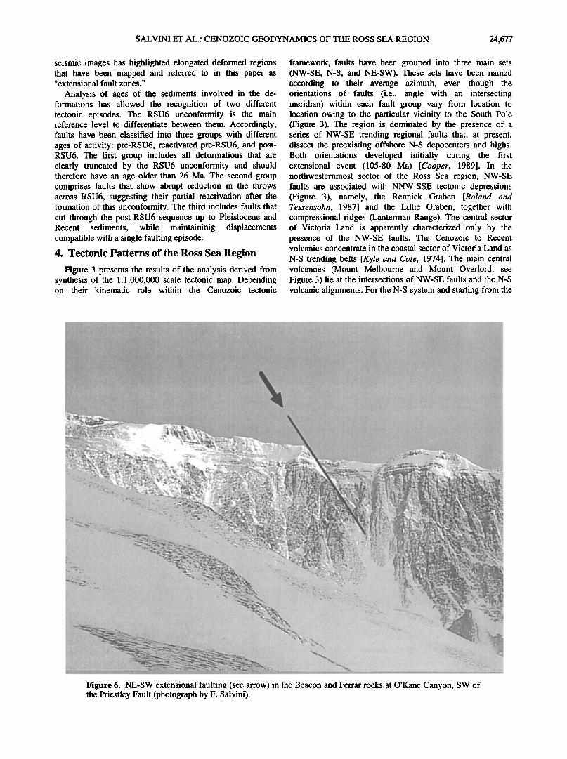
Figure 6. NE-SW extensional faulting (see arrow) in the Beacon and Ferrar rocks at O'Kane Canyon, SW of the Priestley Fault (photograph by F. Salvini).
24,678 SALVINI ET AL.' CENOZOIC GEODYNAMICS OF THE ROSS SEA REGION
west, the major structural features are the Victoria Land Basin, the Coulman High, the Central Trough (divided into three main segments, namely, the northern, the mid-central Trough, and the southern Central Trough), the Central High, and the Eastern Basin [Cooper et al., 1991]. Offshore Daniell Peninsula lies the Northern Basin, another depocenter with the same tectonic age. The eastern sector of Victoria Land constitutes the eastern margin of the Transantarctic Mountains and is characterized by the occurrence of block faulting along NE-SW trending normal faults [Salvini and Storti, 1994; Wilson, 1995] (Figure 6). These NE-SW normal faults do not propagate across the NW-SE regional faults.
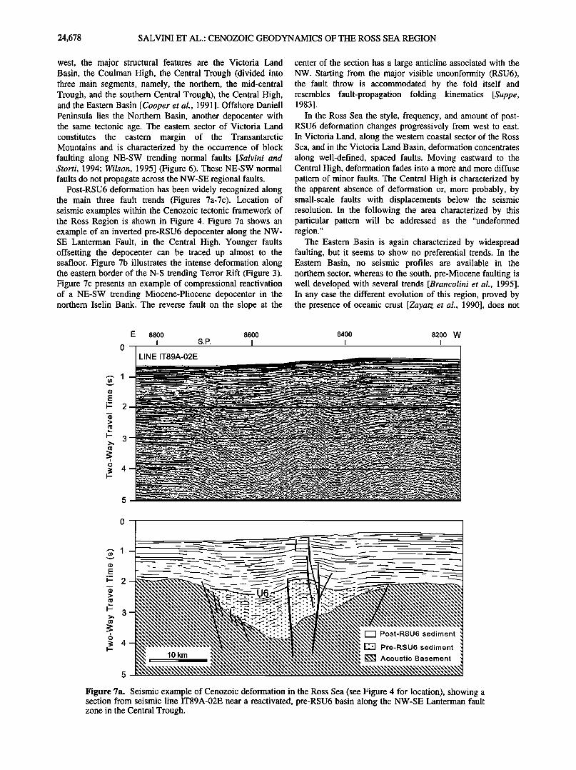
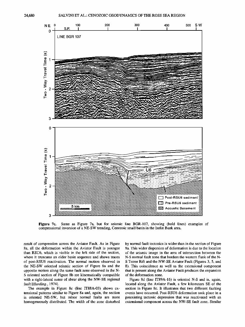
Post-RSU6 deformation has been widely recognized along the main three fault trends (Figures 7a-7c). Location of seismic examples within the Cenozoic tectonic framework of the Ross Region is shown in Figure 4. Figure 7a shows an example of an inverted pre-RSU6 depocenter along the NW- SE Lanterman Fault, in the Central High. Younger faults offsetting the depocenter can be traced up almost to the seafloor. Figure 7b illustrates the intense deformation along the eastern border of the N-S trending Terror Rift (Figure 3). Figure 7c presents an example of compressional reactivation of a NE-SW trending Miocene-Pliocene depocenter in the northern Iselin Bank. The reverse fault on the slope at the
center of the section has a large anticline associated with the NW. Starting from the major visible unconformity (RSU6), the fault throw is accommodated by the fold itself and resembles fault-propagation folding kinematics [Suppe, 1983].
In the Ross Sea the style, frequency, and amount of post- RSU6 deformation changes progressively from west to east. In Victoria Land, along the western coastal sector of the Ross Sea, and in the Victoria Land Basin, deformation concentrates along well-defined, spaced faults. Moving eastward to the Central High, deformation fades into a more and more diffuse pattern of minor faults. The Central High is characterized by the apparent absence of deformation or, more probably, by small-scale faults with displacements below the seismic resolution. In the following the area characterized by this particular pattern will be addressed as the "undeformed region."
The Eastern Basin is again characterized by widespread faulting, but it seems to show no preferential trends. In the Eastern Basin, no seismic profiles are available in the northern sector, whereas to the south, pre-Miocene faulting is well developed with several trends [Brancolini et al., 1995]. In any case the different evolution of this region, proved by the presence of oceanic crust [Zayatz et al., 1990], does not
E 8800 8600
0 LINE IT89A-02E
8400 8200 W I I
o
lO km
Post-RSU6 sediment
Pre-RSU6 sediment
Acoustic Basement
Figure 7a. Seismic example of Cenozoic deformation in the Ross Sea (see Figure 4 for location), showing a section from seismic line IT89A-02E near a reactivated, pre-RSU6 basin along the NW-SE Lanterman fault zone in the Central Trough.
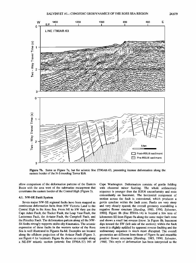
SALVINI ET AL.: CENOZOIC GEODYNAMICS OF THE ROSS SEA REGION 24,679
W 1400 1200 1000 800 600 E s.P. I I I I I
LINE IT90AR-63
•'-'""-•'" "• :'••.... '.•,-i '. • ? '-' -:!'- -'% :•; • :' z., •..-•,• •..•_ .-.._
.•.-..•-,½•.x:! ......................... ... ß _.. ...... ....,.:- .. -'.•-.'•• -
...--.-,.-- ....... , ........ ,,:,-.-. ...... '• .,-,...---••;.•..,-..- ..... ..- . ,,. ;-,-:. ;: .•.-. • •..-..•-.-
.-...:- -, :•'.,,5--•;;-• '.•-----,.--.• .=.•:,_-'=•--•, . .<• ';* . •."<'""--•.•.s;.:.-t',' .'•'.:'•'•.--•'.,25•'5.•-_'C-:0•:-,z'•'-•..- • -•-"-=- . ...t,•..?•?•.A:...•--'_ •:-•-:--- .•_.__--'r7•_..••-'":"-
• •';-"'" -,'" "--'"---' .•.•'.e• .,q-.,-,'n- " ø- .... ' r.. Y'•, '"'" ",'•"•' ..... ;'"a a"'" •' "• u•;'•--",-:.:•.r,•n_' x -'o' "•. ß ' ..•."."', -
--,•.-•.. ,.. .•...-.,•:•. _ ß •.m ,, ß w.-...:. •:•i ,..,..:•:......-.,. •'c.' •. .... ..-,.'r.:; ,,,,-.' -. ,•.- .•.: ..'•:5ø- ,,z ..... ß : - ,w '• :?.•, :/.,'Z_X ,;:st '.:<:• :•,- '.':'•.•.-. ;'.:.",,?¾: :'.:,': '• :.v::'.•.":,•25• ::•.:'-, '.•: '. 'm.."-,- -'"- 3
0
Figure 7b. Same as Figure 7a, but for seismic line IT90AR-63, presenting intense deformation along the eastern border of the N-S trending Terror Rift.
allow comparison of the deformation patterns of the Eastern Basin with the area west of the submarine escarpment that constitutes the eastern border of the Central High (Figure 3).
4.1. NW-SE Fault System
Seven major NW-SE regional faults have been mapped as continuous deformation belts from NW Victoria Land to the
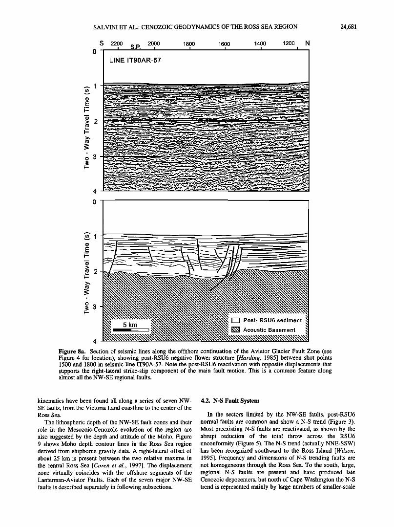
Central High in the Ross Sea. From NE to SW they are the Cape Adare Fault, the Tucker Fault, the Leap Year Fault, the Lanterman Fault, the Aviator Fault, the Campbell Fault, and the Priestley Fault. The deformation pattern along all the NW- SE faults strongly supports strike-slip kinematics. The seismic expression of these faults in the western sector of the Ross Sea is well illustrated in Figures 8a-8d. Examples are located along the offshore projection of the Aviator Fault (Figure 3; see Figure 4 for location). Figure 8a shows an example along a NE-SW seismic section (seismic line IT90A-57) NE of
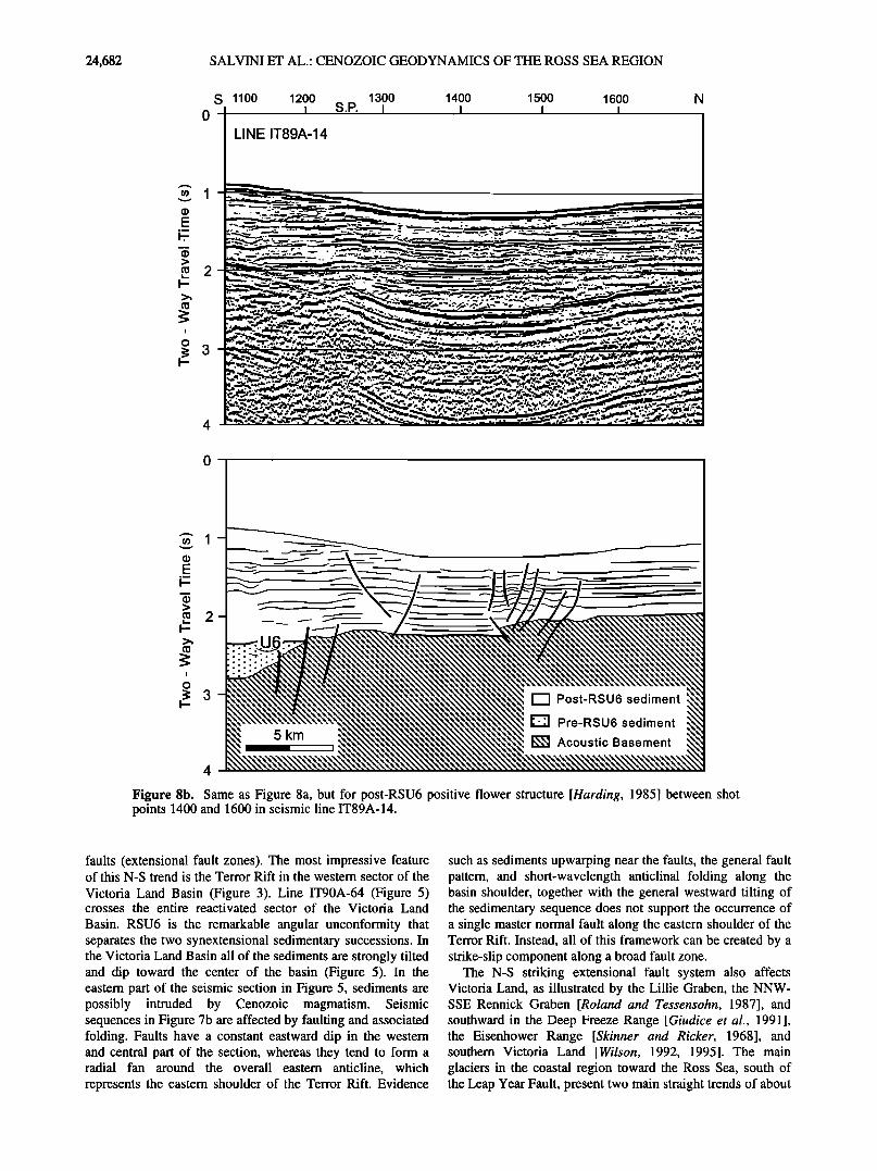
Cape Washington. Deformation consists of gentle folding with clustered minor faulting. The whole sedimentary sequence is younger than the RSU6 unconformity and rests concordantly on basement. The horizontal component of motion across the fault is extensional, which produces a gentle syncline within the fault zone. Faults are very steep and very closely spaced, the overall geometry resembling a negative flower structure [Harding, 1985, 1990; Sylvester, 1988]. Figure 8b (line IT89A-14) is located a few tens of kilometers SE from Figure 8a along the same major fault zone and shows a small but reverse throw. In Figure 8b, basement dips toward the SW (left side of the section); within the fault zone it is slightly uplifted by apparent reverse faulting and the sedimentary sequence is much more disrupted. The overall geometries are different from those of Figure 8a and resemble positive flower structures [Harding, 1985, 1990; Sylvester, 1988]. This style of deformation has been interpreted as the
24,680 SALVINI ET AL.' CENOZOIC GEODYNAMICS OF THE ROSS SEA REGION
N E 0 100 200 300 400
0
5OO
LINE BGR 107
SW
> 0•
, 2 o
i
,m
> 0•
, 2 o
5 km
[-'-I Post-RSU6 sediment
• Pre-RSU6 sediment
• Acoustic Basement
Figure 7c. Same as Figure 7a, but for seismic line BGR-107, showing (bold lines) examples of compressional inversion of a NE-SW trending, Cenozoic small basin in the Iselin Bank area.
result of compression across the Aviator Fault. As in Figure 8a, all the deformation within the Aviator Fault is younger than RSU6, which is visible in the left side of the section, where it truncates an older basin sequence and shows traces of post-RSU6 reactivation. The normal motion observed in the NE-SW oriented seismic section of Figure 8a and the opposite motion along the same fault zone observed in the N- S oriented section of Figure 8b are kinematically compatible with a right-lateral sense of shear along the NW-SE regional fault [Harding., 1974].
The example in Figure 8c (line IT88A-03) shows ex- tensional patterns similar to Figure 8a and, again, the section is oriented NE-SW, but minor normal faults are more
homogeneously distributed. The width of the zone disturbed
by normal fault tectonics is wider than in the section of Figure 8a. This wider dispersion of deformation is due to the location of the seismic image in the area of intersection between the N-S normal fault zone that borders the western flank of the N-
S Terror Riff and the NW-SE Aviator Fault (Figures 3, 5, and 8). This coincidence as well as the extensional component that is present along the Aviator Fault produces the expansion of the deformation zone.
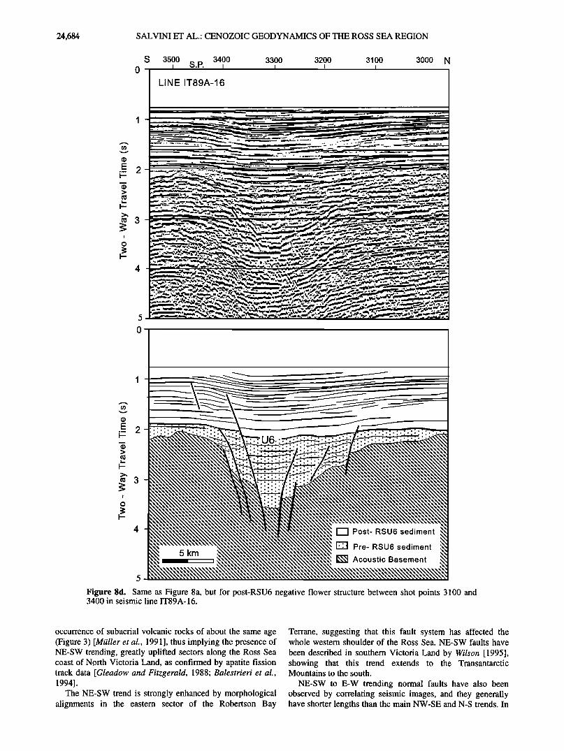
Figure 8d (line IT89A-16) is oriented N-S and is, again, located along the Aviator Fault, a few kilometers SE of the section in Figure 8c. It illustrates that two different faulting events have occurred. Post-RSU6 deformation took place in a preexisting tectonic depression that was reactivated with an extensional component across the NW-SE fault zone. Similar
SALVINI ET AL.' CENOZOIC GEODYNAMICS OF THE ROSS SEA REGION 24,681
s
o-
2200 2000 1800 1600 1400 1200 • S.P. • • • • •
LINE IT90AR-57
4
0
5 km I •
!'--I Post- RSU6 sediment
• Acoustic Basement
Figure 8a. Section of seismic lines along the offshore continuation of the Aviator Glacier Fault Zone (see Figure 4 for location), showing post-RSU6 negative flower structure [Harding, 1985] between shot points 1500 and 1800 in seismic line IT90A-57. Note the post-RSU6 reactivation with opposite displacements that supports the right-lateral strike-slip component of the main fault motion. This is a common feature along almost all the NW-SE regional faults.
kinematics have been found all along a series of seven NW- SE faults, from the Victoria Land coastline to the center of the Ross Sea.
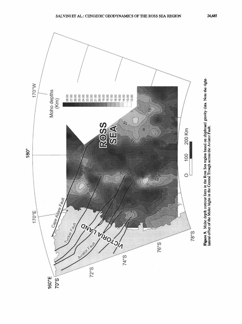
The lithospheric depth of the NW-SE fault zones and their role in the Mesozoic-Cenozoic evolution of the region are also suggested by the depth and attitude of the Moho. Figure 9 shows Moho depth contour lines in the Ross Sea region derived from shipborne gravity data. A right-lateral offset of about 25 km is present between the two relative maxima in the central Ross Sea [Coren et al., 1997]. The displacement zone virtually coincides with the offshore segments of the Lanterman-Aviator Faults. Each of the seven major NW-SE faults is described separately in following subsections.
4.2. N-S Fault System
In the sectors limited by the NW-SE faults, post-RSU6 normal faults are common and show a N-S trend (Figure 3). Most preexisting N-S faults are reactivated, as shown by the abrupt reduction of the total throw across the RSU6 unconformity (Figure 5). The N-S trend (actually NNE-SSW) has been recognized southward to the Ross Island [Wilson, 1995]. Frequency and dimensions of N-S trending faults are not homogeneous through the Ross Sea. To the south, large, regional N-S faults are present and have produced late Cenozoic depocenters, but north of Cape Washington the N-S trend is represented mainly by large numbers of smaller-scale
24,682 SALVINI ET AL.' CENOZOIC GEODYNAMICS OF THE ROSS SEA REGION
S 1100 0-
1
1200 1300 1400 1500 1600 • S.P. • I I •
LINE IT89A-14
5 km i
[•1 Post-RSU6 sediment
:1•:1 Pre-RSU6 sediment
• Acoustic Basement
4
Figure 8b. Same as Figure 8a, but for post-RSU6 positive flower structure [Harding, 1985] between shot points 1400 and 1600 in seismic line IT89A- 14.
faults (extensional fault zones). The most impressive feature of this N-S trend is the Terror Rift in the western sector of the
Victoria Land Basin (Figure 3). Line IT90A-64 (Figure 5) crosses the entire reactivated sector of the Victoria Land
Basin. RSU6 is the remarkable angular unconformity that separates the two synextensional sedimentary successions. In the Victoria Land Basin all of the sediments are strongly tilted and dip toward the center of the basin (Figure 5). In the eastem part of the seismic section in Figure 5, sediments are possibly intruded by Cenozoic magmatism. Seismic sequences in Figure 7b are affected by faulting and associated folding. Faults have a constant eastward dip in the western and central part of the section, whereas they tend to form a radial fan around the overall eastern anticline, which represents the eastern shoulder of the Terror Rift. Evidence
such as sediments upwarping near the faults, the general fault pattern, and short-wavelength anticlinal folding along the basin shoulder, together with the general westward tilting of the sedimentary sequence does not support the occurrence of a single master normal fault along the eastern shoulder of the Terror Rift. Instead, all of this framework can be created by a strike-slip component along a broad fault zone.
The N-S striking extensional fault system also affects Victoria Land, as illustrated by the Lillie Graben, the NNW- SSE Rennick Graben [Roland and Tessensohn, 1987], and southward in the Deep Freeze Range [Giudice et al., 1991], the Eisenhower Range [Skinner and Ricker, 1968], and southern Victoria Land [Wilson, 1992, 1995]. The main glaciers in the coastal region toward the Ross Sea, south of the Leap Year Fault, present two main straight trends of about
$ALVINI ET AL.: CENOZOIC GEODYNAMIC$ OF THE ROSS SEA REGION 24,683
S 2400 2500 2600 2700 2800 S.P. I I I I I
LINE IT88A-03
5 km
["'-] Post- RSU6 sediment
• Pre- RSU6 sediment
• Acoustic Basement
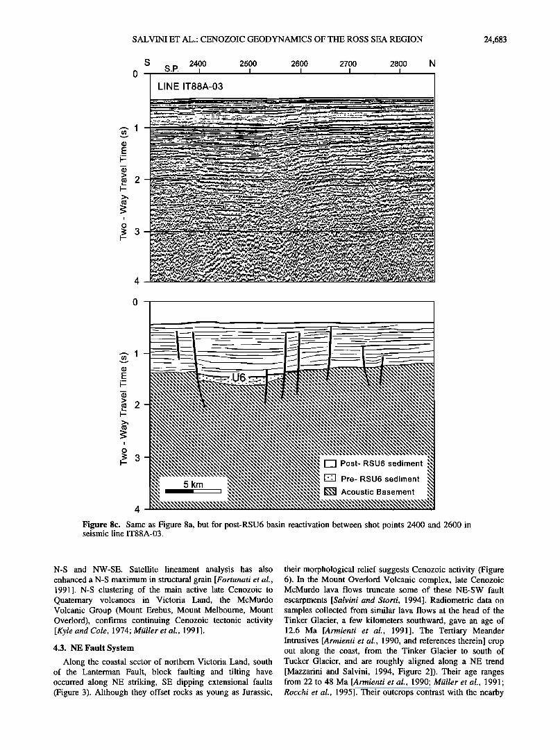
Figure 8c. Same as Figure 8a, but for post-RSU6 basin reactivation between shot points 2400 and 2600 in seismic line IT88A-03.
N-S and NW-SE. Satellite lineament analysis has also enhanced a N-S maximum in structural grain [Fortunati et al., 1991]. N-S clustering of the main active late Cenozoic to Quaternary volcanoes in Victoria Land, the McMurdo Volcanic Group (Mount Erebus, Mount Melbourne, Mount Overlord), confirms continuing Cenozoic tectonic activity [Kyle and Cole, 1974; Mailer et al., 1991].
4.3. NE Fault System
Along the coastal sector of northern Victoria Land, south of the Lanterman Fault, block faulting and tilting have occurred along NE striking, SE dipping extensional faults (Figure 3). Although they offset rocks as young as Jurassic,
their morphological relief suggests Cenozoic activity (Figure 6). In the Mount Overlord Volcanic complex, late Cenozoic McMurdo lava flows truncate some of these NE-SW fault
escarpments [Salvini and $torti, 1994]. Radiometric data on samples collected from similar lava flows at the head of the Tinker Glacier, a few kilometers southward, gave an age of 12.6 Ma [Armienti et al., 1991]. The Tertiary Meander Intrusives [Armienti et al., 1990, and references therein] crop out along the coast, from the Tinker Glacier to south of Tucker Glacier, and are roughly aligned along a NE trend [Mazzarini and Salvini, 1994, Figure 2]). Their age ranges from 22 to 48 Ma [Armienti et al., 1990; Mailer et al., 1991; Rocchi et al., 1995]. Their outcrops contrast with the nearby
24,684 SALVINI ET AL.: CENOZOIC GEODYNAMICS OF THE ROSS SEA REGION
S 3500 3400 3300 3200 3100 3000 N 0-
LINE IT89A-16
-- --i --• i _ l_ .. --•_ . ! •-_• -- - • .. 1
E 2 ..--
--
• 3
i
o
5
o•
• 3
I
¸
5 km
•l Post- RSU6 sediment
• Pre- RSU6 sediment
• Acoustic Basement
5
Figure 8d. Same as Figure 8a, but for post-RSU6 negative flower structure between shot points 3100 and 3400 in seismic line IT89A- 16.
occurrence of subaerial volcanic rocks of about the same age (Figure 3) [Mailer et al., 1991 ], thus implying the presence of NE-SW trending, greatly uplifted sectors along the Ross Sea coast of North Victoria Land, as confirmed by apatite fission track data [Gleadow and Fitzgerald, 1988; Balestrieri et al., 1994].
The NE-SW trend is strongly enhanced by morphological alignments in the eastern sector of the Robertson Bay
Terrane, suggesting that this fault system has affected the whole western shoulder of the Ross Sea. NE-SW faults have
been described in southern Victoria Land by Wilson [1995], showing that this trend extends to the Transantarctic Mountains to the south.
NE-SW to E-W trending normal faults have also been observed by correlating seismic images, and they generally have shorter lengths than the main NW-SE and N-S trends. In
SALVINI ET AL.: CENOZOIC GEODYNAMICS OF THE ROSS SEA REGION 24,685
I:::
:.•' •:• ":'•'• . •..:..•:::;.• ........
-•--..•- •-•. •:.:•...•:•-- •:-•.•:::•.:::.•-----•:- '•:...•?.::•?.•-- • ..... . ..... .• •::::•:: .:•:;•.•:•:•::•' --.:•..•c•.•.• ..... ••:•:--:.•:'• .... '•.'• 3'•.•:?.• .::e- -•- ..•:•;:- ..•:::•---•.•.- . ...... ?--...•....:•....:•, ........... •..•:•?.:•. ..... •:•/;..• .... '• ..•.:'•.'-• Z :-'-::.?•-•:z•-. " •::7 •" •: ::• •;•.:;:•: • .... •':-•:•'7•:...;• '•'•.• ..... •? '":•:
ß ...•,.::•.•?. • ......... .•:•..::....• ,. • •.--• • .............. ..c.:.•.•:•-:• ....... :,•:•. ....... ... .:: .:•:..:•.•:e.- - -• :•: •.-' • •- ..• -.,•..•:• ................... "'e•-•:' ..... '• '• •' ' "•:' -:•.• •' "•:7::• ...... "•'•'•'•". '""'"'• ............. '":':•-'::
• " -'• .... • ' • '.• •' Z.•:•' •' ß •:':-' ..... ::-;•:•-•:• '
............... . ..... • ........ • ............... •:-•? .:.:.-:-:.•... •..• --- .•. • ? •,, .•. .• ........ :•:• •:. .... -• •...-..•::•..•.::• .-•
.. •:.•:• ............ .•.... •.•..•..•,,•:.z--•:•r• •Z•.'•"•-•j .• •: .......... :•...:•,• •.•;•- ............ ;.:•..•(• o ..................................... .... ............. ............................... .................................. • • .:.•::" . • .':--'::•:.• "•'":•'•• •.• z.•-'.:•.•:• - .•,---- • ........... • ......... •:,.....:::..:. ß . . . .... •::::::.:..: ................ ':.::':•':':-- .'•:'..:'::: -:.:::-'" .::•? • .... •?.• ............... ?•;.7•.' 0 .:.:. . •. : ......•: :: ........................... •.:::.:.. .... :.:. :.
.• :• '.. .• :"'• .." •'
• o
¸
,.• ¸
¸ ¸
¸
24,686 SALVINI ET AL.: CENOZOIC GEODYNAMICS OF THE ROSS SEA REGION
most cases they show a complex tectonic history. Pre-RSU6, normal fault activity is commonly followed by inversions that involve all the sequences up to the seafloor, indicating very young apparent changes in the stress orientations within the Ross Sea. More reasonably and comparing such reactivations with the coeval normal reactivation along the N-S normal faulting, both geometries are compatible with deformations expected in NW-SE, right-lateral, strike-slip tectonics [Harding, 1974]. The detailed analysis of seismic data does not confirm the presence of NE-SW to ENE-WSW regional faults in the Ross Sea, as proposed previously (see section 1). Results from our work confirm the existence of ENE-WSW
regional faults only in the southern Eastern Basin of the Ross Sea (Figure 3).
5. Regional Strike-Slip Faults
5.1. Cape Adare Fault
The Cape Adare Fault, northeasternmost of the series, lies mostly offshore (Figure 3). In the northern Ross Sea it is characterized by the presence of NW-SE extensional faults. In the Northern Basin it shows a dominant dip to the NE. An abrupt change in the style occurs crossing the Coulman High; the regional northeastern downdip sense of displacement is replaced by a localized, narrow tectonic depression.
The most interesting evidence of its activity in Cenozoic times occurs where the Cape Adare Fault enters the northern Central High. There it reactivates preexisting ENE-WSW and NNW-SSE normal faults with a reverse sense of motion
(Figure 7c). The coincidence of opposite throws on the extensional faults, together with coeval inversions of extensional faults as reverse ones, fits well with right-lateral, strike-slip motion along the Cape Adare Fault. The contemporaneous inversion of ENE-WSW and NNW-SSE normal faults in the Central High suggests a clockwise rotation of the Cape Adare Fault in its southeasternmost segment.
5.2. Tucker Fault
Morphological features lead to the identification of the Tucker Fault onshore. The NW-SE Tucker Glacier marks its
southeastern segment between the Ross Sea and the Concord Mountains. Along the northern coast of Victoria Land (Pennell Coast) this fault merges into a tectonic depression (Lillie Graben; see Figure 3), characterized by a well- developed gravity low [Reitmayr, 1994], whose surficial morphology corresponds to the northernmost segment of the Lillie Glacier. The NNW-SSE orientation of this depression may relate to a right-lateral, strike-slip component along the Tucker Fault. Between these two sectors, morphological and geological evidence does not allow definition of a single fault zone. In contrast, offshore, the Tucker Fault is well imaged by seismic profiles all along its path up to a narrow divide in between the northern Central Trough (Figure 3). Along the Tucker Fault the northern Central Trough shows an apparent right-lateral displacement of about 25 km. All of the offshore segments of the Tucker Fault are near vertical and are characterized by a series of reversals of the throws. The other striking feature of the Tucker Fault is that almost all of the N- S and NE-SW tectonic features terminate abruptly against it. Right-lateral offsets may be identified tentatively. Post-RSU6 reactivation of the N-S to NNW-SSE extensional faults in the
Northern Basin fits well into a model of overall right-lateral, strike-slip kinematics along the Tucker Fault.
5.3. Leap Year Fault
Onshore, the Leap Year Fault marks the boundary between the Robertson Bay and the Bowers terranes (Figure 3). Its main activity has been in Paleozoic times and is characterized by a complex deformational belt [Kleinschmidt and Tessensohn, 1987, and references therein]. Findlay and Field [1983] suggest possible post-Devonian activity with a right- lateral strike slip motion. Lack of the Permian-Jurassic Beacon and Ferrar Supergroups NE of the Leap Year Fault may relate to a post-Jurassic activity. Offshore, the activity of the Leap Year Fault involves post-RSU6 sediments with mainly extensional components. In the Coulman High the fault downthrows the southwestern sector, while in the Central Trough it possibly merges with the Lanterman Fault (see below).
5.4 Lanterman Fault
The Lanterman Fault is probably the major tectonic lineament of the Ross Sea region. It runs approximately NNW-SSE from the Pennell coast of Victoria Land in the
NW to the Central High in the Ross Sea. Onshore, the Lanterman Fault represents the boundary between the Wilson and Bowers Terranes (Figure 3) and has been active since Paleozoic times [Kleinschmidt and Tessensohn, 1987, and references therein]. Its westernmost segment joins with the eastern shoulder of the Rennick Graben. Strong evidence of post-Jurassic activity has been described at the Lanterman Range, where the main fault locally bends counterclockwise toward a WNW-ESE strike. In this area the Beacon and Ferrar
rocks have been tightly folded [Grindley and Oliver, 1983] and overthrusted by Cambrian-Ordovician Granite Harbour Intrusives [GANOVEX Team, 1987; Roland and Tessensohn, 1987]. Both fold axes and thrust planes strike parallel to the local azimuth of the Lanterman Fault. This deformational
pattern along the fault fits well into a right-lateral, strike-slip motion as a restraining bend along the Lanterman Fault.
Strong evidence of Cenozoic deformation characterizes the offshore sector of the Lanterman Fault. In the Coulman High, south of Coulman Island, the fault is marked by a narrow, 30 km long, negative flower structure with an active, post-RSU6 basin near the coastline (Figure 3). For a few kilometers to the SE the fault surface remains near vertical but reverses its
throw with the footwall being on the SW, possibly relating to a local restraining bend. Approaching the Central Trough, the Lanterman Fault joins with the Leap Year Fault and again produces an extensional basin, slightly wider than the prevoiusly described one, but with the same tectonic style. When crossing the Central Trough, the fault presents a structural high bordered by near-vertical faults with normal displacements. There the fault displacement fades by a series of NNW-SSE trending Cenozoic extensional faults in a "horsetail" array (Figure 3). In the Central High the lack of reactivations in the N-S, pre-RSU6 extensional faults confirms the almost disappearance of the NW-SE, right- lateral displacement farther southeastward. The relative orientations between the regional fault and these subsidiary ones and the observed disappearance of the amount of deformation along the main fault SE of the horsetail feature prove the right-lateral sense of motion on the Lanterman Fault.
SALVINI ET AL.' CENOZOIC GEODYNAMICS OF THE ROSS SEA REGION 24,687
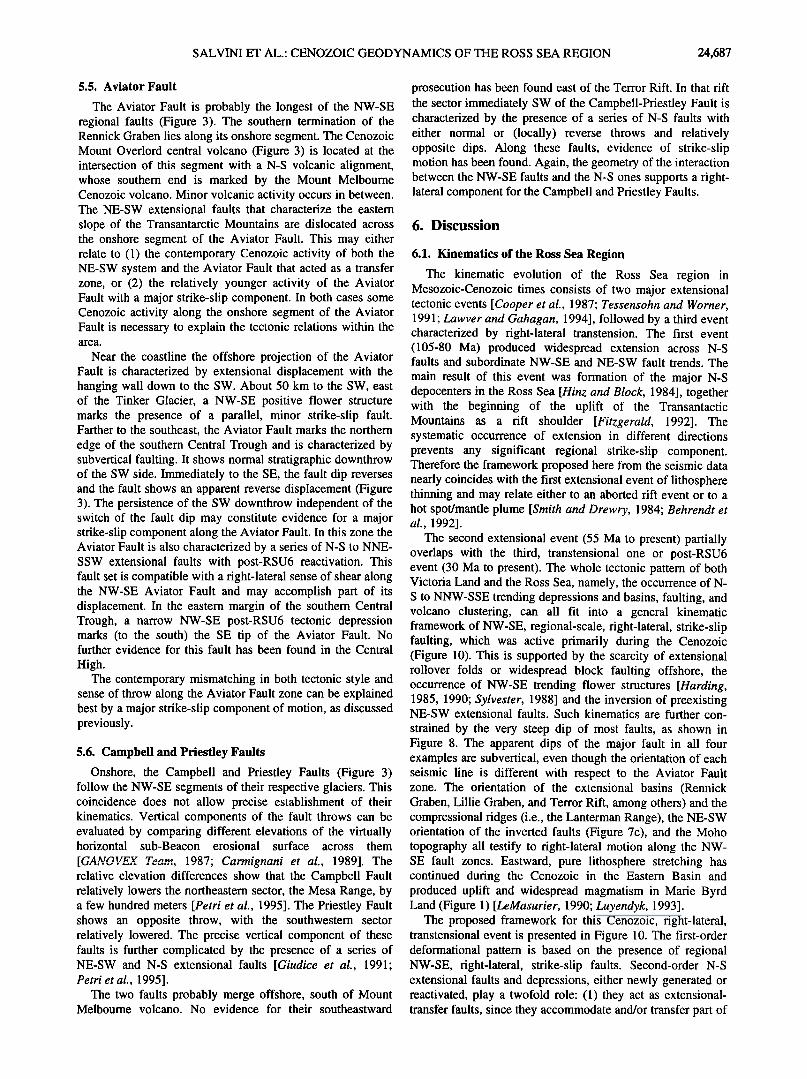
5.5. Aviator Fault
The Aviator Fault is probably the longest of the NW-SE regional faults (Figure 3). The southern termination of the Rennick Graben lies along its onshore segment. The Cenozoic Mount Overlord central volcano (Figure 3) is located at the intersection of this segment with a N-S volcanic alignment, whose southern end is marked by the Mount Melbourne Cenozoic volcano. Minor volcanic activity occurs in between. The NE-SW extensional faults that characterize the eastern
slope of the Transantarctic Mountains are dislocated across the onshore segment of the Aviator Fault. This may either relate to (1) the contemporary Cenozoic activity of both the NE-SW system and the Aviator Fault that acted as a transfer zone, or (2) the relatively younger activity of the Aviator Fault with a major strike-slip component. In both cases some Cenozoic activity along the onshore segment of the Aviator Fault is necessary to explain the tectonic relations within the area.
Near the coastline the offshore projection of the Aviator Fault is characterized by extensional displacement with the hanging wall down to the SW. About 50 km to the SW, east of the Tinker Glacier, a NW-SE positive flower structure marks the presence of a parallel, minor strike-slip fault. Farther to the southeast, the Aviator Fault marks the northern
edge of the southern Central Trough and is characterized by subvertical faulting. It shows normal stratigraphic downthrow of the SW side. Immediately to the SE, the fault dip reverses and the fault shows an apparent reverse displacement (Figure 3). The persistence of the SW downthrow independent of the switch of the fault dip may constitute evidence for a major strike-slip component along the Aviator Fault. In this zone the Aviator Fault is also characterized by a series of N-S to NNE- SSW extensional faults with post-RSU6 reactivation. This fault set is compatible with a right-lateral sense of shear along the NW-SE Aviator Fault and may accomplish part of its displacement. In the eastern margin of the southern Central Trough, a narrow NW-SE post-RSU6 tectonic depression marks (to the south) the SE tip of the Aviator Fault. No further evidence for this fault has been found in the Central
High. The contemporary mismatching in both tectonic style and
sense of throw along the Aviator Fault zone can be explained best by a major strike-slip component of motion, as discussed previously.
5.6. Campbell and Priestley Faults
Onshore, the Campbell and Priestley Faults (Figure 3) follow the NW-SE segments of their respective glaciers. This coincidence does not allow precise establishment of their kinematics. Vertical components of the fault throws can be evaluated by comparing different elevations of the virtually horizontal sub-Beacon erosional surface across them
[r':a •r•utrv 'r,,,,,.. • o•'7. c',,,.,..; .... i ,,,. ,-,• !989]. The relative elevation differences show that the Campbell Fault relatively lowers the northeastern sector, the Mesa Range, by a few hundred meters [Petri et al., 1995]. The Priestley Fault shows an opposite throw, with the southwestern sector relatively lowered. The precise vertical component of these faults is further complicated by the presence of a series of NE-SW and N-S extensional faults [Giudice et al., 1991' Petri et al., 1995].
The two faults probably merge offshore, south of Mount Melbourne volcano. No evidence for their southeastward
prosecution has been found east of the Terror Rift. In that rift the sector immediately SW of the Campbell-Priestley Fault is characterized by the presence of a series of N-S faults with either normal or (locally) reverse throws and relatively opposite dips. Along these faults, evidence of strike-slip motion has been found. Again, the geometry of the interaction between the NW-SE faults and the N-S ones supports a right- lateral component for the Campbell and Priestley Faults.
6. Discussion
6.1. Kinematics of the Ross Sea Region
The kinematic evolution of the Ross Sea region in Mesozoic-Cenozoic times consists of two major extensional tectonic events [Cooper et al., 1987; Tessensohn and Worner, 1991; Lawvet and Gahagan, 1994], followed by a third event characterized by right-lateral transtension. The first event (105-80 Ma) produced widespread extension across N-S faults and subordinate NW-SE and NE-SW fault trends. The
main result of this event was formation of the major N-S depocenters in the Ross Sea [Hinz and Block, 1984], together with the beginning of the uplift of the Transantactic Mountains as a rift shoulder [Fitzgerald, 1992]. The systematic occurrence of extension in different directions prevents any significant regional strike-slip component. Therefore the framework proposed here from the seismic data nearly coincides with the first extensional event of lithosphere thinning and may relate either to an aborted rift event or to a hot spot/mantle plume [Smith and Drewry, 1984; Behrendt et al., 1992].
The second extensional event (55 Ma to present) partially overlaps with the third, transtensional one or post-RSU6 event (30 Ma to present). The whole tectonic pattern of both Victoria Land and the Ross Sea, namely, the occurrence of N- S to NNW-SSE trending depressions and basins, faulting, and volcano clustering, can all fit into a general kinematic framework of NW-SE, regional-scale, right-lateral, strike-slip faulting, which was active primarily during the Cenozoic (Figure 10). This is supported by the scarcity of extensional rollover folds or widespread block faulting offshore, the occurrence of NW-SE trending flower structures [Harding, 1985, 1990; Sylvester, 1988] and the inversion of preexisting NE-SW extensional faults. Such kinematics are further con-
strained by the very steep dip of most faults, as shown in Figure 8. The apparent dips of the major fault in all four examples are subvertical, even though the orientation of each seismic line is different with respect to the Aviator Fault zone. The orientation of the extensional basins (Rennick Graben, Lillie Graben, and Terror Rift, among others) and the compressional ridges (i.e., the Lanterman Range), the NE-SW orientation of the inverted faults (Figure 7c), and the Moho topography all testify to right-lateral motion along the NW- SE fault zones. Eastward, pure lithosphere stretching has continued during the Cenozoic in the Eastern Basin and produced uplift and widespread magmatism in Marie Byrd Land (Figure 1) [LeMasurier, 1990; Luyendyk, 1993].
The proposed framework for this Cenozoic, right-lateral, transtensional event is presented in Figure 10. The first-order deformational pattern is based on the presence of regional NW-SE, right-lateral, strike-slip faults. Second-order N-S extensional faults and depressions, either newly generated or reactivated, play a twofold role: (1) they act as extensional- transfer faults, since they accommodate and/or transfer part of
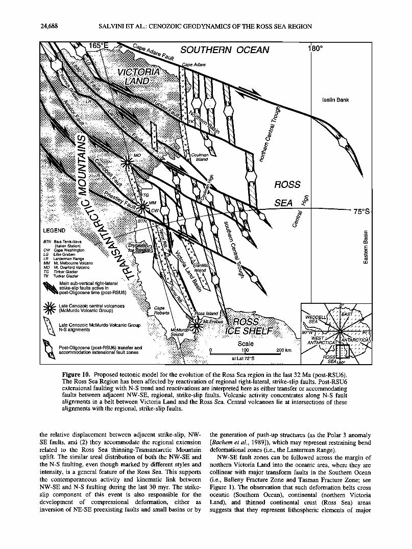
24,688 SALVINI ET AL.: CENOZOIC GEODYNAMICS OF THE ROSS SEA REGION
165øE SOUTHERN OCEAN
Adare
i
180 ø
c)
BTN Baia Terra Nova (Italian Station)
CW Cape Washington LG Lillie Graben LR Lanterman Range
MM Mr. Melbourne Volcano MO Mr. Overlord Volcano TG Tinker Glacier
TK Tucker Glacier
Main sub-vertical right-lateral strike-slip faults active in post-Oligocene time (post-RSU6)
Late Cenozoic central volcanoes (McMurdo Volcanic Group)
Late Cenozoic McMurdo Volcanic Group N-S alignments
Post-Oligocene (post-RSU6) transfer and accommodation extensional fault zones
Island
ROSS
SEA
::. .
Scale '":? ::::.:' ANTARCTICA :::::::::::::::::::::::: :::: :.i:?:!::;:?::::.!;i;:::;:::::::.:,.,..,,. 0 100 200 km ...................
i i i
............ at Lat 72øS RQSS .....
SEA1,
Iselin Bank
75øS
ANTARCTICA
Figure 10. Proposed tectonic model for the evolution of the Ross Sea region in the last 32 Ma (post-RSU6). The Ross Sea Region has been affected by reactivation of regional right-lateral, strike-slip faults. Post-RSU6 extensional faulting with N-S trend and reactivations are interpreted here as either transfer or accommodating faults between adjacent NW-SE, regional, strike-slip faults. Volcanic activity concentrates along N-S fault alignments in a belt between Victoria Land and the Ross Sea. Central volcanoes lie at intersections of these alignments with the regional, strike-slip faults.
the relative displacement between adjacent strike-slip, NW- SE faults, and (2) they accommodate the regional extension related to the Ross Sea thinning-Transantarctic Mountain uplift. The similar areal distribution of both the NW-SE and the N-S faulting, even though marked by different styles and intensity, is a general feature of the Ross Sea. This supports the contemporaneous activity and kinematic link between NW-SE and N-S faulting during the last 30 myr. The strike- slip component of this event is also responsible for the development of compressional deformation, either as inversion of NE-SE preexisting faults and small basins or by
the generation of push-up structures (as the Polar 3 anomaly [Bachem et al., 1989]), which may represent restraining bend deformational zones (i.e., the Lanterman Range).
NW-SE fault zones can be followed across the margin of northem Victoria Land into the oceanic area, where they are collinear with major transform faults in the Southern Ocean (i.e., Balleny Fracture Zone and Tasman Fracture Zone; see Figure 1). The observation that such deformation belts cross oceanic (Southem Ocean), continental (northern Victoria Land), and thinned continental crust (Ross Sea) areas suggests that they represent lithospheric elements of major
SALVINI ET AL.: CENOZOIC GEODYNAMICS OF THE ROSS SEA REGION 24,689
geodynamic importance, namely, intraplate faults. The correspondence with the Balleny and Tasman Fracture Zones may be understood by considering that the NW-SE fault zones developed well before the rift process between Australia and East Antarctica was initiated. These faults may have acted as weak zones at high angles to the rift axis and thus were favorably oriented to influence rift segmentation and the subsequent development of transform faults during seafloor spreading. During the first extensional event the rheology of East Antarctica prevented the reactivation of those faults as projections of the transforms. This geody- namical framework substantially changed during the latter extensional event (55 Ma to present) owing to the prosecution of the thinning of the Ross Sea crust and the presence of newly formed oceanic crust related to the drifting away of the Campbell Plateau, whose rifting started at 85 Ma [Lawyer and Gahagan, 1994]. Thus the geodynamic framework of Victoria Land changed, and this region become a headland of old, isostatically equilibrated continental lithosphere surrounded to the north by oceanic crust (the Southern Ocean) and to the east and the southeast by strongly thinned lithosphere. This allowed reactivation in the last 30 myr of the old NW-SE faults as projections of the main transforms of the Southern Ocean. This process also involved the Ross Sea stretched lithosphere, causing reactivation of those depocenters.
Deformation related to the activity of the major NW-SE faults implies that significant displacements occurred along them, although horizontal displacement (including strike slip and extension) is difficult to compute. Difficulties arise from (1) the transfers from strike-slip to dip-slip displacements and vice versa, (2) the presence of subseismic strain (ductile strain [Walsh et al., 1996]), and (3) the lack of suitable reference layers and markers onshore. The 25 km of apparent right- lateral offset of the Central Trough along the Aviator Fault may represent the minimal amount of relative horizontal displacement along that fault. By assuming that this value may represent the typical minimum offset along NW-SE major faults, one finds that the resulting total, minimal horizontal displacement related to the strike-slip tectonics ap- proaches 200 km. This estimation has to be integrated with extension induced in the Ross Sea region by both the extensional transfer and/or accommodation processes between adjacent strike-slip faults and by the extension induced by the Ross Sea thinning.
Deformational patterns vary along the NW-SE strike-slip faults, according to the different rheology of the lithospheric sectors that they crosscut (see below). Reactivation of the Victoria Land Basin and the occurrence of N-S fracturing in the coastal region of the Ross Sea are likely to enhance the lithospheric differentiation between Victoria Land and the thinned crust offshore [Stern and ten Brink, 1989] and may have caused rejuvenation of uplift of the Transantactic Mountains [Fitzgerald, 1992]. Apart from Quaternary volcanic activity, no detailed onshore data are available on the most recent activity along the main NW-SE striking fault zones.
The N-S fault trend can be explained within a right-lateral, NW-SE, strike-slip regional tectonic regime. A preexisting basin that evolved into a strike-slip regime is likely to be reactivated with transtensional kinematics, provided the strike of preexisting normal faults bounding the basin is approximately normal to the maximum extensional stress induced by the strike-slip fault movement [Harding, 1974].
The development of the Terror Rift within the Victoria Land Basin may have occurred according to this kinematic scheme, in that a right-lateral, strike-slip component can be recognized along its eastern boundary [Brancolini and Salvini, 1994; Del Ben et al. , 1994; Wilson, 1995].
North of Cape Washington, in the western Ross Sea, the tectonic framework contrasts with that to the south. There the
lack of well-defined, post-RSU6 N-S regional extensional faults suggests smaller-scale faulting in N-S en echelon arrays as the predominant mechanism of basin reactivation for accommodating displacement along NW striking faults (Figure 10). Small-scale faulting has long been recognized as a suitable means for accommodating displacement variations around large faults [Walsh et al., 1991]. The change in the deformational style may relate to variations in bulk theology, which weakens progressively from south to north, near the Southern Ocean, and from west (Victoria Land) toward east (Eastern Basin). Development of N-S fracturing along the western coast also has favored the uplift of magma and development of central-type volcanoes (i.e., Mount Erebus, Mount Melbourne and Mount Overlord) (Figure 10).
The uplift of the Transantarctic Mountains [Fitzgerald, 1992, and references therein] and NE-SW block faulting along their eastern side [Salvini and Storti, 1994; Wilson, 1992, 1995] were triggered by isostatic rebound [Wernicke, 1985] of the Ross Sea shoulder during the Mesozoic- Cenozoic, with virtually no contribution from the almost contemporary strike-slip tectonics. The isostatic rebound explains both the large dimensions of the Transantactic Mountains and outcrops of deeper structural levels in crystalline basement close to the coast, unlikely to be related to the strike-slip tectonics. On the other hand, strike-slip tectonics provide suitable kinematics for the development of local, even intense uplifts. Although NE-SW regional faults characterize the margin between the northern Victoria Land and the Ross Sea, offshore, no clear evidence has been observed of continuous, regional NE-SW fault zones crosscutting the Ross Sea, as proposed by Cooper et al. [1991] and Tessensohn and W6rner [1991]. Nevertheless, NE-SW normal faults should be present along the western coastal sector of the Ross Sea in order to explain the observed regional eastward downthrow [e.g., Davey and Cooper, 1987]. However, the difficulty in acquiring seismic data along the coastline makes faults hard to recognize in this region. The NE-SW fault belt may represent the deformation zone between the thinning lithosphere of the Ross Sea and its rift shoulder (i.e., the Transantarctic Mountains). This process started at 105 Ma and is probably still active [Wilson, 1995].
Right-lateral, strike-slip kinematics have been employed by previous authors to explain terrane accretion in northern Victoria Land during the Paleozoic [Findlay and Field, 1983; Weaver et al., 1984; Bradshaw et al., 1985]. Mesozoic- Cenozoic, right-lateral, strike-slip activity along the terrane boundaries has also been proposed [Brancolini and Salvini, 1994; Salvini and Storti, 1994]. The accretionary mechanism and the subsequent evolution are still under debate, but the large amount of time, different plate frameworks, and the occurrence of crustal reequilibration during the Late Paleozoic (i.e., Sub-Beacon Peneplain) suggest the lack of any relationship between the Paleozoic and the Cenozoic tectonic frameworks, except that preexisting crustal discontinuities constitute preferentially weaker zones for subsequent tectonic phases [Tommasi et al., 1995].
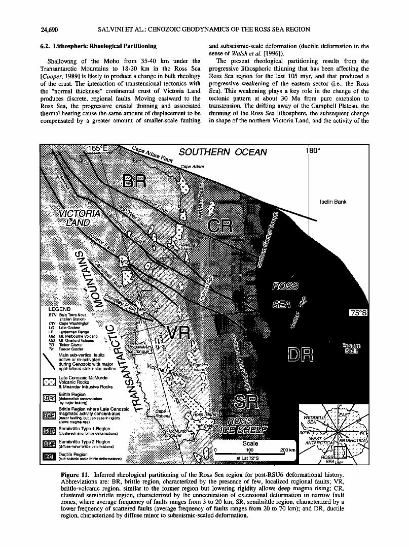
24,690 SALVINI ET AL.' CENOZOIC GEODYNAMICS OF THE ROSS SEA REGION
6.2. Lithospheric Rheological Partitioning
Shallowing of the Moho from 35-40 km under the Transantarctic Mountains to 18-20 km in the Ross Sea
[Cooper, 1989] is likely to produce a change in bulk theology of the crust. The interaction of transtensional tectonics with the "normal thickness" continental crust of Victoria Land
produces discrete, regional faults. Moving eastward to the Ross Sea, the progressive crustal thinning and associated thermal heating cause the same amount of displacement to be compensated by a greater amount of smaller-scale faulting
and subseismic-scale deformation (ductile deformation in the sense of Walsh et al. [1996]).
The present rheological partitioning results from the progressive lithospheric thinning that has been affecting the Ross Sea region for the last 105 myr, and that produced a progressive weakening of the eastern sector (i.e., the Ross Sea). This weakening plays a key role in the change of the tectonic pattern at about 30 Ma from pure extension to transtension. The drifting away of the Campbell Plateau, the thinning of the Ross Sea lithosphere, the subsequent change in shape of the northern Victoria Land, and the activity of the
SOUTHERN OCEAN
Adare
i
180 ø
CT
Iselin Bank
BTN Baia Terra Nova (Italian Station)
CW Cape Washington LG Lillie Graben
LR Lanterman Range MM Mt. Melbourne Volcano
MO Mt. Overlord Volcano •i•!:!i• TG Tinker Glacier TK Tucker Glacier
• Main sub-vertical faults active or re-activated during Cenozoic with major right-lateral strike-slip motion
Late Cenozoic McMurdo
"[-•"•] Volcanic Rocks & Meander Intrusive Rocks
Brittle Region •"• ....... (deformation accomplishes
by major faulting) Brittle Region where Late Cenozoic
ß 'B'•,• magmatic activity concentrates (major faulting, but decrease in rigidity allows magma rise)
,.'.•'..-..'• Semibrittle Type 1 Region (clustered minor brittle deformations)
.:$• Semibrittle Type 2 Region (diffuse minor brittle deformations)
• Ductile Region (sub-seismic scale brittle deformations)
Scale 0 100 200 km t i i
at Lat 72øS
ANTARCTICa
ROSS --
ANTARCTICA
Figure 11. Inferred rheological partitioning of the Ross Sea region for post-RSU6 deformational history. Abbreviations are: BR, brittle region, characterized by the presence of few, localized regional faults; VR, brittle-volcanic region, similar to the former region but lowering rigidity allows deep magma rising; CR, clustered semibrittle region, characterized by the concentration of extensional deformation in narrow fault zones, where average frequency of faults ranges from 3 to 20 km; SR, semibrittle region, characterized by a lower frequency of scattered faults (average frequency of faults ranges from 20 to 70 km); and DR, ductile region, characterized by diffuse minor to subseismic-scaled deformation.
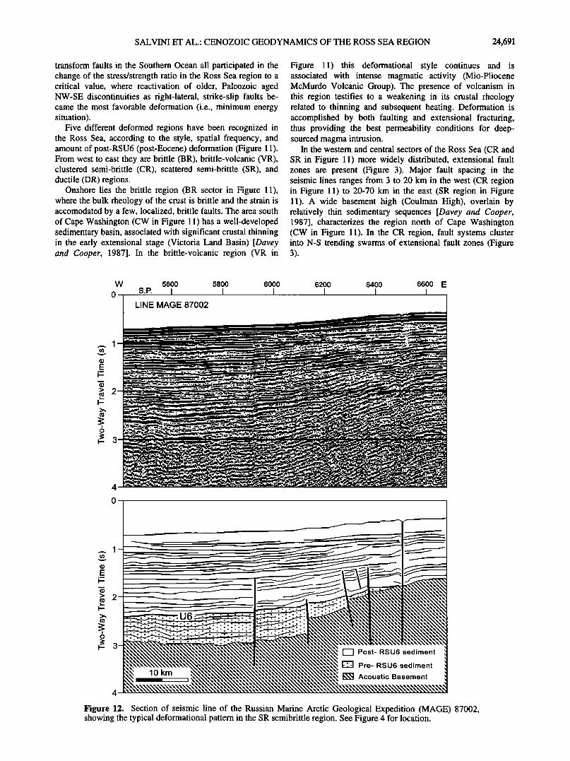
SALVINI ET AL.: CENOZOIC GEODYNAMICS OF THE ROSS SEA REGION 24,691
transform faults in the Southern Ocean all participated in the change of the stress/strength ratio in the Ross Sea region to a critical value, where reactivation of older, Paleozoic aged NW-SE discontinuities as right-lateral, strike-slip faults be- came the most favorable deformation (i.e., minimum energy situation).
Five different deformed regions have been recognized in the Ross Sea, according to the style, spatial frequency, and amount of post-RSU6 (post-Eocene) deformation (Figure 11). From west to east they are brittle (BR), brittle-volcanic (VR), clustered semi-brittle (CR), scattered semi-brittle (SR), and ductile (DR) regions.
Onshore lies the brittle region (BR sector in Figure 11), where the bulk rheology of the crust is brittle and the strain is accomodated by a few, localized, brittle faults. The area south of Cape Washington (CW in Figure 11) has a well-developed sedimentary basin, associated with significant crustal thinning in the early extensional stage (Victoria Land Basin) [Davey and Cooper, 1987]. In the brittle-volcanic region (VR in
Figure 11) this deformational style continues and is associated with intense magmatic activity (Mio-Pliocene McMurdo Volcanic Group). The presence of volcanism in this region testifies to a weakening in its crustal rheology related to thinning and subsequent heating. Deformation is accomplished by both faulting and extensional fracturing, thus providing the best permeability conditions for deep- sourced magma intrusion.
In the western and central sectors of the Ross Sea (CR and SR in Figure 11) more widely distributed, extensional fault zones are present (Figure 3). Major fault spacing in the seismic lines ranges from 3 to 20 km in the west (CR region in Figure 11) to 20-70 km in the east (SR region in Figure 11). A wide basement high (Coulman High), overlain by relatively thin sedimentary sequences [Davey and Cooper, 1987], characterizes the region north of Cape Washington (CW in Figure 11). In the CR region, fault systems cluster into N-S trending swarms of extensional fault zones (Figure 3).
W 5600 5800 6000
0 S.P. I I I LINE MAGE 87002
6200 6400 6600 E I I I
,_. I
4
,_. I
lO km I
[•1 Post- RSU6 sediment
ß E•] Pre- RSU6 sediment
• Acoustic Basement
Figure 12. Section of seismic line of the Russian Marine Arctic Geological Expedition (MAGE) 87002, showing the typical deformational pattern in the SR semibrittle region. See Figure 4 for location.
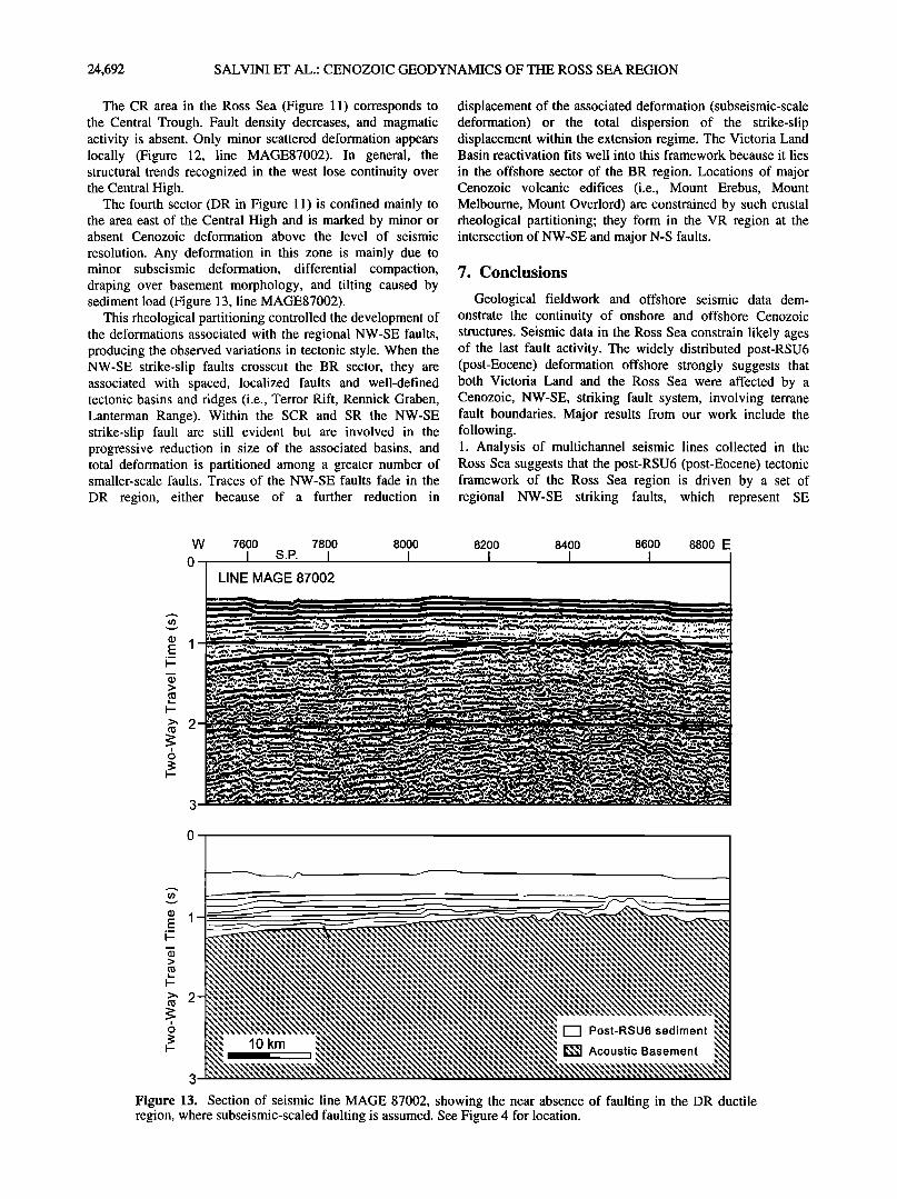
24,692 SALVINI ET AL.: CENOZOIC GEODYNAMICS OF THE ROSS SEA REGION
The CR area in the Ross Sea (Figure 11) corresponds to the Central Trough. Fault density decreases, and magmatic activity is absent. Only minor scattered deformation appears locally (Figure 12, line MAGE87002). In general, the structural trends recognized in the west lose continuity over the Central High.
The fourth sector (DR in Figure 11) is confined mainly to the area east of the Central High and is marked by minor or absent Cenozoic deformation above the level of seismic
resolution. Any deformation in this zone is mainly due to minor subseismic deformation, differential compaction, draping over basement morphology, and tilting caused by sediment load (Figure 13, line MAGE87002).
This rheological partitioning controlled the development of the deformations associated with the regional NW-SE faults, producing the observed variations in tectonic style. When the NW-SE strike-slip faults crosscut the B R sector, they are associated with spaced, localized faults and well-defined tectonic basins and ridges (i.e., Terror Rift, Rennick Graben, Lanterman Range). Within the SCR and SR the NW-SE strike-slip fault are still evident but are involved in the progressive reduction in size of the associated basins, and total deformation is partitioned among a greater number of smaller-scale faults. Traces of the NW-SE faults fade in the
DR region, either because of a further reduction in
displacement of the associated deformation (subseismic-scale deformation) or the total dispersion of the strike-slip displacement within the extension regime. The Victoria Land Basin reactivation fits well into this framework because it lies
in the offshore sector of the BR region. Locations of major Cenozoic volcanic edifices (i.e., Mount Erebus, Mount Melbourne, Mount Overlord) are constrained by such crustal theological partitioning; they form in the VR region at the intersection of NW-SE and major N-S faults.
7. Conclusions
Geological fieldwork and offshore seismic data dem- onstrate the continuity of onshore and offshore Cenozoic structures. Seismic data in the Ross Sea constrain likely ages of the last fault activity. The widely distributed post-RSU6 (post-Eocene) deformation offshore strongly suggests that both Victoria Land and the Ross Sea were affected by a Cenozoic, NW-SE, striking fault system, involving terrane fault boundaries. Major results from our work include the following. 1. Analysis of multichannel seismic lines collected in the Ross Sea suggests that the post-RSU6 (post-Eocene) tectonic framework of the Ross Sea region is driven by a set of regional NW-SE striking faults, which represent SE
W 7600 7800 8000
o I s.P. I I LINE MAGE 87002
8200 8400 8600 8800 E I I I
>
>' 2
•, 2- Post-RSU6 sediment ' o
3
Figure 13. Section of seismic line MAGE 87002, showing the near absence of faulting in the DR ductile region, where subseismic-scaled faulting is assumed. See Figure 4 for location.
SALVINI ET AL.: CENOZOIC GEODYNAMICS OF THE ROSS SEA REGION 24,693
propagation of major faults and terrane boundaries of probable Paleozoic age in northern Victoria Land. 2. Geometric arrays of structural elements, both along these faults and between them, strongly suggest NW-SE, right- lateral, strike-slip sense of shear in Cenozoic time. 3. The proposed NW-SE, right-lateral, strike-slip framework provides a suitable model for explaining widespread N-S extensional faulting in the region. 4. The change in bulk crustal rheology eastward of the Transantactic Mountains can be linked to the shoaling of the Moho from Victoria Land to the Ross Sea. The semibrittle
rheology in the intermediate region strongly constrains the timing and clustering of the Cenozoic magmatic activity. The transtensional proposed framework provides the paths for the implacement of the magma related by the regional, positive heath anomaly (hot spot/mantle plume) in the Ross Sea region. 5. Strike-slip kinematics imply a complex evolution along terrane boundaries, including reactivation during the Mesozoic-Cenozoic. The "engine" of such activity may be found in motions of the Tasman and Balleny fracture zones in the spreading Southern Ocean. The Mesozoic-Cenozoic geodynamic framework of the Ross Sea region may represent the effects of distal Southern Ocean transform zones working through different lithospheric sectors. The model provides a noteworthy example of relationships among regional-scale deformations, crustal thicknesses, heat flow, and lithospheric rheology. 6. Results from this paper reveal that regional NW-SE faults cut across different lithospheres (intraplate faults). NW-SE faults persist through various plate tectonic events, either as active discontinuities or as weak zones that will influence
successive deformational frameworks.
7. The reconstructed history of such lithospheric discon- tinuities shows that weakening in the bulk crustal rheology can trigger their reactivation, even after long periods of inactivity.
Acknowledgments. Most of this work was carried out while the senior author was on sabbatical leave at the Istituto Nazionale di
Geofisica (ING). Kind hospitality and pleasant facilities were greatly appreciated. We wish to thank ING president Enzo Boschi for his encouragement. We gratefully acknowledge revisions by J. Veevers and, in particular, by T. J. Wilson, whose useful suggestions improved the paper. A first version of the manuscript strongly benefited from a critical reading by A. K. Cooper. D. U. Wise provided very useful advice and comments on an improved version. We are indebted to J. A. Austin and S. Henrys for their thorough review of a preliminary version of the paper. In particular, careful revision and suggestions by J. A. Austin allowed us to significantly improve the paper. We wish to thank the OGS Team for the acquisition and processing of the Italian seismic lines. The ANTOSTRAT working group and the Seismic Data Library System (SDLS) are gratefully acknowledged for making available all of the seismic data acquired in the Ross Sea region. Financial support by the Italian Progetto Nazionale di Ricerche in Antartide (PNRA) is acknowledged. F. Storti acknowledges a PNRA postdoctoral fellowship at the Roma Tre University.
References
ANTOsTRAT Project, Seismic stratigraphic atlas of the Ross Sea, Antarctica, in Geology and Seismic Stratigraphy of the Antarctic Margin, Antarct. Res. Ser., vol. 68, edited by A.K. Cooper, P.F. Barker, and G. Brancolini, 22 plates, AGU, Washington, D.C., 1995.
Armienti, P., C. Ghezzo, F. Innocenti, P. Manetti, S. Rocchi, and S. Tonarini, Paleozoic and Cainozoic intrusives of Wilson Terrane:
geochemical and isotopic Data, Mem. 43, pp. 67-75, Soc. Geol. Ital., Rome, 1990.
Armienti, P., L. Civetta, F. Innocenti, P. Manetti, S. Tripodo, L. Villari, and G. Vita, New petrological and geochemical data on Mr. Melbourne Volcanic Field, Northern Victoria Land, Antarctica. (II Italian Antarctic Expedition), Mem. 46, pp. 397- 424, Soc. Geol. Ital., Rome, 1991.
Bachem, H. C., W. Bosum, D. Damaske, and J. Behrendt, Planning and execution of the GANOVEX IV aeromagnetic survey in North Victoria Land, Antarctica, Geol. Jahrb. E38, pp. 69-80, 1989.
Balestrieri, M. L., G. Bigazzi, C. Ghezzo, and B. Lombardo, Fission track dating of apatites from the Granite Harbour Intrusive Suite and the uplift-denudation history of the Transantarctic Mountains in the area between the Mariner and David Glaciers (northern Victoria Land, Antarctica), Terra Antartica, 1, 82-87, 1994.
Barrett, P.J. (Ed.), Antarctic Cenozoic hystory from the MSSTS-1 drillhole McMurdo Sound, DSIR Bull. 237, 174 pp., Sci. Inf. Publ. Cent., Wellington, N. Z., 1986.
Barrett, P.J. (Ed.), Antarctic Cenozoic history from the CIROS-1 drillhole McMurdo sound, DSIR Bull. 245, 254 pp., Sci. Inf. Publ. Cent., Wellington, N. Z., 1989.
Barrett, P.J., G.W. Grindley, and P.N. Webb, The Beacon Supergroup of East Antarctica, in Antarctic Geology and Geophysics, edited by J. Adier, pp. 319-332, Universitersforslag Et, Oslo, 1972.
Behrendt, J.C., W.E. LeMasurier, A.K Cooper, F. Tessensohn, A. Tr•hu, and D. Damaske, Geophysical studies of the West Antarctic Rift System, Tectonics, 10, 1257-1273, 1991.
Behrendt, J.C., W.E. LeMasurier, and A.K. Cooper, The West Antarctic Rift Systemn - A propagating rift "captured" by a mantle plume?, in Recent Progress in Antarctic Earth Science, edited by Y. Yoshida, K. Kaminuma, and K. Shiraishi, pp. 315- 322, Terra Scie., Tokyo, 1992.
Behrendt, J. C., R. Saltus, D. Damaske, A. McCafferty, C. A. Finn, D. Blankenship, and R. E. Bell, Patterns of late Cenozoic volcanic and tectonic activity in the West Antarctic rift system revealed by aeromagnetic survey, Tectonics, 15, 660-676., 1996.
Berger, P., G. Brancolini, G. De Cillia, C. Gantar, A. Marchertl, D. Nieto, and R. Ramella, Acquisition, processing and preliminary results of the Antarctic 1987-88 Geophysical Survey, Mem. 43, pp. 181-204, Soc. Geol. Ital., Rome, 1990.
Borg, S.G., and D.J. DePaolo, A tectonic model of the Antarctic Gondwana margin with implications for southeastern Australia: isotopic and geochemical evidence, Tectonophysics, 196, 339- 358, 1991.
Bott, M.H.P., and T.A. Stern, Finite element analysis of Transantarctic Mountains uplift and coeval subsidence in the Ross Embayment, Tectonophysics, 201,341-356, 1992.
Bradshaw, J.D., Terrane boundaries in North Victoria Land, Mem. 33, pp. 9-15, Soc. Geol. Ital., Rome, 1989.
Bradshaw, J.D., S.D. Weaver, and M.G. Laird, Suspect terranes and Cambrian tectonics in Northern Victoria Land, Antarctica, in Tectonostratigraphic Terranes of the Circum-Pacific Region, Earth Sci. Ser., vol. l, edited by J. Howell, pp. 467-479, Circum- Pacific Res. Counc., Houston, Tex., 1985.
Brancolini, G., and F. Salvini, Modelling the Cenozoic evolution of the Victoria Land-Ross Sea system, paper presented at 5th PNRA Meeting of Earth Science in Antarctica, Siena, Italy, April 11-13, 1994.
Brancolini, G., C. Gantar, E. Lodolo, and A. Marchetti, Acquisition, processing and preliminary results of the 1988/89 Antarctic Geophysical Survey, Mem. 46, pp. 543-560, Soc. Geol. Ital., Rome, 1991.
Brancolini, G., M. Busetti, A.K. Cooper, F. Salvini, and F. Storti, Tectonic map of the Ross Sea-Victoria Land geodynamic system, Antarctica, paper presented at 7th International Symposium on Antarctic Earth Sciences, Siena, Italy, September 10-15, 1995.
Burrerr, C.F., and R.H. Findlay, Cambrian and Ordovician Conodonts from the Robertson Bay Group, Antarctica, and their tectonic significance, Nature, 307, 723-725, 1984.
Busetti, M., A new constraints for the age of unconformity U6 in the Ross Sea, Terra Antartica, 1,523-526, 1994.
Busetti, M., L. De Santis, M. Kavun, and I. Zayatz, Seismic sequences of the Ross Sea continental margin (Antarctica), Boll. Geofis. Teor. Appl., 35, 133-152, 1993.
24,694 SALVINI ET AL.: CENOZOIC GEODYNAMICS OF THE ROSS SEA REGION
Busetti, M., I. Zayatz, and Ross Sea Regional Working Group, Distribution of seismic units in the Ross Sea, Terra Antartica, 1, 523-526, 1994.
Cande, S.C., and J.C. Mutter, A revised identification of the oldest sea-floor spreading anomalies between Australia and Antarctica, Earth Planet. Sci. Lett., 58, 151-160, 1982.
Carmignani, L., C. Ghezzo, G. Gosso, B. Lombardo, M. Meccheri, A. Montrasio, P.C. Pertusati, and F. Salvini, Geology of Wilson Terrane in the area between David and Mariner Glaciers, Victoria Land (Antarctica), Mem 33, pp. 77-97, Soc. Geol. Ital., Rome, 1989.
Cooper, A.K., Crustal structure of the Ross Embayment, Antarctica, in Proceedings of 1st International Symposyum on Antarctic Science, edited by H.T. Huh, B.K.Park, and S.H. Lee, pp. 57-72, Corea Ocean Research and Development Institute, Seul, 1989.
Cooper, A.K., and G. Brancolini, Stratigraphic record of the Ross Sea continental shelf, Terra Antartica, 1, 491-496, 1994.
Cooper, A.K., and F.J. Davey, Episodic rifting of Phanerozoic rocks in the Victoria Land basin, western Ross Sea, Antarctica, Science, 229, 1085-1087, 1985.
Cooper, A.K., F.J. Davey, and J.C. Behrendt, Seismic stratigraphy and structure of the Victoria Land Basin, Western Ross Sea, Antarctica, in The Antarctic Continental Margin: Geology and Geophysics of the Western Ross Sea, Earth Sci. Ser., vol. 5B, edited by A.K. Cooper and F.J. Davey, pp. 27-76, Circum-Pacific Res. Counc., Houston, Tex, 1987.
Cooper, A.K., F.J. Davey, and K. Hinz, Crustal extension and origin of sedimentary basin beneath the Ross Sea and Ross Ice Shelf, Antarctica, in Geological Evolution of Antarctica, edited by M.R.A Thompson, J.A. Crame, and J.W. Thompson, pp. 285- 291, Cambridge Univ. Press, New York, 1991.
Cooper, A. K., G. Brancolini, and F. J. Davey, Summary of the ANTOSTRAT Ross Sea Regional Working Group meeting, Terra Antartica, 1,483-490, 1994.
Coren, F., C. Zanolla, and I. Marson, Computation of the Moho depths from gravity data in the Ross Sea, Antarctica, in Joint symposium IGC and ICG, Graz, Austria, September 11-17, Springer-Verlag, New York, in press, 1997.
Damaske, D., J. C. Behrendt, A. E. McCafferty, R. W. Saltus, and U. Meyer, Transfer faults in the west Ross Sea: New evidence from the McMurdo Sound/Ross Ice Shelf aeromagnetic survey (GANOVEX VI), Antarc'. Sci., 6, 359-364, 1994.
Davey, F.J., Geophysical studies in the Ross Sea region, J. R. Soc. N. Z., 11,465-479, 1981.
Davey, F.J., and G. Brancolini, The Late Mesozoic and Cenozoic structural setting of the Ross Sea Region, in Geology and Seismic Stratigraphy of the Antarctic Margin, Antarct. Res. Ser., vol. 68, edited by A.K. Cooper, P.F. Barker, and G. Brancolini, pp. 167- 182, AGU, Washington, D.C., 1995.
Davey, F.J. and A.K. Cooper, Gravity studies of the Victoria Land basin and Iselin bank, in The Antarctic Continental Margin: Geology and Geophysics of the Western Ross Sea., Earth Sci. Ser., vol. 5B, edited by A.K. Cooper and F.J. Davey, pp. 119- 138, Circum-Pacific Res. Counc., Houston, Tex, 1987.
Davey, F.J., K. Hinz, and H. Schroder, Sedimentary basins of the Ross Sea, Antarctica, in Antarctic Earth Science, edited by R.J. Olivier, P.R. James, and J.B Jago, pp. 533-538, Aust. Acad. of Sci., Canberra, A.C.T., 1983.
Del Ben, A., I. Finetti, M. Pipan, C. Sauli, and P. Fu, Seismic study of the structure, stratigraphy and evolution of the Ross sea (Antarctica),Boll. Geofis. Teor. Appl., 35(1995), 9-106, 1994.
Dow, J.A.S., and V.E. Neall, Geology of the Lower Rennick Glacier, northern Victoria Land, Antarctica, N. Z. J. Geol. Geophys., 17, 659-714, 1974.
Elliot, D. H., Tectonics of Antarctica - A review, Am. J. Sci., 275A, 45-106, 1975.
Findlay, R. H., Silurian and Devonian events in the Tasman Orogenic Zone, New Zealand and Marie Byrd Land and their comparison with Northern Victoria Land, Mem. 43, pp. 9-32, Soc. Geol. Ital., Rome, 1990.
Findlay, R. H., and B.D. Field, Tectonic significance of deformations affecting the Robertson Bay Group and associated rocks, Northern Victoria Land, Antarctica, in Antarctic Earth Science, edited by R.J. Olivier, P.R. James, and J.B Jago, pp. 107-112, Aust. Acad. of Sci., Canberra, A.C.T., 1983.
Fitzgerald, P.G., The Transantarctic Mountains of Southern Victoria Land: The Application of apatite fission track analysis to a rift shoulder uplift, Tectonics, 11,634-662, 1992.
Fitzgerald, P.G., M. Sandiford, P.J. Barrett, and J.W. Gleadow, Asymmetric extension associated with uplift and subsidence in the Transantarctic Mountains and Ross Embayment, Earth Planet. Sci. Lett., 81, 67-78, 1986.
F16ttman, T., and G. Kleinschmidt, Opposite thrust system in Northern Victoria Land, Antarctica: Imprints of Gondwana's Paleozoic accretion, Geology, 19, 45-47, 1991.
Fortunati, L., R. Della Maggiore, F. Mazzarini, F. Salvini, and M. Span6, Regional scale structural geology of Northern Victoria Land (Antarctica) by satellite image processing, Mem. 46, pp. 495-504, Soc. Geol. Ital., Rome, 1991.
Gair, H.S., The geology from the upper Rennick Glacier to the coast, northern Victoria Land, Antarctica, N. Z. J. Geol. Geophys., 10, 309-344, 1967.
Gair, H. S., A. Sturm, S.J. Carryer, and G. W. Grindley, The geology of Northern Victoria Land, Antarct. Map Folio Ser., .folio 12, plate XII, Am. Geogr. Soc., New York, 1969.
GANOVEX Team, Geological Map of North Victoria Land, Antarctica, 1:500,000. Explanatory notes, Geol. Jahrb., B 66, 7- 79, 1987.
Gibson, G. M., Lanterman Fault: Boundary between allochthons terranes in northern Victoria Land, Antarctica, Nature, 315, 480- 483, 1985.
Gibson, G. M., Metamorphism and deformation in the Bowers Supergroup: Implications for terrane accretion in Northern Victoria Land, in Terrane Accretion and Orogenic Belts, Geodyn. Ser., vol. 19, edited by E. C. Leitch and E. Scheibner, pp. 207-219, AGU, Washington, D.C., 1987.
Giudice, A., F. Mazzarini, F. Salvini, and F. Storti, Geology of the Mt. Melbourne area, North Victoria Land, Antarctica: Evidences from photointerpretative analysis, Mem. 46, pp. 505-514, Soc. Geol. Ital., Rome, 1991.
Gleadow, A.J.W., and P. G. Fitzgerald, Uplift history and structure of the Transantarctic Mountains: New evidence from fission
track dating of basement apatites in the Dry Valleys area, southern Victoria Land, Earth Planet. Sci. Lett., 82, 1-14, 1988.
Grindley, G.W., The geology of the Queen Alexandra Range, Beardmore Glacier, Ross Dependency, Antarctica with notes on the correlation of Gondwana sequences, N.Z.J. Geol. Geophys., 6, 307-347, 1963.
Grindley, G.W., and P.J. Oliver, Post-Ross orogeny cratonisation of Northern Victoria Land, in Antarctic Earth Science, edited by R.J. Olivier, P.R. James, and J.B Jago, pp. 133-139, Aust. Acad. of Sci., Canberra, A.T.C., 1983.
Gunn, B.M., and G. Warren, Geology of Victoria Land between the Mawson and the Mulock Glaciers, Antarctica, Bull. N.Z. Geol. Surv., 71, 1-157, 1962.
Harding, T. P., Petroleum traps associated with wrench faults, AAPG Bull., 58, 1290-1304, 1974.
Harding, T. P., Seismic characteristics and identification of negative flower structures, positive flower structures and positive positive structural inversion, AAPG Bull., 69, 582-600, 1985.
Harding, T. P., Identification of wrench faults using subsurface structural data: Criteria and pitfalls, AAPG Bull., 74, 1590-1609, 1990.
Harrington, H.J., Nomenclature of rock units in the Ross Sea region, Antarctica, Nature, 182,4361, 1958.
Hayes, D.E. (Ed.), Marine Geological and Geophysical Atlas of the Circum-Antarctic to 30øS, Antarct. Res. Ser., vol. 54, AGU, Washington, D.C., 1991.
Hayes, D.E., and L.A. Frakes, Initial Report of the Deep Sea Drilling Project, vol. 28, U.S. Gov. Print. 0•., Washington, D.C., 1975.
Hinz, K. and M. Block, Results of geophysical investigations in the Weddell Sea and in the Ross Sea, Antarctica, in Proceedings of the 11th World Petroleum Congress London, 1983, vol. 2, pp. 279-291, John Wiley, New York, 1984.
Hole, M.J., and W.E. Le Masurier, Tectonic controls on the geochemical composition of Cenozoic mafic alkaline volcanic rocks from west Antarctica. Contrib. Mineral. Petrol., 117, 187- 202, 1994.
Houtz, R., and F.J. Davey, Seismic profiler and sonobuoy measurements in Ross Sea, Antarctica, J. Geophys. Res., 78, 3448- 3468, 1973.
Kleinschmidt, G., and F. Tessensohn, Early Paleozoic westward directed subduction at the Pacific margin of Antarctica, in Gondwana Six: Structure, Tectonics and Geophysics, Geophys.
SALVINI ET AL.: CENOZOIC GEODYNAMICS OF THE ROSS SEA REGION 24,695
Monogr. Ser., vol. 4, edited by G. D. M. McKenzie, pp. 89-105, AGU, Washington, D.C., 1987.
Kyle, P.R., and J.W. Cole, Structural controls of volcanism in the McMurdo Volcanic Group, McMurdo Sound, Antarctica, Bull. Volcanol., 38, 16-35, 1974.
Kyle, P.R, D.H. Elliot, and J.F. Sutter, Jurassic Ferrar Supergroup tholeiites from the Transantarctic Mountains, Antarctica, and their relationship to the initial fragmentation of Gondwana, in Gondwana Five, edited by M.M. Cresswell et al., pp. 283-287, A.A. Balkema, Rotterdam, Netherlands, 1981.
Jones, S. A., Late Quaternary reactivation of Paleozoic brittle structures, South Victoria Land, Antarctica, paper presented at 7th International Symposium on Antarctic Earth Sciences, SCAR, Sept. 10-15, Siena, Italy, 1995.
Laird, M. G., The Late Mesozoic fragmentation of the New Zealand segment of Gondwana, in Gondwana Five, edited by M.M. Cresswell et al., pp. 311-318, A.A. Balkema, Rotterdam, Netherlands, 1981.
Laird, M. G., Evolution of the Cambrian-Early Ordovician Bowers basin, Northern Victoria Land, and its relationship with the adjacent Wilson and Robertson Bay Terranes, Mem. 33, pp. 125- 134, Soc. Geol. Ital., Rome, 1989.
Lawver, L. A., and L. M. Gahagan, Constraints on timing of extension in the Ross Sea Region. Terra Antartica, 1, 545-552, 1994.
Le Masurier, W.E., Late Cenozoic volcanism on the Antarctic Plate: An overview, in Volcanoes of the Antarctic Plate and Southern Oceans, Antarct. Res. Ser., vol 48, edited by W.E. Le Masurier and J.W. Thomson, pp. 1-19, AGU, Washington, D.C., 1990.
Luyendyk, B.P., Crustal extension, the exhumation of mid-crustal rocks, and the formation of basin-and-range structure in the northern Edsel Ford Ranges, western Marie Byrd Land, West Antarctica, Ann. Geofis., 36, 165-177, 1993.
Luyendyk, B. P., S. Cisowsky, C. Smith, S. Richard, and D. Kimbrough, Paleomagnetic study of the northern Ford Ranges, western Mary Byrd Land, West Antarctica: Motion between West and East Antarctica, Tectonics, 15, 122-141, 1996.
Mazzarini, F., and F. Salvini, Tectonic blocks in North Victoria Land (Antarctica): Geological and structural constraints by satellite lineament domain analysis, Terra Antartica, 1, 74-77, 1994.
Mtiller, P., M. Schmidt-Thome, H. Kreuzer, F. Tessensohn, and U. Vetter, Cenozoic peralkaline magmatism at the Western Margin of the Ross Sea, Antarctica, Mem. 46, pp. 315-336, Soc. Geol. Ital., Rome, 1991.
Mutter, J.C., K.A. Hegarty, S.C. Cande, and J.K. Weissel, Breakup between Australia and Antarctica: A brief review in the light of new data, Tectonophysics, 114, 255-279, 1985.
Pertusati, P., and F. Tessensohn (Eds.), 1:250,000 geological maps of the northern Victoria Land, Antarctica (Suvorov Glacier, Yule Bay, Mount Murchison and Coulman Island Quadrangles), paper presented at 7th International Symposium on Antarctic Earth Sciences, SCAR, Sept. 10-15, Siena, Italy, 1995.
Petri, A., F. Storti, and F. Salvini, Geology of the Beacon and Ferrar supergroups in the Mesa Range area, Northern Victoria Land, Antarctica: A photogeological study, paper presented at 7th International Symposium on Antarctic Earth Sciences, SCAR, Sept. 10-15, Siena, Italy, 1995.
Reitmayr, G., The gravity map of Victoria Land, Antarctica, Terra Antartica, 1,495-500, 1994.
Rocchi, S., S. Tonarini, P. Armienti, and F. Innocenti, Cenozoic intrusions of northern Victoria Land: Its bearing on timing of Ross Sea rifting, Mem. 43, pp. 67-75, Soc. Geol. Ital., Rome, 1990.
Roland, N.W., and F. Tessensohn, Rennick faulting - An early phase of Ross Sea rifting. Geol. Jahrb., 66, 203-229, 1987.
Salvini F., An approach to regional paleo-stress analysis of fault populations from multiple deformed rocks: Applications to the central Apennines, paper presented at "Fault Populations," TSG Special Meeting, Tectonic Study Group, Edinburgh, Oct. 19-20, 1994.
Salvini, F., and F. Storti, Domino faulting in Northern Victoria Land (Antarctica): preliminary data from the Mr. Murchison Quad area, Terra Antartica, 1, 78-81, 1994.
Salvini, F., and E. Vittori, Analisi strutturale della linea Olevano- Antrodoco-Posta (Ancona-Anzio Auct.): Metodologia di studio delle deformazioni fragili e presentazione del tratto meridionale, Mem. 24, pp. 337-355, Soc. Geol. Ital., Rome, 1982.
Sato, S., N. Asakura, T. Saki, N. Oikawa, and Y. Kaneda, Preliminary results of geological and geophysical surveys in the Ross Sea and in the Dumont d'Urville Sea off Antarctica, Natl. Inst. o.f Polar Res., Spec. Issue 33, pp. 66-92, Tokyo, 1984.
Schmidt, D.L., and P.D. Rowley, Continental rifting and transform faulting along the Jurassic Transantarctic Rift, Antarctica, Tectonics, 5, 279-291, 1986.
Skinner, D.N.B., and J. Ricker, The geology of the region between the Mawson and Priestley glaciers, North Victoria Land, Antarctica, 1, Basement metasedimentary and igneous rocks, N. Z. J. Geol. Geophys., 11, 1009-1040, 1968.
Smith, A.G., and D.J. Drewry, Delayed phase change due to hot asthenosphere causes Transantarctic uplift?, Nature, 309, 536- 538, 1984.
Stackebrandt, W., Some arguments for Cenozoic fault activities around Gondwana Station, Transantarctic Mountains, in Landscape Evolution in the Ross Sea Area, edited by F.M. van der Wateren, A.L.L.M. Verbers, and F. Tessensohn, pp. 53-55, Rijks Geol. Dienst, Haarlem, Netherlands, 1994.
Stern, T.A., and U.S. ten Brink, Flexural uplift of the Transantarctic Mountains, J. Geophys. Res., 94, 10,315-10,330, 1989.
Stock, J., and P. Molnar, Revised history of early Tertiary plate motion in the south-west Pacific, Nature, 325, 495-499, 1987.
Storey, B.C., The crustal blocks of West Antarctica within Gondwana: reconstruction and break-up model, in Geological Evolution o.f Antarctica, edited by M.R.A Thompson, J.A. Crame, and J.W. Thompson, pp. 587-592, Cambridge Univ. Press, New York, 1991.
Storey, B.C., and P.A.R. Nell, Role of strike-slip faulting in the tectonic evolution of the Antarctic Peninsula, J. Geol. Soc. London, 145, 333-337, 1988.
Stump, E., and P.G. Fitzgerald, Episodic uplift of the Transantarctic Mountains, Geology, 20, 161-164, 1992.
Stump, E., M. G. Laird, J. D. Bradshaw, J. R. Holloway, S. G. Borg, and K. Lapham, Bowers graben and associated tectonic features cross Northern Victoria Land, Antarctica, Nature, 304, 334-336, 1983.
Suppe J., Geometry and kinematics of fault-bend folding, Am. J. Sci., 283, 684-721, 1983.
Sylvester, A.G., Strike-slip faults, Geol. Soc. o.f Am. Bull., 100, 1666-1703, 1988.
Tessensohn, F., Structural evolution of the northern end of the Transantarctic Mountains, in Landscape Evolution in the Ross Sea Area, edited by F.M. van der Wateren, A.L.L.M. Verbers, and F. Tessensohn, pp. 57-61, Rijks Geol. Dienst, Haarlem, Netherlands, 1994a.
Tessensohn, F., The Ross Sea Region, Antarctica: Structural interpretation in relation to the evolution of the Southern Ocean, Terra Antartica, 1,553-558, 1994b.
Tessensohn, F., and G. WOrner, The Ross Sea rift system, Antarctic: Structure, evolution and analogues, in Geological Evolution o.f Antarctica, edited by M.R.A Thompson, J.A. Crame, and J.W. Thompson, pp. 273-277, Cambridge Univ. Press, New York, 1991.
Tommasi, A., A. Vauchez, and B. Daudr6, Initiation and propagation of shear zones in a heterogeneous continental lithosphere, J. Geophys. Res., 100, 22,083-22,101, 1995.
Van der Beek, P., S. Cloething, and P. Andriessen, Mechanisms of extensional basin formation and vertical motions of rift flanks:
Constraints from tectonic modelling and fission-track thermochronology, Earth Planet. Sci. Lett., 121, 417-433, 1994.
Vetter, U. and F. Tessensohn, S- and I-type granitoids of Northern Victoria Land, Antarctica, and their inferred geotectonic setting, Geol. Rundsch., 76, 233-243, 1987.
Walker, B.C., The Beacon Supergroup of Northern Victoria Land, Antarctica, in Antarctic Earth Science, edited by R.J. Olivier, P.R. James, and J.B Jago, pp. 211-214, Aust. Acad. of Sci., Canberra, A.C.T., 1983.
Walsh, J.J., J. Watterson, and G. Yielding, The importance of small- scale faulting in regional extension, Nature, 351, 391-393, 1991.
Walsh, J.J.J. Watterson, C. Childs, and A. Nicol, Ductile strain effects in the analysis of seismic interpretations of normal fault systems, in Modern Developments in Structural Interpretation, Validation and Modelling, edited by P.G. Buchanan and D.A. Nieuwland, Spec. Publ. Geol. Soc. London, 99, 27-40, 1996.
Weaver, S. D., J. D. Bradshaw, and M. G. Laird, Geochemistry of Cambrian volcanics in Northern Victoria Land, Antarctica, Earth Planet. Sci. Lett., 68, 128-140, 1984.
24,696 SALVINI ET AL.: CENOZOIC GEODYNAMICS OF THE ROSS SEA REGION
Wernicke, B., Uniform-sense normal simple shear of the continental lithosphere, Can. J. Earth Sci., 22, 108-125, 1985.
Wilson, T.J., Mesozoic and Cenozoic kinematic evolution of the Trans antarctic Mountains, in Recent Progress in Antarctic Earth Science, edited by Y. Yoshida, K. Kaminuma, and K. Shiraishi, pp. 303-314, Terra Sci., Tokyo, 1992.
Wilson, T. J., Structural kinematic studies in the Transantarctic Mountains, Southern Victoria Land, Terra Antattica, 1,537-538, 1994.
Wilson, T. J., Cenozoic transtension along the Transantarctic Mountains-West Antarctic rift boundary, Southern Victoria Land, Antarctica, Tectonics, 14, 531-545, 1995.
Wise, D. U., R. Funiciello, M. Parotto, and F. Salvini, Topographic lineament swarm: Clues to their origin from domains analysis of Italy, Geol. Soc. Am. Bull., 96, 952-967, 1985.
Wright, T. O., R. J. Ross, and J. E. Repetski, Newly discovered youngest Cambrian or oldest Ordovician fossil from Robertson Bay Terrane (formely Precambian), Northern Victoria Land, Antarctica, Geology, 12, 301-305, 1984.
Zayatz, I., M. Kavun, and V. Traube, The Soviet geophysical research in the Ross Sea, in International Workshop on Antarctic Offshore Seismic Stratigraphy (ANTOSTRAT), U.S. Geol. Surv. Open File Rep., 90-309, 283-290, 1990.
G. Brancolini, M. Busetti, and F. Coren, Osservatorio Geofisico Sperimentale, P.O. Box 2011, 34016 Trieste, Italy. (e-mail: branco @magrav.ogs.trieste.it; martina @macmar.ogs.trieste.it; coren @magrav.ogs.trieste.it; )
F. Mazzarini, Centro Scientifico per la Geologia Strutturale e Dinamica dell'Appennino, Comitato Nazionale delle Ricerche, Via S.Maria 53, 56100 Pisa, Italy. (e-mail: [email protected])
F. Salvini and F. Storti, Dipartimento di Scienze Geologiche, Universith "Roma Tre", L.go S. L. Murialdo, 1 00146 Rome, Italy. (e-mail: [email protected]; [email protected])
(Received January 7, 1997; revised May 17, 1997; accepted June 4, 1997.)
Related Documents