1 CellSense: An Accurate Energy-Efficient GSM Positioning System Mohamed Ibrahim, Student Member, IEEE, and Moustafa Youssef, Senior Member, IEEE Abstract —Context-aware applications have been gaining huge interest in the last few years. With cell phones becoming ubiquitous computing devices, cell phone localization has become an important research problem. In this paper, we present CellSense, a prob- abilistic RSSI-based fingerprinting location determi- nation system for GSM phones. We discuss the chal- lenges of implementing a probabilistic fingerprinting localization technique in GSM networks and present the details of the CellSense system and how it addresses these challenges. We then extend the proposed system using a hybrid technique that combines probabilistic and deterministic estimation to achieve both high ac- curacy and low computational overhead. Moreover, the accuracy of the hybrid technique is robust to changes in its parameter values. To evaluate our proposed system, we implemented CellSense on Android-based phones. Results from two different testbeds, represent- ing urban and rural environments, for three differ- ent cellular providers show that CellSense provides at least 108.57% enhancement in accuracy in rural areas and at least 89.03% in urban areas compared to the current state of the art RSSI-based GSM localization systems. In additional, the proposed hybrid technique provides more than 6 times and 5.4 times reduction in computational requirements compared to the state of the art RSSI-based GSM localization systems for the rural and urban testbeds respectively. We also evaluate the effect of changing the different system parameters on the accuracy-complexity tradeoff and how the cell towers density and fingerprint density affect the system performance. I. Introduction As cell phones become more ubiquitous in our daily lives, the need for context-aware applications increases. One of the main context information is location which enables a wide set of cell phone applications including navigation, location-aware social networking, and security applications. Although GPS [2] is considered one of the most well known localization techniques, it is not available in many cell phones, requires direct line of sight to the satellites, and consumes a lot of energy. Therefore, research Copyright (c) 2011 IEEE. Personal use of this material is permit- ted. However, permission to use this material for any other purposes must be obtained from the IEEE by sending a request to pubs- [email protected]. This work is supported in part by a Google Research Award. M. Ibrahim is with the Wireless Intel. Net. Center (WINC), Nile University, Smart Village, Egypt e-mail: [email protected]. M. Youssef is with the Dep. of Comp. Sc. and Eng., Egypt- Japan Univ. of Sc. & Tech. (E-JUST), Alexandria, Egypt e-mail: [email protected]. An earlier version of this paper has appeared in the proceedings of the IEEE Global Communications Conference (GlobeCom) 2010 [1]. for other techniques for obtaining cell phones location has gained momentum fueled by both the users’ need for location-aware applications and government requirements, e.g. FCC [3]. City-wide WiFi-based localization for cellular phones has been investigated in [4], [5] and commercial products are currently available [6]. However, WiFi chips, similar to GPS, are not available in many cell phones and not all cities in the world contain sufficient WiFi coverage to obtain ubiquitous localization. Similarly, using augmented sensors in the cell phones, e.g. accelerometers and compasses, for localization have been proposed in [7]– [9]. However, these sensors are still not widely used in many phones. On the other hand, GSM-based localization, by definition, is available on all GSM-based cell phones, which presents 80-85% of today’s cell phones [10], works all over the world, and consumes minimal energy in addition to the standard cell phone operation. Many research work have addressed the problem of GSM localization [3], [5], [11], [12], including time-based systems, angle-of-arrival based systems, and received signal strength indicator (RSSI) based systems. Only recently, with the advances in cell phones, GSM-based localization systems have been implemented [5], [11], [12]. These systems are mainly RSSI-based as RSSI information is easily available to the user’s applications. Since RSSI is a complex function of distance, due to the noisy wireless channel, RSSI-based systems usually require building an RF fingerprint of the area of interest [5], [11], [12]. A fingerprint stores information about the RSSI received from different base stations at different locations in the area of interest. This is usually constructed once in an offline phase. During the tracking phase, the received RSSI at an unknown location is compared to the RSSI signatures in the fingerprint and the closest location in the fingerprint is returned as the estimated location. Constructing the fingerprint is a time consuming process. However, this is typically done in a process called war driving, where cars scan the streets of a city to map it. Current commercial systems, such as Skyhook, Google’s MyLocation and StreeView services already perform scanning for other purposes. Therefore, constructing the fingerprint for GSM localization can be piggybacked on these systems without extra overhead. In this paper, we propose CellSense,a probabilistic fingerprinting based technique for GSM localization. Un- like the current fingerprinting techniques for GSM phones that use a deterministic approach for estimating the loca- tion of cell phones [11], [12], the CellSense probabilistic technique provides more accurate localization. However, constructing a probabilistic fingerprint is challenging, as

Welcome message from author
This document is posted to help you gain knowledge. Please leave a comment to let me know what you think about it! Share it to your friends and learn new things together.
Transcript
1
CellSense: An Accurate Energy-Efficient GSM
Positioning SystemMohamed Ibrahim, Student Member, IEEE, and Moustafa Youssef, Senior Member, IEEE
Abstract—Context-aware applications have beengaining huge interest in the last few years. With cellphones becoming ubiquitous computing devices, cellphone localization has become an important researchproblem. In this paper, we present CellSense, a prob-abilistic RSSI-based fingerprinting location determi-nation system for GSM phones. We discuss the chal-lenges of implementing a probabilistic fingerprintinglocalization technique in GSM networks and presentthe details of the CellSense system and how it addressesthese challenges. We then extend the proposed systemusing a hybrid technique that combines probabilisticand deterministic estimation to achieve both high ac-curacy and low computational overhead. Moreover, theaccuracy of the hybrid technique is robust to changesin its parameter values. To evaluate our proposedsystem, we implemented CellSense on Android-basedphones. Results from two different testbeds, represent-ing urban and rural environments, for three differ-ent cellular providers show that CellSense provides atleast 108.57% enhancement in accuracy in rural areasand at least 89.03% in urban areas compared to thecurrent state of the art RSSI-based GSM localizationsystems. In additional, the proposed hybrid techniqueprovides more than 6 times and 5.4 times reduction incomputational requirements compared to the state ofthe art RSSI-based GSM localization systems for therural and urban testbeds respectively. We also evaluatethe effect of changing the different system parameterson the accuracy-complexity tradeoff and how the celltowers density and fingerprint density affect the systemperformance.
I. Introduction
As cell phones become more ubiquitous in our dailylives, the need for context-aware applications increases.One of the main context information is location whichenables a wide set of cell phone applications includingnavigation, location-aware social networking, and securityapplications. Although GPS [2] is considered one of themost well known localization techniques, it is not availablein many cell phones, requires direct line of sight to thesatellites, and consumes a lot of energy. Therefore, research
Copyright (c) 2011 IEEE. Personal use of this material is permit-ted. However, permission to use this material for any other purposesmust be obtained from the IEEE by sending a request to [email protected].
This work is supported in part by a Google Research Award.M. Ibrahim is with the Wireless Intel. Net. Center (WINC), Nile
University, Smart Village, Egypt e-mail: [email protected]. Youssef is with the Dep. of Comp. Sc. and Eng., Egypt-
Japan Univ. of Sc. & Tech. (E-JUST), Alexandria, Egypt e-mail:[email protected].
An earlier version of this paper has appeared in the proceedings ofthe IEEE Global Communications Conference (GlobeCom) 2010 [1].
for other techniques for obtaining cell phones locationhas gained momentum fueled by both the users’ need forlocation-aware applications and government requirements,e.g. FCC [3]. City-wide WiFi-based localization for cellularphones has been investigated in [4], [5] and commercialproducts are currently available [6]. However, WiFi chips,similar to GPS, are not available in many cell phonesand not all cities in the world contain sufficient WiFicoverage to obtain ubiquitous localization. Similarly, usingaugmented sensors in the cell phones, e.g. accelerometersand compasses, for localization have been proposed in [7]–[9]. However, these sensors are still not widely used inmany phones. On the other hand, GSM-based localization,by definition, is available on all GSM-based cell phones,which presents 80-85% of today’s cell phones [10], works allover the world, and consumes minimal energy in additionto the standard cell phone operation. Many research workhave addressed the problem of GSM localization [3], [5],[11], [12], including time-based systems, angle-of-arrivalbased systems, and received signal strength indicator(RSSI) based systems. Only recently, with the advancesin cell phones, GSM-based localization systems have beenimplemented [5], [11], [12]. These systems are mainlyRSSI-based as RSSI information is easily available to theuser’s applications. Since RSSI is a complex function ofdistance, due to the noisy wireless channel, RSSI-basedsystems usually require building an RF fingerprint ofthe area of interest [5], [11], [12]. A fingerprint storesinformation about the RSSI received from different basestations at different locations in the area of interest. Thisis usually constructed once in an offline phase. During thetracking phase, the received RSSI at an unknown locationis compared to the RSSI signatures in the fingerprint andthe closest location in the fingerprint is returned as theestimated location. Constructing the fingerprint is a timeconsuming process. However, this is typically done in aprocess called war driving, where cars scan the streetsof a city to map it. Current commercial systems, suchas Skyhook, Google’s MyLocation and StreeView servicesalready perform scanning for other purposes. Therefore,constructing the fingerprint for GSM localization can bepiggybacked on these systems without extra overhead.
In this paper, we propose CellSense, a probabilistic
fingerprinting based technique for GSM localization. Un-like the current fingerprinting techniques for GSM phonesthat use a deterministic approach for estimating the loca-tion of cell phones [11], [12], the CellSense probabilistictechnique provides more accurate localization. However,constructing a probabilistic fingerprint is challenging, as
2
we need to stand at each fingerprint location for a certainamount of time to construct the signal strength histogram.This adds significantly to the overhead of the fingerprintconstruction process. CellSense addresses this challengeby using gridding, where the area of interest is dividedinto a grid and the histogram is constructed for each gridcell. This, not only removes the extra overhead of standingat each location for a certain time, but also helps inincreasing the scalability of the technique as the fingerprintsize can be reduced arbitrarily by increasing the gridcell length. To further reduce the computational overheadof CellSense, we propose a hybrid technique CellSense-Hybrid that combines a probabilistic estimation phasewith a deterministic refinement phase. The CellSense-Hybrid technique has also the added advantage of itsaccuracy being robust to changes in its parameter values.
In order to evaluate CellSense, we implement it onAndroid-enabled cell phones and compare its performanceto other deterministic fingerprinting techniques, modelbased techniques, and Google’s MyLocation service un-der two different testbeds representing rural and urbanenvironments for three different cellular providers. Wealso study the effect of the different parameters on theperformance of CellSense. Our results show that CellSenseoutperforms other systems, with at least 108.57% and89.03% enhancement in accuracy for the urban and ruraltestbeds respectively. In addition, it has significant savingsin terms of energy consumption with 5 to 6 times saving inrunning time. Moreover, the CellSense-Hybrid techniqueaccuracy is robust to the changes in parameter values.
To summarize, the contribution of this paper is three-fold:
1) We introduce the CellSense probabilistic GSM local-ization system. CellSense provides high localizationaccuracy and depends on a novel gridding techniqueto reduce the fingerprint construction overhead.
2) We further extend the CellSense technique througha hybrid technique that adds a deterministic refit-ment phase to the basic CellSense technique. Theaccuracy of the CellSense-Hybrid technique is robustto changes in its parameter values. Therefore, theCellSense-Hybrid technique parameters can be se-lected to achieve a low computational overhead whilemaintaining the same accuracy.
3) We thoroughly evaluate the performance of theCellSense and CellSense-Hybrid techniques, boththrough analysis and under two different testbeds,and show their significant advantage compared toother state-of-the-art GSM localization systems.
The rest of the paper is organized as follows: In SectionII we discuss relevant related work. In Section III, wepresent our CellSense system. Section IV presents theperformance evaluation of our system. Finally, Section Vconcludes the paper and gives directions for future work.
,
II. Related Work
In this section, we discuss the different techniques forcell phone localization and how they differ from theproposed work. We categorize these techniques as: time-based, angle of arrival based, cell-id based, city-wide WiFilocalization, augmented sensors based, and signal strengthbased.
A. Time-of-Arrival based Localization
In time-of-arrival (ToA) based systems, the cell phoneestimates its distance to a reference point based on thetime a signal takes to travel from the reference pointto it. Similarly, time difference of arrival (TDOA) basedsystems use the principle that the emitter location can beestimated by the intersection of the hyperbolae of constantdifferential time of arrival of the signal at two or more pairsof base stations [3].
The most well known localization technique, the GPS[2], can be categorized as a time-of-arrival based system.Time based systems require special hardware and thereforeare usually deployed on high-end phones. In addition, GPSsuffers from two other main problems: availability andpower consumption; It requires line-of-sight to the satel-lites; therefore it does not work indoors and it consumesa lot of power of the energy-limited cell phones.
B. Angle-of-Arrival based Systems
Angle-of-Arrival (AOA) based systems use triangula-tion based on the estimated AOA of a signal at two ormore base stations to estimate the location of the desiredtransmitter [3], [13]–[16]. Antenna arrays are usually usedto estimate the angle of arrival. Similar to TOA basedsystems, AOA based systems require specialized hardware,which makes them less attractive for a large deploymenton cell phones.
C. Cell-ID based Techniques
Cell-ID based techniques, e.g. Google’s MyLocation[17], do not use RSSI explicitly, but rather estimate thecell phone location as the location of the cell tower thephone is currently associated with. This is usually the celltower with the strongest RSSI. Such techniques require adatabase of cell towers locations and provide an efficient,though coarse grained, localization method.
D. City-wide WiFi-based localization
City-wide WiFi-based localization has been proposed in[4], [5] and commercial products are currently available,e.g. [6]. However, WiFi chips, similar to GPS, are notavailable in the majority of cell phones and not all citiesin the world contain sufficient WiFi coverage to obtainubiquitous localization.
3
E. Augmented Sensors-based localization
Using augmented sensors in the cell phones, e.g. ac-celerometers and compasses, for localization have beenproposed in [7]–[9], [18]. For example, in [18] the authorsuse the accelerometer and compass as an energy-efficientway for estimating the phone displacement and direction.Due to the accumulation of error, they synchronize withthe GPS as needed.
The main issue with augmented sensors-based localiza-tion systems is that these sensors are still not widely usedin cell phones.
F. RSSI-based Systems
Recently, RSSI-based systems have been introducedand implemented for cell phone localization. Since RSSIinformation is readily available to the user’s applicationson almost all GSM phones, such systems have the potentialof localizing 80-85% of today’s cell phones [10], work allover the world, and consume minimal energy in additionto the standard cell phone operation.
However, since RSSI is a complex function of distance,RSSI-based systems usually require building an RF fin-gerprint of the area of interest [5], [11], [12]. A finger-print stores information about the RSSI received fromdifferent base stations at different locations in the areaof interest. This is usually constructed once in an offlinephase. During the tracking phase, the received RSSI at anunknown location is compared to the RSSI signatures inthe fingerprint and the closest location in the fingerprintis returned as the estimated location. Constructing thefingerprint is a time consuming process. However, this istypically done in a process called war driving, where carsdrive the area of interest continuously scanning for celltowers and recording the cell tower ID, RSSI, and GPSlocation. Current commercial systems, such as Skyhook,Google’s MyLocation and StreeView services already per-form scanning for other purposes. Therefore, constructingthe fingerprint for GSM localization can be piggybacked onthese systems without extra overhead.
In the rest of this section, we summarize the currentwork in fingerprint-based RSSI localization systems forGSM phones, which is the closest to the proposed work.
1) Deterministic Fingerprinting Techniques: Currentfingerprinting techniques for GSM localization use onlydeterministic techniques [11], [12]. For example, each loca-tion in the fingerprint of [11] stores a vector representingthe RSSI value from each cell tower heard at this loca-tion. During the tracking phase, the K-Nearest Neighbors(KNN) classification algorithm is used, where the RSSIvector at an unknown location is compared to the vectorsstored in the fingerprint and the K-closest fingerprintlocations, in terms of Euclidian distance in the RSSI space,to the unknown vector are averaged as the estimatedlocation. Deterministic fingerprinting techniques requiresearching a larger database than cell-ID based techniquesbut provide higher accuracy. Note that the overhead ofconstructing the fingerprint is the same as constructingthe cell-ID database as both require war driving.
2) Modeling-based Techniques: Modeling-based tech-niques try to capture the relation between signal strengthand distance using a model. For example, the work in [11]uses a Gaussian process to capture this relation assumingthat the received signal strength yi at location xi isyi = f(xi) + ǫi Where ǫi is zero mean, additive Gaussiannoise with known variance σ2
n.A Gaussian process (GP) estimates posterior distribu-
tions over functions f from a training data D (fingerprint).These distributions are represented non-parametrically, interms of the training points. A key idea underlying GP’s isthe requirement that the function values at different pointsare correlated, where the covariance between two functionvalues, f(xp) and f(xq), depends on the input locations, xp
and xq. This dependency can be specified via an arbitrarycovariance function, or kernel, k(xp, xq). The most widelyused kernel function is the squared exponential, or Gaus-sian, Kernel: k(xp, xq) = σ2
f exp( −1
2l2 |xp −xq|2), where l is alength scale that determines how strongly the correlationbetween points drops off.
Building a GP estimator still requires constructing afingerprint, though a less sparse one. This fingerprint isused to estimate the model parameters (l , σ2
n, and σ2
f )and to compute f(x∗) for any location x∗.
This reduces the size of the fingerprint and provides away for extending a sparse fingerprint to a more dense oneas it gives the fingerprint values at any arbitrary locationbased on the assumed model. However, this comes at thecost of substantial increase in computational requirements,as we quantify in Section IV, and there is no actual savingof fingerprinting overhead as war driving has to be doneto collect the training samples (D) anyway. Moreover, theassumed model may not fit the real environment, thusreducing the accuracy of the returned location.
G. Summary
Compared to TOA, AOA, city-wide WiFi, andaugmented sensors based systems, our proposed sys-tem,CellSense, does not require any specialized hardwareand is more ubiqtious, in terms of the number of cellphones it runs on and the coverage area.
Compared to the cell-ID based systems and the currentfingerprinting techniques, our technique is a probabilis-
tic one. Using a probabilistic approach should enhancethe accuracy of localization compared to a deterministicapproach. However it comes with its own challenges, suchas constructing the RSSI probability distribution withminimal overhead. Our proposed technique addresses thesechallenges and provides accuracy better than all of the cur-rent techniques with minimal computational requirementsas we quantify in Section IV.
III. The CellSense System
In this section, we describe our CellSense system forGSM phones localization. We start by an overview ofthe system followed by the details of the offline trainingand online tracking phases. Finally, we propose a hybrid

4
CellSenseSystemComponents
Radio
Map
Radio Map
BuilderGridding-based
Estimator
Applications
Fingerprint
Acquisition API
Samples
Acquisition API
Location API
Estimated Location
(Cell Id, RSS)(CellId,RSS,
Lat,Long)
Figure 1. CellSense components: the arrows show information flowin the system.
approach that combines the basic CellSense and a deter-ministic approach to achieve both accurate localizationand low computational overhead.
A. Overview
Figure 1 shows our CellSense system architecture.CellSense works in two phases: an offline fingerprint con-struction phase and online tracking phase. During theoffline phase, a probabilistic fingerprint is constructed,where the RSSI histogram for each cell tower at givenlocations in the area of interest is estimated. This isperformed in the Radio Map Builder module.
During the online tracking phase, the location estima-tion module uses the fingerprint to calculate the mostprobable fingerprint location the user may be standing at.
The RSSI samples are collected with the Fingerprint Ac-quisition API that interacts with the phone GSM modemto obtain RSSI information from up to seven neighboringcell towers as indicated by the GSM standard. Finally, theLocation API is used by the user’s applications to querythe current estimated user’s location.
B. Mathematical Model
Without loss of generality, let L be a two dimensionalphysical space. Let q represent the total number of celltowers in the system. We denote the q-dimensional signalstrength space as Q. Each element in this space is aq-dimensional vector whose entries represent the RSSIreadings from a different cell tower. We refer to this vector
Grid
Ce
ll
Le
ng
th
LSL USL
Figure 2. CellSense approach for fingerprint construction. The areaof interest is divided into grids and the histogram is constructed usingthe fingerprint locations inside the grid cell. No extra overhead isrequired for fingerprint construction. The grid cell length parametercan be used to tradeoff accuracy and scalability.
as s. We also assume that the samples from different towersare independent. Therefore, the problem becomes, givenan RSSI vector s = (s1, ..., sq), we want to find the locationl ∈ L that maximizes the probability P (l|s).
C. Offline Phase
The purpose of this phase is to construct the signalstrength histogram for the RSSI received from each celltower at each location in the fingerprint. Typically, thisrequires the user to stand at each location in the finger-print for a certain period of time to collect enough samplesto construct the RSSI histogram. This will increase thefingerprint construction overhead significantly, as the war-driving car has to stop at each location in the fingerprintfor a certain time.
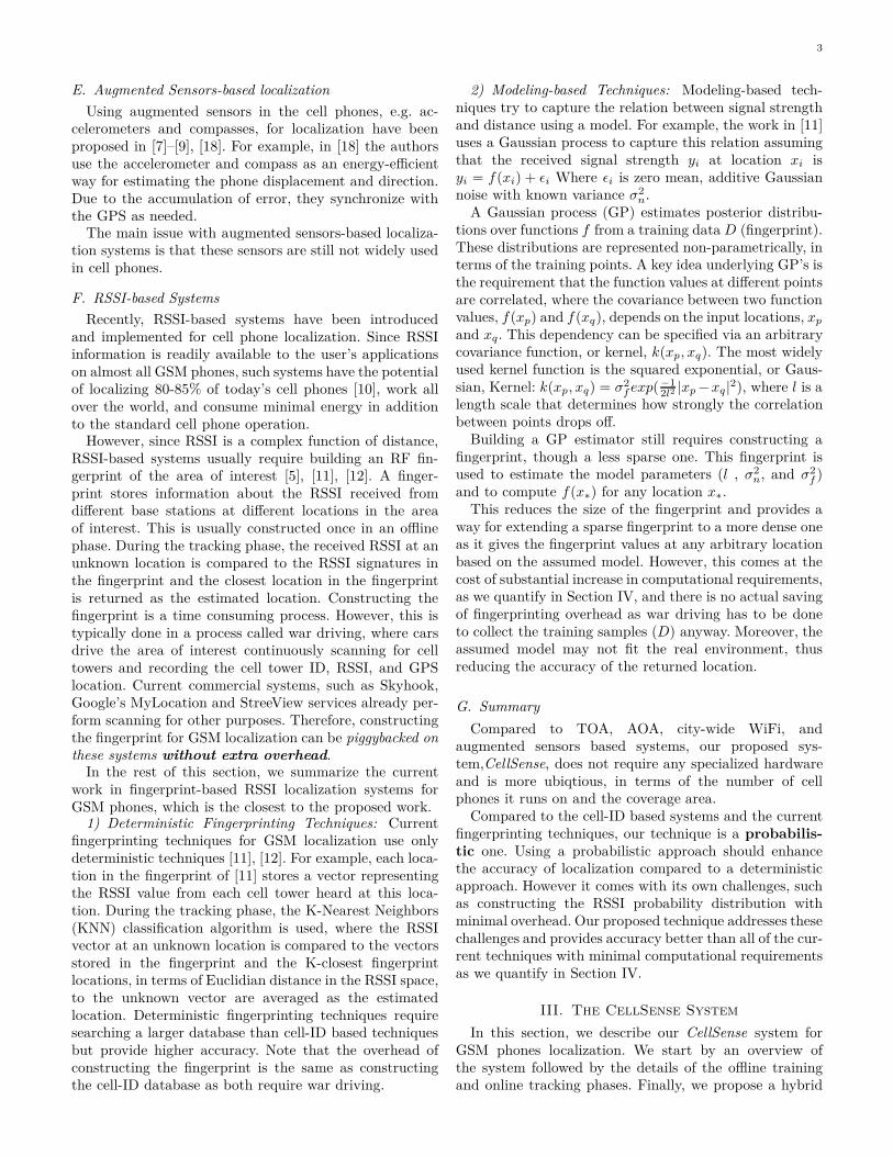
To avoid this overhead, we use a gridding approach,where the war-driving process is performed normally andthe area of interest is divided into cells. The histogramis then constructed for each cell tower in a given cellusing all fingerprint points inside the cell, rather than foreach individual fingerprint point (Figure 2). Note that thisgridding approach reduces the resolution of the fingerprintfrom individual points to cells with a certain size. Thecenter of mass of all fingerprint points inside a grid cell isused to represent the cell1. Figure 3 shows the histogramsfor a certain cell tower in three adjacent cells. The figureshows that the shape of the histogram changes over thedifferent grid cells and hence could be used to distinguishbetween them.
The gridding approach not only removes the extra over-head of war-driving, but also increases the scalability ofCellSense as the fingerprint size can be arbitrarily reducedby increasing the cell size. We quantify the effect of thegrid cell length parameter on performance in Section IV.
1We use the term “fingerprint point” to refer to an individual pointcollected by the wardriving car and use the term “fingerprint cell” todenote the fingerprint collected using all points inside a given cell.
5
0 5 10 15 20 25 300
0.5
1
Signal Strength (ASU)
Fre
qu
en
cy
Cell 1
0 5 10 15 20 25 300
0.5
1
Signal Strength (ASU)
Fre
qu
en
cy
Cell 2
0 5 10 15 20 25 300
0.5
1
Signal Strength (ASU)
Fre
qu
en
cy
Cell 3
Figure 3. An example of the histograms from three adjacent cells(grid length= 70m) from a certain cell tower. The Active Set Update(ASU) is an integer value returned by the phone API (dBm= 2.ASU -113).
D. Online Phase
During the online phase, the user is standing at anunknown location l receiving a signal strength vectors = (s1, ..., sq), containing one entry for each cell tower.We want to find the location in the fingerprint (l ∈ L) thathas the maximum probability given the received signalstrength vector s. That is, we want to find
argmaxl[P (l|s)] (1)
Using Bayes’ theorem and assuming that all locationsare equally probable2, this can be written as:
argmaxl[P (l|s)] = argmaxl[P (s|l)] (2)
P (s|l) can be calculated using the histograms con-structed during the offline phase as:
P (s|l) =
q∏
i=1
P (si|l) (3)
The above equation considers only one sample from eachstream for a location estimate. In general, a number ofsuccessive samples, Ns, from each stream can be used toimprove performance.
In this case, P (s|l) can then be expressed as follows:
P (s|l) =
q∏
i=1
N∏
j=1
P (si,j |l) (4)
Where si,j represents the jth sample from the ith stream.Thus, given the signal strength vector s, the discrete spaceestimator applies Equation 4 to calculate P (s|l) for each
2If the probability of being at each location is known, this can beused in the equation as is.
location l and returns the location that has the maximumprobability.
Similarly, instead of returning just the most probablelocation, a weighted average of the K most probable fin-gerprint cells, weighted by the probability of each location,can be used to obtain a better estimate of location. Westudy the effect of the parameter K on performance inSection IV.
E. The CellSense-Hybrid Technique
For the described CellSense technique, the grid celllength parameter allows us to trade accuracy and com-putational complexity: Larger cells lead to lower accuracybut they reduce the computational complexity due to thereduced number of cells. The CellSense-Hybrid techniquetargets maintaining the accuracy at lower grid sizes whilereducing the computational requirements. To achieve bothaccuracy and low complexity, the CellSense-Hybrid tech-nique runs in two phases: Rough estimation phase andrefinement phase.
1) In the first phase (rough estimation phase), ituses the standard probabilistic fingerprint estima-tion technique to obtain the most probable cell auser may be located in. However, instead of returningthe center of mass of the fingerprint points insidethis cell as the estimated location as in the standardCellSense, it refines this estimate in the second step.
2) In the second phase (estimation refinement phase), aK-nearest neighbor approach is used to estimate theclosest fingerprint point, in the signal strength space,to the current user location inside the cell estimatedin phase one. Note that since the histograms areconstructed for an entire cell, we do not use aprobabilistic technique in the second phase.
To achieve a low computational cost at low valuesof the grid cell length parameter, the CellSense-Hybridtechnique uses only one sample to estimate the mostprobable cell, rather than Ns samples, in its first phase.The refinement phase allows it to compensate for thelost accuracy. Note that the CellSense-Hybrid techniquedoes not have an advantage, in terms of computationalcomplexity, for higher grid cell lengthes as the numberof fingerprint points involved in the second phase willdominate the computational cost.
In summary, the low computational requirement of theCellSense-Hybrid technique is achieved by using a fewernumber of samples in the estimation process as com-pared to the CellSense. To compensate for the reducedaccuracy, CellSense-Hybrid uses an estimation refinementphase. This allows CellSense-Hybrid to achieve both highaccuracy and low computational requirements for lowvalues of the grid cell length parameter. We quantify theperformance of the hybrid technique in Section IV.
IV. Performance Evaluation
In this section, we study the effect of different pa-rameters on CellSense and compare its performance to
6
other RSSI-based GSM localization systems in terms oflocalization accuracy and running time. For the runningtime estimation, all techniques have been implemented ona Dell Inspiron 6400 with a 1.83GHz Intel Core 2 processorrunning Windows XP.
A. Data Collection
We collected data for two different testbeds. The firsttestbed covers the Smart Village in Cairo, Egypt whichrepresents a typical rural area. The second testbed coversa 5.45 Km2 in Alexandria, Egypt representing a typicalurban area. Data was collected using T-Mobile G1 phoneswhich have a GPS receiver (used as the ground truth forlocation) and running the Android 1.6 operating system.The experiment was performed using three phones, eachwith a SIM card for a different cellular provider in Egypt.
We implemented the scanning program using the An-droid SDK. The program records the (cell-ID, signalstrength, GPS location, timestamp) for the cell tower themobile is connected to as well as the other six neighboringcell towers information as dedicated by the GSM specifi-cations. The scanning rate was set to one per second. Twoindependent data sets were collected for each testbed: onefor training and the other for testing. Table I summarizesthe two testbeds.
The calibration process took on average 22.34 minutesfor the rural area and 48.48 minutes for the urban area.The war-driving process involved visiting each point onlyonce. Our experience show that visiting the same pointmore than one time does not lead to enhancement inaccuracy.
B. Effect of Changing Parameters
In this section, we explore the results of changing thedifferent parameters on the performance of CellSense,mainly: grid cell length, number of samples used in es-timation (Ns) and the number of most probable locationsaveraged to obtain the final location (K). We also studythe effect of changing the network provider, cell towersdensity, and the effect of using a sparse radio map. Table IIsummarizes the parameters and their default values, whichare the values that achieve the best performance.
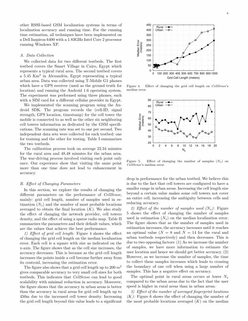
1) Effect of grid cell length: Figure 4 shows the effectof changing the grid cell length on the median localizationerror. Each cell is a square with size as indicated on thex-axis. The figure shows that as the cell size increases, theaccuracy decreases. This is because as the grid cell lengthincreases the points inside a cell become further away fromits centroid, increasing the estimation error.
The figure also shows that a grid cell length up to 200 m2
gives comparable accuracy to very small cell sizes for bothtestbeds. This indicates that CellSense can lead to goodscalability with minimal reduction in accuracy. Moreover,the figure shows that the accuracy in urban areas is betterthan the accuracy in rural areas for grid cell length up to450m due to the increased cell tower density. Increasingthe grid cell length beyond this value leads to a significant
0
50
100
150
200
250
300
350
400
450
0 100 200 300 400 500 600 700 800 900 1000
Me
dia
n E
rro
r (
me
ters
)
Grid Cell Length (meters)
RuralUrban
Figure 4. Effect of changing the grid cell length on CellSense’smedian error.
20
30
40
50
60
70
80
90
0 2 4 6 8 10 12 14 16 18 20
Me
dia
n E
rro
r (
me
ters
)
Ns
RuralUrban
Figure 5. Effect of changing the number of samples (Ns) onCellSense’s median error.
drop in performance for the urban testbed. We believe thisis due to the fact that cell towers are configured to have asmaller range in urban areas. Increasing the cell length sizebeyond a certain value makes some cell towers not coveran entire cell, increasing the ambiguity between cells andreducing accuracy.
2) Effect of the number of samples used (Ns): Figure5 shows the effect of changing the number of samplesused in estimation (Ns) on the median localization error.The figure shows that as the number of samples used inestimation increases, the accuracy increases until it reachesan optimal value (N = 8 and N = 14 for the rural andurban testbeds respectively) and then decreases. This isdue to two opposing factors: (1) As we increase the numberof samples, we have more information to estimate theuser location and hence we should get better accuracy. (2)However, as we increase the number of samples, the timeto collect these samples increases which leads to crossingthe boundary of one cell when using a large number ofsamples. This has a negative effect on accuracy.
The optimal point in rural areas occurs at lower Ns
compared to the urban areas due to the fact that the userspeed is higher in rural areas than in urban areas.
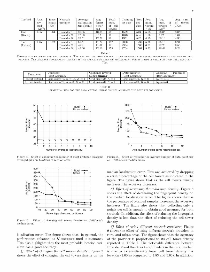
3) Effect of the number of averaged fingerprint locations(K): Figure 6 shows the effect of changing the number ofthe most probable locations averaged (K) on the median
7
Testbed Areacov-ered(Km2)
Tracelength(Km)
Networkprovider
Averagecalibrationtime(min.)
Avg.fgrprtdens/cell
Totalnum.of celltowers
Trainingset size
Testsetsize
Avg.num.towers/ loc.
Avg.num. oftowers /Km2
Avg. num.of towers/Km
One 1.958 13.64 Provider 1 26.65 10.89 51 1599 573 5.63 26.05 3.05(Rural) Provider 2 17.88 9.17 11 1073 594 1.00 5.62 1.04
Provider 3 22.51 12.79 59 1351 592 4.83 30.13 4.33
Two 5.450 18.27 Provider 1 51.5 11.22 137 3090 1239 5.35 25.13 6.97(Urban) Provider 2 48.9 11.07 121 2934 1560 6.01 22.20 6.56
Provider 3 45.06 12.12 155 2704 1564 5.32 28.44 9.28
Table IComparison between the two testbeds. The training set size refers to the number of samples collected by the war drivingprocess. The average fingerprint density is the average number of fingerprint points inside a cell for grid cell length=
70m.
ParameterCellSense(Best accuracy)
CellSense-Hybrid(Best timing)
Deterministic(Best accuracy)
Gaussian Processes(Best accuracy)
Rural testbed Grid size=70, N = 14, K = 2 Grid size=70, K = 1 Grid size=70, K = 8 Np = 1019Urban testbed Grid size=70, N = 8, K = 2 Grid size=70, K = 1 Grid size=90, K = 6 Np = 573
Table IIDefault values for the parameters. These values achieves the best performance.
25
30
35
40
45
50
55
1 2 3 4 5 6 7 8 9 10
Me
dia
n E
rro
r (
me
ters
)
Number of averaged locations (K)
RuralUrban
Figure 6. Effect of changing the number of most probable locationsaveraged (K) on CellSense’s median error.
0
50
100
150
200
250
300
350
400
450
500
10 20 30 40 50 60 70 80 90
Me
dia
n E
rro
r (
me
ters
)
Percentage of retained cell towers
RuralUrban
Figure 7. Effect of changing cell towers density on CellSense’smedian error.
localization error. The figure shows that, in general, theperformance enhances as K increases until it saturates.This also highlights that the most probable location esti-mate has a good accuracy.
4) Effect of changing the cell towers density: Figure 7shows the effect of changing the cell towers density on the
0
50
100
150
200
250
300
2 4 6 8 10 12
Me
dia
n E
rro
r (
me
ters
)
Avg. Number of data points retained per cell
RuralUrban
Figure 8. Effect of reducing the average number of data point percell CellSense’s median error.
median localization error. This was achieved by droppinga certain percentage of the cell towers as indicated in thefigure. The figure shows that as the cell towers densityincreases, the accuracy increases.
5) Effect of decreasing the radio map density: Figure 8shows the effect of decreasing the fingerprint density onthe median localization error. The figure shows that asthe percentage of retained samples increases, the accuracyincreases. The figure also shows that collecting only 8points per cell is enough to obtain good accuracy for bothtestbeds. In addition, the effect of reducing the fingerprintdensity is less than the effect of reducing the cell towerdensity.
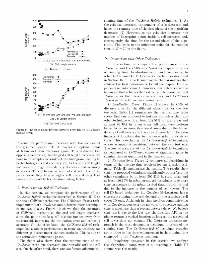
6) Effect of using different network providers: Figure9 shows the effect of using different network providers inrural and urban areas. The figure shows that the accuracyof the provider is proportional to its cell tower densityreported in Table I. The noticeable difference betweenProvider 2 and the other two providers in the rural testbedis due to its significantly lower cell tower density perlocation (1.00 as compared to 4.83 and 5.63). In addition,
8
0
100
200
300
400
500
600
0 100 200 300 400 500 600 700 800 900 1000
Me
dia
n E
rro
r (
me
ters
)
Grid Cell Length (meters)
Provider 2Provider 3Provider 1
(a) Testbed 1 (Rural)
0
50
100
150
200
250
300
350
400
450
0 100 200 300 400 500 600 700 800 900 1000
Me
dia
n E
rro
r (
me
ters
)
Grid Cell Length (meters)
Provider 3Provider 2Provider 1
(b) Testbed 2 (Urban)
Figure 9. Effect of using different network providers on CellSense’smedian error.
Provider 2’s performance increases with the increase ofthe grid cell length until it reaches an optimal pointat 600m and then decreases again. This is due to twoopposing factors: (1) As the grid cell length increases, wehave more samples to construct the histogram, leading tobetter histograms and accuracy. (2) As the grid cell lengthincreases, the fingerprint density decreases and accuracydecreases. This behavior is not noticed with the otherproviders as they have a higher cell tower density thatmakes the second factor the dominating factor.
C. Results for the Hybrid Technique
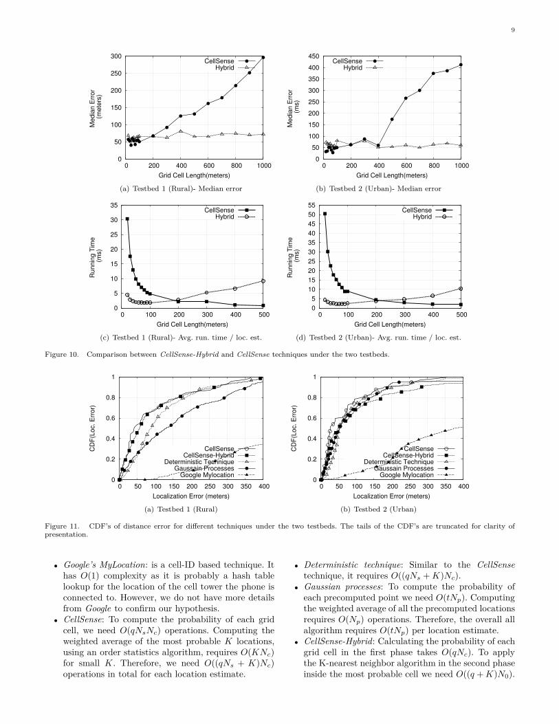
In this section, we compare the performance of theCellSense-Hybrid technique described in Section III-E tothe basic CellSense technique. The CellSense-Hybrid tech-nique mixes both CellSense and a deterministic techniquein its two phases. Figure 10 shows that the accuracyof CellSense degrades as the grid cell length increasessince the points inside a cell become further away fromits centroid, increasing the estimation error and reducingaccuracy. On the other hand, the CellSense-Hybrid tech-nique has a robust performance, in terms on accuracy, fordifferent grid sizes under the two testbeds. This is due tothe estimation refinement phase.
The figure also shows that the running time of theCellSense technique decreases quadratically with the cellsize. On the other hand, there are two factors affecting the
running time of the CellSense-Hybrid technique. (1) Asthe grid size increases, the number of cells decreases andhence the running time of the first phase of the algorithmdecreases. (2) However, as the grid size increases, thenumber of fingerprint points inside a cell increases and,consequently, the time for the second phase of the algo-rithm. This leads to the minimum point for the runningtime at G = 70 in the figure.
D. Comparison with Other Techniques
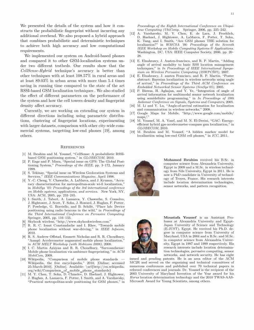
In this section, we compare the performance of theCellSense and the CellSense-Hybrid techniques, in termsof running time, localization error, and complexity, toother RSSI-based GSM localization techniques describedin Section II-F. Table II summarizes the parameters thatachieve the best performance for all techniques. For thepercentage enhancement numbers, our reference is thetechnique that achieves the best value. Therefore, we usedCellSense as the reference in accuracy and CellSense-Hybrid as the reference in running time.
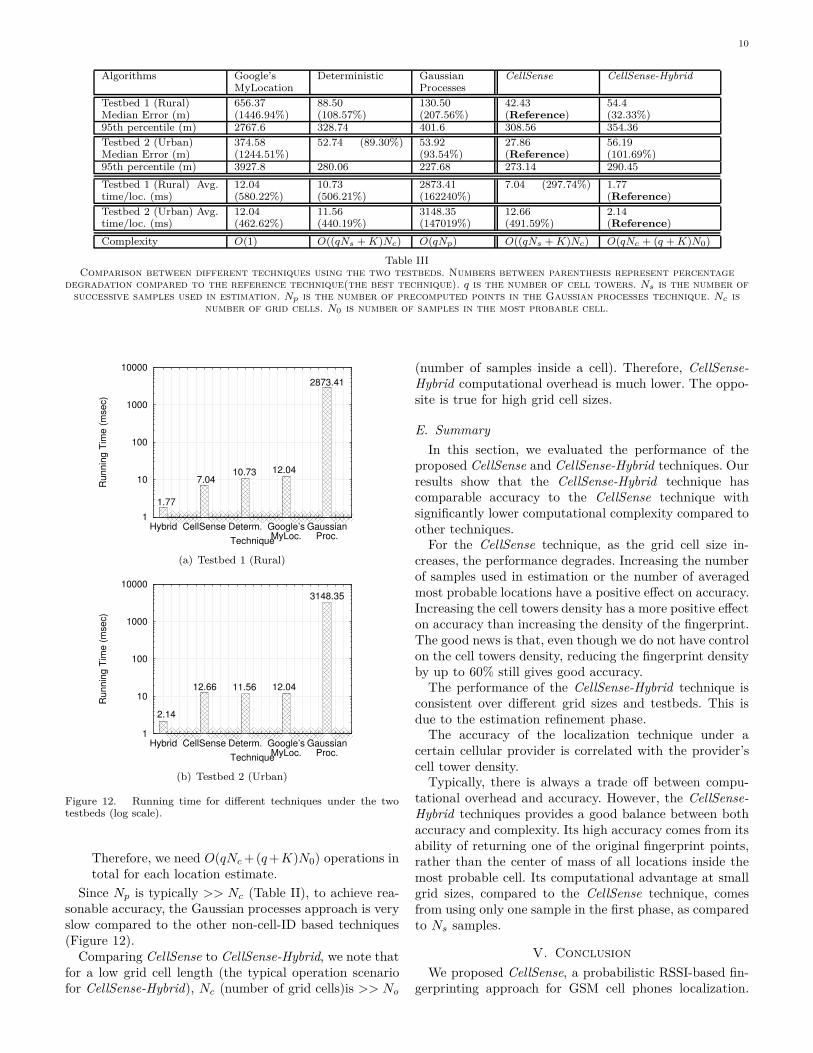
1) Localization Error: Figure 11 shows the CDF ofdistance error for the different algorithms for the twotestbeds. Table III summarizes the results. The tableshows that our proposed techniques are better than anyother technique with at least 108.57% in rural areas andat least 89.30% in urban areas. All techniques performbetter in urban areas than rural areas due to the higherdensity of cell towers and the more differentiation betweenfingerprint locations due to the dense urban area struc-tures. This is excluding the CellSense-Hybrid technique,whose accuracy is consistent between the two testbeds.The loss of accuracy of the CellSense-Hybrid technique,as compared to CellSense, comes at significant gains inrunning time as quantified in the next section.
2) Running time: Figure 12 compares all algorithms interms of the average time required for one location esti-mate. Table III summarizes the results. The results showthat the proposed techniques significantly outperform theother techniques by at least 506.21% in rural areas andat least 440.19% in urban areas. All techniques take moretime on average in the urban testbed than in rural testbeddue to the increase in the number of cell towers. Thecell-ID based technique, i.e. Google’s MyLocation, has aconsistent running time as it depends on the associated celltower ID only. Although its time involves communicatingwith Google servers over the network, the average runningtime is much less than a typical network delay. We believethat this is due to the fact that the Location API on thephone returns a cached location as long as the associatedcell tower does not change. The Gaussian processes ap-proach is the most demanding technique in terms of therunning time. The CellSense-Hybrid technique providesabout three to five times enhancement in the running timecompared to the CellSense technique.
3) Complexity Analysis: In this section, we analyzethe algorithmic complexity of all techniques. Table IIIsummarizes the results.
9
0
50
100
150
200
250
300
0 200 400 600 800 1000
Me
dia
n E
rro
r (
me
ters
)
Grid Cell Length(meters)
CellSenseHybrid
(a) Testbed 1 (Rural)- Median error
0
50
100
150
200
250
300
350
400
450
0 200 400 600 800 1000
Me
dia
n E
rro
r (
ms)
Grid Cell Length(meters)
CellSenseHybrid
(b) Testbed 2 (Urban)- Median error
0
5
10
15
20
25
30
35
0 100 200 300 400 500
Ru
nn
ing
Tim
e
(m
s)
Grid Cell Length(meters)
CellSenseHybrid
(c) Testbed 1 (Rural)- Avg. run. time / loc. est.
0
5
10
15
20
25
30
35
40
45
50
55
0 100 200 300 400 500
Ru
nn
ing
Tim
e
(m
s)
Grid Cell Length(meters)
CellSenseHybrid
(d) Testbed 2 (Urban)- Avg. run. time / loc. est.
Figure 10. Comparison between CellSense-Hybrid and CellSense techniques under the two testbeds.
0
0.2
0.4
0.6
0.8
1
0 50 100 150 200 250 300 350 400
CD
F(L
oc.
Err
or)
Localization Error (meters)
CellSenseCellSense-Hybrid
Deterministic TechniqueGaussain Processes
Google Mylocation
(a) Testbed 1 (Rural)
0
0.2
0.4
0.6
0.8
1
0 50 100 150 200 250 300 350 400
CD
F(L
oc.
Err
or)
Localization Error (meters)
CellSenseCellSense-Hybrid
Deterministic TechniqueGaussain Processes
Google Mylocation
(b) Testbed 2 (Urban)
Figure 11. CDF’s of distance error for different techniques under the two testbeds. The tails of the CDF’s are truncated for clarity ofpresentation.
• Google’s MyLocation: is a cell-ID based technique. Ithas O(1) complexity as it is probably a hash tablelookup for the location of the cell tower the phone isconnected to. However, we do not have more detailsfrom Google to confirm our hypothesis.
• CellSense: To compute the probability of each gridcell, we need O(qNsNc) operations. Computing theweighted average of the most probable K locations,using an order statistics algorithm, requires O(KNc)for small K. Therefore, we need O((qNs + K)Nc)operations in total for each location estimate.
• Deterministic technique: Similar to the CellSensetechnique, it requires O((qNs + K)Nc).
• Gaussian processes: To compute the probability ofeach precomputed point we need O(tNp). Computingthe weighted average of all the precomputed locationsrequires O(Np) operations. Therefore, the overall allalgorithm requires O(tNp) per location estimate.
• CellSense-Hybrid: Calculating the probability of eachgrid cell in the first phase takes O(qNc). To applythe K-nearest neighbor algorithm in the second phaseinside the most probable cell we need O((q + K)N0).
10
Algorithms Google’sMyLocation
Deterministic GaussianProcesses
CellSense CellSense-Hybrid
Testbed 1 (Rural)Median Error (m)
656.37(1446.94%)
88.50(108.57%)
130.50(207.56%)
42.43(Reference)
54.4(32.33%)
95th percentile (m) 2767.6 328.74 401.6 308.56 354.36
Testbed 2 (Urban)Median Error (m)
374.58(1244.51%)
52.74 (89.30%) 53.92(93.54%)
27.86(Reference)
56.19(101.69%)
95th percentile (m) 3927.8 280.06 227.68 273.14 290.45
Testbed 1 (Rural) Avg.time/loc. (ms)
12.04(580.22%)
10.73(506.21%)
2873.41(162240%)
7.04 (297.74%) 1.77(Reference)
Testbed 2 (Urban) Avg.time/loc. (ms)
12.04(462.62%)
11.56(440.19%)
3148.35(147019%)
12.66(491.59%)
2.14(Reference)
Complexity O(1) O((qNs + K)Nc) O(qNp) O((qNs + K)Nc) O(qNc + (q + K)N0)
Table IIIComparison between different techniques using the two testbeds. Numbers between parenthesis represent percentage
degradation compared to the reference technique(the best technique). q is the number of cell towers. Ns is the number ofsuccessive samples used in estimation. Np is the number of precomputed points in the Gaussian processes technique. Nc is
number of grid cells. N0 is number of samples in the most probable cell.
1
10
100
1000
10000
Hybrid CellSense Determ. Google’sMyLoc.
GaussianProc.
Ru
nn
ing
Tim
e (
mse
c)
Technique
1.77
7.0410.73 12.04
2873.41
(a) Testbed 1 (Rural)
1
10
100
1000
10000
Hybrid CellSense Determ. Google’sMyLoc.
GaussianProc.
Ru
nn
ing
Tim
e (
mse
c)
Technique
2.14
12.66 11.56 12.04
3148.35
(b) Testbed 2 (Urban)
Figure 12. Running time for different techniques under the twotestbeds (log scale).
Therefore, we need O(qNc +(q +K)N0) operations intotal for each location estimate.
Since Np is typically >> Nc (Table II), to achieve rea-sonable accuracy, the Gaussian processes approach is veryslow compared to the other non-cell-ID based techniques(Figure 12).
Comparing CellSense to CellSense-Hybrid, we note thatfor a low grid cell length (the typical operation scenariofor CellSense-Hybrid), Nc (number of grid cells)is >> No
(number of samples inside a cell). Therefore, CellSense-Hybrid computational overhead is much lower. The oppo-site is true for high grid cell sizes.
E. Summary
In this section, we evaluated the performance of theproposed CellSense and CellSense-Hybrid techniques. Ourresults show that the CellSense-Hybrid technique hascomparable accuracy to the CellSense technique withsignificantly lower computational complexity compared toother techniques.
For the CellSense technique, as the grid cell size in-creases, the performance degrades. Increasing the numberof samples used in estimation or the number of averagedmost probable locations have a positive effect on accuracy.Increasing the cell towers density has a more positive effecton accuracy than increasing the density of the fingerprint.The good news is that, even though we do not have controlon the cell towers density, reducing the fingerprint densityby up to 60% still gives good accuracy.
The performance of the CellSense-Hybrid technique isconsistent over different grid sizes and testbeds. This isdue to the estimation refinement phase.
The accuracy of the localization technique under acertain cellular provider is correlated with the provider’scell tower density.
Typically, there is always a trade off between compu-tational overhead and accuracy. However, the CellSense-Hybrid techniques provides a good balance between bothaccuracy and complexity. Its high accuracy comes from itsability of returning one of the original fingerprint points,rather than the center of mass of all locations inside themost probable cell. Its computational advantage at smallgrid sizes, compared to the CellSense technique, comesfrom using only one sample in the first phase, as comparedto Ns samples.
V. Conclusion
We proposed CellSense, a probabilistic RSSI-based fin-gerprinting approach for GSM cell phones localization.
11
We presented the details of the system and how it con-structs the probabilistic fingerprint without incurring anyadditional overhead. We also proposed a hybrid approachthat combines probabilistic and deterministic techniquesto achieve both high accuracy and low computationalrequirements.
We implemented our system on Android-based phonesand compared it to other GSM-localization systems un-der two different testbeds. Our results show that theCellSense-Hybrid technique’s accuracy is better thanother techniques with at least 108.57% in rural areas andat least 89.03% in urban areas with more than 5.4 timessaving in running time compared to the state of the artRSSI-based GSM localization techniques . We also studiedthe effect of different parameters on the performance ofthe system and how the cell towers density and fingerprintdensity affect accuracy.
Currently, we are working on extending our system indifferent directions including using parametric distribu-tions, clustering of fingerprint locations, experimentingwith larger datasets, comparison with other city-wide com-mercial systems, targetting low-end phones [19], amongothers.
References
[1] M. Ibrahim and M. Youssef, “CellSense: A probabilistic RSSI-based GSM positioning system,” in GLOBECOM, 2010.
[2] P. Enge and P. Misra, “Special issue on GPS: The Global Posi-tioning System,” Proceedings of the IEEE, pp. 3–172, January1999.
[3] S. Tekinay, “Special issue on Wireless Geolocation Systems andServices,” IEEE Communications Magazine, April 1998.
[4] Y.-C. Cheng, Y. Chawathe, A. LaMarca, and J. Krumm, “Accu-racy characterization for metropolitan-scale wi-fi localization,”in MobiSys ’05: Proceedings of the 3rd international conferenceon Mobile systems, applications, and services. New York, NY,USA: ACM, 2005, pp. 233–245.
[5] I. Smith, J. Tabert, A. Lamarca, Y. Chawathe, S. Consolvo,J. Hightower, J. Scott, T. Sohn, J. Howard, J. Hughes, F. Potter,P. Powledge, G. Borriello, and B. Schilit, “Place lab: Devicepositioning using radio beacons in the wild,” in Proceedings ofthe Third International Conference on Pervasive Computing.Springer, 2005, pp. 116–133.
[6] Skyhook wireless, “http://www.skyhookwireless.com.”[7] R. R. C. Ionut Constandache and I. Rhee, “Towards mobile
phone localization without war-driving,” in IEEE Infocom,2010.
[8] R. S. Andrew Offstad, Emmett Nicholas and R. R. Choudhury,“Aampl: Accelerometer augmented mobile phone localization,”in ACM MELT Workshop (with Mobicom 2008), 2008.
[9] I. C. Martin Azizyan and R. R. Choudhury, “Surroundsense:Mobile phone localization via ambience fingerprinting,” in ACMMobiCom, 2009.
[10] Wikipedia, “Comparison of mobile phone standards —Wikipedia, the free encyclopedia,” 2010, [Online; accessed25-March-2010]. [Online]. Available: \url{http://en.wikipedia.org/wiki/Comparison of mobile phone standards}
[11] M. Y. Chen, T. Sohn, D. Chmelev, D. Haehnel, J. Hightower,J. Hughes, A. Lamarca, F. Potter, I. Smith, and A. Varshavsky,“Practical metropolitan-scale positioning for GSM phones,” in
Proceedings of the Eighth International Conference on Ubiqui-tous Computing (UbiComp. Springer, 2006, pp. 225–242.
[12] A. Varshavsky, M. Y. Chen, E. de Lara, J. Froehlich,D. Haehnel, J. Hightower, A. LaMarca, F. Potter, T. Sohn,K. Tang, and I. Smith, “Are GSM phones THE solution forlocalization?” in WMCSA ’06: Proceedings of the SeventhIEEE Workshop on Mobile Computing Systems & Applications.Washington, DC, USA: IEEE Computer Society, 2006, pp. 20–28.
[13] E. Elnahrawy, J. Austen-francisco, and R. P. Martin, “Addingangle of arrival modality to basic RSS location managementtechniques,” in In Proceedings of IEEE International Sympo-sium on Wireless Pervasive Computing (ISWPCŠ07), 2007.
[14] E. Elnahrawy, J. austen Francisco, and R. P. Martin, “Posterabstract: Bayesian localization in wireless networks using angleof arrival,” in Proceedings of the Third ACM Conference onEmbedded Networked Sensor Systems (SenSys’05), 2005.
[15] P. Biswas, H. Aghajan, and Y. Ye, “Integration of angle ofarrival information for multimodal sensor network localizationusing semidefinite programming,” in In Proceedings of 39thAsilomar Conference on Signals, Systems and Computers, 2005.
[16] M. Li and Y. Lu, “Angle-of-arrival estimation for localizationand communication in wireless networks,” 2008.
[17] Google Maps for Mobile, “http://www.google.com/mobile/maps/.”
[18] M. Youssef, M. A. Yosef, and M. N. El-Derini, “GAC: Energy-efficient hybrid gps-accelerometer-compass gsm localization,” inGLOBECOM, 2010.
[19] M. Ibrahim and M. Youssef, “A hidden markov model forlocalization using low-end GSM cell phones,” in ICC, 2011.
Mohamed Ibrahim received his B.Sc. incomputer science from Alexandria University,Egypt in 2009 and a M.Sc. in wireless technol-ogy from Nile University, Egypt in 2011. He isnow a PhD candidate in University of technol-ogy of Troyes, France. His research interestsinclude location determination technologies,sensor networks, and pattern recognition.
Moustafa Youssef is an Assistant Pro-fessor at Alexandria University and Egypt-Japan University of Science and Technology(E-JUST), Egypt. He received his Ph.D. de-gree in computer science from University ofMaryland, USA in 2004 and a B.Sc. and M.Sc.in computer science from Alexandria Univer-sity, Egypt in 1997 and 1999 respectively. Hisresearch interests include location determina-tion technologies, pervasive computing, sensornetworks, and network security. He has eight
issued and pending patents. He is an area editor of the ACMMC2R and served on the organizing and technical committees ofnumerous conferences and published over 70 technical papers inrefereed conferences and journals. Dr. Youssef is the recipient of the2003 University of Maryland Invention of the Year award for hisHorus location determination technology and the 2010 TWAS-AAS-Microsoft Award for Young Scientists, among others.
Related Documents