International Hydrographic Review, Monaco, LVII (2), July 1980 CELESTIAL FIX BY CALCULATOR FOR ALL BODIES AND ALL POSITIONING PROBLEMS WITHOUT OR WITH INTERCEPTS AND AZIMUTHS K-12 METHOD by Dr. Stjepo KOTLARIC, Assistant Director, Hydrographic Institute of the Yugoslav Navy The method described is a single program method developed for a Texas Instruments SR-52 programmable hand-held calculator, but it can also be easily used on any other programmable calculator of the same or higher capacity. It provides a direct solution for latitude and longitude of the observer’s position from simultaneous or non-simultaneous observa- tions of two celestial bodies (either the sun, moon, planets or stars) as well as from a double observation of one body (usually the sun, which until now has been practiced by advancing the earlier position line to the time of the last observation) even for cases where the second observation is close to or exactly on the observer’s meridian. The coordinates of the fix are obtained directly on the sphere as the intersection of circles of position, thus obviating the need to determine position lines (intercepts and azi- muths) by the Marcq St. Hilaire method or to draw a diagram of the situation in the sky in order to decide what to do with calculated para- meters. The method — named the K-12 method — has been devised by the author and is a modified version of his K -ll method published in five volumes of Tables K-ll for selected stars only. [1]; [2]; [3]. It takes the form of a single program of 666 steps with 19 addressable memory registers, requiring three magnetic cards for Texas Instruments calculator SR-52 or a single one for a TI-59, and it may be used for any latitudes or with any celestial body. Normally it provides a direct solution for latitude and longitude from non-simultaneous observations of two celestial bodies at the time of the second sight (which is common in actual navigational prac- tice) solving parameters of the second body’s navigational triangle. Thus in order to obtain more accurate longitude the second celestial body should not be chosen in the vicinity of the observer’s meridian. However, the program also provides the possibility of computing the parameters of the first body’s navigational triangle, but the first version is a simpler one. The same program also applies to simultaneous observations of two bodies.

Welcome message from author
This document is posted to help you gain knowledge. Please leave a comment to let me know what you think about it! Share it to your friends and learn new things together.
Transcript

International Hydrographic Review , Monaco, LVII (2), July 1980
CELESTIAL FIX BY CALCULATOR FOR ALL BODIES AND ALL POSITIONING PROBLEMS
WITHOUT OR WITH INTERCEPTS AND AZIMUTHS
K-12 METHOD
by Dr. Stjepo KOTLARIC, Assistant Director, Hydrographic Institute of the Yugoslav Navy
The method described is a single program method developed for a Texas Instruments SR-52 programmable hand-held calculator, but it can also be easily used on any other programmable calculator of the same or higher capacity. It provides a direct solution for latitude and longitude of the observer’s position from simultaneous or non-simultaneous observations of two celestial bodies (either the sun, moon, planets or stars) as well as from a double observation of one body (usually the sun, which until now has been practiced by advancing the earlier position line to the time of the last observation) even for cases where the second observation is close to or exactly on the observer’s meridian. The coordinates of the fix are obtained directly on the sphere as the intersection of circles of position, thus obviating the need to determine position lines (intercepts and azimuths) by the Marcq St. Hilaire method or to draw a diagram of the situation in the sky in order to decide what to do with calculated parameters.
The method — named the K-12 method — has been devised by the author and is a modified version of his K -ll method published in five volumes of Tables K -ll for selected stars only. [1 ]; [2 ]; [3]. It takes the form of a single program of 666 steps with 19 addressable memory registers, requiring three magnetic cards for Texas Instruments calculator SR-52 or a single one for a TI-59, and it may be used for any latitudes or with any celestial body. Normally it provides a direct solution for latitude and longitude from non-simultaneous observations of two celestial bodies at the time of the second sight (which is common in actual navigational practice) solving parameters of the second body’s navigational triangle. Thus in order to obtain more accurate longitude the second celestial body should not be chosen in the vicinity of the observer’s meridian. However, the program also provides the possibility of computing the parameters of the first body’s navigational triangle, but the first version is a simpler one. The same program also applies to simultaneous observations of two bodies.

Furthermore, it enables solution of a double observation of one celestial body, even for the case of the sun when the second sight is at local noon, since here longitude is obtained as the difference between the local hour angle (LHA) computed from the corrected first body’s navigational triangle and the first sight Greenwich hour angle (GHA). In addition, two cards of the same program enable the computation of intercepts and azimuths for navigators preferring to determine position lines rather than directly the latitude and longitude of the observer’s position, or wishing to check the K-12 method by means of the Marcq St. Hilaire method (see Example 3, Third Solution).
Because of the above characteristics this is truly a unique method for the direct computation of a celestial fix by calculator, requiring only a single program for the solution of all positioning problems encountered in celestial navigation.
The basic principle for direct solution of latitude and longitude in the K-12 method for the case of simultaneous observations of two celestial bodies is the determination of an accurate value for the second body’s parallactic angle X2 (figure 1). This is made possible by computing auxiliary angles A and B and by using the precomputed approximate value for the second body’s parallactic angle AX2 (figure 2) which determines how to combine angles A and B to find X2 without the need to draw a diagram showing the situation in the sky, which would prolong the solution procedure. The use of this approximate parallactic angle was envisaged by the author as long as 25 years ago [4]. With the computed X2, observed altitude Ho2 and declination Dec 2 we compute the latitude L and the meridian angle MA2. Then MA2 is converted into LHA2, from which the second body’s GHA2 has to be subtracted in order to obtain the longitude, X, of the observed position, i.e. the coordinates of the observer’s zenith Z.
The other variations of the navigational problem, i.e., non-simultaneous observations, the case where the second body is close to or directly on the observer’s meridian, or double observation of the same body, are solved by the same program employing the corrected altitude of the first sight, Hoi ctd, for the time elapsed and the distance made good, or by computing the parameters for the first body’s navigational triangle (see Example 2, First Solution). In addition, when the azimuth of the first body is not taken or it is preferred to have it computed, the same program computes also the true azimuth very simply at the beginning of the procedure for direct solution of the fix (see Example 1, First Solution). This computation of the azimuth may also be used for determining the compass deviation.
In this program, provisionally named NG1-40-1, 2, 3, the formulae given below refer to non-simultaneous observations of two celestial bodies, and thesolutions of the three examples which follow after the formulae are worked with the SR-52 calculator in conjunction with the PC-100 printer. The print-out shows the entering arguments, some intermediate calculations and the final result, i.e. the latitude and longitude of the observer’s position (fix). The three examples are for cases of non-simultaneous observations of two stars, a double observation of the sun and simultaneous observations of the sun and moon respectively. They are taken from the author’s pub-

Pn
FIGURE 3
lished Tables K -ll, the book “New methods of ship’s position finding from celestial observations” and Tables K-l, presenting a further test of these manuals already used in practice.
Hoi correction = knots X A GMT x cos Rel Azl (1)where A GMT is the absolute difference of Greenwich Mean Times (GMT)

Fig. 4. — Texas Instruments SR-52 calculator and PC-100 printer.
and Rel Azl is the first body’s true azimuth relative to the ship’s true course (Rel A zl = T Azl ~ T Course).
H oi corrected = H oi + Hoi correction (2)A GHA = GHA2 — GHA1 ; absolute difference of Greenwich hour an
gles
AX2 = 2 • - i / 1 SU1 V sinT f" 1(90 - Ho2) cos Dec2
(90° - Ho2) + Dec2 + LDR
cos R sin (R — Ldr)
(3)
(4)
zx = 2Dec2 — Declsin sin + sin2 AGHA cos Dec2 cos Decl
A — 2 ■ - 1 nsm v t
izx cos Dec2 zx +Dec2 +Decl
cos F sin (F — Decl)
(5)
(6)
B - 2 sin - l 1 1sin zx cos Ho2
zx + Ho2 + Hoi ctd G ------------------------------
cos G sin (G — Hoi ctd)

X2 = A ~ B
X2 = A +B ; si > 180*, on a 360° - (A + B)
L = 90° - 2 -, nsin . / siir Ho2 - Dec2 , X2---------------+ sin — cos Ho2 cos Dec22 2
(8a)
(8b)
(9)
L is obtained in the correct value with its sign, + if North, and — if South.
MA2 = 21
sinV sin (90 — Dec2) cos L
_ Ho2 + (90° - Dec2) + L ~ 2
LHA2 = MA2 Ouest
LHA2 = 360* - (MA2 Est)
X = LHA2 - GHA2
cos U sin (U — Ho2)
( 1 0)(11a)
(lib )
(1 2 )X is obtained in the correct value with its sign, + if East, and — if West.
Computation of intercepts and azimuths. If for any reason (either from habit, or as a check of K-12 method by Marcq St. Hilaire method using the calculator) the navigator wishes to compute the intercepts and azimuths of the observed bodies he can use the same programmed cards, NG1-40-1 and NG1-40-3, to compute altitude He, intercept a, and azimuth Zn (see Example 3, Third Solution).
The NG1-40-1 card converts the entering arguments from degrees- minutes-decimal minutes to degrees and decimals and retains them in the proper addressable memory registers.
The NG1-40-3 card solves equations (9) and (10) and, when Dec is substituted for Ho2, MA for X2, and LDn for Dec 2, will give the altitude He and azimuth Zn. This card also solves equation (12), and gives the intercept if Ho is substituted for LHA2 and He for GHA2.
The latitude and longitude of the fix may be obtained directly by using the existing Texas Instruments NG1-26 card (see Example 3, Third Solution), or else the azimuths and intercepts can be plotted graphically to obtain the point of intersection of the lines of position and thus derive the latitude and longitude.
Computation of the azimuth needed for determining compass deviation.The NG1-40-1 card solves equation (4), and when LDR is substituted for Dec, and Dec for LDR will give the true azimuth of the observed celestial body, measured from 0“ at the North pole through 180°, therefore it should be labeled with prefix N and suffix E or W to agree with the body’s position Eastward or Westward of the observer’s celestial meridan (see Example 1, First Solution).
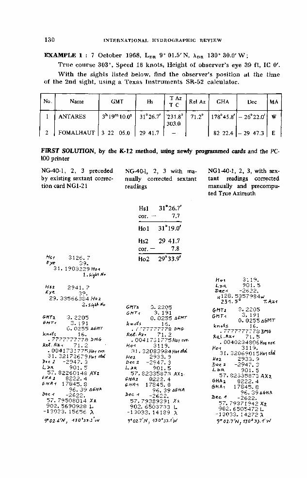
EXAMPLE 1 : 7 October 1968, LDR 9° 01.5'N, 130“ 30.0'W ;True course 303°, Speed 16 knots, Height of observer’s eye 39 ft, IG O'.W ith the sights listed below, find the observer’s position at the time
o f the 2nd sight, using a Texas Instruments SR-52 calculator.
No. Name GMT Hs T Az T C Rel Az GHA Dec MA
1 ANTARES 3h19m10.05 31°26.7' 231.8°303.0
71.2° 178° 45.8' - 26° 22.0' W
2 FOMALHAUT 3 22 05.0 29 41.7 - 82 22.4 - 29 47.3 E
FIRST SOLUTION, by die K-12 method, using newly programmed cards and the PC-100 printerNG-40-1, 2, 3 preceded by existing sextant correction card NG1-21
NG-40-1, 2, 3 with manually corrected sextant readings
NGl-40-1, 2, 3, with sextant readings corrected manually and precomputed True Azimuth
Hsl 31*26.7' cor. — 7.7
Hoi 31*19.0
H a 3 l 2 6 .7
Hs2 29 41.7 cor. — 7.8Ho2 29a33.9'
B y e 39.■~iI. 1903229 Ho-t
H s i
l . £ ijhi rJ°
2 9 4 1. 7E y e •39.
29,. 33566384 H o 2<1. 5l'i OMTi 3, 2205
6-HTx 3 .22 05GHT1 3. 191
0. 0255S-MTi 3. I 9 1 k'no^S 16.
0. 0255 as-Ht ■ f i'" i r- !'* i' i r' S UMlrk n fii 16. Rc£- fi-zt 7 1 .2
. r* i " r r r" i'‘ 7 7 7 o M (r . 0041731 775 Hoi «y.RtX.Az.-i 7 1 .2 H oi 3119.
. 0041731 77S H oi cor. 31. 32083984 H»1 31. 32173679/-1»^ M H cz 2932!. 9
Pec 2 -2 9 4 7 .3 dec j - 2 9 4 7 .3901. 5 L jr . 90 1. 5
57. 82260148 f i l l 57. 82335873 AXi-tH A i 8222 .4 G-HQz 8222. 4S-HH1 17845.8 &HR-1 17845 .8
9 H . .J, 9 Ù 96. 39 a£HADi< -i ~ 1* il* Cl a b e e . -( -2622 "
57. 79508014 X2 57.79389391 X i902 . 569Û92R L. 902. 6503733 L
- l 30 3 3 .1 56 5 6 A -13033. 14189 AV O Z - é '^ , 4 i O ° 3 - i - l v * Voi n'N, ^0°33.1'W
Ho 1 '■-* 1 1 9.
Lva. 901 .5 Dec* -2622.
H128. 5357984iv 231. 5 T
6-AfTi 3. 2205 &MTt 3. 191
0. 0255 a6MT le n d s 16.
. 77777777781)1^6 fcd.1 .Az-f 7 1 .5
■ ÜU 4 U c ■_* 4 S 0 ¢. Hot fof. Hoi 3119.
31. 3206y 01 5Kol atl Ho2 2 933 .9 D ec 2 -2947. 3 L k r 901. 5
57 . 82335873 AXi OHfiiz 8222. 4 SHAi 17845.8
96. 39 A&Hft Jlec. A -2622.
57. 7937Î 942 X2 902. 6505472 L
-13033. 14272 % T o i . T N ,

SECOND SOLUTION, by the Marcq St. Hilaire method, using existing cards :
NG1-21 for sextant correction, NG1-25 for star sight reduction, NG1-26 for fix by two observations — and the PC-100 printer.
Additional entering data :
No. Name SHA GHA Aries for 3h GMT
1 ANTARES 113°08.0' 60° 49.5'2 FOMALHAUT 16 00.7 60 49.5
Hsi 3126. 7 eye 3 9 .
31. 1903229 Ho-i1. Siyhl Mo
Hsi. 2941.7 £■/* 39.
29. 33566384 Hot
Lîf*. 901. 5 13030.
o. 1 9 111300.
kGH a t 6049 .5De.c -t -2622.
31.17323392 H<m1. 514829932 a -i 231. 4809:356 Z*y\a
0. 2205 SH()2 1600.7
r 6049 ,5 Dec. z -2947. 3
. 29. 3656867 He i. -3. 003809567 x lz
131. 9824342 Z m 2 .S.Vfkt H«
S !‘<jh t 1 .[ t r k t 2.
13032. 96072 902.7411511 L
9'o;.7/V 3.0 V
EXAMPLE 2 : 31 January 1954, Ldr 33° 16.6'N, X.DK 27° 40.5'E;True course 141°, Speed 15 knots, Height of Observer’s eye 36 ft, ICO'.With a double observation of the sun’s lower limb as listed below, find the position at the time of the second sight, using a Texas Instruments SR-52 calculator.
No. NAME GMT Hs T Az TC Rel Az GHA Dec MA
1 SUN 6h31m 16s 14°55.0' 123.3°141.0
17.7° 274927.2' - 17s 30.8'2 SUN 10 02 04 39 34.8 327 08.9 - 17 28.5 E

FIRST SOLUTION, by K-12 method, using newly programmed cardsand the PC-100 printer.
NG1-40-1, 2, 3 preceded by existing sextant correction card NG1-21
NG1-40-1, 2, 3 with manually corrected sextant readings
NG1-40-1, 2, 3 with manually corrected sextant readings and LHA at the time of the first observation
H a 1455.*2 lb .3
36.15. 01589223 H o i
i . Sffhf' f*o
Hsl 14*55.0' cor. + 6.9
Hoi 15*01.9
Hs2 39° 34.8' cor. + 9.3
Ho2 39*44.1
H si 3934. 8 16.3
* / ' 36.39. 44058676 H ot
i i^ht Ho
C-M Tz 10. 0204GMT* 6 .31 16
3. 304« Affxrkr>»<s 15.
5i!. 7 IIMtf-R ef.flU 17 .7
. 836719^672 Ho1 ««*15. 86975324 «of eieC
P e t l -1 728. 5L j>r 3316. 6
7 .989784498 AX 2.6 -H fli 32708. 9e-H i7-r 27427. 2
52. 695tec -i -1 7 3 0 .8
4 .894271148 X 23236 .482736 L2823 .079886 A
3 Z '3 (-S 'N , Z 8 “2 3 .1 'B
GHTi 10 .0204 6 .31163. 3048
U'rrO S 15.52. 7 bMG- 1 7. 7
. fci 367 1 92672 H»1 ***■ H ot 1501.9
15. 86838593*01 Hoi. 3944, 1
? -1 7 2 8 .5 3 316 .6
7. 99008987 A X i 6-H&2 32708. 9 ÇHAi 27427. 2
52. 695 a S-ha -c -1 7 3 0 .8
4 . a96602316 Xz 3236. 472864 L 2822. 9573:31 X
32*34 .5 'N , 2 8 ° 11 - 0 ' E
SMTi IQ. 0204 G-MTi 6 .3 1 1 6
3. 3048 k-n.is 15.
52. 7 »M«- fi.et.H z-t j 7 . 7
. 8367192672 w Hot 1501. 9
15. 86838593M»f Hoi. 3944. 1 EXC 3 9 , 7 3 5 H„1 M
15.86838593 Hoi Dec -1 7 3 0 .8 L bfiy 3 31 6 .6
46 .54019444 AXi G-Hflt 27427. 2 S-HAz 32708. 9
52. 695 Af-^A t>«c z -I 728. 5
47 .37755451 X-i 3236 .472864 L 2822.957381 A
32°3i.S'A>f l i ° 2 3 o E
SECOND SOLUTION, by the Marcq St. Hilaire method, using existing cards.
To my knowledge, the Texas Instruments Navigation Library for the SR-52 calculator does not yet include cards for a running fix in celestial navigation. Consequently there is no program to determine the position by a double observation of the sun by advancing the earlier line of position to the time of the second observation, as described in the American Practical Navigator [5], although this method would be of great use in navigation.
The K-12 method, however, provides the solution to this problem, utilizing the same single program. This means that different programs are not needed for different celestial bodies as is the case at present in the existing Texas Instruments Navigation Library for SR-52 calculators.

EXAMPLE 3 : 21 February 1950, LDR 34° 51.5'N, XDR 38“ 06.4' W ;For nearly simultaneous sights of the sun and moon, and with the lower limbs as listed below, find the position at the time of the second sight, using the Texas Instruments SR-52 programmable calculator.
No. NAME GMT Hs GHA Dec MA IC SD HP EYE1 SUN 17h26ra 40.8s 30° 40.5' 78*13.9' - 10° 34.7' + 0.9' 16.2 — 21 ft2 MOON 17 27 01.8 64 53.5 29 08.8 + 11 38.7 E + 0.9 14.8 54.4 21 ft
FIRST SOLUTION, by the K-12 method, using newly programmed cards and the PC-100 printer
NG1-40-1, 2, 3 preceded by existing sextant correction card NG1-21
NGl-40-1,2, 3 with manually corrected sextant readings
Hsi 3 040 .5 Hsl 30*40.5'ic 0. 9 sd 16.2 IC + 0,9eye 2 1. cor. + 10.2
30. 51323419 HotHoi 30*51.6'1. Mo
Hsi 6453. 5 Hs2 64 53.5IC 0. 9 IC + 0.9S5 14 .8f ye 21. cor. + 32.9hp 54. 4
65. 271 10322 Hoz Ho2 65°27.3'2. Sitffif' M?
tM T i 17 .2701817.27018 tf /m 17.26408
G-HT-, 17.26408 0. 0021 A6MT0. 0021 AtrrMT k ’n c i i 0.
k n e is 0. 0. DM0. J>MS- R.e(-D z i 0.
R -tt-R i- 1 o. o. hoi0. Hal cor. k e i 3051. 6
30. 85898386HoîdoL 30. SbHofrfol1138.7 h id 6527. 3
-3451. 5 i5tc z 1138. 717. 55180768 AXi LDk 3451. 5
6-HAi 2908. 8 17. 53972679 AX2<r HA -i 7 813 .9 6-kfti 2908. 8
49. 085 frH 7 81 3 .9Ve.c t -1 0 3 4 .7 49. 085
18. 01481852 Xl Dic-t -1 0 3 4 .73447. 302053 L 18 .01566153 X i
-38 0 8 .8 2 6 9 7 5 X 344 7 .1 8 70 08 L
l8°0S-?'kJ-38 08 .8 01 91 1 X 3*/*^7.1 N t 3 j ' d i . j V
For simultaneous or nearly simultaneous observations this is enough
Note :1. Manual corrections of
sextant readings can easily be taken from Altitude Correction Tables in the American Nautical Almanac.
2. For simultaneous or nearly simultaneous observations it is not necessary to take the compass azimuth or compute T.Azl of the 1st body because Hoi cor. is zero or nearly zero, therefore the procedure can start i at the half way withHo 1.
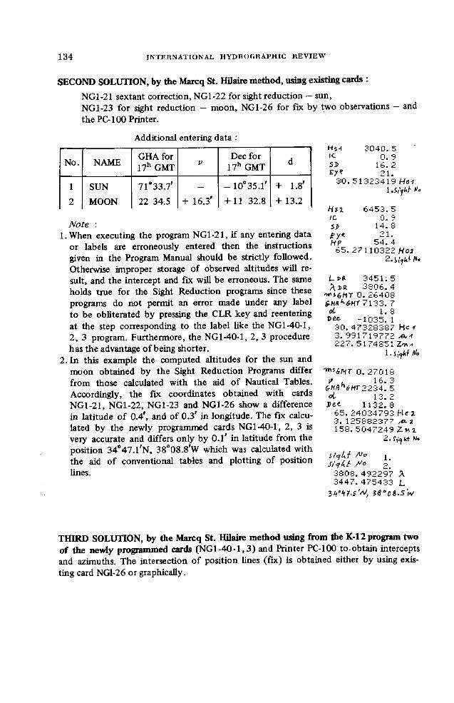
SECOND SOLUTION, by the Marcq St. Hilaire method, using existing cards :NG1-21 sextant correction, NG1-22 for sight reduction — sun,NG1-23 for sight reduction - moon, NG1-26 for fix by two observations - and the PC-100 Printer.
Additional entering data :
No. NAME GHA for 17h GMT V
Dec for 17h GMT d
1 SUN 71*33.7' — - 10°35.l' + 1.8'2 MOON 22 34.5 + 16.3' + 11 32.8 4- 13.2
Note :1.When executing the program NG1-21, if any entering data
or labels are erroneously entered then the instructions given in the Program Manual should be strictly followed. Otherwise improper storage of observed altitudes will result, and the intercept and fix will be erroneous. The same holds true for the Sight Reduction programs since these programs do not permit an error made under any label to be obliterated by pressing the CLR key and reentering at the step corresponding to the label like the NG1-40-1, 2, 3 program. Furthermore, the NG1-40-1, 2, 3 procedure has the advantage of being shorter.
2. In this example the computed altitudes for the sun and moon obtained by the Sight Reduction Programs differ from those calculated with the aid of Nautical Tables. Accordingly, the fix coordinates obtained with cards NG1-21, NG1-22, NG1-23 and NG1-26 show a difference in latitude of 0.4', and of 0.3' in longitude. The fix calculated by the newly programmed cards NG1-40-1, 2, 3 is very accurate and differs only by 0.1' in latitude from the position 34°47.l'N, 38°08.8'W which was calculated with the aid of conventional tables and plotting of position lines.
Hs-I 3040.51C 0. 9SÎ 16. 2Ey? 21.
30. 51-323419 Hoi1 .Si'jUh Vo
H si 6453.5\c 0. 95J> 14. 8?Y< 21.HP 54. 4
65. 27110322 Ho22.
3451.5A J>R 3 b 0 6 .4
■w'i&MT 0. 264087133. 7
oL 1. 8Dec- -1035. 1
30. 47328387 He-f3. 9'91719772 A*.-\■ j •-» "7 . 5174851 Z-n-f
1. i^ki Ho
'mi&NT 0. 27018/ , 16 m à
frHfl'Vwr 2234. 5oi 13. 2Dec- 1132.8
65. 24034793 He 23. 125882377158 . 5047249 Z m
2.f,iW N»
2.3808.492297 A 3447.475433 L
3S°D&-SW
THIRD SOLUTION, by the Marcq St. Hilaire method using from the K-l 2 program two of the newly programmed cards (NGl-40-1,3) and Printer PC-100 to obtain intercepts and azimuths. The intersection of position lines (fix) is obtained either by using existing card NG1-26 or graphically.

Additional entering data
No. NAME MA
1 SUN 40°07.5'W2 MOON 8 57.6 E
NG1-40-1, 3 with sextant readings corrected manually and fix coordinates obtained graphically
SUNl e t -1 0 3 4 .7
MA3 45 1 .5 4007. 5STO -1h
Ho 3051.6o 0 4 7. £ 4 1 c- -j 6 He 4. 369273489 M.i
ddc. 51 27iJ>: Z-m
2)aci- PRMAHo
65158
MOON 1138. 73 451 .5
857. 6 STO 'I A
6527. 3 4 .0 0 6 8 6 4 He 04247011A2 . 5041 161Zn i
FixCoordinates at intersection of position lines plotted graphically : L34647.l'N, X 38e08.8'W
NG1-40-1, 3 with sextant readings corrected manually and fix coordinates obtained with NG1-26
3)ecLt>r.m a
Ho
SUN-10 34 . 7
3451. 5 4007. 5S T O 'tA
3 0 5 1 .6 3047. 241836 He 4. 369273489 -ct-f
'd'd.7. 51^:703 Z mMOON
H e c Lin MA
l l 38. 7 3 4 5 1. 5
857. 6S T O 11,
15:
«.1Z n .10 . 2.
Zn.2Ldr
4. 006864 He 0424701 1 .0,1 . 5041161 Z-nz.
F ix
4. 4 STo 08 227. 5 STo 09
3. 3 STO 40 158. 5 STO -i-1
3 4 5 1 .5 •J b‘ 0 6 .4
Aïe* 1.S i
3 8 0 8 .8 3 3 7 1 9 A 4 4 1"'. 1 7 7 6 6 4 L-
3V47. 2'N, i8'0z.n‘ W
NG1-40-1, 3 preceded by existing sextant correction card NG1-21 and followed by NG1-26 to obtain the fix coordinates
30., 51 32341930 Î1 .■ S 1. Hoi
A fi. , - '11032265 27- 2. 2. H 02
srarDec •1034. 7Ldr. 3 4 5 1 .5MA 4007. 5
STO 11,H o i 3 0 5 1 .5
30*47. £41836 He4. 269'273486 XX.1
512703 Z-n ‘iMOON
Dec 113 8 .73 4 5 1 .5
MA 857. 6STO 4U.
H o z 6527. £6524. 006864 He3. 204 247008 j X i15Ei. 5041 16.1 Z-ri2
F ix0-1 4. 3 STO OS
'Z tn .i 227. 5 STO 03q .2. :-:. £ S.T0 -toZ n . i 158. 5 ST0 -HLin. 3 4 5 1 .5X 3 806 .4S iy h / 1.S i f t i t AJo
o' y u8. 800456 A.344 <'. 29 5 y 9 4 I_2H’ *i7-Z’N , 38°es.8'lV
DISCUSSION AND CONCLUSION
The possibilities realized by the K-12 method using the SR-52 programmable hand-held calculator differ considerably from the results given by the mini-computers Galaxy 1 and Interceptor which were described by the author in an earlier paper [6]. The K-12 method is primarily a direct method giving the latitude and longitude of the position, whilst Galaxy 1 and Interceptor give only the intercept and azimuth, like the second version of the K-12 method. However, modern inspection tables such as my Tables K-21 (described in reference [6]) provide the computed altitudes and azimuths in a very simple way, like the calendar which gives the name of the

holiday when entering with the year, month and date. Such tables give the navigator less chance o f making an error than when using a calculator, because in the use of the calculator buttons must be pressed repeatedly in a strictly scheduled sequence, and the calculator procedures also involve the entering o f different units and the need for careful tracking of the decimal point. Nevertheless, with Tables K-21 it is further necessary to find the altitude differences (intercepts) and plot the position lines in order to obtain the latitude and longitude of the position.
It should also be noted that the price o f the tables is considerably less than that o f a programmable calculator and its magnetic cards, and that caution notes printed in users' instructions for these calculators recommend that navigators should take, along with the calculator, the adequate navigation tables as insurance against a failure o f the calculator or programmed material.
Bearing all this in mind, I would like to conclude with the same words as I did in my former paper: “Let us leave navigators the m ajor responsibility of deciding which o f the accessories available — tables or electronic gadgets — they will use for their onboard calculations.”
Meanwhile, it is evident that the capacity o f hand-held programmable calculators is constantly expanding, with larger numbers of program steps and addressable memory registers. The application o f microprocessors integrated with a precision quartz chronometer has advanced them into the miniature-computer state, bringing them closer to their bigger electronic brothers (com puters), which enables simplification of the K-12 method program.
Consequently, we can expect in the future a preference for the programmable calculator or mini-computer, with their capability to compute not only the intercept and azimuth but also directly the latitude and longitude o f the fix. Accordingly, the K-12 method, with a single program for the solution o f all positioning problems in celestial navigation, might be of interest to producers o f hand-held programmable calculators or, with certain modification, also to producers o f mini-computers. In this connection, any interested manufacturers o f hand-held programmable calculators may refer directly to the author to obtain the step-by-step procedure and other documents and also his permission to insert the K-12 method and the cards in their navigation pac.
REFERENCES
[1] Navigation, Journal of the Institute of Navigation (Washington), Winter1971-72, Vol. 18, No. 4, pp. 440-449.
[2] K o t l a r k ï , S.M. (1971) : Two-star fix without use of altitude differencemethod. Int. Hydrog. Review, Vol. XLVIII (2), pp. 93-115.
[3] KoTLARié, S.M. (1975) : Simplification in observation and computation ofa two-star fix without use of the altitude difference method. Int. Hydrog. Review, Vol. LII (2), pp. 157-167.

[4] K o t l a r i6 , S.M. (1965 and 1978) : New methods of ship’s position findingfrom celestial observations. Hydrographic Institute of the Navy, Split, Yugoslavia.
[5] American Practical Navigator — Bowditch. Hydrographic Center, Washington, D.C. (1977 edition).
[6] K o t l a r i 6, S.M. (1976) : Sight reduction by tables or by celestial navigationcomputer ? Int. Hydrog. Review, Vol. LIII (2), pp. 125-153.
Related Documents