KENTUCKY GEOLOGICAL SURVEY UNIVERSITY OF KENTUCKY, LEXINGTON Donald C. Haney, State Geologist and Director CAVES and KARST KENTUCKY SPECIAL PUBLICATION 12 Series XI, 1985

Welcome message from author
This document is posted to help you gain knowledge. Please leave a comment to let me know what you think about it! Share it to your friends and learn new things together.
Transcript
KENTUCKY GEOLOGICAL SURVEY UNIVERSITY OF KENTUCKY, LEXINGTON
Donald C. Haney, State Geologist and Director
CAVES and
KARST
KENTUCKY
SPECIAL PUBLICATION 12 Series XI, 1985
ISSN 0075-5613
KENTUCKY GEOLOGICAL SURVEY UNIVERSITY OF KENTUCKY, LEXINGTON
Donald C. Haney, State Geologist and Director
CAVES AND KARST OF KENTUCKY
Percy H. Dougherty, Editor
Published in cooperation with the National Speleological Society
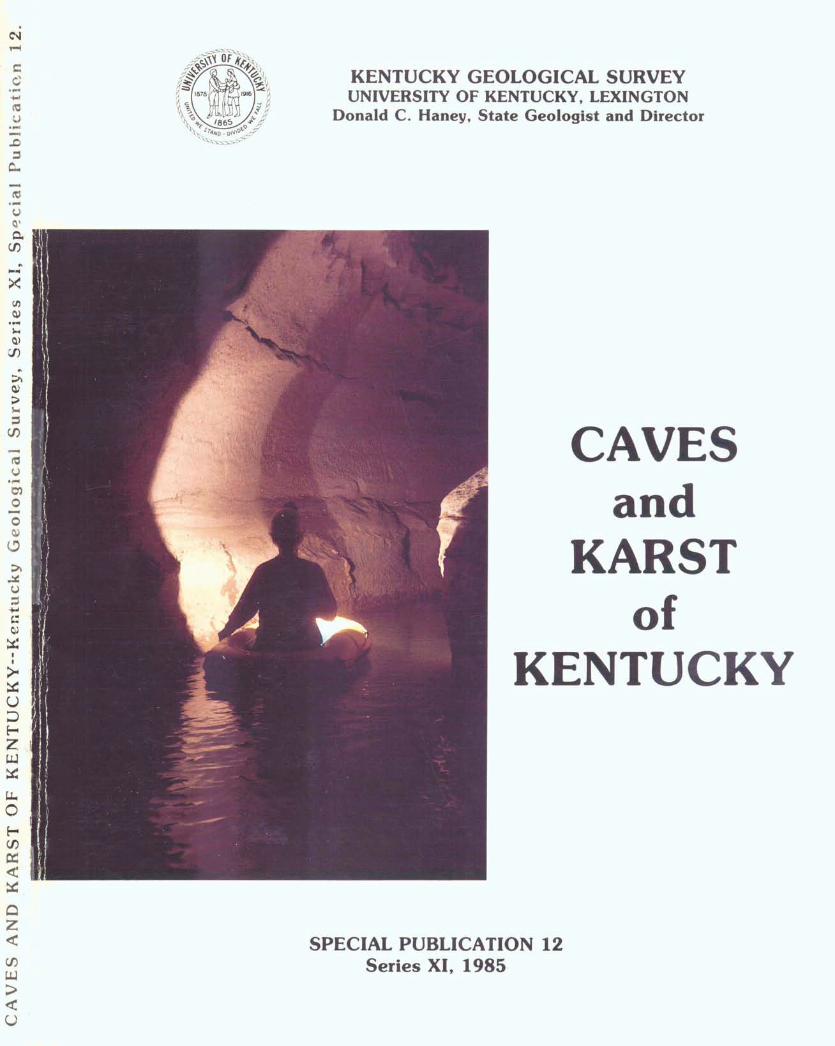
COVER PHOTOGRAPH
Creek section of Sloans Valley Cave. Pulaski County, Kentucky. (Photo by K. L. Day$
SPECIAL PUBLICATION 12 Series XI, 1985
A r t G a l l a h e r , Jr . , C h a n c e l l o r , L e x l n g t o n Campus W l m b e r l y C . K o y s t e r , V l c e C h a n c e l l o r t o r K e s e a r c h
a n d Dean o t t h e U r a d u a t e S c h o o l James Y . M c D o n a l d , E x e c u t ~ v e D ~ r e c t o r , U n f v e r s l t y
o f K e n t u c K y R e s e a r c h F o u n d a t I o n
KENTUCKY GEOLUG I CAL SCIWEY AVV I SORY BOARD P h ~ l M. M ~ l e s , Chairman, L e x l n g t o n J a n e b a l l l o n , J e n K f n s W a l l a c e W. Hagan , L e x l n g t o n H e n r y L . H l n K l e , P a r 1 5 B. W. M c D o n a l d , P a f n t s v ~ l l e W. A . M o s s b a r g e r , L e x t n g t o n W ~ l l l a m J. R e y n o l d s , f i l l e n H e n r y H. S p a l d ~ n g . H a z a r d H e n r y D. S t r a t t o n , P ~ K e v l l l e R a l p h N . I h o m a s , U w e n s b o r o G e o r g e H. W a r r e n , J r . , O w e n s h o r o E l m e r W h ~ t a K e r , L e x l n g t o n
KEN rUCKY GEULUCil CAL 8LlWE.Y D o n a l d C. H a n e y , D ~ r e c t o r a n d S t a t e U e o l o g l s t J o h n D. K i e f e r , A s s l s t a n t S t a t e O e o l o g l s t
ADMIN ISTRA ' r IV t D I V I S I O N P e r s o n n e l a n d F i n a n c e S e c t ~ o n : James L . H a m i l t o n , A d m i n l s t r a t t v e S t a f f O f f l c e r 11 M a r g a r e t A . F e r n a n d e z , A c c o u n t C l e r k 'J
Clerical S e c t l o n : Oosha B. B o y d , S t a f f A s s i s t a n t V I Donna C. Ramseur , S t a t t A s s t s t a n t V1 b h ~ r l e y U. B l a c k , b t a t t A s s ~ s t a n t V J e a n K e l l y , S t a t t H s s ~ s t a n t V J u a n ~ t a G. S m l t h , S t a f t A s s l s t a n t V , H e n d e r s o n
U t f I c e
P u b l l c a t i o n s S e c t l o n : D o n a l d W. H u t c h e s o n , H e a d M a r g a r e t K. L u t h e r , A s s ~ s t a n t E d i t o r R o g e r B P o t t s , C h t e f C a r t o g r a p h ~ c I l l u s t r a t o r R o b e r t C . H o l l a d a y , D r a f t i n g T e c h n l c l a n W i l l l a m A . B r l s c o e , Ill, S a l e s Supervisor R o g e r S. BanK5, A c c o u n t C l e r k 1 1 J o h n D a v ~ s , S t o r e s W o r K e r P a t r l c K H. M c H a f t i e , G e o l o g ~ s t / F e o g r a p h e r I 1
GEOLOGlWL D l V I S I U N C o a l S e c t ~ o n : J a m e s C. Cobb , H e a d R u s s e l l A. f i r a n t , G e o l o g ~ s t V A l l e n L). W ~ l l l a m s o n , G e o l o g f s t 1 0 , H e n d e r s o n
O t f I c e D o n a l d H. C h e s n u t , J r . , G e o l o g l s t 1 1 1 James C. C u r r e n s , G e o l o g ~ s t 1 1 1 H l c h a r d t. S e r g e a n t , G e o l o g f s t 1 1 1 D a v f d A . W ~ l l l a m s , t i e o l o g l s t 1 1 1 , H e n d e r s o n O f t t c e H l c h a r d A . Sma th , G e o l o g t s t I J o h n F. S t ~ c K n e v , t i e o l o g l s t 1 A p r f l L . Cowan, G e o l o g y F ~ e l d A s s l s t s n t
l n d u s t r ~ a l a n d M e t a l l l c M ~ n e r a l s S e c t t o n : G a r l a n d R. V e v e r , J r . , H e a d Eugene J. A m a r a l , G e o l o g ~ s t I V W a r r e n H. A n d e r s o n , G e o l o g ~ s t 1 1
S t r a t ~ a r a p h y a n d P e t r o l e u m G e o l o q y S e c t ~ o n : John D. K i e t e r , . A c t t n g H e a d a n d A s s l s t a n t S t a t e
G e o l o g ~ s t M a r t l n C. N o g e r , G e o l o g l s t V F r a n K H. W a l K e r , U e o l o g l s t I V
J o h n G. B e a r d , G e o l o g ~ s t I V , H e n d e r s o n O f f l c e Wayne 1 . F r a n K l e , G e o l o g l s t I 1 P a t r ~ c K J. B o o d ~ n g , G e o l o g l s t I 1 JacK R. M o o d y , G e o l o g ~ s t 11 B r a n d o n L . N u t t a l l . G e o l o g ~ s t I 1 J u l ~ e R. Kemper , G e o l o g ~ s t I F r a n c e s B e n s o n , L ~ b r a r y l e c h n ~ c l a n 1 1 1 R o b e r t H. D a n ~ e l , L a b o r a t o r y l e c h n ~ c ~ a n B J a c q u e l ~ n e H. t m b r y , D a t a E n t r y U p e r a t o r 1 1 1 V ICK I F . C a m p b e l l , D r a t t ~ n g l e c h n ~ c t a n
W a t e r H e s o u r c e s b e C t l O n : James S. D ~ n g e r , H e a d James K ~ p p , G e o l o g ~ s t 1 1 H ~ c h a r d S. S m a l l e s , U e o l o g l s t I 1 M a r g a r e t A . Townsend, t i e o l o g ~ s t II
C o m ~ u t e r S e r v f c e s G r o u p : S t e v e n C o r d l v ~ o l a . G e o l o q ~ s t I 1 1 J o s e p h B. D I x o n , s y s t e m s - p r o g r a m m e r
SPECIAL PHOJEC-IS DlVISILW4 P r o j e c t s Env t r o n m e n t a l P r o t e c t i o n A g e n c y - - D e v e l opmen t o f a
C o m p r e h e n s ~ v e U i l a n d Gas I n j e c t i o n W e l l I n v e n t o r y , K e n t u c K y James S. D ~ n g e r , P r ~ n c t p a l I n v e s t l g a t o r F r a n K H . W a l k e r , C o - P r t n c l p a l I n v e s t i g a t o r
U.S. E n v ~ r o n m e n t a l P r o t e c t ~ o n A g e n c y - - A r e a o f Rev1 ew a n d l n j e c t t o n P r e s s u r e R s s e s s m e n t o t U i l a n d Gas I n j e c t on Wel I s , K e n t u c K y James S . O ~ n g e r , P r ~ n c t p a l l n v e s t ~ g a t o r H ~ c h a r d S. S m a l l e y , t i e o l o g l s t 1 1
1J.S. G e o l o g i c a l S u r v e y - - 6 s s l s t a n c e ~ n t i a t h e r ~ n g O a t a o n K e n t u c k y C o a l R e s o u r c e s f o r t h e N a t i o n a l C o a l R e s o u r c e s O a t a S y s t e m R u s s e l l fi. B r a n t , P r l n c l p a l I n v e s t l g a t o r
U.S. G e o l o g ~ c a l S u r v e y - - C o a l Sampl i n g ~ n t h e W e s t e r n K e n t u c K r C o a l F i e l d James C. Cobb , P r ~ n c ~ p a l I n u e s t ~ g a t o r James C. C u r r e n s , C o - P r ~ n c i p a l I n v e s t i g a t o r
K e n t u c K y D e p a r t m e n t o t M I l I t a r y Atfa~rs--Drainage D e t e r m ~ n a t ~ o n t o r t h e Boone N a t ~ o n a l G u a r d C e n t e r , 6 r a n K l t n C o u n t y , K e n t u c k y James S. D ~ n g e r , P r l n c ~ p a l I n v e s t l g a t o r J. V . I h r a ~ l K ~ l l , L o - P r l n c l p a l I n v e s t l g a t o r
K e n t u c K y t ' l a t u r a l R e s o u r c e s a n d E n v ~ r o n m e n t a l P r o t e c t ~ o n C a b l n e t - - V e l l n e a t l o n a n d D o c u m e n t a t ~ o n o t M ~ n ~ n g - R e l a t e d Subsidence I n H o p K ~ n s , O h l o , U n ~ o n , a n d W e b s t e r U o u n t l e s H l c h a r d E. S e r g e a n t , P r ~ n c ~ p a l I n v e s t gato or H l c h a r d A. S m a t h , b e o l o g l s t I John 6 . S t t c K n e y , U e o l o g l s t 1 A p r ~ l L . Cowan, G e o l o g y Field A s s l s t a n t
Gas R e s e a r c h I n s t ~ t u t e - - S t u d y o f H y d r o c a r b o n P r o d u c t l o n f r o m t h e D e v o n l a n S h a l e f n L e t c h e r , K n o t t , F l o y d , a n d P l K e C o u n t t e s , E a s t e r n K e n t u c K y Wayne 1. F r a n K c e , P r ~ n c ~ p a l l n v e s t f g a t o r JacK H. Moody , G e o l o g l s t I 1 J u l l e R. Kemper , G e o l o g ~ s t I Jacqueline H. k m b r y , D a t a E n t r y O p e r a t o r I 1 1 'JICKI k . C a m p b e l l , U r a f t l n g T e c h n ~ c ~ a n
L1.S. G e o l o g l c a l S u r v e y - - M l d c o n t l n e n t Strategic a n d C r l t l c a l M t n e r a l s P r o g r a m W a r r e n H. f i n d e r s o n , P r l n c l p a l I n u e s t l g a t o r G a r l a n d K . D e v e r , C o - P r ~ n c ~ p a l I n v e s t f g a t o r
C O N T E N T S P a g e
P r e f a c e . . . . . . . . . . . . . . . . . . . . . . . . . . . . . . . . . . . . . . . . . . . . . . . . . . . . 1 A c K n o w l e d g m e n t s . . . . . . . . . . . . . . . . . . . . . . . . . . . . . . . . . . . . . . . . . . . . 2 F o r e w o r d . . . . . . . . . . . . . . . . . . . . . . . . . . . . . . . . . . . . . . . . . . . . . . . . . . . 3
S e c t i o n f Chap t ~ r 1 : t i v e r v i ew o + t h e 6 e o l o g y a n d P h y s l c a l G e o g r a p h y
. . . . . . . . . . . . . . . . . . . . . . . . . . . . . . . . . . . . . . . . . . . . . . o f K e n t u c k y 5 C h a p t e r 2: C a v e s o + K e n t u c K y . . . . . . . . . . . . . . . . . . . . . . . . . . . . . 18
S e c t i o n 11
C h a p t e r 3: T h e I n n e r B l u e G r a s s K a r s t H e g l o n . . . . . . . . . . . . . 28 L h a p t e r 4 : P a t t e r n s o t C a v e r n D e v e l o p m e n t A l o n g t h e
C u m b e r l a n d E s c a r p m e n t l n S o u t h e a s t e r n K e n t u c K y . . . . . . . . . . 63 C h a p t e r 5: C a v e s o t N o r t h e a s t e r n K e n t u c k y ( W ~ t h S p e c i a l
E m p h a s ~ s o n C a r t e r C a v e s S t a t e P a r k ) . . . . . . . . . . . . . . . . . . . . 78 C h a p t e r a: P t n e M o u n t a ~ n K a r s t a n d C a v e s . . . . . . . . . . . . . . . . . 86 C h a p t e r 7: T h e Mammoth Cave Reg1 o n a n d P e n n y r o y a l
P l a t e a u . . . . . . . . . . . . . . . . . . . . . . . . . . . . . . . . . . . . . . . . . . . . . . . 97 C h a p t e r 8: W e s t e r n K e n t u c k y H e g l o n . . . . . . . . . . . . . . . . . . . . . . 1 1 9
S e c t i o n 111
C h a p t e r 9 : C a v e L l f e o t K e n t u c K r . . . . . . . . . . . . . . . . . . . . . . . . 146 C h a p t e r 1 0 : V e r t e b r a t e R e m a i n s t n K e n t u c k r C a v e s . . . . . . . . . 16.9 C h a p t e r 11 : A r c h e o l o g v . . . . . . . . . . . . . . . . . . . . . . . . . . . . . . . . . . . 1 7 6 C h a p t e r 1 2 : C a v e s a n d t h e S a l t p e t e r I n d u s t r y i n
K e n t u c K y ................................................ 1 8 7
P R E F A C E M e m b e r s o?: t h e N a t i o n a l S p e l e o l o g i c a l S o c i e t y a r e t o b e
commended f o r t h e p r e p a r a t i o n o+ t h i s p u b 1 i c a t i o n o n t h e c a v e s a n d r e l a t e d K a r s t f e a t u r e s o f K e n t u c K y . P e r c y H. O o u g h e r t y , w h o w a s r e s p o n s ~ b l e f o r i n i t i a t i n g t h e p r o j e c t , dolng t e c h n i c a l e d i t ~ n g o f t h e m a n u s c r i p t s , a n d S u r n i s h i n g t y p , e s c r i p t wh i c h w a s u s e d as p r i n t e r ' s c o p y , d e s e r l J e s s p e c I a 1 r e c o g n i t I o n .
The r o l e o + t h e K e n t u c K y G e o l o g i c a l S u r v e y w a s t o d o r n l n o r c o p y e d l t I n g , p r e p a r e t h e I a y u u t , p a s t e u p c a m e r a - r e a d y c o p y , a n d maKe a r r a n g e m e n t s f o r g e t t i n g t h e manuscript p r i n t e d . l n o r d e r t o m e e t t h e p r i n t l n g d e a d 1 ~ n e , i t w a s n e c e s s a r y t c ~ u t i l i z e c o m p u t e r p r ~ n t o u t , p r e p a r e d by t h e N a t i o n a ' l Spe 1201 ugl c a l Soc 1 e t y , a s t y p e s c r I p t + o r t h e p u b 1 i c a t I o n . T h e r e f o r e , t h e p u b 1 i c a t i o n d o e s n o t c o n f o r m t o t h e u s u a l s ty1 e a n d e d r t o r I a l s t a n d a r d s o f t h e K e n t u c K y G e o l o g i c a l S u r v e y .
I t i s t e l t t h a t t h l s p u b l ~ c a t ~ o n w ~ l l s a t 1 5 . f ~ a w l d e s p r e a d n e e d +or u p - t o - d a t e I n f o r m a t I o n a b o u t c a v e s a n d K a r s t g e o l o g y ~ n K e n t u c K y . T h e d ~ v e r s e r a n g e o f t o p I c s c o v e r e d s h o u l d b e o+ I n t e r e s t t o a w l d e a u d ~ e n c e , ~ n c l u d ~ n g b o t h s c l e n t l s t s a n d l a y m e n .
Dona1 d W . HIJ t c h e s o n K e n t u c K y G e o l o g l c a l S u r u e y L e x i n g t o n , K e n t u c K y J u n e 19e5
ACKNOWLEDGMENTS W i t h o u t t h e h e l p o f m a n y p e o p l e , t h i s b o o K w o u l d n o t
h a v e b e e n p o s s i b l e . T h e a u t h o r s o f t h e c h a p t e r s s h o u l d b e c o n g r a t u l a t e d f o r w o r K i n g u n d e r a t i g h t s c h e d u l e a n d n e a r l y i m p o s s i b l e d e a d l i n e s . I n a d d i t i o n , t h e e d i t o r i s d e e p l y i n d e b t e d t o t h e f o l 1 o w i n g c o l l e a g u e s w h o c r i t i c a l l y r e v i e w e d s e c t i o n s o f t h e b o o K a n d made m a n y e x c e l l e n t s u g g e s t i o n s : S t e v e J u s t h a m , R o n L l i i a m a r t e r , J o h n H o + f e l t , P a t r i c k M u n s o n , A1 S c h e i d e , G e o r g e C r o w t h e r s , H o r t o n H o b b s , 1 1 1 , Don P o l l o c K , H a r o l d M e l o y , G e o r g e M o o r e , F r e d G r a d y , R u s s e l l G raham, J o e S a u n d e r s , G e o r g e H u p p e r t , A n g e l o G e o r g e , a n d C h a r l e s B i s h o p .
D o n n a M o o r e , s e c r e t a r y o + t h e G e o g r a p h y D e p a r t m e n t a t K u t z t o w n U n i v e r s i t y , d e s e r v e s m u c h c r e d i t +or s p e n d i n g m a n y h o u r s t y p i n g t h e t e x t . T h e a u t h o r a l s o w i s h e s t o t h a n k t h e G e o g r a p h y D e p a r t m e n t a n d a d m r n i s t r a t i o n a t K u t z t o w n U n i v e r s i t y f o r p r o v i d i n g t h e f a c i l i t i e s a n d s t i m u l a t i n g e n v i r o n m e n t i n w h i c h t o c o m p l e t e t h i s p r o j e c t .
T h e K e n t u c K r G e o l o g i c a r S u r v e y a1 s o d e s e r v e s 5.pec i a1 r e c o g n i t I on. D o n a 1 d C . H a n e y , D i r e c t o r a n d S t a t e G e o l o g i s t , a n d D o n a l d W . H u t c h e s o n , E d i t o r o f t h e S u r v e y , h a v e p r o v i d e d g u i d a n c e f o r t h i s w o r K s i n c e i t s ~ n c e p t l o n . I n a d d i t i o n , s e v e r a l s t a f f m e m b e r s h a v e p r o u I d e d u l u a b l e a s s i s t a n c e i n e d i t i n g t h e t e x t and l a y i n g o u t t h e g r a p h i c s .
F i n a l l y , 1 am i n d e b t e d t o m y w i f e , A n n e , a n d s o n s , T h o m a s a n d H o b e r t , +or t h e I r c o n t i n u i n g s u p p o r t a n d u n d P r s t a n d i n q . T h i s bcnoK 1s d e d i c a t e d t o t h e m a n d my f a t h e r , P e r c y H. D o u g h e r t y , S r . , w h o i s s a d l r m i s s e d s i n c e h i s d e a t h i n A p r r I .
P e r c y H. D o u g h e r t y , e d i t o r
K u t z t o ! , ~ ~ n U n ~ v e r s i t y
J l ~ n e 1985
F O R E W O R D
CAVES AND K6HST O F KENTUCKY i s a specia l pub l i ca t i on o f t he Na- t i onal Spel eol og i c a l Society and the Kentucky Geological Survey t o commemorate the Annual Convention of the National Speleological So- c i e t y a t Kentucky State Un ivers i t y i n Frankfor t , Kentucky on June 22- 29, 1985. It i s appropr iate t o ho ld the Convention i n Kentucky s ince i t i s the home of Mammoth Cave, t he wor ld 's longest cave, and the s i t e o f many other la rge caves and kars t landforms. I n ad- d i t i o n , Kentucky has a long t r a d i - t i o n o f cave and ka rs t research. The Convention and t h i s book are dedicated t o the explorers, map- pers, and researchers who have added t o our knowledge and appre- c i a t i o n o f the S ta te ' s caves.
When plans were being developed f o r the 1985 Convention, i t was rea l i zed t h a t there was a need f o r a book on the caves and kars t o f Kentucky. A f t e r reviewing the pro- f essional l i t e r a t u r e and examining g r o t t o pub l ica t ions, a se t o f goals was formulated t o guide t he design o f the book. The goals i n - cluded: (1) t o prov ide a s t a t e o f the a r t approach t o what has been done i n Kentucky cave and kars t reserch, w r i t t e n by people who are doing the work; (2) t o accumulate d iverse mater ia ls about Kentucky caves and kars t i n one publ ica- t i on , making ava i l ab le a quick and easy reference and research vo l - ume, (3) t o f i l l a gap i n the pro- fess iona l l i t e r a t u r e f o r no s i n g l e statewide reference t o Kentucky caves and kars t ex i s t s , although the Kentucky Geological Survey has published several good case stu- d ies on caves; (4) t o use the regional approach t o compare and contrast var ious cave and ka rs t regions i n Kentucky, enabling t he reader t o appreciate ka rs t proces- ses and understand how reg iona l d i f ferences create unique land- scapes; (5) t o show the s ta tus o f Kentucky cave and kars t research
i n appl ied areas; inc lud ing pale- ontology, archeology, h i s to r y , and biology, ( 6 ) t o present extensive b ib l iog raph ic mater ia l , and, ( 7 ) t o discuss gaps i n t he l i t e r a t u r e , thereby poss ib ly s t imu la t ing fur- ther research i n Kentucky cave and kars t environments.
These goals played a major r o l e i n s t ruc tu r i ng t he book i n t o th ree parts. Sect ion I introduces two chapters o f background in format ion necessary t o understand the caves and ka rs t of Kentucky. Chapter 1, by Percy H. Dougherty, i n v e s t i - gates t he geology and geomorphol- ogy o f the State i n order t o g i ve t he reader a basic background i n order t o understand t h e where and why of cave formation. The discus- s ion takes the reader back 400 m i l l i o n years and t races t he de- velopment of the present rock types and landforms so one can appreciate t he processes t h a t have created Kentucky's great caves. Angelo Gearge expands upon t h i s background by discussing where t he known caves are located and analy- z ing t he po ten t i a l f o r f u r t h e r d i scover i es .
Section I1 d i v i des t h e State i n t o several cave and kars t regions. Each reg ion i s discussed by an i n d i v i d u a l who has done sub- s t a n t i a l research i n the area. The Elue Grass Region i s w r i t t e n by John T h r a i l k i l l who has researched the ka rs t hydrology o f t he Lee i ngton area. The Cumber 1 and Plateau i s d iv ided i n t o two d is - t r i c t s ; a northern area centered on Carter Caves, presented by John Tierney; and a southern region, w i t h i t s major cave area around Pul ask i and Rockcastl e count ies described by Ralph Ewers. Although p a r t o f t he same geologic and geo- morphic regions, t he two areas are discussed separately because of d i f fe rences i n t h e i r speleogenesis and t h e i r geographic separat ion i n t o d i f f e r e n t drainage basins. The chapters on the Mississ ippian
FOREWORD
Plateau are d iv ided i n a s im i l a r manner. Arthur Palmer presents an in-depth chapter on t he Mammoth Cave area and adjacent p a r t s of t h e Pennyroyal Plateau, whi le John Myl ro ie and Mike Dyas discuss the caves and kars t o f t he Land Between the Lakes and the westward extension of the Mammoth Cave and Pennyroyal plateaus. Although s i m i l a r geological 1 y, t he r e s u l t - i n g caves d i f f e r subs tan t i a l l y because of t he f a c t o r s producing them. Local hydrology and sub t le d i f ferences i n t he geology between areas may r e s u l t i n a much d i f f e r - ent end product. Another chapter inves t iga tes the cave and ka rs t processes operat i ng on Pine Mountain. Joseph Saunders has done much caving and i nves t i ga t i on o f t h i 5 unique t h r u s t f au l t ed region and shares h i s experiences i n Chapter 6.
The subject matter i n Section I 1 1 i s diverse. This sect ion focuses upon the appl ied research t h a t has taken p lace on the caves and kars t of Kentucky. Ron Wilson looks a t t he e a r l y l i f e i n Ken- tucky by i nves t i ga t i ng the cave pa leonto log ica l record. He ex- p lo res how ver tebrate bones got i n t o caves, what t he presence of the bones ind icates, what animal species once l i v e d i n Kentucky, and concludes w i t h a general over- view of t he pa leonto log ica l work done i n the State. Pa t ty Jo Watson presents mater ia l on the ea r l y human populat ion o f t he State, concentrat ing on t he archeology of the Mammoth Cave Region, w i t h reference t o other p a r t s o f the State. She explores why p r i m i t i v e people were in te res ted i n the caves, shows evidence of t h e i r exp lora t ion i n Mammoth Cave, and discusses how cavers can help archeological research. Stanley Sides d i scusses the sa l tpe te r indus t ry of Kentucky. Although concentrat ing on t he Mammoth Cave
Thomas Earr, shows the s ta tus of research i n cave biology. The f r a g i l e ecosystem i s explored and the reader i s made aware o f the unusual organisms i nhab i t i ng Kentucky caves today.
Caves and kars t features form unique environments which are eas i l y disturbed. Cave formations once broken and removed from the cave may never regenerate, r e s u l t - i n g i n the l oss o f a beau t i f u l c reat ion of nature f o r f u t u r e generations. Such dest ruct ion may a lso e l iminate research ob jects essent ia l i n unrave l l i ng the mysteries of cave processes. I n addi t ion, undue t r a f f i c i n caves may have a negative e f f e c t upon ba t colonies, endangering a valuable animal which does more good than harm through i t s eradi- ca t ion of harmful insects. Other cave organisms may a lso be ser- i o u s l y reduced o r wiped out by careless act ion. Chemical sp i 11 s, sewage, o v e r - f e r t i l i z a t i o n o f farm f i e l d s , and many other human ac- t i v i t i e s may have a severe impact on the we1 1-being o f caves and kars t , so we must be e x t r a care fu l and p ro tec t these areas.
The National Spel eo l ogi ca l So- c i e t y i s the leading organizat ion engaged i n the conservation o f caves and kars t areas. Their s lo- gan i s , "Take nothing bu t p i c - tures, leave nothing but foo t - p r i n t s , and k i l l nothing but t ime." They have embarked upon an educational campai gn t o develop an appreciat ion among l a y people of the de l i ca te nature of caves. The Society sponsors several conferen- ces and workshops each year and publ ishes two journals, the NSS NEWS and the NSS BULLETIN. For f u r t h e r in format ion on how you can help i n the conservation of caves and kars t environments, please contact: The National Speleolog- i c a l Society, Cave Avenue, Huntsv i l l e , Alabama 35810.
area, the paper a l so discusses the impact o f the sa l t pe te r indust ry on the development o f the United Percy H. Dougherty, ed. States and the e a r l y economy of Department o f Geography Eentucky. The f i n a l select ion, by Kutztown Univers i ty , Pennsylvania
Chapter 1 AN OVERVIEW OF THE GEOLOGY
AND PHYSICAL GEOGRAPHY OFKENTUCKY
Percy H. Dougherty Department of Geography
Kutztown University Kutztown, Pennsylvania 19530
Kentucky i s t h e home of t he b i g caves, a f ac t t h a t cannot be doubted when one r e a l i z e s t h a t Mammoth Cave, a t near ly 500 km i s 300 km longer than i t s nearest competitor. O f t he 10 longest caves i n the Uni ted States, 2 are found i n Kentucky; t h i s number would have been 3 i f i t had not been f o r the recent connection o f t he 70-km-long Hoppel System w i th Mammoth Cave. Feople working on t h e Mammoth Cave P ro jec t f e e l t h a t t he eventual mapped distance of t h e system w i 11 exceed 900 km by the t u r n of the century. Many other la rge cave systems i n the State exceed 3 km, the distance needed t o have a cave l i s t e d on the World's Longest Cave L i s t publ ished by t he I n te rna t i ona l Speleological Union. I n fac t , Kentucky has 45 caves on the l i s t .
Why has Kentucky been so blessed w i th such long caves? Why are there so many caves i n Kentucky? Where a re t he caves located? How have they formed? And, what i s the importance of caves and t h e i r associated land- scape? These and other quest ions w i l l be answered dur ing t h e course of h i s chapter and examined i n more d e t a i l throughout t he book.
Chapter 1 se ts t he stage on which a l l cave forming processes work. One must know the general geology and geomorphic h i s to r y o f
t he area i n order t o understand where and why caves form. I n an area w i t h f l a t 1 y ing rocks of homogeneous compositon, there would be l i t t l e need f o r such a study because the existance of caves would be l im i t ed . Kentucky, on the other hand has a great d i v e r s i t y of ear th mater ia ls and an idea l landform assemblage f o r t h e formation of caves and kars t . Several fac to rs are inves t iga ted throughout t he book t o show why Kentucky i s the home of the "b ig ones." These f a c t o r s include: (1) composi ton of the 1 i mestones-- poros i t y , permeabi l i ty , thickness, impur i t i es , j o i n t i ng , and bedding, (2) composition o f the caprock and adjacent s t ra ta , (3) t he geologic s t ruc tu re and con t r i bu t i on t o the enhancement of speleogenetic pro- cesses, ( 4 ) other f ac to rs such as weather, cl imate, and the impact o f vegetat ion on kars t processes, and (5) d i f f e r e n t i a l erosion and the impact of r i v e r systems on kars t processes.
Formation of caves and ka rs t features i s a complicated process i nvo l v i ng the i n t e r a c t i o n of many fac tors . I n the fo l low ing d i scussi on, on1 y those caves developed i n 1 i mestone environments w i l l be considered. Most caves i n Kentucky are the r e s u l t o f ka rs t processes, although there are examples of caves developed by tecton' ic
G E O L O G Y
movement, p i p i ng o f sediments, and basal spr ing sapping. I n the context o f t h i s book, a s t r i c t d e f i n i t i o n of ka rs t w i l l l i m i t t he discussion t o those environments i n which groundwater r e s u l t s i n t he so lu t i on of rock through carbonation. Karst landscapes are o f ten character ized by extensive development of sinkholes, i n t e r i o r drainage, lack o f surface streams, caverns, so lu t i on sculptured rock (karren), l a rge springs, and other landforms assocated w i t h such areas. For a more de ta i led discussion of caves and kars t i n general, the reader i s encouraged t o r e f e r t o one of t he fol lowing: Jennings (1971), Sweeting (1972) , Jakucs (1977), Su l l i van and Moore (19781, or Bogl i (1980).
The remainder o f t h i s chapter w i l l d iscuss the s p a t i a l d i s t r i b u t i o n of rock types and landforms i n Kentucky. An understanding of t he geologic h i s to r y and the deposi t ional h i s t o r y o f Kentucky enables one t o be t t e r understand why some areas have more caves. I n addi t ion, the explanation o f d i f f e r e n t i a l erosion o f t he var ious rock types and a discussion of regional s t r u c t u r a l va r i a t i ons help one t o understand why c e r t a i n land+orms are more conducive t o cave and kars t formation. Geomorphic h i s t o r y i s discussed i n r e l a t i o n t o geology i n order t o f a c i l i t a t e t h e separat ion of t h e State i n t o d i s t i n c t regions. The p o t e n t i a l f o r caves and ka rs t i n each region i s introduced i n t h i s chapter and more f u l l y discussed i n Section I 1 f o r those areas conta in ing caves and kars t .
GEOLOGY
V i r t u a l l y a l l o f Kentucky i s composed of sedimentary rock +armed from mater ia ls t h a t were o r i g i n a l l y deposited as sediments i n great in land seas o r as near-shore deposi ts i n ancient oceans. These sediments have been compressed and cemented i n t o the v a r i e t y of limestones, sandstones, conglomerates, shales, and coal
deposi ts t h a t form the layers o f rock we see today. The s t o r y o f t h e i r deposi t ion i s t o l d by the many p lan t and animal f o s s i l s found i n the rock, i n d i c a t i n g t h a t dur ing the Ordovician Period deep seas once covered Kentucky. Later deposi t s of the Pennsy 1 vani an, Cretaceous, and T e r t i a r y per iods show t h a t water l e v e l s f luc tua ted g r e a t l y from near shore deposi ts t o coastal p l a i n , de l t a i c , and beach deposits. Great co ra l r ee f s o f t he Middle S i l u r i a n and Middle Devonian per iods resu l t ed i n several l imestone deposi ts i n the State. O f the mater ia l deposited i n the ancient seas, i t i s the l imestone i n which we are p r i m a r i l y in terested, because most caves and kars t topography i n t he State are formed i n t h i s rock type. By understanding the s p a t i a l d i s t r i b u t i o n of l imestone of d i f f e r e n t ages, and studying i t s r e l a t i o n t o the surface, one can b e t t e r understand where caves are t o be found and how they are formed.
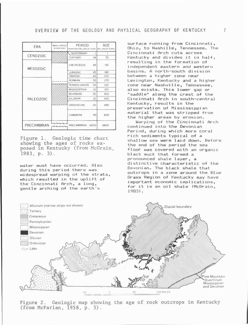
The o ldest rocks i n t he State of Kentucky are those exposed i n the Inner Blue Grass Region around Lexington. They date back over 400 m i l l i o n y e a r s t o the Ordovician Period. I n order t o g ive a po in t of reference, F igure f shows the geologic calendar t h a t w i l l be re fe r red t o when the age of var ious rocks and events are mentioned. The areal ex tent of the Ordovician rock, shown i n the geologic map (Fig. 2 ) , covers most o f the area between Lexington, Loui s v i 1 1 e and C i n c i nnat i . The rocks of the Ordovician Period were deposited i n deep seas. Toward the end of t he period, seas became shallower, as evidenced by t he amount of mud t h a t was depasited and subsequently hardened i n t o shale. The f 01 1 owi ng S i 1 u r i an Period was character ized by warm, c lear, shal low seas, as ind icated by the profus ion of co ra l deposits and brachiopods i n S i 1 u r i an do1 omi t e s and 1 i mestones, although the presence o f shale beds suggests per iods o f t u r b i d
O V E R V I E W OF T H E GEOLOGY AND P H Y S I C A L G E O G R A P H Y O F K E N T U C K Y 7
sur face running from Cinc innat i , Ohio, t o Nashi l le , Tennessee. The Cinc innat i Arch cu t s across Kentucky and d i v i des i t i n h a l f , r e s u l t i n g i n t he +ormation o f independent eastern and western basins. A north-south d i v i s i o n between a higher zone near Lexington, Kentucky and a higher zone near Nashvi 1 1 e, Tennessee, a l so ex is ts . Th is lower gap or "saddle" along the c r e s t o f the Cinc innat i Arch i n south-central Kentucky, r e s u l t s i n t h e preservat ion o f M iss iss ipp i an mater ia l t h a t was s t r i pped from the higher areas by erosion.
Warping o f the C inc inna t i Arch continued i n t o t he Devonian Period, dur ing which more cora l
Figure 1. Geologic time char t r i c h sediments t y p i c a l o f a shallow sea were l a i d down. Before
showing the ages of rocks ex- the end of the per iod the sea posed i n Kentucky (from McGrain, f 1 oor was covered w i t h an organic 1983, p . 3 ) . black muck t h a t formed a
pronounced shale layer , a
water must have occurred. Also dur ing t h i s per iod there was widespread warping of the s t ra ta , which resu l ted i n t he up1 i f t of t he Cinc innat i Arch, a long, gent le arching of the ear th ' s
d i s t i n c t i v e c h a r a c t e r i s t i c o f the Devonian. The black shale t h a t outcrops i n a zone around the Blue Grass Region of Kentucky may have important economic imp l i ca t ions , f o r i t i s an o i l shale (McGrain, 1983).
Al luv~urn (narrow strlps not shown)
["," Tertiary
Cretaceous
Pennsylvanian
0 M ~ s s ~ s s ~ p p ~ a n
Devontan
/ S~lurlan
c;;s Lake
n 50 100 MILES
Figure 2 . Geologic map showing the age of rock outcrops i n Kentucky (from McFarlan, 195 8 , p . 5) .
G E O L O G Y
As t h e M i ss i s s i ppi an Per i od progressed, t h e depos i t i on of t h e black shales was replaced by an i n f l u x of sands, g r a v e l s , s i l t s , and muds deposited by r i v e r s eroding t h e nearby land masses. D e l t a i c depos i t s , w i t h t h e i r c h a r a c t e r i s t i c crossbedding and water cu r ren t worked mate r ia l s were l a i d down. Long per iods of c l e a r , calm c o n d i t i o n s f 01 lowed; and massive beds of l imestone, i n which many of t oday ' s caves a r e l oca ted , were deposited. A per iod of recession of t h e seas occurred, f 01 lowed by ex tens ive eros ion o.f t h e land sur face. These events a re recorded as an uncomf ormi t y between t h e Miss iss ipp ian and l a t e r Pennsylvanian s t r a t a .
Pennsylvanian c o n d i t i o n s were warm and contained i n t e r m i t t e n t t ransgress ions of t h e sea, as evidenced by t h e presence of marine depos i ts i n t h e predominantly fresh-water sediments. The per iod was charac ter ized by t h e fo rmat ion of great swamps and f o r e s t s , as shown by t h e p r o l i f i c f o s s i l record. Great masses of vegeta t ion were bur ied under d e l t a i c depos i ts and s i l t s . T h i s vege ta t i on , i n t h e absence of oxygen, changed i n t o coa l . S i m i l a r developments occurred i n both t h e eastern and western basins on e i t h e r s i d e of t h e C inc inna t i Arch, r e s u l t i n g i n t h e two major coal f i e l d s , which have made t h e S t a t e a leading producer of coa l .
The Permian Period may have been we l l represented i n Kentucky but i t s record was undoubtedly e r o d ~ d away, f o r only minor evidence of i t s presence remains. The rock of t h i s per iod i s pr'eserved i n some small f a u l t b locks and i n small igneous d i kes i n E l l i o t t County i n eastern Kentucky and Caldwell and Cr i t t enden count ies i n western Kentucky; t h e on ly non-sedimentary rock found i n t h e S ta te (McGrain, 1983) . A t t h e end of t h e per iod a s e r i e s of u p l i f t s occurred, leading t o increased e ros ion , which o b l i t e r a t e d much of t h e
geologic record of t h e l a t e Paleozoic. By t h e end of t h e Paleozoic , t h e C i n c i n n a t i Arch had formed, t h e western and eastern coal basins were present , t h e Pine Mountain F a u l t had been t h r u s t 19 t o 16 km t o t h e nor thwest , and many of t h e high-angle f a u l t s of c e n t r a l and western Kentucky were present . Most of t h e S t a t e ' s depos i t i ona l and d i a s t r o p h i c a c t i v i t y came t o a c lose .
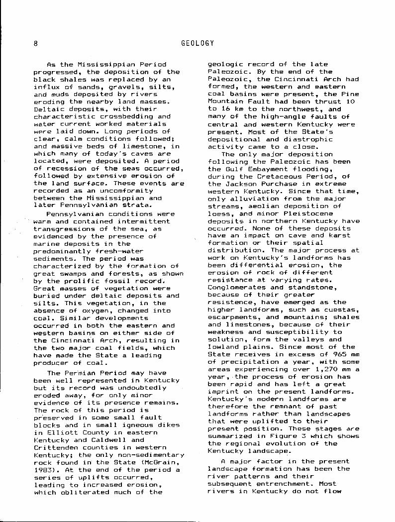
The on ly major d e p o s i t i o n f o l l o w i n g t h e Paleozoic has been t h e Gulf Embayment f l o o d i n g , du r ing t h e Cretaceous Per iod , of t h e Jackson Purchase i n extreme western Kentucky. Since t h a t t i m e , on ly a l l u v i a t i o n from t h e major streams, aeol i an depos i t i on of 1 oess, and m i nor F l e i stocene depos i t s i n no r the rn Kentucky have occurred. None of these depos i ts have an impact on cave and ka rs t fo rmat ion or t h e i r s p a t i a l d i s t r i b u t i o n . The major process a t work on Kentucky 's landforms has been d i f f e r e n t i a l e ros ion , t h e eros ion of rock of d i f f e r e n t r e s i s t a n c e a t va ry ing r a t e s . Conglomerates and standstone, because of t h e i r g reater r e s i s t e n c e , have emerged as t h e h igher landforms, such as cuestas, escarpments, and mountains; shales and l imestones, because of t h e i r weakness and s u s c e p t i b i l i t y t o s o l u t i o n , form t h e v a l l e y s and lowland p l a i n s . Since most of t h e S t a t e rece ives i n excess of 965 mm of p r e c i p i t a t i o n a year , w i t h some areas exper iencing over 1,270 mm a year , t h e process of e ros ion has been rap id and has l e f t a g reat i m p r i n t on t h e present landforms. Kentucky 's modern landforms a re t h e r e f o r e t h e remnant of past landforms ra the r than landscapes t h a t were u p l i f t e d t o t h e i r present p o s i t i o n . These stages a re summarized i n F igu re 3 which shows t h e reg iona l e v o l u t i o n of t h e Kentucky landscape.
A major f a c t o r i n t h e present landscape fo rmat ion has been t h e r i v e r pa t te rns and t h e i r subsequent entrenchment. Most r i v e r s i n Kentucky do not f l o w
O V E R V I E W OF T H E GEOLOGY AND P H Y S I C A L G E O G R A P H Y OF K E N T U C K Y 9
F I G 2 CLOSE O F PALEOZOIC
I<. L C " l L
EARLY TERTIARY
.OTT>~,LL I 1..101~0*( . c ~ ~ ~ ~ o ~ ~ ~ ~ ~ e RECENT - L I I I I , ..*0110*I
F i g u r e 3 . Regional e v o l u t i o n of t h e Kentucky landscape (from McFarlan, 1943, p . 1 5 9 ) .
along the d i p o f the sedimentary s t ra ta . Major r i v e r s such as the Kentucky, Green, Cumberland, and L i c k i n g f low across t he s t r a t a as superposed streams t h a t pre-date t h e present landforms. The r i v e r s were ab le t o maintain t h e i r courses over the more r e s i s t a n t s t r a t a being uncovered by d i f f e r e n t i a l erosion.
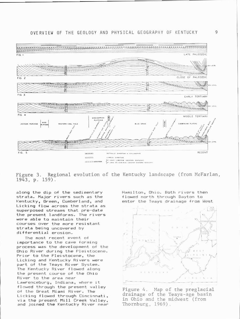
The most recent event of importance t o the cave forming process was the development of the Ohio River dur ing the Pleistocene. P r i o r t o the Pleistocene, the L i ck ing and Kentucky Rivers were p a r t of the Teays River System. The Kentucky River f lowed along the present course of the Ohio River t o the area near Lawrenceburg, Indiana, where i t flowed through the present va l l ey o f the Great Miami River. The L i ck ing flowed through Cinc innat i , v i a the present M i l l Creek Val ley, and jo ined the Kentucky River near
Hamilton, Ohio. Both r i v e r s then flowed nor th through Dayton t o enter the Teays drainage from West
f d R G N A
- - - - - - _ _ _ - f - - - k - - - - -
Figure 4 . Map o f t h e p r e g l a c i a l d r a inage o f t h e Teays-age b a s i n i n Ohio and t h e midwest (from Thornburg, 1969) .
R E G I O N A L D I V I S I O N S
V i r g i n i a and Eastern Ohio a t a junc t ion i n west-central Ohio. The stream then flowed across cen t ra l Indiana as the River Teays. G lac ia l advance blocked the northward f low and the present Ohio River breached the Madison Gap t o f low i n i t s present course. Because of the great f low of water i n the new channel, downward c u t t i n g was rapid. This c u t t i n g l e f t branch t r i b u t a r i e s of the ancestra l Ohio discordant w i th the main stream: r a p i d c u t t i n g occurred r e s u l t i n g i n the entrenchment of the Kentucky, Cumberland, Tennessee, Green, and other r i ve rs . F luc tuat ions i n r i v e r f low and per iods of r ap id entrenchment 1 owered base 1 eve1 throughout the major cave areas o f Kentucky, a process t h a t has resu l t ed i n the p ro f usion of l e v e l s i n Kenturky caves.
REGIONAL DIVISIONS
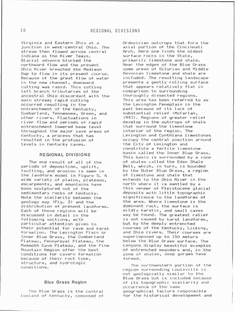
The end r e s u l t o f a l l od the per iods of deposi t ion, u p l i f t , f a u l t i n g , and erosion i s seen i n t he landform model i n Figure 5. A wide v a r i e t y of p la ins , plateaus, escarpments, and mountains have been sculptured out of the sedimentary rocks o f Kentucky. Note the s i m i l a r i t y between the geology map (Fig. 2) and the d i s t r i b u t i on of present 1 and+ orms. Each of these regions w i l l be discussed i n d e t a i l i n t he fo l low ing sect ions, w i t h p a r t i c u l a r a t t e n t i o n given t o t h e i r po ten t i a l f o r cave and kars t formation. The Lexington P la in o r Inner Elue Grass, the Cumberland Plateau, Pennyroyal Plateau, the Mammoth Cave Plateau, and the Pine Mountain Region o f f e r the best condi t ions f o r cavern formation because of t h e i r rock type, s t ruc tu re , and hydrologic condit ions.
Ordovician outcrops t h a t form the a x i a l po r t i on of the Cinc innat i Arch. Here one f i n d s the oldest surface rocks i n the State, p r imar i 1 y 1 imestone and shale. Near the edges of the Blue Grass some areas of Si l u r i a n and Middle Devonian l imestone and shale are included. The r e s u l t i n g landscape presents a gent ly r o l l i n g surface t h a t appears re1 a t i ve l y f 1 a t i n comparison t o surrounding thoroughly dissected regions. This area has been r e f erred t o as t he Lexington Peneplain in the past because of i t s lack o f substant ia l re1 i e f (McFarlan, 1943). Regions of greater r e1 i e f develop i n the outcrops of shale t h a t surround the l imestone i n t e r i o r of the region. The Lexington and Cynthiana l imestones occupy the cen t ra l pos i t i on around the C i t y of Lexington and cons t i t u te a f e r t i l e l imestone basin ca l l ed the Inner Blue Grass. This basin i s surrounded by a zone of shales ca l l ed the Eden Shale Be l t , which, i n turn, i s bounded by the Outer Blue Grass, a reg ion o f l imestone and shale t h a t extends t o the Ohio River i n the nor th where i t i s mantled by a t h i n veneer of Pleistocene g l ac i a1 deposits w i t h 1 i t t l e topographic s ign i f icance t o the landforms of t he area. Where l imestone i s the dominant rock, the surface i s m i l d l y ka rs t i c , and small caves may be found. The greatest r e l i e f i s not caused by kars t landforms, but by the deeply entrenched courses of the Kentucky, L ick ing, and Ohio r i ve rs . Their courses are superimposed up t o 150 meters below the Blue Grass surface. The canyons d isp lay beau t i f u l examples of entrenched meanders and, i n the zone of shales, deep gorges have formed.
The northwestern p o r t i o n of the req ion surroundinq Loui s v i 1 l e i s not geo log ica l ly k i m i l a r t o t he F lue Grass but i s inc luded because
Blue Grass Region ~f i t s topographic s i m i l a r i t y and occurrence of the same
The Blue Grass i s the cen t ra l geographical f a c t o r s responsib le lowland of Kentucky, composed of f o r t he h i s t o r i c a l development and
O V E R V I E W OF T H E GEOLOGY AND P H Y S I C A L G E O G R A P H Y OF K E N T U C K Y 11
WESTERN KENTUCKY I
EASTERN KENTUCKY MISSISSIPPI
EMBA YMEN
Figure 5 . Physiographic map of Kentucky showing geomorphic regions and major escarpments. Generalized cross sec t ion dep ic t s the s t r u c t u r e of rock u n i t s from west t o e a s t across the S t a t e . (From EIcGrain, 1983, p . 13 . )
economy of the Blue Grass. The L o u i s v i l l e p a r t o f t h e Blue Grass, c a l l e d the Scottsbuvg Lowland, has developed on 1 imestones o f Middle S i l u r i a n and Middle Devonian age and more recent a l luv ium deposited by ancestra l stages o f t he Ohio River. Geographically, t he reg ion cons t i t u tes one of the anchors o f what Rai tz (1980) has c a l l e d the "urban t r i a n g l e " of t he Blue Grass, a j o i n i n g by t ranspor ta t ion a r t e r i e s of Loui s v i 11 e, Lex i ngton and Covington, t h e th ree la rges t urban areas i n t he State, and a l l w i t h i n the Flue Grass.
Limestone w i t h i n the Blue Grass is not only responsib le f o r t he k a r s t features and caves, i t has a l s o played an important r o l e i n t he economic growth o f t he region. S o i l s formed on t h e Inner Blue Grass are except iona l ly f e r t i l e ,
brown s i l t loams w i th a h igh phosphatic leve l . The Woodburn Formation which once supported commercial product ion o f phosphate rock. These formations have resu l t ed i n the Blue Grass becoming wide1 y known as an a g r i c u l t u r a l i s l and i n cen t ra l Kentucky, character ized by i t s b e a u t i f u l mansions and extensive horse farms. I n add i t ion , t he Blue Grass i s the center of t he bur ley tobacco region. Kentucky produces 80 percent o f a l l bu r ley tobacco grown i n the United States, making tobacco Kentucky's number one l ega l a g r i c u l t u r a l crop. This crop accounts f o r 85 t o 90 percent of t he s t a t e ' s a g r i c u l t u r a l income per year and 20 percent of the t o t a l United States tobacco product ion i n a good year (Rai tz, 1980).
T H E C U M B E R L A N D P L A T E A U
An outgrowth o f t h e l imestone a g r i c u l t u r a l bounty i s t h e development of t h e bourbon indus t ry . Ear l y Blue Grass s e t t l e r s had an excess o f corn a t t h e end o f t he season and had no convenient means of t ranspor t ing t h e bulky commodity t o C inc innat i o r other markets. A bu lk reduct ion o f t he corn t o d i s t i l l e d s p i r i t s was a l o g i c a l r e s u l t . I n 1789 Reverend E l i j a Craig, of Georgetown i n Bourbon County, developed the rec ipe f o r a malt whiskey t h a t now c a r r i e s t he name o f t he county i n which i t was f i r s t d i s t i l l e d . Even today, Sta te law requ i res t h a t 51 percent of t he g ra in i n bourbon must be corn, thus impart ing t he unique t a s t e t o the beverage. Kentucky a t one t ime had over 400 d i s t i l l e r i e s producing i n excess of 88 percent of America's bourbon whiskey. Through corporate mergers and t he necessi ty of l a rge scale operat ion, the number has dropped t o 28 d i s t i l l e r i e s ; a l l but 3 are i n the Blue Grass. Experts i n bourbon whiskey a t t r i b u t e the excel lence t o t he use o f pure, na tu ra l l imestone waters t ha t emerge from the ka rs t spr ings o f t he area. Kentucky s t i l l produces 75 percent of a l l Uni ted States ' bourbon (Rai t i , 1980) .
The kars t spr ings were a lso instrumental i n t he e a r l y sett lement pa t te rns of t he Blue Grass. C i t i e s such as Lexington, Harrodsburg, and Georgetown were b u i l t a t t he s i t e s of ka rs t spr ings i n order t o assure a steady supply of water f o r the s e t t l e r s . Even today, t he c i t y of Georgetown s t i l l ge ts i t s water supply from the great f l ow of Royal Spring.
Cumberland Plateau
The gen t l y southeastward dipping upland surface east of the P o t t s v i l l e Escarpment and west of t he steep1 y r i s i n g Pine Mountain i s re fe r red t o as t he Cumberland Flateau. The Cumberland Plateau i s o f ten re fe r red t o as t he Eastern
Kentucky Mountains o r t he Eastern Kentucky Coal F ie ld . The l a t t e r terms o f t en inc lude t h e Pine Mountain Overthrust and i t s associated basin and mountains as p a r t of the region, bu t t h i s discussion w i 11 consider these areas as p a r t o f t he Cumberland Mountains. The reason f o r t h i s separat ion i s t he independence o f speleogenetic processes a t work i n the development of caves and ka rs t i n t he two areas, and the great d i f fe rence i n t he two areas' geomorphic h is to ry .
The Cumberland Plateau i s a maturely dissected landscape where M i s s i ss ipp i an 1 i mestones are capped by more r e s i s t a n t sandstones, shales, conglomerates, and coal -bearing deposi ts o f Fennsyl vani an age. The maxi mum development of ka rs t features and caves i s found along the F o t t s v i l l e Escarpment. It i s here t h a t the extensive caves of Fulaski , Rockcastle, and Carter count ies have developed. Espec ia l ly important t o t he landscape's development have been streams l i k e the Rockcastle River, Cumberland River, Buck Creek, L i ck i ng River, and Tygarts Creek. These r i v e r s have entrenched themselves through the Pennsylvanian sediments, exposing t he under1 y i ng Miss iss ipp i an 1 imestones.
Few l eve l areas are present on t h e p lateau sur f ace. The mature1 y dissected Rockcastle Conglomerate and Corbin Sandstone are so dissected t ha t on ly small r ibbons of l eve l i n t e r f l u v e s are present. S o i l s on these f l a t areas are re1 a t i vel y poor and support on1 y the barest, subsistence agr i cu l tu re . I n the va l l ey bottoms the a g r i c u l t u r a l product ion i s be t t e r , but the a l l u v i a l lowlands are severely cons t r i c ted t o small meander bends on present and paleo drainage. The la rges t low1 and areas are re l a ted t o shale outcrops t h a t have been weathered and eroded i n t o bottom f l a t s t h a t support 1 i m i ted ag r i cu l t u re . What t h i s reg ion lacks i n a g r i c u l t u r a l
O V E R V I E W OF T H E GEOLOGY AND P H Y S I C A L G E O G R A P H Y O F K E N T U C K Y 1 3
p r o d u c t i v i t y i s o f f s e t by coal mining a c t i v i t y . O i l and na tu ra l gas are a lso produced i n t h i s region.
Through most o f i t s extent the P o t t s v i 11 e Escarpment i s a southeast-dipping cuesta capped by more r e s i s t a n t beds of Hockcastle Conglomerate o f Pennsylvanian age. Near the Tennessee border the escarpment reaches 550 m, w i t h a
, combination of Hockcastle, Corbin, and Lee s t r a t a forming the cuesta f ront . To the north, near t he Ohio River, the escarpment i s known as t he Waverly Escarpment, a low r e l i e f fea tu re r e s u l t i n g from a pinching out of t he Rockcastle conglomerate.
Of geologic and geomorphic note i n t h i s area are Cumberland F a l l s and the sandstone arches. Cumber1 and Fa1 1 s developed where the Cumberland River crosses r e s i s t a n t sandstones and conglomerates and then f a l l s t o t he l e v e l of Lake Cumberland i n the lower Pennyroyal Province. The f a l l s have re t rea ted upr i ve r from the Burnside area t o where they are today. Not f a r from Cumberland F a l l s one can v i s i t the beau t i f u l sandstone arches and Yahoo F a l l s i n the Daniel Boone Nat ional Forest. Further north, a t Red River Sta te Park and a t Carter Caves State Park, one can a lso see good examples o f na tu ra l br idges formed i n the high1 y eroded res idua l stream i n t e r f luves (Fig. 6).
Hydrologic d iv ides separate the reg ion i n t o several cave and kars t subregions. The most important i n terms of the number of caves and the length of cave passages i s the Pulaski/Rockcast le area where such caves as Sloans Val ley , Coral, Cave Creek, Ha i l s , B ig Sink, Precinct 11, and Goochland are found. The caves are formed along the maturely eroded f r o n t o f the P o t t s v i l l e Escarpment, where i t i s crossed by the Rockcastle and Cumberland drainage. The second major cave reg ion i s a t Carter Caves where Tygarts Creek has cu t through the caprock exposing the
Figure 6 . Por t ion of Pomeroy- ton Quadrangle showing t h e Red River gorge and assoc ia ted n a t u r a l br idge (from McGrain , 1983, p . 35) .
M i s s i s s i pp i an 1 i rnestones and r e s u l t i n g i n the formation o f several caves and arches.
Cumberland Mountains
East o f the Cumberland Plateau i s the zone of Pine Mountain or Cumberland Overthrust, whose northern and western boundaries terminate a t the Russel Fork Faul t . This highland reg ion contains the highest e levat ion i n the State, 1,265 m on B ig Black Mountain i n Harlan County. The western p a r t of t h i s province i s t he southeastward-dipping s t r a t a o f the Lee Formation, which dorms Pine Mountain. The eastern border
1 4 M I S S I S S I P P I A N P L A T E A U S
i s formed by the cuesta o f the westward-dipping Lee Formation t h a t forms Cumberland Mountain; w i t h t he Middlesboro Basin being a l a rge sync l ina l v a l l e y between the two mountains. The whole area i s a huge block 200 km long and 40 km wide t h a t was elevated and displaced westward as much as 10 km from the southeast (NcGrain, 1983).
The area has a diverse h i s t o r y o f stream entrenchment and e x h i b i t s water gaps and wind gaps represent ing the e f f e c t o f superposi t ion and stream piracy. As i n the Cumberland Plateau, the Miss iss ipp i an 1 i mestones are over1 a i n by Pennsylvanian shales, sandstones, conglomerates, and coal-bearing s t ra ta . Some of the most product ive coal-mining i n the S ta te i s on the elevated s t r a t a o f t he Middlesboro Basin. This basin i s s i m i l a r i n composition and topographic expression t o t he 1 ower Cumber 1 and P l ateau.
Because of the overthrust , the reg ion presented a formidable obstacle t o t ranspor ta t ion and sett lement i n pioneer days. S e t t l e r s were forced t o t raverse t h i s area by crossing the famous Cumberland Gap, a wind gap i n Cumberland Mountain. 4nother topographic obstacle i s the Breaks of t he Sandy, where the Russel Fork o f t he B ig Sandy River cuts through the northern end of Pine Mountain i n a 300 m gash through the Lee sandstones. This rugged landscape exempl i f ies the topographic obstacles t o development faced by the o r i g i n a l s e t t l e r s (Fig. 7).
Cave and kars t development i s r e s t r i c t e d t o the t h i n exposures of l imestone t h a t outcrop on the s teep ly d ipping mountains. Because of the great r e l i e f i n the area, t he deepest caves and the la rges t p i t s i n Kentucky are found i n t h i s d i s t r i c t .
Mississippian Plateaus
A1 though composed of M i ddl e t o Upper Miss iss ipp i an outcrops, t h i s
Figure 7 . Topographic map of Pine Mountain and nearby Cumberland Pla teau (from McGrain, 1983, p . 33) .
area i s best characterized by i t s topographic expression. It i s d iv ided i n t o two major par ts , the upper Mammoth Cave Plateau ad the lower Pennyroyal Plateau. The Pennyroyal Plateau i s adjacent t o the lower Blue Grass Region being separated from i t by The Knobs Region and Mu1 draughs Hi 11. The l a t t e r trends t o the east and merges w i th the P o t t s v i l l e Escarpment and pinches out the Pennyroyal on the eastern s ide of the Cinc innat i Arch. The Pennyroyal extends on a westward arc, roughly fo l low ing the Cumberland River through Kentucky and Tennessee. It then arcs northwestward t o t he junc t ion o f the Cumberland and Ohio r i v e r s . On the west and north, the Pennyroyal i s bounded by the Dr ipping Springs
O V E R V I E W OF T H E GEOLOGY AND P H Y S I C A L G E O G R A P H Y OF K E N T U C K Y 1 5
Escarpment, which separates i t from the Mammoth Cave Plateau.
The Pennyroyal Plateau forms a co r r i do r extending away from the Ohio River between the Dr ipping Springs Escarpment and the Knobs Region. The c o r r i d o r continues as i t swings back toward t he Ohio River, s k i r t i n g t h e Western Kentucky Coal F i e l d from which i t i s separated by t h e Mammoth Cave Plateau. It was through t h i s p la teau co r r i do r t h a t many of the o r i g i n a l s e t t l e r s found an easy t ranspor ta t ion route. The l imestone der ived s o i l s are very f e r t i l e and have been extremely product ive a g r i c u l t u r a l l y , although they are l e s s f e r t i l e than the Blue Grass phosphatic s o i 1s.
Much of the Pennyroyal Plateau e x h i b i t s extreme k a r s t i f i c a t i o n , w i t h numerous s inkholes d o t t i n g t h e landscape (Fig. 8). Sinkholes become l ess not iceable as one approaches the a x i a l sect ion o f t he Cinc innat i Arch, where t he karst-prone St. Lou is and Ste. Genevieve formations have been s t r ipped away revea l ing the less so lub le Warsaw and s i m i l a r formations. On the eastern s ide o f the Cinc innat i Arch, t he kars t landscape i s once again obvious; a 1 arge number of s inkholes and k a r s t features have developed on the St. Louis formation.
The Mammoth Cave Plateau i s bounded on the outer margin by t he Dr ipping Springs Escarpment. The escarpment i s capped by sandstone over ly ing the S t . Louis, Ste. Genevieve, and G i r k i n f ormati ons t h a t comprise much of t he cave-f orming l imestone i n t he Mammoth Cave area. A t t he inner margin of t h i s d i s t r i c t i s t he higher Western Kentucky Coal F i e l d of Fennsylvanian rock. I n t h i s t e x t , the Mammoth Cave Plateau i s d iv ided i n t o a Mammoth Cave Region and a Western Kentucky Karst Region because of d i f fe rences i n t h e drainage basins responsib le f o r the ka rs t processes. An argument could a l so be made f o r t he i nc lus ion of another d i s t r i c t
Figure 8. Topographic map of the Park City Quadran~le of the Pennyroyal plateau showing its high density of sinkholes (from McGrain, 1983, p. 50) .
between Elizabethtown and the Ohio River, but t h i s i s no t being done i n t h i s volume.
Mammoth Cave i s unsurpassed i n length because o f the i d e a l condi t ions f o r speleogenesis on t h e Mammoth Cave Plateau. The permeable nature o f t he over l y ing sandstone permit ted maximum water penetrat ion of the l imestone layers. Meanwhile, caprock continued t o provide a s tab le c e i l i n g f o r the area (Fig. 9 ) . Gently d ipping toward the Green River, which became entrenched f 01 1 owing the Pleistocene formation o f the Ohio River, the plateau developed several 1 evels
1 6 K N O B S
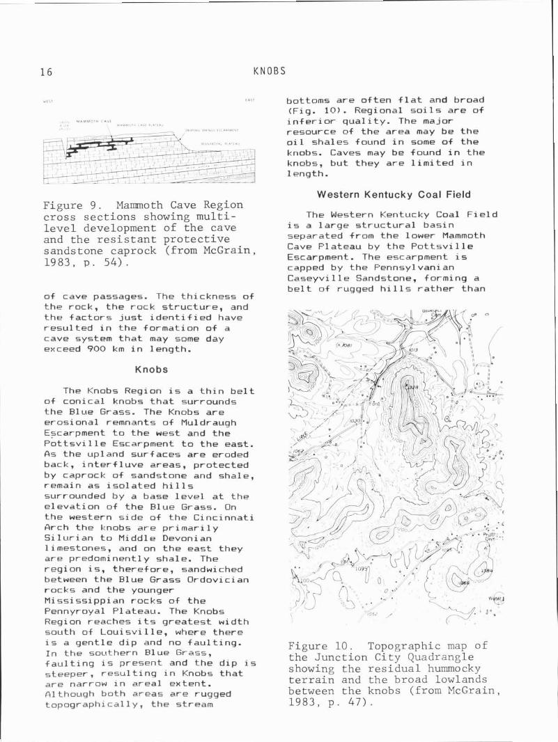
.I,.. MAMMOTH C A V E k , , L , ULh lh l l l - < n i t P I . , * "
Figure 9. Mammoth Cave Region cross sections showing multi- level development of the cave and the resistant protective sands tone caprock (from McGrain , 1983, p. 5 4 ) .
of cave passages. The thickness o f the rock, the rock s t ruc ture , and the f ac to rs j u s t i d e n t i f i e d have resu l ted i n the format ion o f a cave system t h a t may some day exceed 900 km i n length.
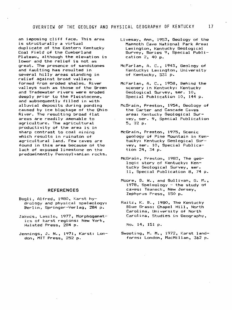
Knobs
The Knobs Region i s a t h i n b e l t of conical knobs t h a t surrounds the Blue Grass. The Knobs are erosional remnants o f Mu1 draugh Escarpment t o the west and the P o t t s v i l l e Escarpment t o the east. A s the upland surfaces are eroded back, i n t e r f l u v e areas, protected by caprock of sandstone and shale, remain as i so la ted h i l l s surrounded by a base l e v e l a t the e levat ion of the Blue Grass. On the western s ide of the Cinc innat i Arch the knobs are p r i m a r i l y S i l u r i an t o Middle Devonian limestones, and on the east they are predominentl y shale. The reg ion i s , therefore, sandwiched between the Blue Grass Ordovician rocks and the younger Mississ ippian rocks o f t he Pennyroyal Plateau. The Knobs Region reaches i t s greatest width south of L o u i s v i l l e , where there
bottoms are o f ten f l a t and broad (Fig. 10). Regional s o i l s are o f i n f e r i o r qua l i t y . The major resource of the area may be the o i 1 shales found i n some of the knobs. Caves may be found i n the knobs, but they are l i m i t e d i n length.
Western Kentucky Coal Field
The Western Kentucky Coal F i e l d i s a la rge s t r u c t u r a l basin separated from the lower Mammoth Cave Plateau by the P o t t s v i l l e Escarpment. The escarpment i s capped by the Pennsylvanian Caseyvi l le Sandstone, forming a be1 t of rugged h i 1 1s ra ther than
i s a gent le d ip and no fau l t i ng . I n the southern Blue Grass,
Figure 10. Topographic map of
f a u l t i n g i s present and the d ip i s the Junction City Quadrangle
steeper, r e s u l t i n g i n Knobs tha t showing the residual hummocky are narrow i n areal extent. terrain and the broad lowlands - -
~ l t h o u g h both areas are rugged between the knobs (from McGrain, topographical ly , the stream 1983, p . 47) .
O V E R V I E W OF T H E GEOLOGY AND P H Y S I C A L G E O G R A P H Y OF K E N T U C K Y 1 7
an imposing c l i f f face. This area i s s t r u c t u r a l l y a v i r t u a l dup l i ca te o f t he Eastern Kentucky Coal F i e l d o f t he Cumberland Plateau, although the e leva t ion i s lower and the r e l i e f i s no t as great . The presence of sandstones and f a u l t i n g has resu l t ed i n several h i l l y areas standing i n r e l i e f against broad va l l eys f orrned from eroded shales. River va l l eys such as those of t he Green and Tradewater r i v e r s were eroded deeply p r i o r t o t h e Pleistocene, and subsequently f i l l e d i n w i t h a l l u . v i a l deposi ts dur ing ponding caused by i c e blockage of t he Ohio River. The r e s u l t i n g broad f l a t areas are r e a d i l y amenable t o agr i cu l tu re . The a g r i c u l t u r a l p r o d u c t i v i t y o f t he area i s i n sharp cont rast t o coal mining which r e s u l t s i n ru i na ton of a g r i c u l t u r a l land. Few caves are found i n t h i s area because of the lack of exposed l imestone on the predominently Pennsylvanian rocks.
Livesay, Onn, 1953, Geology o f t he Mammoth Cave National Park Orea: Lexington, Kentucky Geological Survey, Series 9, Special Publ i - ca t ion 2, 40 p.
McFarlan. 0. C.. 1943, Geology o f Kentucky: Lexington, Un ivers i t y o f Kentucky. 531 p.
McFarlan, fl. C., 1958, Hehind the scenery i n Kentucky: Kentucky Geological Survey. ser. 10, Special Pub l i ca t ion 10, 144 p.
McGrain, Preston, 1954, Geology of the Carter and Cascade Caves area: Kentucky Geological Sur- vey, ser. 9, Special Pub l i ca t ion 5, 32 p.
McGrain, Preston, 1975, Scenic geology of Pine Mountain i n Ken- tucky: Kentucky Geological Sur- vey, ser. 10, Special Publ ica- t i o n 24, 34 p.
McGrain, Preston, 1983, The geo- l o g i c s to ry o f Kentucky: Ken- tucky Geological Survey, ser. 11, Special Pub l i ca t ion 8, 74 p.
Moore, G. W. , and Sul l ivan, G. M., 1978, Speleology - the study of
REFERENCES caves: Teaneck, New Jersey, Zephyrus Press. 150 p.
Bog l i , Alfred, 1980, Karst hy- drology and physical speleology: Rai tz , K. B., 1980, The Kentucky B e r l i n , Springer-Verlag. 284 p. Blue Grass: Chapel H i l l , North
Carolina, Un ivers i t y o f North Jakucs, Laszlo, 1977, Morphogenet- Carolina, Studies i n Geography,
i c s of ka rs t regions: New York, Halsted Press, 284 p. No. 14, 151 p.
Jennings, J. N., 1971, Karst: Lon- Sweeting, M. M.. 1972. Karst land- don, MIT Press. 252 p. forms: Londdn, MacMillan, 362 p.
Chapter 2 CAVES OF KENTUCKY
Angelo I . George A. I. George Consultants
1869 Trevilian Way Louisville, Kentucky 40205
The caves o f Kentucky have been important i n the h i s t o r y o f set- t lement pat terns f o r both the American Indians and the pioneers. Many of the cave entrances served as l i v i n g quarters t o t he Indians. The Indians explored some of these caves and exp lo i ted the mineral resources such as water, gypsum, epsomite, f l i n t , and c a l c i t e . The best examples are Mammoth Cave, S a l t s Cave (Edmondson County) and Great Wonderland Cavern (Hardin County). By t he middle p a r t of the 18th century, pioneers were moving westward i n t o a land c a l l e d Ken- tucky. L i ke the Indians. the p io- neers used caves f o r she l te r (Cave Hut, Muhlenburg County); they too exp lo i ted the mineral resources found i n the caves, espec ia l l y water, epsomite, copperas, and sa l tpe te r . Caves have been used as storehouses f o r f oods tu f f s (Breeding Sal tpeter Cave, ada i r County), mushroom farms (Constantine Sal tpeter Cave, Hardin County), and l i ves tock quar ters (Hidden River Cave, Hart County). During these ea r l y times, few records of caves are known. What i s known about t h i s ea r l y per iod i s based upon contemporary i nves t i ga t i ons i n t o t he h i s t o r y and archeology of t he s i t e .
The f i r s t inventory o f caves i n Kentucky sprang out o f a need t o
e x p l o i t t h e i r economic worth i n the ea r l y 1800s. This inventory was fo l lowed by academic i n q u i r i e s i n t o t he d i s t r i b u t i o n of caves because of t h e i r unique fauna, f l o r a , and archeological s i g n i f i- cance. The contemporary inventory of caves i n Kentucky began w i th e a r l y e f f o r t s by the National Speleological Society, fo l lowed by l o c a l g ro t t os and i nd i v i dua l s c o l l e c t i n g and mapping caves i n t h i s state.
I n 1806 a Lexington sa l tpe te r - gunpowder entrepreneur by the name of Samuel Brown wrote o f 6 caves, g i v i n g t h e i r name, locat ion, some notes on each cave, and a de ta i led descr ip t ion of one of them. He knew of others, but concentrated on the ones t h a t he owned i n present day Rockcastle, Jackson, and Hardin counties.
I n 1817, Luke Munsell was h i r e d by t he s t a t e government as chief surveyor and d i rec ted t o produce a h igh qua l i t y , de ta i l ed map of Kentucky. Ry using e x i s t i n g maps and h i s p r i o r survey f i e l d work, coupled w i th new f i e l d inves t iga t ions , Munsell by 1818 had published h i s "Large Map of Kentucky." This was the f i r s t r e a l l y accurate map of t he State which showed the pos i t i ons n f c u l t u r a l and na tu ra l features i n
C A V E S OF K E N T U C K Y 19
t h e i r t r u e s p a t i a l r e l a t i onsh ips w i t h one another. Munsell took i t upon himself t o inc lude remarkable geographic places. The completed map thus shows a number o f ka rs t features, s i nk ing streams. springs, dry stream channels, and cave entrances. No other s i ng le map i n the S ta te was t o inc lude 50
many kars t features up t o the t ime of our modern topographic mapping program. The f i r s t r e a l catalog of caves and t h e i r d i s t r i b u t i o n was publ ished by Constantine S. Rafinesque i n 1832. This catalog i s based upon h i s tenure a t Transylvania Col lege (Lexington. Kentucky) between 1818 and 1826. He was the f i r s t t o examine the caves' geological and zoological content. He devised seven d i f f e r e n t c l a s s i f i ca tons of caves: c l i f f caves (rock cas t les or rock houses), f i s s u r e caves, s ink ing caves, spr ing caves, c r a t e r or funnel caves, s a l t p e t e r caves, and s t a l a c t i c a l caves. He gave names, locat ions, and phys ica l descr ip t ions of e i g h t caves i n Kentucky. Four of t he caves s tud ied occur i n t he Inner Blue Grass, two caves i n t h e Cumberland Plateau of Rockcastle County, and two caves i n t h e Wississippian Plateau of Edmonson County.
Kentucky h i s t o r i a n s have played a key r o l e i n t h e preservat ion of accounts o f e a r l y cave exp lora t ions and discoveries. Lewis C o l l i n s (1847), fo l lowed by h i s son, Richard C o l l i n s (1874), i n t h e i r "H is to ry o f Kentucky," recorded the l o c a t i o n and physical descr ip t ions o f caves by county. Data were gathered wi thout c r e d i t from o l d newspaper accounts. travelogues, and a smatter ing o f s c i e n t i f i c pub l i ca t ions . Cave descr ip t ions selected were usua l l y of the k ind w i t h bottomless p i t s (Frenchman Knob P i t , Har t County) or l o s t Roman t reasure caves (Love11 Cave, Muhlenburg County). I f t he cave contained animal bones, espec ia l l y mammoth bones, the f i n d i n g of such i n a cave was a f a v o r i t e v i gne t te of t he Co l l i ns ' . A l l succeeding 19th
century h i s t o r i a n s fo l lowed t h e i r o u t l i n e of cave deacriptons.
Throughout t he 19th century, the fame of Mammoth Cave dominated the cave scene w i t h a host of descr ip t ions and maps publ ished on t h i s famous wonder of t he world. There would be sporadic references t o nearby caves, such as Dixon, Long. Short, Hundred Domes, James, Diamond, Hidden River , and Mammoth Onyx caves. Occasional1 y, a travelogue would descr ibe other caves i n t he State. Alexander Wilson (1810) wrote of Rleedinghearts Cave (Warren County), and the anonymous ( a t t r i b u t e d t o Constantine S. Rafinesque, 1820) account of Russell Cave (Fayet te County) made f o r a f i n e add i t i on t o t he speleo h i s t o r y of the State. But, a l l i n a l l , caves outs ide t h e Mammoth Cave Region seem t o have l i t t l e t o o f f e r i n comparison.
Between the t ime o f Rafinesque and Alpheus S. Packard there i s a h ia tus w i t h l i t t l e reg iona l c o l l e c t i o n of cave s i t es . Packard conducted an extensive inventory o f cave l i f e from t h e caves of Kentucky and publ ished h i s f i nd ings i n 1888. He mentioned more than 50 caves from s i t e data and c o l l e c t i o n s by Nathaniel S. Shaler and h i s Kentucky Geological Survey i n 1875. Ar thur M. M i l l e r (19191, Sta te Geologist, l i s t e d 16 representat ive caves and 5 areas where caves occur. Gerard Fowke (1922) describeed 39 caves i n t he State as p a r t o f h i s midwest archaeological inves t iga t ions .
From 1923 t o 1957, Wi l l iam D. Funkhouser and Wi l l i am S. Webb explored, excavated, and cataloged caves as p a r t of a Statewide inventory of archeological s i t e s i n Kentucky.
The massive p u b l i c i t y r e s u l t i n g from Floyd C o l l i n ' s entrapment i n Sand Cave, Edmonson County. generated a demand f o r more newspaper a r t i c l e s on caves, and not j u s t caves i n t he Mammoth Cave v i c i n i t y , but caves a l l over Kentucky. There was a p le thora of newspaper a r t i c l e s publ ished
2 0 G E O G R A P H I C D I S T R I B U T I O N OF C A V E S I N K E N T U C K Y
between 1925 and 1935. The maximum amount was i n 1925 dur ing t h e C o l l i n s i nc i den t and j u s t a f t e r h i s death.
I n 1943, t h e f l e d g l i n g Nat iona l Speleol og i ca l Soc ie ty undertook t h e ca ta log ing o f a l l known caves i n t h e Un i ted s t a t e s and t h e world; Robert Morgan began t h i s task and produced t h e f i r s t modern ca ta log o f caves. By 1944, he had i nven to r i ed 102 caves i n t h e S ta te and t h e l i s t was documented w i t h an ex tens ive b ib l i og raphy . From t h a t t ime, g ro t tos , surveys, and i n d i v i d u a l s have maintained ex tens ive ca ta logs o f caves i n Kentucky.
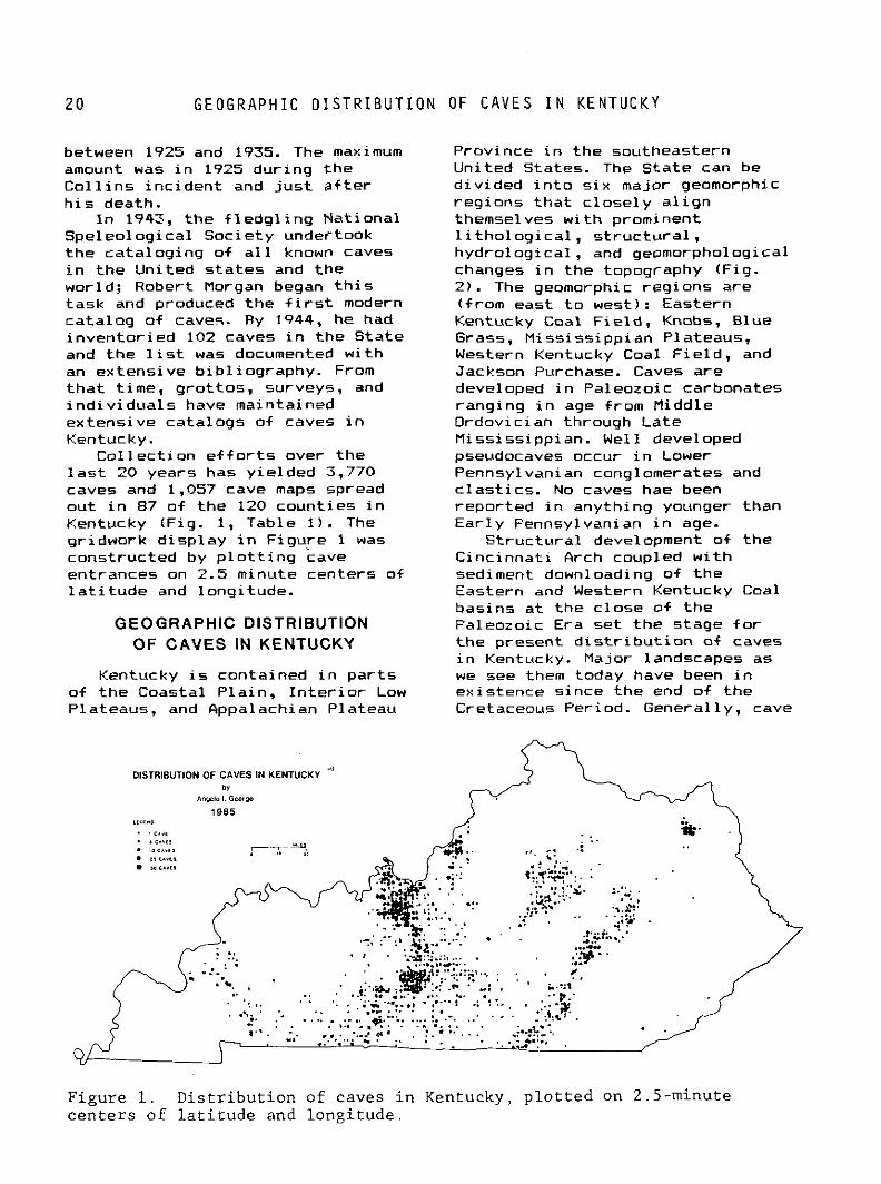
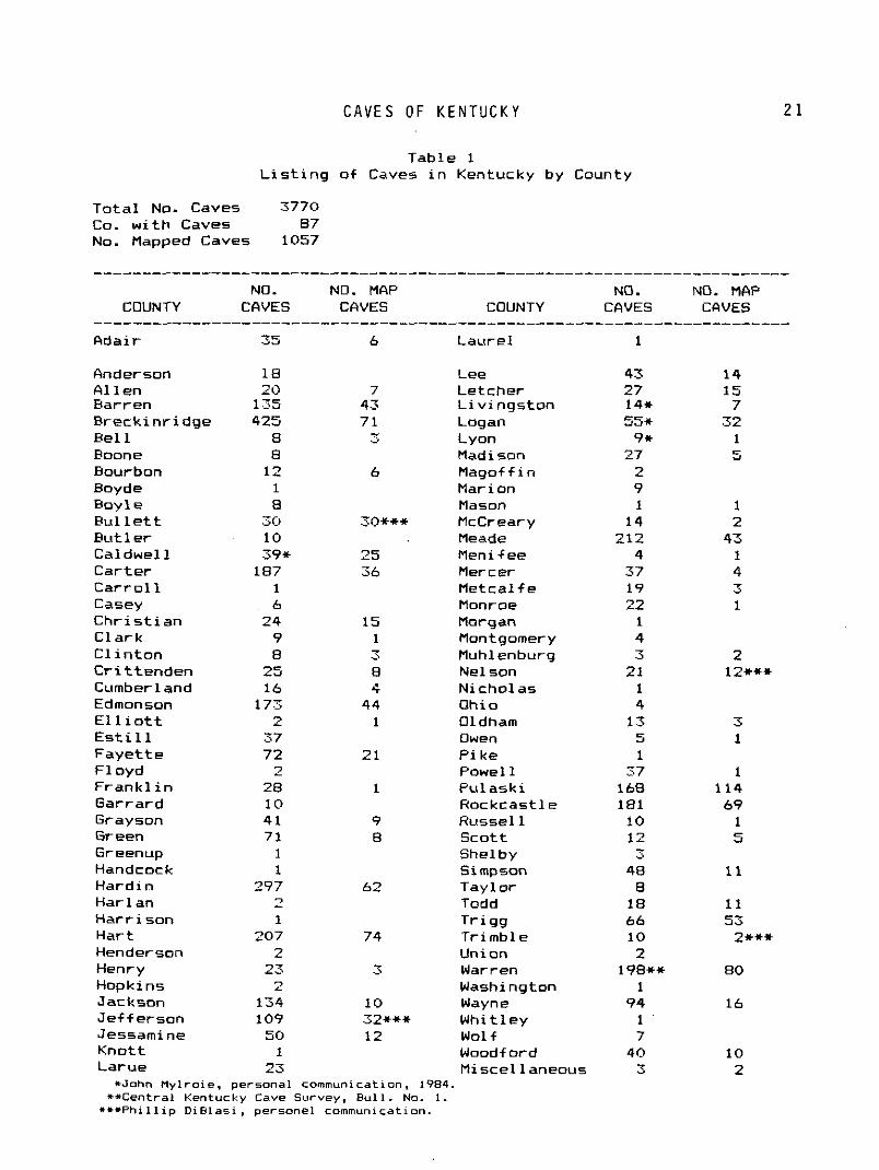
C o l l e c t i o n e f f o r t s over t h e l a s t 20 years has y i e l ded 3,770 caves and 1,057 cave maps spread ou t i n 87 o f t h e 120 count ies i n Kentucky (F ig. 1, Table 1) . The gr idwork d i sp l ay i n F igu re 1 was constructed by p l o t t i n g cave entrances on 2.5 minute centers of l a t i t u d e and longi tude.
GEOGRAPHIC DISTRIBUTION OF CAVES IN KENTUCKY
Kentucky i s conta ined i n p a r t s o f t h e Coastal P la in , I n t e r i o r Low Plateaus, and Appalachian Plateau
Province i n t h e southeastern Un i ted States. The S ta te can be d i v i ded i n t o s i x major geomorph.ic reg ions t h a t c l o s e l y a l i g n themselves w i t h prominent l i t h o l o g i c a l , s t r u c t u r a l . hyd ro log ica l , and geomorphological changes i n t h e topography (Fig. 2 ) . The geomorphic reg ions a re ( from east t o west): Eastern Kentucky C o a l Field, Knobs, Blue Grass, Miss iss ipp ian Plateaus, Western Kentucky Coal F i e l d , and Jackson Purchase. Caves a re developed i n Paleozoic carbonates ranging i n age from Middle Ordovician through La te Miss iss ippian. We1 1 developed pseudocaves occur i n Lower Pennsylvanian conglomerates and c l a s t i c s . No caves hae been repor ted i n anyth ing younger than Ea r l y Pennsylvanian i n age.
S t r uc tu ra l development of the C inc inna t i Arch coupled w i t h sediment downloading of t h e Eastern and Western Kentucky Coal basins a t t h e c lose of t h e Paleozoic Era se t t h e stage f o r t h e present d i s t r i b u t i o n of caves i n Kentucky. Major landscapes as we see them today have been i n ex is tence s ince t h e end o f the Cretaceous Period. General ly , cave
Figure 1. Distribution of caves in Kentucky, plotted on 2.5-minute centers of latitude and longitude.
C A V E S OF K E N T U C K Y
Table 1 L i s t i n g o f Caves i n Kentucky by County
T o t a l No. Caves 3770 Co. w i t h Caves 87 No. Mapped Caves 1057
NO. NO. HAP NO. COUNTY CAVES CAVES COUNTY CAVES
Ada i r 35 6 Laure l 1
Anderson 18 Lee 43 A l l e n 20 7 Letcher 27 Barren 135 43 L i v i n g s t o n 14it R reck in r i dge 425 7 1 Log an 55* Be1 1 B - .-. Lyon 9+ Roone 8 Madison 27 Bourbon 12 6 Magof f i n 2 Boyde 1 Marion 9 Roy 1 e 8 Mason 1 R u l l e t t 30 30+++ McCreary 14 B ~ t t l e r 10 Meade 212 Cal dwe l l 39rc 25 Menif ee 4 Car te r 187 36 Mercer 37 C a r r o l l 1 Metca l f e 19 Casey 6 Monroe 22 C h r i s t i a n 24 15 Morgan 1 C l a r k 9 1 Montgomery 4 C l i n t o n B 3 Muhlenburg 3 - C r i t t enden 25 B Nelson 2 1 Cumberland 16 4 Nicho las 1 Edmonson 173 44 Ohio 4 E l l i o t t 2 1 Oldham 13 E s t i l l 37 Owen 5 F a y e t t e 72 2 1 P i k e 1 F l o y d 2 Powel l 37 Frank1 i n 28 1 P u l a s k i 148 Garrard 10 Hockcast le 181 Grayson 4 1 9 Russel 1 10 Green 71 B Sco t t 12 Greenup 1 She1 by 3 Handcock 1 S i mpson 48 Hard in 297 62 Tayl o r B Har lan - 7 Todd 18 Harr i son 1 T r i g g 66 Har t 207 74 Tr imble 10 Henderson 2 Union 2 Henry 23 3 Warren 198** Hopkins 2 Washington 1 Jackson 134 10 Wayne 94 Je f fe rson 109 32+xit Whi t ley 1 Jessamine 50 12 Wolf 7 t i no t t 1 Woodf o r d 40 Larue 23 M i sce l 1 aneous 3
*John Mylroie, personal communication, 1984. **Central Kentucky Cave Survey, Bull. No. I.
***Phillip Di81asi , personel communication.
. - - - - - - - - - - - - NO. MAP
CAVES
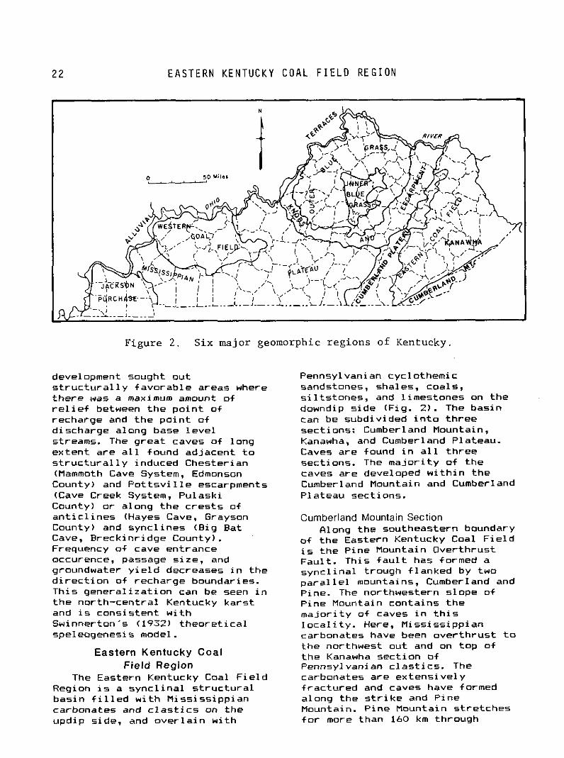
E A S T E R N K E N T U C K Y C O A L F I E L D R E G I O N
Figure 2 . Six major geomorphic reg ions of Kentucky.
development sought out s t r u c t u r a l l y favorable areas where there was a maximum amount of r e l i e f between the po in t of recharge and the p o i n t of discharge along base l e v e l streams. The great caves of long extent are a l l found adjacent t o s t r u c t u r a l l y induced Chesterian (Mammoth Cave System, Edmonson County) and P o t t s v i l l e escarpments (Cave Creek System, Pulaski County) or along the c res t s of a n t i c l i n e s (Hayes Cave, Grayson County) and sync l ines (Big Bat Cave. Breckinr idge County). Frequency of cave entrance occurence, passage s ize, and groundwater y i e l d decreases i n the d i r e c t i o n of recharge boundaries. This genera l iza t ion can be seen i n t he north-centra l Kentucky kars t and i s consistent w i t h Swinnerton's (19.72) t heo re t i ca l speleogenesis model.
Pennsylvanian cyclothemic sandstones, shales, coals, s i l t s t ones , and l imestones on the downdip s ide (Fig. 2 ) . The basin can be subdivided i n t o th ree sections: Cumberland Mountain, Kanawha, and Cumberland Plateau. Caves are found i n a l l th ree sections. The ma jo r i t y of the caves are developed w i t h i n the Cumberland Mountain and Cumberland Plateau sections.
Curnberland Mountain Section Along the southeastern boundary
of the Eastern Kentucky Coal F i e l d i s t he Pine Mountain Overthrust Faul t . This f a u l t has formed a sync l ina l trough f lanked by two p a r a l l e l mountains, Cumberland and Pine. The northwestern slope of Fine Mountain contains t he ma jo r i t y of caves i n t h i s l o c a l i t y . Here, Mississ ippian carbonates have been over thrust t o the northwest out and on top of
Eastern Kentucky Coal the Kanawha sect ion of Field Region Fennsyl vanian c l as t i cs . The
The Eastern Kentucky Coal F i e l d carbonates are extens ive ly Region i s a sync l i na l s t r u c t u r a l f rac tured and caves have formed basin f i l l e d w i t h Niss iss ipp ian along the s t r i k e and Pine carbonates and c l a s t i c s on the Mountain. Pine Mountain s t re tches updip side, and ove r l a i n w i th f o r more than 160 km through
KENTUCKY
Kentucky and contains over 91 m o f carbonates. Th is k a r s t area represents probably one of the greatest untapped caving l o c a l i t i e s i n t he State. There i s much p o t e n t i a l f o r b i g cave. deep p i t s , and systems t o keep cavers busy f o r years. The most famous caves are L ine fo rk Cave, Icebox Cave, the Payne Gap Cavern, Payne Gap Water Cave, and Angel Cave. The Colehole i s a 73-m-deep p i t w i t h no passage a t t he bottom. Sand Cave i s a pseudokarst feature formed i n t h e Lee Sandstone. Carbonate cave passage conf igurat ion i s s i m i l a r t o t h a t seen i n the Val ley and Ridge areas o f V i rg in ia .
Kanawha Section The Kanawha Section i s the
hear t land of the Eastern Kentucky Coal F ie ld . It i s a paradise f o r t h e coal and o i l barons, and a bane f o r t he caver, w i t h impossible roads, rugged terrane, and few caves. Few caves are memorable, and the geologic sect ion i s f u l l of Pennsylvanian c l a s t i c s , coals, shales, and t h i n carbonate un i t s . There are l e s s than 20 caves indexed from t h i s sect ion i n Kentucky.
Cumberland Plateau Section St re tch ing f o r more than 190 km
across t he east c e n t r a l p a r t of Kentucky i s one of t he paramount cave and kars t l o c a l i t i e s i n the State. The l o c a l i t y i s bounded on the west by t he Highland R i m Escarpment and on the east by the P o t t s v i l l e Escarpment. More than 840 caves are known from t h i s area. Caverns of every poss ib le desc r i p t i on can be found i n t h i s sect ion, whether large, d ry walking passage. or wet and muddy s lush tube. Representative caves are: Sloans Val ley System, Cave Creek System, Goochland-Smokehole Complex, Great Sa l t pe t re Cave, T r i p l e S Cave, and Eureka Cave.
Ry r i g h t s , t he Carter County ka rs t should be i n t he Kanawha sect ion; ra ther , i t e x i s t s as a f i nge r o f H iss iss ipp ian carbonates
w i t h i n t he northwestern p o r t i o n o f t he Kanawha sect ion. Nearly 200 caves are known from t h i s area. Many of these caves are long braided networks o r maze caves. Rest known are Bat Cave, Sa l tpeter Cave, Burchetts Cave, Carter C i t y Connection, I r o n H i l l System, and the Cascade System. The highest dens i ty of caves occur along the a x i s o f a syncl ine, t runcated by deeply entrenched Tygarts Creek. This s t r u c t u r a l s e t t i n g provides f o r maximum rock f r a c t u r i n g along the a x i s of the syncl ine, g i v i ng r i s e t o network cave development. Cave entrance d i s t r i b u t i o n i n Carter County shows a northeast-southwest s t i k e o r i en ta t i on along the P o t t s v i l l e Escarpment. Major streams fo l low t h i s t rend toward t he Ohio River.
Pseudokarst i n t he form of na tu ra l br idges, rock she l te rs , l ighthouses, and do l ines are we l l developed adjacent t o va l l eys breaching the P o t t s v i l l e Escarpment. These features have formed i n t he Lee Formation, a sandstone-conglomerate of Ear ly Pennsylvanian age. Best recognized are t he na tu ra l br idges and pseudokarst caves o f the Red River Gorge i n Powell County and the Natural Arch i n McCreary County.
Inspect ion of cave entrance dens i ty reveals a dominant northeast-southwest t rend p a r a l l e l t o the s t r i k e of t he P o t t s v i l l e Escarpment. Dominant cave passage t rends are t o the northeast and northwest. This same p a t t e r n i s repeated i n most o f t he major caves throughout t he State. S t ruc tu ra l upwarping o f the Cinc innat i Arch and development of t h e Appalachian Mountain System are responsib le f o r f os te r i ng the o r i g i n a l f r ac tu re pat tern , v i s i b l e today i n t h i s dominance of cave passage trends.
Mississippian Plateaus Region The Miss iss ipp ian Plateaus
Region (Fig. 3) i s t he la rges t s i ng le continuous sequence of exposed f rac tu red karsted carbonate rocks i n Kentucky. The
MISSISSIPPIAN P L A T E A U S R E G I O N
1 - ! " " " 4 ~ I PL'AIN
Ease f r o m GeoIog1~ Map o f Kentucky Series IX 1954 Revised from Geologic T Ma 9 of hcntu$hy doted 1927ond
E N N E S S E E 19$9 by W . R . Jillson 0 ?s 50 MILES
Figure 3. The Mississippian Plateaus Region, which contains 2,125 known caves, including Mammoth Cave.
region contains the largest compliment of caves with 2,125 known: the largest cave system in the world, Mammoth Cave; and a collection of lesser systems that are among the great long caves in the world: Whigpistle, Hicks, Pig Pat, Lost River, Lisanby, Big Sulphur. and Gradys.
There is a distinct regional clustering of cave entrances along the Chester Escarpment from Prandenburg in Meade County through Bowling Green in Warren County. Cave entrance density declines in both directions away from the escarpment. The largest of the cave systemsare all found beneath the Chester upland or below outliers from this landform.
Large graded trunks and bedding plane tubes are the typical cave passages. These passages occur in the Middle Mississippian carbonate units. In contrast, the character of the cave passages in Chesterian rocks is joint determined maze.
Just north of Mammoth Cave is a Pennsylvanian conglomerate and sandstone f i 1 led f ossi 1 river valley. Contained within the Prownsville Channel are pseudokarst caves, dolines, springs, and ponors. Representative are: Big Spring, Holley, and Lines caves. Deep shafts have formed as a result of initial pseudokarst development followed by interstratal karstification at clastic-carbonate contacts. Good examples can be seen at Frenchman Knob Pit and Lost Hound Pit, Hart County.
In the far northwestern part of the region is the Western Kentucky Fluorspar District. The Rough Creek Fault Zone has intensively fractured this part of the State. It is the site of hydrothermal activity. Karstification has occurred along the faults, joints, and bedding planes. These features have been filled in with minerals
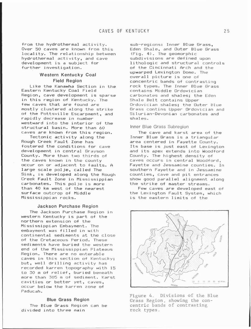
C A V E S OF K E N T U C K Y
from the hydrothermal a c t i v i t y . Over 50 caves are known from t h i s l oca l i ty. The re1 a t i onshi p between hydrothermal a c t i v i t y , and cave development i s a subject f o r f u r t h e r inves t iga t ion .
Western Kentucky Coal Field Region
L i ke the Kanawha Section i n the Eastern Kentucky Coal F i e l d Region, cave development i s sparse i n t h i s reg ion of Kentucky. The few caves t h a t are found are mostly c lus tered along the s t r i k e of the P o t t s v i l l e Escarpment, and r a p i d l y decrease i n number westward i n t o the i n t e r i o r o f the s t r u c t u r a l basin. More than 60 caves are known from t h i s region.
Tectonic a c t i v i t y along the Rough Creek Fau l t Zone has fostered the condi t ions f o r cave development i n cen t ra l Grayson County. More than two t h i r d s o f the caves known i n the county occur on or adjacent t o f au l t s . A l a rge scale po l je, c a l l e d The Sink, i s developed along the Rough Creek Fau l t Zone i n M i s s i s s i pp i an carbonates. This po l j e i s more than 40 km west o f the nearest surface outcrop o f Middle Mississ ippian rocks.
sub-regions: Inner Blue Grass, Eden Shale, and Outer Elue Grass (Fig. 4 ) . The geomorphic subdiv is ions are def ined upon l i t h o l o g i c and s t r u c t u r a l con t ro ls o f the Cinc innat i Arch and the upwarped Lexingtan Dome. The ove ra l l p i c t u r e i s one o f concentr ic bands o f con t ras t ing rock types. The Inner Rlue Grass contains Middle Ordovician carbonates and shales; t he Eden Shale Eel t contains Upper Ordovi c i an shal es; the Outer H l ue Grass con t ins Upper Ordovician and Silurian-Devonian carbonates and shales.
Inner Blue Grass Subregion The cave and ka rs t area of t he
Inner Rlue Grass i s a t r i angu la r area centered i n Fayet te County. I t s base i s j u s t east o f Lexington and i t s apes extends i n t o Woodford County. The highest dens i ty o f raves occurs i n cen t ra l Woodford, Fayet te and Jessamine counties. I n southern Fayette and i n Jessamine counties, cave and p i t entrances show good para1 l e l a1 ignment along the s t r i ke of master streams.
Few caves are developed east o f the Lexington Fau l t System, which i s the eastern l i m i t s o f the
Jackson Purchase Region The Jackson Purchase Region i n
western Kentucky i s p a r t o f the northern extension of the Mississ ippian Embayment. The embayment was f i l l e d i n w i t h cont inenta l sediments a t the c lose o f the Cretaceous Period. These sediments have bur ied the western end of the Mississ ippian Plateaus Region. There are no enterable caves i n t h i s sect ion of Kentucky: but, wel l d r i l l i n g a c t i v i t y has recorded karren topography w i th 15 t o 30 m o f r e l i e f , bur ied beneath more than 305 m o f sediment. Karst c a v i t i e s or be t t e r yet, caves, occur below the karren zone of Faducah.
Figure 4 . Divis ions of t h e Blue Blue Grass Region Grass Region, showing the con-
The Blue Grass Region can be c e n t r i c bands o f c o n t r a s t i n g div ided i n t o three main rock types .
E D E N S H A L E
Lexington karst . There i s a recurrence of caves i n cen t ra l Bourbon and Clark counties. The caves and kars t o f Clark County are i n one of t h e few areas where t he Eden Shale i s t h i n , and caves have formed i n t he under ly ing carbonates adjacent t o stream val leys. This s i t u a t i o n a lso holds t r u e f o r the ka rs t i n the v i c i n i t y of Harrodsburg, Mercer County.
Representative caves i n t h i s l o c a l i t y are: Hryants, Russel l , Phelps, and Foggs. Over 260 caves have been inven to r ied i n t h i s l o c a l i t y .
Eden Shale Belt Subregion Generally, t h e Eden Shale B e l t
i s devoid of cave development, except where t he shale aqu i tard i s t h i n and the under ly ing carbonates are i n c lose p rox im i ty t o base l eve l drainage.
Outer Blue Grass Subregion The Outer Blue Grass marks the
recurrence of h i gh densi ty cave and kars t development. As i n the Inner Blue Grass, cave entrances tend t o c l us te r near base l e v e l drainage and rap id1 y decrease toward drainage div ides. There are two areas where most o f the caves occur. Several caves, such as Adams Sal tpeter Cave i n Madison County are found i n the southern p a r t o f the subregion. The ma jo r i t y o f t he caves are re la ted t o the deep entrenchment of the Ohio River and i t s t r i b u t a r i e s a1 ong the f 01 1 owing counties: Henry, Oldham, Trimble, Shelby, Jefferson, B u l l i t t and Nelson. About 280 caves are known and most are small i n l a t e r a l extent, r a r e l y exceeding 150 m i n length. Caves tend t o have b i g entrances whose passages degrade i n t o crawl ways.
Knobs Region The Knobs Region contains about
15 caves. Most o f the knobs are made up of s i l t s t o n e and shale, which are not conducive t o cave development. As Muldraughs (Highland R i m ) Escarpment i s
BELT S U B R E G I O N
approached, basal carbonates of Ear 1 y M iss iss ipp i an age are present on top o f t h e knobs, and t h i s i s where t he caves are 1 ocated.
CONCLUSION
This d iscussion has on ly been a b r i e f overview o f t h e d i s t r i b u t i o n o f caves i n Kentucky. There are many caves known i n add i t i on t o t h e ones used i n t he compi lat ion o f t h i s repor t . Continuous e f f o r t dur ing t he l a s t 20 years has allowed the inventory o f 3,770 caves i n Kentucky. I f the past i s any i n d i c a t i o n of t h e fu tu re , the next 20 years looks very b r i gh t .
ACKNOWLEDGMENT
Much thanks t o a l l i nd i v i dua l s who cont r ibuted cave data over the years.
REFERENCES
Anonymous, 1820, Russels Cave: Western Review, v. 4, p. 161- 163.
Brown, S., 1809, A descr ip t ion o f a cave on Crooked Creek, w i t h remarks and observat ions on n i t r e and gunpowder: American Fhi losophical Society Transac- t i ons , v. 6, p. 235-247.
Col l ins , L. , 1847, H i s to ry o f Ken- tucky: Maysvi l le , Kentucky, 560 P -
Co l l i ns , R., 1874, H i s to ry of Ken- tucky: Covington, 2 vols.
Fowke, G., 1922, Archaeological Invest igat ions: Smithsonian In- s t i t u t e Bureau of American Eth- nology, B u l l e t i n 76, 204 p.
McFarlan, A. C., 1943, G ~ o l o g y of Kentucky: Lexington, Un ivers i t y of Kentucky, 531 p.
M i l l e r , A. M., 1919, The Geology of Kentucky: Kentucky Department o f Geology and Forestry, ser. 5, B u l l e t i n 2, 392 p.
C A V E S OF K E N T U C K Y 2 7
Morgan, R. E. , 1943, Caves in Packard, A. S., 1888, The cave world history: National Speleo- fauna of North America: National logical Society Bulletin, no. 5, Academy of Science, v. 4, pt. 1, p. 1-16. 156 p .
Rafinesque, C. S., 1832, The caves of Kentucky: Atlantic Journal
Morgan, R. E., 1944, Additions to and Friends of Knowledge, v. 1, "Index of all known caves of no. 1, p. 27-30. the worl dl': National Spel eol og- ical Society Bulletin, no. 6, Swinnerton, A. C., 1932, Origin of p. 29-33.
1 i mestone caves: Geological So- ciety of America Bulletin, v. 43, p. 663-693.
Munsell, L., 1818, & map of the State of Kentucky from actual Wilson, A . , 1810, Letter from surveys, etc. : Phi 1 adel phi a, Nashvi 11 e: The Port Folio, v. State of Kentucky. 4, p. 310-321.
Chapter 3 THE INNER BLUE GRASS KARST REGION
John Thrailkill Department of Geology University of Kentucky
Lexington, Kentucky 40506
Th is d iscuss ion o f t h e Inner B lue Grass Region o f c e n t r a l Ken- t u c k y has been e x t r a c t e d from chapters A and F o f T h r a i l k i l l and o t h e r s ( 1982) . On1 y m i nor changes have been made t o c o r r e c t typogra- p h i c e r r o r s and d e l e t e re fe rences t o o the r chapters and omi t ted por- t i o n s o f chapters A and F.
The p r i n c i p a l method used t o s tudy t h e area was water t rac ing , and a d e s c r i p t i o n o f t h e dyes and techniques used, as w e l l as r e l a - t e d l a b o r a t o r y s t u d i e s (Soc ie ty o f Dyers and Co lou r ie t s , 1971; Bu in lan 1977; Bu in lan and Howe, 1977: McCann, 1978; Byrd, 1981; Bu in lan and Ewers, 1981; Spangler, 1982; Spangler and o thers , submit- t e d f o r p u b l i c a t i o n ) a re descr ibed i n T h r a i l k i l l and o the rs (1982).
The focus o f work i n t h e reg ion has been on t h e geol og i c a l , water supply, and environmental aspects o f t h e k a r s t and i t s a q u i f e r , and a1 though va luab le i n fo rma t ion on these s u b j e c t s has been obta ined f rom s t u d i e s i n caves (as w i l l be d iscussed) , such s t u d i e s have been i n c i d e n t a l t o t h e r e g i o n a l study t o date. No l i s t i n g o r cave loca- t i o n s w i l l be presented, both because such a l i s t i n g would be incomplete and because o f t h e s e n s i t i v e 1 andowner r e 1 a t i onships t h a t e x i s t i n many area5 i n t h e reg ion .
The i n f o r m a t i o n t h a t has served as t h e b a s i s o f t h e d iscuss ion t h a t f o l l o w s has l a rge1 y been de r i ved from area s t u d i e s i n por- t i o n s o f t h e r e g i o n o u t l i n e d on F i g u r e 1. The f i e l d i n v e s t i gat i on5 i n these areas were conducted by M. R. McCann (Nor theast Woodford County a rea) , M. W. Hooper, J r . (Mercer County a rea ) , L. E. Spangler and J. W. Troester (no r the rn Faye t te and southern
Sco t t coun t ies a rea ) , and D. R. Gouz i e (Walnut H i 11 area) . None o f what f o l l o w s would have been p o s s i b l e w i thout t h e i r e f f o r t s . A d e s c r i p t i o n o f each o f these areas, as we1 1 as d e t a i l e d i n f o r - mation on t h e dye t r a c e s made and s p r i n g discharges determined, i s found i n T h r a i l k i l l and o the rs (1982).
P o r t i o n s o f t h e work descr ibed i n t h e present r e p o r t have a l ready appeared (McCann, 1978; T h r a i l k i l l and Troester , 1978; Thra i 1 k i 11, 1980: Thra i 1 k i 11 and o thers , 1980; Spang1 e r and Thra i 1 ki 1 1 , 1981; T h r a i l k i l l and o thers , 1981: Spangler, 1982) o r have been accepted f o r p u b l i c a t i o n T h r a i l k i l l and o thers , accepted f o r p u b l i c a t i o n ) .
Major support f o r t h i s work was prov ided by t h e O f f i c e o f Water Research and Technology (now wi th - i n t h e Un i ted S ta tes Geologica l Survey), Un i ted S ta tes Department o+ I n t e r i o r , as au thor ized by t h e Water Research and Development Act o f 1978, F'ublic Law 95-467. Addi- t i o n a l funding was from t h e McFarlan Fund o f t h e Department of Geology, U n i v e r s i t y o f Kentucky; Dames and Moore: t h e Georgetown Mun ic ipa l Water and Sewer Service; t h e Nat iona l Speleologi c a l Society ; and t h e I n s t i t u t e f o r Min ing and Minera ls Research, and t h e Research Committee o f t h e U n i v e r s i t y o f Kentucky. The support o f these agencies, as w e l l as t h e landowners o f t h e reg ion and t h e many o the rs who have ass i s ted t h e research i s g ra te- f u l 1 y acknowl edged.
Work has, and i s , c o n t i n u i n g i n t h e 3 years s ince t h e d iscuss ion t h a t f o l l o w s was w r i t t e n . Some o f t h e research i s descr ibed i n Eyrd and Thra i 1 k i 11 (198.:) , Hooper and
T H E I N N E R B L U E ' G R A S S K A R S T R E G I O N 2 9
. . . . . . . . . . . . . . . . . . . . . . . . . . . . . . . . . . . . . . . . . . . . . . . . . . . . . . . . . . . . . . . . . . . . ................................ ........................................................... ....................................... ...................................... ...................................... ........
................... / ................... ...................... ................... ..................... ................... ........ ..........................
...... ......
. . . . . . . . . . . . . . ............... ............... ............... . . . . . . . . . . ............... . . . . . . . . . . .......... .......... .......... ......
. . . . . .
........... ........... ...........
........... ........... ........... ........... ........... ........... ........... ...........
....... . . . . . . . . . . . . . . . . . . . . . .... '....,..... ........... ........... ........... ........... . . . . . . ...........
. . . . . . . . . . .......... . . . . . . . . . . . . . . . . . . . . . . . . . . . . . . . . . . . . . . . . . . . . . . . . . . . . . . . . . . . . . . . . . . . . . . . . . . . . . . . . . . . . . . . . . . . . . . . . . . . . . . . . . .
......... . . . . . . . . . . . . . . . . . , . . , . . # . . , . . , . . ,
... . . , Danvills 2 : : : : : : : : : : : : : : : : : : . . . . . . . . . . . . . . . . . . . . . . . , . . . . . . . . . . . . . . . . . . . . , . . . . . . . . . . . . . . . . . . . . , INNER BLUEGRASS ;:; ... . . . . . . . . . . . . . . . . . . . . . . . . . . . . . . . . . . . . . . . K A R S T REGION ... . . . . . . . . . . . . . . . . . . ... . . . . . . . . . . . . . . . . . . BOY L E ... . . . . . . . . . . . . . . . . . . ... . . . . . . . . . . . . . . . . . . ... . . . . . . . . . . . . . . . . . . . . . . . . . . . . . . . . . . . . . . . . . . . . . . . . . . . . . . . . . . . . . . . . . . . . . . . . . . . . . . . . . . . . . . . . . . . . . . . . . . . . . . . . . . . . . . . . . . . . . . . . . . . . . . . . . . . . . . . . . . . . . . . . . . . . . . . . . . . . . . . . . . . . . . . . . . . . . . . . . . . . . . . . . . . . . . . . . . . . . . . . . . . . . . . . . . . . . . . . . . . . . . . . . . . . . . . . . . . . . . . . . . . . . . . . . . . . . . . . . . . . . . . . . . . . . . .
L . . . . . . . ' L Y . . . . . . . . . . . . . . . . . . . . . . . . . .
Figure 1. Map of Inner Blue Grass Region. Coverage of l a r g e r s c a l e maps i n T h r a i l k i l l and o t h e r s (1982) i s a l s o shown.
T H E I N N E R BLUE G R A S S R E G I O N
Thra i 1 k i 11 ( 1983) , Thra i 1 k i 11 (1983) , Thra i 1 k i 11 (1984) , T h r a i l k i l l and Gou i ie (1984), and Thra i 1 k i 11 (accepted f o r pub1 i c a t i o n ) .
INNER BLUE GRASS REGION
The Inner B lue ~ r a s s Region i s an area o f 5,600 km2 i n c e n t r a l Kentucky. It i s l a r g e l y a g e n t l y r o l l i n g upland a t an a l t i t u d e o f 250 m, w i t h genera l l y l e s s than 50 m o f r e l i e f , t h a t has been termed t h e Lexington Peneplain ( J i l l s o n , 1961). Most o f t h e streams which d r a i n t h e area a re on t h e upland, b u t t h e Kentucky River , t h a t crosses the reg ion , has i n c i s e d a gorge more than 100 m deep. A l t i t u d e s range from 350 m i n t h e southeastern p o r t i o n o f t h e upland t o 130 m a long t h e Kentucky R iver where i t leaves t h e reg ion i n t h e northwest.
Although t h e streams on t h e upland sur face appear t o prov ide normal sur face drainage, numerous k a r s t landforms ( e s p e c i a l l y s inkho les) a re present, and p o r t i o n s o f t h e region, some w i t h areas i n excess o f 10 km2, have no sur face drainage. The o u t l i n e s o f t h e reg ion (F ig. 1) were def ined by i n c l u d i n g w i t h i n i t s boundaries a l l 7.5-minute quadrangles (1:24,000) t h a t dep ic t a t l e a s t one s inkho le by topographic contours ( i n t e r v a l 3.0 t o 6.1 m) i n rocks o f Middle Ordovic ian age. The Inner Blue Grass Region i s bo th geograph ica l ly and s t r a t i g r a p h i c a l l y d i s t i n c t from another extensive k a r s t area (a p o r t i o n o f which has been termed t h e Cent ra l Kentucky Kars t ) i n M iss i ss ipp ian rocks, as we1 1 as f rom smal ler k a r s t areas i n Kentucky i n Upper Ordovic ian and S i l u r i a n rocks.
The mean annual p r e c i p i t a t i o n i s about 1,150 mm, f a i r l y evenly d i s t r i b u t e d throughout t h e year. Mean J u l y and January temperatures a re about 25 and (I0, r e s p e c t i v e l y . The r e g o l i t h i s o f t e n a meter o r more t h i c k and i s
genera l l y considered t o be res idua l . The e n t i r e r e g i o n i s south o f t h e area modi f ied by P le is tocene g l a c i a t i o n . The present populaton i s i n excess o f 350,000, o f which more than h a l f i s concentrated a t Lexington, t h e second l a r g e s t c i t y i n Kentucky, which l i e s near t h e center o f t h e reg ion (Fig. 1).
Geologic Structure The reg ion occupies t h e area
where carbonate rocks o f Middle Ordovic ian age have been exposed by eros ion on t h e c r e s t o f t h e C i n c i n n a t i Arch, a r e g i o n a l s t r u c t u r a l f e a t u r e o f t h e eastern Un i ted States. Regional d i p i s genera l l y away from t h e h ighest p o i n t on t h e arch i n Jessamine County (Fig. 1) i n a l l d i r e c t i o n s except t o t h e southeast, where t h e rocks have been down fau l ted . Regional d i p i s g e n t l e (on t h e order o f 10 m/km), and t h e beds seen i n outcrops genera l l y appear near1 y h o r i z o n t a l .
The southeastern boundary o f t h e r e g i o n f o l l o w s the Lexington F a u l t System i n t h e south and t h e i n t e r s e c t i n g Kentucky River F a u l t System t o t h e east (Black and others, 1977). The eastern and southern s ides o f these f a u l t systems a re downdropped, and u n k a r s t i f i ed Upper Ordovician l imestones and shales cover the Middle Ordovic ian carbonates.
There a r e a few areas o f s u b s t a n t i a l f a u l t i n g w i t h i n the reg ion , such as t h e Switzer Graben i n Sco t t County and t h e extension o f t h e Lexington F a u l t System t o t h e nor th . There a re a l so a number o f sho r t , h i gh-angl e f a u l t s and m ine ra l i zed veins.
Stratigraphy The boundary o f t h e reg ion
approximately co inc ides w i t h t h e depos i t i ona l o r f a u l t contact o f r e l a t i v e 1 y pure Middle Ordovic ian carbonates w i t h t h e over ly ing , t h i n l y interbedded Upper Ordovic ian l imestones and shales. The o v e r l y i n g l imestone and shale sequence has been designated t h e
T H E I N N E R B L U E G R A S S K A R S T R E G I O N
Clays Fer ry Formation, and the under ly ing carbonates are, from h ighest t o lowest, the Lexington Limestone, Tyrone Limestone, Oregon Formation, and Camp Nelson L i mestone.
A11 o f t h e area studied t o date has been i n t he lower po r t i on o f the Clays Fer ry Formation and t he upper two-th i rds of t he Lexington Limestone. The lower t h i r d of t he Lexington Limestone ( inc lud ing t h e Logana and Cu rdsv i l l e members) and t he t h ree formations below F t are exposed on ly i n t he gorge of the Kentucky River and t he lower reaches o f i t s t r i b u t a r i e s , and unde r l i e areas no t yet invest igated. Furthermore, i t i s be l ieved t h e subsurface c i r c u l a t i o n o f meteoric water w i t h i n t h e area studied does not extend i n t o these un i t s ; the re fo re these u n i t s w i l l no t be f u r t he r considered.
The p r i n c i p a l l i t h o l o g i c c h a r a c t e r i s t i c o f hydrogeologic i n t e r e s t i n t he Lexington Limestone and over l y ing Clays Fer ry Formation i s t he amount of i nso lub le mate r ia l i n t he l a t t e r and i n u n i t s of t he former. This f a c t o r has been considered a major con t ro l i n t he development of s o l u t i o n openings by most e a r l i e r workers (Hamilton, 1948, 1950; Palmquist and H a l l , 1961; Mul l , 1968; Faust, 1977). S t ra t ig raph ic descr ip t ions of t h e Clays Ferry Formation and t he var ious subunits o f t h e Lexington Limestone accompany t he pub1 ished geological quadrangles of t he area studied (
Black, 1964, 1967; Cressman, 1964, 1967, 1972: Kanizay and Cressman, 1967; M i l l e r , 1967; MacRuown and Dobrovolney, 1968; Pomeroy, 1968, 1970; Cressman and Harbar, 1970; Allingham, 1972). These descr ip t ions are bel ieved t o be based genera l ly on hand specimen examination and usual 1 y s t a t e the approximate percentage of c lay , cher t , and other i nso lub le components, as we1 1 as note the occurrence of minerals such as dolomite and apat i te .
I n a study of the Lexington Limestone i n F rank l i n County, F isher (1968) found t h a t the maximum inso lub le content of the G r i er and Tang 1 ewood 1 i mestone members was 15 percent and averaged l e s s than 5 percent. H is data a lso i n d i c a t e t h a t the maximum content of i nso lub le minerals i n u n i t s general 1 y considered a rg i l l aceous (Macedonia Eed and Brannon Member) was on1 y 25 per rent , and t h a t l i t h o l o g i e s usua l l y described as shales are usua l l y more than 50 percent c a l c i t e and dolomite.
Cressman 11973) ca lcu la ted normative mineral percentages based on chemical ana lys is of 15-cm core segments from the Clays Fer ry Formation and t he Mi l l e rsburg , Erannon, Tanglewood Limestone, and Gr ier Limestone members o f the Lexington Limestone. Analyses were performed on f i v e core segments selected random1 y from the core avai l a b l e f o r each o f the f i v e un i t s . The mean quartz p l us c l ay content ca lcu la ted f o r t he Gr ier and Tanglewood l imestone members was 8 percent and 5 percent respect ive1 y. For t he remaining th ree u n i t s (considered arg i l laceous) these amounts were: Erannon Member, 38 percent; M i l l e rsburg Member, 35 percent: and Clays Ferry Formation, 44 percent.
Although dolomite i s present i n most of t he un i t s , espec ia l l y t he more a r g i l l a c i o u s ones, i t genera l ly occurs as i so la ted rhombs. Fisher (1968) found the dolomi te -ca lc i t e r a t i o t o be general ly l ess than 0.2 and t o exceed u n i t y on ly i n one t h i n ( l ess than 1 m) bed i n t he Gr ier Limestone Member. The normative mineralogy ca lcu la ted by Cressman (1973) y i e l d s mean values of t h i s r a t i o t o be 0.1 and 0.17 f o r the Gr ie r and Tanglewood l imestone members, respect ive ly : t he three a r g i l l a c i o u s u n i t s he examined range from 0.23 t o 0.46 (above).
The s t ra t i g raph i c nomenclature used on t he var ious geologic maps
3 2 P R E V I O U S H Y D R O G E O L O G I C I N V E S T I G A T I O N S
i s n o t always cons i s ten t , and t h e terminology o f Cressman ( 1973) w i l l be used i n t h i s r e p o r t . Except f o r t h e Clays F e r r y Formation and N i l l e r s b u r g Member, a l l o f t h e a r g i l l a c e o u s u n i t s (11 u n i t s o f t h e Lexington Limestone except t h e Clays F e r r y ) a r e l e s s ( a c t u a l 1 y cons iderab ly l e s s ) than 6 m t h i c k . The d e l i n e a t i o n o f t h e v a r i o u s u n i t s i s based on l i t h o l o g y , and t h e u n i t s show complex g rada t iona l and i n t e r t o n g u i n g r e l a t i o n s h i p s , which o f t e n r e s u l t i n m u l t i p l e occurrenres o f a u n i t i n t h e s t r a t i g r a p h i c sec t ion .
I n t h e nor theas tern Woodford County, no r the rn Faye t te and southern Sco t t count ies, and Walnut H i l l areas, t h e r e l a t i v e l y pure Tanglewood and G r i e r l imestone members make up most o f t h e sec t ion . The a r g i l l a c e o u s M i l l e r s b u r g Member, Greendale L e n t i l , and Stamping Ground Member occur w i t h i n t h e Tanglewood, t h e Frannon, and Cane Hun members a t o r near t h e Tanglewood - G r i e r con tac t , and t h e Macedonia Fed occurs w i t h i n t h e under1 y i n g Gr ie r . I n t h e Mercer County area, two r e l a t i v e l y pure u n i t s over l ' i e t h e Tanglewood, and o n l y two o f t h e a r g i l l a c e o u s u n i t s w i t h i n t h e Lex ing ton Limestone a r e present. These r e 1 a t i onshi ps, which are cons iderab ly s i m p l i f i e d , a re shown
i n Table 1. Subd iv is ions o f t h e P e r r y v i l l e i n t h e Mercer County area ( i .e., C o r n i s h v i l l e and S a l v i s a beds) and t h e t h i n pure D e v i l s Hol low Member w i t h i n t h e Tanglewood i n t h e nor theas tern Woodford County area have been omi t ted.
Previous Hydrogeologic Investigations
A number o f hydrogeologic s t u d i e s o f t h e Inner B lue Grass Region have been publ ished. The e a r l i e s t o f these, by tlatson (19091, d e a l t w i t h t h e l a r g e r Blue Grass Region, which i nc ludes ex tens i ve non-karst areas ou ts ide t h e Inner B lue Grass Region. He presented da ta on a number o f w e l l s i n t h e present s tudy area (e.g., 48 i n Fayet te County, 30 i n Sco t t County, and 20 i n Mercer County , b u t w i t h such general l o c a t i o n s t h a t they cou ld no t be u t l i z e d i n t h i s study. H i s d iscuss ions o f t h e hydrogeology a r e general and l a c k conclus ions reg rad ing c o n t r o l s o f groundwater occurrence and movement i n t h e Inner F l u e Grass Region. 4l though he mentioned a t r a c e t o a sp r ing w i t h o i 1 and NaCl , and t h a t NaCl was used i n an examination oS Royal Spr ing (Matson, 1909, p. 80-81). he g i ves no l o c a t i o n i n f ormat i on. The on1 y publ i shed information on water t r a c i n g i n
Table 1.--Stratigraphic Units in the Study Area. All (Except Clays
Ferry Formation) are Units of the Lexington Limestone. * Indicates Unit Present Only in Mercer County Area: **Indicates Unit not Present in Mercer County Area.
LIMESTONE UNITS flRGILLACEOUS LIMESTONE UNITS
S u l p h e r We1 1 Member* P e r r y v i 1 l e L imestone Member* Tanglewood L imes tone Member G r i e r L imes tone Member
C l a y s F e r r y F o r m a t i o n Mi 1 1 e r s b u r g Member*+ Greendal e L e n t i l** Stamping Ground Member Erannon Member Cane Run Member** Macedonia Bed
T H E I N N E R B L U E G R A S S K A R S T R E G I O N
I the reg ion p r i o r t o t he present study was presented by J i 11 son ! 19451, who establ ished f l ow connections i n t h e Roaring Spring ground water basin i n Woodford County.
Hami 1 t on ( 1950) reported an inventory of 964 we l l s i n a four county area (Rourbon, Fayette, Jessamine, and Sco t t ) . Although he l i s t s t h e t o t a l depth of a l l bu t a few o f these, he repo r t s water l e v e l s i n on ly 56 and hence could no t prepare a map of the potent iometr ic surface. He s ta tes t h a t on ly about one out o f f i v e we l l s d r i l l e d i s product ive (Hamilton, 1950, p. 47-48) and concluded (a l so i n Hamilton, 1948) t h a t s o l u t i o n p o r o s i t y i s l i m i t e d t o a depth o f 25 meters, t h a t such po ros i t y i s developed mai n l y a1 ong j o i n t s and i s greatest i n topograph ica l ly low areas. He s ta tes t h a t a rg i l l aceous l imestone u n i t s w i t h i n t he Lexington Limestone p lay a major r o l e i n t h a t they severely i n h i b i t the downward c i r c u l a t i o n of meteroic water and hence r e t a r d the development of so l u t i on porosi t y i n t h e rocks t h a t unde r l i e them. H i s maps, which de l inea te areas o f high, intermediate, and low p r o b a b i l i t y of ob ta in ing a s a t i s f a c t o r y y i e l d and q u a l i t y o f groundwater, are apparent ly based mainly on s t ra t ig raphy.
A se r i es of hydrogeologic maps cover ing t he Inner Blue Grass Region (Hal 1 and Pal mqui s t , 1960a-d; Palmqui s t and Hal 1 , 1960a-c) were issued as p a r t of a statewide p ro jec t , and a d iscussion of t he hydrogeology of t he l a rge r Blue Grass Region (whose area i s near l y 30,000 km') was publ ished i n Pal mqui s t and Hal 1 ( 1961 . The hydrogeologic maps i n d i c a t e areas o f high, intermediate, and low p r o b a b i l i t y of s a t i s f a c t o r y wel l y i e l d and q u a l i t y . Although t h i s approach i s the same as the one used by Hamilton, t he two assessments are o f t en q u i t e d i f f e r e n t f o r t he same area (Hami 1 ton, 1950: Palmquist and
Hal 1 , 1960~1. Var i a t i ons between the assessments are probably due t o d i f f e r i n g eva luat ion c r i t e r i a and the dens i ty o f we l l cont ro l . Palmqui s t and Hal 1 ' s map (1960~ ) , o+ t h e same four count ies studied by Hamilton (1950) i s apprent ly based on 64 we l l s and 31 springs, as opposed t o t he 964 we l l s l i s t e d by Hami 1 ton. Thei r summary s ta tes t h a t 35 we l l s and spr ings were inven to r ied i n each county and t h a t water l e v e l s were measured i n most we1 1s (Palmquist and Hal 1, 1961, p. 3, 151, bu t they g ive ne i t he r t he water l e v e l nor a map o f t h e potent iometr ic surface.
The summary (Pal mqui s t and H a l l , 1961) covers t h e e n t i r e Blue Grass Region, and i t i s d i f f i c u l t t o separate t h e i r conclusions on the Inner Elue Grass Region from the l a r g e l y unka rs t i f i e d areas t h a t surround i t . They appear t o ascr ibe d i f fe rences i n we l l y i e l ds i n t he Inner Blue Grass Region more t o topographic posi t i o n than t o s t ra t ig raphy ( r e f l e c t e d i n t h e i r hydrogeologic maps) , which i s more or l ess the reverse of Hami l ton 's (1950) c r i t e r i a . They a l so s t a t e t h a t l e s s than ha l f of t he we l l s d r i l l e d i n the bedrock are successful (Pal mqui s t and H a l l , 1961, p. 21).
Henderson and K r i eqer ( 1964) presented a summary o f the geochemistry of waters of the e n t i r e Elue Grass Region. A b r i e f r epo r t and map on t he hydrogeology of Fayet te County by Hopkins ( 1966a) expl d ins groundwater f low i n terms of reg iona l and l oca l p o t e n t i a l gradients con t ro l l ed mainly by topographic fac tors , and evaluates areas along mapped surface streams as having the best prosects f o r groundwater development .
A r epo r t by Mul l (1968) a lso dea l t w i th the hydrogeology of Fayet te County, bu t t h e most de ta i l ed groundwater i nves t i ga t i on was i n the Georgetown Buadrangle extending t o North Elkhorn Creek i n Scot t County. Mull considered t h a t the d i r e c t i o n of groundwater movement was con t ro l l ed by the d i p
GROUNDWATER B A S I N S
of the rocks and t h e topography, and presented h i s data on water l e v e l s i n 54 we1 1s on the s t ruc tu re contour map.
A study of we l l s i n t he Cen te rv i l l e Quadrangle i n Bourbon, Fayette. and Scot t count ies (Johnson, 1970; Johnson and T h r a i l k i l l , 1973) was designed t o evaluate the r e l a t i v e importance of t he var ious f a c t o r s proposed by e a r l i e r workers. Based on informat ion (much o f i t from Hamilton, 1950) from 82 we l l s c l a s s i f i e d as adequate, su l f u r , s a l t , or dry, nonparametric s t a t i s t i c a l methods were used t o t e s t t he e f f e c t of a number of topographic, s t r a t i g raph i c , or s t r u c t u r a l var iables. A1 though apparent1 y s i g n i f i c a n t r e l a t i onsh ips were found, the interdependence of topographic and s t r a t i g r a p h i c va r iab les i n an area of near l y hor i zon ta l beds made the r e s u l t s d i f f i c u l t t o i n t e r p r e t .
Faust (1977), i n a study of a six-county area (Bourbon, Clark, Fayette, Jessamine, Scott , and Woodford), prepared t he f i r s t potent iometr ic map i n the region. A t t he small scale of the map, i t appears t o conform ra ther c lose ly t o topography. The map was based on data from more than 500 wel ls (Faust, 1977, p. 9 ) , bu t the data are no t shown. Faust a lso ou t l i ned t he recharge areas of a number of spr ings and we1 1 s, i nc lud ing Royal Spring, Spring S ta t ion Spring, and Ve rsa i l l es Spring. L i k e e a r l i e r workers, he be1 ieves the y i e l d of we l l s i s r e l a t e d both t o topography and s t ra t ig raphy.
There are a lso a number of Statewide repo r t s t h a t f u rn i sh s p e c i f i c hydrogeological informaton w i t h i n the region. These repo r t s inc lude Van Convering (1962) on l a rge springs, Hopkins (1966b) on the e levat ion o f t he f resh-sal ine water i n te r f ace , Whi tes ides (1971) on s p e c i f i c capac i t i es o f we1 1 s, and a se r i es o f annual water resources repo r t s contain ing d a i l y water l e v e l data i n ( cu r ren t l y ) four we l l s i n t he Inner Blue Grass
Region (United States Geological Survey, 1983, i s the most recent) .
Other pub l i ca t ions deal ing p r i m a r i l y w i th other aspects of he geology o f t he reg ion have inc luded data and discussions of t he hydrogeology. MacBuown (1967) located 16 spr ings and 2 wel ls i n a study of the Curdsv i l l e Limestone Member, the basal u n i t of the Lexington Limestone. He found t h a t some of the springs emerged a t o r near the contact of l imestone beds and t h i n bentoni tes and other shale un i t s , and t ha t the v e r t i c a l in tergranu lar po ros i t y and permab i l i t y of the Cu rdsv i l l e was q u i t e low. Another aspect o f h i s i nves t i ga t i on showed t h a t t rends of s inkhole and stream a1 1 ignments were s i m i l a r t o j o i n t o r i en ta t i ons i n the Eryan tsv i l l e Quadrangle i n the southern par t of t he region. An expanded discusson o f t h i s r e l a t i onsh ip can be found i n Hi ne ( 1970) , who a1 so showed t h a t j o i n t s and f r a c t u r e t races ( i d e n t i f i e d by s o i l tone on a e r i a l photographs) tended t o be p a r a l l e l as we1 1 , and who located 5 we1 1 s i n t he B ryan tsv i l l e Quadrangle, a t l e a s t one o f which was on s inkhole trend.
GROUNDWATER BASINS
The present day study has shown t h a t t he major f l ow of subsurface water i n those po r t i ons of the Inner Blue Grass Region inves t iga ted i s i n a t l eas t 38 i nd i v i dua l basins. The term "groundwater" i s usua l l y reserved f o r potable water i n saturated voids which i s beneath the potent iometr ic sur face and hence a t pressures greater than atmospheric. Because these basins contain such water, they w i l l be re fe r red t o as "groundwater basins" although much of t h e i r f low i s unsaturated and above the potent iometr ic sur face i n what i s termed the "vadose zone." These concepts w i 11 be d i scursed 1 ater .
Flow w i t h i n each bas in i s d e n t r i t i c , i n t h a t recharge from swal le ts , sinkholes, and elsewhere
T H E I N N E R B L U E G R A S S K A R S T R E G I O N
successi ve l y coalesces t o emerge a t a spr ing t h a t d ra ins the basin. A few such springs, such as Roaring Spring, Burgin Spring, and Cove Spring have m u l t i p l e ou t le ts , usua l l y w i t h i n a few tens of meters o f each other; i n two o r more o f t he o u t l e t s dye was detected dur ing some traces. I n no instance, however, d i d dye detect ion i n d i c a t e f l ow between adjacent basins. I n a few basins (Roaring Spring, D i s t i l l e r y Spring, Slacks Spring, and Vaughans Spr ing), major f low appears a t the surface a t the bottom of deep s inks !karst windows), and discharge from Spring Lake Spring feeds a surface stream t h a t f lows i n t o a swal l e t of the Lindsay Spring Basin.
Although groundwater basins are a fundamental element of the hydrogeology of t h e region, there has been l i t t l e d iscussion by previous workers. Palmquist and H a l l (1761, p. 14) considered groundwater i n the e n t i r e Elue Grass Region ( i nc lud ing the Inner Blue Grass Region) t o occur i n small , s e l f -contained u n i t s tha t , w i t h few exceptions, coincide w i t h sur f ace watersheds. Faust ( 1977, p. 12-13), ou t l i ned the recharge areas of selected po in ts , inc lud ing Royal, Spring Stat ion, and Versa i l l es springs. He states t h a t such recharge areas general 1 y co inc ide w i th sur f ace drainage basins, and apparent1 y based h i s de l inea t ion of recharge both on topography and h i s potent iometr ic surface map.
Basin Identification, Size,
and Location Outl ines of t he 38 basins were
drawn t o enclose swa l le ts from which dye t races were made t o major springs. hl though subsurface drainage from untraced swal l e t s w i t h i n the basins as ou t l i ned probably a lso discharges a t the spring, d e t a i l s of basin shape are l a r g e l y unknown, espec ia l l y f o r basins i d e n t i f i e d by on ly a s ing le dye trace.
The area of each basin (Table 2) was estimated from the area ou t l i ned and ranges from less than 0.5 km2 up t o 15 kmz f o r the two largest . I t should be emphasized t h a t t he areas given are those tha t are bel ieved t o be under la in by an in tegra ted conduit system? and tha t t he catchment area of the spr ing i s usual 1 y much la rger , since i t inc ludes areas o f s h a l l ow subsurf ace o r su r f ace f low outs ide the basin boundaries. The areas given i n t h i s repo r t (Table 2 ) are thus general ly much small er than ea r l i er estimates (Spangler and Thrai l k i l l , 1981; T h r a i l k i l l and others, 1981: Spangler , 1982) , which were based on the catchment area. These re la t i onsh ips are shown i n Figure 7 -.
I n one l oca t i on where surface f low was observed between a spr ing (Spring Lake Spring) and a swal le t ( i n the Lindsay Spring Basin), the length of the surface f low path suggests t h a t the two basins should be i d e n t i f i e d separate1 y. Other instances where such f low i s seen, are i n the bottom of a deep s inkhole or b l i n d va l ley , and the feature i s considered a kars t window w i th i n t he basin. Groundwater basins were not def ined f o r the shor t dye t races t o Bai ley and Paxton Springs because of lack o f evidence of the existence of deep in tegra ted f low condui ts considered cha rac te r i s t i c of groundwater basins.
Some of the small er groundwater basins appear t o under l ie surface drainage basins (e. g. , Baker Cave, Gano Spring, and Santen Spring), wh i le others do not (e.g., Cove Spring, Elkhorn Spring, and Sharp Swall e t ) . A t l eas t some f 1 ow ind ica ted by dye t races i n a l l of the l a rge r basins (5 kmz or more i n area) passes beneath surface div ides, and the shape of most l a rge r basins shows l i t t l e correspondence t o present or i n f e r r e d former sur f ace drainage (e.g., Roaring Spring, Slacks Spring, Russel Cave, and Rurgin Spring basins) . I n a few basins
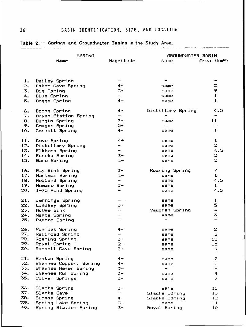
3 6 B A S I N I D E N T I F I C A T I O N , S I Z E , A N D L O C A T I O N
Table 2.-- Springs and Groundwater Basins in the Study Area. --------------------------------------------------------.---------------
SPH I NG GHOUNDWfiTER BASIN Name flagni tude Name EIrea (kma)
Bai 1 ey Spring Baker Cave Spring B ig Spring Blue Spring Boggs Spring
same same same same
D i s t i l l e r y Spring -
same -
B o ~ n e Spring Bryan S ta t i on Spring Burgin Spring Cougar Spring Cornet t Spr ing same
C o v e Spr ing D i s t i l l a r y Spring E l khorn Spring Eureka Spring Gano Spring
same same same same same
Gay Sink Spring Hartman Spr i nq Hol 1 and Spr i nq Humane Spring 1-75 Pond Spring
Roar i nq Spr i ng same same same same
Jennings Spring Lindsay Spring McGee Sink Nance Spring Pax t on Spring
same same
Vaughan Spring same -
P i n Oak Spring Hai l r o a d Spring R o a r i ng Spr i ng Royal Sprinq Russel 1 Cave Spring
same same same same same
Santen Spring Shawnee Copper. Spr ing Shawnee Hef e r Spr i ng Shawnee Hun Sprinq S i l v e r Springs
same same -
same same
Slacks Spring Slacks Cave S l oans Spring Spring Lake Spring Spring S ta t ion Spring
same Slacks Spring Slacks Spring
same Royal Spr inq
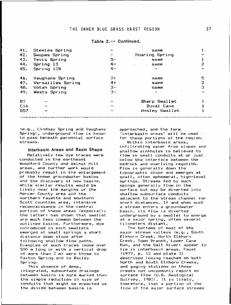
T H E I N N E R B L U E G R A S S K A R S T R E G I O N
41. Stee les Spring 42. Swopes Spring 43. Tevi 5 Spring 44. Spring 13 45. Spring 13B
46. Vaughans Spring 47. V e r s a i l l e s Spring 48. Votah Spring 49. Wests Spring
Table 2.-- Continued.
- same - Roar i ng Spr i ng
5- same 4- same 4- -
same same same -
Sharp Swal 1 e t 1 Duval Cave 1
Rnsl ey Swal 1 et 1
(e. g. , Lindsay Spr ing an'd Vaughans Spr ing ) , underground f l o w i s known t o pass beneath perenn ia l sur face streams.
lnterbasin Areas and Basin Shape R e l a t i v e 1 y few dye t races were
conducted i n t h e nor theast Woodf o r d County and Walnut H i 11 areas, and f u r t h e r work would probab ly r e s u l t i n t h e enlargement o f t h e known groundwater basins and t h e d iscovery o f new basins. While s i m i l a r r e s u l t s would be l i k e l y near t h e margins o f t h e Mercer County area and t h e no r the rn Faye t te and southern Sco t t coun t ies area, i n t e n s i v e reconnaissance i n t h e c e n t r a l p o r t i o n o f these areas ( e s p e c i a l l y t h e l a t t e r ) has shown t h a t s w a l l e t a re much l e s s common between t h e o u t l i n e d basins. Furthermore, dye in t roduced i n each s w a l l e t s emerged a t smal l sp r ings a sho r t d is tance down s lope a f t e r f o l l o w i n g shal low f l o w paths. Examples o f such t r a c e s (none over 500 m long o r w i t h a v e r t i c a l drop o f more than 3 m) were those t o Paxton Spr ing and t o B a i l e y Spring.
Th is absence o f deep, i n teg ra ted , subsurface drainage between bas ins i s more marked than t h e s imple reduc t ion i n s i t e o f condu i ts t h a t might be expected as t h e d i v i d e between bas ins i s
approached, and t h e term " i n t e r b a s i n areas" w i 11 be used f o r these p o r t i o n s o f t h e region.
Wi th in i n t e r b a s i n areas, i n f i l t r a t i n q water f rom slopes and shal low s inkho les i s be1 ieved t o f l o w i n smal l condu i ts a t o r j u s t below t h e i n t e r f a c e between the bedrock and o v e r l y i n g r e g o l i t h . Flow i s general1 y down t h e topographic s lope and emerges a t smal l , o f t e n ephemeral, h igh- leve l spr ings. Streams f e d by such sp ings genera l l y f l o w on t h e sur face b u t may be d i v e r t e d i n t o shal low subsurface condu i ts adjacent t o t h e stream channel f o r s h o r t d is tances. I f and when such a stream en te rs a groundwater bas in , i t s f l o w i s d i v e r t e d underground by a s w a l l e t t o emerge a t a major spr ing, o f t e n several k i l omete rs d i s t a n t .
The bottoms o f most o f t he major stream v a l l e y s (e.g., South E l khorn Creek, Nor th E l khorn Creek, Town Branch, Lower Cane Run, and t h e S a l t R i v e r ) appear t o l i e i n i n t e r b a s i n areas. Faust (1777, p. 12 and p l a t e 3 ) described l o s i n g reaches on both Nor th and South E lkhorn Creeks, and gaging s t a t i o n s on these creeks n o t uncommonly r e p o r t no sur face f l o w (U.S. Geological Sui rvey, 1983). I t i s l i k e l y , t he re f ore, t h a t a p o r t i o n o f t h e f l o w o f t h e major sur face streams
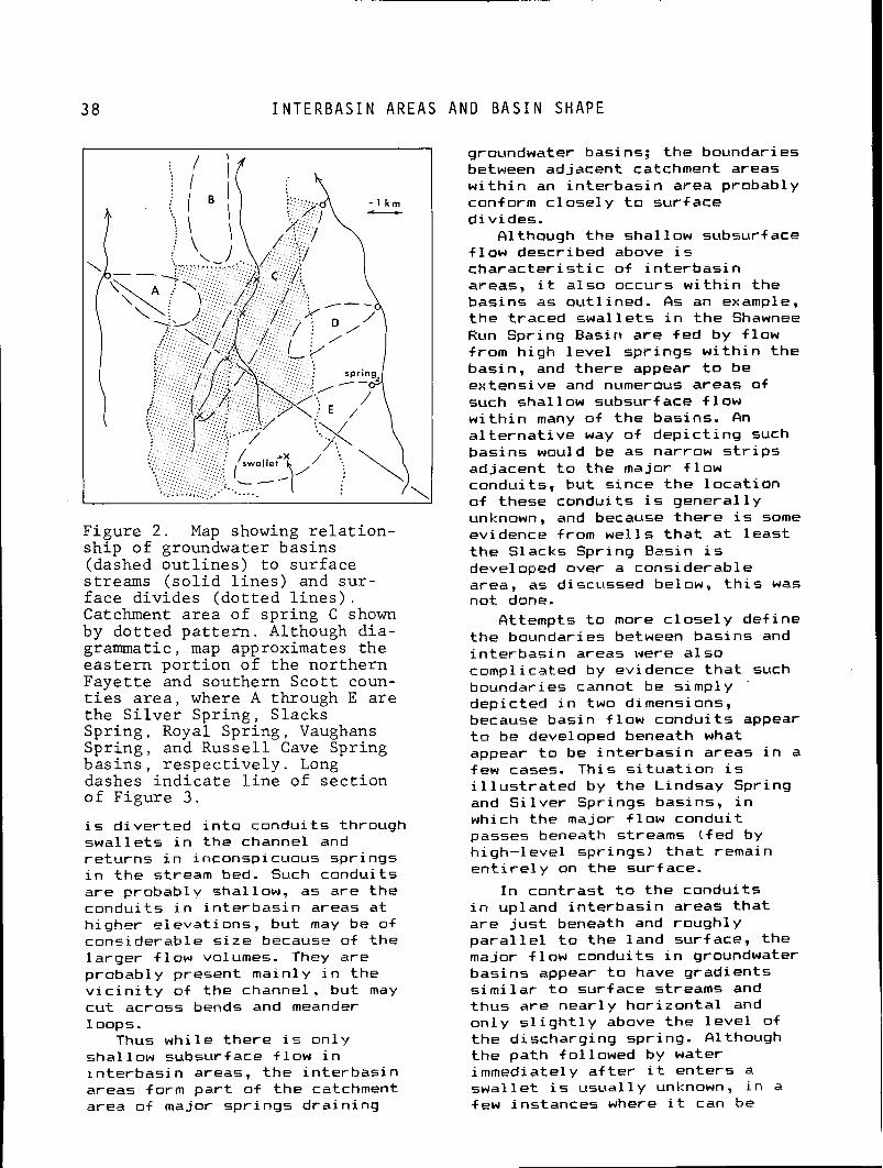
38 I N T E R B A S I N A R E A S A N D B A S I N S H A P E
F i g u r e 2 . Map showing r e l a t i o n - s h i p of groundwater b a s i n s (dashed o u t l i n e s ) t o s u r f a c e s t reams ( s o l i d l i n e s ) and s u r - f a c e d i v i d e s ( d o t t e d l i n e s ) . Catchment a r e a o f s p r i n g C shown by d o t t e d p a t t e r n . Although d i a - grammatic, map approximates t h e e a s t e r n p o r t i o n o f t h e n o r t h e r n F a y e t t e and sou the rn S c o t t coun- t i e s a r e a , where A through E a r e t h e S i l v e r S p r i n g , S l acks S p r i n g , Royal S p r i n g , Vaughans S p r i n g , and R u s s e l l Cave Spr ing b a s i n s , r e s p e c t i v e l y . Long dashes i n d i c a t e l i n e of s e c t i o n o f F i g u r e 3 .
i s d i v e r t e d i n t o condu i ts through s w a l l e t s i n t h e channel and r e t u r n s i n inconspicuuus spr ings i n t h e stream bed. Such condui ts a re probably shal low, as a r e t h e condu i t s i n i n t e r b a s i n areas a t h igher e leva t ions , b u t may be o f cons iderab le s i z e because o f t h e l a r g e r f l o w volumes. They are probably present main ly i n t h e v i c i n i t y o f t h e channel, b u t may c u t across bends and meander 1 oops.
Thus w h i l e t h e r e i s on ly sha l low subsurface f l o w i n i n t e r b a s i n areas, t h e i n t e r b a s i n areas form p a r t o f t h e catchment area o f major sp r ings d r a i n i n g
groundwater basins; t h e boundaries between adjacent catchment areas w i t h i n an i n t e r b a s i n area probably conf orm c lose1 y t o s u r f ace d iv ides .
Although t h e shal low subsurface f l o w descr ibed above i s c h a r a c t e r i s t i c o f i n t e r b a s i n areas, i t a l s o occurs w i t h i n t h e bas ins as out1 ined. As an example, t h e t raced s w a l l e t s i n t h e Shawnee Run Spr ing Basin a r e f e d by f l o w from h igh l e v e l sp r ings w i t h i n t h e basin, and the re appear t o be ex tens ive and numerous areas of such s h a l l ow subsurf ace f 1 ow w i t h i n many o f t h e basins. An a l t e r n a t i v e way o f d e p i c t i n g such bas ins would be as narrow s t r i p s adjacent t o t h e major f l o w condui ts , b u t s ince t h e l o c a t i o n o f these condui ts i s g e n e r a l l y unknown, and because t h e r e i s some evidence from w e l l s t h a t a t l e a s t t h e Slacks Spr ing Basin i s developed over a cons iderab le area, as discussed below, t h i s was n o t done.
Qttempts t o more c l o s e l y de f ine t h e boundaries between bas ins and i n t e r b a s i n areas were a l s o compl i c a t e d by evidence t h a t such boundaries cannot be s imply '
dep ic ted i n two dimensions, because bas in f l o w condu i t s appear t o be developed beneath what appear t o be i n t e r b a s i n areas i n a few cases. Th is s i t u a t i o n i s i l l u s t r a t e d by t h e Lindsay Spring and S i l v e r Springs basins, i n which t h e major f 1 ow condu i t passes beneath streams ( f e d by h igh- leve l spr ings) t h a t remain e n t i r e l y on t h e sur face.
I n con t ras t t o t h e condu i ts i n upland i n t e r b a s i n areas t h a t a re j u s t beneath and rough ly para1 l e l t o t h e land s u r f ace, t h e major f l o w condui ts i n groundwater bas ins appear t o have grad ien ts s i m i l a r t o s u r f ace streams and thus a re near l y h o r i z o n t a l and o n l y s l i g h t l y above t h e l e v e l o f t h e d ischarg ing spr ing. Although t h e pa th fo l lowed by water immediately a f t e r i t e n t e r s a s w a l l e t i s u s u a l l y unknown, i n a few ins tances where i t can be
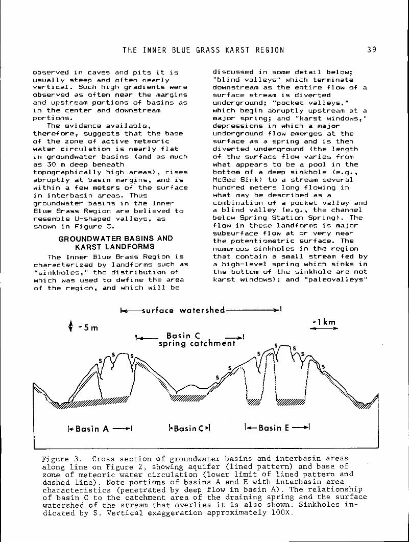
T H E I N N E R B L U E G R A S S K A R S T R E G I O N
o b s ~ r v e d i n caves and p i t s i t i s usual 1 y steep and of ten near1 y v e r t i c a l . Such h igh gradients were observed as o f ten near the margins and upstream por t ions o f basins as i n the center and downstream por t ions.
The ev i dence avai 1 ab l e , theref ore, suggests t h a t the base of the zone of ac t i ve meteoric water c i r c u l a t i o n i s near ly f l a t i n groundwater basins (and as much as 30 m deep beneath topographical ly h igh areas), r i s e s abrup t l y a t basin margins, and i s w i t h i n a few meters o f the surface i n i n te rbas in areas. Thus groundwater basins i n the Inner Elue Grass Region are bel ieved t o resemble U-shaped va l leys, as shown i n Figure 3.
GROUNDWATER BASINS AND KARST LANDFORMS
d i scussed i n some deta i l be1 ow; " b l i n d va l leys" which terminate downstream as the e n t i r e f low of a surface stream i s d ive r ted underground; "pocket va l leys, " which begin abrupt ly upstream a t a major spring: and "kars t windows, " depressions i n which a major underground f low emerges a t the surface as a spr ing and i s then d ive r ted underground ( the 1 ength o f the surface f low var ies from what appears t o be a pool i n the bottom of a deep s inkhole (e.g., McGee Sink) t o a stream several hundred meters long f low ing i n what may be described as a combination o f a pocket va l l ey and a b l i n d va l l e y (e. g. , the channel below Spring S ta t ion Spr ing). The f low i n these landforms i s major subsurface f low a t o r very near the potent iometr ic surface. The numerous sinkholes i n t he reg ion
The Inner Blue Grass Region i s t h a t contain a small stream fed by character ized by landforms such as a h igh- level spr ing which s inks i n "sinkholes, " the d i s t r i b u t i o n o+ the bottom of the s inkhole are not which was used t o def ine the area kars t windows) : and "paleoval leys" of the region, and which w i l l be
L u r f a c e watershed-[
6 - 5 m - - I km cn- Basin C +I
spring catchment
/
I* Basin A -I b ~ a s i n c*I Ic- asi in E +I
Figure 3 . Cross sec t ion of groundwater bas ins and in t e rbas in areas along l i n e on Figure 2 , showing aquifer ( l ined pa t t e rn ) and base of zone of meteoric water c i r cu l a t i on (lower l i m i t of l i ned pa t t e rn and dashed l i n e ) . Note port ions of basins A and E with in te rbas in area c h a r a c t e r i s t i c s (penetrated by deep flow i n bas in A). The r e l a t i onsh ip of bas in C t o the catchment a rea of the draining spr ing and the surface watershed of the stream tha t over l i es i t i s a l so shown. Sinkholes i n - d icated by S . Ver t i ca l exaggeration approximately 100X.
S I N K H O L E ORIGIN
which appear t o be normal sur face v a l l e y s b u t c o n t a i n no sur face stream channel. Pal eoval l e y s u s u a l l y c o n t a i n a s e r i e s o f s inkho les i n t h e i r bottom, and apparent ly formed when t h e i r surf ace 'stream was d i v e r t e d underground a t severa l p o i n t s a long i t s course, fo rming a s e r i e s o f b l i n d v a l l e y s , f 01 lowed by complete abandonment o f sur face f l o w except p o s s i b l y d u r i n g h i g h d ischarge events.
Except f o r some s inkho les , a l l f i v e o f these landforms a r e t h e r e s u l t o f deep c i r c u l a t i o n o f subsurface water, and t h e i r presence i n an area should i n d i c a t e t h e ex is tence o f a groundwater bas in, a l l o w i n g t h e l o c a t i o n and ex ten t o f bas ins t o be a t l e a s t est imated from an examinat ion o f t h e topographic maps. Al though some c o r r e l a t i o n appears t o e x i s t , i t has n o t been p o s s i b l e t o r e l y h e a v i l y on i t because o f s inkho le m o d i f i c a t i o n s and t h e inadequacy o f a v a i l a b l e maps. Eef o r e exami n i nq these f a c t o r s f u r t h e r , a d i scuss ion o f t h e o r i g i n o f s inkho les i n t h e r e g i o n i s appropr ia te .
Sinkhole Origin Contrary t o w ide l y h e l d and
s t a t e d op in ion , t h e c o l l a p s e o f t h e r o o f s o f caves i s no t t h e p r i n c i p a l cause o f s inkho les i n t h e r e g i o n (nor, f o r t h a t mat ter , i n any o the r k a r s t area w i t h which t h e author i s f ami 1 i a r ) . O f t h e many s inkho les examined i n t h e reg ion , cave r o o f c o l l a p s e i s n o t be l i eved t o be a major f a c t o r i n t h e o r i g i n o f any. Rather, they a r e produced by s o l u t i o n o f t h e l imestone bedrock a t t h e contac t w i t h t h e o v e r l y i n g r e g o l i t h by water t h a t has i n f i l t r a t e d from t h e sur face, t h e same process t h a t occurs n e a r l y everywhere i n t h e r e g i o n and has probab ly been t h e p r i n c i p a l agent i n t h e lower ing o f t h e bedrock su r face through t ime.
Although t h e r e w i l l be some p e n e t r a t i o n o f t h e bedrock under a h i l l s lope through many c l o s e l y spaced, very smal l d i ameter
condui ts , s o l u t i o n a t t h e base o f t h e bedrock w i l l be acce lera ted i n t h e v i c i n i t y o f t h e l a r g e r condui ts , and t h e more r a p i d lower ing o f t h e bedrock i n t e r f a c e nearby w i l l cause t h e capture o f more f l o w from adjacent condui ts , and hence increased bedrock s o l u t i o n . When t h e r e s u l t i n g subsidence o f t h e over1 y i n g r e g o l i t h (which i n i t i a l l y i s r e f l e c t e d by a s imp le f l a t t e n i n g i n t h e sur face s lope) i s s u f f i c i e n t t o reve rse t h e downh i l l s lope, a topographic depression i s formed and a t ype one s inkho le r e s u l t s .
The ex is tence o f a topographic depression w i 11 f u r t h e r acce le ra te t h e enlargement o f t h e condu i t , s i n c e most o f t h e water t h a t i n f i l t r a t e s t h e su r face w i t h i n t h e depression w i l l f l ow through i t (a l though some o f t h e f l o w w i l l p robably s t i l l be c a r r i e d by smal ler condu i t s ) . Major deepening and widening o f t h e s i n k h o l e w i l l p robably n o t occur, however, u n t i l t h e condu i t becomes enlarged by s o l u t i o n throughout i t s l e n g t h t o t h e degree t h a t t h e water f l ow ing through i t can t r a n s p o r t p a r t i c l e s o f r e g o l i t h , a f t e r which t ime t h e i ep ress ion becomes a t y p e two s inkho le . The volume o f r e g o l i t h removed may now exceed t h e amount o/ l imestone d isso lved, t o t h e ex ten t t h a t bedrock i s exposed on i t s s ides o r bottom. Although i t seems l i k e l y t h a t a topographic depression i s general 1 y formed p r i o r t o t h e onset o f reg01 i t h removal (i . e., t y p e one precedes t ype two) , t h i s may n o t always be t h e case, e s p e c i a l l y s ince t h e general downslope movement o f r e g o l i t h on h i 1 l s l o p e s w i 11 tend t o f i l l t ype one depressions o r prevent them from forming.
A Aype t h r e e s i n k h o l e i s formed when t h e condu i t i s l a r g e enough and f l o w v e l o c i t i e s a r e h i g h enough f o r i n s o l u b l e o r o therw ise r e s i s t e n t beds t h a t tend t o perch t h e condu i t t o be eroded through. Type t h r e e s inkho les have steep o r near v e r t i c a l d r a i n s t o depth and t h e i r f l o w i s i n t e g r a t e d i n t o t h e
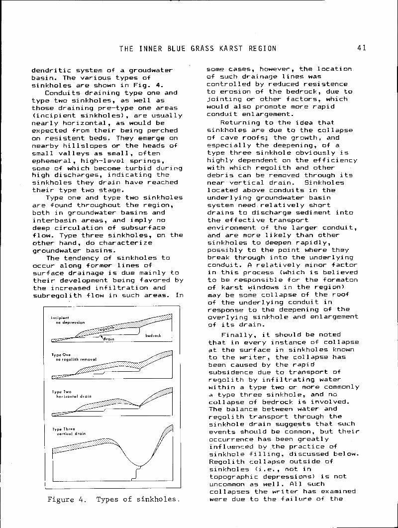
T H E I N N E R B L U E G R A S S K A R S T R E G I O N
d e n d r i t i c system o f a groudwater basin. The va r ious types o f s inkho les a r e shown i n F ig. 4.
Conduits d r a i n i n g t y p e one and t y p e two s inkholes, as w e l l as those d r a i n i n g pre-type one areas ( i n c i p i e n t s inkho les) , a r e usual 1 y n e a r l y h o r i z o n t a l , as would be expected from t h e i r being perched on r e s i s t e n t beds. They emerge on nearby h i l l s l o p e s o r t h e heads of smal l va l l e y s as smal l , o f t e n ephemeral, h igh - leve l spr inqs, some o f which become t u r b i d dur ing h i g h discharges, i n d i c a t i n g t h e s inkho les they d r a i n have reached t h e i r type two stage.
Type one and t ype two s inkho les a r e found throughout t h e reg ion , bo th i n groundwater bas ins and i n t e r b a s i n areas, and imp ly no deep c i r c u l a t i o n o f subsurf ace f low. Type t h r e e s inkholes, on t h e o the r hand, do charac te r i ze groundwater basins.
The tendency o f s inkho les t o occur along former l i n e s o f su r face drainage i s due main ly t o t h e i r development be ing favored by t h e increased i n f i l t r a t i o n and s u b r e g o l i t h f l o w i n such areas. I n
Incipient no depression
bedrock
no r e g o l i t h removal
Type Two h o r i z o n t a l d r a i n
Type Three vert ical d r a i n
Figure 4. Types of sinkholes
some cases, however, t h e l o c a t i o n o f such drainage l i n e s was c o n t r o l l e d by reduced res i s tence t o eros ion o f t h e bedrock, due t o j o i n t i n g o r other f a c t o r s , which would a l s o promote more r a p i d condu i t enlargement.
Return ing t o t h e idea t h a t s inkho les a re due t o t h e co l l apse of cave roo f 5 : t h e growth, and e s p e c i a l l y t h e deepening, o f a t ype t h r e e s inkho le obvious1 y i s h i g h l y dependent on t h e e f f i c i e n c y w i t h which r e g o l i t h and o ther i e b r i s can be removed through i t s near v e r t i c a l d ra in . S inkholes l oca ted above condu i ts i n t h e under1 yi ng groundwater bas in system need re1 a t i v e l y s h o r t d r a i n s t o discharge sediment i n t o t h e e f f e c t i v e t r a n s p o r t environment o f t h e 1 arger condu i t , and a re more l i k e l y than o ther s inkho les t o deepen r a p i d l y , p o s s i b l y t o t h e p o i n t where they break through i n t o t h e under l y ing condui t . A r e l a t i v e l y minor f a c t o r i n t h i s process (which i s be l ieved t o be respons ib le f o r t h e formaton of k a r s t windows i n t h e reg ion ) may be some co l l apse o f t h e r o o f o f t h e under l y ing condu i t i n response t o t h e deepening o f t h e over1 y i ng s inkho le and enlargement o f i t s d ra in .
F i n a l l y , i t should be noted t h a t i n every ins tance o f co l l apse a t t h e su r face i n s inkho les known t o t h e w r i t e r , t h e co l l apse has been caused by t h e r a p i d subsidence due t o t r a n s p o r t of r e g o l i t h by i n f i l t r a t i n g water w i t h i n a t ype two o r more commonly a t ype t h r e e s inkhole, and no c o l 1 apse o f bedrock i s involved. The balance between water and r e g o l i t h t r a n s p o r t through t h e s inkho le d r a i n suggests t h a t such events should be common, b u t t h e i r occurrence has been g r e a t l y i n f l uenced by t h e p r a c t i c e o f s inkho le f i l l i n g , discussed below. R e g o l i t h c o l l a p s e ou ts ide o f s inkho les ( i .e . , n o t i n topographic depressions) i s n o t uncommon as we l l . A l l such c o l lapses t h e w r i t e r has examined were due t o t h e f a i l u r e o f t h e
4 2 S I N K H O L E F I L L I N G A N D M A P I N A D E Q U A C Y
r oo f of a s h a l l ow conduit developed a t or above the reg01 i th-bedrock in ter face.
Sinkhole Filling and Map Inadequacy I n some cases, type th ree
sinkholes, which i nd i ca te the presence of a groundwater basin, can be i d e n t i f i e d ra ther e a s i l y on t h e 1: 24,000 topographic map lcontour i n t e r v a l 3.0 or 6.1 m) o f t h e region. The method used i s t o determine t h e minimum length necessary f o r t he bottom of the s inkho le t o be drained by a near ho r i zon ta l conduit . If t h i s length i s greater than two or th ree hundred meters i t i s q u i t e u n l i k e l y t h a t such a hor i zon ta l s inkho le d ra in e x i s t s and the s inkho le i s judged t o be a type three. Unfor tunately, t he depth of s i n khol es , especi a1 1 y the deeper ones of small areas, i s almost always several meters greater than t he depth depicted on the map by topograhic contours, s ince shadows and dense vegetat ion obscure t h e i r bottoms on a e r i a1 photographs. Deep s inkholes l ess than 50 m across are seldom shown a t a l l on t h e topograhic maps. Many type three s inkholes can be i d e n t i f i e d as such on ly by f i e l d reconnaissance.
A second f a c t o r h inders the i d e n t i f i c a t i o n of t h e type three sinkholes, and hence groundwater basins, even a f t e r f i e l d reconnaissance. Deep sinkholes w i th steep wa l l s prov ide convenient s i t e s f o r r u r a l waste d i sposal ; of ten t he 1 ong-term goal i s t o near l y f i l l them and render them su i t ab le f o r pasture or even row crops. This e f f o r t by farmers has presumably been underway f o r much of t he 2 cen tu r ies of a g r i c u l t u r e i n the region, w i th t he r e s u l t t h a t many sinkholes t h a t are a c t u a l l y type three now have a shallow saucer shape more cha rac te r i s t i c of type one or type two.
The topographic maps of the reg ion do not accurate ly depict many of the other ka rs t landforms
t h a t i nd i ca te the presence of a groundwater basin. Few of the streams i n pocket va l l eys and kars t windows are shown, probably because they are so shor t and hidden by vegetat ion and shadows. Many b l i n d va l leys and paleoval leys are shown as normal sur face va l leys , espec ia l l y when the reversed slope below swal le ts i s gent le and short . F i n a l l y , swa l le ts are too small t o be termed landforms o r t o be shown even by accurate maps, although t h e i r presence i s ind ica ted i n some b l i n d val leys. Swal lets along sur f ace streams and i n sinkholes (many sinkholes do not contain open swa l le ts ) can on ly be located i n the f i e l d .
GEOLOGIC AND OTHER FACTORS INFLUENCING SUBSURFACE FLOW AND GROUNDWATER BASIN DEVELOPMENT
A major ob jec t i ve of t he study on which t h i s chapter was based was t o evaluate the degree t o which subsurface f low and the l oca t i on of groundwater basins del ineated by dye t r a c i n g dur ing t h i s study could be explained by geologic and other fac tors . Such an explanation would no t on1 y con t r ibu te subs tan t i a l l y t o an understanding of t h e nature of subsurface f low i n t he reqion. but - would a l low the p red i c t i on of f low d i r ec t i ons and l oca t i on of groundwater basins i n por t ions o f the reg ion where dye- t r ac i ng has no t been done.
A p a r t i c u l a r emphasis was placed on the relevance t o subsurface f low of the geological in format ion contained on t he U.S. Geological Survey geologic maps o f t he area invest igated ( Black, 1964, 1967: Cressman, 1964, 1967, 1972; Kanizay and Cressman, 1967; M i 1 l e r , 1967; MacQuown and Dobrovolny, 1968; Pomeroy, 1968, 1970: Cressman and Harber, 1970; and Allingham, 19721, inasmuch as s i m i 1 ar 1 arge-scal e ( 1 : 24,000) maps are ava i lab le f o r t he e n t i r e Inner Blue Grass Region.
Previous hydrogeologic inves t iga t ions of t he reg ion have
T H E I N N E R B L U E G R A S S K A R S T R E G I O N
dea l t main1 y w i th t he a v a i l a b i l i t y of subsurface water, and have reached vary ing conclusions as t o the importance of var ious factors. Hamilton (1950) bel ieved the arg i l laceous u n i t s i n the Lexington Limestone were the most important con t ro l of so lu t i on devel opment , and Mu1 1 ( 1968 considered them a major fac tor . Palmquist and Hal 1 (1961 ) , Hopki ns ( 1966a) , and Faust ( 1977) , on the other hand, d i d no t emphasize the r o l e o f 1 i thology, and considered topography t o be t he major fac tor . Mu1 1 (1968) ascribed such an important r o l e t o the d i p of the rocks t h a t he presented h i s wel l data f o r the Georgetown Quadrangle on a s t ruc tu re contour map. Hami 1 ton ( 1950) , Pal mqui s t and H a l l (19611, Hopkins (1966a), and espec ia l l y Faust (1977) bel ieved j o i n t s and f a u l t s played a s i g n i f i c a n t r o l e i n subsurf ace f 1 ow and so lu t ion devel opment . The on ly previaus work u t i l i z i n g t raced f low paths was by J i l l s o n (19451, who emphasized the geomorphic development o f the f low t o Royal Spring and ind ica ted i n d i r e c t l y t h a t downdip f low was a f a c t o r i n i t s development ( J i l l s o n , 1945, p. 25-27).
Lithology of Stratigraphic Units
dra in ing groundwater basins i n t he study area, two are in te rp re ted as being perched on a rg i l l aceous u n i t s i n t h e Lexington Limestone. I n one, the perching i s observable and seeming1 y c lear cut; Shawnee Hefer Spring i n the Mercer County area f lows from a number of h i l l s i d e o u t l e t s over a distance of 60 m along the outcrop of the Macedonia Bed. Although no dye in t roduc t ions were detected a t t he spring, i t s groundwater basin probably l i e s t o the southeast, updip from the spring. The i n t e r p r e t a t i o n i s only s l i g h t l y l ess c e r t a i n f o r Spring Lake Spring i n the northern Fayette and southern Scot t counties area, which emerges a t about the s t ra t i g raph i c pos i t i on of the Cane
Run Bed, wel l above the l eve l of major streams, and i s downdip from i t s t raced groundwater basin.
None of the other 37 major spr ings dra in ing groundwater basins i n the study area i nd i ca te con t ro l by s t ra t i g raph i c u n i t s i n the Lexington Limestone. It would seem reasonable t h a t the few t h a t emerge somewhat above the l e v e l of major surface streams (e.g., Gano and Steeles spr ings) are perched on arg i 1 1 aceous or otherwi se r e s i s t a n t beds, but such beds, i f present (such as. the Macedonia Bed a t Gano Spring) are not ind icated on the geologic maps o r accompanying l i t h o l o g i c descr ip t ions, and were not observed i n the f i e l d .
The con t ro l of shallow subsurf ace f low i n in te rbas in areas ( inc lud ing such areas w i t h i n groundwater basins) by mapped o r unmapped arg i l laceous limestones appear t o be more common. Not in f requent l y , two or more high- level springs w i l l emerge a t t he same s t ra t i g raph i c l eve l , and i n the Sinkhole P la in paleoval leys a number of such springs emerge a t the top o f Macedonia Bed.
There may be occasional perching of surface streams f o r shor t distances on a rg i 11 aceous u n i t s (e. g. , the middle reaches o f Cane Run on the Cane Hun Red and the stream i n the Joyland Cave b l i n d va l l ey on the Brannon Member), but such instances are no t obvious nor widespread.
Because of the general para1 1 e l ism between bedding and the ove ra l l topographic surface i n t he areas studied, most o f the major f low condui ts and spr ings are i n the lower exposed u n i t s of the Lexington Limestone, especial 1 y the Gr ier Limestone, bu t the s t ra t i g raph i c pos i t i on of spr ings emerging from t h i s u n i t va r ies over more than 12 m, and there i s no evidence of 1 i t h o l o g i c ,
cont ro l . S im i l a r l y , those smaller groundwater basins t h a t approx i mate1 y co inc ide w i t h surface drainages have t h e i r margins beneath surface d iv ides
B E D D I N G ATTITUDE
t h a t a r e o f t e n u n d e r l a i n by h igher a r g i l l a c e o u s u n i t s such as t h e M i l l e r s b u r g Member and t h e Clays F e r r y Formati on. The numerous examples f rom bo th smal l and l a r g e bas ins which do n o t show t h i s accord w i t h topography, however, i n d i c a t e l i t h o l o g i c v a r i a t i o n s i n t h e Lex ing ton Limestone a re of l i t t l e o r no importance i n c o n t r o l 1 i n g t h e development of major f l o w condu i t s o r t h e l o c a t i o n o f groundwatr basins. Subsurface f l o w i n major condu i ts occurs beneath a l l seven o f t he a r g i l l a c e o u s u n i t s mapped i n t h e area (Table 1 ) . as f o l l o w s ( t h e l o c a t i o n o f an example i s i n parentheses): Maced~n ia Bed (Burg in Spr ings Bas in ) , Cane Run Member (Royal Spr ing Basin) , Greendale L e n t i 1 ( S i l v e r Spings Basi n , M i 1 1 ersburg Member ('Russel 1 Cave Spr i ng Basin) , and t h e lower p a r t o f t h e Clays Fe r ry Format i o n (Cove Spr ings Basin) .
Bedding Attitude The para1 1 e l ism between bedding
and t h e o v e r a l l topographic su r face mentioned above a l s o compl icates t h e e v a l u a t i o n o f t h e importance o f t h e d i p o f t h e rocks i n de termin ing f l o w d i r e c t i o n s i n groundwater basins. There i s no evidence, however, o f any use fu l r e l a t i o n s h i p between f l o w d i r e c t i o n s as i n d i c a t e d by dye t r a c e s and t h e d i p as shown by s t r u c t u r e contours on t h e geologic maps. Al though f l o w i n some of t h e smal l e r bas ins i s approx imate ly downdip (e.g., V e r s a i l l e s Spring, Votah Spr ing, Jenning Spr ing bas ins ) , i n o the rs i t i s n e a r l y updip (e.g., D i s t i l l e r y Spring, Duva l l Cave, Gano Spr ing bas ins) . Flow d i r e c t i o n s i n t h e l a r g e r bas ins appear t o be s i m i 1 a r l y u n r e l a t e d t o l o c a l d ip . I n t h e L indsay Spr ing and S i l v e r Springs bas ins , f l o w condu i ts c ross mapped a n t i c l i n e s and sync l i nes a t r i g h t angles, and i n t h e Russel l Cave Spr ing bas in t h e d ischarg ing s p r i n g and dye i n p u t p o i n t s a re on oppos i te 1 imbs o f an a n t i c 1 i n e
t h a t appears t o represent t h e c r e s t o f t h e C i n c i n n a t i Qrch.
Because o f t h e problems associated w i t h d e t a i l e d s t r u c t u r a l mapping o f s t r a t i g r a p h i c u n i t s t h a t o f t e n show r a p i d l a t e r a l changes i n th i ckness and l i t h o l o g y , and whose esposures may be sub jec t t o slumping and r o t a t i o n on h i 1 l s l opes , t h e s t r u c t u r e contours shown on t h e geologic maps may n o t accu ra te l y r e f l e c t l o c a l bedding a t t i t u d e everywhere. I f such l o c a l s t r u c t u r e i s ignored and t h e o r i e n t a t i o n o f f l o w d i r e c t i o n s t o t h e o r i g i n a l d i p i s examined, no more cons i s ten t r e l a t i o n s h i p i s found. I n t h e nor thern Fayet te and southern Sco t t Counties area, w h i l e f l o w i n the Royal Spring, S lacks Spring, and Nance Spring bas ins i s t o t h e north-northwest and down t h e reg iona l d i p , f l ow i n t h e adjacent S i l v e r Spr ings and L indsay Springs bas in i s t o t h e southwest along r e g i o n a l s t r i k e . I n t h e Mercer County area t h e r e g i o n a l d i p i s t o t h e west, as i s t h e general f l o w d i r e c t i o n s i n bas ins d r a i n i n g t o t h e S a l t R iver Ie.g., B i g Spring and Eureka Spr ing bas ins) . I n bas ins d r a i n i n g t o t h e D i x and Kentucky R ive rs (e.g., Purg in Spr ing and Shawnee Run Spr i ng basins) , however, f 1 ow i s genera l l y t o t h e east and hence up t h e reg iona l d ip .
Faults, Joints, Sinkhole Trends, and Similar Features
& number o f s teep ly d ipp ing o r v e r t i c a l p lanar s t r u c t u r a l f ea tu res , i n c l u d i n g f a u l t s , m ine ra l i zed ,veins, and j o i n t s , a r e shown on t h e geologic maps o f t h e areas studied. I n a d d i t i o n , l i n e a r t r e n d s o f s inkho les a r e shown by topographic contours and o the rs a r e v i s i b l e on a e r i a l photographs i T h r a i l k i l 1 and others, 1983).
Four o f t h e 39 major spr ings d r a i n i n g groundwater bas ins emerge a t o r w i t h i n a few tens o f meters o f a mapped f a u l t . I n two o f these, 1-73 Spr ing and Nance Spring, t h e dye i n t r o d u c t i o n p o i n t s ( o n l y one f o r 1-75 Spr ing)
T H E I N N E R B L U E G R A S S K A R S T R E G I O N
were along the f a u l t o r an apparent (but unmapped) extension, and the major f l ow conduit f o r the basin i s probably along. o r very near the f a u l t . I n the Shawnee Run Spring Basin, the spr ing i s on the downthrown (about 2 m) s ide of a small f a u l t t h a t t rends a t near ly r i g h t angles t o the l i n e of f low from dye in t roduc t ions on the upthrown side. A more complex r e l a t i o n s h i p e x i s t s i n the Shawnee Copperhead Spring Basin, where a major f l ow conduit i n te r sec t s an unmapped f a u l t and may fo l l ow i t t o i t s i n t e r s e c t i o n w i t h a mapped f a u l t near which the discharging spr ing i s located.
Dye in t roduc t ions were made i n swa l le ts located on mapped f a u l t s i n three other groundwater basins. I n the Sharp Swal let Basin, f low appears t o f o l l o w the f a u l t , and the discharging spr ing i s probably on an unmapped extension. I n the Boggs Spring Basin, however, the f low was away from the f a u l t (par t o f the same system as the 1-73 Spring Basin Fau l t ) a t a h igh angle t o t h e spr ing located some distance away from i t s t race. S im i l a r l y , i n the S i l v e r Springs Basin, f l ow from several swal le ts located along a ser ies of p a r a l l e l mapped f a u l t s i s a t r i g h t angles t o t h e i r trend, as was f low from a swal l e t on t he opposite s ide of the f a u l t s from the spring.
The northern Fayet te and southern Scot t count ies area i s bounded on the southeast by the northeast-trending Lexington Faul t System, a ser ies of p a r a l l e l f a u l t s w i t h up t o 150 m o f mapped displacement. The s ing le dye t race made t o Ba i ley Spring, which l i e s on the southeast (downthrown) s ide o f a major mapped f a u l t i n the system, was from a swa l le t on the northwestern s ide of the f a u l t . The l i n e of the t race, which was so shor t and apparently represented such swallow f low tha t no groundwater basin was defined, crossed the f a ~ ~ l t a t near1 y r i g h t angles.
I I t was poss ib le t o examine the
re la t i onsh ip o f a f low conduit t o
an unmapped mineral ized vein i n a cave i n t he Shawnee Copperhead Spring Basin. The conduit i n t e r s e c t s t he b a r i t e ve in i n several places a t var ious angles and appears t o be unaffected by i t s trend. I n the S i l v e r Spring Basin the major f l ow conduit appears t o cross a mapped b a r i t e ve in a t about a 450 angle.
No general r e l a t i onsh ip was evident between t raced f low l i n e s and j o i n t d i r ec t i qns , although i n a few cases, as i n the S i l ve r Spring Basin near the b a r i t e vein discussed above, the o r ien ta t ions o f +low l i n e s and mapped j o i n t s are s i m i l a r . It should be noted, however, t h a t except i n a few places where a condui t i s accessible and has been mapped, the only i n d i c a t i o n o f the o r i e n t a t i o n o f f low l i n e i s the r e l a t i v e pos i t i ons of the dye inpu t and detect ion po in ts .
Linear t rends o f sinkholes are no t uncommon i n the Inner Blue Grass Region. Eased on a sample, there are about 1,000 such trends i d e n t i f i a b l e on topographic maps i n t he reg ion ( T h r a i l k i l l and others, 1983), and hence approximately 120 i n the area studied assuming uniform d i s t r i b u t i o n . Most are less than 1 km long, and more t rend between northwest and nor th than i n any other d i r ec t i on . Faust (1977, p l a t e 2, p. 16) gave the loca t ion o f 40 such t rends and s ta ted t ha t they were probabl y favorably placed t o obta in goundwater.
Aligned sinkholes are present along the mapped f a u l t s i n the 1-75 Spring, Boggs Spring, Sharp Swallet, Nance Spring, and S i l ve r Springs basins discussed above. Traces from swa l le ts on opposite ends of a l i n e a r t rend i n the northwestern Woodford County area showed t h a t the t rend extends from the Roaring Spring t o t he P in Oak Spring basins. Inves t iga t ions i n the Royal Spring, Slacks Spring, Cornett Spring, and lower Roaring Spring basins s t rong ly suggest t h a t the major conduit i n each of
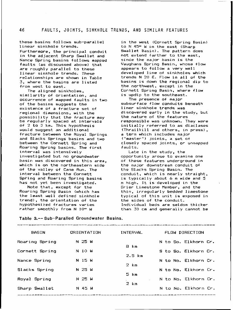
4 6 F A U L T S , J O I N T S , S I N K H O L E T R E N D S , A N D S I M I L A R F E A T U R E S
these basins f o l l ows sub-paral lel 1 inear s inkhole trends. Furthermore, the p r i n c i p a l conduit i n the adjacent Sharp Swallet and Nance Spr i ng basi ns f 01 1 ows mapped f a u l t s (as discussed above) tha t are roughly p a r a l l e l t o these 1 i near s inkhole trends. These re la t ionsh ips are shown i n Table 3, where the basins are l i s t e d from west t o east.
The a1 i gned sinkholes , s i m i l a r i t y of o r i en ta t i on , and occurrence of mapped f a u l t s i n two o f t he basins suggests t he existence of a f r a c t u r e set of reg iona l dimensions, w i t h the p o s s i b i l i t y t ha t the f r ac tu re may be regu la r l y spaced a t i n t e r v a l s o f 2 t o 3 km. Th is hypothesis would suggest an add i t iona l f r a c t u r e between the Royal Springs and Slacks Springs basins and two between the Cornett Spring and Roaring Spring basins. The f i r s t i n t e r v a l was in tens ive1 y invest igated but no groundwater basin was discovered i n t h i s area, which i s on the northeastern side o f the va l l ey o f Cane Run. The i n t e r v a l between the Cornett Spring and Roaring Spring basins has not yet been invest igated.
Note tha t , except f o r the Roaring Spring Easin (which has the l eas t wel l def ined sinkhole t r end ) , the o r i en ta t i on of the hypothesized f r ac tu res var ies ra ther smoothly from N 10" W
i n the west (Cornett Spring Basin) t o N 4S0 W i n the east (Sharp Swallet Basin). The pa t te rn does not extend fa r t he r t o the east, since the major basin i s the Vaughans Spring Basin, whose f low appears t o fo l low a very wel l developed 1 i ne of s inkholes which t rends N 20 E. Flow i n a l l of the basins i s down the reg iona l d ip t o the northwest, except i n the Cornett Spring Basin, where f low i s updip t o the southeast.
The presence of major subsurface f low conduits beneath l i n e r s inkhole trends was discovered ear l y i n the study, but the nature o f the features responsi b l e was unknown. They were i n i t i a l l y re fe r red t o as diaclases ( T h r a i l k i l l and others, i n press), a term which includes major ("master") j o i n t s , a set of c lose ly spaced j o i n t s , or unmapped fau l t s .
Late i n the study, the oppor tun i ty arose t o examine one of these features underground i n the major downstream conduit of the Slacks Spring Basin. The conduit , which i s near ly s t ra i gh t , i s t y p i c a l l y about 6 m wide and 5 m high. It i s developed i n the Gr ier Limestone Member, and the t h i n , i rregu l a r l y bedded 1 i mestone t y p i c a l of t h i s u n i t i s exposed i n the s ides of the conduit. Ind iv idua l beds are seldom th icker than 30 cm and general ly cannot be
Table 3.-- Sub-Paralled Groundwater Basins.
BASIN ORIENTQTION INTERVAL FLOW DIRECTION
Roar ing Sp r i ng N 25 W
C o r n e t t Sp r i ng N 10 W
Nance Sp r i ng N 15 W
Slacks Spr ing N 25 W
Royal Sp r i ng N 25 b!
Sharp S w a l 1 e t N 45 W
N t o So. E l khorn Cr.
S t o So. E lkho rn Cr.
N t o No. E l kho rn Cr.
N t o No. E l kho rn C r .
N t o No. E l kho rn C r .
N t o No. E l kho rn C r .
T H E I N N E R B L U E G R A S S K A R S T R E G I O N
t raced l a t e r a l l y more than a few tens o f meters. V i s i b l e j o i n t s can seldom be t raced more than a meter o r so v e r t i c a l 1 y, and those para1 1 e l t o the conduit seldom extend f o r more than 10 meters.
Over most of t he 1-km accessible length o f the conduit, the c e i l i n g i s the near ly f l a t underside o f an unusual 1 y continuous tabu la r l imestone bed, a l i t h o l o g y more cha rac te r i s t i c o f the Tanglewood Limestone Member. The t race o f a j o i n t , apparently l i t t l e enlarged by so lu t ion, i s v i s i b l e i n t he c e i l i n g i n many places. This j o i n t p a r a l l e l s the condui t and can be observed i n several places t o be continuous f o r a t l e a s t 50 meters. The f l a t ce i 1 i n g (o f ten several meters wide) i s due t o col lapse of weaker beds up t o a more r e s i s t a n t and continuous bed, which i s a common process i n the near ly hor i zon ta l beds of t he region.
Thus, i t i s beleved t h a t a1 i gnment o f s i nkhol es and l o c a l i z a t i o n o f major conduits i n t he absence of f a u l t s i s con t ro l l ed by t he presence o i a j o i n t t ha t , u n l i k e most of the j o i n t s i n the region, i s continuous both h o r i z o n t a l l y and v e r t i c a l l y ( a t l eas t 30 m i n the one observed, judging by the depth of the condui t beneath the sur f ace). The presence of such a j o i n t w i l l promote the development o f deep s inkhole dra ins near the surface, and hence type three s inkholes (as discussed e a r l i er ) . &t depth i t w i l l f u rn i sh a favorab le path f o r i n i t i a l conduit development i f i t trends a t a small angle t o the ea r l y po ten t i a l gradient (as w i 11 be discussed below). Such condui ts w i l l more l i k e l y form i n t h i n bedded 1 imestones w i t h c lose1 y spaced j o i n t s , and l i t t l e enlargement of t he j o i n t i n massive and h o r i z o n t a l l y extensive beds (such as forms t h e c e i l i n g o f the condui t as described above) would be expected w i t h t he exception of occasional near-vert i c a l s inkhole drains.
This i n t e r p r e t a t i o n may exp la in the ra ther anomalous s i t u a t i o n i n the lower Vaughans Spring Basin, where the path of the major conduit down f low from a ka rs t window i s along a l i n e a r t rend of sinkholes, bu t then passes beneath North Elkhorn Creek t o the spr ing on the opposite side. I t i s presumed t h a t the condui t i s developed along a f r a c t u r e t h a t has l oca l i zed the s inkhole t rend but i s beneath a r e s i s t a n t bed a t t he creek, r i s i n g through i t on the f a r bank a t the margin of the bed or a t one of the few po in t s i t i s penetrated by a s o l u t i o n opening. It would seem l i k e l y t ha t the spring, which i s on t he i ns ide o f a meander loop, was once on the opposite (southern) s ide o f t he creek, and t h a t t he creek channel has migrated l a t e r a l l y on the r e s i s t a n t bed.
Topography
There appears t o be no consistent co r re l a t i o n between groundwater basins and surface drainage basins. Several of the smal l e r groundwater basins (e. g. , Baker Cave Spring, Humane Spring, Gano Spring, Santan Spring, and Tevis Spring basins) appear t o a t 1 east approx i matel y under1 i e sur f ace drainage basins. I n other small basins, however (e.g., P in Oak Spring, Cove Spring, Hartman Spring , Sharp Swal 1 e t , and E l khorn Spring) , subsurf ace f 1 ow 1 ines cro5s surf ace div ides. A1 1 of the la rger groundwater basins extend beneath surface div ides. Examples inc lude (surface d i v i de i s i n parentheses) : Big Spring Basin (Sa l t River-Kentucky R iver ) , Nance Spring Basin (North Elkhorn-South E l khorn creeks) , Si l v e r Springs Basin (North E l khorn Creek-Cane fiun). I n add i t ion, i n no instance were t he boundaries o f groundwater basins re la ted t o t he d iv ides of paleoval leys, such as the Lees Branch pa l eoval l e y i n the northeastern Woodford County area or the Sinkhole P l a i n paleoval ley i n t he Mercer County area. I n
G E O M O R P H O L O G Y
con t ras t , t h e f l o w d i r e c t i o n o f t h e shal low subsurf ace f l o w i n i n t e r b a s i n areas i s be l i eved t o be g e n e r a l l y accordant w i t h sur face dra inage as discussed e a r l i e r .
A 1 though t h e f l o w d i r e c t i o n i n groundwater bas ins appears t o bear no cons is ten t r e l a t i o n s h i p t o t h e d e t a i l s of present topography, t h e r e does seem t o be a tendency f o r such f l o w t o be toward t h e nearest major s u r f ace stream. I n t h e Mercer County area, groundwater bas ins apper t o be developed on e i t h e r s i d e o f a 1 i n e drawn midway between t h e S a l t R iver t o t h e west and Her r ing ton Lake (Dix R ive r ) and t h e Kentucky R iver t o t h e east. S i m i l a r l y , i n t h e no r the rn Fayet te and southern Sco t t count ies area, groundwater bas in f l o w i s general 1 y away from a l i n e midway between South E lkharn Creek and Town Branch on
d i r e c t o n s o r groundwater bas in boundaries t h a t a re d i f f e r e n t f rom those now ac t ive .
P r i o r t o t h e Mercer County area study, i t was hypothesized t h a t t h e degree o f groundwater bas in development would be l e s s near t h e margins o f t h e reg ion and i n o ther areas where t h e Lexington Limestone has more recent1 y l o s t i t s cover o f t h e o v e r l y i n g a r g i l l a c e o u s Clays F e r r y Formation. Such a r e l a t i o n s h i p , which was discussed b r i e f 1 y i n T h r a i l k i l l and o the rs ( i n press) , was n o t born ou t by t h e Mercer County area study, where w e l l developed groundwater bas ins (e. g. , Baker Cave Spr ing and Cove Springs bas ins) a re adjacent t o and even beneath outcrops o f t h e Clays F e r r y Formation.
Conclusions and Utility of t h e southwest and Nor th Elkhorn Geologic Maps Creek t o t h e n o r t h and east. These
The preceding anal y s i 5 f l o w d i r e c t i o n s would correspond
i n d i c a t e s t h a t no s i n g l e f a c t o r o r t o t h e s lope o f t h e po ten t iomet r i c
s imple combination o f f a c t o r s s u r f ace o f a r e g i o n a l a q u i f e r
appears t o c o n t r o l t h e l o c a t i o n o f (which does n o t now e x i s t )
groundwater basins o r d i r e c t i o n o f d ischarg ing along these major
subsurface f l o w w i t h i n them. The s t r eams.
bes t p r e d i c t o r o f general f l ow
Geomorphology There have been e a s i l y
i n t e r p r e t e d changes i n t h e landscape r e 1 ated t o t h e development o f underground drainage. The upper p o r t i o n s of a number o f s u r f ace v a l 1 eys have been converted i n t o b l i n d v a l l e y s and i n a few cases pa leova l l eys have been created by the d i v e r s i o n underground o f essent i a1 1 y a1 1 su r face drainage. S i m i l a r l y , i n severa l o+ t h e caves o f t h e reg ion passages t h a t a re n o t now c a r r y i n g subsurface f l o w a re found a few meters above t h e a c t i v e f l o w condui ts , and t h e r e a re h igh- leve l openings near a few of t h e major sp r ings (e.g., Roaring Spring, Lindsay Spr ing) t h a t probably represent abandoned condu i ts (a l though most o f these a re u t i l i z e d du r ing h i g h f l o w ) . None o f these h igher l e v e l condui ts , however, i n d i c a t e e a r l i e r f l o w
d i r e c t i o n would seem t o be p r o x i m i t y t o a major sur face stream, i n t h a t most o f t h e f l o w i n most o f t h e bas ins i n t h e areas i n v e s t i g a t e d was genera l l y toward such streams, prabably i n response t o a po ten t iomet r i c g rad ien t i n ex is tence e a r l y i n t h e development o f t h e subsurface f l o w systems.
Groundwater bas ins w i l l be found beneath deep s inkholes, b l i nd va l 1 eys, and p a l eoval 1 eys, b u t t h e l a c k o f such landforms does n o t necessar i l y i n d i c a t e t h e presence o f i n t e r b a s i n areas. Where t h e t r e n d o f a l igned deep s inkho les does no t dev ia te from t h e d i r e c t i o n o f t h e e a r l y po ten t iomet r i c g rad ien t by a l a r g e angle, i t i s l i k e l y t h a t major bas in condu i ts a re developed beneath such an al ignment.
A11 o f t h e above fea tu res are shown, w i t h va ry ing degrees of accuracy, on t h e topographic maps o f t h e reg ion . The p r i n c i p a l
T H E I N N E R B L U E
in format ion presented on geologic maps, t he area l ex tent and l i t h o l o g i c nature o f s t ra t i g raph i c u n i t s i n ' t he Lexington Limestone, i s o f l i t t l e o r no u t i l i t y i n l oca t i ng t h e boundries of and f low d i r e c t i o n s w i t h i n groundwater basins, nor does bedding a t t i t u d e as shown by s t r u c t u r e contours prov ide usef u l i n f ormation. About the on ly features del ineated on geologic maps (and not on topographic maps) t h a t may be of i n t e r e s t are f a u l t s along which al igned sinkholes are not present, although no condui ts were shown t o f o l l o w such f a u l t s i n t h e area studied. I t i s poss ib le t h a t there i s a s l i g h t tendency f o r basins i n which the f low i s down the reg iona l d i p t o be enlarged r e l a t i v e of those i n which f low i s updip, but no r e a l evidence of t h i s was seen dur ing the study.
NATURE AND DEVELOPMENT OF THE HYDROGEOLOGIC SYSTEM
The fo l low ing discussion may be premature, inasmuch as no studies i n the reg ion o f important top ics such as water budget or carbonate geochemistry have ye t been compl eted. The re1 a t i onshi ps establ ished dur ing the present study, however, prov ide a framework f o r an explanat ion of t he nature and development of the hydrogeology of t he system tha t i s s u f f i c i e n t l y d i f f e r e n t from the views of e a r l i e r workers t o j u s t i f y i t s presentat ion.
The ideas t h a t w i l l be presented are based on arguments t h a t are ra ther h i g h l y deductive. The on ly por t ions o f the subsurface system t h a t can be d i r e c t l y observed i n any d e t a i l are conduits t h a t are l a rge enough t o enter and are no t completely water f i 1 led. Although consistent w i t h observations made dur ing the study, the p roper t ies o f , and processes occurr ing w i th in , the smaller conduits must maini y be deduced from physical p r inc ip les .
The d i f ferences between the hydrogeology of the reg ion and
G R A S S K A R S T R E G I O N
t h a t o f areas under la in by granular mater ia l are so substant ia l t h a t v i r t u a l 1 y the only feature the two systems have i n common i s the presence, f low, and avai 1 abi 1 i t y o f water beneath the surface t o wel ls. Because a fundamental s t a r t i n g po in t f o r the descr ip t ion of the hydrogeology of granular aqui fers, and the over ly ing vadose and r e g o l i t h zones, i s t h a t t he type o f f low i s such tha t Darcy's Law i s followed, an examination o f t he types of subsurface f low i n the Inner Flue Grass Karst Region i s appropriate.
Types of Flow Subsurface f low i n an area
under la in by granular mater ia l i s l a r g e l y through pores of such small diameter t h a t t he f l ow v e l o c i t y i s l i n e a r l y re l a ted t o the po ten t i a l gradient by the hydrau l ic conduct iv i ty , a re l a t i onsh ip described by Darcy's Law. I n add i t ion, f l ow i n small planar f r ac tu res (e-g., j o i n t s and bedding sur f ace) w i 11 a1 so obey t h i s re l a t i onsh ip i f the width of t he f r a c t u r e i s s u f f i c i e n t l y small. The term " c a p i l l a r y s ize" w i l l be used here, although c a p i l l a r y e f f e c t s are per t inen t on ly i n unsaturated f low. I f the pores (and f rac tu res ) are not saturated w i th water, the f low w i l l be termed "unsaturated in te rg ranu la r f low" (and the degree of saturat ion i s an added parameter i n f low re la t i onsh ips ) : otherwise the f low w i l l be termed "saturated in te rg ranu la r f low. " Although other types of f l ow may occur, as i n la rge s o i l f rac tu res and i n areas of h igh p o t e n t i a l grad i ent near pumpi ng we1 1 s , they may usual 1 y be sa fe l y neglected i n descr ib ing the hydrogeologic system. The body of saturated granular mater ia l a t depth i n which saturated in te rg ranu la r f l ow occurs, and i n which the water pressure i s greater than one atmosphere, i s considered the "aqu i fe r " (and i t s contents "groundwater") i f i t s hydrau l ic conduc t i v i t y i s h igh enough f o r
T Y P E S OF FLOW
water t o be y ie lded t o wel ls. Above the "potent iometr ic surface" (termed the "water t ab le " i f the aqui fer i 5 unconfined) , a t which t he pressure i s atmospheric, most of the f low i s unsaturated in te rg ranu la r f low although a reg ion of saturated in tergranular f low (lower po r t i on o f the c a p i l l a y f r i n g e ) i s usua l l y present j u s t above the potent iometr ic surface i n the "vadose zone" and, l o c a l l y and temporari ly, i n por t ions of the r e g o l i t h as a r e s u l t o f h igh recharge.
I n contrast , subsurface meteoric water i n the Inner Flue Grass Region i s transported by six d i f f e r e n t types of f low, a l l of which are s i g n i f i c a n t i n descr ib ing the nature and development o f the hydrogeol ogi c system. I n the r e g o l i t h , f low i s s i m i l a r t o t h a t i n the r e g o l i t h over1 y ing granular mater ia l , and water i s t ransported l a r g e l y by unsaturated in te rg ranu la r f low, w i t h areas of saturated in te rg ranu la r f l ow beneath ponds and surface streams as wel l as e l sewhere f 01 lowing heavy r a i n s o r snow melt. Un l ike many areas of granular rocks w i t h appreciable hydrau l ic conduct iv i ty , however. a zone of saturated in tergranular f low i s o f t en present above the regol i th-bedrock i n t e r f a c e due t o the very low hydrau l ic conduc t i v i t y of the bedrock i f no conduits are developed. I n add i t ion, one or more o f the four types of conduit f 1 ows discussed below may occur i n t he r e g o l i t h (espec ia l ly i t s lower p a r t ) i n condui ts excavated by p ip i ng and other non-solution processes.
Flow i n the bedrock outs ide of conduits w i l l be by saturated in te rg ranu la r f l ow as we1 1. e l though t h i s i s overwhelming1 y the l a rges t reg ion i n the subsurface, in te rg ranu la r hydrau l ic conduc t i v i t i es i n the bedrock are so low t h a t t h i s f low i s o f no i n t e r e s t on a short t ime scale as a source of water t o we l l s nor on an intermediate t ime
scale of a few weeks t o a few years i n considering the water budget of the region. As w i l l be d i scussed , however. such f 1 ow i 5
important on a long ( i .e. , geological t ime scale i n understanding the development of the hydrogeologic system of the region. Note t h a t the two types of in tergranular f low inc lude f low along narrow fractures, as wel l as t h a t between grains.
The other four types o f f low are i n conduits, which are s o l u t i o n a l l y enlarged openings la rger than the c a p i l l a r y s i ze openings so f a r discussed. Although many conduits are tubes ra ther than regu lar cross sect ions t h a t change l i t t l e along the length o f the conduit, t he term w i l l a lso be appl ied t o a l l l a rge openings i n the rock regardless o f t h e i r shape.
"Pipe f low" occurs when the condui t i s completely f i 11 ed wi th water and (since there are no c a p i l l a r y e f f e c t s and the ventur i e f f ec t of h igh v e l o c i t i e s i s neg l i g i b l e ) the pressure i s greater than atmospheric. The other types of conduit f low are unsaturated (i . e. , the conduit contains both water and a i r ) . I n "bedrock channel f low", f low i s on bedrock beneath a f r e e surface, and hence the width, depth, and gradient are f i x e d f o r a given discharge except f o r so lu t i on and abrasion of the bedrock on a long t ime scale. "Gravity f l ow" d i f f e r s from bedrock channel f low i n having a very h igh gradient, lack ing a wel l def ined cross-sectional area, and having poor ly defined contact (or none i n the case of water f a1 1 i n g f ree) w i t h the bedrock, which precludes the appl icat ion of open channel f low re la t ionsh ips (e.g., Chezy-Manning) used f o r other types of unsaturated conduit f lows. F ina l l y , "equ i l i b r ium channel f low" i s s i m i l a r t o bedrock channel f low (and i s describable by open channel f low re la t ionsh ips ) except t h a t the bottom and sides o f the channel
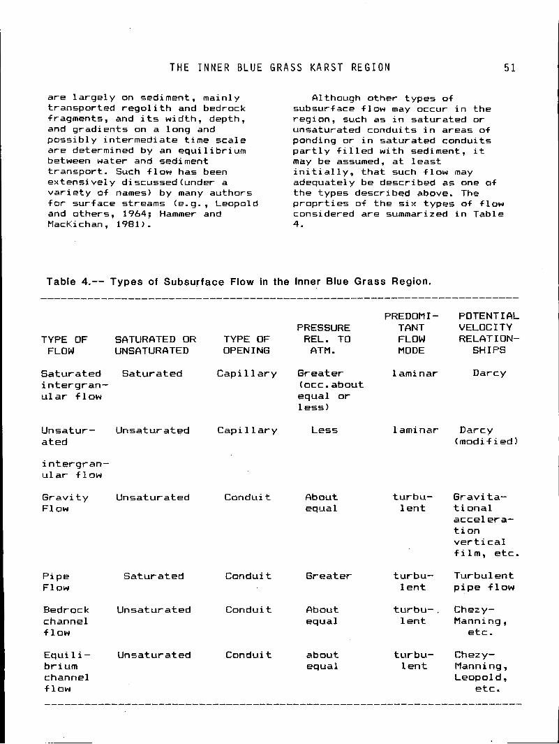
T H E I N N E R B L U E G R A S S K A R S T R E G I O N 5 1
are large1 y on sediment, main1 y transported r e g o l i t h and bedrock fragments, and i t s width, depth, and gradients on a long and poss ib ly intermediate t ime scale are determined by an equ i l i b r ium between water and sediment t ransport . Such f low has been ex tens i vel y discussed (under a v a r i e t y of names) by many authors f o r surface streams (e.g., Leopold and others, 1964; Hammer and MacKichan, 1981 ) .
filthough other types of subsurface f low may occur i n the region. such as i n saturated or unsaturated conduits i n areas of ponding or i n saturated conduits p a r t l y f i i l e d w i th sediment, i t may be assumed, a t l eas t i n i t i a l l y , t h a t such f l ow may adequate1 y be described as one of the types described above. The p rop r t i es of the s i x types of f low considered are summarized i n Table 4.
Table 4.-- Types of Subsurface Flow in the Inner Blue Grass Region.
PREDOMI- POTENTIAL PRESSURE TANT VELOCITY
TYPE OF SATURATED OR TYPE OF REL. TO FLOW RELATION- FLOW UNSATURATED OPEN I NG CITM. MODE SHIPS
Saturated Saturated C a p i l l a r y Greater 1 ami nar Darcy in te rg ran- (occ. about u l a r f l ow equal or
1 ess)
Unsatur- Unsaturated Capi 11 ary Less 1 aminar Darcy ated (modif ied)
i n te rg ran- u l a r +low
G r a v i t y Unsaturated Conduit About turbu- Gravi ta- F l o w equal l e n t t i onal
acce l era- t i o n v e r t i c a l f i l m , etc.
Pipe Saturated Conduit Greater turbu- Turbulent Flow l e n t p i pe f l ow
Bedrock Unsaturated Conduit about turbu- , Chezy- channel equal 1 ent Manni ng , f l ow etc.
Equi 1 i - Unsaturated Conduit about turbu- Chezy- br ium equal l e n t Manni ng , channel Leopol d , f l ow e tc .
T H E N O N - M E T E O R I C S Y S T E M
The Non-Meteoric System Conduit Initiation
Before proceeding f u r t h e r w i t h a d iscuss ion o f t h e n a t u r e and development o f t h e subsurf ace meteor ic water f low system, some ment ion o f what w i l l be termed t h e non-meteoric system i s i n order. As discussed e a r l i e r i n t h e s e c t i o n on water supply, many w e l l s d r i l l e d i n t h e r e g i o n encounter water o f u n s a t i s f a c t o r y q u a l i t y , i n some cases a t depths o f l e s s than 25 m. Th i s water i s v a r i o u s l y r h a r a c t e r i zed as con ta in ing s u l f u r , s a l t , i r o n , e tc . , and may be present i n apprec iab le q u a n t i t i e s i n some we l l s .
Although l i t t l e i s known o f t h i s subsurface water, severa l observa t ions can be made. F i r s t , a t l e a s t some o f t h e water i s i n condu i t s (and presumably by p i p e f l o w a t these depths) , inasmuch as t h e i n t e r g r a n u l a r h y d r a u l i c c o n d u c t i v i t y i s t o o low t o t r a n s m i t t h e amounts o f water t h a t have been encountered. Second, t h e chemist ry o f t h e water i n d i c a t e s t h a t i t i s i s o l a t e d from t h e meteor ic water system. Th i rd , t h e absence o f such water i n many deep d r y ho les and underground quar r i es suggest t h t t h i s system does no t complete ly permeate t h e bedrock. Four th, t h e apparent d i f f e r e n c e i n chemist ry o f t h i s water suggest t h a t i t may be i n smal l , r e l a t i v e l y i s o l ated bodies, and t h a t a cont inuous system does no t e x i s t . F i n a l 1 y, t h e f a c t t h a t some w e l l s t h a t i n i t i a l l y y i e l d water o f u n s a t i s f a c t o r y qua1 i t y l a t e r produce meteor ic water, suggests t h a t pressure communication between t h e non-meteoric and meteor ic systems may e x i s t , and cont inued pumping of t h e former a l l ows t h e l a t t e r t o invade t h e condu i t s and f l u s h them out . A1 t e r n a t i v e l y, these cases may be exp la ined by t h e w e l l i n i t i a l l y producing from bo th systems which then exhausts t h e non-meteoric system, suppor t ing t h e suggest ion t h a t these a r e a c t u a l l y a s e r i e s o f i s o l a t e d systems.
V i r t u a l l y by d e f i n i t i o n , t h e f l o w i n bedrock t o condu i t development i s by sa tura ted i n t e r q r a n u l a r f low, and such f l o w 1s now o c c u r r i n g i n bedrock where condu i t s a r e n o t present. An examinat ion o f t h e t r a n s i t i o n from i n t e r g r a n u l a r t o condu i t f l o w would t h u s seem t o be an e s s e n t i a l p a r t o f t h e development o f t h e f l o w system, b u t as t h e f o l l o w i n g w i l l show, no very s a t i s f a c t o r y conc lus ion can be reached regard ing t h i s phase o f t h e hydrogeo lg ic h i s t o r y o f t h e reg ion .
The p r i n c i p a l mechanism resoonsi b l e f o r t h e i n i t i a t i o n o f condu i t s i s s o l u t i o n o f t h e minera l c a l c i t e , and p r i n c i p a l c o n s t i t u e n t o f l imestone, and a l though va r ious at tempts have been made t o q u a n t i f y t h e r e l a t i o n s h i p s between s o l u t i o n and f l o w (e.g., White, 1977), much work remains i n t h i s area. It i s ev ident , however, t h a t convers ion o f an i n t e r g r a n u l a r f l o w path t o a condu i t f l o w pa th r e q u i r e s t h e passage o f l a r g e amounts o f water s imply t o remove t h e s o l u t i o n products, rega rd less o f t h e d e t a i l s o f t h e so lu ton k i n e t i c s o r degree o f chemical undersaturaton o f t h e water as i t en te rs t h e f l o w path. Assuming a h i g h and constant carbon d i o x i d e p a r t i a l pressure, no d i sso l ved c a l c i t e i n t h e water as i t e n t e r s t h e f l o w path, and complete s a t u r a t i o n w i t h respect t o c a l c i t e as i t leaves t h e f l o w pa th (a1 1 unrea l i 5 t i c a l l y generous s p e c i f i c a t i o n s ) , a volume o f water a t 1 east 1,000 t imes t h e volume o f t h e i n i t i a l condu i t (neg lec t i ng t h e volume o f t h e i n t e r g r a n u l a r f 1 ow path ' i s needed dcrri ng t h e p e r i o d o f i n t e r g r a n u l a r f low.
Assumi ng a p o t e n t i a l g rad ien t o f 0.01 (based on t h e r e g i o n ' s topography) , a f l o w pa th l e n g t h o f C km, and a minimum t ime f o r water t o t r a v e r s e t h e f l o w pa th o f 10 years ! thus p r o v i d i n g t h e above volume i n 10,000 years) , an a p p l i c a t i o n o f Darcy 's Law y i e l d s a minimum h y d r a u l i c c o n d u c t i v i t y
T H E I N N E R B L U E G R A S S K A R S T R E G I O N
a long t h e f l o w l i n e o f a l i t t l e more than 10-s m/s.
I n t e r g r a n u l a r hydrau l i c c o n d u c t i v i t i e s o f t h e l imestones and t h i n sha les o f t h e Lexington Limestones a r e 1 ow. MacQuown (1967, p. 68), presents a de terminat ion equ iva len t t o about lo-' m/s f o r a specimen o f t h e C u r d s v i l l e Member, which i s l i t h o l o g i c a l l y s i m i l a r t o t h e Tanglewood Limestone Member. Freeze and Cherry (1979, p. 29) i n d i c a t e t h a t a h y d r a u l i c c o n d u c t i v i t y o f la-' m/s i s about t h e lower l i m i t f o r l imestone, and hence t h i s probably represents i n t e r g r a n u l a r , as opposed t o f r a c t u r e , h y d r a u l i c conduct i v i t y .
The ac tua l f l o w v e l o c i t y along a f l ow path w i l l be i n v e r s e l y r e l a t e d t o t h e b u l k v e l o c i t y (suggested by t h e h y d r a u l i c c o n d u c t i v i t y ) by t h e v o i d r a t i o , assuming t h e f l o w pa th i s s t r a i g h t . A v o i d r a t i o o f la-=, and a degree o f tor tuousness o f t h e f l o w pa th such t h a t i t i s 10 t imes t h e s t r a i g h t 1 i n e d is tance, y i e l d s a f l o w v e l o c i t y o f lW7 m/s, two o rde rs o f magnitude t o o low f o r condu i t i n i t i a t i o n under t h e c o n d i t i o n s assumed.
Because t h e Lexington Limestone i s thin-bedded and t h e i n d i v i d u a l beds a re j o in ted , pre-condui t f l o w a1 ong bedding and j o i n t s u r f ace, which w i 11 c o l l e c t i v e 1 y be c a l l e d "+rac tures , " would seem l i k e l y . Such f l ow i n a system o f narrow f r a c t u r e s (assuming c e r t a i n c o n d i t i o n s o f t h e i r i n te rconnec t ion and spacing are met) w i l l obey Darcy 's Law and i s here considered sa tu ra ted i n t e r g r a n u l a r f low, even though t h e f l ow paths a re n o t between gra ins.
MacBuown (1967, p. 47) found t h e average spacing o f bedding sur faces t o be 0.05 m and t h e average j o i n t spacing t o be 0.24 rn i n t h e C u r d s v i l l e Member, which y i e l d s a value o f 24.2 fractures/mz. Assuming a w id th of 0.1 mm ( lob4 m ) +o r
a f r a c t u r e t h a t has n o t been s o l u t i o n a l l y widened, a h y d r a u l i c c o n d u c t i v i t y o f about 10-l1 m / s i s obta ined us ing methods descr ibed i n Freeze and Cherry (1979, p. 74), and t h e v o i d r a t i o (assuming a l l f r a c t u r e s a r e p a r a l l e l t o f l o w ) i s about 2.5 x lW3 . Even i f no path lengthening due t o t o r t u o u s i t y i s considered, a f l o w v e l o c i t y w i t h i n a f r a c t u r e o f 4 x lV9 r e s u l t s , one and a h a l f o rders o f magnitude l e s s than t h a t o f an in te rg ranuar path.
Although t h i s admi t ted ly crude a n a l y s i s suggests t h e i n t e r g r a n u l a r f l ow paths should be favored over f r a c t u r e f l o w paths du r ing t h e pre-conduit f l o w stage, t h e reverse i s probably t r u e , s ince smal l condu i ts observed i n outcrop a re usua l l y , b u t n o t i n v a r i a b l y , l o c a l i z e d a long a j o i n t o r bedding surface. Thus, t h e r e may be e r r o r s and incons is tenc ies i n t h e assumptions, most no tab ly i n t h e s p e c i f i c a t i o n o f f r a c t u r e width. Since h y d r a u l i c c o n d u c t i v i t y along a f r a c t u r e i s d i r e c t l y r e l a t e d t o t h e t h i r d power o f t h e f r a c t u r e w id th !Freeze and Cherry, 1979, p. 741, i f t h e w id th i s 1 mm ( lo -=) r a t h e r than 0.1 mm. t h e h y d r a u l i c c o n d u c t i v i t y i s increased by 3 orders o f magnitude, f a v o r i n g f r a c t u r e paths over i n t e r g r a n u l a r paths. Such a w id th f o r non-solut ional 1 y widened f r a c t u r e s a t depth seems t o o g rea t (0.1 mm is probably t o o generous), b u t i t i s l i k e l y t h a t some s o l u t i o n a l widening (and even condu i t development) has occurred i n a t l e a s t some f r a c t u r e s p r i o r t o t h e i n i t i a l e n t r y o f meteoric water. Openings l a r g e enough t o t ransmi t t h e non-meteoric system discussed e a r l i e r a re c e r t a i n 1 y present i n some p laces i n t h e rock.
The apparent near-comparable e f f i c i e n c y o f i n t e r g r a n u l a r paths suggests t h a t pre-conduit f l o w along such paths cannot be ignored, however. I f a steep p o t e n t i a1 g rad ien t were present a t
STAGES OF C O N D U I T GROWTH
an angle t o bedding where no f a m i l i a r second type (branching j o i n t s were present, enlargement upf low). bf in tergranblar paths para1 l e l t o the gradient would be expected. Such paths would probably even cross shale interbeds up t o several m i 11 imeters t h i c k (which probably inc ludes most such interbeds i n the Lexington Limestone) , inasmuch as the shales general ly contain more than 50 percent c a l c i t e (and dolomite) and less than 25 percent c l ay minerals (Fisher, 1968, p. 780) , and hence even t h e i r v e r t i c a l hydrau l ic conduc t i v i t y may be comparable t o the hydrau l ic conduc t i v i t y of the limestones. Conduit development i n such shales would be i n h i b i t e d by t he accumulation of inso lub le residue, however.
Ewers and Quinlan (1981) have presented the most persuasive explanat ion f o r the i n i t i a l development of conduits from saturated in te rg ranu l ar f low a1 ong a f rac ture . Ewer's (1981) experiments ( u t i l i z i n g s a l t and p l a s t e r ) i nd i ca te conduit development begins a t the input po in t and extends down the f low as a complexly branching dend r i t i c pa t t e rn o f small conduits. Because p o t e n t i a l l oss i n the conduits, i s much l e s s than i n the in te rg ranu la r f l ow region, the steepest po ten t i a l gradient i s between the o u t l e t and the end of the condui t nearest the o u t l e t r e s u l t i n g i n increased f low and accelerated conduit growth a1 ong t h i s l i n e . Once the f i r s t conduit reaches the ou t l e t , po ten t i a l f a l l s i n a l l the conduits and f low w i t h i n the growth of the other condui ts i n the dend r i t i c pa t te rn v i r t u a l 1 y ceases. I f dend r i t i c pa t te rns o f conduits are growing from other input po in ts , a steep p o t e n t i a l gradient develops i n the in te rg ranu la r f low region between these conduits and those of the pa t t e rn t h a t f i r s t reached the o u t l e t , causing conduits i n the pa t t e rn t h a t f i r s t reached the o u t l e t . Thus, the f i r s t type of d e n d r i t i c pa t te rn (branching downflow) i s converted t o a more
Stages of Conduit Growth Further so lu t iona l (and
abrasion) enlargement of the conduits and i n teg ra t i on of the conduit system has l e d t o the present hydrogeologic System o+ the region. During t h i s enlargement and in tegra t ion , i nd i v i dua l conduits have passed through a number of s i g n i f i c a n t stages. The t r a n s i t i o n t o the f i r s t stage occurs when the cross-sect ional area of a conduit becomes s u f f i c i e n t l y large, and the f low v e l o c i t i e s (due t o i n teg ra t i on of the conduit system) s u f f i c i e n t l y high, f o r the f low t o become p ipe f low, and hence'no longer described by Darcy's Law. P r i o r t o t h i s t r ans i t i on , the f low would be saturated (usual 1 y) in tergranular f low, even though i t was i n the embryo conduits described i n the preceding sect ion. Because both the plan and cross-section of the conduits a r e , probably qu i t e i r r e g u l a r , the t r a n s i t i o n t o the f i r s t stage probably occurs wel l before the f l ow becomes turbu lent .
The t r a n s i t i o n t o the second stage occurs when conduit s i ze throughout i t s length i s great enough f o r sediment (both reg01 i t h ad the inso lub le residue from the so l u t i onal en1 argement of the conduits) t o be transported through t e system. The t h i r d stage i s reached when the s i z e o f the conduit and the f low v e l o c i t i e s are s u f f i c i e n t l y h igh f o r conduits on bedding surf aces above t h i n shales or otherwise r e s i s t a n t beds t o erode through t o the underlying less res i s tan t limestone. The conduit s i ze and f low ve loc i t y necessary i s obviously a func t ion o f the extent, thickness, and degree of resistance of the under 1 y i ng bed.
It seems u n l i k e l y t h a t s i g n i f i c a n t sediment t ranspor t can occur unless the f 1 ow i s turbu lent , and conduits t h a t are able t o erode shales (probably
T H E I N N E R B L U E GRASS K A R S T R E G I O N
mainly by so lu t ion, inasmuch as the "shales" are dominantly carbonates, as discussed e a r l i e r ) must be able t o t ranspor t the inso lub le residue out o f t he conduit. Thus, the three stages would seem t o be sequential . There i s another t r a n s i t i o n t h a t occurs a t some po in t dur ing the enlargement of a condui t and i n teg ra t i on of t he system whose pos i t i on i n the sequence may vary, a1 though i t probably occurs most o+ten dur ing the second stage. Th is t r a n s i t i o n occurs when the s i z e of the condui ts and i n teg ra t i on of the system reaches the po in t where t he amount of water being suppl ied t o t he conduit i s i n s u f f i c i e n t t o f i l l i t , a t l e a s t dur ing t imes of low recharge, and the f l ow becomes unsaturated, e i t h e r bedrock channel f low, i f t he gradient i s low, g rav i t y f low, i f t h e gradient i s h igh (most common i n a t h i r d stage condui t ) , or equi 1 i b r i um channel f 1 ow i n l a rge r and deeper conduits.
Where t he conduit serves as a s inkhole drain, t h i s c l a s s i f i c a t i o n corresponds t o the c l a s s i f i c a t i o n o f s inkhole types ou t l i ned e a r l i e r , i n t h a t i n c i p i e n t and type one sinkholes are drained by f i r s t stage conduits, type two s inkholes by second stage conduits, and type th ree sinkholes by t h i r d stage conduits.
As s ta ted e a r l i e r , geochemical s tud ies of t he a b i l i t y o f recharging meteoric water t o accomplish the condui t enlargement have no t yet been completed i n the region. A considerable body of l i t e r a t u r e e x i s t s on t h i s question based on s tud ies i n other areas, however (e.g., T h r a i l k i l l and Robl, 1981), and i t i s bel ieved t h a t t h i s model of condui t i n i t i a t i o n and development i s consistent w i t h the geochemistry.
Groundwater Basins, lnterbasin Areas, and the Aquifer
Groundwater basins have been i d e n t i f i e d as areas w i t h i n which
dye t r a c i n g has ind ica ted t ha t the subsurface conduit system appears t o be deep, extensive, and wel l in tegrated, whi le there i s no evidence t h a t the subsurface conduit system i n i n te rbas in areas has any o f these charac te r i s t i cs . I n groundwater basins, a t l e a s t t he major f 1 ow of meteoric water i n f i l t r a t i n g the surface descends steeply through stage three conduits from stream swa l le ts or as type three s inkhole drains.
I n two of the qroundwater basins i d e n t i f i e d (Shawnee Hef er and Spring Lake Spring basins) , the major basin condui ts are bel ieved t o be perched on a r e s i s t a n t bed, and thus have not reached the t h i r d stage of development r e l a t i v e t o t h i s bed (although t h i r d stage conduits are probably developed through th inner r e s i s t a n t beds above i t ) .
I n the remaining 36 groundwater basins, f l ow w i t h i n them appears t o be i n large, near ly hor izonta l conduits, whose e leva t ion i s unre la ted t o l i t h o l o g y . Where major condui ts can be entered and examined, they cons is t o f open passages traversed by a stream f 1 owing over sediment , wi th a c c e s s i b i l i t y terminat ing both upstream and downstream when the conduit becomes complete1 y f i l l e d w i t h water. The near ly hor izonta l gradient o f these major conduits i s bel ieved t o be con t ro l led by the equ i l i b r ium f low occurr ing i n t he unsaturated por t ions of t he major conduits.
PIS discussed e a r l i e r , the width of t he zone of near hor i zon ta l f l ow a t depth i n underground basins i s uncertain. Although potent iometr ic surface e levat ions i n the middle Slacks Spring Basin suggest t h a t i t may be extensive, other evidence would seem t o i nd i ca te t h a t conduit development between major f low l i n e s w i t h i n the basin i s minor o r absent, and t h a t t he basin f low i s l a rge l y through a s i ng le conduit or, i n a few cases, condui ts p a r a l l e l t o and very near the major conduit. Such ev i dence i n c l udes we1 1 data
GROUNDWATER B A S I N S , I N T E R B A S I N A R E A S , AND T H E A Q U I F E R
+,om t h e lower Slacks Spr ing Basin and o t h e r bas ins i n t h e Georgetown Quadrangle, t h e f a c t t h a t most o f t h e s p r i n g s e i t h e r have a s i n g l e o u t l e t o r m u l t i p l e o u t l e t s very c l o s e t o each o the r , and t h e f a c t t h a t impoundment o f sp r ings has n o t l e d t o t h e i r abandonment and a major d i v e r s i o n o f f l o w as t h e p o t e n t i a l i s increased.
Subsurface f l o w w i t h i n t h e groundwatr bas ins (neg lec t i ng t h e sa tu ra ted and unsat ra ted i n t e r g r a n u l a r f l o w i n t h e r e g o l i t h and sa tu ra ted i n t e r g r a n u l a r f l o w i n t h e bedrock o u t s i d e o f condu i t s ) i s t hus d i f f e r e n t i n d i f f e r e n t p a r t s o f t h e basin. Water e n t e r i n g t h e bas in from stream s w a l l e t s and t ype t h r e e s i n k h o l e d ra ins , i n i t i a l l y descends s t e e p l y by g r a v i t y f l ow and s h o r t reaches of bedrock channel f l o w t o t h e f l o o r o f t h e basin. It then i s t ranspor ted t o t h e d ischarg ing s p r i n g main ly by e q u i l i b r i u m channel f l o w and p i p e f l ow , a l though reaches o f low g r a d i e n t bedrock channel f l o w severa l hundred meters long have been observed i n t h e upstream p o r t i o n o f smal l e r condui ts .
Although i t i s r a t h e r easy t o e x p l a i n t h e near h o r i z o n t a l f l ow i n t h e groundwater bas ins as being due t o e q u i l i b r i u m channel f l ow i n a t l e a s t major p o r t i o n s o f t he l a r g e r condu i ts , i t should be noted t h a t o ther , and unknown, f a c t o r s promoting t h i s h o r i z o n t a l f l o w may be operat ing. Fy i t s very n a t u r e e q u i l i b r i u m channel f l ow r e q u i r e s t h a t l a r g e amounts of sediment a r e be ing t ranspor ted i n t h e subsurf ace. Whi le t h i s i s c e r t a i n l y t r u e i n t h e Inner F lue Grass Region, i t may n o t be i n o the r k a r s t areas where near -hor izonta l f l o w a1 so occurs. T h i s equi 1 i br ium f 1 ow exp lanat ion i s no t , t he re fo re , necessa r i l y a general exp lanat ion o f t h e causes o f shal low versus deep p h r e a t i c f l o w t h a t has been ex tens i ve l y debated i n t h e l i t e r a t u r e ( e . g . , Thra i 1 k i 11, 1968).
I n hydrogeologic systems, an a q u i f e r i s considerd t o be a body
o f rock t h a t conta ins water t h a t i s a v a i l a b l e t o w e l l s i n use fu l q u a n t i t i e s and t h a t i s under a pressure grea ter than atmospheric. I n a d d i t i o n , t h e water should be o f usable q u a l i t y . The term has been avoided so f a r i n t h i s r e p o r t because t h e na tu re o f t h e subsurface f l o w system i n t h e r e g i o n i s so d i f f e r e n t f rom t h a t i n g ranu lar m a t e r i a l s t h a t t h e term i s e s s e n t i a l l y meaningless un less c a r e f u l l y character ized. S i m i l a r l y , s i nce t h e term "groundwater" i s bes t reserved f o r water i n t h e aqu i fe r , t h e term "subsurf ace water " has been emp 1 oyed .
I n t h e Inner F l u e Grass Region, t he re fo re , t h e a q u i f e r cons i s t s o n l y o f rock i n which condu i ts a r e developed (s ince i n t e r g r a n u l a r f l o w does n o t s a t i s f y t h e y i e l d c r i t e r i o n ) t h a t c o n t a i n meteor ic water ( t h e non-meteoric system f a i l s t h e q u a l i t y c r i t e r i o n ) a t g rea te r than 1 atmosphere pressure. Because shal low bedrock channel f 1 ow and equi 1 i b r i u m channel f low, as w e l l as g r a v i t y f l ow , a r e a t atmospheric pressure, o n l y rock w i t h condu i t s w i t h p i p e f l o w and t h e deeper water f i l l e d p o r t i o n s o f l a r g e r condu i t s i n which bedrock channel f l o w and e q u i l i b r i u m channel f l o w occurs a r e inc luded.
W i th in groundwater bas ins, t h e po ten t i omet r i c s u r f ace i s represented by t h e water sur face i n t h e l a r g e r condu i ts i n which e q i l i b r i u m channel f l o w i s occur r ing . Adjacent condu i ts are complete ly water f i l l e d i f they a r e below t h i s l e v e l , w i t h t h e water pressure determined by t h e depth below t h e po ten t i omet r i c surface. Flow i n o ther condu i ts t h a t a re p a r t l y above t h i s l e v e l w i l l be main1 y by bedrock channel f l ow , w i t h e q u i l i b r i u m channel f l o w i n those c a r r y i n g l a r g e amounts o f sediment f rom t h e surface. Well data from t h e middle Slacks Spr ing Basin shows t h a t a t l e a s t i n one bas in t h e communication between these va r ious condu i ts i s s u f f i c i e n t t o
T H E I N N E R B L U E G R A S S K A R S T R E G I O N
produce t h e expected near1 y f l a t po ten t iomet r i c su r face over a wide area .
It should be noted t h a t f a i r l y h i g h g rad ien t bedrock channel f l ow occurs i n many p laces and a t many e l e v a t i o n s i n t h e groundwater basins. Since t h e g rad ien t i s h igh, t h e f- low i s r a p i d and shal low. Th is water was excluded from t h e a q u i f e r i n t h e above d e f i n i t i o n because i t i s e s s e n t i a l l y a t atmospheric pressure and, s ince i t i s u n l i k e l y t h a t t h e sur face o f such f l ows i s r e f l e c t e d i n t h e su r face o f nearby unsaturated f l o w s o r t h e pressure i n p i p e f l o w condui ts ; i t i s meaningless as a po ten t iomet r i c s u r f ace.
I n t h e smal le r condu i t s i n t h e i n t e r b a s i n areas, p i p e f l o w and occasional 1 y l a r g e channel f l ows may be encountered near t h e sur face, and a cons is ten t p o t e n t i o m e t r i c su r face may be d e f i n a b l e over a smal l area. Along major streams, 1 arger f 1 ows beneath a more cont inuous p o t e n t i o m e t r i c su r face a t or j u s t above t h e stream l e v e l would be expected. The margins of groundwater bas ins i n t o p o g r a p h i c a l l y h i g h areas are probably so steep t h a t no aqu i fe r e x i s t s .
Thus t h e Inner Blue Grass a q u i f e r i s d iscont inuous on two scales. Since i t e x i s t s on ly where condu i t s a r e developed, i t can be tapped by o n l y a f r a c t i o n o f t h e w e l l s t h a t a r e d r i l l e d . I n a d d i t i o n , s i n c e i t can be def ined o n l y when p i p e f l o w and low g rad ien t channel f l o w a re occu r r i ng , i t may be charac ter ized as being es tens i ve i n groundwater" bas ins and a long major sur+ace streams, d iscont inuous and l o c a l i n t o p o g r a p h i c a l l y h i g h p o r t i o n s o f i n t e r b a s i n areas, and may be absent a t bas in boundaries.
Influence of Human Activities Some mention should be made of
t h e e f f e c t s o f underground f l ow i n t h e r e g i o n as a r e s u l t o f human a c t i v i t i e s . The widespread
p r a c t i c e o f f i l l i n g s inkho les mentioned e a r l i e r has probably decreased subsurf ace f low, s ince p r e c i p i t a t i o n t h a t fo rmer l y entered t h e subsurface r a p i d l y through s w a l l e t s i n deep s inkho les i s n o t r e t a i n e d i n t h e r e g o l i t h (and occasional 1 y i n ponds es tab l i shed i n s inkho les) and evapotranspired. On t h e o ther hand, su r face r u n o f f i n t o small streams and i n t o s w a l l e t s t h a t d i v e r t t h e i r f l o w underground, has been increased by land c l e a r i n g and u rban iza t ion . Although the n e t e f f e c t ( t o e i t h e r increase or decrease recharge) may have been s u b s t a n t i a l , i t cannot be evaluated w i t h t h e present data. Because o f t h e h i g h hydraul i c c o n d u c t i v i t y and low s p e c i f i c s to rage o f t h e a q u i f e r , however, such changes i n recharge r a t e have a smal l e f f e c t r e l a t i v e t o what would be expected i n a granular aqui f e r .
Human a c t i v i t i e s have a l s o modi f ied t h e f l o w i n condu i ts by causing subsurface sedimentation. The i mpoundment o f major spr i ngs such as Russel l Cave and Royal Spr ing has apparent1 y produced ex tens ive depos i t i on i n t h e downstream p o r t i o n o f t h e main condui t , and i t i s l i k e l y t h a t t h e s e r i e s o f low dams t h a t have been const ruc ted on Nor th and South E lkhorn creeks has had a s i m i l a r e f f e c t on some o f t h e sp r ings f l o w i n g i n t o these streams. I n a d d i t i o n , t h e r e a re extensive f i l l s o f t ranspor ted r e g o l i t h i n severa l o f t h e access ib le condu i ts i n t h e region. I n some cases these a re i n upper l e v e l condu i ts (main ly s inkho le d ra ins ) i n which t h e water t r a n s p o r t i s by bedrock channel f l o w and g r a v i t y f low. Although some sediment would be expected t o be t ranspor ted through such condu i ts (and e q u i l i b r i u m channel f l o w might develop l o c a l l y ) , t h e observed f i l l i s f a r i n excess o f t h e amount expected and does n o t appear t o be t ranspor ted by even t h e h ighest recharge events. S i m i l a r l y , the access ib le p o r t i o n s o f t h e major
R E F E R E N C E S C I T E D
conduit i n the Slacks Spring Basin (whose spr ing i s no t impounded) conta in l a rge amounts of t ransported r e g o l i t h on e i t he r s ide of t h e a c t i v e equi 1 i brium channel f low, and dates scratched i n t o t he f i l l i nd ica ted t h a t much o f i t i s no t inundated, o r t ransported dur ing h igh f lows i n t h e conduit . It i s bel ieved, therefore, t h a t much of t h i s excess sediment may have been introduced i n t o the subsurface as a r e s u l t of i n i t i a l land c lear ing operat ions, probably i n t he ear l y p a r t of t he 19th century.
F i n a l l y , i t may be noted t ha t underground basins e x i s t w i t h i n p a r t s of t he c i t y of Lexington, as evidenced by t h e presence of major springs, deep sinkholes, ka rs t windows, and b l i n d val leys. No dye t r a c i n g has yet been attempted w i t h i n t h i s heav i l y urbanized area, however, due t o the d i f f i c u l t y of c l e a r l y d i s t i ngu i sh ing na tu ra l , subsurf ace f l ow from t h a t i n storm drains.
REFERENCES CITED
Allingham, J. W., 1972, Geologic map o f t he Harrodsburg Buadran- g le, Mercer and Woodford coun- t i e s , Kentucky: U. S. Geological Survey Geologic Quadrangle Map GQ- 1020.
Black, D. F. B., 1964, Geology of t h e Versa i l l es Buadrangle, Ken- tucky: U. S. Geological Survey Geol ogi c Quadrangl e Map 68-325.
Black, D. F. B., 1967, Geologic map of t he Coletown Quadrangle, east-centra l Kentucky: U. S. Geological Survey Geologic Quad- rang le Map GQ-644.
Black, D. F. P., Johnson, R. W., J r . , and Kel l e r , G. R. , 1977, Fau l t systems of t he 38th Par- a l l e l l ineament i n cen t ra l Ken- tucky and t h e i r r e l a t i o n s h i p t o other t ec ton i c fea tu res i n the area (fibs. ) : Geological Society of America, f ibs t rac ts w i t h Pro- grams, v. 9, no. 5, p. 576.
Byrd, F. E. , 1981, The e f f e c t s of two water t r ac i ng agents on passive cot ton dye detectors: Lexington, Un i ve rs i t y of Ken- tucky, M.S. Thesis, 51 p.
Byrd, P. E. , and Thrai 1 k i 11, John, 1983, Response of f a b r i c detec- t o r s t o o p t i c a l br ightener i n determining underground f 1 ow connections (Abs. ) : Geological Society o f America, Abstracts w i t h Programs, v. 15, p. 96.
Cressman, E. R. , 198 1, Geol ogy of t he Tyrone Buadrangle, Kentucky: U. S. Geological Survey Geologic Quadrangle Map Gl2-303.
Cressman, E. R., 1967, Geologic map of t he Georgetown Quadran- g le , Scot t and Fayet te counties, Kentucky: U. S. Geological Sur- vey Geologic Buadrangle Map GB-605.
Cressman, E. R, 1972, Geologic map of t h e Danv i l l e Buadrangle, Mercer and Boyle counties, Ken- tucky: U. S. Geological Survey Geol og i c Buadr ang 1 e Map GQ-985.
Cressman, E. R., 1973, L i thos t ra - t ig raphy and deposi t ional envi r- onments o f t he Lexington Lime- stone (Ordovician) o f cen t ra l Kentucky. U. S. Geological Survey Frof essi onal Paper 768, 61 p.
Cressman, E. H., and Harber. S. V., 1970, Geologic map o f the Wilmore Quadrangle, cen t ra l Ken- tucky: U. S. Geological Survey Geol ogi c Quadrangl e Map 68-847.
Ewers, R. O., 1981, The develop- ment of l imestone cave systems i n the dimensions of length and breadth: McMaster Univ., Ph.D. D isser ta t ion.
Ewers, E. O., and Quinlan, J. F., 1981, Cavern po ros i t y develop- ment i n limestones: a low d ip model from Mammoth Cave, Ken- tucky: Eighth I n te rna t i ona l Con- gress o f Speleology Proceedings, p. 727-731.
T H E I N N E R B L U E G R A S S K A R S T R E G I O N 5 9
Faust, R. J., 1977, Groundwater resources in the Lexington, Kentucky, area: U. S. Geological Survey-Water Resources Investi- gations 76-113, 24 p.
Fisher, I. S. , 1968, Interrelation of mineralogy and texture within an Ordovician Lexington Lime- stone section in central Ken- tucky: Journal o+ Sedimentary Petrol ogy , v. 38, p . 775-784.
Freeze, R. A., and Cherry, J. A.. 1979, Groundwater: Engl ewood Cliffs, New Jersey, Prentice- Hal 1 , 604p.
Hal 1, F. R. , and Palmquist, W. N. , Jr., 1960a, kvailability of groundwater in Bath, Fleming, and Montgomery counties, Ken- tucky: U. S. Geological Survey Hydrologic Investigation At1 as HA-18.
Hall, F. R. , and Palmquist, W. N. , 1960b, Availability of ground- water in Clark, Estill , Madison, and Powell counties, Kentucky: U. S. Geological Survey Hydro- logic Investigation Atlas HA-19.
Hall, F. R. , and Palm~t~ist, W. N. , 1960c, Avai 1 abi l i ty of ground- water in Carroll, Gallatin, Henry, Owen, and Trimble coun- f
ties, Kentucky: U. S. Geological Survey Hydrologic Investigation Atlas HA-23.
Hal 1, F. R. , and Palmquist, W. N. , 1960d, Avai 1 abi 1 i ty of ground- water in Anderson, Franklin, She1 by, and Woodf ord counties, Kentucky: U. S. Geological Sur- vey, Hydrologic Investigation Atlas HA-24.
Harni 1 ton, D. K. , 1948, Some sol u- tion features of the limestone near Lexington. Kentucky: Eco- nomic Geology, v. 43, p. 39-52.
Hamilton, D. K., 1950, Areas and principles of groundwater occur- rence in the Inner Blue Grass Karst Region, Kentucky: Kentucky
Geological Survey, ser. 9, Eul- letin 5, 66 p.
Hammer, M. J . , and MacKi chan , K. A. , 1981, Hydrolagy and quality of water resources: New York, Wiley, 486 p.
Hendrickson, G. E., and Krieger, R. A . , 1964, Geochemistry of natural waters of the Blue Grass Region, Kentucky: U. S. Geolog- i cal Survey Water-Suppl y Paper 1700, 135 p.
Hine, G. T., 1970, Relation of fracture traces, joints, and groundwater occurrence in the area of the Bryantsville Ruad- rangle, central Kentucky: Ken- tucky Geological Survey, ser. 10, Thesis Series 3, 27 p.
Hopkins H. T., 1966a, Water re- sources of the Fayette County area, Kentucky, in application to land-use planning and engi- neering in Lexington and Fayette counties, Kentucky: U. S. Geo- logical Survey Open-Fi le Report, p. 1-17.
Hopkins, H. T . , 1966b. Fresh- saline water interface map of Kentucky: Kentucky Geological Survey, ser. 10, Scale 1 in. = 8 mi.
Hopper, William, and Thrailkill, John, 1993, The lack of influ- ence of 1 i tho1 ogy and structure on the development of a karst aquifer (Abs): Geological So- ciety of America, Abstracts with Programs, v. 15, p. 252.
Jillson, W. R., 1945, Geology of Roaring Spring: Frankfort, Ken- tucky, Roberts Printing Co., 44 P .
Jillson, 1961, Erosion cycles in central Kentucky: Frankfort, Kentucky, Roberts Printing Co., 12 p.
Johnson, J. T., 1970, Nonparame- tric analysis of variables in- f 1 uencing 1 i mestone groundwater
R E F E R E N C E S C I T E D
occurrence: Lexington, Universi- ty of Kentucky, M. S. Thesis, 41 p.
Johnson, J. T. , and Thrai 1 ki 11 , John, 1973, Variables affecting well success in a Kentucky lime- stone aqui f er: Journal of Hy- - drology, v. 20, p. ~27-333.
Kanizay, S. P., and Cressman, E. R., 1967, Geologic map of the Centervi 1 le Quadrangle, central Kentucky: U. S. Geological Sur- vey Geologic Buadrangl e Map GB- 654.
Leopold, L. B. , Wolman, M. G., and Miller, J. P . , 1964, Fluvial processes in geomorphol agy: San Francisco, Freeman, 522 p.
MacBuown, W . C., Jr., 1967, FacL tors controlling porosity and permeability in the Curdsville Member of the Lexington Lime- stone: University of Kentucky Water Resources Institute, Re- search Report 7, 80 p.
MacQuown, W . C. , and Dobrovolney, E., 1968, Geologic map of the Lexington East Quadrangl e, Fay- ette and Bourbon counties, Ken- tucky. U. S. Geological Survey Geologic Buadrangle Map GB-683.
Matson, G. C . , 1909, Water re- sources o+ the Blue Grass Region, Kentucky: U. S. Geolog- i cal Survey Wat~r-S~~ppl y Faper 233, 223 p.
McCann, M. R., 1978, Hydrogeology of northeast Woodford County, Kentucky: Lexington, University of Kentucky, M.S. Thesis, 103 p.
ton and Fayette County Planning Commission, 24 p.
Palmquist, W . N. , Jr. , and Hall, F. R., 1960a, Availability of groundwater in Bracken, Harri- son, Mason, Nicholas, and Robertson counties, Kentucky: U. S. Geological Survey Hydrol ogi c- Investigation Atlas HA-16.
Palmquist, W. N. , Jr. , and Hall, F. H., 1940b, Availability of groundwater in Eoyle, Gerrard, Lincoln , and Mercer counties, Kentucky: U. S. Geological Sur- vey Hydrol ogic Investigation Atlas HA-20.
Palmquist, W. N., Jr., and Hall, F. R., 1960c, Availability of groundwater in Bourbon, Fayette, Jessamine, and Scott counties, Kentucky: U. S. Geological Sur- vey Hydrologic Investigation At1 as HA-25.
Falmquist, W. N., Jr. , and Hal 1, F. R. , 1961, Reconnaissance of groundwater resources in the Blue Grass Region, Kentucky: U. S. Geological Survey Water- Supply Paper 1533, 39 p.
Fomeroy, J. S., 1968, Geologic map of the Frankfort East Buadran- gle, Franklin and Woodford coun- ties, Kentucky: U. S. Geological Survey Geologic Quadrangle Map GQ-707.
Fomeroy, J. S., 1970, Geologic map of the Midway Quadrangle, cen- tral Kentucky: V. S. Geological Survey Geol ogi c Quadrangl e Map GQ-856.
Miller, R. D., 1957, Geologic map Quinlan, J. F., 1977, New fluores- of the Lex i ngton West Ouadran- cent direct dye suitable for
gle, Fayette and Scott counties, tracing groundwater and detec-
Kentucky: U. S. Geological Sur- tion: Third International Sym-
vey Geol ogi c Quadrang1 e Map GB- posium of Underground Water
600. Tracing, v. 2, p. 257-262.
Mull, D. S., 1958, The hydrology Guinlan, J. F., and Ewers, R. O., of the Lexington and Fayette 1981, Hydrogeology of the Mam- county, C::entucky area: Lexing- moth Cave Region, Kentucky: Geo-
T H E I N N E R B L U E G R A S S K A R S T R E G I O N 6 1 1
l o g i c a l Society of America F i e l d T r i p ~u idebook , p. 457-506.
Quinlan, J. F., and Rowe, D. H.. 1977, Hydrogeology and water q u a l i t y i n the Centra l Kentucky Karst: Phase I: Un ive rs i t y of Kentucky Water Resources I n s t i - t u t e , Research Report 101, 93 p.
Society of Dyers and Colour i s ts , 1971, Colour index, (3rd ed.): 641 1 p.
Spangler, L. E., 1982, Karst hy- drogeology of nor thern Fayette and southern Scot t counties, Kentucky: Lexington, Un ive rs i t y o f Kentucky, M. S. Thesis, 103 p.
Spangler, L. E., Byrd, P. E., and T h r a i l k i l l , John, submitted, Use o f o p t i c a l br ightener and d i r e c t yel low dyes f o r water t r ac i ng i n t he Inner Blue Grass Karst Region, Kentucky, Jones, W. K. , ed. , Symposi um on water t r a c i n g techniques: Nat ional Spel eo log ica l Society.
Spangler , L. E. , and Thrai 1 k i 11, John, 1981, Hydrogeol ogy of nor thern Fayet te County and southern Scot t County, Kentucky, USA: E ighth I n te rna t i ona l Con- gress o f Speleology Proceedings, p. 535-555.
Thrai 1 k i 11 , John, 1968, Chemical and hydro log ic f a c t o r s i n the excavation of 1 imestone caves: Geological Society of America B u l l e t i n , v. 79, p. 19-46.
Thrai 1 k i 11 , John, 1980, Inner Blue Grass Kars t Hegion (abs.): Pro- ceedings of t he Kentucky Water Resources I n s t i t u t e , p . 25.
T h r a i l k i l l , Johnp 1983, The nature of groundwater basins i n the Inner Blue Grass Kars t Region, Kentucky (Abs. ) : Geological Soc- i e t y of America, Abstracts w i th Programs, v. 15, p. 97.
Thrai 1 k i 11, John, 1984, Hydrogeol- ogy and environmental geology of
t he Inner Blue Grass Karst Region, Kentucky: F i e l d Guide f o r the Annual Meeting of the Southeastern and North-Central Sections, Geological Society o f America, 31 p.
Thrai 1 k i l 1 , John, accepted f o r pub l i ca t ion , Flow i n a l imestone aqu i fer as determined from water t r ac i ng and water l e v e l s i n we1 1 s: Journal of Hydrology.
Thrai 1 k i 11, John, Byrd, P. E. , Hopper, Jr. , W. H . , McCann, M. R., Spangler, L. E., Troester, J. W. , Gouzie, D. R. , and Pogue. K. R., 1981, The Inner Biue Grass Karst Region, Kentucky: An overview: E ighth I n te rna t i ona l Congress of Speleology Proceed- ings, p. 336-338.
T h r a i l k i l l , John, and Gouzie, D. R., 1984, Discharge and t r a v e l t ime determinat ions i n t he Royal Spring groundwater basin, Ken- tucky: Un i ve rs i t y of Kentucky Water Resources Research I n s t i - t u te , Research Report 149, 43 p .
T h r a i l k i l l , John, Hopper, W . H., McCann, M. R., and Troester, J., 1980, Problems associated wi th urban izat ion i n t he Inner Flue Grass C::arst Region (Abs. : Asso- c i a t i on of Ameri can Geographers, Annual Meeting Program Ab- s t r ac t s , p. 112.
T h r a i l k i l l , John, and Robl, T. L., 1981. Carbonate geochemistry of vadose water recharging l ime- stone aqu i fers : Journal of Hy- drology, v. 54, p. 195-208.
Thrai 1 k i 1 l , John, Spangler, L. E. , Hopper, W. M., Jr., McCann, M. R., Troester, J. W., and Grui ie, D. R., 1983, Groundwater i n the Inner Blue Grass Kars t Hegion, Kentucky: Un i ve rs i t y o f Kentucky Water Research I n s t i t u t e , Re- search Report 136, 136 p .
Thrai 1 k i 11, John, Eyrd, S. B., Su l l i van , L. E., Spangler, L. E. , Taylor, C. J., Nelson, G.
REFERENCES C I T E D
N. , and Prague, K. R. , 1983, geology: I n t e r n a t i o n a l Assacia- S tud ies i n dye- t rac ing tech- t i on o f Hydrogeol og i s t s . n iques and k a r s t hydrogeology: U n i v e r s i t y o f Kentucky Water Re- U. S. Geological Survey, 1983, sources Research I n s t i t u t e , Water resources data f o r Ken- Research Report 140, 97 p. tucky: Water-Data Report KY-
83-1, 519 p.
Van Couvering, J. f l . , 1962, Char- T h r a i l k i l l , John, and Troester , J.
a c t e r i s t i c s of l a r g e spr ings i n W., 1978, Pre l im inary , supple-
Kentucky: Kentucky Geological mental, and f i n a l r e p o r t s on hy-
Survey, ser. 10, In fo rmat ion drogeol ogy o f Georgetown, Ken-
C i r c u l a r 8, 37 p. tucky, i n A r e p o r t t o a s s i s t coa l g a s i f i c a t i o n demonstration I
White, W. P., 1977, Role o f solu- p r o j e c t i o n , Georgetown, Ken-
t i o n k i n e t i c s i n t h e develop- tucky: Lesington, G. Reynolds
ment o f k a r s t aqu i fe rs , i n Watkins, p. El-E14.
Tolson, J. S., and Doyle, F. L.,
T h r a i l k i l l , John, Troester , J. W., Spangler, L. S., and Cord iv io la , S. J. , accepted f o r p u b l i c a t i o n , Nature o f a groundwater bas in d i v i d e near Georgetown, Inner B lue Grass Kars t Region, Ken- tucky, USA, LaMoreaux, P. and Burger, A . , eds., Ka rs t Hydro-
eds. , Ears t hydrogeology: Twel f th Congress of t h e I n t e r - n a t i o n a l Associat ion o f Hydro- g e o l o g i s t s Memoirs, p. 503-517.
Whitesides, D. V., 1971, Y ie lds and s p e c i f i c c a p a c i t i e s o f bed- rock w e l l s i n Eentucky: Kentucky Geological Survey, ser. 10, In - fo rmat ion C i r c u l a r 21, 18 p.
Chapter 4 PATTERNS OF CAVERN DEVELOPMENT
ALONG THE CUMBERLAND ESCARPMENT IN
SOUTHEASTERN KENTUCKY Ralph 0. Ewers
Department of Geology Eastern Kentucky University
Richmond, Kentucky
The Cave Creek area contains s i x known u n i t s o f subsurface con- d u i t s t o t a l i n g 17 km i n length. These u n i t s form p a r t of a once f u l l y in tegra ted system of l ime- stone caves. The inpu ts t o t h i s system are confined t o a narrow zone, no more than a few hundred meters across, where stream ero- s ion has breached an impermeable caprock cons is t ing of sandstones and shales. This system of con- d u i t s and inpu ts i s r e l a t i v e l y i s o l a t e d from others and provides one of t he c leares t examples o f t he most common pa t te rn of cavern development i n t he region. L ike- wise, i t provides an almost i dea l l o c a t i o n t o study t he process by which the caves o f the reg ion evol ve.
GEOGRAPHICAL SETTING
Cave Creek, a t r i b u t a r y of the Cumberland River, i s located i n south-central Kentucky, i n Pulaski County. The area i s depic- t ed on t he H a i l 7.5 minute geolog- i c quadrangle map (Smith and others, 1'7731. The area i s p a r t of the l a rge r ka rs t reg ion t h a t extends from j u s t south of the Ohio River, southward along the Appalachian Highlands Escarpment through Tennessee.
GEOLOGICAL SETTING
Lithology The reg ion i s under la in by sed-
imentary rocks, l a r g e l y l ime-
stones, sandstones, and shales o f Upper M i s s i s s i pp i an and Lower Pennsylvanian age. F igure 1 shows a representat ive s t ra t i g raph i c sect ion from the area. The nomen- c l a t u r e used here i s t h a t adopted f o r t he Shopv i l le Quadrangle (Lewis, 1972).
Structure The area l i e s on t he eastern
f lank of t he C inc inna t i Arch, a broad, low, north-south t rending a n t i c l i n a l fea tu re t h a t can be t raced from southern Michigan through C inc inna t i t o northern Alabama. On a reg iona l basis, the rocks may, therefore, be described as d ipp ing gen t l y toward the east- southeast a t 3.5 t o ? m per km. Local 1 y , however, a considerable amount of sub t le s t ruc tu re can be discerned. I n the reg ion o f spec- i f i c i n t e r e s t , a sma.11 a n t i c l i - n i c a l feature extends over the po i n t o f conf 1 uence between the Cumberland River and Cave Creek (Fig. 2 ) .
Geomorphology The reg ion l i e s a t the edge of
t he mature1 y d'i ssected western margin o f t he Cumberland Plateau. The p la teau i s capped w i t h basal Pennsylvanian c l a s t i c s of a high1 y va r i ab le nature. They range from cross-bedded conglomerates, l o c a l 1 y r e f erred t o as t he Rockcastle Member by Hatch (1964), t o s i l tsones, shales, and coals. The h i l l t o p s i n t he plateau region have an e leva t ion of 375 m: maximum r e l i e f here i s 155 m.
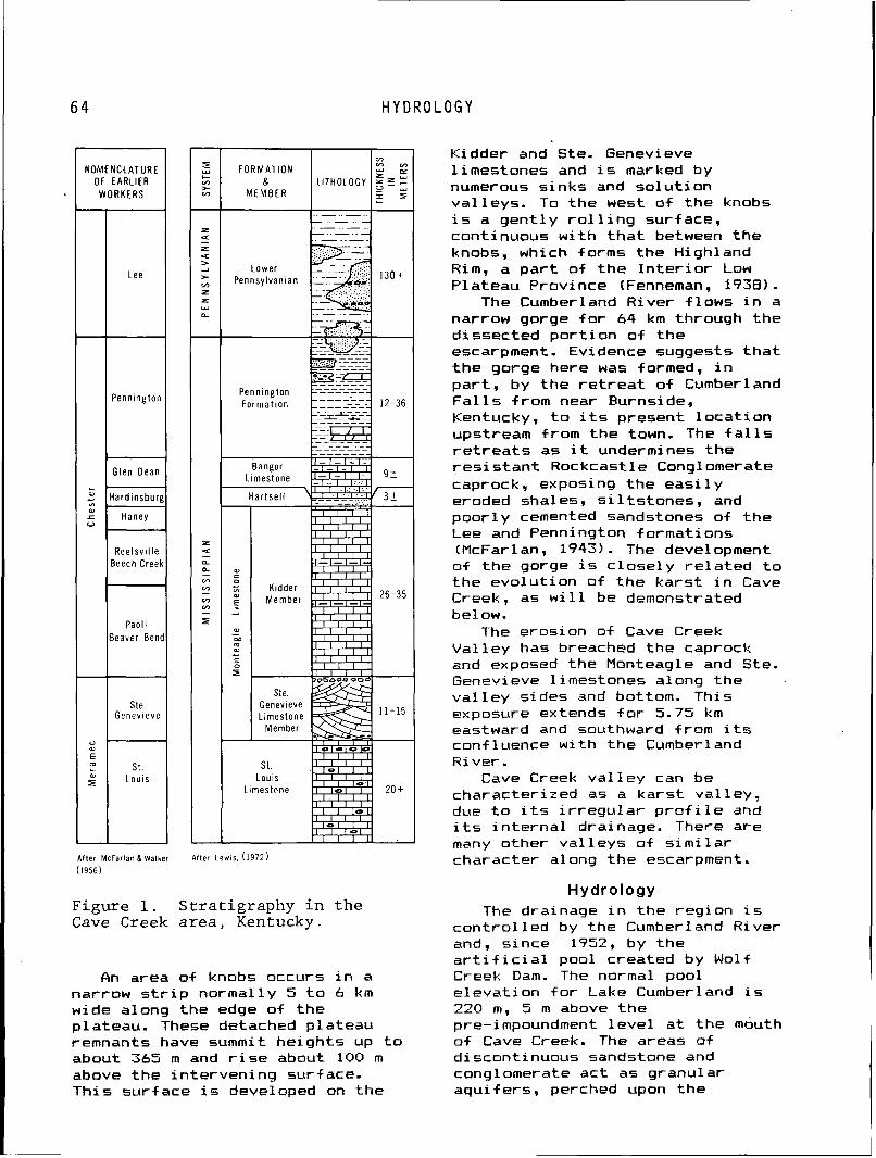
H Y D R O L O G Y
N O M E N C L A T U R E OF EARLIER
L
2 L o ,
0
0 a
E m L
A f t e r Mcfarlan & Walker A f t e r L e w i s . (1972)
(1956)
2 C V) > V)
Z
5
W O R K E R S
L e e
P e n n i n g t o n
G l e n D e a n
H a r d i n s b u r g
H a n e y
R e e l s v i l l e B e e c h Creek
P a o l i B e a v e r B e n d
Ste. G e n e v ~ e v e
'
S t . L o u i s
Figure 1. S t r a t i g r a p h y i n t h e Cave Creek a r e a , Kentucky.
An area o f knobs occurs i n a narrow s t r i p normally 5 t o 6 km wide along the edge of the plateau. These detached plateau remnants have summit he ights up t o about 365 m and r i s e about 100 m above the in terven ing surface. Th is surface i s developed on the
Z u
> V)
Z Z Y
L
F O R M A T I O N &
M E M B E R
Kidder and Ste. Genevieve l imestones and i s marked by numerous s inks and so lu t i on va l leys. To the west of the knobs i s a gen t l y r o l l i n g surface, continuous w i t h t h a t between the knobs, which forms the Highland R i m , a p a r t o f t h e I n t e r i o r Low Plateau Province (Fenneman, 1938).
The Cumber 1 and River f 1 ows i n a narrow gorge f o r 64 km through the dissected po r t i on o f the escarpment. Evidence suggests t h a t t h e gorge here was formed, i n par t , by the r e t r e a t of Cumberland F a l l s from near Burnside, Kentucky, t o i t s present l oca t i on upstream from the town. The f a l l s r e t r e a t s as i t undermines the r e s i s t a n t Rockcastle Conglomerate caprock, exposing the e a s i l y eroded shales, s i l t s t ones , and poor ly cemented sandstones of the Lee and Pennington formations (McFarl an, 1943). The development o f t he gorge i s c l ose l y r e l a t e d t o the evo lu t ion of the ka rs t i n Cave Creek, as w i l l be demonstrated be1 ow.
The erosion of Cave Creek Val ley has breached the caprack and exposed the Monteagle and Ste. Genevieve 1 itnestones a1 ong the v a l l e y sides and bottom. This exposure extends f o r 5.75 k m eastward and southward from i t s conf 1 uence wi th the Cumber I and River .
Cave Creek va l l ey can be characterized as a kars t va l ley , due t o i t s i r r e g u l a r p ro f i 1 e and i t s i n t e r n a l drainage. There are many other val 1 eys of s imi 1 ar character along the escarpment.
Hydrology The drainage i n the region i s
con t ro l l e d by the Cumberland River and, since 1752, by the a r t i f i c i a l pool created by Wolf Creek Dam. The normal pool e levat ion f o r Lake Cumberland i s 220 m, 5 m above the pre-impoundment l e v e l a t t he mouth o f Cave Creek. The areas of discontinuous sandstone and congl omerate act as granul ar aqui fers, perched upon the
LITHOLOGY
. . - . . - . - . . - . . -
. - . . - . . - . . - . . - . . - . - - .
V) V) V)
Y " 5 5
r I C
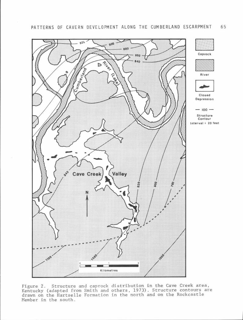
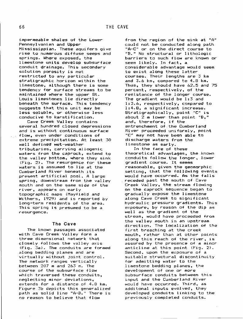
THE
impermeable shales o f the Lower Pennsylvanian and Upper M i s s i s s i ppi an. These aqui f e r s g ive r i s e t o numerous d i f f u s e seeps and springs. Where exposed, t he l imestone u n i t s develop subsurface condui t drainage. This secondary so lu t i on poros i t y i s not r e s t r i c t e d t o any p a r t i c u l a r s t ra t i g raph i c hor izon w i t h i n the limestone, although there i s some tendency f o r surface streams t o be maintained where t he upper St. Louis 1 imestones 1 i e d i r e c t 1 y beneath the surface. This tendency suggests t h a t t h i s u n i t may be l e s s soluble, o r otherwise l ess conducive t o k a r s t i f i c a t i o n .
Cave Creek Val l e y contains several hundred closed depressions and i s without continuous surface f low, even under condi t ions of extreme p rec ip i t a t i on . fit leas t 30 we l l def ined wet-weather t r i b u t a r i e s , ca r ry ing a l logenic waters from the caprock, extend t o t he va l l ey bottom, where they s ink (Fig. 2). The resurgence f o r these waters i s assumed t o l i e a t the Cumberland River beneath i t s present a r t i f i c i a1 pool. A l a rge spring, downstream from the va l l ey mouth and on the same s ide of the r i v e r , appears on ea r l y topographic maps (Mayfield and Withers, 1929) and i s reported by long-term res idents of the area. This spr ing i s presumed t o be a r.esurgence.
The Cave The known passages associated
w i t h Cave Creek Val ley form a th ree dimensional network t ha t c lose ly f 01 lows the va l ley ax i s (Fig. 3a). The conduits are formed along bedding planes and are v i r t u a l 1 y without j o i n t contro l . The network ranges v e r t i c a l l y between 207 m and 263 m. The course of the subsurface f low whi ch traversed these c-ondui t s , neg lect ing minor deviat ions, extends f o r a distance of 4.8 km. Figure 3b depic ts t h i s generalized path as s o l i d l i n e "A-R." There i s no reason t o be l ieve t ha t f low
C A V E
from the region o f the s ink a t " A " could no t be conducted along path "A-C" o r on the d i r e c t course t o "R. " No s t r u c t u r a l o r 1 i tho log ic b a r r i e r s t o such f l ow are known or seem l i k e l y . I n fac t , a considerable advantage would seem t o e x i s t along these l a t t e r courses. Their lengths are 3 km and 3.6 km, compared t o 4.8 km. Thus, they should have 62.5 and 75 percent, respect ive ly , of the res is tance of t he longer course. The gradient would be 1: 3 and 1:3.6, respect ive ly , compared t o 1 :4.8, a s i g n i f i c a n t increase. S t ra t i g raph i ca l 1 y, po in t "C" i s about 2 m lower than po in t "P," and, therefore, i f the entrenchment of t he Cumberland River proceeded uni formly, po in t "C" may no t have been able t o discharge waters from the 1 imestone as ear ly .
I n the face o f these theo re t i ca l advantages, the known condui ts f o l l ow the longer, lower gradient course. It seems reasonable, given the geomorphic se t t ing , t h a t t he f 01 lowing events would have occurred. As the f a l l s receded past the mouth o f Cave Creek Val ley, the stream f lowing on the caprock sequence began t o gradual ly expose the l imestone along Cave Creek t o s i g n i f i c a n t hydrau l i c pressure gradients. This exposure, by reason of t he d i p as we l l as the grad ient of t he stream, would have proceeded from the v a l l e y mouth i n an upstream d i rec t ion . The l o c a l i z a t i o n of the f i r s t breaching a t the creek mouth, ra ther than a t other po in ts along t h i s reach of the r i v e r , i s assured by the presence of a minor a n t i c l i n e a t t h i s p o i n t (Fig. 2 ) . Second, upon the exposure o f a s u i t a b l e s t r u c t u r a l d i scon t i nu i t y f o r admi t t ing water t o the l imestone bedding planes, the development of one or more subsurf ace condui t s between t h i s inpu t and the Cumberland River would have occurred. Third, as addi tonal inpu ts evolved, they developed condui ts l i n k i n g t o the previous1 y completed conduits.
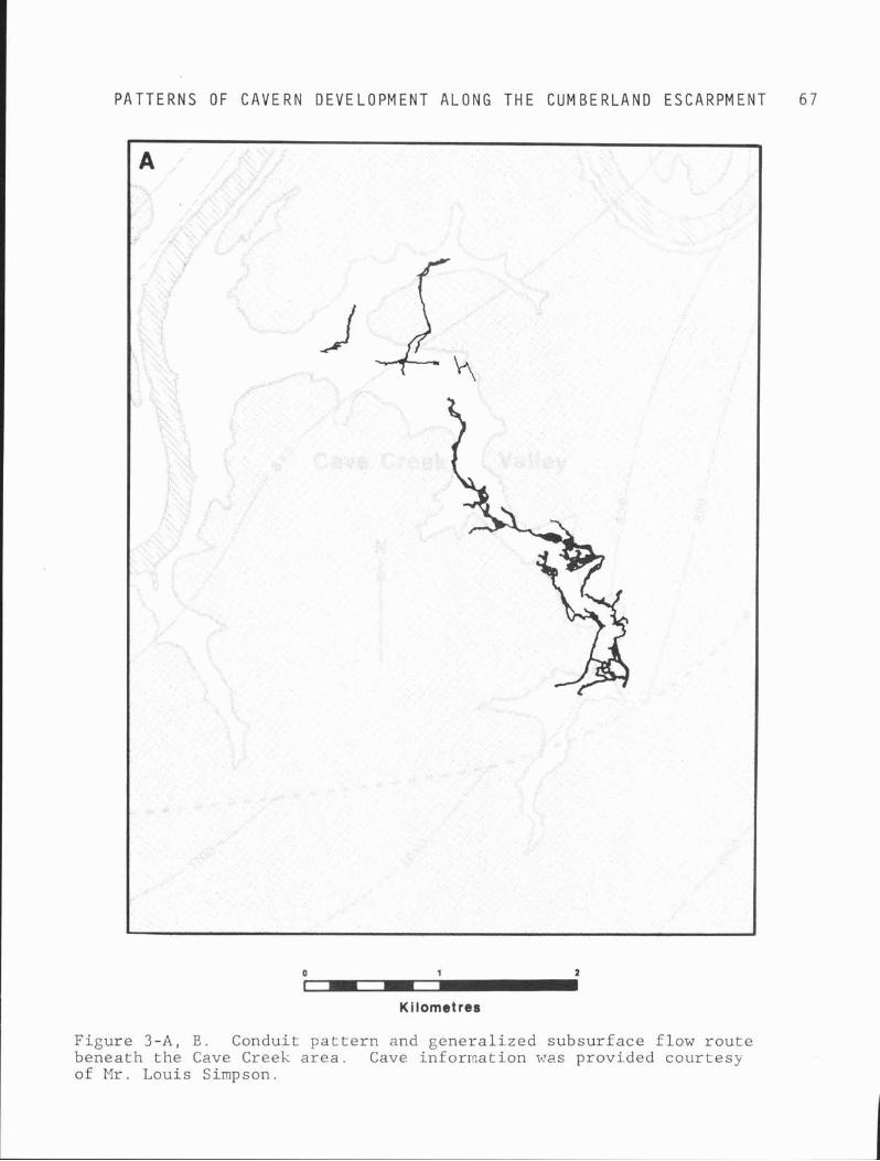
P A T T E R N S OF C A V E R N D E V E L O P M E N T A L O N G T H E C U M B E R L A N D E S C A R P M E N T 6 7
Kilometres
F i g u r e 3 - A , E . Conduit p a t t e r n and g e n e r a l i z e d s u b s u r f a c e f l ow r o u t e benea th t h e Cave Creek a r e a . Cave inforrnat ion was prov ided c o u r t e s y of M r . Louis Simpson.
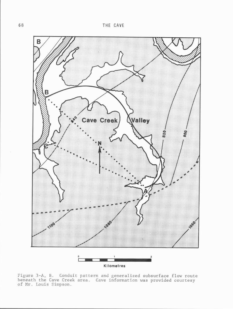
THE C A V E
Kilometres
Figure 3-A, B. Conduit pattern and generalized subsurface flow route beneath the Cave Creek area. Cave information was provided courtesy of Mr. Louis Simpson.
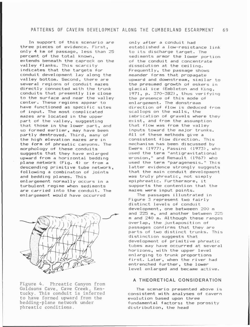
P A T T E R N S O F C A V E R N D E V E L O P M E N T A L O N G T H E C U M B E R L A N D E S C A R P M E N T 6 9
I n support o f t h i s scenario are three pieces of evidence. F i r ~ t , only 4 km of passage, l ess than 25 percent o f the t o t a l known, extends beneath t h e caprock on the va l l ey f lanks. This s c a r c i t y i nd i ca tes t h a t t h e ta rge ts f o r conduit development 1 ay a1 ong the v a l l e y bottom. Second, there are several regions o f conduit mazes d i r e c t l y connected w i t h the t runk condui ts t h a t present ly l i e c lose t o t he surface and near t he va l l ey center. These regions appear t o have funct ioned as s p e c i f i c s i t e s of input . The most complicated mazes are located i n the upper p a r t o f the va l 1 ey, suggesting t h a t those i n t he lower pa r t , and so formed e a r l i e r , may have been p a r t l y destroyed. Third, many of the h igh e leva t ion mazes are i n t he form of phrea t i c canyons. The morph~logy of these condui ts suggests t h a t they have enlarged upward from a hor i zon ta l bedding plane network (Fig. 4) or from a descending p r i m i t i v e tube network, f o l l ow ing a combinaton o f j o i n t s and bedding planes. This enlargement normally occurs i n a tu rbu len t regime when sediments are ca r r i ed i n t o t he conduit. The enlargement would have occurred
on1 y a f t e r a condui t had establ ished a low-resistance 1 i nk t o i t s discharge ta rge t . The sediments armor t h e lower p o r t i o n o f t he conduit and concentrate d i sso lu t i on a t t he c e i l i n g . Frequently, the passage shaws meander forms t h a t propagate upward and downstream, s imi l a r t o the presumed growth o f eskers i n g l a c i a l i c e (Embleton and King, 1971, p. 370-382), thus v e r i f y i n g t he presence of t h i s mode of en1 argement . The donstream d i r e c t i o n of f l ow i s deduced from sca l lops on the wal ls , t he imbr ica t ion of grave ls where they ex i s t , and from the assumption t h a t f low was from t h e v a l l e y inpu ts toward the major trunks. f i l l o f these methods g i ve a consistent f l ow d i rec t i on . This mechanism has been discussed by Ewers (1977) , Passin i ( 1973) , who used the term " a n t i g r a v i t a t i o n a l erosion, " and Renaul t ( 1967) who used the term "paragenesis." This l a t t e r evidence s t rong l y suggests t h a t the main condui t development was t r u l y phreat ic , no t simp1 y epiphreat ic . Furthermore, i t supports the content ion t h a t the mazes were inpu t po in ts .
The passages i l l u s t r a t e d i n F igure 3 represent two f a i r l y d i s t i n c t l e v e l s o f condui t development, one betweeen 200 m and 225 m, and another between 225 m and 240 m. Although these ranges overlap, the j ux tapos i t i on o f passages confirms t h a t they are p a r t s o f two d i s t i n c t trunks. This d i s t i n c t i o n suggests t h a t development of p r i m i t i v e phreat ic tubes may have occurred a t several horizons, w i t h the upper l e v e l en larg ing t o t runk propor t ions f i r s t . Later , when t h e r i v e r had entrenched fu r t he r , t h e lower l e v e l enlarged and became act ive.
A THEORETICAL CONSIDERATION Figure 4 . P h r e a t i c Canyon from Goldsons Cave, Cave Creek, Ken- The scenario presented above i s tucky. This conduit i s i n f e r r e d consistent w i t h anal yses o f cavern t o have formed upward from the evo lu t ion based upon th ree bedding-plane network under fundamental fac tors : t h e poros i t y p h r e a t i c cond i t ions . d i s t r i b u t i o n , the head
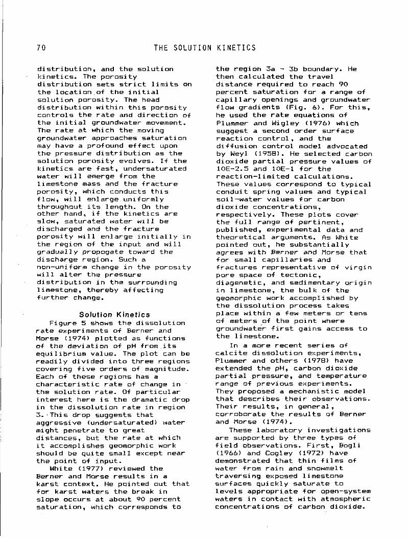
THE SOLUTION KINETICS
d i s t r i b u t i o n , and the so lu t i on k ine t i cs . The po ros i t y d i s t r i b u t i o n sets s t r i c t l i m i t s on the l oca t i on of t he i n i t i a l so lu t i on poros i ty . The head d i s t r i b u t i o n w i t h i n t h i s poros i t y con t ro ls the r a t e and d i r e c t i o n of the i n i t i a l groundwater movement. The r a t e a t which t he moving groundwater approaches saturat ion may have a profound e f f e c t upon the pressure d i s t r i b u t i o n as the so lu t i on po ros i t y evolves. I f the k i n e t i c s are f a s t , undersaturated water w i l l emerge from the l imestone mass and the f r ac tu re poros i t y , which conducts t h i s f low, w i l l enlarge uni formly throughout i t s length. On the other hand, i f the k i n e t i c s are slow, saturated water w i l l be discharged and the f r ac tu re po ros i t y w i l l enlarge i n i t i a l l y i n the region o f the inpu t and w i l l q radual ly propogate toward the discharge region. Such a non-uniform change i n the poros i t y w i l l a l t e r the pressure d i s t r i b u t i o n i n t h e surroundr ng limestone, thereby a f f e c t i n g f u r t h e r change.
1 Solution Kinetics Figure 5 shows the d isso lu t ion
r a t e experiments o f Berner and Morse (1974) p l o t t e d as funct ions of the dev ia t ion o f pH from i t s equ i l i b r ium value. The p l o t can be r e a d i l y d iv ided i n t o three regions covering f i v e orders of magnitude. Each of these regions has a cha rac te r i s t i c r a t e of change i n the so lu t i on ra te . O f p a r t i c u l a r i n t e r e s t here i s t he dramatic drop i n the d i sso lu t i on r a t e i n reg ion 3. . Thi s drop suggests tha t aggressive (undersaturated) water might penetrate t o great distances, but t he r a t e a t which i t accomplishes geomorphic work should be q u i t e small except near the po in t o f input .
White (1977) reviewed the Berner and Morse r e s u l t s i n a ka rs t context. He pointed out t h a t f o r ka rs t waters t he break i n slope occurs a t about 90 percent saturat ion, which corresponds t o
the reg ion 3a - 3b boundary. He then ca lcu la ted t h e t r ave l d istance requ i red t o reach 90 percent sa tu ra t ion f o r a range of c a p i l l a r y openings and groundwater f l ow grad ients (Fig. 6 ) . For t h i s , he used the r a t e equations o f Plummer and Wigley (1976) which suggest a second order su r f ace reac t i on con t ro l , and the d i f f u s i o n con t ro l model advocated by Weyl (1958). He selected carbon d iox ide p a r t i a l pressure values o f 10E-2.5 and 10E-1 f o r t he react ion-1 i m i t ed ca lcu la t ions . These values correspond t o t y p i c a l condui t sp r ing values and t y p i c a l soi l -water values f o r carbon d iox ide concentrat ions, respect ive ly . These p l o t s cover the f u l l range o f per t inen t , pub1 ished, experimental data and theo re t i ca l arguments. As White po in ted out, he s u b s t a n t i a l l y agrees w i t h Perner and Morse t h a t f o r small c a p i l l a r i e s and f rac tu res representat ive o f v i r g i n pore space of tec ton ic , d iagenet ic , and sedimentary o r i g i n i n limestone, t he bu lk of the geomorphic work accomplished by t h e d i s s o l u t i o n process takes place w i t h i n a few meters o r tens o f meters o f the p o i n t where groundwater f i r s t gains access t o t he limestone.
I n a more recent se r ies o f c a l c i t e d i s s o l u t i o n experiments, Plummer and others ( 1978) have extended the pH, carbon d iox ide p a r t i a l pressure, and temperature range of previous experiments. They proposed a mechanistic model t h a t describes t h e i r observations. Their r esu l t s , i n general, corroborate t he r e s u l t s of Berner and Morse ( 1974) .
These labora to ry inves t iga t ions are supported by three types of f i e l d observations. F i r s t , Bog1 i ( 1966) and Cog1 ey ( 1972) have demonstrated t h a t t h i n f i l m s of water from r a i n and snowmelt t r ave rs ing exposed l imestone surfaces qu i ck l y saturate t o l e v e l s appropr iate f o r open-system waters i n contact w i t h atmospheric concent ra t i ons o f carbon d i o x i de.
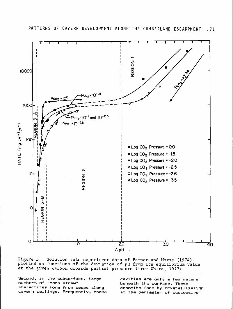
P A T T E R N S OF C A V E R N D E V E L O P M E N T A L O N G T H E C U M B E R L A N D E S C A R P M E N T . 7 1
_-----
I I
I Log C02 Pressure = 0.0 I I Log C02 Pressure = -1.5
I A Log C02 Pressure = -2.0
I 0 Log C02 Pressure = -2.5 I , Log C02 Pressure = -26 I A'Log C02 Pressure = -3.5 I
I
I I I I
I
Figure 5. Solution rate experiment data of Berner and Morse (1974) plotted as functions of the deviation of pH from its equilibrium value at the given carbon dioxide partial pressure (from White, 1977).
Second, i n the subsurface, l a rge c a v i t i e s a r e only a f e w meters numbers of "soda straw" beneath the surface. These s t a l a c t i t e s form from seeps along deposits form by c rys ta l 1 i z a t i o n cavern ce i l ings . Frequently, these a t the perimeter of successive
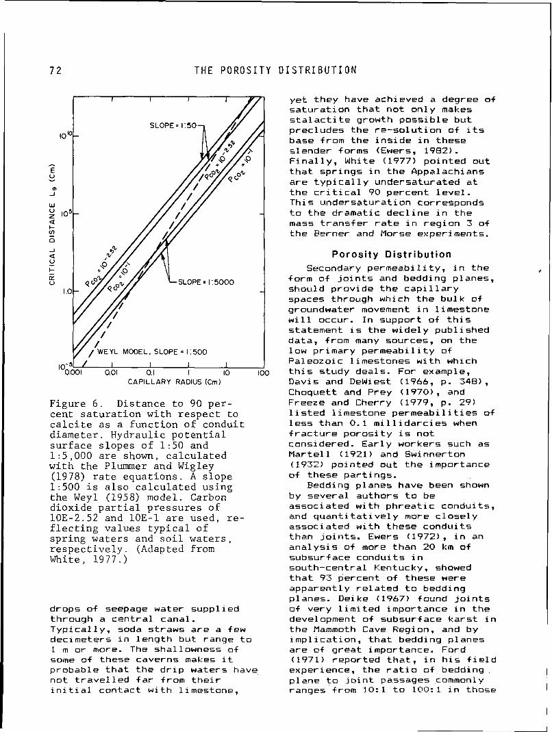
7 2 T H E P O R O S I T Y D I S T R I B U T I O N
I I I I I 0.01 0.1 I 10 1 O(
CAPILLARY RADIUS (Cm)
Figu re 6 . Dis tance t o 90 p e r - cen t s a t u r a t i o n w i t h r e s p e c t t o c a l c i t e a s a f u n c t i o n o f condu i t d i ame te r . Hydrau l ic p o t e n t i a l s u r f a c e s l o p e s o f 1 : 5 0 and 1 : 5 , 0 0 0 a r e shown, c a l c u l a t e d w i t h t h e Plummer and Wigley (1978) r a t e e q u a t i o n s . A s l o p e 1:500 i s a l s o c a l c u l a t e d u s i n g t h e Weyl (1958) model. Carbon d iox ide p a r t i a l p r e s s u r e s o f 10E-2.52 and 10E-1 a r e used , r e - f l e c t i n g va lues t y p i c a l o f s p r i n g wa te r s and s o i l w a t e r s , r e s p e c t i v e l y . (Adapted from White, 1977 . )
drops of seepage water suppl ied through a cen t ra l canal. Typ ica l l y , soda straws are a few decimeters i n leng th bu t range t o 1 m o r more. The shallowness of some of these caverns makes i t probable t h a t t he d r i p waters have no t t r a v e l l e d f a r Srom t h e i r i n i t i a l contact w i t h limestone,
ye t they have achieved a degree of sa tu ra t ion t h a t no t on ly makes s t a l a c t i t e growth poss ib le bu t precludes the re -so lu t ion o f i t s base from the i n s i d e i n these slender forms (Ewers, 1982) . F i n a l l y , White (1977) pointed out t h a t spr ings i n t he Appalachians are t y p i c a l l y undersaturated a t the c r i t i c a l 90 percent l eve l . This undersaturat ion corresponds t o the dramatic dec l ine i n the mass t r ans fe r r a t e i n reg ion 3 of the Ferner and Morse experiments.
Porosi ty Distr ibut ion Secondary permeabi l i ty , i n t he I
form of j o i n t s and bedding planes, should provide t h e c a p i l l a r y spaces through which t he bu lk of groundwater movement i n l imestone w i l l occur. I n support of t h i s statement i s the widely publ ished data, from many sources, on t he low primary permeabi l i ty of Paleozoic 1 i mestones w i t h which
3 t h i s study deals. For example, Davis and Dewiest (1966, p. 348) , Choquett and Prey (1970), and Freeze and Cherry (1979, p. 29) l i s t e d l imestone permeab i l i t i es of l e s s than 0.1 m i l l i d a r c i e s when f r a c t u r e po ros i t y i s not considered. Ear ly workers such as Marte l 1 (1921) and Swinnerton (1932) pointed out the importance of these part ings.
Bedding planes have been shown by several authors t o be associated w i th phrea t i c conduits, and q u a n t i t a t i v e l y more c lose ly associated w i th these condui ts than j o i n t s . Ewers (19721, i n an ana lys is of more than 20 km of subsurf ace condui ts i n south-central Kentucky, showed t h a t 93 percent o f these were apparent ly r e l a t e d t o bedding planes. Deike (1967) found j o i n t s o f very l i m i t e d importance i n t he devel opment of subsurf ace kars t i n the Mammoth Cave Region, and by imp l i ca t ion , t h a t bedding planes are of great importance. Ford (1971) reported t h a t , i n h i s f i e l d experience, the r a t i o o f bedding plane t o j o i n t passages commonly ranges from 10: 1 t o 100:l i n those
P A T T E R N S OF C A V E R N D E V E L O P M E N T A L O N G T H E C U M B E R L A N D E S C A R P M E N T 7 3
caves where bedding planes are o f any importance a t a l l .
The reasons f o r the overwhelming importance of bedding planes i n t h i s regard i s not d i f f i c u l t t o understand. Bedding planes are f requent l y more common than major j o i n t s , and t h e i r l a t e r a l ex t e n t i s of ten much greater , o f ten reaching a l l boundari es of a 1 i mestone mass. Jo in t s t h a t do t raverse an e n t i r e rock mass can ca r r y groundwaters on1 y along a s i n g l e hor izonta l vector, which may no t coincide w i t h t he reg iona l hydrau l ic p o t e n t i a l f i e l d . Bedding planes are capable o f conducting f low along any hor i zon ta l vector. Even i n those cases where complementary j o i n t sets may prov ide a continuous c a p i l l a r y opening t o the l imestone boundary, i t i s not c lear t h a t i t w i l l be enlarged. Ford (1971) pointed out t ha t groundwater f l ow ing through a network of j o i n t s i s required t o make many tu rns a t j o i n t in tersect ions. Such a course i s one of h igh res is tance and vulnerable t o capture by a s t ra i gh te r , more e f f i c i e n t bedding plane, w i th which t he j o i n t almost c e r t a i n l y in te rsec ts .
A THEORETICAL MODEL
Arguing from these stated p r i n c i p l e s and the general ly accepted p r i n c i p l e s of f low i n porous media, f i v e statements l o g i c a l l y fo l low. 1. Because the so lu t i on k i n e t i c s
are q u i t e rap id , the i n i t i a l so lu t i on porosi t y w i 1 1 propa- gate from the inpu t toward the resurgence.
2. Because the pore space conduct- i n g t he groundwater f low, a bedding plane, i s a t h i n three- dimensional space, each inpu t w i l l discharge along a separate vector. Thus, each vector w i l l g i ve r i s e t o a separate network o f tubes. Ewers (1982) has shown t h a t these networks should be i n t he form of d is - t r i b u t a r i e s or anastomotic
bands (Ford, 1968). 3. The r a t e and d i r e c t i o n of t h a t
propagation i s r e l a t e d t o the pressure f i e l d w i t h i n the bed- d ing plane. Th is pressure i s , i n tu rn , r e l a t e d t o the geome- t r y of the i npu ts and resur- gences and t h e i r r e l a t i v e i l u i d po ten t i a l s .
4. As t he networks grow, the pres- sure f i e l d must change, and networks possessing h igh growth r a t e w i l l r e t a r d t he growth of those w i t h slower growth rates.
5. The hydrau l i c capaci ty of a tube network changes abrupt ly when i t f u l l y penetrates a beddinq plane.
P r i o r t o the establishment of a low-resistance 1 i n k w i t h the output , t he meteoric water catchment f o r an i npu t i s l i k e l y t o be small , because the network's discharge capaci ty i s small. The d i scharge capaci t y i s determined by the t r ansm iss i v i t y of the remaining una.1 te red bedding plane through which the growing tube network must ,discharge, not the network i t s e l f . When a network breaches the bedding plane, i t may then be capable o f conducting a1 1 of t he water ava i l ab le t o it. I n such a case, the head throughout the network. w i 11 approach the l e v e l o f the resurgence. This w i l l produce a depression i n the hydrau l i c po ten t i a l f i e l d i n the reg ion o f the network. Surrounding networks w i l l respond t o t h i s pressure f i e l d change w i th an increase i n t h e i r growth ra tes and a r e d i r e c t i o n of t h e i r growth toward the 1 ow-resi stance tube. The f i r s t o f these t o l i n k w i t h the i n i t i a l low-resistance tube w i l l become the dischrge ta rge t f o r some of the remaining networks. These remaining netwoks, i n tu rn , become the ta rge ts f o r add i t i ona l networks developing from s t i l l more d i s t a n t inputs. Thus, t h e cave grows i n length by the l i n k i n g of shor t segments of condui t i n a headward d i r e c t i o n and a stepwise fashion. The gross pa t t e rn i s t r i b u t a r y i n form, but the i n d i v i d u a l elements are
E V O L U T I O N OF T H E L I N K I N G P A T T E R N
d i s t r i b u t a r i e s . Th is evolut ionary scheme has been c a l l e d the progressive headloss model (White, 1977) . The de ta i 1s o f any p a r t i c u l a r l i n k i n g system depend upon boundary condi t ions imposed by topography and geologic s t ruc ture . Three l i n k i n g models have been invest igated: high-dip, low-dip, and res t r i c t ed - i npu t (Ewers, 1982). The l a t t e r appl ies most commonly t o the Cumberland Escarpment ka rs t and t o Cave Creek s p e c i f i c a l l y .
Evolution of the Linking Pattern Figures 7a-e i 1 l u s t r a t e the
development of t he r e s t r i c t e d i npu t l i n k i n g pat tern. I n t h i s idea l i zed case, three inpu ts and a s ingle-point resurgence occur along a stream course where an impermeable caprock has been breached. Groundwater i s assumed t o be conducted t o and from the bedding plane by way of j o i n t s . Equal d r i v i n g p o t e n t i a l s hl, h ~ , and h= are assumed f o r the inputs. Porous media hydrau l i cs requ i re t h a t inpu t 1 w i l l have the highest throughput, w i t h successively small e r Q values f o r Inputs 2 and 3. The so lu t ion k i n e t i c s p red i c t t h a t the growth r a t e s o f the tube networks a r i s i n g from the three inpu ts w i l l be i n p ropor t ion t o t h e i r throughputs. The f l ow from inpu t 1, the proximal input , i s symmetrical about the input-output axis, and the f low envelope w i l l possess an ovoid shape. A tube network should develop along the center o f the i n i t i a l f l ow envelope. Inputs 2 and 3, however, e x h i b i t a two-1 obed f 1 ow envelope and i n i t i a l l y generate a p a i r o f tube networks t h a t form r e l a t i v e l y independent1 y (Fig. 7b).
I n Figure 7c the network forming from inpu t 1 has completed a low-resistance connection t o the output, and i t i s assumed t o have enlarged t o a diameter s u f f i c i e n t t o conduct a l l o f t he water ava i l ab le a t Input 1 under average condi t ions. Therefore, the head a t inpu t 1 w i l l drop t o the l e v e l of
t h e resurgence, and the network associated w i th i t w i l l f unc t ion as a s ink f o r groundwaters entra ined i n the bedding plane. The discharge boundary i s thereby a l t e red from a po in t w i t h l i m i t e d capaci ty t o one of l i n e a r dimension, equal t o the perimeter o f network 1, w i t h g rea t l y increased capacity. I n response t o t h i s change and i t s newly establ ished prox imi ty t o an output boundary, network 2 should commence rap id growth. The new growth o f t h i s network w i l l take place along a rou te t ha t combines already ex i s t i ng tubes wi th the shor tes t ava i lab le path t o form a l i n k w i t h network 1 (Fig. 7d). Network 3 should show increased growth fo l low ing the breaching of the bedding plane by network 1. Subsequent t o the l i n k i n g of networks 1 and 2 , network 3 should commence growth t o complete a low res is tance l i n k w i th network 2, i n t he manner already described (Fig. 7e) .
Laboratory so lu t ion experiments v e r i f y t ha t there i s good reason f o r such a l i n k i n g system t o be opera.ble i n nature: i t i s simply more e f f i c i e n t . Where the p o s s i b i l i t y e x i s t s t o d r i ve a groundwater conduit over a given distance from a s i ng le input or from several intermediately spaced inpu ts i n a l i n k i n g scheme, the m u l t i p l e input systems w i l l prove more t ime-e f f i c ien t (Ewers. 1982).
SUMMARY
The res t r i c ted- inpu t l i n k i n g scheme can be characterized i n the f 01 1 owing ways: 1. Subsurface drainage basins
should be establ ished by the stepwise i n teg ra t i on of small d i s t r i b u t a r y sub-units i n t o a t r i b u t a r y system.
2. S im i la r l y , the in tegra t ion of the system should proceed from the resurgence i n a headward d i rec t ion , the opposite of the d i r e c t i o n of t he network propagation.
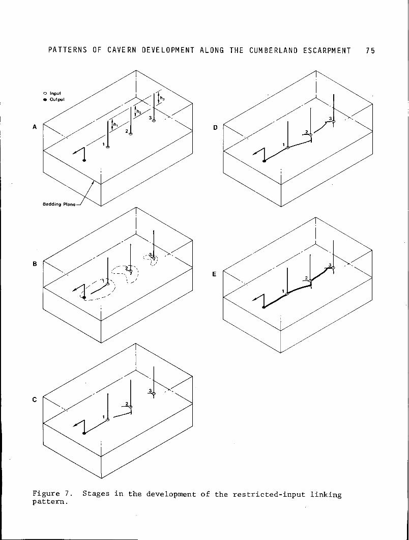
P A T T E R N S OF C A V E R N D E V E L O P M E N T A L O N G T H E C U M B E R L A N D E S C A R P M E N T 7 5
Figure 7. Stages in the development of the restricted-input linking pattern.
7 6 REFERENCES C I T E D
3. The plan form of the conduit pa t t e rn should be simple, l i n - ear, and r e l a t i v e 1 y unbranched and should p a r a l l e l the stream course from which i t or ig inated. The morphology o f the conduits
beneath Cave Creek Val ley are consistent w i t h t h e i r having evolved i n the manner described i n the res t r i c ted- inpu t model. The f a c t t h a t a l ternate , but unused, pathways of steeper gradient f o r discharge of the headwaters of the system e x i s t argues s t rong ly t h a t t he t heo re t i ca l growth advantages o f the m u l t i p l e i npu t system are rea l . Th is mode of cavern development i s the most common type i n the reg ion of the Cumber 1 and Escarpment.
REFERENCES
Eerner, R. A., and Morse, J. W., 1974, D isso lu t ion k i n e t i c s of calcium carbonate i n sea water: I V . Theory of c a l c i t e d issolu- t i on : American Journal of Sci- ence, v. 274, p. 108-134.
Dei ke, G. H. , 1967, The develop- ment of caverns of the Mammoth Cave Region: Un ivers i t y Park, Pennsylvania, Pennsylvania State Univers i ty , Ph. D. D isser ta t ion, 235 p .
Embleton, C. , and King, C. A. M. , 1971, Glac ia l and p e r i g l a c i a l geomorphology: Toronto, Mac- M i 1 l a n of Canada, 608 p.
Ewers, R. O., 1972, A model f o r t he devel opment of subsurf ace drainage routes along bedding planes: C inc innat i , Ohio, Univ- e r s i t y of Cincinnat i , M.S. Thesis, 84 p.
Ewers, R. O., 1977, A model f o r the development o f broad scale networks of groundwater f l ow i n carbonate aqui fers, j n Tolson, J. S. , and Doyle, F. L. , eds. , eds. , Karst hydrogeology: Hunts- v i l l e , Alabama, Un ivers i t y of A1 abama a t Huntsvi 11 e Press, Memoirs, v. X I I , p. 503-517.
Ewers, R. O . , 1982, Cavern devel- opment i n the dimensions of length and breadth: Hami 1 ton, Ontario, HcMaster Univers i ty , Ph.D. Dissertat ion, 398 p.
Fenneman, N. M., 1938, Physiogra- Eogl i , A., 1966, Karstwasserflache phy of the eastern United
und un te r i rd ische Karstniveaus: States: New York, McGraw-Hill Erdkunde, v. 20, p. 11-19. Book Co., 714 p.
Choquett, P. W., and Prey, L. C., 1970, Geologic nomenclature and c l a s s i f i c a t i o n of poros i t y i n sedimentary carbonates: American Associ a t i on of Petr 01 eum Geol o- g i s t s B u l l e t i n , v. 54, no. 2 , p. 207-250.
Cogley, J. G., 1972, Processes of so lu t i on i n the A rc t i c l imestone t e r r a i n , i n Polar Geomorphology: I n s t i t u t e of B r i t i s h Geography, Special Publ icat ion, No. 4.
Ford, D. C.. 1968, Features of cavern development i n cent ra l Mendip: Transactions of the Cave Research Group of Great B r i t a i n , v. 1.0, p . 11-25.
Ford, D. C., 1971, Geologic s t ruc- t u r e and a new explanation of 1 imestone cavern genesis: Trans- ac t ions of Cave Research Group of Great B r i t a i n , v. 13, p. 81-94.
Davis, S. N. , and Dewiest, R. J. Freeze, R . A . , and Cherry. J. A., M. , 1966, Hydrogeology: New 1979. Groundwater: Engl ewood York, John Wiley and Sons, C l i f f s , New Jersey, Prentice- 463 p. Ha l l , Inc., 604 p.
/
P A T T E R N S OF C A V E R N D E V E L O P M E N T A L O N G T H E C U M B E R L A N D E S C A R P M E N T 7 7
Hatch, N. L., J r . , 1964, Geology o f t he Shopvi 11 e Quadrangle, Kentucky: U. S. Geological Sur- vey Geology Buadrangl e Map CQ-282.
Lewis, R. Q., Sr. , 1971, The Mont- eagl e L i mestone o f south-central Kentucky: U. S. Geological Sur- vey B u l l e t i n 1324.E. 10 p.
Mar te l l , E. A., 1921, Nouveau t r a i t e des eaux souterraines: Par is, France, Ed i t i ons Doin, 840 p.
Mayf i e l d , S. M. , and Withers, S. , 1929, Map of area l and s t ruc tu r - a l geology of Pulaski County, Kentucky: Kentucky Geological Survey, ser. 6, scale 1:62,500.
McFarlan, A. C., 1943, Geology o f Kentucky: Lexington, Un ivers i t y o f Kentucky, 531 pp.
Passin i , G. , 1973, S u l l ' importanza spel eogenet i ca d e l l ' "erosi one a n t i g r a v i t a t i v a " : E s t r a t t o da Le Gro t te D ' I t a l i a , Ser ie 4, v. I V , p. 297-322.
Plummer, L. N., and Wigley, T. M. L., 1976, The d i sso lu t i on of c a l c i t e i n COz-saturated so lu t i ons a t 25" C and 1 atmosphere t o t a l pressure. Geochim. Cosmochim. Acta, v. 40, p. 191-202.
Plummer, L. N. , Wigley, T. M. , and Parkhurst, D. L., 1978, The k i - n e t i c s of c a l c i t e d i sso lu t i on i n COa-water systems a t 5" C t o 60- C and 0.0 t o 1.0 atm. CO,: American Journal of Science, 278, p. 179-216.
Renault, P., 1967, Le probleme de 1 a spel eogenese: Anna1 es de Speleologie, v. 22, p. 5-21, 209-267.
Smith, J. H., Pomerene, J. B., Ping, H. G., 1973, Geologic map of the H a i l Quadrangle, McCreary and Pulaski counties, Kentucky: U. S. Geological Survey Geologic Quadrangle Hap GG!-1058.
Swinnerton, A. C., 1932, O r i g i n o f 1 i mestone caverns: Geol ogi ca l Society o f America B u l l e t i n , v. 43, p . 662-693.
Weyl, P. K., 1958, The so lu t i on k i n e t i c s of c a l c i t e : Journal o f Geology, v. 66, p. 163-176.
White, W. E., 1977, Hole of solu- t i o n k i n e t i c s i n the development of ka rs t aqu i fers , i n Tolson, J. S., and Doyle, F. L., eds., Karst Hydrogeology: Huntsv i l l e , Alabama, Un ivers i t y o f Alabama a t H u n t s v i l l e Press, p. 503-517.
Chapter 5 CAVES OF NORTHEASTERN KENTUCKY (WITH SPECIAL EMPHASIS ON CARTER
CAVES STATE PARK) John Tierney
Park Naturalist Carter Caves State Resort Park
Olive Hill. Kentucky 41164
East on I n t e r s t a t e 64 from the hear t o f the Blue Grass area, the jagged rock outcrops are passed so qu ick ly , i t i s d i f f i c u l t t o appre- c i a t e t he incomprehensible amount of t ime t h a t l e d t o t h e i r forma- t i on . I t takes on ly about 2 1/2 hours t o t r a v e l the 193 km from Lexington t o Ashland, i n the northeastern corner of the State. Put i n t h a t s t re tch, one passes rocks t h a t took over 400 m i l l i o n years t o accumulate.
The Paleozoic Era, 600 t o 250 m i l l i o n years ago, was a t ime when a l l o f Kentucky was under water. Sediments accumulated on the f l o o r s o f these ancient seas and eventua l ly were compressed t o form the rocks we now see. We know i t was a t ime of regression and t ransgression o f these ancient seas. There were times of t ran- qu i 1 i t y , when ani ma1 remains could easi 1 y be preserved. There werg t imes of turbulence, when the remains were ground up i n t o micro- 'scopic b i t s and pieces. A l l of these paleoenvironmental f l uc tu - a t i ons are r e a d i l y observed due t o t he d i v e r s i t y o f rock type stacked i n layers, one on top of the other, from the o ldest t o the youngest.
A t some po in t i n t ime a f t e r the rocks had been formed, there was a per iod when these rocks were t h r u s t v e r t i c a l l y upward along a l i n e running north-south from northwestern Ohio through Cinc innat i t o the Nashvi l le , Tennessee area. Had subsequent erosional events not af f ected t h i 5 Cinc inna t i Arch, there would be a h igh r i d g e i n cen t ra l Kentucky today, instead of r o l l i n g , pastor- a l farms and f i e l d s . As t h i s up-
1 i f t occurred, eros i anal forces kept pace, wearing away the arch as i t pushed upward. Today, there i s no mountain grandeur i n cen t ra l Kentucky--just t he core o f the arch exposed. I n the center of the u p l i f t , the youngest rocks have been eroded away, leav ing the older rocks exposed. As one t r a v e l s from the center of the Blue Grass, progressive1 y younger rocks outcrop l i k e concentr ic growth r i n g s i n the center of a t r e e trunk.
A caver, t r ave l i ng east on I n t e r s t a t e 64 from Lexington, wauld not have much t o be enthused about f o r some distance. One would f i r s t pass the t h i n - bedded, f o s s i l i f e r o u s limestones of the Ordovician Period. Not much i n the way of caves there. Farther along, one would pass the shales and dolomites of the S i l u r i a n and Devonian periods. Nothing there. I n t h i s area, a chain of conical- shaped h i l l s can be seen. These are the Knobs. They form a r i n g around the Blue Grass. The M i s s i s s i pp i an and Pennsyl vani an rocks are exposed a t t he tops of these Knobs, and i t i s w i t h i n the next 40 km of I n t e r s t a t e highway t h a t one would cross a northeast- southwest t rending be1 t of 1 ime- stones i n ,which most o f the caves of northeastern Kentucky may be found.
The Mississ ippi an 1 i mestones exposed i n t h i s region have been i d e n t i f i e d as the same limestones found i n s im i l a r s t ra t i g raph i c pos i t i on i n other p a r t s of the State. However, i n northeastern Kentucky, the Miss iss ipp i an and Pennsylvanian per iods were times of transgression and regression o f
C A V E S OF NORTHEASTERN KENTUCKY
in land seas. Water inundated areas f o r a t ime and then receded. B a r r i e r i s l ands o f sand developed, only t o be covered by transgressing seas. Limestones i n te r f ace w i th sandstones t o show the t r a n s i t i o n a l energies t h a t were occurr ing a t the time. I n t he region, the maximum thickness o f good homogeneous l imestone ava i lab le f o r so lu t i on i s 27 m.
Tygart 's Creek i s a r e l a t i v e l y small stream t h a t meanders northeast through Carter and Greenup counties on i t s way t o t he Ohio River. Through a 32 km st re tch, i t crosses the limestones o f northeastern Kentucky, and w i t h i n t ha t sect ion most of the s i gni f i cant cave devel opment o f t he reg ion occurs. The geologic h i s t o r y o f t h i s stream and i t s t r i b u t a r i e s i s v i t a l 1 y important t o the understanding o f the spel eogenesi s.
P r i o r t o the g l a c i a l and i n t e r g l a c i a l events of t he Pleistocene, Tygart 's Creek, then a p a r t o f what has been c a l l e d the Teays River drainage system, was eroding downward toward the Mississ ippian 1 imestones t h a t had been deposited m i l l i o n s of years e a r l i e r . As the stream eroded downward, the limestones became more vulnerable t o the chemical and mechanical act ions of the watershed. Water, seeping i n t o cracks and crevices of the limestone, began the process of so lu t i on along j o i n t s and bedding planes. During the ea r l y g l a c i a l events o f the Pleistocene, many of the cave passages found i n the upper por t ions of the limestones were being acted upon. With subsequent i n t e r g l a c i a l periods, Tygart 's Creek and i t s t r i b u t a r i e s experienced periods o f r ap id down cu t t ing . By the end of the l a s t g l a c i a l transgression, most of the caves i n the area had achieved much of t h e i r present size. During the l a s t g l a c i a l event, many of the passages i n the caves were p r a c t i c a l l y f i l l e d w i t h outwash and sediments. Terracing of the slopes i n the region can be
a t t r i b u t e d t o g l a c i a l events t h a t reduced the erosional energy of t he streams i n the area. Tygar t 's Creek i s a f i n e example o f a stream t h a t has been rejuvenated. Once i t meandered over a wide area, slow1 y c u t t i n g through the rock. Then w i th g l a c i a l mel t ing and a more eas i l y eroded substrate, the stream began a per iad o f entrenchment which i s c l e a r l y v i s i b l e i n t he v i c i n i t y o f Carter Caves State Resort Park.
Today along the northern Cumberland Plateau, t h e tops of t he h i l l s are usua l l y around 305 t o 427 m i n e levat ion, whi le the v a l l e y f l o o r s are usua l l y 152 t o 213 m i n e levat ion. The cave-forming rock, the Newman limestones, outcrop near t he 244 m contour l e v e l and extend downward. The erosional progress o f Tygart ' s Creek has taken i t through the Newman sequence t o the t h i n , impure 1 imestones cor re la ted t o t he St. Louis Formation. Below t h i s , t he shaly, s i l t y s t r a t a o f t he Borden Formaton are no t r e a d i l y d issolved by surface o r subsurface water. Thus, Tygar t 's Creek i t s e l f i s no longer a p a r t o f the cave-forming process. However, t r i b u t a r i e s are s t i l l eroding through the Newman, and t h i s i s where the subsurface water routes s t i l l ex i s t . Within the area, many spr ings of water emerge a t the contact p o i n t of the Newman limestones and the less so lub le s t r a t a beneath it.
With in the northeastern reg ion of Kentucky, Carter Caves State Resort Park i s the best known and most in tens ive1 y v i s i t e d cave s i t e . The Park i s located about 8 km o f f I n t e r s t a t e 64 i n Carter County, Kentucky ( the o r i g i n of t he Park 's name). The r e l i e f w i t h i n the Park averages 152 m. A t t he highest e levat ions w i t h i n the Park, the o r thoqua r t z i t i c sandstones predominate the rock outcrops. The t i d a l b a r r i e r deposits in tergrade i n other pa r t s of the reg ion w i th s i l t s and sandy 1 i mestones o f t he Pennington Formation. O f notable i n t e r e s t t o
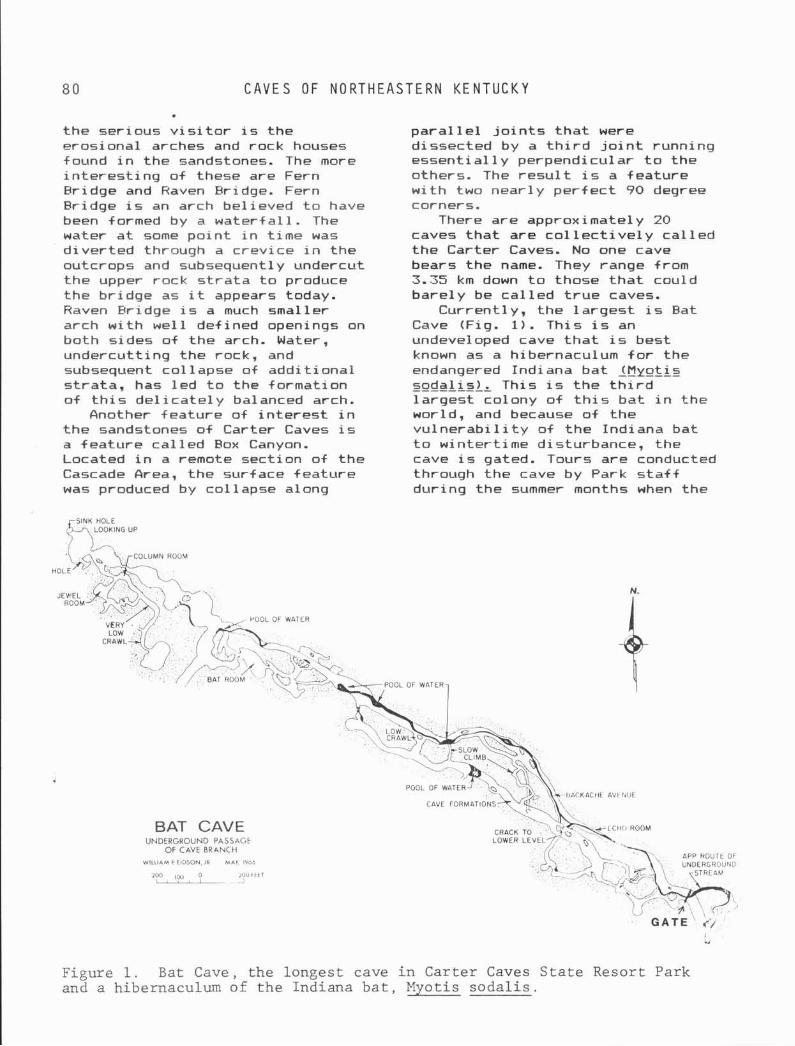
C A V E S OF N O R T H E A S T E R N K E N T U C K Y
t he ser ious v i s i t o r i s the erosional arches and rock houses found i n the sandstones. The more i n t e r e s t i n g o f these are Fern Bridge and Haven Bridge. Fern Bridge i s an arch bel ieved t o have been formed by a wate r fa l l . The water a t some p o i n t i n t ime was d ive r ted through a crevice i n the outcrops and subsequently undercut t he upper rock s t r a t a t o produce the br idge as i t appears today. Haven Bridge i s a much smaller arch w i t h wel l def ined openings on both s ides o f t he arch. Water, undercut t ing the rock, and subsequent co l 1 apse of add i t iona l s t ra ta , has l e d t o the formation o f t h i s d e l i c a t e l y balanced arch.
Another feature of i n t e r e s t i n t he sandstones o f Carter Caves i s a fea tu re c a l l e d Box Canyon. Located i n a remote sect ion o f t he Cascade Area, the surface fea tu re was produced by col lapse along
p a r a l l e l j o i n t s t h a t were dissected by a t h i r d j o i n t running essenti a1 1 y perpendicular t o the others. The r e s u l t i s a feature w i t h two near ly pe r fec t 90 degree corners.
There are approximately 20 caves t h a t are c o l l e c t i v e l y c a l l e d t he Carter Caves. NO one cave bears the name. They range from 3.35 km down t o those t h a t could bare ly be c a l l e d t r u e caves.
Current ly , the l a rges t i s Bat Cave (Fig. 1) . This i s an undeveloped cave t h a t i s best known as a hibernaculum f o r the endangered Indiana bat 1Myotis soda l i s ) . This i s t h e t h i r d l a rges t colony o f t h i s ba t i n the world, and because of t he v u l n e r a b i l i t y of t he Indiana bat t o winter t ime disturbance, the cave i s gated. Tours are conducted through the cave by Park s t a f f dur ing the summer months when the
BAT CAVE UNDERGROUND PASSAGE
OF CAVE BRANCH
WILLIAM P EIDSON, J R M A Y lVbb
100 2?01tt l I > F ' > L p -
Figure 1. Bat Cave, the longest cave i n Carter Caves S t a t e Resort Park and a hibernaculum of the Indiana b a t , Myotis soda l i s .
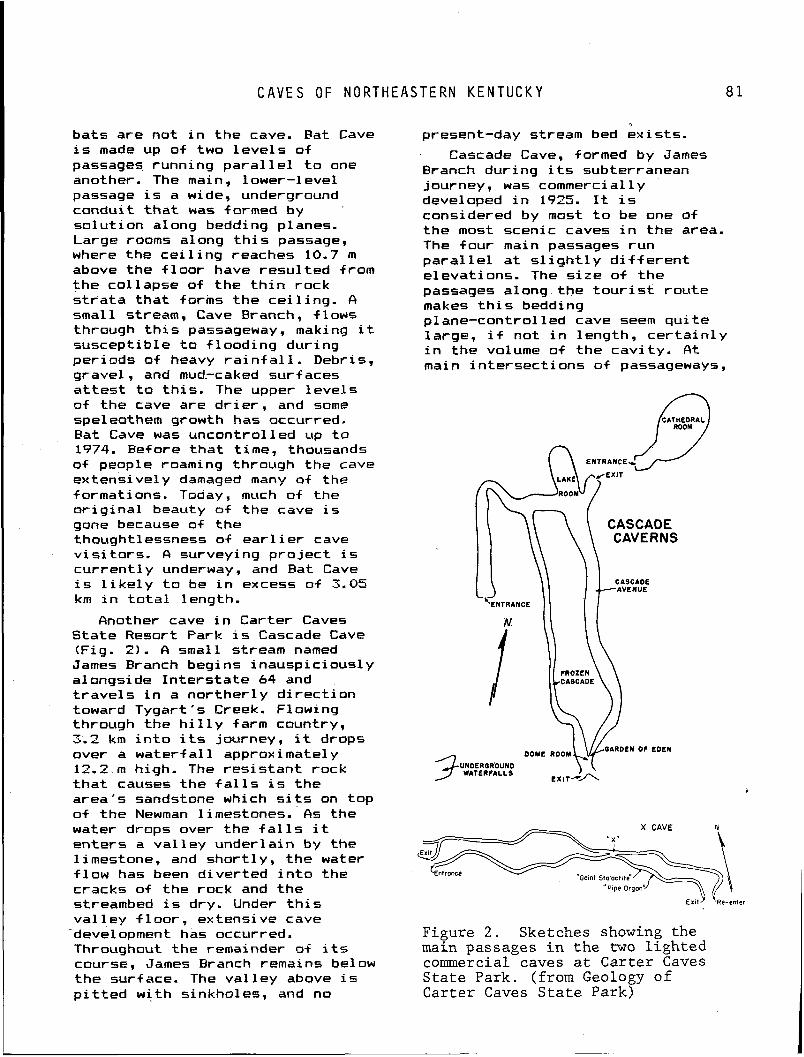
C A V E S OF N O R T H E A S T E R N K E N T U C K Y 8 1
bats are not i n the cave. Fat Cave i s made up of two l e v e l s o f passages running p a r a l l e l t o one another. The main, 1 ower-1 eve1 passage i s a wide, underground conduit t h a t was formed by so lu t ion along bedding planes. Large rooms along t h i s passage, where the c e i l i n g reaches 10.7 m above the f l o o r have resu l ted from the col lapse of t he t h i n rock s t r a t a t h a t forms t h e ce i l i ng . A small stream, Cave Eranch, f lows through t h i s passageway, making i t suscept ib le t o f lood ing during per iods o f heavy r a i n f a1 1. Debris, gravel, and mud.-caked sur f aces a t t e s t t o t h i s . The upper l eve l s of the cave are d r i e r , and some speleothem growth has occurred. Fat Cave w a s uncont ro l led up t o 1974. Bef ore t h a t time, thousands of people roaming through the cave extensively damaged many of the formations. Today, much of the o r i g i n a l beauty o f the cave i s gone because of the thought1 essness o f e a r l i er cave v i s i t o r s . A surveying p r o j e c t i s cu r ren t l y underway, and Eat Cave i s l i k e l y t o be i n excess o f 3.05 km i n t o t a l length.
Another cave i n Carter Caves State Resort Park i s Cascade Cave (Fig. 2 ) . A small stream named James Branch begins inauspic ious ly alongside I n t e r s t a t e 64 and t r a v e l s i n a norther1 y d i r e c t i o n toward Tygart 's Creek. Flowing through the h i l l y farm country, 3.2 km i n t o i t s journey, i t drops over a wa te r fa l l approximately 12.2. m high. The res i s tan t rock t h a t causes the f a l l s i s the area's sandstone which s i t s on top o f t he Newman limestones. As the water drops over the f a l l s i t enters a va l ley under la in by the limestone, and shor t ly , the water f l ow has been d iver ted i n t o the cracks o f the rock and the streambed i s dry. Under t h i s va l 1 ey f 1 oor , ex tens i ve cave
cdevelopment has occurred. Throughout the remainder of its course, James Branch remains below the sur f ace. The va l ley above i s p i t t e d w i t h sinkholes, and no
present-day stream bed ex is ts .
Cascade Cave, formed by James Eranch dur ing i t s subterranean journey, was commercially developed i n 1925. It i s considered by most t o be one of the most scenic caves i n t he area. The four main passages run p a r a l l e l a t s l i g h t l y d i f f e r e n t e levat ions. The s i z e o f t he passages a long- the t o u r i s t rou te makes t h i s bedding plane-control l e d cave seem q u i t e large, i f not i n length, c e r t a i n l y i n t he volume of the cav i t y . A t main in te rsec t ions o f passageways,
CASCADE \ \ \ \ CAVERNS
DOME R o o M ~ V ~ " " " OF EDEN
UNDERORWIND WATERFALLS EXITMA
Figure 2 . Sketches showing the main passages i n the two lighted commercial caves a t Carter Caves State Park. (from Geology of Carter Caves Sta te Park)
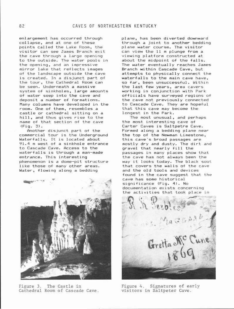
82 C A V E S OF N O R T H E A S T E R N K E N T U C K Y
enlargement has occurred through col lapse, and a t one of these po in t s ca l l ed the Lake Room, the v i s i t o r can see James Branch e x i t the cave through a la rge opening t o the outside. The water pools i n the opening, and an impressive mi r ro r lake t h a t r e f l e c t s images of the landscape outs ide the cave i s created. I n a d i s j unc t p a r t of the tour, the Cathedral Room can be seen. Underneath a massive system of sinkholes, l a rge amounts o f water seep i n t o the cave and deposit a number of formations. Many columns have developed i n t he room. One of them, resembles a c a s t l e o r cathedral s i t t i n g on a h i l l , and thus gives r i s e t o the name of t h a t sect ion o f the cave (Fig. 3 ) .
Another d i s j unc t p a r t o f the commercial tour i s the Underground Waterfal ls. It i s located about 91.4 m west of a s inkhole entrance t o Cascade Cave. Access t o the w a t e r f a l l s i s through a man-made entrance. This i n t e r e s t i n g phenomenon i s a dome-pit s t r uc tu re l i k e those of many other areas. Water, f l ow ing along a bedding
plane, has been d ive r ted downward through a j o i n t t o another bedding plane water course. The v i s i t o r can view the 11 m plunge from a viewing p la t fo rm constructed a t about the midpoint o f the f a l l s . The water eventua l ly reaches James Branch w i t h i n Cascade Cave, but attempts t o phys i ca l l y connect the w a t e r f a l l s t o t he main cave have, so f a r , been unsuccessful . With in t he l a s t few years, area cavers working i n conjunct ion w i t h Park o f f i c i a1 s have surveyed regions o+ the cave no t prev ious ly connected t o Cascade Cave. They are hopeful t h a t t h i s cave may become the longest i n the Park.
The most unusual, and perhaps the most i n t e r e s t i n g cave of Carter Caves i s Sal t p e t r e Cave. Formed along a bedding plane near t he top o f the Newman Limestone, t h i s cave's broad passages are mostly dry and dusty. The d i r t and gravel t h a t near1 y f i l l t he passages i n many places show t h a t t he cave has not always been the way i t looks today. The black soot t h a t covers the wa l l s o f the cave and the o l d t o o l s and devices found i n t he cave suggest t h a t the cave has some h i s t o r i c a l s i gn i f i cance (Fig. 4). No documentation e x i s t s concerning t he a c t i v i t i e s t h a t took place i n
Figure 3. The Castle i n Figure 4 . Signatures of ea r ly Cathedral Room of Cascade Cave. v i s i t o r s i n Sa l tpe t e r Cave.
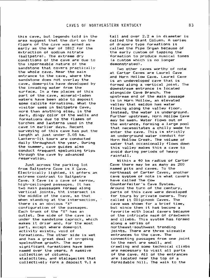
C A V E S OF NORTHEASTERN KENTUCKY
t h i s cave, but legends t o l d i n the area suggest t h a t t he d i r t on the f l o o r s o f t he cave was mined as e a r l y as t he War o f 1812 f o r the ex t rac t i on o f sodium n i t r a t e ( sa l t p e t r e ) . The extreme dry condi t ions o f the cave are due t o t he impermeable nature of the sandstone t h a t covers p r a c t i c a l l v t h e whole cave. Near the main entrance t o the cave, where the sandstone does no t over lay the cave, dome-pits have developed by t he invading water from the surface. I n a few places o f t h i s p a r t o f t he cave, mineral-laden waters have been able t o deposit some c a l c i t e formations. What the v i s i t o r sees i n Sa l tpe t re Cave, more than anything else, i s the dark, dingy co lo r o f t he wal ls and format ions due t o t he flames of torches and lan te rns used i n the cave i n e a r l i e r days. Recent surveying o f t h i s cave has put the leng th a t j u s t under 3.05 km. Lan te rn - l i t t ou rs are conducted d a i l y throughout t h e year. During t he summer, cave guides a lso conduct frequent spelunking t r i p s through the cave by advanced reservat ion.
Just across the park ing l o t from Sa l tpe t re Cave i s X Cave. E l e c t r i c a l l y l i gh ted , i t o f f e r s an extreme cont rast t o Sa l tpe t re Cave. X Cave i s a cave of narraw, h i gh-cei 1 i nged passages. It has two main passsages formed along v e r t i c a l j o i n t s , t h t i n te r sec t i n t he middle o f t he cave, so t ha t when standing a t t he in te rsec t ion , there i s an obvious " X u con f igura t ion o f t h e passages. Each t runk o f t.he " X " has an ou t l e t . One s ide o f t he cave i s under the sandstone caprock, which makes i t d r i e r and, f o r the most pa r t , except where dome-pi t a c t i v i t y ex is ts , vo id of formations. The other s i de i s wet and has a great deal o f on-going speleothem growth. The more s i g n i f i c a n t formations have been named over the years. A massive c o l l e c t i o n o f columns, s t a l a c t i t e s , and sta lagmites t ha t c o l l e c t i v e l y form a deposit 9.1 m
t a l l and over 2.2 m i n diameter i s c a l l e d the Giant Column. A ser ies o f drapery type formations i s c a l l e d the Pipe Organ because of the ea r l y custom of tapping . the formation t o produce musical tones (a custom which i s no longer demonstrated).
Two other caves worthy o f note a t Carter Caves are Laurel Cave and Horn Hol low Cave. Laurel Cave i s an undeveloped cave t h a t i s formed along a v e r t i c a l j o i n t . The downstream entrance i s located alongside Cave Branch. The upstream end of t he main passage is i n Horn Hollow, an elevated v a l l e y t h a t seldom has water f l ow ing along the v a l l e y f l oo r . Instead, t he water i 5 underground. Further upstream, Horn Hollow Cave may be seen. Water f lows out of t he entrance, forming a l a rge pool t h a t necessi tates a c h i l l y wade t o enter the cave. This i s s t r i c t l y an underground water conduit f o r Horn Hollow Creek. The volume of water t h a t occasional ly f l ows down t h i s v a l l e y makes t h i s a cave t o avoi d dur i ng per i ods of heavy r a i n f a1 1.
With in a 40 km rad ius o f Carter Cave there may be as many as 200 named p i t s and caves. To the northeast o f Carter Caves, another cave system of note i s what cavers have c a l l e d The Cow Counte r fe i te r ' s Cave System. Around the t u r n o f the century, p a r t s of t h i s cave were developed f o r t ou rs by p r i v a t e owners. They c a l l e d i t Oliginook Caves. The cave was shown f o r a b r i e f time, but s ince then i t has become a f a v o r i t e w i t h l o c a l cavers because of the i n t r i c a t e maze of crawlways and climbs. This system has formed along a ser ies o f northeast-southwest t rend ing j o i n t s . There are three s izeable entrances t o the cave. The connecting passages from one j o i n t t o t he next are small, and crawl ing and some technica l cl imbs are necessary t o v i s i t a l l pa r t s o f t he cave. A l l of the entrances are located near the top of a formidable h i l l . The walk t o the
8 4 REFERENCES C I T E D
cave from the car weeds out the weaker cave v i s i t o r s .
Because the l imestone thickness i s l e s s than i n the more s i g n i f i c a n t cave areas o f the State, there are few caves which a t t r a c t the v e r t i c a l caver t o northeastern Kentucky. There are a number o f p i t s i n the area, but the deepest of them would not be much deeper than 24.4 m.
Because much of the so lu t i on and development o f caves has occurred along j o i n t s , many of the caves o f f e r some complexity t o rock c l imbing and negot ia t ing through narrow, conf in ing passages. One cave tha t o f f e r s a d i v e r s i t y o f challenge i s Burchett ' s Cave ( former ly Ja rv ie Roark's Cave). This i s a maze of cr iss-crossing, jo in t -con t ro l led passages where so lu t i on has a1 so occurred a t d i f f e r e n t l e v e l s a1 ong the bedding planes. O f p a r t i c u l a r i n t e r e s t i s a narrow passage c a l l e d Rimstone Avenue, where one can see r imstone dams i n excess of 1.5 m i n height. Another i n t e r e s t i n g sect ion o f the cave i s Heavenly Crawl, a low-cei l inged passage where soda straw
REFERENCES Dever, G. R., 1980, Strat igraph-
i c re la t ionsh ips i n t he lower and m i ddl e Newman L i mestone ( M i s s i s s i pp i an) , east-central and northeastern Kentucky: Ken- tucky Geological Survey, 49 p.
Dever, G. R., Hoge, H. P., Hester, N. C., and Ettensohn, F. R., 1977, S t ra t ig raph ic evidence f o r l a t e Paleozoic tectonism i n Northeastern Kentucky, iq F i e l d T r i p Guide, f o r the Eastern Section, American Associat ion of Petroleum Geologists, 80 p.
Fa i io , V. and D'Angelo, D., 1984, The Saltpetre-Moon Cave System: Pholeos, W i t tenberg Un ivers i t y Speleological Society, v. 4, no. 1, 7-13 p.
Ferm, J. C., Horne, J . C., Swinchatt, J . P., and Whaley, P. W., 1971, Carboniferous deposi- t i o n a l environments i n north- eastern Kentucky, j n Spring F i e l d Guide, Geological Society o f Kentucky, Kentucky Geological Survey, 30 p.
s t a l a c t i t e s descend up t o 46 cm. Horne, J. C., Ferm, J. C., 1977,
Along the gorge of Tygart 's Carboniferous deposi t ional envi-
Creek from Ol i ve H i l l , Kentucky t o ronments i n the Pocahontas Basin t he Car.ter-Greenup County l i n e , o f eastern Kentucky and southern caves o f vary ing s izes can be
West V i rg in ia : F i e l d Guide, found. Most are small, being l ess
Depart men t of Geol og y , Un i v- than 91.4 m i n length. Names given of South Carolina, 129 p. them seem t o be s u f f i c i e n t descr ip t ion. Crawlsbad Caverns, Disappointment Cave, H20 Cave, Impossible Cave, Moonshiner's Cave, Garbage Cave, Rat Cave, and Zig-zag Cave.. . a1 1
McGrain. P., 1966, Geology of Carter and Cascade Caves Area: Kentucky Geological Survey, Special Publ icat ion 12, 32 p.
- -
seem t o o f f e r l i t t l e incen t i ve t o Miotke, F. D., and Palmer, A. N. . v i s i t except f o r those masochistic
1972, Genetic re1 a t i onshi ps f o l k t h a t seem t o constant ly be on
between caves and landforms i n the prowl f o r a "BIG" cave somewhere out there j u s t wai t ing
the Mammoth Cave National Park Area: Mammoth Cave, Kentucky,
t o be discovered. Mammoth Cave National Park,
Pf e f f er , N. , Madigan, T. J. , and Hobbs 111, H. H., 1981, Laurel Cave: Pholeos, W i t tenberg Univ- e r s i t y Speleologi ca l Society, v. 2, no. 1.
C A V E S OF N O R T H E A S T E R N K E N T U C K Y
V o i g t , Keller, and Johnson, 1962, Ohio, Central Ohio Grotto, Caves of C a r t e r County, Ken- Nat iona l Spe l eol o g i c a l S o c i e t y , tucky: COG Squeaks, Columbus, v. 5 , no. 1 0 , 31-39 p .
Chapter 6 PINE MOUNTAIN KARST AND CAVES
Joseph W. Saunders Agricultural Research Service
Department of Agriculture 3207 Melody Lane
East Lansing, Michigan 48912
Pine Mountain i s a long, nar- t u r e represents t he northwestern row, s t r a i g h t r i d g e extending 170 edge of the Pine Mountain km i n a northeast-southwest d i rec- Overthrust Block and i s bounded on t i o n i n eastern Kentucky and the northeast by Russell Fork another 24 km i n Tennessee (Fig. Fau l t near E l khorn C i t y (Kentucky) 1). This dominant topographic fed- and on the southwest by t he
Figure 1. Pine Mountain, a large overthrust block, extends 105 miles in a northeast-southwest direction in eastern Kentucky forming the highest cave region in the State.

P I N E M O U N T A I N K A R S T A N D C A V E S
Jacksonboro Fau l t near Lafayet te mountain where the d i p i n t o the (Tennessee). Pine Mountain encom- mountain i s greater. Mountainside passes p a r t s o f Pike, Letcher, hol lows and rav ines are much more Harlan, B e l l and Whit ley counties prominent on the outcrop slope i n i n Kentucky, and Campbell County the northern reaches o f Pine i n Tennessee. I n Letcher and Pike Mountai n. counties, Kentucky shares Pine Moutain w i t h V i rg in i a , as the s t a t e l i n e l i e s a t t h e mountain
G E O L O G Y
crest . Pine Mountain i s a narrow-
crested r i d g e of t he Appalachian Val ley and Ridge type, and i s t he westernmost mountain i n t h i s p a r t of the hppalachians. Due t o the s t ra t ig raphy exposed by the t h r u s t f a u l t i n g , the coal so abundant and important t o t he l o c a l economy i n the Cumberland Plateau t o the northwest, as we l l as t he Middlesboro Fasin t o t he south- east, i s absent on t he outcrop slope of Pine Mountain.
Caves on Pine Mountain under l ie the northern (outcrop) slope of t he mountain, t he on ly pos i t i on on the mountain where l imestones outcrop. S t ra ta d i p i n t o the mountain a t 20 t o 40 degrees. The caves are found i n t he Miss iss ipp i an Newman Limestone, t he l o c a l equivalent of t h e Greenbrier o r Glen Dean-Girki n-Ste. Genevieve-St. Louis 1 i mestones. &l ong Pine Mountain t he Newman Limestone i s between 122 t o 183 m t h i c k and i s
The e leva t ion o f Pine Mountain's c res t commonly ranges from 640 m t o 700 m a t the south- ern end t o 792 m t o 854 m a t the northern end, w i t h r e l i e f up t o 488 m. The highest p o i n t on Pine Mountain i s approximately 997 m above sea l e v e l and located east of the community o f Whitesburg. The mountain i s crossed by streams a t on ly two places. The Cumberland River, the master stream i n the region, encompassing t he southern po r t i on of Pine Mountain, crosses t he mountain a t P i n e v i l l e i n a narrow water gap a t an e leva t ion of 305 m. Near J e l l i c o , 32 km t o the west, Clear Fork crosses the mountain. To t h e east o f F i n e v i l l e , the mountain runs f o r 130 km unbroken by any surface stream, although minor shallow gaps i n t h e c res t occur a t several places. I n t e r s t a t e 75 south o f J e l l i c o c l imbs the outcrop slope of Pine Mountain before t r a v e l i n g along the c res t f o r near ly 16 km. The re1 a t i ve l y homogeneous topo- graphy o f Pine Mountain is remark- able on i t s northern upper slope f o r i t s r e l a t i v e homogeneity, w i t h contours running near ly s t r a i g h t and p a r a l l e l f o r ki lometers. This homogeneity i s especi a1 1 y t r u e along the southern reaches of the
exposed about halfway up the mountain. It i s ove r l a i n by up t o 215 m o f sandstone, s i l t s t o n e , and shale o f t he Pennington Formation (Fig. 21, i nc lud ing the sandstone mountain crest . Ninety meters of t he Grainger Formation, mostly s i l t s t o n e and shale, l i e comf o r t a b l y be1 ow the Newman Limestone. The Chattanooga Shale (upper Devonian and Mississ ippian) is found beneath the Grainger and up t o 183 m of i t extends downslope t o t he F ine Mountain Fau l t near t he f o o t of the mountain. I n places there are secondary f a u l t s i n prox imi ty t o the Pine mountain Fau l t (e.g., a t Jenkins, Kentucky, and Newcomb, Tennessee), and i n a t l eas t one such case a s l i v e r o f Newman Limestone i s exposed a t the f o o t o f the mountain. ( In te res t ing1 y, there appears t o be a subterranean meander cuto f f of Elk Fork i n such a s i t u a t i o n near H e l l s Po in t Ridge, Tennessee.) The Newman i t s e l f i s d iv ided i n t o a l a rge r lower member of l imestone and a smaller upper member consis ing of shale, 1 i mestone, and sandstone. Most, if not a l l , the known caves are i n t he lower member, and most appear t o be i n the low, commonly do lomi t i c por t ions of the lower
88 G E O L O G Y
Figure of the Mountai
Upper member
L o w e r member
Upper member
L o w e r member
P z 2 a 4 z z a a q I> a c n E z ~z 2 ; z
z a I
n n I
cn cn I
cn cn I
z
2. Stratigraphic profile outcrops exposed on Pine .n .
I= c 0 , - . - 0- , a , ',E c L 0 0 a k
a, c t a 0
E Z 3 a, a, E 2 -1
member, a1 thouh lack of exposure of the basal contact and pauc i ty of de ta i l ed s t ra t i g raph i c study w i t h i n the Newman preclude an a u t h o r i t a t i v e statement.
z 2 4 a z z n f 3i z 0 ; > c n W - P I
The water gaps through the mountain a t ~ i n e v i l l e and J e l l i c o are associated w i t h f a u l t s i n t he over thrust block. The gap a t P i n e v i l l e i s on the Rocky Face Fau l t and i s re l a ted i n o r i g i n t o the Cumberland Gap 16 km t o the south (Rich, 1933; F roe l i ch and Tazel aar , 1974) . Qn array of f a u l t s e x i s t s on Pine Mountain j u s t east of the gap a t Pinevi l l e .
Grainger
Format ion
Chat tanooga Shale
The mountainside over1 y ing the Newman Limestone i s steep, and rav ines and hol lows cu t i n t o t he l imestone commonly have braided rubb le streambeds. So lu t ion do l ines are few i n number. Because of t he r e l a t i v e 1 y shor t d istance from the top of the mountain t o t he base exposures of the l imestone, usual ly 305 t o 450 m, stream f low i n these small hol lows and rav ines i s i n te rm i t t en t . There i s recognized po ten t i a l f o r l o s s o f some or a l l such i n t e r m i t t e n t f l ow i n t o the l imestone under the rubble. I n the case of Payne Gap Cavern (Figs. 3 and 4) , the over l y ing rav ine has in tersected the cave passage. This i n te r sec t i on has resu l ted i n an entrance t h a t takes some of the i n t e r m i t t e n t stream f low coming down the ravine. Several p i t s are known on the mountain, inc lud ing Colehole 160 t o 73 m deep) and a v e r t i c a l entrance t o L inef ork Cave. Springs are f a i r l y common i n t he limestone, presumably near the base. They range from small ones w i t h no cave opening t o la rger spr ings w i th base f low of about 14.2 l/s ( l i t e r s per second). The l imestone springs on Pine Mountain tend t o be la rger and cleaner compared w i th spr ings i n the surrounding area, and commonly are employed as domestic or community water sources f o r people 1 i v i n g a t the f o o t of the mountain. Caves are commonly found a t o r near spr ings on Pine Mountain, and i n some instances access t o water supply caves has been d i f f i c u l t . Numerous la rge v e r t i c a l faces o f l imestone are found along the mountain, commonly above the springs.
P I N E M O U N T A I N K A R S T A N D C A V E S
\ / PROFILE
Cross Sec t ion AB
A-
Cross S e c t i o n CDE
PAYNE GAP CAVERN ,',I LE ' /
Letcher County, Kentucky C.R.G. Grade 4 Map Completed in 1 9 7 4 o S C A L E 30 Feet
by Gary Jessey , Ke i th Ort iz , and Joe Saunders - T.H.C. 4 5 5 F e e t
Figure 3. Payne Gap Cavern, Letcher County, Kentucky--a three-level cave containing a base-level streamway.
CAVES
There are n ine mapped caves on Pine Mountain, and 15 t o 20 known bu t unmapped caves. The longest known cave i s L ine f ork Cave i n Kentucky, where a survey i n progress has mapped 2,440 m along t h e s t r i k e (Fig. 5 > , corresponding t o a surface distance of 1,830 m. The cave's main entrance i s near a major spring, and f i v e sumps i n t h e main stream are bypassed through higher l e v e l passages. A s i x t h sump has present ly ha l ted explorat ion. There are i nd i ca t i ons t h a t there has been a terminal sump i n t h i s area o f t he cave f o r some time, namely t he descending
c e i l i n g and f l o o r i n t he upstream d i r e c t i o n (Fig. 6). Although the load reduct ion bank of sand i s o f t e n found a t sumps, i t might a lso have been deposited i n a f l o o d event. An examination of t h e r e l a t i o n o f L inefork Cave's passage t o the over l y ing topography reveals t h a t t he downstream (western) end of t he cave i s found where t he h i l l s i d e i s steepest. I f w e assume t h a t t he d i p i n t o the h i l l s i d e i s r e l a t i v e l y uniform i n magnitude, then the spr ing below t h e main entrance a t the western end represents the lowest e leva t ion i n t he area t h a t t he l imestone i s exposed. One might expect drainage
C A V E S
PAYNE GAP WATER CAVE L e t c h e r C o u n t y , K e n t u c k y
C.R.G Grade 4 Map Comple ted in 1 9 7 4
G a r y Jessey , Ke i th Or t i z , and Joe Saunders
JENKINS W E S T 7 .5 ' Q U A D .
T. , 7 + SCALE Newman L imestone
0 2 5 5 0 Feet - T.H.C. 4 0 3 f e e t
Figure 4. Payne Gap Water Cave, Letcher County, Kentucky--an example of an Appalachian-strike single-passage cave.
w i t h i n the l imestone t o be discharged a t t h i s lowest poss ib le o u t l e t , although t h e a l t e r n a t i v e explanaton of the spr ing branch being responsible f o r t he topographic s i t u a t i o n must a lso be weighed. L inefork Cave has a t t imes i n the past, been re fe r red t o as Water Cave. The present survey p ro jec t i n L inefork Cave i s reserv ing the name Water Cave f o r the 45-m-long spr ing cave located immediately below the main L i nef ork entrance and corresponding t o t he downstream s i de of sump no. 1 i n L i nef ork Cave.
I n add i t ion t o L ine fo rk Cave, there are f i v e caves mapped on
Pine Mountain i n Kentucky, a l l around 152 m i n length. Two of these caves are i n the Pound Gap area near Jenkins and have been hydro1 ogi c a l l Y connected w i t h a f 1 uorescei n t race (Saunders, 1974). Payne Gap Cavern has three d i s t i n c t l e v e l s inc lud ing a base l eve l streamway, whereas Payne Gap Water Cave downstream i s i n some ways the s tereotyp ica l Appalachian s t r i k e s i ng le passage cave (Figs. 3 and 4). Icebox Cave a t the water gap a t P i n e v i l l e may be associated w i t h f a u l t i n g i n the mountain there.
The Colehole i n Letcher County i s the deepest known p i t on Pine Mountain. The entrance t o the p i t
P I N E M O U N T A I N K A R S T A N D C A V E S 9 1
Figure 5. Linefork Cave, the longest mapped cave on Pine Mountain.
"Ieo sump S C A L E I I 0
- .. . . . . . ._ I
5 0 F e e t
sand"... ,
Figure 6. Exploration in Linefork Cave has been stopped by a terminal sump formed from a descending ceiling in the upstream direction.
L O N G M O U N T A I N S E T T I N G
i s a ho le 1.5 m i n diameter. The geologic s t ruc tu re of the mountain i s r e f l e c t e d i n t he p i t by ledges and o f f se t v e r t i c a l drops. From ground zero a t t h e entrance there i s a sheer v e r t i c a l drop of 27 t o 30 m onto a s teep ly s loping ledge. The la rges t area i n the p i t i s a t t h i s ledge, where the sha f t may be 12 t o 15 m i n diameter. Below the f i r s t ledge i s another drop onto a second ledge. A t h i r d drop immediate1 y f olows, descending t o a breakdown slope a t the bottom of the shaf t . Total depth below the entrance has no t been accurately determined but i s between 61 t o 73 m.
Hor izontal g a l l e r y passage i n Pine Mountain caves i s r e l a t i v e l y i r r e g u l a r i n cross section. Pocket and alcove features suggest t h a t phreat ic development played a very s i g n i f i c a n t 1-01 e i n passage formation, perhaps s i m i l a r t o t he r o l e envisioned by Bretz (1942) i n Cudjo's Cave i n Cumber1 and Mountain 16 km south of P inev i l l e , under s i m i 1 ar s t r u c t u r a l and s t ra t i g raph i c condi t ions.
A cha rac te r i s t i c feature of Pine Mountain caves ik, t ha t many of the passage cross sect ions d isp lay the e f f e c t o f the steep dip. Cei l ings, ledges, and sometimes f l o o r s o f ten slope i n t o the mountain (Fig. 7a-b). The
in f luence of the geological s t ruc tu re on passage t rend i s f a i r l y consistent as we1 1. Thus, passages usual 1 y f 01 1 ow the mountainside, near1 y para1 l e l t o both t he outcrop s t r i p and the mountain crest . Dip tubes ( i .e., s teeply s lop ing passages d ra in ing from the sur f ace i n a downdip d i r e c t i o n a t r i g h t angles i n t o t he s t r i k e passages) have not been reen by t he author i n Pine Mountain caves. They are seen i n caves i n other long mountains i n t he Appalachians, where they may be associated more w i t h greater mountainside do1 i n e +requency.
LONG-MOUNTAIN SETTING
Pine Mountain i s one of the long mountains i n t he cen t ra l Appalachians of the eastern United States t h a t were discussed by Saunders and others (1977) as the s e t t i n g f o r a genre o f ka rs t , caves, and subterranean hydrology. Long- mountain kars t occurs where l imestone o r dolomite u n i t s crop out i n continuous s t r i p s along one s ide o f l i n e a r sandstone or conglomerate capped mountains, p a r a l l e l i n g the s t r i k e and the mountain c res t , and dipping i n t o t he mountain. Whereas the s t ra t ig raphy may d i f f e r from mountain t o mountain, the
Figure 7 . Cross s e c t i o n s of passages i n Pine Eiountaic caves show t h e e f f e c t of the s t e e p d ip of the formations.
P I N E M O U N T A I N K A R S T A N D C A V E S
s t r u c t u r a l s e t t i n g i s s i m i l a r and f a i r l y regu lar , w i t h beds dipping 5 t o 40 degrees, depending on the p a r t i c u l a r area. The re1 a t i v e l y uni form r e l a t i o n s h i p between s t ra t ig raphy , s t ruc ture , and topography along each mountain should permit general izatons about the development o f caves and subsurface drainage from the number o f examples t h a t arose under seemi ng l y s i m i 1 ar circumstances. I n t he case o f Pine Mountain, t he cave and spr ing record i s so incomplete t h a t genera l iza t ions based on Pine Mountain examples alone are r i sky . Nevertheless, one can pose questions drawn from other long mountains and t r y t o answer these w i t h ava i l ab le data.
Drainage basins of Pine Mountain spr ings a re long and narrow. With up t o 213 m o f c l a s t i c sediment l y i n g between the Newman Limestone and the c res t o f the mountain, t he widths o f the drainage basins a re between 245 and 460 m. Distance between spr ings on Pine Mountain appears from incomplete f i e l d work t o be up t o 5 km. Thus drainage basins
. are up t o 4,575 m long and 460 m wide. They are o r ien ted along t h e s t r i k e , and thus are concordant w i t h -most o f the adjacent major su r f ace drainage. Drainage under t he mountainside t o a spr ing from one d i r e c t i o n on t he mountainside on ly i s t he r u l e i n t he l imestones i n t he long mountains. On Pine Mountain, i n f ormation i s ava i l ab le f o r on1 y th ree mountainside subterranean drainage systems. Twa appear t o d ra in from one d i r e c t i o n on ly (L inefork Cave and Payne Gap Water Cave). Rose Sping Cave i n Tennessee i s t he exception, as i t dra ins from two d i rec tons (Fig. 8). There i s evidence from the western p a r t of t h a t cave o f an abandoned o u t l e t , suggesting t he f us ion of two drainage systems i n t o one a t some t ime i n t he past.
Drainage f o r these basins cannot be considered f u l l y cap t i ve because dur ing wetter weather some runo f f 'passes over t h e l imestone
band along the steep mountain and continues on down the mountainside surface i n the numerous rav ines and hollows. It has no t been ascertained how many s i t e s i n the 1 i mestone swal 1 ow such i n t e r m i t t e n t stream f l ow e i t h e r p a r t i a l 1 y o r who1 1 y (fewer are known on F ine Mountain than on other long mountains) , nor t o what extent f 1 ood pulses are experienced i n t he downstream po r t i ons o f the subsurf ace drainage systems. It i s presumed t h a t t he range of discharge volumes i s re1 a t i v e l y narrow f o r F ine Mountain spr ings i f much of t he wetter weather f l ow goes uncaptured as i t f lows down the mountainside. A r e l a t e d matter i s the degree t o which water l e v e l s i n t he caves r i s e dur ing extreme p r e c i p i t a t i o n events, and t h e extent t o which cavers might be endangered. I n the judgement of t h i s author, both are r e l a t i v e 1 y m i nor.
WATER GAPS
Perhaps the most i n t e r e s t i n g question per ta in ing t o Pine Mountain caves and subsurface drainage i s the comparison between gap and mountainside caves. Most of the spr ings and caves on Pine Mountain l i e on t he mountainside several hundred meters above present-day base l e v e l surface streams. This i s because the l imestone i s exposed on the mountainside we1 1 above the surface streams. Mountainside spr ings can be viewed as s p i l l o v e r p o i n t s f o r water f lowing w i t h i n the limestone, most of which i n t h e mountain l i e s below the e leva t ion o f the spring. As s p i l l o v e r points, most spr ings can be expected t o represent the 1 owest e leva t ion exposures o+ l imestone along the mountainside. Due t o t he steep d i p i n t o the mountain, inc ised topographic features i n the l imestone outcrop such as deep rav ines and hol lows represent t he lowest e levat ions on t he mountainside where discharge
VERY LOW C R A W L O V E R S M A L L RUBBLE: B R E E Z E
WATER G A P S
ROSE SPRING CAVE Campbell County, Tennessee
C.R.G. Grade 4 Map Completed in 1 9 7 6
by Jim Borden and Joe Saunders
SCALE 0 5 0 Feet
36O 3 4 ' 1 2' N., 8 4 O 06 ' 25" W.
JELLICO EAST 7.5 ' QUAD Elevation Approx. 1 5 0 0 ' T.H.C. 4 1 9 feet Lower Newman Limestone
UNENTERED R O O M I N U N S T A B L E B R E A K D O W N : B R E E Z E
Figure 8. Rose Spring Cave in Campbell County, Tennessee, drains from two directions, an unusual occurrence on Pine Mountain.
from the l imestone i s possible. the lowest mountainside 1 i mestone Extreme examples o f t h i s should be exposures a m i l e o r more away found a t water gaps where major (Figs. 9 and 10). hlthough t h i s base l e v e l sur f ace streams cu t exposure a t r i v e r l e v e l would be through the mountain. Here the expected t o a l low gap spr ings t o l imestone i s found a t r i v e r l e v e l compete very we1 1 w i t h several hundred f e e t 1 ower than mountainside spr ings f o r drainage
P I N E M O U N T A I N K A R S T A N D C A V E S 9 5
Figure 9. Water-gap exposure of limestone at river base level. Expected cave for~ation at the gap spring did not naterialize.
area, and t o a l low discharge s i t e s f o r t he development o f long and deep caves, there i s l i t t l e evidence f o r t h i s a t the water gaps a t P i nevi 11 e and J e l l i co. There are three small caves and a small spr ing known on the east s ide o f t he gap a t P inev i l l e . While no spr ing was noted on the western s i de of t he gap a t P i n e v i l l e , there i s a h igh water o u t l e t i n which t he owner w i l l no t permit explorat ion. Nothing was found on the eastern s ide o f the gap a t J e l l i c o , and a very minor spr ing was located on the western side. Hose Spring Cave on the mountainside, 2.5 km west of the gap a t J e l l i c o and more tha 92 m higher i n e levat ion, dra ins from the d i rec ton of t he gap.
Figure 10. Most springs and caves lie on the mountainside several hundred feet above present base level of surface streams .
k i lometer east of the gap there i s a spr ing on the mountainside near ly 92 m higher i n e leva t ion than the r i v e r gap. No cave was noted there, and no dye t r ac ing was attempted t o determine the f low d i r e c t i o n t o the spring.
It is not c lear how t o account f o r the apparent absence of major spr ings or caves a t the Pine Mountain water gaps. One suggestion has been t h a t i n case5 where the water gap appears t o owe i t s existence t o a f a u l t running through the mountain, such as a t P i n e v i l l e and J e l l i c o , j o i n t s and bedding par t ings otherwise ava i l ab le f o r the development of s o l u t i o n openings and conduits have been adversely a f fec ted dur ing development of the f r a c t u r e
C O N C L U S I O N
zone. fin a1 t e r n a t i v e explanation invo lves recent or r a p i d changes i n reg iona l base l e v e l inasmuch as t h i s might r e l a t e t o t ime ava i l ab le f o r gap spr ings t o capture drainage i n a headward d i r e c t i o n a t t he expense of mountinside springs. One has only t o look 16 km south o f ' P i n e v i l l e t o Cumberland Gap t o see the p o t e n t i a l f o r cave development a t water gaps. There, w i t h s t ra t i g raphy and s t ruc tu re s i m i l a r t o Pine Mountain, Cumberland Gap Sa l tpe t re Cave has a length of several m i les and a depth of several hundred feet . A l a rge spr ing r i s e s a t the gap and has been t raced by Dr. James F. Buinlan from 15 km away on a mountainside. One d i f fe rence i n the s i t u a t i o n there i s t h a t Cumberland Gap i s an abandoned water gap now several hundred meters above the major su r f ace streams. The abandonment i s thought t o have involved the p i racy o f a stream i n t he Middlesboro Basin west o f the gap from the Tennessee River drainage t o t h a t o f the Cumberland River (Rich, 1933). A poss ib le explanat ion f o r the greater cave and hydrosystem development a t Cumberland Gap compared t o the gaps a t P inev i l l e and J e l l i c o i s t h a t t he postulated water gap s t a b i l i z e d the e leva t ion o f the spring, whereas a t P i nevi 1 l e and J e l l i c o the spr ing o u t l e t e levat ions have been con t i nua l l y dropping as the Cumberland River and Clear Fork downcut, dropping a t a r a t e too f a s t t o permit development of s o l u t i o n channels capable of headward growth.
CONCLUSIONS
Pine Mountain kars t and caves are unique wi th regard t o t h e i r
counterparts i n a l l other areas of Kentucky. They are unique because Pine Mountain l i e s i n t he small p o r t i o n o f the State considered t o be i n the Appalachian Val ley and Ridge physiographic province, w i t h i t s c h a r a c t r i s t i c topography and geologic st ructure. Formal exp lora t ion and study of the caves has been l im i ted . I t i s recognized t h a t the po ten t i a l f o r new d iscover ies ex i s t , i nc lud ing p i t s and caves of moderate length t i . e. , approximately 2 km) .
REFERENCES
Bretz , J. H. , 1942, Vadose and phreat ic features of l imestone caverns: Journal of Geology, v. 50, p. 675-811.
Froe l ich , A. J. and Tazelaar, J. F., 1974, Geologic map of the P i n e v i l l e Quadrangle: U. S. Geo- l o g i c a l Survey Geologic Buadran- g l e Map 68- 1 129.
Rich, J. L., 1933, Physiography and s t ruc tu re a t Cumberland Gap: Geological Society o f America B u l l e t i n , v. 44, p. 1219-1236.
Saunders, J. W., 1974, Payne Gap caves, Pine Mountain, Kentucky: COG Squeaks, Central Ohio Grot to Nat ional Speleological Society, v. 17, no. 12, p. 125.
Saunders, J. W., Medvi l le, D. M., and Koerschner, W . F., 1977. Karst drainage pat terns of the long mountains of the eastern United States: Seventh Interna- t i onal Congress of Spel eology, p . 375-376.
Chapter 7 THE MAMMOTH CAVE REGION AND
PENNYROYAL PLATEAU Arthur N. Palmer
Department of Earth Sciences State University of New York
Oneonta, New York 13820 The Mammoth Cave Region i s by
f a r the best known ka rs t area i n t he United States and i s the one most ~0mm6nly c i t e d i n a r t i c l e s on cave o r i g i n . Since i t has been described i n considerable d e t a i l i n previous works, on ly a b r i e f summary of the s p e c i f i c ka rs t landscapes and cave systems w i l l be given here. Instead, the main purpose of t h i s chapter i s t o pro- v ide i n s i g h t i n t o t he o r i g i n of these features and t o determine what makes the area unique.
Only the area i n and around Mammoth Cave Nat ional Park i s con- s idered i n d e t a i l i n t h i s chapter (Fig. I). Except t o t h e northwest, t h e kars t of t h i s reg ion extends a great distance i n a l l d i rec t ions , d imin ish ing somewhat i n i n tens i t y . Although these surrounding areas are not s p e c i f i c a l l y t rea ted here, t h e general concepts apply t o them as we1 1.
REGIONAL SETTING
The area covered by t h i s chap- t e r i s located i n west-central Kentucky a t t he southeastern edge o f t he I l l i n o i s Basin and i s under la in by l imestone o f Hissis- s ipp ian age (Fig. 2). These rocks d i p gent ly northwestward toward the center o f t he basin a t 5 t o 10 m/km. The t o t a l th ickness o fcaver- nous l imestone i n t h e reg ion i s on1 y a few hundred meters--rather t h i n i n comparison t o most other ka rs t regions o f t he world. HOW- ever, i t s small angle o f d i p a l lows i t t o be exposed over a wide area, so t h a t extensive ka rs t drainage basins o f up t o 500 km" have developed.
The cavernous l imestone i s under la in by impure, poor ly karsted 1 i mestone, a1 so o f M i s s i s- s ipp ian age, and i s oveqlain by sandstone and shale o f Mississ ip- p ian and Pennsylvanian age, which conta in t h i n u n i t s o f l imestone general1 y no more than 10 m th ick . The i nso lub le rocks form h i l l y , dissected plateaus i n the center of the 11 1 i n o i s Basin, but around the edges of the basin they have been removed by erosion, exposing t he l imestone a t the surface (Fig. 3 ) . The l imestone forms a broad, low-re l ie f ka rs t p l a i n , t y p i f i e d by s inkholes and s ink ing streams, c a l l e d the Pennyroyal Plateau. The deeply dissected perimeter of the h i 11 y reg ion cons is ts of 1 imestone r idges chapped by inso lub le rocks and separated from one another by steep-wall ed va l 1 eys. Many of these are perched kars t va l leys a t t he general l e v e l o f the Pennyroyal Plateau (Fig. 4 ) . This borderland i s c a l l e d the Chester Upland, and the sharp, i r r egu la r , 60-m-slope t h a t separates i t from the Pennyroyal Plateau i s ca l l ed t h e Chester Escarpment (F i g . 5) . The Pennyroyal i s subdivided i n t o two areas: a s inkhole p la in , which i s 1 ocated on re1 a t i ve l y pure l imestones bordering t he Chester Upland, and the Glasgow Upland, which i s an area o f large1 y sur- face drainage on s i l t y and shal y l imestone lower i n the sect ion. Many o f t he streams on the Glasgow Upland s ink i n t o kars t depressions where they f low onto the purer 1 i mestone.
The Chester Upland and Pennyroyal Plateau form a crescent-shaped band of ka rs t t h a t
98 R E G I O N A L S E T T I N G
Figure 1. Physiographic map of Kentucky, showing the location of the Mamrno th Cave Region.
extends around the southern and eastern edge of the I l l i n o i s Basin from southern I 1 l i n o i s , through western Kentucky, i n t o southern Indiana. The kars t area diminishes northward because of decreasing l imestone thickness and an overburden of g l ac i a1 deposits. The broad-scal e con f igura t ion o f t h i s ka rs t area i s determined p r i m a r i l y by the form of the I l l i n o i s Basin, but i t s l o c a l d e t a i l s are con t ro l led by broad open f 01 ds.
The reg ion i s crossed by several entrenched r i v e r s t h a t serve as o u t l e t s f o r ka rs t
groundwater. The la rges t of these are the Green River and i t s t r i b u t a r y , the Barren River, a t a l o c a l a l t i t u d e o f 130 m. Tr ibutary t o these are numerous kars t basins w i t h main1 y subsurf ace drainage. These basins have been del ineated over the past 10 years by James Bui n l an of t h e Up1 and5 Research Laboratory a t Mammoth Cave w i th t he a i d o f dye t races and measurements of s t a t i c water l eve l i n we1 1 s. These basins are shown i n general ized form i n F igure 6. The la rges t ka rs t basins l i e e i t h e r e n t i r e l y w i t h i n the Pennyroyal o r have headwaters i n
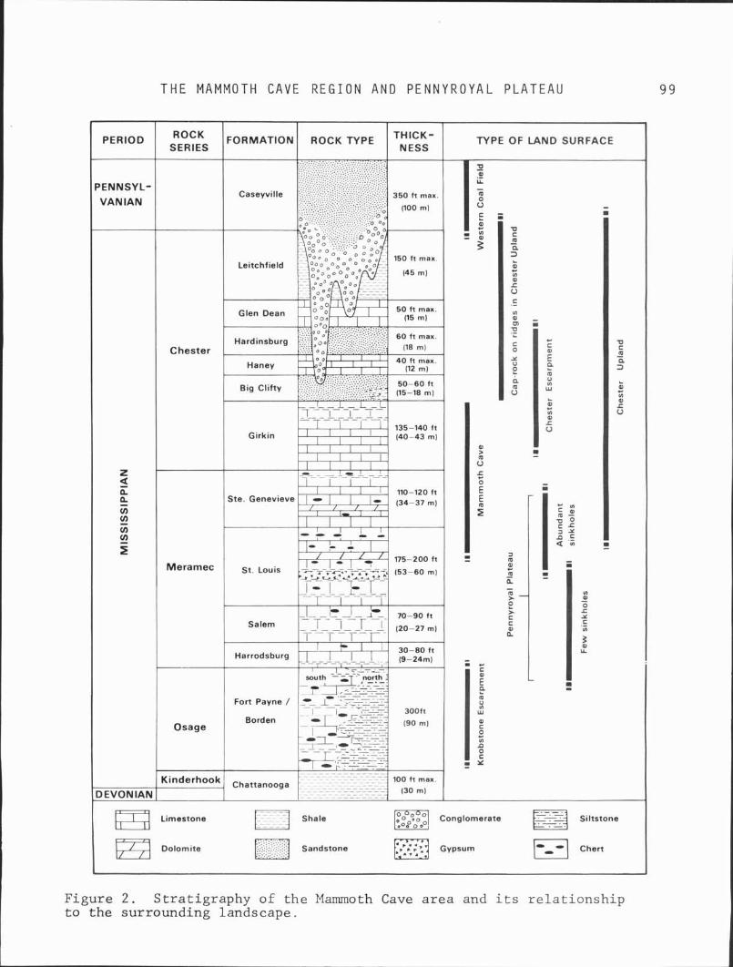
T H E M A M M O T H C A V E R E G I O N A N D P E N N Y R O Y A L P L A T E A U 9 9
Figure 2. Stratigraphy of the Mammoth Cave area and its relationship to the surrounding landscape.
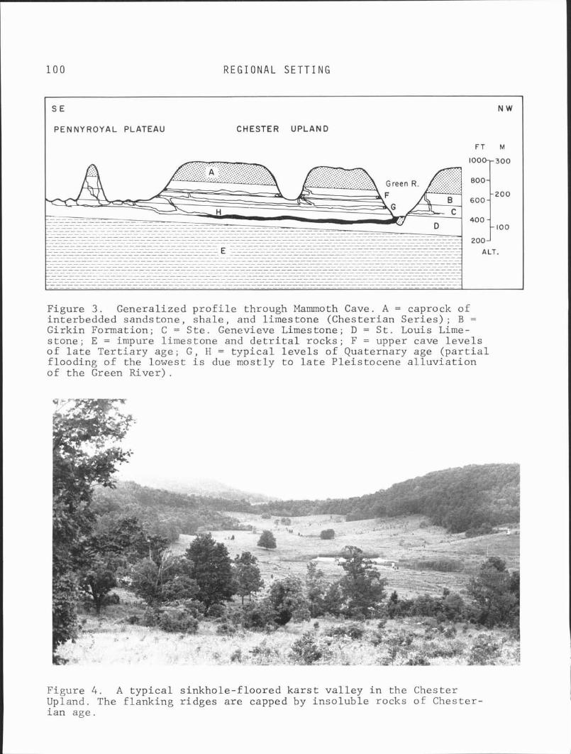
1 0 0 R E G I O N A L S E T T I N G
Figure 3. Generalized profile through Mammoth Cave. A = caprock of interbedded sandstone, shale, and limestone (Chesterian Series); B = Girkin Formation; C = Ste. Genevieve Limestone; D = St. Louis Lime- stone; E = impure limestone and detrital rocks; F = upper cave levels of late Tertiary age; G, H = typical levels of Quaternary age (partial flooding of the lowest is due mostly to late Pleistocene alluviation of the Green River).
Figure 4. A typical sinkhole-floored karst valley in the Chester Upland. The flanking ridges are capped by insoluble rocks of Chester- ian age.
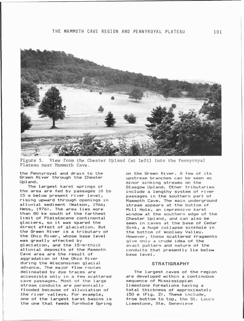
T H E MAMMOTH C A V E R E G I O N A N D P E N N Y R O Y A L P L A T E A U
Figure 5 . View from the Chester Upland ( a t l e f t ) i n to the Pennyroyal Plateau near Mammoth Cave.
t h e Pennyroyal and d r a i n t o t h e Green R i v e r t h r o u g h t h e C h e s t e r Up1 and.
The l a r g e s t k a r s t s p r i n g s of t h e area are f e d by p a s s a g e s 10 t o 15 m below p r e s e n t r i v e r l e v e l , r i s i n g upward t h r o u g h o p e n i n g s i n a1 l u v i a1 s e d i m e n t (Watson, 1966; H e s s , 1976). The a r e a l ies more t h a n 80 km s o u t h of t h e f a r t h e s t 1 i m i t of P l e i s t o c e n e c o n t i n e n t a l g l a c i e r s , so i t w a s s p a r e d t h e d i r e c t e f f e c t of g l a c i a t i o n . But t h e Green R i v e r is a t r i b u t a r y of t h e Ohio R i v e r , whose b a s e l e v e l was g r e a t l y a f f e c t e d by g l a c i a t i o n , and t h e 15-m-thick a l l u v i a l d e p o s i t s of t h e Mammoth Cave area a r e t h e r e s u l t of a g g r a d a t i o n of t h e Ohio R i v e r d u r i n g t h e Wisconsinan g l a c i a l advance. The major f l o w r o u t e s d e l i n e a t e d by d y e traces are a c c e s s i b l e on1 y i n a few s c a t t e r e d c a v e p a s s a g e s . M o s t of t h e l a r g e s t r e a m c o n d u i t s are p e r e n n i a l l y f l o o d e d b e c a u s e of a l l u v i a t i o n of t h e r i v e r v a l l e y s . F o r example, o n e of t h e l a r g e s t k a r s t b a s i n s is t h e o n e t h a t f e e d s T u r n h o l e S p r i n g
on t h e Green R i v e r . & few of its ups t ream b r a n c h e s c a n be s e e n a s minor s i n k i n g s t r e a m s on t h e Glasgow Upland. O t h e r t r i b u t a r i e s i n c l u d e a l e n g t h y s y s t e m of r i v e r p a s s a g e s i n t h e s o u t h e r n p a r t of Mammoth Cave. The main underground stream a p p e a r s a t t h e bot tom of M i 11 H o l e , an i m p r e s s i v e k a r s t window a t t h e s o u t h e r n e d g e o+ t h e C h e s t e r Upland, and c a n a l s o b e s e e n i n c a v e s a t t h e b a s e of Cedar S i n k , a huge c o l l a p s e s i n k h o l e i n t h e bot tom of Wool sey V a l 1 ey. However, t h e s e s c a t t e r e d f r a g m e n t s g i v e o n l y a c r u d e i d e a of t h e e x a c t p a t t e r n and n a t u r e of t h e c o n d u i t s t h a t p r e s e n t 1 y 1 i e be1 ow b a s e l e v e l .
STRATIGRAPHY
The l a r g e s t c a v e s of t h e r e g i o n are deve loped w i t h i n a c o n t i n u o u s s e q u e n c e of M i ssi ssi p p i an 1 i m e s t o n e f o r m a t i o n s h a v i n g a to ta l t h i c k n e s s of a p p r o x i m a t e l y 150 m (F ig . 2 ) . These i n c l u d e , f rom bot tom t o t o p , t h e S t . L o u i s Li mestone , S t e . Genevi e v e
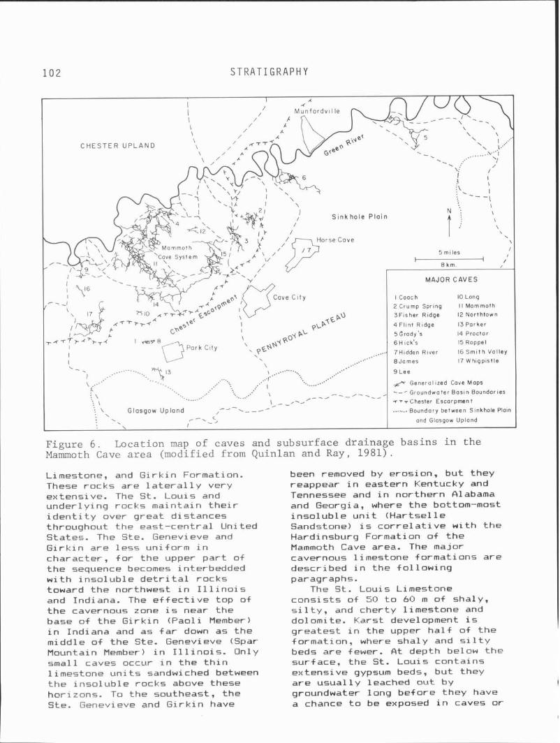
102 S T R A T I G R A P H Y
C H E S T E R U P L A N D
S i n k h o l e P l a i n
2 Crump Spring l l Mammoth 3F isher Ridge 12 Northtown
14 Proctor
#= Generol ized Cove Maps
- --/- .--- Glasgow Up land
Figure 6 . Locat ion map of caves and subsurface dra inage bas ins i n the Mammoth Cave a r e a (modified from Quinlan and Ray, 1981).
Limestone, and G i r k i n Formati on. been removed by erosion, but they These rocks are l a t e r a l l y very reappear i n eastern Kentucky and extensive. The St. Louis and Tennessee and i n northern Olabama under ly ing rocks maintain t h e i r and Georgia, where the bottom-most i d e n t i t y over great distances inso lub le u n i t (Hartsel l e throughout the east-central United Sandstone) i s c o r r e l a t i v e w i th t he States. The Ste. Genevieve and Hardinsburg Formation o f the G i r k i n are less uniform i n Mammoth Cave area. The major character, f o r the upper p a r t of cavernous limestone formations are the sequence becomes interbedded described i n the fo l low ing w i t h inso lub le d e t r i t a l rocks paragraphs. toward the northwest i n I l l i n o i s The S t . Louis Limestone and Indiana. The e f f e c t i v e top of cons is ts of 50 t o 60 m of shaly, the cavernous zone i s near the s i l t y , and cherty l imestone and base of the G i r k i n (Paol i Member) do1 omi te. Karst devel opment i s i n Indiana and as f a r down as the greatest i n the upper h a l f of t he middle o f the Ste. Genevieve (Spar formation, where shaly and s i l t y Mountain Member) i n I 1 1 i no i s . On1 y beds are fewer. A t depth below the small caves occur i n the t h i n surface. the St. Louis contains l imestone u n i t s sandwiched between extensive gypsum beds, but they t he inso lub le rocks above these are usual 1 y leached out by h ~ r i z o n s . To the southeast, the groundwater long before they have Ste. Genevieve and G i r k i n have a chance t o be exposed i n caves o r
T H E MAMMOTH CAVE R E G I O N A N D P E N N Y R O Y A L P L A T E A U
a t t he surface. Bedded and l e n t i c u l a r cher t occurs throughout most o f t he formation and i s p a r t i c u l a r l y abundant near t he top. The St. Louis i s under la in by t h e Salem and Harrodsburg formations, which are ra the r impure shaly l imestones w i t h a combined th ickness o f 30 t o 50 m. Karst development i s ra ther poor i n these rocks, and caves are mainly small and perched on inso lub le beds. The Glasgow Upland i s developed on the lower St. Lou is and the Salem-Harrodsburg, and the s inkhole p l a i n i s developed on the purer upper St. Lou is and t o a lesser degree on the Ste. Geqevieve.
The Ste. Genevieve Limestone i s about 35 m th ick . It i s probably t h e most cavernous l imestone u n i t in the reg ion and contains most o f t he Mammoth Cave System and nearby caves. It cons is ts o f interbedded 1 imestone and dolomite i n the lower ha1 f , and 1 imestone interspersed w i t h t h i n beds of incompetent s i l t y beds i n the upper h a l f . Nodular cher t i s common near the top and i n the middle o f t he formation.
The G i r k i n Formation, 25 t o 40 m t h i c k , cons is ts o f l imestone w i t h t h i n interbedded shale and s i l t s t o n e . It i s a favorable rock f o r cave development where geomorphic- condi t ions are su i tab le . The inso lub le beds are genera l ly l ess than 1 m t h i c k and do not s i g n i f i c a n t l y i n t e r r u p t t he c o n t i n u i t y o f cave development i n the area. The G i r k i n i s ove r l a i n by the B ig C l i f t y Formation, the basal sandstone of the ch ie f 1 y i nso lub le caprock t h a t forms the r i d g e c res t s of t he Chester Upland. Thin l imestone u n i t s between the inso lub le rocks contain perched ka rs t drainage, and spr ings a t t h e i r basal contacts provide t he water supply t o Mammoth Cave Nat ional Park.
These l imestone formations were deposited i n a shallow cont inenta l sea t h a t extended across most of southern North America dur ing the Mississ ippian Period. D e t r i t a l
sediment ca r r i ed from the adjacent land areas created a broad d e l t a (Michigan River Del ta) t h a t extended progressively across t he cen t ra l p a r t o f the sea (Swann, 1964). The t h i n beds of impure 1 imestone i n the G i r k i n and upper Ste. Genevieve are the ea r l y precursors of t h i s invasion of d e t r i t a l sediment, and the t h i c k sandstone and shale o f the Chester Ser ies represent the advance of t he d e l t a i n t o the area. A f te r a per iod o f f l u v i a l erosion a t the end of the Mississ ippian Period, t h e reg ion was blanketed again by Pennsylvanian conglomerate, sandstone, and shale, which are exposed i n the cen t ra l p a r t s o f t he I l l i n o i s Basin. The unconformity a t the base of the Pennsylvanian rocks has a maximum r e l i e f o f near ly 100 m. There i s 1 i t t l e evidence f o r a M iss iss ipp i an pa l eokarst , so preva lent i n the western United States, because most o f the pre-Pennsyl vani an erosion was confined t o the inso lub le rocks capping t he limestone.
F igure 7 shows the s t r a t i g r a p h i c changes i n the G i r k i n Formation as i t i s t raced northward and westward from the Mammoth Cave area. I n both d i r e c t i o n s the formation becomes progress ive ly more pa r t i t i oned by t h i c k shale and sandstone un i t s , breaking the hydrologic con t i nu i t y o f t he limestone. This t rend might he lp exp la in why the Mammoth Cave area i s so favorable t o cave development . However, very few passages i n Mammoth Cave occupy the upper beds of the Gi rk in , so t h i s explanation alone i s inadequate. Wore important1 y, the topographic re1 i e f is greatest i n the Mammoth Cave area, w i t h 90 t o 140 m o f continuous l imestone exposed above base leve l . This f i g u r e d i m i n i shes gradual 1 y northward t o about 65 m and westward t o l ess than 45 m. D issect ion of the Mammoth Cave Region by the Green and Barren r i v e r s was even deeper i n the past, because the va l leys are now
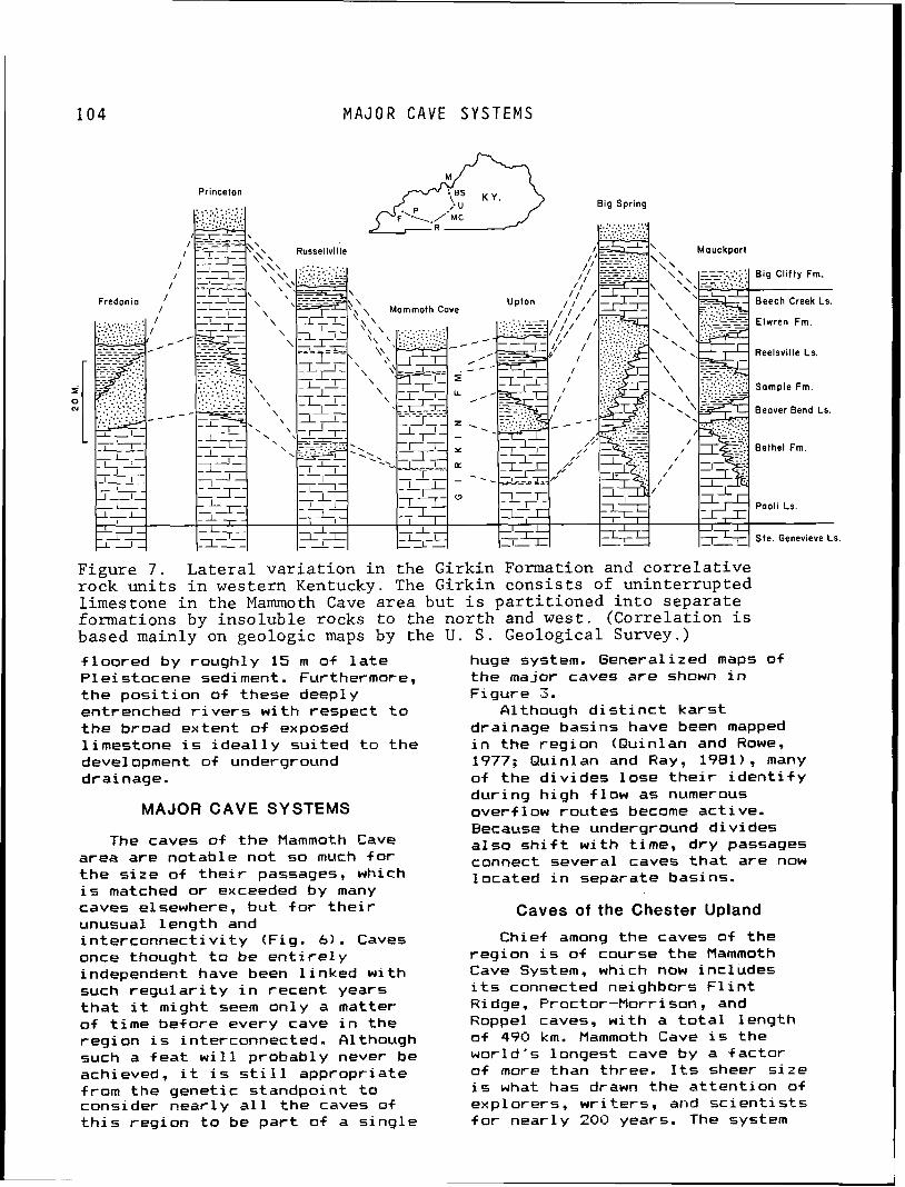
1 0 4 M A J O R 'CAVE S Y S T E M S
Figure 7 . L a t e r a l v a r i a t i o n i n the Girk in Formation and c o r r e l a t i v e rock u n i t s i n western Kentucky. The Girk in c o n s i s t s of un in te r rup ted l imestone i n t h e Mammoth Cave a r e a b u t i s p a r t i t i o n e d i n t o s e p a r a t e formations by i n s o l u b l e rocks t o the n o r t h and wes t . (Corre la t ion i s based mainly on geologic maps by the U . S . Geological Survey.)
f l oo red by roughly 15 m of l a t e huge system. Generalized maps of Ple istocene sediment. Furthermore, the major caves are shown i n t he p o s i t i o n of these deeply Figure 3. entrenched r i v e r s w i t h respect t o filthough d i s t i n c t ka rs t t he broad extent o f exposed drainage basins have been mapped l imestone i s i d e a l l y su i ted t o the i n the region (Quinlan and Rowe, devel opment of underground 1977; Quinlan and Ray, 1981), many drainage. of the d iv ides lose t h e i r i d e n t i f y
dur ing h igh +low as numerous MAJOR CAVE SYSTEMS overf low routes become act ive.
Because the underground d iv ides The caves o f t h e Mammoth Cave a l so s h i f t w i t h time, dry passages
area are notable not so much f o r connect several caves t h a t are now t h e s i ze o f t h e i r passages, which 1 ocated i n separate basins. i s matched o r exceeded by many caves elsewhere, bu t f o r t h e i r Caves of the Chester Upland unusual length and i n te rconnec t i v i t y (Fig. 6 ) . Caves Chief among the caves o f the once thought t o be e n t i r e l y reg ion i s o f course t he Mammoth independent have been l i nked w i th Cave System, which now includes such r e g u l a r i t y i n recent years i t s connected neighbors F l i n t t h a t i t might seem only a matter Ridge, Proctor-Morrison, and of t ime before every cave i n the Roppel caves, w i th a t o t a l length reg ion i s interconnected. Although o f 490 km. Mammoth Cave i s the such a f e a t w i l l probably never be wor ld 's longest cave by a f ac to r achieved, i t i s s t i l l appropriate o f more than three. I t s sheer s i ze from the genetic standpoint t o i s what has drawn the a t t en t i on of consider near ly a l l the caves of explorers, wr i te rs , and s c i e n t i s t s t h i s reg ion t o be p a r t o f a s i ng le f o r near ly 200 years. The system
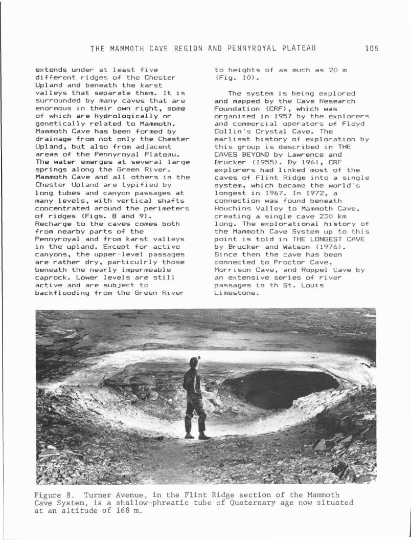
THE MAMMOTH C A V E R E G I O N AND P E N N Y R O Y A L P L A T E A U 1 0 5
ex tends under a t 1 east f i v e d i f f e r e n t r idges o f the Chester Upland and beneath the kars t va l leys t h a t separate them. It i s surrounded by many caves t h a t are enormous i n t h e i r own r i g h t , some of which are hydro log ica l l y o r gene t i ca l l y r e l a t e d t o Mammoth. Mammoth Cave has been formed by drainage from not on ly t he Chester Upland, bu t a lso from adjacent areas of the Pennyroyal Plateau. The water emerges a t several l a rge spr ings along the Green River. Mammoth Cave and a l l others i n the Chester Upland are t y p i f i e d by long tubes and canyon passages a t many 1 eve1 s, w i th v e r t i c a l sha f ts concentrated around the perimeters o f r idges (Figs. 8 and 9 ) . Recharge t o the caves comes both from nearby pa r t s of t he Pennyroyal and from kars t va l leys in t he upland. Except f o r ac t i ve canyons, the upper-level passages are ra ther dry, p a r t i c u l r l y those beneath t he near ly impermeable caprock. Lower l eve l s are s t i l l a c t i v e and are subject t o backf looding from the Green River
t o he ights of as much as 20 m (Fig. 10).
The system i s being explored and mapped by the Cave Research Foundation (CRF), which was organized i n 1957 by t he explorers and commerci a1 operators of Floyd C o l l i n ' s Crystal Cave. The e a r l i e s t h i s t o r y of exp lora t ion by t h i s group i s described in THE CAVES BEYOND by Lawrence and Frucker (1955). By 1961, CRF exp lorers had l i nked most o f the caves o f F l i n t Ridge i n t o a s i ng le system, which became the wor ld 's longest i n 1967. I n 1972, a connection w a s found beneath Houchins Val l e y t o Mammoth Cave, c rea t ing a s i ng le cave 230 km long. The exp lora t iona l h i s t o r y o f the Mammoth Cave System up t o t h i s p o i n t i s t o l d i n THE LONGEST CAVE by Brucker and Watson ( 1976) . Since then the cave has been connected t o Proctor Cave, Morrison Cave, and Rappel Cave by an extensive ser ies of r i v e r passages i n t h St. Louis Limestone.
Figure 8. Turner Avenue, in the Flint Ridge section of the Mammoth Cave System, is a shallow-phreatic tube of Quaternary age now situated at an altitude of 168 m..
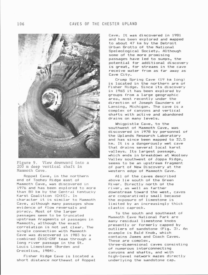
1 0 6 C A V E S OF T H E C H E S T E R U P L A N D
Figure 9 . View downward in to a 200 m deep v e r t i c a l sha f t i n Mammoth Cave.
Roppel Cave, i n the northern end of Toohey Ridge east of Mammoth Cave, was discovered i n 1976 and has been explored t n more than 80 km by the Central Kentucky Karst Coa l i t i on (CKKC). I n character i t i s s im i l a r t o Mammoth Cave, although many passages show evidence of f low reversals and p i racy. Most of the la rger passages seem t o be truncated upstream fragments of passages i n Mammoth, although the exact c o r r e l a t i o n i s not yet c lear. The s i ng le connection w i th Mammoth Cave was discovered i n 1983 by a combined CKKC-CRF team through a long r i v e r passage i n the St. Louis Limestone (Forden and Crecel ius, 1984).
Fisher Ridge Cave i s located a shor t d istance northeast of Roppel
Cave. It w a s discovered i n 1981 and has been explored and mapped t o about 47 km by the D e t r o i t Urban Grot to o f t h e National Speleologi c a l Society. A 1 though some of t he more promising passages have l e d t o sumps, the p o t e n t i a l f o r add i t iona l discovery i s great, f o r streams i n the cave rece ive water from as f a r away as Cave C i ty .
Crump Spring Cave (19 km long) i s located i n t he northern arm of Fisher Ridge. Since i t s discovery i n 1965 i t has been explored by groups from a l a rge geographic area, most recen t l y under the d i r e c t i on of Joseph Saunders of Lansing, Michigan. The cave i s a complex o f canyons and v e r t i c a l sha f t s w i t h a c t i v e and abandoned dra ins on many leve ls .
Whigpist le Cave, t o the southwest o f Mammoth Cave, was discovered i n 1978 by personnel o f the Uplands Research Laboratory and has s ince been mapped t o 32.5 km. It i s a dangerously wet cave t h a t d ra ins several l o c a l ka rs t val leys. I t s l a rges t passage, which ends i n breakdown a t Woolsey Val l e y southwest of Joppa Ridge, seems t o be an upstream fragment of p a r t o f New Discovery a t the western edge of Mammoth Cave.
A11 of the caves described above 1 i e south o f the Green River. D i r e c t l y nor th of the r i v e r , as we1 1 as f a r t h e r downstream toward t he west, caves are cornparati ve l y small because the exposure of l imestone i s l i m i t e d by an inc reas ing ly t h i c k c l a s t i c caprack.
To t he south and southeast o f Mammoth Cave Nat ional Park are many res idua l l imestone knobs present ly o r former ly capped by o u t l i e r s o f sandstone (Fig. 3 ) . An example i s Bald Knob, which contains James and Coach Caves. These are complex, three-dimensional caves cons is t ing o f numerous interconnect ing canyons and shafts, and w i t h h igh- level network mazes d i r e c t l y under1 y ing the sandstone cap.
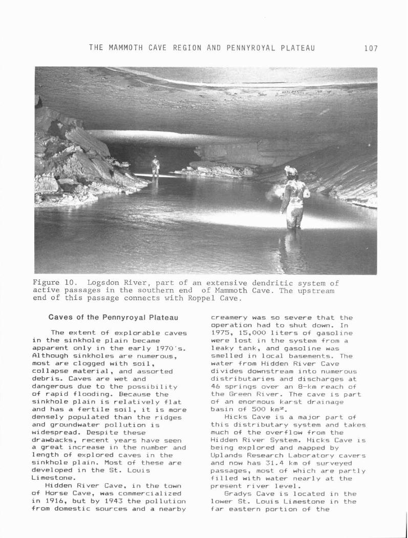
T H E MAMMOTH CAVE R E G I O N A N D P E N N Y R O Y A L P L A T E A U 1 0 7
Figure 10. Logsdon River, part of an extensive dendritic system of active passages in the southern end of Mammoth Cave. The upstream end of this passage connects with Roppel Cave.
Caves of the Pennyroyal Plateau
The extent o f explorable caves i n the s inkhole p l a i n became apparent on ly i n the ea r l y 1970's. Olthough sinkholes are numerous, most are clogged w i t h so i 1, c o l 1 apse materi a1 , and assorted debris. Caves are wet and dangerous due t o the p o s s i b i l i t y o f r a p i d f looding. Because the s inkhole p l a i n i s r e l a t i v e l y f l a t and has a f e r t i l e s o i l , i t i s more densely populated than the r idges and groundwater po l 1 u t i on i s widespread. Despi t e these drawbacks, recent years have seen a great increase i n the number and length of e x p l o r ~ d caves i n the s inkhole p la i n . Most of these are developed i n the St. Louis Limestone.
Hidden River Cave, i n the town of Horse Cave, was commerci a1 i i ed i n 1916, but by 1943 the p o l l u t i o n from domestic sources and a nearby
creamery was so severe t h a t the operat ion had t o shut down. I n 1975, 15,000 l i t e r s o f gasol ine were l o s t i n the system from a leaky tank, and gasol ine was smelled i n l o c a l basements. The water from Hidden River Cave d iv ides downstream i n t o numerous d i s t r i b u t a r i e s and discharges a t 46 spr ings over an 8-km reach of the Green River. The cave i s par t of an enormous ka rs t drainage basin of 500 km2.
Hicks Cave is a major p a r t of t h i s d i s t r i b u t a r y system and takes much of t he overf low from the Hidden River System. Hicks Cave is being explored and mapped by Uplands Research Laboratory cavers and now has 31.4 km of surveyed passages, most o f which are par t1 y f i l l e d w i t h water near ly a t the present r i v e r leve l .
Gradys Cave i s located i n the lower S t . Louis Limestone i n the f a r eastern p o r t i o n a f the
K A R S T A R E A S NOR.TH OF MAMMOTH C A V E
s inkhole p la in . I t was f i r s t explored i n the middle 196QSs, bu t has s ince been pushed f a r t h e r and mapped t o a length o f 19.3 km by a group under the d i r e c t i o n o f Joseph Saunders. Most of t he cave cons is ts of r i v e r passages s i tuatea a t base 1 eve1 , w i th numerous overf low routes.
Parker Cave, near Park C i ty . i s located near the headwater area o f t h e Turnhole Spring drainage basin. It i s d i s t i n c t i v e i n having f i v e independent para1 l e l stream passages connected by a s i ng le upgraded overf low rou te t h a t t ransmi ts water i n various d i r e c t i o n s depending on the pa t t e rn o f f l ood pulses i n the var ious stream passages. The cave was explored by Uplands Research Laboratory personnel and mapped t o a t o t a l length of 9 km.
To the southwest of the area shown i n Figure 6 i s a vast area o f s inkhole kars t dra in ing westward t o the Barren River. The l a rges t ka rs t basin i s t h a t feeding Graham Spring, which d ra ins S10 km2. The c i t y of Bowling Green i s located over a s i m i l a r ka rs t system. The c i t y has occasional prob l em5 w i th i ndustr i a1 and domest i c groundwater po l l u t i on , drainage problems, and backf looding of s inkholes dur ing wet periods. The work o f t he Center f o r Cave and Karst Studies a t Western Kentucky Univers i y i s d i rec ted main1 y toward understanding and a l l e v i a t i n g these problems.
Karst Areas North of Mammoth Cave
The Chester Upland and Pennyroyal Plateau extend northward i n t o southern Indiana (Fig. 1 ) . A1 thouh topograhic r e l i e f diminishes s l i g h t l y i n t h i s d i r e c t i o n and the G i r k i n Formation becomes pa r t i t i oned by d e t r i t a l formations, the region between Mammoth Cave and the Ohio River hosts some of the f i n e s t ka rs t and caves i n the country. The reader i s r e fe r red t o George (1976) f o r a more complete descr ipt ion.
Although the kars t and cave development i n t h i s northern area i s s i m i l a r i n many ways t o the Mammoth Cave Region, there are several features t h a t make i t unique. The boundary between the Pennyroyal Plateau and the Chester Upland i s not so c l e a r l y def ined as i t i s near Mammoth Cave, and the l a rges t cave system, the Sinking Creek System, extends both under r idges and s inkhole p la in . The longest s i ng le cave i n the system i s F i g Bat Cave, w i t h 20.2 km of mapped passages. The cave i s p a r t of a ka rs t drainage basin of 376 km2 t h a t discharges t o B o i l i n g Spring, which has an estimated peak f l ow o f more than 50 mS per second (George, 1976). Some caves i n the area are very shallow, and there are extensive cave pasages t h a t have been p a r t i a l l y unroofed by erosion and exposed as open trenches. These passages genera l ly terminate upstream and downstream i n remnant caves t h a t have no t yet been unroaf ed .
RELATIONSHIP OF KARST AND CAVES
TO THE GEOLOGICAL SETTING Strat igraphy exer ts the primary
con t ro l over the ka rs t landscape, as shown i n F igure 2. The c learest expression i s t he cont rast between the Chester Upland and Pennyroyal Plateau, determined by the presence o r absence 04 inso lub le Chesterian rocks. On a more sub t le scale, the r e l a t i v e 1 y small v e r t i c a l permeabi l i ty o f the Salem, Harrodsburg, and lower S t . Louis i n h i b i t s ka rs t and promotes sur f ace drainage. The areas of greatest s inkhole and cave development i n t he Pennyroyal Plateau are formed by the upper St. Louis beds, which are r e l a t i v e l y pure except f o r t h e i r cher t content. Deep-seated removal o f gypsum by s o l u t i o n may account f o r some of the f r a c t u r i n g and small-scale d i s t o r t i o n o+ these beds, which i n t u r n may fos te r the extensive s inkhole development. The even purer carbonate rocks of
T H E MAMMOTH CAVE R E G I O N AND P E N N Y R O Y A L P L A T E A U
t he Ste. Genevieve, on the other hand, develop broad, shallow sinkholes t ha t are fewer than those i n t he St. Louis. Whether t h i s d i s t r i b u t i o n represents a t r u e s t ra t i g raph i c con t ro l i s obscured by t he f a c t t h a t the area o f t he s inkhole p l a i n where the Ste. Genevieve i s exposed l i e a t t he f o o t o f the Chester Escarpment, where inso lub le . co l luvium accumulates from the up1 and and f i 11 s kars t depressi ons .
Caves o f the reg ion are a f fected ra the r un i formly by the d i f f e r e n t s t ra ta , and the major d i f ferences i n cave type are imposed more by the l o c a l hydrologic and geomorphic set t ing. The t h i n but prominent bedding and numerous small j o i n t s cause the cave t o be more sinuous and concordant t o t he s t r a t a than i n most other ka rs t regions (Deike, 1967; Palmer, 1977). The basic pa t t e rn of passages i s dend r i t i c , bu t t h i s pa t te rn i s usual1 y obscured by the numerous overf low routes i n the Pennyroyal caves and by the many superimposed l e v e l s and divers ions t o progressive1 y lower l e v e l s o f the Chester Upland caves.
The prominent bedding and general lack o f t ec ton i c disturbance has allowed cave passages t o develop very c l e a r l y def ined shapes: high, narrow, sinuous canyons; wide, low-gradient tubu lar passages w i th e l 1 i p t i c a l o r l e n t i c u l a r cross sections; and v e r t i c a l sha f ts up t o 60 m deep w i t h almost p e r f e c t l y v e r t i c a l walls. Canyons and sha f ts are f a r more common i n the h igh- re l ie f Chester Upland than i n t h e Pennyroyal Plateau. Even v e r t i c a l sha f ts are s t rong ly inf luenced by t he prominent bedding , because i n f 1 owing water i s general ly perched along bedding-plane par t ings o r on a r e l a t i v e 1 y r e s i s t a n t bed. Growth o f a t y p i c a l sha f t takes place downward i n stages through time, w i t h the bottom deepening from one major bed t o the next, and w i th
successive 1 a t e r a l d ra ins w i t h i n each bed.
The nature o f any given cave passage depends s t rong l y on whether i t or ig ina ted i n t he vadose zone o r i n t he phreat ic zone. Most passages t h a t form i n t he vadose zone (canyons and perched tubes) have an almost p e r f e c t l y consistent downdip o r ien ta t ion . Many passages of phrea t i c o r i g i n t rend near ly p a r a l l e l t o the l o c a l s t r i k e , because i n these prominently bedded rocks t he most e f f i c i e n t path f o r phreat ic water i s usual ly a t shallow depth a t o r j u s t below t h e water table. Fractures tend t o become t i g h t e r and fewer w i t h depth, and so few l a r g e ones cut across the bedding t h a t deep f low along one bed i s usual 1 y no t able t o pass upward i n t o over l y ing beds. Nevertheless, some passages are discordant t o the bedding and show evidence of phreat ic water t h a t rose i n the downflow d i rec t i on . The discordance i s almost i nva r i ab l y i n a competent, thick-bedded limestone, such as t h a t o f t he G i r k i n Formation, the middle and lowest beds o f the Ste. Genevieve, o r c e r t a i n massive beds i n t h e upper St. Louis. Echo River i n Mammoth Cave shows several such jumps from one bed t o another.
The s inuos i t y of both phreat ic and vadose passages i s s t rong ly con t ro l l ed by l o c a l va r i a t i ons i n d i p and s t r i k e o f the c o n t r o l l i n g bed o r bedding plane. The f a c t t h a t neighboring passages commonly e x h i b i t d iverse and seemingly independent t rends i s due t o l o c a l va r i a t i ons i n s t ruc tu re from bed t o bed. Each bed has i t s own unique s t ruc tu re imposed by depos i t iona l i r r e g u l a r i t e s and by va r i a t i ons i n thickness. Generalized contour maps of the geologic s t ruc tu re drawn on a s i n g l e s t ra t i g raph i c horizon are r a r e l y of use i n i n t e r p r e t i n g the l o c a l s t ruc tu re t h a t con t ro ls cave passages, however usefu l they mav be i n reg iona l studies.
Network mazes are r a r e i n the Mammoth Cave area because of the
C A V E D E P O S I T S
lack o f prominent j o i n t s and the concentraton of groundwater recharge i n t o numerous small po in t sources (mainly sinkholes). Small networks do occur where the upper beds o f t he G i r k i n Formation are h igh l y f rac tu red and over la in by t h i n permeable sandstone, such as i n p a r t s o f James Cave. I n general, t he inso lub le caprock o f the Chester Upland i s too t h i c k and i mpermeabl e t o admi t enough water t o form caves. Instead, the caprock forms a b a r r i e r t o a l l bu t d i f f u s e c a p i l l a r y water, so under ly ing upper-level passages no longer occupied by streams are except iona l ly dry. The t h i n l imestone u n i t s interbedded w i th t he inso lub le Chesterian rocks a c t u a l l y reduce the amount of water passing downward t o the main l imestone below by shunting water 1 a t e r a l l y t o perched springs.
CAVE DEPOSITS D e t r i t a l sediment i s t he most
common type of cave deposi t i n the reg ion (see Davies and Chao, 1959; C o l l i e r and F l i n t , 1974). Present o r former stream passages tha t have had r a p i d f l ow contain sand and sandstone fragments mainly from sandstone i n the Chesterian caprock, quartz pebbles from the basal Pennsylvanian rocks (1 i m i t ed almost exc lus ive ly t o caves i n the Chester Upland), and cher t fragments from the limestone. Much of t h i s mater ia l i s second-generation sediment, having co l lec ted f i r s t a t t he surface a t the base of steep slopes and l a t e r ca r r i ed underground through sinkholes. S i l t and c l ay from heterogeneous sources c o l l e c t i n passages t h a t are f looded by slow-moving water. These include passages abandoned by low-flow streams but which are subject t o f 1 ooding by s l ow-movi ng water overf lowing from a c t i v e passages dur ing h igh f 1 ow, and base-1 eve1 passages backflooded by nearby r i v e r s . Caves o f t he Pennyroyal Plateau are p a r t i c u l a r l y r i c h i n s i l t , c lay, and res idua l chert der ived from the l o c a l limestone.
Calcium carbonate speleothems such as f 1 owstone and d r i pstone are most common where abundant but d i f fuse water passes through s o i l i n t o limestone along t h e f l anks of r idges and knobs i n t h e Chester Upland. This water p i cks up a great deal of carbon d iox ide from the s o i l and qu i ck l y approaches equi 1 i brium w i th d issolved l imestone a t h igh concentrat ion. The water degasses r e a d i l y when i t enters under ly ing dry, aerated passages, which have a much lower carbon d iox ide content. I n the Pennyroyal the f requent f l ood ing o f passages i s no t so conducive t o t he growth of speleothems, a1 though 1 ocal areas o f t r a v e r t i n e occur, especi a1 1 y i n d r y upper cave levels. I so top ic ana lys is of carbonate speleothems from the Mammoth Cave System has been usefu l i n i n t e r p r e t i n g past temperatures of t he reg ion (Harmon -
and others, 1978). The small amount o f water t h a t
penetrates t he caprock o f the Chester Upland genera l ly moves by d i f ferences i n c a p i l l a r y po ten t i a l , ra ther than by g rav i t y . It i s drawn toward dry, aerated caves from the surrounding moist 1 i mestone and p a r t i c u l a r l y gypsum and epsomite, are deposted i n these passages (Pohl and White, 1965). For a complete descr ip t ion o f these mater ia ls, H i l l (1976).
HYDROLOGIC CONTROLS OF CAVE PATTERNS
Although a l l t he caves of the reg ion share c e r t a i n broad s i m i l a r i t i e s , there a re some s t r i k i n g d i f ferences between caves, and commonly between d i f f e r e n t pa r t s o f the same cave system, t h a t are caused by va r i a t i ons i n t he hydrologic se t t ing . These d i f fe rences are most eas i l y seen i n t he Mammoth Cave area, where the great s i ze of the drainage basins and length o f the caves have a1 lowed the + u l l e s t poss ib le response t o va r i a t i ons i n 1 ocal hydrology.
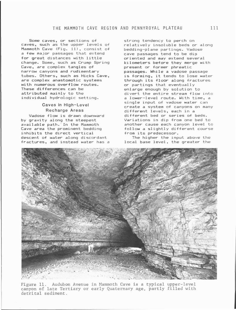
T H E MAMMOTH C A V E R E G I O N A N D P E N N Y R O Y A L P L A T E A U 111
Some caves, o r sect ions of caves, such as the upper l e v e l s of Mammoth Cave {Fig. 11 ) , consist o f a few major passage5 t h a t extend f o r great distances wi th l i t t l e change. Some, such as Crump Spring Cave, are complex tangles o f narrow canyons and rudimentary tubes. Others, such as Hicks Cave, are complex anastomotic systems w i th numerous overf low routes. These d i f ferences can be a t t r i b u t e d mainly t o the i nd i v i dua l hydro1 ogi c se t t ing .
Caves in High-Level Recharge Areas
strong tendency t o perch on r e l a t i v e 1 y inso lub le beds or along bedding-plane part ings. Vadose cave passages tend t o be d i p or iented and may extend several k i lometers before they merge w i t h present o r former phreat ic passages. While a vadose passage i s forming, i t tends t o lose water through i t s f l o o r along f rac tu res o r par t ings t ha t eventual ly enlarge enough by so lu t i on t o d i v e r t the e n t i r e stream f low i n t o a lower- level route. With time, a s i ng le inpu t of vadose water can create a system of canyons on many d i f f e r e n t leve ls , each i n a
Vadose f low i s drawn downward d i f f e r e n t bed or se r ies o f beds. by g r a v i t y along the steepest Var ia t ions i n d ip from one bed t o avai 1 able path. ' I n the Mammoth another cause each canyon l eve l t o Cave area the prominent bedding f o l l o w a s l i g h t l y d i f f e r e n t course i n h i b i t s the d i r e c t v e r t i c a l from i t s predecessor. descent o f water along discordant The higher the inpu t above the f rac tures, and instead water has a l o c a l base l eve l . the greater the
Figure 11. Audubon Avenue i n Mammoth Cave i s a t y p i c a l uppe r - l eve l canyon of l a t e T e r t i a r y o r e a r l y Quaternary age , p a r t l y f i l l e d w i t h d e t r i t a l sed iment .
C A V E S ALONG M A J O R P H R E A T I C D R A I N A G E L I N E S
potent i a1 f o r mu1 t i -1 evel vadose canyons t o develop. The most favorable o f such inpu ts are located i n the Chester Upland along the f lanks of r idges or i n ka rs t val leys, where 50 t o 100 m o f re1 i ef ex i sted above base 1 evel whi le the caves were forming. The Mammoth Cave System, f o r instance, contains l o c a l areas where vadose canyons, shafts, and perched tubes are so densely concentrated t h a t they are almost impossible t o po r t ray c l e a r l y on a p l an-vi ew map. Each of these sect ions has been formed by only a few concentrated high-level inpu ts of aggressive vadose water where a stream va l l ey has breached the inso lub le caprock. The complexity o f the caves i s due t o the tendency f o r vadose water t o d i v e r t t o lower routes, and t o t he many t h i n beds t h a t provide those routes, ra ther than t o a complicated geomorphic h i s t o r y o r t o s h i f t s i n the pa t t e rn of groundwater recharge.
Caves Along Major Phreatic Drainage Lines
Phreat ic cave passages form zones of low hydrau l ic head, toward which the water i n surrounding openings i s drawn. A s a r e s u l t , water i n these passages has l i t t l e o r no tendency t o d i v e r t t o new routes. 6s long as they are located a t or below the l o c a l r i v e r l eve l , no matter how la rge they grow or how much f low they acquire, t h e i r pos i t i on remains stable. Such passages usua l l y have a tubu la r shape and extend f o r -great distances w i th l i t t l e change (Fig. 10). They may be located p rec ise ly a t base l e v e l and be f i l l e d w i t h water on1 y dur ing per iods o f h igh f low, or they may descend i n t o the phreat ic zone and be perenn ia l l y water f i l l e d over p a r t o r a l l of t h e i r length. The tendency f o r water t o f o l l o w shallow paths near the top of the phreat ic zone, ra ther than penetrate t o considerable depth, leads t o the development of d i s t i n c t l e v e l s o f major passages
dur ing lengthy per iods o f s tab le base l e v e l (Fig. 1 2 i . Those passages t h a t do loop downward i n t o t he phrea t i c zone remain ac t i ve and continue t o grow long a f t e r contemporary passages formed a t the water t a b l e have been abandoned by a lower ing o f base leve l . The l a rge s i z e o f the passages i n and around Echo River i n Mammoth Cave i s due p a r t l y t o t he f a c t t h a t they are contemporaries o f passages t h a t l i e as much as 25 m higher. Although the higher passages have long been dry, t he lower pa r t s o f the passage loops are s t i l l a c t i v e today and have grown t o a considerably l a rge r s i z e than otherwise would have been the case.
Many caves i n t he Pennyroyal Plateau have the r e 1 a t i v e l y simp1 e morphology described here. Because o-f t he low r e l i e f , vadose feeders reach the water t a b l e over ra ther shor t distances, i n comparison w i t h those i n the Chester Upland, so complex systems o f canyons and sha f ts are rare.
Caves at the Downstream Ends of Catchment Areas
An exception t o t he s i m p l i c i t y of caves i n the Pennyroyal Plateau i s introduced by f lood water overflow. I n caves subject t o f lood ing, which i s somewhat more common i n the Pennyroyal than i n t h e Chester Upland, t he main passages f i l l w i t h high-pressure f loodwater much f a s t e r than the water t a b l e can r i s e i n the surrounding f rac tu red but non-cavernous bedrock. When t h i s happens, the hydrau l ic gradients around the pasages are reversed, so they are no longer toward the passages but away from them. Water i s forced out of the cave passages i n t o f r ac tu res i n the surrounding 1 imestone, and s ince t h i s water i s so l u t i ona l l y aggressive i t tends t o form a1 ternate routes o f f low. I n a ra ther short time, geological 1 y speaking, t h i s h i gh-gradi ent aggressive water can form a system of d ive rs ion
T H E MAMMOTH CAVE R E G I O N A N D P E N N Y R O Y A L P L A T E A U 113 I I
Figure 1 2 . Generalized p r o f i l e through p a r t of Mammoth Cave, showing the three major l eve l s of passage development ( labeled 1 , 2 , and 3 ) . Shaded areas represent the o r i g i n a l tubular port ions of each passage. Passages on l e v e l 3 were o r ig ina l l y adjusted t o a s t a t i c base l e v e l a t 152 m , but t he ph rea t i c sec t ions span a v e r t i c a l range of 20 m. See t e x t f o r fu r the r d e t a i l s .
I
B lue Spring Branch Gothic Ave. Broadway 650 --
6 0 0 -
Cleaveland Ave.
-2 550 -
Gt. Relief Hal l
5 0 0 -
4 5 0 - F T.
passages emanating from the o r i g i n a l ones, e i t h e r connecting d i f f e r e n t pa r t s o f caves (as i n Parker Cave) or forming d i s t r i b u t a r i e s t o t he nearest r i v e r (as i n Hicks Cave). These passages t y p i c a l l y form approximately a t t he same l eve l and along the same l imestone beds as t he host passages, so the r e s u l t i n g pa t t e rn i s d i s t i n c t 1 y anastomot i c.
- 175
- 150
M.
The processes described here are most common i n t he downstream p a r t s of l a rge drainage basins, where t he discharge i s greatest and where phreat ic passages are most numerous. D i s t r i b u t a r i e s around spr ings are favored by the tendency f o r blockage of out1 e t s by col lapse mater ia l and lands l ide debris. Fackf looding o f caves from the adjacent r i v e r may con t r ibu te t o t he enlargement o f a d i s t r i b u t a r y system. 61 l u v i a t i o n o f l o c a l r i v e r va l l eys has caused many passages i n the downstream ends of cave systems t o be re-flooded. Although they may represent several d i f f e r e n t stages o f cave o r i g i n , a l l passages below present base l e v e l are now water f i l l e d . Because of the numerous
interconnect ions between passages i n the area, dye introduced a t a sing1 e upstream po in t not su rp r i s ing1 y w i 11 usual 1 y emerge a t many d i f f e r e n t springs, espec ia l l y during h igh f low.
Further d e t a i l s on the morphology and geology o# caves in t he reg ion are given by White and others (197U), Ewers and Quin lan (1981), Palmer (19811, and Quinlan and others (1983).
RELATIONSHIP OF KARST TO THE LOCAL GEOMORPHIC HISTORY Two concepts must be in tegra ted
when i n t e r p r e t i n g the geomorphic evo lu t ion o f the region. F i r s t , i n t he broadest sense, t h i s evo lu t ion can be viewed as a steady-state system of gradual u p l i f t and erosion, i n which the mainly c l a s t i c Chesterian and Pennsylvanian rocks are gradual ly s t r ipped from the limestone, causing the locus of ka rs t development t o migrate w i t h t ime toward t he northwest i n the downdip d i rec t ion . With t h i s view, t he present ka rs t landscape and caves are seen t o represent (1) a youthfu l stage i n the northwestern areas where the caprock is j u s t
R E L A T I O N S H I P OF K A R S T TO T H E L O C A L G E O M O R P H I C H I S T O R Y
beginning t o be breached by erosion, ( 2 ) an early-mature stage, as i n the Mammoth Cave area. where limestones are exposed w i t h maximum r e l i e f and cave development i s greatest, (3 ) a late-mature stage, as i n the s inkhole p la i n , where the caprock has been completely removed, a1 1 owing f u l l development of su r f ace kars t but a d iminishing v e r t i c a l extent o f caves, and ( 4 ) an old-age stage i n the southeastern areas where the most so lub le l imestone has been removed by e ros i on.
Superimposed upon t h i s general and steady-state t rend i s the in f luence of r e l a t i v e l y short-term changes i n c l imate and base leve l . The otherwise smooth t r a n s i t i o n from one geomorphic stage t o another i s p e r i o d i c a l l y arrested o r accelerated, leav ing a unique s ignature on the ka rs t features t h a t form a t any given time. Although the steady-state model must be kept i n mind as a general backdrop, the secondary aspects o f geomorphic h i s t o r y are espec ia l ly important here. The s p e c i f i c morphology o f caves and other ka rs t features t e l l s a f a r more var ied and sub t le t a l e than does the steady-state model, and i t i s more f r u i t f u l i n the i n t e r p r e t a t i o n o f past geomorphic condi t ions.
During t he l a t e Te r t i a r y and e a r l y Quaternary periods, the reg ion underwent slow erosional degradation, which a l ternated w i t h per iods of broad-scal e aggradation. This a1 t e rna t i on between erosion and deposi t ion was probably caused by c y c l i c changes i n c l imate from humid t o a r id . As a r e s u l t , a 1 ow-re1 i ef 1 andscape was developed on the exposed limestone, c lose t o base leve l . This landscape was the forerunner o f the Pennyroyal Plateau. The area contain ing t he inso lub le caprock pro jec ted as a res i s tan t h i l l y region, the forerunner of t he Chester Upland, but w i th f a r l ess r e l i e f than now.
The uppermost l e v e l s i n Mammoth Cave and surrounding caves formed a t t h i s time. They r e f l e c t t h i s slow degradation and aggradation i n t h a t they are wide, la rge tubes and canyons up t o 25 m deep, f i l l e d w i th sediment t o a t l eas t two-th i rds of t h e i r depth i n many places (Fig. 11 ) . These passages are concentrated a t a l t i t u d e s around 182 t o 190 m a t t h e i r downstream ends near the Green River, more o r l e s s a t grade w i th nearby pa r t s of the Pennyroyal surface. They are r e l a t i v e l y few, because the l imestone was sparsely dissected a t t h a t time, and underground drainage was fed only by a few l a rge s ink ing streams i n the kars t va l leys and adjacent Pennyroyal Plateau. The Pennyroyal a t t h i s t ime supported mainly su r f ace drainage, as the slow erosion of the reg ion promoted low r e l i e f w i t h on1 y small l o c a l ka rs t basins (Miotke and fapenberg, 1972). The landscape was probably not very d i f f e r e n t from t h a t of t h e Great Val l e y o f Pennsylvania and V i r g i n i a on Cambrian and Ordovician carbonate rocks today.
There has been some debate as t o t he o r i g i n of the f l a t surface of the Pennyroyal Plateau. I t s approximate concordance w i t h the s t r a t a and the presence of low-re1 i ef areas under1 a i n by cher ty horizons has l e d some authors t o i n t e r p r e t the Pennyroyal as a s t r ipped s t r u c t u r a l p l a i n (e.g., Quinlan, 1970) . Another aspect of geologic con t ro l i s the strong re la t i onsh ip between sinkhole d i s t r i b u t i o n and s t ra t igraphy (Howard, 1968). Others, such as Miotke and Papenberg ( 1972) and We1 1s i 1976) , po in t t o the subt le discordance between the surface and the s t r a t a as evidence f o r base-level con t ro l . Both views have mer i t . It seems l i k e l y t ha t the Pennyroyal surface formed c lose t o f l u v i a l base l eve l during the slow T e r t i a r y d issect ion of the region, bu t t h a t l oca l areas show the e f f e c t of d i f f e r e n t i a l resistance of s t ra ta .
T H E MAMMOTH C A V E R E G I O N A N D P E N N Y R O Y A L P L A T E A U
During the Te r t i a r y Period, most o f the sur f ace drainage from the Appalachian Mountains drained through the Teays River, located no r th o f the present Ohio River. Ea r l y i n the Pleistocene, t h i s drainage was d ive r ted southward i n t o the Ohio River by cont inenta l g lac iers . The r e s u l t i n g increase i n discharge caused the Ohio t o entrench rap id ly . Consequently, t he Green River and other t r i b u t a r i e s of the Ohio deepened rap id1 y as wel l (Miotke and Palmer, 1972) . Deep, steep-wal l e d va l l eys were produced i n the Pennyroyal Plateau and Chester Up1 and. This entrenchment was p e r i o d i c a l l y i n te r rup ted by per iods of aggradation, probably co inc id ing w i th per iods of g lac ia t ion . I n l imestone areas, whi le major streams such as the Green River became entrenched, m i nor t r i b u t a r i e s remained hanging, and water d ive r ted underground. The purer l imestone o f t he low-re l ie f Pennyroyal su r f ace, especi a1 1 y t h a t c losest t o t he entrenched r i v e r s , developed underground drainage, caves, and sinkholes. Karst va l l eys formed between r idges i n t h e Chester Upland.
Rapid s h i f t s i n base l e v e l dur ing t h e Quaternary caused cave passages t o form qu ick ly a t many d i f f e r e n t l e v e l s (Figs. 8 and 10). Most prominent are those a t 168 m and a t 152 m. These l eve l s probably co inc ide w i t h periods of r e 1 a t i v e l y stab1 e base 1 eve1 , ra the r than w i t h favorable rock u n i t s , because the passages t h a t c l u s t e r a t uniform e levat ions occur a t d i f f e r e n t s t ra t i g raph i c horizons. Pal eomagneti c anal y s i 5
o f sediment has shown t h a t the 152 m l e v e l i s a t l e a s t 700,000 years o l d (Schmidt, 1982).
With t ime, greater d issect ion and r e l i e f caused an increase i n t he number of recharge points. Although major f l ow routes from the Pennyroyal Plateau s t i 11 e x i s t , recharge from the Chester Upland has become div ided i n t o many small inputs. I n add i t ion t o
a few l a rge passages t h a t are s t i l l forming today, many small ones are being formed by numerous l o c a l sources of recharge from ka rs t va l l eys and r i dge f lanks.
I n t e r p r e t a t i o n o f passage l e v e l s i n Mammoth Cave i s not a simple matter of char t ing the e leva t ion of the la rges t passage. Most passages i n the system have both an upstream vadose sect ion and a downstream phreat ic sect ion formed a t o r below the water tab le . The e levat ion a t which t h i s t r a n s i t i o n takes place i s the most r e l i a b l e i nd i ca to r o f a r e l a t i v e 1 y s t a t i c base leve l . a t the t ime a given passage was forming. Figure 12 shows the major passage l e v e l s i n Mammoth Cave and some of the complex i t i e s t h a t make t h e i r i n t e r p r e t a t i o n d i f f i c u l t . The uppermost l e v e l 182 t o 190 m i s best represented by Gothic Avenue and i t s upstream and downstream extensions. No vadose sect ion i s accessible, and the e n t i r e passage cons is ts o f an undulant tube. Although i t i s more o r l ess concordant w i th t he bedding o i the lower G i r k i n Formation, i t r i s e s and f a l l s impercept ib ly along i t s length. Level ing surveys show t h a t there i s v i r t u l l y no d i p on the beds, except f o r minor l o c a l s t ruc tures. The downstream end (Broadway and Audubon Avenue) i s rough1 y para1 l e l t o the l o c a l s t r i k e , but otherwise t he passage shows no systematic re l a t i onsh ip t o t he l imestone s t ruc ture . The pe rs i s ten t narrow e leva t ion range of the passage and i t s tubular shape (except where vadose entrenchment has taken place i n t he downstream sect ions) suggest development very near t he water t a b l e dur ing a per iod of near ly s t a t i c f l u v i a l base l eve l . This data i s strengthened by the f a c t t h a t other major passages i n the system reach t h e i r maximum width a t t h i s same elevaion. These passages inc lude the main passages of S a l t s Cave and Crysta l Cave i n t he northeastern p a r t o f F l i n t Ridge. They l i e i n rock u n i t s d i f f e r e n t from those of Gothic
R E L A T I O N S H I P OF K A R S T TO T H E L O C A L G E O M O R P H I C H I S T O R Y
Avenue, so the correspondence of e leva t ion i s not caused by favorable s t ra ta .
There has been recent speculat ion t h a t t he uppermost l e v e l s o f Mammoth Cave were formed by paragenesis--this i s , as tubes deep i n t he phrea t i c zone tha t were enlarged upward owing t o sediment accumulation on t h e i r f l o o r s (Derek C. Ford, Hamilton, Ontario, personal communications, 1975) . Under these condi t ions a tubular-shaped passage would migrate upward t o t he water tab le , forming a high, narrow canyon whose lower pa r t s were f i l l e d wi th sediment. The highest passage i n the system, C o l l i n s Qvenue i n Crysta l Cave ( F l i n t Ridge), may have formed a t l e a s t p a r t l y i n t h i s way, as i t has an i r r e g u l a r c e i l i n g and i t s accessible par t r i s e s s l i g h t l y i n the downstream d i rec t i on . Paragenesis i s u n l i k e l y i n most other passages i n the system, however, because of the f 01 1 owing evidence: ( 1 ) numerous passages are f i l l e d e n t i r e l y t o t he c e i 1 i n g w i t h coarse-grained sediment capped by a layer o f s i l t and c l a y on ly a few centimeters t h i ck , i n d i c a t i n g t h a t r a p i d l y f l ow ing streams deposited the f i l l bu t d i d not cause s i g n i f i c a n t upward so lu t ion, (2) canyon c e i l i n g s are h i g h l y concordant t o t he bedding, which i s u n l i k e l y i n a tube dissolved upward through t h e phrea t i c zone, ( 3 ) tubu lar passages on the upper l eve l , such a5 Gothic &venue, are a1 so f i 11 ed wi th stream-deposited sediment i n p laces t h a t have not yet been exhumed by l a t e r entrenchment, and ( 4 ) cu t -and- f i l l s t ruc tu res i n the sediment of upper l e v e l s i n Long Cave, south of Mammoth Cave, show evidence of meandering channels formed by free-surface streams (James Currens, Kentucky Geological Survey, personal communicaton, 1983).
The l e v e l a t 167 t o 170 m i s best observed i n C l eavel and Avenue. Boone Avenue, i t s upstream end, i s a vadpse canyon t h a t extends d i r e c t l y down the d ip of
the beds. A t the t r a n s i t i o n po in t represent ing the former water table, the canyon changes gradual ly t o a tube or iented near ly p a r a l l e l t o the l o c a l s t r i k e . This pa t te rn i s repeated a t the same elevat ion, but i n en t i r e1 y d i f f e r e n t beds, i n Water fa l l T r a i l and F l i n t Ridge (Niotke and Palmer, 1972). The upstream end of Waterf a1 1 Tra i 1 s t i l l contains an ac t i ve stream perched on re1 a t i ve l y inso lub le beds, but i t s former t r a n s i t i o n from vadose t o phreat ic condi t ions i s c l e a r l y detected by the t r a n s i t i o n from dip-oriented canyon t o undulant tube crudely or iented along the s t r i k e . Turner Avenue i n F l i n t Ridge i s another example o f a tube a t t h i s same l e v e l (Fig. 8) .
The lowest major l e v e l i s a t 152 m. Further entrenchment below the 167 m l eve l allowed the water i n Boone Avenue t o bypass Cleaveland Avenue and continue on down the d i p as a canyon known as the Pass of E l Ghor. A t the new s t a t i c water l eve l of 152 m, the canyon gradual ly changed t o a tube (modif ied somewhat by l a t e r entrenchment) i n S i l l iman Avenue. Instead of maintaining t h i s leve l , however, the tube extended as much as 20 m beneath the water table, forming the Echo River passage. It rose i n the downstream d i r e c t i o n i n t o River Ha l l , where i t jo ined the passage from Great Re l ie f Ha l l , a major tube a t 152 m. The combined passage unfor tunate ly terminates i n breakdown a t River H a l l , so the downstream cont i nuat i on i s obscured. However, the presence of the Great Re1 i e f tube a t 152 m and the t r a n s i t i o n from canyon t o tube i n Sil. l iman Avenue a t the same e levat ion i s compell ing evidence f o r a s t a t i c base l e v e l a t t ha t elevat ion. Echo River , the low po in t i n t h i s passage system, has therefore been a c t i v e l y forming ever since the Green River was a t 152 m. The l a rge s i ze of the Echo River passage can be accounted f o r i n t h a t way. Other passages a t the
T H E MAMMOTH C A V E R E G I O N A N D P E N N Y R O Y A L P L A T E A U
152 m l e v e l inc lude F loyd 's Lost Passage and Swinnerton Avenue i n F l i n t Ridge. Each show a t r a n s i i o n from vadose t o shallow-phreatic a t t he same e leva t ion but i n d i f f e r e n t rock un i t s .
The great extent of caves and ka rs t features i n the Mammoth Cave area i s c l e a r l y no t a simple product o f the vast exposure of l imestone, and the steady-state model o f slow denudation i s inadequate t o exp la in it. Without the r e l a t i v e l y r a p i d and deep entrenchment r e s u l t i n g from Quaternary changes i n t he Ohio River drainage, t he reg ion would probably conta in on ly a small f r a c t i o n o f the ,caves and kars t topography t h a t i t does now.
REFERENCES Borden, James, and Crecel ius,
Peter, 1984, The Roppel- Mammoth Connection: National Spel eo l og i c a l Soci e t y News, v. 42, p. 103-109.
Brucker, R. W. and Watson, R. A., 1976, The longest cave: New York, A l f r e d A Knopf, 316 p.
C o l l i e r , C. R., and F l i n t , R. F., 1974, F l u v i a l sedimentation i n Mammoth Cave, Kentucky: U. S. Geological Survey Professional Paper 475-D, p. 141-143.
Davies, W. E., and Chao, E. C. T., 1959, Report on sediments i n Mammoth Cave, Kentucky: U. S. Geological Survey Admi n i s t ra - t i o n Report, 117 p.
Deike, G. H., 1967, The develop- ment o f caverns of t he Mammoth Cave Region: Un i ve rs i t y Park, Pennsylvania Sta te Univers i ty , Ph.D. D isser ta t ion , 235 p.
Ewers, R. 0. , and Quinlan, J. F. , 1981, Cavern po ros i t y develop- ment i n l imestone, A low d ip model from Mammoth Cave, Ken- tucky: Eighth I n te rna t i ona l Congress Spel eo l ogy , Bowl i ng Green, Kentucky, v. 2, p. 727- 731.
George, A. I., 1976, Karst and cave d i s t r i b u t i o n i n north- cen t ra l Kentucky: National Spe- l e o l o g i c a l Society B u l l e t i n , v. 38, p. 93-98.
Harmon, R. S., Schwarcz, H. P., and Ford, D. C., 1978, Stable iso tope geochemi s t r y o f spel e- othems and cave waters from the F l i n t Ridge-Mammoth Cave System, Kentucky: Imp l i ca t ion f o r t e r - r e s t r i a l c l imate change during t he per iod 230,000-100,000 years BP: Journal of Geology, v. 86, p. 373-384.
Hess, 3. W., 1976, A review of the hydrology o f t h e Central Ken- tucky Karst: Nat ional Speleolog- i c a l Society B u l l e t i n , v. 38, p. 99-102.
H i l l , C. A., 1976, Cave minerals: Austin, Texas, Speleo Press, 137 P -
Howard, A. D., 1968, S t ra t ig raph ic and s t r u c t u r a l con t ro ls on land- form development i n the Central Kentucky Karst: National Spele- o l og i ca l Society B u l l e t i n , v. 30, p. 95-114.
Lawrence, J., Jr . , and Erucker, R. W., 1955, The caves beyond (1975 r e p r i n t ) : Teaneck, New Jersey, Zephyrus Press, 283 p.
Miotke, F. D. , and Palmer, A. N. , 1972, Genetic re1 a t ionsh ip between caves and landforms i n t he Mammoth Cave National Park area: Wurtzburg, Germany, Eohler Verlag, 69 p.
Miotke, F. D., and Papenberg, H., 1972, Geomorphology and hydrol- ogy o f the s inkhole p l a i n and Glasgow Upland, Central Ken- tucky Karst, pre l iminary report : Caves and Karst, v. 14, p . 25- 3 2 .
Palmer, A. N., 1977, Inf luence of geologic s t ruc tu re on ground- water f l ow and cave development i n Mammoth Cave National Park, Kentucky, U. S. A. : In te rna t iona l
REFERENCES C I T E D
Associat ion of Hydrogeol ogi s ts , 12th Memoirs, p. 405-414.
Palmer, A. N., 1981, A geologic guide t o Mammoth Cave National Park: Teaneck, New Jersey, Zephyrus Press, 196 p.
Pohl, E. R., 1970, Upper Missis- s ipp ian deposits i n south- cen t ra l Kentucky: Kentucky Academy of Sciences Trans- act ions, v. 31, p. 1-15.
Pohl , E. R., and White, W. B., 1965, Su l fa te minerals: t h e i r
Karst: Phase I: Univers i t y of Kentucky, Water Resources Re- search I n s t i t u t e , Research Report 101, 93 p .
Buinlan, J. F., and Ray. J. A., 1981, Groundwater basins i n the Mammoth Cave Reqion, Kentucky: Fr i ends of the Karst, Occasional Pub l i ca t ion 1.
Schmidt , V. A. , 1982, Magnetostra- t ig raphy of sediments i n Mammoth Cave, Kentucky: Science, v. 217, p. 827-829.
o r i g i n i n the Central Kentucky Karst: American Mineralogist , v. Swann , D. H. , 1964, Late M i s s i 5-
50, p.1462-1465. s ipp ian rhythmic sediments of the Miss iss ipp i Val ley: Associa-
Quinlan, J. F., 1970, Central Ken- t i o n o f American Petroleum Geol-
tucky Karst: Reunion in te rna t - o g i s t s B u l l e t i n , v.48, p. 637-
i onal e karst01 ogie en Languedoc- 658.
Provence 1968, Actes, Mediter- anee, studes e t traveaux, v. 7, p. 235-253.
Ruinlan, J. F., Ewers, R. O., Ray, J. A., Powell, R. L., and Krothe, N. C., 1983, Ground- water hydro1 ogy and geomorphol- ogy o f the Mammoth Cave Reqion, Kentucky, and of the Mi tche l l P l a i n , I n d i ana: Geological Soci - e t y o f America Annual Meeting, Guidebook t o F i e l d T r i p 7. 85 p.
Ouinlan, J. F. , and Rowe, D. R., 1977, Hydrology and water qual- i t y i n t he Central Kentucky
Watson, R. A. , 1966, Central Ken- tucky Karst hydrology: National Speleological Society Ful l e t i n , v. 28, p. 159-166.
Wells, S. G., 1976, Sinkhole P l a i n evo lu t ion i n the Central Ken- tucky Karst: National Spel eol og- i c a l Society B u l l e t i n , v. 38, p. 103- 106.
White, W. B . , Watson, R. A., Pohl, E. R., and Brucker, A. W . , 1970, The Central Kentucky Karst: Geographical Review, v. 60, p. 88-1 15.
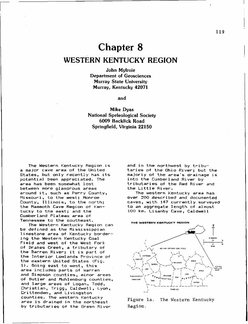
Chapter 8 WESTERN KENTUCKY REGION
John Mylroie Department of Geosciences
Murray State University Murray, Kentucky 42071
and
Mike Dyas National Speleological Society
6009 Backlick Road Springfield, Virginia 22150
The Western Kentucky Region i s a major cave area o f t he United States, bu t on ly r e c e n t l y has i t s p o t e n t i a l been appreciated. The area has been somewhat l o s t between more glamorous areas around i t , such as Perry County, Missouri , t o the west; Monroe County, I l l i n o i s , t o t he north: the Mammoth Cave Region of Ken- tucky t o t he east; and the Cumberland Plateau area o f Tennessee t o the southeast.
The Western Kentucky Hegion can be def ined as t he Miss iss ipp ian l imestone area o f Kentucky border- i n g t he Western Kentucky Coal F i e l d and west o f t h e West Fork of Drakes Creek, a t r i b u t a r y o f the Barren River; i t is p a r t of t h e I n t e r i o r Lowlands Province o f the ea.stern United States (Fig. 1 ) . Going east t o west, t h i s area inc ludes p a r t s o f Warren and Simpson counties, minor areas of Bu t l e r and Muhlenburg counties, and l a rge areas o f Logan, Todd, Chr is t ian , Trigg, Caldwell, Lyon, C r i t tenden , and L i v i ngston counties. The western Kentucky area is drained i n t he northeast by t r i b u t a r i e s o f t he Green River
and i n t he northwest by t r i b u - t a r i e s o f the Ohio River; but the major iy o f t he area's drainage i s i n t o t he Cumberland River by t r i b u t a r i e s of t h e Red River and the L i t t l e River.
The western Kentucky area has over 200 described and documented caves, w i t h 147 c u r r e n t l y surveyed t o an aggregate length of almost 100 km. Lisanby Cave, Caldwell
THE WESTERN KENTUCKY REGION
')..I\ I WESTERR KENTUCKY COAL F I E L D \
v-.-. ?-.: i j I .-.+- 1.- '. ! TEMNESSEE
-.-
Figure la. The Western Kentucky
Region.
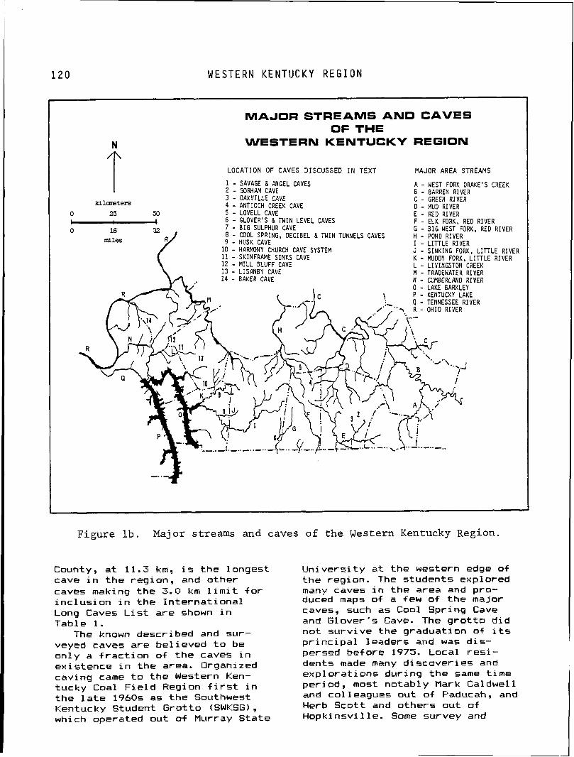
1 2 0 W E S T E R N K E N T U C K Y R E G I O N
MAJOR STREAMS AND CAVES OF THE
WESTERN KENTUCKY REGION
L O C A T I O N O F C A V E S D I S C U S S E D I N TEXT M A J O R A R E A S T R E A M S
1 - SAVAGE & ANGEL CAVES A - WEST FORK DRAKE'S CREEK 2 - GORHAM CAVE B - BARREN RIVER
kilareters 3 - O A K V I L L E CAVE C - GREEN RIVER 4 - ANTIOCH CREEK CAVE D - MU0 RIVER
0 25 50 5 - LOVELL CAVE E - RED RIVER - 6 - GLOVER'S & TWIN LEVEL CAVES F - ELK FORK, RED R I V E R 0 7 - B I G SULPHUR CAVE G - B I G WEST FORK, RED RIVER
8 - COOL SPRING, DECIBEL a TWIN TUNNELS CAVES H - POND RIVER 9 - HUSK CAVE I - L I T T L E RIVER
1 0 - HARMONY CHURCH CAVE SYSTEM J - S I N K I N G FORK, L I T T L E RIVER 11 - SKINFRAME S I N K S CAVE K - MUDDY FORK. L I T T L E RIVER 1 2 - M I L L B L U F F CAVE L - LIVINGSTON CREEK 13 - L I S A N B Y CAVE M - TRADEWATER RIVER 14 - BAKER CAVE N - CUMBERLAND RIVER
0 - LAKE BARKLEY
..,I. ,..,.. -..-
Figure lb. Major streams and caves of the Western Kentucky ~egion.
County, a t 11.3 km, i s the longest cave i n t h e region, and other caves making the 3 . 0 km l i m i t f o r i nc lus ion i n the I n te rna t i ona l Long Caves L i s t are shown i n Table 1.
The known described and sur- veyed caves are bel ieved t o be only a f r a c t i o n o f t he caves i n existence i n the area. Organized caving came t o the Western Ken- tucky Coal F i e l d Region f i r s t i n the l a t e 1960s as the Southwest Kentucky Student Grot to (SWKSG) , which operated out of Murray State
Un ivers i t y a t the western edge of the region. The students explored many caves i n the area and pro- duced map5 o f a few o f t he major caves, such as Cool Spring Cave and Glover's Cave. The g r o t t o d i d no t surv ive the graduation of i t s p r i n c i p a l leaders and was d is - persed bef ore 1975. Local r e s i - dents made many d iscover ies and exp lo ra t i on5 dur ing t he same t ime period, most notably Mark Caldwell and colleagues out of Paducah, and Herb Scot t and others out o f Hopk insv i l le . Some survey and
W E S T E R N K E N T U C K Y R E G I O N
Table I
INTERNATIONAL LONO* CAVES
IN WESTERN KENTUCKY
CAVE LENGTH ( K M ) COUNTY
L l s a n b y 1 1 . 3 1 C a l d w e l l
C o o l S p r l n g 5 . 3 0 T r l 9 9
T w i n L e v e l 5 . 0 0 C h r l s t l a n and Todd
B l g S u l p h u r 4 .80 T r l g g
S a v a g e 4 . 2 8 L o g a n
G l o v e r ' s 3 . 3 5 C h r l s t l a n and Todd
Gorham 3 . 2 1 L o g a n
S k l n f r a m e S l n k s ( R l c e ) 3 . 0 0 C a l d w e l l
*Caves 3 km or more in l e n g t h .
documentation were done by these in formal groups, bu t t he Western Kentucky Coal F i e l d Region was b a s i c a l l y a blank spot w i t h i n t he spel eo l og i c a l know1 edge of the Uni ted States. Some of the best data were i n the hands of speleo- b io l og i s t s , such as Tom Earr and John Holsinger, who made forays i n t o t he area f o r specimen co l lec - t i on , and the Evansv i l l e Metropo l i tan Grotto, which d i d extensive work i n t h e Glover 's Cave area o f Chr i s t i an County.
S i g n i f i c a n t progress i n the study and documentation o f the caves and ka rs t o f western Kentucky began i n August of 1977 w i th t he establishment, by the Board of Governors o f t h e National Speleological Society (NSS) of the Western Kentucky Speleological Survey (WKSS). Mike Dyas, a caver w i t h extensive experience i n other regions, began caving i n western Kentucky i n 1975 when h i s fami ly bought land i n Caldwell County. Mike's i n t e r e s t i n t he reg ion caused him t o search f o r ava i lab le data from the NSS and elsewhere. It became i mmedi ate1 y obvi 01-15 t h a t there was l i t t l e publ ished informat ion, yet f i e l d work showed a reg ion w i t h considerable po ten t i a l . I n the spr ing of 1977. John Mylro ie, a longtime caver from the Northeast, accepted a p o s i t i o n i n the geology program a t
Murray State Univers i ty , and was r e c r u i t e d i n t o the f ledg ing WKSS. To avoid t he problem of l o s t data and dup l i ca t i on o f e f f o r t , i t was decided t o pub l ish an annual r e p o r t conta in ing descr ipt ions, surveys, and s c i e n t i f i c a r t i c l e s on t he work done i n t he WKSS area. Reports covering each year o f a c t i v i t y have been published, w i t h a l i m i t e d and con t ro l l ed d i s t r i b u t i o n t o p ro tec t the caves. A compi lat ion of the WKSS a c t i v i t y through January 1985 i s shown i n Table 2.
GEOLOGY Western Kentucky may be viewed
as a se r i es of cuestas formed by t h e removal of s t r a t a on t he southern and western f l anks of the Western Kentucky Coal F ie ld . The r e s u l t i n g escarpments de f ine up1 ands and low1 ands o f d i s t i n c t geologic and geographic character. The western Kentucky kars t i s a s inkhole p l d i n developed on the
Table I1
WKSS ACTIVITY THROUQH 1985
COUNTY
B u t l e r
C a l d w e l l
C h r i s t i a n
C r i t t e n d e n
L i v i n g s t o n
L o g a n
L y o n
M u h l e n b e r g
S impson*
Todd
T r l g g
W a r r e n *
T o t a l
NUMBER OF
CAVES KNOWN
2
3 6
2 0
1 4
1 4
5 2
9
2
1
1 6
5 1
1
218
NUMBER
MAPPED
0
2 2
1 2
9
7
3 1
1
2
1
1 1
50
1
147
K I L O M E T E R S
MAPPED
0
2 3 . 4 2
1 3 . 2 4
2 . 9 3
2 . 1 9
1 9 . 5 3
0 . 6
1 . 1 3
0 . 0 1
6 . 2 8
2 4 . 0 9
0 . 3 3
9 3 . 7 5
* P o r t i o n o f t h e c o u n t y w i t h i n t h e WKSS o n l y .
1 2 2 S T . L O U I S L I M E S T O N E
Pennyroyal Plateau, a long band of the f a u l t s general 1 y s t r i k e Miss iss ipp i an 1 imestones, northeast and are re la ted t o extending from eastern Kentucky, s i m i l a r f a u l t s i n southern arching southward through cen t ra l I l l i n o i s . The I l l ino is-Kentucky and western Kentucky and Fluorspar D i s t r i c t has produced neighboring Tennessee, t o southern f l u o r i t e and spha le r i t e from I l l i n o i s and eastern Missouri. I n mineral i z a t i on associated w i t h western Kentucky, the l imestones these fau l t s . Fau l ts i n Caldwell d i p approximately 0.5" t o the and Ch r i s t i an count ies have a north-northeast bu t are l o c a l l y northwest ly o r more wester ly undulatory. The plateau i s gent ly trend. To date no s i g n i f i c a n t r o l l i n g t o near ly l eve l , averaging f l u o r i t e mining has taken place no more than 30 t o 40 m i n r e l i e f , along these fau l t s . The gen t le w i t h average e leva t ion around 150 reg iona l d i p f o r t he rocks i n t h i s m. While the p la teau length i s area changes from n o r t h l y i n the extensive, i t s width var ies southern po r t i on t o nor theast ly as considerably. I n western Kentucky, one moves northwest ly around the t h e p la teau averages 30 km i n western f l ank o f the I l l i n o i s width. Commonly re fe r red t o as t he Fasi n and the encl osed Western "Sinks" o r the "Sinkhole Pla in," Kentucky Coal F ie ld . t he p la teau i s character ized by For the most p a r t the rocks i n thousands of s h a l l ow sinkholes, t h i s area are of Mississ ippian age occasional b l i n d va l leys, and and belong t o the 'Meramecian and numerous kars t windows. Karst Chesterian stages. I n extreme pavement has been found i n only a western Tr igg County, Cretaceous few locat ions, due t o the deposits o v e r l i e t he Mississ ippian extensive s o i 1 development i n the rocks. Along the shores o f region. Stream and r i v e r va l leys Kentucky Lake and Lake Barkley, are we1 1 a1 l uv ia ted w i t h sands, 1 imestones of o lder age are c lays, and cher t gravel. St icky present l o c a l l y . However, the vast r ed c l a y and cher t cobbles mantle ma jo r i t y o f the known caves are t he r i d g e tops and p la ins . found i n o r above the St. Louis I n te rna l drainage i s we l l Limestone (Fig. 2) . L i t h o l o g i c developed w i t h surface drainage descr ip t ions and c o r r e l a t i o n being r e s t r i c t e d t o several in format ion can be found i n the entrenched base 1 eve1 streams. 7.5 minute geologic quadrangle
The 1 imestones o f western maps of t h i s area. Deta i led Kentucky are a1 l Mississippian chemical analyses and 1 i tho log ic (Carboniferous) , and are s imi l a r descr ip t ions are a lso ava i lab le i n i n many cha rac te r i s t i c s t o other Dever and McGrain (1969). Figure 2 M i s s i s s i pp i an 1 i mestones of and the accompanying l i t h o l o g i c Kentucky and surrounding states. descr ip t ions are a summary of t h a t The fo l l ow ing geologic descr ip t ion informat ion. i s condensed from Whaley and Black ! 1978). St. Louis Limestone
The age and general s t ruc tu re The St. Louis Limestone i s a o f the rocks i n Western Kentucky l ight-brown t o gray, f i n e t o can be seen on the Geological Map coarse-grai ned , a rg i 1 1 aceous of Kentucky (McFarlan and Jones, l imestone, 120 t o 150 m th ick . 1954). Dolomit ic 1 imestone and beds of
Fau l t s i n the southern po r t i on o o l i t i c limestone are present. o f the area (Logan, Todd, Trigg, Beds are 2 t o 60 cm th ick . The and southern Ch r i s t i an count ies) u n i t i s d iv ided i n t o upper and are l e s s numerous than f a u l t s i n 1 ower 1 i mestone members. The upper northwestern po r t i on (Chr is t ian, member contains dark gray cher t Lyon, Cal dwel l , L i v i ngston , and nodules and i n p a r t of the area i t Cr i t tenden count ies) . I n has been mapped as the lower u n i t L iv ings ton and Cr i t tenden counties o f he Ste. Genevieve Limestone.
W E S T E R N K E N T U C K Y R E G I O N 1 2 3
STRATIGRAPHIC SECT1 ON OF WESTERN KENTUCKY
GOLCONDA FORMATION
---_ ----_ SANDSTONE
PAINT CREEK
FORMATION
_--- - - - _
STE. GENEVIEVE
S T L GENEVIFNE
- - - -_ LOGAN
COUNTY COUNTY
CALDWELL COUNTY CHRISTIAN COUNTY TODD COUNTY
Figure 2. Stratigraphic section of western Kentucky.
Ste. Genevieve Limestone The Ste. Genevieve Limestone is
divided into three members: the lower 60+ m thick Fredonia Limestone, the middle 3+ m-thick Hosiclare Sandstone, and the upper 8+ m-thick Levias Limestone. The variable light gray Fredonia Limestone is predominant1 y an oolitic limestone with beds of fine crystalline, dolomitic limestone and medium t o coarse crystalline, fossiliferous limestone. The Hosiclare Sandstone grades into shale in the southern part of the region. The Levias Limestone is a light gray, oolitic
1 i mestone with grayi sh-green shale laminae. Chert nodules occur in the lower beds.
Renault Limestone The Renault Limestone is a
light t o medium-gray, argillaceous, oolitic, fine t o medium-grained 1 imestone, that is local 1 y i nterbedded with shale and si 1 tstone. The formation averages 20 m in thicknrss but thins to 10 m in the central portion of the region. In the eastern portion of the region the Renault Limestone . is equivalent to the lower 15 t o 18 m of the Girkin Formation.
B E T H E L S A N D S T O N E
Bethel Sandstone The Bethel i s l ight-brownish t o
gray, f i n e t o medium-grained, t h i n t o thick-bedded sandstone. S i l t s t o n e and shale a re found i n t h e upper po r t i on o f t h i s un i t . The Bethel exceeds 35 m i n th ickness i n the west, bu t gradual ly t h i n s t o t he east where i t grades i n t o the G i r k i n Formati on.
Paint Creek Limestone The Pain t Creek i s a va r i ab le
u n i t cons is t ing o f l imestone, shale, and sandstone. F ine t o medi um-grai ned, f oss i 1 i f prous, o o l i t i c , and arg i l laceous beds make up the l imestone components t h a t dominate i n t he east. Chert lenses are l o c a l l y present. Shale and sandstone are dominant i n t he western p a r t of t he area. This u n i t i s p a r t of t he G i r k i n Formation i n the eastern p a r t of t h e region.
Cypress Sandstone The Cypress Sandstone cons is ts
o f sandstone and interbedded shale and s i l t s t one . The sandstone i s whi te t o l i g h t gray i n the west, bu t l i g h t - t a n t o brown i n the east. R ipp le marks i n t he t h i n-bedded deposits and cross-beds i n the t h i cke r beds are common throughout t he study area. This u n i t th ickens westward from Caldwell County and temporar i ly th ickens eastward where i t pinches i n t o t he G i r k i n Formation. Thickness ranges from 1 t o 35+ m i n t he west.
Golconda Formation The Go1 conda Formati on cons is ts
of l imestone, sandstone, and shale u n i t s which i n the eastern p o r t i o n of t he study area have been assigned member status. I t s th ickness var ies from 27 t o 45 m. The upper po r t i on o f the Golconda, a l imestone u n i t , t o t he east i s equivalent t o the Haney Limestone Member whi le the lower por t ion , a l so a limestone, i s c o r r e l a t i v e w i t h t he Beech Creek Limestone Member. The in terven ing sandstones
and shales grade eastward i n t o t he B ig C l i f t y Sandstone Member. The Beech Creek i s a t h i n , f i n e t o coarse-grained, f o s s i l i f e r o u s 1 imestone. The Haney i s an a r g i 1 laceous 1 imestone t h a t y i e l d s res idua l cher t upon weathering. The Big C l i f t y i s a f i n e t o very f ine-grained, t h i n t o very thick-bedded sandstone. Thin beds tend t o be r i p p l e marked whi le t h i c k beds contain cross beds. S i l t s t o n e and shale are interbedded i n the sandstone and l o c a l l y may cons t i t u te t he major l i t h o l o g y of t h i s member.
The placement o f t he major r i v e r s has resu l ted i n on ly a . few va l leys t h a t cu t through both the over l y ing c l a s t i c rocks and deep i n t o the limestones, as t he Green River does a t Mammoth Cave. Therefore, cave development has progressed poor ly i n the limestones under the sandstone-capped up1 apds, w i t h small maze caves and short , simple stream caves being t he dominant type. On the adjacent s inkhole p l a i n , large, dend r i t i c , base l e v e l cave systems are dound. The r e l i e f o f 30 t o 40 m l i m i t s the amount of abandoned upper 1 eve1 s above the ac t i ve cave system, although i n many caves, two, three, o r four dry, abandoned 1 evels can be found compressed w i t h i n 10 m of base l eve l . Occasional i so la ted fragments o f upper l e v e l passages can be found on the i n t e r f l u v e s between .major streams, 'qd ica t ing a well-developed subsurface f low be-fore the i n c i s i o n o f the cur rent master streams t o t h e i r present e levat ion. I n the extreme northwestern p a r t o f t he region, t he l imestone has been broken up by complex normal f a u l t i n g and f l u o r i t e mineral izat ion. Cave systems are smaller but o f t en complex and h igh ly in f luenced by s t ruc ture .
The l imestone i s covered by a t h i c k res idua l so i 1. f i g r i c u l t u r a l land use has mobi 1 i zed t h i s so i 1, and a1 l u v i a t i o n o f s inkholes and cave passages i s common. Open
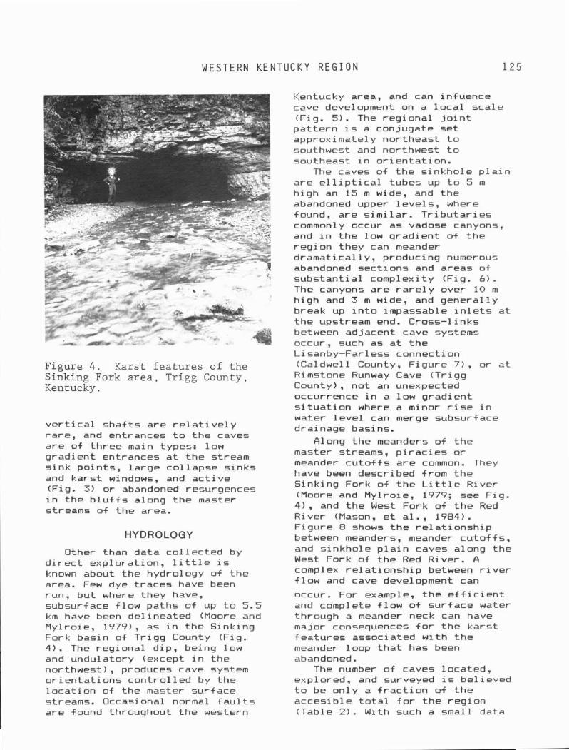
W E S T E R N K E N T U C K Y R E G I O N
Figure 4. Karst features of the Sinking Fork area, Trigg County, Kentucky.
v e r t i c a l sha f ts are r e l a t i v e 1 y rare , and entrances t o t he caves are of three main types: low gradient entrances a t t he stream s ink po in ts , l a rge co l lapse s inks and kars t windows, and a c t i v e (Fig. 3) or abandoned resurgences i n the b l u f f s along the master streams of the area.
HYDROLOGY
Other than data co l lec ted by d i r e c t explorat ion, l i t t l e i s known about the hydrology of t he area. Few dye t races have been run, but where they have, subsurface f low paths of up t o 5.5 km have been del ineated (Moore and Hy l ro ie , 1979), as i n the Sinking Fork basin of Tr igg County (Fig. 4 ) . The regional d ip, being low and undulatory (except i n the northwest), produces cave system o r i en ta t i ons con t ro l l ed by the l oca t i on of the master sur+ace streams. Occasional normal f a u l t s are found throughout the western
Kentucky area, and can infuence cave development on a l o c a l scale (Fig. 5). The reg iona l j o i n t pa t t e rn i s a conjugate se t approximately northeast t o southwest and northwest t o southeast i n o r ien ta t ion .
The caves of t he s inkhole p l a i n are e l l i p t i c a l tubes up t o 5 m h igh an 15 m wide, and the abandoned upper leve ls , where found, are s im i la r . T r i bu ta r i es commonly occur as vadose canyons, and i n t he low gradient of t he r e g i on they can meander dramat ica l ly , producing numerous abandoned sect ions and areas of substant ia l complexity (Fig. 6). The canyons are r a r e l y over 10 m h igh and 3 m wide, and genera l ly break up i n t o impassable i n l e t s a t the upstream end. Cross-l inks between adjacent cave systems occur, such as a t t he Lisanby-Farless connection (Caldwell County, F igure 7), or a t Hi mstone Runway Cave (Tr igg County), no t an unexpected occurrence i n a low gradient s i t u a t i o n where a minor r i s e i n water l e v e l can merge subsurface drainage basins.
Along the meanders o f the master streams, p i r a c i e s o r meander c u t o f f s are common. They have been described from t h e Sinking Fork of t he L i t t l e River (Moore and Mylroie, 1979: see Fig. 4) , and the West Fork o f t he Red River (Mason. e t a1 . . 1984) . Figure 8 shows the re la t i onsh ip between meanders, meander cu to f f s , and s inkhole p l a i n caves along the West Fork o f t he Red River. A compl ex re1 a t ionsh ip between r i v e r f l ow and cave development can
occur. For example, t he e f f i c i e n t and complete f low of surface water through a meander neck can have major consequences f o r t h e kars t features associated w i t h t he meander loop t h a t has been abandoned.
The number o f caves located, explored, and surveyed i s be1 i eved t o be on ly a f r a c t i o n o f t he accesib le t o t a l f o r t h e reg ion (Table 2). With such a small data
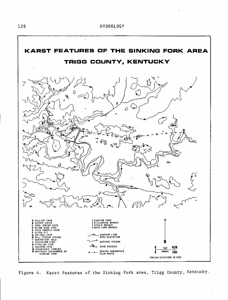
1 1 2 6 H Y D R O L O G Y
I
KARST FEATURES OF THE SINKING FORK AREA
TRIGG COUNTY, KENTUCKY
A H I L L T O P CAVE 1 S I N K I N G FORK B CUTOFF CAVES 1 STILLHOUSE BRANCH C COOL SPRING CAVE 1 STEELE BRANCH D RIVER ROAD CAVE 4 BOYD L A K E BRANCH E TWIN TUNNELS CAVE F D I T C H P I T C D E C I B E L CAVE 4% CONTOUR L I N E H M I L L STREAM SPRING W I T H ELEVATION I BOATWRIGHT HOLE J SKYCOLUMN CAVE 0 SURFACE STREAM I( P I P E L I N E CAVE
1 N
L BUZZARD CAVE CAVE PASSAGE M INSURGENCE COMPLEX lea 4400 N UPSTREAM INSURGENCE OF + - + - PROVEN SUBSURFACE
S I N K I N G FORK FLOW ROUTE 0 meters 1200
CONTOUR ELEVATIONS I N FEET
Figure 4 . Karst features of the Sinking Fork area, Trigg County, Kentucky.
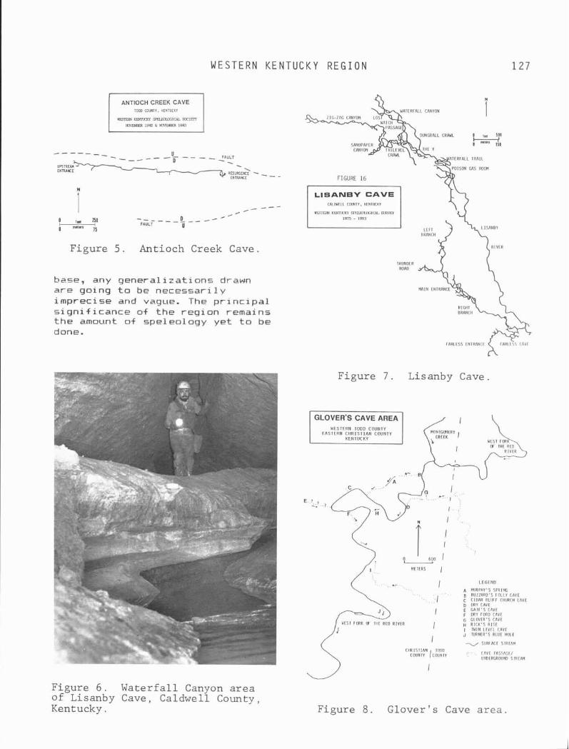
TODD COUNTY. KENTUCKY
m wman sPFurucIUL mEN
N3mEm 1962 k NxnET, 1963
W E S T E R N K E N T U C K Y R E G I O N 1 2 7
----- - - - U - , FAULT - . . R E S U R G E N ~ - , - -
E N ~ M E FIGURE 16
i --- /
/ c -
0 I, qo - - - - - - o - - - - I mn- FAULT
IS U
Figure 5 . Antioch Creek Cave.
base, any generalizations drawn are going t o be necessarily imprecise and vague. The principal significance of the region remains the amount of speleology yet to be done.
FARLESS ENTRANCE
. -
CAlWELL COUNTY. KENlUCKl
mSlERl m smLnlm1m mw 1975 - 1983
Figure 7 . Lisanby Cave.
W E S T E R N T O D D C O U N T Y
L E G E N D
A MIIRI ' I IY 'S S P R I f f i B B U Z Z A R D ' S F O L L Y c n v r C CCOAR BLUFF CHURCH CAVE D DRY C I V I E GAIC'S c n v r F DRY FORD CAVE G G L O V L R ' S CAVE H R I C K ' S R I S E I WIN L E V F L r A v r J N R N E R ' S BLUE I I O L I - SIJRiACE SIRLAM
/cgiyY i.. CAVE FAS5AGt/ U M l E R G R W M l SIRLAM
I
Figure 6 . Waterfall Canyon area of Lisanby Cave, Caldwell County, Kentucky. Figure 8 . Glover's Cave area.
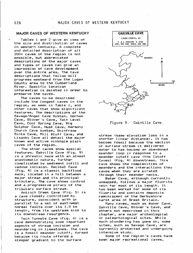
M A J O R C A V E S OF W E S T E R N K E N T U C K Y
MAJOR CAVES OF WESTERN KENTUCKY LOGAN COUNTY, KY
P . 6 S . F O R S Y I H f M . DYAS JUNE. NOV 1982 MARCH. NOV 1983
Tables 1 and 2 g ive an idea of t he s i r e and d i s t r i b u t i o n o f caves i n western Kentucky. A complete and de ta i l ed descr ip t ion o f a l l 200+ caves of t he reg ion i s not possib le, but abbreviated descr ip t ions of t he major caves and types of caves can g ive an impression of cave development over t he e n t i r e area. The cave descr ip t ions t h a t f o l l o w w i l l progress westward from the Logan
I 100
County area t o t he Cumberland METERS
River. Spec i f i c l oca t i on in format ion i s deleted i n order t o preserve t h e caves.
The caves t o be described inc lude the longest caves i n the region, as seen i n Table 1, and other caves t ha t show significant features. The descr ip t ions o f the Savage/Angel Cave System, Gorham Cave, Glover ' s Cave, Twin Level Cave, Cool Spring Cave, B ig Figure 9 , Oakville Cave. Sulphur Cave, Husk Cave, Harmony Church Cave system, Skinframe Sinks Cave, M i 11 B l u f f Cave, and Lisanby Cave a l l d e t a i l t he major known and ac t i ve s inkhole p l a i n caves o f the region.
The other caves show specia l features. Oakv i l l e Cave (Fig. 9) i s a phreat ic maze w i t h an almost anastomotic nature, f u r t h e r complicated by sediment i n f i l l and vadose inc is ion . Deci be1 Cave (Fig. 4) i s a c l ass i c backf lood maze, located i n a h i l l between a major stream and i t s p r i n c i p a l t r i b u t a r y . The cave shows con t ro l and a progressive p i racy o f t he t r i b u t a r y surface stream.
Antioch Creek Cave (Fig. 5) i s a cave c lose ly con t ro l l ed by s t ruc tu re , coincident w i t h o r p a r a l l e l t o a set o f east-west normal f a u l t s over i t s 1.5 km length, from i t s upstream s ink t o i t s downstream resurgence.
Twin Tunnels Cave (Fig. 4 ) 1s a cave demonstrating some important aspects o f stream i n c i s i o n and meandering i n limestones. The cave i s a f ossi 1 meander c u t o f f , formed because i t s r ou te o f f e red a steeper gradient t o t he surface
stream (same e leva t i on l o s s i n a shorter l i n e a r d is tance) . It has become f oss i 1 because the sect ion of su r f ace stream i t de l i ve red water t o has become an abandoned meander loop i n response t o a meander c u t o f f cave ( t h e Cutof f Caves) (Fig. 4) downstream. This cave shows the complex i t ies o f meanders and the i n t e r a c t i o n s they cause when they a re p i r a t e d through t h e i r meander necks.
Baker Cave, a1 though cur rent1 y unmapped, fo l lows a major f l u o r i t e ve in for most o f i t s length. It has been worked f o r some of i t s f l u o r i t e and contains deposi ts reminiscent of t h e Derbyshire ka rs t area of Great B r i t a i n .
Many caves, such as Eaker Cave, Oakv i l l e Cave, Glover 's Cave, and others not described i n t h i s chapter, are major archeological or pa leonto log ica l s i t e s . While much plunder ing has gone on, some s i tes , such as Savage Cave, are c u r r e n t l y protected and undergoing i n tens i ve study.
Some of the r e g i o n ' s caves have been major rec rea t i ona l caves,

W E S T E R N K E N T U C K Y R E G I O N
l i k e Glover 's, Cool Spring, and M i l l b l u f f Cave, wh i le Love11 Cave was once commercialized. Cave management i s i n i t s in fancy i n t h i s reg ion bu t w i l l become a greater concern i n t h e fu ture .
The Western Kentucky Speleological Survey i s the major source of i n f ormation f o r caves of t h e region. As Table 2 shows, 218 caves are known from the region, and 210 have a w r i t t e n descr ip t ion, w i t h 147 mapped as of January, 1985. The resp i s to ry f o r t h i s in format ion i s t he Western Kentucky Speleological Survey Annual Report Series, pub1 i shed s ince 1978. Numerous a r t i c l e s on archeology, paleontology, biospeleology, ka rs t hydrology, ka rs t geomorphology, and geochemistry have been publ ished i n the Annual Report Series. They are on f i l e w i t h t he U. S. Geological Survey, t he National Spel eologi ca l Society and numerous cave groups, or they can be obtained from the authors.
Savage Cave System The Savage Cave System, i n
southern Logan County, cons is ts of over 5 km of t he a c t i v e and abandoned underground stream course o f Woolsey Creek and i t s t r i b u t a r i e s . F igure 10 shows the l o c a t i o n map of t he major features of the area, and the cave system components. The features o f t he Savage Cave System are: Savage Cave, Angel Cave, Barnes Cave, Woolsey Creek Cave, t he s ink p o i n t o f Woolsey Creek, and the resurgence on the banks o f t he South Fork o f t h e Red River (Fig. 10). Por t ions of Savage Cave and Angel Cave, as we l l as a l l of Parnes Cave, are abandoned upper l e v e l conduits, i n d i c a t i n g a long and var ied h i s t o r y f o r the cave system. Wool sey Creek Cave ( located j u s t south o f t he Woolsey Creek s ink po in t shown i n Fig. 10) i s a shor t t r i b u t a r y cave, re leas ing i t s water i n t o the Woolsey Creek b l i n d va l ley . Angel Cave and Savage Cave are separated by about 300 m o f sumped passage.
From Savage Cave t o the suspected resurgence i s a d istance of over 1 km.
The Savage Entrance t o Savage Cave i s a large, 25 m wide, 4 m h igh opening i n a broad, gen t le s lop ing sinkhole. The entrance has an apparent col lapse o r i g i n , and formed a t a meeting p o i n t o f the l a rge upper and middle l e v e l s o f t h e cave. Down the entrance ta lus , a very l a r g e (15 m wide by 6 m h igh j passage leads o f f (west) , and i s t he middle l eve l ; j u s t above i t t o the l e f t , another l a rge passage, the upper l e v e l (10 m by 6 m) , p a r a l l e l s the middle l eve l . The l e f t passage, o r upper l eve l , continues f o r 80 m.
The middle l e v e l passage, o r t he main passage, heads west o f f the entrance room, j u s t t o the r i g h t and below t h e upper l eve l . I n i t i a l l y q u i t e l a rge (15 m by 6 m), a f t e r 30 m i t closes i n , averaging 10 m by 3 m. The passage i s f l a t f l oo red and e a s i l y t raversable, bu t shows evidence of complete back+ looding. It continues i n t h i s manner f o r 350 m westward past breakdown, pools, and f lowstone t o a complete choke.
To the east a t the entrance. a shor t crawl and stoop over breakdown leads t o t h e ma jo r i t y of t he cave and the Eidson Entrance. Over 3.5 km of most1 y easy passage. leads eastward. The stream sumps . i n t h i s area, and i s not seen again u n t i l the resurgence. The main rou te i s t he middle l eve l , usua l l y 3 t o 6 m wide and 1 t o 3 m high, w i t h the stream e i t h e r i n the f l o o r o r meandering i n i t s own spacious crawl beneath t h e middle l eve l . A t t he upstream end of t he cave, a t r i b u t a r y canyon leads t o the Eidson entrance, and the main stream sumps s h o r t l y therea f te r . A canyon complex e x i s t s i n t h i s area, and the downstream sump of Angel Cave i s l e s s than 300 m away t o t h e east.
Angel Cave The 9 m wide, 2 m h igh entrance
i s i n a s ink midway between the Eidson Entrance t o Savage Cave and
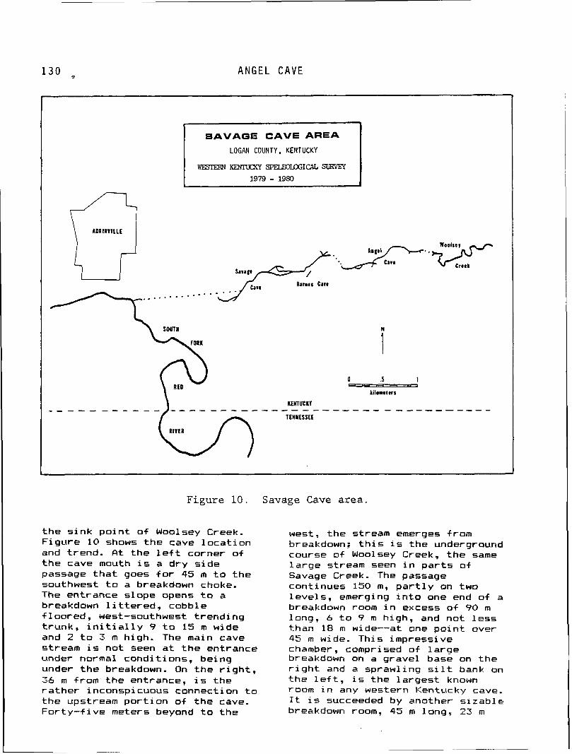
A N G E L CAVE
SAVAGE CAVE AREA
LOGAN COUNTY, KENTUCKY
wEsImN KENmaY SJELDxmICAL SURVEY 1979 - 1980
Barnes Care
0 .5 1 - - - - a
Lilometrrs
m E n u c m v
T E N N E S S E E
1
Figure 1 0 . Savage Cave area.
t he s ink po in t o f Woolsey Creek. F igure 10 shows t h e cave l oca t i on and trend. A t t he l e f t corner o f t he cave mouth i s a dry s i de passage t h a t goes f o r 45 m t o the southwest t o a breakdown choke. The entrance slope opens t o a breakdown l i t t e r e d , cobble f loored, west-southwest t rend ing t runk, i n i t i a l l y 9 t o 15 m wide and 2 t o 3 m high. The main cave stream i s not seen a t t he entrance under normal condi t ions, being under t h e breakdown. On the r i g h t , 36 m from the entrance, i s the ra the r inconspicuous connection t o the upstream p o r t i o n of t he cave. Fo r t y - f i ve meters beyond t o t he
west, the stream emerges from breakdown: t h i s i s the underground course o f Woolsey Creek, t he same l a rge stream seen i n pa r t s of Savage Creek. The passage continues 150 m, p a r t l y on two leve ls , emerging i n t o one end of a breakdown room i n excess o f 90 m long, 6 t o ? m high, and not l ess than 18 m wide--at one po in t over 45 m wide. This impressive chamber, comprised of l a r g e breakdown on a gravel base on the r i g h t and a sprawling s i l t bank on the l e f t , i s the la rges t known room i n any western Kentucky cave. It i s succeeded by another s i zab le breakdown room, 45 m long. 23 m
W E S T E R N K E N T U C K Y R E G I O N
wide, and 3 t o 4 m high. A t the end of t he second major room, t he passage, w i t h ponded water, continues 90 m t o the terminal sump.
The lead t o the upstream p o r t i o n o f t he cave i s a clean f l o o d route , soon reaching t he main stream. One can continue i n a passage vary ing from crouchway sewer t o spacious breakdown t runk t o wet crawlway. Th is extension s k i r t s a broad, f lat-bottomed s ink and i s heav i l y f rac tured. A t t he end, 600 m from t h e entrance, i s a back entrance and another 300 m o f passage near ing t h e s inks of Wool sey Creek.
The Savage Cave entrance area, both sur f ace and subsurf ace, i s an extreme1 y important archeological s i t e (Carstens, 1980). The Archeological Conservancy worked w i t h the WKSS, t he landowner, and Murray State Un i ve rs i t y t o preserve t he cave. The property has been t rans fe r red t o Murray S ta te Univers i ty , and access t o t he cave i s s t r i c t l y con t ro l led . Archeological study o f t he cave i s cont inu ing .
Gorham Cave This cave i s named a f t e r J. H.
Gorham, whose farm included the entrance. Rlthough l o c a l 1 y we1 1 known, t he 3.2 km cave has su f fe red surp r i s ing1 y l i t t l e vandalism. Gorham Cave i s s i t ua ted i n east-centra l Logan County, about 8 km from R u s s e l l v i l l e . The entrance, a 3 m climb-down, i s i n a small s ink a t t he contact of t he lower member of t h e G i r k i n Formation and the Ste. Genevieve Limestone (Fig. 11). The entrance room, l i t t e r e d by massive breakdown, i n t e r s e c t s a t runk car ry ing a stream. The downstream sect ion t rends northwest, averaging 10 m i n width and 3 t o 8 m i n he ight , f o r 180 m t o a sump. Th is sec t ion repor ted ly connects w i t h a resurgence cave a t Spring Acres, a rec rea t ion park a shor t d istance west-northwest o f the Gorham entrance. T h i r t y meters before the sump, a 6-m-wide by
2-m-high s ide passage w i t h two b e a u t i f u l pools extends west f o r 200 m.
From t h e entrance, the upstream sec t ion extends t o most o f the cave. It trends southwest, ca r ry ing the stream, which averages 10-m-wide by 6-m-high, w i t h l a rge breakdown blocks and f lowstone a t i n te r va l s . One k i lometer from t h e entrance, the stream forks . The r i g h t branch continues west, past more l a rge boulders, f o r another 300 m: the c e i 1 i n g he ight gradual 1 y lowers t o a pe r i od i c sump, pushable another 7 - . ~ u 0 m t o a s inkhole entrance, and a f i n a l sump 140 m f u r t he r . There appears t o be one o r two add i t i ona l segments of cave i n a ka rs t window ad j o i n i n g t h i s po in t .
A t t he mainstream fo rk , the l e f t branch goes southwest f o r 800 m, i n t e r s e c t i n g a number of s ide passages of appreciable extent, t o a 10 m wide, 60 m long room w i th several l a rge columns. Just before i t s end the stream emerges from a 40-m-duck-walk t o terminal breakdown. This breakdown p l o t s t o be w i t h i n a few meters o f a logjam i n a nearby kars t window.
Oakville Cave The l oca t i on i s a deep, brushy
s ink surrounded by c u l t i v a t e d f i e l d s south-southwest o f Oakv i l le , Logan County. The entrance, which takes runo f f from heavy p r e c i p i t a t i o n , i s 3 m wide and 1 m h igh, and the cave i n i t i a l l y trends west-northwest. The cave swings south (see Fig. 9) and becomes a very confusing maze of small vadose passages, phreat ic tubes, and abandoned t runk fragments. An a c t i v e stream i s seen i n places, on ly heard i n other locat ions. h i r f low i s noted i n many places. The l a rges t t runk fragments are up t o 5 m wide and 3 m high. There i s abundant mud, and several bone s i t es . Digging a t a few promising places could e a s i l y extend the cave.
A t o t a l of 1.66 km has been surveyed i n Oakv i l l e Cave, w i th a small amount of unmapped passage.
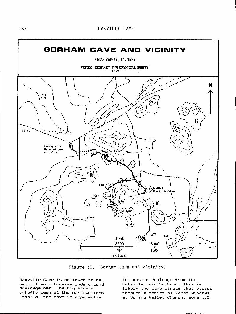
O A K V I L L E C A V E
GORHAM CAVE AND VlClNlTY LOGAN COUNTY, KENTUCKY
W E S I E I F J K E N N a K Y ~ I C A L S U R Y E P 1979
and Cave
meters
Figure 11. Gorham Cave and vicinity.
Oakvi l l e Cave i s be l ieved t o be t he master drainage from the p a r t of an extensi ve underground Oakvi l l e neighborhood. This is drainage net. The b i g stream l i k e l y the same stream t h a t passes b r i e f l y seen a t t h e northwestern through a se r ies @f kars t windows "end" o f t he cave i s apparent ly a t Spring Val l e y Church, some 1.5

W E S T E R N K E N T U C K Y R E G I O N
km southwest. The u l t i m a t e resurgence i s another k i 1 ometer southwest, a t the former s i t e of the Pleasant Grove Church.
By western Kentucky standards, Oakv i l l e Cave i s regarded as dry and u n l i k e l y t o f lood. However, l a rge q u a n t i t i e s o f f r esh mud were encountered i n t h e cave i n May 1983, a f t e r a per iod o f unusual ly heavy ra in , so i t appears t h a t most o f t he cave can f l o o d in f requent l y .
A l a r g e amount o f f l i n t ( cher t ) mate r ia l i s evident i n t he f i e l d ad jo in ing t he entrance s ink. Local res iden ts have co l l ec ted many arrowheads and other Ind ian a r t i f ac ts from t h i s s i t e , which must have been a l a rge camp. Several Ind ian p o i n t s have been found i n pa r t s of t he cave i t s e l f f a r from the present entrance.
Antioch Creek Cave The l oca t i on o f t h i s cave i s
roughly 4 km northeast o f Sharon Grove, Todd County. One entrance, a resurgence, i s a t t h e head of a branch o f Antioch Creek, 1.6 km southwest o f Antioch Church. The other entrance i s a s ink (ka rs t window) , 1.1 km a1 most due west o f t h e spr ing mouth. A stream emerges from t h e western s i de o f t h i s s ink and runs i n t o the cave v i a the back entrance. The cave has 1.49 km o f passage and runs almost s t r a i g h t west t o east (Fig. 5), para1 l e l t o prominent east-west normal f a u l t s i n t he area.
The resurgence entrance opens i n a headwall a t t h e western end o f a rav ine and i s 12 m wide by 3 m high. A walking passage w i t h ponded water t rends i n i t i a l l y southwest f o r about 30 m. Here i t doubles back t o t h e no r th as a narrow walkway, w i t h waist-deep pools, f o r 45 m, emerging over breaddown i n t o t he ma.in p a r t o+ t h e cave. The entrance streamway m a y be p a r t i a l l y bypassed through a d r y . upper l e v e l crawlway. A t t he room where these l e v e l s r e j o i n , t h e stream strunk assumes a near ly due-west trend, which i t maintains +or approximately 1 km, near ly t o the back entrance.
The west-trending t runk i s i n i t i a l 1 y o f n i ce proportions--3.5 t o 4.5 m wide and 2.5 t o 3.5 m high--wi t h broad ledges on one or t h e other side, t he stream f lowing shal low1 y over gravel , and a number o f speleothems. The passage gradual ly lowers, however, becoming a cobble-strewn crawl way w i t h ponded water about 275 m from t h e entrance; passing several s i g n i f i c a n t leads, i t continues west t o l i n k w i t h t he upstream entrance. The upstream entrance, l i k e t h e resurgence, i s q u i t e spacious--9.5 m wide and 3 m high. The main passage assumes the near1 y s t r a i g h t east-west bear i ng of t h e downstream cave, s t a r t i n g o f f as a walking t runk f o r some 200 m, then becoming a low crawl connecting t o the r e s t o f the cave.
Lovell Cave Located south o f Weir i n
Muhlenburg County, Love l l Cave represents what i s probably the l a rges t cave i n t he county. It i s as r i c h i n h i s t o r y and l o c a l legend as i t i s i n passage. During t he 1920s, a man named Clark ran Love1 1 Cave as a l o c a l t o u r i s t a t t r a c t i o n . Tours through the walking passages of t he cave averaged 50 cents. On warm spr ing Sundays when the cave was open f o r business, hundreds o f people camped on the r i d g e above the entrance. By 1928, t h e commercial izat ion o f Love l l Cave had ceased.
f ic tua l ly , the cave's h i s t o r y dates from much e a r l i e r . Ind ian a r t i f a c t s have been found both around the entrance and w i t h i n t he cave. The wa l l s o f the cave ca r r y several smoked dates i n the 1800s inc lud ing "J. K. East 1833" and a dubious "Jessie James 1868." Local legend a l so f i l l s the cave w i t h runaway slaves and an improbable number of bankrobbers. The most u n l i k e l y s to ry t o l d about the cave i s the s t o r y of t he discovery of several "Egyptian mummies" t h a t were supposedly viewed by Floyd C o l l i n s h imsei f . The i n t e r i o r of
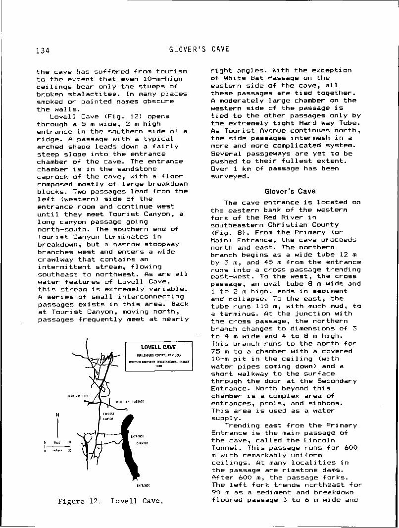
G L O V E R ' S C A V E
the cave has suf fered from tour ism t o t he extent t h a t even 10-m-high c e i l i n g s bear only the stumps of broken s t a l a c t i t e s . I n many places smoked o r painted names obscure t h e wal ls.
Love l l Cave (Fig. 12) opens through a 5 m wide, 2 m h igh entrance i n the southern s ide of a r idge. 6 passage w i t h a t y p i c a l arched shape leads down a f a i r l y steep slope i n t o t h e entrance chamber of the cave. The entrance chamber i s i n the sandstone caprock o f the cave, w i t h a f l o o r composed mostly o f la rge breakdown blocks. Two passages lead from the l e f t (western) s ide of the entrance room and continue w e s t u n t i l they meet Tour is t Canyon, a long canyon passage going north-south. The southern end of Tour is t Canyon terminates i n breakdown, but a narrow stoopway branches west and enters a wide crawlway t h a t contains an i n t e r m i t t e n t stream, f low ing southeast t o northwest. As are a l l water features of Love1 1 Cave, t h i s stream i s extreme1 y var iable. A se r ies o f small in terconnect ing passages e x i s t s i n t h i s area. Back a t Tour is t Canyon, moving north. passages f requent ly meet a t near ly
LOVELLCAVE MalLENBURG C O W T V , KENTUCKV
m wmnn s l ' m 1 c A L suRnr
WHITE BAT PASSAGE
N TOURlST
CANYON
ENTRANCE
0 feet 1 0 0 CHAMBER
LNlRANCL
Figure 1 2 . Love l l Cave,
r i g h t angles. With the exception o f White Bat Passage on the eastern s ide of the cave, a1 1 these passages are t i e d together. A moderately la rge chamber on the western s ide of t he passage i s t i e d t o the other passages on ly by t he extremely t i g h t Hard Way Tube. As Tour is t Ovenue continues north, t he s ide passages intermesh i n a more and more complicated system. Several passgeways are ye t t o be pushed t o t h e i r f u l l e s t extent. Over 1 km of passage has been surveyed.
Glover's Cave The cave entrance i s located on
the eastern bank o f t he western f o r k of the Red River i n southeastern Chr is t ian County (Fig. 8). From the Primary (or Main) Entrance, the cave proceeds no r th and east. The northern branch begins as a wide tube 12 m by 3 m, and 45 m from the entrance runs i n t o a cross passage t rend ing east-west. To the west, t he cross passage, an oval tube 8 m wide and 1 t o 2 m high, ends i n sediment and col lapse. To the east, the tube runs 110 m, w i t h much mud, t o a terminus. A t t he junc t ion w i th t h e cross passage, the northern branch changes t o dimensions of 3 t o 4 m wide and 4 t o 8 m high. This branch runs t o the no r th f o r 75 m t o a chamber w i t h a covered 10-m p i t i n the c e i l i n g (w i t h water p ipes coming down) and a shor t walkway t o the surface through the door a t the Secondary Entrance. North beyond t h i s chamber i s a complex area of entrances, pools, and siphons. Th is area i s used as a water 5uppl y.
Trending east from the Primary Entrance i s the main passage of t h e cave, ca l l ed the L inco ln Tunnel. This passage runs f o r 600 m w i t h remarkably uni form ce i l i ngs . A t many l o c a l i t i e s i n the passage are r imstone dams. A f t e r 600 m, the passage forks. The l e f t f o r k t rends northeast f o r 90 m as a sediment and breakdown f l oo red passage 3 t o 6 rn wide and
W E S T E R N K E N T U C K Y R E G I O N 1 3 5
1 t o 3 m high. This Lake Passage ends i n a deep lake i n a room 18 m long, 10 m wide, and '3 m high. The Lake has a d e f i n i t e water f low from the southeast t o the northeast and may be p a r t o f the water seen a t the resurgence. The pool has abundant cave l i f e p lus many leaves, s t i cks , etc., embedded i n i t s shore. From the incoming passage t o the lake i s a downward 6 m s l ide .
The r i g h t fo rk i s a cont inuat ion o f t he main passage. T h i r t y meters from the fo rk , a stream i s met t h a t cu ts t o the northeast under t he passage wal l i n t o a shor t s ide pa5sage leading t o a domepit i n a decorated chamber c a l l e d t he Grot to (Fig. 13). The stream s inks here, and i s bel ieved t o go t o the Lake. only 60 m t o the north. Just beyond the passage leading t o the Grot to i s another s ide passage t h a t leads east 210 m as a walk. crawl, stoop-walk, and terminates j u s t beyond a small dome i n t he c e i l i n g . This passage was recen t l y ex tended.
The main passage, now car ry ing a stream, meanders south 200 m as a la rge tube up t o 13-m-wide and 8-m-high. h t the Dining Room. co l lapse blocks the passage. A s ide lead a t t h i s po in t , the Winder, trends 200 m west. The main passage co l lapse can be forced t o rega in the major t rend and a shor t passage, the Ballroom. The next 750 m a l te rna tes between s o l u t i o n tube, breakdown passage, and breakdown crawls, averaging 3 t o 6 m h igh and 8 t o 15 m wide, passing t he Eagle, the G u i l l o t i n e , and the C l i f f Hanger. The main passage ends i n a formation area. t he Beauty Par lor . f4 f u r t he r low, wet, and muddy passage can be fo l lowed t o an apparent end a t a siphon, domes, and sediment blockage. Over 3 km has been surveyed.
Twin Level Cave
Figure 13. Formations in the Grotto, Glover's Cave, Christrian County, Kentucky.
Chr i s t i an County (Fig. 8). Over 5 km of passage has been mapped, and survey work continues. The Main Entrance t o the cave i s a spectacular double l e v e l entrance. The upper p a r t i s a l a rge she l te r t h a t becomes a small passage ending a f t e r 60 m. Two passages lead o f f from each s ide of t he entrance. The nor thern passage i s an overflow tube of most1 y walking s ize, w i t h some ponded water. I t lowers t o a crawl then reaches the surface on the banks o f the r i v e r 160 m upstream o f t h e Main Entrance.
Twin Level Cave i s located on The major p o r t i o n o f the cave the eastern bank of the West Fork leads south from t h e r i g h t s ide o f o f the Red River i n southeastern t he Main Entrance. An eas te r l y
136 B I G S U L P H U R C A V E
crawl of 100 m leads t o a junc t ion w i t h t he main stream. Downstream t o t he l e f t , t he main stream passage sumps immediately, but upstream t o the r i g h t i t continues 2 t o 3 m h igh and 2 t o 5 m wide f o r 350 m t o a co l lapse s inkhole entrance, Turner's Window. Pushing upstream the passage continues as before, w i t h some breakdown and low crawls, f o r a f u r t h e r 1,500 m t o another entrance a t Carneal ' s (Watt 's) Cave. The cave continues upstream another 1,000 m t o an add i t iona l entrance, Ham1 e t ' s Well, a d r i l l e d we l l 1.2 m i n diameter. Total survey t o date i s 5 kin, w i t h leads s t i l l remaining.
Big Sulphur Cave Big Sulphur Cave, 4.8 km long,
i s s i t ua ted i n southeastern Tr igg County on t he bank o f L i t t l e River a t t he apex of a sharp meander. A d i s t i n c t , though not overpowerinq, sulphurous smell i s not iced a t the entrance (Fig. 14).
The f i r s t few meters o f passage i s a stoopway over small breakdown. Thereafter, one fo l lows a south-southeast-trending stream channel o f mostly rectangular cross sect ion, averaging 4 t o 7 m width and 2 m he ight (a few shor t s t re tches requ i re easy crawl ing). The stream general ly occupies t he whole f l o o r but i s usual 1 y no more than ankle deep. The f i r s t lead on the r i g h t i s 75 m from the entrance, a 20 m crawl w i t h a
ENTRANCE
V
Figure 14. Big Sulphur Cave.
t r i c k l e t r i b u t a r y em i t t i ng t he sulphur smell. A more important junc t ion i s 30 m past t he "sulphur crawl, " a l so on t he r i g h t . This junc t ion i s a climb-up t o an upper l e v e l sect ion, the Bat Passage, which para l l e l s t he main stream passage f o r over 200 m. It averages 5 m wide by 2 m high.
A t a p o i n t bB0 m from t h e entrance, t he stream f o r k s i n t o segments o f about equal volume. The r i g h t branch continues t o most o f the known cave as t he Middle Cave sect ion. A t t he f o r k s t r a i g h t ahead (southeast) i s a narrow walkway w i t h ponded water. This walkway appears t o aburp t l y end a f t e r 30 m, but beyond a low near-sump, t h i s passage, t he D Survey, continues 150 m southeast t o where a la rge block h a l t s progress despi te a i r f l ow . Right from t h e major f o r k i s t h e way t o t he Middle Cave and most o f B ig Sulphur. The i n i t i a l t r end remains southward but the main passage soon assumes a sharply d i f f e r e n t d i r e c t i o n than the entrance trunk: west o r northwest, roughly para l 1 e l i n g the sur f ace course o f L i t t l e River, but w i t h an opposing stream-flow d i rec t ion . Th is sect ion averages 5 t o 10 m i n width and 1.2 t o 4.5 m i n he ight , w i t h two o r t h ree s l i g h t l y o f f s e t l e v e l s i n most places.
On1 y 25 m past t he mainstream f o r k t o D Survey i s another s i g n i f i c a n t in te rsec t ion ; on the r i g h t , several meters above stream 1 eve1 and not obvious a t f i r s t glance, is a junc t ion o f an upper leve l . This i s a t runcated segment o f t he Bat Passage described above. It begins as a wide but low crawlway, changes t o a s izab le breakdown rou te s i m i l a r t o the Bat Passage, t rends northwest f o r 185 m, and ends i n co l lapse very c lose t o t he southern end of Bat Passage.
A f t e r another 35 rn south, the F Survey t rends southeast f o r 225 m, averaging 1.5 m wide and 0.5 t o 1 m high. It "ends" by breaking up i n t o several small components t h a t are no t negotiable. The F Survey
W E S T E R N K E N T U C K Y R E G I O N
passage close1 y para1 l e l s t he D Cool Spring Cave Survey a t a s l i g h t l y h igher leve l ; Cool Spring Cave i s located on i t probably c a r r i e d t he same water t he Caledonia 7.5+ minute a t one time. Both these passages topographic map, on t he northern are c lose t o a nearby shor t cave, bank of Sinking Fork i n cen t ra l L i t t l e B ig Sulphur Cave. T r igg County. The cave i s complex
The cave swings west, and j u s t over 100 m past t h e F Survey i n t e r s e c t i o n i s a wide bu t somewhat low junc t ion o f another l e f t branch, the H Survey. This semi-maze, broken-dawn area t rends west-southwest, vary ing from walking t o easy crawl ing s i z e and t o t a l s about 280 m. The N Survey, i s a l so on the l e f t , 120 m a f t e r the H Survey. Th is sect ion, a 270 m loop, i s surmised t o be a p o r t i o n of the cave's p r i n c i p a l bu t i n t e r m i t t e n t upper l eve l . It begins as a south-trending walkway f o r 50 m, then a t i g h t crawlway continues, doubl ing around t o t h e northwest and r e j o i n i n g t he main t runk 80 m beyond the i n i t i a l N Survey junct ion.
There are no more s i g n i f i c a n t leads o f f the main passage f o r t he succeeding.320 m a f t e r the second N Survey junct ion, u n t i l a breakdown zone i s encountered. One can s tay low and r i g h t , w i t h the stream, s k i r t i n g t he breakdown i n t o the mainstream cont inuat ion t o t he west. A s l i g h t l y more obvious choice i s t o crawl s t r a i g h t ahead i n t o t he breakdown. Ey doing so one pops up a f t e r 20 m i n t o the B ig .Rooms area. The f i r s t room i n t he B ig Rooms area i s roughly rectangular i n cross sect ions, approximately 20 m on each s i de and 5 m high. Thre are t h ree p r i n c i p a l d i r e c t i o n s from t h i s room.
Near where t he L Survey departs t h e B ig Rooms sect ion are two in terconnect ing and inconspicuous bu t s i g n i f i c a n t s i de passages on two leve ls , t he lower w i t h a small stream. 6 meandering crawl only 1 m wide and 0'.5 m h igh t rends west f o r 325 m, ending i n several mud slumps. Th is i s t he f a r t he res t p o i n t from the entrance i n B ig Sulphur Cave, a 1 i ttl e over 1,500 m.
and the second l a rges t known i n western Kentucky. Unusual f o r the area, Cool Spring Cave has extensive upper l eve1 development , w i th th ree d i s t i n c t horizons. Some good leads remain and i t i s hoped the cave w i l l y i e l d more v i r g i n passage i n the fu tu re . Over 5 km of passage has been surveyed (Figs. 4 and 15).
Cool Spring Cave has th ree known entrances, a1 1 grouped around the resurgence. The Main Entrance, ca r ry ing t he cave stream, leads no r th and then west 145 m as a broad oval tube 8 t o 10 m wide and 1.5 t o 3 m high. The s inkhole entrance enters through the c e i l i n g of an alcove of t h i s passage j u s t i n and t o the west o f t he entrance. A t 145 m, the stream
COOL SPRING CAVE T R I G G COUNTY, KY
SOUTHWEST KENTUCKY S T U D E N T GROTTO
WESTERN KENTUCKY SPELEOLOGICAL SURVEY
CRYSTAL FLOOR PASSAGE
\ L-
DRY ENTRANCE
Figure 15 . Cool Spring Cave.
D E C I B E L C A V E
passage opens i n t o a la rge chamber, Pathos Par lor , 90 m long, 15 m wide, formed by the i n t e r s e c t i o n of the three l e v e l s of t he cave. To the l e f t (south) , i t proceeds t o a passage t h a t ends i n a mud. flowstone, and breakdown choke i n the upper l eve l . Just before the choke, a passage leads down and east as a low, wide stoop and crawl t o the Dry Entrance, as a segment o f the middle l e v e l of t he cave.
From the northern end of the Pathos Par lor , passages leave a t a1 1 th ree leve ls . The upper l e v e l leads west as a tube 4 t o 8 m wide t h a t s t a r t s out 2 m h igh but d i mini shes, f i n a l 1 y ending i n sediment f i l l a f t e r 210 m. Leaving t h e northern end o f Pathos Par lor , the stream or lower l e v e l t rends northwest f o r 200 m t o a sump as a tube 1 t o 2 m h igh and 6 t o 9 m wide. S i x t y meters from Pathos Par lor , a la rge breakdown occurs. Up and t o the south through the breakdown i s a connection t o the upper l eve l . Just before the sump the lower l e v e l crosses under the middle l e v e l t o form a la rge room. To the east t h i s middle l e v e l 1 eads past an important s i de passage a t Breathing Junct ion and continues over 300 m, connecting i n t o Pathos Par lor from the east and i n t o t he Dry Entrance area.
To the west from the siphon area o f the main stream, t he middle l e v e l runs 240 m t o the southwest, as an oval tube 3 t o 4.5 m wide and 1 t o 2.5 m h igh ending i n the Bat Room, a l a rge chamber complex formed by i n t e r s e c t i o n w i th the upper leve l . For t he next 300 m the middle l e v e l i s criss-crossed by the upper l e v e l many times, r e s u l t i n g i n considerable passage complexity and over 900 m of passage. Ample wind and many small domes i n d i c a t e a poss ib le entrance nearby. These passages end i n sediment f i l l , f lowstone, o r collapse. No a c t i v e streams are seen i n t h i s sect ion o f the cave.
The major po r t i on of the cave l i e s no r th of the Breathing
Junction. From t h i s po in t , the middle l e v e l extends nor th 60 m as a tube 3 t o 6 m wide and 1 t o 2 m h igh t o Guano Junction, where t he lower l e v e l stream passage i s re jo ined. The middle l e v e l continues nor th across the stream as a walking passage, gradual ly d iminishing t o a crawl and ending a f t e r 120 m. The stream passage siphons downstream t o t he southwest, but continues nor th as Crawdad Crawl f o r over 600 m, gradual 1 y lowering from a walkway t o a stoop t o a crawl. It continues, upstream from Guano Junction, and the middle l e v e l i s in tersected again. It proceeds east 180 m as a wide, low tube, Crysta l Floor Passage, and nor th over 1,100 m a1 so as a wide, 1 ow tube, He lec t i t e Pass. I t s end has not been reached, as i t degenerates i n t o a very low crawl, Wide Way. A sharp r i g h t from the base of the Guano Junction leads as a d iminishing t r i b u t a r y passage, Mud Cave, f o r 500 m t o the east.
Cool Spring Cave i s a very complex cave, and good po ten t i a l e x i s t s f o r s i g n i f i c a n t extension o f t he cave. The source o f the water i n the cave i s no t known, and the major t r i b u t a r y passages have not been reached w i t h i n the cave. The plan of the cave suggests t ha t i t developed i n i t i a l l y by gathering water from the S t i 1 lhouse Branch t r i b u t a r y of Sinking fork. Much of the cur rent water f low i n the cave i s bel ieved t o o r i g i n a t e from f u r t h e r upstream i n S t i l l house Branch ra the r than i n past stages of the cave's development (Fig. 4 ) .
Decibel Cave Decibel Cave, contain ing almost
2 km of passage, i s located on the northern bank of Sinking Fork west o f M i l l Stream Spring (Fig. 4 ) . The entrance i s a t r i v e r l e v e l i n a 1 ow l i mestone b l u f f , and i 5 1 m h igh and 2 m wide, w i t h a stream f low ing out. This passage leads no r th i n t o a junc t ion room. To the east, a dry crawl a t roo f l e v e l o r
W E S T E R N K E N T U C K Y R E G I O N
a wet crawl a t f l o o r l e v e l u n i t e a f t e r 15 m i n a low, wide stream passage, cont inu ing west 20 m before opening out i n t o a l a rge breakdown chamber over 30 m across and up t o 6 m high. The stream comes out o f impenetrable breakdown a t t he extreme northern p o i n t of t he room.
From the junc t ion room near the entrance, a low, muddy crawl can be fol lowed no r th i n t o a l a rge cor r ido r . The main co r r i do r swings southwest from these s i de passages and the cave suddenly becomes very complex. From the broad, low room w i th several bedrock p i l l a r s , a shor t crawlway leads no r th t o a dome. To the west a se r i es of tubes lead, a f t e r a shor t jog south, t o a l a rge chamber w i t h many -bedrock p a r t i t i o n s . Short s ide passages 1 ead east-southeast from t h i s room, bu t t o t he west-northwest a group o f para1 l e l passages open i n t o a very l a rge chamber f l oo red w i t h breakdown. Fassages r a d i a t e i n a l l d i rec t ions , and the room seems t o have gained i t s breakdown and broad expanse due t o t he col lapse of many bedrock p i l l a r s . Leading no r th out o f t h i s room i s a low ( 1 m ) , wide ( 3 t o 6 m) tube t h a t winds f o r 150 m north, west, north, east, and then no r th again ending i n a breakdown choke. Some h igh rooms are passed along the way, and numerous vadose dome p i t s e s i s t . The wal I s o f t h i s tube show we1 1 developed scal 1 oping , demonstrating past f l ow t o the south and southwest.
From the l a rge cen t ra l chamber. passages lead both west and south. To the west, a se r i es of p a r a l l e l tubes run f o r 80 m before ending i n dome p i t s , mud plugs, and breakdown. These passages have sca l lop ing t h a t shows past f l ow t o t he east. To t he south, a ser ies of low arches t rend ing south-southeast i n t e r s e c t la rqe tubes or iented along j o i n t s and t rend ing west-northwest and east-southeast. These,cross passages end i n mud, d i r t , breakdown, and f lowstone plugs.
The most eas te r l y o f t he passages has a shor t tube 20 cm i n diameter t h a t leads t o t h e surface, bu t i t i s not negotiable.
The cave i s i s o l a t e d i n a low h i l l t h a t extends t o t h e southwest between Sinking Fork and Steele Branch (Fig. 4). The cave apparently conducted water from Steele Branch through the h i l l t o Sinking Fork, as evidenced by sca l lop ing i n the passages i n t he western and northern po r t i ons o f t he cave. The water seen i n the eastern po r t i on o f the cave i s be l ieved t o be derived from Steele Branch, bu t t h i s has not been proven.
Twin Tunnels Cave Twin Tunnels Cave i s located on
the southern bank of Sinking f o r k i n T r igg County (Fig. 4 ) . Steep b l u f f s l i n e the southern bank of t h e stream a t t h i s po in t , and i n t h i s b l u f f , 3 m above stream l e v e l , are the two entrances t o Twin Tunnels Cave and some other m i nor associated cvaes.
The two entrances are 30 rn apart , and lead t o passages 1 t o 2 m h igh and 4 t o 8 rn wide. The passages j o i n 80 m i n t o t he h i l l . From the junct ion, the passage continues west as an oval tube 4 t o 8 m wide and 1 m high, w i t h a mud f l o o r cont inuing a meandering t rench 1 t o 2 m deep f o r 300 m, where a very low and wide s ide passage winds northeast f o r 30 m. Th is passage i s bel ieved t o be a t r i b u t a r y passage associated w i t h some large, blocked entrances on the bank of the Sinking Fork, 60 m downstream of the main entrances t o the cave.
The cave jogs b r i e f l y south be+ ore con t i nu i ng west, encountering a complex junc t ion area 450 m from the entrance. Very wide, but very low passages lead n o r t h and south out of the room. L i ke t he previous s ide passage, a t h i n person could perhaps gain more cave here. The meandering t rench cu t i n t h f l o o r continues west 40 m, emerging a f t e r a short cl imb, i n t o a la rge room 50 m
H U S K ( L A W R E N C E ) C A V E
long, or iented north-south, w i th i t s western wal l composed of massive breakdown. This room p l o t s out as being under a large, closed-contour depression, the cave having penetrated a r i d g e between the ac t i ve Sinking Fork and an abandoned meander.
Ancient and present day f low markings show waterflow i n t o the 580-m-long cave. The cave apparently funct ioned as a meander c u t o f f cave, and was abandoned when i t s po in t o f discharge became a sed iment- f i l led oxbow of Sinking f o r k (Moore and Mylroie, 1979) .
Husk (Lawrence) Cave Husk (Lawrence) Cave i s located
i n northern Tr igg County. The main entrance i s a t the eastern end of the prominent 300 m long kars t window i n a broad s inkhole p la i n . The mouth, 18 m wide and 8 m high, drops down a mud slope t o a t runk car ry ing a stream. Downstream, the water i mmedi ate1 y vani shes i nto an apparently impenetrable breakdown choke, emerging from a secondary entrance i n the middle o f the s ink, and f lowing underground again a t the western end of the s ink .
Upstream from the main entrance i s a borehole passage, 6 t o 12 m wide and 3 t o 10 m high. Large s i l t banks con t i nua l l y l i n e the stream on one or both sides. The t runk t rends predominantly east-southeast, w i t h a couple o+ major meanders, f o r an estimated 1,200 m t o a deep pool. Beyond, t h e character of t he cave changes, becoming much lower, w i t h the stream occupying t he e n t i r e f l o o r . Seventy-five meters beyond the pool, i t becomes necessary t o stoop, w i t h only a few centimeters o f a i r space. The cave may wel l continue f o r a substant ia l d i stance, however.
Harmony Church Cave System The Harmony Church Cave System
cons is ts of three major segments t o t a l l i n g over 4 km of passage. Two major streams, Mil lwood Creek and B a t t l e Creek. s ink c lose t o
t h e i r confluence i n southeastern Caldwell County. The water i s nest seen i n Harmony Spring Cave, a complex 1,404 m system t h a t has four entrances t o a major r i v e r passage w i th overf low routes and t r i b u t a r i e s . It sumps upstream and downstream a t major ka rs t window entrances. Harmony 'Church Cave can be entered 200 m south o f the Harmony Springs downstream entrance. Upstream i t sumps very c lose t o the downstream sump i n Harmony Spring Cave. It continues downstream past a col lapse s inkhole entrance t o 2.5 km of passage, mostly very wet stream passage o r oval f lood-overf low routes. The water i s next seen 2 km t o t he southeast a t t he upstream sump of Perk ins Spring Cave; then i t f lows through a very deep r i v e r passage f o r 300 m t o t he f i r s t Perkins Spring Cave entrance a t a kars t window. Continuing downstream, n ine more entrances are located before the water resurges 150 m south-southwest i n a kars t window. The water crosses the window and s inks again, reappearing a t Mar t i n ' s Spring on the eastern bank o f Kenady Creek l ess than I km south--a c lass ic s inkhole p l a i n cave w i t h almost no abandoned upper 1 eve1 s.
Skinframe Sinks (Rice) Cave The main entrances are located
i n west cen t ra l Caldwell County i n an almost ver t ica l -s ided, e l 1 i p t i c a l col lapse sink, approximate1 y 30 m lang by 15 m wide and 4 m deep a t the terminus o f Ski n f rame Creek's normal 1 y dry bed (Fig. 16).
From i t s entrance, the main upstream passage has been mapped f o r 1.6 km south and east, w i t h a major branch t o the southwest. A t 225 m upstream from the entrance, the stream forks, the lesser f low coming from a major r i g h t branch, t he Brewster Creek sect ion. Beyond, the main upstream passage continues, now predominantly east-southeast. f i t 590 m from the entrance, the stream i s l o s t a t a
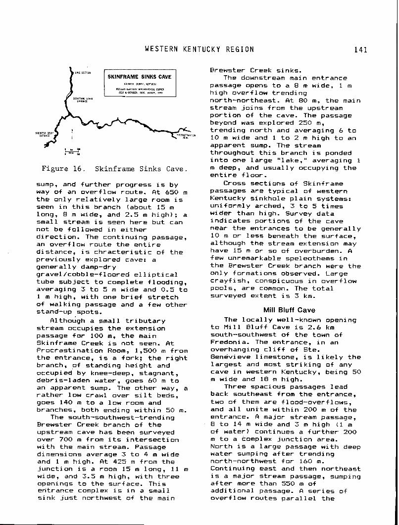
WESTERN K E N T U C K Y R E G I O N
Figure 16. Skinframe Sinks Cave.
sump, and f u r t h e r progress i s by way of an overf low route. A t 650 m t h e on ly r e l a t i v e l y l a rge room i s seen i n t h i s branch (about 15 m long, 8 m wide, and 2.5 m h igh) : a small stream i s seen here bu t can no t be f 01 lowed i n e i t h e r d i r ec t i on . The cont inu ing passage, an overf low rou te t he e n t i r e distance, i s c h r a c t e r i s t i c of t he previous1 y explored cave: a genera l ly damp-dry gravel/cobble-f loored e l l i p t i c a l tube subject t o complete f looding, averaging 3 t o 5 m wide and 0.5 t o 1 m high, w i t h one b r i e f s t r e t c h o f walking passage and a few other stand-up spots.
A1 thobgh a small t r i b u t a r y stream occupies t he extension passage f o r 100 m, t he main Skinframe Creek i s no t seen. A t P roc ras t ina t ion Room, 1,500 m from t h e entrance, i s a fork ; t he r i g h t branch, o f standing he ight and occupied by knee-deep, stagnant, debris-laden water, goes 60 m t o an apparent sump. The other way, a ra the r low crawl over s i l t beds, goes 140 m t o a low room and branches, both ending w i t h i n 50 m.
The south-southwest-trending Brewster Creek branch o f t h e upstream cave has been surveyed over 700 m from i t s i n t e r s e c t i o n w i t h the main stream. Passage dimensions average 3 t o 4 m wide and 1 m high. A t 425 m from the junc t ion i s a room 15 m long, 11 m wide, and 3.5 m high, w i t h three openings t o the surface. This entrance complex i s i n a small s ink j u s t northwest of the main
Brewster Creek sinks. The downstream main entrance
passage opens t o a 8 m wide. 1 m h i qh overf 1 ow t rend ing north-northeast. A t 80 m, the main stream j o i n s from the upstream p o r t i o n o f the cave. The passage beyond was explored 250 m, t rend ing nor th and averaging 6 t o
" 10 m wide and 1 t o 2 m h igh t o an apparent sump. The stream throughout t h i s branch i s ponded i n t o one la rge " lake," averaging 1 m deep, and usua l l y occupying t he e n t i r e f loor .
Cross sect ions o f Skinframe passages are t y p i c a l o f western Kentucky s inkhole p l a i n systems: un i fo rmly arched, 3 t o 5 t imes wider than high. Survey data i nd i ca tes por t ions of t he cave near t he entrances t o be genera l ly 10 m o r l ess beneath the surface, although the stream extension may have 15 m or so o f overburden. A few unremarkable spel eothems i n t h e Brewster Creek branch were t he on1 y f ormati ons observed. Large c ray f i sh , conspicuous i n over-Flow pools, are common. The t o t a l surveyed extent i s 3 km.
Mill Bluff Cave The 1 o c a l l y we1 1 -known opening
t o M i l l B lu f f Cave i s 2.6 km south-southwest o f the town of Fredonia. The entrance, i n an overhanging c l i f f o f Ste. Genevieve 1 imestone, i s 1 i k e l y the l a rges t and most s t r i k i n g o f any cave i n western Kentucky, being 50 m wide and 18 m high.
Three spacious passages lead back southeast from the entrance, two of them are f 1 ood-overf lows, and a l l u n i t e w i t h i n 200 m o f t h e entrance. A major stream passage, B t o 14 m wide and 3 m h igh (1 m o f water) continues a f u r t h e r 200 m t o a complex junc t ion area. North i s a la rge passage w i t h deep water sumping a+ t e r t rend ing north-northwest f o r 160 m. Continuing east and then northeast i s a major stream passage, sumping a f t e r more than 550 m of add i t iona l passage. A se r ies of overf low routes p a r a l l e l the
1 4 2 L I S A N B Y C A V E
stream passage t o the south, j o i n i n g both a t t he junc t ion complex and near the termina l sump. These passages a l t e rna te between wide, roomy tubes and muddl y crawls. The cave, bel ieved t o d ra in a la rge area o f Caldwell County t o the east, penetrates over 1 km eastward and contains 2.4 km of passage.
Lisanby Cave
The main entrance t o Lisanby Cave ( the only one v e r i f i e d p r i o r t o 1983) i s located on the southwestern o u t s k i r t s of the town of Princeton, county seat of Caldwell County. The cave i s l o c a l l y famous and no doubt has been famous f o r a century and a h a l f . However, t o date only sketchy in format ion on the cave's h i s t o r y has been gathered. The cur rent owner, Mrs. A l v i n L i sanby , ind i ca tes t h a t i t was prev ious ly re fe r red t o as the "Sal tpeter Cave"; i t may a lso have been known i n the ea r l y 20th Century as "Hol l ingsworth Cave" a f t e r Mrs. L isanby's fa ther , who was a Confederate so ld ie r . Although heavy contemporary t r a f f i c through t h e main p a r t o f t he cave seems t o have ob l i t e ra ted most i f not a l l evidence of sa l tpe te r mining a c t i v i t i e s , there i s a good chance t h a t the cave was mined dur ing the C i v i l War period. The r e l a t i v e l y d ry passages near the entrance (espec ia l l y the r i g h t branch) s u p e r f i c i a l l y appear conducive t o n i t r e production. Entrenchment i n a passage between the entrance and f i r s t room i n the r i g h t branch may have been the work o f miners. According t o Mrs. Lisanby, deserters (from which army?) h i d i n the cave dur ing t he War Between t h e States. Signatures dat ing t o the 1870s may be seen i n Lisanby Cave but most h i s t o r i c i n s c r i p t i o n s have probably been obscured by the great volume of modern defacement i n t he pa r t s O+
t he cave near the entrance. The owner a lso r e c o l l e c t s dances he ld i n t he cave when she was young. The proper ty was acquired i n 1900
by Mrs. Lisanby's fa ther , James W. Hol l ingsworth, who died i n 1915. The owner married the l a t e A l v i n Lisanby, an attorney, i n 1921, and they remained on the Hol l ingsworth farm. There may have been no reference t o t h i s cave i n speleological l i t e r a t u r e p r i o r t o 1962-63.
The main entrance (6.5 m wide and 1.0 m h igh) t o Lisanby Cave i s i n a col lapse s ink t h a t i n t e r s e c t s a f o s s i l t runk passage. From the entrance, one can go e i t h e r l e f t (upstream) o r r i g h t (downstream) (Fig. 7). The main L e f t Branch passage i s a paleo-condui t, now dry, w i t h t h i c k c l ay f i l l s . It meanders upstream i n a general 1 y northwest t o nor th d i r e c t i o n and i s c h a r a c t e r i s t i c a l l y 4.5 t o 12 m wide and 0.6 t o 3 m high. I n places, a small stream i s accessible i n a 1 ower-1 eve1 c rev ice passage, sometimes unroofed by an over ly ing passage. On the l e f t , 200 m from the entrance, i s a ra ther obscure junc t ion o f a s i g n i f i c a n t s ide passage, Thunder Road, which continues west f o r 180 m, ending i n breakdown. I t s stream may come from Watson Cave, 1.5 km t o the west. The main passage continues north, w i th a few minor s ide passages, f o r 550 m as a gradual ly lowering trunk passage, ending i n co l 1 apse.
The Right Branch rou te i s s i m i l a r t o the L e f t Branch described above: i t i s a general ly dry, c lay- f i 1 l e d pa l eo-trunk. It estends southeast f o r abut 435 m t o apparent1 y terminal breakdown. It cons is ts of a chain of walking he ight rooms connected by easy crawlways. Among the o f t en m u l t i p l e options, the small stream from Thunder Road i n the L e f t Branch can be reached i n places. Besides being the most probable s i t e of sa l tpe te r mining i n Lisanby Cave, the Right Branch i s a l so the most heavi 1 y v i s i t e d p o r t i o n of the cave, w i t h many hundreds of i n s c r i p t i o n s and usua l l y a good deal of l i t t e r i n e v i dence.
W E S T E R N K E N T U C K Y R E G I O N
Just before the dry t runk seemingly ends i n breakdown, the way onward i s a 4.5 m climbdown t o a stream passage, i . e. , the water f i r s t seen i n Thunder Road. This rou te t rends southeast as a walk and scramble, of t en on two leve ls . Only 30 m from the climb-down i s a keyhole or which discouraqes near ly a l l " f l a s h l i g h t cavers" ( judging by the lack o f vandalism beyond). Just over 200 m from the climb-down i s an e a s i l y unnoticed lead a t a s l i g h t l y h igher l eve l . This i s the beginning o f the Far less Extension described i n t he f o l l ow ing sect ion. I n the next 100 m i s a s ide passage conta in ing a segment o f the Far less Cave stream, and a second keyhole o r i s encountered, on the other s ide of which i s the ra ther su rp r i s i ng i n te rsec t i on w i th t he cave's main stream, Lisanby River, a t a p o i n t 785 m from the entrance.
From the obscure connection t o main Lisanby noted i n t he preceding sect ion, t he Far less Estension begins as a t i g h t , dry, t w i s t i n g crawl t rend ing south then west: a t 50 m, a paleo t runk passage i s intersected. This passage averages 4 o r 5 m wide and 1 m high. One d i r e c t i o n i s west-northwest f o r about 100 m before ending. The other way i s southeast. ra ther wide, low, and dry; i t leads t o a ser ies of upper l e v e l fragments and lower l e v e l stream crawls. Over 700 m of va r iab le passage leads t o the c l imbable entrance drop of Far less Cave.
Exact1 y who discovered the Lisanby River, a very s i g n i f i c a n t p a r t o f Lisanby Cave--and when--is uncerta in. The Lisanby River t runk i s remarkably uniform i n cross sect ion and nature, vary ing from 3.5 t o 6 m i n width and 2 t o 3.5 m i n height . This condui t i n massive Ste. Genevieve l imestone has few fea tu res t o speak of , besides modest-size s i l t banks and scat tered so lu t iona l odd i t ies . The stream c a r r i e s about 0.03 m3 per second of water i n normal +low and has j u s t enough grad ient t ha t
water more than ankle deep i s encountered on1 y i n a few pools. The passage meanders considerably but the basic t rend i s north-northwest f o r over 1.5 km. U n t i l almost the very upstream end of t h i s segment, the re i s only a s i ng le minor s ide passage, a t i g h t , 100-m-long t r i b u t a r y from the l e f t a t a p o i n t 1.1 km upstream from the sump.
An abrupt change takes place 1.48 km upstream from the sump as several connections occur w i t h a ra ther extensive complex of dry upper leve ls . Just beyond i s the Poison Gas Room, a breakdown chamber 6 m wide and h igh w i t h three ways on: a connection t o the dry upper leve ls ; the low cont inuat ion of the " r i v e r " , and a 117 m long t r i b u t a r y enter ing over a small r imstone cascade on the r i g h t (nor th) , ca l l e d Waterf a1 1 Tra i 1.
Something o i a maze of dry passages i s developed above Lisanby River around where i t reaches the Poison Gas Room. These passages are on two s l i g t l y o f f s e t leve ls , 3 t o 6 m above the stream and vary from easy crawlways t o bare ly wal kable dimensions. I n a1 1 l i ke l ihood , the upper l e v e l s above the Poison Gas Room--as wel l as those f a r t h e r upcave--were o r i g i n a l 1 y in tegra ted w i t h the L e f t Branch sect ion complex but now are i n te r rup ted by collapses. The various upper l e v e l segments i n the Poison Gas Room area comprise some 838 m of passage.
Upstream (west-northwest) of t he Poison Gas Room, t he main L i sanby R i ver conduit i s reduced t o a ra ther unappealing crawlway, r e f erred t o as t h e Canal o r Elbow Runway ( the 1 a t t e r name r e f e r r i n g t o grooves i n the l i t t l e m~rdbanks on one or the other s ide t h a t cavers wear whi le t ravers ing the crawl ) . This crawlway i s 3 t o 4 m wide and somewhat under 1 m high, w i th ponded water, f o r a d istance of some 125 m. Midway i s a d i s t i n c t 1 y lower ce i 1 i n g po in t , normally no problem but which could be closed a f t e r h igh runo f f .
B A K E R C A V E
On the upstream s ide o f the Canal, the streamway opens back up
t o bare ly walking or stooping s ize, not q u i t e as spacious as before the Poison Gas Room. One hundred f o r t y meters f a r t he r , a s i g n i f i c a n t f o r k o f the stream i s reached, The Y. About two-th i rds of the f low i s from the l e f t (western) branch and one-th i rd from the r i g h t (northern) branch. The northern branch leads t o . a ser ies of stream passages, f i r s t Dungball Crawl and then Water fa l l Canyon, t rending t o the northwest over 500 m before becoming extreme1 y low and wet. The stream passage i n te rsec t s a t two widely separated po in ts along i t s southern wal l , a dry upper l e v e l complex, Lost Watch Passage. This passage trends northwest-southeast, becoming extremely low a t i t s northwestern end, but i n the southeast d i r e c t i o n i t swings south over the l e f t branch of The Y, connecting w i t h f u r t h e r upper l e v e l s t h a t continue both south and southeast. Interconnected upper leve ls , the T r i 1 evel Crawls, j o i n the Lost Watch Passage and wander over the l e f t branch stream t o where i t i n t u r n branches. The southwestern branch contains a small stream i n a m u l t i l e v e l canyon complex c a l l e d Sandpaper Canyon t h a t becomes too small i n less than 200 m. North from the Sandpaper Canyon junct ion overf low passages reach Zig Zag Canyon, a stream canyon t h a t leads west w i t h over 1 km of passage before ending i n mud plugs and sumps. The upper 1 evel passages associ ated w i t h t he Lost Watch Passage and T r i 1 evel Crawl t o t a l over 2.5 km of passage.
The gross morphology o f the cave w ~ u l d suggest t h a t i t began as a major stream passage car ry ing water from the upper (northwestern) end of the Lost Watch Passage southeast past the current pos i t i on of The Y t o the upper l eve l s o f f the Poison Gas Room and on through the L e f t and Right Branches of the main entrance ser ies t o a resurgence on
the banks of Eddy Creek. Along the way i t picked up t r i b u t a r i e s from the west and southwest a t T r i l e v e l Crawl , Thunder Road, and Far l ess Cave. The lower l e v e l s o f these three t r i b u t a r i e s provide water t o the Lisanby River today.
Total passage length i s 11.3 km, w i t h some p o s s i b i l i t i e s f o r extension. This makes i t more than tw ice as long as any other known Western Kentucky cave.
Baker Cave Baker Cave i s located 4 km
north-northeast o f the v i l l a g e o f Salem i n Cri t tenden County. The cave i s developed i n the Renault Limestone, f 01 1 owing j o i n t s , f a u l t s , and veins s t r i k i n g north-northeast t h a t are re la ted t o the nearby Babb and Levias f a u l t systems.. The cave has been mined f o r f l u o r i t e , and shot holes, a collapsed sha f t t o the sur f ace, and various mining paraphernal ia can be found i n the cave.
The cave has two entrances, s i t ua ted c lose t o each other. One i s a crawlway o f f a small s ink on a h i l l s i d e t ha t goes west about 7 m then i n te rsec t s a sha f t t o the sur f ace ( the second entrance) about halfway down i t s 8 m depth. A climbdown reaches the base of t he sha f t which slopes immedi ate1 y i n t o the main stream passage.
Upstream, t o the north, the stream passage s t a r t s out 3 t o 5 m wide and 1.5 t o 3 m high. A f a u l t o r j o i n t i s prominent along the eastern wal l . A f te r about 50 m, t he passage becomes l e s s than 1 m high, h a l f f u l l of water, but s t i l l 3 m wide. The passage has not been pushed beyond t h i s po in t , although i t appears t o continue.
Downstream, t o the south, the passage i s i n i t i a l l y easy walking and scrambling f o r about 40 m, 2 o r 3 m high, 3 t o 5 m wide. The passage then degenerates. w i th the major upper l eve l being blocked by sediment f i l l or col lapse, and progress i s r e s t r i c t e d t o a 0.5 m h igh crawl i n the stream. This crawl opens up a f t e r 25 m i n t o a
W E S T E R N K E N T U C K Y R E G I O N 1 4 5
l a rge chamber f i 1 l e d w i t h mining debr is, and conta in ing a col lapsed mine sha f t on the western side.
From t h i s p o i n t downstream the passage becomes extremely pleasant, being mostly walking he ight i n a f i n e tube up t o 6 m wide 'and 4 m high. Flf ter c rawl ing over and around an occasional breakdown p i l e , a massive termina l co l lapse i s met an estimated 500 m from the entrance. One shor t 20 m s ide passage was noted.
CONCLUSIONS
The Western Kentucky Coal F i e l d Region i s a poor ly explored but ex tens ive ly cavernous, low re1 i e f s inkho le p la in . With almost 100 km o f passage surveyed i n l e s s than 10 years, the cont inu ing p o t e n t i a l o f t he area i s exc i t ing . Because of t he reg ion ' s r e l a t i v e obscur i t y i n speleology, i t has provided an oppor tun i ty f o r a conservation-oriented, s c i e n t i f i c , and comprehensive survey organizat ion, t he Western Kentucky Speleological Survey, t o explore, study, map, and compile cave data f r e e from compl icat ion and po l i t i c s . A number of d iverse groups and i ndi v i dual s work together i n cooperat ion w i t h the WKSS t o maximize both t he study and use o f the reg ion ' s caves. Extreme e f f o r t s have been made t o maintain excel l e n t 1 andowner r e l a t i o n s and t o preserve the caves (Fig. 13).
A1 1 caves are valuable and pr ice less. The value o f t he western Kentucky caves depends on the observer ' s p o i n t o f view. Cavers in te res ted i n deep p i t s , endless spacious g a l l e r i e s , and f a n t a s t i c mineral d isp lays w i l l be disappointed. Cavers from areas w i t h small caves, from co ld cl imates, or areas w i t h vandalized and heav i l y t rave led caves w i l l be pleased w i t h most western Kentucky caves. The authors o f t h i s chapter, as representat ives of t he
WKSS, welcome in te res ted , conservation-minded cavers t o come, locate, explore, and map caves w i t h the WKSS.
REFERENCES 1
Carstens, Kenneth, 1980, Savage Cave--The f u t u r e of i t s prehis- t o r y , In Mylroie, J. E., ed., Western Kentucky Spel eo log ica l Survey Annual Report f o r 1980, Murray, Kentucky, p. 17-28.
Dever, G. R. and McGrain, Preston, 1969, H i gh-cal c i u m and 1 ow- magnesi um l i mestone resources i n t he reg ion of t h e Lower Cumber- land, Tennessee and Ohio Val 1 eys, Western Kentucky: Ken- tucky Geological Survey, ser. 10, B u l l e t i n 5. 192 D.
Mason, D. , MrDowel 1 , D. , and Mylro ie, J. E., 1984, Meander c u t o f f s i n the Glover 's Cave area, Chr is t ian County, Ken- tucky, Mylrqie, J. E., ed., Western Kentucky Speleol og ica l Survey Annual Report f o r 1982 and 1983: Murray, Kentucky, p. 7-10.
McFarlan, A. C., and Jones, D. J., 1954, Geologic map of Kentucky: Kentucky Geological Survey, ser. 9, Scale 1 i n . = 16 m i .
Moore, F. M. and Mylroie, J. E., 1979, In f luence of master stream i n c i s i o n on cave development, Tr igg County, Kentucky, in, Mylroie, J. E., ed., Western Kentucky Speleological Survey Annual Report f o r 1979: Murray, Kentucky, p. 47-68.
Whaley, P. W., and black, P. C., 1978, A b r i e f geological de- s c r i p t i o n o f t h e Western Ken- tucky survey area, in, Mylroie, J. E., ed., Western Kentucky Spel eo l ogi ca l Survey Report f o r 1978, Murray, Kentucky, p. 5-10.
Chapter 9 CAVE LIFE OF KENTUCKY
Thomas C. Barr, Jr. Department of Biology University of Kentucky
Lexington, Kentucky 40506
The unusual ly r i c h l i f e of Ken- tucky caves r e f l e c t s the f a c t t h a t l a r g e segments o f t he two major M i s s i s s i p p i an 1 i mestone p l ateaus o f t he eastern United States are found w i t h i n t he Commonwealth. A1 though s i qni f i cant bu t 1 i m i ted cave faunas occur i n the Flue Grass and i n i so la ted kars t i s l ands along the Rough River Fau l t Zone and the northwestern face o f Pine Mountain, the Missis- s ipp ian Plateau caves harbor the d ive rse t r o g l obi t e faunas f o r which Kentucky i s best known. These faunas are as r i c h as those o f any other ka rs t reg ion i n the world.
H i s t o r i c a l l y , Kentucky bio- spel eo l ogy began when Stephen Bishop crossed Mammoth Cave's Pottomless P i t on a crude cedar ladder and discovered Echo River and i t s b l i n d cavefishes. When James DeKay (1842) described A m b l ~ o e q & ~ spelaea i n a footnote i n h i s "Zoology o f New York", a german physician, Theodor Tellkampf, v i s i t e d Mammoth Cave i n search o f specimens of t h i s , the wor ld ' s f i r s t known b l i n d cave- f i s h . He a1 so c o l lec ted and de- scr ibed b l i n d beetles, a b l i n d harvestman, a b l i n d spider, and a b l i n d c r a y f i s h ( T e l l kampf , 1844a, 1844b, 1845). Constantine Rafinesque (1832) had v i s i t e d Mammoth Cave almost two decades e a r l i e r and observed la rge hiber-
na t ing ba t colonies, but describ- ed nothing else. The eminent Russian c o l eopter i s t , Baron T. V i c to r von Motschulsky, a t t r ac ted by Tel lkampf's descriptons of b l i n d beetles, v i s i t e d Mammoth Cave i n 1854--no small achieve- ment i n those days--and described add i t iona l species he found there. A few years l a t e r Alphaeus Spring Packard, Jr., tak ing advantage of a f r e e t r i p t o Mammoth Cave o f f e r - ed t o pa r t i c i pan ts a t an Ind ianapol is meeting of the Amer- i can Associaion f o r the Advance- ment o f Science by t he L & N Ra i l - road, co l lec ted s t i l l f u r t h e r cave inhabi tants. D i ssa t i s f i ed w i th Darwin's theory o f na tu ra l selec- t i o n because he bel ieved i t d i d no t e n t i r e l y exp la in evolut ionary phenomena, Packard subsequently v i s i t e d Mammoth and other caves, inc lud ing t he Carter Caves i n northeastern Kentucky, as wel l as Wyandotte Cave, Indiana, and Nickajack Cave, Tennessee. He mistakenly bel ieved t h a t l i f e i n caves exerted a d i r e c t e f f e c t on the evolut ionary l oss o f eyes and pigment and was f o r a t ime a cham- p ion of the Neolamarckian school^ o f thought ( see Packard, 1890: Barr, 1968a). Packard's contr ibu- t i ons , though leaving much t o be desired i n t he way of accuracy and heavi 1 y 1 aden w i t h h i 5 Neol amar- ck ian philosophy, a t l e a s t pub- l i c i z e d the ra ther r i c h fauna of
C A V E L I F E OF K E N T U C K Y
Kentucky caves ( see Packard, 1888).
When Horace Carter Hovey ex- p lo red Mammoth Cave he was a t t imes accompanied by R. E. Ca l l , who wrote a chapter on cave l i f e i n Hovey's famous guidebooks t o Mammoth Cave, publ ished i n sever- a l ed i t i ons around the t u r n of the century. Northwestern Un i ve rs i t y ' s Professor O r 1 ando Park (a n a t i ve o f El i iabethtown, Kentucky) took h i s ecology classes t o Mammoth Cave i n t he 1930's and ac tua l l y publ ished a key t o Mammoth Cave animal species as an exerc ise i n h i s laboratory manual on animal ecology and taxonomy (Park, 1939). The key i s now considerably out- dated, bu t i t inc ludes t he species described by Ca l l , ReKay, Motschulsky, Packard, Tellkampf, and others, as we l l as observa- t i o n s and redescr ip t ions made when the European b iospe leo log is ts Rene Jeannel (France) and Candido Bol i v a r y P i e l t a i n (Spain) v i s i t e d Mammoth Cave, Carter Caves, and other caves i n 1929 (Bo l i va r and Jeannel , 1931 .
The bu lk o f our present know- ledge of Kentucky cave l i f e i s based on widespread c o l 1 ec t i ons made by T. C. Barr, J. R. Holsinger, T. 6 . Marsh, R. M. Norton, and S. B. Peck i n the 1960's. Th is mater ia l i s s t i l l being inven to r ied and described. Important con t r i bu t i ons t o cave bee t l e taxonomy were made by J. M. Valent ine (1952) who discovered the t h ree endemic genera Dar l inq- toned, Ameroduvalius, and Nelsoni tgs i n t he Somerset-Mount Vernon area, and by C. H. Krekeler (1973), who co l l ec ted Pseudanoph- thalmus species i n the Blue Grass. The r i c h e r and be t te r known fauna of t he Mammoth Cave Region a t t r ac ted eco log is ts and other b i o l o g i s t s who were dependent on pre-existence of a taxonomic data base. These b i o l o g i s t s included T. C. Far r , T. C. Kane, R. A. Kuehne, T. McKinney, R. M. Norton, T. L. Poulson, and others. Some of the h i s t o r y o f cave b io logy i n the Uni ted s ta tes was sketched by Barr
(1966). The inventory stage i s s t i l l going on; add i t iona l t rog- l o b i t e species are being d is - covered and described, bu t a t a 51 ower r a t e than previously.
Studies o f ba ts i n Kentucky caves reached a peak i n the 1960's and e a r l y 1970's w i t h the work o f R. W. Barbour, W. H. Davis, and t h e i r students a t t he Un ivers i t y o f Kentucky. This research cen- te red p r i m a r i l y on h ibernat ing co lon ies i n Mammoth Cave National Park, Carter Caves State Resort Park, and a small number of caves i n Lee County (Davis and Barbour, 1965; Hassel l and Harvey, 1965).
For considerat ion o f cave faunas, a reg iona l c l a s s i f i c a t i o n s l i g h t l y d i f f e r e n t from t h a t used elsewhere i n t h i s book has been employed , and reasons f o r organi z - i n g discussion around t h i s scheme w i 11 become apparent i n t h i s chapter:
1. Western Missi s s i pp i an Plateau (NP-I)--Pennyroyal + Cumber- land Saddle
2. Eastern Miss iss ipp i an Plateau (MP-11)--Cumberland Plateau Margi n
3. F lue Grass 4. Karst Is lands
a) Pine Mountain b ) Rough River Fau l t Zone and
other i s o l a t e d caves along t h e outer margin o f the Western Kentucky Coal F i e l d
KINDS OF CAVERNICOLES
The taxonomic groups o f animal s i n Kentucky caves w i l l be consid- ered i n a subsequent sect ion. F i r s t , we have t o consider var-ious c l a s s i f i c a t i o n s o f t he ecological o r evolut ionary s ta tus o f caverni- coles. Any animal t h a t l i v e s i n a cave i s a cavernicole. I f * we wish t o emphasize degree of r e s t r i c - t i o n t o caves and other subterran- ean hab i t a t s (phreat ic ground- water, "microcaverns" around t r e e r o o t s and i n t a l u s slopes, and so f o r t h ) , we can d i v i d e caverni- co les i n to :
S P E C I A T ' I O N IN C A V E S
fi) t rog lob i tes- -ob l igate cavern- i c o l e s (e.g., b l i n d cave- f i shes)
B) t rog loph i les--f acul t a t i v e cavernicoles t h a t can l i v e out t h e i r e n t i r e l i v e s i n caves but are a1 so found i n non- cave microhabi tats (springs, deep s o i l )
C ) trogloxenes--caverni co l es t ha t roos t o r remain i n caves by day but depend on feeding out- s ide a t n ight ; " threshold" trogloxenes are bats, cave ra ts , and cave c r i c k e t s
D) accidental s--0ccasi onal wanderers and animals t ha t wash o r f a l l i n t o caves
Flatworms and small crustaceans t h a t disperse through groundwater i n non-karst regions (and thus have wider geographic ranges than species unable t o do t h i s ) are sometimes ca l l ed phreatobi tes or stygobionts, which are more general terms than " t rog lob i te , " bu t they are, o f course, t r o g l o b i tes, too.
Troglobi t e s are re1 i c t species t h a t can no longer e x i s t outside o f caves o r other subterranean microhabi tats of the s o r t discussed; t y p i c a l l y , t h e i r non-cave ancestors are e x t i n c t i n t he cave areas, because surface condi t ions hundreds of thousands o r m i l l i o n s of years ago were d i f f e r e n t . Troglobi tes o f t en show l o s s or rudimentat ion o f eyes, pigment, c i rcad ian rhythms, and other cha rac te r i s t i c s associated w i t h l i f e above ground. The longer they remain i n caves, t he more successfu l ly they have become adapted t o a cave environment, showing such features as slender bodies, long and s t i l t l i k e legs, longer antennae, hypertrophied sensory systems, and so fo r th . Trog lob i tes t h a t have such adaptat ions are sometimes said t o be high1 y "troglomorphic, " a term t h a t emphasizes evolut ionary, r a the r than eco lg ica l status. (For f u r t h e r discussion of terms appl ied t o cavernicles, see Barr, 1968a; Earr and Hol singer , i n press).
SPECIATION IN CAVES
Speciat ion i n cave faunas was recen t l y reviewed by Barr and Holsinger ( i n press). For Kentucky t r og lob i t es , the most common pa t te rn has been mu l t i p l e invasions o f d i f f e r e n t cave systems by widely d i s t r i bu ted non-cave ancestors; w i th gradual e x t i n c t i o n o f the ancestral populat ion outs ide caves, the cave popul a t i ons became i sol ated and underwent genetic divergence t o vary ing degrees. The descendant cave species now occupy one t o many caves, depending on (a) t h e i r mob i l i t y , (b) t h e i r capacity t o disperse through non-karst terranes o r not, and, i f not, ( c ) whether the caves they i n i t i a l 1 y occupied are located i n small, very l o c a l ka rs t is lands, o r broadly contiguous MP kars t w i th subterranean connections between caves, o r some intermedi te kars t area such as p a r t of the Blue Grass.
Even i n MP areas there are occasional d ispersal bar r ie rs . I n MP-I these b a r r i e r s are the Ohio River, the Hart County Ridge and f a u l t zone j u s t nor th of Munfordvi l le , the Barren River a t Bowling Green, s t ra t i g raph i c b a r r i e r s northwest of Hopkinsvi 11 e and between the kars t regions of Caldwell and Cri t tenden counties, and once again, the Ohio River. I n MP-I I the Mississ ippian 1 imestone outcrops are patchy and i so la ted northeast o f Red River, c reat ing several bar r ie rs . To the southwest there are r i v e r bar r ie rs , notably the deep gorge of Kentucky River some 150 m below cave l eve l s a t I r v i ne , Cumberland River near Burnside, and South Fork as f a r as the mouth o f L i t t l e South Fork. River b a r r i e r s rare1 y af f ec t d ispersal o f aquatic t rog lob i tes , but they e f f e c t i v e l y prevent d ispersal o f many t e r r e s t r i a1 t rog lob i tes . Smaller, youthful r i v e r s w i t h a meander frequency higher than l.O/km are r a r e l y ba r r i e r s , apparently because b l i n d beet les and other t r og lob i t es can
C A V E L I F E OF K E N T U C K Y
be washed out of caves on one side and manage to enter crevices in limestone bluffs on the opposite side (Earr, in press).
Di f f erent groups of trogl obi tes may show very small ranges--often single caves--on the one hand, and quite large geographic ranges on the other. Pseudoscorpions of the genus Kleptochtonius, for example, are rarely known from more than one or two caves, and distinct species are reported from Mammoth Cave and nearby White Cave. Smaller cave carabid bettles (trechines) such as Pseudanoph= thalmus inexpectatus may be lim- ited to Mammoth, White, and Great Onyx caves, but large, active beetles such as Neaphaenop~ tell kampf i and. its close rela- tives in MP-I and Darlinqtonea kentuckensis in MP-11 have very ------------ 1 arge ranges.
The process of becoming a trog- lobite (or whole series of troglo- bitic species descended from a common ancestor that colonized different caves) seems to be in different stages at the present time in different groups of Ken- tucky troglobites. For example, carabid bettles include about 60 to 70 discrete species in Ken- tucky that probably became iso- lated in caves by changing climates during Pleistocene time. No ancestral species exist anywhere in eastern United States, although one Pseudanophthalmus species (close1 y related to Greenbri er Val 1 ey cave species nearby) is known from deep soi 1 in the Yew Mountains, Pocahontas County, West Virginia (Barr, 1967a) . Many deep soi 1 speci es of trechine carabids are known in mountains o+ Europe and eastern Asia. The widely distributed trog- 1 omorphi c col 1 embol an Pseudo- sine/&g hirsutg (MP-I and MP-11, Kentucky and Tennessee) probably consists of populations descended from at least four separate cave invasions in different parts of its present day range. These four groups have independently acquir- ed troglomorphic characters at
different evolutionary rates and may eventual 1 y become four bi ol og- ical species (Chri stiansen and Culver, 1968). Compared to tre- chine beetles, EL hirsutg has either evolved more slow1 y or entered caves more recently. Three species of blind crayfishes, Orconectes eellucidus (MP-I south of the Hart County Ridge Fig. 1 Q inermis (MP-I north of the Hart County Ridge), and 0: australis (MP-I1 from Rockcastle --------- County southwest to Alabama), are believed to be descendents of a common epigean ancestor related to 0: limosus, a non-cave species of the eastern At1 antic Coastai Plain that lives in slowly moving, sluggish streams. In early Pleis- tocene time, stream gradients steepened, and flow was faster, creating unsuitable habitats for the ancestral crayfishes, which retreated into small tributaries and ultimately springs and caves. Hobbs and Barr (1972) postulated survi val of thi s ancestral speci es in three river systems--the Green, the Cumberland, and the preglacial Teays River: the three colonies gave rise to eellucidus, 0, australis, and & inermis, --------- respectively. These large troglo- bites are limited to the MP regions, for the most part australis has penetrated the eastern edge of the Central Basin in Tennessee in two places, one such colony evolving into the isolated species 0: incogptus) A because of numerous sol ut i onal openings permitting dispersal.
Some "species" of troglobi tes are probably clusters of sibling species--species difficult to differentiate morphologically but belonging to entire1 y different gene pools. The likelihood that IyehlLchthys sybterraneus a spe- cies of blind cavefish whose range includes southern Kentucky (MP-I and MP-I I ) , central Tennessee, northern Alabama, and the southern Ozark Plateau, is actually a cluster of genetically differing sibling species is quite high (Barr and Holsinger, in press:
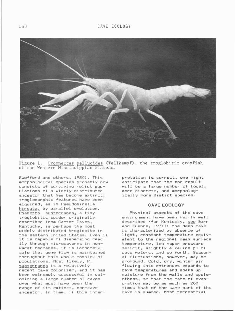
1 5 0 CAVE ECOLOGY
Figure 1. Orconectes ellucides (Tellkampf), the troglobitic crayfish of the Western Mississlpplan \ ateau. Swofford and others, 1980). This morphological species probably now cons is ts o f su rv iv ing r e l i c t pop- u l a t i o n s o f a wide1 y d i s t r i b u t e d ancestor t h a t has become ex t inc t : troglomorphic features have been acquired, as i n Pseudosi ne l l a hirsuta, by para1 l e l evolut ion. Phanetta subterranea, a t i n y t r o g l o b i t i c spider o r i g i n a l l y described from Carter Caves, Kentucky, i s perhaps the most widely d i s t r i b u t e d t r o g l o b i t e i n t he eastern United States. Even i f i t i s capable of d ispers ing read- i l y through microcaverns i n non- kars t terranes, i t i s inconceiv- ab le t h a t gene f law i s maintained throughaut t h i s whole complex od populat ions. Most l i k e l y . PL subterranea i s a r e l a t i v e l y recent cave colonizer, and i t has been extremely successful i n co l - on iz ing a la rge number o f caves over what must have been the range of i t s ex t i nc t , non-cave ancestor. I n time, i f t h i s i n t e r -
p r e t a t i o n is correct , one might an t i c i pa te t h a t t he end r e s u l t w i 11 be a l a rge number o f l oca l , mare d iscre te , and morpholog- i c a l 1 y more d i s t i c t species.
CAVE ECOLOGY
Physical aspects o f the cave environment have been f a i r 1 y we1 1 described ( f o r Kentucky, see Earr and Kuehne, 1971): the deep cave i s character ized by absence of 1 i ght , constant temperature equi v- a l en t t o t he reg iona l mean surface temperature, low vapor pressure d e f i c i t , s l i g h t l y a l k a l i n e pH of cave waters, and so f o r t h . Season- a l f l uc tua t ions , however, may be profound. Cold, dry, winter a i r f l ow ing i n t o entrances expands t o cave temperatures and soaks up moisture from the wa l l s and spele- othems, so t h a t t h e r a t e o f evap- o ra t i on may be as much as 200 t imes t h a t o f the same p a r t of the cave i n summer. Most t e r r e s t r i a l
CAVE L I F E OF K E N T U C K Y
t r o g l o b i t e s cannot t o l e r a t e low r e l a t i v e humid i t ies and disappear from entrance zones i n winter. Aquatic cave microhabi tats are subject t o seasonal d i f ferences i n water l e v e l s i n pools o r t o heavy f lood ing i n streams.
Ul t imate ly , a l l food u t i l i z e d by a cave ecosystem comes from the surface. There are two ways i n which food gets i n t o caves: (1) t ranspor t by vadose water, and (2) t ranspor t o r d i r e c t con t r i bu t i on (feces, dead bodies) by t rog lox - enes such as bats and cave c r i ck - ets. Cave r a t s (Neotoma maqister) cont r ibutes leaves, twigs, and feces t o the deep cave community; such food i s usual1 y l i m i t e d t o shelves o r the. f l o o r below she l f runways o r nest s i t es . Hiberna- t i n g bats con t r ibu te very l i t t l e , but summer bat res idents cont r ib- u t e l a rge amounts o f guano. Only the gray bat , Myotis grisescens, i s a s i g n i f i c a n t con t r ibu to r o f guano i n Kentucky caves, p r i n c i - p a l l y i n the southern p a r t of the Commonwealth. Bat guano decomposes slow1 y, o f t en w i t h t o x i c byprod- ucts, and seems more s i g n i f i c a n t as food when i t i s wide1 y d i s - persed on a wet f l o o r , under f l i g h t paths, o r when i t f a l l s i n small quan t i t i es i n t o r imstone pools, than when i t accumuates i n la rge mounds. Far more important f o r Kentucky cave communities are cave c r i c k e t s o f the genus Hadenoecus, H, subterraneus i n MP-I and Hi gggberlandicus i n MP-11. Unl ike t he common c e l l a r and camel c r i ck - e t s (Ceuthophilus spp. ) , which r a r e l y penetrate deeply i n t o caves, these two species (along w i t h thr,ee s i m i 1 ar species i n MP-I I of Tennessee and A1 abama) roos t i n la rge numbers i n favored s i t e s on cave ce i l i ngs , emerging a t i n t e r v a l s of 2 or 3 days t o feed outside. Beneath the roos ts a t h i n , humus-like layer of guano accumulates, prov id ing food f o r many det r i tus- feed ing t r o g l o b i t e s (sna i ls , co l lembolans, b r i s t l e - t a i l s , Ptomaphaq~~s beetles, etc. ) . The d e t r i t i v o r e s are i n t u r n eaten by predatoy t r o g l o b i t e s (spiders,
pseudoscorpions, carabid beet les) . Two groups o f carabid beetles, Neaphaenops i n MP-I and D a r l i n w tonea i n MP-11, have indepen- ----- dent l y "learned" t o d i g and eat eggs o f these two Hadenoecus species (Hubbell and Norton, 1978). Hadenoecus cumberlandicgs has evolved parthenogenetic popu- l a t i o n s (females on ly ) i n WP-I1 northeast of the Red River Gorge (Lamb and Wi l ley, 1975: see a lso G l esener and T i 1 man, 1978) .
Larger streams s ink ing under- ground may car ry leaves and tw igs t h a t are deposited along cave stream banks and eventua l ly decom- pose through bac te r i a l and fungal act ion. Vadose water enter ing caves v e r t i c a l l y along j o i n t s and fhrough dome p i t s may leach out organic compounds from humus i n t he over l y ing s o i l mantle, a t t he same t ime car ry ing w i t h i t s o i l bacter ia, protozoans, and other microorganisms. Vadose water samples i n Mammoth Cave measured a t d i f f e r e n t seasons of t he year have a t o t a l organic carbon con- t e n t ranging from 2 t o 14 ppm (Barr, unpublished). These organic compounds-hexoses, amino acids, humic and f u l v i c acids, and so for th--are apparently adsorbed onto c l ay micceles i n t he mud of cave pools. Small t r o g l o b i t i c crustaceans--amphipods and i sopods--that eat t h e i r way through the mud i n pools can probably release the organic com- pounds by a l t e r i n g the pH i n t h e i r d iges t i ve t rac ts . 0 wide range of s o i l microorganisms enter caves i n d r ipp ing water, bu t r e l a t i v e 1 y few surv ive f o r more than a few weeks. Most cave protozoans, f o r ex amp1 e , belong t o a small number of c i l i a t e species t h a t are repeat- ed ly encountered i n var ious cave waters (Gi t t leson, 1969). Although there are no photosynthetic pro- ducers i n cave communities, bac te r i a and fungi , through decom- posi ton of organic materi a1 washed i n t o caves, act as secondary pro- ducers, transforming the mater ia l i n t o a form t h a t can be u t i l i z e d by t rog lob i tes . I n the "Shrimp
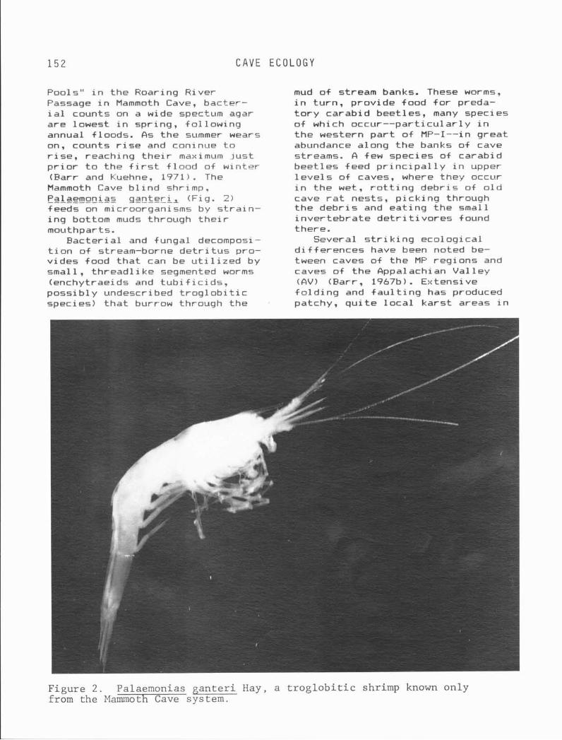
C A V E E C O L O G Y
Pools" i n the Roaring River Passage i n Mammoth Cave, bacter- i a l counts on a wide spectum agar are lowest i n spring, fo l low ing annual f loods. As the summer wears on, counts r i s e and coninue t o r i s e , reaching t h e i r maximum j u s t p r i o r t o the f i r s t f l o o d of w l n t r r (Farr and Kuehne, 1971). The Mammoth Cave b l i n d shrimp. Palaemonias ganteril (Fig. 2 ) feeds on microorganism5 by s t ra i n - i n g bottom muds through t h e i r mouthparts.
Bac te r ia l and fungal decompo- =.I ' - t i o n of stream-borne d e t r i t u s pro- v ides food t h a t can be u t i l i z e d by small, th read l i ke segmented worms (enchytraeids and t u b i f i c i d s , poss ib ly undescribed t r o g l o b i t i c species) t h a t burrow through the
mud of stream banks. These worms, i n turn , provide food f o r preda- t o r y carabid beetles, many species o f which occur--part icular1 y i n t he western p a r t o f MP-I--in great abundance along the banks o f cave streams. A few species of carabid beet les feed p r i n c i p a l 1 y i n upper l e v e l s o f caves, where they occur i n the wet, r o t t i n g debr is of o l d cave r a t nests, p i ck ing thrnuuh the debr is and eat ing the small i nver tebra te d e t r i t i v o r e s found there.
Several s t r i k i n g ecological d i f fe rences have been noted be- tween caves o f the MP regions and caves of the Appalachian Val l e y A (Parr, 1967b). Extensive f o l d i n g and f a u l t i n g has produced patchy, q u i t e l o c a l ka rs t areas i n
Figure 2 . Palaemonias g a n t e r i Hay, a t r o g l o b i t i c shrimp known on ly from the Mammoth Cave system.
C A V E L I F E O F K E N T U C K Y
the AV. Although the AV does not extend i n t o Kentucky, s i m i l a r l y l o c a l and s t r a t i g r a p h i c a l l y iso- l a t e d kars t is lands i n Pine Mountain, t he Rough River Faul t Zone, and patchy exposures o f Glen Dean Limestone around the edge of t he Western Kentucky Coal F i e l d are eco log ica l l y and biogeograph- i c a l l y s i m i l a r t o AV caves. I n the MP regions the dispersal po ten t i a l o f a t r o g l o b i t e i s much greater: i t can move from cave t o cave by subterranean so lu t iona l openings i n broadly contiguous karst . I n cont rast t o AV or kars t i s l and caves, t r o g l o b i t e species i n MP caves have la rger geographic ranges, e x h i b i t fewer species per u n i t area o f exposed kars t , and are more commonly sympatric ( i .e., two o r more species coexist i n t he same caves). 63 t y p i c a l t r o g l o b i t i c communitv i n the MP regions may
<
i nc lude 15 t o 30 species, whi le only 5 t o 10 species are found i n AV o r ka rs t i s l and caves. MP trog- l o b i t e s are o f ten la rger than those of AV or ka rs t i s l and caves, a phenomenon poss ib ly a t t r i b u t - able--at l eas t f o r predators--to a wider v a r i e t y of prey species, consequently a more predicatable supply o f food. I n a small, i so- l a t e d cave system there may be on ly one o r two prey species, and a carabid bee t le predator depen- dent on these w i l l s u f f e r a de- c l i n e i n number i f the prey species decl ine. I n MP caves, f a c t o r s t h a t a f f e c t one prey species may not necessar i ly a f f e c t a l l o f them, consequent1 y carabid bee t le populat ions are o f t en not on ly unusual ly l a rge but much more s tab le (Barr, 1967b, 1968, i n press).
The opportuni t i e s f o r evo lu t ion o f complex communities o f t rog lo - b i t e s are much more favorable i n MP areas. D i f f e r e n t ancestars may have colonized d i f f e r e n t caves a t d i f f e r e n t t imes i n the past, but because there are extensive connections between MP caves, sub- terranean d ispersa l may permit many species t o eventual ly occupy the same caves. Coexist ing species
must be mutual ly compatible, not competing f o r t h e same environ- mental resources. Several ser i es of close1 y s i m i l a r species of cave carabid beet les are known tha t are parapat r ic , t i . e. , t h e i r ranges are contiguous bu t non-over- lapping). Fol lowing co lon iza t ion
o f two o r more d i f f e r e n t cave systems by t he same ancestor, genet ic divergence has occurred. As the d i f f e r e n t bee t l e popula- t i o n s dispersed outward from t h e i r p o i n t s o f o r i g i n by subterranean routes, they eventua l ly came i n t o contact w i t h each other. Because o f gnet ic d i f ferences, hybr ids
between the two populat ions were i n f e r i o r ; consequently, natura l se lec t i on favored in-group breed- ing. Ecological n iches o f the two populatons had not diverged enough so t h a t they could coex is t i n the
same caves. As a r e s u l t of genetic i n c o m p a t i b i l i t y and niche s im i l a r - i t y , the two populat ions estab- l i s h e d a range boundary t h a t
ne i ther could cross. Much of the western p a r t o f MP-I i s inhabi ted by species o f t he pubescens group o f Pseudanoghthal mus: most show parapa t r i c ranges. The so le excep- t i o n i s a d i s t i n c t l y smaller species w i t h d i f f e r e n t feeding habi ts , PI hganens i s (Barr, 1979). While most species of the pubescens group are la rger and c r u i s e mud banks i n search of prey, PI Ipqanensis h ides i n d e t r i t u s p i l e s and between c lay laminae, feeding on small ar thro- pods t h a t i t f i n d s there. I n var ious caves P, loqanensis co- e x i s t s w i t h PL c i l i a r i s and PI p r i n c e ~ s ~ both l a rge r species o f t h e pubescens group. The mean 1 engths o f most 1 oqanensi s popula- t i o n s are c lose t o 4.5 mm, wh i le c i l i a r i s i s normally c lose t o 5.0
mm mean length. Perhaps i t i s s ig - n i f i c a n t t h a t a l l c i l i a r i s co- e x i s t i n g w i h loqanensi s belong t o t he d i s t i n c t 1 y l a rge r subspecies PI c, prggndae, w i t h a mean leng th c lose t o 6.0 mm, thus ex- acerbating the s i ze d i f fe rence (Earr, 1979, and i n press).
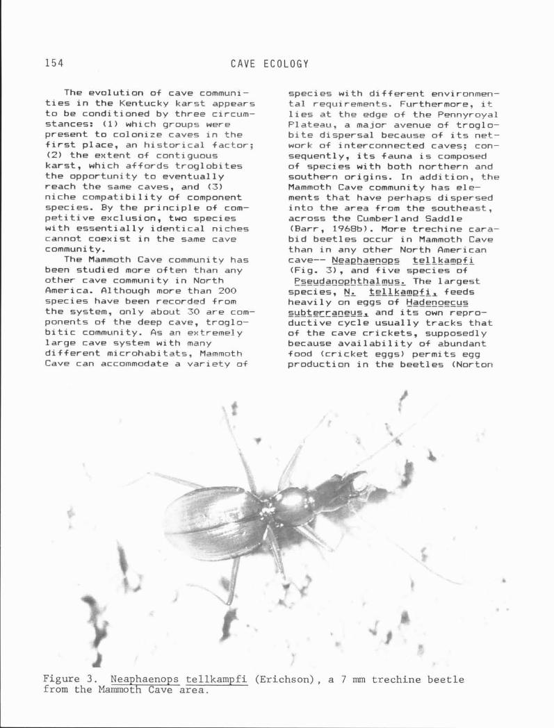
1 5 4 C A V E E C O L O G Y
The evo lu t ion o f cave communi- t i e s i n the Kentucky kars t appears t o be condit ioned by three circum- stances: ( 1 ) which groups were present t o colonize caves i n the f i r s t place, an h i s t o r i c a l fac tor ; (2) t he extent o f contiguous kars t , which a f f o rds t r og lob i t es the opportuni ty t o eventual ly reach the same caves, and (3) n iche compa t i b i l i t y o f component species. By the p r i n c i p l e of com- p e t i t i v e exclusion, two species w i t h essent ia l1 y i d e n t i c a l niches cannot coexist i n the same cave community.
The Mammoth Cave community has been studied more o f t en than any other cave community i n North America. filthough more than 200 species have been recorded from the system, only about 30 are com- ponents of the deep cave, t rog lo - b i t i c community. A s an extremely la rge cave system w i th many d i f f e r e n t microhabitats, Mammoth Cave can accommodate a va r i e t y o i
species w i th d i f f e r e n t environmen- t a l requirements. Furthermore, i t l i e s a t the edge of t h e Pennyroyal Plateau, a major avenue o f t r og lo - b i t e d ispersal because o f i t s net- work o f interconnected caves: con- sequently, i t s fauna i s composed o f species w i t h both northern and southern o r ig ins . I n add i t ion, the Mammoth Cave community has ele- ments t h a t have perhaps dispersed i n t o t he area from t h e southeast, across the Cumberland Saddle (Barr, 1968b). More t rech ine cara- b i d beet les occur i n Mammoth Cave than i n any other North American cave-- Neaphaenops te l l kampf l (Fig. 3) , and f i v e species o f Pseudanophthalmus. The 1 argest
species, N, t e l l kampf i , feeds heav i l y on eggs o f Hadenoecus subterraneus, and i t s own repro- ------------ duc t i ve cyc le usua l l y t racks t h a t o f t he cave c r i cke ts , supposedly because avai 1 abi 1 i t y o f abundant food ( c r i c k e t eggs) permi ts egg product ion i n the beet les (Norton
Figure 3 . Nea haeno s tellkampfi (Erichson), a 7 mm trechine beet le from the Mammot --Eh---E Cave area.
C A V E L I F E OF K E N T U C K Y
and others, 1975). Two smaller species, P, inexpectatus and PI audax, appear i n wet weather and unusual ly dry weather, respec- t i v e l y , suggesting r e s t r i c t i o n t o q u i t e d i f f e r e n t niches (Farr, 1966-67). The f l a t t ened form of e, gudax and i t s great r a r i t y i n caves suggests t h a t i t s normal microhabi tat could be microcaverns a t the i n t e r f a c e between bedrock and s o i l mantle. The three other species are subequal i n s i ze (about 5.5mm) -- P, mnnetriesi , PI z t r i a tus , and P, pubescens. Both menetr iesi and s t r i a t u s be- long t o the menetr iesi group, and thus have higher taxonomic af f i n - i t y t o each other than e i t he r has t o pubescens, which belong t o the pybgscens group (Farr, 1979). While P, s t r i a t u s i s almost ex- c l u s i v e l y a r i p a r i a n species, found along stream banks i n the lower l e v e l s o f caves, P, men- g&r i es i ' s normal hab i t a t i s p i l e s o f debr is i n upper leve ls . Pseuda- cpphf balmgz pubescens, 1 i ke el str iatus, i s a r i p a r i a n feeder, - - - - - - - - although i t can appear i n consi- derable numbers i n upper l e v e l s dur ing per iods o f unusual ly wet weather, suggesting t h a t i t s normal microhabi tat has been f 1 ooded out (Barr , 1966-67: McKinney, 1975).
Cave communi t i es i n kars t i s lands of the Western Kentucky Coal F i e l d o r Pine Mountain are much l e s s complex, comprising on1 y 5 t o 10 t r o g l o b i t i c species. Cave communities of the Blue Grass are more o r l ess intermediate i n eco- l o g i c a l cha rac te r i s t i c s between the two extremes of the MP and AV, having a ra ther small number of component t r o g l o b i t e species, but some of these species have geo- graphic ranges t h a t are moderately extensive, depending on con t i gu i t y o f kars t .
A BRIEF SUMMARY OF MAJOR GROUPS OF CAVERNICOLES
Emphasis i n t h i s sect ion i s on more conspicuous faunal groups, espec ia l l y t r og lob i t es .
Protozoans and Other Microfauna Host protozoans found i n caves
are small c i 1 i a t e s (Gi t t leson, 1969). They are morphological ly s imi l a r t o non-cave species. Nematodes, harpac t i co id copepods. and creeping r o t i f e r s occur i n cave pools and streams bu t have not been s tud ied i n d e t a i l .
Flatworms Most cave flatworms belong t o
the genus Sphallmplana, whose spe- c i e s are widely d i s t r i b u t e d i n Kentucky (Kent, 1977). Geocentro- phora cavernicola, however, i s known on ly from a s i n g l e MP-I1 cave (Carpenter, 1970).
Snails Carychium styqigm i s a minute,
t r o g l o b i t i c land s n a i l only 2 mm h igh (Fig. 4) ; i t feeds p r i n c i - p a l l y on cave-cricket guano and i s l i m i t e d t o M P - I from Hart County t o t he Tennessee l i n e (Hubricht, 1950) . Several other snai 1s from Kentucky caves were described by Hubr icht (1962, 1963, 1964, 1965, 1956, 1968a. l9bBb); t h e i r s ta tus - - t rog lob i tes or not-- is uncer- t a i n , but some appear t o be l i m i t - ed t o caves. A n t r o s ~ l a t e s s p i r a l i s i s an aquatic t r o g l o b i t e known from Echo River i n Mammoth Cave (Hubricht, 1963).
Pseudoscorpions About a dozen t r o g l o b i t i c
pseudoscorpions are known from Kentucky caves, bu t there are undoubtedly many more, espec ia l l y i n t he genus Mleptoch~honius (Muchmore, 1963. 19651, most species o f which appear r e s t r i c t e d t o one o r two caves (Fig. 5).
Harvestmen Phalanqodes armata i s an eye-
less, pa le harvestman, o r opi- l i o n i d found i n the Mammoth Cave and Bowling Green areas (Fig. 6 ) . Trog lob i t i c species o f t h i s group are very l i m i t e d i n Kentucky: the s ta tus o f Erebornaster flavescens caecum i n Carter Caves i s uncer- t a i n , but i t i s usua l l y thought of as a t r og loph i l e race of a more
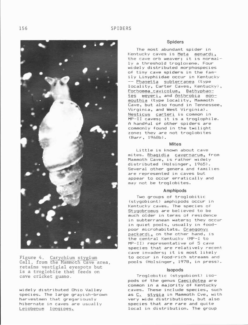
1 5 6 SPIDERS
Figure 4 . C a l l . from r e t a i n s v e s t i g i a l eyespots bu t '
i s a t r o g l o b i t e t h a t feeds on cave c r i c k e t guano.
widely d i s t r i b u t e d Ohio Val 1 ey species. The 1 arge g ray i sh-brown harvestmen tha t gregar iously h ibernate i n caves are usua l l y Le i obgngm lonq i pesL
Spiders
The most abundant spider i n Kentucky caves i s Meta menardis t he cave orb weaver: i t i s normai- l y a threshold trogloxene. Four widely d i s t r i b u t e d morphospeci es of t i n y cave spiders i n t h e f a m - i l y L inyphi idae occur i n Kentucky -- Phanetta s~tbtercgneg ( type l o c a l i t y , Carter Caves. Kentucky), !?ochornrna-~avicolurn, Bathyehanz fez ~ e y e r i ~ and Anthrobla ~ o u t h i a ( type l o c a l i t y . Mammoth Cave, bu t a lso found i n Tennessee. V i rg i n i a , and West V i r g i n i a ) . Nest icus c a r t e r i i s common i n MP-I1 caves: i t i s a t r og loph i l e . A handful of other sp iders are commonly found i n t he t w i l i g h t zone: they are not t r o g l o b i t e s (Barr, 1968b).
Mites L i t t l e i s known about cave
mites. Hhaqidia cavernarum, f rom Mammoth Cave, i s r a the r widely d i s t r i b u t e d (Holsinger, 1965). Several other genera and f ami 1 i e s are represented i n caves bu t appear t o occur e r r a t i c a l l y and may no t be t rog lob i tes .
Amphipods Two groups of t r o g l o b i t i c
(s tyqob iont ) amphipods occur i n Kentucky caves. The species of S3yqobrorn~ts are be l ieved t o be much o lder i n terms of residence i n subterranean waters: they occur i n qu ie t pools, usua l l y i n food- poor microhabitats. Cranqonyx packgrdi, on the other hand. i s t he cen t ra l Kentucky (MP-I t o MP-11) representa t ive of 5 cave species t h a t are r e l a t i v e 1 y recent cave invaders: i t i s most l i k e l y t o occur i n food-r ich streams and pools (Holsinger, 1978, i n press) .
lsopods Trog lob i t i c (s tygob iont ) iso-
pods of t h e genus Caecidotea are common i n a ma jo r i t y o f Kentucky caves. These inc lude species, such as C, s t y g i g i n Mammoth Cve, w i th very wide d i s t r i b u t i o n s , but a lso species t h a t are r a r e and q u i t e l o c a l i n d i s t r i b u t i o n . The group
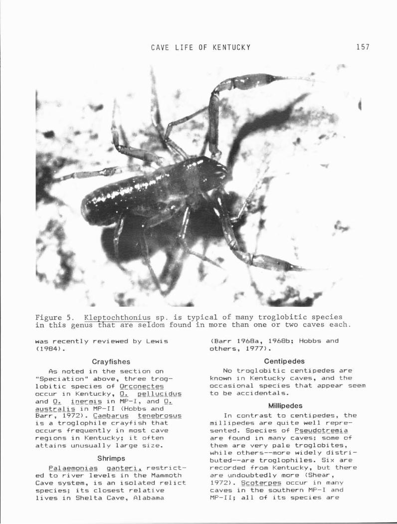
C A V E L I F E OF K E N T U C K Y
Figure 5. Kleptochthonius s p . i s t y p i c a l of many t r o g l o b i t i c s p e c i e s i n t h i s genus t h a t a r e seldom found i n more than one o r two caves each .
was r e c e n t l y reviewed by Lewis (Earr 1968a, 1968b; Hobbs and (1984). others, 1977).
Crayfishes &s noted i n t h e sect ion on
"Speciat ion" above, three t rog- l o b i t i c species o f Orconectes occur i n Kentucky, 0, pex?&ucid~~s and Lnermis i n MF-I, and QL aus t ra l i s i n MP-I1 CHobbs and - - - - - - - - Barr , 1972). Cambarus tenebrosus i s a t r ~ g l o p h i l e c r a y f i s h t h a t occurs f requen t l y i n most cave regions i n Kentucky; i t o f ten a t t a i n s unusual ly l a rge size.
Shrimps Palaemonias q a n t e r i % r e s t r i c t -
ed t o r i v e r l e v e l s i n the Mammoth Cave system, i s an i so la ted r e l i c t species; i t s c losest r e l a t i v e l i v e s i n Shel ta Cave, Alabama
Centipedes No t r o g l o b i t i c centipedes are
known i n Kentucky caves, and the occasi onal species t h a t appear seem t o be accidentals.
Millipedes I n con t ras t t o centipedes, the
m i l l i pedes are q u i t e we l l repre- sented. Species o f F'se~tdotremia are found i n many caves; some of them are very pa le t r og lob i t es . whi l e others--more wide1 y d i s t r i - buted--ars t r og loph i les. Six are recorded from C::entucky, bu t there are undoubted1 y more (Shear, 1972). Scoterpes occur i n many caves i n t he southern M P - I and MF-I I; a1 1 o f i t s species are
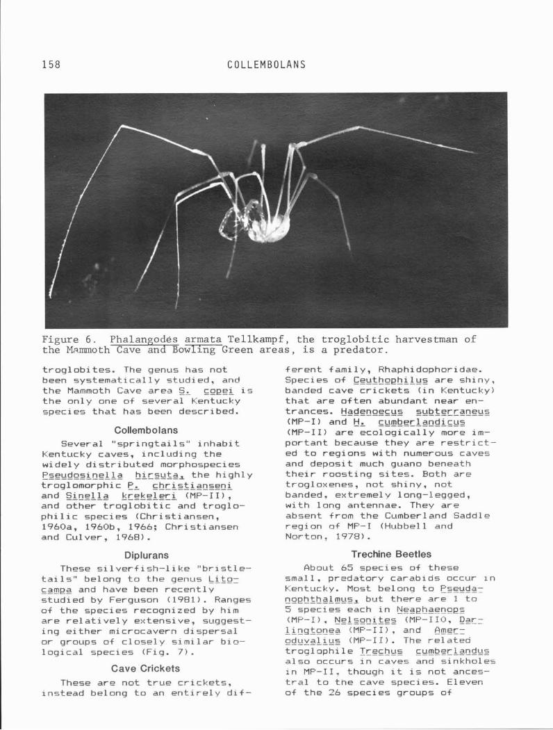
158 COLLEMBOLANS
Figure 6 . Phalan odes armata Tellkampf, the t r o g l o b i t i c harvestman of the M~.mmoth&owlingGreen a reas , i s a predator .
t r og lob i t es . The genus has not been systemat ica l ly studied, and the Mammoth Cave area SL copei i s t he on ly one of several Kentucky species t h a t has been described.
Collernbolans Several " s p r i n g t a i l s " i nhab i t
Kentucky caves, inc lud' ing the widely d i s t r i b u t e d morphospecies Pseudosinella hirsuta, the h igh l y troglomorphic P, ch r i s t iansen i and S i n e l l a k reke le r i CMP-11) , and other t r o g l o b i t i c and t rog lo - ph i l i c species (Christ iansen, 1960a, 1960b, 1966: Christ iansen and Culver, 1968).
f e ren t fami ly , Rhaphidophoridae. Species o f Ceuthophilus are shiny, banded cave c r i c k e t s ( i n Kentucky) t h a t are o f t en abundant near en- trances. Hadenoecus subterraneus (MP-I ) and HI cumber1 andi cgs (MP-11) are eco log i ca l l y more i m - por tant because they are r e s t r i c t - ed t o regions w i t h numerous caves and deposit much guano beneath t h e i r roos t ing s i t es . Both are trogloxenes, not shiny, not banded, extremely 1 ong-l egged, w i t h long antennae. They are absent from the Cumberland Saddle reg ion of MF-I (Hubbell and Nortan, 1978).
Diplurans Trechine Beetles These s i 1 ver f i sh-1 i ke " b r i s t l e -
t a i l s " belong t o the genus !Atpr campa and have been recen t l y studied by Ferguson (1981). Ranges of the species recognized by him are re1 a t i ve l y estensi ve. suggest- i n g e i t he r microcavern dispersal or groups of close1 y s im i l a r b io- l o g i c a l species (Fig. 7 ) .
Cave Crickets These are not t r u e c r i cke ts ,
instead belong t o an e n t i r e l y d i f -
About 65 species of these small . predatory carabids occur I n Kentucky. Most belong t o Pseuda- nophthaim~~s, but there are 1 t o 5 species each i n ijeaphaenopz tMP-I). Nelsoni tes (MP-119. Day: 1 i nqtonea iMF-I I) , and Amer- - - - - - - - - pcigyal i ES !MF-I I ) . The re1 atea t rog loph i 1 e Lrechus cumber1 and~ts a l so occurs i n caves and sinkholes i n MF-11, though i t i s not ances- t r a l t o the cave species. Eleven of the 26 species groups of
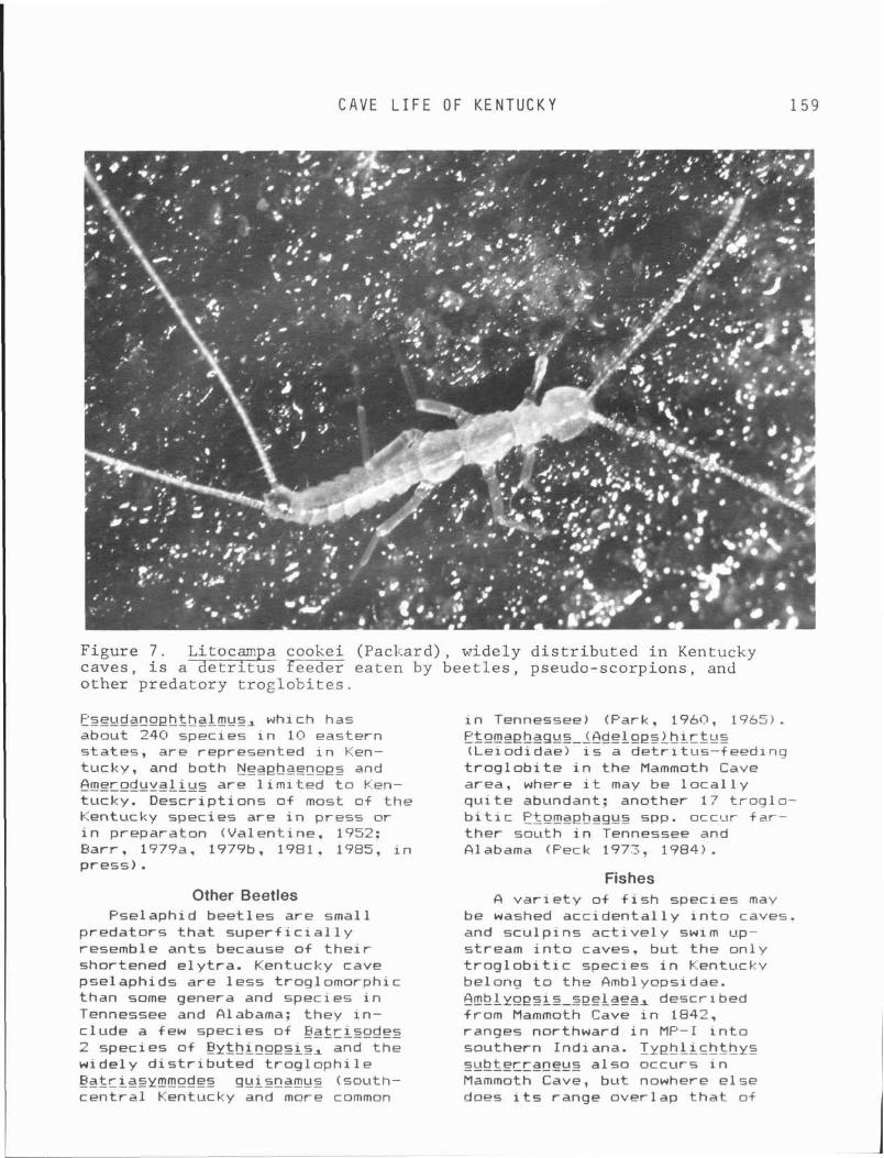
CAVE L I F E OF K E N T U C K Y
Figu re 7 . Litocarr a cooke i (Paclcard) , wide ly d i s t r i b u t e d i n Kentucky c a v e s , i s a + e t r l t u s feeder e a t e n by b e e t l e s , pseudo-scorp ions , and o t h e r p r e d a t o r y t r o g l o b i t e s .
Pseudanoehfhalmus, which has about 240 species i n 10 eastern s ta tes , a re represented i n Ken- tucky, and both Neaphaenops and Ameroduvalius are l i m i t e d t o Ken- tucky. Desc r ip t i ons of most o f t h e k:entucky species are i n press o r i n preparaton (Va lent ine . 1952; Barr , 1?7?a, 1979b. 1981, 1985, i n p ress) .
Other Beetles Psel aphi d beet1 es a re smal l
p redators t h a t s u p e r f i c i a l l y resemble an ts because o f t h e i r shortened e l y t r a . Kentucky cave pselaphids a re l e s s t roglomorphic than some genera and species i n Tennessee and Alabama: they i n - c lude a few species o f Bat r isodes 2 species o f Sjythinopsis, and t h e wide1 y d i s t r i b u t e d t r o g l o p h i l e Batriasymmodes quisnamus (south- c e n t r a l Kentucky and more common
i n Tennessee) (Park. 1960, 1965) .
~t~rnaehas~z-l~delnesLhIr_t~rz (Leiodidae) i s a de t r i tus-+eed inq t r o g l o b i t e i n t h e Mammoth Cave area, where i t may be l o c a l l y q u i t e abundant: another 17 t r o g l o - b i t i c Ptomaphaqgs spp. occur f a r - t h e r south i n Tennessee and Alabama (Peck 1973, 1984).
Fishes A v a r i e t y o f f i s h species may
be washed a c c i d e n t a l l y i n t o caves. and s c u l p i n s a c t i v e l y swim up- stream i n t o caves, b u t t h e on ly t r o g l o b i t i c species i n Kentucky belong t o t h e Amblyopsidae. h b l y o p s i s seelaea, descr ibed from Mammoth Cave i n 1842, ranges northward i n MP-I i n t o southern I n d i ana. I y p h l i chthys subterraneus a1 so occurs i n Mammoth Cave, b u t nowhere e l s e does i t s range over lap t h a t o f
S A L A M A N D E R S
Ambl ygesis spel aea. I n Ken- tucky i t i s reported from MP-I south and west of Mammoth Cave, inc lud ing caves i n G l asgow and Bowling Green and from the Sloans Val ley System i n MP-I1 !Cooper and Ee i te r , 1972). Choloqaster aqass i r i i s a t r o g l o p h i l i c ambby- - ------ opsid found i n caves and spr ings o f southwestzrn M P - I and elsewhere (Woods and Inger, 1957; Poulson, 1963).
Salamanders No t rog lob i t i c salamanders
occur i n Kentucky, but t he "cave salamander " Eurycea 1 u c i f uqa i s widely d is t r ibu ted ; i t i s more common i n entrance areas where food i s more r e a d i l y avai lable. Eseudstritnn ruber, E y ~ y r ~ a lonqicauda, and Plethodon dor- --- s a l i s are reported from occa- s iona l caves i n MP-I and a lso i n the Rough River region.
Cave Rats Neutoma mtggister i s the common
"cave r a t " of Kentucky caves, a l - though floridanus, common i n Tennessee, may occur along the State border.
Bats Ecolog ica l ly , the most impor-
t a n t bat species f o r Kentucky t r o g l o b i t e s i s the gray bat, Nyot is qrisescens, which l i v e s i n caves i n summer and is thus a guano bat. Most of i t s colonies are i n the southern p a r t of MP-I. and there i s evidence t h a t many o lder colonies have been aban- doned. The la rges t populat ions of h ibernat ing bats +re Myotis soda1 15% the "soc ia l , " or Indiana bat; t h i s species migrates t o northern, non-cave roos t ing s i t e s i n summer: i t has been extensively studied i n the Carter Caves and Mammoth Cave areas as wel l as a few other widely scat tered caves, mostly i n MP-I and MP-11. Smaller colonies of the l i t t l e brown bat , t lyo t is l~tci+uqus, h ibernate i n a number of Kentucky caves. The p i p i s t r e l l e , P i p i s t r e l l u s sub= flavus, and the b i g brown bat,
Eetesicus f u ~ c u s ~ are more s o l i - t a r y bats, r a r e l y occurr ing i n la rge h ibernat ing groups. P ip is - t r e l l e s are perhaps the most common bat i n Kentucky caves, but !EL f ~ t s c ~ i s hibernates i n colder s i t e s , o f t en near entrances i n the f a l l and ea r l y winter . Both the eastern and western species o i long-eared bats are found lusua l l y uncommonly) i n Kentucky caves: Plecotus ra j lnesque l f rom the Mammoth Cave Region and Jackson, Pul aski , and Wayne counties; and E, townsendi v i r q l n i anus from a small number of caves i n Lee County (MP-II), where i t i s i n need of pro tect ion.
REGIONAL CAVE FAUNAS IN KENTUCKY
Weste rn Mississippian Plateau (MP-1) and Cumberland Saddle The Mammoth Cave faunas i s one
of the r i c h e s t i n t he world (Barr, 1968b) , inc lud ing t r o g l o b i t i c species o f f 1 atworms, snai 1 5 ,
pseudoscorpions, harvestmen, spiders, mites, amphipods, isopods, crayf ishes, shrimps, mi l l ipedes, co l lembolans, d ip lurans, beetles, and cave f ishes. A ma jo r i t y of the species i n Mammoth Cave i t s e l f range northward toward Wunfordvi l le and southwest t o Barren River along the Pennyroyal, but t o t he southeast, across t he Cumber1 and Saddle, the composition o f the fauna changes rapidly--most bee t le species disappear o r are replaced by others; and crayf ishes, cavef i shes, and even Hadenoec~ts subterrane~ts d i sappear.
To the north, few terrestrial species cross the Har t County Ridge and + a u l t zone (Barr 1968b, 1977a, i n press). A somewhat d iverse fauna continues on t o the Ohio River, character ized by
!lrcnsectes inecmis, B~blyqesis seelaea (8arr and Kuehne, 1962), a few species of Pseudotremi a, Negphaenops henrot i , and Pseud- anoehthal mus of d i f f erent speci es than occur south o f the Hart County ba r r i e r . Hadenoecus sub- terraneus i s abundant.
C A V E L I F E O F K E N T U C K Y 1 6 1
To the southwest, across Barren River, Lyphl i ch thys s~tbtg-raneus i s present but no t fimblyopsis spelaea; a l l t rech ine bee t l e species are d i f f e r e n t , and even HI subterraneus var ies geo- graphical 1 y. Orconectes pe l 1 ~ tc idus i s present.
Farther west i n the Pennyroyal. Neaphaenops disappears a t the eastern edge of Logan County, and Hatienoecus i s no longer present west o f Russel 1 v i 11 e. Scoterpes copei i s replaced by one or more undescribed species o i the same genus, and the prevalent t rech ine beet les are wide-ranging, poly- t y p i c species (such as P, c i l i a r i s ; (see Barr, 1979a) whose ranges do not overlap. Both 0, pe l luc idus and 1, subterraneus continue a t l e a s t t o Tr igg County. D i s t i n c t t rech ine species w i th d i sc re te ranges occupy the - F r i nceton-Freoni a and Sal em-Mar i on cave regions, respect ive ly .
Southeast across t h e Cumberland Saddle from Mammoth Cave there i s a moderate fauna of t rech ine beet les, some mi l l ipedes, amphi- pods and isopods, but Orconectes, Neaehaenoes, Hadenpecuz, and Lyphl ichthyg are not present. The upper ree f l imestone member of t h e Fo r t Payne Formation contains a number o f caves t h a t support a northward extension o f t h i s dauna t o t he Columbia and Greensburg area. The eastern extent o f NeaE$aenoes, Hadennecus, and Orcon~c tes i s the v i c i n i t y of Greensburg, i t s e l f .
Eastern Mississippian Plateau North of Red River the Newman
Limestone t h i n s and i s confined t o l o c a l lenses t h i c k enough t o support caves; much of t h i s area has only dry, rockhouse-like rem- nants of former caves on top of t he r i dqes. However, l o c a l faunas
A small fauna (2 species of
Pseudan~ehthalmuz, S i n ~ l l a , Eleetochthnnius, Pseud~t~emia, Crangmyx, Caeciodotea, bisexual Hi cumber 1 andi cus, etc. ) occu- p i e s upland caves between Red and Kentucky r i v e r s i n Powell, E s t i l l , and the edge of Lee counties. The Kentucky gorge forms a major bar- r i e r t o t e r r e s t r i a l t rog lob i tes ; south o f the Kentucky River, three endemic genera o f t rech ine beet les appear-- Darlinqtonea, Amerodu- va l i us, and Nelson i t es . ------ Scnferees ~ P O , Occqnectes aus t ra l i s packardi (from --------- Rockcastle County southeastward), and I yph l i ch thys ( i n Sloan Val ley System) augment the fauna f a r t h e r t o t he southwest. F'se~tdanoeh- thalmus species i n the range a+ Ameroduval i us species are a1 1 small, l e s s than 4 mm long, but south of the Cumberland River there are several la rger Pseuda- n ~ p h t h a l mus of the robustus group. Wayne County, Kentucky, w i t h 12 species and 5 genera of t rech ine beetles, has the most d iverse t rech ine fauna of any comparable area i n North America. There i s a p a r t i a l d ispersa l bar- r i e r near the Kentucky-Tennessee border i n MP-11, because westward f low ing t r i b u t a r i e s of the Cumberland do not j o i n u n t i l they have cu t down i n t o non-caverni - f erous Osagian rocks. The Cumberland River near Burnside cons t i t u tes a t r i p l e b a r r i e r near Burnside, Pulaski County: the lower Cumberland River below the mouth o f South Fork i s a complete b a r r i e r f o r t e r r e s t r i a l beetles, as i s the lower South Fork below the mouth o f L i t t l e South Fork. The upper Cumberland acts as though i t were a p a r t i a l b a r r i e r , pe rm i t t i ng but reducing gene flow: the upper South Fork i s no b a r r i e r a t a1 1.
i nc lud ing some t r o g l o b i t e s are known f o r the Carter Caves area i n Blue Grass Carter and E l 1 i o t t counties, Caves o f t he Inner Blue Grass Murder Cave i n Menifee County, and are developed i n more o r 1 ess con- one o r two add i t iona l such kars t t i nuous patches o f Ordovician i s l ands. Hadenoecus cumber1 and- limestones. Various species of i c u s i s a l l parthenogenetic here. ---- spiders, isopods, and mi l l i pedes
K A R S T I S L A N D S
are known from s ing le cave sys- tems, bu t some of the Pseudanoph- &ha1 mus species are moderate1 y widespread, notably between C l i f ton and Camp Nelson a1 onq the r i g h t bank of the Kentucky River. A populat ion of parthenogenetic !-jadenoecus cumberlgndicus i s known i n small caves around Camp Nelson: i t i s geographic l ly iso- 1 ated from bisexual popul a t ions o f t he species t o the east. Trechines inc lude species o f the inexeec- t a t ~ t s group, re l a ted t o P, inexpectatus i n Mammoth Cave, and ---- ------- a1 so species of t he h p r n i group, which i s . d i s t r i bu ted not along present drainage basins but a1 ong t h e p reg lac ia l Teays Val l e y and includes species i n southwestern Ohio and southeastern Indiana. These beet les are smaller (3-4 m ) than those of t he MP region. Pseudanophthalmus b g r r i near Clarksv i 1 l e . Indiana, and EL fygqlphytes are s i s t e r species t h a t were probably separated by development of the modern Ohio River dur ing e a r l y Kan'san t ime (Krekeler, 1973). I n MP-I f a r t he r west, ez tenu is (Indiana) and P, barber i (Kentucky! bear the same r e l a t i o n s h i p t o each other (Jeannel, 1949).
Karst Islands Small, i s l and-1 i ke patches of
ka rs t occur on the northwestern face o f Pine Mountain i n south- eastern Kentucky and a lso downdip from MP-I, toward the center of the Western Kentucky Coal F ie ld . These patches are character ized by small - assembl ages o f i so l ated spe- c ies . For example, t he endemic hueolithos group of Pzeeda~eeh= thalmus i s represented by species ------- i n Pike, Harlan. B e l l , and Whitley counties, Kentucky, and a f i f t h species j u s t south of t he A1 l e - gheny Front i n V i rg in ia . One spe- c i e s o f the ipnes i group i s des- c r ibed from a Harlan County cave: t he remainder of the group occurs i n southwestern V i r g i n i a and i n Pine Mountain (Campbell County, Tennessee), and Grassy Cove (Cumberland County, Tennessee).
Pseudotr~mi a, Pseudosinel 1 a
hirsyta, Litocamea, Caeciz dnfea, S t~snbromvs~ and Sehalnz plana are a lso found i n Pine Mountain caves.
Karst i s l ands a1 so occur around the margin of the western Kentucky Coal F i e l d near the edge of MP-I: almost a l l s i g n i f i c a n t caves i n these areas are developed i n Glen Dean Limestone, s t r a t i g r a p h i c a l l y i so la ted from the t h i cke r and more cavernous limestones of the Penny- roya l . Most of the t r o g l o b i t i c species are wide-ranging ones w i t h means of d ispersal through mirro- caverns or phreat ic water, but a t l e a s t 9 i so la ted species of i>zeudanophthalmgg are known ( f i v e from the Rough River Fau l t Zone i n Grayson County: others i n Hart, Warren, Bu t le r , and Todd coun- t i e s ) . The bee t le species are c l ose l y s i m i l a r t o species of the Pennyroyal surface caves and are presumably derived from the same common ancestors. Hadenoecus subterraneus occurs i n a l l of these marginal ka rs t i s l and caves. A small cave i n Madison- v i 11 e Limestone (Pennsylvanian) near Equal i ty , Ohio County, con- t a i n s Sphal loplana, Cranqonyx packardi, Sinellal and Phanetta, as wel l as numerous t rog loph i l e s and trogloxenes.
CONSERVATION OF CAVE LIFE Much a t t en t i on has been devoted
t o conservation and preservat ion o f bat species, w i t h emphasis on avoiding disturbance dur ing h iber - nat ion. Growth of urban areas i n kars t regions, w i th accompanying c losure of caves and p o l l u t i o n of underground streams, notably a t Somerset and Bowling Green, poses a t h rea t t o f i s h and inver tebra te t rog lob i tes . Leakage from o i l we l l s and pumping out we l l s w i th b r i n e has po l lu ted many Kentucky caves i n r u r a l areas. The evolu- t i o n of Hidden River Cave i n t o a g igan t i c sewer f o r the town of Horse Cave or the const ruct ion of a garbage 1 andf i 11 above Sl oans Val ley Cave are t ragedies t h a t should never have been allowed.
C A V E L I F E OF K E N T U C K Y
The l a rge r t r o g l o b i t e s o f cave t o major hibernacula caves a t streams-- Oroconectes crayf ishes c r i t i c a l t imes of the year. and the amblyopsid cavefishes-- face a long-term danger from even very low l e v e l s of heavy metals. These species grow extremely slow- l y and may requ i re 25 t o 50 years t o a t t a i n sexual matur i ty . When t r o g l o b i t i c and non- t rog lob i t i c c rayf ishes from the same cave i n Tennessee were analyzed f o r heavy metal concentrat ions i n t h e i r t i s - sues, the t r o g l o b i t i c species were shown t o have hundreds of t imes the concentrat ion of several metals t h a t were found i n the non- t r o g l o b i t i c c rayf ishes (which reach sexual matu r i t y i n about 2 years). S imi lar very h igh l e v e l s were found i n Qg~onectes pe l luc idus from Parkers Cave, Barren County, Kentucky. These species l i v e so long t h a t minute concentrat ions of heavy metals acquired each year may u l t i m a t e l y reach t o x i c levels. Consider the cavef i shes and crayf ishes o f Echo River i n Mammoth Cave, f o r tuna te l y spared the Hidden River p o l l u t i o n . What about the minute amounts o f cadmium generated from wear of vulcanized t i r e s and of lead from 1 eaded gas01 i ne combusi on a1 ong I n t e r s t a t e 65? There i s a very r e a l p o s s i b i l i t y t h a t the world- famous fauna of Echo River could become e x t i n c t , not from a disas- t r o u s p o l l u t i o n accident, but s lowly and i n s i d i o u s l y from low l e v e l s o f t o x i c metals. The fauna would disappear not w i t h a bang, bu t w i t h a whimper. This i s a po ten t i a1 danger t h a t i s se r ious ly i n need of f u r t he r study.
There i s not much hard evidence t h a t heavy caving pressure, other than the dumping o f spent carbide, which i s f o r t una te l y becoming a
' t h i n g o f t he past, se r ious ly re- duces popul a t i on 1 eve1 s of t rog- l o b i tes. Disturbance of h i berna- t i n g ba ts dur ing winter or d is - turbance of materni ty colonies of ba ts are probably the greatest damage cavers are l i k e l y t o i n f l i c t on Kentucky cave l i f e , but t h i s can be avoided by education, gat ing, and r e s t r i c t i o n of ent ry
F i n a l l y , permanent c losure of caves, e i t h e r by bul ldozers i n an urban area o r by landowners who have been pestered by inconsid- e ra te cavers, may or may not mean e x t i n c t i o n f o r the fauna of these caves. Closure does mean tha t the fauna of those caves i s no longer ava i l ab le f o r study, by anybody. Krekeler (1973) described t w ~ unusual species o f cave beet1 es on opposite sides of t h Ohio River near Loui s v i 11 e, Fseuda- nophthalmus b a r r i i n Indiana and PL t ~ o q l o d y t e s i n Kentucky. The on ly cave where f, t roq- lodytes has been co l lec ted i s --- --- now under Osmoor Shopping Center.
REFERENCES CITED
Barr , T. C., Jr., 1966, Evolut ion of cave b io logy i n t he United States: 1822-1965: National Spe- l e o l o g i c a l Society, v. 28, p. 15-21.
Earr, T. C. , Jr . , 1966-67, Cave Carabi dae (Col eoptera) o f Mam- moth Cave: Psyche, v. 73, p. 284-287: v. 74, p. 24-26.
Parr, T. C., Jr. , 1967a, A new Pseudanophthalmus from an epige- an environment i n West V i r g i n i a (Coleoptera: Carabidae): Psyche, v. 74, p. 166-172.
Earr, T. C., Jr. , 1967b, Observa- t i o n s on the ecology o f caves: American Na tu ra l i s t , v. 101, p. 475-492.
Earr, T. C., Jr. , 1968a, Cave ecology and the evo lu t ion of t rog lob? tes: Evolut ionary E io l - ogy, v. 2, p. 35-102.
Earr, T. C., Jr., 1968b, Ecolog- i c a l s tud ies i n the Mammoth Cave System of Kentucky: I. The b io ta : In te rna t iona l Journal of Speleology, v. 3, p. 147-283.
Barr, T. C., Jr. , 1979a. The tax- onomy, d i s t r i b u t i o n , and a f f i n i -
1 6 4 REFERENCES C I T E D
t i e s of hlegphgengps, w i t h notes on associated species of Pseudanophthalmus (Coleoptera: Carabidae): American Museum No- v i t a t e s , v. 2862, 20 p.
Barr, T. C. , J r . , 1979b, Revision o f Appal achi an Trechus (Col eop- tera: Carabidae) : Brimleyana, no. 2, p. 29-75.
Barr , T. C. , Jr., 1985, New t rech ine beet les from the Appa- 1 achian reg ion (Coleoptera: Carabidae): Brimleyana. no. 11.
Bar r , T. C., Jr., i n press, Pa t te rn and process i n specia- t i o n o f t rech ine beet les i n eastern North America (Coleop- tera: Carabidae: Trechinae) , i n P a l l , G. E., ed. Taxonomy, phy- logeny, and zoogeography of beet les and ants: Ser ies Ento- mologia, v. 33, p. 350-407.
Parr , T. C. , Jr . , and Holsinger, J. R., i n press, Speciat ion i n cave faunas: Ecology and System- a t i cs , Annual Review.
Parr., T. C., Jr., and Kuehne, R. A., 1962, The cavefish, Ambly= pps is spelaea, i n northern Ken- tucky: Copeia, v. 3, p. 662.
Earr , T. C., Jr . , 1971, Ecological s tud ies i n the Mammoth Cave sys- tem o f Kentucky. 11: The Ecosys- tem: Annals of Speleology, v. 26, p. 47-96.
Pol i var , C. , and Jeanne1 , Rene, 1931, Campagne speologique dans 1'Amerique du Nord en 1928 (premiere se r i e ) : Arch. zoo1 . e t gen. 7 1 , p . 383-388.
Carpenter, Je r ry H., 1970, Geo- centrophora c a v ~ r n i c o l a ~ n. sp. Turbel l a r i a , A1 loeocoel a) : F i r s t cave a1 1 oeocoel : American Micro- scopical Society Transactions 89, p. 124-133.
Chr is t iansen, K., 1960a, The genus Pseudosinel 1 a (Col l embol a, Ento- mobryidae) i n caves of the
United States: Psyche 67, p. 1- 25.
C h r i s t i ansen, K. , 1960b, The genus S i n e l l a Brook (Collembola: Ento- mobryidae) i n Nearct ic caves. Anna1 s of the Entomol ogi c a l So- c i e t y of America, 53, p. 438- 491.
Christ iansen, K., 1966, The genus Arrhopal i tes i n the United States and Canada: In te rna t iona l Journal of Speleology, 2, p. 43- 73, pls. 11-14.
Chr i s t i ansen, K. , and Cul ver , D. C., 1968, Geographical v a r i a t i o n and evo lu t ion i n Pseudosinella h i rsu ta : Evolut ion, v. 22, p. 237-255.
Cooper, J. E., and Pe i t e r , D. P., 1972, The southern cavef ish, T v e h l i c h t h y ~ subterraneys (Pis- ces: Amblyopsidae) i n t he east- ern Mississ ippian Plateau of Kentucky: Copeai, v. 4, p. 879- 881.
Davis, W. H., and Parbour, R. W., 1965, The use of v i s i o n i n f l i g h t by the bat fJypfL5 soda1 i s : American Midlands Nat- u r a l i s t 74, p. 497-499.
DeKay, J. E., 1842, Descr ipt ion
of firnblyoesis seelaea, i n Zoology of New York, o r the New York Fauna, Part I V , Fishes: Albany, New York, footnote, p. 187.
Ferguson, L. M., 1981, System- a t i cs, evolut ion, and zoogeogra- phy of the cavernicolous campo- deids o f the genus Litocampa (Diplura: Campodeidae) i n the United States: Placksburg, V i r - g i n i a Polytechnical I n s t i t u t e and Sta te Un i v i ve rs i t y , Ph.D. D isser ta t ion, 372 p.
G i t t l eson , S. M., 1969, Cavern- i c o l ous Protozoa: review of the l i t e r a t u r e and new s tud ies in Mammoth Cave, Kentucky: Annals of Speleology 24, p. 737-776.
C A V E L I F E OF K E N T U C K Y 1 6 5
Glesener, R. R. , and Ti lman, D. , 1978, Sexuality and the compon- ents of environmental uncertain- ty: clues from geographic par- thenogenesis in terrestrial ani- mals: American Naturalist, v. 112, p. 659-673.
Hassell, M. D., and Harvey, M. J. , 1965, Differential homing in Plyotis soda1 is: Amererican Mid- lands Naturalist, v. 74, p. 501- 503.
Hobbs, H. H., Jr., and Barr, T. C. Jr., 1972, Origins and affini- ties of the troglobitic cray- f i shes of North America (Deca- poda: Astacidae). 11: Genus conectes: Smithsonian Contribu- tions to Zoology, v. 105, 84 p.
Hobbs, 111, revi
H. H., Jr., Hobbs, H. H., and Daniel, M. A., 1977, A
ew of the troglobitic deca- pod crustaceans of the Americas: Smithsonian Contributions to Zoology, v. 244, 177 p.
Holsinger, J. R . , 1965, Redescrip- ti ons of two poor1 y known spe- cies of cavernicolous rhagidiid mites (Acarina: Trombidif ormes) from Virginia and Kentucky: Acarologia, v. 7, p. 654-662.
Holsinger, J. R. , 1978, System- atics of the subterranean amphi- pod genus S5yqobromus (Crango- nyctidae), part 11: Species of the eastern United States: Smithsonian Contributions to Zoology, v. 266, 144 p.
Holsinger, J. R., in press, Zooge- ogeographic pattern in North American subterranean amphipod crustaceans, jn F. R. Schram, ed., Crustacean Issues 4, Crus- tacean Biogeography: Rotterdam, A. A. Balkema.
Hubbell, T. H., and Norton, I?. M. , 1978, The systematics and biol- ogy of the cave-crickets of the North American tribe Hadenoecini (Orthoptera Saltatoria: Ensi- fera: Rhaphidophoridae: Dolicho-
podinae) . University of Michi- gan, Museum of Zoo1 ogy , Mi scel- laneous Publication 156, 124 p.
Hubricht, Leslie, 1960, The cave snai 1 , Car ychi um s g y q l um Call : Transactions Kentucky Academy of Science, v. 21, p. 35-38.
Hubricht, Leslie, 1962, New spe- cies of Helicodiscus from the eastern United States: Nauti 1 us, v. 75, p. 102-107.
Hubricht, Leslie, 1963, New 5pe- cies of Hydrobiidae: Nautilus, v. 76, p. 138-140.
Hubricht, Leslie, 1954, Land snai 1s from the caves of Ken- tucky, Tennessee, and Alabama: Bull et i n of Nat i onal Spel eol og-
,56. ical Society, v. 26, p. 33-7
Hubricht, Leslie, 1965, Four new land snails from the southeast- ern United States: Nautilus, v. 79, p. 4-7.
Hubricht, Leslie, 1968a, The land snai 1 s of Mammoth Cave Nati onal Park, Kentucky: Nautilus, v. 82, p. 24-28.
Hubricht, Leslie, 1968b, The land snails of Kentucky: Sterkiana. 32, p. 1-6.
Jeannel, Rene, 1949, Les coleop- teres cavernicoles de la region des Appalaches. Etudes system- atiques: Notes Biospeol., fasr, 4, Publ. Mus. of Nat. Hist. Nat., Paris, no. 12, p. 37-104.
Kenk, Roman, 1977, Freshwater tri- I
clads (Turbellaria) of North . I
America, IX: The genus Sphalz loplana: Smithsonian Contribu- tions to Zoology, v. 246. 38 _el ---------------- ~
EreknLerl-Gari-H,I-L97311-C:a_~e_-b_e_e_~ tles of the genus Pseudanoph- -------------- ---- thal mus (Col eoptera, Carabi d a e ) --------- from the Kentucky Blue Grass and vicinity: Fieldiana (Zoology), v. 62, p. 35-83. I
C A V E L I F E OF K E N T U C K Y 167
Un ivers i t y , Museum of Compara- enden Thiere: Mul lers Arch. f . t i v e Zoology, B u l l e t i n , v. 144, Anat. u. Physiol., v. 4, p. 384- p. 151-352. 394.
Swofford, D. L., Branson, B. &. , Tellkampf, T. G., 1845, Memoirs on
and Si evert, G. A. , 1980, Genet- t he b l i n d f i shes and some other
i c d i f f e r e n t i a t i o n o f cavef ish animals l i v i n g i n Mammoth Cave
populations: Isozyme B u l l e t i n , i n Kentucky: New York Journal o f
v. 14, p. 109-110. Medicine, v. 1845, p. 84-93.
T e l l kampf , T. G. , 1844a, Beschrei- bung e in iger neuer i n der Mam- muth-Hohle i n Kentucky aufge- f undener Gattungen von Gl i eder- th ieren: Arch. f . Naturg., v. 10, p. 318-322.
T e l l kampf , T. G. , 1844b, Ueber den b l inden F i sch der Mammuth-Hohl e i n Kentucky, m i t Bemerkungen uber andere i n dieser Hohle leb-
Valent ine, J. M., 1952, New genera o f anophthal m i d beet1 es from Cumberland Caves (Carabidae, Trechinae): Geological Survey o f Alabama Museum Paper 34, 41 p.
Woods, L. P., and Inger, H. F., 1957, The cave, spring, and swamp f i shes of the fami ly Am- blyopsidae of cen t ra l eastern United States: American Midlands Na tu ra l i s t , v. 58, p. 232-256.
Chapter 10 VERTEBRATE REMAINS IN
KENTUCKY CAVES Ronald C. Wilson
Director, University of Northern Iowa Museum
University of Northern Iowa Cedar Falls, Iowa 50614
168
One of the e a r l i e s t ver tebrate time. The po ten t i a l o f paleontolo- f o s s i l s t o be recognized i n North g i c a l work i n Kentucky caves has America (preceded on ly by those a t hard ly been scratched. Pig Bone L ick , Boone County, Ken- tucky) came from a Kentucky cave. WHY STUDY BONES? A s k u l l of a f lat-headed peccary (P l atyqonus compressus) was co l - ----- -------- ------ Cave bone deposits preserve a l ec ted by Dr. Samuel Frown, about record of past animal communities 1804, from Great Sa l tpeter Cave, spanning a range o f a t l e a s t sev- Hockcastl e County. The specimen i s e r a l tens o f thousands o f years. s t i l l i n t he c o l l e c t i o n o f the These deposits represent an oppor- Ph i lade lph ia Academy of Science. t u n i t y t o study the paleoecology Despite t h i s e a r l y i n t e r e s t i n the o f many e x t i n c t species. Ey ver tebra te paleontology of Ken- inference from known geographic tucky caves, the area has received ranges and ecol ogi c a l to1 erances l i t t l e study since. During the of 1 i v i n g species preserved i n n ineteenth and e a r l y twen t ie th cave deposits, i t i s poss ib le t o centur ies, only t he spectacular reconst ruct the evo lu t ion of f i n d s (e. g. , complete sku1 l s , changing c l imates and environments mammoth o r mastodon bones, etc.) i n the Ohio Valley. Occasional 1 y, were l i k e l y t o be recorded. These we1 1 preserved archeological /pal e- ear l y d i scover i es , however, were onto log ica l s i t e s permit recon- l i k e l y t o be l o s t o r fo rgo t ten be- s t r u c t i o n of the a c t i v i t i e s o f f o r e any s c i e n t i f i c study unless p r e h i s t o r i c man and other preda- t he mater ia l went t o t h e l a rge t o r s of t he d i s tan t past. Perhaps museums i n the East. Host modern most important ly , the k inds o f s c i e n t i f i c s tud ies i n t he verte- in format ion preserved i n cave bone b r a t e paleontology o f Kentucky deposi ts are f requent ly not pre- were accomplished under the d i rec- served i n any other paleontolo- t o n of t he l a t e John E. G u i lday g i c a l context. I f bone deposi ts (Carnegi e Museum of Natural are destroyed or d is turbed by H i s to ry ) dur ing t he 1960's and na tu ra l o r human processes, p a r t e a r l y 1970's. As h i s student, of the p reh is to ry of an e n t i r e I express my g ra t i t ude t o John f o r reg ion i s l o s t forever. h i s t r a i n i n g and encouragement.
Anal y s i 5 of bones from several HOW DO BONES GET INTO CAVES? r ecen t l y excavated s i t e s i s s t i l l i n progress. Some of t he new f i n d s Cavers are f requent ly surpr ised are reported here f o r t he f i r s t t o l ea rn t h a t remains o f l a rge
V E R T E B R A T E R E M A I N S I N K E N T U C K Y C A V E S
animals a re found deep i n s i d e caves, many k i lometers and hours from the nearest entrance. Recovery o f the bones of g ian t short-faced bear (Arctodus ~ i m u s ) ~ flat-headed peccary (Platygonus com~ressus), and American mastodon (Mammut americanum) o r mammoth (Mammuthu~L from Proctor Cave i n 1979, f o r example, requ i red 24-hour cave t r i p s . The mastodon o r mammoth bones were found i n t he t a l u s o f a terminal breakdown whi le t h e remains o f t he other species were scat tered along an a c t i v e cave stream. They had ev iden t l y been washed t o t h a t s i de by f loods a f t e r being eroded from the s i t e o f o r i g i n a l depos i t ion f a r t he r upstream.
Most bones are deposited near present o r past entrances.
. Exceptions t o t h i s general statement may inc lude bones t h a t wash i n , o r skeletons o f animals t h a t wandered f a r from the entrance before dying. V e r t i c a l s h a f t s ac t as p i t - f a l l t r a p s and they are responsib le f o r innumerable cave bone deposits. Other common means of bone accumulation inc lude the a c t i v i t i e s of woodrats, carnivores, and r a p t o r s (predatory b i r d s such as hawks and owls). Man has been an agent i n t he accumulation o f bones i n Kentucky caves f o r a t l e a s t t h e l a s t 10,000 years. Deta i led ana lys is i s o f ten requ i red t o determine t h e mode of accumul a t i on, and many bone deposi ts are the composite o f several processes.
During the thousands of years t h a t an entrance may be open f o r animals t o enter, geo lg ic processes may have s i g n i f i c a n t e f f e c t s on t he r e s u l t i n g bone deposi t s . Roc kf a1 1 s and sedimentation may seal l aye rs o f bones from contamination by more recent accumulations. Erosion may expose o lder l aye rs as drainage pa t te rns s h i f t , and redepos i t ion o f the f oss i 1s may occur. F luc tuat ions i n t he water t a b l e a f f e c t no t on1 y sedimentation pat terns, but a1 so an i ma1
u t i l i z a t i o n and the degree of mineral i za ton o f t he bones present. Traver t ine o r gypsum may encrust f o s s i l bones. Entrances may col lapse o r f i l l i n , a l t e r i n g o r ending t h e i r a c c e s s i b i l i t y t o various k inds o f animal a c t i v i t y . These processes may produce extremel y complex s t ra t i g raphy and requ i re care fu l excavation and record keeping t o decipher. Gnawing and digging by animals such as woodrats, woodchucks, and carnivores may f u r t h e r confuse the record. I n Kentucky, those deposi ts not bur ied soon a f t e r deposi t ion are o f t en so completely gnawed t h a t the accumulation i s reduced t o very small bones such as mouse and shrew par ts , and the harder crowns of l a rge mammal teeth. Complete and a r t i c u l a t e d skeletons are extremel y r a r e ' i n Kentucky caves.
WHAT HAS BEEN FOUND?
Most caves conta in bones. Some contain extensive deposits, represent ing thousands o f i nd i v i dua l animals and dozens of species, whi le o thers may conta in on1 y an occasional scrap o f bone. The s ign i f i cance o f any p a r t i c u l a r bone deposit depends on a v a r i e t y o f f ac to rs i nc lud ing t h e age, number, d i v e r s i t y o f species represented, q u a l i t y o f preservat ion, presence and number o f e x t i n c t or e x t r a l i m i t a l (no longer l i v i n g i n the l o c a l reg ion) species, and the taphonomy ( h i s to r y o f accumulation and subsequent a l t e r a t i o n ) o f the deposi t .
Species represented i n cave bone deposi ts are e i t h e r ex t i nc t , s t i l l l i v i n g i n t he area of t he cave, o r e e t r a l i m i t a l . Those species s t i l l l i v i n g i n t he v i c i n i t y o f the cave seldom provide dramatic i n s i g h t s i n t o changing environments, bu t they can serve as reminders of t he r e l a t i v e a d a p t a b i l i t y o f some species. They may a lso prov ide in format ion on when add i t ions t o t he l o c a l fauna f i r s t a r r i ved i n a p a r t i c u l a r region.
1 7 0 WHAT H A S B E E N F O U N D ?
Ind ica t ions o f how cl imates and environments change may be i n f er red from i n t e r p r e t a t i o n of f oss i 1s o f e x t r a l i m i t a l species. A few examples w i l l serve t o i n d i c a t e t he s i g n i f i c a n t changes i n t he Kentucky mammalian fauna. Northern species l i k e porcupine (Erethizon doprgtum), red s q u i r r e l (Tamiasciurus hudsonicus), heather o r spruce vo le (Phenacomys), yellow-cheeked vo le (Microtus xanthoqnathus), snowshoe hare (Leeus americanus), wolverine (Gulo qulo), p ine marten (Hartes ------ ameri canal and 1 east weasel (Mustela n i v a l i s ) have been found ----------------- i n Kentucky caves. A 1920s repor t by a Un i ve rs i t y o f Kentucky graduate student o f a po la r bear (Thalarctos marit imus) i s almost ...................... c e r t a i n l y based on a m is iden t i f i ca t i on . Unfor tunately, t h e specimen has been l o s t .
Western species recovered from Kentucky caves inc lude 13 l i n e d ground s q u i r r e l s (Speymophilus tridecemlineatus), p l a i n s pocket gopher (Geomys bursarius), Mexican f ree- ta i l e d bat (Tadarida b r a s i l i e n ~ i s ) ~ badger (Taxidea taxus )% and g r i z z l y bear (Ursus ac r tos ) . Kentucky caves a l so conta in evidence of the former presence of many species t h a t have disappeared (or near ly so) from the l o c a l fauna dur ing t he h i s t o r i c period. These inc lude e l k o r wap i t i (Cervus e la~hus) , gray wolf (Canis lupus), red wolf JC, n i ~ e r ) , mountin l i o n ( F e l i ~ concolor), black bear (Ursus americanus) % o t t e r c l u t ra canadensis) % p r a i r i e chicken (Tympanuchus cup ido)% and whooping -- crane (Grus americana).
E x t i n c t species reveal the 1 i m i t s o f environmental f l e x i b i l i t y and are perhaps the most i n t r i g u i n g o f Kentucky ver tebrate f o s s i l s . The e x t i n c t species t h a t have been found i n Kentucky caves are l i s t e d i n Table 1. The most common species i s the flat-headed peccary, having been found i n a t l eas t 8 Kentucky caves. I n the case of Welsh Cave, Woodford County (Carbon-14 date:
12,950 + 550 years before present) and Toolshed Cave, E u l l i t t County, numerous i n d i v i d u a l s were recovered t h a t may represent herds. A t l e a s t 31 i n d i v i d u a l s were recovered from the Welsh Cave deposi ts and a t 1 east two dozen from Tool shed Cave. F l at-headed peccaries are common i n Kentucky caves because they t rave led i n herds and, l i k e 1 i v i ng peccary species, they o f t en used caves as she l ter . Typical 1 y, t he f o s s i l herds are composed of young animals on1 y a few weeks o l d a t the t ime of death as we l l as young adu l ts and aged i n d i v i d u a l s i d e n t i f i a b l e by t h e i r worn t ee th and advanced a r t h r i t i s.
PLatyg~n~s-ve&us, a l a rge r species t h a t preceded P, Gpgpressus evol u t i onar i 1 y , has been found i n Lisanby Cave, Caldwell County. Discovered by cavers who were mapping t he cave, t h i s may be the o ldest Kentucky bone deposit discovered t o date. Although prec ise dat ing i s no t possible, these bones are probably more than 250,000 years old. 6 t h i r d species, the long nosed peccary, Eylphyus-nazutuz, has been recovered i n Savage Cave, Logan County, and Icebox Cave, Be1 1 County. Mylohyug t rave led alone o r i n small f ami 1 y groups and i t prefer red more wooded areas than Platygonus.
Horses evolved i n North America, but became e x t i n c t a t t h e end of the Pleistocene ( I c e Age) about 10,000 years ago. A r e l a t e d European species was introduced by Spanish explorers i n t he s ix teen th century. Bones o r t ee th o f an e x t i n c t horse species have been found i n several caves i n the Blue Grass Region of the State. TWO species o f t ap i r s , small r e l a t i v e s of the horse, w i th long f l e x i b l e snouts, have a lso been preserved i n Kentucky caves. The smaller Tapirus veroensis was found i n the l a t e 1970's i n Proctor and Bowman Sal tpeter caves. The 1 arger Tapirus hays i i was recovred ea r l y -- ------- --- i n t h i s century from a s inkhole i n Scot t County .
V E R T E B R A T E R E M A I N S I N K E N T U C K Y C A V E S
Table 1. E x t i n c t mammals recovered from Kentucky caves.
SCIENTIFIC NAME COMMON NAME SITE NAME
Order Edentata
beaut i f u l armadi 1 l o
*A-maze-i n Cave, B u l l i tt Co.
Mesalnsrx-inffersnsii Jef ferson ' 5
ground s l o t h Glass Cave,
F rank l i n Co. Gi l lenwater Cave,
Barren Co.
Order Carnivora
Canis-dL~us d i r e wol+ Welsh Cave, Woodf ord Co.
g ian t short - f aced Glass Cave, bear F rank l i n Co.
Proctor Cave, Edmonson Co.
jaguar A-maz e- i n Cave, E u l l i t t Co.
Order Hoden t i a
Cast o r o i des ohioensi s g ian t beaver Cutof f Caves, T r igg Co.
Order Per issodacty la
Eguus-cnmelicafus comp 1 e x -toothed horse
f i s s u r e a t Mundy ' 5
Landing , Mercer Co.
!%IUUS SP- horse Glass Cave, F rank l in Co.
Welsh Cave, Woodf ord Co.
Hay's t a p i r
Vero Tapir
sinkhole, Scot t Co.
Bowman Sal tpeter Cave,
Rockcastle Co. Proctor Cave,
Edmonson Co.
Order Pir t iodacty la
Mulnhyus-nasutus lonq-nosed peccary
Icebox Cave, B e l l Co.
Savage Cave, Logan co.
WHAT H A S B E E N F O U N D ?
Tab le 1. (Continued)
r laf~snnus-vetus L e i d y ' s peccary
Plafysnsus-cnrnere~sus f 1 at-headed peccary
L i sanby Cave, Caldwel l Co.
Granny Pucket t Cave Har t Co .
Great Sa l tpe te r Cave,
Rockcast le Co. Lone Star Peccary Cave,
Har t Co. Proc tor Cave
Edmonson Co. Savage Cave,
Logan Co. *Tool shed Cave,
B u l l i t t Co. Welsh Cave,
Woodf o rd Co. unknown,
Wayne Co. Wel ls Cave,
Boyle Co.
Order Proboscidea
Mammut americanum ----------------- Amer i can mastodon
mammoth
* H a l l ' s Cave, F u l l i t t Co.
Tool shed Cave, B u l l i t t Co.
Turner Cave, Barren Co.
Walnut H i 11 Farm Cave,
Fayet te Co.
Welsh Cave, Woodf o rd Co.
* I n v e s t i g a t i o n o f A-maze-i n, Hal 1 '5, and Tool shed caves dur ing 1984 was supported by a g ran t f rom t h e Kentucky Her i tage Counci l t o P h i l i p J. D iH las i and Ronald C. Wilson.
Other unusual species t h a t a re represented by f o s s i l s i n Kentucky caves i n c l u d e Castoroides ohioens&s (Cuto f f Caves, T r i gg County), a g i a n t beaver t h a t approached t h e s i z e o f a b lack bear ; Qglypus be1 1 us ( A-maz e-i n Cave, E u l l i t t County), a g i a n t armadi 1 l o about t w i c e t h e s i z e of t h e 1 i v i n g North American species; and Meqalpnyx j e f f e rson i i (Glass
Cave, F r a n k l i n County and Gi l lenwater Cave, Barren County), a g i a n t ground s l o t h l a r g e r than a b lack bear.
Several e x t i n c t l a r g e carn ivores are a l s o among t h e species recovered from Kentucky caves. The l a r g e s t i s t h e g i a n t short- faced bear, fiyctodus simus. Larger than a g r i z z l y bear, t h i s g i a n t ca rn i vo re has been recovered
V E R T E B R A T E R E M A I N S I N K E N T U C K Y C A V E S 1 7 3
Figure 1. Locations of Kentucky caves where remains of ex t inc t species have been co l l ec t ed .
f rom Glass Cave, F rank l i n County disintegrating fyom lack o f care and Proctor Cave, Edmonson County. i n someone ' s basement o r c 1 oset . Other e x t i n c t carnivores inc lude the d i r e wolf , Canis d i r u s (Welsh Cave, Woodford County) and the jaguar, F e l i s onca a u w s t a (a-maze-in Cave, B u l l i t t County).
Discovery of t he jaguar i n 1984 was b i t tersweet . The f i r s t e x t i n c t l a rge ca t t o be recorded i n Kentucky, the bone preservat ion was be t te r than i n any previous f i n d of t he species i n t he eastern United States. The l a r g e mature c a t was c r i pp led by an i n j u r e d t oe when i t sought t h e d ry she l te r of A-maze-in Cave. It d ied cur led up i n a small dry alcove and l a y there undisturbed f o r more than 10,000 years. When found, however, a1 1 t h a t was l e f t were f o o t bones, r i b s , sternum, one vertebra, and a knee cap. These were found scat tered among t h e back d i r t p i l e s o f a l o o t e r ' s p i t . Had i t been recovered i n t a c t , i t would have provided the f i r s t e x h i b i t qua1 i t y speci men f o r museum d isp lay as we l l as b i o l o g i c a l data on the species. Instead, t he s k u l l , jaws, vertebrae, and a l l major l imb bones are l o s t t o science and are probably
.THE CAVER'S ROLE
The value o f ver tebrate f o s s i l s l i e s i n t he oppor tun i t ies they prov ide f o r i n t e r p r e t a t i o n s of paleobiology and past cl imates. As i n t he case of archeology, s t r a t i g r a p h i c re l a t i onsh ips are important c lues t o the accurate i n t e r p r e t a t i o n o f any f o s s i l assembl ages. Excavation by untra ined i nd i v i dua l s should never be attempted unless they are working under the guidance of a pro fess iona l .
Cavers are responsib le f o r many s i g n i f i c a n t bone discoveries. Fossi 1 bone deposits i n We1 sh, Tool shed, Icebox, Lone Star Peccary, Cutof f , Lisanby, Granny Puckett, Proctor, and Bowman Sal tpeter caves are a l l f i r s t reported by cavers w i t h no pa leonto log ica l experience. Discovery o f such deposi ts requ i res good observat ion s k i l l s . Most deposi ts f i r s t reveal themselves by a few small fragments of bones o r tee th on the surface o f the cave f l o o r . Bones
1 7 4 REFERENCES C I T E D
are more l i k e l y t o be o l d i f they are s ta ined brown or b lack by minerals, b r i t t l e from loss o f organic matter due t o leaching, preserved i n orange, yel low or l i g h t brown seiments o r beneath f lowstone. The major bone deposit i n Toolshed Cave, f o r example, w a s beneath four 1 ayers o f f 1 owstone, but was exposed by erosion of a stream channel. Eones are probably very recent i f they are i n an a c t i v e den o r nest, i f they are i n dark brown sediments, o r i f they s t i l l conta in grease.
I f bones are t o be co l lec ted f o r eva luat ion by a spec ia l i s t , t he i n i t i a l sample should be small and select . It should inc lude those elements t h a t have the h ighest p r o b a b i l i t y o f being i d e n t i f i a b l e : jaws, teeth, major 1 imb bones, p e l v i s o r l a rge ankle bones. Bones should no t be co l l ec ted unless they can be packed we l l enough t o surv ive the t r i p out o f t he cave. I f bones are very d i s t i n c t i v e o r t oo f r a g i l e t o c o l l e c t , they may be i d e n t i f i e d from a photograph o r de ta i l ed sketch. The Srctodus manible from Proctor Cave was f i r s t i d e n t i f i e d from a de ta i l ed sketch i n the notebook of a Cave Research Foundaton survey party.
Whether t he i n i t i a l c o l l e c t i o n o f data i s a sketch, photograph, or representat ive co l l e c t i o n of bones, i t must be labe led i mmedi ate1 y. The 1 abel should inc lude the name and l oca t i on of t h e cave (and of t h e s i t e w i t h i n t he cave i f the cave i s a l a rge one), t he name of the c o l l e c t o r ( s ) , and t h e date. Once out of t h e cave, t he bones should be repacked f o r shipment t o a competent faunal analyst o r ver tebrate pa leonto log is t .
bones-shnuld-nsf-be--washedL If breaks occur, be sure t o save a l l the pieces and wrap them so they do no t rub against each other dur ing shipment.
Eones can be r e l i a b l y i d e n t i f i e d only by profess iona ls w i t h extensive t r a i n i n g , experience and access t o
appropr iate comparative mater ia l . Once i d e n t i f i e d , bone c o l l e c t i o n s belong i n repos i to ry i n s t i t u t i o n s where they w i l l be ava i l ab le t o f u tu re researchers and where they can be maintained w i t h a l l accompanying information. Since no Kentucky i n s t i t u t i o n a t present employs a ver tebrate pa leon to log is t and no c o l l e c t i o n of ver tebrate f o s s i l s i n Kentucky i n s t i t u t i o n s are being a c t i v e l y curated, Kentucky cavers are forced t o look elsewhere t o insure t he proper long term management o f t h e i r discoveries. The i n s t i t u t i o n w i t h t h e la rges t Kentucky co l lec t ions , and a good t rack record f o r professional management o f co l lec t ions , i s Carnegie Museum of Natural Hi story, Pi t tsburgh, Pennsyl vani a. However, other m i dwest s t a t e museums ( I1 1 i no i s, Indiana, e tc . ) a lso have t r a i ned personnel. Further gui dance on deal ing w i t h bone d iscover ies can be obtained by contact ing the author of t h i s chapter o r the NSS Vertebrate Paleontology Section.
The f ossi 1 bones i n Kentucky caves have j u s t begun t o reveal t h e i r secrets. Based on recent d iscover ies i n neighboring states, e x c i t i n g f i n d s can be expected a t any time. Rmong the d iscover ies t o be expected are sabertooth cats, camel, cheetah, be t t e r preserved mater ia l of other e x t i n c t species discussed i n t h i s repor t , and addi t ions t o the l i s t of e x t r a l i m i t a l species from the State. These discover ies await informed cavers who are aware of t he p o s s i b i l i i e s and who have sharp eyes.
REFERENCES
Cooper, C. L., 1931, The P le i s to - cene fauna of Kentucky: Kentucky Geological Survey, Geologic Re- po r t , v. 36, p. 435-460.
Guilday, J. E., Hamilton. H. W., and McCrady. A. D. , 1971, The Welsh Cave peccaries (P l sty=
V E R T E B R A T E R E M A I N S I N K E N T U C K Y C A V E S 1 7 5
qpngsL and associ ated fauna , Kentucky Pleistocene: Anna1 s Carnegie Museum, v. 43, no. 9, p. 249-320.
Gui lday, J. E. , and Parmalee, P. W., 1979, Ple istocene and recent vertebrate remains from Savage Cave (15Lol l1, Kentucky: Western Kentucky Speleological Survey Annual Report, 1979. Murray, Kentucky, p. 5-10.
M i l l e r , A. M., 1923, Recent cave exp lora t ions i n Kentucky f o r an- imal and human remains: Kentucky Geological Survey, ser. 6, v. 10, p. 107-113.
Webb, W. S., and Funkhouser, W. D. 1934, The occurrences o f t he f oss i 1 remains o f Ple istocene vertebrates i n t he caves o f Barren County, Kentucky:
Lexington, Kentucky, Un ivers i t y of Kentucky Reports i n Archeol-
Harr is , Arthur H., 1976, Paleon- ogy and Anthropology, v. 3, no. t o1 ogy: National Cave Management 2, p. 39-65. Symposium Proceedings, 1975, p.
Hay, Ol iver P., 1923, The P le i s to - cene of North America and i t s vertebrated animals: Washington, Carnegie I n s t i t u t e , pub. 322.
Jegla, T. C. and Ha l l , J. S., 1962, A Pleistocene deposi t o f t he f r ee - ta i l ed ba t i n Mammoth Cave, Kentucky: Journal o f Mammallogy, v. 43, no. 4, p. 477-48 1.
J i l l s o n , W. R., 1968, The e x t i n c t ver tebrata of t h e Ple istocene vertebrata o f t he Ple istocene i n Kentucky: Frankfor t , Kentucky, Roberts P r i n t i n g Co., 122 p.
Kurten, E. and Anderson, E., 1980, Pleistocene mammals o f North &m- er ica: New York, Columbia Univ- e r s i t y Press, 422 p.
Wilson, H. C., 1981a, E x t i n c t ver- bra tes from Mammoth Cave, jn Proceedings of t he Eighth I n t e r - n a t i onal Congress of Spel eol ogy: p. 339.
Wilson, R. C., 1981b, Pre l iminary repo r t on ver tebrate remains from Cutoff Caves, T r igg County, Kentucky, Western Kentucky Speleol ogi ca l Survey Annual Re- por t , 1980: Murray, Kentucky, p. 35-37.
Wilson, R. C., 1982, The recogni- t i o n , evaluat ion, and management of cave bone deposits, &n Nat ional Cave Management Symposium Proceedings: 1978, 980, p. 121-122.
Wilson, R. C., Guilday, J. E., and Pranste t ter , J. A., 1975, Ex- t i n c t peccary from a cen t ra l Kentucky cave: Nat ional Speleo- l o g i c a l Society B u l l e t i n , v. 37, p. 83-87.
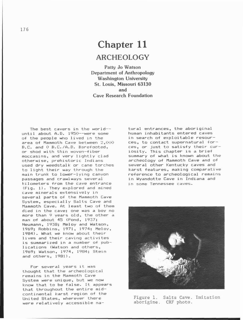
Chapter 11 ARCHEOLOGY
Patty Jo Watson Department of Anthropology
Washington University St. Louis, Missouri 63130
and Cave Research Foundation
The best cavers i n t he world-- u n t i 1 about A. D. 1950--were some of the people who l i v e d i n t he area of Mammoth Cave between 2,000 F. C. and O B. C. / A . I?. Baref eoted, o r shod w i t h t h i n woven-f i ber moccasins, and very l i g h t l y c lad otherwise, p r e h i s t o r i c Indians used dry weedstalk o r cane torches t o l i g h t t h e i r way through the main t runk t o lower- ly ing canyon passages and crawlways several k i lometers from the cave entrance (Fig. 1). They explored and mined cave minerals extensive1 y i n several p a r t s of t he Mammoth Cave System, espec ia l l y S a l t s Cave and Mammoth Cave. A t l e a s t two of them died i n t he cave: one was a boy no more than 9 years o ld , the other a man o f about 45 (Pond, 1937: Neumann, 1938: Meloy and Watson, 1969; Robbins, 1971, 1974: Meloy, 1984). What we know about t h e i r l i v e s and t h e i r caving a c t i v i t e s i s summarized i n a number o f pub- l i c a t i o n s (Watson and others, 1969: Watson, 1974, 1984; S te in and others, 1981).
For several years i t was thought t h a t the archeological remains i n the Mammoth Cave System were unique, bu t we now know t h a t t o be fa lse. It appears t h a t t h r o u ~ h o u t t he e n t i r e mid-
t u r a l entrances, t h e abor ig ina l human inhab i tan ts entered caves i n search o f exp lo i t ab le resour- ces, t o contact supernatural f o r - ces, o r j u s t t o s a t i s f y t h e i r cur- i o s i t y . This chapter i s a b r i e f summary of what i s known about t he archeology o f Mammoth Cave and of several other Kentucky caves and ka rs t features, making comparative reference t o archeological remains i n Wyandotte Cave i n Indiana and i n some Tennessee caves.
- cont inenta l ka rs t reg ion o f the United States, wherever there Figure 1. Salts Cave. Imitation were re1 a t i v e l y accessib le na- aborigine. CRF photo.
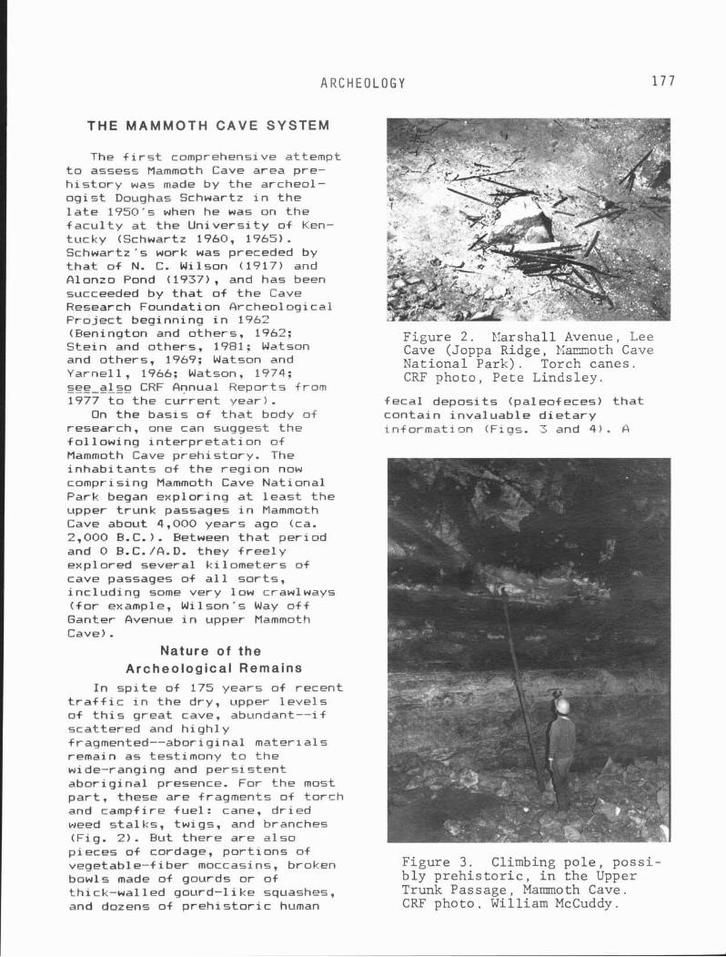
A R C H E O L O G Y
THE MAMMOTH CAVE SYSTEM
The f i r s t comprehensive attempt t o assess Mammoth Cave area pre- h i s t o r y was made by the archeol- o g i s t Doughas Schwartz i n the l a t e 1950's when he was on the f a c u l t y a t t he Un i ve rs i t y of Ken- tucky (Schwartz 1960, 1965). Schwartz's work was preceded by t h a t o f N. C. Wilson (1917) and Alonzo Pond t 1937) , a.nd has been succeeded by t h a t of t h e Cave Research Foundation Archeological Pro jec t beginning i n 1962 (Eenington and others, 1962; Figure 2. Narshal l Avenue, Lee Ste in and others, 1981: Watson Cave (Joppa Ridge, 1;;armoth Cave and others, 1969; Watson and National Park) . Torch canes. Yarnel l , 1966: Watson, 1974; CRF photo, Pe te Linds ley . see a lso CRF Annual Reports from 1977 t o the cur rent year). feca l deposi ts ( paleof eces) t h a t
On the basis o f t h a t body of conta in inva luab le d i e t a r y research, one ran suggest the in fo rmat isn (Figs. 3 and 4 ) . A f 01 lowing i n t e r p r e t a t i o n o f Mammoth Cave preh i s tory . The inhab i tan ts of the reg ion now comprising Mammoth Cave National Park began exp lor ing a t l e a s t the upper t runk passages i n Mammoth Cave about 4,000 years ago Cca. 2,000 B.C.). Between t h a t per iod and 0 B.C. /A.D. they f r e e l y expl ored several k i 1 ometers of cave passages of a1 1 sor ts , i nc lud ing some very low crawlways ( f o r example, Wilson's Way o f f Ganter Avenue i n upper Mammoth Cave) .
Nature of the Archeological Remains
I n s p i t e of 175 years o f recent t r a f f i c i n the dry, upper l e v e l s o f t h i s great cave, abundant--if scat tered and high1 y f ragmented--aborigi na l mater ia ls remain as testimony t o t he wide-ranging and pers is ten t abor ig ina l presence. For the most p a r t , these are fragments of to rch and campfire fue l : cane, d r i ed weed s ta lks , twigs, and branches (Fiq. 2 ) . But there are a lso - pieces o f cordage, por t ions of vegetable-f iber moccasins, broken Figure 3. Climbing p o l e , p o s s i - bowls made of gourds or o f b l y p r e h i s t o r i c , i n t h e Upper th ick-wal led gourd-l ike squashes, Trunk Passage, Mammoth Cave. and dozens of p r e h i s t o r i c human CRF photo , William McCuddy .
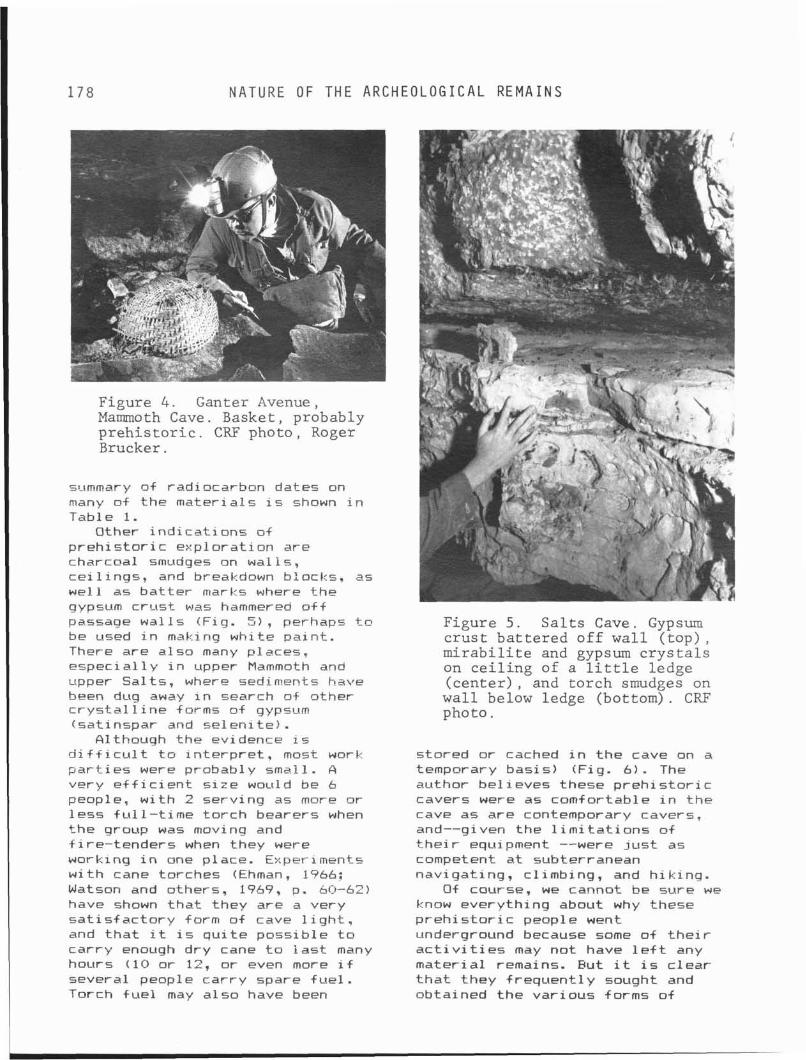
178 N A T U R E OF T H E A R C H E O L O G I C A L R E M A I N S
Figure 4 . Ganter Avenue, Mammoth Cave. Basket , probably p r e h i s t o r i c . CRF photo , Roger Brucker .
summary of radiocar-bon dates on many of the mater ia ls i s shown i n Table 1.
Other i nd i ca t i ons o f p r e h i s t o r i c exp lora t ion are charcoal smudges on wal ls , c e i l i n g s , and breakdown blocks, as wel l as ba t t e r marks where thp gypsum c rus t was hammered a f f passage wa l l s (Fig. 5) , perhaps t o be used i n making white pa in t . There are a lso many places* especi a1 1 y i n upper Mammoth and upper Sal ts , where sediments have been dug away i n search of other c r y s t a l l i n e forms of gypsum !sat inspar and se len i te ) .
A 1 though the evidence is i i f f i c u l t t o i n t e r p r e t , most work p a r t i e s were probably small. A very e i f i c i e n t s i z e would be 6 people, w i t h 2 serv ing as more or l ess f u l 1 -ti me to rch bearers when the group was moving and f i re- tenders when they were working i n one place. Experiments w i t h cane torches (Ehman, 1966; Watsan and others, 1969, p . 60-52) have shown t h a t they are a very z a t i s f ac tory form of cave 1 i g h t , and t h a t i t i s q u i t e poss ib le t o car ry enough dry cane t o i a s t many hours (10 or 12, o r even more i f several people car ry spare f ue l . Torch f u e l may a lso have been
Figure 5 . S a l t s Cave. Gypsum c r u s t b a t t e r e d o f f w a l l ( top) , m i r a b i l i t e and gypsum c r y s t a l s on c e i l i n g of a l i t t l e ledge ( c e n t e r ) , and t o r c h smudges on w a l l below ledge (bottomJ. CRF photo.
stored or cached i n t he cave on a temporary bas is) (Fig. 6). The author be l ieves these p r e h i s t o r i c cavers were as comfortable i n t he cave a5 are contemporary cavers, and--given the l i m i t a t i o n s of t h e i r equipment --were j u s t as competent a t subterranean navigat ing, cl imbing, and h ik ing.
O f course, we cannot be sure we know everyth ing about why these p r e h i s t o r i c people went underground because some of t h e i r a c t i v i t i e s may no t have l e f t any mater ia l remains. Eut i t i s c lear t h a t they f requent l y sought and obtained the var ious forms of
A R C H E O L O G Y
MAMMOTH CAVE NATIONGL PARK P r e h i s t o r y : S u m m a r y o+ A v a i l a b l e R a d i o c a r b o n D a t e s ( L i b b y h a l f - l i f e , u n c a i i b r a t e d )
PROVENIENCE MATERIGL DATE ._ . . . . . . . . . . . . . . . . . . . . . _ _ _ _ _ _ _ _ _ _ _ _ saLts-Gsve-Yezfib~!Le T e s t 11. F. 2 A C h a r c o a l
T e s t E, L e v e l 5 C h a r c o a l
T e s t G, L e v e l 5 C h a r c o a l
T e s t E, L e v e l 7h
T e s t
T e s t T e s t T e s t T e s t T e s t f est T e s t T e s t
E , L e v e l 7b
J I V , J I Ci , J I V , J I 'b' , K I I 7
K I I , K I I , K I I .
L e v e l 4 L e v e l b L e v e l 8 L e v e l 11 L e v e l 4 L e v e l 6 L e v e l 11 L e v e i 14
C h a r c o a l
C h a r c o a l
C h a r c o a l C h a r c o a l C h a r c o a l C h a r c o a l C h a r c o a l C h a r c o a l C h a r c o a l C h a r c o a l
1540 B.C. + 110 (GaK 27673
1410 B.C. 2 220 ( G a E 2764)
1460 B. c. + 220 (Gat.-:: 2766)
710 B.C. 2 100 (GaK 2622)
990 B.C. t 120 ( G a k 2765)
52(:, B.C. + iO 390 B. C. + 50 480 B.C. + 50 560 B.c. + 60 570 B.C. + 70 250 B.C. + 60 431:) B.E. + br:, 460 S.C. + &[I)
salts-Cave-InterLor U p p e r Sa l t s , F54 P a l e o - F e c a l s p e c i m e n 290 5. C. + 200
w i t h s s u a s h s e e d s ( M 1573) U p p e r S a l t s , P 3 8 P a l eof ecal s p e c i m e n 320 B.C. 2 140
( M 1777) U p p e r Sa l t s , P63-64 P a l eof ecal s p e c i m e n 620 B.C. + 140
w i t h g o u r d s e e d s ( M 1574) U p p e r Sa l t s , P54 Soot 1125 B.C. 140
( I 256)
U p p e r S a l t s , T e s t A 0-10 c m C a n e
30-40 c m C a n e
70-80 c m C a n e
140 c m Wood
M i d d l e S a l t s , B l u e A r r o w P a s s a g e . P a l eof ecal s p e c i m e n
460 w i t h s q u a s h p o l i e n A42 P a l eo+ecal s p e c i m e n
w i t h s u n + l o w e r a c h e n e s
L o w e r S a l t s , I n d i a n A v e n u e , 176 Wood
I67 Wood a n d b a r k
B.C. 2 140 1584 ) P.C. + 130 1585) a
B.C. _+ 150 1586) B.C. 2 140 1587)
400 B.C. + 140 ( M 1577)
710 B.C. 2 140 ( M 1770)
770 B.C. 2 140 ( M 1588)
1190 B.C. 2 150 (M 1589)
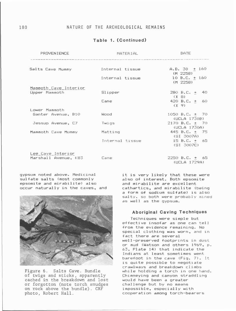
1 8 0 N A T U R E OF T H E A R C H E O L O G I C A L R E M A I N S
Table 1. (Continued)
PROVENIENCE MQTERIGL DATE
Sa l t s Cave Mummy In te rna l t i s s u e
In te rna l t i s s u e
Mammeth-Cave-Lnterl~c Upper Mammoth Sl i pper
Cane
Lower Mammoth Ganter Avenue. B10 Wood
Mammoth Cave Mummy matt in^
In te rna l t i s ~ n e
LEE-cave-Lntcrioc Marshall Avenue. KBS Cane
A.D. 30 2 160 (M 2258) 10 E.C. + 160 (M 2258)
28Cl B.C. f 40 ( X 8)
420 E.C. + 60 i x 9)
1050 B.C. 2 70 (UCLA 1730B)
2170 R.C. 2 70 iUCLA 1730G)
445 E.C. t 75 (51 30t37Q) 15 B.C. _+ 65 (SI 3007C)
gypsum noted above. Medicinal i t i s very l i k e l y t h a t these were s u l f a t e sa l t s (most common1 y a l so o f i n te res t . Both epsomite epsomite and m i r a b i l i t e ) a lso and m i r a b i l i t e are exce l len t occur n a t u r a l l y i n the caves, and ca thar t i cs , and m i r a b i l i t e (being
a form o f sodium s u l f a t e ) i s a lso
Figure 6 . S a l t s Cave. Bundle of twigs and s t i c k s , appa ren t ly cached i n t h e breakdown and l o s t o r fo rgo t ton (note to rch smudges on rock above t h e bundle) . CRF photo, Robert H a l l .
s a l t y , so both were p r o b a t c l v mlned as wel l as the gypsum.
Aboriginal Caving Techniques Techniques were simple but
e f f e c t i v e inso fa r as one can t e l l from the evidence remaininq. No specia l c l o th ing w a s worn, and I n f a c t there are several we1 1-preserved f o o t p r i n t s i n dust o r mud (Watson and others 1969, p. 63, P la te 14) t h a t i n d i c a t e the Indians a t l eas t sometimes went barefoot i n the cave ( F i g . 7). It i s q u i t e poss ib le t o negot ia te crawl ways and breakdown c l i mbs whi le hn ld ing a t o r ch i n one !-land. Chimneying and canyon s t radd l i ng wauld have been a greater challenge but by no means impossible, especi a1 1 y w i t h cooperation among torch-bearers
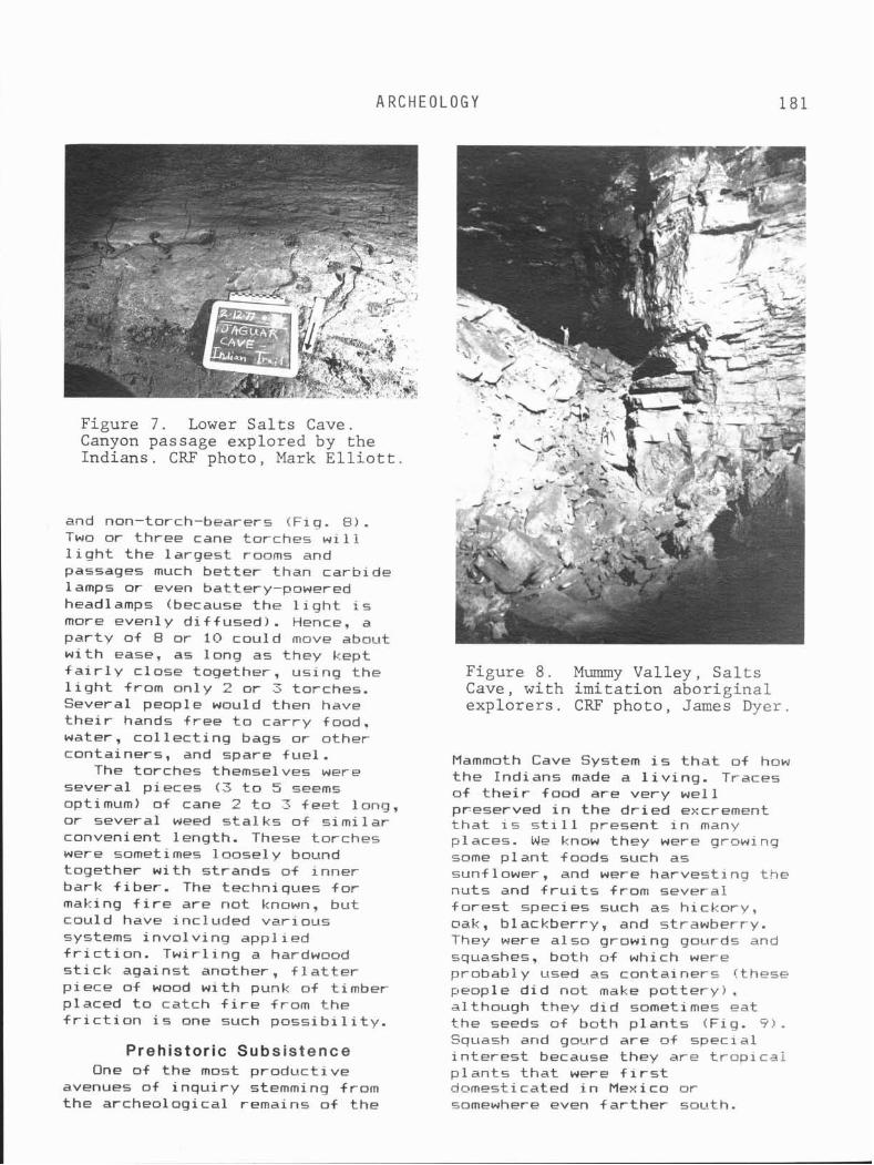
A R C H E O L O G Y 181
Figure 7 . Lower S a l t s Cave. Canyon passage explored by t h e Ind ians . CRF photo, Mark E l l i o t t .
and non-torch-bearers (Fig. €I). Two or three cane torches w i l l l i g h t t he la rges t rooms and passages much be t te r than carbide 1 amps or even ba t te r y-powered headlamps (because the l i g h t i s more evenly d i f f used ) . Hence, a pa r t y of 8 or 10 could move about w i t h ease. as long as they kept f a i r l y c lose together, using the l i g h t from only 2 o r 3 torches. Several people would then have t h e i r hands f r e e t o car ry food, water, c o l l e c t i n g bags or other containers, and spare f ue l .
The torches themselves were several pieces ( 3 t o 5 seems optimum) of cane 2 t o 3 f e e t long, o r several weed s t a l k s o f s imi l a r convenient length. These torches were sometimes loose1 y bound together w i t h strands of inner bark f i be r . The techniques f o r making f i r e are not known, but could have included var ious systems i nvo l v i ng appl ied f r i c t i o n . Tw i r l i ng a hardwood s t i c k against another, f l a t t e r p i e r e o f wood w i t h punk of t imber placed t o catch f i r e from the f r i c t i o n i s one such p o s s i b i l i t y .
Prehistoric Subsistence One of the most product ive
avenues of i n q u i r y stemming from the archeological remains o f the
Figure 8 . Mummy Va l l ey , S a l t s Cave, wi th i m i t a t i o n a b o r i g i n a l e x p l o r e r s . CRF photo , James Dyer.
Mammoth Cave System i s t h a t of how t h e Indians made a l i v i n g . Traces of t h e i r food are very we l l preserved i n the d r i e d excrement t h a t i s s t i l l present i n many places. We know they were growing some p lan t foods such as sunflower, and were harvest ing the nuts and f r u i t s from several f o r e s t species such as h ickary , oak, blackberry, and strawberry. They were a lso growing gourds and squashes? both o f which were probably used as containers (these people d i d not make p o t t e r y ) . although they d i d sometimes eat the seeds of both p l a n t s (Fig. 9 ) . Squash and gourd are a+ specia l i n t e r e s t because they are t r o p i c a l p l an t s t h a t were f i r s t dnmesticated i n Mexico o r somewhere even f a r t h e r south.
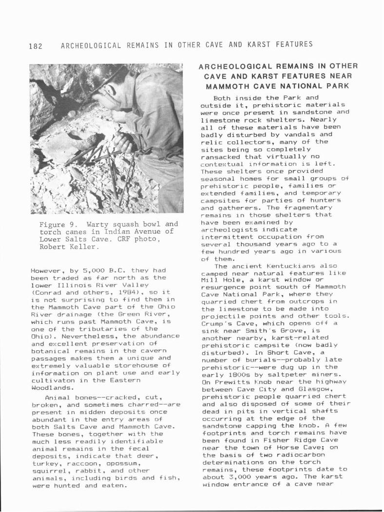
1 8 2 A R C H E O L O G I C A L R E M A I N S I N O T H E R CAVE A N D K A R S T F E A T U R E S
ARCHEOLOGICAL REMAINS IN OTHER CAVE AND KARST FEATURES NEAR MAMMOTH CAVE NATIONAL PARK
Both i n s i d e t h e Park and outs ide it, p r e h i s t o r i c mater ia ls were once present i n sandstone and l imestone rock she l te rs . Nearly a l l of these mater ia ls have been badly d is turbed by vandals and r e l i c co l l ec to rs , many o f t he s i t e s being so completely ransacked t h a t v i r t u a l 1 y no
q . ., cante::tual xn+ormation 1s l e f t . These she l t e r s once provided seasonal homes f o r small groups o i p r e h i s t o r i c people, f a m i l i e s or extended f ami 1 ies , and temporary campsites f o r p a r t i e s o f hunters and gatherers. The fragmentary remains i n those she l t e r s t h a t
Figure 9 . Warty squash bowl and have been examined by torch canes i n Indian Avenue of archeologrsts i n d i c a t e Lower Sa l t s Cave. CRF photo, intermittent occupation from Robert Kel ler . several thousand years ago t o a
few hundred years ago i n var ious
However, by 5,000 B. C. they had been traded as f a r no r th as the lower I l l i n o i s River Va l ley (Conrad and others, 1984). =a i t is not su rp r i s ing t o f i n d them i n t he Mammoth Cave p a r t of t he Ohio River drainage ( the Green River, which runs past Mammoth Cave, i s one of the t r i b u t a r i e s of t he Ohio). Nevertheless, t he abundance and excel l e n t preservat ion of botan ica l remains i n t he cavern passages makes them a unique and extreme1 y valuable storehouse of i n f ormation on p l a n t use and e a r l y c u l t i v a t o n i n t he Eastern Woodl ands .
Animal bones--cracked, cut , broken, and sometimes charred--are present i n midden deposi ts once abundant i n the en t r y areas of both Sa l t s Cave and Mammoth Cave. These bones, together w i t h the much less r e a d i l y iden t i - f i ab le animal remains i n t he feca l deposits. i nd i ca te t h a t deer, turkey. raccoon, opossum. s q u i r r e l , r abb i t , and other animals, inc lud ing b i r d s and f i s h , were hunted and eaten.
of them. The ancient Kentuckians a lso
camped near na tu ra l features l i K e M i 11 Hole, a ka rs t window or resurgence po in t south of Mammoth Cave Nat ional Park, where they quarr ied cher t from outcrops i n t he l imestone t o be made i n t o p r o j e c t i l e po in t s and other too ls . Crump's Cave, which opens o f + a s ink near Smith's Grove, i s another nearby, ka rs t - re la ted p r e h i s t o r i c campsite (now bad1 y d is turbed) . I n Short Cave, a number o f b u r i a1 s--probabl y l a t e prehistor ic--were dug up i n the e a r l y 1800s by sa l t pe te r miners. On P rew i t t s b.lnob near t he highway between Cave C i t y and 61 asgow, p r e h i s t o r i c people quarr ied cher t and a l so disposed of some o i t h e i r dead i n p i t s i n v e r t i c a l sha f ts occurr ing a t t he edge of the sandstone capping t h e knob. fi few f o o t p r i n t s and t o r c h remains have been found i n Fisher Ridge Cave near t he town of Horse Cave: on t he bas is o f two radiocarbon determinations on t he t o r ch remains, these f o o t p r i n t s date t o about 3,000 years ago. The ka rs t window entrance of a cave near

A R C H E O L O G Y 183
Bowling Green (48 km south of Cave C i t y ) was a long-term campsite and cher t quarry l i k e M i 11 Hole; unfor tunate ly i t has been severely vandalized i n the past 2 years. Another archeological s i t e i n a cave opening o f f a s inkhole (Savage Cave, i n south-central Kentucky) has been recen t l y purchased by the Archeological Conservancy, and i s being managed by Murray State Un i ve rs i t y so t h a t what remains of t he c u l t u r a l deposit w i l l be protected.
F i n a l l y , recent work i n the v i c i n i t y of L o u i s v i l l e by paleontologist/zoologist Ron W i 1 son (Uni ve rs i t y Museum. Uni ve rs i t y of Northern Iowa, Cedar F a l l s ) and archeologist P h i l D i B l as i (Archeological Survey. Un ivers i t y of Lou isv i 1 l e ) has resu l t ed i n the l oca t i ng of several caves contain inq h i s t o r i c and p reh i s to r i c c u l t u r a l remains (Fig. 10).
CAVE ARCHEOLOGY ELSEWHERE IN
THE MIDWEST AND MIDSOUTH
A r c h e o l o ~ i c a l remains deep i n caves. and thus somewhat comparable t o the Mammoth Cave s i t u a t i n n , are known from Wyandotte Cave i n southern Indiana and from several Tennessee caves. Middle Woodland Indians explored Wyandotte Cave and mined cher t and aragoni te there, which was ra the r wide1 y traded throughout the Midwest. I n Zarathustra (Sa l tpeter ) Cave i n northern Tennessee, cher t was a lso mined i n some quant i ty , and Jaguar Cave (northern Tennessee) ( 2ee Hobbi ns and others, 1981) (Fig. 1 1 1 , and Big Bone Cave (cen t ra l Tennessee) were both ra ther thoroughly explored p r e h i s t o r i c a l 1 y. The most unusual archeological remains from any cave are probably those i n Mud Glyph Cave i n eastern Tennessee. where drawings i n the mud t h a t
Figure 10. Salts Cave vestibule excavations. CRF photo.
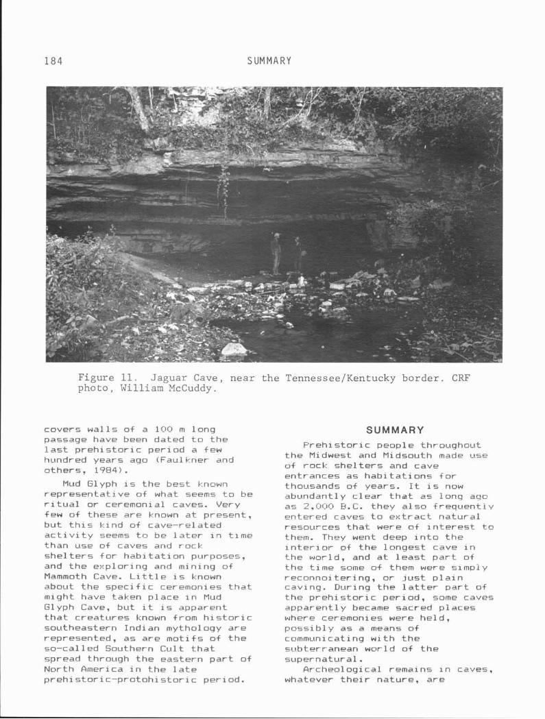
184 SUMMARY
Figure 11. Jaguar Cave, near the Tennessee/Kentucky border. ClW photo, William McCuddy.
covers w a l l s o f a 100 m l ong passage have been dated t o t h e l a s t p r e h i s t o r i c p e r i o d a few hundred years ago iFaul kner and o thers , 1984).
Mud Glyph i s t h e bes t known rep resen ta t i ve o f what seems t o be r i t u a l o r ceremonial caves. Very few o f these are known a t present , b u t t h i s k i n d o f cave-re lated a c t i v i t y seems t o be l a t e r i n t ime than use o f caves and rock s h e l t e r s f o r h a b i t a t i o n purposes, and t h e exp lo r ing and min ing o f Mammoth Cave. L i t t l e i s known about t h e s p e c i f i c ceremonies t h a t might have taken p l a c e i n Mud Glyph Cave, b u t i t i s apparent t h a t c rea tures known from h i s t o r i c southeastern Ind ian mythology a r e represented, as a r e m o t i f s o f t h e so-cal led Southern C u l t t h a t spread through t h e eas tern p a r t o f Nor th America i n t h e l a t e p r e h i s t o r i c - p r o t o h i s t o r i c per iod .
SUMMARY F r e h i s t o r i c people throughout
t h e Midwest and Midsouth made use o f rack s h e l t e r s and cave entrances as h a b i t a t i o n s f o r thousands of years. It i s nQw abundant ly c l e a r t h a t as iong ago as 2,000 F.C. they a l s o f r e q u e n t l y entered caves t o e x t r a c t n a t u r a l resources t h a t were o f i n t e r e s t t o them. They went deep i n t o t h e i n t e r i o r o f t h e l onges t cave i n t h e world, and a t l e a s t p a r t o f t h e t ime some o f them were simpi y reconno i te r ing , o r j u s t p l a i n caving. Dur ing t h e l a t t e r p a r t o f t h e p r e h i s t o r i c pe r iod , some caves apparent ly became sacred p laces where ceremonies were he ld , p o s s i b l y as a means o f communicating w i t h t h e subterranean wor ld o f t h e supernatura l .
Archeological remains i n caves, whatever t h e i r nature, a r e
A R C H E O L O G Y 185
extremely valuable and extremely f r a g i l e . Should you f i n d anything i n a cave t h a t appears t o be evidence f o r h i s t o r i c and p r e h i s t o r i c a c t i v i t y there, do not touch i t or d i s t u r b i t . Record as much in format ion about i t as you can and r e p o r t i t t o t he State Archeologist. Most o f the recent evidence of p r e h i s t o r i c deep-cave u t i l i z a t i o n has been discovered by cavers ra the r than archeologists. Only i f cavers maintain t h i s esemplary t r a d i t i o n can our mutual knowledge of the world underground cont inue t o increase.
REFERENCES
Kentucky: I l l i n o i s Sta te Museum, Report o f Invest iga- t i o n s 16, p. 65-69.
Nelson, N. C., 1917, Cont r ibut ions t o the archeology o f Mammoth Cave and v i c i n i t y , Kentucky: An- thrnpol ogi ca l papers o f t h e Rmerican Museum of Natural His- t o r y , v . 22, p. 1-73.
Neumann, Georg, 1938, The human remains from Mammoth Cave, Ken- - tucky: American An t iqu i t y , v. A, p. 339-353.
Pond, Alonzo, 1937, Lost John of Mummy Ledge: Natural H is tory , v. 39, p. 176-184.
Robbins, Louise, 1971, A Woodland "Mummy" from Sa l t s Cave. Ken-
Benington, F. M . , Melton, Car l , tucky: Qmerican Ant iqu i ty, v.
and Watson, P. J., 1962, Carbon 36, p. 200-206. da t ing p r e h i s t o r i c soot from Robbins, Louise 1974, P reh i s to r i c S a l t s Cave, Kentucky: American people of the Wammoth Cave area, An t i qu i t y , v. 28, p. 238-241. i n Watson, Pat ty Jo, ed., Arche- --
Conrad, Nicholas, Asrh, David, Asch, Nancy, Elmore, David. Gove, Harry, Hubin, Mayer,
ology of the Mammoth Cave area: New York, Academic Press, p. 137-162.
Brown, James, W i ant, Michael , Farnsworth, Kenneth. and Cook. Robbins, Louise, Wilson, 13. C.; Thomas, 1984, Accelerator rad io- and Watson, P. J., 1981, Palean- carbon da t ing o f evidence f o r to logy and archeology of Jaguar p r e h i s t o r i c h o r t i c u l t u r e i n Cave, Tennessee: Eighth Intern3- - I l l i n o i s : Nature, v. a08 p. 443- t i onal Congress o f Spel eol ogy, 446. Proceedings, v. 1, p. 377-ZBC1.
Ehman, M. F., 1966, Cane torches Schwarti, D. W., 1960, Prehistoric as cave i 1 lumination: Nat ional man i n Mammoth Cave: S c i e n t i f i c Speleological Society News, v. American, v. 203, p. 130-140. 247 p = 34-.36.
Schwartz , D. W. , 1965, P reh i s to r i c Faulkner, C. H., Deane? B., and man i n Mammoth Cave: Eastern Na-
Earnest, Howard, 1984, A Missis- t i o n a l Park and Monument As5~c- s ipp ian per iod r i t u a l cave i n i a t i o n , I n t e r p r e t i v e Ser ies No. Tennessee: Amer i can Ant i q u i t y. 2, 10 p.
Meloy, Harold, 1984, Mummies of Mammoth Cave: She lbyv i l l e , I n d i - ana, Micron Publ ish ing Co.
Me1 oy, Harold, and Watson, P. J. , 1969, Human remains: " L i t t l e A l i ce " o f Sa l t s Cave and other mummies, in Watson and others, The P r e - h i s t ~ r y o f Sa l t s Cave,
Stein, J.: Watson, P. J.; and White, W. 6. , 1981, Geaarcheol- ogy of the F l i n t Mammoth Cave System and the Green River, Western Kentucky: Geological So- c i e t y of America, l 9B l Annual Meeting, C inc innat i , Ohio, Guidebooks, v. 111, p. 507-542.
186 R E F E R E N C E S C I T E D
Watson, P. J., ed., 1974, Arch- eology of the Mammoth Cave area: New York, Academic Press, 255 p.
Watson, P. J., 1984, Ancient In- dians of Mammoth Cave: Science Year 1984: World Book Science Annual, p . 140- 153.
Watson, P. J., and Yarnal l , H. A..
1966, Archeological and p a l eo- ethnobotanical inves t iga t ions i n the Sa l ts Cave National Park, Kentucky, American An t iqu i t y , v. 31, p. 842-849.
Watson, P. J., and others, 1969, The p reh is to ry o f Sa l t s Cave, Kentucky: I l l i n o i s Sta te Museum, Reports of Invest igat ions, No. 16.
Chapter 12 CAVES AND THE SALTPETER INDUSTRY
IN KENTUCKY Stanley D. Sides
Cave Research Foundation 2014 Beth Drive
Cape Girardeau, Missouri 63701
Cave exp lora t ion i n t he pioneer days o f the State o f Kentucky was not f o r recreat ion, commercial tourism, o r s c i e n t i f i c study, but ra ther f o r the mining o f minerals necessary f o r su rv i va l . Common s a l t , sodium ch lor ide, was almost t he only preservat ive e a r l y set- t l e r s had t o p i c k l e or cure t h e i r beef o r pork, and preserve t h e i r game. Natural b r ines from s a l t l i c k s were so important t h a t Con- gress encouraged development o f s a l t spr ings wherever they were found.
Also important as a chemical t o pioneer surv iva l was potassi um n i t r a t e , o r sa l tpe te r . The name "sa l tpeter , " w i t h i t s var ious spe l l ings, meant " s a l t o f ear th" o r " s a l t o f rock," i n cont rast t o common s a l t , which came from water. Calcium n i t r a t e deposi ts i n caves and rock she l t e r s were eagerly sought, and an indus t ry was developed t o convert the raw mineral t o p u r i f i e d sa l tpe te r . Sa l tpeter i s an important chemical f o r the preservat ion o f meat. Medic inal ly , i t i s used as a d i u r e t i c . Sal tpeter i s a lso a necessary component, w i t h s u l f u r and charcoal , f o r the manufacture o f gunpowder f o r f i rearms, fuses, and b las t ing.
H i s t o r i e s of sa l t pe te r mining i n Kentucky dazzle readers w i t h s t o r i e s of cave sa l tpe te r p lay ing a major r o l e i n concluding the War
o f 1812. Unfortunately, t h i s may no t be correct . Its use i n gun- powder made supply and demand f o r sa l tpe te r vary g r e a t l y i n t imes of war. This war-related i n f l a t i o n of value l ed t o in tens ive exp lo ra t ion o f t he caves of Kentucky, f o r they were an important economic re- source. The ea r l y i n t e r e s t i n the caves, near ly 200 years ago. has l e f t a r i c h h i s t o r y f o r modern- day h i s t o r i a n s and speleologists.
There are important para1 l e l s between the development o f the sal tworks o f Kentucky, and the saltpeterworks. The technology o f making s a l t from br ines and making sa l t pe te r from calcium n i t r a t e leached from ear th was s im i l a r . Prominent s a l t merchants a lso so ld sa l tpe te r . Without these chemical i ndus t r i es , the settlement o f Kentucky might have occurred d i f f e r e n t l y .
SALTPETER AND EARLY KENTUCKY HISTORY
Daniel Boone f i r s t s e t t l e d i n Kentucky i n 1769, a per iod o f exp lo ra t ion and sett lement of the Blue Grass Region which l e f t the pioneers f a r from sources o f chemicals i n V i rg in ia . To the west o f Kentucky, sett lements i n what are today Missouri and I l l i n o i s were establ ished t o mine lead and t o ob ta in animal furs . I n 1770. "Long Hunters" explored the middle
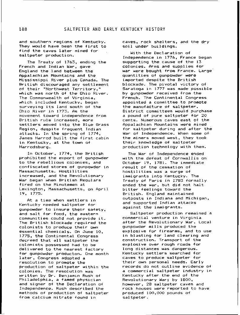
188 S A L T P E T E R AND E A R L Y K E N T U C K Y H I S T O R Y
and southern reg ions o f Kentucky. They would have been t h e f i r s t t o f i n d t h e caves l a t e r mined f o r s a l tpet-er product ion.
The Treaty o f 1763, ending t h e French and Ind ian War, gave England t h e land between t h e fippal ach i an Mountains and t h e M i s s i s s i p p i R iver p l u s Canada. The B r i t i s h discouraged any set t lement o f t h e i r "Northwest T e r r i t o r y , " which was n o r t h of t h e Ohio River . The Commonwealth o f V i r g i n i a , which inc luded Kentucky. began survey ing i t s land south o f t h e Ohio R ive r i n 1773. As t h e movement toward independence from B r i t i s h r u l e increased, more s e t t l e r s moved i n t o t h e Blue Grass Region, desp i te f requent Ind ian a t tacks . I n t h e s p r i n g o f 1774, James Harrod b u i l t t h e f i r s t cabin i n Kentucky, a t t h e town o f Harrodsburg.
I n October, 1774, t h e R r i t i s h p r o h i b i t e d t h e expor t o f gunpowder t o t h e r e b e l l i o u s colonies, and con f i sca ted s t o r e s o f gunpowder i n Massachusetts. H o s t i l i t i e s increased, and t h e Revolut ionary War began when E r i t i s h Regulars f i r e d on t h e Minutemen a t Lexington, Massachusetts, on A p r i l 19, 1775.
caves, rock she l te rs , and t h e d r y s o i 1 under b u i 1 dings.
With t h e Dec la ra t i on o f Independence i n 1776, France began suppor t ing t h e cause o f t h e 13 colonies. firms and supp l i es f o r war were bought f rom France. Large' q u a n t i t i e s o f gunpowder were imported desp i te t h e B r i t i s h blockade. The p i v o t a l v i c t o r y o f Saratoga i n 1777 was made p o s s i b l e by gunpowder rece ived from t h e French. The Cont inenta l Congress appointed a committee t o promote t h e manufacture o f s a l t p e t e r . D i s t r i c t committees would purchase a pound o f pure s a l t p e t e r f o r 20 cents. Numerous caves east o f t h e Appalachian Mountains were mined f o r s a l t p e t e r du r ing and a f t e r t h e War o f Independence. When some o f t h e miners moved west, they took t h e i r knowledge o f s a l t p e t e r p roduct ion technology w i t h them.
The War a+ Independence ended w i t h t h e defeat o f Cornwa l l i s on October 17, 1781. The immediate r e s u l t o f t h e cessat ion o f h o s t i l i t i e s was a surge o f immigrants i n t o Kentucky. The Treaty o f P a r i s i n 1783 f o r m a l l y ended t h e war, b u t d i d n o t h a l t b i t t e r f e e l i n g s toward t h e B r i t i s h . Enqland maintained -
A t a t ime when s e t t l e r s i n ou tpos ts i n Indiana and Michigan,
Kentucky needed s a l t p e t e r f o r and supported Ind ian a t t a c k s aga ins t t h e immigrants.
gunpowder t o i n s u r e t h e i r sa fe ty , and s a l t f o r food, t h e eastern Sa l tpe te r p roduct ion remained a communi t i es cou ld n o t p rov ide i t . commercial venture i n V i r g i n i a The B r i t i s h blockade reau i red t h e a f t e r t h e Revolut ionary War. Local c o l o n i s t s t o produce t h e i r own e s s e n t i a l chemicals. On June 10, 1775, t h e Cont inenta l Congress decreed t h a t a l l s a l t p e t e r t h e c o l o n i s t s possessed had t o be d e l i v e r e d t o t h e nearest f a c t o r y f o r gunpowder producton. One month l a t e r , Congress adopted a r e s o l u t i o n t o promote t h e p roduc t ion o f s a l t p e t e r w i t h i n t h e c o l on i es. The r e s o l u t i on was w r i t t e n by D r . Benjamin Hush o f Ph i l ade lph ia , a famed phys ic ian and s igner o f t h e Dec la ra t i on o f Independence. Rush descr ibed t h e methods o f p roduc t ion of s a l t p e t e r f rom ca lc ium n i t r a t e found i n
gunpowder m i l l s produced t h e exp los i ve f o r f i rearms, and t o use i n b l a s t i n g f o r land c l e a r i n g and const ruc t ion . Transport o f t h e exp los i ve over rough roads f o r l ong d is tances was dangerous. Kentucky s e t t l e r s searched f o r caves t o produce s a l t p e t e r f o r t h e i r own personal needs. E a r l y records do not o u t l i n e evidence of a commercial s a l t p e t e r i n d u s t r y i n Kentucky a f t e r the end o f t h e Revolut ionary War; by 1800, however, 28 s a l t p e t e r caves and rock houses were repor ted t o have produced 100,000 pounds o f s a l t p e t e r .
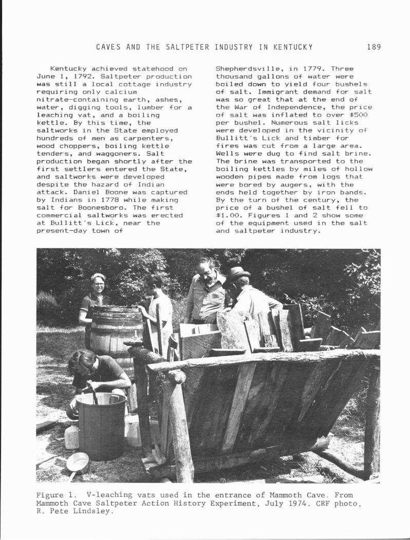
C A V E S A N D T H E S A L T P E T E R I N D U S T R Y I N K E N T U C K Y 189
Kentucky achieved statehood on June 1, 1792. Sal tpeter production was s t i l l a l oca l cot tage indus t ry requ i r i ng on1 y calcium n i t ra te-conta in ing earth, ashes, water, d igging too ls , lumber +or a leaching vat, and a bo i 1 i n g k e t t l e . By t h i s time, the saltworks i n the State employed hundreds o f men as carpenters, wood choppers, b o i l i n g k e t t l e tenders, and waggoners. Sa l t production began s h o r t l y a f t e r t he f i r s t s e t t l e r s entered the State, and saltworks were developed despi te the hazard o f Indian at tack. Daniel Eoone was captured by Indians i n 1778 whi le making s a l t f o r Boonesboro. The f i r s t commercial saltworks was erected a t B u l l i t t ' s L ick , near the present-day town of
Shepherdsvil le, i n 1779. Three thousand ga l lons o f water were bo i l ed down t o y i e l d four bushels o f s a l t . Immigrant demand f o r s a l t was so great t h a t a t the end of the War o f Independence, the p r i c e o f s a l t was i n f l a t e d t o over 6500 per bushel. Numerous s a l t l i c k s were developed i n t he v i c i n i t y of B u l l i t t ' s L ick and t imber +or f i r e s was cu t from a l a rge area. We1 1s were dug t o f i n d s a l t br ine. The b r i n e was t ransported t o the S o i l i n g k e t t l e s by mi les o f hol low wooden pipes made from logs t h a t were bored by augers, w i t h the ends he ld together by i r o n bands. By t h e t u r n of the century, the p r i c e of a bushel o f s a l t f e l l t o 81.00. Figures 1 and 2 show some of the equipment used i n the s a l t and sa l tpe te r indust ry .
Figure 1. V-leaching va t s used i n the entrance of Mammoth Cave. From Mammoth Cave Sa l tpe t e r Action History Experiment, Ju ly 1974. CRF photo, R . Pete Lindsley.
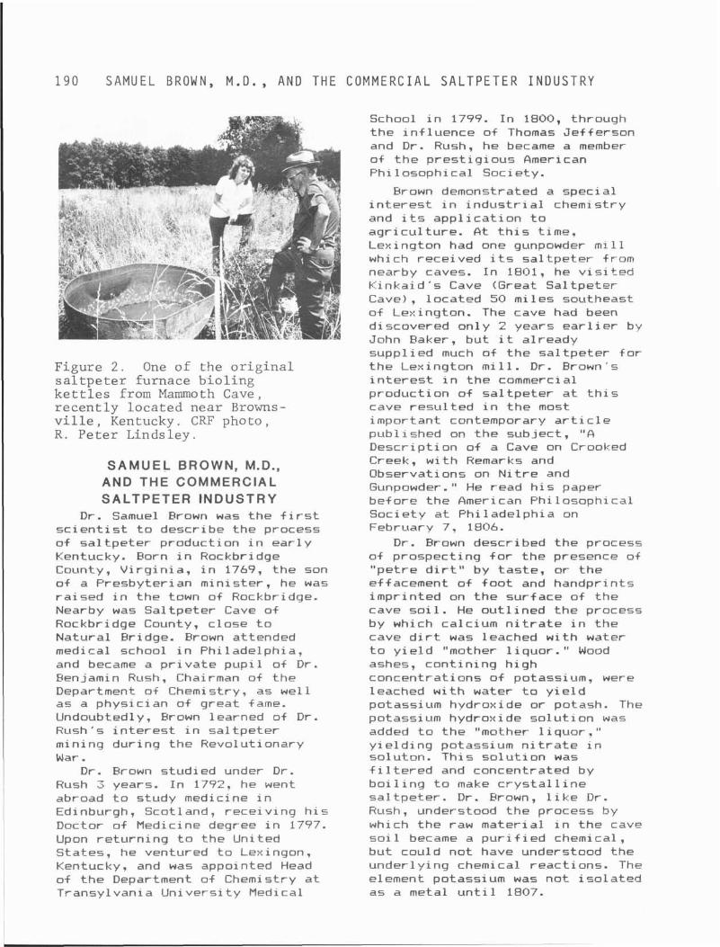
1 9 0 S A M U E L BROWN, M.D. , A N D T H E C O M M E R C I A L S A L T P E T E R I N D U S T R Y
School i n 1799. I n 1800, through the i n f luence of Thomas Jef ferson and D r . Rush, he became a member o f t he p res t i g i ous American Phi losophical Society.
Brown demonstrated a specia l i n t e r e s t i n i n d u s t r i a l chemistry and i t s app l i ca t i on t o agr i cu l tu re . A t t h i s time. Lexington had one gunpowder m i l l which received i t s sa l tpe te r from nearby caves. I n 1801, he v i s i t e d K inka id 's Cave (Great Sa l tpeter Cave) , located 50 mi les southeast of Lexington. The cave had been discovered on ly 2 years e a r l i e r by John Baker, but i t already
Figure 2 . One o f t h e o r i g i n a l s a l t p e t e r fu rnace b i o l i n g k e t t l e s from Mammoth Cave, r e c e n t l y l o c a t e d n e a r Browns- v i l l e , Kentucky. CRF photo , R. P e t e r L inds l ey .
SAMUEL BROWN, M.D., AND THE COMMERCIAL SALTPETER INDUSTRY
D r . Samuel Erown was the f i r s t s c i e n t i s t t o describe the process o f sa l t pe te r production i n e a r l y Kentucky. Eorn i n Rockbridge County, V i rg i n i a , i n 1769, the son of a Presbyterian min is ter , he was ra ised i n the town of Rockbridge. Nearby was Sal tpeter Cave of Rockbridge County, c lose t o Natural Bridge. Frown attended medical school i n Phi ladelphia, and became a p r i v a t e pup i l o i D r . Benjamin Rush, Chairman of the Department of Chemistry. as we1 1 as a physic ian o f great fame. Undoubted1 y , Brown 1 earned of D r . Rush's i n t e r e s t i n sa l tpe te r mining dur ing the Revolutionary War.
D r . Brown studied under D r . Rush 3 years. I n 1772. he went abroad t o study medicine i n Edinburgh, Scotland, rece iv ing h i s Doctor o f Medicine degree i n 1797. Upon re tu rn ing t o the United States, he ventured t o Lexingon, Kentucky. and was appointed Head of t he Department of Chemistry a t Transylvania Un ivers i t y Medical
suppl ied much of the sa l tpe te r f o r t he Lexington m i l l . D r . Brown's i n t e r e s t i n t he commercial product ion o f sa l t pe te r a t t h i s cave resu l t ed i n t he most important contemporary a r t i c l e publ ished on t h e subject, " A Descr ip t ion of a Cave on Crooked Creek, w i t h Remarks and Observations on N i t r e and Gunpowder." He read h i s paper before the American Phi 1 osophi cal Society a t Ph i lade lph ia on February 7, 1806.
D r . Brown described the process o f prospecting f o r the presence of "pet re d i r t " by tas te , o r the effacement o f f o o t and handpr ints impr inted on the surface of the cave s o i l . He ou t l i ned the process by which calcium n i t r a t e i n the cave d i r t was leached w i t h water t o y i e l d "mother l i quo r . " Wood ashes, con t in ing h igh concentrat ions o f potassium, were leached w i t h water t o y i e l d potassium hydroxide or potash. The potassi um hydroxide s o l u t i o n was added t o the "mother l i quo r . " y i e l d i n g potassium n i t r a t e i n soluton. Th is s o l u t i o n was f i l t e r e d and concentrated by b o i l i n g t o make c r y s t a l l i n e sa l tpe te r . D r . Brown, l i k e D r . Rush, understood the process by which the raw mater ia l i n the cave so i 1 became a p u r i f i ed chemical , but could not have understood the under1 y ing chemical react ions. The element potassium was no t i s o l a t e d as a metal u n t i l 1807.
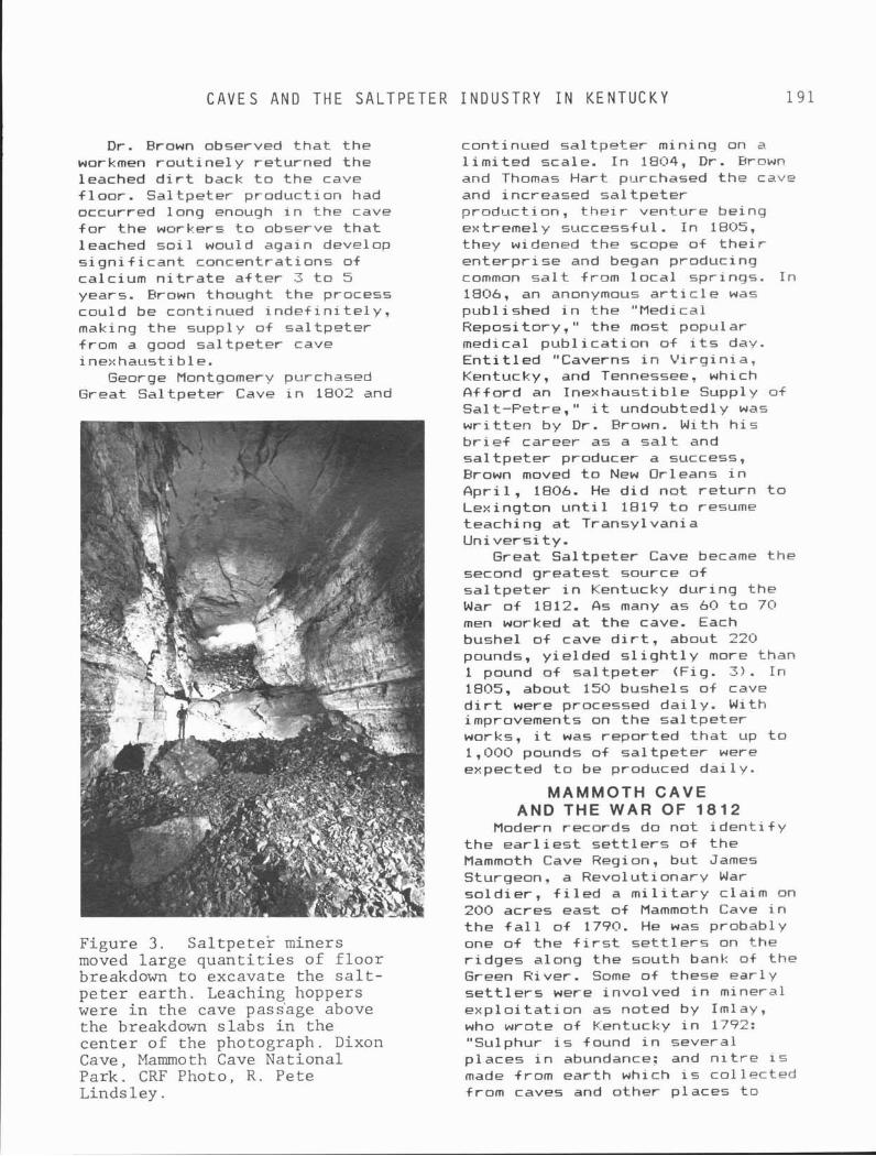
C A V E S A N D T H E S A L T P E T E R I N D U S T R Y I N K E N T U C K Y 1 9 1
D r . Brown observed t h a t the workmen r o u t i n e l y returned the leached d i r t back t o the cave f 1 oor. Sal tpeter production had occurred long enough i n the cave f o r t he workers t o observe t h a t leached s o i l wouid again develop s i g n i f i c a n t concentrat ions of calcium n i t r a t e a f t e r 3 t o 5 years. Frown thought the process could be continued i n d e f i n i t e l y , making the supply of sa l tpe te r from a good sa l tpe te r cave inexhaust ib le.
George Montgomery purchased Great Sal tpeter Cave i n 1802 and
Figure 3 . Saltpetek miners moved large quan t i t i e s of f l o o r breakdown t o excavate the s a l t - pe te r ea r th . Leaching hoppers were i n the cave pass'age above the breakdown s labs i n the center of the photograph. Dixon Cave, Mammoth Cave National Park. CRF Photo, R . Pete Linds l ey .
continued sa l t pe te r mining on a l i m i t e d scale. I n 1904, D r . Brown and Thomas Hart purchased the cave and increased sa l t pe te r production, t h e i r venture being extremely sucressf u l . I n 1805, they widened the scope of t h e i r en te rp r i se and began producing common s a l t from l o c a l springs. I n 1906, an anonymous a r t i c l e was publ ished i n the "Medical Repository," the most popular medical pub l i ca t i on o+ i t s day. E n t i t l e d "Caverns i n V i rg in i a , Kentucky, and Tennessee, which A f fo rd an Inexhaust ib le Supply o f Salt-Fetre," i t undoubtedly was w r i t t e n by D r . Frown. With h i s b r i e f career as a s a l t and sa l t pe te r producer a success, Brown moved t o New Orleans i n A p r i l , 1806. He d i d not r e t u r n t o Lexington u n t i l 1819 t o resume teaching a t Transylvania Univers i ty .
Great Sal tpeter Cave became the second greatest source o f sa l t pe te r i n Kentucky dur ing the War o f 1812. As many as 60 t o 70 men worked a t the cave. Each bushel of cave d i r t , about 220 pounds, y ie lded s l i g h t 1 y more than 1 pound of sa l tpe te r (Fig. 3 ) . I n 1805, about 150 bushels of cave d i r t were processed dai 1 y. With improvements on the sa l tpe te r works, i t was reported t h a t up t o 1,000 pounds of sa l tpe te r were expected t o be produced da i l y .
MAMMOTH CAVE AND THE WAR OF 1812
Modern records do not i d e n t i f y the e a r l i e s t s e t t l e r s of the Mammoth Cave Region, but James Sturgeon. a Revolutionarv War so ld ie r , f i l e d a m i l i t a r y c la im on 200 acres east of Mammoth Cave i n t he f a l l of 1790. He was probably one of the f i r s t s e t t l e r s on the r idges along the south bank of the Green River. Some of these ear l y s e t t l e r s were involved i n mineral e x p l o i t a t i o n as noted by Imlay, who wrote of Kentucky i n 1792: "Sulphur i s found i n several places i n abundance: and n i t r e i s made from ear th which i s co l lec ted from caves and other places t o
MAMMOTH CAVE AND THE WAR OF 1 8 1 2
which wet has no t penetrated. The making o f t h i s s a l t , i n t h i s country, i s so common, t h a t many s e t t l e r s manufacture t h e i r own gunpowder. This ear th i s discovered i n greater p len ty on t he waters o f Green River, than i t i s i n any other p a r t of Kentucky."
Today, there i s no record of the e a r l i e s t sa l tpe te r production a t Mammoth Cave and the Dixon Cave; however, i t i s l i k e l y t ha t these were among the f i r s t caves mined i n the State. On September 14, 1798, Valent ine Simons purchased 200 acres f o r 880, making a down payment of about $10. I n 1799, t he property was surveyed and i t included "two sa l t pe te r caves. " Simons assigned r i g h t s of the caves t o John F l a t t , and i n 1808 Mammoth Cave was known as F l a t t ' s Cave. Common V-1 eachi ng va ts were used i n the entrance o f Mammoth Cave (Fig. 1 ) . The extent o f t he product ion o f sa l tpe te r from the caves i n t h i s per iod i s ~ t n known.
Pe rs i s t i ng h o s t i l i t i e s w i th Great B r i t a i n were soon t o have a profound e f f e c t on n i t r a t e mining and sa l t pe te r product ion i n Kentucky. On October 21, 1805, Great B r i t a i n defeated the French and Spanish i n t he B a t t l e of Tra fa lgar and gained cont ro l of t he seas. Several weeks l a t e r , however, Napolean gained supremacy on land i n Europe. The United States was the wor ld 's second-greatest marit ime na t ion a t t h i s time, and was uninvolved d i r e c t l y i n t he European war. American ships suppl ied war materi a1 s t o Napol eon, prompti nq Great B r i t a i n t o blockade American por ts . Congress responded w i t h passage of t he Embargo and Non-Intercourse Act t o deprive both France and Great B r i t a i n o f American Goods. This ac t ion harmed Uni ted States ' t rade and sources of sa l t pe te r from Spain and Ind ia became l e s s accessible.
I n Kentucky, i t was f e l t tha t t he B r i t i s h were i n c i t i n g the Indians t o a t tack f r o n t i e r settlements, and were supplying
them w i th gunpowder and arms. The ne t r e s u l t o f mounting c o n f l i c t w i t h Great B r i t a i n was congressional Declarat ion of War on June 18, 1812.
P r i o r t o 1808. Valent ine Simons so ld the 200 acres inc lud ing Dixon Cave and "Big Cave" t o John F l a t t f o r a t l e a s t 8116.67. Also p r i o r t o 1808, F l a t t assigned the proper ty t o bro thers John, Leonard, and George NcLean f o r an unknown sum, bu t a t 1 east 8400. I n January, 1808, 44 acres inc lud ing Dixon Cave were so ld t o Charles Morton f o r 8600. P r i o r t o 1910, t he McLeans so ld the remaining 156 acres i nc lud ing Mammoth Cave t o a " sa l t pe te r company" owned by F l emi ng Gatewood and Char 1 es Wi lk ins f o r 83,000.
Char1 es W i 1 k i ns was a prominent Lexington, Kentucky s a l t and sa l t pe te r merchant. Records document t h a t i n 1808 he was s e l l i n g Kentucky sa l tpe te r v i a Phi l ade l ph i a 5a l t pe te r merchant Archibald McCall t o E.I. du Pont Company of W i l m i ngton , Delaware. Wi lk ins purchased sa l tpe te r made a t Great Sa l tpeter Cave, and must have known of Dr. Brown's ownership and i n t e r e s t i n the cave. As t he B r i t i s h blockade t ightened p r i o r t o t he War o f 1812, sources o f sa l t pe te r near Lexington could no t meet the demand of t he l a rge manufacturers o f gunpowder such as du Pont. Wi lk ins found h i s needed sources of sa l t pe te r i n t h e caves o i the Mammoth Cave Region. I n 1812, weal thy Phi lade lph ia merchant and sa l t pe te r dealer Hyman Gratz purchased Fleming Gatewood ' s i n t e r e s t f o r 8 10,000. The combined business acumen of Wi lk ins and Gratz resu l t ed i n spectacular sa l t pe te r product ion from Mammoth Cave between 1812 and 1815.
As the p r i c e o f sa l t pe te r rose p r i o r t o t he War o f 1812, the value of caves conta in ing sa l t pe te r a1 so increased. Sa l tpeter so ld f o r 17 cents a pound i n 1808 w i t h land a t Mammoth Cave s e l l i n g f o r 814 per acre (Tab1 e 1 ) . When war was declared
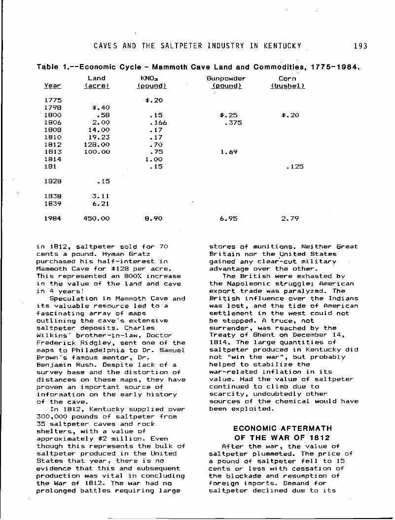
C A V E S AND T H E S A L T P E T E R I N D U S T R Y I N K E N T U C K Y 1 9 3
I Table 1.--Economic Cycle - Mammoth Cave Land and Commodities, 1775- 1 0 8 4 , Land KNOs
Year ---- ------ (acre) - (pound ----- 1 Gunpowder Corn
(pound 1 - ----- -----A-A (bushel )
i n 1812, sa l tpe te r so ld f o r 70 cents a pound. Hyman Gratz purchased h i s ha l f - i n te res t i n Mammoth Cave f o r 8128 per acre. This represented an 800% increase i n t he value of t he land and cave i n 4 years!
Speculation i n Mammoth Cave and i t s valuable resource l e d t o a fasc ina t ing ar ray of maps o u t l i n i n g the cave's extensive sa l tpe te r deposits. Charles M i 1 k i ns ' bro ther - i n-1 aw, Doctar Frederick Ridgley, sent one of the maps t o Phi lade lph ia t o D r . Samuel Brown's famous mentor. D r . Benjamin Rush. Despite lack of a survey base and the d i s t o r t i o n of distances on these maps, they have proven an important source of in format ion on the ea r l y h i s t o r y o f the cave.
I n 1812, Kentucky suppl ied over 300,000 pounds @f sa l tpe te r from 35 sa l tpe te r caves and rock shel ters, w i t h a value o f approximately 52 m i 11 ion. Even though t h i s represents the bulk of sa l tpe te r produced i n the United States t h a t year, there i s no evidence t h a t t h i s and subsequent production was v i t a l i n concluding the War of 1812. The war had no prolonged b a t t l e s requ i r i ng la rge
s tores of munitions. Nei ther Great B r i t a i n nor the United States gained any clear-cut m i l i t a r y advantage over t he other.
The B r i t i s h were exhasted by t he Napoleonic struggle; American export t rade was para1 yzed. The B r i t i s h i n + luence over the Indians was l o s t , and the t i d e o f American sett lement i n the west could not be stopped. A t ruce, not surrender, was reached by the Treaty of Ghent on December 14. 1814. The la rge quan t i t i es of sa l tpe te r produced i n Kentucky d i d no t "win the war", but probably helped t o s t a b i l i z e the war-related i n f l a t i o n i n i t s value. Had the value o f sa l tpe te r continued t o c l imb due t o scarc i t y , undoubtedly other sources o f the chemical would have been exploited.
ECONOMIC AFTERMATH OF THE WAR OF 1 8 1 2
A-fter the war, the value o f sa l tpe te r plummeted. The p r i c e of a pound of sa l tpe te r f e l l t o 15 cents o r l ess w i th cessation of t he blockade and resumption o f fo re ign imports. Demand f o r sa l t pe te r decl ined due t o i t s
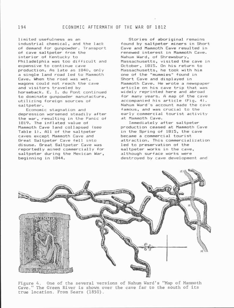
1 9 4 E C O N O M I C A F T E R M A T H O F T H E W A R O F 1812
l i m i t e d usefulness as an i n d u s t r i a l chemical, and the lack of demand f o r gunpowder. Transport o f cave sa l tpe te r from the i n t e r i o r of Kentucky t o Phi ladelphia was too d i f f i c u l t and espensive t o continue cave production. As l a t e as 1840, only a s i ng le land road l e d t o Mammoth Cave. When the road was wet, wagons could not reach the cave and v i s i t o r s t rave led by horseback. E. I. du Font continued t o dominate gunpowder manufacture, u t i l i z i n g fo re ign sources o f sa l tpe te r .
Economic stagnation and depression worsened steadi 1 y a f t e r the war, r e s u l t i n g i n the Panic of 1819. The i n f l a t e d value of Mammoth Cave land col lapsed (see Table 1 ) . A1 1 of the sa l tpe te r caves except Mammoth Cave and Great Sal tpeter Cave f e l l i n t o disuse. Great Sal tpeter Cave was reported1 y mined commerci a1 1 y f o r sa l t pe te r dur ing the Mexican War, beginning i n 1844.
S to r i es o f abor ig ina l remains found by sa l t pe te r miners i n Short Cave and Mammoth Cave resu l ted i n renewed i n t e r e s t i n Mammoth Cave. Nahum Ward, o f Shrewsbury, Massachusetts, v i s i t e d the cave i n October, 1815. On h i s r e t u r n t o Massachusetts, he took w i t h him one of the "mummies" found i n Short Cave and displayed i n Mammoth Cave. He wrote a newspaper a r t i c l e on h i s cave t r i p t ha t was widely rep r i n ted here and abroad f o r many years. & map of the cave accompanied h i s a r t i c l e (Fig. 4) . Nahum Ward's account made the cave famous, and was c r u c i a l t o the e a r l y commercial t o u r i s t a c t i v i t y a t Mammoth Cave.
Immediately a f t e r sa l tpe te r product ion ceased a t Mammoth Cave i n t he Spring o f 1815, the cave became a commercial t o u r i s t a t t r a c t i o n . Thi s commercial i i a t i o n l e d t o preservat ion of the sa l t pe te r works i n the cave, although surface works were destroyed by cave development and
Figure 4 . One of t he severa l vers ions of Nahum Ward's "Map of Mammoth Cave." The Green River i s shown over the cave f a r t o the south of i t s t r u e l oca t i on . From Sears (1850).
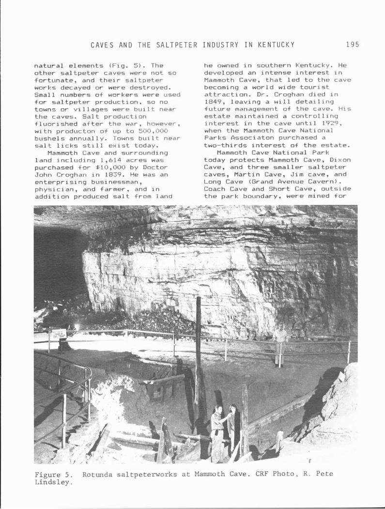
C A V E S A N D T H E S A L T P E T E R I N D U S T R Y I N K E N T U C K Y 1 9 5
na tu ra l elements (Fig. 5). The other sa l t pe te r caves were not so for tunate , and t h e i r sa l tpe te r works decayed or were destroyed. Small numbers of workers were used f o r sa l t pe te r praduct ion. so no towns o r v i l l a g e s were b u i l t near the caves. S a l t praduct ion f l uo r i shed a f t e r the war, however, w i t h producton o+ up t o 500,000 bushel s annual 1 y. Towns bu i 1 t near s a l t l i c k s s t i l l e x i s t today.
Mammoth Cave and surrounding land i nc l ud ing 1,614 acres was purchased f o r SIO, OOO by Doctor John Croghan i n 1839. He was an en te rp r i s i ng businessman, physic ian, and farmer, and i n add i t i on produced s a l t from land
he owned i n southern Kentucky. He developed an in tense i n t e r e s t i n Mammoth Cave, t h a t l e d t o the cave becoming a world wide t o u r i s t a t t r a c t i o n . D r . Croqhan died i n 1847, leav ing a w i l l d e t a i l i n g f u t u r e management of the cave. H i s es ta te maintained a con t ro l 1 i ng i n t e r e s t i n t he cave u n t i l 1727, when the Mammoth Cave National Parks Ossociaton purchased a two- th i rds i n t e r e s t o f t h e estate.
Mammoth Cave Nat iona l Park today p ro tec t s Mammoth Cave, Dixon Cave, and th ree smal ler sa l t pe te r caves, Mar t in Cave, Jim cave, and Long Cave (Grand Avenue Cavern). Coach Cave and Short Cave, outs ide t h e park boundary, were mined f o r
Figure 5 . Rotunda saltpeterworks a t Mammoth Cave. CRF Photo, R . Pete Linds l ey .
R E F E R E N C E S
sa l tpe te r , and are i n t e r m i t t e n t l y shown on a commercial basis. Other caves t h a t had l i m i t e d sa l t pe te r product ion e x i s t i n t he Mammoth Cave Region. Only Prue t t Sa l tpeter Cave near Bowling Green had a large-scale operat ion t h a t would compare w i t h t h a t o f Mammoth Cave and Great Sal tpeter Cave. Sa l tpeter Cave i n Carter Caves State Park, and Great Sa l tpeter Cave a lso have underground sa l t pe te r works preserved, and are open t o the publ ic .
I n 1973, the Sal tpeter Group of t he Cave Research Foundation addressed the challenges o f the science and h i s t o r y o f cave n i t r a t e formation and sa l t pe te r production. Under t he leadership o f Carol A. H i l l and Duane DePaepe, the r e s u l t s of t h e i r s tud ies were publ ished i n the " B u l l e t i n o f t he Nat ional Speleological Society i n October, 1981. This remains the d e f i n i t i v e study o f the s c i e n t i f i c aspects o f cave sa l tpeter .
hcknowl edgements: Harold Meloy , A l f red Scheide, and Richard A. Watson provided t h e i r i n s i g h t and suggestions f o r t h i s chapter.
REFERENCES The purpose o f the f o l l ow ing
references i s t o provide recent accessible references f rom speleological 1 i terature. These provide access t o the more extensive b ib l iography used i n w r i t i n g t h i s chapter.
DePaepe, Duane, 1979, The s a l t - peter era a t Mammoth Cave, a c u l t u r a l resources invest iga-
t i on : Nat ional Park Service, Cave Nat ional Park, 33 p.
Faust, Burton, 1955, Sa l tpeter mining t o o l s used i n caves: Na- t i o n a l Speleological Society Bu- l e t i n , v. 17, p. 8-18.
Faust, Burton, 1967, Sa l tpeter mining i n Mammoth Cave, Ken- tucky: L o u i s v i l l e , F i l son Club, 96 p.
H i l l , Carol A., ed., 1981, Sa l t - peter: Nat ional Spel eol ogi ca l Society B u l l e t i n , v. 43, 48 p.
H i l l , Carol A., 1982, Sa l tpeter caves o f the Uni ted States - updated 1 i st : Nat ional Spel eol o- g i c a l Society B u l l e t i n , v. 11, p. 24-27.
Jackson, George F., 1949, Sa l t - peter mining i n American caves: National Speleological Society B u l l e t i n , v. 11, p. 24-27.
McDowel 1 , Robert E. , 1956, Bul- l i t t ' s L ick , t he r e l a t e d s a l t - works and settlements: F i l s o n Club H is to ry Quarter ly , v. 30, p. 241-269,.
Meloy, Harold, 1984, Mummies of Mammoth Cave: She1 byv i 11 e, I n d i - ana, Micron Publ ish ing Company, 43 p.
White, Wayne R., 1967, The Speleo- graphy o f Great Sa l tpeter Cave: National Spel eol og i c a l Society News, v. 25, p. 169.
Wigginton, E l i o t , ed., 1979, Fox- f i r e 5: Garden C i t y , New York, Anchor Books, p. 246-260.
Related Documents