Çatalhöyük 2014 Archive Report by members of the Çatalhöyük Research Project

Welcome message from author
This document is posted to help you gain knowledge. Please leave a comment to let me know what you think about it! Share it to your friends and learn new things together.
Transcript
Çatalhöyük 2014 Archive Report
by members of the Çatalhöyük Research Project

2
Report compiled by Scott D. Haddow
Cover image: ArcScene screen capture of Building 80
3
ContentsChapter 1 - 2014 Season Review 7
Acknowledgements 102014 Field Team 11
Chapter 2 - Excavations in the North Area 13Building 52 13Building 77 17Building 102 24Building 113 26Building 114 28Building 119 32Building 128 36Buildings 129 and 131 37GT4 42
Chapter 3 - Excavations in the South Area 43Season overview 43Spaces 470 and 492 45Building 43 (Spaces 235 and 236) 47Building 80 (Spaces 135 and 373) 52Building 96 66Building 97 and Building 130 68
Chapter 4 - Excavations in the TPC Area 72Introduction 72The Neolithic sequence 73The Hellenistic settlement 74The Early Islamic (?) occupation 76The Early Islamic (?) burial ground 76Final remarks 77
Cultural and Environmental Materials
Chapter 5 - Human Remains 80Introduction 80North Area Neolithic burials 81South Area Neolithic burials 87TPC (Team Poznan Connection) Post-Chalcolithic burials 90
Chapter 6 - Faunal Remains 93Introduction 93Overview of 2014 material 93East Mound 94KOPAL: All mixed up? Human:animal relations at early Çatalhöyük 97Faunal remains from TPC Area, 2014 104Research involvements 106
4
Chapter 7 - Macro- and Micro- Botanical Remains from the 2013 and 2014 Seasons 1182013 Season 1182014 Season 130
Chapter 8 - Phytoliths and Starch Grains 136Introduction 136Methodology 136Summary information on phytoliths 138
Chapter 9 - Anthracology 143
Chapter 10 - Çatalhöyük Figurines Report 145Recorded finds from 2014 145Ongoing research 146
Chapter 11 - Ground Stone 150Technological and contextual analysis of the ground stone assemblage 150Research projects 151Contribution to conference presentations 152Conference presentations 153
Chapter 12 - Ceramics 154Database study 154Crate lists 1542014 excavation season, TPC, North, South, and Ground Truthing (GT) sherds 1542012-2014 TPC area pottery sherds 154North and South Area pottery 2012-2014 155Lipid analysis on TP pottery 156Rosemary A. Joyce and Russell N. Sheptak’s Templeton Project research 156Organic residue 156X-Ray analysis on the pottery 156Shaped pot sherds 157
Support Teams
Chapter 13 - Finds 158
Chapter 14 - Conservation 159Introduction 159Site-wide condition survey 159Environmental monitoring 160Conservation and maintenance of the North Shelter 160 Conservation and maintenance of the South Shelter 160Experimental capping project update 160Conservation of small finds 161Uses and applications of perlite during the 2014 season 162
Chapter 15 - Heavy Residue 166
5
Chapter 16 - Tablet Recording Overview 168Workflow and tools 168Results 172
Chapter 17 - Site Visualization and Presentation 173EAA exhibition 174Augmented reality delivered by mobile device 176Konya Museum 178Visitor demographics 178Visitor and staff research 180On-site signage 182Visitor’s centre 182Acknowledgements 185
Research Projects
Chapter 18 - Building 89 3D Digging Project 186Introduction 1863D features 187Experimental activities 187Laser scanning 188Digital documentation statistics –2014 season 189Building 89 Post-excavation: Structure from Motion processing report 190Total Station-based Digital Terrain Models 191Conclusions 191
Chapter 19 - Late Neolithic Architecture 194Introduction 194Research within GDN.1 Area 195Research within GDN.2 Area 198Acknowledgments 201
Chapter 20 - Analysis of the Post-Chalcolithic Cemeteries 203
Chapter 21 - Modelling Chronology 204
Chapter 22 - Use-Wear Analysis of Chipped Stone Tools 205Building 65 205Building 77 207
Chapter 23 - Micromorphology 208Fieldwork and sampling 208Acknowledgements 209
Chapter 24 - Speleothems and Their Context at Çatalhöyük 211Introduction 211Speleothems at Çatalhöyük 212East Mound 212West Mound 217
6
Other 217Discussion 217Conclusion 219
Chapter 25 - Reflexive Methodology and Recording 222
Community Collaboration Projects
Chapter 26 - Çatalhöyük Archaeology Workshop 224Children Education Program 224Adult Education Program 225
Chapter 27 - Assembling an Oral History of Excavation at Çatalhöyük 226Introduction 226Methodology 226Support for preliminary findings 227Initial analysis 228Future directions 229
7
Chapter 1
2014 Season Review
Ian Hodder, Stanford University
Those who attended the excavations at Çatalhöyük in the summer of 2014 might have been forgiven for thinking they had come to the wrong site! The excavation methods used at the site have long been known to be slow and painstaking, the main tools being dental picks and small brushes. Some of the field staff did use such tools this year, but others found themselves amid mattocks, shovels, wheelbarrows and clouds of dust, returning to the dig house at the end of each day caked in sweat and grime. As the overall Çatalhöyük Research Project approach-es its last years of excavation, the pace has quickened and the push is on to reach deeper levels and complete the digging of buildings.
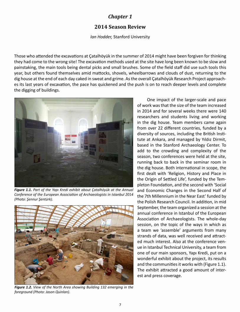
One impact of the larger-scale and pace of work was that the size of the team increased in 2014 and for several weeks there were 140 researchers and students living and working in the dig house. Team members came again from over 22 different countries, funded by a diversity of sources, including the British Insti-tute at Ankara, and managed by Yıldız Dirmit, based in the Stanford Archaeology Center. To add to the crowding and complexity of the season, two conferences were held at the site, running back to back in the seminar room in the dig house. Both international in scope, the first dealt with ‘Religion, History and Place in the Origin of Settled Life’, funded by the Tem-pleton Foundation, and the second with ‘Social and Economic Changes in the Second Half of the 7th Millennium in the Near East’ funded by the Polish Research Council. In addition, in mid September, the team organized a session at the annual conference in Istanbul of the European Association of Archaeologists. The whole-day session, on the topic of the ways in which as a team we ‘assemble’ arguments from many strands of data, was well received and attract-ed much interest. Also at the conference ven-ue in Istanbul Technical University, a team from one of our main sponsors, Yapı Kredi, put on a wonderful exhibit about the project, its results and the communities it works with (Figure 1.1). The exhibit attracted a good amount of inter-est and press coverage.
Figure 1.1. Part of the Yapı Kredi exhibit about Çatalhöyük at the Annual Conference of the European Association of Archaeologists in Istanbul 2014 (Photo: Şennur Şentürk).
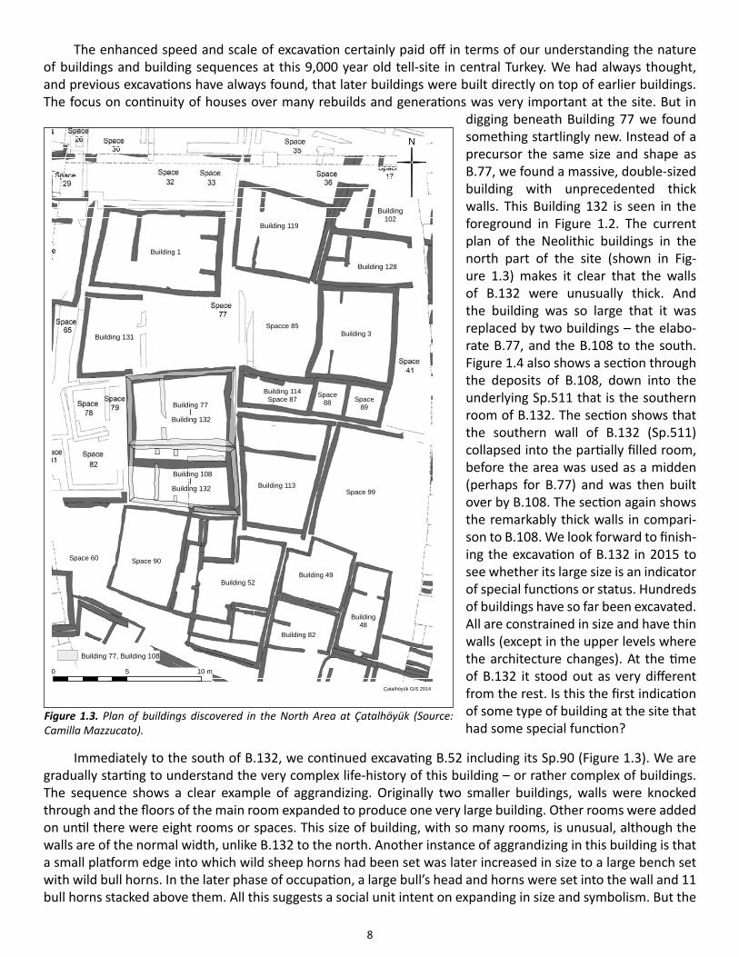
Figure 1.2. View of the North Area showing Building 132 emerging in the foreground (Photo: Jason Quinlan).
8
The enhanced speed and scale of excavation certainly paid off in terms of our understanding the nature of buildings and building sequences at this 9,000 year old tell-site in central Turkey. We had always thought, and previous excavations have always found, that later buildings were built directly on top of earlier buildings. The focus on continuity of houses over many rebuilds and generations was very important at the site. But in
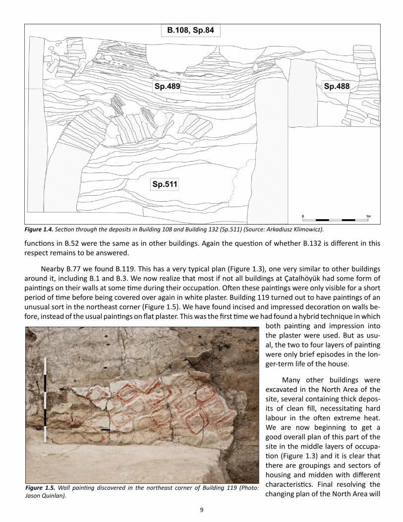
digging beneath Building 77 we found something startlingly new. Instead of a precursor the same size and shape as B.77, we found a massive, double-sized building with unprecedented thick walls. This Building 132 is seen in the foreground in Figure 1.2. The current plan of the Neolithic buildings in the north part of the site (shown in Fig-ure 1.3) makes it clear that the walls of B.132 were unusually thick. And the building was so large that it was replaced by two buildings – the elabo-rate B.77, and the B.108 to the south. Figure 1.4 also shows a section through the deposits of B.108, down into the underlying Sp.511 that is the southern room of B.132. The section shows that the southern wall of B.132 (Sp.511) collapsed into the partially filled room, before the area was used as a midden (perhaps for B.77) and was then built over by B.108. The section again shows the remarkably thick walls in compari-son to B.108. We look forward to finish-ing the excavation of B.132 in 2015 to see whether its large size is an indicator of special functions or status. Hundreds of buildings have so far been excavated. All are constrained in size and have thin walls (except in the upper levels where the architecture changes). At the time of B.132 it stood out as very different from the rest. Is this the first indication of some type of building at the site that had some special function?
Immediately to the south of B.132, we continued excavating B.52 including its Sp.90 (Figure 1.3). We are gradually starting to understand the very complex life-history of this building – or rather complex of buildings. The sequence shows a clear example of aggrandizing. Originally two smaller buildings, walls were knocked through and the floors of the main room expanded to produce one very large building. Other rooms were added on until there were eight rooms or spaces. This size of building, with so many rooms, is unusual, although the walls are of the normal width, unlike B.132 to the north. Another instance of aggrandizing in this building is that a small platform edge into which wild sheep horns had been set was later increased in size to a large bench set with wild bull horns. In the later phase of occupation, a large bull’s head and horns were set into the wall and 11 bull horns stacked above them. All this suggests a social unit intent on expanding in size and symbolism. But the
!!
!!
!
Building 128
Building 3
Building 114Space 87 Space
89
Space88
Spacce 85
Space 90
Building 52Building 49
Building48
Space 60
0 5 10 m
N
Building 82
Building 113
Building 1
Building 119
Building 131
Space 99
Building 132
Çatalhöyük GIS 2014
Building102
Building 77
Building 132
Building 108
Building 77, Building 108
Figure 1.3. Plan of buildings discovered in the North Area at Çatalhöyük (Source: Camilla Mazzucato).
9
functions in B.52 were the same as in other buildings. Again the question of whether B.132 is different in this respect remains to be answered.
Nearby B.77 we found B.119. This has a very typical plan (Figure 1.3), one very similar to other buildings around it, including B.1 and B.3. We now realize that most if not all buildings at Çatalhöyük had some form of paintings on their walls at some time during their occupation. Often these paintings were only visible for a short period of time before being covered over again in white plaster. Building 119 turned out to have paintings of an unusual sort in the northeast corner (Figure 1.5). We have found incised and impressed decoration on walls be-fore, instead of the usual paintings on flat plaster. This was the first time we had found a hybrid technique in which
both painting and impression into the plaster were used. But as usu-al, the two to four layers of painting were only brief episodes in the lon-ger-term life of the house.
Many other buildings were excavated in the North Area of the site, several containing thick depos-its of clean fill, necessitating hard labour in the often extreme heat. We are now beginning to get a good overall plan of this part of the site in the middle layers of occupa-tion (Figure 1.3) and it is clear that there are groupings and sectors of housing and midden with different characteristics. Final resolving the changing plan of the North Area will
Figure 1.4. Section through the deposits in Building 108 and Building 132 (Sp.511) (Source: Arkadiusz Klimowicz).
Figure 1.5. Wall painting discovered in the northeast corner of Building 119 (Photo: Jason Quinlan).
10
depend on detailed stratigraphic and radiocarbon research.
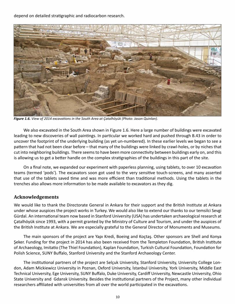
We also excavated in the South Area shown in Figure 1.6. Here a large number of buildings were excavated leading to new discoveries of wall paintings. In particular we worked hard and pushed through B.43 in order to uncover the footprint of the underlying building (as yet un-numbered). In these earlier levels we began to see a pattern that had not been clear before – that many of the buildings were linked by crawl-holes, or by niches that cut into neighboring buildings. There seems to have been more connectivity between buildings early on, and this is allowing us to get a better handle on the complex stratigraphies of the buildings in this part of the site.
On a final note, we expanded our experiment with paperless planning, using tablets, to over 10 excavation teams (termed ‘pods’). The excavators soon got used to the very sensitive touch-screens, and many asserted that use of the tablets saved time and was more efficient than traditional methods. Using the tablets in the trenches also allows more information to be made available to excavators as they dig.
AcknowledgementsWe would like to thank the Directorate General in Ankara for their support and the British Institute at Ankara under whose auspices the project works in Turkey. We would also like to extend our thanks to our temsilci Sevgi Gürdal. An international team now based in Stanford University (USA) has undertaken archaeological research at Çatalhöyük since 1993, with a permit granted by the Ministry of Culture and Tourism, and under the auspices of the British Institute at Ankara. We are especially grateful to the General Director of Monuments and Museums.
The main sponsors of the project are Yapı Kredi, Boeing and Koçtaş. Other sponsors are Shell and Konya Şeker. Funding for the project in 2014 has also been received from the Templeton Foundation, British Institute of Archaeology, Imitatio (The Thiel Foundation), Kaplan Foundation, Turkish Cultural Foundation, Foundation for Polish Science, SUNY Buffalo, Stanford University and the Stanford Archaeology Center.
The institutional partners of the project are Selçuk University, Stanford University, University College Lon-don, Adam Mickiewicz University in Poznan, Oxford University, İstanbul University, York University, Middle East Technical University, Ege University, SUNY Buffalo, Duke University, Cardiff University, Newcastle University, Ohio State University and Gdansk University. Besides the institutional partners of the Project, many other individual researchers affiliated with universities from all over the world participated in the excavations.
Figure 1.6. View of 2014 excavations in the South Area at Çatalhöyük (Photo: Jason Quinlan).
11
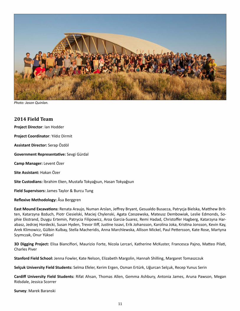
2014 Field TeamProject Director: Ian Hodder
Project Coordinator: Yıldız Dirmit
Assistant Director: Serap Özdöl
Government Representative: Sevgi Gürdal
Camp Manager: Levent Özer
Site Assistant: Hakan Özer
Site Custodians: İbrahim Eken, Mustafa Tokyağsun, Hasan Tokyağsun
Field Supervisors: James Taylor & Burcu Tung
Reflexive Methodology: Åsa Berggren
East Mound Excavations: Renata Araujo, Numan Arslan, Jeffrey Bryant, Gesualdo Busacca, Patrycja Bielska, Matthew Brit-ten, Katarzyna Bzduch, Piotr Ciesielski, Maciej Chylenski, Agata Czeszewska, Mateusz Dembowiak, Leslie Edmonds, So-phie Ekstrand, Duygu Ertemin, Patrycia Filipowicz, Aroa Garcia-Suarez, Remi Hadad, Christoffer Hagberg, Katarzyna Har-abasz, Jedrzej Hordecki, Susan Hyden, Trevor Iliff, Justine Issavi, Erik Johansson, Karolina Joka, Kristina Jonsson, Kevin Kay, Arek Klimowicz, Gülbin Kulbay, Stella Macheridis, Anna Marchlewska, Allison Mickel, Paul Pettersson, Kate Rose, Martyna Szymczak, Onur Yüksel
3D Digging Project: Elisa Biancifiori, Maurizio Forte, Nicola Lercari, Katherine McKuster, Francesca Pajno, Matteo Pilati, Charles Piver
Stanford Field School: Jenna Fowler, Kate Nelson, Elizabeth Margolin, Hannah Shilling, Margaret Tomaszczuk
Selçuk University Field Students: Selma Efeler, Kerim Ergen, Osman Ertürk, Uğurcan Selçuk, Recep Yunus Serin
Cardiff University Field Students: Rifat Ahsan, Thomas Allen, Gemma Ashbury, Antonia James, Aruna Pawson, Megan Ridsdale, Jessica Scorrer
Survey: Marek Baranski
Photo: Jason Quinlan.
12
GIS: Camilla Mazzucato
Conservation: Kiraz Akoğlu, Oliver Burton, Elif Çıplak, Christopher Cleere, Michelle Crepeau, Courtney Kemnitz, Laurie King, Ashley Lingle, Mehmet Mertek, Phil Parkes, Flavia Ravaioli, Jerrod Seifert
IT Systems: Ahmet Bozgeyik
Database Development: Claudia Engel
Image and Media: Marta Perlinska, Jason Quinlan
Illustration: Katy Killackey
Finds: Kyle Crosset, Lisa Guerre
Heavy Residue: Dragana Filipović, Jovana Tripković, Milena Vasić
Faunal Team: Andrew Cochrane, Julie Daujat, Arzu Demirergi, Hayley Foster, Emma Jenkins, Richard Madgwich, Jacqui Mulville, David Orton, Kathryn Twiss, Jesse Wolfhagen
Malacology: Daniella Bar-Yosef
Human Remains: Barbara Betz, Merve Ceylan, Bonnie Glencross, Scott Haddow, Claire Hodson, Christopher Knüsel, Cansu Kurt, Clark Larson, Marco Milella, Sophie Moore, Belinda Tibbets
Palaeoethnobotany: Amy Bogaard, Lara Gonzaléz Carretero, Mike Charles, Dragana Filipović, Dorian Fuller, Laura Green, Mikael Larsson, Amanda Leon, Elizabeth Stroud, Gregory Thoma, Hüseyin Yaşlı
Anthracology: Eleni Asouti, Ceren Kabukçu
Phytoliths: Juan Jose Garcia Granero Fos, Marco Madella
Chipped Stone: Tristan Carter, Davide D’Errico, Sean Doyle, Adam Nazaroff, Christina Lemoniri, Anda Petrovic
Ground Stone: Charlotte Spiering, Marketa Stovickova, Christina Tsoraki, Anne van Gijn, Mirjam van Saane
Pottery: Serap Özdöl, Duygu Tarkan
Figurines and Clay Objects: Lucy Bennison Chapman, Lindsay Der, Lynn Meskell, Carolyn Nakamura
Dating: Alex Bayliss
Site Visualization: Gözde Can, Angeliki Chrysanthi, Erica Emond, Andrew Henderson, Kerrie Hoffman, Ian Kirkpatrick, Gamze Meşe, Sara Perry, Özgür Can Uslu, Lucy Wheeler
West Mound Team: Peter Biehl, Jacob Brady, Hallvard Bruvoll, Caitlin Curtis, Ingmar Franz, Naumov Goce, Sonia Ostap-tchouk, Camile Pilliougine, Jana Rogasch, Ivana Stojanović, Elizabeth Stroud, Talu Emre Tüntaş, Alice Vinet, Patrick Willett
Archaeology Workshop: Cumhur Ertüzün, Tunc Ilada, Aydan Karademir, Gülay Sert, Hatice Tokyağsun
House Staff: Mehmet Altınay, Gülsüm Eken, Nevriye Şener, Mavili Tokyağsun, Keziban Sivas
Site Workers: Hasan Akçay, Mustafa Akyurt, İsa Bilgiç, İsmail Bülüç, Mahmut Çelik, Haşim Ferahkaya, Orhan Kuşçuoğlu, Muhammet Söken, Hasan Yaşlı, Hüseyin Yaşlı, Metin Yaşlı, MustafaYaşlı, Osman Yaşlı, Lokman Yaşlı
Residue Sorters: Hatice Çelik, Şenay Yasli, Hatice Tokyağsun
13
Chapter 2
Excavations in the North Area
Burcu Tung, University of California, Merced
This season work at the northern areas of the mound focused on 10 separate buildings and spaces and one trench within and immediately outside of the northern shelter (see Figure 1.3 in Introduction). The excavation team within the North Shelter comprised of an international team of 29 excavators and students. Much of the work of this season focused on continuing excavations from previous years (B.52, B.77, B. 102, B.108, B.114, B.119). Excavations that were initiated in 2012 but given a break in 2013 were continued in three areas (B.113, B.128, Sp.99). Finally, this season saw the commencement of work within two completely new areas (the B.129 and B.131 sequence and GT4). Below is a summary of this year’s findings.
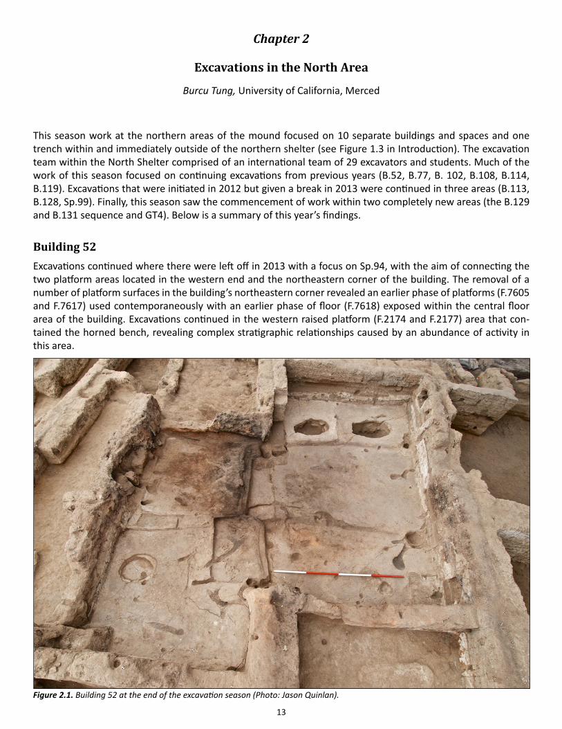
Building 52Excavations continued where there were left off in 2013 with a focus on Sp.94, with the aim of connecting the two platform areas located in the western end and the northeastern corner of the building. The removal of a number of platform surfaces in the building’s northeastern corner revealed an earlier phase of platforms (F.7605 and F.7617) used contemporaneously with an earlier phase of floor (F.7618) exposed within the central floor area of the building. Excavations continued in the western raised platform (F.2174 and F.2177) area that con-tained the horned bench, revealing complex stratigraphic relationships caused by an abundance of activity in this area.
Figure 2.1. Building 52 at the end of the excavation season (Photo: Jason Quinlan).
14
The excavations this season revealed in an earlier phases of use of B.52, although the eastern and western section of the building, as it is currently exposed is not in phase (Figure 2.1). The eastern end of Sp.94 is repre-sented by the northern platforms and the central and southern floor areas. While the configuration is similar to the later use of the building, there are some changes in the size of the platforms as well as the extent of the cen-tral floor area, which is not entirely exposed. The southern floor area no longer has a fire installation associated with it. The raised western end represents a slightly later phase in occupation, particularly the northwestern cor-ner. Here we see that the southern platform contains no benches and is connected to the southern space with a large step-like feature that appears to cut an earlier wall, possibly belonging to the western predecessor of B.52. Next season excavations will focus on bringing the entire building to phase with an emphasis on the excavation of the building’s side rooms and the raised western area. Below is a more detailed overview of the three areas of excavation within Sp.94.
The northern platformsLocated in the northeastern corner of the northern end of Sp.94, platform F.7605 at 1.3m length and 1.6m width is larger than its predecessor of platform F.3695. The final floor of use, (21313) remains in situ. Abutting F.7605 to the west is platform F.7617, the predecessor of platform F.3694. At 1.1m wide and 1.1m long it is much small-er than its successor. Its final use surface, (21389), also remains in situ. These surfaces are contemporary with surface (21390) immediately to the south (see below).
Before the remodeling of this northern area, burial F.7606 was placed within platform F.7605. Partially truncated by later burial F.7120, F.7606 contained the re-mains of a primary young adult Sk(21526), buried in a flexed po-sition on its left side facing the north with its feet to the east. The cranium and mandible of the in-dividual was missing, although it was matched later in the lab with the cranium and manbidble found within a later burial (F.7112) with-in the successor platform F.3695 (see Human Remains chapter Figure 5.2). The semi-articulated remains of a juvenile found with-in the fill (21525) matched with Sk(30521) which was excavated
from burial F.7120 in 2013. The fill of the burial contained some flakes of obsidian, fragments of shell and a small flint flake. Some organic orange residue was found underneath the remains of the juvenile that were sampled during excavation.
F.7606 can be viewed “as a termination event for platform 7605 and a foundation event for platform F.3695” (RH, 27/7) as it was sealed by (30532) which was a thick (0.15m) make-up layer made from light brown silty clay make-up, damaged from the building’s conflagration in places covering an area of 1.3m2 area. This in turn was sealed by (30516) which comprised of a number of finely layered plastered surfaces excavated as a single unit. This unit represents the earliest occupation of platform F.3695.
The earliest surface of neighboring platform F.7617 was sealed by (21312), a composite unit comprised of a very thick foundational make-up similar to (30532). This foundational make-up defined platform F.3694, and
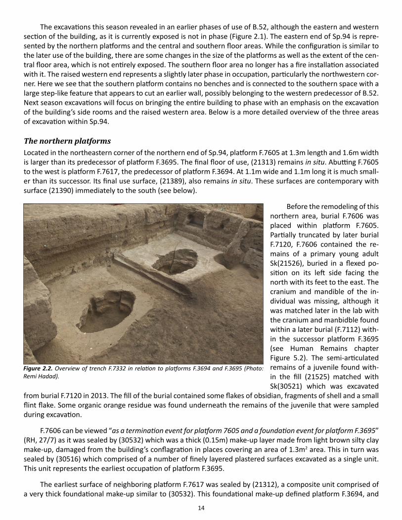
Figure 2.2. Overview of trench F.7332 in relation to platforms F.3694 and F.3695 (Photo: Remi Hadad).
15
was covered with a multiple fine plastered surfaces, the final one painted red. The red surface was sealed by a number fine plastered floors excavated as (30528), whose final plastering event had red painting on it. These units covered an area of 1.2m2.
It is unclear which of the neighboring platforms was built first as platform F.3694’s eastern and southern edges were cut by trench F.7332 (21124 cut, 21125 fill) destroying the constructional relationship between the platforms. F.7332 was a 0.3m trench that essentially outlined the eastern and southern edges of platform F.3694. The cut for the trench 0.2m deep, and was filled by brown silty clay fill that contained plaster bits within its ma-trix. No artifacts or rubble of any sort were within the fill to point the function of the trench. It may be remain-ing evidence of the removal of an architectural element. It may have also been an attempt to build a partition around platform F.3694, which was later abandoned. The trench was sealed by plastered floored, excavated as a part of (21120) which represents two consecutive plastering events and their respective make-ups.
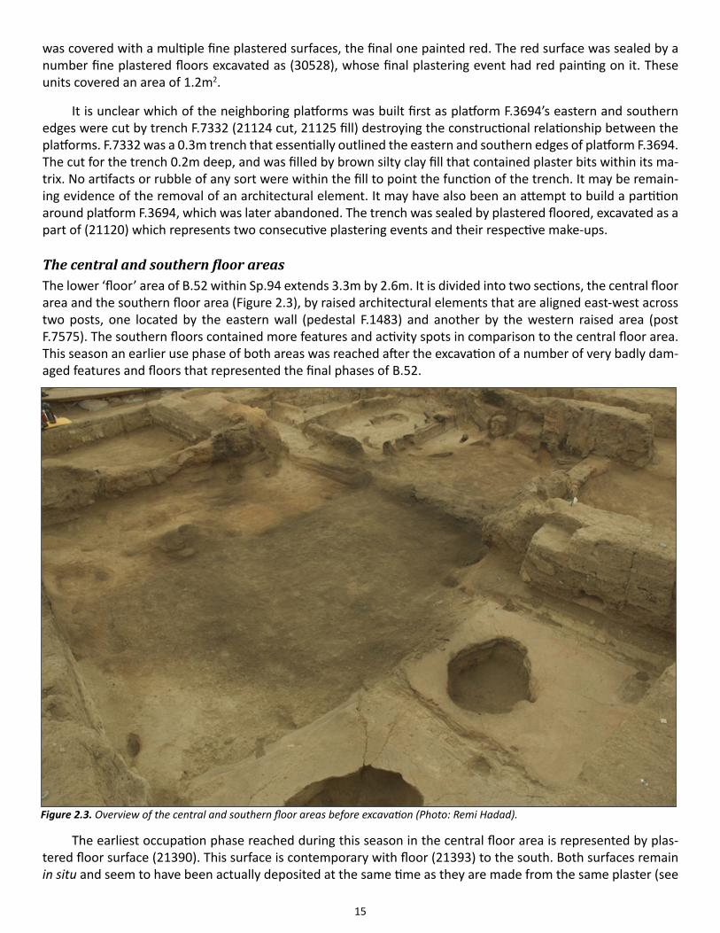
The central and southern floor areasThe lower ‘floor’ area of B.52 within Sp.94 extends 3.3m by 2.6m. It is divided into two sections, the central floor area and the southern floor area (Figure 2.3), by raised architectural elements that are aligned east-west across two posts, one located by the eastern wall (pedestal F.1483) and another by the western raised area (post F.7575). The southern floors contained more features and activity spots in comparison to the central floor area. This season an earlier use phase of both areas was reached after the excavation of a number of very badly dam-aged features and floors that represented the final phases of B.52.
The earliest occupation phase reached during this season in the central floor area is represented by plas-tered floor surface (21390). This surface is contemporary with floor (21393) to the south. Both surfaces remain in situ and seem to have been actually deposited at the same time as they are made from the same plaster (see
Figure 2.3. Overview of the central and southern floor areas before excavation (Photo: Remi Hadad).
16
Figure 2.1). Both floors were sealed with (30539), a composite unit comprised of a thick sandy clay make-up and an eroded plaster surface. This unit was contemporary with platforms F.3694 and F.3695. The deposit was badly damaged by the fire that caused the abandonment of the house. It was in rather bad condition during the time of excavation as it had been exposed to elements for over eight years. (30539) has not been entirely excavated this season as the deposit runs beneath platform F.2174 at the western end of Sp.94. Many features identified above this floor in 2006 were barely recognizable due to general erosion, and were all excavated this season. A number of new features were also identified.
Post F.7575 located centrally within Sp.94 was cut into make-up (30539). The post itself, (21320), which was retrieved completely carbonized, was a small post, 0.08m in diameter. Its shallow cut, (21319), indicates that the post was not used to bare weight, but may have been a space differentiating feature. In the same alignment of post F.7575 was kerb F.1582 identified in 2006. Very little of this feature remained intact and was excavated as unit (21321), comprised of “3-4 remaining layers of highly scorched plaster covering a thin layer of make up ma-terial” (RH, 2012). Immediately to the southeast of the kerb was the remnant of pedestal F.1483, (21326), which did not show any structure. The remnants of the ladder base, F.1484, were excavated as (21327).
The excavation of the badly damaged hearth F.1482, ((21384) cut, (21329) arbitrary layer), revealed a small scoop, F.7588, filled with ash and quite a bit of animal bone. F.7588 may have been a foundational deposit for hearth F.1482. During the use of the hearth, five other scoops were deposited immediately around it (F.7585, F.7586, F.7589, F.7596 and F.7597). These scoops contained charcoal and ash, and less bone than those found in scoop F.7588. Some of these scoops were actually sealed by floor (21311), which represent very badly eroded floors most likely associated with the final use of B.52. As such, they are contemporary with the floating plas-tered floors excavated in the central floor area excavated as (21310).
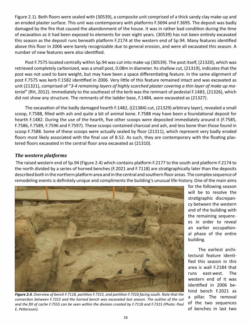
The western platforms The raised western end of Sp.94 (Figure 2.4) which contains platform F.2177 to the south and platform F.2174 to the north divided by a series of horned benches (F.2021 and F.7118) are stratigraphically later than the deposits described both in the northern platform area and in the central and southern floor areas. The complex sequence of remodeling events is definitely unique and compliments the building’s unusual life-history. One of the main aims
for the following season will be to resolve the stratigraphic discrepan-cy between the western and of the building with the remaining sequenc-es in order to reveal an earlier occupation-al phase of the entire building.
The earliest archi-tectural feature identi-fied this season in this area is wall F.2184 that runs east-west. The western end of it was identified in 2006 be-hind bench F.2021 as a pillar. The removal of the two sequences of benches in last two
Figure 2.4. Overview of bench F.7118, partition F.7315, and partition F.7316 facing south. Note that the connection between F.7315 and the horned bench was excavated last season. The outline of the cut and the fill of cache F.7555 can be seen within the division created by F.7118 and F.7315 (Photo: Paul E. Pettersson).
17
years has revealed that F.2184 is actually an internal wall that may have extended to meet F.2013. Both walls were truncated to form the raised platform area. In fact, the truncation may have been implemented to form step F.7642.
Platform/floor F.7637 abuts the southern, while platform/floor F.7638 abuts the northern face of wall F.2184. The top-most layer of the southern platform was excavated as (21392) revealing another plastered sur-face (21396) that remains in situ. Horned bench F.7118 was constructed above (21392) and the wall F.2184. The feature, completely excavated this season, revealed at least six pairs of wild sheep and one pair of wild goat horns. The horns were stacked at the beginning of the bench where room permitted – possibly for the first three pairs. The wild goat horn pair was the third pair in the row, located at the bottom. The bench was constructed with a clay core (30501) to which all the horns were attached. It was then plastered over a number of times (21383), and saw a number of repairs ((21382), (21389)).
The bench stood by itself in this area for some time, evidenced by continuous floor and make-up deposit (30519). A number of partition elements, however, were soon added and joined with bench F.7118 to clearly delineate very specific divisions of space. A partition wall extending 0.6m was attached to wall F.2012 creating feature F.7316. Then, L-shaped partition wall F.7315 was constructed and joined with the tip of bench F.7118 to create a square partitioned area above platform F.2177. These features were then joined with the addition of F.7554. At this point the southwestern corner space delineated by partition F.7316 and F.7315 was filled with a heterogeneous deposit, (21112) that contained a lot of rubble within. The skeleton (30531) of a juvenile that was placed on its right, facing the north with its feet to the south that was excavated with arbitrary fill (30530) was actually placed in this area before the infilling process took place and therefore does not have a cut associated with it.
A similar filling event took place in the partition area joined by features F.7118 and F.7315. This deposit was excavated in 2012. Before the filling took place, it appears that a cache was removed from this area of the building, identified as F.7555. The feature’s fill (30536) contained no discernible artifacts. The empty circular pit while thought to have been a burial cut before its excavation may actually been formed through two separate events, a cut made first for the placement of a cache and a cut made for the retrieval of the cache, the former event having been truncated by the latter.
Building 77 This season, all of the remaining walls of B.77 and its final occupation phase were removed to uncover its prede-cessor, B.132. During the excavations of the final occupation phase of the building, two infant burials from the eastern platform, two adult and one infant burial from the northeastern platform, and four infant and juvenile burials from the north central platform were excavated. The burials did not contain any finds although all of the infants and juveniles had some evidence of cord binding and two were buried within baskets that were badly preserved. Next year, excavations will begin within B.132, the predecessor of B.77.
Building 132Building 132 is the predecessor of Building 77. It is one of the largest buildings uncovered at Neolithic Çatal-höyük: Two buildings, B.108 and B.77, were built above the entire space B.132 covered (Figure 2.5). With its massive walls (about 0.6m wide) not typical to the buildings that were constructed in the mid and early occupa-tion sequences of the mound to which this building belongs to, B.132 can be considered unique.
The building consists of main room, Sp.531 to the north and side room, Sp.511 to the south. The entirety of the main space, Sp.531, was exposed at the end of the season, and is defined by wall F.7584 ((22070) brick, (22071) mortar) to the north, wall F.7149 to the east ((19552) brick, (19553) mortar), partition wall F.3679 to the south ((30143) brick, (30144) mortar) and wall F.7346 to the west ((22029) brick, (22030) mortar). This main space measures 5.7m north-south and 6.3m east west. Side room Sp.511 was exposed in 2013 only partially,
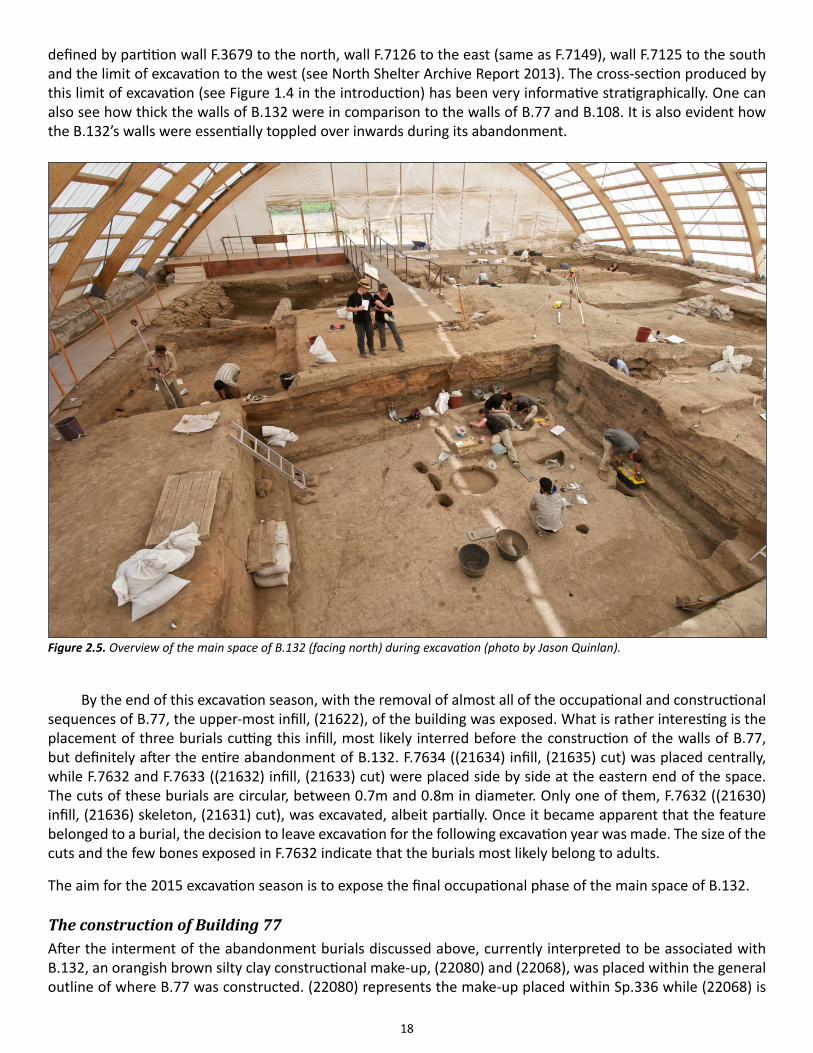
18
defined by partition wall F.3679 to the north, wall F.7126 to the east (same as F.7149), wall F.7125 to the south and the limit of excavation to the west (see North Shelter Archive Report 2013). The cross-section produced by this limit of excavation (see Figure 1.4 in the introduction) has been very informative stratigraphically. One can also see how thick the walls of B.132 were in comparison to the walls of B.77 and B.108. It is also evident how the B.132’s walls were essentially toppled over inwards during its abandonment.
By the end of this excavation season, with the removal of almost all of the occupational and constructional sequences of B.77, the upper-most infill, (21622), of the building was exposed. What is rather interesting is the placement of three burials cutting this infill, most likely interred before the construction of the walls of B.77, but definitely after the entire abandonment of B.132. F.7634 ((21634) infill, (21635) cut) was placed centrally, while F.7632 and F.7633 ((21632) infill, (21633) cut) were placed side by side at the eastern end of the space. The cuts of these burials are circular, between 0.7m and 0.8m in diameter. Only one of them, F.7632 ((21630) infill, (21636) skeleton, (21631) cut), was excavated, albeit partially. Once it became apparent that the feature belonged to a burial, the decision to leave excavation for the following excavation year was made. The size of the cuts and the few bones exposed in F.7632 indicate that the burials most likely belong to adults.
The aim for the 2015 excavation season is to expose the final occupational phase of the main space of B.132.
The construction of Building 77After the interment of the abandonment burials discussed above, currently interpreted to be associated with B.132, an orangish brown silty clay constructional make-up, (22080) and (22068), was placed within the general outline of where B.77 was constructed. (22080) represents the make-up placed within Sp.336 while (22068) is
Figure 2.5. Overview of the main space of B.132 (facing north) during excavation (photo by Jason Quinlan).
19
the make-up placed in Sp.337. These deposits were used as leveling deposits. A small section of (22080) - the northeastern corner - remains in situ, covered by an “island” of burials left unexcavated due to time constraints in the 2014 excavation season. A number of activities, associated with the foundation of the building were iden-tified this season to have taken place immediately after the deposition of (22080).
Foundational burialsOnce the outline of B.77 was made the leveling deposit, at least four foundational burials were interred to the northern section of the building’s space, where the north-central platform, F.6062 would eventually be placed. The earliest of these burials belong to an adult, and remains to be excavated.
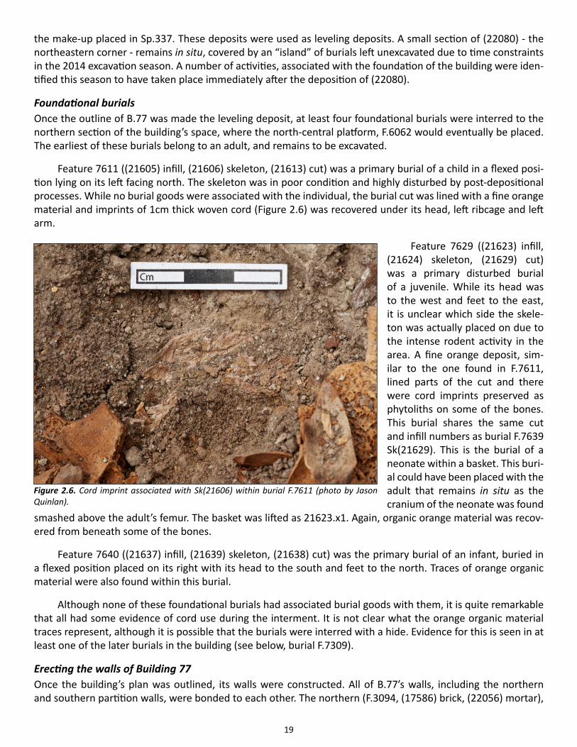
Feature 7611 ((21605) infill, (21606) skeleton, (21613) cut) was a primary burial of a child in a flexed posi-tion lying on its left facing north. The skeleton was in poor condition and highly disturbed by post-depositional processes. While no burial goods were associated with the individual, the burial cut was lined with a fine orange material and imprints of 1cm thick woven cord (Figure 2.6) was recovered under its head, left ribcage and left arm.
Feature 7629 ((21623) infill, (21624) skeleton, (21629) cut) was a primary disturbed burial of a juvenile. While its head was to the west and feet to the east, it is unclear which side the skele-ton was actually placed on due to the intense rodent activity in the area. A fine orange deposit, sim-ilar to the one found in F.7611, lined parts of the cut and there were cord imprints preserved as phytoliths on some of the bones. This burial shares the same cut and infill numbers as burial F.7639 Sk(21629). This is the burial of a neonate within a basket. This buri-al could have been placed with the adult that remains in situ as the cranium of the neonate was found
smashed above the adult’s femur. The basket was lifted as 21623.x1. Again, organic orange material was recov-ered from beneath some of the bones.
Feature 7640 ((21637) infill, (21639) skeleton, (21638) cut) was the primary burial of an infant, buried in a flexed position placed on its right with its head to the south and feet to the north. Traces of orange organic material were also found within this burial.
Although none of these foundational burials had associated burial goods with them, it is quite remarkable that all had some evidence of cord use during the interment. It is not clear what the orange organic material traces represent, although it is possible that the burials were interred with a hide. Evidence for this is seen in at least one of the later burials in the building (see below, burial F.7309).
Erecting the walls of Building 77Once the building’s plan was outlined, its walls were constructed. All of B.77’s walls, including the northern and southern partition walls, were bonded to each other. The northern (F.3094, (17586) brick, (22056) mortar),
Figure 2.6. Cord imprint associated with Sk(21606) within burial F.7611 (photo by Jason Quinlan).
20
eastern (F. 3095, (19552) brick, (19553) mortar) and western walls (F.3097, (22039) brick, (22040) mortar) of the building were immediately constructed above the walls of B.132. The southern wall (F.3096, F.7301) however, was placed around 1.7m to 1.5m further northward from the partition wall of B.132. To add more stability to the southern wall, the builders actually set the entire wall within a foundation trench. Similarly, the northern (F.3098) and southern (F.3099) partition walls were placed within small foundation trenches. The bonded walls and the use of foundation trenches for those walls not supported by B.132’s walls indicate that the building’s plan and possible constructional instabilities were premeditated before its construction.
The conflagration that caused the abandonment of B.77 had highly damaged the walls in both if its spaces. All of the walls show intense evidence of burning, and only in a few areas were some undamaged bricks and mortar, mostly at the bottom most layers of the southern wall. As such all of the walls show a medley of coloring for the brick and mortar, ranging from bright reddish brown to black. Despite the changes in color caused by the burning, it is clear that all of the walls, with the exception of the central eastern section of the southern wall (see discussion below), were constructed from the same mud brick and mortar. The mud brick was made from a fine sandy clay orangish-brown alluvial sediment with the inclusion of quite a bit of plant-based temper. It was shaped into pieces about 0.85m to 0.90m long, 0.30m wide and 0.10m thick, the most common brick size seen on site. The mortar used for the building, on the other hand was clay-rich clean sediment that revealed its blocky structure after the baking caused by the fire.
As mentioned above, the southern wall was placed within a foundation trench. The cut (22076) of foun-dation trench F.7591 extended 6.5m east-west, was approximately 1.3m wide and 0.3m deep. Once dug, it was filled by two courses of brick and a silty clay mortar, excavated as unit (22088). The foundation trench was then filled with (22099), which was a heterogeneous deposit comprised of crushed bricks and plaster. Then, southern wall F.7301 ((30149) brick, (30150) mortar) was constructed.
Feature 7590, is the foundation trench for the northern partition wall. The cut (22074) for the trench, ex-tending 1.7m, is actually shorter than the recorded extent of the wall itself by about 0.5m. This cut was sealed at its northern end with a clay-rich sediment, (22081), that acted as a stabilizer. This was in turn sealed with sandy clay loam (22073) that covered the entire foundation trench, before the construction of the wall. The southern partition wall’s foundation trench, F.7598 was about the same size as the southern partition wall itself. It was filled with (22082), a sandy loam deposit that was friable, to which on top the partition wall was built on.
A small circular posthole 0.16m in diameter, F.7592, was placed at the corner of the western face of parti-tion wall F.3099. The shallow cut, (22078), cut the foundation deposits and its fill, (22077), did not contain any artifacts. Nevertheless the feature may represent an architectural element related to the passageway between the two rooms.
The placement of structural timbersOnce the walls were constructed, the structural timbers of the building were placed. Three posts placed, one after the other in a north-south alignment, about 0.7m to 0.8m east of the northern partition wall F.3098. The southern-most of these was F.7595 ((17540) timber, (19594) cut), followed by F.7594 ((17543) timber, (19592) cut), followed by F.7593 ((17541) timber, (19599) cut). These timbers were incorporated into various features located in this area, the most impressive one being F.6050 – a massive partitioned area with high walls used at the latest occupation phase of the building.
Another post, F.6069 ((17542) timber, (19296) packing, (20600) cut) was placed almost in the same north-south alignment of the posts described above, abutting the northern wall F.3094. The cut of this post, as with the other two posts that abutted the walls of the building (see below) contained a dense clay rich packing material, (19296), that was wedged in behind the post while still moist.
Two posts were placed abutting the eastern wall. Post F.6055 ((17537) timber, (21610) packing, (21609) cut) formed southern corner of platform F.6055. The cut for the post was thin and oval and the dense packing
21
was used at the bottom of the cut behind the timber. In contrast, post F.6065 ((17538) timber, (21621) packing, (20600) cut) had a packing material that surrounded the entire cut, clearly placed in after the timber was posi-tioned. This eventually formed the southern boundary of eastern platform F.6056.
Other activities During the construction of the walls other activities took place within Sp.336 by the southern wall. Five small activity pits and a fire spot were excavated. F.7622 ((21617) infill, (21618) cut) was a small scoop of burnt plant material, about 0.23m in diameter and only 0.03m thick. This little scoop was actually cut by another small pit 0.20m in diameter, F.7623 ((21619) fill, (21620) cut), which was most likely a posthole evident by its depth of 0.30m. Both of these features were in turn sealed by a firespot (22092), which was irregular in shape about 0.55m in diameter. The fire spot was a shallow depositional event with an abundance of charcoal within its sandy and ashy dark gray matrix. It may be associated with a third small pit, identified as scoop, found immediately to its east, F.7602 ((22097) infill, (22098) cut), cutting the primary make-up of the space, (22080). This scoop was 0.14m in diameter and relatively shallow, as though it was cut to hold a pot.
Two other small pits were found nearby, within the boundaries of the southern wall’s foundation trench. F.7601 ((22095) fill, (22096) cut) cut the infill of the foundation trench deposit (22075). A small (0.2m diameter) and shallow pit with a charcoal-rich infill, it has been interpreted to be associated with cooking / burning activ-ities. After it was filled, it was cut by another small pit, F.7600 ((22093) infill, (22094) cut). This too was a small scoop-like pit.
To summarize, there were four scoop-like deposits associated with small-scale cooking/burning activities, one post-hole and a firespot at the southern end of the building. The location of these activities and their asso-ciation with burning/cooking is consistent with the use of space at Çatalhöyük in general, the southern end of buildings being associated with domestic activities. What is interesting is the consistency of the Neolithic build-ers in using this section of a house still under construction for such activities.
Once the northern wall was erected, niche F.6067 (21612 cut) was cut centrally into the wall by northeast-ern platform F.6051. At the same time lateral post F.6068 (17569 timber, 21608 cut) was placed centrally above the northeastern platform, cutting through the eastern wall.
Once the walls were erected and the timbers were set in place, the entirety of Sp.336 was sealed by orang-ish brown lluvial make-up, (22084). It is above this make-up that the main architectural features and divisions were placed within the building.
The arrangement of Space 336The overall layout of Sp.336 could be considered to be pre-determined as its organization shows very little change from its inception. The building was delineated into six general areas: The northwestern quadrant of the space was distinguished by multiple bin/basin-like structures that would eventually form a massive partitioned area supported by the timbers. The northern wall was flanked by two platforms that denoted two separate areas, the lower central platform F.6062/F.3617 and the higher northeastern platform F.6051. The eastern end of the space was distinguished by yet another platform, F.6052 that was flanked on each side by engaged pillars. The entire southern end of the space can also be distinguished as a separate activity area, as can the central floors.
Northeastern platform F.6051The northeastern platform F.6051 was the first platform to be shaped in the space. Its initial makeup (22091) abutting the northern wall, was contained to the west and south with the use of planks. The eastern edge of the deposit actually abutted the remaining stump of the eastern wall of B.132. This layer was sealed by (22079) which was laid out in the same fashion. The make-up and B.132’s eastern wall was then sealed by the earliest plastered floors of the platform.
22
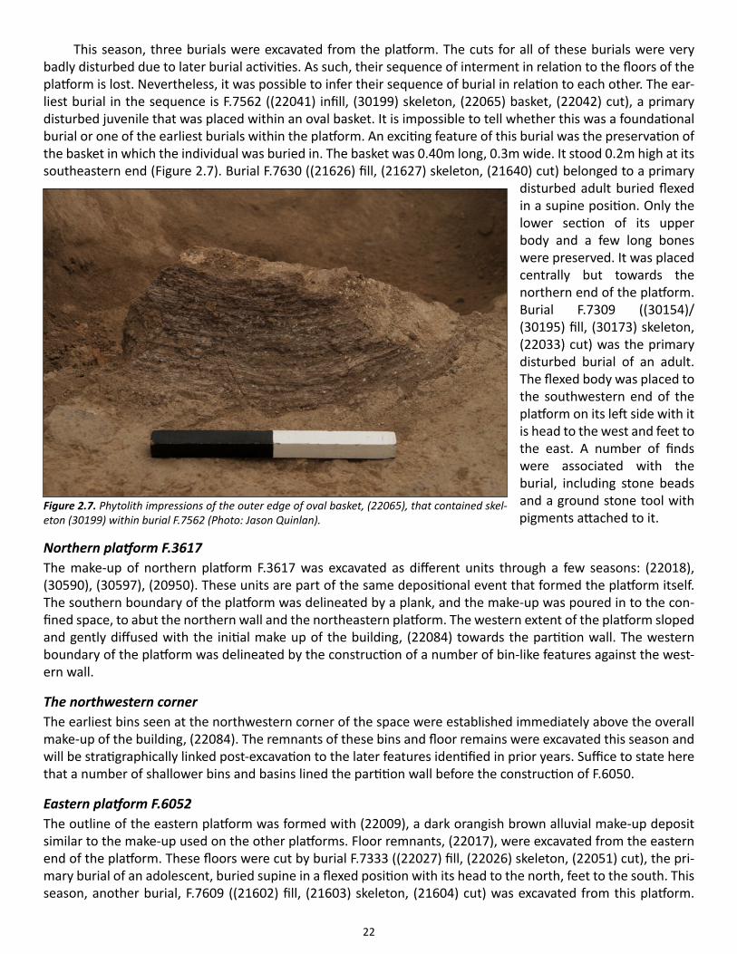
This season, three burials were excavated from the platform. The cuts for all of these burials were very badly disturbed due to later burial activities. As such, their sequence of interment in relation to the floors of the platform is lost. Nevertheless, it was possible to infer their sequence of burial in relation to each other. The ear-liest burial in the sequence is F.7562 ((22041) infill, (30199) skeleton, (22065) basket, (22042) cut), a primary disturbed juvenile that was placed within an oval basket. It is impossible to tell whether this was a foundational burial or one of the earliest burials within the platform. An exciting feature of this burial was the preservation of the basket in which the individual was buried in. The basket was 0.40m long, 0.3m wide. It stood 0.2m high at its southeastern end (Figure 2.7). Burial F.7630 ((21626) fill, (21627) skeleton, (21640) cut) belonged to a primary
disturbed adult buried flexed in a supine position. Only the lower section of its upper body and a few long bones were preserved. It was placed centrally but towards the northern end of the platform. Burial F.7309 ((30154)/(30195) fill, (30173) skeleton, (22033) cut) was the primary disturbed burial of an adult. The flexed body was placed to the southwestern end of the platform on its left side with it is head to the west and feet to the east. A number of finds were associated with the burial, including stone beads and a ground stone tool with pigments attached to it.
Northern platform F.3617The make-up of northern platform F.3617 was excavated as different units through a few seasons: (22018), (30590), (30597), (20950). These units are part of the same depositional event that formed the platform itself. The southern boundary of the platform was delineated by a plank, and the make-up was poured in to the con-fined space, to abut the northern wall and the northeastern platform. The western extent of the platform sloped and gently diffused with the initial make up of the building, (22084) towards the partition wall. The western boundary of the platform was delineated by the construction of a number of bin-like features against the west-ern wall.
The northwestern cornerThe earliest bins seen at the northwestern corner of the space were established immediately above the overall make-up of the building, (22084). The remnants of these bins and floor remains were excavated this season and will be stratigraphically linked post-excavation to the later features identified in prior years. Suffice to state here that a number of shallower bins and basins lined the partition wall before the construction of F.6050.
Eastern platform F.6052The outline of the eastern platform was formed with (22009), a dark orangish brown alluvial make-up deposit similar to the make-up used on the other platforms. Floor remnants, (22017), were excavated from the eastern end of the platform. These floors were cut by burial F.7333 ((22027) fill, (22026) skeleton, (22051) cut), the pri-mary burial of an adolescent, buried supine in a flexed position with its head to the north, feet to the south. This season, another burial, F.7609 ((21602) fill, (21603) skeleton, (21604) cut) was excavated from this platform.
Figure 2.7. Phytolith impressions of the outer edge of oval basket, (22065), that contained skel-eton (30199) within burial F.7562 (Photo: Jason Quinlan).
23
Placed centrally, it was difficult to understand this burial’s stratigraphic relationship with them platform itself. The primary burial belonged to an infant that was buried tightly flexed on its left with its head to the west, feet to the east. The burial contained evidence for cord use in the binding of the individual. Some of the bones rested upon a soft dark brown organic material that was initially identified as fur. This would mean that the infant was buried in a hide pouch, its body resting upon the fur.
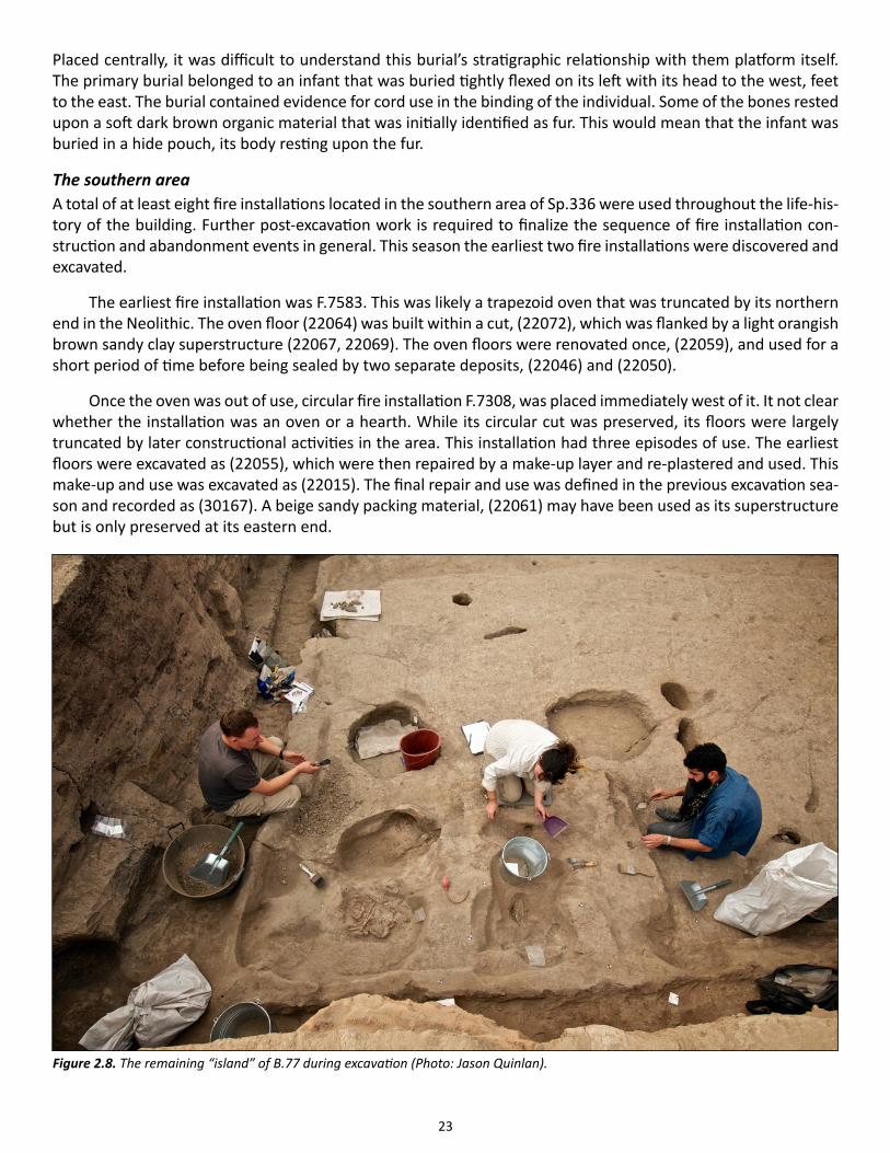
The southern areaA total of at least eight fire installations located in the southern area of Sp.336 were used throughout the life-his-tory of the building. Further post-excavation work is required to finalize the sequence of fire installation con-struction and abandonment events in general. This season the earliest two fire installations were discovered and excavated.
The earliest fire installation was F.7583. This was likely a trapezoid oven that was truncated by its northern end in the Neolithic. The oven floor (22064) was built within a cut, (22072), which was flanked by a light orangish brown sandy clay superstructure (22067, 22069). The oven floors were renovated once, (22059), and used for a short period of time before being sealed by two separate deposits, (22046) and (22050).
Once the oven was out of use, circular fire installation F.7308, was placed immediately west of it. It not clear whether the installation was an oven or a hearth. While its circular cut was preserved, its floors were largely truncated by later constructional activities in the area. This installation had three episodes of use. The earliest floors were excavated as (22055), which were then repaired by a make-up layer and re-plastered and used. This make-up and use was excavated as (22015). The final repair and use was defined in the previous excavation sea-son and recorded as (30167). A beige sandy packing material, (22061) may have been used as its superstructure but is only preserved at its eastern end.
Figure 2.8. The remaining “island” of B.77 during excavation (Photo: Jason Quinlan).
24
A small shallow pit, F.7564, measuring 0.27 by 0.22m, cut the earliest floors (22024) remaining in the south-western corner of space 336. Its fill, (22036) contained the partial articulated skeleton of a lamb. The pit seems to represent a symbolic offering.
Closing remarks on Building 77A small ‘island’ of the building remains to be excavated in the following season. This island represents the north-eastern corner of the space where many burials have been recorded (Figure 2.8).
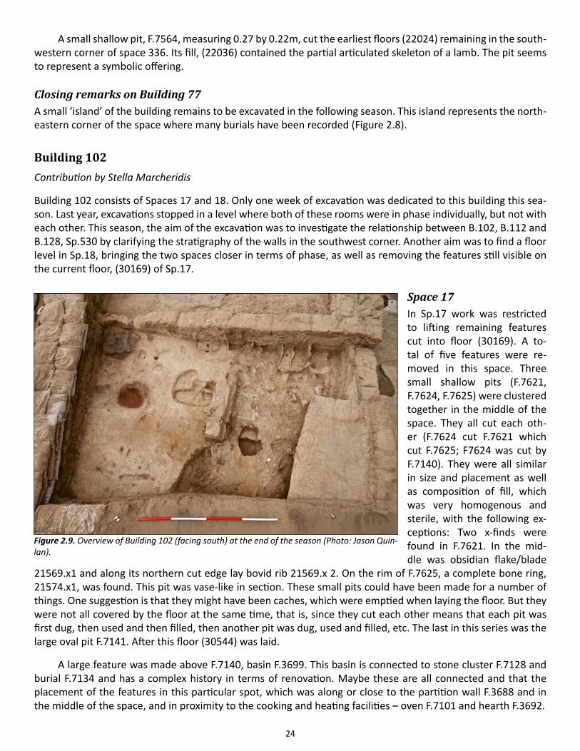
Building 102Contribution by Stella Marcheridis
Building 102 consists of Spaces 17 and 18. Only one week of excavation was dedicated to this building this sea-son. Last year, excavations stopped in a level where both of these rooms were in phase individually, but not with each other. This season, the aim of the excavation was to investigate the relationship between B.102, B.112 and B.128, Sp.530 by clarifying the stratigraphy of the walls in the southwest corner. Another aim was to find a floor level in Sp.18, bringing the two spaces closer in terms of phase, as well as removing the features still visible on the current floor, (30169) of Sp.17.
Space 17In Sp.17 work was restricted to lifting remaining features cut into floor (30169). A to-tal of five features were re-moved in this space. Three small shallow pits (F.7621, F.7624, F.7625) were clustered together in the middle of the space. They all cut each oth-er (F.7624 cut F.7621 which cut F.7625; F7624 was cut by F.7140). They were all similar in size and placement as well as composition of fill, which was very homogenous and sterile, with the following ex-ceptions: Two x-finds were found in F.7621. In the mid-dle was obsidian flake/blade
21569.x1 and along its northern cut edge lay bovid rib 21569.x 2. On the rim of F.7625, a complete bone ring, 21574.x1, was found. This pit was vase-like in section. These small pits could have been made for a number of things. One suggestion is that they might have been caches, which were emptied when laying the floor. But they were not all covered by the floor at the same time, that is, since they cut each other means that each pit was first dug, then used and then filled, then another pit was dug, used and filled, etc. The last in this series was the large oval pit F.7141. After this floor (30544) was laid.
A large feature was made above F.7140, basin F.3699. This basin is connected to stone cluster F.7128 and burial F.7134 and has a complex history in terms of renovation. Maybe these are all connected and that the placement of the features in this particular spot, which was along or close to the partition wall F.3688 and in the middle of the space, and in proximity to the cooking and heating facilities – oven F.7101 and hearth F.3692.
Figure 2.9. Overview of Building 102 (facing south) at the end of the season (Photo: Jason Quin-lan).
25
Another pit that was excavated this season was is F.7628, located in the middle of Sp.17, which was a small oval shallow pit. It contained four units. The first fill (21590) was sealed by a pure plaster, (21589). On it were a few fragments of human bone were deriving from a child. As such the pit is currently interpreted as a bone cache, where the bones had been retrieved before laying the plaster. The cut was uneven and had been leveled by (21590). It was dug in the floor (30161). Immediately to its southeast was burial F.7626, which was actually sealed by (30161). The burial was excavated out of sequence as bones were popping up and the risk of trampling and its subsequent destruction was too high. It was a burial of a perinatal individual, with the head to the south, tightly squeezed in a small pit (0.27x0.21m). It was lying on its right side, arms flexed with hands beneath its cranium as if resting. The left leg was flexed, but the right was flexed backwards. It was located immediately west of oven F.7305, which remains in situ, immediately below oven F.7101 that was removed last year. F.7626 cuts another fill, (22133), probably of another burial, that remains to be excavated the following year.
Space 18Excavations in Sp.18 began with the removal of packing layer (30139) which covered almost all of the space. It was, compared to the general find-richness of the space, not rich in finds. It was composite deposit containing clay and plaster inclusions. It should be considered as an accumulation of packing to the subsequent laying of floor or matting excavated as (30953) in 2013. The underlying layer was (30161), a phytolith-rich floor covering all Sp.18, remains in situ. Last year part of 30161 was visible only in the north part. It was sloping from the south and the “threshold” between F.3688 (partition wall) and F.3655 (southern outer wall). A number of finds were recorded in situ as 30161.x1-x6, ranging from ground stone, bone, to pottery.
We continued work on the bin F.3698 attached to the partition wall F.3688. We removed its walls, (20923), which revealed the initial construction of the bin. From the beginning it was built with three separate walls (22118, 22129, 22102). (22102) is the western wall, and was attached last. The western and northern had been repaired with (22103), a make-up.
Work continued on bin F.7116, which is the latest of the now visible bins. It has not been removed fully. F.7116 was very elaborate with a subdivision consisting of a mini-basin (20954 plaster, 22116 make-up) and shelf ((21598) plaster, (21599) make-up). Under these layers was a make-up/leveling layer, (22119). The subdivision might have been created from the start when building the bin, since it seems that the internal wall, (22124) ac-tually belongs to an older bin that remains in situ. In that case they flattened out the older bin’s fill with (22119) and constructed a make up for first laying the basin and then the shelf.
The southwest corner of the space was investigated more thoroughly in terms of the walls. It has been very unclear because of prehistoric wall collapse (20977) and truncation in 2012 which cut a large part of F.7627. The top of F.3672 which was the east wall of B.112 was removed to further clarify the relations. At one point it seems that F.3653 together with F.7599 in Sp.530 was a longer wall constituting the western limit of an older building below B102 and Sp.530. This longer wall was cut creating F.3653 in Sp.17. Either contemporary with or subsequent to the truncation, a dog-legged wall, F.3652 was constructed. Then a thinner wall, F.7627, was built to support F.7616 (the eastern wall of B119). F.7627 is keyed with the latest courses of F.3655, making them contemporary. It is still quite possible that F.3655 was built for that older building as well but that they built it up, when creating F.7627 and cutting F.3653’s former extension. This renovation process created extra space, or an extra corner, to Sp.18, which is an area full of activities. It also explains why the southwest corner was messy, hard to define and full of wall collapse (20977).
26
Building 113 With Maciej Chyleński
Building 113 was uncovered and partially excavated during 2012. It is comprised of two spaces, the main room Sp.96 and side room Sp.95. Trapezoid in plan, it measures 7.75m in length, 4.40m in width by its southern end and 6.5m in width by its northern end. In 2012, the building was cross-sectioned along a north-south axis and most of the deposits that remained in the eastern half of the building were excavated. This season, work within this area focused on removing the foundation walls of the building that were built up over 1.5m in depth in cer-tain locations with re-used brick. The excavations revealed that in fact the building was constructed on a slope, which was stepped from its northern end towards its southern end. As such the different courses of the foun-dation wall were also stepped.
Space 532Space 532 represents the earliest occupation phase excavated within the boundaries of B.113. The boundaries of the space are currently defined to the west by the extent of excavation, to the south by the S-shaped support wall F.6949 and to the east by support walls F.7701 and F.7700. The northern boundary of the space is yet to be determined, although likely is defined by the southern wall (F.1024) of B.114 (Sp.87). The exposed yet unexca-vated portion of the space, (22131) seems to have been a midden. Overlying (22131) were midden-like deposits excavated consecutively as (22545) and (22130), deposits rich with charcoal containing fine orange lenses within them. Of these deposits, (22130), which was excavated as an arbitrary layer, abuts support wall F.6949, while overlaying partially exposed wall F.7702, most likely an earlier support wall beneath F.6949. F.6949 must have been constructed during the occupation of B.52 or its predecessor quite, some time before the construction of B.113. Support walls F.7701 and F.7700, point to the use of this area as an open space, supporting the western wall of Sp.534, a building only partially exposed through the excavations within Sp.99 (see below).
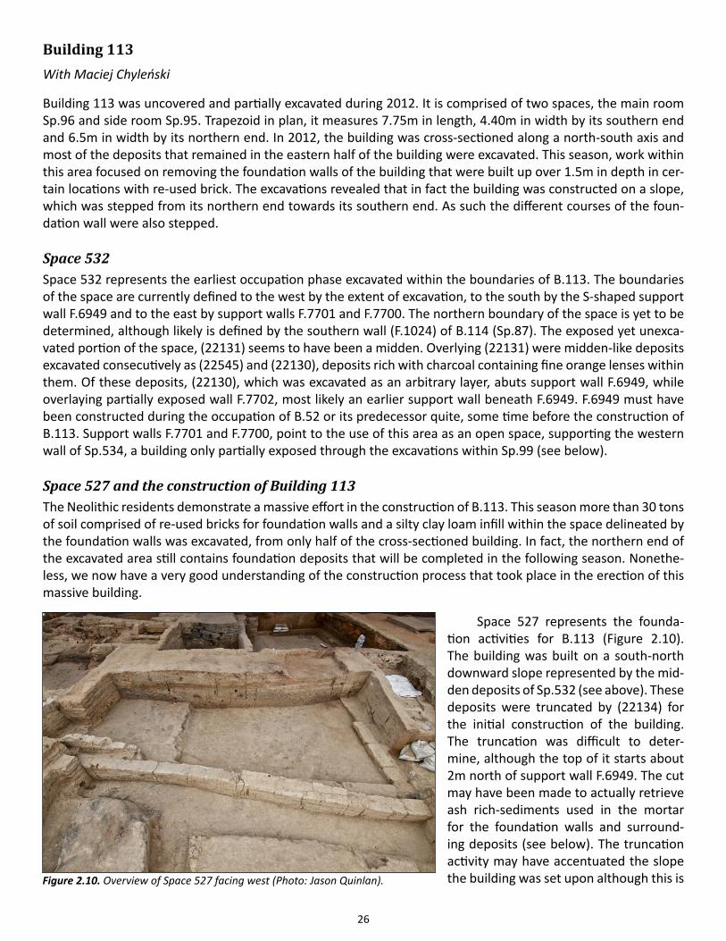
Space 527 and the construction of Building 113The Neolithic residents demonstrate a massive effort in the construction of B.113. This season more than 30 tons of soil comprised of re-used bricks for foundation walls and a silty clay loam infill within the space delineated by the foundation walls was excavated, from only half of the cross-sectioned building. In fact, the northern end of the excavated area still contains foundation deposits that will be completed in the following season. Nonethe-less, we now have a very good understanding of the construction process that took place in the erection of this massive building.
Space 527 represents the founda-tion activities for B.113 (Figure 2.10). The building was built on a south-north downward slope represented by the mid-den deposits of Sp.532 (see above). These deposits were truncated by (22134) for the initial construction of the building. The truncation was difficult to deter-mine, although the top of it starts about 2m north of support wall F.6949. The cut may have been made to actually retrieve ash rich-sediments used in the mortar for the foundation walls and surround-ing deposits (see below). The truncation activity may have accentuated the slope the building was set upon although this is Figure 2.10. Overview of Space 527 facing west (Photo: Jason Quinlan).
27
difficult to determine at this stage.
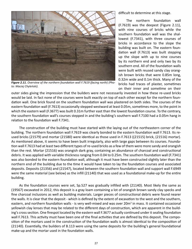
The northern foundation wall (F.7619) was the deepest (Figure 2.11), with nine courses of bricks while the southern foundation wall was the shal-lowest (F.7341), with three courses of bricks in accordance to the slope the building was built on. The eastern foun-dation wall (F.7613) was built stepping up the slope with up to nine courses by its northern end and only two by its southern end. All of the foundation walls were built with reused sandy clay orang-ish brown bricks that were 0.85m long, 0.32m wide and 0.1m thick. Many of the bricks had traces of plaster, sometimes on their inner and sometime on their
outer sides giving the impression that the builders were not necessarily invested in how these re-used bricks would be laid. In fact none of the courses were built exactly on top of each other except for the northern foun-dation wall. One brick found on the southern foundation wall was plastered on both sides. The courses of the eastern foundation wall (F.7613) occasionally stepped westward at least 0.05m, sometimes more, to the point in which the eastern wall (F.3677) was built 0.31m further east than the lowest foundation course. To the contrary, the southern foundation wall’s courses stepped in and the building’s southern wall F.7100 had a 0.05m hang in relation to the foundation wall F.7341.
The construction of the building must have started with the laying out of the northeastern corner of the building. The northern foundation wall F.7619 was clearly bonded to the eastern foundation wall F.7613. Its re-used bricks (21579) and mortar (21580) were identical as those used in F.7613 ((21515) brick, (21516) mortar). As mentioned above, it seems to have been built irregularly, also with large gaps between its courses. Founda-tion wall F.7613 had at least two different types of re-used bricks as a few of them were more sandy and orangish than the rest. Mortar (21516) was orangish dark gray, containing an abundance of charcoal and constructional debris. It was applied with variable thickness ranging from 0.04 to 0.25m. The southern foundation wall (F.7341) was also bonded to the eastern foundation wall, although it must have been constructed slightly later than the northern end of the building due to the time it would have taken to lay the foundation courses and associated deposits. Deposits (21356) and (21547), located between the southern foundation wall and support wall F.6949 were the same material (see below) as the infill (21140) that was used as a foundational make-up for the entire building.
As the foundation courses were set, Sp.527 was gradually infilled with (21140). Most likely the same as (19567) excavated in 2012, this deposit is a gray loam containing a lot of orangish brown sandy clay specks and fine charcoal inclusions as well as building materials. Larger pieces of constructional debris were found nearer the walls. It is clear that the deposit - which is defined by the extent of excavation to the west and the southern, eastern, and northern foundation walls - is very well-mixed and was over 20m3 in mass. It contained occasional yellowish clay lenses that may be related to the different days of construction, which are apparent in the build-ing’s cross section. One firespot located by the eastern wall F.3677 actually continued under it sealing foundation wall F.7613. This activity must have been one of the final activities that are defined by this deposit. The compo-sition of the mortars used in the construction of the foundation walls is almost identical to the composition of (21140). Essentially, the builders of B.113 were using the same deposits for the building’s general foundational make-up and the mortar used in the foundation walls.
Figure 2.11. Overview of the northern foundation wall F.7619 (facing north) (Pho-to: Maciej Chyleński).
28
Once (21140) was laid, the building’s walls were erected above the foundation walls (although as men-tioned above, not directly above them). Due to erosion, it was not possible to understand the relationship be-tween the northern wall (F.1022) and eastern wall (F.3677). F.1022 was badly preserved, its bricks (21513) and mortar (21514) same as eastern wall F.3677. F.3677 was constructed with orangish yellow sandy clay loam bricks (21116) about 1.0m in length 0.10m in height and 0.31m in width, bonded together with a gray ashy mortar with few charcoal flecks (21117) applied with variable thickness ranging from 4cm to 10cm.
The building was divided into spaces 95 and 95, with the erection of the partition wall (F.3676) immediately above (21140). Only three courses of this wall survived. The bricks (21114) were an orangish brown sandy loam and mortar (21115) a light gray clay loam, were more affected by the conflagration that had taken place in the building (see Tung 2012). The excavations this season confirmed the existence of a small passageway between the two rooms where the partition wall ends 0.70m before it reaches the eastern wall.
During the excavation of the building, in-between wall fills were also excavated. In-between wall fill (21165) was contained in a rectangular space, defined by the northwest corner of B.49 and its boundary to B.113, with a panhandle extending west between the southern wall (F.7100) and the S-shaped support wall (F.6949). Het-erogeneous in nature, the deposit contained constructional debris that included large pieces of oven floors, especially by its eastern part where ashy spots were found. A large red deer antler, 21165.x1, seems to have been intentionally placed in this contained area. Consecutive fills, (21118) and (21102) respectfully, were located between eastern wall F.3677 and the possible support wall F.3678 defining the western boundary of Sp.99 (see below for discussion). The fill between B.113 and B.114, (22117) was heterogeneous dark gray silty clay that actually sealed an earlier fill which was deposited during the constructional phase of B.113.
There are interesting questions surrounding the construction of B.113. Where did the re-used bricks come from? Re-used bricks were also observed in the deep foundation walls of neighboring building, B.108. Inciden-tally these are the only two buildings that seem to have such deep foundation wall within this area. Where were the deposits used for the foundational make-up coming from? Is it indeed in part midden from Sp.532? This would explain the cut located in this area. Although if so much effort was to be made extracting deposits from this area, why did the settler not spend a bit more effort actually making the foundation of the building more level? Next season we hope to expand the fully excavate the western half of the building to gain a better insight of the building’s stratigraphic relationship to the surrounding structures.
Building 114 Building 114, comprised of Sp.87 and Sp.88 is an east-west oriented rectangular building. Between 1997 and 2002, the BACH team completely excavated Sp.88, and partially excavated Sp.87. Since 2012, excavations re-commenced within Sp.87 measuring internally about 4.60m in length and 1.7m in width. In 2012, excavations only focused on the retrieval of a burial that had already been exposed by the BACH team and the infill of the building, which covered its eastern two thirds. In 2013, it was decided that the building would essentially be ex-cavated in 1m to 1.5m slices westward in order to leave sections to collect micromorphology samples. After the collection of a few key samples (see chapter 24) this methodology was abandoned this season in order get a full understanding of the division of space within this very small room.
Indeed, we now fully understand that Sp.87 defies almost all ‘rules’ that pertain to spatial configuration at Çatalhöyük. For example, this season we saw that the fire installation of the space was actually cut into the northern wall. Immediately across this installation was the burial of a female adult (F.7614), at the southern sec-tion of the space. By the end of the season, we were able to glean information on the general division of space within this extremely complex, finely stratified and constantly modified small living area.
Space 87 (Figure 2.12) seems to have been divided into two main areas, although the boundaries of these areas changed and the areas themselves underwent specific configurations through the use of the space. The eastern half of the entire space can loosely be defined as the ‘clean’ area, with a platform at the southeast corner
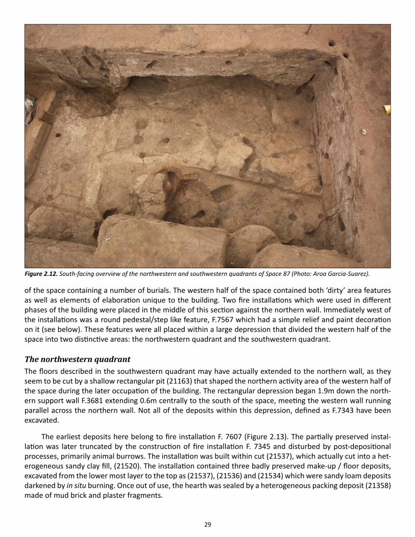
29
of the space containing a number of burials. The western half of the space contained both ‘dirty’ area features as well as elements of elaboration unique to the building. Two fire installations which were used in different phases of the building were placed in the middle of this section against the northern wall. Immediately west of the installations was a round pedestal/step like feature, F.7567 which had a simple relief and paint decoration on it (see below). These features were all placed within a large depression that divided the western half of the space into two distinctive areas: the northwestern quadrant and the southwestern quadrant.
The northwestern quadrantThe floors described in the southwestern quadrant may have actually extended to the northern wall, as they seem to be cut by a shallow rectangular pit (21163) that shaped the northern activity area of the western half of the space during the later occupation of the building. The rectangular depression began 1.9m down the north-ern support wall F.3681 extending 0.6m centrally to the south of the space, meeting the western wall running parallel across the northern wall. Not all of the deposits within this depression, defined as F.7343 have been excavated.
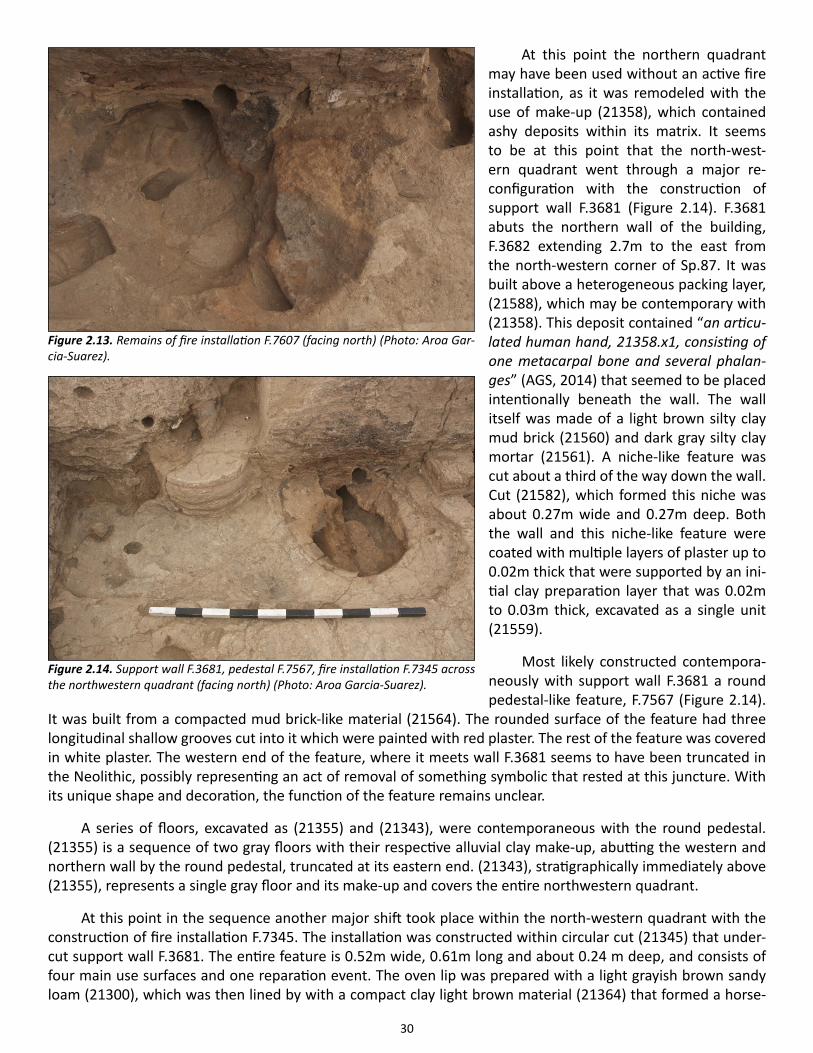
The earliest deposits here belong to fire installation F. 7607 (Figure 2.13). The partially preserved instal-lation was later truncated by the construction of fire installation F. 7345 and disturbed by post-depositional processes, primarily animal burrows. The installation was built within cut (21537), which actually cut into a het-erogeneous sandy clay fill, (21520). The installation contained three badly preserved make-up / floor deposits, excavated from the lower most layer to the top as (21537), (21536) and (21534) which were sandy loam deposits darkened by in situ burning. Once out of use, the hearth was sealed by a heterogeneous packing deposit (21358) made of mud brick and plaster fragments.
Figure 2.12. South-facing overview of the northwestern and southwestern quadrants of Space 87 (Photo: Aroa Garcia-Suarez).
30
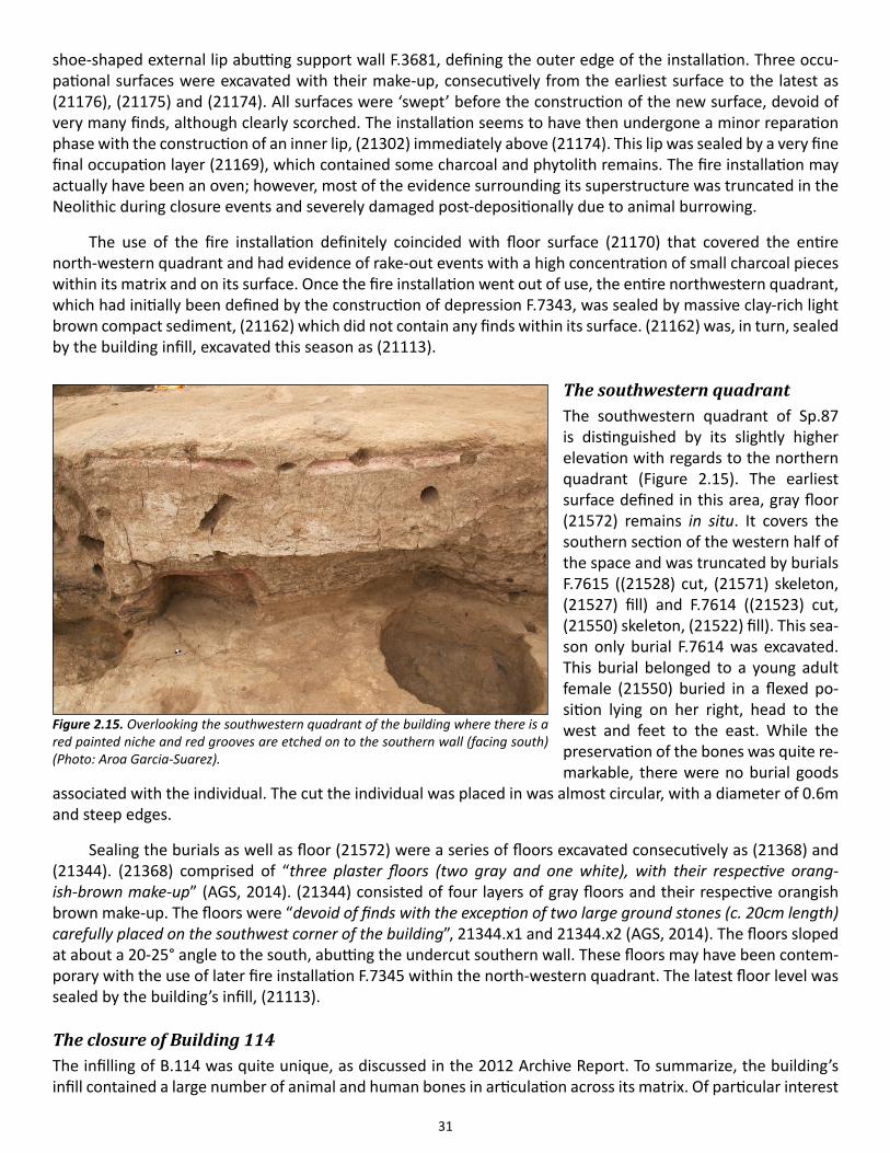
At this point the northern quadrant may have been used without an active fire installation, as it was remodeled with the use of make-up (21358), which contained ashy deposits within its matrix. It seems to be at this point that the north-west-ern quadrant went through a major re-configuration with the construction of support wall F.3681 (Figure 2.14). F.3681 abuts the northern wall of the building, F.3682 extending 2.7m to the east from the north-western corner of Sp.87. It was built above a heterogeneous packing layer, (21588), which may be contemporary with (21358). This deposit contained “an articu-lated human hand, 21358.x1, consisting of one metacarpal bone and several phalan-ges” (AGS, 2014) that seemed to be placed intentionally beneath the wall. The wall itself was made of a light brown silty clay mud brick (21560) and dark gray silty clay mortar (21561). A niche-like feature was cut about a third of the way down the wall. Cut (21582), which formed this niche was about 0.27m wide and 0.27m deep. Both the wall and this niche-like feature were coated with multiple layers of plaster up to 0.02m thick that were supported by an ini-tial clay preparation layer that was 0.02m to 0.03m thick, excavated as a single unit (21559).
Most likely constructed contempora-neously with support wall F.3681 a round pedestal-like feature, F.7567 (Figure 2.14).
It was built from a compacted mud brick-like material (21564). The rounded surface of the feature had three longitudinal shallow grooves cut into it which were painted with red plaster. The rest of the feature was covered in white plaster. The western end of the feature, where it meets wall F.3681 seems to have been truncated in the Neolithic, possibly representing an act of removal of something symbolic that rested at this juncture. With its unique shape and decoration, the function of the feature remains unclear.
A series of floors, excavated as (21355) and (21343), were contemporaneous with the round pedestal. (21355) is a sequence of two gray floors with their respective alluvial clay make-up, abutting the western and northern wall by the round pedestal, truncated at its eastern end. (21343), stratigraphically immediately above (21355), represents a single gray floor and its make-up and covers the entire northwestern quadrant.
At this point in the sequence another major shift took place within the north-western quadrant with the construction of fire installation F.7345. The installation was constructed within circular cut (21345) that under-cut support wall F.3681. The entire feature is 0.52m wide, 0.61m long and about 0.24 m deep, and consists of four main use surfaces and one reparation event. The oven lip was prepared with a light grayish brown sandy loam (21300), which was then lined by with a compact clay light brown material (21364) that formed a horse-
Figure 2.14. Support wall F.3681, pedestal F.7567, fire installation F.7345 across the northwestern quadrant (facing north) (Photo: Aroa Garcia-Suarez).
Figure 2.13. Remains of fire installation F.7607 (facing north) (Photo: Aroa Gar-cia-Suarez).
31
shoe-shaped external lip abutting support wall F.3681, defining the outer edge of the installation. Three occu-pational surfaces were excavated with their make-up, consecutively from the earliest surface to the latest as (21176), (21175) and (21174). All surfaces were ‘swept’ before the construction of the new surface, devoid of very many finds, although clearly scorched. The installation seems to have then undergone a minor reparation phase with the construction of an inner lip, (21302) immediately above (21174). This lip was sealed by a very fine final occupation layer (21169), which contained some charcoal and phytolith remains. The fire installation may actually have been an oven; however, most of the evidence surrounding its superstructure was truncated in the Neolithic during closure events and severely damaged post-depositionally due to animal burrowing.
The use of the fire installation definitely coincided with floor surface (21170) that covered the entire north-western quadrant and had evidence of rake-out events with a high concentration of small charcoal pieces within its matrix and on its surface. Once the fire installation went out of use, the entire northwestern quadrant, which had initially been defined by the construction of depression F.7343, was sealed by massive clay-rich light brown compact sediment, (21162) which did not contain any finds within its surface. (21162) was, in turn, sealed by the building infill, excavated this season as (21113).
The southwestern quadrantThe southwestern quadrant of Sp.87 is distinguished by its slightly higher elevation with regards to the northern quadrant (Figure 2.15). The earliest surface defined in this area, gray floor (21572) remains in situ. It covers the southern section of the western half of the space and was truncated by burials F.7615 ((21528) cut, (21571) skeleton, (21527) fill) and F.7614 ((21523) cut, (21550) skeleton, (21522) fill). This sea-son only burial F.7614 was excavated. This burial belonged to a young adult female (21550) buried in a flexed po-sition lying on her right, head to the west and feet to the east. While the preservation of the bones was quite re-markable, there were no burial goods
associated with the individual. The cut the individual was placed in was almost circular, with a diameter of 0.6m and steep edges.
Sealing the burials as well as floor (21572) were a series of floors excavated consecutively as (21368) and (21344). (21368) comprised of “three plaster floors (two gray and one white), with their respective orang-ish-brown make-up” (AGS, 2014). (21344) consisted of four layers of gray floors and their respective orangish brown make-up. The floors were “devoid of finds with the exception of two large ground stones (c. 20cm length) carefully placed on the southwest corner of the building”, 21344.x1 and 21344.x2 (AGS, 2014). The floors sloped at about a 20-25° angle to the south, abutting the undercut southern wall. These floors may have been contem-porary with the use of later fire installation F.7345 within the north-western quadrant. The latest floor level was sealed by the building’s infill, (21113).
The closure of Building 114The infilling of B.114 was quite unique, as discussed in the 2012 Archive Report. To summarize, the building’s infill contained a large number of animal and human bones in articulation across its matrix. Of particular interest
Figure 2.15. Overlooking the southwestern quadrant of the building where there is a red painted niche and red grooves are etched on to the southern wall (facing south) (Photo: Aroa Garcia-Suarez).
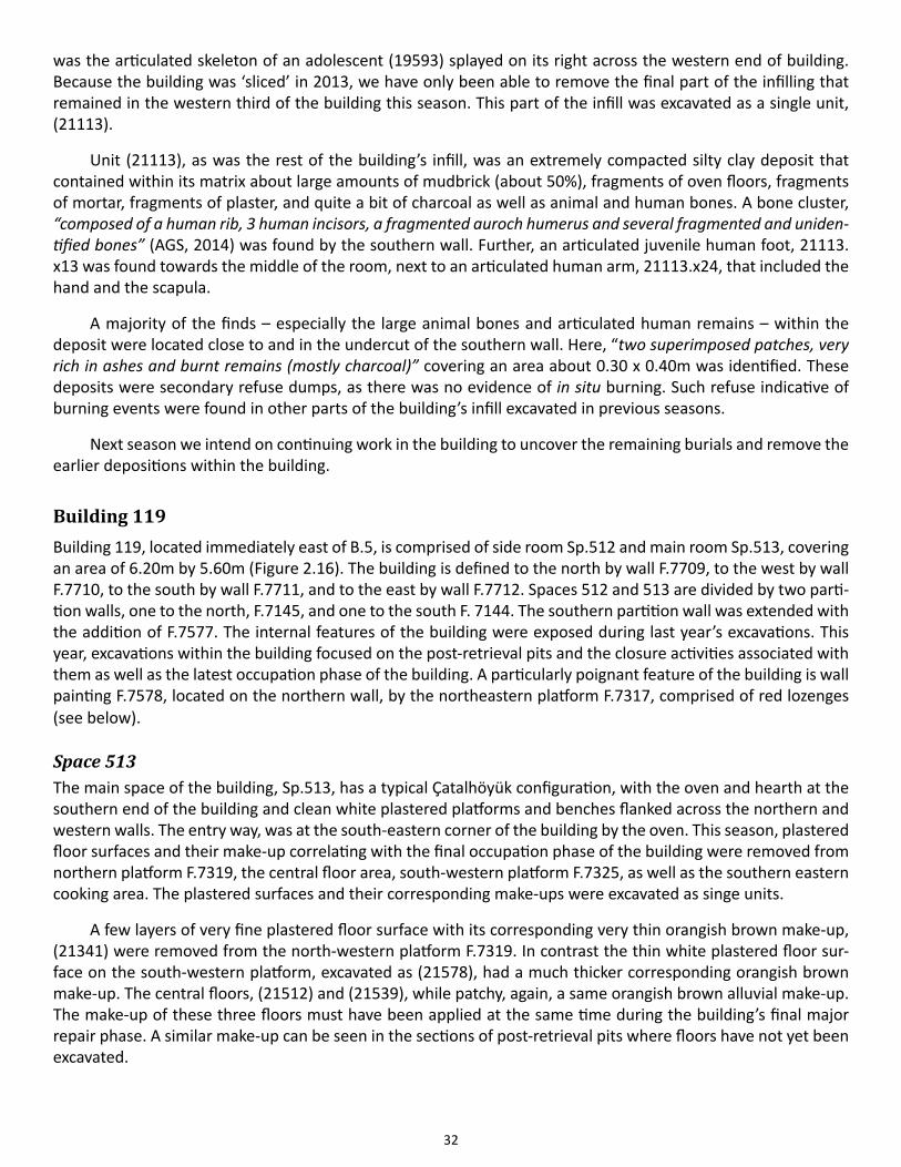
32
was the articulated skeleton of an adolescent (19593) splayed on its right across the western end of building. Because the building was ‘sliced’ in 2013, we have only been able to remove the final part of the infilling that remained in the western third of the building this season. This part of the infill was excavated as a single unit, (21113).
Unit (21113), as was the rest of the building’s infill, was an extremely compacted silty clay deposit that contained within its matrix about large amounts of mudbrick (about 50%), fragments of oven floors, fragments of mortar, fragments of plaster, and quite a bit of charcoal as well as animal and human bones. A bone cluster, “composed of a human rib, 3 human incisors, a fragmented auroch humerus and several fragmented and uniden-tified bones” (AGS, 2014) was found by the southern wall. Further, an articulated juvenile human foot, 21113.x13 was found towards the middle of the room, next to an articulated human arm, 21113.x24, that included the hand and the scapula.
A majority of the finds – especially the large animal bones and articulated human remains – within the deposit were located close to and in the undercut of the southern wall. Here, “two superimposed patches, very rich in ashes and burnt remains (mostly charcoal)” covering an area about 0.30 x 0.40m was identified. These deposits were secondary refuse dumps, as there was no evidence of in situ burning. Such refuse indicative of burning events were found in other parts of the building’s infill excavated in previous seasons.
Next season we intend on continuing work in the building to uncover the remaining burials and remove the earlier depositions within the building.
Building 119Building 119, located immediately east of B.5, is comprised of side room Sp.512 and main room Sp.513, covering an area of 6.20m by 5.60m (Figure 2.16). The building is defined to the north by wall F.7709, to the west by wall F.7710, to the south by wall F.7711, and to the east by wall F.7712. Spaces 512 and 513 are divided by two parti-tion walls, one to the north, F.7145, and one to the south F. 7144. The southern partition wall was extended with the addition of F.7577. The internal features of the building were exposed during last year’s excavations. This year, excavations within the building focused on the post-retrieval pits and the closure activities associated with them as well as the latest occupation phase of the building. A particularly poignant feature of the building is wall painting F.7578, located on the northern wall, by the northeastern platform F.7317, comprised of red lozenges (see below).
Space 513The main space of the building, Sp.513, has a typical Çatalhöyük configuration, with the oven and hearth at the southern end of the building and clean white plastered platforms and benches flanked across the northern and western walls. The entry way, was at the south-eastern corner of the building by the oven. This season, plastered floor surfaces and their make-up correlating with the final occupation phase of the building were removed from northern platform F.7319, the central floor area, south-western platform F.7325, as well as the southern eastern cooking area. The plastered surfaces and their corresponding make-ups were excavated as singe units.
A few layers of very fine plastered floor surface with its corresponding very thin orangish brown make-up, (21341) were removed from the north-western platform F.7319. In contrast the thin white plastered floor sur-face on the south-western platform, excavated as (21578), had a much thicker corresponding orangish brown make-up. The central floors, (21512) and (21539), while patchy, again, a same orangish brown alluvial make-up. The make-up of these three floors must have been applied at the same time during the building’s final major repair phase. A similar make-up can be seen in the sections of post-retrieval pits where floors have not yet been excavated.
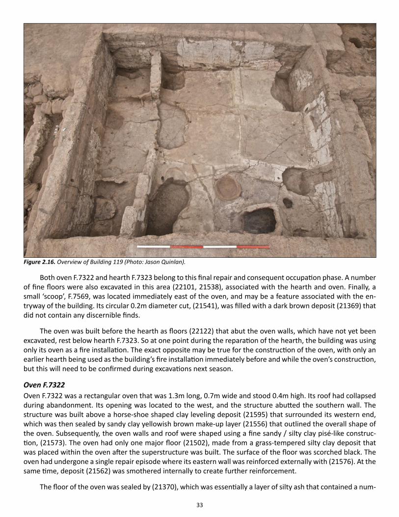
33
Both oven F.7322 and hearth F.7323 belong to this final repair and consequent occupation phase. A number of fine floors were also excavated in this area (22101, 21538), associated with the hearth and oven. Finally, a small ‘scoop’, F.7569, was located immediately east of the oven, and may be a feature associated with the en-tryway of the building. Its circular 0.2m diameter cut, (21541), was filled with a dark brown deposit (21369) that did not contain any discernible finds.
The oven was built before the hearth as floors (22122) that abut the oven walls, which have not yet been excavated, rest below hearth F.7323. So at one point during the reparation of the hearth, the building was using only its oven as a fire installation. The exact opposite may be true for the construction of the oven, with only an earlier hearth being used as the building’s fire installation immediately before and while the oven’s construction, but this will need to be confirmed during excavations next season.
Oven F.7322Oven F.7322 was a rectangular oven that was 1.3m long, 0.7m wide and stood 0.4m high. Its roof had collapsed during abandonment. Its opening was located to the west, and the structure abutted the southern wall. The structure was built above a horse-shoe shaped clay leveling deposit (21595) that surrounded its western end, which was then sealed by sandy clay yellowish brown make-up layer (21556) that outlined the overall shape of the oven. Subsequently, the oven walls and roof were shaped using a fine sandy / silty clay pisé-like construc-tion, (21573). The oven had only one major floor (21502), made from a grass-tempered silty clay deposit that was placed within the oven after the superstructure was built. The surface of the floor was scorched black. The oven had undergone a single repair episode where its eastern wall was reinforced externally with (21576). At the same time, deposit (21562) was smothered internally to create further reinforcement.
The floor of the oven was sealed by (21370), which was essentially a layer of silty ash that contained a num-
Figure 2.16. Overview of Building 119 (Photo: Jason Quinlan).
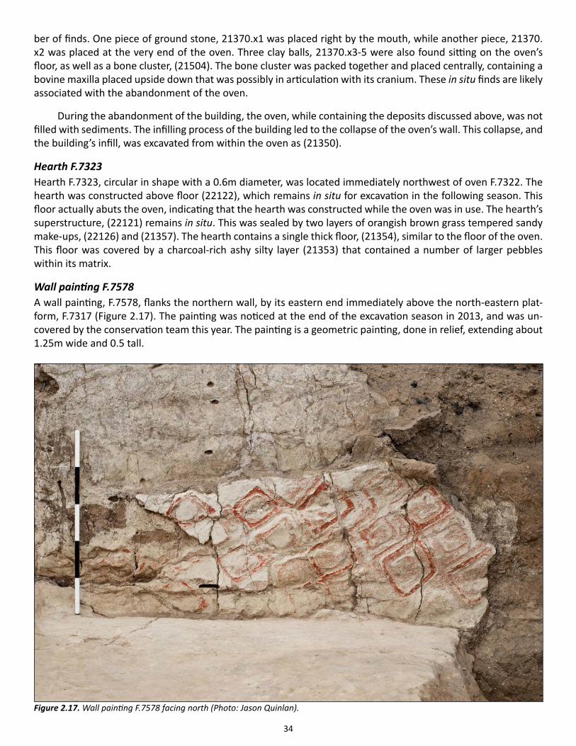
34
ber of finds. One piece of ground stone, 21370.x1 was placed right by the mouth, while another piece, 21370.x2 was placed at the very end of the oven. Three clay balls, 21370.x3-5 were also found sitting on the oven’s floor, as well as a bone cluster, (21504). The bone cluster was packed together and placed centrally, containing a bovine maxilla placed upside down that was possibly in articulation with its cranium. These in situ finds are likely associated with the abandonment of the oven.
During the abandonment of the building, the oven, while containing the deposits discussed above, was not filled with sediments. The infilling process of the building led to the collapse of the oven’s wall. This collapse, and the building’s infill, was excavated from within the oven as (21350).
Hearth F.7323Hearth F.7323, circular in shape with a 0.6m diameter, was located immediately northwest of oven F.7322. The hearth was constructed above floor (22122), which remains in situ for excavation in the following season. This floor actually abuts the oven, indicating that the hearth was constructed while the oven was in use. The hearth’s superstructure, (22121) remains in situ. This was sealed by two layers of orangish brown grass tempered sandy make-ups, (22126) and (21357). The hearth contains a single thick floor, (21354), similar to the floor of the oven. This floor was covered by a charcoal-rich ashy silty layer (21353) that contained a number of larger pebbles within its matrix.
Wall painting F.7578A wall painting, F.7578, flanks the northern wall, by its eastern end immediately above the north-eastern plat-form, F.7317 (Figure 2.17). The painting was noticed at the end of the excavation season in 2013, and was un-covered by the conservation team this year. The painting is a geometric painting, done in relief, extending about 1.25m wide and 0.5 tall.
Figure 2.17. Wall painting F.7578 facing north (Photo: Jason Quinlan).
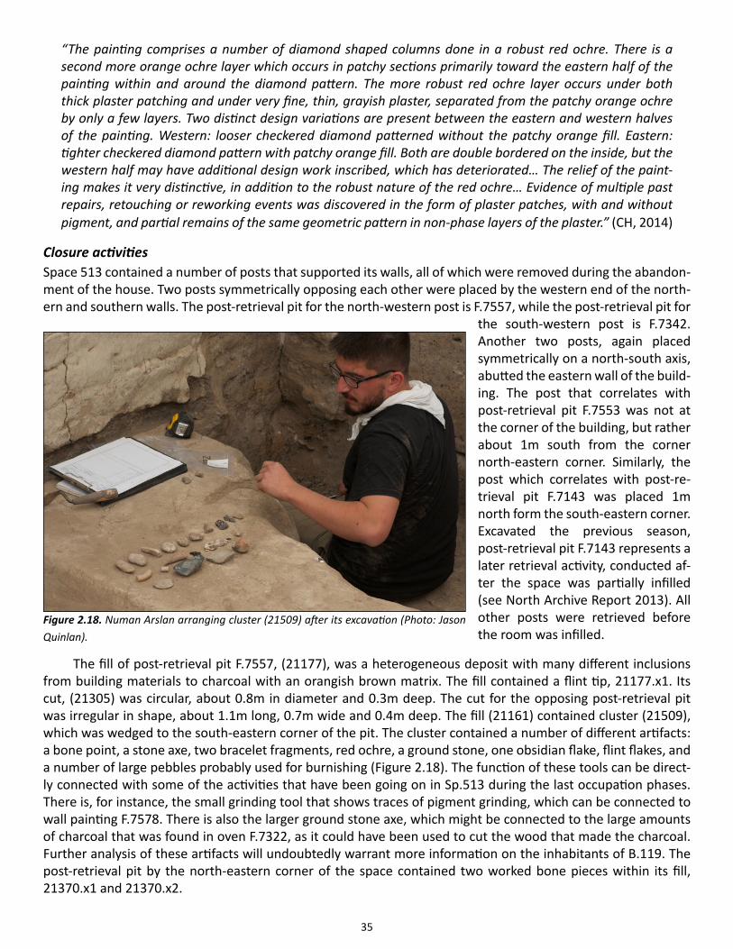
35
“The painting comprises a number of diamond shaped columns done in a robust red ochre. There is a second more orange ochre layer which occurs in patchy sections primarily toward the eastern half of the painting within and around the diamond pattern. The more robust red ochre layer occurs under both thick plaster patching and under very fine, thin, grayish plaster, separated from the patchy orange ochre by only a few layers. Two distinct design variations are present between the eastern and western halves of the painting. Western: looser checkered diamond patterned without the patchy orange fill. Eastern: tighter checkered diamond pattern with patchy orange fill. Both are double bordered on the inside, but the western half may have additional design work inscribed, which has deteriorated… The relief of the paint-ing makes it very distinctive, in addition to the robust nature of the red ochre… Evidence of multiple past repairs, retouching or reworking events was discovered in the form of plaster patches, with and without pigment, and partial remains of the same geometric pattern in non-phase layers of the plaster.” (CH, 2014)
Closure activitiesSpace 513 contained a number of posts that supported its walls, all of which were removed during the abandon-ment of the house. Two posts symmetrically opposing each other were placed by the western end of the north-ern and southern walls. The post-retrieval pit for the north-western post is F.7557, while the post-retrieval pit for
the south-western post is F.7342. Another two posts, again placed symmetrically on a north-south axis, abutted the eastern wall of the build-ing. The post that correlates with post-retrieval pit F.7553 was not at the corner of the building, but rather about 1m south from the corner north-eastern corner. Similarly, the post which correlates with post-re-trieval pit F.7143 was placed 1m north form the south-eastern corner. Excavated the previous season, post-retrieval pit F.7143 represents a later retrieval activity, conducted af-ter the space was partially infilled (see North Archive Report 2013). All other posts were retrieved before the room was infilled.
The fill of post-retrieval pit F.7557, (21177), was a heterogeneous deposit with many different inclusions from building materials to charcoal with an orangish brown matrix. The fill contained a flint tip, 21177.x1. Its cut, (21305) was circular, about 0.8m in diameter and 0.3m deep. The cut for the opposing post-retrieval pit was irregular in shape, about 1.1m long, 0.7m wide and 0.4m deep. The fill (21161) contained cluster (21509), which was wedged to the south-eastern corner of the pit. The cluster contained a number of different artifacts: a bone point, a stone axe, two bracelet fragments, red ochre, a ground stone, one obsidian flake, flint flakes, and a number of large pebbles probably used for burnishing (Figure 2.18). The function of these tools can be direct-ly connected with some of the activities that have been going on in Sp.513 during the last occupation phases. There is, for instance, the small grinding tool that shows traces of pigment grinding, which can be connected to wall painting F.7578. There is also the larger ground stone axe, which might be connected to the large amounts of charcoal that was found in oven F.7322, as it could have been used to cut the wood that made the charcoal. Further analysis of these artifacts will undoubtedly warrant more information on the inhabitants of B.119. The post-retrieval pit by the north-eastern corner of the space contained two worked bone pieces within its fill, 21370.x1 and 21370.x2.
Figure 2.18. Numan Arslan arranging cluster (21509) after its excavation (Photo: Jason Quinlan).
36
Space 513 contains a fifth pit, F.7570 located at the western end of the space, cutting the central floors and the south-western corner of platform F.7319. While the largest pit in the building with its cut (21524) measuring 1.75m long and 0.95m wide, it is relatively shallow at 0.2m. The origin of F.7570 is unclear. Fill (21351), similar to the other pit fills, contained few artifacts, of which a worked bone tool, 21351.x1 was noteworthy. The position of the feature may suggest a retrieval of a sculpture, or some other sort of wall installation, attached to the par-tition wall prior to the abandonment of the building.
It is definitely worth noting that all of the pits contained at least one artifact that seemed to have been in-tentionally left behind within the context. This is not dissimilar to practices observed in other Neolithic buildings at Çatalhöyük.
Space 512This season, remaining room fill (21367) was removed from the northern end of the narrow space to reveal a bin-like square division. This area had a shallow pit, F.7608, dug into its north-western corner. The fill (21508) of the pit was a grayish brown silty clay with orange clay aggregates. The function of the pit remains unclear.
Final notesBuilding 119, judging from the sections revealed in the post-retrieval pits, seems to not have been an extensively repaired building. Next year’s work will focus on further excavating the remaining occupation surfaces the build-ing.
Building 128Contribution by Stella Macheridis
B.128 was a quite late building, probably contemporary with B112. It was fully removed this year, and consisted of main room Sp.40 and side rooms Sp.39 and Sp.502. The aim of working in this area was to investigate the area below the building and its function and relation to adjacent buildings (B.102 and B.3). This building was built on Sp.530 (see below).
The building is built above wall collapse that was visible and recorded as (21180). An older wall, (F.7599), was located to the west. The top bricks of this wall were reused as foundation for F.3656. Foundation trench F.7646 was thus made for half of F.3656, and also for F.3660, the southern outer wall. It was also clear when ex-cavating the walls that the foundation courses for both these ((21348), (21349)) consisted of reused bricks from older walls, larger and of different materials. The above bricks courses for both walls (21178 and 21303) were c. 0.6 x 0.3 m in size and quite similar. F.3656 and F.3660 were keyed into each other and built in the same time. They were very eroded and hard to follow. It is really only the construction of them that was documentable. The same goes for F.3658 and F.3659, which were even more eroded (see below). After constructing the outer walls they began leveling and raising the building.
Spaces 39 and 502The side rooms of B.128 were quite similar in size. They were limited by F.3658 to the east and F.3656 to the west. F.3658 which is an internal wall in the building was built late, and the internal separating wall F3659 was built last. Space 39 was the marginally larger one, situated in the north. Space 502 was a bit smaller. They both contained similar eroded infills (21110) and (21121), before reaching a level on which their walls were built (21123). No floors were thus found. I imagine that either the floor was too eroded to be noticed in these infills or it had been eroded away in an earlier stage.
37
Space 40Space 40 was investigated in 2012, and during that season the excavators managed to document a cluster of graves (11, of which 9 were subadults). Work was resumed in 2014, and it started with the excavation of a grave east of the cluster (F.7329). It was the grave of a child, but only the torso had survived the trampling and expo-sure since 2012. It was also cut by pit F.7647 in prehistory. It seems that the layers we excavated in Sp.40 should be associated with construction mainly. If there was a floor, it is probable this has been eroded away and was on a higher level. Soon after the grave, we were on a level below the side rooms ((20202)/(21122)). The side of F.3658 facing to Sp.40 had fragments of plaster (21149); this was not visible in the side rooms. This underscores perhaps the main room-quality of this space. No features except graves were excavated. This perhaps can also be used in the argument that the floor level was higher up.
Space 530This is the space below (prior to) B.128. We removed a series of infills, and they were similar in composition and character; probably thrown over the space and then trampled on for a little while before the new next big infill layer. This happened at least three times. We stopped excavation when we reached a more obvious tram-pled surface – a grayish infill with hard and worn surface (21549). This is interpreted as an outdoor “floor” level (not excavated) and emphasizes the contemporaneity with B128 and B3. Thus we had reached our aims for this space. Other layers visible when we stopped were a second course of wall collapse (21503). Perhaps this outdoor surface was cut for filling in wall collapse, but this is something for future excavations to investigate. Also a layer (actually more similar a room infill) remains unexcavated. An important result is the exposure of wall F.7599 which was below F.3656. Only the top courses are exposed. It is slightly sloping (inverted) like wall F.3653 in B.102, and is similar to that wall also in direction and size. It has had plaster on the wall, still visible but heavily eroded.
Buildings 129 and 131Buildings 129 and 131 are two successive buildings covering the same area within the North Shelter, located between B.5 and B.77. The area is currently partially covered by the foot of a bridge for the walkway that goes over B.5, hence work this season focused on the western end of the buildings, covering an area 4.2m wide and 5.8m long. B.129 is the later of the buildings, and due to its proximity to the mound’s surface, extremely eroded. It was completely excavated this season, to reveal an earlier building that’s been intensely burnt, B.131. During this season, all of the infill within B.131’s side room, Sp.504 was removed, revealing a burnt space that contained some patchy floors and what seems to be a large bin. Next season, we plan on removing the bridge that covers the eastern half of the buildings to explore the main spaces of the buildings. Below is an overview of the exca-vations in this area, from the earliest occupational sequence to the latest occupational sequence uncovered in this excavation season.
Building 131During the Neolithic, B.131 was exposed to a strong a fire that must have ended its use-life. This is seen through the rubified building materials found within its infill as well as the way in which the walls of the building have lost their structural integrity and hence have largely crumbled away. This season’s excavations focused on the building’s side room, Sp.504. Space 504 is defined by four walls that form a rectangular space 3.2m by 5m: par-tition wall F.7708 to the east, northern wall F.7707, western wall F.7708, and southern wall F.7705 (Figure 2.19). The northern and southern walls have been exposed only partially. Only the western wall of the space has been completely exposed, extending 5.6m north-south. All the walls, except for the partition wall that is 0.25-0.30m thick, are between 0.35 to 0.4m thick. Further investigation on the partition wall is required to reveal its com-plete extent and the passageway to the building’s main room.
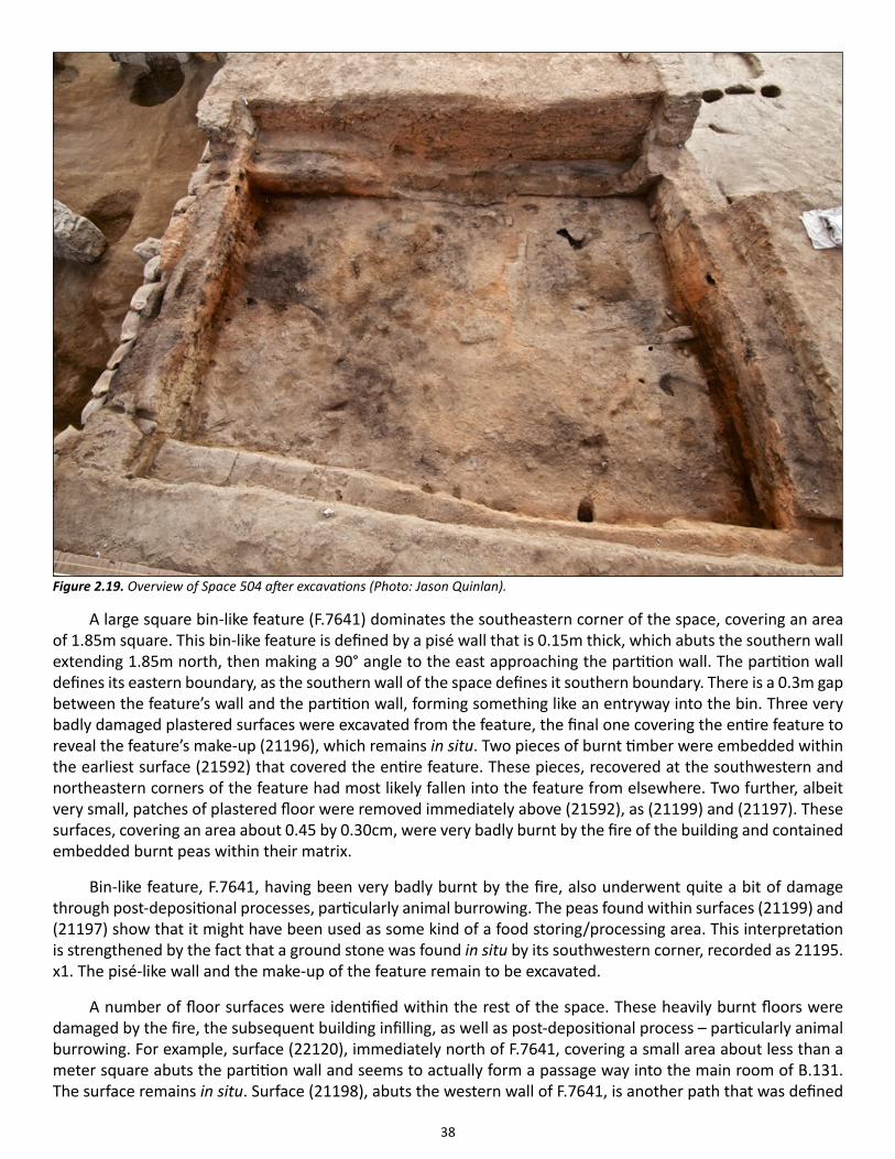
38
A large square bin-like feature (F.7641) dominates the southeastern corner of the space, covering an area of 1.85m square. This bin-like feature is defined by a pisé wall that is 0.15m thick, which abuts the southern wall extending 1.85m north, then making a 90° angle to the east approaching the partition wall. The partition wall defines its eastern boundary, as the southern wall of the space defines it southern boundary. There is a 0.3m gap between the feature’s wall and the partition wall, forming something like an entryway into the bin. Three very badly damaged plastered surfaces were excavated from the feature, the final one covering the entire feature to reveal the feature’s make-up (21196), which remains in situ. Two pieces of burnt timber were embedded within the earliest surface (21592) that covered the entire feature. These pieces, recovered at the southwestern and northeastern corners of the feature had most likely fallen into the feature from elsewhere. Two further, albeit very small, patches of plastered floor were removed immediately above (21592), as (21199) and (21197). These surfaces, covering an area about 0.45 by 0.30cm, were very badly burnt by the fire of the building and contained embedded burnt peas within their matrix.
Bin-like feature, F.7641, having been very badly burnt by the fire, also underwent quite a bit of damage through post-depositional processes, particularly animal burrowing. The peas found within surfaces (21199) and (21197) show that it might have been used as some kind of a food storing/processing area. This interpretation is strengthened by the fact that a ground stone was found in situ by its southwestern corner, recorded as 21195.x1. The pisé-like wall and the make-up of the feature remain to be excavated.
A number of floor surfaces were identified within the rest of the space. These heavily burnt floors were damaged by the fire, the subsequent building infilling, as well as post-depositional process – particularly animal burrowing. For example, surface (22120), immediately north of F.7641, covering a small area about less than a meter square abuts the partition wall and seems to actually form a passage way into the main room of B.131. The surface remains in situ. Surface (21198), abuts the western wall of F.7641, is another path that was defined
Figure 2.19. Overview of Space 504 after excavations (Photo: Jason Quinlan).
39
in 2013, and left in situ. Cutting this surface, right outside the southwestern corner of bin-like feature F.7641 was a small shallow pit (F.7048), formed by cut (21594) that about 0.20m wide and 0.34m long. Fill (21593) contained some bovine bone as well as fragments of mini clay balls. This deposition must have been one of the final depo-sitional events that took place within the space.
The space, as with the rest of the building, underwent a tremendous fire that damaged its surfaces and fea-tures. What is particularly interesting about the fire that took place here is the way the building’s rubble seems to have been processed for the building infilling. This is apparent through the nature of the room’s infill ((21195), (21193)), which did not contain any rubble that was in situ, but rather processed showing secondary deposition. This infill was composed of burnt brick, mortar, floor remains, quite a bit of charcoal and burnt animal bone that was all mixed up in a burnt sandy matrix (indicative of make-up?) about 0.8m thick. The largest rubble pieces were about 0.15m in diameter. This picture highly contrasts rubble removed from other burnt buildings such as B.77 and B.52 where large architectural elements were clearly apparent within the infill as collapse. The north-western corner of the infill contained large mineral formations that may have come from a cave.
Excavations will resume in B.131 in 2015.
Building 129Building 129 was built immediately above B.131, most likely following the same plan of B.131. As mentioned above, the building, being so close to the mound’s surface, was eroded to the point to which no occupational surfaces were recovered. While the plan of the building is not entirely clear, as most of the building is covered by a walkway, it is likely that the building extended eastward and contained Sp.77, within which number of burials that contained two obsidian mirrors were excavated (see 2014 Archive Report, North Area). The 1990s surface scrape delineates two space numbers for the eastern end of the building: Sp.74 to the north and Sp.75 to the south. This season’s excavations did not reveal a division of space in the same area, hence the eastern end of the building was allocated a single space number: Sp.74. Space 74 is defined to the north by wall F.7558, to the east by the extent of excavation, to the south by wall F.7560, and to the west by wall F.7559.
While B.129 was built immediately above B.131, the construction of B.129 must have taken place some time after the abandonment of B.131. This is evidenced by the foundation trench, F.7563, that was cut into the infill of B.131 for the construction of B.129’s walls. The stepped-trench, about 0.5m deep and between 0.40 to 1m thick irregularly outlined B.129’s walls, immediately above the preserved sections of B.131’s walls. Before the construction of the walls, the trench was stabilized with a heterogeneous silty clay deposit, (21194), that was about 0.5m thick. Once this preparation layer was laid the walls of the building were constructed.
The western wall of B.129, F.7559 was bonded both to the northern wall F.7558 and to the southern wall F.7560. The three walls were made from the same brick and mortar. The bricks, excavated as (21167), (21189) and (21191) were constructed from a sandy clay light brown sediment that had very few inclusions within it. The brick sizes varied from 0.45cm to up to 1m in length, about 0.30m in width and 0.08m in thickness. The mortar, excavated as (21188), (21190), and (21192) had a gray silty clay matrix with a high inclusion content, with char-coal and animal bones, typical of the mortars seen on site. Once the walls were erected, the foundation trench was filled with (21184), a dark heterogeneous deposit that contained some of B.131’s rubble within it.
The only feature identified within Sp.74 was pit F.7561. This circular pit (21186), 0.72m in diameter and 0.50m deep, cut the southern wall as well as the foundation trench. Its dark brown fill (21182) did not contain any immediate evidence eluding to the function of the pit.
The remaining eastern end of the building will be excavated in the following field season.
40
Space 99
The large expansive space east of B.113 defined as Sp.99 was first excavated in 2012 where a number of post-Neo-lithic burials were located. This season, work focused on the Neolithic sequences of the area. The southern end of the space was used as midden, which was partially excavated. Excavations in the western and northern sec-tions of the space revealed foundation trenches dug in order to build retaining walls immediately above the walls of an earlier Neolithic structure (Sp.534). This earlier building’s walls contained wall plaster. Work in the coming years will focus on the removal of the remaining midden to understand the stratigraphic relationships between this area and B.49.
Space 534By the end of the season it became apparent that Sp.99 was not always used as an open space, and that a large Neolithic building, Sp.534 once occupied the area. The western wall of the building, F.7704, is 7.7m long while the only partially exposed northern wall is 4.3m long. F.2841, excavated in 2007 during the excavations required for foundation trenches of the Northern shelter, may represent part of the eastern wall of the building. During the time, it was noted that F.2841 appears “to turns west … into the section”, which would be in perfect align-ment of the northern wall F.7703 (Archive Report, 2007: 36). Then the extent of the northern wall would be an impressive 6.7m. The southern end of the building is not yet defined and most likely lays under midden deposits (see below). Both the western and northern walls are plastered although very little of the plaster has actually been exposed, as the walls themselves have not been exposed in their entirety. Further, no house-abandonment deposits have actually been reached.
Space 99Space 534 was used as an outdoor space once it was abandoned. Space 99 is defined to the south by B.49 and B.48, to the west by B.113, and to the north by Sp.88 and Sp.89. Its eastern extent is not entirely clear due to the limit of excavation. Space 99 seems to have been divided into two different use areas. While the southern half of the space was used as a midden represented by typical midden deposits, the northern end of the space may have been partially enclosed by light structure, as the accumulation of deposits are indicative of infilling events and occupation evidence such as burning rather than midden-like accumulation. The boundary between the two areas is diffuse although there is evidence of a wall construction seen through the cut of post-Neolithic burial F.3685 that runs east-west at this boundary which has not been entirely exposed as it remains below the excavated deposits.
Shoring walls F.7103 and F.7326, which represent the earliest activities within the space, were highly erod-ed due to water run-off from the mound due to their location at an eastward dip of the slope. Shoring wall F.7103, which extends 3.2m east-west abutting the northern wall F.1661 of B.49. It may have been constructed immediately after the abandonment of Sp.534 as an extra precaution to order keep the midden at bay from B.49, built immediately above the southern wall of Sp.534. This season, only the much eroded top two courses of the wall was excavated in order to understand its relationship to wall F.3678 (see below) and wall F.7326. Composed of light yellowish brown sandy clay mud bricks with phytolith remains bonded with a light gray ashy mortar, it became clear that F.7103 abutted F.3678, which is a secondary wall construction immediately above F.7704. Fill (21543) between F.7103 and F.1661 was also partially excavated. Flanked against wall F.7103 was another shor-ing wall F.7326 also partially excavated this season due to its eroded condition. (21119) consists of an orangish brown silty clay loam eroded brick and mortar. The removal of this eroded material defined the current extent of the wall that reaches 1.9m. The wall was truncated at its western end by post-Neolithic burial F.3689, eradicating its relationship to wall. F.3678. Nonetheless the southern section of the burial cut reveals that the courses of the wall extend below all currently defined deposits.
The upper layers of the midden were excavated as (21103). This deposit was defined to the north by its boundary with possibly contemporary deposit (21139), to the west by the limit of excavation, to the south by
41
shoring wall F.7326 and to the east by foundation trench cut (21142). The midden had a heterogeneous compo-sition, rich of organic materials. Some of the animal bone assemblage was one of ‘post-consumption’ including bones digested by canines. Of interest was a broken arrow straightener, 21103.x1, made from stone. The initial pottery and chipped stone assemblage analysis show the possibility of the midden belonging to Level North G. The remaining extent of the midden, which has been defined as unit (21111), will most likely be excavated in 2015.
Deposit (21139), possibly contemporary and immediately north of the midden was defined by wall F.7105 to the north, limit of excavation to the east and foundation cut (21142) to the east. This relatively homogenous gray loam that contained quite a bit of building material and some phytoliths was not excavated at its full depth due to time constraints. Immediately above this deposit were three shallow refuse and burning areas ((21146), (21147), (21148)). The northern most deposit (21147), the largest of the activity spots ha an irregular boundary extending about 1.7 x 0.6m with some evidence of in situ burning at its edges in the form partially baked surfac-es. The deposit itself was a dark brown ashy silt. Immediately south of I was deposit (21146), which represents the refuse of burnt material extending 1.7m northwest-southeast and 0.3m northeast-southwest. Immediately to its west was (21148) which was a circular refuse area 0.4m in diameter.
Unit (21139) and the midden to the south were cut by foundation trenches F.7338 and F.7327 which most likely represent the same event. Trench F.7338 was 7.1m long and 0.9m wide seems to have been dug rather reg-ularly. Trench F.7327 runs only 3.5m due to the limit of excavation and is slightly narrower from its counterpart at 0.65m. The trenches may be contiguous with the refuse deposits ((21146), (21147), (21148)) described above. Currently, it seems that the trenches were made to construct retention wall F.3678 immediately above F.7704 and retention wall F.7105 immediately above F.7703.
This season only F.3678 was excavated fully. Wall F.3678 composed of two types of bricks, excavated as (21371) that were both light orangish brown in color but had different textures. One was clay rich while the oth-er was sand rich. The clay rich bricks in particular had extensive plant impressions and phytolith remains within them. Some of the bricks actually had plaster remains on them giving the impression that they were re-used. Most bricks were between 0.8-0.77m long while a few were up to 0.9m long. They all were about 0.1m thick and 0.3m wide. Mortar (21372) was a gray loam with many different types of inclusions typical of the mortar used on site. At the lower end of the wall, some 12 courses down, it seems to have been used as preparation layer with smaller brick pieces that were difficult to differentiate from the mortar and vice versa.
Once wall F.3678 was built, buttress F.7109 was constructed within foundation trench F.7338, most likely to further support the wall. Defined in 2012, it was truncated by post-Neolithic burials F.3689 and F.3685. During the Neolithic, it would have extended 2.25m north-south and 0.9m east-west, xxxm tall. The compacted earth feature seems to have been built in multiple episodes. It was excavated consecutively from bottom to top as three units ((21143), (21145), (21104)) although all of these units actually reflect the same construction event. (21143) and (21104) were homogenous light yellowish brown sandy clay deposit that contained fine lenses of ash, while (21145) resembled a mortar-like ashy deposit between the two deposits. The fine lenses indicate a purposeful compaction not of long-term accumulation.
The construction of F.3678 and buttress F.7109 is likely associated with an effort to stabilize the eastern wall of B.113. A smaller yet similar buttress flanking the outer side of the western wall of B.114 was observed but not excavated immediately below the western wall of B.108. Once the buttress was built, foundation trench F.7338 was filled with a heterogeneous deposit that contained constructional debris which was excavated arbitrarily as two separate units (21171) and (21301). Contemporaneous deposit (21347) filled foundation trench F.7327. These deposits were sealed by (21128), a gray homogenous loam containing little evidence of occupation or refuse, extending from the northern end of the space until midden (21103).
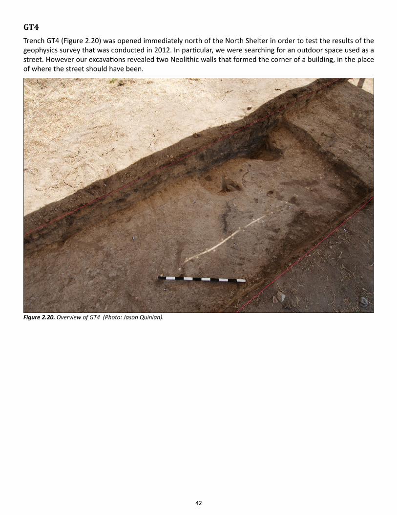
42
GT4Trench GT4 (Figure 2.20) was opened immediately north of the North Shelter in order to test the results of the geophysics survey that was conducted in 2012. In particular, we were searching for an outdoor space used as a street. However our excavations revealed two Neolithic walls that formed the corner of a building, in the place of where the street should have been.
Figure 2.20. Overview of GT4 (Photo: Jason Quinlan).
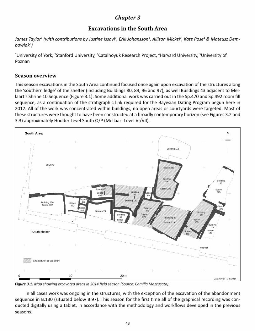
43
Chapter 3
Excavations in the South Area
James Taylor1 (with contributions by Justine Issavi2, Erik Johansson3, Allison Mickel2, Kate Rose4 & Mateusz Dem-bowiak5)
1University of York, 2Stanford University, 3Catalhoyuk Research Project, 4Harvard University, 5University of Poznan
Season overviewThis season excavations in the South Area continued focused once again upon excavation of the structures along the ‘southern ledge’ of the shelter (including Buildings 80, 89, 96 and 97), as well Buildings 43 adjacent to Mel-laart’s Shrine 10 Sequence (Figure 3.1). Some additional work was carried out in the Sp.470 and Sp.492 room fill sequence, as a continuation of the stratigraphic link required for the Bayesian Dating Program begun here in 2012. All of the work was concentrated within buildings, no open areas or courtyards were targeted. Most of these structures were thought to have been constructed at a broadly contemporary horizon (see Figures 3.2 and 3.3) approximately Hodder Level South O/P (Mellaart Level VI/VII).
In all cases work was ongoing in the structures, with the exception of the excavation of the abandonment sequence in B.130 (situated below B.97). This season for the first time all of the graphical recording was con-ducted digitally using a tablet, in accordance with the methodology and workflows developed in the previous seasons.
!
!
!
!
!
!
!
!
!
!
!
!
!
!
!
!
!
!
!
!
!
!
!
!
!
!
!
!
!
!
!
!
!!
!!
!!
!
!
!!
!!
!
!
!
!
!
!
!
!!
!!
! !
!
!!
!
!!
!! ! !
!
!
!
!
!
!
!
!
!
!
!
!
!!
!
!
!
!
!
!
!
!
!
!
!
!
!
!
!
!
!
!
!
!
!
!
!
!
!
!
!
!
!
!
!
!!
!!
!!
!
!
!!
!!
!
!
!
!
!
!
!
!!
!!
! !
!
!!
!
!!
!! ! !
!
!
!
!
!
!
!
!
!
!
!
!
!
!
!
!!
!
!
!
!
!
!
!
!
!
!
!
!
!
!
!
!
!
!
!!
!
!
!
!
!
!
!
!
!
!
!
!
!
!
!
!
!
!
!
!
!
!
!
!
!
!
!
!
!
!
!
!
!
!
!
!
!
!
!
!
!
!
!
!
!
!
!
!
!
!
!
!
!
!
!
!
!
!
!
!
!
!
!
!
!
!
!
!
!
!
!
!
!!
!!
!
!
!
!
!!
!
!
!
!
!
!
!
!
!
Building 100Space 382
Building86
Building80
Building79
Building96
Building87
Building97
Space 474
Space471
Space472
Space473
Space374
N
0 10 20 mÇatalhöyük GIS 2014
905/970
935/955
Space 470
Space370
Space 379
Space444
Space135
Space373
Space134
Space375
Space376
South Area
Building43
Building 118
South shelter
Excavation area 2014
Space492
Building 130
Building 89
Space 235
Space 236
Figure 3.1. Map showing excavated areas in 2014 field season (Source: Camilla Mazzucato).
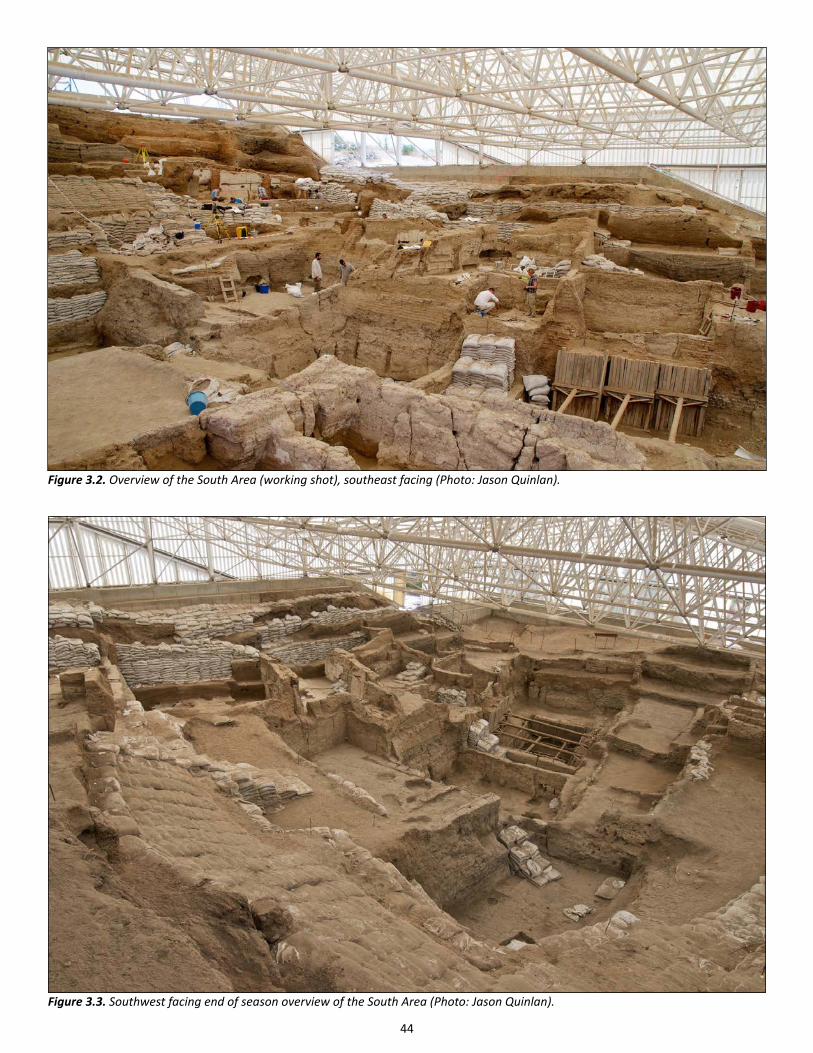
44
Figure 3.3. Southwest facing end of season overview of the South Area (Photo: Jason Quinlan).
Figure 3.2. Overview of the South Area (working shot), southeast facing (Photo: Jason Quinlan).
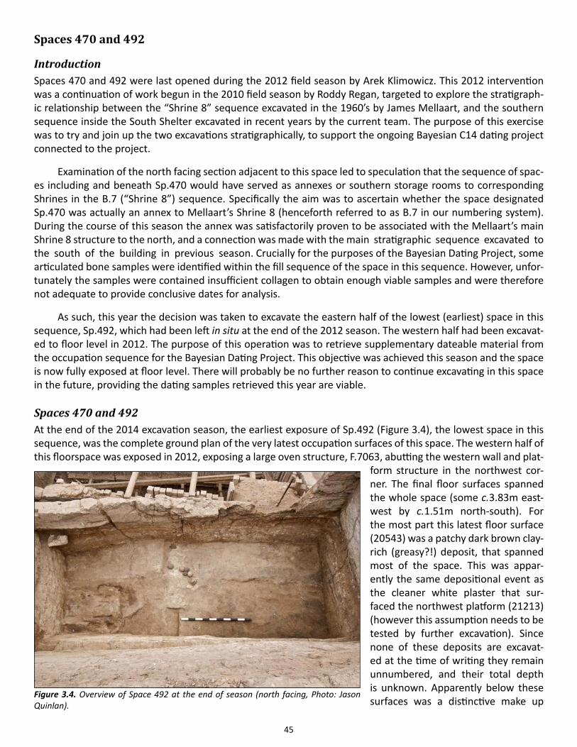
45
Spaces 470 and 492
IntroductionSpaces 470 and 492 were last opened during the 2012 field season by Arek Klimowicz. This 2012 intervention was a continuation of work begun in the 2010 field season by Roddy Regan, targeted to explore the stratigraph-ic relationship between the “Shrine 8” sequence excavated in the 1960’s by James Mellaart, and the southern sequence inside the South Shelter excavated in recent years by the current team. The purpose of this exercise was to try and join up the two excavations stratigraphically, to support the ongoing Bayesian C14 dating project connected to the project.
Examination of the north facing section adjacent to this space led to speculation that the sequence of spac-es including and beneath Sp.470 would have served as annexes or southern storage rooms to corresponding Shrines in the B.7 (“Shrine 8”) sequence. Specifically the aim was to ascertain whether the space designated Sp.470 was actually an annex to Mellaart’s Shrine 8 (henceforth referred to as B.7 in our numbering system). During the course of this season the annex was satisfactorily proven to be associated with the Mellaart’s main Shrine 8 structure to the north, and a connection was made with the main stratigraphic sequence excavated to the south of the building in previous season. Crucially for the purposes of the Bayesian Dating Project, some articulated bone samples were identified within the fill sequence of the space in this sequence. However, unfor-tunately the samples were contained insufficient collagen to obtain enough viable samples and were therefore not adequate to provide conclusive dates for analysis.
As such, this year the decision was taken to excavate the eastern half of the lowest (earliest) space in this sequence, Sp.492, which had been left in situ at the end of the 2012 season. The western half had been excavat-ed to floor level in 2012. The purpose of this operation was to retrieve supplementary dateable material from the occupation sequence for the Bayesian Dating Project. This objective was achieved this season and the space is now fully exposed at floor level. There will probably be no further reason to continue excavating in this space in the future, providing the dating samples retrieved this year are viable.
Spaces 470 and 492At the end of the 2014 excavation season, the earliest exposure of Sp.492 (Figure 3.4), the lowest space in this sequence, was the complete ground plan of the very latest occupation surfaces of this space. The western half of this floorspace was exposed in 2012, exposing a large oven structure, F.7063, abutting the western wall and plat-
form structure in the northwest cor-ner. The final floor surfaces spanned the whole space (some c.3.83m east-west by c.1.51m north-south). For the most part this latest floor surface (20543) was a patchy dark brown clay-rich (greasy?!) deposit, that spanned most of the space. This was appar-ently the same depositional event as the cleaner white plaster that sur-faced the northwest platform (21213) (however this assumption needs to be tested by further excavation). Since none of these deposits are excavat-ed at the time of writing they remain unnumbered, and their total depth is unknown. Apparently below these surfaces was a distinctive make up
Figure 3.4. Overview of Space 492 at the end of season (north facing, Photo: Jason Quinlan).
46
layer (which also remains un-excavated).
The earliest fully exca-vated unit in the overlying se-quence was a concentration of black charcoal rich material (21212), which immediately sealed the underlying floor surface, (20543), at a height of approximately 1004.73m ASL. This deposit was sampled as a backup for the dating pro-gramme. Apparently associat-ed with this lens of charcoal was a cluster of bone, stone and clay balls (21208). This cluster (Figure 3.5) consist-ed of a total of six clay balls (c.0.075m diameter), a ground stone artifact, an animal long
bone and a small scatter of articulated animal vertebrae. This cluster was the same stratigraphic event as the cluster, (20542), identified in the western half of the space in 2012, which contained a further 14 clay balls and six ground stone artifacts, as well as a number of faunal articulations.
These units were sealed by the first major room fill in the abandonment sequence, (20524) – numbered when the western half was removed in 2012 as part of a section through the room fills. Excavation of the eastern half of the deposit revealed more of the same material (friable dark gray/orange brown mixed silty-clay). Overall the deposit re-mained fairly sterile, about 0.33m deep. In total this deposit fill the room (c.3.76m east-west by c.1.56m north-south) to a height of between 1004.43-1004.76m ASL with a gentle slope from north to south. This marks the last deposit in the sequence that can be attributed to Sp.492.
Sealing this was another fill deposit, (20545), which was also half excavated in 2012 (Figure 3.6). This, a mid-dark orange silty-clay, was another mixed layer of compact room fill, with the same lateral dimensions as the fill below, and a depth of 0.38m. The deposit was also fairly sterile, but did contain obvious inclusions of brick and some plaster frag-ments. This deposit was interpreted as a stabilizing, founda-tion fill prior to the erection of the walls that would make up the overlying Sp.470.
Also founded upon this layer was a low partition wall, (20399), orientated north-south and abutting the southern wall of the space (identified with/identical to (20540/20541), defined and recorded in plan in 2012).
Figure 3.5. Mixed cluster (21208) close to the final floor surface in Space 492 (north facing, Photo: Trevor Iliff).
Figure 3.6. Fill deposits in Space 492 (east facing, Photo: Trevor Iliff).
47
This ephemeral structure was c.0.73m long by c.0.24m wide and was 0.24m high. The wall was apparently sealed by a thin band (c.0.12m deep) of fill material (20206), which as almost indistinguishable from the underlying deposit, (20545), and was only apparent because it sealed the wall itself, it may have had a slightly different consistency and lighter color than its lower counterpart. This unit was sealed by the plasters that lined the walls of Sp.470, and as such is tied at this point into the stratigraphic sequence excavated 2012.
Building 43 (Spaces 235 and 236)Erik Johansson
Work continued this season in B.43 (Figure 3.7) from where it was left last season. Originally it was James Mel-laart who excavated the building in the 1960’s. He named it E.VIII.27. Not until the season of 2004 was the build-ing focus for excavation again, but the main work has been carried out over the last three years. The aim for 2012, 2013 and this year’s excavation have been to excavate the occupation sequence of the building and finally removing it in order to expose the structures underneath.
Since Mellaart exposed the building interior almost 50 years ago the building has suffered heavy erosion and because of lacking documentation from Mellaart there have been difficulties attaining detailed spatial and chronological relations between all the features. The problems of erosion especially affected the stratigraphic relations between the burials and the floors and platforms of Sp.236.
Building 43 consists of two rooms, one small and narrow in the north (Sp.235) and one larger in the south (Sp.236). The eastern wall F.1855 of the building has a ‘dog-leg’ break in the middle which gives the building its irregular shape. The two rooms are divided by a partition wall F.1853 along an east-west axis. The party wall
Figure 3.7. West facing overview of B.43 at the end of season (Photo: Jason Quinlan).
48
abuts the eastern wall but not the western since there was a passageway here connecting the two rooms. The other walls of the building have heavily eroded surfaces and plaster only remains in the corners and close to the floor surface. The western wall had a double leopard relief originally that Mellaart took down. Most of the wall has since then collapsed and only remains in the south sloping towards the north.
Space 236Space 236 consists of the large room in the south and is bound by partition wall F.1853, partially by east wall F.1855, south wall F.1856 and west wall F.1857. This space was the main focus of excavation this season and besides the party wall and the northern wall all units excavated this year was in space 236. The work continued from where the team supervised by Agatha Czeszewska left it in 2013. The work in B.43 went on throughout season 2014 and was supervised by Erik Johansson and Onur Yüksel.
Northern areaA small feature interpreted as wall collapse (30346) was removed in order to free an underlying make-up layer (30347) covering most of Sp.236. This make-up layer was the earliest make-up in the main room of B.43.
After removing the collapsed wall and work had begun removing the make-up layer, it was decided to exca-vate a burial lying just south of the party wall. The burial F.7508 was easily detected as the top part of cranium was exposed at the surface, and probably been so since Mellaart excavated the platforms in this part of the building. The fill (30348) consisted of building material and room infill very similar to the surrounding soil and its cut (30360) was therefore difficult to make out. The burial was that of a female in its early twenties oriented in a tightly flexed upright position. This made us excavate and document the skeleton (30351) in sections, lifting parts and 3D-document it in four stages. This burial gave valuable information on using multiple 3D-models to document and plan skeletons in Çatalhöyük, especially when it came to the importance of precision measuring with the total station. The cranium of the skeleton was unarticulated and could indicate skull retrieval or post depositional disturbance, perhaps from removing the platforms.
A pit F.7506 situated between burial F.7508 and the collapsed west wall of Sp.236 was excavated and found to be cutting the burial. While cleaning, another burial F.7512 was found in the north area just at the end of the season. The skeleton (21802) was of an adolescent, with undetermined sex, estimated age around 14-16 years. The burial contained two perforated shells clearly deposited with the skeleton. They were situated neat-ly around the individual’s neck and had clearly been part of a necklace. Also a cow tooth was found in direct contact with the sacrum. It’s not clear however if this is to be regarded as part of the fill (21801) or deliberately placed there with the burial.
The partition wall F.1853 was excavated and removed this season. It was allocated unit number (5754) during post-ex in 2004 but wasn’t excavated until this season. Fragmented plaster (30371) was removed making it possible to remove brick and mortar (30378 & 30379). The party wall had a foundation cut (30380) into the room infill of the building below, thus indicating that the party wall was built in an early stage in the construction of B.43. Also the central make-up layer (30347) sealed the party wall plaster.
The excavation of the pit, the two burials and the party wall in the north part of Sp.236 exposed some of the underlying architecture. The burials were dug into the room infill of the building below and could be foundation burials. However since Mellaart excavated the platforms but not the burials themselves we can’t be sure of their physical relation. The burials could very well have been dug in a later phase of B.43. What was clear though is that the burials very neatly respected the plaster on the partition wall below. This indicated knowledge of the previous building and would suggest that burials F.7508 and F.7512 should be regarded as early features in the occupation of B.43. A cut (30360) of burial F.7508 was made into the plaster line and brick of the party wall be-neath and this could indicate skull retrieval or just a mistake when digging the burial pit.
Because of Mellaart’s undocumented excavation of B.43 and the following erosion, the burials in Sp.236
49
are floating stratigraphically. We simply don’t know their relation with the floors or the platforms of the building.
Niche/crawl hole F.1863 and F.7507Niche F.1863 was found in 2012 and emptied out in 2013. This season we could determine that F.1863 originally was constructed as a crawl hole, with the dimensions 1.14m x 0.4m x 0.3m. When excavating the remaining plaster layers covering the interior of the niche, a fill layer (30376) was exposed that clearly had been used as blocking material. A make-up layer (30372) had been put on the blocking which then was plastered over. How-ever the earliest plaster phase (30390) was red painted, covering the roof and sides of the niche and going in behind the blocking. When removing the niche fill it became clear that F.1865 was originally an access hole that was reconstructed into a niche when the space just east of B.43 was filled in. Taking into account the number of plaster layers connected to the niche phase and the quite few associated with the crawl hole it can be argued that the feature was made into a niche early on in the life of B.43.
Crawl hole F.7507 was uncov-ered in 2012 after recognizing a trace of plaster and a different brick and mortar ((30356) and (30357)) in the south part of the western wall F.1857 (Figures 3.8 and 3.9). The niche/crawl hole had the di-mensions 0.86m x 1.56m and a depth of 0.28m. As with F.1865 this feature also had an early red paint-ed plaster (30391) that covered the sides and roof of the feature. This feature was originally constructed as a crawl hole connecting Sp.236 with a possible side-room south-west of B.43. Later the crawl hole was blocked using brick and mor-tar and plaster, and turned into a niche. However the niche wasn’t plastered all the way down and that could indicate that the niche was made in one event with brick and mortar.
Up until this season, B.43 was believed to be a late structure in its area and thus effort has been made to excavate and remove it. The dis-covery of crawl hole F.7507 led to a reanalyzing of the stratigraphy be-tween the spaces west and south-west of B.43. As F.7507 was exca-vated, plaster (30391) was found to be the same as the plaster on the far side of the west wall prov-ing that B.43 was earlier than the surrounding structures. This meant
Figure 3.8. West facing view of the west side of Building 43, note crawl hole F.7507 on the southern end (Photo: Erik Johansen).
Figure 3.9. Detail of crawl hole F.7507 (west facing, Photo: Erik Johansson).
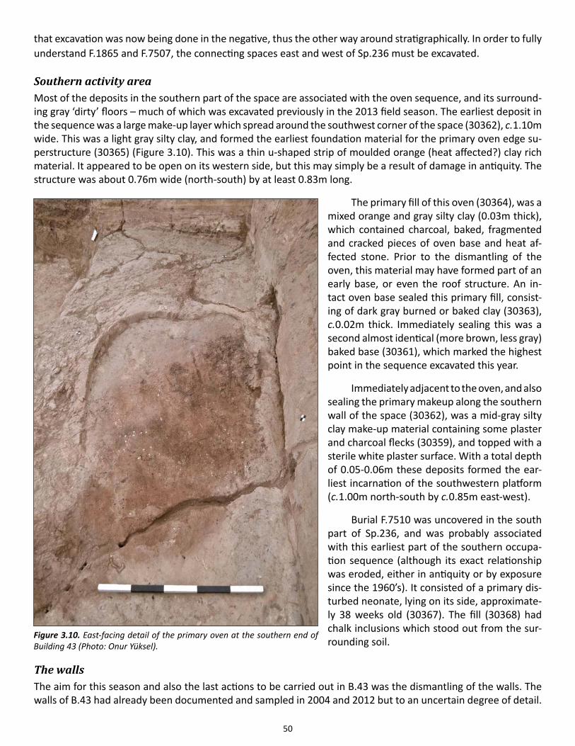
50
that excavation was now being done in the negative, thus the other way around stratigraphically. In order to fully understand F.1865 and F.7507, the connecting spaces east and west of Sp.236 must be excavated.
Southern activity areaMost of the deposits in the southern part of the space are associated with the oven sequence, and its surround-ing gray ‘dirty’ floors – much of which was excavated previously in the 2013 field season. The earliest deposit in the sequence was a large make-up layer which spread around the southwest corner of the space (30362), c.1.10m wide. This was a light gray silty clay, and formed the earliest foundation material for the primary oven edge su-perstructure (30365) (Figure 3.10). This was a thin u-shaped strip of moulded orange (heat affected?) clay rich material. It appeared to be open on its western side, but this may simply be a result of damage in antiquity. The structure was about 0.76m wide (north-south) by at least 0.83m long.
The primary fill of this oven (30364), was a mixed orange and gray silty clay (0.03m thick), which contained charcoal, baked, fragmented and cracked pieces of oven base and heat af-fected stone. Prior to the dismantling of the oven, this material may have formed part of an early base, or even the roof structure. An in-tact oven base sealed this primary fill, consist-ing of dark gray burned or baked clay (30363), c.0.02m thick. Immediately sealing this was a second almost identical (more brown, less gray) baked base (30361), which marked the highest point in the sequence excavated this year.
Immediately adjacent to the oven, and also sealing the primary makeup along the southern wall of the space (30362), was a mid-gray silty clay make-up material containing some plaster and charcoal flecks (30359), and topped with a sterile white plaster surface. With a total depth of 0.05-0.06m these deposits formed the ear-liest incarnation of the southwestern platform (c.1.00m north-south by c.0.85m east-west).
Burial F.7510 was uncovered in the south part of Sp.236, and was probably associated with this earliest part of the southern occupa-tion sequence (although its exact relationship was eroded, either in antiquity or by exposure since the 1960’s). It consisted of a primary dis-turbed neonate, lying on its side, approximate-ly 38 weeks old (30367). The fill (30368) had chalk inclusions which stood out from the sur-rounding soil.
The wallsThe aim for this season and also the last actions to be carried out in B.43 was the dismantling of the walls. The walls of B.43 had already been documented and sampled in 2004 and 2012 but to an uncertain degree of detail.
Figure 3.10. East-facing detail of the primary oven at the southern end of Building 43 (Photo: Onur Yüksel).
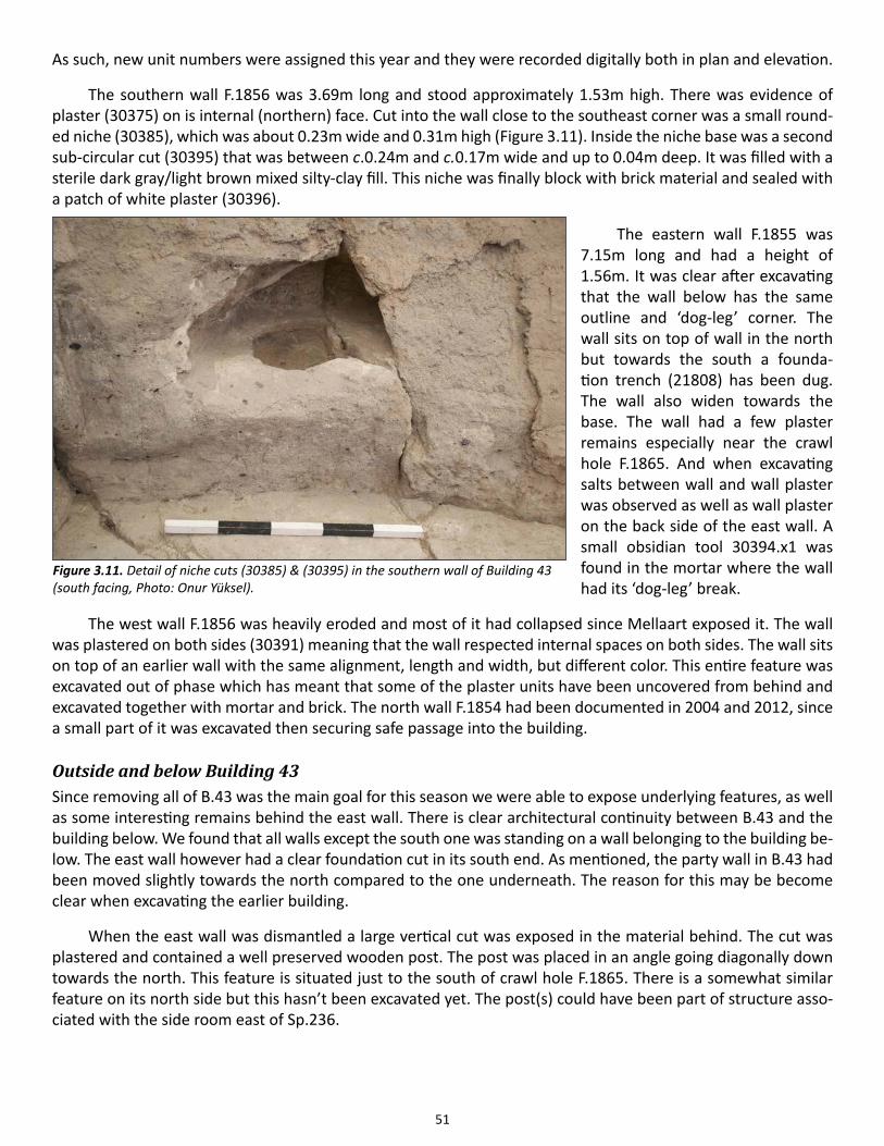
51
As such, new unit numbers were assigned this year and they were recorded digitally both in plan and elevation.
The southern wall F.1856 was 3.69m long and stood approximately 1.53m high. There was evidence of plaster (30375) on is internal (northern) face. Cut into the wall close to the southeast corner was a small round-ed niche (30385), which was about 0.23m wide and 0.31m high (Figure 3.11). Inside the niche base was a second sub-circular cut (30395) that was between c.0.24m and c.0.17m wide and up to 0.04m deep. It was filled with a sterile dark gray/light brown mixed silty-clay fill. This niche was finally block with brick material and sealed with a patch of white plaster (30396).
The eastern wall F.1855 was 7.15m long and had a height of 1.56m. It was clear after excavating that the wall below has the same outline and ‘dog-leg’ corner. The wall sits on top of wall in the north but towards the south a founda-tion trench (21808) has been dug. The wall also widen towards the base. The wall had a few plaster remains especially near the crawl hole F.1865. And when excavating salts between wall and wall plaster was observed as well as wall plaster on the back side of the east wall. A small obsidian tool 30394.x1 was found in the mortar where the wall had its ‘dog-leg’ break.
The west wall F.1856 was heavily eroded and most of it had collapsed since Mellaart exposed it. The wall was plastered on both sides (30391) meaning that the wall respected internal spaces on both sides. The wall sits on top of an earlier wall with the same alignment, length and width, but different color. This entire feature was excavated out of phase which has meant that some of the plaster units have been uncovered from behind and excavated together with mortar and brick. The north wall F.1854 had been documented in 2004 and 2012, since a small part of it was excavated then securing safe passage into the building.
Outside and below Building 43Since removing all of B.43 was the main goal for this season we were able to expose underlying features, as well as some interesting remains behind the east wall. There is clear architectural continuity between B.43 and the building below. We found that all walls except the south one was standing on a wall belonging to the building be-low. The east wall however had a clear foundation cut in its south end. As mentioned, the party wall in B.43 had been moved slightly towards the north compared to the one underneath. The reason for this may be become clear when excavating the earlier building.
When the east wall was dismantled a large vertical cut was exposed in the material behind. The cut was plastered and contained a well preserved wooden post. The post was placed in an angle going diagonally down towards the north. This feature is situated just to the south of crawl hole F.1865. There is a somewhat similar feature on its north side but this hasn’t been excavated yet. The post(s) could have been part of structure asso-ciated with the side room east of Sp.236.
Figure 3.11. Detail of niche cuts (30385) & (30395) in the southern wall of Building 43 (south facing, Photo: Onur Yüksel).
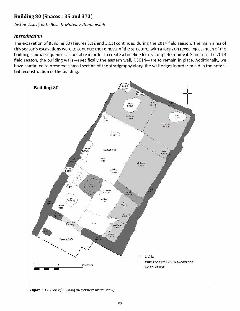
52
Building 80 (Spaces 135 and 373) Justine Issavi, Kate Rose & Mateusz Dembowiak
Introduction The excavation of Building 80 (Figures 3.12 and 3.13) continued during the 2014 field season. The main aims of this season’s excavations were to continue the removal of the structure, with a focus on revealing as much of the building’s burial sequences as possible in order to create a timeline for its complete removal. Similar to the 2013 field season, the building walls—specifically the eastern wall, F.5014—are to remain in place. Additionally, we have continued to preserve a small section of the stratigraphy along the wall edges in order to aid in the poten-tial reconstruction of the building.
Figure 3.12. Plan of Building 80 (Source: Justin Issavi).
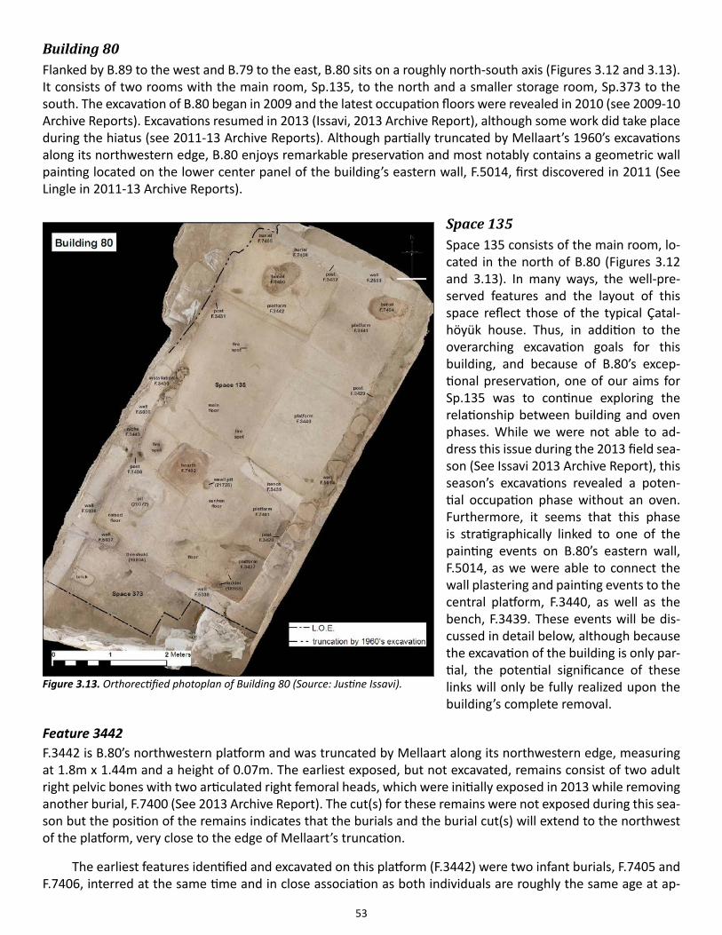
53
Building 80 Flanked by B.89 to the west and B.79 to the east, B.80 sits on a roughly north-south axis (Figures 3.12 and 3.13). It consists of two rooms with the main room, Sp.135, to the north and a smaller storage room, Sp.373 to the south. The excavation of B.80 began in 2009 and the latest occupation floors were revealed in 2010 (see 2009-10 Archive Reports). Excavations resumed in 2013 (Issavi, 2013 Archive Report), although some work did take place during the hiatus (see 2011-13 Archive Reports). Although partially truncated by Mellaart’s 1960’s excavations along its northwestern edge, B.80 enjoys remarkable preservation and most notably contains a geometric wall painting located on the lower center panel of the building’s eastern wall, F.5014, first discovered in 2011 (See Lingle in 2011-13 Archive Reports).
Space 135Space 135 consists of the main room, lo-cated in the north of B.80 (Figures 3.12 and 3.13). In many ways, the well-pre-served features and the layout of this space reflect those of the typical Çatal-höyük house. Thus, in addition to the overarching excavation goals for this building, and because of B.80’s excep-tional preservation, one of our aims for Sp.135 was to continue exploring the relationship between building and oven phases. While we were not able to ad-dress this issue during the 2013 field sea-son (See Issavi 2013 Archive Report), this season’s excavations revealed a poten-tial occupation phase without an oven. Furthermore, it seems that this phase is stratigraphically linked to one of the painting events on B.80’s eastern wall, F.5014, as we were able to connect the wall plastering and painting events to the central platform, F.3440, as well as the bench, F.3439. These events will be dis-cussed in detail below, although because the excavation of the building is only par-tial, the potential significance of these links will only be fully realized upon the building’s complete removal.
Feature 3442F.3442 is B.80’s northwestern platform and was truncated by Mellaart along its northwestern edge, measuring at 1.8m x 1.44m and a height of 0.07m. The earliest exposed, but not excavated, remains consist of two adult right pelvic bones with two articulated right femoral heads, which were initially exposed in 2013 while removing another burial, F.7400 (See 2013 Archive Report). The cut(s) for these remains were not exposed during this sea-son but the position of the remains indicates that the burials and the burial cut(s) will extend to the northwest of the platform, very close to the edge of Mellaart’s truncation.
The earliest features identified and excavated on this platform (F.3442) were two infant burials, F.7405 and F.7406, interred at the same time and in close association as both individuals are roughly the same age at ap-
Figure 3.13. Orthorectified photoplan of Building 80 (Source: Justine Issavi).
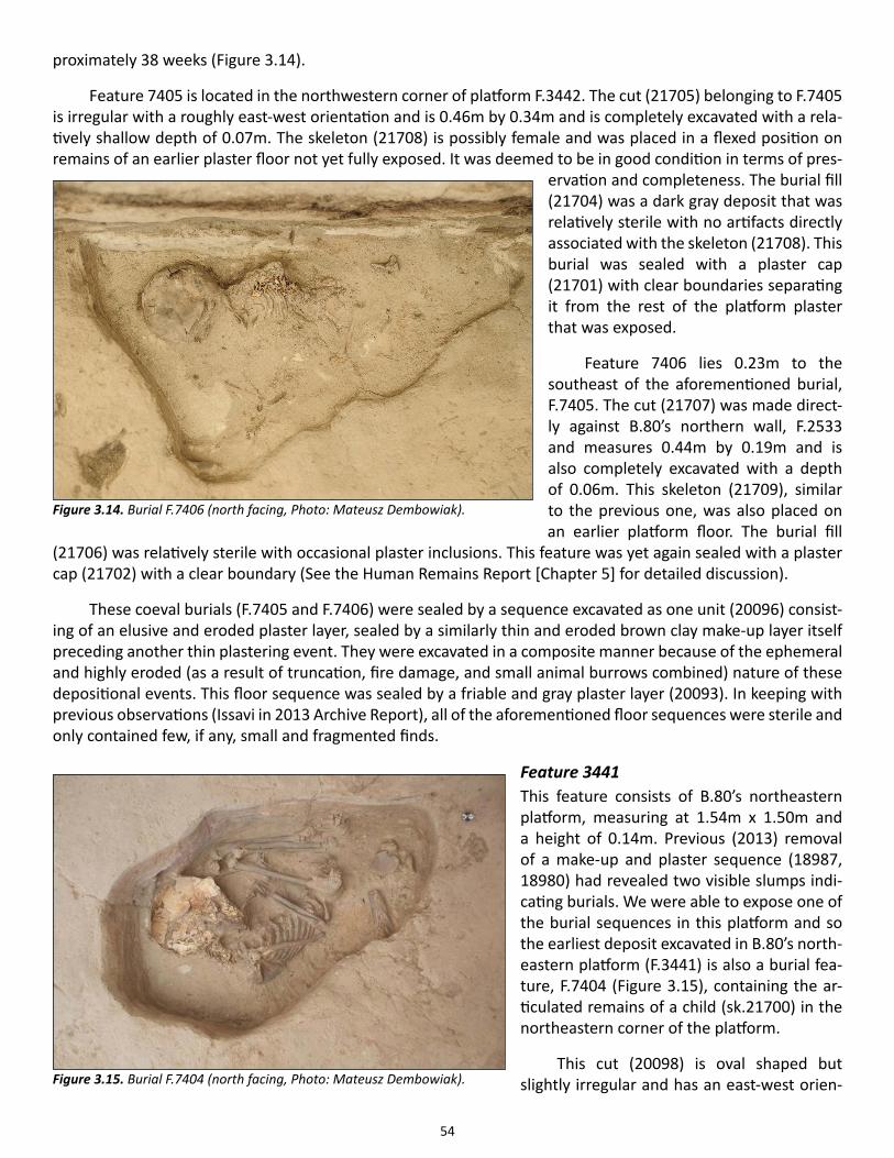
54
proximately 38 weeks (Figure 3.14).
Feature 7405 is located in the northwestern corner of platform F.3442. The cut (21705) belonging to F.7405 is irregular with a roughly east-west orientation and is 0.46m by 0.34m and is completely excavated with a rela-tively shallow depth of 0.07m. The skeleton (21708) is possibly female and was placed in a flexed position on remains of an earlier plaster floor not yet fully exposed. It was deemed to be in good condition in terms of pres-
ervation and completeness. The burial fill (21704) was a dark gray deposit that was relatively sterile with no artifacts directly associated with the skeleton (21708). This burial was sealed with a plaster cap (21701) with clear boundaries separating it from the rest of the platform plaster that was exposed.
Feature 7406 lies 0.23m to the southeast of the aforementioned burial, F.7405. The cut (21707) was made direct-ly against B.80’s northern wall, F.2533 and measures 0.44m by 0.19m and is also completely excavated with a depth of 0.06m. This skeleton (21709), similar to the previous one, was also placed on an earlier platform floor. The burial fill
(21706) was relatively sterile with occasional plaster inclusions. This feature was yet again sealed with a plaster cap (21702) with a clear boundary (See the Human Remains Report [Chapter 5] for detailed discussion).
These coeval burials (F.7405 and F.7406) were sealed by a sequence excavated as one unit (20096) consist-ing of an elusive and eroded plaster layer, sealed by a similarly thin and eroded brown clay make-up layer itself preceding another thin plastering event. They were excavated in a composite manner because of the ephemeral and highly eroded (as a result of truncation, fire damage, and small animal burrows combined) nature of these depositional events. This floor sequence was sealed by a friable and gray plaster layer (20093). In keeping with previous observations (Issavi in 2013 Archive Report), all of the aforementioned floor sequences were sterile and only contained few, if any, small and fragmented finds.
Feature 3441This feature consists of B.80’s northeastern platform, measuring at 1.54m x 1.50m and a height of 0.14m. Previous (2013) removal of a make-up and plaster sequence (18987, 18980) had revealed two visible slumps indi-cating burials. We were able to expose one of the burial sequences in this platform and so the earliest deposit excavated in B.80’s north-eastern platform (F.3441) is also a burial fea-ture, F.7404 (Figure 3.15), containing the ar-ticulated remains of a child (sk.21700) in the northeastern corner of the platform.
This cut (20098) is oval shaped but slightly irregular and has an east-west orien-
Figure 3.14. Burial F.7406 (north facing, Photo: Mateusz Dembowiak).
Figure 3.15. Burial F.7404 (north facing, Photo: Mateusz Dembowiak).
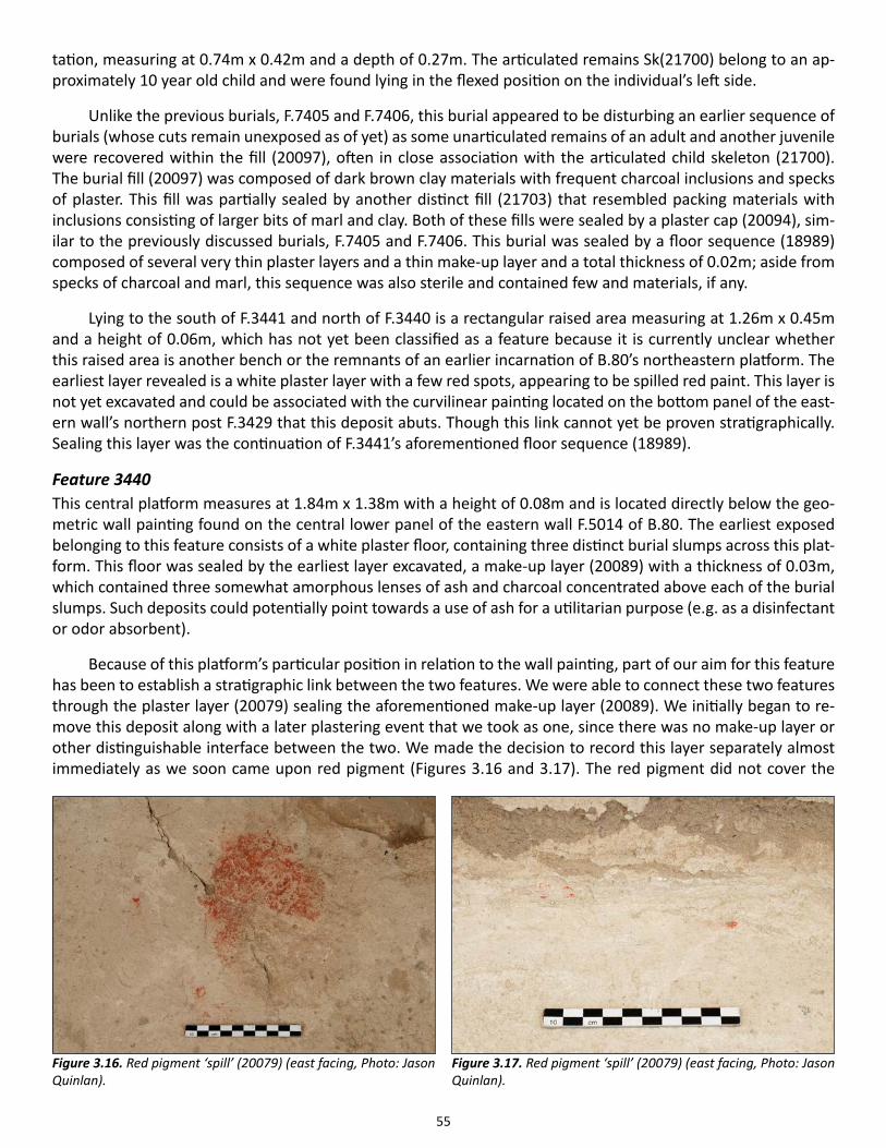
55
tation, measuring at 0.74m x 0.42m and a depth of 0.27m. The articulated remains Sk(21700) belong to an ap-proximately 10 year old child and were found lying in the flexed position on the individual’s left side.
Unlike the previous burials, F.7405 and F.7406, this burial appeared to be disturbing an earlier sequence of burials (whose cuts remain unexposed as of yet) as some unarticulated remains of an adult and another juvenile were recovered within the fill (20097), often in close association with the articulated child skeleton (21700). The burial fill (20097) was composed of dark brown clay materials with frequent charcoal inclusions and specks of plaster. This fill was partially sealed by another distinct fill (21703) that resembled packing materials with inclusions consisting of larger bits of marl and clay. Both of these fills were sealed by a plaster cap (20094), sim-ilar to the previously discussed burials, F.7405 and F.7406. This burial was sealed by a floor sequence (18989) composed of several very thin plaster layers and a thin make-up layer and a total thickness of 0.02m; aside from specks of charcoal and marl, this sequence was also sterile and contained few and materials, if any.
Lying to the south of F.3441 and north of F.3440 is a rectangular raised area measuring at 1.26m x 0.45m and a height of 0.06m, which has not yet been classified as a feature because it is currently unclear whether this raised area is another bench or the remnants of an earlier incarnation of B.80’s northeastern platform. The earliest layer revealed is a white plaster layer with a few red spots, appearing to be spilled red paint. This layer is not yet excavated and could be associated with the curvilinear painting located on the bottom panel of the east-ern wall’s northern post F.3429 that this deposit abuts. Though this link cannot yet be proven stratigraphically. Sealing this layer was the continuation of F.3441’s aforementioned floor sequence (18989).
Feature 3440 This central platform measures at 1.84m x 1.38m with a height of 0.08m and is located directly below the geo-metric wall painting found on the central lower panel of the eastern wall F.5014 of B.80. The earliest exposed belonging to this feature consists of a white plaster floor, containing three distinct burial slumps across this plat-form. This floor was sealed by the earliest layer excavated, a make-up layer (20089) with a thickness of 0.03m, which contained three somewhat amorphous lenses of ash and charcoal concentrated above each of the burial slumps. Such deposits could potentially point towards a use of ash for a utilitarian purpose (e.g. as a disinfectant or odor absorbent).
Because of this platform’s particular position in relation to the wall painting, part of our aim for this feature has been to establish a stratigraphic link between the two features. We were able to connect these two features through the plaster layer (20079) sealing the aforementioned make-up layer (20089). We initially began to re-move this deposit along with a later plastering event that we took as one, since there was no make-up layer or other distinguishable interface between the two. We made the decision to record this layer separately almost immediately as we soon came upon red pigment (Figures 3.16 and 3.17). The red pigment did not cover the
Figure 3.16. Red pigment ‘spill’ (20079) (east facing, Photo: Jason Quinlan).
Figure 3.17. Red pigment ‘spill’ (20079) (east facing, Photo: Jason Quinlan).
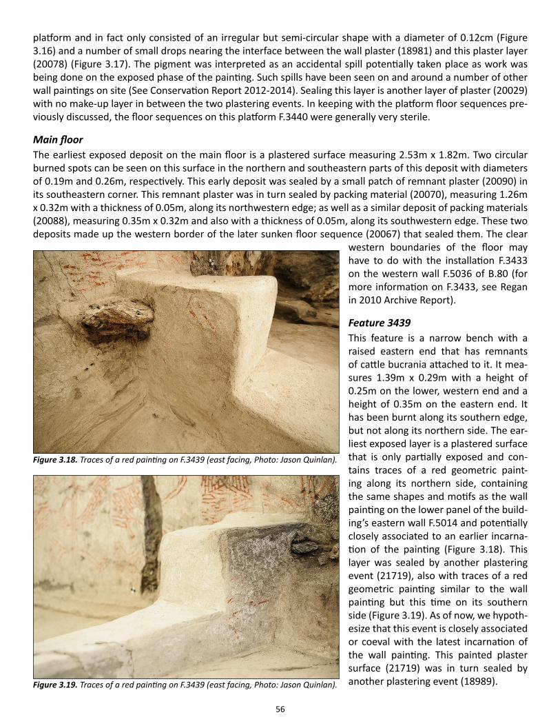
56
platform and in fact only consisted of an irregular but semi-circular shape with a diameter of 0.12cm (Figure 3.16) and a number of small drops nearing the interface between the wall plaster (18981) and this plaster layer (20078) (Figure 3.17). The pigment was interpreted as an accidental spill potentially taken place as work was being done on the exposed phase of the painting. Such spills have been seen on and around a number of other wall paintings on site (See Conservation Report 2012-2014). Sealing this layer is another layer of plaster (20029) with no make-up layer in between the two plastering events. In keeping with the platform floor sequences pre-viously discussed, the floor sequences on this platform F.3440 were generally very sterile.
Main floorThe earliest exposed deposit on the main floor is a plastered surface measuring 2.53m x 1.82m. Two circular burned spots can be seen on this surface in the northern and southeastern parts of this deposit with diameters of 0.19m and 0.26m, respectively. This early deposit was sealed by a small patch of remnant plaster (20090) in its southeastern corner. This remnant plaster was in turn sealed by packing material (20070), measuring 1.26m x 0.32m with a thickness of 0.05m, along its northwestern edge; as well as a similar deposit of packing materials (20088), measuring 0.35m x 0.32m and also with a thickness of 0.05m, along its southwestern edge. These two deposits made up the western border of the later sunken floor sequence (20067) that sealed them. The clear
western boundaries of the floor may have to do with the installation F.3433 on the western wall F.5036 of B.80 (for more information on F.3433, see Regan in 2010 Archive Report).
Feature 3439This feature is a narrow bench with a raised eastern end that has remnants of cattle bucrania attached to it. It mea-sures 1.39m x 0.29m with a height of 0.25m on the lower, western end and a height of 0.35m on the eastern end. It has been burnt along its southern edge, but not along its northern side. The ear-liest exposed layer is a plastered surface that is only partially exposed and con-tains traces of a red geometric paint-ing along its northern side, containing the same shapes and motifs as the wall painting on the lower panel of the build-ing’s eastern wall F.5014 and potentially closely associated to an earlier incarna-tion of the painting (Figure 3.18). This layer was sealed by another plastering event (21719), also with traces of a red geometric painting similar to the wall painting but this time on its southern side (Figure 3.19). As of now, we hypoth-esize that this event is closely associated or coeval with the latest incarnation of the wall painting. This painted plaster surface (21719) was in turn sealed by another plastering event (18989).
Figure 3.18. Traces of a red painting on F.3439 (east facing, Photo: Jason Quinlan).
Figure 3.19. Traces of a red painting on F.3439 (east facing, Photo: Jason Quinlan).
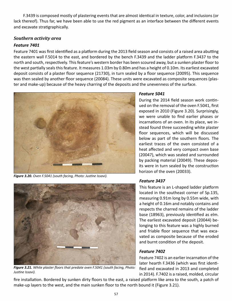
57
F.3439 is composed mostly of plastering events that are almost identical in texture, color, and inclusions (or lack thereof). Thus far, we have been able to use the red pigment as an interface between the different events and excavate stratigraphically.
Southern activity areaFeature 7401Feature 7401 was first identified as a platform during the 2013 field season and consists of a raised area abutting the eastern wall F.5014 to the east, and bordered by the bench F.3439 and the ladder platform F.3437 to the north and south, respectively. This feature’s western border has been scoured away, but a sunken plaster floor to the west partially seals this feature. It measures 1.03m by 0.80m and has a height of 0.10m. Its earliest excavated deposit consists of a plaster floor sequence (21730), in turn sealed by a floor sequence (20095). This sequence was then sealed by another floor sequence (20084). These units were excavated as composite sequences (plas-ter and make-up) because of the heavy charring of the deposits and the unevenness of the surface.
Feature 5041During the 2014 field season work contin-ued on the removal of the oven F.5041, first exposed in 2010 (Figure 3.20). Surprisingly, we were unable to find earlier phases or incarnations of an oven. In its place, we in-stead found three succeeding white plaster floor sequences, which will be discussed below as part of the southern floors. The earliest traces of the oven consisted of a heat affected and very compact oven base (20047), which was sealed and surrounded by packing material (20049). These depos-its were in turn sealed by the construction horizon of the oven (20033).
Feature 3437This feature is an L-shaped ladder platform located in the southeast corner of Sp.135, measuring 0.91m long by 0.55m wide, with a height of 0.16m and notably contains and respects the charred remains of the ladder base (18963), previously identified as elm. The earliest excavated deposit (20044) be-longing to this feature was a highly burned and friable floor sequence that was exca-vated as composite because of the eroded and burnt condition of the deposit.
Feature 7402Feature 7402 is an earlier incarnation of the later hearth F.3436 (which was first identi-fied and excavated in 2013 and completed in 2014). F.7402 is a raised, molded, circular
fire installation. Bordered by sunken dirty floors to the east, a raised platform like area to the south, a patch of make-up layers to the west, and the main sunken floor to the north bound it (Figure 3.21).
Figure 3.20. Oven F.5041 (south facing, Photo: Justine Issavi).
Figure 3.21. White plaster floors that predate oven F.5041 (south facing, Photo: Justine Issavi).
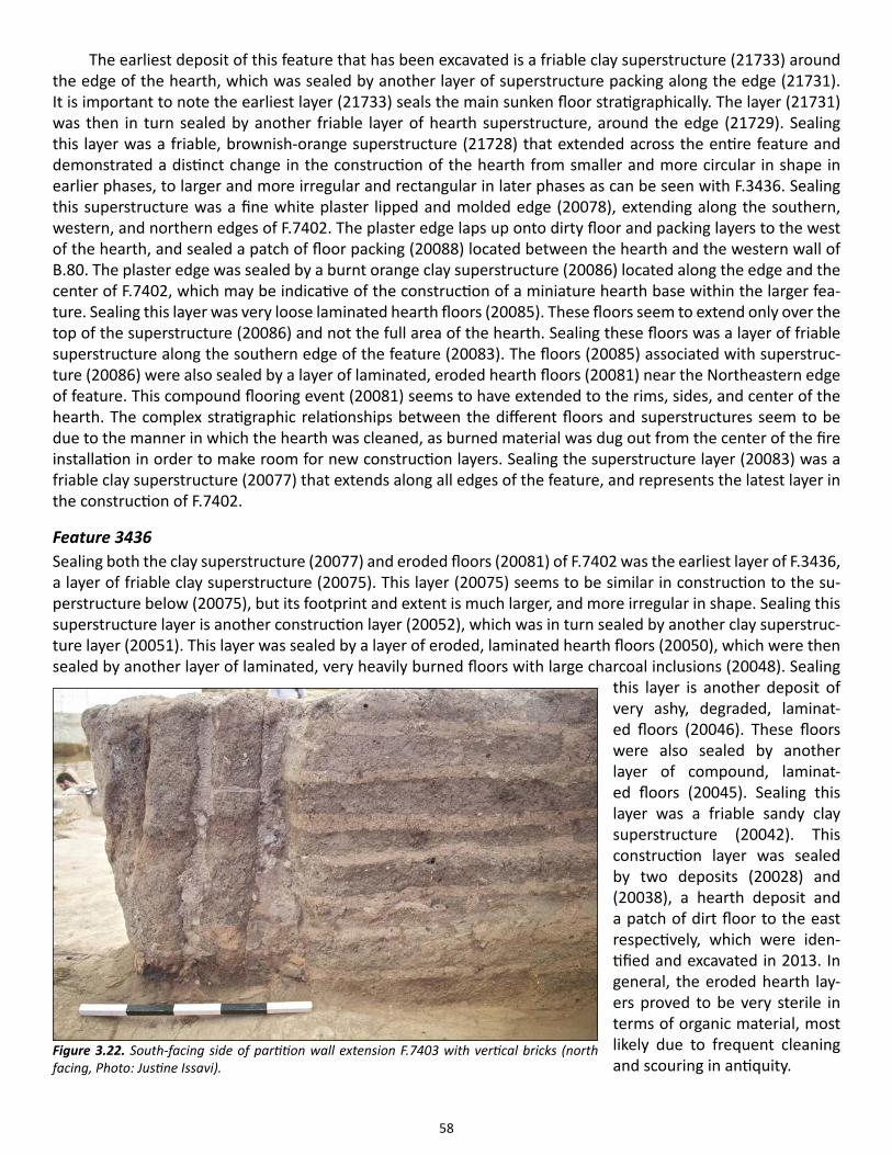
58
The earliest deposit of this feature that has been excavated is a friable clay superstructure (21733) around the edge of the hearth, which was sealed by another layer of superstructure packing along the edge (21731). It is important to note the earliest layer (21733) seals the main sunken floor stratigraphically. The layer (21731) was then in turn sealed by another friable layer of hearth superstructure, around the edge (21729). Sealing this layer was a friable, brownish-orange superstructure (21728) that extended across the entire feature and demonstrated a distinct change in the construction of the hearth from smaller and more circular in shape in earlier phases, to larger and more irregular and rectangular in later phases as can be seen with F.3436. Sealing this superstructure was a fine white plaster lipped and molded edge (20078), extending along the southern, western, and northern edges of F.7402. The plaster edge laps up onto dirty floor and packing layers to the west of the hearth, and sealed a patch of floor packing (20088) located between the hearth and the western wall of B.80. The plaster edge was sealed by a burnt orange clay superstructure (20086) located along the edge and the center of F.7402, which may be indicative of the construction of a miniature hearth base within the larger fea-ture. Sealing this layer was very loose laminated hearth floors (20085). These floors seem to extend only over the top of the superstructure (20086) and not the full area of the hearth. Sealing these floors was a layer of friable superstructure along the southern edge of the feature (20083). The floors (20085) associated with superstruc-ture (20086) were also sealed by a layer of laminated, eroded hearth floors (20081) near the Northeastern edge of feature. This compound flooring event (20081) seems to have extended to the rims, sides, and center of the hearth. The complex stratigraphic relationships between the different floors and superstructures seem to be due to the manner in which the hearth was cleaned, as burned material was dug out from the center of the fire installation in order to make room for new construction layers. Sealing the superstructure layer (20083) was a friable clay superstructure (20077) that extends along all edges of the feature, and represents the latest layer in the construction of F.7402.
Feature 3436Sealing both the clay superstructure (20077) and eroded floors (20081) of F.7402 was the earliest layer of F.3436, a layer of friable clay superstructure (20075). This layer (20075) seems to be similar in construction to the su-perstructure below (20075), but its footprint and extent is much larger, and more irregular in shape. Sealing this superstructure layer is another construction layer (20052), which was in turn sealed by another clay superstruc-ture layer (20051). This layer was sealed by a layer of eroded, laminated hearth floors (20050), which were then sealed by another layer of laminated, very heavily burned floors with large charcoal inclusions (20048). Sealing
this layer is another deposit of very ashy, degraded, laminat-ed floors (20046). These floors were also sealed by another layer of compound, laminat-ed floors (20045). Sealing this layer was a friable sandy clay superstructure (20042). This construction layer was sealed by two deposits (20028) and (20038), a hearth deposit and a patch of dirt floor to the east respectively, which were iden-tified and excavated in 2013. In general, the eroded hearth lay-ers proved to be very sterile in terms of organic material, most likely due to frequent cleaning and scouring in antiquity.
Figure 3.22. South-facing side of partition wall extension F.7403 with vertical bricks (north facing, Photo: Justine Issavi).
59
Southern floorsBeyond the in situ and identified structural elements, the southern activity area that has been exposed extends from the western edge of platform F.3437 to the southwestern corner of Sp.135, with the bench F.3439, hearth F.7402, and the main floor acting as the northern boundary. This southern area consists of three smaller sep-arate plastered areas: one in the place where the oven was previously located, another in the southwestern corner of Sp.135 (currently identified as a raised floor), and a sunken floor flanked by the hearth F.7402 to the west and platform F.7401 to the east. The boundaries between these areas were frequently unclear, especially because of the higher level of fire damage and erosion, which is why we have not been always able to define exact stratigraphic relationships with adjacent depositional events (Figure 3.21).
The earliest deposit excavated in the sunken floor area was a sunken floor sequence (21722) that partially locked the hearth F.7402 superstructure. (21722) contained a small and shallow (depth of 0.09m) circular cut (21725) with a diameter of 0.16m containing a small amount of fill (21724). Similar small, circular pits have been found in close proximity to the hearth feature in the neighboring, but earlier, B.89 (See Taylor in 2013 Archive Report as well as in current volume). These deposits were sealed by a make-up layer (20069), in turn sealed by an ashy lens (20057) and sandy packing material (20066). (20066) was sealed by another make-up layer (20065) and along with the aforementioned deposits fill in the earlier sunken floor (21722).
The earliest deposit belonging to the raised floor in the southwestern corner of Sp.135 excavated is a make-up (20076) and plaster (20074) sequence, also containing an irregular but shallow cut (depth of 0.13m) cut (21722) with a diameter of 0.52m containing a piece of ground stone lodged into the surface of the cut but otherwise a relatively sterile fill (21721). These deposits are sealed by a make-up layer (20068), which is in turn sealed by an irregular sandy deposit (20064). The irregular nature of this deposit suggests that it may have been acted as a kind of leveling preparation for subsequent events. A plaster surface (20063) and a make-up layer (20060) sealed (20064), respectively.
The earliest deposit uncovered in the southern portion of Sp.135 and abutting the eastern partition wall F.5038 (i.e., the previous location of the oven F.5041) was a make-up layer (20061), which was sealed by a plastering event (20059). This floor sequence—along with the aforementioned sequence (20063, 20060) in the southwestern corner of Sp.135; although only partially in this case—were sealed by a succession of thin, white plaster floors ((20058), (20054), (20053)-from earliest to latest). The position of these floor sequences, the ‘clean’ or whiteness of the plaster, along with the slimness and general delicacy of these southern floors suggests that they were laid down in quick succession in preparation for the addition of the oven F.5041; furthermore, they were probably not exposed for an extended period of time (Figure 3.21).
Feature 3428This feature consists of remnants of a post placed in the southern portion of B.80’s eastern wall, F.5014, and was first identified during the 2010 field season. Although the feature was not yet stratigraphically free, the remain-ing charred timber (21734) and fill (18939) had to be excavated, by the Çatalhöyük Anthracology team, during this season because of its increasingly deteriorating condition and threat of potential collapse. The timber was predated by a host of plastering events with alternating red painted and white plaster, as well as post mainte-nance. As a result of these early activities, we were able to deduce that the timber (21734), did not reach the top of the eastern wall F.5014 and thus could not provide much structural support. Feature 5014’s northern post, F.3429, also exhibits potentially corroborating evidence although it remains unexcavated (For detailed discussion see the Anthracology Report in current volume).
Feature 7403Feature number 7403 was attributed to the extension of B.80’s southeastern partition wall (F.5038) after its re-moval during this field season. The complete removal of this extension has exposed the earlier wooden thresh-old (19804)—first recognized and recorded in 2011—that divides Sp.135 and Sp.373.
60
Although originally this extension was considered part of the partition wall, its later construction and the dissimilar nature of its vertically placed bricks (18911) and mortar (20062) impelled us to identify it as a separate feature. This extension consisted of three courses of vertical bricks, with a height of 0.67m, length of 0.33m, and width measuring 0.26m (Figure 3.22).
This extension was built on top of a distinct preparation layer ((20091), (20092)) and was sealed by the three white plaster floors (20058), (20054), (20053). The vertical and generally sloppy nature of this extension, especially in direct comparison to the existing eastern partition F.5038, suggests that this extension was poten-tially built in a hurry. These characteristics then lend credence to the hypothesis that the extension was built in order to accommodate the later oven F.5041.
Space 373 Space 373 is a smaller storage room located in the southern part of B.80. Because of safety concerns, the south-ern limit of excavation (LOE) for B.80 was pushed further north and the original extent of the space, or the building remains unknown. We realized soon after excavating in this space that there was remnant room fill that needed to be excavated from this space although we initially believed that the occupation floors of Sp.373 had been reached in 2010.
The earliest exposed surface consists of a patchy, ashy, midden lens that is rich in artifacts and sealing bits of plaster (possibly representing Sp.373’s occupation floors). To the west, an intact—and potentially in situ—brick (measuring 0.36m x 0.20m and roughly oriented on an east-west axis) has been partially uncovered. Al-though the brick is positioned near B.80’s western wall, F.5036, it is not directly abutting it. These unexcavated deposits were sealed by a clay and charcoal rich room fill deposit (21727) that extends beyond the current LOE. (21727) was sealed by another highly burned room fill layer (21726), which is itself sealed with another artifact rich room fill deposit (21720), which contained a cluster (21723) of bone and stone cluster (generally weathered and broken) just south of the western partition wall, F.5037. The cluster (21723) was then sealed by a mixed room fill deposit (21718)—rich in charcoal, plaster, and clay—that covered the entire excavation area in Sp.373 and extended beyond LOE.
The difference in terms of artifact densities of the fill in Sp.373 and the relative sterility of the occupation floors in Sp.135 is stark and was one of the impetuses leading us to interpret the deposits in Sp.373 as room fill (one exception to this stark difference would be the midden-like fills that Sp.135’s structural elements—such as the pillars F.3428 and F.3429 and the installation F.3433—seem to contain).
Concluding notesIt is hoped that the excavation of this building can be completed by the end of the upcoming field season, however, since we were unable to reach some of B.80’s burial sequences (i.e. F.3440) it is difficult to predict the amount of time needed to complete this removal. It should also be noted that the latest burial sequenc-es—F.7400, F.7404, F.7405 and F7406—all consist of children (juveniles under 10 years of age in the case of F.7400 and F.7404 and infants in the case of F.7405 and F.7406).
Additionally, while B.80’s hearth F.7402 was active without a coeval oven, the lack of an earlier incarna-tion of the oven F.5041 is also stimulating and could further substantiate claims of sharing, especially in regards subsistence and productive activities. It could also have implications regarding symbolic activities as the links that have been made with the eastern wall’s geometric painting and the platform F.3440 and bench F.3439 stratigraphically correlate with the oven-less phase of B.80. Whether or not there was an earlier oven in another location (beyond current LOE) cannot be concretely established, although typically this is unlikely.
Lastly, in spite of B.80’s great state of preservation, it has often been difficult to ascertain certain rela-tionships between the building’s structural elements and features, especially concerning homogenous plas-tering events and flooring sequences (this point is especially salient in areas where fire damage is substan-
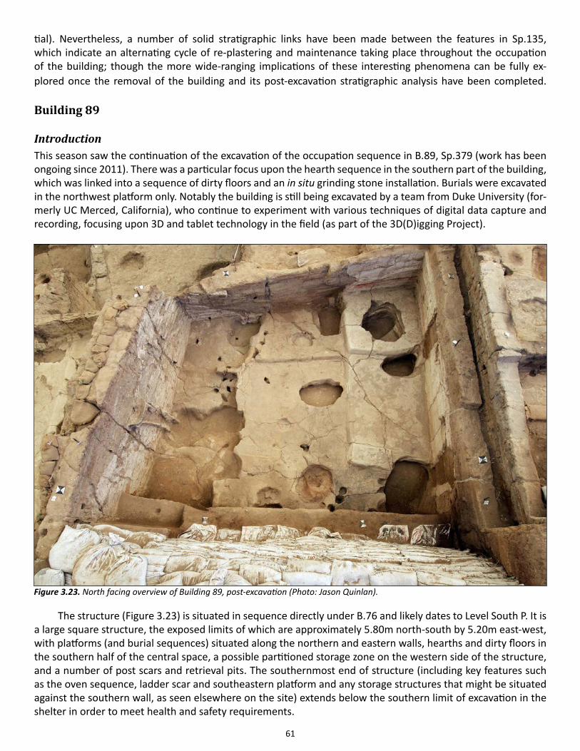
61
tial). Nevertheless, a number of solid stratigraphic links have been made between the features in Sp.135, which indicate an alternating cycle of re-plastering and maintenance taking place throughout the occupation of the building; though the more wide-ranging implications of these interesting phenomena can be fully ex-plored once the removal of the building and its post-excavation stratigraphic analysis have been completed. Building 89
IntroductionThis season saw the continuation of the excavation of the occupation sequence in B.89, Sp.379 (work has been ongoing since 2011). There was a particular focus upon the hearth sequence in the southern part of the building, which was linked into a sequence of dirty floors and an in situ grinding stone installation. Burials were excavated in the northwest platform only. Notably the building is still being excavated by a team from Duke University (for-merly UC Merced, California), who continue to experiment with various techniques of digital data capture and recording, focusing upon 3D and tablet technology in the field (as part of the 3D(D)igging Project).
The structure (Figure 3.23) is situated in sequence directly under B.76 and likely dates to Level South P. It is a large square structure, the exposed limits of which are approximately 5.80m north-south by 5.20m east-west, with platforms (and burial sequences) situated along the northern and eastern walls, hearths and dirty floors in the southern half of the central space, a possible partitioned storage zone on the western side of the structure, and a number of post scars and retrieval pits. The southernmost end of structure (including key features such as the oven sequence, ladder scar and southeastern platform and any storage structures that might be situated against the southern wall, as seen elsewhere on the site) extends below the southern limit of excavation in the shelter in order to meet health and safety requirements.
Figure 3.23. North facing overview of Building 89, post-excavation (Photo: Jason Quinlan).
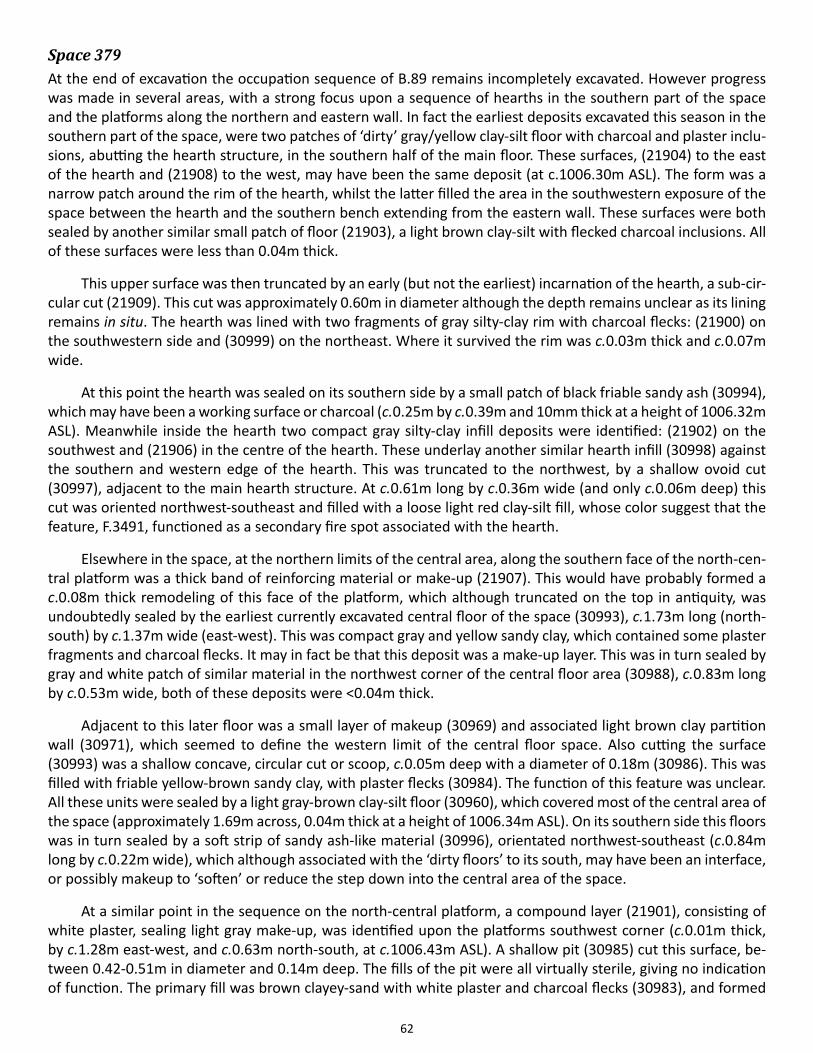
62
Space 379At the end of excavation the occupation sequence of B.89 remains incompletely excavated. However progress was made in several areas, with a strong focus upon a sequence of hearths in the southern part of the space and the platforms along the northern and eastern wall. In fact the earliest deposits excavated this season in the southern part of the space, were two patches of ‘dirty’ gray/yellow clay-silt floor with charcoal and plaster inclu-sions, abutting the hearth structure, in the southern half of the main floor. These surfaces, (21904) to the east of the hearth and (21908) to the west, may have been the same deposit (at c.1006.30m ASL). The form was a narrow patch around the rim of the hearth, whilst the latter filled the area in the southwestern exposure of the space between the hearth and the southern bench extending from the eastern wall. These surfaces were both sealed by another similar small patch of floor (21903), a light brown clay-silt with flecked charcoal inclusions. All of these surfaces were less than 0.04m thick.
This upper surface was then truncated by an early (but not the earliest) incarnation of the hearth, a sub-cir-cular cut (21909). This cut was approximately 0.60m in diameter although the depth remains unclear as its lining remains in situ. The hearth was lined with two fragments of gray silty-clay rim with charcoal flecks: (21900) on the southwestern side and (30999) on the northeast. Where it survived the rim was c.0.03m thick and c.0.07m wide.
At this point the hearth was sealed on its southern side by a small patch of black friable sandy ash (30994), which may have been a working surface or charcoal (c.0.25m by c.0.39m and 10mm thick at a height of 1006.32m ASL). Meanwhile inside the hearth two compact gray silty-clay infill deposits were identified: (21902) on the southwest and (21906) in the centre of the hearth. These underlay another similar hearth infill (30998) against the southern and western edge of the hearth. This was truncated to the northwest, by a shallow ovoid cut (30997), adjacent to the main hearth structure. At c.0.61m long by c.0.36m wide (and only c.0.06m deep) this cut was oriented northwest-southeast and filled with a loose light red clay-silt fill, whose color suggest that the feature, F.3491, functioned as a secondary fire spot associated with the hearth.
Elsewhere in the space, at the northern limits of the central area, along the southern face of the north-cen-tral platform was a thick band of reinforcing material or make-up (21907). This would have probably formed a c.0.08m thick remodeling of this face of the platform, which although truncated on the top in antiquity, was undoubtedly sealed by the earliest currently excavated central floor of the space (30993), c.1.73m long (north-south) by c.1.37m wide (east-west). This was compact gray and yellow sandy clay, which contained some plaster fragments and charcoal flecks. It may in fact be that this deposit was a make-up layer. This was in turn sealed by gray and white patch of similar material in the northwest corner of the central floor area (30988), c.0.83m long by c.0.53m wide, both of these deposits were <0.04m thick.
Adjacent to this later floor was a small layer of makeup (30969) and associated light brown clay partition wall (30971), which seemed to define the western limit of the central floor space. Also cutting the surface (30993) was a shallow concave, circular cut or scoop, c.0.05m deep with a diameter of 0.18m (30986). This was filled with friable yellow-brown sandy clay, with plaster flecks (30984). The function of this feature was unclear. All these units were sealed by a light gray-brown clay-silt floor (30960), which covered most of the central area of the space (approximately 1.69m across, 0.04m thick at a height of 1006.34m ASL). On its southern side this floors was in turn sealed by a soft strip of sandy ash-like material (30996), orientated northwest-southeast (c.0.84m long by c.0.22m wide), which although associated with the ‘dirty floors’ to its south, may have been an interface, or possibly makeup to ‘soften’ or reduce the step down into the central area of the space.
At a similar point in the sequence on the north-central platform, a compound layer (21901), consisting of white plaster, sealing light gray make-up, was identified upon the platforms southwest corner (c.0.01m thick, by c.1.28m east-west, and c.0.63m north-south, at c.1006.43m ASL). A shallow pit (30985) cut this surface, be-tween 0.42-0.51m in diameter and 0.14m deep. The fills of the pit were all virtually sterile, giving no indication of function. The primary fill was brown clayey-sand with white plaster and charcoal flecks (30983), and formed
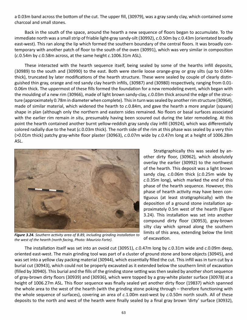
63
a 0.03m band across the bottom of the cut. The upper fill, (30979), was a gray sandy clay, which contained some charcoal and small stones.
Back in the south of the space, around the hearth a new sequence of floors began to accumulate. To the immediate north was a small strip of friable light-gray sandy-silt (30992), c.0.50m by c.0.43m (orientated broadly east-west). This ran along the lip which formed the southern boundary of the central floors. It was broadly con-temporary with another patch of floor to the south of the oven (30991), which was very similar in composition (c.0.54m by c.0.58m across, at the same height c.1006.31m ASL).
These interacted with the hearth sequence itself, being sealed by some of the hearths infill deposits, (30989) to the south and (30990) to the east. Both were sterile loose orange-gray or gray silts (up to 0.04m thick), truncated by later modifications of the hearth structure. These were sealed by couple of clearly distin-guished thin gray, orange and red sandy clay hearth infills, (30987) and (30980) respectively, ranging from 0.01-0.06m thick. The uppermost of these fills formed the foundation for a new remodeling event, which began with the moulding of a new rim (30966), made of light brown sandy-clay, c.0.03m thick around the edge of the struc-ture (approximately 0.78m in diameter when complete). This in turn was sealed by another rim structure (30964), made of similar material, which widened the hearth to c.0.84m, and gave the hearth a more angular (square) shape in plan (although only the northern and eastern sides remained. No floors or basal surfaces associated with the earlier rim remain in situ, presumably having been scoured out during the later remodeling. At this point the hearth contained another burnt yellow-reddish gray sandy clay infill (30924), which was differentially colored radially due to the heat (c.0.03m thick). The north side of the rim at this phase was sealed by a very thin (>0.01m thick) patchy gray-white floor plaster (30963), c.0.07m wide by c.0.47m long at a height of 1006.28m ASL.
Stratigraphically this was sealed by an-other dirty floor, (30962), which absolutely overlay the earlier (30992) to the northwest of the hearth. This deposit was a light brown sandy clay, c.0.06m thick (c.0.25m wide by c.0.35m long), which marked the end of this phase of the hearth sequence. However, this phase of hearth activity may have been con-tiguous (at least stratigraphically) with the deposition of a ground stone installation ap-proximately 0.5m west of the hearth (Figure 3.24). This installation was set into another compound dirty floor (30953), gray-brown silty clay which spread along the southern limits of this area, extending below the limit of excavation.
The installation itself was set into an ovoid cut (30951), c.0.47m long by c.0.31m wide and c.0.09m deep, oriented east-west. The main grinding tool was part of a cluster of ground stone and bone objects (30945), and was set into a yellow clay packing material (30944), which essentially filled the cut. This infill was in turn cut by a burial cut (30943), which could not be properly excavated as it extended below the southern limit of excavation (filled by 30940). This burial and the fills of the grinding stone setting was then sealed by another short sequence of gray-brown dirty floors (30939) and (30936), which were topped by a gray-white plaster surface (30978) at a height of 1006.27m ASL. This floor sequence was finally sealed yet another dirty floor (19837) which spanned the whole area to the west of the hearth (with the grinding stone poking through – therefore functioning with the whole sequence of surfaces), covering an area of c.1.00m east-west by c.0.50m north south. All of these deposits to the north and west of the hearth were finally sealed by a final gray brown ‘dirty’ surface (30932),
Figure 3.24. Southern activity area of B.89, including grinding installation to the west of the hearth (north facing, Photo: Maurizio Forte).
64
c.0.63m by c.0.48m at a height of 1006.37m ASL – this marked the highest point in the sequence excavated this season.
Cut into the floor (30991) to the south of the hearth was a stake hole (30981), c.0.14m in diameter and c.0.11m deep, which was the first in a series, interleaved into the stratigraphic sequence here (Figure 3.25). These stake holes were all set around the southeastern quadrant of the hearth, and may be associated with some kind of superstructure that extended over the hearth (for cooking, supporting pots, etc.). This stake hole contained two gray silt fills with some charcoal inclusions: (30982) and (30976). This feature was immediately sealed by a patch light gray-brown ‘dirty’ floor (30975) (which also sealed a one of the earlier hearth infills (30990) above), and may have been associated with a second surface, (30977), to the east. The surfaces sloped gently from west to east, from 1006.34m ASL to 1006.27m ASL.
At this point in the sequence there appears to have been a single remod-eling event associated with the spaces eastern furniture, specifically a light gray make-up and white re-plastering event which covered the southern bench ex-tending from the eastern wall, ((30956), (30952) and (30922)), as well as the surface of the central eastern platform (30917) and the north-east platform (30921). Meanwhile west of the hearth area small patch of residual mud-brick infill (30958) was located on the north side of the step down into the central floor area.
At around this point in the se-quence the second of the stake-hole
cuts associated with the southern side of the hearth (30974), and its fill (30972). This stake-hole had a diameter of c.0.13m and was 0.15m deep. It may have been associated with another light gray clay silt surface, or make-up (30973), at 1006.30m ASL. Both were in turn sealed by a further similar surface (30970) at 1006.32m ASL. Before being finally sealed by a white plaster layer (30968), approximately 0.88m square just to the east of the hearth. Two further ‘dirty’ gray surfaces were then identified in this area, (30967) & (30965), reinforcing a pat-tern around the hearth (especially on this eastern side) of constant use and reuse, wear and re-surfacing. At this level two further stake-holes were identified, (30942) and its fill (30941), as well as (30961) and its fill (30959). It is unclear whether these to features functioned at the same time (this may be an artifact of local scouring of the associated floor surfaces, however morphologically they were almost identical to the two identified earlier in the sequence (see above).
Two further patches of ash rich (cinders?) gray silty floor (30937) and (30938) sealed these features at a height of c.1006.37m ASL. Forming the final part of this sequence of remnant ‘dirty’ floors – culminating in (30934) and (30935) at c.1006.35m ASL (the latter having been scoured out to the point where it could only be identified against the southern face of the south bench extending from the eastern wall of the space. These were topped by a white plaster surface (30931), which linked into a central floor make-up(19835). This was a light brown sandy clay, c.0.05m deep which covered most of the central area (c.1.94m by c.1.86m across), marking the latest unit to be excavated this season in that part of the building.
Within the central floor area itself, this uppermost plaster sealed a second earlier floor (30957). This was sealed by (but probably contiguous with) a thin band of residual make-up (30954) and plaster surface (30949)
Figure 3.25. South facing detail of the hearth sequence with associated stake holes on the southeast side (Photo: Jason Quinlan).
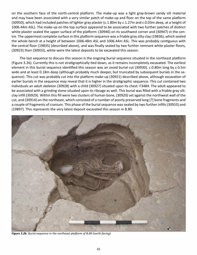
65
on the southern face of the north-central platform. The make-up was a light gray-brown sandy silt material and may have been associated with a very similar patch of make-up and floor on the top of the same platform (30950), which had included patches of lighter gray plaster (c.1.80m by c.1.27m and c.0.03m deep, at a height of 1006.44m ASL). The make-up on the top surface appeared to be associated with two further patches of distinct white plaster sealed the upper surface of the platform: (30946) on its southwest corner and (30947) in the cen-tre. The uppermost complete surface in this platform sequence was a friable gray silty clay (19836), which sealed the whole bench at a height of between 1006.48m ASL and 1006.44m ASL. This was probably contiguous with the central floor (19835) (described above), and was finally sealed by two further remnant white plaster floors, (30923) then (30933), white were the latest deposits to be excavated this season.
The last sequence to discuss this season is the ongoing burial sequence situated in the northeast platform (Figure 3.26). Currently this is not stratigraphically tied down, as it remains incompletely excavated. The earliest element in this burial sequence identified this season was an ovoid burial cut (30930), c.0.80m long by c.0.5m wide and at least 0.18m deep (although probably much deeper, but truncated by subsequent burials in the se-quence). This cut was probably cut into the platform make-up (30921) described above, although excavation of earlier burials in the sequence may reveal that it is higher in the stratigraphic sequence. This cut contained two individuals an adult skeleton (30928) with a child (30927) situated upon its chest: F3484. The adult appeared to be associated with a grinding stone situated upon its ribcage as well. This burial was filled with a friable gray silt-clay infill (30929). Within this fill were two clusters of human bone, (30920) set against the northwest wall of the cut, and (30914) on the northeast, which consisted of a number of poorly preserved long [?] bone fragments and a couple of fragments of cranium. This phase of the burial sequence was sealed by two further infills (30910) and (19897). This represents the very latest deposit excavated this season in B.89.
Figure 3.26. Burial sequence in the northeast platform of B.89 (north facing).
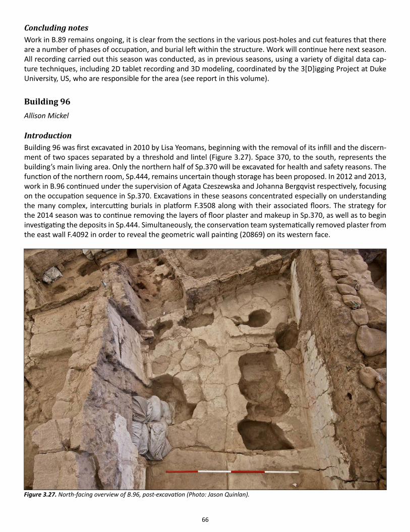
66
Concluding notesWork in B.89 remains ongoing, it is clear from the sections in the various post-holes and cut features that there are a number of phases of occupation, and burial left within the structure. Work will continue here next season. All recording carried out this season was conducted, as in previous seasons, using a variety of digital data cap-ture techniques, including 2D tablet recording and 3D modeling, coordinated by the 3[D]igging Project at Duke University, US, who are responsible for the area (see report in this volume).
Building 96Allison Mickel
IntroductionBuilding 96 was first excavated in 2010 by Lisa Yeomans, beginning with the removal of its infill and the discern-ment of two spaces separated by a threshold and lintel (Figure 3.27). Space 370, to the south, represents the building’s main living area. Only the northern half of Sp.370 will be excavated for health and safety reasons. The function of the northern room, Sp.444, remains uncertain though storage has been proposed. In 2012 and 2013, work in B.96 continued under the supervision of Agata Czeszewska and Johanna Bergqvist respectively, focusing on the occupation sequence in Sp.370. Excavations in these seasons concentrated especially on understanding the many complex, intercutting burials in platform F.3508 along with their associated floors. The strategy for the 2014 season was to continue removing the layers of floor plaster and makeup in Sp.370, as well as to begin investigating the deposits in Sp.444. Simultaneously, the conservation team systematically removed plaster from the east wall F.4092 in order to reveal the geometric wall painting (20869) on its western face.
Figure 3.27. North-facing overview of B.96, post-excavation (Photo: Jason Quinlan).
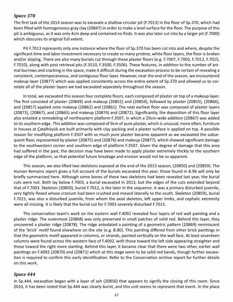
67
Space 370The first task of the 2014 season was to excavate a shallow circular pit (F.7013) in the floor of Sp.370, which had been filled with homogeneous gray clay (20847) in order to make a level surface for the floor. The purpose of this pit is ambiguous, as it was only 4cm deep and contained no finds. It was also later cut into by a larger pit (F.7000) which obscures its original full extent.
Pit F.7013 represents only one instance where the floor of Sp.370 has been cut into and where, despite the significant time and labor investment necessary to create so many pristine, white floor layers, the floor is broken and/or sloping. There are also many burials cut through these plaster floors (e.g. F.7007, F.7003, F.7012, F.7015, F.7010), along with post retrieval pits (F.3510, F.3500, F.3506). These features, in addition to the number of ani-mal burrows and cracking in the space, make it difficult during the excavation process to be certain of revealing a consistent, contemporaneous, and contiguous floor layer. However, near the end of the season, we encountered makeup layer (20877) which was applied consistently across the entire extent of Sp.370 and allowed us to cor-relate all of the plaster layers we had excavated separately throughout the season.
In total, we excavated this season four complete floors, each composed of plaster on top of a makeup layer. The first consisted of plaster (20849) and makeup (20852) and (20854), followed by plaster (20855), (20866), and (20857) applied onto makeup (20862) and (20861). The next earliest floor was composed of plaster layers (20873), (20867), and (20865) and makeup (20874) and (20872). Significantly, the deposition of this floor layer also entailed a remodeling of northeastern platform F.3507, in which a 29cm-wide addition (20867) was added to its southern edge. This addition was composed of 9cm of pure plaster, which is unusual; more often, furniture in houses at Çatalhöyük are built primarily with clay packing and a plaster surface is applied on top. A possible reason for modifying platform F.3507 with so much pure plaster became apparent as we excavated the subse-quent floor, represented by plaster (20875) and (20876) and makeup (20877), which showed significant damage to the southwestern corner and southern edge of platform F.3507. Given the degree of damage that this area had suffered in the past, the decision may have been made to apply plaster extremely thickly to the southern edge of the platform, so that potential future breakage and erosion would not be so apparent.
This season, we also lifted two skeletons exposed at the end of the 2013 season, (20850) and (20859). The Human Remains report gives a full account of the burials excavated this year; those found in B.96 will only be briefly summarized here. Although some bones of these two skeletons had been revealed last year, the burial cuts were not. Both lay below F.7003, a burial excavated in 2013, but the edges of the cuts extended beyond that of F.7003. Skeleton (20850), burial F.7012, is the later in the sequence. It was a primary disturbed juvenile, very tightly flexed whose cranium had been crushed and moved laterally to the south. Skeleton (20859), burial F.7015, was also a disturbed juvenile, from whom the axial skeleton, left upper limbs, and cephalic extremity were all missing. It is likely that the burial cut for F.7003 severely disturbed F.7015.
The conservation team’s work on the eastern wall F.4092 revealed four layers of red wall painting and a plaster ridge. The outermost (20868) was only preserved in small patches of solid red. Behind this layer, they uncovered a plaster ridge (20878). The ridge antedated a painting of a geometric pattern (20869) reminiscent of the ‘brick’ motif found elsewhere on the site (e.g. B.80). This painting differed from other brick paintings in that the geometric motif appeared in columns, or strands, painted vertically on the wall face. At least seventeen columns were found across the western face of F.4092, with those toward the left side appearing straighter and those toward the right more slanting. Behind this layer, it became clear that there were two other, earlier wall paintings on F.4092 (20870) and (20871) which at this stage seem to be solid red bands, though further excava-tion is required to confirm this early identification. Refer to the Conservation archive report for further details on this work.
Space 444In Sp.444, excavation began with a layer of ash (20856) that appears to signify the closing of this room. Since 2010, it has been noted that Sp.444 was clearly burnt, and this unit seems to represent that event. In the place
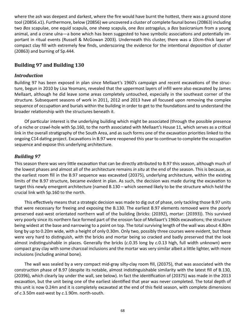
68
where the ash was deepest and darkest, where the fire would have burnt the hottest, there was a ground stone tool (20856.x1). Furthermore, below (20856) we uncovered a cluster of complete faunal bones (20863) including two Bos scapulae, one equid scapula, one sheep scapula, one Bos astragalus, a Bos basicranium from a young animal, and a crane ulna—a bone which has been suggested to have symbolic associations and potentially im-portant in ritual events (Russell & McGowan 2003). Underneath this cluster, there was a 10cm-thick layer of compact clay fill with extremely few finds, underscoring the evidence for the intentional deposition of cluster (20863) and burning of Sp.444.
Building 97 and Building 130
IntroductionBuilding 97 has been exposed in plan since Mellaart’s 1960’s campaign and recent excavations of the struc-ture, begun in 2010 by Lisa Yeomans, revealed that the uppermost layers of infill were also excavated by James Mellaart, although he did leave some areas completely untouched, especially in the southeast corner of the structure. Subsequent seasons of work in 2011, 2012 and 2013 have all focused upon removing the complex sequence of occupation and burials within the building in order to get to the foundations and to understand the broader relationship with the structures beneath it.
Of particular interest is the underlying building which might be associated (through the possible presence of a niche or crawl-hole with Sp.160, to the north associated with Mellaart’s House 11, which serves as a critical link in the overall stratigraphy of the South Area, and as such forms one of the excavation priorities linked to the ongoing C14 dating project. Excavations in B.97 were reopened this year to continue to complete the occupation sequence and expose this underlying architecture.
Building 97This season there was very little excavation that can be directly attributed to B.97 this season, although much of the lowest phases and almost all of the architecture remains in situ at the end of the season. This is because, as the earliest room fill in the B.97 sequence was excavated (20375), underlying architecture, within the existing limits of the B.97 structure, became evident in plan. As such, the decision was made during the excavation to target this newly emergent architecture (named B.130 – which seemed likely to be the structure which held the crucial link with Sp.160 to the north.
This effectively means that a strategic decision was made to dig out of phase, only tackling those B.97 units that were necessary for freeing and exposing the B.130. The earliest B.97 elements removed were the poorly preserved east-west orientated northern wall of the building (bricks: (20392), mortar: (20393)). This survived very poorly since its northern face formed part of the erosion face of Mellaart’s 1960s excavations; the structure being widest at the base and narrowing to a point on top. The total surviving length of the wall was about 4.80m long by up to 0.20m wide, with a height of only 0.30m. Only two, possibly three courses were evident, but these were very hard to distinguish, with the bricks and mortar being so cracked and badly preserved that the look almost indistinguishable in places. Generally the bricks (c.0.35 long by c.0.13 high, full width unknown) were compact gray clay with some charcoal inclusions and the mortar was very similar albeit a little lighter, with more inclusions (including animal bone).
The wall was sealed by a very compact mid-gray silty-clay room fill, (20375), that was associated with the construction phase of B.97 (despite its notable, almost indistinguishable similarity with the latest fill of B.130, (20396), which clearly lay under the wall, see below). In fact the identification of (20375) was made in the 2013 excavation, but the unit being one of the earliest identified that year was never completed. The total depth of this unit is now 0.24m and it is completely excavated at the end of this field season, with complete dimensions of c.3.50m east-west by c.1.90m. north-south.

69
This fill yielded almost no finds at this lower level; however, its excavation did reveal the presence of two more infant/child burials in the northern part of B.97. This included F.3558, a child buried inside the very well-pre-served phytolith remains of a basket (20395) tucked into the north-eastern corner of the underlying B.130, and F.3559, an infant flexed on its right side in the northern part of the B.97. Any association between these burials and the underlying architecture is probably misleading, since it seems likely that this architecture (specifically the placement of its eastern walls) physically influenced the placement of the later platforms on the northern and eastern sides of B.97. As such the burials (cut at a height of approximately 1006.20m ASL) were most likely to be associated with the burial sequence in the northern platforms of this upper building. However, both burials had cuts which were impossible to clearly define from above (the fill being so similar to the room fill through which they were cut), leading to some speculation as to whether these to inhumations were in fact ‘foundation burials’ – a trend which is certainly seen elsewhere on the site.
Building 130Building 130 (Sp.529) was a small and very unusual building which lay immediately under the northwest corner of B.97 (Figure 3.28). The plan of this almost square building (with a slight dogleg in the northeastern corner – damaged by erosion) has many of the characteristic hallmarks (layout and furnishings) of a ‘whole building’; however, its very small size (c.2.91m east-west by c.2.62m north-south) gives the space a ‘very compact feel’ in comparison to other structures in the sequence/neighborhood. This season B.130 was excavated down to its latest occupation surfaces, which for the most part were a series of very thin gray (‘dirty’) white plasters span-ning the area of the room; although their preservation was particularly poor at the northern side due to cracking – presumably arising from the proximity of the deposits to Mellaart’s section.
Figure 3.28. North facing overview of Building 97, with Building 130 in the northeast corner, post-excavation (Photo: Jason Quinlan).
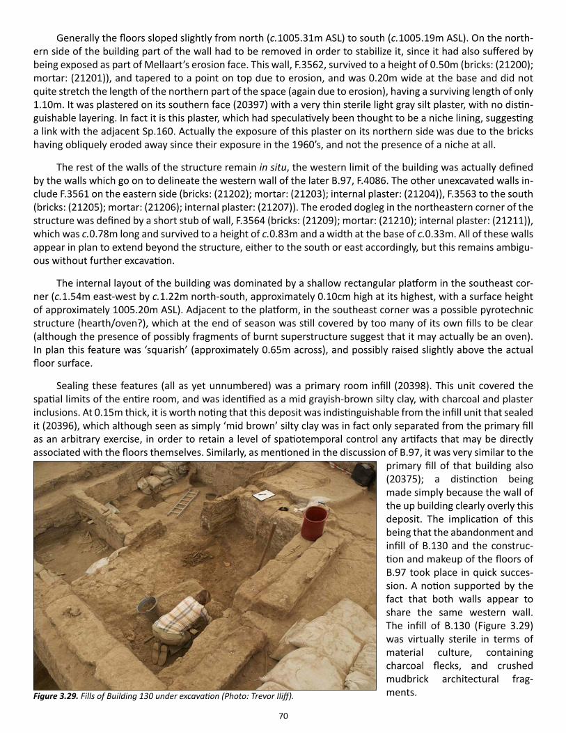
70
Generally the floors sloped slightly from north (c.1005.31m ASL) to south (c.1005.19m ASL). On the north-ern side of the building part of the wall had to be removed in order to stabilize it, since it had also suffered by being exposed as part of Mellaart’s erosion face. This wall, F.3562, survived to a height of 0.50m (bricks: (21200); mortar: (21201)), and tapered to a point on top due to erosion, and was 0.20m wide at the base and did not quite stretch the length of the northern part of the space (again due to erosion), having a surviving length of only 1.10m. It was plastered on its southern face (20397) with a very thin sterile light gray silt plaster, with no distin-guishable layering. In fact it is this plaster, which had speculatively been thought to be a niche lining, suggesting a link with the adjacent Sp.160. Actually the exposure of this plaster on its northern side was due to the bricks having obliquely eroded away since their exposure in the 1960’s, and not the presence of a niche at all.
The rest of the walls of the structure remain in situ, the western limit of the building was actually defined by the walls which go on to delineate the western wall of the later B.97, F.4086. The other unexcavated walls in-clude F.3561 on the eastern side (bricks: (21202); mortar: (21203); internal plaster: (21204)), F.3563 to the south (bricks: (21205); mortar: (21206); internal plaster: (21207)). The eroded dogleg in the northeastern corner of the structure was defined by a short stub of wall, F.3564 (bricks: (21209); mortar: (21210); internal plaster: (21211)), which was c.0.78m long and survived to a height of c.0.83m and a width at the base of c.0.33m. All of these walls appear in plan to extend beyond the structure, either to the south or east accordingly, but this remains ambigu-ous without further excavation.
The internal layout of the building was dominated by a shallow rectangular platform in the southeast cor-ner (c.1.54m east-west by c.1.22m north-south, approximately 0.10cm high at its highest, with a surface height of approximately 1005.20m ASL). Adjacent to the platform, in the southeast corner was a possible pyrotechnic structure (hearth/oven?), which at the end of season was still covered by too many of its own fills to be clear (although the presence of possibly fragments of burnt superstructure suggest that it may actually be an oven). In plan this feature was ‘squarish’ (approximately 0.65m across), and possibly raised slightly above the actual floor surface.
Sealing these features (all as yet unnumbered) was a primary room infill (20398). This unit covered the spatial limits of the entire room, and was identified as a mid grayish-brown silty clay, with charcoal and plaster inclusions. At 0.15m thick, it is worth noting that this deposit was indistinguishable from the infill unit that sealed it (20396), which although seen as simply ‘mid brown’ silty clay was in fact only separated from the primary fill as an arbitrary exercise, in order to retain a level of spatiotemporal control any artifacts that may be directly associated with the floors themselves. Similarly, as mentioned in the discussion of B.97, it was very similar to the
primary fill of that building also (20375); a distinction being made simply because the wall of the up building clearly overly this deposit. The implication of this being that the abandonment and infill of B.130 and the construc-tion and makeup of the floors of B.97 took place in quick succes-sion. A notion supported by the fact that both walls appear to share the same western wall. The infill of B.130 (Figure 3.29) was virtually sterile in terms of material culture, containing charcoal flecks, and crushed mudbrick architectural frag-ments.Figure 3.29. Fills of Building 130 under excavation (Photo: Trevor Iliff).
71
Concluding notes on Buildings 97 and 130Two things need to be noted in conclusion at the end of the 2014 excavation season in relation to B.130. The first is that this is an unusual structure both spatially and temporally in terms of how it fits into the sequence. It is extremely small, despite having the characteristic of a ‘normal’ Çatalhöyük building, including: post-scars, a platform (albeit in the ‘wrong place’) and hearth or oven. As such it may fit into a pattern of anomalous small complex structures (e.g. B.49), but more work needs to be done to explore this possibility. Temporally the build-ing appears to have a short lifespan (thin plaster, few signs of modifications), but more curiously it seems to be incorporated into the construction of the later B.97, apparently sharing a western wall, whilst the other wall clearly affecting the placement of the earliest incarnations of B.97’s internal furniture. This may be linked into the anomalies noted by James Mellaart in his Level VIa/b (Levels South M, N and O), something which again may require more thought when this sequence is completely excavated.
The second point is that the key objectives of our excavations here (relating to the requirements of the Bayesian Dating Project) were successfully completed this season. The Sp.160 niche proved not to be a niche after all, but rather an artifact of the oblique erosion of the northern wall of B.130. The bricks of this wall had completely eroded on the western end of this wall, leaving the internal plaster face (originally on the south face of the northern wall) adhering to the room infill (which was extremely clay-rich and compact). So no direct stratigraphic link could be ascertained with Sp.160. However the eastern end of this and some associated floor [?] plaster layers, could be seen in the erosion face to seal the southern walls of the Shrine 10 structure at the next level down, which may be enough of a link to constrain the Bayesian Chronology.
References
Russell, N. & K. McGowan 2003. Dance of the cranes: crane symbolism at Çatalhöyük and beyond. Antiquity 77: 445-455.
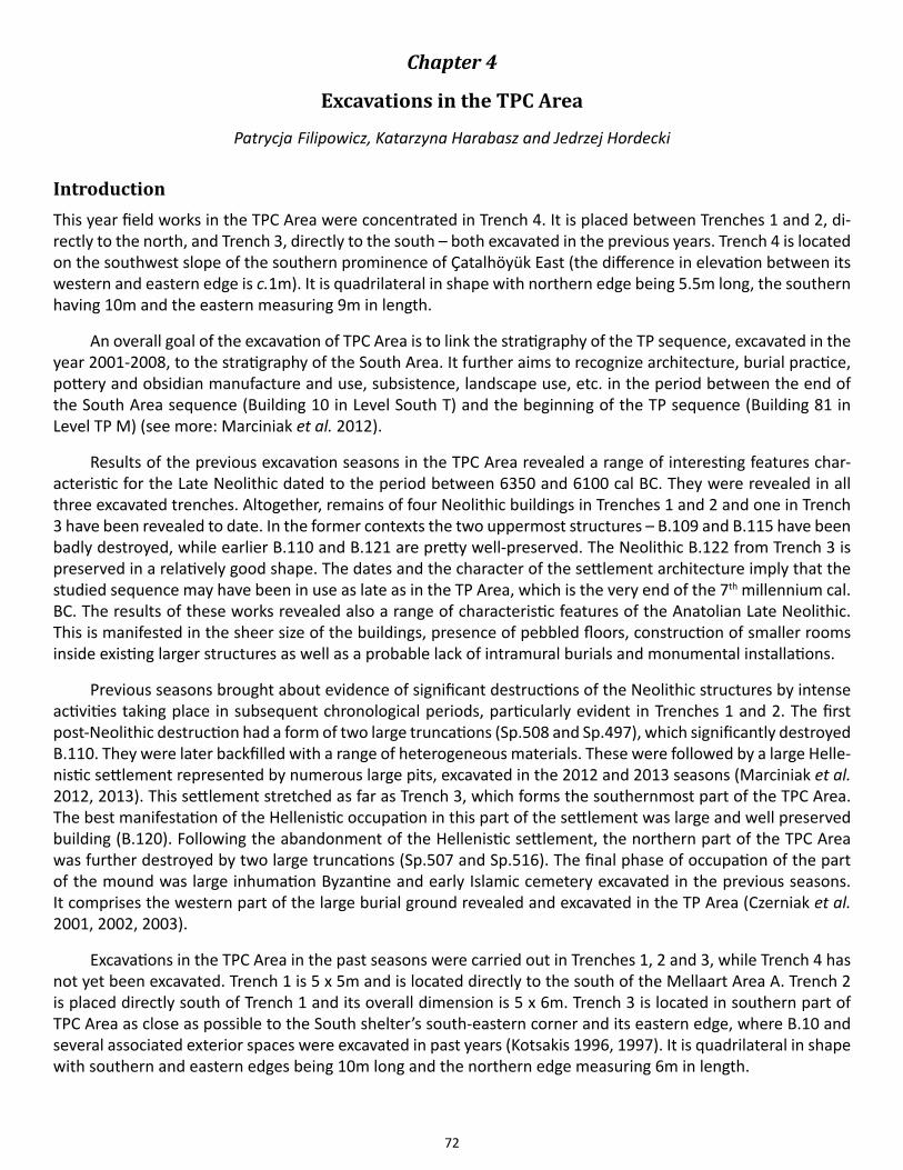
72
Chapter 4
Excavations in the TPC Area
Patrycja Filipowicz, Katarzyna Harabasz and Jedrzej Hordecki
IntroductionThis year field works in the TPC Area were concentrated in Trench 4. It is placed between Trenches 1 and 2, di-rectly to the north, and Trench 3, directly to the south – both excavated in the previous years. Trench 4 is located on the southwest slope of the southern prominence of Çatalhöyük East (the difference in elevation between its western and eastern edge is c.1m). It is quadrilateral in shape with northern edge being 5.5m long, the southern having 10m and the eastern measuring 9m in length.
An overall goal of the excavation of TPC Area is to link the stratigraphy of the TP sequence, excavated in the year 2001-2008, to the stratigraphy of the South Area. It further aims to recognize architecture, burial practice, pottery and obsidian manufacture and use, subsistence, landscape use, etc. in the period between the end of the South Area sequence (Building 10 in Level South T) and the beginning of the TP sequence (Building 81 in Level TP M) (see more: Marciniak et al. 2012).
Results of the previous excavation seasons in the TPC Area revealed a range of interesting features char-acteristic for the Late Neolithic dated to the period between 6350 and 6100 cal BC. They were revealed in all three excavated trenches. Altogether, remains of four Neolithic buildings in Trenches 1 and 2 and one in Trench 3 have been revealed to date. In the former contexts the two uppermost structures – B.109 and B.115 have been badly destroyed, while earlier B.110 and B.121 are pretty well-preserved. The Neolithic B.122 from Trench 3 is preserved in a relatively good shape. The dates and the character of the settlement architecture imply that the studied sequence may have been in use as late as in the TP Area, which is the very end of the 7th millennium cal. BC. The results of these works revealed also a range of characteristic features of the Anatolian Late Neolithic. This is manifested in the sheer size of the buildings, presence of pebbled floors, construction of smaller rooms inside existing larger structures as well as a probable lack of intramural burials and monumental installations.
Previous seasons brought about evidence of significant destructions of the Neolithic structures by intense activities taking place in subsequent chronological periods, particularly evident in Trenches 1 and 2. The first post-Neolithic destruction had a form of two large truncations (Sp.508 and Sp.497), which significantly destroyed B.110. They were later backfilled with a range of heterogeneous materials. These were followed by a large Helle-nistic settlement represented by numerous large pits, excavated in the 2012 and 2013 seasons (Marciniak et al. 2012, 2013). This settlement stretched as far as Trench 3, which forms the southernmost part of the TPC Area. The best manifestation of the Hellenistic occupation in this part of the settlement was large and well preserved building (B.120). Following the abandonment of the Hellenistic settlement, the northern part of the TPC Area was further destroyed by two large truncations (Sp.507 and Sp.516). The final phase of occupation of the part of the mound was large inhumation Byzantine and early Islamic cemetery excavated in the previous seasons. It comprises the western part of the large burial ground revealed and excavated in the TP Area (Czerniak et al. 2001, 2002, 2003).
Excavations in the TPC Area in the past seasons were carried out in Trenches 1, 2 and 3, while Trench 4 has not yet been excavated. Trench 1 is 5 x 5m and is located directly to the south of the Mellaart Area A. Trench 2 is placed directly south of Trench 1 and its overall dimension is 5 x 6m. Trench 3 is located in southern part of TPC Area as close as possible to the South shelter’s south-eastern corner and its eastern edge, where B.10 and several associated exterior spaces were excavated in past years (Kotsakis 1996, 1997). It is quadrilateral in shape with southern and eastern edges being 10m long and the northern edge measuring 6m in length.
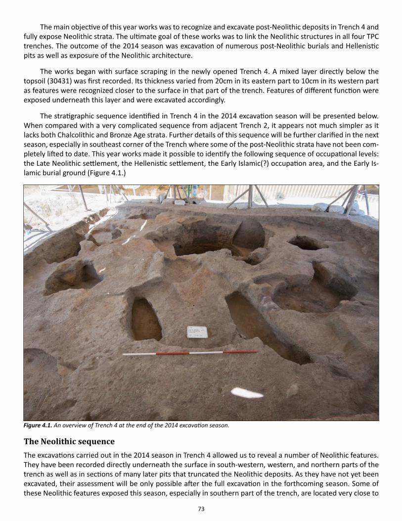
73
The main objective of this year works was to recognize and excavate post-Neolithic deposits in Trench 4 and fully expose Neolithic strata. The ultimate goal of these works was to link the Neolithic structures in all four TPC trenches. The outcome of the 2014 season was excavation of numerous post-Neolithic burials and Hellenistic pits as well as exposure of the Neolithic architecture.
The works began with surface scraping in the newly opened Trench 4. A mixed layer directly below the topsoil (30431) was first recorded. Its thickness varied from 20cm in its eastern part to 10cm in its western part as features were recognized closer to the surface in that part of the trench. Features of different function were exposed underneath this layer and were excavated accordingly.
The stratigraphic sequence identified in Trench 4 in the 2014 excavation season will be presented below. When compared with a very complicated sequence from adjacent Trench 2, it appears not much simpler as it lacks both Chalcolithic and Bronze Age strata. Further details of this sequence will be further clarified in the next season, especially in southeast corner of the Trench where some of the post-Neolithic strata have not been com-pletely lifted to date. This year works made it possible to identify the following sequence of occupational levels: the Late Neolithic settlement, the Hellenistic settlement, the Early Islamic(?) occupation area, and the Early Is-lamic burial ground (Figure 4.1.)
The Neolithic sequence The excavations carried out in the 2014 season in Trench 4 allowed us to reveal a number of Neolithic features. They have been recorded directly underneath the surface in south-western, western, and northern parts of the trench as well as in sections of many later pits that truncated the Neolithic deposits. As they have not yet been excavated, their assessment will be only possible after the full excavation in the forthcoming season. Some of these Neolithic features exposed this season, especially in southern part of the trench, are located very close to
Figure 4.1. An overview of Trench 4 at the end of the 2014 excavation season.
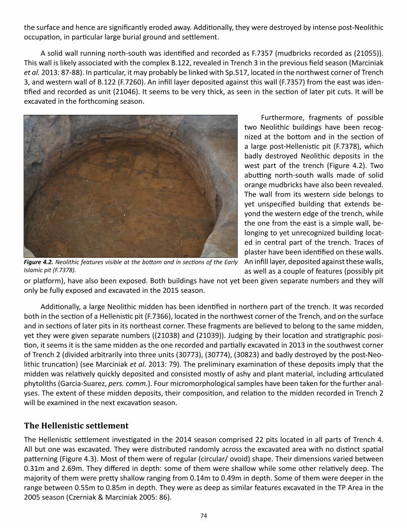
74
the surface and hence are significantly eroded away. Additionally, they were destroyed by intense post-Neolithic occupation, in particular large burial ground and settlement.
A solid wall running north-south was identified and recorded as F.7357 (mudbricks recorded as (21055)). This wall is likely associated with the complex B.122, revealed in Trench 3 in the previous field season (Marciniak et al. 2013: 87-88). In particular, it may probably be linked with Sp.517, located in the northwest corner of Trench 3, and western wall of B.122 (F.7260). An infill layer deposited against this wall (F.7357) from the east was iden-tified and recorded as unit (21046). It seems to be very thick, as seen in the section of later pit cuts. It will be excavated in the forthcoming season.
Furthermore, fragments of possible two Neolithic buildings have been recog-nized at the bottom and in the section of a large post-Hellenistic pit (F.7378), which badly destroyed Neolithic deposits in the west part of the trench (Figure 4.2). Two abutting north-south walls made of solid orange mudbricks have also been revealed. The wall from its western side belongs to yet unspecified building that extends be-yond the western edge of the trench, while the one from the east is a simple wall, be-longing to yet unrecognized building locat-ed in central part of the trench. Traces of plaster have been identified on these walls. An infill layer, deposited against these walls, as well as a couple of features (possibly pit
or platform), have also been exposed. Both buildings have not yet been given separate numbers and they will only be fully exposed and excavated in the 2015 season.
Additionally, a large Neolithic midden has been identified in northern part of the trench. It was recorded both in the section of a Hellenistic pit (F.7366), located in the northwest corner of the Trench, and on the surface and in sections of later pits in its northeast corner. These fragments are believed to belong to the same midden, yet they were given separate numbers ((21038) and (21039)). Judging by their location and stratigraphic posi-tion, it seems it is the same midden as the one recorded and partially excavated in 2013 in the southwest corner of Trench 2 (divided arbitrarily into three units (30773), (30774), (30823) and badly destroyed by the post-Neo-lithic truncation) (see Marciniak et al. 2013: 79). The preliminary examination of these deposits imply that the midden was relatively quickly deposited and consisted mostly of ashy and plant material, including articulated phytoliths (Garcia-Suarez, pers. comm.). Four micromorphological samples have been taken for the further anal-yses. The extent of these midden deposits, their composition, and relation to the midden recorded in Trench 2 will be examined in the next excavation season.
The Hellenistic settlement The Hellenistic settlement investigated in the 2014 season comprised 22 pits located in all parts of Trench 4. All but one was excavated. They were distributed randomly across the excavated area with no distinct spatial patterning (Figure 4.3). Most of them were of regular (circular/ ovoid) shape. Their dimensions varied between 0.31m and 2.69m. They differed in depth: some of them were shallow while some other relatively deep. The majority of them were pretty shallow ranging from 0.14m to 0.49m in depth. Some of them were deeper in the range between 0.55m to 0.85m in depth. They were as deep as similar features excavated in the TP Area in the 2005 season (Czerniak & Marciniak 2005: 86).
Figure 4.2. Neolithic features visible at the bottom and in sections of the Early Islamic pit (F.7378).
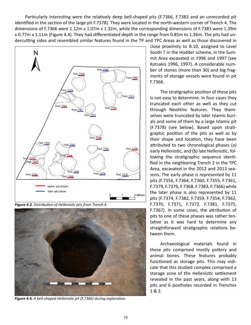
75
Particularly interesting were the relatively deep bell-shaped pits (F.7366, F.7383 and an unrecorded pit identified in the section of the large pit F.7378). They were located in the north-western corner of Trench 4. The dimensions of F.7366 were 1.12m x 1.07m x 1.32m, while the corresponding dimensions of F.7383 were 1.39m x 0.77m x 1.11m (Figure 4.4). They had differentiated depth in the range from 0.85m to 1.36m. The pits had un-dercutting sides and resembled similar features found in the TP and TPC Areas as well as those discovered in
close proximity to B.10, assigned to Level South T in the Hodder scheme, in the Sum-mit Area excavated in 1996 and 1997 (see Kotsakis 1996, 1997). A considerable num-ber of stones (more than 30) and big frag-ments of storage vessels were found in pit F.7366.
The stratigraphic position of these pits is not easy to determine. In four cases they truncated each other as well as they cut through Neolithic features. They them-selves were truncated by later Islamic buri-als and some of them by a large Islamic pit (F.7378) (see below). Based upon strati-graphic position of the pits as well as by their shape and location, they have been attributed to two chronological phases (a) early Hellenistic, and (b) late Hellenistic, fol-lowing the stratigraphic sequence identi-fied in the neighboring Trench 2 in the TPC Area, excavated in the 2012 and 2013 sea-sons. The early phase is represented by 11 pits (F.7356, F.7364, F.7360, F.7355, F.7361, F.7379, F.7376, F.7368, F.7383, F.7366) while the later phase is also represented by 11 pits (F.7374, F.7382, F.7359, F.7354, F.7362, F.7370, F.7371, F.7372, F.7381, F.7375, F.7367). In some cases, the attribution of pits to one of these phases was rather ten-tative as it was hard to determine any straightforward stratigraphic relations be-tween them.
Archaeological materials found in these pits comprised mostly pottery and animal bones. These features probably functioned as storage pits. This may indi-cate that this studied complex comprised a storage zone of the Hellenistic settlement revealed in the past years, along with 13 pits and 6 postholes recorded in Trenches 1 & 2.
Figure 4.3. Distribution of Hellenistic pits from Trench 4.
Figure 4.4. A bell-shaped Hellenistic pit (F.7366) during exploration.
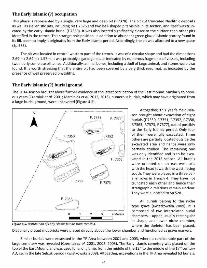
76
The Early Islamic (?) occupation This phase is represented by a single, very large and deep pit (F.7378). The pit cut truncated Neolithic deposits as well as Hellenistic pits, including pit F.7375 and two bell-shaped pits visible in its section, and itself was trun-cated by the early Islamic burial (F.7350). It was also located significantly closer to the surface than other pits identified in the trench. This stratigraphic position, in addition to abundant green glazed Islamic pottery found in its fill, seem to imply it originates from the Early Islamic period. Accordingly, the pit was allocated to a new space (Sp.533).
The pit was located in central-western part of the trench. It was of a circular shape and had the dimensions 2.69m x 2.64m x 1.57m. It was probably a garbage pit, as indicated by numerous fragments of vessels, including two nearly complete oil lamps. Additionally, animal bones, including a skull of large animal, and stones were also found. It is worth stressing that the entire pit had been covered by a very thick reed mat, as indicated by the presence of well preserved phytoliths.
The Early Islamic (?) burial groundThe 2014 season brought about further evidence of the latest occupation of the East mound. Similarly to previ-ous years (Czerniak et al. 2001; Marciniak et al. 2012, 2013), numerous burials, which may have originated from a large burial ground, were uncovered (Figure 4.5).
Altogether, this year’s field sea-son brought about excavation of eight burials (F.7350, F.7351, F.7352, F.7358, F.7363, F.7373, F.7377), dated possibly to the Early Islamic period. Only four of them were fully excavated. Three others are partially located outside the excavated area and hence were only partially studied. The remaining one was only identified and is to be exca-vated in the 2015 season. All burials were oriented on an east-west axis with the head towards the west, facing south. They were placed in a three par-allel rows in Trench 4. They have not truncated each other and hence their stratigraphic relations remain unclear. They were allocated to Sp.528.
All burials belong to the niche type grave (Kwiatkowska 2009). It is composed of two interrelated burial chambers – upper, usually rectangular in shape, and lower niche chamber, where the skeleton has been placed.
Diagonally placed mudbricks were placed directly above the lower chamber and functioned as grave markers.
Similar burials were excavated in the TP Area between 2001 and 2003, where a considerable part of the large cemetery was revealed (Czerniak et al. 2001, 2002, 2003). The Early Islamic cemetery was placed on the top of the East Mound and was used for a long time: from the middle of the 12th to the middle of the 17th century AD, i.e. in the late Selçuk period (Kwiatkowska 2009). Altogether, excavations in the TP Area revealed 63 burials.
Figure 4.5. Distribution of Early Islamic burials from Trench 4.
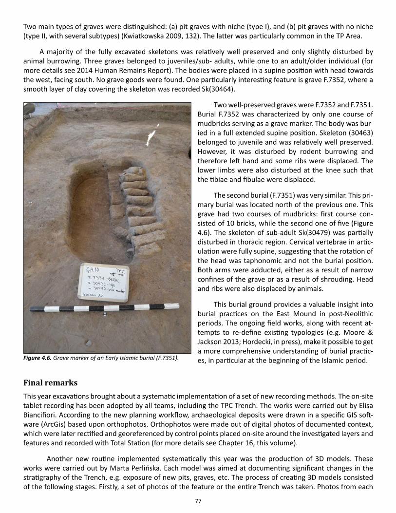
77
Two main types of graves were distinguished: (a) pit graves with niche (type I), and (b) pit graves with no niche (type II, with several subtypes) (Kwiatkowska 2009, 132). The latter was particularly common in the TP Area.
A majority of the fully excavated skeletons was relatively well preserved and only slightly disturbed by animal burrowing. Three graves belonged to juveniles/sub- adults, while one to an adult/older individual (for more details see 2014 Human Remains Report). The bodies were placed in a supine position with head towards the west, facing south. No grave goods were found. One particularly interesting feature is grave F.7352, where a smooth layer of clay covering the skeleton was recorded Sk(30464).
Two well-preserved graves were F.7352 and F.7351. Burial F.7352 was characterized by only one course of mudbricks serving as a grave marker. The body was bur-ied in a full extended supine position. Skeleton (30463) belonged to juvenile and was relatively well preserved. However, it was disturbed by rodent burrowing and therefore left hand and some ribs were displaced. The lower limbs were also disturbed at the knee such that the tibiae and fibulae were displaced.
The second burial (F.7351) was very similar. This pri-mary burial was located north of the previous one. This grave had two courses of mudbricks: first course con-sisted of 10 bricks, while the second one of five (Figure 4.6). The skeleton of sub-adult Sk(30479) was partially disturbed in thoracic region. Cervical vertebrae in artic-ulation were fully supine, suggesting that the rotation of the head was taphonomic and not the burial position. Both arms were adducted, either as a result of narrow confines of the grave or as a result of shrouding. Head and ribs were also displaced by animals.
This burial ground provides a valuable insight into burial practices on the East Mound in post-Neolithic periods. The ongoing field works, along with recent at-tempts to re-define existing typologies (e.g. Moore & Jackson 2013; Hordecki, in press), make it possible to get a more comprehensive understanding of burial practic-es, in particular at the beginning of the Islamic period.
Final remarks This year excavations brought about a systematic implementation of a set of new recording methods. The on-site tablet recording has been adopted by all teams, including the TPC Trench. The works were carried out by Elisa Biancifiori. According to the new planning workflow, archaeological deposits were drawn in a specific GIS soft-ware (ArcGis) based upon orthophotos. Orthophotos were made out of digital photos of documented context, which were later rectified and georeferenced by control points placed on-site around the investigated layers and features and recorded with Total Station (for more details see Chapter 16, this volume).
Another new routine implemented systematically this year was the production of 3D models. These works were carried out by Marta Perlińska. Each model was aimed at documenting significant changes in the stratigraphy of the Trench, e.g. exposure of new pits, graves, etc. The process of creating 3D models consisted of the following stages. Firstly, a set of photos of the feature or the entire Trench was taken. Photos from each
Figure 4.6. Grave marker of an Early Islamic burial (F.7351).
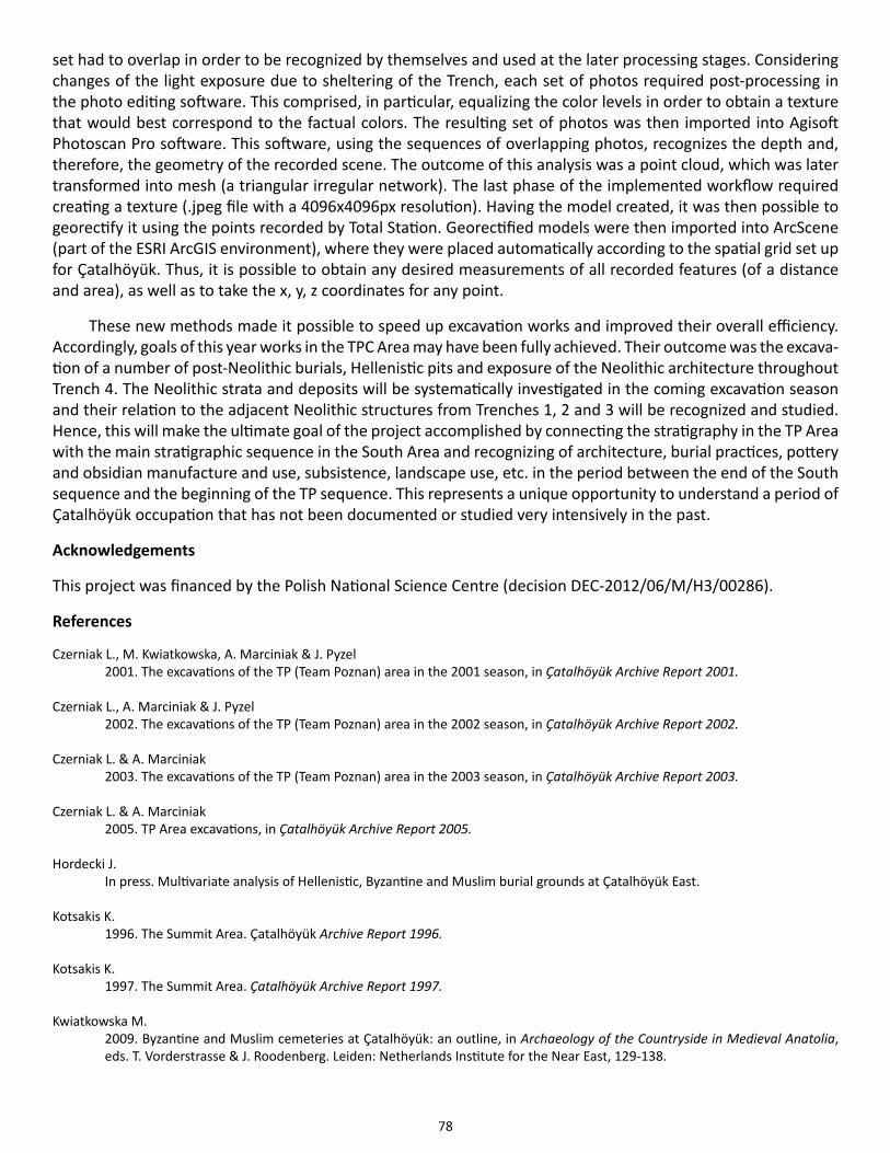
78
set had to overlap in order to be recognized by themselves and used at the later processing stages. Considering changes of the light exposure due to sheltering of the Trench, each set of photos required post-processing in the photo editing software. This comprised, in particular, equalizing the color levels in order to obtain a texture that would best correspond to the factual colors. The resulting set of photos was then imported into Agisoft Photoscan Pro software. This software, using the sequences of overlapping photos, recognizes the depth and, therefore, the geometry of the recorded scene. The outcome of this analysis was a point cloud, which was later transformed into mesh (a triangular irregular network). The last phase of the implemented workflow required creating a texture (.jpeg file with a 4096x4096px resolution). Having the model created, it was then possible to georectify it using the points recorded by Total Station. Georectified models were then imported into ArcScene (part of the ESRI ArcGIS environment), where they were placed automatically according to the spatial grid set up for Çatalhöyük. Thus, it is possible to obtain any desired measurements of all recorded features (of a distance and area), as well as to take the x, y, z coordinates for any point.
These new methods made it possible to speed up excavation works and improved their overall efficiency. Accordingly, goals of this year works in the TPC Area may have been fully achieved. Their outcome was the excava-tion of a number of post-Neolithic burials, Hellenistic pits and exposure of the Neolithic architecture throughout Trench 4. The Neolithic strata and deposits will be systematically investigated in the coming excavation season and their relation to the adjacent Neolithic structures from Trenches 1, 2 and 3 will be recognized and studied. Hence, this will make the ultimate goal of the project accomplished by connecting the stratigraphy in the TP Area with the main stratigraphic sequence in the South Area and recognizing of architecture, burial practices, pottery and obsidian manufacture and use, subsistence, landscape use, etc. in the period between the end of the South sequence and the beginning of the TP sequence. This represents a unique opportunity to understand a period of Çatalhöyük occupation that has not been documented or studied very intensively in the past.
Acknowledgements
This project was financed by the Polish National Science Centre (decision DEC-2012/06/M/H3/00286).
References
Czerniak L., M. Kwiatkowska, A. Marciniak & J. Pyzel 2001. The excavations of the TP (Team Poznan) area in the 2001 season, in Çatalhöyük Archive Report 2001.
Czerniak L., A. Marciniak & J. Pyzel 2002. The excavations of the TP (Team Poznan) area in the 2002 season, in Çatalhöyük Archive Report 2002.
Czerniak L. & A. Marciniak 2003. The excavations of the TP (Team Poznan) area in the 2003 season, in Çatalhöyük Archive Report 2003.
Czerniak L. & A. Marciniak 2005. TP Area excavations, in Çatalhöyük Archive Report 2005.
Hordecki J. In press. Multivariate analysis of Hellenistic, Byzantine and Muslim burial grounds at Çatalhöyük East.
Kotsakis K. 1996. The Summit Area. Çatalhöyük Archive Report 1996.
Kotsakis K. 1997. The Summit Area. Çatalhöyük Archive Report 1997.
Kwiatkowska M.2009. Byzantine and Muslim cemeteries at Çatalhöyük: an outline, in Archaeology of the Countryside in Medieval Anatolia, eds. T. Vorderstrasse & J. Roodenberg. Leiden: Netherlands Institute for the Near East, 129-138.

79
Marciniak, A., P. Filipowicz & A. Mickel 2012. The excavations of the TPC Area in the 2012 season. Çatalhöyük Archive Report 2012.
Marciniak, A., P. Filipowicz, E. Johansson & A. Mickel 2013. The excavations of the TPC Area in the 2013 season. Çatalhöyük Archive Report 2013.
Moore, S. & M. Jackson 2014. Late burials from the 4040 Area of the East Mound, in Çatalhöyük Excavations: the 2000-2008 Seasons, ed. I. Hodder. London: British Institute at Ankara; Los Angeles: Cotsen Institute of Archaeology Press, 603-620.

80
Cultural and Environmental Materials
Chapter 5
Human Remains
Scott D. Haddow1, Christopher J. Knüsel2 and Marco Milella3
1Çatalhöyük Research Project, 2Université de Bordeaux, 3University of Zurich
IntroductionDuring the 2014 field season, the Human Remains Team (Larsen, Knüsel, Haddow, Milella, Betz, Moore, Hodson, Tibbetts, Kurt and Ceylan) worked closely with the excavation team to assist in excavating and lifting the human skeletal remains as they were uncovered in the field, processed the newly recovered skeletons in the laboratory, continued preparations for publications and conference presentations (European Association of Archaeologists (EAA), 2014, which will take place in Istanbul), held regular meetings with team leaders from other on-site labs to continue to facilitate the integration of analyses between labs during the final phase of the Çatalhöyük Re-search Project. Scott Haddow continued to produce 3D models of all excavated burials. He also produced fo-cus-stacked photographs (a composite of multiple photographs) of cutmarks on human bones to be used in 3D models (Figure 5.1).
The Funerary Archaeology component of the Human Remains Team (Haddow, Knüsel and Milella) contin-ued discussions of joint project with Lynn Meskell and Carrie Nakamura that incorporated the site GIS (in collab-oration with Camilla Mazzucato) to take a biocultural approach to funerary treatment at Neolithic Çatalhöyük, one linking the analysis of skeletal remains of the deceased - aspects of social identity (age, sex), palaeopathol-ogy and well-being (as indicated by growth and development) - with grave location, burial inclusions (i.e. found in the fill of burials), and grave goods, such as items of personal adornment and those directly associated with
Figure 5.1. Focus-stacked 3D model of cutmarks on an atlas (1st cervical vertebrae) (Source: Scott Haddow).
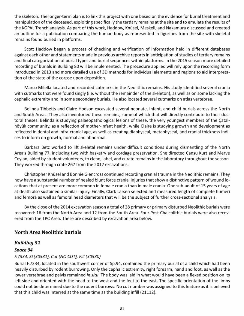
81
the skeleton. The longer-term plan is to link this project with one based on the evidence for burial treatment and manipulation of the deceased, exploiting specifically the tertiary remains at the site and to emulate the results of the KOPAL Trench analysis. As part of this work, Haddow, Knüsel, Meskell, and Nakamura discussed and created an outline for a publication comparing the human body as represented in figurines from the site with skeletal remains found buried in platforms.
Scott Haddow began a process of checking and verification of information held in different databases against each other and statements made in previous archive reports in anticipation of studies of tertiary remains and final categorization of burial types and burial sequences within platforms. In the 2015 season more detailed recording of burials in Building 80 will be implemented. The procedure applied will rely upon the recording form introduced in 2013 and more detailed use of 3D methods for individual elements and regions to aid interpreta-tion of the state of the corpse upon deposition.
Marco Milella located and recorded cutmarks in the Neolithic remains. His study identified several crania with cutmarks that were found singly (i.e. without the remainder of the skeleton), as well as on some lacking the cephalic extremity and in some secondary burials. He also located several cutmarks on atlas vertebrae.
Belinda Tibbetts and Claire Hodson excavated several neonate, infant, and child burials across the North and South Areas. They also inventoried these remains, some of which that will directly contribute to their doc-toral theses. Belinda is studying palaeopathological lesions of these, the very youngest members of the Çatal-höyük community, as a reflection of mother-infant health, while Claire is studying growth and development as reflected in dental and infra-cranial age, as well as creating diaphyseal, metaphyseal, and cranial thickness indi-ces to inform on growth, normal and abnormal.
Barbara Betz worked to lift skeletal remains under difficult conditions during dismantling of the North Area’s Building 77, including two with basketry and cordage preservation. She directed Cansu Kurt and Merve Ceylan, aided by student volunteers, to clean, label, and curate remains in the laboratory throughout the season. They worked through crate 267 from the 2012 excavations.
Christopher Knüsel and Bonnie Glencross continued recording cranial trauma in the Neolithic remains. They now have a substantial number of healed blunt force cranial injuries that show a distinctive pattern of wound lo-cations that at present are more common in female crania than in male crania. One sub-adult of 15 years of age at death also sustained a similar injury. Finally, Clark Larsen selected and measured length of complete humeri and femora as well as femoral head diameters that will be the subject of further cross-sectional analysis.
By the close of the 2014 excavation season a total of 28 primary or primary disturbed Neolithic burials were recovered: 16 from the North Area and 12 from the South Area. Four Post-Chalcolithic burials were also recov-ered from the TPC Area. These are described by excavation area below.
North Area Neolithic burials
Building 52Space 94F.7334, Sk(30531), Cut (NO CUT), Fill (30530)Burial F.7334, located in the southwest corner of Sp.94, contained the primary burial of a child which had been heavily disturbed by rodent burrowing. Only the cephalic extremity, right forearm, hand and foot, as well as the lower vertebrae and pelvis remained in situ. The body was laid in what would have been a flexed position on its left side and oriented with the head to the west and the feet to the east. The specific orientation of the limbs could not be determined due to the rodent burrows. No cut number was assigned to this feature as it is believed that this child was interred at the same time as the building infill (21112).
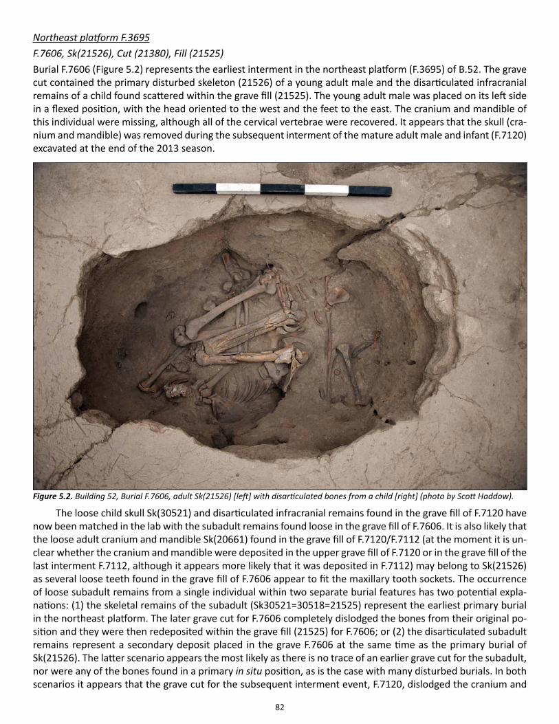
82
Northeast platform F.3695F.7606, Sk(21526), Cut (21380), Fill (21525)Burial F.7606 (Figure 5.2) represents the earliest interment in the northeast platform (F.3695) of B.52. The grave cut contained the primary disturbed skeleton (21526) of a young adult male and the disarticulated infracranial remains of a child found scattered within the grave fill (21525). The young adult male was placed on its left side in a flexed position, with the head oriented to the west and the feet to the east. The cranium and mandible of this individual were missing, although all of the cervical vertebrae were recovered. It appears that the skull (cra-nium and mandible) was removed during the subsequent interment of the mature adult male and infant (F.7120) excavated at the end of the 2013 season.
The loose child skull Sk(30521) and disarticulated infracranial remains found in the grave fill of F.7120 have now been matched in the lab with the subadult remains found loose in the grave fill of F.7606. It is also likely that the loose adult cranium and mandible Sk(20661) found in the grave fill of F.7120/F.7112 (at the moment it is un-clear whether the cranium and mandible were deposited in the upper grave fill of F.7120 or in the grave fill of the last interment F.7112, although it appears more likely that it was deposited in F.7112) may belong to Sk(21526) as several loose teeth found in the grave fill of F.7606 appear to fit the maxillary tooth sockets. The occurrence of loose subadult remains from a single individual within two separate burial features has two potential expla-nations: (1) the skeletal remains of the subadult (Sk30521=30518=21525) represent the earliest primary burial in the northeast platform. The later grave cut for F.7606 completely dislodged the bones from their original po-sition and they were then redeposited within the grave fill (21525) for F.7606; or (2) the disarticulated subadult remains represent a secondary deposit placed in the grave F.7606 at the same time as the primary burial of Sk(21526). The latter scenario appears the most likely as there is no trace of an earlier grave cut for the subadult, nor were any of the bones found in a primary in situ position, as is the case with many disturbed burials. In both scenarios it appears that the grave cut for the subsequent interment event, F.7120, dislodged the cranium and
Figure 5.2. Building 52, Burial F.7606, adult Sk(21526) [left] with disarticulated bones from a child [right] (photo by Scott Haddow).
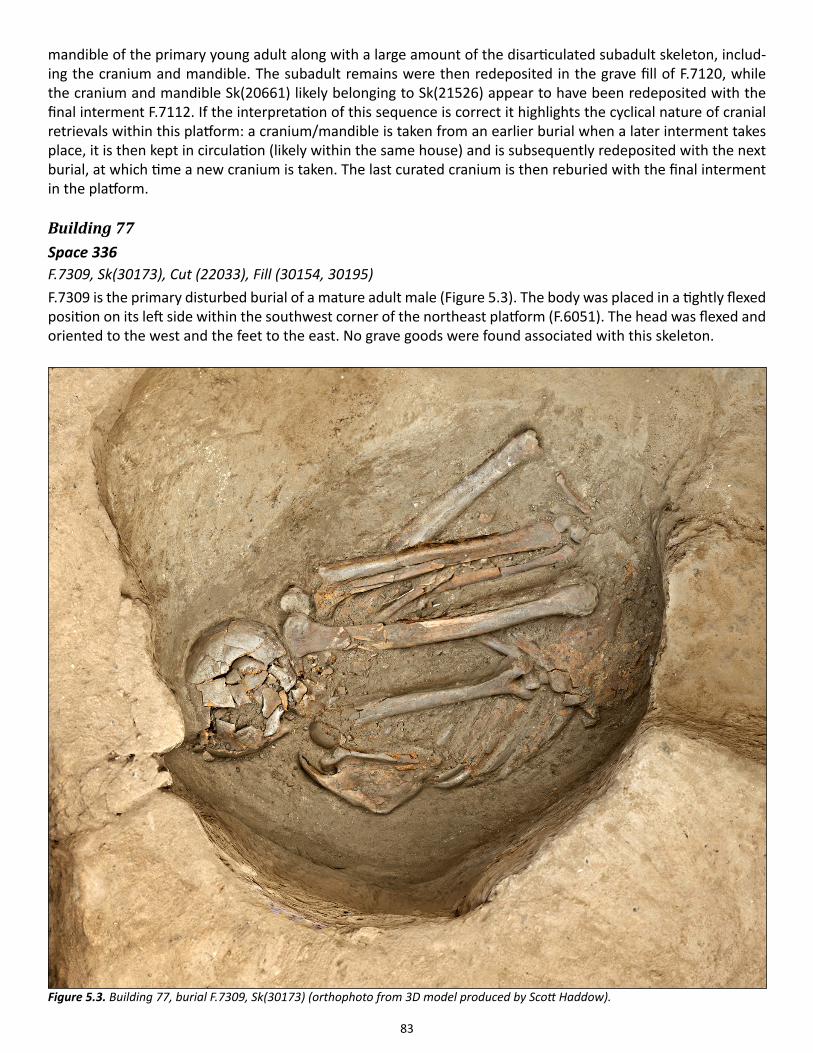
83
mandible of the primary young adult along with a large amount of the disarticulated subadult skeleton, includ-ing the cranium and mandible. The subadult remains were then redeposited in the grave fill of F.7120, while the cranium and mandible Sk(20661) likely belonging to Sk(21526) appear to have been redeposited with the final interment F.7112. If the interpretation of this sequence is correct it highlights the cyclical nature of cranial retrievals within this platform: a cranium/mandible is taken from an earlier burial when a later interment takes place, it is then kept in circulation (likely within the same house) and is subsequently redeposited with the next burial, at which time a new cranium is taken. The last curated cranium is then reburied with the final interment in the platform.
Building 77Space 336F.7309, Sk(30173), Cut (22033), Fill (30154, 30195)F.7309 is the primary disturbed burial of a mature adult male (Figure 5.3). The body was placed in a tightly flexed position on its left side within the southwest corner of the northeast platform (F.6051). The head was flexed and oriented to the west and the feet to the east. No grave goods were found associated with this skeleton.
Figure 5.3. Building 77, burial F.7309, Sk(30173) (orthophoto from 3D model produced by Scott Haddow).
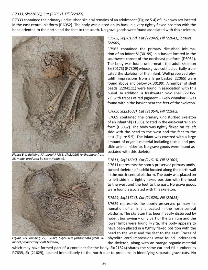
84
F.7333, Sk(22026), Cut (22051), Fill (22027)F.7333 contained the primary undisturbed skeletal remains of an adolescent (Figure 5.4) of unknown sex located in the east central platform (F.6052). The body was placed on its back in a very tightly flexed position with the head oriented to the north and the feet to the south. No grave goods were found associated with this skeleton.
F.7562, Sk(30199), Cut (22042), Fill (22041), basket (22065)F.7562 contained the primary disturbed inhuma-tion of an infant Sk(30199) in a basket located in the southwest corner of the northeast platform (F.6051). The body was found underneath the adult skeleton Sk(30173) (F.7309) whose grave cut had partially trun-cated the skeleton of the infant. Well-preserved phy-tolith impressions from a large basket (22065) were found above and below Sk(30199). A number of shell beads (22041.x1) were found in association with this burial. In addition, a freshwater Unio shell (22065.x3) with traces of red pigment – likely cinnabar – was found within the basket near the feet of the skeleton.
F.7609, Sk(21603), Cut (21064), Fill (21602)F.7609 contained the primary undisturbed skeleton of an infant Sk(21603) located in the east-central plat-form (F.6052). The body was tightly flexed on its left side with the head to the west and the feet to the east (Figure 5.5). The infant was covered with a large amount of organic material including textile and pos-sible animal hide/fur. No grave goods were found as-sociated with this skeleton.
F.7611, Sk(21606), Cut (21613), Fill (21605)F.7611 represents the poorly preserved primary undis-turbed skeleton of a child located along the north wall in the north-central platform. The body was placed on its left side in a tightly flexed position with the head to the west and the feet to the east. No grave goods were found associated with this skeleton.
F.7629, Sk(21624), Cut (21625), Fill (21625)F.7629 represents the poorly preserved primary in-humation of an infant located in the north central platform. The skeleton has been heavily disturbed by rodent burrowing – only part of the cranium and the lower limbs were found in situ. The body appears to have been placed in a tightly flexed position with the head to the west and the feet to the east. Traces of phytolith cord impressions were found underneath the skeleton, along with an orange organic material
which may have formed part of a container for the body. Sk(21624) shares the same cut and fill numbers as F.7639, Sk (21629), located immediately to the north due to problems in identifying separate grave cuts. No
Figure 5.4. Building 77, burial F.7333, Sk(22026) (orthophoto from 3D model produced by Scott Haddow).
Figure 5.5. Building 77, F.7609, Sk(21603) (orthophoto from 3D model produced by Scott Haddow).
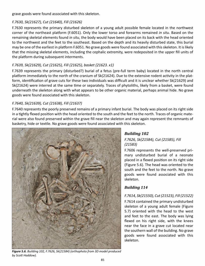
85
grave goods were found associated with this skeleton.
F.7630, Sk(21627), Cut (21640), Fill (21626)F.7630 represents the primary disturbed skeleton of a young adult possible female located in the northwest corner of the northeast platform (F.6051). Only the lower torso and forearms remained in situ. Based on the remaining skeletal elements found in situ, the body would have been placed on its back with the head oriented to the northwest and the feet to the southeast. Based on the depth and its heavily disturbed state, this burial may be one of the earliest in platform F.6051. No grave goods were found associated with this skeleton. It is likely that the missing skeletal elements, including the cephalic extremity, were redeposited in the upper fill units of the platform during subsequent interments.
F.7639, Sk(21629), Cut (21625), Fill (21625), basket (21623. x1)F.7639 represents the primary (disturbed?) burial of a fetus (pre-full term baby) located in the north central platform immediately to the north of the cranium of Sk(21624). Due to the extensive rodent activity in the plat-form, identification of grave cuts for these two individuals was difficult and it is unclear whether Sk(21629) and Sk(21624) were interred at the same time or separately. Traces of phytoliths, likely from a basket, were found underneath the skeleton along with what appears to be other organic material, perhaps animal hide. No grave goods were found associated with this skeleton.
F.7640, Sk(21639), Cut (21638), Fill (21637)F.7640 represents the poorly preserved remains of a primary infant burial. The body was placed on its right side in a tightly flexed position with the head oriented to the south and the feet to the north. Traces of organic mate-rial were also found preserved within the grave fill near the skeleton and may again represent the remnants of basketry, hide or textile. No grave goods were found associated with this skeleton.
Building 102F.7626, Sk(21584), Cut (21585), Fill (21583)F.7606 represents the well-preserved pri-mary undisturbed burial of a neonate placed in a flexed position on its right side (Figure 5.6). The head was oriented to the south and the feet to the north. No grave goods were found associated with this skeleton.
Building 114
F.7614, Sk(21550), Cut (21523), Fill (21522)F.7614 contained the primary undisturbed skeleton of a young adult female (Figure 5.7) oriented with the head to the west and feet to the east. The body was lying flexed on his right side, with the knees near the face in a grave cut located near the southern wall of the building. No grave goods were found associated with this skeleton.
Figure 5.6. Building 102, F.7626, Sk(21584) (orthophoto from 3D model produced by Scott Haddow).
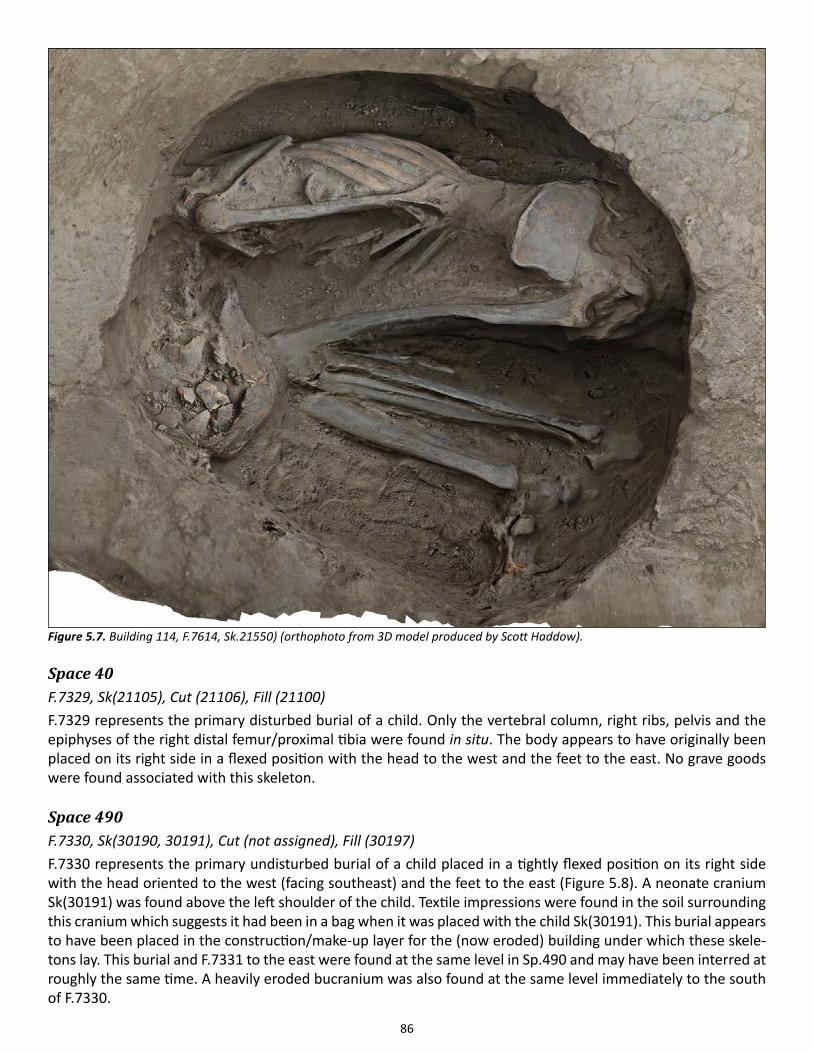
86
Space 40F.7329, Sk(21105), Cut (21106), Fill (21100)F.7329 represents the primary disturbed burial of a child. Only the vertebral column, right ribs, pelvis and the epiphyses of the right distal femur/proximal tibia were found in situ. The body appears to have originally been placed on its right side in a flexed position with the head to the west and the feet to the east. No grave goods were found associated with this skeleton.
Space 490F.7330, Sk(30190, 30191), Cut (not assigned), Fill (30197)F.7330 represents the primary undisturbed burial of a child placed in a tightly flexed position on its right side with the head oriented to the west (facing southeast) and the feet to the east (Figure 5.8). A neonate cranium Sk(30191) was found above the left shoulder of the child. Textile impressions were found in the soil surrounding this cranium which suggests it had been in a bag when it was placed with the child Sk(30191). This burial appears to have been placed in the construction/make-up layer for the (now eroded) building under which these skele-tons lay. This burial and F.7331 to the east were found at the same level in Sp.490 and may have been interred at roughly the same time. A heavily eroded bucranium was also found at the same level immediately to the south of F.7330.
Figure 5.7. Building 114, F.7614, Sk.21550) (orthophoto from 3D model produced by Scott Haddow).
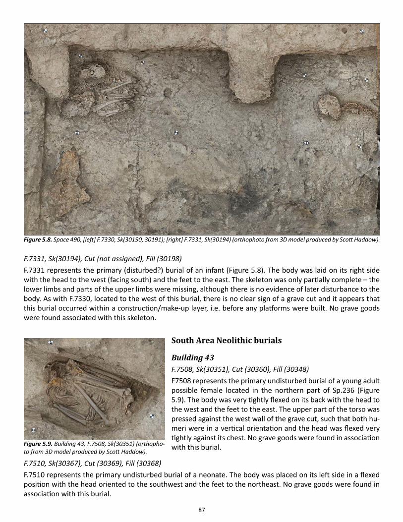
87
F.7331, Sk(30194), Cut (not assigned), Fill (30198)F.7331 represents the primary (disturbed?) burial of an infant (Figure 5.8). The body was laid on its right side with the head to the west (facing south) and the feet to the east. The skeleton was only partially complete – the lower limbs and parts of the upper limbs were missing, although there is no evidence of later disturbance to the body. As with F.7330, located to the west of this burial, there is no clear sign of a grave cut and it appears that this burial occurred within a construction/make-up layer, i.e. before any platforms were built. No grave goods were found associated with this skeleton.
South Area Neolithic burials
Building 43F.7508, Sk(30351), Cut (30360), Fill (30348)F7508 represents the primary undisturbed burial of a young adult possible female located in the northern part of Sp.236 (Figure 5.9). The body was very tightly flexed on its back with the head to the west and the feet to the east. The upper part of the torso was pressed against the west wall of the grave cut, such that both hu-meri were in a vertical orientation and the head was flexed very tightly against its chest. No grave goods were found in association with this burial.
F.7510, Sk(30367), Cut (30369), Fill (30368)F.7510 represents the primary undisturbed burial of a neonate. The body was placed on its left side in a flexed position with the head oriented to the southwest and the feet to the northeast. No grave goods were found in association with this burial.
Figure 5.8. Space 490, [left] F.7330, Sk(30190, 30191); [right] F.7331, Sk(30194) (orthophoto from 3D model produced by Scott Haddow).
Figure 5.9. Building 43, F.7508, Sk(30351) (orthopho-to from 3D model produced by Scott Haddow).

88
F.7512, Sk(21802), Cut (21803), Fill (21801)F.7512 contained the primary undisturbed burial of a tightly flexed adolescent (Figure 5.10). No sex assessment was possible due to the young age of the subject. The burial was located directly to the southeast of F.7508 in the north part of Sp.236. The head was oriented to the south and the feet to the north. The skeleton was lying on its back, with the neck region markedly flexed anteriorly and the head rotated on its left side. A marked wall
effect affects the upper extremities and both shoul-ders. Grave goods include two polished and perforat-ed shells (21802.x1 and x3) located at the level of the upper cervical region. A single cow tooth (21802.x2) was also found directly above the lower abdomen.
Building 80F.7404, Sk(21700), Cut (20098), Fills (20097 and 21703)This is the primary undisturbed inhumation of a child, approximately 10 years of age at death (Figure 5.11). It was in a flexed position on its left side, oriented with the head to the west and the feet to the east. The burial cut was clearly visible through the white plaster layer (18989) of the platform F.3441. The cut (20098) for this burial disturbed an earlier adult Sk(21732) interment; a loose adult lumbar vertebra was found sitting superior-side uppermost on the skeleton of the child. No grave goods were found associated with this skeleton.
F.7405, Sk(21708), Cut (21705), Fill (21704)This is a primary undisturbed inhumation of a peri-nate probably around 38 weeks of age at death. The body was placed on its right side and oriented with the head to the east (facing north) and the feet to the west. It was buried close to the western wall on a plaster base. Completeness and preservation were ex-cellent. The infra-cranial skeleton displays no unusual lesions, but there are some minimal new bone chang-es on the endocranial surface of the frontals. Buried in close association to Sk(21709) and likely contem-porary; both individuals are approximately the same age. No grave goods were found associated with this skeleton.
F.7406, Sk(21709), Cut (21707), Fill( 21706)Like Sk(21708), Sk(21709) was the primary undisturbed inhumation of a neonate of approximately 38 weeks. Both burials were likely the last in platform F.3442. The body of Sk(21708) was flexed on the right side in a very shallow burial cut (21707), oriented with the head to the northwest (facing south) and the feet to the east. No grave goods were found associated with this skeleton.
Figure 5.10. Building 43, burial F.7512, Sk(21802) (orthophoto from 3D model produced by Scott Haddow).
Figure 5.11. Building 89, burial F.7404, Sk(21700) (Photo by Scott Haddow).
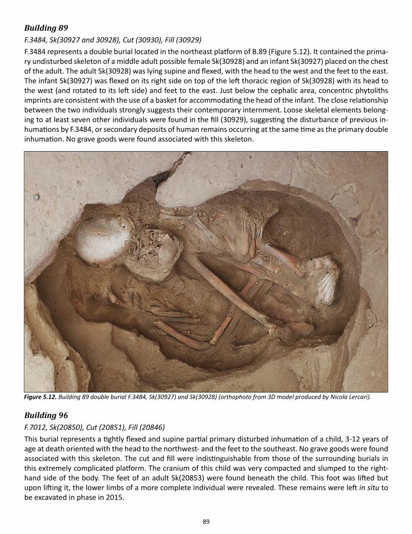
89
Building 89F.3484, Sk(30927 and 30928), Cut (30930), Fill (30929)F.3484 represents a double burial located in the northeast platform of B.89 (Figure 5.12). It contained the prima-ry undisturbed skeleton of a middle adult possible female Sk(30928) and an infant Sk(30927) placed on the chest of the adult. The adult Sk(30928) was lying supine and flexed, with the head to the west and the feet to the east. The infant Sk(30927) was flexed on its right side on top of the left thoracic region of Sk(30928) with its head to the west (and rotated to its left side) and feet to the east. Just below the cephalic area, concentric phytoliths imprints are consistent with the use of a basket for accommodating the head of the infant. The close relationship between the two individuals strongly suggests their contemporary internment. Loose skeletal elements belong-ing to at least seven other individuals were found in the fill (30929), suggesting the disturbance of previous in-humations by F.3484, or secondary deposits of human remains occurring at the same time as the primary double inhumation. No grave goods were found associated with this skeleton.
Building 96F.7012, Sk(20850), Cut (20851), Fill (20846)This burial represents a tightly flexed and supine partial primary disturbed inhumation of a child, 3-12 years of age at death oriented with the head to the northwest- and the feet to the southeast. No grave goods were found associated with this skeleton. The cut and fill were indistinguishable from those of the surrounding burials in this extremely complicated platform. The cranium of this child was very compacted and slumped to the right-hand side of the body. The feet of an adult Sk(20853) were found beneath the child. This foot was lifted but upon lifting it, the lower limbs of a more complete individual were revealed. These remains were left in situ to be excavated in phase in 2015.
Figure 5.12. Building 89 double burial F.3484, Sk(30927) and Sk(30928) (orthophoto from 3D model produced by Nicola Lercari).
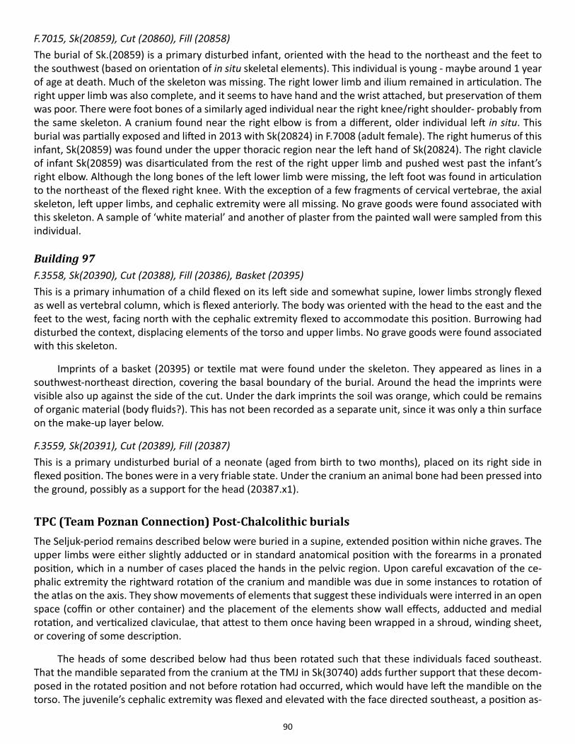
90
F.7015, Sk(20859), Cut (20860), Fill (20858)The burial of Sk.(20859) is a primary disturbed infant, oriented with the head to the northeast and the feet to the southwest (based on orientation of in situ skeletal elements). This individual is young - maybe around 1 year of age at death. Much of the skeleton was missing. The right lower limb and ilium remained in articulation. The right upper limb was also complete, and it seems to have hand and the wrist attached, but preservation of them was poor. There were foot bones of a similarly aged individual near the right knee/right shoulder- probably from the same skeleton. A cranium found near the right elbow is from a different, older individual left in situ. This burial was partially exposed and lifted in 2013 with Sk(20824) in F.7008 (adult female). The right humerus of this infant, Sk(20859) was found under the upper thoracic region near the left hand of Sk(20824). The right clavicle of infant Sk(20859) was disarticulated from the rest of the right upper limb and pushed west past the infant’s right elbow. Although the long bones of the left lower limb were missing, the left foot was found in articulation to the northeast of the flexed right knee. With the exception of a few fragments of cervical vertebrae, the axial skeleton, left upper limbs, and cephalic extremity were all missing. No grave goods were found associated with this skeleton. A sample of ‘white material’ and another of plaster from the painted wall were sampled from this individual.
Building 97F.3558, Sk(20390), Cut (20388), Fill (20386), Basket (20395)This is a primary inhumation of a child flexed on its left side and somewhat supine, lower limbs strongly flexed as well as vertebral column, which is flexed anteriorly. The body was oriented with the head to the east and the feet to the west, facing north with the cephalic extremity flexed to accommodate this position. Burrowing had disturbed the context, displacing elements of the torso and upper limbs. No grave goods were found associated with this skeleton.
Imprints of a basket (20395) or textile mat were found under the skeleton. They appeared as lines in a southwest-northeast direction, covering the basal boundary of the burial. Around the head the imprints were visible also up against the side of the cut. Under the dark imprints the soil was orange, which could be remains of organic material (body fluids?). This has not been recorded as a separate unit, since it was only a thin surface on the make-up layer below.
F.3559, Sk(20391), Cut (20389), Fill (20387)This is a primary undisturbed burial of a neonate (aged from birth to two months), placed on its right side in flexed position. The bones were in a very friable state. Under the cranium an animal bone had been pressed into the ground, possibly as a support for the head (20387.x1).
TPC (Team Poznan Connection) Post-Chalcolithic burialsThe Seljuk-period remains described below were buried in a supine, extended position within niche graves. The upper limbs were either slightly adducted or in standard anatomical position with the forearms in a pronated position, which in a number of cases placed the hands in the pelvic region. Upon careful excavation of the ce-phalic extremity the rightward rotation of the cranium and mandible was due in some instances to rotation of the atlas on the axis. They show movements of elements that suggest these individuals were interred in an open space (coffin or other container) and the placement of the elements show wall effects, adducted and medial rotation, and verticalized claviculae, that attest to them once having been wrapped in a shroud, winding sheet, or covering of some description.
The heads of some described below had thus been rotated such that these individuals faced southeast. That the mandible separated from the cranium at the TMJ in Sk(30740) adds further support that these decom-posed in the rotated position and not before rotation had occurred, which would have left the mandible on the torso. The juvenile’s cephalic extremity was flexed and elevated with the face directed southeast, a position as-
91
cribable to taphonomic changes, rather than to intention on the part of the buriers. The displacement of some patellae suggests movement of this most labile element due to post-depositional processes. In some cases these remain in articulation in the extended lower limbs, again attesting to the presence of a constraint like a shroud. Save for a single bone pin above the cephalic extremity of one individual, they possessed no grave goods (i.e. items of personal adornment) or grave inclusions.
F.7350, Sk(30470), Cuts (30437and 30465), Fill (30436)Sk(30470) is the burial of an extended supine primary inhumation of a middle adult male skeleton, oriented east-west, head to the west, facing south (Figure 5.13). This individual was lying on his right side and, as a result, the right patella had fallen down lateral to the knee. The shoulders are elevated and the clavicles verticalized follow-ing the inferior movement of the manubrium and rib cage (collapse due to decomposition of the thoracic con-tents). The sacro-iliac joints are in an articulated position. The right lower limb is rotated laterally (therefore ac-counting for displacement of the patella). The 2nd metacarpal and trapezoid and all left carpals are in articulation, the left shoulder and upper limb show a wall effect with the cut of the grave and likely wrapping of the body (winding sheet/shroud). The mandible is protracted and the mouth is agape (open). The cephalic extremely is rotated right and the movement of the mandible and thyroid cartilage reflects that this rotation occurred before disarticulation of the TMJ (temporo-mandibular joint).
This individual suffered from dysplasia of the right hip (slipped proximal femoral capital epiphysis). This developmental condition explains the unusual rotation of right lower limb of this individual, the position of which reflects the laterally deviated foot that is diagnostic of this condition (rotated to the right as observed and recorded on excavation). A dental calculus sample from the teeth was collected for pathogen aDNA testing
Figure 5.13. TPC Area Burial F.7350, Sk(30470) (orthophoto from 3D model produced by Scott Haddow).
92
by Dr. Christina Warriner (University of Oklahoma). A bone pin (30470.x1) was found above the cranium of this individual.
F.7351, Sk(30479), Cut (30433, 30478), Fill (30432,30477)Sk(30479), a primary burial, was laid out east-west, with the head at the west end of the grave in a supine posi-tion. The cranium had slightly rolled to the south. Cervical vertebrae found in articulation were fully supine and not rotated, suggesting that the rotation of the cranium was taphonomic and not the original burial position. Both arms were adducted, either as a result of narrow confines of the grave or as a result of shrouding. The epiphyses of the individual were largely unfused, suggesting it is an adolescent of indeterminate sex, roughly 15 years of age at death. The thoracic cavity had been greatly disturbed by animal burrowing, disrupting the ribs and thoracic vertebrae. The feet and hands were also disrupted by animals and were largely missing.
Hip dysplasia was also found to affect this adolescent, found nearby to Sk(30470). This condition is bilateral, but the expression varies: the right hip possesses a separate caput (i.e. unfused as normal) but with fragmen-tation of the caput in the form of osteochondritis dissecans, with the dissected pieces recovered in excavation. On the left side the caput was flattened and articulated with the metaphysis in a slipped position, the caput re-maining in an unfused state, which is consistent with the estimated age-at-death of this individual. The vertebral column had a cranial shift in the lower thoracic region.
F.7352, Sk(30463), Cut (30435, 30467), Fill (30434, 30454)Sk(30463), a fully extended supine primary inhumation of an older adult male of 50+ years of age at death, whose body had decomposed in an open space, permitting movement of the acetabulo–femoral joints (now viewed as labile elements by Henri Duday). The left hand had been disturbed by rodent burrowing. The lower limbs were disturbed at the knee such that the tibiae and fibulae had been displaced. Some ribs were displaced and the sternum verticalized to expose the right side in superior view. The mandible was no longer in occlusion, and the mouth is open (mandible protracted). Pubic symphysis is open (attesting to burial in an open space). The presence of an ossified xiphoid process and vertebral degeneration (osteophytes and syndesmophytes) support an advanced age at death. The left femur presented its posterior aspect uppermost. The feet appear to have been in a burrow. The hands were hidden beneath the mass of hip. The left hand was disarticulated and partially visible, but the right hand fully hidden by right hip mass (due to the movement of acetabulo-femoral joint-rolling.) The left hand elements were present but disturbed. The patellae had been displaced quite some distance from their normal anterior position on the femoral condyles, which suggests movement by rodents or water or both.
Sk(30463) also had evidence of a healed depressed fracture located in the squama of the frontal, a healed rib fracture, a healed nasal fracture that affected not only the nasal bones but also the left border of the nasal aperture. He also shows extensive tooth wear.
F.7373, Sk(21020), Cut (21018, 21019), Fill (21001)This is a primary disturbed burial, Sk(21020) in F.7373, oriented southwest-northeast, cephalic extremity to the southwest. This individual was lying in supine position, rotated slightly to the right. The cervical vertebrae in their upper part were not in anatomical position because of animal disturbance. The shoulders were elevated (claviculae verticalized), and the left clavicle and scapula displaced. The left clavicle was found above the right clavicle. The left scapula was lying near the pelvis. The right upper limb was extended and in articulation. Both right and left hand elements were dispersed in a hole fill (21018) due to decomposition of hand elements and subsequent animal activity. The lower right limb was rotated to the right (acetabulo-femoral joint rolling), and both lower limbs were extended. The metacarpals as well as the foot phalanges were in articulation. The skull (cranium and mandible) was also in articulation and rotated right, facing southeast.
93
Chapter 6
Faunal Remains
Jacqui Mulville1, Katheryn Twiss2, Jesse Wolfhagen2, G. Arzu Demirergi2, David Orton3, Hayley Foster4, Julie Dau-jat5, Richard Madgwick1, Jennifer Jones6 and Christopher Knüsel7
1Cardiff University, 2Stony Brook University, 3University College London, 4Exeter University, 5UMR 7209 (MNHN/CNRS/InEE) Paris / University of Aberdeen, 6Universidad de Cantabria, 7Université Bordeaux
IntroductionThis report incorporates the work of a series of different authors, and includes material from the East and West Mounds The former includes the North and South areas (Mulville, Twiss, Wolfhagen, Demirergi, Foster and Madgwick), KOPAL (Mulville, Jones and Knüsel) as well as material from TPC (Daujat). Analyses from the West Mound (Orton) are also included; additionally worked bone analysis was undertaken this year but is not report-ed here.
In addition to research lead by this team we also report on recent work on ancient DNA in collaboration with two teams; the first, from Johannes Gutenberg University, Mainz, Germany, includes work on sheep, cattle and pigs, and the second, involving a team from Middle East Technical University, Ankara, Turkey and Stockholm University, Sweden, is focused on sheep and humans (see human remains archive report, Chapter 5). Addition-ally, sampling of sheep dental calculus (mineralized plaque) to examine the oral microbiome was undertaken in collaboration with Knüsel.
Report structureThis archive account begins with an overview of the character of faunal remains analyzed in 2014. The aims and research responses to the East Mound material are then discussed, included further recording revisions, followed by a more detailed discussion of this year’s work on the East Mound material by phase and by area.
This is followed by an extended report on the preliminary results from analysis of the mixed human and animal deposit in the KOPAL trench. Full recording and analysis of the assemblage was achieved in 2013/4 using a single recording mechanism to allow for full comparability between humans and animals to focus on tapho-nomic changes. The faunal remains from the Team Poznan Connect Area are then assessed and future research objectives are then presented.
The final section focuses on material from Çatalhöyük whose research extends beyond a single season of analysis or excavation area. A number of projects are described and include our ongoing research into bovid, equid, caprine and avian remains. In addition, a series of collaborative ancient DNA projects are presented. The results from an ongoing aDNA project are reported and then discussed in the context of the zooarchaeological research (Project A); this is followed by a description of the structure of a new project and preliminary results (Project B).
Overview of 2014 materialThe distribution of recorded material (NISP) by area (where available) is shown in Tables 6.1 and 6.2. A total of 8,862 fragments were recorded in 2014, from both the East and West Mounds. Around 5,000 of these fragments derived from the Neolithic East Mound, with a further 4,000 fragments from the Chalcolithic West Mound. A large number of fragments remain as yet unallocated to an individual phase or area.
94
East Mound
AimsThe aims of this tranche of excavations and study seasons continue to focus on obtaining a comprehensive series of radiocarbon dates and providing secure chronological contexts for the Hodder levels; linking the various exca-vated areas together via the Team Poznan Connect excavation (TPC); and extending the spatial and chronological extent of the site. These goals are being achieved by further exploring the earliest activity on the East Mound in the South Area and by extending excavations in the North Area.
Review of the research aims and objectives of the faunal analysis continued with extensive discussion and debate both within the faunal team and across the wider project team, which brought about further develop-ment of faunal research agendas and strategies. Whilst the abundant ovicaprid remains at Çatalhöyük have been the focus of substantial work (e.g. Henton 2013), a review of the dataset for the less numerous species revealed that relatively small quantities of material that could provide quality zooarchaeological data (e.g. dental aging and morphometrical analysis) have been produced. In order to facilitate the study of human:animal interaction of other species it was decided to focus our recording strategy on extending the rarer species datasets. As a re-sult, our methodologies were refined to minimise the recording of ovicaprid material (see below), allowing more material from other species to be examined.
This year we also began to plan for the conclusion of the Çatalhöyük project, aiming to ensure that all groups of material are being studied--i.e. bird bone, fish bone, eggshell-- as well as to expand the range of ana-lytical techniques applied to the material. In particular this year saw a continued expansion of bioarchaeological methodologies: these are discussed below.
Considerable time was dedicated to the location, retrieval and sampling of material for the site’s Radiocar-bon dating program (an estimated equivalent of eight working days for the faunal team, plus another four work-ing days volunteer labor). As a result of information provided by the RC program, future analysis will be focused on units and sequences that will be dated.
Specific East Mound aims for 2014 were:
1. to provide feedback on priority units
2. to initiate recording of newly generated excavated material from the East Mound
3. to continue to record material excavated in previous seasons
4. to provide samples for radiocarbon dating (see below; also Chapter 21, this report)
5. to continue to analyze the faunal (and human) osteological material from KOPAL
6. to provide data for the EAA paper on Building 77
7. to plan for the analysis of all groups of faunal material
8. to expand the application of new bioarchaeological techniques to the faunal assemblage
9. to collaborate with the various Çatalhöyük research projects
The number and size of priority units this year was smaller than in previous seasons; this facilitated an increased focus on other forms of analysis.
East Mound recording revisions 2014In order to facilitate our 2014 season goal of locating and recording taxa other than ovicaprines, we instituted
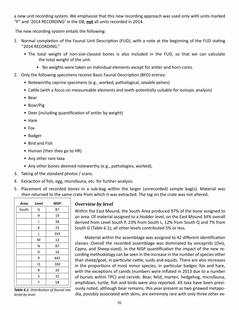
95
a new unit recording system. We emphasize that this new recording approach was used only with units marked “P” and ‘2014 RECORDING’ in the DB, not all units recorded in 2014.
The new recording system entails the following:
1. Normal completion of the Faunal Unit Description (FUD), with a note at the beginning of the FUD stating “2014 RECORDING.”
• The total weight of non-size-classed bones is also included in the FUD, so that we can calculate the total weight of the unit.
• No weights were taken on individual elements except for antler and horn cores.
2. Only the following specimens receive Basic Faunal Description (BFD) entries:
• Noteworthy caprine specimens (e.g., worked, pathological, sexable pelves)
• Cattle (with a focus on measureable elements and teeth potentially suitable for isotopic analysis)
• Bear
• Boar/Pig
• Deer (including quantification of antler by weight)
• Hare
• Fox
• Badger
• Bird and Fish
• Human (then they go to HR)
• Any other rare taxa
• Any other bones deemed noteworthy (e.g., pathologies, worked).
3. Taking of the standard photos / scans.
4. Extraction of fish, egg, microfauna, etc. for further analysis.
5. Placement of recorded bones in a sub-bag within the larger (unrecorded) sample bag(s). Material was then returned to the same crate from which it was extracted. The tag on the crate was not altered.
Overview by levelWithin the East Mound, the South Area produced 97% of the bone assigned to an area. Of material assigned to a Hodder level, on the East Mound 34% overall derived from Level South P, 23% from South L, 12% from South Q and 7% from South G (Table 6.1); all other levels contributed 5% or less.
Material within the assemblage was assigned to 42 different identification classes. Overall the recorded assemblage was dominated by ovicaprids (Ovis, Capra, and Sheep-sized). In the NISP quantification the impact of the new re-cording methodology can be seen in the increase in the number of species other than sheep/goat, in particular cattle, suids and equids. There are also increases in the proportions of most minor species, in particular badger, fox and hare, with the exceptions of canids (numbers were inflated in 2013 due to a number of burials within TPC) and cervids. Bear, felid, marten, hedgehog, microfauna, amphibian, turtle, fish and birds were also reported. All taxa have been previ-ously noted, although bear remains, this year present as two gnawed metapo-dia, possibly associated with skins, are extremely rare with only three other ex-
Table 6.1. Distribution of faunal ma-terial by level.
Area Level NISPSouth G 87
H 19I 38K 25L 293M 12N 87O 16P 442Q 160R 20S 31T 58
96
amples encountered during previous seasons of excavation. Marten remains are also rare, with marten (Martes cf. foina), marbled polecat (Vormela peregusna), and weasel (Mustela nivalis) having been positively identified in only a small number of cases (Russell et al. 2014).
Overview by areaG. Arzu Demirergi and Katheryn Twiss
Building 119In addition to setting up a new recording protocol focusing on rare taxa, which we applied to recording units ex-cavated in the previous season, we analyzed many of the units excavated during the current season. We focused on the buildings or spaces that yielded large amounts of bone, and prioritized units that seemed unusual during excavation.
This protocol led us to record many of the units from B.119 in particular. Excavation of this North Area building started in 2013 (Tung 2013: 32-35). In 2014, the excavation of the fill was completed, and at least some of the floor layers were removed. Taking 2013 and 2014 faunal recording work together, we have now recorded much of the faunal content of B.119’s fill. This fill showed similarities to other fills in the North area in that it was mostly made up of construction rubble, with little animal bone. The fill in the side room of the building seemed richer in animal bones than the main room’s fill, although a few units in the fill of the main room were excep-tionally rich in animal bones.
Space 513 (Main room)The homogenous fill of the main room (Sp.513) did not contain large quantities of bones (Tung 2013: 32), how-ever, there were a few units with relatively unusual faunal contents: (30123), (21540), (21509), (21173) and (21177).
Unit (30123) was a possible feasting cluster. It was deposited on the floor of the building’s southeast plat-form, near the ladder scar, oven and hearth. According to excavator Numan Arslan, this unit might have been the first deposit dumped as fill in B.119 (Tung 2013: 34). Russell et al. (2014) suggest that possible feasting deposits in buildings’ lower fills may be abandonment deposits deriving from feasts related to the closure of a building. If so, this unit may reflect the ritual closing of B.119.
Apart from (30123), most of the bones in Sp.513’s fill were recovered from pits. The pit fills were not partic-ularly rich in faunal remains, but they yielded several bone tools, including a bone needle in (21540) and a bone point in (21509), as well as relatively rare non-mammalian specimens, such as (possibly worked) bird remains in (21173) and amphibian remains in (21177).
Space 512 (side room)The fill of the side room was richer in bones than that of the main room. Noteworthy units are (21101), (30106) and (21367).
Unit (21101) came from the southern part of the side room. Excavators noted that this unit contained clus-ter(s) of large pieces of bone. Indeed, in the lab we identified large pieces of cattle, equid and caprine bones that might, like (30123), represent the remains of a feast related to the abandonment of B.119 (sensu Russell et al. 2014). (21101), a large unit, also contained midden material that might have been deposited during the infilling of the house.
In addition to the potential feasting cluster in (21101), this side room also yielded a pit fill containing a mod-erately interesting deposit (30106). This was a very small unit in terms of the amount of bones, but the remains (an articulating Ovis astragalus and calcaneus; a non-articulating caprine 2nd phalanx and metatarsal, and long bone splinters) plausibly derive from a single sheep. If so, this unit might also be the remains of a single event,

97
possibly a feast; perhaps the pit was dug in order to bury the feasting remains, as they came from the bottom part of the pit.
Another unit worth mentioning is (21367), which contained relatively rare taxa: a toad (articulating margin-al carapace) and a hedgehog (maxilla with tooth).
DiscussionFaunal analysis confirms excavators’ initial observation that abandonment activities in the side and main rooms of B.119 (Sp.512 and Sp.513 respectively) were mutually distinct (Tung 2013: 34). Over all, the infill in the side room was much richer in animal bones than was that of the main room, but the main room’s fill contained bone tools. Both rooms’ fills yielded apparent feasting deposits and rare taxa.
B.119 has many features common in Çatalhöyük buildings, such as its internal layout (Tung 2013: 35) and pits in its fill. Indeed, B.119 is much more typical than are other North area buildings currently under excavation, such as B.102 and B.114, in terms of the relatively low amounts of bone in its fills and on its house floors. B.119 was the predecessor of another house (B.112) that was constructed immediately after the closure of this build-ing (Tung 2013: 32). Like B.119, the fill of B.112 did not contain many finds. Detailed comparison of the fills of the two houses is impossible, however, as unfortunately B.112 was highly eroded.
Building 77 The faunal team contributed data to field supervisor James Taylor’s visual biography of B.77’s life history, dis-cussing as we did the nature of the faunal data and the challenges and opportunities of using it in Taylor’s spa-tiotemporal framework. Time limitations meant that faunal data were present but not emphasized in Taylor et al.’s presentation at the EAA in Istanbul (Taylor 2014); they will, however, be key components as Taylor’s project matures and proceeds toward publication.
KOPAL: All mixed up? Human:animal relations at early ÇatalhöyükJennifer Jones, Jacqui Mulville and Christopher Knüsel
IntroductionThe KOPAL trench was excavated in 1996 as part of the ‘Konya Basin Palaeoenvironments Project’ aimed at un-derstanding the environment surrounding the central tell at Çatalhöyük. The excavations focused on linking the environmental remains from the Pleistocene Lake Konya with in situ environmental deposits. Excavations pro-duced a significant quantity of apparently disarticulated human and animal remains. These osteological assem-blages are important to the understanding of the site as they represent the only collection of offsite remains that are contextually distinctive in comparison to the other faunal and human assemblages identified within the site.
Assessment of the faunal remains was undertaken, at the time, but the disarticulated human remains were not a priority for analysis and no recording occurred. The initial assessment of the faunal assemblage from the KOPAL deposits indicated that cattle dominated (NISP 155) with fewer ovicaprids present (NISP 109). This pat-tern is atypical when compared with other parts of the site, which is dominated to a large degree by Ovis and Capra (Russell & Martin 2005). There were also higher proportions of wild species, including Cervus sp., Equus sp. and Sus scrofa and higher frequencies of meat-bearing elements. Within the wider context of the site, the KOPAL deposits are unusual due to the species and skeletal element representations, and these are considered to be special deposits indicative of ceremonial consumption (Russell & Martin 2005: 96).
The original faunal assessment looked at a small proportion of the entire KOPAL assemblage, recording only 365 fragments to species, and there was a need to explore this pattern further. Additionally, the extensive co-mingled human and animal deposits found within the KOPAL trenches at Çatalhöyük represent an unusual and enigmatic collection of remains. The method by which these two groups of remains came to be deposited

98
together is an intriguing issue.
The focus of this research was to explore the nature of these intermingled human and animal remains within the KOPAL trenches in order to:
• Understand the pre-, peri- and post-mortem processes that resulted in the formation of this deposit
• Understand the treatment of different species within the deposits.
• Understand the chronology of the deposit in relation to the wider temporality at Çatalhöyük.
• Interpret the remains within their social and temporal framework.
MethodsDuring the 2013 field season a full analysis of the faunal and human remains from the KOPAL deposit was undertaken. The zooarchaeological assemblage and human remains from the KOPAL deposits were recorded, by Jones and Knüsel respec-tively, during the 2013 excavation season at Çatalhöyük. Both groups of material were recorded using identical methodolo-gies, this technique has previously been successfully applied to assemblages of co-mingled human and animal remains (Out-ram et al. 2005).
The entire assemblage of osteological material was ana-lyzed. This included full taphonomic analysis of the bone spec-imens to provide a clear understanding of the depositional
history of the assemblages. Bones were assigned zones to determine the parts and the proportions of the bones present. The zoning systems used for the faunal remains followed Dobney and Reilly (1988). Human remains zones were in accor-dance with Knüsel and Outram (2004), which correspond directly to the zonation of the faunal material. Bones were only counted in the NISP if greater than 50% of a zone was present to prevent duplication during the quantification. Ribs were in-cluded in the NISP if the proximal ends were present (zone 1 according to Dobney & Reilly 1988). Also vertebrae were only reported if at least 50% of the centrum was present. Loose teeth were included in the NISP if greater than 50% of a tooth was present. Bone fracture patterns were assessed using the criteria outlined by Outram (2001), and bones were assigned to the following categories: complete, peri-mortem fracture, dry fracture (post mortem or depositional), new fractures
sustained during and post excavation, and combinations thereof. Weathering of bone fragments was assessed following Behrensmeyer (1978) to contribute to the record the understanding of the taphonomic history of them. Unidentifiable fragments were assigned to a size class of mammal (for animal bones), with all unidentifi-able fragments measured to assess the quantity of long bones present within this fraction of the remains.
ResultsA total of 19,174 bone fragments were available for analysis. Of these 2,279 fragments were identified to species or taxon, 12% of the total assemblage, with 16,795 fragments (88% of the assemblage) only identifiable to size class. Bone fragments were found within 116 excavated units within the KOPAL deposits. There were no units
Taxon MNIOvicaprid 20Bos 14Homo sapiens 5Sus 7Canis 5Equid 4Cervid 3
Table 6.3. MNI values within the KOPAL deposits.
Taxon NISP % of NISPOvicaprid 792 34.8Bos sp. 572 25.1Homo sapiens 164 7.2Canis familiaris 140 6.1Sus scrofa 118 5.2Equus sp. 61 2.7Cervus elaphus 31 1.4Vulpes sp. 3 0.1Turtle 2 0.1Small bird 3 0.1Small canid 7 0.3Small carnivore 1 0.0Large canid 1 0.0Medium bird 2 0.1Bird 1 0.0Amphibian 2 0.1Medium canid 6 0.3Medium carnivore 2 0.1Large mammal 147 6.5Medium mammal 133 5.8Hare sized 16 0.7Microfauna 1 0.0Indeterminate mammal 74 3.2
Table 6.2. Taxon NISP within the KOPAL deposits.
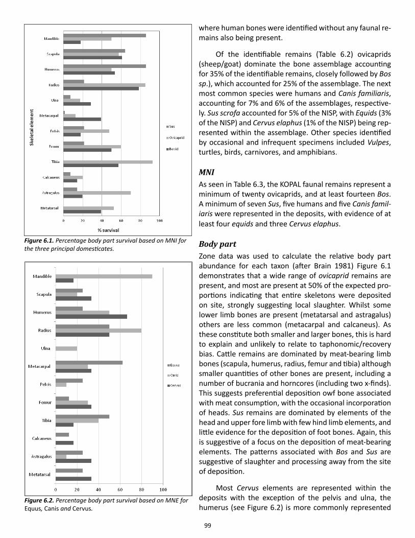
99
where human bones were identified without any faunal re-mains also being present.
Of the identifiable remains (Table 6.2) ovicaprids (sheep/goat) dominate the bone assemblage accounting for 35% of the identifiable remains, closely followed by Bos sp.), which accounted for 25% of the assemblage. The next most common species were humans and Canis familiaris, accounting for 7% and 6% of the assemblages, respective-ly. Sus scrofa accounted for 5% of the NISP, with Equids (3% of the NISP) and Cervus elaphus (1% of the NISP) being rep-resented within the assemblage. Other species identified by occasional and infrequent specimens included Vulpes, turtles, birds, carnivores, and amphibians.
MNIAs seen in Table 6.3, the KOPAL faunal remains represent a minimum of twenty ovicaprids, and at least fourteen Bos. A minimum of seven Sus, five humans and five Canis famil-iaris were represented in the deposits, with evidence of at least four equids and three Cervus elaphus.
Body part Zone data was used to calculate the relative body part abundance for each taxon (after Brain 1981) Figure 6.1 demonstrates that a wide range of ovicaprid remains are present, and most are present at 50% of the expected pro-portions indicating that entire skeletons were deposited on site, strongly suggesting local slaughter. Whilst some lower limb bones are present (metatarsal and astragalus) others are less common (metacarpal and calcaneus). As these constitute both smaller and larger bones, this is hard to explain and unlikely to relate to taphonomic/recovery bias. Cattle remains are dominated by meat-bearing limb bones (scapula, humerus, radius, femur and tibia) although smaller quantities of other bones are present, including a number of bucrania and horncores (including two x-finds). This suggests preferential deposition owf bone associated with meat consumption, with the occasional incorporation of heads. Sus remains are dominated by elements of the head and upper fore limb with few hind limb elements, and little evidence for the deposition of foot bones. Again, this is suggestive of a focus on the deposition of meat-bearing elements. The patterns associated with Bos and Sus are suggestive of slaughter and processing away from the site of deposition.
Most Cervus elements are represented within the deposits with the exception of the pelvis and ulna, the humerus (see Figure 6.2) is more commonly represented
Figure 6.1. Percentage body part survival based on MNI for the three principal domesticates.
Figure 6.2. Percentage body part survival based on MNE for Equus, Canis and Cervus.
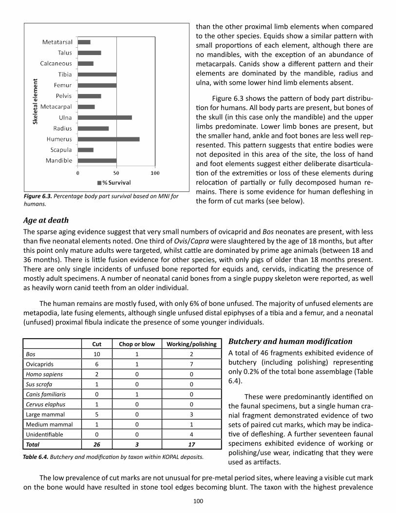
100
than the other proximal limb elements when compared to the other species. Equids show a similar pattern with small proportions of each element, although there are no mandibles, with the exception of an abundance of metacarpals. Canids show a different pattern and their elements are dominated by the mandible, radius and ulna, with some lower hind limb elements absent.
Figure 6.3 shows the pattern of body part distribu-tion for humans. All body parts are present, but bones of the skull (in this case only the mandible) and the upper limbs predominate. Lower limb bones are present, but the smaller hand, ankle and foot bones are less well rep-resented. This pattern suggests that entire bodies were not deposited in this area of the site, the loss of hand and foot elements suggest either deliberate disarticula-tion of the extremities or loss of these elements during relocation of partially or fully decomposed human re-mains. There is some evidence for human defleshing in the form of cut marks (see below).
Age at deathThe sparse aging evidence suggest that very small numbers of ovicaprid and Bos neonates are present, with less than five neonatal elements noted. One third of Ovis/Capra were slaughtered by the age of 18 months, but after this point only mature adults were targeted, whilst cattle are dominated by prime age animals (between 18 and 36 months). There is little fusion evidence for other species, with only pigs of older than 18 months present. There are only single incidents of unfused bone reported for equids and, cervids, indicating the presence of mostly adult specimens. A number of neonatal canid bones from a single puppy skeleton were reported, as well as heavily worn canid teeth from an older individual.
The human remains are mostly fused, with only 6% of bone unfused. The majority of unfused elements are metapodia, late fusing elements, although single unfused distal epiphyses of a tibia and a femur, and a neonatal (unfused) proximal fibula indicate the presence of some younger individuals.
Butchery and human modificationA total of 46 fragments exhibited evidence of butchery (including polishing) representing only 0.2% of the total bone assemblage (Table 6.4).
These were predominantly identified on the faunal specimens, but a single human cra-nial fragment demonstrated evidence of two sets of paired cut marks, which may be indica-tive of defleshing. A further seventeen faunal specimens exhibited evidence of working or polishing/use wear, indicating that they were used as artifacts.
The low prevalence of cut marks are not unusual for pre-metal period sites, where leaving a visible cut mark on the bone would have resulted in stone tool edges becoming blunt. The taxon with the highest prevalence
Figure 6.3. Percentage body part survival based on MNI for humans.
Cut Chop or blow Working/polishingBos 10 1 2Ovicaprids 6 1 7Homo sapiens 2 0 0Sus scrofa 1 0 0Canis familiaris 0 1 0Cervus elaphus 1 0 0Large mammal 5 0 3Medium mammal 1 0 1Unidentifiable 0 0 4Total 26 3 17
Table 6.4. Butchery and modification by taxon within KOPAL deposits.
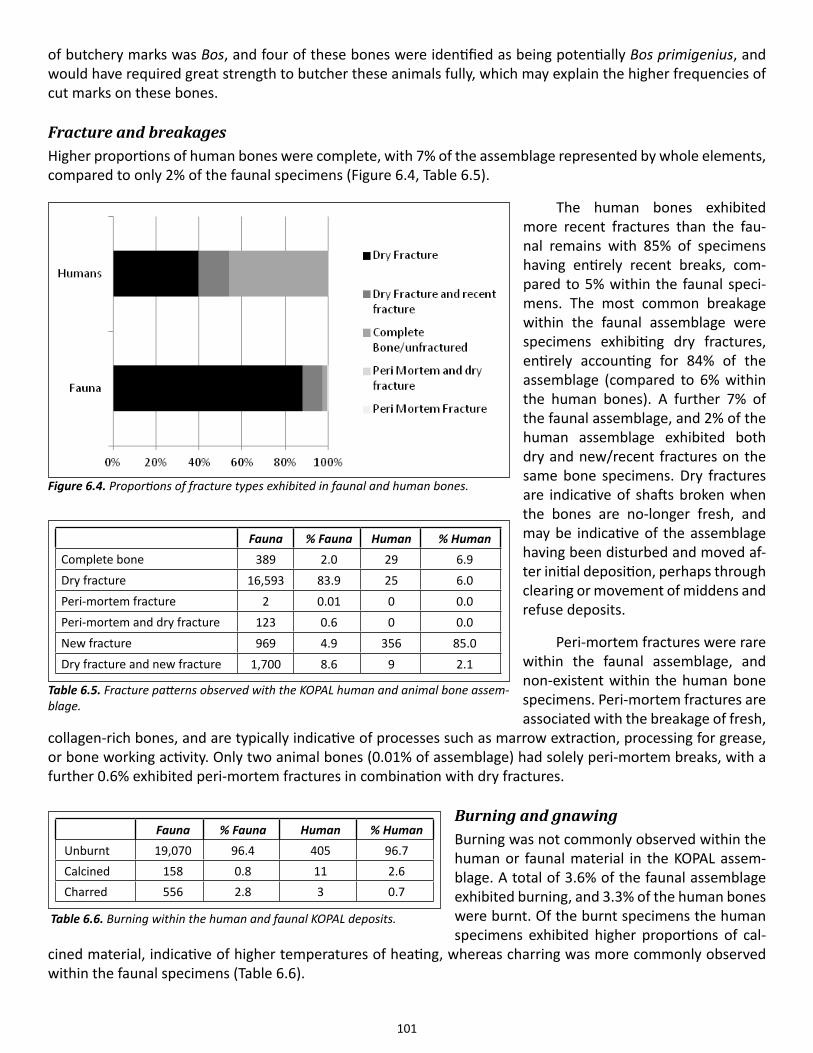
101
of butchery marks was Bos, and four of these bones were identified as being potentially Bos primigenius, and would have required great strength to butcher these animals fully, which may explain the higher frequencies of cut marks on these bones.
Fracture and breakagesHigher proportions of human bones were complete, with 7% of the assemblage represented by whole elements, compared to only 2% of the faunal specimens (Figure 6.4, Table 6.5).
The human bones exhibited more recent fractures than the fau-nal remains with 85% of specimens having entirely recent breaks, com-pared to 5% within the faunal speci-mens. The most common breakage within the faunal assemblage were specimens exhibiting dry fractures, entirely accounting for 84% of the assemblage (compared to 6% within the human bones). A further 7% of the faunal assemblage, and 2% of the human assemblage exhibited both dry and new/recent fractures on the same bone specimens. Dry fractures are indicative of shafts broken when the bones are no-longer fresh, and may be indicative of the assemblage having been disturbed and moved af-ter initial deposition, perhaps through clearing or movement of middens and refuse deposits.
Peri-mortem fractures were rare within the faunal assemblage, and non-existent within the human bone specimens. Peri-mortem fractures are associated with the breakage of fresh,
collagen-rich bones, and are typically indicative of processes such as marrow extraction, processing for grease, or bone working activity. Only two animal bones (0.01% of assemblage) had solely peri-mortem breaks, with a further 0.6% exhibited peri-mortem fractures in combination with dry fractures.
Burning and gnawingBurning was not commonly observed within the human or faunal material in the KOPAL assem-blage. A total of 3.6% of the faunal assemblage exhibited burning, and 3.3% of the human bones were burnt. Of the burnt specimens the human specimens exhibited higher proportions of cal-
cined material, indicative of higher temperatures of heating, whereas charring was more commonly observed within the faunal specimens (Table 6.6).
Fauna % Fauna Human % HumanComplete bone 389 2.0 29 6.9Dry fracture 16,593 83.9 25 6.0Peri-mortem fracture 2 0.01 0 0.0Peri-mortem and dry fracture 123 0.6 0 0.0New fracture 969 4.9 356 85.0Dry fracture and new fracture 1,700 8.6 9 2.1
Table 6.5. Fracture patterns observed with the KOPAL human and animal bone assem-blage.
Figure 6.4. Proportions of fracture types exhibited in faunal and human bones.
Fauna % Fauna Human % HumanUnburnt 19,070 96.4 405 96.7Calcined 158 0.8 11 2.6Charred 556 2.8 3 0.7
Table 6.6. Burning within the human and faunal KOPAL deposits.
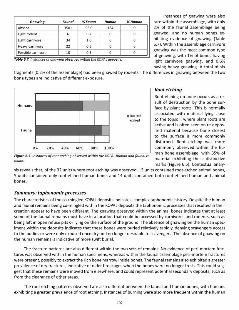
102
Instances of gnawing were also rare within the assemblage, with only 2% of the faunal assemblage being gnawed, and no human bones ex-hibiting evidence of gnawing (Table 6.7). Within the assemblage carnivore gnawing was the most common type of gnawing, with 1% of bones having light carnivore gnawing, and 0.6% having heavy gnawing. A total of six
fragments (0.2% of the assemblage) had been gnawed by rodents. The differences in gnawing between the two bone types are indicative of different exposure.
Root etchingRoot etching on bone occurs as a re-sult of destruction by the bone sur-face by plant roots. This is normally associated with material lying close to the topsoil, where plant roots are active and is often seen on re-depos-ited material because bone closest to the surface is more commonly disturbed. Root etching was more commonly observed within the hu-man bone assemblage, with 35% of material exhibiting these distinctive marks (Figure 6.5). Contextual analy-
sis reveals that, of the 32 units where root etching was observed, 13 units contained root-etched animal bones, 5 units contained only root-etched human bone, and 14 units contained both root-etched human and animal bones.
Summary: taphonomic processesThe characteristics of the co-mingled KOPAL deposits indicate a complex taphonomic history. Despite the human and faunal remains being co-mingled within the KOPAL deposits the taphonomic processes that resulted in their creation appear to have been different. The gnawing observed within the animal bones indicates that at least some of the faunal remains must have in a location that could be accessed by carnivores and rodents, such as being left in open refuse pits or lying on the surface of the ground. The absence of gnawing on the human spec-imens within the deposits indicates that these bones were buried relatively rapidly, denying scavengers access to the bodies or were only exposed once dry and no longer desirable to scavengers. The absence of gnawing on the human remains is indicative of more swift burial.
The fracture patterns are also different within the two sets of remains. No evidence of peri-mortem frac-tures was observed within the human specimens, whereas within the faunal assemblage peri-mortem fractures were present, possibly to extract the rich bone marrow inside bones. The faunal remains also exhibited a greater prevalence of dry fractures, indicative of older breakages when the bones were no longer fresh. This could sug-gest that these remains were moved from elsewhere, and could represent potential secondary deposits, such as from the clearance of other areas.
The root etching patterns observed are also different between the faunal and human bones, with humans exhibiting a greater prevalence of root etching. Instances of burning were also more frequent within the human
Gnawing Faunal % Fauna Human % HumanAbsent 3501 98.0 184 0Light rodent 6 0.2 0 0Light carnivore 34 1.0 0 0Heavy carnivore 22 0.6 0 0Possible carnivore 10 0.3 0 0
Table 6.7. Instances of gnawing observed within the KOPAL deposits.
Figure 6.5. Instances of root etching observed within the KOPAL human and faunal re-mains.
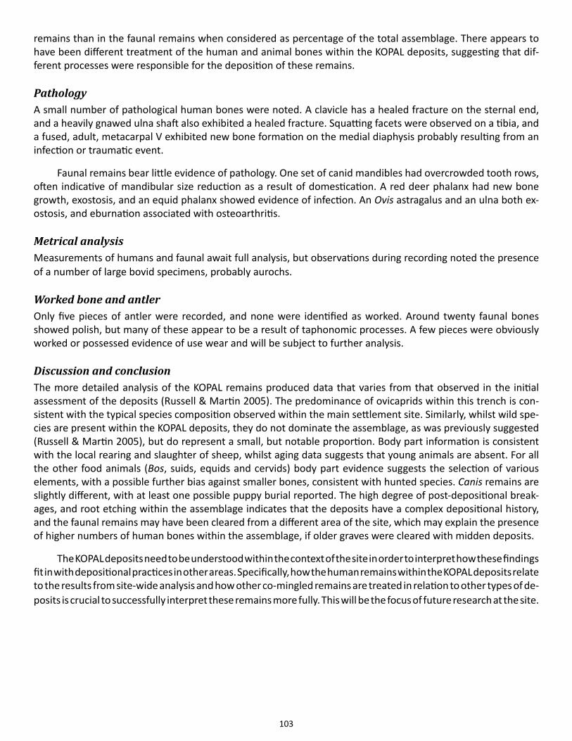
103
remains than in the faunal remains when considered as percentage of the total assemblage. There appears to have been different treatment of the human and animal bones within the KOPAL deposits, suggesting that dif-ferent processes were responsible for the deposition of these remains.
PathologyA small number of pathological human bones were noted. A clavicle has a healed fracture on the sternal end, and a heavily gnawed ulna shaft also exhibited a healed fracture. Squatting facets were observed on a tibia, and a fused, adult, metacarpal V exhibited new bone formation on the medial diaphysis probably resulting from an infection or traumatic event.
Faunal remains bear little evidence of pathology. One set of canid mandibles had overcrowded tooth rows, often indicative of mandibular size reduction as a result of domestication. A red deer phalanx had new bone growth, exostosis, and an equid phalanx showed evidence of infection. An Ovis astragalus and an ulna both ex-ostosis, and eburnation associated with osteoarthritis.
Metrical analysisMeasurements of humans and faunal await full analysis, but observations during recording noted the presence of a number of large bovid specimens, probably aurochs.
Worked bone and antlerOnly five pieces of antler were recorded, and none were identified as worked. Around twenty faunal bones showed polish, but many of these appear to be a result of taphonomic processes. A few pieces were obviously worked or possessed evidence of use wear and will be subject to further analysis.
Discussion and conclusionThe more detailed analysis of the KOPAL remains produced data that varies from that observed in the initial assessment of the deposits (Russell & Martin 2005). The predominance of ovicaprids within this trench is con-sistent with the typical species composition observed within the main settlement site. Similarly, whilst wild spe-cies are present within the KOPAL deposits, they do not dominate the assemblage, as was previously suggested (Russell & Martin 2005), but do represent a small, but notable proportion. Body part information is consistent with the local rearing and slaughter of sheep, whilst aging data suggests that young animals are absent. For all the other food animals (Bos, suids, equids and cervids) body part evidence suggests the selection of various elements, with a possible further bias against smaller bones, consistent with hunted species. Canis remains are slightly different, with at least one possible puppy burial reported. The high degree of post-depositional break-ages, and root etching within the assemblage indicates that the deposits have a complex depositional history, and the faunal remains may have been cleared from a different area of the site, which may explain the presence of higher numbers of human bones within the assemblage, if older graves were cleared with midden deposits.
The KOPAL deposits need to be understood within the context of the site in order to interpret how these findings fit in with depositional practices in other areas. Specifically, how the human remains within the KOPAL deposits relate to the results from site-wide analysis and how other co-mingled remains are treated in relation to other types of de-posits is crucial to successfully interpret these remains more fully. This will be the focus of future research at the site.
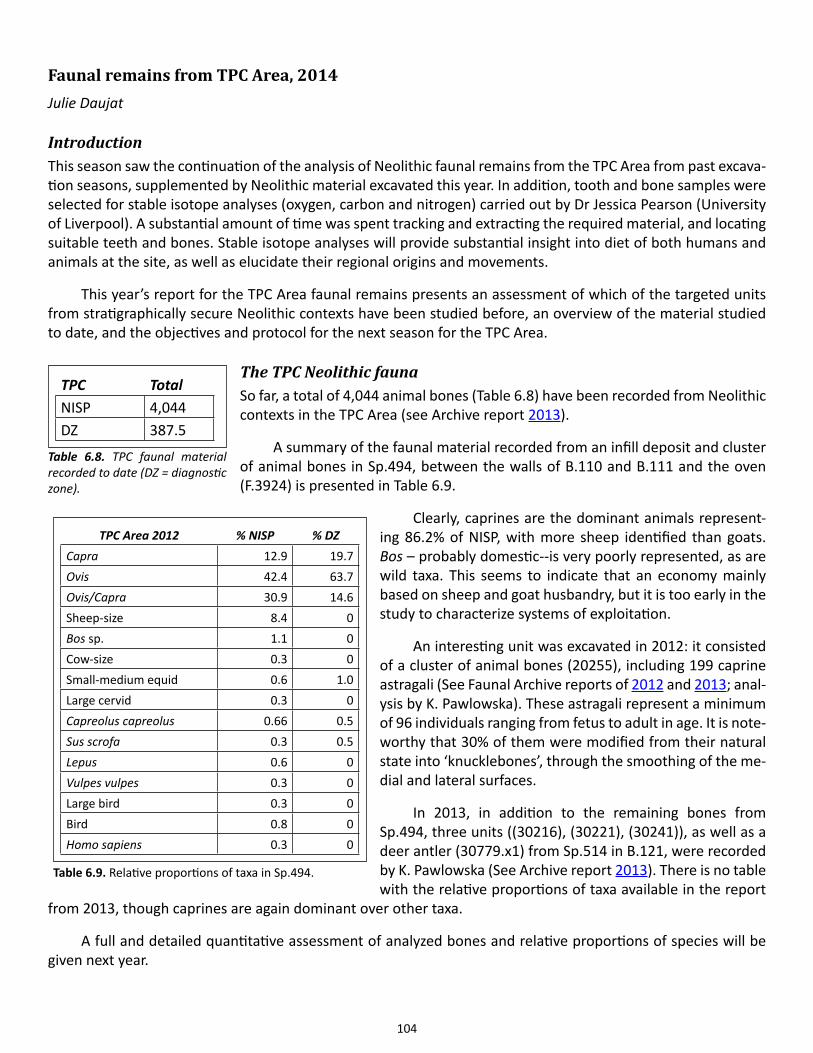
104
Faunal remains from TPC Area, 2014Julie Daujat
IntroductionThis season saw the continuation of the analysis of Neolithic faunal remains from the TPC Area from past excava-tion seasons, supplemented by Neolithic material excavated this year. In addition, tooth and bone samples were selected for stable isotope analyses (oxygen, carbon and nitrogen) carried out by Dr Jessica Pearson (University of Liverpool). A substantial amount of time was spent tracking and extracting the required material, and locating suitable teeth and bones. Stable isotope analyses will provide substantial insight into diet of both humans and animals at the site, as well as elucidate their regional origins and movements.
This year’s report for the TPC Area faunal remains presents an assessment of which of the targeted units from stratigraphically secure Neolithic contexts have been studied before, an overview of the material studied to date, and the objectives and protocol for the next season for the TPC Area.
The TPC Neolithic fauna So far, a total of 4,044 animal bones (Table 6.8) have been recorded from Neolithic contexts in the TPC Area (see Archive report 2013).
A summary of the faunal material recorded from an infill deposit and cluster of animal bones in Sp.494, between the walls of B.110 and B.111 and the oven (F.3924) is presented in Table 6.9.
Clearly, caprines are the dominant animals represent-ing 86.2% of NISP, with more sheep identified than goats. Bos – probably domestic--is very poorly represented, as are wild taxa. This seems to indicate that an economy mainly based on sheep and goat husbandry, but it is too early in the study to characterize systems of exploitation.
An interesting unit was excavated in 2012: it consisted of a cluster of animal bones (20255), including 199 caprine astragali (See Faunal Archive reports of 2012 and 2013; anal-ysis by K. Pawlowska). These astragali represent a minimum of 96 individuals ranging from fetus to adult in age. It is note-worthy that 30% of them were modified from their natural state into ‘knucklebones’, through the smoothing of the me-dial and lateral surfaces.
In 2013, in addition to the remaining bones from Sp.494, three units ((30216), (30221), (30241)), as well as a deer antler (30779.x1) from Sp.514 in B.121, were recorded by K. Pawlowska (See Archive report 2013). There is no table with the relative proportions of taxa available in the report
from 2013, though caprines are again dominant over other taxa.
A full and detailed quantitative assessment of analyzed bones and relative proportions of species will be given next year.
TPC TotalNISP 4,044DZ 387.5
Table 6.8. TPC faunal material recorded to date (DZ = diagnostic zone).
TPC Area 2012 % NISP % DZCapra 12.9 19.7Ovis 42.4 63.7Ovis/Capra 30.9 14.6Sheep-size 8.4 0Bos sp. 1.1 0Cow-size 0.3 0Small-medium equid 0.6 1.0Large cervid 0.3 0Capreolus capreolus 0.66 0.5Sus scrofa 0.3 0.5Lepus 0.6 0Vulpes vulpes 0.3 0Large bird 0.3 0Bird 0.8 0Homo sapiens 0.3 0
Table 6.9. Relative proportions of taxa in Sp.494.
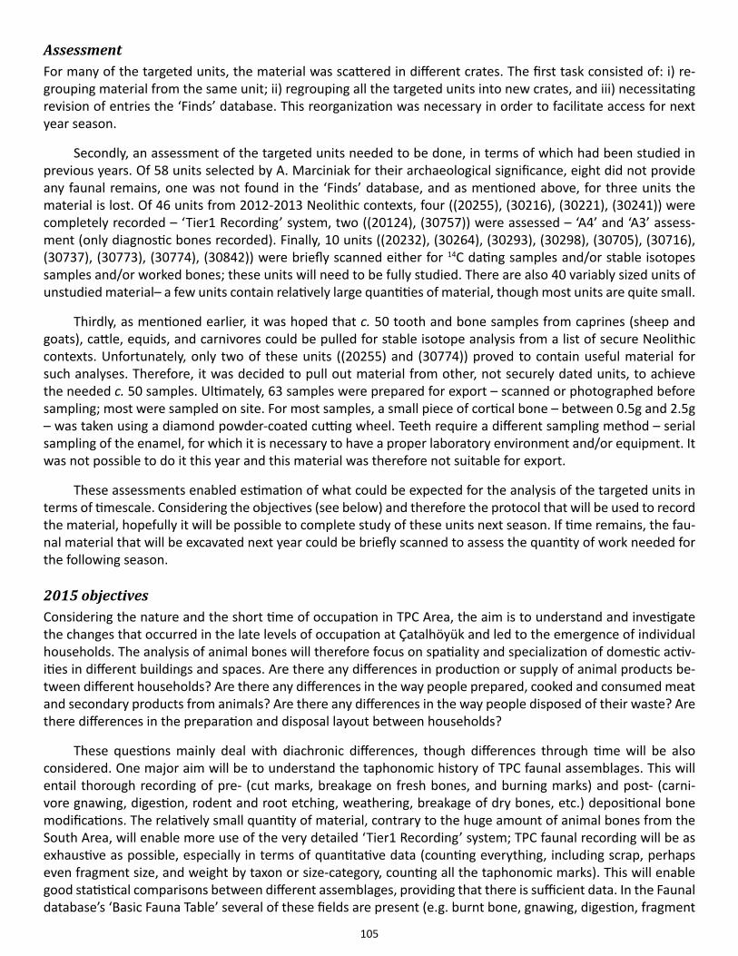
105
Assessment For many of the targeted units, the material was scattered in different crates. The first task consisted of: i) re-grouping material from the same unit; ii) regrouping all the targeted units into new crates, and iii) necessitating revision of entries the ‘Finds’ database. This reorganization was necessary in order to facilitate access for next year season.
Secondly, an assessment of the targeted units needed to be done, in terms of which had been studied in previous years. Of 58 units selected by A. Marciniak for their archaeological significance, eight did not provide any faunal remains, one was not found in the ‘Finds’ database, and as mentioned above, for three units the material is lost. Of 46 units from 2012-2013 Neolithic contexts, four ((20255), (30216), (30221), (30241)) were completely recorded – ‘Tier1 Recording’ system, two ((20124), (30757)) were assessed – ‘A4’ and ‘A3’ assess-ment (only diagnostic bones recorded). Finally, 10 units ((20232), (30264), (30293), (30298), (30705), (30716), (30737), (30773), (30774), (30842)) were briefly scanned either for 14C dating samples and/or stable isotopes samples and/or worked bones; these units will need to be fully studied. There are also 40 variably sized units of unstudied material– a few units contain relatively large quantities of material, though most units are quite small.
Thirdly, as mentioned earlier, it was hoped that c. 50 tooth and bone samples from caprines (sheep and goats), cattle, equids, and carnivores could be pulled for stable isotope analysis from a list of secure Neolithic contexts. Unfortunately, only two of these units ((20255) and (30774)) proved to contain useful material for such analyses. Therefore, it was decided to pull out material from other, not securely dated units, to achieve the needed c. 50 samples. Ultimately, 63 samples were prepared for export – scanned or photographed before sampling; most were sampled on site. For most samples, a small piece of cortical bone – between 0.5g and 2.5g – was taken using a diamond powder-coated cutting wheel. Teeth require a different sampling method – serial sampling of the enamel, for which it is necessary to have a proper laboratory environment and/or equipment. It was not possible to do it this year and this material was therefore not suitable for export.
These assessments enabled estimation of what could be expected for the analysis of the targeted units in terms of timescale. Considering the objectives (see below) and therefore the protocol that will be used to record the material, hopefully it will be possible to complete study of these units next season. If time remains, the fau-nal material that will be excavated next year could be briefly scanned to assess the quantity of work needed for the following season.
2015 objectivesConsidering the nature and the short time of occupation in TPC Area, the aim is to understand and investigate the changes that occurred in the late levels of occupation at Çatalhöyük and led to the emergence of individual households. The analysis of animal bones will therefore focus on spatiality and specialization of domestic activ-ities in different buildings and spaces. Are there any differences in production or supply of animal products be-tween different households? Are there any differences in the way people prepared, cooked and consumed meat and secondary products from animals? Are there any differences in the way people disposed of their waste? Are there differences in the preparation and disposal layout between households?
These questions mainly deal with diachronic differences, though differences through time will be also considered. One major aim will be to understand the taphonomic history of TPC faunal assemblages. This will entail thorough recording of pre- (cut marks, breakage on fresh bones, and burning marks) and post- (carni-vore gnawing, digestion, rodent and root etching, weathering, breakage of dry bones, etc.) depositional bone modifications. The relatively small quantity of material, contrary to the huge amount of animal bones from the South Area, will enable more use of the very detailed ‘Tier1 Recording’ system; TPC faunal recording will be as exhaustive as possible, especially in terms of quantitative data (counting everything, including scrap, perhaps even fragment size, and weight by taxon or size-category, counting all the taphonomic marks). This will enable good statistical comparisons between different assemblages, providing that there is sufficient data. In the Faunal database’s ‘Basic Fauna Table’ several of these fields are present (e.g. burnt bone, gnawing, digestion, fragment
106
length; the ‘Modification Table’ allows recording of cut marks and chop marks. However, some post-depositional traces (e.g. weathering, root etching) cannot be recorded precisely using the current database. Such data can be entered in the ‘Notes’ field, and once the data are extracted, it should not be too difficult to add specific columns, in order to use the data for quantitative analyses. Species and anatomical representation will also be quantitatively analyzed and statistically compared whenever possible. Ageing and biometric data will be ana-lyzed and compared in order to detect differences in the supply and/or choice of animals between households.
Research involvements
Introduction of domestic cattle: process and impactJessie Wolfhagen and Katheryn Twiss
Doctoral dissertation research being undertaken by Jesse Wolfhagen focuses on re-examining the process and social/environmental impact of the appearance of domestic cattle at the site. This will entail using: (a) standard-ized Bos measurements to create a change-point model to estimate when domestic cattle arrived at the site, and (b) stable and radiogenic isotopic analyses to compare aspects of wild and domestic cattle diet. Isotopic sampling will be undertaken in the next two seasons; this report focuses on describing the mathematical model for the appearance of domestic cattle.
Cattle are sexually dimorphic, and domestic cattle are generally smaller than both sexes of aurochsen, though domestic males and wild females overlap (Degerbol 1970; Russell et al. 2005). This complicates discrimi-nation of wild vs. domestic cattle based on size alone as there are no threshold values that point towards domes-ticity; nor can one use evidence for two size groups to infer a mixed population (cf. Rowley-Conwy et al. 2012). Wolfhagen will resolve this issue by fitting mixture models to Bos limb bone measurements from the South Area. Mixture models fit data that can be interpreted as coming from multiple sources that would have different average sizes (e.g. wild male, wild female, and domestic males and females) (Helmer et al. 2005). Prior to the appearance of domestic cattle at Çatalhöyük, Bos measurement assemblages should be two-member mixtures (wild males and wild females). Since wild cattle are known to have been exploited throughout the occupation of Çatalhöyük, after the appearance of domestic cattle, Bos assemblages should be either three- or four-member mixtures (the two possibilities are due to the overlapping size of wild females and domestic males).
To determine when the shift from a two-member to a three+ -member mixture occurred a change-point model with Bayesian inference will be employed. This model states that initial levels of Çatalhöyük should contain two-member mixtures up to a certain stratigraphic level, when all of the following levels contain three-member mixtures. Bayesian inference on this model will allow identification of the ‘change-point’ by estimating parame-ter values and determining the likelihood (or how well the data ‘fit’ those parameter values). Possible values will be drawn from prior distributions: i.e. contextual information will be used to determine whether or not certain values are possible/likely before evaluating the data. By iteratively estimating sets of parameter values and us-ing the likelihood of each set as a filter (i.e. sets of parameter values with higher likelihood are more likely than those with a low likelihood), this model will provide posterior distributions of parameter values for (1) the sizes of the different sub-populations of Bos (wild male, wild female, domestic), (2) at what stratigraphic level domes-tic cattle first appeared, and (3) the probability of each measured bone being in any of the three sub-popula-tions. The third set of posterior estimates will be used to help structure stable and radiogenic isotopic analyses to directly compare wild and domestic cattle
Equid speciation and ecology Katheryn Twiss, Jacqui Mulville, Jessie Wolfhagen, G. Arzu Demirergi and Richard Madgwick
Equids were important prey species across much of Pleistocene and early Holocene Eurasia, providing meat, hides, bones, teeth, and presumably hair. Both large (horse-sized) and smaller (ass or donkey-sized) equids were
107
exploited in prehistoric southwest Asia, their remains having been identified at sites from the Zagros to the southern Levant to central Anatolia (e.g. Davis 1980; Marean & Kim 1998; Carruthers 2006). Based on then-avail-able equid speciation and biogeographical data, Russell and Martin (2005) and Cameron (2005) modeled three wild equid species at Neolithic Çatalhöyük: horses (Equus ferus), onagers (Equus hemionus), and European wild asses (Equus hydruntinus). After publication of Geigl and Grange’s (2012) discovery that hydruntine mtDNA se-quences belonged to hemione-type mitochondrial DNA groups, Russell et al. (2013) grouped all smaller equids into a single category.
Yet there remains a lack of clarity as to whether hydruntinus is best modeled as a subspecies of hemionus, or as a separate species (Crees & Turvey 2014: 17). Geigl and Grange (2012) themselves note that certain equids with poor mtDNA differentiation are nonetheless classified as separate species on the basis of phenotype, gen-otype and geographic distribution, and parapatric and morphologically distinct equid populations may occupy different ecological niches–even as gene flow occurs between them. We thus consider it possible that two mor-phologically distinct populations (that may or may not have constituted distinct species) of small-medium equids occupied the Konya Plain. These populations might have had differentiable ethologies and/or ecologies, which could affect human hunting strategies and/or landscape exploitation patterns.
In 2014 we therefore decided to investigate the taxonomic statuses and ecological signatures of the Çatal-höyük equids. During the field season we scanned large, previously excavated, and faunally unanalyzed units to recover and measure as many equid specimens as possible: our equid records now total 2209 specimens, or 1.9% of all macrofaunal specimens identified to the family, genus or species level. All body parts are represented. During the 2014-15 academic year the following will be undertaken: statistical evaluation of the measurement data; application of standard dental speciation techniques, in addition to geometric morphometric analyses, to scans of tooth occlusal surfaces; assessment of equid carbon and nitrogen stable isotopic signatures.
ZooMS analysis of caprine mandibles and pelvesDavid Orton
The 2014 season also saw the first phase of sampling for a new two-year project looking at the implications of sheep/goat identification biases for studies of culling patterns. The project will (a) use the Çatalhöyük assem-blage to address a global methodological problem, while also (b) testing the reliability of identifications and (c) enlarging the reliable datasets of age and sex data available for understanding herding at the site.
Sheep and goats were among the first and most important domesticates in the Eurasian Neolithic, but mor-phological distinction between them is notoriously hard. Since the two species have different preferences and potentials, age-at-death analyses must be based only on specimens positively identified to either species. Apart from greatly reducing sample sizes, identification issues may introduce systematic bias. Published identification criteria (e.g. Payne 1985; Helmer 2000; Halstead et al. 2002) often rely on interspecific differences in individual teeth. As these erupt at different times of life there is a risk of age-correlated bias: the chance of being identified to species (and hence included in analysis) may vary with age. This is also true for sex ratios; any difference be-tween male and female specimens in the rate of identification to species will distort results.
This raises the troubling prospect of a key tool for research on domestication and early farming having in-herent systematic bias. While reliability of individual criteria has been tested (Zeder & Pilaar 2010), the implica-tions of uncertainty for age/sex studies have yet to be explored. It is imperative that any bias be evaluated and, if necessary and possible, corrections developed.
The new study at Çatalhöyük will use ZooMS collagen fingerprinting (see Buckley et al. 2010) at the BioArCh unit in York to provide independent species identifications for a large collection of sheep/goat mandibles and pelves. Comparison of age/sex structures based on: (a) morphological identifications and (b) ZooMS will allow assessment of biases and of their impact on interpretations.
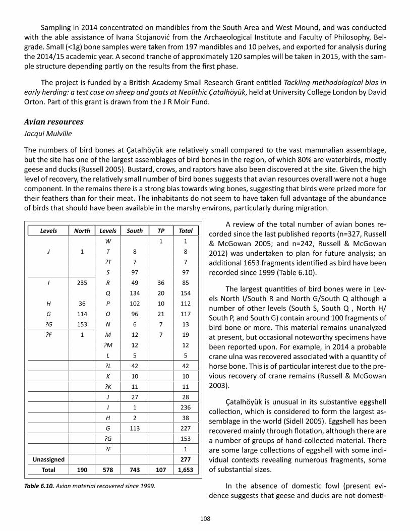
108
Sampling in 2014 concentrated on mandibles from the South Area and West Mound, and was conducted with the able assistance of Ivana Stojanović from the Archaeological Institute and Faculty of Philosophy, Bel-grade. Small (<1g) bone samples were taken from 197 mandibles and 10 pelves, and exported for analysis during the 2014/15 academic year. A second tranche of approximately 120 samples will be taken in 2015, with the sam-ple structure depending partly on the results from the first phase.
The project is funded by a British Academy Small Research Grant entitled Tackling methodological bias in early herding: a test case on sheep and goats at Neolithic Çatalhöyük, held at University College London by David Orton. Part of this grant is drawn from the J R Moir Fund.
Avian resourcesJacqui Mulville
The numbers of bird bones at Çatalhöyük are relatively small compared to the vast mammalian assemblage, but the site has one of the largest assemblages of bird bones in the region, of which 80% are waterbirds, mostly geese and ducks (Russell 2005). Bustard, crows, and raptors have also been discovered at the site. Given the high level of recovery, the relatively small number of bird bones suggests that avian resources overall were not a huge component. In the remains there is a strong bias towards wing bones, suggesting that birds were prized more for their feathers than for their meat. The inhabitants do not seem to have taken full advantage of the abundance of birds that should have been available in the marshy environs, particularly during migration.
A review of the total number of avian bones re-corded since the last published reports (n=327, Russell & McGowan 2005; and n=242, Russell & McGowan 2012) was undertaken to plan for future analysis; an additional 1653 fragments identified as bird have been recorded since 1999 (Table 6.10).
The largest quantities of bird bones were in Lev-els North I/South R and North G/South Q although a number of other levels (South S, South Q , North H/South P, and South G) contain around 100 fragments of bird bone or more. This material remains unanalyzed at present, but occasional noteworthy specimens have been reported upon. For example, in 2014 a probable crane ulna was recovered associated with a quantity of horse bone. This is of particular interest due to the pre-vious recovery of crane remains (Russell & McGowan 2003).
Çatalhöyük is unusual in its substantive eggshell collection, which is considered to form the largest as-semblage in the world (Sidell 2005). Eggshell has been recovered mainly through flotation, although there are a number of groups of hand-collected material. There are some large collections of eggshell with some indi-vidual contexts revealing numerous fragments, some of substantial sizes.
In the absence of domestic fowl (present evi-dence suggests that geese and ducks are not domesti-
Levels North Levels South TP Total W 1 1
J 1 T 8 8 ?T 7 7 S 97 97I 235 R 49 36 85 Q 134 20 154H 36 P 102 10 112G 114 O 96 21 117
?G 153 N 6 7 13?F 1 M 12 7 19 ?M 12 12 L 5 5 ?L 42 42 K 10 10 ?K 11 11 J 27 28 I 1 236 H 2 38 G 113 227 ?G 153 ?F 1
Unassigned 277Total 190 578 743 107 1,653
Table 6.10. Avian material recovered since 1999.
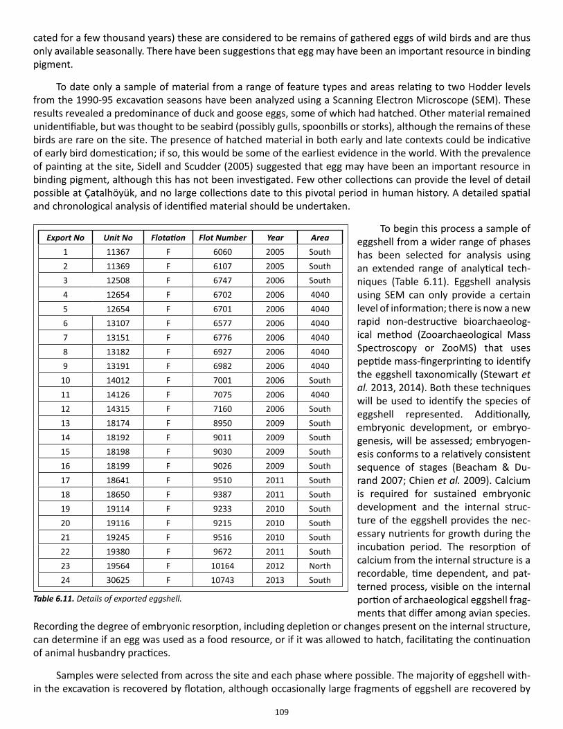
109
cated for a few thousand years) these are considered to be remains of gathered eggs of wild birds and are thus only available seasonally. There have been suggestions that egg may have been an important resource in binding pigment.
To date only a sample of material from a range of feature types and areas relating to two Hodder levels from the 1990-95 excavation seasons have been analyzed using a Scanning Electron Microscope (SEM). These results revealed a predominance of duck and goose eggs, some of which had hatched. Other material remained unidentifiable, but was thought to be seabird (possibly gulls, spoonbills or storks), although the remains of these birds are rare on the site. The presence of hatched material in both early and late contexts could be indicative of early bird domestication; if so, this would be some of the earliest evidence in the world. With the prevalence of painting at the site, Sidell and Scudder (2005) suggested that egg may have been an important resource in binding pigment, although this has not been investigated. Few other collections can provide the level of detail possible at Çatalhöyük, and no large collections date to this pivotal period in human history. A detailed spatial and chronological analysis of identified material should be undertaken.
To begin this process a sample of eggshell from a wider range of phases has been selected for analysis using an extended range of analytical tech-niques (Table 6.11). Eggshell analysis using SEM can only provide a certain level of information; there is now a new rapid non-destructive bioarchaeolog-ical method (Zooarchaeological Mass Spectroscopy or ZooMS) that uses peptide mass-fingerprinting to identify the eggshell taxonomically (Stewart et al. 2013, 2014). Both these techniques will be used to identify the species of eggshell represented. Additionally, embryonic development, or embryo-genesis, will be assessed; embryogen-esis conforms to a relatively consistent sequence of stages (Beacham & Du-rand 2007; Chien et al. 2009). Calcium is required for sustained embryonic development and the internal struc-ture of the eggshell provides the nec-essary nutrients for growth during the incubation period. The resorption of calcium from the internal structure is a recordable, time dependent, and pat-terned process, visible on the internal portion of archaeological eggshell frag-ments that differ among avian species.
Recording the degree of embryonic resorption, including depletion or changes present on the internal structure, can determine if an egg was used as a food resource, or if it was allowed to hatch, facilitating the continuation of animal husbandry practices.
Samples were selected from across the site and each phase where possible. The majority of eggshell with-in the excavation is recovered by flotation, although occasionally large fragments of eggshell are recovered by
Export No Unit No Flotation Flot Number Year Area1 11367 F 6060 2005 South2 11369 F 6107 2005 South3 12508 F 6747 2006 South4 12654 F 6702 2006 40405 12654 F 6701 2006 40406 13107 F 6577 2006 40407 13151 F 6776 2006 40408 13182 F 6927 2006 40409 13191 F 6982 2006 4040
10 14012 F 7001 2006 South11 14126 F 7075 2006 404012 14315 F 7160 2006 South13 18174 F 8950 2009 South14 18192 F 9011 2009 South15 18198 F 9030 2009 South16 18199 F 9026 2009 South17 18641 F 9510 2011 South18 18650 F 9387 2011 South19 19114 F 9233 2010 South20 19116 F 9215 2010 South21 19245 F 9516 2010 South22 19380 F 9672 2011 South23 19564 F 10164 2012 North24 30625 F 10743 2013 South
Table 6.11. Details of exported eggshell.
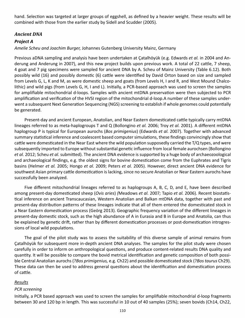
110
hand. Selection was targeted at larger groups of eggshell, as defined by a heavier weight. These results will be combined with those from the earlier study by Sidell and Scudder (2005).
Ancient DNA Project AAmelie Scheu and Joachim Burger, Johannes Gutenberg University Mainz, Germany
Previous aDNA sampling and analysis have been undertaken at Çatalhöyük (e.g. Edwards et al. in 2004 and An-derung and Anderung in 2007), and this new project builds upon previous work. A total of 22 cattle, 7 sheep, 4 goat and 7 pig specimens were sampled for ancient DNA by A. Scheu of Mainz University (Table 6.12). Both possibly wild (16) and possibly domestic (6) cattle were identified by David Orton based on size and sampled from Levels G, L, K and M, as were domestic sheep and goats (from Levels H, I and R, and West Mound Chalco-lithic) and wild pigs (from Levels G, H, I and L). Initially, a PCR-based approach was used to screen the samples for amplifiable mitochondrial d-loops. Samples with ancient mtDNA preservation were then subjected to PCR amplification and verification of the HVSI region of the mitochondrial d-loop.A number of these samples under-went a subsequent Next Generation Sequencing (NGS) screening to establish if whole genomes could potentially be generated.
Present-day and ancient European, Anatolian, and Near Eastern domesticated cattle typically carry mtDNA lineages referred to as meta-haplogroups T and Q (Bollongino et al. 2006; Troy et al. 2001). A different mtDNA haplogroup P is typical for European aurochs (Bos primigenius) (Edwards et al. 2007). Together with advanced summary statistical inference and coalescent based computer simulations, these findings convincingly show that cattle were domesticated in the Near East where the wild population supposedly carried the T/Q types, and were subsequently imported to Europe without substantial genetic influence from local female aurochsen (Bollongino et al. 2012; Scheu et al. submitted). The ancient DNA evidence is supported by a huge body of archaeozoological and archaeological findings, e.g. the oldest signs for bovine domestication come from the Euphrates and Tigris basins (Helmer et al. 2005; Hongo et al. 2009; Peters et al. 2005). However, direct ancient DNA evidence for southwest Asian primary cattle domestication is lacking, since no secure Anatolian or Near Eastern aurochs have successfully been analyzed.
Five different mitochondrial lineages referred to as haplogroups A, B, C, D, and E, have been described among present-day domesticated sheep (Ovis aries) (Meadows et al. 2007; Tapio et al. 2006). Recent biostatis-tical inference on ancient Transcaucasian, Western Anatolian and Balkan mtDNA data, together with past and present-day distribution patterns of these lineages indicate that all of them entered the domesticated stock in a Near Eastern domestication process (Geörg 2013). Geographic frequency variation of the different lineages in present-day domestic stock, such as the high abundance of A in Eurasia and B in Europe and Anatolia, can thus be explained by genetic drift, rather than by different domestication processes or post-domestication introgres-sions of local wild populations.
The goal of the pilot study was to assess the suitability of this diverse sample of animal remains from Çatalhöyük for subsequent more in-depth ancient DNA analyses. The samples for the pilot study were chosen carefully in order to inform on anthropological questions, and produce content-related results DNA quality and quantity. It will be possible to compare the bovid metrical identification and genetic composition of both possi-ble Central Anatolian aurochs (?Bos primigenius, e.g. Ch22) and possible domesticated stock (?Bos taurus Ch29). These data can then be used to address general questions about the identification and domestication process of cattle.
ResultsPCR screeningInitially, a PCR based approach was used to screen the samples for amplifiable mitochondrial d-loop fragments between 30 and 120 bp in length. This was successful in 10 out of 40 samples (25%); seven bovids (Ch14, Ch22,
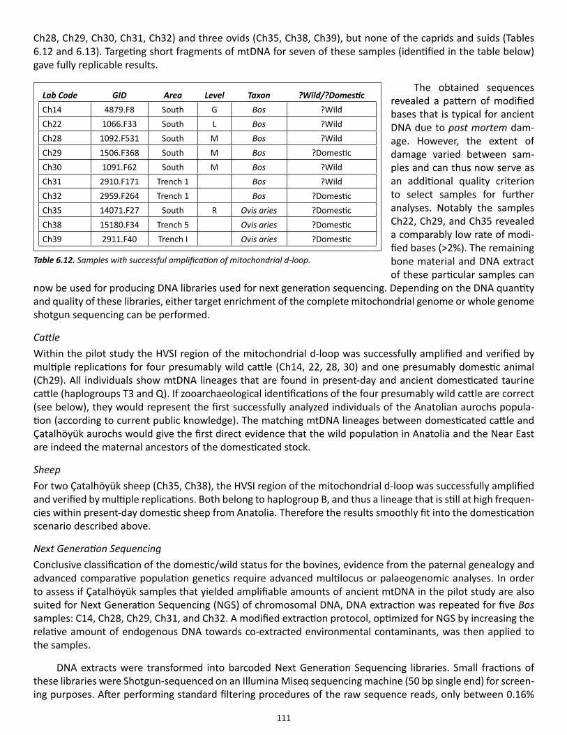
111
Ch28, Ch29, Ch30, Ch31, Ch32) and three ovids (Ch35, Ch38, Ch39), but none of the caprids and suids (Tables 6.12 and 6.13). Targeting short fragments of mtDNA for seven of these samples (identified in the table below) gave fully replicable results.
The obtained sequences revealed a pattern of modified bases that is typical for ancient DNA due to post mortem dam-age. However, the extent of damage varied between sam-ples and can thus now serve as an additional quality criterion to select samples for further analyses. Notably the samples Ch22, Ch29, and Ch35 revealed a comparably low rate of modi-fied bases (>2%). The remaining bone material and DNA extract of these particular samples can
now be used for producing DNA libraries used for next generation sequencing. Depending on the DNA quantity and quality of these libraries, either target enrichment of the complete mitochondrial genome or whole genome shotgun sequencing can be performed.
CattleWithin the pilot study the HVSI region of the mitochondrial d-loop was successfully amplified and verified by multiple replications for four presumably wild cattle (Ch14, 22, 28, 30) and one presumably domestic animal (Ch29). All individuals show mtDNA lineages that are found in present-day and ancient domesticated taurine cattle (haplogroups T3 and Q). If zooarchaeological identifications of the four presumably wild cattle are correct (see below), they would represent the first successfully analyzed individuals of the Anatolian aurochs popula-tion (according to current public knowledge). The matching mtDNA lineages between domesticated cattle and Çatalhöyük aurochs would give the first direct evidence that the wild population in Anatolia and the Near East are indeed the maternal ancestors of the domesticated stock.
SheepFor two Çatalhöyük sheep (Ch35, Ch38), the HVSI region of the mitochondrial d-loop was successfully amplified and verified by multiple replications. Both belong to haplogroup B, and thus a lineage that is still at high frequen-cies within present-day domestic sheep from Anatolia. Therefore the results smoothly fit into the domestication scenario described above.
Next Generation SequencingConclusive classification of the domestic/wild status for the bovines, evidence from the paternal genealogy and advanced comparative population genetics require advanced multilocus or palaeogenomic analyses. In order to assess if Çatalhöyük samples that yielded amplifiable amounts of ancient mtDNA in the pilot study are also suited for Next Generation Sequencing (NGS) of chromosomal DNA, DNA extraction was repeated for five Bos samples: C14, Ch28, Ch29, Ch31, and Ch32. A modified extraction protocol, optimized for NGS by increasing the relative amount of endogenous DNA towards co-extracted environmental contaminants, was then applied to the samples.
DNA extracts were transformed into barcoded Next Generation Sequencing libraries. Small fractions of these libraries were Shotgun-sequenced on an Illumina Miseq sequencing machine (50 bp single end) for screen-ing purposes. After performing standard filtering procedures of the raw sequence reads, only between 0.16%
Lab Code GID Area Level Taxon ?Wild/?DomesticCh14 4879.F8 South G Bos ?WildCh22 1066.F33 South L Bos ?WildCh28 1092.F531 South M Bos ?WildCh29 1506.F368 South M Bos ?DomesticCh30 1091.F62 South M Bos ?WildCh31 2910.F171 Trench 1 Bos ?WildCh32 2959.F264 Trench 1 Bos ?DomesticCh35 14071.F27 South R Ovis aries ?DomesticCh38 15180.F34 Trench 5 Ovis aries ?DomesticCh39 2911.F40 Trench I Ovis aries ?Domestic
Table 6.12. Samples with successful amplification of mitochondrial d-loop.
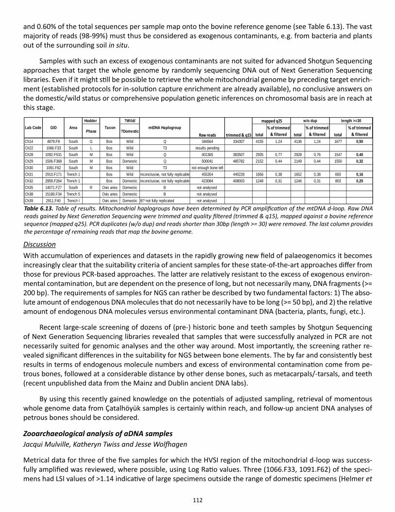
112
and 0.60% of the total sequences per sample map onto the bovine reference genome (see Table 6.13). The vast majority of reads (98-99%) must thus be considered as exogenous contaminants, e.g. from bacteria and plants out of the surrounding soil in situ.
Samples with such an excess of exogenous contaminants are not suited for advanced Shotgun Sequencing approaches that target the whole genome by randomly sequencing DNA out of Next Generation Sequencing libraries. Even if it might still be possible to retrieve the whole mitochondrial genome by preceding target enrich-ment (established protocols for in-solution capture enrichment are already available), no conclusive answers on the domestic/wild status or comprehensive population genetic inferences on chromosomal basis are in reach at this stage.
DiscussionWith accumulation of experiences and datasets in the rapidly growing new field of palaeogenomics it becomes increasingly clear that the suitability criteria of ancient samples for these state-of-the-art approaches differ from those for previous PCR-based approaches. The latter are relatively resistant to the excess of exogenous environ-mental contamination, but are dependent on the presence of long, but not necessarily many, DNA fragments (>= 200 bp). The requirements of samples for NGS can rather be described by two fundamental factors: 1) The abso-lute amount of endogenous DNA molecules that do not necessarily have to be long (>= 50 bp), and 2) the relative amount of endogenous DNA molecules versus environmental contaminant DNA (bacteria, plants, fungi, etc.).
Recent large-scale screening of dozens of (pre-) historic bone and teeth samples by Shotgun Sequencing of Next Generation Sequencing libraries revealed that samples that were successfully analyzed in PCR are not necessarily suited for genomic analyses and the other way around. Most importantly, the screening rather re-vealed significant differences in the suitability for NGS between bone elements. The by far and consistently best results in terms of endogenous molecule numbers and excess of environmental contamination come from pe-trous bones, followed at a considerable distance by other dense bones, such as metacarpals/-tarsals, and teeth (recent unpublished data from the Mainz and Dublin ancient DNA labs).
By using this recently gained knowledge on the potentials of adjusted sampling, retrieval of momentous whole genome data from Çatalhöyük samples is certainly within reach, and follow-up ancient DNA analyses of petrous bones should be considered.
Zooarchaeological analysis of aDNA samples Jacqui Mulville, Katheryn Twiss and Jesse Wolfhagen
Metrical data for three of the five samples for which the HVSI region of the mitochondrial d-loop was success-fully amplified was reviewed, where possible, using Log Ratio values. Three (1066.F33, 1091.F62) of the speci-mens had LSI values of >1.14 indicative of large specimens outside the range of domestic specimens (Helmer et
Hodder ?Wild/
Phase ?Domestictotal
% of trimmed & filtered total
% of trimmed & filtered total
% of trimmed & filtered
Ch14 4879.F8 South G Bos Wild Q 346564 334307 4155 1,24 4136 1,24 1677 0,50Ch22 1066.F33 South L Bos Wild T3 results pendingCh28 1092.F531 South M Bos Wild Q 401365 383507 2935 0,77 2928 0,76 1547 0,40Ch29 1506.F368 South M Bos Domestic Q 500041 485782 2152 0,44 2149 0,44 1550 0,32Ch30 1091.F62 South M Bos Wild T3 not enough bone leftCh31 2910.F171 Trench 1 Bos Wild inconclusive, not fully replicable 455354 440228 1656 0,38 1652 0,38 693 0,16Ch32 2959.F264 Trench 1 Bos Domestic inconclusive, not fully replicable 423084 408003 1248 0,31 1246 0,31 803 0,20Ch35 14071.F27 South R Ovis aries Domestic B not analysed Ch38 15180.F34 Trench 5 Ovis aries Domestic B not analysed Ch39 2911.F40 Trench I Ovis aries Domestic B? not fully replicated not analysed
length >=30
Raw reads trimmed & q15mtDNA HaplogroupLab Code GID Area Taxon
mapped q25 w/o dup
Table 6.13. Table of results. Mitochondrial haplogroups have been determined by PCR amplification of the mtDNA d-loop. Raw DNA reads gained by Next Generation Sequencing were trimmed and quality filtered (trimmed & q15), mapped against a bovine reference sequence (mapped q25). PCR duplicates (w/o dup) and reads shorter than 30bp (length >= 30) were removed. The last column provides the percentage of remaining reads that map the bovine genome.
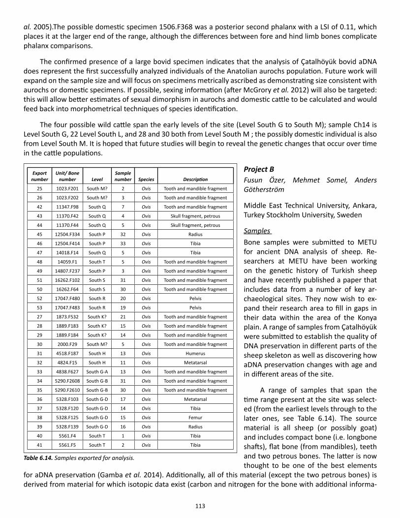
113
al. 2005).The possible domestic specimen 1506.F368 was a posterior second phalanx with a LSI of 0.11, which places it at the larger end of the range, although the differences between fore and hind limb bones complicate phalanx comparisons.
The confirmed presence of a large bovid specimen indicates that the analysis of Çatalhöyük bovid aDNA does represent the first successfully analyzed individuals of the Anatolian aurochs population. Future work will expand on the sample size and will focus on specimens metrically ascribed as demonstrating size consistent with aurochs or domestic specimens. If possible, sexing information (after McGrory et al. 2012) will also be targeted: this will allow better estimates of sexual dimorphism in aurochs and domestic cattle to be calculated and would feed back into morphometrical techniques of species identification.
The four possible wild cattle span the early levels of the site (Level South G to South M); sample Ch14 is Level South G, 22 Level South L, and 28 and 30 both from Level South M ; the possibly domestic individual is also from Level South M. It is hoped that future studies will begin to reveal the genetic changes that occur over time in the cattle populations.
Project BFusun Özer, Mehmet Somel, Anders Götherström
Middle East Technical University, Ankara, Turkey Stockholm University, Sweden
Samples Bone samples were submitted to METU for ancient DNA analysis of sheep. Re-searchers at METU have been working on the genetic history of Turkish sheep and have recently published a paper that includes data from a number of key ar-chaeological sites. They now wish to ex-pand their research area to fill in gaps in their data within the area of the Konya plain. A range of samples from Çatalhöyük were submitted to establish the quality of DNA preservation in different parts of the sheep skeleton as well as discovering how aDNA preservation changes with age and in different areas of the site.
A range of samples that span the time range present at the site was select-ed (from the earliest levels through to the later ones, see Table 6.14). The source material is all sheep (or possibly goat) and includes compact bone (i.e. longbone shafts), flat bone (from mandibles), teeth and two petrous bones. The latter is now thought to be one of the best elements
for aDNA preservation (Gamba et al. 2014). Additionally, all of this material (except the two petrous bones) is derived from material for which isotopic data exist (carbon and nitrogen for the bone with additional informa-
Export number
Unit/ Bone number Level
Sample number Species Description
25 1023.F201 South M? 2 Ovis Tooth and mandible fragment
26 1023.F202 South M? 3 Ovis Tooth and mandible fragment
42 11347.F98 South Q 7 Ovis Tooth and mandible fragment
43 11370.F42 South Q 4 Ovis Skull fragment, petrous
44 11370.F44 South Q 5 Ovis Skull fragment, petrous
45 12504.F334 South P 32 Ovis Radius
46 12504.F414 South P 33 Ovis Tibia
47 14018.F14 South Q 5 Ovis Tibia
48 14059.F1 South T 5 Ovis Tooth and mandible fragment
49 14807.F237 South P 3 Ovis Tooth and mandible fragment
51 16262.F102 South S 31 Ovis Tooth and mandible fragment
50 16262.F64 South S 30 Ovis Tooth and mandible fragment
52 17047.F480 South R 20 Ovis Pelvis
53 17047.F483 South R 19 Ovis Pelvis
27 1873.F532 South K? 21 Ovis Tooth and mandible fragment
28 1889.F183 South K? 15 Ovis Tooth and mandible fragment
29 1889.F184 South K? 14 Ovis Tooth and mandible fragment
30 2000.F29 South M? 5 Ovis Tooth and mandible fragment
31 4518.F187 South H 13 Ovis Humerus
32 4824.F15 South H 11 Ovis Metatarsal
33 4838.F627 South G-A 13 Ovis Tooth and mandible fragment
34 5290.F2608 South G-B 31 Ovis Tooth and mandible fragment
35 5290.F2610 South G-B 30 Ovis Tooth and mandible fragment
36 5328.F103 South G-D 17 Ovis Metatarsal
37 5328.F120 South G-D 14 Ovis Tibia
38 5328.F125 South G-D 15 Ovis Femur
39 5328.F139 South G-D 16 Ovis Radius
40 5561.F4 South T 1 Ovis Tibia
41 5561.F5 South T 2 Ovis Tibia
Table 6.14. Samples exported for analysis.
114
tion on oxygen for the teeth). By combining the various datasets we hope to maximize information. With the results from the radiocarbon program becoming available it will be easier in the future for us to select samples with secure radiocarbon dates, but for now the site-based ‘Hodder Levels’ are employed.
ResultsDNA isolation from the 25 Ovis samples has produced 8 positive results. A further four samples await initial investigation and a second round of isolation will be attempted for all samples. Once complete, a selection of those with amplifiable amounts of ancient DNA number will be selected for whole genome sequencing (with Dr Anders Götherström, Uppsala, Sweden).
Future work will expand on this research; in particular using zooarchaeological identifications of probable wild and domestic Ovis and exploring the to the genetic relationship between the two groups, as well as these to the size changes witnessed at the site.
AcknowledgementsThe analysis of the TPC faunal remains was financed by the Polish National Science Centre (decision DEC-2012/06/M/H3/00286).
References
Beacham, B.E. & S.R. Durand2007. Eggshell and the archaeological record: new insights into turkey husbandry in the American South-west. Journal of Archaeological Science 34: 1610-1621.
Bollongino, R., J. Burger, A, Powell, M. Mashkour, J.-D. Vigne & M.G. Thomas2012. Modern Taurine Cattle descended from small number of Near-Eastern founders. Molecular Biology and Evolution 29: 2101-2104.
Bollongino, R., C.J. Edwards, K.W. Alt, J. Burger & D.G. Bradley2006. Early history of European domestic cattle as revealed by ancient DNA. Biology Letters 2: 155-159.
Brain, C.K. 1981. The Hunters or the Hunted? Chicago: University of Chicago Press.
Buckley, M., K. Whitcher, S. Howard, S. Campbell, J. Thomas-Oates & M. Collins 2010. Distinguishing between archaeological sheep and goat bones using a single collagen peptide. Jour-nal of Archaeological Science, 37: 13-20.
Cameron, I.C.2005. Equids of Çatalhöyük. Unpublished Thesis, UCL Institute of Archaeology.
Carruthers, D. 2006. Pınarbaşı 1994: Animal Bones. http://opencontext.org/projects/TESTPRJ0000000004. Released 2006-03-25 ed.
Chien, Y.C., M.T. Hincke & M.D. McKee2009. Ultrastructure of avian eggshell during resorption following egg fertilization. Journal of Structural Biology 168: 527-538.
115
Crees, J.J. & S.T. Turvey 2014. Holocene extinction dynamics of Equus hydruntinus, a late-surviving European megafaunal mam-mal. Quaternary Science Reviews 91:16-29.
Davis, S.J.M. 1980. Late Pleistocene and Holocene equid remains from Israel. Zoological Journal of the Linnean Society 70: 289-312.
Demirci, S., E. Koban Bastanlar, N.D. Dagtas, E. Piskin & A. Engin2013. Mitochondrial DNA diversity of modern, ancient and wild sheep (Ovis gmelinii anatolica) from Tur-key: New Insights on the Evolutionary History of Sheep. PLoS ONE 8:e81952.
Dobney, K. & A. Rielly1988. Method for recording archaeological animal bones: the use of diagnostic zones. Circaea 5: 79-96.
Edwards, C.J., R. Bollongino, A. Scheu, A. Chamberlain & A. Tresset2007. Mitochondrial DNA analysis shows a Near Eastern Neolithic origin for domestic cattle and no indi-cation of domestication of European aurochs. Proceedings of the Royal Society B: Biological Sciences 274: 1377-1385.
Gamba, C., E.R. Jones, M.D. Teasdale, R.L. McLaughlin & G. Gonzalez-Fortes 2014. Genome flux and stasis in a five millennium transect of European prehistory. Nature Communica-tions 5: 5257.1-9.
Geigl, E.-M. & T. Grange 2012. Eurasian wild asses in time and space: morphological versus genetic diversity. Annals of Anatomy - Anatomischer Anzeiger 194: 88-102.
Geörg, C. 2013. Paläopopulationsgenetik von Schwein und Schaf in Südosteuropa und Transkaukasien. Forschungs-Cluster1. Rahden/Westfalia: Verlag Marie Leidorf.
Halstead, P., P. Collins & V. Isaakidou 2002. Sorting the sheep from the goats: morphological dinstinctions between the mandibles and man-dibular teeth of adult Ovis and Capra. Journal of Archaeological Science 29: 545-553.
Helmer, D. 2000. Discrimination des genres Ovis et Capra à l’aide des prémolaires inférieures 3 et 4 et interprétation des âges d’abbatage: l’exemple de DikiliTash (Grece). Ibex: Journal of Mountain Ecology 5/Anthropozoo-logica 31: 29-38.
Helmer, D., L. Gourichon, H. Monchot, J. Peters & M.S. Segui 2005. Identifying early domestic cattle from Pre-Pottery Neolithic sites on the Middle Euphrates using sexual dimorphism, in The First Steps of Animal Somestication. New Archaeological Approaches. Pro-ceedings of the 9th ICAZ Conference, Durham 2002, eds. J.-D. Vigne, J. Peters & D. Helmer. Oxford: Oxbow Books, 86-95.
Hongo, H., J. Pearson, B. Öksük & G. Ilgezdi 2009. The process of ungulate domestication at Cayönü, Southeastern Turkey: A multidisciplinary ap-
116
proach focusing on Bos sp. and Cervus elaphus. Anthropozoologica 44: 63-73.
Knüsel, C.J. & A.K. Outram2004. Fragmentation: the zonation method applied to fragmented human remains from archaeological and forensic contexts. In Environmental Archaeology 9: 85-97.
Marean, C.W. & S.Y. Kim1998. Mousterian large mammal remains from Kobeh Cave. Current Anthropology 39: S79-S114.
McGrory, S., E.M. Svensson, A. Gotherstrom, J. Mulville, A.J. Powell, M.J. Collins & T.P. O’Connor 2012. A novel method for integrated age and sex determination from archaeological cattle mandibles. Journal of Archaeological Science 39: 3324-3330.
Meadows, J.R., I. Cemal, O. Karaca, E. Gootwine & J.W. Kijas 2007. Five ovine mitochondrial lineages identified from sheep breeds of the near East. Genetics 175: 1371-1379.
Outram, A.K., C.J. Knüsel, S. Knight & A.F. Harding2005. Understanding complex fragmented assemblages of human and animal remains: a fully integrated approach. Journal of Archaeological Science 32: 1699-1710.
Payne, S. 1985. Morphological distinctions between the mandibular teeth of young sheep, Ovis, and goats, Capra. Journal of Archaeological Science 12: 139-147.
Peters, J., A. von den Driesch & D. Helmer2005. The upper Euphrates-Tigris basin: cradle of agro-pastoralism? In The First Steps of Animal Domesti-cation. New Archaeological Approaches. Proceedings of the 9th ICAZ Conference, Durham 2002, eds. J.-D. Vigne, J. Peters & D. Helmer. Oxford: Oxbow Books, 96-124.
Russell, N. & K.J. McGowan2003. Dance of the cranes: crane symbolism at Çatalhöyük and beyond. Antiquity 77: 445–455.
Russell, N. & K.J. McGowan2005. The Çatalhöyük bird bones, in Inhabiting Çatalhöyük: Reports from the 1995-1999 Seasons, ed. I. Hodder. London: British Institute for Archaeology at Ankara; Cambridge: McDonald Institute for Archae-ological Research, 33-98.
Russell, N. & L. Martin 2005. The Çatalhöyük mammal remains, in Inhabiting Çatalhöyük: Reports from the 1995-1999 Seasons ed. I. Hodder. Cambridge: McDonald Institute for Archaeological Research, 33-98.
Russell, N. & K.J. McGowan 2012. Bird remains from the BACH Area, in Last House on the Hill: BACH Area Reports from Çatalhöyük, Turkey, eds. R.E. Tringham & M. Stevanović. Los Angeles: Cotsen Institute of Archaeology Press, 243-252.
Russell, N., K.C. Twiss, D. Orton & G.A. Demirergi 2013. More on the Çatalhöyük mammal remains, in Humans and Landscapes of Çatalhöyük: Reports from the 2000–2008 Seasons, ed. I. Hodder. London: British Institute at Ankara; Los Angeles: Cotsen In-stitute of Archaeology Press, 213-258.
117
Russell, N., K.I. Wright, T. Carter, S. Ketchum, E.N. Yalman, R. Regan, M. Stevanović, P. Ryan & M. Milić2014. Bringing down the house: House closing deposits at Çatalhöyük, in Integrating Çatalhöyük: Themes from the 2000-2008 Seasons, ed. I. Hodder. Los Angeles: Cotsen Institute of Archaeology Press, 109-122.
Scheu, A., Powell, A., Bollongino, R., et al. Submitted. The genetic prehistory of domesticated cattle from its origin to the spread across Europe.
Sidell, E.J. & C. Scudder2005. The eggshell from Çatalhöyük: a pilot study, in Inhabiting Çatalhöyük: Reports from the 1995-99 Seasons, ed. I. Hodder. Cambridge: McDonald Institute for Archaeological Research; London: British In-stitute for Archaeology at Ankara, 117-121.
Stewart, J.R., R.B. Allen, A.K. Jones, K.E. Penkman, & M.J. Collins 2013. ZooMS: making eggshell visible in the archaeological record. Journal of Archaeological Science 40: 1797-1804.
Stewart, J.R., R.B. Allen, A.K. Jones, T. Kendall, K.E. Penkman, B. Demarchi, T. O’Connor & M.J. Collins 2014. Walking on eggshells: a study of egg use in Anglo-Scandinavian York based on eggshell identifica-tion using ZooMS. International Journal of Osteoarchaeology 24: 247-255.
Tapio, M., N. Marzanov, M. Ozerov, M. Cinkulov, G. Gonzarenko, T. Kiselyova, M. Murawski, H. Viinalass & J. Kan-tanen
2006. Sheep mitochondrial DNA variation in European, Caucasian, and Central Asian areas. Molecular Biology and Evolution 23: 1776-1783.
Taylor, J., Tung, B., Mazzucato, C., Asouti, E., Bogaard, et al. 2014. Up in flames: a visual exploration of a burnt building at Çatalhöyük. Paper presented at the 20th Annual Meeting of the European Association of Archaeologists, Istanbul, Turkey.
Troy, C.S., D.E., MacHugh, J.F. Bailey, D.A. Magee, R.T. Loftus, P. Cunningham, A.T. Chamberlain, B.C. Sykes & D.G. Bradley
2001. Genetic evidence for Near-Eastern origins of European cattle. Nature 410: 1088-1091.
Tung, B.2013. Excavations in the North Area, 2013. Çatalhöyük Research Project, Archive Report. http://www.catalhoyuk.com/downloads/Archive_Report_2013.pdf
Zeder, M.A. & Pilaar, S.E. 2010. Assessing the reliability of criteria used to identify mandibles and mandibular teeth in sheep, Ovis, and goats, Capra. Journal of Archaeological Science 37: 225-242.
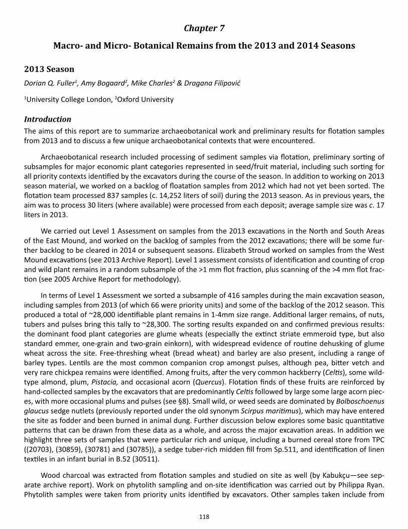
118
Chapter 7
Macro- and Micro- Botanical Remains from the 2013 and 2014 Seasons
2013 SeasonDorian Q. Fuller1, Amy Bogaard2, Mike Charles2 & Dragana Filipović
1University College London, 2Oxford University
Introduction The aims of this report are to summarize archaeobotanical work and preliminary results for flotation samples from 2013 and to discuss a few unique archaeobotanical contexts that were encountered.
Archaeobotanical research included processing of sediment samples via flotation, preliminary sorting of subsamples for major economic plant categories represented in seed/fruit material, including such sorting for all priority contexts identified by the excavators during the course of the season. In addition to working on 2013 season material, we worked on a backlog of floatation samples from 2012 which had not yet been sorted. The flotation team processed 837 samples (c. 14,252 liters of soil) during the 2013 season. As in previous years, the aim was to process 30 liters (where available) were processed from each deposit; average sample size was c. 17 liters in 2013.
We carried out Level 1 Assessment on samples from the 2013 excavations in the North and South Areas of the East Mound, and worked on the backlog of samples from the 2012 excavations; there will be some fur-ther backlog to be cleared in 2014 or subsequent seasons. Elizabeth Stroud worked on samples from the West Mound excavations (see 2013 Archive Report). Level 1 assessment consists of identification and counting of crop and wild plant remains in a random subsample of the >1 mm flot fraction, plus scanning of the >4 mm flot frac-tion (see 2005 Archive Report for methodology).
In terms of Level 1 Assessment we sorted a subsample of 416 samples during the main excavation season, including samples from 2013 (of which 66 were priority units) and some of the backlog of the 2012 season. This produced a total of ~28,000 identifiable plant remains in 1-4mm size range. Additional larger remains, of nuts, tubers and pulses bring this tally to ~28,300. The sorting results expanded on and confirmed previous results: the dominant food plant categories are glume wheats (especially the extinct striate emmeroid type, but also standard emmer, one-grain and two-grain einkorn), with widespread evidence of routine dehusking of glume wheat across the site. Free-threshing wheat (bread wheat) and barley are also present, including a range of barley types. Lentils are the most common companion crop amongst pulses, although pea, bitter vetch and very rare chickpea remains were identified. Among fruits, after the very common hackberry (Celtis), some wild-type almond, plum, Pistacia, and occasional acorn (Quercus). Flotation finds of these fruits are reinforced by hand-collected samples by the excavators that are predominantly Celtis followed by large some large acorn piec-es, with more occasional plums and pulses (see §8). Small wild, or weed seeds are dominated by Bolboschoenus glaucus sedge nutlets (previously reported under the old synonym Scirpus maritimus), which may have entered the site as fodder and been burned in animal dung. Further discussion below explores some basic quantitative patterns that can be drawn from these data as a whole, and across the major excavation areas. In addition we highlight three sets of samples that were particular rich and unique, including a burned cereal store from TPC ((20703), (30859), (30781) and (30785)), a sedge tuber-rich midden fill from Sp.511, and identification of linen textiles in an infant burial in B.52 (30511).
Wood charcoal was extracted from flotation samples and studied on site as well (by Kabukçu—see sep-arate archive report). Work on phytolith sampling and on-site identification was carried out by Philippa Ryan. Phytolith samples were taken from priority units identified by excavators. Other samples taken include from
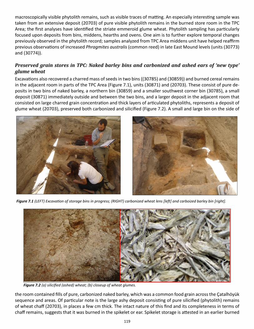
119
macroscopically visible phytolith remains, such as visible traces of matting. An especially interesting sample was taken from an extensive deposit (20703) of pure visible phytolith remains in the burned store room in the TPC Area; the first analyses have identified the striate emmeroid glume wheat. Phytolith sampling has particularly focused upon deposits from bins, middens, hearths and ovens. One aim is to further explore temporal changes previously observed in the phytolith record; samples analyzed from TPC Area middens unit have helped reaffirm previous observations of increased Phragmites australis (common reed) in late East Mound levels (units (30773) and (30774)).
Preserved grain stores in TPC: Naked barley bins and carbonized and ashed ears of ‘new type’ glume wheatExcavations also recovered a charred mass of seeds in two bins ((30785) and (30859)) and burned cereal remains in the adjacent room in parts of the TPC Area (Figure 7.1), units (30871) and (20703). These consist of pure de-posits in two bins of naked barley, a northern bin (30859) and a smaller southwest corner bin (30785), a small deposit (30871) immediately outside and between the two bins, and a larger deposit in the adjacent room that consisted on large charred grain concentration and thick layers of articulated phytoliths, represents a deposit of glume wheat (20703), preserved both carbonized and silicified (Figure 7.2). A small and large bin on the side of
the room contained fills of pure, carbonized naked barley, which was a common food grain across the Çatalhöyük sequence and areas. Of particular note is the large ashy deposit consisting of pure silicified (phytolith) remains of wheat chaff (20703), in places a few cm thick. The intact nature of this find and its completeness in terms of chaff remains, suggests that it was burned in the spikelet or ear. Spikelet storage is attested in an earlier burned
Figure 7.1 (LEFT) Excavation of storage bins in progress; (RIGHT) carbonized wheat lens [left] and carboized barley bin [right].
Figure 7.2 (a) silicified (ashed) wheat; (b) closeup of wheat glumes.
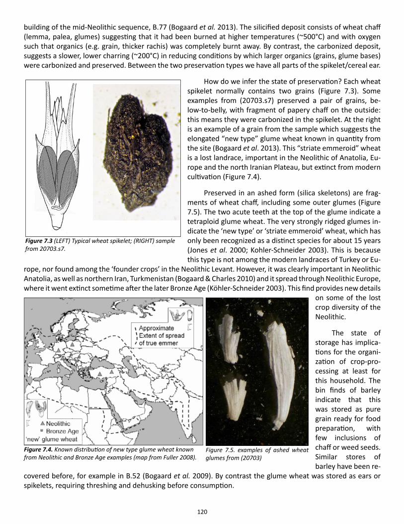
120
building of the mid-Neolithic sequence, B.77 (Bogaard et al. 2013). The silicified deposit consists of wheat chaff (lemma, palea, glumes) suggesting that it had been burned at higher temperatures (~500°C) and with oxygen such that organics (e.g. grain, thicker rachis) was completely burnt away. By contrast, the carbonized deposit, suggests a slower, lower charring (~200°C) in reducing conditions by which larger organics (grains, glume bases) were carbonized and preserved. Between the two preservation types we have all parts of the spikelet/cereal ear.
How do we infer the state of preservation? Each wheat spikelet normally contains two grains (Figure 7.3). Some examples from (20703.s7) preserved a pair of grains, be-low-to-belly, with fragment of papery chaff on the outside: this means they were carbonized in the spikelet. At the right is an example of a grain from the sample which suggests the elongated “new type” glume wheat known in quantity from the site (Bogaard et al. 2013). This “striate emmeroid” wheat is a lost landrace, important in the Neolithic of Anatolia, Eu-rope and the north Iranian Plateau, but extinct from modern cultivation (Figure 7.4).
Preserved in an ashed form (silica skeletons) are frag-ments of wheat chaff, including some outer glumes (Figure 7.5). The two acute teeth at the top of the glume indicate a tetraploid glume wheat. The very strongly ridged glumes in-dicate the ‘new type’ or ‘striate emmeroid’ wheat, which has only been recognized as a distinct species for about 15 years (Jones et al. 2000; Kohler-Schneider 2003). This is because this type is not among the modern landraces of Turkey or Eu-
rope, nor found among the ‘founder crops’ in the Neolithic Levant. However, it was clearly important in Neolithic Anatolia, as well as northern Iran, Turkmenistan (Bogaard & Charles 2010) and it spread through Neolithic Europe, where it went extinct sometime after the later Bronze Age (Köhler-Schneider 2003). This find provides new details
on some of the lost crop diversity of the Neolithic.
The state of storage has implica-tions for the organi-zation of crop-pro-cessing at least for this household. The bin finds of barley indicate that this was stored as pure grain ready for food preparation, with few inclusions of chaff or weed seeds. Similar stores of barley have been re-
covered before, for example in B.52 (Bogaard et al. 2009). By contrast the glume wheat was stored as ears or spikelets, requiring threshing and dehusking before consumption.
Figure 7.3 (LEFT) Typical wheat spikelet; (RIGHT) sample from 20703.s7.
Figure 7.4. Known distribution of new type glume wheat known from Neolithic and Bronze Age examples (map from Fuller 2008).
Figure 7.5. examples of ashed wheat glumes from (20703)
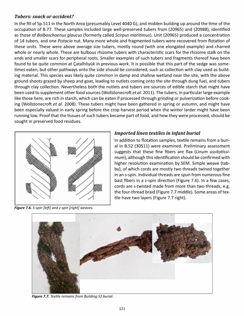
121
Tubers: snack or accident?In the fill of Sp.511 in the North Area (presumably Level 4040 G), and midden building up around the time of the occupation of B.77. These samples included large well-preserved tubers from (20965) and (20988), identified as those of Bolboschoenus glaucus (formerly called Scirpus maritimus). Unit (20965) produced a concentration of 14 tubers, and one Pistacia nut. Many more whole and fragmented tubers were recovered from flotation of these units. These were above average size tubers, mostly round (with one elongated example) and charred whole or nearly whole. These are bulbous rhizome tubers with characteristic scars for the rhizome stalk on the ends and smaller scars for peripheral roots. Smaller examples of such tubers and fragments thereof have been found to be quite common at Çatalhöyük in previous work. It is possible that this part of the sedge was some-times eaten, but other pathways onto the side should be considered, such as collection with clay used as build-ing material. This species was likely quite common in damp and shallow wetland near the site, with the above ground shoots grazed by sheep and goat, leading to nutlets coming onto the site through dung fuel, and tubers through clay collection. Nevertheless both the nutlets and tubers are sources of edible starch that might have been used to supplement other food sources (Wollstonecroft et al. 2011). The tubers, in particular large example like those here, are rich in starch, which can be eaten if processed through grinding or pulverization before cook-ing (Wollstonecroft et al. 2008). These tubers might have been gathered in spring or autumn, and might have been especially valued in early spring before the crop harvest period when the winter larder might have been running low. Proof that the tissues of such tubers became part of food, and how they were processed, should be sought in preserved food residues.
Imported linen textiles in infant burialIn addition to flotation samples, textile remains from a buri-al in B.52 (30511) were examined. Preliminary assessment suggests that these fine fibers are flax (Linum ussitatissi-mum), although this identification should be confirmed with higher resolution examination by SEM. Simple weave (tab-by), of which cords are mostly two threads twined together in an s-spin. Individual threads are spun from numerous fine bast fibers in a z-spin direction (Figure 7.6). In a few cases, cords are s-twisted made from more than two threads, e.g. the four-thread braid (Figure 7.7 middle). Some areas of tex-tile have two layers (Figure 7.7 right).
Figure 7.6. S-spin [left] and z-spin [right] weaves.
Figure 7.7. Textile remains from Building 52 burial.
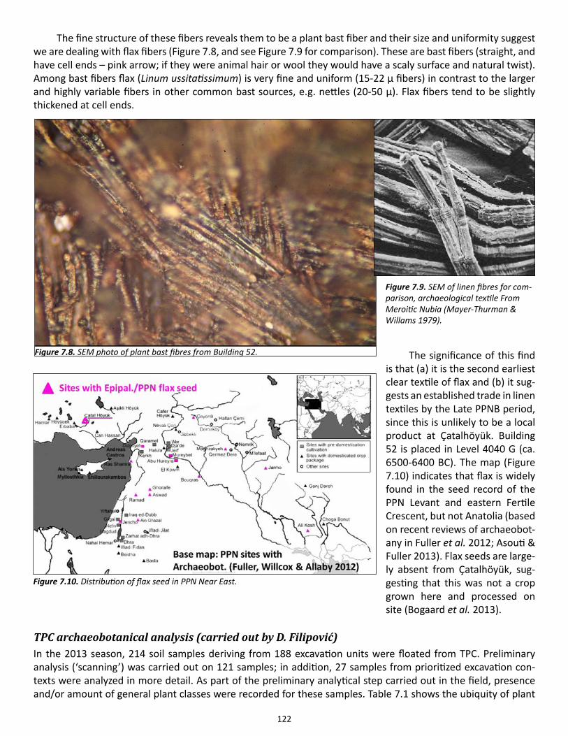
122
The fine structure of these fibers reveals them to be a plant bast fiber and their size and uniformity suggest we are dealing with flax fibers (Figure 7.8, and see Figure 7.9 for comparison). These are bast fibers (straight, and have cell ends – pink arrow; if they were animal hair or wool they would have a scaly surface and natural twist). Among bast fibers flax (Linum ussitatissimum) is very fine and uniform (15-22 µ fibers) in contrast to the larger and highly variable fibers in other common bast sources, e.g. nettles (20-50 µ). Flax fibers tend to be slightly thickened at cell ends.
The significance of this find is that (a) it is the second earliest clear textile of flax and (b) it sug-gests an established trade in linen textiles by the Late PPNB period, since this is unlikely to be a local product at Çatalhöyük. Building 52 is placed in Level 4040 G (ca. 6500-6400 BC). The map (Figure 7.10) indicates that flax is widely found in the seed record of the PPN Levant and eastern Fertile Crescent, but not Anatolia (based on recent reviews of archaeobot-any in Fuller et al. 2012; Asouti & Fuller 2013). Flax seeds are large-ly absent from Çatalhöyük, sug-gesting that this was not a crop grown here and processed on site (Bogaard et al. 2013).
TPC archaeobotanical analysis (carried out by D. Filipović)In the 2013 season, 214 soil samples deriving from 188 excavation units were floated from TPC. Preliminary analysis (‘scanning’) was carried out on 121 samples; in addition, 27 samples from prioritized excavation con-texts were analyzed in more detail. As part of the preliminary analytical step carried out in the field, presence and/or amount of general plant classes were recorded for these samples. Table 7.1 shows the ubiquity of plant
Figure 7.8. SEM photo of plant bast fibres from Building 52.
Figure 7.9. SEM of linen fibres for com-parison, archaeological textile From Meroitic Nubia (Mayer-Thurman & Willams 1979).
Figure 7.10. Distribution of flax seed in PPN Near East.
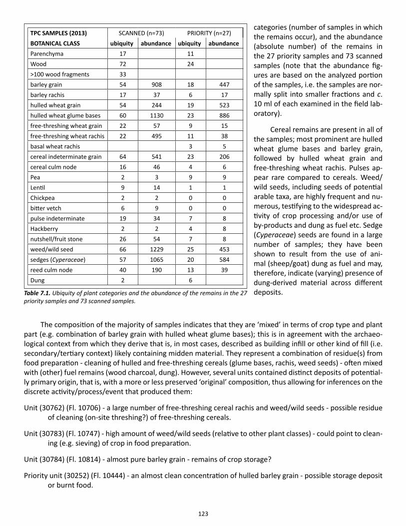
123
categories (number of samples in which the remains occur), and the abundance (absolute number) of the remains in the 27 priority samples and 73 scanned samples (note that the abundance fig-ures are based on the analyzed portion of the samples, i.e. the samples are nor-mally split into smaller fractions and c. 10 ml of each examined in the field lab-oratory).
Cereal remains are present in all of the samples; most prominent are hulled wheat glume bases and barley grain, followed by hulled wheat grain and free-threshing wheat rachis. Pulses ap-pear rare compared to cereals. Weed/wild seeds, including seeds of potential arable taxa, are highly frequent and nu-merous, testifying to the widespread ac-tivity of crop processing and/or use of by-products and dung as fuel etc. Sedge (Cyperaceae) seeds are found in a large number of samples; they have been shown to result from the use of ani-mal (sheep/goat) dung as fuel and may, therefore, indicate (varying) presence of dung-derived material across different deposits.
The composition of the majority of samples indicates that they are ‘mixed’ in terms of crop type and plant part (e.g. combination of barley grain with hulled wheat glume bases); this is in agreement with the archaeo-logical context from which they derive that is, in most cases, described as building infill or other kind of fill (i.e. secondary/tertiary context) likely containing midden material. They represent a combination of residue(s) from food preparation - cleaning of hulled and free-threshing cereals (glume bases, rachis, weed seeds) - often mixed with (other) fuel remains (wood charcoal, dung). However, several units contained distinct deposits of potential-ly primary origin, that is, with a more or less preserved ‘original’ composition, thus allowing for inferences on the discrete activity/process/event that produced them:
Unit (30762) (Fl. 10706) - a large number of free-threshing cereal rachis and weed/wild seeds - possible residue of cleaning (on-site threshing?) of free-threshing cereals.
Unit (30783) (Fl. 10747) - high amount of weed/wild seeds (relative to other plant classes) - could point to clean-ing (e.g. sieving) of crop in food preparation.
Unit (30784) (Fl. 10814) - almost pure barley grain - remains of crop storage?
Priority unit (30252) (Fl. 10444) - an almost clean concentration of hulled barley grain - possible storage deposit or burnt food.
TPC SAMPLES (2013) SCANNED (n=73) PRIORITY (n=27)BOTANICAL CLASS ubiquity abundance ubiquity abundanceParenchyma 17 11 Wood 72 24 >100 wood fragments 33 barley grain 54 908 18 447barley rachis 17 37 6 17hulled wheat grain 54 244 19 523hulled wheat glume bases 60 1130 23 886free-threshing wheat grain 22 57 9 15free-threshing wheat rachis 22 495 11 38basal wheat rachis 3 5cereal indeterminate grain 64 541 23 206cereal culm node 16 46 4 6Pea 2 3 9 9Lentil 9 14 1 1Chickpea 2 2 0 0bitter vetch 6 9 0 0pulse indeterminate 19 34 7 8Hackberry 2 2 4 8nutshell/fruit stone 26 54 7 8weed/wild seed 66 1229 25 453sedges (Cyperaceae) 57 1065 20 584reed culm node 40 190 13 39Dung 2 6
Table 7.1. Ubiquity of plant categories and the abundance of the remains in the 27 priority samples and 73 scanned samples.
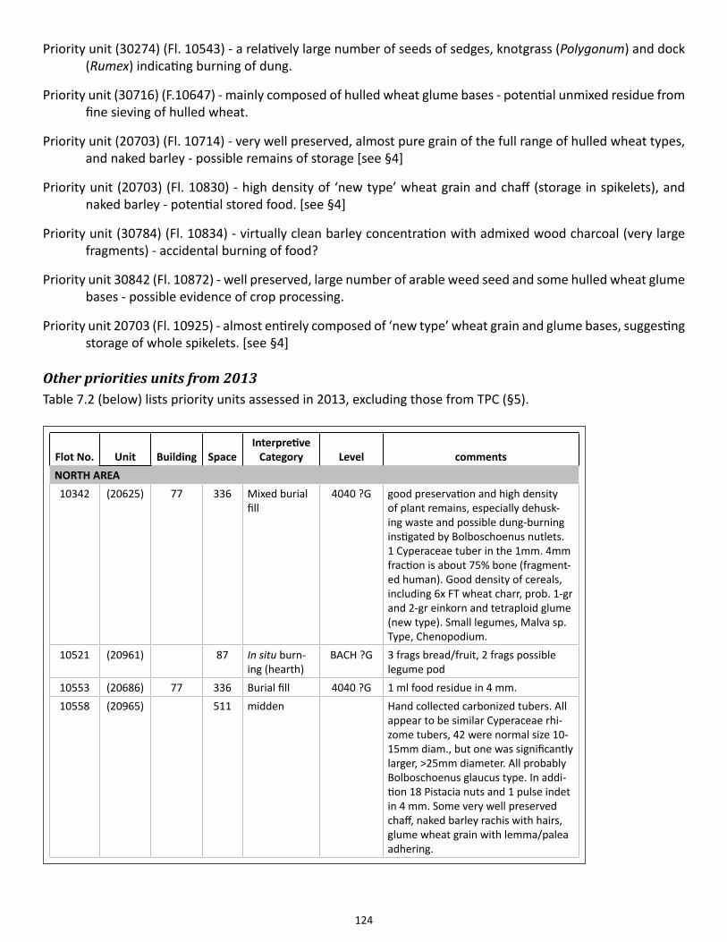
124
Priority unit (30274) (Fl. 10543) - a relatively large number of seeds of sedges, knotgrass (Polygonum) and dock (Rumex) indicating burning of dung.
Priority unit (30716) (F.10647) - mainly composed of hulled wheat glume bases - potential unmixed residue from fine sieving of hulled wheat.
Priority unit (20703) (Fl. 10714) - very well preserved, almost pure grain of the full range of hulled wheat types, and naked barley - possible remains of storage [see §4]
Priority unit (20703) (Fl. 10830) - high density of ‘new type’ wheat grain and chaff (storage in spikelets), and naked barley - potential stored food. [see §4]
Priority unit (30784) (Fl. 10834) - virtually clean barley concentration with admixed wood charcoal (very large fragments) - accidental burning of food?
Priority unit 30842 (Fl. 10872) - well preserved, large number of arable weed seed and some hulled wheat glume bases - possible evidence of crop processing.
Priority unit 20703 (Fl. 10925) - almost entirely composed of ‘new type’ wheat grain and glume bases, suggesting storage of whole spikelets. [see §4]
Other priorities units from 2013Table 7.2 (below) lists priority units assessed in 2013, excluding those from TPC (§5).
Flot No. Unit Building SpaceInterpretive
Category Level commentsNORTH AREA10342 (20625) 77 336 Mixed burial
fill4040 ?G good preservation and high density
of plant remains, especially dehusk-ing waste and possible dung-burning instigated by Bolboschoenus nutlets. 1 Cyperaceae tuber in the 1mm. 4mm fraction is about 75% bone (fragment-ed human). Good density of cereals, including 6x FT wheat charr, prob. 1-gr and 2-gr einkorn and tetraploid glume (new type). Small legumes, Malva sp. Type, Chenopodium.
10521 (20961) 87 In situ burn-ing (hearth)
BACH ?G 3 frags bread/fruit, 2 frags possible legume pod
10553 (20686) 77 336 Burial fill 4040 ?G 1 ml food residue in 4 mm.10558 (20965) 511 midden Hand collected carbonized tubers. All
appear to be similar Cyperaceae rhi-zome tubers, 42 were normal size 10-15mm diam., but one was significantly larger, >25mm diameter. All probably Bolboschoenus glaucus type. In addi-tion 18 Pistacia nuts and 1 pulse indet in 4 mm. Some very well preserved chaff, naked barley rachis with hairs, glume wheat grain with lemma/palea adhering.
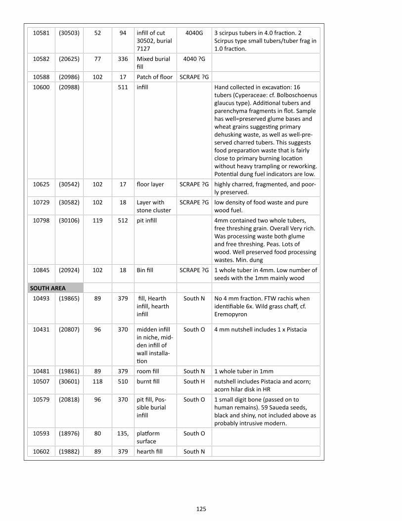
125
10581 (30503) 52 94 infill of cut 30502, burial 7127
4040G 3 scirpus tubers in 4.0 fraction. 2 Scirpus type small tubers/tuber frag in 1.0 fraction.
10582 (20625) 77 336 Mixed burial fill
4040 ?G
10588 (20986) 102 17 Patch of floor SCRAPE ?G10600 (20988) 511 infill Hand collected in excavation: 16
tubers (Cyperaceae: cf. Bolboschoenus glaucus type). Additional tubers and parenchyma fragments in flot. Sample has well=preserved glume bases and wheat grains suggesting primary dehusking waste, as well as well-pre-served charred tubers. This suggests food preparation waste that is fairly close to primary burning location without heavy trampling or reworking. Potential dung fuel indicators are low.
10625 (30542) 102 17 floor layer SCRAPE ?G highly charred, fragmented, and poor-ly preserved.
10729 (30582) 102 18 Layer with stone cluster
SCRAPE ?G low density of food waste and pure wood fuel.
10798 (30106) 119 512 pit infill 4mm contained two whole tubers, free threshing grain. Overall Very rich. Was processing waste both glume and free threshing. Peas. Lots of wood. Well preserved food processing wastes. Min. dung
10845 (20924) 102 18 Bin fill SCRAPE ?G 1 whole tuber in 4mm. Low number of seeds with the 1mm mainly wood
SOUTH AREA10493 (19865) 89 379 fill, Hearth
infill, hearth infill
South N No 4 mm fraction. FTW rachis when identifiable 6x. Wild grass chaff, cf. Eremopyron
10431 (20807) 96 370 midden infill in niche, mid-den infill of wall installa-tion
South O 4 mm nutshell includes 1 x Pistacia
10481 (19861) 89 379 room fill South N 1 whole tuber in 1mm10507 (30601) 118 510 burnt fill South H nutshell includes Pistacia and acorn;
acorn hilar disk in HR10579 (20818) 96 370 pit fill, Pos-
sible burial infill
South O 1 small digit bone (passed on to human remains). 59 Saueda seeds, black and shiny, not included above as probably intrusive modern.
10593 (18976) 80 135, platform surface
South O
10602 (19882) 89 379 hearth fill South N
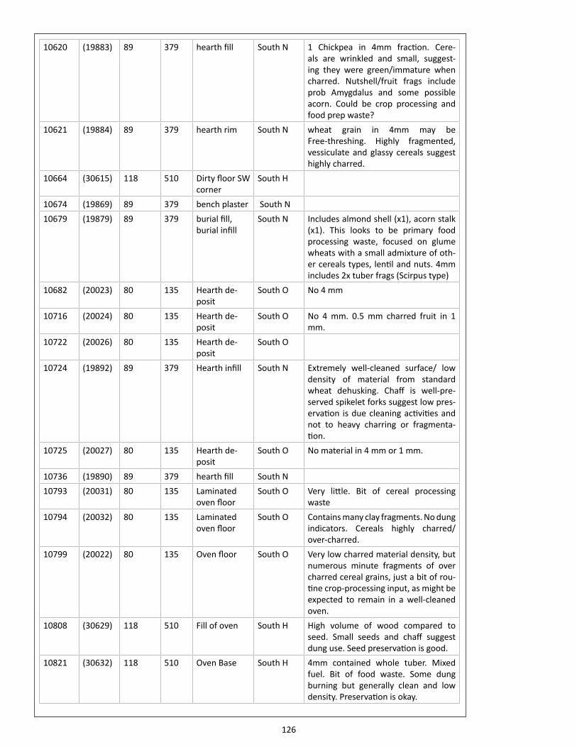
126
10620 (19883) 89 379 hearth fill South N 1 Chickpea in 4mm fraction. Cere-als are wrinkled and small, suggest-ing they were green/immature when charred. Nutshell/fruit frags include prob Amygdalus and some possible acorn. Could be crop processing and food prep waste?
10621 (19884) 89 379 hearth rim South N wheat grain in 4mm may be Free-threshing. Highly fragmented, vessiculate and glassy cereals suggest highly charred.
10664 (30615) 118 510 Dirty floor SW corner
South H
10674 (19869) 89 379 bench plaster South N10679 (19879) 89 379 burial fill,
burial infillSouth N Includes almond shell (x1), acorn stalk
(x1). This looks to be primary food processing waste, focused on glume wheats with a small admixture of oth-er cereals types, lentil and nuts. 4mm includes 2x tuber frags (Scirpus type)
10682 (20023) 80 135 Hearth de-posit
South O No 4 mm
10716 (20024) 80 135 Hearth de-posit
South O No 4 mm. 0.5 mm charred fruit in 1 mm.
10722 (20026) 80 135 Hearth de-posit
South O
10724 (19892) 89 379 Hearth infill South N Extremely well-cleaned surface/ low density of material from standard wheat dehusking. Chaff is well-pre-served spikelet forks suggest low pres-ervation is due cleaning activities and not to heavy charring or fragmenta-tion.
10725 (20027) 80 135 Hearth de-posit
South O No material in 4 mm or 1 mm.
10736 (19890) 89 379 hearth fill South N10793 (20031) 80 135 Laminated
oven floorSouth O Very little. Bit of cereal processing
waste10794 (20032) 80 135 Laminated
oven floorSouth O Contains many clay fragments. No dung
indicators. Cereals highly charred/ over-charred.
10799 (20022) 80 135 Oven floor South O Very low charred material density, but numerous minute fragments of over charred cereal grains, just a bit of rou-tine crop-processing input, as might be expected to remain in a well-cleaned oven.
10808 (30629) 118 510 Fill of oven South H High volume of wood compared to seed. Small seeds and chaff suggest dung use. Seed preservation is good.
10821 (30632) 118 510 Oven Base South H 4mm contained whole tuber. Mixed fuel. Bit of food waste. Some dung burning but generally clean and low density. Preservation is okay.
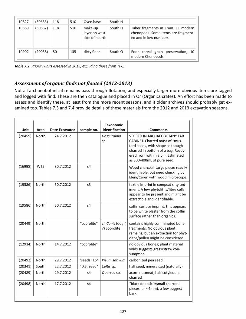
127
Assessment of organic finds not floated (2012-2013)Not all archaeobotanical remains pass through flotation, and especially larger more obvious items are tagged and logged with find. These are then catalogue and placed in Or (Organics crates). An effort has been made to assess and identify these, at least from the more recent seasons, and it older archives should probably get ex-amined too. Tables 7.3 and 7.4 provide details of these materials from the 2012 and 2013 excavation seasons.
10827 (30633) 118 510 Oven base South H10869 (30637) 118 510 make-up
layer on west side of hearth
South H Tuber fragments in 1mm. 11 modern chenopods. Some items are fragment-ed and in low numbers.
10902 (20038) 80 135 dirty floor South O Poor cereal grain preservation, 10 modern Chenopods
Table 7.2. Priority units assessed in 2013, excluding those from TPC.
Unit Area Date Excavated sample no.Taxonomic
identification Comments(20459) North 24.7.2012 Descurainia
sp.STORED IN ARCHAEOBOTANY LAB CABINET. Charred mass of “mus-tard seeds, with shape as though charred in bottom of a bag. Recov-ered from within a bin. Estimated as 300-400mL of pure seed.
(16998) WT5 30.7.2012 s4 Wood charcoal. Large piece; readily identifiable, but need checking by Eleni/Ceren with wood microscope.
(19586) North 30.7.2012 s3 textile imprint in compcat silty sed-iment. A few phytoliths/fibre cells appear to be present and might be extractible and identifiable.
(19586) North 30.7.2012 s4 coffin surface imprint: this appears to be white plaster from the coffin surface rather than organics.
(20449) North “coprolite” cf. Canis (dog)( ?) coprolite
contains highly comminuted bone fragments. No obvious plant remains; but an extraction for phyt-oiths/pollen might be considered.
(12934) North 14.7.2012 “coprolite” no obvious bones; plant material voids suggests grass/straw con-sumption.
(20492) North 29.7.2012 “seeds H.S” Pisum sativum carbonized pea seed.(20341) South 22.7.2012 “D.S. Seed” Celtis sp. half seed, mineralized (naturally)(20489) North 29.7.2012 s4 Quercus sp. acorn nutmeat, half cotyledon,
charred(20498) North 17.7.2012 s4 “black deposit”=small charcoal
pieces (all <4mm), a few suggest bark
128
(20341) South 23.7.2012 “seed” Celtis sp. 3 whole, 6 halves, 2 frags; mineral-ized (naturally)
(20308) South 23.7.2012 “seed” Celtis sp. 2 whole, 1 half; mineralized (natu-rally)
(19435) North 4.7.2012 “organic?” gray clay with imprints of straw/grass culm; some epidermal phyto-liths preserved in situ
(20450) North 18.7.2012 s5 Pisum sp. 4 fragments of large Viciae. Appears to be Pisum but has a surface pat-tern, suggesting either a wild-type seed coat or a larger more round seeded Vicia
(20321) South 17.7.2012 “D.S. Seed” Celtis sp. 3 whole, 7 halves, 22 frags; mineral-ized (naturally)
(20321) South 17.7.2012 “D.S. Seed” Mollusc shell (aquatic?) with Celtis sp., above
(20302) South 7.7.2012 “seed” Celtis sp. half seed, mineralized (naturally)(20307) South 10.7.2012 “seed” Celtis sp. 8 frags, mineralized (naturally)(19813) South 9.7.2012 “hS seeds” Quercus sp. Carbonized:2 whole, 2 frags. 2
acorns with a bit of apical shell and shell tip preserved
(19476) North 8.7.2012 “seed” Prunus sp. plum stone; uncarbonized(19476) North 8.7.2012 “seed” Celtis sp. 1 while. Mineralized (naturally)(20320) South 14.7.2012 “seed” Celtis sp. 15 frags, mineralized (naturally)(20305) South 8.7.2102 “seed” Mollusc shell
(aquatic?)(19471) North 12.7.2012 “seed” Triticum cf.
aestivum1 Wheat grain, probably free-threshing type.
(20320) South 12.7.2012 “seed” Celtis sp. 4 halves, 3 frags; mineralized (nat-urally)
(20320) South 12.7.2012 “seed” Mollusc shell (aquatic?) with Celtis sp., above
(20314) South 11.7.2012 “seed” Celtis sp. 9 frags, mineralized (naturally)(19447) North 7.7.2012 s3 Celtis sp. 6 whole, 7 halves, 29 frags; mineral-
ized (naturally)(19471) North 12.7.2012 s2 recent decom-
posing wood & roots
“plant fiber”= No! Looks like de-graded, uncarbonized wood with some mixture of recent plant roots. Like to be recent wood + intrusive roots.
17262) WT5 5.8.2012 s4 Quercus sp. acorn nutmeat, about half of acorn, shows some remnant of apex
Table 7.3. Notes on OR (“organic residue”) small finds.
129
Doctoral research projectsThere are presently four doctorial research projects on Çatalhöyük archaeobotanics. Elizabeth Stroud is doing her D.Phil in Oxford on West Mound Archaeobotany; she started in Oct. 2012. See her separate Archive report for some of her results. Petra Vaiglova, University of Oxford, is carrying out stable isotope analysis of archae-obotanical material to reconstruct the nature of agricultural management in early farming contexts, including material from Çatalhöyük; she also began in 2012. Laura Green is doing a D.Phil in Oxford with a focus on arable ecology and weed flora from the East Mound; she started in Oct. 2013. Lara Gonzalez Carretero started her PhD at UCL in October 2013 on the origins of bread culture, with a focus on studying cereal processing and processed cereal products from Çatalhöyük and the extent to which any changes in the practices of cooking/baking can be reconstructed through the sequence. It should also be noted that the doctoral thesis by Dragana Filipović, completed at Oxford in 2012 is scheduled to published soon as a BAR volume.
Unit Area Date Excavated sample no. Taxonomic identification Comments(19726) South 4/8/2012 S2 “plant
fibers from sacrum”
Silty sediment with admixture of phytoliths. Nothing appears as intact fibers.
(20542) South 1/8/2012 S2 Celtis sp. (hackberry) 15 Celtis stones embedded in clayey matrix.
(30189) North 2/7/2014 D.S. “carbon-ized plant”
Pisum sativum: 1 Celtis sp.: 1
Sedge tubers: 2 (Bolboschoenus glaucus)
1 pea, 2 tubers, 1 hackberry. Plausible food plant waste
(21143) North (Sp.99)
7/7/2014 “charred seed”
Sedge tuber (x1) (Bolboschoenus glaucus)
(4867) South Ex. 28/7/1999 from faunal: 30/6/2014
Celtis sp.: 3
(20852) South 5/7/2014 “seeds” Chenopodium sp. UNCHARRED. Naturally black. Modern intrusive(?).
Table 7.4. Tabulation of notes on crate OR. 11 (2013/14)
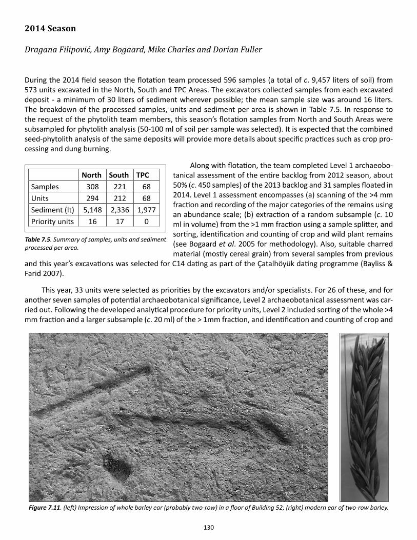
130
2014 Season
Dragana Filipović, Amy Bogaard, Mike Charles and Dorian Fuller
During the 2014 field season the flotation team processed 596 samples (a total of c. 9,457 liters of soil) from 573 units excavated in the North, South and TPC Areas. The excavators collected samples from each excavated deposit - a minimum of 30 liters of sediment wherever possible; the mean sample size was around 16 liters. The breakdown of the processed samples, units and sediment per area is shown in Table 7.5. In response to the request of the phytolith team members, this season’s flotation samples from North and South Areas were subsampled for phytolith analysis (50-100 ml of soil per sample was selected). It is expected that the combined seed-phytolith analysis of the same deposits will provide more details about specific practices such as crop pro-cessing and dung burning.
Along with flotation, the team completed Level 1 archaeobo-tanical assessment of the entire backlog from 2012 season, about 50% (c. 450 samples) of the 2013 backlog and 31 samples floated in 2014. Level 1 assessment encompasses (a) scanning of the >4 mm fraction and recording of the major categories of the remains using an abundance scale; (b) extraction of a random subsample (c. 10 ml in volume) from the >1 mm fraction using a sample splitter, and sorting, identification and counting of crop and wild plant remains (see Bogaard et al. 2005 for methodology). Also, suitable charred material (mostly cereal grain) from several samples from previous
and this year’s excavations was selected for C14 dating as part of the Çatalhöyük dating programme (Bayliss & Farid 2007).
This year, 33 units were selected as priorities by the excavators and/or specialists. For 26 of these, and for another seven samples of potential archaeobotanical significance, Level 2 archaeobotanical assessment was car-ried out. Following the developed analytical procedure for priority units, Level 2 included sorting of the whole >4 mm fraction and a larger subsample (c. 20 ml) of the > 1mm fraction, and identification and counting of crop and
North South TPCSamples 308 221 68Units 294 212 68Sediment (lt) 5,148 2,336 1,977Priority units 16 17 0
Table 7.5. Summary of samples, units and sediment processed per area.
Figure 7.11. (left) Impression of whole barley ear (probably two-row) in a floor of Building 52; (right) modern ear of two-row barley.
131
wild remains (see Bogaard et al. 2005 for methodology). Although the majority of priority units represented fills of fire installations (ovens, hearths), they were generally poor in macro-remains. The few relatively ‘rich’ ones are described below. Two ‘special’ archaeobotanical contexts were encountered this year. One is a concentration of peas (21195) in an infill layer of Sp.504 (side room of B.131) in the North Area, found near or within a possible bin (not yet excavated). The pea concentration sample was exported to Oxford University, UK for full analysis. Another unusual archaeobotanical find is an impression of a, most likely, two-row barley ear in a floor of Building 52 (a small number of cleaned glume wheat grain was found in the layer on top of this floor) (Figure 7.11). Also of particular interest is a concentration (a layer) of charred reed stems and leaves within the burnt deposit (21007) in TPC Area which was analyzed in more detail by the anthracology team members.
Botanical commentary for selected units which were of relatively high botanical density/richness or were otherwise interesting is provided below (by excavation area). In general, results of the initial sample assess-ment were consistent with previous archaeobotanical observations: glume wheat remains were most ubiquitous across different contexts, with glume wheat chaff more frequent and abundant than glume wheat grain, contrib-uting to the ubiquitous evidence for processing of glume wheat grain (i.e. dehusking). All previously registered glume wheat types were found in the samples - ‘new’ type wheat, one- and two-seeded einkorn, and emmer. Free-threshing wheat and barley were also present. Lentils were the most common among pulses, although pea, bitter vetch and a few chickpea remains were identified. The edible fruit/nut assemblage included the very com-mon hackberry fruit (Celtis), wild-type almond nutshell (Amygdalus), wild plum stone fragments (Prunus), whole and fragmented nuts of terebinth (Pistacia) and occasional fragments of acorn cotyledons and shell (Quercus). Remains of wild taxa were in most cases dominated by sea clubrush nutlets (Bolboschoenus glaucus).
North AreaMost samples from the North Area assessed to Level 1 or 2 and containing 100 or more items were mainly com-posed of crop processing/food preparation residue in the form of a large number of glume wheat glume bases and relatively high quantity (e.g. 50 or more) of wild/weed seeds of which some/all may represent by-products of crop cleaning. Sedge seeds are also numerous in some of these samples and they likely derive from burning of animal dung. In midden (21103) similar number of sedge seeds and other wild/weed seeds was registered (around 300) in addition to the several hundred glume wheat glume bases, suggesting a combination of the remains from the two distinct plant-related practices (crop processing and burning of animal dung). An ashy lens (21365) in midden in Space 40 also contained similar quantities of sedge and wild/weed seeds plus an abundance of glume wheat glume bases and, perhaps as a discrete ‘dumping event’, results from dung-burning and crop cleaning activities. Sedge seeds were generally less common in the indoor deposits (compared to their numbers in middens). For instance, the oven fill (21350) was almost entirely composed of glume wheat glume bases, had a high density (over 100 items per liter of soil) and contained a large quantity of wood. Wood and chaff may have been the main and/or the last fuel used in this oven and crop processing may have taken place nearby. Dirty floor (21177) contained a mixture of glume wheat processing waste, very little (background noise) from dung fuel, some bread wheat cleaning residue and a large quantity of sedge tubers (10 ml of parenchyma). Burnt deposit (21169) was largely composed of by-products of late glume wheat processing stage(s), barley rachis and grain, some bread wheat rachis and a high number of weedy seeds, showing evidence of cleaning of cereal grain as part of food preparation. Rake-out (21170) had a similar composition to (21169) in terms of final cereal processing waste, though with bread wheat rachis slightly more abundant than barley rachis and much fewer wild/weed seeds; these were mixed with fuel remains - wood charcoal and some sedge seeds. In agreement with its characterisation as a refuse pit, (21146) contained traces of all main crop categories including free-threshing wheat grain, several barley grains, glume wheat grain and glume bases, chickpea, pea, a signif-icant amount of wild/weed seeds (higher than glume wheat glume bases), some sedge nutlets, fragments of dung and some wood. The pit may have served for disposal of fire waste and food preparation waste. Fire spot (22032) within a room fill was dominated by wood charcoal; it also contained some glume wheat glume bases and a fair number of weedy seeds of which majority were of knotweed family (Polygonaceae) but also included large-seeded Galium; a single sedge seed was present. The deposit likely derives from final crop processing stag-
132
es (dehusking, fine sieving, hand cleaning) and does not include dung-derived plant remains which have been frequently found in this kind of archaeological deposits.
South AreaOnly three analyzed units/samples from the South Area contained at least a hundred seed/chaff remains. Burial fill (30348) represented a mixture of crop processing waste and dung-derived seeds (i.e. a large number of glume wheat glume bases, some wild/weed seeds and over a hundred sedge nutlets); such combination is usually found in middens or otherwise ‘mixed’ contexts. Platform make-up (30359) in Building 43 had a similar compo-sition but slightly higher botanical density. However, the lack of in situ burning in these two contexts means that there is no necessary relation between the contexts and the plant remains. A small, 8 liter-sample from oven fill (30372) was entirely composed of glume wheat glume bases, and also contained wood charcoal; no remains of dung were present. Wood may have been the main (and/or final) fuel used in the oven, along with glume wheat processing waste thrown into fire.
TPC AreaTwo samples from TPC Area received field assessment. The fill of a cut (30440) was poor in remains (>100 items); unlike the majority of observed Çatalhöyük deposits, it did not contain glume wheat glume bases but was mostly composed of free-threshing wheat rachis and grain, some barley rachis, several pulse seeds, and c. 10 wild seeds including sedge. The remains result from crop cleaning/food preparation and may have been swept into the cut or have been present in the material used for infilling. The sample from a pit fill (30449) was distinguished by the visible charred plant content. A large number of sedge seed were found here; crop remains were virtually ab-sent. No traces of in situ burning were recorded, but the deposit may represent fire waste from a single episode of burning (much like fire spots).
Student projectsThe genesis of bread cultures at Çatalhöyük: an archaeobotanical perspective on changing cuisineLara Gonzaléz Carretero, PhD candidate, Institute of Archaeology, University College London
My PhD project traces the origins of bread cultures in the Near East and Europe, with a particular focus on Neolithic Çatalhöyük (Turkey). The overall aims of this project are to provide substantial new knowledge about unstudied amorphous plant remains, such as lumps of ‘cooked’ cereal preparations, shifts in cooking practices with the advent of ceramics as cooking pots and the use of wild plant species, with special attention to species of wild mustard like Descurainia sophia, whose oily seeds were possible food condiment at Neolithic Çatalhöyük.
From the 2013 season at Çatalhöyük, around 15 archaeobotanical samples were selected for preliminary study of possible charred food fragments. I carried out scanning electronic microscope analysis of the possible food remains and have successfully recognized the actual charred food matter. Therefore, during the 2014 sea-son at Çatalhöyük, 150 more archaeobotanical samples that span the major phases of Çatalhöyük (pre-ceramic, cooking ceramic and post-cattle periods) were collected from the North, South and TPC Areas of the site for export. Initial scanning suggests that, these samples are representative of, primarily, food processing contexts (rather than dung-burning) such as ovens, hearths, fire spots and storage deposits as well as representing as-pects of ‘Neolithic recipes’ before, during and after cooking.
Very little has been said about the use of non-staple foods (wild species) and how the ingredients and the way these were cooked may have changed through time at Çatalhöyük. For the first time in the archaeobotani-cal analysis at Çatalhöyük, this project combines the analysis of unstudied plant evidence, such as cereal lumps originally identified as ‘bread’, with the study of artifact assemblages (clay balls, pots, ground stones, etc.) and experimental food preparation. Following up on Soultana Valamoti’s work on prehistoric processed cereal prepa-rations in Greece (2002, 2008, and 2011); this project aims to compare the characteristics of Neolithic cereal food preparations retrieved from Neolithic Çatalhöyük with modern experimental cereal preparations cooked

133
under (similar) controlled circumstances. These comparative analyses of Neolithic and experimental food prepa-rations involving macroscopic and scanning electron microscope examination will shed light on cultural changes in cooking practices and possible ingredients used for the preparation of food for the Neolithic community at Çatalhöyük.
Assessing the nature of Early Neolithic farming in Western Asia: a functional ecological approach to emerging arable weedsLaura Green, DPhil candidate, Institute of Archaeology, University of Oxford
This DPhil project aims to determine the specific nature and social implications of early cultivation practices in Neolithic Western Asia, by applying a functional ecological approach to the now substantial ‘weed’ dataset available from Pre-Pottery and Pottery Neolithic sites. A functional ecological approach to ecological interpre-tation of arable ‘weed’ taxa associated with early cultivars enables nuanced comparison between modern flora developed under known conditions and ancient assemblages (Jones 2002; Charles et al. 2002). The usefulness of this approach has been demonstrated in the context of early farming in central Europe (Bogaard 2004). In-terpretation of the Near Eastern data has so far been limited by the general nature of the ecological data used, but inferences to date suggest that cultivation practices changed considerably through the Pre-Pottery Neolithic (Colledge 1998). Çatalhöyük presents an ideal established farming site for the application of this approach, with its extensive archaeobotanical dataset and in situ storage contexts containing weed seeds associated with stored crops.
The core approach will be to analyze the functional ecological attributes (e.g. leaf area and thickness; can-opy dimensions; stomatal density and distribution) of the relevant arable weed taxa to determine the specific growing conditions of early crops and hence the nature of management practices. Functional attributes are morphological or behavioral characteristics that predict species’ potential in relation to major environmental variables, such as soil productivity, disturbance and moisture. Statistical analysis of these attributes will explore variation amongst Çatalhöyük samples and compare them with weed survey data from relevant modern re-gimes, including a recent study of traditional cereal farming in Morocco.
The Çatalhöyük data will also be compared in ecological terms with those from a number of earlier farming sites, including PPNA Jerf el Ahmar and early PPNB Dja’de in northern Syria, and PPNB Tell Aswad. The results of these analyses will be explored in relation to other contextual data at the selected sites and will aim to de-termine the cultural context of specific farming practices. Statistical analyses between regions and through time will seek to establish the extent of variation in cultivation methods, with implications for the social factors and consequences involved in the emergence of agricultural societies.
AcknowledgementsThe analysis of the archaeobotanical material from the TPC Area was financed by the Polish National Science Centre (decision DEC-2012/06/M/H3/00286).
References
Asouti, E. & D.Q. Fuller2013. A Contextual approach to the emergence of agriculture in Southwest Asia. Current Anthropology 54 (3): 299-345.
Bayliss, A. & S. Farid 2007. Interpreting chronology at Çatalhöyük (Neolithic East Mound). Çatalhöyük 2007 Archive Report, 390-392.
134
Bogaard, A. 2004. Neolithic Farming in Central Europe. London: Routledge.
Bogaard, A., M. Charles, M. Ergun, G. Jones, K. Ng, M. Polcyn & N. Stone 2005. Macro Botanical Remains. Çatalhöyük 2005 Archive Report, 152-155.
Bogaard, A., M. Charles, K.C. Twiss, A. Fairbairn, N. Yalman, D. Filipović, A. Demirergi, F. Ertuğ, N. Russell & J. Henecke 2009. Private pantries and celebrated surplus: storing and sharing food at Neolithic Çatalhöyük, Central Anatolia. Antiquity 83: 649-668
Bogaard, A., M. Charles, A. Livarda, M. Ergun, D. Filipović & G. Jones 2013. The archaeobotany of mid-later Neolithic Çatalhöyük, in Humans and Landscapes of Çatalhöyük: Reports from the 2000-2008 Seasons, ed. I. Hodder. London: British Institute at Ankara; Los Angeles: Costen Institute of Archaeology Press, 93-128.
Charles, M. & A. Bogaard2010. Charred plant macro-remains from Jeitun: implications for early cultivation and herding practices in western Central Asia, in Excavations at Jeitun, ed. D.R. Harris. Philadelphia: University of Pennsylvania Museum Press, 150-165.
Charles, M., A. Bogaard, G. Jones & P. Halstead 2002. Towards the archaeobotanical identification of intensive cereal cultivation: present-day ecological investigation in the mountains of Asturias, northwest Spain. Vegetation History and Archaeobotany 11: 133-142.
Colledge, S.1998. Identifying pre-domestication cultivation using multivariate analysis, in The Origins of Agriculture and Crop Domestication, eds. A.B.Damania, J. Valkoun, G. Willcox and C.O. Qualset. Aleppo: ICARDA, 121-131.
Fuller, D.Q. 2008. Recent lessons from Near Eastern archaeobotany: wild cereal use, pre-domestication cultivation and tracing multiple origins and dispersals. Pragdhara 18: 105-134.
Fuller, D.Q. 2013. “The Nut Age? The importance wild plant foods in the Neolithic of West and East Eurasia.” Unpub-lished conference presentation at the International Work Group for Palaeoethnobotany, Thessaloniki, Greece, June 2013.
Fuller, D.Q & C.J. Stevens 2009. Agriculture and the development of complex societies, in From Foragers to Farmers. Papers in Hon-our of Gordon C. Hillman, eds. A. Fairbairn & Ehud Weiss. Oxford: Oxbow Books, 37-57.
Fuller, D.Q., G. Willcox & R. Allaby2012. Early agricultural pathways: moving outside the ‘core area’ hypothesis’ in Southwest Asia. Journal of Experimental Botany 63: 617-633.
135
Jones, G.2002. Weed ecology as a method for the archaeobotanical recognition of crop husbandry practices. Acta Palaeobotanica 42: 185-193.
Jones G., S. Valamoti & M. Charles2000. Early crop diversity: a ‘new’ glume wheat from northern Greece. Vegetation History and Archaeo-botany 9: 133–146.
Köhler-Schneider, M. 2003. Contents of a storage pit from late Bronze Age Stillfried, Austria: another record of the ‘new’ glume wheat. Vegetation History and Archaeobotany 12: 105–111.
Valamoti, S-M.2002. Food remains from Bronze Age Archondiko and Mesimeriani Toumba in northern Greece? Vegeta-tion History and Archaeobotany 11: 17-22.
Valamoti, S-M., D. Samuel, M. Bayram & E. Marinova2008. Prehistoric cereal foods from Greece and Bulgaria: investigation of starch microstructure in experi-mental and archaeological charred remains. Vegetation History and Archaeobotany 17: 265–276.
Valamoti, S-M. 2011. Ground cereal food preparations from Greece: the prehistory and modern survival of traditional Mediterranean ‘fast foods’. Archaeological and Anthropological Sciences 3: 19-39.
Wollstonecroft, M., P.R. Ellis, G.C. Hillman & D.Q. Fuller 2008. Advances in plant food processing in the Near Eastern Epipalaeolithic and implications for im-proved edibility and nutrient bioaccessibility: an experimental assessment of Bolboschoenus maritimus (L.) Palla (sea club-rush). Vegetation History and Archaeobotany 17(S1): S19–S27.
Wollstonecroft, M., P.Z. Hroudová, G.C. Hillman & D.Q. Fuller 2011. Bolboschoenus glaucus (Lam.) S.G. Smith, a new species in the flora of the ancient.
136
Chapter 8
Phytoliths and Starch Grains
Marco Madella1 and Juan José Garcia-Granero2
1Universitat Pompeu Fabra and IMF-CSIC, 2IMF – Spanish National Research Council
IntroductionPhytoliths are microscopic bodies formed by the deposition of opal silica in or between plant cells. Silica in solu-tion in the groundwater is absorbed by plants as monosilicic acid and deposited in a variety of intracellular or extra-cellular locations (Piperno 2006). Grasses and sedges are the plant groups with the highest production of phytoliths but the amount of phytolith deposition depends on both genetic and environmental factors (Madella et al. 2009). Phytoliths with analytical interests are casts of cell lumens and therefore bring both taxonomical and anatomical information. Indeed, a strong aspect of the analysis of phytolith is the possibility to distinguish different plant parts (e.g. floral parts, culms, leaves, fruits) augmenting the interpretative power of this micro-fossil. Another important aspect of phytoliths is that they do not need to come into contact with fire for being preserved. This means that it is possible to investigate and directly compare plant use from charred and non-charred contexts.
The analysis of phytoliths can be carried out at single cells levels or as “silica skeletons”, which are sheets of conjoined phytoliths – mostly but not exclusively from grass and sedges epidermal tissues.
At Çatalhöyük, there are unusually large accumulations of silicified remains visible to the naked eye provid-ing evidence for the original depositional context of plant materials, as well as the use of specific plants for pre-cise purposes. Sometimes patterning survives enabling distinction between different types of woven remains, and in other instances visible remains provide evidence for plants present in construction materials.
Research objectives for the 2014 field seasonThe 2014 field season was the first carried out by the micro-remains team from form the Universitat Pompeu Fabra. The group has a general interest in the communities of practice in connections with plant use, and its change in space and time. The main research objectives for the season were:
1) Plant use by subsistence farmers: crops and wild plants
2) Food processing and consumption
3) Pathways of plant materials in a Neolithic settlement
MethodologyA methodological approach was set in place be able to collect an exhaustive body of samples that could be used to answer to the research objectives of the micro-remains group and connected with Çatalhöyük communities of practice approach. Also, a specific sampling approach has been set in place to create a continuous and parallel body of evidence to the plant macro-remains. To do so, each sediment sample brought to the flotation station was sub-sampled for phytoliths just before processing and the c. 100ml sample stored for future reference. This is extremely important as the plant macro-remains are going to be analyzed in the future and there could be the need to also recuperate the phytoliths (or starch grains) evidence to substantiate the macros results.
Sediment samplesSamples were collected from both archaeological units and discrete areas within the units. The strategy was put in place to understand distribution patters of phytoliths (and therefore patterns of plant use) as well as the in-
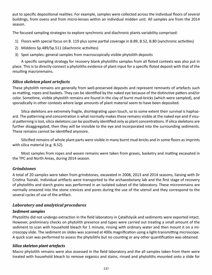
137
put to specific depositional realities. For example, samples were collected across the individual floors of several buildings, from ovens and from micro-lenses within an individual midden unit. All samples are from the 2014 season.
The focused sampling strategies to explore synchronic and diachronic plants variability comprised:
1) Floors with special focus on B. 119 plus some partial coverage in B.89, B.52, B.80 (synchronic activities)
2) Middens Sp.489/Sp.511 (diachronic activities)
3) Spot samples: general samples from macroscopically visible phytolith deposits
A specific sampling strategy for recovery blank phytoliths samples from all floted contexts was also put in place. This is to directly connect a phytoliths evidence of plant input for a specific floted deposit with that of the resulting macroremains.
Silica skeleton plant artefacts These phytolith remains are generally from well-preserved deposits and represent remnants of artefacts such as matting, ropes and baskets. They can be identified by the naked eye because of the distinctive patters and/or color. Sometime, visible phytolith remains are found in the clay of burnt mud-bricks (which were sampled), and sporadically in other contexts where large amounts of plant material seem to have been deposited.
Silica skeletons are extremely fragile, disintegrating upon touch, so to some extent their survival is haphaz-ard. The patterning and concentration is what normally makes these remains visible at the naked eye and if visu-al patterning is lost, silica skeletons can be positively identified only as plant concentrations. If silica skeletons are further disaggregated, then they will be invisible to the eye and incorporated into the surrounding sediments. These remains cannot be identified anymore.
Silicified remains of whole plant parts were visible in many burnt mud-bricks and in some floors as imprints with silica material (e.g. B.52).
Most samples from ropes and woven remains were taken from graves, basketry and matting excavated in the TPC and North Areas, during 2014 season.
GrindstonesA total of 20 samples were taken from grindstones, excavated in 2008, 2013 and 2014 seasons, liaising with Dr Cristina Tsoraki. Individual artifacts were transported to the archaeobotany lab and the first stage of recovery of phytoliths and starch grains was performed in an isolated subset of the laboratory. These microremains are normally smeared into the stone crevices and pores during the use of the utensil and they correspond to the several cycles of use of the artifact.
Laboratory and analytical proceduresSediment samplesPhytoliths did not undergo extraction in the field laboratory in Çatalhöyük and sediments were exported intact. However, preliminary checks on phytolith presence and types were carried out treating a small amount of the sediment to scan with household bleach for 1 minute, rinsing with ordinary water and then mount it on a mi-croscopy slide. The sediment on slides was scanned at 400x magnification using a light-transmitting microscope. A quick scan was performed to assess the phytoliths but no counting or any other quantification was obtained.
Silica skeleton plant artefactsMacro phytolith remains were also assessed in the field laboratory and the all samples taken from them were treated with household bleach to remove organics and stains, rinsed and phytoliths mounted onto a slide for
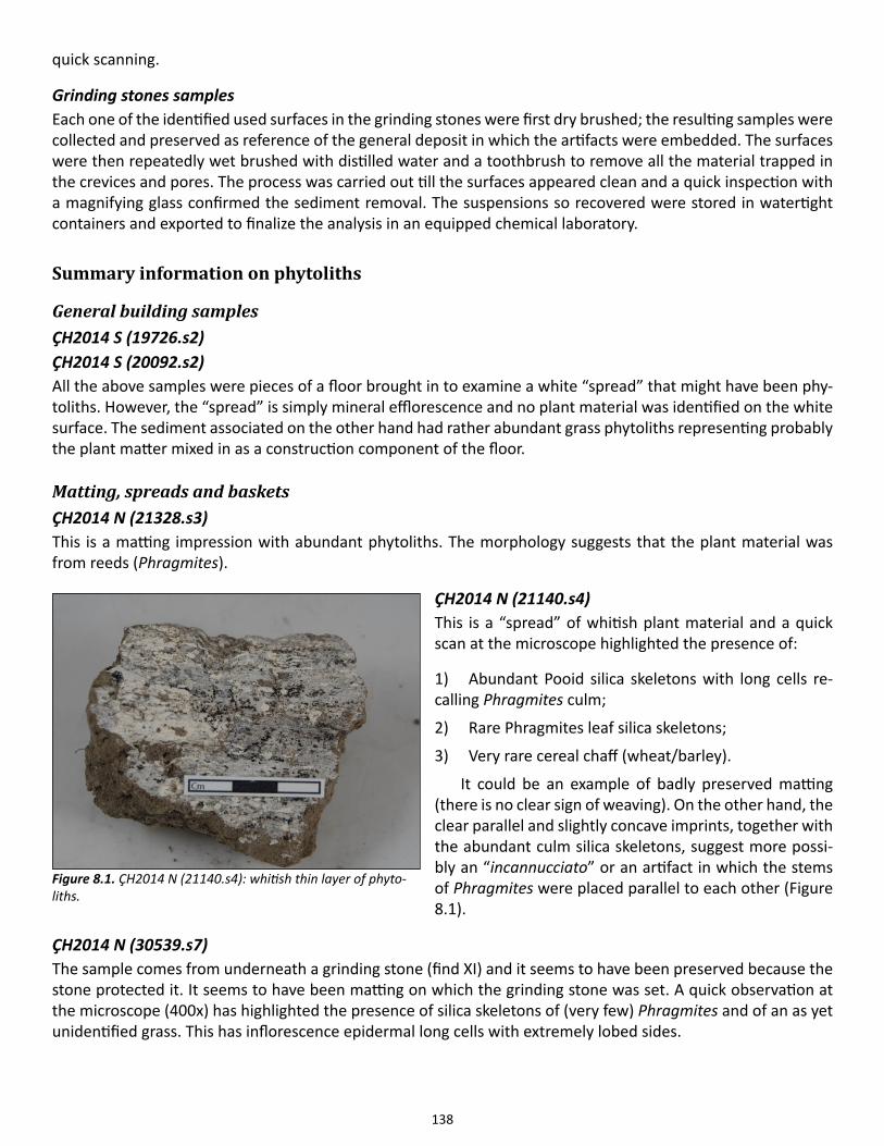
138
quick scanning.
Grinding stones samplesEach one of the identified used surfaces in the grinding stones were first dry brushed; the resulting samples were collected and preserved as reference of the general deposit in which the artifacts were embedded. The surfaces were then repeatedly wet brushed with distilled water and a toothbrush to remove all the material trapped in the crevices and pores. The process was carried out till the surfaces appeared clean and a quick inspection with a magnifying glass confirmed the sediment removal. The suspensions so recovered were stored in watertight containers and exported to finalize the analysis in an equipped chemical laboratory.
Summary information on phytoliths
General building samplesÇH2014 S (19726.s2)ÇH2014 S (20092.s2)All the above samples were pieces of a floor brought in to examine a white “spread” that might have been phy-toliths. However, the “spread” is simply mineral efflorescence and no plant material was identified on the white surface. The sediment associated on the other hand had rather abundant grass phytoliths representing probably the plant matter mixed in as a construction component of the floor.
Matting, spreads and basketsÇH2014 N (21328.s3)This is a matting impression with abundant phytoliths. The morphology suggests that the plant material was from reeds (Phragmites).
ÇH2014 N (21140.s4)This is a “spread” of whitish plant material and a quick scan at the microscope highlighted the presence of:
1) Abundant Pooid silica skeletons with long cells re-calling Phragmites culm;
2) Rare Phragmites leaf silica skeletons;
3) Very rare cereal chaff (wheat/barley).
It could be an example of badly preserved matting (there is no clear sign of weaving). On the other hand, the clear parallel and slightly concave imprints, together with the abundant culm silica skeletons, suggest more possi-bly an “incannucciato” or an artifact in which the stems of Phragmites were placed parallel to each other (Figure 8.1).
ÇH2014 N (30539.s7)The sample comes from underneath a grinding stone (find XI) and it seems to have been preserved because the stone protected it. It seems to have been matting on which the grinding stone was set. A quick observation at the microscope (400x) has highlighted the presence of silica skeletons of (very few) Phragmites and of an as yet unidentified grass. This has inflorescence epidermal long cells with extremely lobed sides.
Figure 8.1. ÇH2014 N (21140.s4): whitish thin layer of phyto-liths.
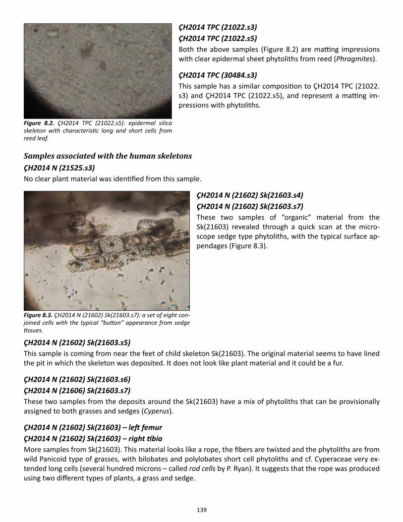
139
ÇH2014 TPC (21022.s3)ÇH2014 TPC (21022.s5)Both the above samples (Figure 8.2) are matting impressions with clear epidermal sheet phytoliths from reed (Phragmites).
ÇH2014 TPC (30484.s3)This sample has a similar composition to ÇH2014 TPC (21022.s3) and ÇH2014 TPC (21022.s5), and represent a matting im-pressions with phytoliths.
Samples associated with the human skeletonsÇH2014 N (21525.s3)No clear plant material was identified from this sample.
ÇH2014 N (21602) Sk(21603.s4) ÇH2014 N (21602) Sk(21603.s7)These two samples of “organic” material from the Sk(21603) revealed through a quick scan at the micro-scope sedge type phytoliths, with the typical surface ap-pendages (Figure 8.3).
ÇH2014 N (21602) Sk(21603.s5)This sample is coming from near the feet of child skeleton Sk(21603). The original material seems to have lined the pit in which the skeleton was deposited. It does not look like plant material and it could be a fur.
ÇH2014 N (21602) Sk(21603.s6)ÇH2014 N (21606) Sk(21603.s7)These two samples from the deposits around the Sk(21603) have a mix of phytoliths that can be provisionally assigned to both grasses and sedges (Cyperus).
ÇH2014 N (21602) Sk(21603) – left femurÇH2014 N (21602) Sk(21603) – right tibiaMore samples from Sk(21603). This material looks like a rope, the fibers are twisted and the phytoliths are from wild Panicoid type of grasses, with bilobates and polylobates short cell phytoliths and cf. Cyperaceae very ex-tended long cells (several hundred microns – called rod cells by P. Ryan). It suggests that the rope was produced using two different types of plants, a grass and sedge.
Figure 8.2. ÇH2014 TPC (21022.s5): epidermal silica skeleton with characteristic long and short cells from reed leaf.
Figure 8.3. ÇH2014 N (21602) Sk(21603.s7): a set of eight con-joined cells with the typical “button” appearance from sedge tissues.
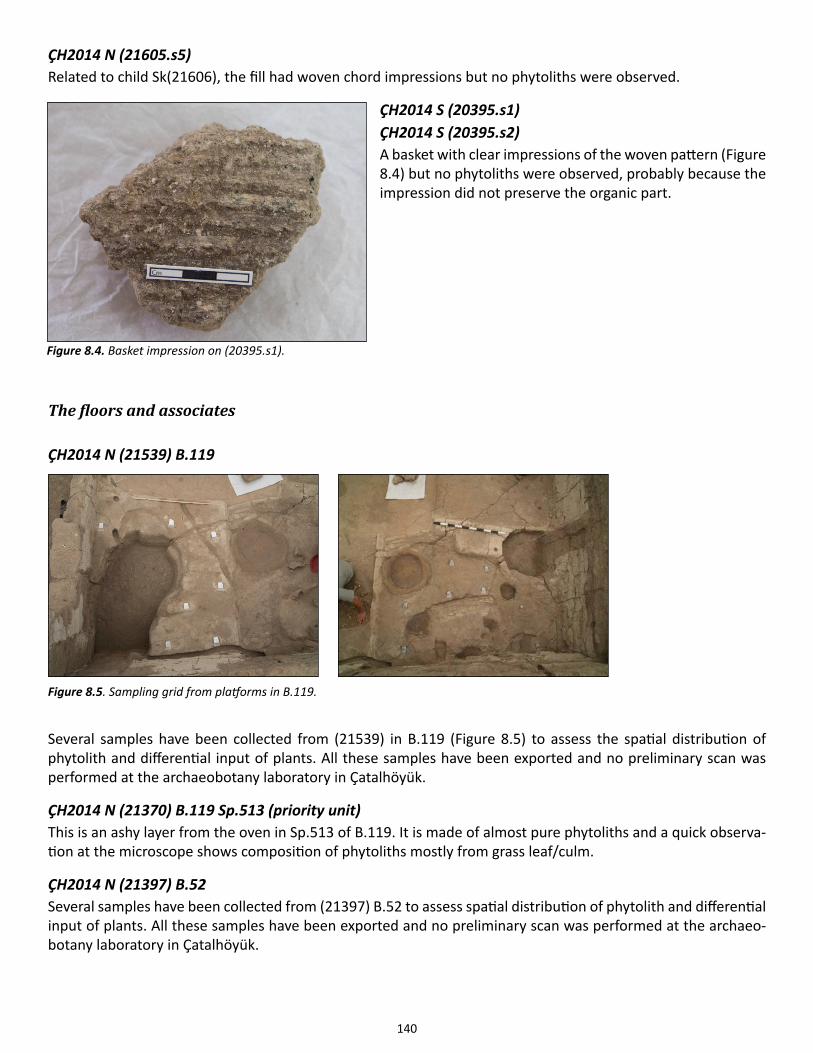
140
ÇH2014 N (21605.s5)Related to child Sk(21606), the fill had woven chord impressions but no phytoliths were observed.
ÇH2014 S (20395.s1)ÇH2014 S (20395.s2)A basket with clear impressions of the woven pattern (Figure 8.4) but no phytoliths were observed, probably because the impression did not preserve the organic part.
The floors and associates ÇH2014 N (21539) B.119
Several samples have been collected from (21539) in B.119 (Figure 8.5) to assess the spatial distribution of phytolith and differential input of plants. All these samples have been exported and no preliminary scan was performed at the archaeobotany laboratory in Çatalhöyük.
ÇH2014 N (21370) B.119 Sp.513 (priority unit)This is an ashy layer from the oven in Sp.513 of B.119. It is made of almost pure phytoliths and a quick observa-tion at the microscope shows composition of phytoliths mostly from grass leaf/culm.
ÇH2014 N (21397) B.52 Several samples have been collected from (21397) B.52 to assess spatial distribution of phytolith and differential input of plants. All these samples have been exported and no preliminary scan was performed at the archaeo-botany laboratory in Çatalhöyük.
Figure 8.4. Basket impression on (20395.s1).
Figure 8.5. Sampling grid from platforms in B.119.
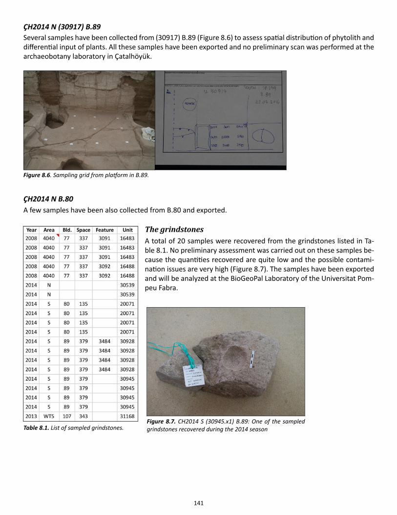
141
ÇH2014 N (30917) B.89 Several samples have been collected from (30917) B.89 (Figure 8.6) to assess spatial distribution of phytolith and differential input of plants. All these samples have been exported and no preliminary scan was performed at the archaeobotany laboratory in Çatalhöyük.
ÇH2014 N B.80 A few samples have been also collected from B.80 and exported.
The grindstonesA total of 20 samples were recovered from the grindstones listed in Ta-ble 8.1. No preliminary assessment was carried out on these samples be-cause the quantities recovered are quite low and the possible contami-nation issues are very high (Figure 8.7). The samples have been exported and will be analyzed at the BioGeoPal Laboratory of the Universitat Pom-peu Fabra.
Figure 8.6. Sampling grid from platform in B.89.
Figure 8.7. CH2014 S (30945.x1) B.89: One of the sampled grindstones recovered during the 2014 seasonTable 8.1. List of sampled grindstones.

142
References
Madella, M., M.K. Jones, P. Echlin, A. Powers-Jones & M. Moore2009. Plant water availability and analytical microscopy of phytoliths: implications for ancient irrigation in arid zones. Quaternary International 193: 32-40.
Piperno, D.2006. Phytoliths: A Comprehensive Guide for Archaeologists and Paleoecologists. Lanham MD: AltaMira Press.

143
Chapter 9
Anthracology
Ceren Kabukcu and Eleni Asouti, Liverpool University
During the 2014 field season anthracological work concentrated on the following objectives:
a. The onsite microscopic identification of wood charcoals from 15 priority units that contained wood charcoal (19837), (20069), (20071), (20075), (21161), (21169), (21170), (21173), (21177), (21350), (22032), (30364), (30936), (30939), (30944) and 17 units that were prioritized for charcoal work (middens, fire spots, fire features and burnt activity areas: (30129), (20467), (20480), (20489), (30622), (18704), (21103), (19213), (30340), (30829), (19861), (30870), (21147), (21354), (21314), (22059), (30625)).
b. The onsite recording, measurement and macro-photography of 19 units (excavated in 2014) representing carbonized timber elements and other in situ carbonized wood remains (30539), (21334), (20082), (21323), (21316), (21320), (21195), (21386), (19572), (19476), (21332), (21376), (21334), (22068), (21614), (21576), (21562), (21592).
c. The onsite recording, measurement and macro-photography (to be continued over the next two seasons) of charred timbers excavated in previous years. During the 2014 field season we concentrated mostly on burnt timbers and other burnt deposits that were associated with structural elements belonging to B.77.
d. The onsite micro-photography (using a digital camera attached to a binocular stereomicroscope) of select charcoal specimens. The purpose of this was to obtain precise measurements of growth ring curvature that will permit us to evaluate the caliber class of the wood logs originally used as timber and/or fuel.
e. The onsite micro-photography (using a digital camera attached to a reflected/darkfield-brightfield/light microscope with polarizer) of select charcoal specimens from B.77 which revealed the presence of red pigments preserved on carbonized wood surfaces (the same fragments were also examined and digitally photographed with a binocular stereomicroscope).
The full results of these detailed measurements and other data categories will be reported in full detailed in forthcoming Çatalhöyük project volumes. The range of the taxa present included oak (Quercus), elm (Ulmus), juniper (Juniperus) and Salicaceae (willow/poplar). Timber and worked wood remains consisted exclusively of these taxa, with the majority of them identified as oak, juniper and elm. The same taxa were also present in fuel wood remains, alongside hackberry (Celtis), ash wood (Fraxinus), almond (Amygdalus), terebinth (Pistacia), tamarisk (Tamarix), wild plums and cherries (Prunus), wild pear/hawthorn (Maloideae), wormwood (Artemisia), chenopods (Chenopodiaceae) and buckthorn (Rhamnus). The latter is a newly discovered taxon, not previously reported from the site, and was present with three charcoal fragments in (30625) (Level South H midden; this sample was also very rich in charred twig fragments).
The most remarkable find of the season came from the analysis of wood charcoals that were hand-col-lected in 2008 from (17519) in B.77 (Sp.336). This unit has been previously described as a “burnt pea concen-tration”. Examination of the charcoal materials during initial sorting revealed the presence of what appeared to be traces of red pigment. Fifty charcoal fragments were counted from this hand-collected sample, in order to assess taxonomic diversity and surface morphology/modification. The assemblage consisted of three taxa: almond (Amygdalus), oak (Quercus) and willow/poplar (Salicaceae). Of these, fragments of Salicaceae were the most pigmented, while oak and almond fragments bore faint or no traces at all (see Figures 9.1-9.3). Observa-tions at high magnifications using a reflected, bright-field, polarized light microscope also revealed that in all cases red pigment traces were overlain by whitish/yellowish and buff orange mineral deposits and other accre-
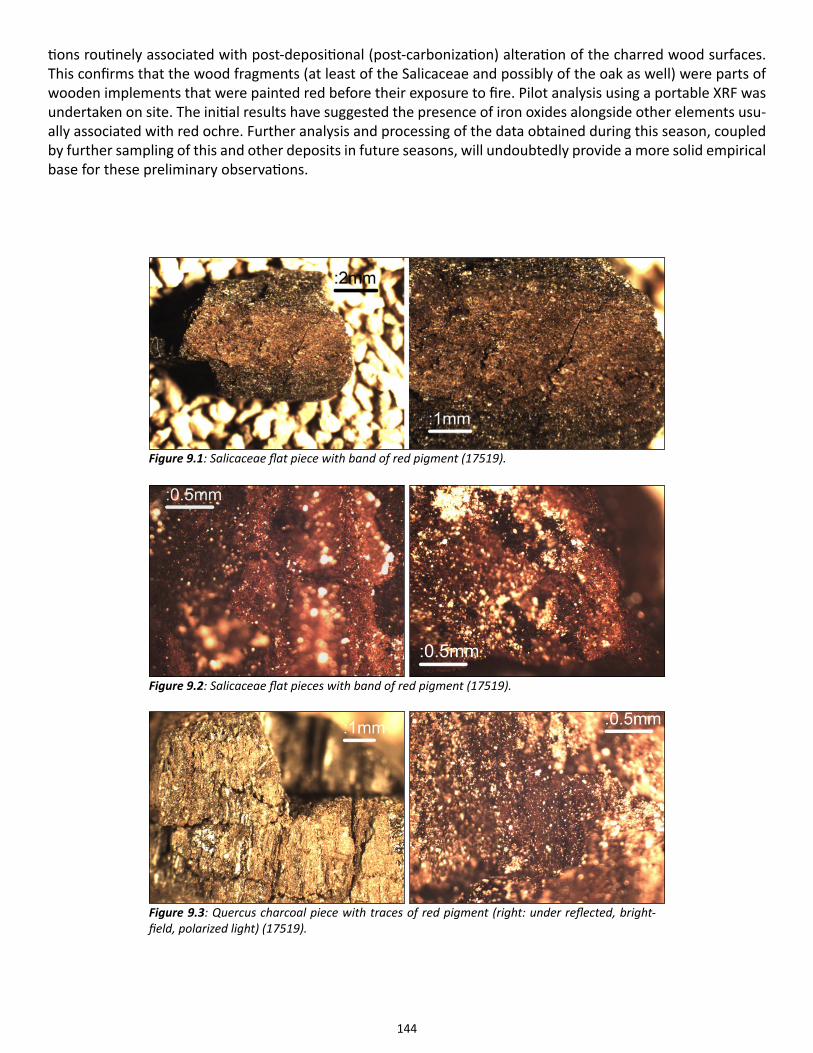
144
tions routinely associated with post-depositional (post-carbonization) alteration of the charred wood surfaces. This confirms that the wood fragments (at least of the Salicaceae and possibly of the oak as well) were parts of wooden implements that were painted red before their exposure to fire. Pilot analysis using a portable XRF was undertaken on site. The initial results have suggested the presence of iron oxides alongside other elements usu-ally associated with red ochre. Further analysis and processing of the data obtained during this season, coupled by further sampling of this and other deposits in future seasons, will undoubtedly provide a more solid empirical base for these preliminary observations.
Figure 9.1: Salicaceae flat piece with band of red pigment (17519).
Figure 9.2: Salicaceae flat pieces with band of red pigment (17519).
Figure 9.3: Quercus charcoal piece with traces of red pigment (right: under reflected, bright-field, polarized light) (17519).
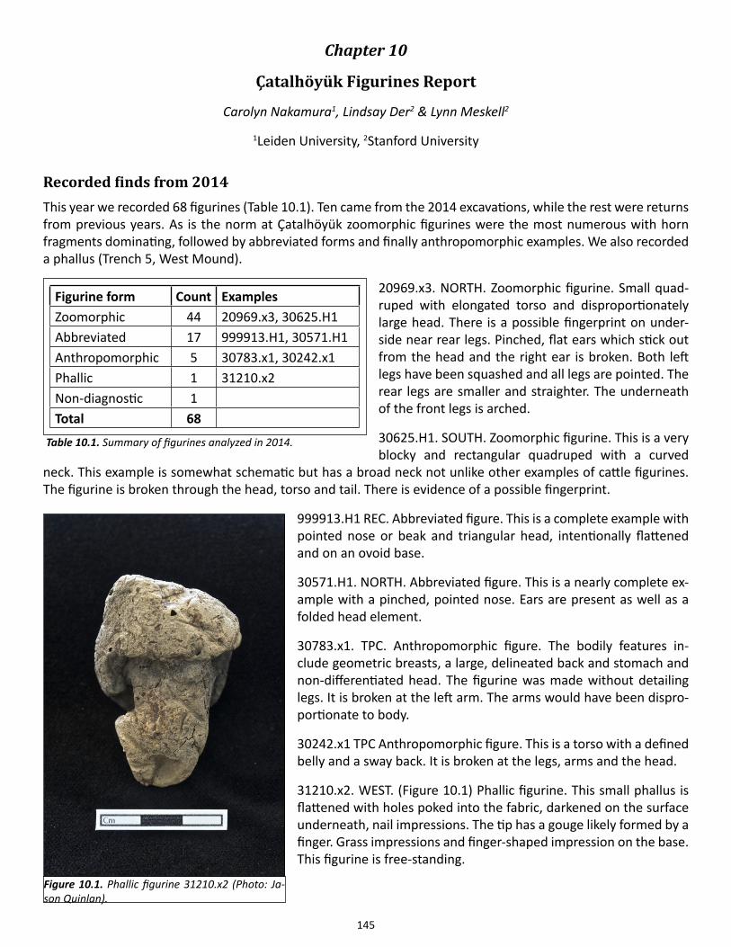
145
Chapter 10
Çatalhöyük Figurines Report
Carolyn Nakamura1, Lindsay Der2 & Lynn Meskell2
1Leiden University, 2Stanford University
Recorded finds from 2014 This year we recorded 68 figurines (Table 10.1). Ten came from the 2014 excavations, while the rest were returns from previous years. As is the norm at Çatalhöyük zoomorphic figurines were the most numerous with horn fragments dominating, followed by abbreviated forms and finally anthropomorphic examples. We also recorded a phallus (Trench 5, West Mound).
20969.x3. NORTH. Zoomorphic figurine. Small quad-ruped with elongated torso and disproportionately large head. There is a possible fingerprint on under-side near rear legs. Pinched, flat ears which stick out from the head and the right ear is broken. Both left legs have been squashed and all legs are pointed. The rear legs are smaller and straighter. The underneath of the front legs is arched.
30625.H1. SOUTH. Zoomorphic figurine. This is a very blocky and rectangular quadruped with a curved
neck. This example is somewhat schematic but has a broad neck not unlike other examples of cattle figurines. The figurine is broken through the head, torso and tail. There is evidence of a possible fingerprint.
999913.H1 REC. Abbreviated figure. This is a complete example with pointed nose or beak and triangular head, intentionally flattened and on an ovoid base.
30571.H1. NORTH. Abbreviated figure. This is a nearly complete ex-ample with a pinched, pointed nose. Ears are present as well as a folded head element.
30783.x1. TPC. Anthropomorphic figure. The bodily features in-clude geometric breasts, a large, delineated back and stomach and non-differentiated head. The figurine was made without detailing legs. It is broken at the left arm. The arms would have been dispro-portionate to body.
30242.x1 TPC Anthropomorphic figure. This is a torso with a defined belly and a sway back. It is broken at the legs, arms and the head.
31210.x2. WEST. (Figure 10.1) Phallic figurine. This small phallus is flattened with holes poked into the fabric, darkened on the surface underneath, nail impressions. The tip has a gouge likely formed by a finger. Grass impressions and finger-shaped impression on the base. This figurine is free-standing.
Figurine form Count ExamplesZoomorphic 44 20969.x3, 30625.H1Abbreviated 17 999913.H1, 30571.H1Anthropomorphic 5 30783.x1, 30242.x1Phallic 1 31210.x2Non-diagnostic 1Total 68
Table 10.1. Summary of figurines analyzed in 2014.
Figure 10.1. Phallic figurine 31210.x2 (Photo: Ja-son Quinlan).

146
Ongoing research
Human-animal relations (Der)In addition to working with the figurines team to record figurines from the 2014 excavations, as well as those ex-cavated but not yet recorded from previous years, Lind-say Der continued work on her dissertation project. Aside from data cleaning densities for relevant units in the exca-vation database, Der began exploratory data analysis on the changing relationship between people and animals during the Neolithic at Çatalhöyük. As much of the house elaboration at the site centers on wild animals, her analy-ses utilize both quantitative and qualitative datasets inclu-sive of the faunal remains, plastered faunal installations, zoomorphic figurines, stamp seals, wall paintings, and plastered reliefs.
Der has identified forty houses with faunal remains from the North (including the former 4040 Area), South, BACH, TP, and TPC Areas of the Neolithic East Mound. She then grouped the houses into three time periods which roughly mark before (Group 1), during (Group 2), and after the introduction of domesticated cattle to the site (Group 3) (Table 10.1). Twenty-seven of these houses were exca-vated between 2003 and 2013 and thus have total volume deposits recorded as well as units digitized in GIS. Data analysis this season focused on B.1, B.3, B.49, B.52, B.59, B.77, and B.82, all of which are houses from Level North G and which belong to Group 2. Given that there appears to be a pre-occupation with horns, both in the zoomorphic figurines and in the faunal remains and plastered faunal installations, such as bucrania, she focused on identifying any potential relationship between the real and the figur-al.
Building Area Level Group FaunaZoomorphic
figurines
5 North North F 1 X X
118 South South H 1 X X
18 South South J 1 X X
23 South South J 1 X X
2 South South K 1 X X
17 South South K 1 X X
6 South South L 1 X X
43 South South L 1 X X
8 South South M 1 X X
24 South South M 1 X
40 South South M 1 X X
104 South South M 1 X
3 BACH BACH G 2 X X
1 North North G 2 X X
49 North North G 2 X X
52 North North G 2 X X
59 North North G 2 X X
82 North North G 2 X
77 North North G 2 X X
76 South South O 2 X X
76 South South O 2 X X
79 South South O 2 X X
80 South South O 2 X X
87 South South O 2 X X
96 South South O 2 X X
97 South South O 2 X X
55 North North H 3 X
57 North North H 3 X X
58 North North H 3 X X
47 North North J 3 X X
75 South South P 3 X X
370 South South P 3 X X
53 South South Q 3 X X
65 South South Q 3 X X
68 South South Q 3 X X
42 South South R 3 X X
56 South South R 3 X X
74 TP TP N 3 X X
95 TP TP O 3 X X
73 TP TP P 3 X X
95 TP TP P 3 X X
122 TPCTPC
Unstratified Neolithic
3 X
Table 10.1. House groupings based on the introduction of domesticated cattle at Çatalhöyük (Group 1 = Levels North F, South G through M; Group 2 = Levels North G, BACH G, South O; Group 3 = Levels North H through J, South P through T, TP, TPC).
147
Revisiting the human figurines (Nakamura & Meskell)Over the past ten years, we have become more familiar with various figurine conventions and have been able to provide some finer-grained analyses of certain subgroups. As the corpus expanded, Martin & Meskell (2012) noted that figurine makers depicted not simply generic zoomorphs/quadrupeds, but specific species; we also noted that abbreviated figurines constitute a spectrum that can range from more animal-like figures to more human-like figures, showing details such as facial features, the suggestion of limbs and decoration (Nakamura & Meskell 2006: 229). Likewise, much of the human figurine corpus, while remaining fairly diverse and idiosyncrat-ic, also clusters into some common types or bodily tropes. This season we began a new project of body mapping, developing terminology for certain postures and arrangements with the human remains team (Chris Knüsel and Scott Haddow).
Previously, we used body mapping to explore the non/represented sexual and sexualized traits of human figurines (Nakamura & Meskell 2009). This kind of analysis is useful as it takes seriously various bodily configu-rations such as posture, the presence or absence of certain traits, as well as their attenuation or exaggeration as materializations of the human body that distill, emphasize, and forge a specific set of choices and preoccu-pations; such mapping allows the investigation of various perceptions of the human body and its features as particular sites of social attention and production (Nakamura & Meskell 2009: 206). Our new mapping project extends this kind of analysis to all depicted sub-cranial bodily features and postures. We developed a terminol-ogy to describe the features commonly depicted:
In the future, some of our work will focus on a quantitative analysis of various correlations and non-correla-tions between various traits to see if certain body types emerge and also possibly include an analysis of facial traits. Some preliminary observations, however, reveal a few possible lines of further investigation. First, there is a range of depicting what we have previously called bodily excess and abundance (Nakamura & Meskell 2009). These anthropomorphic figures range from simple three-dimensional outlines (Figure 10.2a) to more detailed but ambiguously sexed bodies (Figure 10.2b) to well-delineated robust female bodies (Figure 10.2c). Also, most figurines with dowel holds in the neck region (n=13) appear to be seated or have a trunk/lower limbs suggested by a thick base rather than delineated legs. Fourteen of the twenty heads we have recorded appear to be human and show a range of details, many with ears, facial features and different hair-styles or head garments (Figure 10.3). Although all twenty heads (or fragments with heads) have been categorized as ‘anthropomorphic’, the remaining heads have a more animal like appearance. Some appear to have broad blunt snout-like noses with wide cheeks and high ears (e.g., 5021.D1, 5043.x1, 19385.x3), while others appear to have narrow faces, very large protruding beak-like noses, and intriguingly, dowel holes (e.g., 4121.H6, 12501.H1).
A few people have noted that certain figurines classified as anthropomorphic, in fact appear more ani-mal-like give the character and positioning of certain features (mostly cranial, but some sub-cranial). This input has led us to more specifically define attributes that we take to define definitively human bodies; these include: a bipedal posture, and the presence, depiction and placement of gross anatomical features (breasts, stomachs, buttocks, navels, ears, eyes, fingers, etc.) that evoke specifically human bodies.
headless (intentional) head/neck stub elongated neck shoulder/upper limb stubs upper limbs upper limbless flexed upper limbs upper limbs extended outward upper limbs extended along side lower limbs undifferentiated lower limbs lower limb stubs
lower limbs extended lower limbs flexed at knee and hip lower limbs flexed, crossed feet hands fingers stomach navel buttocks breasts reclined
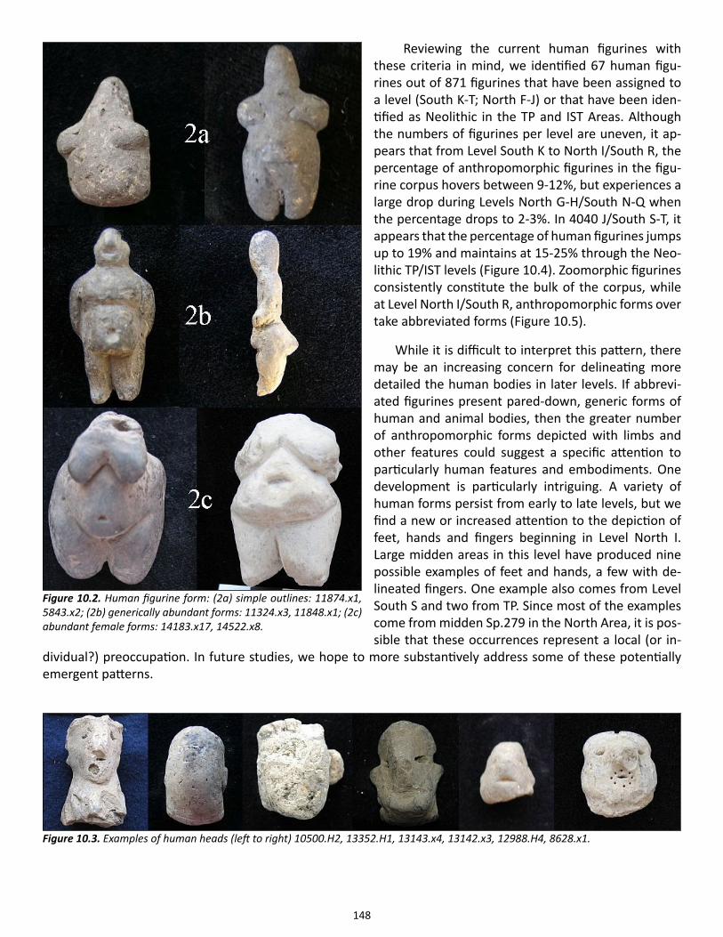
148
Reviewing the current human figurines with these criteria in mind, we identified 67 human figu-rines out of 871 figurines that have been assigned to a level (South K-T; North F-J) or that have been iden-tified as Neolithic in the TP and IST Areas. Although the numbers of figurines per level are uneven, it ap-pears that from Level South K to North I/South R, the percentage of anthropomorphic figurines in the figu-rine corpus hovers between 9-12%, but experiences a large drop during Levels North G-H/South N-Q when the percentage drops to 2-3%. In 4040 J/South S-T, it appears that the percentage of human figurines jumps up to 19% and maintains at 15-25% through the Neo-lithic TP/IST levels (Figure 10.4). Zoomorphic figurines consistently constitute the bulk of the corpus, while at Level North I/South R, anthropomorphic forms over take abbreviated forms (Figure 10.5).
While it is difficult to interpret this pattern, there may be an increasing concern for delineating more detailed the human bodies in later levels. If abbrevi-ated figurines present pared-down, generic forms of human and animal bodies, then the greater number of anthropomorphic forms depicted with limbs and other features could suggest a specific attention to particularly human features and embodiments. One development is particularly intriguing. A variety of human forms persist from early to late levels, but we find a new or increased attention to the depiction of feet, hands and fingers beginning in Level North I. Large midden areas in this level have produced nine possible examples of feet and hands, a few with de-lineated fingers. One example also comes from Level South S and two from TP. Since most of the examples come from midden Sp.279 in the North Area, it is pos-sible that these occurrences represent a local (or in-
dividual?) preoccupation. In future studies, we hope to more substantively address some of these potentially emergent patterns.
Figure 10.3. Examples of human heads (left to right) 10500.H2, 13352.H1, 13143.x4, 13142.x3, 12988.H4, 8628.x1.
Figure 10.2. Human figurine form: (2a) simple outlines: 11874.x1, 5843.x2; (2b) generically abundant forms: 11324.x3, 11848.x1; (2c) abundant female forms: 14183.x17, 14522.x8.
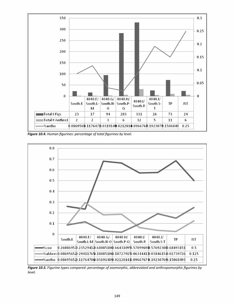
149
Figure 10.4. Human figurines: percentage of total figurines by level.
Figure 10.5. Figurine types compared: percentage of zoomorphic, abbreviated and anthropomorphic figurines by level.
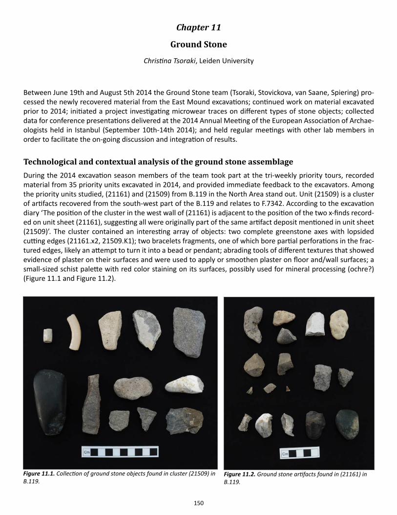
150
Chapter 11
Ground Stone
Christina Tsoraki, Leiden University
Between June 19th and August 5th 2014 the Ground Stone team (Tsoraki, Stovickova, van Saane, Spiering) pro-cessed the newly recovered material from the East Mound excavations; continued work on material excavated prior to 2014; initiated a project investigating microwear traces on different types of stone objects; collected data for conference presentations delivered at the 2014 Annual Meeting of the European Association of Archae-ologists held in Istanbul (September 10th-14th 2014); and held regular meetings with other lab members in order to facilitate the on-going discussion and integration of results.
Technological and contextual analysis of the ground stone assemblageDuring the 2014 excavation season members of the team took part at the tri-weekly priority tours, recorded material from 35 priority units excavated in 2014, and provided immediate feedback to the excavators. Among the priority units studied, (21161) and (21509) from B.119 in the North Area stand out. Unit (21509) is a cluster of artifacts recovered from the south-west part of the B.119 and relates to F.7342. According to the excavation diary ‘The position of the cluster in the west wall of (21161) is adjacent to the position of the two x-finds record-ed on unit sheet (21161), suggesting all were originally part of the same artifact deposit mentioned in unit sheet (21509)’. The cluster contained an interesting array of objects: two complete greenstone axes with lopsided cutting edges (21161.x2, 21509.K1); two bracelets fragments, one of which bore partial perforations in the frac-tured edges, likely an attempt to turn it into a bead or pendant; abrading tools of different textures that showed evidence of plaster on their surfaces and were used to apply or smoothen plaster on floor and/wall surfaces; a small-sized schist palette with red color staining on its surfaces, possibly used for mineral processing (ochre?) (Figure 11.1 and Figure 11.2).
Figure 11.1. Collection of ground stone objects found in cluster (21509) in B.119.
Figure 11.2. Ground stone artifacts found in (21161) in B.119.
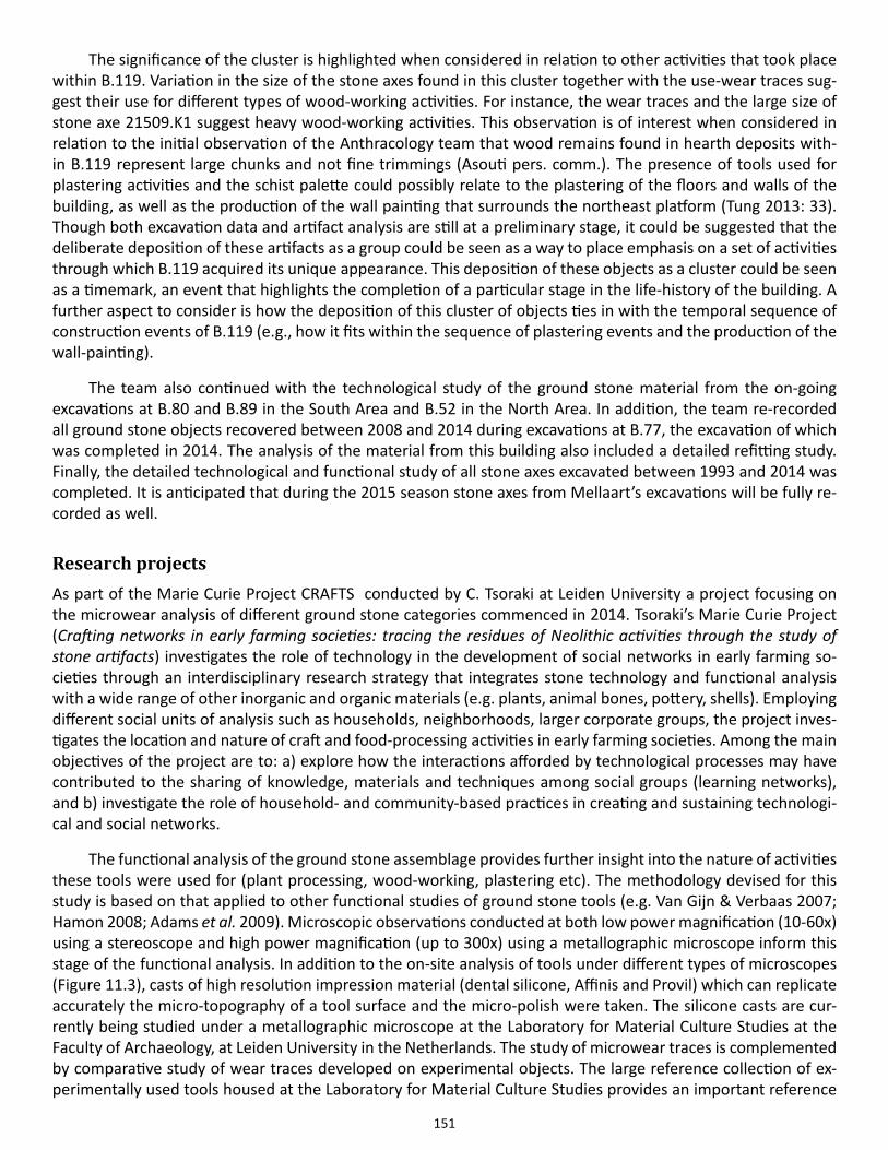
151
The significance of the cluster is highlighted when considered in relation to other activities that took place within B.119. Variation in the size of the stone axes found in this cluster together with the use-wear traces sug-gest their use for different types of wood-working activities. For instance, the wear traces and the large size of stone axe 21509.K1 suggest heavy wood-working activities. This observation is of interest when considered in relation to the initial observation of the Anthracology team that wood remains found in hearth deposits with-in B.119 represent large chunks and not fine trimmings (Asouti pers. comm.). The presence of tools used for plastering activities and the schist palette could possibly relate to the plastering of the floors and walls of the building, as well as the production of the wall painting that surrounds the northeast platform (Tung 2013: 33). Though both excavation data and artifact analysis are still at a preliminary stage, it could be suggested that the deliberate deposition of these artifacts as a group could be seen as a way to place emphasis on a set of activities through which B.119 acquired its unique appearance. This deposition of these objects as a cluster could be seen as a timemark, an event that highlights the completion of a particular stage in the life-history of the building. A further aspect to consider is how the deposition of this cluster of objects ties in with the temporal sequence of construction events of B.119 (e.g., how it fits within the sequence of plastering events and the production of the wall-painting).
The team also continued with the technological study of the ground stone material from the on-going excavations at B.80 and B.89 in the South Area and B.52 in the North Area. In addition, the team re-recorded all ground stone objects recovered between 2008 and 2014 during excavations at B.77, the excavation of which was completed in 2014. The analysis of the material from this building also included a detailed refitting study. Finally, the detailed technological and functional study of all stone axes excavated between 1993 and 2014 was completed. It is anticipated that during the 2015 season stone axes from Mellaart’s excavations will be fully re-corded as well.
Research projects As part of the Marie Curie Project CRAFTS conducted by C. Tsoraki at Leiden University a project focusing on the microwear analysis of different ground stone categories commenced in 2014. Tsoraki’s Marie Curie Project (Crafting networks in early farming societies: tracing the residues of Neolithic activities through the study of stone artifacts) investigates the role of technology in the development of social networks in early farming so-cieties through an interdisciplinary research strategy that integrates stone technology and functional analysis with a wide range of other inorganic and organic materials (e.g. plants, animal bones, pottery, shells). Employing different social units of analysis such as households, neighborhoods, larger corporate groups, the project inves-tigates the location and nature of craft and food-processing activities in early farming societies. Among the main objectives of the project are to: a) explore how the interactions afforded by technological processes may have contributed to the sharing of knowledge, materials and techniques among social groups (learning networks), and b) investigate the role of household- and community-based practices in creating and sustaining technologi-cal and social networks.
The functional analysis of the ground stone assemblage provides further insight into the nature of activities these tools were used for (plant processing, wood-working, plastering etc). The methodology devised for this study is based on that applied to other functional studies of ground stone tools (e.g. Van Gijn & Verbaas 2007; Hamon 2008; Adams et al. 2009). Microscopic observations conducted at both low power magnification (10-60x) using a stereoscope and high power magnification (up to 300x) using a metallographic microscope inform this stage of the functional analysis. In addition to the on-site analysis of tools under different types of microscopes (Figure 11.3), casts of high resolution impression material (dental silicone, Affinis and Provil) which can replicate accurately the micro-topography of a tool surface and the micro-polish were taken. The silicone casts are cur-rently being studied under a metallographic microscope at the Laboratory for Material Culture Studies at the Faculty of Archaeology, at Leiden University in the Netherlands. The study of microwear traces is complemented by comparative study of wear traces developed on experimental objects. The large reference collection of ex-perimentally used tools housed at the Laboratory for Material Culture Studies provides an important reference
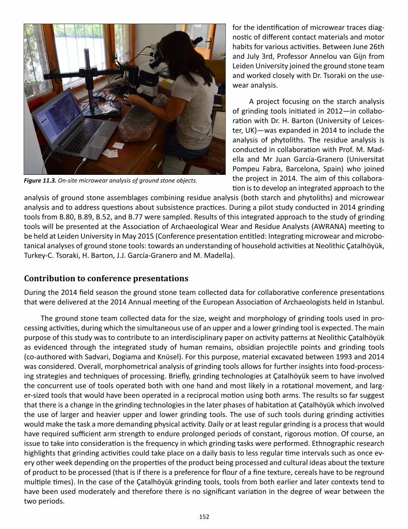
152
for the identification of microwear traces diag-nostic of different contact materials and motor habits for various activities. Between June 26th and July 3rd, Professor Annelou van Gijn from Leiden University joined the ground stone team and worked closely with Dr. Tsoraki on the use-wear analysis.
A project focusing on the starch analysis of grinding tools initiated in 2012—in collabo-ration with Dr. H. Barton (University of Leices-ter, UK)—was expanded in 2014 to include the analysis of phytoliths. The residue analysis is conducted in collaboration with Prof. M. Mad-ella and Mr Juan García-Granero (Universitat Pompeu Fabra, Barcelona, Spain) who joined the project in 2014. The aim of this collabora-tion is to develop an integrated approach to the
analysis of ground stone assemblages combining residue analysis (both starch and phytoliths) and microwear analysis and to address questions about subsistence practices. During a pilot study conducted in 2014 grinding tools from B.80, B.89, B.52, and B.77 were sampled. Results of this integrated approach to the study of grinding tools will be presented at the Association of Archaeological Wear and Residue Analysts (AWRANA) meeting to be held at Leiden University in May 2015 (Conference presentation entitled: Integrating microwear and microbo-tanical analyses of ground stone tools: towards an understanding of household activities at Neolithic Çatalhöyük, Turkey-C. Tsoraki, H. Barton, J.J. García-Granero and M. Madella).
Contribution to conference presentationsDuring the 2014 field season the ground stone team collected data for collaborative conference presentations that were delivered at the 2014 Annual meeting of the European Association of Archaeologists held in Istanbul.
The ground stone team collected data for the size, weight and morphology of grinding tools used in pro-cessing activities, during which the simultaneous use of an upper and a lower grinding tool is expected. The main purpose of this study was to contribute to an interdisciplinary paper on activity patterns at Neolithic Çatalhöyük as evidenced through the integrated study of human remains, obsidian projectile points and grinding tools (co-authored with Sadvari, Dogiama and Knüsel). For this purpose, material excavated between 1993 and 2014 was considered. Overall, morphometrical analysis of grinding tools allows for further insights into food-process-ing strategies and techniques of processing. Briefly, grinding technologies at Çatalhöyük seem to have involved the concurrent use of tools operated both with one hand and most likely in a rotational movement, and larg-er-sized tools that would have been operated in a reciprocal motion using both arms. The results so far suggest that there is a change in the grinding technologies in the later phases of habitation at Çatalhöyük which involved the use of larger and heavier upper and lower grinding tools. The use of such tools during grinding activities would make the task a more demanding physical activity. Daily or at least regular grinding is a process that would have required sufficient arm strength to endure prolonged periods of constant, rigorous motion. Of course, an issue to take into consideration is the frequency in which grinding tasks were performed. Ethnographic research highlights that grinding activities could take place on a daily basis to less regular time intervals such as once ev-ery other week depending on the properties of the product being processed and cultural ideas about the texture of product to be processed (that is if there is a preference for flour of a fine texture, cereals have to be reground multiple times). In the case of the Çatalhöyük grinding tools, tools from both earlier and later contexts tend to have been used moderately and therefore there is no significant variation in the degree of wear between the two periods.
Figure 11.3. On-site microwear analysis of ground stone objects.
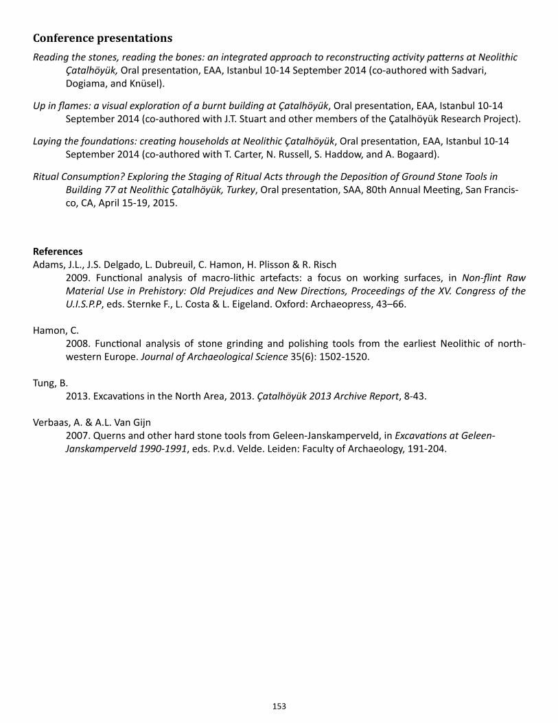
153
Conference presentationsReading the stones, reading the bones: an integrated approach to reconstructing activity patterns at Neolithic Çatalhöyük, Oral presentation, EAA, Istanbul 10-14 September 2014 (co-authored with Sadvari, Dogiama, and Knüsel).
Up in flames: a visual exploration of a burnt building at Çatalhöyük, Oral presentation, EAA, Istanbul 10-14 September 2014 (co-authored with J.T. Stuart and other members of the Çatalhöyük Research Project).
Laying the foundations: creating households at Neolithic Çatalhöyük, Oral presentation, EAA, Istanbul 10-14 September 2014 (co-authored with T. Carter, N. Russell, S. Haddow, and A. Bogaard).
Ritual Consumption? Exploring the Staging of Ritual Acts through the Deposition of Ground Stone Tools in Building 77 at Neolithic Çatalhöyük, Turkey, Oral presentation, SAA, 80th Annual Meeting, San Francis- co, CA, April 15-19, 2015.
References Adams, J.L., J.S. Delgado, L. Dubreuil, C. Hamon, H. Plisson & R. Risch 2009. Functional analysis of macro-lithic artefacts: a focus on working surfaces, in Non-flint Raw Material Use in Prehistory: Old Prejudices and New Directions, Proceedings of the XV. Congress of the U.I.S.P.P, eds. Sternke F., L. Costa & L. Eigeland. Oxford: Archaeopress, 43–66.
Hamon, C. 2008. Functional analysis of stone grinding and polishing tools from the earliest Neolithic of north- western Europe. Journal of Archaeological Science 35(6): 1502-1520.
Tung, B. 2013. Excavations in the North Area, 2013. Çatalhöyük 2013 Archive Report, 8-43.
Verbaas, A. & A.L. Van Gijn 2007. Querns and other hard stone tools from Geleen-Janskamperveld, in Excavations at Geleen- Janskamperveld 1990-1991, eds. P.v.d. Velde. Leiden: Faculty of Archaeology, 191-204.
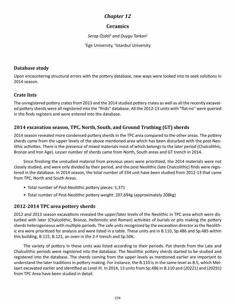
154
Chapter 12
Ceramics
Serap Özdöl1 and Duygu Tarkan2
1Ege University, 2Istanbul University
Database studyUpon encountering structural errors with the pottery database, new ways were looked into to seek solutions in 2014 season.
Crate listsThe unregistered pottery crates from 2013 and the 2014 studied pottery crates as well as all the recently excavat-ed pottery sherds were all registered into the “finds” database. All the 2012-13 units with “flat-no” were queried in the finds registers and were entered into the database.
2014 excavation season, TPC, North, South, and Ground Truthing (GT) sherds2014 season revealed more condensed pottery sherds in the TPC area compared to the other areas. The pottery sherds came from the upper levels of the above mentioned area which has been disturbed with the post-Neo-lithic activities. There is the presence of mixed materials most of which belongs to the later period (Chalcolithic, Bronze and Iron Age). Lesser number of sherds came from North, South areas and GT trench in 2014.
Since finishing the unstudied material from previous years were prioritized, the 2014 materials were not closely studied, and were only divided by their period, and the post Neolithic (late Chalcolithic) finds were regis-tered in the database. In 2014 season, the total number of 334 unit have been studied from 2012-13 that came from TPC, North and South Areas.
• Total number of Post-Neolithic pottery pieces: 5,371
• Total number of Post-Neolithic pottery weight: 207,694g (approximately 208kg)
2012-2014 TPC area pottery sherds2012 and 2013 season excavations revealed the upper/later levels of the Neolithic in TPC area which were dis-turbed with later (Chalcolithic, Bronze, Hellenistic and Roman) activities of burials or pits making the pottery sherds heterogeneous with multiple periods. The safe units recognized by the excavation director as the Neolith-ic era were prioritized for analysis and were listed in a table. These units are in B.110, Sp.486 and Sp.485 within this building, B.115, B.121, an oven in the 2-F trench and Sp.506.
The variety of pottery in these units was listed according to their periods. Pot sherds from the Late and Chalcolithic periods were registered into the database. The Neolithic pottery sherds started to be studied and registered into the database. The sherds coming from the upper levels as mentioned earlier are important to understand the later traditions in pottery making. For instance, the B.110 is in the same level as B.5, which Mel-laart excavated earlier and identified as Level III. In 2014, 13 units from Sp.486 in B.110 and (20221) and (20291) from TPC Area have been studied in detail.
155
North and South Area pottery 2012-2014The same TPC method was employed to study the unsorted and unstudied pottery sherds from North and South by separating them into late and Chalcolithic categories. After the division the relatively small number of Neolithic sherds were studied and registered. The study of some of the material was postponed to 2015 as the season was short and hectic with other season programs such as the conference that took place at the site and the time allocated to help Rosemary A. Joyce and Russel N. Sheptak’s research in the pottery lab.
The excavation of the buildings starting in 2013 revealed architectural features which are important to un-derstand the levels in the settlement. These are B.119 and B.112. Unit (20988) from Sp.511 in relation with B.112 unearthed small number of pottery sherds with a certain characteristics of production technology, raw material and typology that situates the building in Mellaart’s Level VIII and Hodder’s Level 4040 F.
The upper units in B.119 revealed small number of pottery sherds of middle-late Neolithic and Chalcolith-ic in a mixed context. The units below revealed only middle-late Neolithic sherds identifying this phase of the building as Neolithic. However, the finds were not distinct while remaining in small numbers and small pieces disabling to pass a clear judgment on the dating of the building. Some of the unique pottery samples from units in the North Area:
(20481): LidThe lid coming from the fill of B.102 is the only almost intact lid (Figure 12.1). Apart from this, two lid fragments were found in the North Area ((12652) and (13159)) in 2006 and, in 2008, one was recovered from TP (17608). The common features of all these lids were the facts that, first of all, these lids were of similar sizes and secondly, that they belong to the same group of red paste material.
(20971): Animal lug
Figure 12.1. Lid from Building 102.
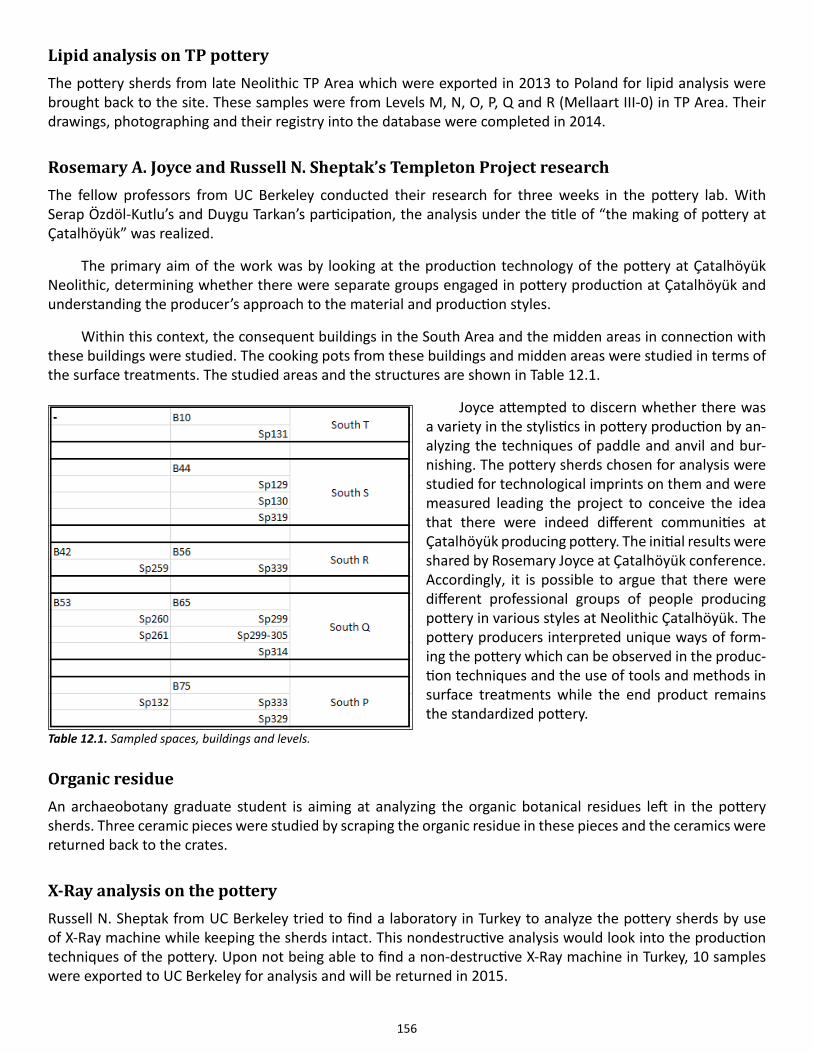
156
Lipid analysis on TP potteryThe pottery sherds from late Neolithic TP Area which were exported in 2013 to Poland for lipid analysis were brought back to the site. These samples were from Levels M, N, O, P, Q and R (Mellaart III-0) in TP Area. Their drawings, photographing and their registry into the database were completed in 2014.
Rosemary A. Joyce and Russell N. Sheptak’s Templeton Project researchThe fellow professors from UC Berkeley conducted their research for three weeks in the pottery lab. With Serap Özdöl-Kutlu’s and Duygu Tarkan’s participation, the analysis under the title of “the making of pottery at Çatalhöyük” was realized.
The primary aim of the work was by looking at the production technology of the pottery at Çatalhöyük Neolithic, determining whether there were separate groups engaged in pottery production at Çatalhöyük and understanding the producer’s approach to the material and production styles.
Within this context, the consequent buildings in the South Area and the midden areas in connection with these buildings were studied. The cooking pots from these buildings and midden areas were studied in terms of the surface treatments. The studied areas and the structures are shown in Table 12.1.
Joyce attempted to discern whether there was a variety in the stylistics in pottery production by an-alyzing the techniques of paddle and anvil and bur-nishing. The pottery sherds chosen for analysis were studied for technological imprints on them and were measured leading the project to conceive the idea that there were indeed different communities at Çatalhöyük producing pottery. The initial results were shared by Rosemary Joyce at Çatalhöyük conference. Accordingly, it is possible to argue that there were different professional groups of people producing pottery in various styles at Neolithic Çatalhöyük. The pottery producers interpreted unique ways of form-ing the pottery which can be observed in the produc-tion techniques and the use of tools and methods in surface treatments while the end product remains the standardized pottery.
Organic residueAn archaeobotany graduate student is aiming at analyzing the organic botanical residues left in the pottery sherds. Three ceramic pieces were studied by scraping the organic residue in these pieces and the ceramics were returned back to the crates.
X-Ray analysis on the potteryRussell N. Sheptak from UC Berkeley tried to find a laboratory in Turkey to analyze the pottery sherds by use of X-Ray machine while keeping the sherds intact. This nondestructive analysis would look into the production techniques of the pottery. Upon not being able to find a non-destructive X-Ray machine in Turkey, 10 samples were exported to UC Berkeley for analysis and will be returned in 2015.
Table 12.1. Sampled spaces, buildings and levels.

157
Shaped pot sherdsA group of shaped Neolithic pottery sherds were were categorized separately and put aside to be studied later.
158
Support Teams
Chapter 13
Finds
Lisa Guerre, URS Corporation
Archaeological projects, like museums, must guarantee proper management, preservation and use of collections and facilitate research through a clear knowledge of project holdings. To ensure access to the abundance of material, and to support the various research initiatives of onsite specialists, rigorous collections management is key. This is the primary responsibility of the Çatalhöyük Finds Lab. The Finds Lab functions as a nodal point in the processing of all material recovered during excavation and their distribution to relevant onsite specialists; additional responsibilities include maintenance of the artifact stores, and management of the digital inventory.
The 2014 season saw a decrease in the volume of new finds recovered during excavation. This can be at-tributed to the nature of the deposits excavated as well as the closing of West Mound excavations in 2013. This decrease in newly excavated material freed up time for Finds Lab staff (Finds Officer, Lisa Guerre; Finds Assistant, Kyle Lee-Crossett) to focus on the comprehensive crate inventory first begun in 2005, notably the completion of the pottery inventory, as well as continue with data cleaning of past inventories. As always, the Finds Lab staff also provided support and database assistance to the various labs and their individual research initiatives as needed.
In 2012 a new Finds Policy was introduced to tighten tracking mechanisms and stress the accountability of all project staff; the 2014 season saw the continued implementation of this policy. The Finds Policy has success-fully increased emphasis on accessibility and sustainability with a focus on physical access to project materials; project members have become more intimately aware of the importance of the timely and accurate tracking of inventory changes, and their accountability in the successful management of the Çatalhöyük Research Project artifact assemblage. The policy is in no way static and the Finds Officer is in steady coordination with Lab Heads and Database Administrators amending permissions and protocol to meet the individual needs of each lab while maintaining the necessary checks and balances.
Overall the 2014 season of The Çatalhöyük Research project proved to be positive and productive. The Finds Lab Staff, along with the individual labs and specialists, continue to strive to improve project collection management systems and efficiently and accurately contribute to the building of diverse datasets for current and future research while providing proper stewardship for all material housed on site.
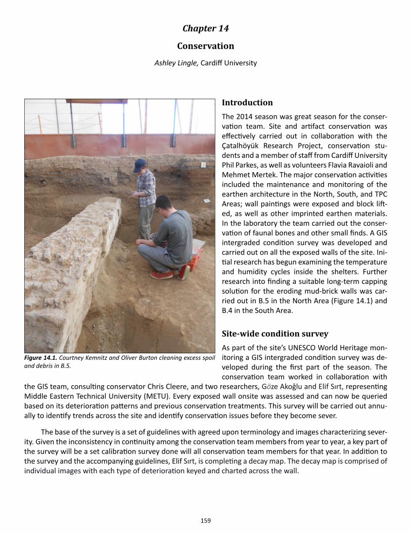
159
Chapter 14
Conservation
Ashley Lingle, Cardiff University
IntroductionThe 2014 season was great season for the conser-vation team. Site and artifact conservation was effectively carried out in collaboration with the Çatalhöyük Research Project, conservation stu-dents and a member of staff from Cardiff University Phil Parkes, as well as volunteers Flavia Ravaioli and Mehmet Mertek. The major conservation activities included the maintenance and monitoring of the earthen architecture in the North, South, and TPC Areas; wall paintings were exposed and block lift-ed, as well as other imprinted earthen materials. In the laboratory the team carried out the conser-vation of faunal bones and other small finds. A GIS intergraded condition survey was developed and carried out on all the exposed walls of the site. Ini-tial research has begun examining the temperature and humidity cycles inside the shelters. Further research into finding a suitable long-term capping solution for the eroding mud-brick walls was car-ried out in B.5 in the North Area (Figure 14.1) and B.4 in the South Area.
Site-wide condition survey As part of the site’s UNESCO World Heritage mon-itoring a GIS intergraded condition survey was de-veloped during the first part of the season. The conservation team worked in collaboration with
the GIS team, consulting conservator Chris Cleere, and two researchers, Göze Akoǧlu and Elif Sırt, representing Middle Eastern Technical University (METU). Every exposed wall onsite was assessed and can now be queried based on its deterioration patterns and previous conservation treatments. This survey will be carried out annu-ally to identify trends across the site and identify conservation issues before they become sever.
The base of the survey is a set of guidelines with agreed upon terminology and images characterizing sever-ity. Given the inconsistency in continuity among the conservation team members from year to year, a key part of the survey will be a set calibration survey done will all conservation team members for that year. In addition to the survey and the accompanying guidelines, Elif Sırt, is completing a decay map. The decay map is comprised of individual images with each type of deterioration keyed and charted across the wall.
Figure 14.1. Courtney Kemnitz and Oliver Burton cleaning excess spoil and debris in B.5.
160
Environmental monitoring Building our understanding of the agents of deterioration onsite continued further this year with the initial stag-es of an environmental monitoring program. Three TinyTag™ temperature and relative humidity monitors were purchased at the beginning of the season. Given the limited number of monitors the conservation team set up a small number of experiments at the start of the season to maximize data over the summer. Phil Parkes took the lead on the project. Focus for this year was mainly on the North Shelter, due to the expedited agents of deterio-ration and perceived oppressive working conditions. In summary Phil’s findings were:
“The direction of the sun plays an important part in the conditions within the shelters, in particular in the North shelter. The East side of the shelter warms up more quickly due to the morning sun and dries out more rapidly, staying at these higher temperatures for longer. Consequently this means that there is both a temperature and a relative humidity gradient across the shelter which may be more pronounced when the shelter is closed due to reduced air movement.” (Parkes 2014)
There are plans to expand the environmental monitoring program in the 2015 season.
Conservation and maintenance of the North ShelterAfter the number of changes made to the conservation program at Çatalhöyük in the 2013, an assessment was carried out across the site to gauge what was successful and what was not. The new gap fills; perlite (amorphous volcanic glass) and Paraloid B-48N (acrylic resin) in acetone, appeared to weather well. The perlite program was continued in the 2014 season. The modifications made to the shelter had also seasoned well, and for the first time in several years the area surrounding B.5 to the west was relatively dry, due to the extended flap built around the exterior of the shelter (see 2013 Archive Report).
Conservation and maintenance was undertaken in buildings both with ongoing excavation as well as on open display. Given that a number of spaces were opened in the shelter, the conservation team was busy main-taining both newly excavated features and previously exposed features. Building 119 had a geometric painting in the Northeast corner, which was uncovered and treated by the conservation team. The painting was a set of geometric diamonds or lozenges in relief. Again both B.5 and B.119 required the most maintenance. B.5 has an ongoing problem with moisture and salts (see Archive Report 2010). In 2013 samples were taken and sent to Car-diff University. As a result Laurie King did a further study during the 2014 season as a Masters Dissertation; using x-ray diffraction (XRD) comparing B.5 and B.49 she was able to identify the following soluble salts: NaCl, KCl, NaNO3, KNO3, KMgCl3·6(H2O), 2CaSO4-H2O, CaSO4-2H2O. The implication of these soluble salts is that they are naturally found in the clays and not introduced by external factors as previously hypothesized. Other buildings in the North Shelter had sacking added where needed for support, and spoil removed which had accumulated over the off-season.
Conservation and maintenance of the South Shelter Buildings under excavation and those on open display were regularly checked and treated by the conservation team as necessary during the 2014 season. A significant amount of work was done in B.96 to uncover the pre-viously exposed geometric wall painting, which turned out to be several painted layers. The conservation team worked with some of the ladies from the local village for an afternoon to perform some much needed mainte-nance in the western half of the shelter. The accumulated spoil and other debris were removed from the levels above the Deep Sounding.
Experimental capping project update Grouting and capping treatments of the archaeological material continued with the new materials used in the 2013 season (See 2013 Archive Report). Grouting is done with a mixture of Perlite, spoil, and 10% w/v Paraloid
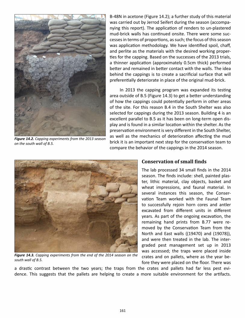
161
B-48N in acetone (Figure 14.2); a further study of this material was carried out by Jerrod Seifert during the season (accompa-nying this report). The application of renders to un-plastered mud-brick walls has continued onsite. There were some suc-cesses in terms of proportions, as such; the focus of this season was application methodology. We have identified spoil, chaff, and perlite as the materials with the desired working proper-ties for the capping. Based on the successes of the 2013 trials, a thinner application (approximately 0.5cm thick) performed better and remained in better contact with the walls. The idea behind the cappings is to create a sacrificial surface that will preferentially deteriorate in place of the original mud-brick.
In 2013 the capping program was expanded its testing area outside of B.5 (Figure 14.3) to get a better understanding of how the cappings could potentially perform in other areas of the site. For this reason B.4 in the South Shelter was also selected for cappings during the 2013 season. Building 4 is an excellent parallel to B.5 as it has been on long-term open dis-play and is found in a similar location within the shelter. As the preservation environment is very different in the South Shelter, as well as the mechanics of deterioration affecting the mud brick it is an important next step for the conservation team to compare the behavior of the cappings in the 2014 season.
Conservation of small finds The lab processed 34 small finds in the 2014 season. The finds include: shell, painted plas-ter, lithic material, clay objects, basket and wheat impressions, and faunal material. In several instances this season, the Conser-vation Team worked with the Faunal Team to successfully rejoin horn cores and antler excavated from different units in different years. As part of the ongoing excavation, the remaining hand prints from B.77 were re-moved by the Conservation Team from the North and East walls ((19470) and (19078)), and were then treated in the lab. The inter-graded pest management set up in 2013 was accessed; the traps were placed inside crates and on pallets, where as the year be-fore they were placed on the floor. There was
a drastic contrast between the two years; the traps from the crates and pallets had far less pest evi-dence. This suggests that the pallets are helping to create a more suitable environment for the artifacts.
Figure 14.2. Capping experiments from the 2013 season on the south wall of B.5.
Figure 14.3. Capping experiments from the end of the 2014 season on the south wall of B.5.
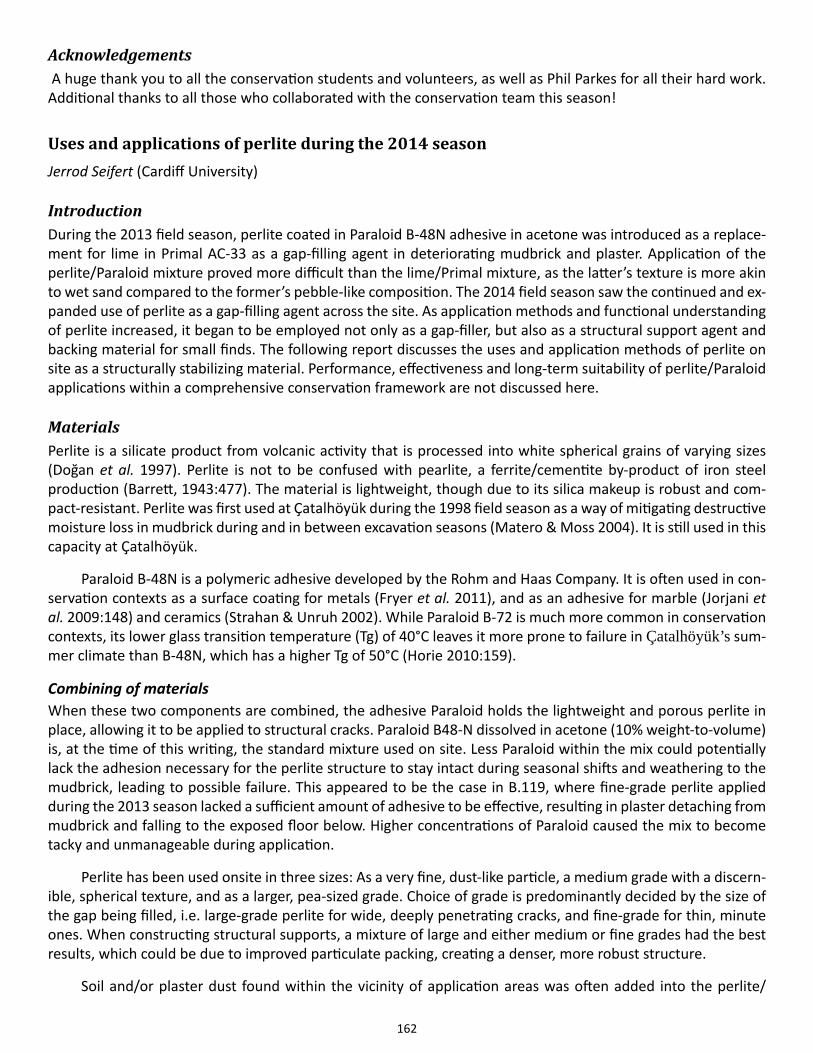
162
Acknowledgements A huge thank you to all the conservation students and volunteers, as well as Phil Parkes for all their hard work. Additional thanks to all those who collaborated with the conservation team this season!
Uses and applications of perlite during the 2014 season Jerrod Seifert (Cardiff University)
IntroductionDuring the 2013 field season, perlite coated in Paraloid B-48N adhesive in acetone was introduced as a replace-ment for lime in Primal AC-33 as a gap-filling agent in deteriorating mudbrick and plaster. Application of the perlite/Paraloid mixture proved more difficult than the lime/Primal mixture, as the latter’s texture is more akin to wet sand compared to the former’s pebble-like composition. The 2014 field season saw the continued and ex-panded use of perlite as a gap-filling agent across the site. As application methods and functional understanding of perlite increased, it began to be employed not only as a gap-filler, but also as a structural support agent and backing material for small finds. The following report discusses the uses and application methods of perlite on site as a structurally stabilizing material. Performance, effectiveness and long-term suitability of perlite/Paraloid applications within a comprehensive conservation framework are not discussed here.
MaterialsPerlite is a silicate product from volcanic activity that is processed into white spherical grains of varying sizes (Doğan et al. 1997). Perlite is not to be confused with pearlite, a ferrite/cementite by-product of iron steel production (Barrett, 1943:477). The material is lightweight, though due to its silica makeup is robust and com-pact-resistant. Perlite was first used at Çatalhöyük during the 1998 field season as a way of mitigating destructive moisture loss in mudbrick during and in between excavation seasons (Matero & Moss 2004). It is still used in this capacity at Çatalhöyük.
Paraloid B-48N is a polymeric adhesive developed by the Rohm and Haas Company. It is often used in con-servation contexts as a surface coating for metals (Fryer et al. 2011), and as an adhesive for marble (Jorjani et al. 2009:148) and ceramics (Strahan & Unruh 2002). While Paraloid B-72 is much more common in conservation contexts, its lower glass transition temperature (Tg) of 40°C leaves it more prone to failure in Çatalhöyük’s sum-mer climate than B-48N, which has a higher Tg of 50°C (Horie 2010:159).
Combining of materialsWhen these two components are combined, the adhesive Paraloid holds the lightweight and porous perlite in place, allowing it to be applied to structural cracks. Paraloid B48-N dissolved in acetone (10% weight-to-volume) is, at the time of this writing, the standard mixture used on site. Less Paraloid within the mix could potentially lack the adhesion necessary for the perlite structure to stay intact during seasonal shifts and weathering to the mudbrick, leading to possible failure. This appeared to be the case in B.119, where fine-grade perlite applied during the 2013 season lacked a sufficient amount of adhesive to be effective, resulting in plaster detaching from mudbrick and falling to the exposed floor below. Higher concentrations of Paraloid caused the mix to become tacky and unmanageable during application.
Perlite has been used onsite in three sizes: As a very fine, dust-like particle, a medium grade with a discern-ible, spherical texture, and as a larger, pea-sized grade. Choice of grade is predominantly decided by the size of the gap being filled, i.e. large-grade perlite for wide, deeply penetrating cracks, and fine-grade for thin, minute ones. When constructing structural supports, a mixture of large and either medium or fine grades had the best results, which could be due to improved particulate packing, creating a denser, more robust structure.
Soil and/or plaster dust found within the vicinity of application areas was often added into the perlite/

163
Paraloid mixture. This allowed the fills to closely match the surrounding aesthetics. Perlite was combined with Paraloid on site, in small batches as needed to avoid acetone evaporation.
Application methodsSeveral application methods of perlite were employed, each to varying degrees of success. Spoons were orig-inally used to hold the mixture in front of large gaps while a packing tool ‘pushed’ the perlite to the desired area. This was highly inefficient and resulted in significant material loss, as the rounded spoon was incapable of forming to the shape of gaps. The introduction of plastazote (polyethylene foam) sheeting allowed for perlite to be directly applied to the desired area. Thin plastazote can be formed around gaps and structures of vary-ing shapes and sizes. For gap filling, it was fashioned into a ‘chute’, which allowed it to fit within larger cracks. Packing tools, such as leaf trowels, plastic sticks, and palette knives, were used to compact the perlite in place by pushing it through the chute. Packing provided the greatest amount of support and adhesion of the mixture to the substrate (Figure 14.4).
While the ‘chute’ method worked best for vertical cracks that could be filled from the base upward, it was less effective in areas where gaps were inset into walls or where structures sitting at less than 90° angles. For these areas, it was most efficient to hold a large quantity of perlite mixture in a plastazote pad and press it into place with one’s hands and fingers. This method resulted in a greater loss of materials, as any surplus perlite fell to the floor.
Occasionally, some areas lacking in structural support required stabilizing perlite ‘bridges’. A combination of medium and fine grade perlites, soil, and excess acetone resulted in a clay-like slurry that was formed and
Figure 14.4. (left): Building 119, F.220 shows a failing lime fill and expanding crack; (right): the gap after removal of the lime fill and replacement with perlite.
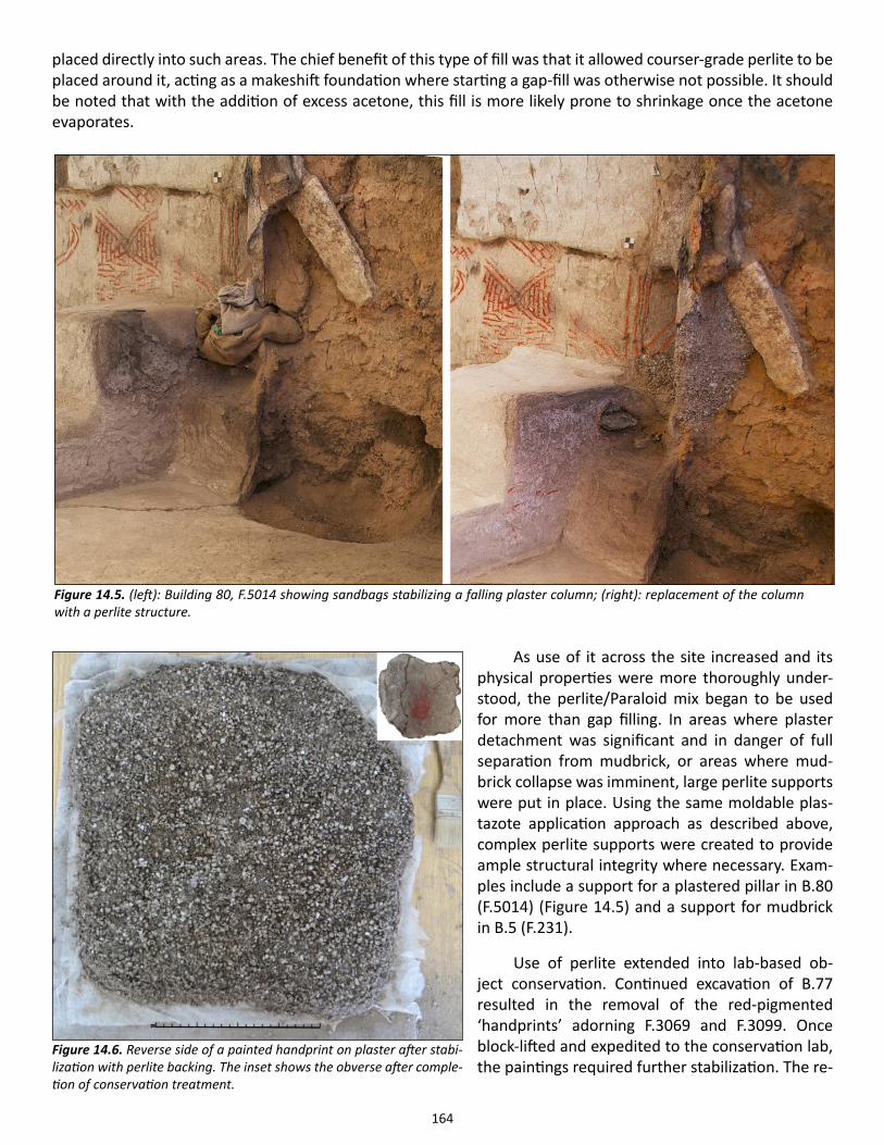
164
placed directly into such areas. The chief benefit of this type of fill was that it allowed courser-grade perlite to be placed around it, acting as a makeshift foundation where starting a gap-fill was otherwise not possible. It should be noted that with the addition of excess acetone, this fill is more likely prone to shrinkage once the acetone evaporates.
As use of it across the site increased and its physical properties were more thoroughly under-stood, the perlite/Paraloid mix began to be used for more than gap filling. In areas where plaster detachment was significant and in danger of full separation from mudbrick, or areas where mud-brick collapse was imminent, large perlite supports were put in place. Using the same moldable plas-tazote application approach as described above, complex perlite supports were created to provide ample structural integrity where necessary. Exam-ples include a support for a plastered pillar in B.80 (F.5014) (Figure 14.5) and a support for mudbrick in B.5 (F.231).
Use of perlite extended into lab-based ob-ject conservation. Continued excavation of B.77 resulted in the removal of the red-pigmented ‘handprints’ adorning F.3069 and F.3099. Once block-lifted and expedited to the conservation lab, the paintings required further stabilization. The re-
Figure 14.5. (left): Building 80, F.5014 showing sandbags stabilizing a falling plaster column; (right): replacement of the column with a perlite structure.
Figure 14.6. Reverse side of a painted handprint on plaster after stabi-lization with perlite backing. The inset shows the obverse after comple-tion of conservation treatment.
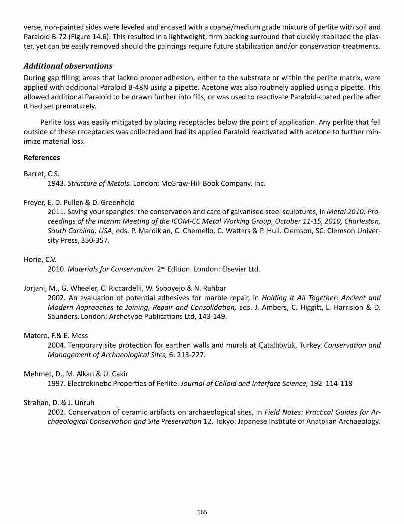
165
verse, non-painted sides were leveled and encased with a coarse/medium grade mixture of perlite with soil and Paraloid B-72 (Figure 14.6). This resulted in a lightweight, firm backing surround that quickly stabilized the plas-ter, yet can be easily removed should the paintings require future stabilization and/or conservation treatments.
Additional observationsDuring gap filling, areas that lacked proper adhesion, either to the substrate or within the perlite matrix, were applied with additional Paraloid B-48N using a pipette. Acetone was also routinely applied using a pipette. This allowed additional Paraloid to be drawn further into fills, or was used to reactivate Paraloid-coated perlite after it had set prematurely.
Perlite loss was easily mitigated by placing receptacles below the point of application. Any perlite that fell outside of these receptacles was collected and had its applied Paraloid reactivated with acetone to further min-imize material loss.
References
Barret, C.S. 1943. Structure of Metals. London: McGraw-Hill Book Company, Inc.
Freyer, E, D. Pullen & D. Greenfield2011. Saving your spangles: the conservation and care of galvanised steel sculptures, in Metal 2010: Pro-ceedings of the Interim Meeting of the ICOM-CC Metal Working Group, October 11-15, 2010, Charleston, South Carolina, USA, eds. P. Mardikian, C. Chemello, C. Watters & P. Hull. Clemson, SC: Clemson Univer-sity Press, 350-357.
Horie, C.V. 2010. Materials for Conservation. 2nd Edition. London: Elsevier Ltd.
Jorjani, M., G. Wheeler, C. Riccardelli, W. Soboyejo & N. Rahbar2002. An evaluation of potential adhesives for marble repair, in Holding It All Together: Ancient and Modern Approaches to Joining, Repair and Consolidation, eds. J. Ambers, C. Higgitt, L. Harrision & D. Saunders. London: Archetype Publications Ltd, 143-149.
Matero, F.& E. Moss2004. Temporary site protection for earthen walls and murals at Çatalhöyük, Turkey. Conservation and Management of Archaeological Sites, 6: 213-227.
Mehmet, D., M. Alkan & U. Cakir1997. Electrokinetic Properties of Perlite. Journal of Colloid and Interface Science, 192: 114-118
Strahan, D. & J. Unruh
2002. Conservation of ceramic artifacts on archaeological sites, in Field Notes: Practical Guides for Ar-chaeological Conservation and Site Preservation 12. Tokyo: Japanese Institute of Anatolian Archaeology.
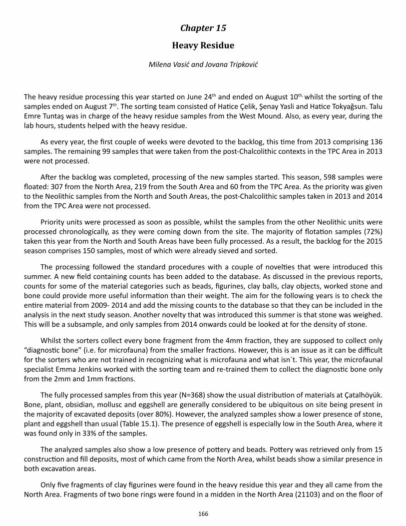
166
Chapter 15
Heavy Residue
Milena Vasić and Jovana Tripković
The heavy residue processing this year started on June 24th and ended on August 10th, whilst the sorting of the samples ended on August 7th. The sorting team consisted of Hatice Çelik, Şenay Yasli and Hatice Tokyağsun. Talu Emre Tuntaş was in charge of the heavy residue samples from the West Mound. Also, as every year, during the lab hours, students helped with the heavy residue.
As every year, the first couple of weeks were devoted to the backlog, this time from 2013 comprising 136 samples. The remaining 99 samples that were taken from the post-Chalcolithic contexts in the TPC Area in 2013 were not processed.
After the backlog was completed, processing of the new samples started. This season, 598 samples were floated: 307 from the North Area, 219 from the South Area and 60 from the TPC Area. As the priority was given to the Neolithic samples from the North and South Areas, the post-Chalcolithic samples taken in 2013 and 2014 from the TPC Area were not processed.
Priority units were processed as soon as possible, whilst the samples from the other Neolithic units were processed chronologically, as they were coming down from the site. The majority of flotation samples (72%) taken this year from the North and South Areas have been fully processed. As a result, the backlog for the 2015 season comprises 150 samples, most of which were already sieved and sorted.
The processing followed the standard procedures with a couple of novelties that were introduced this summer. A new field containing counts has been added to the database. As discussed in the previous reports, counts for some of the material categories such as beads, figurines, clay balls, clay objects, worked stone and bone could provide more useful information than their weight. The aim for the following years is to check the entire material from 2009- 2014 and add the missing counts to the database so that they can be included in the analysis in the next study season. Another novelty that was introduced this summer is that stone was weighed. This will be a subsample, and only samples from 2014 onwards could be looked at for the density of stone.
Whilst the sorters collect every bone fragment from the 4mm fraction, they are supposed to collect only “diagnostic bone” (i.e. for microfauna) from the smaller fractions. However, this is an issue as it can be difficult for the sorters who are not trained in recognizing what is microfauna and what isn`t. This year, the microfaunal specialist Emma Jenkins worked with the sorting team and re-trained them to collect the diagnostic bone only from the 2mm and 1mm fractions.
The fully processed samples from this year (N=368) show the usual distribution of materials at Çatalhöyük. Bone, plant, obsidian, mollusc and eggshell are generally considered to be ubiquitous on site being present in the majority of excavated deposits (over 80%). However, the analyzed samples show a lower presence of stone, plant and eggshell than usual (Table 15.1). The presence of eggshell is especially low in the South Area, where it was found only in 33% of the samples.
The analyzed samples also show a low presence of pottery and beads. Pottery was retrieved only from 15 construction and fill deposits, most of which came from the North Area, whilst beads show a similar presence in both excavation areas.
Only five fragments of clay figurines were found in the heavy residue this year and they all came from the North Area. Fragments of two bone rings were found in a midden in the North Area (21103) and on the floor of
167
a hearth in B.80 (20045).
When the excavated floor deposits in the North and South Areas are compared, they show a similar pres-ence of materials in both areas. On the other hand, building floors in the North Area have higher densities of bone and obsidian, whilst the building floors in the South Area have a higher density of mollusc. The density of other materials seems similar across the two areas.
The samples reported here represent only part of the assemblage from 2009 to 2014 that will be analyzed altogether in the next study season.
Table 15.1. Presence of the materials in the excavated contexts in 2014.
168
Chapter 16
Tablet Recording Overview
Justine Issavi1 and James Taylor2
1Stanford University, 2University of York
Based on a successful pilot study conducted previously (See Taylor & Issavi in 2013 Archive Report), the digital tablet recording workflow was expanded to the entire excavation team during the 2014 season with the addi-tion of ten Microsoft Surface Pro tablets (1st gen). Our most important goals for this transition have been, and continue to be, the following:
● Ensuring no data would be lost in the transition from paper to digital.
● Creating a workflow with a manageable learning curve that could be utilized by team members with di-verse technological backgrounds.
● Ensuring an increased overall efficiency when compared with traditional paper drawing.
Workflow and toolsWe made use of the workflow developed during the previous field season, using ESRI’s ArcGIS 10.2 as the main digitizing solution, with only minor changes, such as the addition of another set of shapefiles for section and el-evation drawings to complement the multi-context and single-context shapefiles. Another important addition to tablet use, but not directly related to the graphic archive, was the use of the tablet along with Microsoft Office’s Excel for recording the photograph meta-data for the site camera. The workflow presented below is taken from the 2013 Archive Report with minor adjustments where necessary.
● Setting up a mini grid in building
Before the beginning of the excavation, numbered, semi-permanent targets (2x2cm) should be placed in the excavation area at a 1x1m scale.
These targets will then be picked up by the total station and saved into a shapefile to be used as control points.
● Taking photos
Take photos using site camera and monopod and keep distortion to a minimum with at least 4 well-dispersed targets.
Photos will then be transferred unto tablet using a USB cable.
● Ortho-rectifying/georeferencing photos
Ortho-rectify images using ArcMap georeferencing tools and process.
Save rectified version in tiff format to be used in digitizing.
● Digitizing in ArcMap
Here the digitization process can begin using the Editor toolbar and editing shapefiles.
169
● There will be three sets of shapefiles that can be edited in the prepared mxd. One set will be used for multi-context plans (such as pre-excavation, post-excavation, and phase plans) and another set for single context plans.
Single context plans have four types of shapefiles:
Base Unit Polygon
Unit Detail Lines
Annotations
X-finds
Elevations
Each shapefile will have a number of preset attribute fields that will need to be filled in by the excavator as they are digitized. They are described below:
Base unit polygon:
Unit number 12345Excavated YES/NO/PARTIALNotes Unit interpretationSource File name of photo source
Unit detail lines attribute fields (for symbols see crib sheet: drawing conventions):
Type Limit of excavation –LOE
Extent of unit-EU
Truncation-TR
Uncertain limit-UL
Slope-SL
Inverted slope-IS
Break of slope-BS
Line of section LSUnit number 12345Excavated YES/NO/PARTIALHighest Z 1234.5
Annotations attribute fields:
Unit number 12345Notes Label
170
X-finds attribute fields:
Unit number 12345Type BEAD/BLADE/WORKED BONE, ETC.X-find number x1, x2, x3, etc. X 123.11Y 123.11Z 1234.11
Elevation attribute fields:
Unit number 12345Elevation 1234.12
Unlike single context plans, multi-context plans will have a graphics number assigned to them (just as you would a hand-drawn map).
Multi-context plans have three types of shapefiles:
Multiplans details
Multiplans elevations
Multiplans annotations
Each shapefile will have a number of preset attribute fields that will need to be filled in by the excavator as they are digitized. They are described below:
Multiplans details:
Type Limit of excavation –LOE
Extent of unit-EU
Truncation-TR
Uncertain limit-UL
Slope-SL
Inverted slope-IS
Break of slope-BS
Line of section LSUnit number 12345Graphic number 13/400
Multiplans elevations:
Graphic number 13/400Elevation 1234.12
171
Multiplans annotations:
Graphic number 13/400Notes Label
● Post excavation plans & section/elevation drawings
Orthophotos obtained from 3D models created through dense stereo matching techniques can be used for detailed post excavation plans and section/elevation drawings. The presence of an archived 3D model associated with the aforementioned plans will also be a useful addition to the spatial dataset.
Sections and elevations, along with other graphic data, will be digitized in ArcMap, using the fol-lowing shapefiles.
● Similar to multi-context plans, Section and Elevation drawings have three types of shapefiles:
▪ Section/Elevation details
▪ Section/Elevation elevations
▪ Section/Elevation annotations
Section/Elevation details:
Type Limit of excavation –LOE
Extent of unit-EU
Truncation-TR
Uncertain limit-UL
Slope-SL
Inverted slope-IS
Break of slope-BS
Line of section LSUnit number 12345Graphic number 13/400
Section/Elevation heights:
Graphic number 13/400Elevation 1234.12
Section/Elevation annotations:
Graphic number 13/400Notes Label
172
● All data is saved and backed up daily, weekly, and at the end of every season.
● Each team data-package will contain the following documents:
Item File type Example file name Reason for inclusionSource photo .raw img123 Archival copySource photo .jpg 18080 Working copy-for rectificationSource photo .tiff 18080Rec Working copy-for digitizingBack-up SHP .shp unit_details, etc. Archival/back-up
SHP files .shp unit_details, etc. Working copyArcMap file .mxd B.80_plans_2013 Working station/plat
ArcScene file .sxd B.80_plans_2013 Working station 3d dataStyles .style Tablet_styles Standardized SHP symbols
TotalSt.Data .shp B.80_targets Building control pointsPrevious data various Archive_Report_2012 Useful informationGeodatabase .mdb site_geodatabase_date Useful informationWorking 3D
model.obj B80_preexc_model Used for section/elevation drawings; to create
orthogonal photos
ResultsWith the initial results of this site-wide transition in hand, we can say that this project continues to be success-ful. When problems did come up, they were generally related to logistical issues. For example, several pods had to share their tablets, which sometimes created bottlenecks in the recording process. This issue was especially highlighted at the beginning of the season when excavators were generally unfamiliar with the new workflow but was alleviated as familiarity increased. Ironically, the very usefulness of the tablets in the field (Antiquity Article; CAA presentation?), encouraged us to integrate them into other workflows on site (e.g., recording photo metadata, using tablets for recording and uploading Daily Sketches, etc.), which also tended to create holdups.
On the other hand, our attempts at integration have resulted in useful technical improvisation in the field. For example, excavators found that using Microsoft Office’s OneNote for recording and annotating Daily Sketch-es was a more reflexive exercise because it allowed more room and flexibility to accommodate the excavator’s varied notes. This in turn resulted in a more substantial use of Daily Sketches.
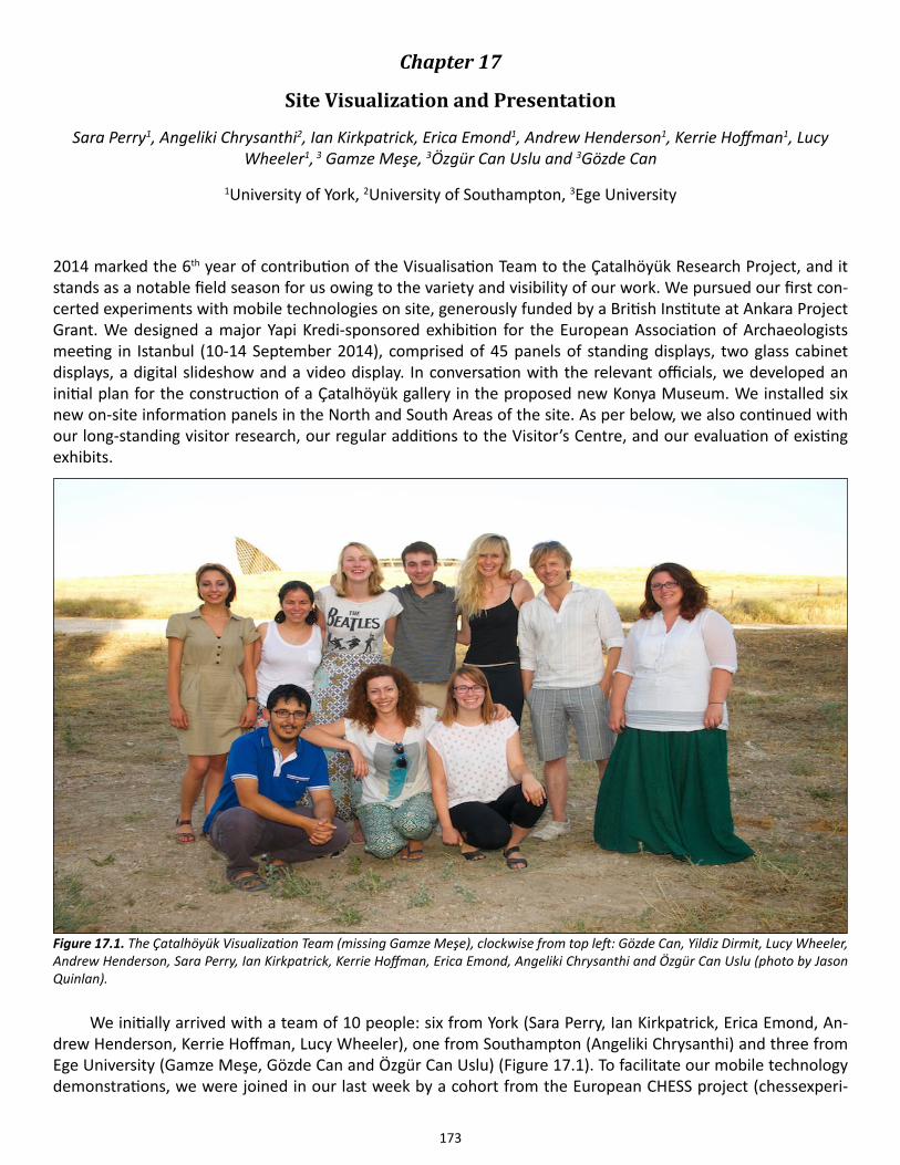
173
Chapter 17
Site Visualization and Presentation
Sara Perry1, Angeliki Chrysanthi2, Ian Kirkpatrick, Erica Emond1, Andrew Henderson1, Kerrie Hoffman1, Lucy Wheeler1, 3 Gamze Meşe, 3Özgür Can Uslu and 3Gözde Can
1University of York, 2University of Southampton, 3Ege University
2014 marked the 6th year of contribution of the Visualisation Team to the Çatalhöyük Research Project, and it stands as a notable field season for us owing to the variety and visibility of our work. We pursued our first con-certed experiments with mobile technologies on site, generously funded by a British Institute at Ankara Project Grant. We designed a major Yapi Kredi-sponsored exhibition for the European Association of Archaeologists meeting in Istanbul (10-14 September 2014), comprised of 45 panels of standing displays, two glass cabinet displays, a digital slideshow and a video display. In conversation with the relevant officials, we developed an initial plan for the construction of a Çatalhöyük gallery in the proposed new Konya Museum. We installed six new on-site information panels in the North and South Areas of the site. As per below, we also continued with our long-standing visitor research, our regular additions to the Visitor’s Centre, and our evaluation of existing exhibits.
We initially arrived with a team of 10 people: six from York (Sara Perry, Ian Kirkpatrick, Erica Emond, An-drew Henderson, Kerrie Hoffman, Lucy Wheeler), one from Southampton (Angeliki Chrysanthi) and three from Ege University (Gamze Meşe, Gözde Can and Özgür Can Uslu) (Figure 17.1). To facilitate our mobile technology demonstrations, we were joined in our last week by a cohort from the European CHESS project (chessexperi-
Figure 17.1. The Çatalhöyük Visualization Team (missing Gamze Meşe), clockwise from top left: Gözde Can, Yildiz Dirmit, Lucy Wheeler, Andrew Henderson, Sara Perry, Ian Kirkpatrick, Kerrie Hoffman, Erica Emond, Angeliki Chrysanthi and Özgür Can Uslu (photo by Jason Quinlan).
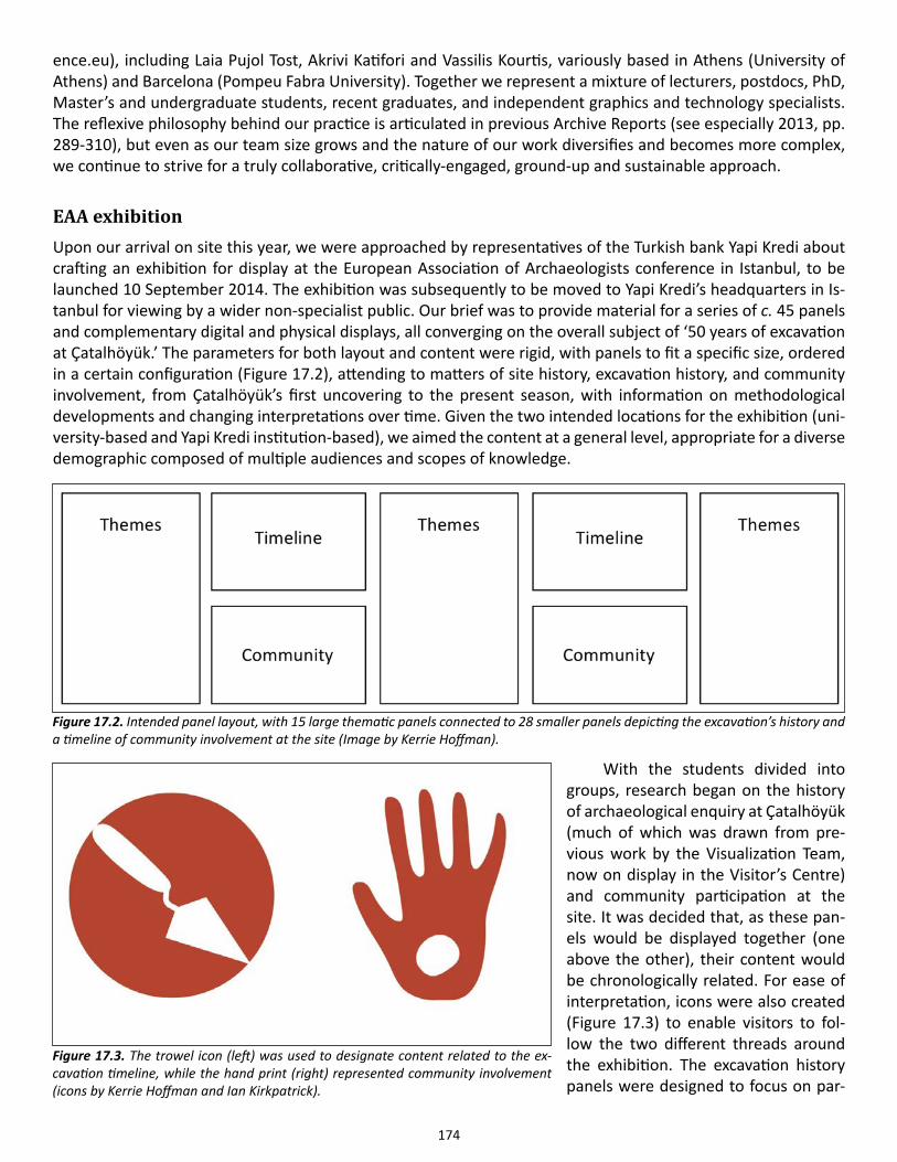
174
ence.eu), including Laia Pujol Tost, Akrivi Katifori and Vassilis Kourtis, variously based in Athens (University of Athens) and Barcelona (Pompeu Fabra University). Together we represent a mixture of lecturers, postdocs, PhD, Master’s and undergraduate students, recent graduates, and independent graphics and technology specialists. The reflexive philosophy behind our practice is articulated in previous Archive Reports (see especially 2013, pp. 289-310), but even as our team size grows and the nature of our work diversifies and becomes more complex, we continue to strive for a truly collaborative, critically-engaged, ground-up and sustainable approach.
EAA exhibitionUpon our arrival on site this year, we were approached by representatives of the Turkish bank Yapi Kredi about crafting an exhibition for display at the European Association of Archaeologists conference in Istanbul, to be launched 10 September 2014. The exhibition was subsequently to be moved to Yapi Kredi’s headquarters in Is-tanbul for viewing by a wider non-specialist public. Our brief was to provide material for a series of c. 45 panels and complementary digital and physical displays, all converging on the overall subject of ‘50 years of excavation at Çatalhöyük.’ The parameters for both layout and content were rigid, with panels to fit a specific size, ordered in a certain configuration (Figure 17.2), attending to matters of site history, excavation history, and community involvement, from Çatalhöyük’s first uncovering to the present season, with information on methodological developments and changing interpretations over time. Given the two intended locations for the exhibition (uni-versity-based and Yapi Kredi institution-based), we aimed the content at a general level, appropriate for a diverse demographic composed of multiple audiences and scopes of knowledge.
With the students divided into groups, research began on the history of archaeological enquiry at Çatalhöyük (much of which was drawn from pre-vious work by the Visualization Team, now on display in the Visitor’s Centre) and community participation at the site. It was decided that, as these pan-els would be displayed together (one above the other), their content would be chronologically related. For ease of interpretation, icons were also created (Figure 17.3) to enable visitors to fol-low the two different threads around the exhibition. The excavation history panels were designed to focus on par-
Figure 17.2. Intended panel layout, with 15 large thematic panels connected to 28 smaller panels depicting the excavation’s history and a timeline of community involvement at the site (Image by Kerrie Hoffman).
Figure 17.3. The trowel icon (left) was used to designate content related to the ex-cavation timeline, while the hand print (right) represented community involvement (icons by Kerrie Hoffman and Ian Kirkpatrick).
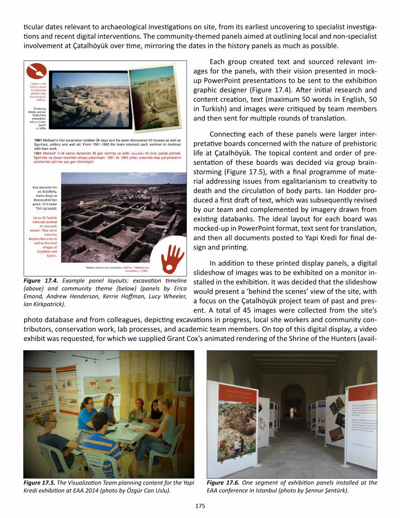
175
ticular dates relevant to archaeological investigations on site, from its earliest uncovering to specialist investiga-tions and recent digital interventions. The community-themed panels aimed at outlining local and non-specialist involvement at Çatalhöyük over time, mirroring the dates in the history panels as much as possible.
Each group created text and sourced relevant im-ages for the panels, with their vision presented in mock-up PowerPoint presentations to be sent to the exhibition graphic designer (Figure 17.4). After initial research and content creation, text (maximum 50 words in English, 50 in Turkish) and images were critiqued by team members and then sent for multiple rounds of translation.
Connecting each of these panels were larger inter-pretative boards concerned with the nature of prehistoric life at Çatalhöyük. The topical content and order of pre-sentation of these boards was decided via group brain-storming (Figure 17.5), with a final programme of mate-rial addressing issues from egalitarianism to creativity to death and the circulation of body parts. Ian Hodder pro-duced a first draft of text, which was subsequently revised by our team and complemented by imagery drawn from existing databanks. The ideal layout for each board was mocked-up in PowerPoint format, text sent for translation, and then all documents posted to Yapi Kredi for final de-sign and printing.
In addition to these printed display panels, a digital slideshow of images was to be exhibited on a monitor in-stalled in the exhibition. It was decided that the slideshow would present a ‘behind the scenes’ view of the site, with a focus on the Çatalhöyük project team of past and pres-ent. A total of 45 images were collected from the site’s
photo database and from colleagues, depicting excavations in progress, local site workers and community con-tributors, conservation work, lab processes, and academic team members. On top of this digital display, a video exhibit was requested, for which we supplied Grant Cox’s animated rendering of the Shrine of the Hunters (avail-
Figure 17.4. Example panel layouts: excavation timeline (above) and community theme (below) (panels by Erica Emond, Andrew Henderson, Kerrie Hoffman, Lucy Wheeler, Ian Kirkpatrick).
Figure 17.6. One segment of exhibition panels installed at the EAA conference in Istanbul (photo by Şennur Şentürk).
Figure 17.5. The Visualization Team planning content for the Yapi Kredi exhibition at EAA 2014 (photo by Özgür Can Uslu).
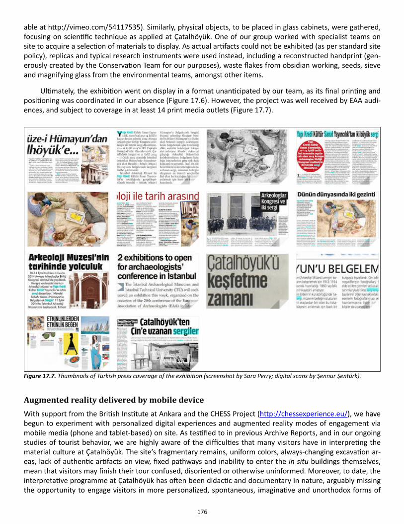
176
able at http://vimeo.com/54117535). Similarly, physical objects, to be placed in glass cabinets, were gathered, focusing on scientific technique as applied at Çatalhöyük. One of our group worked with specialist teams on site to acquire a selection of materials to display. As actual artifacts could not be exhibited (as per standard site policy), replicas and typical research instruments were used instead, including a reconstructed handprint (gen-erously created by the Conservation Team for our purposes), waste flakes from obsidian working, seeds, sieve and magnifying glass from the environmental teams, amongst other items.
Ultimately, the exhibition went on display in a format unanticipated by our team, as its final printing and positioning was coordinated in our absence (Figure 17.6). However, the project was well received by EAA audi-ences, and subject to coverage in at least 14 print media outlets (Figure 17.7).
Augmented reality delivered by mobile deviceWith support from the British Institute at Ankara and the CHESS Project (http://chessexperience.eu/), we have begun to experiment with personalized digital experiences and augmented reality modes of engagement via mobile media (phone and tablet-based) on site. As testified to in previous Archive Reports, and in our ongoing studies of tourist behavior, we are highly aware of the difficulties that many visitors have in interpreting the material culture at Çatalhöyük. The site’s fragmentary remains, uniform colors, always-changing excavation ar-eas, lack of authentic artifacts on view, fixed pathways and inability to enter the in situ buildings themselves, mean that visitors may finish their tour confused, disoriented or otherwise uninformed. Moreover, to date, the interpretative programme at Çatalhöyük has often been didactic and documentary in nature, arguably missing the opportunity to engage visitors in more personalized, spontaneous, imaginative and unorthodox forms of
Figure 17.7. Thumbnails of Turkish press coverage of the exhibition (screenshot by Sara Perry; digital scans by Şennur Şentürk).

177
presentation and storytelling about the past. Our negligible budget and minimal capacity also demand that we look beyond traditional forms of exhibition (e.g., printed materials, glass case displays) and towards mechanisms that are more malleable, economical and visitor-supplied.
Recognizing successes in implementing novel, personalized mobile phone and mobile tablet-delivered narratives at the new Acropolis Museum and elsewhere (specifically as part of the CHESS project: chessexperience.eu), we applied for a British Institute at Ankara Project Grant to bring CHESS members Akrivi Katifori, Vassilis Kourtis, and Laia Pujol-Tost to Çatal-höyük. Our intent was to begin scoping out the first iteration of mobile storytelling on site, with a view towards applying for major funding in 2015 to roll out such technology at Çatalhöyük and several other European archaeological sites over the next four years. To facilitate our test-ing programme this year, we convened a sto-ry-crafting night during which 17 members of Çatalhöyük’s various specialist teams gathered for two hours following their normal fieldwork day to script stories around B.52. Using prompt
cards containing data and interpretations compiled from site reports, diaries, and associated publications about B.52, three groups prepared three separate narratives (Figure 17.8). The most complete of these narratives was selected for integration into our mobile prototype. [Further detail on the story and our prototyping work will be published in the next edition of the BI-AA’s Heritage Turkey magazine.]
We transcribed the written script, and prepared an audio recording of it, created two story-telling avatar characters, and gathered a variety of specialist field imagery from B.52. These were combined into the CHESS Project’s pre-built authoring plat-form, resulting in an interactive narrative that was accessible via tablets on site, connected to the CHESS server (Figure 17.9). We conducted nine video-recorded test-runs of the technology with members of the site team and visitors (Figure 17.10), followed by audio-recorded evaluative interviews with participants. Their feedback reinforced the promise of such digital stories: they sought to elaborate the stories with more movement, more in-teractivity between the user and the archaeological site via nar-rative prompts, more multi-sensory stimuli, and more opportuni-ties to explore notions of time and space via animation. On top of this, the initial story-writing process actually stimulated unantic-ipated intellectual debate and conceptual collaboration amongst
the site’s specialists. Their reactions suggest a possible impact on professional knowledge-making itself. The outcomes of this process are now being developed for presentation at the 2015 Museums and the Web confer-ence, and for academic publication.
Figure 17.8. A range of members of the larger Çatalhöyük Research Project participate in an intensive story-authoring session on site (photo by Sara Perry).
Figure 17.9. Screenshot of a frame from the narrative, as seen on the mobile tablet (screenshot by Vassilis Kourtis).
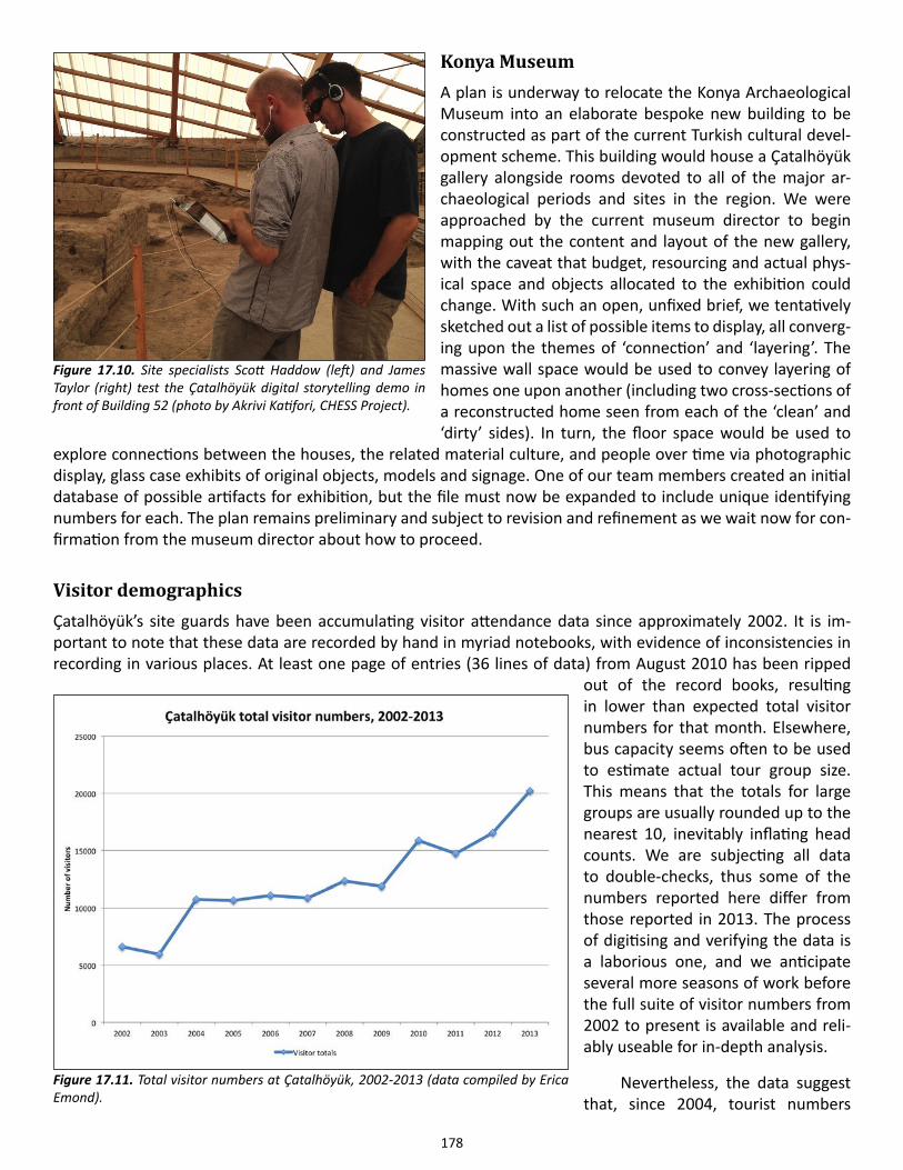
178
Konya MuseumA plan is underway to relocate the Konya Archaeological Museum into an elaborate bespoke new building to be constructed as part of the current Turkish cultural devel-opment scheme. This building would house a Çatalhöyük gallery alongside rooms devoted to all of the major ar-chaeological periods and sites in the region. We were approached by the current museum director to begin mapping out the content and layout of the new gallery, with the caveat that budget, resourcing and actual phys-ical space and objects allocated to the exhibition could change. With such an open, unfixed brief, we tentatively sketched out a list of possible items to display, all converg-ing upon the themes of ‘connection’ and ‘layering’. The massive wall space would be used to convey layering of homes one upon another (including two cross-sections of a reconstructed home seen from each of the ‘clean’ and ‘dirty’ sides). In turn, the floor space would be used to
explore connections between the houses, the related material culture, and people over time via photographic display, glass case exhibits of original objects, models and signage. One of our team members created an initial database of possible artifacts for exhibition, but the file must now be expanded to include unique identifying numbers for each. The plan remains preliminary and subject to revision and refinement as we wait now for con-firmation from the museum director about how to proceed.
Visitor demographicsÇatalhöyük’s site guards have been accumulating visitor attendance data since approximately 2002. It is im-portant to note that these data are recorded by hand in myriad notebooks, with evidence of inconsistencies in recording in various places. At least one page of entries (36 lines of data) from August 2010 has been ripped
out of the record books, resulting in lower than expected total visitor numbers for that month. Elsewhere, bus capacity seems often to be used to estimate actual tour group size. This means that the totals for large groups are usually rounded up to the nearest 10, inevitably inflating head counts. We are subjecting all data to double-checks, thus some of the numbers reported here differ from those reported in 2013. The process of digitising and verifying the data is a laborious one, and we anticipate several more seasons of work before the full suite of visitor numbers from 2002 to present is available and reli-ably useable for in-depth analysis.
Nevertheless, the data suggest that, since 2004, tourist numbers
Figure 17.10. Site specialists Scott Haddow (left) and James Taylor (right) test the Çatalhöyük digital storytelling demo in front of Building 52 (photo by Akrivi Katifori, CHESS Project).
Figure 17.11. Total visitor numbers at Çatalhöyük, 2002-2013 (data compiled by Erica Emond).
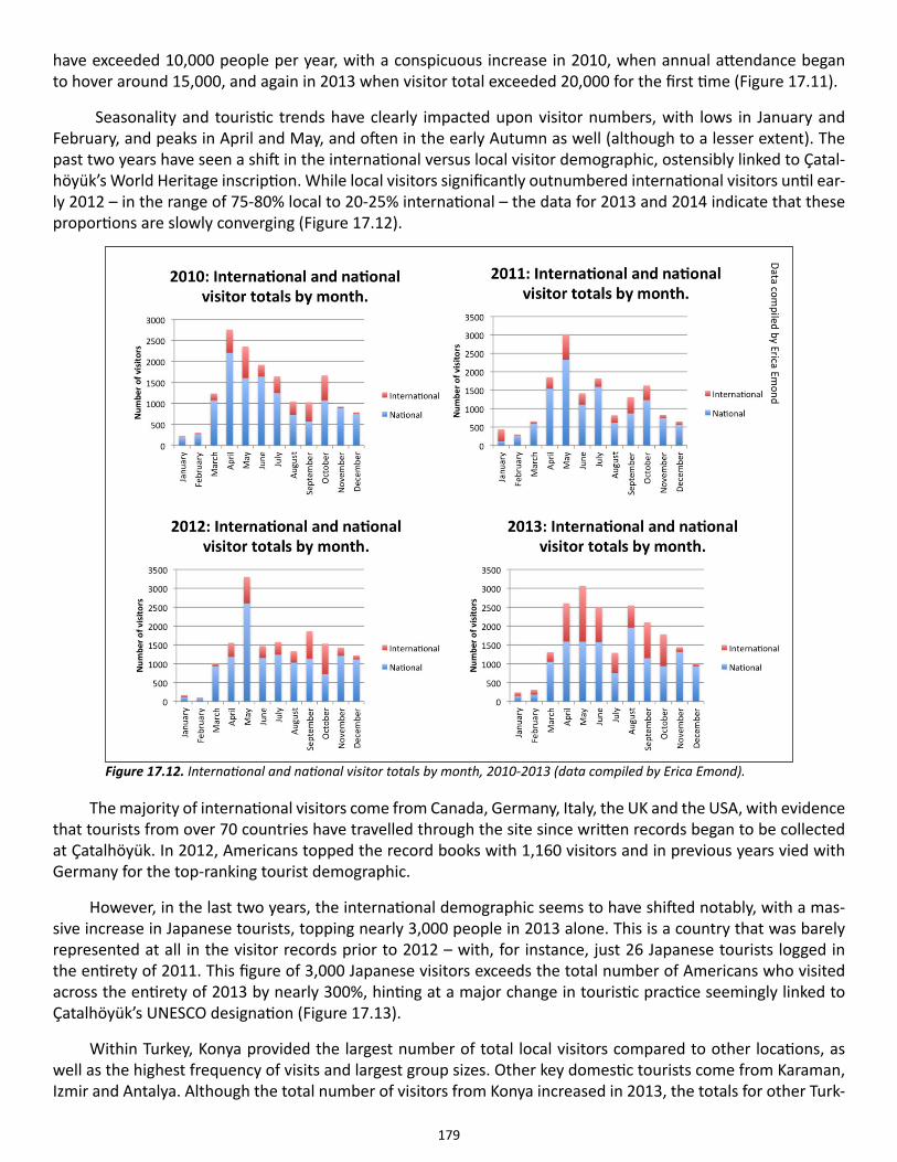
179
have exceeded 10,000 people per year, with a conspicuous increase in 2010, when annual attendance began to hover around 15,000, and again in 2013 when visitor total exceeded 20,000 for the first time (Figure 17.11).
Seasonality and touristic trends have clearly impacted upon visitor numbers, with lows in January and February, and peaks in April and May, and often in the early Autumn as well (although to a lesser extent). The past two years have seen a shift in the international versus local visitor demographic, ostensibly linked to Çatal-höyük’s World Heritage inscription. While local visitors significantly outnumbered international visitors until ear-ly 2012 – in the range of 75-80% local to 20-25% international – the data for 2013 and 2014 indicate that these proportions are slowly converging (Figure 17.12).
The majority of international visitors come from Canada, Germany, Italy, the UK and the USA, with evidence that tourists from over 70 countries have travelled through the site since written records began to be collected at Çatalhöyük. In 2012, Americans topped the record books with 1,160 visitors and in previous years vied with Germany for the top-ranking tourist demographic.
However, in the last two years, the international demographic seems to have shifted notably, with a mas-sive increase in Japanese tourists, topping nearly 3,000 people in 2013 alone. This is a country that was barely represented at all in the visitor records prior to 2012 – with, for instance, just 26 Japanese tourists logged in the entirety of 2011. This figure of 3,000 Japanese visitors exceeds the total number of Americans who visited across the entirety of 2013 by nearly 300%, hinting at a major change in touristic practice seemingly linked to Çatalhöyük’s UNESCO designation (Figure 17.13).
Within Turkey, Konya provided the largest number of total local visitors compared to other locations, as well as the highest frequency of visits and largest group sizes. Other key domestic tourists come from Karaman, Izmir and Antalya. Although the total number of visitors from Konya increased in 2013, the totals for other Turk-
Figure 17.12. International and national visitor totals by month, 2010-2013 (data compiled by Erica Emond).
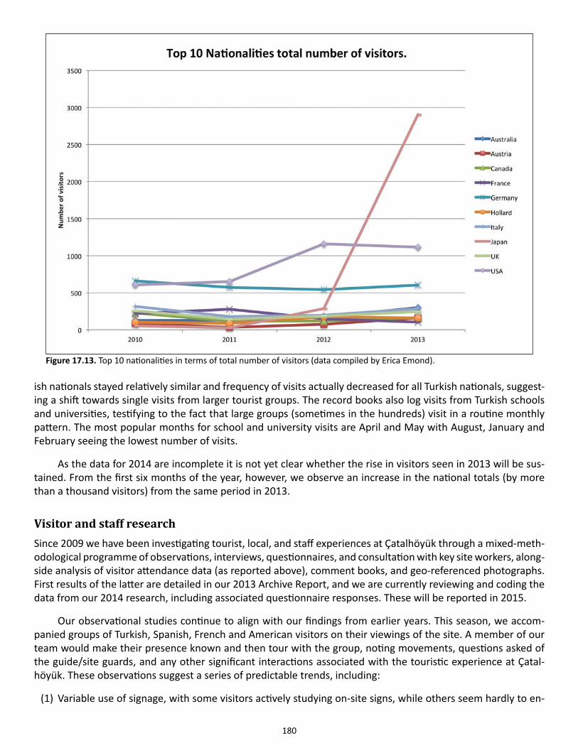
180
ish nationals stayed relatively similar and frequency of visits actually decreased for all Turkish nationals, suggest-ing a shift towards single visits from larger tourist groups. The record books also log visits from Turkish schools and universities, testifying to the fact that large groups (sometimes in the hundreds) visit in a routine monthly pattern. The most popular months for school and university visits are April and May with August, January and February seeing the lowest number of visits.
As the data for 2014 are incomplete it is not yet clear whether the rise in visitors seen in 2013 will be sus-tained. From the first six months of the year, however, we observe an increase in the national totals (by more than a thousand visitors) from the same period in 2013.
Visitor and staff researchSince 2009 we have been investigating tourist, local, and staff experiences at Çatalhöyük through a mixed-meth-odological programme of observations, interviews, questionnaires, and consultation with key site workers, along-side analysis of visitor attendance data (as reported above), comment books, and geo-referenced photographs. First results of the latter are detailed in our 2013 Archive Report, and we are currently reviewing and coding the data from our 2014 research, including associated questionnaire responses. These will be reported in 2015.
Our observational studies continue to align with our findings from earlier years. This season, we accom-panied groups of Turkish, Spanish, French and American visitors on their viewings of the site. A member of our team would make their presence known and then tour with the group, noting movements, questions asked of the guide/site guards, and any other significant interactions associated with the touristic experience at Çatal-höyük. These observations suggest a series of predictable trends, including:
(1) Variable use of signage, with some visitors actively studying on-site signs, while others seem hardly to en-
Figure 17.13. Top 10 nationalities in terms of total number of visitors (data compiled by Erica Emond).
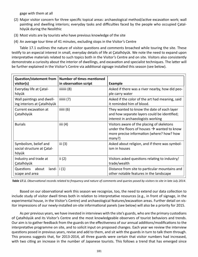
181
gage with them at all
(2) Major visitor concern for three specific topical areas: archaeological method/active excavation work; wall painting and dwelling interiors; everyday tasks and difficulties faced by the people who occupied Çatal-höyük during the Neolithic
(3) Most visits are by tourists who have previous knowledge of the site
(4) An average tour time of 41 minutes, excluding stops in the Visitor’s Centre
Table 17.1 outlines the nature of visitor questions and comments broached while touring the site. These testify to an especial interest in small, everyday details of life at Çatalhöyük. We note the need to expand upon interpretative materials related to such topics both in the Visitor’s Centre and on site. Visitors also consistently demonstrate a curiosity about the interior of dwellings, and excavation and specialist techniques. The latter will be further explained in the Visitor’s Centre via additional signage installed this season (see below).
Based on our observational work this season we recognize, too, the need to extend our data collection to include study of visitor dwell times both in relation to interpretative resources (e.g., in front of signage, in the experimental house, in the Visitor’s Centre) and archaeological features/excavation areas. Further detail on vis-itor impressions of our newly-installed on-site informational panels (see below) will also be a priority for 2015.
As per previous years, we have invested in interviews with the site’s guards, who are the primary custodians of Çatalhöyük and its Visitor’s Centre and the most knowledgeable observers of tourist behaviors and trends. Our aim is to gather feedback from the guards on the effectiveness of our annual additions/modifications to the interpretative programme on site, and to solicit input on proposed changes. Each year we review the interview questions posed in previous years, revise and add to them, and sit with the guards in turn to talk them through. This process suggests that, for 2013-2014, all three guards were certain that visitor numbers had increased, with two citing an increase in the number of Japanese tourists. This follows a trend that has emerged since
Question/statement from visitor(s)
Number of times mentioned in observation script Example
Everyday life at Çatal-höyük
iiiiiiii (8) Asked if there was a river nearby, how did peo-ple carry water
Wall paintings and dwell-ing interiors at Çatalhöyük
iiiiiii (7) Asked if the color of the art had meaning, said it reminded him of blood.
Current excavation at Çatalhöyük
iiiiii (6) They wanted to know the date of each layer and how separate layers could be identified; interest in archaeologists working
Burials iiii (4) Visitors aware of the placing of skeletons under the floors of houses wanted to know more precise information (where? how? how many?)
Symbolism, belief and social structure at Çatal-höyük
iii (3) Asked about religion, and if there was symbol-ism in houses
Industry and trade at Çatalhöyük
ii (2) Visitors asked questions relating to industry/trade/wealth
Questions about land-scape and area
i (1) Distance from site to particular mountains and other notable features in the landscape
Table 17.1. Observational records related to frequency and nature of comments and queries posed by visitors to site in late July 2014.

182
Çatalhöyük was designated a World Heritage Site by UNESCO. The guards did not see any significant changes in how visitors tour the site, although there was some suggestion that the Japanese spend less time on site. This culturally-specific trend is affirmed in our geo-referenced photographic research (see above).
In regards to our ongoing redesign of the Visitor’s Centre, the guards were in agreement about the positive impact of the Texture Board installed in 2013. In contrast, the Follow Me icon was not considered a success in shepherding visitors in the right direction around the Centre. This leaves open the possibility for an alternative or more visible navigational method to be implemented in the future. Similarly, the Postcards printed in 2014 were hardly remembered by the guards—they were quickly distributed and seemingly just as quickly forgotten. There was a general call from the guards for the removal of the curtains positioned in the middle of the Centre (around the television display). These are apparently frequently pulled down by young visitors, and their height means that reinstallation is always problematic. According to the guards, the most popular aspects of the Centre are the replica salt shaker, and the reconstructed paintings positioned around the room. In the same breath, however, the guards are clear that visitors regularly express dissatisfaction at the lack of original artifacts on display.
After a discussion and critique session amongst our team, we proposed to the guards an installation of spotlights and better usage of the existing lighting in the Visitor’s Centre in an effort to highlight certain content. The guards were divided about this suggestion, keen on the idea, but concerned about maintenance. As many of the current bulbs are blown, a system first needs to be devised to replace them before investing in more elab-orate lighting plans.
We also proposed the installation of a world map to orient visitors and situate Çatalhöyük amongst oth-er archaeological and UNESCO sites in the world. The guards were in support, thus became a key focus of the additions to the Centre in 2014 (see below). Otherwise, two of the guards suggested that there was too much writing incorporated into the interpretative programme on site, and that our team should be considering means to reduce text and increase alternative forms of engagement. This is a challenge that we continue to explore—a priority for our team for 2015.
On-site signageAs described in the 2013 Archive Report, we crafted a series of new panels to replace the weathered and ob-solete interpretative boards currently on display in the North and South areas. These were designed to match the site’s excavation philosophies, such that the North Area signs aimed to provide a snapshot of a specific neighborhood at Çatalhöyük, whilst those in the South attended to the site’s temporal depth and stratigraphic/archaeological complexity. Feedback on the significance of one of the existing signs (which sits at the top of the South Area) means that we decided to update and reprint it to include alongside our new creations. As such, six panels in total (three for each area), each approximately 140 x 50cm in dimension, digitally printed on aluminum composite and affixed to moveable metal frames, were installed immediately following our departure from site this season. Our evaluations next year will include assessment of the impact of these signs on visitors.
Visitor’s centreAs always, new content has been added to the Centre this season (Figures 17.14 and 17.15), its subject matter decided via research with site staff, visitors and archaeological team members. None of this work could have been completed without the graphic design and intellectual support of Ian Kirkpatrick.
Global map
The UNESCO listing of Çatalhöyük in 2012 made official the global importance of the site, however beyond small and brief UNESCO identifying plaques, no context on the nature or relevance of World Heritage Site (WHS) designation has been made available to visitors. A team critique of the Visitor’s Centre conducted upon our arrival this season led to the decision that not only should WHS status be explained, but Çatalhöyük
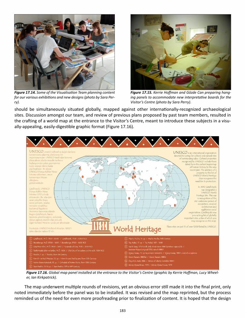
183
should be simultaneously situated globally, mapped against other internationally-recognized archaeological sites. Discussion amongst our team, and review of previous plans proposed by past team members, resulted in the crafting of a world map at the entrance to the Visitor’s Centre, meant to introduce these subjects in a visu-ally-appealing, easily-digestible graphic format (Figure 17.16).
The map underwent multiple rounds of revisions, yet an obvious error still made it into the final print, only noted immediately before the panel was to be installed. It was revised and the map reprinted, but the process reminded us of the need for even more proofreading prior to finalization of content. It is hoped that the design
Figure 17.14. Some of the Visualisation Team planning content for our various exhibitions and new designs (photo by Sara Per-ry).
Figure 17.15. Kerrie Hoffman and Gözde Can preparing hang-ing panels to accommodate new interpretative boards for the Visitor’s Centre (photo by Sara Perry).
Figure 17.16. Global map panel installed at the entrance to the Visitor’s Centre (graphic by Kerrie Hoffman, Lucy Wheel-er, Ian Kirkpatrick).
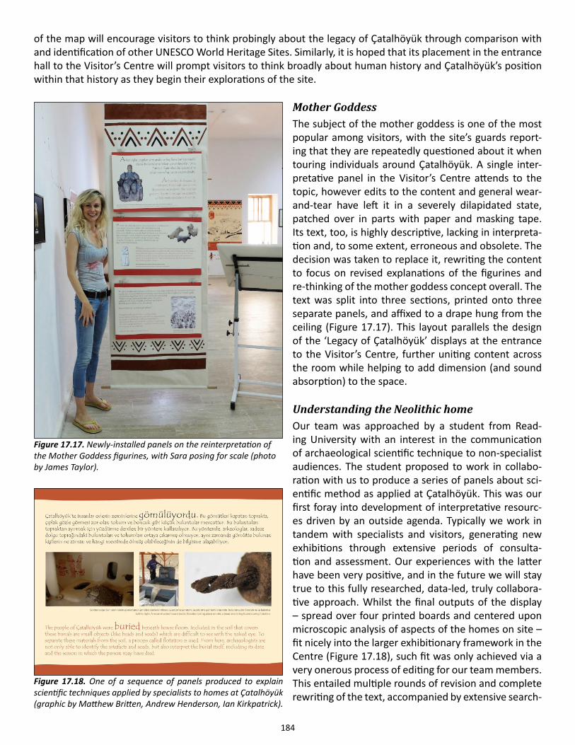
184
of the map will encourage visitors to think probingly about the legacy of Çatalhöyük through comparison with and identification of other UNESCO World Heritage Sites. Similarly, it is hoped that its placement in the entrance hall to the Visitor’s Centre will prompt visitors to think broadly about human history and Çatalhöyük’s position within that history as they begin their explorations of the site.
Mother GoddessThe subject of the mother goddess is one of the most popular among visitors, with the site’s guards report-ing that they are repeatedly questioned about it when touring individuals around Çatalhöyük. A single inter-pretative panel in the Visitor’s Centre attends to the topic, however edits to the content and general wear-and-tear have left it in a severely dilapidated state, patched over in parts with paper and masking tape. Its text, too, is highly descriptive, lacking in interpreta-tion and, to some extent, erroneous and obsolete. The decision was taken to replace it, rewriting the content to focus on revised explanations of the figurines and re-thinking of the mother goddess concept overall. The text was split into three sections, printed onto three separate panels, and affixed to a drape hung from the ceiling (Figure 17.17). This layout parallels the design of the ‘Legacy of Çatalhöyük’ displays at the entrance to the Visitor’s Centre, further uniting content across the room while helping to add dimension (and sound absorption) to the space.
Understanding the Neolithic homeOur team was approached by a student from Read-ing University with an interest in the communication of archaeological scientific technique to non-specialist audiences. The student proposed to work in collabo-ration with us to produce a series of panels about sci-entific method as applied at Çatalhöyük. This was our first foray into development of interpretative resourc-es driven by an outside agenda. Typically we work in tandem with specialists and visitors, generating new exhibitions through extensive periods of consulta-tion and assessment. Our experiences with the latter have been very positive, and in the future we will stay true to this fully researched, data-led, truly collabora-tive approach. Whilst the final outputs of the display – spread over four printed boards and centered upon microscopic analysis of aspects of the homes on site – fit nicely into the larger exhibitionary framework in the Centre (Figure 17.18), such fit was only achieved via a very onerous process of editing for our team members. This entailed multiple rounds of revision and complete rewriting of the text, accompanied by extensive search-
Figure 17.18. One of a sequence of panels produced to explain scientific techniques applied by specialists to homes at Çatalhöyük (graphic by Matthew Britten, Andrew Henderson, Ian Kirkpatrick).
Figure 17.17. Newly-installed panels on the reinterpretation of the Mother Goddess figurines, with Sara posing for scale (photo by James Taylor).
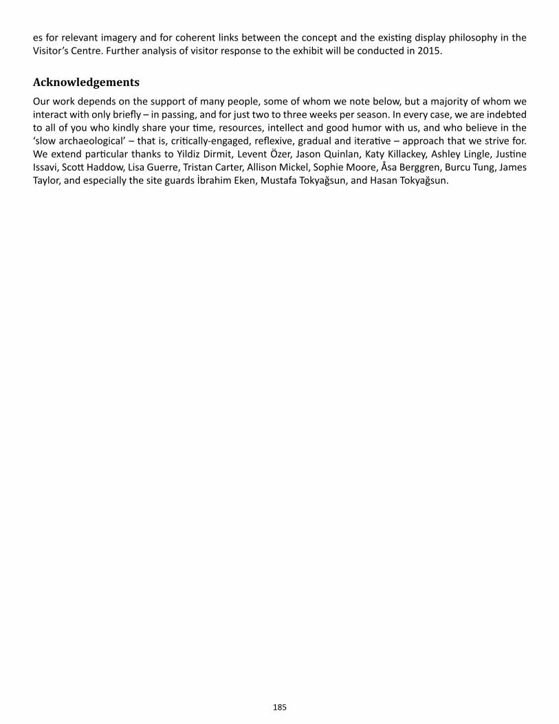
185
es for relevant imagery and for coherent links between the concept and the existing display philosophy in the Visitor’s Centre. Further analysis of visitor response to the exhibit will be conducted in 2015.
AcknowledgementsOur work depends on the support of many people, some of whom we note below, but a majority of whom we interact with only briefly – in passing, and for just two to three weeks per season. In every case, we are indebted to all of you who kindly share your time, resources, intellect and good humor with us, and who believe in the ‘slow archaeological’ – that is, critically-engaged, reflexive, gradual and iterative – approach that we strive for. We extend particular thanks to Yildiz Dirmit, Levent Özer, Jason Quinlan, Katy Killackey, Ashley Lingle, Justine Issavi, Scott Haddow, Lisa Guerre, Tristan Carter, Allison Mickel, Sophie Moore, Åsa Berggren, Burcu Tung, James Taylor, and especially the site guards İbrahim Eken, Mustafa Tokyağsun, and Hasan Tokyağsun.
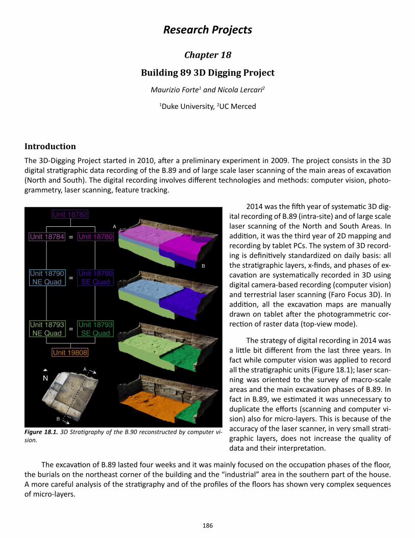
186
Research Projects
Chapter 18
Building 89 3D Digging Project
Maurizio Forte1 and Nicola Lercari2
1Duke University, 2UC Merced
IntroductionThe 3D-Digging Project started in 2010, after a preliminary experiment in 2009. The project consists in the 3D digital stratigraphic data recording of the B.89 and of large scale laser scanning of the main areas of excavation (North and South). The digital recording involves different technologies and methods: computer vision, photo-grammetry, laser scanning, feature tracking.
2014 was the fifth year of systematic 3D dig-ital recording of B.89 (intra-site) and of large scale laser scanning of the North and South Areas. In addition, it was the third year of 2D mapping and recording by tablet PCs. The system of 3D record-ing is definitively standardized on daily basis: all the stratigraphic layers, x-finds, and phases of ex-cavation are systematically recorded in 3D using digital camera-based recording (computer vision) and terrestrial laser scanning (Faro Focus 3D). In addition, all the excavation maps are manually drawn on tablet after the photogrammetric cor-rection of raster data (top-view mode).
The strategy of digital recording in 2014 was a little bit different from the last three years. In fact while computer vision was applied to record all the stratigraphic units (Figure 18.1); laser scan-ning was oriented to the survey of macro-scale areas and the main excavation phases of B.89. In fact in B.89, we estimated it was unnecessary to duplicate the efforts (scanning and computer vi-sion) also for micro-layers. This is because of the accuracy of the laser scanner, in very small strati-graphic layers, does not increase the quality of data and their interpretation.
The excavation of B.89 lasted four weeks and it was mainly focused on the occupation phases of the floor, the burials on the northeast corner of the building and the “industrial” area in the southern part of the house. A more careful analysis of the stratigraphy and of the profiles of the floors has shown very complex sequences of micro-layers.
Figure 18.1. 3D Stratigraphy of the B.90 reconstructed by computer vi-sion.
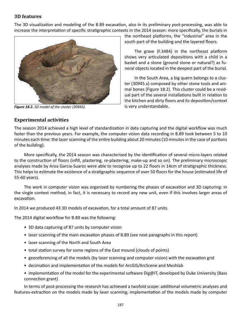
187
3D featuresThe 3D visualization and modeling of the B.89 excavation, also in its preliminary post-processing, was able to increase the interpretation of specific stratigraphic contexts in the 2014 season: more specifically, the burials in
the northeast platforms, the “industrial” area in the south part of the building and the layered floors.
The grave (F.3484) in the northeast platform shows very articulated depositions with a child in a basket and a stone (ground stone or natural?) as fu-neral objects located in the deepest part of the burial.
In the South Area, a big quern belongs to a clus-ter (30945.x) composed by other stone tools and ani-mal bones (Figure 18.2). This cluster could be a resid-ual part of the several installations built in relation to the kitchen and dirty floors and its deposition/context is very understandable.
Experimental activitiesThe season 2014 achieved a high level of standardization in data capturing and the digital workflow was much faster than the previous years. For example, the computer vision data recording in B.89 took between 5 to 10 minutes each time: the laser scanning of the entire building about 20 minutes (10 minutes in the case of portions of the building).
More specifically, the 2014 season was characterized by the identification of several micro-layers related to the construction of floors (infill, plastering, re-plastering, make-up and so on). The preliminary microscopic analyses made by Aroa Garcia-Suarez were able to recognize up to 22 floors in 14cm of stratigraphic thickness. This helps to estimate the existence of a stratigraphic sequence of over 50 floors for the house (estimated life of 55-60 years).
The work in computer vision was organized by numbering the phases of excavation and 3D capturing: in the single context method, in fact, it is necessary to record any new unit, even if this involves larger areas of excavation.
In 2014 we produced 43 3D models of excavation, for a total amount of 87 units.
The 2014 digital workflow for B.89 was the following:
• 3D data capturing of 87 units by computer vision
• laser scanning of the main excavation phases of B.89 (see next paragraphs in this report)
• laser scanning of the North and South Area
• total station survey for some regions of the East mound (clouds of points)
• georeferencing of all the models (by laser scanning and computer vision) with the excavation grid
• decimation and implementation of the models for ArcGIS/ArcScene and Meshlab
• implementation of the model for the experimental software Dig@IT, developed by Duke University (Bass connection grant)
In terms of post-processing the research has achieved a twofold scope: additional volumetric analyses and features-extraction on the models made by laser scanning; implementation of the models made by computer
Figure 18.2. 3D model of the cluster (30945).
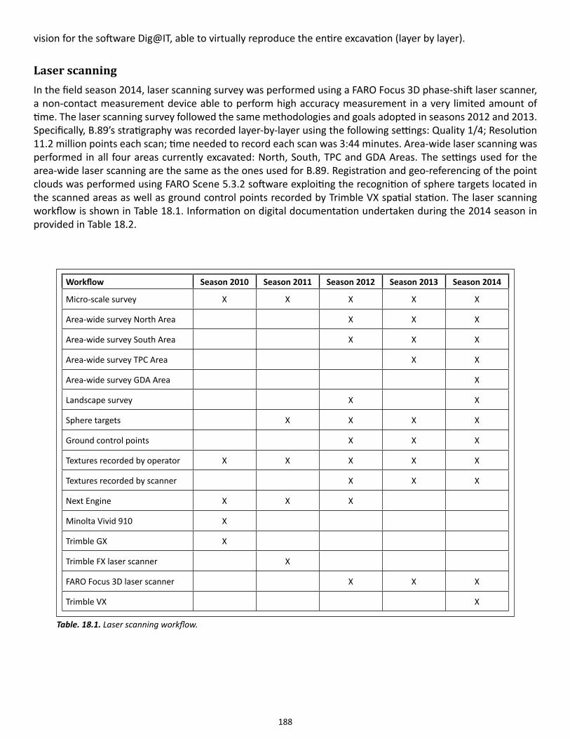
188
vision for the software Dig@IT, able to virtually reproduce the entire excavation (layer by layer).
Laser scanningIn the field season 2014, laser scanning survey was performed using a FARO Focus 3D phase-shift laser scanner, a non-contact measurement device able to perform high accuracy measurement in a very limited amount of time. The laser scanning survey followed the same methodologies and goals adopted in seasons 2012 and 2013. Specifically, B.89’s stratigraphy was recorded layer-by-layer using the following settings: Quality 1/4; Resolution 11.2 million points each scan; time needed to record each scan was 3:44 minutes. Area-wide laser scanning was performed in all four areas currently excavated: North, South, TPC and GDA Areas. The settings used for the area-wide laser scanning are the same as the ones used for B.89. Registration and geo-referencing of the point clouds was performed using FARO Scene 5.3.2 software exploiting the recognition of sphere targets located in the scanned areas as well as ground control points recorded by Trimble VX spatial station. The laser scanning workflow is shown in Table 18.1. Information on digital documentation undertaken during the 2014 season in provided in Table 18.2.
Workflow Season 2010 Season 2011 Season 2012 Season 2013 Season 2014
Micro-scale survey X X X X X
Area-wide survey North Area X X X
Area-wide survey South Area X X X
Area-wide survey TPC Area X X
Area-wide survey GDA Area X
Landscape survey X X
Sphere targets X X X X
Ground control points X X X
Textures recorded by operator X X X X X
Textures recorded by scanner X X X
Next Engine X X X
Minolta Vivid 910 X
Trimble GX X
Trimble FX laser scanner X
FARO Focus 3D laser scanner X X X
Trimble VX X
Table. 18.1. Laser scanning workflow.
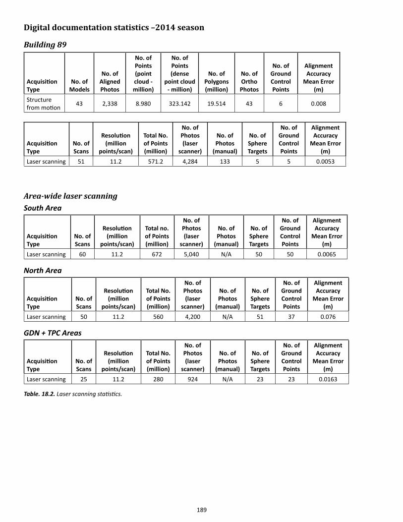
189
Digital documentation statistics –2014 season
Building 89
Acquisition Type
No. of Models
No. of Aligned Photos
No. of Points (point cloud - million)
No. of Points (dense
point cloud - million)
No. of Polygons (million)
No. of Ortho Photos
No. of Ground Control Points
Alignment Accuracy
Mean Error (m)
Structure from motion 43 2,338 8.980 323.142 19.514 43 6 0.008
Acquisition Type
No. of Scans
Resolution (million
points/scan)
Total No. of Points (million)
No. of Photos (laser
scanner)
No. of Photos
(manual)
No. of Sphere Targets
No. of Ground Control Points
Alignment Accuracy
Mean Error (m)
Laser scanning 51 11.2 571.2 4,284 133 5 5 0.0053
Area-wide laser scanningSouth Area
Acquisition Type
No. of Scans
Resolution (million
points/scan)
Total no. of Points (million)
No. of Photos (laser
scanner)
No. of Photos
(manual)
No. of Sphere Targets
No. of Ground Control Points
Alignment Accuracy
Mean Error (m)
Laser scanning 60 11.2 672 5,040 N/A 50 50 0.0065
North Area
Acquisition Type
No. of Scans
Resolution (million
points/scan)
Total No. of Points (million)
No. of Photos (laser
scanner)
No. of Photos
(manual)
No. of Sphere Targets
No. of Ground Control Points
Alignment Accuracy
Mean Error (m)
Laser scanning 50 11.2 560 4,200 N/A 51 37 0.076
GDN + TPC Areas
Acquisition Type
No. of Scans
Resolution (million
points/scan)
Total No. of Points (million)
No. of Photos (laser
scanner)
No. of Photos
(manual)
No. of Sphere Targets
No. of Ground Control Points
Alignment Accuracy
Mean Error (m)
Laser scanning 25 11.2 280 924 N/A 23 23 0.0163
Table. 18.2. Laser scanning statistics.
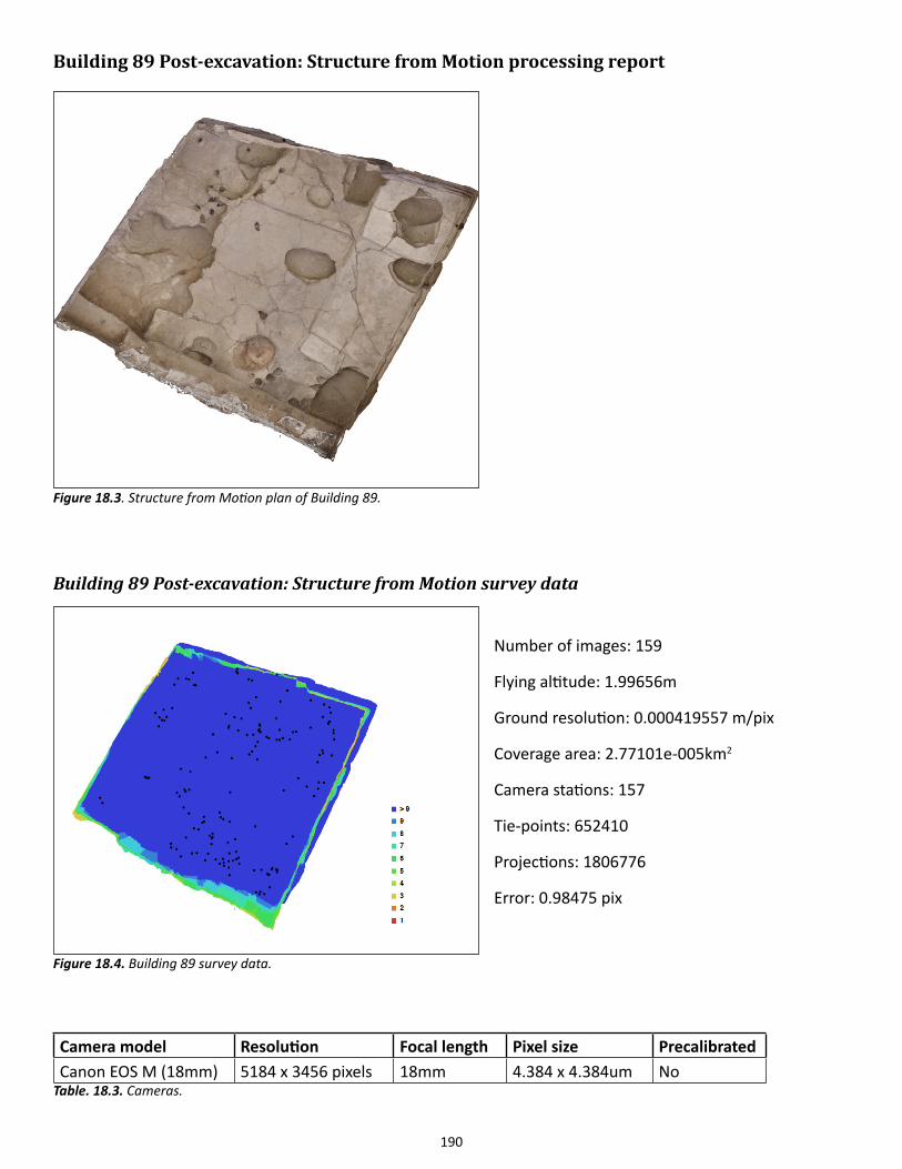
190
Building 89 Post-excavation: Structure from Motion processing report
Building 89 Post-excavation: Structure from Motion survey data
Number of images: 159
Flying altitude: 1.99656m
Ground resolution: 0.000419557 m/pix
Coverage area: 2.77101e-005km2
Camera stations: 157
Tie-points: 652410
Projections: 1806776
Error: 0.98475 pix
Camera model Resolution Focal length Pixel size PrecalibratedCanon EOS M (18mm) 5184 x 3456 pixels 18mm 4.384 x 4.384um No
Table. 18.3. Cameras.
Figure 18.3. Structure from Motion plan of Building 89.
Figure 18.4. Building 89 survey data.
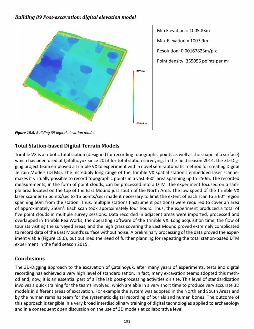
191
Building 89 Post-excavation: digital elevation model Min Elevation = 1005.83m
Max Elevation = 1007.9m
Resolution: 0.00167823m/pix
Point density: 355056 points per m2
Total Station-based Digital Terrain ModelsTrimble VX is a robotic total station (designed for recording topographic points as well as the shape of a surface) which has been used at Çatalhöyük since 2013 for total station surveying. In the field season 2014, the 3D-Dig-ging project team employed a Trimble VX to experiment with a novel semi-automatic method for creating Digital Terrain Models (DTMs). The incredibly long range of the Trimble VX spatial station’s embedded laser scanner makes it virtually possible to record topographic points in a vast 360° area spanning up to 250m. The recorded measurements, in the form of point clouds, can be processed into a DTM. The experiment focused on a sam-ple area located on the top of the East Mound just south of the North Area. The low speed of the Trimble VX laser scanner (5 points/sec to 15 points/sec) made it necessary to limit the extent of each scan to a 60° region spanning 50m from the station. Thus, multiple stations (instrument positions) were required to cover an area of approximately 250m2. Each scan took approximately four hours. Thus, the experiment produced a total of five point clouds in multiple survey sessions. Data recorded in adjacent areas were imported, processed and overlapped in Trimble RealWorks, the operating software of the Trimble VX. Long acquisition time, the flow of tourists visiting the surveyed areas, and the high grass covering the East Mound proved extremely complicated to record data of the East Mound’s surface without noise. A preliminary processing of the data proved the exper-iment viable (Figure 18.6), but outlined the need of further planning for repeating the total station-based DTM experiment in the field season 2015.
ConclusionsThe 3D-Digging approach to the excavation of Çatalhöyük, after many years of experiments, tests and digital recording has achieved a very high level of standardization. In fact, many excavation teams adopted this meth-od and, now, it is an essential part of all the lab post-processing activities on site. This level of standardization involves a quick training for the teams involved, which are able in a very short time to produce very accurate 3D models in different areas of excavation. For example the system was adopted in the North and South Areas and by the human remains team for the systematic digital recording of burials and human bones. The outcome of this approach is tangible in a very broad interdisciplinary training of digital technologies applied to archaeology and in a consequent open discussion on the use of 3D models at collaborative level.
Figure 18.5. Building 89 digital elevation model.
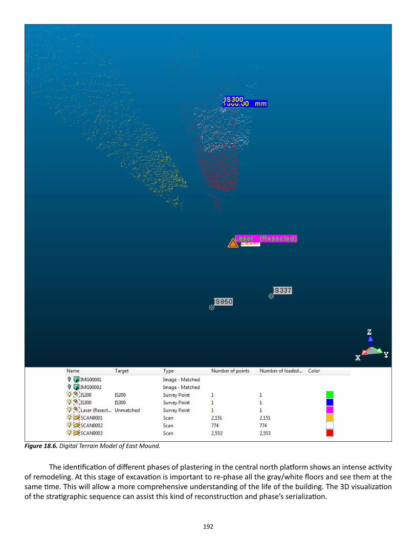
192
The identification of different phases of plastering in the central north platform shows an intense activity of remodeling. At this stage of excavation is important to re-phase all the gray/white floors and see them at the same time. This will allow a more comprehensive understanding of the life of the building. The 3D visualization of the stratigraphic sequence can assist this kind of reconstruction and phase’s serialization.
Figure 18.6. Digital Terrain Model of East Mound.
193
The large and standardized use of 3D models is very revolutionary because of its adoption at large scale and in different stratigraphic contexts and from different teams. This approach is generating new research questions and more advanced interpretation of buildings, architectural elements and stratigraphy.
There is no doubt that the 3D approach enriches the interpretation and shows often “hidden relations”. It means that that holistic-comprehensive three-dimensional view of the excavation, shaped as a 3D puzzle, unveils/exposes more specifically the activities of the Neolithic house and not only its archaeological taxonomy (the units).
The use of terrestrial laser scanning for large-scale surveys (North and South areas) was extremely suc-cessful for the management of the site, the monitoring of the state of conservation of the buildings and, more in general, for a holistic view of the entire East mound. In fact, the fast deterioration process of mud bricks and the decay of architectural structures need an accurate survey of the status quo of the entire area. In this way, the combination of laser scanning and computer vision technologies is able to digitally “freeze” the state of conservation of existing buildings and to save what doesn’t’ exist anymore because completely excavated or deteriorated.
The first tests of semi-automatic digital feature-extraction by software (3D Reshaper) on 3D models are very promising. In fact the algorithms, once calibrated, are able to generate automatically vectorial drawings, outlines or plans of specific units or layers. In addition this approach can help in understanding stratigraphy, ar-chitectural features and in general the layers segmentation and definition.
The first test of Dig@IT, the software created by Duke University, was very positive, as demonstrated by the encouraging feedback of the Çatalhöyük community on site. The main goal of the software is the virtual excava-tion: puzzling, assembling and disassembling stratigraphic units. Since every 3D unit is linked to the excavation database it will be possible to make sophisticated queries in 3D and to study as well in 3D the stratigraphic relations within the building. Future directions of the project will be focused on the creation of an on line 3D repository of all the excavation and related metadata.
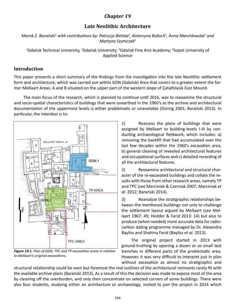
194
Chapter 19
Late Neolithic Architecture
Marek Z. Barański1 with contributions by: Patrycja Bielska2, Katarzyna Bzduch3, Anna Marchlewska2 and Martyna Szymczak4
1Gdańsk Technical University, 2Gdańsk University; 3Gdańsk Fine Arts Academy; 4Sopot University of Applied Science
IntroductionThis paper presents a short summary of the findings from the investigation into the late Neolithic settlement form and architecture, which was carried out within GDN (Gdańsk) Area that covers to a greater extent the for-mer Mellaart Areas: A and B situated on the upper part of the western slope of Çatalhöyük East Mound.
The main focus of the research, which is planned to continue until 2016, was to reexamine the structural and socio-spatial characteristics of buildings that were unearthed in the 1960’s as the archive and architectural documentation of the uppermost levels is either problematic or unavailable (Düring 2001; Barański 2013). In particular, the intention is to:
1) Reassess the plans of buildings that were assigned by Mellaart to building-levels I-III by con-ducting archaeological fieldwork, which includes: a) removing the backfill that had accumulated over the last few decades within the 1960’s excavation area, b) general cleaning of revealed architectural features and occupational surfaces and c) detailed recording of all the architectural features.
2) Reexamine architectural and structural char-acter of the re-excavated buildings and collate the re-sults with those from other research areas, namely TP and TPC (see Marciniak & Czerniak 2007; Marciniak et al. 2012; Barański 2014).
3) Reanalyze the stratigraphic relationships be-tween the mentioned buildings not only to challenge the settlement layout argued by Mellaart (see Mel-laart 1967: 49; Hodder & Farid 2013: 14) but also to produce (when needed) more accurate data for radio-carbon dating programme managed by Dr. Alexandra Bayliss and Shahina Farid (Bayliss et al. 2013).
The original project started in 2013 with ground-truthing by opening a dozen or so small test trenches in different parts of the problematic area. However, it was very difficult to interpret just in plan without excavation as almost no stratigraphic and
structural relationship could be seen but foremost the real outlines of the architectural remnants rarely fit with the available archive plans (Barański 2013). As a result of this the decision was made to expose most of the area by cleaning off the overburden, and only then concentrate on selected corners of some buildings. There were also four students, studying either an architecture or archaeology, invited to join the project in 2014 which
Figure 19.1. Plan of GDN, TPC and TP excavation areas in relation to Mellaart’s original excavations.
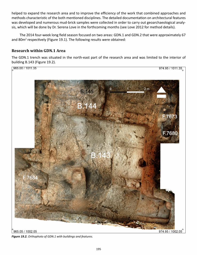
195
helped to expand the research area and to improve the efficiency of the work that combined approaches and methods characteristic of the both mentioned disciplines. The detailed documentation on architectural features was developed and numerous mud-brick samples were collected in order to carry out geoarchaeological analy-sis, which will be done by Dr. Serena Love in the forthcoming months (see Love 2012 for method details).
The 2014 four-week long field season focused on two areas: GDN.1 and GDN.2 that were approximately 67 and 80m2 respectively (Figure 19.1). The following results were obtained:
Research within GDN.1 AreaThe GDN.1 trench was situated in the north-east part of the research area and was limited to the interior of building B.143 (Figure 19.2).
Figure 19.2. Orthophoto of GDN.1 with buildings and features.
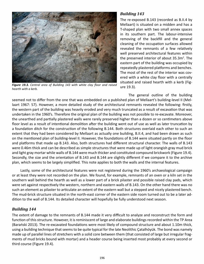
196
Building 143The re-exposed B.143 (recorded as B.II.4 by Mellaart) is situated on a midden and has a T-shaped plan with two small annex spaces in its southern part. The labour-intensive removing of the backfill and the general cleaning of the occupation surfaces allowed revealed the remnants of a few relatively well preserved architectural features within the preserved interior of about 35.3m2. The eastern part of the building was occupied by repeatedly plastered platforms and benches. The most of the rest of the interior was cov-ered with a white clay floor with a centrally situated and raised hearth with a kerb (Fig-ure 19.3).
The general outline of the building seemed not to differ from the one that was embedded on a published plan of Mellaart’s building-level II (Mel-laart 1967: 57). However, a more detailed study of the architectural remnants revealed the following: firstly, the western part of the building was heavily eroded and very much truncated as a result of excavation that was undertaken in the 1960’s. Therefore the original plan of the building was not possible to re-excavate. Moreover, the unearthed and partially plastered walls were rarely preserved higher than a dozen or so centimeters above floor level as a result of intentional demolition after the building went out of use as well as later truncation by a foundation ditch for the construction of the following B.144. Both structures overlaid each other to such an extent that they had been considered by Mellaart as actually one building, B.II.4, and had been drawn as such on the mentioned plan of building-level II. However, the foundations of B.144 were situated partly on the floor and platforms that made up B.143. Also, both structures had different structural character. The walls of B.143 were 0.46m thick and can be described as simple structures that were made up of light orangish gray mud brick and light gray mortar while walls of B.144 were much thicker and constituted compound brickwork (Figure 19.4). Secondly, the size and the orientation of B.143 and B.144 are slightly different if we compare it to the archive plan, which seems to be largely simplified. This note applies to both the walls and the internal features.
Lastly, some of the architectural features were not registered during the 1960’s archaeological campaign or at least they were not recorded on the plan. We found, for example, remnants of an oven or a kiln set in the southern wall behind the hearth as well as a lower part of a brick pilaster and possible raised clay pads, which were set against respectively the western, northern and eastern walls of B.143. On the other hand there was no such an element as pilaster to articulate an extent of the eastern wall but a stepped and nicely plastered bench. The mud-brick structure situated in the north-east corner of the eastern side room turned out to be a later ad-dition to the wall of B.144. Its detailed character will hopefully be fully understood next season.
Building 144The extent of damage to the remnants of B.144 made it very difficult to analyze and reconstruct the form and function of this structure. However, it is reminiscent of large and elaborate buildings recorded within the TP Area (Barański 2013). The re-excavated foundations were most likely of compound structure and about 1.10m thick, using a building technique that seems to be quite typical for the late Neolithic Çatalhöyük. The bond was namely made up of parallel lines of stretchers with a solid core between them (that consisted of large but irregular frag-ments of mud bricks bound with mortar) and a header course being inserted most probably at every second or third course (Figure 19.4).
Figure 19.3. Central area of Building 143 with white clay floor and raised hearth with a kerb.
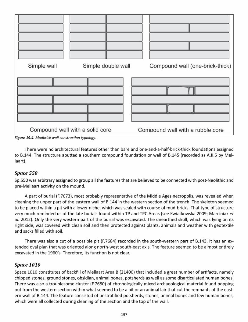
197
There were no architectural features other than bare and one-and-a-half-brick-thick foundations assigned to B.144. The structure abutted a southern compound foundation or wall of B.145 (recorded as A.II.5 by Mel-laart).
Space 550Sp.550 was arbitrary assigned to group all the features that are believed to be connected with post-Neolithic and pre-Mellaart activity on the mound.
A part of burial (F.7673), most probably representative of the Middle Ages necropolis, was revealed when cleaning the upper part of the eastern wall of B.144 in the western section of the trench. The skeleton seemed to be placed within a pit with a lower niche, which was sealed with course of mud-bricks. That type of structure very much reminded us of the late burials found within TP and TPC Areas (see Kwiatkowska 2009; Marciniak et al. 2012). Only the very western part of the burial was excavated. The unearthed skull, which was lying on its right side, was covered with clean soil and then protected against plants, animals and weather with geotextile and sacks filled with soil.
There was also a cut of a possible pit (F.7684) recorded in the south-western part of B.143. It has an ex-tended oval plan that was oriented along north-west south-east axis. The feature seemed to be almost entirely excavated in the 1960’s. Therefore, its function is not clear.
Space 1010Space 1010 constitutes of backfill of Mellaart Area B (21400) that included a great number of artifacts, namely chipped stones, ground stones, obsidian, animal bones, potsherds as well as some disarticulated human bones. There was also a troublesome cluster (F.7680) of chronologically mixed archaeological material found popping out from the western section within what seemed to be a pit or an animal lair that cut the remnants of the east-ern wall of B.144. The feature consisted of unstratified potsherds, stones, animal bones and few human bones, which were all collected during cleaning of the section and the top of the wall.
Figure 19.4. Mudbrick wall construction typology.
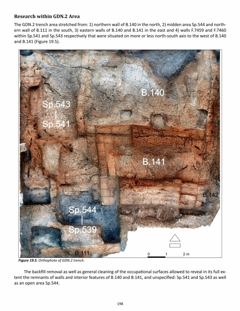
198
Research within GDN.2 AreaThe GDN.2 trench area stretched from: 1) northern wall of B.140 in the north, 2) midden area Sp.544 and north-ern wall of B.111 in the south, 3) eastern walls of B.140 and B.141 in the east and 4) walls F.7459 and F.7460 within Sp.541 and Sp.543 respectively that were situated on more or less north-south axis to the west of B.140 and B.141 (Figure 19.5).
The backfill removal as well as general cleaning of the occupational surfaces allowed to reveal in its full ex-tent the remnants of walls and interior features of B.140 and B.141, and unspecified: Sp.541 and Sp.543 as well as an open area Sp.544.
Figure 19.5. Orthophoto of GDN.2 trench.
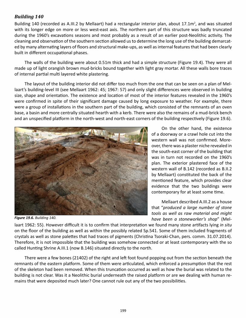
199
Building 140Building 140 (recorded as A.III.2 by Mellaart) had a rectangular interior plan, about 17.1m2, and was situated with its longer edge on more or less west-east axis. The northern part of this structure was badly truncated during the 1960’s excavations seasons and most probably as a result of an earlier post-Neolithic activity. The cleaning and observation of the southern section allowed us to determine the long use of the building demarcat-ed by many alternating layers of floors and structural make-ups, as well as internal features that had been clearly built in different occupational phases.
The walls of the building were about 0.51m thick and had a simple structure (Figure 19.4). They were all made up of light orangish brown mud-bricks bound together with light gray mortar. All these walls bore traces of internal partial multi layered white plastering.
The layout of the building interior did not differ too much from the one that can be seen on a plan of Mel-laart’s building-level III (see Mellaart 1962: 45; 1967: 57) and only slight differences were observed in building size, shape and orientation. The existence and location of most of the interior features revealed in the 1960’s were confirmed in spite of their significant damage caused by long exposure to weather. For example, there were a group of installations in the southern part of the building, which consisted of the remnants of an oven base, a basin and more centrally situated hearth with a kerb. There were also the remains of a mud-brick bench and an unspecified platform in the north-west and north-east corners of the building respectively (Figure 19.6).
On the other hand, the existence of a doorway or a crawl hole cut into the western wall was not confirmed. More-over, there was a plaster niche revealed in the south-east corner of the building that was in turn not recorded on the 1960’s plan. The exterior plastered face of the western wall of B.142 (recorded as B.II.2 by Mellaart) constituted the back of the mentioned feature, which provides clear evidence that the two buildings were contemporary for at least some time.
Mellaart described A.III.2 as a house that “produced a large number of stone tools as well as raw material and might have been a stoneworker’s shop” (Mel-
laart 1962: 55). However difficult it is to confirm that interpretation we found many stone artifacts lying in situ on the floor of the building as well as within the possibly related Sp.541. Some of them included fragments of crystals as well as stone palettes that had traces of pigments (Christina Tsoraki-Chan, pers. comm. 31.07.2014). Therefore, it is not impossible that the building was somehow connected or at least contemporary with the so called Hunting Shrine A.III.1 (now B.146) situated directly to the north.
There were a few bones (21402) of the right and left foot found popping out from the section beneath the remnants of the eastern platform. Some of them were articulated, which enforced a presumption that the rest of the skeleton had been removed. When this truncation occurred as well as how the burial was related to the building is not clear. Was it a Neolithic burial underneath the raised platform or are we dealing with human re-mains that were deposited much later? One cannot rule out any of the two possibilities.
Figure 19.6. Building 140.
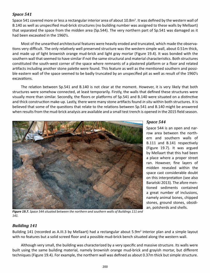
200
Space 541Space 541 covered more or less a rectangular interior area of about 10.8m2. It was defined by the western wall of B.140 as well as unspecified mud-brick structures (no building number was assigned to these walls by Mellaart) that separated the space from the midden area (Sp.544). The very northern part of Sp.541 was damaged as it had been excavated in the 1960’s.
Most of the unearthed architectural features were heavily eroded and truncated, which made the observa-tions very difficult. The only relatively well preserved structure was the western simple wall, about 0.51m thick, and made up of light brownish orange mud-brick and light gray mortar (Figure 19.4). It was bonded with the southern wall that seemed to have similar if not the same structural and material characteristics. Both structures constituted the south-west corner of the space where remnants of a plastered platform or a floor and related artifacts including another stone palette were found. This feature as well as the mentioned southern and possi-ble eastern wall of the space seemed to be badly truncated by an unspecified pit as well as result of the 1960’s excavations.
The relation between Sp.541 and B.140 is not clear at the moment. However, it is very likely that both structures were somehow connected, at least temporarily. Firstly, the walls that defined these structures were visually more than similar. Secondly, the floors or platforms of Sp.541 and B.140 were situated on a distinctive and thick construction make-up. Lastly, there were many stone artifacts found in situ within both structures. It is believed that some of the questions that relate to the relations between Sp.541 and B.140 might be answered when results from the mud-brick analysis are available and a small test trench is opened in the 2015 field season.
Space 544Space 544 is an open and nar-row area between the north-ern and southern walls of B.111 and B.141 respectively (Figure 19.7). It was argued by Mellaart that this had been a place where a proper street ran. However, fine layers of midden revealed within the space cast considerable doubt on this interpretation (see also Barański 2013). The afore men-tioned sediments contained a great number of inclusions, namely animal bones, chipped stones, ground stones, obsidi-an, potsherds and shells.
Building 141Building 141 (recorded as A.III.3 by Mellaart) had a rectangular about 5.9m2 interior plan and a simple layout with no features but a solid screed floor and a possible mud-brick bench situated along the western wall.
Although very small, the building was characterized by a very specific and massive structure. Its walls were built using the same building material, namely brownish orange mud-brick and grayish mortar, but different techniques (Figure 19.4). For example, the northern wall was defined as about 0.37m thick but simple structure.
Figure 19.7. Space 544 situated between the northern and southern walls of Buildings 111 and 141.
201
The southern wall was in turn a compound one-and-a-half-brick (about 1.2m) thick wall. The bond was made up of three parallel lines of stretchers in one course and headers being inserted probably at every second or third course of mud-bricks. The eastern and most probably the barely preserved western wall was also compound but one-brick (about 0.77m) thick structures that consisted of alternating courses of headers and stretchers. We argue that the observed differences might have resulted from the setting the building on a slope and the need to protect its southern part against damage caused by what we can define now as settlement load. It seemed very likely that most of the mentioned mud-brick structures were situated within a foundation ditch, which had been cut into the underlying layers of midden within Sp.544. Building 141 abutted the southern wall of B.140 and possibly western wall of B.142 (recorded by Mellaart as B.II.2).
Space 543Space 543 covered more or less the same area as the mentioned Sp.541. It was defined by the western walls of B.141 and B.140 as well as unspecified mud-brick structures (no building number was assigned to these walls by Mellaart) that separated the space from the midden that was revealed in the southern and western part of the research area. The very northern part of Sp.543 was damaged as a result of excavations in the 1960’s.
There were no architectural features revealed within the space except for the heavily truncated and erod-ed southern and western foundations or walls of unspecified structure. The very bad state of preservation of these features made it very difficult to define the original form and function of the whole structure. However, the re-excavated and most probably compound foundations or walls that defined Sp.543 were situated on top of the mud-brick structures and a platform assigned to Sp.541 as well as midden area defined within Sp.544. They were all made up of brownish orange mud-bricks bound with dark gray mortar and were most probably about 1.2m thick (Figure 19.4).
The exact relation between Sp.543 and B.141 is not clear at the moment, although it is very likely that both structures were contemporary or even made up one building compound.
Space 539There were remnants of unspecified mud-brick structure F.7463 found within Sp.539. This feature was very badly affected by post-depositional processes and the consequence was that neither credible measurements nor other architectural analysis could be undertaken. The mentioned foundation or wall was situated on top of the midden attributed to Sp.544. However, it is not clear whether the feature is of Neolithic origin or represents some kind of structure built during the time of one of the later periods.
Space 1010Space 1010 constitutes backfill (21401) of Mellaart Area A that included a great number of artifacts, mainly chipped stones, ground stones, crystals, obsidian, animal bones and potsherds. There was also a complete but very fragmented human skull Sk(21473) found, 3D documented and lifted. It was situated within the infill that had accumulated between the exposed walls of B.111 and B.141.
Acknowledgments This project is funded by the National Science Center in Poland as well as private equities including the funds of all GDN team members.
I would sincerely like to thank Ian Hodder, Yildiz Dirmit, Burcu Tung and James Taylor for their support during the season. I extend particular thanks to Lech Czerniak, Jakub Szczepański, Alexandra Bayliss, Shahina Farid, Serena Love, Arkadiusz Klimowicz, Marta Perlińska, Ashley Lingle, Flavia Ravaioli, Jason Quinlan, Nicola Lercari, Cordelia Hall, David Mackie and especially all GDN team members: Patrycja Bielska, Katarzyna Bzduch, Anna Marchlewska and Martyna Szymczak as the last four of them considerably contributed to the project both
202
physically and financially.
I am also very grateful to Mathew Britten, Christina Tsoraki-Chan, Janna Rogasch, Lisa Guerre, Kyle Crosset, Christopher Knüsel, Scott Haddow, Matteo Pilati and the site workers for all their help in various situations.
References
Barański M.Z.2013. Back to Mellaart A Area: survey on Late Neolithic architecture. Çatalhöyük 2013 Archive Report, http://www.catalhoyuk.com/downloads/Archive_Report_2013.pdf, 20.10.2014: 220-234.
2014. Late Neolithic architecture of Çatalhöyük. The technical aspects of the mound and building con-struction, in Regional Studies in Archaeology Symposium Proceedings: 12-13 May 2011, Ankara, eds. B. Erciyas & E. Sökmen. Istanbul: Yayinlari, 173-185.
Bayliss, A., S. Farid & T. Higham2013. Time will tell: practicing Bayesian chronological modeling on the East Mound, in Çatalhöyük Excavations: the 2000-2008 Seasons ed. I. Hodder. London: British Institute at Ankara; Los Angeles: Co-tsen Institute of Archaeology Press, 53-89.
Düring, B.S. 2001. Social dimensions in the architecture of Neolithic Çatalhöyük. Anatolian Studies 51: 1-18.
Hodder, I. & S. Farid2013. Questions, history of work and summary of results, In Çatalhöyük Excavations: the 2000-2008 Seasons, ed. I. Hodder. London: British Institute at Ankara; Los Angeles: Cotsen Institute of Archaeology Press, 1-34.
Kwiatkowska M.2009. Byzantine and Muslim cemeteries at Çatalhöyük – an outline, in Archaeology of the Countryside in Medieval Anatolia (Pihans 113), eds. T. Vorderstrasse T. & J. Roodenberg. Leiden: Netherlands Institute for the Near East, 129-138.
Love S.2012. A geoarchaeology of mudbricks in architecture: a methodological study from Çatalhöyük, Turkey. Geoarchaeology, 27(2): 140-156.
Marciniak A. & L. Czerniak2007. Social transformations in the Late Neolithic and the Early Chalcolithic periods in central Anatolia. Anatolian Studies 57: 115-130.
Marciniak A., P. Filipowicz & A. Mickel2012. The excavations of the TPC Area in the 2012 Season. Çatalhöyük 2012 Archive Report, http://www.catalhoyuk.com/downloads/Archive_Report_2012.pdf, 20.10.2014: 62-75.
Mellaart J. 1962. Excavations at Çatal Hüyük. First preliminary report, 1961. Anatolian Studies XII: 41-65. 1967. Çatal Hüyük: A Neolithic Town in Anatolia. London, Thames & Hudson.
203
Chapter 20
Analysis of the Post-Chalcolithic Cemeteries
Sophie Moore
Sophie Moore spent the 2014 season in the Human Remains Lab continuing her study of the Post-Chalcolithic cemeteries on both the East and West Mounds at Çatalhöyük. She also assisted in the excavation of several 11th/12th century burials in the TPC Area of the site. Her specific focus this field-season was to go through the archives and catalogue the small finds from the 1st and 2nd millennium AD graves on the West Mound and the graves from the North Area which had not already been studied.
The graves from the West Mound are all likely to date from the 1st to 3rd centuries AD based on the previous-ly established typology of funerary architecture and body orientation (Moore and Jackson 2013) as well as the few deliberately deposited small finds recovered from the burial contexts. One item in particular is of interest, a yellow carnelian intaglio excavated in (2001) (object in fill (7229)), which has lost its setting, shows two fish and an anchor. The symbolism of the sigil suggests both Christian origin and an early date.
Two other intaglios excavated in 2012 were also studied; a gem stone (which is probably serpentine) set in a Cu alloy ring shows the figure of Artemis of Ephesus (20493.x7). An intaglio of unidentified material, possibly meerschaum, set in an iron ring (19587.x3) shows a winged figure radiating light that we might identify as Nike.
The previously published grave typology, which was based on the North Area material and groups Roman, Byzantine and Islamic burials separately has been refined to include another Islamic group of burials. These graves are closely comparable to burials present at nearby Pınarbaşı which have been dated by the presence of a coin and two artifacts to between the 11th and 13th centuries AD. These burials have a specific construction, with the burial niche opening laterally from the south side of a primary pit. The burial niches were not back filled, but capped with a mudbrick construction. The post-Chalcolithic phases now number four: Roman, Byzantine, and two medieval phases, one dating to the 11th/12th century Seljuk period and a second to the later medieval period.
204
Chapter 21
Modelling Chronology
Alex Bayliss and Shahina Farid, English Heritage
Steady progress has been made on the scientific dating programme over the course of 2013/14. Two articles have been accepted for publication. The first summarizes the chronology of the TP Area and its implications (Marciniak et al. 2014), and the second provides an updated the chronology for the base of the mound (Bayliss et al. 2014). More detailed modelling of the chronology of the TP Area continues and will be reported in the forthcoming volume on the TP Neolithic sequence (Marciniak and Czerniak, in preparation).
Work to provide a chronology for the whole span of deposits in the South Area also continues. The first preliminary model for the entire sequence was presented to the Çatalhöyük team on site in July, but three more batches of radiocarbon results have been reported since then, so that model is already outdated. The next iter-ation of the interim model is running (it now takes more than a week to calculate) and will aid the selection of further samples. We now have about three quarters of the results that are needed for dating the sequence of buildings and spaces which runs from the top of the South Area (B.10) to the base of the mound (Sp.181), but less than half those that will be needed to tie in other buildings and spaces in the South Area to this spine. A funding application has been submitted to complete the chronological modelling in this area of the site.
We have received a grant from the Albert Reckitt Archaeological Fund (administered by the British Acad-emy) to analyze the new plans from the 1960s excavations which were kindly lent to the project by James Mel-laart before his death. Alex and Shahina have identified the ‘most reliable’ (usually largest scale) plan on which each building recorded by Mellaart appears, and these have been digitized by Cordelia Hall. The plans have then been fitted together using an explicit hierarchy of criteria (for example, five plans show pegs 9 and 10 of the 1965 grid). We are now working on defining the outlines of the buildings and spaces recorded by Mellaart and on tying the 1960s plans to the modern grid. The next step is to assess their accuracy in comparison to buildings which have been recorded in both the 1960s and by the current project. For the upper levels we are working closely with Marek Z. Barański and Team Gdańsk (GDN), who are providing invaluable additional evidence by which we can evaluate Mellaart’s approach to the drawn record.
References
Bayliss, A., Brock, F., Farid, S., Hodder, I., Southon, J., & Taylor, R.E.In press. Getting to the bottom of it all: a Bayesian approach to dating the start of Çatalhöyük, Journal of World Prehistory.
Marciniak, A., Barański, M.Z., Bayliss, A., Czerniak, L., Goslar, T., Southon, J., & Taylor, R.E.In press. Fragmenting times: interpreting a Bayesian chronology for the late Neolithic occupation of Çatalhöyük East, Turkey. Antiquity.
Marciniak, A., & Czerniak, L.in preparation. Late Neolithic at Çatalhöyük East: Excavations of Upper Levels in the Team Poznan Area. Los Angeles: Cotsen Institute of Archaeology Press.
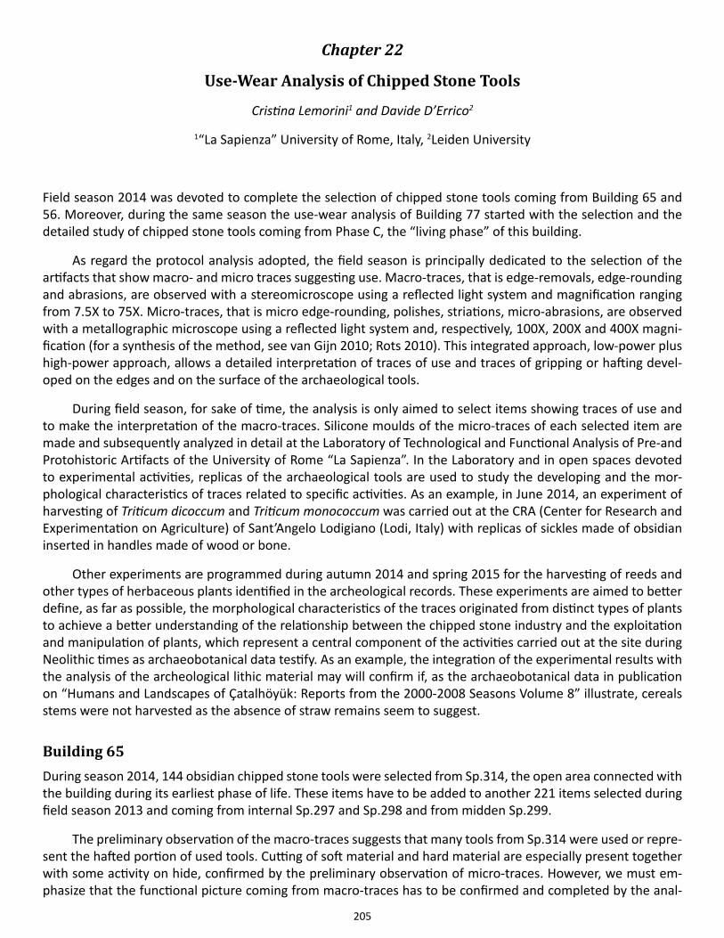
205
Chapter 22
Use-Wear Analysis of Chipped Stone Tools
Cristina Lemorini1 and Davide D’Errico2
1“La Sapienza” University of Rome, Italy, 2Leiden University
Field season 2014 was devoted to complete the selection of chipped stone tools coming from Building 65 and 56. Moreover, during the same season the use-wear analysis of Building 77 started with the selection and the detailed study of chipped stone tools coming from Phase C, the “living phase” of this building.
As regard the protocol analysis adopted, the field season is principally dedicated to the selection of the artifacts that show macro- and micro traces suggesting use. Macro-traces, that is edge-removals, edge-rounding and abrasions, are observed with a stereomicroscope using a reflected light system and magnification ranging from 7.5X to 75X. Micro-traces, that is micro edge-rounding, polishes, striations, micro-abrasions, are observed with a metallographic microscope using a reflected light system and, respectively, 100X, 200X and 400X magni-fication (for a synthesis of the method, see van Gijn 2010; Rots 2010). This integrated approach, low-power plus high-power approach, allows a detailed interpretation of traces of use and traces of gripping or hafting devel-oped on the edges and on the surface of the archaeological tools.
During field season, for sake of time, the analysis is only aimed to select items showing traces of use and to make the interpretation of the macro-traces. Silicone moulds of the micro-traces of each selected item are made and subsequently analyzed in detail at the Laboratory of Technological and Functional Analysis of Pre-and Protohistoric Artifacts of the University of Rome “La Sapienza”. In the Laboratory and in open spaces devoted to experimental activities, replicas of the archaeological tools are used to study the developing and the mor-phological characteristics of traces related to specific activities. As an example, in June 2014, an experiment of harvesting of Triticum dicoccum and Triticum monococcum was carried out at the CRA (Center for Research and Experimentation on Agriculture) of Sant’Angelo Lodigiano (Lodi, Italy) with replicas of sickles made of obsidian inserted in handles made of wood or bone.
Other experiments are programmed during autumn 2014 and spring 2015 for the harvesting of reeds and other types of herbaceous plants identified in the archeological records. These experiments are aimed to better define, as far as possible, the morphological characteristics of the traces originated from distinct types of plants to achieve a better understanding of the relationship between the chipped stone industry and the exploitation and manipulation of plants, which represent a central component of the activities carried out at the site during Neolithic times as archaeobotanical data testify. As an example, the integration of the experimental results with the analysis of the archeological lithic material may will confirm if, as the archaeobotanical data in publication on “Humans and Landscapes of Çatalhöyük: Reports from the 2000-2008 Seasons Volume 8” illustrate, cereals stems were not harvested as the absence of straw remains seem to suggest.
Building 65During season 2014, 144 obsidian chipped stone tools were selected from Sp.314, the open area connected with the building during its earliest phase of life. These items have to be added to another 221 items selected during field season 2013 and coming from internal Sp.297 and Sp.298 and from midden Sp.299.
The preliminary observation of the macro-traces suggests that many tools from Sp.314 were used or repre-sent the hafted portion of used tools. Cutting of soft material and hard material are especially present together with some activity on hide, confirmed by the preliminary observation of micro-traces. However, we must em-phasize that the functional picture coming from macro-traces has to be confirmed and completed by the anal-
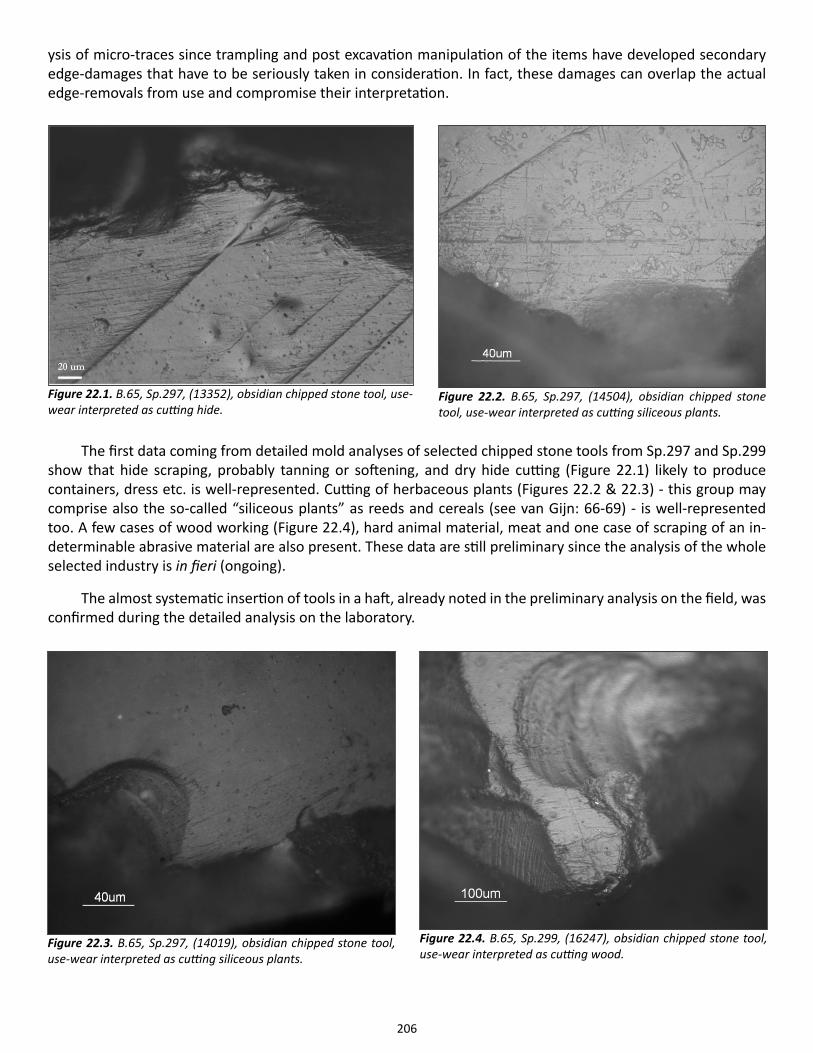
206
ysis of micro-traces since trampling and post excavation manipulation of the items have developed secondary edge-damages that have to be seriously taken in consideration. In fact, these damages can overlap the actual edge-removals from use and compromise their interpretation.
The first data coming from detailed mold analyses of selected chipped stone tools from Sp.297 and Sp.299 show that hide scraping, probably tanning or softening, and dry hide cutting (Figure 22.1) likely to produce containers, dress etc. is well-represented. Cutting of herbaceous plants (Figures 22.2 & 22.3) - this group may comprise also the so-called “siliceous plants” as reeds and cereals (see van Gijn: 66-69) - is well-represented too. A few cases of wood working (Figure 22.4), hard animal material, meat and one case of scraping of an in-determinable abrasive material are also present. These data are still preliminary since the analysis of the whole selected industry is in fieri (ongoing).
The almost systematic insertion of tools in a haft, already noted in the preliminary analysis on the field, was confirmed during the detailed analysis on the laboratory.
Figure 22.1. B.65, Sp.297, (13352), obsidian chipped stone tool, use-wear interpreted as cutting hide.
Figure 22.2. B.65, Sp.297, (14504), obsidian chipped stone tool, use-wear interpreted as cutting siliceous plants.
Figure 22.3. B.65, Sp.297, (14019), obsidian chipped stone tool, use-wear interpreted as cutting siliceous plants.
Figure 22.4. B.65, Sp.299, (16247), obsidian chipped stone tool, use-wear interpreted as cutting wood.
207
Building 56The preliminary selection of the lithic industry of B.56 has been completed during season 2014. 122 chipped stone tools have been selected and silicone molds of their traces of use or hafting were taken to the laboratory of Technological and Functional Analysis of Pre-and Protohistoric Artifacts of “La Sapienza”.
Building 77Regarding this building, we decided to carry out the complete use-wear analysis of the chipped stone tools di-rectly in the field since we needed detailed data to be integrated in the presentation dedicated to this building and presented by J.S. Taylor during the EAA Congress held in Istanbul in September 2014.
For the sake of time, we were able to analyze only the “living phase” of the building, Phase C. Phase C is characterized essentially by débris and débitage testifying knapping activities in situ; maybe, the micro-traces of façonnage observed on projectiles 1090, 1094 and 1027 are part of this knapping and shaping activities. The unique functional datum of Phase C is related to an activity of softening of dry hide carried out with a small shaped tool made of flint, laying on the floor of unit (22009).
References
van Gijn, A. 2010. Flint in Focus. Lithic Biographies in the Neolithic and Bronze Age. Leiden: Sidestone Press.
Lemorini, C. & D. D’Errico 2013. Use-wear analysis 2013. Çatalhöyük Archive Report 2013, 237-239.
Rots, V. 2010. Prehension and Hafting Traces on Flint Tools: A Methodology. Leuven: Leuven University Press.
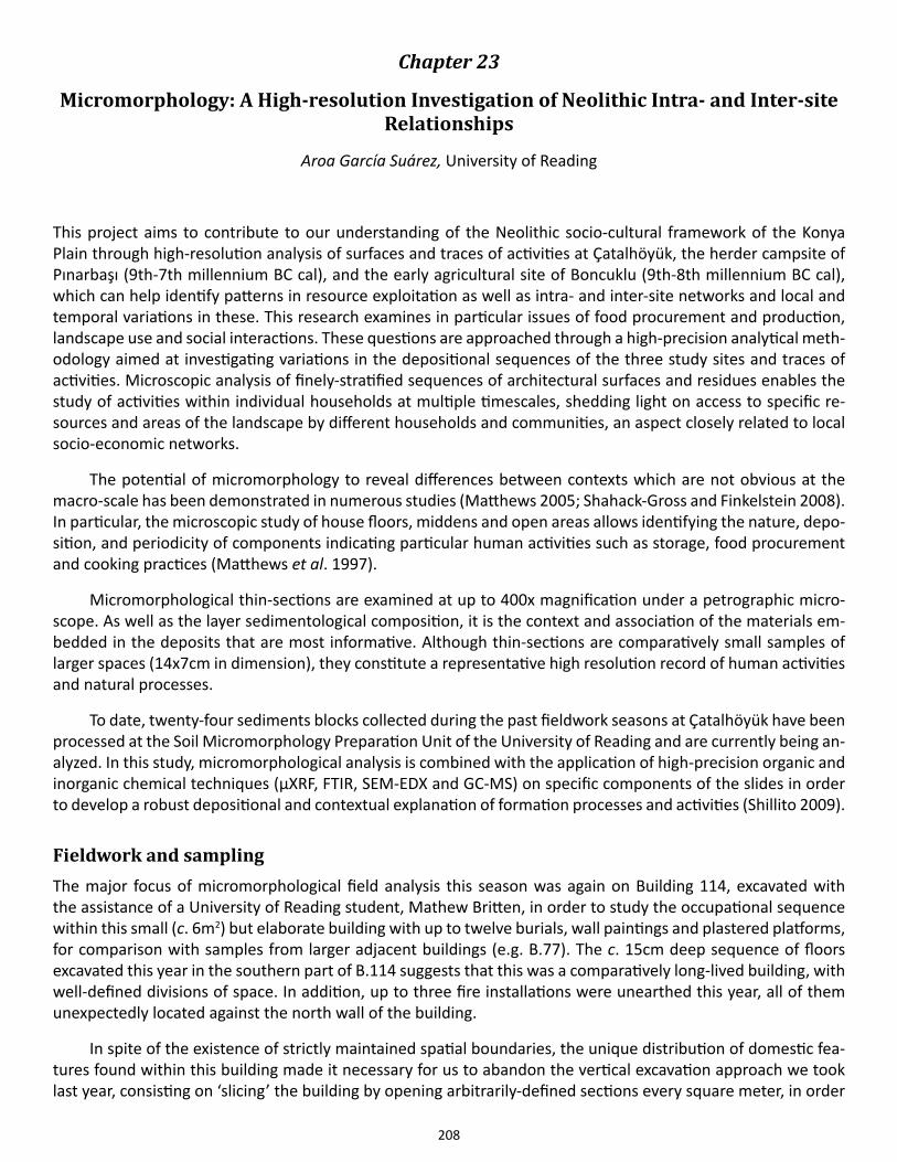
208
Chapter 23
Micromorphology: A High-resolution Investigation of Neolithic Intra- and Inter-site Relationships
Aroa García Suárez, University of Reading
This project aims to contribute to our understanding of the Neolithic socio-cultural framework of the Konya Plain through high-resolution analysis of surfaces and traces of activities at Çatalhöyük, the herder campsite of Pınarbaşı (9th-7th millennium BC cal), and the early agricultural site of Boncuklu (9th-8th millennium BC cal), which can help identify patterns in resource exploitation as well as intra- and inter-site networks and local and temporal variations in these. This research examines in particular issues of food procurement and production, landscape use and social interactions. These questions are approached through a high-precision analytical meth-odology aimed at investigating variations in the depositional sequences of the three study sites and traces of activities. Microscopic analysis of finely-stratified sequences of architectural surfaces and residues enables the study of activities within individual households at multiple timescales, shedding light on access to specific re-sources and areas of the landscape by different households and communities, an aspect closely related to local socio-economic networks.
The potential of micromorphology to reveal differences between contexts which are not obvious at the macro-scale has been demonstrated in numerous studies (Matthews 2005; Shahack-Gross and Finkelstein 2008). In particular, the microscopic study of house floors, middens and open areas allows identifying the nature, depo-sition, and periodicity of components indicating particular human activities such as storage, food procurement and cooking practices (Matthews et al. 1997).
Micromorphological thin-sections are examined at up to 400x magnification under a petrographic micro-scope. As well as the layer sedimentological composition, it is the context and association of the materials em-bedded in the deposits that are most informative. Although thin-sections are comparatively small samples of larger spaces (14x7cm in dimension), they constitute a representative high resolution record of human activities and natural processes.
To date, twenty-four sediments blocks collected during the past fieldwork seasons at Çatalhöyük have been processed at the Soil Micromorphology Preparation Unit of the University of Reading and are currently being an-alyzed. In this study, micromorphological analysis is combined with the application of high-precision organic and inorganic chemical techniques (μXRF, FTIR, SEM-EDX and GC-MS) on specific components of the slides in order to develop a robust depositional and contextual explanation of formation processes and activities (Shillito 2009).
Fieldwork and sampling The major focus of micromorphological field analysis this season was again on Building 114, excavated with the assistance of a University of Reading student, Mathew Britten, in order to study the occupational sequence within this small (c. 6m2) but elaborate building with up to twelve burials, wall paintings and plastered platforms, for comparison with samples from larger adjacent buildings (e.g. B.77). The c. 15cm deep sequence of floors excavated this year in the southern part of B.114 suggests that this was a comparatively long-lived building, with well-defined divisions of space. In addition, up to three fire installations were unearthed this year, all of them unexpectedly located against the north wall of the building.
In spite of the existence of strictly maintained spatial boundaries, the unique distribution of domestic fea-tures found within this building made it necessary for us to abandon the vertical excavation approach we took last year, consisting on ‘slicing’ the building by opening arbitrarily-defined sections every square meter, in order
209
to define the extension and modification stages of the different constructional features.
In addition to the micromorphological sampling of B.114, from where three blocks were taken this season, selected contexts from the neighboring B.77 and B.119 were sampled for comparative analyses. Four further sediment blocks were collected from the TPC trench, comprising the whole depositional sequence of a Late Neo-lithic midden. Spaces 489 and 511, excavated by Arek Klimowicz, were also extensively sampled (Figure 23.1). These two open areas (Sp.511 underlying Sp.489) have been cross-sectioned and as a result, a c. 2.5m deep vertical profile has been exposed, providing a wealth of detail on the microstratigraphic histories of these spac-es and of opportunities for sampling. Thirteen blocks were taken, spanning the whole depositional squence of the spaces, which comprise midden deposits, rubble, plaster floors, infill and activity areas. The microanalytical study of this sequence, in conjunction with the detailed macroscopic observations and recording conducted by the excavators, will aid in the understanding of the complex life-histories of these spaces.
AcknowledgementsI am grateful to the Konya Museum for permission to export the micromorphological blocks and sediments. I would like to thank Ian Hodder, Arek Marciniak, Douglas Baird and Andy Fairbairn for kind permission to study and sample microstratigraphic sequences at their sites. Special thanks to Burcu Tung for her patience and guid-
Figure 23.1. Upper part of section in Sp.489/511 during micromorphological sampling (photo by Aroa García Suárez).
210
ance during the field season. Marta Perlińska, Marek Barański and Christoffer Hagberg provided invaluable help during fieldwork and sampling. Thanks to Arek Klimowicz, Patrycja Filipowicz, Lara González, Jędrzej Hordecki and Maciej Chylenski for their very much needed professional support. And most especially, thank you, Matt. This project is supported by a doctoral grant from AHRC.
References
Matthews, W. 2005. Micromorphological and microstratigraphic traces of uses and concepts of space. In: Hodder, I. (ed.) Inhabiting Çatalhöyük: Reports from the 1995-1999 Seasons. Cambridge: McDonald Institute and British Institute of Archaeology at Ankara.
Matthews, W., French, C. A. I., Lawrence, T., Cutler, D. F.& Jones, M. K. 1997. Microstratigraphic Traces of Site Formation Processes and Human Activities. World Archaeology, 29: 281-308.
Shahack-Gross, R. & Finkelstein, I. 2008. Subsistence practices in an arid environment: a geoarchaeological investigation in an Iron Age site, the Negev Highlands, Israel. Journal of Archaeological Science, 35: 965-982.
Shillito, L.-M. 2009. Rapid characterisation of archaeological midden components using FT-IR spectroscopy, SEM-EDX and micro-XRD. Spectrochimica Acta Part A: Molecular and Biomolecular Spectroscopy, 73: 133-139.
211
Chapter 24
Speleothems and Their Context at Çatalhöyük
Holley Moyes, UC Merced
IntroductionNeolithic cave use is well-reported in many areas. It is frequent in Ireland where burial caves were predominant from approximately 3600 B.C. to 3400 B.C. (Dowd 2008) and in Great Britain in the 4th millennium B.C. (Cham-berlain 2012). Peter Tomkins (2012:66) reports that there are no less than 100 cave sites in Crete that contain Neolithic-EM material. Israel contains a number of caves with Neolithic materials and the Chalcolithic burial site, Peqi’in Cave, is reported to have Neolithic components (Rowan & Illan 2012). Further afield, Niah cave in Borneo contains at least 200 Neolithic burials (Barker & Smith 2012) as part of an overall pattern of the funerary use of caves dating to this period in Island Southeast Asia (Anderson 1997).
In her analyses of Neolithic caves in Italy, Ruth Whitehouse (1992:132-33) proposed a number of ritual themes operating at the time that included cults devoted to “abnormal water,” which could include steam, bub-bling water, still pools, or “solid water” (speleothems). The Grotta Scaloria in North Apulia provides and interest-ing example. Although the upper chamber of the cave was a Late Neolithic burial site containing 137 individuals, Whitehouse proposed that the lower part of the cave was the venue of a water cult. In the centre of the sloping area of the chamber, there was a hollowed rectangular basin used to collect the water dripping from the stalac-tites on the roof (Skeates 2012:34-35). Surrounding the basin, pottery vessels, some of which were whole, were placed near stalactites or directly underneath them to catch drips. A single radiocarbon sample collected from the surface near the vessels returned a date range of c. 4470-4160 B.C., but the vessels themselves suggested earlier placement.
Given the prevalence of cave use during the Neolithic, it is no surprise that the people of Çatalhöyük were familiar with the region’s caves as evidenced by the presence of speleothems excavated from the site. Spele-othems represent a class of artifact that often goes unreported because they are not recognized by archae-ologists. One reason is that they exhibit many different shapes and sizes that can be composed of numerous minerals (though they often consist of calcium carbonates or gypsum). Speleothems are typically classified by their morphology as opposed to their mineral structures because they are of interest to recreational cavers (Hill & Forti 1997:13, 45). This classification allows for easy identification because it is based on visible properties. For the archaeologist, this type of formal identification helps to provide a phenomenological tie to people of the past because the visual and tactile features of the artifacts are easily observed once one knows what to look for.
Speleothems are considered to be sacred or special objects in many cultures. For instance, in ancient Me-soamerica, harvested speleothems were used as stela or in architectural constructions, carved as idols, or de-posited in burials and caches (Brady et al. 1997). Their use in ritual contexts likely had to do with their formation from water dripping in caves. Drip water, referred to by the Maya as zuhuy ha or “virgin water,” was considered sacred and used in ritual throughout Mesoamerica during prehispanic times and continues into the present. The Yucatec term for speleothem is xix ha tunich or “drip-water stone.” This lexical evidence suggests that the Maya were cognizant of the process of speleothem formation and that these stones were considered sacred because they were composed of and therefore represented pure or sacred water (Moyes 2001:79-80).
Speleothem breakage and removal has an even deeper history. It is well-known that humans used caves as special or ritual spaces beginning in the Paleolithic period but less well-reported that speleothem breakage was part of Paleolithic cave practice. For instance, Jean Clottes (2012) noted that at Cosquer cave the tops of stalag-mites were broken and removed from the site.
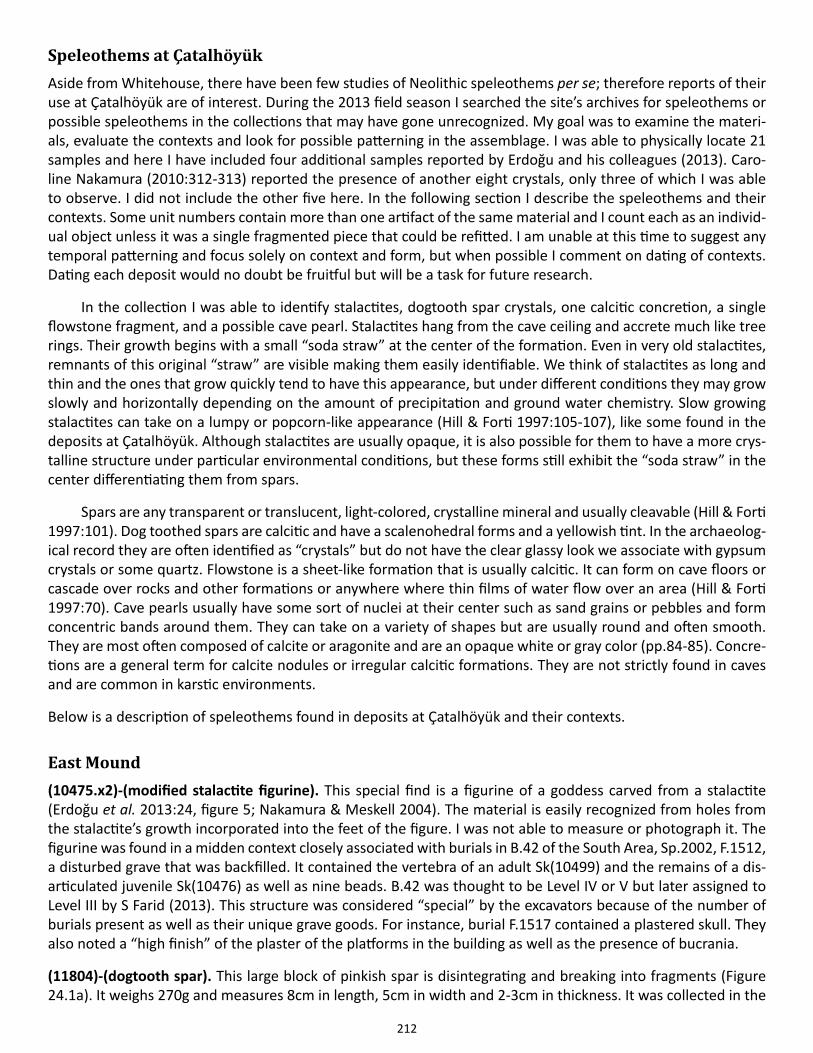
212
Speleothems at ÇatalhöyükAside from Whitehouse, there have been few studies of Neolithic speleothems per se; therefore reports of their use at Çatalhöyük are of interest. During the 2013 field season I searched the site’s archives for speleothems or possible speleothems in the collections that may have gone unrecognized. My goal was to examine the materi-als, evaluate the contexts and look for possible patterning in the assemblage. I was able to physically locate 21 samples and here I have included four additional samples reported by Erdoğu and his colleagues (2013). Caro-line Nakamura (2010:312-313) reported the presence of another eight crystals, only three of which I was able to observe. I did not include the other five here. In the following section I describe the speleothems and their contexts. Some unit numbers contain more than one artifact of the same material and I count each as an individ-ual object unless it was a single fragmented piece that could be refitted. I am unable at this time to suggest any temporal patterning and focus solely on context and form, but when possible I comment on dating of contexts. Dating each deposit would no doubt be fruitful but will be a task for future research.
In the collection I was able to identify stalactites, dogtooth spar crystals, one calcitic concretion, a single flowstone fragment, and a possible cave pearl. Stalactites hang from the cave ceiling and accrete much like tree rings. Their growth begins with a small “soda straw” at the center of the formation. Even in very old stalactites, remnants of this original “straw” are visible making them easily identifiable. We think of stalactites as long and thin and the ones that grow quickly tend to have this appearance, but under different conditions they may grow slowly and horizontally depending on the amount of precipitation and ground water chemistry. Slow growing stalactites can take on a lumpy or popcorn-like appearance (Hill & Forti 1997:105-107), like some found in the deposits at Çatalhöyük. Although stalactites are usually opaque, it is also possible for them to have a more crys-talline structure under particular environmental conditions, but these forms still exhibit the “soda straw” in the center differentiating them from spars.
Spars are any transparent or translucent, light-colored, crystalline mineral and usually cleavable (Hill & Forti 1997:101). Dog toothed spars are calcitic and have a scalenohedral forms and a yellowish tint. In the archaeolog-ical record they are often identified as “crystals” but do not have the clear glassy look we associate with gypsum crystals or some quartz. Flowstone is a sheet-like formation that is usually calcitic. It can form on cave floors or cascade over rocks and other formations or anywhere where thin films of water flow over an area (Hill & Forti 1997:70). Cave pearls usually have some sort of nuclei at their center such as sand grains or pebbles and form concentric bands around them. They can take on a variety of shapes but are usually round and often smooth. They are most often composed of calcite or aragonite and are an opaque white or gray color (pp.84-85). Concre-tions are a general term for calcite nodules or irregular calcitic formations. They are not strictly found in caves and are common in karstic environments.
Below is a description of speleothems found in deposits at Çatalhöyük and their contexts.
East Mound(10475.x2)-(modified stalactite figurine). This special find is a figurine of a goddess carved from a stalactite (Erdoğu et al. 2013:24, figure 5; Nakamura & Meskell 2004). The material is easily recognized from holes from the stalactite’s growth incorporated into the feet of the figure. I was not able to measure or photograph it. The figurine was found in a midden context closely associated with burials in B.42 of the South Area, Sp.2002, F.1512, a disturbed grave that was backfilled. It contained the vertebra of an adult Sk(10499) and the remains of a dis-articulated juvenile Sk(10476) as well as nine beads. B.42 was thought to be Level IV or V but later assigned to Level III by S Farid (2013). This structure was considered “special” by the excavators because of the number of burials present as well as their unique grave goods. For instance, burial F.1517 contained a plastered skull. They also noted a “high finish” of the plaster of the platforms in the building as well as the presence of bucrania.
(11804)-(dogtooth spar). This large block of pinkish spar is disintegrating and breaking into fragments (Figure 24.1a). It weighs 270g and measures 8cm in length, 5cm in width and 2-3cm in thickness. It was collected in the
213
IST Area of the East Mound from Sp.251 and is associated with kerpic blocks.
(11904)-(stalactite). This is a large, burned stalactite is broken into several pieces in its current condition, but originally measured 11cm x 13cm as reported by Erdoğu et al. (2013:22, figure 1). It is quite heavy weighing 2.3kg. While most speleothems show evidence of rings, similar to tree rings, but this stalactite exhibits a crys-talline structure. Because it was burned, the stalactite has become friable and is disintegrating into small pieces along the crystal fault lines. It was discovered in B.52 on the North Area (Bogden 2005). This is a well-elaborated structure that contained an embedded bucrania in an installation set within a niche in the western wall as well as three right-sided cattle horn cores fixed in a row adjacent to it. Recent studies suggest that the building slowly burned but it is inconclusive as to whether this was intentional (Harrison et al. 2013). Building 52 contained a group of four storage bins in the northeast corner of the structure. The stalactite was found in fill (11904) directly above a bin along with a burned boar skull. Excavators suggest that both items fell from above during the fire.
Figure 24.1 (a) (11804) is a large block of pinkish spar is disintegrating and breaking into fragments; (b) (13429) is likely to be a large crystal that has fragmented with age and weathering; (c) (16253) is a weathered speleothem; (d) (16258) is a conical shaped crystal or spar (photos by author).
214
(12357)-(flowstone). This roughly square 8cmx4cmx1cm piece of flowstone was found in Sp.1002 in the North Area. The area is associated with post-Chalcolithic burials.
(12438)-(dogtooth spar). I was unable to physically locate this in the collections, but Erdoğu and his colleague (2013:23) reported that it is a worked fragment of spar found in association with obsidian tools in B.63 in the IST Area.
(13342)-(dogtooth spar). I was unable to locate this in the collections, but Erdoğu and his colleagues (2013:23) reported that it is a small 5x3cm piece of dogtooth spar found in association with a polished stone axe and a pigment in B.56 in the South Area.
(13429)-(calcite crystals). These crystals were informally identified in the field as “gypsum” but a simple scratch test suggests that they are calcite. The many crystal fragments weighed 223g and were probably part of a larger rock that disintegrated over time (Figure 24.1b). They were found in Sp.304 (B.67) of the 4040 Area in and were considered to be a special find (x4). Space 304 is described in the field notes as a storage room or workspace that was backfilled. However, on the map in the 2006 Archive report (p.21, figure 15), there is a wall between B.67 and the space. There is however an opening between B.58 and Sp.304. The crystals were associated with four other special finds- a flat grinding stone, a round grinding stone, a flint tool, and a flattened round grinding stone. These objects were all placed inside of a blocked crawl hole in wall F.2354.
(13952)-(dogtooth spar). This large piece of spar is pinkish to brown in color and weighs 187g. It was collected in B.63 Sp.283 in the IST Area of the East Mound. The building was a large room 2.6 x. 5.0 divided in two. The space dates to two phases with the spar dating to the oldest. This was dated by Mellaart to Level V-IV. The area is in the southwest corner of the building and had storage bins, one of which contained barley, a number of natural stones, and a clay figurine depicting life and death (see Archive Reports 2005 and 2006:115).
(14019)-(dogtooth spar). I was unable to locate this artifact reported by Erdoğu and his colleagues (2013:22). The authors describe it as a small 6.5x3cm piece of banded dog-tooth spar found in B.65 in the South Area in a storage area.
(16253)-(stalactite). This stalactite was labeled as “stone” by the excavators. It is the mid-section of a very old and somewhat disintegrated speleothem measuring 4.5 x 2cm and weighing 14.9g and is gray in color (Figure 24.1c). It may have been dead when it was harvested or simply collected from a cave floor. It was found in the South Area of the East Mound in Sp.129. The space is described as an external midden south of B.44, which post-dates the construction of the building. Bone, charcoal, obsidian, modified stone, and pottery were associated with it (see Archive Report 2008).
(16258)-(dogtooth spar). This spar fragment is conical shaped, yellowish in color, measures 4cm in length and 2cm in diameter and weighs 5.7g (Figure 24.1d). It was collected in the South Area in Sp.129. The space is de-scribed as external midden space south of B.44 and postdates its construction. Associated artifacts were pottery, animal bone, and stone (see Archive Report 2008).
(16507) (dogtooth spar-two crystals). These two yellowish-tinted calcite crystals weighing 8g and 6g respective-ly were located in the South Area in midden fill (Sp.319) exterior to and on the south side of B.44 (Figure 24.2a). This area post-dated the structure and Farid (2013) places this space in Level II.
(16590)-(dogtooth spar-two crystals). These two dogtooth spars have a typical yellowish-cast (Figure 24.2b). The first is 3cm x 2cm and weighs 6.9g. The second is 2cm x 2cm and weighs 4.6g. They were collected from Sp.339 in the South Area. It is external to B.56 on its south side and postdates the structure. Mellaart dated this to Level V, but more recently Farid (2013) reassigned it to Level III. The area is described as a midden with de-posits interspersed with fire spots and pits. Artifacts in the area included charcoal, a large number of phytoliths, and bone fragments (See Archive report 2008).
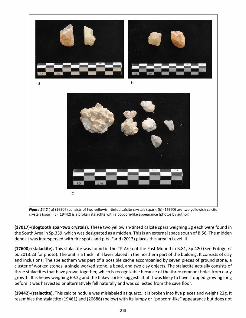
215
(17017)-(dogtooth spar-two crystals). These two yellowish-tinted calcite spars weighing 3g each were found in the South Area in Sp.339, which was designated as a midden. This is an external space south of B.56. The midden deposit was interspersed with fire spots and pits. Farid (2013) places this area in Level III.
(17600)-(stalactite). This stalactite was found in the TP Area of the East Mound in B.81, Sp.420 (See Erdoğu et al. 2013:23 for photo). The unit is a thick infill layer placed in the northern part of the building. It consists of clay and inclusions. The speleothem was part of a possible cache accompanied by seven pieces of ground stone, a cluster of worked stones, a single worked stone, a bead, and two clay objects. The stalactite actually consists of three stalactites that have grown together, which is recognizable because of the three remnant holes from early growth. It is heavy weighing 69.2g and the flakey cortex suggests that it was likely to have stopped growing long before it was harvested or alternatively fell naturally and was collected from the cave floor.
(19442)-(stalactite). This calcite nodule was mislabeled as quartz. It is broken into five pieces and weighs 22g. It resembles the stalactite (19461) and (20686) (below) with its lumpy or “popcorn-like” appearance but does not
Figure 24.2 ( a) (16507) consists of two yellowish-tinted calcite crystals (spar); (b) (16590) are two yellowish calcite crystals (spar); (c) (19442) is a broken stalactite with a popcorn-like appearance (photos by author).
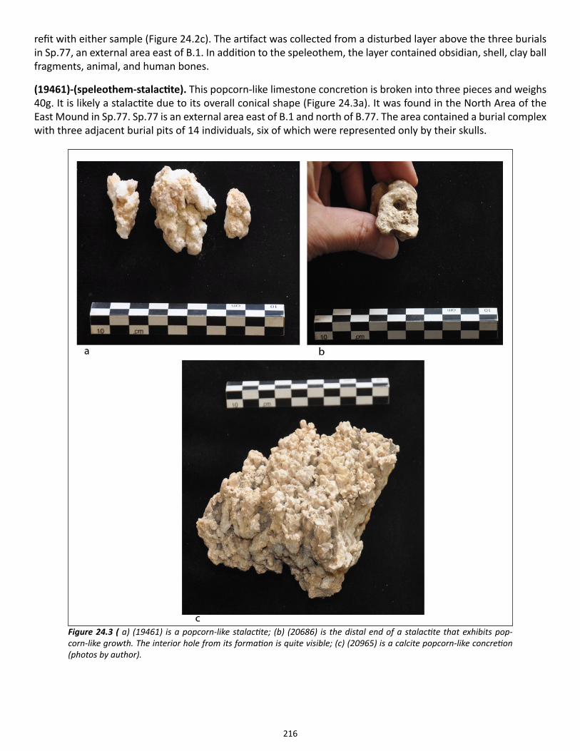
216
refit with either sample (Figure 24.2c). The artifact was collected from a disturbed layer above the three burials in Sp.77, an external area east of B.1. In addition to the speleothem, the layer contained obsidian, shell, clay ball fragments, animal, and human bones.
(19461)-(speleothem-stalactite). This popcorn-like limestone concretion is broken into three pieces and weighs 40g. It is likely a stalactite due to its overall conical shape (Figure 24.3a). It was found in the North Area of the East Mound in Sp.77. Sp.77 is an external area east of B.1 and north of B.77. The area contained a burial complex with three adjacent burial pits of 14 individuals, six of which were represented only by their skulls.
Figure 24.3 ( a) (19461) is a popcorn-like stalactite; (b) (20686) is the distal end of a stalactite that exhibits pop-corn-like growth. The interior hole from its formation is quite visible; (c) (20965) is a calcite popcorn-like concretion (photos by author).
217
(20686.x7)-(stalactite). This is the distal end of a stalactite that exhibits popcorn-like growth. It measures 4cm. in length and 2cm in width, and weighs 25.8g. The interior hole from its formation is quite visible (Figure 24.3b). It was found in the North Area in Building 77, Sp.336, F.3697. This was an elaborate building that was burnt. Space 336 was a highly decorated living area. F.3697 is an undisturbed adult burial k(20683) within a platform (F.3615), found in a flexed position. Excavators suggest that a skull Sk(20684) may have been placed with the individual but later reassessed and assigned it to F.3619. Accompanying the individual were beads made of copper, stone, bone, and shell. Several beads fell out of the hole in the stalactite. Excavators suggest that these objects along with the speleothem may have been placed in a leather bag. A number of small black beads were found in the vicinity of stone palette, a clay object, three fragments of ground stone, two horn cores, and eight pieces of worked bone. No dating information was available.
(20965)-(calcite concretion). This calcite formation is a “popcorn” formation weighing 376g. It was found in a midden on the north part of the East Mound (Figure 25.3c). The midden (Sp.511) was located between struc-tures B.52, B.113 and Sp.488/518 beneath a fallen wall. The midden contained pieces of a clay oven dome, plaster, crushed bricks, charcoal, seeds, and an ash coating. Other artifacts found in the midden included a stone ball, six bone pins, a copper bead, a stone ball, a located near the surface in a disturbed area characterized as “burial infill.” Directly associated with the speleothem was an obsidian tool, a shell, a figurine fragment, and two beads, one of which was limestone. F.3686 was associated with these deposits. This feature consisted of two disarticulated skeletons Sk(19493) and Sk(19450). These were headless and their long bones were interlocking and arranged like a “bird’s nest.” As reported in Archive Report, 2012, two obsidian mirrors were found with an associated interment of two disarticulated individuals in the same spatial unit.
West Mound(13734)-(dogtooth spar). This calcite crystal measures 3cm x 1.5cm and weighs 2.8g. It is unusual in that it was modified with two notches carved into the edge. Collected from the West Mound in Trench 5 in an “arbitrary” layer that contained artifacts, bones, and pebbles, it dates to the Chalcolithic Period.
(18331)-(dogtooth spar). This calcite crystal measuring 2cm x2cm and weighing 3.7g was found in the West Mound in Trench 5, Sp.345. It is located in the southern part of the trench in a refuse pile that also contained pottery, tools, building material, and animal bones and may be associated with burial F.5060.
Other(31108.x3)-(possible cave pearl). This is a possible cave pearl irregular in shape measuring approximately 2cm in length and 1cm in width. It weighs 1.3g and is a grayish white color. It cannot be found in the database.
DiscussionTo start to think about understanding how these formations may have been used at the site, I divided the con-texts between burials, middens, and “other” (See Table 24.1). I reserved the “other” category for contexts that were uncertain, not well identified or described as “fill.” Speleothems were relatively easy to categorize as crys-talline spars and more opaque limestone stalactites. I focused on these two categories because they represented the majority of the material. Although I did find a single cave pearl in the collections, there was no provenience data available. I found only one concretion in a midden context, but did not include it in the overall analysis because it is possible that it did not come from a cave. I focused on the East Mound because only two samples of speleothems came from the West Mound, which of course may be meaningful. Both of these examples were spars, one of which came from a midden and the other from a less defined context. The only fragment of flow-stone in the collection came from a Chalcolithic burial context that clearly dated much later than the rest of the material so it was not included. This left 21 artifacts of which 14 are spars and 7 stalactites (Figure 24.4). While this is a very small sample, some observations can be made about the data.
218
First, the most striking result is that only stalactites are located in burial contexts. By examining individual cases we find that this pattern may be even stronger than the initial analysis suggests. For instance, in the case of (10475.x2), the modified stalactite figurine, excavators classified the context as “midden,” yet the object was closely associated with burial F.1517, which contained a plastered skull. Therefore, it is unlikely that the context is a true “midden” but may be part of this burial, thus strengthening the pattern. Another stalactite (11904) as-sociated with “storage” also bears discussion. This example-though clearly a stalactite- has a crystalline structure similar to a spar. There are a myriad of reasons why this piece remained in a storage area, but it could be because of its spar-like properties. The stalactite (17600) fits into the “other” context, but was likely part of a cache. It was accompanied by seven pieces of ground stone, a cluster of worked stones, a single worked stone, a bead, and two clay objects.
When we consider the burial contexts it is instructive to consider (19461). The speleothem accompanied not just a single individual but an entire burial complex. The complex contained 14 individuals, six of which were represented only by crania and two disarticulated skeletons Sk(19493) and Sk(19450) whose heads were removed and their long bones interlocked so that the arrangement resembled a “bird’s nest.” Not only this, but obsidian mirrors accompanied two additional disarticulated individuals in the same spatial unit. Artifacts directly associated with the speleothem included an obsidian tool, a shell, a figurine fragment, and two beads. Therefore, this was no ordinary context but a highly specialized ritual venue. When we bear in mind the special contexts in which we find the stalactites there can be little doubt as to their importance.
Unit Morphology Context Area10475.x2 Stalactite Midden/Burial East Mound11904 Stalactite Other- burned building East Mound-404012357 Flowstone Burial East Mound-4040 Chalcolithic13342 Spar Construction/Abandonment East Mound13429 Crystals Other East Mound-404011804 Spar Other East Mound-IST12438 Spar Construction East Mound-IST13342 Spar Other East Mound- South13952 Spar Storage Bin East Mound-IST14019 Spar Storage Room East Mound16253 Stalactite Midden East Mound16258 Spar Midden East Mound16507 Spar Midden East Mound-South16507 Spar Midden East Mound-South16590 Spar Midden East Mound-South16590 Spar Midden East Mound-South17017 Spar Midden East Mound-South17017 Spar Midden East Mound-South17600 Stalactite Other East Mound-TP19442 Stalactite Burial East Mound19461 Stalactite Burial East Mound20686.x7 Stalactite Burial-burned building East Mound-404020965 Concretion Midden East Mound18331 Spar Midden West Mound13734 Spar Other West Mound Chalcolithic
Table 24.1. Speleothem morphologies and contexts by area.
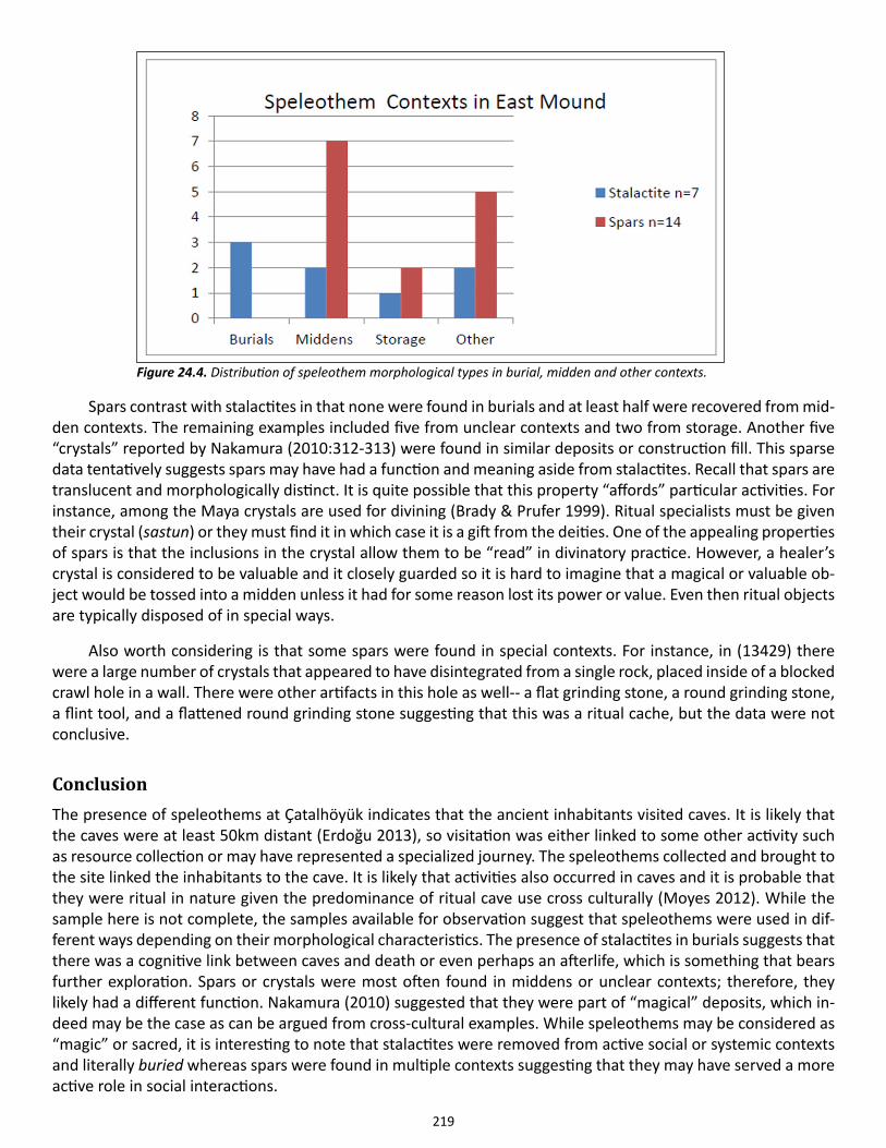
219
Spars contrast with stalactites in that none were found in burials and at least half were recovered from mid-den contexts. The remaining examples included five from unclear contexts and two from storage. Another five “crystals” reported by Nakamura (2010:312-313) were found in similar deposits or construction fill. This sparse data tentatively suggests spars may have had a function and meaning aside from stalactites. Recall that spars are translucent and morphologically distinct. It is quite possible that this property “affords” particular activities. For instance, among the Maya crystals are used for divining (Brady & Prufer 1999). Ritual specialists must be given their crystal (sastun) or they must find it in which case it is a gift from the deities. One of the appealing properties of spars is that the inclusions in the crystal allow them to be “read” in divinatory practice. However, a healer’s crystal is considered to be valuable and it closely guarded so it is hard to imagine that a magical or valuable ob-ject would be tossed into a midden unless it had for some reason lost its power or value. Even then ritual objects are typically disposed of in special ways.
Also worth considering is that some spars were found in special contexts. For instance, in (13429) there were a large number of crystals that appeared to have disintegrated from a single rock, placed inside of a blocked crawl hole in a wall. There were other artifacts in this hole as well-- a flat grinding stone, a round grinding stone, a flint tool, and a flattened round grinding stone suggesting that this was a ritual cache, but the data were not conclusive.
ConclusionThe presence of speleothems at Çatalhöyük indicates that the ancient inhabitants visited caves. It is likely that the caves were at least 50km distant (Erdoğu 2013), so visitation was either linked to some other activity such as resource collection or may have represented a specialized journey. The speleothems collected and brought to the site linked the inhabitants to the cave. It is likely that activities also occurred in caves and it is probable that they were ritual in nature given the predominance of ritual cave use cross culturally (Moyes 2012). While the sample here is not complete, the samples available for observation suggest that speleothems were used in dif-ferent ways depending on their morphological characteristics. The presence of stalactites in burials suggests that there was a cognitive link between caves and death or even perhaps an afterlife, which is something that bears further exploration. Spars or crystals were most often found in middens or unclear contexts; therefore, they likely had a different function. Nakamura (2010) suggested that they were part of “magical” deposits, which in-deed may be the case as can be argued from cross-cultural examples. While speleothems may be considered as “magic” or sacred, it is interesting to note that stalactites were removed from active social or systemic contexts and literally buried whereas spars were found in multiple contexts suggesting that they may have served a more active role in social interactions.
Figure 24.4. Distribution of speleothem morphological types in burial, midden and other contexts.
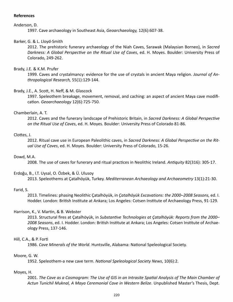
220
References
Anderson, D. 1997. Cave archaeology in Southeast Asia, Geoarchaeology, 12(6):607-38.
Barker, G. & L. Lloyd-Smith2012. The prehistoric funerary archaeology of the Niah Caves, Sarawak (Malaysian Borneo), in Sacred Darkness: A Global Perspective on the Ritual Use of Caves, ed. H. Moyes. Boulder: University Press of Colorado, 249-262.
Brady, J.E. & K.M. Prufer1999. Caves and crystalmancy: evidence for the use of crystals in ancient Maya religion. Journal of An-thropological Research, 55(1):129-144.
Brady, J.E., A. Scott, H. Neff, & M. Glascock1997. Speleothem breakage, movement, removal, and caching: an aspect of ancient Maya cave modifi-cation. Geoarchaeology 12(6):725-750.
Chamberlain, A. T.2012. Caves and the funerary landscape of Prehistoric Britain, in Sacred Darkness: A Global Perspective on the Ritual Use of Caves, ed. H. Moyes. Boulder: University Press of Colorado 81-86.
Clottes, J.2012. Ritual cave use in European Paleolithic caves, in Sacred Darkness: A Global Perspective on the Rit-ual Use of Caves, ed. H. Moyes. Boulder: University Press of Colorado, 15-26.
Dowd, M.A.2008. The use of caves for funerary and ritual practices in Neolithic Ireland. Antiquity 82(316): 305-17.
Erdoğu, B., I.T. Uysal, O. Özbek, & Ü. Ulusoy2013. Speleothems at Çatalhöyük, Turkey. Mediterranean Archaeology and Archaeometry 13(1):21-30.
Farid, S.2013. Timelines: phasing Neolithic Çatalhöyük, in Çatalhöyük Excavations: the 2000–2008 Seasons, ed. I. Hodder. London: British Institute at Ankara; Los Angeles: Cotsen Institute of Archaeology Press, 91-129.
Harrison, K., V. Martin, & B. Webster2013. Structural fires at Çatalhöyük, in Substantive Technologies at Çatalhöyük: Reports from the 2000–2008 Seasons, ed. I. Hodder. London: British Institute at Ankara; Los Angeles: Cotsen Institute of Archae-ology Press, 137-146.
Hill, C.A., & P. Forti 1986. Cave Minerals of the World. Huntsville, Alabama: National Speleological Society.
Moore, G. W. 1952. Speleothem-a new cave term. National Speleological Society News, 10(6):2.
Moyes, H.2001. The Cave as a Cosmogram: The Use of GIS in an Intrasite Spatial Analysis of The Main Chamber of Actun Tunichil Muknal, A Maya Ceremonial Cave in Western Belize. Unpublished Master’s Thesis, Dept.
221
of Anthropology, Florida Atlantic University, Boca Raton, Fl.
2012. Introduction, in Sacred Darkness: A Global Perspective on the Ritual Use of Caves, ed. H. Moyes. Boulder: University Press of Colorado, 1-14.
Nakamura, C.2010. Magical deposits at Çatalhöyük: a matter of time and place? In Religion in the Emergence of Civili-zation: Çatalhöyük as a Case Study, ed. I. Hodder. New York: Cambridge University Press, 300-331.
Nakamura, C. & L. Meskell2004. Figurines and miniature clay objects, Çatalhöyük 2004 Archive report. http://www.catalhoyuk.com/archive_ reports/2004/ar05_13.html.
Tomkins, P.2012. Landscapes of ritual, identity, and memory: reconsidering Neolithic and Bronze Age cave use in Crete, Greece, in Sacred Darkness: A Global Perspective on the Ritual Use of Caves, ed. H. Moyes. Boul-der: University Press of Colorado 59-80.
Rowan, Y.M., & D. Illan2012. The Subterranean landscape of the southern Levant during the Chalcolithic Period, in Sacred Dark-ness: A Global Perspective on the Ritual Use of Caves, ed. H. Moyes. Boulder: University Press of Colora-do, 87-108.
Whitehouse, R.D. 1992. Underground Religion: Cult and Culture in Prehistoric Italy. London: Accordia Research Center, University of London.
222
Chapter 25
Reflexive Methodology and Recording
Åsa Berggren
As described in the archive report of last year (Berggren 2013), the Çatalhöyük Research Project has made some changes and adjustments of the recording system in order to better suit the workflow and facilitate a reflexive interpretation process. Even though a part of the documentation is now being done digitally, the recording sheets are still being filled out by hand, with pen and paper in the trenches (Figure 25.1). However, the sheets have been adjusted to better follow the excavation.
Last year we made changes to the unit and skeleton sheets. This year we created a new version of the fea-ture sheet. The aim is twofold. One objective is to prioritize the feature as an interpretation tool and highlight when it is realized as an entity in the process of excavation. A second aim is to practically create a flow of record-ing that follows the flow of excavation. On the feature recording sheet many recording fields were re-ordered and others were added.
Figure 25.1. The last remains of Building 77 are being removed. The paper recording sheets are being used to document the remains of the oldest platform of the building (photo by Åsa Berggren).
223
The fields for description and interpretative discussion were moved to the front of the sheet as these are processes that should start directly as the feature is opened. In addition fields were added to allow for date and signature of the different discussion entries. This way the time sequence and the various people involved in the interpretation process become visible. The sketch was also placed on the front of the feature sheet, as the fea-ture should be sketched soon after it is realized as a feature.
Other fields are placed on the back of the sheet that can be filled in later in the process, such as the fields for relations to other features and for units in the feature. Other fields were added, such as a box where a sketch of a local feature matrix should be drawn, and the contextual situation can be discussed in a specially designat-ed text field. In order to illuminate the various finds found within units of the feature, general finds should be listed in a separate field. X-finds and clusters are pulled automatically from the database and do not have to be entered especially. A new text field to discuss the context of the finds was also added. For example, it may be needed to discuss which finds are interpreted as grave goods and which are not in a burial. This may be discussed in the general discussion on the front of the sheet, but this field is added to place extra emphasis on this type of discussion.
When a feature is opened, the date and the name of the person opening it should be recorded in designat-ed fields, as should date and name be noted when a feature is closed. This way it is possible to track the “life” of a feature, and also it is clear when it is considered fully excavated.
After having been used for one season, it seems this new feature sheet works well with the flow of ex-cavation. Also, it is interesting to see how many discussion entries are made on some sheets. It is clear that the excavators go back and make additional interpretations and adjustments for quite some time after initial excava-tion. This process is now more clearly documented.
As digital recording on Windows-based tablets have been implemented by the project, this has also had an impact on how the interpretation process and the reflexive engagement with the material being excavated and recorded. The fact that previous records such as plans and reports are available on the tablet has made infor-mation more accessible in the field. Also, plan and section drawing is done directly on the tablet, creating shape files, giving the excavator an overview of the excavated area in GIS. This process omits the step where paper drawings had to be scanned and digitized by someone else, and leaving the excavators without the overview. The tablet has also changed the way we work with the daily sketch. Instead of having to draw on printed photos that were later scanned, now the excavators draw the sketch of their daily work on a photo taken with the tablet, on the tablet. This sketch is uploaded to the server at the end of the workday.
The tablets have made work somewhat more efficient, letting us cut several steps out of the workflow. Of course some steps have also been added, such as uploading information to the server and securing backup. There have also been some problems of tablets shutting down due to hot conditions in the trenches, and other glitches of the digital system. These are problems that will have to be solved in order for the digital recording to work efficiently. But more importantly, the tablets have enabled a better access to more information and a quicker overview in the field, all of which add to the prerequisites of a reflexive process of interpretation.
References
Berggren, Å. 2013. Reflexive methodology, in Çatalhöyük 2013 Archive Report. http://www.catalhoyuk.com/down-loads/Archive_Report_2013.pdf
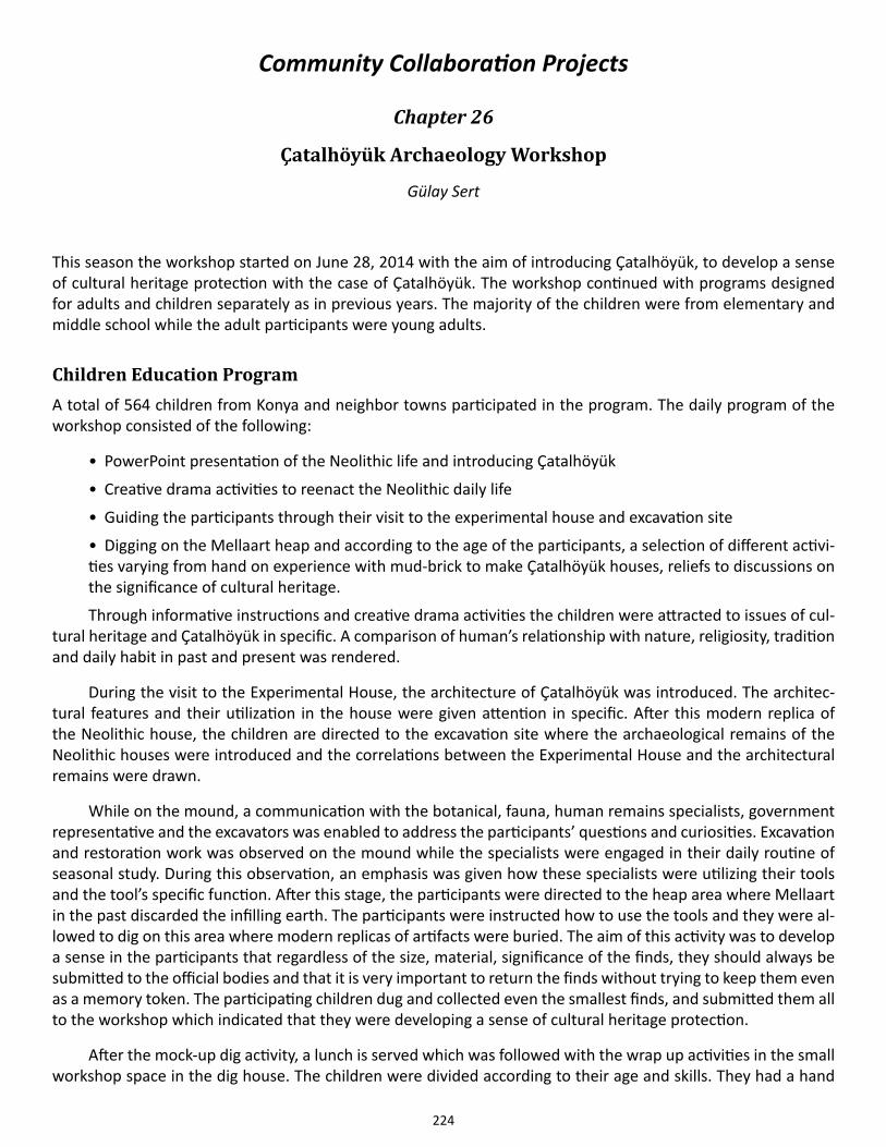
224
Community Collaboration Projects
Chapter 26
Çatalhöyük Archaeology Workshop
Gülay Sert
This season the workshop started on June 28, 2014 with the aim of introducing Çatalhöyük, to develop a sense of cultural heritage protection with the case of Çatalhöyük. The workshop continued with programs designed for adults and children separately as in previous years. The majority of the children were from elementary and middle school while the adult participants were young adults.
Children Education ProgramA total of 564 children from Konya and neighbor towns participated in the program. The daily program of the workshop consisted of the following:
• PowerPoint presentation of the Neolithic life and introducing Çatalhöyük
• Creative drama activities to reenact the Neolithic daily life
• Guiding the participants through their visit to the experimental house and excavation site
• Digging on the Mellaart heap and according to the age of the participants, a selection of different activi-ties varying from hand on experience with mud-brick to make Çatalhöyük houses, reliefs to discussions on the significance of cultural heritage.
Through informative instructions and creative drama activities the children were attracted to issues of cul-tural heritage and Çatalhöyük in specific. A comparison of human’s relationship with nature, religiosity, tradition and daily habit in past and present was rendered.
During the visit to the Experimental House, the architecture of Çatalhöyük was introduced. The architec-tural features and their utilization in the house were given attention in specific. After this modern replica of the Neolithic house, the children are directed to the excavation site where the archaeological remains of the Neolithic houses were introduced and the correlations between the Experimental House and the architectural remains were drawn.
While on the mound, a communication with the botanical, fauna, human remains specialists, government representative and the excavators was enabled to address the participants’ questions and curiosities. Excavation and restoration work was observed on the mound while the specialists were engaged in their daily routine of seasonal study. During this observation, an emphasis was given how these specialists were utilizing their tools and the tool’s specific function. After this stage, the participants were directed to the heap area where Mellaart in the past discarded the infilling earth. The participants were instructed how to use the tools and they were al-lowed to dig on this area where modern replicas of artifacts were buried. The aim of this activity was to develop a sense in the participants that regardless of the size, material, significance of the finds, they should always be submitted to the official bodies and that it is very important to return the finds without trying to keep them even as a memory token. The participating children dug and collected even the smallest finds, and submitted them all to the workshop which indicated that they were developing a sense of cultural heritage protection.
After the mock-up dig activity, a lunch is served which was followed with the wrap up activities in the small workshop space in the dig house. The children were divided according to their age and skills. They had a hand

225
on experience working with mud, painting and similar materials to make murals, reliefs, replica house in small scales, figurines, seals, cups and pots which were found at Çatalhöyük. A small quiz was given at the end of the workshop with questions about what they learned throughout the workshop. At the end of the quiz, children were given children books, magazines and toys as well a document designed by the Çatalhöyük Research Project stating the participation in the workshop and now they are the protectors of the cultural heritage.
As described above, the model from previous years was followed for the structure of the workshop which attracted many children’s attention and enabled a joyful experience for them while developing an awareness of the cultural heritage and informing about Çatalhöyük as a case study.
Adult Education ProgramA total of 160 individual participated in the workshop. The groups were mostly consisting of young adults. To address the young adults, the workshop committee was in touch with Konya Youth and Sports Directorate and Konya Muftiate to invite the young adults these local institutions were training.
The activities started similarly compared to the children with introducing Çatalhöyük and the Neolithic period and life in Neolithic period with examples from Çatalhöyük. The participants visited the Experimental House and the excavation site. A communication with the specialists and excavators was initiated to address the participants’ questions and curiosities about archaeology and Çatalhöyük. The issues of publicizing and pro-tecting Çatalhöyük and the problems the participants were observing were discussed with their thoughts on solving these issues especially the public participation in the cultural heritage protection.
During these discussions, the workshop committee observed that the participating young adults followed the contemporary issues closer while remaining more distant to the issues of cultural heritage and the cultural properties in their immediate geography. That’s why; the culture of Çatalhöyük was relayed in a certain frame-work in which the relationship was drawn in terms of craftsmanship, economy and architecture in the Neolithic and in the present.
The program was designed to run for 32 workdays with the participation of 800 individuals. However, the fasting month of Ramadan did not allow the workshop to achieve its goal. Between June 28-August 7, 2014 the workshop was held between 10.00 am and 3.00 pm with the participation of 724 individuals in total.
226
Chapter 27
Assembling an Oral History of Excavation at Çatalhöyük
Allison Mickel, Stanford University
IntroductionBuilding on research begun in the 2013 excavation season (see Mickel 2013), in 2014 I continued to conduct in-terviews aimed at building an oral history of excavations at Çatalhöyük, from those directed by Mellaart through to the present. For my Ph.D. dissertation, I will compare stories and memories recalled by those who have been employed to work at the site with the extensive multimedia archives consisting of context forms, databases, diary entries, photography, and video. Since many of the people hired on the projects at Çatalhöyük have not participated in these documentation strategies, their observations and perspectives have never been recorded, representing a substantial gap in the archival record. My research aims to determine the nature of this gap and how it has impacted knowledge about Çatalhöyük, thereby demonstrating how nuanced and comprehensive the record would be if recording strategies at Çatalhöyük were made more inclusive and accessible.
This year, interviews were restricted to the boundaries of the site, and study participants consisted only of current team members at Çatalhöyük, including guards, kitchen staff, and local men and women hired to help with excavation, flotation, and sorting heavy residue. Between July 19 and August 4, I conducted 11 separate interviews with 12 individuals in total. These interviews both supported and extended beyond the preliminary findings from the 2013 field season. Ultimately, my goal is to develop a system for integrating the oral history data into the vast and diverse existing database, as well as to propose a recording strategy that will allow these previously undocumented perspectives to be recorded in situ.
MethodologyAll interviews this season took place at Çatalhöyük, during work hours, with project team members. Interviews were conducted with nearly every local team member at Çatalhöyük, with the exception of two of the guards. With the help of a translator, questions were posed in Turkish and responses were translated into English. From July 19 until July 25, Cansu Kurt volunteered to translate, and then from July 26 to August 4 Duygu Ertemin worked as the interpreter. Each day, the translator and I approached a potential interviewee, introduce our-selves, and explain the nature of my dissertation project. We would then ask if they wanted to participate in the study. No one declined, although many (women in particular) preferred to be interviewed in groups, and so about half of the interviews were with three or four people. Research participants preferred that I hand-write what they were saying, rather than recording either video or audio, so the analysis that follows is based on copi-ous notes taken during these meetings. Each interview lasted about an hour.
I began each conversation by asking the interviewees how long they had worked at Çatalhöyük, and what their work was like. I then asked about why they had decided to work on the project, what sorts of things they knew about the site before they came to work, and what they had learned since then. Other questions solicit-ed stories about Mellaart’s excavations. The majority of the questions were designed to identify what kinds of expert knowledge these team members gained by working in their specific positions (i.e. flotation, the kitchen, sorting heavy residue, etc.). Furthermore, although I had prepared a list of questions prior to approaching each interviewee, most of the time was spent discussing follow-up questions stemming from the specific stories and memories that people offered. I also allowed ample time for participants to ask me questions about my project, about Çatalhöyük, or about the project, in order to alleviate as much as possible the sense that they were being quizzed on excavation methods or that their job performance was being reviewed. This dialogic and flexible ap-
227
proach was more effective than adhering to a strict list of questions, given my goal of documenting the particular observations and specific points of view that each person possessed. The methodology of the interviews in the 2014 season overall closely resembled that followed in 2013, yielding results that in many ways resonate with those of the previous year.
Support for preliminary findingsOne of the most consistent experiences in 2013 was that people who had previously worked on the project re-membered specific objects or materials found during excavation in acute detail (Mickel 2013). In particular, in 2013 as well as in 2014, interviewees recalled details about beads and jewelry they had found or simply seen. Not only were they able to describe the physical appearance, but often they discussed the contexts in which these objects were found, even if they had not seen the excavation itself. In fact, those who worked in flotation and the sorting of heavy residue (away from the digging) talked the most about necklaces and beads as well as the burials from which they believed these artifacts had come. Burials were overall mentioned extremely frequently—much more so than in the previous season. Some team members recalled specific burials, others hypothesized about the circumstances of death and interment, and a few even possessed photographs of burials uncovered while they were working onsite. Less frequently, interviewees offered similar observations and theo-ries about archaeobotanical finds, stratigraphy, ceramics, lithics, figurines, and wall paintings. The combination of descriptive and interpretive data offered about these finds mirrors the content in the Çatalhöyük archive and database, suggesting that integrating these narratives into the existing record will be both possible and produc-tive, creating a more complete and complex body of knowledge.
The team members interviewed this season provided additional perspectives on the methodology em-ployed at Çatalhöyük. Last year, former team members recalled varying means of making decisions about how and when to sieve, or increasing the efficiency of excavation. Those interviewed this year who worked on site also addressed decision-making processes, particularly with regard to safety precautions on the site. They re-lated stories of several accidents that had occurred on the project, and suggested ways in which incidents like these could be avoided. Moreover, talking to people in positions that weren’t addressed in the 2013 interviews yielded insight into procedures such as sorting heavy residue and flotation. Team members described how they learned these processes, and the details of these activities which might go unknown to someone who had never participated in them. In fact, this is the case for many of the stages that local team members are hired to assist with, and so despite extensive, flexible, and reflexive documentation strategies and publications (e.g. Berggren et al. forthcoming; Chadwick 2003; Hassan 1997; Hodder 1998, 2000) there remains a large amount of the ex-cavation methods that has gone unrecorded. Oral history interviews represent a means by which these stages in the research process can be fully documented, to ensure a more complete understanding of how data was collected, analyzed, and how knowledge about the Neolithic past was created.
In both the 2013 and 2014 interviews, I asked each individual how he or she learned the skills needed to perform their jobs on site. Many people mentioned the specific team member who had taught them, as well as when and how they learned. Significantly, many of the interviewees this year were related to other team mem-bers and especially the younger ones had grown up observing the techniques of their parents, aunts, and uncles. Still, even in cases where someone had spent so much of his or her live observing the ongoing excavations, this person nearly always asserted their own minimal knowledge of steps in the research process beyond the stage in which they were working. Anything happening in the labs, in particular, were declared to be completely mys-terious by nearly all interviewees—but even moments in the excavation such as photography, unit sheets, and the washing of finds were named as events about which local team members had no knowledge, regardless of whether they had seen such procedures transpire or not. In fact, some team members said that they were “not allowed” to participate or sometimes, even ask, about those parts of the research process.
As many examples as there are, however, of people expressing their lack of understanding regarding parts of the excavation, there are an equal number of instances where people claim to have either mastered a
228
skill or to possess expertise relevant to the study of the Neolithic. This was the case in 2013 as well; the Küçük-köy residents I interviewed emphasized their own contemporary practices that were analogous to activities in ancient Anatolia, including grinding grain and food storage. This year they also mentioned pottery production, purposes of clay balls, how ovens are designed and used, and the reasons behind particular motifs in wall paint-ings. These topics tap into past and ongoing research foci of scholars studying Çatalhöyük (e.g. Yalman et al. 2013; Doherty & Tarkan 2013 on pottery; Atalay 2003 on clay balls; Ketchum 2012 on ovens; Mellaart 1962; De Jesus 1985; Collon 1990; Gimbutas 1990; Czeszewska 2014 on wall paintings). Now that comprehensive and dynamic databases such as the ‘living archive’ are becoming a reality for Çatalhöyük (Grossner et al. 2014), the technology required to integrate formal publication with oral history is available. Making use of these resources to present multiple viewpoints about the material at Çatalhöyük—whether complementary or competing—is a step toward the project’s goals of remaining reflexive and multivocal (Hodder 2000). The past two years of oral history interviews have amassed numerous examples of unpublished local perspectives based both on experi-ence working with the project as well as traditions practiced over generations in the region.
The final broad objective identified last year to which oral history research can contribute is understand-ing how local team members envision the future of the site, both in terms of research directions and tourism development. Many of the project participants who had worked on the project the longest drew upon their memories and experience to propose new areas where archaeologists should dig in order to find the most buri-als and artifacts—the aspects of Çatalhöyük in which local team members are most interested. When I asked if they would pass these suggestions on to a future archaeologist who came to dig at the site, they expressed their worry that another project director would not listen to their ideas, even if they had worked at the site for ten years or more. These team members not only possessed exceptional expertise about excavation history and methodology, but also about what visitors to the site were hoping to see and do. They envisioned changes to the museum and site tour based on their extensive observations of tourists. Peoples’ willingness to share their own suggestions for the future presentation of the site is a change from the earliest attempts at community engagement at Çatalhöyük (Atalay 2012), though when I asked if they thought their ideas were likely to be im-plemented, nearly everyone offered disclaimers like, “We can’t know the future” or stated that an organization seeking to develop the site should talk with Ian Hodder rather than them, even if they had worked on the project for many seasons. This should not only encourage further attempts at capacity-building, building on the positive progress that has already been achieved, but also compels the current project members to take these proposals seriously and to do what we can to see that they are executed. Interviewing locals who have worked on the ex-cavation has been an effective way to start recording these ideas; further examination of the interview material will be necessary to understand the reasons underpinning them, and the ways in which local perspectives differ from those traditionally documented during the excavation.
Initial analysisThis year’s focus on team members currently working on the excavation as work was ongoing permitted a more direct focus on the specific types of expert knowledge retained by local project participants. I was able to ask questions about the work that interviewees were doing, as they were doing it, rather than asking them to recol-lect procedures and techniques from 50 years prior. Those working onsite shared approaches to excavation that made digging easier and more efficient, even suggesting which specific types of equipment should be purchased (i.e. plastic instead of metal buckets; wooden instead of metal ladders). The person I spoke to with the most experience in flotation claimed to be able to tell the context from which a given flotation bag had come based on the color of the soil and the materials yielded through the flotation process—something which a person who had not participated in this stage of the research process would be unlikely to be able to do. The women working to sort the heavy residue stated freely that it is very easy to tell apart the material types, even when they are 2 mm or less in diameter. They explained that they had no problem telling apart human and faunal bone at any size due to growing up cooking freshly butchered meat and seeing all of the bones. The kitchen staff, as well, contrary to the possibility that they might be viewed as peripheral to the excavation process, possessed particular expert
229
knowledge. Not only did they claim to know what meals made archaeologists happiest and healthiest, but they also offered insight into the social structure of the team. Their perception of who possesses the greatest amount of authority or respect on the project would be extremely valuable to someone revisiting the body of data about Çatalhöyük later; it would aid immensely in better understanding the circumstances structuring data collection, analysis, and publication.
Despite these examples of apparent expertise that other project members lack, nearly all of the people with whom I spoke emphasized their ignorance rather than their knowledge about Çatalhöyük and the excava-tion process. Many of them claimed that if another project director came to dig at Çatalhöyük in the future, they would be unable to advise this person in any way, or to explain how research had been conducted previously (despite their ability to tell me precisely this type of information in the same conversation, albeit information limited to their own roles). Instead, the topic on which they confidently claimed to possess expert knowledge was Neolithic lifeways, stating that their grandparents had produced, stored, and prepared food, decorated their homes and their bodies, as well as cleaned clothing, pots, and houses in the same way as ancient residents of Çatalhöyük had. They emphasized the lack of change over time; one woman said that the houses in Çatalhöyük were “just like my house.” Even in the case of behaviors that villagers do not perform anymore, interviewees emphasized how recently these traditions faded from practice. “Even my mother used to grind grain,” one wom-an told me, as well as, “we were still cooking in pottery when I got married. Now that we use tin it doesn’t taste as good.” The degree to which interviewees want to be seen as practicing traditional lifestyles may be surpris-ing. One might expect them instead to point out ways in which the village is not simple but instead modern or cosmopolitan—but this is not the case. In the past, providing ethnoarchaeological information has proven one of the most productive ways that villagers have been able to assist Çatalhöyük researchers (see Matthews et al. 1996; Shankland 1999). One interviewee even participated in a documentary posing as a Neolithic woman. It has perhaps been beneficial to local team members to present themselves as unmatched experts about the past. This dynamic may complicate the ability to identify the information and comprehension they have acquired about excavations, in the present and to begin addressing this gap in the record of excavations at Çatalhöyük.
Another potential difficulty became apparent during the interviews this season. Speaking to team mem-bers actively working on the project yielded very different answers from those offered by interviewees last year, who had worked with Mellaart or with the earliest seasons of the current endeavor. This year, when I asked about their favorite or most interesting find, most people described something they had seen in the last week of excavation. The stories they told about events that had occurred on site were overall similarly recent, and when I asked them if they had any questions about methodology or about the site, people’s questions nearly always concerned something found or discussed in the preceding days. Although the 2013 interviews with older mem-bers of the local community revealed that there are memories of excavations that remain after twenty years or even sixty, the research conducted this year reveals how much richer and more complete these memories can be when they are fresh. This is perhaps unremarkable, but it does highlight the need for recording methodolo-gies that capture the observations and perspectives of local team members in situ, in order to achieve the kind of nuanced, multivocal archaeological record that the Çatalhöyük Research Project has always pursued (Hodder 2000).
Future directions2015 will mark the last season of interviews aimed at assembling narratives about the history of excavations at Çatalhöyük. As I continue to analyze the material already collected, I will also compare it to the archives of other data collected during past and present excavations at the site. Given the need for in situ documentation of local knowledge, I plan to implement a systematic documentation procedure in 2015 that will allow for these stories and memories to be recorded and integrated with the main data that the project produces. I will then write up the results of all interviews as well as this recording experiment for my Ph.D. dissertation.
230
On a site-specific level, the aim of this research project is to produce a more nuanced, inclusive, and dy-namic archaeological record at Çatalhöyük, by identifying gaps in the existing documentation and demonstrating a means of filling these gaps. This project will add new and diverse perspectives to the wide-ranging multimedia strategies of data collection which already exist at Çatalhöyük. With this research, I also aim to make a larger contribution to the field of archaeology both by presenting new methodological possibilities and by investigating processes of epistemology at Çatalhöyük. I hope to demonstrate how crucial local team members have been to the production of knowledge about the past, and to show the particular perspectives they have to offer the field of archaeology by occupying particular, unique roles in the excavation process at Çatalhöyük and at other archaeological sites around the world.
References
Atalay, S.2003. Domesticating Clay: Engaging with ‘They’: The Social Life of Clay Balls from Çatalhöyük, Turkey and Public Archaeology for Indigenous Communities. Unpublished Ph.D. dissertation, University of California, Berkeley.
2012. Community-based Archaeology: Research With, By, and for Indigenous and Local Communities. University of California Press, Berkeley.
Berggren, Å., N. Dell’Unto, M. Forte, S. Haddow, I. Hodder, J. Issavi, N. Lercari, C. Mazzucato, A. Mickel, & J. Taylor(Forthcoming) Revisiting reflexive archaeology at Çatalhöyük: integrating digital and 3D technologies at the trowel’s edge. Antiquity.
Chadwick, A.2003. Post-processualism, professionalization and archaeological methodologies: towards reflective and radical practice. Archaeological Dialogues, 10(1):97-117.
Doherty, C. & D. Tarkan2013. Pottery production at Çatalhöyük: a petrographic perspective, in Substantive Technologies at Çatal-höyük: Reports from the 2000-2008 Seasons, ed. I. Hodder. London: British Institute at Ankara; Los Ange-les: Cotsen Institute of Archaeology Press, 183-192.
Grossner, K., I. Hodder, E. Meeks, C. Engel, & A. Mickel2014. A Living Archive for Çatalhöyük. Paper presented at the Computer Applications and Quantitative Methods in Archaeology, Paris.
Hassan, F.A.1997. Beyond the surface: comments on Hodder’s ‘reflective excavation methodology’. Antiquity 71:1020-1025.
Hodder, I. 1998. Whose rationality? A response to Fekri Hassan. Antiquity 72(275):213-217.
Hodder, I. (editor)2000. Towards Reflexive Method in Archaeology: The Example at Çatalhöyük. Cambridge: McDonald In-stitute for Archaeological Research; London: British Institute for Archaeology at Ankara.
231
Ketchum, S. 2012. Fire installations. Çatalhöyük 2012 Archive Report, 258-259.
Matthews, W., C. Hastorf & B. Ergenekon2000. Ethnoarchaeology: Studies in local villages aimed at understanding aspects of the Neolithic site, in Towards Reflexive Method in Archaeology: The Example at Çatalhöyük, ed. I. Hodder. Cambridge: McDon-ald Institute for Archaeological Research; London: British Institute for Archaeology at Ankara, 177-189.
Mickel, A.2013. Initial interviews: first steps toward assembling an oral history of excavation at Çatalhöyük . In Çatalhöyük 2013 Archive Report, 311-315.
Shankland, D. 1999. Ethno-archaeology at Küçükköy. Anatolian Archaeology 5:23-24.
Yalman, E.N., D. Tarkan & H. Gültekin2013. The Neolithic pottery of Çatalhöyük: recent studies, in Substantive Technologies at Çatalhöyük: Re-ports from the 2000-2008 Seasons, ed. I. Hodder. London: British Institute at Ankara; Los Angeles: Cotsen Institute of Archaeology Press, 147-182.
Related Documents


