Welcome message from author
This document is posted to help you gain knowledge. Please leave a comment to let me know what you think about it! Share it to your friends and learn new things together.
Transcript
2 ■ Cascade Lookout
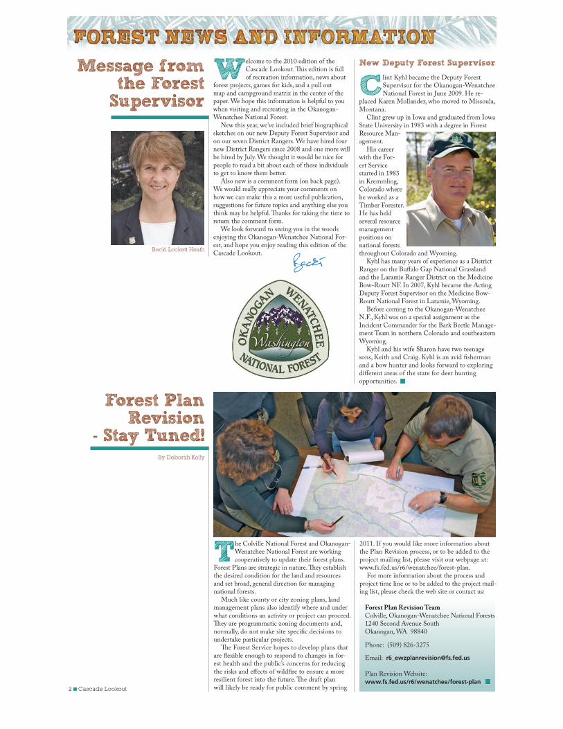
New Deputy Forest Supervisor
Clint Kyhl became the Deputy Forest Supervisor for the Okanogan-Wenatchee National Forest in June 2009. He re-
placed Karen Mollander, who moved to Missoula, Montana.
Clint grew up in Iowa and graduated from Iowa State University in 1983 with a degree in Forest Resource Man-agement.
His career with the For-est Service started in 1983 in Kremmling, Colorado where he worked as a Timber Forester. He has held several resource management positions on national forests throughout Colorado and Wyoming.
Kyhl has many years of experience as a District Ranger on the Buffalo Gap National Grassland and the Laramie Ranger District on the Medicine Bow-Routt NF. In 2007, Kyhl became the Acting Deputy Forest Supervisor on the Medicine Bow-Routt National Forest in Laramie, Wyoming.
Before coming to the Okanogan-Wenatchee N.F., Kyhl was on a special assignment as the Incident Commander for the Bark Beetle Manage-ment Team in northern Colorado and southeastern Wyoming.
Kyhl and his wife Sharon have two teenage sons, Keith and Craig. Kyhl is an avid fisherman and a bow hunter and looks forward to exploring different areas of the state for deer hunting opportunities.
Message from the Forest
Supervisor
Welcome to the 2010 edition of the Cascade Lookout. This edition is full of recreation information, news about
forest projects, games for kids, and a pull out map and campground matrix in the center of the paper. We hope this information is helpful to you when visiting and recreating in the Okanogan-Wenatchee National Forest.
New this year, we’ve included brief biographical sketches on our new Deputy Forest Supervisor and on our seven District Rangers. We have hired four new District Rangers since 2008 and one more will be hired by July. We thought it would be nice for people to read a bit about each of these individuals to get to know them better.
Also new is a comment form (on back page). We would really appreciate your comments on how we can make this a more useful publication, suggestions for future topics and anything else you think may be helpful. Thanks for taking the time to return the comment form.
We look forward to seeing you in the woods enjoying the Okanogan-Wenatchee National For-est, and hope you enjoy reading this edition of the Cascade Lookout.
Becki Lockett Heath
The Colville National Forest and Okanogan-Wenatchee National Forest are working cooperatively to update their forest plans.
Forest Plans are strategic in nature. They establish the desired condition for the land and resources and set broad, general direction for managing national forests.
Much like county or city zoning plans, land management plans also identify where and under what conditions an activity or project can proceed. They are programmatic zoning documents and, normally, do not make site specific decisions to undertake particular projects.
The Forest Service hopes to develop plans that are flexible enough to respond to changes in for-est health and the public’s concerns for reducing the risks and effects of wildfire to ensure a more resilient forest into the future. The draft plan will likely be ready for public comment by spring
Forest Plan Revision
- Stay Tuned!By Deborah Kelly
2011. If you would like more information about the Plan Revision process, or to be added to the project mailing list, please visit our webpage at: www.fs.fed.us/r6/wenatchee/forest-plan.
For more information about the process and project time line or to be added to the project mail-ing list, please check the web site or contact us:
Forest Plan Revision TeamColville, Okanogan-Wenatchee National Forests1240 Second Avenue SouthOkanogan, WA 98840
Phone: (509) 826-3275
Email: [email protected]
Plan Revision Website:www.fs.fed.us/r6/wenatchee/forest-plan
Cascade Lookout ■ 3
Since 1970, more than a million acres have burned on the Okanogan-Wenatchee National Forest. More than 186,000 acres
burned in a single summer in 1994, destroying 37 homes, threatening communities throughout Chelan County and forcing hundreds of residents to flee homes. Large portions of these fires burned at severities that were uncharacteristic for the ecosystem.
At about the same time, Forest Service scientists were finding about a third of the four-million-acre national forest had become dense thickets of flammable trees. They knew fires that burned about every seven to 15 years and maintained open forests with widely-spaced big trees were no longer shaping the landscape because decades of firefight-ing were so successful.
In addition, past logging practices often re-moved larger pines, opening growing sites for young trees that could feed more catastrophic fires. Intensive sheep and cattle grazing was also thought to have removed grass and brush that once helped low-intensity fires spread and provided competi-tion to young tree growth.
Local Forest Service managers proposed a vig-orous program of thinning, pruning and controlled burning to reduce small trees in fire-prone areas, while ensuring big old trees survive future cata-strophic fires. In 1996, the Okanogan-Wenatchee National Forest Dry Forest Strategy was intro-duced. Currently, they are overhauling and updat-ing the original strategy to focus more on forest restoration and integrating new science and policy.
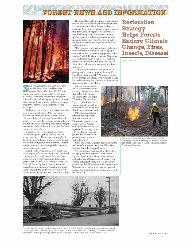
Restoration Strategy Helps Forests Endure Climate Change, Fires, Insects, Disease! by Roland Giller
The Forest Restoration Strategy is a significant shift in forest management because it emphasizes a restoration model where defined ecological outcomes drive the development of projects, rather than forest product targets. It also emphasizes interdisciplinary teams of foresters, botanists, wildlife biologists, soil scientists and watershed specialists that design projects so forests will be resilient to catastrophic fires, insect infestations and tree diseases.
“The emphasis is on creating forest landscapes more resilient to disturbances and changing cli-mates, with forest products as a by-product of res-toration,” said Bill Gaines, Okanogan-Wenatchee N.F. Restoration Team member. “It is the broad application of science on the ground—a unique feature few land managers have tried on a forest-wide scale.”
Last winter, 10 scientists from various disci-plines provided input to improve the scientific foundation of the original 1996 strategy. The im-proved strategy also addresses how climate change has made dense thickets of trees even more suscep-tible to fires, insects and disease.
Climate change can also lead to expensive repairs and untimely closures to the more than 8,400 miles of roads crisscrossing the Okanogan-Wenatchee National Forest. This is because it can bring weather conditions such as rain on snow and flash floods that destroy sections of roads.
“More frequent, higher intensity flooding events that take out roads and infrastructure could become more common,” Gaines said. “That’s where the social aspects of the strategy come into play. Failing roads can greatly limit recreation op-portunities and access to national forests.”
Many of our nation’s leaders believe now is the time for efforts like the Okanogan-Wenatchee National Forest Restoration Strategy.
“Declining forest health and the effects of our changing climate have resulted in an increas-ing number of catastrophic wildfires and insect outbreaks,” said U.S. Agriculture Secretary Tom Vilsack last August during a speech in Seattle where he outlined his vision for the nation’s forests. “It is time for a change in the way we view and manage America’s forestlands with an eye towards the future.”
Past logging practices often removed larger trees, opening growing sites for young trees that can feed catastrophic fires. The Okanogan-Wenatchee National Forest Restoration Strategy provides a vigorous program of thinning, pruning and controlled burning to reduce small trees in fire-prone areas.
Controlled burns that reduce brush and woody debris that can feed catastrophic wildland fires are part of the Okanogan-Wenatchee National Forest Restoration Strategy.
4 ■ Cascade Lookout
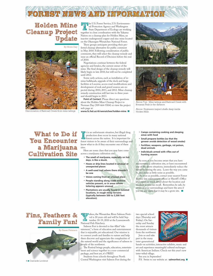
The U.S. Forest Service, U.S. Environmen-tal Protection Agency and Washington State Department of Ecology are working
together in close coordination with the Yakama Nation on a cleanup plan for Holden Mine, an inactive underground copper and zinc mine located on the Okanogan-Wenatchee National Forest.
These groups anticipate providing their pre-ferred cleanup alternative for public comment in May 2010. Following consideration of public comments, they will select the cleanup remedy and issue an official Record of Decision before the end of 2010.
Negotiations continue between the federal agencies and Intalco, the current owner of the mine. The final design of the cleanup remedy will likely begin in late 2010, but will not be completed until 2012.
Some early actions, such as installation of in-mine bulkheads, upgrade of the dock and barge facilities at Lucerne, access road modifications and development of rock and gravel sources are ex-pected during 2010, 2011, and 2012. Mine cleanup remedy construction will last two to three years and should begin in 2013.
Point of Contact: Please direct any questions about the Holden Mine Cleanup Project to Norman Day (509-664-9304) or view the project web page at: www.fs.fed.us/r6/wenatchee/holden-mine
It is an unfortunate situation, but illegal drug production does occur in many national forests across the nation. It is important for
forest visitors to be aware of their surroundings and know what to do if they encounter one of these sites.
Here are some clues that you may have come across a marijuana cultivation site:
The smell of marijuana, especially on hot days, is like a skunk.
Hoses or drip lines located in unusual or unexpected places
A well-used trail where there shouldn’t be one
Voices coming from an unusual place
People standing along roads without vehicles present, or in areas where loitering appears unusual
Plantations are usually found in isolated locations, in rough steep terrains (typically between 500 to 5,500 feet elevation).
Holden Mine Cleanup Project
UpdateBy Norm Day
What to Do if You Encounter
a Marijuana Cultivation Site
Yahoo, the Wenatchee River Salmon Festi-val is 20 years old and will be held Sep-tember 18-19, 2010 at the Leavenworth
National Fish Hatchery. Salmon Fest is devoted to fun-filled “edu-
tainment,” a form of education and entertainment that is enjoyable, yet educational. Our mission is to connect youth and families to nature and help them discover and appreciate the complexities of the natural world and the significance of salmon to people of the northwest.
The Festival brings people, education, entertain-ment and science together in a non-commercial package, and best yet, it’s FREE!
Students from schools throughout North Central Washington visit Salmon Fest during the
two special school days (Thursday and Friday). On Sat-urday and Sunday the event attracts thousands of visitors from the northwest.
Join us and take part in the many inter-generational hands-on activities, interactive exhibits, music and art and experience meaningful cultural exchanges with American Indians. Check out this year’s new inter-tribal village.
See you in September!P.S. Swim to our website at: salmonfest.org
Fins, Feathers & Family Fun!
By Susan Peterson
■ Cascade Lookout
thato cthethepeo
Thmepac
SCen
Discoloration of Railroad Creek from mine tailings.
Above Top: Mine tailings and Railroad Creek with Bonanza Peak in the distance.
Above: Engineers inspect shafts deep inside Holden Mine.
Camps containing cooking and sleeping areas with food
Small propane bottles (so that the grower avoids detection of wood smoke)
Fertilizer, weapons, garbage, rat poison, dead animals
Individuals armed with rifles out of hunting season
As soon as you become aware that you have encountered a cultivation site, or have encountered any of the above situations, immediately reduce the threat by leaving the area. Leave the way you came in, and make as little noise as possible.
As soon as possible, contact your nearest Forest Service law enforcement officer or Sheriff ’s Office and report as much detail about the location and incident as you can recall. Remember, be safe, be aware of your surroundings and leave the area if you see any signs that it may be a grow site.
Cascade Lookout ■ 5
There is a greater awareness now that we are losing touch with the natural world, and that many of our youth today have either
lost or have limited opportunity to connect with the great outdoors. Because of this, the Washing-ton State University (WSU) 4-H Eco-Stewardship Program was developed for youth in Chelan and Douglas Counties. The program connects youth and nature in a positive way, by providing learn-ing opportunities relative to the environment and natural resources surrounding local communities.
Now in its eighth year, the 4-H Eco-Steward-ship Program has served over 18,000 teens from Chelan and Douglas counties. Approximately 86 percent of the youth are from low income families and 45 percent are from underserved populations. A direct result of the program is that program graduates have gone on to academic and career choices in the natural resource field.
The program connects kids with nature by working on service-oriented projects, engaging them in relevant “hands-on” educational activi-ties. The Forest Service and over thirty local, state, and federal agency partners provide guidance and direction in natural resource related projects. Teens monitor water quality and quantity in regional streams and rivers and work with re-vegetation efforts to reduce erosion and improve fish spawn-ing habitat. They assist with Chinook and Coho
In 2005, the Forest Service issued the Travel Management Rule which directed all Na-tional Forests across the nation to identify and
designate roads, trails and areas where motorized use is appropriate, sustainable and desirable. Cur-rently, the forest is open to motorized use unless specifically closed. Under the Rule, motorized use will be allowed on those roads, trails and areas designated for such use and motorized use will prohibited elsewhere. The forest’s Travel Manage-ment process will not affect over-the-snow motor-ized access.
Since 2006, the Okanogan-Wenatchee National Forest has considered information gathered from a variety of public and agency sources to develop a Proposed Action for its Travel Management Plan-ning project. The Proposed Action serves as a start-ing point for discussions as the forest works toward designating a system of roads, trails and areas open to motorized use.
What,s been happening recently?
The Travel Management Planning Team con-tinues to work toward producing a Draft Environ-mental Impact Statement for public review this year.
In March 2009, a proposed action for Travel Management on the Okanogan-Wenatchee Na-tional Forest was released to the public for review and comment. This Proposed Action identified a system of roads, trails and areas to be designated as open for motorized use.
Over 500 public comments on the Proposed Action were received in April and May of 2009. A variety of issues were identified while additional proposals were considered for addition or dele-tion from the Proposed Action. Some of the issues included:
Effects of the proposed motorized system on resources
Effects of the proposed system on the local economy
Need for more motorized recreation opportunities
salmon spawning activities at federal hatcheries, build interpretive nature trails, or take part in the live capture of mule deer to evaluate the declining species population. The program extends to school recycling programs to reduce the carbon footprint and impacts on landfills.
In the Okanogan-Wenatchee National For-est, students have completed work in wilderness restoration, eradication of noxious weeds and aspen regeneration.
In recognition of this work, the program was recently honored with the U.S. Fish and Wildlife’s
“Connecting Youth with Nature through Natural Resources Conservation Education Award” for outstanding 4-H program development, imple-mentation, and evaluation in wildlife conservation and environmental education. The program previ-ously received the U.S. Forest Service’s “Caring for the Land Award.”
Issues that were identified during the Travel Management Planning Team review of public comments were used to formulate a range of alternatives to the Proposed Action. Public route proposals were then screened to ensure their consistency with the Forest Plan and adjacent landowner management. All proposals that made it through the screening process are now part of a pool of routes used to form alternatives.
During the 2009 field season, surveys were performed for different resources that could be affected by the motorized use alternatives. These surveys included cultural sites, aquatic resources, sensitive plants and animals, and other resources.
What,s happening now?
Using the issues, public proposals and screening process, the Planning Team defined alternatives, or the different ways the motorized system might look across the forest. The team is currently analyz-ing the environmental effects of the alternatives.
What,s next?
The Draft Environmental Impact Statement will document the Planning Team’s analysis of environmental effects and will then be released for public review and comment.
Once the team has reviewed and responded to public comments on the DEIS, we will issue a Fi-nal Environmental Impact Statement and Record of Decision. The new designated motorized system will be implemented with release of the Motor Vehicle Use Map.
Do you have more questions?Travel Management website:
www.fs.fed.us/r6/okawen/travel-managementor Aaron Pratt, Team Leader at 509-664-9321
4-H - Head, Heart, Hands and Health
Helping Students Become
Connected With NatureBy Susan Peterson and Betsy Fradd,
Washington State University Extension 4-H
What’s Happening with the Motorized Travel Plan?By Susan Peterson and Betsy Fradd,
Washington State University Extension 4-H
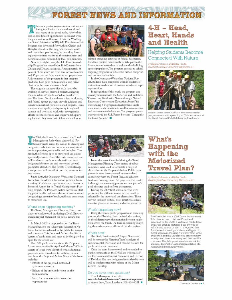
Photos: Teens in the WSU 4-H Eco-Stewardship program assist with spawning of Chinook salmon at the Entiat National Fish Hatchery and trail work.
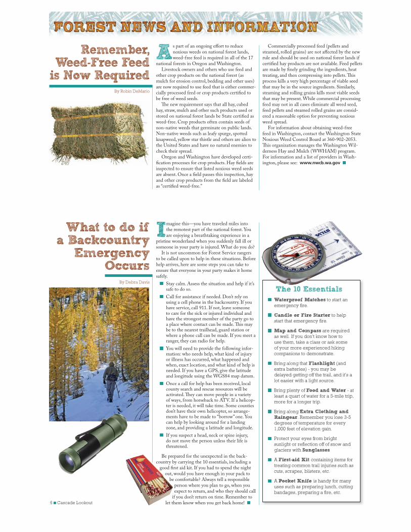
The Forest Service’s 2005 Travel Management Rule directed each National Forest and grassland to designate a system of roads, trails and areas open to motorized use by type of vehicle and season of use. It recognized that there were increasing numbers and types of motor vehicles accessing National Forest lands and concluded that unrestricted cross country travel posed resource, safety and user conflict concerns. The Rule provides a framework for analysis, designation, and implementation of a sustainable motorized system.
6 ■ Cascade Lookout
What to do if a Backcountry
Emergency Occurs
By Debra Davis
As part of an ongoing effort to reduce noxious weeds on national forest lands, weed-free feed is required in all of the 17
national forests in Oregon and Washington. Livestock owners and others who use feed and
other crop products on the national forest (as mulch for erosion control, bedding and other uses) are now required to use feed that is either commer-cially processed feed or crop products certified to be free of weed seeds.
The new requirement says that all hay, cubed hay, straw, mulch and other such products used or stored on national forest lands be State certified as weed-free. Crop products often contain seeds of non-native weeds that germinate on public lands. Non-native weeds such as leafy spurge, spotted knapweed, yellow star thistle and others are alien to the United States and have no natural enemies to check their spread.
Oregon and Washington have developed certi-fication processes for crop products. Hay fields are inspected to ensure that listed noxious weed seeds are absent. Once a field passes this inspection, hay and other crop products from the field are labeled as “certified weed-free.”
Imagine this—you have traveled miles into the remotest part of the national forest. You are enjoying a breathtaking experience in a
pristine wonderland when you suddenly fall ill or someone in your party is injured. What do you do?
It is not uncommon for Forest Service rangers to be called upon to help in these situations. Before help arrives, here are some steps you can take to ensure that everyone in your party makes it home safely.
Stay calm. Assess the situation and help if it’s safe to do so.
Call for assistance if needed. Don’t rely on using a cell phone in the backcountry. If you have service, call 911. If not, leave someone to care for the sick or injured individual and have the strongest member of the party go to a place where contact can be made. This may be to the nearest trailhead, guard station or where a phone call can be made. If you meet a ranger, they can radio for help.
You will need to provide the following infor-mation: who needs help, what kind of injury or illness has occurred, what happened and when, exact location, and what kind of help is needed. If you have a GPS, give the latitude and longitude using the WGS84 map datum.
Once a call for help has been received, local county search and rescue resources will be activated. They can move people in a variety of ways, from horseback to ATV. If a helicop-ter is needed, it will take time. Some counties don’t have their own helicopter, so arrange-ments have to be made to “borrow” one. You can help by looking around for a landing zone, and providing a latitude and longitude.
If you suspect a head, neck or spine injury, do not move the person unless their life is threatened.
Be prepared for the unexpected in the back-country by carrying the 10 essentials, including a
good first aid kit. If you had to spend the night out, would you have enough in your pack to
be comfortable? Always tell a responsible person where you plan to go, when you expect to return, and who they should call
if you don’t return on time. Remember to let them know when you get back home!
Commercially processed feed (pellets and steamed, rolled grains) are not affected by the new rule and should be used on national forest lands if certified hay products are not available. Feed pellets are made by finely grinding the ingredients, heat treating, and then compressing into pellets. This process kills a very high percentage of viable seed that may be in the source ingredients. Similarly, steaming and rolling grains kills most viable seeds that may be present. While commercial processing feed may not in all cases eliminate all weed seed, feed pellets and steamed rolled grains are consid-ered a reasonable option for preventing noxious weed spread.
For information about obtaining weed-free feed in Washington, contact the Washington State Noxious Weed Control Board at 360-902-2053. This organization manages the Washington Wil-derness Hay and Mulch (WWHAM) program. For information and a list of providers in Wash-ington, please see: www.nwcb.wa.gov
Remember, Weed-Free Feed
is Now RequiredBy Robin DeMario
The 10 Essentials
Waterproof Matches to start an
emergency fire.
Candle or Fire Starter to help
start that emergency fire.
Map and Compass are required
as well. If you don't know how to
use them, take a class or ask some
of your more experienced hiking
companions to demonstrate.
Bring along that Flashlight (and
extra batteries) - you may be
delayed getting off the trail, and it's a
lot easier with a light source.
Bring plenty of Food and Water - at
least a quart of water for a 5-mile trip,
more for a longer trip.
Bring along Extra Clothing and Raingear. Remember you lose 3-5
degrees of temperature for every
1,000 feet of elevation gain.
Protect your eyes from bright
sunlight or reflection off of snow and
glaciers with Sunglasses
A First-aid Kit containing items for
treating common trail injuries such as
cuts, scrapes, blisters, etc.
A Pocket Knife is handy for many
uses such as preparing lunch, cutting
bandages, preparing a fire, etc.
Cascade Lookout ■ 7
Well-maintained trails, clean toilets, visitor information and safe and clean campgrounds—these are some of the
services and benefits the Recreation Fee Program enables the Okanogan-Wenatchee National Forest to provide for forest visitors.
While most recreation opportunities on the Forest remain free, recreation fees are required at some of our more developed campgrounds, trail-heads, picnic areas and boat launches to help offset higher operation and maintenance costs at these sites. Since the Forest retains 95 percent of the money collected, user fees directly contribute to the stewardship of these sites. We strive to spend your fee dollars wisely and to invest in facilities and services that are important to you.
Last year, the Okanogan-Wenatchee National Forest spent nearly $700,000 of recreation fee revenue to accomplish work that would not have been possible without your recreation fees. North-west Forest Pass receipts, paired with the help of volunteers, enabled us to maintain over 800 miles of trails, make improvements to more than 50 de-veloped trailheads and provide visitor information to thousands of people.
Your campground fees funded garbage service, toilet pumping, new fire rings and picnic tables, and a multitude of other services at your favorite recreation sites. Your fees helped to create jobs for more than a dozen seasonal employees and funded campground hosts at busy campgrounds. In addi-tion, fee dollars were used to leverage grant funds to help us improve the condition of more trails and facilities than could have been achieved with fee revenue alone.
Following is a brief list of activities accomplished on the Okanogan-Wenatchee National Forest using Recreation Fee Program revenue in 2009:
Chelan Ranger District Chelan Boat Dock permit revenue paid for full
deck replacement of Deer Point dock and new hinges on docks located at Mitchell Creek, Graham Harbor and Refrigerator Harbor
Echo Ridge Nordic Area permit revenue funded the grooming of the ski trails and operation of the facilities at the site
Cle Elum Ranger District Constructed and installed two new
information boards at Deception and Pete Lake Trailheads
Cut and removed brush from Rachel Lake Trailhead parking lot and access road
Repainted approximately one-quarter of the district trailhead information boards and signs
Funded one temporary employee to patrol and maintain recreation use sites
Painted a vault toilet, repaired a broken window and built and installed a new base for the wood stove at the A-Frame Rental Cabin
Cut eight cords of firewood for use at the A-Frame Cabin and Teanaway Guard Station
Entiat Ranger District Maintained and removed downed trees from
275 miles of forest recreation trails, 180 miles of motorized/multiple use trails, 50 miles of wilderness trails and 45 miles of non-motorized non-wilderness trails
Reconstructed and restored 12 miles of motorized/multiple use trails, five miles of non-motorized non-wilderness trails and four miles of wilderness trails
Built and installed new information boards, picnic tables and parking barriers at several campgrounds
Recreation Fees Helped Make 2009 Another Productive Year- Thanks to You!By Brenda Yankoviak
Methow Valley Ranger District Maintained approximately 300 miles of trails
Maintained and improved signage at 32 trailheads, reconstructed livestock loading docks at seven trailheads and installed steel hitch rails at two trailheads
Funded seven campground hosts and one recreation area host to maintain recreation sites and provide visitor information
Purchased and installed seven picnic tables and 12 bulletin boards
Thinned trees and chipped brush to reduce fire hazards in Flat Camp, Nice Camp and Ruffed Grouse Campgrounds
Enlarged 19 parking spurs in two campgrounds to accommodate larger recreational vehicles
Naches Ranger District Reconstructed 12 permit boxes and repaired
or replaced information boards at six trailheads
Maintained approximately 200 miles of trails
Funded five campground hosts and 10 seasonal employees to maintain sites and provide visitor information
Purchased and installed new accessible picnic tables and fire rings at Willows and White Pass Campgrounds and Clear Lake Day Use site
Repaired and painted eight vault toilets
Completed upgrades and repairs to American River Guard Station—installed new appliances, replaced all wiring, added lighting to the outhouse and installed support posts under the porch roof
Tonasket Ranger District Repaired the post-and-rail fence at Long
Swamp Trailhead Replaced 24 parking barriers at Bonaparte
Lake and Lost Lake Campgrounds Repaired the post-and-rail and wire fences to
exclude livestock at Bonaparte and Lost Lake Campgrounds
Repaired and maintained water systems at Cottonwood, Oriole, Bonaparte Lake, Lost Lake, Beaver Lake and Beth Lake Campgrounds
Completed brush removal to improve access for large RVs at Bonaparte Lake, Beth Lake and Beaver Lake Campgrounds
Wenatchee River Ranger District Removed down trees from two miles of
avalanche damaged trail
Repaired two slumps on Devil’s Gulch Trail caused by the Mission Creek washout
Enchantment Lakes Area permit revenues funded annual helicopter removal of backcountry toilets, Forest Service Wilderness Rangers to patrol the permit area, maintenance of the trail system within the permit area and the management and rehabilitation of areas to maintain a primitive to pristine setting
Your fee dollars accomplished a huge amount of work. Thank you for directly contributing to the stewardship of your national forest campgrounds, trailheads and other recreation sites! We work hard to spend your fees wisely, and we value your feedback and suggestions. For more information about the Recreation Fee program, please go to the Region 6 recreation fee webpage at:
www.fs.fed.us/r6/passespermits
8 ■ Cascade Lookout
It's early morning; the sun feels warm on your back and dew glistens on the avalanche lilies as you traverse a switchback in the trail. Kick-
ing a stone off the tread you wonder how much effort goes into maintaining trails like these.
The Backcountry Horsemen of Washington can tell you. In celebration of National Trails Day, the Okanogan Valley Chapter of Backcountry Horsemen mobilized their members to work on the Bonaparte Trail system. Heading out with chainsaws on pack stock, they cleared fallen logs and trees from the two and a half mile long Cabin Creek Trail and the seven and a half mile long Fourth of July ridge trail.
Those members not running the chainsaws stayed behind and worked at the trailhead. This work included the removal of brush and logs from areas where two new campsites would be located, and the four hours it took the backhoe to dig 10 holes in the rocky terrain.
On June 6, 2009, the trail crew finished clear-ing the Fourth of July ridge trail. The trailhead crew completed the installation of three steel hitch rails, two sets of highline poles, two fire rings and assembled two picnic tables. These tasks required moving 1,600 pounds of ready-mix cement from the parking lot to the various installation sites.
The next day, after finishing up a few small tasks, Backcountry Horsemen volunteers celebrated with a nice trail ride over the newly cleared trail, all feel-ing a sense of pride and accomplishment in a job well done.
Since the Okanogan Valley Chapter of Back-country Horsemen adopted this trail, the site has been transformed from a nondescript wide spot in the road to a first-class camping area. It now has a graveled parking area, a restroom, trail signage, a bulletin board kiosk, three campsites with tables and fire rings, a loading ramp, three metal hitch rails, one wooden hitch rail and two sets of highline poles.
In August, 2009, this same chapter, with grant funding, completed work on the Bannon Mountain Trailhead. Two picnic tables were assembled; two fire rings, two sets of steel highline poles and three steel hitch rails were installed. A large four-foot by eight-foot prefabricated Backcountry Horsemen sign was also installed. The sign shows all the trail systems in the Bannon Mountain area, including mileage and color-coding of each trail to orient all visitors who want to use the trail system. They also repaired an existing barbed wire fence and cleaned one mile of trail alongside the fence. Lastly, they replaced one signpost that had been destroyed by
vandals. The Bannon Mountain trail system is open to stock, ATV's, hikers and mountain bikes.
Some other great partners in the woods are the Butte Busters Snowmobile and Tri River Snowmobile Clubs, both members of the Wash-ington Association of Snowmobile Clubs. These clubs keep hundreds of miles of snowmobile routes groomed on Forest roads and snowmobile trails open throughout the winter. Working with Okanogan County, they ensure that the system is well groomed. During the summer months, these organizations’ volunteers put in hundreds of hours of work clearing debris from the roads and trails. Using their own chainsaws, ORVs and pickup trucks for trail maintenance, these groups exceed $40,000 annually in donated labor and machine use.
Each January, the Butte Busters and Tri Rivers Snowmobile Clubs host a chili feed at the cabin in 30 Mile Meadows on the Tonasket Ranger District. They feed around 60 snowmobile riders who stop in for hotdogs, chili, something warm to drink and a little conversation before continuing on with their rides.
This free event is a get together of volunteers who have kept the off road routes open for the pub-lic to use. Some of these trails were built by the Ci-vilian Conservation Corps in the 1930s. One of the routes is an old Department of Natural Resources route constructed in the 1890s when the Loomis State Forest was part of the Federal Lands System and before the U.S. Forest Service was formed.
Becoming a District Ranger was a long-time goal for Mark Morris. During summer breaks from college, Morris worked for the
Lake Tahoe Visitor Center in California as a wil-derness ranger. He also worked in fire prevention and law enforcement for the Tahoe Basin Manage-ment Unit. Morris graduated with Bachelor's and Master's degrees in Public Administration from California State University Chico in 1973.
Morris worked as District Administrative Officer, Budget Officer and Administrative Of-ficer on a variety of forests including the Siuslaw and Deschutes National Forests in Oregon and the Okanogan National Forest and Wenatchee National Forest in Washington. He became the Tonasket District Ranger in January 2000.
Morris is an avid fisherman and hunter, and likes to raise horses and cattle. He and his wife Rae have two adult daughters.
Mark Morris, Tonasket District
Ranger will retire in July 2010
Partners in the Woods
By Tommy Days
Right: Mark Morris, wilderness ranger, in 1971
Cascade Lookout ■ 9
G-12
M-13
G-12
J-5
W-2
F-17
W-2
G-17
J-10
M-4
M-5
F-17
M-4
G-13
K-12
H-12
Q-5
L-12
J-10
J-10
K-6
G-17
M-5
G-13
M-5
J-13
G-14
H-14
J-11
J-11
H-13
L-12
K-12
J-10
G-10
G-17
G-17
K-12
J-5
J-13
4
10
67
14
15
11
6
1
5
9
1216
21
4
30
4
6
4
4
45
12
7
3
12
16
23
29
5
5
1
4
1
2
2
10
65
5
18
Alpine Meadows
Antilon Lake
Atkinson Flat
Beaver Lake
Beth Lake
Ballard
Black Pine
23Black Pine Lake
Bridge Creek (S)
Buck Lake
Camp Four
Cascade Creek
Chatter Creek
Chewuch
Chiwawa
Corral Creek
Cottonwood (Entiat RD)
Cottonwood (Tonasket RD)
V-6 19Crawfish Lake
Deer Point
Domke Falls
Domke Lake
Early Winters
Eightmile
Falls Creek
Finner Creek
Flat
Fox Creek
Glacier View
Goose Creek
Graham Harbor
Graham Harbor Creek
Grouse Creek
Grouse Mountain
Handy Spring
Hatchery Camp
Holden Ballpark
Ida Creek
Johnny Creek
P-8 6JR
Junior Point
Klipchuck
Lake Creek
Site Name
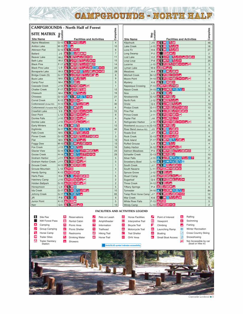
CAMPGROUNDS - North Half of Forest
SITE MATRIXFacilities and Activities C
amps
ites
Cam
psite
s
Map
Loca
tion
Site Name Facilities and Activities
Map
Loca
tion
Site Fee
NW Forest Pass
Camping
Group Camping
Horse Camp
Trailer Sites
Trailer Sanitary Station
FACILITIES AND ACTIVITIES LEGEND
Horse Facilities
Interpretive Trail
Bicycle Trail
Motorcycle Trail
Trail Shelter
OHV Area
Point of Interest
Viewpoint
Climbing
Launching Ramp
Boating
Small Boat Access
Rafting
Swimming
Fishing
Winter Recreation
Cross Country Skiing
Snowshoeing
Not Accessible by car (boat or hike in)
Lone Fir
Lucerne
Mitchell Creek
Moore Point
Mystery
Napeequa Crossing
Nason Creek
Nineteenmile
North Fork
Phelps Creek
Pine Flat
Prince Creek
Poplar Flat
Refrigerator Harbor
Riverbend (Wenatchee R. RD)
Roads End
Rock Creek
Rock Island
Ruffed Grouse
Safety Harbor
Schaefer Creek
Silver Falls
Snowberry Bowl
South Navarre
Spruce Grove
Stuart Camp
Three Creek
Tumwater
White River Falls
Windy Camp
H-6
J-10
M-12
H-10
K-8
F-13
H-15
G-12
J-12
G-11
K-15
J-11
J-8
J-10
G-13
J-7
G-13
F-17
L-4
K-12
G-13
J-13
L-13
L-11
J-12
J-10
H-12
H-16
F-13
L-13
3
7
6
4
5
73
27
4
8
13
16
6
6
4
6
4
4
22
4
Salmon Meadows P-5 7
4
10
31
9
South Creek 4
4
2
2
3
84
5
2
Reservations
Rental Cabin
Picnic Area
Picnic Shelter
Restrooms
Drinking Water
Showers
Pets on Leash
Amphitheater
Information
Trailhead
Hiking Trail
Horse Trail
W-3
L-9
28Bonaparte Lake
Lyman Lake W-6 4
Long Swamp P-2 2
Lost Lake V-2 19
Loup Loup P-8 25
Nice L-5 3
Meadows H-4 14
River Bend (Methow RD) J-5 5
Sugarloaf Q-5 4
Oriole Q-5 10
Q-5 13
46
Kerr
L-4 5Honeymoon Tiffany Springs P-4 6
M-10 13Foggy Dew
H-4 5Harts Pass
Solid BLUE symbol indicates accessibility
Twisp River Horse Camp J-7 12
War Creek K-8 10
J-7
12 ■ Cascade Lookout
Site Fee
Camping
Group Camping
Horse Camp
Trailer Sites
Trailer Sanitary Station
FACILITIES AND ACTIVITIES LEGEND
Horse Facilities
Interpretive Trail
Bicycle Trail
Motorcycle Trail
Trail Shelter
OHV Area
Point of Interest
Viewpoint
Climbing
Launching Ramp
Boating
Small Boat Access
Rafting
Swimming
Fishing
Winter Recreation
Cross Country Skiing
Snowshoeing
Not Accessible by car (boat or hike in)
Reservations
Rental Cabin
Picnic Area
Picnic Shelter
Restrooms
Drinking Water
Showers
Pets on Leash
Amphitheater
Information
Trailhead
Hiking Trail
Horse Trail
Solid BLUE symbol indicates accessibility
D-24
D-24
D-24
G-20
F-17
G-17
E-19
D-25
F-17
E-20
C-28
C-28
E-25
D-25
D-24
F-19
C-28
G-17
E-18
E-24
E-28
C-24
F-23
G-17
D-28
D-24
G-17
D-20
13
1
1
14
10
6
13
15
12
23
33
22
16
12
15
6
11
45
56
9
42
18
14
10
39
22
65
143
American Forks
American Ridge Lodge
American River Guard Station
Beverly
Black Pine
Bridge Creek
Cayuse
Cedar Springs
Chatter Creek
Cle Elum River
Clear Lake North
Clear Lake South
Cottonwood (Naches RD)
Cougar Flat
Crow Creek
De Roux
Dog Lake
Eightmile
Fish Lake
Halfway Flat
Hause Creek
Hells Crossing
Icewater Creek
Ida Creek
Indian Creek
Indian Flat
Johnny Creek
Kachess
Site Name
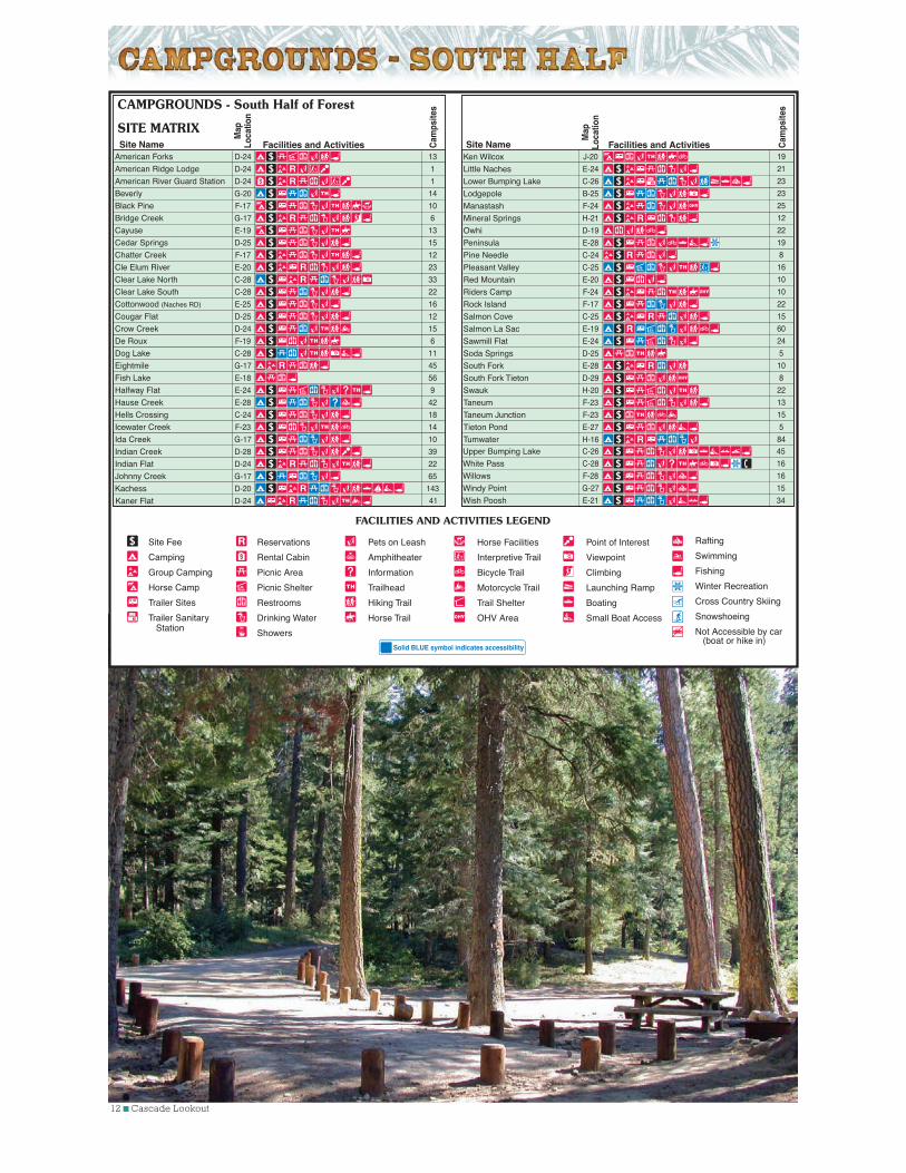
CAMPGROUNDS - South Half of Forest
SITE MATRIXFacilities and Activities C
amps
ites
Map
Loca
tion
Site Name Facilities and Activities
Map
Loca
tion
Kaner Flat
Ken Wilcox
Little Naches
Lower Bumping Lake
Lodgepole
Manastash
Mineral Springs
Owhi
Peninsula
Pine Needle
Pleasant Valley
Red Mountain
Riders Camp
Rock Island
Salmon Cove
Salmon La Sac
Sawmill Flat
Soda Springs
South Fork
South Fork Tieton
Swauk
Taneum
Taneum Junction
Tieton Pond
Tumwater
D-24
J-20
E-24
C-26
B-25
F-24
H-21
D-19
E-28
C-24
C-25
E-20
F-24
F-17
C-25
E-19
E-24
D-25
E-28
D-29
H-20
F-23
F-23
E-27
H-16
41
19
21
23
23
25
12
22
19
8
16
10
10
22
15
60
24
5
10
8
22
13
15
5
84
Upper Bumping Lake
White Pass
Willows
Windy Point
Wish Poosh
C-26
C-28
F-28
G-27
E-21
45
16
16
15
34
Cam
psite
s
Cascade Lookout ■ 13
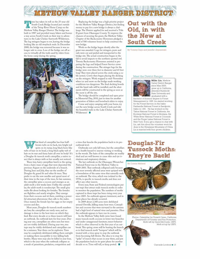
Time has taken its toll on the 25-year old South Creek Bridge located just outside of the Twisp River Horse Camp on the
Methow Valley Ranger District. The bridge was built in 1987 and provided many hikers and horses a way across South Creek on their way to adven-tures in the Lake Chelan-Sawtooth Wilderness. The log stringers began to rot, leaving the bridge looking like an old swayback mule. In December 2008, the bridge was removed because it was no longer safe to cross. Loss of the bridge cut off ac-cess to virtually all the trails used by riders from the horse camp during the spring.
Out with the Old, in with the New at South CreekBy Tommy Days and Jennifer Zbyszewski
Replacing the bridge was a high priority project for the Methow Valley Ranger District, but finding money to pay for a new bridge is always a chal-lenge. The District applied for and received a Title II grant from Okanogan County. To improve the chances of securing the grant, the Methow Valley Chapter of the Backcountry Horsemen pledged a total of 500 volunteer hours to help construct the new bridge.
Work on the bridge began shortly after the grant was awarded. Logs for stringers, posts and rails were cut and peeled and transported to the bridge site. The actual construction began in the fall to avoid impacts to the northern spotted owl. Twenty Backcountry Horsemen assisted in pre-paring the logs and helped Forest Service crews during the construction. The stringer logs for the bridge were over three feet in diameter and 65 feet long! They were placed across the creek using a ca-ble system. Crews then began placing the decking on the stringers. Work stopped in mid-November when ice and snow on the bridge made working conditions too dangerous. The final decking boards and the hand rails will be installed, and the abut-ments will be constructed in the spring as soon as the snow is off the site.
The bridge should be completed and open prior to Memorial Day, 2010, just in time for another generation of hikers and horseback riders to enjoy.
Come and enjoy camping with your horse, try out the new bridge across South Creek and ride the beautiful trails in the Lake Chelan-Sawtooth Wilderness!
What kind of caterpillar has four buff-brown tufts on its back, two bright red spots on its rump, long black horn-like
tufts of hair on its head, a long black spiky tuft of hair on its rear and fuzzy hairs all over its body? It’s a Douglas-fir tussock moth caterpillar, a native in-sect that is always with us but usually not noticed.
These tiny, hairy caterpillars hatch in the spring from a hairy mass of eggs that were deposited the previous August on the underside of a branch. During June and July, they eat the needles of Douglas-fir, grand fir and other fir trees. They prefer to eat the new needles and spend most of their time in the tops of the trees. In late summer, the caterpillar spins a cocoon and emerges as an adult moth a few weeks later. Unlike the caterpil-lar, the adult moth is nondescript. The small grey males flit about looking for females. The females are flightless and nearly wingless. They emerge from their cocoons and sit there, emitting a power-ful attractant pheromone that calls to the males. Once mated, the female lays her eggs on her empty cocoon and dies.
Most years, Douglas-fir tussock moth numbers are low, the caterpillars are rarely seen, and no damage is done to the host trees on which they feed. But every decade or so these insects will have an outbreak. An outbreak lasts for four years. Dur-ing year one, caterpillars are often seen but trees are not visibly defoliated. During year two, tree tops may be visibly defoliated and caterpillars can be a nuisance. Year three can be explosive. Trees may be completely defoliated, killing them outright or making them susceptible to tree-killing bark beetles. Many trees may also be killed in year four, which is the year when the outbreak collapses as a result of parasitism, predation, competition and
Douglas-Fir Tussock Moths: They’re Back!By Connie Mehmel
a virus that knocks the population back to its pre-outbreak level.
Outbreaks not only kill trees, but the caterpillars are a health hazard to anyone visiting or working in the woods. The hairs of the caterpillar are readily shed and are well known to cause skin and eye ir-ritations and respiratory distress.
The last outbreak on the Okanogan-Wenatchee National Forest was in the Methow Valley in 2000-2001. That outbreak collapsed early because the most severely affected areas were sprayed with a formulation of the same virus that naturally ends an outbreak. The virus, which was isolated in the 1970s, is specific to tussock moths and does not affect any other insects.
Every year, State and Federal entomologists put out traps that attract male tussock moths in order to monitor the population. The numbers of moths captured in these traps has been rising every year since 2005. An outbreak appears imminent, and in some places has already occurred.
In 2009 about 2,300 acres were defoliated around Oroville, killing many host trees. Caterpil-lars and cocoons that were surveyed in the autumn had a high level of natural virus and parasites. Here the outbreak appears to have run its course.
In the Methow Valley field crews have found many tussock moth cocoons in lower tree branches and under campground furniture; insect behavior which is often observed in the first year of an out-break. This spring crews will be beating the branch-es to find tussock moth “hotspots” which will be treated with a virus spray to stop the outbreak from becoming full-blown. The idea is to stop the “spike” of insects that occurs in year three, and put the population back in its quiet phase for another decade or so. Time will tell, so keep posted.
Photos: Caterpillar by Donald Owen, California Department of Forestry and Fire Protection.
Moth left by David McComb, USFS.Moth at top by USFS.
By Connie Mehmel
s
t
-
Department of FoMoth left
Meet the District Ranger
Mike Liu, Methow
Valley District Ranger
since May 2009,
grew up in California,
attended Humboldt
State University and
graduated with a
Bachelor of Science degree in Forest
Management in 1985. Liu started working
for the Forest Service on the Idaho
Panhandle National Forest in Sandpoint,
Idaho in 1981. He has worked on the
Tahoe National Forest in California, the
Kootenai National Forest in Montana, the
White River National Forest in Colorado
and the Finger Lakes National Forest in
New York. If you get a chance to chat with
Liu, ask him about the volunteer work he
does in the Himalayan Mountains of China.
Liu is married with four grown children.
14 ■ Cascade Lookout
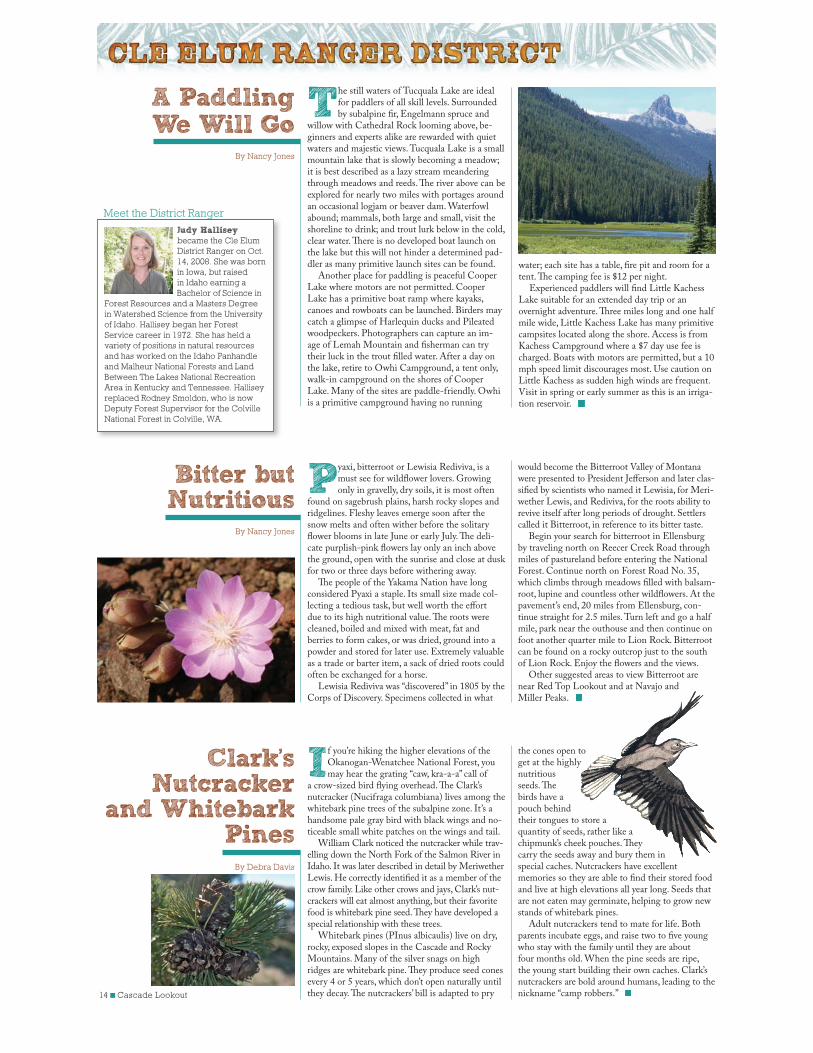
The still waters of Tucquala Lake are ideal for paddlers of all skill levels. Surrounded by subalpine fir, Engelmann spruce and
willow with Cathedral Rock looming above, be-ginners and experts alike are rewarded with quiet waters and majestic views. Tucquala Lake is a small mountain lake that is slowly becoming a meadow; it is best described as a lazy stream meandering through meadows and reeds. The river above can be explored for nearly two miles with portages around an occasional logjam or beaver dam. Waterfowl abound; mammals, both large and small, visit the shoreline to drink; and trout lurk below in the cold, clear water. There is no developed boat launch on the lake but this will not hinder a determined pad-dler as many primitive launch sites can be found.
Another place for paddling is peaceful Cooper Lake where motors are not permitted. Cooper Lake has a primitive boat ramp where kayaks, canoes and rowboats can be launched. Birders may catch a glimpse of Harlequin ducks and Pileated woodpeckers. Photographers can capture an im-age of Lemah Mountain and fisherman can try their luck in the trout filled water. After a day on the lake, retire to Owhi Campground, a tent only, walk-in campground on the shores of Cooper Lake. Many of the sites are paddle-friendly. Owhi is a primitive campground having no running
water; each site has a table, fire pit and room for a tent. The camping fee is $12 per night.
Experienced paddlers will find Little Kachess Lake suitable for an extended day trip or an overnight adventure. Three miles long and one half mile wide, Little Kachess Lake has many primitive campsites located along the shore. Access is from Kachess Campground where a $7 day use fee is charged. Boats with motors are permitted, but a 10 mph speed limit discourages most. Use caution on Little Kachess as sudden high winds are frequent. Visit in spring or early summer as this is an irriga-tion reservoir.
A PaddlingWe Will Go
By Nancy Jones
Pyaxi, bitterroot or Lewisia Rediviva, is a must see for wildflower lovers. Growing only in gravelly, dry soils, it is most often
found on sagebrush plains, harsh rocky slopes and ridgelines. Fleshy leaves emerge soon after the snow melts and often wither before the solitary flower blooms in late June or early July. The deli-cate purplish-pink flowers lay only an inch above the ground, open with the sunrise and close at dusk for two or three days before withering away.
The people of the Yakama Nation have long considered Pyaxi a staple. Its small size made col-lecting a tedious task, but well worth the effort due to its high nutritional value. The roots were cleaned, boiled and mixed with meat, fat and berries to form cakes, or was dried, ground into a powder and stored for later use. Extremely valuable as a trade or barter item, a sack of dried roots could often be exchanged for a horse.
Lewisia Rediviva was “discovered” in 1805 by the Corps of Discovery. Specimens collected in what
If you’re hiking the higher elevations of the Okanogan-Wenatchee National Forest, you may hear the grating “caw, kra-a-a” call of
a crow-sized bird flying overhead. The Clark’s nutcracker (Nucifraga columbiana) lives among the whitebark pine trees of the subalpine zone. It’s a handsome pale gray bird with black wings and no-ticeable small white patches on the wings and tail.
William Clark noticed the nutcracker while trav-elling down the North Fork of the Salmon River in Idaho. It was later described in detail by Meriwether Lewis. He correctly identified it as a member of the crow family. Like other crows and jays, Clark’s nut-crackers will eat almost anything, but their favorite food is whitebark pine seed. They have developed a special relationship with these trees.
Whitebark pines (PInus albicaulis) live on dry, rocky, exposed slopes in the Cascade and Rocky Mountains. Many of the silver snags on high ridges are whitebark pine. They produce seed cones every 4 or 5 years, which don’t open naturally until they decay. The nutcrackers’ bill is adapted to pry
Bitter but Nutritious
By Nancy Jones
Clark’s Nutcracker
and Whitebark Pines
By Debra Davis
would become the Bitterroot Valley of Montana were presented to President Jefferson and later clas-sified by scientists who named it Lewisia, for Meri-wether Lewis, and Rediviva, for the roots ability to revive itself after long periods of drought. Settlers called it Bitterroot, in reference to its bitter taste.
Begin your search for bitterroot in Ellensburg by traveling north on Reecer Creek Road through miles of pastureland before entering the National Forest. Continue north on Forest Road No. 35, which climbs through meadows filled with balsam-root, lupine and countless other wildflowers. At the pavement’s end, 20 miles from Ellensburg, con-tinue straight for 2.5 miles. Turn left and go a half mile, park near the outhouse and then continue on foot another quarter mile to Lion Rock. Bitterroot can be found on a rocky outcrop just to the south of Lion Rock. Enjoy the flowers and the views.
Other suggested areas to view Bitterroot are near Red Top Lookout and at Navajo and Miller Peaks.
the cones open to get at the highly nutritious seeds. The birds have a pouch behind their tongues to store a quantity of seeds, rather like a chipmunk’s cheek pouches. They carry the seeds away and bury them in special caches. Nutcrackers have excellent memories so they are able to find their stored food and live at high elevations all year long. Seeds that are not eaten may germinate, helping to grow new stands of whitebark pines.
Adult nutcrackers tend to mate for life. Both parents incubate eggs, and raise two to five young who stay with the family until they are about four months old. When the pine seeds are ripe, the young start building their own caches. Clark’s nutcrackers are bold around humans, leading to the nickname “camp robbers.”
Meet the District Ranger
Judy Hallisey became the Cle Elum
District Ranger on Oct.
14, 2008. She was born
in Iowa, but raised
in Idaho earning a
Bachelor of Science in
Forest Resources and a Masters Degree
in Watershed Science from the University
of Idaho. Hallisey began her Forest
Service career in 1972. She has held a
variety of positions in natural resources
and has worked on the Idaho Panhandle
and Malheur National Forests and Land
Between The Lakes National Recreation
Area in Kentucky and Tennessee. Hallisey
replaced Rodney Smoldon, who is now
Deputy Forest Supervisor for the Colville
National Forest in Colville, WA.
Cascade Lookout 15
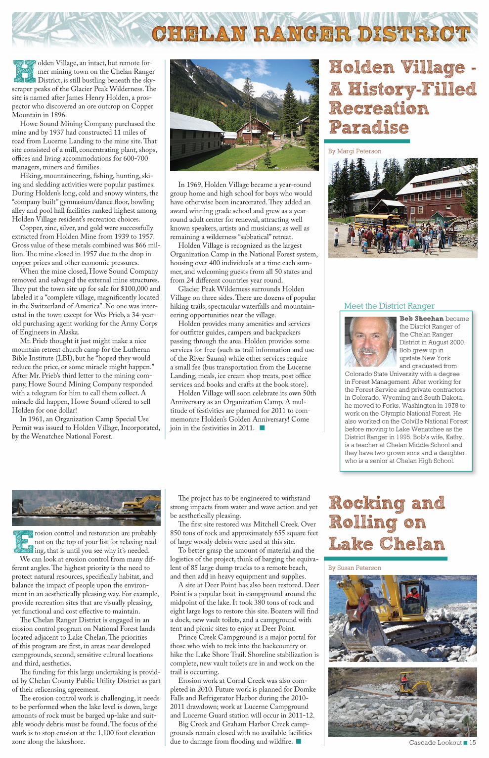
Holden Village, an intact, but remote for-mer mining town on the Chelan Ranger District, is still bustling beneath the sky-
scraper peaks of the Glacier Peak Wilderness. The site is named after James Henry Holden, a pros-pector who discovered an ore outcrop on Copper Mountain in 1896.
Howe Sound Mining Company purchased the mine and by 1937 had constructed 11 miles of road from Lucerne Landing to the mine site. That site consisted of a mill, concentrating plant, shops, offices and living accommodations for 600-700 managers, miners and families.
Hiking, mountaineering, fishing, hunting, ski-ing and sledding activities were popular pastimes. During Holden’s long, cold and snowy winters, the “company built” gymnasium/dance floor, bowling alley and pool hall facilities ranked highest among Holden Village resident’s recreation choices.
Copper, zinc, silver, and gold were successfully extracted from Holden Mine from 1939 to 1957. Gross value of these metals combined was $66 mil-lion. The mine closed in 1957 due to the drop in copper prices and other economic pressures.
When the mine closed, Howe Sound Company removed and salvaged the external mine structures. They put the town site up for sale for $100,000 and labeled it a “complete village, magnificently located in the Switzerland of America”. No one was inter-ested in the town except for Wes Prieb, a 34-year-old purchasing agent working for the Army Corps of Engineers in Alaska.
Mr. Prieb thought it just might make a nice mountain retreat church camp for the Lutheran Bible Institute (LBI), but he “hoped they would reduce the price, or some miracle might happen.” After Mr. Prieb’s third letter to the mining com-pany, Howe Sound Mining Company responded with a telegram for him to call them collect. A miracle did happen, Howe Sound offered to sell Holden for one dollar!
In 1961, an Organization Camp Special Use Permit was issued to Holden Village, Incorporated, by the Wenatchee National Forest.
Erosion control and restoration are probably not on the top of your list for relaxing read-ing, that is until you see why it’s needed.
We can look at erosion control from many dif-ferent angles. The highest priority is the need to protect natural resources, specifically habitat, and balance the impact of people upon the environ-ment in an aesthetically pleasing way. For example, provide recreation sites that are visually pleasing, yet functional and cost effective to maintain.
The Chelan Ranger District is engaged in an erosion control program on National Forest lands located adjacent to Lake Chelan. The priorities of this program are first, in areas near developed campgrounds, second, sensitive cultural locations and third, aesthetics.
The funding for this large undertaking is provid-ed by Chelan County Public Utility District as part of their relicensing agreement.
The erosion control work is challenging, it needs to be performed when the lake level is down, large amounts of rock must be barged up-lake and suit-able woody debris must be found. The focus of the work is to stop erosion at the 1,100 foot elevation zone along the lakeshore.
In 1969, Holden Village became a year-round group home and high school for boys who would have otherwise been incarcerated. They added an award winning grade school and grew as a year-round adult center for renewal, attracting well known speakers, artists and musicians; as well as remaining a wilderness “sabbatical” retreat.
Holden Village is recognized as the largest Organization Camp in the National Forest system, housing over 400 individuals at a time each sum-mer, and welcoming guests from all 50 states and from 24 different countries year round.
Glacier Peak Wilderness surrounds Holden Village on three sides. There are dozens of popular hiking trails, spectacular waterfalls and mountain-eering opportunities near the village.
Holden provides many amenities and services for outfitter guides, campers and backpackers passing through the area. Holden provides some services for free (such as trail information and use of the River Sauna) while other services require a small fee (bus transportation from the Lucerne Landing, meals, ice cream shop treats, post office services and books and crafts at the book store).
Holden Village will soon celebrate its own 50th Anniversary as an Organization Camp. A mul-titude of festivities are planned for 2011 to com-memorate Holden’s Golden Anniversary! Come join in the festivities in 2011.
The project has to be engineered to withstand strong impacts from water and wave action and yet be aesthetically pleasing.
The first site restored was Mitchell Creek. Over 850 tons of rock and approximately 655 square feet of large woody debris were used at this site.
To better grasp the amount of material and the logistics of the project, think of barging the equiva-lent of 85 large dump trucks to a remote beach, and then add in heavy equipment and supplies.
A site at Deer Point has also been restored. Deer Point is a popular boat-in campground around the midpoint of the lake. It took 380 tons of rock and eight large logs to restore this site. Boaters will find a dock, new vault toilets, and a campground with tent and picnic sites to enjoy at Deer Point.
Prince Creek Campground is a major portal for those who wish to trek into the backcountry or hike the Lake Shore Trail. Shoreline stabilization is complete, new vault toilets are in and work on the trail is occurring.
Erosion work at Corral Creek was also com-pleted in 2010. Future work is planned for Domke Falls and Refrigerator Harbor during the 2010-2011 drawdown; work at Lucerne Campground and Lucerne Guard station will occur in 2011-12.
Big Creek and Graham Harbor Creek camp-grounds remain closed with no available facilities due to damage from flooding and wildfire.
Holden Village - A History-Filled Recreation ParadiseBy Margi Peterson
Rocking and Rolling on Lake ChelanBy Susan Peterson
Meet the District RangerBob Sheehan became the District Ranger of the Chelan Ranger District in August 2000. Bob grew up in upstate New York and graduated from
Colorado State University with a degree in Forest Management. After working for the Forest Service and private contractors in Colorado, Wyoming and South Dakota, he moved to Forks, Washington in 1978 to work on the Olympic National Forest. He also worked on the Colville National Forest before moving to Lake Wenatchee as the District Ranger in 1995. Bob’s wife, Kathy, is a teacher at Chelan Middle School and they have two grown sons and a daughter who is a senior at Chelan High School.
16 ■ Cascade Lookout
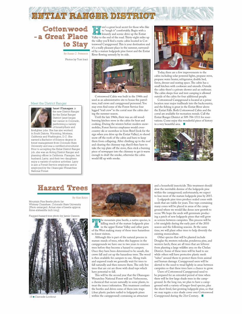
Here’s a great local secret for those who like to “rough it” comfortably. Begin with a leisurely and scenic drive up the Entiat
Valley to the end of the road. Thirty-eight miles up the valley you’ll find a rustic cabin located in Cot-tonwood Campground. This is your destination and it’s a really pleasant place in the summer, surround-ed by a mature lodgepole pine forest and the Entiat River flowing serenely by its side.
Cottonwood Cabin was built in the 1940s and used as an administrative site to house fire patrol-men, trail crews and campground personnel. You may even find some of the Forest Service four legged “trail crew” in the corral near the cabin dur-ing the summer season.
Until the late 1960s, there was an old wood-burning kitchen stove in the cabin for heat and cooking. During the winters before modern snow-mobiles, Forest Service employees would cross-country ski or snowshoe in from Brief (look for the sign when you drive up the Entiat Valley), to shovel snow off the roofs of the cabin and barn to keep them from collapsing. After climbing up to the roof and clearing the chimney top, they’d then have to take the top plate off the stove, then stick a burning piece of newspaper into the chimney to get it warm enough to draft the smoke, otherwise the cabin would fill up with smoke.
The mountain pine beetle, a native species, is killing much of the mature lodgepole pine in the upper Entiat Valley and other parts
of the West making many of these trees hazardous to forest visitors.
Although this is part of the natural process in mature stands of trees, when this happens in the campgrounds we have one to two years to remove trees before they become a hazard to campers. Once they have been determined to be unsafe, fire crews fall and cut up the hazardous trees. The wood is then available for campers to use. Along trails and unpaved roads we generally wait for trees to fall naturally and then remove them. The only live trees that are cut are those with dead tops which have potential to fall.
This will be the second year that the Okanogan-Wenatchee National Forest will use Verbeonone, a chemical that occurs naturally in some plants, to treat the insect infestation. This treatment confuses the beetles and drives some of them into traps (clear plastic packets nailed to lodgepole pines within the campground) containing an attractant
Cottonwood-a Great Place
to StayBy Susan C. Peterson
Hazard TreesBy Alan Kelso
Today, there are a few improvements to the cabin including solar powered lights, propane stove, propane water heater, refrigerator, double bed, futon, dresser and seating space. The cabin has a small kitchen with cookware and utensils. Outside the cabin there’s a private shower and an outhouse. The cabin sleeps four and tent camping is allowed outside of the cabin for four additional people.
Cottonwood Campground is located at a prime location near major trailheads into the backcountry, and the fishing is great in the Entiat River above the Entiat Falls. Both Cottonwood Cabin and the corral are available for recreation rentals. Call the Entiat Ranger District at 509-784-1511 for reser-vations. Come enjoy this wonderful piece of history in a very beautiful area.
and a household insecticide. This treatment should slow the inevitable demise of the lodgepole pine within the campground; unfortunately, we expect to lose most of the mature lodgepole pine by 2015.
Lodgepole pine trees produce sealed cones with seeds that are viable for years. Tree tops containing many cones will be placed in areas of the camp-ground where we would like dense new growth to occur. We hope the seeds will germinate produc-ing a patch of new lodgepole pines that will grow as screens between campsites. This process will be a bit unsightly during the early part of the 2010 season and the following seasons. At the same time, we will plant other trees to help diversify the existing monoculture.
Other species that will be planted include Douglas-fir, western redcedar, ponderosa pine, and western larch; these are all trees that are leftover from planting a large wildfire area on the Chelan District. Some of these trees will be hard to see while others will have protective plastic mesh "tubes" around them to protect them from animal and human damage. Campground users will be alerted to the need to tread lightly in areas between campsites so that these trees have a chance to grow.
Users of Cottonwood Campground need to be prepared for an extended period of time when there will be few large shade trees in the camp-ground. In the long run, we plan to have a camp-ground with a variety of longer-lived species, plus the short-lived, fast growing lodgepole pine, so that we may regain a nice shade cover over Cottonwood Campground during the 21st Century.
Photos by Tom Iraci
Mountain Pine Beetle photo by:Whitney Cranshaw, Colorado State University[Photo enlarged. Actual size of beetle approx. three-sixteenths inch long]
Flagged hazard tree photo by Jamie Cannon
Meet the District Ranger
Janet Flanagan is
the new District Ranger
for the Entiat Ranger
District! Janet began
her career in Colorado,
performing a variety
of forestry/fuels and
firefighter jobs. She has also worked
in South Dakota, Wyoming, Montana,
California and Washington, D.C. She
earned a Bachelor of Science degree in
forest management from Colorado State
University and was a certified silviculturist.
Prior to accepting the Entiat District Ranger
job, she was an Acting District Ranger and
planning officer in California. Flanagan, her
husband, Larry, and their two daughters
enjoy a variety of outdoor activities. Larry
is also a Forest Service employee and is
employed by the Okanogan-Wenatchee
National Forest.
Cascade Lookout ■ 17
That’s an excellent question and the answer is, “It’s all about people and managing our public lands for their benefit.” That state-
ment includes everything from outdoor recreation to wildlife habitat.
What it boils down to is providing all facets of our visiting public with outstanding opportunities to camp, hike, bike, ride, hunt, fish, learn and enjoy while visiting the Naches Ranger District.
There are 30 campgrounds on the Naches District; 15 are managed by the Forest Service and 15 by a concessionaire, Hoodoo Recreation. There are six group reservation sites allowing visitors the opportunity to have large family gatherings for less than $100 per day. Not a bad deal when you can split the cost many ways.
Like to hike or ride horses? Naches Ranger District offers excellent opportunities to take in the astonishing views of the Cascades and also experi-ence the remoteness of three Wilderness areas.
Goat Rocks Wilderness area encompasses 36,063 acres and has roughly 58 miles of trails; William O. Douglas Wilderness at 150,883 acres has 275 miles of trails, and Norse Peak Wilderness with 35,702 acres has 45 miles of trails.
If you are not into hiking or horseback riding, try other recreational activities that involve riding high horse powered motorized vehicles. ATV’s (all terrain vehicles), UTV’s (utility vehicles), jeeps or motorcycles are all welcome on different parts of the ranger district. The Naches Ranger District manages over 200 miles of single tread motorcycle trails and 150 miles of four-wheel drive/ATV/UTV trails. These trails are held in high regard by many of the motorized users throughout the northwest.
What About Naches Ranger District?By Doug Jenkins
There are three major reservoirs on the Naches Ranger District—Rimrock, Clear Lake and Bump-ing Lake. These are wonderful places to play or just set back, relax and catch a fish or two. Keep in mind, these reservoirs are filled with runoff from mountain snowfields so a little dip can be a bone chilling experience. Other lakes and streams are located across the district and provide excellent op-portunities for fishing, swimming and relaxing.
The district is also a gateway to the west part of the state via two mountain passes--White (U.S. Highway 12) and Chinook (State Route 410). Naches Pass, now a four-wheel drive trail, was one of the first mountain passes used by early settlers in 1853 to cross the Cascades.
For more information, suggestions on things to see or do, or help in deciding which area of the Naches Ranger District to visit, stop by or call our office at 509-653-1401. Our foyer is open seven days a week for forest visitors. There’s information on historical events, rules and regulations, passes that are needed, safety and places to visit and more. Stop by, chat awhile and get to know the Naches Ranger District a little better.
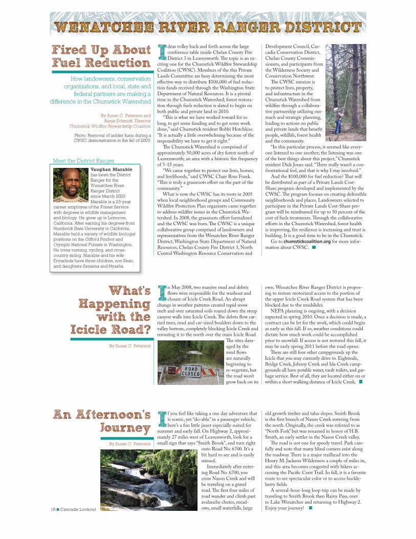
Picture these scenes in your mind. Back in 1901 two prospectors hiking around the streams and creeks along the Naches
River looking for gold come across a massive cave with a creek flowing through it. A cattle wrangler looking for his cows comes upon a creek running fast and furious with spring runoff. After some coaxing he’s able to get his horse to cross the creek and once on the other side says, “That’s a devil of a creek!” Both incidents were to become a part of history, the discovery of Boulder Cave and Devil Creek which created and now runs through the cave.
To protect the uniqueness of Boulder Cave and the Townsend’s big-eared bats (Corynorhinus townsendii) that remain in its dark chambers, steps are being taken to insure this once tranquil setting will always remain a major attraction to visitors and a sanctuary for bats.
In an attempt to protect the bats from human encroachment, gates were installed to prevent people from entering a chamber known to house nursing bats during the spring and summer as well as provide a safe roosting area. These locked, reinforced gates were breached this year and
Boulder Cave, Bats and Devil’s CreekBy Doug Jenkins
graffiti was found on interior signs. Trash littered the cave floor and crevices, native vegetation was trampled, graffiti was abundant and fire pits left unattended.
Starting in spring 2010, the Forest Service will again manage the site which includes the shelter, day use site, trail and cave. The cave and trail will be closed from 8 p.m. to 8 a.m. seven days a week. A Forest Service host will open the gate each day. An interpreter will be there at least three days a week to conduct group tours and nature walks. Large groups will be asked to contact the Naches Ranger Station to schedule tours. To offset the costs of the program, a donation of $5 per person is suggested for all tours.
For those who have the desire to help protect Boulder Cave and the trail through the cave, or who would enjoy volunteering to help in a pro-gram to preserve and protect the beauty of this area, please call the Naches Ranger Station at 509-653-1401 for more information. This is an excellent opportunity to meet people from around the country, share with them the history of the area, teach them why it is necessary to protect bat populations and also enjoy the great outdoors.
Townsend,s Big-eared Bat
Photo by Kent Woodruff
Above left photo: Looking out the entrance of Boulder Cave
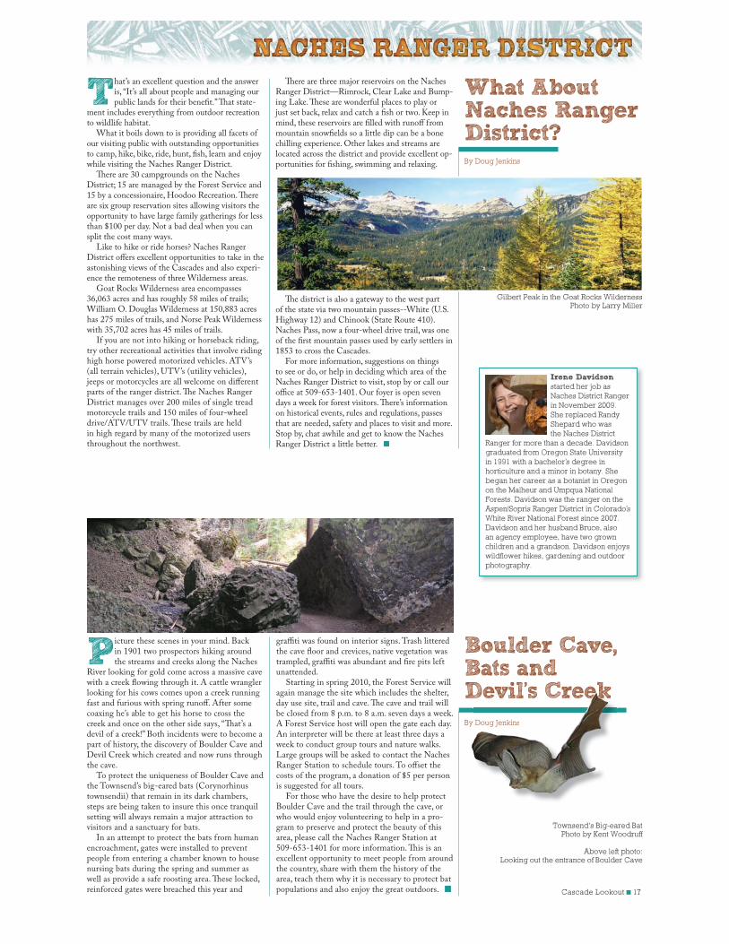
Gilbert Peak in the Goat Rocks Wilderness Photo by Larry Miller
Irene Davidson
started her job as
Naches District Ranger
in November 2009.
She replaced Randy
Shepard who was
the Naches District
Ranger for more than a decade. Davidson
graduated from Oregon State University
in 1991 with a bachelor,s degree in
horticulture and a minor in botany. She
began her career as a botanist in Oregon
on the Malheur and Umpqua National
Forests. Davidson was the ranger on the
Aspen/Sopris Ranger District in Colorado,s
White River National Forest since 2007.
Davidson and her husband Bruce, also
an agency employee, have two grown
children and a grandson. Davidson enjoys
wildflower hikes, gardening and outdoor
photography.
Devils CreekkkDoug Jenkins
18 ■ Cascade Lookout
Ideas volley back and forth across the large conference table inside Chelan County Fire District 3 in Leavenworth. The topic is an ex-
citing one for the Chumstick Wildfire Stewardship Coalition (CWSC). Members of the this Private Lands Committee are busy determining the most effective way to distribute $100,000 of fuel reduc-tion funds received through the Washington State Department of Natural Resources. It is a pivotal time in the Chumstick Watershed; forest restora-tion through fuels reduction is slated to begin on both public and private land in 2010.
“This is what we have worked toward for so long, to get some funding and to get some work done,” said Chumstick resident Bobbi Hotchkiss. “It is actually a little overwhelming because of the responsibility we have to get it right.”
The Chumstick Watershed is comprised of approximately 50,000 acres of dry forest north of Leavenworth; an area with a historic fire frequency of 5-15 years.
“We came together to protect our lives, homes, and livelihoods,” said CWSC Chair Ross Frank. “This is truly a grassroots effort on the part of the community.”
What is now the CWSC has its roots in 2005 when local neighborhood groups and Community Wildfire Protection Plan organizers came together to address wildfire issues in the Chumstick Wa-tershed. In 2008, the grassroots effort formalized and the CWSC was born. The CWSC is a unique collaborative group comprised of landowners and representatives from the Wenatchee River Ranger District, Washington State Department of Natural Resources, Chelan County Fire District 3, North Central Washington Resource Conservation and
Development Council, Cas-cadia Conservation District, Chelan County Commis-sioners, and participants from the Wilderness Society and Conservation Northwest.
The CWSC mission is to protect lives, property, and infrastructure in the Chumstick Watershed from wildfire through a collabora-tive partnership utilizing out-reach and strategic planning, leading to actions on public and private lands that benefit people, wildlife, forest health and the community.
“In this particular process, it seemed like every-one listened to one another; the listening was one of the best things about this project,” Chumstick resident Dick Jones said. “There really wasn’t a con-frontational feel, and that is why I stay involved.”
And the $100,000 for fuel reduction? That will be distributed as part of a Private Lands Cost-Share program developed and implemented by the CWSC. The program focuses on creating defensible neighborhoods and places. Landowners selected to participate in the Private Lands Cost-Share pro-gram will be reimbursed for up to 50 percent of the cost of fuels treatments. Through the collaborative efforts in the Chumstick Watershed, forest health is improving, fire resilience is increasing and trust is building. It is a good time to be in the Chumstick.
Go to chumstickcoalition.org for more infor-mation about CWSC.
Fired Up About Fuel Reduction
How landowners, conservation
organizations, and local, state and
federal partners are making a
difference in the Chumstick Watershed
By Susan C. Peterson and
Annie Schmidt, Director
Chumstick Wildfire Stewardship Coalition
If you feel like taking a one day adventure that is scenic, yet “do-able” in a passenger vehicle, here’s a fun little jaunt especially suited for
summer and early fall. On Highway 2, approxi-mately 27 miles west of Leavenworth, look for a small sign that says “Smith Brook”, and turn right
onto Road No. 6700. It’s a bit hard to see and is easily missed.
Immediately after enter-ing Road No. 6700, you cross Nason Creek and will be traveling on a gravel road. The first four miles of road wander and climb past avalanche chutes, mead-ows, small waterfalls, large
In May 2008, two massive mud and debris flows were responsible for the washout and closure of Icicle Creek Road. An abrupt
change in weather patterns created rapid snow melt and over saturated soils roared down the steep canyon walls into Icicle Creek. The debris flow car-ried trees, mud and car-sized boulders down to the valley bottom, completely blocking Icicle Creek and rerouting it to the north over the main Icicle Road.
The sites dam-aged by the mud flows are naturally beginning to re-vegetate, but the road won’t grow back on its
An Afternoon’s Journey
By Susan C. Peterson
What’s Happening
with theIcicle Road?
By Susan C. Peterson
old growth timber and talus slopes. Smith Brook is the first branch of Nason Creek entering from the north. Originally, the creek was referred to as “North Fork” but was renamed in honor of H.B. Smith, an early settler in the Nason Creek valley.
The road is not one for speedy travel. Park care-fully and note that many blind corners exist along the roadway. There is a major trailhead into the Henry M. Jackson Wilderness a couple of miles in, and this area becomes congested with hikers ac-cessing the Pacific Crest Trail. In fall, it is a favorite route to see spectacular color or to access huckle-berry fields.
A several-hour-long loop trip can be made by traveling to Smith Brook then Rainy Pass, over to Lake Wenatchee and returning to Highway 2. Enjoy your journey!
own. Wenatchee River Ranger District is propos-ing to restore motorized access to the portion of the upper Icicle Creek Road system that has been blocked due to the mudslides.
NEPA planning is ongoing, with a decision expected in spring 2010. Once a decision is made, a contract can be let for the work, which could begin as early as this fall. If so, weather conditions could dictate how much work could be accomplished prior to snowfall. If access is not restored this fall, it may be early spring 2011 before the road opens.
There are still four other campgrounds up the Icicle that you may currently drive to. Eightmile, Bridge Creek, Johnny Creek and Ida Creek camp-grounds all have potable water, vault toilets, and gar-bage service. Best of all, they are located either on or within a short walking distance of Icicle Creek.
Meet the District Ranger
Vaughan Marable
has been the District
Ranger for the
Wenatchee River
Ranger District
since March 2005.
Marable is a 23-year
career employee of the Forest Service
with degrees in wildlife management
and biology. He grew up in Lemoore,
California. After earning his degrees from
Humboldt State University in California,
Marable held a variety of wildlife biologist
positions on the Gifford Pinchot and
Olympic National Forests in Washington.
He loves running, cycling, and cross-
country skiing. Marable and his wife
Ermalinda have three children, son Sean,
and daughters Savanna and Nyasha.
Photo: Removal of ladder fuels during a CWSC demonstration in the fall of 2009.
Cascade Lookout ■ 19
Help Smokey find the Forest Fire!Forest Maze Did You Know...Forest Tracks
The tallest tree in the world is a 363 foot tall redwood in northern California. That makes it almost 60 feet taller than the Statue of Liberty.
How many teeth does a bear have? 42
A full grown bear can run as fast as a horse.
There are only two animals with blue tongues, the black bear and the Chow dog.
A group of geese on the ground is gaggle, a group of geese in the air is skein.
The only continent without reptiles or snakes is Antarctica.
Bees must collect the nectar from two thousand flowers to make one tablespoonful of honey.
A group of geese is called a gaggle.
A group of ravens is called a murder.
A group of larks is called an exaltation.
A group of owls is called a parliament.
The top knot that quails have is called a hmuh.
Quail live in groups called coveys.
Baby porcupines are called "porcupettes."
Porcupines are able to float in water. The quills are very light and they act as a life preserver that helps them float when they swim.
The oldest tree is a bristle cone pine, some of which are 4,000-6,000 years old!
The black-tailed jackrabbit is the fastest of the rabbits and hares, it can run as fast as 45 mph and leap 15-20 feet.
The bald eagle is the second largest bird of prey in North America. What is the largest? The California Condor.
Coyotes live in all of the United States except which state? Hawaii.
TRUE or FALSE?
The Forest Service official badge design was inspired by a Union Pacific railroad shield.
True
A black bears fur is only black.
False. Black bears range in color from black, brown, cinnamon and reddish-blonde.
A typical black bear will live 20 years or more in the wild.
True
Porcupines throw their quills.
False. Quills come out of the porcupine's skin easily and quickly become embedded.
1 2
12
3 4 5 6 7 8 9
10
13 14
15
191817
20
16
24
2827
30
31 32
25
22
26
29
33
35
38
42 43
40
37
41
36
34
39
21 23
11
Use the clues to fill in the blanks of the puzzle!Forest Crossword
ACROSS
2. Stone flame encircler
4. One color of fire
7. Weed & leaf remover to be used around your house
11. Shade-giver vulnerable to fire
12. Better than a "bucket brigade"
13. Often coiled in rest; should reach all parts of your home
16. Famous fire prevention symbol
19. "Arrester" which prevents fires, not crimes
21. "Hood" one can live in but not wear; can be made firesafe
25. Firefighting tool whose name describes what it does
21. Campers must not allow theirs to go out on its own
28. Firefighter's forest "clean-up"
29. Dangerous objects; to be handled ONLY by adults
30. Falling leaf season
32. Fireplace fuel; store it away from your house
33. Where dead branches shouldn't be; in relation to your roof
36. Dangerous as matches, with an explosive personality
31. "Only ____ can prevent forest fires"
38. Troughs to collect water, not leaves
39. "Before" (+ st = answer to no. 36 down)
40. Opposite of "cause"
42. Fire radiates this
43. Surroundings, climate, atmosphere, etc. (ecosystem, earth)
DOWN
1. An alarm to protect you from fire
2. Firefighter and engine abode
3. Smokey co-worker in forest protection
5. Once lost by a tree, shouldn't be left laying around
6. Describes both forest animals and the fire they flee from
8. Like us, fire needs this to survive
9. Kind of numbers that should be kept near telephone
10. Number of exits every home needs, in case of fire
14. Flammable house frame material
15. Fire's favorite season (Syn. of "parched")
11. Baby Smokey
18. Without concern (Describes many fire starters)
19. Smokey carries one
20. Synonym of "creature"
22. Wildfires can strike here
23. Proper kind of container for barbecue coals
24. Conflagration combatant
26. Thirst and fire quencher
27. "Arms" of a fire
31. Should be firesafe before used
34. It burns everyone
35. Kind of person to tell if you find an out-of-control fire
36. Flammable tree gathering
41. Time you can begin helping Smokey 12
12
3456789
10
1314
15
19 18 17
20
16
24
28 27
30
3132
25
22
26
29
33
35
38
4243
40
37
41
36
34
39
2123
11
SMOKE
FIRESTATION
IRERING
NE GH O H OD
MATCHE
OV R
FIREWORKS
NVIRONMENT
F REPREVENT
YOUG TTER
HEAT
XTINGUISHER
MO UP FIREFAL
F REW OD
RAKE
TREERGENCY
IMYELLOW
NGINEHOSE
SPA KMOKEY
W
OD
FI
EPROOF
F
R
FIGHTER
W
TER
ADULT
O
ES
FIR
PLACE
A
SON
OW
LAME
DRY
AN
CUB
A
IMAL
OME
CARELESS
HOVEL
TW
EAVES
ILD
ER
Black Bear
MountainGoat
Bald Eagle
Mule Deer
Raccoon
Porcupine
Track illustrations used by permission from The Mountaineers Books: Animal Tracks of the Pacific Northwest by Karen Pandell and Chris Stall
Coyote
7"
3½"
5½"
3"
3"
3½"
2"
Cougar
Skunk
3"
1½"
20 ■ Cascade Lookout
The United States Department of Agriculture (USDA) Forest Service is a diverse organization committed to equal opportunity in employment and program delivery. USDA prohibits discrimination on the basis of race, color, national origin, sex, religion,
age, disability, political affiliation and familial status. Persons believing they have been discriminated against should contact the Secretary, US Department of Agriculture, Washington, DC 20250, or call 202-720-7327 (voice), or 202-720-1127 (TTY).
Cover photos by Daniel O'Connor: Mountain goats and creek
in the Enchantments area of Alpine Lakes Wilderness.
The CASCADE LOOKOUT is an annual publication of the Okanogan-Wenatchee National Forest
Managing Editor: Robin DeMario
Design and Production: Daniel O’Connor
Okanogan-Wenatchee National Forest
Forest Headquarters215 Melody LaneWenatchee, WA 98801 (509) 664-9200(509) 664-9201 (TTY)
Chelan Ranger District 428 W. Woodin AvenueChelan, WA 98816(509) 682-4900 (Voice/TDD)
Cle Elum Ranger District 803 W. 2nd StreetCle Elum, WA 98922(509) 852-1100(509) 674-9770 (TTY)
Entiat Ranger District 2108 Entiat WayEntiat, WA 98822(509) 784-1511 (Voice/TTY)
Naches Ranger District 10237 Highway 12Naches, WA 98937(509) 653-1401 (Voice/TDD)
Okanogan Valley Office1240 South Second AvenueOkanogan, WA 98840(509) 826-3275(509) 662-4396 (TTY)
Methow Valley Ranger District24 West Chewuch Rd.Winthrop, WA 98862(509) 996-4003
Tonasket Ranger District1 W. WinesapTonasket, WA 98855(509) 486-2186(509) 486-5144 (TTY)
Wenatchee River Ranger District 600 SherbourneLeavenworth, WA 98826(509) 548-2550 (Voice/TDD)
Lake Wenatchee office (summer only)22976 State Highway 207Leavenworth, WA 98826(509) 763-3103 (Voice/TTY)
Smokey's Story
ey'sTo understand how Smokey Bear became as-sociated with forest fire prevention, we must go back to World War II. In the spring of
1942, a Japanese submarine surfaced near the coast of Southern California and fired shells that explod-ed on an oil field near Santa Barbara, very close to the Los Padres National Forest.
There was a fear that enemy incendiary shells exploding in the forests of the Pacific Coast could easily set off numerous raging forest fires. Protec-tion of these forests became a matter of national importance, and a new idea was born. If people could be urged to be more careful, perhaps some of the fires could be prevented. With this in mind, the Forest Service organized the Cooperative Forest Fire Prevention Campaign with the help of the Wartime Advertising Council.
On August 9, 1944, the first poster of Smokey Bear was prepared. The poster depicted a bear pouring a bucket of water on a campfire. Smokey Bear soon became popular, and his image began appearing on other posters and cards.
Orphan BearOne spring day in 1950 in the Capitan Moun-
tains of New Mexico, a major forest fire was spot-ted. Word spread rapidly and more crews reported to help control the raging fire. During one of the
lulls in firefighting, a report of a lonely bear cub who had been seen wandering near the fireline was reported. The men left him alone because they thought the mother bear might come for him.
Several firefightters were caught directly in the path of the fire storm, barely escaping by laying face down on a rockslide for over an hour until the fire had burned past them. The firefighters were safe but nearby, the little cub had been caught in the path of the same fire and had not fared as well. He had taken refuge in a tree that was now completely charred. His climb had saved his life but left him badly burned on the paws and hind legs. The cub needed veterinary aid and was flown in a small plane to Santa Fe where the burns were treated and bandaged.
The news about the little bear spread swiftly throughout New Mexico. Soon the United Press and Associated Press picked up the story and broadcast it nationwide. Many people wrote or called to inquire about the little bear's progress. The State Game Warden wrote an official letter to the Chief of the Forest Service, presenting the cub to the agency with the understanding that the small bear would be dedicated to a publicity program of fire prevention and conservation. The go-ahead was given to send the bear to Washington, DC, where he found a home at the National Zoo, becoming the living symbol of Smokey Bear.
The Smokey Bear wildfire prevention message is as vital today as ever before. Each new generation must be reminded of their role in wildfire preven-tion. For more information and fun activities for kids, visit smokeybear.com
Comment CornerWhat do you think of the Cascade Lookout?
Strongly Agree
Agree DisagreeStrongly Disagree
Not Applicable
Photos and graphics were appropriate for the articles
Articles helped in my decision to visit different areas of the forest
The information was what I needed
Should the kid’s section be included in future editions of the paper?
Should the map matrix be included in future editions of the paper?
Did you find this paper helpful and informative?
What mix or types of stories would you like to see highlighted?
Recreation focus?
Management focus?
Both?
What can we do to improve the paper and meet your needs?Comments or suggestions for improvement:
We thank you for your comments. The information will help us provide better service in future editions of the Cascade Lookout.
Please cut this section from the paper, put in an envelope and mail to the address below.
Okanogan-Wenatchee National ForestAttn: Cascade Lookout Editor215 Melody LaneWenatchee, WA 98801
Thank You!
Related Documents