seminari e convegni

Welcome message from author
This document is posted to help you gain knowledge. Please leave a comment to let me know what you think about it! Share it to your friends and learn new things together.
Transcript

seminarie convegni

Proceedings of the International ConferencePisa, Scuola Normale SuperioreNovember 6-7, 2013

Cartography and cadastral mapsVisions from the past, for a vision of our future
edited by Benedetto Benedetti, Charles Farrugia, Beatrice Romiti and András Sipos

© 2015 Scuola Normale Superiore Pisaisbn 978-88-7642-396-3
This conference has been carried out within the ENArC Project with the support of the Culture Programme 2007-13 of the European Commission. This publication reflects the views only of the author(s), and the Commission cannot be held responsible for any use which may be made of the information contained therein.The images are supplied by the authors: they are at the disposal of any copyright holders whose iconographic material has not been identified.
Contents
PresentationBenedetto Benedetti ix
IntroductionThomas Aigner, Charles J. Farrugia xi
La cartografia al servizio del Pubblico: il caso delle aree del Policlinico Umberto I 1Beatrice Romiti
Cadastral Maps – Ideal Field for International Archival Cooperation 9András Sipos
The Territory Portal 13Mario Signori
Estate Maps in 18th Century France: Between Representation of Land Rights and the Production of Accurate Maps 31Nicolas Verdier
Step by Step: Digitisation Projects of Cadastral Documents in the Central Archive of National Archives of Hungary, Budapest 41Enikő Török
Gesher Galicia’s Cadastral Map & Landowner Records Project: A Virtual Recreation of a Vanished Province 47Pamela A. Weisberger
Gesher Galicia’s Online Cadastral Map Room: Evolution and Opportunities 55Jay Osborn
Early Aerial Photographs from the State Archives of Bavaria. Exploring a New Synergy between Archival Holdings and Geographic Imaging 63Julian Holzapfl
The Historical Cadaster of Tuscany and the CASTORE Project 71Umberto Sassoli
Register of the Maps in National Archives of Estonia:Visions, Plans, Practices 81Liina Lõhmus
Present and Future of the Digital Catastral Heritage in Croatian State Archives 85Mirjana Jurić
Cadastral Maps in the State Archives in Pazin and Their Usage in Everyday Archival Practice 93Biserka Budicin, Maja Cerić
Ancient Cartography and Historical Maps,Useful Tools in the Hands of the Archaeologists 101Enrico Romiti
Landscape Archaeology and Historical Cartography:A Contribution to the Study of Ancient and Medieval Settlement in Canicattini Bagni (Syracuse) 111Santino Alessandro Cugno
‘Cadastral Records’ ante litteram? Suggestions from the Catalogus Baronum and the Confinationes of Southern Norman Italy Notarial Documents 121Paola Massa
Sources for Knowing the Territory: The Terrilogi of the Historical Diocesan Archives of Lucca 135Tommaso Maria Rossi
Illustrated Cabrei, a Private Form of Cadastral Maps:The Case of the Republic of Genoa 147Micaela Antola

Online Access to the Historical Cartography of Trapani’s Territory: Problems and Perspectives 155Vincenzo De Santi
From Hidden to Online, the Case of Horta’s Cadastral Map 163Alexandre Nobajas
Costruire la nazione. Le Carte geografiche della Raccolta Mayer 169Sante Lesti

Presentation
I am very glad to present the proceedings of the workshop Cartog-raphy and cadastral maps ‒ Visions from the past for a vision of our future, which took place at Scuola Normale Superiore di Pisa in coop-eration with Budapest City Archives – Budapest Föváros Levéltára, Na-tional Archives of Malta and Sapienza-Università di Roma.
The workshop has been carried out inside the ENArC Project, with the support of the Culture Programme 2007-13 of European Union, on 3rd December 2013 and was a chance to present to researchers and ar-chivists community the platforms and tools that have been developed and implemented by the ICARUs community and should also foster the discussion on the opportunities of shared cultural resources as a basis for further cooperation with ICARUS – International Center for Archival Cooperation and APE – Archival Portal Europe.
Our aim was to present a wide panorama of European and extra-Eu-ropean experiences in the field of archival treatment of cartographic material, with participants from institutions and archives represent-ing many European and non- European countries, as Archivio di Sta-to di Milano, CNRS UMR 8504 Géographicité – Paris, The National Archives – UK, National Archives of Hungary, Arcanum Ldt. Hunga-ry, Österreichisches Staatsarchiv, Gesher Galicia project and Gesher Galicia’s Cadastral Maps & Landowner records project – Los Angeles, Bayrisches Hauptstaatsarchiv, Center for Enviromental Planing and Technology University – India, National Archives of Georgia, CAS-TORE CAtasti STOrici REgionali project – Regione Toscana, Univer-sità di Firenze, National Archives of Estonia, Croatian State Archive – Zagreb, State Archives of Pazin, Scuola per la Conservazione e il Res-tauro dei Beni Culturali della Regione Autonoma Friuli Venezia Gi-ulia, Università degli Studi de L’Aquila, Archivio Storico Diocesano di Lucca, Archivio di Stato di Trapani, Università degli Studi di Macerata, Univerity of Keele.

X Benedetto Benedetti
I want to stress the relevance of the presence of so many Europe-an countries, as the history and civilization of Europe testifies a long and complex tradition of national and local archival documentation. Within the wide and long archival tradition in Europe, cadastral maps represent a specific character and a particularly important sector of the economic and political history of Europe. The archives and insti-tutions, as well the single specialists, present a very rich and complex documentation related to the different historical and cultural tradition, variously developed in their countries and regions, from Malta to Lith-uania, from the lands of the former Habsburgs Empire to the British, French and Italian National cadastral archives. This workshop aimed at focusing on such a multifarious and complex historical tradition, touching directly and indirectly the political and economic founda-tions of the different countries. Cadastral maps touch both individual and collective, that means civic, interests and principles. Their added value is the capability to communicate also to non-specialists through the «language of images», which brings them close to visual arts. In few cases the access to archival heritage is so easy and outright as for cadas-tral maps, which enable nearly everybody to visualize the his own and his ancestors living places, monuments, properties and landscapes. Therefore it seems quiet advisable to allow to an increasing wide au-dience the opportunity to get in touch to this part of our cultural by means of online portals and we are proud of having fostered the coop-eration of several institutions also through this workshop.
Benedetto BenedettiScuola Normale Superiore, Pisa
Introduction
Maps in general and cadastral maps in particular can be seen not on-ly as one of the most important sources in an archive, but also as one of the most attractive. In contrast to written documents they are not on-ly highly valuable for research purposes, but also in order to draw the attention of a vast culturally interested audience to archival material in general.
From this point of view such sources can be the perfect communica-tors of what archives are and what they are doing. Already existing on-line resources containing cadastral maps and their success in terms of visitors are the best proof of this fact.
It has been a big pleasure for me to watch the cadastral maps work group led by András Sipos from the Budapest Municipal Archives grow among the various other initiatives inside ICARUS for the past few years.
The conference on Cartography and Cadastral Maps organized by the Scuola Normale Superiore in Pisa can be called an absolute high-light within these activities. The given proceedings are a highly im-pressive document of this event and will undoubtfully provide a good fundament for further projects in the field of digital cartography and cadastral maps in Europe.
Thomas AignerPresident of ICARUS
XII Thomas Aigner - Charles J. Farrugia
In his masterpiece The Mediterranean and the Mediterranean World in the Age of Philip II, historian Fernand Braudel wrote:no history of the sea can be written without precise knowledge of the vast re-sources of its archives. Here the task would appear to be beyond the powers of an individual historian. There is not one sixteenth-century Mediterranean state that does not possess its charter-room, usually well furnished with those doc-uments that have escaped the fires, sieges, and disasters of every kind known to the Mediterranean world. To prospect and catalogue this unsuspected store, these mines of the purest historical gold, would take not one lifetime but at least twenty, or the simultaneous dedication of twenty researchers. Perhaps the day will come when we shall no longer be working on the great sites of history with the methods of small craftsmen. Perhaps on that day it will become possible to write general history from original documents and not from more or less sec-ondary works.
What Braudel wrote about the history of the sea applies also to the history of the land. With the Cadastral Maps project carried out un-der the ENArC Project we can say we are a step nearer to what Braudel called «purest historical gold». We are bringing the public nearer and in a lot cases from the comfort of their own home or over the Wi-Fi con-nectivity of a public place the public can consult the representations of land and sea in maps.
While one has to respect all the traditional norms of the profession of which we are so proud, we need to move forward and adapt to change. We need to move from the art of cataloguing maps in isolation to the art of standards that make interoperability possible; to move from the art of palaeography and diplomatic for its own sake to the art of languages that the public can understand across borders – and maps are ideal for this as they speak a universal language; to move away from dedicating all our energies exclusively on national holdings to the building up of a common repository of memory.
It is a time for celebration. This project involved a large number of people, archivists and IT specialists to arrive up to this phase. It also in-volved the collaboration that goes beyond national boundaries. Thus ar-riving home safe and dry was a challenge. This publication is a witness to this homecoming. And we all deserve to celebrate!
I congratulate all those involved in this project, especially the Scuola Normale Superiore of Pisa, the Budapest City Archives and the Sapienza University of Rome for this venture. It was an honour to work with you.
Charles J. FarrugiaNational Archivist of Malta

La cartografia al servizio del Pubblico: il caso delle aree del Policlinico Umberto I
The article point out the history of the development of Policlinico ‒ the main hospital in Rome, which was built in the 1920s-30s in close relationship to Sapienza University. Cadastral maps and plans, strictly connected to admin-istrative documents allow us to reconstruct the events which brought to this huge architectonical and urbanistic development of a former peripheral area of the Eternal City.
Come in molti casi accade, solo attraverso lo studio degli atti e della cartografia catastale1 ad essi correlati si può attribuire con certezza la re-ale proprietà di un bene o di un’area specifica. A partire dal XV secolo, in primo luogo a Firenze, venne imposto, attraverso un articolato testo, l’ob-bligo di presentare la dichiarazione delle proprietà che i singoli possede-vano2. Tuttavia per avere una regola valida per tutto il territorio nazionale si è dovuto aspettare fino al 1807, momento in cui Napoleone attraverso il suo editto mise chiarezza sul sistema di esazione3.
La ricerca, diretta a ricostruire alcuni elementi storici riguardanti le aree circostanti il Policlinico4, è stata effettuata utilizzando alcuni fondi che so-no conservati a Roma presso l’Archivio centrale dello Stato; in particolare sono state analizzate le carte delle serie del Ministero della Pubblica Istru-zione, Divisione III, per gli anni 1925 e 1945, buste 13 e 14 nonché, nello stesso fondo, Divisione III, per gli anni 1935-45, le buste 32 e 335. I risulta-
1 La cartografia catastale italiana ha inizio con la legge n. 3682 del 1° marzo 1886 per il riordinamento dell’imposta fondiaria (Legge Messedaglia).
2 O. Karmin, La legge del catasto Fiorentino del 1427, Firenze 1906.3 M. Gottardi, Il regime fondiario: estimi comunali settecenteschi e catasto napole-
onico, Vicenza 1985.4 C. Serarcangeli (ed.), Il Policlinico Umberto I: un secolo di storia, Roma 2006; P.
Bartolucci, Il policlinico Umberto I di Roma nella storia dello Stato unitario italiano, Roma 2012.
5 La documentazione conservata nelle buste prese in esame non risulta essere stata sottoposta a operazioni di ordinamento e neppure di cartolazione; nei nostri riferi-
2 Beatrice Romiti
ti di questa prima indagine sono stati sufficientemente positivi in quan-to hanno evidenziato un buon quantitativo di atti, documenti, mappe e planimetrie attinenti alle aree situate nei pressi del Policlinico.
Tra il materiale che è stato individuato sono da mettere in luce al-cune descrizioni di grande interesse quali le cartine perimetrali e gli atti concernenti le alienazioni relative a zone collegate con l’area inte-ressata; acquisendo gli atti, è stato possibile raggiungere dati certi ed oggettivi che hanno fornito ulteriori spunti di riflessione.
Nel sopra indicato carteggio tuttavia non è stato possibile reperi-re alcuni di quei Decreti che erano stati segnalati in via prelimina-re, mentre si è rilevata la presenza di altri importanti documenti, tra i quali la cartografia dettagliata dell’area e altri Decreti utili sen-za dubbio per la finalità. L’analisi delle carte ha evidenziato inol-tre molte delle decisioni prese a seguito dei contatti che durante i procedimenti furono posti in essere tra il Ministero dell’Istruzione, l’Ufficio del Genio Civile, gli Uffici Tecnici del Comune di Roma e l’Università. Non si deve dimenticare, comunque, che per ottenere l’ufficialità delle operazioni tutte le alienazioni, le vendite e i passag-gi di diritti rappresentavano testi che venivano pubblicati sulla Gaz-zetta Ufficiale.
In conseguenza di questa situazione, si è ritenuto necessario sud-dividere le strade di ricerca seguendo due percorsi: il primo è sta-to condotto orientandoci allo studio degli atti esistenti nel fondo Ministero Pubblica Istruzione, conservato all’Archivio Centrale del-lo Stato di Roma e il secondo ha avuto come oggetto l’analisi della raccolta della «Gazzetta Ufficiale». L’attività è stata indirizzata in un primo tempo all’analisi delle annate 1932-45 mentre, in un successi-vo momento, sono state prese in considerazione le annate 1925-31. In parallelo sono state condotte le indagini effettuate per verificare la presenza di documenti specifici nella serie Gazzetta Ufficiale e in particolare in tutte quelle parti nelle quali poteva risultare menzio-nata l’Università di Roma.
Il controllo analitico e lo spoglio della documentazione conser-vata nell’Archivio Centrale dello Stato ha permesso di raggiungere alcuni risultati che possono essere considerati di indubbio rilievo e che qui di seguito andremo in modo sintetico a commentare.
Nel 1923 il Ministero della Guerra, in data 26 agosto, in una mis-siva rivolta al Ministero dell’Istruzione specificò che aveva richie-
menti si rimanda pertanto genericamente alla «unità archivistica».
3 La cartografia al servizio del Pubblico
sto e caldamente auspicato un accordo per alienare le aree non «più necessarie alle costruzioni per gli Istituti Universitari»; nella stes-sa nota inoltre venne affidato al Direttore del Genio l’incarico di rappresentante dell’Amministrazione Militare nelle trattative che avrebbero dovuto avere un immediato seguito con l’Ufficio Tecnico di Finanza e con l’Ufficio speciale per gli Edifici Governativi6.
Il fermento che portò alla creazione della nuova e avvenieristica città Universitaria pose alla luce alcune problematiche, evidenzia-te anche nelle carte, tra le quali si segnalano gli interventi necessari per la determinazione degli assi viari, della rete tranviaria7 e in al-cuni casi della conservazione di aree verdi8. La decisione presa dal Capo di Governo, Primo Ministro, Segretario di Stato, Ministro Se-gretario di Stato per l’Interno il 4 novembre 1931 individuò quali fossero le aree riservate esclusivamente alla costruzione di edifici universitari destinati ad alcune Facoltà9. Tutti gli interventi urba-nistici vennero studiati, valutati ed effettuati in conformità del Pia-no Regolatore approvato nel 193110 e modificato l’anno successivo11.
6 Archivio Centrale dello Stato (d’ora in poi ACS), Ministero Pubblica Istruzione, an-ni 1925-45, n. 33, prot. n. 17840, 29 agosto 1923: «si prega cotesto Comando di dare incarico al dipendente Direttore del Genio rappresentante l’Amministrazione Mili-tare nelle trattative che dovranno essere subito iniziate con l’Ufficio tecnico di Finanza e con l’Ufficio Speciale per gli edifici governativi, ai quali il Ministero dell’Istruzione e quello delle Finanze hanno rispettivamente affidato lo studio particolare di tutte le questioni attinenti alle aree demaniali nei pressi del Policlinico».
7 ACS, Ministero Pubblica Istruzione, anni 1925-45, n. 13, prot. n. 11013, 10 luglio 1929: il Governatorato di Roma con la missiva assicura l’interessamento anche alla «di-versa sistemazione della rete tramviaria che contorna il Policlinico».
8 ACS, Ministero Pubblica Istruzione, anni 1925-45, n. 13, prot. n. 11514, 17 luglio 1929. In una lettera del Corpo Reale del Genio civile si nota che «il Governatorato ha accettato la richiesta di modifica della Piazza dei Frentani a forma circolare, rilevando però l’opportunità che le future costruzioni su detta piazza siano arretrate di m. 4 dal fronte della piazza in modo da conservare a questo una nota di verde con i piccoli gi-ardinetti fronteggianti».
9 Il decreto prevedeva che le zone dovessero essere messe a disposizione per le seg-uenti facoltà: Lettere, Giurisprudenza, Scienze Politiche, Fisica, Chimica, Biologia, Mineralogia e Botanica.
10 Regio Decreto Legge 6 Luglio 1931, n. 891.11 Legge 24 marzo 1932, Anno X, n. 335. Si segnala che a seguito della pubbliciz-
zazione del Piano regolatore furono inoltrati ricorsi contro l’ampliamento delle strade.
4 Beatrice Romiti
Mentre nel 1936 l’Università restituì all’Amministrazione del De-manio due importanti stabili, ovvero il Palazzo della Sapienza e il Museo Zoologico12, l’anno immediatamente seguente vennero evi-denziate le aree dove sarebbero dovute sorgere le Facoltà di Inge-gneria, di Architettura, di Economia e Commercio e di Magistero13.
Oltre ai rapporti intrapresi con gli organi di Governo, fu necessario anche rapportarsi con soggetti privati come lo manifesta il contratto registrato a Roma in data 12 agosto 1938 dal notaio Francesco Pane-bianco, attraverso il quale i signori Giacomo e Eugenio Marsaglia e la Società Italiana Terreni Edilizi (S.I.T.E.) vendettero all’Università di Roma il terreno fabbricabile situato nella contrada Via Cupa, tra il ter-reno occupato dal Centro Chimico Militare, già assegnato all’Univer-sità, il futuro Viale dell’Università e la proprietà della An. Auto Garage Roma. L’area che fu oggetto di compravendita era di proprietà dalla S.I.T.E., misurava mq. 5.318,06 ed era censita al Catasto rustico di Ro-ma alla mappa 65 nn. 101 (parte) e 382 (parte), mentre l’area venduta dai signori Marsaglia era censita al Catasto rustico di Roma con i n. 1551 (parte) e 3544 (parte) e compresa tra il Centro Chimico Militare, il prolungamento del Viale dell’Università, i beni della ditta S.I.T.E. e i beni della Sociètà An. Auto Garage di Roma14.
A partire dall’anno 1940 molto vivace fu il dibattito sulle aree da espropriare a favore dello sviluppo della ormai costituita Città Uni-versitaria: la missiva del 28 luglio 1941 vide l’Università impegnata a scrivere al Ministero della Educazione Nazionale, Ordine Universita-rio, poiché alcuni terreni, vincolati per la città Universitaria, venivano espropriati per conto dell’Istituto di Sanità Pubblica15.
Il ricco carteggio in oggetto portò in data 15 ottobre 1942 alla con-venzione, perfezionata nell’anno seguente, tra l’Università degli Studi di Roma e l’Istituto Superiore di Sanità, attraverso la quale l’Università riconobbe all’Istituto di Sanità i pieni diritti di occupare con i suoi edi-
12 ACS, Ministero Pubblica Istruzione, anni 1925-45, n. 33.13 ACS, Ministero Pubblica Istruzione, anni 1925-45, n. 32.14 ACS, Ministero Pubblica Istruzione, anni 1925-45, n. 33.15 ACS, Ministero Pubblica Istruzione, anni 1925-45, n. 33, prot. 5273. La lettera a
firma del rettore De Francisci si conclude con le seguenti parole: «Si prega pertanto codesto ministero di voler interporre il suo autorevole interessamento perché sia ac-colta la richiesta dell’Università, ed in conseguenza i terreni in oggetto non vengano espropriati per conto dell’Istituto di Sanità pubblica ma rimangano, come attualmente sono, vincolati per la Città Universitaria».
5 La cartografia al servizio del Pubblico
fici l’area compresa tra il centro Chimico Militare, la via Castro Lau-renziano, la Via Tiburtina e la Via di Canneti; l’istituto Superiore di Sanità rinunciava alla pretesa sull’area che da Via dei Canneti si esten-de verso la Via Tiburtina e al viale delle Provincie16.
Per riuscire a comprendere meglio come le carte e i disegni fossero redatti in relazione e o in successione ai decreti si è provveduto all’a-nalisi dettaglaita di questi.
Nel 1925 venne stabilito che dovesse istituirsi un «Comitato Superi-ore» per le assegnazioni di locali, fabbricati e aree necessarie ai servizi governativi che dovevano avere la sede negli stabili demaniali. L’or-gano sopra citato era composto dal rappresentante del Ministro delle Finanze o in sua assenza dal Sottosegretario, dal Direttore superiore delle costruzioni del Genio per la Guerra, dall’Ispettore e Direttore Centrale del Genio militare per la Regia Marina, dal presidente del Consiglio Superiore dei lavori pubblici e dal Provveditore Generale dello Stato. Nella definizione della norma si precisò che «considerata la necessità di risolvere in modo definitivo ed organico» tutti i prob-lemi, venivano deferiti al Comitato i più ampi poteri17.
Le opere edilizie che dovevano essere eseguite per conto dello Sta-to dal 1931 furono assegnate alla diretta competenza del Ministero dei Lavori Pubblici e tra questi si trovavano gli edifici scolastici e gli edifici Universitari la cui costruzione doveva essere a totale carico dello Stato18.
La vera e propria innovazione si ebbe alla data del 1931, momento in cui venne approvato il nuovo Piano Regolatore di Roma che esplicita-mente escludeva (art. 2) alcune aree, tra le quali si evidenziò «la parte relativa alla sistemazione della zona di Castro Pretorio» per la quale si rimandava alle decisioni che avrebbe preso il Governatorato di Ro-ma19. La norma prevedeva inoltre quali fossero i tassi da applicare agli edifici oggetto di esproprio (art. 4).
Il sopra citato Regio Decreto Legge concernente il piano regolatore, con alcune modifiche relative alla sistemazione definitiva della Sta-zione Termini, ai poteri del Governatorato e alle cifre da applicare al-
16 ACS, Ministero Pubblica Istruzione, anni 1925-45, n. 33.17 Regio Decreto Legge 5 luglio 1925, n. 1117. Questo venne inoltre pubblicato sulla
Gazzetta Ufficiale del 6 Luglio.18 Regio Decreto Legge 18 maggio 1931, n. 544.19 Regio Decreto Legge 6 luglio 1931, n. 981. Era compito del governatorato di prov-
vedere alla compilazione dei piani particolareggiati delle singole zone, in taluni casi era necessario inoltre il parere di una speciale Commissione.
6 Beatrice Romiti
le indennità di espropriazione, venne convertito in legge nel 193220.In pari anno venne approvata la convenzione stipulata, in data 4 apri-
le, attraverso la quale venne istituito un Consorzio Autonomo21 per il completamento dell’assetto edilizio dell’Università; in particolare fu sta-bilito che lo Stato, oltre alla somma che aveva messo in bilancio, «con-corre all’attuazione dei fini della presente Convenzione, con la cessione delle aree occorrenti la zona attigua al policlinico» (art. 3). Le opere che dovevano essere realizzate sono le seguenti: il Palazzo del Rettorato con Aula Magna e uffici, le Facoltà di Giurisprudenza, di Scienze politi-che, di Lettere e filosofia con annesse le biblioteche e i musei, gli Istituti Biologici (zoologia, botanica, etc.), gli Istituti d’igiene, parassitologia, batteriologia, geologia, mineralogia, paleontologia, fisica, chimica, ma-tematica; era prevista inoltre la «sistemazione definitiva» degli Istituti delle Facoltà di Medicina e chirurgia, ortopedia e traumatologia, iso-lamento, per l’Ostetricia, radiologia, patologia speciale chirurgica (art. 4). Tutti i lavori che avrebbero dovuto essere realizzati, o meglio «tut-te le costruzioni ed i relativi arredamenti passeranno in proprietà della Regia Università di Roma» (art. 15)22.
Vista l’importanza dell’argomentazione che avrebbe cambiato non so-lo la visione urbanistica, ma anche quella economica e sociale dell’area in oggetto, nello stesso anno e in pari data venne emanata una norma che isti-tuiva e regolamentava il Comitato Centrale per le Opere Universitarie23.
Con la data del 1935 venne decisa l’aggregazione alla Regia Uni-versità di Roma degli Istituti Superiori di ingegneria24, architettu-ra, scienze economiche e commerciali e magistero nella stessa sede. A tal riguardo è doveroso sottolineare che oltre alle assegnazioni am-
20 Legge 24 marzo 1932, n. 355.21 Il consorzio era composto da enti finanziatori ovvero dallo Stato, dal Governatora-
to di Roma, dalla Provincia di Roma, dal consiglio provinciale dell’economia corpora-tiva di Roma, dall’Istituto nazionale per le assicurazioni, dal Consorzio di credito per le opere pubbliche e dall’Istituto di credito per le imprese di pubblica Utilità; vi parte-cipava inoltre la Regia Università di Roma.
22 Legge 5 giugno 1932, n. 607.23 Regio Decreto 5 giugno 1932, n. 1003. Il Comitato centrale per le opere universi-
tarie ebbe tra i suoi compiti principali non solo la promozione degli interventi assisten-ziali come l’istituzione della casa dello studente ma anche la cooperazione tra nazioni diverse per l’interscambio degli studenti.
24 Il regio istituto era costituito dalle Facoltà di Ingegneria civile e industriale, Ingeg-neria mineraria e dalla Scuola d’Ingegneria aereonautica.
7 La cartografia al servizio del Pubblico
ministrative previste di rito, venne specificato che alle strutture so-pra citate era dato «l’uso perpetuo degli immobili, la proprietà del materiale mobile e tutti i diritti e gli oneri patrimoniali pertinenti»25.
L’individuazione delle aree destinate ad ospitare le Facoltà di Ingegne-ria, di Architettura, di Economia e commercio e di Magistero vennero evidenziate, poco tempo dopo, dando il giusto rilievo alle operazioni che dovevano essere effettuate: si specificarono oltre ai perimetri delle rispettive zone anche i riferimenti catastali e i tempi entro i quali i sog-getti che li avevano in uso le dovevano consegnare all’Amministrazione dell’Educazione Nazionale nel 193726.
Per completare le opere vennero autorizzate alcune spese tra le quali si ricorda quella di lire 1.000.000 per il «l’ampliamento ed una più ra-zionale sistemazione dell’edificio ad uso della Clinica Neuropsichiatri-ca della Regia Università di Roma»27.
Dall’analisi e dallo studio della documentazione a corredo degli at-ti che abbiamo sopra descritto si evince come anche nel caso in cui ci accingiamo a fare una ricostruzione ben precisa di un’area geografica, in questo caso in via di espansione, i decreti e gli atti debbano esse-re corredati dalla necessaria documentazione cartografica, utile anche all’individuazione esatta delle aree di interesse, pur sapendo che per il corretto utilizzo di questi archivi, corredati da materiale di natura non omogenea, serve una conoscenza multidisciplinare che possa mettere in risalto anche gli aspetti meno diretti.
Beatrice RomitiUniversità di Roma La Sapienza
25 Regio decreto 27 ottobre 1935, n. 2153. La norma venne applicata dal 29 ottobre 1935.26 Regio Decreto Legge 2 gennaio 1937, n. 1155: «Alle Amministrazioni usuarie è
fatto divieto di eseguire nelle aree sopradescritte nuove costruzioni o comunque pre-giudicarne con nuove opere o sistemazioni la futura utilizzazione da parte della Regia università di Roma».
27 Regio Decreto n. 1063 del 16 giugno 1938 convertito in Legge in data 19 gennaio 1939, n. 400.

Cadastral Maps – Ideal Field for International Archival Cooperation
One of the most basic types of human knowledge is spatial knowl-edge. Space is essential dimension of all human activities. Efforts of visual representation of spatial relations led to the birth of cartography. Maps store and present spatial information, geoinformation. Written records preserved in archives are also reservoir of spatial information.
Interpretation of archival sources and exploitation of their content is usually such a labour-intensive task which means considerable limit of social utilization of archives. If archives strive to enhance their so-cial reputation and raise the interest of the public, they have to ease not only access to the sources but also transformation of data into usable knowledge.
Digital Geographical Information Systems (GIS) are developed to capture, store, manage, present and analyse geoinformation. Integra-tion of digitized maps into GIS systems is one of the most effective ways to transform archival sources into knowledge directly.
Within the large family of maps cadastral maps constitute a special category, although with somewhat faded dividing lines. The main fea-tures by which they can be identified are the followings:
• High-scale maps made for land registry (usually 1:1500 - 1:5000);• Based on cadastral survey in the field and measurement of land;• Represent the individual parcels, the dividing lines between them
and their identifying numbers, illustrate the land use and the most important natural and built objects in the terrain;
• Provide information on land ownership at parcel level.
Cadastral survey and mapping were basic tools of emergence and functioning of modern state and capitalist market economy. Cadas-tral maps provide us nowadays detailed and authentic information on the earlier state of the natural and built environment and on changes in land use.
10 András Sipos
Archival institutions and organizations have already made a lot to digitize them and make them accessible online. Achievements and solutions are described minutely in the papers of this volume. Further breakthrough is needed in the direction of creation of international platforms where cadastral heritage of different countries and regions can be made accessible, and in the direction of transforming maps from just visual sources into components of complex spatio-temporal databases.
There are a number of reasons why they seem to be ideal objects of international archival cooperation:
• They are comprehensible and usable sources for international mul-tilingual public.
• Their potential for publicity is high: they are spectacular and peo-ple might enjoy navigating through them even without specific re-search purposes.
• They are usable for multiple ends: for historical reconstruction, just as for highly practical aims like urban and landscape planning or legal affairs; but also for finding and identifying the house where our ancestors lived or the church and market they visited.
• The technological and methodological challenges are basically the same everywhere so they require coordinated efforts to tackle with.
Cadastral maps and records are archival holdings of international interest not only from users’ point of view. They are common heritage of different nations and countries and regions regarding their creation and provenance. But this common heritage is divided and scattered in many cases.
Let’s take the example of cadastral maps of the Habsburg Empire. From 1817 onwards, an overall cadastral survey and mapping of the Empire was undertaken systematically, after the premises of 18th century. The legal basis was the Land Tax Patent of emperor Franz I (Franziscean Cadastre or Stabile Cadastre). Between 1817 and 1861 took place the surveying and mapping in Austria (Cisleithania): 300,082 square kilometers, 30,556 cadastral parishes divided into 50 million land parcels were surveyed based on thorough preparation and strict quality management. After the fall of 1848-49 revolution it was extended to the countries of Hungarian Crown where it was put through between 1856 and 1883. Surveying and mapping were carried out according to basically same procedures and technical re-
11 Cadastral Maps – Ideal Field for International Archival Cooperation
quirements in different countries and provinces of the Empire, the territory belongs nowadays to 12 different states. The maps and re-cords of its «supranational» cadastral system are preserved in archives of all these states. They are subject to varied archival practices with regards to methods of processing, description, and access. Recurrent displacement of holdings because of changing of state borders or ad-ministrative and archival structures, tumultuous events of the history of the region led to massive losses and division of archives which are closely related in view of provenance and pertinence. Different level and practices of description and publication leads to lack of overview over the whole domain.
Digitization, online publication and the combination of these with new technologies of GIS-based application and automatic interpreta-tion is a possible and feasible way of virtual ‘reunification’ of what have been divided. A highly promising initiation in this field is the MAPIRE project (<www.mapire.eu>) which makes the maps of the three mili-tary surveys of the whole EMPIRE (1763-87, 1806-69, 1869-87) avail-able georeferenced and with the services of toponym search by Google database and layered view with Google Satellite or Google Street. One can already make a ‘virtual tour’ throughout the Habsburg Monarchy by military survey maps. The integration of cadastral maps into this system is feasible and has already started with maps of Hungary and Croatia. (The level of efforts and resources required for cadastral maps is much higher not only due to their quantity. The original materials of the military surveys are preserved centrally in Austrian State Ar-chives in Vienna, so they are not affected by the problems of division and dispersion.)
Land surveying and mapping didn’t start of course with modern car-tography and state cadastral systems. The interpretation of the much more multiple and fragmentary ‘pre-cadastral’ heritage and histori-cal reconstruction based on it mean special challenges which are pro-foundly described in some contributions of this volume.
Wish to cooperate in this field may serve the interests of all part-ners but it’s hampered by lots of difficulties. Just to mention a few of them: the information is lacking in many cases because of the afore-mentioned reasons, what exactly is preserved in different institutions, where the maps of a definite place are preserved, what has perished, what is replaceable or can be supplemented from other collections. The extreme differences in preservation conditions, accessibility, find-ing aids and databases between different countries and different re-positories don’t make ‘reunification’ easier. And we can’t forget about

12 András Sipos
the massive technical, infrastructural, organizational and financial re-quirements of digitization and GIS-based internet-publication of huge amount of large-scale maps in common databases.
The aim of the seminar held in November 2013 in Pisa and of the publication of this volume is to offer a platform for mutual informa-tion on the state of the art, recent and upcoming developments in these fields, as well as to strengthen cooperation between archival and research institutions.
András Sipos Budapest City Archives
The Territory Portal
1. Introduction
Italian Law 291 of October 16, 2003 provided for the creation of both the unified Information System of the State Archives and Ar-chival Superintendence (SAN) and of the National Archives Portal. The purpose was to support greater knowledge of the Italian cultural heritage through Archives, suggested creating a set of thematic Por-tals in the National Archive Portal, selecting seven thematic areas of potential interest, also for non specialist users: Business Archives, Fashion Archives, Music Archives, Archives to not Forget, Ances-tors, Multimedia Historical Archives of the Mediterranean Sea, Ter-ritory archives. In order to encourage a more friendly approach to cultural heritage through the network, all the thematic portals make sizeable digital resources such as photos, audio, videos, graphic ma-terials, records on the respective topics, chosen to illustrate their contents, accessible to all. The Thematic Portals were presented at the National Meeting on Archives organised in Pescara on Decem-ber 17, 2011.
The main purpose of the Territory Portal, common to the oth-er thematic portals in the National Archival System (hereinafter referred to as SAN), is to allow people to search and view digital resources obtained through reproduction of entire series or docu-mentary units belonging to different archives. Till now, these could only be consulted separately through their respective websites.
This contribution presents the Territory Portal. It provides a brief il-lustration of Portal functionality and its associated management system, guaranteeing the sharing of resources held in systems adhering to it1.
1 This contribution partially reproduces what the author published in the «Rassegna degli Archivi di Stato», n.s., 7/1-3, 2011, in the deeds of the Convention Territories. A Portal for Historical Cartography and Land Registers, held in Rome on March 25, 2013 in the Central State Archives when the portal was presented.
14 Mario Signori
The documentary sector maximised by the Territory Portal refers to an ample, yet well defined topic, the territorial one. The first list of the most interesting thematic portals to be created as part of the Na-tional Archival System established creating two different portals for the land registers and the cartographic collections stored in archives. This was oriented towards being anchored to the essential extrinsic and intrinsic characters of documents, more than the thematic area they were used in.
It was later decided to create a single portal. The territory was iden-tified as a thematic reference common to searches based on systematic use of the land register documentary series and units definable as car-tographic materials. The Portal itself wants to valorise these as units so they can be fully associated to the users’ use level.
Based on this, the Territory Portal was created to be a single access point to an ample sector of the Italian archival heritage. Including maps and land register deeds and valuation adopted in Italian states before unity to census real estate; and maps and plans created in territorial surveys organised by government bodies, public and private entities for sundry territorial management purposes.
Cartographic and geo-iconographic heritage can be preserved in in-dependent series in the Archives. These were created ab origine by their producers, as normally occurs for land register series or, at times, were designed by archivists for preservation needs. One can also often find maps and geo-iconographic drawings in archival units with other documentary types where they are just attached or simply combined.
Cartography kept in archives was produced over a very wide time span. For most of it, this starts in the 16th century and extends to the last century. What is common to most maps is that they were pro-duced as manuscripts, as single items or in very small numbers, based on territorial surveys, or by copying or redrawing existing maps. Ar-chival units often store the drafts and collections of maps and plans then perfected for office needs.
Archives, like libraries, have collections of maps, topographies and plants produced based on original surveys or as copies; printed by en-gravers, printers and pressmen for commercial distribution and scien-tific disclosure purposes. They are probably present in archival units because used in offices or collected by public or private entities.
In general, cartographic production includes numerous document types created for different purposes classified based on scales. Scales determine the degree of descriptive detail compatible with the size of the geographical area and that of elements presented based on the
15 The Territory Portal
purpose of the maps themselves. Authors only indicate scales used when drawing maps more systematically from the mid 16th century onwards; using graphic references inserted in the margin, as well as symbols to establish orientation. Geo-iconographies often include no indication of scale and orientation.
Maps include geographical and topographical elements (territori-al areas, natural elements, anthropic settlements and infrastructures) referable to defined territorial entities that can be coeval political-ad-ministrative districts attributable to current ones. Identification is es-sentially based on places names associated to type classification of entities presented.
Maps and plans stored in the Italian State Archives were produced by authors from various professional categories: surveyors, delineators, en-gineers, architects, engravers, topographers and printers, members of boards or operating in central, peripheral or local administrative offices. From the mid 16th century, almost all the pre-unity Italian States set up groups of military or civil engineer topographers, bodies of draughts-men to create the State’s official cartography; at the same time as astro-nomic observatories and scientific academies involved in the geodetic works providing the setting needed to develop the topographical maps.
Aspects characterising the cartographic and geo-iconographic docu-mentation referred to above are, as a whole, a non exhaustive but signif-icant part of information to be considered in the archival description.
2. The State Archives and the Cartographic Reproduction Projects
In the last fifteen years, several Italian archival institutes have or-ganised the digitalisation of series of historical land registers and car-tographic and geo-iconographic documentation of land register series to provide concrete answers to users’ growing interest in documenta-ry sources.
A first census to monitor and valorise historical cartographic repro-ductions conserved in the State Archives, promoted in 2008 by the General Management for archives, had enabled us to outline a synthet-ic picture of projects to reproduce land register and cartographic doc-uments digitally. At the time, this was promoted by several Italian State Archives, showing widespread interest in these documentary sectors2.
2 The census was carried out by Carlo Vivoli, who, at the time, was the director of the Pistoia State Archives and of the Pescia State Archive Section.
16 Mario Signori
Data provided by the survey, referred to a period prior to the Terri-tory Portal project, showed that of the 45 projects already carried out or in progress at the time of the survey, 40 were for the digital repro-duction of land register documents ‒ mainly maps ‒ and only 16 for the digital reproduction of cartographic documents. We need to un-derline that, at the time of survey, only a small part of those projects (19) had foreseen preparation of archival descriptions to be associated with the images of documentary units reproduced. Projects surveyed could have been promoted directly by the institutes or been carried out with the support of local authorities, territorial bodies and local uni-versities. However, participation in projects promoted by other entities for administrative purposes or research on urban and territorial struc-tures gave the institutes the chance to increase their digital collections.
Most of the local projects implemented by the State Archives did not contemplate web publication of reproductions obtained from the orig-inals; just local use with images displayed in Windows; to replace con-sulting originals directly. This survey provided a first, useful focus on the diffusion and size of cartography and land register projects already implemented in the various Italian archival institutes. Following that, the central archives promoted more in-depth surveys on the consisten-cy of the entire digital heritage created through the local projects of the various Italian institutes.
Creation of the thematic Territory portal as part of the SAN pro-ject took its cue from the existence, nationally, of portals and websites promoted by some of the main State Archives (Cagliari3, Genoa4, Mi-lan5, Turin6, Rome7, Trieste8, Venice9, Siena10, Toscana State Archives11) through independent projects to, at times not exclusively, maximise the land register series and cartographic collections. The projects, at times created collaborating with territorial bodies and local universities, have
3 <http://www.archiviostatocagliari.it> (30/11/2014).4 <http://www.topographia.beniculturali.it/AWasge> (30/11/2014).5 <http://www.atlantecatastilombardia.it> (30/11/2014).6 <http://archiviodistatotorino.beniculturali.it/Site/index.php/it/progetti/introdu-
zione/cartografia> (30/11/2014).7 <http://www.cflr.beniculturali.it/Patrimonio/Archivi/Imago> (30/11/2014).8 <http://www.catasti.archiviodistatotrieste.it> (30/11/2014).9 <http://www.archiviodistatovenezia.it/divenire> (30/11/2014).10 <http://www.imagotusciae.it> (30/11/2014).11 <http://web.rete.toscana.it/castoreapp> (30/11/2014).
17 The Territory Portal
enabled the above institutes to publish various land register archival units and cartographic collections stored in their respective offices, al-ready partly reproduced through specific projects (Imago projects and others), online through dedicated portals and websites.
Projects launched autonomously by the various institutes helped lay the foundations for global valorisation of this important documentary sector. The need to create a thematic portal dedicated to land registers and cartography came to the attention of the archives’ General Man-agement in 2010, when creation of other thematic SAN portals started.
3. Creating the Territory Portal
After a planning stage that had started, Portal creation got going concretely in spring 2011 with the supply of a first prototype, ordered from the company, Hyperborea by General Management for archives. In 2011, the Portal’s first version was presented during the 21st Interna-tional Conference on Archives in Trieste12 and at the National Confer-ence on Archives in Pescara13. In 2012, the Portal was integrated with its first important functions implementing new place name geo-refer-encing modules with massive, punctual procedures, and collaborating with the SAN CAT to export metadata referred to digital objects and image thumbnails.
As a starting point for the Territory Portal, it seemed a good idea to associate the State Archives of Genoa, Milan, Trieste and Venice. They had already published their cartographic and land register resources reproduced in digital format online through their respective portals or websites using the application Divenire.
The land register and cartographic sources published in the Portal offer wide territorial coverage while presenting the former land reg-isters created in some of the main Italian pre-unity States: The Ther-esian land register of Austrian Lombardy (State Archives of Milan), Stable Land Register of the Lombard-Veneto Kingdom (State Archives of Milan and Venice), Austro-Italian Land register of Lombard-Veneto District (State Archives of Milan and Venice), Franceschino Land Reg-ister (State Archives of Trieste), New post-unity land register (State Ar-chives of Milan). Flanking land register sources of the topographies and
12 21st International Conference on Archives organised by the International Insti-tute of Archival Science of Trieste and Maribor (IIAS), Trieste, November 12-13, 2011.
13 National Conference on Archives, Pescara, November 16-17, 2011.
18 Mario Signori
geo-iconographs of the Ligurian area belonging to collections stored in the State Archives of Genoa and those of the Trieste area stored in the Piani Archives of the State Archives of Trieste permitted expansion of document types published on the Territories, causing a considerable increase in place names managed by the system14.
4. Descriptions in the Territory Portal
Characteristics of the cartographic and geo-iconographic docu-mentation referred to above make it necessary to describe single car-tographic units with a high analytical level to users.
The Central Archives Institute has interpreted that need. In 2007, it promoted creation of a map description card, to give the State Ar-chives information System (SIAS) a specific module to be used to describe this type of document; also based on the map description experiences matured in projects created by the various Italian State Archives15.
Archive descriptions produced by Archives currently associated to the Territory Portal have homogeneous granularity levels. Layouts adopted to describe the cartographic units substantially comply with those of the card to be used for the cartographic description proposed by the central Institute for Archives16. Land register and cartograph-ic document unit description homogeneousness was helped by the
14 For a detailed list of complexes and series published on the Portal related to the various archives, please refer to the page Sources. The total of digital images of maps and documents published is over 800,000 image units, but this figure is changing continuously.
15 The cartographic unit description card promoted by ICAR, implemented at first as a module of the SIAS Archival software application, was then implemented in the Dive-nire and Arianna applications. A work group set by specifically by the ICAR helped define the layout. This group originally included Grazia Tatò, Mario Signori and Car-lo Vivoli. When defining the layout, the following were considered: Cartographic Materials: A Manual of Interpretation for AACR2, 2002 Revision, prepared by the An-glo-American Cataloguing Committee for Cartographic Materials, Chicago 2003 and Guidelines for the Digitalisation of Cartographic Materials, by the Work Group digital-ising cartographic materials, Rome 2006.
16 The institutes use the Arianna Web application for the hierarchical archival de-scriptions. This enables publication online of the descriptions of the series archival groups and the relative archival units in compliance with the EAD model.
19 The Territory Portal
choice made by the four institutes to adopt the software application Divenire to implement their respective projects.
Divenire is a tool used to manage document descriptions and their digital presentation. It presents content organisation in a hierarchical structure divided into series, archival units and documents; and of-fers the possibility to define card layouts for document units associated to images that can be customised based on the intrinsic and extrinsic characteristics of documents. The application was developed to sim-plify creation of descriptive content to be associated with the images of documents reproduced. The connection between archival units ‒ or between single documents belonging to them ‒ and respective images is based on MAG files. These describe the digital items as tidy sets of single digital images through metadata originally created in the ICCU - MAG 2.01 format17.
Divenire is divided into different modules or layers dedicated respec-tively to the user interface, the functional logic and to managing persis-tent data. The application offers the possibility to manage series and description of documentary units reproduced in two specular working environments: the back office, usable by supervisor archivists and users and administrators assigned respectively to managing the series repro-duced, creating descriptions of archival units and other administra-tion functions (user management, e-commerce); the front office, usable by web users to access resources available through the search function on single database elements, to navigate the series and documents and view their images also through preview galleries.
Divenire has been integrated with a number of modules adding spe-cific functionalities to the system; some implemented specifically for the Territory Portal. Divenire is a software application based on open source components owned by the archival Administration which holds the source code. It was based on a project of the State Archives of Venice which still follows its developmental maintenance. The ap-plication can be requested and reused by any Archives interested in using it, following the path activated by those that have already used it in their portals18.
17 Metadata defined by the MAG 2.01 standard will be replaced by those defined by the METS standard, already used in the National Archival System.
18 Divenire is currently used by the following State Archives: Genoa, L’Aquila, Milan, Turin, Trieste, Venice and Verona. At present, the request to reuse must be addressed to the State Archives Venice.
20 Mario Signori
Divenire enables production of highly analytical archival descrip-tions for single documentary units belonging to archival complexes. Descriptions can be aligned with the ICAR cartographic description card model using the module in the system. Unit description cards cre-ated by the institutes include references to the geo-localisation of local-ities and territories referred to in documents published; these can be land register sections, communities, administrative municipalities, dis-tricts and provinces, specific districts defined by producers.
Online distribution of the cartographic production and documents published is a specific user need. Divenire integrates an e-commerce module configured to enable the Archives to sell digital images, adding basket functions to the front office and order management to the back office. Use of the e-commerce module enables institutes to decide a cost for copy products parameterizing a number of elements fully manage-able by the system’s back office ‒ copy type, file size, user profiles and type of user licence ‒ and to manage the entire copy supply procedure transparently. The module can be used to purchase digital images on-line with a web purchase and payment procedure, to purchase digital images with payments that can be made by cash c/o the institutes or to purchase digital products requested by the user with online payments.
5. The Role of Images in the Territory Portal
One of the elements making the Territory Portal stand out in the context of those adhering to the National Archival System ‒ SAN ‒ is relations between information context and the serial structure of digi-tal resources the Portal itself makes available.
Images published in the Territory Portal do not just have an illustra-tive function for editorial content provided through cards found on the different thematic layouts. They are the Portal’s information nucleus, and systematically produce the set of documentary units belonging to entire land register series and cartographic collections.
The entire cartographic heritage stored in the State Archives is main-ly very large or large scale maps, with a high density of information, and exceedingly rich semantically.
The need to valorise maps belonging to archival units and digital col-lections created by the institutes, already published through specific projects, has led them to reproducing the originals in high resolution19.
19 The various institutes have used sampling frequencies of between 250 and 400 MB
21 The Territory Portal
Raster images are memorised in the standard TIFF pyramidal mul-ti-resolution format and are large, in a range (30-400 MB) which var-ies related to the size of originals reproduced.
Technological solutions, functional to the need to offer users a per-forming display, were implemented when the Territory Portal was created. This visualisation must maximise the high quality of images obtained from the high resolution reproduction of the cartographic and land register units published.
Divenire, used to manage publication of the digital reproductions of documents stored by Archives associated to the Territory Portal, displays images through the image server IIPImage application. This open source software, based on the Internet Imaging Protocol, was specifically designed to visualise very high resolution images of var-ious sizes from remote through Internet; including the TIFF mul-ti-resolution size currently used to reproduce maps and documents published on the Portal.
IIPImage is a very efficient system ensuring limited use of memory and low band consumption. There is no local memorisation of infor-mation when the user’s client opens the image; portions of the image are just extracted rapidly from the source file stored on the server, with JPEG compression corresponding to different resolutions, re-turned to the user related to interaction requested using system func-tionalities (zoom, pan, etc.). The visualisation system is compatible with the technical requirements established by the Stanca law, as no third party plug-ins are required to visualise images on client com-puters20.
The Territory Portal offers navigation and visualisation functions allowing the user to view the images in a way that goes well beyond the size of direct contact with original documents; one can read de-tails that are difficult to see for the naked eye whilst ensuring that the entire graphic layout as a whole is readable. The Portal can satisfy both professional user needs and those of the non specialised public.
for the maps and 150 and 300 MB for land registers and documents.20 Law January 9, 2004, n. 4 (O.G. n. 13 of January 17, 2004), containing «Provisions
to favour the access of disable subjects to computer tools» and Ministerial Decree, July 8, 2005, containing «Technical requirements and the different levels for accessibility to computer tools», integrating the previous law.
22 Mario Signori
6. Geolocalization of Place Names
In the most advanced stage when creating the Territory Portal, the need emerged to integrate an instrument enabling effective elim-ination of any ambiguity in the fairly frequent same name cases in toponymy. Just think, as an example, of the really high number of mu-nicipalities, sections and localities present all over Italy, identified by Catholic Church saint names.
General management for the archives sustained, in collaboration with project promoters, implementing a geo-referencing function in the Divenire associated management platform; this is currently dis-tributed to the institutes associated to the Territory Portal. In the Por-tal context, the geo-referencing function establishes an association between the historical place names managed in certain fields of the cards describing the cartographic units ‒ e.g. in the Title field ‒ and current place names, associated to geographical coordinates (longi-tude and latitude) defining the position in a certain geodetic refer-ence system21.
The geo-referencing module provides two separate procedures. The first enables automatic massive geo-localisation of place names associ-ated to a certain geographical area, definable on the map with an inter-active tool (bounding box), using geo-coding functions made available in the main UGC (User Generated Contents) services of cartography distributed online: Google Maps, Open Street Map, MapQuest22. Re-peating the procedure using alternatively the three map systems hones results obtainable from the massive geo-referencing.
The second enables specific geo-referencing of historical place names by reviewing single relations between historical place names and current ones established through the massive geo-referencing. Single relations can be modified through a management interface pre-senting a list of historical place names associated to current ones and respective coordinates. Simultaneously, you can visualise the various documents correlated to the place names through hypertextual links that can be removed if association is not correct because of homony-my. The procedure enables visualisation of the proposed geographical
21 Google Maps coordinates are based on data of the global geodetic system WGS 84. Use of the term geo-referencing in the Territory Portal context is limited to the geo-lo-calisation function for historical place names in the descriptions of documents in ref-erence to current place names, whose position in the geographical space is defined.
22 <maps.google.com>, <openstreetmap.org>, <mapquest.com>.
23 The Territory Portal
position of historical place names on Google Maps; and to validate or modify, graphically, both their geographical position and association with current place names.
Systematic use of this function by the institutes is the indispensa-ble premise for eliminating that unpleasant computer noise caused by the incorrect geographical location of old place names induced by homonymies.
The geo-referencing function included in the Territory Portal sub-stantially enriches archival descriptions of cartographic units; signif-icantly widening their being used in reference to other documentary sources and to current thematic cartography produced in various for-mats by local and territorial entities for purposes connect to territorial and urban planning.
Perspectively, the systematic use of this function can contribute to creating an authority list of historical place names.
7. Main Technical Characteristics and Functions of the Territory Portal
The Territory Portal has been created with the Content Manage-ment System (CMS) of the Liferay23 framework, an open source con-tent management module used to create the national archival Portal; it offers several functions that can be used to manage contents, collab-orate and integrate with external systems24. Choice of Liferay is func-tional to interoperability between the Territory Portal and the national archival Portal itself.
The Territory Portal’s communication structure is divided into sec-tions partly similar to those in the two SAN portals: Business Archives and Archives Network to not forget, in particular for what concerns ac-cess to editorial content offered by the Portal. Sections and paths were introduced with presentation and access functions suited to the char-acteristics of documents published, the high granularity of archival de-scriptions associated to images and the user needs mentioned above.
The Territory Portal has been specifically designed as a hub; to be a primary access point with various search paths to the reproduction of documents and descriptions that single institutes can maintain in sepa-
23 <http://www.liferay.com> (30/11/2014).24 The Territory Portal was developed by Hyperborea s.r.l., as technological partner
of the archival Administration.

24 Mario Signori
rate repositories and publish contextually. Also through portals or web-sites created based on specific projects or that can be published solely through the Portal itself.
The need to allow the various archives to make their cartographic and land register resources available in the Territory Portal, whilst as-suring full sharing of access instruments to the resources themselves, led Portal design to creating an associated architecture. Portal archi-tecture is based on integration into the Liferay Content Management System of the associated management platform, a Divenire module specifically designed to support simultaneous interrogation via web of the various remote databases managed by the single Divenire installa-tions of the State Archives as if it were a single database.
The associated management platform integrated in the Portal man-ages, above all, creation of the ‘sources’, virtual subsets of archival units and collections, to which the archival units, series and collections stored locally by one or more associated institutes can be connected; to be published and made accessible in the Sources section. Think, for example, of the set of documentation referable to creation and storage of a land register which, as was said, can be stored in various archives. The single institutes can enter, from their system’s back office through a specific interface, both the connections from a ‘source’ to respective pertinent series and general information related to sources activated, in a non structured editorial form.
Simultaneously, the associated Management platform manages and makes available through the Portal’s Search path search functions dis-tributed in significant subset metadata related to people, place names, map types, extreme recent, extreme remote. From their system’s back office, single institutes can activate association to the Portal’s metada-ta search by mapping the fields of the respective description cards of the archival units connected to the images. Searches of people, place names, map types, extreme recent, extreme remote activated from the Territory Portal will present the set of data corresponding to search cri-teria present in the fields mapped of the cards of all systems associated to Divenire.
The associated Management platform enables the institutes to share their digital resources and descriptions of units belonging to the archi-val units and cartographic collections that each Archive publishes on respective portals or websites, considerably expanding the Portal’s use potential for users.
This solution has evident benefits. It allows each conservation entity to maintain the copyrights on their images intact and remain the sole
25 The Territory Portal
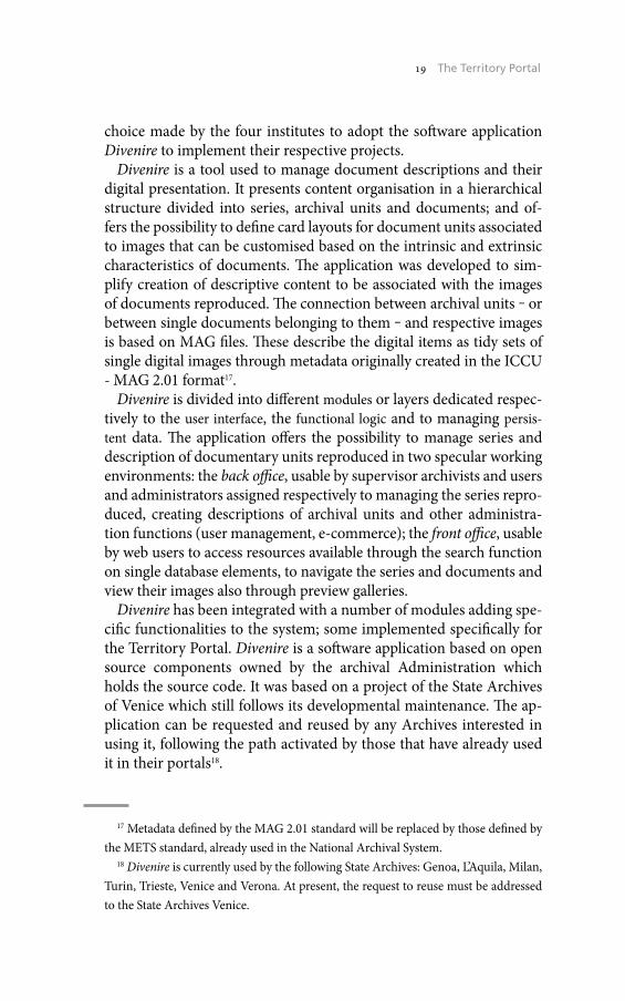
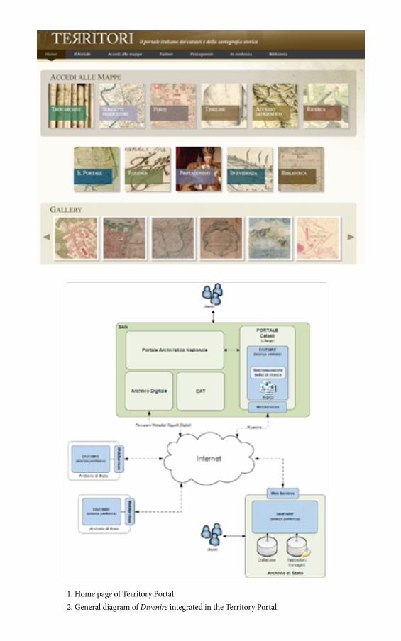
scientific entity responsible for the databases containing the archival descriptions made accessible in the Portal (fig. 2).
Users access both the system’s central application, integrated in the Portal itself and the databases and repositories of the digital images of the single institutes managed by the peripheral applications of Divenire, integrated in the portals or websites of the single associated institutes.
The path integrating the Territory Portal with the SAN is an essential passage for its operations, based on a procedure established in Diveni-re, functional to importing and exporting metadata related to digital resources and data for the shared management of bibliographical in-formation in the SAN.
Potentially, the Territory Portal is the publication area of digital re-sources created thanks to the digitalisation projects of cartographic and land register sources created over the last two decades, safeguard-ing full independence of institutes, in compliance with SAN profiles.
Associated management of resources on the Territory Portal makes virtual reunification of cartographic sources and land register docu-ments produced to create and store the various land registers created in the pre-unity States and the post-unity land register itself concretely implementable; now all stored in the different State Archives. This am-bitious goal, impossible till now, is now concretely feasible. The portal offers a further result, with considerable impact on the development of territorial searches, founded on the geo-localisation of place names: the possibility to compare cartographic documents referred to the same territorial localities and districts, with different scales and creat-ed by different producers for purposes based on respective functions, competences and interests.
There are basically two presuppositions for achieving these goals: the effective use of the Territory Portal as a collector of all the cartograph-ic and land register publication projects that the various institutes have reproduced in digital format; and adoption of a description layout for the cartographic units produced that can be referred to the model pro-posed by the Central Institute for the Archives - ICAR.
8. How to Access Resources. Home Page of the Territory Portal
The Portal home page is divided into three main parts (fig. 1). The up-per part holds the navigation bar with links to the different sections, en-abling access to both documentation and a part of its editorial content.
The central part of the homepage is divided into two box groups. The
26 Mario Signori
six boxes in the global Access Maps section are links to the respec-tive sections: Findarchives (fig. 4), Producers, Sources, Timeline (fig. 5), Geographical access, Search (fig. 6), offering different access routes to documents belonging to the ‘sources’ and to the relative single Ar-chives series.
The second group of boxes aligned in the central part offer links, also present in the navigation bar, to the sections The Portal (fig. 3), Partners, Protagonists, Highlighted, Library, which supply educational editorial content, to contextualise documents published.
The Gallery in the lower part of the home page presents a slide-show of map miniatures (thumbnails), selected from amongst the most significant or with the most visual impact, made available by the various pertinent systems. Clicking on each miniature, the user enters the home page of the Portal or website the digital map reproduction belongs to directly.
Mario SignoriState Archive of Milan
27 The Territory Portal
1. Home page of Territory Portal.2. General diagram of Divenire integrated in the Territory Portal.
28 Mario Signori
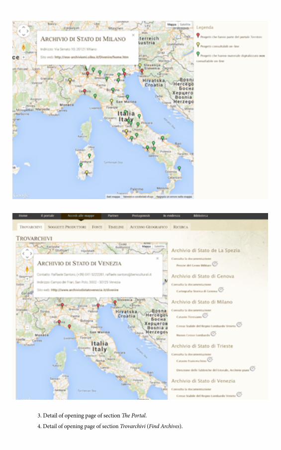
3. Detail of opening page of section The Portal.
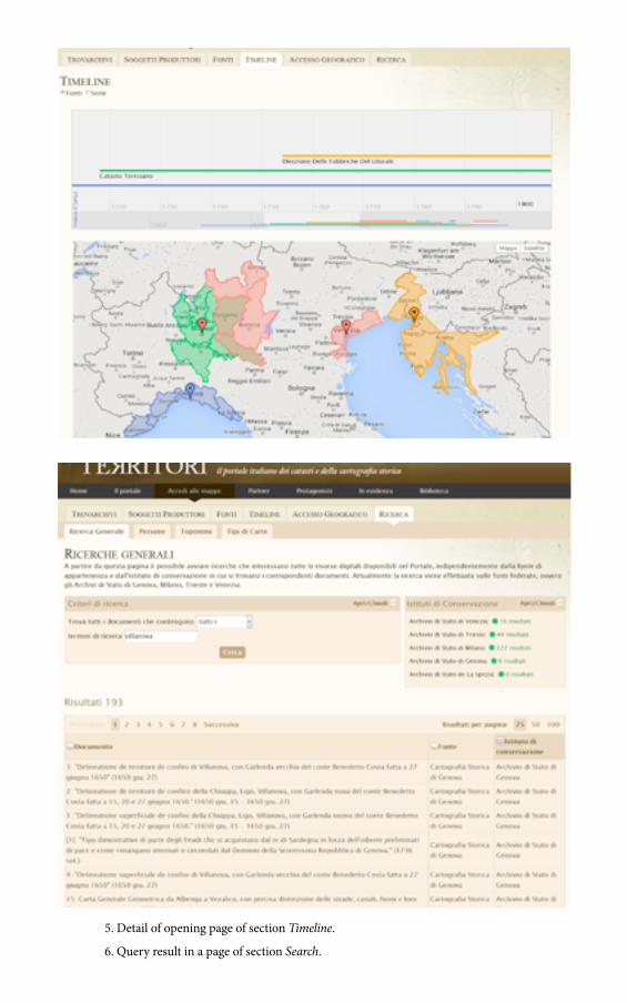
4. Detail of opening page of section Trovarchivi (Find Archives).
29 The Territory Portal
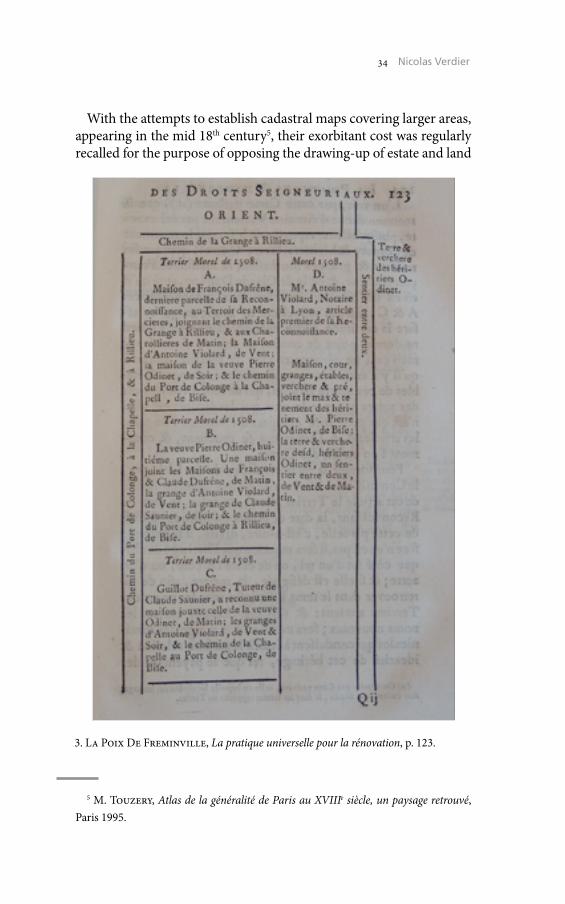
5. Detail of opening page of section Timeline.
6. Query result in a page of section Search.


Estate Maps in 18th Century France: Between Representation of Land Rights and the Production of Accurate Maps
Although a few recent publications in France have revived the inter-est in history of local map-making in the modern period1, the subject does not appear to have been a major concern of historians or geogra-phers. Only after the studies of Marc Bloch’s, one of the main historians of the first half of the 20th century, a survey of European estate maps was launched at the end of the 1920s2. Bloch’s undertaking consisted of starting from the estate maps of the 17th and 18th centuries in order to reconstruct medieval spatial layouts. The recent interest in the question has several explanations. First of all, there are the analyses seeking to articulate art history and landscape history in research on defining the place of artists in the map-making of the 17th and 18th centuries3. Final-ly, again in connection with these issues of landscape, there is the re-search based on estate maps and aiming to reconstruct the landscapes contemporary to the creation of these maps4. The questions raised here are not approached in complete reverse, but the aim is to start by fo-cusing on the slow diffusion of these maps, then to concentrate on the methodologies developed in the 18th century, in order to explain the
For more information: N. Verdier, La Carte avant les cartographes, l’avènement du régime cartographique en France au XVIIIe siècle, Paris 2015.
1 C. Brunel, O. Guyotjeannin, J.-M. Moriceau (edd.), Terriers et plans terriers du XIIe au XVIIIe siècle, Paris 2002.
2 M. Bloch, S. Aakjar, H. Hall, A.-H. Tawney, W. Vogel, Les plans parcellaires: Allemagne, Angleterre, Danemark, France, «Annales d’histoire économique et sociale», 1-2, 1929, pp. 225-31.
3 N. Verdier, Cartes et paysages: tenter la médiation au XVIIIe siècle. La question des paysages en plan et en perspective, «Les Carnets du Paysage», 20, 2010, pp. 14-31.
4 A. Antoine, Le paysage de l’historien. Archéologie des espaces bocagers de l’Ouest de la France au XVIIIe siècle, Rennes 2000.

32 Nicolas Verdier
difficulties of dealing with 18th century estate map, to reach a modern reconstruction of the special dimension of the past.
These questions first of all were generated by an interest in the his-tory of space representation, and then by a difficulty to comprehend the very heterogeneous nature of the archival sources. Indeed, how should we consider estate maps produced about at the same time, but that have very little in common? One is clearly oriented, by a compass rose showing that the north is not exactly at the top of the sheet, while another carries indications that attribute a direction to each side, but without the same precision. One has a scale that ap-pears precise, easily recognisable to the eye, while another has none. Some are easy to identify, others can only perplex (figg. 1-2).
1. 1er carte du plan général des dixmes de Varenne, Archives Maine et Loire, 1 Fi 2.

33 Estate Maps in 18th Century France
The first question is what hampered diffusion. In other words, we need to determine why plots were not all mapped to produce the 18th century estate maps. The first part of the answer lies in the history of the spread of the actual use of maps. At the end of the 17th centu-ry and at the beginning of the 18th century, some landowners had al-ready seen maps, and indeed few of them had received instruction about maps, for example, in the Jesuit colleges, or had even had oc-casion to use maps in court proceedings. However, as a general rule, maps were rare objects, and probably were mainly on different scales – the nation, the province or the episcopate. Although a few estate maps appeared in the 17th century, they only spread, gradually, in the course of the 18th century. In addition, in a world in which repetition was a principle for survival, and where innovation equated with risk, there was probably no reason to adopt this costly object, inevitably not so well mastered than verbal descriptions of territory.
We need to remind that the French monarchy did nothing to en-courage this process. When, in the phase of reaffirming royal power following the Fronde (1648-53), a series of texts was issued aiming to re-compose the royal estates, the idea of appraising these estates by way of maps was never put forward.
2. Terres de la Métairie de la Motte, Archives Maine et Loire, 1 Fi 262.
34 Nicolas Verdier
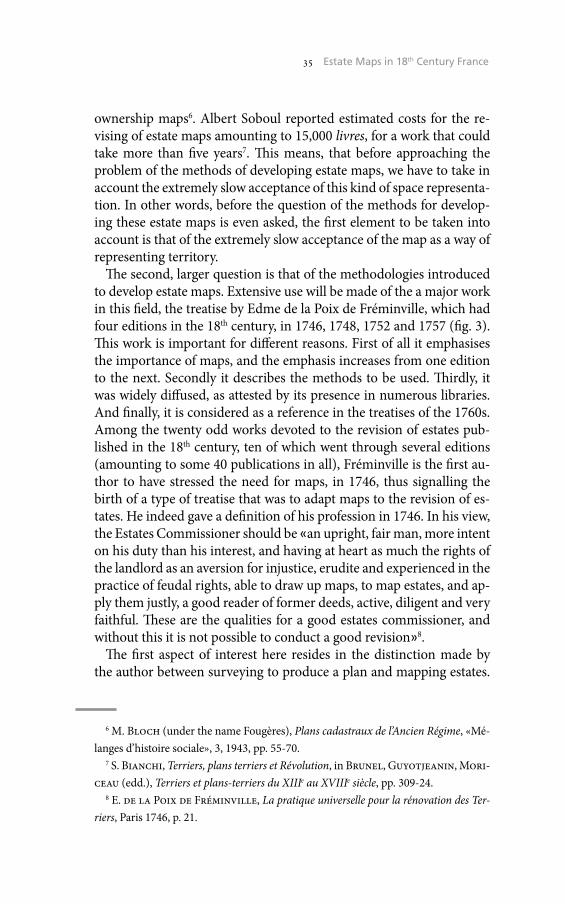
With the attempts to establish cadastral maps covering larger areas, appearing in the mid 18th century5, their exorbitant cost was regularly recalled for the purpose of opposing the drawing-up of estate and land
5 M. Touzery, Atlas de la généralité de Paris au XVIIIe siècle, un paysage retrouvé, Paris 1995.
3. La Poix De Freminville, La pratique universelle pour la rénovation, p. 123.
35 Estate Maps in 18th Century France
ownership maps6. Albert Soboul reported estimated costs for the re-vising of estate maps amounting to 15,000 livres, for a work that could take more than five years7. This means, that before approaching the problem of the methods of developing estate maps, we have to take in account the extremely slow acceptance of this kind of space representa-tion. In other words, before the question of the methods for develop-ing these estate maps is even asked, the first element to be taken into account is that of the extremely slow acceptance of the map as a way of representing territory.
The second, larger question is that of the methodologies introduced to develop estate maps. Extensive use will be made of the a major work in this field, the treatise by Edme de la Poix de Fréminville, which had four editions in the 18th century, in 1746, 1748, 1752 and 1757 (fig. 3). This work is important for different reasons. First of all it emphasises the importance of maps, and the emphasis increases from one edition to the next. Secondly it describes the methods to be used. Thirdly, it was widely diffused, as attested by its presence in numerous libraries. And finally, it is considered as a reference in the treatises of the 1760s. Among the twenty odd works devoted to the revision of estates pub-lished in the 18th century, ten of which went through several editions (amounting to some 40 publications in all), Fréminville is the first au-thor to have stressed the need for maps, in 1746, thus signalling the birth of a type of treatise that was to adapt maps to the revision of es-tates. He indeed gave a definition of his profession in 1746. In his view, the Estates Commissioner should be «an upright, fair man, more intent on his duty than his interest, and having at heart as much the rights of the landlord as an aversion for injustice, erudite and experienced in the practice of feudal rights, able to draw up maps, to map estates, and ap-ply them justly, a good reader of former deeds, active, diligent and very faithful. These are the qualities for a good estates commissioner, and without this it is not possible to conduct a good revision»8.
The first aspect of interest here resides in the distinction made by the author between surveying to produce a plan and mapping estates.
6 M. Bloch (under the name Fougères), Plans cadastraux de l’Ancien Régime, «Mé-langes d’histoire sociale», 3, 1943, pp. 55-70.
7 S. Bianchi, Terriers, plans terriers et Révolution, in Brunel, Guyotjeanin, Mori-ceau (edd.), Terriers et plans-terriers du XIIIe au XVIIIe siècle, pp. 309-24.
8 E. de la Poix de Fréminville, La pratique universelle pour la rénovation des Ter-riers, Paris 1746, p. 21.
36 Nicolas Verdier
What in fact is involved in mapping estates? For Fréminville, above all it involves starting from written archives to produce a graphic rep-resentation. Thus Fréminville takes the example of a text concerning an estate, comprising the description of each plot in both form and content, and he explains how to ‘map’ it. Here he uses an estate doc-ument signed by a sollicitor, Morel, in 1508. The text first of all de-scribes the plot belonging to François Dufrene.
The description explains that the plot borders «the track to Rieu’s barn» to the east, Antoine Violard’s house to the south, the house of widow Odinet to the west, and the Port de Colonge road to the north. He then moves on to the property of widow Odinet, and re-peats the enumeration, and so forth from property to property un-til the whole estate area has been included9. To put the value of this map in context, it can be noted that the method used was very sim-ilar to that used by Guillaume Delisle (1675-1726) when he cor-rected the dimensions of the Mediterranean at the end of the 17th century, giving it, on maps, the shape we know today. This erudite brand of cartography, of which Anville (1697-1782) was the main exponent in the 18th century, is essentially derived from written material rather than from surveying procedures and coordinates. In other words, this form of cartography, while we today may find it surprising or even unsettling, was nevertheless a relevant mode of map-making at the time. It is a thematic mapping technique, de-signed to represent rights to plots of land. It can be noted that by using maps of more recent plots, it is in fact possible to partly re-trieve the layout of the past.
However this procedure was not necessarily the last task of the estates commissioner. Indeed, once the estate map was drawn up, according to Fréminville it then had to be «applied to a plan». Here there was a choice: either a visual plan, or a geometric plan. While the estate map was produced away from the field, the second stage was to draw up a plan actually in the field, working « from sight », that is to say without any instruments, or perhaps more accu-rately without any instrument other than a surveyor’s chain (Gunt-er’s Chain), and measures related to the human body. At the time, the body was commonly used in various techniques, and surveyors learnt not only to pace out distances, but also to avoid their paces varying with the nature of the terrain. It is exactly in this manner
9 Ibid., p. 122.

37 Estate Maps in 18th Century France
that Kashmir was mapped in the 1860s10. Thus in short, the task was to make a document, here a land register, coincide with a land-scape as it can be represented by an observer at ground level.
If on the other hand a geometric plan and not a visual plan was to be used, the whole procedure was reorganised. Fréminville starts by noting that when a landlord has a geometric plan drawn up, he does so with the intention of preserving it. This distinction is inter-esting, since it positions estate maps and maps applied to a visual plan on the side of documents that are not necessarily intended to be kept. In others words, the impression we derive from archives when we consult a series of estate maps – that they should be clas-sified on an equal footing with other documents intended to last – is incorrect. This does not however mean that estate maps were not to be preserved, or that preserving them was a mistake. It merely means that only the geometric plans were designed by their devel-opers as retaining value for subsequent estate revisions.
In all events, when a geometric plan was used, it involved sur-veying in the field, using technical instruments, and then in a sec-ond stage mapping the estates on this plan. Thus this was a reverse procedure: the visual plan enabled an approximation, so that is was then possible first of all to map, and only then to survey «in the same style». In contrast, the geometric plan preceded and imposed itself on the map. But another element occurs here, which also en-ables the period when geometric plans spread among estate com-missioners to be more accurately dated. Indeed, in Fréminville’s first edition in 1746, the use of a geometric plan required a form of delegation. The estate commissioner relied on another person to produce geometric plans beforehand. However in the 1752 edi-tion, Fréminville adds a short treatise on the use of the plane table, which is in line with the literature of the map-makers in the 17th and 18th centuries, such as Jean Beaulieu, and later Jacques Oza-nam whose work appeared in numerous editions, or Louis-Charles Dupain de Montesson who in the mid 18th century produced man-uals for the design of plans and maps.
The considerable difference between a layout plan drawn up from visual survey and a geometric plan in estate revisions is in fact of
10 K. Raj, La construction de l’Empire de la géographie, l’odyssée des arpenteurs de sa Très Gracieuse Majesté la Reine Victoria en Asie Centrale, «Annales H.S.S.», 5, 1997, pp. 1153-80.

38 Nicolas Verdier
only relative importance. Indeed, Fréminville considered on the one hand, that if the visual layout plan was correctly managed, and the information from local sources enabling the estate map to be adjust-ed to the plan was adequately verified, this layout plan could be con-sidered sufficient. This was an important point, as Fréminville had to pay attention to the financial means of his clients. Having a ge-ometric plan drawn up required considerably more money than a visual survey plan. Thus it was important not to excessively deval-ue the product of work that would cost less. However the differ-ence between the two was also related to differences in practice. Thus the visually surveyed plan was based on individual reports, which meant that it belonged to the sphere of legal experts, who in the 18th century in France were attaching increasing importance to proof on paper rather than to verbal evidence. In contrast, the ge-ometric plan was reputed to possess qualities of accuracy, assim-ilating it to the technical sphere where deception was viewed as being impossible. Indeed, the two notions of precision and truth occur throughout the description of the geometric map in Frémin-ville’s argument.
The difference between visually surveyed plans and geometric plans is not always clear-cut. In many cases, it is difficult to know which technique was used to establish the estate plans, and dis-tinguishing between excellent visual survey maps and technically incorrect geometric plans is often not easy, in particular because there is always a lack of homogeneity. A geometric plan is in fact a plan for which a certain number of points have been surveyed us-ing instruments. The lines joining up these points are always left to the appreciation of the person drawing the map.
Thus research on the plans and maps used in the 17th and 18th centuries, first of all requires understanding that the relationship with maps was not as obvious as today. From this point of view, estate maps, sometimes very far-removed from our present-day conceptions, provide us an approach to the conceptions of our an-cestors. While the large-scale digitisation of maps from the past is highly desirable, for a better understanding of the modern period, we should keep in mind that maps have altered our perceptions of space, whether on global or local scale. A remark in 1790 by an inhabitant of Pont de l’Arche in Normandy, criticising the Cassi-ni map used to create the French départements in December 1789, gives us the measure of this: «The Cassini maps that were used for this task, very good in themselves to measure visual distance from
39 Estate Maps in 18th Century France
steeple to steeple, are not suited to this job; you need to have paced it out and checked the position and the extent of the plots, to have apprehended obstacles and the fording of rivers, to satisfy the re-quirements of the Assemblée Nationale»11.
Nicolas VerdierCNRS UMR 8504 Géographicité
CNRS/Université Paris I Panthéon SorbonneUniversité Paris VII Denis Diderot
11 French National Archives, D IVbis 6 / 192 - 4, Adresse à nosseigneurs de l’assem-blée Nationale, par les habitants en général de la ville de Pont de l’Arche, Province de Normandie, Rouen 1790.

Step by Step: Digitisation Projects of Cadastral Documents in the Central Archive of National Archives of Hungary, Budapest
The cadastral survey of Hungary was carried out in the second half of the 19th century as the part of the Habsburg Monarchy. The patent of the emperor Franz Joseph the First of Austria introduced the land taxation cadastre for Hungary in 1849. The provisional survey began in 1850, and the detailed, parcel by parcel survey later, in 18561. The country was surveyed progressively from west to east. The rectification, the revision of the maps was ordered in 1875 to enter all boundary and ownership changes on the maps and registers.
The cadastral documents of Hungary are kept in many institutions, they are preserved in several archives (for example in central archive and in regional archives of the National Archives of Hungary), in li-braries (for example in National Széchényi Library) and at The Insti-tute of Geodesy, Cartography and Remote Sensing, moreover in some county land registration offices. That means, that unfortunately the col-lection of the central archive is not complete.
The map collection of the central archive includes many important cadastral cartographic materials and written documents in two fonds: in cadastral collection and in so called cadastral oleatas (S 76). Within the cadastral collection there are two subfonds: maps (S 78) and writ-ten documents (S 79). Some cadastral maps are located in other fonds, for example among the maps of the family archives.
Various types of maps were produced during the cadastral survey: small-scale sketch maps, provisional maps and agriculture maps, fur-thermore large-scale field sketches, original maps, indication sketches, printed maps and so called oleatas.
In the second half of the 19th century diverse sketch maps were drawn during the cadastral surveys, inter alia croquis. The German
1 Instruction zur Ausführung der zum Behufe des allgemeinen Katasters in Folge der Allerhöchsten Patente vom 23. December 1817 und vom 20. October 1849 angeordneten Landes-Vermessung, Wien 1856, <http://www.catastrum.hu/docs/Instruktion_1856.pdf> (01/19/2015).

42 Eniko Török
croquis about the individual cadastral communities were produced in the 1850s, even at the beginning of the surveys. Later, in the 1870s, during the revision surveys Hungarian sketch maps were already constructed. The sketches mostly at a scale of 1:28800 represent the fields and their land use, and in the tables, belonging to the sketches, field names with their land use and area are given2.
In recognition that a mapped cadastre would take a long time to ef-fect, provisional order was issued in 1850 to specify the systems which were to operate while work for the new cadastre was carried out. The provisional survey took place in the 1850s, so called provisional maps were drawn mostly at a scale of 1:7200. It wasn’t a parcel-by-parcel surveying, only the boundaries of the cultivated areas were delimited as a block, the property owners were required to submit depositions of the extent and boundaries of their lands.
Field sketches at a scale of 1:2880 are free-hand drawings of the ar-ea, they were drawn up in the field. The cadastral units were mapped using the «a la vue» method, which means that the surveyors simply observed the terrain and anticipated the distances. The quarter sheets
2 E. Török, Krokik, avagy kataszteri térképvázlato,k, «Catastrum», 1/1, 2014, pp. 26-9.
1. The 5. sheet of field sketch of the community Kékesd, 1865 (HU-MNL-OL S 79, N. 86/5).
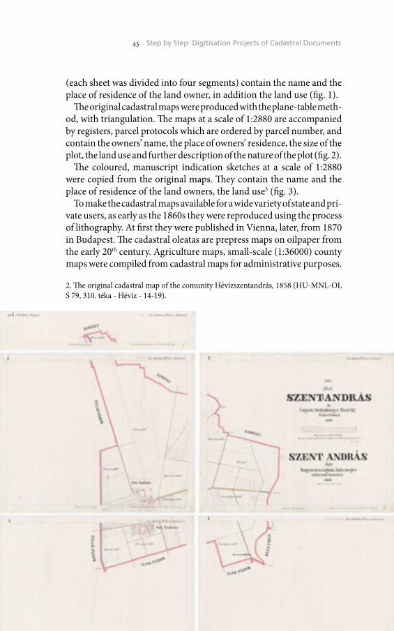
43 Step by Step: Digitisation Projects of Cadastral Documents
(each sheet was divided into four segments) contain the name and the place of residence of the land owner, in addition the land use (fig. 1).
The original cadastral maps were produced with the plane-table meth-od, with triangulation. The maps at a scale of 1:2880 are accompanied by registers, parcel protocols which are ordered by parcel number, and contain the owners’ name, the place of owners’ residence, the size of the plot, the land use and further description of the nature of the plot (fig. 2).
The coloured, manuscript indication sketches at a scale of 1:2880 were copied from the original maps. They contain the name and the place of residence of the land owners, the land use3 (fig. 3).
To make the cadastral maps available for a wide variety of state and pri-vate users, as early as the 1860s they were reproduced using the process of lithography. At first they were published in Vienna, later, from 1870 in Budapest. The cadastral oleatas are prepress maps on oilpaper from the early 20th century. Agriculture maps, small-scale (1:36000) county maps were compiled from cadastral maps for administrative purposes.
3 E. Török, Felvételi előrajz, kataszteri térkép és birtokvázlat, «Catastrum», 1/2, 2014, pp. 14-21.
2. The original cadastral map of the comunity Hévízszentandrás, 1858 (HU-MNL-OL S 79, 310. téka - Hévíz - 14-19).
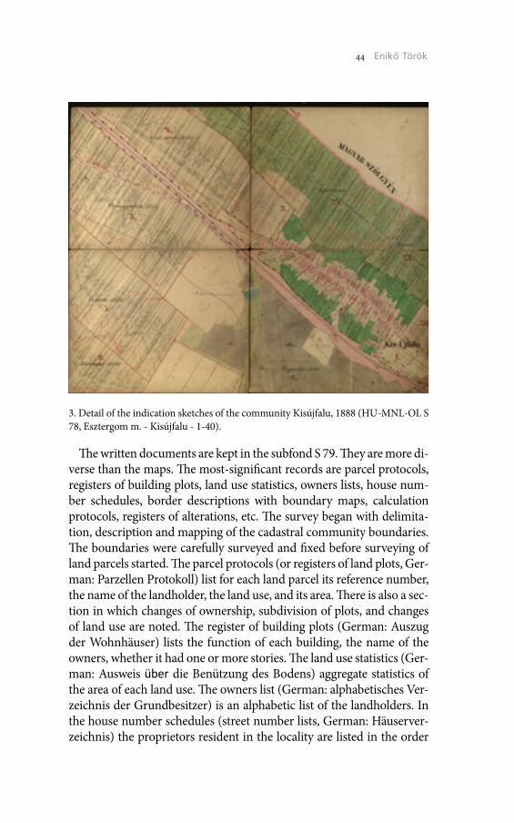
44 Eniko Török
The written documents are kept in the subfond S 79. They are more di-verse than the maps. The most-significant records are parcel protocols, registers of building plots, land use statistics, owners lists, house num-ber schedules, border descriptions with boundary maps, calculation protocols, registers of alterations, etc. The survey began with delimita-tion, description and mapping of the cadastral community boundaries. The boundaries were carefully surveyed and fixed before surveying of land parcels started. The parcel protocols (or registers of land plots, Ger-man: Parzellen Protokoll) list for each land parcel its reference number, the name of the landholder, the land use, and its area. There is also a sec-tion in which changes of ownership, subdivision of plots, and changes of land use are noted. The register of building plots (German: Auszug der Wohnhäuser) lists the function of each building, the name of the owners, whether it had one or more stories. The land use statistics (Ger-man: Ausweis über die Benützung des Bodens) aggregate statistics of the area of each land use. The owners list (German: alphabetisches Ver-zeichnis der Grundbesitzer) is an alphabetic list of the landholders. In the house number schedules (street number lists, German: Häuserver-zeichnis) the proprietors resident in the locality are listed in the order
3. Detail of the indication sketches of the community Kisújfalu, 1888 (HU-MNL-OL S 78, Esztergom m. - Kisújfalu - 1-40).
45 Step by Step: Digitisation Projects of Cadastral Documents
of house numbers. The registers of alterations show alterations made in ownership, area of the plots or land use4.
In 2006 we have started to build up virtual collections of scanned maps to reduce the handling and use of original material, to protect it and to increase access to the documents. Beside the old maps we start-ed to scan the cadastral maps too, with the support of the National Cul-tural Fund of Hungary. By 2008 the great part of the subfond S 78, more than 450 multisheets maps, was digitise, not the whole subfond: since at the beginning of the project not the whole cadastral collection was cat-alogued, we didn’t know exactly how many sheets we have, therefore we could not exactly calculate. In 2008 253 maps were scanned for outside order, with own resources further 96 maps in 2010.
In line with the digitisation of the maps the senior researchers of this project compiled a study about the digitisation of the cadastral maps. Some data about the history of cadastral surveys, about the transfer of the documents to the archives and about the contents of the maps are also collected there5.
Due to the second project in 2009 the oleatas, the prepress maps on oilpaper were scanned, georeferenced and online published. This project was funded by the National Cultural Fund of Hungary, led by my colleague, Csaba Reisz, and carried out by Arcanum Database Ltd., as previously.
In 2010 we made our catalogue with images of maps available online (<http://mol.arcanum.hu/terkep/>) in framework of a project support-ed by the National Cultural Fund of Hungary. The catalogue provides more access points to the documents, allows customers to search and browse by title, geographical names, names of the surveyors, date, type of documents, scale etc., and to study the maps by the help of the im-ages. The database consists of more than 30,000 descriptions, and more than 100,000 images, belonging to the one third of the descriptions.
Our current, three-year project started in 2013, and is funded by the Hungarian Scientific Research Fund. The aim of the project is to de-scribe the written documents and the field sketches in our catalogue, to scan field sketches, to make the catalogue with images online accessible.
4 Ead., Néhány kataszteri irattípus, in Zs. Kádár, B. Lakatos, Á. Zarnóczki (edd.), Archivariorum historicorumque magistra: Történeti tanulmányok Bak Borbála tanárnő 70. születésnapjára, Budapest 2013, pp. 207-23.
5 B. Bak et al., Kataszteri térképek tömeges digitalizálása, módszertani tanulmány, Bu-dapest 2008, <http://mek.oszk.hu/13200/13275/> (01/19/2015).
46 Eniko Török
We will compile a handbook about the cadastral documents and a list of the people participating in the cadastral survey. We want to collect, scan and publish regulations and old periodicals regarding the cadastral surveys. For example last we scanned the instruction for the surveyors from 18696. In this year up to the present we catalogued more than 4700 documents and prepared more than 300 field sketches for digitization.
Finally some words about our plans. It is possible to integrate our al-ready existing digital content in European portals. It is necessary to ini-tiate a national catalogue of the historical cadastral documents to get an overview over cadastral heritage, what is preserved where. For the ar-chives the Digital Archives Portal can provide an opportunity for stan-dard cataloguing of the cadastral documents: <https://www.eleveltar.hu/>. The work can be continued by developing a historical cadastral database with the information of the preserved documents, a database which contains both the information from parcel protocols and from maps in digital format. Some attempts have been made in this direction on the Hungarian archives portal7.
Enikő TörökNational Archive of Hungary, Budapest
6 <http://www.catastrum.hu/docs/Utasitas_1869.pdf> (01/19/2015).7 In 2014 we published the first numbers of our magazin about the history of
the Hungarian cadastral survey: «Catastrum» (<http://www.catastrum.hu/>, (01/19/2015).
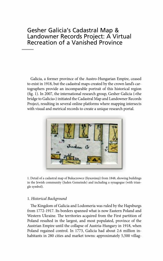
Gesher Galicia’s Cadastral Map & Landowner Records Project: A Virtual Recreation of a Vanished Province
Galicia, a former province of the Austro-Hungarian Empire, ceased to exist in 1918, but the cadastral maps created by the crown land’s car-tographers provide an incomparable portrait of this historical region (fig. 1). In 2007, the international research group, Gesher Galicia («the bridge to Galicia») initiated the Cadastral Map and Landowner Records Project, resulting in several online platforms where mapping intersects with visual and metrical records to create a unique research portal.
1. Historical Background
The Kingdom of Galicia and Lodomeria was ruled by the Hapsburgs from 1772-1917. Its borders spanned what is now Eastern Poland and Western Ukraine. The territories acquired from the First partition of Poland resulted in the largest, and most populated, province of the Austrian Empire until the collapse of Austria-Hungary in 1918, when Poland regained control. In 1773, Galicia had about 2.6 million in-habitants in 280 cities and market towns: approximately 5,500 villag-
1. Detail of a cadastral map of Bukaczowce (Букачівці) from 1848, showing buildings in the Jewish community (Juden Gemeinde) and including a synagogue (with trian-gle symbol).
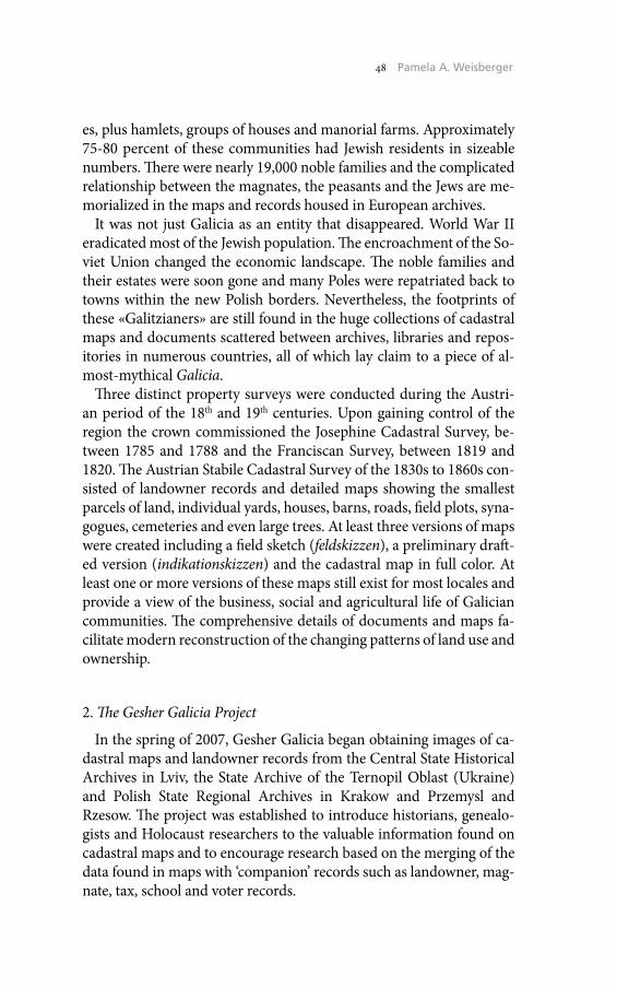
48 Pamela A. Weisberger
es, plus hamlets, groups of houses and manorial farms. Approximately 75-80 percent of these communities had Jewish residents in sizeable numbers. There were nearly 19,000 noble families and the complicated relationship between the magnates, the peasants and the Jews are me-morialized in the maps and records housed in European archives.
It was not just Galicia as an entity that disappeared. World War II eradicated most of the Jewish population. The encroachment of the So-viet Union changed the economic landscape. The noble families and their estates were soon gone and many Poles were repatriated back to towns within the new Polish borders. Nevertheless, the footprints of these «Galitzianers» are still found in the huge collections of cadastral maps and documents scattered between archives, libraries and repos-itories in numerous countries, all of which lay claim to a piece of al-most-mythical Galicia.
Three distinct property surveys were conducted during the Austri-an period of the 18th and 19th centuries. Upon gaining control of the region the crown commissioned the Josephine Cadastral Survey, be-tween 1785 and 1788 and the Franciscan Survey, between 1819 and 1820. The Austrian Stabile Cadastral Survey of the 1830s to 1860s con-sisted of landowner records and detailed maps showing the smallest parcels of land, individual yards, houses, barns, roads, field plots, syna-gogues, cemeteries and even large trees. At least three versions of maps were created including a field sketch (feldskizzen), a preliminary draft-ed version (indikationskizzen) and the cadastral map in full color. At least one or more versions of these maps still exist for most locales and provide a view of the business, social and agricultural life of Galician communities. The comprehensive details of documents and maps fa-cilitate modern reconstruction of the changing patterns of land use and ownership.
2. The Gesher Galicia Project
In the spring of 2007, Gesher Galicia began obtaining images of ca-dastral maps and landowner records from the Central State Historical Archives in Lviv, the State Archive of the Ternopil Oblast (Ukraine) and Polish State Regional Archives in Krakow and Przemysl and Rzesow. The project was established to introduce historians, genealo-gists and Holocaust researchers to the valuable information found on cadastral maps and to encourage research based on the merging of the data found in maps with ‘companion’ records such as landowner, mag-nate, tax, school and voter records.
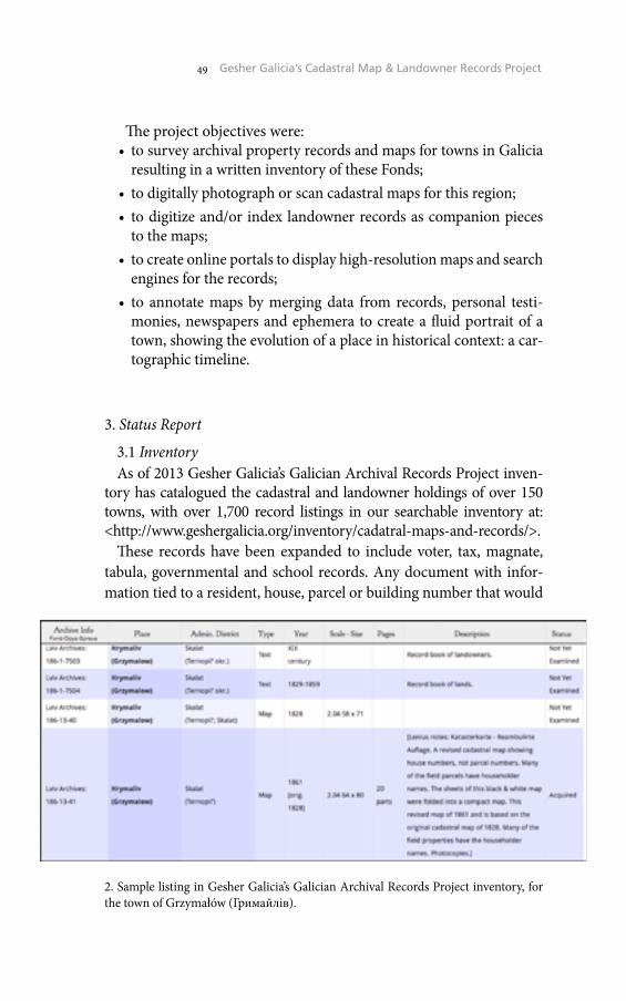
49 Gesher Galicia’s Cadastral Map & Landowner Records Project
The project objectives were:• to survey archival property records and maps for towns in Galicia
resulting in a written inventory of these Fonds;• to digitally photograph or scan cadastral maps for this region;• to digitize and/or index landowner records as companion pieces
to the maps;• to create online portals to display high-resolution maps and search
engines for the records;• to annotate maps by merging data from records, personal testi-
monies, newspapers and ephemera to create a fluid portrait of a town, showing the evolution of a place in historical context: a car-tographic timeline.
3. Status Report
3.1 InventoryAs of 2013 Gesher Galicia’s Galician Archival Records Project inven-
tory has catalogued the cadastral and landowner holdings of over 150 towns, with over 1,700 record listings in our searchable inventory at: <http://www.geshergalicia.org/inventory/cadatral-maps-and-records/>.
These records have been expanded to include voter, tax, magnate, tabula, governmental and school records. Any document with infor-mation tied to a resident, house, parcel or building number that would
2. Sample listing in Gesher Galicia’s Galician Archival Records Project inventory, for the town of Grzymałów (Гримайлів).
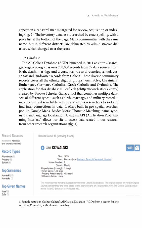
50 Pamela A. Weisberger
appear on a cadastral map is targeted for review, acquisition or index-ing (fig. 2). The inventory database is searched by exact spelling, with a place list at the bottom of the page. Many communities with the same name, but in different districts, are delineated by administrative dis-tricts, which changed over the years.
3.2 DatabaseThe All Galicia Database (AGD) launched in 2011 at <http://search.
geshergalicia.org> has over 230,000 records from 79 data sources from birth, death, marriage and divorce records to directories, school, vot-er, tax and landowner records from Galicia. These diverse community records cover all the ethnic/religious groups: Jews, Poles, Ukrainians, Ruthenians, Germans, Catholics, Greek Catholic and Orthodox. The application for this database is LeafSeek (<http://www.leafseek.com>) created by Brooke Schreier Ganz, a tool that combines multiple data-sets of different types ‒ such as birth, marriage, and military records ‒ into one unified searchable website and allows researchers to sort and find inter-connections in data. It offers built-in geo-spatial searches, pop-up Google Maps, Beider-Morse Phonetic Matching, name syno-nyms, and language localization. Using an API (Application Program-ming Interface) allows our site to access data related to our research from other research organizations (fig. 3).
3. Sample results in Gesher Galicia’s All Galicia Database (AGD) from a search for the surname Kowalska, with phonetic matches.
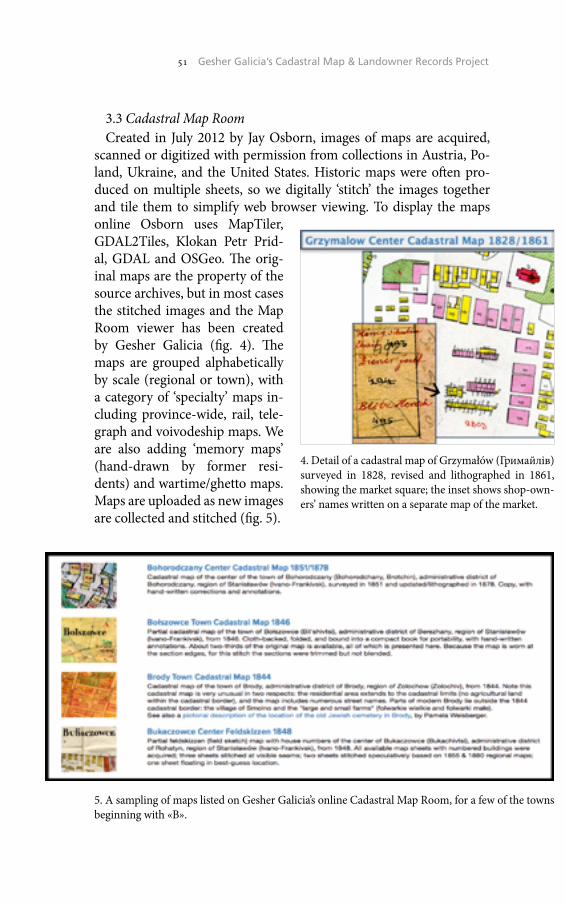
51 Gesher Galicia’s Cadastral Map & Landowner Records Project
3.3 Cadastral Map RoomCreated in July 2012 by Jay Osborn, images of maps are acquired,
scanned or digitized with permission from collections in Austria, Po-land, Ukraine, and the United States. Historic maps were often pro-duced on multiple sheets, so we digitally ‘stitch’ the images together and tile them to simplify web browser viewing. To display the maps online Osborn uses MapTiler, GDAL2Tiles, Klokan Petr Prid-al, GDAL and OSGeo. The orig-inal maps are the property of the source archives, but in most cases the stitched images and the Map Room viewer has been created by Gesher Galicia (fig. 4). The maps are grouped alphabetically by scale (regional or town), with a category of ‘specialty’ maps in-cluding province-wide, rail, tele-graph and voivodeship maps. We are also adding ‘memory maps’ (hand-drawn by former resi-dents) and wartime/ghetto maps. Maps are uploaded as new images are collected and stitched (fig. 5).
4. Detail of a cadastral map of Grzymałów (Гримайлів) surveyed in 1828, revised and lithographed in 1861, showing the market square; the inset shows shop-own-ers’ names written on a separate map of the market.
5. A sampling of maps listed on Gesher Galicia’s online Cadastral Map Room, for a few of the towns beginning with «B».
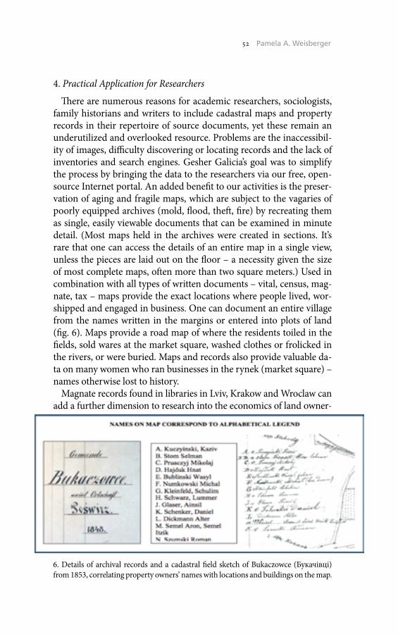
52 Pamela A. Weisberger
4. Practical Application for Researchers
There are numerous reasons for academic researchers, sociologists, family historians and writers to include cadastral maps and property records in their repertoire of source documents, yet these remain an underutilized and overlooked resource. Problems are the inaccessibil-ity of images, difficulty discovering or locating records and the lack of inventories and search engines. Gesher Galicia’s goal was to simplify the process by bringing the data to the researchers via our free, open-source Internet portal. An added benefit to our activities is the preser-vation of aging and fragile maps, which are subject to the vagaries of poorly equipped archives (mold, flood, theft, fire) by recreating them as single, easily viewable documents that can be examined in minute detail. (Most maps held in the archives were created in sections. It’s rare that one can access the details of an entire map in a single view, unless the pieces are laid out on the floor – a necessity given the size of most complete maps, often more than two square meters.) Used in combination with all types of written documents – vital, census, mag-nate, tax – maps provide the exact locations where people lived, wor-shipped and engaged in business. One can document an entire village from the names written in the margins or entered into plots of land (fig. 6). Maps provide a road map of where the residents toiled in the fields, sold wares at the market square, washed clothes or frolicked in the rivers, or were buried. Maps and records also provide valuable da-ta on many women who ran businesses in the rynek (market square) – names otherwise lost to history.
Magnate records found in libraries in Lviv, Krakow and Wroclaw can add a further dimension to research into the economics of land owner-
6. Details of archival records and a cadastral field sketch of Bukaczowce (Букачівці) from 1853, correlating property owners’ names with locations and buildings on the map.
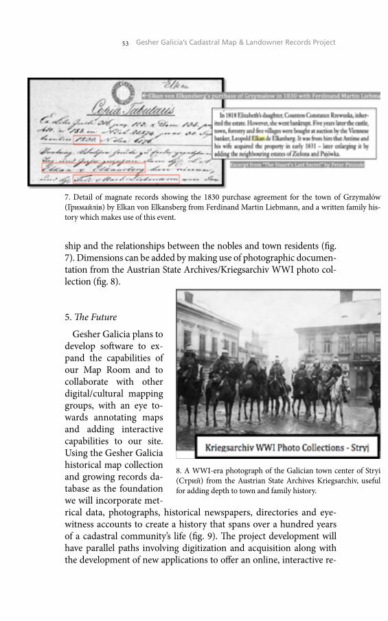
53 Gesher Galicia’s Cadastral Map & Landowner Records Project
ship and the relationships between the nobles and town residents (fig. 7). Dimensions can be added by making use of photographic documen-tation from the Austrian State Archives/Kriegsarchiv WWI photo col-lection (fig. 8).
5. The Future
Gesher Galicia plans to develop software to ex-pand the capabilities of our Map Room and to collaborate with other digital/cultural mapping groups, with an eye to-wards annotating maps and adding interactive capabilities to our site. Using the Gesher Galicia historical map collection and growing records da-tabase as the foundation we will incorporate met-rical data, photographs, historical newspapers, directories and eye-witness accounts to create a history that spans over a hundred years of a cadastral community’s life (fig. 9). The project development will have parallel paths involving digitization and acquisition along with the development of new applications to offer an online, interactive re-
7. Detail of magnate records showing the 1830 purchase agreement for the town of Grzymałów (Гримайлів) by Elkan von Elkansberg from Ferdinand Martin Liebmann, and a written family his-tory which makes use of this event.
8. A WWI-era photograph of the Galician town center of Stryi (Стрий) from the Austrian State Archives Kriegsarchiv, useful for adding depth to town and family history.
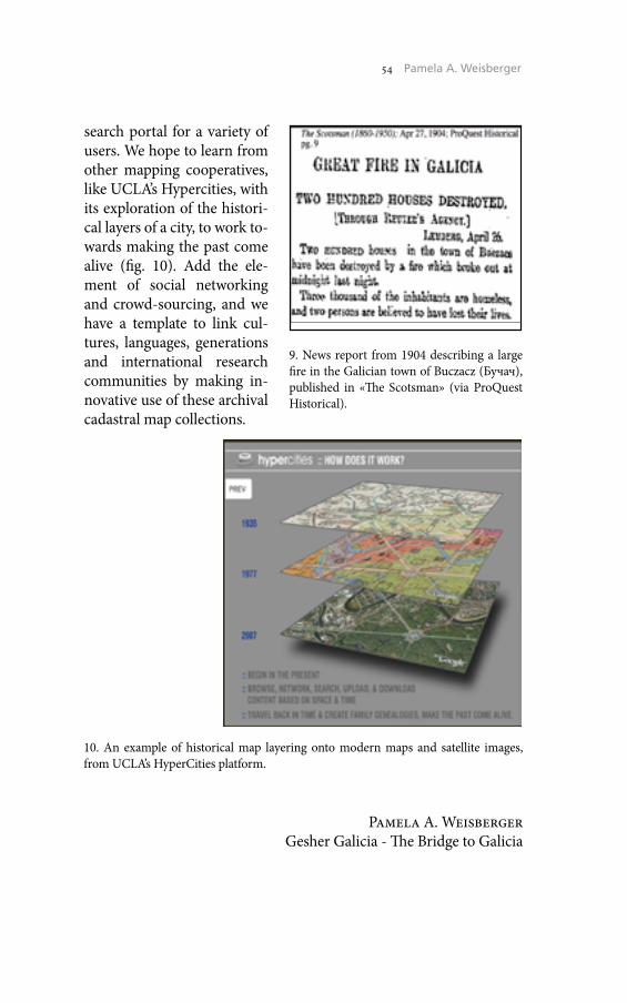
54 Pamela A. Weisberger
search portal for a variety of users. We hope to learn from other mapping cooperatives, like UCLA’s Hypercities, with its exploration of the histori-cal layers of a city, to work to-wards making the past come alive (fig. 10). Add the ele-ment of social networking and crowd-sourcing, and we have a template to link cul-tures, languages, generations and international research communities by making in-novative use of these archival cadastral map collections.
Pamela A. WeisbergerGesher Galicia - The Bridge to Galicia
9. News report from 1904 describing a large fire in the Galician town of Buczacz (Бучач), published in «The Scotsman» (via ProQuest Historical).
10. An example of historical map layering onto modern maps and satellite images, from UCLA’s HyperCities platform.
Gesher Galicia’s Online Cadastral Map Room: Evolution and Opportunities
1. Introduction
The Gesher Galicia (GG) online «Map Room» (<maps.geshergali-cia.org>) is a component of the organization’s Cadastral Map & Land-owner Records Project, described in a companion paper by Pamela Weisberger. Working from GG’s inventory of archival records, the map website presents digitized historical cadastral maps of towns in the for-mer Austro-Hungarian Empire province of Galicia, a region which once spanned portions of what is now Eastern Poland and Western Ukraine. The Map Room aims to offer graphical descriptions of histor-ical towns and neighborhoods over time, and to integrate non-graph-ical historical data about the landscape, buildings, and especially the people who lived and worked there. GG’s purpose is to provide free-ly-accessible, simple online tools and data for use by historians, geneal-ogists, and Holocaust researchers studying the past of Galicia. Beyond the cadastral maps and data (fig. 1), other historical map types (re-gional, transportation, communication, and «memory maps») are be-ing added to supplement the core research resources.
1. Detail of a cadastral map of Komarno (Комарно) from 1853, showing a portion of the town center surrounding a synagogue.

56 Jay Osborn
To date, more than 35 cadastral maps have been assembled and pre-sented; several times that number remain in the GG inventory awaiting processing, and our researchers continue to work in archives, libraries, and other repositories to gather more map images and data. As a mem-ber-funded US 501(c)(3) non-profit organization, a key challenge for GG is amplifying the limited skills and capacity of our volunteers and tools to achieve our goals for breadth, depth, and quality of our pre-sented data.
This paper gives a retrospective of our map processing methods, out-lines current experiments to expand the data presentation, and pro-poses cooperative work to adapt our data and methods to standards in development and use in the ongoing cadastral mapping programs of European countries. We hope to learn from participants in the ENArC and ICARUS projects, their working groups, and the attendees to the 2013 Cartography and Cadastral Maps workshop.
2. Evolution of the Map Processing Methods
From the beginning of the GG project, it was clear that a simple way to make the historical paper maps accessible was needed. As elsewhere, Galician cadastral maps for individual towns are divided into multiple sheets. Further, allowable digitization methods in the archives (macro camera and/or A4 scanner, at high resolution to capture map details) mean that each sheet must be divided into multiple images. Most re-searchers interested in the maps and related land and family records are not able to integrate the separate images and sheets, nor relate them to current geography.
A first attempt to assemble a georeferenced Galician cadastral map was made in early 2011 by Dr. Alex Feller, using separate map sheet images in the Google Earth application. This trial allowed users to se-lectively enable map sheets on the globe surface, and to vary opaci-ty of the layers, but the application was found to be too complex for many end users, and the large map files required very long download times. Instead, a browser-based, tiled-map approach was selected for ongoing work.
Lacking a true GIS platform and related skills, we opted for relatively simple/manual tools for map rubbersheeting, assembly, tiling, and web presentation. Map image fragments are cut and then re-assembled in a «stitching» process using Adobe Photoshop Elements; the same meth-od applies both within a map sheet (from the separate scans necessary

57 Gesher Galicia’s Online Cadastral Map Room
to capture an entire sheet) and between sheets of the original litho-graphed or sketched map. Image distortion of even well-drafted maps (from scanner tracking errors, camera lens distortion, and map paper shrinkage) has often made alignment and stitching of features difficult. The APE program only allows distortion of quadrilateral image units (e.g. no 9-point adjustments), so in some cases a map image requires digital cutting into very small pieces to achieve a smooth fit. In other cases, the paper map edges are too worn to digitally assemble, so are aligned with visible gaps. Stitching a complete lithographed cadastral map of 4 to 150 images typically takes 1 to 30 hours of hand work (field sketches are more difficult, as noted below). We typically retain map defects and other signs of age, altering the original image only when it improves clarity. A simple example of separate and stitched map edges is shown in fig. 2.
Another limitation of this method is the total image file size: APE permits a maximum of 30,000 pixels per side regardless of installed RAM; even on a dedicated machine, 25kpx per side is a practical lim-it. A workaround for this limitation is stitching a map in smaller sub-sections and then assembling those subsections into a complete map using the free and open-source application GIMP, which more aggres-sively swaps RAM to disc. Using this workaround, to date GG has as-sembled two very large cadastral maps, each measuring more than one gigapixel.
Few of the maps completed so far have been carefully aligned to Earth geography; none has been technically georeferenced. This is partly due to a lack of tools, but also reflects the difficulty we have ex-perienced in working with the original paper maps. One 1846 map was
2. Detail of a cadastral map of Trzcieniec (Тщенець) from 1852, showing the process of ‘stitching’ separate digitized map sheets into a seamless image.
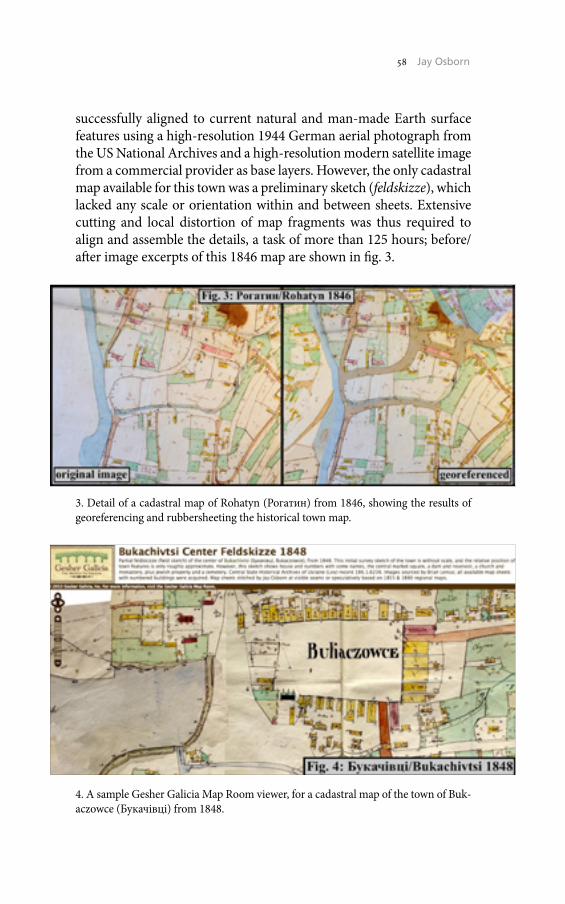
58 Jay Osborn
successfully aligned to current natural and man-made Earth surface features using a high-resolution 1944 German aerial photograph from the US National Archives and a high-resolution modern satellite image from a commercial provider as base layers. However, the only cadastral map available for this town was a preliminary sketch (feldskizze), which lacked any scale or orientation within and between sheets. Extensive cutting and local distortion of map fragments was thus required to align and assemble the details, a task of more than 125 hours; before/after image excerpts of this 1846 map are shown in fig. 3.
4. A sample Gesher Galicia Map Room viewer, for a cadastral map of the town of Buk-aczowce (Букачівці) from 1848.
3. Detail of a cadastral map of Rohatyn (Рогатин) from 1846, showing the results of georeferencing and rubbersheeting the historical town map.
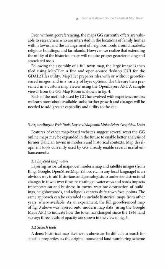
59 Gesher Galicia’s Online Cadastral Map Room
Even without georeferencing, the maps GG currently offers are valu-able to researchers who are interested in the locations of family homes within towns, and the arrangement of neighborhoods around markets, religious buildings, and farmlands. However, we realize that extending the utility of the historical maps will require proper georeferencing and associated tools.
Following the assembly of a full town map, the large image is then tiled using MapTiler, a free and open-source desktop GUI for the GDAL2Tiles utility; MapTiler prepares tiles with or without georefer-enced images, and in a variety of layer options. The tiles are then pre-sented in a custom map viewer using the OpenLayers API. A sample viewer from the GG Map Room is shown in fig. 4.
Each of the methods used by GG has evolved with experience and as we learn more about available tools; further growth and changes will be needed to add greater capability and utility to the site.
3. Expanding the Web Tools: Layered Maps and Linked Non-Graphical Data
Features of other map-based websites suggest several ways the GG online maps may be expanded in the future to enable better analysis of former Galician towns in modern and historical contexts. Map devel-opment tools currently used by GG already enable several useful en-hancements:
3.1 Layered map viewsLayering historical maps over modern map and satellite images (from
Bing, Google, OpenStreetMap, Yahoo, etc. in any local language) is an obvious way to aid historians and genealogists to understand structural changes in towns over time: re-routing of waterways and roads impacts transportation and business in towns; wartime destruction of build-ings, neighborhoods, and religious centers shifts town focal points. The same approach can be extended to include historical maps from other years, where available. As an experiment, the full georeferenced map of fig. 3 above was layered onto modern map data (using the Google Maps API) to indicate how the town has changed since the 1846 land survey; three levels of opacity are shown in the view of fig. 5.
3.2 Search toolsA dense historical map like the one above can be difficult to search for
specific properties, as the original house and land numbering scheme
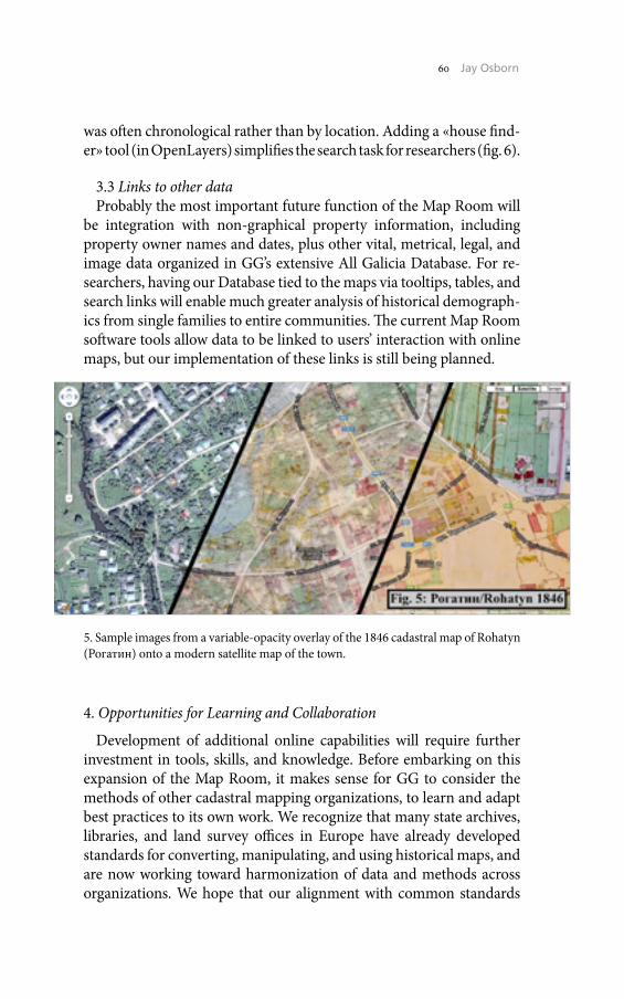
60 Jay Osborn
was often chronological rather than by location. Adding a «house find-er» tool (in OpenLayers) simplifies the search task for researchers (fig. 6).
3.3 Links to other dataProbably the most important future function of the Map Room will
be integration with non-graphical property information, including property owner names and dates, plus other vital, metrical, legal, and image data organized in GG’s extensive All Galicia Database. For re-searchers, having our Database tied to the maps via tooltips, tables, and search links will enable much greater analysis of historical demograph-ics from single families to entire communities. The current Map Room software tools allow data to be linked to users’ interaction with online maps, but our implementation of these links is still being planned.
4. Opportunities for Learning and Collaboration
Development of additional online capabilities will require further investment in tools, skills, and knowledge. Before embarking on this expansion of the Map Room, it makes sense for GG to consider the methods of other cadastral mapping organizations, to learn and adapt best practices to its own work. We recognize that many state archives, libraries, and land survey offices in Europe have already developed standards for converting, manipulating, and using historical maps, and are now working toward harmonization of data and methods across organizations. We hope that our alignment with common standards
5. Sample images from a variable-opacity overlay of the 1846 cadastral map of Rohatyn (Рогатин) onto a modern satellite map of the town.
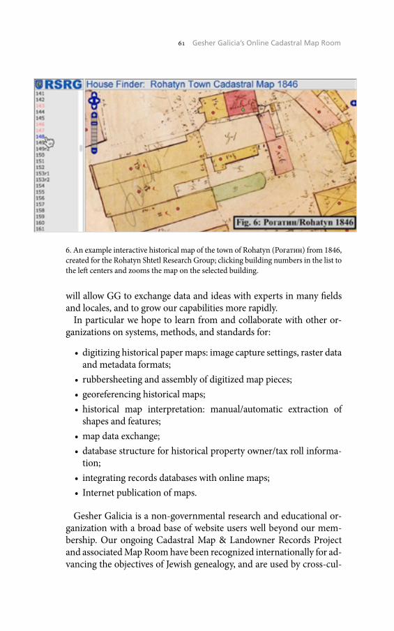
61 Gesher Galicia’s Online Cadastral Map Room
will allow GG to exchange data and ideas with experts in many fields and locales, and to grow our capabilities more rapidly.
In particular we hope to learn from and collaborate with other or-ganizations on systems, methods, and standards for:
• digitizing historical paper maps: image capture settings, raster data and metadata formats;
• rubbersheeting and assembly of digitized map pieces;• georeferencing historical maps;• historical map interpretation: manual/automatic extraction of
shapes and features;• map data exchange;• database structure for historical property owner/tax roll informa-
tion;• integrating records databases with online maps;• Internet publication of maps.
Gesher Galicia is a non-governmental research and educational or-ganization with a broad base of website users well beyond our mem-bership. Our ongoing Cadastral Map & Landowner Records Project and associated Map Room have been recognized internationally for ad-vancing the objectives of Jewish genealogy, and are used by cross-cul-
6. An example interactive historical map of the town of Rohatyn (Рогатин) from 1846, created for the Rohatyn Shtetl Research Group; clicking building numbers in the list to the left centers and zooms the map on the selected building.

62 Jay Osborn
tural researchers studying historic Poland and Ukraine as well as lands outside the former boundaries of Galicia. To further develop our map-ping capabilities and quality, we appreciate advice and information from experts in any map organization having similar interests, and we welcome opportunities to build virtual bridges between our organiza-tion and others.
Jay OsbornGesher Galicia - The Bridge to Galicia
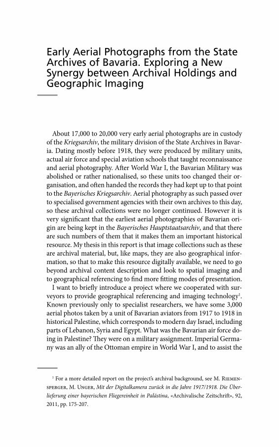
Early Aerial Photographs from the State Archives of Bavaria. Exploring a New Synergy between Archival Holdings and Geographic Imaging
About 17,000 to 20,000 very early aerial photographs are in custody of the Kriegsarchiv, the military division of the State Archives in Bavar-ia. Dating mostly before 1918, they were produced by military units, actual air force and special aviation schools that taught reconnaissance and aerial photography. After World War I, the Bavarian Military was abolished or rather nationalised, so these units too changed their or-ganisation, and often handed the records they had kept up to that point to the Bayerisches Kriegsarchiv. Aerial photography as such passed over to specialised government agencies with their own archives to this day, so these archival collections were no longer continued. However it is very significant that the earliest aerial photographies of Bavarian ori-gin are being kept in the Bayerisches Hauptstaatsarchiv, and that there are such numbers of them that it makes them an important historical resource. My thesis in this report is that image collections such as these are archival material, but, like maps, they are also geographical infor-mation, so that to make this resource digitally available, we need to go beyond archival content description and look to spatial imaging and to geographical referencing to find more fitting modes of presentation.
I want to briefly introduce a project where we cooperated with sur-veyors to provide geographical referencing and imaging technology1. Known previously only to specialist researchers, we have some 3,000 aerial photos taken by a unit of Bavarian aviators from 1917 to 1918 in historical Palestine, which corresponds to modern day Israel, including parts of Lebanon, Syria and Egypt. What was the Bavarian air force do-ing in Palestine? They were on a military assignment. Imperial Germa-ny was an ally of the Ottoman empire in World War I, and to assist the
1 For a more detailed report on the project’s archival background, see M. Riemen-sperger, M. Unger, Mit der Digitalkamera zurück in die Jahre 1917/1918. Die Über-lieferung einer bayerischen Fliegereinheit in Palästina, «Archivalische Zeitschrift», 92, 2011, pp. 175-207.
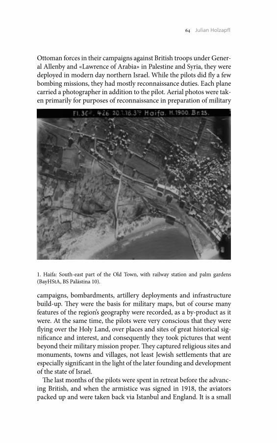
64 Julian Holzapfl
Ottoman forces in their campaigns against British troops under Gener-al Allenby and «Lawrence of Arabia» in Palestine and Syria, they were deployed in modern day northern Israel. While the pilots did fly a few bombing missions, they had mostly reconnaissance duties. Each plane carried a photographer in addition to the pilot. Aerial photos were tak-en primarily for purposes of reconnaissance in preparation of military
campaigns, bombardments, artillery deployments and infrastructure build-up. They were the basis for military maps, but of course many features of the region’s geography were recorded, as a by-product as it were. At the same time, the pilots were very conscious that they were flying over the Holy Land, over places and sites of great historical sig-nificance and interest, and consequently they took pictures that went beyond their military mission proper. They captured religious sites and monuments, towns and villages, not least Jewish settlements that are especially significant in the light of the later founding and development of the state of Israel.
The last months of the pilots were spent in retreat before the advanc-ing British, and when the armistice was signed in 1918, the aviators packed up and were taken back via Istanbul and England. It is a small
1. Haifa: South-east part of the Old Town, with railway station and palm gardens (BayHStA, BS Palästina 10).
65 Early Aerial Photographs from the State Archives of Bavaria
miracle that they managed to bring about 3,000 photographic glass plates back undamaged. These make up the collection that we have al-ready made available in digitised form2 (figg. 1-2).
Presented like this, we are dealing with a conventional, as it were, on-line presentation of an archival finding aid, with digitised images at-tached. The geographical structure that underlies the description sorts the images into regional groups and offers a short verbal description of each. This can be seen to fall short in two ways: there is no spatial grid that visualises the geographical spread, as well as the focal areas of the collection as a whole, and, more importantly, there is no way to visual-ise the area pictured in any given photograph as against current topog-raphy. A preliminary search will of course tell you if a particular place name is mentioned in the description for one or more images, but this is of course not precise enough, given the summary nature of the de-scription and the linguistic challenges involved. In order to ascertain if a particular place is covered in the aerial photographs, you still have
2 <http://www.gda.bayern.de/service/bestaende/> (01/21/2015).
2. Web presentation of the archival collection.
66 Julian Holzapfl
to look at a great many likely pictures, and rather laboriously interpret them for geographical orientation. But presenting a collection such as this based on a spatial grid and digital maps, in other words as a geo-graphic information system (GIS), is a technical challenge that cannot be met with archival description alone.
At this point, our project partnership with the Bavarian Agency for Digitisation, High-Speed Internet and Surveying and the Survey of Is-rael comes in. The surveyors generously lent their technical expertise to a cooperation project and worked on the images in four steps.
As a first step, they digitised the original images3 using a specialised photogrammetry scanner for aerial photos, which reproduces the im-ages with no optical distortion. They then used their experience with digital aerial photography to carefully process the images so that clarity and contrast were enhanced.
On the basis of these digital images, the crucial second step was the georeferencing of the images by the Survey of Israel. In practical terms, this meant aligning the center point of any picture with geographical coordinates. This is painstaking work that requires a thorough knowl-edge of regional geography, as well as the historical changes in topog-raphy, settlement and land use between 1917-18 and today. It was successful for a good two thirds of all pictures. Images that show only featureless desert terrain, with contemporary documentation making only vague reference as to the precise location have been left out.
With the data thus enhanced, the third step could be approached: setting up a presentation that could make these new layers of technical metadata operational. The ideal solution would be a customised web map service (WMS), a powerful imaging tool which presents maps dy-namically with a layer linking geographical information and descrip-tive metadata and its own map viewer. Since this proved too costly for a relatively limited collection, we looked for a technically more straight-forward alternative, and found it in the most widely known GIS of all: Google Earth. This program uses data annotated in the Keyhole Markup Language (KML) standard. The Bavarian Agency for Digitisa-tion, High-Speed Internet and Surveying thus created a KML-file that integrates the archival metadata and the geographical metadata. By up-loading it into the standard Google Earth application that can be run
3 As the original glass plates are very fragile and the risk of damaging the originals was judged too high, were used for this high quality microfilm copies.
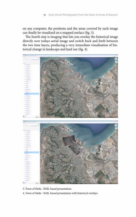
67 Early Aerial Photographs from the State Archives of Bavaria
on any computer, the positions and the areas covered by each image can finally be visualized on a mapped surface (fig. 3).
The fourth step is imaging that lets you overlay the historical image directly over todays aerial image and switch back and forth between the two time layers, producing a very immediate visualisation of his-torical change in landscape and land use (fig. 4).
3. Town of Haifa - KML-based presentation.4. Town of Haifa - KML-based presentation with historical overlays.
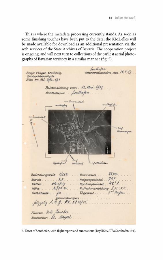
68 Julian Holzapfl
This is where the metadata processing currently stands. As soon as some finishing touches have been put to the data, the KML-files will be made available for download as an additional presentation via the web services of the State Archives of Bavaria. The cooperation project is ongoing, and will next turn to collections of the earliest aerial photo-graphs of Bavarian territory in a similar manner (fig. 5).
5. Town of Sonthofen, with flight report and annotations (BayHStA, Üfla Sonthofen 191).

69 Early Aerial Photographs from the State Archives of Bavaria
The conclusion, then, to be drawn from the preliminary results of these projects is very simple: for archival material that is geographic in nature, such as aerial photographs, but also such as historical maps, we should look for presentations that visualise space. As these visual-isations are usually beyond our own technical expertise, we should ac-tively seek the cooperation of cartographers and surveyors.
Julian HolzapflBavarian State Archive, Munich

The Historical Cadaster of Tuscany and the CASTORE Project
During the 18th and 19th centuries, similarly to what happens in the rest of Europe, various States of the Italian peninsula open the debate on the new criteria for the taxation of real estate. In that context land registries are established in order to define new forms of taxation, thus enabling modern States to respond to new social and political needs. The land registers that are established in that period can be substan-tially traced to two basic types: those descriptive, which do not pro-vide a mapping of the goods stacked, and the geometric particle-ones, where, conversely, the price of goods is associated with an appropriate cartographic representation based mostly on geodetic and topographic knowledge, now scientifically established. To the descriptive ones be-long the eighteenth-century Neapolitan and 19th century Sicilian ca-daster. The geometric-particle registry belonging to the Milanese, born in the early decades of the 18th century, will be taken as a model in the creation of those relating to the Tuscan territory, substantially con-structed in the first half of the 19th century. In the Grand Duchy of Tus-cany1, a first discussion on the rebuilding of the registry began in the last decades of the 18th century in conjunction with the reform of the Community by the Grand Duke Pietro Leopoldo. In 1807, with the an-
This text is an excerpt from the article U. Sassoli, I catasti storici della Toscana e il Pro-getto CASTORE, «Rassegna degli Archivi di Stato», n.s., 7/1-2-3, 2011.
1 The literature on the formation of the cadastre Ferdinandeo-Leopoldino and, more generally, of the geometric particle-cadastres in Tuscany is really large, so we limit ourselves to point out the fundamental work of E. Conti, I catasti agrari della Re-pubblica fiorentina e il catasto particellare toscano (secc. XIV-XIX), Roma 1966; G. Bi-agioli, L’agricoltura e la popolazione in Toscana all’inizio dell’Ottocento – Un’indagine sul catasto particellare, Pisa 1975, which we suggest for a deeper understanding of the issues just mentioned in the introductory part of this article; C. Pazzagli, Per la storia dell’agricoltura toscana nei secoli XIX e XX. Dal catasto particellare lorenese al catasto agrario del 1929, Torino 1979.
72 Umberto Sassoli
nexation of Tuscany by the Napoleonic Empire and with the promul-gation of the French cadastral laws, measurement tasks begin, which, at the fall of the Empire, had affected about 40 of the 242 Community territory of the Grand Dukes. In 1817, a Motu Proprio of Grand Duke Ferdinando III of Lorraine prescribed the resumption of operations started by the French and the establishment of a Deputation with the task of defining the criteria and rules for the evaluation and measure-ment of the new Tuscan registry. Among the members of the deputa-tion we find the astronomer Giovanni Inghirami, who would take care of the first order triangulation over which subsequent triangulation of a lower order would be coordinated2. The realization of a single trian-gulation of the first order for the whole of the Grand Duchy, placed the Tuscan in a forward position compared to other Italian cadastres, ear-lier or contemporaneous3. In 1819, the Deputation published the Istru-zioni4 for the operations of estimation and measurement. The estimate, which started in 1819, was completed in 1830, while measuring oper-ations, which were suspended by the French in 1810, resumed in 1819 and ended in 1825. In the years 1832-35, with the delivery to Com-munity Chancery of a copy of the three series of fundamental compo-nents of the land registry (Tavole Indicative, Campioni and Mappe)5 the so-called Attivazione del Catasto took place. The islands of the Tuscan Archipelago, which are exempt from property tax, were excluded. The Archipelago mapping and stacking was done between 1840 and 1845. During the same decades similar experiences had meanwhile begun also in the territories not belonging to the Grand Duchy of Tuscany. In the Duchy of Lucca the long awaited land registry reform was ordered in 1829 by the Duke Carlo Lodovico of Bourbon, whose decree start-ed an important triangulation operation that originated the first mod-ern maps of the territory of Lucca, while the measurements survey was completed in 1869. For the territories of Lucca formerly belonging to
2 The network of the first order consisted of 2,505 triangles and was based on 767 trigonometric points, cf. Biagioli, L’agricoltura, pp. 49-53.
3 Cf. G. Biagioli, I catasti, in L. Gambi (ed.), Vita civile degli italiani. Società, econo-mia, cultura materiale, vol. 4, Ambiente e società alle origini dell’Italia contemporanea, 1700-1850, Milano 1990.
4 Deputazione sopra il catasto, Istruzioni e Regolamenti, Approvati dall’I. e R. Gover-no, Firenze 1821.
5 For more details see the following web resource: <http://www.archiviodistato.fi-renze.it/catastotoscano/fondo_indice.html> (01/01/2015).
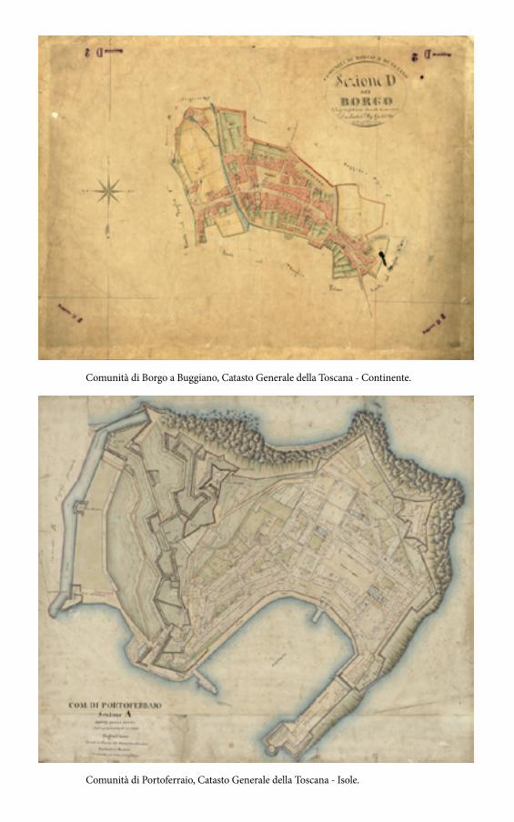
73 The Historical Cadaster of Tuscany and the CASTORE Project
Comunità di Portoferraio, Catasto Generale della Toscana - Isole.
Comunità di Borgo a Buggiano, Catasto Generale della Toscana - Continente.
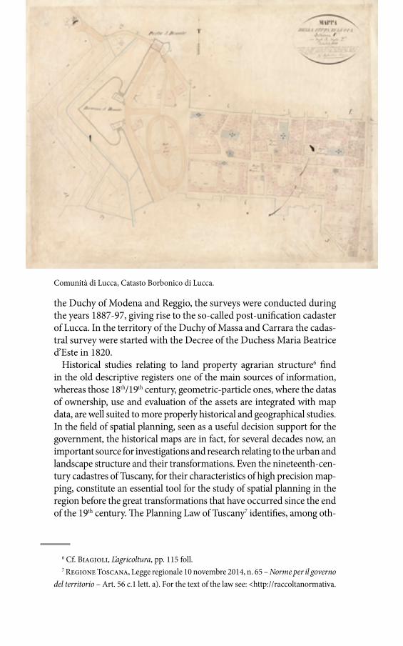
74 Umberto Sassoli
the Duchy of Modena and Reggio, the surveys were conducted during the years 1887-97, giving rise to the so-called post-unification cadaster of Lucca. In the territory of the Duchy of Massa and Carrara the cadas-tral survey were started with the Decree of the Duchess Maria Beatrice d’Este in 1820.
Historical studies relating to land property agrarian structure6 find in the old descriptive registers one of the main sources of information, whereas those 18th/19th century, geometric-particle ones, where the datas of ownership, use and evaluation of the assets are integrated with map data, are well suited to more properly historical and geographical studies. In the field of spatial planning, seen as a useful decision support for the government, the historical maps are in fact, for several decades now, an important source for investigations and research relating to the urban and landscape structure and their transformations. Even the nineteenth-cen-tury cadastres of Tuscany, for their characteristics of high precision map-ping, constitute an essential tool for the study of spatial planning in the region before the great transformations that have occurred since the end of the 19th century. The Planning Law of Tuscany7 identifies, among oth-
6 Cf. Biagioli, L’agricoltura, pp. 115 foll.7 Regione Toscana, Legge regionale 10 novembre 2014, n. 65 – Norme per il governo
del territorio – Art. 56 c.1 lett. a). For the text of the law see: <http://raccoltanormativa.
Comunità di Lucca, Catasto Borbonico di Lucca.

75 The Historical Cadaster of Tuscany and the CASTORE Project
er things, the historical maps as fundamental components of regional geographic information database. For the Tuscan legislator, therefore, all public entities respon-sible for planning and land management find in the territory historical representations a specif-ic cognitive support.
The CASTORE proj-ect8, sponsored by the Tuscan Region, was started in cooperation with the Tuscan State Archives on the basis of an agreement9 signed with the Ministry of Heritage and Culture (MIBAC) in July 2004. One of the main objec-tives of the project is to provide local govern-ments with an histor-ical cartographic ba-sis for the enrichment of the cognitive frame-works for spatial, land-scape and environment planning. Another one is to highlight the first cartographic represen-
consiglio.regione.toscana.it/articolo?urndoc=urn:nir:regione.toscana:legge:2014-11-10;65&dl_t=text/xml&dl_a=y&dl_id=&idx=tit3> (01/012015).
8 The CASTORE acronym (CAtasti STOrici REgionali) identifies the project for the acquisition of regional historical cadastral maps but, in general, refers to the process, still in progress, for the acquisition of historical cartographic heritage of Tuscany.
9 For the text of the agreement see: <http://web.rete.toscana.it/castoreapp/accordo11.3.htm> (01/01/2015).
Comunità di Barga, Catasto Post-unitario di Lucca.
76 Umberto Sassoli
tations made by scientific methods, easing access by citizens, techni-cians, the world of school and research through their diffusion on the Web and, finally, to safeguard the conservation status of the original documents and to enhance their fruition at the official Archives. Tak-en as a whole, through various operational phases, the project involved the filing, the digital reproduction and the georeferencing of histori-cal cadastral map. In particular, the General Cadastre of Tuscany, al-so known as Ferdinandeo-Leopoldino, presents over a large part of the regional continental and insular territory; Bourbon and Post-unifica-tion cadastres, which are complementary, are relative to the province of Lucca; the Estense cadaster is about the territory of Massa and Carrara, and finally the French cadaster which integrates some of the gaps in the General Cadastre of Tuscany. The first operational phase of the proj-ect involved the study of texture and distribution of cartographic her-itage preserved in the Tuscan State Archives. Each map was uniquely coded, selected and described, in a single board, in its main documen-tary and content features. The highly specialized scientific and meth-odological activities of this first phase were carried out by the Depart-ment of Historical and Geographical Studies, University of Florence. The second phase involved the digital acquisition of the original maps, preserved in the State Archives. For this purpose, large format scanners have been used, in order to allow the acquisition of each document in a single scan at high resolution. The work was carried out at the prem-ises of the State Archives in accordance with appropriate security pro-tocols. Then all the maps where geo-references with the aim to cre-ate a continuum coverage of the region affected by the cadaster. To this end, to georeference the over twelve thousand digital maps, a proce-dure capable to minimize the geometric inconsistencies in correspon-dence to the edges of the maps has been adopted. Methodologically, the homologous checkpoints necessary for georeferencing were identi-fied both on ancient maps and geographically corresponding to mod-ern features, then chosen on the coincidence of ‘persistent’ topograph-ic elements and identified on maps, such as, for example, intersections, junctions of hydrographic elements, buildings of greater clarity and relevance. Furthermore, in order to achieve, as far as possible, a ‘mosa-ic’ of maps geometrically congruent to the edges, the process of georef-erencing applied to the single map was reiterated between neighboring maps and, finally, between ‘blocks’ of contiguous maps, using addition-al homologous points of connection. The operations of georeferenc-ing, carried out by personnel experienced in the use of GIS technology (Geographic Information System), made it possible to produce a vector
77 The Historical Cadaster of Tuscany and the CASTORE Project
map of the boundaries of the cadastral map which, through successive geometric operations of aggregation, reconstructed a mesh of cadas-tral sections and, from this, the boundary of 19th century Communi-ties. Finally, in the spring of 2007, the three phase products have been integrated into a single information system designed to encourage the publication on the Internet. The system, designed and maintained by the technical units of the Tuscan Region, integrates the three main ar-eas: research, display of original maps and navigation in WebGIS envi-ronment10. The system was also implemented with a WMS11 (Web Map Service) that allows users to freely access the archive of maps and car-tographic work directly by a GIS software.
Despite the growing interest shown by the local government and the scientific and technical community to the nineteenth-century cadasters,
10 The URL of the service is: <http://www.regione.toscana.it/-/castore-catasti-storici-regionali> (01/01/2015).
11 The WMS services are compliant to a communication standard for network shar-ing of maps, defined by the Open Geospatial Consortium. For more information see: <http://www.opengeospatial.org/> (01/01/2015).
Comunità di Cantagallo, Catasto Francese.
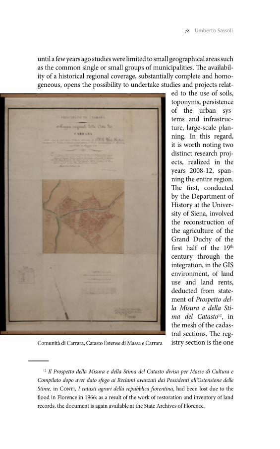
78 Umberto Sassoli
until a few years ago studies were limited to small geographical areas such as the common single or small groups of municipalities. The availabil-ity of a historical regional coverage, substantially complete and homo-geneous, opens the possibility to undertake studies and projects relat-
ed to the use of soils, toponyms, persistence of the urban sys-tems and infrastruc-ture, large-scale plan-ning. In this regard, it is worth noting two distinct research proj-ects, realized in the years 2008-12, span-ning the entire region. The first, conducted by the Department of History at the Univer-sity of Siena, involved the reconstruction of the agriculture of the Grand Duchy of the first half of the 19th century through the integration, in the GIS environment, of land use and land rents, deducted from state-ment of Prospetto del-la Misura e della Sti-ma del Catasto12, in the mesh of the cadas-tral sections. The reg-istry section is the one
12 Il Prospetto della Misura e della Stima del Catasto divisa per Masse di Cultura e Compilato dopo aver dato sfogo ai Reclami avanzati dai Possidenti all’Ostensione delle Stime, in Conti, I catasti agrari della repubblica fiorentina, had been lost due to the flood in Florence in 1966: as a result of the work of restoration and inventory of land records, the document is again available at the State Archives of Florence.
Comunità di Carrara, Catasto Estense di Massa e Carrara

79 The Historical Cadaster of Tuscany and the CASTORE Project
which, from the point of view of territorial extension at a resolution intermediate between the detail of the individual particles and the Community territory, is well suited to the representation of land culti-vation and ground rent at the regional or sub-regional level. The other project, conducted by the Department of Urban Planning of the Flor-ence University, takes into account the reconstruction of persistence and transformations of urban systems, in the areas currently built, doc-umented by nineteenth-century cadastral maps and 20th century Aeri-al photography of the years 1954, 1978, 1988, 1996.
Worth mentioning, finally, two other regional projects, conducted in cooperation with the CIST13 on the basis of an agreement signed with Ministry of Heritage and Culture (MIBAC) and currently in prog-ress. The first concerns the implementation of the database CASTORE through the indexing and the digital acquisition of more than six thou-sand maps of the 15th-19th, since there is common consensus that even the previous maps, albeit different from those measured with geo-detic-topographic techniques, provide an important contribution to knowledge for proper land use planning and landscape. The second project concerns, moreover, the realization of a comparative-histori-cal archive of names of places in Tuscany. The database will be made through the georeferencing and documentation of names of places from 19th century maps and of those on the most recent cartographic sources, both topographical and cadastral, in order to build a diachron-ic information base which will be useful for studies of place-names and historical-philological, but also to pursue a future revision and integra-tion of place-names in existing regional technical maps.
Umberto SassoliRegione Toscana
13 The CIST, Centro Interuniversitario di Scienze del Territorio, was founded in June 2011 with an agreement between the major universities and university institutes in Tuscany to reconstruct a unified vision of the different disciplines that address the political and territorial government. For more information see: <http://www.cist.it/> (01/01/2015).


Register of the Maps in National Archives of Estonia: Visions, Plans, Practices
The National Archives of Estonia is the centre of archival administra-tion in Estonia, which includes Historical Archives, State Archives, Film Archives and 4 regional departments in Rakvere, Kuressaare, Haapsalu and Valga.
The collection of National Archives of Estonia includes approximate-ly 9 million records. The oldest one from the 13th and the most recent one from the 21st century. We have more than 12 million digital images online but it is still only about 2% of our collections.
In recent years we have had quite stormy developments on e-servic-es. We are a very modern archive, concentrated on being available for our users around the clock. Virtual reading room VAU (<www.ra.ee/vau>) is the central access point to all online services and resources. All inventories are online: from the year 2013 users can submit their orders on not digitised items also online. Everyone can also find here central digital collection Saaga (<http://www.ra.ee/dgs/explorer.php/>, 02/09/2014) and different online solutions for different types of re-cords. For example: FOTIS-database of photos, database of seals and stamps, database for parchments, database of historical maps etc.
1. Collections of Historical Maps in National Archives of Estonia
Our collections of maps contain approximately 200,000 map sheets from 17th to 20th century. But the size of our map collection is approxi-mate, depending upon what we consider as «archival unit», e.g. a large cadastral map of a manor, consisting of 20 sheets, might be considered one single unit, or 20 different maps, so 20 units. In the database each page is described separately and automatic statistics give us only the number of description units. However, the exact size of the collection is not our main topic.
The diversity of maps is expressed in technical design and form. Cartographic documents have been drawn up as plans, maps, per-spectives, profiles etc. The maps are mostly handwritten and often ar-tistically illustrated.
82 Liina Lõhmus
The oldest maps in the Historical Archives date back to the first half of the 17th century, the oldest that we know is supposed to date back to 1630. The first largest series of maps originates from the years 1680-90 when the whole country was mapped in connection with the nation-alization of manor houses. During the period 1681-1709 were made around 500 North Estonian maps and 2200 South Estonian maps. Car-tographic work was connected with determining the economic poten-tial with manors and getting new Wackenbücher ready (Wackenbücher ‒ the list of the peasant taxes). On the maps of manors their farms were depicted in their actual configurations, with water bodies, roads and natural objects. The maps where provided with detailed map descrip-tion books. The following extensive campaign of compiling cadastral maps began during the last three decades of the 18th century in Saare-maa (the biggest island in Estonia). Few original maps have been pre-served from this time. Extensive land registration works started again at the beginning of the 19th century at the time of the Agrarian Reforms in Russian empire. The majority of our maps originate from the 19th and the beginning of the 20th century.
The oldest maps in the State Archives originate not before the sec-ond half of the 19th century. We can find topographic, hydrographic, administrative divisions, road communications and other such maps and plans. There are also many land and forest use and ownership re-lated plans. These border maps form a major part of the cartographic materials. In addition, military plans can be found: battle operations and sketch maps of troop positions, land allotted to the army. Most of the State Archives maps and plans originate from the time of the first Republic of Estonia, but there are also earlier topographic maps from the times of Czarist Russia and maps of the Baltics and north-western Russia that were drawn based on the Russian maps in Germany in the years 1916-18. Similar maps which were drawn in Germany date back to World War II.
2. Creating the Database and Digitizing the Historical Maps
The first public database of historical maps was created already in 1998 in National Archives of Estonia. The idea behind was the in-creasing need of archivists and archival users to find right maps quickly and easily.
The collections of maps in Estonian National Archives are not the classical collections. Generally, the maps are on archival fonds of the
83 Register of the Maps in National Archives of Estonia
institutions where they are created or used. And they can be found from different files.
The register is designed to meet three purposes:
• To assemble all descriptions of maps into one place.• To give as simple as possible searching tools without assuming
from users expert knowledge in historical geography and land sur-veying history.
• To display digitized maps as convenient as possible.
Alongside with simple and advanced search, users can search for maps by drawing a simple square on modern Google Map.
In 2008, the digitizing of maps from Swedish era was started. In 2010 the new Register of the maps in the National Archives of Estonia was developed to give users better and up-to-date searching and viewing tools. From 2010 to 2012 nearly 20,000 maps were digitized with sup-port of European Union.
The National Archives of Estonia received funding for several digi-tization projects in the end of 2009. We had 6 European Union fund-ed projects in National Archives of Estonia. In addition the projects of digitization of photos, parchments, videos, nitride-base films and paper materials from periods 1917-22 and 1987-92, were historical maps too.
The project ‒ «The Digitizing of Maps and Blueprints of the National Archives» ‒ is as far as we know the largest one-time contract of digi-tizing maps. It involves the conserving and scanning maps in the State Archives and the Historical Archives. The project lasted from June 2010 until May 2012. 10 terabytes of digital images, which will reach the public in Saaga and the new information system of the Nation-al Archives which incorporates map descriptions and digital images (<http://www.ra.ee/kaardid/index.php/en>, 07/29/2014).
Zeutschel Omniscan 14000 AO scanner is currently used for scan-ning the maps in the National Archives of Estonia. We have also used large format flat scan
ner from Oce company for large-scale maps (Oce CS4154 colour). The files are not processed and they are kept in the servers of Digi-tal Archives. The master files are scanned with resolution 300 dpi and saved in uncompressed TIFF format. The maps are scanned in colour with 1:1 ratio.
Today over 110,000 descriptions of maps and approximately 36,000 digital images are available to all interested.

84 Liina Lõhmus
3. Working with the Database Today and Visions for Future
The register of maps is very good example of cooperation between ar-chives and university. Part of the curriculum of the students of archival studies of Tartu University is internship in National Archives of Estonia. Adding new descriptions to the register of maps is one of the most in-teresting tasks.
National Archives of Estonia is going to continue adding descriptions and digital images of map from own resources. Additionally we improve the location parameters and searching possibilities. The creation of uni-fied geographic information system also belongs to our intensions.
Today the colleagues from the Digital Archives are engaged in creat-ing the new access system that also remarks completing the digital ar-chives. The new archival information system will be given to use in 2015. It intends to create central search opportunities for users so you would not have to search for maps, photos and text files separately. But all the handy features of the register of maps will remain available for users.
4. References
<http://www.ra.ee/kaardid/index.php/en> (07/29/2014)<www.ra.ee/vau> (09/02/2014)<http://www.ra.ee/dgs/explorer.php/> (09/02/2014)
Liina LõhmusNational Archives of Estonia, Tartu
Present and Future of the Digital Catastral Heritage in Croatian State Archives
1. Introduction
Cadastral heritage which is now preserved in the Croatian State Ar-chives can be divided into several fonds or collections that are kept in the Map collection, Map Archives for Croatia and Slavonia and State Geodetic Administration.
1.1 Map CollectionMap collection consists of cadastral maps from the period of Joseph
II (economic survey), besides many types of maps from the period 1522-1997. This economic survey has not been completed in the area of civil Croatia and Slavonia, but only for Croatian and Slavonian Mili-tary Frontier, for Rijeka and part of the Primorje1. That is why the only preserved cadastral maps are for some parts of the Military Frontier, by regiments and locations2. They are an excellent historical source to get a clear picture of all the changes in the development, structure, expan-sion of a settlement and how to use the landed property for individual sites in large scale, and to compare the cadastral maps from the period of cadastre Joseph II (economic survey) with the ones of the period of Francis I (first stabile cadastre). There are no online digital copies yet available (cadastral maps are not yet digitized).
1.2 Map Archives for Croatia and SlavoniaMap Archives for Croatia and Slavonia consists of cadastral docu-
ments from the period of the first systematic cadastral survey conduct-ed by the Patent of the Emperor Francis I («first stabile cadastre»). It is
1 Jozefinski katastar grada Rijeke i njegove uže okolice (1785/87), Sv. I. i II. Zagreb 1998, pp. VII-XV: VII-XII.
2 HR-HDA-902, Map collection; M. Slukan Altić, Kartografska zbirka Hrvatskog državnog arhiva i njena vrijednost kao izvora za istraživanja, «Arhivski vjesnik», 41, 1998, pp. 121-61.

86 Umberto Sassoli86 Mirjana Juric
an indispensable resource for historical research of economic and so-cial history of the 19th century and represents the first systematic and methodologically based collection of data on the size of the land, the annual return on annual income, and with detailed information on the landowners, buildings and agricultural parcels, etc3. These documents contain information on property, real estate, property relations, culti-vation of land, mutual relations of land owners, property quality, and are also an evidence of all fiscal changes that occurred after the cadas-tral survey was finished. Cadastral archives can be used as a subject for various research studies, e.g. structure of land ownership and its chang-es throughout the different time periods, place development within the historical and geographical processes, genealogical research, etc. There are online digital copies available (original cadastral maps) realized in cooperation with Arcanum Adatbźis Kft4.
1.3 State Geodetic AdministrationState Geodetic Administration consists the cadastral documents
(land consolidation, aerial survey, tacheometric survey) from the peri-od 1960-80s, which refers to the territory of Croatia. There are no on-line digital copies available yet (as cadastral maps are not yet digitized).
Digitization of original cadastral maps from first systematic cadas-tral survey 1847-77 for the territory of Kingdom of Croatia and Slavo-nia was mostly implemented still (there are some missing sheets which are planned to be digitized). Other types of cadastral maps are partially digitized (e.g. reambulation plans or copies of original cadastral maps). The publication online of so far digitized cadastral maps is in the pro-cess5. Digitization is carried out in accordance with the instructions from the Guidelines for the selection of materials for digitization, with a specific purpose6:
3 HR-HDA-1421, Arhiv mapa za Hrvatsku i Slavoniju; M. Slukan Altić, Državna geodetska uprava (1847-1963). Inventar, Zagreb 2000.
4 <http://www.arcanum.hu/english/szolgaltatasok/digitalizalas/> (09/10/2013); <http://croatia.arcanum.hu/?zoom=8&lat=45.30208&lon=16.93141> (09/10/2013); <http://arhinet.arhiv.hr/details.aspx?ItemId=1_5308> (09/10/2013).
5 <http://arhinet.arhiv.hr/details.aspx?ItemId=1_5308> (09/10/2013).6 Smjernice za odabir građe za digitalizaciju, Radna verzija, Zagreb 2007, available
online: <http://kultura.hr/hr/Sudjelujte/Preuzimanja-i-dokumenti/Smjernice-za-oda-bir-i-pripremu-grade-za-snimanje> (10/02/2012).

87 The Historical Cadaster of Tuscany and the CASTORE Project87 Present and Future of the Digital Catastral Heritage
a. to protect the original;b. to increase the accessibility and possibilities for better and wider
use of the material;c. to create or expand service to users;d. to complete fond or collection ‒ the goal is to complement the fond
with digital records of other potential institutions which possibly hold the originals or copies or duplicates.
a. Digital copies are used to avoid mechanical damage to the origi-nals in use, transmission, transportation, etc. Avoiding frequent digiti-zation of the originals by request (official request, exhibitions, etc.) also protects originals from mechanical damage. Cadastral archives that are kept in the fond Map archives for Croatia and Slavonia are very often used in the Reading Room of the CSA. Analysis of the frequency of use in the Reading Room made for the last few years shows that the ca-dastral archives occupies high second/third place (except 2009 when it was in fourth place) in relation to the most used collection and least used fonds, and being so often used and exposed to the material dam-age was a good choice for the digitization7. For comparison parish reg-isters were selected because they regularly appear in the first place by frequency of use in the Reading Room. In addition to the fact that this archives is frequently in use, it should be noted that this is an extremely valuable historical source, which is registered as the cultural heritage in the Register of Cultural Goods of the Republic of Croatia8.
Analysis 1: Usage statistics of the Maps archives for Croatia and Slavo-nia in the CSA Reading Room.
Analysis is relating to the period before the digitization, and graph 1 shows the annual percentage of use of this fond in the Reading Room of the CSA. Types of cadastral records that have been digitized:• original cadastral maps (there aren’t original cadastral plans for all
cadastral districts);• partially the copies of cadastral maps if there is no original cadas-
tral plan preserved.
7 T. Jakopec, M. Jurić, Modeliranje i optimizacija sustava za pozicioniranje i vi-zualno označivanje povijesnih katastarskih planova, «Libellarium», 5/2, 2012, p. 186.
8 <http://www.min-kulture.hr/default.aspx?id=6212&kdId=101079845> (09/01/2013); Pravilnik o obliku, sadržaju i načinu vođenja Registra kulturnih doba-ra Republike Hrvatske, «Narodne novine», 89, 2011.
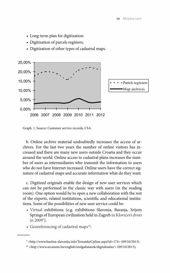
88 Umberto Sassoli88 Mirjana Juric
• Long-term plan for digitization:• Digitization of parcels registers;• Digitization of other types of cadastral maps.
b. Online archive material undoubtedly increases the access of ar-chives. For the last two years the number of online visitors has in-creased and there are many new users outside Croatia and they occur around the world. Online access to cadastral plans increases the num-ber of users as intermediaries who transmit the information to users who do not have Internet increased. Online users have the correct sig-nature of cadastral maps and accurate information what do they want.
c. Digitized originals enable the design of new user services which can not be performed in the classic way with users (in the reading room). One option would be to open a new collaboration with the rest of the experts, related institutions, scientific and educational institu-tions. Some of the possibilities of new user service could be:• Virtual exhibitions (e.g. exhibitions Slavonia, Baranja, Srijem
Springs of European civilization held in Zagreb in Klovićevi dvori in 20099);
• Georeferencing of cadastral maps10;
9 <http://www.bastina-slavonija.info/TematskeCjeline.aspx?id=174> (09/10/2013).10 <http://www.arcanum.hu/english/szolgaltatasok/digitalizalas/> (09/10/2013);
0,00%
5,00%
10,00%
15,00%
20,00%
25,00%
2006 2007 2008 2009 2010 2011 2012
Parish registersMap archives
Graph. 1. Source: Customer service records, CSA.
89 The Historical Cadaster of Tuscany and the CASTORE Project89 Present and Future of the Digital Catastral Heritage
• Digital connection data cadastral plans with the data from the par-cel register (connection of parcels from the cadastral plan with parcels in the parcel registers);
• Indexing of toponyms from cadastral plans (old toponyms on plans are usually widely known traditional names for a specific part of cadastral settlements).
With these new services students and volunteers could be used as a resources. Students could be involved in the design of new user ser-vices as part of their student practices (study of geography, geode-sy, information science). Volunteers might be familiar with the work of individual institutions to get an experience as well as to contrib-ute with their results to wider community. Volunteers could be stu-dents and elderly volunteers. Croatia has organized volunteer centers that provide information about current volunteer projects that can in-volve different kind of volunteers, at the same time available data indi-cates on initiated various projects in culture (e.g. library inventory of books). The same could be implemented in the case of CSA digitized cadastral archives depending on the IT knowledge of volunteers (from geo-referencing, indexing mentioned toponyms from cadastral maps, listing landowners who are handwritten registered in parcel register, etc.). Some current cooperation: CSA and the Faculty of Philosophy in Osijek, Department of Information Sciences with a pilot project of a Model system for visual marking and making actual index of histor-ical cadastral maps. The project’s aim is positioning and visual mark-up of old historical cadastral maps of Garesnica area from the time of the first systematic cadastral surveys (1847-77) and highlight different data from cadastral plans and index accumulation. The project is ac-tually testing this system for tagging images and cartographic material (maps, plans), and in the case of cadastral maps is an excellent example of a detailed cartographic representation11. It is planned to make data-base of cultures, parcels, contour lines, meadows, forests, hills, water, roads which opens the possibility to compare the present situation on maps with the data of the stabile cadaster period.
Due to the specific features that cartographic archival materials pro-vides (authenticity, value, attractiveness, visual experience, skills of reading the old maps, a comparison of the old and new maps), archives
<http://croatia.arcanum.hu/?zoom=8&lat=45.30208&lon=16.93141> (09/10/2013).11 <http://oziz.ffos.hr/pilotkarte/> (09/10/2013).
90 Umberto Sassoli90 Mirjana Juric
is very convenient to carry out workshops providing a visual experi-ence through telling stories, playing games, and whose ultimate goal is education. An example is part of the mapping workshop for children of preschool/primary school age and seniors as well using the digitized originals of cadastral maps.
d. Cadastral archives for the territory of Croatia and Slavonia is not fully preserved, and is mainly composed of cadastral registers, fiscal registers and complaints documentation. The mentioned fond has largely preserved cadastre registers, and has no fiscal registers and complaints documentation. Cadastral registers are not complete-ly preserved for all cadastral settlements in the Kingdom of Croatia and Slavonia and the current aim is to complete digital copies that are kept in the potentional institutions outside the CSA, and to com-plete other preserved cadastral documentation that is still lacking in the mentioned fond (fiscal registers). Međimurje region is an example of unsystematic storage of cadastral archives in Zagreb because of the fragmentation of the Croatian lands at that time. Međimurje was part of the Varazdin County (Croatia and Slavonia) until 12 March 1861 and from 1861 to 1918. It was part of the Zala County (Hungary). Ca-dastral survey of Međimurje area as an integral part of the Varazdin County was made in the period from 1850 to 1860 during the survey of Kingdoms of Croatia and Slavonia. In 1861 Međimurje incorporat-ed Hungary, so all of the following survey, reambulation and changes were undertaken in the framework of the Hungarian survey, and not within the framework of Kingdom of Croatia and Slavonia so the ca-dastral survey and on its basis built cadastre and land registry in Međi-murje had Hungarian characteristic. With regard to the above, overall cadastral documentation was not delivered and stored in the Maps Ar-chives in Zagreb. Most likely the original cadastral maps, instead of being transferred to the Maps Archives in Zagreb, due to the incorpo-ration of Međimurje area to Hungary, had been left in cadastral offices in Međimurje (then part of Hungary), and part of them was probably stored in the Maps Archives for Hungary. The main consequence today is that the cadastral documents of the same creator are kept scattered in collections in several institutions in Croatia and outside the Croatia.
2. Conlusions and Plans for the Future
• Digitization of cadastral maps preserved from the period of the so-called Economic Surveys (Cadastre of Joseph II).
91 The Historical Cadaster of Tuscany and the CASTORE Project91 Present and Future of the Digital Catastral Heritage
• Digitization of other types of cadastral plans for cadastral settle-ments in case there is no preserved original cadastral maps in CSA (Cadastre of Francis I).
• Digitization of original cadastral plans kept in other government archives in Croatia and linking to ARHiNET, adding this in-formation to the description of additional sources (Cadastre of Francis I).
• Digitalization of the register of particles and connecting link with digital copies of cadastral plans - it is necessary to closely associ-ate and simultaneously perform the review of cadastral plans and the examination of the registers of particles (Cadastre of Francis I).
• Virtual link of archives with other potential institutions as care-givers of cadastral material of which originals are not stored in the CSA (Cadastre of Francis I).
• Opening of an international portal of cadastre of Francis I (linking digitized copies of the cadastre of Francis I).
• Further educational activity to educational/cultural institutions in the society: preschool, secondary and higher education insti-tutions, museums, libraries (Cadastre of Joseph II and Francis I).
Long-term protection and preservation of the originals of everyday use, transfer and mechanical damage are just some of the direct posi-tive consequences of digitization.
Digitization of originals and digitized copies are opening some new features in working with users from wider distribution and better avail-ability of archival material to the formation of new consumer servic-es (mapping workshops for children, collaboration with institutions of higher education, including volunteers, students), or linking cadastral heritage as a result of the first systematic cadastral surveying of the Habsburg Empire, in order to consolidate and finding parts of cadas-tral documentation lacking in the home country.
3. Literature and Historical Sources
HR-HDA-902, Kartografska zbirka.HR-HDA-1421, Arhiv mapa za Hrvatsku i Slavoniju.M. Božićnik, Katastar zemljišta i zemljišna knjiga u Međimurju,
«Međimurje», 9, 1986, pp. 18-28.
92 Umberto Sassoli92 Mirjana Juric
M. Lapaine, N. Frančula, Geodetsko-geoinformatički rječnik, Za-greb 2008.
M. Manin, Zapadna Istra u katastru Franje I (1818-1840), Zagreb 2006.
M. Slukan-Altić, Državna geodetska uprava (1847-1963). Inventar, Zagreb 2000.
Patent br. 162, Einführung eines neuen Grundsteuer Systems. Franz des Ersten politische Gesetze und Verordnungen für die Österreichischen, Böhmischen und Galizischen Erbländer, Wien 1819.
Nacionalni program digitalizacije arhivske, knjižnične i muzejske građe, Zagreb 2006, available online: <http://kultura.hr/hr/Sudjelujte/Preuzimanja-i-dokumenti/Nacionalni-program-digitalizacije-arhivs-ke-knjiznicne-i-muzejske-grade> (09/01/2013).
Naputak za oblasti i obćine o dužnostih njihovih prilikom razmiere katastralne i o izpravljenju i ustanovljenju granicah od obćinah i vlast-ničtvah u području c.kr. hèrvatsko-slavonskoga namiesničtva, koje stoji u savezu s time, Zagreb 1858.
Pravilnik o obliku, sadržaju i načinu vođenja Registra kulturnih do-bara Republike Hrvatske, «Narodne novine», 89, 2011.
Smjernice za odabir građe za digitalizaciju, Radna verzija, Zagreb 2007, available online: <http://kultura.hr/hr/Sudjelujte/Preuzima-nja-i-dokumenti/Smjernice-za-odabir-i-pripremu-grade-za-snima-nje> (10/10/2012).
Smjernice za pripremu projekta digitalizacije. Nacionalni projekt «Hrvatska kulturna baština», Digitalizacija arhivske, knjižnične i mu-zejske građe, available online: <http://kultura.hr/hr/Sudjelujte/Preuzi-manja-i-dokumenti/Smjernice-za-pripremu-projekta-digitalizacije> (10/10/2012).
Mirjana JurićCroatian State Archives, Zagreb
Cadastral Maps in the State Archives in Pazin and Their Usage in Everyday Archival Practice
1. Surveying of Istria during the Venetian Republic
At the time of the Venetian Republic cadastre was created individu-ally, without systematic survey and inventory of assets over a wide ar-ea and is closely related to the division of land and colonization of the new population.
The oldest so far found cadastral plan from Istria refers to the ec-clesiastical possessions of the St. Michaels monastery by Lim Chan-nel dated in 1433 and shows the territorial extent and the confines of the monastery property. It is kept in the Archivio di Stato di Venezia. The second dates in the 1563 and refers to the Pulas area. It was creat-ed at the initiative of the Venetian Senate, as a matter of fact of his body Provveditori sopra and Beni Inculti which had played an important role in the allocation of land holdings from the mid 16th century, and thus production of cadastral records. This copy is kept in the Museo Civico Correr in Venezia. The third surviving cadastral plan refers to the area around the Lim Fjord; made in 1597 and stored in the aforementioned Venetian archives.
2. The First Systematic Cadastral Survey of Istria (1818-40)
The first systematic cadastral survey of the entire area of the Istri-an territory was conducted only after the inclusion of Istria in the Habsburg Monarchy. In the year 1813 the Habsburg Monarchy re-sumes Venetian as well as Austrian Istria and then the preconditions for a systematic cadastral survey in the entire area that was within the survey countries of the Habsburg Monarchy (for the first time includes all Croatian lands) were made. It is a measure of the Francis, and was named after the Emperor Francis I, a cadastre is called Franciscan Ca-dastre. In 1806 the Francis topographic survey and preparation for implementation of cadastral survey began, with the purpose of intro-ducing a steady cadastre as a fairer system of taxation of land revenue.
94 Umberto Sassoli94 Biserka Budicin, Maja Ceric
On 23rd of December 1817 initiated the survey. The first was the Aus-trian Littoral (Küstenland or Provincia del Litorale) which included the Landscape Istra (Istria Kreis or Circolo dell’Istria).
3. Archives of Maps in Istria and their Material
• State Archives of Trieste (Archivio di Stato di Trieste): the most of the material of that archive is kept in the fund Franciscan Cadas-tre (Catasto Franceschini, 1818-40). It was the first archive of maps for the Austrian Littoral and was established on 21st of February 1824 in Trieste.
• State Archives in Split Fund: Archives of maps for Istria and Dal-matia.
• State Archives in Rijeka.• Croatian State Archives.• State Archive in Pazin.
4. The History of the Archival Fond
In order to store and protect the abundant documentation created by cadastral surveys, the archives of maps were established. For the Aus-trian Littoral such an archive was founded in Trieste the 21st of Feb-ruary 1824. Today, the most of the material records of the Archives of Maps for the territory of Austrian Littoral is stored in the State Ar-chives of Trieste in the fond Franciscan Cadastre (Catasto Franceschi-no 1818-40). A part of the first cadastral survey of Istria is now stored at the National Archives in Split, in the fond Archives of maps for Is-tria and Dalmatia. Less material records of Cadastre of Istria are stored in the Collection of cartographic material records at the National Ar-chives in Rijeka, mainly of cadastral communities Cres, Kastav, Rijeka, Belaj, Buzet and Motovun. While arranging this cadastral plans and maps from the HR-DAPA-426 Collection of drawings and plans were annexed to it.
The fonds consists of written and cartographic part of documenta-tion for each cadastral community. The State Archives in Pazin pre-serves only the cartographic material records: indication sketches of the revision from the late 19th century and cadastral maps predomi-nant from the 20th century. Indication sketches indicating the outline (sketches of possessions/property/land deed) served as the basis for
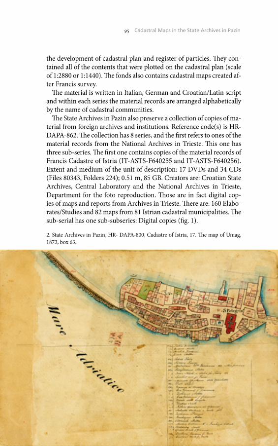
95 The Historical Cadaster of Tuscany and the CASTORE Project95 Cadastral Maps in the State Archives in Pazin
the development of cadastral plan and register of particles. They con-tained all of the contents that were plotted on the cadastral plan (scale of 1:2880 or 1:1440). The fonds also contains cadastral maps created af-ter Francis survey.
The material is written in Italian, German and Croatian/Latin script and within each series the material records are arranged alphabetically by the name of cadastral communities.
The State Archives in Pazin also preserve a collection of copies of ma-terial from foreign archives and institutions. Reference code(s) is HR-DAPA-862. The collection has 8 series, and the first refers to ones of the material records from the National Archives in Trieste. This one has three sub-series. The first one contains copies of the material records of Francis Cadastre of Istria (IT-ASTS-F640255 and IT-ASTS-F640256). Extent and medium of the unit of description: 17 DVDs and 34 CDs (Files 80343, Folders 224); 0.51 m, 85 GB. Creators are: Croatian State Archives, Central Laboratory and the National Archives in Trieste, Department for the foto reproduction. Those are in fact digital cop-ies of maps and reports from Archives in Trieste. There are: 160 Elabo-rates/Studies and 82 maps from 81 Istrian cadastral municipalities. The sub-serial has one sub-subseries: Digital copies (fig. 1).
2. State Archives in Pazin, HR- DAPA-800, Cadastre of Istria, 17. The map of Umag, 1873, box 63.
96 Umberto Sassoli96 Biserka Budicin, Maja Ceric
In the State Archives in Pazin maps make a part of the collective fond whose reference code is HR-DAPA-800 entitled Cadastre of Istria. The material records date from 1817 to the 1960. The fond contains 80 box-es, 451 cadastral map, 8.2 m.
After this theoretical part, follows the analytical and statistical review of the use of cadastral maps of each fond in the daily archival practice in the State Archive in Pazin, in the last 5 years (from 2009 until 2012 and for the first ten months of the year 2013).
4.1 Year 2009From a total of 500 requests for the use of archival material, 28 of
them (5.6%) were filled for the use of cadastral maps from the fond HR-DAPA-800 Cadastre of Istria and 8 (1.6%) were filled for browsing maps from the fond HR-DAPA-862 Collection of the copies of mate-rial records from foreign archives and institutions. Total were filled 36 (7.2%) requests related to the use of cadastral maps.
Total: 500 requestsHR-DAPA-800 Cadastre of Istria: 28 requests (5.6%)HR-DAPA-862 Collection of copies of materials from foreign ar-chives and institutions: 8 requests (1.6%)Total requests for the use of cadastral records: 36 (7.2%)
4.2 Year 2010From a total of 599 requests for the use of archival material, 14 of
them (2.3%) were filled for the use of cadastral maps from the fond HR-DAPA-800 Cadastre of Istria and 39 (6.5%) were filled for brows-ing maps from the fond HR-DAPA-862 Collection of the copies of ma-terial records from foreign archives and institutions. Total were filled 53 (8.9%) requests related to the use of cadastral maps.
Total: 599 requestsHR-DAPA-800 Cadastre of Istria: 14 requests (2.3%)HR-DAPA-862 Collection of copies of materials from foreign ar-chives and institutions: 39 requests (6.5%)Total requests for the use of cadastral records: 53 (8.9%)
4.3 Year 2011From a total of 491 requests for the use of archival material, 27 of
them (5.5%) were filled for the use of cadastral maps from the fond HR-DAPA-800 Cadastre of Istria and 32 (6.5%) were filled for brows-ing maps from the fond HR-DAPA-862 Collection of the copies of ma-terial records from foreign archives and institutions. Total were filled 59 (12%) requests related to the use of cadastral maps.
97 The Historical Cadaster of Tuscany and the CASTORE Project97 Cadastral Maps in the State Archives in Pazin
Total: 491 requestsHR-DAPA-800 Cadastre of Istria: 27 requests (5.5%)HR-DAPA-862 Collection of copies of materials from foreign ar-chives and institutions: 32 requests (6.5%)Total requests for the use of cadastral records: 59 (12%)
4.4 Year 2012From a total of 543 requests for the use of archival material, 19 of
them (3.5%) were filled for the use of cadastral maps from the fond HR-DAPA-800 Cadastre of Istria and 15 (2.8%) were filled for brows-ing maps from the fond HR-DAPA-862 Collection of the copies of ma-terial records from foreign archives and institutions. Total were filled 34 (6.3%) requests related to the use of cadastral maps.
Total: 543 requestsHR-DAPA-800 Cadastre of Istria: 19 requests (3.5%)HR-DAPA-862 Collection of copies of materials from foreign ar-chives and institutions: 15 requests (2.8%)Total requests for the use of cadastral records: 34 (6.3%)
4.5 January 1st 2013 - October 31st 2013From a total of 437 requests for the use of archival material, 11 of
them (2.5%) were filled for the use of cadastral maps from the fond HR-DAPA-800 Cadastre of Istria and 8 (1.8%) were filled for browsing maps from the fond HR-DAPA-862 Collection of the copies of mate-rial records from foreign archives and institutions. Total were filled 19 (4.4%) requests related to the use of cadastral maps.
Total: 437 requestsHR-DAPA-800 Cadastre of Istria: 11 requests (2.5%)HR-DAPA-862 Collection of copies of materials from foreign ar-chives and institutions: 8 requests (1.8%)Total requests for the use of cadastral records: 19 (4.4%)
5. Users of the Cadastral Maps
In the studied and analyzed period, in total there were 76 users and 67 of them, while filling out the forms, stated their educational quali-fications.
5.1 Education of UsersElemantary school education: 1.5% (1 of 67)Secondary education 32.8% (22 of 67)Associate degree: 7.4% (5 of 67)
98 Umberto Sassoli98 Biserka Budicin, Maja Ceric
University degree: 49.2% (33 of 67)Other (students, pupils): 8.9% (6 of 67)
5.2 Profession of UsersWhen filling out the forms 56 users stated their profession.Economists: 7.1% (4 of 56)Lawyers: 3.5% (2 of 56)Civil engineers, geodesists: 12.5% (7 of 56)Architects: 16% (9 of 56)Experts in culture, conservators, restorers, curators, archaeologists: 16% (9 of 56)Workers in the tourism industry, caterers: 12.5% (7 of 56)Teachers, professors: 10.7% (6 of 56)Agronomists: 3.5% (2 of 56)Electrical experts: 3.5% (2 of 56)Mechanical and mechanic specialists: 7.1% (4 of 56)Experts in health care: 1.8% (1 of 56)Cops: 1.8% (1 of 56)
5.3 Age of the Users (in Years)16-30: 14.4% (11 of 76)31-40: 27.6% (21 of 76)41-50: 23.6% (18 of 76)51-60: 17.1% (13 of 76)61-70: 9.2% (7 of 76)71-further: 6.5% (5 of 76)
6. For What Purpose Cadastral Maps are Used?
In the studied period cadastral maps are used by private individuals for personal use (109 of 201 requisitions = 54%) and those who explore for entities, that is companies and institutions (92 out 201 requisitions = 46%).
7. Problems in the Usage
Main problems are:• incompleteness of the preserved material;• records dispersion of the material records which hinders is visi-
bility;

99 The Historical Cadaster of Tuscany and the CASTORE Project99 Cadastral Maps in the State Archives in Pazin
• mismatch between today’s and historical numbers of cadastral par-cels;
• frequent inability of users to independently interpret map (e.g. which information can be found on them);
• large formats which makes difficult their manipulation and scan-ning of maps.
Biserka Budicin, Maja CerićPazin State Archives, Croatia

Ancient Cartography and Historical Maps, Useful Tools in the Hands of the Archaeologists
The analysis of ancient written documents and maps, like Estimi and Terrilogi, and cadastral maps in particular, is a valuable aid for an archaeologist who is about to study a city or a territory, because in those documents are kept descriptive data that allow to reconstruct the human environment in an often well defined chronological period, drawing the settlement structure of a region or a plan of a city as they appeared in that particular historical context: this situation provides matter for some fields of study dealing Archaeology of Landscape, Ur-ban Archaeology and Archaeology of Historical Buildings.
In recent times this kind of analysis has been made extremely easier thanks not only to the valuable work provided by the Castore project1, by means of which the maps located into Historical Cadastral Archives of Tuscany were made easily available, but also from the increased amount of cartographic documentation made accessible into the in-ternet network by individual Italian State Archives like Lucca, Roma, Florence and so on2. Even if those institutions have adopted different internet platforms those tools are very useful and make easier the con-sultation of this kind of papers.
The archaeological use of topographical information contained with-in the documents related to the territorial administration of some pre-unification states, such as Lucca and Pisa, allows to find some useful clues already included also in Estimi of 13th-14th century even if, how-ever, in those medieval registers the information are almost exclusively reported in written words and this condition often makes very difficult to assign an accurate localization concerning a single archaeological
1 <http://web.rete.toscana.it/castoreapp/> (10/20/2014).2 Lucca: <http://www.archiviodistatoinlucca.it/ips/nodes/832483?open=%2F-
D[01]%2F&tab=Albero> (10/20/2014); Firenze: <http://www.archiviodistato.firenze.it/nuovosito/index.php?id=39> (10/20/2014); Roma: <http://www.cflr.beniculturali.it/index.html> (10/20/2014).
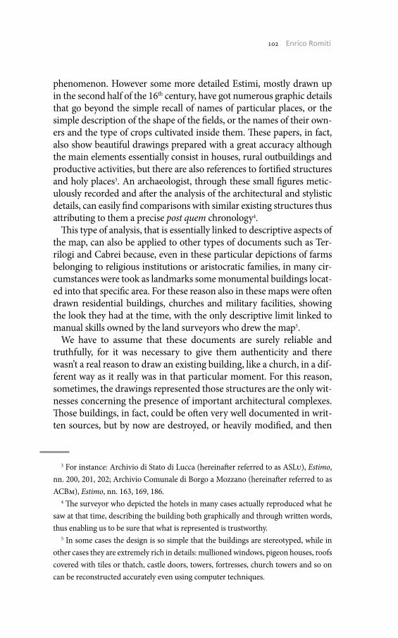
102 Umberto Sassoli102 Enrico Romiti
phenomenon. However some more detailed Estimi, mostly drawn up in the second half of the 16th century, have got numerous graphic details that go beyond the simple recall of names of particular places, or the simple description of the shape of the fields, or the names of their own-ers and the type of crops cultivated inside them. These papers, in fact, also show beautiful drawings prepared with a great accuracy although the main elements essentially consist in houses, rural outbuildings and productive activities, but there are also references to fortified structures and holy places3. An archaeologist, through these small figures metic-ulously recorded and after the analysis of the architectural and stylistic details, can easily find comparisons with similar existing structures thus attributing to them a precise post quem chronology4.
This type of analysis, that is essentially linked to descriptive aspects of the map, can also be applied to other types of documents such as Ter-rilogi and Cabrei because, even in these particular depictions of farms belonging to religious institutions or aristocratic families, in many cir-cumstances were took as landmarks some monumental buildings locat-ed into that specific area. For these reason also in these maps were often drawn residential buildings, churches and military facilities, showing the look they had at the time, with the only descriptive limit linked to manual skills owned by the land surveyors who drew the map5.
We have to assume that these documents are surely reliable and truthfully, for it was necessary to give them authenticity and there wasn’t a real reason to draw an existing building, like a church, in a dif-ferent way as it really was in that particular moment. For this reason, sometimes, the drawings represented those structures are the only wit-nesses concerning the presence of important architectural complexes. Those buildings, in fact, could be often very well documented in writ-ten sources, but by now are destroyed, or heavily modified, and then
3 For instance: Archivio di Stato di Lucca (hereinafter referred to as ASLu), Estimo, nn. 200, 201, 202; Archivio Comunale di Borgo a Mozzano (hereinafter referred to as ACBm), Estimo, nn. 163, 169, 186.
4 The surveyor who depicted the hotels in many cases actually reproduced what he saw at that time, describing the building both graphically and through written words, thus enabling us to be sure that what is represented is trustworthy.
5 In some cases the design is so simple that the buildings are stereotyped, while in other cases they are extremely rich in details: mullioned windows, pigeon houses, roofs covered with tiles or thatch, castle doors, towers, fortresses, church towers and so on can be reconstructed accurately even using computer techniques.
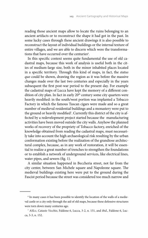
103 The Historical Cadaster of Tuscany and the CASTORE Project103 Ancient Cartography and Historical Maps
reading those ancient maps allow to locate the ruins belonging to an ancient artifacts or to reconstruct the shape it had got in the past. In some lucky cases through these ancient drawings it is also possible to reconstruct the layout of individual buildings or the internal texture of entire villages, and we are able to discern which were the transforma-tions that have occurred over the centuries6.
In this specific context seems quite fundamental the use of old ca-dastral maps, because this work of analysis is useful both in the cit-ies of medium-large size, both in the minor inhabited places located in a specific territory. Through this kind of maps, in fact, the status quo could be shown, drawing the region as it was before the massive changes made over the last two centuries and especially in the years subsequent the first post-war period to the present day. For example the cadastral maps of Lucca have kept the memory of a different con-dition of city plan. In fact in early 20th century some city quarters were heavily modified: in the south/west portion was implanted a Tobacco Factory in which the famous Tuscan cigars were made and so a great number of medieval residential buildings and a monastery were put to the ground or heavily modified7. Currently this district of the city is af-fected by a redevelopment project started because the manufacturing activities have been moved outside the city walls. Anyhow the planned works of recovery of the propriety of Tobacco factory, enriched of the knowledge obtained from reading the cadastral maps, must necessari-ly take into account the high archaeological risk resulting by the urban conformation existing before the realization of the grandiose architec-tural complex, because, as in any work of restoration, it will be essen-tial to realize a great number of trenches to strengthen the foundations or to establish a network of underground services, like electrical lines, water pipes, and sewers (fig. 1).
A similar situation happened in Beccheria street, not far from the city center, between San Michele square and Napoleone square. The medieval buildings existing here were put to the ground during the Fascist period because the street was considered too much narrow and
6 In many cases it has been possible to identify the location of the walls of a medie-val castle or a city only through the aid of old maps, because these defensive structures were torn down many centuries ago.
7 ASLu, Catasto Vecchio, Faldone 6, Lucca, 3-2, n. 151, and ibid., Faldone 6, Luc-ca, 3-3, n. 152.
104 Umberto Sassoli104 Enrico Romiti
1. Lucca (LU), the south-west portion of the city before the construction of the tobacco factory (1873). ASLU, Catasto Vecchio, Faldone 6, Lucca, 3-3, n. 152.
2. Lucca (LU), the area between Beccaria Street and San Giusto square in the 19th cen-tury (1873). ASLU, Catasto Vecchio, Faldone 6, Lucca, 3-2, n. 149.
105 The Historical Cadaster of Tuscany and the CASTORE Project105 Ancient Cartography and Historical Maps
there was a plan to build a larger and brighter structure8. After a single look to the cadastral maps it’s easy to understand how much this kind of work, called «Sventramento», has changed the shape of this side of Lucca, and at the same time could give us an useful indication in the moment it could be necessary to excavate in Beccaria street for realize underground services, because in that circumstance we are able to lo-cate exactly where are the foundations of destroyed buildings. It’s not a lucky case if every work concerning underground services located in this street systematically avoids the eastern side of the road because by knowing what was there, administrators decide to made excavations on the west side, avoiding to unearth walls and others archaeological ‘surprises’ that could slow down the works (fig. 2).
In Pisa the reading of city maps allows us to define what was the ur-ban setting, before the devastating changes made in the 20th century, in part due to the damages caused by the bombings in the Second World War, more often as a consequence of lack of particular attention by past administrators who did not have much regard for certain architectural antiques. This is the case of the city walls that are well preserved only in its north/east portion and this doesn’t happen because centuries and wars damaged them, but for the fact that they were demolished in or-der to eliminate an encumbrance that would slow the contacts between the old town, suburban areas and countryside. In other sides of the city, in fact, the medieval and renaissance walls exists only in some frag-mented portions, as if they were survived to a natural disaster9.
Kilometers of very strong walls located in the south portion of the city, with gates and towers, were then unfortunately and deliberately put to the ground shortly in 20th century, but in the cadastral maps they are represented with a detail that allows us to define with certainty the space occupied by the medieval city. Any archaeological excavations, therefore, whether realized for an emergency or planned, carried out in the city can take great advantage of the important aid offered by the historical cartography.
Even in small towns spread in the territory is possible to operate in the same way to obtain information that are not otherwise availa-ble. The study of the cartographic component, in fact, has allowed in several times to highlight the presence of fortified enclosures, tow-
8 Ibid., Faldone 6, Lucca, 3-2, n. 149.9 Archivio di Stato di Pisa (hereinafter referred to as ASPi), Catasto Terreni, Mappe,
Pisa, Allegati, 4-6.
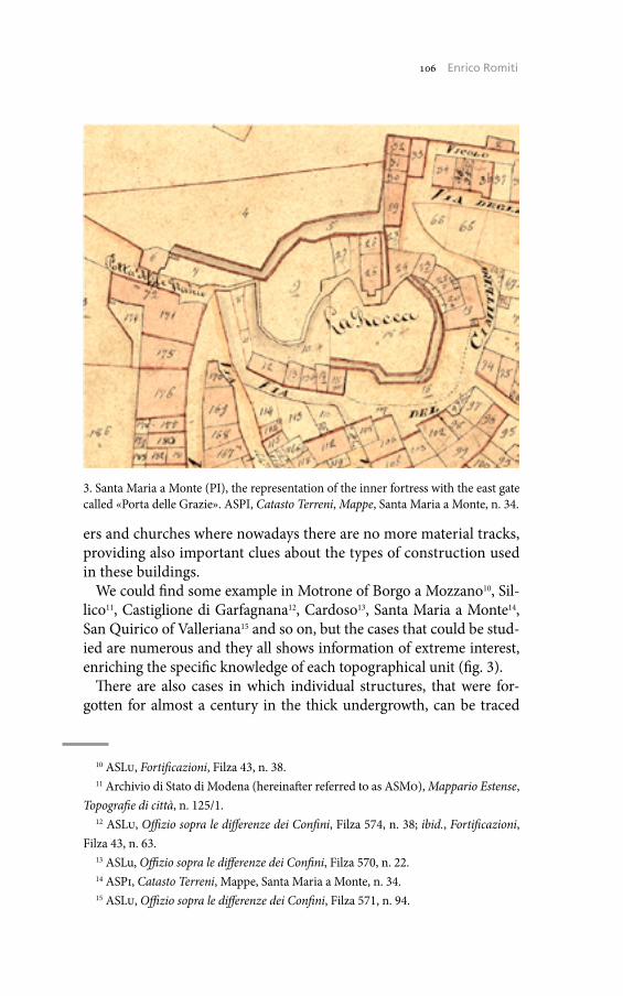
106 Umberto Sassoli106 Enrico Romiti
ers and churches where nowadays there are no more material tracks, providing also important clues about the types of construction used in these buildings.
We could find some example in Motrone of Borgo a Mozzano10, Sil-lico11, Castiglione di Garfagnana12, Cardoso13, Santa Maria a Monte14, San Quirico of Valleriana15 and so on, but the cases that could be stud-ied are numerous and they all shows information of extreme interest, enriching the specific knowledge of each topographical unit (fig. 3).
There are also cases in which individual structures, that were for-gotten for almost a century in the thick undergrowth, can be traced
10 ASLu, Fortificazioni, Filza 43, n. 38.11 Archivio di Stato di Modena (hereinafter referred to as ASMo), Mappario Estense,
Topografie di città, n. 125/1.12 ASLu, Offizio sopra le differenze dei Confini, Filza 574, n. 38; ibid., Fortificazioni,
Filza 43, n. 63.13 ASLu, Offizio sopra le differenze dei Confini, Filza 570, n. 22.14 ASPi, Catasto Terreni, Mappe, Santa Maria a Monte, n. 34.15 ASLu, Offizio sopra le differenze dei Confini, Filza 571, n. 94.
3. Santa Maria a Monte (PI), the representation of the inner fortress with the east gate called «Porta delle Grazie». ASPI, Catasto Terreni, Mappe, Santa Maria a Monte, n. 34.
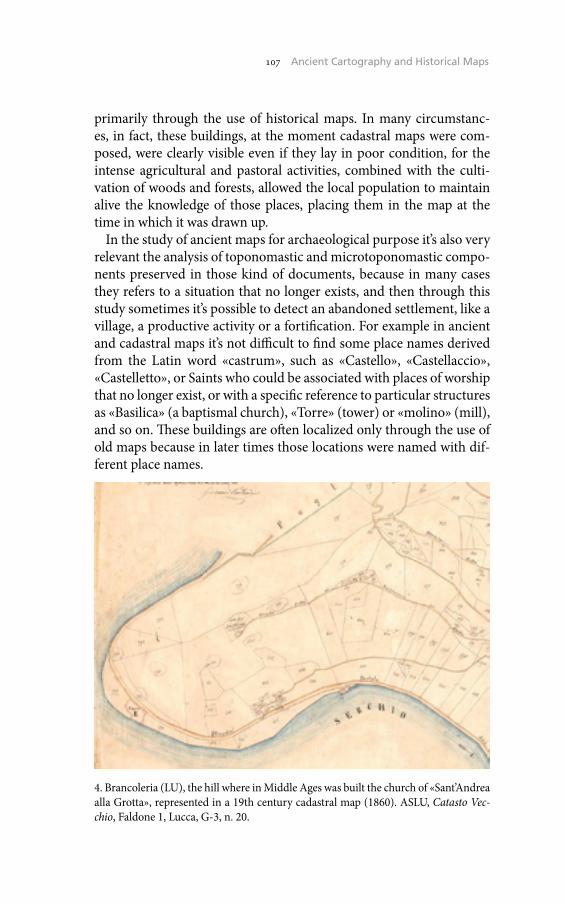
107 The Historical Cadaster of Tuscany and the CASTORE Project107 Ancient Cartography and Historical Maps
primarily through the use of historical maps. In many circumstanc-es, in fact, these buildings, at the moment cadastral maps were com-posed, were clearly visible even if they lay in poor condition, for the intense agricultural and pastoral activities, combined with the culti-vation of woods and forests, allowed the local population to maintain alive the knowledge of those places, placing them in the map at the time in which it was drawn up.
In the study of ancient maps for archaeological purpose it’s also very relevant the analysis of toponomastic and microtoponomastic compo-nents preserved in those kind of documents, because in many cases they refers to a situation that no longer exists, and then through this study sometimes it’s possible to detect an abandoned settlement, like a village, a productive activity or a fortification. For example in ancient and cadastral maps it’s not difficult to find some place names derived from the Latin word «castrum», such as «Castello», «Castellaccio», «Castelletto», or Saints who could be associated with places of worship that no longer exist, or with a specific reference to particular structures as «Basilica» (a baptismal church), «Torre» (tower) or «molino» (mill), and so on. These buildings are often localized only through the use of old maps because in later times those locations were named with dif-ferent place names.
4. Brancoleria (LU), the hill where in Middle Ages was built the church of «Sant’Andrea alla Grotta», represented in a 19th century cadastral map (1860). ASLU, Catasto Vec-chio, Faldone 1, Lucca, G-3, n. 20.
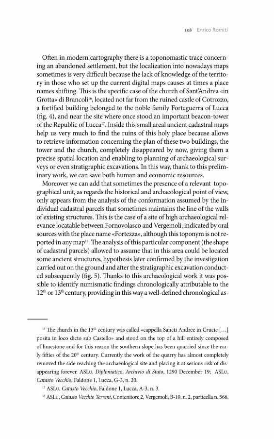
108 Umberto Sassoli108 Enrico Romiti
Often in modern cartography there is a toponomastic trace concern-ing an abandoned settlement, but the localization into nowadays maps sometimes is very difficult because the lack of knowledge of the territo-ry in those who set up the current digital maps causes at times a place names shifting. This is the specific case of the church of Sant’Andrea «in Grotta» di Brancoli16, located not far from the ruined castle of Cotrozzo, a fortified building belonged to the noble family Forteguerra of Lucca (fig. 4), and near the site where once stood an important beacon-tower of the Republic of Lucca17. Inside this small areal ancient cadastral maps help us very much to find the ruins of this holy place because allows to retrieve information concerning the plan of these two buildings, the tower and the church, completely disappeared by now, giving them a precise spatial location and enabling to planning of archaeological sur-veys or even stratigraphic excavations. In this way, thank to this prelim-inary work, we can save both human and economic resources.
Moreover we can add that sometimes the presence of a relevant topo-graphical unit, as regards the historical and archaeological point of view, only appears from the analysis of the conformation assumed by the in-dividual cadastral parcels that sometimes maintains the line of the walls of existing structures. This is the case of a site of high archaeological rel-evance locatable between Fornovolasco and Vergemoli, indicated by oral sources with the place name «Fortezza», although this toponym is not re-ported in any map18. The analysis of this particular component (the shape of cadastral parcels) allowed to assume that in this area could be located some ancient structures, hypothesis later confirmed by the investigation carried out on the ground and after the stratigraphic excavation conduct-ed subsequently (fig. 5). Thanks to this archaeological work it was pos-sible to identify numismatic findings chronologically attributable to the 12th or 13th century, providing in this way a well-defined chronological as-
16 The church in the 13th century was called «cappella Sancti Andree in Crucie […] posita in loco dicto sub Castello» and stood on the top of a hill entirely composed of limestone and for this reason the southern slope has been quarried since the ear-ly fifties of the 20th century. Currently the work of the quarry has almost completely removed the side reaching the archaeological site and placing it at serious risk of dis-appearing forever. ASLu, Diplomatico, Archivio di Stato, 1290 December 19; ASLu, Catasto Vecchio, Faldone 1, Lucca, G-3, n. 20.
17 ASLu, Catasto Vecchio, Faldone 1, Lucca, A-3, n. 3.18 ASLu, Catasto Vecchio Terreni, Contenitore 2, Vergemoli, B-10, n. 2, particella n. 566.
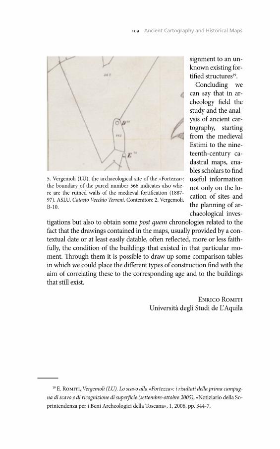
109 The Historical Cadaster of Tuscany and the CASTORE Project109 Ancient Cartography and Historical Maps
signment to an un-known existing for-tified structures19.
Concluding we can say that in ar-cheology field the study and the anal-ysis of ancient car-tography, starting from the medieval Estimi to the nine-teenth-century ca-dastral maps, ena-bles scholars to find useful information not only on the lo-cation of sites and the planning of ar-chaeological inves-
tigations but also to obtain some post quem chronologies related to the fact that the drawings contained in the maps, usually provided by a con-textual date or at least easily datable, often reflected, more or less faith-fully, the condition of the buildings that existed in that particular mo-ment. Through them it is possible to draw up some comparison tables in which we could place the different types of construction find with the aim of correlating these to the corresponding age and to the buildings that still exist.
Enrico RomitiUniversità degli Studi de L’Aquila
19 E. Romiti, Vergemoli (LU). Lo scavo alla «Fortezza»: i risultati della prima campag-na di scavo e di ricognizione di superficie (settembre-ottobre 2005), «Notiziario della So-printendenza per i Beni Archeologici della Toscana», 1, 2006, pp. 344-7.
5. Vergemoli (LU), the archaeological site of the «Fortezza»: the boundary of the parcel number 566 indicates also whe-re are the ruined walls of the medieval fortification (1887-97). ASLU, Catasto Vecchio Terreni, Contenitore 2, Vergemoli, B-10.


Landscape Archaeology and Historical Cartography: A Contribution to the Study of Ancient and Medieval Settlement in Canicattini Bagni (Syracuse)
The territory of Canicattini Bagni, 20 km west of Syracuse (Sicily), is located at the center of a wide hilly area, in the eastern border of the Hyblaean plateau, and occupies a dominant position in the Cavadonna river basin. This limestone area, between the Anapo river basin to the north and the Cassibile river basin to the south, identifies a large terri-torial district with a high geomorphological and cultural homogeneity.
Thanks to the most favorable conditions for human settlements (ease of defence, fertile lands, availability of water and raw materials in the typical natural canyons of the Hyblaean landscape), the area around Canicattini Bagni has been populated since the Upper Paleolithic1. The presence of several canyons and water springs, whose name in Arab lan-guage may have been the origin of the toponym «Canicattini» (Khandaq at-tin or Ayn at-tin)2, and its strategic position along the ancient main road connecting the city of Syracuse with its sub-colony of Akrai3, seem to be the main factors behind the high density of these ancient settle-ments, distributed according to an almost uniform and capillary pattern since the Greek period. The presence of rural communities, however, is particularly evident in the Late Antiquity and Medieval Age4.
1 S. Tusa, La Sicilia nella Preistoria, Palermo 1992, p. 75; R. Leighton, Sicily Before History, London 1999, p. 24; L. Guzzardi, L’uomo e le grotte nella Preistoria nella re-gione iblea, «Speleologia Iblea», 10, 2002, p. 294.
2 G. Caracausi, Arabismi medievali di Sicilia, Palermo 1983, pp. 247-8; V. Ficara, Genesi e sviluppo di una terra feudale del Netino: Canicattini Bagni, in F. Balsamo, V. La Rosa (edd.), Contributi alla geografia storica dell’agro netino, Atti delle Giornate di Studio (Noto, May 29-31, 1998), Noto 2001, p. 223, note 1.
3 R. Mirisola, L. Polacco, Contributi alla paleogeografia di Siracusa e del territo-rio siracusano (VIII-V sec. a.C.), «Memorie dell’Istituto Veneto di Scienze, Lettere ed Arti», 66, 1996, pp. 65-75; G. Uggeri, La viabilità della Sicilia in età romana, Galatina 2004, pp. 190-3.
4 L. Arcifa, Tra casale e feudo: dinamiche insediative nel territorio di Noto in ep-oca medievale, in Balsamo, La Rosa (edd.), Contributi alla geografia storica dell’agro
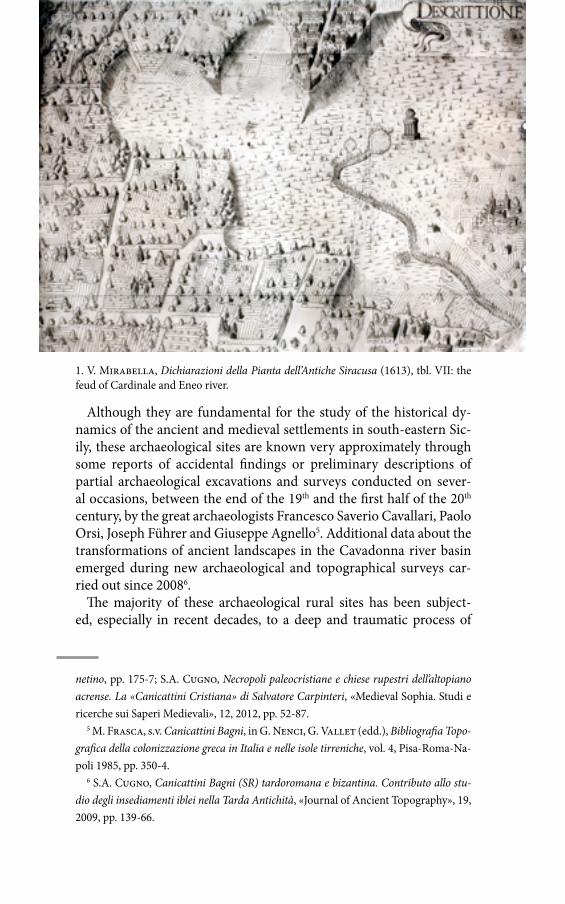
112 Umberto Sassoli112 Santino Alessandro Cugno
Although they are fundamental for the study of the historical dy-namics of the ancient and medieval settlements in south-eastern Sic-ily, these archaeological sites are known very approximately through some reports of accidental findings or preliminary descriptions of partial archaeological excavations and surveys conducted on sever-al occasions, between the end of the 19th and the first half of the 20th century, by the great archaeologists Francesco Saverio Cavallari, Paolo Orsi, Joseph Führer and Giuseppe Agnello5. Additional data about the transformations of ancient landscapes in the Cavadonna river basin emerged during new archaeological and topographical surveys car-ried out since 20086.
The majority of these archaeological rural sites has been subject-ed, especially in recent decades, to a deep and traumatic process of
netino, pp. 175-7; S.A. Cugno, Necropoli paleocristiane e chiese rupestri dell’altopiano acrense. La «Canicattini Cristiana» di Salvatore Carpinteri, «Medieval Sophia. Studi e ricerche sui Saperi Medievali», 12, 2012, pp. 52-87.
5 M. Frasca, s.v. Canicattini Bagni, in G. Nenci, G. Vallet (edd.), Bibliografia Topo-grafica della colonizzazione greca in Italia e nelle isole tirreniche, vol. 4, Pisa-Roma-Na-poli 1985, pp. 350-4.
6 S.A. Cugno, Canicattini Bagni (SR) tardoromana e bizantina. Contributo allo stu-dio degli insediamenti iblei nella Tarda Antichità, «Journal of Ancient Topography», 19, 2009, pp. 139-66.
1. V. Mirabella, Dichiarazioni della Pianta dell’Antiche Siracusa (1613), tbl. VII: the feud of Cardinale and Eneo river.

113 The Historical Cadaster of Tuscany and the CASTORE Project113 Landscape Archaeology and Historical Cartography
transformation caused by the growth of agriculture and the increase of modern buildings. For such reasons archival documents, local eru-dition, toponymy and historical cartography are a valuable aid to the archeological research, especially if the archeological finds early illus-trated or described no longer exist or were destroyed to a large extent. The contribution of the archival searches and studies, mainly antiquar-ians’ and travelers’ reports, medieval documents and historical cartog-raphy, is essential to fulfill the huge gaps in scientific knowledge about ancient population dynamics. Historical cartography, cadastral maps and documentation evidences will be used to elaborate a database of archival material regarding the antiquities of Canicattini Bagni and Ca-vadonna river basin.
The aim of this paper is to introduce some preliminary results of the multidisciplinary approach to the analysis of the archeological records in relation to the descriptions and drawings made in earlier centuries.
1. Historical cartography and ancient aqueducts
Old maps of Sicily, produced in Europe between the second half of the 16th and the late 18th century to guide foreign travelers during their Grand Tour in Mediterranean countries, and the odeporic literature provide important hints on local toponymy, ancient itineraries and material evidences of Greek civilization7. In particular, the works of some of the greatest Sicilian scholars and intellectuals have often de-scribed the existence of ancient channels and aqueducts near Canicat-tini Bagni, built in various periods and in different ways to channel the water from many local springs to Syracuse and the surrounding rural villages.
In the De rebus Siculis (1558) by Tommaso Fazello, the main starting point for any dissertation about the topography of ancient Sicily, we find the first detailed description ‒ deriving from direct observation or lost oral traditions ‒ of the impressive channels excavated into the rock for water canalization from the «fountains» of Cardinale and Cavadon-na rivers8. Also Vincenzo Mirabella Alagona (fig. 1), antiquarian and
7 L. Dufuor, A. La Gumina (edd.), Imago Siciliae. Cartografia storica della Sicil-ia, Catania 1998; F. Buscemi, Percorsi antichi e viaggiatori moderni attraverso gli Iblei. Note di topografia, in F. Buscemi, F. Tomasello (edd.), Paesaggi archeologici della Si-cilia sud-orientale. Il paesaggio di Rosolini, Palermo 2008, pp. 5-31.
8 T. Fazello, De Rebus Siculis decades duae, I, Panormi 1558, p. 94: «Hodie vero in
114 Umberto Sassoli114 Santino Alessandro Cugno
expert in the Greek and Latin sources about the network of ancient aq-ueducts that supplied Syracuse, attests the existence of a river flowing in the feud of Cardinale, belonging to the Lords of Erizzi and «nel fine di detto feudo in una gran valle sotto terra si nasconde, e perisce; e così ascoso per lo spazio di undici miglia camina, finché pervenuto vicino al mare tre miglia nella campagna di Siracusa di nuovo a noi risorge da questa voragine»; the abundant presence of water would have been the origin of the proliferation in this area of gardens and aristocratic villas since Greek-Hellenistic age9. The abbott Vito Maria Amico, in his criti-cal observations on the Fazello’s De rebus Siculis, notes that
novi nominis oppidula Balnea et Floridia, illud quidam in agro Candicattino anno MDCXXC ortum habuit, ac titulo Marchionatus insignitum ad Danie-les pertinet. Spectantur ibi veterum sepulcra, aliaque priscae aetatis vestigia et aquaeductus adhuc extat in saxo excisus, quae eodem in loco ex Syracusanis pagis aliquem stetisse olim satis innuunt10.
In the second half of the 19th century the ancient aqueducts of Car-dinale were the object of the rich technical documentation produced by the expert Salvatore Carpinteri Lombardo during the protracted legal dispute between the administrators of the Municipality of Ca-
agro Syracusano Cavae donnae 7 p.m. Sortinum versus, et Ricalcaci p.m. 6 ab urbe dis-tantes fontes sunt celebres. Cacyparis fluvii aquae ad agrum quod; Syracusanum, qui Gereates dicebatur, olim deducebantur, ut mirandis aquaeductibus in rupibus excisis simul et caementitiis hucusque; pro magna parte integris passim ante oculos cerni-mus. Sed etiam fluvii Cardinalis hodie appellati 18 p.m. ab urbe distantis, qui in valle Yhannicatini sarracenice dicta totus mire absorbetur, aquae in agros Syracusanos per quosdam ductus 12 p.m. in rupe excisos, et ponte etiam ad id extructo, quorum adhuc clarissima visuntur monumenta, antiquitus procurrebant».
9 V. Mirabella, Dichiarazioni della Pianta dell’antiche Siracuse, e d’alcune scelte Medaglie d’esse, e de’ Principi che quelle possedettero, Napoli 1613, pp. 104-5.
10 V.M. Amico, Criticis animadversionibus, Catanae 1749, p. 464, note 35. About the small town of Balnei, in the Noto’s territory, he wrote that «situs est amaenissimi in tumulo, nec insalubris aeris, vetustaeque habitationis reliquias circumquaque servat, cujus excidit memoria. […] Ager vini, olei, et frugum feracissimus est, aliisque ter-rae fructibus abundat; aquas e proximo Cardinali fundo uberrimas excipit, quae in profundam cryptam praecipites ruentes, omnino evanescunt, rursusque emergere cre-duntur in fontibus Pismae et Pismottae, feu Cyanes, unde flumen cognomine ortum ducit» (Id., Lexicon Topographicum Siculum, I, Panormi 1757, p. 75).
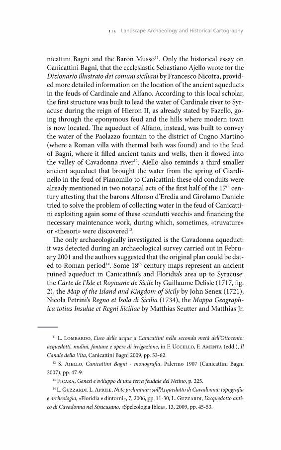
115 The Historical Cadaster of Tuscany and the CASTORE Project115 Landscape Archaeology and Historical Cartography
nicattini Bagni and the Baron Musso11. Only the historical essay on Canicattini Bagni, that the ecclesiastic Sebastiano Ajello wrote for the Dizionario illustrato dei comuni siciliani by Francesco Nicotra, provid-ed more detailed information on the location of the ancient aqueducts in the feuds of Cardinale and Alfano. According to this local scholar, the first structure was built to lead the water of Cardinale river to Syr-acuse during the reign of Hieron II, as already stated by Fazello, go-ing through the eponymous feud and the hills where modern town is now located. The aqueduct of Alfano, instead, was built to convey the water of the Paolazzo fountain to the district of Cugno Martino (where a Roman villa with thermal bath was found) and to the feud of Bagni, where it filled ancient tanks and wells, then it flowed into the valley of Cavadonna river12. Ajello also reminds a third smaller ancient aqueduct that brought the water from the spring of Giardi-nello in the feud of Pianomilo to Canicattini: these old conduits were already mentioned in two notarial acts of the first half of the 17th cen-tury attesting that the barons Alfonso d’Eredia and Girolamo Daniele tried to solve the problem of collecting water in the feud of Canicatti-ni exploiting again some of these «cundutti vecchi» and financing the necessary maintenance work, during which, sometimes, «truvature» or «thesori» were discovered13.
The only archaeologically investigated is the Cavadonna aqueduct: it was detected during an archaeological survey carried out in Febru-ary 2001 and the authors suggested that the original plan could be dat-ed to Roman period14. Some 18th century maps represent an ancient ruined aqueduct in Canicattini’s and Floridia’s area up to Syracuse: the Carte de l’Isle et Royaume de Sicile by Guillaume Delisle (1717, fig. 2), the Map of the Island and Kingdom of Sicily by John Senex (1721), Nicola Petrini’s Regno et Isola di Sicilia (1734), the Mappa Geograph-ica totius Insulae et Regni Siciliae by Matthias Seutter and Matthias Jr.
11 L. Lombardo, L’uso delle acque a Canicattini nella seconda metà dell’Ottocento: acquedotti, mulini, fontane e opere di irrigazione, in F. Uccello, F. Amenta (edd.), Il Canale della Vita, Canicattini Bagni 2009, pp. 53-62.
12 S. Ajello, Canicattini Bagni - monografia, Palermo 1907 (Canicattini Bagni 2007), pp. 47-9.
13 Ficara, Genesi e sviluppo di una terra feudale del Netino, p. 225.14 L. Guzzardi, L. Aprile, Note preliminari sull’Acquedotto di Cavadonna: topografia
e archeologia, «Floridia e dintorni», 7, 2006, pp. 11-30; L. Guzzardi, L’acquedotto anti-co di Cavadonna nel Siracusano, «Speleologia Iblea», 13, 2009, pp. 45-53.
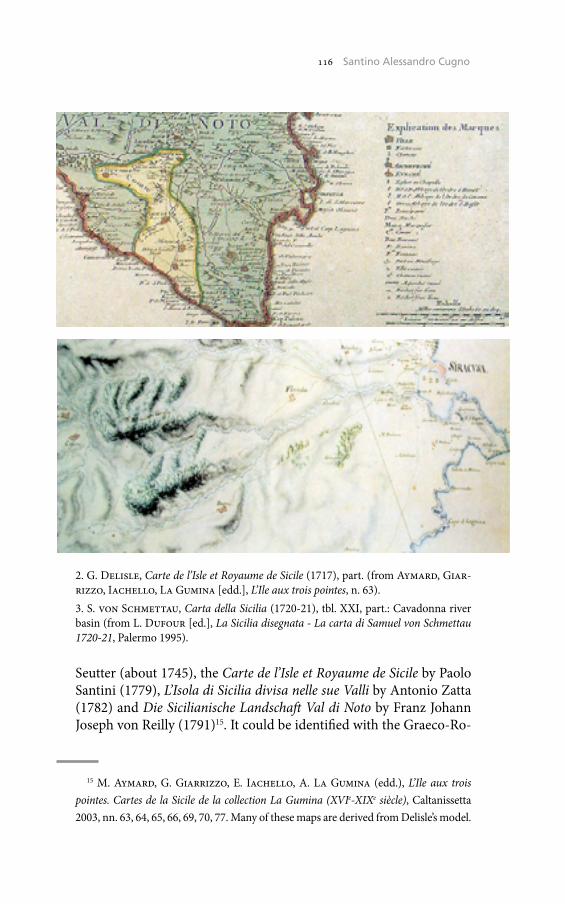
116 Umberto Sassoli116 Santino Alessandro Cugno
Seutter (about 1745), the Carte de l’Isle et Royaume de Sicile by Paolo Santini (1779), L’Isola di Sicilia divisa nelle sue Valli by Antonio Zatta (1782) and Die Sicilianische Landschaft Val di Noto by Franz Johann Joseph von Reilly (1791)15. It could be identified with the Graeco-Ro-
15 M. Aymard, G. Giarrizzo, E. Iachello, A. La Gumina (edd.), L’Ile aux trois pointes. Cartes de la Sicile de la collection La Gumina (XVIe-XIXe siècle), Caltanissetta 2003, nn. 63, 64, 65, 66, 69, 70, 77. Many of these maps are derived from Delisle’s model.
2. G. Delisle, Carte de l’Isle et Royaume de Sicile (1717), part. (from Aymard, Giar-rizzo, Iachello, La Gumina [edd.], L’Ile aux trois pointes, n. 63).3. S. von Schmettau, Carta della Sicilia (1720-21), tbl. XXI, part.: Cavadonna river basin (from L. Dufour [ed.], La Sicilia disegnata - La carta di Samuel von Schmettau 1720-21, Palermo 1995).
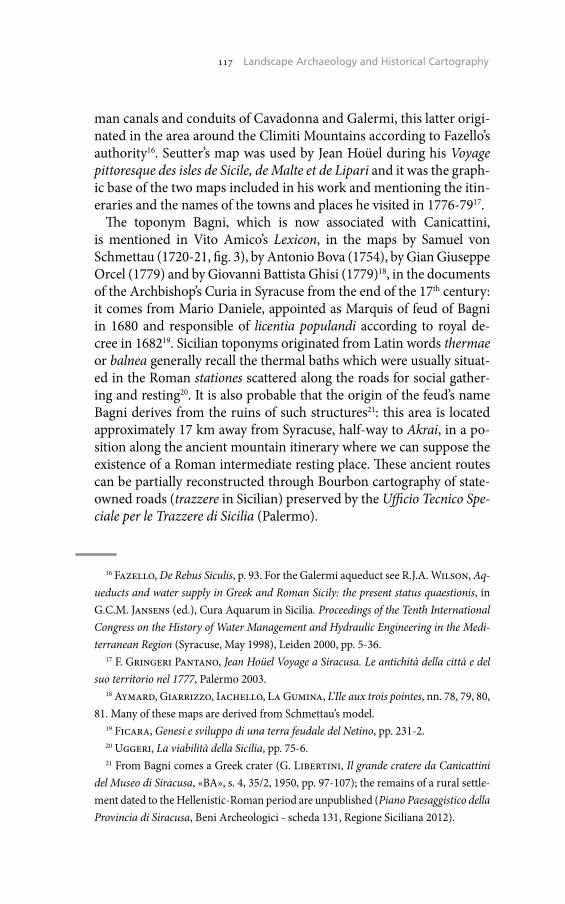
117 The Historical Cadaster of Tuscany and the CASTORE Project117 Landscape Archaeology and Historical Cartography
man canals and conduits of Cavadonna and Galermi, this latter origi-nated in the area around the Climiti Mountains according to Fazello’s authority16. Seutter’s map was used by Jean Hoüel during his Voyage pittoresque des isles de Sicile, de Malte et de Lipari and it was the graph-ic base of the two maps included in his work and mentioning the itin-eraries and the names of the towns and places he visited in 1776-7917.
The toponym Bagni, which is now associated with Canicattini, is mentioned in Vito Amico’s Lexicon, in the maps by Samuel von Schmettau (1720-21, fig. 3), by Antonio Bova (1754), by Gian Giuseppe Orcel (1779) and by Giovanni Battista Ghisi (1779)18, in the documents of the Archbishop’s Curia in Syracuse from the end of the 17th century: it comes from Mario Daniele, appointed as Marquis of feud of Bagni in 1680 and responsible of licentia populandi according to royal de-cree in 168219. Sicilian toponyms originated from Latin words thermae or balnea generally recall the thermal baths which were usually situat-ed in the Roman stationes scattered along the roads for social gather-ing and resting20. It is also probable that the origin of the feud’s name Bagni derives from the ruins of such structures21: this area is located approximately 17 km away from Syracuse, half-way to Akrai, in a po-sition along the ancient mountain itinerary where we can suppose the existence of a Roman intermediate resting place. These ancient routes can be partially reconstructed through Bourbon cartography of state-owned roads (trazzere in Sicilian) preserved by the Ufficio Tecnico Spe-ciale per le Trazzere di Sicilia (Palermo).
16 Fazello, De Rebus Siculis, p. 93. For the Galermi aqueduct see R.J.A. Wilson, Aq-ueducts and water supply in Greek and Roman Sicily: the present status quaestionis, in G.C.M. Jansens (ed.), Cura Aquarum in Sicilia. Proceedings of the Tenth International Congress on the History of Water Management and Hydraulic Engineering in the Medi-terranean Region (Syracuse, May 1998), Leiden 2000, pp. 5-36.
17 F. Gringeri Pantano, Jean Hoüel Voyage a Siracusa. Le antichità della città e del suo territorio nel 1777, Palermo 2003.
18 Aymard, Giarrizzo, Iachello, La Gumina, L’Ile aux trois pointes, nn. 78, 79, 80, 81. Many of these maps are derived from Schmettau’s model.
19 Ficara, Genesi e sviluppo di una terra feudale del Netino, pp. 231-2.20 Uggeri, La viabilità della Sicilia, pp. 75-6.21 From Bagni comes a Greek crater (G. Libertini, Il grande cratere da Canicattini
del Museo di Siracusa, «BA», s. 4, 35/2, 1950, pp. 97-107); the remains of a rural settle-ment dated to the Hellenistic-Roman period are unpublished (Piano Paesaggistico della Provincia di Siracusa, Beni Archeologici - scheda 131, Regione Siciliana 2012).
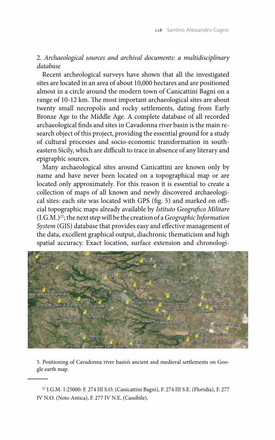
118 Umberto Sassoli118 Santino Alessandro Cugno
2. Archaeological sources and archival documents: a multidisciplinary database
Recent archeological surveys have shown that all the investigated sites are located in an area of about 10,000 hectares and are positioned almost in a circle around the modern town of Canicattini Bagni on a range of 10-12 km. The most important archaeological sites are about twenty small necropolis and rocky settlements, dating from Early Bronze Age to the Middle Age. A complete database of all recorded archaeological finds and sites in Cavadonna river basin is the main re-search object of this project, providing the essential ground for a study of cultural processes and socio-economic transformation in south-eastern Sicily, which are difficult to trace in absence of any literary and epigraphic sources.
Many archaeological sites around Canicattini are known only by name and have never been located on a topographical map or are located only approximately. For this reason it is essential to create a collection of maps of all known and newly discovered archaeologi-cal sites: each site was located with GPS (fig. 5) and marked on offi-cial topographic maps already available by Istituto Geografico Militare (I.G.M.)22; the next step will be the creation of a Geographic Information System (GIS) database that provides easy and effective management of the data, excellent graphical output, diachronic thematicism and high spatial accuracy. Exact location, surface extension and chronologi-
22 I.G.M. 1:25000: F. 274 III S.O. (Canicattini Bagni), F. 274 III S.E. (Floridia), F. 277 IV N.O. (Noto Antica), F. 277 IV N.E. (Cassibile).
5. Positioning of Cavadonna river basin’s ancient and medieval settlements on Goo-gle earth map.
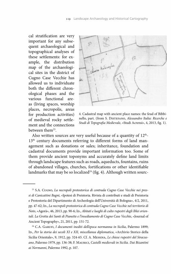
119 The Historical Cadaster of Tuscany and the CASTORE Project119 Landscape Archaeology and Historical Cartography
cal stratification are very important for any subse-quent archaeological and topographical analyses of these settlements: for ex-ample, the distribution map of the archaeologi-cal sites in the district of Cugno Case Vecchie has allowed us to individuate both the different chron-ological phases and the various functional are-as (living spaces, worship places, necropolis, areas for production activities) of medieval rocky settle-ment and the connections between them23.
Also written sources are very useful because of a quantity of 12th-13th century documents referring to different forms of land man-agement such as donations or sales; inheritance, foundation and cadastral documents provide important information too. Some of them provide ancient toponyms and accurately define land limits through landscape features such as roads, aqueducts, fountains, ruins of abandoned villages, churches, fortifications or other identifiable landmarks that may be so localized24 (fig. 4). Although written sourc-
23 S.A. Cugno, La necropoli protostorica di contrada Cugno Case Vecchie nei pres-si di Canicattini Bagni, «Ipotesi di Preistoria. Rivista di contributi e studi di Preistoria e Protostoria del Dipartimento di Archeologia dell’Università di Bologna», 4/2, 2011, pp. 47-62; Id., La necropoli protostorica di contrada Cugno Case Vecchie nel territorio di Noto, «Agorà», 46, 2013, pp. 90-6; Id., Abitati e luoghi di culto rupestri degli Iblei orien-tali. La Grotta dei Santi di Pianette e l’insediamento di Cugno Case Vecchie, «Journal of Ancient Topography», 21, 2011, pp. 151-72.
24 C.A. Garufi, I documenti inediti dell’epoca normanna in Sicilia, Palermo 1899; Id., Per la storia dei secoli XI e XII, miscellanea diplomatica, «Archivio Storico della Sicilia Orientale», 9, 1912, pp. 324-65. Cf. A. Messina, Le chiese rupestri del Siracus-ano, Palermo 1979, pp. 136-38; F. Maurici, Castelli medievali in Sicilia. Dai Bizantini ai Normanni, Palermo 1992, p. 107.
4. Cadastral map with ancient place names: the feud of Bibbi-nello, part. (from S. Distefano, Alessandro Italia: Ricerche e Studi di Topografia Medievale, «Studi Acrensi», 4, 2013, fig. 1).
120 Umberto Sassoli120 Santino Alessandro Cugno
es just provide post quem dates, they should be sufficient to obtain a chronological frame to include archaeological traces25.
The outcome will be an integrated database including exhaustive site documentation, records of all archaeological sites, photographic and graphic documentation, Digital terrain models (DTM) and aerial imag-es. The multidisciplinary analysis of settlement pattern in the Hyblaean landscape will allow to understand the historic evolution of the rural settlements in the Cavadonna river basin, in particular social, cultur-al and economic conditions underlying phenomena of continuity and displacement, abandonment and development.
Santino Alessandro CugnoUniversità di Firenze
25 Cf. H.A. Orengo, J.M. Palet Martínez, Methodological Insights into the Study of Centuriated Field Systems: A Landscape Archaeology Perspective, «Agri centuriati. An international journal of landscape archaeology», 6, 2009, p. 180.

‘Cadastral Records’ ante litteram? Suggestions from the Catalogus Baronum and the Confinationes of Southern Norman Italy Notarial Documents
If «cadastral maps and records of 18th-20th centuries were basic tools of con-trol over land use, proprietary rights and taxation», and «they are basic tools of historical research», it is true that «detailed and authentic information on the earlier state of the natural and built environment, on land ownership and on changes in land use» can also be provided through charters and documents that date back to the turn of the XI century, well before the modern age.These documents can be regarded as ‘cadastral maps’ ante litteram, especial-ly if we shift the focus from the document itself to the ‘function’ that this type of documentation held within the legal system that produces it. Whereas the forms adopted by the documentation change over time as expression of the ‘historical documentation system’, typical of a specific age and of a territory, the functions of the documents remain substantially unchanged over time, as they have to meet the same legal purposes.Since ancient times, the ‘cadastre’ has played a detection function of the ability of landholdings and real estates to produce income and it is through this ‘rep-resentation’ that the central authorities of any time have been able to ascertain and verify the taxable income and calculate what was due from owners and possessors. We want to highlight here how documents dating back to the first two centuries of the second millennium have performed the same ‘representa-tion function’ of the cadastral maps of the modern era, though in a completely different form, as part of a completely different system of legal documentation.In this context, documentation of the modern era and land censuses such as the Catalogus Baronum, produced in the Norman kingdom of Sicily between 1150 and 1168, that lists of all the vassals and their possessions in the main-land provinces of Ducatus Apuliae and principatus Capuae, and the confina-tiones expressed in private notarial documents of southern Norman Italy, could be regarded by the historians as integrative and ancillary ‘maps’, useful to reconstruct a ‘virtual cartography’ of the territory.
Se mappe e registri catastali dei secoli XVIII-XX, nati come stru-menti di controllo dell’utilizzo della terra e di ricognizione dei diritti dei proprietari, nonché come strumento per quantificare la tassazione cui sottoporre i patrimoni fondiari, sono per noi fonti storiche di pri-maria importanza sull’ambiente naturale, sulle sue modificazioni ad
122 Umberto Sassoli122 Paola Massa
opera dell’uomo e sulla distribuzione e gestione della proprietà terri-era, è anche vero che dettagliate informazioni su questi temi, magari espresse in una forma narrativa che poco assomiglia all’oggettività de-scrittiva di un catasto, possono essere ricavate anche da documentazi-one molto più antica: in quest’ottica, infatti, anche elenchi come ad es. il Catalogus Baronum per l’Italia meridionale del secolo XII o le confinationes delle carte notarili private potrebbero utilmente guidar-ci per identificare terre, case, chiese e coltivazioni che insistevano su determinati territori dell’Italia medievale.
In questo senso, sulla scorta della più recente letteratura diploma-tistica e in particolare delle ricerche di Giovanna Nicolaj sul rapporto tra funzioni del documento e forme da questo assunte in risposta alle mutevoli esigenze della società nel corso dei secoli1, appare opportuno riflettere sulla funzione o sulle funzioni assolte dalla documentazione originata da una rilevazione topografica dei terreni, accompagnata o meno da una rappresentazione grafica.
Nel nostro diritto positivo, sotto un profilo dinamico, il termine catasto individua «l’insieme delle operazioni che hanno lo scopo di stabilire la consistenza e la rendita dei beni immobili e i soggetti a cui appartengono al fine di determinare il valore dei beni stessi e la misu-ra dei tributi che sui medesimi andrà a gravare». Sotto un profilo sta-tico, invece, il catasto indica «l’insieme degli atti e registri nei quali vengono riportati i risultati delle citate operazioni e annotate le mod-ificazioni oggettive e soggettive dei beni immobili»2, affinché i registri risultino continuamente aggiornati. Il catasto ha pertanto una funzi-one ‘di rappresentazione’, una rappresentazione che però è ‘vincolata’ nei suoi scopi e nella sua struttura: sia che si tratti di catasti descritti-vi, che forniscano cioè soltanto dati e notizie relative alle singole pro-prietà, sia che si tratti di catasti geometrici, che forniscano cioè anche la rappresentazione grafica dei beni mediante le rilevazioni topogra-fiche, è infatti attraverso questa funzione di rilevamento che lo Stato è
1 G. Nicolaj, Lezioni di diplomatica generale, 1, Istituzioni, Roma 2007, p. 25 e, per una panoramica sulle funzioni della documentazione nell’ordinamento contem-poraneo, pp. 58-63.
2 M. Basilavecchia, Funzione impositiva e forme di tutela. Lezioni sul processo tributario, Torino 20132, pp. 333-4; cfr. anche A.M. Ratti, Catasto, in Enciclopedia Italiana di Scienze, Lettere ed Arti fondata da Giovanni Treccani, 9, Roma 1950, pp. 437-8; T. Rumboldt, Catasto (diritto attuale), in Enciclopedia del diritto, 6, Milano 1960, pp. 495-510: 495.
123 The Historical Cadaster of Tuscany and the CASTORE Project123 ‘Cadastral Records’ ante litteram?
in grado di procedere all’univoca individuazione del bene, di tenerne in conto le variazioni e di accertarne la rendita imponibile sulla quale calcolare le imposte.
È inoltre da sottolineare che il catasto in Italia non ha generalmente una funzione probatoria, in quanto non costituisce prova dei diritti reali in esso indicati (da provare con gli altri mezzi previsti dall’ordina-mento), né tantomeno della posizione dei confini rappresentati nelle mappe. Le risultanze catastali hanno quindi semplice valore indica-tivo e possono soltanto concorrere, con altri elementi, a dimostrare l’originario dominio quando questo sia controverso fra le parti di cui nessuna abbia titolo formale3. L’unico caso in cui il catasto fa prova di quanto in esso registrato è quello in cui insorgano contestazioni per la delimitazione di un confine incerto: al verificarsi di tale fattispecie, qualora non sia possibile ricorrere ad un «amichevole componimen-to»4, l’art. 950 del Codice civile dispone che «ogni mezzo di prova è ammesso [e che] in mancanza di altri elementi, il giudice si attiene al confine delineato dalle mappe catastali». Si comprende il senso della norma se si tiene conto del fatto che, per procedere alle misurazioni e alla successiva operazione di apposizione dei termini di confine, oggi è necessario l’intervento di funzionari pubblici, in grado pertanto di garantire l’autenticità della documentazione prodotta sulla base dei rilevamenti effettuati in situ. Possiamo allora parlare di una funzione ‘probatoria’ per così dire derivata, pure se limitata all’azione di rego-lamento dei confini, finalizzata a una sicura determinazione dell’es-tensione dei fondi e non all’accertamento della proprietà o di altro diritto reale.
Ma il compito del catasto non si esaurisce nelle operazioni di im-pianto dei relativi atti. Questi, una volta formati, fotografano la situ-azione esistente in un dato momento, ma la corrispondenza verrebbe meno se non si tenesse conto dei continui cambiamenti che si verif-icano nella persona dei possessori, nello stato e negli estimi dei ter-reni. Affinché il catasto risulti continuamente aggiornato occorre quindi introdurre negli atti, fin dalla loro formazione, le variazioni necessarie a porre in evidenza i cambiamenti, il che si ottiene attra-
3 A. Massarat, In materia di effetti giuridici del catasto, «Rivista di diritto agrario», 44/1, 1965, pp. 343-72: 348, 353-4 e passim.
4 Cfr. art. 6 della Legge Messedaglia del 1 marzo 1886, n. 3682, sul riordinamento dell’imposta fondiaria e istitutiva del Catasto dei Terreni.
124 Umberto Sassoli124 Paola Massa
verso verificazioni ordinarie e straordinarie5, nonché mediante le op-erazioni cosiddette di ‘conservazione’, cioè volture e note di variazione che vengono introdotte nei registri in seguito alla presentazione di una domanda da parte del cittadino direttamente agli organi del catasto, e cioè agli Uffici tecnici erariali. Si ottiene in tal modo il «duplice van-taggio dell’interpretazione certa della volontà dei contraenti da parte dei notai roganti o dei medesimi interessati e del contatto diretto degli stessi con gli Uffici»6.
Tutte queste operazioni si concretano nella produzione di una serie di documenti connessi strettamente tra loro: se il catasto ha una funzi-one di rilevamento di una situazione fattuale, in ogni scrittura che con-corre alla formazione definitiva del ‘libro’ del catasto si può rintracciare una funzione procedimentale in quanto ogni scrittura, inserita in un procedimento disciplinato dalla normativa, è vincolata a quella che la precede e costituisce il presupposto della successiva: ciascun elemento può essere pertanto sia singolo oggetto di studio, sia tassello di un mo-saico studiabile nella sua interezza.
Molti documenti di rilevazione topografica dei terreni prodotti dalle civiltà antiche possono leggersi in un’ottica molto vicina a quella che risponde alla nozione moderna di catasto. Sappiamo infatti che oper-azioni di delimitazione di confini e di valutazione economica dei ter-reni furono effettuate, fin dal terzo millennio a.C., in Egitto, a Babilonia, a Pylos nel Peloponneso. Pratiche simili furono note anche presso gli Etruschi, ma fu soltanto con gli agrimensori romani, dapprima sempl-ici cittadini e poi pubblici ufficiali, che le operazioni di misura e stima dei terreni assunsero un’importanza crescente: in epoca imperiale, sot-to Traiano, è infatti documentata l’esistenza di un vero e proprio catasto estimativo, fondato sulla tipologia delle colture denunciate dai privati7. Possono quindi considerarsi affini alle mappe catastali le formae region-is, redatte in seguito alla misurazione e delimitazione del terreno, con le due modalità della limitatio, cioè la delimitazione dei fondi e il con-
5 N. Caggia, Catasto, in Enciclopedia Italiana di Scienze, Lettere ed Arti fondata da Giovanni Treccani, App. 4, Roma 1978, pp. 387-90: 388.
6 Cfr. Relazione sui lavori svolti dall’Amministrazione del catasto e dei servizi tecnici erariali durante l’anno 1973, Ministero delle Finanze, Direzione generale del Catasto e dei Servizi tecnici erariali, Roma 1976.
7 Per un’organica e approfondita trattazione sull’argomento, cfr. S. Pugliatti, La trascrizione, 1/1, La pubblicità in generale, Milano 1957, rist. in Scritti giuridici, 3, 1947-1957, Milano 2010, pp. 1077-1666: 1122-221, con ampia bibliografia.
125 The Historical Cadaster of Tuscany and the CASTORE Project125 ‘Cadastral Records’ ante litteram?
seguente picchettamento attraverso dei limites, e della strigatio o scam-natio, che delimitava i fondi non attraverso dei cippi, bensì prendendo come confini le strade vicinali. La mappatura romana però, riportan-do solo le coordinate del fondo, la condizione dei terreni, la stesura in mappa dei rilievi e la valutazione fiscale, non tiene in realtà conto delle proprietà, così come non tiene conto né dei mutamenti né degli aggior-namenti, ma è una rappresentazione fissata nel tempo finalizzata all’as-segnazione delle terre, in particolare di quelle conquistate, mediante la suddivisione delle centurie in lotti rettangolari.
In ogni caso, la caduta dell’impero segnò il rapido scomparire di og-ni pratica agrimensoria. Regolari rilievi topografici e stime dei beni si ritroveranno solo nel XII secolo, in epoca comunale, quando le pro-fonde modificazioni economiche, amministrative, politiche e socia-li renderanno sempre più necessaria una riorganizzazione del sistema fiscale che troverà forma definitiva nei catasti di beni del XV secolo e che, a partire dal XVII secolo, culminerà nell’ampio lavoro di perfezi-onamento e riorganizzazione dei catasti che coinvolgerà tutti gli Stati italiani8. In particolare, per quanto riguarda l’Italia meridionale, Carlo III di Borbone ordinò l’attuazione di un catasto meramente descrittivo, entrato in vigore nel 1741. A prescindere da una valutazione sulla mag-giore o minore efficacia che ebbe questa manovra fiscale, è interessante rilevare che ogni cittadino era tenuto a dichiarare in una ‘rivela’ il pro-prio nome, quello della moglie, il numero dei figli, l’età, la professione o il mestiere esercitati, i debiti o i pesi, come i canoni e i censi dovuti, le doti da dare alle figlie, i beni posseduti, i confini, l’estensione e le ren-dite dei terreni. Al termine della raccolta delle rivele, che si configura-vano come vere e proprie ‘autocertificazioni’ e che venivano sostituite da valutazioni di estimatori in caso di mancata dichiarazione, veniva steso il libro del catasto, nel quale era riportato il calcolo della tassa a carico di ciascun nucleo familiare9.
Questa rapida panoramica lascia però in ombra i secoli che vanno dal-la caduta dell’impero romano all’età comunale. Cosa accadde nell’Italia meridionale in questo lungo periodo? Come nel resto d’Europa, anche
8 Ibid., pp. 1221-78; E. Cortese, Catasto (età medievale e moderna), in Enciclopedia del diritto, 6, Milano 1960, pp. 486-94.
9 L. del Pozzo, Cronaca civile e militare delle Due Sicilie sotto la dinastia borboni-ca dall’anno 1734 in poi, Napoli 1857, p. 40; N.F. Faraglia, La sala del catasto onciario nell’archivio di Stato di Napoli, «Napoli nobilissima», 7/5-6, 1898, pp. 65-7, 85-7: 65; G. Coniglio, I Borboni di Napoli, Milano 1981, p. 92.

126 Umberto Sassoli126 Paola Massa
qui l’organizzazione fiscale dell’impero si disgregò rapidamente, paral-lelamente al processo involutivo seguito dalle altre istituzioni romane. Possidenti e signori privati iniziarono ad esercitare prerogative e dirit-ti un tempo riservati al potere centrale e a tener nota in appositi libri delle corresponsioni e dei servizi dovuti dai loro sottoposti. È opinione comunemente accettata che questi elenchi, pur costituendone il pre-supposto storico, non possano però essere ricondotti ai catasti di età moderna, principalmente a causa del carattere privatistico delle com-pilazioni10, pure se fino al XII secolo non è poi così agevole distinguere tra sfera pubblica e sfera privata.
Nell’ambito del diritto privato si inquadrano certamente le confina-tiones, cioè le descrizioni confinarie espresse nelle carte notarili me-dievali che dispongono del trasferimento dei terreni e/o dei diritti accessori gravanti su di essi. Anche nel Medioevo, così come abbia-mo visto per l’età romana, necessaria premessa per l’identificazione dei fondi erano le operazioni di delimitazione e terminazione dei possedi-menti, pure se non abbiamo notizia di come queste si articolassero. Le carte riportano descrizioni estremamente particolareggiate, finalizzate a identificare con la massima precisione il bene oggetto del negozio: si precisano i confini delle terre, se ne danno a volte le misure, espresse nei modi più diversi in dipendenza dall’usus loci11, e si elencano le per-tinenze insieme ai quali il bene sarà trasferito, come per esempio la tip-ologia e il numero delle piante coltivate. Sembra difficile considerare la prolissità di confinationes e formule pertinenziali come una ‘ques-tione di stile’, spiegabile soltanto attraverso il perdurare di formulari documentari ripetitivi e legati alla tradizione. Le descrizioni dei con-fini sembrerebbero infatti funzionali anche all’individuazione dei dirit-ti reali su un determinato bene, che nel Medioevo potevano ricadere in capo a persone diverse e potevano avere diversa intensità: per esempio era possibile vendere una terra mantenendo servitù di passaggio per recarsi in altri fondi o senza comprendere nel trasferimento anche i di-ritti derivanti dallo sfruttamento di pozzi, fonti o corsi d’acqua.
10 Cortese, Catasto, p. 486.11 V. Matera, Minima diplomatica. Per l’edizione delle più antiche carte dell’abbazia
di Santa Sofia di Benevento (secoli VIII-XI), in Scrittura e produzione documentaria nel Mezzogiorno longobardo, Atti del Convegno internazionale di studio (Badia di Cava, 3-5 ottobre 1990), Badia di Cava 1991, pp. 383-98: 398, con indicazioni bibliografiche; Id., Una formula notarile d’area beneventana del secolo XI, «Nuovi Annali della Scuola Speciale per Archivisti e Bibliotecari», 11, 1997, pp. 71-7: 72.
127 The Historical Cadaster of Tuscany and the CASTORE Project127 ‘Cadastral Records’ ante litteram?
Emerge così dalle carte uno sforzo costante teso a mitigare quella es-trema incertezza dei confini che caratterizza il possesso della terra nel medioevo, sforzo che traspare dalla puntigliosa descrizione di una re-altà territoriale composta da segni artificiali, come strade, vie poderali o cippi, o da elementi naturali come corsi d’acqua, valli, strapiombi, bo-schi, monti, ecc. Ne deriva la demarcazione non casuale di uno ‘spazio’ che, pur manifestando evidenti caratteri di discontinuità e non line-arità, si materializza attraverso la scrittura, restituendo l’immagine di un patrimonio fondiario organizzato e delimitato, all’interno del quale i sovrani, le istituzioni laiche ed ecclesiastiche o i singoli individui po-tevano rivendicare non soltanto i propri diritti patrimoniali, ma anche un’identità territoriale che legittimasse pretese e prerogative di carat-tere politico e sociale12.
Nessuna meraviglia, quindi, se a partire dall’XI-XII secolo le carte private attestanti trasferimenti di beni, in origine custodite da privati e da piccole chiese e monasteri sparsi sul territorio, iniziarono a essere raccolte e conservate in archivi che oggi definiremmo ‘di concentrazi-one’, insieme agli altri munimina e iniziarono ad essere registrate e co-piate nelle cosiddette plátee e giaride su cui proprietari e possessori fondavano il loro dominio e organizzavano la gestione dei loro patri-moni13. Con questi termini si intendevano originariamente, nell’Italia meridionale normanna, gli elenchi dei servi e dei villani donati a is-tituzioni ecclesiastiche o a privati, con l’indicazione di quanto dovuto in denaro o in prestazioni lavorative, ma già nella seconda metà del XII secolo il termine plátea «assunse il significato di elenco di tutti i beni fondiari di un signore, di un monastero, di un ente ecclesiastico»14, reg-
12 «A territorial boundary may be the only symbolic form that combines a statement about direction in space and a statement about possession and exclusion», R.D. Sack, Human Territoriality. Its Theory and History, Cambridge 1986, pp. 21, 32.
13 V. von Falkenhausen, non rintracciando l’uso della parola plateia né nell’Italia me-ridionale prenormanna né nel resto dell’Impero d’Oriente, ha ipotizzato che non sia termine bizantino, ma piuttosto la traduzione della parola araba ğarida, coniata nell’am-biente grecofono della Sicilia orientale durante la dominazione araba, cfr. Id., L’inciden-za della conquista normanna sulla terminologia giuridica e agraria nell’Italia meridionale e in Sicilia, in V. Fumagalli, G. Rossetti (edd.), Medioevo rurale. Sulle tracce della civ-iltà contadina, Bologna 1980, pp. 221-45: 240-1; H. Enzensberger, Le cancellerie nor-manne: materiali per la storia della Sicilia musulmana, in Giornata di studio. Del nuovo sulla Sicilia musulmana, (Roma, 3 maggio 1993), Roma 1995, pp. 51-67: 62-6.
14 E. Cuozzo, Le istituzioni politico-amministrative legate alla conquista. Le ripar-
128 Umberto Sassoli128 Paola Massa
istrati a fini di «verifica catastale»15. Gli elenchi infatti erano di rego-la accompagnati dall’indicazione dei confini dei singoli appezzamenti, dei diritti, delle servitù, del valore delle proprietà e delle relative ren-dite, con lo scopo di definire l’assetto giuridico, economico e sociale di un preciso territorio. Salvatore Tramontana, in una sua indagine sul-la popolazione e sulla distribuzione delle terre voluta da Ruggero I di Sicilia, pur nella consapevolezza del lungo tempo necessario per pro-cedere a una ricostruzione cartografica attendibile sulla base delle de-scrizioni di beni immobili contenute nei documenti dell’epoca, per lo più privi «di misure laterali, di superfici e di confini precisi», riesce co-munque a «suggerire […] il panorama delle infeudazioni territoriali in Sicilia» attraverso l’analisi delle fonti coeve, in cui si accenna chiara-mente all’esistenza di elenchi di terre del re e dei suoi feudatari16.
tizioni territoriali: i comitati, in R. Licinio, F. Violante (edd.), I caratteri originari della conquista normanna. Diversità e identità nel Mezzogiorno (1030-1130), Atti del-le XVI giornate normanno-sveve (Bari, 5-8 ottobre 2004), Bari 2006, pp. 287-304: 300-1; cfr. anche S. Tramontana, Popolazione, distribuzione della terra e classi sociali nella Sicilia di Ruggero II il Granconte, in Ruggero il Gran Conte e l’inizio dello stato normanno, Relazioni e comunicazioni nelle Seconde Giornate normanno-sveve (Bari, maggio 1975), Roma 1977, pp. 213-70: 252, nota 152.
15 E. Mazzarese Fardella, Note sull’amministrazione normanna al tempo di Rug-gero II, in O. Zecchino (ed.), Alle origini del Costituzionalismo europeo. Le Assise di Ariano. 1140-1190, Bari-Roma 1996, pp. 115-25: 16 (Collana di Fonti e Studi, 1).
16 Cfr. Tramontana, Popolazione, distribuzione della terra e classi sociali, pp. 213-70: 215-6, note 12 e 13. In una postilla a un documento greco-arabo del 1095 e rela-tivo alla concessione di villani alla chiesa di Catania, si legge infatti: «Questa platea è scritta per ordine mio, conte Ruggero, […] mentre sono in Messina, ed è compi-lata sulle platee delle mie terre e di quelle dei terrarii (feudatari) redatte in Mazzara nel 1093», cfr. S. Cusa, I diplomi greci e arabi di Sicilia pubblicati nel testo originale, tradotti e illustrati, 1/1-2, I diplomi della chiesa di Catania, Palermo 1868-82, doc. 1, pp. 542-9: 548. L’esistenza di queste plátee è confermata anche da un altro diploma arabo-greco del 1145, in cui si confermano le suddette concessioni alla chiesa di Ca-tania, cfr. ibid., doc. 7, pp. 563-85. E a volte, pur non essendo specificati nei diplomi di concessione, gli esatti confini dei territori possono ricavarsi dalla documentazio-ne delle istituzioni ecclesiastiche, che si preoccupavano di descrivere minutamente i confini dei loro possedimenti sia a tutela dei loro diritti, sia in quanto richiesto a fini impositivi dall’autorità cui erano soggette, come nel caso del monastero di San-ta Maria la Nuova di Monreale, il cui inventario fu fatto compilare nel 1182 da Gu-glielmo II: ibid., doc. 4, pp. 179-244; C.A. Garufi, Catalogo illustrato del tabulario
129 The Historical Cadaster of Tuscany and the CASTORE Project129 ‘Cadastral Records’ ante litteram?
L’uso di redigere plátee è ampiamente documentato nel Meridione anche nei secoli successivi. Risale infatti al XIV secolo un manoscrit-to cartaceo un tempo conservato a Benevento, la cd. Plátea antiqua usque ad annum 1382, nella quale furono elencati i vasti possedimen-ti dell’Abbazia di Santa Sofia al fine di recuperare beni e diritti andati perduti per l’incuria dell’amministrazione17. Ne emerge la descrizione precisa e dettagliata del territorio: case, botteghe, orti, cascine, mulini, addirittura la menzione dei balconi sui quali era possibile stendere i panni. Si indica se le terre erano situate in pianura, in collina, in mon-tagna o in zone paludose; se erano floride e irrigate da canali o fiumi, se si trovavano in stato di abbandono, se erano incolte o sterili. Si delin-eano le tipologie di colture, le caratteristiche degli alvei e delle sponde dei fiumi, con la possibile presenza di arenari in periodi di siccità. E in-fine si illustrano le attività economiche della città e della sua periferia, tra le quali per es. la presenza di piscarie, perfino con l’elenco delle spe-cie di pesci che era possibile pescare. Certo, i monaci e i funzionari dell’Abbazia non disegnarono una mappa catastale e non procedette-ro ad alcun tipo di rappresentazione cartografica, ma soltanto a un’op-erazione di ricognizione e di registrazione dei possessi effettuata sulla base dei dati forniti dalla documentazione notarile raccolta e conserva-ta in archivio. Ma dalle risultanze dell’incrocio dei dati contenuti nel-le fonti di un’epoca così risalente potrebbe essere possibile ‘disegnare’ e ‘tratteggiare’ un territorio in modo estremamente dettagliato, pressoc-ché paragonabile a quello rappresentato nei cabrei di età moderna, con i quali sono evidenti analogie e similitudini: plátee e cabrei possono pertanto considerarsi, come un «prototipo di mappe catastali struttur-ate secondo i confini generali di una data circoscrizione territoriale»18, ‘disegno descrittivo’ le prime, ‘descrizione’ disegnata i secondi.
di Santa Maria Nuova in Monreale, Palermo 1902 (Documenti per servire alla storia di Sicilia, s. 1, 19).
17 Ce ne dà notizia A. Zazo, che ha potuto consultare la grande plátea trecentesca in-torno agli anni Cinquanta del Novecento presso l’Archivio Provinciale di Benevento, I beni della badia di S. Sofia in Benevento nel XIV secolo, «Samnium», 29/3, 1956, pp. 131-55: 131 e passim, pubblicata parzialmente in Id., Chiese feudi e possessi della badia be-nedettina di Santa Sofia di Benevento nel sec. XIV, «Samnium», 37, 1964, pp. 1-67: 63-7.
18 S. Falletta, Scrittura e memoria del confine. Considerazioni in margine al Rollum Bullarum di Monreale, «Mediterranea. Ricerche storiche», 7/18, 2010, pp. 31-54: 36 <https://www.academia.edu/2592083/Scrittura_e_memoria_del_confine._Considera-zioni_in_margine_al_Rollum_Bullarum_di_Monreale> (09/20/2014).
130 Umberto Sassoli130 Paola Massa
Attraverso la compilazione delle plátee si identificava anche il patri-monio appartenente al demanio regio o concesso a feudatari e baroni: ci spostiamo così nell’ambito della documentazione pubblica dell’I-talia meridionale, dove censimenti e verifiche venivano effettuati da-gli ufficiali dell’amministrazione del Regno normanno su mandato del sovrano19. È infatti testimoniata l’esistenza di quaterni, detti defetari, in cui si annotavano i confini e le pertinenze delle terre, l’elenco dei servi e dei villani, i servizi e le angarie cui questi erano soggetti, i passaggi di proprietà, nonché i documenti reali di concessione e investitura20. In tal modo l’amministrazione regia veniva a dotarsi di un ‘embriona-le strumento catastale’, tenuto costantemente aggiornato, da cui poter far discendere e con cui verificare non soltanto i diritti dei proprietari, ma anche i corrispondenti diritti del sovrano a riscuotere le imposte dovute21, come si legge in diversi documenti ove si fa riferimento ad
19 C.A. Garufi, I documenti inediti dell’epoca normanna in Sicilia, Palermo 1899, doc. n. 24 (Palermo, 1145), pp. 57-9; M. Caravale, Il Regno normanno di Sicilia, Mi-lano 1966, pp. 179-80; Mazzarese Fardella, Note sull’amministrazione, p. 19.
20 Sull’origine ancora non chiarita di questi registri, cfr. M. Amari, Storia dei Mu-sulmani di Sicilia, 3/1, Firenze 1868, pp. 321-4; L. Genuardi, I defetari normanni, in Scritti per il Centenario di Michele Amari, 1, Palermo 1910, pp. 159-64: 159 (rist. Pal-ermo 1990); F. Chalandon, Histoire de la domination normande en Italie et en Sicile, 2, Paris 1907, pp. 530-2 (rist. New York 1960 e 1969); E. Mazzarese Fardella, La struttura amministrativa del Regno Normanno, in Atti del Congresso Internazionale di Studi sulla Sicilia Normanna (Palermo, 4-8 dicembre 1972), Palermo 1973, pp. 213-24: 217; J. Johns, Duana regia: il contributo arabo all’organizzazione finanziaria ed amministrativa del regno di Sicilia, in C.D. Fonseca (ed.), Mezzogiorno - Federico II - Mezzogiorno, Atti del Convegno internazionale di Studio promosso dall’Istitu-to Internazionale di Studi Federiciani, Consiglio Nazionale delle Ricerche (Poten-za-Avigliano-Castel Lagopesole-Melfi, 18-23 ottobre 1994), 1, Roma 1999, pp. 513-35: 520-1, 35 e passim.
21 Chalandon, Histoire de la domination normande, pp. 530-1; Genuardi, I defetari normanni, pp. 160-2. Secondo G. Trovato in questi registri si annotavano i beni demani-ali e le loro modificazioni (cfr. Id., Sopravvivenze arabe in Sicilia: documenti arabo-sicu-li del periodo normanno. Luoghi, contrade, feudi, fonti e castelli siculi di origine araba. I comuni siciliani, con particolare riguardo a quelli di origine araba. I cognomi siciliani di origine araba, Monreale 1949, p. 3), e per A. De Simone vi si registravano i passaggi di proprietà derivanti da negozi traslativi e gli obblighi fiscali e di servizio dei proprietari terrieri verso la Curia (cfr. Id., I diplomi arabi di Sicilia, in Testimonianze degli arabi in Italia, Giornata di studio (Roma, 10 dicembre 1987), Roma 1988, pp. 57-75: 60).
131 The Historical Cadaster of Tuscany and the CASTORE Project131 ‘Cadastral Records’ ante litteram?
elenchi riguardanti concessioni di terre relative al nuovo assetto fon-diario del Meridione22.
E proprio sull’esempio dei defetari, se non sul ricordo di quello che è considerato il più antico catasto inglese, il Domesday Book23, po-trebbe essere stato compilato, all’indomani della conquista del Sud d’Italia, il Catalogus Baronum, la lista cioè dei vassalli del re e dei loro possedimenti nei territori del ducatus Apuliae e del principatus Capuae, la cui edizione è stata curata da Evelyn Jamison24. Il Catalo-gus, una delle fonti di maggior rilievo per la conoscenza della storia dell’Italia continentale normanna nella metà del XII secolo, risponde perfettamente alla necessità del sovrano normanno a esercitare uno stretto controllo sulla periferia del Regno attraverso una attenta vigi-lanza sull’operato dei baroni che governavano la maggior parte delle terre e degli abitanti, facendo tuttavia attenzione ad assicurarsi il loro sostegno e la loro fedeltà25. Non si trattava soltanto di un «mere reg-
22 Cfr. C.A. Garufi, Censimento e catasto della popolazione servile. Nuovi studi e ricerce sull’ordinamento amministrativo dei Normanni in Sicilia nei secoli XI e XII, «Ar-chivio Storico Siciliano», n.s., 49, 1928, pp. 1-100: 7-21; secondo Chalandon, invece, in questi registri erano annotati soltanto i servizi dovuti dai villani e non anche quel-li che ricadevano in capo ai vassalli, cfr. Chalandon, Histoire de la domination nor-mande, p. 649, nota 2.
23 S.K. Mitchell, Taxation in Medieval England, New Haven 1951 (Yale Historical Publications. Studies, 15), pp. 156, 236.
24 L’unico manoscritto del testo (Napoli, Reg. Ang. 242, ff. 13r-63r) è andato perdu-to insieme alla più antica e preziosa documentazione dell’Archivio di Stato di Napoli, bruciata dai tedeschi il 30 settembre 1943 nella Villa Montesano presso S. Paolo Belsito. L’edizione è stata pubblicata nel 1972 e condotta sulla base di un’unica copia angioina, andata distrutta nel 1943, a sua volta derivante da una copia sveva. Il quaternus origi-nale di epoca normanna fu iniziato nel 1150, durante il regno di Ruggero II, aggiornato nel 1167 e revisionato per l’ultima volta probabilmente nella primavera del 1168, all’ep-oca della reggenza della regina Margherita di Navarra (1166-71), moglie di Guglielmo I d’Altavilla. Nella revisione del 1168 furono introdotti per la prima volta dei titoli a in-dicare le contee, sostituendo il riferimento istituzionale al comitatus a quello personale al comes, a significare in tal modo la crescente importanza della stima del bene indip-endentemente dal suo proprietario o possessore, cfr. E. Jamison (ed.), Catalogus Baro-num, Romae 1972 (Fonti per la storia d’Italia, 101*), pp. XV-XXII.
25 H. Takayama, The Administration of the Norman Kingdom of Sicily, Leiden-New York-Köln 1993, p. 165; Id., The Administrative Organization of the Norman King-dom of Sicily, in Fonseca (ed.), Mezzogiorno - Federico II - Mezzogiorno, 1, pp. 61-78
132 Umberto Sassoli132 Paola Massa
ister of feudal military service», ma «it was concerned with the tradi-tional obligation incumbent on all freemen of fighting age to come to their country’s aid in any emergency» e il suo scopo essenziale «was to supply a permanent record of official use of the levy over the years 1150 to 1168 of the magna expeditio, otherwise described in the reg-num as the levy nomine proelii or the adjuvamen regni». Inoltre, poi-ché «practical expediency required that the amount and quality of the service should be geared to a man’s material resources», nel Catalogus furono raccolte informazioni dettagliate sui possedimenti dei baroni, dei feudatari e dei loro vassalli, nonché su servi e villani di cui que-sti disponevano, al fine di quantificare esattamente l’entità delle forze in armi e l’esatto numero dei militi che i baroni erano tenuti a forni-re al re per la costruzione di «a royal force […] controlled by royal officials»26.
Le informazioni biografiche e storiche dei personaggi del Catalo-gus sono state in seguito raccolte da Errico Cuozzo in un Commen-tario27: disponiamo così oggi di un’importante ricerca prosopografica che al nome del personaggio affianca le informazioni relative all’origi-ne del possesso e quelle relative al dominus, re o altro feudatario, nei confronti del quale è dovuto il servizio militare, al nome della terra o delle terre su cui esercita la sua signoria, nonché alla famiglia e alle parentele del personaggio. Ciò che è rilevante, e ancor di più in questa sede, è che tali informazioni sono desunte dalle fonti di XII secolo, di ognuna delle quali è indicata data e provenienza.
Per concludere, nel tentativo di individuare quel ‘vincolo naturale’ che lega indissolubilmente passato e presente, torniamo a concentra-re l’attenzione sulla funzione giuridica della documentazione: a cosa servono registrazioni e mappe catastali? Qual è la funzione che svolge questo tipo di documentazione all’interno dell’ordinamento giuridico che la produce? E che forma assume il ‘contenitore’ documentario che ne veicola lo scopo giuridico?
(trad. it. L’organizzazione amministrativa del regno normanno di Sicilia, in E. Cuozzo [ed.], Studi in onore di Salvatore Tramontana, Pratola Serra 2003, pp. 415-29, <http://www.l.u-tokyo.ac.jp/~tkymh/24-Ad.org.talian-rev.pdf> [09/20/2014]); G.A. Loud, La Campania in età normanna, in Fonseca (ed.), Mezzogiorno - Federico II - Mezzogior-no, 1, pp. 253-72: 262, 266 e passim.
26 Jamison (ed.), Catalogus Baronum, pp. XX-XXI.27 E. Cuozzo, Catalogus Baronum. Commentario, Roma 1984 (Fonti per la storia
d’Italia, 101**), pp. X-XV.
133 The Historical Cadaster of Tuscany and the CASTORE Project133 ‘Cadastral Records’ ante litteram?
Abbiamo detto che il catasto italiano ha la funzione di rilevare fatti e situazioni per il perseguimento di fini fiscali e tributari: nulla di così di-verso quindi dai censimenti e dai catasti medievali italiani, la cui evo-luzione storica pare rispondere unicamente a finalità fiscali28. In talune città poi, come a Perugia nel Duecento, i risultati della rilevazione di immobili venivano trascritti anche nei Libri delle misure, che, redatti in occasione dei trasferimenti di proprietà, davano la garanzia notarile alla misurazione del bene (non alla sua valutazione economica)29. Allo stes-so modo, secondo quanto previsto dal nostro ordinamento, i funzionari pubblici che procedono all’apposizione dei termini di confine sono ga-ranti dell’esattezza delle misurazioni dei terreni.
Nel nostro ordinamento il catasto assume quella che abbiamo defini-to come funzione probatoria ‘derivata’ nel caso di controversie insorte per la delimitazione di un confine incerto: in questo caso il giudice, in mancanza di altri elementi di prova, deve attenersi al confine delineato dalle mappe. E nel Medioevo? Potevano le descrizioni dei confini costi-tuire prova dell’estensione della terra? Così come le dichiarazioni di età moderna e contemporanea, anche le confinationes contenute nelle carte medievali raccontano una ‘verità’ fattuale, fissata per iscritto su una per-gamena a tutela e garanzia dei diritti e degli obblighi del destinatario e dell’autore dell’atto e come tali non possedevano in sé alcuna funzione probatoria, se non quella normalmente assunta con il tempo da tutta la documentazione di carattere giuridico. Tuttavia, in caso di contestazio-ne dei confini, questa verità avrebbe potuto essere all’occorrenza testi-moniata in processo, trasformando così il documento che la conteneva in un potenziale mezzo di prova, finalizzato alla esatta determinazione dell’estensione dei fondi e non all’accertamento della proprietà o di altro diritto reale su un fondo.
Infine, che funzione aveva il Catalogus Baronum? Non è forse anch’es-so l’esposizione di una situazione fattuale, accertata da un’autorità pubbli-ca, sulla base della quale fissare l’entità del quantum dovuto dai feudatari normanni per la creazione di un contingente armato al servizio del re? Certo, non si tratta della rappresentazione grafica in scala di un territorio e non abbiamo notizia di verbali o mappe redatti da mensuratores o agri-
28 Cortese, Catasto, p. 494.29 «due boni homines divites et legales cum uno notario [...] dovevano ricevere le asse-
gnazioni o denunzie dei cittadini perugini pro libra facienda», cfr. G. Mira, I catasti e gli estimi perugini del XIII secolo, e Id., I catasti perugini del XIV e XV secolo, «Economia e storia», 2/1-2, 1955, rispettivamente pp. 76-84: 79 e 171-204: 181.
134 Umberto Sassoli134 Paola Massa
mensores, ma è anche vero che sarebbe stato impensabile il contrario, in quanto il Catalogus è figlio del proprio tempo e delle vicende proprie di un particolare territorio. E se anche qui spostiamo il punto di vista dal-la ‘forma’ che il documento assume all’interno del sistema documenta-rio che lo ha prodotto, alla ‘funzione’ documentaria, anche il Catalogus potrebbe essere letto come una ‘mappa’, in cui sono stati ‘disegnati’ i beni immobili, le terre e i feudi, il nome dei possessori e le rendite.
L’attenzione alla cartografia, la tendenza alla raffigurazione scientifica del paesaggio e la nascita dei catasti geometrici quali strumenti precisi di misurazione e rilevazione del territorio sono, come s’è visto, fenome-ni di età moderna. Il sistema di descrizione medievale dello spazio sug-gerisce invece un’elaborazione lontana, se non estranea, «dalla nozione univoca di estensione materiale, omogenea e misurabile, cui la civiltà occidentale contemporanea riconduce lo spazio e i suoi limiti»30: ne è paradigma la Tabula Peutingeriana, che lungi dall’offrire una ‘cartogra-fia’ delle vie militari dell’Impero romano, delle città e delle stazioni di posta, ne dava invece una rappresentazione simbolica, comunque con-sentendo ai viaggiatori di conoscere i percorsi e le distanze fra le tappe. Ma una rappresentazione simbolica non avrebbe potuto assolvere alle necessità di certezza – per quanto questo termine possa essere riferito all’età medievale – della società normanna di XI e XII secolo, che sceglie invece, come sempre si era fatto, di descrivere fondi, terre, feudi e confi-ni in ‘mappe verbali’, rappresentative di un contesto territoriale, ambien-tale e socio-economico di grande complessità e di eccezionale interesse.
Pertanto, al fine di ricostruire una ‘cartografia virtuale’ del territorio in età moderna, potrebbero utilizzarsi anche quelle informazioni contenu-te nella documentazione medievale che a tutt’oggi rimangono una delle fonti meno sfruttate e consultate, come lamentava già nel 1943 Giovan-ni Italo Cassandro, storico del diritto, giudice della Corte Costituziona-le e uomo politico della seconda metà del XX secolo 31. I dati contenuti nelle confinationes, nelle plátee e nei censimenti ed elenchi come il Ca-
30 Falletta, Scrittura e memoria del confine, p. 31. Circa la rappresentazione dello spazio e del paesaggio nel medioevo, cfr. A. Guerreau, Il significato dei luoghi nell’Oc-cidente medioevale: struttura e dinamica di uno spazio specifico, in E. Castelnuovo, G. Sergi (edd.), Arti e storia nel medioevo. Tempi, spazi e istituzioni, 1, Torino 2002, pp. 201-39; G. Chouquer (ed.), Les formes du paysage, 3 voll., Paris 1996; Id., L’étude des paysages. Essais sur leurs formes et leur histoire, Paris 2000.
31 G.I. Cassandro, Storia delle terre comuni e degli usi civici nell’Italia meridionale, Bari 1943, p. 8.
135 The Historical Cadaster of Tuscany and the CASTORE Project135 ‘Cadastral Records’ ante litteram?
talogus Baronum potrebbero infatti essere interpretabili come elementi di mappe e registrazioni catastali, sia pure ante litteram, da cui ricavare una vera e propria griglia di lettura di limitati spazi geografici, partendo dalla quale si potrebbe pazientemente tentare la ricostruzione cartogra-fica di ambiti territoriali più ampi.
Paola MassaUniversità di Roma La Sapienza

Sources for Knowing the Territory: The Terrilogi of the Historical Diocesan Archives of Lucca
With the term «terrilogio» we mean a collection of news and infor-mation concerning the territory including land properties and every kind of buildings and constructions present in the piece of ground considered. All this in order to get precise and detailed descriptions with extension, location and value of the property itself. The «terrilo-gi» (a term widely used and prevailing in common language all during the 18th century), also called «martilogi» (this name prevailed until the last decade of the 17th century), usually appear as records with the function of listing lands and their real estate referring to public or pri-vate properties. They can have inserted also graphical representations, plans or a prospectus of the territorial asset.
In Italian, the term «terrilogio» refers immediately to the element «terra» (land) and it contains also the Greek term «logos» (meaning: word, speech and, in general, a way for describing something). A reg-ister of «terrilogio» presents a more detailed and precise description of properties and status of land.
These registers, which in Italy and in other countries are called «cabrei» or «platee», were commissioned by noble families, eccle-siastical institutions, or public institutions such as municipalities. The experts required for this work were called «Agrimensori» (Land Surveyors) and «Geometri» (technicians), who had the task of ac-curately detecting the borders of each property and their extension. The importance of this type of documentary is also demonstrated by the presence of numerous treatises on the proper compilation of the registers, for example the Francesco Antonio Filonzi’s book (1775), in which there is a section devoted just to «Pratica per formare un cabreo» (practice to form a cabreo)1.
Lucca has had a role of great importance in the creation of this par-ticular type of documents. The iconography of books for estate in
1 F.A. Filonzi, Pratiche matematiche divise in tre trattati, 2, Ancona 1775, pp. 169-72.
138 Umberto Sassoli138 Tommaso Maria Rossi
Tuscany, with the representation of the real estate planning, axono-metric from above, is due to Lucca’s way for compilating martilogi and terrilogi2.
The big terrilogi differ from state registers consequently to the cli-ents commissioning the work: they could be private persons or also ecclesiastical institutions. In Lucca’s terrilogi it is possible to identify the basic types of historical iconography of the city3:• perspective view (a view above);• isometric view, orthogonal and oblique, drawn on topographic
baste (plant);• profile (orthographic projection);• plant, or map.
The first studies on the iconography in Lucca are those of Luigi Mat-teucci who, in 1913, made a preliminary study of cartographic doc-uments preserved at the State Library of Lucca4. In 1980, Isa Belli Barsali oversaw an interesting publication on the iconography of the city of Lucca in the 16th century. Starting from there some scholars have focused on religious buildings and socio-political situation of the city5. There was a change in the iconography of Lucca due to the weak and complex balance of civic power and religious power. Only with-in the city walls there were more than twenty religious institutions of some power and prestige. Religious power always had collided in Luc-ca against the civic magistrates’ power, in spite of the representatives of the noble families of the city who were part in the one power (reli-gious power) and in the other (civic power). There were considerable variations in the relations between the two powers often correspond-
2 G. Bedini, G. Fanelli, Lucca. Iconografia della città, Lucca 1998, 1, p. 13; B. Romi-ti, La cartografia cabreistica lucchese e il cabreo ottocentesco della famiglia Bottini, «L’U-niverso», 77, 1997, pp. 548-66.
3 Bedini, Fanelli, Lucca. Iconografia della città, 1, p. 9.4 L. Matteucci, Saggio di cartografia lucchese, «Rivista delle Biblioteche e degli Ar-
chivi», June-September 1913, pp. 102-10.5 G. Citti, G. Pacini, L’edilizia religiosa. L’assistenza: Compagnie, Confraternite, Spe-
dali, in I. Belli Barsali (ed.), I palazzi dei mercanti nella libera Lucca del ’500. Imma-gine di una città-stato al tempo dei Medici, Lucca 1980, pp. 279-311; I. Belli Barsali, Ville e committenti dello Stato di Lucca, Lucca 2000; V. Cappellini, T.M. Rossi, G.E. Unfer Verre (edd.), Disegnare Lucca. Terrilogi di chiese e monasteri nell’Archivio Sto-rico Diocesano (secoli XVI-XVIII), Lucca 2014.
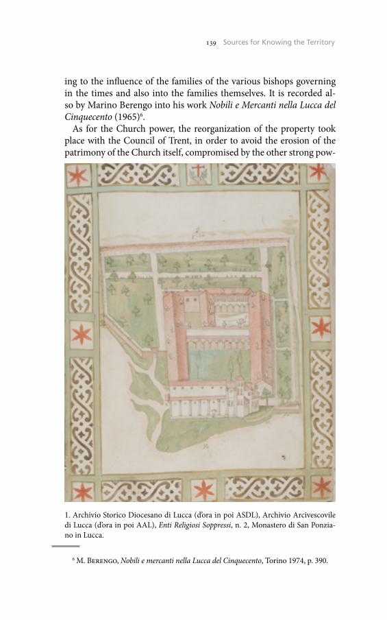
139 The Historical Cadaster of Tuscany and the CASTORE Project139 Sources for Knowing the Territory
ing to the influence of the families of the various bishops governing in the times and also into the families themselves. It is recorded al-so by Marino Berengo into his work Nobili e Mercanti nella Lucca del Cinquecento (1965)6.
As for the Church power, the reorganization of the property took place with the Council of Trent, in order to avoid the erosion of the patrimony of the Church itself, compromised by the other strong pow-
6 M. Berengo, Nobili e mercanti nella Lucca del Cinquecento, Torino 1974, p. 390.
1. Archivio Storico Diocesano di Lucca (d’ora in poi ASDL), Archivio Arcivescovile di Lucca (d’ora in poi AAL), Enti Religiosi Soppressi, n. 2, Monastero di San Ponzia-no in Lucca.
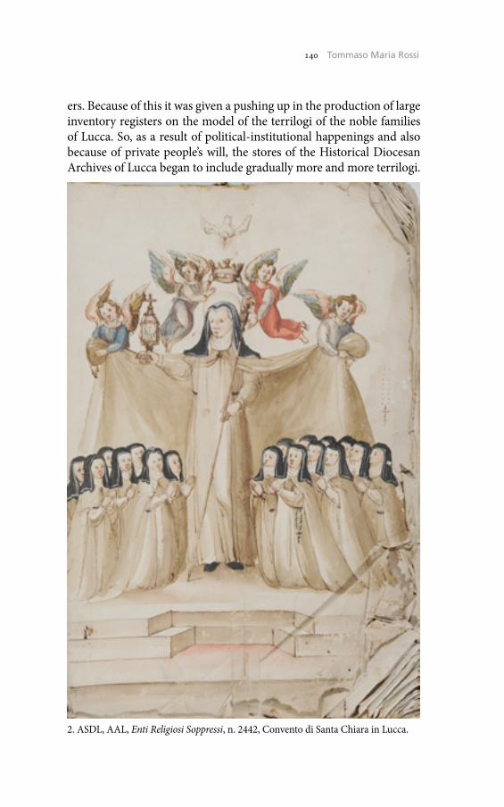
140 Umberto Sassoli140 Tommaso Maria Rossi
ers. Because of this it was given a pushing up in the production of large inventory registers on the model of the terrilogi of the noble families of Lucca. So, as a result of political-institutional happenings and also because of private people’s will, the stores of the Historical Diocesan Archives of Lucca began to include gradually more and more terrilogi.
2. ASDL, AAL, Enti Religiosi Soppressi, n. 2442, Convento di Santa Chiara in Lucca.
141 The Historical Cadaster of Tuscany and the CASTORE Project141 Sources for Knowing the Territory
Lucca’s Bishops’ Archives, famous throughout the world for its pre-cious diplomatic fund, recently included in the UNESCO Memory of the World Register7, preserves about over 750 registers relating to the goods and estates of the Church. The funds of the Mensa Arcivescovile, of the Operaro Maggiore, of the Enti Religiosi Soppressi are rich in ter-rilogi and inventories of properties, but it is into the series named Am-ministrazione delle Parrocchie that we will keep the whole subseries of Terrilogi belonging to the parishes in the diocese of Lucca. The numer-ous archival units produced by the Curia of Lucca for the control of the assets scattered throughout the area appear an essential tool for recon-structing the boundaries of church properties during the centuries. It is known, in fact, that the diocese of Lucca has been changed several times into its borders because of the birth of other Dioceses like Pescia, San Miniato, Pontremoli and Massa8. Inside Historical Diocesan Ar-chives of Lucca they are other terrilogi of some parishes which nowa-days belong to other dioceses.
The Historical Diocesan Archives of Lucca consists essentially of two major documentary collections: the Archive of the Chapter of the Ca-thedral of San Martino in Lucca and the Archiepiscopal Archives, to which must be added 4 private archives of ecclesiastical functionaries, 30 archives aggregates of parishes, churches and brotherhoods, the Ar-chive of the Metropolitan Opera of Santa Croce in Lucca and the funds of some Catholic associations (such as Catholic Action, the Founda-tion Artigianelli, etc.), for a total of 50 funds (about 1,300 metres and a number of over 13,300 scrolls).
A recent preliminary census identified about 780 registers with ter-rilogi and martilogi distributed as follows:
Archiepiscopal Archives• Enti Religiosi Soppressi - Suppressed Religious Institutions (313
units)• Operaro Maggiore (27 units)• Mensa Arcivescovile - Archbishop Mensa (45 units)
7 S. Pagano, P. Piatti (edd.), Actum Lucae. L’archivio Storico Diocesano di Lucca iscritto nel Registro Internazionale per la Memoria del Mondo, Cerimonia per la con-segna del Diploma UNESCO (Lucca, 28 aprile 2012), Lucca 2012; UNESCO. Memo-ry of the World. XXXII Executive Board - XFUCA (Lucca, Palazzo Guinigi, 8-13 marzo 2013), Lucca 2013.
8 S. Bongi (ed.), Inventario del Regio Archivio di Stato in Lucca, 4, Lucca 1888, pp. 114-5.
142 Umberto Sassoli142 Tommaso Maria Rossi
• Administration of the parishes (234 units)• Miscellanea (16 units)
Archive of the Chapter of the Cathedral of San Martino in Lucca • Amministrazione (82 units)
Archives aggregates• Chiesa di San Girolamo di Lucca (2 units)• Chiesa della SS. Annunziata di Lucca (7 units)• Chiesa dei Ss. Paolino e Donato (1 unit)• Compagnia della SS. Trinità di Lucca (3 units)• Decanato di San Michele in Foro di Lucca (4 units)• Archivio dei Beneficiati della Cattedrale di Lucca (27 units)• Arciconfraternita della Rosa di Lucca (1 unit)• Arciconfraternita del Suffragio di Lucca (2 units)• Chiesa di Torcigliano di Monsagrati (1 unit)• Chiesa dei Ss. Jacopo e Ginese di Boveglio (3 units)• Chiesa di S. Lorenzo alla Cappella (6 units)
Archives given to custody• Opera di Santa Croce of S. Martino’s in Lucca (7 units)
This census allows a vision of the production of documents on time. In the 13th century there result 8 terrilogi; in the 14th century the terrilogi are 37; in the 15th century they are 49; in the 16th cen-tury they are 182; in the 17th century they are 206; in the 18th cen-tury they are 266 and in the 19th century the terrilogi are 33.
The Historical Diocesan Archive of Lucca has been for years en-gaged in making inventories of the funds there preserved. At the moment, we have not yet in our disposal any research tools or fit means that can absolutely permit a good work about the content of the stores. In the early 20th century more archbishop’s archivists have made efforts to inventory this immense number of pieces. These in-struments however show an obvious suffering as a result of the defi-ciencies from the lacks of the age when they were made9. Only in the 2000s new operations have been put in progress by inventories in an
9 L. Carratori, Osservazioni in margine alle fonti per la storia della Valdinievole: l’Archivio Arcivescovile di Lucca, in Atti del Convegno su archivi della Valdinievole e sto-ria locale (Buggiano Castello, giugno 1985), Buggiano 1986, pp. 63-8.
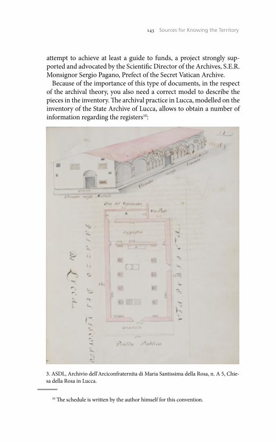
143 The Historical Cadaster of Tuscany and the CASTORE Project143 Sources for Knowing the Territory
attempt to achieve at least a guide to funds, a project strongly sup-ported and advocated by the Scientific Director of the Archives, S.E.R. Monsignor Sergio Pagano, Prefect of the Secret Vatican Archive.
Because of the importance of this type of documents, in the respect of the archival theory, you also need a correct model to describe the pieces in the inventory. The archival practice in Lucca, modelled on the inventory of the State Archive of Lucca, allows to obtain a number of information regarding the registers10:
10 The schedule is written by the author himself for this convention.
3. ASDL, Archivio dell'Arciconfraternita di Maria Santissima della Rosa, n. A 5, Chie-sa della Rosa in Lucca.
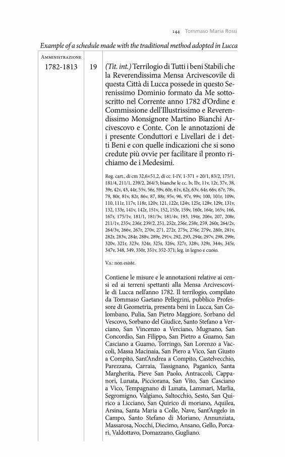
144 Umberto Sassoli144 Tommaso Maria Rossi
Example of a schedule made with the traditional method adopted in LuccaAmministrazione
1782-1813 19 (Tit. int.) Terrilogio di Tutti i beni Stabili che la Reverendissima Mensa Arcivescovile di questa Città di Lucca possede in questo Se-renissimo Dominio formato da Me sotto-scritto nel Corrente anno 1782 d’Ordine e Commissione dell’Illustrissimo e Reveren-dissimo Monsignore Martino Bianchi Ar-civescovo e Conte. Con le annotazioni de i presente Conduttori e Livellari de i det-ti Beni e con quelle indicazioni che si sono credute più ovvie per facilitare il pronto ri-chiamo de i Medesimi.Reg. cart., di cm 32,6×51,2, di cc. I-IV, 1-371 + 20/1, 83/2, 175/1, 181/4, 211/1, 239/2, 264/3; bianche le cc. Iv, IIv, 11v, 12r, 37v, 38, 39r, 42v, 43, 44r, 55v, 56r, 59v, 60r, 61v, 62r, 63v, 64r, 66v, 67r, 78v, 79, 80r, 81v, 82r, 86v, 87, 88r, 95v, 96, 97r, 99v, 100, 101r, 109v, 110, 111r, 117v, 118r, 120v, 121, 122r, 124v, 125r, 128v, 129r, 131v, 132, 133r, 141v, 142r, 151v, 152, 153r, 159v, 160r, 164r, 165v, 166, 167r, 175/1v, 181/1, 181/3v, 181/4v, 193, 194r, 206v, 207, 208r, 211/1v, 235v, 236r, 239/2, 251, 252r, 256r, 258r, 259, 260r, 264/2v, 264/3v, 266v, 267r, 270v, 271, 272r, 275v, 276r, 279v, 280r, 281v, 282r, 283v, 284r, 288v, 289r, 291v, 292, 293, 294r, 297v, 298, 299r, 320v, 321r, 323v, 324r, 325r, 326v, 327r, 328v, 329r, 344v, 345r, 347v, 348, 349, 350r, 351v, 352-371; leg. in legno e cuoio.
V.s.: non esiste.
Contiene le misure e le annotazioni relative ai cen-si ed ai terreni spettanti alla Mensa Arcivescovi-le di Lucca nell’anno 1782. Il terrilogio, compilato da Tommaso Gaetano Pellegrini, pubblico Profes-sore di Geometria, presenta beni in Lucca, San Co-lombano, Pulia, San Pietro Maggiore, Sorbano del Vescovo, Sorbano del Giudice, Santo Stefano a Ver-ciano, San Vincenzo a Verciano, Mugnano, San Concordio, San Filippo, San Pietro a Guamo, San Casciano a Guamo, Torringo, San Lorenzo a Vac-coli, Massa Macinaia, San Piero a Vico, San Giusto a Compito, Sant’Andrea a Compito, Castelvecchio, Parezzana, Carraia, Tassignano, Paganico, Santa Margherita, Pieve San Paolo, Antraccoli, Cappa-nori, Lunata, Picciorana, San Vito, San Casciano a Vico, Tempagnano di Lunata, Lammari, Marlia, Segromigno, Valgiano, Saltocchio, Sesto, San Qui-rico a Licciano, San Quirico di moriano, Aquilea, Arsina, Santa Maria a Colle, Nave, Sant’Angelo in Campo, Santo Stefano di Moriano, Annunziata, Massarosa, Nocchi, Diecimo, Ansano, Gello, Porca-ri, Valdottavo, Domazzano, Gugliano.
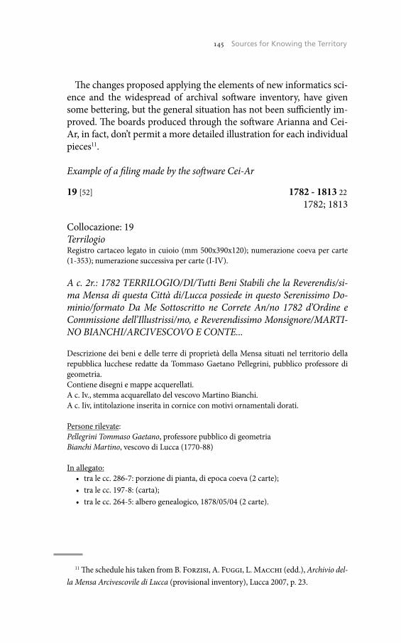
145 The Historical Cadaster of Tuscany and the CASTORE Project145 Sources for Knowing the Territory
The changes proposed applying the elements of new informatics sci-ence and the widespread of archival software inventory, have given some bettering, but the general situation has not been sufficiently im-proved. The boards produced through the software Arianna and Cei-Ar, in fact, don’t permit a more detailed illustration for each individual pieces11.
Example of a filing made by the software Cei-Ar
19 [52] 1782 - 1813 221782; 1813
Collocazione: 19TerrilogioRegistro cartaceo legato in cuioio (mm 500x390x120); numerazione coeva per carte (1-353); numerazione successiva per carte (I-IV).
A c. 2r.: 1782 TERRILOGIO/DI/Tutti Beni Stabili che la Reverendis/si-ma Mensa di questa Città di/Lucca possiede in questo Serenissimo Do-minio/formato Da Me Sottoscritto ne Correte An/no 1782 d’Ordine e Commissione dell’Illustrissi/mo, e Reverendissimo Monsignore/MARTI-NO BIANCHI/ARCIVESCOVO E CONTE...
Descrizione dei beni e delle terre di proprietà della Mensa situati nel territorio della repubblica lucchese redatte da Tommaso Gaetano Pellegrini, pubblico professore di geometria.Contiene disegni e mappe acquerellati.A c. Iv., stemma acquarellato del vescovo Martino Bianchi.A c. Iiv, intitolazione inserita in cornice con motivi ornamentali dorati.
Persone rilevate:Pellegrini Tommaso Gaetano, professore pubblico di geometriaBianchi Martino, vescovo di Lucca (1770-88)
In allegato:• tra le cc. 286-7: porzione di pianta, di epoca coeva (2 carte);• tra le cc. 197-8: (carta);• tra le cc. 264-5: albero genealogico, 1878/05/04 (2 carte).
11 The schedule his taken from B. Forzisi, A. Fuggi, L. Macchi (edd.), Archivio del-la Mensa Arcivescovile di Lucca (provisional inventory), Lucca 2007, p. 23.
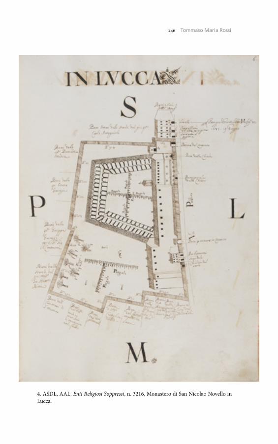
146 Umberto Sassoli146 Tommaso Maria Rossi
4. ASDL, AAL, Enti Religiosi Soppressi, n. 3216, Monastero di San Nicolao Novello in Lucca.
147 The Historical Cadaster of Tuscany and the CASTORE Project147 Sources for Knowing the Territory
The necessity leading the efforts by the archivists in their action for a correct inventorying of this particular documentary type is the study of a method of description which allows, on one hand the preserva-tion of the archival tradition of Lucca, and on the other the possibility to make available the documentation through an effective database. In the description of a piece it needs, moreover, supplying titles of exter-nal, internal and rib report, in addition to the name of land surveyors, including the client, where specified, but especially the institutions to which it is referred the terrilogio, to identify the various locations of the various properties. More information would obviously follow giv-ing the physical description of the specific register: number of cards (indicating any white papers), measures of the piece, the type of sub-strate and binding, the general conditions of any piece and any old signatures.
After completing the activity of inventory, you might think about the acquisition of digital terrilogi so you can compare them overlap with the latest cadastral maps (on the model of the Castore project initiated by the Region of Tuscany12) in order to have a clearer picture of the territory of Lucca.
Tommaso Maria RossiArchivio Storico Diocesano di Lucca
12 <http://web.rete.toscana.it/castoreapp/> (09/15/2014).

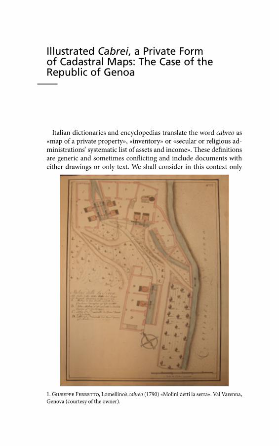
Illustrated Cabrei, a Private Form of Cadastral Maps: The Case of the Republic of Genoa
Italian dictionaries and encyclopedias translate the word cabreo as «map of a private property», «inventory» or «secular or religious ad-ministrations’ systematic list of assets and income». These definitions are generic and sometimes conflicting and include documents with either drawings or only text. We shall consider in this context only
1. Giuseppe Ferretto, Lomellino’s cabreo (1790) «Molini detti la serra». Val Varenna, Genova (courtesy of the owner).
150 Umberto Sassoli150 Micaela Antola
the cabrei with maps: these documents became very popular between the end of the 17th and the end of the 18th century. The maps include especially land surveys, but also drawings of rural buildings, palaces, villas and gardens, which are mostly on a topographic scale (fig. 1).The cabrei are different from the cadastral maps: while both are drawn up on a topographic scale, the cabrei were requested to be drawn up by clients who were private citizens, whereby the cadas-tral maps were drawn up by state agencies for tax purposes; fur-thermore, they don’t survey the whole land but only those portions of the land that the owners wanted to be surveyed.
The cabrei were part of the administrative papers, and they were usually kept in private archives where, in some cases, they have remained until today. Sometimes they were merged into bigger or different archives due to marriages or to the unification of dif-ferent religious administrations. In other cases, they ended up in State Archives, in libraries or, through the antiques market, in pri-vate collections. Furthermore, if the owner of the property decid-ed to sell it altogether, it could include in the sale the cabreo in which such property was recorded1. It is important to be able to study the cabrei in their original context, if possible, because in the complete archives it is possible to find related documents, such as records of measurements and correspondence between cartog-raphers and clients, and to understand the entire planning phase of the cabreo, from the decision of drawing it up to the delivery of the finished book.
The Order of Malta has been the most important client for the cabrei, and it still keeps the largest number of cabrei pertaining to the Italian, and probably to the European, territories. The proper-ties of the Order were divided in districts called Priorati that were managed by people called commendatari who had, among others, the task to draw up the cabrei, for the purpose of recording all the existing assets of the commenda. The cabrei were revised and updat-ed every twenty-five years, in order to allow the Priorati to monitor their assets and to prevent possible frauds or abuses on the part of either the commendatari or of any other person involved with the management of said assets. The drawing up of the cabrei was codi-
ADGe = Archivio Durazzo Giustiniani, archivio Durazzo, Genova. 1 M. Antola, L’archivio e la carta. I cabrei figurati in Liguria, tesi di dottorato, Uni-
versità degli Studi di Genova, a.a. 2010-11.
151 The Historical Cadaster of Tuscany and the CASTORE Project151 Illustrated Cabrei, a Private Form of Cadastral Maps
fied in the charter of the Order issued in 1588 and the Fra Giovanni Caravita’s pamphlet, written in the middle of the 18th century, exam-ines in detail this aspect, in particular specifying that each cabreo has to conform to the law of the country to which it pertains2.
In the Republic of Genoa the geometrical-nit cadastre was intro-duced under Napoleon’s ruling: until then, there were only few sur-veys of the land and the drawing up of the cabrei was much freer and more flexible than in the Duchy of Milan and in the Savoy state, to the point that the owners were able to decide independently what, and how, would be included.
This study considers the illustrated cabrei produced in the Republic of Genoa, for which a census has been prepared, identifying 27 docu-ments, almost all of the 18th century, some requested by religious or-ganizations, but most of them by private families.
The study develops the theory that the aristocratic families have found these documents to be an useful and convenient managerial tool, and that they have adopted the then consolidated procedure of the Order for the administration of their properties, after adapting it to their own needs. However, the big differences between the docu-ments – particularly between those related to the fiefs of the Oltregio-go (Piedmont) and those related to the properties of the Riviera – has made it necessary to analyze the specific types of documents.
The comparison has shown that the cabrei cannot be confined with-in rigid schemes and that what connects them is the reason of their drawing up, i.e. the need to have a model of the real world for practi-cal and managerial uses.
As to the form, the cabrei are a single archive piece, usually a book, with only maps or with some text. They have a frontispiece with the essential information regarding the document: the title (cabreo, type, contents), the object (land, buildings, palaces), the name of the owner, the place where the property is located, the name of the cartographer who has drawn up the cabreo and the year. To follow is the index of the tables, some initial notices and the legend with the symbols of the ag-ricultural landscape. There could also be some general maps (i.e. maps which pertain to the whole property) which would allow a global view of the property: these maps could be inserted within the book or be kept separate so that they could be hung to the wall.
2 Cf. J.E. Critien, Cabrevatio bonorum. Priorati, Baliaggi e Commende dell’Ordine di Malta, Perugia 1997.
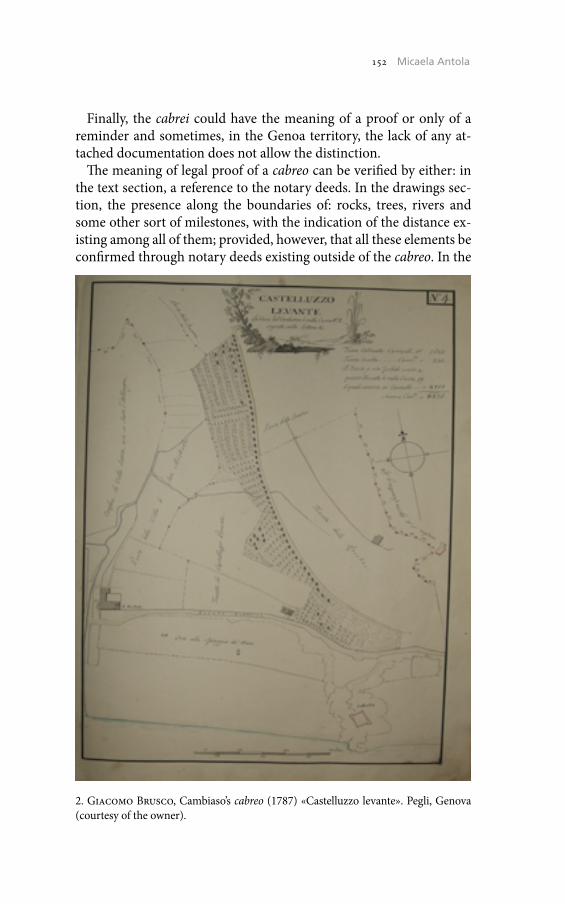
152 Umberto Sassoli152 Micaela Antola
Finally, the cabrei could have the meaning of a proof or only of a reminder and sometimes, in the Genoa territory, the lack of any at-tached documentation does not allow the distinction.
The meaning of legal proof of a cabreo can be verified by either: in the text section, a reference to the notary deeds. In the drawings sec-tion, the presence along the boundaries of: rocks, trees, rivers and some other sort of milestones, with the indication of the distance ex-isting among all of them; provided, however, that all these elements be confirmed through notary deeds existing outside of the cabreo. In the
2. Giacomo Brusco, Cambiaso’s cabreo (1787) «Castelluzzo levante». Pegli, Genova (courtesy of the owner).
153 The Historical Cadaster of Tuscany and the CASTORE Project153 Illustrated Cabrei, a Private Form of Cadastral Maps
cabrei with the meaning only of a reminder these elements are miss-ing; however there could be a mention of the notary references of the purchase in the text section purely as a remainder note.
An example of cabreo carrying a legal meaning is the cabreo of the Fief of Gabiano, drawn up in 1724 for the genoese Giacomo Filippo II Durazzo: this is a legally binding document which follows a rigid pro-cedure as it has been drawn up within the territory of the Duchy of Monferrato, then under the Savoia rule3. In the first part of the cabreo all the deeds are recorded, while in the second part the tables are in-cluded. The documentation of the archive, and especially the corre-spondence, has then permitted to reconstruct the whole relationship, from the moment of the initial idea until the delivery to Durazzo. Through the letters we have learned that Durazzo had requested to the judge in charge of the region a report on his properties. In 1723 the judge wrote that many parts of the property have been seized by the neighboring owners and proposed to draw up a cabreo and to set up new property boundaries in order to define and make well visible the borders on the territory itself. The judge explained that the meas-urements are necessary but that the drawings are not, and Giacomo Filippo initially decided not to order them because they representd an added cost. At the beginning of the cabreo we find all the transcripts of the deeds: the proxys; the appointment of the land surveyor, of the notary and of the experts; the letters sent to all the neighboring own-ers requiring that they have to be present to the measurements with their own expert and with any possible documentation. Then we find the minutes of the measurements, the possible cross-examinations of the counterpart and finally the drawing up of the book with the draw-ings. The cabreo was then deposited with the Podesta and a notice was issued ordering all the neighboring owners to inspect it and, if war-ranted, oppose it. At the end of this long and expensive procedure, the cabreo was deemed to be authentic and legal in all respects4.
Within the territory of the Republic of Genoa, as already ex-plained, there is more freedom, due to the lack of specific laws and the cabrei can even be modified later in time. In this context surfac-es the cartographer Giacomo Brusco who, due to his seven cabrei
3 «Tipo dei beni feudali dipendenti dal castello di Gabiano et appartenenti all’Illustrissimo Signor Marchese Giacomo Filippo Durazzo fatto l’anno 1724», ADGe, Gabiano 477, G365 bis.
4 Antola, L’archivio e la carta, pp. 117-31.
154 Umberto Sassoli154 Micaela Antola
found to date, leaves the most valuable contribution both for the ar-tistic quality and the technical expertise of his work5 (fig. 2). He in-cludes the «initial notices» where he explains that he uses different size scales and asks the reader to check the actual area shown in fig-ures on each table, in order not to be misled by the larger or smaller size of the drawings6.
In the Genoa territory the relationship client-cartographer pro-duces a document entirely personal and not so objective. The owners could require a greater attention to some buildings and the survey of only certain interiors’ parts. These aspects show the cabrei from a different standpoint: they are not only a model of the real world for practical, managerial uses, but they can become a tool of self-cele-bration of the owner itself.
An example of self-celebratory cabreo is the cabreo commissioned by Francesco Maria della Rovere to the cartographer Giacomo Brus-co, which was drawn up in several stages between 1762 and 1782 7. In the middle of the 18th century Francesco Maria della Rovere starts the renovation of the palace in Albissola and soon thereafter the dec-orative renovation of the decaying Sistina chapel in Savona built by his ancestor Sisto IV as the funeral chapel for his own parents. At the same time, he expands his properties of Albissola and Savona, orga-nizing them as efficient agricultural and manufacturing businesses. During the realization of this challenging project, he hires the car-tographer Giacomo Brusco to «take drawings and measurements» of his whole property and to collect them in a «book» or cabreo8. The cartographer devotes many plates to the villa in Albissola and par-ticularly to the Sistine chapel of which he presents, in addition to the plans, the internal and external sections that show the decorations, and the drawing of the mausoleum of Sisto IV parents9 (fig. 3).
5 Giacomo Brusco draws up, in addition to the della Rovere cabreo, the following cabrei: the jesuit boarding school in Genoa in 1773; the Marcello q. Gio. Luca Durazzo in 1775; the Cristoforo, Filippo and Bendinelli q. Domenico Spinola, in duplicate, in 1784; the Vincenzo Spinola in 1787; the Gio. Maria, Gio. Luigi and Gio. Michelangelo q. Nicolo’ Cambiaso in 1787.
6 Antola, L’archivio e la carta, p. 223.7 Private archive.8 Ibid.9 M. Antola, Lo spazio della carta come strumento di conoscenza della volontà col-
lezionistica: inventari e cabrei figurati, in L. Magnani (ed.), Collezionismo e spazi del
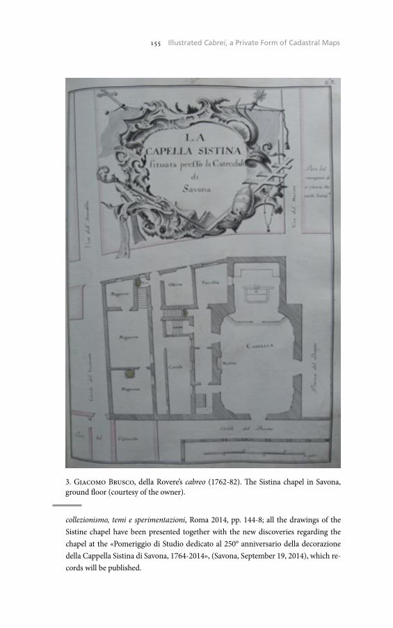
155 The Historical Cadaster of Tuscany and the CASTORE Project155 Illustrated Cabrei, a Private Form of Cadastral Maps
collezionismo, temi e sperimentazioni, Roma 2014, pp. 144-8; all the drawings of the Sistine chapel have been presented together with the new discoveries regarding the chapel at the «Pomeriggio di Studio dedicato al 250° anniversario della decorazione della Cappella Sistina di Savona, 1764-2014», (Savona, September 19, 2014), which re-cords will be published.
3. Giacomo Brusco, della Rovere’s cabreo (1762-82). The Sistina chapel in Savona, ground floor (courtesy of the owner).

156 Umberto Sassoli156 Micaela Antola
The cabreo Doria, ordered by Francesco Maria Doria to the cartogra-pher Giuseppe Ferretto in 1775, is characterized instead by a rich sym-bolism and by a strict link with the papers of the private archive10. In the cabreo drawn up in 1775 all the assets are reported, together with the maps of the palace and of the garden at the time of the agreement. These maps allow a verification of the improvements realized over the thirty-eight years period. Each drawing is then diligently completed with references to a text, often placed next to the drawing, which re-ports the name or the toponym of the place represented, its description and the notarial references of the purchase. Finally, the references to the documents kept in the then existing family archive are reported in a column to the right11.
The illustrated cabrei as a type of documentation are therefore a top-ic almost unknown in Liguria, whereas as a source they provide many examples of the Ligurian landscape, from the urban to the agricultural to the residential villas, focusing the attention in particular on the de-tails of the crops and of the gardens. Each table can be compared with the present situation: a landscape often mutilated, where the buildings are separated from their original context and survive amid the modern concrete, while the most fragile elements – the gardens, the vegetable gardens and the agricultural landscape – have disappeared and they can be rediscovered today through the particular magnifying glasses represented by the cabrei. The cabrei however, due to their private na-ture, cannot be studied separately from their context. To the extent the client recognizes their value as testimonials of its estate and decides to develop this role, the cabrei become a mirror which reflects its own prestige and an object to be displayed in its own mansion12.
Micaela Antola
10 Private Archive.11 Antola, Lo spazio della carta, pp. 149-53.12 Ibid., p. 153.
Online Access to the Historical Cartography of Trapani’s Territory: Problems and Perspectives
The cartographic documents have different nature, definition, qual-ity, representation scales, as they are related to the legal and admin-istrative functions assigned to the reproduction of the territory. A cartographic document is created for a precise purpose and incorpo-rates in the document a certain amount of knowledge about a given territory, informing us of the physical, historical, political, legal and administrative, anthropological, social and cultural characteristics.
The Sicilian Archives, as it is known, preserve for the period between the 18th and 19th century cartographic documents quantitatively very numerous and qualitatively very different, uniting, along with repro-ductions of large portions of the territory for the most varied destina-tions (statistical survey for taxation purposes, design of public works, eversion of the ecclesiastical estates, administration of feudal lands), the documentation of cadastral nature.
Immediately after the unification of Italy, in Sicily, following the sup-pression of the religious orders and the confiscation of ecclesiastical property by the new Italian state, there were established in each district the Committees for the lease of the ecclesiastical rural property. These Committees were established pursuant to the Law of October 10, 1862 , n. 743, entitled «Corleo Law», named after the Sicilian Simone Corleo, member of the Italian Parliament from 1861 to 1864, to whom was in fact assigned the task of studying, preparing and then implement the law regarding the leasing of the rural ecclesiastical properties.
After years of centralization of the large estates in the possession of the Church, the Committees had the task to undertake the inventory of the ecclesiastical rural properties and proceed to the concessions in lease to the new middle class of small and medium landowners.
The activity of the lease Committee of Trapani lasted from 1862 to 1878. This activity has resulted in the creation of a fund, preserved in the State Archives of Trapani, consisting of descriptive documents (Acts, various Notebooks, resolutions, headings) and of 122 maps,

158 Umberto Sassoli158 Vincenzo De Santi
whose chronological limits range from 1864 to 18771. These maps, drawn up by agro-surveyors, engineers and technicians who had the task of carrying out the plan of partition of the properties, have dif-ferent sizes and are in monochrome or are colored and water-colored.
In addition to this set of charts, it is kept at the State Archives of Trapani a large collection of maps and topographic charts, called «General Directorate of the Cadaster and of the Fiscal Technical Ser-vices», which constitutes the most considerable part of the historical
cartographic complex. It is a matter of more than 3,500 maps, going back mostly to 1942 and whose total chronological limits range from 1875 to 1964, reproducing the territory of the Province of Trapani (figg. 1-2).
1 <http://www.archivi-sias.it/Scheda_Complesso.asp?FiltraComplesso=880090140> (10/31/2013).
1. Archivio di Stato di Trapani, Direzione Generale del Catasto e dei Servizi Tecnici Erariali, Trapani, Centro Urbano, Foglio 3 bis. Acquarellato.
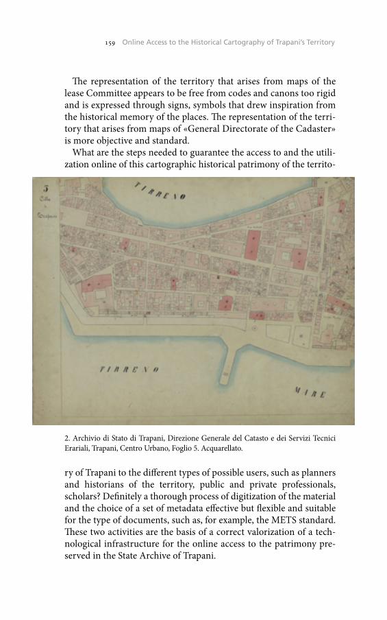
159 The Historical Cadaster of Tuscany and the CASTORE Project159 Online Access to the Historical Cartography of Trapani’s Territory
The representation of the territory that arises from maps of the lease Committee appears to be free from codes and canons too rigid and is expressed through signs, symbols that drew inspiration from the historical memory of the places. The representation of the terri-tory that arises from maps of «General Directorate of the Cadaster» is more objective and standard.
What are the steps needed to guarantee the access to and the utili-zation online of this cartographic historical patrimony of the territo-
ry of Trapani to the different types of possible users, such as planners and historians of the territory, public and private professionals, scholars? Definitely a thorough process of digitization of the material and the choice of a set of metadata effective but flexible and suitable for the type of documents, such as, for example, the METS standard. These two activities are the basis of a correct valorization of a tech-nological infrastructure for the online access to the patrimony pre-served in the State Archive of Trapani.
2. Archivio di Stato di Trapani, Direzione Generale del Catasto e dei Servizi Tecnici Erariali, Trapani, Centro Urbano, Foglio 5. Acquarellato.
160 Umberto Sassoli160 Vincenzo De Santi
The process of digitization of the maps must necessarily focus on two key issues: the question of the long time preservation and the representation methodologies to foster in the best possible manner the online access.
The technological obsolescence of the electronic formats or of the storage media, and the necessity to ensure access and use of the digital objects over the long term are issues more important and current than ever in the field of digital preservation.
First of all a digital object well-formed and stored, such as a car-tographic image, is necessarily an analogic object digitally well ac-quired. In the case of utilization of a scanner to capture the cartographic images, it is necessary to keep under control at least two fundamental parameters for a good quality of the images: the resolution, expressed in pixels per inch (ppi), and the depth of color, expressed in bits per pixel (bpp). In the case of digitization of the historical cartography of the State Archive of Trapani were used a scanner of large format Metis DRS A1 Plus, especially suited, through the book cradle, to digital re-production of books and manuscripts but also of maps and drawings, and a software DRS owner Metis. This equipment has been made avail-able by the State Archive of Palermo. The results obtained are images in uncompressed TIFF format, large about 10,000 pixels, with 300 ppi resolution and color depth of 24 bits. Clearly, these are security digital copies, made to be kept for a wholesome period in order to guarantee their long time preservation. For this purpose, at least every five years, in fact, the operations of direct reversal (refreshing) or replacement (migration) of the copies of the files should be planned. It is essential in our opinion to guarantee the preservation of the security digital copies, and consequently their longevity, within the physical archival struc-ture, ensuring, through the above mentioned planned operations, the access over time. The TIFF format, which is a standard format de jure, non-modifiable, with a large diffusion and widely used, with the po-tential to be self-documenting (self-documentation), stable over time, appears the most suitable for the security cartographic digital copies for the long time preservation. In addition, compared to other formats such as, for example, the JPG, being uncompressed, it is more robust and less sensitive to corruptions and errors that may occur over time as a result of various processes of reversal of the files copies. Another dis-cussion can be made regarding the copies, «lighter», for consultation purposes, which could for example take the JPEG2000 format. This is considered the better successor of the JPG and it is a standard format, non-proprietary, compressed (lossy or lossless) and allows the inclu-

161 The Historical Cadaster of Tuscany and the CASTORE Project161 Online Access to the Historical Cartography of Trapani’s Territory
sion of metadata. It allows the compression of the images with minimal loss of data, maintains an excellent color rendering and is suitable for cartography, however, it is as yet little utilized because of the scarcity of software and browsers that support it.
What is common to TIFF and JPEG2000 is the ability to encode im-ages by subdividing them in multi-resolution cards (tiles). This feature introduces us to a particular method of representation of images of medium to large size, such as the cartographic ones, based precisely on the multi-resolution open formats, such as the pyramidal TIFF. It is known that, especially in the online environment, the visualization and navigation of high-resolution images is hampered by technical limita-tions such as the amount of RAM in the system and the bandwidth of the Internet connection. A method of representation that allows to en-large the image to its maximum resolution, without the need to load it entirely in memory, is that provided by the open source IIPImage system2. It represents an advantage especially in the context of the on-line publication of the archivist digitized cartographic patrimony. The IIPImage system works through the interaction between a client and a server: the result is the fast remote visualization of very high resolution images through the internet. The system is based on the principle that the client needs to download only the portion of the image visible on the user’s screen, without to store all the information of the image on the local machine. The cards of a TIFF or JPEG2000 image (tiles) re-quested to a certain resolution are extracted from the master file stored on the server and sent to the client in the form of compressed JPG.
This particular method of visualization of the cartographic images can obviously represent an advantage, simple and fast, in the naviga-tion-exploration of the places reproduced in the maps. At home and from anywhere in the world, as in the Archive, we have the possibility to consult the topographic map or the cadastral map that are of interest to us. But such a technological solution does not exhaust the possibil-ities that a map has to speak for itself, neither the ability of the user to «read» the information that a map in different ways conveys.
The metadata are the liaison between all the possible information having an identifying, descriptive, managerial, administrative charac-ter – intrinsic and extrinsic – that relate to the cartographic materi-al and the conveyance system as well as the use of such information through the digital access.
2 <http://iipimage.sourceforge.net/> (10/31/2013).
162 Umberto Sassoli162 Vincenzo De Santi
The choice of the metadata adequate to the documentary type of the historical cartography, understood as a digital resource, therefore af-fects the «readability» of such archival heritage, and of course we have to take into account both the «daily» management of the digital re-sources and of their long-time preservation. In the case of the digi-tization process of the historical cartography of the State Archive of Trapani for the selection and valorization of such metadata the stand-ard METS has been followed3. As we all know the U.S. standard METS, developed by the Library of Congress, belongs to the family of the ad-ministrative/managerial and structural metadata schemes on the pat-tern of the OAIS model. It is an XML format designed both for the management of the information and to facilitate the interoperability of the digital objects among the institutions.
Simply put, we can say that, in our case, not all metadata have been valorized; in the first logical area in which it is articulated the standard METS, that of the Heading, were chosen the metadata related to the records identification codes and the reference to the owner of the data. As to the area of the descriptive metadata of the analog object digitized, expressed according to the standard EAD, they have been valorized: the title, the description, the textual and codified date, the latter in the format ISO 8601-SAN; the physical description, the language, the type of materials and content, and the caption; the sections regarding the indexation of persons, entities, places and terms. With regard to the ar-ea of administrative metadata, the technical metadata have been valor-ized with information about the file format or mime-type and the basic characteristics of the digitized image, such as the width and height in pixels; the metadata concerning intellectual property, the metadata on the analogic origin and those on the digital provenance.
The readability of the cartographic documents preserved in the State Archives of Trapani, given their peculiar wealth of varied and detailed information, could also be valorized by other instruments, such as de-scriptions and thesauri, that allow users to orient and recognize them-selves in the «updated» representation of the same historical Sicilian places. In addition to the technologically advanced method of display-ing images, as well as the metadata complex to be valorized, the tech-nological infrastructure for the online access to the maps could benefit, for example, from a database structured in a thesaurus that collects and describes in detail: the place-names contained in the maps, terms often
3 <http://www.loc.gov/standards/mets/METSOverview.v2.html> (10/31/2013).

163 The Historical Cadaster of Tuscany and the CASTORE Project163 Online Access to the Historical Cartography of Trapani’s Territory
in the Sicilian language or of Sicilian derivation that require a transla-tion; the geographical terms related to the soil and land use, crop types, phytonyms, etc.; the technical terms belonging to the material culture of the 19th and 20th centuries, the names of the streets and of the roads, the types of buildings located in the municipalities, in the country es-tates or in the city centers. In this way the user could be able to connect those parts of rural 19th century and, in general, the municipalities of the Province of Trapani from the 19th century to the 20th, to the current territory. A process of geo-referencing of the digitized historic cartog-raphy through the layering of the official cartographies, free of rights of disposal, would give the possibility to anchor the knowledge of an his-torical, geographical, cultural character that the cartography in ques-tion contains in itself, to the correlated image of today’s landscape.
Vincenzo De SantiArchivio di Stato di Trapani
Università degli Studi di Macerata

From Hidden to Online, the Case of Horta’s Cadastral Map
In the year 1845 the Spanish Liberal government introduced the Con-tribution of Properties, Cultivation and Livestock tax which charged the agricultural and livestock wealth of municipalities and was applied in a vertical spread quota system. The new tax had a certain degree of ar-bitrariness1 as there was a lack of rural cadastre which could be used to define the amount of tax each land owner had to pay and consequently how much each municipality would have to give to the Spanish Treas-ury2. Towns had however the obligation of creating and delivering a written document to the provincial fiscal authorities, the amillaramien-to. This document listed the names of those taxpayers who lived in the town, both rural and urban3, and allowed the registration by the fiscal authorities of the duties each proprietor and municipality had to pay4.
Because of the level of arbitrariness of this tax, where each town was expected to provide a certain amount of revenue to the Treasury, many conflicts arose due to the fact that many owners and councils felt they were overpaying for their assets. All these conflicts caused the Spanish Government to pass a new law in 1847 which allowed those who felt more overtaxed to file claims and have their case considered5. Conse-quently many municipalities and some owners decided to hire agri-mensores – qualified land surveyors – who were commissioned with
1 J. Pro Ruiz, Estado, geometría y propiedad: los orígenes del catastro en España (1715-1941), Madrid 1992.
2 R. Vallejo Pousada, La Estadística territorial española desde 1845 a 1900. ¿Por qué no se hizo un Catastro en el siglo XIX?, «CT/Catastro», 68, 2010, pp. 81-115.
3 E. Llorente Roselló, El municipi de Tortosa l’any 1875. Propietat immobiliària i activitat econòmica, «Recerca», 12, 2008, pp. 295-346.
4 F. Nadal, L. Urteaga, J.I. Muro, La documentación cartográfica de la Contri-bución de Inmuebles, Cultivo y Ganadería: el caso de la provincia de Barcelona (1845-1895), «Boletín de la Asociación de Geógrafos Españoles», 40, 2006, pp. 83-109.
5 Ibid.
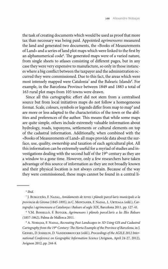
166 Umberto Sassoli166 Alexandre Nobajas
the task of creating documents which would be used as proof that more tax than necessary was being paid. Appointed agrimensores measured the land and generated two documents, the «Books of Measurements of Land» and a series of land plot maps which were linked to the first by an alphanumerical code6. The generated maps were of a varied nature, from single sheets to atlases consisting of different pages, but in any case they were very expensive to manufacture, so only in those instanc-es where a big conflict between the taxpayer and the administration oc-curred they were commissioned. Due to this fact, the areas which were most intensely mapped were Catalonia7 and the Balearic Islands8. For example, in the Barcelona Province between 1849 and 1883 a total of 163 rural plot maps from 105 towns were drawn.
Since all this cartographic effort did not stem from a centralised source but from local initiatives maps do not follow a homogeneous format. Scale, colours, symbols or legends differ from map to map9 and are more or less adapted to the characteristics of the town or the abil-ities and preferences of the author. This means that while some maps are quite simple, others include extremely valuable information about hydrology, roads, toponyms, settlements or cultural elements on top of the cadastral information. Additionally, when combined with the «Books of Measurements of Land» all maps provide data about the sur-face, use, quality, ownership and taxation of each agricultural plot. All this information can be extremely useful for a myriad of studies and in-vestigations dealing with the second half of the 19th century as they are a window to a gone time. However, only a few researchers have taken advantage of this source of information as they are not broadly known and their physical location is not always certain. Because of the way they were commissioned, these maps cannot be found in a central li-
6 Ibid.7 J. Burgueño, F. Nadal, Amidaments de terres i plànols parcel·laris municipals a la
província de Girona (1845-1895), in C. Montaner, F. Nadal, L. Urteaga (edd.), Car-tografia i agrimensura a Catalunya i Balears al segle XIX, Barcelona 2011, pp. 127-41.
8 V.M. Rosselló, F. Rotger, Agrimensors i plànols parcel.laris a les Illes Balears (1857-1862), Palma de Mallorca 2011.
9 A. Nobajas, F. Nadal, Recreating Past Landscapes in 3D Using GIS and Cadastral Cartography from the 19th Century: The Horta Example of the Province of Barcelona, in J. Gensel, D. Josselin, D. Vandenbroucke (edd.), Proceedings of the AGILE 2012 Inter-national Conference on Geographic Information Science (Avignon, April 24-27, 2012), Avignon 2012, pp. 244-8.
167 The Historical Cadaster of Tuscany and the CASTORE Project167 From Hidden to Online, the Case of Horta’s Cadastral Map
brary or archive, they are scattered across many archives, town councils and private owners, so many of them are not easily accessible. So far, and thanks to the work of the Grup d’Estudis d’Historia de Cartografia, a catalogue of those maps which have been located exists10, but many are yet to be found.
However, it is not enough just to find and publicise the maps, it is also necessary to facilitate the access and analysis of the information contained in them. In order to achieve this goal, we used the cadastral map of Horta dated 1861. Horta is nowadays a neighbourhood of the city of Barcelona, but up to the year 1904 it was an independent town11 where, because of the over taxation, was considered necessary to com-plain and therefore commissioned the agrimensor Joan Serra i Bonet to draw a map of the municipality12. The map was finished in 1861 with a scale of 1:5000 and a size of 105 x 136 cm. Even if it was manuscript, there are several copies of it13, one of them stored in the Arxiu Munici-pal Contemporani de Barcelona. With a digitised copy of this map and after trimming all superfluous data and information such as scale bars, titles or legends, the map was georeferenced using current digital car-tography14. One of the main issues of the georeferencing process was that the area has experienced dramatic changes in the last 150 years, so finding common points between the two maps was an arduous task. This issue was finally solved by using still standing country houses, re-ligious buildings, street crossings and mountain peaks.
Once the map is correctly georeferenced it can be vectorised, a pro-cess by which information held by the historic map is extracted and stored as independent layers. In the Horta’s map case six layers refer-ring to punctual symbology, housing, roads, hydrology, land plots and
10 C. Montaner, A. Nobajas, Catàleg de la cartografia parcel.lària municipal de Catalunya (1849-1897) aplegada pel GEHC, in C. Montaner, F. Nadal, L. Luis (edd.), Cartografia i agrimensura a Catalunya i Balears al segle XIX (Barcelona, October 20-21, 2010), Barcelona 2011, pp. 281-6.
11 D. Díez I Quijano, Horta (1904-2004): aproximació a cent anys d’història, Bar-celona 2005.
12 Montaner, Nobajas, Catàleg de la cartografia.13 D. Díez I Quijano, El que ha estat i és Horta, Barcelona 1982.14 Institut Cartogràfic De Catalunya, Mapa topogràfic de Catalunya 1:10000,
full 144-62, Barcelona 2008; Id., Mapa topogràfic de Catalunya 1:10000, full 144-63, Barcelona 2008; Id., Mapa topogràfic de Catalunya 1:10000, full 145-62, Barcelona 2008; Id., Mapa topogràfic de Catalunya 1:10000, full 145-63, Barcelona 2008.
168 Umberto Sassoli168 Alexandre Nobajas
town limits were created. The resulting layers allow observing a single phenomenon contained in the map at a time, permitting performing quick visual analysis which can lead to identifying trends or patterns which, due to the historic map’s cartographic noise or lack of contrast,
could be overlooked. This improvement on the extraction of informa-tion from a historic map is important in itself, but in the case of the Catalan cadastral maps it can be improved when combined with the amillaramientos.
1. Land use change in Horta (1861-2003). Legend: Pink-Urban, Yellow-Agriculture, Grey-Barren, Light Green-Shrub land, Dark Green-Forest, Red-Roads. Source: Author’s work.

169 The Historical Cadaster of Tuscany and the CASTORE Project169 From Hidden to Online, the Case of Horta’s Cadastral Map
Horta’s map had an amillaramiento linked to it and two copies have survived at the Arxiu de la Corona d’Aragó15. Both documents are linked by a series of codes which allow associating each land plot with information contained in the amillaramiento. However, Horta’s map was drawn in 1861, while its corresponding amillaramiento was writ-ten in 1862, so some minor discrepancies exist, mainly referred to land ownership changes16. Even with this little drawback, the information contained in the amillaramiento allows expanding the one contained in the map, by linking them new cartographic information which did not exist in the original map can be created. As an example of its useful-ness, figure 1 shows a comparison between land use in 1862 and 2003 in Horta, something which can be of interest to many researchers (fig. 1).
However, the possibilities of what it can be done by vectorising his-torical cartography do not end here: as once the information has been extracted it can be made available to the public by distributing it online. This allows sharing the work done by researcher with the general pop-ulation and therefore benefit society and increase the impact that re-search has on society. In Horta’s case the technology chosen was KML, an OGC standard17 which can be opened by several programmes in-cluding the popular Google Earth. By converting the information vec-torised from the map into different KML layers users can view, interact and analyse the data contained in the historic map and even overlay it on top of current aerial imagery (fig. 2).
By showing a method to transform historic Catalan cadastral maps into digital copies which can be combined with online systems this paper has shown that it is possible to give a second youth to maps which otherwise would be in an archive and only accessible to experts. It is therefore of paramount importance to find and digitise as many of these maps as possible, as a quantity of them are not stored prop-erly and could be lost forever in the near future. Once this has been achieved it will be necessary to apply the aforementioned process to all
15 Ministerio De Hacienda - Delegación Provincial De Barcelona, Amillar-amiento. Rústica y Urbana. Horta, Barcelona 1862.
16 A. Nobajas, Integració entre cartografia històrica i models d’elevació digital del ter-reny. El cas del plànol percel·lari del municipi d’Horta de 1861, in Montaner, Nadal, Urteaga (edd.), Cartografia i agrimensura a Catalunya, pp. 237-48.
17 Open Geospatial Consortium, 04/14/2008, 2008-last update, OGC Approves KML as Open Standard [Homepage of Open Geospatial Consortium], available on-line: <http://www.opengeospatial.org/node/857> (2/15/2013).

170 Umberto Sassoli170 Alexandre Nobajas
of them to safeguard and make them available to the general public. If this is achieved, a part of the cartographic heritage of Catalonia will be preserved and present and future generations will be able to use the in-formation stored in these unique maps.
Alexandre NobajasKeele University
Costruire la nazione. Le Carte geografiche della Raccolta Mayer
This paper aims at presenting the cartographic fund of the so called «Archivio Mayer», preserved in the Archive of the Scuola Normale Superiore, Pisa. The most important part of the collection contains WWI maps, belonging to Gen. Francesco Mayer, whose military career started during the Great War.
1. La collezione
Ordinate dalla dott.ssa Maria Augusta Morelli Timpanaro nel 2008, le Carte geografiche della Raccolta Mayer (composta, quest’ultima, an-che da libri, miscellanee a stampa, e da un archivio, parte del comples-so ancora oggi conservato presso la villa dei discendenti della famiglia, a Santa Maria a Monte, in provincia di Pisa) comprendono materiale cartografico risalente al XIX e (per la maggior parte) XX secolo. In par-ticolare, la b. 1 contiene la Gran Carta d’Italia edita da Civelli, a Milano, nel 1853. Carta murale «derivata» sulla «scorta delle opere più recenti ed accreditate», in 28 fogli nell’inusuale scala di 1:555555, essa appar-tiene al numero degli strumenti messi a disposizione dagli editori spe-cializzati per le esigenze didattiche della scuola post-unitaria1. La b. 2
Mi sia concesso di ringraziare fin d’ora: la signora Angelica Mayer Passerin d’Entreves e sua figlia, la dott.ssa Maria Cristina Passerin d’Entrèves, per il prezioso aiuto nel reper-imento delle prime informazioni sul generale Francesco Mayer, oltre che per la gentile concessione di due fotografie; il colonnello Pasquale Lino Parisse, capo della 5^ sezione della Direzione generale per il personale militare, V reparto, 10^ divisione, Documen-tazione Esercito, per lo stato di servizio del Generale; Matteo Giunti, dell’associazione culturale Livorno delle Nazioni, creatore del progetto Leghorn Merchant Network, per l’albero genealogico del Generale; e, last but not least, la dott.ssa Barbara Allegranti, re-sponsabile della sezione Rari e Manoscritti (carteggi, archivi personali) della Biblioteca della Scuola Normale Superiore di Pisa, per il competente supporto fornitomi durante tutta la ricerca.
1 C. Cerreti, La rappresentazione del territorio, in L’Unificazione (2011), disponibile online all’indirizzo <http://www.treccani.it/enciclopedia/la-rappresentazione-del-terri

172 Umberto Sassoli172 Sante Lesti
contiene materiale miscellaneo fine ottocentesco-primo novecentesco, anch’esso di natura patriottica: esemplare il caso del foglio 13 bis della Carta d’Italia del Touring Club Italiano, sul quale ritorneremo. Le bb. 3-8 contengono fogli, quadranti e tavolette della Carta d’Italia dell’Isti-tuto Geografico Militare, la carta topografica ufficiale dell’Italia unita, ordinate per scala. Le bb. 9-14 contengono carte (per la maggior par-te propriamente militari) riguardanti la Prima guerra mondiale: esse rappresentano il cuore pulsante della collezione. Infine, le bb. 15 e 16 contengono materiale cartografico, anch’esso prevalentemente primo-novecentesco, concernente alcuni territori non italiani.
2. Il collezionista
Un appunto, redatto sul retro di una delle due carte ipsometriche della Carsia Giulia appartenenti alla III armata e rappresentanti le sistemazioni difensive austriache al 25 novembre 1916 contenute nel-la b. 10 (carta 136) – «Comando Generale dell’Arma di Cavalleria – Tenente Mayer» – consente di attribuire il grosso della collezione a un membro particolare della famiglia Mayer, il generale – all’epoca della Grande Guerra tenente, poi capitano del Regio esercito – Franc-esco Mayer, nipote del celebre pedagogista e patriota Enrico2.
Come apprendiamo dal suo stato di servizio, conservato negli ar-chivi della Direzione generale per il personale militare, Francesco Mayer (Firenze, 4 gennaio 1892-1 giugno 1951) giunge in zona di guerra il 5 giugno 1915 come tenente nel reggimento Cavalleggeri di Treviso (28^). Negli anni seguenti presta servizio – dal 23 agosto 1917 con i gradi di capitano – presso il Quartier generale della 35^ di-visione di fanteria (8 gennaio 1917-), il Comando generale dell’Arma di Cavalleria (25 settembre 1917-) e infine, dopo essere stato ammes-
torio_%28L%27Unificazione%29/> (09/14/2014); M.C. Morandini, Scuola e nazione. Maestri e istruzione popolare nella costruzione dello Stato unitario (1848-1861), Milano 2003, pp. 388-9, nota 112.
2 Sul quale si veda, almeno, A. Volpi, Mayer, Enrico, in Dizionario Biografico degli Ital-iani, 72, Roma 2008, disponibile online all’indirizzo <http://www.treccani.it/enciclope-dia/enrico-mayer_%28Dizionario-Biografico%29/> (09/14/2014). Interessante, per dare un’idea dell’immagine del celebre «educatore e patriota» negli anni Trenta, Giov. C. e A. Pan., Mayer, Enrico, in Enciclopedia italiana (1934), disponibile online all’indirizzo <http://www.treccani.it/enciclopedia/enrico-mayer_(Enciclopedia-Italiana)/> (09/14/2014).

173 The Historical Cadaster of Tuscany and the CASTORE Project173 Costruire la nazione. Le Carte geografiche della Raccolta Mayer
so, nel gennaio 1918, a frequentare il corso pratico di stato maggiore, presso il Comando della 53^ divisione di fanteria (3 aprile 1918-).
Il suo battesimo del fuoco risale al 15 maggio 1916, in occasione dei combattimenti di «quota 93» nella zona di Monfalcone. «Appiedato» per le esigenze della guerra di trincea, il Treviso era stato schierato a difesa della fronte compresa fra quota 98 e quota 93 nella notte fra il 12 e il 13. Il pomeriggio del 15, dopo ore di intensi bombardamen-ti, gli austriaci scatenavano il proprio attacco, costringendo le truppe italiane a retrocedere. Soltanto in quel giorno, il reggimento regis-trava più di duecento morti: «molti corpi erano così orribilmente
1. Comando della III armata, Ufficio informazioni, Probabile situazione delle truppe nemiche dislocate sul Basso Piave al Mattino del 19 giugno 1918 (in scala 1:100000), in Centro Archivistico della Scuola Normale Superiore di Pisa, Carte geografiche della Raccolta Mayer, carta 180.
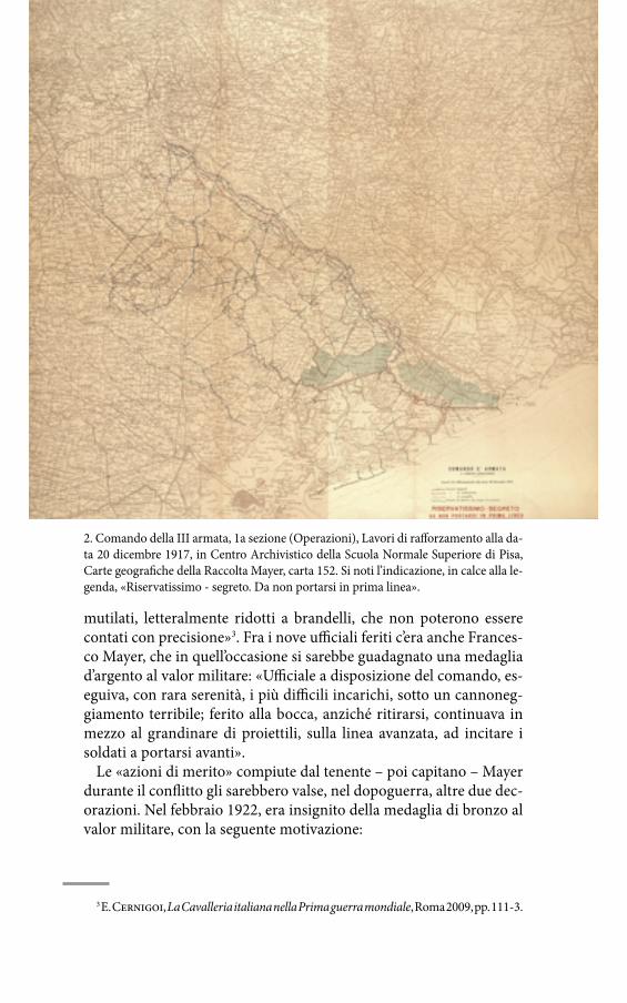
174 Umberto Sassoli174 Sante Lesti
mutilati, letteralmente ridotti a brandelli, che non poterono essere contati con precisione»3. Fra i nove ufficiali feriti c’era anche Frances-co Mayer, che in quell’occasione si sarebbe guadagnato una medaglia d’argento al valor militare: «Ufficiale a disposizione del comando, es-eguiva, con rara serenità, i più difficili incarichi, sotto un cannoneg-giamento terribile; ferito alla bocca, anziché ritirarsi, continuava in mezzo al grandinare di proiettili, sulla linea avanzata, ad incitare i soldati a portarsi avanti».
Le «azioni di merito» compiute dal tenente – poi capitano – Mayer durante il conflitto gli sarebbero valse, nel dopoguerra, altre due dec-orazioni. Nel febbraio 1922, era insignito della medaglia di bronzo al valor militare, con la seguente motivazione:
3 E. Cernigoi, La Cavalleria italiana nella Prima guerra mondiale, Roma 2009, pp. 111-3.
2. Comando della III armata, 1a sezione (Operazioni), Lavori di rafforzamento alla da-ta 20 dicembre 1917, in Centro Archivistico della Scuola Normale Superiore di Pisa, Carte geografiche della Raccolta Mayer, carta 152. Si noti l’indicazione, in calce alla le-genda, «Riservatissimo - segreto. Da non portarsi in prima linea».
175 The Historical Cadaster of Tuscany and the CASTORE Project175 Costruire la nazione. Le Carte geografiche della Raccolta Mayer
Lasciato dal comando di una divisione ritiratasi dalla linea di combattimento come ufficiale di collegamento della divisione subentrante, con nobile senso di emulazione e di cameratismo adempiva la propria missione offrendosi per ardite ricognizioni che eseguiva con particolare arditezza, recandosi sponta-neamente sulla linea del fuoco, nei luoghi di maggiore pericolo e rendendo in tal modo preziosi servizi. Monastier – Fornaci – Pralongo (Piave), 17-23 giugno 1918.
Di quelle ricognizioni del giugno 1917, la b. 13 conserva, per altro, alcuni strumenti importantissimi, nonché, presumibilmente, i frut-ti: le carte della probabile dislocazione delle truppe nemiche (fig. 1).
Nel 1923, invece, Francesco Mayer sarebbe stato insignito della croce di guerra al valor militare. In quest’occasione, la motivazione era la seguente:
A disposizione del comando di una grande unità, mancando notizie es-atte di una divisione di cavalleria impegnata in combattimento, riusciva, di notte, dopo lunghe ore di marcia a cavallo in un terreno percorso dal nemico, a rintracciare la divisione stessa, riportando esatte notizie sugli av-venimenti. Villa Sgraffa-Fanna, 4-5 novembre 1917.
Il contesto dell’«azione di merito» è, in questo caso, quello della riti-rata di Caporetto; le operazioni di rafforzamento della zona del Piave che ne sarebbero seguite, fra il novembre e il dicembre 1917, sono doc-umentate dalle carte 150-152 contenute nella b. 11 (fig. 2).
3. Cartografia e patriottismo
Al di là dell’importanza documentaria dei singoli pezzi – in se stes-si, o in relazione all’esperienza di guerra di Francesco Mayer che sia, l’interesse principale della collezione risiede, mi pare, nel suo insieme. Essa conferma, infatti, come la cartografia costituisca uno dei cana-li principali di espressione della cultura nazional-patriottica. Nello specifico, la collezione riunita da Francesco Mayer testimonia il trip-lice contributo fornito dalla cartografia alla costruzione della nazione. In un primo tempo immaginando la nazione: quando il Touring Club Italiano descrive, nella propria Carta d’Italia, la zona Fiume-Pola, es-sa non appartiene ancora (nella prospettiva del Touring Club e di chi, come Francesco Mayer, maneggia la carta) all’Italia: nonostante ques-to, anzi proprio per questo, si tratta di una regione da «far conoscere» e «far amare»4. Naturalmente, poi, la cartografia contribuisce alla costru-
4 S. Pivato, Il Touring Club Italiano, Bologna 2006.
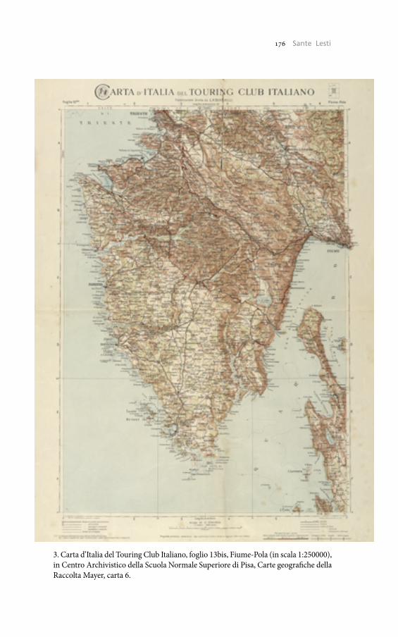
176 Umberto Sassoli176 Sante Lesti
3. Carta d’Italia del Touring Club Italiano, foglio 13bis, Fiume-Pola (in scala 1:250000), in Centro Archivistico della Scuola Normale Superiore di Pisa, Carte geografiche della Raccolta Mayer, carta 6.
177 The Historical Cadaster of Tuscany and the CASTORE Project177 Costruire la nazione. Le Carte geografiche della Raccolta Mayer
zione materiale della nazione con il proprio apporto militare. Infine – ed è per questo che Francesco Mayer ritiene di riunire, anziché lasciar disperdere, le carte militari della Prima guerra mondiale quand’ormai non erano più utili come strumenti di guerra – la cartografia con-tribuisce alla costruzione o, per meglio dire, al consolidamento della nazione, ricordando il «memorabile» evento del suo «compimento». In questo senso, la collezione è in primis il documento della «Grande Guerra» delle nazioni alla quale Francesco Mayer sentiva, come tan-ti altri suoi contemporanei – poeti, intellettuali, o semplici soldati che fossero – di aver partecipato5 (fig. 3).
Sante LestiScuola Normale Superiore, Pisa
5 A. Gibelli, La Grande Guerra degli italiani, Milano 2007 (1998).


Related Documents