1 Natural vegetation of the Carolinas: Classification and Description of Plant Communities of the Pamlimarle Peninsula A report prepared for the Ecosystem Enhancement Program, North Carolina Department of Environment and Natural Resources in partial fulfillments of contract D07042. By M. Forbes Boyle, Robert K. Peet, Thomas R. Wentworth, Michael P. Schafale, and Michael Lee Carolina Vegetation Survey Curriculum in Ecology, CB#3275 University of North Carolina Chapel Hill, NC 27599‐3275 Version 1. May 19, 2009

Welcome message from author
This document is posted to help you gain knowledge. Please leave a comment to let me know what you think about it! Share it to your friends and learn new things together.
Transcript

1
Natural vegetation of the Carolinas: Classification and Description of Plant Communities of the Pamlimarle Peninsula
A report prepared for the Ecosystem Enhancement Program, North Carolina Department of Environment and Natural Resources in partial fulfillments of contract D07042.
By M. Forbes Boyle, Robert K. Peet, Thomas R. Wentworth, Michael P. Schafale, and Michael Lee
Carolina Vegetation Survey Curriculum in Ecology, CB#3275 University of North Carolina Chapel Hill, NC 27599‐3275
Version 1. May 19, 2009

2
INTRODUCTION
In early May 2009, the Carolina Vegetation Survey conducted an initial inventory of natural communities along the Pamlimarle Peninsula of eastern NC. In spite of numerous floristic inventories, there had never been a project designed to classify the diversity of natural wetland communities throughout this portion of North Carolina. Furthermore, the data captured from these plots will enable us to refine the community classification within the broader region. The goal of this report is to determine a classification structure based on the synthesis of vegetation data obtained from the May 2009 sampling event, and to use the resulting information to develop restoration targets for disturbed ecosystems location in this general region of North Carolina.
STUDY AREA AND FIELD METHODS
From May 3‐10 2009, a total of 62 vegetation plots were established along the Pamlimarle Peninsula and region due south of the Pamlico River in eastern North Carolina (Figure 1). Focus locations within the study area included Pocosin Lakes, Alligator River, and Swan Quarter National Wildlife Refuges (NWR), Goose Creek Game Land, Pettigrew State Park, and the Dare County Bomb Range. Target natural communities throughout the week included Coastal Plain mesic mixed hardwood forests, nonriverine swamp forests, tidal cypress‐gum swamps, wet pine flatwoods, Atlantic white cedar forests, estuarine pine woodlands, and brackish marshes.
Vegetation was sampled following the North Carolina Vegetation Survey protocol described in Peet et al. (1998), and data collected conformed to established and proposed federal standards (see: Jennings et al. 2007, and Federal Geographic Data Committee 2007) http://www.fgdc.gov/standards/projects/FGDC‐standards‐projects/vegetation/index_html). Plots were subjectively located to best capture the composition of the target plant community. Each plot contained from 1 to 10 100 m2 modules, the number reflecting the area of visually homogeneous vegetation available to sample. Species presence was recorded across a logarithmic sequence of subplot sizes including 0.01, 0.1, 1, 10, 100, and where sufficient modules were sampled 400 and 1000 m2. Species cover was recorded individually for up to 4 intensively sampled modules (those containing the nested subplots), and overall cover for the plot was also recorded for species not found in intensively sampled modules. Soil samples were collected and sent to Brookside Laboratories for analysis. Soil nutrients were extracted by the Mehlich III technique. Mean soil nutrient and texture values are summarized by community in Appendix 1. Tree stems were recorded for each plot by diameter.

3
FIGURE 1. Pulse 2009A sample region and established plots. Map courtesy of GoogleMaps: http://maps.google.com/maps?q=http://cvs.bio.unc.edu/maps/110‐pointsA.kml.xml
VEGETATION CLASSIFICATION
Plots were classified to association following the US National Vegetation Classification (NVC) standard (Grossman et al. 1998, Jennings et al. 2006) and the Carolina Vegetation Survey’s “Vegetation of the Carolinas” project (http://cvs.bio.unc.edu/vegetation.htm). The ‘association’ is defined as a group of plots having similar species composition, structure, and habitat. Plot assignment was accomplished through a qualitative assessment of vegetation composition, landscape position, hydrologic regime, and soil characteristics. The associations were grouped into higher categories following the classification hierarchy developed by the “Vegetation of the Carolinas” project and include the Formation (e.g., Coastal Plain lowland evergreen forests and shrublands) and Ecological Group (e.g., White cedar forests) levels. The lowest, finest level of the classification scheme used was the NVC association.

4
Where possible, plots were assigned to an NVC association, identified by association name and unique CEGL identifier. Also, a degree of fit was applied to the classification scheme based on the plot’s correspondence with its assigned association. The 5‐level scale of fit we employ conforms to that the standards employed by the VegBank archive and the proposed US Federal standards (see Jennings et al. 2007): Excellent, Good, Fair, Poor (similar but wrong), and Incorrect (unambiguously wrong). In some cases it was necessary to assign a plot to more than one community because of its intermediate character. In 49 of the 76 cases (see Appendix 2), the fit was either fair or poor, suggesting a need for numerous revisions of the NVC to better represent the vegetation of this part of North Carolina.
For each community type to which we assigned plots, we provide a brief summery. We also provide hotlinks (with the CEGL codes) to the formal descriptions of these types in the National Vegetation Classification. Where the fit is weak or poor, we briefly explain the problem. Composition is shown in detail in Appendix 3 where the prevalent species (most frequent species with the number equal to the average number of species per 100 m2 plot) are listed by constancy among plots, and mean percent cover where present. Average cover class was calculated using the geometric mean of the true cover range for each cover class. Vegetation that was novel or failed to fit well in established associations of the National Vegetation Classification are summarized in Appendix 2. Botanical nomenclature follows Weakley 2006.
Our classification yielded assignments to 36 high‐order community associations, from 22 Ecological Groups and 15 Formations. A community characterization is presented for each association below. Names are based on the naming system used in the U.S. National Vegetation Classification (NatureServe 2007). Names reflect species with high constancy and high cover; a “‐“ separates species within the same vertical strata, while a “/” separates species of different strata.

5
ASSOCIATIONS
I. Coastal Plain Mixed Mesic Forests
A. Mesotrophic Mesic Forests
1) Fagus grandifolia ‐ Quercus nigra Forest (CEGL007211)
NVC Fit = Good Plots = 110‐02‐1304
This plot is located on an interfluve within the upper Scuppernong River drainage in northern Tyrell County, NC. The NVC describes this community association as a mixed hardwood forest type dominated by Fagus grandifolia and occurring on acidic bluffs, or other acidic, fire‐sheltered sites in the Piedmont and Mid‐Atlantic Coastal Plain. Besides Fagus grandifolia, other canopy and subcanopy species found within this plot include Ilex opaca var. opaca, Pinus taeda, Oxydenrum arboreum, and Quercus alba. Ericaceous shrubs are important in the shrub stratum, and include Gaylussacia frondosa, Vaccinium corymbosum, and Lyonia lucida. The herbaceous stratum also includes acidic‐tolerant species, such as Mitchella repens, Gaultheria procumbens, and Chimaphila maculata.

6
II. Coastal Plain Subxeric Forests
A. Acid Oak Forests
1) Quercus falcata ‐ Quercus stellata ‐ Carya alba / Vaccinium spp. Coastal Plain Forest (CEGL007246)
NVC Fit = Fair Plots = 110‐06‐1307
This plot is located on a west‐facing bluff of Nevil Creek in southern Beufort County, NC, south of the Pamlico River. The NVC describes this community association as an upland hardwood forest of the Atlantic and Gulf Coastal Plain, occurring naturally on acidic soils and fire‐protected landscapes. These forests typically lack species restricted to higher pH soils or wetter, riparian slope positions. The canopy of this plot is dominated by Quercus falcata,and Quercus alba, while the subcanopy is composed of these species, as well as Liquidambar styraciflua, Cornus florida, Oxydendrum arboreum,and Nyssa sylvatica. The shrub stratum is dominated by Vaccinium tenellum, Gaylussacia frondosa, and Vaccinium formosum. Herbaceous species diversity and abundance values are both low in this plot. Species include Arundinaria tecta, Chasmanthium spp., Hypericum hypericoides, and Mitchella repens. The occurrence of species from the nearby stream zone (e.g. Liquidambar styraciflua, Clethra alnifolia) justify labeling this plot a fair fit to the NVC‐described association.
III. Coastal Plain Fire‐maintained Woodlands
A. Pine Flatwoods
1) Pinus palustris - (Pinus serotina) / Ilex glabra - Gaylussacia frondosa - (Kalmia carolina) Woodland (CEGL003647)
NVC Fit = Fair to Good Plots = 110‐01‐1300, 110‐04‐1300, 110‐04‐1301
This wet pine flatwood community type occurs north of the range of Aristida stricta, and is characterized by an open canopy of Pinus palustris (with Pinus taeda or Pinus serotina), and a dense shrub stratum of Ilex glabra and Gaylussacia frondosa. The three plots sampled during this study occur on Goose Creek Game Lands, in southeastern Beaufort County, NC. Along with the community nomimal species, these plots are dominated by Persea palustris, Acer rubrum var. trilobum, Clethra alnifolia, and Morella caroliniensis. The herbacouse stratum is dominated Arundinaria tecta and Pteridium aquilinum. Two of the three plots sampled are floristically similar to the NVC‐described association; the high diversity of shrub and understory species found within plot 04‐1301 explain its ‘fair’ fit assignment to the NVC‐described association.

7
IV. Coastal Plain Blackwater River Forests
A. Blackwater Swamp Forests
1) Taxodium distichum - Nyssa aquatica - Nyssa biflora / Fraxinus caroliniana / Itea virginica Forest (CEGL007432)
NVC Fit = Fair Plots = 110‐04‐1303
This Coatal Plain swamp forest occurs on fine‐textured mineral soils of Coastal Plain blackwater rivers, and experiences long periods of river overbank flow. This plot occurs along the upper Scuppernong River in eastern Washington County, NC; the canopy and subcanopy of this stand is composed of Nyssa aquatica, Fraxinus caroliniana, Fraxinus pennsylvanica, Taxodium distichum, and Acer rubrum var. rubrum. The shrub stratum is open in this example, and the herbaceous stratum is composed of Boehmeria cylindrica, Woodwardia areolata, Glyceria septentrionalis, and Saururus cernuus. This association is typically co‐dominated by both Nyssa biflora and Nyssa aquatica; however, this plot does not contain the former. This plot also does not correspond well with the NVC‐described association due to the abundance of both Fraxinus spp. in the canopy and understory.
2) Nyssa biflora - Liquidambar styraciflua / Glyceria septentrionalis - Hydrocotyle ranunculoides Forest (CEGL007743)
NVC Fit = Fair Plots = 110‐02‐1305
This bottomland hardwood forest of the Atlantic Coastal Plain is dominated by a canopy of Nyssa biflora, Liquidambar styraciflua, and Acer rubrum. It has been described for Virginia, while its presence in North

8
Carolina is questionable. The herbaceous stratum of this community is characterized by extensive colonies of Glyceria septentrionalis and Hydrocotyle ranunculoides. This type is known to occur along small stream backwater swamps or along upland blackwater swamp edges. This plot is located along the upper Scuppernong River in western Tyrell County, NC. The canopy and subcanopy of this stand is dominated by a variable mixture of Nyssa aquatica, Acer rubrum, Taxodium distichum, Fraxinus pennsylvanica, Nyssa biflora, and Quercus laurifolia. The small tree and shrub strata are relatively open, but composed of Fraxinus caroliniana and Cornus foemina. The herbaceous stratum is fairly diverse for a wet blackwater swamp forest, and includes Glyceria septentrionalis, Saururus cernuus, Carex stipata var. maxima, and Viola esculenta. The NVC describes this community type as completely lacking Taxodium distichum, Nyssa aquatica, and Fraxinus pennsylvanica.
V. Coastal Plain Lowland Deciduous Forests
A. Coastal Plain Hardwood Flats
1) Quercus michauxii - Quercus pagoda / Clethra alnifolia - Leucothoe axillaris Forest (CEGL007449)
NVC Fit = Poor to Good Plots = 110‐04‐1306, 110‐04‐1307, 110‐06‐1300, 110‐09‐1304
This wetland forest type occurs on nonalluvial flats, is typically underlain by limestone, and is prone to seasonal saturation. It is found in association with large peatlands of the Atlantic Coastal Plain of North

9
Carolina and Virginia. The stands sampled during this study that are representative of this community type are dominated by a canopy of Quercus pagoda and Quercus michauxii, as well as other hardwood species such as Liriodendron tulipifera and Liquidambar styraciflua. The subcanopy of these stands is comprised of Ilex opaca var. opaca, Asimina triloba, Carpinus caroliniana var. caroliniana, Fagus grandifolia, and Quercus nigra. The shrub stratum is relatively sparse in these stands, and community nominal shrubs are completely absent. Plot 06‐1300 is described as having a ‘poor’ fit to the association because of the dominance of Quercus phellos and successional Pinus taeda in the canopy.
B. Coastal Plain Nonriverine Swamp Forests
1) Taxodium distichum - Nyssa biflora / Berchemia scandens - Toxicodendron radicans / Woodwardia areolata Forest (CEGL004429)
NVC Fit = Good Plots = 110‐01‐1307
This nonriverine forest, codominated by Taxodium distichum and Nyssa biflora, occurs over saturated wetland soils of the Atlantic Coastal Plain of North Carolina and Virginia. The stand sampled during this study is located in the Pocosin Lakes National Wildlife Refuge, in western Tyrell County. The canopy is dominated by Nyssa biflora and Acer rubrum var. trilobum, with lesser amounts of Taxodium distichum, and Magnolia virginiana. The subcanopy contains canopy species, along with Ilex opaca var. opaca, and Persea palustris; woody vines are characteristic of this stand, and include Vitis rotundifolia var. rotundifolia, Toxicodendron radicans var. radicans, Gelsemium sempervirens, and several species of Smilax. The shrub and herbaceous strata are sparse in this example. Some species in the herbaceous layer include Athyrium asplenoides, Mitchella repens, Woodwardia areolata, and Asplenium platyneuron.

10
2) Nyssa biflora - Liquidambar styraciflua - Acer rubrum var. trilobum / Clethra alnifolia Forest (CEGL004679)
NVC Fit = Good Plots = 110‐01‐1310
This nonriverine forest, codominated by Liquidambar styraciflua, Nyssa biflora, and Acer rubrum var. trilobum, occurs over saturated wetlands soils of the North Carolina (and potentially Virginia) Coastal Plain. The soil is characteristically more mineral than organic in this nonriverine type. The stand of this type sampled during this study is located in the southern portion of the Alligator River National Wildlife Refuge, in Dare County, NC. The canopy and subcanopy are dominated by Acer rubrum var. trilobum, Liquidambar styraciflua, Persea palustris, Nyssa biflora, and Magnolia virginiana. The vine and shrub strata are well‐developed, and include Vaccinium fuscatum, Arundinaria tecta, Decumaria barbara, Smilax laurifolia, and Gelsemium sempervirens. The herbaceous layer is not well‐developed, but does include Osmunda cinnamomea, Woodwardia virginica, and Osmunda regalis var. spectabilis.
3) Taxodium ascendens / (Nyssa biflora) / Leucothoe racemosa - Lyonia lucida - Morella cerifera Depression Forest (CEGL007420)
NVC Fit = Poor to Good Plots = 110‐03‐1301, 110‐04‐1304
This Coastal Plain swamp forest occurs in permanently wet depressions and is characterized by a closed canopy of Taxodium ascendens or Nyssa biflora and a poorly developed graminoid strata. This forested wetland is differentiated from other nonriverine swamp forests by occurring in closed basins and experiencing profoundly deeper flooding events. The two plots of this type sampled during this study occur within the Alligator River National Wildlife Refuge of Dare County, NC. The canopy of these two plots are dominated by Taxodium ascendens, Persea palustris, Nyssa biflora, and, in the case of the ‘poor’ fit plot 03‐1301, Taxodium distichum. The shrub stratum is composed of pocosin species, such as Lyonia lucida, Ilex coriacea, and Ilex glabra, as well as Clethra alnifolia. The herbaceous layer is not well‐developed in these stands.
VI. Coastal Plain Lowland Evergreen Forests and Shrublands
A. White Cedar Forests
1) Chamaecyparis thyoides / Persea palustris / Lyonia lucida - Ilex coriacea Forest (CEGL006146)
NVC Fit = Good to Excellent Plots = 110‐01‐1309, 110‐06‐1306
This community is found on flat, permanently saturated peatlands of nonriverine bottomlands of the Atlantic Coastal Plain and adjacent Sandhills. The canopy is dominated by Chamaecyparis thyoides, with lesser amounts of Nyssa biflora and Acer rubrum var. rubrum. Subcanopy species include Persea palustris, Magnolia virginiana var. virginiana and Ilex opaca var. opaca. A moderately dense shrub

11
stratum is composed of Ilex coriacea, Lyonia lucida, and Leucothoe axillaris. A sparse herbaceous stratum includes Woodwardia areolata, Woodwardia virginica, and Osmunda cinnamomea var. cinnamomea. The two plots inventoried during this study are located in northern Tyrell and Dare Counties, NC.
B. Pocosins
1) Ilex glabra - Lyonia lucida - Zenobia pulverulenta Shrubland (CEGL003944)
NVC Fit = Fair to Good Plots = 110‐02‐1308, 110‐05‐1300
This low pocosin occurs on deep peat domes of the Outer and Middle Atlantic Coastal Plain of North and South Carolina. This pocosin type is differentiated from others by the low stature of shrubs (typically less than 1.5 meters tall) and pines (when present). Like most pocosin and peatland communities of the Coastal Plain, this type is maintained by extremely poor soil nutrient status and occasional fire events. The only constant dominant shrub in these plots is Ilex glabra. Other shrubs include Zenobia pulverulenta, Cyrilla racemiflora, and Lyonia lucida. In one plot, there is a patcy tree stratum of Pinus serotina. Plot 02‐1308 is characterized as a ‘fair’ fit to the NVS‐described association because of the co‐dominance of Cyrilla racemiflora and Zenobia pulverulenta in the shrub stratum and the abundance of herbs (e.g. Sarracenia flava, Chamaedaphne calyculata).
12
2) Chamaedaphne calyculata - Vaccinium macrocarpon / Carex striata var. striata - Woodwardia areolata Dwarf-shrubland (CEGL004165)
NVC Fit = Fair Plots = 110‐01‐1306, 110‐05‐1301
These dwarf shrub/herbaceous vegetation types occur in openings within the shrub‐dominated pocosin landscape. These communities are patchy in distribution, and may be very small. Because of their small size and occurrence within a larger vegetation matrix, they often contain typical low/high pocosin shrub species mixed in with association nominals. The two plots sampled during this study occur within Mashoes Pocosin, in Dare County, NC. The dwarf shrub stratum is dominated by Vaccinium macrocarpon, while the shrub stratum contains a mixture of low pocosin species‐‐Ilex glabra, Morella cerifera, and Lyonia lucida. The herbaceous layer is rich for occurring on a nutrient‐limited geomorphic position. Herbaceous and graminoid vegetation include Woodwardia virginica, Rhynchospora plumosa, Chamaedaphne calyculata, Carex striata, and Xyris ambigua. Plots are characterized as a ‘fair’ fit to the NVC‐described association because Vaccinium macrocarpon does not occur with great abundance (< 5% cover in each) in either of these two plots.
C. Pond Pine Forests and Woodlands
1) Pinus serotina / Ilex glabra / Woodwardia virginica Woodland (CEGL004652)
NVC Fit = Good Plots = 110‐01‐1305
This community type contains typical pocosin shrub species underneath a well‐developed tree canopy (typically >25% cover), although coverage may decrease depending on the fire history (frequency, severity) of a particular site. This plot occurs on the Dare Bombing Range in southern Dare County, NC, and may represent a subset of this association, due to the absence of Ilex glabra. Otherwise, the plot is structurally and compositionally similar to the NVC‐described association. The canopy is dominated by well‐developed Pinus serotina, while the shrub and herbaceous strata include Smilax laurifolia, Vaccinium formosum, Persea palustris, and Rhus copallinum.
VII. Coastal Plain Ponds and Marshes
A. Wooded Lake and Pond Shores
1) Taxodium distichum - Liquidambar styraciflua - Platanus occidentalis / Asimina triloba Forest (CEGL004424)
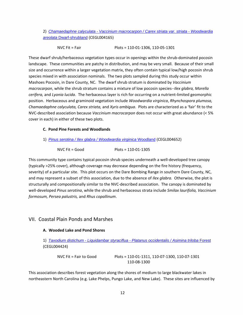
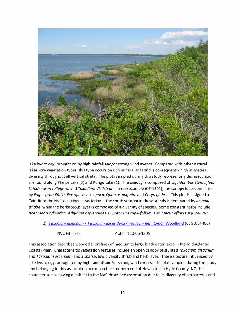
NVC Fit = Fair to Good Plots = 110‐01‐1311, 110‐07‐1300, 110‐07‐1301 110‐08‐1300 This association describes forest vegetation along the shores of medium to large blackwater lakes in northeastern North Carolina (e.g. Lake Phelps, Pungo Lake, and New Lake). These sites are influenced by
13
lake hydrology, brought on by high rainfall and/or strong wind events. Compared with other natural lakeshore vegetation types, this type occurs on rich mineral soils and is consequently high in species diversity throughout all vertical strata. The plots sampled during this study representing this association are found along Phelps Lake (3) and Pungo Lake (1). The canopy is composed of Liquidambar styraciflua, Liriodendron tulipifera, and Taxodium distichum. In one example (07‐1301), the canopy is co‐dominated by Fagus grandifolia, Ilex opaca var. opaca, Quercus pagoda, and Carya glabra. This plot is assigned a ‘fair’ fit to the NVC‐described association. The shrub stratum in these stands is dominated by Asimina triloba, while the herbaceous layer is composed of a diversity of species. Some constant herbs include Boehmeria cylindrica, Athyrium asplenoides, Eupatorium capillifolium, and Juncus effuses ssp. solutus.
2) Taxodium distichum - Taxodium ascendens / Panicum hemitomon Woodland (CEGL004466)
NVC Fit = Fair Plots = 110‐06‐1305 This association describes wooded shorelines of medium to large blackwater lakes in the Mid‐Atlantic Coastal Plain. Characterisitic vegetation features include an open canopy of stunted Taxodium distichum and Taxodium ascenden, and a sparse, low diversity shrub and herb layer. These sites are influenced by lake hydrology, brought on by high rainfall and/or strong wind events. The plot sampled during this study and belonging to this association occurs on the southern end of New Lake, in Hyde County, NC. It is characterized as having a ‘fair’ fit to the NVC‐described association due to its diversity of herbaceous and

14
graminoid species. These include Juncus repens, Triadenum walteri, Eupatorium perfoliatum, Lycopodiella prostrata, and Solidago spp.
B. Freshwater Marshes
1) Panicum hemitomon - Juncus spp. Coastal Plain Lake Shore Herbaceous Vegetation (CEGL004307)
NVC Fit = Excellent Plots = 110‐01‐1303, 110‐01‐1304, 110‐01‐1308, 110‐09‐1305 This herbaceous vegetation association occurs on the shorelines of blackwater lakes in the Coastal Plain of northeastern North Carolina. It is distinguished from other natural lakeshore vegetation types by herbaceous species dominance and having only a few scattered Taxodium stems. The four plots sampled during this study occur along the shore of Lake Phelps, within the Pocosin Lakes National Wildlife Refuge. The plots are dominated by Juncus militaris and Panicum hemitomon. Other species include Eupatorium capillifolium, Eriocaulon aquaticum, Hydrocotyle umbellate, and Eleocharis equisetoides.

15
VIII. Maritime Forests
A. Mesic Maritime Hardwood Forests
1) Quercus falcata - Pinus taeda - (Fagus grandifolia, Quercus nigra) / Persea palustris Maritime Forest (CEGL007540)
NVC Fit = Fair Plots = 110‐02‐1306, 110‐08‐1301 This deciduous‐dominated maritime forest occurs on sheltered sites of barrier islands and similar coastal areas where it is protected from storm surges and salt spray. The plots sampled during this study occur on private land in northern Tyrell County, NC, just south of the Albemarle Sound and technically outside the boundary of the maritime fringe. The canopy of these plots is dominated by a mixture of hardwood species, including Quercus nigra, Fagus grandifolia, Liriodendron tulipifera, Quercus falcata, and Liquidambar styraciflua; Pinus taeda is also abundant in the canopy. The shrub and vine strata are well‐developed and highly diverse. Species include Symplocos tinctoria, Castanea pumilla, Vitis rotundifolia var. rotundifolia, Smilax rotundifolia, Stryax grandifolius, and Clethra alnifolia. Herbaceous diversity is extremely low in both of these plots.
IX. Freshwater Tidal Woodlands
A. Tidal Hardwood Swamps
1) Nyssa biflora - (Taxodium distichum, Nyssa aquatica) / Morella cerifera - Rosa palustris Tidal Forest (CEGL004484)
NVC Fit = Good Plots = 110‐02‐1307, 110‐06‐1302, 110‐08‐1306 This is a broadly described NVC association which is used for tidally influenced swamp forests of both brownwater and blackwater rivers of the Atlantic and Gulf Coastal Plains. Flooding events can be driven by wind or lunar tides, and species present are typically resilient to permanent saturation. Composition within these stands is a variable mixture of blackwater and brownwater species, along with species typical of tidal influence (e.g. Morella cerifera). The three plots sampled during this survey occur along the southern Albemarle Sound and the lower Scuppernong River in Tyrell County, NC. The canopy is codominated by Taxodium distichum, Nyssa biflora, Nyssa aquatica, and Liquidambar styraciflua. The shrub stratum is dominated by Morella cerifera. The herbaceous layer is well‐developed in these stands, due to the nutrient input from tidal events. Constant species include Osmunda regalis var. spectabilis, Hydrocotyle spp., Saururus cernuus, and Cicuta maculata var. maculata.

16
B. Tidal Conifer Swamps
1) Juniperus virginiana var. silicicola / Morella cerifera / Kosteletzkya virginica - Bacopa monnieri Woodland (CEGL007166)
NVC Fit = Poor to Fair Plots = 110‐02‐1303, 110‐03‐1300, 110‐04‐1310 This flooded brackish woodland occurs along tidal creeks of coastal North Carolina and Georgia. The canopy of these sites is usually open, and dominated by Juniperus virginiana var. silicicola; marsh species are typically found in the shrub and herbaceous strata. The three plots sampled during this survey occur along Goose Creek in Beufort/Pamlico County, NC and along Pamlico Sound in Hyde County, NC. Like the NVC community describes, the canopy within these plots is dominated by Juniperus virginiana, with a Pinus taeda serving as a codominant or subordinate. Both Morella cerifera and Toxicondendron radicans var. radicans are constant species occurring in the shrub and woody vine strata. Brackish marsh species are found within the herbaceous stratum of these sites, and include Distichlis spicata, Juncus roemerianus, and Typha angustifolia. There is a need to examine the species composition of these marsh woodlands as it relates to

17
salinity and soil characteristics (e.g., silt versus organic muck concentration). The current NVC association for these Juniperus woodlands may be too broad.
C. Oligohaline Tidal Woodlands
1) Pinus serotina / Morella cerifera /Osmunda regalis var. spectabilis Woodland (CEGL003669)
NVC Fit = Fair Plots = 110‐04‐1302 This community type encompasses Pinus serotina‐dominated woodlands adjacent to estuarine wetlands with some form of tidal influence. This type is found along the Atlantic Coastal Plain of Virginia and North Carolina. This plot is located within Goose Creek Game Land, in Pamlico County, NC. The canopy is dominated by a comination of Nyssa biflora, Pinus serotina, Persea palustris, and Acer rubrum var. trilobum. Morella cerifera is the dominant shrub, while the herbaceous stratum is composed of such species as Osmunda regalis var. spectabilis, Osmunda cinnamomea, and Berchemia scandens. Except for the co‐dominance of hardwood species in the canopy, this plot resembles the NVC‐described association.
2) Pinus taeda / Morella cerifera / Osmunda regalis var. spectabilis Forest (CEGL006137)
NVC Fit = Fair to Good Plots = 110‐02‐1302, 110‐06‐1301, 110‐06‐1304 This community type encompasses Pinus taeda‐dominated woodlands adjacent to estuarine sounds or marshes with some form of tidal influence during high water events. The plots linked to this community sampled during this survey occur along Pamlico Sound or its tributaries. They are dominated by a canopy of Pinus taeda, with lesser amounts of Persea palustris. The shrub stratum is dominated by Morella cerifera, Baccharis halimifolia, and in one example, Arundinaria tecta. The herbaceous stratum is dominated by Osmunda regalis var. spectabilis in two of the three plots sampled. Plot 06‐1304 is characterized as having a fair fit to the NVC‐described association due to the co‐dominance of hardwood species (e.g., Acer rubrum var. trilobum, Magnolia virginiana, Quercus nigra, and Liquidambar styraciflua in the canopy.

18
X. Shrubby Tidal Vegetation
A. Saline Tidal Shrublands
1) Borrichia frutescens / (Spartina patens, Juncus roemerianus) Shrubland (CEGL003924)
NVC Fit = Fair to Good Plots = 110‐01‐1301, 110‐09‐1300 This shrubby vegetation community type occurs on upper marsh edges that are infrequently flooded with salt water. Salt tolerant shrubs and herbs dominate these patches, as well as brackish grasses. These stands are typically dominated by Borrichia frutescens, although this species is absent in both plots sampled during this study. Species composition within these two plots is quite distinct; neither shares the same species. Low shrubs and herbs/graminoids encountered include Cladium jamaicense, Juncus roemerianus, Baccharis halimifolia, Spartina patens, and Osmunda cinnamomea.
2) Iva frutescens / Spartina patens Shrubland (CEGL006848)
NVC Fit = Fair Plots = 110‐10‐1301 This shrubby vegetation type of the Atlantic Coastal Plain occurs along ecotonal sites between salt marshes and upland vegetation, and is typically dominated by Iva frutescens. This plot is dominated by Spartina patens in the herbaceous stratum, along with Juncus roemerianus and Distichlis spicata. Although the association nominal shrub is found in this plot, its low cover value (5‐10%) could more likely represent this plot as an ecotone between a saline shrub and graminoid‐dominated wetland.
XI. Open Salt and Brackish Tidal Vegetation
A. Tidal Salt Marshes
1) Spartina patens - Distichlis spicata - (Juncus roemerianus) Herbaceous Vegetation (CEGL004197)
NVC Fit = Fair to Good Plots = 110‐08‐1302, 110‐08‐1303, 110‐08‐1305, 110‐09‐1302, 110‐09‐1306, 110‐10‐1300 110‐02‐1300 This graminoid‐dominated wetland occurs on irregularly flooded tidal marshes of the Atlantic Coastal Plain. This type is often dominated, or co‐dominated by Spartina patens, occurring with Distichlis spicata, Juncus roemerianus, and species from adjacent salt marshes, e.g., Spartina alterniflora. These six plots occur on the southern end of the Pamlimarle Peninsula and south of the Pamlico River on the Goose Creek Game Land. All are dominated by Spartina patens, with varying degrees of importance from the aforementioned species. Plots that had high importance of more salt‐tolerant Spartina alterniflora perhaps represent an ecotone along the saline gradient, and correspond as a ‘fair’ fit to the NVS‐described association.

19
2) Schoenoplectus americanus - Spartina patens Herbaceous Vegetation (CEGL006612)
NVC Fit = Fair Plots = 110‐04‐1309 This graminoid‐dominated tidal wetland occurs between low and high salt marsh zones and is irregularly flooded. It is dominated by extensive colonies of Schoenoplectus americanus, occurring with other salt‐brackish marsh graminoid species, including Spartina patens, Spartina alterniflora, and Distichlis spicata. This plot is located on the southeastern corner of the Pamlimarle Peninsula, within Gull Rock Game Land. Although it occurs on the same geomorphic gradient as the NVC‐association, the dominant graminoid is Schoenoplectus pungens var. pungens. This community type has not been described for North Carolina.

20
B. Brackish Marshes
1) Cladium mariscus ssp. jamaicense Tidal Herbaceous Vegetation (CEGL004178)
NVC Fit = Fair to Good Plots = 110‐06‐1303, 110‐09‐1303 This brackish to oligohaline tidal marsh community is distinguished from other marshes by the dominance of Cladium mariscus ssp. jamaicense. Other species associated with tidal wetlands may be found within the dense stands of Cladium. One of the plots sampled during this inventory occurs on the northern edge of the Pamlico River, in Beaufort County, N.C.; the other plot occurs at the mouth of the Pamlico River in southern Hyde County, N.C. Besides Cladium mariscus ssp. jamaicense, the other constant species found in these two plots is Toxicodendron radicans var. radicans. Plot 09‐1303 is characterized as having a ‘fair’ fit to the NVC‐described association because of the short stature of plants within the stand, due to its recent (< 3 month) fire disturbance.
2) Juncus roemerianus Herbaceous Vegetation (CEGL004186)
NVC Fit = Fair to Good Plots = 110‐02‐1301, 110‐04‐1308, 110‐08‐1304 This brackish tidal marsh community is characterized by dense stands of Juncus roemerianus, occurring with other species associated with tidal wetlands. These species may include Distichlis spicata, Spartina alterniflora, and Spartina patens. It can occur in upper topographic positions of salt marshes, at the headwaters of tidal creeks, or in expansive brackish zones. These three plots are scattered across the sampling region of this study, and all are dominated by Juncus roemerianus. Plot 04‐1308 is characterized as having a ‘fair’ fit to the NVC‐described association because of the codominance of Distichlis spicata within the stand.

21
XII. Open Fresh and Oligohaline Vegetation
A. Oligohaline Tidal Marshes
1) Juncus roemerianus - Pontederia cordata Herbaceous Vegetation (CEGL004660)
NVC Fit = Fair Plots = 110‐01‐1302 This freshwater tidal marsh community is characterized by dense stands of Juncus roemerianus, occurring with species of low salt tolerance, including Osmunda regalis var. spectabilis, Thelypertis palustris var. palustris, and Pontederia cordata. This plot occurs within Goose Creek Game Land, in Beaufort County, NC. It is dominated by a dense stand of Juncus roemerianus. Other species within this plot include Hisbiscus mascheutos, Cladium jamaicense, and Osmunda regalis var. spectabilis. The range of variation in species composition found within these Juncus‐dominated freshwater tidal wetlands is the reason why this plot was assigned a ‘fair’ fit to the NVC‐described community type.
XIII. Marine Aquatic Herb Vegetation
A. Open Aquatic Marine Vegetation
1) Ceratophyllum demersum - Utricularia macrorhiza - Nymphaea odorata Herbaceous Vegetation (CEGL004661)
NVC Fit = Poor Plots = 110‐04‐1305 This community represents a floating or submergent aquatic zone of wind‐tidally flooded freshwater rivers of the Atlantic Coastal Plain. The NVC describes this associtation as having a dominance or codominance of Ceratophyllum demersum. However, this species is not found within the plot sampled during this study. The plot is dominated by a submersed stratum of Utricularia inflata, with overhanging woody species from the adjacent river bank (Acer rubrum var. trilobum and Persea palustris). This plot occurs on a wind‐tidally influenced Coastal Plain small stream, and floristically bares little resemblance to the NVC‐described association.
LITERATURE CITED
Federal Geographic Data Committee. 2007. (http://www.fgdc.gov/standards/projects/FGDC‐standards‐projects/vegetation/index_html).
Grossman D.H., Faber‐Langendoen D., Weakley A.S., Anderson M., Bourgeron P., Crawford R., Goodin K., Landaal S., Metzler K., Patterson K.D., Pyne M., Reid M., and Sneddon L. 1998. International classification of ecological communities: terrestrial vegetation of the United States. Volume I,

22
The National Vegetation Classification System: development, status, and applications. The Nature Conservancy: Arlington, VA.
Jennings, M. D. et al 2006. Description, documentation, and evaluation of associations and alliances within the U.S. national Vegetation Classification. Version 4.5. Vegetation Classification Panel. Ecolgoical Society of America. http://www.esa.org/vegweb/docFiles/NVC_Guidelines_v45.pdf
NatureServe. 2007. U.S. National Vegetation Classifcation. http://www.natureserve.org/explorer/servlet/NatureServe?init=Ecol
Peet, R.K., T.R. Wentworth and P.S. White. 1998. A flexible, multipurpose method for recording vegetation composition and structure. Castanea 63:262‐274
Schafale, M.P. and Weakley, A.S. 1990. Classification of the Natural Communities of North Carolina: Third Approximation. N.C. Natural Heritage Program, Raleigh, N.C. 325 pp. http://www.ncnhp.org/Images/Other%20Publications/class.pdf.
Weakley, A.S. 2006. Flora of the Carolinas, Virginia, Georgia, and the Surrounding area. Draft of January 2006. University of North Carolina Herbarium, Chapel Hill, NC.

23
Appendix 1: Soil Nutrient and Texture Values Summarized by Association. Specific soil variables include pH, Organic Matter (%), exchangeable cations (Ca, Mg, K, Na, Mn; ppm), texture class (clay, silt, sand; %).
Community Type PH Organic Calcium Magnesium Potassium Sodium Manganese Sand % Silt % Clay %I.A.1: Fagus grandifolia ‐ Quercus nigra Forest
(CEGL007211) 3.9 4 74 23 23 34 1 75 22 4II.A.1: Quercus falcata ‐ Quercus stellata ‐ Carya
alba / Vaccinium spp. Coastal Plain Forest (CEGL007246) 4.0 5 87 21 30 22 1 68 28 4
III.A.1: Pinus palustris ‐ (Pinus serotina) / Ilex glabra ‐ Gaylussacia frondosa ‐ (Kalmia carolina)
Woodland (CEGL003647) 3.9 16 251 130 46 151 1 69 28 3IV.A.1: Taxodium distichum ‐ Nyssa aquatica ‐ Nyssa biflora / Fraxinus caroliniana / Itea
virginica Forest (CEGL007432) 5.3 49 2021 542 178 505 11 71 22 7
IV.A.2: Nyssa biflora ‐ Liquidambar styraciflua / Glyceria septentrionalis ‐ Hydrocotyle ranunculoides Forest (CEGL007743) 5.4 56 2077 619 162 483 10 77 20 3
IX.A.1: Nyssa biflora ‐ (Taxodium distichum, Nyssa aquatica) / Morella cerifera ‐ Rosa palustris
Tidal Forest (CEGL004484) 5.4 29 916 703 152 874 6 75 23 3
IX.B.1: Juniperus virginiana var. silicicola / Morella cerifera / Kosteletzkya virginica ‐ Bacopa
monnieri Woodland (CEGL007166) 5.4 25 898 1028 283 3439 10 62 32 6IX.C.1: Pinus serotina / Morella cerifera
/Osmunda regalis var. spectabilis Woodland (CEGL003669) 4.8 12 317 302 112 532 1 69 27 4
IX.C.2: Pinus taeda / Morella cerifera / Osmunda regalis var. spectabilis Forest (CEGL006137) 4.9 18 396 383 131 977 1 67 29 4V.A.1: Quercus michauxii ‐ Quercus pagoda / Clethra alnifolia ‐ Leucothoe axillaris Forest
(CEGL007449) 4.1 9 546 89 63 33 7 32 61 7
V.B.1: Taxodium distichum ‐ Nyssa biflora / Berchemia scandens ‐ Toxicodendron radicans / Woodwardia areolata Forest (CEGL004429) 3.4 89 304 74 52 41 1 77 20 3
V.B.2: Nyssa biflora ‐ Liquidambar styraciflua ‐ Acer rubrum var. trilobum / Clethra alnifolia
Forest (CEGL004679) 3.9 19 320 41 48 51 1 40 55 5
V.B.3: Taxodium ascendens / (Nyssa biflora) / Leucothoe racemosa ‐ Lyonia lucida ‐ Morella cerifera Depression Forest (CEGL007420) 3.5 93 319 209 89 278 3 83 14 3
VI.A.1: Chamaecyparis thyoides / Persea palustris / Lyonia lucida ‐ Ilex coriacea Forest
(CEGL006146) 3.5 95 175 107 41 156 1 83 12 5
VI.B.1: Ilex glabra ‐ Lyonia lucida ‐ Zenobia pulverulenta Shrubland (CEGL003944) 3.7 89 206 89 58 53 1 77 18 5
VI.B.2: Chamaedaphne calyculata ‐ Vaccinium macrocarpon / Carex striata var. striata ‐ Woodwardia areolata Dwarf‐shrubland
(CEGL004165) 4.1 84 216 206 73 270 1 83 10 7
VI.C.1: Pinus serotina / Ilex glabra / Woodwardia virginica Woodland (CEGL004652) 4.0 93 198 71 15 43 2 79 1 19

24
Community Type PH Organic Calcium Magnesium Potassium Sodium Manganese Sand % Silt % Clay %VII.A.1: Taxodium distichum ‐ Liquidambar styraciflua ‐ Platanus occidentalis / Asimina
triloba Forest (CEGL004424) 4.4 10 653 81 64 39 6 55 43 2VII.A.2: Taxodium distichum ‐ Taxodium
ascendens / Panicum hemitomon Woodland (CEGL004466) 5.2 1 99 22 7 32 1 92 6 2
VII.B.1: Panicum hemitomon ‐ Juncus spp. Coastal Plain Lake Shore Herbaceous Vegetation
(CEGL004307) 4.9 10 413 348 108 1474 1 77 18 4VIII.A.1: Quercus falcata ‐ Pinus taeda ‐ (Fagus grandifolia, Quercus nigra) / Persea palustris
Maritime Forest (CEGL007540) 4.0 5 141 43 41 70 5 84 13 3X.A.1: Borrichia frutescens / (Spartina patens, Juncus roemerianus) Shrubland (CEGL003924) 4.6 33 474 543 175 2443 1 68 23 9
X.A.2: Iva frutescens / Spartina patens Shrubland (CEGL006848) 4.4 8 582 707 258 3131 2 68 22 10
XI.A.1: Spartina patens ‐ Distichlis spicata ‐ (Juncus roemerianus) Herbaceous Vegetation
(CEGL004197) 5.3 15 530 857 296 5327 6 77 18 5XI.A.2: Schoenoplectus americanus ‐ Spartina patens Herbaceous Vegetation (CEGL006612) 5.2 43 975 1437 420 8948 4 58 27 14XI.B.1: Cladium mariscus ssp. jamaicense Tidal
Herbaceous Vegetation (CEGL004178) 4.7 57 764 863 246 3741 73 70 24 6XI.B.2: Juncus roemerianus Herbaceous
Vegetation (CEGL004186) 5.1 40 823 1280 402 6640 6 54 37 9XII.A.1: Juncus roemerianus ‐ Pontederia cordata
Herbaceous Vegetation (CEGL004660) 5.3 62 762 749 310 3893 1 56 37 7

25
Appendix 2: Association Groups with Poor or Fair Fit
CEGL # of
Plots NVC Fit Reason Quercus falcata ‐ Quercus stellata ‐ Carya alba / Vaccinium spp. Coastal Plain Forest (CEGL007246) 1 Fair
Occurrence of species from lower slope, mesic topographic positions
Pinus palustris ‐ (Pinus serotina) / Ilex glabra ‐Gaylussacia frondosa ‐ (Kalmia carolina) Woodland
(CEGL003647) 3 Fair to Good
High species diversity of one plot in the shrub and understory strata
Taxodium distichum ‐ Nyssa aquatica ‐ Nyssa biflora / Fraxinus caroliniana / Itea virginica Forest
(CEGL007432) 1 Fair
Absence of Nyssa biflora and dominance of Fraxinus spp. in plot
canopy/subcanopy
Nyssa biflora ‐ Liquidambar styraciflua / Glyceria septentrionalis ‐ Hydrocotyle ranunculoides Forest
(CEGL007743) 1 Fair
Occurrence of Nyssa aquatica, Taxodium distichum, and Fraxinus pennsylvanica in the plot’s canopy
Quercus michauxii ‐ Quercus pagoda / Clethra alnifolia ‐ Leucothoe axillaris Forest (CEGL007449) 4
Poor to Good
Absence of association nominal shrub species in all of these stands;
occurrence of Quercus phellos as a canopy co‐dominant in ‘poor’ fit plot
Taxodium ascendens / (Nyssa biflora) / Leucothoe racemosa ‐ Lyonia lucida ‐ Morella cerifera
Depression Forest (CEGL007420) 2 Poor to Good
Occurrence of Taxodium distichum in the canopy of the ‘poor’ fit plot
Ilex glabra ‐ Lyonia lucida ‐ Zenobia pulverulenta Shrubland (CEGL003944) 2
Fair to Good
Occurrence of Cyrilla racemiflora and other co‐dominating shrubs along with a relatively rich herbaceous
layer (Sarracenia flava, Chamaedaphne calyculata) in ‘fair’ fit
plot Chamaedaphne calyculata ‐ Vaccinium macrocarpon / Carex striata var. striata ‐ Woodwardia areolata Dwarf‐
shrubland (CEGL004165) 2 Fair
Low abundance of the dwarf shrub, Vaccinium macrocarpon, in both
plots
Taxodium distichum ‐ Liquidambar styraciflua ‐ Platanus occidentalis / Asimina triloba Forest
(CEGL004424) 4 Fair to Good
High diversity of upland hardwood canopy species in ‘fair’ fit plot
Taxodium distichum ‐ Taxodium ascendens / Panicum hemitomon Woodland (CEGL004466) 1 Fair
High diversity of herbaceous species found in plot
Quercus falcata ‐ Pinus taeda ‐ (Fagus grandifolia, Quercus nigra) / Persea palustris Maritime Forest
(CEGL007540) 2 Fair Plot falls outside the range of
maritime fringe region Juniperus virginiana var. silicicola / Morella cerifera
/ Kosteletzkya virginica ‐ Bacopa monnieri Woodland (CEGL007166) 3
Poor to Fair
NVC Association for these community types is too broadly defined
Pinus serotina / Morella cerifera /Osmunda regalis var. spectabilis Woodland (CEGL003669) 1 Fair
Canopy of this plot is co‐dominated by hardwood species
Pinus taeda / Morella cerifera / Osmunda regalis var. spectabilis Forest (CEGL006137) 3
Fair to Good
Canopy of one of these plots is co‐dominated by hardwood species

26
CEGL # of
Plots NVC Fit Reason Borrichia frutescens / (Spartina patens, Juncus
roemerianus) Shrubland (CEGL003924) 2 Fair to Good
Absence of Borrichia frutescens in the plot
Iva frutescens / Spartina patens Shrubland (CEGL006848) 1 Fair
The plot may best represent an ecotone between shrub and
graminod dominated saline tidal wetlands
Spartina patens ‐ Distichlis spicata ‐ (Juncus roemerianus) Herbaceous Vegetation
(CEGL004197) 6 Fair to Good
Three of these plots contained high importance of Spartina alterniflora; perhaps these are ecotonal between
brackish and high saline tidal grasslands
Schoenoplectus americanus ‐ Spartina patens Herbaceous Vegetation (CEGL006612) 1 Fair
Plot is dominated by a species of Schoenoplectus different from the
community nomincal Juncus roemerianus Herbaceous Vegetation
(CEGL004186) 2 Fair to Good
One plot is codominated by Distichlis spicata
Juncus roemerianus ‐ Pontederia cordata Herbaceous Vegetation (CEGL004660) 1 Fair
Species composition of the plot does not resemble that of the association
Ceratophyllum demersum ‐ Utricularia macrorhiza ‐Nymphaea odorata Herbaceous Vegetation
(CEGL004661) 1 Poor Species composition of the plot does not resemble that of the association

27
Appendix 3: Floristic tables for Association Groups
Floristic table for Group I.A.1 : CEGL007211 ‐ Fagus grandifolia ‐ Quercus nigra Forest
Number of Plots: 1 Average Species Richness: 36 Species listed: 36 Average Plot Size: 1000 May be > avg. spp. richness Homoteneity: 100 due to ties Avg Cover Species Constancy Class Fagus grandifolia var. caroliniana 100% 7 Ilex opaca var. opaca 100% 6 Pinus taeda 100% 6 Oxydendrum arboreum 100% 5 Quercus alba 100% 5 Gaylussacia frondosa 100% 4 Persea palustris 100% 4 Vaccinium corymbosum 100% 4 Acer rubrum var. rubrum 100% 4 Clethra alnifolia 100% 4 Symplocos tinctoria 100% 3 Nyssa sylvatica 100% 3 Mitchella repens 100% 2 Hamamelis virginiana var. virginiana 100% 2 Smilax glauca 100% 2 Unknown 100% 2 Magnolia virginiana 100% 2 Lyonia lucida 100% 2 Liquidambar styraciflua 100% 2 Vitis rotundifolia var. rotundifolia 100% 2 Gaultheria procumbens 100% 2 Amelanchier 100% 2 Smilax 100% 1 Quercus nigra 100% 1 Woodwardia areolata 100% 1 Smilax rotundifolia 100% 1 Vaccinium stamineum 100% 1 Hexastylis arifolia 100% 1 Arundinaria tecta 100% 1 Sassafras albidum 100% 1 Chimaphila maculata 100% 1 Ilex coriacea 100% 1 Ilex glabra 100% 1 Osmunda cinnamomea 100% 1 Pteridium aquilinum 100% 1 Quercus phellos 100% 1

28
Floristic table for Group II.A.1: Avg Cover CEGL007246 ‐ Quercus falcata ‐ Quercus stellata ‐ Carya alba / Vaccinium spp. Species Constancy Class Coastal Plain Forest Sassafras albidum 100% 1 Quercus phellos 100% 1 Number of Plots: 1 Quercus laurifolia 100% 1 Average Species Richness: 47 Species listed: 47 Dichanthelium 100% 1 Average Plot Size: 1000 May be > avg. spp. richness Homoteneity: 100 due to ties Avg Cover Species Constancy Class Quercus falcata 100% 8 Cornus florida 100% 6 Quercus alba 100% 6 Liquidambar styraciflua 100% 6 Oxydendrum arboreum 100% 6 Vaccinium tenellum 100% 5 Gaylussacia frondosa 100% 5 Vaccinium formosum 100% 4 Nyssa sylvatica 100% 4 Acer rubrum var. rubrum 100% 4 Ilex opaca var. opaca 100% 3 Hamamelis virginiana var. virginiana 100% 3 Vaccinium 100% 3 Parthenocissus quinquefolia 100% 2 Persea palustris 100% 2 Pinus taeda 100% 2 Vitis rotundifolia var. rotundifolia 100% 2 Smilax glauca 100% 2 Tillandsia usneoides 100% 2 Morella cerifera 100% 2 Unknown 100% 2 Symplocos tinctoria 100% 2 Carya alba 100% 2 Arundinaria tecta 100% 2 Desmodium nudiflorum 100% 2 Carex 100% 2 Mitchella repens 100% 2 Chasmanthium 100% 2 Clethra alnifolia 100% 2 Diospyros virginiana 100% 2 Gelsemium sempervirens 100% 2 Malaxis unifolia 100% 2 Magnolia tripetala 100% 2 Lamiaceae 100% 2 Ilex glabra 100% 2 Monotropa uniflora 100% 1 Toxicodendron radicans var. radicans 100% 1 Amelanchier 100% 1 Prunus serotina var. serotina 100% 1 Asteraceae 100% 1 Spiranthes praecox 100% 1 Smilax rotundifolia 100% 1 Hypericum hypericoides 100% 1 Floristic table for Group III.A.1: Avg Cover

29
CEGL003647 ‐ Pinus palustris ‐ (Pinus serotina) / Ilex glabra ‐ Gaylussacia frondosa Species Constancy Class (Kalmia carolina) Woodland Sphagnum 33% 2 Nyssa biflora 33% 2 Number of Plots: 3 Nyssa sylvatica 33% 2 Average Species Richness: 40 Species listed: 49 Rubus 33% 2 Average Plot Size: 1000 May be > avg. spp. richness Rhododendron viscosum 33% 2 Homoteneity: 73 due to ties Dichanthelium tenue 33% 2 Avg Cover Species Constancy Class Arundinaria tecta 100% 7 Ilex glabra 100% 6 Pinus palustris 100% 6 Gaylussacia frondosa 100% 5 Liquidambar styraciflua 100% 5 Pinus serotina 100% 5 Persea palustris 100% 4 Acer rubrum var. trilobum 100% 4 Osmunda cinnamomea 100% 4 Clethra alnifolia 100% 3 Morella cerifera 100% 3 Smilax laurifolia 100% 2 Smilax glauca 100% 2 Aronia arbutifolia 100% 2 Dichanthelium 100% 2 Rhus copallinum var. copallinum 100% 2 Magnolia virginiana 100% 2 Pteridium aquilinum var. pseudocaudatum 67% 6 Morella caroliniensis 67% 5 Andropogon 67% 4 Woodwardia virginica 67% 3 Vaccinium formosum 67% 2 Vaccinium fuscatum 67% 2 Osmunda regalis var. spectabilis 67% 2 Vaccinium tenellum 67% 2 Gaylussacia dumosa 67% 2 Symplocos tinctoria 67% 2 Asteraceae 67% 2 Tillandsia usneoides 67% 1 Eupatorium 67% 1 Pteridium aquilinum 33% 4 Rhododendron 33% 2 Rhododendron atlanticum 33% 2 Pinus taeda 33% 2 Carex striata 33% 2 Lyonia lucida 33% 2 Quercus nigra 33% 2 Aristida virgata 33% 2 Vitis rotundifolia var. rotundifolia 33% 2 Calamagrostis cinnoides 33% 2 Eupatorium rotundifolium 33% 2 Andropogon [capillipes + glomeratus] 33% 2 Symphyotrichum dumosum 33% 2

30
Floristic table for Group IV.A.1 : CEGL007432 ‐ Taxodium distichum ‐ Nyssa aquatica ‐ Nyssa biflora / Fraxinus caroliniana / Itea virginica Forest
Number of Plots: 1 Average Species Richness: 31 Species listed: 31 Average Plot Size: 1000 May be > avg. spp. richness Homoteneity: 100 due to ties Avg Cover Species Constancy Class Nyssa aquatica 100% 8 Fraxinus caroliniana 100% 6 Fraxinus pennsylvanica 100% 6 Glyceria septentrionalis 100% 5 Saururus cernuus 100% 5 Taxodium distichum 100% 5 Acer rubrum var. rubrum 100% 5 Sagittaria lancifolia var. media 100% 4 Ulmus americana 100% 3 Solidago 100% 2 Triadenum walteri 100% 2 Peltandra virginica 100% 2 Quercus lyrata 100% 2 Polygonum 100% 2 Viola 100% 2 Woodwardia areolata 100% 2 Boehmeria cylindrica 100% 2 Orchidaceae 100% 2 Itea virginica 100% 2 Iris virginica 100% 2 Hydrocotyle 100% 2 Cornus foemina 100% 2 Parthenocissus quinquefolia 100% 1 Carex striata var. striata 100% 1 Cicuta maculata var. maculata 100% 1 Clematis viorna 100% 1 Toxicodendron radicans var. radicans 100% 1 Clethra alnifolia 100% 1 Galium obtusum var. obtusum 100% 1 Potentilla indica 100% 1 Polygonaceae 100% 1

31
Floristic table for Group IV.A.2 : Avg Cover CEGL007743 ‐ Nyssa biflora ‐ Liquidambar styraciflua / Glyceria septentrionalis ‐ Species Constancy Class Hydrocotyle ranunculoides Forest Galium 100% 1 Impatiens 100% 1 Number of Plots: 1 Ptilimnium 100% 1 Average Species Richness: 46 Species listed: 46 Average Plot Size: 1000 May be > avg. spp. richness Homoteneity: 100 due to ties Avg Cover Species Constancy Class Nyssa aquatica 100% 8 Acer rubrum 100% 7 Taxodium distichum 100% 7 Fraxinus pennsylvanica 100% 6 Fraxinus caroliniana 100% 6 Glyceria septentrionalis 100% 5 Nyssa biflora 100% 5 Quercus laurifolia 100% 4 Cornus foemina 100% 4 Saururus cernuus 100% 4 Unknown 100% 3 Polygonum 100% 2 Symphyotrichum 100% 2 Toxicodendron radicans var. radicans 100% 2 Ulmus americana 100% 2 Liquidambar styraciflua 100% 2 Itea virginica 100% 2 Carex stipata var. maxima 100% 2 Cicuta maculata var. maculata 100% 2 Viola esculenta 100% 2 Hydrocotyle 100% 2 Arundinaria tecta 100% 2 Bidens 100% 2 Ilex laevigata 100% 2 Triadenum walteri 100% 1 Baccharis halimifolia 100% 1 Cardamine 100% 1 Smilax walteri 100% 1 Smilax smallii 100% 1 Smilax rotundifolia 100% 1 Carex 100% 1 Sagittaria lancifolia 100% 1 Clematis crispa 100% 1 Pontederia cordata var. cordata 100% 1 Decumaria barbara 100% 1 Pilea 100% 1 Persea palustris 100% 1 Peltandra virginica 100% 1 Parthenocissus quinquefolia 100% 1 Osmunda regalis var. spectabilis 100% 1 Onoclea sensibilis var. sensibilis 100% 1 Eubotrys racemosa 100% 1 Fraxinus 100% 1

32
Floristic table for Group V.A.1: Avg Cover CEGL007449 ‐ Quercus michauxii ‐ Quercus pagoda / Clethra alnifolia ‐ Species Constancy Class Leucothoe axillaris Forest Hypericum 50% 1 Ligustrum sinense 50% 1 Number of Plots: 4 Microstegium vimineum 50% 1 Average Species Richness: 43 Species listed: 46 Average Plot Size: 1000 May be > avg. spp. richness Homoteneity: 74 due to ties Avg Cover Species Constancy Class Ilex opaca var. opaca 100% 7 Quercus pagoda 100% 6 Quercus michauxii 100% 6 Liriodendron tulipifera 100% 6 Arundinaria tecta 100% 6 Liquidambar styraciflua 100% 5 Parthenocissus quinquefolia 100% 4 Toxicodendron radicans var. radicans 100% 3 Woodwardia areolata 100% 2 Vitis rotundifolia var. rotundifolia 100% 2 Bignonia capreolata 100% 2 Smilax rotundifolia 100% 2 Smilax glauca 100% 2 Mitchella repens 100% 2 Carpinus caroliniana var. caroliniana 75% 6 Lonicera japonica 75% 4 Asimina triloba 75% 4 Fagus grandifolia var. caroliniana 75% 4 Quercus nigra 75% 4 Magnolia virginiana 75% 2 Euonymus americanus 75% 2 Carex 75% 2 Poaceae 75% 2 Rubus 75% 2 Dichanthelium 75% 2 Osmunda cinnamomea 75% 2 Juncus 75% 1 Prunus caroliniana 75% 1 Fraxinus pennsylvanica 50% 3 Nyssa sylvatica 50% 3 Vaccinium fuscatum 50% 3 Nyssa biflora 50% 3 Pinus taeda 50% 2 Callicarpa americana 50% 2 Osmunda regalis var. spectabilis 50% 2 Arisaema triphyllum 50% 2 Athyrium asplenioides 50% 2 Solidago 50% 2 Persea palustris 50% 2 Symplocos tinctoria 50% 2 Crataegus 50% 2 Gelsemium sempervirens 50% 1 Morus rubra 50% 1

33
Floristic table for Group V.B.1: CEGL004429 ‐ Taxodium distichum ‐ Nyssa biflora / Berchemia scandens ‐ Toxicodendron radicans / Woodwardia areolata Forest
Number of Plots: 1 Average Species Richness: 24 Species listed: 24 Average Plot Size: 1000 May be > avg. spp. richness Homoteneity: 100 due to ties Avg Cover Species Constancy Class Nyssa biflora 100% 8 Acer rubrum var. trilobum 100% 7 Ilex opaca var. opaca 100% 7 Persea palustris 100% 6 Vitis rotundifolia var. rotundifolia 100% 6 Magnolia virginiana 100% 6 Toxicodendron radicans var. radicans 100% 5 Taxodium distichum 100% 4 Gelsemium sempervirens 100% 4 Smilax glauca 100% 3 Liriodendron tulipifera 100% 3 Asplenium platyneuron 100% 3 Smilax rotundifolia 100% 2 Smilax laurifolia 100% 2 Mitchella repens 100% 2 Decumaria barbara 100% 2 Athyrium asplenioides 100% 2 Pleopeltis polypodioides ssp. michauxiana 100% 2 Woodwardia areolata 100% 1 Rubus 100% 1 Euonymus americanus 100% 1 Bignonia capreolata 100% 1 Aralia spinosa 100% 1 Parthenocissus quinquefolia 100% 1

34
Floristic table for Group V.B.2: CEGL004679 ‐ Nyssa biflora ‐ Liquidambar styraciflua ‐ Acer rubrum var. trilobum / Clethra alnifolia Forest
Number of Plots: 1 Average Species Richness: 34 Species listed: 34 Average Plot Size: 1000 May be > avg. spp. richness Homoteneity: 100 due to ties Avg Cover Species Constancy Class Acer rubrum var. trilobum 100% 8 Liquidambar styraciflua 100% 7 Persea palustris 100% 7 Nyssa biflora 100% 7 Vaccinium fuscatum 100% 6 Woodwardia areolata 100% 6 Arundinaria tecta 100% 6 Magnolia virginiana 100% 5 Ilex opaca var. opaca 100% 4 Rubus 100% 4 Decumaria barbara 100% 3 Morella caroliniensis 100% 3 Vaccinium formosum 100% 3 Smilax laurifolia 100% 3 Gelsemium sempervirens 100% 3 Sphagnum 100% 2 Carex 100% 2 Carex striata 100% 2 Dichanthelium 100% 2 Osmunda cinnamomea 100% 2 Parthenocissus quinquefolia 100% 2 Pinus taeda 100% 2 Smilax glauca 100% 2 Toxicodendron radicans var. radicans 100% 2 Amelanchier 100% 1 Woodwardia virginica 100% 1 Vitis rotundifolia var. rotundifolia 100% 1 Viburnum nudum 100% 1 Smilax walteri 100% 1 Quercus nigra 100% 1 Pleopeltis polypodioides ssp. michauxiana 100% 1 Osmunda regalis var. spectabilis 100% 1 Ilex glabra 100% 1 Symplocos tinctoria 100% 1

35
Floristic table for Group V.B.3: CEGL007420 ‐ Taxodium ascendens / (Nyssa biflora) / Leucothoe racemosa ‐ Lyonia lucida ‐ Morella cerifera Depression Forest
Number of Plots: 2 Average Species Richness: 24 Species listed: 27 Average Plot Size: 1000 May be > avg. spp. richness Homoteneity: 83 due to ties Avg Cover Species Constancy Class Lyonia lucida 100% 7 Persea palustris 100% 7 Taxodium ascendens 100% 6 Nyssa biflora 100% 6 Ilex coriacea 100% 5 Ilex opaca var. opaca 100% 5 Ilex glabra 100% 4 Clethra alnifolia 100% 4 Magnolia virginiana 100% 4 Smilax laurifolia 100% 2 Toxicodendron radicans var. radicans 100% 2 Woodwardia areolata 100% 2 Parthenocissus quinquefolia 100% 2 Smilax glauca 100% 2 Osmunda cinnamomea 100% 2 Gelsemium sempervirens 100% 2 Acer rubrum var. rubrum 50% 6 Acer rubrum var. trilobum 50% 6 Taxodium distichum 50% 5 Sphagnum 50% 3 Gordonia lasianthus 50% 3 Vaccinium formosum 50% 3 Vaccinium fuscatum 50% 2 Eubotrys racemosa 50% 2 Decumaria barbara 50% 2 Pleopeltis polypodioides ssp. michauxiana 50% 2 Pinus serotina 50% 2

36
Floristic table for Group VI.A.1: CEGL006146 ‐ Chamaecyparis thyoides / Persea palustris / Lyonia lucida ‐ Ilex coriacea Forest
Number of Plots: 2 Average Species Richness: 22 Species listed: 27 Average Plot Size: 700 May be > avg. spp. richness Homoteneity: 82 due to ties Avg Cover Species Constancy Class Chamaecyparis thyoides 100% 8 Lyonia lucida 100% 7 Sphagnum 100% 6 Persea palustris 100% 6 Nyssa biflora 100% 6 Gordonia lasianthus 100% 5 Smilax laurifolia 100% 4 Acer rubrum var. trilobum 100% 4 Ilex glabra 100% 4 Magnolia virginiana 100% 4 Toxicodendron radicans var. radicans 100% 3 Vaccinium formosum 100% 3 Woodwardia virginica 100% 2 Woodwardia areolata 100% 2 Ilex coriacea 50% 7 Pinus taeda 50% 4 Gaylussacia frondosa 50% 3 Peltandra virginica 50% 2 Vitis rotundifolia var. rotundifolia 50% 2 Ilex opaca var. opaca 50% 2 Vaccinium fuscatum 50% 2 Parthenocissus quinquefolia 50% 2 Moss 50% 2 Morella cerifera 50% 2 Clethra alnifolia 50% 2 Quercus nigra 50% 2 Gelsemium sempervirens 50% 2

37
Floristic table for Group VI.B.1: CEGL003944 ‐ Ilex glabra ‐ Lyonia lucida ‐ Zenobia pulverulenta Shrubland
Number of Plots: 2 Average Species Richness: 14 Species listed: 18 Average Plot Size: 100 May be > avg. spp. richness Homoteneity: 57 due to ties Avg Cover Species Constancy Class Ilex glabra 100% 7 Persea palustris 100% 2 Sphagnum 50% 7 Zenobia pulverulenta 50% 6 Cyrilla racemiflora 50% 5 Carex 50% 4 Pinus serotina 50% 3 Lyonia lucida 50% 3 Nyssa biflora 50% 2 Chamaedaphne calyculata 50% 2 Osmunda cinnamomea 50% 2 Rhus copallinum var. copallinum 50% 2 Sarracenia flava 50% 2 Sarracenia purpurea 50% 2 Smilax laurifolia 50% 2 Gaylussacia dumosa var. bigeloviana 50% 2 Vaccinium fuscatum 50% 2 Morella cerifera 50% 2

38
Floristic table for Group VI.B.2: CEGL004165 ‐ Chamaedaphne calyculata ‐ Vaccinium macrocarpon / Carex striata var. striata ‐ Woodwardia areolata Dwarf‐shrubland
Number of Plots: 2 Average Species Richness: 26 Species listed: 32 Average Plot Size: 100 May be > avg. spp. richness Homoteneity: 87 due to ties Avg Cover Species Constancy Class Sphagnum 100% 8 Woodwardia virginica 100% 7 Ilex glabra 100% 6 Morella cerifera 100% 5 Acer rubrum var. trilobum 100% 4 Rhynchospora plumosa 100% 4 Chamaedaphne calyculata 100% 4 Smilax laurifolia 100% 4 Vaccinium macrocarpon 100% 4 Persea palustris 100% 4 Peltandra virginica 100% 3 Osmunda cinnamomea 100% 3 Lyonia lucida 100% 3 Carex striata 100% 3 Toxicodendron radicans var. radicans 100% 2 Nyssa biflora 100% 2 Utricularia subulata 100% 2 Pinus serotina 100% 2 Xyris ambigua 100% 1 Sphagnum cuspidatum 50% 5 Andropogon glomeratus 50% 3 Cyrilla racemiflora 50% 2 Magnolia virginiana 50% 2 Poaceae 50% 2 Drosera capillaris 50% 2 Drosera intermedia 50% 2 Triadenum tubulosum 50% 2 Triadenum virginicum 50% 2 Osmunda regalis var. spectabilis 50% 2 Vaccinium formosum 50% 2 Andropogon glaucopsis 50% 2 Gaylussacia dumosa var. bigeloviana 50% 2

39
Floristic table for Group VI.C.1: CEGL004652 ‐ Pinus serotina / Ilex glabra / Woodwardia virginica Woodland
Number of Plots: 1 Average Species Richness: 10 Species listed: 10 Average Plot Size: 200 May be > avg. spp. richness Homoteneity: 100 due to ties Avg Cover Species Constancy Class Pinus serotina 100% 6 Smilax laurifolia 100% 5 Vaccinium formosum 100% 3 Persea palustris 100% 3 Rhus copallinum var. copallinum 100% 3 Smilax glauca 100% 2 Morella cerifera 100% 2 Parthenocissus quinquefolia 100% 2 Aralia spinosa 100% 2 Lyonia lucida 100% 2
40
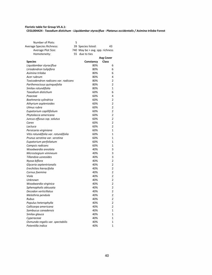
Floristic table for Group VII.A.1: CEGL004424 ‐ Taxodium distichum ‐ Liquidambar styraciflua ‐ Platanus occidentalis / Asimina triloba Forest
Number of Plots: 5 Average Species Richness: 39 Species listed: 43 Average Plot Size: 740 May be > avg. spp. richness Homoteneity: 55 due to ties Avg Cover Species Constancy Class Liquidambar styraciflua 80% 6 Liriodendron tulipifera 80% 6 Asimina triloba 80% 6 Acer rubrum 80% 4 Toxicodendron radicans var. radicans 80% 2 Parthenocissus quinquefolia 80% 2 Smilax rotundifolia 80% 1 Taxodium distichum 60% 6 Poaceae 60% 4 Boehmeria cylindrica 60% 2 Athyrium asplenioides 60% 2 Ulmus rubra 60% 2 Eupatorium capillifolium 60% 2 Phytolacca americana 60% 2 Juncus effusus ssp. solutus 60% 2 Carex 60% 2 Lactuca 60% 2 Persicaria virginiana 60% 1 Vitis rotundifolia var. rotundifolia 60% 1 Prunus serotina var. serotina 60% 1 Eupatorium perfoliatum 60% 1 Campsis radicans 60% 1 Woodwardia areolata 40% 3 Microstegium vimineum 40% 3 Tillandsia usneoides 40% 3 Nyssa biflora 40% 2 Glyceria septentrionalis 40% 2 Erechtites hieracifolia 40% 2 Cornus foemina 40% 2 Viola 40% 2 Unknown 40% 2 Woodwardia virginica 40% 2 Sphenopholis obtusata 40% 2 Decodon verticillatus 40% 2 Melothria pendula 40% 2 Rubus 40% 2 Populus heterophylla 40% 2 Callicarpa americana 40% 2 Sambucus canadensis 40% 1 Smilax glauca 40% 1 Cyperaceae 40% 1 Osmunda regalis var. spectabilis 40% 1 Potentilla indica 40% 1

41
Floristic table for Group VII.A.2: CEGL004466 ‐ Taxodium distichum ‐ Taxodium ascendens / Panicum hemitomon Woodland
Number of Plots: 1 Average Species Richness: 39 Species listed: 39 Average Plot Size: 1000 May be > avg. spp. richness Homoteneity: 100 due to ties Avg Cover Species Constancy Class Taxodium distichum 100% 5 Juncus 100% 4 Taxodium ascendens 100% 4 Scrophularia 100% 2 Juncus repens 100% 2 Morella cerifera 100% 2 Juncus coriaceus 100% 2 Solidago 100% 2 Triadenum walteri 100% 2 Xyris 100% 2 Andropogon 100% 2 Hypericum 100% 2 Unknown 100% 2 Asteraceae 100% 2 Acer rubrum var. rubrum 100% 2 Cyperaceae 100% 2 Carex 100% 2 Dichanthelium 100% 2 Cyrilla racemiflora 100% 2 Drosera intermedia 100% 2 Eleocharis 100% 2 Eupatorium 100% 2 Eupatorium perfoliatum 100% 2 Galium 100% 1 Rubus 100% 1 Campsis radicans 100% 1 Smilax laurifolia 100% 1 Baccharis halimifolia 100% 1 Toxicodendron radicans var. radicans 100% 1 Lycopodiella prostrata 100% 1 Pseudognaphalium 100% 1 Prunus serotina var. serotina 100% 1 Poaceae 100% 1 Parthenocissus quinquefolia 100% 1 Murdannia keisak 100% 1 Moss 100% 1 Smilax glauca 100% 1 Liriodendron tulipifera 100% 1 Hydrocotyle 100% 1
42
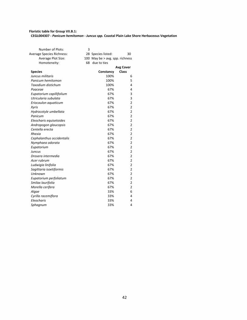
Floristic table for Group VII.B.1: CEGL004307 ‐ Panicum hemitomon ‐ Juncus spp. Coastal Plain Lake Shore Herbaceous Vegetation
Number of Plots: 3 Average Species Richness: 28 Species listed: 30 Average Plot Size: 100 May be > avg. spp. richness Homoteneity: 68 due to ties Avg Cover Species Constancy Class Juncus militaris 100% 6 Panicum hemitomon 100% 5 Taxodium distichum 100% 4 Poaceae 67% 4 Eupatorium capillifolium 67% 3 Utricularia subulata 67% 3 Eriocaulon aquaticum 67% 2 Xyris 67% 2 Hydrocotyle umbellata 67% 2 Panicum 67% 2 Eleocharis equisetoides 67% 2 Andropogon glaucopsis 67% 2 Centella erecta 67% 2 Rhexia 67% 2 Cephalanthus occidentalis 67% 2 Nymphaea odorata 67% 2 Eupatorium 67% 2 Juncus 67% 2 Drosera intermedia 67% 2 Acer rubrum 67% 2 Ludwigia linifolia 67% 2 Sagittaria isoetiformis 67% 2 Unknown 67% 2 Eupatorium perfoliatum 67% 2 Smilax laurifolia 67% 2 Morella cerifera 67% 2 Algae 33% 6 Cyrilla racemiflora 33% 4 Eleocharis 33% 4 Sphagnum 33% 4

43
Floristic table for Group VIII.A.1: CEGL007540 ‐ Quercus falcata ‐ Pinus taeda ‐ (Fagus grandifolia, Quercus nigra) / Persea palustris Maritime Forest
Number of Plots: 2 Average Species Richness: 39 Species listed: 42 Average Plot Size: 900 May be > avg. spp. richness Homoteneity: 78 due to ties Avg Cover Species Constancy Class Quercus nigra 100% 7 Symplocos tinctoria 100% 6 Pinus taeda 100% 6 Fagus grandifolia var. caroliniana 100% 6 Quercus falcata 100% 6 Liquidambar styraciflua 100% 6 Cornus florida 100% 4 Persea palustris 100% 4 Quercus velutina 100% 3 Castanea pumila 100% 3 Vitis rotundifolia var. rotundifolia 100% 3 Ilex opaca var. opaca 100% 3 Nyssa sylvatica 100% 2 Sassafras albidum 100% 2 Smilax rotundifolia 100% 2 Smilax glauca 100% 2 Asimina parviflora 100% 2 Gelsemium sempervirens 100% 2 Carex 100% 2 Morus rubra 100% 2 Callicarpa americana 100% 2 Hamamelis virginiana var. virginiana 100% 1 Liriodendron tulipifera 50% 5 Acer rubrum var. rubrum 50% 4 Carya pallida 50% 4 Styrax grandifolius 50% 3 Carpinus caroliniana var. caroliniana 50% 3 Quercus laurifolia 50% 3 Clethra alnifolia 50% 2 Oxydendrum arboreum 50% 2 Hexastylis arifolia 50% 2 Smilax bona‐nox 50% 2 Vaccinium formosum 50% 2 Quercus phellos 50% 2 Mitchella repens 50% 2 Aralia spinosa 50% 2 Parthenocissus quinquefolia 50% 2 Gaylussacia frondosa 50% 2 Prunus serotina var. serotina 50% 2 Vitis 50% 2 Quercus alba 50% 2 Vaccinium corymbosum 50% 2

44
Floristic table for Group IX.A.1: Avg Cover CEGL004484 ‐ Nyssa biflora ‐ (Taxodium distichum, Nyssa aquatica) Species Constancy Class / Morella cerifera - Rosa palustris Tidal Forest Sisyrinchium 33% 2 Iris virginica 33% 2 Number of Plots: 3 Woodwardia virginica 33% 2 Average Species Richness: 48 Species listed: 78 Smilax auriculata 33% 2 Average Plot Size: 500 May be > avg. spp. richness Vitis rotundifolia var. rotundifolia 33% 2 Homoteneity: 68 due to ties Solidago sempervirens 33% 2 Avg Cover Smilax walteri 33% 2 Species Constancy Class Smilax walteri 33% 2 Nyssa biflora 100% 6 [Peltandra + Pontederia + Sagittaria] 33% 2 Taxodium distichum 100% 5 Viburnum nudum 33% 2 Morella cerifera 100% 5 Viola 33% 2 Nyssa aquatica 100% 5 Salix caroliniana 33% 2 Liquidambar styraciflua 100% 5 Boehmeria cylindrica 33% 2 Osmunda regalis var. spectabilis 100% 4 Vaccinium fuscatum 33% 2 Toxicodendron radicans var. radicans 100% 3 Typha latifolia 33% 2 Unknown 100% 3 Smilax rotundifolia 33% 2 Hydrocotyle 100% 3 Elymus virginicus 33% 2 Baccharis halimifolia 100% 2 Ipomoea sagittata 33% 2 Poaceae 100% 2 Juncus effusus ssp. solutus 33% 2 Rosa palustris 100% 2 Ilex decidua var. decidua 33% 2 Saururus cernuus 100% 2 Galium tinctorium var. floridanum 33% 2 Itea virginica 100% 2 Magnolia virginiana 33% 2 Lonicera japonica 100% 2 Fraxinus profunda 33% 2 Cicuta maculata var. maculata 100% 2 Amelanchier stolonifera 33% 2 Fraxinus caroliniana 67% 6 Osmunda cinnamomea 33% 2 Acer rubrum var. trilobum 67% 5 Cyperaceae 33% 2 Alternanthera philoxeroides 67% 3 Cornus foemina 33% 2 Peltandra virginica 67% 2 Carex seorsa 33% 2 Juncus 67% 2 Carex lurida 33% 2 Parthenocissus quinquefolia 67% 2 Carex gynandra 33% 2 Pinus taeda 67% 2 Poa 33% 2 Persea palustris 67% 2 Pontederia cordata var. cordata 33% 2 Clematis 67% 2 Ptilimnium ahlesii 33% 2 Persicaria sagittata 67% 2 Ranunculus 33% 2 Cyrilla racemiflora 67% 2 Rhododendron viscosum 33% 2 Persicaria 67% 2 Onoclea sensibilis var. sensibilis 33% 2 Phoradendron serotinum ssp. serotinum 67% 2 Carex 67% 2 Clethra alnifolia 67% 2 Ptilimnium 67% 1 Galium 67% 1 Mikania scandens 67% 1 Panicum 33% 6 Taxodium ascendens 33% 6 Spartina patens 33% 5 Smilax 33% 2 Carex sect. Ovales 33% 2 Acer rubrum 33% 2 Eubotrys racemosa 33% 2 Sphenopholis pensylvanica 33% 2 Acer rubrum var. rubrum 33% 2

45
Floristic table for Group IX.B.1: CEGL007166 ‐ Juniperus virginiana var. silicicola / Morella cerifera / Kosteletzkya virginica ‐ Bacopa monnieri Woodland
Number of Plots: 3 Average Species Richness: 20 Species listed: 20 Average Plot Size: 533 May be > avg. spp. richness Homoteneity: 57 due to ties Avg Cover Species Constancy Class Morella cerifera 100% 5 Pinus taeda 100% 3 Toxicodendron radicans var. radicans 100% 3 Distichlis spicata 67% 7 Juniperus virginiana var. silicicola 67% 6 Juncus roemerianus 67% 6 Iva frutescens 67% 4 Baccharis halimifolia 67% 3 Carex 67% 2 Solidago sempervirens 67% 2 Sabal minor 67% 2 Typha angustifolia 33% 6 Juniperus virginiana 33% 6 Spartina patens 33% 5 Bolboschoenus robustus 33% 5 Fimbristylis castanea 33% 5 Spartina cynosuroides 33% 3 Persea palustris 33% 3 Tillandsia usneoides 33% 2 Typha latifolia 33% 2

46
Floristic table for Group IX.C.1: Avg Cover CEGL003669 ‐ Pinus serotina / Morella cerifera / Osmuda regalis var. spectabilis Woodland Species Constancy Class Carex 100% 1
Number of Plots: 1 Average Species Richness: 44 Species listed: 44 Average Plot Size: 800 May be > avg. spp. richness Homoteneity: 100 due to ties Avg Cover Species Constancy Class Morella cerifera 100% 7 Nyssa biflora 100% 6 Osmunda regalis var. spectabilis 100% 6 Pinus serotina 100% 4 Persea palustris 100% 4 Acer rubrum var. trilobum 100% 4 Quercus laurifolia 100% 3 Smilax glauca 100% 2 Rubus 100% 2 Poaceae 100% 2 Smilax walteri 100% 2 Toxicodendron radicans var. radicans 100% 2 Parthenocissus quinquefolia 100% 2 Osmunda cinnamomea 100% 2 Cyperaceae 100% 2 Magnolia virginiana 100% 2 Mikania scandens 100% 2 Viola primulifolia 100% 2 Dichanthelium 100% 2 Lonicera japonica 100% 2 Juniperus virginiana var. silicicola 100% 2 Ilex opaca var. opaca 100% 2 Gelsemium sempervirens 100% 2 Berchemia scandens 100% 2 Carex striata 100% 2 Bignonia capreolata 100% 1 Solidago 100% 1 Sphagnum 100% 1 Symphyotrichum 100% 1 Tillandsia usneoides 100% 1 Smilax laurifolia 100% 1 Viburnum nudum 100% 1 Erigeron vernus 100% 1 Andropogon tenuispatheus 100% 1 Lyonia lucida 100% 1 Smilax bona‐nox 100% 1 Carex elliottii 100% 1 Pteridium aquilinum 100% 1 Pluchea odorata 100% 1 Asplenium platyneuron 100% 1 Eupatorium serotinum 100% 1 Hydrocotyle 100% 1 Mitchella repens 100% 1

47
Floristic table for Group IX.C.2: CEGL006137 ‐ Pinus taeda / Morella cerifera / Osmunda regalis var. spectabilis Forest
Number of Plots: 3 Average Species Richness: 23 Species listed: 24 Average Plot Size: 467 May be > avg. spp. richness Homoteneity: 64 due to ties Avg Cover Species Constancy Class Morella cerifera 100% 7 Pinus taeda 100% 6 Toxicodendron radicans var. radicans 100% 5 Poaceae 100% 2 Persea palustris 67% 5 Baccharis halimifolia 67% 3 Smilax glauca 67% 2 Panicum 67% 2 Liquidambar styraciflua 67% 2 Diospyros virginiana 67% 2 Solidago sempervirens 67% 2 Rubus 67% 2 Osmunda regalis var. spectabilis 67% 2 Ipomoea 67% 2 Smilax bona‐nox 67% 2 Hydrocotyle 67% 2 Campsis radicans 67% 1 Arundinaria tecta 33% 7 Spartina patens 33% 6 Morella cerifera (dead) 33% 5 Smilax rotundifolia 33% 5 Acer rubrum var. trilobum 33% 3 Nyssa biflora 33% 3 Juniperus virginiana var. silicicola 33% 3

48
Floristic table for Group X.A.1: CEGL003924 ‐ Borrichia frutescens / (Spartina patens, Juncus roemerianus) Shrubland
Number of Plots: 2 Average Species Richness: 26 Species listed: 42 Average Plot Size: 150 May be > avg. spp. richness Homoteneity: 50 due to ties Avg Cover Species Constancy Class Cladium jamaicense 50% 6 Juncus roemerianus 50% 6 Spartina patens 50% 6 Pinus palustris 50% 4 Distichlis spicata 50% 4 Solidago 50% 4 Thelypteris palustris var. pubescens 50% 3 Osmunda regalis var. spectabilis 50% 3 Baccharis halimifolia 50% 3 Rosa palustris 50% 3 Osmunda cinnamomea 50% 2 Pteridium aquilinum 50% 2 Rubus 50% 2 Smilax bona‐nox 50% 2 Nyssa biflora 50% 2 Phragmites australis 50% 2 Persea palustris 50% 2 Parthenocissus quinquefolia 50% 2 Panicum 50% 2 Zizaniopsis miliacea 50% 2 Viola 50% 2 Toxicodendron radicans var. radicans 50% 2 Rhus copallinum var. copallinum 50% 2 Dichanthelium 50% 2 Ambrosia artemisiifolia 50% 2 Baccharis angustifolia 50% 2 Campsis radicans 50% 2 Centella erecta 50% 2 Eupatorium serotinum 50% 2 Cyperaceae 50% 2 Diospyros virginiana 50% 2 Morella cerifera 50% 2 Iris 50% 2 Cuscuta 50% 2 Iva frutescens 50% 2 Erigeron vernus 50% 2 Ipomoea sagittata 50% 2 Ilex glabra 50% 2 Hydrocotyle 50% 2 Hibiscus moscheutos 50% 2 Acer rubrum var. trilobum 50% 2 Mikania scandens 50% 2

49
Floristic table for Group X.A.2: CEGL006848 ‐ Iva frutescens / Spartina patens Shrubland
Number of Plots: 2 Average Species Richness: 6 Species listed: 7 Average Plot Size: 100 May be > avg. spp. richness Homoteneity: 83 due to ties Avg Cover Species Constancy Class Spartina patens 100% 8 Iva frutescens 100% 5 Juncus roemerianus 100% 4 Distichlis spicata 100% 3 Spartina alterniflora 50% 2 Scirpus 50% 2 Solidago sempervirens 50% 2 Floristic table for Group XI.A.1: CEGL004197 ‐ Spartina patens ‐ Distichlis spicata ‐ (Juncus roemerianus) Herbaceous Vegetation
Number of Plots: 6 Average Species Richness: 7 Species listed: 7 Average Plot Size: 117 May be > avg. spp. richness Homoteneity: 69 due to ties Avg Cover Species Constancy Class Spartina patens 100% 7 Solidago sempervirens 83% 2 Spartina alterniflora 67% 6 Distichlis spicata 67% 6 Juncus roemerianus 67% 2 Iva frutescens 67% 2 Fimbristylis castanea 33% 2 Floristic table for Group XI.A.2: CEGL006612 ‐ Schoenoplectus americanus ‐ Spartina patens Herbaceous Vegetation
Number of Plots: 1 Average Species Richness: 4 Species listed: 4 Average Plot Size: 100 May be > avg. spp. richness Homoteneity: 100 due to ties Avg Cover Species Constancy Class Distichlis spicata 100% 7 Schoenoplectus pungens var. pungens 100% 7 Juncus roemerianus 100% 3 Spartina alterniflora 100% 2

50
Floristic table for Group XI.B.1: CEGL004178 ‐ Cladium mariscus ssp. jamaicense Tidal Herbaceous Vegetation
Number of Plots: 2 Average Species Richness: 5 Species listed: 4 Average Plot Size: 100 May be > avg. spp. richness Homoteneity: 75 due to ties Avg Cover Species Constancy Class Cladium jamaicense 100% 8 Toxicodendron radicans var. radicans 100% 2 Hibiscus moscheutos 50% 3 Baccharis halimifolia 50% 2 Floristic table for Group XI.B.2: CEGL004186 ‐ Juncus roemerianus Herbaceous Vegetation
Number of Plots: 3 Average Species Richness: 4 Species listed: 5 Average Plot Size: 100 May be > avg. spp. richness Homoteneity: 58 due to ties Avg Cover Species Constancy Class Juncus roemerianus 100% 7 Distichlis spicata 67% 6 Spartina alterniflora 33% 4 Iva frutescens 33% 2 Symphyotrichum tenuifolium 33% 2 Floristic table for Group XI.C.1: CEGL007694 ‐ Distichlis spicata ‐ (Sporobolus virginicus) Herbaceous Vegetation
Number of Plots: 1 Average Species Richness: 6 Species listed: 6 Average Plot Size: 100 May be > avg. spp. richness Homoteneity: 100 due to ties Avg Cover Species Constancy Class Distichlis spicata 100% 8 Iva frutescens 100% 3 Juncus roemerianus 100% 3 Symphyotrichum tenuifolium 100% 2 [Scirpus + Schoenoplectus] 100% 2 Borrichia frutescens 100% 1

51
Floristic table for Group XII.A.1: CEGL004660 ‐ Juncus roemerianus ‐ Pontederia cordata Herbaceous Vegetation
Number of Plots: 1 Average Species Richness: 12 Species listed: 12 Average Plot Size: 100 May be > avg. spp. richness Homoteneity: 100 due to ties Avg Cover Species Constancy Class Juncus roemerianus 100% 9 Hibiscus moscheutos 100% 4 Panicum 100% 3 Cladium jamaicense 100% 2 Erigeron vernus 100% 2 Hydrocotyle 100% 2 Solidago sempervirens 100% 2 Poaceae 100% 2 Baccharis halimifolia 100% 2 Osmunda regalis var. spectabilis 100% 2 Kosteletzkya virginica 100% 2 Samolus parviflorus 100% 2 Floristic table for Group XIII.A.1: CEGL004661 ‐ Ceratophyllum demersum ‐ Utricularia macrorhiza ‐ Nymphaea odorata Herbaceous Vegetation
Number of Plots: 1 Average Species Richness: 3 Species listed: 3 Average Plot Size: 100 May be > avg. spp. richness Homoteneity: 100 due to ties Avg Cover Species Constancy Class Utricularia inflata 100% 7 Persea palustris 100% 6 Acer rubrum var. trilobum 100% 5
Related Documents