www.carlsonsw.com Authorized Developer Authorized Unique Application Reseller Authorized ISV Partner

Welcome message from author
This document is posted to help you gain knowledge. Please leave a comment to let me know what you think about it! Share it to your friends and learn new things together.
Transcript

www.carlsonsw.comAuthorized DeveloperAuthorized Unique Application ResellerAuthorized ISV Partner
Authorized DeveloperAuthorized Unique Application ResellerAuthorized ISV Partner
www.carlsonsw.com
For sales information or to locate a reseller please call:
800-989-5028
© C
opyr
ight
200
6 C
arls
on S
oftw
are.
All
right
s re
serv
ed. C
arls
on S
oftw
are
is a
regi
ster
ed tr
adem
ark
of C
arls
on S
oftw
are.
Aut
odes
k, th
e Au
tode
sk lo
go, a
nd A
utoC
AD a
re re
gist
ered
trad
emar
ks o
f Aut
odes
k, In
c., i
n th
e U
SA a
nd/o
r oth
er c
ount
ries.
All
othe
r pro
duct
nam
es, b
rand
nam
es, o
r tra
dem
arks
bel
ong
to th
eir r
espe
ctiv
e ho
lder
s.
ServCE 2 AD – 12-27-06Full Page 8.5 x 11 + bleed
Colors: Cyan, Magenta, Yellow, Black. Files not trapped or preflighted.Prepress company, please Preflight and Trap this art as needed.
Carlson Software Products
Carlson Survey 2007 Our most productive and intuitive AutoCAD-based survey solution yet. Available for AutoCAD or Standalone with built in AutoCAD.
Carlson Civil Suite 2007 Without a doubt, these four powerful programs, working together, create the ultimate civil package.
Carlson GIS 2007 Includes tools for data capture and linking, data labeling, import/export of SHP files, polygon topology creation and analysis, and more.
Carlson Civil 2007 Powerful automation, and unmatched ease-of-use for road design, site and subdivision design. Works with AutoCAD® and AutoCAD® Map.
Carlson Hydrology 2007 Perform watershed analysis and create rainfall maps, design pipe culverts, sewer piping, orifices. With weir design & HYDRA.®
Carlson Survey Desktop A complete set of easy-to-use survey tools for the acclaimed Autodesk Land Desktop.
Carlson Takeoff 2007 Carlson Takeoff is the most complete and powerful site estimating AutoCAD-based software on the market.
Carlson GIS-CE GIS GPS data collection.Store multiple attributes for each shot quickly and easily.
Carlson Roads 2007 Road design made easy. From simple subdivision streets to super elevated highway design.
Carlson Natural Regrade Natural Regrade with GeoFluv™ applies fluvial geomorphic principles to upland landform design.
Carlson PointCloud Process laser scan data to generate models, breaklines and points.
Carlson Field 2007 CAD-based data collection! Collection data directly in a DWG file. No download into CAD needed!
Carlson Tech Support and Training is UnmatchedCarlson College Where Education and Training Come Together
Training Direct from the ManufacturerEmployers pay for training one way or the other. Self teaching means time, unproductive time spent on trial and error learning. Our training, “Direct From the Manufacturer,” allows attendees to be production ready immediately following training. Our Continuing Education follows by providing a growth path to expert status.
Get Professional Training from the Carlson ExpertsCarlson Software offers professional training at our facilities in Virginia, Kentucky and Massachusetts. In addition, Carlson Software offers regional training throughout the U.S. Our approach to training is the T.I.E. Training method, where we teach the software Tools and Imaginative use of Tools combined with industry Expertise. Classes are kept small, and each student has their own workstation for hands-on exercise. All training materials and books are yours to keep afterwards.
Carlson College offers:■ Professionally Delivered
Training Sessions, CEU’s/PDH’s Offered
■ Multiple Offerings, Forums & Locations
■ Instruction by Industry Experts
■ Consulting on Business Processes, Systems Integration, CADD Standards
Please refer to our web site for our training calendar and class offerings.
For more information on the new Carlson College or training, please contact Harry Ward or Reiko Lewis at 800-989-5028, or email [email protected].
Technical SupportSince 1983, a Carlson trademark has been FREE technical support. It is incumbent upon us to design software that is so intuitive that we don't get barraged with phone calls. This design philosophy allows us to provide this service at no additional cost. Our technicians become part of your team, helping in anyway necessary. Carlson Software's foundation is in supporting our customer's needs. This objective will be central to our company's success well into the 21st century.
For more information on training or the new Carlson College, please call 800-989-5028
®
www.carlsonsw.comAuthorized DeveloperAuthorized Unique Application ResellerAuthorized ISV Partner
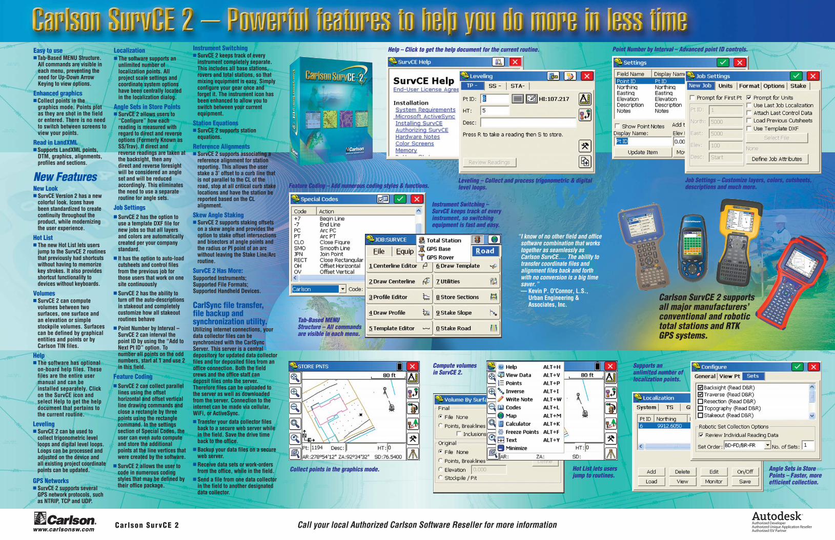
Tab-Based MENU Structure – All commands are visible in each menu.
Compute volumes in SurvCE 2.
Supports an unlimited number of localization points.
Angle Sets in Store Points – Faster, more efficient collection.
Collect points in the graphics mode. Hot List lets users jump to routines.
Feature Coding – Add numerous coding styles & functions.
Instrument Switching – SurvCE keeps track of every instrument, so switching equipment is fast and easy.
Help – Click to get the help document for the current routine.
Job Settings – Customize layers, colors, cutsheets, descriptions and much more.
Leveling – Collect and process trigonometric & digital level loops.
Point Number by Interval – Advanced point ID controls.
ServCE 2 AD – 12-27-06Full Page 8.5 x 11 + bleed
Colors: Cyan, Magenta, Yellow, Black. Files not trapped or preflighted.Prepress company, please Preflight and Trap this art as needed.
®
www.carlsonsw.comCarlson SurvCE 2 Call your local Authorized Carlson Software Reseller for more information
“I know of no other field and office software combination that works together as seamlessly as Carlson SurvCE.... The ability to transfer coordinate files and alignment files back and forth with no conversion is a big time saver.”— Kevin P. O'Connor, L.S., Urban Engineering & Associates, Inc.
Carlson SurvCE 2 supports all major manufacturers’ conventional and robotic total stations and RTK GPS systems.
Easy to use■ Tab-Based MENU Structure.
All commands are visible in each menu, preventing the need for Up-Down Arrow Keying to view options.
Enhanced graphics■ Collect points in the
graphics mode. Points plot as they are shot in the field or entered. There is no need to switch between screens to view your points.
Read in LandXML■ Supports LandXML points,
DTM, graphics, alignments, profiles and sections.
New FeaturesNew Look■ SurvCE Version 2 has a new
colorful look. Icons have been standardized to create continuity throughout the product, while modernizing the user experience.
Hot List■ The new Hot List lets users
jump to the SurvCE 2 routines that previously had shortcuts without having to memorize key strokes. It also provides shortcut functionality to devices without keyboards.
Volumes■ SurvCE 2 can compute
volumes between two surfaces, one surface and an elevation or simple stockpile volumes. Surfaces can be defined by graphical entities and points or by Carlson TIN files.
Help■ The software has optional
on-board help files. These files are the entire user manual and can be installed separately. Click on the SurvCE icon and select Help to get the help document that pertains to the current routine.
Leveling■ SurvCE 2 can be used to
collect trigonometric level loops and digital level loops. Loops can be processed and adjusted on the device and all existing project coordinate points can be updated.
GPS Networks■ SurvCE 2 supports several
GPS network protocols, such as NTRIP, TCP and UDP.
Localization■ The software supports an
unlimited number of localization points. All project scale settings and coordinate system options have been centrally located in the localization dialog.
Angle Sets in Store Points■ SurvCE 2 allows users to
“Configure” how each reading is measured with regard to direct and reverse options (Formerly Known as SS/Trav). If direct and reverse readings are taken at the backsight, then any direct and reverse foresight will be considered an angle set and will be reduced accordingly. This eliminates the need to use a separate routine for angle sets.
Job Settings■ SurvCE 2 has the option to
use a template DXF file for new jobs so that all layers and colors are automatically created per your company standard.
■ It has the option to auto-load cutsheets and control files from the previous job for those users that work on one site continuously
■ SurvCE 2 has the ability to turn off the auto-descriptions in stakeout and completely customize how all stakeout routines behave
■ Point Number by Interval – SurvCE 2 can interval the point ID by using the “Add to Next Pt ID” option. To number all points on the odd numbers, start at 1 and use 2 in this field.
Feature Coding■ SurvCE 2 can collect parallel
lines using the offset horizontal and offset vertical line drawing commands and close a rectangle by three points using the rectangle command. In the settings section of Special Codes, the user can even auto compute and store the additional points at the line vertices that were created by the software.
■ SurvCE 2 allows the user to code in numerous coding styles that may be defined by their office package.
Instrument Switching■ SurvCE 2 keeps track of every
instrument completely separate. This includes all base stations, rovers and total stations, so that mixing equipment is easy. Simply configure your gear once and forget it. The instrument icon has been enhanced to allow you to switch between your current equipment.
Station Equations■ SurvCE 2 supports station
equations.
Reference Alignments■ SurvCE 2 supports associating a
reference alignment for station reporting. This allows the user stake a 3’ offset to a curb line that is not parallel to the CL of the road, stop at all critical curb stake locations and have the station be reported based on the CL alignment.
Skew Angle Staking■ SurvCE 2 supports staking offsets
on a skew angle and provides the option to stake offset intersections and bisectors at angle points and the radius or PI point of an arc without leaving the Stake Line/Arc routine.
SurvCE 2 Has More:Supported Instruments;Supported File Formats;Supported Handheld Devices.
CarlSync file transfer, file backup and synchronization utility.Utilizing internet connections, your data collector files can be synchronized with the CarlSync Server. This server is a central depository for updated data collector files and for deposited files from an office connection. Both the field crews and the office staff can deposit files onto the server. Therefore files can be uploaded to the server as well as downloaded from the server. Connection to the internet can be made via cellular, WiFi, or ActiveSync.■ Transfer your data collector files
back to a secure web server while in the field. Save the drive time back to the office.
■ Backup your data files on a secure web server.
■ Receive data sets or work-orders from the office, while in the field.
■ Send a file from one data collector in the field to another designated data collector.

www.carlsonsw.comAuthorized DeveloperAuthorized Unique Application ResellerAuthorized ISV Partner
Authorized DeveloperAuthorized Unique Application ResellerAuthorized ISV Partner
www.carlsonsw.com
For sales information or to locate a reseller please call:
800-989-5028
© C
opyr
ight
200
6 C
arls
on S
oftw
are.
All
right
s re
serv
ed. C
arls
on S
oftw
are
is a
regi
ster
ed tr
adem
ark
of C
arls
on S
oftw
are.
Aut
odes
k, th
e Au
tode
sk lo
go, a
nd A
utoC
AD a
re re
gist
ered
trad
emar
ks o
f Aut
odes
k, In
c., i
n th
e U
SA a
nd/o
r oth
er c
ount
ries.
All
othe
r pro
duct
nam
es, b
rand
nam
es, o
r tra
dem
arks
bel
ong
to th
eir r
espe
ctiv
e ho
lder
s.
ServCE 2 AD – 12-27-06Full Page 8.5 x 11 + bleed
Colors: Cyan, Magenta, Yellow, Black. Files not trapped or preflighted.Prepress company, please Preflight and Trap this art as needed.
Carlson Software Products
Carlson Survey 2007 Our most productive and intuitive AutoCAD-based survey solution yet. Available for AutoCAD or Standalone with built in AutoCAD.
Carlson Civil Suite 2007 Without a doubt, these four powerful programs, working together, create the ultimate civil package.
Carlson GIS 2007 Includes tools for data capture and linking, data labeling, import/export of SHP files, polygon topology creation and analysis, and more.
Carlson Civil 2007 Powerful automation, and unmatched ease-of-use for road design, site and subdivision design. Works with AutoCAD® and AutoCAD® Map.
Carlson Hydrology 2007 Perform watershed analysis and create rainfall maps, design pipe culverts, sewer piping, orifices. With weir design & HYDRA.®
Carlson Survey Desktop A complete set of easy-to-use survey tools for the acclaimed Autodesk Land Desktop.
Carlson Takeoff 2007 Carlson Takeoff is the most complete and powerful site estimating AutoCAD-based software on the market.
Carlson GIS-CE GIS GPS data collection.Store multiple attributes for each shot quickly and easily.
Carlson Roads 2007 Road design made easy. From simple subdivision streets to super elevated highway design.
Carlson Natural Regrade Natural Regrade with GeoFluv™ applies fluvial geomorphic principles to upland landform design.
Carlson PointCloud Process laser scan data to generate models, breaklines and points.
Carlson Field 2007 CAD-based data collection! Collection data directly in a DWG file. No download into CAD needed!
Carlson Tech Support and Training is UnmatchedCarlson College Where Education and Training Come Together
Training Direct from the ManufacturerEmployers pay for training one way or the other. Self teaching means time, unproductive time spent on trial and error learning. Our training, “Direct From the Manufacturer,” allows attendees to be production ready immediately following training. Our Continuing Education follows by providing a growth path to expert status.
Get Professional Training from the Carlson ExpertsCarlson Software offers professional training at our facilities in Virginia, Kentucky and Massachusetts. In addition, Carlson Software offers regional training throughout the U.S. Our approach to training is the T.I.E. Training method, where we teach the software Tools and Imaginative use of Tools combined with industry Expertise. Classes are kept small, and each student has their own workstation for hands-on exercise. All training materials and books are yours to keep afterwards.
Carlson College offers:■ Professionally Delivered
Training Sessions, CEU’s/PDH’s Offered
■ Multiple Offerings, Forums & Locations
■ Instruction by Industry Experts
■ Consulting on Business Processes, Systems Integration, CADD Standards
Please refer to our web site for our training calendar and class offerings.
For more information on the new Carlson College or training, please contact Harry Ward or Reiko Lewis at 800-989-5028, or email [email protected].
Technical SupportSince 1983, a Carlson trademark has been FREE technical support. It is incumbent upon us to design software that is so intuitive that we don't get barraged with phone calls. This design philosophy allows us to provide this service at no additional cost. Our technicians become part of your team, helping in anyway necessary. Carlson Software's foundation is in supporting our customer's needs. This objective will be central to our company's success well into the 21st century.
For more information on training or the new Carlson College, please call 800-989-5028
Paul
For sales information or to locate a reseller please call: 800-989-5028
Paul
Total Survey Systems Pty Ltd 7 South Street Rydalmere NSW 2116 Australia Ph. +61 2 96380055 Fax +61 2 96383933 www.totalsurvey.com.au
Paul
Related Documents