CARDAMOM LANDSCAPE MANAGEMENT TO SUSTAIN BIODIVERSITY AND ECONOMIC RETURNS IN CAMBODIA A Dissertation SUBMITTED TO THE FACULTY OF UNIVERSITY OF MINNESOTA BY SUN HEAN IN PARTIAL FULFILLMENT OF THE REQUIREMENTS FOR THE DEGREE OF DOCTOR OF PHILOSOPHY Dr. Stephen Polasky and Dr. James D. L. Smith June 2014

Welcome message from author
This document is posted to help you gain knowledge. Please leave a comment to let me know what you think about it! Share it to your friends and learn new things together.
Transcript
CARDAMOM LANDSCAPE MANAGEMENT TO SUSTAIN
BIODIVERSITY AND ECONOMIC RETURNS IN CAMBODIA
A Dissertation
SUBMITTED TO THE FACULTY OF
UNIVERSITY OF MINNESOTA
BY
SUN HEAN
IN PARTIAL FULFILLMENT OF THE REQUIREMENTS
FOR THE DEGREE OF
DOCTOR OF PHILOSOPHY
Dr. Stephen Polasky and Dr. James D. L. Smith
June 2014

© Sun Hean 2014
i
Acknowledgements
I am grateful to all individuals and organizations that contributed to make this
research a success. I express gratitude to my advisor, Dr. Stephen Polasky, and my co-
advisor, Dr. James L.D. Smith, for their invaluable supervision and guidance throughout
my graduate program. I also thank my committee members, Drs. Dean A. Current and
Jay S. Coggins, for their invaluable advice, suggestions, and insightful criticisms of this
manuscript.
I would also like to thank the Wildlife Alliance and the University of Minnesota
for contributing the necessary scholarships, cooperation, and arrangements to facilitate
my program. I am indebted to the Royal Government of Cambodia for the permission to
enroll in the University of Minnesota Conservation Biology Graduate Program.
I express my sincere thanks to H.E. Chan Sarun, Minister of Agriculture,
Forestry, and Fisheries for government support, advice, and permission to use data to
conduct my research. My special thanks to Wildlife Alliance Staff who helped me on
field data collection and Eric Nelson, Andrew C. Jenks, and Ryan R. Noe for their kind
advice and helpful suggestions on data analysis. Thanks also to Carah Kucharski for her
valuable suggestions on this writing and friends and colleagues at the Conservation
Biology Program as well as those in Polasky’s Lab for their comments and
encouragement for me to pursue my study.
I would also like to deeply thank Mr. Sotheary Duong, his wife, and Mrs. Lar
Mundstock and her husband for their kind encouragement, motivation, support, and
hospitality to let me stay with them for the last three years. Without their support, I would
have had a financial burden and would not make today happen.
Finally, I would like to especially thank my parents, other family members, my
children, Kevin, Daradath, and Alisa for their spiritual support, love, and being there for
me. I would like to dedicate this dissertation to them and pray that they will get the best
education as they can from what the world has to offer them.
Sun Hean
ii
Abstract
Today, there are few large landscapes that remain to support biodiversity. Their
preservation is especially difficult in developing countries, where population growth is
high and there is a great demand for land for increased production. The Cardamom
landscape in Cambodia is one place where ecosystem preservation has become a national
concern. Stakeholders have argued over the management of the landscape that features
intact natural forest, valuable biodiversity, and ecosystem services. The private sector,
along with several government agencies, is pushing for industrial development. Donor
communities and none-governmental organizations want preservation. Finally, several
government agencies such as the Ministry of Environment prefer to balance the two
different interests. However, the most important question to ask is how we should
develop this important landscape in an environmentally sound and economically efficient
manner. To answer this question, I created three landscape management scenarios: strong
development, strong conservation, and mixed conservation and development based on
current government policy, development pressure, and donor community and NGO’s
arguments. I used GIS, InVEST (Integrated Valuation of Ecosystem Services and
Tradeoffs), and other models, to evaluate monetary values of carbon sequestration,
biodiversity, hydropower, and agriculture returns under each scenario and compared the
returns across scenarios. Changes in elephant population and revenue from four
ecotourism projects were used to convert biodiversity habitat scores into monetary
values. I found that the strong conservation scenario provided the greatest economic
return and at the same time sustained biodiversity in the landscape. Carbon sequestration
was the most influential ecosystem service with a large difference in monetary returns
between the conservation scenario and the development scenario. The results of this
dissertation provide support for recommending that the Cambodian government should
strongly protect the Cardamom landscape instead of managing it in other directions.
iii
Table of Contents
Acknowledgements .......................................................................................................... iAbstract ........................................................................................................................... iiTable of Contents ........................................................................................................... iiiList of Tables ................................................................................................................. viList of Figures ............................................................................................................... viiList of Abbreviations ................................................................................................... viiiIntroduction ..................................................................................................................... 1
Chapter 1: Conservation and Development in the Cardamom Landscape: History and Current Context ............................................................................................... 4
1.1- Introduction ............................................................................................................. 51.1.1- Geological and Climatic Information ............................................................... 51.1.2- Biodiversity Status .......................................................................................... 101.1.3- Ecosystem Functions, Goods, and Services ................................................... 131.1.4- Social and Economic Information .................................................................. 161.1.5- Impacts/Threats .............................................................................................. 16
1.2- Key Institutions, Policies, and Regulations ........................................................... 171.2.1- Management Institutions of the Cardamom Landscape ................................. 181.2.2- Policies and Regulations related to the Cardamom Landscape ...................... 21
1.3- Conservation Status and Mechanism ..................................................................... 361.3.1- International Instruments and Royal Government of Cambodia Obligations 361.3.2- Conservation Areas ......................................................................................... 43
1.3.3- Conservation Mechanisms ................................................................................ 511.4- Development Status ............................................................................................... 56
1.4.1- Special Economic Zone (SEZ) ....................................................................... 561.4.2- Mining Concessions ....................................................................................... 571.4.3- Economic Land Concessions (ELCs) ............................................................. 581.4.4- Social land concessions .................................................................................. 591.4.5- Hydropower Development ............................................................................. 591.4.6- Irrigation Development ................................................................................... 621.4.7- Infrastructure Development ............................................................................ 621.4.8- Urbanization ................................................................................................... 63
iv
1.4.9- Community Development ............................................................................... 64Chapter 2: Land Management Planning in the Cardamom Landscape: Implications for
Biodiversity Conservation and Economic Development ............................... 652.1- Introduction ........................................................................................................... 662.2- Methods ................................................................................................................. 67
2.2.1- Formal statement of the problem .................................................................... 672.2.2- Threat mapping ............................................................................................... 672.2.3- Defining Land Use Land Cover Scenarios ..................................................... 682.2.4- Description of InVEST model ........................................................................ 702.2.5- Modeling Ecosystem Services ........................................................................ 71
2.2.5.1- Carbon sequestration ............................................................................... 712.2.5.2- Biodiversity ............................................................................................. 722.2.5.3- Water Yield .............................................................................................. 762.2.5.4- Water Scarcity ......................................................................................... 782.2.5.5- Valuation of Hydropower Value ............................................................. 792.2.5.6- Agriculture ............................................................................................... 81
2.3- Results ................................................................................................................... 822.3.1- LULC maps .................................................................................................... 822.3.2- Carbon Sequestration ...................................................................................... 83
2.3.1.1- Carbon Stock ........................................................................................... 832.3.1.2- Carbon Sequestration and Emission ........................................................ 84
2.3.2- Biodiversity .................................................................................................... 852.3.3- Hydropower .................................................................................................... 87
2.3.3.1- Water Yield .............................................................................................. 882.3.3.2- Water Scarcity ......................................................................................... 892.3.3.3- Hydropower Production Value ................................................................ 892.3.3.4- Agriculture ............................................................................................... 902.3.3.5- Totaling of Ecosystem Services .............................................................. 91
Chapter 3: Discussion and Recommendation ................................................................... 933.1- Discussion .............................................................................................................. 94
3.1.1- How the landscape is managed? ..................................................................... 943.1.2- Creation of Land Management Scenarios ....................................................... 95
v
3.1.3- Carbon Model ................................................................................................. 963.1.4- Hydropower model ......................................................................................... 973.1.5- Biodiversity .................................................................................................... 983.1.6- Sustainable Land Management Planning ....................................................... 983.1.7- Payment for ecosystem services and benefit sharing among stakeholders .... 993.1.8- Future studies ................................................................................................ 100
3.2- Recommendations to the RGC ............................................................................ 1003.2.1- Short Term–Stop Landscape Deforestation and Degradation ...................... 1003.2.2- Long Term–Adoption and Implement of SLM and PES .............................. 102
Bibliography ............................................................................................................... 104Appendices .................................................................................................................. 121
Appendix 1: List of mammals of international conservation concern of the Cardamom landscape ........................................................................ 121
Appendix 2: List of birds of international conservation concern of the Cardamom landscape ........................................................................................... 122
Appendix 3: List of reptiles of international conservation concern of the Cardamom landscape ........................................................................................... 124
Appendix 4: List of international treaties ratified by the Cambodian government 124Appendix 5: Carbon Table for Carbon Model ....................................................... 126Appendix 6: Sensitivity Table for Biodiversity Model .......................................... 127Appendix 7: Threat Table for Biodiversity Model ................................................. 128Appendix 8: Biophysical Table for Water Yield Model ........................................ 129Appendix 9: Water Demand Table for Water Sscarcity Model ............................. 130Appendix 10: Evaluation Table for Hydropower Production Model ..................... 130
vi
List of Tables
Table 1: LULC types in the Cardamom Landscape ............................................................ 9
Table 2: Ecosystem functions, goods, and services of the Cardamom landscape ............ 14
Table 3: Related Cambodian Millennium Development Goals ........................................ 22
Table 4: Criteria for Creating Landscape management Scenarios .................................... 70
Table 5: Water yield, water consumption, hydropower energy, and hydropower value
over 50 years of each watershed among the three scenarios ............................. 87
vii
List of Figures
Figure 1: Location of the Cardamom landscape ................................................................. 6
Figure 2: Vegetation covers of the Cardamom landscape .................................................. 8
Figure 3: Conservation Areas in the Cardamom Landscape ............................................ 45
Figure 4: Development profile of the Cardamom landscape ............................................ 60
Figure 5: Divers and direct impacts of threats to the Cardamom Landscape ................... 68
Figure 6: Relationships between ecotourism revenue, elephant population, and habitat
quality ................................................................................................................ 75
Figure 7: Land Use Land Cover maps of the three landscape scenarios .......................... 83
Figure 8: Distribution of Carbon Stock of the three landscape scenarios ......................... 84
Figure 9: Carbon Sequestration of SCO and SDE (million USD) over 50 years ............. 84
Figure 10: Habitat Degradation between the three Scenarios provided by InVEST ........ 85
Figure 11: Habitat quality between the three Scenarios provided by InVEST ................. 85
Figure 12: Comparing biodiversity value of the three scenarios over 50 years ................ 86
Figure 13: Comparing water yield among the three scenarios over 50 years ................... 88
Figure 14: Comparing water consumption among the three scenarios over 50 years ...... 89
Figure 15: Comparing hydropower value of the three scenarios over 50 years ............... 90
Figure 16: Comparing agriculture value among the three scenarios over 50 years .......... 91
Figure 17: Totaling all ecosystem services among the three scenarios ............................ 92
viii
List of Abbreviations
ADB : Asian Development Bank AET : Annual Actual Evapotranspiration AWC : Plant Available Water Content BCI : Biodiversity Corridors Initiative CBD : Convention on Biological Diversity CCCSP : Cambodian Climate Change Strategic Plan CCX : Chicago Climate Exchange CDC : Council for Development of Cambodia CITES : Convention on International Trade in Endangered Species of Wild
Fauna and Flora CMDGs : Cambodian Millennium Development Goals COR : Community Road Development ELCs : Economic Land Concessions ETo : Reference Evapotranspiration FA : Forestry Administration FFI : Flora and Fauna International FiA : Fisheries Administration GEF : Global Environment Facility GHG : Green house gas GIS : Global Information System GMS : Greater Mekong Subregion HYD : Hydropower development IBA : Important Bird Area ICEM : International Centre for Environmental Management ILE : Illegal land encroachment InVEST : Integrated Valuation of Environmental Services and Tradeoffs IRD : Irrigation development IUCN : International Union for Conservation of Nature JICA : Japanese International Cooperation Agency Kc : Evaporation Factor LDCs : Least Developed Countries LULC : Land Use Land Cover MAFF : Ministry of Agriculture, Forestry and Fisheries MCD : Mixed Conservation and Development Scenario MEF : Ministry of Economic and Finance MIME : Ministry of Industrial, Mine and Energy MLMUPC : Ministry of Land Management, Urban Planning and Construction MoC : Ministry of Commerce MoE : Ministry of Environment MoT : Ministry of Tourism MOWRAM : Ministry of Water Resources and Meteorology
ix
MPWT : Ministry of Public Works and Transportation MRD : Ministry of Rural Development NAR : National road development NBSAP : National Biodiversity Strategy and Action Plan NEAP : National Environmental Action Plan NFP : National Forest Program NGOs : Non-Governmental Organizations NPASMP : National Protected Area Strategic Management Plan NPCA : Nature Protection and Conservation Administration NPV : Net Present value NSDP : National Strategic Development Plan NTFPs : Non-Timber Forest Products NWAP : National Wetland Action Plan OT : Overall Target PES : Payment for Ecosystem Service RAMSAR : Convention on Wetlands of International Importance RAW : Railway development REDD : Reducing Emissions from Deforestation and Degradation RGC : Royal Government of Cambodia RS : Rectangular Strategy SCO : Strong Conservation Scenario SDE : Strong development Scenario SEDP : Social-Economic Development Plan SEZ : Special economic zone UNCCD : United Nation Convention to Combat Desertification UNCED : United Nations Conference on Environment and Development UNDP : United National Development Program UNFCCC : United Nation Framework Convention for Climate Change UNFF : United Nation Forum on Forests URD : Urban Development VID : Village Development
1
Introduction
Today, there are few large landscapes that remain to support biodiversity. Their
preservation is especially difficult in developing countries, where population growth is
high and there is a great demand for land for increased production (Critical Ecosystem
Partnership Fund [CEPF], 2010; Edmond, 2008). The Cardamom landscape in Cambodia
is one place where ecosystem preservation has become a national concern (Asian
Development Bank [ADB], 2008; Halperin & Turner, 2013; Sarou, 2009; Wildlife
Alliance, 2011, 2012). Stakeholders have argued over the management of the landscape
that features intact natural forest, valuable biodiversity, and ecosystem services. The
private sector, along with several government agencies, is pushing for industrial
development. Donor communities and none-governmental organizations (NGOs) want
preservation. Finally, several government agencies such as the Ministry of Environment
prefer to balance the two different interests (Pittock, 2011).
When it comes to the Cardamom landscape, the private sector believes that
development is the right direction to take. Its stance is to urbanize, creating areas for
residences, industrial development, modern agriculture, mining concessions, highways,
an airport, and luxury resorts (Hance, 2012; Open Development Cambodia, 2014b).
Currently, the private sector has the backing of various government ministries such as the
Council for Development of Cambodia (CDC), Ministry of Economic and Finance
(MEF), Ministry of Commerce (MoC), Ministry of Industrial, Mine and Energy (MIME),
Ministry of Rural Development (MRD), and the Ministry of Public Works and
Transportation (MPWT).
In contrast, biodiversity and ecosystem conservation is strongly recommended by
donor communities and NGOs, who are contributing billions of dollars per year to
Cambodia. They argue that the Cardamom landscape is the largest natural landscape
remaining in Southeast Asia, rich in biodiversity and ecosystem types and must be
protected (Asian Development Bank [ADB], 2008; Grieg-Gran, HarpeJohn, & Bond,
2008; Wildlife Alliance, 2009, 2010, 2011). The donors and NGOs also complain that
2
present development activities and plans have threatened the Cardamom landscape’s
natural resources. This group of stakeholders have confirmed that the landscape is home
to many endangered species through biodiversity surveys (Coudrat, Rogers, & Nekaris,
2011; Daltry & Momberg, 2000; J. L. Grismer, Grismer, & Chav, 2010; L. L. Grismer &
Neang, 2008; Holden & Neang, 2009; Mulligan, Rours, Sun, Sam, & Goes, 2012; Neang
et al., 2010; Neang, Grismer, & Daltry, 2012; Rawson & Senior, 2005; Royan, 2010,
2009; Sitha, Yoeung, Chamnan, Sokhron, & Kagna, 2007; Stuart & Emmett, 2006;
Webb, 2005). Others have provided financial and technical support to protect the
landscape through conservation programs (Conservation International, 2014; Wildlife
Alliance, 2011, 2012).
Furthermore, balancing between development and conservation in the Cardamom
landscape becomes the interest of a few government agencies such as the Ministry of
Environment (MoE), Ministry of Tourism (MoT), and other international institutions.
The UNDP, World Bank and Asian Development Bank (ADB) support sustainable
development and work with the Royal Government of Cambodia (RGC) to adopt and
implement the Cambodian Millennium Development Goals, green development, and
climate change policies and action plans. This group of stakeholders established
significant legal frameworks for protecting the Cardamom landscape such as the creation
of the conservation area systems and related regulations (Kingdom of Cambodia, 1993a,
1996, 2001a, 2002, 2006, 2008). The ADB has even supporting the implementation of
the biodiversity corridors initiative (BCI) projects to ensure the wilderness of the
Cardamom landscape (Asian Development Bank [ADB], 2005a, 2005b, 2007, 2008).
However, the most important question to ask is how we should develop this
important landscape in an environmental and economical way. This means we need to
integrate these two objectives, environmental protection and economic development
together to ensure the long term sustainability of the area. All ecosystem services should
be evaluated and compared for decision making.
Several studies already have been conducted in the area. The most comprehensive
evaluation of ecosystem services in the Cardamom landscape was made by Soussan and
3
Sam (2011) in partnership with the Cambodian Ministry of Agriculture, Forestry and
Fisheries, the Global Mechanism, Conservation International and the Asian Development
Bank (ADB). This study included 5 services: timber and crop, NTFPs, watershed
protection, biodiversity, and carbon sequestration values and estimated all in monetary
term. However, the evaluation was made on a lump sum basis without any spatial
analysis, included only the Central Cardamom area, and did not include hydropower
value (Soussan & Sam, 2011). Other studies include the estimation of carbon credits from
Reducing Emissions from Deforestation and Degradation (REDD) in the Southern
Cardamoms (van Beukering, Grogan, Hansfort, & Leeuw, 2009), payment for ecosystem
services benefiting hydropower generation (Arias, Cochrane, Lawrence, Killeen, &
Farrell, 2011), payment for biodiversity conservation (Clements et al., 2010),
community-level payment for environmental services (Milne & Adams, 2012), and local
livelihood (Sarou, 2009; Sophat, Chandara, & Vibol, 2012).
For this study, I create three landscape management scenarios: strong
development (SDE), strong conservation (SCO), and mixed conservation and
development (MCD) based on current government policy, development pressure, and
donor community and NGO’s arguments. I used Global Information System (GIS) and
Integrated Valuation of Environmental Services and Tradeoffs (InVEST) tools to
evaluate carbon sequestration, hydropower value, biodiversity habitat, and agriculture
return of each scenario and make a comparison. Chapter 1 is a literature review to explore
all related information to create the three landscape scenarios and provide the required
data for my models. Chapter 2 evaluates ecosystem services under the three scenarios and
finally, I discuss sustainable management of the Cardamom landscape and provide
recommendations in Chapter 3.
4
Chapter 1: Conservation and Development in the
Cardamom Landscape: History and Current
Context
5
1.1- Introduction
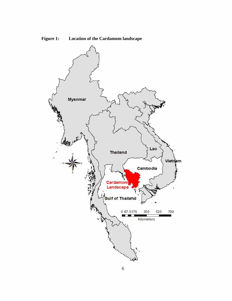
The Cardamom landscape is located in the southwest of Cambodia. The landscape
extends over 8 administrative provinces and can be accessed from Phnom Penh by
national roads 4, 5, and 48. The area is bordered by Samlaut Multiple Use Zone, Pailin,
and Battambang provinces to the north; national road 5, Pursat, and Kampong Chhnang
provinces to the east; Bokor, Ream National Parks, Kampot, and Preah Sihanouk
provinces to the south; and Samkos, Peam Krasop Wildlife Sanctuaries, Botum Sakor
National Park, Thailand, and the Gulf of Thailand to the west (Figure 1).
1.1.1- Geological and Climatic Information
This landscape consists of a combination of several mountain ranges and valleys:
Samkos, Aural, Elephant, and Bokor. The two highest mountains are Aural and Samkos
with elevations of 1,813 and 1,717 meters, respectively (International Centre for
Environmental Management [ICEM], 2003a). The Elephant and Bokor Mountains have
elevations between 500 and 1,000 meters, which is also the average elevation of the
landscape. These mountain ranges form a separate drainage divide. To the east, the rivers
flow into the Tonle Sap basin, while to the west they flow into the Gulf of Thailand
(Clausen, 2009). However, due to the topography toward the southern end of the
Elephant Mountains, some small rivers flow southward on the eastern side of the divide.
The area was formed during the Himalayan uplift that occurred from the middle
of the Jurassic period to the Pliocene period. The landscape is composed of a large
Mesozoic and Cenozoic sedimentary basin superimposed over a Proterozoic continental
nuclear land mass that was compressed after the formation of the Indochina peninsula
(Ashwell, 1997). The magma eruptions that occurred from the end of the Pliocene period
to the beginning of the Pleistocene period in the third episode of the Himalayan
movement explain the presence of some isolated basalt formations of this landscape
(Ashwell, 1997).
The majority of soil in the landscape consists of unfertile mixtures of gravel,
stone, and sandstone that do not provide favorable conditions for agricultural cultivation.
6
Figure 1: Location of the Cardamom landscape
7
The soil was developed as a result of natural geological processes and the decomposition
of acid and basic rocks under a humid to sub-humid tropical climate with alternate wet
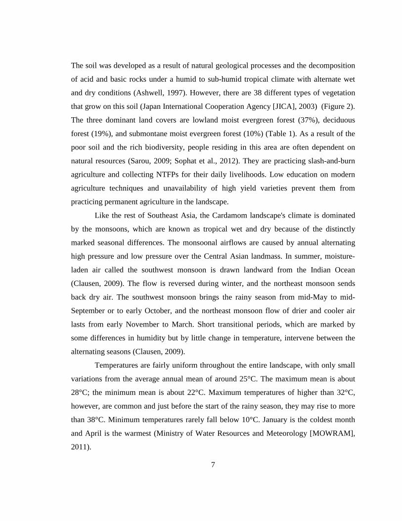
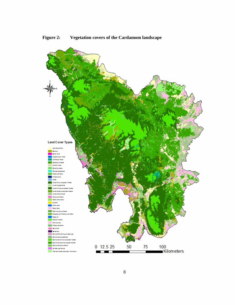
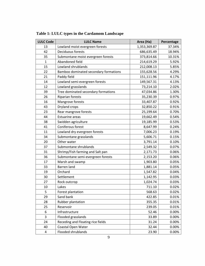
and dry conditions (Ashwell, 1997). However, there are 38 different types of vegetation
that grow on this soil (Japan International Cooperation Agency [JICA], 2003) (Figure 2).
The three dominant land covers are lowland moist evergreen forest (37%), deciduous
forest (19%), and submontane moist evergreen forest (10%) (Table 1). As a result of the
poor soil and the rich biodiversity, people residing in this area are often dependent on
natural resources (Sarou, 2009; Sophat et al., 2012). They are practicing slash-and-burn
agriculture and collecting NTFPs for their daily livelihoods. Low education on modern
agriculture techniques and unavailability of high yield varieties prevent them from
practicing permanent agriculture in the landscape.
Like the rest of Southeast Asia, the Cardamom landscape's climate is dominated
by the monsoons, which are known as tropical wet and dry because of the distinctly
marked seasonal differences. The monsoonal airflows are caused by annual alternating
high pressure and low pressure over the Central Asian landmass. In summer, moisture-
laden air called the southwest monsoon is drawn landward from the Indian Ocean
(Clausen, 2009). The flow is reversed during winter, and the northeast monsoon sends
back dry air. The southwest monsoon brings the rainy season from mid-May to mid-
September or to early October, and the northeast monsoon flow of drier and cooler air
lasts from early November to March. Short transitional periods, which are marked by
some differences in humidity but by little change in temperature, intervene between the
alternating seasons (Clausen, 2009).
Temperatures are fairly uniform throughout the entire landscape, with only small
variations from the average annual mean of around 25°C. The maximum mean is about
28°C; the minimum mean is about 22°C. Maximum temperatures of higher than 32°C,
however, are common and just before the start of the rainy season, they may rise to more
than 38°C. Minimum temperatures rarely fall below 10°C. January is the coldest month
and April is the warmest (Ministry of Water Resources and Meteorology [MOWRAM],
2011).
8
Figure 2: Vegetation covers of the Cardamom landscape
9
Table 1: LULC types in the Cardamom Landscape
LULC Code LULC Name Area (Ha) Percentage 13 Lowland moist evergreen forests 1,353,369.87 37.34% 42 Deciduous forests 686,635.49 18.94% 35 Submontane moist evergreen forests 373,814.66 10.31% 1 Abandoned field 214,619.29 5.92%
15 Lowland shrublands 212,008.13 5.85% 22 Bamboo dominated secondary formations 155,628.56 4.29% 21 Paddy field 151,111.96 4.17% 14 Lowland semi-evergreen forests 149,567.31 4.13% 12 Lowland grasslands 73,214.10 2.02% 39 Tree dominated secondary formations 47,034.86 1.30% 26 Riparian forests 35,230.39 0.97% 16 Mangrove forests 33,407.87 0.92% 43 Dryland crops 32,850.22 0.91% 23 Rear mangrove forests 25,199.64 0.70% 44 Estuarine areas 19,662.49 0.54% 38 Swidden agriculture 19,185.99 0.53% 41 Coniferous forest 8,647.99 0.24% 11 Lowland dry evergreen forests 7,006.23 0.19% 34 Submontane grasslands 5,606.71 0.15% 20 Other water 3,791.14 0.10% 37 Submontane shrublands 2,549.32 0.07% 31 Shrimp/Fish farming and Salt pan 2,171.73 0.06% 36 Submontane semi-evergreen forests 2,153.20 0.06% 17 Marsh and swamp 1,903.80 0.05% 33 Barren land 1,881.14 0.05% 19 Orchard 1,547.82 0.04% 30 Settlement 1,142.95 0.03% 27 Rock outcrop 1,024.74 0.03% 10 Lakes 711.10 0.02% 5 Forest plantation 568.63 0.02%
29 Sand bank 422.85 0.01% 28 Rubber plantation 355.35 0.01% 25 Reservoir 239.05 0.01% 6 Infrastructure 52.46 0.00% 3 Flooded grasslands 33.89 0.00%
24 Receding and Floating rice fields 31.24 0.00% 40 Coastal Open Water 32.44 0.00% 4 Flooded shrublands 23.90 0.00%
10
This climatic condition provides the Cardamom landscape an annual rainfall from
900 to 4,100 millimeters of precipitation (Ministry of Water Resources and Meteorology
[MOWRAM], 2011). The southern part of the landscape such as the provinces of
Kampot, Preah Sihanouk, and Koh Kong received the maximum rainfall as the southwest
monsoon first reaches the coast. This area of greatest rainfall, however, drains mostly to
the sea; only a small quantity goes into the rivers flowing into the Tonle Sap basin.
The relative humidity is high at night throughout the year; usually it exceeds 90
percent. During the daytime in the dry season, humidity averages about 50 percent or
slightly lower, but it may remain about 60 percent in the rainy period (Ministry of Water
Resources and Meteorology [MOWRAM], 2011).
1.1.2- Biodiversity Status
With more than 2.5 million hectares of continuous rainforest cover, the
Cardamom landscape is the largest area of evergreen forest in Cambodia and represents
one of the seven remaining elephant corridors in Southeast Asia (Asian Development
Bank, 2005; Wildlife Alliance, 2009, 2010, 2011, 2012). It provides habitats for 97
species of mammals, 322 species of birds, 100 species of reptiles, 44 species of
amphibians, and more than 500 species of insect, as well as hundreds of species of fish
(Asian Development Bank [ADB], 2005a; Daltry, 2008). Of these, 33 mammals, 53
birds, and 18 reptiles species are considered of international conservation concern by the
International Union for Conservation of Nature (IUCN) and the Convention on
International Trade in Endangered Species of Wild Fauna and Flora (CITES)
(Convention on International Trade in Endangered Species of Wild Fauna and Flora
[CITES], 2013; International Union for Conservation of Nature [IUCN], 2012)
(Appendix 1, 2, & 3). In addition, among the 2,300 species of Cambodia’s plants, over
half are found in the Cardamom landscape and more than 100 species of them are
endemic to the area (Ashwell, 1997; Asian Development Bank [ADB], 2005b; Dy Phon,
1982; Royal Government of Cambodia [RGC], 2002a).
11
The Cardamom landscape has been recognized to be the most important area in
Cambodia for mammal species, which are often used as indicators to reflect the
environmental ‘health’ of local habitats. Such species include the Indochinese Tiger
(Panthera tigris) and the Asian Elephant (Elephas maximus). The last estimate of the tiger
population was no more than 130 breeding individuals (Cutter & Sun, 2010). The area
has also been recognized as a Level I tiger conservation unit (TCU) (Eric Dinerstein,
1997) with significant prey such as Gaur (Bos guarus), Banteng (Bos javanicus), Sambar
Deer (Cervus unicolor), and Wild Pig (Sus scrofa) (Sun, 2000). The Level I TCU is one
of the three levels that offer the highest probability of persistence of tiger populations
over the long term. They are essential for a global tiger conservation strategy. The TCU
was first defined in 1995 by the World Wildlife Fund and Wildlife Conservation Society
to guide and prioritize in situ tiger conservation efforts across Asia. It was then updated
to tiger conservation landscapes (TCLs) in 2006 (E. Dinerstein et al., 2006).
Although the Elephant population has been decreasing, it is still a good number.
Flora and Fauna International (FFI) genetic study in 2007 estimated that more than 200
elephants still remain in the area and it is one of the largest populations in Indochina. The
area also provides the best habitat and is home to one of the largest populations of
Pileated Gibbon (Hylobates pileatus) in the region. In a recent survey, Coudrat et al.
(2011) found 3,100 groups of this sepcies just inside the Samkos wildlife sanctuary,
suggesting this landscape is extremely important for the conservation of this species and
other primates. Other mammal species of international conservation concern, like the
Javan Rhinoceros (Rhinoceros sondaicus) and the Khting Vor (Pseudonovibos spiralis),
are listed in Appendix 1 of this dissertation (Daltry & Momberg, 2000; WildAid, 2003).
The Cardamom landscape is also home to many birds of global and regional
conservation concern, including the White-winged Duck (Cairina scutulata), the Masked
Finfoot (Heliopais personata), the Sarus Crane (Grus antigone), the Black-necked Stork
(Ephippiorhynchus asiaticus), the Lesser Adjutant (Leptoptilos javanicus), the Great
Hornbill (Buceros bicornis), the Green Peafowl (Pavo muticus), the Chestnut-headed
12
Partridge (Arborophila cambodiana), and others as shown in Appendix 2 (Bauld &
Sovan, 2004; Daltry & Momberg, 2000; Mulligan et al., 2012; Royan, 2009).
The presence of the critically endangered Royal Turtle (Batagur baska), which has
been rediscovered in the Southern Cardamoms in the lower Sre Ambel valley (Platt,
Stuart, Sovannara, Kheng, & Kimchay, 2003; WildAid, 2003), adds more conservation
value to the landscape. This is because the species has disappeared in the wild outside of
Cambodia, except for small populations in India, Bangladesh, and Malaysia. Siamese
Crocodiles (Crocodylus siamensis) are also globally critically endangered and were
assumed to be extinct until surviving and breeding populations were identified in the
central and southern parts of the landscape (Daltry & Momberg, 2000). Other reptile
species of global and regional conservation concern are listed in Appendix 3. A good
population of Asian Arowana (Schleropages formosus), which is a CITES Appendix I
species, is also present in the landscape and has breeding populations in most of the
rivers. It is also important for the conservation of the IUCN critical endangered
Agarwood (Aquilaria crassna) and other threatened species of orchids, pitcher plants, and
cycads in this area.
The landscape also provides a variety of non-timber forest products (NTFPs) for
local community livelihoods including Rattan (Korthalsia spp.) stems for canes and
wickers for furniture production; agarwood (Aquilaria crassna) infected wood for
valuable wood and extraction of essential oil; Mreah Prew Phnom (Cinnamomum
parthenoxylon) wood for extraction of another essential oils; yellow vine (Coscinium
spp.) stems for medicinal products; Tep Porou (Cinnamomum tetragonum) bark for
coloring drinking water; Samraang (Scaphium macropodum) fruit for boiled seeds; Kuy
(Willoughbeia edulis) fruit for local consumption; and ant plants (Myrmecodia spp. and
Hydnophytum spp.) epiphyte roots for medicine (Ashwell, 1997; Dy Phon, 1982;
WildAid, 2003).
13
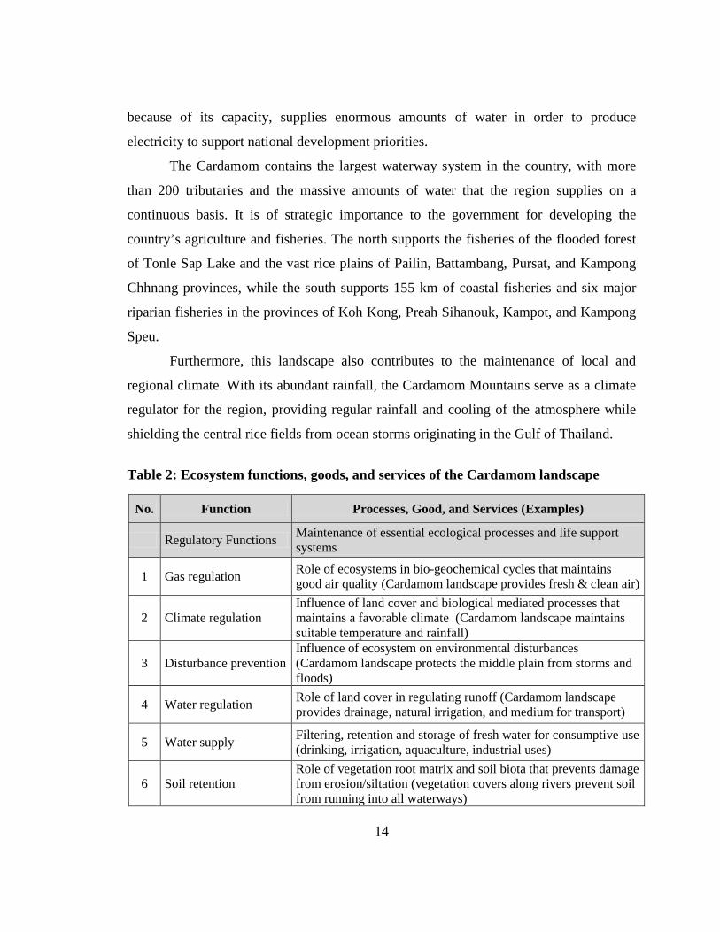
1.1.3- Ecosystem Functions, Goods, and Services
The Cardamom landscape contains 16 ecosystems ranging from wetlands and
coastal mangrove forests to grasslands, lowland forests, and evergreen dense forests
(WildAid, 2003). Ecosystems functions in the Cardamom landscape provide a wide
variety of goods and services. These functions can be defined in four categories:
regulatory, habitat, production and information (Groot, Wilson, & Boumans, 2002).
Regulation functions relate to the capacity of natural and semi-natural ecosystems to
regulate essential ecological processes and life support systems through bio-geochemical
cycles and other biospheric processes. For example, gas and climate regulation,
disturbance prevention, water regulation, supply and treatment, soil retention and
formation, pollination, and biological control are included in this category. Habitat
functions occur when ecosystems provide refuge and reproduction habitat to wild plants
and animals which includes refugium and nursery functions. Production functions occur
when photosynthesis and nutrient uptake by autotrophs converts energy, carbon dioxide,
water and nutrients into a wide variety of carbohydrate structures which are then used by
secondary producers to create an even larger variety of living biomass. Goods that are
provided under these functions include foods, raw materials, genetic, medicinal, and
ornamental resources. Information functions contribute to the maintenance of human
health by providing opportunities for reflection, spiritual enrichment, cognitive
development, recreation and aesthetic experience. Values that are provided under these
functions consist of aesthetic, cultural and artistic, spiritual and historic information,
recreation, science and education. Table 2 was adopted from Groot et al. (2002) and
integrated goods and services provided by the Cardamom landscape ecosystems.
Today, the Cardamom landscape is a vital strategic reserve and several sectors of
the economy, including energy, agriculture, forestry, fisheries, ecotourism, and local
livelihoods depend on the maintenance of its ecosystems even if they have been
modified. Its rainforests are of critical importance to Cambodia’s water security, food
security, and adaptation to climate change. The Cardamom landscape is an essential life
support to a large portion of the Cambodian population and the national economy
14
because of its capacity, supplies enormous amounts of water in order to produce
electricity to support national development priorities.
The Cardamom contains the largest waterway system in the country, with more
than 200 tributaries and the massive amounts of water that the region supplies on a
continuous basis. It is of strategic importance to the government for developing the
country’s agriculture and fisheries. The north supports the fisheries of the flooded forest
of Tonle Sap Lake and the vast rice plains of Pailin, Battambang, Pursat, and Kampong
Chhnang provinces, while the south supports 155 km of coastal fisheries and six major
riparian fisheries in the provinces of Koh Kong, Preah Sihanouk, Kampot, and Kampong
Speu.
Furthermore, this landscape also contributes to the maintenance of local and
regional climate. With its abundant rainfall, the Cardamom Mountains serve as a climate
regulator for the region, providing regular rainfall and cooling of the atmosphere while
shielding the central rice fields from ocean storms originating in the Gulf of Thailand.
Table 2: Ecosystem functions, goods, and services of the Cardamom landscape
No. Function Processes, Good, and Services (Examples)
Regulatory Functions Maintenance of essential ecological processes and life support systems
1 Gas regulation Role of ecosystems in bio-geochemical cycles that maintains good air quality (Cardamom landscape provides fresh & clean air)
2 Climate regulation Influence of land cover and biological mediated processes that maintains a favorable climate (Cardamom landscape maintains suitable temperature and rainfall)
3 Disturbance prevention Influence of ecosystem on environmental disturbances (Cardamom landscape protects the middle plain from storms and floods)
4 Water regulation Role of land cover in regulating runoff (Cardamom landscape provides drainage, natural irrigation, and medium for transport)
5 Water supply Filtering, retention and storage of fresh water for consumptive use (drinking, irrigation, aquaculture, industrial uses)
6 Soil retention Role of vegetation root matrix and soil biota that prevents damage from erosion/siltation (vegetation covers along rivers prevent soil from running into all waterways)
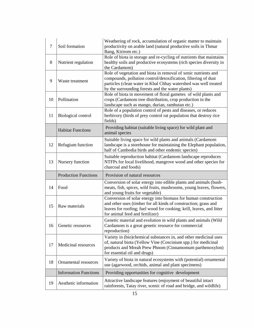
15
7 Soil formation Weathering of rock, accumulation of organic matter to maintain productivity on arable land (natural productive soils in Thmar Bang, Kirirom etc.)
8 Nutrient regulation Role of biota in storage and re-cycling of nutrients that maintains healthy soils and productive ecosystems (rich species diversity in the Cardamom)
9 Waste treatment
Role of vegetation and biota in removal of xenic nutrients and compounds, pollution control/detoxification, filtering of dust particles (clean water in Kbal Chhay watershed was well treated by the surrounding forests and the water plants)
10 Pollination Role of biota in movement of floral gametes of wild plants and crops (Cardamom tree distribution, crop production in the landscape such as mango, durian, rambutan etc.)
11 Biological control Role of a population control of pests and diseases, or reduces herbivory (birds of prey control rat population that destroy rice fields)
Habitat Functions Providing habitat (suitable living space) for wild plant and animal species
12 Refugium function Suitable living space for wild plants and animals (Cardamom landscape is a storehouse for maintaining the Elephant population, half of Cambodia birds and other endemic species)
13 Nursery function Suitable reproduction habitat (Cardamom landscape reproduces NTFPs for local livelihood, mangrove wood and other species for charcoal and foods)
Production Functions Provision of natural resources
14 Food Conversion of solar energy into edible plants and animals (bush-meats, fish, spices, wild fruits, mushrooms, young leaves, flowers, and young fruits for vegetable)
15 Raw materials
Conversion of solar energy into biomass for human construction and other uses (timber for all kinds of construction; grass and leaves for roofing; fuel wood for cooking; krill, leaves, and litter for animal feed and fertilizer)
16 Genetic resources Genetic material and evolution in wild plants and animals (Wild Cardamom is a great genetic resource for commercial reproduction)
17 Medicinal resources
Variety in (bio)chemical substances in, and other medicinal uses of, natural biota (Yellow Vine (Coscinium spp.) for medicinal products and Mreah Prew Phnom (Cinnamomum parthenoxylon) for essential oil and drugs)
18 Ornamental resources Variety of biota in natural ecosystems with (potential) ornamental use (agarwood, orchids, animal and plant specimens)
Information Functions Providing opportunities for cognitive development
19 Aesthetic information Attractive landscape features (enjoyment of beautiful intact rainforests, Tatay river, scenic of road and bridge, and wildlife)
16
20 Recreation Variety in landscapes with (potential) recreational uses (getways to a green adventure at Chi Phat, Trapeang Rung, and Tatay)
21 Cultural and artistic information
Variety in natural features with cultural and artistic value (use of Cardamom landscape as motive in books, film, songs, and ecotourism advertising)
22 Spiritual and historic information
Variety in natural features with spiritual and historic value (Ghost Mountain, historical jars and coffins)
23 Science and education Variety in nature with scientific and educational values (many biological and social research opportunities provided by the Cardamom landscape)
1.1.4- Social and Economic Information
Human density in the Cardamom landscape is extremely low compared to other
locations in the country, less than one person per hectare of land. The livelihood of the
locals depends on using natural resources for survival such as logging and hunting, non-
timber forest product collection, and clearing forest for slash-burn agriculture (Sophat et
al., 2012). Other livelihoods include animal husbandry, fishing, supply and sales of local
products, and government employment. Large scale development such as resort, casino,
and industrial zone development along the Thai border; hydropower development and
logging in the reservoirs; sand dredging along main waterways; and economic land
concession development operate in the area. Green businesses such as community
ecotourism, guest houses, and home stays in several attractive locations were just recently
introduced by conservation NGOs (Wildlife Alliance, 2012).
1.1.5- Impacts/Threats
Threats and impacts to the Cardamom landscape are driven by many factors
(Halperin & Turner, 2013) such as country political instability, human population growth,
government policies, bad governance, investment pressure etc. Daltry and Momberg
(2000) discussed hunting for local consumption, national and international trade, habitat
loss, road construction, habitat degradation, and lack of education as the main impacts
and threats to biodiversity in the area. Sophat et al. (2012) found that illegal logging by
new migrants and hydropower development are the biggest threats that lead to forest
degradation. Sarou (2009) discussed the challenges and the impacts of different
17
government natural resource management policies, NGOs, and external actors on the
indigenous people’s livelihood. Puthea (2008) identified soil erosion and deforestation as
being widespread and of particular concern in Cambodia, jeopardizing both agricultural
productivity and the integrity of a number of ecosystems. The same report identifies a
range of causes of land degradation, a number of which characterize the study area in the
Cardamom Mountains. These include recent influxes of external migrants to the area,
increasing resource pressures and leading to new forms of land resource exploitation and
encroachment. Based on a literature review, it is clearly seen that threats to the
Cardamom landscape include both drivers that produced access to the landscape and
direct impacts that took place in the access areas. These threats include urban and
community development, infrastructure expansion, hydropower and irrigation system
development, economic land concessions (ELCs), and illegal land encroachment.
1.2- Key Institutions, Policies, and Regulations
In order to understand the current situation of the landscape and to create the
Mixed Conservation and Development (MCD) scenario for the study, this section will
review all key government institutions, policies, and regulations that are currently in
place for the management of the Cardamom landscape. As with other nations, the
Cambodian National Constitution is the top legislation, providing a clear framework for
managing natural resources in Cambodia as well as in the Cardamom landscape. Article
58 states “land, mineral resources, mountains, sea, underwater, continental shelf,
coastline, airspace, islands, rivers, canals, streams, lakes, forests, natural resources…” are
state property. Article 59 obligates the state to protect “the environment and balance of
abundant natural resources and establish a precise plan of management of land, water, air,
wind, geology, ecological system, mines, energy, petrol and gas, rocks and sand, gems,
forests and forestry products, wildlife, fish, and aquatic resources” (Kingdom of
Cambodia, 1993b). Based on this constitution, the state has established the following
institutions, policies, and regulations to manage the country’s natural resources and the
following are related to the Cardamom landscape.
18
1.2.1- Management Institutions of the Cardamom Landscape
The following are government agencies responsible for managing and monitoring
of the Cardamom landscape. These institutions each have eight provincial departments
with the exception of the Council for Development of Cambodia (CDC) and provincial
authorities.
Council for Development of Cambodia (CDC) is responsible for making all
decisions regarding rehabilitation, development, and investment activities as well as for
providing guidance on the preparation of development strategies and the utilization of all
public and private resources. . CDC also coordinates donor support, and facilitates inter-
ministerial activities (Kingdom of Cambodia, 1994a, 2003). This council is chaired by
the Prime Minister and has all line ministries as its members. CDC has the ability to
approve all kind of investment projects in 45 days. So, it is extremely important that the
relevant line ministry representatives have the ability and capacity to provide comments
and discuss the cost and benefit correctly and comprehensively on each proposed project
that will be permitted or rejected by the council. Line ministries frequently send their low
level representatives to participate in the meetings and did not share professional
comments, leading to the improper approval of projects. Moreover, corruption often
influences decision making and public consultations are rarely conducted even though
required by several regulations. As a result, these issues led to future conflicts and caused
severe environmental impacts.
Ministry of Environment (MoE) plans, manages, and monitors environment
sector as stated in the Law on Environmental Protection and Natural Resources
Management (Kingdom of Cambodia, 1996), the Protected Area Law (Kingdom of
Cambodia, 2008), National Environmental Action Plan (NEAP), National Wetland
Action Plan (NWAP), National Biodiversity Strategy and Action Plan, and Cambodian
Climate Change Strategic Plan (CCCSP) that was recently launched by the RGC.
Responsibilities on the ground are mostly carried out by the Nature Protection and
Conservation Administration (NPCA). The NPCA is responsible for assisting the MoE
with managing a particular protected area system created in 1993 (Kingdom of
19
Cambodia, 1993a), developing and implementing the Protected Areas Strategic
Management Plan and coordinating other conservation works in the country. According
to the Sub-decree on Environmental Impact Assessment Process, MoE has the authority
to make the decision on whether or not a development project is approved based on
review of the submitted environmental impact assessment report.
Ministry of Agriculture, Forestry and Fisheries (MAFF) plans and manages
the agricultural, forestry and fisheries sectors with three central departments specifically:
the Forestry Administration (FA), the Fisheries Administration (FiA), and the General
Department of Rubber Plantation. FA is responsible for managing protected forests and
areas outside the protected areas managed by MoE, preparing protective policies and
regulations, developing management plans, and supporting the rehabilitation of forests
and wildlife resources as stated in the Forestry Law (Kingdom of Cambodia, 2002), the
Sustainable Forest Management Plan, and the Nation Forest Sector Policy of the RGC.
FiA is responsible for managing mangrove forests, developing plans for the protection,
management, and rehabilitation of fishery resources as stated in the Fisheries Law
(Kingdom of Cambodia, 2006). The General Department of Rubber Plantation is
responsible for managing rubber plantations in the landscape. The FA and FiA assist
MAFF to manage forests and fisheries in the area through de-concentrated single-line
organizations. A de-concentrated single-line organization is a term that the RGC uses to
describe management structure from central to provincial to community levels.
Ministry of Land Management, Urban Planning and Construction
(MLMUPC) is responsible for general land management, urbanization, and construction
as stated in the Land Law (Kingdom of Cambodia, 2001a). MLMUPC is also responsible
for providing land title and land registration including the social and economic land
concessions in the area. Recently, this ministry has been working with provincial
authorities and Wildlife Alliance to allocate three social land concessions in the
Cardamom landscape that might add more pressure on biodiversity and ecosystem
conservation.
20
Ministry of Water Resources and Meteorology (MOWRAM) is responsible
for water resources management and meteorology as started in the Law on Water
Resources Management (Kingdom of Cambodia, 2007) and the Strategic Development
Plan on Water Resources and Meteorology 2009-2013, and the Climate Change Strategic
Plan on Water Resources Sector 2013-2017. This ministry is also responsible for
permitting sand dredging projects in waterways in the Cardamom landscape, many of
which affect ecosystem and local communities.
Ministry of Industrial, Mine and Energy (MIME) is responsible for energy
development including hydropower, coal burning, diesel power stations, and transmission
lines. In addition, this ministry oversees mine exploring and exploitation as stated in the
Law on Mineral Resource Management and Exploitation (Kingdom of Cambodia,
2001b). Both energy development and mineral exploration existed in the Cardamom
landscape. Hydropower has great potential to be developed in the landscape; however,
mining is a controversial issue in Cardamom natural resource management. Given that
underground resources are governed by another separate law, conflicts occur between
MIME and other aboveground, natural resource management institutions.
Ministry of Tourism (MoT) is responsible for managing and developing the
tourism sector in the country. Ecotourism is critically important for the Cardamom
landscape sustainable management. Even though a Cambodian tourism law is not in
effect, this ministry has been trying to get involved in ecotourism projects in the area,
especially with the three community-based ecotourism projects that are being established
by Wildlife Alliance in Chi Phat, Trapeang Rung, and Tatay communes.
The Eight Provincial Authorities are responsible for community development,
including resettlement, infrastructure, and land expansion in each individual province in
the landscape. These authorities, in cooperation with other institutions, development
partners, and NGOs, implement the central government policies and regulations, improve
community development and people’s livelihood, and in the same time protect natural
resources and the environment. As previously mentioned, many of the line ministries
21
have their departments under the provincial authorities, assisting the governors to develop
and govern their provinces based on each policy sector.
1.2.2- Policies and Regulations related to the Cardamom Landscape
Cardamom landscape management is directed by a number of major national
policies, regulations, strategies, and action plans. The following is a review of the
documents that are currently in place and implemented.
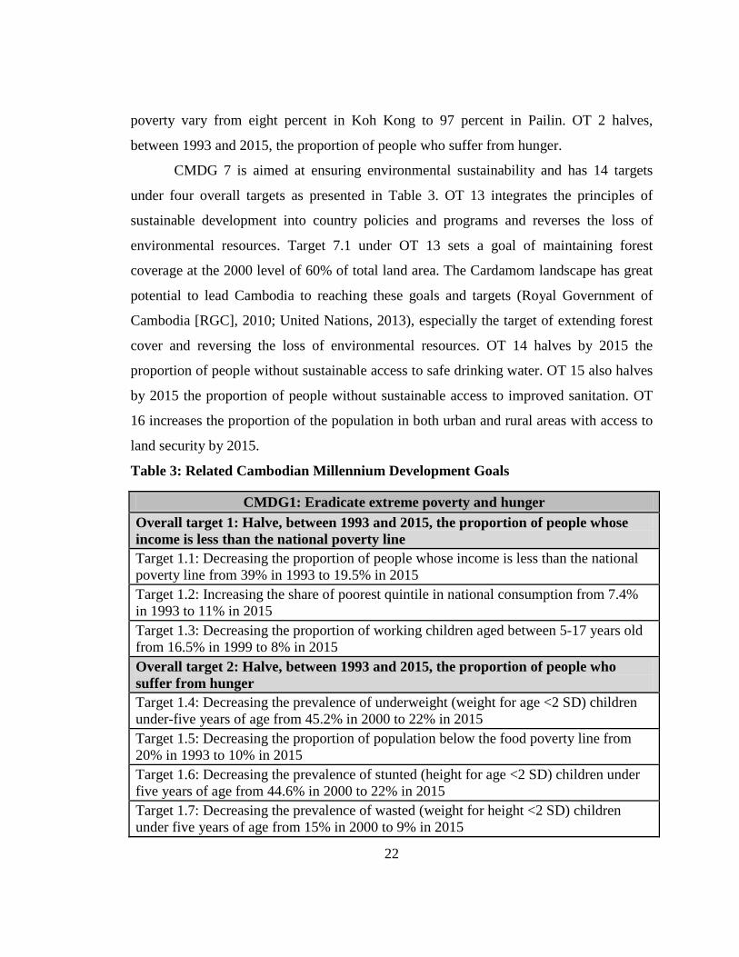
Cambodian Millennium Development Goals (CMDGs): CMDGs were first
developed in 2001 in cooperation with the United Nations and had the merit of laying the
foundations of future reporting and sensitizing a large audience of stakeholders. The
current 2003 CMDGs were developed based on medium-term planning exercises of the
Cambodian’s Social-Economic Development Plan II and the National Poverty Reduction
Strategy (Council for Social Development, 2003). In 2003, the Ministry of Planning took
a further step in setting medium-term targets and defining national monitoring and
evaluation indicators when it developed its own set of national development goals for
2015. These were based on the Millennium Development Goals agreed at the United
Nation Millennium Summit in 2000 to which Cambodia was a signatory along with all
other countries (United Nations General Assembly, 2000). In addition to the eight agreed
goals of the United Nations, Cambodia has added an additional goal, related to removal
of mining explosives (Royal Government of Cambodia [RGC], 2003a). Based on this
review, Cambodian Millennium Development Goals (CMDG) 1 and 7 are strongly
related to Cardamom landscape management (Table 3). CMDG 1 is aimed at eradicating
extreme poverty and hunger through eight targets under two overall targets (OT). OT 1
focuses on the proportion of people whose income is less than the national poverty line.
The goal is to halve the 39% of Cambodian people whose income is less than poverty line
in 2003 by 2015. According to the Japan International Cooperation Agency’s study on
Cambodia poverty profiles in 2007, poverty lines in Phnom Penh, other urban areas, and
rural areas were US$0.76, US$0.66, and US$0.57 per day respectively (Japan
International Cooperation Agency [JICA], 2010). In the Cardamom landscape, rates of
22
poverty vary from eight percent in Koh Kong to 97 percent in Pailin. OT 2 halves,
between 1993 and 2015, the proportion of people who suffer from hunger.
CMDG 7 is aimed at ensuring environmental sustainability and has 14 targets
under four overall targets as presented in Table 3. OT 13 integrates the principles of
sustainable development into country policies and programs and reverses the loss of
environmental resources. Target 7.1 under OT 13 sets a goal of maintaining forest
coverage at the 2000 level of 60% of total land area. The Cardamom landscape has great
potential to lead Cambodia to reaching these goals and targets (Royal Government of
Cambodia [RGC], 2010; United Nations, 2013), especially the target of extending forest
cover and reversing the loss of environmental resources. OT 14 halves by 2015 the
proportion of people without sustainable access to safe drinking water. OT 15 also halves
by 2015 the proportion of people without sustainable access to improved sanitation. OT
16 increases the proportion of the population in both urban and rural areas with access to
land security by 2015.
Table 3: Related Cambodian Millennium Development Goals
CMDG1: Eradicate extreme poverty and hunger Overall target 1: Halve, between 1993 and 2015, the proportion of people whose income is less than the national poverty line Target 1.1: Decreasing the proportion of people whose income is less than the national poverty line from 39% in 1993 to 19.5% in 2015 Target 1.2: Increasing the share of poorest quintile in national consumption from 7.4% in 1993 to 11% in 2015 Target 1.3: Decreasing the proportion of working children aged between 5-17 years old from 16.5% in 1999 to 8% in 2015 Overall target 2: Halve, between 1993 and 2015, the proportion of people who suffer from hunger Target 1.4: Decreasing the prevalence of underweight (weight for age <2 SD) children under-five years of age from 45.2% in 2000 to 22% in 2015 Target 1.5: Decreasing the proportion of population below the food poverty line from 20% in 1993 to 10% in 2015 Target 1.6: Decreasing the prevalence of stunted (height for age <2 SD) children under five years of age from 44.6% in 2000 to 22% in 2015 Target 1.7: Decreasing the prevalence of wasted (weight for height <2 SD) children under five years of age from 15% in 2000 to 9% in 2015
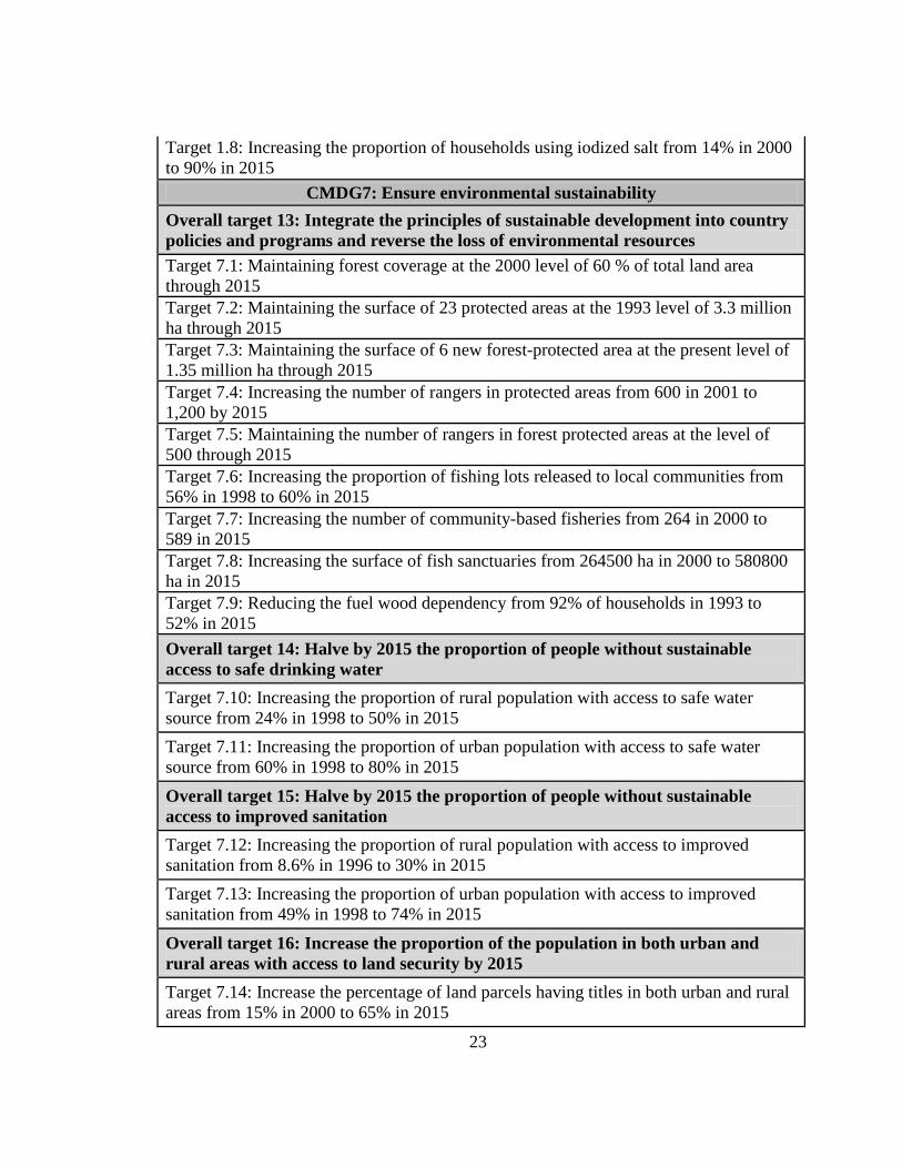
23
Target 1.8: Increasing the proportion of households using iodized salt from 14% in 2000 to 90% in 2015
CMDG7: Ensure environmental sustainability Overall target 13: Integrate the principles of sustainable development into country policies and programs and reverse the loss of environmental resources Target 7.1: Maintaining forest coverage at the 2000 level of 60 % of total land area through 2015 Target 7.2: Maintaining the surface of 23 protected areas at the 1993 level of 3.3 million ha through 2015 Target 7.3: Maintaining the surface of 6 new forest-protected area at the present level of 1.35 million ha through 2015 Target 7.4: Increasing the number of rangers in protected areas from 600 in 2001 to 1,200 by 2015 Target 7.5: Maintaining the number of rangers in forest protected areas at the level of 500 through 2015 Target 7.6: Increasing the proportion of fishing lots released to local communities from 56% in 1998 to 60% in 2015 Target 7.7: Increasing the number of community-based fisheries from 264 in 2000 to 589 in 2015 Target 7.8: Increasing the surface of fish sanctuaries from 264500 ha in 2000 to 580800 ha in 2015 Target 7.9: Reducing the fuel wood dependency from 92% of households in 1993 to 52% in 2015 Overall target 14: Halve by 2015 the proportion of people without sustainable access to safe drinking water Target 7.10: Increasing the proportion of rural population with access to safe water source from 24% in 1998 to 50% in 2015 Target 7.11: Increasing the proportion of urban population with access to safe water source from 60% in 1998 to 80% in 2015 Overall target 15: Halve by 2015 the proportion of people without sustainable access to improved sanitation Target 7.12: Increasing the proportion of rural population with access to improved sanitation from 8.6% in 1996 to 30% in 2015 Target 7.13: Increasing the proportion of urban population with access to improved sanitation from 49% in 1998 to 74% in 2015 Overall target 16: Increase the proportion of the population in both urban and rural areas with access to land security by 2015 Target 7.14: Increase the percentage of land parcels having titles in both urban and rural areas from 15% in 2000 to 65% in 2015
24
Rectangular Strategy (RS): This strategy provides the platform for national
development. The RS I was transformed from the Triangle Strategy of the Second
Legislature of the national assembly (1998-2003) and implemented during the Third
Legislature (2003-2008). The RS II was implemented during the Fourth Legislature
(2008-2013). RS III is in the process of being implemented under the Fifth Legislature
(2013-2018). All RSs have the same structure. In RS III, the core of the rectangular
strategy which is about good governance and the first strategic rectangle which is about
promotion of agriculture sector are strongly related to the Cardamom landscape
management. This is because good governance is the key issue to everything, including
fighting corruption, legal and judicial reforms, public administration reform, and reform
of armed forces that direct sustainable management of natural resources. Under the
promotion of the agriculture sector strategic rectangle; the first side is about improved
productivity, diversification and commercialization, the second is about promotion of
livestock farming and aquaculture, the third is about land reform and clearance of mines,
and the fourth is about sustainable management of natural resources.
To achieve this objective, the RGC is implementing a comprehensive and cross-
cutting approach, aimed at improving the effectiveness and equity in the exploitation of
natural resources, by: 1) clearly determining the ownership of natural resources; 2)
developing an appropriate incentive scheme for the conservation of natural resources and
empowering the sub-national government, communities and individuals to participate in
their conservation by focusing on training, information sharing as well as strengthening
social capital, and institutional accountability and transparency; and 3) stepping up
cooperation with concerned stakeholders under the framework of green growth and
climate change.
The RGC places priority on further managing forest and wildlife resources in
accordance with the National Forest Program 2010-2029, fishery resources in line with
the Strategic Planning Framework for Fisheries Sector 2010-2019 and the Declaration on
the National Policy for Fisheries Sector, and protected area systems, wetlands,
biodiversity as stated in the Law on the Environmental Protection and the Management of
25
Natural Resources and Law on Protected Natural Areas” and Guideline on the
Development of Coastal Areas in the Kingdom of Cambodia. The RGC is also stepping
up cooperation with relevant development stakeholders under the framework of the
National Policy on Green Development” and the “National Strategic Plan on Green
Growth 2013-2030 through the development of regulatory frameworks and mechanisms
for carbon trading, strengthening the capability, preparation and implementation of
climate change adaptation measures.
National Strategic Development Plan (NSDP): This plan plays a central role as
the main policy tool in implementing national development visions pronounced in
political platform and national development strategies of the RGC such as the RS. The
NSDP was renamed from the Social-Economic Development Plans (SEDP), which were
implemented previously (SEDP I 1996-2000, SEDP II 2001-2006). The NSDP 2006-
2010 was developed based on the RS framework and RGC led the process of the
preparation of the plan while ensuring participation of and consultations with all
stakeholders. To ensure consistency in terms of hierarchy, role, substance, coherence, and
synchronization between the RS, NSDP, and other sectoral development policies and
strategies; during the first meeting of the Fourth Legislature, the Prime Minister called for
a review of the timeframe of the NSDP, and the NSDP Update 2009-2013 was
formulated and still under implementation, while NSDP 2014-2018 is in the development
process and not yet published. The NSDP Update 2009-2013 detailed and placed priority
on land, forestry and fisheries reforms separately as presented in the RS II. This plan
also included the development sections such as rehabilitation and construction of
transport infrastructure, development of water, energy and information and
communication technology sectors. This plan tried to improve the country’s economy and
livelihood of the people based on those reforms after the effect of the global economic
crises and did not clearly target sustainable natural resource management, especially
biodiversity and ecosystem conservation as the key solution to the sustainable
development. Hopefully, the NSDP 2014-2018 will include clear sustainable natural
resource management guidelines because this is already presented the RS III.
26
National Policy and Strategic Plan on Green Growth 2013-2030: This plan
was approved on 01 March 2013 by the RGC, aiming at developing the economy with
consideration for environment and natural resources sustainability. The national policy
targets a balance between economic development and environmental protection, culture
preservation, social stability and sustainable consumption of natural resources to improve
people’s living conditions and welfare. The 2013-2030 green growth plan aims to
develop a green economy through the effective use of natural resources, environmental
sustainability, green jobs, green technologies, green finance, green credit, and green
investment. Prior to these, Cambodia had already adopted several legal instruments to
promote the green growth, including the roadmap for green growth, the memorandum of
understanding on green growth cooperation between Cambodia and the Republic of
Korea’s Global Green Growth Institute and the establishment of the National Council on
Green Growth and the General Secretariat for Green Growth. Moreover, workshops and
meetings with relevant stakeholders on inclusive green growth were conducted to gather
inputs, raise awareness at the national and sub-national level, increase capacity building,
mobilize domestic financial and human resources, promote balanced integration of
economic, environmental, social and cultural dimensions into the overall development of
Cambodia. It was understood that inclusive green growth is a means to achieve
sustainable development, mainstreaming green growth in NSDP 2014-2018 and in all
developmental sectors, and establishing Law on Green Growth is critically important for
the implementation of this policy and strategy plan.
Cambodia Climate Change Strategic Plan 2014-2023 (CCCSP): This strategic
plan was officially launched and strongly supported by the Prime Minister in November
2013. The plan captures the main strategic objectives and directions for a climate-smart
development of Cambodia in the next 10 years. It builds synergies with existing
government policies to ensure a strategic cohesion to address a wide range of climate
change issues linked to adaptation, greenhouse gas (GHG) mitigation, and low-carbon
development. The CCCSP covers eight strategic objectives: 1) promote climate resilience
through improving food, water and energy security, 2) reduce vulnerability of sectors,
27
regions, gender and health to climate change impacts, 3) ensure climate resilience of
critical ecosystems such as the Cardamom landscape, biodiversity, protected areas, and
cultural heritage sites, 4) promote low-carbon planning and technologies to support
sustainable development of the country, 5) improve capacities, knowledge and awareness
for climate change responses, 6) promote adaptive social protection and participatory
approaches in reducing loss and damage, 7) strengthen institutions and coordination
frameworks for national climate change responses, and 8) strengthen collaboration and
active participation in regional and global climate change processes. Based on this policy,
the Cambodian Cardamom landscape should be managed to mitigate GHG by promoting
carbon sequestration trading and low-carbon development. This also means that the RGC
will not deforest the landscape and stop granting any ELCs in the area.
Several other environmental sector strategies and action plans exist. Although
many of these are out of date or in the amendment process, they include the National
Environmental Action Plan 1998-2002, the National Biodiversity Strategy and Action
Plan (NBSAP) (2002), the Ministry of Environment Strategic Plan 2001-2003, and the
National Wetland Action Plan (NWAP). The NBSAP (2002) was one of the important
tools to elaborate the convention on biodiversity by aiming to ensure that the benefits of
sustainable biological resource use contribute to poverty reduction and the improved
quality of life for all Cambodians.
Private Sector Investment Policy: This policy allows for investment by any
entity. The policy framework includes a liberal foreign investment regime that allows a
100% foreign equity ownership investment. except the ownership of land. It also includes
free remittance of foreign currencies abroad, no price controls on products or services,
equal treatment of all investors, no nationalization adversely affecting the property of
investors, and no foreign exchange controls on current account transactions. The Private
Sector Investment Policy allows for investment in agriculture and agro-industry, energy,
processing, tourism, and mining sectors. In addition, natural resources such as land,
beaches, oil and gas, and minerals such as bauxite, gold, iron, manganese, phosphate
rock, silica, and zircon can also be invested in (Sophal, 2010). The majority of these
28
resources now only remain in the Cardamom landscape and investment can even take
place inside the sustainable use zone of any protected areas (Kingdom of Cambodia,
2008). It is extremely important that this policy be implemented in conjunction with the
sustainable management of natural resources as specified in the RS and environment
sectoral laws, policies, strategies, and action plans.
Law on Investment in the Kingdom of Cambodia: This law was first adopted
in 1994 (Kingdom of Cambodia, 1994b) and amended in 2003 (Kingdom of
Cambodia, 2003). The laws aim to govern all qualified investment projects and define
procedures by which any person establishes a qualified investment project. Only qualified
investment projects are entitled to the benefits subject to the scope of these laws. The
CDC is obligated to be the sole and one-stop service organization responsible for the
evaluation, decision making, monitoring of all rehabilitation, development and
investment projects in Cambodia. Provisions on investment procedures, guarantees, and
incentives, land ownership and use; employment practices; and disputes and dissolution
are also clearly stated in these laws. With the new amendment, clear deadlines for
decision making have been stated to encourage investors and avoid corruption. For
example, the conditional registration certificate or a letter of non-compliance shall be
issued to the applicant within three working days by the CDC after the receipt of the
investment proposal. The laws also stated that all government entities responsible for
issuing any related authorization, clearance, license, permit or registration shall be issued
no later than the 28th working day from the date of the conditional registration certificate.
Any government official who, without proper reason, fails to respond to an applicant’s
request by this deadline shall be punished by law. However, investment projects that are
related to natural resource use should be strictly evaluated and monitored, especially
those in the Cardamom landscape to avoid unsustainable use and resource depletion.
Environmental Protection and Natural Resources Law (1996): This law
establishes the basic provision for environmental protection and preservation of natural
resources within Cambodia, including important provisions on the requirement for
29
environmental impact assessments. This law focuses on MoE’s responsibilities over
pollution control issues and calls for the development of a National Environmental Plan.
Protected Area Law of 2008: The development of Cambodia’s PA Law was
initiated in 2001 and adopted in 2008. Some PAs are of special regional and/or
international significance like the Biosphere Reserve comprising the Tonle Sap Multiple-
Use Area. Cambodia has Ramsar sites that are, like PAs, under the jurisdiction of the
MoE. These sites include the Boeung Tonle Chmar core zone of the Tonle Sap Multiple-
Use Area, the Koh Kapik wetland and associated islets in the Peam Krasop Wildlife
Sanctuary, and stretches of the Mekong River area between Stung Treng and the border
with Lao PDR.
Article 11 provides instruction on PA zoning that each protected area shall be
divided into four management zoning systems: 1) core zone–area(s) of high conservation
value containing threatened and critically endangered species and fragile ecosystems–
cannot be accessed except the NCPA's officials and researchers who, with prior
permission from the MoE, 2) conservation zone–area(s) of high conservation value
containing natural resources, ecosystems, watershed areas, and natural landscape located
adjacent to the core zone–can be accessed only with prior consent of the NCPA and
small-scale community uses of NTFPs to support local ethnic minorities' livelihood may
be allowed under strict control, 3) sustainable use zone–area(s) of high economic value
for national economic development and conservation of this area itself thus contributing
to the local communities’ livelihood–can be permitted for development and
investment activities, and 4) community zone–area(s) for socio-economic development
of the local communities and may contain existing residential lands, paddy field and field
garden–can be issued land title or permission to use land in this zone in accordance with
the land law.
The law on protected areas also stated that the MoE shall develop a National
Protected Area Strategic Management Plan (NPASMP) and ensure that the plan is
compatible and consistent with national plans such as the National Environment Action
30
Plan, NBSAP and the National Wetland Action Plan. The NPASMP should be adopted
by the Royal Government of Cambodia at the request of the Ministry of Environment.
It is stated in the protected area law that the NPCA shall develop for each
protected area an action plan to be approved by the Ministry of Environment and in
accordance with the NPASMP. The process for the development of these plans shall
involve coordination and consultations with local authority, local community, indigenous
ethnic minorities' community and stakeholders. Article 20 also authorized the
establishment of a National Committee for Conflict Resolution on Protected Area
Management, chaired by the Minister of Environment with participation by relevant
ministries and institutions, to assist in the discussion, consultation and conflict resolution
on protected areas. The law also authorizes the NPCA to offset national community
protected areas so that local people can sustainably use resources for their livelihoods,
but only in the community use zones. These agreements last no more than 15 years.
Statement of the Royal Government on National Forest Sector Policy: The
RGC has worked to accomplish forest resource conservation, good governance, social
economic development, and poverty reduction since 2002. For forest resource
conservation, the RGC is trying to reclassify and dedicate the major part of remaining
natural forest stands to their ecosystems protection and biodiversity conservation
functions; promote conservation and protection strategies such as protected forests,
watershed management, genetic and wildlife resources conservation, eco-tourism, and
special management areas with a maximum participation of the local population;
implement the strict application of the Code of Practice as the regulatory framework for
the sustainable management of forest resources and forest concessions; and conduct
extension, education and public awareness campaigns at all levels of Cambodian society.
In good governance; the RGC has committed to implement capacity building,
institutional strengthening and research programs at all levels; conduct education,
training and public awareness campaigns, with particular regard to the participation of
local populations within conservation and sustainable forest management plans; establish
a forest administration in which necessary steps of devolution of decision-making power
31
can take place and in which functional procedures for multi-institutional collaborations
are grounded; encourage, implement and coordinate multi-stakeholder processes that
enable the harmonization of the different perceptions, interests and objectives of the
various forest interest groups at local, regional and international levels; and promote
transparent information for the forest sector.
Commitment to socio-economic development includes the promotion of high
socio-economic value of forest ecosystems protection and biodiversity conservation
functions of natural forest resources, the substitution of timber supply from natural forest
stands by timber plantations through encouraging private investment and public
participation, and the optimization of the use, processing and marketing system for forest
products especially plantation forest products to support domestic demand and export.
The RGC’s endeavor in poverty reduction is to legally recognize and protect the
traditional rights of local populations to use forest resources under the framework of food
security and poverty reduction considerations and to optimize the benefits to local
populations from the use and management of forest resources through the implementation
of forestry and wildlife conservation concept based on the participation of local
populations.
In addition to the set of national goals directed towards the development
framework for the conservation and sustainable management of forest resources, the
RGC acknowledges international issues, processes and commitments occurring as a result
of the United Nations Conference on Environment and Development (UNCED) in Rio de
Janeiro in 1992 and its follow-up processes relevant to the country’s forest resources. The
RGC envisions that a long term National Forest Program (NFP) will be implemented
consistent with the framework of the Intergovernmental Panel on
Forests/Intergovernmental Forum on Forests promoted by the International Arrangement
on Forests with the United Nations Forum on Forests and the Collaborative Partnership
on Forests.
Forestry Law: This law is the major legal instrument for the Cardamom
landscape, defining forest land classifications, management systems, enforcement, fiscal,
32
and other regulatory mechanisms. The objective of this law is to “ensure the sustainable
management of the forests for their social, economic, and environmental benefits,
including conservation of biological diversity and cultural heritage” (Kingdom of
Cambodia, 2002). The Law outlines general rules and regulations related to
administration and management of the permanent forestry estates within Cambodia, with
management jurisdiction granted to the FA (except for those areas that fall within PAs
under the MoE). The Forestry Law outlines the implementation of a resource-based
approach and establishes a de-concentrated single-line organization. Public participation
is provided for in the decision-making processes - classification of forests into categories
for production, protection, and conversion purposes - and acknowledges traditional user
rights of local communities. The basic structures, functions, and responsibilities of the
FA are set forth along with the basic rules and regulations related to concession
management, community forestry, traditional user rights, wildlife management, and
forest crimes. It also ensures customary user rights of forest products and by-products for
local communities.
National Forest Program 2010-2029: This program was adopted in 2010 by the
RGC. The national program was developed to address, among other things, the National
Forest Policy Statement of the RGC, the CMDGs, and the NSDP Update 2009-2013. The
overall mission of the program is to achieve the sustainable management and
development of forests for their contribution to poverty alleviation, enhanced livelihoods,
economic growth and environmental protection, including conservation of biological
diversity and cultural heritage. The objectives of this program are to: 1) maximize
sustainable forest contributions to poverty alleviation, enhanced livelihoods and equitable
economic growth, 2) adapt to climate change and mitigate its effects on local livelihoods,
3) integrate macro land-use planning that allows for holistic planning across sectors,
jurisdictions and local government borders, 4) implement forest governance, law and
enforcement at all levels, 5) develop a conflict management system, 6) raise awareness,
capacity of institutions and quality of education to implement this program, 7) ensure
environmental protection and conservation of forest resources, 8) apply modern
33
sustainable management models adaptive to changing context, and 9) develop sustainable
financing systems. There are a total of 6 programs and 25 sub-programs targeted in this
document and will be updated every 5 years. These include forest demarcation,
classification and registration; conservation and development of forest resource and
biodiversity; forest law enforcement and governance; community forestry programs;
capacity and research development; and sustainable forest financing. The program also
set a target to establish three million hectares of protected forests by 2029, which is
critically important to turn all intact forest areas remaining in the Cardamom landscape to
be protected forest. In general, this program is useful and has been implemented in
cooperation with the Wildlife Alliance and CI for sustainable forest management in the
Cardamom landscape.
Land Policy: The statement of the RGC on land policy highlights the need for
coordination of land use planning with natural resource management in a harmonized
legal framework that is directed towards enabling the achievement of national goals of
economic development, poverty reduction, and good governance. The objectives are to:
strengthen land tenure security and land markets; prevent or resolve land disputes,
manage land and natural resources in an equitable, sustainable and efficient manner; and
promote land distribution with equity.
Land Law: This law was adopted in 2001 (Kingdom of Cambodia, 2001a) to set
out a comprehensive system of land classification and land ownership rights. It includes
important provisions on social and economic land concessions (ELCs), indigenous land
rights, land registration, and land dispute resolution. The land law also authorizes the
enactment of a series of important sub-decrees and other legislation. The significant
elements of this law for the forestry sector as well as the Cardamom landscape are three-
fold: definition of state public property, definition of state private property, and definition
of indigenous property under the collective ownership category.
The law distinguishes between state land in the public domain, such as forests and
protected areas, and state land in the private domain, which is used to provide land for
economic and social development. Indigenous property is a communal title, which is
34
vested in an incorporated community with bylaws, so the land registration certificate is to
be considered equal to the right of a private person. The lands in the communal title that
are part of the permanent forest estates may either be converted to private state land or
remain public land meaning that the government can take back the land in the communal
title which is state public land. The Sub-Decree on State Land Management provides the
framework for state land identification, mapping, registration, and classification and
notes where additional administrative guidelines are required.
The land law authorizes the granting of land concessions for either social or
economic purposes. Land concessions must be based on a specific legal document, issued
by the competent authority (in the case of forest, either MAFF or MoE) prior to the
occupation of the land, and must be registered with the MLMUPC. There are three main
types of land concessions in Cambodia, but all types are limited to an area of 10,000
hectares, and a maximum duration of 99 years: social land concessions–under which
beneficiaries can build residential constructions and/or cultivate state lands for their
subsistence; economic land concessions–under which beneficiaries can clear land for
industrial or agricultural businesses; and use, development, or exploitation concessions–
includes fishing, mining concessions, port concessions, airport concessions, and
industrial development concessions. The Sub-Decree for Social Land Concessions (Royal
Government of Cambodia [RGC], 2003b) regulates allocation of state private land to
poor communities and households. The Council for the Development of Cambodia is
responsible for authorizing investment projects to be implemented under concession
contracts. In general, these apply to infrastructure projects.
Sub-Decree on Economic Land Concessions: The Sub-Decree on ELCs (Royal
Government of Cambodia [RGC], 2005) was adopted in 2005 to provide criteria for
granting ELCs. According to the land law, ELCs can only be granted over state private
land. Although concessions cannot establish ownership rights over land, concessionaires
are vested with all other rights associated with ownership during the term of the contract.
ELCs granted prior to the passage of the land law are to be reduced to comply with the
area limit, although an exemption may be granted if the reduction will compromise
35
exploitation in progress. Article 59 of the land law further prohibits the granting of
concessions in several locations, jointly exceeding the 10,000 ha size limit, to the same
person(s) or different legal entities controlled by the same person(s).
Article 4 of the Sub-Decree on ELCs states that an ELC may be granted only on
land that meets all of the following five criteria: 1) the land has been registered and
classified as state private land in accordance with the Sub-decree on State Land
Management and the Sub-decree on Procedures for Establishing Cadastral Maps and
Land Register or the Sub decree on Sporadic Registration, 2) a land use plan for the land
has been adopted by the Provincial-Municipal State Land Management Committee and
the land use is consistent with the plan, 3) environmental and social impact assessments
have been completed with respect to the land use and project’s development plan, 4) land
that has solutions for resettlement issues and has no conflict with local communities, and
5) land for which there have been public consultations, with regard to the concession
projects or proposals, with territorial authorities and residents of the locality.
Evaluation of ELC proposals shall be based on the following criteria: increase in
agricultural and industrial-agricultural production by using modern technology, creation
of increasing employment, promotion of living standards of local and indigenous people,
continuous environmental protection and natural resources management, avoidance or
minimization of adverse social impacts, linkages and mutual support between social land
concessions and ELCs, and processing of raw agricultural materials to be specified in the
concession contract.
ELCs must be exploited within 12 months of being granted, or will be considered
cancelled. Concessions granted prior to the land law must be exploited within 12 months
of the law’s entry into force, or shall be cancelled. Any failure to fulfill the conditions of
a concession shall be grounds for its withdrawal and concessionaires are not entitled to
seek compensation for any damages resulting from the withdrawal of a concession.
Article 18 of the land law states that land concessions that fail to comply with the above
provisions are null and void and cannot be made legal in any form. Article 55 provides
that concessions may be revoked by the government for non-compliance with legal
36
requirements and the concessionaire may appeal this decision. Further, a court may
cancel the concession if a concessionaire does not comply with clauses specified in the
contract. However, these regulations are not well implemented and due to the bad
governance and corruption, hundreds of ELCs were granted to local tycoons, government
high ranking officers or persons with close personal affiliation to leading politicians just
holding them for future benefits, blocking other real investors from investing.
Furthermore, ELCs granted in the Cardamom landscape always overlapped with natural
forest covers that are home to rich biodiversity as presented in Appendix 1, 2, and 3 of
this dissertation.
1.3- Conservation Status and Mechanism
For the creation of Strong Conservation Scenario (SCO), this section will review
international instruments that the RGC has ratified and conservation status and
mechanisms that have been implemented under the support of donor communities and in
cooperation with conservation NGOs in the landscape.
1.3.1- International Instruments and Royal Government of Cambodia Obligations
In addition to national policies and regulations, Cambodia has also committed to
international conventions, protocols, treaties, and agreements as shown in Appendix 4.
Many of these instruments are related to the management of the Cardamom landscape.
Global Environment Facility (GEF): Cambodia became a member of GEF in
1995. The GEF provides grants and concessional funding for projects and programs that
protect the global environment and promote sustainable development. It is the designated
financial mechanism for the UN Framework Convention on Climate Change, the
Convention on Biological Diversity, the Stockholm Convention on Persistent Organic
Pollutants, and the Convention to Combat Desertification. GEF funds are only given for
activities that benefit the global environment in six focal areas: biological diversity,
climate change, international waters, the ozone layer, persistent organic pollutants, and
land degradation (Ministry of Environment [MoE], 2002). In order to receive full support
37
and eligibility for this funding, Cambodia also signed most of the conventions as
described above. As a result, Cambodia has received many short and medium term grants
for projects such as sustainable forest management, community-ecotourism, and others
(CEPF, 2010).
United Nation Framework Convention for Climate Change (UNFCCC): This
convention was ratified by Cambodia in 1995 as a Non-Annex I party. A Non-Annex I
party is recognized by the convention as being especially vulnerable to the adverse
impacts of climate change with low-lying coastal areas or prone to desertification and
drought. The objective of this agreement is to achieve stabilization of greenhouse gas
concentrations in the atmosphere at a level that would prevent dangerous anthropogenic
interference with the climate system, to achieve such a level within a time frame
sufficient to allow ecosystems to naturally adapt to climate change, to ensure that food
production is not threatened, and to enable economic development to proceed in a
sustainable manner. Being one of the 49 parties classified as a least developed countries
(LDCs) by the United Nations, Cambodia is given special consideration under the
convention on account of its limited capacity to respond to climate change and adapt to
its adverse effects.
As a party to this convention, Cambodia is also obligated to reach the goals of
reducing climate change impacts of critical natural and societal systems and most
vulnerable groups and to shift towards a green development path by promoting low-
carbon development and technologies. To fulfill these commitments, on 19 Nov 2013
during the High Level Segment of the United Nations Climate Change Conference in
Warsaw, Cambodian Minister of Environment recognized that the increase of
temperature will have catastrophic impacts for LDCs and requested Annex I Parties
(developed countries) must strengthen their political commitments, leadership and
willingness to increase the level of GHG mitigation ambition for the pre-2020 period in
order to hold the global average temperature below 1.5° C above preindustrial level by
2100.
38
The Cambodian minister also called upon all parties to understand the sense of
urgency to work towards a 2015 agreement, which should incorporate a broad range of
commitments by all parties, in particular leadership of all countries to contribute to global
climate action as indicated in Article 4.7 of the UNFCCC. The minister also requested for
a comprehensive finance roadmap to provide new, additional and predictable public
finance to developing countries to fill the gaps between 2013 and 2020 and encouraged
developed countries to provide financial support of US$100 billion annually to
developing countries by 2020 as indicated in the Copenhagen Accord.
Furthermore, Cambodia has recently adopted the Climate Change Strategic Plan
2014-2023 to guide climate-smart development of Cambodia in the next 10 years and the
Strategic Plan on Green Growth 2013-2030 to navigate the country’s economic
development with consideration for environment and natural resources sustainability.
However, the implementation of these plans is just starting and there are many obstacles
such as lack of human and financial resources which might prevent Cambodia from the
successful implementation of the plans as well as fulfilling its UNFCCC obligation. To
date, the obligation to the UNFCCC has produced little result in preventing deforestation
and forest degradation in the Cardamom landscape. Even though hundreds of thousands
of hectares of forest areas were offset for carbon credit sale under several international
agreements, hundred thousand hectares of forest also have been cleared every year under
illegal logging, conversion to urbanization areas, sugarcane and other agro-industrial
plantations (Open Development Cambodia, 2014a).
Kyoto Protocol to the UNFCCC: This protocol was ratified by Cambodia in
2002. The objectives of this agreement are: 1) to reduce or limit the emission of gases
contributing to the greenhouse effect and causing climate change in the industrialized
countries; 2) to enhance individual and combined effectiveness in scientific research and
technology, the dissemination of technology and the application of ecologically sound
practices and procedures; and 3) to encourage the development of systems to reduce
uncertainties related to the climate system, the adverse effects of climate change, and its
economic and social impact.
39
This Kyoto Protocol has the same objectives, principles and institutions as the
UNFCCC convention, but significantly reinforces the convention by committing the
parties under Annex I to individual, legally binding objectives for the reduction or
limiting of their greenhouse gas emissions. However, only those parties to the convention
who also become parties to the protocol are bound by the protocol commitments. The
individual objectives represent a total reduction of greenhouse gases by at least 5% in
relation to the 1990 levels in the commitment period 2008-2012.
Being a party to this protocol, Cambodia has developed policies and regulations
to sell carbon sequestered to Annex I parties (developed countries) of the convention. In
this context, the Cardamom landscape plays an important role in earning financial
revenue for the country as well as for supporting sustainable forest or protected areas
system management in the country. There are three main NGOs working with FA and
MoE for carbon credits in the Cardamom landscape: 1) the Wildlife Alliance and FA are
responsible for the Southern Cardamom Protected Forest, 2) CI and FA are responsible
for the Central Cardamom Protected Forest, and 3) the FFI and MoE are responsible for
Samkos and Aural Wildlife Sanctuaries. However, to date, no carbon credits have been
traded and precise plan for benefit sharing with local communities was not yet developed.
United Nation Forum on Forests (UNFF): This instrument was created in 2000
and a comprehensive agreement was reached in 2007on a framework for an international
agreement on forests. It was not legally binding, but the scope and issues were agreed by
192 countries in the United Nations and endorsed by the UN General Assembly. The
agreement is now referred to informally as the forest instrument. The other important
agreement reached was on setting four global objectives. One objective describes forest
financing to reverse the decline in official development assistance for sustainable forest
management and mobilize significantly increased, new, and additional financial resources
from all sources for the implementation of sustainable forest management. Cambodia is
still committed to this forum by implementing the national forest program 2010-2029 and
seeks solutions for financial and technical assistance from the international community
for its sustainable forest management.
40
Convention on Biological Diversity (CBD): This convention was ratified by
Cambodia in 1995. The objective of this convention is to ensure the conservation of
biological diversity, the sustainable use of its components and the fair and equitable
sharing of the benefits arising out of the utilization of genetic resources. It is also to
anticipate, prevent and attack the causes of significant reduction or loss of biological
diversity.
Being a party to this convention, Cambodia is obligated to develop national
strategies, plans, or programs for the conservation and sustainable use of biodiversity and
integrate them as far as possible and as appropriate into relevant sectoral and cross-
sectoral strategies, plans and policies. The country shall also ensure the success of
conducting in situ conservation and ex situ conservation, improving public education and
awareness, adopting incentive measures, promoting research and training, operating
environmental impact assessment and minimizing adverse impacts, providing access to
genetic resources and technology, exchanging information, and strengthening scientific
cooperation on the conservation and sustainable use of biodiversity.
To implement this convention, the MoE was assigned by the RGC to be the focal
point and lead a national committee to develop the Cambodian NBSAP as already
reviewed above and coordinates the implementation of this strategy and action plan with
relevant line-ministries. It seems that all the obligations have been slowly targeted and
achieved with technical and financial support from governmental and non-governmental
organizations. These are because central government support and leadership, long-term
and consistent international support, and cross-sectoral consistency are not effectively
integrated for the implementation of this convention.
Cartagena Protocol on Biosafety to the Convention on Biological Diversity:
This protocol was ratified by Cambodia in 2003. It is a multilateral agreement that aims
to protect biological diversity from the potential risks posed by living modified organisms
resulting from modern biotechnology. The protocol also ensures adequate level of
protection for the transfer, handling, and use of genetically modified organisms that may
41
have adverse effects on the environment and human health, specifically focusing on
transboundary movements.
Responsibility for the implementation of this protocol is under the MoE who is
the focal point of the CBD and MAFF who has its phytosanitary inspection agents in all
international border check points. However, the capacity and capability of the inspection
agents are limited. In addition, bad governance and corruption can make it virtually
impossible to control the transboundary movements of the genetically modified organism
production across Cambodia.
United Nations Convention to Combat Desertification (UNCCD): This
convention was ratified by Cambodia in 1997. The objective of this convention is to
combat desertification and mitigate the effects of drought in countries experiencing
serious drought through international cooperation and partnership with a view to
achieving sustainable development; to implement long-term integrated strategies that
focus simultaneously on improved productivity of land and the rehabilitation,
conservation and sustainable management of land and water resources, leading to
improved living conditions; and to encourage the use of existing financial mechanisms.
In the spirit of the convention, combating desertification includes activities that
are part of the integrated development of land in arid, semi-arid and dry sub-humid areas
and are aimed at prevention and/or reduction of land degradation, rehabilitation of partly
degraded land, and reclamation of decertified land. The Convention is being implemented
through national, sub-regional and regional programs designed to form an integral part of
a country's national sustainable development policy. They are updated under an ongoing
participative process in the light of work on the ground and the results of research.
Under a 10-year Strategic Plan and Framework to enhance the implementation of
the convention for 2008–2018, adopted at the eighth Conference of the Parties in Spain in
2007, the UNCCD aims to forge a global partnership to reverse and prevent
desertification/land degradation and to mitigate the effects of drought in order to support
poverty reduction and environmental sustainability. The Strategic Plan and Framework
supports the development and implementation of national and regional policies, programs
42
and measures to prevent, control and reverse desertification/land degradation; and to
mitigate the effects of drought through scientific and technological excellence, raising
public awareness, standard-setting, advocacy and resource mobilization.
Being a party to this convention, the RGC has nominated MAFF to be the focal
point of the UNCCD and developed policies, strategies, and programs such as the
Cambodian National Program 2011-2018 to improve the living conditions of
communities and ecosystems facing land degradation and climate change, the Strategy on
Agriculture and Water, and other polices that already integrated into the NSDP as well as
the RS.
Convention on International Trade in Endangered Species of Wild Fauna
and Flora (CITES): This convention was ratified by Cambodia in 1997. Its aim is to
ensure that international trade in specimens of wild animals and plants does not threaten
their survival. This convention works by subjecting international trade in specimens of
selected species to certain controls. All import, export, re-export, and introduction from
the sea of species covered by the convention has to be authorized through a licensing
system. Each party to the convention must designate one or more Management
Authorities in charge of administering the licensing system and one or more Scientific
Authorities to advise them on the effects of trade on the status of the species.
CITES Appendix I includes species threatened with extinction. Trade in
specimens of these species is permitted only in exceptional circumstances. Appendix II
includes species not necessarily threatened with extinction, but in which trade must be
controlled in order to avoid utilization incompatible with their survival. Appendix III
contains species that are protected in at least one country, which has asked other CITES
parties for assistance in controlling the trade. Changes to Appendix III follow a distinct
procedure from changes to Appendices I and II, as each Party is entitled to make
unilateral amendments to it.
To implement this convention, the RGC has issued a Sub-decree on
Implementation of CITES in Cambodia that assigned MAFF to be the Management
Authority and FA and FiA as the Scientific Authorities. These authorities have identified
43
specimens of Cambodian species that related to the convention and restricted
international trade through its licensing system. However, scientific findings for the
conservation and sustainable use of long-tailed macaque, several reptiles, marine species
and amphibian in Cambodia are a serious problem to be addressed.
Convention on Wetlands of International Importance (RAMSAR): This
convention was ratified by Cambodia on 23 Oct 1999. The Convention provides a
framework for national action and international cooperation for the conservation and
sustainable use of wetlands and their resources. Contracting parties are also expected to
manage all wetlands within their territories, in accordance with the principles of
sustainable use, and to engage in international cooperation to further the convention’s
objectives. It calls upon contracting parties to recognize the interdependence of humans
and the environment as well as the ecological functions of wetlands, such as wildlife
habitat, nutrient cycling, and flood control. The Ramsar Convention is the oldest
multilateral international conservation convention and the only one to deal with one
habitat or ecosystem type, wetlands. As of August 2013 there are 168 contracting parties
and 2,127 designated sites covering 205,448,714 hectares (507,674,830 acres) of wetland
under this conservation.
Being a party to this convention and with technical support from Wetland
International, Cambodia has designated three Ramsar sites with an area of 54, 600 ha
under this convention. One of the three Ramsar sites is located in the Cardamom
landscape, Koh Kapik that is described in the conservation areas section below. In
addition, the National Wetland Action Plan has been adopted by MoE for the sustainable
management of wetland in Cambodia. However, due to the lack of funding,
comprehensive ground activities have not yet been conducted for the protection of the
three sites as well as other important wetland areas in the country.
1.3.2- Conservation Areas
Cambodia has a long history of creating and managing protected area systems. In
1925 during the period of France domination, Cambodia declared 10,800 hectares of
44
forests surrounding Angkor Temple as the first national park in Southeast Asia (Wager,
1995). By the close of the 1950s, the French continued surveys, defined important forest
and wildlife areas, and classified nearly one third of Cambodia land into 173 forest (3.9
million hectares) and six wildlife (2.2 million hectares) reserves (International Centre for
Environmental Management [ICEM], 2003b).
During the monarchy from 1953-1970, Cambodia’s protected areas were strongly
promoted as important economic and cultural national assets. The six wildlife reserves
were reclassified into national parks and wildlife sanctuaries covering around 12% of the
country. However, during the Khmer Republic Regime from 1970-1975, parks and
sanctuaries were not staffed or managed. .
From 1975-1979, Cambodia fell under control of the Khmer Rouge Regime when
about three million people were killed and national protected areas were wiped from the
records. During the Vietnamese domination period from 1979-1993, the protected areas
were not recognized and reestablished for 12 years. This period was very bad for
Cambodian natural resources. The Forest along national roads was logged to eliminate
the Khmer Rouge guerrilla, but timbers were transported to Vietnam. In addition, Russian
and Thai forest concession companies began to have a significant impact on Cambodian
forest cover, mainly along the border with Thailand and in selected areas relatively close
to Phnom Penh.
Not until 1993, after the United Nations supervised elections in Cambodia, His
Majesty King Norodom Sihanouk introduced a royal decree that designated 23 protected
areas, covering about 3.3 million hectares (18.3% of the total land area) (Kingdom of
Cambodia, 1993). This protected area system was put under the management of the
newly established environment ministry–the MoE. Moreover, the MAFF also was given a
mandate to establish fish sanctuaries, protected forests, community forests, and other site-
based conservation areas. To date, after adding a growing number of fish sanctuaries,
protected forests, and other site-based conservation areas, the number of environmental
conservation areas has risen to a total of 32. The current level of territory set aside for
conservation is at 26.3% (Dunai, 2008), among the highest national figures in the world.
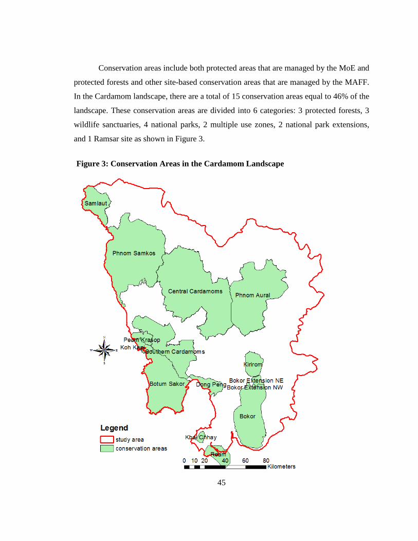
45
Conservation areas include both protected areas that are managed by the MoE and
protected forests and other site-based conservation areas that are managed by the MAFF.
In the Cardamom landscape, there are a total of 15 conservation areas equal to 46% of the
landscape. These conservation areas are divided into 6 categories: 3 protected forests, 3
wildlife sanctuaries, 4 national parks, 2 multiple use zones, 2 national park extensions,
and 1 Ramsar site as shown in Figure 3.
Figure 3: Conservation Areas in the Cardamom Landscape
46
Central Cardamoms Protected Forest: This protected forest was established in
2002 with an area of 401,313 hectares (Royal Government of Cambodia [RGC], 2002b).
The protected forest connects Phnom Samkos and Phnom Aural wildlife sanctuaries,
forming one of Southeast Asia’s largest conservation areas (Asian Development Bank
[ADB], 2005a). The area contains large areas of three of the most threatened ecosystems
in the region: lowland evergreen forest, riparian forests, and wetlands. Despite extensive
logging, most of the forest still retains complete canopy closure, reducing fire risk and
promoting natural regeneration (Soussan & Sam, 2011). It is home to the Asian Elephant,
Indochinese Tiger, Pileated Gibbon, Siamese Crocodile, and other globally threatened
wildlife (Coudrat et al., 2011; Daltry & Momberg, 2000; Rhim, Son, Kim, Hwng, & Lee,
2012). The Areng Valley that is located in the southeast part of this protected forest
provides habitat for threatened waterbirds such as White-wing Wood Duck, Sarus Crane,
Black-necked Stork, and Milky Stork and other endangered species of fish including the
Asian Arowana and Back Fish (Bauld & Sovan, 2004). Threats to this area include illegal
logging, hunting, and over-exploitation of natural resources. Conservation International
and the FA are working together to protect the wilderness of this area through a ranger
program and community-based conservation.
Southern Cardamoms Protected Forest: This protected forest was established
in 2004 with an area of 144,275 hectares (Royal Government of Cambodia [RGC], 2004).
Vegetation types in this area are a combination of dry evergreen forest, melaleuca
woodland, and grassland. The protected forest connects the Botum-Sakor National Park
to the Talam village community, Dong Peng Multiple Use Area, and Kirirom National
Park. This area provides habitat for globally endangered wildlife such as the Asian
Elephant, Indochinese Tiger, Pileated Gibbon, and other birds (Daltry & Momberg, 2000;
WildAid, 2003). National Road 48 cuts through the southern part of the area from east to
west, creating development pressure and many threats to biodiversity and ecosystem
services. However, this area still plays a critical role for the Asian Elephant providing a
corridor to move from the Botum Sakor all the way to the Kirirom and possibly Bokor
National Parks. The area also provides ecotourism potential since it is easy to access.
47
The Wildlife Alliance (formally called WildAid) and the FA are working together
through zoning and demarcation, ranger patrol, community agriculture development,
community-based ecotourism, public education and awareness, wildlife reintroduction,
and reforestation to ensure the sustainable development of the area.
Kbal Chhay Protected Forest: This protected forest was established in 1960
(before Khmer Rouge regime) and reestablished after the regime as the protected forest in
1996 with an area of more than 6,000 hectares. The area is the main watershed to supply
clean water to the city of Preah Sihanouk. Construction of a reservoir for this city began
in the 1960s, however, it was interrupted due to civil war, and the site became a hide-out
for the Khmer Rouge. In 1997, the Cambodia government awarded a contract to the Kok
An Company to develop the area for tourism (Kbal Chhay Waterfall) and supply clean
water to the city. Today, this protected forest has provided and demonstrated valuable
ecosystem services to the country.
Phnom Samkos and Phnom Aural Wildlife Sanctuaries: These wildlife
sanctuaries were established in 1993 with areas of 333,750 hectares and 253,750
hectares, respectively (Kingdom of Cambodia, 1993a). The Phnom Samkos and Phnom
Aural Wildlife Sanctuaries have similar ecosystem profiles, consisting of lowland dry
dipterocarp, lowland dry evergreen, lower and upper hill evergreen, extensive pine,
gallery forests (along rivers), bamboo, and some marshes and grasslands (Japan
International Cooperation Agency [JICA], 2003). They contain the highest elevation
forests in Cambodia and support many unique plant and animal communities (Coudrat et
al., 2011; Daltry & Momberg, 2000; L. L. Grismer, Neang, Chav, & Wood, 2008; Webb,
2005). Many new species and first records of reptile and amphibian were recently found
in these wildlife sanctuaries (J. L. Grismer et al., 2010; Neang et al., 2010; Neang, Chhin,
Kris, & Hun, 2011; Neang et al., 2012). However, these sanctuaries are threatened by
illegal logging, hunting, over-exploitation of NTFPs, and ELCs permitted by the RGC
(Bradfield & Daltry, 2009; Grieg-Gran et al., 2008; Neang, 2009). The FFI and the MoE
are working together through community protected areas and other programs to ensure
the biodiversity conservation and sustainable development of these wildlife sanctuaries.
48
Peam Krasop Wildlife Sanctuary: This wildlife sanctuary was established in
1993 with an area of 23,750 hectares (Kingdom of Cambodia, 1993a). This area is
completely covered by coastal wetland, including mangrove and melaleuca forests and
has around 10,000 people living within its borders (International Union for Conservation
of Nature [IUCN], 2009). Besides the considerable floral biodiversity, twenty-four
species of mammals, at least twenty-eight species of birds, and a large number of marine
species have been identified (Dara, Piseth, Mather, & Kim Sreng, 2009). The area is also
home to several globally threatened species such as the Irrawaddy Dolphin, Finless
Porpoise, and possibly Dugong (Beasley & Davidson, 2007). Major threats affecting
biodiversity loss are illegal logging, hunting and over-fishing. Illegal land encroachment,
or land grabbing, has also been and remains a problem. The mangrove forests were
heavily impacted by the cutting of mangrove trees for charcoal production and shrimp
farms (Razvi & Singer, 2011). The area is influenced by inter-tidal levels and water from
highland areas, and provides favorable conditions for fishery and other resources. Many
people reside in this area and are dependent upon the natural resources for their
livelihoods, including intensive shrimp aquaculture, large scale charcoal production, and
other aquatic resource collection for family consumption and sale.
Botum Sakor National Park: This national park was established in 1993 with an
area of 171,250 hectares (Kingdom of Cambodia, 1993a). Satellite images in 1988/89
indicated that 87% of the area was in a natural or semi-natural state, with a large expanse
of dense evergreen forest and significant areas of mangroves, dunes, and aquatic plant
formations. This park provides critical habitat for the Asian Elephant to forage, especially
during the dry season when the high elevation habitats dry up and also a place to escape
from hunting and forest fire. Other globally threatened mammal species such as the
Sunda Pangolin, Bengal Slow Loris, Indochinese Lutung, Indochinese Tiger, Pig-tailed
Macaque, Dhole, Sun Bear, White-winged Wood Duck, Lesser Adjutant, Milky Stork,
Green Peafowl, Silvered Pheasant, and other reptiles are found in this park (Royan, 2009,
2010). However, after the Protected Area Law was adopted in 2008, this park was
significantly impacted by development. The first major project was ecotourism
49
development by the Union Development Group of China that developed more than
36,000 ha of coastal area to be a modern city. Other projects that threaten the park are
also ELCs that were granted by the RGC for sugarcane, acacia plantations, and
ecotourism. It is impossible to protect the wilderness and biodiversity of this park since
so many large projects have been permitted by the RGC.
Kirirom National Park: This national park was established in 1993 with an area
of 35,000 hectares. The park is largely covered by semi-evergreen forest, with drier
deciduous forest at lower elevations and an extensive area of pine forest on a central
plateau (Japan International Cooperation Agency [JICA], 2003). The park provides
habitat for the Asian Elephant, Indochinese Tiger, Malayan Sub Bear, Pileated Gibbon,
Indochinese Lutung, Pig-tailed Macaque, Stump-tailed Macaque and other globally
threaded birds (Coudrat et al., 2011; Daltry & Momberg, 2000). A new species of
Harrison's Tube-nosed Bat was also discovered in this park (Csobra & Bates, 2005).
Moreover, ecosystem services such as the water supply for Kirirom I and III hydropower
dams and ecotourism have been also provided by this park. However, similar to other
conservation areas this park is facing threats such as illegal logging and hunting and land
encroachment (Lacerda, Schmitt, Cutter, & Meas, 2004). The MoE is working hard to
protect this park through ranger programs, public education, zoning, and demarcation.
Bokor National Park: This national park was established in 1993 with an area of
140,000 hectares. The park is dominated by evergreen forests in the south and southwest
and semi-evergreen green forests in the northeast. The forests are relatively intact apart
from northern areas of the park, which were heavily logged. This area is home to
Indochinese Tiger, Pileated Gibbon, and other reptiles (Coudrat et al., 2011; Eames,
Steinheimer, & Bansok, 2002; Rawson & Senior, 2005). Recently, the RGC has granted
this park to a private company for ecotourism investment. Additionally, a hydropower
plant was constructed in the southeast part of the park to utilize the water supply.
Bokor National Park Extension NE and Extension NW: These extensions were
established in 2002 by a government sub-decree with areas of more than 7,000 hectares
and about 1,000 hectares respectively. The purpose of these extensions is to build a
50
corridor reconnecting Bokor to Kirirom National Parks. Forests along national road 4
located in the middle of this corridor are heavily fragmented due to resettlement and land
encroachment. The Asian Development Bank has supported BCI projects since 2005 to
rebuild the corridor however efforts to regain forest cover in that corridor have been
slow.
Ream National Park: This national park was established in 1993 with an area of
150,000 hectares. The park encompasses both terrestrial and marine habitats including
beaches, mangrove forests, and tropical jungles. The park was reported to have Malayan
sun bear, fishing cat, leopard and tiger, though leopard and tiger may be on the verge of
extinction (IUCN, 1997). Notable bird species include green peafowl, Indian pied
hornbill, and great hornbill. A number of large waterbird species are found in the
mangroves and associated mudflats, including the endangered milky stork and lesser
adjutant (ICEM, 2002). There are also reports of the endangered masked finfoot in the
mangroves. Crocodiles have also been occasionally reported in the Prek Toek Sap, and at
least two species of marine dolphin have also been observed (ADB, 2000; Beasley &
Davidson, 2007). In February 2012, construction work and road building was going on at
the southeastern tip of the park in order to create a small tourist resort. All this seems to
be funded by Chinese capital. It was not clear how all this fits into the idea of protecting
threatened species in the area. Park rangers stated that many animals had fled from the
area since 2011.
Dong Peng Multiple Use Area: This area was established in 1993 with an area of
27,700 hectares. Part of this area also overlaps with the Important Bird Area (IBA) of
Cambodia. This area mainly encompasses the Melaleuca forest and swamp which
contains numerous small wetlands and grassland. The area is important for a range of
large waterbird conservation such as the Milky Stork, Painted Stork, Woolly-necked
Stork, Black-necked Stork and Lesser Adjutant. Because of its clarification as a multiple
use zone, the area is heavy used. Illegal land encroachment, Melaleuca forest clearing,
land speculation and poor governance are the main threats to this area.
51
Samlaut Multiple Use Area: This area was established in 1993 with an area of
60,000 hectares. It is located north of the Cardamom landscape. The area is the last
remaining tropical rainforest in northwestern Cambodia. It is home to a wide array of rare
vegetation and wildlife, including the endangered Asian Elephant. Due to the limited
resources of Cambodia, this area received little government management or support for
wildlife enforcement and nature conservation. In 2003, the Maddox Jolie-Pitt Foundation
began to support the park. An agreement was signed by the Cambodian Ministry of
Environment, the National Park Service of the United States, and Maddox Jolie-Pitt
Foundation making the Sequoia and Kings Canyon National Parks sister parks to Samlaut
(MoE, 2006). The agreement facilitates the sharing of experience, skills, technical
knowledge, and professional abilities between the two protected areas.
Koh Kapik Ramsar Site: This site was established in 1999 with an area of about
13,500 hectares. The area encompasses alluvial islands immediately off the mainland of
Koh Kong province. The site consists of two main wetland types; estuarine waters, and
intertidal mud, sand or salt flats; and the extensive mangrove stand is representative of a
still-functioning mangrove ecosystem in the Gulf of Thailand. The area plays a critical
role in providing a nutrient source supporting coastal fishery in the near-shore and
offshore waters of Cambodia. It is also home to globally threatened bird and mammal
species such as the critically endangered Giant Ibis, the endangered Sunda Pangolin, and
Indochinese Lutung. At present, much of the degraded mangrove area has been replanted
through coordinated efforts of the agencies and local communities in the area.
1.3.3- Conservation Mechanisms
While protected areas often form the core of conservation strategies, there are other
conservation strategies that complement protected areas. This section reviews other
conservation approaches.
Other Site-based Approaches: A number of site-based measures have been
established to contribute to integrated conservation strategies. These include community
forests, community protected areas, important bird areas, no fishing areas/fish refuges,
52
reforestation zones, and even various agricultural systems. Many of these approaches are
already part of Cardamom landscape management strategies. Community forests are
forests owned and managed by FA. They are allocated to communities under a 15-year
agreement. These forests are managed by the local communities with technical support
from the FA. The management of these forests is also financially supported by several
international NGOs. The primary goal of community forests is to protect and rehabilitate
forests and to enhance the sustainable use of forest resources of the communities.
Community protected areas are managed by MOE and are composed of four zones:
core, conservation, sustainable use and community use. Part of the community zone can
be designated as a community protected area. Similar to community forests, the goal for
these areas is to promote the sustainable use of natural resources inside the protected area
system. The MoE and FFI are working together to implement this mechanism in Samkos
and Aural Wildlife Sanctuaries. Important Bird Areas (IBA) have been identified and
defined by the FA with technical support from BirdLife International. As mentioned
earlier, there is an IBA that is located close to and overlaps with the Dong Peng Multiple
Used Area in Sre Ambel district. The purpose of IBAs is to monitor and follow up the
status of important bird species. Reforestation zones are defined by the FA to reforest
degraded areas. As stated in the CMDGs and the National Forest Program, reforestation
has been targeted as a key mechanism to increase the country’s forest cover to 60% by
2015. In the Cardamom landscape, there is a reforestation project that is being
implemented by the Wildlife Alliance and the FA to rebuild elephant corridors in the
landscape.
Species-based Approaches: Various initiatives focus conservation efforts on
particular species or groups of species. Usually, species-based approaches are funding
initiatives that support a variety of approaches contributing to the conservation of the
target species in question. Often, targeted species are wide-ranging species for which
conservation area approaches are only partially effective. One species targeted by such
initiatives is the Asian Elephant. The Asian elephant is a wide-ranging species can be
used as an umbrella species for other biodiversity conservation. For example, the purpose
53
of the establishment of the Southern Cardamom Protected Forest was to protect elephant
corridors, and this objective was clearly stated in the title of the sub-decree. As a result,
many conservation activities have been conducted by the FA and Wildlife Alliance such
as zoning and demarcation, reforestation, public education, and alternative livelihoods for
local communities in the corridors (Wildlife Alliance, 2009, 2010, 2011, 2012).
Another species targeted by the species-based approach is the Siamese Crocodile.
There were two approaches. The FFI and FA's Cambodia Crocodile Conservation
Program in the O’Som Commune (Veal Veng District, Pursat Province) used a
participatory conservation model, which provided incentives to local communities to
manage their natural resources and develop sustainable agriculture with assistance from a
partner NGO, the Cambodian Centre for the Study and Development of Agriculture
(Sony et al., 2009). The second approach was a direct payment scheme introduced by CI's
Conservation Stewardship Program for Crocodile conservation at the Chumnoab
Commune (Thmar Bang District, Koh Kong Province). It provided financial payments
for community rangers to achieve conservation targets including removing wildlife
snares, reducing poaching of wildlife, prohibition of illegal fishing techniques, and illegal
harvest of forest products. Sony et al. (2009)’s evaluation, found that both approaches
were successful in achieving Crocodile conservation goals.
Other species-based approaches have been used with tigers with funding directed
toward education and the control of illegal trade, Sea Turtles with efforts to understand
migration routes and increasing populations and Irrawaddy Dolphin with efforts focusing
on education and community involvement in the landscape.
Ecosystem Approaches: Conservation efforts and funding are increasingly
directed to ecosystem-level projects. These projects seek to recognize ecological
landscape linkages in which natural systems provide services that impact different human
land use regimes. Such projects are often interdisciplinary and involve the participation
of diverse stakeholders including those responsible for natural resource conservation,
land management, and rural development. . Current ecosystem-level projects in the
Cardamom landscape include the Biodiversity Conservation Corridor Initiative (funded
54
by ADB). This initiative is making funds available to support the work in the Southern
Cardamom landscape and the Coastal Zone Management Project (primarily funded by the
Danish International Development Agency) which has supported integrated conservation
and development efforts in Cambodia’s coastal provinces. Conservation areas often form
the core of such landscape efforts. Both planning and management of the conservation
area system should encourage and support these activities.
Community Based Conservation: With the exception of very remote areas,
ecological systems are fundamentally linked with and affected by people who live and
work in these areas. Many of the threats to conservation features arise from
anthropogenic activities incompatible with long-term conservation. Successful
conservation at virtually all levels therefore requires the support and participation of local
people. This approach is often closely linked with conservation area management and
governance. In Cambodia, this linkage is being formalized legally through inclusion in
the protected area law (Kingdom of Cambodia, 2008), officially promoted through
integration with standardized protected area planning policies and has been applied as a
structured component of recent protected area management planning efforts.
Policy Advocacy and Government Lobbying: Although these are often seen as
sensitive or confrontational areas for engagement, they can also be powerful agents of
change. Advocacy and lobbying can originate both from outside and inside government
policy agencies and has resulted in a number of positive steps. Dialogue and advocacy
surrounding the formulation of Cambodia’s Protected Area Law (Kingdom of Cambodia,
2008) is an example of advocacy at work as many provisions of the law would not have
appeared without the input of numerous stakeholders (Dunai, 2008). Cancellation of a
titanium mining project and numerous ELC projects in the middle of the elephant
corridor would not be possible without clear explanation of the on the ground situation to
policy decision makers. Of course, a strong strategic plan for each project must be created
including the involvement of donor support, scientific proof, and media witnesses. All
conservation organizations that are working in the Cardamom landscape have their own
styles of conducting this approach.
55
Education and Public Awareness: Efforts to expand conservation awareness and
ensure that conservation becomes part of the country’s educational system are vital long-
term approaches to conservation. NGOs such as Mlup Baitong, Save Cambodia’s
Wildlife, and the Wildlife Alliance have been engaged in education and public outreach
activities for years. Kouprey Express has been implemented by the Wildlife Alliance in
the Cardamom landscape. It has been conducted through a well-equipped mobile bus
with build board display, video and slide shows, and PowerPoint presentation. Recently,
the FFI has committed significant resources to the establishment of a Master’s degree
program in Conservation Biology at the Royal University of Phnom Penh. The program
has convinced many national students to be scientists. At the national level, the Ministry
of Environment recently partnered with the Ministry of Education’s various projects to
emphasize the importance of conservation education for Cambodia’s youth and the public
at large. Many protected areas in Cambodia lend themselves to facilitating and
encouraging conservation education and awareness-raising but development of
appropriate visitor and interpretive facilities has a long way to go.
Law Enforcement: Law enforcement is needed to ensure all regulations are
respected. In the Cardamom landscape, there are many ranger programs that enforce the
land law, protected area laws, law on forestry and other laws. Illegal land encroachment,
logging, and hunting have been identified as the main target for law enforcement in the
landscape. Most of the conservation areas in the landscape consist of ranger programs
that are supported by NGOs. The Wildlife Alliance supports 15 staff of the FA and about
100 military police officials to patrol the Southern Cardamom Protected Forest with six
base stations located on the main waterways and roads. Conservation International has
been supporting the FA a community ranger program to patrol and monitor the Central
Cardamom Protected Forest. Moreover, the MoE also has its own park rangers to guard
each individual protected area, though with limited capacity. However, this mechanism
seems to produce few results due to the corruption and nepotism of the court system that
leads to impunity of the rich and powerful and only poor people are prosecuted.
56
Reducing Trade in Wildlife and Other Biological Resources: Southeast Asia
has an active illegal trade in wildlife and other biological resources (Mainka & Mills,
1995; Martin & Phipps, 1996; Sun, 2000). Cambodia has been involved in recent
ASEAN-wide efforts to increase enforcement and strengthen regional cooperation in this
area. A number of NGOs and regional governments continue to provide technical inputs
for identifying and suppressing illegal trade. With large natural and semi-natural areas
still intact and a potentially high level of plant endemism, Cambodia also has an incentive
to carefully manage its genetic resources.
1.4- Development Status
This section will review all development activities in the landscape to create the
Strong Development Scenario (SDE) for this study. There are many investment projects
that have been approved in Cambodia as well as in the Cardamom landscape under the
RGC’s investment policies and legislation. The biggest investor in Cambodia is China
with an investment capital of more than USD 7 billion (Sophal 2010) followed by Korea
and Malaysia with capital investments of USD 2.8 billion and USD 2.2 billion,
respectively. The main sectors attracting investment are tourism (53%), services (21%),
industry (20%), and agriculture (6%).
1.4.1- Special Economic Zone (SEZ)
The SEZ scheme was reintroduced into Cambodia in December 2005. SEZs are
managed by the Cambodian Special Economic Zone Board of the CDC. To govern the
SEZ scheme, a Sub-Decree No. 148 on the Establishment and Management of the Special
Economic Zone (Sub-Decree on SEZs) was issued on 29 December 2005. In addition, the
law on the Special Economic Zones has been drafted by the CDC in 2008 and is now
under examination by the RGC.
According to Sub-Decree No. 148, the SEZ refers to the special area for the
development of economic sectors which brings together all industrial and other related
activities and may include General Industrial Zones and/or Export Processing Zones.
57
Each Special Economic Zone shall have a Production Area which may have a Free Trade
Area, Service Area, Residential Area and Tourist Area. The SEZ must be more than 50
hectares with precise location and geographic boundaries, a surrounding fence,
management office buildings and administration offices, a water sewage network, waste
water treatment network, location for storage and management of solid wastes,
environment-protection measures, and other related infrastructure (RGC, 2005).
The strategic location of the Cardamom landscape next to the Gulf of Thailand
makes it attractive for SEZ location. There are 12 SEZs that have been developed in the
landscape to produce products and directly export through the sea (Council for the
Development of Cambodia, n.d.). Six SEZs are located in Preah Sihanouk, four in Koh
Kong, one in Kampot, and one in Pursat. The development of these SEZs has brought
thousands of factory workers into the landscape, increased pressure on natural resource
use, encouraged immigration, and polluted the landscape due to the poor governance. The
RGC needs to do careful conservation planning to reduce the negative environmental
impacts of development projects.
1.4.2- Mining Concessions
Mining has been prioritized by the RGC for a long term economic development. To date,
there are a total of 208 concessions that have been permitted throughout Cambodia
including 34 located in the Cardamom landscape (Open Development Cambodia, 2014a).
These projects are small-scale quarries producing materials for construction, such as
laterite, marble, granite, limestone, gravel, and sand. Compared to other countries such as
Lao and Vietnam, the mining sector in Cambodia is still largely undeveloped. There has
been no industrial scale extraction of precious minerals, although in recent years there
have been a large number of exploration licenses granted to both local and international
companies.
Due to various factors, including decades of civil war, proliferation of landmines
and unexploded ordnances, and inadequate infrastructure, Cambodia lags far behind its
58
neighbors in development of this sector. Sand dredging is the main concern of
conservation NGOs in the Cardamom landscape.
1.4.3- Economic Land Concessions (ELCs)
Under the 2001 Land Law, state land is divided into state public land and state
private land. State public land is any land of natural origin (such as rivers, lakes, forests),
land that provides a general public use (such as schools, hospitals, roads), and
archaeological and cultural heritage sites (Kingdom of Cambodia, 2001a). State private
land is any state land that does not provide a public service or come under any of the
other categories of state public land. According to this land law and the sub-decree on
ELCs, ELCs can only be legally granted on state private land (RGC, 2005). In addition,
the law states that ELCs cannot exceed 10,000 hectares, and that the same person or legal
entity cannot hold several concessions that total more than 10,000 hectares. This also
applies to several legal entities controlled by the same person. ELCs can be granted for a
maximum of 99 years (although 70 years is most typical) and concessionaires must begin
operations within one year of the concession being granted. If a concessionaire does not
comply with the legal requirements, the concession can be cancelled. According to the
2008 protected area law, ELCs can also be granted in the sustainable use zone of each
protected area by the MoE (Kingdom of Cambodia, 2008).
ELC development has been one of Cambodia’s controversial issues in large part
because of corruption and nepotism that permits development that goes beyond the rules
governing ELC development. Because of a lack of transparency in the way ELCs are
granted, it is very difficult to assess exactly how many ELCs have been approved, which
concessions are active, and how much state revenue has been raised. According to the
MAFF website and information from the MoE, a total of 117 ELCs have been granted
throughout Cambodia by the RGC and 23 ELCs are currently located in the Cardamom
landscape (RGC, 2012) (Figure 4). Open Development, an international NGO, reported
in 2014 that this number ELCs has increased to 36 (Open Development Cambodia,
2014a). The ELC investment includes tourism development and agro-industrial
59
plantations for products such as rubber, sugarcane, cassava, palm, cashews, and acacia.
Ecotourism development in this context is Chinese based which usually converts the
natural forest habitat into a modern resettlement. For example, the tourism project of the
Union Development Group is converting more than 36,000ha of Botum Sakor National
Park coastal area into a modern city, which is completely different from the western
ecotourism style. For this study, 23 ELCs will be included for the current land
management scenario (MCD), 36 ELCs for the SDE, and only 16 ELCs for the strong
conservation scenario.
1.4.4- Social land concessions
Three social land concessions have been planned in Koh Kong province of the
Cardamom landscape. The allocation will be based on the Sub-decree on Social Land
Concession (RGC, 2003b). The RGC has decided that the Cardamom landscape is the
only opened space for resettlement of demobilized soldiers and other poor families.
However, environmental impacts will occur as a result of resettlement. Thousands of
hectares of forest clearing will be conducted in the planned areas and more pressure on
using surrounding forests for livelihood of newcomers will affect the elephant corridor
and biodiversity. To minimize the effect from social land concession development, the
Wildlife Alliance is in the process of lobbying the RGC to allocate these land concessions
in strategic locations so less forest will be destroyed and resettled people will have closer
access to water, health clinics, markets, and public transportation. This NGO will also
make sure that the development will be consistent with the BCI project that supported by
the ADB and the provincial authority.
1.4.5- Hydropower Development
The Cardamom landscape has large potential areas for hydropower development.
Sixteen hydropower projects have been studied in the landscape with an estimated
installed capacity of 1,731 MW, of which 9 are currently operational, under construction
or planned (operational: Kirirom I and Kamchay, under construction: Kirirom III, Stung
Russey Chrum, Stung Tatay, or planned: Stung Battambang, Stung Pursat, Stung Metoek,
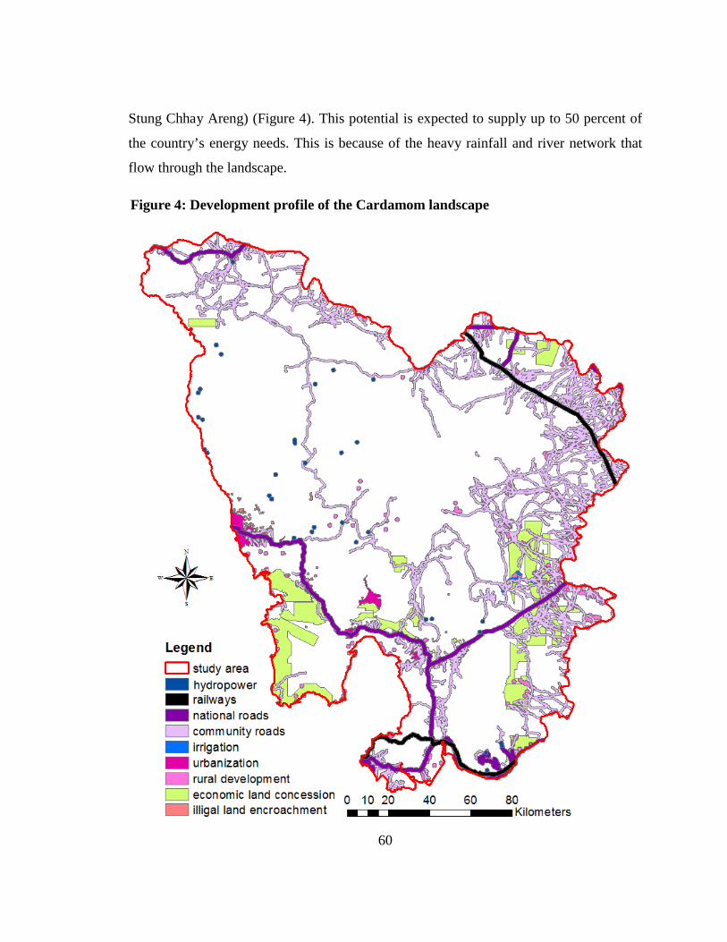
60
Stung Chhay Areng) (Figure 4). This potential is expected to supply up to 50 percent of
the country’s energy needs. This is because of the heavy rainfall and river network that
flow through the landscape.
Figure 4: Development profile of the Cardamom landscape
61
However, all of these hydropower facilities would mostly be managed as a
concession under a build, operate, and transfer model agreements, where investors
assume responsibility to design the facility, obtain financing, oversee their construction
and operate them to recover the investment and to make a profit. At the end of the
concession period, which in Cambodia is generally 30 years, the facility is returned to the
state. This is the multimillion dollar investment and the energy sources are intended to
supply power to neighboring towns and communities. However, hydropower also creates
large environmental impacts. The first impact is the forest destruction caused by these
projects due to forest clearing in the reservoir and power line areas. Furthermore, sub-
contract the reservoir forest clearing projects to logging companieshas led to the whole
forest area destruction due to bad governance and corruption of government institutions.
The second impact is the change of ecosystem that is caused by the different water
regime between the upstream and downstream areas. In the Cardamom case, upstream
area face community floods, for example, the Chhay Areng hydropower now needs to
move three communities away from the project area (International Rivers, n.d.). The
downstream area suffers from reduced water flow, which causes water shortages for
agriculture and community uses. Biodiversity is also affected due to the change of
ecosystem, especially fish and aquatic species that can’t migrate through the dam
construction between upstream and downstream.
Other effects of this development include immigration, settlement, and pollution
that are caused by each project. Immigration happens as a result of the project's
employment and usually creates settlement around the project areas. Pollution is one of
the biggest issues. There is a concern that foreign companies have little incentive to
reduce environmental impacts. If settlement occurs in the areas, more forest destruction
happens because of a higher demand for wood for house construction and firewood for
energy.
62
1.4.6- Irrigation Development
Recognizing the importance of water management for promoting the country’s
rice production, the Royal Government of Cambodia and donors are making efforts to
expand the irrigated area in Cambodia. The expectation is that irrigation will make
farmers less reliant on rainfall, allowing them to cultivate more crops with more certainty
and predictability, resulting in higher productivity and better livelihood outcomes. Based
on this policy, the MOWRAM has been assigned to be responsible for irrigation
development in the country. Many construction projects have been planned and
completed in the Cardamom landscape, especially in eastern parts to provide irrigation
water for agriculture. Even though this development appears to improve rural community
economy, it also has negative landscape impacts because it expands the road network,
which opens the area to illegal land clearing for agricultural expansion, immigration, fuel
wood gathering, timber harvest and poaching.
1.4.7- Infrastructure Development
Infrastructure development has been targeted as one of the RGC’s policies to
strengthen the national economy and eliminate rural poverty. The Fourth Legislature of
the RGC was elected to continue the rehabilitation and development of transport
infrastructure, including further construction and maintenance of roads, expansion of port
capacity, restoration and development of railroads, expansion of airport services, and
strengthening of flight safety and traffic safety. In the Cardamom landscape, there are
three national roads (National Road 4, 5, and 48), two railways (the southern railway is
connecting from Phnom Penh to Kampot and Preah Sihanouk and the northern railway
connecting from Phnom Penh to Battambang and Poipet), and other many secondary and
community roads. The construction of the new National Road 48 created remarkable
pressure on natural resource management of the landscape. It created significant forest
destruction, brought in new immigrants, and encouraged other development activities
along the road. Illegal logging and hunting in the area have also significantly increased.
63
The rehabilitation of the two railway lines to handle higher volumes of cargo
traffic and be part of the Asian Railway Network through linkage with the railway
network in Thailand and Vietnam will create the same experience. According to a Loan
Agreement (Greater Mekong Subregion (GMS) Rehabilitation of the Railway in
Cambodia) between the Kingdom of Cambodia and ADB, the ongoing project’s objective
is to facilitate sub-regional trade and economic growth in Cambodia by providing a cost-
effective and efficient transport railway. The railway link through Cambodia is also an
integral part of the GMS southern economic corridor, which is one of 11 flagship
programs under the GMS sub-regional economic cooperation. However, the donor and
the RGC have to take into account the indirect impacts on the Cardamom landscape that
might result from this development.
1.4.8- Urbanization
There are two types of urbanization in the Cardamom landscape. The first type
often undertaken by the government enlarges district and provincial towns. The second is
implemented through leasing ELCs for 99 years
However, either type of urbanization converts natural forests into modern cities
and increase human density in the area, create more pressure on natural resources uses,
and attract other development activities. In the case of Chinese development, it might not
benefit much to the Cambodian people since the concession rental fee is extremely cheap
(maximum USD 10 per hectare per year) (Ministry of Agriculture Forestry and Fisheries
[MAFF], 2012). To balance the development and conservation of the Cardamom
landscape, the RGC must take into account proper management of the area including the
elimination of deforestation drivers, such as stopping ELC permission, improving the tax
to foreign companies to develop tourism
projects. For example, the development a 36,000 ha site within the Botum Sakor National
Park by the Chinese Union Development Group (Hance, 2012) is creating a huge and
fancy master plan for this area’s development with several highways, a modern sea port,
an international class airport, a luxury residential area, and a high class resort.
64
system, fighting corruption and nepotism, and supporting local communities through
appropriate environmentally compatible development projects.
1.4.9- Community Development
Based on the RGC’s governance reform plan, decentralization and
deconcentration are encouraged to happen at the commune level. Many projects are
supported by government and donors directly to the commune councils of each province
of the landscape. Each commune council requested to develop its own commune annual
development project proposal to submit to the government and donors for support. Based
on my own review, many of those projects are illegal and environmentally incompatible.
Those include projects to improve community livelihood through infrastructure and
agriculture expansion inside conservation area systems, which again creates more
pressure for sustainable forest management in the areas. There is a lack of understanding
of environmental and ecosystem issues in each commune council, which might lead to
the implementation of incompatible projects that decrease natural resources and affect
their livelihood in the long term.
65
Chapter 2: Land Management Planning in the
Cardamom Landscape: Implications for
Biodiversity Conservation and Economic
Development
66
2.1- Introduction
The management of land resources is the basis of the livelihoods of most of
Cambodia’s population and is a dominant part of the national economy. Although other
sectors are growing rapidly, agriculture accounted for nearly 1/3 of Cambodia’s GDP and
directly employed over 50% of the workforce (Hill & Menon, 2013), whilst nearly 80%
of the population still live in rural areas (Löhr, 2011). Other natural resource-based
sectors such as forestry and fisheries are also important and the multiplier effects of
agriculture and related sectors in areas such as trade and processing increase their
significance in the national economy. Despite recent economic progress, Cambodia
remains poor, ranking 138th
The increasing recognition of the importance of ecosystem goods and services to
economic growth and poverty reduction comes at the same time as evidence that human
pressure on ecosystems is negatively impacting the provision of these services. Land
degradation pressures such as deforestation and soil erosion have emerged as important
issues in the development debate in Cambodia, directly affecting the productivity of
agriculture as well as impacting water resource availability, the availability of fish and
forest products and other key ecosystems services.
in the world in terms of the UNDP’s Human Development
Index (United Nations Development Programme [UNDP], 2013). The recent global
economic downturn and rising food prices have together shown the potential
vulnerability of emerging growth sectors to external conditions and the management of
land resources remains the foundation of livelihoods and food security for the majority of
Cambodia’s population.
There are also concerns over the integrity of important ecosystems including
ecosystems in the Cardamom landscape – ecosystems that contain biodiversity resources
of global significance and provide a wide range of other vital services to people living
both in the immediate vicinity and further afield. This study represents the first attempt at
a comprehensive evaluation of a number of important ecosystems services in the
Cardamom landscape. Three landscape management scenarios representing different
67
views of how the Cardamom landscape should be managed are evaluated in terms of their
effect on four ecosystem services. .
2.2- Methods
2.2.1- Formal statement of the problem
Three stakeholder groups have different opinions and strategies to manage the
Cardamom landscape. The private sector, along with several government agencies
responsible for economic development, such as the CDC, the MEF, the MoC, the MIME,
the MRD, the MPWT are in favor of developing the Cardamom landscape into cities,
industrial agriculture, hydropower dams and power lines, mining concessions, highways,
sea ports and other forms of development. In contrast, donor communities and NGOs
state that the Cardamom landscape is the largest landscape remaining in Southeast Asia
and should be protected for biodiversity conservation and ecosystem services. The
Cambodian government with assistance from other line ministries such as the MoE and
the MAFF is trying to balance the two different interests. This chapter develops three
scenarios that are broadly reflective of these three views on how to manage the
Cardamom landscape. To wisely manage this important landscape, it is important to
integrate environmental and economic principles. Each landscape scenario is evaluated
and compared on how well it delivers on various environmental and economic objectives.
2.2.2- Threat mapping
Literature reviews and field investigations indicate nine main threats in the
Cardamom landscape. Urban development (URD) is one of the main threats and is
usually driven by population growth, national economic development, globalization,
privatization, and private sector investment policies. Direct impacts of this threat consist
of habitat degradation and biodiversity loss, forest clearing, illegal logging, and hunting.
Similarly, village development (VID), especially in the form of social land concessions,
which clears additional forest land for displaced people, reduces forest cover. Railway
(RAW) and national road (NAR) construction threaten the landscape by increasing access
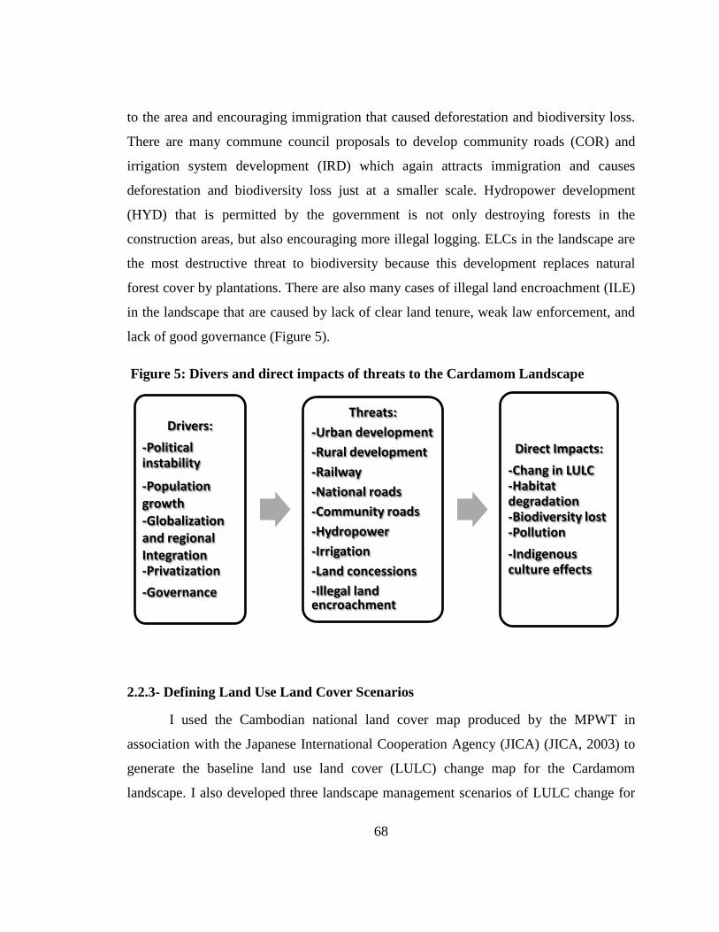
68
to the area and encouraging immigration that caused deforestation and biodiversity loss.
There are many commune council proposals to develop community roads (COR) and
irrigation system development (IRD) which again attracts immigration and causes
deforestation and biodiversity loss just at a smaller scale. Hydropower development
(HYD) that is permitted by the government is not only destroying forests in the
construction areas, but also encouraging more illegal logging. ELCs in the landscape are
the most destructive threat to biodiversity because this development replaces natural
forest cover by plantations. There are also many cases of illegal land encroachment (ILE)
in the landscape that are caused by lack of clear land tenure, weak law enforcement, and
lack of good governance (Figure 5).
2.2.3- Defining Land Use Land Cover Scenarios
I used the Cambodian national land cover map produced by the MPWT in
association with the Japanese International Cooperation Agency (JICA) (JICA, 2003) to
generate the baseline land use land cover (LULC) change map for the Cardamom
landscape. I also developed three landscape management scenarios of LULC change for
Figure 5: Divers and direct impacts of threats to the Cardamom Landscape
Drivers: -Political instability
-Population growth -Globalization and regional Integration -Privatization -Governance
Threats: -Urban development -Rural development -Railway -National roads -Community roads -Hydropower -Irrigation -Land concessions -Illegal land encroachment
Direct Impacts: -Chang in LULC -Habitat degradation -Biodiversity lost -Pollution -Indigenous culture effects
69
the 2002–2052 time periods. The three landscape management scenarios are: 1) strong
conservation (SCO), 2) mixed conservation and development (MCD), and 3) strong
development (SDE). I compared Thematic Mapper satellite imagery between 2002 and
2006 to estimate the extent of change over 50 years using current rates of change. This
was done in three reference landscapes. One located in a conservation zone (within a
protected area), a second outside of a protected area, but not in an area of intensive
development, and a third in a high development zone. I then visited each of these
reference areas to verify changes and buffer distances.
The strong conservation scenario is a future land management option that land is
put into conservation by minimizing all development activities, improving law
enforcement, limiting the number of ELCs, and increasing CA as much as possible in the
landscape. This scenario LULC map is predicted based on conservation initiatives of
donors and NGO community’s arguments for conserving the Cardamom landscape.
These arguments include the recommendation on the establishment of conservation areas
and pressure for cancellation of inappropriate development projects as well as the
reduction of illegal logging, hunting and land encroachment around settlement and along
infrastructure. Criteria and buffer distances for defining this scenario was provided in
Table 4.
The mixed conservation and development scenario is the current government land
management option that balances conservation and development. This scenario LULC
map is based on the RGC’s sustainable natural resource management policies with all
impacts and threats that are occurring on the landscape today. Based on previous year
satellite imageries of land use changes and my direct field investigation, many threats
must be buffered to include all existing impacts in this scenario. Criteria and buffer
distances for defining this scenario was shown in Table 4
The strong development scenario is a future land management option where all
planned development activities are allowed to occur, such as permitting all ELCs that
planned by the private sectors even though they are located in the current CAs. The
LULC map of this scenario is predicted based on development pressure caused by the
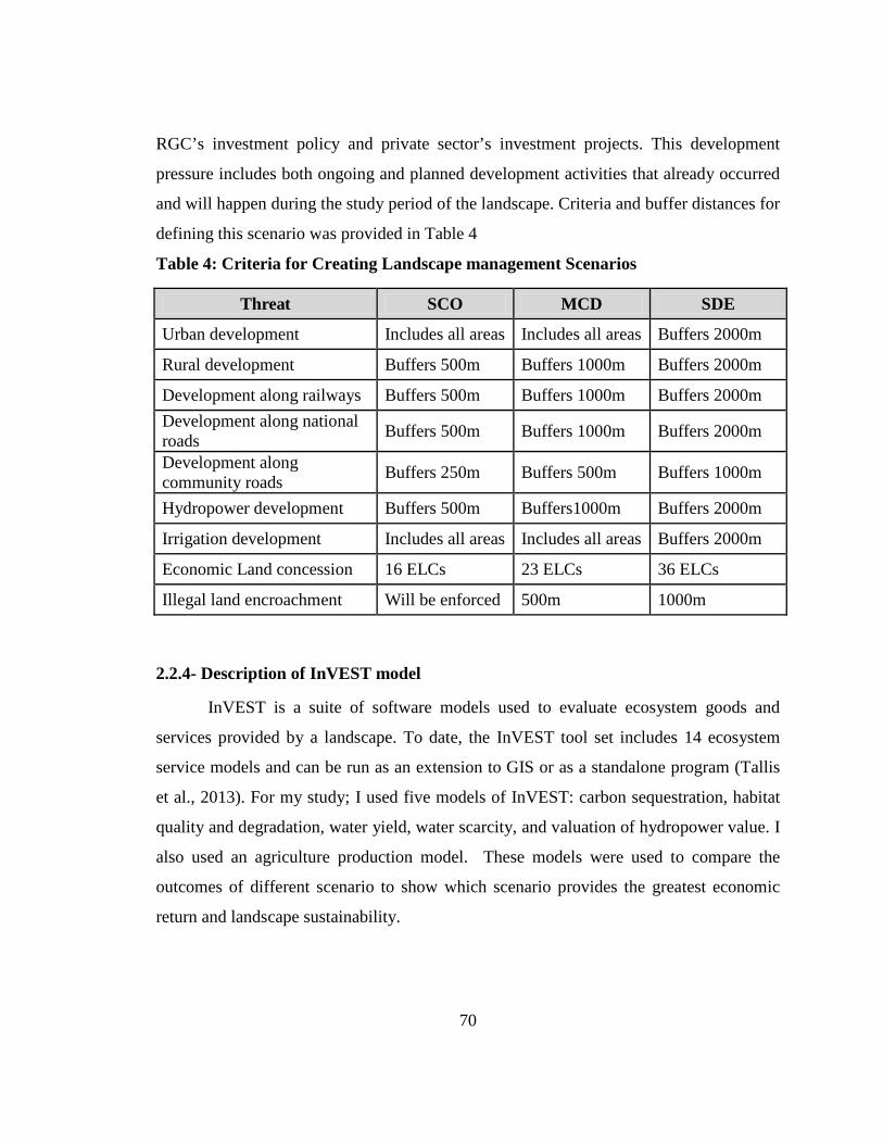
70
RGC’s investment policy and private sector’s investment projects. This development
pressure includes both ongoing and planned development activities that already occurred
and will happen during the study period of the landscape. Criteria and buffer distances for
defining this scenario was provided in Table 4
Table 4: Criteria for Creating Landscape management Scenarios
Threat SCO MCD SDE
Urban development Includes all areas Includes all areas Buffers 2000m
Rural development Buffers 500m Buffers 1000m Buffers 2000m
Development along railways Buffers 500m Buffers 1000m Buffers 2000m Development along national roads Buffers 500m Buffers 1000m Buffers 2000m
Development along community roads Buffers 250m Buffers 500m Buffers 1000m
Hydropower development Buffers 500m Buffers1000m Buffers 2000m
Irrigation development Includes all areas Includes all areas Buffers 2000m
Economic Land concession 16 ELCs 23 ELCs 36 ELCs
Illegal land encroachment Will be enforced 500m 1000m
2.2.4- Description of InVEST model
InVEST is a suite of software models used to evaluate ecosystem goods and
services provided by a landscape. To date, the InVEST tool set includes 14 ecosystem
service models and can be run as an extension to GIS or as a standalone program (Tallis
et al., 2013). For my study; I used five models of InVEST: carbon sequestration, habitat
quality and degradation, water yield, water scarcity, and valuation of hydropower value. I
also used an agriculture production model. These models were used to compare the
outcomes of different scenario to show which scenario provides the greatest economic
return and landscape sustainability.
71
2.2.5- Modeling Ecosystem Services
2.2.5.1- Carbon sequestration
The carbon storage model applied to the Cardamom landscape includes the sizes
of three carbon pools: aboveground biomass, belowground biomass, and dead organic
matter. Aboveground biomass is comprised of all living plant material above the soil
(e.g., bark, trunks, branches, leaves). Belowground biomass encompasses the living root
systems of aboveground biomass. Dead organic matter includes litter as well as lying and
standing dead wood. Due to data deficiency, soil carbon pool was not included in this
analysis.
The InVEST carbon storage and sequestration model aggregates the amount of
carbon stored in these pools according to the LULC map of each scenario. Using maps of
LULC types and the amount of carbon stored in carbon pools, this model estimates: the
net amount of carbon stored in a land parcel over time and the market and social values
of the carbon sequestered in remaining stock.
The model runs on a gridded map of cells called raster format in either GIS or as a
standalone model. Each cell in the raster is assigned a LULC type such as forest, orchard,
or water reservoir. For each LULC type, the model requires an estimate of the amount of
carbon in the three pools described above. I estimated the aboveground carbon pool based
on Sasaki (2006), Kapos et al. (2010), Top et al. (2006), and van Beukering et al. (2009).
I then calculated the belowground carbon pool by using Cairns et al. (1997)’s regression
𝑪𝒃𝒆𝒍𝒐𝒘 = 𝑬𝑿𝑷�−𝟏.𝟎𝟓𝟖𝟕 + 𝟎.𝟖𝟑𝟑𝟔 ∗ 𝑳𝒏(𝑪𝒂𝒃𝒐𝒗𝒆)� and dead organic pool based on
Harmon and Sexton (1996), which is assumed to be equal to 15% of aboveground pool.
All these carbon pools were calculated in metric tons per hectare (tC/ha) as provided in
Appendix 5.
I used the MCD LULC map as the current LULC and SDE and SCO LULC maps
as the future LULC to calculate the net change in carbon storage over a 50 year time
period to estimate the carbon sequestration/loss and its social value and compare the
differences between the current MCD and alternate future landscapes of SDE and SCO.
For this analysis, I assumed the time path of carbon sequestration is a linear transition
72
over 50 years and used an estimate of the social cost of carbon of USD 43 per metric ton
(Nelson et al., 2009). I also applied a 4% market discount rate (Sasaki, 2010; van
Beukering, Cesar, & Janssen, 2003), and 0% carbon discount for this analysis. I reported
outputs of the model expressed in Mg of carbon per grid cell and the value of
sequestration in dollars per grid cell.
Valuation is applied to sequestration, not storage, because current policies relate
to carbon sequestration. The social value of a sequestered ton of carbon is the social
damage avoided by not releasing the ton of carbon into the atmosphere. There are two
discount rates that determine how the social value of carbon sequestration changes over
time. The first discount rate is the standard economic discount rate that reflects the fact
that people typically value immediate benefits more than future benefits. The second
discount rate adjusts the social value of carbon sequestration over time. This value will
change with the impact of carbon emissions on expected climate change-related damages
changes. If we expect carbon sequestered today to have a greater impact on climate
change damages than carbon sequestered in the future, this second discount rate should
be negative. On the other hand, if we expect carbon sequestered today to have less of an
impact on climate change mitigation than carbon sequestered in the future, this second
discount rate should be positive.
2.2.5.2- Biodiversity
I first defined habitat as “the resources and conditions present in an area that
produce occupancy – including survival and reproduction – by a given organism” (Hall,
Krausman, & Morrison, 1997). High quality habitat for a species has the structure and
function within the range of historic variability of habitat used by that species. Habitat
quality usually declines in proximity to anthropogenic disturbances and the intensity of
these disturbances. In the Cardamom landscape application, I used the Asian Elephant as
the target conservation object for this model because it is an umbrella species and its
population density is stable and high
Maps of the LULC are transformed into maps of habitat quality for elephants.
Habitat quality in a grid cell is a function of the LULC in the grid cell, the LULC in
. Elephants are also important for ecotourism.
73
surrounding grid cells, and the sensitivity of the habitat in the grid cell to the threats
posed by the surrounding LULC. Each LULC type is given a habitat suitability or quality
score of 0 to 1. For example, lowland dry evergreen forests suitable for elephants
(habitat suitability=1), but settlement areas are not suitable for elephants (habitat
suitability=0). Appendix 6 shows how a particular LULC type is considered as an
elephant habitat and its specific sensitivity to each threat.
Besides a map of LULC and data that relates LULC to habitat suitability, the
model also requires data on habitat threat density and its effects on habitat quality. In
general, I consider human modified LULC types that cause habitat fragmentation, edge,
and degradation in neighboring habitat threats. The conversion of a habitat LULC to non-
habitat LULC reduces the size and contiguity of neighboring habitat patches which
impose “edge effects” on habitat parcels and can have negative impacts within habitat
parcels by, for example, facilitating entry of predators, competitors, invasive species, or
toxic chemicals and other pollutants. Further, in the Cardamom landscape, road
construction is a threat to forest habitat quality because of roads provide access to timber
and NTFP harvesters. This impact of threats on habitat in a grid cell is a factor of the
degradation source’s weight, the distance between habitat and threat source, the level of
legal/institutional/social/physical protection from disturbance in each cell, and the
relative sensitivity of each habitat type to each threat on the landscape as described
above. Appendix 7 shows all threats in the landscape, scores of the degradation source’s
weight, and the maximum distance between habitat and threat source across space.
Then, I analyzed habitat quality for the three landscape scenarios with a set of
threat layers for each modeled scenario and assume that the relative weights of threats
and sensitivity of habitat to threats do not change over time. I used the threat data table as
shown in Appendix 7 and the habitat sensitivity data table as shown in Appendix 6 to
generate a habitat quality and degradation score for each scenario. These habitat quality
scores should be interpreted as relative scores with higher scores indicating landscapes
more favorable for the elephant and other related species conservation. The landscape
habitat quality score cannot be interpreted as a prediction of species persistence on the
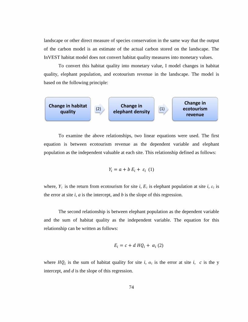
74
landscape or other direct measure of species conservation in the same way that the output
of the carbon model is an estimate of the actual carbon stored on the landscape. The
InVEST habitat model does not convert habitat quality measures into monetary values.
To convert this habitat quality into monetary value, I model changes in habitat
quality, elephant population, and ecotourism revenue in the landscape. The model is
based on the following principle:
To examine the above relationships, two linear equations were used. The first
equation is between ecotourism revenue as the dependent variable and elephant
population as the independent valuable at each site. This relationship defined as follows:
𝑌𝑖 = 𝑎 + 𝑏 𝐸𝑖 + 𝜀𝑖 (1)
where, Yi is the return from ecotourism for site i, Ei is elephant population at site i, εi
is
the error at site i, a is the intercept, and b is the slope of this regression.
The second relationship is between elephant population as the dependent variable
and the sum of habitat quality as the independent variable. The equation for this
relationship can be written as follows:
𝐸𝑖 = 𝑐 + 𝑑 𝐻𝑄𝑖 + 𝛼𝑖 (2)
where 𝐻𝑄𝑖 is the sum of habitat quality for site i, αi is the error at site i, c is the y
intercept, and d is the slope of this regression.
Change in habitat quality (2) Change in
elephant density (1) Change in
ecotourism revenue
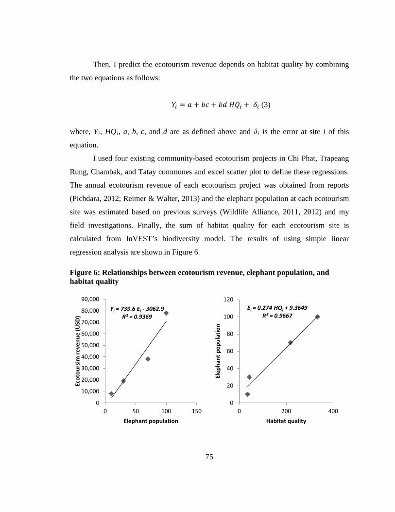
75
Then, I predict the ecotourism revenue depends on habitat quality by combining
the two equations as follows:
𝑌𝑖 = 𝑎 + 𝑏𝑐 + 𝑏𝑑 𝐻𝑄𝑖 + 𝛿𝑖 (3)
where, Yi, HQi, a, b, c, and d are as defined above and δi
I used four existing community-based ecotourism projects in Chi Phat, Trapeang
Rung, Chambak, and Tatay communes and excel scatter plot to define these regressions.
The annual ecotourism revenue of each ecotourism project was obtained from reports
(Pichdara, 2012; Reimer & Walter, 2013) and the elephant population at each ecotourism
site was estimated based on previous surveys (Wildlife Alliance, 2011, 2012) and my
field investigations. Finally, the sum of habitat quality for each ecotourism site is
calculated from InVEST’s biodiversity model. The results of using simple linear
regression analysis are shown in Figure 6.
is the error at site i of this
equation.
A
Figure 6: Relationships between ecotourism revenue, elephant population, and habitat quality
Yi = 739.6 Ei - 3062.9 R² = 0.9369
0
10,000
20,000
30,000
40,000
50,000
60,000
70,000
80,000
90,000
0 50 100 150
Ecot
ours
im re
venu
e (U
SD)
Elephant population
Ei = 0.274 HQi + 9.3649 R² = 0.9667
0
20
40
60
80
100
120
0 200 400
Elep
hant
pop
ulat
ion
Habitat quality
76
The relationship between elephant population and habitat quality was predicted
with the R2 is 0.9667 and the standard error of estimate is 9 elephants. The relationship
between ecotourism revenue and the elephant population was predicted with the R2
To get the whole landscape ecotourism value, I applied equation (3) to the
InVEST habitat quality map of each scenario. Similar to other services, I applied a 4%
annual discount rate to calculate the total value over the 50 year time.
is
0.9369 and the standard error of estimate is USD9,473.
2.2.5.3- Water Yield
The water yield is the first step of the InVEST reservoir hydropower model. It
determines the amount of water running off each pixel, which is calculated as the
difference between precipitation and evapotranspiration. This model is based on the
Budyko curve and annual average precipitation. The annual water yield Y(x) for each
pixel on the landscape x as follows:
𝑌(𝑥) = �1 −𝐴𝐸𝑇(𝑥)𝑃(𝑥) � .𝑃(𝑥)
where, AET(x) is the annual actual evapotranspiration for pixel x, and P(x) is the annual
precipitation on pixel x.
For vegetated LULC, the evapotranspiration partition of the water balance, 𝐴𝐸𝑇(𝑥)𝑃(𝑥)
is an approximation of the Budyko curve developed by Zhang et al. (2001):
𝐴𝐸𝑇(𝑥)𝑃(𝑥)
= 1 + 𝑤(𝑥)𝑅(𝑥)
1 + 𝑤(𝑥)𝑅(𝑥) + 1𝑅(𝑥)
where, R(x) is the dimensionless Budyko dryness index on pixel x, defined as the ratio of
potential evapotranspiration to precipitation (Budyko, 1974) and ω(x) is a modified
dimensionless ratio of plant accessible water storage to expected precipitation during the
77
year. As defined by Zhang et al. (2001), ω(x) is a non-physical parameter to characterize
the natural climatic-soil properties. The non-physical parameter is defined as follows:
𝑤(𝑥) = 𝑍𝐴𝑊𝐶(𝑥)𝑃(𝑥)
where, AWC(x) is the volumetric plant available water content. The soil texture and
effective rooting depth define AWC(x), which establishes the amount of water that can be
held and released in the soil for use by a plant, estimated as the product of the difference
between field capacity and wilting point and the minimum root restricting layer depth and
vegetation rooting depth. Root restricting layer depth is the soil depth at which root
penetration is strongly inhibited because of physical or chemical characteristics.
Vegetation rooting depth is often given as the depth at which 95% of a vegetation type’s
root biomass occurs. This root depth value was given in the table of Appendix 8. Z is a
seasonality factor that represents the seasonal rainfall distribution and rainfall depths.
Rainfall in the Cardamom landscape is high (9 months per year), so I used 8 as the Z
value for this analysis.
Finally, I define the Budyko dryness index, where R(x) values that are greater
than one denote pixels that are potentially arid (Budyko, 1974), as follows:
𝑅(𝑥) = 𝐾𝑐(𝑙𝑥).𝐸𝑇𝑜(𝑥)
𝑃(𝑥)
where, ETo(x) is the reference evapotranspiration from pixel x and Kc(lx) is the plant
(vegetation) evapotranspiration coefficient associated with the LULC lx on pixel x.
ETo(x) reflects local climatic conditions, based on the evapotranspiration of a reference
vegetation such as grass of alfalfa grown at that location. Kc(lx) is largely determined by
the vegetative characteristics of the LULC found on that pixel (Allen, Pereira, Raes, &
Smith, 1998). Kc adjusts the ETo values based on the crop or vegetation type in each
pixel of the LULC map, and is then used to estimate actual ET (AET) for the watershed,
one of the model outputs.
78
For other LULCs (open water, urban, wetland), actual evapotranspiration is
directly computed from the reference evapotranspiration ETo:
𝐴𝐸𝑇(𝑥) = 𝐾𝑐(𝑙𝑥).𝐸𝑇𝑜(𝑥)
where ETo(x) is the reference evapotranspiration, and Kc(lx) is the evaporation factor for
each LULC. The estimated Kc value is provided in Appendix 8.
2.2.5.4- Water Scarcity
Water Scarcity is the second step of the InVEST reservoir hydropower model. It
calculates the water scarcity value based on water yield and water consumptive use in the
watershed(s) of interest. Appendix 9 shows how much water is consumed by each LULC
type that is calculated based on Bhagabati et al. (2012). These land use-based values only
relate to the consumptive portion of demand; some water use is non-consumptive such as
water used for cooling or other industrial processes that return water to the stream after
use. For simplicity, each pixel in the watershed is either a “contributing” pixel, which
contributes to hydropower production, or a “use” pixel, which uses water for other
consumptive uses. This assumption implies that land use associated with consumptive
uses will not contribute any yield for downstream use. The amount of water that actually
reaches the reservoir for dam 𝑑 is defined as the difference between total water yield and
total consumptive use in the watershed. This water consumption is calculated as follows:
𝑉𝑖𝑛 = 𝑌 − 𝑢𝑑
where 𝑢𝑑 is the total volume of water consumed in the watershed upstream of dam 𝑑 and
Y is the total water yield from the watershed upstream of dam 𝑑.
If the user has observed data available on actual annual inflow rates to the
reservoir for dam 𝑑, they can be compared to 𝑉𝑖𝑛. This is done by dividing the observed
values by the estimated values to derive a calibration constant. This can then be entered
79
in to the hydropower calibration table and used to make actual power and value estimates
rather than relative.
2.2.5.5- Valuation of Hydropower Value
In the third step, the reservoir hydropower model estimates for each scenario, the
amount of energy produced, the value of that energy, and the present value dollar
estimate for the entire remaining lifetime of the reservoir. The net present value can be
calculated using current hydropower production cost data. The energy produced and
revenue are then redistributed over the landscape based on the proportional contribution
of each sub-watershed to energy production. Final output maps show how much the
energy production and hydropower values can be attributed to each sub-watershed’s
water yield over the lifetime of the reservoir.
So, at dam d, power is calculated using the following equation:
𝑝𝑑 = 𝜌 . 𝑞𝑑 .𝑔 . ℎ𝑑
where 𝑝𝑑 is power in watts, ρ is the water density (1000 Kg/m3), 𝑞𝑑 is the flow rate
(m3/s), 𝑔 is the gravity constant (9.81 m/s2
The power production equation is connected to the water yield model by
converting the annual inflow volume adjusted for consumption (𝑉𝑖𝑛) to a cubic meters per
second flow rate. Since electric energy is normally measured in kilowatt-hours, the power
𝑝𝑑 is multiplied by the number of hours in a year. All hydropower reservoirs are built to
produce a maximum amount of electricity. This is called the energy production rating,
and represents how much energy could be produced if the turbines are 100% efficient and
all water that enters the reservoir is used for power production. However, in the real
world, turbines have inefficiencies and water in the reservoir may be extracted for other
uses like irrigation, retained in the reservoir for other uses like recreation, or released
from the reservoir for non-power production uses like maintaining flows downstream. To
), and ℎ𝑑 is the water height behind the dam at
the turbine (m) (Appendix 10). In this model, we assume that the total annual inflow
water volume is released equally and continuously over the course of each year.
80
account for these inefficiencies, the flow rate, and power unit adjustments, annual
average energy production 𝜀𝑑 at dam d is calculated as follows:
𝜀𝑑 = 0.00272 .𝛽 . 𝑦𝑑 .ℎ𝑑 .𝑉𝑖𝑛
where 𝜀𝑑 is hydropower energy production (KWH), β is the turbine efficiency coefficient
(%), 𝑦𝑑 is the percent of inflow water volume to the reservoir at dam d that will be used
to generate energy.
To convert 𝜀𝑑, the annual energy generated by dam d, into a net present value
(NPV) of energy produced (point of use value), we use the following,
𝑁𝑃𝑉𝐻𝑑 = (𝑝𝑒𝜀𝑑 − 𝑇𝐶𝑑) .�1
(1 + 𝑟)𝑡
𝑇−1
𝑡=0
where 𝑇𝐶𝑑 is the total annual operating costs for dam d, and 𝑝𝑒 is the market value of
electricity (per unit of energy consumed) provided by the hydropower plant at dam d. 𝑇𝑑
indicates the number of years present landscape conditions are expected to persist or the
expected remaining lifetime of the station at dam d (set T to the smallest value if the two
time values differ), and r is the market discount rate. The form of the equation above
assumes that 𝑇𝐶𝑑, 𝑝𝑒, and 𝜀𝑑, are constant over time.
Energy production over the lifetime of dam d is attributed to each sub-watershed
as follows:
𝜀𝑥 = (𝑇𝑑𝜀𝑑). (𝑐𝑥𝑐𝑡𝑜𝑡
)
where the first term in parentheses represents electricity production over the lifetime of
dam d. The second term represents the proportion of water volume used for hydropower
production that comes from sub-watershed x relative to the total water volume for the
81
whole watershed. The value of each sub-watershed for hydropower production over the
lifetime of dam d is calculated similarly:
𝑁𝑃𝑉𝐻𝑥 = 𝑁𝑃𝑉𝐻𝑑 . (𝑐𝑥𝑐𝑡𝑜𝑡
)
The hydropower energy and value grids are the most relevant model outputs for
prioritizing the landscape for investments that wish to maintain water yield for
hydropower production. The hydropower value grid contains the most information for
this purpose as it represents the revenue attributable to each sub-watershed over the 50
year lifetime of the hydropower stations. In my case, the energy values do not vary much
across the landscape, so the hydropower energy outputs are very useful in planning and
prioritization. Comparing any of these grids between LULC scenarios allows me to
understand how the role of the landscape may change under different management plans.
Appendix 10 contains all data needed and simply feed into InVEST to run.
2.2.5.6- Agriculture
The net present value of agricultural crop production in the landscape depends on
cultivated areas, crop type and cycle, yield, crop prices and production costs. LULCs that
are considered to be cultivated areas include orchards, paddy fields, dryland crops,
swidden agriculture, forest plantations, rubber plantations, receding and floating rice
fields, and parts of development areas inside settlement and along roads (JICA, 2003).
I obtained crop cultivated areas from the three scenario LULC maps. I determined
each crop type, cycle, and yield based on MAFF statistics data (MAFF, 2013). The
production price for each crop was taken from the Cambodian agriculture market
information website (MAFF, 2014).
For this analysis, I assumed that 20% of the settlement area is cultivated by
villagers for family consumption and sale. This included mostly vegetable and other fruit
trees (village crops). I also assumed that 20% of land cover along roads were crops such
as maize, sweet potatoes, soybean, cassava, and others (road crops) that are cultivated by
82
villagers and agricultural enterprises. Large scale agricultural included all ELCs that
generally cultivate agro-industrial crops such as cassava, sugarcane, oil palm, cashew nut,
rubber, acacia and eucalyptus (industrial crops). I aggregated the yield and prices of all
crops cultivated in each agriculture land type (i.e. village, road, and industrial). The crop
production period is also included in this analysis. For example, rice and other vegetable
productions can be produced up to 3 times per year depending on the variety and
irrigation conditions. So, the production yield for these crops is calculated as annual
bases. Then, I estimated the agriculture value as follows:
𝑁𝑃𝑉𝐴𝐺 = 𝐶𝐴(𝑥).𝑃𝑌(𝑥).𝐶𝑃(𝑥). (1 − 𝑃𝑇𝐶).�1
(1 + 𝑟)𝑡
𝑇−1
𝑡=0
where CA(x) is the cultivated area for crop x calculated in ha, PY(x) is the production
yield for crop x calculated in matrix ton per ha per year, CP(x) is the price of crop x
calculated in USD per ton, PTC is the fraction of production and transportation cost, T is
the 50 year timeframe, and r is the 4% market discount rate. Due to limitation of data on
production cost, I calculate the PTC based on Dararath et al. (2011) and (MAFF, 2013),
which is 25.65% for tree plantations and 44.63% if they are cash crops and others.
2.3- Results
2.3.1- LULC maps
LULC maps of the three scenarios are shown in Figure 7. Green color indicates
nature habitat and blue color indicates disturbances caused by development activities.
Yellow color shows ELCs granted by the RGC in the landscape. Based on the above
criteria, the future conservation LULC map (SCO), the current LULC map (MCD), and
the future development LULC map (SDE) consisted of about 16%, 26%, and 40% of
disturbance, respectively. SDE converts natural habitats to other LULCs two and a half
times as much as the SCO. These habitat conversions mostly occurred at the edge areas
around the landscape.
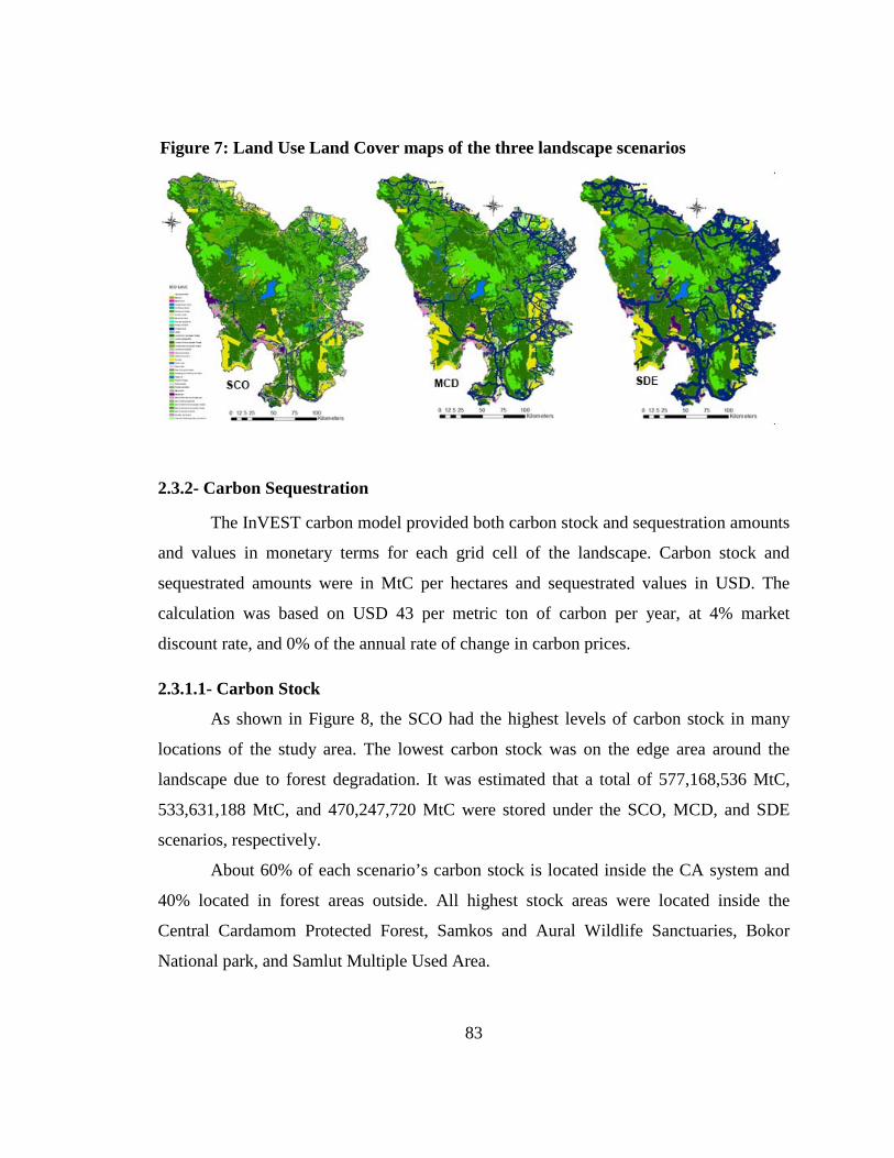
83
2.3.2- Carbon Sequestration
The InVEST carbon model provided both carbon stock and sequestration amounts
and values in monetary terms for each grid cell of the landscape. Carbon stock and
sequestrated amounts were in MtC per hectares and sequestrated values in USD. The
calculation was based on USD 43 per metric ton of carbon per year, at 4% market
discount rate, and 0% of the annual rate of change in carbon prices.
2.3.1.1- Carbon Stock
As shown in Figure 8, the SCO had the highest levels of carbon stock in many
locations of the study area. The lowest carbon stock was on the edge area around the
landscape due to forest degradation. It was estimated that a total of 577,168,536 MtC,
533,631,188 MtC, and 470,247,720 MtC were stored under the SCO, MCD, and SDE
scenarios, respectively.
About 60% of each scenario’s carbon stock is located inside the CA system and
40% located in forest areas outside. All highest stock areas were located inside the
Central Cardamom Protected Forest, Samkos and Aural Wildlife Sanctuaries, Bokor
National park, and Samlut Multiple Used Area.
Figure 7: Land Use Land Cover maps of the three landscape scenarios
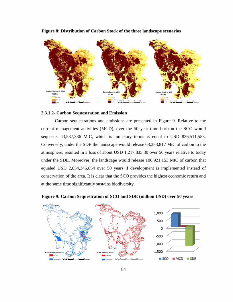
84
2.3.1.2- Carbon Sequestration and Emission
Carbon sequestrations and emissions are presented in Figure 9. Relative to the
current management activities (MCD), over the 50 year time horizon the SCO would
sequester 43,537,336 MtC, which is monetary terms is equal to USD 836,511,553.
Conversely, under the SDE the landscape would release 63,383,817 MtC of carbon to the
atmosphere, resulted in a loss of about USD 1,217,835,30 over 50 years relative to today
under the SDE. Moreover, the landscape would release 106,921,153 MtC of carbon that
equaled USD 2,054,346,854 over 50 years if development is implemented instead of
conservation of the area. It is clear that the SCO provides the highest economic return and
at the same time significantly sustains biodiversity.
Figure 9: Carbon Sequestration of SCO and SDE (million USD) over 50 years
-1,500
-1,000
-500
0
500
1,000
SCO MCD SDE
Figure 8: Distribution of Carbon Stock of the three landscape scenarios
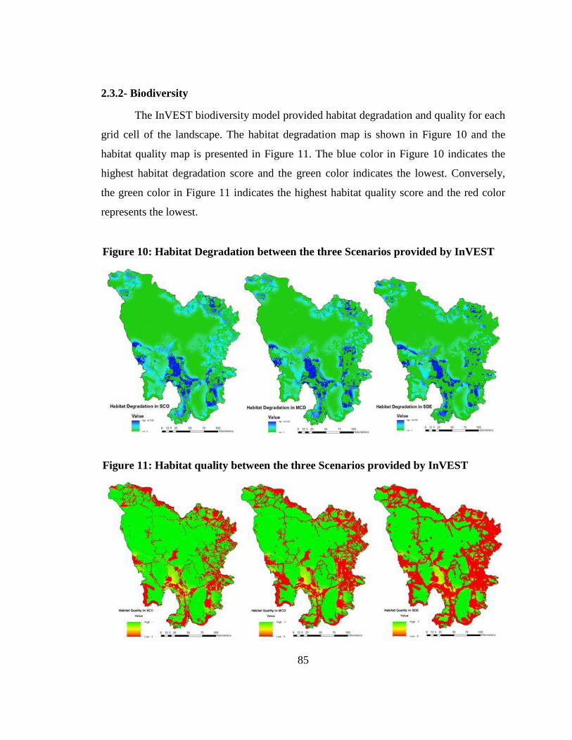
85
2.3.2- Biodiversity
The InVEST biodiversity model provided habitat degradation and quality for each
grid cell of the landscape. The habitat degradation map is shown in Figure 10 and the
habitat quality map is presented in Figure 11. The blue color in Figure 10 indicates the
highest habitat degradation score and the green color indicates the lowest. Conversely,
the green color in Figure 11 indicates the highest habitat quality score and the red color
represents the lowest.
Figure 11: Habitat quality between the three Scenarios provided by InVEST
Figure 10: Habitat Degradation between the three Scenarios provided by InVEST
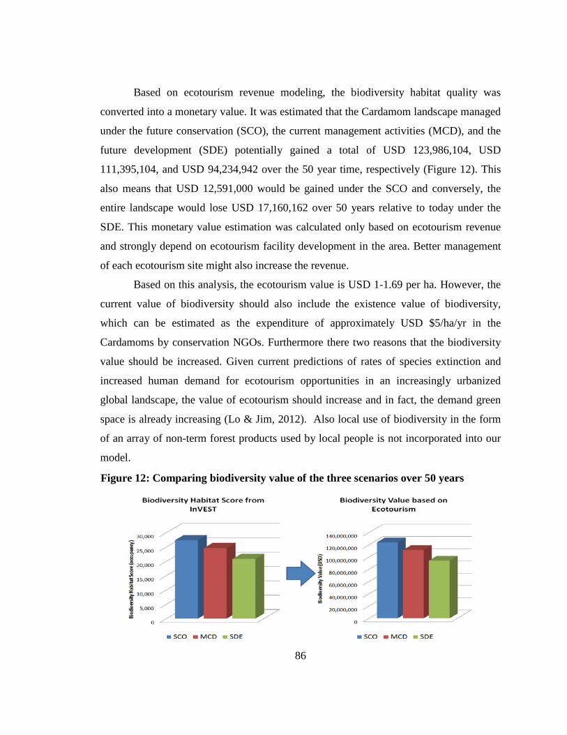
86
Based on ecotourism revenue modeling, the biodiversity habitat quality was
converted into a monetary value. It was estimated that the Cardamom landscape managed
under the future conservation (SCO), the current management activities (MCD), and the
future development (SDE) potentially gained a total of USD 123,986,104, USD
111,395,104, and USD 94,234,942 over the 50 year time, respectively (Figure 12). This
also means that USD 12,591,000 would be gained under the SCO and conversely, the
entire landscape would lose USD 17,160,162 over 50 years relative to today under the
SDE. This monetary value estimation was calculated only based on ecotourism revenue
and strongly depend on ecotourism facility development in the area. Better management
of each ecotourism site might also increase the revenue.
Based on this analysis, the ecotourism value is USD 1-1.69 per ha. However, the
current value of biodiversity should also include the existence value of biodiversity,
which can be estimated as the expenditure of approximately USD $5/ha/yr in the
Cardamoms by conservation NGOs. Furthermore there two reasons that the biodiversity
value should be increased. Given current predictions of rates of species extinction and
increased human demand for ecotourism opportunities in an increasingly urbanized
global landscape, the value of ecotourism should increase and in fact, the demand green
space is already increasing (Lo & Jim, 2012). Also local use of biodiversity in the form
of an array of non-term forest products used by local people is not incorporated into our
model.
Figure 12: Comparing biodiversity value of the three scenarios over 50 years
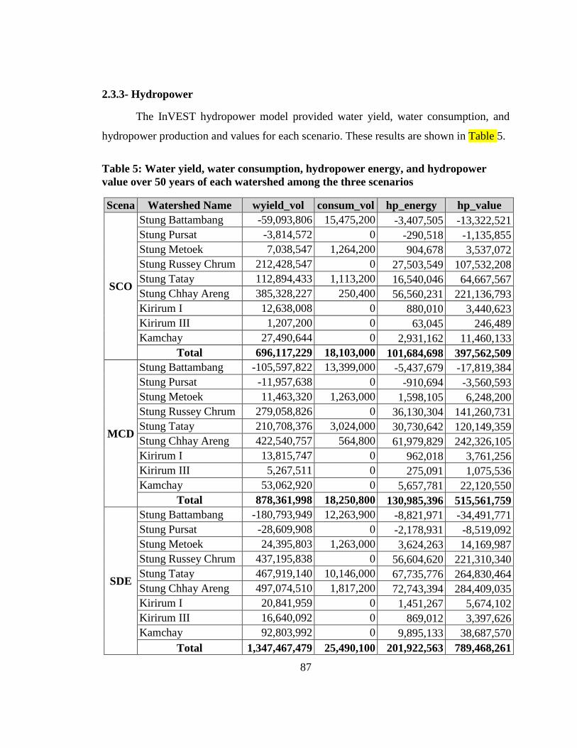
87
2.3.3- Hydropower
The InVEST hydropower model provided water yield, water consumption, and
hydropower production and values for each scenario. These results are shown in Table 5.
Table 5: Water yield, water consumption, hydropower energy, and hydropower value over 50 years of each watershed among the three scenarios
Scena Watershed Name wyield_vol consum_vol hp_energy hp_value
SCO
Stung Battambang -59,093,806 15,475,200 -3,407,505 -13,322,521 Stung Pursat -3,814,572 0 -290,518 -1,135,855 Stung Metoek 7,038,547 1,264,200 904,678 3,537,072 Stung Russey Chrum 212,428,547 0 27,503,549 107,532,208 Stung Tatay 112,894,433 1,113,200 16,540,046 64,667,567 Stung Chhay Areng 385,328,227 250,400 56,560,231 221,136,793 Kirirum I 12,638,008 0 880,010 3,440,623 Kirirum III 1,207,200 0 63,045 246,489 Kamchay 27,490,644 0 2,931,162 11,460,133
Total 696,117,229 18,103,000 101,684,698 397,562,509
MCD
Stung Battambang -105,597,822 13,399,000 -5,437,679 -17,819,384 Stung Pursat -11,957,638 0 -910,694 -3,560,593 Stung Metoek 11,463,320 1,263,000 1,598,105 6,248,200 Stung Russey Chrum 279,058,826 0 36,130,304 141,260,731 Stung Tatay 210,708,376 3,024,000 30,730,642 120,149,359 Stung Chhay Areng 422,540,757 564,800 61,979,829 242,326,105 Kirirum I 13,815,747 0 962,018 3,761,256 Kirirum III 5,267,511 0 275,091 1,075,536 Kamchay 53,062,920 0 5,657,781 22,120,550
Total 878,361,998 18,250,800 130,985,396 515,561,759
SDE
Stung Battambang -180,793,949 12,263,900 -8,821,971 -34,491,771 Stung Pursat -28,609,908 0 -2,178,931 -8,519,092 Stung Metoek 24,395,803 1,263,000 3,624,263 14,169,987 Stung Russey Chrum 437,195,838 0 56,604,620 221,310,340 Stung Tatay 467,919,140 10,146,000 67,735,776 264,830,464 Stung Chhay Areng 497,074,510 1,817,200 72,743,394 284,409,035 Kirirum I 20,841,959 0 1,451,267 5,674,102 Kirirum III 16,640,092 0 869,012 3,397,626 Kamchay 92,803,992 0 9,895,133 38,687,570
Total 1,347,467,479 25,490,100 201,922,563 789,468,261
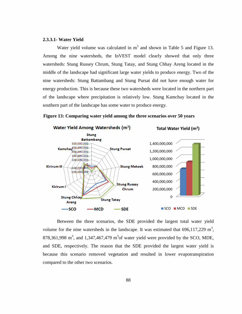
88
2.3.3.1- Water Yield
Water yield volume was calculated in m3
and shown in Table 5 and Figure 13.
Among the nine watersheds, the InVEST model clearly showed that only three
watersheds: Stung Russey Chrum, Stung Tatay, and Stung Chhay Areng located in the
middle of the landscape had significant large water yields to produce energy. Two of the
nine watersheds: Stung Battambang and Stung Pursat did not have enough water for
energy production. This is because these two watersheds were located in the northern part
of the landscape where precipitation is relatively low. Stung Kamchay located in the
southern part of the landscape has some water to produce energy.
Between the three scenarios, the SDE provided the largest total water yield
volume for the nine watersheds in the landscape. It was estimated that 696,117,229 m3,
878,361,998 m3, and 1,347,467,479 m3of water yield were provided by the SCO, MDE,
and SDE, respectively. The reason that the SDE provided the largest water yield is
because this scenario removed vegetation and resulted in lower evapotranspiration
compared to the other two scenarios.
Figure 13: Comparing water yield among the three scenarios over 50 years
0
200,000,000
400,000,000
600,000,000
800,000,000
1,000,000,000
1,200,000,000
1,400,000,000
Total Water Yield (m3)
SCO MCD SDE
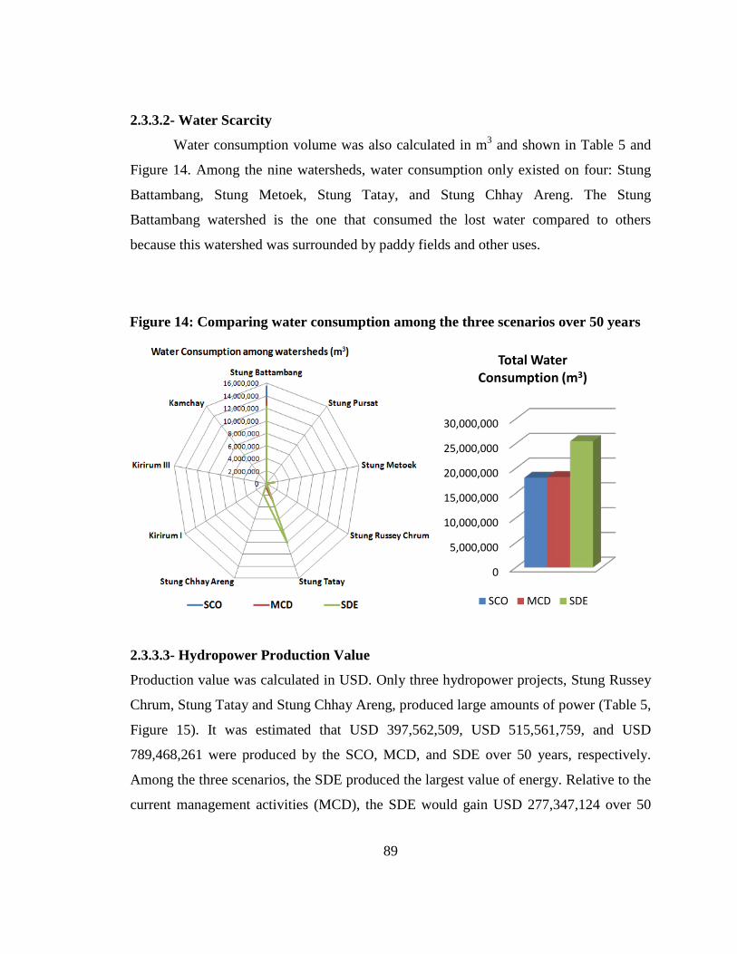
89
2.3.3.2- Water Scarcity
Water consumption volume was also calculated in m3
and shown in Table 5 and
Figure 14. Among the nine watersheds, water consumption only existed on four: Stung
Battambang, Stung Metoek, Stung Tatay, and Stung Chhay Areng. The Stung
Battambang watershed is the one that consumed the lost water compared to others
because this watershed was surrounded by paddy fields and other uses.
2.3.3.3- Hydropower Production Value
Production value was calculated in USD. Only three hydropower projects, Stung Russey
Chrum, Stung Tatay and Stung Chhay Areng, produced large amounts of power (Table 5,
Figure 15). It was estimated that USD 397,562,509, USD 515,561,759, and USD
789,468,261 were produced by the SCO, MCD, and SDE over 50 years, respectively.
Among the three scenarios, the SDE produced the largest value of energy. Relative to the
current management activities (MCD), the SDE would gain USD 277,347,124 over 50
Figure 14: Comparing water consumption among the three scenarios over 50 years
0
5,000,000
10,000,000
15,000,000
20,000,000
25,000,000
30,000,000
Total Water Consumption (m3)
SCO MCD SDE
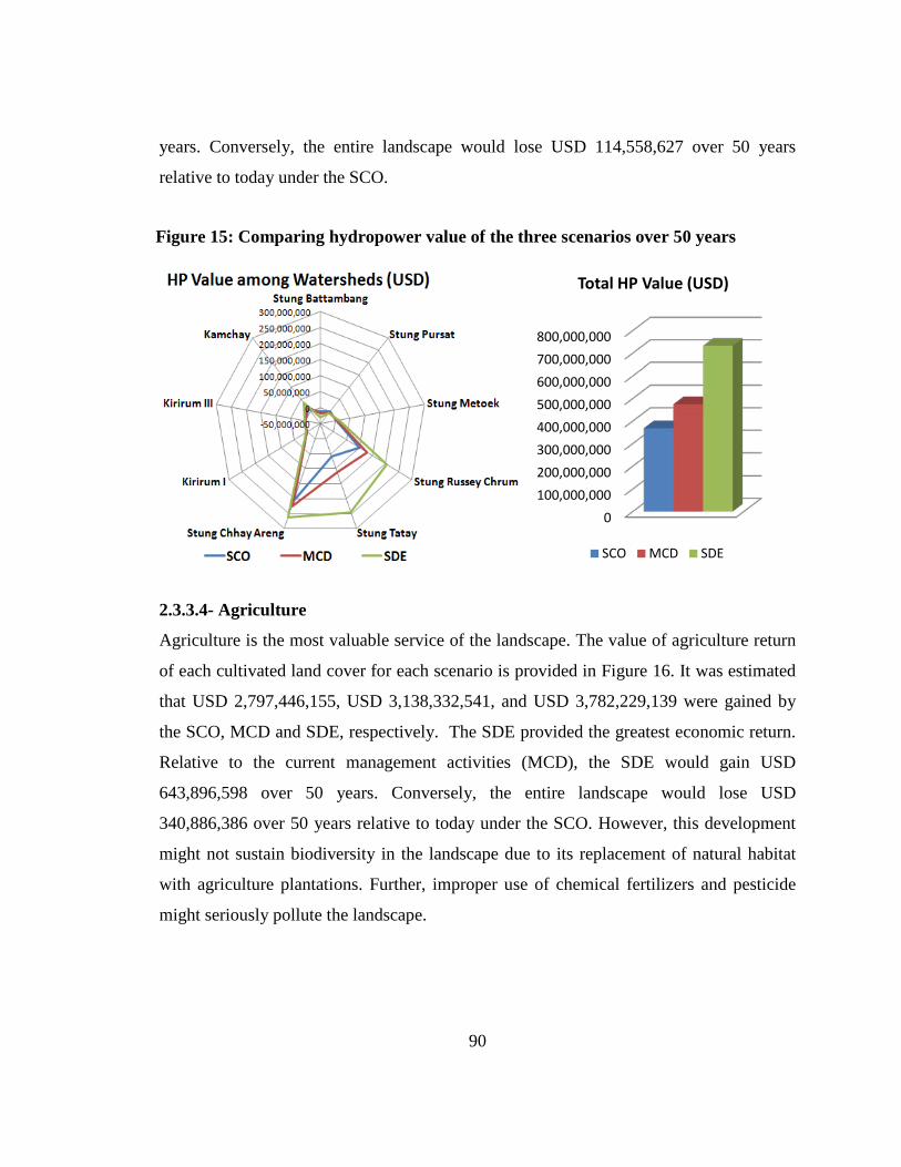
90
years. Conversely, the entire landscape would lose USD 114,558,627 over 50 years
relative to today under the SCO.
2.3.3.4- Agriculture
Agriculture is the most valuable service of the landscape. The value of agriculture return
of each cultivated land cover for each scenario is provided in Figure 16. It was estimated
that USD 2,797,446,155, USD 3,138,332,541, and USD 3,782,229,139 were gained by
the SCO, MCD and SDE, respectively. The SDE provided the greatest economic return.
Relative to the current management activities (MCD), the SDE would gain USD
643,896,598 over 50 years. Conversely, the entire landscape would lose USD
340,886,386 over 50 years relative to today under the SCO. However, this development
might not sustain biodiversity in the landscape due to its replacement of natural habitat
with agriculture plantations. Further, improper use of chemical fertilizers and pesticide
might seriously pollute the landscape.
Figure 15: Comparing hydropower value of the three scenarios over 50 years
0 100,000,000 200,000,000 300,000,000 400,000,000 500,000,000 600,000,000 700,000,000 800,000,000
Total HP Value (USD)
SCO MCD SDE
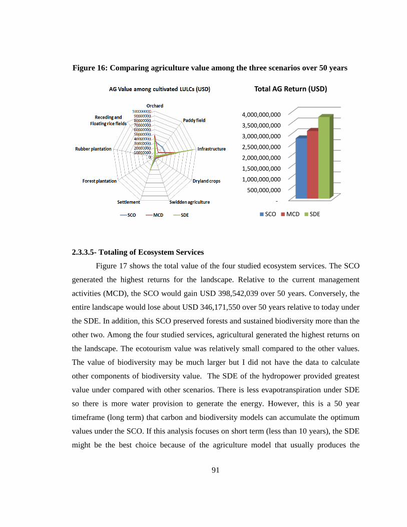
91
2.3.3.5- Totaling of Ecosystem Services
Figure 17 shows the total value of the four studied ecosystem services. The SCO
generated the highest returns for the landscape. Relative to the current management
activities (MCD), the SCO would gain USD 398,542,039 over 50 years. Conversely, the
entire landscape would lose about USD 346,171,550 over 50 years relative to today under
the SDE. In addition, this SCO preserved forests and sustained biodiversity more than the
other two. Among the four studied services, agricultural generated the highest returns on
the landscape. The ecotourism value was relatively small compared to the other values.
The value of biodiversity may be much larger but I did not have the data to calculate
other components of biodiversity value. The SDE of the hydropower provided greatest
value under compared with other scenarios. There is less evapotranspiration under SDE
so there is more water provision to generate the energy. However, this is a 50 year
timeframe (long term) that carbon and biodiversity models can accumulate the optimum
values under the SCO. If this analysis focuses on short term (less than 10 years), the SDE
might be the best choice because of the agriculture model that usually produces the
Figure 16: Comparing agriculture value among the three scenarios over 50 years
-
500,000,000
1,000,000,000
1,500,000,000
2,000,000,000
2,500,000,000
3,000,000,000
3,500,000,000
4,000,000,000
Total AG Return (USD)
SCO MCD SDE
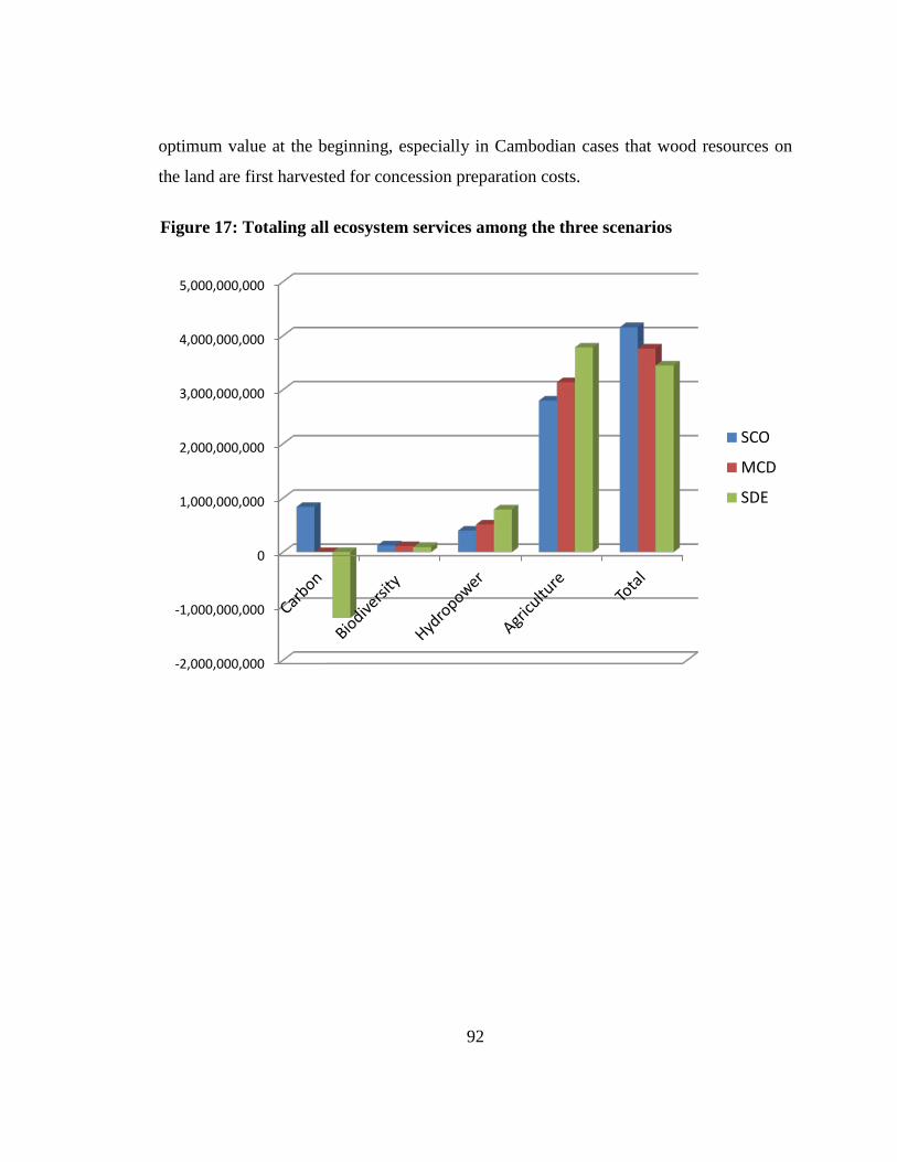
92
optimum value at the beginning, especially in Cambodian cases that wood resources on
the land are first harvested for concession preparation costs.
Figure 17: Totaling all ecosystem services among the three scenarios
-2,000,000,000
-1,000,000,000
0
1,000,000,000
2,000,000,000
3,000,000,000
4,000,000,000
5,000,000,000
SCO
MCD
SDE

93
Chapter 3: Discussion and Recommendation
94
3.1- Discussion
3.1.1- How the landscape is managed?
This study attempted to assess the best land management option for the
Cardamom landscape. The Cardamom landscape is currently influenced by three
powerful stakeholder groups. The private sector values industrial development, which
may help to improve the country’s economy and provide jobs and income. Donor
communities and NGOs want preservation and have influence on the RGC to preserve
the landscape. The donor community has providing billions of dollars per year to run the
country. The RCG currently manages the landscape by balancing these two different
interests. Fifteen CAs equaled 45.5% of the landscape were set up to protect biodiversity
and ecosystems. At the same time, 23 ELCs equaled 17% of the landscape and other
development projects were also granted to the private sector to develop the area. The
findings of this study largely support the donor communities and NGOs to preserve this
important landscape. It means that to have the greatest economic return and at the same
time sustain biodiversity in the area, the landscape must be managed under the SCO. The
worst scenario of this landscape management is the SDE. These results are also consistent
with previous research such as Soussan & Sam (2011) and van Beukering et al., (2009)
that found preservation of the Cardamom landscape was critical and should be adopted.
One possible explanation is that my evaluation was a 50 year timeframe so it gave
enough time for conservation services such as carbon and biodiversity to accumulate in
the SCO, surpassing SDE levels. However, long term management of a landscape, for
example, the 50 years of this study, might not be in the interest of many governments.
This is because most governments are powered by their political parties and they prefer to
do something that can produce short term results so people can see and give them votes.
In contrast, local communities need long term and sustainable management because they
depend on the landscape for generations. In the case of the Cardamom landscape, the
management not only targets the short term, but consists of many social and political
problems such as corruption and nepotism (Global Withness, 2009). Local people have
95
been badly treated by not involving them in the decision making, giving them fair
benefits from development projects, and even worse, their lands are stolen by the
government’s ELC agreements with the private sector. It is important for civil society to
become more important actors in Cambodian natural resource management. Besides
supporting local communities to sustain their livelihoods on the landscape, civil societies
also play an important role in reflecting how the RGC implements the donor community
benchmarks. To sustain biodiversity and the greatest economic return as shown in this
study, the RGC should stop all deforestation activities on the landscape and donor
communities have to seriously monitor and put pressure on the RGC if they do not do a
better job.
3.1.2- Creation of Land Management Scenarios
Predicting future land management scenarios is not simple. For this study, the
creation of land management scenarios was based on the preferences of three stakeholder
groups. The strong development scenario resulted in more forest destruction, the strong
conservation preserves more forests, and the current landscape management the RGC, is
trying to balance development and conservation. This study found that increased
development of hydro power and agriculture had positive economic returns, but these
came as a substantial cost of lower ecotourism and carbon sequestration payments.
Moreover, ELCs granted by the RGC create serious environmental impacts and forest
degradation. It usually becomes a hidden mechanism for providing benefits to a few rich
and powerful people through corruption and nepotism system and local people are
suffering from losing their lands for producing foods. For example, among the 23 ELCs
currently permitted in the landscape, only a few of them are actually operating. Others
seem to just cut forests for direct benefit or to hold concessions for transferring to other
companies to make money. Moreover, while the renting fee of these concessions is
extremely low (MAFF, 2012), the under table payments to related decision makers for
concession granting and operating is relatively high. Another reason that the SDE
converted natural habitats to other LULCs two and a half times as much as the SCO may
96
be a result of the protected area law adoption in 2008 that allows industrial development
inside the protected area system (Kingdom of Cambodia, 2008). Bad governance
including corruption and nepotism has also been identified as one of the main drivers of
the landscape forest destruction. Even though the LULC maps of the three scenarios were
created by applying specific buffered distances and these distances were estimated based
on previous year LULC changes and present field investigations, our sample was very
small. However, these results do provide important suggestions about the prediction of
land management options.
3.1.3- Carbon Model
Carbon value is the most influential component of the models so using the right
carbon price is critical. There are two types of carbon price: one is based on social value
and another based on current market demand. The social value of a sequestered ton of
carbon is equal to the social damage avoided by not releasing the ton of carbon into the
atmosphere (Stern, 2006; Tol, 2005). These social cost calculations are complicated and
controversial (Nordhaus, 2007; Weitzman, 2007) and sometimes might not be able to
convince policy makers to accept them because they usually based on the market price.
There is also a considerable range of estimates in the social cost of carbon (Tol 2009).
Relative rankings can also be influenced by the geographic or temporal scope of the
analysis (Polasky, Nelson, Pennington, & Johnson, 2011). The market price depends on
both regulation and voluntary demand. The Kyoto Protocol – the current treaty
addressing international climate change – includes a mechanism for establishing projects
that sequester carbon to earn credits, which they then can sell to others needing to offset
their own CO2 emissions. As a result of the Kyoto Protocol, the European Union
Emissions Trading Scheme emerged to allow the regulated firms of the EU to trade their
emissions allowances and the Chicago Climate Exchange (CCX) emerged in the United
States. However, the Kyoto Protocol was expired since the end of 2012 and the CCX was
not a signatory party of the Kyoto Protocol and went out of business a few years ago. In
addition to these centralized markets, there is a few over-the-counter market for voluntary
97
carbon offsets. The market price of a sequestrated ton of carbon in Cambodia these days
ranges between USD 7.00 to USD 9.00 (Voice of America, 2014). These prices do not
come close to the profit made possible from felling the forest. Furthermore, local
communities whose livelihoods depend on natural resource uses need to be fairly
compensated to avoid deforestation. These prices will strongly reflect policies, subsidies,
and other factors, and therefore will only indicate the true value of this service to society
by chance (Murray, Sohngen, & Ross, 2006). For this reason, I used a low social cost of
USD 43 per ton of sequestrated carbon (Nelson et al., 2009). Based on this analysis, USD
27.5 is the breakeaven point for the
3.1.4- Hydropower model
strong conservation and strong development
scenarios. As argued by the U.S.-based Center for Clean Air Policy’s 2010 study in the
Koh Kong province, carbon credits in Cambodia would have to sell for more than USD
15 per ton to compete with the likely revenue from growing sugarcane on the land
instead, even more if it were used to harvest rubber (Dararath et al., 2011; Sasaki, 2010).
So, USD 43 per ton seems to provide reasonable compensation to avoid deforestation and
sustain biodiversity in the landscape.
Hydropower development in the Cardamom landscape is critically important for
Cambodia, especially since only about 20% of Cambodian households have access to
electricity (Sarraf, Rismanchi, Saidur, Ping, & Rahim, 2013). Due to the Cardamom
landscape’s climate and geography, most of the main waterways have potential for
electricity generation (JICA, 2003). Therefore, many hydropower projects have been
developed in the area (Ministry of Industrial Mine and Energy, 2005). This study found
that the SDE gained the largest return, about USD 790 million, over 50 years. One
possible reason is that the SDE, with more forest destruction, gains more returns than the
SCO because the water undergoes evapotranspiration in each watershed less than the
SCO. This is also because the InVEST model has assumed the precipitation of each
watershed remained constant and is not affected by deforestation over time. However,
this finding appears to be the best estimate compared to others such as Soussan & Sam
98
2011 that estimated over USD 75 million a year for the value of the watershed functions
of the study area in the Central Cardamom Mountains. The approach of this study should
be applied to evaluate other hydropower development projects in Cambodia in order to
make a wise decision. For more precision, the horizontal hydrological study of the
Cardamom coastal rainforests should be taken into account to detail the hydrological
function of this important landscape.
3.1.5- Biodiversity
The Cardamom landscape has been recognized as one of the richest biodiversity
hotspots in Asia. Preservation of its natural habitats and ecosystem functions is not only
important for sustaining biodiversity in the area, but also for poverty reduction and
improving local community livelihoods. By using a combination of InVEST and
ecotourism modeling, this study confirmed that the potential ecotourism value of this
landscape is invaluable. Even though the value is less than other services, it reflects the
biodiversity value based on ecotourism in the area and the method of doing this is new to
science. The unit value of this estimate was only USD1-1.69 per ha which is less than the
costs that NGOs have paid to protect biodiversity in the area (USD 5/ha/year) and it even
much less than the estimation made by previous literature (Bann, 1997; Soussan & Sam,
2011). However, this value is critically important because it is directly shared at the
community level among local guides, boat runners, and owners of restaurants, guest
houses, and local businesses. Moreover, there are also ways to increase this revenue by
adding more projects and improving or investing in more facilities. I recommend the
RGC to consider this incredible biodiversity value for any land management issue in this
landscape and consider it is one of the strategies to eliminate poverty in the area.
3.1.6- Sustainable Land Management Planning
In order to properly manage the landscape, sustainable land management planning
of the Cardamom landscape is needed. There are several land management plans and
activities that have been developed separately, inconsistently, geographically, and
institutionally based. For example, in the southern part of the landscape, the Wildlife
99
Alliance is cooperating with the FA and the Koh Kong Provincial Authority to develop
the Southern Cardamom Permanent Forest Reserve Management Plan (Forestry
Administration, 2011) and implement the Southern Cardamom Biodiversity Corridor
Zoning and Demarcation (Koh Kong Governor Office, 2009) under the financial support
by the ADB. In the central part, the FFI is working with the MoE to develop and
implement community protected area plans for the Samkos and Aural wildlife
Sanctuaries and CI is working with the FA on community ranger programs. In the
northern part, the Maddox Jolie-Pitt Foundation is working with the MoE to support the
management of the Samlaut multiple use area. However, the whole Cardamom landscape
management plan is not yet initiated. The plan must identify the roles and responsibilities
of stakeholders at all levels to ensure the success of REDD projects as well as the suitable
development of local communities (Sasaki, 2010). This planning should focus on a long
term approach, integrate all multiple values, and take into account the clear zoning of
existing local communities, development, and conservation areas.
3.1.7- Payment for ecosystem services and benefit sharing among stakeholders
Payment for ecosystem services (PES) is the key issue for sustainable
development. Individuals, private company managers, and government officials who
make decisions that affect ecosystems and their services will pay the prices that reflect
these impacts (Daily et al., 2009). Then, this PES has to be fairly shared among
stakeholders at the local and global levels. The local level includes the providing of
resources for local livelihoods, rich habitat for biodiversity, and regulating the
hydrological cycle and climate; the global level includes acting as a vast carbon sink,
sequestrating carbon dioxide from the atmosphere and locking it into stores of biomass
(Chomitz, 2006). It needs a system that can compensate local people for avoiding
deforestation in the area. There are many services that the RGC can promote in the
landscape including, carbon sequestration, biodiversity conservation, hydropower
development, and watershed protection. Poverty reduction is a laudable goal, but it
should not prevent PES schemes from signaling the scarcity of ES. Every payment
100
system has implications for equity; although these effects may be extremely important
they should be addressed separately, not through payments made under the scheme
(Kinzig et al., 2011). Payment under table to specific authorities must be stopped because
it is a crime under corruption law (Global Withness, 2009). The RGC should develop and
adopt this PES policy and implement it as soon as possible.
3.1.8- Future studies
This study did not include all ecosystem services in the landscape. The study just
focused on four main ecosystem services in the area: carbon sequestration, biodiversity
value, hydropower development, and agriculture return. It would be helpful to include
other services in a future study. NTPF is one of the most interesting services that should
be precisely studied because it strongly supports local community livelihoods. Horizontal
hydrological function of this coastal rainforest should be seriously studied to provide
more detail on how important the Cardamom landscape is for supplying water to the
country, especially to the agriculture sector that more than 80% of Cambodian people
depend on. Other services such as storms, flood and drought prevention, forestry, and
fisheries should also be included.
3.2- Recommendations to the RGC
Based on this study, I would like to make recommendations for the Cambodian
government to wisely manage the Cardamom landscape in the short and long term as
follows:
3.2.1- Short Term–Stop Landscape Deforestation and Degradation
1- Since the SCO is the best option for sustaining biodiversity and economic
returns of the landscape, this study recommended that all deforestation activities should
be stopped. No more new ELCs should be granted and those that are already permitted
must be strictly monitored to ensure that they are compliant with current ELC procedures
101
and regulations. If there are those that still violate the regulations, cancellations must be
made after warnings as stated by the Sub-decree on ELCs.
2- Other illegal activities such as resettlement, land encroachment, logging,
and hunting usually follow development projects and are caused by new immigrants.
These activities must be closely monitored and laws enforced to prevent illegal
resettlement. Local authorities should develop and adopt policies to stop immigrants to
the landscape.
3- Alternative livelihoods for local communities should be developed to
move them away from slash-and-burn farming practices and other overuse of natural
resources. Community-based ecotourism, modern agriculture development on existing
cleared land, and value added businesses on sustainable NTFP uses should be encouraged
and assisted.
4- The adoption of the protected area law in 2008 that allowed development
projects inside the sustainable use zone (Article 11) caused significant deforestation, PA
destruction, and effects on biodiversity conservation. This is because of two main
reasons: the location of this sustainable use zone is right next to the conservation zone
which does not make any sense for sustaining biodiversity and the decision to allocate
development projects such ELCs is mostly made without proper biological surveys and is
involved with corruption and nepotism. Therefore, this law should be amended to not
allow any more development projects in the PA system.
5- Better governance and elimination of corruption and nepotism at all levels
are needed from the top policy makers down to ground enforcement teams for Cardamom
landscape management. Close monitoring on the implementation of agreements,
permissions, and projects must be conducted so illegal and unlawful activities that used to
go along with this legal status are prevented. For example, if the permission was made to
clear forests in the reservoir to export timbers, other woods from outside must be strictly
controlled and enforced. The law on corruption must be applied to all, not only to the
poor, but also rich and policy makers, whoever violated the law.
102
6- The court system must be reformed. Elimination of corruption, nepotism,
and impunity in the court system is needed to encourage law enforcement on the ground.
As stated by the national constitution, the Cambodian juridical system is an independent
body from legislature and government, but it is not up to date. Therefore, making the
court system independent and strictly implementing corruption law are extremely
important tasks.
3.2.2- Long Term–Adoption and Implement of SLM and PES
1- The landscape has local community livelihoods that strongly depend on
natural resource uses; therefore sustainable community-based land resource and forestry
management systems should be implemented. Based on previous research, this is
recommended within five kilometers of their villages. Working with local communities to
stop slash-and-burn farming by assisting them with upland farming systems is critical and
must be conducted. This support can be made through existing support by NGOs and the
PES system.
2- Up to date, there has not yet been a single credit of carbon traded in
Cambodia. Even though some projects that supported by NGOs are ready to sell, there
are problems with government institutions that are trying to claim the ownership of it. To
have significant returns from carbon credit trading, the RGC should develop clear
policies on the benefits from carbon trading, as well as for other PES to be shared. At the
same time, the RGC must promote carbon credit sales and put pressure on the UN to
issue a clear policy on carbon credit prices.
3- Hydropower development provides great economic benefits and depends
on effective watershed conservation to increase water yield and reduce sedimentation.
Similarly, these benefits should be reflected through a payment for PES whereby there is
a levy on electricity generated that is used to protect the watershed and benefit local
communities.
4- The high value biodiversity, watershed maintenance and carbon
sequestration ecosystems services are contingent upon the continued maintenance of the
103
integrity of the large forest ecosystems of the area. The Cardamom Mountains already
have a series of conservation measures in place, including several designated protected
areas and active work by organizations such as Conservation International. These existing
conservation measures should be continued and strengthened, for example to prevent
encroachment and combat illegal logging and wildlife trading. This can be paid for
through the PES levy described above and through further levies on beneficiaries from
these ecosystems services such as tourists to the area and downstream water users.
5- The income from PES schemes has the potential to be the financial basis
for a number of the other recommendations for developing SLM options. It means that
the development of the area would not be dependent on resources provided from outside,
whether from central government or civil society, ensuring the long-term sustainability of
these measures
6- The whole Cardamom landscape management planning should be
developed by integrating all existing plans such as the Southern Cardamom Permanent
Forest Reserve Management Plan, the Cardamom Biodiversity Corridor Zoning and
Demarcation, and other CA and PA management plans. This plan should also incorporate
the SLM and PES mechanisms and the conversion of all unprotected areas should be CAs
for biodiversity and ecosystem conservation.
104
Bibliography
Allen, R. G., Pereira, L. S., Raes, D., & Smith, M. (1998). Crop evapotranspiration.
Guidelines for computing crop water requirements. Food and Agriculture
Organization of the United Nations, Rome, Italy.
Arias, M. E., Cochrane, T. A., Lawrence, K. S., Killeen, T. J., & Farrell, T. A. (2011).
Paying the forest for electricity: a modelling framework to market forest
conservation as payment for ecosystem services benefiting hydropower generation.
Environmental Conservation, 38(04), 473–484.
Ashwell, D. A. (1997). A national biodiversity prospectus: a contribution towards the
implementation of the Convention on Biological Diversity with particular emphasis
upon Cambodia’s terrestrial ecosystems. IUCN, Phnom Penh, Cambodia.
Asian Development Bank [ADB]. (2000). Final Report: ADB 5712-REG: Coastal and
Marine Management in the South China Sea, Phase 2. 2000 (p. 303).
Asian Development Bank [ADB]. (2005a). Cardamoms Biodiversity Conservation
Corridors Cambodia: Pilot Project Profile (2005-2008) (p. 18). ADB, Phnom Penh,
Cambodia.
Asian Development Bank [ADB]. (2005b). GMS Biodiversity Conservation Corridors
Initiative Action Plan 2005 – 2008. ADB, Phnom Penh, Cambodia.
Asian Development Bank [ADB]. (2007). Biodiversity Corridors Initiative Pilot Site
Implementation: Status Report ADB TA 6289 (Phase I 2006-2009). ADB, Phnom
Penh, Cambodia.
Asian Development Bank [ADB]. (2008). Cambodia Cardamom Mountains Biodiversity
Corridors Initiative Pilot Site. In GMS-SEP-BCI Sub-regional Exchane Meeting.
Bangkok, Thailand.
105
Bann, C. (1997). An economic analysis of tropical forest land use options, Ratanakiri
Province, Cambodia. Retrieved from http://www.crdi.ca/uploads/user-
S/10536114500ACF4B.pdf
Bauld, S., & Sovan, S. (2004). A rapid ecotourism assessment of the Thmar Bang
District, Koh Kong Province, Cambodia. Conservation International. Phnom Penh,
Cambodia.
Beasley, I. L., & Davidson, P. J. a. (2007). Conservation Status of Marine Mammals in
Cambodian Waters, Including Seven New Cetacean Records of Occurrence. Aquatic
Mammals, 33(3), 368–379.
Bhagabati, A. N., Barano, T., Conte, M., Ennaanay, D., Hadian, O., Mckenzie, E., …
Wolny, S. (2012). A Green Vision for Sumatra: Using Ecosystem Services
Information to Make Recommendations for Sustainable Land Use Planning at the
Province and. Natural Capital Project.
Bradfield, D., & Daltry, J. C. (2009). Progress in breaking the link between narcotics
crime and rainforest loss in Cambodia. Cambodian Journal of Natural History, 5–6.
Budyko, M. I. (1974). Climate and Life. Academic, San Diego, California.
Cairns, M. a., Brown, S., Helmer, E. H., & Baumgardner, G. a. (1997). Root biomass
allocation in the world’s upland forests. Oecologia, 111(1), 1–11.
Clausen, T. J. (2009). Cambodia : Preparing the Water Resources Management ( Sector )
Project. Water Resources Management.
Clements, T., John, A., Nielsen, K., An, D., Tan, S., & Milner-Gulland, E. J. (2010).
Payments for biodiversity conservation in the context of weak institutions:
Comparison of three programs from Cambodia. Ecological Economics, 69(6), 1283–
1291.
106
Conservation International. (2014). Cambodia Cardamom Mountains. Retrieved March
03, 2014, from http://www.conservation.org/where/asia-
pacific/cambodia/pages/cardamom_mountains.aspx
Convention on International Trade in Endangered Species of Wild Fauna and Flora
[CITES]. (2013). CITES Appendices I, II and III. Diss.fu-Berlin.de. CITES, Geneva,
Switzerland.
Coudrat, C. N. Z., Rogers, L. D., & Nekaris, K. a. I. (2011). Abundance of primates
reveals Samkos Wildlife Sanctuary, Cardamom Mountains, Cambodia as a priority
area for conservation. Oryx, 45(03), 427–434.
Council for Social Development. (2003). National Poverty Reduction Strategy 2003-
2005.
Council for the Development of Cambodia. (n.d.). Special Economic Zones in Cambodia.
Retrieved February 18, 2014, from http://www.cambodiainvestment.gov.kh/KM/list-
of-sez.html
Critical Ecosystem Partnership Fund [CEPF]. (2010). Mid-term Assessment of CEPF
Investment in the Indo-Burma Biodiversity Hotspot (pp. 1–45).
Csobra, G., & Bates, P. J. J. (2005). Description of a new species of Murina from
Cambodia (Chiroptera: Vespertilionidae: Murininae). Acta Chiropterologica, 7(1),
1–7.
Cutter, P., & Sun, H. (2010). Costs and Benefits of Sustaining Wild Tigers in Cambodia:
A Strategic Economic Perspective. In R. Tilson & P. J. Nyhus (Eds.), Tigers of the
World, Second Edition. The Science, Politics and Conservation of Panthera tigris.
Academic Press.
107
Daily, G., Polasky, S., Goldstein, J., Kareiva, P. M., Mooney, H. A., Pejchar, L., …
Shallenberger, R. (2009). Ecosystem services in decision making: time to deliver.
The Ecological Society of America, 7(1), 21–28.
Daltry, J. C. (2008). Editorial-Cambodia’s biodiversity revealed. Cambodian Journal of
Natural History, 2008(1), 3–5.
Daltry, J. C., & Momberg, F. (2000). Cardamom Mountains: Biodiversity Survey 2000
(p. 252). Flora and Fauna International.
Dara, A., Piseth, H., Mather, R., & Kim Sreng, K. (2009). Integrated assessment for
identification of a preliminary zoning scheme for Peam Krasob Wildlife Sanctuary
in southwest Cambodia. Ministry of Environment, Phnom Penh, Cambodia.
Dararath, Y., Top, N., & Lic, V. (2011). Rubber plantation development in Cambodia: at
what cost. Phnom Penh, Cambodia.
Dinerstein, E. (1997). A Framework for Identifying High Priority Areas and Actions for
the Conservation of Tigers in the Wild. World Wildlife Fund-US.
Dinerstein, E., Loucks, C., Heydlauff, A., Wikramanayake, E., Bryja, G., Forrest, J., …
Songer, M. (2006). Setting Priorities for the Conservation and Recovery of Wild
Tigers: 2005-2015. A User’s Guide. WWF, WCS, Smithsonian, and NFWF-STF,
Washington, D.C. – New York.
Dunai, A. (2008). The Protected Area Law of Cambodia: A legal evaluation. Cambodian
Journal of Natural History, (17), 29–44.
Dy Phon, P. (1982). Vegetation du Cambodge: endemisme et affinites de sa flore avec les
Regions Voisines. C.R. Seance Socio-Biogeographiques, 58, 135–144.
108
Eames, J. C., Steinheimer, F. D., & Bansok, R. (2002). A collection of birds from the
Cardamom Mountains, Cambodia, including a new subspecies of Arborophila
cambodiana. Forktail, 18, 67–86.
Edmond, J. (2008). Conservation International’s Population, Health and Environment
Program. Basins and Coasts, 2(3), 1–7.
Forestry Administration. (2011). Souhtern Cardamom Permanance Forest Estage
Management Plan 2011-2015. Phnom Penh, Cambodia.
Global Withness. (2009). Country for Sale: How Cambodia’s elite has captured the
country's extractive industries (p. 72). Global Witness, London, United Kingdom.
Grieg-Gran, M., HarpeJohn, M. de la, & Bond, M. (2008). Sustainable financing of
protected areas in Cambodia: Phnom Aural and Phnom Samkos wildlife sanctuaries
(p. 67). Environmental Economics Programme.
Grismer, J. L., Grismer, L. L., & Chav, T. (2010). New species of Cnemaspis Strauch
1887 (Squamata: Gekkonidae) from southwestern Cambodia. Journal of
Herpetology, 44, 28–36.
Grismer, L. L., & Neang, T. (2008). Checklist of the amphibians and reptiles of the
Cardamom region of southwestern Cambodia. Cambodian Journal of Natural
History, 2008(1), 12–28.
Grismer, L. L., Neang, T., Chav, T., & Wood, P. L. (2008). Additional Amphibians and
Reptiles from Phnom Samkos Wildlife Sanctuary in northwestern Cardamom
Mountains, Cambodia, with comments on their taxonomy and the discovery of three
new species. The Raffles Bulletin of Zoology, 56(1), 161–175.
109
Groot, R. De, Wilson, M., & Boumans, R. (2002). A typology for the classification,
description and valuation of ecosystem functions, goods and services. Ecological
Economics, 41(3), 393–408.
Hall, L., Krausman, P., & Morrison, M. (1997). The habitat concept and a plea for
standard terminology. Wildlife Society Bulletin, 25(1), 173–182.
Halperin, J. J., & Turner, R. L. (2013). Forest Degradation in Cambodia: An assessment
of Monitoring Options in the Central Cardamom Protected Forest. International
Programs, United States Forest Service.
Hance, J. (2012). Cambodia sells off nation park for city-sized pleasure resorts.
MOGABAY.COM. Retrieved December 02, 2014, from
http://news.mongabay.com/2012/0319-hance_botumsakor.html
Harmon, M. E., & Sexton, J. (1996). Guidelines for measurements of woody detritus in
forest ecosystems. US LTER Publication No. 20 US LTER Network Office,
University ofWashington, Seattle,WA.
Hill, H., & Menon, J. (2013). Cambodia: Rapid growth with weak institutions. Asian
Economic Policy Review, 8(1), 46–65. doi:10.1111/aepr.12003
Holden, J., & Neang, T. (2009). Small carnivore records from the Cardamom Mountains,
southwestern Cambodia. Small Carnivore Conservation, 40, 16–21.
International Centre for Environmental Management [ICEM]. (2002). Field Study :
Cambodia Bokor, Kirirom, Kep and Ream National Park. Indooroopilly,
Queensland, Australia.
International Centre for Environmental Management [ICEM]. (2003a). Cambodia
National Report on Protected Areas and Development (p. 150). Indooroopilly,
Queensland, Australia.
110
International Centre for Environmental Management [ICEM]. (2003b). Protected areas
and development : lessons from Cambodia. In Review of protected areas and
development in the four countries of the Lower Mekong River Region: Lessons
learned in Cambodia, Lao PDR, Thailand and Vietnam (p. 104 pp). Indooroopilly,
Queensland, Australia.
International Rivers. (n.d.). Cheay Areng Dam. Retrieved February 16, 2014, from
http://www.internationalrivers.org/campaigns/cheay-areng-dam
International Union for Conservation of Nature [IUCN]. (1997). The Conservation and
Sustainable Use of Biological Resources Associated With Protected Areas of
Southern Cambodia. The Parks, People and Biodiversity Project: A Concept Paper.
(p. 52). IUCN-Cambodia.
International Union for Conservation of Nature [IUCN]. (2009). Zoning Proposal for
Peam Krasop Wildlife Sanctuary, Koh Kong Province, Cambodia (pp. 1–8).
International Union for Conservation of Nature [IUCN]. (2012). IUCN Red List
Categories and Criteria Version 3.1 Second Edition. TWSG NEWS (p. iv+32).
Japan International Cooperation Agency [JICA]. (2003). Cambodia Reconnaissance
Survey Digital Dataset. Ministry of Public Works and Transportation (MPWT),
Kingdom of Cambodia and Japan International Cooperation Agency (JICA), Japan.
Japan International Cooperation Agency [JICA]. (2010). Study for Poverty Profiles in the
Asian Region. Phnom Penh, Cambodia.
Kapos, V., Ravilious, C., Leng, C., & Bertzky, M. (2010). Carbon, biodiversity and
ecosystem services: Exploring co-benefits, Cambodia. UNEP World Conservation
Monitoring Centre, United Kingdom.
111
Kingdom of Cambodia. (1993a). Royal Decree on Creation and Designation of Protected
Areas. Royal Palace, Phnom Penh, Cambodia.
Kingdom of Cambodia. The Constitution of the Kingdom of Cambodia (1993).
Constitutional Assembly, Phnom Penh, Cambodia.
Kingdom of Cambodia. Law on Investment of the Kingdom of Cambodia (1994).
Constitutional Assembly, Phnom Penh, Cambodia.
Kingdom of Cambodia. Law on the Investment of the Kingdom of Cambodia (1994).
Constitutional Assembly, Phnom Penh, Cambodia.
Kingdom of Cambodia. Law on Environmental Protection and Management of Natural
Resources (1996). Constitutional Assembly, Phnom Penh, Cambodia.
Kingdom of Cambodia. Land Law (2001). Constitutional Assembly, Phnom Penh,
Cambodia.
Kingdom of Cambodia. Law on Mineral Resource Management and Exploitation (2001).
Constitutional Assembly, Phnom Penh, Cambodia.
Kingdom of Cambodia. Law on Forestry (2002). Constitutional Assembly, Phnom Penh,
Cambodia.
Kingdom of Cambodia. Amendament of Law on Investment in the Kingdom of
Cambodia (2003). Phnom Penh, Cambodia: Constitutional Assembly, Phnom Penh,
Cambodia.
Kingdom of Cambodia. Law on Fisheries (2006). Constitutional Assembly, Phnom Penh,
Cambodia.
112
Kingdom of Cambodia. Law on Water Resources Management (2007). Constitutional
Assembly, Phnom Penh, Cambodia.
Kingdom of Cambodia. Protected Area Law (2008). Phnom Penh, Cambodia:
Constitutional Assembly, Phnom Penh, Cambodia.
Kinzig, A., Perrings, C., Chapin, F., Polasky, S., Smith, V., Tilman, D., & Turner, B.
(2011). Paying for ecosystem services—promise and peril. Science, 334(December),
603–604.
Koh Kong Governor Office. (2009). Southern Cardamom Biodiversity Corridor Zoning
and Demarcation. Koh Kong, Cambodia.
Lacerda, L., Schmitt, K., Cutter, P., & Meas, S. (2004). Management Effectiveness
Assessment of the System of Protected Areas in Cambodia using WWF’s RAPPAM
Methodology. Biodiversity and Protected Areas Management Project (BPAMP),
Phnom Penh, Cambodia.
Lo, A. Y. H., & Jim, C. Y. (2012). Citizen attitude and expectation towards greenspace
provision in compact urban milieu. Land Use Policy, 29(3), 577–586.
doi:10.1016/j.landusepol.2011.09.011
Löhr, D. (2011). The Cambodian land market: Development, aberrations and
perspectives. Asien, 120(Juli), 28–47. Retrieved from
http://www.asienkunde.de/content/zeitschrift_asien/archiv/pdf/120_loehr_cambodia
n_land_market.pdf
Mainka, S. A., & Mills, J. A. (1995). Wildlife and traditional Chinese medicine: supply
and demand for wildlife species. Journal of Zoo and Wildlife Medicine, 193–200.
Martin, E. B., & Phipps, M. (1996). A review of the wild animal trade in Cambodia.
Traffic Bulletin-Widlife Trade Monitoring Unit, 16, 45–60.
113
Milne, S., & Adams, B. (2012). Market Masquerades: Uncovering the Politics of
Community-level Payments for Environmental Services in Cambodia. Development
and Change, 43(1), 133–158.
Ministry of Agriculture Forestry and Fisheries [MAFF]. (2012). The Fixation of
Concession Land Rental Fee. Phnom Penh, Cambodia.
Ministry of Agriculture Forestry and Fisheries [MAFF]. (2013). Agricuture statistics
2012-2013. Phnom Penh, Cambodia.
Ministry of Agriculture Forestry and Fisheries [MAFF]. (2014). Agricultire Commodity
Price Table. Retrieved March 14, 2014, from
http://www.agriculturalmarketinformation.org.kh/price-and-production-data/price-
data/commodity-price-table/commodityfilter?lang=en
Ministry of Environment [MoE]. (2002). Cambodia’s Initial National Communication
under the United Nations Framework Convention on Climate Change. Phnom Penh,
Cambodia.
Ministry of Environment [MoE]. (2006). Sister Park Agreement between Samlaut
Multiple Use Area and Sequoia and King Canyon National Parks. Phnom Penh,
Cambodia.
Ministry of Industrial Mine and Energy. (2005). Cambodia Energy Sector Strategy.
Phnom Penh, Cambodia.
Ministry of Water Resources and Meteorology [MOWRAM]. (2011). Annual average of
weather focasted of provinces in the Cardamom Landscape, Southwestern
Cambodia. Phnom Penh, Cambodia.
Mulligan, B., Rours, V., Sun, V., Sam, H., & Goes, F. (2012). Status of the masked
finfoot in Cambodia. Cambodian Journal of Natural History, 2012, 13–28.
114
Murray, B. C., Sohngen, B., & Ross, M. T. (2006). Economic consequences of
consideration of permanence, leakage and additionality for soil carbon sequestration
projects. Climatic Change, 80(1-2), 127–143.
Neang, T. (2009). Liquid resin tapping by local people in Phnom Samkos Wildlife
Sanctuary. Cambodian Journal of Natural History, 2009(1), 16–25.
Neang, T., Chhin, S., Kris, M., & Hun, S. (2011). First records of two reptile species
(Gekkonidae: Hemidactylus garnotii Dumeríl & Bibron, 1836; Viperidae: Ovophis
convictus Stoliczka, 1870) from Cambodia. Cambodian Journal of Natural History,
2011(2), 86–92.
Neang, T., Grismer, L. L., & Daltry, J. C. (2012). A new species of kukri snake
(Colubridae: Oligodon Fitzinger, 1826) from the Phnom Samkos Wildlife
Sanctuary, Cardamom Mountains, southwest Cambodia. Zootaxa, 55(May), 41–55.
Neang, T., Grismer, L. L., Onn, C. K., Grismer, J. L., Wood, P. L., & Youmans, T. M.
(2010). First report on the herpetofauna of Dalai Mountain in Phnom Samkos
Wildlife Sanctuary, southwestern Cardamom Mountains, Cambodia. Cambodian
Journal of Natural History, 2010(2), 127–143.
Nelson, E., Mendoza, G., Regetz, J., Polasky, S., Tallis, H., Cameron, R. D., … Shaw, R.
M. (2009). Modeling multiple ecosystem services, biodiversity conservation,
commodity production, and tradeoffs at landscape scales. Frontiers in Ecology and
the Environment, 7(1), 4–11.
Nordhaus, W. (2007). A Review of the“ Stern Review on the Economics of Climate
Change.” Journal of Economic Literature, XLV(September), 686–702.
115
Open Development Cambodia. (2014a). Company Concessions Profiles. Retrieved
February 24, 2014, from http://www.opendevelopmentcambodia.net/company-
profiles/concessions-of-mining/
Open Development Cambodia. (2014b). Maps of concessions permited by Cambodia
government. Open Development Cambodia. Retrieved February 12, 2014, from
http://www.opendevelopmentcambodia.net/maps/?cat=0&map=mining&type=1&tie
r=2&sec=cons
Pichdara, L. (2012). Community‐Based Ecotourism in Forest Conservation and Local
Livelihood Improvement A Case Study in Chambok Community‐Based Ecotourism,
Cambodia. Retrieved from http://www.cdri.org.kh/nre/FinalThesis_LONN
PICHDARA.pdf
Pittock, J. (2011). National climate change policies and sustainable water management,
conflicts and synergies. Ecology and Society, 16(2), 25.
Platt, S. G., Stuart, B. L., Sovannara, H., Kheng, L., & Kimchay, H. (2003). Rediscovery
of the critically endangered river terrapin, Batagur baska, in Cambodia, with notes
on occurrence, reproduction, and conservation status. Chelonian Conservation and
Biology, 4(3), 691–695.
Polasky, S., Nelson, E., Pennington, D., & Johnson, K. A. (2011). The impact of land-use
change on ecosystem services, biodiversity and returns to landowners: A case study
in the State of Minnesota. … and Resource Economics, 48(2), 219–242.
Puthea, H. (2008). Situation Analysis on Sustainable Land Management in Cambodia.
Ministry of Agriculture, Forestry and Fisheries, Phnom Penh.
Rawson, B., & Senior, B. (2005). Pileated Gibbon (Hylobates pileatus) Status in Preah
Monivong “Bokor” National Park, Cambodia (pp. 1–37).
116
Razvi, R. A., & Singer, U. (2011). Cambodia Coastal situational analysis. IUCN-
Cambodia.
Reimer, J. K. (Kila), & Walter, P. (2013). How do you know it when you see it?
Community-based ecotourism in the Cardamom Mountains of southwestern
Cambodia. Tourism Management, 34, 122–132. doi:10.1016/j.tourman.2012.04.002
Rhim, S., Son, S., Kim, K., Hwng, H., & Lee, W. (2012). Bird Community
Charasteristics During the Rainy and Dry Seasons in Lowland Dry Evergreen
Forests of the Central Cardamom Protected Forest and the Seima Biodiversity
Conservation Area in Cambodia. Journal of Animal and Veterinary Advances,
11(23), 4476–4481.
Royal Government of Cambodia [RGC]. (2002a). National Biodiversity Strategy and
Action Plan. Ministry of Environment, Phnom Penh, Cambodia.
Royal Government of Cambodia [RGC]. (2002b). Sub-decree on the Establishment of
Central Cardamom Protected Forest. Ministry of Agriculture, Forestry and Fisheries,
Phnom Penh, Cambodia.
Royal Government of Cambodia [RGC]. (2003a). Cambodia Millenium Development
Goals Report.
Royal Government of Cambodia [RGC]. (2003b). Sub-decree on Social Land
Concessions. Phnom Penh, Cambodia.
Royal Government of Cambodia [RGC]. (2004). Sub-decree on the Establishment of
Southern Cardamom Proetced Forest. Ministry of Agriculture, Forestry and
Fisheries, Phnom Penh, Cambodia.
117
Royal Government of Cambodia [RGC]. (2005). Sub-decree on Economic Land
Concessions. Ministry of Agriculture, Forestry and Fisheries, Phnom Penh,
Cambodia.
Royal Government of Cambodia [RGC]. (2010). Achievement of the Cambodian
Millenium Development Goals.
Royal Government of Cambodia [RGC]. (2012). Granted Economic Land Concessions.
Retrieved February 12, 2014, from http://www.elc.maff.gov.kh/
Royan, A. (2009). Avifaunal inventory with annotated accounts for Botum-Sakor
National Park, Southwest Cambodia. Cambodian Journal of Natural History,
2009(1), 26–39.
Royan, A. (2010). Significant mammal records from Botum-Sakor National Park, south-
west Cambodia. Cambodian Journal of Natural History, 2010(2005), 22–26.
Sarou, L. (2009). Livelihood strategies amongst indigenous peoples in the Central
Cardamom Protected Forest, Cambodia.
Sarraf, M., Rismanchi, B., Saidur, R., Ping, H. W., & Rahim, N. a. (2013). Renewable
energy policies for sustainable development in Cambodia. Renewable and
Sustainable Energy Reviews, 22, 223–229.
Sasaki, N. (2006). Carbon emissions due to land-use change and logging in Cambodia: a
modeling approach. Journal of Forest Research, 11(6), 397–403.
Sasaki, N. (2010). Carbon-based Payments for Tropical Forest Conservation–A Case
Study for Evergreen Forest in Cambodia.
118
Sin, S. M. (2009). Reincarnated landscape: A symbiotic relationship between landfill
remediation and a built environment in Phnom Penh, Cambodia. Dalhousie
University, Halifax, Nova Scotia, Canada.
Sitha, S., Yoeung, S., Chamnan, K., Sokhron, K., & Kagna, C. (2007). Final Report:
Extending Chelonian Research, Education and Conservation in Southwest
Cambodia. Cambodian Turtle Conservation Project, Phnom Penh, Cambodia.
Sony, O., Leng, H., Sam, H., Pisith, S., Simpson, B. K., & Daltry, J. C. (2009). A
comparative study of incentive-based schemes for Siamese crocodile in the
Cardamom Mountains, Cambodia. Cambodian Journal of Natural History, 2009(1),
40–57.
Sophal, S. (2010). Cambodia’s Investment Policy and Trends. In ADBI-OECD
Roundtable on Asia’s Policy Framework for Investment: Investing in a Stronger,
Cleaner, and Fairer Asian Economy (p. 32). Tokyo, Japan.
Sophat, S., Chandara, P., & Vibol, S. (2012). Importance of Forest Ecosystem Services
for the Livelihoods of a Rural Community in O’Som Commune, Pursat Province,
Cambodia. Researchgate.net, 1(i), 5–22.
Soussan, J., & Sam, C. (2011). The Values of Land Resources in the Cardamom
Mountains of Cambodia (pp. 1–19).
Stern, N. (2006). What is the economics of climate change? … ECONOMICS-HENLEY
ON THAMES-, 7(2), 1–10.
Stuart, B. L., & Emmett, D. A. (2006). A collection of amphibians and reptiles from the
Cardamom Mountains, southwestern Cambodia. Fieldiana Zoology, (109).
Sun, H. (2000). Status of the tiger and its conservation in Cambodia. University of
Minnesota, USA.
119
Tallis, E. H., Ricketts, T., Guerry, A., Wood, S., Sharp, R., Authors, C., … Lacayo, M.
(2013). InVEST 2.5.6 User’s Guide: Intergrated Valuation of Environmnetal
Services and Tradeoffs. The Natural Capital Project, Stanford.
Tol, R. S. J. (2005). The marginal damage costs of carbon dioxide emissions: an
assessment of the uncertainties. Energy Policy, 33(16), 2064–2074.
Top, N., Mizoue, N., Ito, S., Kai, S., Nakao, T., & Ty, S. (2006). Re-assessment of
woodfuel supply and demand relationships in Kampong Thom Province, Cambodia.
Biomass and Bioenergy, 30(2), 134–143.
United Nations. (2013). The Millennium Development Goals Report 2013.
United Nations Development Programme [UNDP]. (2013). Human development report
2013. New York.
United Nations General Assembly. (2000). Millenium Declaration. Security. New York,
United States of America.
Van Beukering, P., Cesar, H., & Janssen, M. (2003). Economic valuation of the Leuser
National Park on Sumatra, Indonesia. Ecological Economics, 44.
Van Beukering, P., Grogan, K., Hansfort, S. L., & Leeuw, K. van der. (2009). Reduced
Emission from Deforestation and Degradation in the Southern Cardamom
Ecosystem, Cambodia, (July), 133. Retrieved from
http://www.ivm.vu.nl/en/Images/R09-13 decisionmakers summary_tcm53-
95564.pdf
Voice of America. (2014). Carbon Credits Ready for Sale in Oddar Meanchey Forest.
Retrieved April 10, 2014, from http://www.voacambodia.com/content/carbon-
credits-ready-for-sale-in-oddar-meanchey-forest/1827513.html
120
Webb, C. (2005). Vegetation mapping in Phnom Samkos and Phnom Aural Wildlife
Sanctuaries, Cardamom Mountains, Cambodia. FFI-Cambodia.
Weitzman, M. L. (2007). A Review of The Stern Review on the Economics of Climate
Change. Journal of Economic Literature, XLV(September), 703–724.
WildAid. (2003). Dry Season Biodiversity Survey of the Southern Cardamom Mountains.
Wildlife Alliance, Phnom Penh, Cambodia.
Wildlife Alliance. (2009). Annual Report. Wildlife Alliance, Phnom Penh, Cambodia.
Wildlife Alliance. (2010). Annual Report. Wildlife Alliance, Phnom Penh, Cambodia.
Wildlife Alliance. (2011). Annual Report. Wildlife Alliance, Phnom Penh, Cambodia.
Wildlife Alliance. (2012). Annual Report. Wildlife Alliance, Phnom Penh, Cambodia.
Zhang, L., Dawes, W., & Walker, G. (2001). Response of mean annual
evapotranspiration to vegetation changes at catchment scale. Water Resources
Research, 37(3), 701–708.
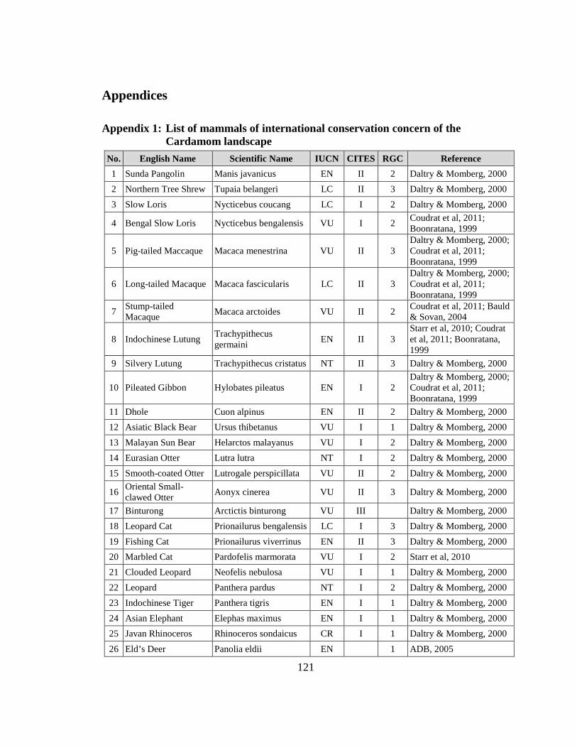
121
Appendices
Appendix 1: List of mammals of international conservation concern of the Cardamom landscape
No. English Name Scientific Name IUCN CITES RGC Reference 1 Sunda Pangolin Manis javanicus EN II 2 Daltry & Momberg, 2000 2 Northern Tree Shrew Tupaia belangeri LC II 3 Daltry & Momberg, 2000 3 Slow Loris Nycticebus coucang LC I 2 Daltry & Momberg, 2000
4 Bengal Slow Loris Nycticebus bengalensis VU I 2 Coudrat et al, 2011; Boonratana, 1999
5 Pig-tailed Maccaque Macaca menestrina VU II 3 Daltry & Momberg, 2000; Coudrat et al, 2011; Boonratana, 1999
6 Long-tailed Macaque Macaca fascicularis LC II 3 Daltry & Momberg, 2000; Coudrat et al, 2011; Boonratana, 1999
7 Stump-tailed Macaque Macaca arctoides VU II 2 Coudrat et al, 2011; Bauld
& Sovan, 2004
8 Indochinese Lutung Trachypithecus germaini EN II 3
Starr et al, 2010; Coudrat et al, 2011; Boonratana, 1999
9 Silvery Lutung Trachypithecus cristatus NT II 3 Daltry & Momberg, 2000
10 Pileated Gibbon Hylobates pileatus EN I 2 Daltry & Momberg, 2000; Coudrat et al, 2011; Boonratana, 1999
11 Dhole Cuon alpinus EN II 2 Daltry & Momberg, 2000 12 Asiatic Black Bear Ursus thibetanus VU I 1 Daltry & Momberg, 2000 13 Malayan Sun Bear Helarctos malayanus VU I 2 Daltry & Momberg, 2000 14 Eurasian Otter Lutra lutra NT I 2 Daltry & Momberg, 2000 15 Smooth-coated Otter Lutrogale perspicillata VU II 2 Daltry & Momberg, 2000
16 Oriental Small-clawed Otter Aonyx cinerea VU II 3 Daltry & Momberg, 2000
17 Binturong Arctictis binturong VU III Daltry & Momberg, 2000 18 Leopard Cat Prionailurus bengalensis LC I 3 Daltry & Momberg, 2000 19 Fishing Cat Prionailurus viverrinus EN II 3 Daltry & Momberg, 2000 20 Marbled Cat Pardofelis marmorata VU I 2 Starr et al, 2010 21 Clouded Leopard Neofelis nebulosa VU I 1 Daltry & Momberg, 2000 22 Leopard Panthera pardus NT I 2 Daltry & Momberg, 2000 23 Indochinese Tiger Panthera tigris EN I 1 Daltry & Momberg, 2000 24 Asian Elephant Elephas maximus EN I 1 Daltry & Momberg, 2000 25 Javan Rhinoceros Rhinoceros sondaicus CR I 1 Daltry & Momberg, 2000 26 Eld’s Deer Panolia eldii EN 1 ADB, 2005
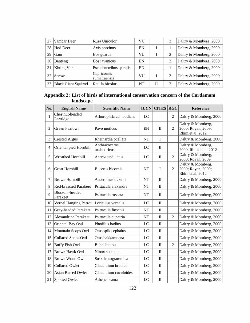
122
27 Sambar Deer Rusa Unicolor VU 3 Daltry & Momberg, 2000 28 Hod Deer Axis porcinus EN I 1 Daltry & Momberg, 2000 29 Gaur Bos guarus VU I 2 Daltry & Momberg, 2000 30 Banteng Bos javanicus EN 2 Daltry & Momberg, 2000 31 Khting Vor Pseudonovibos spiralis EN 1 Daltry & Momberg, 2000
32 Serow Capricornis sumatraensis VU I 2 Daltry & Momberg, 2000
33 Black Giant Squirrel Ratufa bicolor NT II 2 Daltry & Momberg, 2000
Appendix 2: List of birds of international conservation concern of the Cardamom landscape
No. English Name Scientific Name IUCN CITES RGC Reference
1 Chestnut-headed Partridge Arborophila cambodiana LC 2 Daltry & Momberg, 2000
2 Green Peafowl Pavo muticus EN II 2 Daltry & Momberg, 2000; Royan, 2009; Rhim et al, 2012
3 Crested Argus Rheinardia ocellata NT I Daltry & Momberg, 2000
4 Oriental pied Hornbill Anthracoceros malabaricus LC II
Daltry & Momberg, 2000, Rhim et al, 2012
5 Wreathed Hornbill Aceros undulatus LC II 2 Daltry & Momberg, 2000; Royan, 2009
6 Great Hornbill Buceros bicornis NT I 2 Daltry & Momberg, 2000; Royan, 2009; Rhim et al, 2012
7 Brown Hornbill Anorrhinus tickelli NT II Daltry & Momberg, 2000
8 Red-breasted Parakeet Psittacula alexandri NT II Daltry & Momberg, 2000
9 Blossom-headed Parakeet Psittacula roseata NT II Daltry & Momberg, 2000
10 Vernal Hanging Parrot Loriculus vernalis LC II Daltry & Momberg, 2000
11 Grey-headed Parakeet Psittacula finschii NT II Daltry & Momberg, 2000
12 Alexandrine Parakeet Psittacula eupatria NT II 2 Daltry & Momberg, 2000
13 Oriental Bay Owl Phodilus badius LC II Daltry & Momberg, 2000
14 Mountain Scops Owl Otus spilocephalus LC II Daltry & Momberg, 2000
15 Collared Scops Owl Otus bakkamoena LC II Daltry & Momberg, 2000
16 Buffy Fish Owl Bubo ketupu LC II 2 Daltry & Momberg, 2000
17 Brown Hawk Owl Ninox scutulata LC II Daltry & Momberg, 2000
18 Brown Wood Owl Strix leptogrammica LC II Daltry & Momberg, 2000
19 Collared Owlet Glaucidium brodiei LC II Daltry & Momberg, 2000
20 Asian Barred Owlet Glaucidium cuculoides LC II Daltry & Momberg, 2000
21 Spotted Owlet Athene brama LC II Daltry & Momberg, 2000
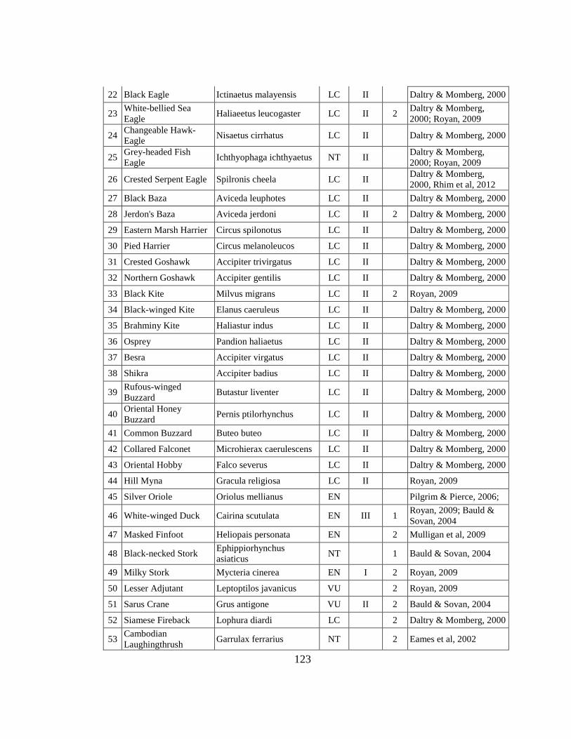
123
22 Black Eagle Ictinaetus malayensis LC II Daltry & Momberg, 2000
23 White-bellied Sea Eagle Haliaeetus leucogaster LC II 2 Daltry & Momberg,
2000; Royan, 2009
24 Changeable Hawk-Eagle Nisaetus cirrhatus LC II Daltry & Momberg, 2000
25 Grey-headed Fish Eagle Ichthyophaga ichthyaetus NT II
Daltry & Momberg, 2000; Royan, 2009
26 Crested Serpent Eagle Spilronis cheela LC II Daltry & Momberg, 2000, Rhim et al, 2012
27 Black Baza Aviceda leuphotes LC II Daltry & Momberg, 2000
28 Jerdon's Baza Aviceda jerdoni LC II 2 Daltry & Momberg, 2000
29 Eastern Marsh Harrier Circus spilonotus LC II Daltry & Momberg, 2000
30 Pied Harrier Circus melanoleucos LC II Daltry & Momberg, 2000
31 Crested Goshawk Accipiter trivirgatus LC II Daltry & Momberg, 2000
32 Northern Goshawk Accipiter gentilis LC II Daltry & Momberg, 2000
33 Black Kite Milvus migrans LC II 2 Royan, 2009
34 Black-winged Kite Elanus caeruleus LC II Daltry & Momberg, 2000
35 Brahminy Kite Haliastur indus LC II Daltry & Momberg, 2000
36 Osprey Pandion haliaetus LC II Daltry & Momberg, 2000
37 Besra Accipiter virgatus LC II Daltry & Momberg, 2000
38 Shikra Accipiter badius LC II Daltry & Momberg, 2000
39 Rufous-winged Buzzard Butastur liventer LC II Daltry & Momberg, 2000
40 Oriental Honey Buzzard Pernis ptilorhynchus LC II Daltry & Momberg, 2000
41 Common Buzzard Buteo buteo LC II Daltry & Momberg, 2000
42 Collared Falconet Microhierax caerulescens LC II Daltry & Momberg, 2000
43 Oriental Hobby Falco severus LC II Daltry & Momberg, 2000
44 Hill Myna Gracula religiosa LC II Royan, 2009
45 Silver Oriole Oriolus mellianus EN Pilgrim & Pierce, 2006;
46 White-winged Duck Cairina scutulata EN III 1 Royan, 2009; Bauld & Sovan, 2004
47 Masked Finfoot Heliopais personata EN 2 Mulligan et al, 2009
48 Black-necked Stork Ephippiorhynchus asiaticus NT 1 Bauld & Sovan, 2004
49 Milky Stork Mycteria cinerea EN I 2 Royan, 2009
50 Lesser Adjutant Leptoptilos javanicus VU 2 Royan, 2009
51 Sarus Crane Grus antigone VU II 2 Bauld & Sovan, 2004
52 Siamese Fireback Lophura diardi LC 2 Daltry & Momberg, 2000
53 Cambodian Laughingthrush Garrulax ferrarius NT 2 Eames et al, 2002
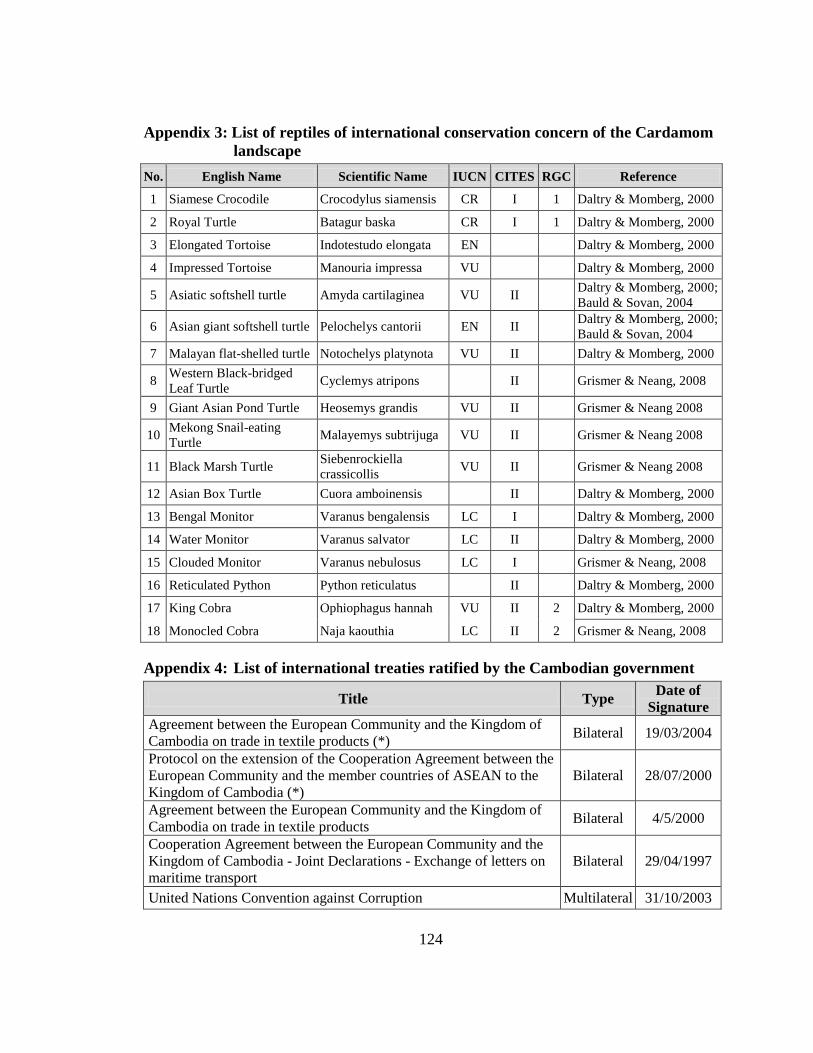
124
Appendix 3: List of reptiles of international conservation concern of the Cardamom landscape
No. English Name Scientific Name IUCN CITES RGC Reference
1 Siamese Crocodile Crocodylus siamensis CR I 1 Daltry & Momberg, 2000
2 Royal Turtle Batagur baska CR I 1 Daltry & Momberg, 2000
3 Elongated Tortoise Indotestudo elongata EN Daltry & Momberg, 2000
4 Impressed Tortoise Manouria impressa VU Daltry & Momberg, 2000
5 Asiatic softshell turtle Amyda cartilaginea VU II Daltry & Momberg, 2000; Bauld & Sovan, 2004
6 Asian giant softshell turtle Pelochelys cantorii EN II Daltry & Momberg, 2000; Bauld & Sovan, 2004
7 Malayan flat-shelled turtle Notochelys platynota VU II Daltry & Momberg, 2000
8 Western Black-bridged Leaf Turtle Cyclemys atripons II Grismer & Neang, 2008
9 Giant Asian Pond Turtle Heosemys grandis VU II Grismer & Neang 2008
10 Mekong Snail-eating Turtle Malayemys subtrijuga VU II Grismer & Neang 2008
11 Black Marsh Turtle Siebenrockiella crassicollis VU II Grismer & Neang 2008
12 Asian Box Turtle Cuora amboinensis II Daltry & Momberg, 2000
13 Bengal Monitor Varanus bengalensis LC I Daltry & Momberg, 2000
14 Water Monitor Varanus salvator LC II Daltry & Momberg, 2000
15 Clouded Monitor Varanus nebulosus LC I Grismer & Neang, 2008
16 Reticulated Python Python reticulatus II Daltry & Momberg, 2000
17 King Cobra Ophiophagus hannah VU II 2 Daltry & Momberg, 2000
18 Monocled Cobra Naja kaouthia LC II 2 Grismer & Neang, 2008
Appendix 4: List of international treaties ratified by the Cambodian government
Title Type Date of Signature
Agreement between the European Community and the Kingdom of Cambodia on trade in textile products (*) Bilateral 19/03/2004
Protocol on the extension of the Cooperation Agreement between the European Community and the member countries of ASEAN to the Kingdom of Cambodia (*)
Bilateral 28/07/2000
Agreement between the European Community and the Kingdom of Cambodia on trade in textile products Bilateral 4/5/2000
Cooperation Agreement between the European Community and the Kingdom of Cambodia - Joint Declarations - Exchange of letters on maritime transport
Bilateral 29/04/1997
United Nations Convention against Corruption Multilateral 31/10/2003
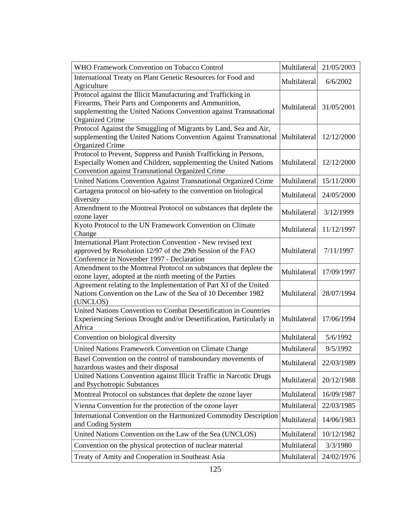
125
WHO Framework Convention on Tobacco Control Multilateral 21/05/2003 International Treaty on Plant Genetic Resources for Food and Agriculture Multilateral 6/6/2002
Protocol against the Illicit Manufacturing and Trafficking in Firearms, Their Parts and Components and Ammunition, supplementing the United Nations Convention against Transnational Organized Crime
Multilateral 31/05/2001
Protocol Against the Smuggling of Migrants by Land, Sea and Air, supplementing the United Nations Convention Against Transnational Organized Crime
Multilateral 12/12/2000
Protocol to Prevent, Suppress and Punish Trafficking in Persons, Especially Women and Children, supplementing the United Nations Convention against Transnational Organized Crime
Multilateral 12/12/2000
United Nations Convention Against Transnational Organized Crime Multilateral 15/11/2000 Cartagena protocol on bio-safety to the convention on biological diversity Multilateral 24/05/2000
Amendment to the Montreal Protocol on substances that deplete the ozone layer Multilateral 3/12/1999
Kyoto Protocol to the UN Framework Convention on Climate Change Multilateral 11/12/1997
International Plant Protection Convention - New revised text approved by Resolution 12/97 of the 29th Session of the FAO Conference in November 1997 - Declaration
Multilateral 7/11/1997
Amendment to the Montreal Protocol on substances that deplete the ozone layer, adopted at the ninth meeting of the Parties Multilateral 17/09/1997
Agreement relating to the Implementation of Part XI of the United Nations Convention on the Law of the Sea of 10 December 1982 (UNCLOS)
Multilateral 28/07/1994
United Nations Convention to Combat Desertification in Countries Experiencing Serious Drought and/or Desertification, Particularly in Africa
Multilateral 17/06/1994
Convention on biological diversity Multilateral 5/6/1992 United Nations Framework Convention on Climate Change Multilateral 9/5/1992 Basel Convention on the control of transboundary movements of hazardous wastes and their disposal Multilateral 22/03/1989
United Nations Convention against Illicit Traffic in Narcotic Drugs and Psychotropic Substances Multilateral 20/12/1988
Montreal Protocol on substances that deplete the ozone layer Multilateral 16/09/1987 Vienna Convention for the protection of the ozone layer Multilateral 22/03/1985 International Convention on the Harmonized Commodity Description and Coding System Multilateral 14/06/1983
United Nations Convention on the Law of the Sea (UNCLOS) Multilateral 10/12/1982 Convention on the physical protection of nuclear material Multilateral 3/3/1980 Treaty of Amity and Cooperation in Southeast Asia Multilateral 24/02/1976
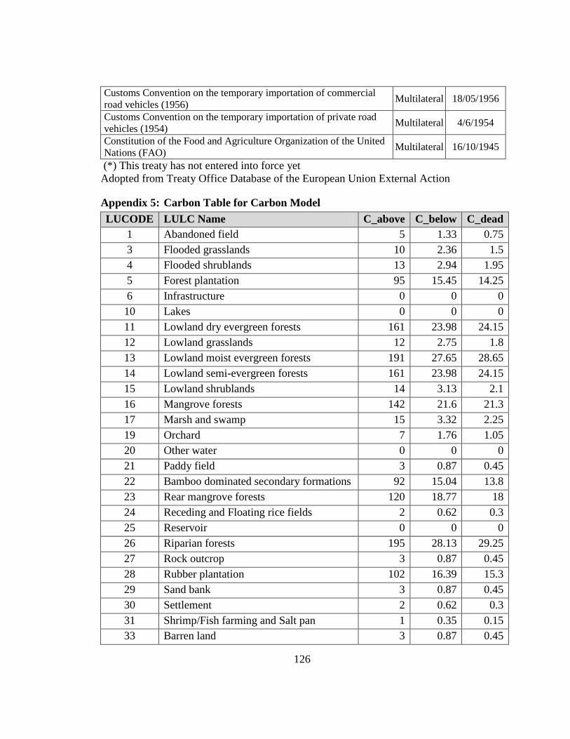
126
Customs Convention on the temporary importation of commercial road vehicles (1956) Multilateral 18/05/1956
Customs Convention on the temporary importation of private road vehicles (1954) Multilateral 4/6/1954
Constitution of the Food and Agriculture Organization of the United Nations (FAO) Multilateral 16/10/1945
(*) This treaty has not entered into force yet Adopted from Treaty Office Database of the European Union External Action
Appendix 5: Carbon Table for Carbon Model LUCODE LULC Name C_above C_below C_dead
1 Abandoned field 5 1.33 0.75 3 Flooded grasslands 10 2.36 1.5 4 Flooded shrublands 13 2.94 1.95 5 Forest plantation 95 15.45 14.25 6 Infrastructure 0 0 0 10 Lakes 0 0 0 11 Lowland dry evergreen forests 161 23.98 24.15 12 Lowland grasslands 12 2.75 1.8 13 Lowland moist evergreen forests 191 27.65 28.65 14 Lowland semi-evergreen forests 161 23.98 24.15 15 Lowland shrublands 14 3.13 2.1 16 Mangrove forests 142 21.6 21.3 17 Marsh and swamp 15 3.32 2.25 19 Orchard 7 1.76 1.05 20 Other water 0 0 0 21 Paddy field 3 0.87 0.45 22 Bamboo dominated secondary formations 92 15.04 13.8 23 Rear mangrove forests 120 18.77 18 24 Receding and Floating rice fields 2 0.62 0.3 25 Reservoir 0 0 0 26 Riparian forests 195 28.13 29.25 27 Rock outcrop 3 0.87 0.45 28 Rubber plantation 102 16.39 15.3 29 Sand bank 3 0.87 0.45 30 Settlement 2 0.62 0.3 31 Shrimp/Fish farming and Salt pan 1 0.35 0.15 33 Barren land 3 0.87 0.45
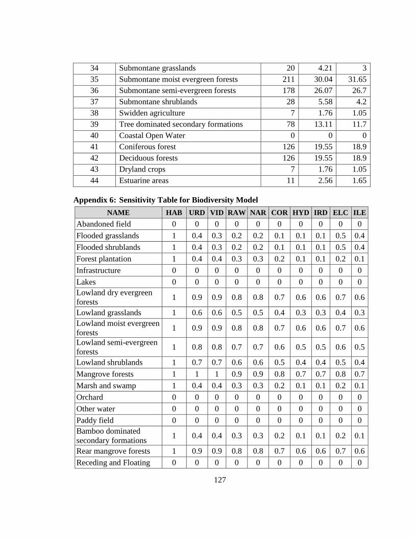
127
34 Submontane grasslands 20 4.21 3 35 Submontane moist evergreen forests 211 30.04 31.65 36 Submontane semi-evergreen forests 178 26.07 26.7 37 Submontane shrublands 28 5.58 4.2 38 Swidden agriculture 7 1.76 1.05 39 Tree dominated secondary formations 78 13.11 11.7 40 Coastal Open Water 0 0 0 41 Coniferous forest 126 19.55 18.9 42 Deciduous forests 126 19.55 18.9 43 Dryland crops 7 1.76 1.05 44 Estuarine areas 11 2.56 1.65
Appendix 6: Sensitivity Table for Biodiversity Model NAME HAB URD VID RAW NAR COR HYD IRD ELC ILE
Abandoned field 0 0 0 0 0 0 0 0 0 0 Flooded grasslands 1 0.4 0.3 0.2 0.2 0.1 0.1 0.1 0.5 0.4 Flooded shrublands 1 0.4 0.3 0.2 0.2 0.1 0.1 0.1 0.5 0.4 Forest plantation 1 0.4 0.4 0.3 0.3 0.2 0.1 0.1 0.2 0.1 Infrastructure 0 0 0 0 0 0 0 0 0 0 Lakes 0 0 0 0 0 0 0 0 0 0 Lowland dry evergreen forests 1 0.9 0.9 0.8 0.8 0.7 0.6 0.6 0.7 0.6
Lowland grasslands 1 0.6 0.6 0.5 0.5 0.4 0.3 0.3 0.4 0.3 Lowland moist evergreen forests 1 0.9 0.9 0.8 0.8 0.7 0.6 0.6 0.7 0.6
Lowland semi-evergreen forests 1 0.8 0.8 0.7 0.7 0.6 0.5 0.5 0.6 0.5
Lowland shrublands 1 0.7 0.7 0.6 0.6 0.5 0.4 0.4 0.5 0.4 Mangrove forests 1 1 1 0.9 0.9 0.8 0.7 0.7 0.8 0.7 Marsh and swamp 1 0.4 0.4 0.3 0.3 0.2 0.1 0.1 0.2 0.1 Orchard 0 0 0 0 0 0 0 0 0 0 Other water 0 0 0 0 0 0 0 0 0 0 Paddy field 0 0 0 0 0 0 0 0 0 0 Bamboo dominated secondary formations 1 0.4 0.4 0.3 0.3 0.2 0.1 0.1 0.2 0.1
Rear mangrove forests 1 0.9 0.9 0.8 0.8 0.7 0.6 0.6 0.7 0.6 Receding and Floating 0 0 0 0 0 0 0 0 0 0
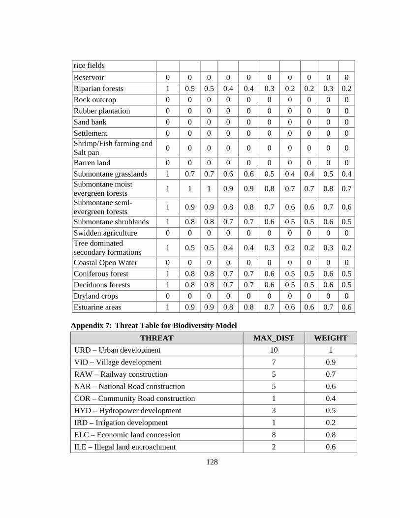
128
rice fields Reservoir 0 0 0 0 0 0 0 0 0 0 Riparian forests 1 0.5 0.5 0.4 0.4 0.3 0.2 0.2 0.3 0.2 Rock outcrop 0 0 0 0 0 0 0 0 0 0 Rubber plantation 0 0 0 0 0 0 0 0 0 0 Sand bank 0 0 0 0 0 0 0 0 0 0 Settlement 0 0 0 0 0 0 0 0 0 0 Shrimp/Fish farming and Salt pan 0 0 0 0 0 0 0 0 0 0
Barren land 0 0 0 0 0 0 0 0 0 0 Submontane grasslands 1 0.7 0.7 0.6 0.6 0.5 0.4 0.4 0.5 0.4 Submontane moist evergreen forests 1 1 1 0.9 0.9 0.8 0.7 0.7 0.8 0.7
Submontane semi-evergreen forests 1 0.9 0.9 0.8 0.8 0.7 0.6 0.6 0.7 0.6
Submontane shrublands 1 0.8 0.8 0.7 0.7 0.6 0.5 0.5 0.6 0.5 Swidden agriculture 0 0 0 0 0 0 0 0 0 0 Tree dominated secondary formations 1 0.5 0.5 0.4 0.4 0.3 0.2 0.2 0.3 0.2
Coastal Open Water 0 0 0 0 0 0 0 0 0 0 Coniferous forest 1 0.8 0.8 0.7 0.7 0.6 0.5 0.5 0.6 0.5 Deciduous forests 1 0.8 0.8 0.7 0.7 0.6 0.5 0.5 0.6 0.5 Dryland crops 0 0 0 0 0 0 0 0 0 0 Estuarine areas 1 0.9 0.9 0.8 0.8 0.7 0.6 0.6 0.7 0.6
Appendix 7: Threat Table for Biodiversity Model THREAT MAX_DIST WEIGHT
URD – Urban development 10 1 VID – Village development 7 0.9 RAW – Railway construction 5 0.7 NAR – National Road construction 5 0.6 COR – Community Road construction 1 0.4 HYD – Hydropower development 3 0.5 IRD – Irrigation development 1 0.2 ELC – Economic land concession 8 0.8 ILE – Illegal land encroachment 2 0.6
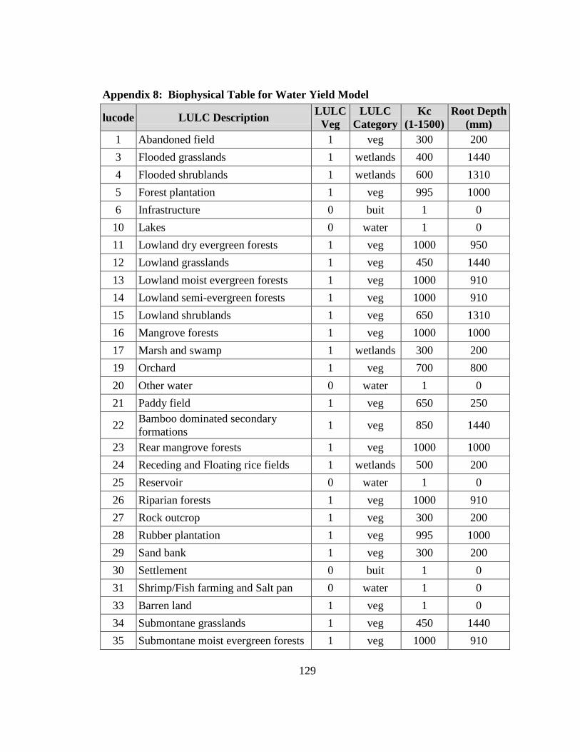
129
Appendix 8: Biophysical Table for Water Yield Model
lucode LULC Description LULC Veg
LULC Category
Kc (1-1500)
Root Depth (mm)
1 Abandoned field 1 veg 300 200 3 Flooded grasslands 1 wetlands 400 1440 4 Flooded shrublands 1 wetlands 600 1310 5 Forest plantation 1 veg 995 1000 6 Infrastructure 0 buit 1 0 10 Lakes 0 water 1 0 11 Lowland dry evergreen forests 1 veg 1000 950 12 Lowland grasslands 1 veg 450 1440 13 Lowland moist evergreen forests 1 veg 1000 910 14 Lowland semi-evergreen forests 1 veg 1000 910 15 Lowland shrublands 1 veg 650 1310 16 Mangrove forests 1 veg 1000 1000 17 Marsh and swamp 1 wetlands 300 200 19 Orchard 1 veg 700 800 20 Other water 0 water 1 0 21 Paddy field 1 veg 650 250
22 Bamboo dominated secondary formations 1 veg 850 1440
23 Rear mangrove forests 1 veg 1000 1000 24 Receding and Floating rice fields 1 wetlands 500 200 25 Reservoir 0 water 1 0 26 Riparian forests 1 veg 1000 910 27 Rock outcrop 1 veg 300 200 28 Rubber plantation 1 veg 995 1000 29 Sand bank 1 veg 300 200 30 Settlement 0 buit 1 0 31 Shrimp/Fish farming and Salt pan 0 water 1 0 33 Barren land 1 veg 1 0 34 Submontane grasslands 1 veg 450 1440 35 Submontane moist evergreen forests 1 veg 1000 910
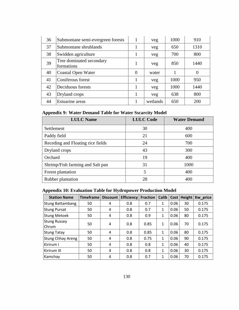
130
36 Submontane semi-evergreen forests 1 veg 1000 910 37 Submontane shrublands 1 veg 650 1310 38 Swidden agriculture 1 veg 700 800
39 Tree dominated secondary formations 1 veg 850 1440
40 Coastal Open Water 0 water 1 0 41 Coniferous forest 1 veg 1000 950 42 Deciduous forests 1 veg 1000 1440 43 Dryland crops 1 veg 638 800 44 Estuarine areas 1 wetlands 650 200
Appendix 9: Water Demand Table for Water Sscarcity Model LULC Name LULC Code Water Demand
Settlement 30 400 Paddy field 21 600 Receding and Floating rice fields 24 700 Dryland crops 43 300 Orchard 19 400 Shrimp/Fish farming and Salt pan 31 1000 Forest plantation 5 400 Rubber plantation 28 400
Appendix 10: Evaluation Table for Hydropower Production Model Station Name Timeframe Discount Efficiency Fraction Calib Cost Height Kw_price
Stung Battambang 50 4 0.8 0.7 1 0.06 30 0.175 Stung Pursat 50 4 0.8 0.7 1 0.06 50 0.175 Stung Metoek 50 4 0.8 0.9 1 0.06 80 0.175 Stung Russey Chrum 50 4 0.8 0.85 1 0.06 70 0.175
Stung Tatay 50 4 0.8 0.85 1 0.06 80 0.175 Stung Chhay Areng 50 4 0.8 0.75 1 0.06 90 0.175 Kirirum I 50 4 0.8 0.8 1 0.06 40 0.175 Kirirum III 50 4 0.8 0.8 1 0.06 30 0.175 Kamchay 50 4 0.8 0.7 1 0.06 70 0.175
Related Documents