Auckland Manukau Eastern Transport Initiative. AMETI October 2013 Newsletter Work gets underway on a major makeover for a forgotten corner of Panmure. Makeover for historic lagoon Capturing Panmure’s past The aim is to give people in the area better transport choices by improving public transport, walking and cycling facilities and reducing traffic congestion. Other major aims are to create jobs by unlocking the economic potential of the area, improve transport for freight and business traffic and to promote good urban design. Panmure Phase One: New road linking Mt Wellington Highway and Morrin Rd, Panmure Station upgrade, Van Damme’s Lagoon improvements, walking and cycling paths, busway bridge and two bridge replacements. Panmure to Pakuranga (Phase Two) – new intersection to replace Panmure roundabout, busway from Panmure Station to Pakuranga town centre, walking and cycle paths, Reeves Rd flyover in Pakuranga. Other future developments: Sylvia Park bus interchange and route improvements, busway extended to Botany along the centre of Ti Rakau Dr, East-West link improvements, extension of new AMETI Rd to Merton Rd. The NZ Transport Agency and Auckland Council are major funders of AMETI. A forgotten and neglected historic corner of Panmure is getting a major makeover as part of one of Auckland’s biggest transport projects. Work is underway on upgrading and revitalising Van Damme’s Lagoon and reserve as part of AMETI. Watercare is also carrying out a stormwater pipe upgrade. Just off Mt Wellington Highway, Van Damme’s Lagoon has been through a number of changes in its history. (story continues on page three) In 1841, the government purchased what was then known as the Kohimarama block from Ngati Paoa. Soon after, a local surveying company divided the area into 37 farms totalling 3856 acres. Part of this area, between Mt Wellington and the Tamaki River, then became the settlement of Panmure. One of the traditional transportation routes between the Waitemata Harbour and the Manukau Harbour was located approximately five kilometres up the Tamaki River. Maori would beach their waka at the end of a small creek (that now passes under the southern motorway) and drag them overland to the Manukau Harbour. Mokoia Pa, on the headland where Panmure Bridge is now, was visited in 1820 by the missionary Samuel Marsden. During the musket wars in September 1821 Mokoia Pa was the scene of severe fighting as the area was invaded by 4000 musket carrying warriors from the north. The fighting devastated what had been the Ngati Paoa population centre of the Auckland Isthmus during pre- European times, which had a population of approximately 7,000 people. Although 3000 men took part in the defence of the pa, Ngati Paoa was defeated by the combined northern alliance. In 1848, 80 Fencible families arrived from Ireland and England on the ship Clifton and established a settlement with 99 raupo huts on the eastern shores of Panmure Lagoon. The Fencibles were retired soldiers from Britain and Ireland who enlisted as a military reserve to act as a defence force for the protection of the early settlers in Auckland. More than 2500 men, women and children arrived in New Zealand between 1847 and 1852. They settled in the now south and eastern suburbs of Auckland, including Onehunga, Otahuhu, Panmure and Howick. In return for availability in case of attack and attendance at parades, the Fencibles were provided with a cottage and an acre of land which they would own after seven years of service. Panmure was initially favoured to be the new capital of New Zealand but Governor William Hobson decided otherwise, and Auckland was established further to the west along the shores of the Waitemata Harbour. Panmure subsequently became a Fencible settlement, where retired soldiers were required to give 12 days military service per year and parade on Sunday in full military attire. In 1851, the Fencibles were called to arms when a flotilla of 20 waka carrying 350 warriors landed in Mechanics Bay to attack Auckland. The Panmure Fencibles were issued with ammunition to defend the Tamaki River and stop any armed Maori attack. Panmure was an important town and port as it was strategically placed near the narrowest part of the isthmus. Even after the railway reached Auckland in 1908, Panmure continued as a transport hub. In the early twentieth century, Panmure remained a prosperous but mostly rural area despite being the smallest Auckland borough. It was only after World War II with the construction of better bridges to Pakuranga that Panmure grew and became a commercial centre. Find out more: (09) 355 3553 or visit aucklandtransport.govt.nz About the AMETI transport projects The new Ellerslie-Panmure Highway bridge has been open to traffic since August. One of the area’s busiest roads, the bridge completion is a major milestone in the Auckland Manukau Eastern Transport Initiative (AMETI). The bridge, a key part of the first phase of AMETI, was officially opened at the beginning of August. Since the old Ellerslie-Panmure Highway Bridge was demolished during the Christmas period, traffic had been temporarily using a new bridge built for a future busway. Work is now underway on completing the busway bridge. Auckland Transport Chairman Lester Levy says AMETI is Auckland Transport’s largest construction project which on completion will see the delivery of the first major infrastructure in the area for a number of years. “It’s fantastic to see this project taking shape and my congratulations go out to the AMETI team who have worked hard to get the bridge completed ahead of schedule. This major project will see an integrated approach to improving transport - with work on roads, public transport, walking and cycling infrastructure. “When the new Panmure Station building is completed, commuters and residents will benefit from a much easier transfer between buses and trains.” Major milestone – Ellerslie-Panmure Highway Bridge opens As AMETI progresses and the Panmure area is transformed, we take a look back at the history of one of Auckland’s first settlements….. The Auckland Manukau Eastern Transport Initiative (AMETI) is a group of transport projects for the south east (Panmure, Mt Wellington, Pakuranga, Howick and Botany). Additional Panmure Bridge Mt Wellington Countdown Mt Wellington Shopping Centre Panmure Stonefields Van Damm Lagoon Sylvia Park Shopping Centre The University of Auckland Pillkington Rd Dunn Rd Green Rd Pleasant View Jellicoe Rd Morrin Rd Apirana Ave C o a t e s C r e s Hobson St Panmure Bridge Merton Rd Ellerslie Panmure Hwy Mt Wellington Hwy Waipuna Rd Mou ntain Rd Ireland Rd Lago o n D r Pakura n ga Rd Ti Rakau Dr Harris Rd Udys Rd Reeves Rd Gossamer Dr Trugood Dr Botany Key Phase 1 Panmure l North/South Rd l New Panmure Station Phase 2 Panmure to Pakuranga l New Panmure Intersection l Busway Lagoon Dr & Pakuranga Rd l New Panmure Bridge l New Reeves Rd Flyover Future developments South Eastern Connections Study Waipuna Bridge To Botany New Panmure intersection New north-south road Panmure Station new bus/rail interchange Panmure to Pakuranga north side busway 10 Sylvia Park bus route improvements Reeves Rd Flyover Pakuranga to Botany central busway North south road extension 10A Bus Station Pakuranga Quarry Link Rd Gossamer intersection improvements Trugood intersection improvements 1 2125_AMETI newsletter_Oct 13.indd 1,3 7/10/13 3:32 PM

Welcome message from author
This document is posted to help you gain knowledge. Please leave a comment to let me know what you think about it! Share it to your friends and learn new things together.
Transcript
Auckland Manukau Eastern Transport Initiative. AMETI October 2013NewsletterWork gets underway on a major makeover for a forgotten corner of Panmure.
Makeover for historic lagoon
Capturing Panmure’s past
The aim is to give people in the area better transport choices by improving public transport, walking and cycling facilities and reducing traffic congestion. Other major aims are to create jobs by unlocking the economic potential of the area, improve transport for freight and business traffic and to promote good urban design.
Panmure Phase One: New road linking Mt Wellington Highway and Morrin Rd, Panmure Station upgrade, Van Damme’s Lagoon improvements, walking and cycling paths, busway bridge and two bridge replacements.
Panmure to Pakuranga (Phase Two) – new intersection to replace Panmure roundabout, busway from Panmure Station to Pakuranga town centre, walking and cycle paths, Reeves Rd flyover in Pakuranga.
Other future developments: Sylvia Park bus interchange and route improvements, busway extended to Botany along the centre of Ti Rakau Dr, East-West link improvements, extension of new AMETI Rd to Merton Rd.
The NZ Transport Agency and Auckland Council are major funders of AMETI.
A forgotten and neglected historic corner of Panmure is getting a major makeover as part of one of Auckland’s biggest transport projects.
Work is underway on upgrading and revitalising Van Damme’s Lagoon and reserve as part of AMETI.
Watercare is also carrying out a stormwater pipe upgrade.
Just off Mt Wellington Highway, Van Damme’s Lagoon has been through a number of changes in its history.
(story continues on page three)
In 1841, the government purchased what was then known as the Kohimarama block from Ngati Paoa. Soon after, a local surveying company divided the area into 37 farms totalling 3856 acres.
Part of this area, between Mt Wellington and the Tamaki River, then became the settlement of Panmure.
One of the traditional transportation routes between the Waitemata Harbour and the Manukau Harbour was located approximately five kilometres up the Tamaki River. Maori would beach their waka at the end of a small creek (that now passes under the southern motorway) and drag them overland to the Manukau Harbour.
Mokoia Pa, on the headland where Panmure Bridge is now, was visited in 1820 by the missionary Samuel Marsden. During the musket wars in September 1821 Mokoia Pa was the scene of severe fighting as the area was invaded by 4000 musket carrying warriors from the north.
The fighting devastated what had been the Ngati Paoa population centre of the Auckland Isthmus during pre-European times, which had a population of approximately 7,000 people. Although 3000 men took part in the defence of the pa, Ngati Paoa was defeated by the combined northern alliance.
In 1848, 80 Fencible families arrived from Ireland and England on the ship Clifton and established a settlement with 99 raupo huts on the eastern shores of Panmure Lagoon.
The Fencibles were retired soldiers from Britain and Ireland who enlisted as a military reserve to act as a defence force for the protection of the early settlers in Auckland.
More than 2500 men, women and children arrived in New Zealand between 1847 and 1852. They settled in the now south and eastern suburbs of Auckland, including Onehunga, Otahuhu, Panmure and Howick. In return for availability in case of attack and attendance at parades, the Fencibles were provided with a cottage and an acre of land which they would own after seven years of service.
Panmure was initially favoured to be the new capital of New Zealand but Governor William Hobson decided otherwise, and Auckland was established further to the west along the shores of the Waitemata Harbour.
Panmure subsequently became a Fencible settlement, where retired soldiers were required to give 12 days military service per year and parade on Sunday in full military attire.
In 1851, the Fencibles were called to arms when a flotilla of 20 waka carrying 350 warriors landed in Mechanics Bay to attack Auckland. The Panmure Fencibles were issued with ammunition to defend the Tamaki River and stop any armed Maori attack.
Panmure was an important town and port as it was strategically placed near the narrowest part of the isthmus. Even after the railway reached Auckland in 1908, Panmure continued as a transport hub.
In the early twentieth century, Panmure remained a prosperous but mostly rural area despite being the smallest Auckland borough.
It was only after World War II with the construction of better bridges to Pakuranga that Panmure grew and became a commercial centre.
Find out more: (09) 355 3553 or visit aucklandtransport.govt.nz
About the AMETI transport projects
The new Ellerslie-Panmure Highway bridge has been open to traffic since August.
One of the area’s busiest roads, the bridge completion is a major milestone in the Auckland Manukau Eastern Transport Initiative (AMETI).
The bridge, a key part of the first phase of AMETI, was officially opened at the beginning of August.
Since the old Ellerslie-Panmure Highway Bridge was demolished during the Christmas period, traffic had been temporarily using a new bridge built for a future busway. Work is now underway on completing the busway bridge.
Auckland Transport Chairman Lester Levy says AMETI is Auckland Transport’s largest construction project which on completion will see the delivery of the first major infrastructure in the area for a number of years.
“It’s fantastic to see this project taking shape and my congratulations go out to the AMETI team who have worked hard to get the bridge completed ahead of schedule. This major project will see an integrated approach to improving transport - with work on roads, public transport, walking and cycling infrastructure. “When the new Panmure Station building is completed, commuters and residents will benefit from a much easier transfer between buses and trains.”
Major milestone – Ellerslie-Panmure Highway Bridge opens
As AMETI progresses and the Panmure area is transformed, we take a look back at the history of one of Auckland’s first settlements…..
The Auckland Manukau Eastern Transport Initiative (AMETI) is a group of transport projects for the south east (Panmure, Mt Wellington, Pakuranga, Howick and Botany).
Additional PanmureBridge
Mt Wellington
Countdown
Mt WellingtonShopping Centre
Panmure
Stonefields
Van Damm Lagoon
Sylvia ParkShopping Centre
The University ofAuckland
Pillk
ing
ton
Rd
Dunn Rd
Green Rd
Pleasant View
Jelli
coe
Rd
Morrin R
d
Apirana A
ve
Coates Cres
Hobson St
Panmure Bridge
Merton Rd
Ellerslie Panmure Hwy
Mt W
ellin
gton
Hw
y
Waipuna Rd
Mountain Rd
Ireland Rd
Lagoon D
r
Pakuranga Rd
Ti Rakau Dr
Har
ris R
d
Ud
ys R
d
Reeves Rd
Gos
sam
er D
r
Trugood Dr
Botany
KeyPhase 1 Panmurel North/South Rdl New Panmure Station
Phase 2 Panmure to Pakurangal New Panmure Intersectionl Busway Lagoon Dr & Pakuranga Rdl New Panmure Bridgel New Reeves Rd Flyover
Future developments
South Eastern ConnectionsStudy
Waipuna Bridge
To Botany
New Panmureintersection
New north-south road
Panmure Stationnew bus/rail interchange
Panmure to Pakuranga north side busway
10
Sylvia Park bus routeimprovements
Reeves RdFlyover
Pakuranga toBotany central busway
North south road extension
10A
Bus Station
Pakuranga
QuarryLink Rd
Gossamer intersectionimprovements Trugood
intersectionimprovements
1
2125_AMETI newsletter_Oct 13.indd 1,3 7/10/13 3:32 PM
Makeover for historic lagoon (continued)From the Project DirectorAs we move into the final months of 2013, it gives me great pleasure to reflect on the progress we have made so far this year.
At the beginning of August, the new Ellerslie-Panmure Highway Bridge was opened thanks to the hard work of all involved. This was a key milestone in Phase One of AMETI and we were delighted to have Transport Minister Gerry Brownlee attend the official opening.
The bulk of excavation work on the new AMETI Link Road is now complete, enabling landscaping to get underway.
The construction in Panmure will continue to be highly visible over the next 18 months and there will be some disruptions as we work on improvements to the transport system. However, when the work is complete, journey times between Mt Wellington and Glen Innes will be quicker and traffic congestion will also be reduced through Panmure.
I thank you for your patience as we continue to work to make the area better for traffic, pedestrians and cyclists.
Sincerely,
Peter KingAMETI Project Director
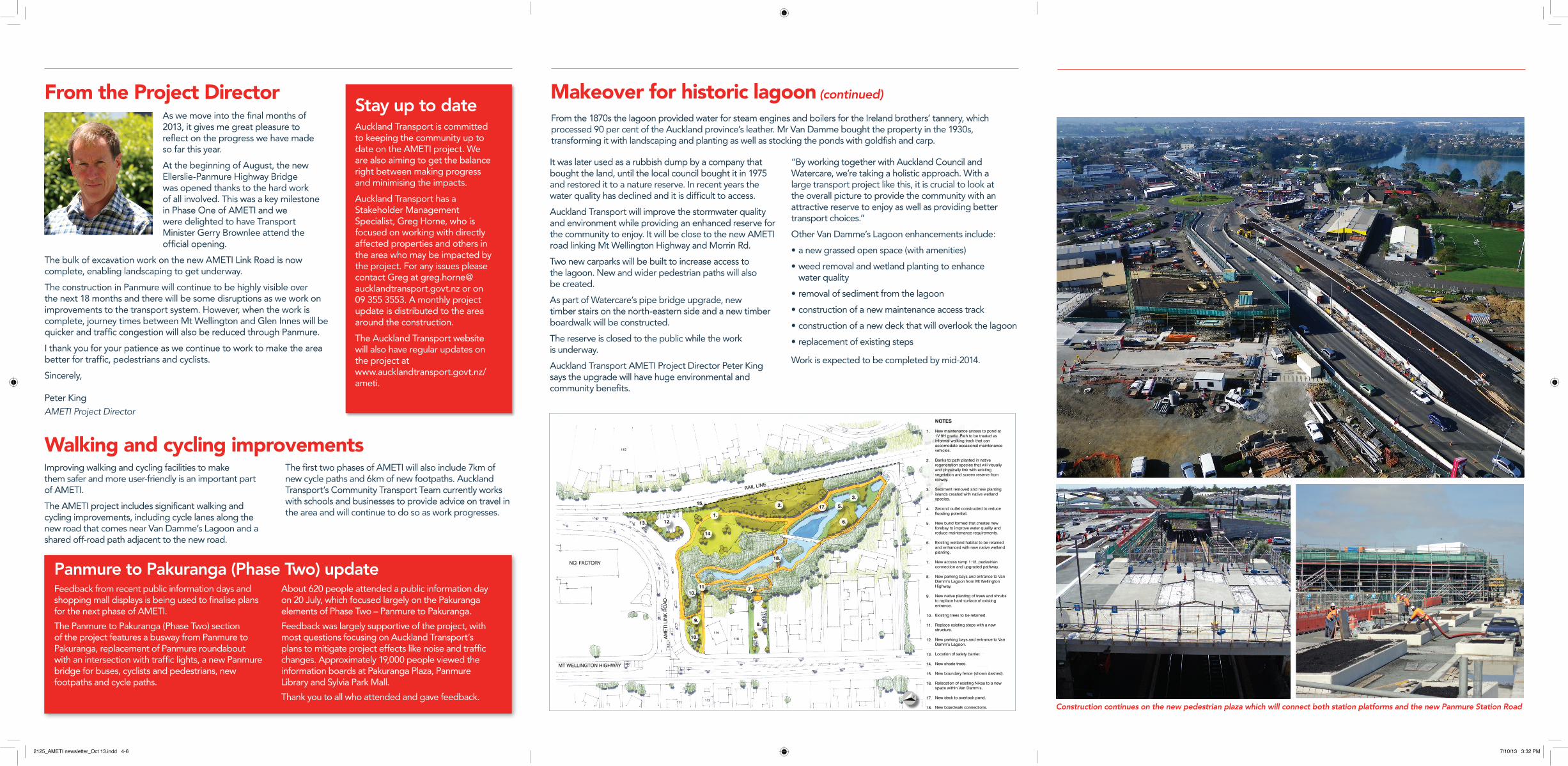
It was later used as a rubbish dump by a company that bought the land, until the local council bought it in 1975 and restored it to a nature reserve. In recent years the water quality has declined and it is difficult to access.
Auckland Transport will improve the stormwater quality and environment while providing an enhanced reserve for the community to enjoy. It will be close to the new AMETI road linking Mt Wellington Highway and Morrin Rd.
Two new carparks will be built to increase access to the lagoon. New and wider pedestrian paths will also be created.
As part of Watercare’s pipe bridge upgrade, new timber stairs on the north-eastern side and a new timber boardwalk will be constructed.
The reserve is closed to the public while the work is underway.
Auckland Transport AMETI Project Director Peter King says the upgrade will have huge environmental and community benefits.
“By working together with Auckland Council and Watercare, we’re taking a holistic approach. With a large transport project like this, it is crucial to look at the overall picture to provide the community with an attractive reserve to enjoy as well as providing better transport choices.”
Other Van Damme’s Lagoon enhancements include:
• a new grassed open space (with amenities)
• weed removal and wetland planting to enhance water quality
• removal of sediment from the lagoon
• construction of a new maintenance access track
• construction of a new deck that will overlook the lagoon
• replacement of existing steps
Work is expected to be completed by mid-2014.
From the 1870s the lagoon provided water for steam engines and boilers for the Ireland brothers’ tannery, which processed 90 per cent of the Auckland province’s leather. Mr Van Damme bought the property in the 1930s, transforming it with landscaping and planting as well as stocking the ponds with goldfish and carp.
L a n d s c a p e , O p e n S p a c e & V i s u a l A s s e s s m e n t
A M E T I P H A S E 1
F I G U R E 1 1 : V a n D a m m ’ s T w o L a n e C o n c e p t D e s i g n
R e v i s i o n 1
Feedback from recent public information days and shopping mall displays is being used to finalise plans for the next phase of AMETI.
The Panmure to Pakuranga (Phase Two) section of the project features a busway from Panmure to Pakuranga, replacement of Panmure roundabout with an intersection with traffic lights, a new Panmure bridge for buses, cyclists and pedestrians, new footpaths and cycle paths.
About 620 people attended a public information day on 20 July, which focused largely on the Pakuranga elements of Phase Two – Panmure to Pakuranga.
Feedback was largely supportive of the project, with most questions focusing on Auckland Transport’s plans to mitigate project effects like noise and traffic changes. Approximately 19,000 people viewed the information boards at Pakuranga Plaza, Panmure Library and Sylvia Park Mall.
Thank you to all who attended and gave feedback.
Panmure to Pakuranga (Phase Two) update
Construction continues on the new pedestrian plaza which will connect both station platforms and the new Panmure Station Road
Improving walking and cycling facilities to make them safer and more user-friendly is an important part of AMETI.
The AMETI project includes significant walking and cycling improvements, including cycle lanes along the new road that comes near Van Damme’s Lagoon and a shared off-road path adjacent to the new road.
The first two phases of AMETI will also include 7km of new cycle paths and 6km of new footpaths. Auckland Transport’s Community Transport Team currently works with schools and businesses to provide advice on travel in the area and will continue to do so as work progresses.
Walking and cycling improvements
Stay up to dateAuckland Transport is committed to keeping the community up to date on the AMETI project. We are also aiming to get the balance right between making progress and minimising the impacts.
Auckland Transport has a Stakeholder Management Specialist, Greg Horne, who is focused on working with directly affected properties and others in the area who may be impacted by the project. For any issues please contact Greg at [email protected] or on 09 355 3553. A monthly project update is distributed to the area around the construction.
The Auckland Transport website will also have regular updates on the project at www.aucklandtransport.govt.nz/ameti.
2125_AMETI newsletter_Oct 13.indd 4-6 7/10/13 3:32 PM
Related Documents