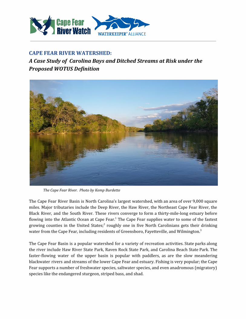
CAPE FEAR RIVER WATERSHED: A Case Study of Carolina Bays and Ditched Streams at Risk under the Proposed WOTUS Definition The Cape Fear River. Photo by Kemp Burdette The Cape Fear River Basin is North Carolina’s largest watershed, with an area of over 9,000 square miles. Major tributaries include the Deep River, the Haw River, the Northeast Cape Fear River, the Black River, and the South River. These rivers converge to form a thirty-mile-long estuary before flowing into the Atlantic Ocean at Cape Fear. 1 The Cape Fear supplies water to some of the fastest growing counties in the United States; 2 roughly one in five North Carolinians gets their drinking water from the Cape Fear, including residents of Greensboro, Fayetteville, and Wilmington. 3 The Cape Fear Basin is a popular watershed for a variety of recreation activities. State parks along the river include Haw River State Park, Raven Rock State Park, and Carolina Beach State Park. The faster-flowing water of the upper basin is popular with paddlers, as are the slow meandering blackwater rivers and streams of the lower Cape Fear and estuary. Fishing is very popular; the Cape Fear supports a number of freshwater species, saltwater species, and even anadromous (migratory) species like the endangered sturgeon, striped bass, and shad.

Welcome message from author
This document is posted to help you gain knowledge. Please leave a comment to let me know what you think about it! Share it to your friends and learn new things together.
Transcript
CAPE FEAR RIVER WATERSHED: A Case Study of Carolina Bays and Ditched Streams at Risk under the Proposed WOTUS Definition
The Cape Fear River. Photo by Kemp Burdette
The Cape Fear River Basin is North Carolina’s largest watershed, with an area of over 9,000 square miles. Major tributaries include the Deep River, the Haw River, the Northeast Cape Fear River, the Black River, and the South River. These rivers converge to form a thirty-mile-long estuary before flowing into the Atlantic Ocean at Cape Fear.1 The Cape Fear supplies water to some of the fastest growing counties in the United States;2 roughly one in five North Carolinians gets their drinking water from the Cape Fear, including residents of Greensboro, Fayetteville, and Wilmington.3 The Cape Fear Basin is a popular watershed for a variety of recreation activities. State parks along the river include Haw River State Park, Raven Rock State Park, and Carolina Beach State Park. The faster-flowing water of the upper basin is popular with paddlers, as are the slow meandering blackwater rivers and streams of the lower Cape Fear and estuary. Fishing is very popular; the Cape Fear supports a number of freshwater species, saltwater species, and even anadromous (migratory) species like the endangered sturgeon, striped bass, and shad.
Cape Fear River Watershed: Case Study Page 2 of 8
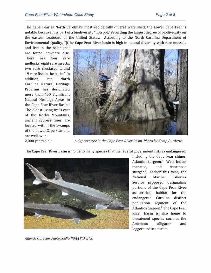
The Cape Fear is North Carolina’s most ecologically diverse watershed; the Lower Cape Fear is notable because it is part of a biodiversity “hotspot,” recording the largest degree of biodiversity on the eastern seaboard of the United States. According to the North Carolina Department of Environmental Quality, "[t]he Cape Fear River basin is high in natural diversity with rare mussels and fish in the basin that are found nowhere else. There are four rare mollusks, eight rare insects, two rare crustaceans, and 19 rare fish in the basin." In addition, the North Carolina Natural Heritage Program has designated more than 450 Significant Natural Heritage Areas in the Cape Fear River Basin.4 The oldest living trees east of the Rocky Mountains, ancient cypress trees, are located within the swamps of the Lower Cape Fear and are well over 2,000 years old.5 A Cypress tree in the Cape Fear River Basin. Photo by Kemp Burdette. The Cape Fear River basin is home to many species that the federal government lists as endangered,
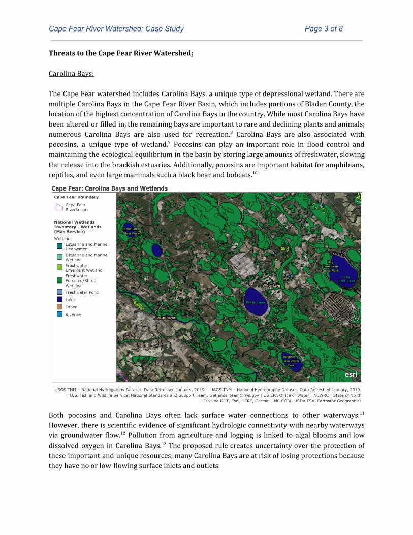
including the Cape Fear shiner, Atlantic sturgeon,6 West Indian manatee, and shortnose sturgeon. Earlier this year, the National Marine Fisheries Service proposed designating portions of the Cape Fear River as critical habitat for the endangered Carolina distinct population segment of the Atlantic sturgeon.7 The Cape Fear River Basin is also home to threatened species such as the American alligator and loggerhead sea turtle.
Atlantic sturgeon. Photo credit: NOAA Fisheries.
Cape Fear River Watershed: Case Study Page 3 of 8
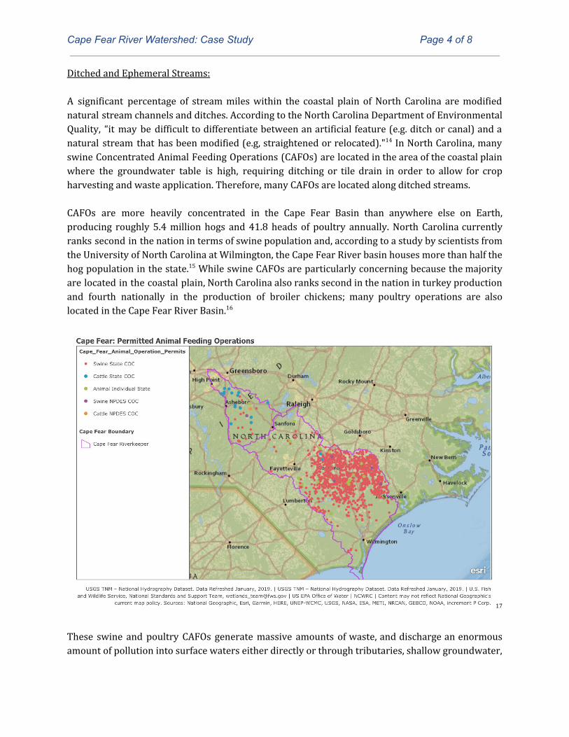
Threats to the Cape Fear River Watershed: Carolina Bays: The Cape Fear watershed includes Carolina Bays, a unique type of depressional wetland. There are multiple Carolina Bays in the Cape Fear River Basin, which includes portions of Bladen County, the location of the highest concentration of Carolina Bays in the country. While most Carolina Bays have been altered or filled in, the remaining bays are important to rare and declining plants and animals; numerous Carolina Bays are also used for recreation.8 Carolina Bays are also associated with pocosins, a unique type of wetland.9 Pocosins can play an important role in flood control and maintaining the ecological equilibrium in the basin by storing large amounts of freshwater, slowing the release into the brackish estuaries. Additionally, pocosins are important habitat for amphibians, reptiles, and even large mammals such a black bear and bobcats.10
Both pocosins and Carolina Bays often lack surface water connections to other waterways.11 However, there is scientific evidence of significant hydrologic connectivity with nearby waterways via groundwater flow.12 Pollution from agriculture and logging is linked to algal blooms and low dissolved oxygen in Carolina Bays.13 The proposed rule creates uncertainty over the protection of these important and unique resources; many Carolina Bays are at risk of losing protections because they have no or low-flowing surface inlets and outlets.
Cape Fear River Watershed: Case Study Page 4 of 8
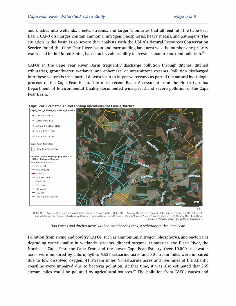
Ditched and Ephemeral Streams: A significant percentage of stream miles within the coastal plain of North Carolina are modified natural stream channels and ditches. According to the North Carolina Department of Environmental Quality, “it may be difficult to differentiate between an artificial feature (e.g. ditch or canal) and a natural stream that has been modified (e.g, straightened or relocated)."14 In North Carolina, many swine Concentrated Animal Feeding Operations (CAFOs) are located in the area of the coastal plain where the groundwater table is high, requiring ditching or tile drain in order to allow for crop harvesting and waste application. Therefore, many CAFOs are located along ditched streams. CAFOs are more heavily concentrated in the Cape Fear Basin than anywhere else on Earth, producing roughly 5.4 million hogs and 41.8 heads of poultry annually. North Carolina currently ranks second in the nation in terms of swine population and, according to a study by scientists from the University of North Carolina at Wilmington, the Cape Fear River basin houses more than half the hog population in the state.15 While swine CAFOs are particularly concerning because the majority are located in the coastal plain, North Carolina also ranks second in the nation in turkey production and fourth nationally in the production of broiler chickens; many poultry operations are also located in the Cape Fear River Basin.16
17
These swine and poultry CAFOs generate massive amounts of waste, and discharge an enormous amount of pollution into surface waters either directly or through tributaries, shallow groundwater,
Cape Fear River Watershed: Case Study Page 5 of 8
and ditches into wetlands, creeks, streams, and larger tributaries that all feed into the Cape Fear Basin. CAFO discharges contain ammonia, nitrogen, phosphorus, heavy metals, and pathogens. The situation in the basin is so severe that analysts with the USDA's Natural Resources Conservation Service found the Cape Fear River basin and surrounding land area was the number one priority watershed in the United States, based on its vulnerability to livestock manure nutrient pollution.18 CAFOs in the Cape Fear River Basin frequently discharge pollution through ditches, ditched tributaries, groundwater, wetlands, and ephemeral or intermittent streams. Pollution discharged into these waters is transported downstream to larger waterways as part of the natural hydrologic process of the Cape Fear Basin. The most recent Basin Assessment from the North Carolina Department of Environmental Quality documented widespread and severe pollution of the Cape Fear Basin.
Hog Farms and ditches near Ivanhoe, on Moore's Creek, a tributary to the Cape Fear.
Pollution from swine and poultry CAFOs, such as ammonium, nitrogen, phosphorus, and bacteria, is degrading water quality in wetlands, streams, ditched streams, tributaries, the Black River, the Northeast Cape Fear, the Cape Fear, and the Lower Cape Fear Estuary. Over 10,000 freshwater acres were impaired by chlorophyll-a; 6,527 estuarine acres and 50 stream miles were impaired due to low dissolved oxygen, 41 stream miles, 97 estuarine acres and five miles of the Atlantic coastline were impaired due to bacteria pollution. At that time, it was also estimated that 265 stream miles could be polluted by agricultural sources.19 The pollution from CAFOs causes and
Cape Fear River Watershed: Case Study Page 6 of 8
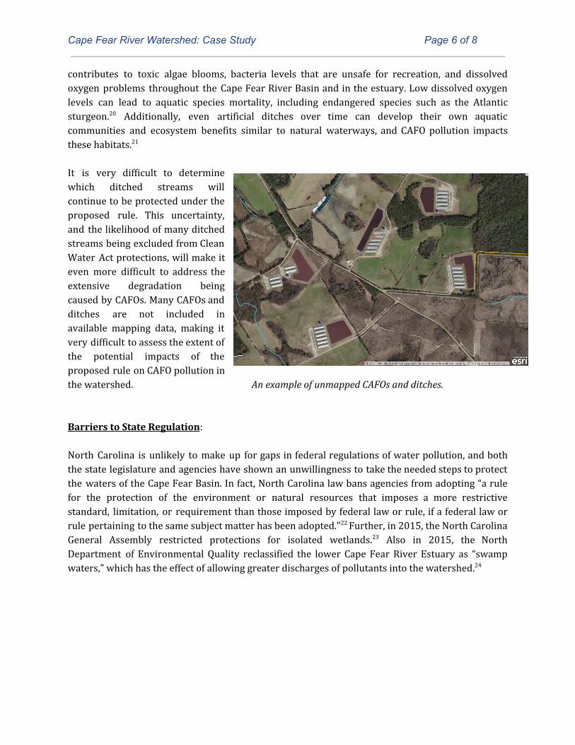
contributes to toxic algae blooms, bacteria levels that are unsafe for recreation, and dissolved oxygen problems throughout the Cape Fear River Basin and in the estuary. Low dissolved oxygen levels can lead to aquatic species mortality, including endangered species such as the Atlantic sturgeon.20 Additionally, even artificial ditches over time can develop their own aquatic communities and ecosystem benefits similar to natural waterways, and CAFO pollution impacts these habitats.21 It is very difficult to determine which ditched streams will continue to be protected under the proposed rule. This uncertainty, and the likelihood of many ditched streams being excluded from Clean Water Act protections, will make it even more difficult to address the extensive degradation being caused by CAFOs. Many CAFOs and ditches are not included in available mapping data, making it very difficult to assess the extent of the potential impacts of the proposed rule on CAFO pollution in the watershed. An example of unmapped CAFOs and ditches. Barriers to State Regulation: North Carolina is unlikely to make up for gaps in federal regulations of water pollution, and both the state legislature and agencies have shown an unwillingness to take the needed steps to protect the waters of the Cape Fear Basin. In fact, North Carolina law bans agencies from adopting “a rule for the protection of the environment or natural resources that imposes a more restrictive standard, limitation, or requirement than those imposed by federal law or rule, if a federal law or rule pertaining to the same subject matter has been adopted."22 Further, in 2015, the North Carolina General Assembly restricted protections for isolated wetlands.23 Also in 2015, the North Department of Environmental Quality reclassified the lower Cape Fear River Estuary as “swamp waters,” which has the effect of allowing greater discharges of pollutants into the watershed.24
Cape Fear River Watershed: Case Study Page 7 of 8
Endnotes 1. National Oceanic and Atmospheric Administration, Cape Fear, available at: 2. Sloane Realty, Brunswick County Among Fastest Growing Areas In The US (2019), available at: https://www.google.com/url?q=https://www.sloanerealty.com/blog/2018/01/29/brunswick-county-among-fastest-growing-areas-us/&sa=D&ust=1555025162959000&usg=AFQjCNGrwe8Z1QaBQYUkBkftGrY8nd8PsA. 3. North Carolina Department of Environment and Natural Resources, Basin 2 Cape Fear (2001), available at: https://www.ncwater.org/Reports_and_Publications/swsp/swsp_jan2001/final_pdfs/B02_CapeFear.pdf. 4. North Carolina Department of Environmental Quality, Cape Fear 2005, available at: https://deq.nc.gov/about/divisions/water-resources/planning/basin-planning/water-resource-plans/cape-fear-2005. 5. Crystal Cockman, Ancient trees stand guard over this N.C. river (Oct. 2017), available at: https://ui.uncc.edu/story/ancient-trees-stand-guard-over-nc-river. 6. North Carolina Department of Environmental Quality, Atlantic Sturgeon, Acipenser oxyrinchus oxyrinchus, available at: http://portal.ncdenr.org/web/mf/atlantic-sturgeon; Ross, S., F. Rhode, and D. Lundquist. 1988. Endangered, threatened, and rare fauna of North Carolina: 40 in Moser, M. L. and S. W. Ross. 1995. Habitat use and movements of shortnose and Atlantic sturgeons in the lower Cape Fear River, North Carolina. Transactions of the American Fisheries Society 124(2): 225; Moser, M. L. and S. W. Ross. 1995. Habitat use and movements of shortnose and Atlantic sturgeons in the lower Cape Fear River, North Carolina. Transactions of the American Fisheries Society 124(2): 225. 7. 81 Fed. Reg. 36077. 8. See, e.g. North Carolina State Parks, Singletary Lake State Park, available at: https://www.ncparks.gov/singletary-lake-state-park; North Carolina State Parks, Jones Lake State Park, available at: https://www.ncparks.gov/jones-lake-state-park. 9. North Carolina Wildlife Resources Commission, 2015 North Carolina Wildlife Action Plan, 364 (2015), available at: 10. North Carolina Department of Environmental Quality, Wetlands, available at: https://deq.nc.gov/about/divisions/coastal-management/coastal-management-estuarine-shorelines/wetlands. 11. Duke University Wetland Center, Curtis J. Richardson, Pocosins: Hydrologically isolated or integrated wetlands on the landscape?, available at: https://nicholas.duke.edu/wetland/ab_Richardson_03.htm. 12. EPA, "Connectivity of Streams and Wetlands to Downstream Waters: A Review and Synthesis of the Scientific Evidence" EPA/600/R-14/475F (Jan. 2015). 13. North Carolina Wildlife Resources Commission, 2015 North Carolina Wildlife Action Plan, 288 (2015), available at: 14. North Carolina Division of Water Quality, Identification Methods for the Origins of Intermittent and Perennial streams, Version 4.11 (NCDENR 2010), available at http://www.xerces.org/wp-content/uploads/2009/03/NC_2010_Methodology_identification_intermittent_perennial_streams.pdf.
15. See "Nitrogen and Phosphorus Imports to the Cape Fear and Neuse River Basins to Support Intensive Livestock Production" by Lawrence B. Cahoon, Jill A. Mikucki, and Michael A. Mallin Environ. Sci. Technol., 1999, 33 (3), pp 410 -415.). 16. Stephen L. Harden, "Surface-Water Quality in Agricultural Watersheds of the North Carolina Coastal Plain Associated with Concentrated Animal Feeding Operations" http://pubs.usgs.gov/sir/2015/5080/pdf/sir2015-5080.pdf. 17. Source: NCDEQ, Animal Feeding Operations ("DWR permitting database in October 2018. (“This includes all active animal operations that are required to be permitted by the state.") https://services2.arcgis.com/kCu40SDxsCGcuUWO/arcgis/rest/services/AnimapOperationsPermits20160219Public/FeatureServer.
Cape Fear River Watershed: Case Study Page 8 of 8
18. Robert Kellogg, Manure Nutrients Relative to the Capacity of Cropland and Pastureland to Assimilate Nutrients: Spatial and Temporal Trends for the United States, (Dec. 2000) available at: https://www.nrcs.usda.gov/Internet/FSE_DOCUMENTS/nrcs143_012133.pdf. 19. North Carolina Department of Environmental Quality, Cape Fear 2005, available at: https://deq.nc.gov/about/divisions/water-resources/planning/basin-planning/water-resource-plans/cape-fear-2005. 20. See, e.g., The Nature Conservancy, Potential Impacts of Dissolved Oxygen, Salinity and Flow on the Successful Recruitment of Atlantic Sturgeon in the Delaware River (May 2016), available at: https://www.conservationgateway.org/ConservationPractices/Freshwater/HabitatProtectionandRestoration/Pages/delaware-river-sturgeon.aspx. 21. North Carolina Department of Environmental Quality, Cape Fear 2005, 280 (2005) available at: https://deq.nc.gov/about/divisions/water-resources/planning/basin-planning/water-resource-plans/cape-fear-2005. 22. N.C.G.S. 150B-19.3. 23. S. 2015, General Assembly of North Carolina, Session law 2015-286, House Bill 765 § 4.18 (2015). 24. Waterkeeper Alliance, Waterkeeper Groups Petition N.C. to Remove “Swamp Waters” Classification from Lower Cape Fear River (Jan. 2019), available at: https://waterkeeper.org/waterkeeper-groups-petition-n-c-to-remove-swamp-waters-classification-from-lower-cape-fear-river/.
Related Documents