California Water Plan Update 2013 Groundwater Content Enhancements Abdul Khan and Dan McManus California Department of Water Resources October 17, 2012 California Water Commission

Welcome message from author
This document is posted to help you gain knowledge. Please leave a comment to let me know what you think about it! Share it to your friends and learn new things together.
Transcript
California Water Plan Update 2013 Groundwater Content Enhancements
Abdul Khan and Dan McManus
California Department of Water Resources October 17, 2012
California Water Commission
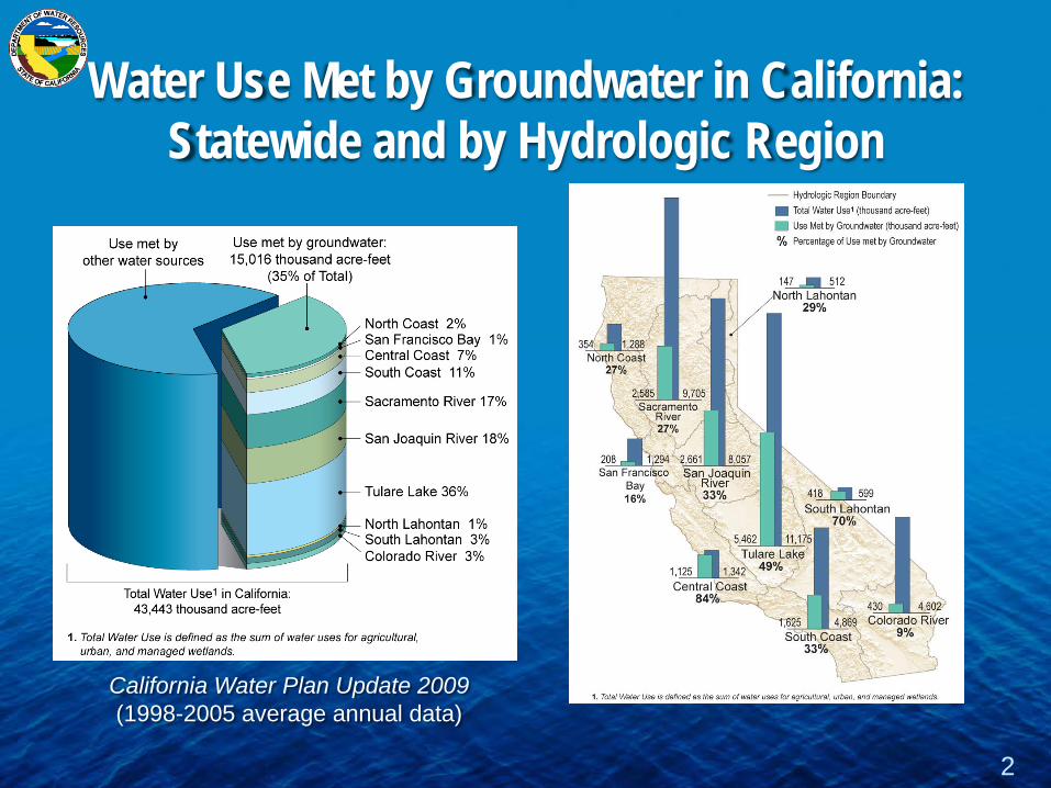
Water Use Met by Groundwater in California: Statewide and by Hydrologic Region
2
California Water Plan Update 2009 (1998-2005 average annual data)

Water Plan Update 2013 Groundwater Content Enhancement
Objective
compilation and summarization of data and analysis
to
through
Expand information about statewide and regional groundwater conditions
better inform groundwater management actions
3
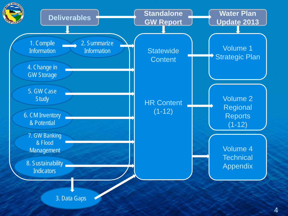
4
1. Compile Information
4. Change in GW Storage
6. CM Inventory & Potential
7. GW Banking & Flood
Management
5. GW Case Study
8. Sustainability Indicators
2. Summarize Information
3. Data Gaps
Volume 1 Strategic Plan
Volume 2 Regional Reports (1-12)
Deliverables
Standalone GW Report
Water Plan Update 2013
Statewide Content
HR Content (1-12)
Volume 4 Technical Appendix

5
1. GW Supply & Development
2. Groundwater Use
3. GW Monitoring Efforts
4. Aquifer Conditions
5. GW Mgm Activities
7. Integrated GW Management
6. Case Studies
8. GW Budget & Sustainability
9. Data Gap Analysis
Standalone GW Report
Table of Contents
Alluvial Aquifers Fractured Rock
Aquifer Well Infrastructure
& Distribution Priority Basins
GW Level GW Quality
Land Subsidence Remote
Sensing/Satellite Groundwater
Modeling
GW Occurrence & Movement GW Levels
GW Level Trends Change in Storage
GW Quality Land Subsidence
GW Mgm Plans GW Ordinances
Court Adjudications Other GW Mgm
Planning
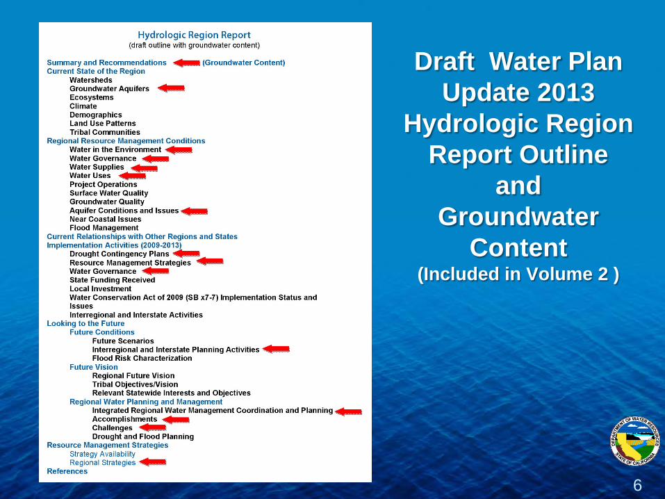
Draft Water Plan Update 2013
Hydrologic Region Report Outline
and Groundwater
Content (Included in Volume 2 )
6
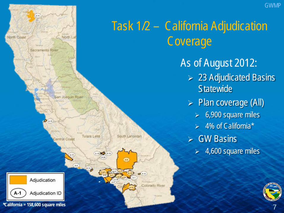
As of August 2012: 23 Adjudicated Basins
Statewide Plan coverage (All) 6,900 square miles 4% of California*
GW Basins 4,600 square miles
7 *California = 158,600 square miles
Task 1/2 – California Adjudication Coverage
GWMP
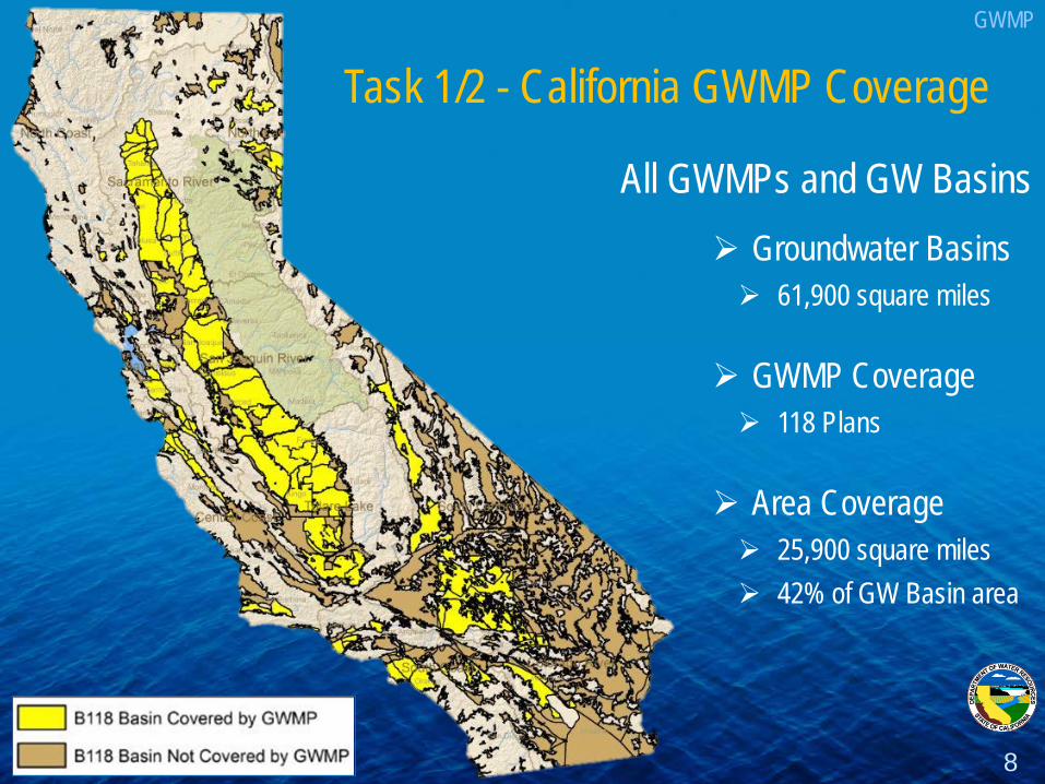
All GWMPs and GW Basins
Groundwater Basins 61,900 square miles
GWMP Coverage 118 Plans
Area Coverage 25,900 square miles 42% of GW Basin area
Task 1/2 - California GWMP Coverage GWMP
8
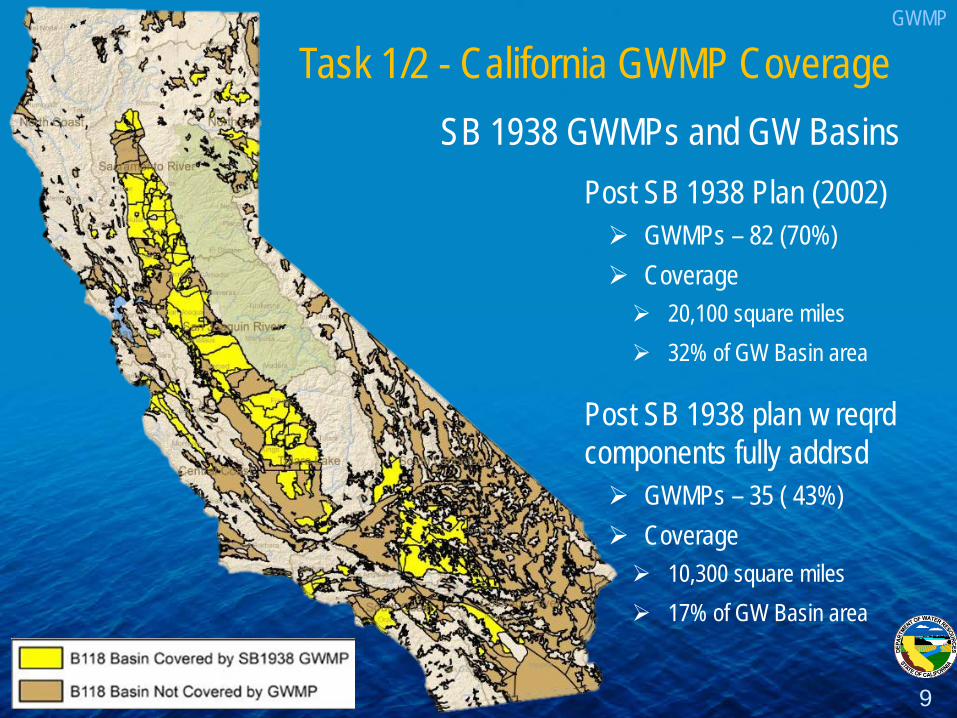
Task 1/2 - California GWMP Coverage SB 1938 GWMPs and GW Basins
Post SB 1938 Plan (2002) GWMPs – 82 (70%) Coverage 20,100 square miles 32% of GW Basin area
Post SB 1938 plan w reqrd components fully addrsd GWMPs – 35 ( 43%) Coverage 10,300 square miles 17% of GW Basin area
GWMP
9

10
Yes 43%
No 57%
ALL SB 1938 Requirements
Addressed
Yes 50%
No 9%
Partial 41%
Basin Management Objectives
Yes 95%
No 5%
Agency Cooperation
Yes 80%
No 7%
Partial 12%
Map
Yes 46%
No 4%
Partial 50%
Monitoring Protocols
Task 1/2 - Preliminary Results of Statewide GWMP Assessment
35 Plans
47 Plans
GWMP

Task 4 - Annual Change in Groundwater Storage Estimates - Spring 2005 to Spring 2010
Water Level Data Availability - focused on Central Valley for CWP Update 2012 Time frame – 2005 to 2010, based on CWP Update 2013 GW storage coefficients - to estimate change in groundwater volume based on a
change in GW levels for an area; assumes “unconfined” aquifer conditions (Sy)
11
Collect, query and filter groundwater level data Develop groundwater level (WL) surfaces Compare WL surfaces - determine the distance (“space”) between two WL surfaces Estimate change in groundwater storage - apply storage coeff to estimate GW
storage betn two WL surfaces for a given area and summarize by “reporting areas”
Considerations
Method

Sacramento River Hydrologic Region
12
Preliminary Data – Subject to Revision
Increase: +40 feet
No Change
Decrease: -40 feet
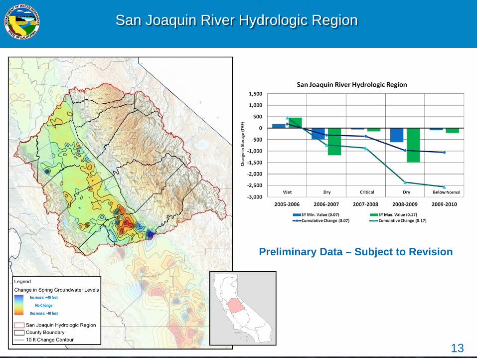
San Joaquin River Hydrologic Region
13
Preliminary Data – Subject to Revision
Increase: +40 feet
No Change
Decrease: -40 feet

Tulare Lake Hydrologic Region
14
Increase: +40 feet
No Change
Decrease: -40 feet
Preliminary Data – Subject to Revision

Task 6 - Conjunctive Management and Groundwater Storage
Three Main Goals of Update 2013 Survey: 1. Inventory existing conjunctive use, recharge
and groundwater banking projects 2. Determine future conjunctive management
potential 3. Define program constraints
15
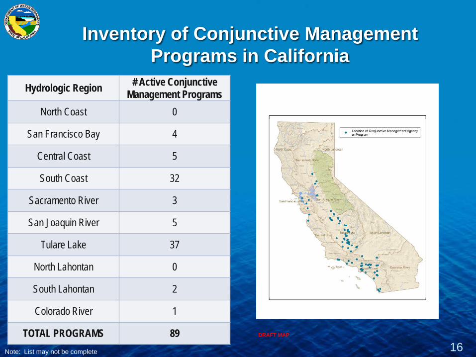
Inventory of Conjunctive Management Programs in California
Hydrologic Region # Active Conjunctive Management Programs
North Coast 0
San Francisco Bay 4
Central Coast 5
South Coast 32
Sacramento River 3
San Joaquin River 5
Tulare Lake 37
North Lahontan 0
South Lahontan 2
Colorado River 1
TOTAL PROGRAMS 89 16 Note: List may not be complete
DRAFT MAP
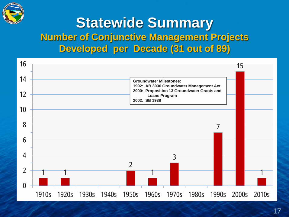
Statewide Summary Number of Conjunctive Management Projects
Developed per Decade (31 out of 89)
17
1 1 2
1
3
7
15
1
0
2
4
6
8
10
12
14
16
1910s 1920s 1930s 1940s 1950s 1960s 1970s 1980s 1990s 2000s 2010s
Groundwater Milestones: 1992: AB 3030 Groundwater Management Act 2000: Proposition 13 Groundwater Grants and
Loans Program 2002: SB 1938
18
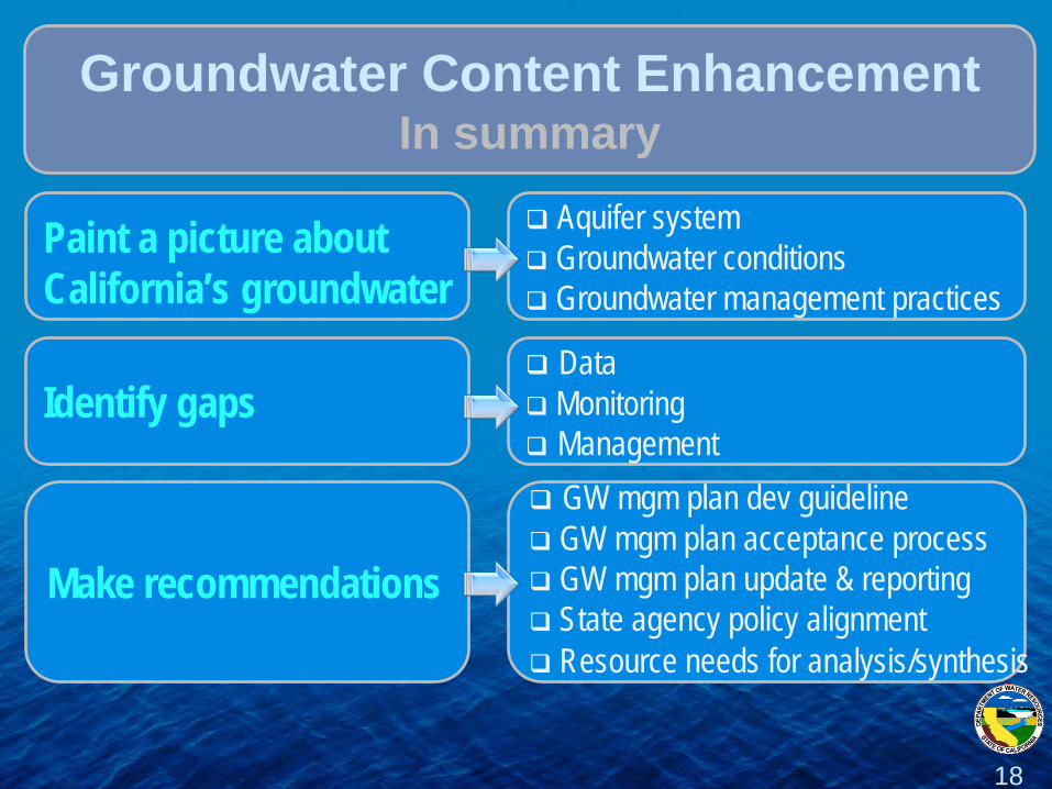
Paint a picture about California’s groundwater
Aquifer system Groundwater conditions Groundwater management practices
Groundwater Content Enhancement In summary
Identify gaps
Data Monitoring Management
Make recommendations
GW mgm plan dev guideline GW mgm plan acceptance process GW mgm plan update & reporting State agency policy alignment Resource needs for analysis/synthesis
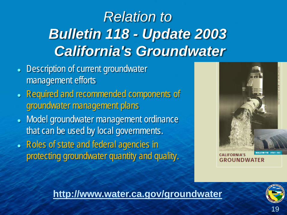
Relation to Bulletin 118 - Update 2003 California's Groundwater
Description of current groundwater management efforts
Required and recommended components of groundwater management plans
Model groundwater management ordinance that can be used by local governments.
Roles of state and federal agencies in protecting groundwater quantity and quality.
19
http://www.water.ca.gov/groundwater

Relation to CASGEM
California Statewide Groundwater Elevation Monitoring
Voluntary, long-term, statewide groundwater elevation program Builds on established local groundwater monitoring programs Uses local agencies designated as MEs to collect and submit
groundwater elevation data Establishes an online system for data submittal Makes groundwater data readily and widely available online to public Requires DWR to prioritize groundwater basins, investigate groundwater
basins, and provide status reports to Governor and Legislature
20
http://www.water.ca.gov/groundwater/casgem

21
Groundwater
Workteam
Continue to develop content Prepare draft GW Report: Oct-Nov/12 Fold content in draft Regnl Report: Oct-Nov/12
Groundwater Content Enhancement Near Term Activities
Groundwater Caucus
Review content/provide feedback: Dec/12-Jan/13 Work on GW Case Studies and sustainability indicators: Jan/13
Public Advisory Committee
Review content/provide feedback: Dec/12-Jan/13
State Agency Steering Committee
Discuss state agency coordination and alignment on conjunctive management and groundwater storage and recharge: Nov-Dec/12
California Water Commission
We invite you to participate, discuss, and provide guidance and direction on the GW initiative
Related Documents