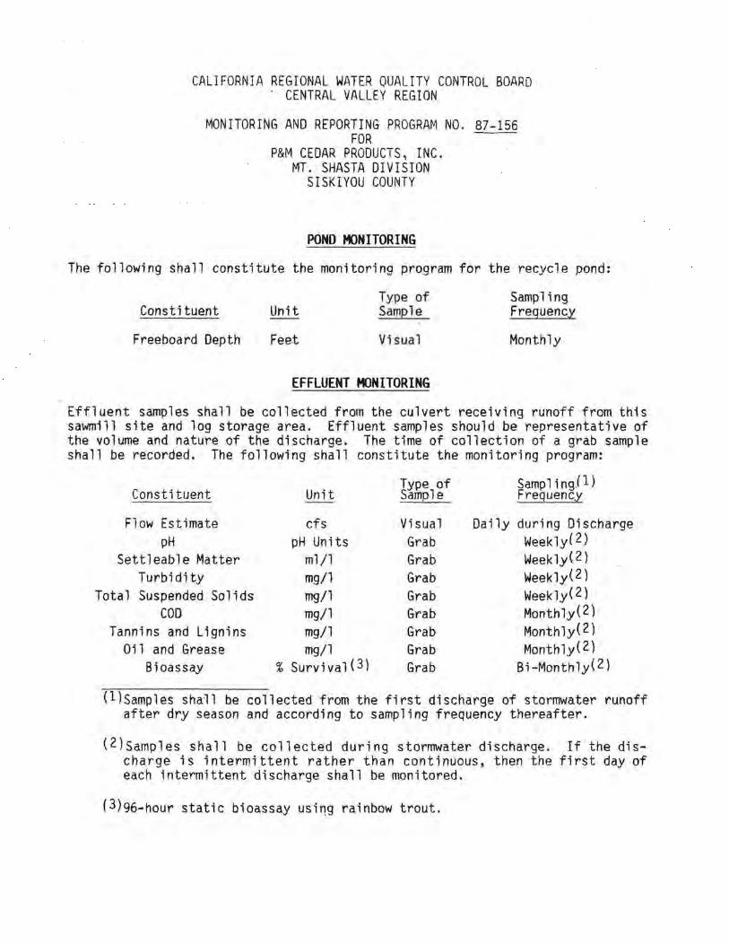
CALIFORNIA REGIONAL WATER QUALITY CONTROL BOARD . CENTRAL VALLEY REGION MONITORING AND REPORTING PROGRAM NO. 87-156 FOR P&M CEDAR PRODUCTS, INC. MT. SHASTA DIVISION SISKIYOU COUNTY POND MONITORING The following shall constitute the monitoring program for the recycle pond: Constituent Freeboard Depth Unit Feet Ty.pe of Sample Visual EFFLUENT MONITORING Sampling Frequency Monthly Effluent samples shall be collected from the culvert receiving runoff from this sawmil1 site and log storage area. Effluent samples should be representative of the volume and nature of the discharge. The time of collection of a grab sample shall be recorded. The following shall constitute the monitoring program: Constituent Unit Type of Sample SamplingJl) Frequency Flow Estimate cfs Visual Daily during Discharge pH pH Units Grab Weekly( 2.) Settleable Matter ml/1 Grab Week1y{2) Turbidity mg/1 Grab Weekly(2) Total Suspended Solids mg/1 Grab Weekly(2) coo mg/1 Grab Monthly(2) Tannins and Lignins mg/1 Grab Monthly(2) Oil and Grease mg/1 Grab Monthly(2) Bioassay % Survival{3) Grab Bi-Monthly(2) (l)samples shall be collected from the first discharge of stormwater runoff after dry season and according to sampling frequency thereafter. (2)samples shall be collected during stormwater discharge. If the dis- charge is intermittent rather than continuous, then the first day of each intermittent discharge shall be monitored. (3)96-hour static bioassay rainbow trout.

Welcome message from author
This document is posted to help you gain knowledge. Please leave a comment to let me know what you think about it! Share it to your friends and learn new things together.
Transcript
CALIFORNIA REGIONAL WATER QUALITY CONTROL BOARD . CENTRAL VALLEY REGION
MONITORING AND REPORTING PROGRAM NO. 87-156 FOR
P&M CEDAR PRODUCTS, INC. MT. SHASTA DIVISION
SISKIYOU COUNTY
POND MONITORING
The following shall constitute the monitoring program for the recycle pond:
Constituent
Freeboard Depth
Unit
Feet
Ty.pe of Sample
Visual
EFFLUENT MONITORING
Sampling Frequency
Monthly
Effluent samples shall be collected from the culvert receiving runoff from this sawmil1 site and log storage area. Effluent samples should be representative of the volume and nature of the discharge. The time of collection of a grab sample shall be recorded. The following shall constitute the monitoring program:
Constituent Unit Type of Sample
SamplingJl) Frequency
Flow Estimate cfs Visual Daily during Discharge pH pH Units Grab Weekly( 2.)
Settleable Matter ml/1 Grab Week1y{2) Turbidity mg/1 Grab Weekly(2)
Total Suspended Solids mg/1 Grab Weekly(2) coo mg/1 Grab Monthly(2)
Tannins and Lignins mg/1 Grab Monthly(2) Oil and Grease mg/1 Grab Monthly(2)
Bioassay % Survival{3) Grab Bi-Monthly(2)
(l)samples shall be collected from the first discharge of stormwater runoff after dry season and according to sampling frequency thereafter.
(2)samples shall be collected during stormwater discharge. If the discharge is intermittent rather than continuous, then the first day of each intermittent discharge shall be monitored.
(3)96-hour static bioassay usi~g rainbow trout.
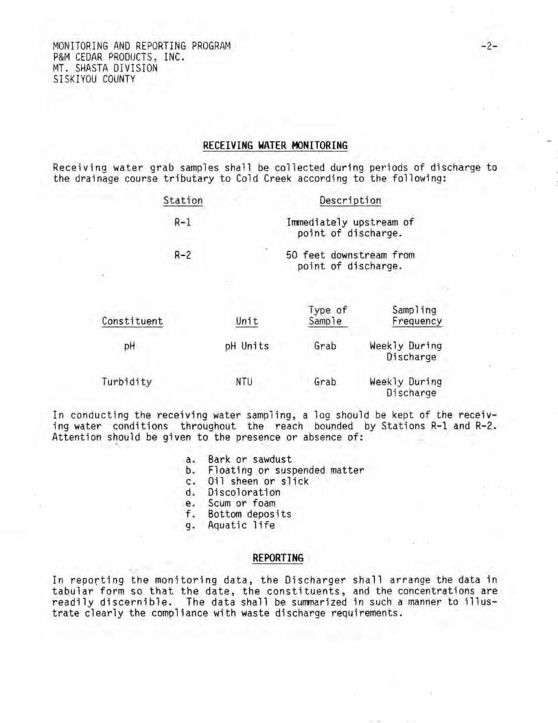
MONITORING AND REPORTING PROGRAM P&M CEDAR PRODUCTS, INC. MT. SHASTA DIVISION SISKIYOU COUNTY
RECEIVING WATER MONITORING
-2-
Receiving water grab samples shall be collected during periods of discharge to the drainage course tributary to Cold Creek according to the following:
Stat ion
R-1
R-2
Constituent Unit
pH pH Units
Turbidity NTU
Description
Immediately upstream of point of discharge.
50 feet downstream from point of discharge.
Type of Sampl e
Grab
Grab
Sampling Frequency
Weekly During Discharge
Weekly During Discharge
In conducting the receiving water sampling, a log should be kept of the receiving water conditions throughout the reach bounded by Stations R-1 and R-2. Attention should be given to the presence or absence of:
a. Bark or sawdust b. Floating or suspended matter c. Oil sheen or slick d. Discoloration
.e. Scum or foam f. Bottom deposits g. Aquatic 1 ife
REPORTING
In reporting the monitoring data, the Discharger shall arrange the data in tabular form so that the date, the constituents, and the concentrations are readily discernible. The data shall be summarized in such a manner to illustrate clearly the compliance with waste discharge requirements.
MONITORING ANO REPORTING PROGRAM P&M CEDAR PRODUCTS, INC .
• MT. SHASTA DIVISION SISKlYOlJ COUNI'i
-3-
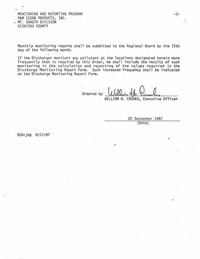
Monthly monitoring reports shall be submitted to the Regional Board by the 15th day of the following month.
If t he Discharger monitors any pollut ant at the locations designated herein more frequently than is required by this Order, he shall 1nclude the results of such monitoring in the calculation and reporting of the values required in the Discharge Monitoring Report Form. Such increased frequency shall be indicated on the Discharge Monitoring Report Form.
Ordered by_W_:L{!rti WILLIAM H. CROOKS, Executive Officer
25 September 1987 (Date)
DCW:jdg 8/12/87
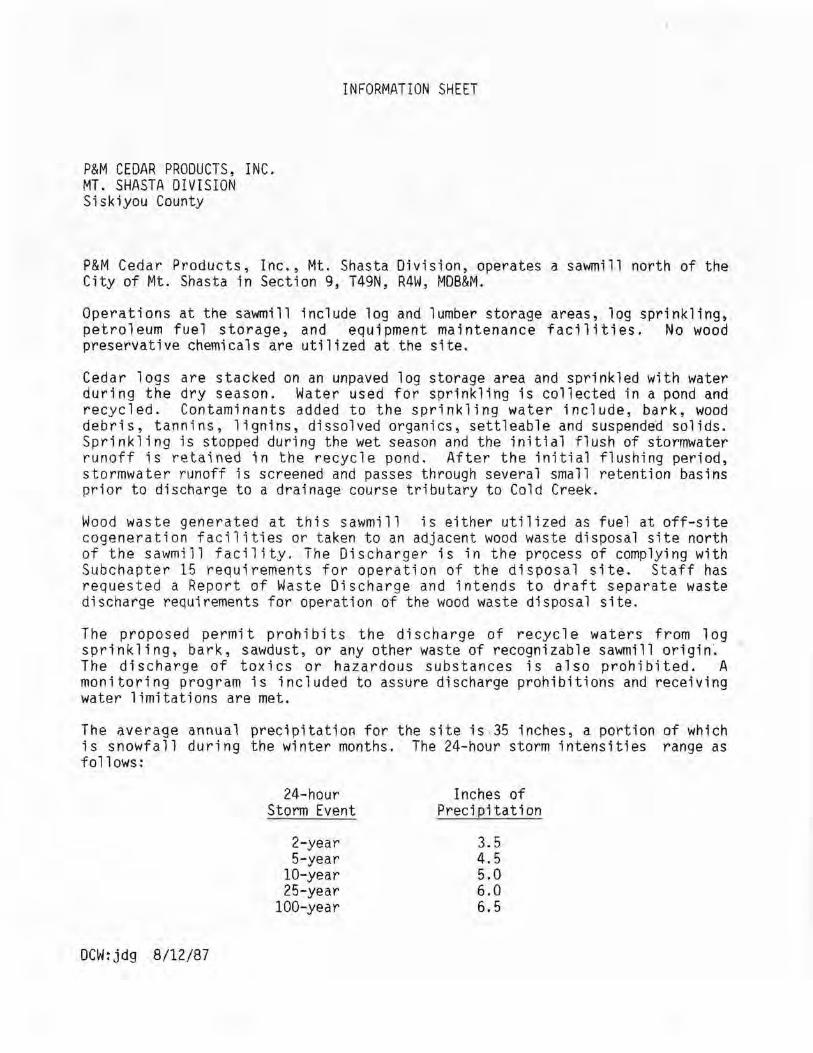
INFORMATION SHEET
P&M CEDAR PRODUCTS, INC. MT. SHASTA DIVISION Siskiyou County
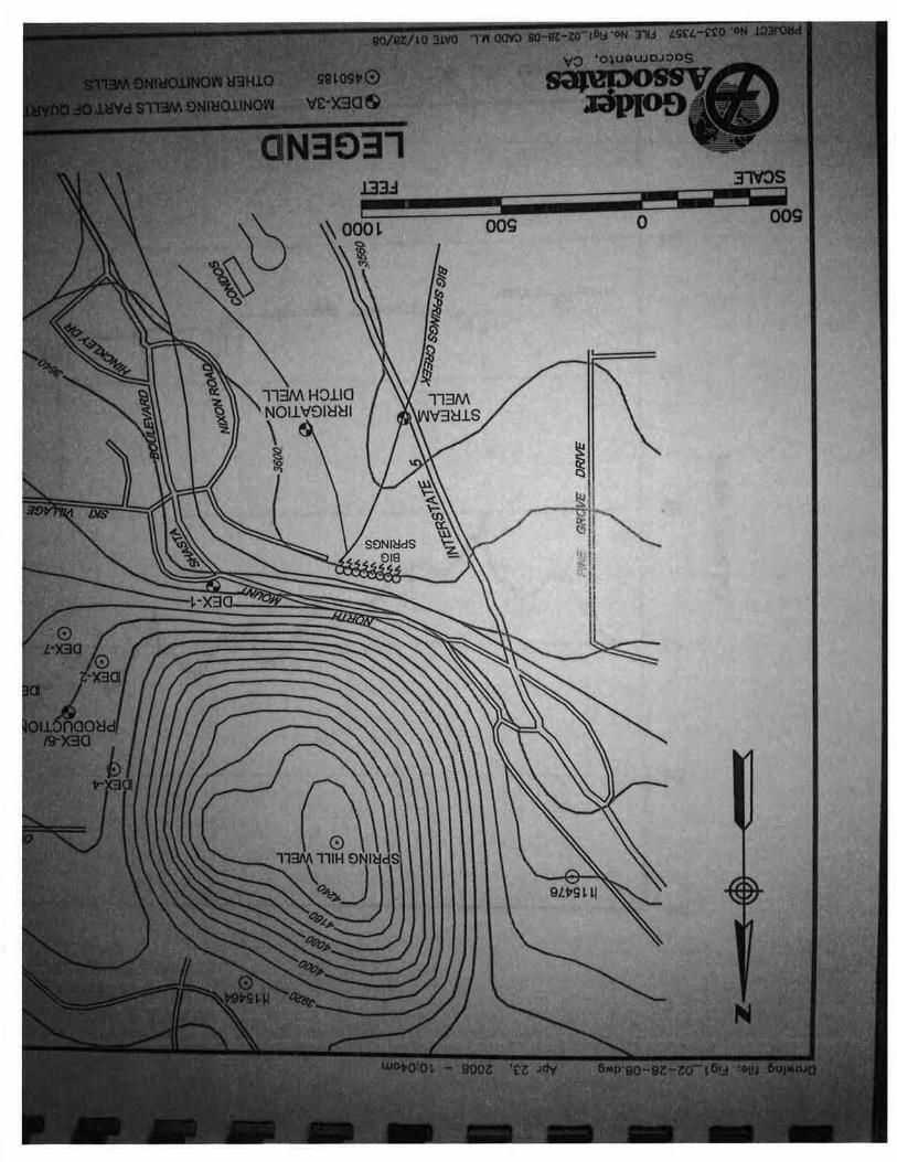
P&M Cedar Products, Inc., Mt. Shasta Division, operates a sawmill north of the City of Mt. Shasta in Section 9, T49N, R4W, MDB&M.
Operations at the sawmill include log and lumber storage areas, log sprinkling, petroleum fuel storage, and equipment maintenance facilities. No wood preservative chemicals are utilized at the site.
Cedar logs are stacked on an unpaved log storage area and sprinkled with water during the dry season. Water used for sprinkling is collected in a pond and recycled. Contaminants added to the sprinkling water include, bark, wood debris, tannins, lignins, dissolved organics, settleable and suspended solids. Sprinkling is stopped during the wet season and the initial flush of stormwater runoff is retained in the recycle pond. After the initial flushing period, stormwater runoff is screened and passes through several small retention basins prior to discharge to a drainage course tributary to Cold Creek.
Wood waste generated at this sawmill is either utilized as fuel at off-site cogeneration facilities or taken to an adjacent wood waste disposal site north of the sawmill facility. The Discharger is in the process of complying with Subchapter 15 requirements for operation of the disposal site. Staff has requested a Report of Waste Discharge and intends to draft separate waste discharge requirements for operation of the wood waste disposal site.
The proposed permit prohibits the discharge of recycle waters from 1 og sprinkling, bark, sawdust, or any other waste of recognizable sawmill origin·. The discharge of toxics or hazardous substances is also prohibited. A monitoring program is included to assure discharge prohibitions and receiving water limitations are met.
The average annual precipitation for the site is -35 inches, a portion of which is snowfall during the winter months. The 24-hour storm intensities range as follows:
DCW:jdg 8/12/87
24-hour Storm Event
2-year 5-year
10-year 25-year
100-year
Inches of Precipitation
3.5 4.5 5.0 6.0 6.5
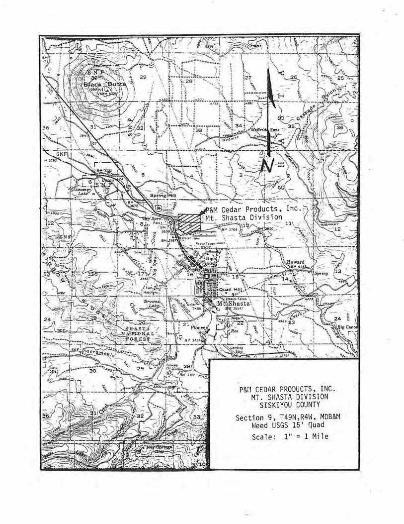
P&i1 CEDAR PRODUCTS, INC. MT. SHASTA DIVISION
SISKIYOU COUNTY
T 49N, R4H, MDB&~·1 Section 9, ~leed USGS 15 1 Quad
Scale: 111 = 1 Mile
WASTE DISCHARGE REQUIREMENTS P&M CEDAR PRODUCTS, INC. MT. SHASTA DIVISION SISKIYOU COUNTY
-4-
4. The discharge shall not cause aesthetically undesirable discoloration of receiving waters.
5. The discharge shall not cause fungus, slimes, or other objectionable growths in the receiving waters.
6. The discharge shall not cause bottom deposits in the receiving waters.
7. The discharge shall not increase the turbidity of the receiving waters by more than 20 percent over background levels.
8. The discharge shall ·not cause the pH of the receiving waters to be depressed below 6.5 or raised above 8.5. Changes in normal ambient pH shall not exceed 0.5.
9. The discharge shall not cause a violation of any applicable water quality standard for receiving waters adopted by the Board or the State Water Resources Control Board as required by the Clean Water Act and regulations adopted thereunder. If more stringent applicable water quality standards are approved pursuant to Section 303 of the Clean Water Act, or amendments thereto, the s·oard will revise and modify this Order in accordance with such more stringent standards.
10. This permit shall be modified, or alternatively revoked and reissued, to comply with any applicable effluent standard or limitation issued or approved under Sections 301(b)(2)(C) and (0), 304(b)(2), and 307(a)(2) of the Clean Water Act, if the effluent standard or limitation so issued or approved:
(a) Contains different conditions or is otherwise more stringent than any effluent limitation in the permit; or
b) Controls any pollution not limited in the permit.
The permit, as modified or reissued under this paragraph, shall also contain any other requirements of the Act when applicable.
F. Provisions: .
1. The requirements prescribed by this Order supersede the requirements prescribed by Order No. 81-082 adopted by the Board on 24 July 1981, which is hereby rescinded.
2. The Discharger shall comply with the 11 Standard Provisions and Reporting Requirements (NPDESr', dated 15 May 1986, which are part of this Order.
3. The Discharger shall comply with the attached Monitoring and Reporting Program No. 87-156 as ordered by the Executive Officer.
WASTE DISCHARGE REQUIREMENTS P&t-1 C EOAR f!RCIDUCI S ~ INC.
• MT. SHASTA DIVISION SISKIYOU COUNTY
-5-
4. The Oischarger shall implement a maintenance program to remove bark, slash, and wood debris from the log storage area to minimize the amount of material subject to leaching during periods of rainfall. The maintenance program shall involve diversion of upslope runoff around the log storage area.
5. This Order expires on 1 September 1992, and the Discharger must file a Rep~rt of Waste Discharge in accordance with Title 23, California Administrative Code, not later than 180 days in advance of such date as application for issuance of new waste discharge requirements.
6. In the event of any change in cont ro 1 or ownership of 1 and or waste discharge facilities presently owned or controlled by the Discharge, the Discharger shall notify the succeeding owner or operator of the existence of ·this Order by letter, a copy of which shall be forwarded to this office.
I, HI lliAM H. CROOKS, Executive Officer, do hereby certify the foregoing is a full, true, and correct copy of an Order adopted by the California Regional Water Quality Control Board, Central Valley Region, on 25 September 1987
WILLIAM H. CROOKS, Executive Officer
DCW:jdg 8/12/87
Attachments
CENTRAL VALLEY REGIONAL WATER QUALITY CONTROL BOARD
19 September 1997
DISCHARGER: P&M Cedar, Mt. Shasta waste pile
LOCATION & COUNTY: Ski Village Road, Mt. Shasta
CONTACT(S): George Capelle
INSPECTION DATE: 16 September 1997
INSPECTED BY: James F. Rohrbach
ACCO:MPANIED BY:
OBSERVATIONS AND COMMENTS:
An inspection of the subject site was conducted 16 September 1997 for the purpose of determining the quantity of waste still at the site and the site's general condition.
The quantity of wood waste has been greatly reduced over the past several years, however there is still a reasonable quantity remaining, approximately 10,000 yards. The last record of any material being removed was in September 1996.
Drainage ditches have undergone some additional erosion and should be replaced by culvert of rock lined. The light volcanic soil is highly erodable and the entire site would benefit from the establishment of vegetative cover.
INSPECTION SUIYThiARY:
An inspection of the P&M Cedar Mt. Shasta waste pile revealed some additional erosion and approximately 10,000 yards ofwood waste remaining.
Sanitary Engineering Associate JFR:tch
X
• . "!' . .• ,:
£I. d
t •• • ' ~'~ : . • •
Descr iption' · ~ · w ·Disposal
or Use · . .. ·. Fraction . • ' .... .
Seal pings
.. ,· .. . :::..
. ·, . .
. Sc.:~en accepts • • • • • ····~ '. ·:_ . : .· : - · .·.j'
t 0
O I : . · t~ ;~·? 0 I ... .. Air· knife
,. ··; , •" 'f · ."•• .. • ·. I ,
·: Chunks . · · · · "Large rocks
Tramp ~tal • ~ ' t ~ •, •
' : • : ; •• . l '
Wood/soil fines ·, . :
Rocks/dense material Hog fuel
'P'£90-'P'99 SOB
Burned, hog fuel Remain on-site Recycle
. . . · On-site soil enhance·.· ment
Landfill Sale to cogeneration plants
Landscape bark
-:r . . :, ~;.;-::_ : , ~ \(
<5% ·· ·:= · 45%
3%
~\f va9=Lo

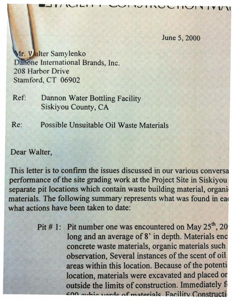
r. Iter SanlYlenko one lnten1ational Brands, Inc.
~08 ~1arbor Drive Statn tt.1rd. CT 06902
Ref Dannon Water Bottling Facility Siskiyou County, CA
June 5, 2000
Re: Possible Unsuitable Oil Waste Materials
Dear Walter,
This Jetter is to confrrm the issues discussed in our various conversa performance of the site grading work at the-Project Site in Siskiyou separate pit locations which contain waste building material, organil materials. The following summary represents what was found in eac what actions have been taken to date:
· Pit# 1: Pit number one was encountered on May 25th, 20 long and an average of 8' in depth. Materials enc concrete waste materials, organic materials such observation, Several instances of the scent of oil areas within this location. Because of the potenti location, materials were excavated and placed o . outside the limits of construction. Immediately f!
...___... ______ £nn ~.., .. ~.-:,.. :w r.ft@,.a "~ ""~t~1~ lC! li~r.11itv Constructi

· r ;;.;li ter· Sarn y lcr~ko t ); li\~rc tr-,; ~;nJti t !~__ md IYnnds. !11 -. 21) ~~ I i<H'b<~ r · U r'i'r ~: :-; r :-;m i·~~'d . C"T 06902
f~ <: l· I l;'Jt1t1 J lll W~rt~ !' n o ttl i n f~ F a~o: il i t y ;i rd~ ' )' ' U' Colllnty, C:\
Iuiie' ;:, ;. IOU
1 ~ ... l' <;~·~ ibl e Unsuitabl e O il \Va$1<: ivtatt·ri :d ~
tC!
Th i lcttcl' 1 ~. tC• confirm the i)sucs dl.;c.usscet 111 ,·,ur Vfil'""' <' <lll\1 <·r·~.Jlt<ll1', ltrh' lcr.t \\\;d. I ''" 111l) th .; . p<; i"l'v nnan ce: ,,~ fthc •; it~ .glading '''Ork :11th.: l'n>kt' t Sit<' 111 't·;l-.i )' •Hl < ntrrrt ; . t 1\ '"' •;11Lil111tl l! IL-d tlrrce I '• ) '~l'>; lr ~rt~· pit lo C<.ttl rii S whic h cont rt in wn. tL' buildin~ llt rrtL·ri :d, ur·~·"'i'; JJI , tl<: l'l.d ~ ttlld P•' '· , ,hk ' rl w:t·. tc mat,;r 1 41! ~ . Tl1<: f'rlllll\Ving . u111111ar .• n.; pt'L· ·~ ,:nt ~. wh;rt "'"' tound i11 •: .n;h •tl tho,; I• ,,, .,rtl"ll'• ,;'"· ' JJIII<;n:d '"'"
w lt;Ji ;tel i(! m ha c bel'n taken to ddtL~ :
I' it !! I: !'11 nulllbL'I' nnl' was .:llcounll'rl'd on 1\·b~ :~">'' ' , ., 000 .uHI r. "1111' 1;\IIIJ.Itl'l y .:: 11' \\ uk by li) lung .rnd <Ill a .:r<tg<.: of!)' in d.:pth ivLtt'.:riab clluHIIItl' ,;d 111 tl11 •i ic>~.' .tll"t' 111 l111k umcrd.: wast~ rn:.tcria b. url;!an ic matcriil b sud1 a·· '• HJd ch IJ''; .lfld t• •p· ... rl I >u t II t 1' ~· lr ,.;l; ot ser ,uion, Several instanc~s ol'tlw s~:cntufoll ur lucl \\l'l<~ e ll '"'"1\:rnJ Ill ' '·llttllh arCilli \ ithin thiS ktl'iltioll . J.kcaliSL.' of tht• pulCiltial lor ~<Hllitllllfi.ttnllllllkf t.t\ -. HI thh location. materials wurc excavat.:d and pl:u:l'd on,, ·,llltd lay.:r .,f' 1· qtll: l'll " "''1.'1111)~ outside the limits of construction. lmm.:di.ttcly li•llowing tlrt· 1\:hll';ttH•tr ut appru.XIIll.lh:ly 600 cuhic vards of materials. htcility Constrm:tiun !'vhlll<~!!Ctncnt . lm . n .. ;r,lmah~d tiH: efforts of System Consultant~ to lilkc o;ampks and p.:rlurtll tl''h ill! tho· nt.tkt rail or
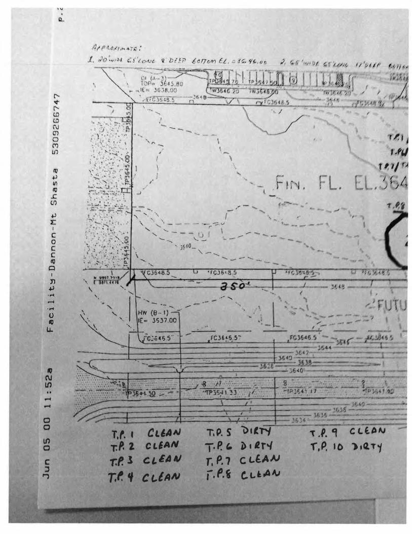
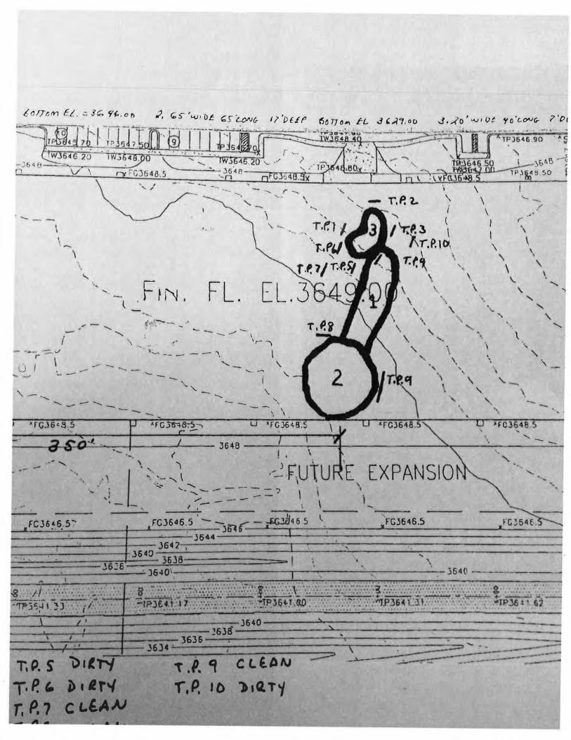
verification of contents.
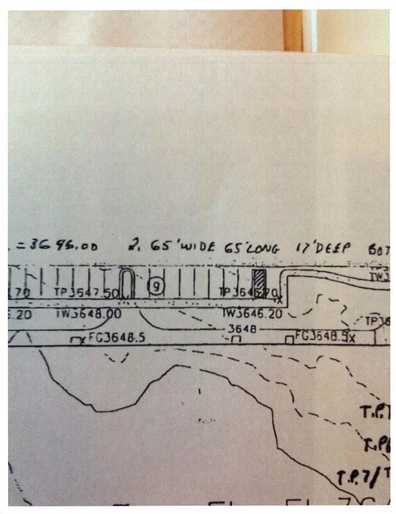
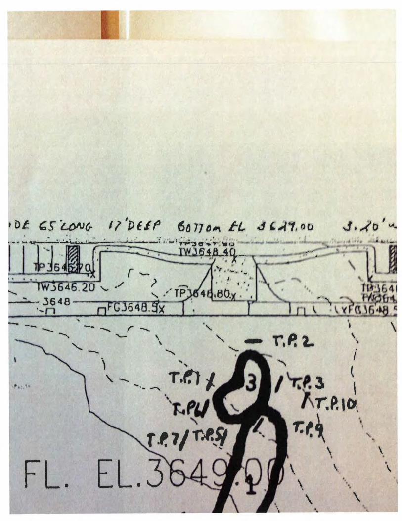
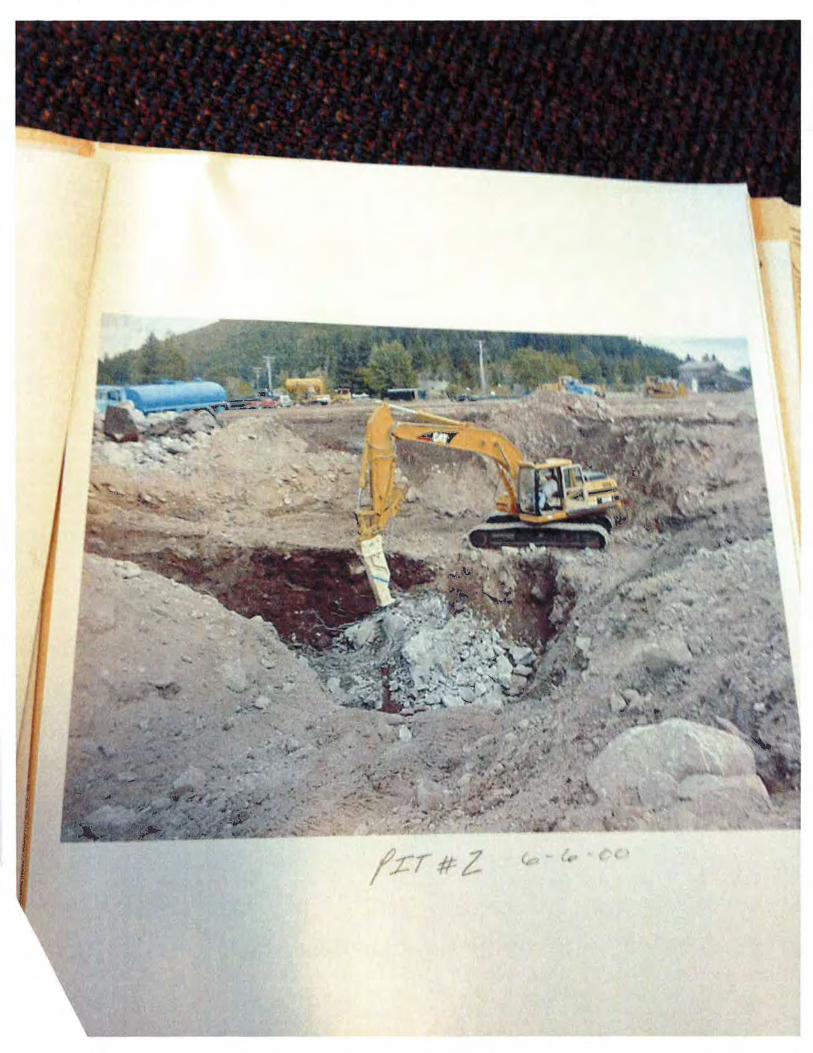
Pit # 2: Pit number two was cncountcrcu on M;)y 31 ''. 20(Hl and j, at tid\ time .tppruxltnatt:l) h'i · wide by 65' long and an average of 17' in dl·pth. This loclllion app~·ar-; II· hl· .ltl~;')ilsting on site landfill for the previous land owner. Materials encountered tn tl11s ltlliltton itbo included concrete waste m<~terials. organic materials such:~:> wood 'hip~ .md top·.otl as well as in place concrete foundations varying in ~ize . Durm~ the cxl.!tvl'ltttlll of tltt location evidence of possible contaminates were found the numHng, ol June \ 20(Jfl .
Excavation and relocation of these materials has he en '\tl,)pptd
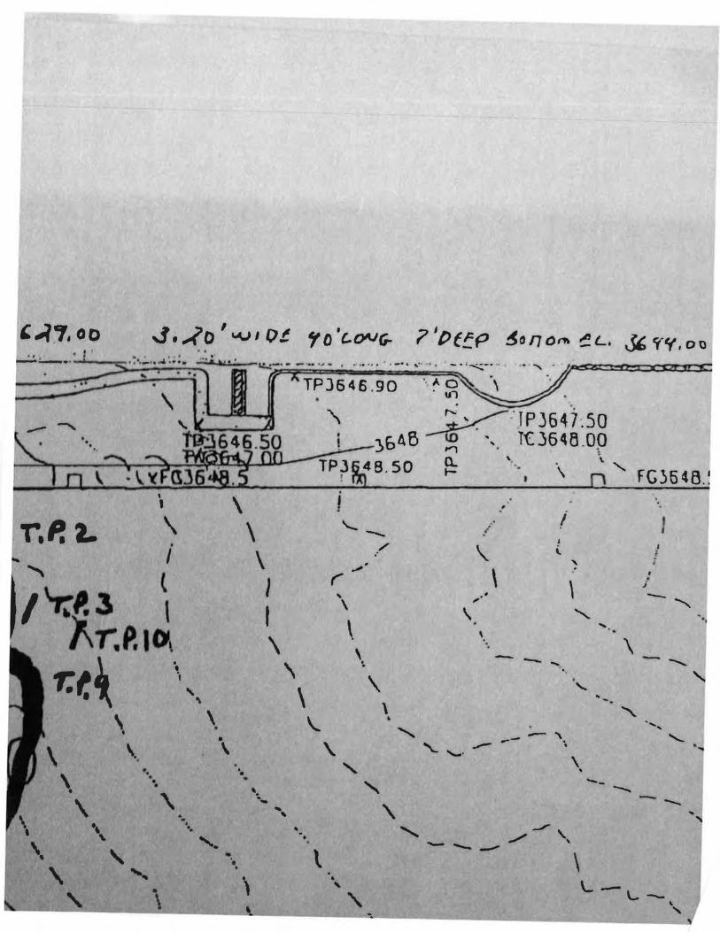
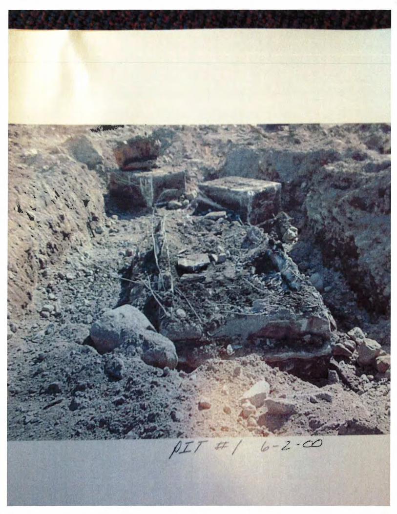
Pit tl 3: Pit number three was encountered on June 2"'1• 2000 at II :00 AM and b itpproximatd;. 20' wide by 40' long and an average of 7' Ill depth . tv1atC::niils encountered tn this lm:ation include existing in place foundations and organic wood chip materials . The portion of foundation exposed is approximately 6' wide by 40' long, ami an average depth of 3 ·. The top of foundation is approximately 8' below the existing surface dcvatton Once the foundation was exposed evidence of oil and/or fuel waste was encountered in so tis surrounding the foundation. From local sources we were told that the foundatitm is approximately 70' in length and was used as a foundation for the de-barker conve-. er it was also stated that the total length of the conveyer was btlieved to be 200' and · ' supported by several spread type foundations. Upon discovery of the po~slhle contaminates we stopped all work within this location.
~ rhe request ofUIIIIOQO 1ntcN'Il•ltiorwJa1'81~ds.lnc. Facility Construction Management, Inc. has contacted Carol Crow, at tho Quality Control Board kl Redding. Ca ho in turn
SflJ(MliU·C:OIUIIlY tleahh Department who will visit the Project srtc

It is o111' l'l'Colllllllmdation that Danone International Brands, Inc. notifies in writillb~. tiH: lu~:al aud/ur• ·tall: !~ovcruing agencies having jurisdiction in this matter in accordance with Califumia Stall; Law a·. wdl a· L'IIIJlloy a third party material testing company to verify if conraminatcs exist in thl: lllitll; t• ial ~ .
I would likL' to reiterate that any necessary environmental remediation ot' the •;oil·; from any of Pit• I,'). will he thL' responsibility ofthe owner. Facility Construction Management, lm:. will a~1~ht ita IIH: L:oPnlin·llion and management of the removal process so as to minimize as nluch a•; pw;~HhiL; any l111pat thl' project cost and schedule. I will keep you informed regarding the magnitudl: ol the impact oil the prOjl:Gt caused by the remediation of these soils and materials.
I have altached to this letter a breakdown on the additional costs incurn:d through Frid;·,y .luuc 2'"1• '1,()1
will continue to do so for the duration of this process . If you have any questions pertaining to the t:oll\
of this letter or attachment please do not hesitate to contact me.
Rcgan.b.
J E. Currie Project Manager, Western Region
JC\0:\PROJECTS\99160-Dannon\Construc\CORRESP\OWNER\Unsuit Mat Ltr 06-05-00.doc
Attacbmehts
...., I:
I
c 0 c c 10
Cl I
n ~ ..... ~ ..... 0 ~
IJ..
_, N tn •• ~
~
0 0
lf) 0
c :l ,.,
a..
. . ,_)
,JI. \ • 4 ... . ... ~ ·
.' ~ ,, .: t • :
: -· ... ·:~ ..... :~· ..... .. .. · .. .. ...... g • ~- :_. .. ·_: ... '!/ \ ' , "1''' 1.0
.. ~ •• ' .... !.
.. :.-.... ~ ~:.. ·-· '- . , ... - .:.. ~ 7": .. ......,. . : ..._· ~ ..... · . .
: .. .
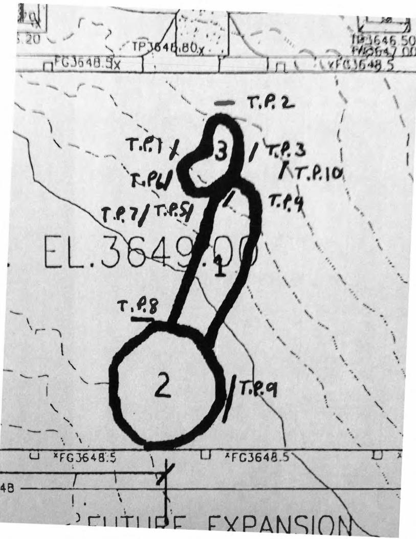
T,f. I T.P. z. r:f.l Ttf.'
() I (•1 - ~' r.._ p.,., JE-.i s.so ( ,_, 3GJB, GG
,), '~ ·: ' ,, , :,j
• / '< r c-' 6 ~as-~---;..,~ 6 < e--=::...--'7-:---....-
- --- -,.. --
;
!
' · .
CLIAN Cc.fAN
CL6AII
CLIAN
,...... I
r ,-,
I ~
.,---........ -- ....... -- - ·
T,P. S
T·P.' r. P.1 f. fJ.i
· ~.
·.: I --
1>1£
i>•l.r'i C c..~AAJ e,.t.l.AN
r:-t ,.._""; I I '
.. ,
·--
't .1. , -r.P. ao
II ' !J tll'
T'.l
J~IJ·
f '1/ r ) _ ~ .. -.. I .J /(;
CLE.~AJ
')aG.Ttf
-- - -·-\
l .FtN I FL. -....
~,.- .......... ' --. -- _, - \
( {~- .. ;' •, ........ ... ,.., ",--'
- - -;::. v ,-u l ---- --·- -· ---- -.... _ -
"---- ............ - -
.--' \ ... ~ ·. I . · ..... .. ~ --
~~- ----- "'·
... , \.
\
\ '
'\
"· ' '
E EXPANSIO
----
'-- -..... /
'
' \
' ' ' \ \
\ ' ' '-
' ' .........
·. \ \ . . . .,
' ' -' -
~~~~~----~----~ 3636 ---T--------------~----.-------~--------~--~ ~~~~----~- J6J4==~==~;=~~~=-;;-~~~========
T, t'. S' T . I. Cf C l E. A AI ---------
T· P.' r.P. •o ,,Q. T~ r. P. {I
"'

I TJ D"'' f-L .3 ';(1. 00
" i (
I 'T:P. 3 I Ar.P.J&,
I T.f.'
\
•. \ ·. \ \ .
'
' .... . \ ...
\ '
' . '
E EXPANSIO .. ,
f'GJ646.5
·. ·~
' \
\
\
\
'
\ . \
\
' '
AO • u ·l
~ IP3647 .50 )f>t.B ~~ ·. iC 3545 00
a.. • \ ·- \
-- - , I ,.
" ' \ / \
,.. "' \ ......
\ \ \ - - ' ---\ .... '-..
\ ..
\. " '- - - · "\ \. ' '-- '- ...... ' \
~ ' --... -' \ -...._ ·, ........ '
~ ---- - - ' t '
" \.. ·-., L-. ' .~ ......... _ ... - - \
'--\ \
-..... . -..... ,.
-' ' ' ·
...... . ·~ · .
· . . . ~ ·.
......
'-
Q._ : u._ X
w .. ) ~~---
l· --.
' . ·- ? . .... ' ' l ' ,_ -. TP I
'" T -- ...=f ·-. 1t3.~x J l \
,.
' '{ --, '
''-.
' ' r.P.L -, \ '· \ '""" I I ., \ ..... •,
' I
T.f.lJ I \.. ............ .
- .~-, \
' PIJ I ' ' T ·'- 7/ r..r.,)J
' \ ...
L. 3 \ \
t \ . •. \ \
' \
\ ·~ .. " \.
. .....___
' '· \ • ... 'r- '
.. . .. . " " •
\ #
' \
\ \
\ .. ' .
2 . ......_-
'- ' • • ' I \ • .
' ' ' ..... ' .. ' '-- ' ·. -- ' . . •
' u )C FG 364 a·~5 )
... · . .
4B •
' \ ·. •
- l Cl ~QAt\JSIO

/11 P "-!J;r I"'- 4 TIC :
1. tJo'a.u,~l.. '!'t.oi\Je- g' IJ!.t? i~fTniYl ~L .
' ,.
. •
• • 01 (A-J,) ·~ TOP= 3li45.BO
I
·~~IE= J6J8.00 ': .,!f.,...C_J..._6_48 ........ --s ~~n J 6 4 B --=:::::a~
"" \ ----.. :1 ~
:. . . .. . . ..... ~ ·- .. - ~ ... ..,.._. •• I • •• • .-- I . . . . .• • 4.. .•. . . . . :J . . . . .
I • : •e o I • , I.__ . ..·. .-. - . .. . . . .. . . . .. . .. -.... . ..... • . . ~ ..... , . . . . .. . ...
! ; ...._,
........ --- --..... ~--
' ' . . . . . .. . ' ... ·\· : . ' . . ' " - '
~--~····-·'~~·· ~· ~=·~--------------------~~--~6--~
· .. ....... -- -- """ ...... ,
""'-
' .. .
• --- --.. ....... ..
FL.
..
' . - -... r -.... ' '-- ' \ ' -- """"
•
' \ r.~t.. \
\
"" I
t 3 \ T.P. I D ..
T.f.' ' •.
' ' \ \ ' •
\ . \ \
• ~
r.P. L '
I
\ \
\ \.
\. •.
' '
• •
••
" \
. , '
·•••
.. \ • \
'·
\ \
. ••
• • • \
\ I I \
'· .....
\ \ \.
• ·. \
I \......--
... \
\
'
' '
... '
/
~
\ \ ..
' '\ '
,
.,·· i I j
\ " ' J •
\ .
' .• , \ ' · . .... .
' . ·. \ -- ..... • . •
" .. -. ' . ....... - ' ......... -- .
'- ~ • '-•
\ ...
• -- -... - -... ..
\ L-\...--
' '
r Z
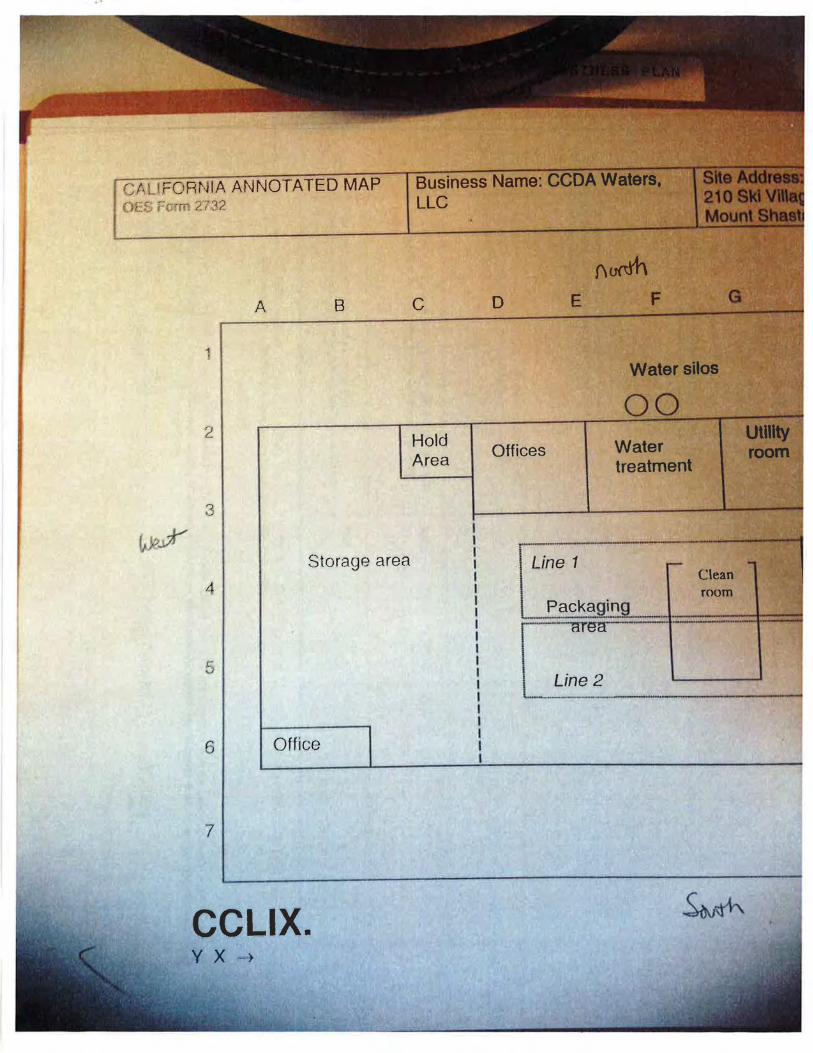
CALI FORNIA ANNOTATED MAP C ES F7rr: 2/32
1
2
') •.J
A 8
Storage area
4
5
6 Office
7
CCLIX. y X -·~
Business Name: ........ ·-LLC
c
Hold Area
D E
Offices
Line 1
Line 2
F
00 Water treatment
Clean room
E
u e2
F
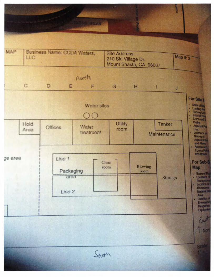
Site Address: 21 0 Ski Viltage Dr Mount CA
G H
Water silos
00 tlaJec re.a:ment
Cie~n
room
Utility room
Tanker
Maintenance
Blowtng
see. '"~t
SJ<I VILLAGE DRIVE:
C..u T LU "-'\ i3. t:.R. 'STO RAC1E:..
?lt4 CeDAR. ?Roouc-r5J
,Vf-r. S .t--t A-=:.r:4 Dt'v,
__ jl
S !-fOP
! 1h S"D'
sc...a.Le.:
Department of Toxic Substances Control
Matthew Rodriquez Secretary for
Environmental Protection
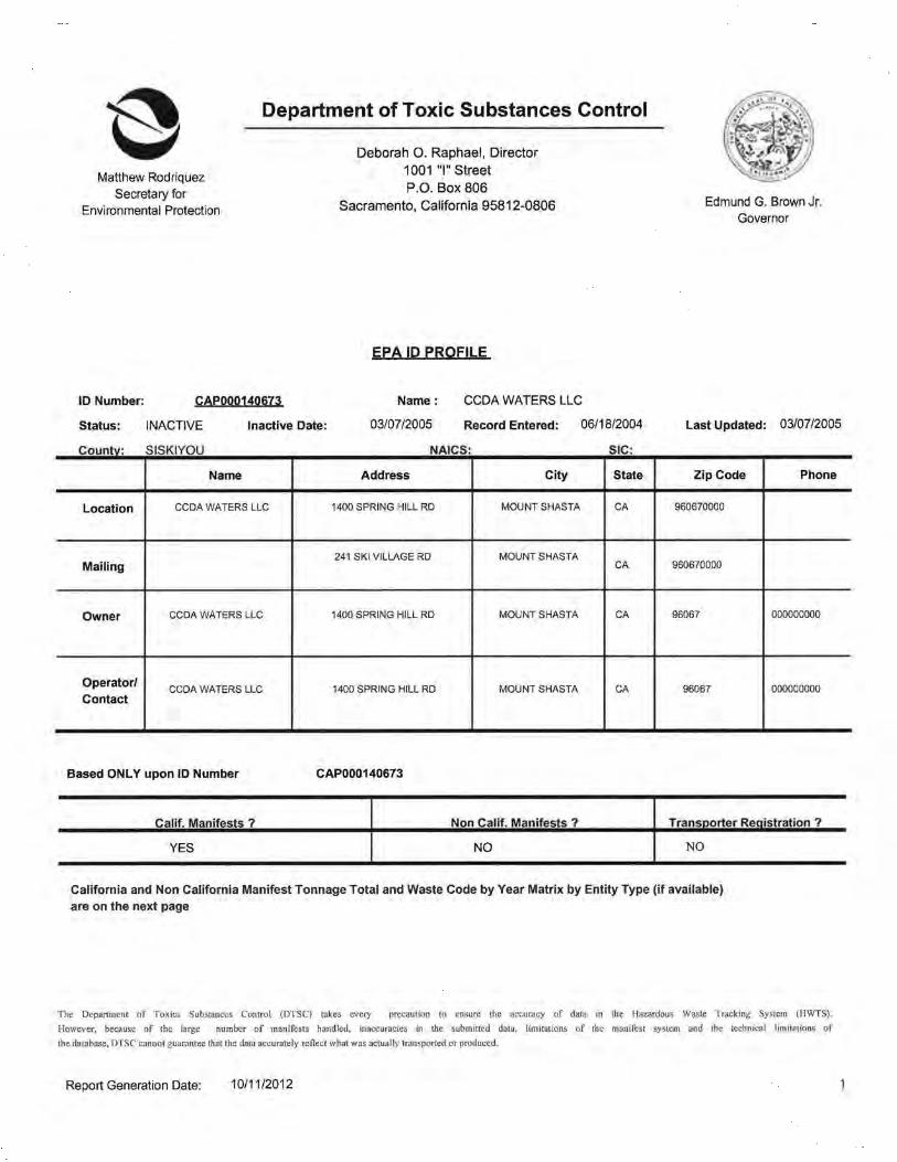
ID Number: CAP000140673
Status: INACTIVE Inactive Date:
Countv: SISKIYOU
Name
Location CCDA WATERS LLC
Mailing
Owner CCDA WATERS LLC
Operator/ CCDA WATERS LLC
Contact
Deborah 0. Raphael, Director
1001 "I" Street
P.O. Box 806 Sacramento, California 95812-0806
EPA ID PROFILE
Name: CCDA WATERS LLC
03/07/2005 Record Entered: 06/18/2004
NAICS: SIC:
Address City State
1400 SPRING HILL RD MOUNT SHASTA CA
241 SKI VILLAGE RD MOUNT SHASTA CA
1400 SPRING HILL RD MOUNT SHASTA CA
1400 SPRING HILL RD MOUNT SHASTA CA
Based ONLY upon ID Number CAP000140673
Calif. Manifests ? Non Calif. Manifests ?
YES NO
Edmund G. Brown Jr. Governor
Last Updated: 03/07/2005
Zip Code Phone
960670000
960670000
96067 000000000
96067 000000000
Transoorter Registration ?
NO
California and Non California Manifest Tonnage Total and Waste Code by Year Matrix by Entity Type (if available) are on the next page
The Department of Toxics Substances Control (DTSC) takes every precaution to ensure the accuracy of data in the Hazardous Waste Tracking System (HWTS).
However, because of the large number of manifests handled, inaccuracies in the submitted data, limitations of the manifest system and the technical Hmltations of
the database, DTSC cannot guarantee that the data accurately reflect what was actually transported or produced.
Report Generation Date: 10/11/2012
2003
Calif.
RCRA
Calif. Manifest Counts and Total Tonnage
Top line represents Manifest Count and Bottom line represents Total Tonnage
GE ERA TOR
6 91.0224
Non California Manifest Total Tonnage
Qenerator
Generator
Waste Code By Year By Entity Matrix Report (based on California Manifests only)
Transporter I TranspQ!:l!lr 2 IS..I2E
T ranS[!Orter I Trans[!ortcr 2 T DF
Report Generation Date: 10/11/2012
All. TSDF
81!. TSDF
2

California Waste Code By Year Matrix
10 Number: CAP000140673
Entlly Type : GENERATOR
Weight (In Tons)
Calif Sh1p Years
Code Descrtption 2003
61 1 CONTAMINATED SOILS 91.0224 FROM SITE CLEAN-UP
Grand Total 91.0224
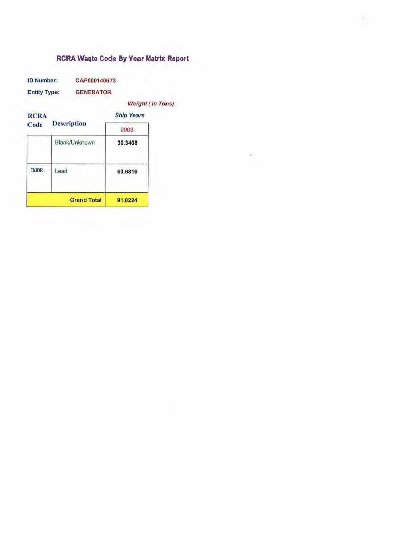
RCRA Was.te Co.<Je By Year M"'trtx Report
10 Number: CAP000140673
GENERATOR Entity Type:
RCRA Code Descript ion
Blank/Unknown
DOOS Lead
Grand Total
Weight (in Tons)
Ship Years
2003
30.3408
60.6816
91 .0224
Department of Toxic Substances Control
Matthew Rodriquez Secretary for
Environmental Protection
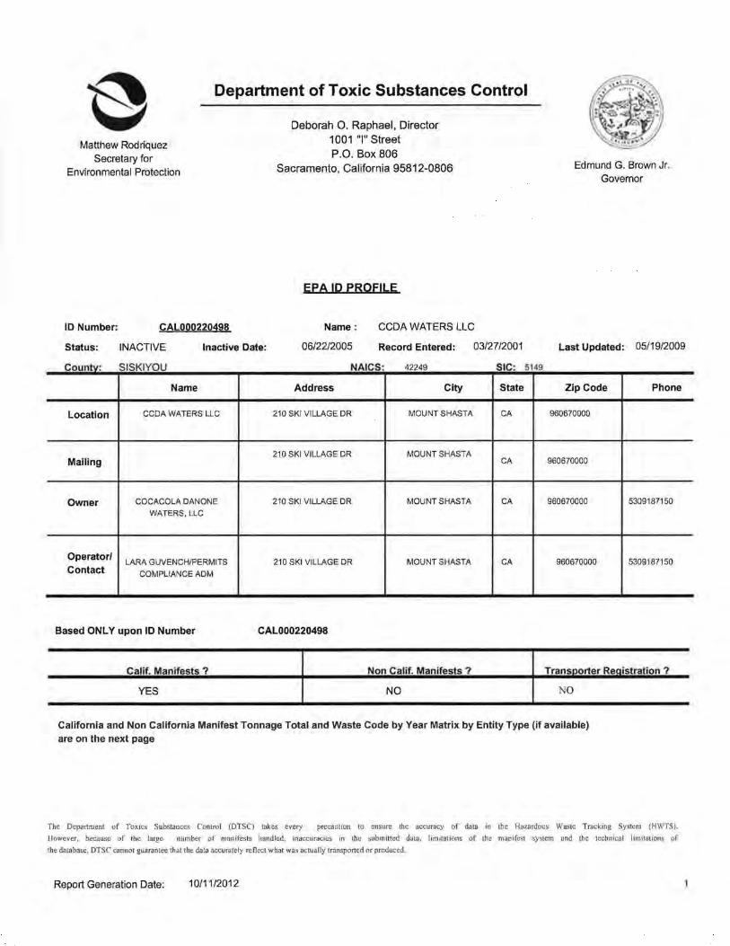
ID Number: CAL000220498
Status: INACTIVE Inactive Date:
Countv: SISKIYOU
Name
Location CCDA WATERS LLC
Mailing
Owner COCACOLA DANONE
WATERS, LLC
Operator/ LARA GUVENCH/PERMITS
Contact COMPLIANCE ADM
Deborah 0. Raphael, Director 1001 "I" Street P.O. Box 806
Sacramento, California 95812-0806
EPA !D PROFILE
Name : CCDA WATERS LLC
06/22/2005 Record Entered: 03/2712001
NAICS: 42249 SIC:
Address City State
210 SKI VILLAGE DR MOUNT SHASTA CA
210 SKI VILLAGE DR MOUNT SHASTA CA
210 SKI VILLAGE DR MOUNT SHASTA CA
210 SKI VILLAGE DR MOUNT SHASTA CA
Based ONLY upon ID Number CAL000220498
Calif. Manifests ? Non Calif. Manifests ?
YES NO
5149
Edmund G. Brown Jr. Governor
Last Updated: 05/19/2009
Zip Code Phone
960670000
960670000
960670000 5309187150
960670000 53091871 50
Transoorter Reaistration ?
NO
California and Non California Manifest Tonnage Total and Waste Code by Year Matrix by Entity Type (if available) are on the next page
The Department of Toxics Substances Control (DTSC} takes every precaution to ensure the accuracy of data in the Hazardous Waste Tracking System (HWTS) .
However, because of the large number of manifests handled, inaccuracies in the submitted data, limitations of the manifest system and the technical limitations of
the database, DTSC cannot guarantee that the data accurately reflect what was actually transported or produced.
Report Generation Date: 10/1112012
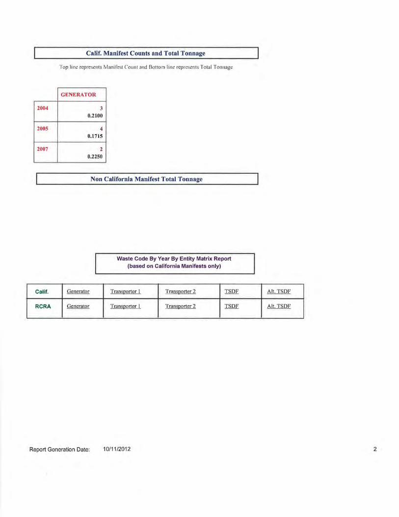
2004
2005
2007
Calif.
RCRA
Calif. Manifest Counts and Total Tonnage
Top line represents tvlanifest Co unt and Bottom line represents Total Tonnage
GENERATOR
3 0.2100
4 0.1715
2 0.2250
Non California Manifest Total Tonnage
Generator
Generator
Waste Code By Year By Entity Matrix Report (based on California Manifests only)
TransQorter I Trans11orter 2 TSDF
Trans11orter I TranSQQrter 2 TSDF
Report Generation Date: 10/11/2012
Alt. TSDF
Alt, TSDF
2
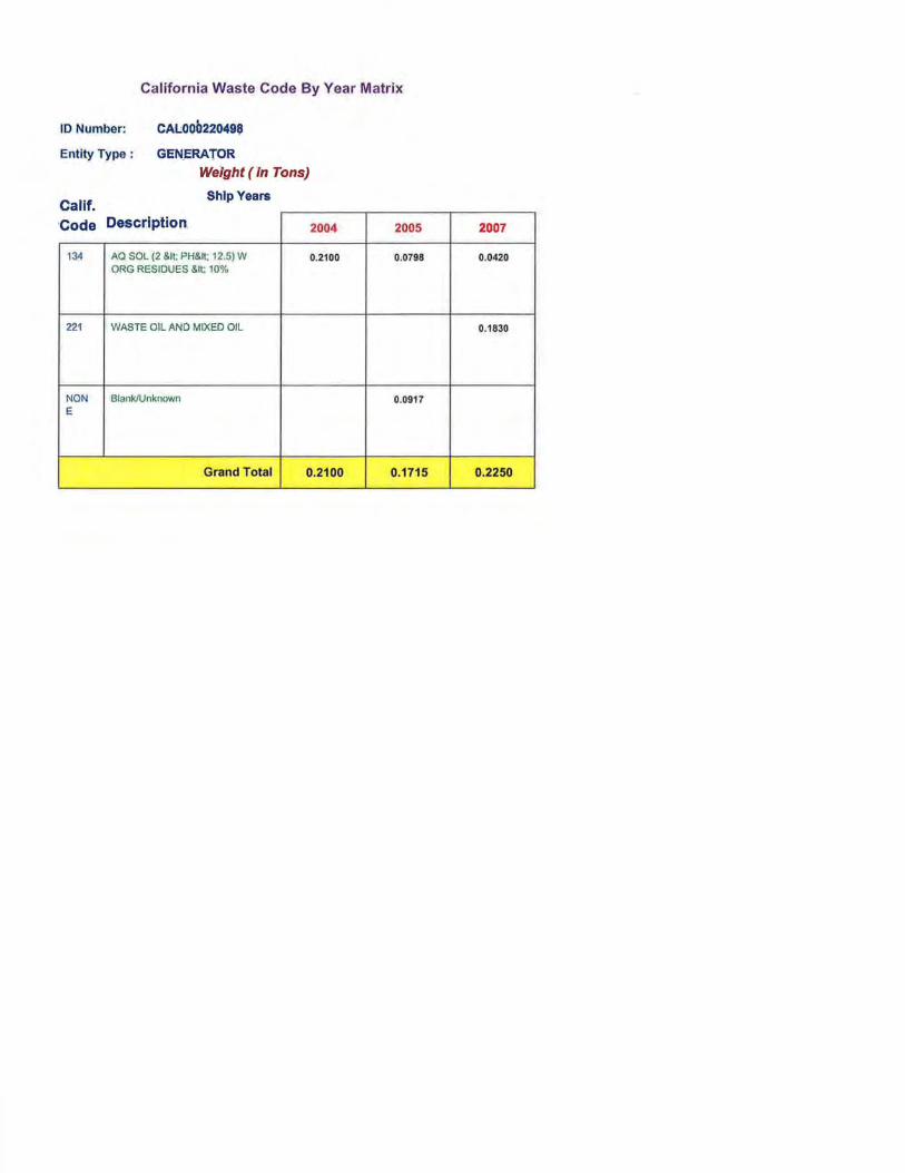
Californ ia Waste Code By Year Matrix
ID Number:
Entity Type :
C.AL00012049$
GENERATOR Weight (In Tons)
Oalif Shlp Years
·Code Description. 2004
134 AQ SOL (2 &It; PH&It; 12,5) W 0.2100 ORG RESIDUES S.lt: 10%
221 WASTE OIL ANO MIXED OIL
NON Blank/Unknown E
Grand Total 0.2100
2005
0:0798
0.0917
0.1715
2007
0.0420
0.1830
0.2250

Matthew Rodriquez Secretary for
Environmental Protection
Department of Toxic Substances Control
Deborah 0. Raphael, Director 1001 "I" Street P.O. Box 806
Sacramento, California 95812-0806
EPA ID PROFILE
Edmund G. Brown Jr. Governor
ID Number: CAL000295470 Name: COCA COLA DANONE WATERS, LLC
Status: ACTIVE Inactive Date: Record Entered: 06/22/2005 Last Updated: 12/07/2011
County: SISKIYOU NAICS: 42249 SIC: 5149
Name Address City State Zip Code Phone
Location COCA COLA DANONE 210 SKI VILLAGE DR MOUNT SHASTA CA 960670000
WATERS, LLC
1551 ATLANTIC STREET UNION CITY Mailing CA 945870000
Owner THE COCA-COLA 1 COCA COLA PLZ NW ATLANTA GA 303132420 4046762121
COMPANY
Operator/ ANN MACDONALD 1551 ATLANTIC STREET UNION CITY CA 945870000 5104767088
Contact
Based ONLY upon ID Number CAL000295470
Calif. Manifests ? Non Calif. Manifests ? Transoorter Re~istration ?
YES NO NO
California and Non California Manifest Tonnage Total and Waste Code by Year Matrix by Entity Type (if available) are on the next page
The Department of Toxics s~bstances Control (DTSC) takes every precaution to ensure the accuracy of data in the Hazardous Waste Tracking System (HWTS).
However, because of the large number of manifests handled, inaccuracies in the submitted data, limitations of the manifest system and the technical Hmjtations of
the database, DTSC cannot guarantee that the data accurately reflect what was actually transported or produced.
Report Generation Date: 10/11/2012
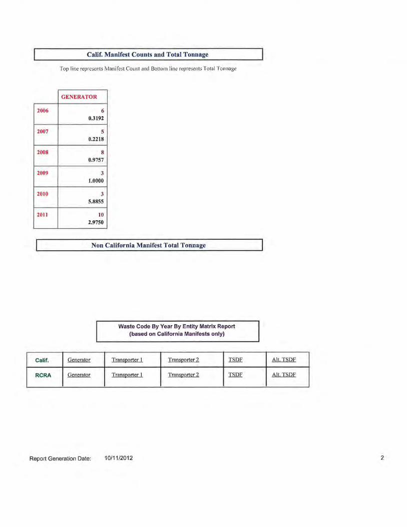
2006
2007
2008
2009
2010
2011
Calif.
RCRA
Calif. Manifest Counts and Total Tonnage
Top line rep1·esents Manifest Count and Bottom lin~ represents Total Tonnage
GENERATOR
6 0.3192
5 0.2218
8 0.9757
3 1.0000
3 5.8855
10 2.9750
Non California Manifest Total Tonnage
Generator
Generator
Waste Code By Year By Entity Matrix Report (based on California Manifests only)
Transporter I Transporter 2 TSDF
Transporter I Transporter 2 TSDF
Report Generation Date: 10/11/2012
Alt. TSDF
Alt. TSD.E
2
California Waste Code By Year Matrix
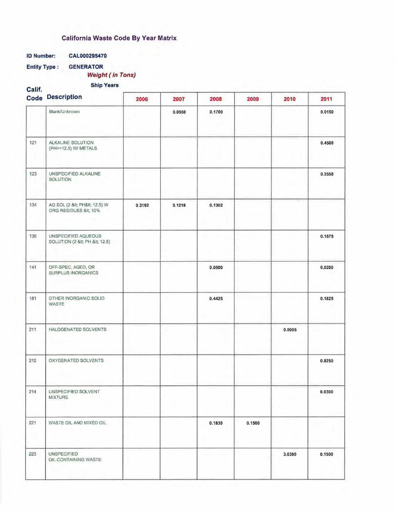
ID Number: CAL000295470
GENERATOR Entity Type :
Weight (in Tons)
Calif Ship Years
Code Description
Blank/Unknown
121 ALKALINE SOLUTION (PH>=12.5) W/ METALS
123 UNSPECIFIED ALKALINE SOLUTION
134 AQ SOL (2 &It; PH&It; 12.5) W ORG RESIDUES &It; 10%
135 UNSPECIFIED AQUEOUS SOLUTION (2 &It; PH &It; 12.5}
141 OFF-SPEC, AGED, OR SURPLUS INORGANICS
181 OTHER INORGANIC SOLID WASTE
211 HALOGENATED SOLVENTS
212 OXYGENATED SOLVENTS
214 UNSPECIFIED SOLVENT MIXTURE
221 WASTE OIL AND MIXED OIL
223 UNSPECIFIED OIL-CONTAINING WASTE
2006 2007
0.0550
0.3192 0.1218
2008 2009 2010 2011
0.1700 0.0150
0.4500
0.2550
0.1302
0.1575
0.0500 0.0200
0.4425 0.1825
0.0005
0.8250
0.0300
0.1830 0.1500
3.0300 0.1500
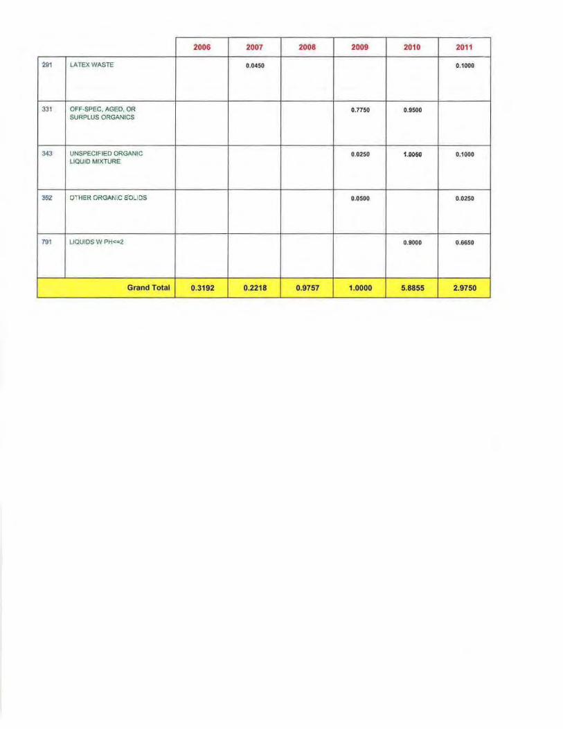
2006 2007 2008 2009 2010 2011
291 LATEX WASTE 0.0450 0.1000
331 OFF-SPEC. AGED, OR 0.7750 0.9500 SURPLUS ORGANICS
343 UNSPECIFIED ORGANIC 0.0250 1.11050 0.1000 LIQUID MIXTURE
352 OTHER ORGANlC s·OLIQS 0.0500 0 .0250
791 LIQUIDS W PH<-=2 0.9000 0.6650
Grand Total 0.3192 0.2218 0.9757 1.0000 5.8855 2.9750
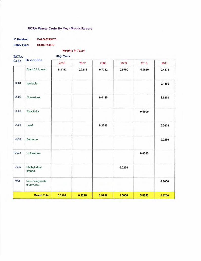
RCRA Waste Code By Year Matrix Report
ID Number: CAL000295470
GENERATOR Entity Type:
RCRA Code Description
Blank/Unknown
0001 Ignitable
0002 Corrosives
0003 Reactivity
0008 Lead
0018 Benzene
0022 Chloroform
0035 Methyl ethyl ketone
F005 Non-halogenate d solvents
Grand Total
Weight (in Tons)
Ship Years
2006 2007
0.3192 0.2218
0.3192 0.2218
2008 2009 2010 2011
0.7382 0.9750 4.9850 0.4275
0.1400
0.0125 1.5200
0.9000
0.2250 0.0625
0.0250
0.0005
0.0250
0.8000
0.9757 1.0000 5.8855 2.9750
APPENDIX H Qualifications of
Environmental Professionals

TRACEY LYNN SCHWARTZ regulatory compliance
waste management/closure RCRA/CERCLA due Diligence
REPRESENTATIVE SKILLS AND EXPERIENCE Ms. Schwartz has over 20 years of experience in the field of regulatory compliance and permitting, environmental investigations, litigation support and research to support property transactions. As Environmental Manager for a manufacturing and importing business, she audited forestry suppliers for sustainable practices and implemented a management system for waste minimization and conformance to corporate customer environmental requirements. She supported the U.S. EPA on their RCRA/Superfund Hazardous Waste Hotline for two years, and performed environmental impact audits and supported wildlife conservation projects in South Africa. Her consulting responsibilities have included multi-media compliance audits, due diligence for complex industrial facility acquisitions and divestitures, environmental support for process manufacturing and waste handling, site investigations and regulatory support leading to closure of the facility. Representative project experience includes:
Environmental Site Assessment / Support of Demolition Activities, Confidential Catalyst Manufacturer, California: For this 95-year old manufacturing facility, Ms. Schwartz performed an extensive review of historical operations that included the manufacturing of pesticides, tear gas, chemicals, airplane components, and automotive and petroleum catalysts. For the Phase I Site Assessment, extensive documentation and inspection records from agency files and other sources was reviewed to provide a comprehensive site history. Additional support was provided on regulated unit closure/post closure, closure strategy, historical regulatory status, permit closure, corrective action compliance, investigation-derived waste management, and site closure.
Regulatory Permit and Historic Assessment, Confidential Refinery and Chemical Manufacturer, California: Ms. Schwartz performed a comprehensive regulatory permitting assessment of a refinery and chemical manufacturing operation to identify key issues associated with closure and post-closure activities at the facility. Because much of the facility has already been demolished, extensive review of over 100 years of site history was necessary in order to identify area specific historical operations and resulting issues. Activities included records review, research for site-specific environmental criteria and agency jurisdictional issues.
1 of 6
TRACEY L. SCHWARTZ Historic Resource and Documentation Assessment, Confidential Department of Defense Contractor, Virginia. For a former solid rocket propellant production facility, a comprehensive assessment was performed to review waste management practices and to identify and evaluate historical resources to determine if and where there is a potential for additional burial areas, trenching, and burn areas. Activities included extensive record and historical resource review in conjunction with existing physical and geophysical survey data. Phase I Environmental Site Assessment, Four Corners Generating Station, Southern California Edison: Ms. Schwartz performed a large-scale Phase I ESA for the Four Corners Generating Station (FCGS), a large coal-burning power plant located in northwestern New Mexico on land leased by the Navajo Nation. Since initiation of the plant in 1959, coal-combustion residuals have been disposed onsite and on adjoining properties. Geosyntec was contracted to perform a suite of due diligence services for the site to evaluate the potential environmental liabilities associated with the possible sale of the client’s interest in the FCGS which resulted in a successful property transaction. In addition to the Phase 1, additional services were performed in association with identifying risks from the adjacent coal plant.
RCRA Part B Program Compliance and Development, Confidential Industrial Facility, Western US: Ms. Schwartz is the lead consultant for a large treatment/recycling RCRA TSDF. She managed the revision of a Part B permit for the RCRA treatment and storage facility. Issues included closure cost development, waste classification, financial assurance, interpretation of agency guidance, emergency release reporting, regulatory unit closure and interaction with state and federal agencies. Key waste streams include waste oil, used glycol, oily water, and solvent wastes.
Multi-media Compliance Reviews and Environmental Site Assessments, Cummins West, Incorporated, California: In support of a corporate transaction, Ms. Schwartz conducted performed compliance reviews and Phase I ESAs to evaluate for the potential presence of Recognized Environmental Conditions, at select Cummins distribution and repair facilities. The compliance portion of the project included a review of available hazardous waste manifests, environmental permits, Material Safety Data Sheets, and plans, such as Hazardous Materials Business Plans and Spill Prevention Control and Countermeasure Plans, where applicable. Key issues included waste characterization, wastewater collection, emergency response, recycling, and/or treatment systems used at each of the facilities.
2 of 6
TRACEY L. SCHWARTZ RCRA Program Compliance and Development, Confidential Copper Mine, Arizona: Ms. Schwartz performed a gap analysis and permit review before recommending compliance program modifications. She also assisted in the development of a subcontractor training program. Key issues included waste analysis, written waste determinations, RCRA exclusions, transportation, storage, and documentation.
RCRA Program Compliance and Strategy, Hazardous Waste Management Training, Confidential Military Base, Georgia: Ms. Schwartz is the lead regulatory manager for a multi-disciplinary project concerning RCRA compliance, Part B Permit renewal, modification and negotiation, permit interpretation, and waste disposal issues. She is also responsible for annual Hazardous Waste Management Training and has performed waste evaluations at the base in order to determine whether waste streams should be listed or characteristic waste.
Multi-media Compliance Audits, Regulatory Support, Agency Interaction and Strategy Development, Confidential Manufacturers, California: Ms. Schwartz performed comprehensive regulatory compliance audits and support for a group of specialty metal forge manufacturers for the medical, aerospace, and automotive industries. Tasks included development of comprehensive regulatory programs to resolve historic enforcement orders, waste analysis and determinations, preparation for agency inspections, and preparation of regulatory strategy for litigation support and agency settlement conferences. As a result of the program, the client went from having 28 NOVs at one facility during the last inspection to zero during the most recent agency visit.
Multi-media Compliance Audits, Hazardous Materials Business Plan Preparation and Local Agency (CUPA) Compliance, Telecommunications Facilities, Confidential Client, Nationwide: Ms. Schwartz performed audits of eleven warehouse, office, switch, and distributed antenna system hotel (“DAS Hotel”) facilities in California and supervised more than 3,000 paperwork audits The audits focused on compliance with certain provisions of the Emergency Planning and Community Right-to-Know Act (EPCRA), the Clean Water Act, Clean Air Act, and RCRA. Ms. Schwartz prepared SPCC plans, assisted with air permitting, prepared EPCRA filings which included Hazardous Material Business Plans and provided waste management support for many of the audit sites. As a result of the audit findings, the company entered into an audit agreement with the U.S. EPA with Geosyntec providing on-going compliance support.
3 of 6
TRACEY L. SCHWARTZ Hazardous Waste and Material Classification and Disposal Preparation, Agency Inspection Support, Confidential Hospitality Operation, Arizona: Ms. Schwartz performed a waste classification audit in preparation for a large disposal event at a remote resort location in Arizona. Key issues were associated with boat repair and servicing, fleet servicing, boat fueling, waste transportation, sumps and secondary containment structures, and old electrical equipment. As a result of the work performed at the site, the inspection yielded zero violations for the first time in their inspection history.
Multi-media Compliance Audits and Transactional Due Diligence, Confidential E-waste and Pharmaceutical Waste Processing Facility, California: In support of a property transaction for Waste Management, Inc. regulatory compliance audits were performed at three facilities in California involved in the pickup of household, e-waste, and city and county-sponsored specialty waste programs. Issues included compliance with e-waste and pharmaceutical waste transporter requirements, permitting of temporary storage facilities, handling of carcinogens, hazardous waste and universal waste classification and management, and employee training. Activities included records review, site reconnaissance, and employee interviews across multiple work shifts.
Multimedia Compliance Review and Litigation Support, Confidential Manufacturer, Cudahy, California: At the request of their attorneys, Ms. Schwartz performed a compliance audit focusing release reporting, emergency response, hazardous waste and material issues, permit-by rule requirements, permit closures, and point of generation issues associated operations and wastewater treatment and discharge.
RCRA Delisting Petition Preparation, Solid Waste/ Hazardous Waste Landfill, Texas: In response to an agency violation notice concerning the disposal of listed hazardous waste as non-hazardous, Ms. Schwartz assisted in the preparation of a delisting petition for landfill leachate at the site. In addition to writing the petition, other tasks included the review of analytical data and correspondence with EPA representatives.
RCRA Permit Compliance and Litigation Support, Confidential Coatings Manufacturer, California: Ms. Schwartz was project manager for a multi-disciplinary project concerning RCRA permitting and compliance and legal defense for a large coating manufacturer threatened with Proposition 65 litigation. Activities included full-
4 of 6
TRACEY L. SCHWARTZ scale regulatory compliance review and document preparation, air sampling and analysis, and attorney support.
Multi-media Compliance Audits, Confidential Manufacturer, Oregon, California and Texas: Ms. Schwartz performed comprehensive regulatory compliance audits of a heavy equipment manufacturer for their large property located on a waterfront and adjacent to a federal Superfund site as well as a number of their service centers. Issues included waste water and air permitting, storm water management, hazardous waste training and management, and oversight of remediation activities. Activities included records review, research for site-specific environmental criteria, site reconnaissance, employee interviews and report preparation.
Remedial Design and Construction Permitting, Superfund Site, California: Ms. Schwartz wrote permitting documents for an extensive groundwater remediation Superfund project. As part of a multi-disciplinary team, she served as the lead permit specialist for the completion of extremely varied permit requirements. These include: CEQA, well installation permits for multiple agencies, 97-005 Drinking Water Permit from the California Department of Health Services and numerous access, right-of-way and construction permits.
Multi-media Compliance Audits, Confidential Manufacturer, California: Ms. Schwartz performed a comprehensive regulatory compliance audit of a specialty component manufacturer for the medical and automotive industries. Issues included waste water and air permitting, handling of carcinogens, hazardous waste classification and management, and employee training. Activities included records review, site reconnaissance, and employee interviews across multiple work shifts. Recommendations included an analysis of transport and fate of a volatile organic compound used in the manufacturing process, redesign of the wastewater treatment system, and employee training to reduce and replace the chemical use in the facility.
Regulatory Specialist, U.S. Environmental Protection Agency, Washington DC: For the U.S. EPA RCRA/Superfund Hotline, Ms. Schwartz consulted to the public and industry regarding all aspects of the federal hazardous waste program as a specialist on the Environmental Protection Agency’s RCRA/Superfund Hotline staffed by Booz, Allen and Hamilton. In addition, she developed a lecture series as an educational program for new hotline staff and researched inconsistencies in the regulations.
Product Development and Support, Formations International Inc, California: Ms. Schwartz implemented all aspects of a Forest Stewardship Council (FSC)
5 of 6

TRACEY L. SCHWARTZ compliant program for sustainably-grown wood products for this building products manufacturer. She managed import compliance, domestic regulations and health and safety standards for domestic, South African, and Chinese facilities including environmental regulations, domestic and international transportation requirements and Food and Drug Administration requirements for food-safe materials. In addition, she recommended, researched and implemented waste minimization standards and use of “green” building products, created and maintained quality control procedures and managed client and customer contact and logistics programs.
Environmental Technology and Trend Research, Confidential Environmental Investment Fund, Washington DC: Ms. Schwartz tracked performance and environmental sensitivity of over 700 companies involved in environmental technology and services. She performed site visits to evaluate the manufacturing processes, researched environmental trends and issues and evaluated the environmental sensitivity of companies included in stock portfolios.
EDUCATION University of Maryland: B.S., Environmental Science, 1990
PROFESSIONAL HISTORY
Geosyntec Consultants, Senior Scientist, 2006-Present Formations International Inc., Vice President – Operations, 1998–2006 Geomatrix Consultants, Project Scientist, 1996-1998 Environmental Solutions, Environmental Scientist, 1993-1996 US Environmental Protection Agency, Regulatory Specialist, 1991-1993
6 of 6

MAP FINDINGSMap IDDirection
EDR ID NumberDistanceEPA ID NumberDatabase(s)SiteElevation
A3 HAZNETCOCA COLA DANONE WATERS, LLC S113137801Target 210 SKI VILLAGE DR N/AProperty MOUNT SHASTA, CA 96067
Actual:3679 ft.
Site 3 of 5 in cluster A
HAZNET: S113137801envid: 2011Year: CAL000295470GEPAID: ANN MACDONALDContact: 5104767088Telephone: Not reportedMailing Name: 1551 ATLANTIC STREETMailing Address: UNION CITY, CA 945870000Mailing City,St,Zip: Not reportedGen County: NVT330010000TSD EPA ID: Not reportedTSD County: Other organic solidsWaste Category: Landfill Or Surface Impoundment That Will Be Closed As Landfill( ToDisposal Method: Include On-Site Treatment And/Or Stabilization) 0.025Tons:
Other organic solidsCat Decode: Landfill Or Surface Impoundment That Will Be Closed As Landfill( ToMethod Decode: Include On-Site Treatment And/Or Stabilization) SiskiyouFacility County:
S113137801envid: 2011Year: CAL000295470GEPAID: ANN MACDONALDContact: 5104767088Telephone: Not reportedMailing Name: 1551 ATLANTIC STREETMailing Address: UNION CITY, CA 945870000Mailing City,St,Zip: Not reportedGen County: NVT330010000TSD EPA ID: Not reportedTSD County: Alkaline solution (pH >= 12.5) with metalsWaste Category: Landfill Or Surface Impoundment That Will Be Closed As Landfill( ToDisposal Method: Include On-Site Treatment And/Or Stabilization) 0.45Tons: Alkaline solution (pH >= 12.5) with metalsCat Decode: Landfill Or Surface Impoundment That Will Be Closed As Landfill( ToMethod Decode: Include On-Site Treatment And/Or Stabilization) SiskiyouFacility County:
S113137801envid: 2011Year: CAL000295470GEPAID: ANN MACDONALDContact: 5104767088Telephone: Not reportedMailing Name: 1551 ATLANTIC STREETMailing Address: UNION CITY, CA 945870000Mailing City,St,Zip: Not reportedGen County: NVT330010000TSD EPA ID:
Page: 1

MAP FINDINGSMap IDDirection
EDR ID NumberDistanceEPA ID NumberDatabase(s)SiteElevation
Not reportedTSD County: Off-specification, aged or surplus inorganicsWaste Category: Other Recovery Of Reclamation For Reuse Including Acid Regeneration,Disposal Method: Organics Recovery Ect 0.01Tons: Off-specification, aged or surplus inorganicsCat Decode: Other Recovery Of Reclamation For Reuse Including Acid Regeneration,Method Decode: Organics Recovery Ect SiskiyouFacility County:
S113137801envid: 2011Year: CAL000295470GEPAID: ANN MACDONALDContact: 5104767088Telephone: Not reportedMailing Name: 1551 ATLANTIC STREETMailing Address: UNION CITY, CA 945870000Mailing City,St,Zip: Not reportedGen County: NVT330010000TSD EPA ID: Not reportedTSD County: Latex wasteWaste Category:
Other Recovery Of Reclamation For Reuse Including Acid Regeneration,Disposal Method: Organics Recovery Ect 0.1Tons: Latex wasteCat Decode: Other Recovery Of Reclamation For Reuse Including Acid Regeneration,Method Decode: Organics Recovery Ect SiskiyouFacility County:
S113137801envid: 2011Year: CAL000295470GEPAID: ANN MACDONALDContact: 5104767088Telephone: Not reportedMailing Name: 1551 ATLANTIC STREETMailing Address: UNION CITY, CA 945870000Mailing City,St,Zip: Not reportedGen County: TXD077603371TSD EPA ID: Not reportedTSD County: Unspecified solvent mixtureWaste Category: Fuel Blending Prior To Energy Recovery At Another SiteDisposal Method: 0.03Tons: Unspecified solvent mixtureCat Decode: Fuel Blending Prior To Energy Recovery At Another SiteMethod Decode: SiskiyouFacility County:
Click this hyperlink while viewing on your computer to access 32 additional CA_HAZNET: record(s) in the EDR Site Report.
Page: 2

MAP FINDINGSMap IDDirection
EDR ID NumberDistanceEPA ID NumberDatabase(s)SiteElevation
A2 ENFCRYSTAL GEYSER WATER COMPANY S108202787Target 210 SKI VILLAGE DR N/AProperty MOUNT SHASTA, CA 96067
Actual:3679 ft.
Site 2 of 5 in cluster A
ENF: 5RRegion: 215034Facility Id: Crystal Geyser Water CompanyAgency Name: Industrial and Commercial ServicesPlace Type: Food ProcessorPlace Subtype: IndustrialFacility Type: Privately-Owned BusinessAgency Type: 1# Of Agencies: 41.32712Place Latitude: -122.31734Place Longitude: 2086SIC Code 1: Bottled and Canned Soft Drinks and Carbonated WatersSIC Desc 1: 5149SIC Code 2: Groceries and Related Products, NECSIC Desc 2: 1541SIC Code 3: General Contractors-Industrial Buildings and WarehousesSIC Desc 3: Not reportedNAICS Code 1: Not reportedNAICS Desc 1: Not reportedNAICS Code 2: Not reportedNAICS Desc 2: Not reportedNAICS Code 3: Not reportedNAICS Desc 3: 1# Of Places: Reg MeasSource Of Facility: 0Design Flow: 3Threat To Water Quality: CComplexity:
X - Facility is not a POTWPretreatment: Domestic wastewaterFacility Waste Type: Not reportedFacility Waste Type 2: Not reportedFacility Waste Type 3: Not reportedFacility Waste Type 4: WDRINDFPProgram: WDRProgram Category1: WDRProgram Category2: 1# Of Programs: 5A472001001WDID: 148456Reg Measure Id: WDRReg Measure Type: Not reportedRegion: 5-01-233Order #: Not reportedNpdes# CA#: Not reportedMajor-Minor: Not reportedNpdes Type: N - NoReclamation: Not reportedDredge Fill Fee: Not reported301H: 900Application Fee Amt Received: ActiveStatus: 04/18/2014Status Date:
Page: 1

MAP FINDINGSMap IDDirection
EDR ID NumberDistanceEPA ID NumberDatabase(s)SiteElevation
09/07/2001Effective Date: 09/07/2016Expiration/Review Date: Not reportedTermination Date: Not reportedWDR Review - Amend: Not reportedWDR Review - Revise/Renew: Not reportedWDR Review - Rescind: Not reportedWDR Review - No Action Required: Not reportedWDR Review - Pending: Not reportedWDR Review - Planned: NStatus Enrollee: IIndividual/General: 58 - Non15 Based on (TTWQ)/CPLX)Fee Code: PassiveDirection/Voice: 332023Enforcement Id(EID): Not reportedRegion: Not reportedOrder / Resolution Number: Oral CommunicationEnforcement Action Type: 09/11/2007Effective Date: Not reportedAdoption/Issuance Date: Not reportedAchieve Date: 09/11/2007Termination Date: Not reportedACL Issuance Date: Not reportedEPL Issuance Date: HistoricalStatus: Verbal 9/11/2007 for CCDA Waters LLCTitle: Called CCDA to remind them to send June results.Description: WDRProgram: Not reportedLatest Milestone Completion Date: 1# Of Programs1: $0.00Total Assessment Amount: $0.00Initial Assessed Amount: $0.00Liability $ Amount: $0.00Project $ Amount: $0.00Liability $ Paid:
$0.00Project $ Completed: $0.00Total $ Paid/Completed Amount:
5RRegion: 215034Facility Id: Crystal Geyser Water CompanyAgency Name: Industrial and Commercial ServicesPlace Type: Food ProcessorPlace Subtype: IndustrialFacility Type: Privately-Owned BusinessAgency Type: 1# Of Agencies: 41.32712Place Latitude: -122.31734Place Longitude: 2086SIC Code 1: Bottled and Canned Soft Drinks and Carbonated WatersSIC Desc 1: 5149SIC Code 2: Groceries and Related Products, NECSIC Desc 2: 1541SIC Code 3: General Contractors-Industrial Buildings and WarehousesSIC Desc 3: Not reportedNAICS Code 1: Not reportedNAICS Desc 1: Not reportedNAICS Code 2: Not reportedNAICS Desc 2: Not reportedNAICS Code 3: Not reportedNAICS Desc 3:
Page: 2

MAP FINDINGSMap IDDirection
EDR ID NumberDistanceEPA ID NumberDatabase(s)SiteElevation
1# Of Places: Reg MeasSource Of Facility: 0Design Flow: 3Threat To Water Quality: CComplexity: X - Facility is not a POTWPretreatment: Domestic wastewaterFacility Waste Type: Not reportedFacility Waste Type 2: Not reportedFacility Waste Type 3: Not reportedFacility Waste Type 4: WDRINDFPProgram: WDRProgram Category1: WDRProgram Category2: 1# Of Programs: 5A472001001WDID: 148456Reg Measure Id: WDRReg Measure Type: Not reportedRegion: 5-01-233Order #: Not reportedNpdes# CA#: Not reportedMajor-Minor: Not reportedNpdes Type: N - NoReclamation: Not reportedDredge Fill Fee: Not reported301H: 900Application Fee Amt Received: ActiveStatus: 04/18/2014Status Date: 09/07/2001Effective Date: 09/07/2016Expiration/Review Date: Not reportedTermination Date: Not reportedWDR Review - Amend:
Not reportedWDR Review - Revise/Renew: Not reportedWDR Review - Rescind: Not reportedWDR Review - No Action Required: Not reportedWDR Review - Pending: Not reportedWDR Review - Planned: NStatus Enrollee: IIndividual/General: 58 - Non15 Based on (TTWQ)/CPLX)Fee Code: PassiveDirection/Voice: 307343Enforcement Id(EID): Not reportedRegion: Not reportedOrder / Resolution Number: Notice of ViolationEnforcement Action Type: 05/23/2006Effective Date: 05/23/2006Adoption/Issuance Date: Not reportedAchieve Date: 05/23/2006Termination Date: Not reportedACL Issuance Date: Not reportedEPL Issuance Date: HistoricalStatus: NOV 5/26/2006 for CCDA Waters LLCTitle: The discharge of bottle rinse water, floor wash water, CIPDescription: wastewater, pipeline disinfection water, and domestic wastewater to surface waters or surface water drainage courses is prohibited WDRProgram: Not reportedLatest Milestone Completion Date:
Page: 3

MAP FINDINGSMap IDDirection
EDR ID NumberDistanceEPA ID NumberDatabase(s)SiteElevation
1# Of Programs1: $0.00Total Assessment Amount: $0.00Initial Assessed Amount: $0.00Liability $ Amount: $0.00Project $ Amount: $0.00Liability $ Paid: $0.00Project $ Completed: $0.00Total $ Paid/Completed Amount:
Page: 4

MAP FINDINGSMap IDDirection
EDR ID NumberDistanceEPA ID NumberDatabase(s)SiteElevation
B7 LUSTERICKSON TRUCKING S102429253
NNE HIST CORTESE305 SKI VILLAGE DR N/A< 1/8 MT SHASTA, CA 96067
Relative:Higher
Actual:3704 ft.
0.018 mi.95 ft. Site 2 of 2 in cluster B
LUST: STATERegion: T0609300156Global Id: 41.3271474Latitude: -122.3171767Longitude: LUST Cleanup SiteCase Type: Completed - Case ClosedStatus: 03/17/1993Status Date: SISKIYOU COUNTYLead Agency: GENCase Worker: SISKIYOU COUNTYLocal Agency: 470022RB Case Number: Not reportedLOC Case Number: Not reportedFile Location: SoilPotential Media Affect: DieselPotential Contaminants of Concern: Not reportedSite History:
Click here to access the California GeoTracker records for this facility:
Contact: T0609300156Global Id: Regional Board CaseworkerContact Type: RECEPTIONIST, REGION 5 REDDINGContact Name: CENTRAL VALLEY RWQCB (REGION 5R)Organization Name: 415 KNOLLCREST DR., SUITE 100Address: REDDINGCity: Not reportedEmail: Not reportedPhone Number:
T0609300156Global Id: Local Agency CaseworkerContact Type: GENE BELCASTROContact Name: SISKIYOU COUNTYOrganization Name: 806 SOUTH MAIN STREETAddress: YREKACity: Not reportedEmail: Not reportedPhone Number:
Status History: T0609300156Global Id: Completed - Case ClosedStatus: 03/17/1993Status Date:
T0609300156Global Id: Open - Case Begin DateStatus: 04/15/1992Status Date:
T0609300156Global Id: Open - Site AssessmentStatus:
Page: 1

MAP FINDINGSMap IDDirection
EDR ID NumberDistanceEPA ID NumberDatabase(s)SiteElevation
06/28/1992Status Date:
Regulatory Activities: T0609300156Global Id: OtherAction Type: 04/15/1992Date: Leak DiscoveryAction:
T0609300156Global Id: OtherAction Type: 06/16/1992Date: Leak ReportedAction:
T0609300156Global Id: ENFORCEMENTAction Type: 03/17/1993Date: Closure/No Further Action LetterAction:
T0609300156Global Id: OtherAction Type: 04/15/1992Date: Leak StoppedAction:
LUST REG 5:5Region:Case ClosedStatus:470022Case Number:Soil onlyCase Type:DIESELSubstance:CMBStaff Initials:LocalLead Agency:LUSTProgram:N/AMTBE Code:
HIST CORTESE: CORTESERegion: 47Facility County Code: LTNKAReg By: 470022Reg Id:
Page: 2

MAP FINDINGSMap IDDirection
EDR ID NumberDistanceEPA ID NumberDatabase(s)SiteElevation
A4 WDSCOCA COLA WATER BOTTLING FACIL S105256615Target 210 SKI VILLAGE DR N/AProperty MT SHASTA, CA 96067
Actual:3679 ft.
Site 4 of 5 in cluster A
WDS: Sacramento River 472001001Facility ID: Industrial - Facility that treats and/or disposes of liquid orFacility Type: semisolid wastes from any servicing, producing, manufacturing or processing operation of whatever nature, including mining, gravel washing, geothermal operations, air conditioning, ship building and repairing, oil production, storage and disposal operations, water pumping. Active - Any facility with a continuous or seasonal discharge that isFacility Status: under Waste Discharge Requirements. Not reportedNPDES Number: 0Subregion: 5309187140Facility Telephone: JAMES L PETERSONFacility Contact: CCDA WATERS LLCAgency Name: 210 SKI VILLAGE DRAgency Address: MT SHASTA 96067Agency City,St,Zip: PEGGY PELUCCAAgency Contact: 5309187145Agency Telephone: PrivateAgency Type: 5149SIC Code: Not reportedSIC Code 2: Nonhazardous Solid Wastes/Influent or Solid Wastes that containPrimary Waste Type:
nonhazardous putrescible and non putrescible solid, semisolid, and liquid wastes (E.G., garbage, trash, refuse, paper, demolition and construction wastes, manure, vegetable or animal solid and semisolid waste). DOMINDPrimary Waste: Not reportedWaste Type2: Domestic Sewage combined with Industrial WasteWaste2: Nonhazardous Solid Wastes/Influent or Solid Wastes that containPrimary Waste Type: nonhazardous putrescible and non putrescible solid, semisolid, and liquid wastes (E.G., garbage, trash, refuse, paper, demolition and construction wastes, manure, vegetable or animal solid and semisolid waste). Not reportedSecondary Waste: Not reportedSecondary Waste Type: 0Design Flow: 0Baseline Flow: No reclamation requirements associated with this facility.Reclamation: The facility is not a POTW.POTW: Minor Threat to Water Quality. A violation of a regional board orderTreat To Water: should cause a relatively minor impairment of beneficial uses compared to a major or minor threat. Not: All nurds without a TTWQ will be considered a minor threat to water quality unless coded at a higher Level. A Zero (0) may be used to code those NURDS that are found to represent no threat to water quality. Category C - Facilities having no waste treatment systems, such asComplexity: cooling water dischargers or thosewho must comply through best management practices, facilities with passive waste treatment and disposal systems, such as septic systems with subsurface disposal, or
Page: 1

MAP FINDINGSMap IDDirection
EDR ID NumberDistanceEPA ID NumberDatabase(s)SiteElevation
dischargers having waste storage systems with land disposal such as dairy waste ponds.
5R 47I016440Facility ID: Industrial - Facility that treats and/or disposes of liquid orFacility Type: semisolid wastes from any servicing, producing, manufacturing or processing operation of whatever nature, including mining, gravel washing, geothermal operations, air conditioning, ship building and repairing, oil production, storage and disposal operations, water pumping. Active - Any facility with a continuous or seasonal discharge that isFacility Status: under Waste Discharge Requirements. CAS000001 The 1st 2 characters designate the state. The remaining 7NPDES Number: are assigned by the Regional Board 0Subregion: 5309187140Facility Telephone: JAMES L PETERSONFacility Contact: CCDA WATERS LLCAgency Name: 210 SKI VILLAGE DRAgency Address: MT SHASTA 96067Agency City,St,Zip: PEGGY PELUCCAAgency Contact: 5309187145Agency Telephone: PrivateAgency Type: 2086SIC Code: Not reportedSIC Code 2: Inert/Influent or Solid Wastes that do not contain soluble pollutantsPrimary Waste Type: or organic wastes and have little adverse impact on water quality. Such wastes could cause turbidity and siltation. Uncontaminated soils, rubble and concrete are examples of this category.
STORMSPrimary Waste: Not reportedWaste Type2: Stormwater RunoffWaste2: Inert/Influent or Solid Wastes that do not contain soluble pollutantsPrimary Waste Type: or organic wastes and have little adverse impact on water quality. Such wastes could cause turbidity and siltation. Uncontaminated soils, rubble and concrete are examples of this category. Not reportedSecondary Waste: Not reportedSecondary Waste Type: 0Design Flow: 0Baseline Flow: Not reportedReclamation: Not reportedPOTW: Minor Threat to Water Quality. A violation of a regional board orderTreat To Water: should cause a relatively minor impairment of beneficial uses compared to a major or minor threat. Not: All nurds without a TTWQ will be considered a minor threat to water quality unless coded at a higher Level. A Zero (0) may be used to code those NURDS that are found to represent no threat to water quality. Category C - Facilities having no waste treatment systems, such asComplexity: cooling water dischargers or thosewho must comply through best management practices, facilities with passive waste treatment and disposal systems, such as septic systems with subsurface disposal, or dischargers having waste storage systems with land disposal such as dairy waste ponds.
Page: 2

MAP FINDINGSMap IDDirection
EDR ID NumberDistanceEPA ID NumberDatabase(s)SiteElevation
D14 LUSTSHELL SS DON ERICKSON S102437370WSW 1031 NIXON N/A1/8-1/4 MT SHASTA, CA 96067
Relative:Lower
Actual:3606 ft.
0.134 mi.705 ft. Site 1 of 4 in cluster D
LUST REG 5:5Region:Case ClosedStatus:470028Case Number:Soil onlyCase Type:
GASOLINESubstance:CMBStaff Initials:LocalLead Agency:LUSTProgram:N/AMTBE Code:
Page: 1

MAP FINDINGSMap IDDirection
EDR ID NumberDistanceEPA ID NumberDatabase(s)SiteElevation
G22 LUSTRAMBOS TRUCK STOP S110655577South TRUCK VILLAGE DR N/A1/4-1/2 MT SHASTA, CA 96067
Relative:Lower
Actual:3556 ft.
0.467 mi.2467 ft. Site 1 of 3 in cluster G
LUST: STATERegion: T0609300147Global Id: 41.3166584Latitude: -122.3198147Longitude: LUST Cleanup SiteCase Type: Completed - Case ClosedStatus: 01/30/1992Status Date: SISKIYOU COUNTYLead Agency: GENCase Worker: SISKIYOU COUNTYLocal Agency: 470013RB Case Number: Not reportedLOC Case Number: Not reportedFile Location: SoilPotential Media Affect: DieselPotential Contaminants of Concern: Not reportedSite History:
Click here to access the California GeoTracker records for this facility:
Contact: T0609300147Global Id: Local Agency CaseworkerContact Type: GENE BELCASTROContact Name: SISKIYOU COUNTYOrganization Name: 806 SOUTH MAIN STREETAddress: YREKACity: Not reportedEmail: Not reportedPhone Number:
Status History: T0609300147Global Id: Completed - Case ClosedStatus: 01/30/1992Status Date:
T0609300147Global Id: Open - Case Begin DateStatus: 11/22/1989Status Date:
T0609300147Global Id: Open - RemediationStatus:
01/02/1990Status Date:
T0609300147Global Id: Open - Site AssessmentStatus: 12/21/1989Status Date:
Regulatory Activities: T0609300147Global Id: ENFORCEMENTAction Type:
Page: 1

MAP FINDINGSMap IDDirection
EDR ID NumberDistanceEPA ID NumberDatabase(s)SiteElevation
01/30/1992Date: Closure/No Further Action LetterAction:
T0609300147Global Id: OtherAction Type: 11/22/1989Date: Leak DiscoveryAction:
T0609300147Global Id: OtherAction Type: 12/15/1989Date: Leak ReportedAction:
T0609300147Global Id: OtherAction Type: 11/22/1989Date: Leak StoppedAction:
Page: 2

MAP FINDINGSMap IDDirection
EDR ID NumberDistanceEPA ID NumberDatabase(s)SiteElevation
E19 LUSTMERCY MEDICAL CENTER S105025113
SSW HIST CORTESE914 PINE ST N/A1/4-1/2 MT SHASTA, CA 96067
Relative:Lower
Actual:3566 ft.
0.332 mi.1755 ft. Site 2 of 2 in cluster E
LUST: STATERegion: T0609300163Global Id: 41.3190422Latitude: -122.323252Longitude: LUST Cleanup SiteCase Type: Completed - Case ClosedStatus: 03/24/1994Status Date: SISKIYOU COUNTYLead Agency: GENCase Worker: SISKIYOU COUNTYLocal Agency: 470029RB Case Number: Not reportedLOC Case Number: Not reportedFile Location: SoilPotential Media Affect: DieselPotential Contaminants of Concern: Not reportedSite History:
Click here to access the California GeoTracker records for this facility:
Contact: T0609300163Global Id: Regional Board CaseworkerContact Type: RECEPTIONIST, REGION 5 REDDINGContact Name: CENTRAL VALLEY RWQCB (REGION 5R)Organization Name: 415 KNOLLCREST DR., SUITE 100Address: REDDINGCity: Not reportedEmail: Not reportedPhone Number:
T0609300163Global Id: Local Agency CaseworkerContact Type: GENE BELCASTROContact Name: SISKIYOU COUNTYOrganization Name: 806 SOUTH MAIN STREETAddress: YREKACity: Not reportedEmail: Not reportedPhone Number:
Status History: T0609300163Global Id: Completed - Case ClosedStatus: 03/24/1994Status Date:
T0609300163Global Id: Open - Case Begin DateStatus: 03/02/1994Status Date:
T0609300163Global Id: Open - Site AssessmentStatus:
Page: 1

MAP FINDINGSMap IDDirection
EDR ID NumberDistanceEPA ID NumberDatabase(s)SiteElevation
03/02/1994Status Date:
Regulatory Activities: T0609300163Global Id: ENFORCEMENTAction Type: 03/24/1994Date: Closure/No Further Action LetterAction:
T0609300163Global Id: OtherAction Type: 03/02/1994Date: Leak DiscoveryAction:
T0609300163Global Id: OtherAction Type: 03/23/1994Date: Leak ReportedAction:
T0609300163Global Id: OtherAction Type: 03/02/1994Date: Leak StoppedAction:
HIST CORTESE: CORTESERegion: 47Facility County Code: LTNKAReg By: 470029Reg Id:
Page: 2

GEOCHECK - PHYSICAL SETTING SOURCE MAP FINDINGS®
Map IDDirectionDistanceElevation EDR ID NumberDatabase
3WSW1/2 - 1 MileLower
19543CA WELLS
Water System Information:ATTUser ID:40N/04W-08Q01 MPrime Station Code:SiskiyouCounty:4700680001FRDS Number:WELL/AMBNT/MUN/INTAKEStation Type:01District Number:Active RawWell Status:Well/GroundwaterWater Type:1,000 Feet (10 Seconds)Precision:411912.0 1222001.0Source Lat/Long:
WELL 01Source Name:4700680System Number:TASSIES ENTERPRISESSystem Name:
Organization That Operates System:Not Reported
Unknown, Small SystemConnections:Unknown, Small SystemPop Served:Not ReportedArea Served:
Page: 1

MAP FINDINGSMap IDDirection
EDR ID NumberDistanceEPA ID NumberDatabase(s)SiteElevation
D17 LUSTSHELL SS DON ERICKSON S105025112
WSW HIST CORTESE1031 NIXON RD N/A1/8-1/4 MT SHASTA, CA 96067
Relative:Lower
Actual:3606 ft.
0.134 mi.705 ft. Site 4 of 4 in cluster D
LUST: STATERegion: T0609300162Global Id: 41.324642Latitude: -122.3224026Longitude: LUST Cleanup SiteCase Type: Completed - Case ClosedStatus: 01/18/1994Status Date: SISKIYOU COUNTYLead Agency: GENCase Worker: SISKIYOU COUNTYLocal Agency: 470028RB Case Number: Not reportedLOC Case Number: Not reportedFile Location: SoilPotential Media Affect: GasolinePotential Contaminants of Concern: Not reportedSite History:
Click here to access the California GeoTracker records for this facility:
Contact: T0609300162Global Id: Regional Board CaseworkerContact Type: RECEPTIONIST, REGION 5 REDDINGContact Name: CENTRAL VALLEY RWQCB (REGION 5R)Organization Name: 415 KNOLLCREST DR., SUITE 100Address: REDDINGCity: Not reportedEmail: Not reportedPhone Number:
T0609300162Global Id: Local Agency CaseworkerContact Type: GENE BELCASTROContact Name: SISKIYOU COUNTYOrganization Name: 806 SOUTH MAIN STREETAddress: YREKACity: Not reportedEmail: Not reportedPhone Number:
Status History: T0609300162Global Id:
Completed - Case ClosedStatus: 01/18/1994Status Date:
T0609300162Global Id: Open - Case Begin DateStatus: 09/10/1993Status Date:
T0609300162Global Id: Open - Site AssessmentStatus:
Page: 1

MAP FINDINGSMap IDDirection
EDR ID NumberDistanceEPA ID NumberDatabase(s)SiteElevation
12/13/1993Status Date:
Regulatory Activities: T0609300162Global Id: OtherAction Type: 09/10/1993Date: Leak DiscoveryAction:
T0609300162Global Id: OtherAction Type: 11/02/1993Date: Leak ReportedAction:
T0609300162Global Id: ENFORCEMENTAction Type: 01/18/1994Date: Closure/No Further Action LetterAction:
T0609300162Global Id: OtherAction Type: 09/10/1993Date: Leak StoppedAction:
HIST CORTESE: CORTESERegion: 47Facility County Code: LTNKAReg By: 470028Reg Id:
Page: 2

GEOCHECK - PHYSICAL SETTING SOURCE MAP FINDINGS®
Map IDDirectionDistanceElevation EDR ID NumberDatabase
1SE1/2 - 1 MileLower
19544CA WELLS
Water System Information:ATTUser ID:40N/04W-10P01 MPrime Station Code:SiskiyouCounty:4710008004FRDS Number:WELL/AMBNT/MUN/INTAKEStation Type:01District Number:Active UntreatedWell Status:Well/GroundwaterWater Type:1,000 Feet (10 Seconds)Precision:411905.0 1221822.0Source Lat/Long:
HIGH SCHOOL WELL 02Source Name:4710008System Number:City of Mt. ShastaSystem Name:
Organization That Operates System:305 N. MOUNT SHASTA BLVD.MOUNT SHASTA, CA 96067
1555Connections:3549Pop Served:MT. SHASTA, CITY OFArea Served:
8.8 CFindings:21-NOV-13Sample Collected:SOURCE TEMPERATURE CChemical:
76. USFindings:21-NOV-13Sample Collected:SPECIFIC CONDUCTANCEChemical:
7.45Findings:21-NOV-13Sample Collected:PH, LABORATORYChemical:
41. MG/LFindings:21-NOV-13Sample Collected:ALKALINITY (TOTAL) AS CACO3Chemical:
50. MG/LFindings:21-NOV-13Sample Collected:BICARBONATE ALKALINITYChemical:
40. MG/LFindings:21-NOV-13Sample Collected:HARDNESS (TOTAL) AS CACO3Chemical:
6.06 MG/LFindings:21-NOV-13Sample Collected:CALCIUMChemical:
2.72 MG/LFindings:21-NOV-13Sample Collected:MAGNESIUMChemical:
6.14 MG/LFindings:21-NOV-13Sample Collected:SODIUMChemical:
1.84 MG/LFindings:21-NOV-13Sample Collected:POTASSIUMChemical:
0.53 MG/LFindings:21-NOV-13Sample Collected:CHLORIDEChemical:
466. UG/LFindings:21-NOV-13Sample Collected:IRONChemical:
86. MG/LFindings:21-NOV-13Sample Collected:TOTAL DISSOLVED SOLIDSChemical:
10.2Findings:21-NOV-13Sample Collected:AGGRSSIVE INDEX (CORROSIVITY)Chemical:
. 1.1 NTUFindings:22-MAY-15Sample Collected:TURBIDITY, LABORATORYChemical:
Page: 1

MAP FINDINGSMap IDDirection
EDR ID NumberDistanceEPA ID NumberDatabase(s)SiteElevation
B6 WMUDS/SWATMT SHASTA DIV CL III LANDFILL S103442141
NNE HIST UST241 SKI VILLAGE DR N/A< 1/8 MOUNT SHASTA CA, CA 96067
Relative:Higher
Actual:3703 ft.
0.015 mi.78 ft. Site 1 of 2 in cluster B
WMUDS/SWAT: Not reportedEdit Date: Category B - Any facility having a physical, chemical, or biologicalComplexity: waste treatment system (except for septic systems with subsurface disposal), or any Class II or III disposal site, or facilities without treatment systems that are complex, such as marinas with petroleum products, solid wastes, and sewage pump out facilities. SLDWSTPrimary Waste: Nonhazardous Solid Wastes/Influent or Solid Wastes that containPrimary Waste Type: nonhazardous putrescible and non putrescible solid, semisolid, and liquid wastes (E.G., garbage, trash, refuse, paper, demolition and construction wastes, manure, vegetable or animal solid and semisolid waste). Stormwater RunoffSecondary Waste: NSecondary Waste Type: MDBase Meridian: Not reportedNPID: 0Tonnage: Not reportedRegional Board ID: FalseMunicipal Solid Waste: FalseSuperorder: FalseOpen To Public: FalseWaste List: PrivateAgency Type: P&M CEDAR PRODUCTS INCAgency Name: RESIDENT MANAGERAgency Department: 300 PARK MARINA CIRCLEAgency Address: REDDING CA 96001Agency City,St,Zip: GEORGE CAPELLEAgency Contact: 5302424642Agency Telephone: P&M CEDAR PRODUCTS, INC.Land Owner Name: PO BOX 215Land Owner Address: MT SHASTA, CA 96067Land Owner City,St,Zip: JOHN LAMANNALand Owner Contact: 9169264548Land Owner Phone: 5RRegion: Solid Waste Site-Class III - Landfills for non hazardous solid wastes.Facility Type:
Not reportedFacility Description: Not reportedFacility Telephone: P&M CEDAR MT SHASTA SAWMILLSWAT Facility Name: 2421Primary SIC: 4953Secondary SIC: Not reportedComments: Not reportedLast Facility Editors: TrueWaste Discharge System: TrueSolid Waste Assessment Test Program: FalseToxic Pits Cleanup Act Program: FalseResource Conservation Recovery Act: FalseDepartment of Defence: P&M CEDAR PRODUCTS, INC.Solid Waste Assessment Test Program:
Page: 1

MAP FINDINGSMap IDDirection
EDR ID NumberDistanceEPA ID NumberDatabase(s)SiteElevation
Moderate Threat to Water Quality. A violation could have a majorThreat to Water Quality: adverse impact on receiving biota, can cause aesthetic impairment to a significant human population, or render unusable a potential domestic or municipal water supply. Awsthetic impairment would include nuisance from a waste treatment facility. TrueSub Chapter 15: CNCRegional Board Project Officer: 1Number of WMUDS at Facility: 49N04W9Section Range: NoRCRA Facility: HWaste Discharge Requirements: Monthly SubmittalSelf-Monitoring Rept. Frequency: 5A470303001Waste Discharge System ID: Not reportedSolid Waste Information ID:
HIST UST: 000210DAFile Number: http://geotracker.waterboards.ca.gov/ustpdfs/pdf/000210DA.pdfURL: Not reportedRegion: Not reportedFacility ID: Not reportedFacility Type: Not reportedOther Type: Not reportedContact Name: Not reportedTelephone: Not reportedOwner Name: Not reportedOwner Address: Not reportedOwner City,St,Zip: Not reportedTotal Tanks:
Not reportedTank Num: Not reportedContainer Num: Not reportedYear Installed: Not reportedTank Capacity: Not reportedTank Used for: Not reportedType of Fuel: Not reportedContainer Construction Thickness: Not reportedLeak Detection:
Not reportedTank Num: Not reportedContainer Num: Not reportedYear Installed: Not reportedTank Capacity: Not reportedTank Used for: Not reportedType of Fuel:
Not reportedContainer Construction Thickness: Not reportedLeak Detection:
Click here for Geo Tracker PDF:
Page: 2

MAP FINDINGSMap IDDirection
EDR ID NumberDistanceEPA ID NumberDatabase(s)SiteElevation
C12 EDR Hist Auto 1015127707WSW 1014 N MOUNT SHASTA BLVD N/A< 1/8 MOUNT SHASTA, CA 96067
Relative:Lower
Actual:3604 ft.
0.065 mi.345 ft. Site 4 of 4 in cluster C
EDR Historical Auto Stations: SKINNERS ROADSIDE TRUCK REPAIR INCName: 2011Year: 1014 N MOUNT SHASTA BLVDAddress:
SKINNERS ROADSIDE TRUCK REPAIR INCName: 2012Year: 1014 N MOUNT SHASTA BLVDAddress:
Page: 1

MAP FINDINGSMap IDDirection
EDR ID NumberDistanceEPA ID NumberDatabase(s)SiteElevation
F21 LUSTPELLETIER GERALD S105025060
NE HIST CORTESE1604 EVERITT MEMORIAL WAY N/A1/4-1/2 MT SHASTA, CA 96067
Relative:Higher
Actual:3898 ft.
0.446 mi.2355 ft. Site 2 of 2 in cluster F
LUST: STATERegion: T0609300143Global Id: 41.3166584Latitude:
-122.3198147Longitude: LUST Cleanup SiteCase Type: Completed - Case ClosedStatus: 01/29/1992Status Date: SISKIYOU COUNTYLead Agency: MARCase Worker: SISKIYOU COUNTYLocal Agency: 470009RB Case Number: Not reportedLOC Case Number: Not reportedFile Location: SoilPotential Media Affect: GasolinePotential Contaminants of Concern: Not reportedSite History:
Click here to access the California GeoTracker records for this facility:
Contact: T0609300143Global Id: Local Agency CaseworkerContact Type: MARK CRAMERContact Name: SISKIYOU COUNTYOrganization Name: Not reportedAddress: r5 UNKNOWNCity: Not reportedEmail: Not reportedPhone Number:
Status History: T0609300143Global Id: Completed - Case ClosedStatus: 01/29/1992Status Date:
T0609300143Global Id: Open - Case Begin DateStatus: 08/08/1989Status Date:
T0609300143Global Id: Open - Site AssessmentStatus: 08/16/1989Status Date:
Regulatory Activities: T0609300143Global Id: OtherAction Type: 08/08/1989Date: Leak DiscoveryAction:
Page: 1

MAP FINDINGSMap IDDirection
EDR ID NumberDistanceEPA ID NumberDatabase(s)SiteElevation
T0609300143Global Id: OtherAction Type: 08/08/1989Date: Leak ReportedAction:
T0609300143Global Id: ENFORCEMENTAction Type: 01/29/1992Date: Closure/No Further Action LetterAction:
T0609300143Global Id: OtherAction Type:
08/08/1989Date: Leak StoppedAction:
HIST CORTESE: CORTESERegion: 47Facility County Code: LTNKAReg By: 470009Reg Id:
Page: 2

MAP FINDINGSMap IDDirection
EDR ID NumberDistanceEPA ID NumberDatabase(s)SiteElevation
F20 LUSTPELLETIER GERALD S104403736NE 1604 EVERITT MEMORIAL WAY N/A1/4-1/2 MT SHASTA, CA 96067
Relative:Higher
Actual:3898 ft.
0.446 mi.2355 ft. Site 1 of 2 in cluster F
LUST REG 5:5Region:Case ClosedStatus:470009Case Number:Soil onlyCase Type:GASOLINESubstance:RSDStaff Initials:LocalLead Agency:LUSTProgram:N/AMTBE Code:
Page: 1

MAP FINDINGSMap IDDirection
EDR ID NumberDistanceEPA ID NumberDatabase(s)SiteElevation
E18 LUSTMERCY MEDICAL CENTER S102433303SSW 914 PINE ST N/A1/4-1/2 MT SHASTA, CA 96067
Relative:Lower
Actual:3566 ft.
0.332 mi.1755 ft. Site 1 of 2 in cluster E
LUST REG 5:5Region:Case ClosedStatus:470029Case Number:Soil onlyCase Type:DIESELSubstance:CMBStaff Initials:LocalLead Agency:LUSTProgram:N/AMTBE Code:
Page: 1

MAP FINDINGSMap IDDirection
EDR ID NumberDistanceEPA ID NumberDatabase(s)SiteElevation
D15 ASTERICKSON SHELL OIL JOBBER A100339243WSW 1031 NIXON RD. N/A1/8-1/4 MT. SHASTA, CA 96067
Relative:Lower
Actual:3606 ft.
0.134 mi.705 ft. Site 2 of 4 in cluster D
AST: SiskiyouCertified Unified Program Agencies: DON ERICKSONOwner: 77,970Total Gallons:
Page: 1

MAP FINDINGSMap IDDirection
EDR ID NumberDistanceEPA ID NumberDatabase(s)SiteElevation
C11 USTCROSS PETROLEUM U004186620WSW 1012 N. MT. SHASTA BLVD., P.O. BOX 95 N/A< 1/8 MT SHASTA, CA 96067
Relative:Lower
Actual:3603 ft.
0.065 mi.343 ft. Site 3 of 4 in cluster C
UST: 47-001-880091Facility ID: SISKIYOU COUNTYPermitting Agency: 41.32027Latitude: -122.31983Longitude:
Page: 1

MAP FINDINGSMap IDDirection
EDR ID NumberDistanceEPA ID NumberDatabase(s)SiteElevation
G24 LUSTSOUTHERN PACIFIC MT SHASTA S102437846South ALMA ST N/A1/4-1/2 MT SHASTA, CA 96067
Relative:Lower
Actual:3556 ft.
0.467 mi.2467 ft. Site 3 of 3 in cluster G
LUST: STATERegion: T0609300151Global Id: 41.3166584Latitude: -122.3198147Longitude: LUST Cleanup SiteCase Type:
Completed - Case ClosedStatus: 03/17/1993Status Date: SISKIYOU COUNTYLead Agency: MARCase Worker: SISKIYOU COUNTYLocal Agency: 470017RB Case Number: Not reportedLOC Case Number: Not reportedFile Location: SoilPotential Media Affect: GasolinePotential Contaminants of Concern: Not reportedSite History:
Click here to access the California GeoTracker records for this facility:
Contact: T0609300151Global Id: Regional Board CaseworkerContact Type: RECEPTIONIST, REGION 5 REDDINGContact Name: CENTRAL VALLEY RWQCB (REGION 5R)Organization Name: 415 KNOLLCREST DR., SUITE 100Address: REDDINGCity: Not reportedEmail: Not reportedPhone Number:
T0609300151Global Id: Local Agency CaseworkerContact Type: MARK CRAMERContact Name: SISKIYOU COUNTYOrganization Name: Not reportedAddress: r5 UNKNOWNCity: Not reportedEmail: Not reportedPhone Number:
Status History: T0609300151Global Id: Completed - Case ClosedStatus: 03/17/1993Status Date:
T0609300151Global Id: Open - Case Begin DateStatus: 06/08/1988Status Date:
Regulatory Activities: T0609300151Global Id:
Page: 1

MAP FINDINGSMap IDDirection
EDR ID NumberDistanceEPA ID NumberDatabase(s)SiteElevation
ENFORCEMENTAction Type: 03/17/1993Date: Closure/No Further Action LetterAction:
T0609300151Global Id: OtherAction Type: 10/23/1988Date: Leak DiscoveryAction:
T0609300151Global Id: OtherAction Type: 06/08/1988Date: Leak ReportedAction:
T0609300151Global Id: OtherAction Type: 10/23/1988Date: Leak StoppedAction:
STATERegion: T0609300165Global Id: 41.3166584Latitude: -122.3198147Longitude: LUST Cleanup SiteCase Type: Completed - Case ClosedStatus: 02/05/1996Status Date: SISKIYOU COUNTYLead Agency: GENCase Worker: SISKIYOU COUNTYLocal Agency: 470031RB Case Number: Not reportedLOC Case Number: Not reportedFile Location: SoilPotential Media Affect: Waste Oil / Motor / Hydraulic / LubricatingPotential Contaminants of Concern: Not reportedSite History:
Click here to access the California GeoTracker records for this facility:
Contact: T0609300165Global Id: Regional Board CaseworkerContact Type: RECEPTIONIST, REGION 5 REDDINGContact Name: CENTRAL VALLEY RWQCB (REGION 5R)Organization Name: 415 KNOLLCREST DR., SUITE 100Address: REDDINGCity: Not reportedEmail: Not reportedPhone Number:
T0609300165Global Id: Local Agency CaseworkerContact Type: GENE BELCASTROContact Name: SISKIYOU COUNTYOrganization Name: 806 SOUTH MAIN STREETAddress: YREKACity: Not reportedEmail: Not reportedPhone Number:
Status History:
Page: 2

MAP FINDINGSMap IDDirection
EDR ID NumberDistanceEPA ID NumberDatabase(s)SiteElevation
T0609300165Global Id: Completed - Case ClosedStatus: 02/05/1996Status Date:
T0609300165Global Id: Open - Case Begin DateStatus: 08/09/1994Status Date:
T0609300165Global Id: Open - Site AssessmentStatus: 08/09/1994Status Date:
T0609300165Global Id: Open - Site AssessmentStatus: 10/27/1994Status Date:
T0609300165Global Id: Open - Site AssessmentStatus: 08/11/1995Status Date:
T0609300165Global Id: Open - Site AssessmentStatus: 12/19/1995Status Date:
Regulatory Activities: T0609300165Global Id: OtherAction Type: 08/09/1994Date: Leak DiscoveryAction:
T0609300165Global Id: OtherAction Type: 09/21/1995Date: Leak ReportedAction:
T0609300165Global Id: ENFORCEMENTAction Type: 02/05/1996Date: Closure/No Further Action LetterAction:
T0609300165Global Id: OtherAction Type: 08/09/1994Date: Leak StoppedAction:
LUST REG 5:5Region:Case ClosedStatus:470017Case Number:Soil onlyCase Type:GASOLINESubstance:CMBStaff Initials:LocalLead Agency:LUSTProgram:N/AMTBE Code:
5Region:
Page: 3

MAP FINDINGSMap IDDirection
EDR ID NumberDistanceEPA ID NumberDatabase(s)SiteElevation
Case ClosedStatus:470031Case Number:Soil onlyCase Type:OIL&GREASE WSTESubstance:CMBStaff Initials:LocalLead Agency:LUSTProgram:N/AMTBE Code:
Page: 4

MAP FINDINGSMap IDDirection
EDR ID NumberDistanceEPA ID NumberDatabase(s)SiteElevation
A5 HAZNETCCDA WATERS LLC S113111205Target 210 SKI VILLAGE DR N/AProperty MOUNT SHASTA, CA 96067
Actual:3679 ft.
Site 5 of 5 in cluster A
HAZNET: S113111205envid: 2007Year: CAL000220498GEPAID: JIM PETERSON/PLANT MANAGERContact: 5309187150Telephone: Not reportedMailing Name: 210 SKI VILLAGE DRMailing Address: MOUNT SHASTA, CA 960670000Mailing City,St,Zip: Not reportedGen County: ORD000712067TSD EPA ID: Not reportedTSD County: Aqueous solution with total organic residues less than 10 percentWaste Category: Storage, Bulking, And/Or Transfer Off Site--No Treatment/ReoveryDisposal Method: (H010-H129) Or (H131-H135) 0.04Tons: Aqueous solution with total organic residues less than 10 percentCat Decode: Storage, Bulking, And/Or Transfer Off Site--No Treatment/ReoveryMethod Decode: (H010-H129) Or (H131-H135) SiskiyouFacility County:
S113111205envid: 2007Year: CAL000220498GEPAID: JIM PETERSON/PLANT MANAGERContact: 5309187150Telephone:
Not reportedMailing Name: 210 SKI VILLAGE DRMailing Address: MOUNT SHASTA, CA 960670000Mailing City,St,Zip: Not reportedGen County: ORD000712067TSD EPA ID: Not reportedTSD County: Aqueous solution with total organic residues less than 10 percentWaste Category: Storage, Bulking, And/Or Transfer Off Site--No Treatment/ReoveryDisposal Method: (H010-H129) Or (H131-H135) 0.04Tons: Aqueous solution with total organic residues less than 10 percentCat Decode: Storage, Bulking, And/Or Transfer Off Site--No Treatment/ReoveryMethod Decode: (H010-H129) Or (H131-H135) SiskiyouFacility County:
S113111205envid: 2007Year: CAL000220498GEPAID: JIM PETERSON/PLANT MANAGERContact: 5309187150Telephone: Not reportedMailing Name: 210 SKI VILLAGE DRMailing Address: MOUNT SHASTA, CA 960670000Mailing City,St,Zip: Not reportedGen County: TXD077603371TSD EPA ID:
Page: 1

MAP FINDINGSMap IDDirection
EDR ID NumberDistanceEPA ID NumberDatabase(s)SiteElevation
Not reportedTSD County: Waste oil and mixed oilWaste Category: Fuel Blending Prior To Energy Recovery At Another SiteDisposal Method: 0.18Tons: Waste oil and mixed oilCat Decode: Fuel Blending Prior To Energy Recovery At Another SiteMethod Decode: SiskiyouFacility County:
S113111205envid: 2007Year: CAL000220498GEPAID: JIM PETERSON/PLANT MANAGERContact: 5309187150Telephone: Not reportedMailing Name: 210 SKI VILLAGE DRMailing Address: MOUNT SHASTA, CA 960670000Mailing City,St,Zip: Not reportedGen County: TXD077603371TSD EPA ID: Not reportedTSD County: Waste oil and mixed oilWaste Category: Fuel Blending Prior To Energy Recovery At Another SiteDisposal Method: 0.18Tons: Waste oil and mixed oilCat Decode: Fuel Blending Prior To Energy Recovery At Another SiteMethod Decode: SiskiyouFacility County:
S113111205envid: 2006Year: CAL000220498GEPAID: JIM PETERSON/PLANT MANAGERContact: 5309187150Telephone: Not reportedMailing Name:
210 SKI VILLAGE DRMailing Address: MOUNT SHASTA, CA 960670000Mailing City,St,Zip: Not reportedGen County: ORD000712067TSD EPA ID: Not reportedTSD County: Aqueous solution with total organic residues less than 10 percentWaste Category: Transfer StationDisposal Method: 0.05Tons: Aqueous solution with total organic residues less than 10 percentCat Decode: Transfer StationMethod Decode: SiskiyouFacility County:
Click this hyperlink while viewing on your computer to access 19 additional CA_HAZNET: record(s) in the EDR Site Report.
Page: 2

FORM-NULL-PVC
tropeR paM suidaR yrammuS RDE
6 Armstrong Road, 4th floorShelton, CT 06484Toll Free: 800.352.0050www.edrnet.com
Crystal Geyser210 and 214 Ski Village DriveMount Shasta, CA 96067
Inquiry Number: 4707363.2sAugust 23, 2016

SECTION PAGE
Executive Summary ES1
Overview Map 2
Detail Map 3
Map Findings Summary 4
Map Findings 8
Orphan Summary 37
Government Records Searched/Data Currency Tracking GR-1
GEOCHECK ADDENDUM
Physical Setting Source Addendum A-1
Physical Setting Source Summary A-2
Physical Setting SSURGO Soil Map A-5
Physical Setting Source Map A-9
Physical Setting Source Map Findings A-11
Physical Setting Source Records Searched PSGR-1
TC4707363.2s Page 1
Thank you for your business.Please contact EDR at 1-800-352-0050
with any questions or comments.
Disclaimer - Copyright and Trademark Notice
This Report contains certain information obtained from a variety of public and other sources reasonably available to Environmental DataResources, Inc. It cannot be concluded from this Report that coverage information for the target and surrounding properties does not exist fromother sources. NO WARRANTY EXPRESSED OR IMPLIED, IS MADE WHATSOEVER IN CONNECTION WITH THIS REPORT. ENVIRONMENTALDATA RESOURCES, INC. SPECIFICALLY DISCLAIMS THE MAKING OF ANY SUCH WARRANTIES, INCLUDING WITHOUT LIMITATION,MERCHANTABILITY OR FITNESS FOR A PARTICULAR USE OR PURPOSE. ALL RISK IS ASSUMED BY THE USER. IN NO EVENT SHALLENVIRONMENTAL DATA RESOURCES, INC. BE LIABLE TO ANYONE, WHETHER ARISING OUT OF ERRORS OR OMISSIONS, NEGLIGENCE,ACCIDENT OR ANY OTHER CAUSE, FOR ANY LOSS OF DAMAGE, INCLUDING, WITHOUT LIMITATION, SPECIAL, INCIDENTAL,CONSEQUENTIAL, OR EXEMPLARY DAMAGES. ANY LIABILITY ON THE PART OF ENVIRONMENTAL DATA RESOURCES, INC. IS STRICTLYLIMITED TO A REFUND OF THE AMOUNT PAID FOR THIS REPORT. Purchaser accepts this Report "AS IS". Any analyses, estimates, ratings,environmental risk levels or risk codes provided in this Report are provided for illustrative purposes only, and are not intended to provide, norshould they be interpreted as providing any facts regarding, or prediction or forecast of, any environmental risk for any property. Only a Phase IEnvironmental Site Assessment performed by an environmental professional can provide information regarding the environmental risk for anyproperty. Additionally, the information provided in this Report is not to be construed as legal advice.
Copyright 2016 by Environmental Data Resources, Inc. All rights reserved. Reproduction in any media or format, in wholeor in part, of any report or map of Environmental Data Resources, Inc., or its affiliates, is prohibited without prior written permission.
EDR and its logos (including Sanborn and Sanborn Map) are trademarks of Environmental Data Resources, Inc. or its affiliates. All othertrademarks used herein are the property of their respective owners.
TABLE OF CONTENTS

EXECUTIVE SUMMARY
TC4707363.2s EXECUTIVE SUMMARY 1
A search of available environmental records was conducted by Environmental Data Resources, Inc (EDR).The report was designed to assist parties seeking to meet the search requirements of EPA’s Standardsand Practices for All Appropriate Inquiries (40 CFR Part 312), the ASTM Standard Practice forEnvironmental Site Assessments (E 1527-13) or custom requirements developed for the evaluation ofenvironmental risk associated with a parcel of real estate.
TARGET PROPERTY INFORMATION
ADDRESS
210 AND 214 SKI VILLAGE DRIVEMOUNT SHASTA, CA 96067
COORDINATES
41.3261730 - 41˚ 19’ 34.22’’Latitude (North): 122.3175370 - 122˚ 19’ 3.13’’Longitude (West): Zone 10Universal Tranverse Mercator: 557114.0UTM X (Meters): 4574978.5UTM Y (Meters): 3679 ft. above sea levelElevation:
USGS TOPOGRAPHIC MAP ASSOCIATED WITH TARGET PROPERTY
TP Target Property:U.S. Geological SurveySource:
AERIAL PHOTOGRAPHY IN THIS REPORT
20140712, 20140707Portions of Photo from:USDASource:

4707363.2s Page 2
G24 SOUTHERN PACIFIC MT ALMA ST LUST Lower 2467, 0.467, South
G23 P&M CEDAR PRODUCTS SKI VILLAGE DR LUST Lower 2467, 0.467, South
G22 RAMBOS TRUCK STOP TRUCK VILLAGE DR LUST Lower 2467, 0.467, South
F21 PELLETIER GERALD 1604 EVERITT MEMORIA LUST, HIST CORTESE Higher 2355, 0.446, NE
F20 PELLETIER GERALD 1604 EVERITT MEMORIA LUST Higher 2355, 0.446, NE
E19 MERCY MEDICAL CENTER 914 PINE ST LUST, HIST CORTESE Lower 1755, 0.332, SSW
E18 MERCY MEDICAL CENTER 914 PINE ST LUST Lower 1755, 0.332, SSW
D17 SHELL SS DON ERICKSO 1031 NIXON RD LUST, HIST CORTESE Lower 705, 0.134, WSW
D16 DON ERICKSON SHELL O 1031 NIXON ROAD HIST UST, HAZNET Lower 705, 0.134, WSW
D15 ERICKSON SHELL OIL J 1031 NIXON RD. AST Lower 705, 0.134, WSW
D14 SHELL SS DON ERICKSO 1031 NIXON LUST Lower 705, 0.134, WSW
13 24 SKI VILLAGE DR EDR Hist Auto Lower 406, 0.077, WNW
C12 1014 N MOUNT SHASTA EDR Hist Auto Lower 345, 0.065, WSW
C11 CROSS PETROLEUM 1012 N. MT. SHASTA B UST Lower 343, 0.065, WSW
C10 CROSS PETROLEUM 1012 N MOUNT SHASTA SWEEPS UST Lower 343, 0.065, WSW
C9 1032 N MOUNT SHASTA EDR Hist Auto Lower 342, 0.065, WSW
8 MT SHASTA MINI MART 411 MT SHASTA HIST CORTESE Higher 110, 0.021, North
B7 ERICKSON TRUCKING 305 SKI VILLAGE DR LUST, HIST CORTESE Higher 95, 0.018, NNE
B6 MT SHASTA DIV CL III 241 SKI VILLAGE DR WMUDS/SWAT, HIST UST Higher 78, 0.015, NNE
A5 CCDA WATERS LLC 210 SKI VILLAGE DR HAZNET TP
A4 COCA COLA WATER BOTT 210 SKI VILLAGE DR WDS TP
A3 COCA COLA DANONE WAT 210 SKI VILLAGE DR HAZNET TP
A2 CRYSTAL GEYSER WATER 210 SKI VILLAGE DR ENF TP
A1 DANNON WATERS NORTH 210 SKI VILLAGE DR NPDES TP
MAPPED SITES SUMMARY
Target Property Address:210 AND 214 SKI VILLAGE DRIVEMOUNT SHASTA, CA 96067
Click on Map ID to see full detail.
MAP RELATIVE DIST (ft. & mi.)ID DATABASE ACRONYMS ELEVATION DIRECTIONSITE NAME ADDRESS

EXECUTIVE SUMMARY
TC4707363.2s EXECUTIVE SUMMARY 3
TARGET PROPERTY SEARCH RESULTS
The target property was identified in the following records. For more information on thisproperty see page 8 of the attached EDR Radius Map report:
EPA IDDatabase(s)Site
DANNON WATERS NORTH 210 SKI VILLAGE DRMOUNT SHASTA, CA 96067
N/ANPDES
CRYSTAL GEYSER WATER210 SKI VILLAGE DRMOUNT SHASTA, CA 96067
N/AENFStatus: HistoricalStatus: ActiveFacility Id: 215034
COCA COLA DANONE WAT210 SKI VILLAGE DRMOUNT SHASTA, CA 96067
N/AHAZNETGEPAID: CAL000295470
COCA COLA WATER BOTT210 SKI VILLAGE DRMT SHASTA, CA 96067
N/AWDSFacility Status: AFacility Id: 5A472001001Facility Id: 5R47I016440
CCDA WATERS LLC210 SKI VILLAGE DRMOUNT SHASTA, CA 96067
N/AHAZNETGEPAID: CAL000220498
SURROUNDING SITES: SEARCH RESULTS
Surrounding sites were identified in the following databases.
Elevations have been determined from the USGS Digital Elevation Model and should be evaluated ona relative (not an absolute) basis. Relative elevation information between sites of close proximityshould be field verified. Sites with an elevation equal to or higher than the target property have beendifferentiated below from sites with an elevation lower than the target property.Page numbers and map identification numbers refer to the EDR Radius Map report where detaileddata on individual sites can be reviewed.
Sites listed in bold italics are in multiple databases.
Unmappable (orphan) sites are not considered in the foregoing analysis.

EXECUTIVE SUMMARY
TC4707363.2s EXECUTIVE SUMMARY 4
STANDARD ENVIRONMENTAL RECORDS
State and tribal leaking storage tank lists
LUST: A review of the LUST list, as provided by EDR, has revealed that there are 10 LUST sites withinapproximately 0.5 miles of the target property.
PageMap IDDirection / Distance Address Equal/Higher Elevation ____________________ ________ ___________________ _____ _____
ERICKSON TRUCKING 305 SKI VILLAGE DR NNE 0 - 1/8 (0.018 mi.) B7 9Database: LUST, Date of Government Version: 06/13/2016Database: LUST REG 5, Date of Government Version: 07/01/2008Status: Completed - Case ClosedStatus: Case ClosedGlobal Id: T0609300156
PELLETIER GERALD 1604 EVERITT MEMORIA NE 1/4 - 1/2 (0.446 mi.) F20 12Database: LUST REG 5, Date of Government Version: 07/01/2008Status: Case Closed
PELLETIER GERALD 1604 EVERITT MEMORIA NE 1/4 - 1/2 (0.446 mi.) F21 12Database: LUST, Date of Government Version: 06/13/2016Status: Completed - Case ClosedGlobal Id: T0609300143
PageMap IDDirection / Distance Address Lower Elevation ____________________ ________ ___________________ _____ _____
SHELL SS DON ERICKSO 1031 NIXON WSW 1/8 - 1/4 (0.134 mi.) D14 10Database: LUST REG 5, Date of Government Version: 07/01/2008Status: Case Closed
SHELL SS DON ERICKSO 1031 NIXON RD WSW 1/8 - 1/4 (0.134 mi.) D17 11Database: LUST, Date of Government Version: 06/13/2016Status: Completed - Case ClosedGlobal Id: T0609300162
MERCY MEDICAL CENTER 914 PINE ST SSW 1/4 - 1/2 (0.332 mi.) E18 11Database: LUST REG 5, Date of Government Version: 07/01/2008Status: Case Closed
MERCY MEDICAL CENTER 914 PINE ST SSW 1/4 - 1/2 (0.332 mi.) E19 11Database: LUST, Date of Government Version: 06/13/2016Status: Completed - Case ClosedGlobal Id: T0609300163
RAMBOS TRUCK STOP TRUCK VILLAGE DR S 1/4 - 1/2 (0.467 mi.) G22 12Database: LUST, Date of Government Version: 06/13/2016Status: Completed - Case ClosedGlobal Id: T0609300147
P&M CEDAR PRODUCTS SKI VILLAGE DR S 1/4 - 1/2 (0.467 mi.) G23 12Database: LUST, Date of Government Version: 06/13/2016Status: Completed - Case ClosedGlobal Id: T0609300152
SOUTHERN PACIFIC MT ALMA ST S 1/4 - 1/2 (0.467 mi.) G24 13Database: LUST, Date of Government Version: 06/13/2016Database: LUST REG 5, Date of Government Version: 07/01/2008

EXECUTIVE SUMMARY
TC4707363.2s EXECUTIVE SUMMARY 5
Status: Completed - Case ClosedStatus: Case ClosedGlobal Id: T0609300151Global Id: T0609300165
State and tribal registered storage tank lists
UST: A review of the UST list, as provided by EDR, has revealed that there is 1 UST site withinapproximately 0.25 miles of the target property.
PageMap IDDirection / Distance Address Lower Elevation ____________________ ________ ___________________ _____ _____
CROSS PETROLEUM 1012 N. MT. SHASTA B WSW 0 - 1/8 (0.065 mi.) C11 10Database: UST, Date of Government Version: 06/13/2016Facility Id: 47-001-880091
AST: A review of the AST list, as provided by EDR, and dated 08/01/2009 has revealed that there is 1AST site within approximately 0.25 miles of the target property.
PageMap IDDirection / Distance Address Lower Elevation ____________________ ________ ___________________ _____ _____
ERICKSON SHELL OIL J 1031 NIXON RD. WSW 1/8 - 1/4 (0.134 mi.) D15 10
ADDITIONAL ENVIRONMENTAL RECORDS
Local Lists of Landfill / Solid Waste Disposal Sites
WMUDS/SWAT: A review of the WMUDS/SWAT list, as provided by EDR, and dated 04/01/2000 has revealedthat there is 1 WMUDS/SWAT site within approximately 0.5 miles of the target property.
PageMap IDDirection / Distance Address Equal/Higher Elevation ____________________ ________ ___________________ _____ _____
MT SHASTA DIV CL III 241 SKI VILLAGE DR NNE 0 - 1/8 (0.015 mi.) B6 9
Local Lists of Registered Storage Tanks
SWEEPS UST: A review of the SWEEPS UST list, as provided by EDR, and dated 06/01/1994 has revealedthat there is 1 SWEEPS UST site within approximately 0.25 miles of the target property.
PageMap IDDirection / Distance Address Lower Elevation ____________________ ________ ___________________ _____ _____
CROSS PETROLEUM 1012 N MOUNT SHASTA WSW 0 - 1/8 (0.065 mi.) C10 9Status: A

EXECUTIVE SUMMARY
TC4707363.2s EXECUTIVE SUMMARY 6
Tank Status: AComp Number: 54541
HIST UST: A review of the HIST UST list, as provided by EDR, and dated 10/15/1990 has revealed thatthere are 2 HIST UST sites within approximately 0.25 miles of the target property.
PageMap IDDirection / Distance Address Equal/Higher Elevation ____________________ ________ ___________________ _____ _____
MT SHASTA DIV CL III 241 SKI VILLAGE DR NNE 0 - 1/8 (0.015 mi.) B6 9
PageMap IDDirection / Distance Address Lower Elevation ____________________ ________ ___________________ _____ _____
DON ERICKSON SHELL O 1031 NIXON ROAD WSW 1/8 - 1/4 (0.134 mi.) D16 11
Other Ascertainable Records
HIST CORTESE: A review of the HIST CORTESE list, as provided by EDR, and dated 04/01/2001 hasrevealed that there are 5 HIST CORTESE sites within approximately 0.5 miles of the targetproperty.
PageMap IDDirection / Distance Address Equal/Higher Elevation ____________________ ________ ___________________ _____ _____
ERICKSON TRUCKING 305 SKI VILLAGE DR NNE 0 - 1/8 (0.018 mi.) B7 9Reg Id: 470022
MT SHASTA MINI MART 411 MT SHASTA N 0 - 1/8 (0.021 mi.) 8 9Reg Id: 470019
PELLETIER GERALD 1604 EVERITT MEMORIA NE 1/4 - 1/2 (0.446 mi.) F21 12Reg Id: 470009
PageMap IDDirection / Distance Address Lower Elevation ____________________ ________ ___________________ _____ _____
SHELL SS DON ERICKSO 1031 NIXON RD WSW 1/8 - 1/4 (0.134 mi.) D17 11Reg Id: 470028
MERCY MEDICAL CENTER 914 PINE ST SSW 1/4 - 1/2 (0.332 mi.) E19 11Reg Id: 470029
EDR HIGH RISK HISTORICAL RECORDS
EDR Exclusive Records
EDR Hist Auto: A review of the EDR Hist Auto list, as provided by EDR, has revealed that there are 3EDR Hist Auto sites within approximately 0.125 miles of the target property.
PageMap IDDirection / Distance Address Lower Elevation ____________________ ________ ___________________ _____ _____
Not reported 1032 N MOUNT SHASTA WSW 0 - 1/8 (0.065 mi.) C9 9 Not reported 1014 N MOUNT SHASTA WSW 0 - 1/8 (0.065 mi.) C12 10

EXECUTIVE SUMMARY
TC4707363.2s EXECUTIVE SUMMARY 7
PageMap IDDirection / Distance Address Lower Elevation ____________________ ________ ___________________ _____ _____
Not reported 24 SKI VILLAGE DR WNW 0 - 1/8 (0.077 mi.) 13 10

ED
R Inc.
ED
R Inc.
ED
R Inc.
ED
R Inc.
ED
R Inc.
ED
R Inc.
ED
R Inc.
ED
R Inc.
ED
R Inc.
ED
R Inc.
ED
R Inc.
ED
R Inc.
ED
R Inc.
ED
R Inc.
ED
R Inc.
ED
R Inc.
ED
R Inc.
ED
R Inc.
ED
R Inc.
ED
R Inc.
ED
R Inc.
ED
R Inc.
ED
R Inc.
ED
R Inc.
ED
R Inc.
ED
R Inc.
ED
R Inc.
ED
R Inc.
ED
R Inc.
ED
R Inc.
ED
R Inc.
ED
R Inc.
ED
R Inc.
ED
R Inc.
ED
R Inc.
ED
R Inc.
ED
R Inc.
ED
R Inc.
ED
R Inc.
ED
R Inc.
ORPHAN SUMMARY
City EDR ID Site Name Site Address Zip Database(s)
Count: 4 records.
MT SHASTA S102434044 MT SHASTA INSPECTION FACILITY I-5 96067 LUSTMT SHASTA S104163898 P&M CEDAR PRODUCTS SKI VILLAGE DR 96067 LUSTMT SHASTA 1003879381 ABANDONED ASBESTOS MINES 19 MI SO OF MT SHASTA 96067 SEMS-ARCHIVEMT. SHASTA S106127599 ROSS PROPERTY MT. SHASTA BLVD. 96067 LUST
TC4707363.2s Page 37

EDR Inc.EDR Inc.EDR Inc.EDR Inc.EDR Inc.EDR Inc.EDR Inc.EDR Inc.EDR Inc.EDR Inc.EDR Inc.EDR Inc.EDR Inc.EDR Inc.EDR Inc.EDR Inc.EDR Inc.EDR Inc.EDR Inc.EDR Inc.EDR Inc.EDR Inc.EDR Inc.EDR Inc.EDR Inc.EDR Inc.EDR Inc.EDR Inc.EDR Inc.EDR Inc.EDR Inc.EDR Inc.EDR Inc.EDR Inc.EDR Inc.EDR Inc.EDR Inc.EDR Inc.EDR Inc.EDR Inc.
408
3920
4840
48
00
3 76
0
4 28042
40
42
00
41
60
4 1
2 0
4 1 2 0
4 0 8 0
4 0 8 0
4 0 4 0
4 0 4 0
4 0 0 0
40
0 0
3 9 6 0
3960
3 92 0
39
20
4 6 0 04 5 6 04 5 2 0
4 4 8 0
4 4 4 0
4
4 0 0
4 4 0 0
4 3 6 0
4 3 6 0
4 3 2 0
4 3 2 0
43
2 0
4 2 8 0
42 8
0
4 2 4 0
42
40
4 2 40
42 0 0
4 2 0 0
42
0 0
41
6 0
4 1 6 0
4
1 6 0
41
60
2 0
4 1 2 0
4
1 2 0
4 1 2 0
4 08 0
4 0 8 04
0
8 0
40
80
4
0 4 0
4 0 4 0
4 0 4 0
4 04
0
4 0 0 0
40
0 0
4 0 0 0
4 0
40
3960
3 9 6 0
3 9 6 0
3 9 6 0
39
60
3 9
3
39
20
3 9 20
3 9 2 0
3 9 2 0
39
20
39
20
39
20
38
80
3 8 8 0
38
8 0
3 8 8 0
3 8 8 0
3 8 8 0
3 88 0
38
80
38
80
38
40
38
40
38
40
3 8 4 0
38
40
3 8 4 0
38
00
3800
3 8 0 0
3 8 0 0
3800
3 80
0
38
03 7 6 0
3760
3 76 0
37
60
37
60
37 2 0
37
20
3 7 2 0
3 7 2 0
0
36
8 0
3 6 8 0
36 8 0
6 40
3 6 4 0
3 6 4 0
36
40
3 6 0 0
3 6 0 0
36
0 0
3 5 6 0
3 5 6 0
35
60
3 5 2 0
3 5 2 0
35
20
3 4 8 0
34
80

EDR Inc.EDR Inc.EDR Inc.EDR Inc.EDR Inc.EDR Inc.EDR Inc.EDR Inc.EDR Inc.EDR Inc.EDR Inc.EDR Inc.EDR Inc.EDR Inc.EDR Inc.EDR Inc.EDR Inc.EDR Inc.EDR Inc.EDR Inc.EDR Inc.EDR Inc.EDR Inc.EDR Inc.EDR Inc.EDR Inc.EDR Inc.EDR Inc.EDR Inc.EDR Inc.EDR Inc.EDR Inc.EDR Inc.EDR Inc.EDR Inc.EDR Inc.EDR Inc.EDR Inc.EDR Inc.EDR Inc.
42
80
424
0
4 240
42
80
42
40
42
00
4160
4 1 6 0
4
1 60
4120
4120
4080
40804040
4000
3960
3920
3920
0
39603920
3920
3880
3880
3840
3840
3800
3800
3760
3760
3720
3720
3680
3680
3680
3640

EDR Inc.EDR Inc.EDR Inc.EDR Inc.EDR Inc.EDR Inc.EDR Inc.EDR Inc.EDR Inc.EDR Inc.EDR Inc.EDR Inc.EDR Inc.EDR Inc.EDR Inc.EDR Inc.EDR Inc.EDR Inc.EDR Inc.EDR Inc.EDR Inc.EDR Inc.EDR Inc.EDR Inc.EDR Inc.EDR Inc.EDR Inc.EDR Inc.EDR Inc.EDR Inc.EDR Inc.EDR Inc.EDR Inc.EDR Inc.EDR Inc.EDR Inc.EDR Inc.EDR Inc.EDR Inc.EDR Inc.
MAP FINDINGS SUMMARY
SearchTargetDistance Total
Database Property(Miles) < 1/8 1/8 - 1/4 1/4 - 1/2 1/2 - 1 > 1 Plotted
STANDARD ENVIRONMENTAL RECORDS
Federal NPL site list
0 NR 0 0 0 0 1.000NPL 0 NR 0 0 0 0 1.000Proposed NPL 0 NR NR NR NR 0 0.001NPL LIENS
Federal Delisted NPL site list
0 NR 0 0 0 0 1.000Delisted NPL
Federal CERCLIS list
0 NR NR 0 0 0 0.500FEDERAL FACILITY 0 NR NR 0 0 0 0.500SEMS
Federal CERCLIS NFRAP site list
0 NR NR 0 0 0 0.500SEMS-ARCHIVE
Federal RCRA CORRACTS facilities list
0 NR 0 0 0 0 1.000CORRACTS
Federal RCRA non-CORRACTS TSD facilities list
0 NR NR 0 0 0 0.500RCRA-TSDF
Federal RCRA generators list
0 NR NR NR 0 0 0.250RCRA-LQG 0 NR NR NR 0 0 0.250RCRA-SQG 0 NR NR NR 0 0 0.250RCRA-CESQG
Federal institutional controls /engineering controls registries
0 NR NR 0 0 0 0.500LUCIS 0 NR NR 0 0 0 0.500US ENG CONTROLS 0 NR NR 0 0 0 0.500US INST CONTROL
Federal ERNS list
0 NR NR NR NR 0 0.001ERNS
State- and tribal - equivalent NPL
0 NR 0 0 0 0 1.000RESPONSE
State- and tribal - equivalent CERCLIS
0 NR 0 0 0 0 1.000ENVIROSTOR
State and tribal landfill and/orsolid waste disposal site lists
0 NR NR 0 0 0 0.500SWF/LF
State and tribal leaking storage tank lists
10 NR NR 7 2 1 0.500LUST
TC4707363.2s Page 4

MAP FINDINGS SUMMARY
SearchTargetDistance Total
Database Property(Miles) < 1/8 1/8 - 1/4 1/4 - 1/2 1/2 - 1 > 1 Plotted
0 NR NR 0 0 0 0.500INDIAN LUST 0 NR NR 0 0 0 0.500SLIC
State and tribal registered storage tank lists
0 NR NR NR 0 0 0.250FEMA UST 1 NR NR NR 0 1 0.250UST 1 NR NR NR 1 0 0.250AST 0 NR NR NR 0 0 0.250INDIAN UST
State and tribal voluntary cleanup sites
0 NR NR 0 0 0 0.500VCP 0 NR NR 0 0 0 0.500INDIAN VCP
State and tribal Brownfields sites
0 NR NR 0 0 0 0.500BROWNFIELDS
ADDITIONAL ENVIRONMENTAL RECORDS
Local Brownfield lists
0 NR NR 0 0 0 0.500US BROWNFIELDS
Local Lists of Landfill / SolidWaste Disposal Sites
1 NR NR 0 0 1 0.500WMUDS/SWAT 0 NR NR 0 0 0 0.500SWRCY 0 NR NR NR NR 0 0.001HAULERS 0 NR NR 0 0 0 0.500INDIAN ODI 0 NR NR 0 0 0 0.500DEBRIS REGION 9 0 NR NR 0 0 0 0.500ODI
Local Lists of Hazardous waste /Contaminated Sites
0 NR NR NR NR 0 0.001US HIST CDL 0 NR 0 0 0 0 1.000HIST Cal-Sites 0 NR NR NR 0 0 0.250SCH 0 NR NR NR NR 0 0.001CDL 0 NR 0 0 0 0 1.000Toxic Pits 0 NR NR NR NR 0 0.001US CDL
Local Lists of Registered Storage Tanks
1 NR NR NR 0 1 0.250SWEEPS UST 2 NR NR NR 1 1 0.250HIST UST 0 NR NR NR 0 0 0.250CA FID UST
Local Land Records
0 NR NR NR NR 0 0.001LIENS 0 NR NR NR NR 0 0.001LIENS 2 0 NR NR 0 0 0 0.500DEED
Records of Emergency Release Reports
0 NR NR NR NR 0 0.001HMIRS
TC4707363.2s Page 5

MAP FINDINGS SUMMARY
SearchTargetDistance Total
Database Property(Miles) < 1/8 1/8 - 1/4 1/4 - 1/2 1/2 - 1 > 1 Plotted
0 NR NR NR NR 0 0.001CHMIRS 0 NR NR NR NR 0 0.001LDS 0 NR NR NR NR 0 0.001MCS 0 NR NR NR NR 0 0.001SPILLS 90
Other Ascertainable Records
0 NR NR NR 0 0 0.250RCRA NonGen / NLR 0 NR 0 0 0 0 1.000FUDS 0 NR 0 0 0 0 1.000DOD 0 NR NR 0 0 0 0.500SCRD DRYCLEANERS 0 NR NR NR NR 0 0.001US FIN ASSUR 0 NR NR NR NR 0 0.001EPA WATCH LIST 0 NR NR NR 0 0 0.2502020 COR ACTION 0 NR NR NR NR 0 0.001TSCA 0 NR NR NR NR 0 0.001TRIS 0 NR NR NR NR 0 0.001SSTS 0 NR 0 0 0 0 1.000ROD 0 NR NR NR NR 0 0.001RMP 0 NR NR NR NR 0 0.001RAATS 0 NR NR NR NR 0 0.001PRP 0 NR NR NR NR 0 0.001PADS 0 NR NR NR NR 0 0.001ICIS 0 NR NR NR NR 0 0.001FTTS 0 NR NR NR NR 0 0.001MLTS 0 NR NR NR NR 0 0.001COAL ASH DOE 0 NR NR 0 0 0 0.500COAL ASH EPA 0 NR NR NR NR 0 0.001PCB TRANSFORMER 0 NR NR NR NR 0 0.001RADINFO 0 NR NR NR NR 0 0.001HIST FTTS 0 NR NR NR NR 0 0.001DOT OPS 0 NR 0 0 0 0 1.000CONSENT 0 NR NR NR NR 0 0.001INDIAN RESERV 0 NR 0 0 0 0 1.000FUSRAP 0 NR NR 0 0 0 0.500UMTRA 0 NR NR NR NR 0 0.001LEAD SMELTERS 0 NR NR NR NR 0 0.001US AIRS 0 NR NR NR 0 0 0.250US MINES 0 NR NR NR NR 0 0.001FINDS 0 NR 0 0 0 0 1.000UXO 0 NR NR NR NR 0 0.001DOCKET HWC 0 NR 0 0 0 0 1.000CA BOND EXP. PLAN 0 NR NR 0 0 0 0.500Cortese 0 NR NR NR 0 0 0.250CUPA Listings 0 NR NR NR 0 0 0.250DRYCLEANERS 0 NR NR NR NR 0 0.001EMI 1 NR NR NR NR 0 0.001 1ENF 0 NR NR NR NR 0 0.001Financial Assurance 2 NR NR NR NR 0 0.001 2HAZNET 5 NR NR 2 1 2 0.500HIST CORTESE 0 NR 0 0 0 0 1.000HWP 0 NR NR NR 0 0 0.250HWT
TC4707363.2s Page 6

MAP FINDINGS SUMMARY
SearchTargetDistance Total
Database Property(Miles) < 1/8 1/8 - 1/4 1/4 - 1/2 1/2 - 1 > 1 Plotted
0 NR NR NR NR 0 0.001MINES 0 NR NR NR 0 0 0.250MWMP 1 NR NR NR NR 0 0.001 1NPDES 0 NR NR NR NR 0 0.001PEST LIC 0 NR NR 0 0 0 0.500PROC 0 NR 0 0 0 0 1.000Notify 65 0 NR NR NR NR 0 0.001UIC 0 NR NR 0 0 0 0.500WASTEWATER PITS 1 NR NR NR NR 0 0.001 1WDS 0 NR NR NR 0 0 0.250WIP 0 NR NR NR NR 0 0.001ECHO 0 NR NR NR 0 0 0.250FUELS PROGRAM
EDR HIGH RISK HISTORICAL RECORDS
EDR Exclusive Records
0 NR 0 0 0 0 1.000EDR MGP 3 NR NR NR NR 3 0.125EDR Hist Auto 0 NR NR NR NR 0 0.125EDR Hist Cleaner
EDR RECOVERED GOVERNMENT ARCHIVES
Exclusive Recovered Govt. Archives
0 NR NR NR NR 0 0.001RGA LF 0 NR NR NR NR 0 0.001RGA LUST
29 0 0 9 5 10 5- Totals --
NOTES:
TP = Target Property
NR = Not Requested at this Search Distance
Sites may be listed in more than one database
TC4707363.2s Page 7

TC4707363.2s Page 8
A5 HAZNETCCDA WATERS LLC S113111205Target 210 SKI VILLAGE DR N/AProperty MOUNT SHASTA, CA 96067
Actual:3679 ft.
Click here for full text details
HAZNET GEPAID: CAL000220498
A4 WDSCOCA COLA WATER BOTTLING FACIL S105256615Target 210 SKI VILLAGE DR N/AProperty MT SHASTA, CA 96067
Actual:3679 ft.
Click here for full text details
WDS Facility Id: 5A472001001 Facility Id: 5R47I016440 Facility Status: Active - Any facility with a continuous or seasonal discharge that is under Waste Discharge Requirements.
A3 HAZNETCOCA COLA DANONE WATERS, LLC S113137801Target 210 SKI VILLAGE DR N/AProperty MOUNT SHASTA, CA 96067
Actual:3679 ft.
Click here for full text details
HAZNET GEPAID: CAL000295470
A2 ENFCRYSTAL GEYSER WATER COMPANY S108202787Target 210 SKI VILLAGE DR N/AProperty MOUNT SHASTA, CA 96067
Actual:3679 ft.
Click here for full text details
ENF Status: Active Facility Id: 215034 Status: Historical
A1 NPDESDANNON WATERS NORTH AMERICA S117698593Target 210 SKI VILLAGE DR N/AProperty MOUNT SHASTA, CA 96067
Actual:3679 ft.
Click here for full text details
MAP FINDINGSMap IDDirection
EDR ID NumberDistanceEPA ID NumberDatabase(s)SiteElevation

TC4707363.2s Page 9
C10 SWEEPS USTCROSS PETROLEUM U001619505WSW 1012 N MOUNT SHASTA BLVD N/A< 1/8 MOUNT SHASTA, CA 96067
Relative:Lower
Click here for full text details
0.065 mi.343 ft.
SWEEPS UST Status: A Tank Status: A
C9 EDR Hist Auto 1015134572WSW 1032 N MOUNT SHASTA BLVD N/A< 1/8 MOUNT SHASTA, CA 96067
Relative:Lower
Click here for full text details
0.065 mi.342 ft.
8 HIST CORTESEMT SHASTA MINI MART S105025067North 411 MT SHASTA N/A< 1/8 MOUNT SHASTA, CA 96067
Relative:Higher
Click here for full text details
0.021 mi.110 ft.
HIST CORTESE Reg Id: 470019
B7 LUSTERICKSON TRUCKING S102429253NNE HIST CORTESE305 SKI VILLAGE DR N/A< 1/8 MT SHASTA, CA 96067
Relative:Higher
Click here for full text details
0.018 mi.95 ft.
LUST Status: Case Closed Status: Completed - Case Closed Global Id: T0609300156
Click here to access the California GeoTracker records for this facility
HIST CORTESE Reg Id: 470022
B6 WMUDS/SWATMT SHASTA DIV CL III LANDFILL S103442141NNE HIST UST241 SKI VILLAGE DR N/A< 1/8 MOUNT SHASTA CA, CA 96067
Relative:Higher
Click here for full text details
0.015 mi.78 ft.
MAP FINDINGSMap IDDirection
EDR ID NumberDistanceEPA ID NumberDatabase(s)SiteElevation

TC4707363.2s Page 10
D15 ASTERICKSON SHELL OIL JOBBER A100339243WSW 1031 NIXON RD. N/A1/8-1/4 MT. SHASTA, CA 96067
Relative:Lower
Click here for full text details
0.134 mi.705 ft.
D14 LUSTSHELL SS DON ERICKSON S102437370WSW 1031 NIXON N/A1/8-1/4 MT SHASTA, CA 96067
Relative:Lower
Click here for full text details
0.134 mi.705 ft.
LUST Status: Case Closed
13 EDR Hist Auto 1015353167WNW 24 SKI VILLAGE DR N/A< 1/8 MOUNT SHASTA, CA 96067
Relative:Lower
Click here for full text details
0.077 mi.406 ft.
C12 EDR Hist Auto 1015127707WSW 1014 N MOUNT SHASTA BLVD N/A< 1/8 MOUNT SHASTA, CA 96067
Relative:Lower
Click here for full text details
0.065 mi.345 ft.
C11 USTCROSS PETROLEUM U004186620WSW 1012 N. MT. SHASTA BLVD., P.O. BOX 95 N/A< 1/8 MT SHASTA, CA 96067
Relative:Lower
Click here for full text details
0.065 mi.343 ft.
UST Facility Id: 47-001-880091
CROSS PETROLEUM (Continued) U001619505
Comp Number: 54541
MAP FINDINGSMap IDDirection
EDR ID NumberDistanceEPA ID NumberDatabase(s)SiteElevation

TC4707363.2s Page 11
E19 LUSTMERCY MEDICAL CENTER S105025113SSW HIST CORTESE914 PINE ST N/A1/4-1/2 MT SHASTA, CA 96067
Relative:Lower
Click here for full text details
0.332 mi.1755 ft.
LUST Status: Completed - Case Closed Global Id: T0609300163
Click here to access the California GeoTracker records for this facility
HIST CORTESE Reg Id: 470029
E18 LUSTMERCY MEDICAL CENTER S102433303SSW 914 PINE ST N/A1/4-1/2 MT SHASTA, CA 96067
Relative:Lower
Click here for full text details
0.332 mi.1755 ft.
LUST Status: Case Closed
D17 LUSTSHELL SS DON ERICKSON S105025112WSW HIST CORTESE1031 NIXON RD N/A1/8-1/4 MT SHASTA, CA 96067
Relative:Lower
Click here for full text details
0.134 mi.705 ft.
LUST Status: Completed - Case Closed Global Id: T0609300162
Click here to access the California GeoTracker records for this facility
HIST CORTESE Reg Id: 470028
D16 HIST USTDON ERICKSON SHELL OIL JOBBER S113048992WSW HAZNET1031 NIXON ROAD N/A1/8-1/4 MOUNT SHASTA, CA 96067
Relative:Lower
Click here for full text details
0.134 mi.705 ft.
HAZNET GEPAID: CAL000071430
MAP FINDINGSMap IDDirection
EDR ID NumberDistanceEPA ID NumberDatabase(s)SiteElevation

TC4707363.2s Page 12
G23 LUSTP&M CEDAR PRODUCTS S110655580South SKI VILLAGE DR N/A1/4-1/2 MT SHASTA, CA 96067
Relative:Lower
Click here for full text details
0.467 mi.2467 ft.
LUST Status: Completed - Case Closed Global Id: T0609300152
Click here to access the California GeoTracker records for this facility
G22 LUSTRAMBOS TRUCK STOP S110655577South TRUCK VILLAGE DR N/A1/4-1/2 MT SHASTA, CA 96067
Relative:Lower
Click here for full text details
0.467 mi.2467 ft.
LUST Status: Completed - Case Closed Global Id: T0609300147
Click here to access the California GeoTracker records for this facility
F21 LUSTPELLETIER GERALD S105025060NE HIST CORTESE1604 EVERITT MEMORIAL WAY N/A1/4-1/2 MT SHASTA, CA 96067
Relative:Higher
Click here for full text details
0.446 mi.2355 ft.
LUST Status: Completed - Case Closed Global Id: T0609300143
Click here to access the California GeoTracker records for this facility
HIST CORTESE Reg Id: 470009
F20 LUSTPELLETIER GERALD S104403736NE 1604 EVERITT MEMORIAL WAY N/A1/4-1/2 MT SHASTA, CA 96067
Relative:Higher
Click here for full text details
0.446 mi.2355 ft.
LUST Status: Case Closed
MAP FINDINGSMap IDDirection
EDR ID NumberDistanceEPA ID NumberDatabase(s)SiteElevation

TC4707363.2s Page 13
G24 LUSTSOUTHERN PACIFIC MT SHASTA S102437846South ALMA ST N/A1/4-1/2 MT SHASTA, CA 96067
Relative:Lower
Click here for full text details
0.467 mi.2467 ft.
LUST Status: Case Closed Status: Completed - Case Closed Global Id: T0609300151 Global Id: T0609300165
Click here to access the California GeoTracker records for this facility
MAP FINDINGSMap IDDirection
EDR ID NumberDistanceEPA ID NumberDatabase(s)SiteElevation

ED
R Inc.
ED
R Inc.
ED
R Inc.
ED
R Inc.
ED
R Inc.
ED
R Inc.
ED
R Inc.
ED
R Inc.
ED
R Inc.
ED
R Inc.
ED
R Inc.
ED
R Inc.
ED
R Inc.
ED
R Inc.
ED
R Inc.
ED
R Inc.
ED
R Inc.
ED
R Inc.
ED
R Inc.
ED
R Inc.
ED
R Inc.
ED
R Inc.
ED
R Inc.
ED
R Inc.
ED
R Inc.
ED
R Inc.
ED
R Inc.
ED
R Inc.
ED
R Inc.
ED
R Inc.
ED
R Inc.
ED
R Inc.
ED
R Inc.
ED
R Inc.
ED
R Inc.
ED
R Inc.
ED
R Inc.
ED
R Inc.
ED
R Inc.
ED
R Inc.
ED
R Inc.
ED
R Inc.
ED
R Inc.
ED
R Inc.
ED
R Inc.
ED
R Inc.
ED
R Inc.
ED
R Inc.
ED
R Inc.
ED
R Inc.
ED
R Inc.
ED
R Inc.
ED
R Inc.
ED
R Inc.
ED
R Inc.
ED
R Inc.
ED
R Inc.
ED
R Inc.
ED
R Inc.
ED
R Inc.
ED
R Inc.
ED
R Inc.
ED
R Inc.
ED
R Inc.
ED
R Inc.
ED
R Inc.
ED
R Inc.
ED
R Inc.
ED
R Inc.
ED
R Inc.
ED
R Inc.
ED
R Inc.
ED
R Inc.
ED
R Inc.
ED
R Inc.
ED
R Inc.
ED
R Inc.
ED
R Inc.
ED
R Inc.
ED
R Inc.
CA AST Aboveground Petroleum Storage Tank Facilities California Environmental Protection Agency 08/01/2009 09/10/2009 10/01/2009CA BROWNFIELDS Considered Brownfieds Sites Listing State Water Resources Control Board 02/29/2016 03/07/2016 05/04/2016CA CA BOND EXP. PLAN Bond Expenditure Plan Department of Health Services 01/01/1989 07/27/1994 08/02/1994CA CA FID UST Facility Inventory Database California Environmental Protection Agency 10/31/1994 09/05/1995 09/29/1995CA CDL Clandestine Drug Labs Department of Toxic Substances Control 12/31/2015 05/10/2016 06/17/2016CA CHMIRS California Hazardous Material Incident Report System Office of Emergency Services 04/11/2016 04/27/2016 06/17/2016CA CORTESE "Cortese" Hazardous Waste & Substances Sites List CAL EPA/Office of Emergency Information 06/27/2016 06/28/2016 08/18/2016CA DEED Deed Restriction Listing DTSC and SWRCB 06/06/2016 06/07/2016 07/20/2016CA DRYCLEANERS Cleaner Facilities Department of Toxic Substance Control 06/02/2016 07/12/2016 08/18/2016CA EMI Emissions Inventory Data California Air Resources Board 12/31/2015 06/22/2016 08/09/2016CA ENF Enforcement Action Listing State Water Resoruces Control Board 05/25/2016 05/27/2016 07/20/2016CA ENVIROSTOR EnviroStor Database Department of Toxic Substances Control 05/02/2016 05/04/2016 06/21/2016CA Financial Assurance 1 Financial Assurance Information Listing Department of Toxic Substances Control 04/25/2016 04/29/2016 06/21/2016CA Financial Assurance 2 Financial Assurance Information Listing California Integrated Waste Management Board 05/25/2016 06/01/2016 07/20/2016CA HAULERS Registered Waste Tire Haulers Listing Integrated Waste Management Board 06/16/2016 06/16/2016 08/09/2016CA HAZNET Facility and Manifest Data California Environmental Protection Agency 12/31/2014 10/14/2015 12/11/2015CA HIST CAL-SITES Calsites Database Department of Toxic Substance Control 08/08/2005 08/03/2006 08/24/2006CA HIST CORTESE Hazardous Waste & Substance Site List Department of Toxic Substances Control 04/01/2001 01/22/2009 04/08/2009CA HIST UST Hazardous Substance Storage Container Database State Water Resources Control Board 10/15/1990 01/25/1991 02/12/1991CA HWP EnviroStor Permitted Facilities Listing Department of Toxic Substances Control 05/23/2016 05/25/2016 07/20/2016CA HWT Registered Hazardous Waste Transporter Database Department of Toxic Substances Control 07/11/2016 07/13/2016 08/18/2016CA LDS Land Disposal Sites Listing State Water Qualilty Control Board 06/13/2016 06/14/2016 08/09/2016CA LIENS Environmental Liens Listing Department of Toxic Substances Control 06/02/2016 06/07/2016 07/20/2016CA LUST Geotracker’s Leaking Underground Fuel Tank Report State Water Resources Control Board 06/13/2016 06/14/2016 08/09/2016CA LUST REG 1 Active Toxic Site Investigation California Regional Water Quality Control Boa 02/01/2001 02/28/2001 03/29/2001CA LUST REG 2 Fuel Leak List California Regional Water Quality Control Boa 09/30/2004 10/20/2004 11/19/2004CA LUST REG 3 Leaking Underground Storage Tank Database California Regional Water Quality Control Boa 05/19/2003 05/19/2003 06/02/2003CA LUST REG 4 Underground Storage Tank Leak List California Regional Water Quality Control Boa 09/07/2004 09/07/2004 10/12/2004CA LUST REG 5 Leaking Underground Storage Tank Database California Regional Water Quality Control Boa 07/01/2008 07/22/2008 07/31/2008CA LUST REG 6L Leaking Underground Storage Tank Case Listing California Regional Water Quality Control Boa 09/09/2003 09/10/2003 10/07/2003CA LUST REG 6V Leaking Underground Storage Tank Case Listing California Regional Water Quality Control Boa 06/07/2005 06/07/2005 06/29/2005CA LUST REG 7 Leaking Underground Storage Tank Case Listing California Regional Water Quality Control Boa 02/26/2004 02/26/2004 03/24/2004CA LUST REG 8 Leaking Underground Storage Tanks California Regional Water Quality Control Boa 02/14/2005 02/15/2005 03/28/2005CA LUST REG 9 Leaking Underground Storage Tank Report California Regional Water Quality Control Boa 03/01/2001 04/23/2001 05/21/2001CA MCS Military Cleanup Sites Listing State Water Resources Control Board 06/13/2016 06/14/2016 08/09/2016CA MINES Mines Site Location Listing Department of Conservation 06/13/2016 06/14/2016 08/09/2016CA MWMP Medical Waste Management Program Listing Department of Public Health 05/25/2016 06/07/2016 07/20/2016CA NOTIFY 65 Proposition 65 Records State Water Resources Control Board 09/10/2015 01/05/2016 02/12/2016CA NPDES NPDES Permits Listing State Water Resources Control Board 05/16/2016 05/18/2016 06/23/2016CA PEST LIC Pesticide Regulation Licenses Listing Department of Pesticide Regulation 06/06/2016 06/07/2016 07/20/2016CA PROC Certified Processors Database Department of Conservation 06/13/2016 06/14/2016 08/09/2016CA RESPONSE State Response Sites Department of Toxic Substances Control 05/02/2016 05/04/2016 06/21/2016CA RGA LF Recovered Government Archive Solid Waste Facilities List Department of Resources Recycling and Recover 07/01/2013 01/13/2014CA RGA LUST Recovered Government Archive Leaking Underground Storage Tan State Water Resources Control Board 07/01/2013 12/30/2013CA SCH School Property Evaluation Program Department of Toxic Substances Control 05/02/2016 05/04/2016 06/21/2016CA SLIC Statewide SLIC Cases State Water Resources Control Board 06/13/2016 06/14/2016 08/09/2016CA SLIC REG 1 Active Toxic Site Investigations California Regional Water Quality Control Boa 04/03/2003 04/07/2003 04/25/2003
TC4707363.2s Page GR-1
GOVERNMENT RECORDS SEARCHED / DATA CURRENCY TRACKING
St Acronym Full Name Government Agency Gov Date Arvl. Date Active Date

CA SLIC REG 2 Spills, Leaks, Investigation & Cleanup Cost Recovery Listing Regional Water Quality Control Board San Fran 09/30/2004 10/20/2004 11/19/2004CA SLIC REG 3 Spills, Leaks, Investigation & Cleanup Cost Recovery Listing California Regional Water Quality Control Boa 05/18/2006 05/18/2006 06/15/2006CA SLIC REG 4 Spills, Leaks, Investigation & Cleanup Cost Recovery Listing Region Water Quality Control Board Los Angele 11/17/2004 11/18/2004 01/04/2005CA SLIC REG 5 Spills, Leaks, Investigation & Cleanup Cost Recovery Listing Regional Water Quality Control Board Central 04/01/2005 04/05/2005 04/21/2005CA SLIC REG 6L SLIC Sites California Regional Water Quality Control Boa 09/07/2004 09/07/2004 10/12/2004CA SLIC REG 6V Spills, Leaks, Investigation & Cleanup Cost Recovery Listing Regional Water Quality Control Board, Victorv 05/24/2005 05/25/2005 06/16/2005CA SLIC REG 7 SLIC List California Regional Quality Control Board, Co 11/24/2004 11/29/2004 01/04/2005CA SLIC REG 8 Spills, Leaks, Investigation & Cleanup Cost Recovery Listing California Region Water Quality Control Board 04/03/2008 04/03/2008 04/14/2008CA SLIC REG 9 Spills, Leaks, Investigation & Cleanup Cost Recovery Listing California Regional Water Quality Control Boa 09/10/2007 09/11/2007 09/28/2007CA SPILLS 90 SPILLS90 data from FirstSearch FirstSearch 06/06/2012 01/03/2013 02/22/2013CA SWEEPS UST SWEEPS UST Listing State Water Resources Control Board 06/01/1994 07/07/2005 08/11/2005CA SWF/LF (SWIS) Solid Waste Information System Department of Resources Recycling and Recover 05/16/2016 05/18/2016 06/21/2016CA SWRCY Recycler Database Department of Conservation 06/13/2016 06/14/2016 08/09/2016CA TOXIC PITS Toxic Pits Cleanup Act Sites State Water Resources Control Board 07/01/1995 08/30/1995 09/26/1995CA UIC UIC Listing Deaprtment of Conservation 02/12/2016 03/16/2016 06/13/2016CA UST Active UST Facilities SWRCB 06/13/2016 06/14/2016 08/08/2016CA UST MENDOCINO Mendocino County UST Database Department of Public Health 06/07/2016 06/09/2016 06/23/2016CA VCP Voluntary Cleanup Program Properties Department of Toxic Substances Control 05/02/2016 05/04/2016 06/21/2016CA WASTEWATER PITS Oil Wastewater Pits Listing RWQCB, Central Valley Region 04/15/2015 04/17/2015 06/23/2015CA WDS Waste Discharge System State Water Resources Control Board 06/19/2007 06/20/2007 06/29/2007CA WIP Well Investigation Program Case List Los Angeles Water Quality Control Board 07/03/2009 07/21/2009 08/03/2009CA WMUDS/SWAT Waste Management Unit Database State Water Resources Control Board 04/01/2000 04/10/2000 05/10/2000US 2020 COR ACTION 2020 Corrective Action Program List Environmental Protection Agency 04/22/2013 03/03/2015 03/09/2015US BRS Biennial Reporting System EPA/NTIS 12/31/2013 02/24/2015 09/30/2015US COAL ASH DOE Steam-Electric Plant Operation Data Department of Energy 12/31/2005 08/07/2009 10/22/2009US COAL ASH EPA Coal Combustion Residues Surface Impoundments List Environmental Protection Agency 07/01/2014 09/10/2014 10/20/2014US CONSENT Superfund (CERCLA) Consent Decrees Department of Justice, Consent Decree Library 12/31/2014 04/17/2015 06/02/2015US CORRACTS Corrective Action Report EPA 12/09/2015 03/02/2016 04/05/2016US DEBRIS REGION 9 Torres Martinez Reservation Illegal Dump Site Locations EPA, Region 9 01/12/2009 05/07/2009 09/21/2009US DOCKET HWC Hazardous Waste Compliance Docket Listing Environmental Protection Agency 03/01/2016 03/03/2016 04/05/2016US DOD Department of Defense Sites USGS 12/31/2005 11/10/2006 01/11/2007US DOT OPS Incident and Accident Data Department of Transporation, Office of Pipeli 07/31/2012 08/07/2012 09/18/2012US Delisted NPL National Priority List Deletions EPA 03/07/2016 04/05/2016 04/15/2016US ECHO Enforcement & Compliance History Information Environmental Protection Agency 09/20/2015 09/23/2015 01/04/2016US EDR Hist Auto EDR Exclusive Historic Gas Stations EDR, Inc.US EDR Hist Cleaner EDR Exclusive Historic Dry Cleaners EDR, Inc.US EDR MGP EDR Proprietary Manufactured Gas Plants EDR, Inc.US EPA WATCH LIST EPA WATCH LIST Environmental Protection Agency 08/30/2013 03/21/2014 06/17/2014US ERNS Emergency Response Notification System National Response Center, United States Coast 03/28/2016 03/30/2016 05/20/2016US FEDERAL FACILITY Federal Facility Site Information listing Environmental Protection Agency 11/13/2015 01/06/2016 05/20/2016US FEDLAND Federal and Indian Lands U.S. Geological Survey 12/31/2005 02/06/2006 01/11/2007US FEMA UST Underground Storage Tank Listing FEMA 01/01/2010 02/16/2010 04/12/2010US FINDS Facility Index System/Facility Registry System EPA 07/20/2015 09/09/2015 11/03/2015US FTTS FIFRA/ TSCA Tracking System - FIFRA (Federal Insecticide, Fu EPA/Office of Prevention, Pesticides and Toxi 04/09/2009 04/16/2009 05/11/2009US FTTS INSP FIFRA/ TSCA Tracking System - FIFRA (Federal Insecticide, Fu EPA 04/09/2009 04/16/2009 05/11/2009US FUDS Formerly Used Defense Sites U.S. Army Corps of Engineers 01/31/2015 07/08/2015 10/13/2015US FUELS PROGRAM EPA Fuels Program Registered Listing EPA 05/24/2016 05/25/2016 07/13/2016
TC4707363.2s Page GR-2
GOVERNMENT RECORDS SEARCHED / DATA CURRENCY TRACKING
St Acronym Full Name Government Agency Gov Date Arvl. Date Active Date

US FUSRAP Formerly Utilized Sites Remedial Action Program Department of Energy 03/11/2016 03/15/2016 06/03/2016US HIST FTTS FIFRA/TSCA Tracking System Administrative Case Listing Environmental Protection Agency 10/19/2006 03/01/2007 04/10/2007US HIST FTTS INSP FIFRA/TSCA Tracking System Inspection & Enforcement Case Lis Environmental Protection Agency 10/19/2006 03/01/2007 04/10/2007US HMIRS Hazardous Materials Information Reporting System U.S. Department of Transportation 06/24/2015 06/26/2015 09/02/2015US ICIS Integrated Compliance Information System Environmental Protection Agency 01/23/2015 02/06/2015 03/09/2015US INDIAN LUST R1 Leaking Underground Storage Tanks on Indian Land EPA Region 1 10/27/2015 10/29/2015 01/04/2016US INDIAN LUST R10 Leaking Underground Storage Tanks on Indian Land EPA Region 10 01/07/2016 01/08/2016 02/18/2016US INDIAN LUST R4 Leaking Underground Storage Tanks on Indian Land EPA Region 4 02/05/2016 04/29/2016 06/03/2016US INDIAN LUST R5 Leaking Underground Storage Tanks on Indian Land EPA, Region 5 02/17/2016 04/27/2016 06/03/2016US INDIAN LUST R6 Leaking Underground Storage Tanks on Indian Land EPA Region 6 12/11/2015 02/19/2016 06/03/2016US INDIAN LUST R7 Leaking Underground Storage Tanks on Indian Land EPA Region 7 10/09/2015 02/12/2016 06/03/2016US INDIAN LUST R8 Leaking Underground Storage Tanks on Indian Land EPA Region 8 10/13/2015 10/23/2015 02/18/2016US INDIAN LUST R9 Leaking Underground Storage Tanks on Indian Land Environmental Protection Agency 02/25/2016 04/27/2016 06/03/2016US INDIAN ODI Report on the Status of Open Dumps on Indian Lands Environmental Protection Agency 12/31/1998 12/03/2007 01/24/2008US INDIAN RESERV Indian Reservations USGS 12/31/2005 12/08/2006 01/11/2007US INDIAN UST R1 Underground Storage Tanks on Indian Land EPA, Region 1 10/20/2015 10/29/2015 01/04/2016US INDIAN UST R10 Underground Storage Tanks on Indian Land EPA Region 10 01/07/2016 01/08/2016 02/18/2016US INDIAN UST R4 Underground Storage Tanks on Indian Land EPA Region 4 02/05/2016 04/29/2016 06/03/2016US INDIAN UST R5 Underground Storage Tanks on Indian Land EPA Region 5 11/05/2015 11/13/2015 01/04/2016US INDIAN UST R6 Underground Storage Tanks on Indian Land EPA Region 6 12/03/2015 02/04/2016 06/03/2016US INDIAN UST R7 Underground Storage Tanks on Indian Land EPA Region 7 09/23/2014 11/25/2014 01/29/2015US INDIAN UST R8 Underground Storage Tanks on Indian Land EPA Region 8 01/26/2016 02/05/2016 06/03/2016US INDIAN UST R9 Underground Storage Tanks on Indian Land EPA Region 9 02/25/2016 04/27/2016 06/03/2016US INDIAN VCP R1 Voluntary Cleanup Priority Listing EPA, Region 1 07/27/2015 09/29/2015 02/18/2016US INDIAN VCP R7 Voluntary Cleanup Priority Lisitng EPA, Region 7 03/20/2008 04/22/2008 05/19/2008US LEAD SMELTER 1 Lead Smelter Sites Environmental Protection Agency 11/25/2014 11/26/2014 01/29/2015US LEAD SMELTER 2 Lead Smelter Sites American Journal of Public Health 04/05/2001 10/27/2010 12/02/2010US LIENS 2 CERCLA Lien Information Environmental Protection Agency 02/18/2014 03/18/2014 04/24/2014US LUCIS Land Use Control Information System Department of the Navy 05/28/2015 05/29/2015 06/11/2015US MLTS Material Licensing Tracking System Nuclear Regulatory Commission 03/07/2016 03/18/2016 04/15/2016US NPL National Priority List EPA 03/07/2016 04/05/2016 04/15/2016US NPL LIENS Federal Superfund Liens EPA 10/15/1991 02/02/1994 03/30/1994US ODI Open Dump Inventory Environmental Protection Agency 06/30/1985 08/09/2004 09/17/2004US PADS PCB Activity Database System EPA 07/01/2014 10/15/2014 11/17/2014US PCB TRANSFORMER PCB Transformer Registration Database Environmental Protection Agency 02/01/2011 10/19/2011 01/10/2012US PRP Potentially Responsible Parties EPA 10/25/2013 10/17/2014 10/20/2014US Proposed NPL Proposed National Priority List Sites EPA 03/07/2016 04/05/2016 04/15/2016US RAATS RCRA Administrative Action Tracking System EPA 04/17/1995 07/03/1995 08/07/1995US RADINFO Radiation Information Database Environmental Protection Agency 07/07/2015 07/09/2015 09/16/2015US RCRA NonGen / NLR RCRA - Non Generators / No Longer Regulated Environmental Protection Agency 12/09/2015 03/02/2016 04/05/2016US RCRA-CESQG RCRA - Conditionally Exempt Small Quantity Generators Environmental Protection Agency 12/09/2015 03/02/2016 04/05/2016US RCRA-LQG RCRA - Large Quantity Generators Environmental Protection Agency 12/09/2015 03/02/2016 04/05/2016US RCRA-SQG RCRA - Small Quantity Generators Environmental Protection Agency 12/09/2015 03/02/2016 04/05/2016US RCRA-TSDF RCRA - Treatment, Storage and Disposal Environmental Protection Agency 12/09/2015 03/02/2016 04/05/2016US RMP Risk Management Plans Environmental Protection Agency 08/01/2015 08/26/2015 11/03/2015US ROD Records Of Decision EPA 11/25/2013 12/12/2013 02/24/2014US SCRD DRYCLEANERS State Coalition for Remediation of Drycleaners Listing Environmental Protection Agency 03/07/2011 03/09/2011 05/02/2011
TC4707363.2s Page GR-3
GOVERNMENT RECORDS SEARCHED / DATA CURRENCY TRACKING
St Acronym Full Name Government Agency Gov Date Arvl. Date Active Date

US SEMS Superfund Enterprise Management System EPA 03/07/2016 04/05/2016 04/15/2016US SEMS-ARCHIVE Superfund Enterprise Management System Archive EPA 03/07/2016 04/05/2016 04/15/2016US SSTS Section 7 Tracking Systems EPA 12/31/2009 12/10/2010 02/25/2011US TRIS Toxic Chemical Release Inventory System EPA 12/31/2014 11/24/2015 04/05/2016US TSCA Toxic Substances Control Act EPA 12/31/2012 01/15/2015 01/29/2015US UMTRA Uranium Mill Tailings Sites Department of Energy 09/14/2010 10/07/2011 03/01/2012US US AIRS (AFS) Aerometric Information Retrieval System Facility Subsystem ( EPA 10/20/2015 10/27/2015 01/04/2016US US AIRS MINOR Air Facility System Data EPA 10/20/2015 10/27/2015 01/04/2016US US BROWNFIELDS A Listing of Brownfields Sites Environmental Protection Agency 03/21/2016 03/22/2016 07/13/2016US US CDL Clandestine Drug Labs Drug Enforcement Administration 05/04/2016 06/03/2016 07/13/2016US US ENG CONTROLS Engineering Controls Sites List Environmental Protection Agency 09/10/2015 09/11/2015 11/03/2015US US FIN ASSUR Financial Assurance Information Environmental Protection Agency 09/01/2015 09/03/2015 11/03/2015US US HIST CDL National Clandestine Laboratory Register Drug Enforcement Administration 05/04/2016 06/03/2016 07/13/2016US US INST CONTROL Sites with Institutional Controls Environmental Protection Agency 09/10/2015 09/11/2015 11/03/2015US US MINES Mines Master Index File Department of Labor, Mine Safety and Health A 02/09/2016 03/02/2016 04/15/2016US US MINES 2 Ferrous and Nonferrous Metal Mines Database Listing USGS 12/05/2005 02/29/2008 04/18/2008US US MINES 3 Active Mines & Mineral Plants Database Listing USGS 04/14/2011 06/08/2011 09/13/2011US UXO Unexploded Ordnance Sites Department of Defense 10/25/2015 01/29/2016 04/05/2016
CT CT MANIFEST Hazardous Waste Manifest Data Department of Energy & Environmental Protecti 07/30/2013 08/19/2013 10/03/2013NJ NJ MANIFEST Manifest Information Department of Environmental Protection 12/31/2013 07/17/2015 08/12/2015NY NY MANIFEST Facility and Manifest Data Department of Environmental Conservation 05/01/2016 05/06/2016 06/17/2016PA PA MANIFEST Manifest Information Department of Environmental Protection 12/31/2014 07/24/2015 08/18/2015RI RI MANIFEST Manifest information Department of Environmental Management 12/31/2013 06/19/2015 07/15/2015WI WI MANIFEST Manifest Information Department of Natural Resources 12/31/2015 04/14/2016 06/03/2016
Oil/Gas PipelinesSource: PennWell CorporationPetroleum Bundle (Crude Oil, Refined Products, Petrochemicals, Gas Liquids (LPG/NGL), and SpecialtyGases (Miscellaneous)) N = Natural Gas Bundle (Natural Gas, Gas Liquids (LPG/NGL), and Specialty Gases(Miscellaneous)). This map includes information copyrighted by PennWell Corporation. This informationis provided on a best effort basis and PennWell Corporation does not guarantee its accuracy nor warrantits fitness for any particular purpose. Such information has been reprinted with the permission of PennWell.
Electric Power Transmission Line DataSource: PennWell CorporationThis map includes information copyrighted by PennWell Corporation. This information is provided on a besteffort basis and PennWell Corporation does not guarantee its accuracy nor warrant its fitness for anyparticular purpose. Such information has been reprinted with the permission of PennWell.
US AHA Hospitals Sensitive Receptor: AHA Hospitals American Hospital Association, Inc.US Medical Centers Sensitive Receptor: Medical Centers Centers for Medicare & Medicaid ServicesUS Nursing Homes Sensitive Receptor: Nursing Homes National Institutes of HealthUS Public Schools Sensitive Receptor: Public Schools National Center for Education StatisticsUS Private Schools Sensitive Receptor: Private Schools National Center for Education Statistics
TC4707363.2s Page GR-4
GOVERNMENT RECORDS SEARCHED / DATA CURRENCY TRACKING
St Acronym Full Name Government Agency Gov Date Arvl. Date Active Date

CA Daycare Centers Sensitive Receptor: Licensed Facilities Department of Social Services
US Flood Zones 100-year and 500-year flood zones Emergency Management Agency (FEMA)US NWI National Wetlands Inventory U.S. Fish and Wildlife ServiceCA State Wetlands Wetland Inventory Department of Fish & GameUS Topographic Map U.S. Geological Survey
STREET AND ADDRESS INFORMATION
© 2015 TomTom North America, Inc. All rights reserved. This material is proprietary and the subject of copyright protectionand other intellectual property rights owned by or licensed to Tele Atlas North America, Inc. The use of this material is subjectto the terms of a license agreement. You will be held liable for any unauthorized copying or disclosure of this material.
TC4707363.2s Page GR−5
GOVERNMENT RECORDS SEARCHED / DATA CURRENCY TRACKING
St Acronym Full Name Government Agency Gov Date Arvl. Date Active Date

TC4707363.2s Page A-1
geologic strata.of the soil, and nearby wells. Groundwater flow velocity is generally impacted by the nature of theGroundwater flow direction may be impacted by surface topography, hydrology, hydrogeology, characteristics
2. Groundwater flow velocity. 1. Groundwater flow direction, and
Assessment of the impact of contaminant migration generally has two principal investigative components:
forming an opinion about the impact of potential contaminant migration.EDR’s GeoCheck Physical Setting Source Addendum is provided to assist the environmental professional in
2012Version Date:5603410 CITY OF MOUNT SHASTA, CATarget Property Map:
USGS TOPOGRAPHIC MAP
3679 ft. above sea levelElevation:4574978.5UTM Y (Meters): 557114.0UTM X (Meters): Zone 10Universal Tranverse Mercator: 122.317537 - 122˚ 19’ 3.13’’Longitude (West): 41.326173 - 41˚ 19’ 34.22’’Latitude (North):
TARGET PROPERTY COORDINATES
MOUNT SHASTA, CA 96067210 AND 214 SKI VILLAGE DRIVECRYSTAL GEYSER
TARGET PROPERTY ADDRESS
®GEOCHECK - PHYSICAL SETTING SOURCE ADDENDUM®

TC4707363.2s Page A-2
should be field verified.on a relative (not an absolute) basis. Relative elevation information between sites of close proximitySource: Topography has been determined from the USGS 7.5’ Digital Elevation Model and should be evaluated
SURROUNDING TOPOGRAPHY: ELEVATION PROFILES
Ele
vatio
n (f
t)E
leva
tion
(ft)
TP
TP0 1/2 1 Miles
✩Target Property Elevation: 3679 ft.
North South
West East
3534
3548
3563
3578
3594
3609
3621
3635
3655
3679
3706
3739
3776
3817
3848
3872
3909
3945
39733561
3577
3578
3562
3563
3596
3618
3645
3661
3679
3697
3710
3726
3749
3764
3789
3808
3817
3825
General SSWGeneral Topographic Gradient:TARGET PROPERTY TOPOGRAPHY
should contamination exist on the target property, what downgradient sites might be impacted.assist the environmental professional in forming an opinion about the impact of nearby contaminated properties or,Surface topography may be indicative of the direction of surficial groundwater flow. This information can be used toTOPOGRAPHIC INFORMATION
collected on nearby properties, and regional groundwater flow information (from deep aquifers).sources of information, such as surface topographic information, hydrologic information, hydrogeologic datausing site-specific well data. If such data is not reasonably ascertainable, it may be necessary to rely on otherGroundwater flow direction for a particular site is best determined by a qualified environmental professionalGROUNDWATER FLOW DIRECTION INFORMATION
®GEOCHECK - PHYSICAL SETTING SOURCE SUMMARY®

TC4707363.2s Page A-3
Not Reported
GENERAL DIRECTIONLOCATIONGROUNDWATER FLOWFROM TPMAP ID
hydrogeologically, and the depth to water table.authorities at select sites and has extracted the date of the report, groundwater flow direction as determinedflow at specific points. EDR has reviewed reports submitted by environmental professionals to regulatoryEDR has developed the AQUIFLOW Information System to provide data on the general direction of groundwater
AQUIFLOW®
Search Radius: 1.000 Mile.
Not found Status:1.25 miles Search Radius:
Site-Specific Hydrogeological Data*:
* ©1996 Site−specific hydrogeological data gathered by CERCLIS Alerts, Inc., Bainbridge Island, WA. All rights reserved. All of the information and opinions presented are those of the cited EPA report(s), which were completed undera Comprehensive Environmental Response Compensation and Liability Information System (CERCLIS) investigation.
contamination exist on the target property, what downgradient sites might be impacted.environmental professional in forming an opinion about the impact of nearby contaminated properties or, shouldof groundwater flow direction in the immediate area. Such hydrogeologic information can be used to assist theHydrogeologic information obtained by installation of wells on a specific site can often be an indicatorHYDROGEOLOGIC INFORMATION
YES - refer to the Overview Map and Detail MapWEED SE
NATIONAL WETLAND INVENTORYNWI ElectronicData CoverageNWI Quad at Target Property
Not ReportedAdditional Panels in search area:
06093C - FEMA DFIRM Flood dataFlood Plain Panel at Target Property:
YES - refer to the Overview Map and Detail MapSISKIYOU, CA
FEMA FLOOD ZONEFEMA FloodElectronic DataTarget Property County
and bodies of water).Refer to the Physical Setting Source Map following this summary for hydrologic information (major waterways
contamination exist on the target property, what downgradient sites might be impacted.the environmental professional in forming an opinion about the impact of nearby contaminated properties or, shouldSurface water can act as a hydrologic barrier to groundwater flow. Such hydrologic information can be used to assistHYDROLOGIC INFORMATION
®GEOCHECK - PHYSICAL SETTING SOURCE SUMMARY®

TC4707363.2s Page A-4
Map, USGS Digital Data Series DDS - 11 (1994).of the Conterminous U.S. at 1:2,500,000 Scale - a digital representation of the 1974 P.B. King and H.M. BeikmanGeologic Age and Rock Stratigraphic Unit Source: P.G. Schruben, R.E. Arndt and W.J. Bawiec, Geology
ROCK STRATIGRAPHIC UNIT GEOLOGIC AGE IDENTIFICATION
Volcanic RocksCategory:CenozoicEra:QuaternarySystem:Quaternary volcanic rocksSeries:QvCode: (decoded above as Era, System & Series)
at which contaminant migration may be occurring.Geologic information can be used by the environmental professional in forming an opinion about the relative speedGEOLOGIC INFORMATION IN GENERAL AREA OF TARGET PROPERTY
move more quickly through sandy-gravelly types of soils than silty-clayey types of soils.characteristics data collected on nearby properties and regional soil information. In general, contaminant plumesto rely on other sources of information, including geologic age identification, rock stratigraphic unit and soilusing site specific geologic and soil strata data. If such data are not reasonably ascertainable, it may be necessaryGroundwater flow velocity information for a particular site is best determined by a qualified environmental professionalGROUNDWATER FLOW VELOCITY INFORMATION
®GEOCHECK - PHYSICAL SETTING SOURCE SUMMARY®

EDR Inc.EDR Inc.EDR Inc.EDR Inc.EDR Inc.EDR Inc.EDR Inc.EDR Inc.EDR Inc.EDR Inc.EDR Inc.EDR Inc.EDR Inc.EDR Inc.EDR Inc.EDR Inc.EDR Inc.EDR Inc.EDR Inc.EDR Inc.EDR Inc.EDR Inc.EDR Inc.EDR Inc.EDR Inc.EDR Inc.EDR Inc.EDR Inc.EDR Inc.EDR Inc.EDR Inc.EDR Inc.EDR Inc.EDR Inc.EDR Inc.EDR Inc.EDR Inc.EDR Inc.EDR Inc.EDR Inc.
1
2
3
0 1/16 1/8 1/4 Miles

TC4707363.2s Page A-6
4.5Max: 6 Min:
Min: 42Max: 141
Gravelfines, SiltyGravels withSOILS, Gravels,COARSE-GRAINED
Sand.Gravel andFragments,200), Stonepassing No.pct. or lessmaterials (35Granular
loamy sandto gravellygravelly sandstratified very64 inches38 inches 3
4.5Max: 6 Min:
Min: 42Max: 141
Silty Sand.Sands with fines,SOILS, Sands,COARSE-GRAINED
Sand.Gravel andFragments,200), Stonepassing No.pct. or lessmaterials (35Granular
loamy sandto gravellystratified sand38 inches 7 inches 2
4.5Max: 6 Min:
Min: 42Max: 141
Silty Sand.Sands with fines,SOILS, Sands,COARSE-GRAINED
and Sand.Clayey Gravel200), Silty, orpassing No.pct. or lessmaterials (35Granular
sandgravelly loamy 7 inches 0 inches 1
Soil Layer Information
Boundary Classification Saturatedhydraulicconductivitymicro m/sec
Layer Upper Lower Soil Texture Class AASHTO Group Unified Soil Soil Reaction(pH)
> 0 inchesDepth to Watertable Min:
> 0 inchesDepth to Bedrock Min:
ModerateCorrosion Potential - Uncoated Steel:
Hydric Status: Partially hydric
Somewhat excessively drainedSoil Drainage Class:
excessively drained sands and gravels.Class A - High infiltration rates. Soils are deep, well drained toHydrologic Group:
gravelly loamy sandSoil Surface Texture:
DEETZSoil Component Name:
Soil Map ID: 1
in a landscape. The following information is based on Soil Conservation Service SSURGO data.for privately owned lands in the United States. A soil map in a soil survey is a representation of soil patternsSurvey (NCSS) and is responsible for collecting, storing, maintaining and distributing soil survey informationThe U.S. Department of Agriculture’s (USDA) Soil Conservation Service (SCS) leads the National Cooperative Soil
DOMINANT SOIL COMPOSITION IN GENERAL AREA OF TARGET PROPERTY
®GEOCHECK - PHYSICAL SETTING SOURCE SUMMARY®

TC4707363.2s Page A-7
Somewhat poorly drainedSoil Drainage Class:
movement of water, or soils with moderately fine or fine textures.Class C - Slow infiltration rates. Soils with layers impeding downwardHydrologic Group:
loamSoil Surface Texture:
DIYOUSoil Component Name:
Soil Map ID: 3
Min: 4.5Max: 5.5
Min: 4Max: 14
50%), silt.limit less thanClays (liquidSOILS, Silts andFINE-GRAINED
Soils.200), Siltypassing No.than 35 pct.Materials (moreSilt-Claysilt loam70 inches59 inches 3
Min: 4.5Max: 5.5
Min: 4Max: 14
50%), silt.limit less thanClays (liquidSOILS, Silts andFINE-GRAINED
Soils.200), Siltypassing No.than 35 pct.Materials (moreSilt-Clayloam59 inches12 inches 2
Min: 4.5Max: 6.5
Min: 14Max: 42
Silty Sand.Sands with fines,SOILS, Sands,COARSE-GRAINED
and Sand.Clayey Gravel200), Silty, orpassing No.pct. or lessmaterials (35Granular
loamgravelly sandy12 inches 0 inches 1
Soil Layer Information
Boundary Classification Saturatedhydraulicconductivitymicro m/sec
Layer Upper Lower Soil Texture Class AASHTO Group Unified Soil Soil Reaction(pH)
> 0 inchesDepth to Watertable Min:
> 0 inchesDepth to Bedrock Min:
HighCorrosion Potential - Uncoated Steel:
Hydric Status: Not hydric
Well drainedSoil Drainage Class:
textures.moderately well and well drained soils with moderately coarseClass B - Moderate infiltration rates. Deep and moderately deep,Hydrologic Group:
gravelly sandy loamSoil Surface Texture:
ASTASoil Component Name:
Soil Map ID: 2
®GEOCHECK - PHYSICAL SETTING SOURCE SUMMARY®

TC4707363.2s Page A-8
1/2 - 1 Mile SEUSGS40000194781 2
FEDERAL USGS WELL INFORMATION
LOCATIONFROM TPWELL IDMAP ID
1.000State DatabaseNearest PWS within 0.001 milesFederal FRDS PWS1.000Federal USGS
WELL SEARCH DISTANCE INFORMATION
SEARCH DISTANCE (miles)DATABASE
opinion about the impact of contaminant migration on nearby drinking water wells.professional in assessing sources that may impact ground water flow direction, and in forming anEDR Local/Regional Water Agency records provide water well information to assist the environmental
LOCAL / REGIONAL WATER AGENCY RECORDS
Min: 6.6Max: 7.8
Min: 42Max: 141
soils, Peat.Highly organicA-8peat61 inches40 inches 3
Min: 6.6Max: 7.8
Min: 1.4Max: 4
50%), Lean Claylimit less thanClays (liquidSOILS, Silts andFINE-GRAINED
Soils.200), Clayeypassing No.than 35 pct.Materials (moreSilt-Clay
clay loamsandy loam tostratified40 inches11 inches 2
Min: 6.6Max: 7.8
Min: 4Max: 14
50%), silt.limit less thanClays (liquidSOILS, Silts andFINE-GRAINED
Soils.200), Siltypassing No.than 35 pct.Materials (moreSilt-Clayloam11 inches 0 inches 1
Soil Layer Information
Boundary Classification Saturatedhydraulicconductivitymicro m/sec
Layer Upper Lower Soil Texture Class AASHTO Group Unified Soil Soil Reaction(pH)
> 76 inchesDepth to Watertable Min:
> 0 inchesDepth to Bedrock Min:
HighCorrosion Potential - Uncoated Steel:
Hydric Status: Partially hydric
®GEOCHECK - PHYSICAL SETTING SOURCE SUMMARY®

TC4707363.2s Page A-9
1/2 - 1 Mile WSW19543 31/2 - 1 Mile SE19544 1
STATE DATABASE WELL INFORMATION
LOCATIONFROM TPWELL IDMAP ID
Note: PWS System location is not always the same as well location.
No PWS System Found
FEDERAL FRDS PUBLIC WATER SUPPLY SYSTEM INFORMATION
LOCATIONFROM TPWELL IDMAP ID
®GEOCHECK - PHYSICAL SETTING SOURCE SUMMARY®

EDR Inc.EDR Inc.EDR Inc.EDR Inc.EDR Inc.EDR Inc.EDR Inc.EDR Inc.EDR Inc.EDR Inc.EDR Inc.EDR Inc.EDR Inc.EDR Inc.EDR Inc.EDR Inc.EDR Inc.EDR Inc.EDR Inc.EDR Inc.EDR Inc.EDR Inc.EDR Inc.EDR Inc.EDR Inc.EDR Inc.EDR Inc.EDR Inc.EDR Inc.EDR Inc.EDR Inc.EDR Inc.EDR Inc.EDR Inc.EDR Inc.EDR Inc.EDR Inc.EDR Inc.EDR Inc.EDR Inc.
3 76
0
42804
24
04
20
04
16
0
4 1
2 0
4 1 2 0
4 0 8 0
4 0 8 0
4 0 4 0
4 0 4 0
4 0 0 0
40
0 0
3 9 6 0
3960
3 92 0
39
20
3 9 6 0
3 92
0
4 64 5 6 0
4 5 2 0
4 4 8 0
4 4 4 04 4 0 0
4 3 6
4 3 2 0
4 3 2 0
4 2 8 04
4 2 4 0
42
40
4
4 2 0 0
42
0 0
16 0
4 1 6 0
4
1 6 0
4 1 2 0
4
1 2 0
4 1 2 0
8 0
4 0 8 0
40
8 0
40
80
4
0 4 0
4 0 4 0
4 0 4 0
4
04
0
40 0 0
40
0 0
4 0 0 0
3960
3 9 6 0
3 9 6 0
3 9 6 0
39
60
39
20
3 9 20
3 9 2 0
3 9 2 0
39
20
39
20
39
20
3 8 8 0
38
8 0
3 8 8 0
3 8 8 0
3 8 8 0
3 88
0
38
80
38
80
0
38
40
38
40
38
40
3 8 4 0
38
40
3 8 4 0
3 8 40
38
00
3800
3 8 0 0
3 8 0 0
3800
3 80
0
38
00
3 7 6 0
3760
3 7
6 0
37
60
37
60
37 2 0
37
20
3 7 2 0
3 7 2 0
37
20
80
36
80
36
8 0
3 6 8 0
36 8 0
36
8 00
3 6 40
3 6 4 0
3 6 4 0
36
40
3
3 6 0 0
3 6 0 0
36
0 0
3 6 0 0
3 5 6 0
3 5 6 0
35
60
3 5 2 0
3 5 2 0
35
20
3 4 8 0
34
80
3
34
40
3 4 4 0
CA

EDR Inc.EDR Inc.EDR Inc.EDR Inc.EDR Inc.EDR Inc.EDR Inc.EDR Inc.EDR Inc.EDR Inc.EDR Inc.EDR Inc.EDR Inc.EDR Inc.EDR Inc.EDR Inc.EDR Inc.EDR Inc.EDR Inc.EDR Inc.EDR Inc.EDR Inc.EDR Inc.EDR Inc.EDR Inc.EDR Inc.EDR Inc.EDR Inc.EDR Inc.EDR Inc.EDR Inc.EDR Inc.EDR Inc.EDR Inc.EDR Inc.EDR Inc.EDR Inc.EDR Inc.EDR Inc.EDR Inc.
GEOCHECK - PHYSICAL SETTING SOURCE MAP FINDINGS®
Map IDDirectionDistanceElevation EDR ID NumberDatabase
1SE1/2 - 1 MileLower
19544CA WELLSClick here for full text details
2SE1/2 - 1 MileLower
USGS40000194781FED USGSClick here for full text details
3WSW1/2 - 1 MileLower
19543CA WELLSClick here for full text details
Page: 1

0%100%0%6.800 pCi/LBasementNot ReportedNot ReportedNot ReportedNot ReportedLiving Area - 2nd Floor0%0%100%0.260 pCi/LLiving Area - 1st Floor
% >20 pCi/L% 4-20 pCi/L% <4 pCi/LAverage ActivityArea
Number of sites tested: 5
Federal Area Radon Information for Zip Code: 96067
: Zone 3 indoor average level < 2 pCi/L. : Zone 2 indoor average level >= 2 pCi/L and <= 4 pCi/L. Note: Zone 1 indoor average level > 4 pCi/L.
Federal EPA Radon Zone for SISKIYOU County: 3
11696067
______________________> 4 pCi/LNum TestsZipcode
Radon Test Results
State Database: CA Radon
AREA RADON INFORMATION
®GEOCHECK - PHYSICAL SETTING SOURCE MAP FINDINGSRADON
®
TC4707363.2s Page 2

EDR Inc.EDR Inc.EDR Inc.EDR Inc.EDR Inc.EDR Inc.EDR Inc.EDR Inc.EDR Inc.EDR Inc.EDR Inc.EDR Inc.EDR Inc.EDR Inc.EDR Inc.EDR Inc.EDR Inc.EDR Inc.EDR Inc.EDR Inc.EDR Inc.EDR Inc.EDR Inc.EDR Inc.EDR Inc.EDR Inc.EDR Inc.EDR Inc.EDR Inc.EDR Inc.EDR Inc.EDR Inc.EDR Inc.EDR Inc.EDR Inc.EDR Inc.EDR Inc.EDR Inc.EDR Inc.EDR Inc.
TOPOGRAPHIC INFORMATION
USGS 7.5’ Digital Elevation Model (DEM)Source: United States Geologic SurveyEDR acquired the USGS 7.5’ Digital Elevation Model in 2002 and updated it in 2006. The 7.5 minute DEM correspondsto the USGS 1:24,000- and 1:25,000-scale topographic quadrangle maps. The DEM provides elevation datawith consistent elevation units and projection.
Source: U.S. Geological Survey
HYDROLOGIC INFORMATION
Flood Zone Data: This data, available in select counties across the country, was obtained by EDR in 2003 & 2011 from the FederalEmergency Management Agency (FEMA). Data depicts 100-year and 500-year flood zones as defined by FEMA.
NWI: National Wetlands Inventory. This data, available in select counties across the country, was obtained by EDRin 2002, 2005 and 2010 from the U.S. Fish and Wildlife Service.
State Wetlands Data: Wetland InventorySource: Department of Fish & GameTelephone: 916-445-0411
HYDROGEOLOGIC INFORMATION
AQUIFLOW Information SystemR
Source: EDR proprietary database of groundwater flow informationEDR has developed the AQUIFLOW Information System (AIS) to provide data on the general direction of groundwater
flow at specific points. EDR has reviewed reports submitted to regulatory authorities at select sites and hasextracted the date of the report, hydrogeologically determined groundwater flow direction and depth to water tableinformation.
GEOLOGIC INFORMATION
Geologic Age and Rock Stratigraphic UnitSource: P.G. Schruben, R.E. Arndt and W.J. Bawiec, Geology of the Conterminous U.S. at 1:2,500,000 Scale - A digitalrepresentation of the 1974 P.B. King and H.M. Beikman Map, USGS Digital Data Series DDS - 11 (1994).
STATSGO: State Soil Geographic DatabaseSource: Department of Agriculture, Natural Resources Conservation Service (NRCS)The U.S. Department of Agriculture’s (USDA) Natural Resources Conservation Service (NRCS) leads the nationalConservation Soil Survey (NCSS) and is responsible for collecting, storing, maintaining and distributing soilsurvey information for privately owned lands in the United States. A soil map in a soil survey is a representationof soil patterns in a landscape. Soil maps for STATSGO are compiled by generalizing more detailed (SSURGO)soil survey maps.
SSURGO: Soil Survey Geographic DatabaseSource: Department of Agriculture, Natural Resources Conservation Service (NRCS)Telephone: 800-672-5559SSURGO is the most detailed level of mapping done by the Natural Resources Conservation Service, mappingscales generally range from 1:12,000 to 1:63,360. Field mapping methods using national standards are used toconstruct the soil maps in the Soil Survey Geographic (SSURGO) database. SSURGO digitizing duplicates theoriginal soil survey maps. This level of mapping is designed for use by landowners, townships and countynatural resource planning and management.
TC4707363.2s Page PSGR-1
PHYSICAL SETTING SOURCE RECORDS SEARCHED

LOCAL / REGIONAL WATER AGENCY RECORDS
FEDERAL WATER WELLS
PWS: Public Water SystemsSource: EPA/Office of Drinking WaterTelephone: 202-564-3750Public Water System data from the Federal Reporting Data System. A PWS is any water system which provides water to at
least 25 people for at least 60 days annually. PWSs provide water from wells, rivers and other sources.
PWS ENF: Public Water Systems Violation and Enforcement DataSource: EPA/Office of Drinking WaterTelephone: 202-564-3750Violation and Enforcement data for Public Water Systems from the Safe Drinking Water Information System (SDWIS) after
August 1995. Prior to August 1995, the data came from the Federal Reporting Data System (FRDS).
USGS Water Wells: USGS National Water Inventory System (NWIS)This database contains descriptive information on sites where the USGS collects or has collected data on surfacewater and/or groundwater. The groundwater data includes information on wells, springs, and other sources of groundwater.
STATE RECORDS
Water Well DatabaseSource: Department of Water ResourcesTelephone: 916-651-9648
California Drinking Water Quality DatabaseSource: Department of Public HealthTelephone: 916-324-2319The database includes all drinking water compliance and special studies monitoring for the state of California
since 1984. It consists of over 3,200,000 individual analyses along with well and water system information.
OTHER STATE DATABASE INFORMATION
California Oil and Gas Well LocationsSource: Department of ConservationTelephone: 916-323-1779Oil and Gas well locations in the state.
RADON
State Database: CA RadonSource: Department of Health ServicesTelephone: 916-324-2208Radon Database for California
Area Radon InformationSource: USGSTelephone: 703-356-4020The National Radon Database has been developed by the U.S. Environmental Protection Agency(USEPA) and is a compilation of the EPA/State Residential Radon Survey and the National Residential Radon Survey.The study covers the years 1986 - 1992. Where necessary data has been supplemented by information collected atprivate sources such as universities and research institutions.
EPA Radon ZonesSource: EPATelephone: 703-356-4020Sections 307 & 309 of IRAA directed EPA to list and identify areas of U.S. with the potential for elevated indoorradon levels.
TC4707363.2s Page PSGR-2
PHYSICAL SETTING SOURCE RECORDS SEARCHED

OTHER
Airport Landing Facilities: Private and public use landing facilitiesSource: Federal Aviation Administration, 800-457-6656
Epicenters: World earthquake epicenters, Richter 5 or greaterSource: Department of Commerce, National Oceanic and Atmospheric Administration
California Earthquake Fault Lines: The fault lines displayed on EDR’s Topographic map are digitized quaternary fault lines,prepared in 1975 by the United State Geological Survey. Additional information (also from 1975) regarding activity at specific faultlines comes from California’s Preliminary Fault Activity Map prepared by the California Division of Mines and Geology.
STREET AND ADDRESS INFORMATION
© 2015 TomTom North America, Inc. All rights reserved. This material is proprietary and the subject of copyright protectionand other intellectual property rights owned by or licensed to Tele Atlas North America, Inc. The use of this material is subjectto the terms of a license agreement. You will be held liable for any unauthorized copying or disclosure of this material.
TC4707363.2s Page PSGR-3
PHYSICAL SETTING SOURCE RECORDS SEARCHED

MAP FINDINGSMap IDDirection
EDR ID NumberDistanceEPA ID NumberDatabase(s)SiteElevation
A3 HAZNETCOCA COLA DANONE WATERS, LLC S113137801Target 210 SKI VILLAGE DR N/AProperty MOUNT SHASTA, CA 96067
Actual:3679 ft.
Site 3 of 5 in cluster A
HAZNET: S113137801envid: 2011Year: CAL000295470GEPAID: ANN MACDONALDContact: 5104767088Telephone: Not reportedMailing Name: 1551 ATLANTIC STREETMailing Address: UNION CITY, CA 945870000Mailing City,St,Zip: Not reportedGen County: NVT330010000TSD EPA ID: Not reportedTSD County: Other organic solidsWaste Category: Landfill Or Surface Impoundment That Will Be Closed As Landfill( ToDisposal Method: Include On-Site Treatment And/Or Stabilization) 0.025Tons:
Other organic solidsCat Decode: Landfill Or Surface Impoundment That Will Be Closed As Landfill( ToMethod Decode: Include On-Site Treatment And/Or Stabilization) SiskiyouFacility County:
S113137801envid: 2011Year: CAL000295470GEPAID: ANN MACDONALDContact: 5104767088Telephone: Not reportedMailing Name: 1551 ATLANTIC STREETMailing Address: UNION CITY, CA 945870000Mailing City,St,Zip: Not reportedGen County: NVT330010000TSD EPA ID: Not reportedTSD County: Alkaline solution (pH >= 12.5) with metalsWaste Category: Landfill Or Surface Impoundment That Will Be Closed As Landfill( ToDisposal Method: Include On-Site Treatment And/Or Stabilization) 0.45Tons: Alkaline solution (pH >= 12.5) with metalsCat Decode: Landfill Or Surface Impoundment That Will Be Closed As Landfill( ToMethod Decode: Include On-Site Treatment And/Or Stabilization) SiskiyouFacility County:
S113137801envid: 2011Year: CAL000295470GEPAID: ANN MACDONALDContact: 5104767088Telephone: Not reportedMailing Name: 1551 ATLANTIC STREETMailing Address: UNION CITY, CA 945870000Mailing City,St,Zip: Not reportedGen County: NVT330010000TSD EPA ID:
Page: 1

MAP FINDINGSMap IDDirection
EDR ID NumberDistanceEPA ID NumberDatabase(s)SiteElevation
Not reportedTSD County: Off-specification, aged or surplus inorganicsWaste Category: Other Recovery Of Reclamation For Reuse Including Acid Regeneration,Disposal Method: Organics Recovery Ect 0.01Tons: Off-specification, aged or surplus inorganicsCat Decode: Other Recovery Of Reclamation For Reuse Including Acid Regeneration,Method Decode: Organics Recovery Ect SiskiyouFacility County:
S113137801envid: 2011Year: CAL000295470GEPAID: ANN MACDONALDContact: 5104767088Telephone: Not reportedMailing Name: 1551 ATLANTIC STREETMailing Address: UNION CITY, CA 945870000Mailing City,St,Zip: Not reportedGen County: NVT330010000TSD EPA ID: Not reportedTSD County: Latex wasteWaste Category:
Other Recovery Of Reclamation For Reuse Including Acid Regeneration,Disposal Method: Organics Recovery Ect 0.1Tons: Latex wasteCat Decode: Other Recovery Of Reclamation For Reuse Including Acid Regeneration,Method Decode: Organics Recovery Ect SiskiyouFacility County:
S113137801envid: 2011Year: CAL000295470GEPAID: ANN MACDONALDContact: 5104767088Telephone: Not reportedMailing Name: 1551 ATLANTIC STREETMailing Address: UNION CITY, CA 945870000Mailing City,St,Zip: Not reportedGen County: TXD077603371TSD EPA ID: Not reportedTSD County: Unspecified solvent mixtureWaste Category: Fuel Blending Prior To Energy Recovery At Another SiteDisposal Method: 0.03Tons: Unspecified solvent mixtureCat Decode: Fuel Blending Prior To Energy Recovery At Another SiteMethod Decode: SiskiyouFacility County:
Click this hyperlink while viewing on your computer to access 32 additional CA_HAZNET: record(s) in the EDR Site Report.
Page: 2

MAP FINDINGSMap IDDirection
EDR ID NumberDistanceEPA ID NumberDatabase(s)SiteElevation
A2 ENFCRYSTAL GEYSER WATER COMPANY S108202787Target 210 SKI VILLAGE DR N/AProperty MOUNT SHASTA, CA 96067
Actual:3679 ft.
Site 2 of 5 in cluster A
ENF: 5RRegion: 215034Facility Id: Crystal Geyser Water CompanyAgency Name: Industrial and Commercial ServicesPlace Type: Food ProcessorPlace Subtype: IndustrialFacility Type: Privately-Owned BusinessAgency Type: 1# Of Agencies: 41.32712Place Latitude: -122.31734Place Longitude: 2086SIC Code 1: Bottled and Canned Soft Drinks and Carbonated WatersSIC Desc 1: 5149SIC Code 2: Groceries and Related Products, NECSIC Desc 2: 1541SIC Code 3: General Contractors-Industrial Buildings and WarehousesSIC Desc 3: Not reportedNAICS Code 1: Not reportedNAICS Desc 1: Not reportedNAICS Code 2: Not reportedNAICS Desc 2: Not reportedNAICS Code 3: Not reportedNAICS Desc 3: 1# Of Places: Reg MeasSource Of Facility: 0Design Flow: 3Threat To Water Quality: CComplexity:
X - Facility is not a POTWPretreatment: Domestic wastewaterFacility Waste Type: Not reportedFacility Waste Type 2: Not reportedFacility Waste Type 3: Not reportedFacility Waste Type 4: WDRINDFPProgram: WDRProgram Category1: WDRProgram Category2: 1# Of Programs: 5A472001001WDID: 148456Reg Measure Id: WDRReg Measure Type: Not reportedRegion: 5-01-233Order #: Not reportedNpdes# CA#: Not reportedMajor-Minor: Not reportedNpdes Type: N - NoReclamation: Not reportedDredge Fill Fee: Not reported301H: 900Application Fee Amt Received: ActiveStatus: 04/18/2014Status Date:
Page: 1

MAP FINDINGSMap IDDirection
EDR ID NumberDistanceEPA ID NumberDatabase(s)SiteElevation
09/07/2001Effective Date: 09/07/2016Expiration/Review Date: Not reportedTermination Date: Not reportedWDR Review - Amend: Not reportedWDR Review - Revise/Renew: Not reportedWDR Review - Rescind: Not reportedWDR Review - No Action Required: Not reportedWDR Review - Pending: Not reportedWDR Review - Planned: NStatus Enrollee: IIndividual/General: 58 - Non15 Based on (TTWQ)/CPLX)Fee Code: PassiveDirection/Voice: 332023Enforcement Id(EID): Not reportedRegion: Not reportedOrder / Resolution Number: Oral CommunicationEnforcement Action Type: 09/11/2007Effective Date: Not reportedAdoption/Issuance Date: Not reportedAchieve Date: 09/11/2007Termination Date: Not reportedACL Issuance Date: Not reportedEPL Issuance Date: HistoricalStatus: Verbal 9/11/2007 for CCDA Waters LLCTitle: Called CCDA to remind them to send June results.Description: WDRProgram: Not reportedLatest Milestone Completion Date: 1# Of Programs1: $0.00Total Assessment Amount: $0.00Initial Assessed Amount: $0.00Liability $ Amount: $0.00Project $ Amount: $0.00Liability $ Paid:
$0.00Project $ Completed: $0.00Total $ Paid/Completed Amount:
5RRegion: 215034Facility Id: Crystal Geyser Water CompanyAgency Name: Industrial and Commercial ServicesPlace Type: Food ProcessorPlace Subtype: IndustrialFacility Type: Privately-Owned BusinessAgency Type: 1# Of Agencies: 41.32712Place Latitude: -122.31734Place Longitude: 2086SIC Code 1: Bottled and Canned Soft Drinks and Carbonated WatersSIC Desc 1: 5149SIC Code 2: Groceries and Related Products, NECSIC Desc 2: 1541SIC Code 3: General Contractors-Industrial Buildings and WarehousesSIC Desc 3: Not reportedNAICS Code 1: Not reportedNAICS Desc 1: Not reportedNAICS Code 2: Not reportedNAICS Desc 2: Not reportedNAICS Code 3: Not reportedNAICS Desc 3:
Page: 2

MAP FINDINGSMap IDDirection
EDR ID NumberDistanceEPA ID NumberDatabase(s)SiteElevation
1# Of Places: Reg MeasSource Of Facility: 0Design Flow: 3Threat To Water Quality: CComplexity: X - Facility is not a POTWPretreatment: Domestic wastewaterFacility Waste Type: Not reportedFacility Waste Type 2: Not reportedFacility Waste Type 3: Not reportedFacility Waste Type 4: WDRINDFPProgram: WDRProgram Category1: WDRProgram Category2: 1# Of Programs: 5A472001001WDID: 148456Reg Measure Id: WDRReg Measure Type: Not reportedRegion: 5-01-233Order #: Not reportedNpdes# CA#: Not reportedMajor-Minor: Not reportedNpdes Type: N - NoReclamation: Not reportedDredge Fill Fee: Not reported301H: 900Application Fee Amt Received: ActiveStatus: 04/18/2014Status Date: 09/07/2001Effective Date: 09/07/2016Expiration/Review Date: Not reportedTermination Date: Not reportedWDR Review - Amend:
Not reportedWDR Review - Revise/Renew: Not reportedWDR Review - Rescind: Not reportedWDR Review - No Action Required: Not reportedWDR Review - Pending: Not reportedWDR Review - Planned: NStatus Enrollee: IIndividual/General: 58 - Non15 Based on (TTWQ)/CPLX)Fee Code: PassiveDirection/Voice: 307343Enforcement Id(EID): Not reportedRegion: Not reportedOrder / Resolution Number: Notice of ViolationEnforcement Action Type: 05/23/2006Effective Date: 05/23/2006Adoption/Issuance Date: Not reportedAchieve Date: 05/23/2006Termination Date: Not reportedACL Issuance Date: Not reportedEPL Issuance Date: HistoricalStatus: NOV 5/26/2006 for CCDA Waters LLCTitle: The discharge of bottle rinse water, floor wash water, CIPDescription: wastewater, pipeline disinfection water, and domestic wastewater to surface waters or surface water drainage courses is prohibited WDRProgram: Not reportedLatest Milestone Completion Date:
Page: 3

MAP FINDINGSMap IDDirection
EDR ID NumberDistanceEPA ID NumberDatabase(s)SiteElevation
1# Of Programs1: $0.00Total Assessment Amount: $0.00Initial Assessed Amount: $0.00Liability $ Amount: $0.00Project $ Amount: $0.00Liability $ Paid: $0.00Project $ Completed: $0.00Total $ Paid/Completed Amount:
Page: 4

MAP FINDINGSMap IDDirection
EDR ID NumberDistanceEPA ID NumberDatabase(s)SiteElevation
B7 LUSTERICKSON TRUCKING S102429253
NNE HIST CORTESE305 SKI VILLAGE DR N/A< 1/8 MT SHASTA, CA 96067
Relative:Higher
Actual:3704 ft.
0.018 mi.95 ft. Site 2 of 2 in cluster B
LUST: STATERegion: T0609300156Global Id: 41.3271474Latitude: -122.3171767Longitude: LUST Cleanup SiteCase Type: Completed - Case ClosedStatus: 03/17/1993Status Date: SISKIYOU COUNTYLead Agency: GENCase Worker: SISKIYOU COUNTYLocal Agency: 470022RB Case Number: Not reportedLOC Case Number: Not reportedFile Location: SoilPotential Media Affect: DieselPotential Contaminants of Concern: Not reportedSite History:
Click here to access the California GeoTracker records for this facility:
Contact: T0609300156Global Id: Regional Board CaseworkerContact Type: RECEPTIONIST, REGION 5 REDDINGContact Name: CENTRAL VALLEY RWQCB (REGION 5R)Organization Name: 415 KNOLLCREST DR., SUITE 100Address: REDDINGCity: Not reportedEmail: Not reportedPhone Number:
T0609300156Global Id: Local Agency CaseworkerContact Type: GENE BELCASTROContact Name: SISKIYOU COUNTYOrganization Name: 806 SOUTH MAIN STREETAddress: YREKACity: Not reportedEmail: Not reportedPhone Number:
Status History: T0609300156Global Id: Completed - Case ClosedStatus: 03/17/1993Status Date:
T0609300156Global Id: Open - Case Begin DateStatus: 04/15/1992Status Date:
T0609300156Global Id: Open - Site AssessmentStatus:
Page: 1

MAP FINDINGSMap IDDirection
EDR ID NumberDistanceEPA ID NumberDatabase(s)SiteElevation
06/28/1992Status Date:
Regulatory Activities: T0609300156Global Id: OtherAction Type: 04/15/1992Date: Leak DiscoveryAction:
T0609300156Global Id: OtherAction Type: 06/16/1992Date: Leak ReportedAction:
T0609300156Global Id: ENFORCEMENTAction Type: 03/17/1993Date: Closure/No Further Action LetterAction:
T0609300156Global Id: OtherAction Type: 04/15/1992Date: Leak StoppedAction:
LUST REG 5:5Region:Case ClosedStatus:470022Case Number:Soil onlyCase Type:DIESELSubstance:CMBStaff Initials:LocalLead Agency:LUSTProgram:N/AMTBE Code:
HIST CORTESE: CORTESERegion: 47Facility County Code: LTNKAReg By: 470022Reg Id:
Page: 2

MAP FINDINGSMap IDDirection
EDR ID NumberDistanceEPA ID NumberDatabase(s)SiteElevation
A4 WDSCOCA COLA WATER BOTTLING FACIL S105256615Target 210 SKI VILLAGE DR N/AProperty MT SHASTA, CA 96067
Actual:3679 ft.
Site 4 of 5 in cluster A
WDS: Sacramento River 472001001Facility ID: Industrial - Facility that treats and/or disposes of liquid orFacility Type: semisolid wastes from any servicing, producing, manufacturing or processing operation of whatever nature, including mining, gravel washing, geothermal operations, air conditioning, ship building and repairing, oil production, storage and disposal operations, water pumping. Active - Any facility with a continuous or seasonal discharge that isFacility Status: under Waste Discharge Requirements. Not reportedNPDES Number: 0Subregion: 5309187140Facility Telephone: JAMES L PETERSONFacility Contact: CCDA WATERS LLCAgency Name: 210 SKI VILLAGE DRAgency Address: MT SHASTA 96067Agency City,St,Zip: PEGGY PELUCCAAgency Contact: 5309187145Agency Telephone: PrivateAgency Type: 5149SIC Code: Not reportedSIC Code 2: Nonhazardous Solid Wastes/Influent or Solid Wastes that containPrimary Waste Type:
nonhazardous putrescible and non putrescible solid, semisolid, and liquid wastes (E.G., garbage, trash, refuse, paper, demolition and construction wastes, manure, vegetable or animal solid and semisolid waste). DOMINDPrimary Waste: Not reportedWaste Type2: Domestic Sewage combined with Industrial WasteWaste2: Nonhazardous Solid Wastes/Influent or Solid Wastes that containPrimary Waste Type: nonhazardous putrescible and non putrescible solid, semisolid, and liquid wastes (E.G., garbage, trash, refuse, paper, demolition and construction wastes, manure, vegetable or animal solid and semisolid waste). Not reportedSecondary Waste: Not reportedSecondary Waste Type: 0Design Flow: 0Baseline Flow: No reclamation requirements associated with this facility.Reclamation: The facility is not a POTW.POTW: Minor Threat to Water Quality. A violation of a regional board orderTreat To Water: should cause a relatively minor impairment of beneficial uses compared to a major or minor threat. Not: All nurds without a TTWQ will be considered a minor threat to water quality unless coded at a higher Level. A Zero (0) may be used to code those NURDS that are found to represent no threat to water quality. Category C - Facilities having no waste treatment systems, such asComplexity: cooling water dischargers or thosewho must comply through best management practices, facilities with passive waste treatment and disposal systems, such as septic systems with subsurface disposal, or
Page: 1

MAP FINDINGSMap IDDirection
EDR ID NumberDistanceEPA ID NumberDatabase(s)SiteElevation
dischargers having waste storage systems with land disposal such as dairy waste ponds.
5R 47I016440Facility ID: Industrial - Facility that treats and/or disposes of liquid orFacility Type: semisolid wastes from any servicing, producing, manufacturing or processing operation of whatever nature, including mining, gravel washing, geothermal operations, air conditioning, ship building and repairing, oil production, storage and disposal operations, water pumping. Active - Any facility with a continuous or seasonal discharge that isFacility Status: under Waste Discharge Requirements. CAS000001 The 1st 2 characters designate the state. The remaining 7NPDES Number: are assigned by the Regional Board 0Subregion: 5309187140Facility Telephone: JAMES L PETERSONFacility Contact: CCDA WATERS LLCAgency Name: 210 SKI VILLAGE DRAgency Address: MT SHASTA 96067Agency City,St,Zip: PEGGY PELUCCAAgency Contact: 5309187145Agency Telephone: PrivateAgency Type: 2086SIC Code: Not reportedSIC Code 2: Inert/Influent or Solid Wastes that do not contain soluble pollutantsPrimary Waste Type: or organic wastes and have little adverse impact on water quality. Such wastes could cause turbidity and siltation. Uncontaminated soils, rubble and concrete are examples of this category.
STORMSPrimary Waste: Not reportedWaste Type2: Stormwater RunoffWaste2: Inert/Influent or Solid Wastes that do not contain soluble pollutantsPrimary Waste Type: or organic wastes and have little adverse impact on water quality. Such wastes could cause turbidity and siltation. Uncontaminated soils, rubble and concrete are examples of this category. Not reportedSecondary Waste: Not reportedSecondary Waste Type: 0Design Flow: 0Baseline Flow: Not reportedReclamation: Not reportedPOTW: Minor Threat to Water Quality. A violation of a regional board orderTreat To Water: should cause a relatively minor impairment of beneficial uses compared to a major or minor threat. Not: All nurds without a TTWQ will be considered a minor threat to water quality unless coded at a higher Level. A Zero (0) may be used to code those NURDS that are found to represent no threat to water quality. Category C - Facilities having no waste treatment systems, such asComplexity: cooling water dischargers or thosewho must comply through best management practices, facilities with passive waste treatment and disposal systems, such as septic systems with subsurface disposal, or dischargers having waste storage systems with land disposal such as dairy waste ponds.
Page: 2

MAP FINDINGSMap IDDirection
EDR ID NumberDistanceEPA ID NumberDatabase(s)SiteElevation
D14 LUSTSHELL SS DON ERICKSON S102437370WSW 1031 NIXON N/A1/8-1/4 MT SHASTA, CA 96067
Relative:Lower
Actual:3606 ft.
0.134 mi.705 ft. Site 1 of 4 in cluster D
LUST REG 5:5Region:Case ClosedStatus:470028Case Number:Soil onlyCase Type:
GASOLINESubstance:CMBStaff Initials:LocalLead Agency:LUSTProgram:N/AMTBE Code:
Page: 1

MAP FINDINGSMap IDDirection
EDR ID NumberDistanceEPA ID NumberDatabase(s)SiteElevation
G22 LUSTRAMBOS TRUCK STOP S110655577South TRUCK VILLAGE DR N/A1/4-1/2 MT SHASTA, CA 96067
Relative:Lower
Actual:3556 ft.
0.467 mi.2467 ft. Site 1 of 3 in cluster G
LUST: STATERegion: T0609300147Global Id: 41.3166584Latitude: -122.3198147Longitude: LUST Cleanup SiteCase Type: Completed - Case ClosedStatus: 01/30/1992Status Date: SISKIYOU COUNTYLead Agency: GENCase Worker: SISKIYOU COUNTYLocal Agency: 470013RB Case Number: Not reportedLOC Case Number: Not reportedFile Location: SoilPotential Media Affect: DieselPotential Contaminants of Concern: Not reportedSite History:
Click here to access the California GeoTracker records for this facility:
Contact: T0609300147Global Id: Local Agency CaseworkerContact Type: GENE BELCASTROContact Name: SISKIYOU COUNTYOrganization Name: 806 SOUTH MAIN STREETAddress: YREKACity: Not reportedEmail: Not reportedPhone Number:
Status History: T0609300147Global Id: Completed - Case ClosedStatus: 01/30/1992Status Date:
T0609300147Global Id: Open - Case Begin DateStatus: 11/22/1989Status Date:
T0609300147Global Id: Open - RemediationStatus:
01/02/1990Status Date:
T0609300147Global Id: Open - Site AssessmentStatus: 12/21/1989Status Date:
Regulatory Activities: T0609300147Global Id: ENFORCEMENTAction Type:
Page: 1

MAP FINDINGSMap IDDirection
EDR ID NumberDistanceEPA ID NumberDatabase(s)SiteElevation
01/30/1992Date: Closure/No Further Action LetterAction:
T0609300147Global Id: OtherAction Type: 11/22/1989Date: Leak DiscoveryAction:
T0609300147Global Id: OtherAction Type: 12/15/1989Date: Leak ReportedAction:
T0609300147Global Id: OtherAction Type: 11/22/1989Date: Leak StoppedAction:
Page: 2

MAP FINDINGSMap IDDirection
EDR ID NumberDistanceEPA ID NumberDatabase(s)SiteElevation
E19 LUSTMERCY MEDICAL CENTER S105025113
SSW HIST CORTESE914 PINE ST N/A1/4-1/2 MT SHASTA, CA 96067
Relative:Lower
Actual:3566 ft.
0.332 mi.1755 ft. Site 2 of 2 in cluster E
LUST: STATERegion: T0609300163Global Id: 41.3190422Latitude: -122.323252Longitude: LUST Cleanup SiteCase Type: Completed - Case ClosedStatus: 03/24/1994Status Date: SISKIYOU COUNTYLead Agency: GENCase Worker: SISKIYOU COUNTYLocal Agency: 470029RB Case Number: Not reportedLOC Case Number: Not reportedFile Location: SoilPotential Media Affect: DieselPotential Contaminants of Concern: Not reportedSite History:
Click here to access the California GeoTracker records for this facility:
Contact: T0609300163Global Id: Regional Board CaseworkerContact Type: RECEPTIONIST, REGION 5 REDDINGContact Name: CENTRAL VALLEY RWQCB (REGION 5R)Organization Name: 415 KNOLLCREST DR., SUITE 100Address: REDDINGCity: Not reportedEmail: Not reportedPhone Number:
T0609300163Global Id: Local Agency CaseworkerContact Type: GENE BELCASTROContact Name: SISKIYOU COUNTYOrganization Name: 806 SOUTH MAIN STREETAddress: YREKACity: Not reportedEmail: Not reportedPhone Number:
Status History: T0609300163Global Id: Completed - Case ClosedStatus: 03/24/1994Status Date:
T0609300163Global Id: Open - Case Begin DateStatus: 03/02/1994Status Date:
T0609300163Global Id: Open - Site AssessmentStatus:
Page: 1

MAP FINDINGSMap IDDirection
EDR ID NumberDistanceEPA ID NumberDatabase(s)SiteElevation
03/02/1994Status Date:
Regulatory Activities: T0609300163Global Id: ENFORCEMENTAction Type: 03/24/1994Date: Closure/No Further Action LetterAction:
T0609300163Global Id: OtherAction Type: 03/02/1994Date: Leak DiscoveryAction:
T0609300163Global Id: OtherAction Type: 03/23/1994Date: Leak ReportedAction:
T0609300163Global Id: OtherAction Type: 03/02/1994Date: Leak StoppedAction:
HIST CORTESE: CORTESERegion: 47Facility County Code: LTNKAReg By: 470029Reg Id:
Page: 2

GEOCHECK - PHYSICAL SETTING SOURCE MAP FINDINGS®
Map IDDirectionDistanceElevation EDR ID NumberDatabase
3WSW1/2 - 1 MileLower
19543CA WELLS
Water System Information:ATTUser ID:40N/04W-08Q01 MPrime Station Code:SiskiyouCounty:4700680001FRDS Number:WELL/AMBNT/MUN/INTAKEStation Type:01District Number:Active RawWell Status:Well/GroundwaterWater Type:1,000 Feet (10 Seconds)Precision:411912.0 1222001.0Source Lat/Long:
WELL 01Source Name:4700680System Number:TASSIES ENTERPRISESSystem Name:
Organization That Operates System:Not Reported
Unknown, Small SystemConnections:Unknown, Small SystemPop Served:Not ReportedArea Served:
Page: 1

MAP FINDINGSMap IDDirection
EDR ID NumberDistanceEPA ID NumberDatabase(s)SiteElevation
D17 LUSTSHELL SS DON ERICKSON S105025112
WSW HIST CORTESE1031 NIXON RD N/A1/8-1/4 MT SHASTA, CA 96067
Relative:Lower
Actual:3606 ft.
0.134 mi.705 ft. Site 4 of 4 in cluster D
LUST: STATERegion: T0609300162Global Id: 41.324642Latitude: -122.3224026Longitude: LUST Cleanup SiteCase Type: Completed - Case ClosedStatus: 01/18/1994Status Date: SISKIYOU COUNTYLead Agency: GENCase Worker: SISKIYOU COUNTYLocal Agency: 470028RB Case Number: Not reportedLOC Case Number: Not reportedFile Location: SoilPotential Media Affect: GasolinePotential Contaminants of Concern: Not reportedSite History:
Click here to access the California GeoTracker records for this facility:
Contact: T0609300162Global Id: Regional Board CaseworkerContact Type: RECEPTIONIST, REGION 5 REDDINGContact Name: CENTRAL VALLEY RWQCB (REGION 5R)Organization Name: 415 KNOLLCREST DR., SUITE 100Address: REDDINGCity: Not reportedEmail: Not reportedPhone Number:
T0609300162Global Id: Local Agency CaseworkerContact Type: GENE BELCASTROContact Name: SISKIYOU COUNTYOrganization Name: 806 SOUTH MAIN STREETAddress: YREKACity: Not reportedEmail: Not reportedPhone Number:
Status History: T0609300162Global Id:
Completed - Case ClosedStatus: 01/18/1994Status Date:
T0609300162Global Id: Open - Case Begin DateStatus: 09/10/1993Status Date:
T0609300162Global Id: Open - Site AssessmentStatus:
Page: 1

MAP FINDINGSMap IDDirection
EDR ID NumberDistanceEPA ID NumberDatabase(s)SiteElevation
12/13/1993Status Date:
Regulatory Activities: T0609300162Global Id: OtherAction Type: 09/10/1993Date: Leak DiscoveryAction:
T0609300162Global Id: OtherAction Type: 11/02/1993Date: Leak ReportedAction:
T0609300162Global Id: ENFORCEMENTAction Type: 01/18/1994Date: Closure/No Further Action LetterAction:
T0609300162Global Id: OtherAction Type: 09/10/1993Date: Leak StoppedAction:
HIST CORTESE: CORTESERegion: 47Facility County Code: LTNKAReg By: 470028Reg Id:
Page: 2

GEOCHECK - PHYSICAL SETTING SOURCE MAP FINDINGS®
Map IDDirectionDistanceElevation EDR ID NumberDatabase
1SE1/2 - 1 MileLower
19544CA WELLS
Water System Information:ATTUser ID:40N/04W-10P01 MPrime Station Code:SiskiyouCounty:4710008004FRDS Number:WELL/AMBNT/MUN/INTAKEStation Type:01District Number:Active UntreatedWell Status:Well/GroundwaterWater Type:1,000 Feet (10 Seconds)Precision:411905.0 1221822.0Source Lat/Long:
HIGH SCHOOL WELL 02Source Name:4710008System Number:City of Mt. ShastaSystem Name:
Organization That Operates System:305 N. MOUNT SHASTA BLVD.MOUNT SHASTA, CA 96067
1555Connections:3549Pop Served:MT. SHASTA, CITY OFArea Served:
8.8 CFindings:21-NOV-13Sample Collected:SOURCE TEMPERATURE CChemical:
76. USFindings:21-NOV-13Sample Collected:SPECIFIC CONDUCTANCEChemical:
7.45Findings:21-NOV-13Sample Collected:PH, LABORATORYChemical:
41. MG/LFindings:21-NOV-13Sample Collected:ALKALINITY (TOTAL) AS CACO3Chemical:
50. MG/LFindings:21-NOV-13Sample Collected:BICARBONATE ALKALINITYChemical:
40. MG/LFindings:21-NOV-13Sample Collected:HARDNESS (TOTAL) AS CACO3Chemical:
6.06 MG/LFindings:21-NOV-13Sample Collected:CALCIUMChemical:
2.72 MG/LFindings:21-NOV-13Sample Collected:MAGNESIUMChemical:
6.14 MG/LFindings:21-NOV-13Sample Collected:SODIUMChemical:
1.84 MG/LFindings:21-NOV-13Sample Collected:POTASSIUMChemical:
0.53 MG/LFindings:21-NOV-13Sample Collected:CHLORIDEChemical:
466. UG/LFindings:21-NOV-13Sample Collected:IRONChemical:
86. MG/LFindings:21-NOV-13Sample Collected:TOTAL DISSOLVED SOLIDSChemical:
10.2Findings:21-NOV-13Sample Collected:AGGRSSIVE INDEX (CORROSIVITY)Chemical:
. 1.1 NTUFindings:22-MAY-15Sample Collected:TURBIDITY, LABORATORYChemical:
Page: 1

MAP FINDINGSMap IDDirection
EDR ID NumberDistanceEPA ID NumberDatabase(s)SiteElevation
B6 WMUDS/SWATMT SHASTA DIV CL III LANDFILL S103442141
NNE HIST UST241 SKI VILLAGE DR N/A< 1/8 MOUNT SHASTA CA, CA 96067
Relative:Higher
Actual:3703 ft.
0.015 mi.78 ft. Site 1 of 2 in cluster B
WMUDS/SWAT: Not reportedEdit Date: Category B - Any facility having a physical, chemical, or biologicalComplexity: waste treatment system (except for septic systems with subsurface disposal), or any Class II or III disposal site, or facilities without treatment systems that are complex, such as marinas with petroleum products, solid wastes, and sewage pump out facilities. SLDWSTPrimary Waste: Nonhazardous Solid Wastes/Influent or Solid Wastes that containPrimary Waste Type: nonhazardous putrescible and non putrescible solid, semisolid, and liquid wastes (E.G., garbage, trash, refuse, paper, demolition and construction wastes, manure, vegetable or animal solid and semisolid waste). Stormwater RunoffSecondary Waste: NSecondary Waste Type: MDBase Meridian: Not reportedNPID: 0Tonnage: Not reportedRegional Board ID: FalseMunicipal Solid Waste: FalseSuperorder: FalseOpen To Public: FalseWaste List: PrivateAgency Type: P&M CEDAR PRODUCTS INCAgency Name: RESIDENT MANAGERAgency Department: 300 PARK MARINA CIRCLEAgency Address: REDDING CA 96001Agency City,St,Zip: GEORGE CAPELLEAgency Contact: 5302424642Agency Telephone: P&M CEDAR PRODUCTS, INC.Land Owner Name: PO BOX 215Land Owner Address: MT SHASTA, CA 96067Land Owner City,St,Zip: JOHN LAMANNALand Owner Contact: 9169264548Land Owner Phone: 5RRegion: Solid Waste Site-Class III - Landfills for non hazardous solid wastes.Facility Type:
Not reportedFacility Description: Not reportedFacility Telephone: P&M CEDAR MT SHASTA SAWMILLSWAT Facility Name: 2421Primary SIC: 4953Secondary SIC: Not reportedComments: Not reportedLast Facility Editors: TrueWaste Discharge System: TrueSolid Waste Assessment Test Program: FalseToxic Pits Cleanup Act Program: FalseResource Conservation Recovery Act: FalseDepartment of Defence: P&M CEDAR PRODUCTS, INC.Solid Waste Assessment Test Program:
Page: 1

MAP FINDINGSMap IDDirection
EDR ID NumberDistanceEPA ID NumberDatabase(s)SiteElevation
Moderate Threat to Water Quality. A violation could have a majorThreat to Water Quality: adverse impact on receiving biota, can cause aesthetic impairment to a significant human population, or render unusable a potential domestic or municipal water supply. Awsthetic impairment would include nuisance from a waste treatment facility. TrueSub Chapter 15: CNCRegional Board Project Officer: 1Number of WMUDS at Facility: 49N04W9Section Range: NoRCRA Facility: HWaste Discharge Requirements: Monthly SubmittalSelf-Monitoring Rept. Frequency: 5A470303001Waste Discharge System ID: Not reportedSolid Waste Information ID:
HIST UST: 000210DAFile Number: http://geotracker.waterboards.ca.gov/ustpdfs/pdf/000210DA.pdfURL: Not reportedRegion: Not reportedFacility ID: Not reportedFacility Type: Not reportedOther Type: Not reportedContact Name: Not reportedTelephone: Not reportedOwner Name: Not reportedOwner Address: Not reportedOwner City,St,Zip: Not reportedTotal Tanks:
Not reportedTank Num: Not reportedContainer Num: Not reportedYear Installed: Not reportedTank Capacity: Not reportedTank Used for: Not reportedType of Fuel: Not reportedContainer Construction Thickness: Not reportedLeak Detection:
Not reportedTank Num: Not reportedContainer Num: Not reportedYear Installed: Not reportedTank Capacity: Not reportedTank Used for: Not reportedType of Fuel:
Not reportedContainer Construction Thickness: Not reportedLeak Detection:
Click here for Geo Tracker PDF:
Page: 2

MAP FINDINGSMap IDDirection
EDR ID NumberDistanceEPA ID NumberDatabase(s)SiteElevation
C12 EDR Hist Auto 1015127707WSW 1014 N MOUNT SHASTA BLVD N/A< 1/8 MOUNT SHASTA, CA 96067
Relative:Lower
Actual:3604 ft.
0.065 mi.345 ft. Site 4 of 4 in cluster C
EDR Historical Auto Stations: SKINNERS ROADSIDE TRUCK REPAIR INCName: 2011Year: 1014 N MOUNT SHASTA BLVDAddress:
SKINNERS ROADSIDE TRUCK REPAIR INCName: 2012Year: 1014 N MOUNT SHASTA BLVDAddress:
Page: 1

MAP FINDINGSMap IDDirection
EDR ID NumberDistanceEPA ID NumberDatabase(s)SiteElevation
F21 LUSTPELLETIER GERALD S105025060
NE HIST CORTESE1604 EVERITT MEMORIAL WAY N/A1/4-1/2 MT SHASTA, CA 96067
Relative:Higher
Actual:3898 ft.
0.446 mi.2355 ft. Site 2 of 2 in cluster F
LUST: STATERegion: T0609300143Global Id: 41.3166584Latitude:
-122.3198147Longitude: LUST Cleanup SiteCase Type: Completed - Case ClosedStatus: 01/29/1992Status Date: SISKIYOU COUNTYLead Agency: MARCase Worker: SISKIYOU COUNTYLocal Agency: 470009RB Case Number: Not reportedLOC Case Number: Not reportedFile Location: SoilPotential Media Affect: GasolinePotential Contaminants of Concern: Not reportedSite History:
Click here to access the California GeoTracker records for this facility:
Contact: T0609300143Global Id: Local Agency CaseworkerContact Type: MARK CRAMERContact Name: SISKIYOU COUNTYOrganization Name: Not reportedAddress: r5 UNKNOWNCity: Not reportedEmail: Not reportedPhone Number:
Status History: T0609300143Global Id: Completed - Case ClosedStatus: 01/29/1992Status Date:
T0609300143Global Id: Open - Case Begin DateStatus: 08/08/1989Status Date:
T0609300143Global Id: Open - Site AssessmentStatus: 08/16/1989Status Date:
Regulatory Activities: T0609300143Global Id: OtherAction Type: 08/08/1989Date: Leak DiscoveryAction:
Page: 1

MAP FINDINGSMap IDDirection
EDR ID NumberDistanceEPA ID NumberDatabase(s)SiteElevation
T0609300143Global Id: OtherAction Type: 08/08/1989Date: Leak ReportedAction:
T0609300143Global Id: ENFORCEMENTAction Type: 01/29/1992Date: Closure/No Further Action LetterAction:
T0609300143Global Id: OtherAction Type:
08/08/1989Date: Leak StoppedAction:
HIST CORTESE: CORTESERegion: 47Facility County Code: LTNKAReg By: 470009Reg Id:
Page: 2

MAP FINDINGSMap IDDirection
EDR ID NumberDistanceEPA ID NumberDatabase(s)SiteElevation
F20 LUSTPELLETIER GERALD S104403736NE 1604 EVERITT MEMORIAL WAY N/A1/4-1/2 MT SHASTA, CA 96067
Relative:Higher
Actual:3898 ft.
0.446 mi.2355 ft. Site 1 of 2 in cluster F
LUST REG 5:5Region:Case ClosedStatus:470009Case Number:Soil onlyCase Type:GASOLINESubstance:RSDStaff Initials:LocalLead Agency:LUSTProgram:N/AMTBE Code:
Page: 1

MAP FINDINGSMap IDDirection
EDR ID NumberDistanceEPA ID NumberDatabase(s)SiteElevation
E18 LUSTMERCY MEDICAL CENTER S102433303SSW 914 PINE ST N/A1/4-1/2 MT SHASTA, CA 96067
Relative:Lower
Actual:3566 ft.
0.332 mi.1755 ft. Site 1 of 2 in cluster E
LUST REG 5:5Region:Case ClosedStatus:470029Case Number:Soil onlyCase Type:DIESELSubstance:CMBStaff Initials:LocalLead Agency:LUSTProgram:N/AMTBE Code:
Page: 1

MAP FINDINGSMap IDDirection
EDR ID NumberDistanceEPA ID NumberDatabase(s)SiteElevation
D15 ASTERICKSON SHELL OIL JOBBER A100339243WSW 1031 NIXON RD. N/A1/8-1/4 MT. SHASTA, CA 96067
Relative:Lower
Actual:3606 ft.
0.134 mi.705 ft. Site 2 of 4 in cluster D
AST: SiskiyouCertified Unified Program Agencies: DON ERICKSONOwner: 77,970Total Gallons:
Page: 1

MAP FINDINGSMap IDDirection
EDR ID NumberDistanceEPA ID NumberDatabase(s)SiteElevation
C11 USTCROSS PETROLEUM U004186620WSW 1012 N. MT. SHASTA BLVD., P.O. BOX 95 N/A< 1/8 MT SHASTA, CA 96067
Relative:Lower
Actual:3603 ft.
0.065 mi.343 ft. Site 3 of 4 in cluster C
UST: 47-001-880091Facility ID: SISKIYOU COUNTYPermitting Agency: 41.32027Latitude: -122.31983Longitude:
Page: 1

MAP FINDINGSMap IDDirection
EDR ID NumberDistanceEPA ID NumberDatabase(s)SiteElevation
G24 LUSTSOUTHERN PACIFIC MT SHASTA S102437846South ALMA ST N/A1/4-1/2 MT SHASTA, CA 96067
Relative:Lower
Actual:3556 ft.
0.467 mi.2467 ft. Site 3 of 3 in cluster G
LUST: STATERegion: T0609300151Global Id: 41.3166584Latitude: -122.3198147Longitude: LUST Cleanup SiteCase Type:
Completed - Case ClosedStatus: 03/17/1993Status Date: SISKIYOU COUNTYLead Agency: MARCase Worker: SISKIYOU COUNTYLocal Agency: 470017RB Case Number: Not reportedLOC Case Number: Not reportedFile Location: SoilPotential Media Affect: GasolinePotential Contaminants of Concern: Not reportedSite History:
Click here to access the California GeoTracker records for this facility:
Contact: T0609300151Global Id: Regional Board CaseworkerContact Type: RECEPTIONIST, REGION 5 REDDINGContact Name: CENTRAL VALLEY RWQCB (REGION 5R)Organization Name: 415 KNOLLCREST DR., SUITE 100Address: REDDINGCity: Not reportedEmail: Not reportedPhone Number:
T0609300151Global Id: Local Agency CaseworkerContact Type: MARK CRAMERContact Name: SISKIYOU COUNTYOrganization Name: Not reportedAddress: r5 UNKNOWNCity: Not reportedEmail: Not reportedPhone Number:
Status History: T0609300151Global Id: Completed - Case ClosedStatus: 03/17/1993Status Date:
T0609300151Global Id: Open - Case Begin DateStatus: 06/08/1988Status Date:
Regulatory Activities: T0609300151Global Id:
Page: 1

MAP FINDINGSMap IDDirection
EDR ID NumberDistanceEPA ID NumberDatabase(s)SiteElevation
ENFORCEMENTAction Type: 03/17/1993Date: Closure/No Further Action LetterAction:
T0609300151Global Id: OtherAction Type: 10/23/1988Date: Leak DiscoveryAction:
T0609300151Global Id: OtherAction Type: 06/08/1988Date: Leak ReportedAction:
T0609300151Global Id: OtherAction Type: 10/23/1988Date: Leak StoppedAction:
STATERegion: T0609300165Global Id: 41.3166584Latitude: -122.3198147Longitude: LUST Cleanup SiteCase Type: Completed - Case ClosedStatus: 02/05/1996Status Date: SISKIYOU COUNTYLead Agency: GENCase Worker: SISKIYOU COUNTYLocal Agency: 470031RB Case Number: Not reportedLOC Case Number: Not reportedFile Location: SoilPotential Media Affect: Waste Oil / Motor / Hydraulic / LubricatingPotential Contaminants of Concern: Not reportedSite History:
Click here to access the California GeoTracker records for this facility:
Contact: T0609300165Global Id: Regional Board CaseworkerContact Type: RECEPTIONIST, REGION 5 REDDINGContact Name: CENTRAL VALLEY RWQCB (REGION 5R)Organization Name: 415 KNOLLCREST DR., SUITE 100Address: REDDINGCity: Not reportedEmail: Not reportedPhone Number:
T0609300165Global Id: Local Agency CaseworkerContact Type: GENE BELCASTROContact Name: SISKIYOU COUNTYOrganization Name: 806 SOUTH MAIN STREETAddress: YREKACity: Not reportedEmail: Not reportedPhone Number:
Status History:
Page: 2

MAP FINDINGSMap IDDirection
EDR ID NumberDistanceEPA ID NumberDatabase(s)SiteElevation
T0609300165Global Id: Completed - Case ClosedStatus: 02/05/1996Status Date:
T0609300165Global Id: Open - Case Begin DateStatus: 08/09/1994Status Date:
T0609300165Global Id: Open - Site AssessmentStatus: 08/09/1994Status Date:
T0609300165Global Id: Open - Site AssessmentStatus: 10/27/1994Status Date:
T0609300165Global Id: Open - Site AssessmentStatus: 08/11/1995Status Date:
T0609300165Global Id: Open - Site AssessmentStatus: 12/19/1995Status Date:
Regulatory Activities: T0609300165Global Id: OtherAction Type: 08/09/1994Date: Leak DiscoveryAction:
T0609300165Global Id: OtherAction Type: 09/21/1995Date: Leak ReportedAction:
T0609300165Global Id: ENFORCEMENTAction Type: 02/05/1996Date: Closure/No Further Action LetterAction:
T0609300165Global Id: OtherAction Type: 08/09/1994Date: Leak StoppedAction:
LUST REG 5:5Region:Case ClosedStatus:470017Case Number:Soil onlyCase Type:GASOLINESubstance:CMBStaff Initials:LocalLead Agency:LUSTProgram:N/AMTBE Code:
5Region:
Page: 3

MAP FINDINGSMap IDDirection
EDR ID NumberDistanceEPA ID NumberDatabase(s)SiteElevation
Case ClosedStatus:470031Case Number:Soil onlyCase Type:OIL&GREASE WSTESubstance:CMBStaff Initials:LocalLead Agency:LUSTProgram:N/AMTBE Code:
Page: 4

MAP FINDINGSMap IDDirection
EDR ID NumberDistanceEPA ID NumberDatabase(s)SiteElevation
A5 HAZNETCCDA WATERS LLC S113111205Target 210 SKI VILLAGE DR N/AProperty MOUNT SHASTA, CA 96067
Actual:3679 ft.
Site 5 of 5 in cluster A
HAZNET: S113111205envid: 2007Year: CAL000220498GEPAID: JIM PETERSON/PLANT MANAGERContact: 5309187150Telephone: Not reportedMailing Name: 210 SKI VILLAGE DRMailing Address: MOUNT SHASTA, CA 960670000Mailing City,St,Zip: Not reportedGen County: ORD000712067TSD EPA ID: Not reportedTSD County: Aqueous solution with total organic residues less than 10 percentWaste Category: Storage, Bulking, And/Or Transfer Off Site--No Treatment/ReoveryDisposal Method: (H010-H129) Or (H131-H135) 0.04Tons: Aqueous solution with total organic residues less than 10 percentCat Decode: Storage, Bulking, And/Or Transfer Off Site--No Treatment/ReoveryMethod Decode: (H010-H129) Or (H131-H135) SiskiyouFacility County:
S113111205envid: 2007Year: CAL000220498GEPAID: JIM PETERSON/PLANT MANAGERContact: 5309187150Telephone:
Not reportedMailing Name: 210 SKI VILLAGE DRMailing Address: MOUNT SHASTA, CA 960670000Mailing City,St,Zip: Not reportedGen County: ORD000712067TSD EPA ID: Not reportedTSD County: Aqueous solution with total organic residues less than 10 percentWaste Category: Storage, Bulking, And/Or Transfer Off Site--No Treatment/ReoveryDisposal Method: (H010-H129) Or (H131-H135) 0.04Tons: Aqueous solution with total organic residues less than 10 percentCat Decode: Storage, Bulking, And/Or Transfer Off Site--No Treatment/ReoveryMethod Decode: (H010-H129) Or (H131-H135) SiskiyouFacility County:
S113111205envid: 2007Year: CAL000220498GEPAID: JIM PETERSON/PLANT MANAGERContact: 5309187150Telephone: Not reportedMailing Name: 210 SKI VILLAGE DRMailing Address: MOUNT SHASTA, CA 960670000Mailing City,St,Zip: Not reportedGen County: TXD077603371TSD EPA ID:
Page: 1

MAP FINDINGSMap IDDirection
EDR ID NumberDistanceEPA ID NumberDatabase(s)SiteElevation
Not reportedTSD County: Waste oil and mixed oilWaste Category: Fuel Blending Prior To Energy Recovery At Another SiteDisposal Method: 0.18Tons: Waste oil and mixed oilCat Decode: Fuel Blending Prior To Energy Recovery At Another SiteMethod Decode: SiskiyouFacility County:
S113111205envid: 2007Year: CAL000220498GEPAID: JIM PETERSON/PLANT MANAGERContact: 5309187150Telephone: Not reportedMailing Name: 210 SKI VILLAGE DRMailing Address: MOUNT SHASTA, CA 960670000Mailing City,St,Zip: Not reportedGen County: TXD077603371TSD EPA ID: Not reportedTSD County: Waste oil and mixed oilWaste Category: Fuel Blending Prior To Energy Recovery At Another SiteDisposal Method: 0.18Tons: Waste oil and mixed oilCat Decode: Fuel Blending Prior To Energy Recovery At Another SiteMethod Decode: SiskiyouFacility County:
S113111205envid: 2006Year: CAL000220498GEPAID: JIM PETERSON/PLANT MANAGERContact: 5309187150Telephone: Not reportedMailing Name:
210 SKI VILLAGE DRMailing Address: MOUNT SHASTA, CA 960670000Mailing City,St,Zip: Not reportedGen County: ORD000712067TSD EPA ID: Not reportedTSD County: Aqueous solution with total organic residues less than 10 percentWaste Category: Transfer StationDisposal Method: 0.05Tons: Aqueous solution with total organic residues less than 10 percentCat Decode: Transfer StationMethod Decode: SiskiyouFacility County:
Click this hyperlink while viewing on your computer to access 19 additional CA_HAZNET: record(s) in the EDR Site Report.
Page: 2

MAP FINDINGSMap IDDirection
EDR ID NumberDistanceEPA ID NumberDatabase(s)SiteElevation
A1 NPDESDANNON WATERS NORTH AMERICA S117698593Target 210 SKI VILLAGE DR N/AProperty MOUNT SHASTA, CA 96067
Actual:3679 ft.
Site 1 of 5 in cluster A
NPDES: Not reportedNpdes Number: Not reportedFacility Status: Not reportedAgency Id: 5RRegion: 276533Regulatory Measure Id: Not reportedOrder No: IndustrialRegulatory Measure Type: Not reportedPlace Id: 5R47I019603WDID: Not reportedProgram Type: Not reportedAdoption Date Of Regulatory Measure: Not reportedEffective Date Of Regulatory Measure: Not reportedExpiration Date Of Regulatory Measure: 7/5/2011Termination Date Of Regulatory Measure: Not reportedDischarge Name: Not reportedDischarge Address: Not reportedDischarge City: Not reportedDischarge State: Not reportedDischarge Zip: 5/9/2008RECEIVED DATE: 6/28/2005PROCESSED DATE: TerminatedSTATUS CODE NAME: 7/8/2011STATUS DATE: 213PLACE SIZE: 52PLACE SIZE UNIT: Not reportedFACILITY CONTACT NAME: Not reportedFACILITY CONTACT TITLE: Not reportedFACILITY CONTACT PHONE: Not reportedFACILITY CONTACT PHONE EXT: Not reportedFACILITY CONTACT EMAIL: CC Water Acouisition Co LLCOPERATOR NAME: 210 Ski Village DrOPERATOR ADDRESS: Mount ShastaOPERATOR CITY: CaliforniaOPERATOR STATE: 96067OPERATOR ZIP: Jim PetersonOPERATOR CONTACT NAME: Plant MngrOPERATOR CONTACT TITLE: 530-918-7150OPERATOR CONTACT PHONE: Not reportedOPERATOR CONTACT PHONE EXT: Not reportedOPERATOR CONTACT EMAIL: Private BusinessOPERATOR TYPE: Not reportedDEVELOPER NAME: Not reportedDEVELOPER ADDRESS: Not reportedDEVELOPER CITY: CaliforniaDEVELOPER STATE: Not reportedDEVELOPER ZIP: Not reportedDEVELOPER CONTACT NAME: Not reportedDEVELOPER CONTACT TITLE: Not reportedCONSTYPE LINEAR UTILITY IND: 530-918-7150EMERGENCY PHONE NO:
Page: 1

MAP FINDINGSMap IDDirection
EDR ID NumberDistanceEPA ID NumberDatabase(s)SiteElevation
Not reportedEMERGENCY PHONE EXT: Not reportedCONSTYPE ABOVE GROUND IND:
Not reportedCONSTYPE BELOW GROUND IND: Not reportedCONSTYPE CABLE LINE IND: Not reportedCONSTYPE COMM LINE IND: Not reportedCONSTYPE COMMERTIAL IND: Not reportedCONSTYPE ELECTRICAL LINE IND: Not reportedCONSTYPE GAS LINE IND: Not reportedCONSTYPE INDUSTRIAL IND: Not reportedCONSTYPE OTHER DESRIPTION: Not reportedCONSTYPE OTHER IND: Not reportedCONSTYPE RECONS IND: Not reportedCONSTYPE RESIDENTIAL IND: Not reportedCONSTYPE TRANSPORT IND: Not reportedCONSTYPE UTILITY DESCRIPTION: Not reportedCONSTYPE UTILITY IND: Not reportedCONSTYPE WATER SEWER IND: Not reportedDIR DISCHARGE USWATER IND: Not reportedRECEIVING WATER NAME: Jim PetersonCERTIFIER NAME: Plant MngrCERTIFIER TITLE: 20-JUN-05CERTIFICATION DATE: 5149-Groceries and Related Products, NECPRIMARY SIC: Not reportedSECONDARY SIC: Not reportedTERTIARY SIC:
Page: 2

MAP FINDINGSMap IDDirection
EDR ID NumberDistanceEPA ID NumberDatabase(s)SiteElevation
G23 LUSTP&M CEDAR PRODUCTS S110655580South SKI VILLAGE DR N/A1/4-1/2 MT SHASTA, CA 96067
Relative:Lower
Actual:3556 ft.
0.467 mi.2467 ft. Site 2 of 3 in cluster G
LUST: STATERegion: T0609300152Global Id: 41.3166584Latitude: -122.3198147Longitude: LUST Cleanup SiteCase Type: Completed - Case ClosedStatus: 01/30/1992Status Date: CENTRAL VALLEY RWQCB (REGION 5R)Lead Agency: Not reportedCase Worker: SISKIYOU COUNTYLocal Agency: 470018RB Case Number: Not reportedLOC Case Number: Not reportedFile Location: SoilPotential Media Affect: DieselPotential Contaminants of Concern: Not reportedSite History:
Click here to access the California GeoTracker records for this facility:
Contact: T0609300152Global Id: Local Agency CaseworkerContact Type: GENE BELCASTROContact Name:
SISKIYOU COUNTYOrganization Name: 806 SOUTH MAIN STREETAddress: YREKACity: Not reportedEmail: Not reportedPhone Number:
Status History: T0609300152Global Id: Completed - Case ClosedStatus: 01/30/1992Status Date:
T0609300152Global Id: Open - Case Begin DateStatus: 11/27/1990Status Date:
T0609300152Global Id: Open - RemediationStatus: 06/28/1991Status Date:
T0609300152Global Id: Open - Site AssessmentStatus: 12/27/1990Status Date:
Regulatory Activities: T0609300152Global Id: OtherAction Type:
Page: 1

MAP FINDINGSMap IDDirection
EDR ID NumberDistanceEPA ID NumberDatabase(s)SiteElevation
11/27/1990Date: Leak DiscoveryAction:
T0609300152Global Id: OtherAction Type: 12/14/1990Date: Leak ReportedAction:
T0609300152Global Id: ENFORCEMENTAction Type: 01/30/1992Date: Closure/No Further Action LetterAction:
T0609300152Global Id: OtherAction Type: 11/27/1990Date: Leak StoppedAction:
Page: 2

MAP FINDINGSMap IDDirection
EDR ID NumberDistanceEPA ID NumberDatabase(s)SiteElevation
C9 EDR Hist Auto 1015134572WSW 1032 N MOUNT SHASTA BLVD N/A< 1/8 MOUNT SHASTA, CA 96067
Relative:Lower
Actual:3619 ft.
0.065 mi.342 ft. Site 1 of 4 in cluster C
EDR Historical Auto Stations: BROOKS COMPLETE AUTO REPAIRName: 1999Year: 1032 N MOUNT SHASTA BLVDAddress:
BROOKS COMPLETE AUTO REPAIRName: 2000Year: 1032 N MOUNT SHASTA BLVDAddress:
BROOKS COMPLETE AUTO REPAIRName: 2001Year: 1032 N MOUNT SHASTA BLVDAddress:
BROOKS COMPLETE AUTO REPAIRName: 2002Year: 1032 N MOUNT SHASTA BLVDAddress:
BROOKS COMPLETE AUTO REPAIRName: 2003Year: 1032 N MOUNT SHASTA BLVDAddress:
BROOKSCOMPLETE AUTO REPAIRName: 2004Year: 1032 N MOUNT SHASTA BLVDAddress:
BROOKS COMPLETE AUTO REPAIRName: 2006Year: 1032 N MOUNT SHASTA BLVDAddress:
BROOKS COMPLETE AUTO REPAIRName: 2007Year: 1032 N MOUNT SHASTA BLVDAddress:
BROOKS COMPLETE AUTO REPAIRName: 2008Year: 1032 N MOUNT SHASTA BLVDAddress:
BROOKS COMPLETE AUTO REPAIRName: 2009Year: 1032 N MOUNT SHASTA BLVDAddress:
THUNDER MOUNTAIN MOTORSPORTSName: 2010Year: 1032 N MOUNT SHASTA BLVDAddress:
THUNDER MOUNTAIN MOTORSPORTSName: 2011Year: 1032 N MOUNT SHASTA BLVDAddress:
BROOKS COMPLETE AUTO REPAIRName: 2012Year:
Page: 1

MAP FINDINGSMap IDDirection
EDR ID NumberDistanceEPA ID NumberDatabase(s)SiteElevation
1032 N MOUNT SHASTA BLVDAddress:
Page: 2

MAP FINDINGSMap IDDirection
EDR ID NumberDistanceEPA ID NumberDatabase(s)SiteElevation
8 HIST CORTESEMT SHASTA MINI MART S105025067North 411 MT SHASTA N/A< 1/8 MOUNT SHASTA, CA 96067
Relative:Higher
Actual:3858 ft.
0.021 mi.110 ft.
HIST CORTESE: CORTESERegion: 47Facility County Code: LTNKAReg By: 470019Reg Id:
Page: 1

MAP FINDINGSMap IDDirection
EDR ID NumberDistanceEPA ID NumberDatabase(s)SiteElevation
C10 SWEEPS USTCROSS PETROLEUM U001619505WSW 1012 N MOUNT SHASTA BLVD N/A< 1/8 MOUNT SHASTA, CA 96067
Relative:Lower
Actual:3603 ft.
0.065 mi.343 ft. Site 2 of 4 in cluster C
SWEEPS UST: ActiveStatus: 54541Comp Number: 9Number: 44-027419Board Of Equalization: 10-25-91Referral Date: 11-05-93Action Date: 12-31-88Created Date: #1 DSCOwner Tank Id: 47-000-054541-000001SWRCB Tank Id: ATank Status: 12000Capacity: 08-10-89Active Date: M.V. FUELTank Use: PSTG: DIESELContent: 3Number Of Tanks:
ActiveStatus: 54541Comp Number: 9Number: 44-027419Board Of Equalization: 10-25-91Referral Date: 11-05-93Action Date: 12-31-88Created Date: #2 REGOwner Tank Id: 47-000-054541-000002SWRCB Tank Id: ATank Status: 12000Capacity: 08-10-89Active Date: M.V. FUELTank Use: PSTG: LEADEDContent: Not reportedNumber Of Tanks:
ActiveStatus: 54541Comp Number: 9Number: 44-027419Board Of Equalization: 10-25-91Referral Date: 11-05-93Action Date: 12-31-88Created Date: #3ULOwner Tank Id: 47-000-054541-000003SWRCB Tank Id: ATank Status: 12000Capacity: 08-10-89Active Date: M.V. FUELTank Use: PSTG: REG UNLEADEDContent: Not reportedNumber Of Tanks:
Page: 1

MAP FINDINGSMap IDDirection
EDR ID NumberDistanceEPA ID NumberDatabase(s)SiteElevation
13 EDR Hist Auto 1015353167WNW 24 SKI VILLAGE DR N/A< 1/8 MOUNT SHASTA, CA 96067
Relative:Lower
Actual:3646 ft.
0.077 mi.406 ft.
EDR Historical Auto Stations: SKI VILLAGE AUTO REPAIRName: 1999Year: 24 SKI VILLAGE DRAddress:
MOUNT SHASTA RADIATOR SERVICEName: 2000Year: 24 SKI VILLAGE DRAddress:
OMNI MOTORS FOREIGN AUTO RPRName: 2001Year: 24 SKI VILLAGE DRAddress:
Page: 1

GEOCHECK - PHYSICAL SETTING SOURCE MAP FINDINGS®
Map IDDirectionDistanceElevation EDR ID NumberDatabase
2SE1/2 - 1 MileLower
USGS40000194781FED USGS
USGS-CAOrg. Identifier:USGS California Water Science CenterFormal name:USGS-411900122182101Monloc Identifier:040N004W16A001MMonloc name:WellMonloc type:Not ReportedMonloc desc:
Not ReportedDrainagearea value:18020005Huc code:Not ReportedContrib drainagearea:Not ReportedDrainagearea Units:41.3165413Latitude:Not ReportedContrib drainagearea units:62500Sourcemap scale:-122.3069556Longitude:secondsHoriz Acc measure units:1Horiz Acc measure:
Interpolated from mapHoriz Collection method:3680.00Vert measure val:NAD83Horiz coord refsys:40Vertacc measure val:feetVert measure units:
feetVert accmeasure units:Interpolated from topographic mapVertcollection method:
USCountrycode:NGVD29Vert coord refsys:Pacific Northwest basin-fill aquifersAquifername:Not ReportedFormation type:Not ReportedAquifer type:
328Welldepth:Not ReportedConstruction date:328Wellholedepth:ftWelldepth units:
ftWellholedepth units:Ground-water levels, Number of Measurements: 0
Page: 1

MAP FINDINGSMap IDDirection
EDR ID NumberDistanceEPA ID NumberDatabase(s)SiteElevation
D16 HIST USTDON ERICKSON SHELL OIL JOBBER S113048992
WSW HAZNET1031 NIXON ROAD N/A1/8-1/4 MOUNT SHASTA, CA 96067
Relative:Lower
Actual:3606 ft.
0.134 mi.705 ft. Site 3 of 4 in cluster D
HIST UST: 00021060File Number: http://geotracker.waterboards.ca.gov/ustpdfs/pdf/00021060.pdfURL: Not reportedRegion: Not reportedFacility ID: Not reportedFacility Type: Not reportedOther Type: Not reportedContact Name: Not reportedTelephone: Not reportedOwner Name: Not reportedOwner Address: Not reportedOwner City,St,Zip: Not reportedTotal Tanks:
Not reportedTank Num: Not reportedContainer Num: Not reportedYear Installed: Not reportedTank Capacity: Not reportedTank Used for: Not reportedType of Fuel: Not reportedContainer Construction Thickness: Not reportedLeak Detection:
Click here for Geo Tracker PDF:
HAZNET: S113048992envid: 2003Year: CAL000071430GEPAID: DENNIS ERICKSONContact: 5309262675Telephone: Not reportedMailing Name: PO BOX 5Mailing Address:
MOUNT SHASTA, CA 960670000Mailing City,St,Zip: Not reportedGen County: CAT080013352TSD EPA ID: Not reportedTSD County: Unspecified aqueous solutionWaste Category: RecyclerDisposal Method: 9.59Tons: Unspecified aqueous solutionCat Decode: RecyclerMethod Decode: SiskiyouFacility County:
Page: 1

MAP FINDINGSMap IDDirection
EDR ID NumberDistanceEPA ID NumberDatabase(s)SiteElevation
A1 NPDESDANNON WATERS NORTH AMERICA S117698593Target 210 SKI VILLAGE DR N/AProperty MOUNT SHASTA, CA 96067
Actual:3679 ft.
Site 1 of 5 in cluster A
NPDES: Not reportedNpdes Number: Not reportedFacility Status: Not reportedAgency Id: 5RRegion: 276533Regulatory Measure Id: Not reportedOrder No: IndustrialRegulatory Measure Type: Not reportedPlace Id: 5R47I019603WDID: Not reportedProgram Type: Not reportedAdoption Date Of Regulatory Measure: Not reportedEffective Date Of Regulatory Measure: Not reportedExpiration Date Of Regulatory Measure: 7/5/2011Termination Date Of Regulatory Measure: Not reportedDischarge Name: Not reportedDischarge Address: Not reportedDischarge City: Not reportedDischarge State: Not reportedDischarge Zip: 5/9/2008RECEIVED DATE: 6/28/2005PROCESSED DATE: TerminatedSTATUS CODE NAME: 7/8/2011STATUS DATE: 213PLACE SIZE: 52PLACE SIZE UNIT: Not reportedFACILITY CONTACT NAME: Not reportedFACILITY CONTACT TITLE: Not reportedFACILITY CONTACT PHONE: Not reportedFACILITY CONTACT PHONE EXT: Not reportedFACILITY CONTACT EMAIL: CC Water Acouisition Co LLCOPERATOR NAME: 210 Ski Village DrOPERATOR ADDRESS: Mount ShastaOPERATOR CITY: CaliforniaOPERATOR STATE: 96067OPERATOR ZIP: Jim PetersonOPERATOR CONTACT NAME: Plant MngrOPERATOR CONTACT TITLE: 530-918-7150OPERATOR CONTACT PHONE: Not reportedOPERATOR CONTACT PHONE EXT: Not reportedOPERATOR CONTACT EMAIL: Private BusinessOPERATOR TYPE: Not reportedDEVELOPER NAME: Not reportedDEVELOPER ADDRESS: Not reportedDEVELOPER CITY: CaliforniaDEVELOPER STATE: Not reportedDEVELOPER ZIP: Not reportedDEVELOPER CONTACT NAME: Not reportedDEVELOPER CONTACT TITLE: Not reportedCONSTYPE LINEAR UTILITY IND: 530-918-7150EMERGENCY PHONE NO:
Page: 1

MAP FINDINGSMap IDDirection
EDR ID NumberDistanceEPA ID NumberDatabase(s)SiteElevation
Not reportedEMERGENCY PHONE EXT: Not reportedCONSTYPE ABOVE GROUND IND:
Not reportedCONSTYPE BELOW GROUND IND: Not reportedCONSTYPE CABLE LINE IND: Not reportedCONSTYPE COMM LINE IND: Not reportedCONSTYPE COMMERTIAL IND: Not reportedCONSTYPE ELECTRICAL LINE IND: Not reportedCONSTYPE GAS LINE IND: Not reportedCONSTYPE INDUSTRIAL IND: Not reportedCONSTYPE OTHER DESRIPTION: Not reportedCONSTYPE OTHER IND: Not reportedCONSTYPE RECONS IND: Not reportedCONSTYPE RESIDENTIAL IND: Not reportedCONSTYPE TRANSPORT IND: Not reportedCONSTYPE UTILITY DESCRIPTION: Not reportedCONSTYPE UTILITY IND: Not reportedCONSTYPE WATER SEWER IND: Not reportedDIR DISCHARGE USWATER IND: Not reportedRECEIVING WATER NAME: Jim PetersonCERTIFIER NAME: Plant MngrCERTIFIER TITLE: 20-JUN-05CERTIFICATION DATE: 5149-Groceries and Related Products, NECPRIMARY SIC: Not reportedSECONDARY SIC: Not reportedTERTIARY SIC:
Page: 2

MAP FINDINGSMap IDDirection
EDR ID NumberDistanceEPA ID NumberDatabase(s)SiteElevation
G23 LUSTP&M CEDAR PRODUCTS S110655580South SKI VILLAGE DR N/A1/4-1/2 MT SHASTA, CA 96067
Relative:Lower
Actual:3556 ft.
0.467 mi.2467 ft. Site 2 of 3 in cluster G
LUST: STATERegion: T0609300152Global Id: 41.3166584Latitude: -122.3198147Longitude: LUST Cleanup SiteCase Type: Completed - Case ClosedStatus: 01/30/1992Status Date: CENTRAL VALLEY RWQCB (REGION 5R)Lead Agency: Not reportedCase Worker: SISKIYOU COUNTYLocal Agency: 470018RB Case Number: Not reportedLOC Case Number: Not reportedFile Location: SoilPotential Media Affect: DieselPotential Contaminants of Concern: Not reportedSite History:
Click here to access the California GeoTracker records for this facility:
Contact: T0609300152Global Id: Local Agency CaseworkerContact Type: GENE BELCASTROContact Name:
SISKIYOU COUNTYOrganization Name: 806 SOUTH MAIN STREETAddress: YREKACity: Not reportedEmail: Not reportedPhone Number:
Status History: T0609300152Global Id: Completed - Case ClosedStatus: 01/30/1992Status Date:
T0609300152Global Id: Open - Case Begin DateStatus: 11/27/1990Status Date:
T0609300152Global Id: Open - RemediationStatus: 06/28/1991Status Date:
T0609300152Global Id: Open - Site AssessmentStatus: 12/27/1990Status Date:
Regulatory Activities: T0609300152Global Id: OtherAction Type:
Page: 1

MAP FINDINGSMap IDDirection
EDR ID NumberDistanceEPA ID NumberDatabase(s)SiteElevation
11/27/1990Date: Leak DiscoveryAction:
T0609300152Global Id: OtherAction Type: 12/14/1990Date: Leak ReportedAction:
T0609300152Global Id: ENFORCEMENTAction Type: 01/30/1992Date: Closure/No Further Action LetterAction:
T0609300152Global Id: OtherAction Type: 11/27/1990Date: Leak StoppedAction:
Page: 2

MAP FINDINGSMap IDDirection
EDR ID NumberDistanceEPA ID NumberDatabase(s)SiteElevation
C9 EDR Hist Auto 1015134572WSW 1032 N MOUNT SHASTA BLVD N/A< 1/8 MOUNT SHASTA, CA 96067
Relative:Lower
Actual:3619 ft.
0.065 mi.342 ft. Site 1 of 4 in cluster C
EDR Historical Auto Stations: BROOKS COMPLETE AUTO REPAIRName: 1999Year: 1032 N MOUNT SHASTA BLVDAddress:
BROOKS COMPLETE AUTO REPAIRName: 2000Year: 1032 N MOUNT SHASTA BLVDAddress:
BROOKS COMPLETE AUTO REPAIRName: 2001Year: 1032 N MOUNT SHASTA BLVDAddress:
BROOKS COMPLETE AUTO REPAIRName: 2002Year: 1032 N MOUNT SHASTA BLVDAddress:
BROOKS COMPLETE AUTO REPAIRName: 2003Year: 1032 N MOUNT SHASTA BLVDAddress:
BROOKSCOMPLETE AUTO REPAIRName: 2004Year: 1032 N MOUNT SHASTA BLVDAddress:
BROOKS COMPLETE AUTO REPAIRName: 2006Year: 1032 N MOUNT SHASTA BLVDAddress:
BROOKS COMPLETE AUTO REPAIRName: 2007Year: 1032 N MOUNT SHASTA BLVDAddress:
BROOKS COMPLETE AUTO REPAIRName: 2008Year: 1032 N MOUNT SHASTA BLVDAddress:
BROOKS COMPLETE AUTO REPAIRName: 2009Year: 1032 N MOUNT SHASTA BLVDAddress:
THUNDER MOUNTAIN MOTORSPORTSName: 2010Year: 1032 N MOUNT SHASTA BLVDAddress:
THUNDER MOUNTAIN MOTORSPORTSName: 2011Year: 1032 N MOUNT SHASTA BLVDAddress:
BROOKS COMPLETE AUTO REPAIRName: 2012Year:
Page: 1

MAP FINDINGSMap IDDirection
EDR ID NumberDistanceEPA ID NumberDatabase(s)SiteElevation
1032 N MOUNT SHASTA BLVDAddress:
Page: 2

MAP FINDINGSMap IDDirection
EDR ID NumberDistanceEPA ID NumberDatabase(s)SiteElevation
8 HIST CORTESEMT SHASTA MINI MART S105025067North 411 MT SHASTA N/A< 1/8 MOUNT SHASTA, CA 96067
Relative:Higher
Actual:3858 ft.
0.021 mi.110 ft.
HIST CORTESE: CORTESERegion: 47Facility County Code: LTNKAReg By: 470019Reg Id:
Page: 1

MAP FINDINGSMap IDDirection
EDR ID NumberDistanceEPA ID NumberDatabase(s)SiteElevation
C10 SWEEPS USTCROSS PETROLEUM U001619505WSW 1012 N MOUNT SHASTA BLVD N/A< 1/8 MOUNT SHASTA, CA 96067
Relative:Lower
Actual:3603 ft.
0.065 mi.343 ft. Site 2 of 4 in cluster C
SWEEPS UST: ActiveStatus: 54541Comp Number: 9Number: 44-027419Board Of Equalization: 10-25-91Referral Date: 11-05-93Action Date: 12-31-88Created Date: #1 DSCOwner Tank Id: 47-000-054541-000001SWRCB Tank Id: ATank Status: 12000Capacity: 08-10-89Active Date: M.V. FUELTank Use: PSTG: DIESELContent: 3Number Of Tanks:
ActiveStatus: 54541Comp Number: 9Number: 44-027419Board Of Equalization: 10-25-91Referral Date: 11-05-93Action Date: 12-31-88Created Date: #2 REGOwner Tank Id: 47-000-054541-000002SWRCB Tank Id: ATank Status: 12000Capacity: 08-10-89Active Date: M.V. FUELTank Use: PSTG: LEADEDContent: Not reportedNumber Of Tanks:
ActiveStatus: 54541Comp Number: 9Number: 44-027419Board Of Equalization: 10-25-91Referral Date: 11-05-93Action Date: 12-31-88Created Date: #3ULOwner Tank Id: 47-000-054541-000003SWRCB Tank Id: ATank Status: 12000Capacity: 08-10-89Active Date: M.V. FUELTank Use: PSTG: REG UNLEADEDContent: Not reportedNumber Of Tanks:
Page: 1

MAP FINDINGSMap IDDirection
EDR ID NumberDistanceEPA ID NumberDatabase(s)SiteElevation
13 EDR Hist Auto 1015353167WNW 24 SKI VILLAGE DR N/A< 1/8 MOUNT SHASTA, CA 96067
Relative:Lower
Actual:3646 ft.
0.077 mi.406 ft.
EDR Historical Auto Stations: SKI VILLAGE AUTO REPAIRName: 1999Year: 24 SKI VILLAGE DRAddress:
MOUNT SHASTA RADIATOR SERVICEName: 2000Year: 24 SKI VILLAGE DRAddress:
OMNI MOTORS FOREIGN AUTO RPRName: 2001Year: 24 SKI VILLAGE DRAddress:
Page: 1

ORPHAN SUMMARY
City EDR ID Site Name Site Address Zip Database(s)
Count: 4 records
MT SHASTA S102434044 MT SHASTA INSPECTION FACILITY I-5 96067 LUSTMT SHASTA S104163898 P&M CEDAR PRODUCTS SKI VILLAGE DR 96067 LUSTMT SHASTA 1003879381 ABANDONED ASBESTOS MINES 19 MI SO OF MT SHASTA 96067 SEMS-ARCHIVEMT. SHASTA S106127599 ROSS PROPERTY MT. SHASTA BLVD. 96067 LUST
TC4707363.2s Page 1 of 1

DETAILED ORPHAN LISTING
EDR ID NumberEPA ID NumberDatabase(s)Site
N/AMTBE Code:LUSTProgram:LocalLead Agency:CMBStaff Initials:DIESELSubstance:Soil onlyCase Type:470025Case Number:Case ClosedStatus:5Region:
LUST REG 5:
MT SHASTA, CA 96067I-5 N/A
LUSTMT SHASTA INSPECTION FACILITY S102434044
N/AMTBE Code:LUSTProgram:RegionalLead Agency:RSDStaff Initials:DIESELSubstance:Soil onlyCase Type:470018Case Number:Case ClosedStatus:5Region:
LUST REG 5:
MT SHASTA, CA 96067SKI VILLAGE DR N/A
LUSTP&M CEDAR PRODUCTS S104163898
MT SHASTA, CA 9606719 MI SO OF MT SHASTA CAD982400210
SEMS-ARCHIVEABANDONED ASBESTOS MINES 1003879381
N/AMTBE Code:LUSTProgram:RegionalLead Agency:DPSStaff Initials:DIESELSubstance:Soil onlyCase Type:470047Case Number:Case ClosedStatus:5Region:
LUST REG 5:
MT. SHASTA, CA 96067MT. SHASTA BLVD. N/A
LUSTROSS PROPERTY S106127599
ORPHAN DETAIL TC4707363.2s Page 1

GEOCHECK - PHYSICAL SETTING SOURCE MAP FINDINGS®
Map IDDirectionDistanceElevation EDR ID NumberDatabase
2SE1/2 - 1 MileLower
USGS40000194781FED USGS
USGS-CAOrg. Identifier:USGS California Water Science CenterFormal name:USGS-411900122182101Monloc Identifier:040N004W16A001MMonloc name:WellMonloc type:Not ReportedMonloc desc:
Not ReportedDrainagearea value:18020005Huc code:Not ReportedContrib drainagearea:Not ReportedDrainagearea Units:41.3165413Latitude:Not ReportedContrib drainagearea units:62500Sourcemap scale:-122.3069556Longitude:secondsHoriz Acc measure units:1Horiz Acc measure:
Interpolated from mapHoriz Collection method:3680.00Vert measure val:NAD83Horiz coord refsys:40Vertacc measure val:feetVert measure units:
feetVert accmeasure units:Interpolated from topographic mapVertcollection method:
USCountrycode:NGVD29Vert coord refsys:Pacific Northwest basin-fill aquifersAquifername:Not ReportedFormation type:Not ReportedAquifer type:
328Welldepth:Not ReportedConstruction date:328Wellholedepth:ftWelldepth units:
ftWellholedepth units:Ground-water levels, Number of Measurements: 0
Page: 1

MAP FINDINGSMap IDDirection
EDR ID NumberDistanceEPA ID NumberDatabase(s)SiteElevation
D16 HIST USTDON ERICKSON SHELL OIL JOBBER S113048992
WSW HAZNET1031 NIXON ROAD N/A1/8-1/4 MOUNT SHASTA, CA 96067
Relative:Lower
Actual:3606 ft.
0.134 mi.705 ft. Site 3 of 4 in cluster D
HIST UST: 00021060File Number: http://geotracker.waterboards.ca.gov/ustpdfs/pdf/00021060.pdfURL: Not reportedRegion: Not reportedFacility ID: Not reportedFacility Type: Not reportedOther Type: Not reportedContact Name: Not reportedTelephone: Not reportedOwner Name: Not reportedOwner Address: Not reportedOwner City,St,Zip: Not reportedTotal Tanks:
Not reportedTank Num: Not reportedContainer Num: Not reportedYear Installed: Not reportedTank Capacity: Not reportedTank Used for: Not reportedType of Fuel: Not reportedContainer Construction Thickness: Not reportedLeak Detection:
Click here for Geo Tracker PDF:
HAZNET: S113048992envid: 2003Year: CAL000071430GEPAID: DENNIS ERICKSONContact: 5309262675Telephone: Not reportedMailing Name: PO BOX 5Mailing Address:
MOUNT SHASTA, CA 960670000Mailing City,St,Zip: Not reportedGen County: CAT080013352TSD EPA ID: Not reportedTSD County: Unspecified aqueous solutionWaste Category: RecyclerDisposal Method: 9.59Tons: Unspecified aqueous solutionCat Decode: RecyclerMethod Decode: SiskiyouFacility County:
Page: 1
Related Documents


