ASX Announcement Board-Management Contact Details Craig McGown Non-Executive Chairman David Crook Managing Director Wayne Spilsbury Non-Executive Director Allan Trench Non-Executive Director Timothy Spencer David Crook T: +61 8 9322 6974 E:[email protected] James Moses Media and Investor Relations Mandate Corporate T: +61 420 991 574 [email protected] G/72 Kings Park Road, West Perth, WA 6005 | Ph: +61 89322 6974| www.PIOresources.com.au| ASX: PIO First Drilling results from the Cade Spodumene Discovery include 33m at 1.63% Li 2 O Perth, Western Australia: 26 September 2019: Pioneer Resources Limited ("Company" or “Pioneer”) (ASX: PIO) is pleased to advise that most of the assay results from the recently completed drilling programme, which tested two lithium-caesium-tantalum (“LCT”) pegmatite targets, have been received, confirming the discovery of dominantly spodumene-rich deposits. Assays have been received for drill holes PDRC263 to PDRC277, while those for holes PDRC278-PDRC288 are still awaited. PDRC263, the discovery drill hole for the Cade Spodumene Deposit, intersected: • PDRC263: 113*m at 1.04 Li2O * Not true width. The mineralised pegmatite was intersected at an angle near-parallel to the plunge orientation, so while not being representative of width, this hole does give an indication of mineralisation continuity with depth. Results from holes drilled at right angles to the Cade Spodumene Deposit, meaning that the reported intersections are close to ‘true width’, included: • PDRC265: 25m at 1.61 Li2O • PDRC267: 33m at 1.63 Li2O • PDRC268: 18m at 1.47 Li2O • PDRC270: 23m at 1.36 Li2O • PDRC277: 10m at 1.60 Li2O Results from the Spodumene 1 Target included: • PDRC275: 10m at 1.08 Li2O and 129ppm Ta2O5 A list of selected intersections is included as Table 1. The remaining assays are expected before the end of September 2019. For personal use only

Welcome message from author
This document is posted to help you gain knowledge. Please leave a comment to let me know what you think about it! Share it to your friends and learn new things together.
Transcript

ASX Announcement
Board-Management Contact Details Craig McGown Non-Executive Chairman
David Crook Managing Director
Wayne Spilsbury Non-Executive Director
Allan Trench Non-Executive Director
Timothy Spencer
David Crook T: +61 8 9322 6974 E:[email protected] James Moses Media and Investor Relations Mandate Corporate T: +61 420 991 574 [email protected]
G/72 Kings Park Road, West Perth, WA 6005 | Ph: +61 89322 6974| www.PIOresources.com.au| ASX: PIO
First Drilling results from the Cade Spodumene Discovery include 33m at 1.63% Li2O
Perth, Western Australia: 26 September 2019: Pioneer Resources Limited ("Company" or “Pioneer”) (ASX: PIO) is pleased to advise that most of the assay results from the recently completed drilling programme, which tested two lithium-caesium-tantalum (“LCT”) pegmatite targets, have been received, confirming the discovery of dominantly spodumene-rich deposits.
Assays have been received for drill holes PDRC263 to PDRC277, while those for holes PDRC278-PDRC288 are still awaited.
PDRC263, the discovery drill hole for the Cade Spodumene Deposit, intersected:
• PDRC263: 113*m at 1.04 Li2O
* Not true width. The mineralised pegmatite was intersected at an angle near-parallel to the plunge orientation, so while not being representative of width, this hole does give an indication of mineralisation continuity with depth.
Results from holes drilled at right angles to the Cade Spodumene Deposit, meaning that the reported intersections are close to ‘true width’, included:
• PDRC265: 25m at 1.61 Li2O • PDRC267: 33m at 1.63 Li2O • PDRC268: 18m at 1.47 Li2O • PDRC270: 23m at 1.36 Li2O • PDRC277: 10m at 1.60 Li2O
Results from the Spodumene 1 Target included:
• PDRC275: 10m at 1.08 Li2O and 129ppm Ta2O5
A list of selected intersections is included as Table 1. The remaining assays are expected before the end of September 2019.
For
per
sona
l use
onl
y
2
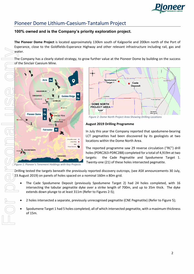
Pioneer Dome Lithium-Caesium-Tantalum Project
100% owned and is the Company’s priority exploration project. The Pioneer Dome Project is located approximately 130km south of Kalgoorlie and 200km north of the Port of Esperance, close to the Goldfields-Esperance Highway and other relevant infrastructure including rail, gas and water.
The Company has a clearly stated strategy, to grow further value at the Pioneer Dome by building on the success of the Sinclair Caesium Mine.
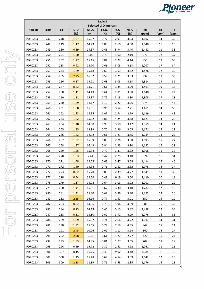
August 2019 Drilling Programme
In July this year the Company reported that spodumene-bearing LCT pegmatites had been discovered by its geologists at two locations within the Dome North Area.
The reported programme saw 29 reverse circulation (“RC”) drill holes (PDRC263-PDRC288) completed for a total of 4,919m at two targets: the Cade Pegmatite and Spodumene Target 1. Twenty-one (21) of these holes intersected pegmatite.
Drilling tested the targets beneath the previously reported discovery outcrops, (see ASX announcements 30 July, 23 August 2019) on panels of holes spaced on a nominal 160m x 80m grid.
• The Cade Spodumene Deposit (previously Spodumene Target 2) had 24 holes completed, with 16 intersecting the tabular pegmatite dyke over a strike length of 700m, and up to 35m thick. The dyke extends down plunge to at least 311m (Refer to Figures 2-5);
• 2 holes intersected a separate, previously unrecognised pegmatite (CNE Pegmatite) (Refer to Figure 5);
• Spodumene Target 1 had 5 holes completed, all of which intersected pegmatite, with a maximum thickness of 15m.
Figure 1: Pioneer's Tenement Holdings with Key Projects
Figure 2: Dome North Project Area Showing Drilling Locations
For
per
sona
l use
onl
y

3
Figure 3: Drill Hole Collar Plan Figure 4: Cross Section of the Cade Pegmatite
Figure 5: Oblique Section looking NW of the Cade Pegmatite showing Drill Hole Traces and Lithium (Li2O %) Intersections.
For
per
sona
l use
onl
y

4
Table 1 Selected High Grade Results
Hole ID From (m)
To (m)
Interval (m)
Li2O (%)
Cade Spodumene Deposit PDRC263 180 293 113* 1.04
including 180 186 6 1.59 including 211 215 4 2.48 including 235 255 20 1.21 including 258 272 14 1.48 including 278 283 5 1.47 including 288 293 5 1.87
PDRC264 47 112 29 0.86 including 47 53 6 1.16 including 67 70 3 1.79 including 108 112 4 1.55
PDRC265 122 147 25 1.61 including 134 142 8 1.95
PDRC266 48 64 16 1.19 including 56 64 8 1.41
PDRC267 116 149 33 1.63 including 120 128 8 1.95
PDRC268 207 225 18 1.47 including 212 218 6 1.94 PDRC270 50 73 23 1.36
including 50 69 19 1.46 PDRC272 95 105 10 0.80
including 105 110 5 1.40 PDRC276 69 79 10 1.22
including 72 79 7 1.42 PDRC277 116 126 10 1.60
including 119 124 5 1.97
Spodumene Target 1 PDRC274 53 59 6 0.93 PDRC275 101 110 10 1.08
* Not true width
For
per
sona
l use
onl
y

5
About Pioneer Resources Limited
Having successfully completed its first mining operation at the Sinclair Caesium Mine, and now well-funded through the sale of pollucite, Pioneer returns to being an active explorer focused on key global demand-driven commodities, looking for its next mining opportunity.
The Company operates a portfolio of strategically located lithium, caesium, potassium (“alkali metals”), nickel, cobalt and gold projects in mining regions in Western Australia, plus a high-quality lithium asset in Canada.
Lithium: In addition to the Pioneer Dome LCT Project, the Company holds a 51% Project interest in the Mavis Lake Lithium Project, Canada where Company drilling has intersected spodumene.
Nickel: The Company owns the Golden Ridge Project which includes the suspended Blair Nickel Sulphide Mine, located between Kalgoorlie and Kambalda, WA. Near-mine target generation is continuing, with the Company announcing a new disseminated nickel sulphide drilling discovery at the Leo’s Dam Prospect in 2018, highlighting the prospectivity of the greater project area.
Gold: Pioneer’s key gold projects are free-carried with well credentialed JV partners:
• Acra JV Project near Kalgoorlie W.A.: Northern Star Resources limited has earned a 75% Project Interest and continues to fully fund exploration programmes until a decision to mine.
• Kangan JV Project in the West Pilbara W.A: Novo Resources Corp and Sumitomo Corporation will fully fund gold exploration programmes until a decision to mine is made, with Pioneer retaining a significant free-carried position.
• Balagundi JV Project which is a new joint venture where Black Cat Syndicate Limited may earn a 75% interest in the Project located at Bulong, near Kalgoorlie, W.A.
REFERENCES
Pioneer Dome: Refer Company’s announcements to ASX dated 19 May 2016, 27 July 2016, 28 August 2016, 1 September 2016, 4 October 2016, 17 October 2016, 14 November 2016, 2 December 2016, 13 December 2016, 13 January 2017, 24 January 2017, 23 February 2017, 20 March 2017, 22 March 2017, 20 May 2017, 21 February 2018, 19 April 2018, 20 May 2018, 25 July 2018, 26 July 2018, 30 July 2018, 30 August 2018, 8 November 2018 (Mineral Resource update), 28 November 2018, 12 December 2018, 22 January 2019, 1 February 2019, 26 March 2019, 17 April 2019, 27 May 2019, 25 June 2019, 17 July 2019, 30, July 2019, 15 August 2019, 22 August 2019, 23 August 2019, 11 September 2019, 16 September 2019.
The Company is not aware of any new information or data that materially affects the information included in this Report.
For
per
sona
l use
onl
y

6
COMPETENT PERSON
The information in this report that relates to Exploration Results is based on information supplied to and compiled by Mr David Crook. Mr Crook is a full time employee of Pioneer Resources Limited. Mr Crook is a member of The Australasian Institute of Mining and Metallurgy and the Australian Institute of Geoscientists and has sufficient experience which is relevant to the exploration processes undertaken to qualify as a Competent Person as defined in the 2012 Editions of the ‘Australasian Code for Reporting of Exploration Results, Mineral Resources and Ore Reserves’.
The reports listed in the References are available to review on the ASX website and on the Company’s website at www.PIOresources.com.au. The Company confirms that it is not aware of any new information or data that materially effects the information included in the original market announcement, and, in the case of estimates of Mineral Resources, that all market assumptions and technical assumptions underpinning the estimates in the relevant market announcement continue to apply and have not materially changed.
CAUTION REGARDING FORWARD LOOKING INFORMATION
This Announcement may contain forward looking statements concerning the projects owned or being earned in by the Company. Statements concerning mining reserves and resources may also be deemed to be forward looking statements in that they involve estimates based on specific assumptions.
Forward-looking statements are not statements of historical fact and actual events and results may differ materially from those described in the forward looking statements as a result of a variety of risks, uncertainties and other factors. Forward-looking statements are inherently subject to business, economic, competitive, political and social uncertainties and contingencies. Many factors could cause the Company’s actual results to differ materially from those expressed or implied in any forward-looking information provided by the Company, or on behalf of, the Company. Such factors include, among other things, risks relating to additional funding requirements, metal prices, exploration, development and operating risks, competition, production risks, regulatory restrictions, including environmental regulation and liability and potential title disputes.
Forward looking statements in this document are based on the Company’s beliefs, opinions and estimates of the Company as of the dates the forward looking statements are made, and no obligation is assumed to update forward looking statements if these beliefs, opinions and estimates should change or to reflect other future developments.
There can be no assurance that the Company’s plans for development of its mineral properties will proceed as currently expected. There can also be no assurance that the Company will be able to confirm the presence of additional mineral deposits, that any mineralisation will prove to be economic or that a mine will successfully be developed on any of the Company’s mineral properties. Circumstances or management’s estimates or opinions could change. The reader is cautioned not to place undue reliance on forward-looking statements.
For
per
sona
l use
onl
y

7
APPENDIX 1. Drill Hole Information and Results Summary Table 2
Drill Hole Collar Locations Hole ID Prospect Type East
(m) North
(m) RL
(m) Depth
(m) Dip (°)
Azimuth (°)
PDRC263 CADE RC 367,679 6,485,999 334.0 311 -60 90
PDRC264 CADE RC 367,760 6,486,001 335.2 204 -60 270
PDRC265 CADE RC 367,834 6,485,999 335.4 204 -60 270
PDRC266 CADE RC 367,771 6,486,160 332.7 120 -60 270
PDRC267 CADE RC 367,860 6,486,161 333.5 168 -60 270
PDRC268 CADE RC 367,935 6,486,161 333.8 258 -60 270
PDRC269 CADE RC 367,640 6,485,838 334.4 156 -60 270
PDRC270 CADE RC 367,717 6,485,840 335.5 156 -60 270
PDRC271 CADE RC 367,803 6,485,837 336.1 204 -60 270
PDRC272 CADE RC 367,680 6,485,674 335.4 150 -60 270
PDRC273 CADE RC 367,762 6,485,678 336.4 246 -60 270
PDRC274 SPOD 1 RC 365,621 6,486,600 359.4 150 -60 270
PDRC275 SPOD 1 RC 365,657 6,486,602 356.9 126 -60 270
PDRC276 CADE RC 367,852 6,486,318 331.3 126 -60 270
PDRC277 CADE RC 367,902 6,486,321 331.8 138 -60 270
PDRC278 CADE RC 367,993 6,486,317 332.7 234 -60 270
PDRC279 CADE RC 367,877 6,486,479 331.0 210 -60 270
PDRC280 CADE RC 367,956 6,486,485 332.4 150 -60 270
PDRC281 CADE RC 368,038 6,486,478 334.0 150 -60 270
PDRC282 CADE RC 368,117 6,486,482 335.7 150 -60 270
PDRC283 CADE RC 367,637 6,485,679 334.8 72 -60 270
PDRC284 CADE RC 367,592 6,485,516 336.7 126 -60 270
PDRC285 CADE RC 367,641 6,485,522 336.6 78 -60 270
PDRC286 CADE RC 367,676 6,485,524 336.8 90 -60 270
PDRC287 CADE RC 367,922 6,485,997 335.6 318 -60 270
PDRC288 CADE RC 368,017 6,486,164 333.4 312 -60 270
PDRC289 SPOD 1 RC 365,437 6,486,519 351.2 96 -60 270
PDRC290 SPOD 1 RC 365,511 6,486,444 351.0 150 -60 270
PDRC291 SPOD 1 RC 365,523 6,486,502 352.7 66 -60 270 Notes:
• Hole locations were measured by a licenced surveyor in MGA 94 zone 51 using a DGPS. • The azimuth is in true north degrees and measured using a north seeking AXIS gyro instrument.
For
per
sona
l use
onl
y

8
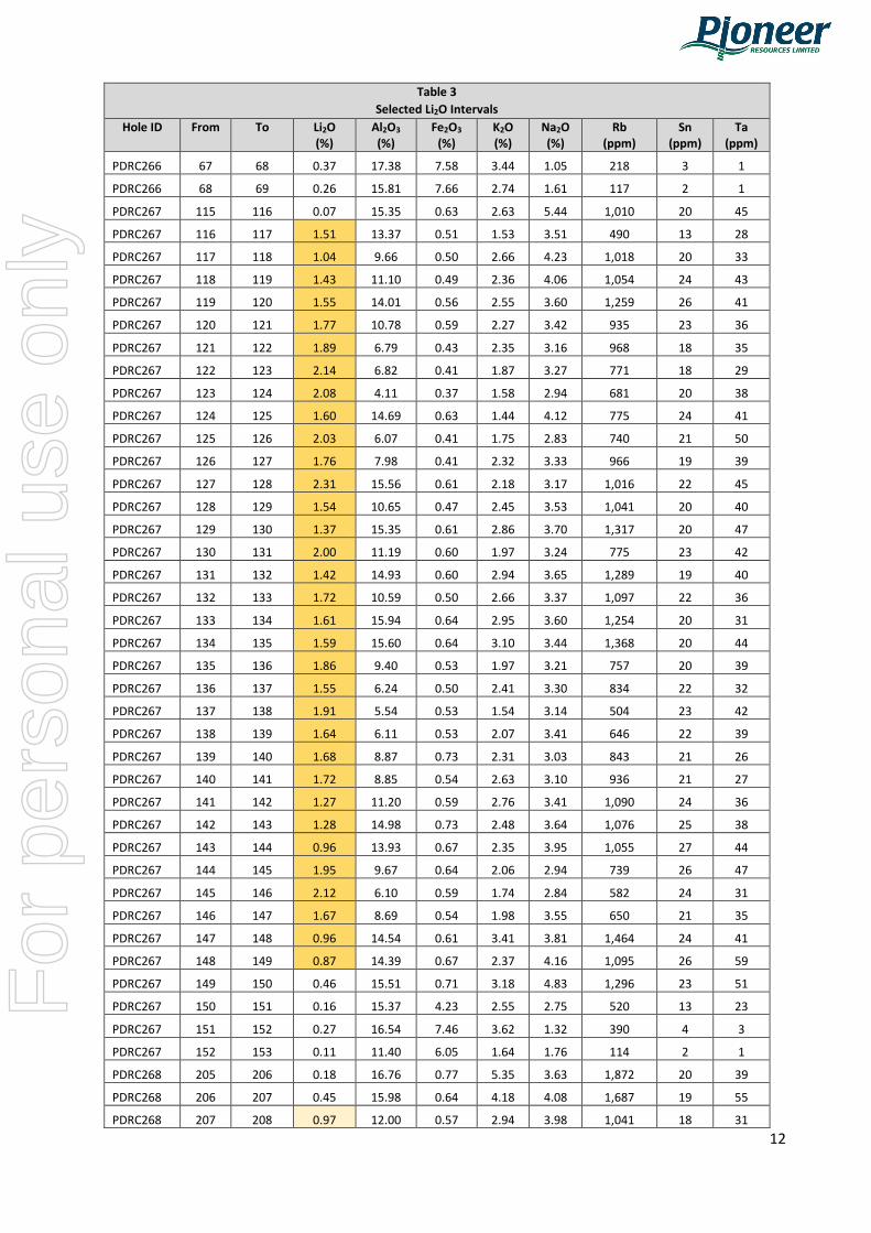
Table 3 Selected Li2O Intervals
Hole ID From To Li2O (%)
Al2O3 (%)
Fe2O3 (%)
K2O (%)
Na2O (%)
Rb (ppm)
Sn (ppm)
Ta (ppm)
PDRC263 177 178 0.51 14.53 0.61 2.03 5.38 790 14 30
PDRC263 178 179 0.51 14.36 0.69 2.36 5.08 921 15 28
PDRC263 179 180 0.71 14.73 0.60 2.63 4.58 1,179 18 36
PDRC263 180 181 1.21 14.11 0.90 1.50 4.53 652 15 52
PDRC263 181 182 1.23 14.41 0.86 3.74 3.17 1,557 14 26
PDRC263 182 183 1.91 10.70 0.69 3.07 2.59 1,120 17 26
PDRC263 183 184 1.71 6.26 0.60 2.91 2.77 1,033 17 24
PDRC263 184 185 1.78 9.14 0.66 3.24 3.20 1,144 17 51
PDRC263 185 186 1.70 9.70 0.76 1.22 4.06 364 15 46
PDRC263 186 187 0.83 14.90 0.84 2.16 4.75 1,011 19 36
PDRC263 187 188 0.92 14.75 0.97 1.95 4.82 896 17 28
PDRC263 188 189 0.85 14.80 0.79 2.40 4.60 1,121 19 42
PDRC263 189 190 1.23 13.13 0.80 2.08 4.00 893 19 43
PDRC263 190 191 0.36 14.05 0.74 3.55 4.26 1,540 18 32
PDRC263 206 207 0.37 13.33 0.77 2.67 4.18 1,155 22 41
PDRC263 207 208 1.45 15.14 0.61 3.30 3.43 1,326 11 27
PDRC263 208 209 1.42 15.30 0.61 2.82 3.92 1,103 11 23
PDRC263 209 210 1.22 14.45 0.69 2.40 4.13 978 14 31
PDRC263 210 211 1.28 14.84 0.69 2.29 4.28 982 15 32
PDRC263 211 212 1.75 14.87 0.64 2.18 3.82 940 14 37
PDRC263 212 213 2.56 10.71 0.64 1.69 2.59 615 14 27
PDRC263 213 214 2.82 11.98 0.69 1.85 2.23 666 13 29
PDRC263 214 215 2.78 13.07 0.59 1.89 2.13 717 12 31
PDRC263 215 216 0.94 15.38 0.69 3.72 3.94 1,616 22 29
PDRC263 216 217 0.75 15.62 0.60 4.44 4.34 1,774 15 34
PDRC263 217 218 1.68 13.57 0.63 2.09 3.63 863 15 33
PDRC263 218 219 0.73 15.03 0.54 3.54 4.56 1,459 15 35
PDRC263 219 220 0.64 14.62 0.66 2.93 4.88 1,246 15 32
PDRC263 234 235 0.46 14.62 0.74 4.38 4.13 1,706 15 31
PDRC263 235 236 1.32 14.08 0.71 4.20 3.91 1,604 15 28
PDRC263 236 237 1.89 15.18 0.63 4.53 3.87 1,678 18 26
PDRC263 237 238 1.49 15.09 0.70 2.51 3.79 985 18 34
PDRC263 238 239 0.73 15.33 0.63 4.50 3.89 1,703 18 27
PDRC263 239 240 0.24 14.70 0.60 4.35 4.50 1,643 19 24
PDRC263 240 241 1.24 13.04 0.50 2.22 4.65 858 12 27
PDRC263 241 242 1.84 13.07 0.60 2.53 3.59 984 13 28
PDRC263 242 243 1.47 12.80 0.63 2.69 3.81 1,046 14 27
PDRC263 243 244 1.66 13.64 0.67 2.29 3.78 893 13 32
PDRC263 244 245 0.89 15.16 0.69 3.57 4.17 1,413 16 28
PDRC263 245 246 0.29 14.25 0.67 3.34 3.95 1,328 15 25
PDRC263 246 247 1.27 16.25 0.81 3.10 4.17 1,185 15 33
For
per
sona
l use
onl
y
9
Table 3 Selected Li2O Intervals
Hole ID From To Li2O (%)
Al2O3 (%)
Fe2O3 (%)
K2O (%)
Na2O (%)
Rb (ppm)
Sn (ppm)
Ta (ppm)
PDRC263 247 248 1.27 15.07 0.77 2.91 3.94 1,102 14 30
PDRC263 248 249 1.17 14.79 0.80 2.60 4.00 1,048 16 26
PDRC263 249 250 0.39 14.37 0.46 5.94 3.40 2,432 11 33
PDRC263 250 251 1.20 8.08 0.79 1.00 2.19 370 12 37
PDRC263 251 252 1.27 15.15 0.84 2.22 4.14 950 19 53
PDRC263 252 253 0.92 14.70 0.66 3.05 4.63 1,207 17 34
PDRC263 253 254 1.29 15.18 0.60 3.53 3.82 1,426 12 30
PDRC263 254 255 2.25 16.32 0.59 2.21 3.33 937 19 38
PDRC263 255 256 0.87 15.21 0.63 3.08 4.53 1,314 19 32
PDRC263 256 257 0.82 14.71 0.61 3.35 4.29 1,401 19 33
PDRC263 257 258 1.11 14.49 0.64 2.81 3.88 1,140 18 22
PDRC263 258 259 1.31 15.37 0.77 3.13 3.80 1,303 17 28
PDRC263 259 260 1.49 14.17 1.10 2.27 3.25 974 16 45
PDRC263 260 261 1.68 15.01 0.96 3.54 2.71 1,461 14 58
PDRC263 261 262 1.93 14.95 1.07 2.74 2.79 1,126 15 48
PDRC263 262 263 1.22 15.92 0.86 4.24 3.58 1,621 14 20
PDRC263 263 264 1.48 14.50 0.93 3.58 3.12 1,359 14 21
PDRC263 264 265 1.35 13.99 0.76 2.96 3.65 1,171 15 29
PDRC263 265 266 1.23 14.92 0.61 3.21 3.85 1,284 14 29
PDRC263 266 267 1.52 15.59 0.80 2.76 3.68 1,093 15 27
PDRC263 267 268 1.37 16.49 0.84 2.93 3.90 1,152 16 29
PDRC263 268 269 1.25 15.34 0.70 3.31 3.72 1,308 16 32
PDRC263 269 270 1.63 7.44 0.47 2.75 3.48 974 16 31
PDRC263 270 271 1.48 15.65 0.63 3.47 3.68 1,414 15 46
PDRC263 271 272 1.80 14.34 0.71 2.62 3.32 1,078 18 37
PDRC263 272 273 0.82 15.20 0.83 2.39 4.77 1,041 19 39
PDRC263 277 278 0.44 15.66 0.49 6.19 3.60 2,410 10 19
PDRC263 278 279 1.17 14.98 0.64 3.03 3.92 1,201 14 22
PDRC263 279 280 1.41 15.31 0.67 3.30 3.48 1,287 12 15
PDRC263 280 281 1.41 15.50 0.67 3.36 3.40 1,322 13 20
PDRC263 281 282 2.55 16.16 0.77 1.57 3.01 650 15 19
PDRC263 282 283 0.82 14.96 0.79 1.96 4.89 888 15 38
PDRC263 283 284 0.23 14.13 0.46 5.15 3.52 2,488 12 35
PDRC263 287 288 0.31 13.80 0.69 3.92 4.09 1,776 16 83
PDRC263 288 289 1.29 15.37 0.74 2.66 4.22 1,017 14 31
PDRC263 289 290 1.32 15.65 0.74 2.19 4.35 842 15 24
PDRC263 290 291 2.45 10.26 0.69 1.17 3.24 360 16 27
PDRC263 291 292 2.78 9.38 0.61 1.27 2.77 420 16 24
PDRC263 292 293 1.53 14.35 0.81 1.77 3.65 702 18 29
PDRC263 293 294 0.69 15.72 0.80 2.52 4.92 1,061 21 25
PDRC263 306 307 0.15 16.25 0.43 9.02 3.48 3,384 6 10
PDRC263 307 308 1.45 15.48 0.69 4.54 3.09 1,642 12 20
PDRC263 308 309 2.13 11.89 0.71 3.58 2.35 1,176 14 21
For
per
sona
l use
onl
y

10
Table 3 Selected Li2O Intervals
Hole ID From To Li2O (%)
Al2O3 (%)
Fe2O3 (%)
K2O (%)
Na2O (%)
Rb (ppm)
Sn (ppm)
Ta (ppm)
PDRC263 309 310 0.67 15.49 0.64 5.11 3.45 1,781 13 60
PDRC263 310 311 0.27 14.62 0.84 1.86 5.72 792 18 39
PDRC264 46 47 0.25 16.06 0.63 2.49 4.44 1,264 27 50
PDRC264 47 48 0.90 7.81 0.43 1.88 4.18 671 25 48
PDRC264 48 49 0.55 11.14 0.50 3.28 3.77 1,320 24 55
PDRC264 49 50 1.06 8.14 0.41 2.46 4.05 946 21 37
PDRC264 50 51 1.45 5.89 0.29 2.23 3.86 883 21 28
PDRC264 51 52 1.87 5.85 0.31 2.09 3.62 774 19 27
PDRC264 52 53 1.12 7.13 0.37 2.88 4.43 1,140 22 43
PDRC264 53 54 0.30 14.99 0.49 2.58 5.52 1,166 26 53
PDRC264 54 55 0.64 17.31 7.03 2.51 1.87 612 8 12
PDRC264 55 56 0.46 16.04 7.68 2.07 1.51 198 3 8
PDRC264 56 57 0.34 15.08 8.38 1.82 1.55 101 2 1
PDRC264 57 60 0.25 14.07 8.02 1.53 1.57 73 1 1
PDRC264 60 63 0.28 14.28 7.88 1.73 1.75 88 2 1
PDRC264 63 64 0.36 14.24 7.82 1.54 1.48 78 2 1
PDRC264 64 65 0.36 13.40 7.59 1.71 1.58 97 2 1
PDRC264 65 66 0.49 15.72 7.86 2.77 1.51 1,497 22 3
PDRC264 54 55 0.64 17.31 7.03 2.51 1.87 612 8 12
PDRC264 55 56 0.46 16.04 7.68 2.07 1.51 198 3 8
PDRC264 56 57 0.34 15.08 8.38 1.82 1.55 101 2 1
PDRC264 57 60 0.25 14.07 8.02 1.53 1.57 73 1 1
PDRC264 60 63 0.28 14.28 7.88 1.73 1.75 88 2 1
PDRC264 66 67 0.64 12.74 0.60 3.75 4.36 1,573 20 38
PDRC264 67 68 1.54 8.88 0.67 2.15 3.59 736 21 47
PDRC264 68 69 2.04 5.74 0.34 2.27 2.97 885 17 38
PDRC264 69 70 1.78 7.93 0.36 2.53 3.48 919 15 27
PDRC264 70 71 0.96 9.59 0.39 2.66 4.50 950 15 28
PDRC264 71 72 0.43 16.96 6.48 2.54 2.35 530 8 11
PDRC264 72 73 0.33 15.52 8.01 2.04 1.66 153 3 2
PDRC264 73 74 0.22 14.57 7.63 1.85 1.49 85 2 1
PDRC264 74 75 0.14 11.94 6.29 1.52 1.40 63 5 1
PDRC264 107 108 0.31 15.56 3.16 3.10 3.19 1,510 25 45
PDRC264 108 109 1.47 13.37 2.49 2.37 2.84 769 16 34
PDRC264 109 110 1.72 4.07 0.34 2.32 3.42 855 14 29
PDRC264 110 111 1.78 8.46 0.49 2.68 3.10 1,016 14 49
PDRC264 111 112 1.21 6.86 0.41 2.85 3.87 1,037 14 39
PDRC264 112 113 0.51 8.83 0.46 2.44 5.41 988 22 102
PDRC265 121 122 0.18 13.40 1.06 2.34 4.60 520 20 35
PDRC265 122 123 0.99 9.93 0.60 3.22 3.66 930 17 39
PDRC265 123 124 1.61 5.27 0.51 1.78 3.54 590 20 34
PDRC265 124 125 1.15 7.27 0.49 2.73 3.86 1,020 19 37
PDRC265 125 126 1.60 4.66 0.34 2.35 3.49 862 20 38
For
per
sona
l use
onl
y

11
Table 3 Selected Li2O Intervals
Hole ID From To Li2O (%)
Al2O3 (%)
Fe2O3 (%)
K2O (%)
Na2O (%)
Rb (ppm)
Sn (ppm)
Ta (ppm)
PDRC265 126 127 1.57 6.20 0.41 2.25 3.58 925 19 41
PDRC265 127 128 1.21 5.39 0.36 2.44 3.89 924 20 34
PDRC265 128 129 1.29 10.20 0.59 2.38 3.79 1,034 21 47
PDRC265 129 130 1.52 6.48 0.46 2.00 3.76 700 20 45
PDRC265 130 131 1.61 6.57 0.50 2.06 3.50 781 20 52
PDRC265 131 132 1.41 9.74 0.93 2.09 3.60 631 19 48
PDRC265 132 133 1.29 6.96 0.50 2.00 4.38 734 21 37
PDRC265 133 134 1.54 4.35 0.36 2.35 3.56 1,043 24 36
PDRC265 134 135 2.40 9.93 0.47 1.95 2.79 862 22 45
PDRC265 135 136 1.94 4.98 0.33 1.96 3.31 827 23 47
PDRC265 136 137 2.58 7.36 0.47 2.00 3.03 809 22 53
PDRC265 137 138 1.45 6.27 0.40 2.38 3.73 1,003 22 57
PDRC265 138 139 1.41 7.72 0.51 2.52 3.87 926 21 52
PDRC265 139 140 1.74 4.92 0.44 2.26 3.49 842 19 30
PDRC265 140 141 2.01 6.88 0.53 1.96 3.26 803 20 33
PDRC265 141 142 2.09 4.46 0.46 1.98 3.01 719 20 35
PDRC265 142 143 1.39 7.93 0.57 2.18 4.02 787 18 38
PDRC265 143 144 1.88 6.49 0.51 2.37 3.10 936 20 44
PDRC265 144 145 1.76 11.51 0.74 1.90 3.86 824 19 47
PDRC265 145 146 1.40 6.93 0.50 2.24 3.89 857 22 44
PDRC265 146 147 1.47 5.40 0.39 2.36 3.69 958 21 43
PDRC265 147 148 0.14 9.78 0.54 2.85 5.88 1,019 19 30
PDRC266 46 47 0.08 14.12 0.63 2.42 3.86 967 20 31
PDRC266 47 48 0.55 13.59 0.67 1.92 3.60 822 25 30
PDRC266 48 49 1.97 14.38 0.49 1.20 2.73 638 24 46
PDRC266 49 50 1.04 9.42 0.46 2.19 4.04 811 25 39
PDRC266 50 51 1.80 13.81 0.61 2.59 2.79 992 25 38
PDRC266 51 52 0.55 13.03 0.56 2.06 3.10 769 27 54
PDRC266 52 53 0.35 15.50 0.43 2.15 4.89 988 20 40
PDRC266 53 54 0.53 11.62 0.53 2.57 3.50 845 21 37
PDRC266 54 55 0.58 15.48 0.41 4.28 4.12 1,746 15 26
PDRC266 55 56 0.98 14.47 0.57 3.07 3.97 1,186 18 30
PDRC266 56 57 1.68 8.13 0.49 2.21 3.55 695 18 38
PDRC266 57 58 1.04 11.88 2.03 1.77 3.31 306 19 32
PDRC266 58 59 1.33 13.95 0.83 2.68 3.55 801 26 41
PDRC266 59 60 1.85 12.13 0.57 2.83 3.15 1,005 19 39
PDRC266 60 61 1.43 14.87 0.53 3.81 3.33 1,568 19 39
PDRC266 61 62 1.81 11.10 0.56 2.49 2.94 803 20 34
PDRC266 62 63 1.09 15.36 0.57 2.69 4.05 1,111 20 56
PDRC266 63 64 1.04 14.37 2.60 2.79 2.86 850 18 29
PDRC266 64 65 0.49 14.17 5.09 2.60 2.64 663 11 15
PDRC266 65 66 0.98 15.60 0.76 2.46 4.46 1,074 24 66
PDRC266 66 67 0.19 12.87 6.19 2.51 1.33 291 5 5
For
per
sona
l use
onl
y
12
Table 3 Selected Li2O Intervals
Hole ID From To Li2O (%)
Al2O3 (%)
Fe2O3 (%)
K2O (%)
Na2O (%)
Rb (ppm)
Sn (ppm)
Ta (ppm)
PDRC266 67 68 0.37 17.38 7.58 3.44 1.05 218 3 1
PDRC266 68 69 0.26 15.81 7.66 2.74 1.61 117 2 1
PDRC267 115 116 0.07 15.35 0.63 2.63 5.44 1,010 20 45
PDRC267 116 117 1.51 13.37 0.51 1.53 3.51 490 13 28
PDRC267 117 118 1.04 9.66 0.50 2.66 4.23 1,018 20 33
PDRC267 118 119 1.43 11.10 0.49 2.36 4.06 1,054 24 43
PDRC267 119 120 1.55 14.01 0.56 2.55 3.60 1,259 26 41
PDRC267 120 121 1.77 10.78 0.59 2.27 3.42 935 23 36
PDRC267 121 122 1.89 6.79 0.43 2.35 3.16 968 18 35
PDRC267 122 123 2.14 6.82 0.41 1.87 3.27 771 18 29
PDRC267 123 124 2.08 4.11 0.37 1.58 2.94 681 20 38
PDRC267 124 125 1.60 14.69 0.63 1.44 4.12 775 24 41
PDRC267 125 126 2.03 6.07 0.41 1.75 2.83 740 21 50
PDRC267 126 127 1.76 7.98 0.41 2.32 3.33 966 19 39
PDRC267 127 128 2.31 15.56 0.61 2.18 3.17 1,016 22 45
PDRC267 128 129 1.54 10.65 0.47 2.45 3.53 1,041 20 40
PDRC267 129 130 1.37 15.35 0.61 2.86 3.70 1,317 20 47
PDRC267 130 131 2.00 11.19 0.60 1.97 3.24 775 23 42
PDRC267 131 132 1.42 14.93 0.60 2.94 3.65 1,289 19 40
PDRC267 132 133 1.72 10.59 0.50 2.66 3.37 1,097 22 36
PDRC267 133 134 1.61 15.94 0.64 2.95 3.60 1,254 20 31
PDRC267 134 135 1.59 15.60 0.64 3.10 3.44 1,368 20 44
PDRC267 135 136 1.86 9.40 0.53 1.97 3.21 757 20 39
PDRC267 136 137 1.55 6.24 0.50 2.41 3.30 834 22 32
PDRC267 137 138 1.91 5.54 0.53 1.54 3.14 504 23 42
PDRC267 138 139 1.64 6.11 0.53 2.07 3.41 646 22 39
PDRC267 139 140 1.68 8.87 0.73 2.31 3.03 843 21 26
PDRC267 140 141 1.72 8.85 0.54 2.63 3.10 936 21 27
PDRC267 141 142 1.27 11.20 0.59 2.76 3.41 1,090 24 36
PDRC267 142 143 1.28 14.98 0.73 2.48 3.64 1,076 25 38
PDRC267 143 144 0.96 13.93 0.67 2.35 3.95 1,055 27 44
PDRC267 144 145 1.95 9.67 0.64 2.06 2.94 739 26 47
PDRC267 145 146 2.12 6.10 0.59 1.74 2.84 582 24 31
PDRC267 146 147 1.67 8.69 0.54 1.98 3.55 650 21 35
PDRC267 147 148 0.96 14.54 0.61 3.41 3.81 1,464 24 41
PDRC267 148 149 0.87 14.39 0.67 2.37 4.16 1,095 26 59
PDRC267 149 150 0.46 15.51 0.71 3.18 4.83 1,296 23 51
PDRC267 150 151 0.16 15.37 4.23 2.55 2.75 520 13 23
PDRC267 151 152 0.27 16.54 7.46 3.62 1.32 390 4 3
PDRC267 152 153 0.11 11.40 6.05 1.64 1.76 114 2 1
PDRC268 205 206 0.18 16.76 0.77 5.35 3.63 1,872 20 39
PDRC268 206 207 0.45 15.98 0.64 4.18 4.08 1,687 19 55
PDRC268 207 208 0.97 12.00 0.57 2.94 3.98 1,041 18 31
For
per
sona
l use
onl
y

13
Table 3 Selected Li2O Intervals
Hole ID From To Li2O (%)
Al2O3 (%)
Fe2O3 (%)
K2O (%)
Na2O (%)
Rb (ppm)
Sn (ppm)
Ta (ppm)
PDRC268 208 209 0.81 16.04 0.59 3.71 4.12 1,531 25 33
PDRC268 209 210 1.82 15.39 0.66 2.53 3.42 1,022 21 40
PDRC268 210 211 0.44 14.89 0.71 3.59 4.15 1,423 18 33
PDRC268 211 212 1.13 14.23 0.70 2.82 3.78 1,046 16 25
PDRC268 212 213 2.06 7.13 0.47 2.79 2.66 972 16 31
PDRC268 213 214 1.83 14.18 0.60 1.91 3.41 819 21 39
PDRC268 214 215 1.78 15.45 0.73 2.10 3.64 1,017 22 59
PDRC268 215 216 2.44 4.50 0.47 1.28 2.92 532 21 38
PDRC268 216 217 1.72 15.81 0.83 2.02 3.58 872 17 32
PDRC268 217 218 1.83 15.31 0.76 2.16 3.34 899 17 32
PDRC268 218 219 1.41 16.32 0.64 3.88 3.47 1,548 15 19
PDRC268 219 220 1.24 15.47 0.69 2.51 3.91 1,122 19 32
PDRC268 220 221 1.66 16.15 0.66 2.84 3.67 1,159 15 29
PDRC268 221 222 1.67 14.09 0.71 2.12 3.68 827 16 27
PDRC268 222 223 0.96 13.96 0.80 4.12 3.72 1,529 16 33
PDRC268 223 224 1.29 15.16 0.76 3.13 3.49 1,313 18 36
PDRC268 224 225 1.38 15.21 0.86 2.85 3.68 1,173 20 37
PDRC268 225 226 0.63 14.95 0.92 3.96 3.78 1,691 22 41
PDRC270 49 50 0.07 11.92 1.20 1.84 4.58 498 17 31
PDRC270 50 51 1.36 9.86 0.87 2.85 3.55 883 15 28
PDRC270 51 52 1.65 15.92 0.60 2.85 3.55 1,168 17 27
PDRC270 52 53 1.44 15.86 0.54 3.73 3.32 1,490 18 30
PDRC270 53 54 1.52 16.23 0.57 3.55 3.29 1,442 19 49
PDRC270 54 55 1.45 15.68 0.67 3.22 3.52 1,212 17 38
PDRC270 55 56 1.36 15.71 0.66 3.17 3.72 1,207 16 34
PDRC270 56 57 1.36 15.43 0.60 3.02 3.68 1,215 17 30
PDRC270 57 58 1.89 15.52 0.64 2.28 3.42 908 17 26
PDRC270 58 59 1.54 15.46 0.56 3.11 3.55 1,275 20 27
PDRC270 59 60 1.55 12.85 0.53 1.87 4.01 779 21 32
PDRC270 60 61 1.39 12.44 0.59 2.93 3.52 1,098 16 30
PDRC270 61 62 1.43 13.16 0.59 2.97 3.20 1,149 18 27
PDRC270 62 63 1.35 15.44 0.54 3.10 3.68 1,313 22 28
PDRC270 63 64 1.09 15.08 0.57 2.77 3.88 1,161 23 35
PDRC270 64 65 1.49 15.80 0.67 2.47 3.88 1,041 23 40
PDRC270 65 66 1.59 16.15 0.71 2.16 3.97 914 23 41
PDRC270 66 67 1.73 15.71 0.77 1.90 3.74 785 24 38
PDRC270 67 68 1.20 16.16 0.61 3.02 4.16 1,258 23 42
PDRC270 68 69 1.32 16.05 0.60 2.22 4.36 961 25 57
PDRC270 69 70 0.88 15.00 0.70 3.24 3.90 1,369 24 51
PDRC270 70 71 0.87 15.85 0.64 3.31 4.20 1,411 27 50
PDRC270 71 72 1.01 14.95 0.56 2.51 4.20 1,016 20 45
PDRC270 72 73 0.88 14.32 0.61 3.10 3.92 1,209 22 42
PDRC270 73 74 0.41 15.93 0.60 3.46 5.07 1,346 18 39
For
per
sona
l use
onl
y

14
Table 3 Selected Li2O Intervals
Hole ID From To Li2O (%)
Al2O3 (%)
Fe2O3 (%)
K2O (%)
Na2O (%)
Rb (ppm)
Sn (ppm)
Ta (ppm)
PDRC272 93 94 0.07 15.54 0.71 3.79 5.16 1,567 22 32
PDRC272 94 95 0.30 16.35 0.67 3.64 5.95 1,689 18 44
PDRC272 95 96 0.89 16.04 0.63 3.45 4.86 1,589 18 48
PDRC272 96 97 1.32 11.08 0.63 3.13 3.90 1,222 20 38
PDRC272 97 98 0.98 16.25 0.67 2.96 4.53 1,318 24 38
PDRC272 98 99 0.93 10.98 0.53 3.43 4.44 1,395 24 43
PDRC272 99 100 0.72 7.07 0.49 4.54 3.84 1,660 25 40
PDRC272 100 101 0.75 14.91 0.66 4.29 4.25 1,731 21 37
PDRC272 101 102 0.86 16.66 0.67 3.68 4.46 1,567 23 41
PDRC272 102 103 0.56 10.52 0.59 3.20 4.63 1,103 20 28
PDRC272 103 104 0.17 15.72 0.57 5.37 4.24 1,991 21 30
PDRC272 104 105 0.86 16.52 0.64 3.35 4.39 1,521 28 41
PDRC272 105 106 0.42 16.66 0.64 3.01 5.67 1,389 28 51
PDRC272 106 107 0.18 17.30 0.51 3.60 6.20 1,587 22 73
PDRC272 107 108 0.26 15.08 0.61 4.35 4.34 1,904 30 37
PDRC272 108 109 0.47 15.36 0.57 3.34 5.12 1,440 22 41
PDRC272 109 110 0.34 10.14 0.59 2.78 5.49 1,117 27 70
PDRC272 110 111 0.95 10.87 0.46 3.11 4.11 1,244 25 62
PDRC272 111 112 0.82 8.99 0.53 2.96 4.02 1,111 21 61
PDRC272 112 113 0.24 14.52 0.59 4.39 4.18 1,924 21 45
PDRC274 51 52 0.19 13.27 2.57 2.25 4.78 2,946 16 131
PDRC274 52 53 0.10 15.48 0.87 2.25 6.25 2,159 21 128
PDRC274 53 54 1.06 13.27 1.10 2.62 3.42 2,442 31 90
PDRC274 54 55 1.15 10.13 0.29 2.41 3.61 1,602 22 102
PDRC274 55 56 0.80 9.70 0.26 2.36 4.21 1,647 34 83
PDRC274 56 57 0.75 11.40 0.34 2.21 4.16 1,369 35 71
PDRC274 57 58 0.84 12.00 0.34 2.22 4.14 1,057 19 79
PDRC274 58 59 1.00 9.85 0.23 2.26 3.83 1,456 34 86
PDRC274 59 60 0.78 11.05 0.31 2.41 3.87 1,395 13 81
PDRC274 60 61 0.15 12.92 0.53 2.20 5.60 1,087 18 103
PDRC275 100 101 0.20 15.01 1.39 2.57 5.41 2,059 24 71
PDRC275 101 102 0.99 12.22 0.83 2.02 4.38 1,029 22 124
PDRC275 102 103 0.89 12.23 0.69 2.20 4.64 1,339 36 77
PDRC275 103 104 0.77 12.06 0.81 2.67 4.75 1,883 30 82
PDRC275 104 105 0.36 14.28 3.86 2.07 4.84 1,788 22 93
PDRC275 105 106 1.55 13.74 3.40 2.52 3.20 2,571 42 131
PDRC275 106 107 1.46 6.55 0.30 2.44 3.60 2,876 45 111
PDRC275 107 108 1.68 7.27 0.39 2.04 3.73 1,861 50 140
PDRC275 108 109 1.12 14.43 0.92 3.34 3.57 3,289 43 118
PDRC275 109 110 1.20 10.49 0.41 2.35 4.25 1,905 47 102
PDRC275 110 111 0.81 14.99 0.53 3.54 4.42 3,209 44 87
PDRC275 111 112 0.65 14.45 2.17 2.14 5.19 1,787 54 113
PDRC275 112 113 0.57 14.75 1.56 2.17 5.24 1,607 38 56
For
per
sona
l use
onl
y

15
Table 3 Selected Li2O Intervals
Hole ID From To Li2O (%)
Al2O3 (%)
Fe2O3 (%)
K2O (%)
Na2O (%)
Rb (ppm)
Sn (ppm)
Ta (ppm)
PDRC275 113 114 0.18 16.11 7.96 0.32 2.19 219 16 4
PDRC275 114 115 0.16 15.42 7.78 0.30 3.90 226 5 7
PDRC275 115 116 0.70 11.65 11.24 0.16 1.56 141 14 1
PDRC275 116 119 0.59 12.78 10.68 0.16 2.02 126 11 0
PDRC275 119 122 0.10 14.88 8.48 0.43 4.93 412 24 81
PDRC276 68 69 0.20 12.63 6.63 3.20 0.88 1,457 21 12
PDRC276 69 70 0.91 12.00 0.71 3.07 3.48 1,330 24 50
PDRC276 70 71 0.46 12.93 0.51 2.27 5.38 1,328 28 88
PDRC276 71 72 0.93 6.03 0.43 2.41 3.73 1,199 30 54
PDRC276 72 73 1.52 9.58 0.51 3.54 3.07 1,717 25 33
PDRC276 73 74 1.03 8.59 0.41 2.33 4.27 1,131 21 70
PDRC276 74 75 0.78 14.53 0.46 3.89 3.87 2,367 22 54
PDRC276 75 76 1.57 5.01 0.31 2.83 2.88 1,166 19 37
PDRC276 76 77 1.78 5.53 0.33 2.32 3.16 1,057 26 58
PDRC276 77 78 1.69 6.61 0.39 1.58 3.61 724 22 39
PDRC276 78 79 1.53 10.52 1.22 1.93 3.24 914 29 47
PDRC276 79 80 0.09 11.46 0.46 1.61 6.18 786 20 68
PDRC276 80 81 0.15 14.78 3.83 1.96 3.59 710 17 37
PDRC277 114 115 0.40 15.62 7.92 2.40 1.47 781 10 1
PDRC277 115 116 0.53 12.13 0.86 2.45 3.16 1,241 54 155
PDRC277 116 117 1.13 6.02 0.26 2.58 4.06 1,523 33 78
PDRC277 117 118 1.57 4.42 0.27 2.33 3.57 1,275 29 72
PDRC277 118 119 1.41 7.25 0.33 2.82 3.62 1,257 19 38
PDRC277 119 120 2.49 4.26 0.30 2.49 2.82 1,046 19 39
PDRC277 120 121 1.18 14.43 0.53 2.73 4.29 1,301 18 45
PDRC277 121 122 2.74 8.15 0.60 1.91 2.47 830 22 50
PDRC277 122 123 1.35 6.66 0.43 1.91 3.67 776 19 50
PDRC277 123 124 2.10 5.62 0.39 2.00 3.25 804 20 70
PDRC277 124 125 0.42 14.41 0.43 3.80 4.35 2,071 16 50
PDRC277 125 126 1.64 5.67 0.34 2.30 3.58 1,077 23 55
PDRC277 126 127 0.46 15.45 0.53 1.82 5.82 899 27 41
PDRC277 127 128 0.07 13.24 0.92 1.40 5.81 375 19 35
Notes:
• Selected Assay results derived from chemical analysis reports from Intertek-Genalysis. • The element assays were determined by 4 acid digest and ICP analysis. • In this table oxide fields are calculated from the elemental value i.e. using the formula: Li * 2.153 to derive Li2O. • Intersections noted are ‘down-hole’ and do not necessarily represent a true width. Hole PDRC263 was drilled
‘down-dip’ so the intersection reported specifically does not represent a true width. • RC drilling is known to introduce Fe contamination. Samples were generally prepared using a zirconium bowl to
minimise additional Fe contamination.
For
per
sona
l use
onl
y

16 | P a g e
Section 1 - Sampling Techniques and Data (Criteria in this section apply to all succeeding sections.) Pioneer Dome Project, Cade Deposit, RC Drilling.
Criteria JORC Code explanation Commentary Sampling techniques
• Nature and quality of sampling (eg cut Faces, random chips, or specific specialised industry standard measurement tools appropriate to the minerals under investigation, such as down-hole gamma sondes, or handheld XRF instruments, etc). These examples should not be taken as limiting the broad meaning of sampling.
• Reverse circulation (RC) samples from holes drilled from surface reported. • Single metre samples were collected in calico bags via a cone splitter directly from
the cyclone on the RC drill rig. Three-metre composite samples for intervals that were considered to have low LCT element concentrations from the pXRF data were collected from the sample piles via an aluminium scoop.
• pXRF analysis was undertaken on each 1m sample using a Bruker S1 Titan 800 hand held portable XRF analyser for internal use, and not reported herein.
• Include reference to measures taken to ensure sample representivity and the appropriate calibration of any measurement tools or systems used.
• Industry-standard reverse circulation drilling, using a face-sampling hammer with a booster and auxiliary compressors used to ensure dry samples.
• RC: Individual one metre samples were collected using a cyclone and a cone splitter into sub samples of approximately 3.5kg weight, the cyclone was regularly cleaned to minimise contamination.
• Duplicate samples and Certified Reference Standards were inserted at regular intervals to provide assay quality checks. The standards and duplicates reported within acceptable limits.
• Samples are considered ‘fit for purpose’. • Aspects of the determination of mineralisation that are Material to the Public
Report. • In cases where ‘industry standard’ work has been done this would be relatively
simple (eg ‘reverse circulation drilling was used to obtain 1 m samples from which 3 kg was pulverised to produce a 30 g charge for fire assay’). In other cases more explanation may be required, such as where there is coarse gold that has inherent sampling problems. Unusual commodities or mineralisation types (eg submarine nodules) may warrant disclosure of detailed information.
• RC drilling was used to obtain 1 m samples from which approximately 3.5 kg sampled.
• 3.5kg samples were crushed then subsetted to produce a 100g sample which was pulverised by zirconium bowl pulp mill to nominal P80/75um to produce a standard charge for analysis.
• Lithium exploration package of elements: analysed by a four acid digestion with a Mass Spectrometer (MS) determination (Intertek analysis code ZR01 4A Li48-MS). The quoted detection limits for this method are a lower detection limit of 0.1ppm and an upper detection of 5000ppm Li. Most other elements have a similar analytical range. Any over range samples were re analysed by a sodium peroxide zirconium crucible fusion with a detection range of 1ppm to 20% Li.
Drilling techniques
• Drill type (eg core, reverse circulation, open-hole hammer, rotary air blast, auger, Bangka, sonic, etc) and details (eg core diametre, triple or standard tube, depth of diamond tails, face-sampling bit or other type, whether core is oriented and if so, by what method, etc).
• Reverse Circulation Drilling. • 4.5 inch drill string. • Face-sampling hammer. • Auxiliary and Booster compressors used to exclude ground water.
Drill sample recovery
• Method of recording and assessing core and chip sample recoveries and results assessed.
• During RC drilling the geologist recorded occasions when sample quality is poor, sample return was low, when the sample was wet or compromised in another way.
For
per
sona
l use
onl
y
17 | P a g e
Criteria JORC Code explanation Commentary • Measures taken to maximise sample recovery and ensure representative nature of
the samples. • Sample recovery is good for RC drilling using the equipment described. • RC Sample recovery is mostly under the control of the drill operator and is generally
influenced by the experience and knowledge of the operator. • Whether a relationship exists between sample recovery and grade and whether
sample bias may have occurred due to preferential loss/gain of fine/coarse material.
• Because the sample recoveries are assumed to be high, any possible relationship between sample recovery and grade has not been investigated.
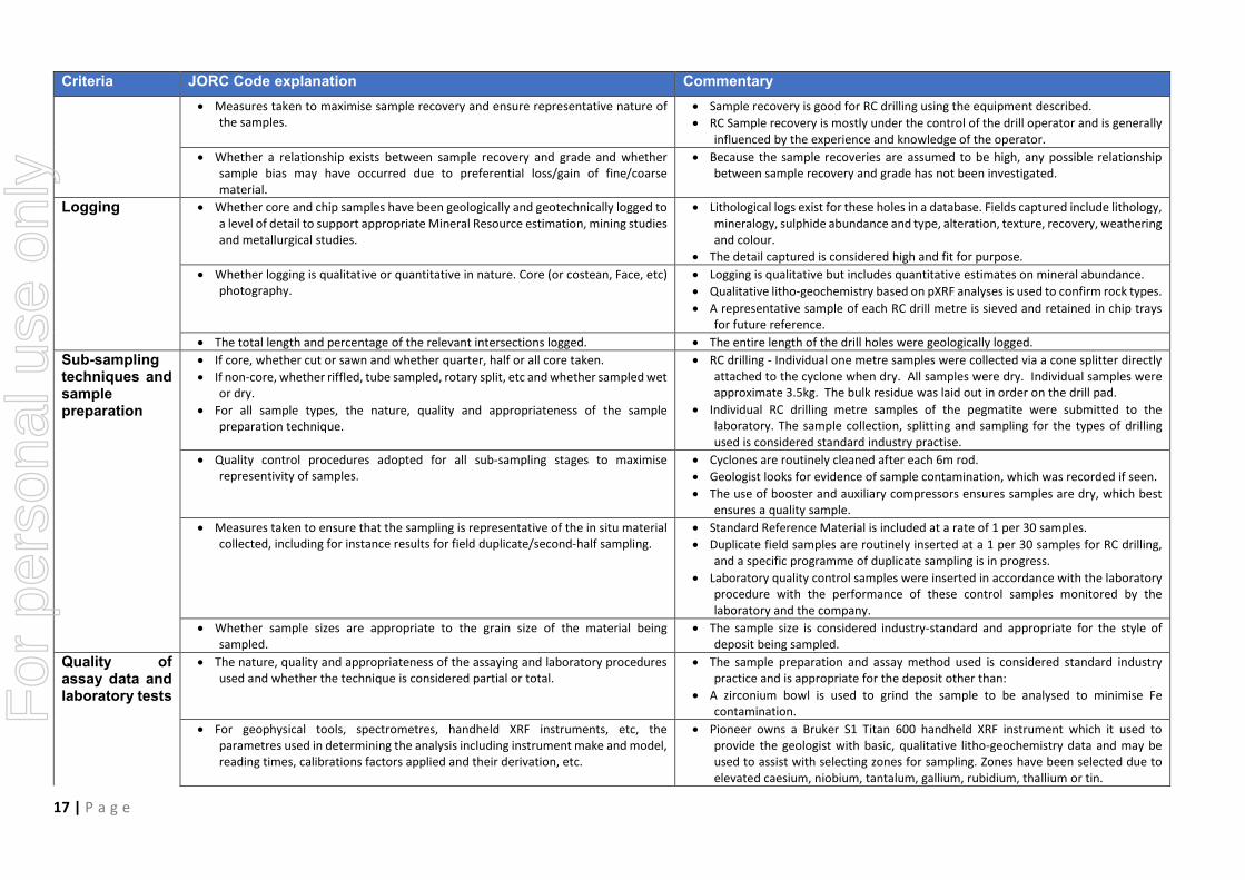
Logging • Whether core and chip samples have been geologically and geotechnically logged to a level of detail to support appropriate Mineral Resource estimation, mining studies and metallurgical studies.
• Lithological logs exist for these holes in a database. Fields captured include lithology, mineralogy, sulphide abundance and type, alteration, texture, recovery, weathering and colour.
• The detail captured is considered high and fit for purpose. • Whether logging is qualitative or quantitative in nature. Core (or costean, Face, etc)
photography. • Logging is qualitative but includes quantitative estimates on mineral abundance. • Qualitative litho-geochemistry based on pXRF analyses is used to confirm rock types. • A representative sample of each RC drill metre is sieved and retained in chip trays
for future reference. • The total length and percentage of the relevant intersections logged. • The entire length of the drill holes were geologically logged. Sub-sampling techniques and sample preparation
• If core, whether cut or sawn and whether quarter, half or all core taken. • If non-core, whether riffled, tube sampled, rotary split, etc and whether sampled wet
or dry. • For all sample types, the nature, quality and appropriateness of the sample
preparation technique.
• RC drilling - Individual one metre samples were collected via a cone splitter directly attached to the cyclone when dry. All samples were dry. Individual samples were approximate 3.5kg. The bulk residue was laid out in order on the drill pad.
• Individual RC drilling metre samples of the pegmatite were submitted to the laboratory. The sample collection, splitting and sampling for the types of drilling used is considered standard industry practise.
• Quality control procedures adopted for all sub-sampling stages to maximise representivity of samples.
• Cyclones are routinely cleaned after each 6m rod. • Geologist looks for evidence of sample contamination, which was recorded if seen. • The use of booster and auxiliary compressors ensures samples are dry, which best
ensures a quality sample. • Measures taken to ensure that the sampling is representative of the in situ material
collected, including for instance results for field duplicate/second-half sampling. • Standard Reference Material is included at a rate of 1 per 30 samples. • Duplicate field samples are routinely inserted at a 1 per 30 samples for RC drilling,
and a specific programme of duplicate sampling is in progress. • Laboratory quality control samples were inserted in accordance with the laboratory
procedure with the performance of these control samples monitored by the laboratory and the company.
• Whether sample sizes are appropriate to the grain size of the material being sampled.
• The sample size is considered industry-standard and appropriate for the style of deposit being sampled.
Quality of assay data and laboratory tests
• The nature, quality and appropriateness of the assaying and laboratory procedures used and whether the technique is considered partial or total.
• The sample preparation and assay method used is considered standard industry practice and is appropriate for the deposit other than:
• A zirconium bowl is used to grind the sample to be analysed to minimise Fe contamination.
• For geophysical tools, spectrometres, handheld XRF instruments, etc, the parametres used in determining the analysis including instrument make and model, reading times, calibrations factors applied and their derivation, etc.
• Pioneer owns a Bruker S1 Titan 600 handheld XRF instrument which it used to provide the geologist with basic, qualitative litho-geochemistry data and may be used to assist with selecting zones for sampling. Zones have been selected due to elevated caesium, niobium, tantalum, gallium, rubidium, thallium or tin.
For
per
sona
l use
onl
y

18 | P a g e
Criteria JORC Code explanation Commentary • Intervals during RC drilling identified as not obviously mineralised have been
sampled with three metre composites. • Standards, blanks and duplicates have been analysed with the Bruker to ensure the
instrument is operating as expected and correctly calibrated. • Nature of quality control procedures adopted (eg standards, blanks, duplicates,
external laboratory checks) and whether acceptable levels of accuracy (ie lack of bias) and precision have been established.
• Standards and laboratory checks have been assessed. The standards show results within acceptable limits of accuracy, with good precision. Internal laboratory checks indicate very high levels of precision.
Verification of sampling and assaying
• The verification of significant intersections by either independent or alternative company personnel.
• The use of twinned holes.
• Significant intersections are calculated by experienced staff with these intersections checked by other staff.
• No holes have been twinned • Documentation of primary data, data entry procedures, data verification, data
storage (physical and electronic) protocols. • Pioneer has a digital SQL drilling database where information is stored. • The Company uses a range of consultants to load and validate data and appraise
quality control samples. • Discuss any adjustment to assay data. • Pioneer has adjusted the lithium (Li), tantalum (Ta) and caesium (Cs) assay results to
determine Li2O, Ta2O5 and Cs2O grades. This adjustment is a multiplication of the elemental Li, Ta and Cs assay results by 2.153, 1.221 and 1.06 to determine Li2O, Ta2O5 and Cs2O grades respectively.
Location of data points
• Accuracy and quality of surveys used to locate drill holes (collar and down-hole surveys), trenches, mine workings and other locations used in Mineral Resource estimation.
• The collar locations of the holes have been surveyed by a licenced surveyor using a differential GPS. The collar surveys provide very accurate positions for all holes including the RL of each drill collar.
• Specification of the grid system used. • MGA94 (Zone 51) • Quality and adequacy of topographic control. • Topographic control is by DGPS, carried out by a licensed surveyor.
• A high-resolution DEM exists over the entire M63/665 lease. Data spacing and
• Data spacing for reporting of Exploration Results. • Drill spacing for lithium was drilled on 160m spaced panels with drill holes 80m apart.
distribution • Whether the data spacing and distribution is sufficient to establish the degree of geological and grade continuity appropriate for the Mineral Resource and Ore Reserve estimation procedure(s) and classifications applied.
• The data is being reviewed to ascertain whether it is sufficient and dense enough to conduct the estimation of an inferred mineral resource at a later date.
• Whether sample compositing has been applied. • All reported assays are of 1m samples for RC drilling. Orientation of data in relation to geological structure
• Whether the orientation of sampling achieves unbiased sampling of possible structures and the extent to which this is known, considering the deposit type.
• If the relationship between the drilling orientation and the orientation of key mineralised structures is considered to have introduced a sampling bias, this should be assessed and reported if material.
• The strike of the mineralisation is estimated at to be broadly north-south, and dipping east, therefore (after the first hole which determined the dip) angled drill holes at -60° have been drilled towards 2700. Down hole intersection widths are estimated to closely approximately true widths based on the interpreted dip of the pegmatite bodies and the orientation of the drilling.
Sample security
• The measures taken to ensure sample security. • Pioneer uses standard industry practices when collecting, transporting and storing samples for analysis.
• Drilling pulps are retained by Pioneer off site. Audits or reviews
• The results of any audits or reviews of sampling techniques and data. • Sampling techniques for assays have not been specifically audited but follow common practice in the Western Australian exploration industry.
• The assay data and quality control samples are periodically audited by an independent consultant.
For
per
sona
l use
onl
y

19 | P a g e
Section 2 - Reporting of Exploration Results (Criteria listed in the preceding section also apply to this section.)
Criteria JORC Code explanation Commentary Mineral tenement and land tenure status
• Type, reference name/number, location and ownership including agreements or material issues with third parties such as joint ventures, partnerships, overriding royalties, native title interests, historical sites
• The Pioneer Dome drilling reported herein is entirely within E15/1515 which is a granted Exploration Licence.
• The tenement is located approximately 60km N of Norseman WA. • Pioneer Resources Limited is the registered holder of the tenement and holds a 100%
unencumbered interest in all minerals within the tenement. • The tenement is on vacant crown land. • The Ngadju Native Title Claimant Group has a determined Native Title Claim which
covers the Pioneer Dome project. • The security of the tenure held at the time of reporting along with any known
impediments to obtaining a licence to operate in the area. • At the time of this Statement E15/1515 is in Good Standing. To the best of the
Company’s knowledge, other than industry standard permits to operate there are no impediments to Pioneer’s operations within the tenement.
Exploration done by other parties
• Acknowledgment and appraisal of exploration by other parties. • There has been no previous lithium exploration drilling or sampling on the Pioneer Dome Project other than by Pioneer Resources Ltd. Previous mapping by the Western Australian Geological Survey and Western Mining Corporation (WMC) in the 1970’s identified several pegmatite intrusions however these were not systematically explored for Lithium or associated elements.
Geology • Deposit type, geological setting and style of mineralisation. • The Project pegmatites are consistent with records of highly differentiated Lithium Caesium Tantalum (LCT) pegmatite intrusion. This type of pegmatite intrusions are the target intrusions of hard rock lithium deposits. The Sinclair Deposit is classified as a Petalite/Lepidolite sub type.
Drill hole Information
• A summary of all information material to the understanding of the exploration results including a tabulation of the following information for all Material drill holes, including easting and northing of the drill hole collar, elevation or RL (Reduced Level – elevation above sea level in metres) of the drill hole collar, dip and azimuth of the hole, down hole length and interception depth plus hole length.
• If the exclusion of this information is justified on the basis that the information is not Material and this exclusion does not detract from the understanding of the report, the Competent Person should clearly explain why this is the case.
• Refer to Appendix 1 of this announcement.
Data aggregation methods
• In reporting Exploration Results, weighting averaging techniques, maximum and/or minimum grade truncations (eg cutting of high grades) and cut-off grades are usually Material and should be stated.
• Where aggregate intercepts incorporate short lengths of high grade results and longer lengths of low grade results, the procedure used for such aggregation should be stated and some typical examples of such aggregations should be shown in detail.
• The assumptions used for any reporting of metal equivalent values should be clearly stated.
• Weighted average Li2O assays on page 1 and Table 1 of this release are for generally adjacent samples above 1% Li2O, with the intervals used in the calculations highlighted in colour in Table 3.
• Assays in Table 3 are of the interval sampled. • There are no metal equivalent values reported. F
or p
erso
nal u
se o
nly

20 | P a g e
Criteria JORC Code explanation Commentary Relationship between mineralisation widths and intercept lengths
• These relationships are particularly important in the reporting of Exploration Results.
• If the geometry of the mineralisation with respect to the drill hole angle is known, its nature should be reported.
• If it is not known and only the down hole lengths are reported, there should be a clear statement to this effect (eg ‘down hole length, true width not known’).
• Downhole lengths are reported in Appendix 1. The current geological interpretation, based on drilling and mapping, suggests that the true widths approximate the down hole widths. (See the cross section, Figure 4)
Diagrams • Appropriate maps and sections (with scales) and tabulations of intercepts should be included for any significant discovery being reported These should include, but not be limited to a plan view of drill hole collar locations and appropriate sectional views.
• Refer to figures in this report.
Balanced reporting
• Where comprehensive reporting of all Exploration Results is not practicable, representative reporting of both low and high grades and/or widths should be practiced to avoid misleading reporting of Exploration Results.
• Comprehensive reporting of drill details has been provided in Appendix 1 of this announcement.
Other substantive exploration data
• Other exploration data, if meaningful and material, should be reported including (but not limited to): geological observations; geophysical survey results; geochemical survey results; bulk samples – size and method of treatment; metallurgical test results; bulk density, groundwater, geotechnical and rock characteristics; potential deleterious or contaminating substances.
• All meaningful and material exploration data has been reported.
Further work • The nature and scale of planned further work (eg tests for lateral extensions or depth extensions or large-scale step-out drilling).
• Diagrams clearly highlighting the areas of possible extensions, including the main geological interpretations and future drilling areas, provided this information is not commercially sensitive.
• Planned further work includes geological modelling – 3DM update. • It’s unclear at this stage whether results warrant a resource estimation.
ion in this report that relates to Exploration Results is based on information supplied to and compiled by Mr David Crook. Mr Crook is a full-time employee of Pioneer Resources Limited. Mr Crook is a member of The Australasian Institute of Mining and Metallurgy and the Australian Institute of Geoscientists and has sufficient experience which is relevant to the exploration processes undertaken to qualify as a Competent Person as defined in the 2012 Editions of the ‘Australasian Code for Reporting of Exploration Results, Mineral Resources and Ore Reserves’. The reports listed in the References are available to review on the ASX website and on the Company’s website at www.PIOresources.com.au. The Company confirms that it is not aware of any new information or data that materially effects the information included in the original market announcement, and, in the case of estimates
For
per
sona
l use
onl
y
Related Documents