1 LIST OF CONTENTS Page . Executive Summary 3 Location and Access 4 Geophysics 4 Mineral Occurrences (Historical data) 5 PL Mineralisation 5 Regional Geology 6-7 C-66 Area Geology 7-8 Structure and relative age 8 Comments & Conclusions 9 References 19

Welcome message from author
This document is posted to help you gain knowledge. Please leave a comment to let me know what you think about it! Share it to your friends and learn new things together.
Transcript
1
LIST OF CONTENTS Page .
Executive Summary 3
Location and Access 4
Geophysics 4
Mineral Occurrences (Historical data) 5
PL Mineralisation 5
Regional Geology 6-7
C-66 Area Geology 7-8
Structure and relative age 8
Comments & Conclusions 9
References 19
2
List of Figures
Page
Figure 1. Location Map 10
Figure 2. Gold Geochemistry Summary map 11
Figure 3. Mineral Occurrence Summary Map. 12
Figure 4. Geological Summary Map 13
Figure 5. Geological Summary Map 14
Figure 6. Geological Summary Map. 15
Figure 7. Structural Summary Map 16
Figure 8. Aeromagnetic Map 17
Figure 9. Topographic Map 18

3
Executive Summary
The Prospecting Licence (C-66) located in the Cuyuni Mining District No. 4 as shown on
Terra Surveys Topographic Map 18SW, as shown in fig 9 and enclosing an area of
approximately 5541 acres of the headwaters Ekabago River. The potential of the area
for gold is very good.
The PL is presently under mining license by C B & R Mining Enterprises. Active gold
extraction is presently undertaken by land dredging, using excavators on mining concesions
bordering this PL area.
The PL area is located in the upper drainage portion of the Ekabago River that drains in
the Puruni River,and close to the mouth of the Waikuri River that drains into the Cuyuni
River, approximately 150 km due west of the city of Georgetown .
Based on information from surface mapping in the areas of the soil geochemical anomalies
suggest the majority of the alluvial gold and gold anomaly areas are located to the
north/west of this PL, see fig 3. The PL area is likely to be related to zones of weakly
mineralized, structurally deformed, lithological contact between mafic and felsic volcanic or
intrusive rocks which interlayer with more extensive packages of sedimentary formations,
however because of limited data available for this PL,it is just an assumption. A portion
(perhaps the majority) of the gold mineralization may have been derived from quartz lode
type occurrences in lithologically controlled shear structures in the area.
The geology of the area consists of Lower Proterozoic Mazaruni Supergroup (greenstone
belts) consisting of meta-sediments and meta-volcanic rocks, intruded by Younger Granites.
Unconformably overlying these rocks is the Roraima Formation, a generally flat lying series
of conglomerates, sandstones, shales and with minor interbedded volcanics. All of these
rocks (greenstones, granites, and post-orogenic sedimentary series), are intruded by
doleritic and gabbroic dikes and sills (the Younger Basic Intrusive Suite), see fig 4-6.
4
Location and Access
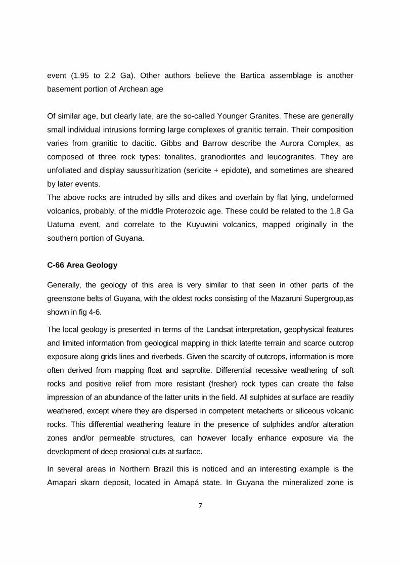
The PL area can be accessed by 4WD vehicle or Bedford truck via a logging and mining
road from Bartica, crossing the Mazaruni at Itaballi,from Itaballi the journey by truck/pick up
is approximately 5-6 hours to the PL.0.. . Bartica is accessed from Georgetown via speed
boat from Parika, or by road via the Georgetown-Linden Highway crossing the Essequibo
River at the Shirima crossing, see fig 1.
Geophysics
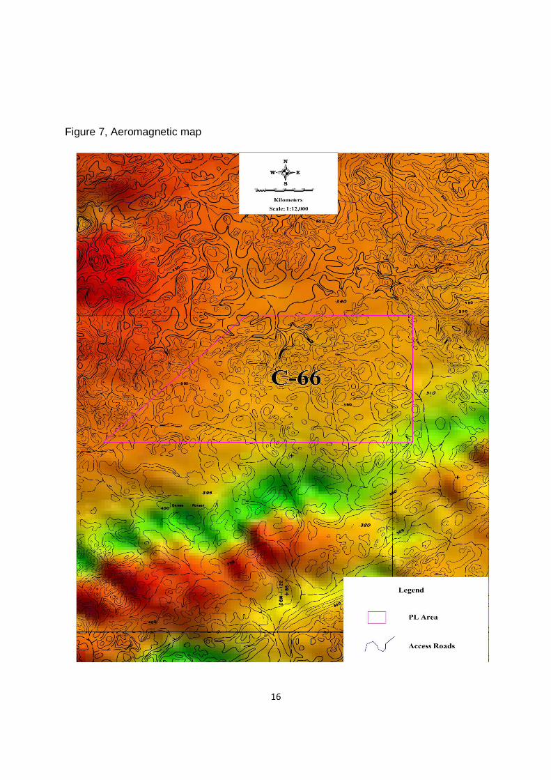
The first systematic geophysical survey in Guyana was an aeromagnetic survey flown by
Aero Services Corporation, funded by the United Nations in 1963. The survey used a set of
N-S flight lines at a spacing of approximately 1.6 to 2.4 km, and a height of 300m. In 1971-
72 additional areas in Guyana were flown by Terra Surveys, funded by the Canadian
Commonwealth Bureau, and older data was incorporated in a set of 1:200,000 scale maps.
These sheets were then re-issued with an interpretation by Tyl & Reford of Terra Surveys
Ltd in 1973. In 1994 aeromagnetic data covering Guyana was converted to digital form by
Gtech Ltd, a commercial group attached to the University of Leeds in the UK as part of the
“South American Magnetic Mapping Project” (SAMMP). A relief-shaded map compiled
recently (Heesterman 2004) from this data. It should be noted that this data has not been
reduced to the pole.
The aeromagnetic data shows distinct areas with magnetic highs, or abrupt magnetic
gradients,see fig 7. The Quartzstone mountains, which trend north-south, directly to the west
of the study locations (excluding Wiamu) show elevated geophysics results to the immediate
background geophysics. `

5
Mineral Occurrences
Historical Data
Historically the plains underlain by granitic saprolite in the area has been a good source of
gold. However recent sampling from this area has not determined a significant source of
gold in the granitic saprolite, which is now exposed. It is therefore suggested that historical
extraction of gold has derived from alluvial material deposited on the bed rock which has
subsequently been removed and processed for gold. The alluvial material is most likely to be
derived from lode structures and schistose rocks observed and from the hill ranges. It is
therefore seen as an important exercise to study the hill range of the area for primary
mineralization.
The Quartzstone – Aremu Batholith which may be present within the PL area is associated
with extensive surface gold workings along the contact zone with the country rock. Gold
occurs in the contact zone, marginal granite and gold bearing quartz veins, which are
usually associated with shear zones in this area (Annual Report, 1964)
PL Mineralisation
From data on the mining activities bordering the PL, gold is found to be present in quartz
veins and quartz rich lodes and well foliated saprolitic schist which in general all strike north-
south throughout the area. The gold bearing quartz veins are usually associated with a black
mineral (tourmaline?). Active extraction of gold from saprolite and quartz material in areas
bordering the PL area is presently undertaken by small and medium scale miner. In some
areas saprolite and quartz is being crushed and washed. One notably anomalous area is
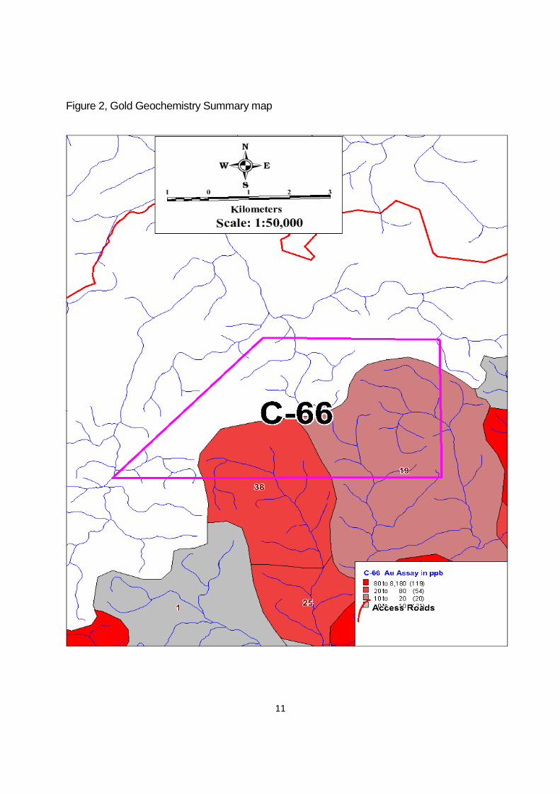
located within the PL area with an Au assay value 25-38 ppb,see fig 2,however it should be
noted that only approximately thirty five percent (35%) of the PL area have subjected to
geochemical sampling .
6
Regional Geology Two major lithological sequences, the Bartica Assemblage and the Barama – Mazaruni
Supergroup Greenstone sequences, underlie the northwestern area of Guyana.
Basement – the Kanuku complex is considered to be part of the Archean basement. It
consists of paragneisses and migmatites, granulites (Kanuku Mts.) and granite
gneisses.
Greenstones - The Barama and Mazaruni groups have been classically considered as
part of the Guiana Shield’s widespread Birrimian Age Greenstone Belts (2.2 G.a). The
Barama group outcrops in the northwestern region of Guyana, close to the border with
Venezuela. It consists of a predominantly sedimentary sequence with locally developed
Mn rich chert layers (Mathews Ridge deposit) interbeded with volcano sedimentary
packages. It is bounded to the west by the predominantly volcanic Mazaruni group (El
Callao in Venezuela stratigraphy). The contacts between The Mazaruni group, the
Barama Group and the gneissic basement sequences have not been well defined.
Generalized descriptions by Gibbs and Barron, made at Waikuri, suggest a typical
Archean greenstone sequence, with ultramafics rocks in the lower part, andesitic and
felsic volcanics in the central part and sediments in the upper part. All the above
sequences were deformed during the Trans Amazonian Event (2.1-1.9 Ga.).
Older Basic Rocks – this is a distinct group, also of Birrimian age, and is described as
intruding the Barama –Mazaruni greenstones. These are deformed and
metamorphosed to the same degree as the host sequences (Heesterman 2001).
The Bartica assemblage is a gneissic terrain, occurring in the Cuyuni River Region,
composed of various ortho / paragneisses with amphibolites, metamorphosed to the
amphibolite facies. Locally it reached the granulite facies. These rocks are believed
(Gibbs and Barron) to be reworked Barama-Mazaruni units during the Trans Amazonian
7
event (1.95 to 2.2 Ga). Other authors believe the Bartica assemblage is another
basement portion of Archean age
Of similar age, but clearly late, are the so-called Younger Granites. These are generally
small individual intrusions forming large complexes of granitic terrain. Their composition
varies from granitic to dacitic. Gibbs and Barrow describe the Aurora Complex, as
composed of three rock types: tonalites, granodiorites and leucogranites. They are
unfoliated and display saussuritization (sericite + epidote), and sometimes are sheared
by later events.
The above rocks are intruded by sills and dikes and overlain by flat lying, undeformed
volcanics, probably, of the middle Proterozoic age. These could be related to the 1.8 Ga
Uatuma event, and correlate to the Kuyuwini volcanics, mapped originally in the
southern portion of Guyana.
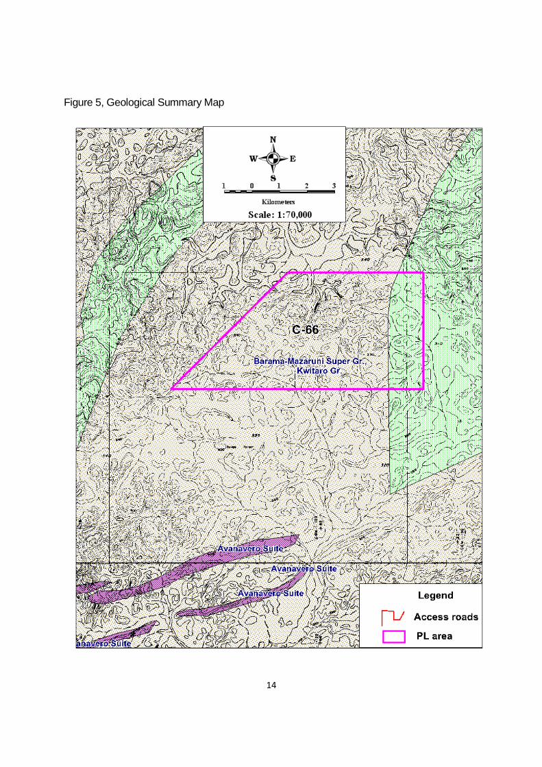
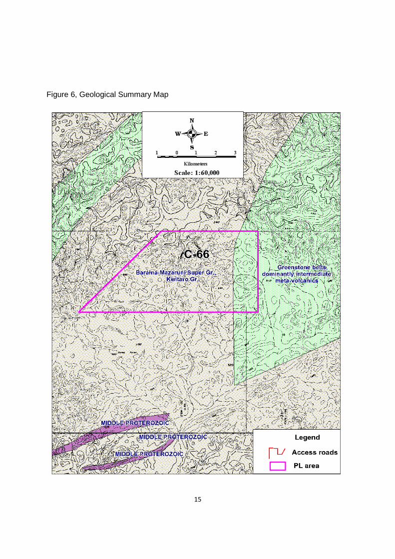
C-66 Area Geology
Generally, the geology of this area is very similar to that seen in other parts of the
greenstone belts of Guyana, with the oldest rocks consisting of the Mazaruni Supergroup,as
shown in fig 4-6.
The local geology is presented in terms of the Landsat interpretation, geophysical features
and limited information from geological mapping in thick laterite terrain and scarce outcrop
exposure along grids lines and riverbeds. Given the scarcity of outcrops, information is more
often derived from mapping float and saprolite. Differential recessive weathering of soft
rocks and positive relief from more resistant (fresher) rock types can create the false
impression of an abundance of the latter units in the field. All sulphides at surface are readily
weathered, except where they are dispersed in competent metacherts or siliceous volcanic
rocks. This differential weathering feature in the presence of sulphides and/or alteration
zones and/or permeable structures, can however locally enhance exposure via the
development of deep erosional cuts at surface.
In several areas in Northern Brazil this is noticed and an interesting example is the
Amapari skarn deposit, located in Amapá state. In Guyana the mineralized zone is
8
deeply weathered to as much as 140m while the adjacent rock units are generally only
weakly weathered and oxidized to depths of 20 to 60 meters.
Greenstone Belts: These areas was identified using Landsat interpretation, the
greenstone sequence is the predominant rock type, and is characterized by a weak, but
persistent, bedding or foliation generally trending NNW-SSE. Because of the weak
contrast in the Landsat imagery of the bedding/foliation, it was not possible to determine
the internal structure of the units or to separate it into predominantly volcanic or
sedimentary units. Only a few resistive ridges were clearly identified and interpreted to
consist of either massive volcanics, sandstones, chert or BIF.
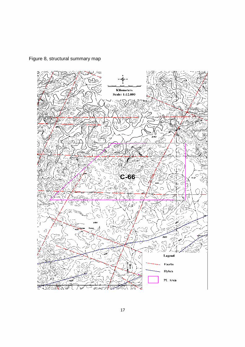
Structure and relative age
A study of lineaments from stereoscopic examination of air photos was modified using
aeromagnetic and field data to identify major structures. Where all different data types
coincide, the probability that the structure is significant is higher. A similar process was used
to define major lithological boundaries.
Historically very few faults have been mapped in the field, mainly as softer faulted material
rarely survives as outcrop. Airphoto interpretation suggests that many linear features can be
traced between photographs over long distances. At least some of these must be faults with
significant movement, and others are first and second order fracture systems related to
primary movement. Some of the larger lineaments thought to be faults and fractures are
shown on Figures 8.
A number of main lineament directions can be recognised. Age relationships of some of
these can be interpreted from the way that they control the geology and mineralisation, but
in many cases these structures may be long lived, and have been re-activated several
times.
9
Comments & Conclusions
Based on the limited for data for this concession, further exploration activity is warranted, in
order to develop into a mine, because areas bordering this PL have been some of the most
productive placer mining areas in the Cuyuni River District. The workings in the area are
located along the granite-greenstone contact of the Aremu batholith.
Therefore it is recommended that a program which consists of detail soil sampling and
geological mapping should be undertaken within the PL area to accurately define the
grade and type of mineralization. However from the sampling and study undertaken in
other areas bordering the PL it can be suggested that gold mineralization is hosted in
quartz veins and quartz rich lodes in this area. Therefore further work to better
understand the geology in this concession should be undertaken as there may be a
significant source of primary gold within the concession.
10
Fig1, Location map
11
Figure 2, Gold Geochemistry Summary map

12
Figure 3, Mineral Occurrence Summary map

13
Figure 4, Geological Summary Map
14
Figure 5, Geological Summary Map
15
Figure 6, Geological Summary Map
16
Figure 7, Aeromagnetic map
17
Figure 8, structural summary map
18
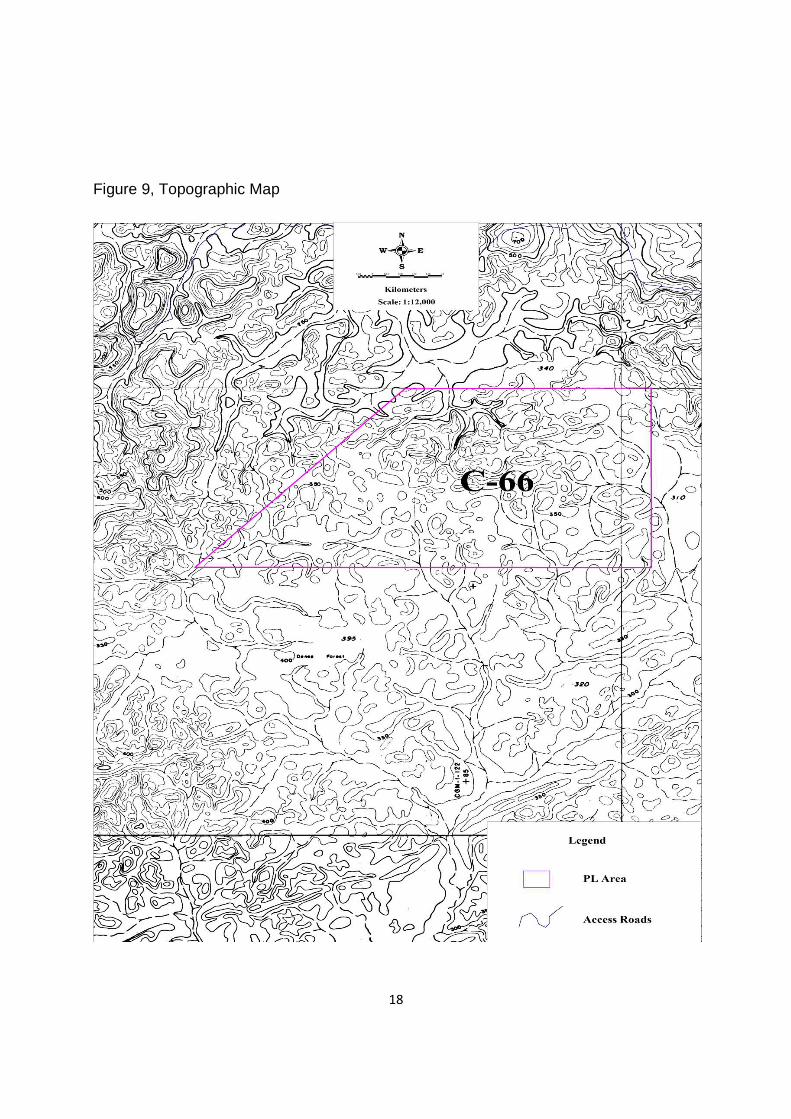
Figure 9, Topographic Map
19
REFERENCES :
Bishop DW. 1936. Quartzstone-Wiamu area. Cuyuni River. Preliminary report
Annual Report of Geological Services Department, British Guiana. 1964. Special geological problems. Granite studies: Quartzstone – Aremu, Rupa, Kopang. 33-35
Learmont J W. 1954. Area vbetween Aremu and Quartzstone Rivers, Cuyuni Rivers. Annual Report on the Geological Survey Department for the Year 1954 (British Guiana Geological Survey). 42-43, 88-89
Lloyd JW. 1958, Area North-west of Quartzstone Landing, Cuyuni River. Annual Report on the Geological Survey Department for the Year 1958 (British Guiana Geological Survey). 42-43
Gibbs, A.K. and Barron, C.N. – 1993 – The Geology of the Guiana Shield. Oxford Univ. Press. Gibbs, A.K. – 1984 – Review of the geology and mineral deposits of the Guiana shield. Report for Utah International Inc.
Goodwin, Alan M. – 2000 – Precambrian Geology of South American Platform. Academic Press
Related Documents


