Top Banner
BYC CCYC Sextant Training
29

BYC CCYC Sextant Training. What is a sextant? An instrument for measuring angular distances used especially in navigation to observe altitudes of celestial.

Dec 17, 2015

Download

Documents

Caitlin Barrett
Welcome message from author
This document is posted to help you gain knowledge. Please leave a comment to let me know what you think about it! Share it to your friends and learn new things together.
Transcript
Page 1: BYC CCYC Sextant Training. What is a sextant? An instrument for measuring angular distances used especially in navigation to observe altitudes of celestial.

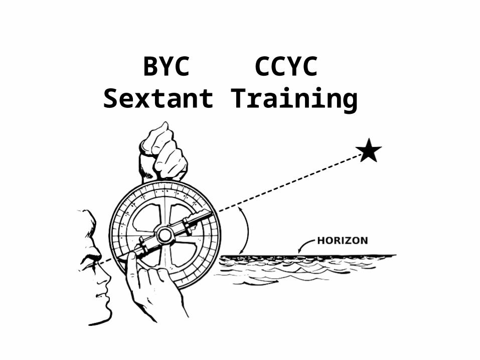
BYC CCYCSextant Training

Page 2: BYC CCYC Sextant Training. What is a sextant? An instrument for measuring angular distances used especially in navigation to observe altitudes of celestial.

What is a sextant?

• An instrument for measuring angular distances used especially in navigation to observe altitudes of celestial bodies.

Page 3: BYC CCYC Sextant Training. What is a sextant? An instrument for measuring angular distances used especially in navigation to observe altitudes of celestial.
Page 4: BYC CCYC Sextant Training. What is a sextant? An instrument for measuring angular distances used especially in navigation to observe altitudes of celestial.

Olden Days

Page 5: BYC CCYC Sextant Training. What is a sextant? An instrument for measuring angular distances used especially in navigation to observe altitudes of celestial.

Objectives

• This course is designed to teach the basic sextant operation with emphasis on:

• Basic sextant operation and measurement• Finding latitude using LAN Sun measurements • Making corrections• Local Apparent Noon• Worksheets• Intro to the Pole Star (maybe)

Page 6: BYC CCYC Sextant Training. What is a sextant? An instrument for measuring angular distances used especially in navigation to observe altitudes of celestial.

Teaching MethodThis course will be taught using:

• Lecture

• Video

• Demo/Practical Labs

Page 7: BYC CCYC Sextant Training. What is a sextant? An instrument for measuring angular distances used especially in navigation to observe altitudes of celestial.

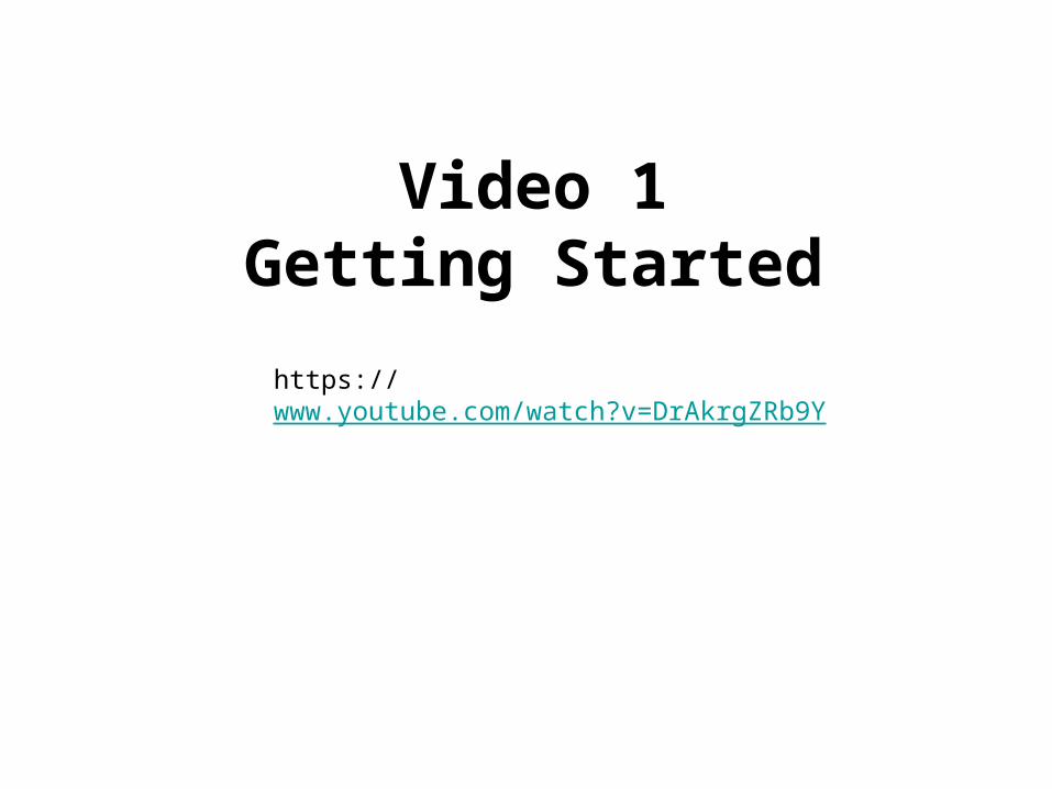
Video 1Getting Started

https://www.youtube.com/watch?v=DrAkrgZRb9Y
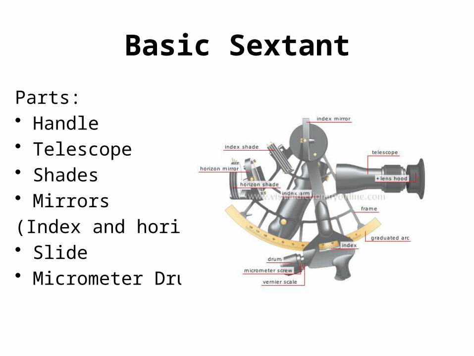
Page 8: BYC CCYC Sextant Training. What is a sextant? An instrument for measuring angular distances used especially in navigation to observe altitudes of celestial.

Basic Sextant

Parts:• Handle• Telescope• Shades• Mirrors

(Index and horizon)• Slide• Micrometer Drum

Page 9: BYC CCYC Sextant Training. What is a sextant? An instrument for measuring angular distances used especially in navigation to observe altitudes of celestial.

Basic Sextant

Reading a Sextant:

One degree of arc = 1 nautical mile

60’ 00.0”

30’ 30.0”

15’ 25.4”

Page 10: BYC CCYC Sextant Training. What is a sextant? An instrument for measuring angular distances used especially in navigation to observe altitudes of celestial.

Basic Sextant

Taking a measurement:

1. Set to zero degrees

2. Set shades as needed, look at sun to check

3. Move drum 30 minutes to separate sun in mirror

4. Bring bottom of sun to horizon

5. Swing sextant in an arc to get best measurement

Page 11: BYC CCYC Sextant Training. What is a sextant? An instrument for measuring angular distances used especially in navigation to observe altitudes of celestial.

Questions

Page 12: BYC CCYC Sextant Training. What is a sextant? An instrument for measuring angular distances used especially in navigation to observe altitudes of celestial.

Video 2The Noon Sight for Latitude

https://www.youtube.com/watch?v=BWGOlpj4YwE

Page 13: BYC CCYC Sextant Training. What is a sextant? An instrument for measuring angular distances used especially in navigation to observe altitudes of celestial.

Noon Sight

Geographic Position: An object at its 90’ position relative to earth – directly above!

Zenith Distance: distance between your position and an objects geographic position. (degrees X 60)

Declination: Latitude spot beneath an object
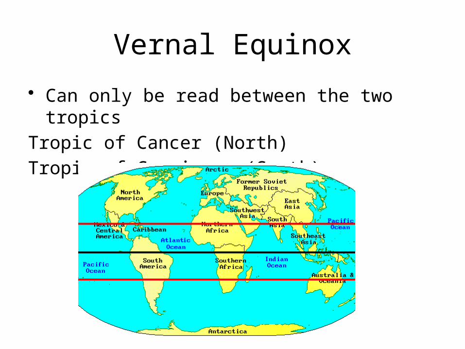
Page 14: BYC CCYC Sextant Training. What is a sextant? An instrument for measuring angular distances used especially in navigation to observe altitudes of celestial.

Vernal Equinox

• Can only be read between the two tropics

Tropic of Cancer (North)

Tropic of Capricorn (South)

Page 15: BYC CCYC Sextant Training. What is a sextant? An instrument for measuring angular distances used especially in navigation to observe altitudes of celestial.

Noon SightSun below equator

Latitude Zenith Distance Declination= -

Page 16: BYC CCYC Sextant Training. What is a sextant? An instrument for measuring angular distances used especially in navigation to observe altitudes of celestial.

1. Shoot sun at 1800 UTC:

2. Sextant reading: 49 15.0

3. Compute Zenith Distance (zd):

89’ 60.0” - sextant reading = 40 45.0

4. Find declination (dec) from almanac: S 17 16.0

Lat = zd – dec

Lat = 23 29.0

Noon SightSun below equator

Page 17: BYC CCYC Sextant Training. What is a sextant? An instrument for measuring angular distances used especially in navigation to observe altitudes of celestial.

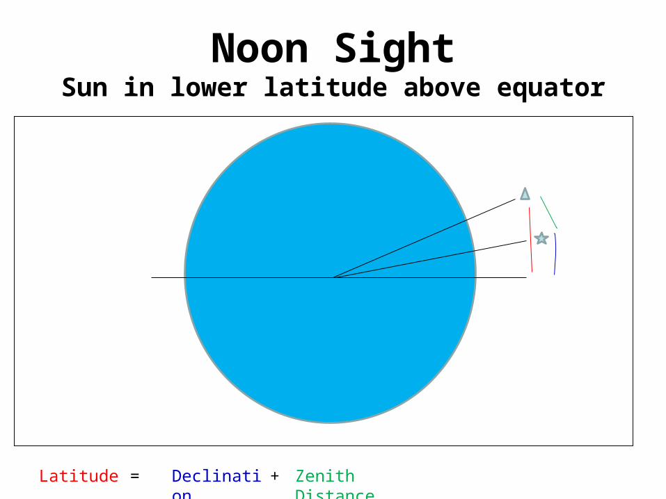
Noon SightSun in lower latitude above equator

Latitude Zenith Distance Declination= +

Page 18: BYC CCYC Sextant Training. What is a sextant? An instrument for measuring angular distances used especially in navigation to observe altitudes of celestial.

1. Shoot sun at 1530 UTC:

2. Sextant reading: 53 24.7

3. Compute Zenith Distance (zd):

89’ 60.0” - sextant reading = 36 35.3

4. Find declination (dec) from almanac: N 08 09.7

Lat = zd + dec

Lat = 44 45.0

Noon Sight Sun in lower latitude above equator

Page 19: BYC CCYC Sextant Training. What is a sextant? An instrument for measuring angular distances used especially in navigation to observe altitudes of celestial.

Noon SightSun in upper latitude above equator

Latitude Zenith Distance Declination= -

Page 20: BYC CCYC Sextant Training. What is a sextant? An instrument for measuring angular distances used especially in navigation to observe altitudes of celestial.

1. Shoot sun at 1618 UTC:

2. Sextant reading: 86 53.3

3. Compute Zenith Distance (zd):

89’ 60.0” - sextant reading = 03 06.7

4. Find declination (dec) from almanac: N 17 08.7

Lat = dec - zd

Lat = 14 02.0

Noon Sight Sun in upper latitude above equator

Page 21: BYC CCYC Sextant Training. What is a sextant? An instrument for measuring angular distances used especially in navigation to observe altitudes of celestial.

Questions

Page 22: BYC CCYC Sextant Training. What is a sextant? An instrument for measuring angular distances used especially in navigation to observe altitudes of celestial.

Video 3Precision

https://www.youtube.com/watch?v=uNWTN2LQ-TU

Page 23: BYC CCYC Sextant Training. What is a sextant? An instrument for measuring angular distances used especially in navigation to observe altitudes of celestial.

Index Error

• Sextant correction for built in error of the sextant

1. Find the horizon and make level in both mirrors

2. Read the micrometer drum

3. If the error is above zero subtract the reading

4. If the error is below the zero add the reading

Makes sense if you understand you are trying to get back to zero!
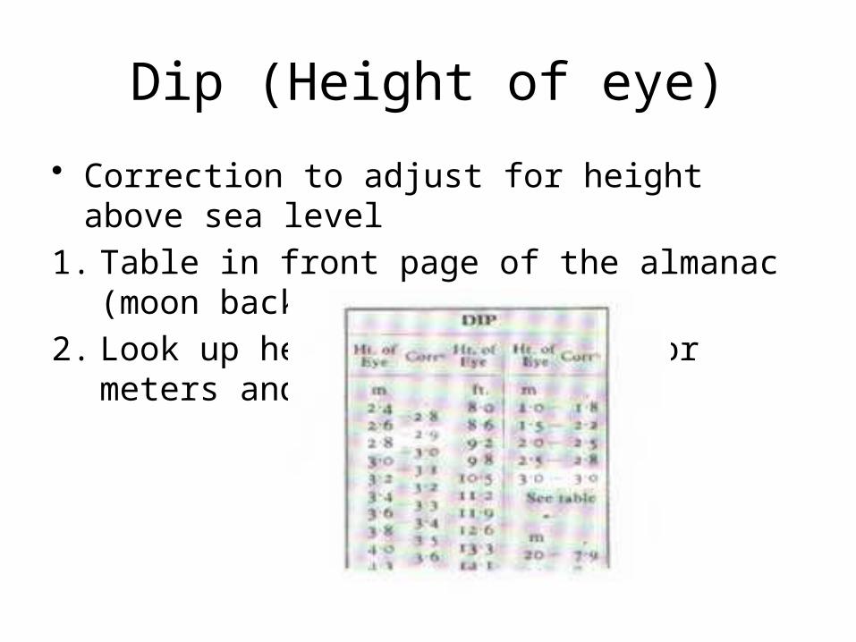
Page 24: BYC CCYC Sextant Training. What is a sextant? An instrument for measuring angular distances used especially in navigation to observe altitudes of celestial.

Dip (Height of eye)

• Correction to adjust for height above sea level

1. Table in front page of the almanac (moon back)

2. Look up height of eye in ft or meters and subtract

Page 25: BYC CCYC Sextant Training. What is a sextant? An instrument for measuring angular distances used especially in navigation to observe altitudes of celestial.

Main Correction

• Correction to adjust to the center of the object

1. Table in the first page of the almanac

2. Look up month

3. Lower or upper limb

4. Use you apparent altitude

- Apparent Altitude is the number after you have made your sextant sight and adjusted for index error and Dip.

Page 26: BYC CCYC Sextant Training. What is a sextant? An instrument for measuring angular distances used especially in navigation to observe altitudes of celestial.

Exact Declination • Correction to refine declination

1. Find hourly declination on chart

Actual reading 1150

2. Hourly declination – ex: 8 28.7

3. Find the .d number bottom of page ex: d=.9

4. Look at the increments and corrections pages for 50 minutes

5. Fifth column is d corrections .9 (left)= .8 (right)

6. Look to see if declination is increasing or decreasing – make adjustment with .8

Page 27: BYC CCYC Sextant Training. What is a sextant? An instrument for measuring angular distances used especially in navigation to observe altitudes of celestial.

Local Apparent Noon

• Highest point of the sun

• Median between Sunrise and Sunset

Page 28: BYC CCYC Sextant Training. What is a sextant? An instrument for measuring angular distances used especially in navigation to observe altitudes of celestial.

Questions!

Rick Bell361 815 3111

[email protected]

Page 29: BYC CCYC Sextant Training. What is a sextant? An instrument for measuring angular distances used especially in navigation to observe altitudes of celestial.

Video 3The Pole Star

https://www.youtube.com/watch?v=sa_2qF1iCqk