The archaeology of the Sulphur Spring Valley, Arizona Item Type text; Thesis-Reproduction (electronic) Authors Caywood, Louis R. (Louis Richard), 1906- Publisher The University of Arizona. Rights Copyright © is held by the author. Digital access to this material is made possible by the University Libraries, University of Arizona. Further transmission, reproduction or presentation (such as public display or performance) of protected items is prohibited except with permission of the author. Download date 24/05/2018 21:44:53 Link to Item http://hdl.handle.net/10150/553164

Welcome message from author
This document is posted to help you gain knowledge. Please leave a comment to let me know what you think about it! Share it to your friends and learn new things together.
Transcript

The archaeology of the Sulphur Spring Valley, Arizona
Item Type text; Thesis-Reproduction (electronic)
Authors Caywood, Louis R. (Louis Richard), 1906-
Publisher The University of Arizona.
Rights Copyright © is held by the author. Digital access to this materialis made possible by the University Libraries, University of Arizona.Further transmission, reproduction or presentation (such aspublic display or performance) of protected items is prohibitedexcept with permission of the author.
Download date 24/05/2018 21:44:53
Link to Item http://hdl.handle.net/10150/553164

THE ARCHAEOLOGY OF THE SULPHUR SPRING VALLEY, ARIZONA
"by
L o u is R. Cay wood
S u b m i t t e d in p a r t i a l f u l f i l l m e n t o f th e
r e q u i r e m e n t s f o r t h e d e g r e e o f
MASTER OF ARTS
i n th e C o l l e g e o f L e t t e r s , A r t s , and S c i e n c e s , o f t h e
U n i v e r s i t y o f A r i z o n a
1 9 3 3
A p p r o v e d :M a jo r a d v i a

» •• / ' . • ' - ~ ->■• * -• p » — * ?■ *• i ■ * , ' r ■■ * -*~r.L\> '. i '•. * l » J . ■•" i i : t ; . i l u - U l i i V v ‘ * - . J . , : - ' .-3 i
j>o o”;v.o o .-! cl yotl
o :{d l o J n o . : . ' ! £ 2 ' i . ‘ ;. ' i- I . . u d ' x ^ q i r l :>v'd
':;o o;> -ro'i c d : o ' r Z ; ; p o - i
c r
.5'bC'Z. -zCir-ri■
' " 1 3 i v 3.-: "CO N'4

/ £
ACKNOWLEDGMENT
The w r i t e r w i s h e s t o acknow ledge
h i s i n d e b t e d n e s s t o t h e f o l l o w i n g p e r s o n s f o r t h e i r
h e l p f u l s u g g e s t i o n s a n d i n t e r e s t d u r i n g t h e w r i t i n g
o f t h i s p a p e r :
D r . Byron Cummings, head o f t h e
D e p a r tm en t o f A r c h a e o lo g y a t t h e U n i v e r s i t y o f A r i z o n a
and D i r e c t o r o f th e A r i z o n a S t a t e Museum, f o r h i s a s
s i s t a n c e , s u g g e s t i o n s , and i n s t r u c t i o n ;
Mr. W i l l i a m Kardon o f B i s b e e , A r i z
o n a , f o r h i s s u g g e s t i o n s , i n t e r e s t , and h e l p a t a l l
t im e s in t h e f i e l d work c a r r i e d on;
Mr. C a r l T r i s c h k a o f B i s b e e , A r i z o n a ,
f o r p h o t o g r a p h s ;
And t o t h e s t u d e n t s o f t h e D e p a r tm en t
o f A rc h a e o lo g y f o r t h e i r i n t e r e s t and a s s i s t a n c e .
90539

TABLE OF CONTENTS
In troduction ...................................................... 1
P h y s io g ra p h y ........................................................... . 11
H i s t o r y ...................... 14-
Geology ............................................................................ l 6
Archaeology ................................................................... 19
Southern Sub-Area ......................................... 21
Middle Sub-Area . ........................... 35
northern S u b - A r e a ............................................4-4-
S um m ary........................................................ 4-7
B ib lio g r a p h y ............................................................ 52

THE ARCHAEOLOGY OF THE SULPHUR SPRING VALLEY, ARIZ.
Ill TRODUCTIOII
An in trod u ction to the study o f North
American archaeology r e v e a ls human h is to r y and p reh isto ry
as "being d iv ided in to c u ltu r e s and cu ltu re areas to fa c
i l i t a t e the understanding o f the development o f the
e a r l ie s t in h ab itan ts of t h is co n tin en t. "C ulture, or
c iv i l iz a t io n ,'* as d efined by E. B. T y lo r , "taken in i t s
wide ethnographic sen se , i s that complex whole which in
c lu d es knowledge, b e l i e f , a r t , m orals, law, customs and
any other c a p a b i l i t ie s and h ab its acquired by man as a1
member o f so c ie ty ." C u ltu r a l.remains are the imple
ments, ornaments, and o b je c ts that p r im itiv e people made
and developed through which they expressed th e ir "know
led g e , b e l i e f , a r t , m ora ls, law, custom s," e t c . and
a rch a eo lo g ica l cu ltu re areas show the geograph ica l d i s
tr ib u tio n o f th ese a r t i f a c t s .
1. E. B. T y lo r , 1

- 2 -
To the student of n orth American arch
aeology the main a rch a eo lo g ica l cu ltu re areas are the Mayan,
T oltec and Aztec in Mexico and C entral America, the Pueblo
in the Southwest, and the Moundbuilder in the M is s is s ip p i
V a lley .
The Southwest area in clu d es a l l o f the
s ta te s of Utah, New M exico, Arizona, and part o f south
w estern Colorado, w estern Texas, sou th eastern Nevada, south
eastern C a lifo rn ia , northern Sonora, and northwestern Chi
huahua.
The Southwest area is ch aracterized by a
cu ltu re showing a good degree of development in a r c h ite c tu r e ,
ceram ics, and ornaments worked from ston e , bone, and s h e l l .
In turn th is area can be subdivided in to geographical c u l
ture a re a s . The p r e h is to r ic in h ab itan ts liv e d in d if fe r e n t
se c t io n s much as we do today, but to them water and food
were most im portant; so they e s ta b lish e d them selves where
th ese were o b ta in a b le . These various sub-areas had th e ir
own d is t in g u ish in g t r a i t s due, perhaps, to the c r e a t iv e
n ess of in d iv id u a l minds w ith in th e groups, to geographic
i s o la t io n , to the m a ter ia ls a t hand from which they d evelop
ed th e ir a r t s , or to a com bination o f any o f th e se .
The sub-areas o f the Southwest have
been named geograp h ica lly according to the drainage a reas.2
Kidder in h is work on the Southwest l i s t s n ine such areas,
2 . K idder, 47

P l a t e I
1I___
COLORADO
\\
R I Z 0 \NA
4
N E w M E X i & O s
SONORAC u l t u r e . Areal'S \ \
1. S a fi i T u a n 6. M / m b r e s 1 1Z. N orthern Pe,rif»h*iral 7- C/nhuahua. ) /3 E a s te r n Peripheral 8 U p p e r Ci la4 .Pto Grande. 9 L o w e * " Gilo. / /
5 L i t t l e Colorado to Mi d d l e Gila.1
1 \CHIHUAHUA'
9V
X3
X
- 3 “
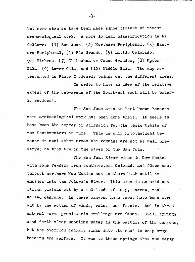
"but some changes have been made s in ce because o f recent
a rch a eo lo g ica l work. A more lo g ic a l c la s s i f i c a t io n i s as
f o l lo w s : (1) San Juan, (2) Northern P er ip h era l, (3) E ast
ern P er ip h era l, (4) Rio Grande, (5) L i t t l e Colorado,
(6) Mimbres, (7) Chihuahua or Casas Grandes, (8) Upper -
G ila , (9 ) Lower G ila , and (10) Middle G ila . The map r e
presented in P la te I c le a r ly brings out the d if fe r e n t areas.
In order to have an idea o f the r e la t iv e
exten t of the sub-areas o f the Southwest each w i l l be b r ie f
ly review ed.
The San Juan area i s b est known because
more a rch a eo lo g ica l work has been done th e re . I t seems to
have been the cen ter o f d if fu s io n for the b asic t r a .it s of
the Southwestern c u ltu r e . This is only h y p o th e tica l be
cause in most other areas the remains are not as w e ll pre
served as they are in the caves o f the San Juan.
The San Juan River r i s e s in New Mexico
w ith some feed ers from southw estern Colorado and flow s west
through northern New Mexico and southern Utah u n t i l i t
em pties in to the Colorado R iver. This area i s an arid and
barren p la teau cut by a m ultitude of deep, narrow, rock-
w alled canyons. In th ese canyons huge caves have been worn
out by the a c tio n o f w inds, r a in s , and f r o s t s . And in th ese
n a tu ra l caves p r e h is to r ic d w ellin gs are found. Sm all springs
send fo r th c le a r bubbling water in the bottoms of the canyons,
but the overflow q u ick ly sinks in to the sand to seep away
beneath the su r fa c e . I t was to these sp rin gs that the ea r ly

- 4 -
in h ab itan ts owed th e ir e x is te n c e .
The San Juan area i s d iv id ed in to three
important d i s t r i c t s which are the Kayenta, Mesa Verde, and
Chaco Canyon.
Hot a great d ea l is known about the two
p erip h era l areas as y e t , but n otab le work has been done in
both the northern and E astern P er ip h era ls .
The northern P erip h era l in clu d es Arizona
n orth o f the Grand Canyon, part of sou theastern Hevada, and
most of Utah. The ru in s in th is area are not nearly as
ex ten siv e or imposing as those o f the San Juan area, but
the r e s u lt s ob ta ined , when fu r th er work i s done, w i l l pro
bably do much to en lig h ten a rc h a e o lo g ists about c e r ta in
p eriod s of p r e h is to r ic c u ltu r e .
The Eastern P er ip h era l area in clu d es
eastern Hew Mexico, sou theastern Colorado, northw estern
Oklahoma, w estern Texas, and p o ss ib ly n ortheastern Chihuahua
and northw estern C oahuila. Hew f in d s are being made and the
borders are being c o n tin u a lly pushed fu rth er out.
The Rio Grande R iver r is e s in the h igh
mountains of southwestern Colorado and a f te r flow ing eastward
turns south in to Hew Mexico where i t runs through the c e n tra l
part of that s t a t e . In th is drainage area cer ta in s e c t io n s
have been c a r e fu lly explored and fu l ly s tu d ied , but there
are others which s t i l l aw ait ca r e fu l in v e s t ig a t io n . The coun
try ranges from sandy d esert to lo f t y mountain peaks, and the
v eg e ta tio n i s as varied w ith c a c t i , sage-brush , ced ars, and
pinyons.

- 5 “
tThe Rio Grande area d i f f e r s from other
p arts o f the Southwest w ith the excep tion of the L i t t l e
Colorado area in that i t i s occupied hy th e l iv in g tr ib e s
who even today re ta in much the same a r t , s o c ia l organiza
t io n and customs as did th e ir p r e h is to r ic a n ces to r s . So
a r c h a e o lo g is ts working in th is region are ab le to work from
known data , which can be used as c r i t e r ia fo r the arch
a e o lo g ic a l problems presented by the ru ins excavated .
The L i t t l e Colorado R iver r is e s in w est
ern New Mexico and flow s a l i t t l e north o f w est through
Arizona to empty in to the Colorado R iver . About on e-fou rth
of t h is drainage area l i e s in northw estern New M exico; the
r e s t being in Arizona.
The e le v a t io n above sea le v e l shows more
v a r ia tio n than any other sub-area. The low est e le v a tio n i s
2,800 f e e t at the mouth o f the L i t t le Colorado River where
i t em pties in to the Colorado R iver and the h ig h est p o in t
i s Agassez peak in the San F rancisco Mountains which r i s e s
to 12,794 f e e t . Between th ese two e le v a t io n s a varied
topography p resen ts i t s e l f . In some p arts i t i s purely a
d esert region and in others heavy growths o f y e llo w p in e ,
D ouglass F ir , and spruce abound.
Here the descendants of the once num
erous pueblos s t i l l e x i s t on three mesas and in seven towns
of which Walpi, S h ip au lov i, Mishongnovi, H o te v il la , and
O raibi are the la r g e s t and most im portant. P r e h is to r ic

- 6 -
ru ins are found in most p arts o f the L i t t l e Colorado area
and they range from the e a r l ie s t p it houses to the w e ll
constructed pueblos o f the Late Pueblo P eriod w ith a l l
sta g es o f development p resen ted .
The Himbres River r is e s in the Black
Mountains o f southeastern Hew Mexico and flow s southward
in to an inland basin which i s part of the in land drainage
system o f northern Chihuahua. The upper r iv er i s a good
s ized running stream bordered by tr e e s and the v a lle y on
e ith e r sid e is e a s i ly ir r ig a b le and f e r t i l e . I t was here3
the s o -c a lle d Mimbrenos b u i l t th e ir b e st p u eb los. Further
south when i t emerges from the mountains the water of the
r iv e r sinks in to the sand and on ly appears here and there
and then in sm all flow s or seep s.
The ru in s o f the Mimbres V a lley are
noted for th e ir very f in e and extraordinary type of p o ttery
fo r which the d i s t r ic t i s famous. The ty p ic a l Mimbres wareV
is in the form o f ab lack -on-w hite bowl decorated on theA
in te r io r by geom etric d esign s and n a tu r a l is t ic f ig u r e s .
The Casas Grandes V alley l i e s in the
northw estern part o f the s ta te of Chihuahua, Mexico. Chi
huahua i s bounded on the north by ITew Mexico and Texas,
on the ea st by C oahuila, on the south by Durango and S in a loa ,
and on the west by Sonora. The northern part o f the s ta te
i s on a p la teau 4 ,000 f e e t in a lt itu d e w ith h i l l s here and
3 . Ib id . 101.

- 7 -
there which are "barren o f v eg e ta tio n except for m esquite
"bushes, g ra ss , and a few shrubs. Through t h is "barren
region .1 the Rio Casas Grandes flow s from south to north
u n t i l i t nears the Hew Mexico s ta te l in e and then i t makes
a great bend eastward and south and flow s in to Lake Guzman.
In the dry season no water flow s above ground in the r iv e r
bed except in the one s e c t io n near Casas Grandes i t s e l f .
Here in a long wide v a lle y formed by the Capulins and the
S ierra de la Escondida to the e a s t , and the S ierra Hadre to
the west the r iv e r flow s the year round and crops can be
e a s i ly grown.
Long ago in th is region a p r e h is to r ic
cu ltu re e x is te d . Today one fin d s large mounds o f various
s iz e s which are the remains o f great houses o f adobe in
which these people l iv e d . And to the w est in the canyons
of the S ierra Madre a r e . found many groups o f c l i f f - d w e l l
ings o f wood and adobe. The S ierra Madre w est o f t h is
region i s rugged and in p la ces almost im passable. Deep
canyons drop hundreds of fe e t to rushing streams below
m aking-travel to the w est over th ese mountains very d i f
f i c u l t .
The e n t ir e area covered by th is p re
h is to r ic cu ltu re and known as the Casas Grandes Area ex
tends from the In tern a tio n a l boundary l in e between Hew
Mexico and Chihuahua south to the Mexican town of Temosachic,
roughly a d istan ce o f some two hundred and f i f t y m ile s .

- 8 -
A rch aeo log ica l in v e s t ig a t io n in th is
region has "been very scant u n t i l recent years although
many of the e a r l ie s t exp lorers v is i t e d h ere . B a r t le t t
f i r s t saw the Casas Grandes ru ins in the e a r ly f i f t i e s .
They were so named "because of the th ick n ess and h eigh t o f
the w a lls . Some t h ir t y - f iv e years la te r B andelier d es
cribed them and the w a lls were s t i l l stand ing . Lumholtz
explored, here in the ea r ly n in e t ie s and secured p o ttery
which is now in the American Museum o f N atural H istory .
B la ck isto n v i s i t e d the c l i f f - d w e l l in g s and the mounds in
the ea r ly part o f the tw en tie th cen tu ry . In 1922 when
Kidder v is i t e d the ru in s the w a lls were almost a l l crumbled
and eroded away and only the o u tlin e s o f the stru c tu res
d escrib ed by the ea r ly v i s i t o r s could be made ou t. In 1927,
1928, and 1929, Henry A. Carey was in th is reg ion making
surveys and excavating sev era l mounds. In 1931 Donald Brand
a lso made a b r ie f survey o f the area.
Q u a n tities o f m ateria l from the mounds
and caves have found th e ir way in to American museums through
Mexican sp ecu la to rs in p o tte r y . P ot-hunting has been prac
t ic e d in the mounds fo r many years by Mexicans in hopes o f
f in d in g rare a n t iq u it ie s which could be so ld . Much harm
has been done to the houses in th is way, but many cerem onial
o b jec ts from b u r ia ls under the f lo o r s have been brought to
l i g h t .
The Upper G ila l i e s in ea stern Arizona
and w estern New Mexico. I t in clu d es the drainage areas o f

- 9 - -
the B lue, White, T ularosa, San F rancisco , and G ila R ivers
and dovna tbs G ila River to By la s , around Mt. -Graham and
along the C hiricahuas, then d escr ib in g an unknown curve
south and ea st to meet the c o n tin e n ta l d iv id e again some- •
where near the In tern a tio n a l boundary. Thus, t h is area
in clu d es San Simon V a lley in sou theastern Arizona and
southwestern Hew Mexico.
The Lower G ila area extends from the
town of G ila Bend to the mouth o f the G ila R iver where i t
em pties in to the Colorado R iver. Ruins in the reg ion as
fa r as i s known are sm all and c o n s is t c h ie f ly of camp s i t e s .
Very l i t t l e is known o f the reg ion because o f i t s extrem ely
dry and sandy w a stes . Some large ru ins have been reported
by the surveyors and hunters but th ese rep orts have not
been v e r if ie d .
The Middle G ila area between the Lower
and Upper G ila areas extends from Bylas to G ila Bend in an
ea st-w est d ir e c t io n . The northern boundary i s the d iv id e
between the S a lt and L i t t l e Colorado R iv ers. The Verde
R iver drainage area is a lso included in the Middle G ila .
Overlapping i s encountered in p o ttery types in the p e r i
pheral regions of the L i t t l e Colorado and Middle G ila a reas,
but the drainage d iv id e between the two areas seems to be
the b est boundary l in e .
On th e south , the Middle G ila in clu d es
the Santa Cruz, San Pedro, and Sulphur Spring V alley reg ion s
in southern A rizona. How fa r south the area extends i s as

y e t unknown. The Sulphur Spring V alley i s included in the
Middle G ila , although i t i s in the Yaqui drainage area,
"because o f the s im ila r ity of c u ltu r e .

PHYSIOGRAPHY
The Sulphur Spring V alley l i e s in south
eastern Arizona and extends north-northwestward fo r a d i s
tance of n in e ty m iles from the in te r n a tio n a l "boundary, which
has b e e n .a r b itr a r ily taken as i t s southern l im it . The aver
age w idth o f the v a lle y is about twenty m iles and i t s t o t a l
area is more than 1,800 square m ile s .1
0 . E. Me Inzer has g iven us a very good
d esc r ip tio n o f the geography o f the reg ion in h is work on
the geology and water resou rces o f the v a lle y as fo llo w s:
"The v a lle y i s bordered on each sid e by a chain of mountain ranges. The mountains on the west separate i t from San Pedro V a lley , which drains northward into G ila R iver; the mountains on the e a s t separate i t from San Simon V a lley , which drains northward in to the G ila , and from San Bernardino V a lley , which drains southward in to Yaqui. N early 1,000 square m iles of the bordering mountainous areas shed th e ir storm waters in to Sulphur Spring V a lley . Thus the v a lle y and the mountains whose drainage i s tr ib u ta ry to i t comprise an area o f about 2 ,800 square m ile s .The southern tw o - f if th s of t h is area i s t r ib utary to Whitewater Draw, which drains in to the Yaqui; the northern t h r e e - f i f t h s forms a depression w ith no drainage o u t le t but w ith a large barren a lk a l i f l a t in the low est p a rt. N orth of th is depression i s A rivaipa V a lley , which drains northwestward in to the San Pedro."
1. Me In zer , 9

- 1 2 -
The mountain chain on the w est from north
to sou th in clu d es the G aliuro, W inchester, L i t t le Dragoon,
and Mule M ountains/ The chain on the e a s t from north to
south includes the P in a len o , Dos Cahezas, C hiricahuas, Sw iss-
helm and P e r i l ia Mountains. Between th ese mountain ranges
p asses occur lead in g t o : the San Pedro on the west , the G ila
on the north , and the San Simon and San Bernardino oh the
e a s t , Through th ese p asses a l l o f the t r a v e l has taken
p lace from the time p r e h is to r ic man f i r s t entered the v a lle y
up to the p resen t time when good roads have been "built across
th ese p a sse s .
' ‘ The c lim ate i s arid and most of the rain
f a l l s during the ra iny season which occurs between the f i r s t
of July and the middle o f September. The dry, c lo u d le ss
atmosphere accounts for the great changes in temperature
between day and n ig h t. ' ' •
In the C hiricahua:and P inaleno mountains
there i s ' s u f f ic le n t r a in f a l l to support a growth of t a l l
y e llo w p in e . There are springs and stream s in the m ountains,
but no permanent stream descends to the v a lle y .
The" e le v a t io n above sea l e v e l ranges from
around 3 ,900 f e e t where Whitewater Wash cro sse s the in te r
n a tio n a l boundary to more than 5»000 f e e t on the mountain
s lo p e s . The h ig h est peaks r i s e to more than 9 ,000 f e e t .
The n orth basin of Sulphur Spring V alley
a t one time contained a lake which, accord ing to Me Inzer,
was approxim ately twenty m iles in len g th and e leven m iles

- 1 3 -
in w idth w ith a shore l in e o f n early f i f t y m ile s . The area
covered would he n early one hundred twenty square m ile s .
The water stood at a l e v e l o f f o r t y - f iv e f e e t above the
present le v e l of the dry lake bed and covered the presen t
s i t e o f W illcox w ith a shallow sheet of w ater.
Around most o f the an cien t lakeu there
are beaches. On the e a s t s id e , the beach extends fo r a
d ista n ce of about ten m ile s . On the w est s id e i t extends
fo r about n in eteen m iles , and on the southw est fo r about
four m ile s . The in flu en ce o f these beaches on human develop
ment is seen very p la in ly by the fa c t th at both the pre
h is to r ic in h ab itan ts, and the p resen t w hite in h ab itan ts were
a ttr a c ted by the s i t e and b u i l t th e ir h a b ita tio n s th ere .' - - ~ ** ' • * •
; On the southern end o f the great dry lake
i s found a sulphur spring and i t i s from t h is spring th a t
the v a lle y has rece iv ed i t s name. On the w est s id e o f -the
dry lake are a number o f springs known as Croton Springs
from which flow brack ish w ater.
In the south end o f the v a lle y near the
Double Adobe school house on Whitewater Wash another an cien t
lake area is found, but t h is lake seems older than the one
p rev io u sly m entioned. I t may have been more o f a swamp in
ch aracter than a la k e . Here have been - found the. remains o f
P le is to c e n e anim als.

■ 1 4 -
HISTORY
There i s very l i t t l e e a r ly h is to r y con
nected w ith th is reg io n . The Spanish ex p lo rers and m is
s io n a r ie s avoided i t because o f the C hiricahua Apache
In d ians. And la t e r the Mexican and American s e t t l e r s had
con sid erab le trou b le w ith th ese In d ians.
In 1853 the land south o f the G ila R iver
was acquired by the Gadsden Purchase from M exico. And in
1855 two exp lor in g p a r t ie s crossed Sulphur Spring V a lley .
One was the Mexican Boundary Survey headed -by W. H. Emory
and the other was led by L ieutenant John G. Parke to re -1
con n o iter fo r a tra n sco n tin e n ta l ra ilro a d ro u te .
Then from 1859 u n t i l 1872 the Apache
Indians under Cochise and Geronimo went on the warpath.
Innumerable bloody ra id s were made on the Mexicans and •
Americans. The United S ta te s army had a number of encount
ers w ith them, but spent most o f th e ir time chasing them
from one p lace to another. Nothing was done u n t i l 1872
when General 0 . 0 . Howard made - a tr e a ty o f peace w ith
C och ise. As a r e s u lt o f th is tr e a ty the Chiricahua Reserva
1 . M einzer, 11

- 1 5 -
t io n was e s ta b lish e d to include most o f the v a l le y . How
ever, in 1876, two years a f te r Cochise had d ied , fu rth er
trou b le arose and the Chiricahua Apaches were removed to
the San Carlos R eservation and Sulphur Spring V alley was2resto red to p u b lic domain.
Fort Grant had been e s ta b lish e d in 1872
and the f i r s t c a t t le ranch was s ta r ted that year by H. C.
Hooker, who had reached Sulphur Spring V alley in . 1867 w ith
a large herd of c a t t l e . He e s ta b lish e d the S ierra B onita
Ranch in the northern end of the v a l le y and t h is ranch to
day i s one o f the la r g e s t c a t t le ranches in the v a l le y .
Trouble continued from time to time, when
bands o f Apaches escaped, from the San C arlos R eservation
and went on ra id in g p a r t ie s . In 1886 such a band led by
Geronimo and H aiche, son o f C ochise, surrendered to .G eneral
IT. 0 . M iles and were, deported to Fort P ick en s, F lo r id a .
- ; , , In i860 the main lin e , of the .Southern
P a c if ic R ailroad was b u i l t across the northern end o f the
v a lle y and W illcox sprang in to e x is te n c e . Douglas sprang
up in 1902 when the E l Paso and Southwestern R ailroad was
b u il t and soon a f te r a sm elter was erec ted . These are the
two most important towns in the v a lle y at the p resen t.
P earce, Courtland, and G leason, a l l o f which were once
f lo u r is h in g mining camps, are now abandoned.
2 . B ancroft, $6 6 .

- 1 6 -
geology
I t i s necessary to know something o f the
geology o f t h is v a lle y to "better understand the p h y sica l
environment in which the people liv ed and the part i t played
in shaping the l iv e s o f th ese p r e h is to r ic p eo p les .
The most ex ten siv e and valuab le work on1
the geology o f th is v a lle y was done by F. L. Ransome in
1902 when he in v e s t ig a te d the B isbee m ining d i s t r i c t . Other
work had been done p rev io u sly in 1857 by Thomas A n t is e l l and
C. C. Parry. In 1873 G. K. G ilbert w ith the Wheeler Survey
made valuab le ob servation s on the n ortheastern part o f the2v a l le y . 0 . E. Me Inzer worked on the geology and ground
w aters in 1913 and i t is h is work that p resen ts to us the
most prominent fea tu res o f the geologr o f the v a lle y .
The g eo lo g ic form ations date from the
Quaternary back through the T ertia ry , C retaceous, Carbon
ifero u s , Devonian, Cambrian, and in to the Pre-Cambrian
epochs.
The Quaternary geology i s a l l that we are
in te r e s te d in . The v a lle y l i e s in a rock trough made by the
1. Ransome, F. L. , U . S . G . S . , 1904, p . 12.2 . Me In z e r , 4 4 .

- 1 7 -
deform ation and erosion of the rocks that make up the moun-
ta in sran ges on e ith e r s id e . The rock f lo o r on which the
v a lle y f i l l r e s t s i s very irreg u la r and v a r ies in depth
from numerous b u ttes r is in g out o f the f i l l to o ther p la ces
where the th ick n ess reaches a depth o f se v era l thousand f e e t
"below the su rfa ce . This v a lle y has "been made up of stream
d ep o s its which have "been "built up and spread out from the
mouths o f the canyons.
B esid es stream d ep o sits there are e v i
dences of surface lake d e p o s its as p rev io u sly mentioned and
a lso o f "buried lake d e p o s its , found "by w e ll d r i l l in g . These
lake d ep o sits are made up o f f in e c lay "beds which are s o f t
and p la s t ic . In a d d itio n to lake d ep o sits there are wind
d ep o s its and d ep o s its made "by ground w ater. The wind de
p o s it s r e s t on the stream d ep o s its and an cien t "beach g r a v e ls .
The ground water has d ep osited layers of c a lic h e made up of
lime carbonate and other p r e c ip ita te s which have firm ly
cemented the v a lle y f i l l a t depths of two and three f e e t
below the su rface . A lk a li and sulphur d ep o s its are a lso
found in some p arts o f the v a lle y . The c h ie f sulphur de
p o s it s are a t Sulphur Springs and Croton S prings.
Two m ile s ea s t o f Douglas a dark v e s icu
la r ex tru siv e bed o f b a s a lt ic lava l i e s a t the su rface o f a
low mound. This same so r t o f lava is found in the h i l l s o f
the Galiuro Mountains w est o f Hooker’ s ranch. I t has a lso
been encountered in w e ll d r i l l in g a t Douglas a t a depth o f
884 f e e t .

- 1 8 -
Prom t h is b r ie f account o f the study o f
the most recent g e o lo g ic a l changes which have taken p lace
in the v a lle y , i t i s seen th a t there have been produced r e
s u l t s which have in flu en ced to some degree the p r e h is to r ic
in h a b ita n ts .

- 1 9 -
ARCHAEOLOGY
The Sulphur Spring V alley i s not part o f
the G ila drainage area, hut l i e s in the Yaqui drainage area.
However, because cu ltu re a f f i l i a t i o n s are so s im ila r to
those o f the Middle G ila cu ltu re area, and because so very
l i t t l e i s known about the Yaqui drainage area south o f the
In tern a tio n a l boundary, the Sulphur Spring V a lley w i l l be
placed in the Middle G ila area for the p resen t d isc u ss io n .
As p rev io u sly mentioned, the northern end o f the v a lle y
drains in to the large dry lake w hile only the southern end
i s included in the Yaqui drainage.
The nature of th is v a lle y makes i t doubly
hard fo r the a rc h a eo lo g ist to obtain d e f in ite inform ation
about the p r e h is to r ic in h a b ita n ts . In the f i r s t p lace many
of th e s ig n s o f ea r ly v i l la g e s have been com pletely erased
by denudation. In other p la ces the e n t ir e s i t e s have been
covered by a l lu v ia l d e p o s its . Again, there are no caves in
the surrounding mountains which might show some sig n s of
h a b ita tio n by an early p eo p le . Caves would rev ea l p e r ish
able as w e ll as im perishable a r t i f a c t s , which would more
e a s i ly lin k th is region w ith a b e tter known cu ltu re area .

~ 20 —
The fa c t s to he determined are the d ir e c t r e s u lt o f remains
found on the v a lle y s i t e s where only the im perishable o b jec ts
have remained.
In order to be ab le to study more c lo s e ly
and sy s te m a tic a lly the archaeology of the v a lle y , i t has been
found b est to d iv id e i t into three sub-areas because o f the
d iffe r e n c e s in c u ltu r a l remains found in each, and for
greater ease in handling the work. These s e c t io n s w i l l be
c a lle d the Southern, the M iddle, and the Northern su b -areas.
The Southern sub-area in clu d es the lower
end of the v a l le y from the In tern a tio n a l boundary l in e to a
l in e drawn between Gleeson and the h ig h est p o in t in the
Swisshelm Mountains.
The Middle sub-area in clu d es the c e n tr a l
portion of the v a lle y n orth to a l in e drawn between the
easternm ost p ortion o f the W inchester Mountains and the
northwestern end o f the Dos Cabezjbs Mountains.
The Northern sub-area in clu d es the r e
mainder of the v a lle y to the d iv id e between the A rivaipa
and Sulphur Spring v a l le y s .
The method involved in the study o f the
archaeology of these three sub-areas was to v i s i t as many
of the known important s i t e s as p o ss ib le and to try to
d iscover other s i t e s . At each s i t e a sherd c o l le c t io n was
made and such a r t i f a c t s as were on the su rface were gathered .
Also a t each s i t e the typ es o f s tru ctu res were determ ined,
i f p o s s ib le , from su rface in d ic a t io n s .

- 2 1 -
SOUTHEM SUB-AREA
SITES ;
In the Southern sub-area alm ost a l l o f
the important s i t e s are located on the mountain pediment
which is the s lo p in g area between the base o f the mountains
and the v a lle y f lo o r . The surface here is o f s im ila r slop e
throughout and the summer ra in s and summer streams from the
mountains spread out in f lo o d sh ee ts making wonderful a g r i
c u ltu r a l s i t e s .
x More a rch a eo lo g ica l s i t e s appear on the
w estern sid e of Whitewater Draw than on the eastern s id e .
The three most important lo c a tio n s are camps Ho. 1, Ho. 2 ,
and ITo.3 (See map in b ack ). The word camp may p o ss ib ly
seem a misnomer, but no other a p p e lla tio n i s su ita b le fo r
th ese s i t e s , because the co n d itio n in which they are found
resem bles a camp more than a v i l la g e . Camp Ho. 1 i s lo ca ted
in S ectio n s 27 and 28, Township 22 South, and Range 25 E a st.
The area covered i s about two square m iles and at no p lace
i s there enough s tr u c tu r a l evidence to c a l l such a s i t e a
v i l la g e or pueblo. Camp Ho. 2 i s loca ted four and o n e-h a lf
m iles d ir e c t ly north o f the f i r s t camp in S ectio n s 33* 34",
and 35, Township 21 South, and Range 25 E a st. Camp Ho. 3
is lo ca ted in one of the p asses between the Sulphur Spring
and San Pedro v a l le y s . I t i s in Township 20 South, Range
24 E ast, and is about four m iles southwest o f the town o f
tileeso n . B esid es th ese s i t e s there are a number o f other

- 2 2
sm all camps sca ttered over the area. These are numbered
4 , 5, 6 , 7. 8 1 and 9» and are lo ca ted on the map in the
back o f th is paper. A ll o f th ese s i t e s are pure Red-on-
Buff in c u ltu r e .
On the ea stern sid e o f the v a lle y in
Township 22 South, Range 28 E ast, and near Mud Springs are
two s i t e s , Ho. 10 and Ho. 11 , which can r e a d ily be c a lle d
v i l la g e s because of the grouping o f rooms. These two s i t e s
are G ila Polychrome w ith a mixture of Red-on-Buff and Casas
Grandes wares.
AGRICULTURE:
S evera l fea tu r es mark the ea r ly inhab i
ta n ts o f th is sub-area as sedentary a g r ic u l t u r a l is t s . In
the f i r s t p la ce , the fa c t th a t they liv e d in such large
camps marks them as more than h u n ters. Secondly, th e ir
ceramic industry was w e ll developed, showing th at they were
fa r advanced in the art o f preparing fo o d s tu ffs . Then, the
numerous manos and m etates c le a r ly show that much corn was
ground by the women. And la s t ly , the lo c a tio n o f the camps
w ith the surrounding arab le land lea v es no doubt in the mind
o f anyone fa m ilia r w ith the fa c t s that a g r icu ltu re played
an important part in the l iv e s o f th ese ea r ly p eop le .
Ho p o s it iv e tra ces of ir r ig a t io n d itc h e s
are found at any of th ese s i t e s but some p o s s i b i l i t i e s occur
where the remains o f can a ls (?) are found branching from the
w ashes. There are s e c t io n s o f land which may have been

- 2 3 -
flooded during the rainy season 'ey a llow in g the water to
spread over them. These s e c t io n s have teen terraced by
b u ild in g long re ta in in g w a lls of stone behind which the
ground had been c u lt iv a te d . The remains o f some o f these
w a lls can be traced fo r ,s e v e r a l hundred f e e t where they
fo llo w the contour of the land. Behind th ese r e ta in in g
w a lls are found other tr a c e s of a g r icu ltu re where the sur
face stones have been n e a tly p ile d to improve the ground
and make more space fo r p la n tin g . The ground was probably
cleared annually and fo r a long period o f time from the
s iz e o f the p i le s o f rock s.
The only ev id en ces of a g r ic u ltu r a l pro
ducts which have been found in t h i s area were the charred
tra ces of k ern els o f corn in the bottom of the small"Red-
on-Buff bowl shown in P la te X III . The products here must
have c o n s is te d of squash and beans in ad d ition to corn, as
th ese same products were ra ised in other reg ion s of the
Southwest.
HOUSE TYPES:
House types are the b est b a s is fo r the
chronology of the Southw est. The ev o lu tio n o f house b u ild
ing is e a s i ly traced from the ea r ly c ir c u la r p ith ou se through
the various s ta g es o f development to the large heavy-w alled ,
m any-storied pueblo. The same house types are to be found
in the Sulphur Spring V a lley as are found in other p arts o f
the Southwestern cu ltu re area .

- 2 4 -
C ircu lar P ith ou ses of the Southern Sub-area
The c ir c u la r p ith ou see found at Camp No. 1
and Camp No. 2 mark th ese s i t e s as "belonging to the Early
Pueblo p eriod . No other tra ces o f h a b ita tio n s are found in
the Southern sub-area except at Mud Springs where surface "
pueblos were co n stru cted . I t i s in te r e s t in g to note that
th ese c ir c u la r p ith ou ses are located on the w estern sid e o f
Whitewater Draw w hile the su rface s tru ctu res are on the e a s t
ern s id e .
The c ir c u la r p ith ou ses at both camps were
constructed in the same manner averaging from eigh teen to
twenty f e e t in d iam eter, a lthough some are as sm all as ten
f e e t , w hile others are as large as th ir ty f e e t a cr o ss . Other
h a b ita tio n s here were probably no more than brush s h e lt e r s ,
a l l ev idences o f which have disappeared long ago.
The c ir c u la r p ith ou se w a lls (P la te VI) are
marked by a c i r c l e o f s to n es on the su r fa ce . Sometimes th ese
c ir c le s occur in groups o f twos and th rees but g en era lly they
are separate . They are not arranged to form a pueblo or
v i l l a g e , but are sc a tter ed over a large te r r ito r y , most of
which has been denuded by ero sio n ; so th at very l i t t l e remains
of the m ateria l cu ltu re except the houses them selves and what
they might co n ta in . The rocks making up the w a lls are angular
and broken and show s ig n s o f having been f i r e burned. No
tra ce s o f post h o les have been found; so the manner o f roof
co n stru ctio n is p ro b lem a tica l. Domed ro o fs were probably used.
P/a-te 2T
E t c a y e c t e d If ~I4- -50
P la - te HZ
o o

-25“
In the cen ter o f each c ir c u la r p ith ou se
a huge hearth or f i r e p i t was sunk "below the f lo o r su r fa ce .
(See P la te V) The f lo o r is about a fo o t "below the o r ig in a l
ground le v e l and the "bottom o f the hearth i s about four
f e e t below the f lo o r l e v e l . The hearth i s u su a lly shaped
s im ila r to an o l la w ith a f l a t bottom. In t h is bottom some
form o f d epression always occurs, the reason fo r which is
unknown.
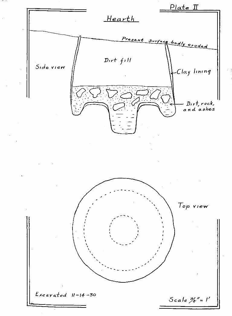
Fourteen of these c ir c u la r p ith ou ses and
hearths have been excavated . The f i r s t hearth to be excav
ated was by Hr. W. P. Harden on November 14, 1930. This one
is fig u red on P la te II and in the s e r ie s o f photographs in
p la te s VII, V III, and IX. This type has been c a lle d the
”doughnut” because of i t s s im ila r ity in shape to a large
doughnut. There was a sk e le to n found ly in g on top o f the
rocks and ashes w ith which the hearth was h a lf f i l l e d . The
w a lls were c la y lin ed and w e ll baked.
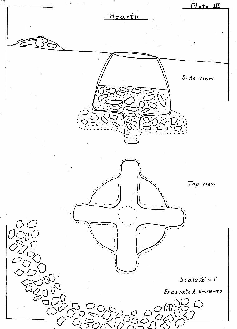
The second hearth was excavated November
28, 1930, by Mr. W. P. Harden, Mr. Carl T rischka, and m y se lf.
I t was found on a sm all wash which had already swept away
part of the c ir c u la r rock w a ll o f the p ith ou se and had ex
posed the sm all c ir c u la r rim or l ip o f red c la y which was
the top of the hearth . This one (P la te I I I ) proved to be o f
a much d if fe r e n t type than the f i r s t one and no sk e le to n was
found in i t . About two f e e t below the su rface o f the rim ,
burnt rocks and ashes were encountered, and below th ese were
found two tren ch es, a lso f u l l o f rooks and a s h e s , making the

P / a t e H f
H e cl r~t k
v # e w
Pre^s&n't ^ur/ ice
Floe r Ie ve.1
CI ay lined.
~To p o-f o Idcree& 4>ec( 0 : . C > C > 9
0 ^ - ^ p x ) Q (S i d e vi&w
f o o
5 c « / e

Circular Piihoufe Showing Hearth
PU
t

- 2 6 -
shape o f a c r o ss . In the extreme "bottom and cen ter of the p i t
was a c ir c u la r hole tw elve inches in diam eter and e ig h t inch
es "below the "bottom o f the trenches* This hole was f u l l o f
ashes "but no rocks.
The c la y w a ll l in in g the hearth was from
two to three inches in th ick n ess and was w e ll "baked, show
ing th a t the f i r e had produced great h ea t. Part of the l ip
or rim o f t h is immense hearth which had not "been carried
away "by erosion showed th a t i t f la re d s l i g h t ly outward sim
i la r to the rim o f an o l l a . This c h a r a c te r is t ic i s more
c le a r ly "brought out in P la te IV.
As o th er c ir c u la r p ith o u ses and hearths
were excavated , i t was found th at the usual type o f hearth
which had "been "built was s im ila r to the one in P la te IV.
Here there are s ix h o les around the large hole in the cen
te r o f the "bottom. Other hearths had seven or e ig h t o f
th ese h o les "besides the one in the ce n ter . Two o f the
"doughnut" type (P la te s I I and IX) were found, one of the
"cross" type and the remainder have round h o le s in the
bottom s. (P la te IX)
In two of the hearths sk e le to n s were
found. (P la te s VII and XI) These inhumations were pro
bably e ith e r made la t e r by an in tru s iv e people or a t the
time the s i t e was abandoned by the o r ig in a l in h a b ita n ts ,
but probably the former because the Red-on-Buff people
cremated th e ir dead. The s k e le ta l m a ter ia l was too f r a g i le
fo r measurement.

PLATE V I
P n o to "by Cummings
P h o to "by T r i s c h k a

- 2 7 -
Many su ggestion s have been made as to the
uses o f these h ea rth s. They may have been ro a stin g p i t s fo r
large game such as deer and an te lo p e , or th ey may have been
used fo r ordinary cooking and baking purposes. The p o s s ib i l
i ty th a t they might have been used fo r crem ation purposes seems
hardly fe a s ib le because no tra ces o f human bones are found in
connection w ith the p it s and b esid es they are too numerous
fo r camps of such s iz e . No other hearths have ever been found
at any other R ed-on-Buff s i t e s and crem ation was p ra cticed by
a l l of these R ed-on-Buff p eo p les . Another su ggestion is that
they might have been cerem onial h ou ses, but n e ith e r does th is
seem lo g ic a l because of the number o f them, there being about
fo r ty in a l l , and such a f i r e p i t in the c e n ter o f a p ithouse
would probably have had a u t i l i t a r ia n purpose rather than
cerem onial. That they might have been sweat houses i s s t i l l
another p o s s ib i l i t y . They wouM have made com fortable l i v
ing quarters in the w in ter time w ith a good f i r e in the
hearth . The fa c t remains th a t no implements o f any k ind ,
except in one case where manos and m etates and p o ttery were
found, have been noted in connection w ith th ese c ir c u la r p i t -
houses. In the one where th ese a r t i f a c t s were found there
appeared to have been a la t e r occupation and th ese a r t i f a c t s
were dumped in the hearth along w ith numerous sherds o f p o t
te r y . The uses o f these c ir c u la r p ith o u ses and h ea r th s ,
which are herein mentioned, are only c o n je c tu r a l.
Large hearths or f i r e p i t s were excavated
at the Grewe S ite by the Van Bergen - Los A ngeles Museum
exp ed ition in 1931.- "These p it s were coated w ith a carbonized

PLATE V I I
P h o t o s "by T r i s c h k a

- 2 8 -
la y er of c lay or mud about four inches th ic k . The ea r th
around the p i t s was red d ish in co lo r as though i t had been
su bjected to a great h ea t.
"When found the p i t s were f i l l e d w ith
sm all b o u ld ers, broken manos, and fragments o f rocks, a l l
of which were f i r e burned. In the bottoms o f th ese large
p i t s were sm aller d ep ress io n s .................... The usage o f th ese1
p i t s i s unknown.M
These p i t s varied in s iz e from seven
and a h a lf to e ig h t f e e t in diam eter, and from twenty inches
to three f e e t in depth. They were not o l la shaped and were
found o u tsid e o f the houses.
In the same area where the c ir c u la r p i t -
houses are found there a lso appear numerous ro ck -lin e f ir e
p i t s . These f i r e p i t s are w e ll made and range from twenty
to t h ir t y - s ix inches in diam eter and are about a fo o t deep.
Ho s ig n s o f any h a b ita tio n s are found in conjunction w ith
any o f these f i r e p i t s . One shallow c la y - lin e d f i r e p i t
was found where a wash had cu t down and exposed i t as w e ll
as part o f a f lo o r . Ho tra ces o f w a lls could be found in
connection w ith the f lo o r .
An in te r e s t in g p o in t in connection w ith
Camp No. 1 was the f in d in g of p arts o f an old t r a i l which
lead s from the main part o f the camp to the spring in Mex
ican Canyon. Where i t had been n ecessary to go through
rocky patches o f ground, the rocks were thrown to one s id e
1. Arthur Woodward, 15

PLA TE V I I I
P h o t o s "by T r i s c h k a

- 2 9 -
and a very good t r a i l i s s t i l l v i s ib le .
Other House Types o f the Southern Sub-area
At Mud Springs water was probably abund
ant the e n tire year a t the time o f the occupation o f the
two v i l la g e s nearby. I t has on ly been r e c e n t ly , according
to old tim ers o f the reg io n , th a t the sp rin g has f a i le d to
run the year.around. From the surface in d ic a tio n s i t would
be hard to say what type o f houses were b u i l t h ere. There
are approxim ately f i f t e e n to twenty rooms a t one s i t e w hile
the other s i t e is fa r la r g e r . I f a pueblo e x is te d here a t
one tim e, erosion has alm ost com pletely washed away the
w a lls .
At no other p lace in the Southern Sub-
area were s ig n s o f house types ex ta n t. N eith er were any
tra ce s o f debris heaps found at any of the s i t e s .
CERAMICS:
The p o ttery o f the Southern Sub-area con
s i s t s o f p la in ware, R ed-on-Buff, and G ila Polychrome. These
three wares are n a tiv e to the reg ion south o f the G ila R iver.
On the w estern sid e o f Whitewater Draw the s i t e s are pure
Red-on-Buff w ith a few sherds o f Mimbres, which i s in tr u s iv e .
At Mud S p rin gs, where the s i t e s may have been occupied at a
la t e r date than the w estern s i t e s or may have been occupied
a number of tim es, th ere are se v era l wares found. The G ila
Polychrome i s most abundant w ith a sm all percentage o f Red
on-B uff, Casas Grandes Polychrome, and Casas Grandes in c ised

PLATE IX
ft?
: «
4-lt
s1 \
' \ ' ' ' A /J v: <-I :j&.v , (
; ? r 3 ^ |lS" A \ ' ■ ■ ■
P h o t o s "by T r i s c h k a

- 3 0 -
ware.
The p la in and Red-on-Buff wares o f t h is
sub-area, as fa r as the tex tu re o f the p a ste i s concerned,
appear to he ind igenous. I t seems q u ite l ik e ly that th ese
people used the c la y s a t hand from which to manufacture
th e ir p ottery .and t h is f a c t accounts fo r the v a r ia tio n in
these wares compared to those found in the Santa Cruz and
G ila v a l le y s . The paste o f the p la in ware v a r ie s in co lo r
from a b righ t p in k ish b u ff through varying shades to a dark
brown, depending upon the c la y , tem pering, and f ir in g . I t
is rath er porous and seems, on the average, to be u nd erfired .
The Red-on-Buff ware i s u su a lly slip p ed and w e ll p o lish ed on
the su rface which is d ecorated , but o c c a s io n a lly a p iece i s
found that has been decorated over a rough su rfa ce . The
co lo r decoration here i s more b r i l l i a n t than the Red-on-Buff
of other re g io n s . (P la te XIVT) The b u ff and the red are
b righ t and fr e sh and the red has a t in g e o f orange. The
p aste o f the decorated ware is smoother and more compact than
that of the p la in ware and is composed o f f in e ly ground clay
and f in e sand, showing th at the p o tter s were w e ll advanced
in the a r t o f p o ttery making. The c lay was w e ll worked and
only a sm all amount o f tempering m ateria l was added.
The Red-on-Buff ceramic development seems
to be w e ll advanced as fa r as the m u lt ip l ic i t y o f v e s s e l
forms i s concerned. The most common shapes, (P la te XIV)
judging mainly from sherds, are those o f the f la r in g rimmed
bowl and the s tr a ig h t rimmed bowl. O lla s w ith and w ithout

PLATE X
P h o t o s "by T r i s c h k a

- 3 1 -
a shoulder and some w ith an alm ost f l a t "bottom are found.
The scoop and a heavy w alled v e s s e l , which has "been c a lle d
an incense "burner, have a lso "been found. A ll o f th ese
Red-on-Buff shapes are s im ila r to those found a t the Grewe
S ite in the G ila V alley near C oolidge "by the Van Bergen-2
Los Angeles Museum E xpedition in 193!•
The method o f manufacture o f a great
d ea l o f the ware of t h is sub-area was o f the paddle and
a n v il techn ique. The roughened in te r io r o f large numbers
of sherds o f o l la s and bowls’ show the im prints o f the to o ls
used in shaping the v e s s e ls . Many o f the f in e r p iec e s were
undoubtedly made by the c o ile d method. Some of the Red-on-
B uff sherds are very smooth and seem to have been made in
the la t t e r manner. G ila Polychrome and Casas Grandes sherds
from Mud Springs were a ls o made by the c o ile d method.
STORE ARTIFACTS:
Stone work reached a h igh degree o f de
velopment along u t i l i t a r ia n and a e s th e t ic l in e s in th is sub-
area . The stone used varied from sandstone, m alapai, and
lim estone to f in e grained hard sto n es.
The grooved m etate w ith a f l a t and alm ost
rectangu lar mano i s very common. Some m etates are very large
and heavy, and are of sandstone s im ila r to the large rocks
found in the v ic in i ty o f the camps, showing th at they were
2 . Arthur Woodward, 16

z
PLATE ?!
Photo "by T r isch k a

- 3 2 -
not carried very fa r "before "being put to u se . Some were
found w ith the "bottoms "broken out from long usage. At
Hud Springs a good mortar and sev era l grind ing ston es were
found.
The ax i s the three quarter groove
v a r ie ty made from a hard green sto n e , probably d io r it e .
The hammer ston es are made o f very hard ir reg u la r rocks
and are found in great numbers.
A number o f stone zoomorphic o b jec ts
have been found. One o f the b est i s the fro g shown in
P la te X II. I t i s made o f ca lcareous shale and i s d e l
ic a te ly carved. Another o b ject was a' p iece o f tu fa carved
in to the shape o f a G ila m onster. A number o f p h a ll ic
rep resen ta tio n s have been found, the la r g e s t being four
teen inches long and pecked out o f a c y l in d r ic a l p iece o f
sto n e . Q,uite a number o f round rocks w ith h o les in the
cen ter resem bling doughnuts have been picked up. These
are thought to have been used fo r cerem onial purposes much
as the Pimas today use them as prayer stones in prayers to
the water s p ir i t s o f the earth .
Arrow heads and d r i l l p o in ts are numer
ous. Some are d e l ic a t e ly chipped o f chalcedony and ob sid ian
(P la te XII) and others not so w e ll done are o f f l i n t , rhy
o l i t e , and ch er t. East o f Camp Mo. 2 , about one-quarter o f
a m ile toward Whitewater Draw, is an area se v e r a l acres in
ex ten t which was covered w ith arrow heads, spear heads, and
numerous chipped stone implements resem bling crude kn ives
and scrap ers. Not one o f th ese implements i s large enough

PLATE X I I

PLATE X I I I
Hop! vase found in Rucker Canyon
Red-on-Buff pottery

- 3 3 “
to "be ca lled a coup de p o in g . No tra ces o f p o ttery were
found at th is p la ce . In l e s s than three hours alm ost f iv e
hundred o f these stone implements were picked up by Mr.
W. P. Harden and m yself. Why they were so numerous a t th is
one p lace i s not known.
At Camp No. 1 and No. 2 a number o f stone
combs w ith handles have been found. These combs (P la te XV)
are s im ila r to modern combs w ith handles and average about
s ix or seven inches in len g th . Some are made o f a gray soap
stone w h ile the r e s t are o f a red sandy s la t e . They are w e ll
made but th e ir user is unknown. The te e th are too short for
them to have been used to comb human h a ir . They may have been
used fo r the carding o f yucca f ib r e .
At Camp No. 2 part o f a th ree-leg g ed stone
bowl was found which had been worked out o f a p iece o f malapai
rock. A number of d igg ing s to n e s , scra p ers , and stone punches
were a lso found here. (P la te XVa) Numerous stone d ish es
and mud d ish es were found at th is camp. These stone d ish es
were probably used as m ortars. The mud d ish es were carved
or pecked from b a l ls of vo lcan ic mud. (P la te XVb) At the
extreme top of P la te XVb is shown a doughnut sto n e . Axes
found here were of a dark green s to n e , probably d io r i t e ,
and very w e ll made, but few have been found.
A few stone pendants and beads have been
found which show e x c e lle n t workmanship. The quartz pendant
in P la te XII when moved in the l ig h t r e f l e c t s p rism atic
co lo r s of the rainbow. The h o le fo r attachment i s s k i l l f u l l y

P l a t e X IV
V esse l Shapes
e
a. F larin g rimmed bowl
c. Globular o l la
e. Scoop
f
b. Bowl
d. O lla w ith shoulder
f . Ir cense burner

- 3 4 -
"bored and the groove around the middle i s very w e ll done.
It i s one of the t e s t p ie c e s o f jew elry from th is reg io n .
How i t was fashioned from such stone as quartz is d i f f i c u l t
to say . Two stone cro sse s which must have a lso "been used
fo r pendants show great s k i l l in stone c u tt in g and workman
sh ip . One was made of b lack stone w hile the o ther was o f
moss a ga te . As no h o les were bored in th ese cro sse s they
were probably bound w ith some form of cord and hung about
the neck, fo r no b i t s of jew elry o f such beauty would be
carr ied in a sack unseen by these vain p eop le . The one
made of moss agate was w e ll cut and p o lish ed s im ila r to
work done on turquoise by modem pueblo In d ians. A number
of turquoise and stone beads were a lso found.
A cache o f e ig h ty -fo u r smooth water-worn
round black b a sa lt sto n es about an inch in diam eter were
found. I f only one or two o f th ese ston es had been picked
up, i t would be probable th a t they had been used fo r
p o lish in g p o ttery , but when e ig h ty -fo u r are found in one
p la c e , one wonders i f they might not have been used in a
game of some s o r t .
BONE Aim SHELL ARTIFACTS:
Hot a great d ea l o f bone and s h e l l work
has been found in the southern sub-area. A few badly burnt
bone awls were recovered from the f lo o r s o f p ith o u ses . Frag
ments of s h e l l b r a c e le ts are o c c a s io n a lly found which are
s im ila r to the b r a c e le ts found in other p arts o f the Kiddle

PLATE XV
Photos by Trischka

“3 5 “
G ila area . Some s h e l l heads were made which show good work
manship. Two p ie c e s o f carved s h e l l rep resen tin g b ird heads
were found on the su r fa ce . On the whole the hone and s h e l l
o b jects are rather meager in numbers, but show a good degree
of s k i l l in manufacture.
MIDDLE SUB-AREA
SITES:
The s i t e s in the Middle Sub-area are much
more ex ten siv e than those o f the previous sub-area. Most o f
the s i t e s f a l l in to the group of surface pueblos and th ere
fore would be o f Late Pueblo o r ig in . However, there are a
number of s i t e s which belong to the E arly Pueblo Period and
i f excavation work was done many o f the Late Pueblo s i t e s
would probably be found superimposed over E arly Pueblo r e
m ains. Instead of covering th is sub-area g en era lly as was
done in the Southern Sub-area , each s i t e w i l l be b r ie f ly
described here.
McBride Ranch
S ta r tin g in the extreme southern end o f
th is sub-area there has been found a large pueblo co n ta in in g
s ix mounds. This s i t e i s lo ca ted in S ection 5> Township 20
South, and Range 26 E a s t , and i s on the McBride ranch a t
Webb. I t i s shown as No. 12 on the map in the back of t h is
work. The pueblo i s now alm ost overgrown w ith large mes-
q u ite tr e e s and sm all shrubs and a great d ea l o f f in e sand
has accumulated on the su rface so that very l i t t l e i s to be

PLA TE XVI
Red-on-Buff sherds showing co lo r

- 3 6 -
seen except the mounds. These average about three f e e t h igh
and cover areas o f about one hundred f e e t by one hundred f i f t y
f e e t . A few h o les have been dug in d if fe r e n t p la ces on the
mounds and large chunks o f burned roof m a ter ia l have been un
covered which show very c le a r ly the im prints o f reeds and
sm all branches.
I was shown a complete gray corrugated
bowl which had been dug up in one o f the mounds. Judging
from i t s shape and f in e ly corrugated surface i t may have come
from the San Juan area . In ad d ition to the bow l,sherds o f
the fo llo w in g kinds were shown to me: Gray corrugated, ob
l i t e r a te d c o i l , L i t t le Colorado, B lack-on-R ed, R ed-on-Buff,
Mimbres, R oosevelt B lack-on-W hite, G ila Polychrome, Casas
Grandes Polychrome, In c ised ware, and Old Hopi. The sherd
c o l le c t io n I obtained from th is s i t e did n ot con ta in such a
v a r ie ty .
In the fro n t yard o f the McBride Ranch
are one hundred and tw e n ty -fiv e m etates and tw e n ty -s ix mor
ta rs which were picked up on th is s i t e . Many more must be
buried in the ru in . Stone axes of the u su a l three quarter
groove v a r ie ty are found here, but no other a r t i f a c t s were
seen . An extrem ely large population must have inhab ited
th is v i l la g e when i t was at i t s h e ig h t. I t i s loca ted on
le v e l ground which is very f e r t i l e and w i l l produce e x c e lle n t
crops. Just ex a c tly where water was obtained by the pre-
h is to r ie s i s not known, but ground water i s shallow and must
have come to the surface in the form of sp rin gs when the
pueblo was in hab ited . Whitewater Draw has cu t i t s way

- 37-
through th is se c t io n during h is to r ic tim es and probably has
drained the springs which once flowed someplace nearby. I
was to ld that tra ce s of ir r ig a t io n d itc h e s were once in
evidence here but they cannot now be seen .
Rucker Canyon
At the mouth o f Rucker Canyon and fo r
se v era l m iles up the canyon, abundant evidence o f p r e h is to r ic
occupation i s seen . In the low land next to the creek are
found sherds and arrow heads. And up on the benches above
the creek bed are found the remains of the foundations and
w a lls o f s tr u c tu r e s .
There are four s i t e s , N os. 13, 14, 15,
and 16 in Rucker Canyon. Each i s marked by rows of ston es
se t on end in c la y w a lls , some in s tra ig h t l in e s and others
in c i r c l e s . The most ex ten s iv e extant s i t e i s No. 13. This
v i l la g e i s s itu a te d on the p o in t o f a low bench below the
Meadow's ranch house and is p la in ly marked by a number of
re c ta n g le s and c ir c le s o f sto n e . This la te r c h a r a c te r is t ic
was noted by R. T. Burr, M. D . , U. S. A ., and a b r ie f report
was published in the Smithsonian Report fo r 1879• These
c ir c le s are from two and o n e-h a lf f e e t to th ree f e e t in
diam eter and the s tones are imbedded in c la y and are from
s ix inches to a fo o t ap art. The c i r c le s o f stone mark what
remains o f storage chambers which were f lo o re d w ith f l a t
s to n e s . Burr s ta te s th at when he saw th ese c ir c u la r s tr u c
tu res the c la y w a lls were from two to tw elve inches h igher
than the surrounding ground and were much b e tte r preserved
3 . Smithsonian R eport, 1879. 333•

“3 8 -
than the w a lls o f rectangu lar s tr u c tu r e s . Today there is no
evidence of any w a lls above the ground su rfa ce . There are
the remains of tw elve c ir c u la r stru ctu res and f i f t e e n or
more rectangu lar stru ctu res at th is s i t e . The only a r t i
fa c t s were a number of grooved m etates and sherds.
Hear H ick’ s Ranch (Ho. 14) are two groups
of room separated by a ra v in e . The su rface in d ica tio n s are
s im ila r to those found a t Ho. 13. Mr. John Hands sta rted
to excavate one o f the rooms and d isc lo se d a w e ll p la stered
w a ll and a f lo o r le v e l about th ir ty in d ie s below the present
su rfa ce . Later Mr. W. P . Hardon did more work in the same
p lace and found a sm all Hopi v a se . Sherds are very scarce
because at one time a cava lry troop encamped here and the
h o rse s’ hoofs p u lverized them. Part o f the ruin has been
c u lt iv a te d and a great many Red-on-Buff sh erd s, as w e ll as
a number of m etates and manos, have been brought to l ig h t .
Mr. George W inkler's ranch house has
been b u il t on a mound which at one time was a f lo u r ish in g
v i l la g e (Ho. 15)• He k in d ly uncovered one of the w a lls fo r
me so that I could see the w e ll p la stered su rface of the
in te r io r . W h ile le v e lin g h is yard he excavated se v era l
rooms and about s ix ty -se v e n f e e t of w a ll, forming one s id e
of a s e r ie s o f rooms of a pueblo s tru c tu r e . In the rooms
he found the charred remains o f p o sts th at had supported the
ro o fs o f the s tr u c tu r e s . He uncovered a number of a r t i
fa c t s includ ing burnt p iec e s o f roof p la s te r w ith the im
p r in t o f p o les and brush in them, two stone d ish e s , one

- 39-
th ree-q u arter groove ax, one f u l l groove ax, three arrow
sh a ft s tr a ig h te n e r s , and one scrap er. Sherds were very
sca rce , hut I did see some L i t t le Colorado Black-on-Red
and a p iece of red ware w ith cord in c is io n s about the ou t
sid e of the rim.
About o n e-h a lf m ile e a s t o f W inkler’ s
ranch in Rucker Canyon on the l e f t s id e of the road as one
goes up the canyon is one more v i l la g e , (Mo. l 6 ) . Rows of
ston es mark the w a lls o f the rooms. The arrangement o f
the v i l la g e is a p a tio surrounded by four groups of s tr u c
tu r e s . The e n tire area is now alm ost com pletely covered
by a l lu v ia l d e p o s it . One w a ll was. p a r t ia l ly excavated
and proved to be that o f a surface pueblo s im ila r to the
w a lls found at the r e s t of the s i t e s in Rucker Canyon.
P inery Canyon
On Frank Hands’ ranch in P inery Canyon
is a Late Pueblo ruin (Mo. 17) • This s i t e i s noted in the4*
report by Sauer and Brand . on the pueblos of sou theastern
Arizona. A very good sherd c o l le c t io n is on f i l e in the
Arizona S tate Museum from th is lo c a t io n . A ll evidence o f
w a lls was destroyed when an orchard was p lanted by Mr.
Frank Hands. He sa id th a t when he f i r s t occupied the land
there were tra ces of ir r ig a t io n d itch es near the pueblo,
but no such evidence now e x i s t s .
4 . Sauer and Brand

—4-0—
Near the R ig g s’ ranch on Pinery Creek
there is a rectangu lar p ithouse v i l la g e (No. 1 8 ). Two rooms
were excavated in 1931 "by a group o f stud en ts under the d ir
e c tio n o f Byron Cummings. The f lo o r s are two and o n e-h a lf
f e e t helow the su rface and are of c la y . The w a lls are o f
the n a tu ra l d ir t covered w ith c la y p la s te r . The p o ttery
found co n s is te d mainly o f p la in ware, some Red-on-Buff and
a very few ea r ly Blaclc-on-W hite sherds.
Other S ite s in the C hiricahuas
S ite s are found in a l l o f the canyons
on the eastern s id e o f the Chiricahua Mountains. And each
s i t e seems to he s im ila r to those already mentioned.
In Turkey Creek se v e r a l mounds have
heen reported which are marked hy rows of s to n e s . In L e s lie
Canyon on the Hunsaker ranch remains o f w a lls o f rooms are
found which appear to he arranged around a p a t io . Another
s i t e known as L e s lie Ruin i s found about s ix m iles from
Hunsaker’ s ranch on the road to Rucker Canyon. Erosion has
been g r e a t , hut the o u t lin e s o f about twenty rooms can be
traced . Many m etates and xnanos are found, but sherds are
sca rce .
Grantham Ranch - No. 19
At Grantham's ranch a number of r e c
tangular p ith ou ses have been found. One of th ese measuring
eigh teen f e e t by th ir te e n f e e t was excavated by Hr. John
5. Sauer & Brand, 440.

—4 1 -
Hands. The w a lls were w e l l p la stered and have a core o f
f la t s to n e s . This f lo o r was alm ost three f e e t helow the
present su rfa ce . Q u an tities o f burnt roof c la y was found
during excavation . Only p la in and corrugated sherds were
found.
Cooper Ranch - No. 20
About a m ile west o f Grantham’ s ranch
i s an ex ten siv e ru in w ith ten or more mounds in ev idence.
In one se c tio n o f the ruin four large mounds en close a
patio;, covering an area approxim ately one hundred f e e t by
one hundred f e e t . Met ate s and manos are numerous. The
sherds are G ila Polychrome, Casas Grandes Polychrome, Cor
rugated O b literated C o il, R ed-on-B uff, B lack-on-Red, and
p la in ware. H alf of a round b u ff co lored d isc w ith b lack
con cen tric r in g s around a hole in the cen ter was shown to
me by Mr. Grantham. B esides the p o ttery , many arrowheads,
turquoise pendants, and broken s h e l l ornaments have been
found.
Sulphur Springs and V ic in ity
At Sulphur Springs Butte (No. 21) there
are tw enty-three mortar h o le s in the rocks on the summit.
At the base of the butte toward the north i s one spring and
toward the southwest o f the h i l l are found two more. These
sp rin gs have never been known to become dry and they pro
bably have always been the m eeting p lace fo r p r e h is to r ic

- 4 2 -
p eo p les . A few sherds were picked up, hut not enough to he
o f any importance. On the northeast s id e o f the h i l l are
tra ce s o f f i r e p i t s and a number of m etates and manos were
found h a lf buried . Probably a t one time sherds were p le n t i
f u l , but many people have v is i t e d th is p lace and must have
picked up most o f the sh erds.
On the northwest sid e o f Three S is te r s
B u tte , which is a l i t t l e over a m ile ea st of Sulphur Springs
B u tte , there are remains o f a camp. Many m etates and manos
and a few movable mortars have been found around the base o f
the b u tte . Very few sherds were seen and those were p la in .
A number of b u r ia ls , marked by large sto n es , have been found,
and there are probably many more. In large boulders around
the base of t h is b u tte numerous mortar h o les are found.
Sometimes as many as ten or more appear in the same boulder.
In the gap between the two northern
b u ttes o f Three S is te r s Butte and up the ea stern sid e o f
the northw estern butte are a number o f rock f o r t i f i c a t io n
w a lls . There are three rows o f w a lls up one sid e and the
top o f the b u tte is covered w ith sm all f o r t i f i c a t io n s .
Midway between Sulphur Springs Butte and
Three S is te r s Butte on h igh ground i s another camp s i t e
(Ho. 23) from which I gathered a f a ir ly good sample o f
sh erds. Theie seems to be a number o f sm all mounds, but
the ground has been com pletely covered by a lk a l i d ep o sits
so th a t th is i s u n certa in .

-4-3-
On the w est sid e of Sulphur Spring
V alley on the road from C ochise to Johnson in the L i t t l e
Dragoon Mountains (No. 24) i s found a R ed-on-Buff s i t e .
I t has been plowed a number of tim es so that no tra ces o f
w alls are v i s ib le . Sauer and Brand noted th is ruin in6
th e ir rep o rt.
Along the an cien t beach on the western
sid e of the dry lake near Croton Springs, m etates and manos
have been found, but no fu r th er ev idences o f h a b ita tio n
were seen .7 -
Me Inzer in h is work on the geology of
the v a lle y noted a camp in S ection s 14 and 23, Township
14 South, Range 25 E a s t , one and on e-h a lf to two m iles from
the n ortheastern margin o f the barren f l a t on a chain of
sand h i l l s about f i f t y f e e t high (No. 2 5 ) • On top o f these
h i l l s were found "a great number o f stone r e l i c s , c o n s is t
ing o f large m etates, sm all stones w ith p o lish ed su rfaces
ev id e n tly used for grind ing on the m etates, one broken but
c a r e fu lly rounded c y l in d r ic a l implement su g g estin g a p e s t l e ,
a wedge-shaped stone about f i f t e e n inches long p lanted deep
in the ground a t a sm all angle w ith the v e r t i c a l , and num
erous angular f l i n t chips such as might have been produced
in making arrowheads or spearheads. The implements and
fragments are grouped to some ex ten t on bare patches of
6 . Sauer & Brand, 435.7. MeInzer, 17.

- 4 4 -
ground , commonly surrounding a large m etate . The implements
have become p a r tly covered w ith a w hite ca lcareous co a tin g .
A ll the stones must have been brought from some d istan ce
fo r on the sand h i l l s sto n es do not n a tu r a lly occur at the
su rface ."
There are probably a few more s i t e s in
th is sub-area, but th ese mentioned are the la r g e s t and the
most e a s i ly traced on the su rface . I t w i l l now be n ecessary
to turn to the Northern Sub-area fo r a d escr ip tio n of the
ruins found th ere .
NORTHERN SUB-AREA
This sub-area i s separated from the
G ila drainage area to the north by a very g e n tle d iv id e . In
f a c t , the d iv id e can hardly be n o ticed when i t i s cro ssed .
The A rivaipa flow s in to the, San Pedro which in turn flow s
in to the G ila . The people who e s ta b lish e d pueblos on the
G ila gradually spread and many co lo n ized the northern sub-
area of the Sulphur Spring V a lley . The cu ltu re o f th is sub-
area i s id e n t ic a l w ith th a t o f the G ila area.
At the S ierra B onita ranch house (N o.27)
is a large mound o f the Late Pueblo p eriod . The area around
the ranch is f l a t and w e ll su ited for a g r ic u ltu r e . At
Hooker’ s Cienega there i s p len ty o f w ater, making th is
lo c a tio n id ea l fo r th ese p eop le. The sherds found here are
p la in , G ila Polychrome, B lack-on-R ed, and a few are Casas

“4-5“
Grandes. Part of the mound was used to make adobes fo r a
co r ra l w a ll in the ea r ly days and many sherds can now be
seen in th is w a ll.
About f iv e m iles northw est of the S ierra
B onita ranch i s a sm aller ruin (Ho. 2 8 ) . I t i s marked by
rows o f stones showing the rectangu lar w a lls o f houses. The
f lo o r s are from tw elve to e igh teen inches below the su r fa c e .
The sherds were p la in and Early G ila Polychrome.
S cattered along the w estern sid e of the
P inaleno Mountains w ith in an area about ten m iles long and
from one to four m iles wide are a number o f mounds and e v i
dences everywhere of p r e h is to r ic occupation . The cen ter of
the area i s a t Fort Grant, but i t extends to B on ita . This
area i s very f e r t i l e and pediment flo o d in g from the moun
ta in s is important during the rainy season . The ru in s must
have been two s to r ie s h igh . The w a lls are w e ll p la stered on
the in s id e . A great number of sherds are found; the most
p le n t i f u l being p la in and G ila Polychrome. R ed-on-Buff,
B lack-on-W hite, Black-on-Red, and Casas Grandes Polychrome
are a lso found. I f excavated , th ese ru in s would probably be
found to r e s t on e a r l ie r s tr u c tu r e s , because the area pre
sen ts a long period o f occupation . There are rep orts th a t
ir r ig a t io n d itch es were in evidence when the ground was c u l
t iv a te d by w hite men, but none are now seen .
Fourteen m iles northwest of W illcox , I
was shown what remains o f a ruin (Ho. 26)". The s i t e had

- 4 6
been c u lt iv a te d fo r a number of years so th a t nothing now
remains except an in d is t in c t mound. P la in and B lack-on-
White sherds were c o l le c te d , but no other ev idences of
h a b ita tio n s were noted . I was to ld th at numbers of m etates
and manos and a few axes have been carried away by v i s i t o r s .
Ruins are reported in the G aliuro Mountains,
e s p e c ia lly in R iley Creek, but I was unable to lo ca te any
of th e s e . I was shown very good Middle G ila Black-on-Red
sherds from a ruin in R iley Creek. Beyond mention of these
ru in s , there apparently are no other large enough to be
worthy of note in th is su b-area .

- 4 7 -
SUMMARY
In the preceding review of the arch
aeology of the three sub-areas o f the Sulphur Spring V alley
only the bare f a c t s were presented w ith very l i t t l e attempt
at in te r p r e ta t io n . I t was d i f f i c u l t in some cases to g iv e
even the fa c t s because o f the incom plete nature o f the data
a v a ila b le . In the fo llo w in g d iscu ss io n the fa c t s presented
w i l l be in terp reted and c o r r e la te d , as fa r as p o s s ib le ,
w ith in the area under co n sid era tio n and w ith the neighbor
ing areas.
The Sulphur Spring V alley is surrounded
by se v e r a l d if fe r e n t cu ltu re areas or d iv is io n s th e reo f . On
the w est in the San Pedro and Santa Cruz v a lle y s i s found
the s o -c a lle d R ed-on-Buff c u ltu r e . This cu ltu re probably
had i t s o r ig in in the G ila area a t Casa Grande or other
ru ins which show very e a r ly cu ltu re remains. The Grewe s i t e
p resen ts the e a r l ie s t known house types and a r t i f a c t s o f
th is cu ltu r e , but fu r th er work i s rap id ly bringing to l ig h t
other ea r ly lo c a tio n s at various p la c e s . The fa c t th a t
some of the s i t e s in the Sulphur Spring V alley show ea r ly

- 48-
p o ttery developments and house types lead s us to "believe that
i t was inhabited a t the same time the Grewe s i t e was f lo u r is h
ing or immediately a fterw ards.
The e a r l ie s t ware i s a p la in undecorated
p o ttery o f coarse p a s te , which is found in a very few p la ces
a sso c ia ted w ith crude stone knives and p o in ts . A few sherds
of Red-on-Buff are a lso u su a lly found w ith t h i s p la in ware.
The R ed-on-Buff sherds are of the e a r ly unslipped v a r ie ty .
The e a r l ie s t decorated ware was, no doubt, th is R ed-on-Buff,
which penetrated from the west through the p a sses between the
mountain ranges. That i t was the e a r l ie s t ware is proved by
the fa c t th a t i t i s found on alm ost a l l camps, but on pure
Red-on-Buff s i t e s there are no other kinds o f sherds found,
u n less i t be an o cca s io n a l Mimbres sherd, su g g estin g con
tem poraneity between the two.
The R ed-on-Buff v i l la g e s in the Southern
Sub-area belong to the E arly P ithou se p eriod . The c ir c u la r
house types and f i r e p i t s or hearths are d is t in c t iv e in that
none l ik e them have been found in any other area. A number
of s i t e s in the Middle sub-area a lso belong to the Early
P ithou se period , but are o f la t e r type than those of the
Southern sub-area. These are the rectangu lar p ith ou ses found
by Byron Cummings a t the R ig g s’ ranch (No. 18) and the one a t
the Grantham ranch (No. 19) uncovered by Mr. Hands. Other
ev idences o f ea r ly occupation would undoubtedly be revealed
beneath Late Pueblo remains i f excavation was ca rr ied on at

- 4 9 -
any o f the larger ru in s .
To the north o f the v a lle y on the G ila
R iver is a cu ltu re very s im ila r to that o f the Santa Cruz
V a lley . The region i s ch aracter ized by the G ila P o ly
chrome p ottery which i s decorated by p la c in g a w hite or
cream co lo r over the foundation s l ip of red; on th is w hite
background i s painted the decoration in b lack . Other wares
n a tiv e to the Middle G ila area are the B lack-on-W hite,
Black-on-Red, and corrugated wares. During the Late Pueblo
period there seems to have been con sid erab le m igration of
th ese Middle G ila people from the G ila V a lley up the San
Pedro and A rivaipa v a lle y s and in to the northern end o f the
Sulphur Spring V a lley . The h e igh t of the Late Pueblo Period
had been reached and people were seek ing new lands because
of crowded co n d itio n s in the cen ters o f c i v i l i z a t i o n . Along
the fo o t o f the P inaleno Mountains is a s tr ip o f very f e r t i l e
ground about ten m iles long by three or four w ide. Here
th ese people e s ta b lish e d one o f the most d en sely populated
areas in the e n t ir e v a lle y . Another se ttlem en t was made at
Hooker's Cienega or the S ierra B onita Ranch about seven m iles
southw est. In the Middle sub-area at No. 12 and in the
Southern sub-area a t Nos. 1C and 11" are found Middle G ila
rem ains. A ll o f th ese s i t e s are very w e ll adapted fo r
a g r ic u ltu r a l purposes and have or have had abundant water
su p p lie s in the p a s t.
On the eastern sid e o f the v a lle y in ’
the canyons o f the C hiricahua Mountains another th ic k ly
30539

—de
populated area is found. Here ru ins occur in large numbers
in a l l o f the canyons. The sherds show a m ixture o f c u ltu r e s .
L it t le Colorado wares and Casas Grandes wares are p le n t i f u l
along w ith G ila Polychrome and some R ed-on-Buff. The Red-
on-Buff sherds, when found in abundance, are not mixed w ith
those o f other c u ltu r e s , hut are on separate lo c a t io n s . The
L it t le Colorado, Casas Grandes, and Middle G ila wares are
found interm ixed on the various s i t e s and p e r s is te n t a sso c
ia t io n of these three wares in d ica te s th e ir p a r t ia l con
tem poraneity. These la s t two mentioned wares may have been
traded in by the peop le who made the G ila Polychrome ware.
This, o f course, would only hold true fo r some s i t e s because
Casas Grandes in flu en ce i s shown in the region ad jo in in g the
v a lle y on the south and e a s t in the San Bernardino V alley
where pure Casas Grandes s i t e s are found. Probably the
people from the two or even three areas met here.
The development o f the v a lle y proceeds
from a p ithouse stru ctu re ranging from eigh teen inches to
three f e e t in depth w ith n a tu ra l or rock lin e d w a lls covered
w ith c la y p la s te r to the la t e s t type o f surface stru ctu res
comparable to th ose found in the large pueblos o f the b e t te r
known areas. The p o ttery in turn ranges from crude p la in
unslipped ware, which is found in the p ith o u ses and on camp
s i t e s , to the b e a u t ifu lly decorated wares o f the Late Pueblo
P eriod . Developments in the a r ts and m anufactures--bone,
s to n e , and s h e l l —would no doubt fo llo w the same l in e o f pro
gress i f examples were as numerous as those of p o ttery and

- 5 1 -
house ty p es. The a g r ic u ltu r a l development was from d esu ltory
ex ten siv e working of the land to h igh ly developed in te n s iv e
a g r icu ltu re aided "by ir r ig a t io n .
I f system atic a rch a eo lo g ica l work could
he carried on in th is v a l le y , a great many other in te r e s t in g
developments would he rev ea led .
- 5 2 -
bibliography
1. B ancroft, Hubert Howe1889 H istory of Arizona and Hew Mexico,
San F ra n cisco , 1889.
2. Hough, Walter1907 A n tiq u it ie s o f the Upper G ila and S a lt
R iver V alleys in Arizona and Hew Mexico, Bureau of American Ethnology, B u lle t in 35, Washington, 1907.
3 . Kidder, A. V.1924 An In trodu ction to the Study of South
w estern Archaeology. Hew Haven, 1924.
Geology and Water Resources o f Sulphur Spring V a lle y , A rizona. Water Supply Paper 320, United S ta te s G eo log ica l Survey, United S ta te s Department of the Int e r io r , Washington, 1913*
Geology and Ore D ep osits o f the B isbee Quadrangle, A rizona. P r o fe s s io n a l Paper U nited S ta tes G eo log ica l Survey Ho. 21, Washington, 1904.
and Brand, DonaldPueblo S ite s in Southeastern Arizona, U n iv ers ity of C a lifo rn ia P u b lica tio n s in Geography, Vol. 3 , Ho. 7, B erkeley , 1930.
7* Smithsonian Report1879 Washington, 1879*
8. Tylor, Edward B.1889 P r im itiv e C ulture, Researches in to the
Development o f M ythology, P hilosophy, R e lig io n , Language, Art and Custom,V ol. 1, Hew York, 1889.
4 . Me In zer , 0 . E 1913
5* Ransome, F. L 1904
6 . Sauer, C arl, 1930
9 . Woodward, Arthur1931 The Grewe S ite , Los A ngeles Museum of
H istory , Science and A rt, O ccasional P ap ers, Ho. 1, Los A ngeles, 1931*

w.zie. m.zze. H.Z3 c. R . 2 5 g . R .2 6 g . R Z 7 E-. R.zac. If.M 6 R.aoe.
&
<y'
$
:/LU? "/''h' i
'l~s|E1@ % —
'«^U. x %
- \
* \A *W
V *i*»s*0**Fort
za•»
r%
3
' (V;-.ft
f\ \ " l 'OX
S s , «rra
't'Mrevj?
1
%
o \ c \
%
-»
6-V
x<’.Vi"S’.
i fSf«
I
^ :>^ \
X
1L\tP
SULPHUR SPRING VALLEY
SHOW ING A R C H A E O L O G IC A L S I T E S
5 c a I*#o Miles
" • v
%
I*(A
0 *htt*'
»4
v* .
V x
'S
/XNU»
v„v
S\
% n s
— —
O' #: 7>
0x"c'E 3#
1
; ; ^
f", -* v%
"‘ l * ' %
H V/
\ \VS%
>1%
Aprmgeenx
SV ' ' ' S/A_
<•, X
\ ^
' vy°s cabetz s v x ,
f,,.-' / vy A pache .
^ ' o ^ ' v
P a » d \
; °ii °
\*
Wc #
, 2 3 2 Z
C f i
i
r > * . .
- .; fz«—,— t7,,~
PEARCEttiv (5b :--'’
4
, ° x .' \ ' :
3 > %V "’v .
\ yv
\
■N't •Vv^COURTUANDfXIl o.*:
-'Glceson^
#
V z^ r " ' %
<..'A'V,,
\
/ V s
e
A \
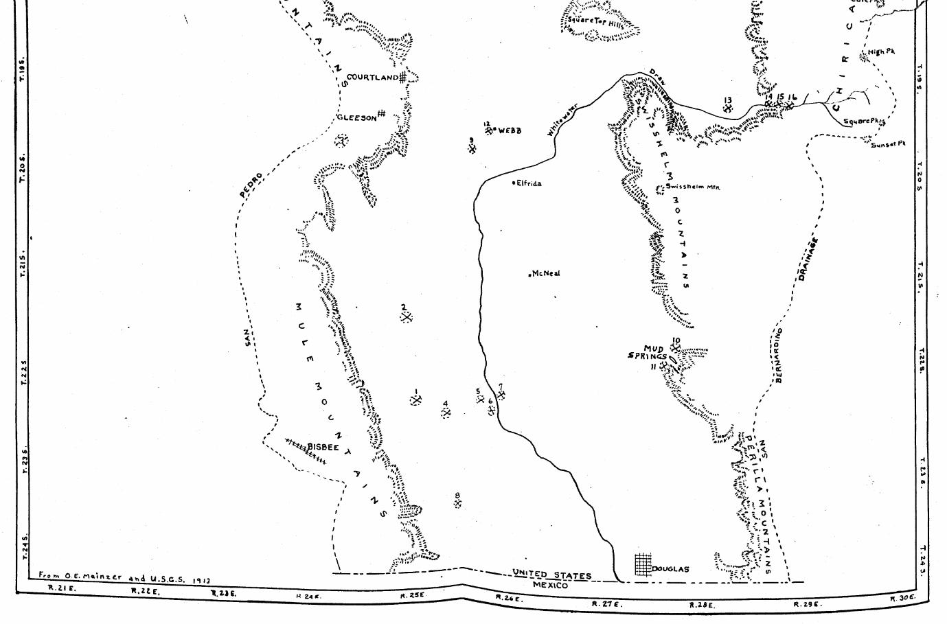
T 24
S.
r. 2
3 S
.____
____
____
____
T Z
Z S_
____
____
____
____
____
^ g
fir %
/ ' » 3 w i l $ h « l m Mfn.
'V;'- r »
___JY ------ \£N iTCD s t a t e s XMEXICO
KzZTT
>" O f M a i n t t r a * A U S r

ft 8 f
Related Documents


