BUTTE COUNTY FOREST ADVISORY COMMITTEE __________________________________________________________________________________________ October 27, 2014, 2014 - 6:00 P.M. ITEM NO. 1.00 2.00 2.01 Call to order – Butte County Library, Durham, CA Pledge of allegiance to the Flag of the United States of America (if American flag is present) Roll Call __________________________________________________________________________________________ 3.00 3.01 4.00 4.01 4.02 Consent Agenda Review Minutes of 9-22-14. ACTION REQUESTED: Approve Minutes Agenda Self Introduction of Forest Advisory Committee Members, Alternates, Guests and Public Butte County OHV Ground Operations Grant, Plumas NF proposed Cooperative Forest Agreement – list of roads needed. (Mike Crump). Preliminary Routes and Draft Cooperative Agreement are included with agenda. Randy Gould of the Forest Service has been invited to participate at this meeting. ACTION REQUESTED: Develop recommendations for consideration by the Coordinating Committee for submission of roads to propose for repairs/maintenance using OHV grant money. 4.03 Review and discussion of maps of USFS, State, BLM, Fish & Wildlife lands, parks, trails, and roads, and Plumas proposed Travel Mgt. Plan (TMP) (Shary, Crump). Include Over-Snow Vehicle Use updates (Stewart, Teeter) Region – 5 of the USFS is starting the environmental analysis (NEPA) for five national forests in the Sierra’s (including Plumas and Lassen NF) relating to ”over-snow vehicle use” based on Subpart C of the Travel Management Rule 4.04 General Plan overview – elements related to FAC purpose (Chuck Thistlewaite) INFORMATION ONLY 4.05 Review of Coordinating Committee activity to date, including comments (Mike Crump) INFORMATION ONLY 4.06 4.07 Fisher Listing – Threatened Species. Comment period 10-07-14 through 1-07-15. (announcement included in agenda packet) ACTION REQUESTED: share information and agendize for recommendation for comment for November meeting Review and discussion of current SOPAs for Lassen and Plumas Forests (Chair) 4.08 Update on the Fish & Wildlife proposed designation of critical habitat for the yellow-billed cuckoo along the Sacramento River. The public comment period has been extended to December 14, 2014. Butte County sent a letter requesting a six month extension to May 14, 2015. INFORMATION ONLY 4.09 Update: Mike Crump, Coordinating Committee, is working on getting Forest Service Managers to appear at joint meeting of FAC and Coordinating Committee, at a future date INFORMATION ONLY

Welcome message from author
This document is posted to help you gain knowledge. Please leave a comment to let me know what you think about it! Share it to your friends and learn new things together.
Transcript

BUTTE COUNTY FOREST ADVISORY COMMITTEE
__________________________________________________________________________________________ October 27, 2014, 2014 - 6:00 P.M. ITEM NO. 1.00 2.00 2.01
Call to order – Butte County Library, Durham, CA Pledge of allegiance to the Flag of the United States of America (if American flag is present) Roll Call
__________________________________________________________________________________________ 3.00 3.01 4.00 4.01 4.02
Consent Agenda Review Minutes of 9-22-14. ACTION REQUESTED: Approve Minutes Agenda Self Introduction of Forest Advisory Committee Members, Alternates, Guests and Public
Butte County OHV Ground Operations Grant, Plumas NF proposed Cooperative Forest Agreement – list of roads needed. (Mike Crump). Preliminary Routes and Draft Cooperative Agreement are included with agenda. Randy Gould of the Forest Service has been invited to participate at this meeting. ACTION REQUESTED: Develop recommendations for consideration by the Coordinating Committee for submission of roads to propose for repairs/maintenance using OHV grant money.
4.03
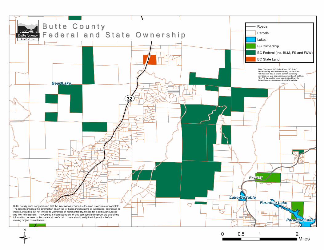
Review and discussion of maps of USFS, State, BLM, Fish & Wildlife lands, parks, trails, and roads, and Plumas proposed Travel Mgt. Plan (TMP) (Shary, Crump). Include Over-Snow Vehicle Use updates (Stewart, Teeter) Region – 5 of the USFS is starting the environmental analysis (NEPA) for five national forests in the Sierra’s (including Plumas and Lassen NF) relating to ”over-snow vehicle use” based on Subpart C of the Travel Management Rule
4.04 General Plan overview – elements related to FAC purpose (Chuck Thistlewaite) INFORMATION
ONLY 4.05 Review of Coordinating Committee activity to date, including comments (Mike Crump)
INFORMATION ONLY 4.06 4.07
Fisher Listing – Threatened Species. Comment period 10-07-14 through 1-07-15. (announcement included in agenda packet) ACTION REQUESTED: share information and agendize for recommendation for comment for November meeting Review and discussion of current SOPAs for Lassen and Plumas Forests (Chair)
4.08 Update on the Fish & Wildlife proposed designation of critical habitat for the yellow-billed cuckoo
along the Sacramento River. The public comment period has been extended to December 14, 2014. Butte County sent a letter requesting a six month extension to May 14, 2015. INFORMATION ONLY
4.09
Update: Mike Crump, Coordinating Committee, is working on getting Forest Service Managers to appear at joint meeting of FAC and Coordinating Committee, at a future date INFORMATION ONLY

4.10 What is the number one reason tourists come to Butte County (Hilgeman) 4.11
Discuss solving abuse of BLM, USFS & other lands in close proximity to residential areas – law enforcement or ranger presence?
4.12 Public Service Message on Butte County Website: Illegal Marijuana Cultivation on Public Lands-
INFORMATION ONLY
http://www.fs.fed.us/t‐d/pubs/pdfpubs/pdf10672317/pdf10672317dpi72.pdf
http://www.fs.usda.gov/Internet/FSE_DOCUMENTS/stelprdb5302522.pdf
http://blogs.usda.gov/2013/09/26/be‐prepared‐when‐visiting‐our‐national‐forests‐what‐to‐do‐if‐you‐encounter‐a‐marijuana‐cultivation‐site/
http://blogs.usda.gov/?s=marijuana&commit=Search&x=0&y=0 (scroll down the page to see a photo of Oroville youth in a clean‐up program in Washington)
http://www.whitehouse.gov/ondcp/marijuana‐on‐public‐lands 4.13 4.14 4.15
New Business – considerations for next meeting agenda Public Comment (THE COMMITTEE IS PROHIBITED BY STATE LAW FROM TAKING ACTION ON ANY ITEM PRESENTED IF IT IS NOT LISTED ON THE AGENDA.) Discussion item: Next meeting will be Monday, 11/24/2014, at 4:00 PM (location?)

USDA, Forest Service OMB 0596-0217
FS-1500-9
Page 1 of 7
FS Agreement No. - - -
Cooperator Agreement No.
COOPERATIVE FOREST ROAD AGREEMENT
Between BUTTE COUNTY
And The USDA, FOREST SERVICE
REGION 5/PLUMAS NATIONAL FOREST/FEATHER RIVER RANGER DISTRICT
PARTIES TO AGREEMENT: This agreement, made and entered into this the day of , 20 , by and between Butte County, hereinafter referred to as “Butte County,” and the USDA, Forest Service REGION 5/PLUMAS NATIONAL FOREST/FEATHER RIVER RANGER DISTRICT, hereinafter referred to as the “U.S. Forest Service.” PURPOSE OF AGREEMENT: The purpose of this agreement is to set forth the general terms and conditions, acceptable to the parties hereto, for the cooperative planning, survey, design, construction, reconstruction, improvement, and maintenance of certain Forest Roads in Butte County, State of California, pursuant to the provisions of 16 U.S.C. 532-538, 23 U.S.C. 205, and the regulations issued by the Secretary of Agriculture. The Congress has, from time to time, authorized and appropriated funds for "Forest Roads," which are defined as "those Forest roads of primary importance for the protection, administration, and utilization of the National Forests, or where necessary, for the use and development of the resources upon which communities within or adjacent to the National Forests are dependent." Recognizing that substantial benefits will accrue to the Nation and to the State from the construction, reconstruction, improvement, maintenance, and use of certain Forest roads and roads on the State or local road system over which Butte County has jurisdiction, and further that such roads carry substantial volumes of public service traffic as well as National Forest traffic, and further that Butte County has road construction, reconstruction, improvement, maintenance, and right-of-way acquisition facilities available to assist in the accomplishment of the work, it is accordingly deemed fitting and desirable to the parties hereto to express by this agreement the general terms of their mutual cooperation in that regard to achieve the maximum benefits therefrom in the public interest.
1. INTENT TO COOPERATE. It is the intention of the parties under this agreement to cooperate as follows:
a. Agree that certain roads under the jurisdiction of Butte Error! Reference source not
found. or the U.S. Forest Service which serve the Plumas National Forest should be maintained and, if necessary, improved to a standard adequate to accommodate safely and economically all traffic which uses such roads.
b. Agree on the identification of roads or road segments which meet the criteria in item a by a listing and appropriate maps.

USDA, Forest Service OMB 0596-0217
FS-1500-9
Page 2 of 7
c. Provide for formal meetings and informal consultation on a regular basis to discuss
and agree on action with respect to the roads identified pursuant to item b. d. Provide for regular and adequate maintenance of the roads identified in item b,
including the assignment of maintenance responsibilities. e. Provide for entering into project agreements when improvements of a road under the
jurisdiction of one party is to be financed in whole or in part from funds or resources provided by the other party.
f. Provide for appropriate jurisdictional status of roads through transfer of easements
and acquisition of easements by the appropriate party. 2. IDENTIFICATION OF ROADS. A list of roads and segments of roads which meet the
criteria set forth in item 1a is agreed upon and is marked "Schedule A" and attached as part of this agreement. Schedule A may be modified from time to time by agreement between Butte Error! Reference source not found. and U.S. Forest Service, by adding or removing roads or road segments, or by altering the description of a road or road segments, to give it proper identity. Each such modification shall be indicated by a revised Schedule A bearing the signatures of the parties or their authorized representatives and the effective date of the revision.
3. MAINTENANCE PLANS. At the annual meeting provided for in item 6, plans for
maintaining the roads listed in Schedule A shall be agreed upon. Such plans shall include assignment of responsibility for maintenance or particular elements of maintenance to Butte Error! Reference source not found. or U.S. Forest Service for each road or segment of road listed in Schedule A. To the extent practical, and subject to availability of funds, responsibility for maintenance shall be assigned in proportion to use for which each party is properly responsible.
Maintenance shall include preserving and keeping the roads, including structures and related facilities as nearly as possible in their original condition as constructed or reconstructed to provide satisfactory and safe road service. Maintenance plans shall provide for prompt changes in maintenance assignments during the period of the plan upon agreement by the parties or their designated representatives.
4. PROJECT AGREEMENTS. When improvement of a road listed in Schedule A is to be financed in whole or in part from funds or resources provided by the party not having jurisdiction, the parties shall enter into a project agreement providing for performing the improvement work and its financing. A project agreement is not required for improvement of a road or a road segment over which the party performing and financing such improvement has jurisdiction. Project agreements shall be supplements to this general agreement and subject to the agreements, provisions, and conditions herein contained.
USDA, Forest Service OMB 0596-0217
FS-1500-9
Page 3 of 7
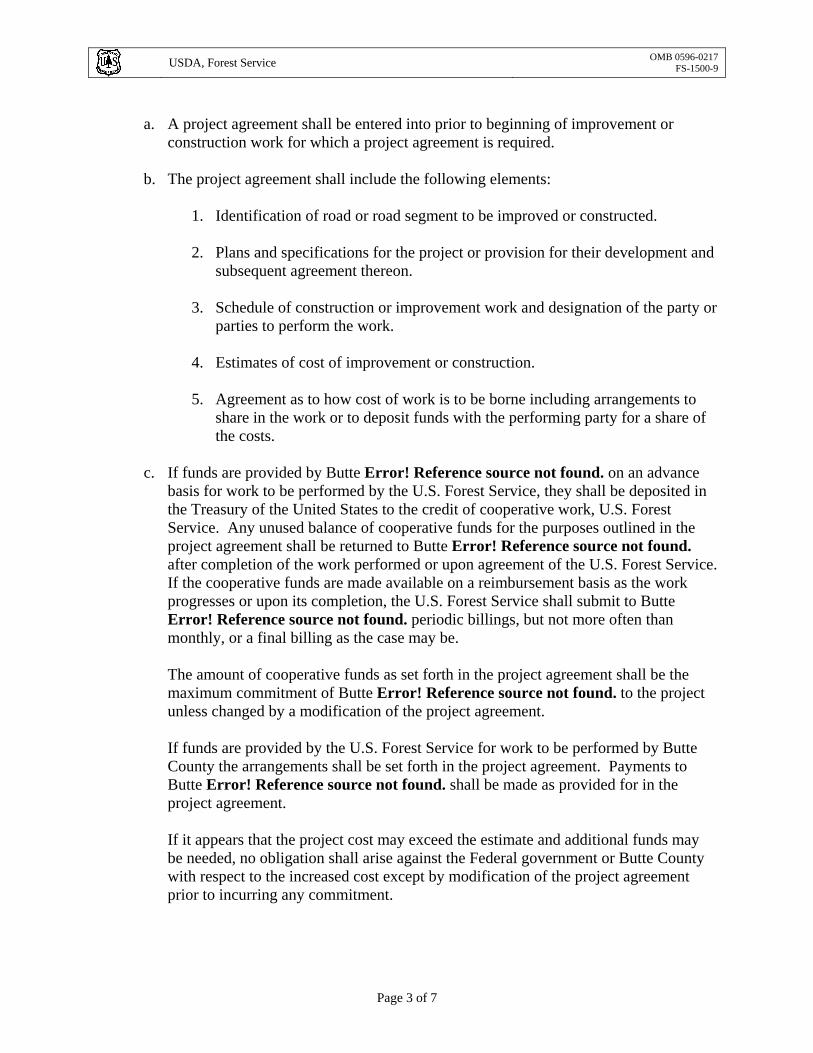
a. A project agreement shall be entered into prior to beginning of improvement or
construction work for which a project agreement is required. b. The project agreement shall include the following elements:
1. Identification of road or road segment to be improved or constructed. 2. Plans and specifications for the project or provision for their development and
subsequent agreement thereon. 3. Schedule of construction or improvement work and designation of the party or
parties to perform the work. 4. Estimates of cost of improvement or construction. 5. Agreement as to how cost of work is to be borne including arrangements to
share in the work or to deposit funds with the performing party for a share of the costs.
c. If funds are provided by Butte Error! Reference source not found. on an advance
basis for work to be performed by the U.S. Forest Service, they shall be deposited in the Treasury of the United States to the credit of cooperative work, U.S. Forest Service. Any unused balance of cooperative funds for the purposes outlined in the project agreement shall be returned to Butte Error! Reference source not found. after completion of the work performed or upon agreement of the U.S. Forest Service. If the cooperative funds are made available on a reimbursement basis as the work progresses or upon its completion, the U.S. Forest Service shall submit to Butte Error! Reference source not found. periodic billings, but not more often than monthly, or a final billing as the case may be. The amount of cooperative funds as set forth in the project agreement shall be the maximum commitment of Butte Error! Reference source not found. to the project unless changed by a modification of the project agreement.
If funds are provided by the U.S. Forest Service for work to be performed by Butte County the arrangements shall be set forth in the project agreement. Payments to Butte Error! Reference source not found. shall be made as provided for in the project agreement. If it appears that the project cost may exceed the estimate and additional funds may be needed, no obligation shall arise against the Federal government or Butte County with respect to the increased cost except by modification of the project agreement prior to incurring any commitment.

USDA, Forest Service OMB 0596-0217
FS-1500-9
Page 4 of 7
5. RIGHTS-OF-WAY. Easements or other interests in land acquired by either party shall be adequate to serve the road needs of both parties. The party having jurisdiction of an existing road or intended to have jurisdiction of a road to be constructed shall obtain the needed rights-of-way in its name. There shall be no provisions in any easement document that will prevent the U.S. Forest Service from using or authorizing the use of roads for which Federal funds were expended. Butte County must be in a position to assure the U.S. Forest Service the continuance of such uses for the period needed. The party acquiring the easement or other interest in land shall obtain such title evidence and title approval as required in its acquisitions for roads of comparable standards. The costs of such easements or other interests in land are to be at the expense of the acquiring party. The U.S. Forest Service shall cooperate in the procurement of rights-of-way over land administered by other agencies of the United States required for any project included under this agreement and shall furnish Butte Error! Reference source not found. copies of survey notes, maps, and other records. To the extent possible under available authority, each party agrees to convey easements over lands or interests in lands it owns or administers to the other party in order to provide jurisdiction by the appropriate party as may be agreed to for any road or road segment listed on Schedule A.
6. ANNUAL MEETING AND CONTINUING CONSULTATION. Butte Error! Reference source not found. and U.S. Forest Service shall meet at least once each year to review matters covered by this agreement and to agree on actions to implement this agreement including, but not limited to, (1) approval of changes in the listing of roads on Schedule A; (2) approval of the annual maintenance plan; (3) approval of project agreements for construction or reconstruction; and (4) approval of transfer of jurisdiction of particular roads by easement conveyance. It is also the intent of the parties to arrange for continuing consultation between their representatives with the objective of reaching prompt agreement by the parties on all matters of mutual concern which are covered by this agreement. The Forest Supervisor of the Plumas National Forest for the U.S. Forest Service, and Director of Public Works for Butte Error! Reference source not found. shall be responsible for making the arrangements for formal meetings and continuing consultation.
7. TEXT MESSAGING WHILE DRIVING. In accordance with Executive Order (EO)
13513, “Federal Leadership on Reducing Text Messaging While Driving,” any and all text messaging by Federal employees is banned: a) while driving a Government owned vehicle (GOV) or driving a privately owned vehicle (POV) while on official Government business; or b) using any electronic equipment supplied by the Government when driving any vehicle at any time. All cooperators, their employees, volunteers, and contractors are encouraged to adopt and enforce policies that ban text messaging when driving company owned, leased or rented vehicles, POVs or GOVs when driving while on official Government business or when performing any work for or on behalf of the Government.

USDA, Forest Service OMB 0596-0217
FS-1500-9
Page 5 of 7
8. MODIFICATION AND TERMINATION.
a. This agreement may be modified by mutual consent. b. This agreement may be terminated by either party upon at least 30 days prior written
notice, except that such termination shall in no way affect or change any commitment made authorizing the use of roads or rights-of-way for purposes for which Federal funds were expended, or any operation in progress at time of notice, and provided that such termination shall in no way affect the agreement of the parties hereto with respect to any obligations incurred under the agreement until a full settlement has been made.
9. MISCELLANEOUS.
a. It is understood that any default by a permittee or other authorized road user creates
no liability on the part of the U.S. Forest Service. b. Nothing herein contained shall be construed to obligate the U.S. Forest Service or
Butte Error! Reference source not found. beyond the extent of available funds allocated or programmed for this work, or contrary to applicable laws, rules, and regulations.
c. No Member of, or Delegate to, the Congress, or Resident Commissioner, shall be
admitted to any share or part of this agreement or to any benefits that may arise therefrom, unless it is made with a corporation for its general benefit.
d. Where applicable, any contract, agreement, or understanding entered into pursuant to
this agreement providing for work to be performed shall include the requirements of Federal laws, Executive orders, and Regulations.
10. PRINCIPAL CONTACTS. Individuals listed below are authorized to act in their
respective areas for matters related to this agreement.
Principal Cooperator Contacts:
Cooperator Program Contact Cooperator Administrative ContactName: Mike Crump Address: 7 County Center Drive City, State, Zip: Oroville, CA 95965 Telephone: (530) 538-7681 FAX: (530) 538-7171 Email: [email protected]
Name: Cindy jones Address: 7 County Center Drive City, State, Zip: Oroville, CA 95965 Telephone: (530) 538-7681 FAX: (530) 538-7171 Email: [email protected]
Principal U.S. Forest Service Contacts:
USDA, Forest Service OMB 0596-0217
FS-1500-9
Page 6 of 7
U.S. Forest Service Program Manager Contact
U.S. Forest Service Administrative Contact
Name: Earl Ford Address: 159 Lawrence Street City, State, Zip: Quincy, CA 95971 Telephone: (530) 283-2050 FAX: (530) 283-7746 Email: [email protected]
Name: Dave C. Wood Address: 159 Lawrence Street City, State, Zip: Quincy, CA 95 Telephone: (530) 283-7772 FAX: (530) 283-7746 Email: [email protected]
11. COMMENCEMENT/EXPIRATION DATE. This agreement is executed as of the date of last signature and is effective through December 31, 2019 at which time it will expire unless extended.
12. AUTHORIZED REPRESENTATIVES. By signature below, the parties certify that the
individuals listed in this document as representatives of each party are authorized to act in their respective areas for matters related to this agreement.
This agreement shall be effective as of the date herein written and shall supersede all prior existing agreements, if any, for the same roads.
Mike Crump, Director of Public Works County of Butte
Date
FORD, EARL U.S. Forest Service, Plumas National Forest
Date
County Commissioner
Date
The authority and format of this agreement have been reviewed and approved for signature.
Date

USDA, Forest Service OMB 0596-0217
FS-1500-9
Page 7 of 7
U.S. Forest Service Grants & Agreements Specialist
Burden Statement According to the Paperwork Reduction Act of 1995, an agency may not conduct or sponsor, and a person is not required to respond to a collection of information unless it displays a valid OMB control number. The valid OMB control number for this information collection is 0596-0217. The time required to complete this information collection is estimated to average 4 hours per response, including the time for reviewing instructions, searching existing data sources, gathering and maintaining the data needed, and completing and reviewing the collection of information. The U.S. Department of Agriculture (USDA) prohibits discrimination in all its programs and activities on the basis of race, color, national origin, age, disability, and where applicable, sex, marital status, familial status, parental status, religion, sexual orientation, genetic information, political beliefs, reprisal, or because all or part of an individual’s income is derived from any public assistance. (Not all prohibited bases apply to all programs.) Persons with disabilities who require alternative means for communication of program information (Braille, large print, audiotape, etc.) should contact USDA’s TARGET Center at 202-720-2600 (voice and TDD). To file a complaint of discrimination, write USDA, Director, Office of Civil Rights, 1400 Independence Avenue, SW, Washington, DC 20250-9410 or call toll free (866) 632-9992 (voice). TDD users can contact USDA through local relay or the Federal relay at (800) 877-8339 (TDD) or (866) 377-8642 (relay voice). USDA is an equal opportunity provider and employer.

!
!
!
!
!#0
#0
#0
Granite Basin
French Creek Road
North
Fork
Feat h
erRiv
er
Middle ForkFe
ather
R ive
r
B u t t e B u t t e C o u n t y C o u n t y
P l u m a s P l u m a sC o u n t yC o u n t y23N02
BC52
515A
BC66553BC
5251
3
23N63Y
23N14X
23N6023N28
23N00
23N15
23N0
6
22N33
23N27
22N76X
23N02
22N96X
22N12X
22N01Y
23N22Y
22N8
2
23N15
23N60
Pulga
Concow
Jarbo Gap
Yankee Hill
Brush Creek
¬«70
Paradise Lake
Lake DeSablaParadise Lake
Bear Lake
Skyway
B u t t e C o u n t yB u t t e C o u n t yF e d e r a l a n d S t a t e O w n e r s h i pF e d e r a l a n d S t a t e O w n e r s h i p
Ü
Butte County does not guarantee that the information provided in the map is accurate or complete. The County provides this information on an "as is" basis and disclaims all warranties, expressed or implied, including but not limitied to warranties of merchantability, fitness for a particular purpose and non-infringement. The County is not responsible for any damages arising from the use of this information. Access to this data is at user's risk. Users should verify the information before making project commitments.
RoadsParcelsLakesFS OwnershipBC Federal (inc. BLM, FS and F&W)BC State Land
0 1 20.5 Miles
UV32
Note: The layers "BC Federal" and "BC State"are ownership data from the county. Much of the "BC Federal" data is shown as USA ownership and does not give a specific department such as BLM.The "FS Ownership" layer was obtained from the Forest Service database on the USDA website.

Lake Oroville
Thermalito Afterbay
Thermalito Afterbay
Paradise Lake
Thermalito Forebay
Concow Reservoir
Thermalito ForebayThermalito Diversion Pool
Philbrook Reservoir
Snag Lake
Eddy Lake
One Mile Pond
Lost Creek Reservoir
Ponderosa Reservoir
Magalia Reservoir
Lake Wyandotte
Perkins Lake
Cannon ReservoirThe Lagoon
Cal Park Lake
Murphy SloughLake Madrone
Littlefield Reservoir
Lake DeSabla
Kunkle Reservoir
Grub Flat Reservoir
Horseshoe Lake
Summit Lake
Dicus Slough
Cal Park Lake
Thermalito Afterbay
Balsam Lake
Breedlove Reservoir
Sycamore Reservoir
Bear Lake
Skyw
ay
Midway
Coha
sset
Rd
Pentz Rd
Agua
s Fria
s Rd
Neal Rd
Afton Rd
La Po
rte Rd
Oroville Quincy Hwy
Colusa Hwy
Humboldt Rd
Nelson Rd
Richvale Hwy
Ord Ferry Rd
River Rd
Dayto
n Rd
Keefer Rd
Durham-Dayton Hwy Durham-Pentz Rd
Nord Hwy
Clark
Rd
Paler
mo H
oncu
t Hwy
Cottonwood Rd
Ophir Rd
Lark
in Rd
Rice
ton H
wy
Lumpkin Rd
Town
ship
Rd
Ivy St
Bell Rd
Skyway
La Porte Rd
B u t t e C o u n t yB u t t e C o u n t yF e d e r a l a n d S t a t e O w n e r s h i pF e d e r a l a n d S t a t e O w n e r s h i p
Ü
Butte County does not guarantee that the information provided in the map is accurate or complete. The County provides this information on an "as is" basis and disclaims all warranties, expressed or implied, including but not limitied to warranties of merchantability, fitness for a particular purpose and non-infringement. The County is not responsible for any damages arising from the use of this information. Access to this data is at user's risk. Users should verify the information before making project commitments.
0 6.5 133.25Miles
RoadsLakesFS OwnershipBC Federal (inc. BLM, FS and F&W)BC State Land
Note: The layers "BC Federal" and "BC State"are ownership data from the county. Much of the "BC Federal" data is shown as USA ownership and does not give a specific department such as BLM.The "FS Ownership" layer was obtained from the Forest Service database on the USDA website.

Forks of Butte Creek ' Recreation Area
Bureau ofLand Management, Redding Field Office (530) 224·2100 www.blm.gov/calredding
To Chico
PI
Highway 32 Skyway Paved Road
- Gravel Road
o
~
e w
Non-Motorized Trail
BLM
US Forest Service
PG&E
Private Property
Primitive Camping Area
Trailhead
0.5
Q <t"'/~
'11(/ ~OilrJ
'li ~
'" o .~
<3
1
..\( Q)
5
Primitive Campln~ Area and Trailhead
Trail
Indian Springs Reservoir
'li &.
.....1tranllIUIt 1II0ft111 PG&I! 1Iun.
... m __ lnthe .... n.r..,.NlrTUW
...~ 011 flulllM _lid -'ft _ kI ~ Donat ....rmnU ... a.e atnme c.auIkIn when hltdng along caNIIa and flu.... l'NftI. your own rtIk. - . -j -r ~__
To
j
Magalia


This document is scheduled to be published in theFederal Register on 10/07/2014 and available online at http://federalregister.gov/a/2014-23456, and on FDsys.gov
1
Billing Code 4310–55
DEPARTMENT OF THE INTERIOR
Fish and Wildlife Service
50 CFR Part 17
[Docket No. FWS–R8–ES–2014–0041]
[4500030113]
RIN 1018–BA05
Endangered and Threatened Wildlife and Plants; Threatened Species Status for
West Coast Distinct Population Segment of Fisher
AGENCY: Fish and Wildlife Service, Interior.
ACTION: Proposed rule.
SUMMARY: We, the U.S. Fish and Wildlife Service (Service), propose to list the West
Coast Distinct Population Segment of fisher (Pekania pennanti), a mustelid species from
California, Oregon, and Washington, as a threatened species under the Endangered

2
Species Act (Act). If we finalize this rule as proposed, it would extend the Act’s
protections to this species. The effect of this regulation will be to add this species to the
List of Endangered and Threatened Wildlife.
DATES: Written Comments: We will accept comments received or postmarked on or
before [INSERT DATE 90 DAYS AFTER DATE OF PUBLICATION IN THE
FEDERAL REGISTER]. Comments submitted electronically using the Federal
eRulemaking Portal (see ADDRESSES, below) must be received by 11:59 p.m. Eastern
Time on the closing date. We must receive requests for additional public hearings, in
writing, at the address shown in FOR FURTHER INFORMATION CONTACT by
[INSERT DATE 45 DAYS AFTER DATE OF PUBLICATION IN THE FEDERAL
REGISTER].
Public Informational Meetings and Public Hearing: We will hold one public
hearing and seven public informational meetings. The public hearing will be held on:
(1) November 17, 2014, from 6:00 p.m. to 8:00 p.m. in Redding, California.
The seven public informational meetings will be held on:
(2) November 13, 2014, from 5:00 p.m. to 7:00 p.m. in Yreka, California.
(3) November 17, 2014, from 4:30 p.m. to 6:30 p.m. in Medford, Oregon.
(4) November 20, 2014, from 6:00 p.m. to 8:00 p.m. in Arcata, California.
(5) November 20, 2014, from 3:00 p.m. to 5:00 p.m. and another from 6:00 p.m.
to 8:00 p.m. in Lacey, Washington.
(6) December 3, 2014, from 1:00 p.m. to 3:00 p.m. in Visalia, California.
(7) December 4, 2014, from 4:00 p.m. to 6:00 p.m. in Turlock, California.

3
ADDRESSES: Comment Submission: You may submit comments by one of the
following methods:
(1) Federal eRulemaking Portal: http://www.regulations.gov. In the Search box,
enter the Docket Number for this proposed rule, which is FWS–R8–ES–2014–0041. You
may submit a comment by clicking on “Comment Now!'' Please ensure that you have
found the correct rulemaking before submitting your comment.
(2) U.S. mail or hand delivery: Public Comments Processing, Attn: Docket No.
FWS–R8–ES–2014–0041; U.S. Fish & Wildlife Headquarters, MS: BPHC, 5275
Leesburg Pike, Falls Church, VA 22041–3803.
Public Informational Meetings and Public Hearing: We will hold one public hearing and
seven public informational meetings at the locations listed below:
(1) Redding, California: Red Lion, 1830 Hilltop Dr., Redding, CA 96002.
(2) Yreka, California: Best Western Miner’s Inn, 122 E. Miner St., Yreka, CA
96097.
(3) Medford, Oregon: Rogue Regency Inn, 2300 Biddle Rd., Medford, OR 97504.
(4) Arcata, California: Arcata Public Library, 500 7th St., Arcata, CA 95521.
(5) Lacey, Washington: Lacey Community Center, Banquet A, 6729 Pacific Ave
SE, Lacey, WA 98503.
(6) Visalia, California: Visalia Convention Center, 303 E. Acequia Ave., Visalia,
CA 93291.
(7) Turlock, California: California State University, Stanislaus Campus, Faculty
Development Center, Room 118, 1 University Circle, Turlock, CA 95382.

4
People needing reasonable accommodation in order to attend and participate in
any of the public informational meetings or the public hearing should contact Erin
Williams, Field Supervisor, Yreka Fish and Wildlife Office, as soon as possible (see
FOR FURTHER INFORMATION CONTACT).
FOR FURTHER INFORMATION CONTACT: Erin Williams, Field Supervisor,
U.S. Fish and Wildlife Service, Yreka Fish and Wildlife Office, 1829 South Oregon
Street, Yreka, CA 96097, by telephone 530–842–5763 or by facsimile 530–842–4517.
Persons who use a telecommunications device for the deaf (TDD) may call the Federal
Information Relay Service (FIRS) at 800–877–8339.
SUPPLEMENTARY INFORMATION:
Executive Summary
Why we need to publish a rule. Under the Endangered Species Act of 1973, as amended
(16 U.S.C. 1531 et seq.) (Act), if a species is determined to be an endangered or
threatened species throughout all or a significant portion of its range, we are required to
promptly publish a proposal in the Federal Register and make a determination on our
proposal within 1 year. Under section 3(16) of the Act, we may consider for listing any
species, including subspecies, of fish, wildlife, or plants, or any distinct population
segment (DPS) of vertebrate fish or wildlife that interbreeds when mature. Critical
habitat shall be designated, to the maximum extent prudent and determinable, for any

5
species determined to be an endangered or threatened species under the Act. Listing a
species as an endangered or threatened species and designations and revisions of critical
habitat can only be completed by issuing a rule.
This rule will propose the listing of the West Coast DPS of fisher (Pekania pennanti) as a
threatened species. At this time, we have found the designation of critical habitat to be
“not determinable” for the West Coast DPS of fisher. The West Coast DPS of fisher is a
candidate species for which we have on file sufficient information on biological
vulnerability and threats to support preparation of a listing proposal, but for which
development of a listing regulation has been precluded by other higher priority listing
activities. This rule reassesses all available information regarding status of and threats to
the West Coast DPS of fisher. In addition, this rule requests consideration and comments
on potential alternative DPSs.
The basis for our action. Under the Act, we can determine that a species is an
endangered or threatened species based on any of five factors: (A) The present or
threatened destruction, modification, or curtailment of its habitat or range; (B)
Overutilization for commercial, recreational, scientific, or educational purposes; (C)
Disease or predation; (D) The inadequacy of existing regulatory mechanisms; or (E)
Other natural or manmade factors affecting its continued existence. We have determined
that the main threats to the West Coast DPS of fisher are habitat loss from wildfire and
vegetation management; toxicants (including anti-coagulant rodenticides); and the
cumulative and synergistic effects of these and other stressors acting on small

6
populations.
We will seek peer review. We will seek comments from independent specialists to ensure
that our designation is based on scientifically sound data, assumptions, and analyses. We
will invite these peer reviewers to comment on our listing proposal. Because we will
consider all comments and information received during the comment period, our final
determination may differ from this proposal.
A team of biologists within the Service prepared a draft Species Report for the
West Coast DPS of fisher (Service 2014, entire). This draft Species Report represents a
compilation of the best scientific and commercial data available through December 2013
concerning the status of the species, including the past, present, and future stressors to
this species. The draft Species Report will be peer-reviewed along with this proposed
rule during the comment period. The draft Species Report and other materials relating to
this proposal can be found on the Yreka Fish and Wildlife Office website at:
www.fws.gov/cno/es/fisher/. The draft Species Report can also be found on
http://www.regulations.gov in this docket for this proposal as a supporting document.
Any new information that has become available since December 2013 or received during
the public comment period will be incorporated, as appropriate, into the final species
report. In addition, if substantial new information since December 2013 is considered,
we may open an additional comment period before the final rule.

7
Information Requested
Public Comments
We intend that any final action resulting from this proposed rule will be based on
the best scientific and commercial data available and be as accurate and as effective as
possible. Therefore, we request comments or information from the public, other
concerned governmental agencies, Native American tribes, the scientific community,
industry, or any other interested parties concerning this proposed rule.
Because in this proposed rule we are seeking peer review and public comment of
some particularly complex issues with regard to the status of the species and
identification of potential distinct population segments, we are providing additional
background information in association with several of our questions to aid in
understanding the context for the questions posed. Moreover, again due to the
complexity of the issues under review, we are requesting information as outlined below
to ensure that our final determination is based on the best scientific and commercial
information available. We particularly seek comments and information concerning:
(1) The West Coast DPS of fisher’s historical and current biology, range, status,
distribution, and population size and trends, including:
(a) Biological or ecological requirements of the species, including habitat
requirements for feeding, breeding, and sheltering;

8
(b) Genetics and taxonomy;
(c) Historical and current range including distribution patterns;
(d) Historical and current population levels, and current and projected trends;
(e) Past and ongoing conservation measures for the species, its habitat, or both;
and
(f) Data regarding the current status and trend for the extant native populations in
the proposed DPS.
(2) Factors that may affect the continued existence of the species, which may
include habitat modification or destruction, overutilization, disease, predation, the
inadequacy of existing regulatory mechanisms, or other natural or manmade factors,
including:
(a) Information regarding the magnitude and overall immediacy of threats; and
(b) Information and data concerning whether the factors that may affect the
continued existence of the species are evenly distributed across the historical range of the
species in Washington, Oregon, and California.
(3) Biological, commercial trade, or other relevant data concerning any threats
(or lack thereof) to this species and existing regulations that may be addressing those
threats, and biological, commercial trade, or other relevant data indicating actions or
factors that may benefit fishers (such as fuels treatments that reduce the risk of fires).

9
(4) Scientific or commercial information on the expansion of populations,
especially with respect to verified evidence of reproduction, including the verified
locations of any individuals or populations of this species not already documented in the
draft Species Report (Service 2014, entire).
(5) Information that may assist the Service in designating habitat as “critical
habitat” under section 4 of the Act (16 U.S.C. 1533), including information as to whether
the designation of critical habitat is prudent and determinable.
(6) Scientific or commercial information concerning the listable entity defined in
this proposed rule, or concerning possible alternative DPS options as outlined below in
the Other DPS Alternatives section; scientific or commercial information concerning
whether a separate DPS would be appropriate that encompasses the areas where the West
Coast DPS of fisher are considered to be likely extirpated, although on occasion
individual fishers may be detected (Washington and most of Oregon); and whether it is
appropriate to include areas within a DPS where native fishers are considered to be likely
extirpated (Washington and most of Oregon). The Service is also interested in comments
regarding other potential DPS configurations not outlined in the Other DPS Alternatives
section.
(7) Under section 4(d) of the Act, the Service has discretion to issue regulations
that we find necessary and advisable to provide for the conservation of threatened
species. We seek data that support various management actions and regulations that

10
could be utilized to develop a potential section 4(d) rule necessary and advisable to
provide for the conservation of fisher, should it be listed as a threatened species.
(8) Any additional genetic information that is important to consider for
conservation management of fishers in the proposed DPS or other potential DPS
configurations. In particular, we seek public comment on scientific information and
perspective regarding potential restoration of connectivity between certain populations of
fishers that was not available at the time of the 2004 Finding (described below under
Previous Federal Actions). We direct the public to the recent publications of Tucker
(2013), Tucker et al. (2012), Knaus et al. (2011), and the earlier publications of Warheit
(2004), Wisely et al. (2004), and Drew et al. (2003), and we particularly seek comment
regarding:
(a) Whether and how this information that has become available since the 2004
Finding may result in a different conclusion from that reached in 2004 regarding the DPS
determination and the impact of population isolation on the fisher's overall conservation
status.
(b) Whether genetics in the Northern California–Southwestern Oregon (NCSO)
population should be managed separately from genetics in the Southern Sierra Nevada
(SSN) population, including scientific basis, and how these data may be used to evaluate
alternative DPS configurations.
(c) Whether genetics of fishers in Oregon and Washington should be managed
separately from genetics in NCSO, including scientific basis, and how these data may be
used to evaluate alternative DPS configurations.

11
(d) Whether various reintroduced populations should be managed based on
genetic considerations, including scientific basis.
(9) Scientific data indicating whether the Klamath River, the Rogue River, and
Interstate 5 may act as filters or barriers to fisher movement between the native NCSO
population and the reintroduced Southern Oregon Cascades (SOC) population, and how
these data may be used to evaluate alternative DPS configurations.
(10) Information regarding the scope and severity of the potential threat of anti-
coagulant rodenticides throughout the proposed DPS as well as data on potential
sublethal effects from disease and toxicants and scientific or commercial information
regarding whether there is a difference in the scope and severity of rodenticides among
NCSO, SSN, the reintroduced populations, and the rest of the historical range.
(11) Scientific or commercial information regarding the scope and severity of the
potential threat of other causes of direct mortality (such as vehicle collisions and disease)
throughout the proposed DPS and scientific or commercial information regarding
differences in the scope and severity of these causes of direct mortality among NCSO,
SSN, the reintroduced populations, and the rest of the historical range.
(12) Scientific or commercial information regarding the scope and severity of the
potential threat of wildfire throughout the proposed DPS; in particular, we are interested
in public comment on whether and how new research that has become available since the

12
2004 Finding may affect our evaluation of habitat loss from fire as a potential threat to
fishers; and information on the potential tradeoff in terms of risk to fishers from habitat
loss as a consequence of wildfire and the potential degradation or removal of habitat by
removing structural forest components utilized by fishers in the course of fuel treatments.
We ask for comment on this issue in the context of information indicating that climate
change is expected to further exacerbate the loss of habitat in certain areas of the DPS,
particularly in the SSN and NCSO populations, as noted in the draft Species Report. We
direct the public to recent studies indicating that certain populations of fishers may
experience relatively high vulnerability to habitat loss from wildfires, in turn leading
some to recommend evaluating, prioritizing, and implementing fuels treatment to reduce
the amount and severity of habitat loss (see Scheller et al. 2011, Mallek et al. 2013,
Thompson et al. 2011, Underwood et al. 2010, Truex and Zielinski 2013, Zielinski
2013a, Zielinski et al. 2013b). In addition, some of these researchers have suggested that
carefully applied treatments to reduce fire risk may be consistent with maintaining fisher
habitat. In the context of this new information, we are seeking:
(a) Scientific or commercial information to aid in evaluating the tradeoff between
loss of fisher habitat value that may occur when forests are treated to reduce
severity of future fires and the loss of fisher habitat that occurs when untreated
stands are consumed by wildfire; and
(b) Scientific or commercial information regarding potential differences in the scope
and severity of wildfire among NCSO, SSN, and the rest of the historical range.

13
(13) Scientific or commercial information regarding the scope and severity of the
potential stressor of climate change throughout the proposed DPS and scientific or
commercial information regarding differences in the scope and severity of climate change
among NCSO, SSN, and the rest of the historical range. We are also seeking scientific or
commercial information regarding how the potential direct effects of climate change may
manifest in fishers throughout the proposed DPS.
(14) Scientific or commercial information on the scope and severity of vegetation
management on Federal land within the range of the fisher, but outside the range of the
northern spotted owl in California (we used the northern spotted owl data as a surrogate
for fisher data because we do not have fisher-specific information), and scientific or
commercial information on the type, scope, and severity of vegetation management
(timber harvest, restoration thinning, fuels reduction, etc.; see draft Species Report for
details) on non-Federal land in Oregon and Washington. The most useful information
would be quantified in terms of acres harvested rather than board-foot volume.
(15) Scientific evaluation of the use of northern spotted owl habitat data as a
surrogate for fisher habitat data, and its use as the best available data to determine the
scope and severity of vegetation management effects on Federal lands. The Service
elected to use northern spotted owl habitat data as a surrogate for habitat data that are
lacking for fishers because there is a vast amount of information on northern spotted owl
habitat that has been collected, analyzed, and monitored over the past several decades
throughout all but the Sierra Nevada portion of the proposed DPS for fisher. Northern

14
spotted owls use habitat types and structural components similar to what fishers use, but
fishers also use some habitat types that are not suitable or are poor-quality habitat for
northern spotted owls. Therefore, we are seeking comment on:
(a) The strengths and weaknesses of using northern spotted owl habitat data as a
surrogate for fisher data, and whether or not and why it is an appropriate surrogate; and
(b) Whether or not and why there is another appropriate surrogate or approach.
(16) Information on the effects of livestock grazing on habitat for fisher prey
within the proposed DPS.
(17) Information to assist in evaluating whether or not the existing amount and
distribution of habitat may be limiting for fishers within the proposed DPS. We ask for
public comment on this issue in the context of information indicating that there are areas
of high- and intermediate-quality fisher habitat distributed throughout most of the DPS.
At the same time, however, for the most part, existing fisher populations do not appear to
have expanded into nearby unoccupied habitat. We are seeking scientific data that will
help to elucidate our understanding of the following:
(a) Whether or not the existing amounts and distribution of habitat are limiting for
fishers within the DPS; and
(b) Whether and how the current type and amount of habitat loss (for example, as a
consequence of wildfire, climate change, or various types of vegetation
management) may or may not be a threat to the persistence of fishers within all or
portions of the DPS.

15
(18) Information to assist in evaluating the magnitude and overall immediacy of
threats to fisher populations within the proposed DPS, or any of the potential alternative
DPSs, in light of new information that has become available regarding occupancy or
abundance of fishers in specific study areas since the 2004 Finding (Zielinski 2013a;
Hamm et al. 2012; Hiller 2011; Matthews et al. 2011, Hamm et al. 2012).
(19) Comments on the methodology for developing stressor scope and severity,
adequacy in revealing assumptions and uncertainties, appropriateness of data
extrapolations, and applicability and interpretation of quantitative stressor values in the
draft Species Report.
(20) Information to assist in quantifying habitat recruitment through ingrowth of
intermediate- and high-quality fisher habitat.
Please include sufficient information with your submission (such as scientific
journal articles, other publications, or unpublished data sets) to allow us to verify any
scientific or commercial information you include.
Please note that submissions merely stating support for or opposition to the action
under consideration without providing supporting information may not meet the standard
of information required section 4(b)(1)(A) of the Act, which directs that determinations
16
as to whether any species is a threatened or endangered species must be made “solely on
the basis of the best scientific and commercial data available.”
You may submit your comments and materials concerning this proposed rule by
one of the methods listed in ADDRESSES. We request that you send comments only by
the methods described in ADDRESSES.
If you submit information via http://www.regulations.gov, your entire
submission—including any personal identifying information—will be posted on the
website. If your submission is made via a hard copy that includes personal identifying
information, you may request at the top of your document that we withhold this
information from public review. However, we cannot guarantee that we will be able to
do so. We will post all hard copy submissions on http://www.regulations.gov.
Comments and materials we receive, as well as supporting documentation we
used in preparing this proposed rule, will be available for public inspection on
http://www.regulations.gov, or by appointment, during normal business hours, at the U.S.
Fish and Wildlife Service, Yreka Fish and Wildlife Office (see FOR FURTHER
INFORMATION CONTACT).
Public Hearing

17
Section 4(b)(5) of the Act provides for one or more public hearings on this
proposal, if requested. Requests must be received within 45 days after the date of
publication of this proposed rule in the Federal Register. Such requests must be sent to
the address shown in FOR FURTHER INFORMATION CONTACT. We will
schedule public hearings on this proposal, if any are requested, and announce the dates,
times, and places of those hearings, as well as how to obtain reasonable accommodations,
in the Federal Register and local newspapers at least 15 days before the hearing.
Peer Review
In accordance with our joint policy on peer review published in the Federal
Register on July 1, 1994 (59 FR 34270), we have sought the expert opinions of a
minimum of five appropriate and independent specialists regarding this proposed rule.
The purpose of peer review is to ensure that our listing determination and critical habitat
designation are based on scientifically sound data, assumptions, and analyses. The peer
reviewers will have expertise in such things as fisher biology, ecology, and genetics and
are concurrently reviewing the draft Species Report; their review of the proposed rule and
draft Species Report will inform our final determination. We invite comment from the
peer reviewers during this public comment period.
Previous Federal Actions

18
On June 5, 1990, we received a petition from Sierra Biodiversity Project to list the
Pacific fisher (Martes pennanti pacifica) as endangered in California, Oregon, and
Washington. We published a notice in the Federal Register (56 FR 1159) on January
11, 1991, stating that, while the petition provided evidence that the Pacific fisher
represented a potential listable entity (“a distinct population that interbreeds”—a
definition that predates the 1996 policy (61 FR 4722) regarding the recognition of distinct
vertebrate populations), it did not present substantial information indicating that the
requested action may be warranted.
On December 29, 1994, we received a petition from the Biodiversity Legal
Foundation to list two fisher (Martes pennanti) populations in the western United States
(the Coastal Range population in Washington, Oregon, and California; and the Rocky
Mountain population in Idaho, Montana, and Wyoming) as threatened. On March 1,
1996, the Service published a notice in the Federal Register (61 FR 8016) finding that
the petition did not present substantial information indicating that the two fisher
populations at issue constitute distinct vertebrate population segments listable under the
Act.
On December 5, 2000, we received from the Center for Biological Diversity and
other groups a petition dated November 28, 2000, to list a DPS of the fisher that includes
portions of California, Oregon, and Washington as an endangered species pursuant to the
Act, and to concurrently designate critical habitat for this distinct population segment. A
court order was issued on April 4, 2003, by the U.S. District Court, Northern District of

19
California, that required us to submit for publication in the Federal Register a 90-day
finding on the November 2000 petition (Center for Biological Diversity, et al. v. Norton,
et al., No. C 01–2950 SC). On July 10, 2003, we published a 90-day petition finding (68
FR 41169) that the petition provided substantial information that listing may be
warranted and initiated a 12-month status review. Through a stipulated order, the court
set a deadline of April 3, 2004, for the Service to make a 12-month finding under 16
U.S.C. 1533(b)(3)(B). On April 8, 2004, we published a 12-month status review (69 FR
18769) finding (2004 Finding) that the West Coast DPS of fisher was warranted for
listing, but was precluded by higher priority actions; through the 2004 Finding, the West
Coast DPS of fisher was added to our candidate species list. Candidates are those fish,
wildlife, and plants for which we have on file sufficient information on biological
vulnerability and threats to support preparation of a listing proposal, but for which
development of a listing regulation is precluded by other higher priority listing activities.
The West Coast DPS of fisher was included in all of our subsequent annual Candidate
Notice of Reviews (CNORs) (78 FR 70103, November 22, 2013; 77 FR 69993,
November 21, 2012; 76 FR 66370, October 26, 2011; 75 FR 69222, November 10, 2010;
74 FR 57804, November 9, 2009; 73 FR 75176, December 10, 2008; 72 FR 69034,
December 6, 2007; 71 FR 53756, September 12, 2006; 70 FR 24870, May 11, 2005).
The West Coast DPS of fisher has a listing priority number of 6, which reflects a species
with threats that are high in magnitude and not imminent.
On June 10, 2007, Sierra Forest Products, Inc., challenged the Service's April 8,
2004, Finding of warranted but precluded for the West Coast DPS of the fisher by
20
asserting that the Service violated the Act and the Administrative Procedure Act by
failing to specify whether the West Coast DPS of the fisher is a DPS of a species or a
DPS of a subspecies (Sierra Forest Products, Inc, v. Kempthorne et al., No. 2:1007-cv-
00060-JAM GGH). On June 6, 2008, the Eastern District Court in California determined
the record contained scientific support for the Service’s determination that the West
Coast DPS of the fisher is a DPS of a species and that the Service’s determination in this
regard was not arbitrary, capricious, an abuse of discretion, or otherwise not in
accordance with law. On appeal, the Ninth Circuit affirmed the District Court finding by
memorandum opinion issued January 6, 2010 (Sierra Forest Products, Inc., v.
Kempthorne, et al. (No. 08-16721)).
On April 8, 2010, the Center for Biological Diversity challenged the Service’s
alleged lack of expeditious progress on pending listing proposals, and in particular
regarding the west coast DPS of fisher, for species for which the Service had found
listing to be warranted but precluded (Center for Biological Diversity v. Salazar (No.
3:10-cv-01501-JCS)(N.D. California)). This challenge was resolved by stipulated
dismissal and approved by the court on October 5, 2011, based on the Service’s
agreement in the context of a larger multidistrict litigation to submit a proposed rule or a
not-warranted finding regarding the West Coast DPS of fisher to the Federal Register by
the end of Fiscal Year (September 30) 2014 (In re Endangered Species Act Section 4
Deadline Litig., Misc. Action No. 10–377 (EGS), MDL Docket No. 2165 (D.D.C.)).
21
We published a notice of initiation of status review and solicitation of new
information for the West Coast DPS of fisher in the Federal Register on March 19,
2013 (78 FR 16828).
Background
Distinct Population Segment Analysis Based on the November 28, 2000, petition, we considered whether the potential
distinct vertebrate population segment (DPS) of fisher as described by the petitioners
meets the definition of a DPS as described in the Service’s Policy Regarding the
Recognition of Distinct Vertebrate Population Segments under the Endangered Species
Act (DPS Policy) (61 FR 4722; February 7, 1996).
Under section 3(16) of the Act, we may consider for listing any species, including
subspecies, of fish, wildlife, or plants, or any DPS of vertebrate fish or wildlife that
interbreeds when mature (16 U.S.C. 1532(16)). Such entities are considered eligible for
listing under the Act (and, therefore, are referred to as listable entities), should we
determine that they meet the definition of an endangered or threatened species.
Under the Service’s DPS Policy, three elements are considered in the decision
concerning the establishment and classification of a possible DPS. These elements
include:

22
(1) The discreteness of a population in relation to the remainder of the species to
which it belongs;
(2) The significance of the population segment to the species to which it belongs;
and
(3) The population segment’s conservation status in relation to the Act’s standards
for listing, delisting, or reclassification (i.e., is the population segment endangered or
threatened).
In evaluating the distribution of fisher in the species’ West Coast range, we
examined information in published range maps, published works that included historical
occurrences, unpublished studies related to fisher distribution, and other submitted data.
Fisher distribution in the species’ West Coast range is discussed in detail in the
“Distribution” section of the draft Species Report (Service 2014, pp. 23–46). We made a
DPS determination in our initial 2004 Finding (April 8, 2004; 69 FR 18769); below we
summarize discreteness and significance for fisher in the species’ West Coast range.
Discreteness
Under the DPS policy, a population segment of a vertebrate taxon may be
considered discrete if it satisfies either one of the following conditions:

23
(1) It is markedly separated from other populations of the same taxon as a
consequence of physical, physiological, ecological, or behavioral factors. Quantitative
measures of genetic or morphological discontinuity may provide evidence of this
separation.
(2) It is delimited by international governmental boundaries within which
differences in control of exploitation, management of habitat, conservation status, or
regulatory mechanisms exist that are significant in light of section 4(a)(1)(D) of the Act.
Under the Service’s DPS policy, a population segment of a vertebrate taxon may
be considered discrete if it is either markedly separate or delimited by international
governmental boundaries. All West Coast populations of fishers are markedly separated
from fisher populations to the east by geographical barriers, unsuitable habitat, and urban
development. The native fisher populations on the West Coast are separated from native
populations to the north by approximately 900 km (560 mi), and it is extremely unlikely
that transient individuals could disperse far enough to provide a functional population
connection between the native NCSO population and Canadian populations. In addition,
the Olympic National Park (ONP) reintroduced population is also physically isolated
from known fisher populations in British Columbia by 400 km (250 mi) and by urban
development in the greater Seattle/Vancouver area. In summary, fisher populations on
the West Coast in Washington, Oregon, and California are geographically isolated from
all other populations of the species. Therefore, the marked separation condition for

24
discreteness is met by geographical filters/barriers, urban development, and distances that
are beyond the known dispersal distance of fishers.
Regarding the international governmental boundaries condition for discreteness,
we conclude that this condition can also be met due to differences in exploitation,
management of habitat, conservation status, and regulatory mechanisms between the
United States and Canada that collectively play a role in delimiting the northern boundary
of the analysis area along the international border with Canada. These differences
include the United States’ land management under the National Forest Management Act
of 1976, as amended (16 U.S.C. 1600), and the Federal Land and Policy Management
Act (43 U.S.C. 1712), which provide for protection of wildlife habitat; many of the
associated management plans address fisher as a sensitive species (Service 2014, pp.
117–124). Alternatively, Canada has no overarching forest practice laws governing
management of its national lands similar to those in the United States. In addition, the
fisher can be legally harvested by licensed trappers under regional regulations in Canada,
whereas trapping the species has been prohibited for decades in Washington, Oregon, and
California (Service 2014, pp. 106–108). Overall, both the marked separation and
international governmental boundary conditions are met, and they each individually
satisfy the discreteness element of the DPS policy for the fisher in the species’ West
Coast range.
Significance
25
If a population segment is considered discrete under one or more of the conditions
described in the Service’s DPS policy, its biological and ecological significance will be
considered in light of Congressional guidance that the authority to list DPSs be used
“sparingly” (see Senate Report 151, 96th Congress, 1st Session). In making this
determination, we consider available scientific evidence of the DPS’s importance to the
taxon to which it belongs. Since precise circumstances are likely to vary considerably
from case to case, the DPS policy does not describe all the classes of information that
might be used in determining the biological and ecological importance of a discrete
population. However, the DPS policy describes four possible classes of information that
provide evidence of a population segment’s biological and ecological importance to the
taxon to which it belongs. As specified in the DPS policy (61 FR 4722, February 7,
1996), this consideration of the population segment’s significance may include, but is not
limited to, the following:
(1) Persistence of the DPS in an ecological setting unusual or unique to the taxon;
(2) Evidence that loss of the DPS would result in a significant gap in the range of
a taxon;
(3) Evidence that the DPS represents the only surviving natural occurrence of a
taxon that may be more abundant elsewhere as an introduced population outside its
historical range; or

26
(4) Evidence that the DPS differs markedly from other populations of the species
in its genetic characteristics.
To be considered significant, a population segment needs to satisfy only one of
these conditions, or other classes of information that might bear on the biological and
ecological importance of a discrete population segment, as described in the DPS policy
(61 FR 4722, February 7, 1996). Three of these criteria are met for the fisher in the
species’ West Coast range. We found that loss of the species from its West Coast range
in the United States would represent a significant loss of the species from a unique
ecological setting because fishers in the West Coast inhabit landscapes dominated by
different forest types, climate, and predator–prey relationships compared to fishers in the
rest of the range of the taxon. We also found that loss of the West Coast populations of
fisher would result in a significant gap in the range because it would significantly impact
representation of the species by shifting the southern boundary of the taxon more than
1,600 km (994 mi) to the north and would create a significant gap in the range of the
taxon because of its situation at the southern periphery of the species’ range. Finally, we
found that populations of fisher in the species’ West Coast range (NCSO and SSN) differ
markedly from other populations of the species in their genetic characteristics because
these native fisher populations on the West Coast are genetically distinct from fishers in
the remainder of North America (for example, Canada, Rocky Mountains, and Great
Lakes) and from each other. As a result, loss of the fisher in the species’ West Coast
range would result in the reduction in the species’ genetic diversity. Overall, the unusual
or unique ecological setting, significant gap in the range of the taxon, and marked genetic

27
differences conditions are met, and they each individually satisfy the significance element
of the DPS policy for fisher in the species’ West Coast range.
Summary of DPS Analysis Regarding Fisher in Its West Coast Range
Given that both the discreteness and the significance elements of the DPS policy
are met for fisher in the species’ West Coast range, we find that the West Coast DPS of
fisher is a valid DPS. Therefore, the West Coast DPS of fisher is a listable entity under
the Act, and we now assess this DPS’s conservation status in relation to the Act’s
standards for listing, delisting, or reclassification (i.e., whether this DPS meets the
definition of an endangered or threatened species under the Act).
Draft Species Report
We found the West Coast DPS of fisher to be warranted for listing in 2004 and
each subsequent year in the CNOR. Also, we completed a draft Species Report
incorporating new information that has become available since the 2004 Finding,
including new genetic and survey information. The analysis area in the draft Species
Report covers the range of the 2004 Finding.
Figure 1. West Coast DPS of fisher (historical range and 2004 Finding range boundary). The black dots represent high reliability fisher detections from 1993 to present, and the white circles represent all fisher observations (low, moderate, and high reliability) before 1993. Please note that the ONP population here is represented by a single black dot, and this representation is based on the information we received from the Washington Department of Fish and Wildlife.

28
29
A thorough review of the taxonomy, life history, and ecology of the West Coast
Distinct Population Segment (DPS) of fisher is presented in the draft Species Report
(Service 2014; http:// www.fws.gov/cno/es/fisher/; http://www.regulations.gov). The
fisher is a medium-sized light-brown to dark blackish-brown mammal, with the face,
neck, and shoulders sometimes being slightly gray; the chest and underside often has
irregular white patches. The fisher is classified in the order Carnivora, family
Mustelidae, a family that also includes weasels, mink, martens, and otters (Service 2014,
pp. 8–9). The occurrence of fishers at regional scales is consistently associated with low-
to mid-elevation environments of coniferous and mixed conifer and hardwood forests
with characteristics of late-successional forests (large-diameter trees, coarse downed
wood, and singular features of large snags, tree cavities, or deformed trees). Historically,
fishers were well-distributed throughout the analysis area in the habitats described above.
In Washington and Oregon, outside of the existing known populations, fishers are
considered likely extirpated (although on occasion individual fishers may be detected).
In California, recent survey efforts have not detected fishers in the northern Sierra
Nevada, outside of the reintroduced population. Key fisher habitat includes forests with
diverse successional stages containing a high proportion of mid- and late-successional
characteristics. Throughout their range, fishers are obligate users of tree or snag cavities
for denning, and they select resting sites with characteristics of late-successional forests.
Late-successional forest characteristics are maintained and recruited in the forest through
ecological process such as fire, insect-related tree mortality, disease, and decay (Service
2014, pp. 13–18).

30
Fishers are found only in North America, and the West Coast DPS encompasses
the area where fishers historically occurred throughout western Washington, western
Oregon, and California to the Sierra Nevada (Service 2014, p. 26). Currently, the West
Coast DPS of fisher occurs in two original native populations (Northern California–
Southwestern Oregon Population (NCSO) and the Southern Sierra Nevada Population
(SSN)) and three reintroduced populations (Northern Sierra Nevada Reintroduced
Population (NSN) in California, Southern Oregon Cascades (SOC) Reintroduced
Population in Oregon, and the Olympic Peninsula Reintroduced Population (ONP) in
Washington) (Service 2014, p. 34). There have been several approaches used to estimate
the NCSO population size in the literature. Based on these various approaches, the
NCSO population estimates range from a total population size of 258 to 4,018. For the
SSN, population estimates reveal approximately 300 fishers (Service 2014, pp. 37–42).
Regarding the reintroduced populations, the SOC has persisted for more than 30 years,
despite an apparently small geographic extent, but does not exhibit evidence of broad-
scale population expansion. Both the ONP and the NSN have been reintroduced within
the past 10 years, and it is too early to determine if the populations will persist. Current
indications are encouraging, but it will take time to determine population trend and
stability of these two new reintroductions (Service 2014, pp. 43–46).
Summary of Biological Status and Threats
The Act directs us to determine whether any species is an endangered species or a
threatened species because of any factors affecting its continued existence, as described

31
below. We completed a comprehensive assessment of the biological status of the West
Coast DPS of fisher, and we prepared a report of the assessment (draft Species Report),
which provides a thorough account of the species’ biology and stressors. In this section,
we summarize the information presented in that assessment (draft Species Report), which
can be accessed at Docket FWS–R8–ES–2014–0041 on http://www.regulations.gov and
at http:// www.fws.gov/cno/es/fisher/. Section 4 of the Act (16 U.S.C. 1533) and
implementing regulations (50 CFR 424) set forth procedures for adding species to,
removing species from, and reclassifying species on the Federal Lists of Endangered and
Threatened Wildlife and Plants. Under section 4(a)(1) of the Act, a species may be
determined to be an endangered or threatened species based on any of the following five
factors:
(A) The present or threatened destruction, modification, or curtailment of its
habitat or range;
(B) Overutilization for commercial, recreational, scientific, or educational
purposes;
(C) Disease or predation;
(D) The inadequacy of existing regulatory mechanisms; or
(E) Other natural or manmade factors affecting its continued existence.
A species is an endangered species for purposes of the Act if it is in danger of
extinction throughout all or a significant portion of its range, and is a threatened species if

32
it is likely to become an endangered species within the foreseeable future throughout all
or a significant portion of its range.
In making this finding, information pertaining to the West Coast DPS of fisher in
relation to the five factors provided in section 4(a)(1) of the Act is summarized below,
based on the analysis of stressors affecting fisher contained in the draft Species Report.
In considering what stressors might constitute threats, we must look beyond the mere
exposure of the species to the stressor to determine whether the species responds to the
stressor in a way that causes actual negative impacts to the species. If there is exposure
to a stressor, but no response, or only a positive response, that stressor is not a threat. If
there is exposure and the species responds negatively, the stressor may be a threat and we
then attempt to determine the scope, severity, and impact of the potential threat. If the
threat is having a significant impact on the species, it may drive or contribute to the risk
of extinction of the species such that the species warrants listing as an endangered or
threatened species as those terms are defined by the Act. This determination does not
necessarily require empirical proof of a threat. The combination of exposure and some
corroborating evidence of how the species is likely impacted could suffice. The mere
identification of stressors that could impact a species negatively is not sufficient to
compel a finding that listing is appropriate; we require evidence that these stressors are
operative threats that act on the species to the point that the species meets the definition
of an endangered or threatened species under the Act.

33
The draft Species Report represents a comprehensive review of the West Coast
DPS of fisher and provides a thorough account of the species’ biology and stressors. In
the draft Species Report, we reviewed and evaluated past, current, and potential future
stressors that may be affecting fishers in the analysis area. For each stressor, we used the
best information available to us to estimate the timing, scope, and severity of the potential
stressor, noting where stressors may differ regionally (among sub-regions) (Service 2014,
pp. 46–51). The sub-regions analyzed in the draft Species Report include: Coastal
Washington, Western Washington Cascades, and Eastern Washington Cascades (in
Washington); Coastal Oregon, Western Oregon Cascades, and Eastern Oregon Cascades
(in Oregon); Northern California–Southwestern Oregon (in Oregon and California); and
Sierra Nevada (in California) (Service 2014, p. 47). For the estimations in these sub-
regions, we defined stressors as the activities or processes that have caused, are causing,
or may cause in the future the destruction, degradation, or impairment of West Coast
fisher populations or their habitat.
The timing is the time period that we can be reasonably certain the stressor is
acting on fisher populations or their habitats. The scope is the proportion of the fisher
analysis area sub-region that can reasonably be expected to be affected by a stressor
within the appropriate time period of the stressor, given continuation of current
circumstances and trends. The severity is the level of damage to fisher populations or
their habitat (within the scope) that can reasonably be expected from the stressor within
the appropriate period for the given stressor assuming continuation of current
circumstances and trends. Note that, for the stressors related to habitat, the severity is the

34
percent of habitat within the scope that is likely to be lost over 40 years, whereas for the
stressors related to direct mortality, the severity is the percent of animals within the scope
that are estimated to die annually. Therefore, a direct comparison cannot be made
between the stressors related to habitat and those related to direct mortality of fishers.
Please refer to the draft Species Report for the time period over which we analyzed each
stressor. The timing (immediacy) of each stressor was assessed independently based
upon the nature of the stressor and time period that we can be reasonably certain the
stressor is acting on fisher populations or their habitats. In general, we considered that
the trajectories of the stressors acting on fisher populations within the analysis area could
be reasonably anticipated over the next 40 years (Service 2014, pp. 46–49).
The values and explanations for the scope and severity for each potential stressor
in the draft Species Report reflect our current best estimate, but we acknowledge that
other estimates are also possible. Depending on the level of data available for each
stressor, we made relative estimates of the impacts of the various stressors discussed
above between sub-regions. In some cases we had empirical data that supported our
estimates (e.g., mortality estimates for some sub-regions), and in others we extrapolated
because we did not have data available for that area or we extrapolated from other areas.
Therefore, our estimates have the greatest degree of certainty for estimates of mortality
derived from studies in areas with extant populations of fishers. Estimates derived from
extrapolations of data from one sub-region to another or applied to areas not currently
occupied by fishers have greater uncertainty (for habitat stressors) or are not applicable
(for stressors related to direct mortality). We utilized these estimates to help us assess the

35
gross level of impact of the various stressors, rather than as a precise quantification, and
we recognize that we may further refine these estimates upon review of additional
information prior to our final listing determination. Please refer to the narrative sections
for each stressor in the draft Species Report for important caveats in interpreting scope
and severity estimates.
Analysis under Section 4(a)(1) of the Act
The Act directs us to determine whether any species is an endangered species or a
threatened species because of any of the factors outlined in section 4(a)(1) of the Act that
may affect its continued existence. In this section, information regarding the status and
threats to this species in relation to the five factors is summarized below.
All potential stressors currently acting upon the West Coast DPS of fisher or
likely to affect the species in the future are evaluated and addressed in the draft Species
Report; below we consider those stressors in light of the statutory factors identified
above. The reader is directed to the draft Species Report for a more detailed discussion
of the stressors summarized in this document (http:// www.fws.gov/cno/es/fisher/).
The draft Species Report evaluated the biological status of the species and each of
the potential stressors affecting its continued existence (Service 2014, entire). It was
based upon the best available scientific and commercial data and the expert opinion of the
draft Species Report team members. Based on the analyses and discussion contained

36
therein, in this document we evaluated potential habitat stressors including wildfire,
emergency fire suppression actions, and post-fire management actions; climate change;
current vegetation management; and human development (Factor A). We also evaluated
potential stressors related to direct mortality of fishers including trapping and incidental
capture, research activities, disease or predation, collision with vehicles, and exposure to
toxicants (Factors B, C, and E). Finally, we evaluated the inadequacy of existing
regulatory mechanisms (Factor D) and other natural or manmade factors affecting its
continued existence including direct climate effects and small population size (Factor E).
Factor A. The Present or Threatened Destruction, Modification, or Curtailment of the
Species’ Habitat or Range.
Wildfire and Fire Suppression
Our evaluation of the effects of wildfire on fisher habitat included those activities
associated with fire suppression that may result in removal of fisher habitat (for example,
backburning, fuel breaks, and snag removal). For the wildfire and fire suppression
stressor, we found that the naturally occurring fire regimes vary widely across the
analysis area, and, therefore, the effects of wildfire are also likely to vary geographically.
In general, high-severity fire has the potential to permanently remove suitable fisher
habitat, and is very likely to remove habitat for a period of many decades while the forest
regrows. Moderate-severity fire may also remove habitat, but likely in smaller patches

37
and for a shorter length of time. Low-severity fire may reduce some elements of fisher
habitat temporarily, but in general is unlikely to remove habitat.
Fishers' behavioral and population responses to fires are unknown within the West
Coast range, but it seems likely based on fishers outside of the West Coast range and
other related species that large fires, particularly those of higher severity and larger scale,
could cause shifts in home ranges and movement patterns, lower the fitness of fishers
remaining in the burned area (due to increased predation, for example), or create barriers
to dispersal. Fire suppression actions and post-fire management have the potential to
exacerbate the effects of wildfire on fisher habitat. Overall, we found that the scope and
severity for this stressor were the highest for the Sierra Nevada and northern California–
southwestern Oregon areas; these are the two areas where the two remaining original
native populations of fishers are found. Because there is evidence of increasing fire
severity in yellow pine–mixed-conifer forests, which include the majority of fisher
habitat in the Sierra Nevada, the estimate of the severity of stressors related to wildfire is
likely to be an underestimate. Also, because fisher habitat in the Sierra Nevada occurs in
a narrow band running north to south, fires burning at high severity within fisher habitat
have the potential to severely disrupt north–south connectivity of habitat within the Sierra
Nevada which, if lost, could prevent population expansion. In addition, forests burned at
high severity in this region may be replaced by chaparral or grassland, which may
represent a permanent loss of fisher habitat. The fire regime in northern California and
southwestern Oregon is historically extremely variable, as is the forest composition
within this region. In forests with a large hardwood or redwood component, post-fire

38
stump-sprouting may speed the recovery of fisher habitat. However, fisher habitat is
highly fragmented in many parts of northern California and southwestern Oregon, and
even temporary losses of habitat may impede dispersal and increase fragmentation of the
resident fisher population. Throughout most of Oregon and Washington, the scope and
severity for this stressor were lower than the Sierra Nevada and northern California–
southwestern Oregon areas; however, high- severity fires that remove fisher habitat have
the potential to further disrupt habitat connectivity and availability (Service 2014, pp. 57–
71).
We consider wildfire and fire suppression to be a threat to fisher habitat now and
in the future because the frequency and size of wildfires is increasing; we expect this
trend to continue into the future; and based on fishers outside of the West Coast range
and other related species, we predict that large fires (particularly those of higher severity
and larger scale) will cause shifts in home ranges and movement patterns, lower the
fitness of fishers remaining in the burned area, and create barriers to dispersal. We
consider fire and fire suppression to be particularly problematic in the SSN because of the
narrow band of habitat that comprises SSN and the small population size. The degree to
which fire-related effects impact NCSO is lower than SSN because the NCSO does not
exist in a narrow band of habitat but rather covers a larger area. However, fire and fire
suppression will likely have a negative effect on NCSO because fire will decrease
connectivity in the highly fragmented habitat of NCSO. It is difficult to fully determine
the impact at NCSO because the locations and severities of future fires relative to
important habitat components are not known at this time. In Washington and areas of

39
Oregon outside of NCSO, the effect of fire in scope and severity is lower than the other
areas, and much of this area is considered to be unoccupied. Fire in these areas is likely
to have a negative impact on existing fisher populations only if they occur within or in
proximity to occupied areas; however, as with NCSO, it is difficult to fully determine the
potential impact because the locations and severities of future fires relative to important
habitat components are not known at this time.
Climate Change
Climate change is ongoing, and its effects on fisher habitat are already occurring
in some areas and are likely to increase and become more readily perceptible in the
future. Overall, fisher habitat is likely to be affected by climate change, but the severity
will vary, potentially greatly, among different regions, with effects to fishers ranging
from negative, neutral, or potentially beneficial. Climate change is likely to affect fisher
habitat by altering the structure and tree species composition of fisher habitat, and also
through the changes to habitat of prey communities and ultimately on prey availability.
These effects may cause mortality, decrease reproductive rates, alter behavioral patterns,
or lead to range shifts. However, studies of climate change present a range of effects
including some that indicate conditions could remain suitable for fisher. Climate
throughout the analysis area is projected to become warmer over the next century, and in
particular, summers will be hotter and drier, with more frequent heat waves. In the
northern portion of the analysis area, winters will likely become wetter, but even these
areas will likely experience increased water deficits during the growing season.
40
Modeling projections are done at a large scale, and effects to species can be complex,
unpredictable, and highly influenced by local-level biotic and abiotic factors. Although
many climate models generally agree about the changes in temperature and precipitation,
the consequent effects on vegetation are more uncertain. Therefore, it is not clear how
changes in forest type, species composition, or growth rate will affect the availability of
fisher habitat and its ability to support fisher populations (Service 2014, pp. 71–84).
Consequently, at this time, climate change is not viewed as a threat to fisher habitat now
or in the future, although we will continue to seek additional information concerning how
climate change may affect fisher habitat.
Vegetation Management
Vegetation management techniques of the past (primarily timber harvest) have
been implicated as one of the two primary causes for fisher declines across the United
States. Many fisher researchers have suggested that the magnitude and intensity of past
timber harvest is one of the main reasons fishers have not recovered in Washington,
Oregon, and portions of California, as compared to the northeastern United States
(Service 2014, pp. 54–56). Current vegetation management techniques have, and can,
substantially modify the overstory canopy, the numbers and distribution of structural
elements, and the ecological processes that create them. There are also areas where
habitat may not be the limiting factor for current or potential fisher populations and
where habitat is being managed intentionally or incidentally in ways that benefit fisher.
For example, the Northwest Forest Plan (NWFP), which was adopted by the U.S. Forest

41
Service and the Bureau of Land Management (BLM) in 1994 to guide the management of
more than 24 million ac (9.7 million ha) of Federal lands in Washington, Oregon, and
northwestern California within the range of the northern spotted owl, provides the basis
for conservation of the spotted owl and other late-successional and old-growth forest
associated species, such as fisher, on Federal lands. The NWFP incorporates seven land
allocations (Congressionally Reserved Areas, Late Successional Reserves, Adaptive
Management Areas, Managed Late Successional Areas, Administratively Withdrawn
Areas, Riparian Reserves, and Matrix). Much of the NWFP area currently provides
fisher habitat, which is expected to increase over time. The Matrix, which represents
only 16 percent of the Federal land within the NWFP area, is the Federal land outside the
other six NWFP land allocations and is the area in which most timber harvest and other
silvicultural activities will be conducted. Late Successional Reserves (LSRs), which
cover 30 percent of the NWFP area, are expected, in combination with the other
allocations and standards and guidelines, to maintain a functional, interactive, late-
successional and old-growth forest ecosystem and are designed to serve as habitat for
late-successional and old-growth related species including fishers. Scheduled timber
harvest is prohibited from LSRs.
In order to evaluate the current vegetation management stressor on Federal land,
we used data on harvest of northern spotted owl habitat as a surrogate for the amount of
habitat removed or downgraded, which occurs mostly on Matrix lands, by current
vegetation management activities. Because of the similarity between fisher and northern
spotted owl habitat requirements, we determined this to be one of the best sources of data

42
to evaluate the potential effects of vegetation management on loss of fisher habitat on
Federal lands throughout the analysis area. We used timber harvest acreage data,
approved Timber Harvest Plans, and consultations to evaluate the stressor of current
vegetation management on fisher habitat.
Our estimates revealed that the total scope of vegetation management (Federal
and non-Federal combined) is the highest in the Oregon and Washington Coast Ranges,
likely due to the prevalence of non-Federal land ownership in these sub-regions, where
timber harvest rates are substantially higher than on Federal lands (where harvest rates
have substantially declined over the past two decades); the lowest values for total scope
(Federal and non-Federal combined) were in the Western Oregon Cascades and Sierra
Nevada. Overall, we note that the scope for non-Federal areas is higher than the scope
for Federal areas in all sub-regions. We estimated severity values separately for the
Federal and non-Federal portions of the sub-regions. Because we derived the scope of
vegetation management by identifying the removal or downgrading of habitat, we
ascribed high severity values (60 to 80 percent) for most regions and ownerships within
the scope. Data limitations in most sub-regions prevented us from quantifying what
proportion of the treatments in the data sets we used may be outside the scope of habitat
loss or downgrade (for example, may include vegetation management activities that may
still function as fisher habitat post-treatment), so the severity scores represent our best
estimate and are a relatively broad range to incorporate this uncertainty. However,
additional data for Federal lands in Washington allowed us to ascribe lower severity
values for this ownership in these sub-regions. Landscapes with reduced canopy cover

43
may affect fisher by providing decreased protection from predation, raising the energy
costs of traveling between foraging sites, and providing unfavorable microclimate and
decreased abundance or vulnerability of preferred prey species (Service 2014, pp. 84–92).
In analyzing stressors related to habitat loss, we only assessed stressors resulting
in habitat loss. We did not account for ingrowth of fisher habitat over our 40-year
analysis timeframe and, therefore, provide no values for net habitat loss, although we do
acknowledge ingrowth is occurring, primarily on Federal lands (Service 2014, pp. 84–
92).
We found that vegetation management is a threat because activities that remove or
substantially degrade fisher habitat through the removal of large structures and overstory
canopy are projected to take place within the analysis area over the next 40 years. For the
Sierra Nevada, over half of the sub-region is within Federal ownership with less than 1
percent of fisher habitat expected to be treated by vegetation management that
downgrades or removes habitat. Within the Sierra Nevada, 15 percent of fisher habitat is
expected to be affected by non-Federal vegetation management that downgrades or
removes habitat. For the northwest California–southwest Oregon sub-region, just under
half of the sub-region is within Federal ownership with 1 percent of fisher habitat
expected to be treated by vegetation management that downgrades or removes habitat.
Within the northwest California–southwest Oregon sub-region, 22 percent of fisher
habitat is expected to be affected by non-Federal vegetation management that
downgrades or removes habitat. In Washington and areas of Oregon outside of NCSO,

44
vegetation management on Federal lands that downgrades or removes habitat in most
sub-regions is less than 2 percent of fisher habitat, although the Western Oregon
Cascades and Eastern Oregon Cascades range from 5 to 10 percent of fisher habitat. In
Washington and areas of Oregon outside of NCSO, 14 to 37 percent of fisher habitat is
expected to be affected by non-Federal vegetation management that downgrades or
removes habitat.
The type of vegetation management and where it occurs is important to
understanding the impacts to fishers. Vegetation management that removes important
habitat elements (such as den sites and canopy cover) has a greater effect on fishers than
activities that maintain these elements. Vegetation management in or near occupied
habitat (particularly where habitat is fragmented or connectivity is limited) would have a
greater effect on fishers than actions outside of occupied habitat. The SSN is particularly
sensitive to the location and type of vegetation management because of the narrow band
of habitat that comprises SSN and the small population size. Vegetation management
will likely have a negative effect on NCSO because vegetation management will decrease
connectivity in the highly fragmented habitat of NCSO. In Washington and areas of
Oregon where the reintroductions have occurred, the effect of vegetation management is
less of a concern because habitat occurs in large contiguous blocks. Outside of these
areas, much of the fisher habitat in Washington and Oregon is considered to be
unoccupied. Although vegetation management outside of occupied areas is less likely to
have a negative impact on the viability of existing fisher populations, the maintenance of
fisher habitat in these areas is important for future expansion. Maintenance of fisher

45
habitat throughout the analysis area is additionally influenced by the differences in
regulatory mechanisms among the different ownerships (see factor D below).
Development
The draft Species Report revealed that human population density within the
analysis area varies considerably, but all areas appear to be increasing. Human
population growth within the analysis area will increase needs for housing, services,
transportation, and other infrastructure, placing ever-greater demands on land, water, and
other natural resources. Specifically, human infrastructure growth includes recreational
opportunities such as ski area developments, vacation cabins, trails, and campgrounds.
Besides permanently removing potential fisher habitat, human developments in rural
areas are changing land use from forest to other land cover types, which can fragment
previously continuous habitat or hamper fisher movements. Overall, human
developments associated with population growth will have an increasing impact on fisher
habitat into the future, but the severity varies depending on the type and location of
development. The scope of the human development stressor is relatively low throughout
the analysis area, but the higher severity values were in the Sierra Nevada, Coastal
Washington, and Western Washington Cascades. Within much of the analysis area,
human development is generally considered to be of relatively low concern for fishers
and occurs at relatively small spatial scales in forested landscapes (Service 2014, pp. 92–
96). Consequently, we do not consider development to be a threat to fish habitat now or
in the future.

46
Factor B. Overutilization for commercial, recreational, scientific, or educational
purposes.
Trapping
Unregulated historical trapping appears to have been the primary initial cause of
fisher population losses in the Pacific States. The effects of current trapping, which are
limited to incidental capture and an unknown amount of poaching, are significantly
reduced compared to the previous effects of widespread unregulated legal trapping of
fishers. Overall, we found that the severity of the potential stressor of trapping and
incidental capture is extremely low throughout the analysis area (Service 2014, pp. 106–
108), and therefore, do not consider trapping to be a threat to the fisher now or in the
future.
Research
Although scientific research is necessary to understand the various aspects of a
species’ life-history needs and population status, some research techniques have potential
risks to the individual animal including injury and mortality. Current research and
monitoring efforts vary greatly by sub-region within the analysis area. The draft Species
Report revealed extremely low to nonexistent scope and severity for the research activity

47
stressor throughout the analysis area (Service 2014, pp. 109–112). We conclude that
research is not a threat to the continued existence of fisher, now or in the future.
Factor C. Disease or Predation.
Several viral and bacterial diseases are known to affect mustelids, including
fishers, but it is unclear how these diseases affect wild populations of fishers. Potential
predators of fishers include mountain lions, bobcats, coyotes, and large raptors. Disease
and predation are stressors related to direct mortality of fishers, and, as described above,
they cannot be directly compared with the stressors related to habitat (for habitat
stressors, the severity is the percent of habitat within the scope that is likely to be lost
over 40 years, whereas for the stressors related to direct mortality, the severity is the
percent of animals within the scope that are estimated to die annually). The potential
stressors of disease and predation occur throughout the analysis area. The draft Species
Report reveals that, where data exist to evaluate severity for the group of direct mortality
stressors, the severity of predation throughout the analysis area is higher than that of
disease (Service 2014, pp. 112–116). Disease and predation are naturally occurring
sources of mortality (although the associated mortality rates may be increased by human-
caused factors such as climate change or vegetation management; see Synergistic effects
section below), and although they are the most prevalent sources of direct mortality
among individual fishers within the study areas for which we have information, it is
unknown how disease and predation rates influence fisher population trends in general

48
(Service 2014, pp. 112–116 and 167–169). We do not consider disease or predation to be
threats to the fisher, now or in the future.
Factor D. The Inadequacy of Existing Regulatory Mechanisms.
In the draft Species Report, we evaluated the potential for an inadequacy of
existing regulatory mechanisms, and we found that there are many existing regulatory
mechanisms that provide a benefit to fishers and their habitat. For example, trapping
regulations have substantially reduced fisher mortality throughout the analysis area.
There are places in the analysis area where forest management practices are explicitly
applied to benefit fishers or other species with many similar habitat requirements, such as
the northern spotted owl. In addition, some habitat conservation plans (HCPs) are in
place and are intended to provide a benefit to fishers and their habitat. Also, fisher is a
candidate species under the California Endangered Species Act, and take under that law
is prohibited, at least until the California Fish and Wildlife Commission makes a final
determination on the listing status of fishers.
Take of fishers in Oregon is also prohibited through its designation as a protected
nongame species, although the definition of take under Oregon law is different from the
definition of take under the Act. The fisher is State-listed as endangered in Washington,
where poaching is prohibited and environmental analyses need to occur for projects that
may affect fishers. State and Federal regulatory mechanisms have abated the large-scale
loss of fishers to trapping and loss of fisher habitat, especially on Federal land (Service

49
2014, pp. 117–141). Rodenticides are regulated under Federal and State laws. However,
it is not clear how well those regulations prevent fishers from exposure to legal uses of
these rodenticides. Fishers are also exposed to rodenticides used illegally (as discussed
below).
Federal regulatory mechanisms
Forest Service and BLM
There are a number of Federal agency regulations that pertain to management of
fisher (and other species and habitat). Most Federal activities must comply with the
National Environmental Policy Act of 1969, as amended (NEPA) (42 U.S.C. 4321 et
seq.). NEPA requires Federal agencies to formally document, consider, and publicly
disclose the environmental impacts of major Federal actions and management decisions
significantly affecting the human environment. NEPA does not regulate or protect
fishers, but requires full evaluation and disclosure of the effects of Federal actions on the
environment. Other Federal regulations affecting fishers are the Multiple-Use Sustained-
Yield Act of 1960, as amended (16 U.S.C. 528 et seq.) and the National Forest
Management Act of 1976, as amended (NFMA) (90 Stat. 2949 et seq.; 16 U.S.C. 1601 et
seq.).
NFMA specifies that the Forest Service must have a land and resource
management plan to guide and set standards for all natural resource management

50
activities on each National Forest or National Grassland. In addition, the fisher has been
identified as a sensitive species by the Forest Service throughout the analysis area. BLM
management is directed by the Federal Land Policy and Management Act of 1976, as
amended 43 U.S.C. 1704 et seq.). This legislation provides direction for resource
planning and establishes that BLM lands shall be managed under the principles of
multiple use and sustained yield. This law directs development and implementation of
resource management plans, which guide management of BLM lands at the local level.
Fishers are also designated as a sensitive species throughout the analysis area on BLM
lands.
In addition, the Northwest Forest Plan (NWFP) was adopted by the Forest Service
and BLM in 1994 to guide the management of more than 24 million ac (9.7 million ha) of
Federal lands in portions of western Washington and Oregon and northwestern California
within the range of the northern spotted owl. The NWFP Record of Decision amends the
management plans of National Forests and BLM Districts and is intended to provide the
basis for conservation of the spotted owl and other late-successional and old-growth
forest associated species on Federal lands. The NWFP is important for fishers because it
created a network of late-successional and old-growth forests (late-successional reserves,
or LSRs) that currently provide fisher habitat, and the amounts of habitat are expected to
increase over time. Also, the National Forest and BLM units with anadromous fish
watersheds provide riparian habitat conservation area buffers on either side of a stream,
depending on the stream type and size. With limited exceptions, timber harvesting is
generally not permitted in riparian habitat conservation areas, and the additional

51
protection guidelines provided by National Forests and BLM may provide refugia and
connectivity among more substantive blocks of fisher habitat.
Rodenticide Regulatory Mechanisms
The threats posed to fishers from the use of rodenticides are described below,
under Factor E. In the draft Species Report, we analyzed whether existing regulatory
mechanisms are able to address the threats to fishers posed from both legal and illegal use
of rodenticides. As described in the draft Species Report, the use of rodenticides is
regulated by several federal and state mechanisms (e.g., Federal Insecticide, Fungicide,
and Rodenticide Act of 1947, as amended, (FIFRA) 7 U.S.C. §§136 et seq.; California
Final Regulation Designating Brodifacoum, Bromadiolone, Difenacoum, and
Difethialone (Second Generation Anticoagulant Rodenticide Products) as Restricted
Materials, California Department of Pesticide Regulation, 2014). The primary
regulatory issue for fishers with respect to rodenticides is the availability of large
quantities of rodenticides that can be purchased under the guise of legal uses, but are then
used illegally in marijuana grows within fisher habitat. However, amounts of
rodenticides commercially available for legal use are above those that could be expected
to kill or harm individual fishers. Both EPA, through its 2008 Risk Mitigation Decision
for Ten Rodenticides (EPA 2008, entire) which issued new legal requirements for the
labelling, packaging and sale of second generation anticoagulants, and California’s
Department of Pesticide Regulation, through a new rule effective in July 2014, which
restricts access to second generation anticoagulants, are attempting to reduce the risk

52
posed by second generation anticoagulants. However, at present, it is not clear that these
mechanisms have yet been effective in addressing the threat of rodenticide and its effects
on fishers.
National Park Service
Statutory direction for the 1.6 million ha (4 million ac) of National Park Service
lands in the analysis area is provided by provisions of the National Park Service Organic
Act of 1916, as amended (16 U.S.C. 1 et seq.) and the National Park Service General
Authorities Act of 1970 (16 U.S.C. 1a-1). Land management plans for the National Parks
within the West Coast analysis area do not contain specific measures to protect fishers,
but areas not developed specifically for recreation and camping are managed toward
natural processes and species composition and are expected to maintain fisher habitat. In
addition, hunting and trapping are generally prohibited in National Parks (16 U.S.C. 127).
Tribal lands
Several tribes in the analysis area recognize fishers as a culturally significant
species, but only a few tribes have fisher-specific guidelines in their forest management
plans. Some tribes, while not managing their lands for fishers explicitly, manage for
forest conditions conducive to fisher (for example, marbled murrelet habitat, old-forest
structure restoration). Trapping is typically allowed on most reservations and tribal
lands, and is frequently restricted to tribal members. Whereas a few tribal governments

53
trap under existing State trapping laws, most have enacted trapping laws under their
respective tribal codes. However, trapping is not known to be a common occurrence on
any of the tribal lands.
State Regulatory Mechanisms
Washington
The fisher is listed as endangered in Washington (Washington Administrative
Code 232–12–014, Statutory Authority: RCW 77.12.020 WSR 98–23–013 (Order 98–
232), §232–12–014, filed 11/6/98, effective 12/7/98). This designation imposes stringent
fines for poaching and establishes a process for environmental analysis of projects that
may affect the fisher. The primary regulatory mechanism on non-Federal forest lands in
western Washington is the Washington State Forest Practices Rules, title 222 of the
Washington Administrative Code. These rules apply to all commercial timber growing,
harvesting, or processing activities on non-Federal lands, and they give direction on how
to implement the Forest Practices Act (Revised Code of Washington (RCW) 76.09) and
Stewardship of Non-Industrial Forests and Woodlands (RCW 76.13). The rules are
administered by the Washington Department of Natural Resources. The Washington
State Forest Practices Rules do not specifically address fishers and their habitat
requirements; however, some habitat components important to fishers, like snags,
downed wood, and canopy cover, are likely to be retained in riparian management zones
as a result of the rules. Land conversion from forested to non-forested uses is interrelated

54
to private timber harvest, but is primarily regulated by individual city and county
ordinances that are influenced by Washington’s Growth Management Act (RCW 36.70a).
In some cases, these ordinances result in maintaining forested areas within the range of
the fisher.
Oregon
In Oregon, the fisher is a protected nongame species (Oregon Administrative
Rules (OAR) 635–044–0130). In addition, the Oregon Department of Fish and Wildlife
does not allow trapping of fishers in Oregon. Although fishers can be injured and/or
killed by traps set for other species, known fisher captures are infrequent. State parks in
Oregon are managed by the Oregon Parks and Recreation Department, and many State
parks in Oregon may provide forested habitats suitable for fisher. The Oregon Forest
Practice Administrative Rules (OAR chapter 629, division 600) and Forest Practices Act
(Oregon Revised Statutes (ORS) 527.610 to 527.770, 527.990(1) and 527.992) (Oregon
Department of Forestry 2010a, entire) apply to all non-Federal and non-Tribal lands in
Oregon, regulating activities that are part of the commercial growing and harvesting of
trees, including timber harvesting, road construction and maintenance, slash treatment,
reforestation, and pesticide and fertilizer use. The OAR provides additional guidelines
intended for conserving soils, water, fish and wildlife habitat, and specific wildlife
species while engaging in tree growing and harvesting activities, and these rules may
retain some structural features (i.e., snags, green trees, downed wood) that contribute to
fisher habitat. There are approximately 821,000 ac (332,300 ha) of State forestlands

55
within the analysis area that are managed by the Oregon Department of Forestry, and
management of these State forest lands are guided by forest management plans.
Managing for the structural habitats as described in these plans should increase habitat
for fishers on State forests.
California
Fishers are a Candidate Species in California, and take, under the California
Endangered Species Act (CESA) definition, is prohibited during the candidacy period.
The California Department of Fish and Wildlife (CDFW) is evaluating the status of the
species for possible listing as a threatened or endangered species under the CESA. Thus,
protection measures for fishers are in effect in California at this time, but the duration of
that protection is uncertain. In addition, it is illegal to intentionally trap fishers in
California. The California Environmental Quality Act (CEQA) can provide protections
for a species that, although not listed as threatened or endangered, meets one of several
criteria for rarity (CEQA 15380). Fishers meet these criteria, and under CEQA a lead
agency can require that adverse impacts be avoided, minimized, or mitigated for projects
subject to CEQA review that may impact fisher habitat. All non-Federal forests in
California are governed by the State’s Forest Practice Rules (FPR) under the Z’Berg
Nejedly Forest Practice Act of 1973, a set of regulations and policies designed to
maintain the economic viability of the State’s forest products industry while preventing
environmental degradation. FPRs do not contain rules specific to fishers, but they may
provide some protection for fishers.
56
Factor E. Other Natural or Manmade Factors affecting the Continued Existence of the
Species.
Vehicle Collisions
Regarding the potential stressor of collision with vehicles, roads are sources of
vehicle-collision mortality of fishers and disrupt habitat continuity, particularly in high-
use, high-speed areas. Collision with vehicles is a stressor related to direct mortality of
fishers. In the draft Species Report, we found that collision with vehicles has the
potential to be a stressor to extant fisher populations. Collision with vehicles is not a
naturally occurring source of mortality, and where we had data to evaluate this stressor,
the severity of this stressor is likely lower than that of the naturally occurring stressors of
disease and predation, but higher than the current mortality from human-caused trapping
(Service 2014, pp. 144–146). Overall, the scope of the vehicle collision stressor is high
within all occupied areas. The severity of this stressor ranges from 1 to 4 percent of the
population that dies annually from this stressor. At this time, we conclude that vehicle
collisions are not a threat to fisher, although, over time, the impact of this stressor on
fishers will likely accumulate and act synergistically with other stressors to impact fishers
where they occur.
Climate Change

57
The draft Species Report describes the potential stressor of direct climate effects
to fishers as ongoing and likely to become more pronounced in the future as warming
increases. In addition to the climate change effects to fisher habitat discussed above,
some researchers have suggested climate change may cause direct effects to fishers
potentially including increased mortality, decreased reproductive rates, or alterations in
behavioral patterns, in addition to range shifts. Fishers may be especially sensitive,
physiologically, to warming summer temperatures. These observations suggest that
fishers likely will either alter their use of microhabitats or shift their range northward and
upslope, in order to avoid thermal stress associated with increased summer temperatures.
However, we do not have sufficient data to reliably predict the effect on fisher
populations at this time (Service 2014, pp. 146–148).
Exposure to Toxicants
The draft Species Report describes the potential stressor of exposure to toxicants.
Recent research documenting mortalities from anticoagulant rodenticides (ARs) in
California fisher populations has raised concerns regarding both individual and
population-level impacts of toxicants within the fisher’s range in the Pacific States.
Exposure to ARs, resulting in death in some cases, has been documented in fishers. ARs
impair the animal’s ability to produce several key blood clotting factors, and
anticoagulant exposure is manifested by such conditions as bleeding nose and gums,
extensive bruises, anemia, fatigue, and difficulty breathing. Anticoagulants also damage
the small blood vessels, resulting in spontaneous and widespread hemorrhaging. In

58
addition, sublethal exposure to ARs likely results in sickness, which may increase the
probability of mortality from other sources, and multiple studies have demonstrated that
sublethal exposure to ARs or organophosphates may impair an animal’s ability to recover
from physical injury. A sublethal dose of AR can produce significant clotting
abnormalities and hemorrhaging.
Within the Pacific States, AR exposure in fishers appears to be widespread, and
has been documented in all extant fisher populations in California. Fishers from the
reintroduced ONP population also exhibit AR exposure. Because most of the fishers that
were tested were captured and relocated from British Columbia, it is unknown whether
these animals were exposed before or after their translocation to the Olympic Peninsula.
A comparison of the areas where ARs are reported as being applied under labeled uses in
California in relation to areas that are supportive of fisher habitats demonstrates legal
applications of ARs are not likely the source for the ARs that have been observed in
fishers by researchers. Although all sources of AR exposure in fishers have not been
conclusively determined, large quantities of ARs have been found at illegal marijuana
cultivation sites within occupied fisher habitat on public, private, and tribal lands in
California. The proximity of a large number of marijuana cultivation sites to fisher
populations in California and southwestern Oregon and the lack of other probable sources
of ARs within occupied fisher habitat have led researchers to implicate marijuana
cultivation sites as the source of AR exposure in fishers. In addition, ARs have been
detected in a majority of fisher carcasses tested in Washington and California, and ARs
have been determined as the direct cause of death for some fisher mortalities in

59
California. However, it is not known if AR exposure in fisher carcasses represents the
proportion of live fishers exposed, especially considering the potential sublethal effects of
ARs that may predispose them to mortality.
We found that the scope of the toxicant stressor was best reflected by a range of
values and varied by sub-region, due to differences in format of available data or the lack
thereof. Where we had data available to evaluate, the severity of the toxicant stressor
was comparable to disease throughout the analysis area, although we note that disease is
a naturally occurring stressor and toxicants are a human-caused stressor. We based our
severity estimates on mortality rates alone, but we acknowledge that these values likely
underrepresent the population-level effects when considering research conclusions
regarding sublethal levels of rodenticides and other toxicants in a wide variety of animal
species (Service 2014, pp. 149–166).
We view toxicants as a newly identified threat because of reported mortalities of
fishers from toxicants and a variety of potential sublethal effects. Most fisher carcasses
tested in SSN, NCSO, and ONP have ARs in their tissues, but we do not know the
exposure rate of live fishers. In addition, the minimum amount of AR required for
sublethal or lethal poisoning of fishers is currently unknown; however, we do have
evidence or fisher mortality and sublethal effects as a result of ARs. Overall, ARs are
likely a threat to fisher populations, although we do not have information about the
population-level effects at this point in time.

60
Small Population Size
A principle of conservation biology is that small, isolated populations are subject
to an increased risk of extinction from stochastic (random) environmental, genetic, or
demographic events. Fishers appear to have several characteristics related to small
population size that increase the species’ vulnerability to extinction from stochastic
events and other threats on the landscape. Extremely small populations of low-density
carnivores, like fishers, are more susceptible to small increases in mortality factors due to
their relatively low fecundity and low natural population densities. Fishers may also be
prone to instability in population sizes in response to fluctuations in prey availability.
Low reproductive rates retard the recovery of populations from declines, further
increasing their vulnerability. These factors together imply that fishers are highly prone
to localized extirpation, their colonizing ability is somewhat limited, and their
populations are slow to recover from deleterious impacts. A scarcity of verifiable
sightings in the Western and Eastern Cascades in Washington and Oregon, coastal
Oregon, and the north and central sections of the Sierra Nevada indicates that populations
of fishers in southwestern Oregon and California are isolated from fishers elsewhere in
North America. Fishers in the analysis area are currently restricted to two extant native
populations and three reintroduced populations, most of which are known to be small in
size. In general, researchers have identified the greatest long-term risk to fishers as the
isolation of small populations and the higher risk of extinction due to stochastic events
(Service 2014, pp. 147–149). We conclude that small population size constitutes a threat
to fisher, now and in the future.

61
Measures To Reduce the Stressors Related to Habitat or Range
As described in detail in the draft Species Report (Service 2014, pp. 100–105), the
fisher is a covered species under the Act in six HCPs within Washington and California
(five in Washington and one in California). The species is currently known to occur on
lands encompassed by three California HCPs (two that do not cover fisher and one that
does) and two Washington HCPs (one that does not cover fisher, and one that does).
Should fisher become listed and for purposes of section 10(a)(1)(B), these HCPs include
permitted incidental take, and in covering fisher, they are deemed to minimize and
mitigate take and not appreciably reduce the likelihood of the survival and recovery of
the fisher. Nearly all of the HCPs in California that cover areas of fisher habitat occur in
the northwestern portion of the State and are focused on northern spotted owls. Most of
the fisher habitat on private lands in California is not currently covered under any HCPs.
Several HCPs that do not include fishers as a covered species do provide ancillary
benefits because they focus on providing habitat for species such as northern spotted owls
and anadromous salmonids that provide some of the habitat conditions beneficial for
fisher. These HCPs require maintenance of relatively intact mature forested habitats
along streams, where fishers may also be present. By preserving or developing
components of habitat structure, these HCPs may benefit fishers above and beyond what
would otherwise be required by forest practice regulations in individual States. However,
the size and amounts of structural components retained (for example, downed wood,
snags, live trees) are less than what are typically found in fisher habitat. Other HCPs

62
have resulted in the retention of large blocks of habitat that may provide refugia for
fishers in areas that may otherwise not be conducive to fisher conservation. The fisher is
not a covered species under any HCPs in Oregon (Service 2014, pp. 100–102).
Regarding other conservation measures, a Candidate Conservation Agreement
with Assurances is in place for the fisher in the Sierra Nevada for management of fisher
denning and resting habitat (Service 2014, p. 102). In addition, a draft Interagency
Conservation Strategy was created, but not finalized and, therefore, is not being
implemented throughout the analysis area. Components of this strategy are, however,
being used by Region 5 of the U.S. Forest Service, as well as the Service, to further fisher
conservation (Service 2014, pp. 102–103). A State of Washington Fisher Recovery Plan
was completed in 2006 that outlines strategies that seek to restore self-sustaining fisher
populations to the three recovery areas identified in Washington: the Olympic Mountains,
the South Cascade Mountains, and the North Cascade Mountains (Service 2014, pp. 102–
103). The ONP reintroduction occurred within the Olympic Mountains recovery area
under this Recovery Plan, and, at this point in time, a second reintroduction is in the
planning stages for the North and South Cascade Mountains in Washington.
Finally, on December 4, 2012, the Service designated revised critical habitat for
the northern spotted owl (77 FR 71876) in California, Oregon, and Washington, and all
of this critical habitat is within the range of the West Coast DPS of fisher. The physical
or biological features essential to the conservation of the northern spotted owl likely
provide ancillary benefit to fishers and fisher habitat that occur within designated
63
northern spotted owl critical habitat. Critical habitat receives protection under section 7
of the Act, requiring that Federal agencies consult with the Service to ensure that their
actions will not likely result in the destruction or adverse modification of critical habitat.
In practice in this area, Federal agencies implement a form of section 7 consultation,
“Streamlined Consultation,” where working together the Service and other Federal
agencies can develop projects that minimize effects to critical habitat and thereby help to
meet the Federal agencies’ responsibilities to conserve species and their critical habitat.
Thus, implementation of projects within northern spotted owl designated critical habitat
often focuses on retaining many of the forest types and structural elements important to
fishers and that constitute fisher habitat (for example, canopy closure, large trees, and
vegetation diversity) (Service 2014, pp. 103–105).
Synergistic Effects
We took into consideration all of the stressors operating within the five disjunct
populations of fishers (four small populations and one with population size estimates
ranging from 258 to 4,018); these populations are reduced in size due to historical
trapping and past loss of late-successional habitat and, therefore, are more vulnerable to
extinction from random events and increases in mortality. We evaluated the potential for
cumulative and synergistic (combination of) effects of multiple stressors in the draft
Species Report, although we were unable to quantify the scope and severity of synergistic
effects and the variation of these effects between sub-regions. However, just as stressors
are not occurring in equal scope and severity across the analysis area, it is reasonable to

64
conclude that cumulative and synergistic effects from these stressors are occurring more
in some sub-regions than others. Some examples of the synergistic effects of multiple
stressors on fisher include:
• alterations to habitat, which may increase fishers' vulnerability to predation
(Factors A and C);
• sublethal exposure to anticoagulant rodenticides may increase the death rates from
predation, vehicle collisions, disease, or intraspecific conflict (Factors C and E);
• stressors associated with climate change, such as increased risk of fire and forest
disease, and environmental impacts of human development that will likely
interact to cause large-scale ecotype conversion including shifts away from fisher
habitat types, which could impact the viability of populations and reduce the
likelihood of reestablishing connectivity (Factors A and E);
• increases in disease caused by climate change (Factors A, C, and E); and
• human development, which is likely to cause increases in vehicle collisions,
conflicts with domestic animals, and infections contracted from domestic animals
(Factors A, C, and E).
Depending on the scope and severity of each of the stressors and how they combine
cumulatively and synergistically, these stressors can be of particular concern where
populations are small and isolated. Cumulative and synergistic stressors will be
increasingly important in the 21st century, particularly in areas not managed for retention
and recruitment of fisher habitat attributes, areas sensitive to climate change, and areas
where direct mortality of fishers reduces their ability to maintain or expand their
populations (Service 2014, pp. 166–169).

65
We found that several combinations of cumulative and synergistic stressors rose
to the level of a threat in most fisher populations, although there is uncertainty
surrounding our estimates of the cumulative and synergistic effects of stressors. As noted
above, we had varying levels of uncertainty about the severity and scope of those
stressors. In the case of anthropogenic mortality stressors, we added each of these
together to arrive at a cumulative estimate, and we qualitatively estimated the synergistic
impacts.
For the habitat-related stressors, we qualitatively assessed the cumulative and
synergistic impacts. While there is uncertainty in these estimates, these estimates are
based on the best available information at this point in time. For the habitat-related
stressors, the cumulative and synergistic impacts are particularly problematic in the SSN
because of the narrow band of habitat that comprises SSN and its small population size.
In addition, for the habitat-related stressors, the degree to which cumulative and
synergistic impacts affect NCSO is lower than SSN because the NCSO does not exist in a
narrow band of habitat but rather covers a larger area. The cumulative and synergistic
impacts related to the habitat stressors will have a negative effect on NCSO because the
cumulative and synergistic impacts will decrease connectivity in the highly fragmented
habitat of NCSO. In Washington and areas of Oregon outside of NCSO, the effect of
cumulative and synergistic impacts related to habitat-related stressors is lower than the
other areas, and much of this area is considered to be unoccupied. Where extant
populations do occur in these areas (SOC and ONP), the cumulative and synergistic

66
effects are likely relatively greater in SOC compared to ONP, due to the potentially
greater effects of fire associated with climate change, although in both cases the
cumulative and synergistic effects of stressors remain relatively low.
For the mortality-related stressors, we quantitatively assessed the cumulative
impacts where data were available to do so. For fisher populations in SSN and NCSO,
where data were available, mortality related to research activities, collisions with
vehicles, and anticoagulant rodenticide poisoning add, in aggregate, 3–17 percent annual
mortality to naturally occurring mortality from disease and predation (collectively 6–32
percent mortality) and other natural sources such as starvation. These numbers are
comparable to studies showing that 10–20 percent reductions within the reasonable range
of mortality and reproductive rates would cause fisher populations to shift from growth to
population stagnation (lack of expansion) or decline. Therefore, we have concern about
cumulative effects related to mortality stressors in these fisher populations. Because we
lack specific mortality estimates for reintroduced populations in Washington and Oregon
outside of NCSO, we are uncertain whether mortality rates are transferable from the areas
with quantitative data. In addition, because the remainder of the area in Washington and
Oregon outside of NCSO is considered unoccupied by fishers, estimates of direct
mortality do not apply in these areas.
For synergistic effects among mortality stressors, and synergistic effects between
mortality and habitat stressors, we qualitatively described, above and in the Species
Report (Service 2014, Cumulative and Synergistic Effects section), some of the expected

67
consequences of these combinations of stressors. While the data lack specificity
supporting conclusions about impacts to fisher populations, or comparisons between
fisher populations, studies indicate that these synergistic effects may lead to increases in
mortality rates in the future, beyond those reflected in the scope and severity calculations
drawn from current data.
We found that the cumulative and synergistic effects of both mortality and
habitat-related stressors pose a threat based on the information presented above. We
recognize that there will likely be differences in how these cumulative and synergistic
effects present themselves in the various sub-regions and populations. Considered
collectively, cumulative and synergistic effects of habitat and mortality-related stressors
are particularly problematic in the SSN and NCSO. In Washington and areas of Oregon
outside of NCSO, these effects are lower than the other areas, and much of this area is
considered to be unoccupied.
The reader is directed to the draft Species Report for a more detailed discussion of
our evaluation of the biology of and threats to the West Coast DPS of fisher and the
influences that may affect its continued existence. Our conclusions are based upon the
best scientific and commercial data available as reflected in our January 2014 draft
Species Report and the expert conclusions of the draft Species Report team members.
Determination
68
Section 4 of the Act (16 U.S.C. 1533), and its implementing regulations at 50
CFR part 424, set forth the procedures for adding species to the Federal Lists of
Endangered and Threatened Wildlife and Plants. Under section 4(a)(1) of the Act, we
may list a species based on: (A) The present or threatened destruction, modification, or
curtailment of its habitat or range; (B) Overutilization for commercial, recreational,
scientific, or educational purposes; (C) Disease or predation; (D) The inadequacy of
existing regulatory mechanisms; or (E) Other natural or manmade factors affecting its
continued existence. Listing actions may be warranted based on any of the above threat
factors, singly or in combination. We have carefully assessed the best scientific and
commercial data available regarding the past, present, and future threats to the West
Coast DPS of fisher.
The Act defines an endangered species as any species that is “in danger of
extinction throughout all or a significant portion of its range” and a threatened species as
any species “that is likely to become endangered throughout all or a significant portion of
its range within the foreseeable future.” We find that the West Coast DPS of fisher meets
the definition of a threatened species (likely to become endangered throughout all or a
significant portion of its range within the foreseeable future) based on the scope and
severity of threats currently impacting the species.
At the time of the 2004 Finding, the West Coast DPS of fisher was described as
having lost much of its historical habitat and range. Specifically, the 2004 Finding stated
that the fisher is considered to be extirpated or reduced to scattered individuals in

69
Washington, extant fisher populations in Oregon are restricted to two genetically
distinguishable populations in the southern portion of the State, and extant fisher
populations in California consist of two remnant populations located in northwestern
California and the southern Sierra Nevada Mountains (69 FR 18771). Regarding
population size, the 2004 Finding found that the relative reduction in the range of the
fisher on the West Coast, the lack of detections or sightings over much of its historical
distribution, and the high degree of genetic relatedness within some populations indicate
the likelihood that extant fisher populations are small (69 FR 18772). In addition, threats
to the West Coast DPS of fisher were described including habitat loss and fragmentation,
incidental capture, removal of important habitat elements such as cover, mortality from
vehicle collisions, decrease in the prey base, human disturbance, small population size
and isolation, and inadequacy of existing regulatory mechanisms (69 FR 18791). A
Listing Priority Number of 6 was given to the West Coast DPS of fisher in the 2004
Finding because the overall magnitude of threats was high and the overall immediacy of
threats was not imminent. In addition, the threats were described as occurring across the
range of the DPS, resulting in a negative impact on fisher distribution and abundance (69
FR 18792). The 2004 Finding also stated that additional reintroduced populations of
fishers will reduce the probability that a stochastic event would result in extirpation of the
species, and we would evaluate a completed conservation strategy to determine whether
it sufficiently removes threats to the fisher so that it no longer meets the definition of a
threatened species under the Act (69 FR 18792). Since the 2004 Finding, reintroductions
have occurred in ONP and NSN, but a multi-State conservation strategy has not been
finalized and implemented.

70
Currently, fishers in the West Coast DPS are known to exist in two extant native
populations (one small population and one with population size estimates ranging from
258 to 4,018) and three small reintroduced populations (Service 2014, pp. 34–46). The
two extant native populations are the SSN population and the NCSO population. The
three reintroduced populations are the ONP reintroduced population, SOC reintroduced
population, and NSN reintroduced population. The population estimate of the SSN
population is approximately 300 individuals, but there is no statistically detectable trend
in occupancy. There are no discernible positive or negative total trends in the NCSO
population, and studies have suggested both positive and negative population trends at
various times and at localized study sites. The status and population estimate of the
NCSO population as a whole is unclear. The SOC population has persisted since its
establishment more than 30 years ago, but it does not appear to have expanded much
beyond the area in which it was reintroduced. Fishers reintroduced into ONP and NSN
have successfully bred and produced young, but it is still too early to determine the long-
term persistence of these populations. Overall, the West Coast DPS of fisher exists in
two separate native populations (one small population and one with population size
estimates ranging from 258 to 4,018) that have persisted but do not appear to be
expanding, and the West Coast DPS of fisher has been supplemented by one reintroduced
population more than 30 years ago and two recent reintroductions for which it is too early
to conclude the degree to which they will persist and contribute to future fisher
conservation.

71
Based on our draft Species Report, we find the threat of trapping (Factor B) that
was prevalent in the early 1900s is no longer a threat to the West Coast DPS of fisher, but
the two extant populations are not expanding geographically even though this threat has
been removed. The main threats to the West Coast DPS are habitat loss from wildfire
and vegetation management (Factor A), as well as toxicants (Factor E), and the
cumulative impact and synergistic effects of these and other stressors in small
populations (Factor E). These threats, however, are not evenly distributed across the
DPS. In addition, threats such as vegetation management are not evenly distributed in
scope and severity across ownerships, for example, with increased harvest rates on non-
Federal lands. Furthermore, habitat loss on Federal lands, particularly in the NWFP area,
has substantially decreased over the past two decades; this information was not
recognized or available for our 2004 Finding.
Fisher populations are fragmented and greatly reduced from their historical range
in the West Coast DPS area. Since the 2004 Finding, we have more information on many
of the threats. For example, it appears that wildfire is increasing in extent (Factor A),
more information on the potential effects of climate change on fishers (Factor A and E)
has become available, and toxicant exposure has recently been identified as a threat
(Factor E). In addition, data are now available that quantify overall mortality rates for
direct causes of fisher mortality within study areas. Overall, fishers are still absent from
much of their historical range (the two original extant populations have not expanded),
threats at the time of the 2004 Finding are still in place, and some threats since the time

72
of the 2004 Finding have increased or are new. And it is too early to determine if the
reintroduced populations will persist.
Based on our review of the best scientific and commercial data available, we have
determined the West Coast DPS of fisher meets the definition of a threatened species
under the Act. The main threats to the West Coast DPS of fisher are habitat loss from
wildfire and vegetation management, as well as toxicants, and the cumulative impact and
synergistic effects of these and other stressors in small populations. We find that the
West Coast DPS of fisher is not currently in danger of extinction throughout all of its
range because it exists in two separate native populations (one small and one with
population size estimates ranging from 258 to 4,018) that have persisted, and it currently
exists in three reintroduced populations that provide redundancy, representation, and
resiliency for the extant populations. In addition, the threats acting on the West Coast
DPS of fisher are not all imminent, and the threats are not evenly distributed across the
DPS. However, we do find that the West Coast DPS of fisher is likely to become
endangered throughout all of its range in the foreseeable future (estimated as 40 years for
the West Coast DPS of fisher) based on multiple threats impacting the remaining two
extant native original populations and the cumulative and synergistic effects of the threats
on small populations in the West Coast DPS of fisher. In reaching this conclusion, we
have considered available conservation measures and regulatory mechanisms that may
ameliorate these threats, but even after taking those factors into account, we conclude that
the species is likely to become endangered throughout all of its range in the foreseeable
future. After studying an array of time periods used in modeling, we estimated 40 years

73
as the foreseeable future for fisher. For example, climate models pertaining to fisher
habitat, HCPs, and timber harvest models generally predict 50 to 100 years into the
future, and forest planning documents often predict over shorter timeframes (10 to 20
years). As a result, we considered 40 years to be a reasonable estimate of the foreseeable
future for fisher because it falls within the spectrum of predictions into the future and is
supported by habitat model and climate model predictability.
Therefore, on the basis of the best available scientific and commercial
information, we propose listing the West Coast DPS of fisher as a threatened species in
accordance with sections 3(20) and 4(a)(1) of the Act.
Significant Portion of the Range
Because we have determined that the West Coast DPS of fisher is a threatened
species throughout all of its range, no portion of its range can be "significant" for
purposes of the definitions of endangered species and threatened species. See our final
policy interpreting the phrase “Significant Portion of its Range” (SPR) (79 FR 37578) for
more information.
Available Conservation Measures
Conservation measures provided to species listed as endangered or threatened
species under the Act include recognition, recovery actions, requirements for Federal

74
protection, and prohibitions against certain practices. Recognition through listing results
in public awareness and conservation by Federal, State, Tribal, and local agencies, private
organizations, and individuals. The Act encourages cooperation with the States and other
countries and calls for recovery actions to be carried out for listed species. The
protection required by Federal agencies and the prohibitions against certain activities are
discussed, in part, below.
The primary purpose of the Act is the conservation of endangered and threatened
species and the ecosystems upon which they depend. The ultimate goal of such
conservation efforts is the recovery of these listed species, so that they no longer need the
protective measures of the Act. Subsection 4(f) of the Act calls for the Service to
develop and implement recovery plans for the conservation of endangered and threatened
species. The recovery planning process involves the identification of actions that are
necessary to halt or reverse the species’ decline by addressing the threats to its survival
and recovery. The goal of this process is to restore listed species to a point where they
are secure, self-sustaining, and functioning components of their ecosystems.
Recovery planning includes the development of a recovery outline shortly after a
species is listed and preparation of a draft and final recovery plan. The recovery outline
guides the immediate implementation of urgent recovery actions and describes the
process to be used to develop a recovery plan. Revisions of the plan may be done to
address continuing or new threats to the species, as new substantive information becomes
available. The recovery plan also identifies recovery criteria for review when a species

75
may be ready for downlisting or delisting, and methods for monitoring recovery progress.
Recovery plans also establish a framework for agencies to coordinate their recovery
efforts and provide estimates of the cost of implementing recovery tasks. Recovery
teams (composed of species experts, Federal and State agencies, nongovernmental
organizations, and stakeholders) are often established to develop recovery plans. When
completed, the recovery outline, draft recovery plan, and the final recovery plan will be
available on our website (http://www.fws.gov/endangered), or from our Yreka Fish and
Wildlife Office (see FOR FURTHER INFORMATION CONTACT).
Implementation of recovery actions generally requires the participation of a broad
range of partners, including other Federal agencies, States, Tribes, nongovernmental
organizations, businesses, and private landowners. Examples of recovery actions include
habitat restoration (for example, restoration of native vegetation), research, captive
propagation and reintroduction, and outreach and education. The recovery of many listed
species cannot be accomplished solely on Federal lands because their range may occur
primarily or solely on non-Federal lands. To achieve recovery of these species requires
cooperative conservation efforts on private, State, and Tribal lands. If this species is
listed, funding for recovery actions will be available from a variety of sources, including
Federal budgets, State programs, and cost share grants for non-Federal landowners, the
academic community, and nongovernmental organizations. In addition, pursuant to
section 6 of the Act, the States of California, Oregon, and Washington would be eligible
for Federal funds to implement management actions that promote the protection or

76
recovery of the West Coast DPS of fisher. Information on our grant programs that are
available to aid species recovery can be found at: http://www.fws.gov/grants.
Although the West Coast DPS of fisher is only proposed for listing under the Act
at this time, please let us know if you are interested in participating in recovery efforts for
this species. Additionally, we invite you to submit any new information on this species
whenever it becomes available and any information you may have for recovery planning
purposes (see FOR FURTHER INFORMATION CONTACT).
Section 7(a) of the Act requires Federal agencies to evaluate their actions with
respect to any species that is proposed or listed as an endangered or threatened species
and with respect to its critical habitat, if any is designated. Regulations implementing
this interagency cooperation provision of the Act are codified at 50 CFR part 402.
Section 7(a)(4) of the Act requires Federal agencies to confer with the Service on any
action that is likely to jeopardize the continued existence of a species proposed for listing
or result in destruction or adverse modification of proposed critical habitat. If a species is
listed subsequently, section 7(a)(2) of the Act requires Federal agencies to ensure that
activities they authorize, fund, or carry out are not likely to jeopardize the continued
existence of the species or destroy or adversely modify its critical habitat. If a Federal
action may affect a listed species or its critical habitat, the responsible Federal agency
must enter into consultation with the Service.

77
Federal agency actions within the species’ habitat that may require conference or
consultation or both as described in the preceding paragraph include management and
any other landscape-altering activities as well as toxicant use on Federal lands
administered by FWS, the U.S. Forest Service, BLM, and National Park Service;
issuance of section 404 Clean Water Act permits by the Army Corps of Engineers; and
construction and maintenance of roads or highways by the Federal Highway
Administration.
Analysis Under Section 4(d) of the Act
Under section 4(d) of the Act, the Service has discretion to issue regulations that
we find necessary and advisable to provide for the conservation of threatened species.
The Act and its implementing regulations set forth a series of general prohibitions and
exceptions that apply to threatened wildlife. The prohibitions of section 9(a)(1) of the
Act, as applied to threatened wildlife and codified at 50 CFR 17.31, make it illegal for
any person subject to the jurisdiction of the United States to take (which includes harass,
harm, pursue, hunt, shoot, wound, kill, trap, capture, or collect; or to attempt any of
these) threatened wildlife within the United States or on the high seas. In addition, it is
unlawful to import; export; deliver, receive, carry, transport, or ship in interstate or
foreign commerce in the course of commercial activity; or sell or offer for sale in
interstate or foreign commerce any listed species. It is also illegal to possess, sell,
deliver, carry, transport, or ship any such wildlife that has been taken illegally. Certain

78
exceptions apply to employees of the Service, the National Marine Fisheries Service,
other Federal land management agencies, and State conservation agencies.
The prohibitions have certain statutory exemptions, which are found in section 10
of the Act. We may issue permits to carry out otherwise prohibited activities involving
threatened wildlife under certain circumstances. Regulations governing permits are
codified at 50 CFR 17.32. With regard to threatened wildlife, a permit may be issued for
the following purposes: for scientific purposes, to enhance the propagation or survival of
the species, and for incidental take in connection with otherwise lawful activities.
While we are not proposing a section 4(d) rule concurrent with the proposed
listing rule, we are soliciting comments and information regarding the applicability of
such a rule for the species. See the Information Requested section above for more
information.
Other DPS Alternatives
The November 28, 2000, petition we received to list a DPS of the fisher under the
Act targeted the portion of the fisher’s range that included portions of California, Oregon,
and Washington. Because the petitioned action covered the three-State area, and to be
responsive to the petition, we began our analysis with this area constituting the DPS
boundary. We have found fisher in this area to be a valid DPS warranting listing as a
threatened species under the Act (see Determination section above). However, the range
79
of a species may theoretically be divided into any of several potential configurations that
may all meet the discreteness and significance criteria of our DPS policy. In the case of
the fisher, we have identified smaller areas within the larger DPS boundary that would
also potentially constitute a valid DPS, and that may warrant listing under the Act. The
historical fisher populations in most of Oregon and Washington are considered to be
likely extirpated. Studies of neutral genetic variation revealed that fishers in the West
Coast range show a gradient of genetic diversity, decreasing from north to south
consistent with a history of colonization from the north, but we do not know the genetic
identity of fishers now extirpated from Oregon. New information about genetics and the
current distribution of extant fishers led us to consider two other DPS alternatives that
more closely reflect the areas where native fishers are known to be currently extant.
Through peer review and public comment we may determine that the proposed
DPS as set forth in this document is the most appropriate for fisher conservation.
Alternatively, we could determine that one of the alternative DPSs set forth below would
be most appropriate for the conservation of the fisher. Therefore, any final listing
determination may differ from this proposal.
In conducting our status review of the West Coast DPS of fisher, we evaluated a
number of alternative DPSs that may potentially also be valid DPSs (covering a smaller
entity or entities). We are considering the appropriateness of two of these alternatives,
and we are seeking public and peer review input on potential DPS alternatives. The first
alternative (Alternative 1) consists of a single DPS encompassing the extant native

80
populations (one DPS that includes NCSO (which includes the reintroduced native NSN)
and SSN (see Figure 2). The second alternative (Alternative 2) consists of two separate
narrowly drawn DPSs around each of the extant native populations (one DPS around
NCSO (which includes the reintroduced native NSN) and one DPS around SSN) (see
Figure 3). Both of these alternatives would not include the reintroduced nonnative SOC
population, and an option for the boundary separating the native populations from the
nonnative population may be at the Rogue River and Interstate 5 at the northeast corner
of the NCSO population. In addition, both of these alternatives would not include the
portion of Oregon north of NCSO and all of Washington because native fishers are
considered to be likely extirpated. These alternatives would also not include the
reintroduced population in Washington (ONP) or the reintroduced population in Oregon
(SOC) because individuals in these areas do not share the unique genetic characteristics
found in the California and southern Oregon NCSO (which includes the reintroduced
native NSN) and SSN populations. Each of these two DPS alternatives is described
below.
Alternative 1: Single DPS encompassing the extant populations with unique genetic
characteristics in California and southern Oregon.
Alternative 1 includes a single DPS covering the NCSO (which includes the
reintroduced NSN) and SSN populations and the area in between these populations. The
northern boundary for this DPS could be described as generally the Rogue River in
Oregon (approximately 20 km from the northernmost recent verified fisher location in

81
NCSO), Interstate 5 (which divides NCSO from SOC), the Klamath River, and the
California border. The rest of the boundary would be based on the historical distribution
of fishers as described in the 2004 Finding.
Alternative 1 focuses on conservation of known native west coast fishers and
excludes all reintroduced populations established with non-California/Oregon fishers. In
addition, this alternative excludes the area to the north of NCSO where native fisher
populations are considered to be likely extirpated. This alternative does include both the
SSN and the NCSO (which includes the reintroduced NSN) populations, which each have
unique genetic characteristics, and it would allow management of both these native
populations as a single DPS, allowing for recovery efforts throughout the fisher’s
historical range in California and southern Oregon.

82
Figure 2. Alternative 1—Single DPS encompassing the extant populations with unique genetic characteristics in California and southern Oregon.

83
Alternative 2: Two narrowly drawn DPSs around the extant populations with unique
genetic characteristics in California and southern Oregon.
Alternative 2 encompasses two separate DPSs: one NCSO (which includes the
reintroduced NSN) DPS and another SSN DPS. The NCSO (which includes the
reintroduced NSN) DPS could be described as the area generally south of the Rogue
River in Oregon (approximately 20 km from the northernmost recent verified fisher
location in NCSO), Interstate 5 (which divides NCSO from SOC), the Klamath River,
and the California border. The NCSO (which includes the reintroduced NSN) DPS
southern boundary could be described as running along the Middle Fork Feather River
(approximately 20 km south of NSN translocated animals) and California Highway 70.
The SSN DPS northern boundary could be described as running along the Tuolumne
River (approximately 30 km north of recent verified fisher locations), which corresponds
to a break in habitat continuity according to the habitat models described in the draft
Species Report (Service 2014, pp. 18–22). The northeastern boundary of the SSN DPS
could be described as running along Tioga Pass Road (State Highway 120) to its junction
with forested areas west of Highway 395. The rest of the boundary is based on the
historical distribution of fishers as described in the 2004 Finding.
Alternative 2 focuses on conservation of extant native populations with unique
genetic characteristics in California and southern Oregon and excludes all reintroduced
populations established with non-California/Oregon fishers. In addition, this alternative
excludes the area to the north of NCSO where fisher populations (excluding SOC) are

84
considered to be likely extirpated. This alternative does include both the SSN and the
NCSO (which includes the reintroduced native NSN) populations, which each have
unique genetic characteristics, and this alternative would allow for management of the
populations as separate DPSs recognizing the unique genetic characteristics within each
population. In addition, if the magnitude of certain threats were found to be different in
the two DPSs, this alternative would allow different management for each DPS with
regard to recovery.

85
Figure 3. Alternative 2—Two narrowly drawn DPSs around the extant populations with
unique genetic characteristics in California and southern Oregon.

86
We seek peer review and public comment on the uncertainties associated with the
specific topics outlined above in the Information Requested section and in this Other
DPS Alternatives section. We envision that specific information from the peer
reviewers and the public on the proposed DPS and the two alternatives will inform our
final listing decision.
Critical Habitat
Section 3(5)(A) of the Act defines critical habitat as “(i) the specific areas within
the geographical area occupied by the species, at the time it is listed...on which are found
those physical or biological features (I) Essential to the conservation of the species and
(II) which may require special management considerations or protection; and (ii) specific
areas outside the geographical area occupied by the species at the time it is listed...upon a
determination by the Secretary that such areas are essential for the conservation of the
species.” Section 3(3) of the Act (16 U.S.C. 1532(3)) also defines the terms “conserve,”
“conserving,” and “conservation” to mean “to use and the use of all methods and
procedures which are necessary to bring any endangered species or threatened species to
the point at which the measures provided pursuant to this chapter are no longer
necessary.”
Section 4(a)(3) of the Act, as amended, and implementing regulations (50 CFR
424.12), require that, to the maximum extent prudent and determinable, the Secretary

87
shall designate critical habitat at the time the species is determined to be an endangered
or threatened species. Our regulations (50 CFR 424.12(a)(1)) state that the designation of
critical habitat is not prudent when one or both of the following situations exist:
(1) The species is threatened by taking or other human activity,
and identification of critical habitat can be expected to increase the degree of threat to the
species, or
(2) such designation of critical habitat would not be beneficial to the
species.
There is currently no imminent threat of take attributed to collection or vandalism
under Factor B for this species, and identification and mapping of critical habitat is not
expected to initiate any such threat. Therefore, in the absence of finding that
the designation of critical habitat would increase threats to a species, if there are any
benefits to a critical habitat designation, a finding that designation is prudent is
warranted. Here, the potential benefits of designation include: (1) Triggering
consultation under section 7 of the Act, in new areas for actions in which there may be a
Federal nexus where it would not otherwise occur because, for example, it is unoccupied;
(2) focusing conservation activities on the most essential features and areas; (3) providing
educational benefits to State or county governments or private entities; and (4) preventing
people from causing inadvertent harm to the species.
88
Because we have determined that the designation of critical habitat will not likely
increase the degree of threat to the species and may provide some measure of benefit, we
determine that designation of critical habitat is prudent for the West Coast DPS of fisher.
Our regulations (50 CFR 424.12(a)(2)) further state that critical habitat is not
determinable when one or both of the following situations exists: (1) Information
sufficient to perform required analysis of the impacts of the designation is lacking; or (2)
the biological needs of the species are not sufficiently well known to permit identification
of an area as critical habitat.
Delineation of critical habitat requires, within the geographical area occupied by
the West Coast DPS of fisher, identification of the physical or biological features
essential to the conservation of the species. Information regarding the West Coast DPS
of fisher life functions and habitats associated with these functions has expanded greatly
in recent years. At this point, the information sufficient to perform a required analysis of
the impacts of the designation is lacking due to the considered DPS alternatives in this
proposed rule and our request to seek public and peer review input on these alternatives.
A careful assessment of the habitats that may qualify for designation as critical habitat
will require a thorough assessment; we also need more time to analyze the
comprehensive data to identify specific areas appropriate for critical habitat designation.
Accordingly, we find designation of critical habitat to be “not determinable” at this time.

89
Required Determinations
Clarity of the Rule
We are required by Executive Orders 12866 and 12988 and by the Presidential
Memorandum of June 1, 1998, to write all rules in plain language. This means that each
rule we publish must:
(1) Be logically organized;
(2) Use the active voice to address readers directly;
(3) Use clear language rather than jargon;
(4) Be divided into short sections and sentences; and
(5) Use lists and tables wherever possible.
If you feel that we have not met these requirements, send us comments by one of
the methods listed in ADDRESSES. To better help us revise the rule, your comments
should be as specific as possible. For example, you should tell us the numbers of the
sections or paragraphs that are unclearly written, which sections or sentences are too
long, the sections where you feel lists or tables would be useful, etc.
National Environmental Policy Act (42 U.S.C. 4321 et seq.)
We have determined that environmental assessments and environmental impact
statements, as defined under the authority of the National Environmental Policy Act

90
(NEPA; 42 U.S.C. 4321 et seq.), need not be prepared in connection with listing a species
as an endangered or threatened species under the Endangered Species Act. We published
a notice outlining our reasons for this determination in the Federal Register on October
25, 1983 (48 FR 49244).
Government-to-Government Relationship with Tribes
In accordance with the President’s memorandum of April 29, 1994 (Government-
to-Government Relations with Native American Tribal Governments; 59 FR 22951),
Executive Order 13175 (Consultation and Coordination With Indian Tribal
Governments), and the Department of the Interior’s manual at 512 DM 2, we readily
acknowledge our responsibility to communicate meaningfully with recognized Federal
Tribes on a government-to-government basis. In accordance with Secretarial Order 3206
of June 5, 1997 (American Indian Tribal Rights, Federal–Tribal Trust Responsibilities,
and the Endangered Species Act), we readily acknowledge our responsibilities to work
directly with tribes in developing programs for healthy ecosystems, to acknowledge that
tribal lands are not subject to the same controls as Federal public lands, to remain
sensitive to Indian culture, and to make information available to tribes. Specifically, we
reached out to Tribes regarding the March 19, 2013, Notice of Initiation of Status Review
(78 FR 16828), and in September 2013, we sent a formal request to Tribes for their
review of the draft Species Report.

91
References Cited
A complete list of references cited in this rulemaking is available on the Internet
at http://www.regulations.gov and upon request from the Yreka Fish and Wildlife Office
(see FOR FURTHER INFORMATION CONTACT).
Authors
The primary authors of this proposed rule are the staff members of the Pacific
Southwest Regional Office, the Yreka Fish and Wildlife Office, and the Pacific Regional
Office.
List of Subjects in 50 CFR Part 17
Endangered and threatened species, Exports, Imports, Reporting and
recordkeeping requirements, Transportation.
Proposed Regulation Promulgation
Accordingly, we propose to amend part 17, subchapter B of chapter I, title 50 of
the Code of Federal Regulations, as set forth below:

92
PART 17—[AMENDED]
1. The authority citation for part 17 continues to read as follows:
Authority: 16 U.S.C. 1361–1407; 1531–1544; and 4201–4245; unless otherwise
noted.
2. Amend § 17.11(h) by adding an entry for ‘‘Fisher’’ to the List of Endangered
and Threatened Wildlife in alphabetical order under Mammals to read as follows:
§ 17.11 Endangered and threatened wildlife.
* * * * *
(h) * * *

93
Species
Historic range Vertebrate population where endangered or threatened
Status When listed
Critical habitat
Special rules
Common name Scientific name
Mammals
* * * * * * *
Fisher Pekania pennanti Canada (Alberta, British Columbia, Manitoba, New Brunswick, Nova Scotia, Northwest Territories, Ontario, Quebec, Saskatchewan, Yukon); U.S.A. (CA, CT, DC, IA, ID, IL, IN, KY, MA, MD, ME, MI, MN, MT, NC, ND, NH, NJ, NV, NY, OH, OR, PA, RI, TN, UT, VA, VT, WA,WI, WV, WY)
West Coast DPS: CA, OR, and WA
T NA NA
* * * * * * *

94
* * * * *
Dated: September 9, 2014
Signed: Rowan W. Gould
Acting Director, U.S. Fish and Wildlife Service
[Endangered and Threatened Wildlife and Plants; Threatened Species Status for
West Coast Distinct Population Segment of Fisher]
[FR Doc. 2014-23456 Filed 10/06/2014 at 8:45 am; Publication Date: 10/07/2014]

606,
314
Source: Mourad W
. Gabriel, MS, PhD, Integral Ecology Research Center
Poisons Found at Illegal Marijuana Grow Sites are a Threat to the Fisher
85% of fishers studied from 2012-14 had rodent poisons in
their blood.
13 fishers were found poisoned to death in California at that time.
Over 3.5 million pot plants were removed from 59 National Forests in 2010.
Sour
ce: U
.S. D
epar
tmen
t of J
ustic
e, 2
011
Show your support for the species on social media with #FisherFacts
Infographic: Sacramento Fish & Wildlife Office Photo Credits: Cathy Raley, Jeff Lewis, and D.O.I.
Learn more at www.fws.gov/cno/es/fisher
Fisher At-RiskFishers have been part of forests in the Pacific states for thousands of years, but they have virtually disappeared from many landscapes across Washington, Oregon and California.
With our partners, we are working to conserve the species.
U.S. Fish & Wildlife Service
Range Lost
Current Native Populations Reintroduced Populations
Fisher Range Map (West Coast DPS)
A pair of fisher kits peer toward the camera from their den high up a tree in Olympic National Park after the reintroduction of 90 fishers, which began in 2008.
20052006
20072008
20092010
20112012
20132014
Acres Burned
California Wildfires in Fisher Range
Estimates derived from
MTBS (M
onitoring Trends in Burn
Fire poses a threat by removing prey and habitat, and cutting
fishers off from each other.
Fires are becoming more frequent in
California
Not all the news is bad. Together with Sierra Pacific Industries, and state and university support, we are helping the fishers. Between late 2009 and 2011, 24 female and 16 male fishers were released on SPI lands in California.
606,
314
50,000
100,000
150,000
200,000
250,000
300,000
350,000

Marijuana on Public and Tribal Lands | The White House
file:///T|/...ak/Coordination%20Committee%20-%20USFS/FAC/Agendas/October/Marijuana%20on%20Public%20and%20Tribal%20Lands%20%20The%20White%20House.htm[10/22/2014 8:56:06 AM]
Home • The Administration • Office of National Drug Control Policy
ISSUES
InitiativesPrescription Drug AbuseDrugged DrivingCommunity BasedPreventionHealthcareMarijuanaMethamphetaminePublic Lands
Special PopulationsMilitary, Veterans, andFamilesWomen, Children, andFamiliesColleges andUniversitiesNative Americans andAlaskan Indians
Drug EndangeredChildren
Fact Sheets
Marijuana on Public and Tribal LandsThe United States has an abundance of public lands set aside by Congress for conservation, recreational use, andenjoyment of the citizens of this country and visitors from around the globe. Unfortunately, criminal organizations areexploiting some of our most pristine public and tribal lands as grow sites for marijuana.
During calendar year 2012, nearly 3.6 million plants were removed from more than 5,000 illegal outdoor grow sites inthe United States. More than 43 percent of the marijuana plants eradicated in 2012 were eradicated from public andtribal lands. The U.S. Forest Service reports that nearly 83 percent of the 1,048,768 plants eradicated from NationalForests were eradicated in California. Marijuana grow sites are typically in excess of 1,000 plants per site andsometimes more than 200,000 plants.
Public SafetyIndividuals associated with Transnational Criminal Organizations are often involved in growing marijuana on publicand tribal lands and can be armed and dangerous. Individuals tending domestic grow sites often use weapons—such as semiautomatic assault rifles and high-powered rifles—against intruders to protect grow sites. The number ofintimidation incidents and the amount of violence associated with illegal marijuana grows on public lands hasincreased over the last two years.
Environmental ConcernsOutdoor marijuana cultivation is harmful to the environment. It negatively affects wildlife, vegetation, water, soil, andother natural resources because of chemicals, fertilizers, terracing, and poaching. Cannabis cultivation results in thechemical contamination and alteration of watersheds; diversion of natural water courses; elimination of nativevegetation; wildfire hazards; poaching of wildlife; and harmful disposal of garbage, non-biodegradable materials, andhuman waste.
Law enforcement officials are also increasingly encountering dumpsites of highly toxic insecticides, chemicalrepellants, and poisons purchased by drug trafficking organizations, and transported into the country.
Cultivators apply insecticides directly to plants to protect them from insect damage. Chemical repellants and poisonsare applied at the base of the cannabis plants and around the perimeter of the grow site to ward off or kill rats, deer,and other animals that could cause crop damage. These toxic chemicals enter and contaminate ground water,pollute watersheds, and kill fish and other wildlife.
ResponseONDCP coordinates closely with Federal, state, local, and tribal agencies to disrupt this illegal market, whileincreasing efforts to reduce the demand for marijuana in the United States through prevention and treatment. ONDCPand the Department of Interior, through the Public Land Drug Control Committee (PLDCC), are working closely withthe DEA, other Federal public lands agencies, the National Drug Intelligence Center, and the National Guard Bureauto combat this threat.
Th DEA N ti l G d ll t t d l l i l id iti l i t i f di h li t
About Policy & Research Issues Prevention Treatment & Recovery International Partnerships Enforcement Grants Media Blog
the WHITE HOUSE PRESIDENT BARACK OBAMA Contact Us
BRIEFING ROOM ISSUES THE ADMINISTRATION PARTICIPATE 1600 PENN

Marijuana on Public and Tribal Lands | The White House
file:///T|/...ak/Coordination%20Committee%20-%20USFS/FAC/Agendas/October/Marijuana%20on%20Public%20and%20Tribal%20Lands%20%20The%20White%20House.htm[10/22/2014 8:56:06 AM]

1
Technology & Development Program
United States Department of Agriculture
Forest Service
June 2010
6700/5300 1067–2317–MTDC
For additional information, contact: Bob Beckley, project leader; USDA Forest Service, MTDC; 5785 Hwy. 10 West; Missoula, MT 59808–9361. Phone: 406–329–3996; fax: 406–329–3719; email: [email protected]
This tech tip includes basic safety information for
Forest Service employees who inadvertently come across a
marijuana grow site (figure 2).
AAlthough growing marijuana (figure 1) on public
lands is illegal, hidden marijuana grow sites are
becoming more common. Years ago, marijuana
was illegally planted on small patches of national forest.
The marijuana was intended for personal use or small-
scale distribution. Usually, the grow sites were small and
unattended.
Today, marijuana production on national forest lands
poses substantial risks to employees, the public, and the
environment. Many of the marijuana operations on public
lands are associated with organized crime. The potential for
violent confrontations is high.
Forest Service employees who have entered areas
where marijuana was being grown have been confronted,
threatened, and shot at by armed growers. Growers have
killed people they felt were threatening their grow sites or
their security.
DRAFTSafety and HealthLaw Enforcement& Investigations
Keeping Safe If You Come Across a Marijuana Grow Site
Bob Beckley, Project Leader
• Marijuana grow sites are not legal on
public land, but they’re becoming more
common.
• Forest Service employees need to be able
to recognize the signs of a marijuana
grow site.
• If you realize you are near a grow site:
Be Quiet and Leave
the Area Immediately!
Figure 1—A mature marijuana plant with buds (top photo), the most potent part of the plant. The bottom photo shows the plant when it is not in bud.

2
Marijuana Is Big BusinessA pound of marijuana may sell for thousands of dollars,
depending on its strain and quality. Because marijuana
plants are worth so much, growers have resorted to extreme
measures to protect their crops from theft or confiscation by
authorities.
Today’s marijuana is not the same as that grown in years
past. Many operations on public lands use genetically altered
plants that produce a potent product in a short growing
season. Some plants no longer look like the traditional
marijuana plant and may grow in areas where unaltered
plants would not have grown.
When you’re working in remote locations, your survival
may depend on your ability to identify signs of a marijuana
grow site (figure 3) and leave the area before you have been
seen.
What To Look ForIn national forests, marijuana grow sites tend to be
planted in areas where visitors are unlikely. Southern or
western slopes are preferred, but grow sites can be found in
any type of terrain or on any aspect. Sometimes grow sites
are planted along roads or freeways on steep hillsides where
brush and trees hide the marijuana plants.
Forest Service employees working in the field or fighting
fires may enter areas where marijuana is being grown. The
dangers of encountering marijuana growers or entering a
grow site cannot be overemphasized.
Be aware of your surroundings. Look for signs of
human activity in isolated areas. If you suspect you may
be near a marijuana grow site, be quiet and leave the area
immediately—do not go any farther.
Signs of a Marijuana Grow SiteInformal, unmarked, hiking trails may be a sign that you
are approaching a grow site. Other signs include:
• PVC (plastic) pipes, hose lines, drip irrigation lines,
cisterns, gardening supplies, or gardening tools.
• Containers for fertilizers, insecticides, and animal
poisons (figure 4).
• Signs of established camping, cooking, and sleeping
areas.
• Structures in remote locations.
• Trash or garbage in remote locations—especially if
the trash contains canned goods or other heavy items
not common in the backcountry.
Figure 3—Most marijuana grow sites have camps nearby with kitchens and sleeping areas.
Figure 2—If you find a marijuana grow site on national forest lands, leave the area.

3
• Propane bottles or tanks. Growers use propane to
avoid smoke from campfires.
• Sights or sounds of human activity in remote forest
areas.
• People sitting on cutbanks or hillsides along forest
roads. They may be growers waiting for food drops or
supplies.
• Food cached near trailheads or alongside roads.
• Individuals with firearms when hunting seasons are
closed.
• Pungent strong odor. Marijuana plants can have a
strong smell, especially on hot days.
• Signs of cultivation or soil disturbance in forested areas.
• Areas cleared of brush or timber, especially in isolated
areas.
• Paper cups, chicken wire, or plastic sheets. These are
often used for starting and protecting plants.
Coming Across a Marijuana Grow Site
Entering a marijuana grow site or encountering growers
could cost you your life. Your best defense is to be aware of
your surroundings and retreat immediately if you think you
are near a grow site.
Some sites may also be protected by sophisticated
monitoring and detection systems or by deadly booby
traps (such as explosives triggered by trip wires). Growers
frequently have observation points where they can view the
grow site and the surrounding area. Growers may know you
are approaching long before you are aware of the dangers
that may confront you (figure 5).
Do Not Enter a Marijuana Grow Site!
Figure 4—Do not drink water from irrigation systems in marijuana grow site or wash with the water—it may contain toxic pesticides or fertilizer.
Figure 5—Increasingly, automatic and semiautomatic weapons are being found at marijuana grow sites on national forest lands.

4
Most marijuana grow sites on national forest lands have
someone watching 24 hours a day, 7 days a week. Even
unattended sites pose a significant risk. Marijuana grow sites
may have a variety of chemicals for pest and animal control,
including chemicals that may be so hazardous they are illegal
in the United States. These toxins may be in the leaves and
buds of marijuana plants. Insects, rodents, and animals may
die if they eat these plants.
If You Come Across a Marijuana Grow SiteDo not enter the area. Quietly leave the same way you
came in.
Don’t
• Look around or explore.
• Take a sample.
• Take a GPS location while you are in the grow site.
• Use your camera, radio, or cell phone while you are
in the grow site.
Do
• Return to your vehicle (figure 6) and leave as soon
as possible.
• Call your dispatch office and report your location
when you are a safe distance away and sure you are
not being watched (figure 7). Do not mention the
grow site on the radio.
• Return to your duty station.
• Report your finding to Forest Service law
enforcement as soon as possible.
Prepare for the FieldForest Service employees frequently work in remote and
isolated locations where radio or cell phone contact may be
limited and help could be hours away. Let others know where
you are going before you leave for the field.
Good practices to follow, especially if you’re working in
areas that might have marijuana grow sites, include:
• Check with local law enforcement officers to see
whether they know of any dangers or concerns in the
area where you will be working.
• Establish and follow check-in and checkout procedures
every day.
• Make sure your supervisor and the dispatch office
know where you will be working.
• Agree on a phrase that you would use to let your
dispatcher know you are in danger and need law
enforcement assistance immediately at your last
known location.
• Make sure you have a working radio and extra
batteries.
• Use the buddy system. Work in pairs.
• Make sure that others can tell you are a Forest Service
employee by wearing a Forest Service uniform or
a hardhat with Forest Service logo, a cruiser’s vest,
or fire clothes. You should have your Forest Service
identification.
• Check in with your dispatcher when you arrive at your
work location, letting the dispatcher know where you
Figure 7—Keep in contact with your dispatcher. Carry your Forest Service radio and extra batteries at all times.
Figure 6—Park your vehicle so you can leave quickly if you need to.

5
park your vehicle. Check in again when you get to
your work site, letting your dispatcher know when you
will be leaving.
• Park your vehicle so it’s pointing in the direction of
escape.
• Let your dispatcher know when you’re leaving the
work site and where you’re heading.
• Don’t take side trips without letting your dispatcher
know where you are and where you’re going.
A poster showing the signs of marijuana grow sites,
“Keep Off the Grass,” is available at http://fsweb.mtdc.wo.fs.
fed.us/pubs/htmlpubs/htm10672317/images/poster.jpg
Additional information on safety in remote locations is
available on a DVD produced by the Missoula Technology
and Development Center (MTDC), “Personal Safety in
Remote Work Locations” (0867–2D01–MTDC). The DVD
includes four modules ranging from 20 to 40 minutes long
on “General Awareness,” “Supervisor Responsibilities,”
“Avoiding Trouble,” and “Building Trust in Small Towns.”
The DVD can be ordered by calling MTDC at 406–329–
3978.

6
The Forest Service, United States Department of Agriculture (USDA), has developed this information for the guidance of its employees, its contractors, and its cooperating Federal and State agencies and is not responsible for the interpretation or use of this information by anyone except its own employees. The use of trade, firm, or corporation names in this document is for the information and convenience of the reader and does not constitute an endorsement by the Department of any product or service to the exclusion of others that may be suitable.
The U.S. Department of Agriculture (USDA) prohibits discrimination in all its programs and activities on the basis of race, color, national origin, age, disability, and where applicable, sex, marital status, familial status, parental status, religion, sexual orientation, genetic information, political beliefs, reprisal, or because all or part of an individual’s income is derived from any public assistance program. (Not all prohibited bases apply to all programs.) Persons with disabilities who require alternative means for communication of program information (Braille, large print, audiotape, etc.) should contact USDA’s TARGET Center at (202) 720-2600 (voice and TDD). To file a complaint of discrimination, write to USDA, Director, Office of Civil Rights, 1400 Independence Avenue, S.W., Washington, D.C. 20250-9410, or call (800) 795-3272 (voice) or (202) 720-6382 (TDD). USDA is an equal opportunity provider and employer.
Library Card
Beckley, Bob. 2010. Keeping safe if you come across a marijuana grow site. Tech Tip 1067–2317–MTDC. Missoula, MT:
U.S. Department of Agriculture, Forest Service, Missoula Technology and Development Center. 6 p.
Marijuana grow sites are becoming more common on public lands, including national forests. Forest Service employees
need to recognize the signs of these sites so they can leave quickly if they are near one. This tech tip provides advice to help
Forest Service employees avoid marijuana grow sites and to help keep themselves safe if they do come across one.
Keywords: gardens, hazardous materials, illegal drugs, national forests, pot, safety at work
Electronic copies of MTDC’s documents are available on
the Internet at:
http://www.fs.fed.us/eng/t-d.php
For additional information about keeping safe if you come
across a marijuana grow site, contact Bob Beckley at
MTDC:
Phone: 406–329–3996
Fax: 406–329–3719
Email: [email protected]
Forest Service and Bureau of Land Management employ-
ees can search a more complete collection of MTDC’s
documents, CDs, DVDs, and videos on their internal com-
puter networks at:
http://fsweb.mtdc.wo.fs.fed.us/search/
Bob Beckley received a bachelor’s degree in political science from the University of Montana in 1982. He began his
Forest Service career as a timber technician for the Nez Perce National Forest. Beckley was a smokejumper when he came
to the Missoula Technology and Development Center in 1990. He assists in the explosives program and works as a project
leader and public affairs specialist.
About the Author

Be Safe in the National Forests
What to do if you encounter a marijuana cultivation site
Marijuana growers are active in the nation’s national forests and it’s important for your safety to be aware of your surroundings. If you encounter a drug operation, back out immediately! Never engage the growers as these are extremely dangerous people. If you can identify a landmark or record a GPS coordinate, that’s very helpful. The growers may be present and may or may not know that you have found their operation. Get to a safe place and report the encounter to any uniformed member of the Forest Service or to your local law enforcement agency. Here are some clues that you may have come across a marijuana cultivation site: The smell of marijuana, especially on hot days, is like a skunk.
Hoses or drip lines located in unusual or unexpected places.
A well-used trail where there shouldn’t be one.
Voices coming from an unusual place.
People standing along roads without vehicles present, or in areas where loitering appears
unusual.
Grow sites are usually found in isolated locations, in rough steep terrain (typically between
500 to 5,500 feet elevation.)
Camps containing cooking and sleeping areas with food, fertilizer, weapons, garbage,
rat poison, and/or dead animals.
Small propane bottles (so that the grower avoids detection of wood smoke.)
Individuals armed with rifles out of hunting season.
As soon as you become aware that you have come upon a cultivation site, or have encountered any of the above situations, back out immediately! Leave the way you came in, and make as little noise as possible. Get to a safe place and, as soon as possible, report the encounter to any uniformed member of the Forest Service or to your local law enforcement agency. Report as much detail about the location and incident as you can recall.
The U.S. Department of Agriculture (USDA) prohibits discrimination in all its programs and activities on the basis of race, color, national origin, age, disability, and where applicable, sex, marital status, familial status, parental status, religion, sexual orientation, genetic information, political beliefs, reprisal, or because all or part of an individual’s income is derived from any public assistance program. (Not all prohibited bases apply to all pro-grams.) Persons with disabilities who require alternative means for communication of program information (Braille, large print, audiotape, etc.) should contact USDA’s TARGET Center at (202) 720-2600 (voice and TDD). To file a complaint of discrimination, write USDA, Director, Office of Civil Rights, 1400 Independence Avenue, S.W., Washington, D.C. 20250-9410, or call (800) 795-3272 (voice) or (202) 720-6382 (TDD). USDA is an equal opportunity provider and employer.
Related Documents