BUSINESS PLAN FOR NDAKANA ZERO WASTE AGRICULTURAL BUSINESS CLUSTER PHASE 1: PRE-FEASIBILITY AND CONCEPT DEVELOPMENT April 23, 2010 Prepared by: Coastal & Environmental Services P.O. Box 8145 East London, 5210 Phone: 043-722-5812 Fax: 086-872-4339 Cell: 083-379-9861 E-mail: [email protected] Web-site: www.cesnet.co.za

Welcome message from author
This document is posted to help you gain knowledge. Please leave a comment to let me know what you think about it! Share it to your friends and learn new things together.
Transcript
BUSINESS PLAN FOR NDAKANA
ZERO WASTE AGRICULTURAL BUSINESS CLUSTER
PHASE 1: PRE-FEASIBILITY AND CONCEPT DEVELOPMENT
April 23, 2010
Prepared by:
Coastal & Environmental Services
P.O. Box 8145
East London, 5210
Phone: 043-722-5812
Fax: 086-872-4339
Cell: 083-379-9861
E-mail: [email protected]
Web-site: www.cesnet.co.za
PHASE 1: PRE-FEASIBILITY AND CONCEPT DEVELOPMENT Page i
NDAKANA ZERO WASTE AGRICULTURAL BUSINESS CLUSTER
Coastal Environmental Services March 18, 2010
Executive Summary
This pre-feasibility study was commissioned by ASPIRE, the development agency for the Amathole District Municipality, following the recommendations of the Amabele Local Spatial Development Framework (2009) which called for the development of a zero waste agricultural business cluster at Ndakana. The objective of the study was to identify regenerative economic activities that will compliment the nearby R45m, 200 ha organic berry farm known as Amathole Berries and the proposed berry handling and support facility at Amabele as well as the renewal of Amabele and Ndakana villages.
Zero-waste agriculture is essentially an “agro-ecological” approach to the integration of biological systems that makes functional connections between agriculture, aquaculture, food processing, waste management, water use, and fuel generation. It is an integrative and holistic approach to rural development which links sustainable agricultural development, with economic development and social development, includes traditional knowledge systems and the goals and aspirations of the community. Wastes and by-products from one operation are used as inputs for another. In this way food, fertiliser, animal feed and fuel can be produced with the minimum input of nutrients, water and other resources.
Agroecological systems are seen by science[1] as the best solution for addressing food security, climate change mitigation and adaptation, the global food price crisis and the realization of the UN Millennium Development Goals (MDGs): the reduction of hunger and poverty, the improvement of rural livelihoods and human health, and facilitating equitable, socially, environmentally and economically sustainable development. The IAASTD [1] not only showed that intensive agro-ecological farming practices are more productive and sustainable than conventional agriculture but called on Governments and development agencies to focus their attention on agroecological farming systems in order to achieve food security, climate adaptation and climate change resilience.
Ndakana consists predominantly of 2350ha of tribal land owned by the Amazibula tribe with a population of about 8000 people living in 1500 households located in four villages. The land use of this area can be broadly categorised as follows.
• Households (including food gardens): 280 ha
• Cultivated land (recent): 300 ha
• Forests (gum and wattle): 250 ha
• Communal grazing: 1420 ha
• Wattle encroachment onto grazing land: 100 ha
1 The International Assessment of Agricultural Science and Technology for Development (IAASTD) is the most comprehensive assessment of agriculture and food security ever undertaken. The purpose of IAASTD was to assess agricultural knowledge, science and technology in order to use agricultural knowledge, science, and technology more effectively to reduce hunger and poverty, improve rural livelihoods, and facilitate equitable, environmentally, socially and economically sustainable development. The project is a major global initiative, developed out of a four year consultative process involving 1200 scientists experts and agro-economists (including two peer reviews) from 110 countries from all regions of the world. The IAASTD was launched as an intergovernmental process, with a multi-stakeholder Bureau, under the co-sponsorship of the FAO, GEF, UNDP, UNEP, UNESCO, the World Bank and WHO. The resulting World Agricultural Report published in 2008 has been ratified by 58 countries. To learn more about the IAASTD at http://www.agassessment.org.
PHASE 1: PRE-FEASIBILITY AND CONCEPT DEVELOPMENT Page ii
NDAKANA ZERO WASTE AGRICULTURAL BUSINESS CLUSTER
Coastal Environmental Services March 18, 2010
The land allocation at Ndakana is the result of ‘betterment planning’ implemented under the apartheid government. Each household typically has a 0.25ha stand with some households having access to a plot of arable land (0.5 to 1ha) for the cultivation of dry land crops (there is no irrigation). There is also about 170ha of arable communal farm land owned by the tribe which is presently unutilised. Most households have abandoned the cultivation of their distant arable plots to focus on more intensive cultivation of smaller household gardens closer and consequently more compatible with the heavy domestic responsibilities of adult women who usually tend these gardens. As many as 60% of households have intensive food gardens and up 90% of households have animals other than chickens and most of this is agricultural activity takes place on a subsistence basis although many families sell some of their cattle at the end of the year to raise finances to cover schooling and other costs for the new year.
The extent of household food garden production and animal husbandry in the community provides an opportunity develop vibrant householder agroecological enterprises as a core component of the zerowaste agricultural cluster. With proper support in the form of agro-ecological extension and equitable distribution services it has been demonstrated that a typical householder with a minimum of 500m2 of food gardens can produce enough fresh produce for his or her family and generate an income of R3000 per month from the sale of surplus produce (Abalimi Bezekhaya 2009).
“Establishing household food security is the first priority. To do this, and to lay the foundations for the emergence of small-scale farming entrepreneurs, support on a massive scale will be given to the development of homestead agricultural production. The expansion
of smallholder production will lay the basis for marketed surpluses where the potential exists. In addition, support will be given to the development of institutions and systems for
the storage, processing and marketing of agricultural products, including livestock.” Provincial Growth & Development Plan, 2004-2014
It is estimated that there is up to 90 ha of existing productive household food gardens at Ndakana with a potential of up to 180ha of household gardens which could produce over 27000 tons of fresh produce per year with the transition form subsistence to commercial gardening. To facilitate this transition requires the adoption of two key cluster components in the form of agroecological extension services and an agri-processing, packaging, distribution and marketing enterprise. There are also additional opportunities to gain assistance from the many non governmental organisations and development agencies involved in the promotion of agroecology and organic farming.
The full cluster development includes the promotion of viable crop production on arable plots and communal farm land as well as other activities and enterprise. All of which have strong interrelationship of energy, nutrient raw material, knowledge & informational flows with other clusters as is to be expected of a zero waste system which essentially mimics the diversity of nature, the ultimate example of zero waste in action.
The enterprises proposed for incorporation into the overall cluster include: agroecological extension services, biomass CHP energy; an organic piggery; a processing & distribution cooperative; dry vegetables & soup production; a brewery, meadery, winemaking, ethanol production hub; bamboo product manufacturing; a local consumer cooperative; information and communication technology services; timber wattle harvesting; berry picking, visitors centre; biodiesel production and aquaculture.
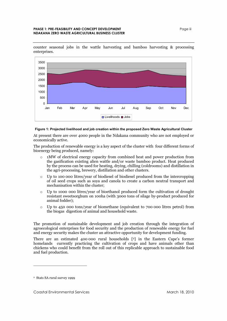
At full implementation, the cluster will create an average of about 1500 sustainable livelihoods and 1000 jobs. Care was taken to identify crops and activities that are counter seasonal to the berry harvesting window which will require up to 5000 seasonal jobs between December and March. This was achieved mainly through the proposed allocation of 660
PHASE 1: PRE-FEASIBILITY AND CONCEPT DEVELOPMENT Page iii
NDAKANA ZERO WASTE AGRICULTURAL BUSINESS CLUSTER
Coastal Environmental Services March 18, 2010
counter seasonal jobs in the wattle harvesting and bamboo harvesting & processing enterprises.
0
500
1000
1500
2000
2500
3000
3500
Jan Feb Mar Apr May Jun Jul Aug Sep Oct Nov Dec
Livelihoods Jobs
Figure 1: Projected livelihood and job creation within the proposed Zero Waste Agricultural Cluster
At present there are over 4000 people in the Ndakana community who are not employed or economically active.
The production of renewable energy is a key aspect of the cluster with four different forms of bioenergy being produced, namely:
o 1MW of electrical energy capacity from combined heat and power production from the gasification existing alien wattle and/or waste bamboo product. Heat produced by the process can be used for heating, drying, chilling (coldrooms) and distillation in the agri-processing, brewery, distillation and other clusters.
o Up to 100 000 litres/year of biodiesel of biodiesel produced from the intercropping of oil seed crops such as soya and canola to create a carbon neutral transport and mechanisation within the cluster;
o Up to 1000 000 litres/year of bioethanol produced form the cultivation of drought resistant sweetsorghum on 100ha (with 3000 tons of silage by-product produced for animal fodder);
o Up to 450 000 tons/year of biomethane (equivalent to 700 000 litres petrol) from the biogas digestion of animal and household waste.
The promotion of sustainable development and job creation through the integration of agroecological enterprises for food security and the production of renewable energy for fuel and energy security makes the cluster an attractive opportunity for development funding.
There are an estimated 400 000 rural households [2] in the Eastern Cape’s former homelands currently practicing the cultivation of crops and have animals other than chickens who could benefit from the roll out of this replicable approach to sustainable food and fuel production.
2 Stats SA rural survey 1999
PHASE 1: PRE-FEASIBILITY AND CONCEPT DEVELOPMENT Page iv
NDAKANA ZERO WASTE AGRICULTURAL BUSINESS CLUSTER
Coastal Environmental Services March 18, 2010
Acknowledgements
The authors gratefully acknowledge the valuable support and assistance of those who contributed to this study which contains research and contributions from a multitude of sources. Special recognition goes to:
Chief Sandile who helped clarified the role, responsibility and perspectives of the tribal authority in relation to the study.
The villagers of Ndakana who provided valuable inputs at both the stakeholder meetings and at interviews during various site surveys.
Councillor Peters for sharing his passion around the development of the cooperatives
Leon Coetzee from the Department of Agriculture who provided access to information on the areas suitable for intercropping of maize and canola.
Dr Theunis Morgenthal from the Dohne Agricultural Development Institute for assistance in providing an overview of the ARC GIS data set and recommendations.
Prof Miguel Altieri of the University of Berkley who provided valuable perspectives and motivations on the viability of agroecological model in the traditional farmer context and relevancy of extension including the effective use of simple agroecological indicators for farmers and the benefits of the farmer to farmer approach.
Alistair McMaster who assisted with the initial scope development of the project and through the provision of GIS data.
Rob Small of Abalimi Bezekhaya who provided detailed access to information to the harvest of hope programme and valuable advice on community based agriculture.
Steve Song from the Shuttleworth Foundation who took time out to explore user cooperative based ICT services and how the Village Telco could be used to support rural development.
Chris Pienaar from the new economic foundation who provided information and advice on appropriate practical ‘bottom-up’ approaches for the regeneration and local enterprise development at Ndakana.
Zolile Ntshona from the Eastern Cape Socio-economic Consultative Council who provided background information on the past and current rural development policy and strategy development in the province.
PHASE 1: PRE-FEASIBILITY AND CONCEPT DEVELOPMENT Page v
NDAKANA ZERO WASTE AGRICULTURAL BUSINESS CLUSTER
Coastal Environmental Services March 18, 2010
Table of Contents
1. Introduction 1 1.1 Objectives 1 1.2 Specific objectives 2 1.3 Zero Waste Agriculture 2 1.4 Business Cluster Development 4 1.5 Alignment with the Provincial Growth and Development Plan 6 1.6 Stakeholder Engagements 7
2. Natural Resources 8 2.1 Geography 8 2.1.1 Locality 8 2.1.2 Study Boundary 8 2.1.3 Geographical Features 9 2.1.4 Soil Analysis 9
2.2 Climatic Features 12 2.3 Water Availability 14 2.3.1 Potable water supply 14 2.3.2 Water Sources 14 2.3.3 Irrigation potentials 15
2.4 Vegetation 18
3. Land Tenure & Use 19 3.1 Types of Land Tenure 19 3.1.1 Private Tenure areas 19 3.1.2 Communal Land Tenure 19
3.2 Land Ownership 19 3.2.1 Tribal Land 20 3.2.2 State Land 20 3.2.3 Private Land 21
3.3 Tenure Reform in Communal Areas 22 3.4 Land Claims 23 3.5 Existing Land-Use Activities 24 3.5.1 Tribal land 24 3.5.2 State Land 28 3.5.3 Private land 28
4. Socio-Economic Assessment 29 4.1 Background Population Size and Spatial Distribution 29 4.2 Population Structure 29 4.3 Population Movement 30 4.4 Socio-Economic Characteristics 31 4.4.1 Education 31 4.4.2 Household income 34
4.5 Housing 35 4.5.1 Housing type 35
4.6 Rural Livelihoods 36
PHASE 1: PRE-FEASIBILITY AND CONCEPT DEVELOPMENT Page vi
NDAKANA ZERO WASTE AGRICULTURAL BUSINESS CLUSTER
Coastal Environmental Services March 18, 2010
4.6.1 Agricultural livelihoods 36 4.6.2 Use of natural resources 38
5. Resource Recovery and Recycling Potentials 39 5.1 Local Ndakana Community 39 5.1.1 Household waste 39 5.1.2 Sewage and waste water 39 5.1.3 Money 39 5.1.4 Nitrogen from kraal manure 40
5.2 Surrounding Areas 41 5.2.1 Rance Timbers 41 5.2.2 W P Timber Products 41 5.2.3 Stutt Poles 41 5.2.4 Amabele Poles 42 5.2.5 Stutterheim landfill 42 5.2.6 Stutterheim waste water treatment 42 5.2.7 Anca Chickens 42 5.2.8 Eco-Logix 43 5.2.9 Amathole Berries Farm 43 5.2.10 Proposed berry handling and support facility 43 5.2.11 Waste water form Amabele 44
6. Identification and Selection of Cluster Activities 45 6.1 Preliminary Enterprise & Activity List 45 6.2 First Order Enterprise & Activity Assessment 45 6.2.1 Ranking of activities 45
6.3 Second Order Assessment of Crops 47 6.4 Considerations for Coping with Climate change 52 6.4.1 Rainwater harvesting 52 6.4.2 Multiple cropping systems 53 6.4.3 Soil organic matter enhancement 53 6.4.4 Locally based research extension and farmer-to-farmer networks 54
6.5 Short Listed Activities 55 6.5.1 Crops 55 6.5.2 Other activities & enterprises 55
7. Cluster Components 56 7.1 Householder Enterprises Cluster Component 56 7.1.1 Household Gardens 56 7.1.2 Orchards 58 7.1.3 Free range chickens & eggs 59 7.1.4 Beekeeping 59 7.1.5 Livestock (pasture fed) 60 7.1.6 Kraal manure and biogas digester 61 7.1.7 Algae and aquaponics 62 7.1.8 Mushrooms 63
7.2 Agri-processing Marketing and Distribution Hub 64 7.2.1 Collections and Internal Control Systems 64 7.2.2 Cleaning, Processing, Packaging, Cold storage 65 7.2.3 Drying / dehydration 65 7.2.4 Grain Storage and micro milling operation 65
PHASE 1: PRE-FEASIBILITY AND CONCEPT DEVELOPMENT Page vii
NDAKANA ZERO WASTE AGRICULTURAL BUSINESS CLUSTER
Coastal Environmental Services March 18, 2010
7.2.5 Abattoir 66 7.2.6 Marketing and distribution 66
7.3 Arable Plots Holder Enterprises 67 7.4 Specialist Producers 69 7.4.1 Herbs 69 7.4.2 Pomegranates 72 7.4.3 Grain and Sweet Sorghum 73 7.4.4 Bamboo 74
7.5 Bamboo Processing Enterprise 76 7.6 The Forest Management Enterprise 78 7.6.1 Harvesting & Transport Teams 79 7.6.2 The yard 80
7.7 Combined Heat and Power Enterprise 80 7.8 Mead, Brewing & Distillation Cluster 84 7.8.1 Meadery 84 7.8.2 Brewery 85 7.8.3 Spirits, tinctures and Bio-ethanol distillation 86
7.9 Ndakana Biodiesel Enterprise 87 7.10 Tribal Authority 88 7.11 Agroecological Extension Services 89 7.11.1 Extension services 90 7.11.2 Seed bank development 91 7.11.3 BAP/BAT Agroecological Demonstration Centre 91 7.11.4 Farmer Training and Train the Trainer facilities 91 7.11.5 Internship programme 91
7.12 Information and Communication User Cooperative 92 7.12.1 The village telco 92 7.12.2 Open access to AEKIS 92 7.12.3 Online Cooperative Banking 92 7.12.4 Internet media centre 93
7.13 Ndakana Local Economic Development Cooperative 93 7.13.1 Lifeskills training 93 7.13.2 Information and events promotion 93 7.13.3 Enterprise coaching 94 7.13.4 Enterprise mentorship 95
7.14 Local Consumer Cooperative 95 7.15 Agri / Eco Tourism Cluster 96 7.16 Agroecological Carbon Enterprise 98
8. Cluster Structure and Linkages 99 8.1 Cluster components and linkages 99 8.2 Complexity, a new lens to understand development differently 103
9. Employment & Livelihood Creation 105
10. Financing 106 10.1 Costs 106 10.2 Cash Flow Requirements 108 10.3 Donor & Development Agency Support 108 10.3.1 Support for Agroecological Farming and Organic Value Chain Developments 108 10.3.2 Support for Renewable Energy 109
PHASE 1: PRE-FEASIBILITY AND CONCEPT DEVELOPMENT Page viii
NDAKANA ZERO WASTE AGRICULTURAL BUSINESS CLUSTER
Coastal Environmental Services March 18, 2010
11. Recommendations 110 11.1 Phasing of implementation 110 11.2 Spatial arrangement of the cluster 111 11.2.1 Impacts to communal grazing land 113 11.2.2 Bamboo production 113 11.2.3 Impacts to Amabele 114
11.3 Sourcing of Funding 114 11.3.1 Grant funding for feasibility study development 114 11.3.2 Funding for implementation 114
12. References 115
13. Annexure 117
PHASE 1: PRE-FEASIBILITY AND CONCEPT DEVELOPMENT Page ix
NDAKANA ZERO WASTE AGRICULTURAL BUSINESS CLUSTER
Coastal Environmental Services March 18, 2010
Table of Figures
Figure 1: Projected livelihood and job creation within the proposed Zero Waste Agricultural Cluster .............................................................................................................................. iii
Figure 2: Programme Schedule for the Ndakana Zerowaste Agricultural Cluster Business Plan Development .............................................................................................................. 1
Figure 3: Integrated agroecological systems approach (Warburton et al, 2000)......................3
Figure 4: The inescapable interconnectedness of agriculture’s roles and functions (IAASTD 2008)..................................................................................................................................4
Figure 5: A potential brand logo symbolising low carbon zero-waste agroecological farming .5
Figure 6: A well attended community meeting at the Ndakana Community Hall.....................7
Figure 7: Location of Ndakana (in green)................................................................................. 8
Figure 8: The Ndakana Study Area............................................................................................9
Figure 9: location of the soil samples taken from 780ha of potential arable land ..................10
Figure 10: Excavations showing the red fertile soil in the area and the local quarry showing high clay content of subsoils............................................................................................. 11
Figure 11: Average monthly temperatures at Wriggleswade Dam........................................... 13
Figure 12: Average monthly rainfall and daily evaporation at Wriggleswade Dam ................ 13
Figure 13: Water sources in the area ....................................................................................... 14
Figure 14: Maximum monthly abstraction potential from Dam 1 (near Amabele) ................. 16
Figure 15: Maximum monthly abstraction potential from Dam 2 (South of Nkululeko)........ 16
Figure 16: Maximum monthly abstraction potential from a proposed 120,000kL dam between Jerseyville and Stanhope.................................................................................... 17
Figure 17: Maximum monthly abstraction potential from a proposed 200,000kL dam between Jerseyville and Stanhope....................................................................................18
Figure 18: Land Ownership in the study area......................................................................... 20
Figure 19: Typical land allocation showing fenced household plots within the Ndakana villages............................................................................................................................. 24
Figure 20: A small household food garden in Ndakana ..........................................................25
Figure 21: Part of the 130ha of largely unutilised fertile arable plots that were once part of the failed MFPP ......................................................................................................................25
Figure 22: Cultivated areas in the form of arable plots and communal farm land................. 26
Figure 23: 85ha of weed invested communal farm lands (foreground) ................................. 26
Figure 24: Herds of cattle grazing on communal land ............................................................27
Figure 25: Harvest wattle staked for collection to be sold for pulping. .................................. 28
Figure 26: Graph of population migration to Amahlathi LM.................................................. 31
Figure 27:Typical livestock grazing in communal pastures.................................................... 38
Figure 28: Recent escalations in the price of Nitrogen based fertilizer for agriculture.......... 40
PHASE 1: PRE-FEASIBILITY AND CONCEPT DEVELOPMENT Page x
NDAKANA ZERO WASTE AGRICULTURAL BUSINESS CLUSTER
Coastal Environmental Services March 18, 2010
Figure 29: The AIPS reference WWTW at Grahamstown with high rate algal ponds sized for 150k/day of waste water.................................................................................................. 44
Figure 30: Map showing areas suitable for Canola (purple) bordering the study area (Source DoA) ................................................................................................................................ 50
Figure 31: A shopping basket with fair trade organic products (Source: Transfair Germany) 51
Figure 32: The sustainable continuum for organic micro projects (Source Abalimi Bezekhaya)..........................................................................................................................................57
Figure 33: Typical household food garden intercropped with maize, beans and pumpkins...57
Figure 34: Beekeepers (Source Makana Meadery) ..................................................................59
Figure 35: The tick eating red-billed oxpecker ....................................................................... 60
Figure 36: Installation of a low cost tube digester...................................................................61
Figure 37: Construction of a below ground digester under construction and a biogas fueled cooker ...............................................................................................................................61
Figure 38: Algal and aquaculture as a proposed phase 2 activity........................................... 62
Figure 39: A biogas fuelled steam sterilizer for oyster mushroom production & the resulting oyster mushrooms ............................................................................................................63
Figure 40: The processing marketing and distribution hub.................................................. 64
Figure 41: A simple dehuller and mill manufactured in South Africa ( Source: Taylor) .........65
Figure 42: Costs for commissioning a 2t/h micro milling plant............................................. 66
Figure 43: Maximising the position on value chain through downstream integration .......... 66
Figure 44: The push-pull practice of integrated pest management using the intercropping maize with desmodium and napier grass on the field border to control stalk borer....... 68
Figure 45: Fruiting pomegrate (left) and open fruit showing arils (right) ..............................72
Figure 46: Existing wattle harvesting & collection activities at Ndakana................................78
Figure 47: A 100KW gasifier and engine .................................................................................81
Figure 48: Storage and handling of chipped wood fuel .......................................................... 82
Figure 49: A Makana Meadery micro-meadery in Portland, USA (left) and mead made in South Africa (right).......................................................................................................... 84
Figure 50: Examples of packaged traditional sorghum beers (left) and Nigerian ‘conventional’ beers made with sorghum (right)............................................................. 86
Figure 51: The relationship between the farmer and agricultural knowledge and information systems (FAO & WorldBank, 2000)................................................................................ 90
Figure 52: The village telco wifi mesh system. ....................................................................... 92
Figure 53: Supporting development of the local economy through coaching (Source: nef) .. 94
Figure 54: Clean and content pigs in a biogas heated piggery.................................................97
Figure 55: Example of an integrated biogas, algal, aquaculture and aquaponic system .........97
Figure 56: Cluster Component Overview...............................................................................100
Figure 57: Proposed Linkages to Institutions........................................................................ 101
Figure 58: Other cluster links to institutions......................................................................... 101
PHASE 1: PRE-FEASIBILITY AND CONCEPT DEVELOPMENT Page xi
NDAKANA ZERO WASTE AGRICULTURAL BUSINESS CLUSTER
Coastal Environmental Services March 18, 2010
Figure 59: The detailed cluster map showing cluster activities, product and resources flows........................................................................................................................................102
Figure 60: The seasonal nature of livelihood and job creation in the cluster........................105
Figure 61: Projected cashflow over time (Source: The Organic Business Guide Developing Sustainable Value Chains with Smallholders, Elzakker & Eyhorn 2010).......................108
Figure 62: A simplified version of the cluster for implementation.........................................111
Figure 63: Proposed layout of general cluster activities in the area ...................................... 113
List of Tables
Table 1: Soil sample location, class and depth.........................................................................10
Table 2: Results of the deeds search on property within the study area (Source: Windeed, Feb 2010)................................................................................................................................. 21
Table 3: Number of people per ethnic group in Ward 9 ......................................................... 29
Table 4: Population structure ................................................................................................. 29
Table 5: Population movement............................................................................................... 30
Table 6: Education levels ......................................................................................................... 31
Table 7: Amathole Berries Skills Audit –Unemployed levels of education..............................32
Table 8: Employment ..............................................................................................................33
Table 9: Occupational category ...............................................................................................33
Table 10: Household income ...................................................................................................34
Table 11: Housing types in ALM ..............................................................................................35
Table 12: Housing ownership ..................................................................................................35
Table 13: First order enterprise ranking assessment of enterprises...................................... 46
Table 14: Specialist fruit and nut assessment matrix ..............................................................47
Table 15: Screening matrix for specialist crop production ..................................................... 48
Table 16: Sources of Nitrogen for Agriculture (FAO 2009).....................................................53
Table 17: Typical South African sorghum products.................................................................73
Table 18: Table of risks for bamboo production (Source Envirovest Bioproducts).................75
Table 19: Bamboo ready for processing into incense (josh) sticks (Source Envirovest Bioproducts) ..................................................................................................................... 77
Table 20: Bamboo production and processing financials (source Envirovest Bioproducts)...77
Table 21: Gross order of magnitude costs and incomes for 2 x 500kw gassifier plant .......... 83
Table 22: First Order Assessment of Livelihood and Job Creation per Cluster Component.105
Table 23:Summary of capital costs for enterprise implementation ......................................106
Table 24: Capital Costs for Implementation of Enterprise Support Services........................ 107
Table 25: List of donors, development agencies and funders supporting agroecolcological devlopment and organic value chain development (Elzakker & Eyhorn, 2010) ............109
PHASE 1: PRE-FEASIBILITY AND CONCEPT DEVELOPMENT Page xii
NDAKANA ZERO WASTE AGRICULTURAL BUSINESS CLUSTER
Coastal Environmental Services March 18, 2010
Acronyms and abbreviations
ADM Amathole District Municipality
AEKIS Agroecological Knowledge and Information System
AGIS Agricultural Geographical Information System
AIPS Advanced Algal Pond Technology
ALM Amahlathi Local Municipaolity
ALSDF Amabele Local Spatial Development Framework
ARDRI Agricultural Rural Development Research Institute (Fort Hare University)
ASPIRE Amathole Economic Development Agency (trading as ASPIRE)
BAP Best available practices
BAT Best available technologies
BTE Bamboo to Electricity
CH4 Methane
CO2e Carbon dioxide equivalent
CPA Communal Property Association
DBSA Development Bank of South Africa
DEAT Department of Environmental Affairs and Tourism
DEDEA Department of Economic Development and Environmental Affairs
DLA Department of Land Affairs
DTI Department of Trade and Industry
DWAF Department of Water Affairs and Forestry (former)
DWA Department of Water Affairs
EBRU Institute of Environmental Biotechnology at Rhodes University
GHG Greenhouse Gas
GJ Giga Joules
GTZ Deutsche Gesellschaft für Technische Zusammenarbeit GmbH
ha Hectares
IAASTD International Assessment of Agricultural Knowledge, Science and Technology for Development
ICS Internal Control System (for organic certification)
IDC Industrial Development Corporation
IDP Integrated Development Plans
ISO International Standards Organisation
PHASE 1: PRE-FEASIBILITY AND CONCEPT DEVELOPMENT Page xiii
NDAKANA ZERO WASTE AGRICULTURAL BUSINESS CLUSTER
Coastal Environmental Services March 18, 2010
kg Kilogram
kL Kilolitres
kW Kilowatt
kWhe Kilowatt hour electrical
L Litres
LSDF Local Spatial Development Framework
m Meter
m3 Cubic meter
MFPP Massive Food Production Programme
MWhe Megawatt hour of electrical energy
OFSW Organic Fraction of Solid Waste
OFMSW Organic fraction of municipal solid waste
PGDP Provincial Growth and Development Plan
PPP Public Private Partnership
PSC Project Steering Committee
SANEDI South African National Energy Development Institute
SANERI South Africa's National Energy Research Institute
SMME Small, medium and micro enterprises
t Metric tonne
ULIMOCO Former Ciskei Agricultural Development Corporation
VER Verified carbon reduction certificates
WWOOFs Willing workers on organic farms
WTW Water Treatment Works
WWTW Wastewater Treatment Works
PHASE 1: PRE-FEASIBILITY AND CONCEPT DEVELOPMENT Page 1
NDAKANA ZERO WASTE AGRICULTURAL BUSINESS CLUSTER
Coastal Environmental Services March 18, 2010
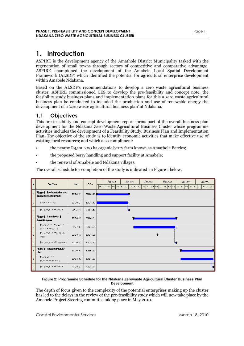
1. Introduction ASPIRE is the development agency of the Amathole District Municipality tasked with the regeneration of small towns through sectors of competitive and comparative advantage. ASPIRE championed the development of the Amabele Local Spatial Development Framework (ALSDF) which identified the potential for agricultural enterprise development within Amabele Ndakana.
Based on the ALSDF’s recommendations to develop a zero waste agricultural business cluster, ASPIRE commissioned CES to develop the pre-feasibility and concept note, the feasibility study business plans and implementation plans for this a zero waste agricultural business plan be conducted to included the production and use of renewable energy the development of a ‘zero waste agricultural business plan’ at Ndakana.
1.1 Objectives This pre-feasibility and concept development report forms part of the overall business plan development for the Ndakana Zero Waste Agricultural Business Cluster whose programme activities includes the development of a Feasibility Study, Business Plan and Implementation Plan. The objective of the study is to identify economic activities that make effective use of existing local resources; and which also compliment:
• the nearby R45m, 200 ha organic berry farm known as Amathole Berries;
• the proposed berry handling and support facility at Amabele;
• the renewal of Amabele and Ndakana villages.
The overall schedule for completion of the study is indicated in Figure 1 below.
Figure 2: Programme Schedule for the Ndakana Zerowaste Agricultural Cluster Business Plan Development
The depth of focus given to the complexity of the potential enterprises making up the cluster has led to the delays in the review of the pre-feasibility study which will now take place by the Amabele Project Steering committee taking place in May 2010.
PHASE 1: PRE-FEASIBILITY AND CONCEPT DEVELOPMENT Page 2
NDAKANA ZERO WASTE AGRICULTURAL BUSINESS CLUSTER
Coastal Environmental Services March 18, 2010
1.2 Specific objectives As per projects terms of reference, the specific objectives of this study is to:
• Undertake a pre-feasibility assessment of the proposed agricultural business cluster including zero-waste methods
• Brief situation assessment of by-product/waste streams per Amabele LSDF and other projects (including resource requirements and recycling potentials).
• Identify feasible counter-seasonal crop alternatives.
• Determine value chains and approximate product volumes for proposed agricultural business cluster.
• Outline relevant zero-waste technologies.
• Produce approximate costings of proposed zero-waste technologies.
• Stakeholder engagement to clarify projects.
• Prepare pre-feasibility and concept report for proposed agricultural business cluster at Ndakana and present at PSC.
1.3 Zero Waste Agriculture Zero-waste agriculture is essentially an agroecological approach to the integration of biosystems that makes functional connections between agriculture, aquaculture, food processing, waste management, water use, and fuel generation. It encourages the dynamic flows of material and energy by treating wastes and by-products of one operation as inputs for another. In this way food, fertiliser, animal feed and fuel can be produced with the minimum input of nutrients, water and other resources (Warburton et al, 2002).
Integrated agroecological systems make explicit connections between agriculture, aquaculture, food processing, waste management, water use and fuel generation. They are life-support systems based on the dynamic flow of material and energy, where wastes and by-products of one operation become inputs for another. In this way food, fertiliser, animal feed and fuel can be produced with the minimum input of nutrients, water and other resources.
The management of wastes and residues is treated as a central design feature. Thus, in contrast to other production systems where waste disposal and remediation are essentially treated as externalities, sustainable design features are intrinsic to integrated biosystems. Such design features include the following:
• minimise resource inputs by redirecting "waste" outputs within the system;
• contain material flows within the system;
• treat production and consumption as a continuous cyclical process, rather than a linear one;
• tighten production-consumption loops to minimise losses, transport costs etc;
• maximise efficiency of natural conversion processes (e.g., microbial decomposition and trophic links) and of nutrient / water retention.
This integrated agroecological approach increases system efficiency. Further, integrated biosystems take advantage of natural ecological processes, and as a result some components of such systems can be low technology, requiring less management, less maintenance and less capital expense. Integrated biosystems are scalable both in size and in technical complexity and can be developed in stages, possibly through joint enterprise arrangements.
PHASE 1: PRE-FEASIBILITY AND CONCEPT DEVELOPMENT Page 3
NDAKANA ZERO WASTE AGRICULTURAL BUSINESS CLUSTER
Coastal Environmental Services March 18, 2010
These features help in the take-up of local farm-based systems whilst enhancing valuable ecosystem services such as nitrogen fertilisation and carbon sequestration and biological services such as pollination and integrated pest management.
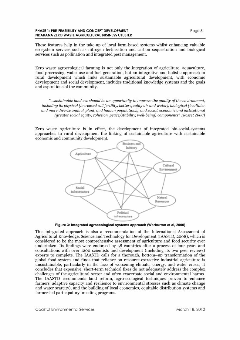
Zero waste agroecological farming is not only the integration of agriculture, aquaculture, food processing, water use and fuel generation, but an integrative and holistic approach to rural development which links sustainable agricultural development, with economic development and social development, includes traditional knowledge systems and the goals and aspirations of the community.
“…sustainable land use should be an opportunity to improve the quality of the environment,
including its physical (increased soil fertility, better quality air and water), biological (healthier
and more diverse animal, plant, and human populations), and social, economic and institutional (greater social equity, cohesion, peace/stability, well-being) components”. (Rosset 2000)
Zero waste Agriculture is in effect, the development of integrated bio-social-systems approaches to rural development the linking of sustainable agriculture with sustainable economic and community development.
Figure 3: Integrated agroecological systems approach (Warburton et al, 2000)
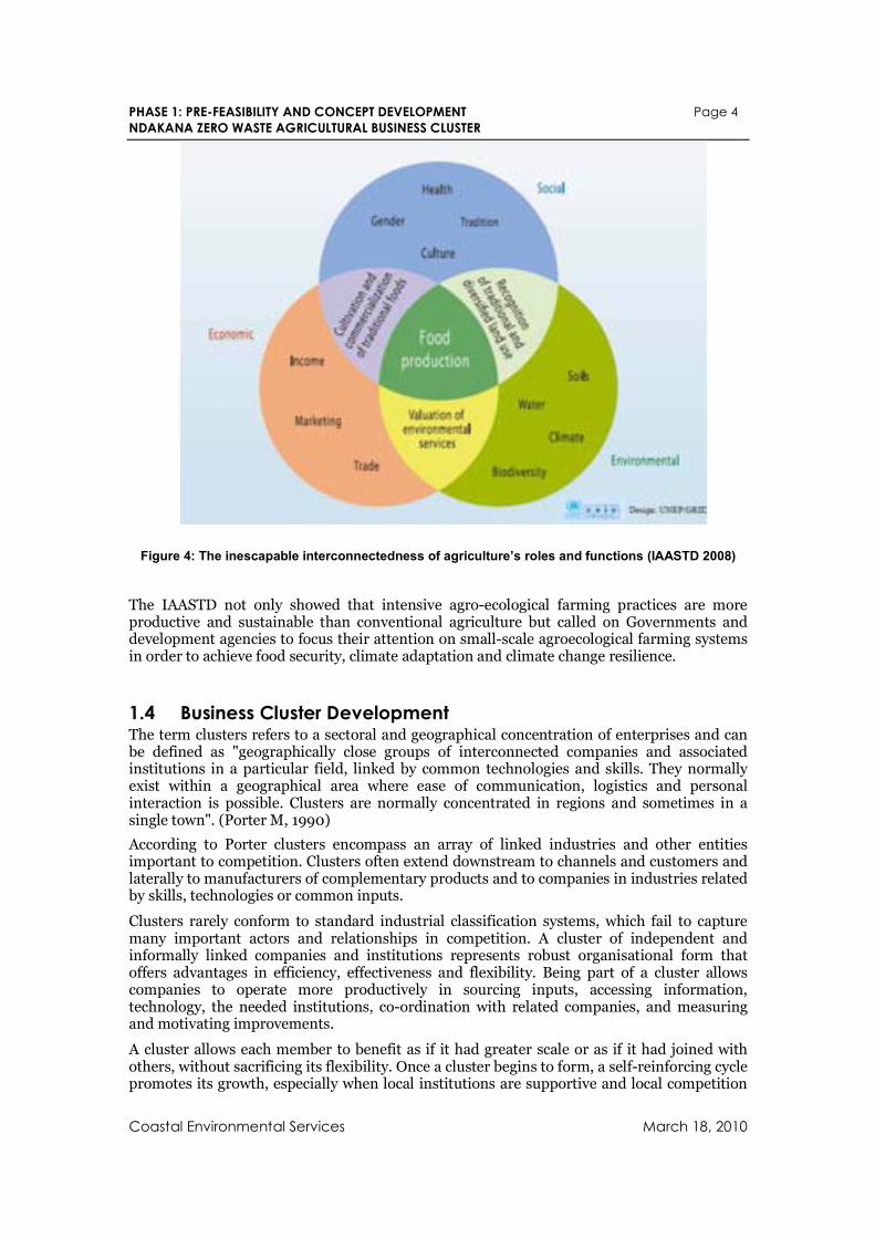
This integrated approach is also a recommendation of the International Assessment of Agricultural Knowledge, Science and Technology for Development (IAASTD, 2008), which is considered to be the most comprehensive assessment of agriculture and food security ever undertaken. Its findings were endorsed by 58 countries after a process of four years and consultations with over 1200 scientists and development (including its two peer reviews) experts to complete. The IAASTD calls for a thorough, bottom–up transformation of the global food system and finds that reliance on resource-extractive industrial agriculture is unsustainable, particularly in the face of worsening climate, energy, and water crises; it concludes that expensive, short-term technical fixes do not adequately address the complex challenges of the agricultural sector and often exacerbate social and environmental harms. The IAASTD recommends land reform, agro-ecological techniques proven to enhance farmers’ adaptive capacity and resilience to environmental stresses such as climate change and water scarcity), and the building of local economies, equitable distribution systems and farmer-led participatory breeding programs.
PHASE 1: PRE-FEASIBILITY AND CONCEPT DEVELOPMENT Page 4
NDAKANA ZERO WASTE AGRICULTURAL BUSINESS CLUSTER
Coastal Environmental Services March 18, 2010
Figure 4: The inescapable interconnectedness of agriculture’s roles and functions (IAASTD 2008)
The IAASTD not only showed that intensive agro-ecological farming practices are more productive and sustainable than conventional agriculture but called on Governments and development agencies to focus their attention on small-scale agroecological farming systems in order to achieve food security, climate adaptation and climate change resilience.
1.4 Business Cluster Development The term clusters refers to a sectoral and geographical concentration of enterprises and can be defined as "geographically close groups of interconnected companies and associated institutions in a particular field, linked by common technologies and skills. They normally exist within a geographical area where ease of communication, logistics and personal interaction is possible. Clusters are normally concentrated in regions and sometimes in a single town". (Porter M, 1990)
According to Porter clusters encompass an array of linked industries and other entities important to competition. Clusters often extend downstream to channels and customers and laterally to manufacturers of complementary products and to companies in industries related by skills, technologies or common inputs.
Clusters rarely conform to standard industrial classification systems, which fail to capture many important actors and relationships in competition. A cluster of independent and informally linked companies and institutions represents robust organisational form that offers advantages in efficiency, effectiveness and flexibility. Being part of a cluster allows companies to operate more productively in sourcing inputs, accessing information, technology, the needed institutions, co-ordination with related companies, and measuring and motivating improvements.
A cluster allows each member to benefit as if it had greater scale or as if it had joined with others, without sacrificing its flexibility. Once a cluster begins to form, a self-reinforcing cycle promotes its growth, especially when local institutions are supportive and local competition
PHASE 1: PRE-FEASIBILITY AND CONCEPT DEVELOPMENT Page 5
NDAKANA ZERO WASTE AGRICULTURAL BUSINESS CLUSTER
Coastal Environmental Services March 18, 2010
is vigorous. As the cluster expands, so does its influence with government and with public and private institutions.
Developing the economy of an area means that the enterprises in the area must become more competitive and grow. Enterprises are connected to suppliers, service providers and markets through networks and market systems forming small economic sub-systems. With the onset of globalisation these regional or local economic sub-systems compete with sub-systems in other parts of the country or the world. Thus, the economic well-being of an area very often depends on the collective performance of groups of enterprises in its locality (Rücker & Trah, 2007).
By understanding these sub-systems, a more leveraged approach to local economic development can be reached. Rather than trying to grow the local economy one enterprise at a time, the needs, issues and opportunities of a selection or group of enterprise can be dealt with at the same time. This allows for specific gaps to be addressed and for improved networking and co-operation between the various actors involved in the local economy. Opportunities for the development of new enterprises, for new investment or for the creation of specialized factors of productions can be identified when working with groups of enterprises that are interrelated.
Clusters can also result in an increase in innovative human capital resulting from attraction of service providers that benefits enterprises in the region the where a location has developed a certain profile or cluster.
Cluster are able to effectively attract investment if the promotion and locational marketing able to exploit and enhance synergies between different local activities, builds on existing or emerging strengths of the area and helps close gaps with regard to input, output and service markets. According to the GTZ (Rücker & Trah, 2007) cluster investment promotion should ideally achieve the following:
• help build a local profile and facilitates the development of business clusters
• attract external suppliers, complementary firms and service providers and thus helps strengthening the local business base instead of crowding out local businesses
• align with important sector policies, especially with skills development and higher education strategies and institutions
• promote high quality living not just hard and tangible locational factors such as labour costs,
• promote a strong local brand strengthens the attractiveness of local products in regional, national and international markets.
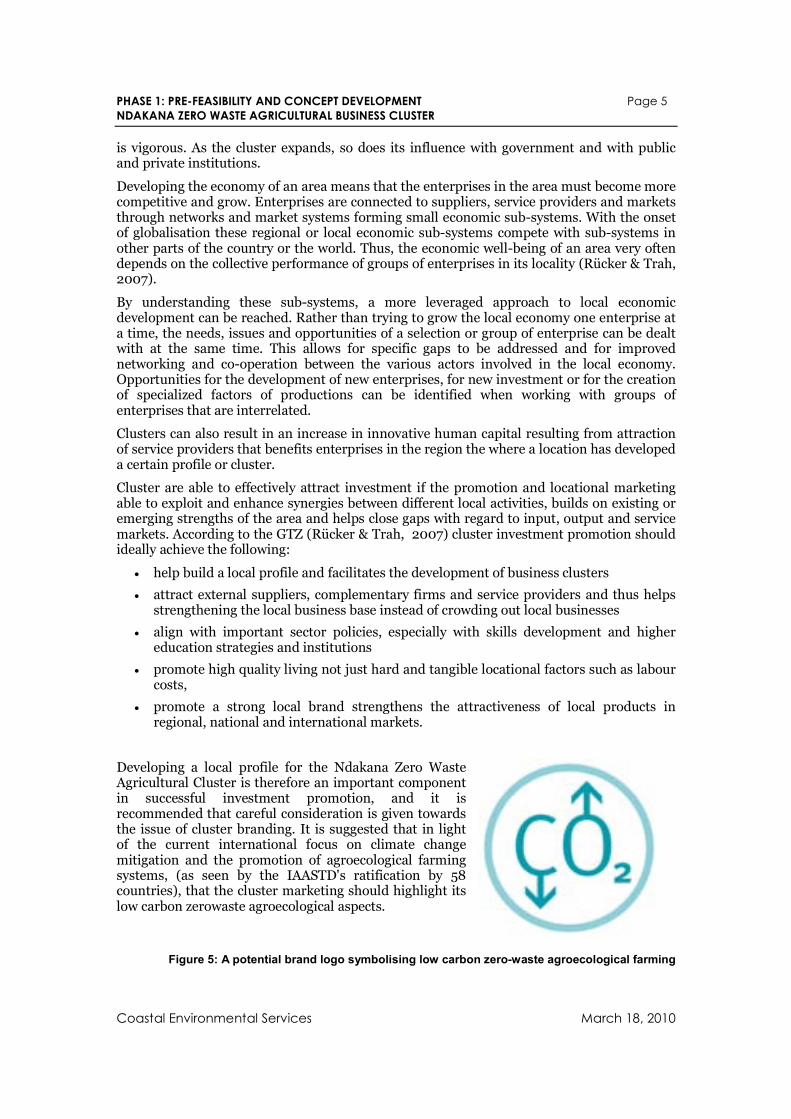
Developing a local profile for the Ndakana Zero Waste Agricultural Cluster is therefore an important component in successful investment promotion, and it is recommended that careful consideration is given towards the issue of cluster branding. It is suggested that in light of the current international focus on climate change mitigation and the promotion of agroecological farming systems, (as seen by the IAASTD's ratification by 58 countries), that the cluster marketing should highlight its low carbon zerowaste agroecological aspects.
Figure 5: A potential brand logo symbolising low carbon zero-waste agroecological farming
PHASE 1: PRE-FEASIBILITY AND CONCEPT DEVELOPMENT Page 6
NDAKANA ZERO WASTE AGRICULTURAL BUSINESS CLUSTER
Coastal Environmental Services March 18, 2010
1.5 Alignment with the Provincial Growth and Development Plan Ndakana includes an estimated 1500 rural households. Most these household engage in agricultural activities including the cultivation of domestic food gardens practice and traditional livestock management. The Provincial Growth and Development Plan provides strategic guidelines for inclusion of these householders into the cluster.
PROVINCIAL GROWTH & DEVELOPMENT PLAN, 2004-2014
Section 3 Strategic Framework
6.2 Agrarian Transformation and Strengthening Household Food Security
This objective focuses on increased agricultural production, incomes and employment by the poorest households, particularly in the ex-homelands. In the short to medium term, the State will need to lead this process, with market-related interventions receiving greater emphasis over the medium to long term as the capacity of poor households to enter markets is developed. The objective suggests that State programmes need to be clustered around three areas of intervention:
• Promoting food security through expanded smallholder production.
• Expanding the asset base of the poor, particularly through effective land tenure reform.
• Increasing the use of land for commercial agriculture in the former homelands, especially through ownership and institutional mechanisms that benefit the poorest households.
6.2.1 Approach Establishing household food security is the first priority. To do this, and to lay the foundations for the emergence of small-scale farming entrepreneurs, support on a massive scale will be given to the development of homestead agricultural production. The expansion of smallholder production will lay the basis for marketed surpluses where the potential exists. In addition, support will be given to the development of institutions and systems for the storage, processing and marketing of agricultural products, including livestock.
A second aspect of this approach will be the effective use of land as a lever to improve the livelihoods of the poor. Land reform will be of crucial importance, particularly land redistribution and land tenure reform. Mobilisation for effective prioritisation and funding of land redistribution and land tenure reform is required, given the current limited funding for these components of the land reform process.
The third strand of the approach to agrarian transformation will be the expansion of commercial agricultural enterprises, especially in the former homelands. This will require both the development of new structures for commercial farming enterprises, including CPPPs, trusts and companies, and the allocation of prime agricultural land to these structures. New ownership structures must include communities and smallholders as shareholders or co-owners. Prioritisation of land for its best agricultural use will form part of the approach.
Viable farming enterprises producing and marketing surpluses will provide opportunities for beneficiation of agricultural products. This in turn will leverage the development of agro-industry close to emerging centres of agricultural production. Expanding agricultural production will also provide the opportunity for linkage with the manufacturing sector as a source of inputs and raw materials.
The objective of infrastructure development will play a key supporting role to agrarian transformation, through the improvement of access roads, water and power supply.
Institutions supporting agricultural development will also require transformation and refocusing in
the following areas:
• Formal agricultural training and the development of agricultural skills.
• Decentralisation and refocusing of extension services on food security.
• Support to farmer-owned cooperatives.
PHASE 1: PRE-FEASIBILITY AND CONCEPT DEVELOPMENT Page 7
NDAKANA ZERO WASTE AGRICULTURAL BUSINESS CLUSTER
Coastal Environmental Services March 18, 2010
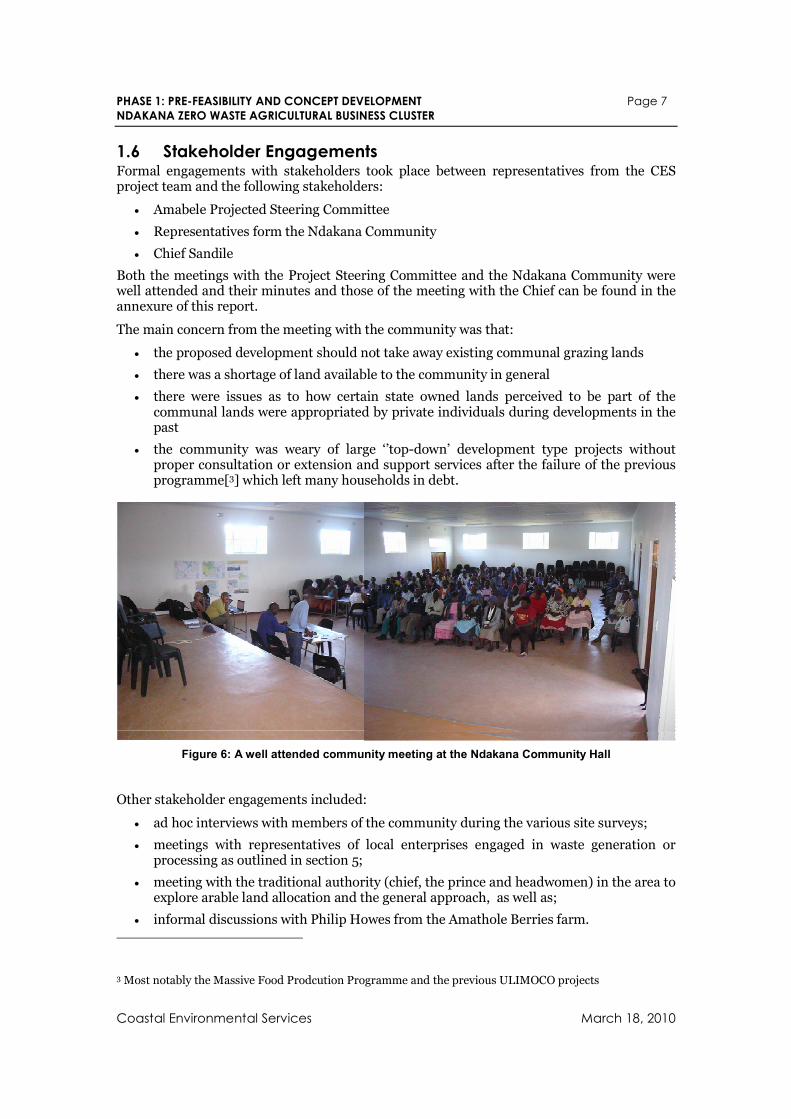
1.6 Stakeholder Engagements Formal engagements with stakeholders took place between representatives from the CES project team and the following stakeholders:
• Amabele Projected Steering Committee
• Representatives form the Ndakana Community
• Chief Sandile
Both the meetings with the Project Steering Committee and the Ndakana Community were well attended and their minutes and those of the meeting with the Chief can be found in the annexure of this report.
The main concern from the meeting with the community was that:
• the proposed development should not take away existing communal grazing lands
• there was a shortage of land available to the community in general
• there were issues as to how certain state owned lands perceived to be part of the communal lands were appropriated by private individuals during developments in the past
• the community was weary of large ‘’top-down’ development type projects without proper consultation or extension and support services after the failure of the previous programme[3] which left many households in debt.
Figure 6: A well attended community meeting at the Ndakana Community Hall
Other stakeholder engagements included:
• ad hoc interviews with members of the community during the various site surveys;
• meetings with representatives of local enterprises engaged in waste generation or processing as outlined in section 5;
• meeting with the traditional authority (chief, the prince and headwomen) in the area to explore arable land allocation and the general approach, as well as;
• informal discussions with Philip Howes from the Amathole Berries farm.
3 Most notably the Massive Food Prodcution Programme and the previous ULIMOCO projects
PHASE 1: PRE-FEASIBILITY AND CONCEPT DEVELOPMENT Page 8
NDAKANA ZERO WASTE AGRICULTURAL BUSINESS CLUSTER
Coastal Environmental Services March 18, 2010
2. Natural Resources
2.1 Geography
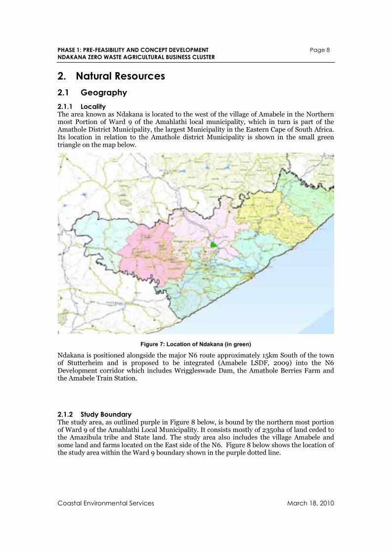
2.1.1 Locality The area known as Ndakana is located to the west of the village of Amabele in the Northern most Portion of Ward 9 of the Amahlathi local municipality, which in turn is part of the Amathole District Municipality, the largest Municipality in the Eastern Cape of South Africa. Its location in relation to the Amathole district Municipality is shown in the small green triangle on the map below.
Figure 7: Location of Ndakana (in green)
Ndakana is positioned alongside the major N6 route approximately 15km South of the town of Stutterheim and is proposed to be integrated (Amabele LSDF, 2009) into the N6 Development corridor which includes Wriggleswade Dam, the Amathole Berries Farm and the Amabele Train Station.
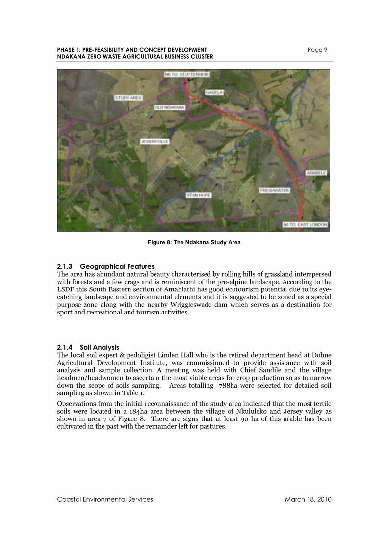
2.1.2 Study Boundary The study area, as outlined purple in Figure 8 below, is bound by the northern most portion of Ward 9 of the Amahlathi Local Municipality. It consists mostly of 2350ha of land ceded to the Amazibula tribe and State land. The study area also includes the village Amabele and some land and farms located on the East side of the N6. Figure 8 below shows the location of the study area within the Ward 9 boundary shown in the purple dotted line.
PHASE 1: PRE-FEASIBILITY AND CONCEPT DEVELOPMENT Page 9
NDAKANA ZERO WASTE AGRICULTURAL BUSINESS CLUSTER
Coastal Environmental Services March 18, 2010
Figure 8: The Ndakana Study Area
2.1.3 Geographical Features The area has abundant natural beauty characterised by rolling hills of grassland interspersed with forests and a few crags and is reminiscent of the pre-alpine landscape. According to the LSDF this South Eastern section of Amahlathi has good ecotourism potential due to its eye-catching landscape and environmental elements and it is suggested to be zoned as a special purpose zone along with the nearby Wriggleswade dam which serves as a destination for sport and recreational and tourism activities.
2.1.4 Soil Analysis The local soil expert & pedoligist Linden Hall who is the retired department head at Dohne Agricultural Development Institute, was commissioned to provide assistance with soil analysis and sample collection. A meeting was held with Chief Sandile and the village headmen/headwomen to ascertain the most viable areas for crop production so as to narrow down the scope of soils sampling. Areas totalling 788ha were selected for detailed soil sampling as shown in Table 1.
Observations from the initial reconnaissance of the study area indicated that the most fertile soils were located in a 184ha area between the village of Nkululeko and Jersey valley as shown in area 7 of Figure 8. There are signs that at least 90 ha of this arable has been cultivated in the past with the remainder left for pastures.
PHASE 1: PRE-FEASIBILITY AND CONCEPT DEVELOPMENT Page 10
NDAKANA ZERO WASTE AGRICULTURAL BUSINESS CLUSTER
Coastal Environmental Services March 18, 2010
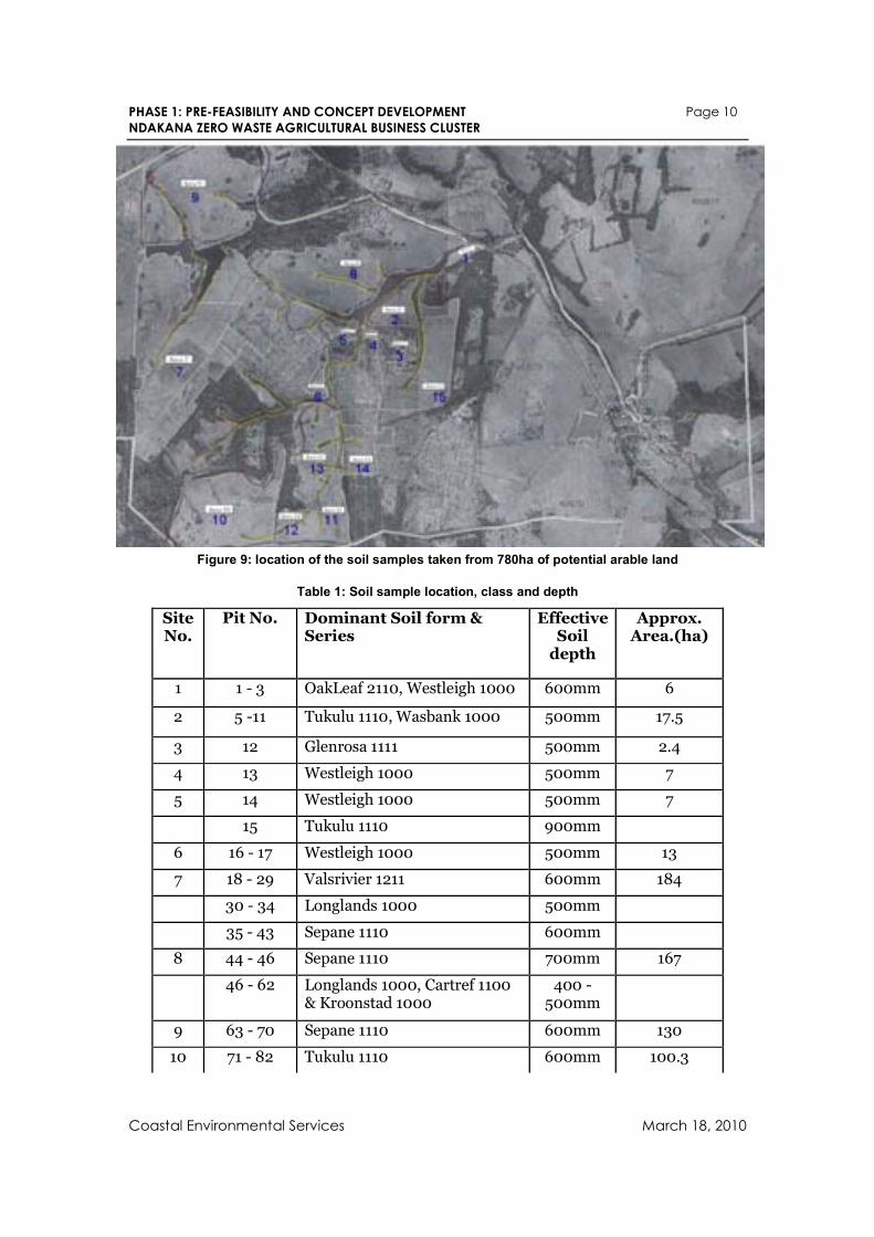
Figure 9: location of the soil samples taken from 780ha of potential arable land
Table 1: Soil sample location, class and depth
Site No.
Pit No. Dominant Soil form & Series
Effective Soil depth
Approx. Area.(ha)
1 1 - 3 OakLeaf 2110, Westleigh 1000 600mm 6
2 5 -11 Tukulu 1110, Wasbank 1000 500mm 17.5
3 12 Glenrosa 1111 500mm 2.4
4 13 Westleigh 1000 500mm 7
5 14 Westleigh 1000 500mm 7
15 Tukulu 1110 900mm
6 16 - 17 Westleigh 1000 500mm 13
7 18 - 29 Valsrivier 1211 600mm 184
30 - 34 Longlands 1000 500mm
35 - 43 Sepane 1110 600mm
8 44 - 46 Sepane 1110 700mm 167
46 - 62 Longlands 1000, Cartref 1100 & Kroonstad 1000
400 - 500mm
9 63 - 70 Sepane 1110 600mm 130
10 71 - 82 Tukulu 1110 600mm 100.3
PHASE 1: PRE-FEASIBILITY AND CONCEPT DEVELOPMENT Page 11
NDAKANA ZERO WASTE AGRICULTURAL BUSINESS CLUSTER
Coastal Environmental Services March 18, 2010
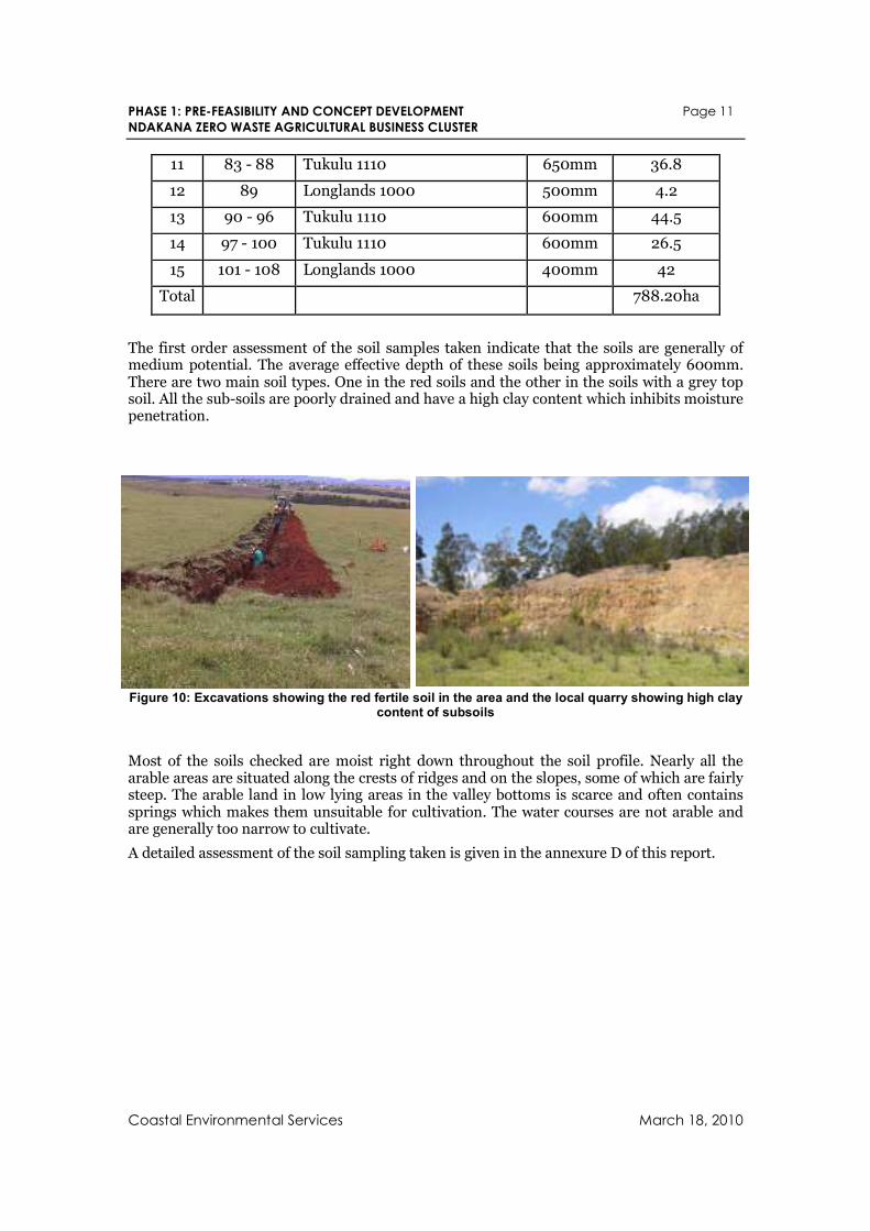
11 83 - 88 Tukulu 1110 650mm 36.8
12 89 Longlands 1000 500mm 4.2
13 90 - 96 Tukulu 1110 600mm 44.5
14 97 - 100 Tukulu 1110 600mm 26.5
15 101 - 108 Longlands 1000 400mm 42
Total 788.20ha
The first order assessment of the soil samples taken indicate that the soils are generally of medium potential. The average effective depth of these soils being approximately 600mm. There are two main soil types. One in the red soils and the other in the soils with a grey top soil. All the sub-soils are poorly drained and have a high clay content which inhibits moisture penetration.
Figure 10: Excavations showing the red fertile soil in the area and the local quarry showing high clay content of subsoils
Most of the soils checked are moist right down throughout the soil profile. Nearly all the arable areas are situated along the crests of ridges and on the slopes, some of which are fairly steep. The arable land in low lying areas in the valley bottoms is scarce and often contains springs which makes them unsuitable for cultivation. The water courses are not arable and are generally too narrow to cultivate.
A detailed assessment of the soil sampling taken is given in the annexure D of this report.
PHASE 1: PRE-FEASIBILITY AND CONCEPT DEVELOPMENT Page 12
NDAKANA ZERO WASTE AGRICULTURAL BUSINESS CLUSTER
Coastal Environmental Services March 18, 2010
2.2 Climatic Features The climate of this area is temperate. This is characterised by warm wet summers and relatively mild winters with warm days and cool nights. Frost occurs throughout the area. Snow occurs on the high mountain peaks to the North of the Study area during the late winter and early spring. Occasional snow has occurred throughout the area.
The rainfall of the area is fairly consistent and reliable with a summer rainfall where 70% and less fall during the months of October to March. The rain is characterized by berg winds followed by cold fronts during the Autumn/Winter/Spring bringing cold misty rain. Summer is characterized by thundershowers. The most reliable rain occurs during the months of February March. Hail is limited and occurs on average of one storm per year. The mean annual evaporation ranges from 1 400mm to 1 600mm per annum.
Data from the AGIS system:
Rainfall:
Rainfall (33rd percentile): 602 to 800mm
Rainfall (67th percentile): 800mm to 1000mm
Rainfall erosivity: 300-400mm
Temperatures:
Temp. Maximum summer >=24.6 degrees
Temp. Maximum winter 20.2- 21.7 degrees
Temp. Mean Maximum annual: 25-27 degrees
Mean minimal summer temp.: 11 to 13 degrees
Mean Min winter temp.; 2.6 to 7.4 degrees
Mean minimal annual: 4.1 to 6 degrees
Frost:
Average first dates (1 out of 10 years): 1st to the 10 May in the top half of study area & 21 to 20 April bottom half of study area.
Average first dates (5 out of ten days): 21st to 21st of May
Average last days (1 out of 10 years): 01 to 10 October
Average last days (5 out of 10 years): 01 to 10 September
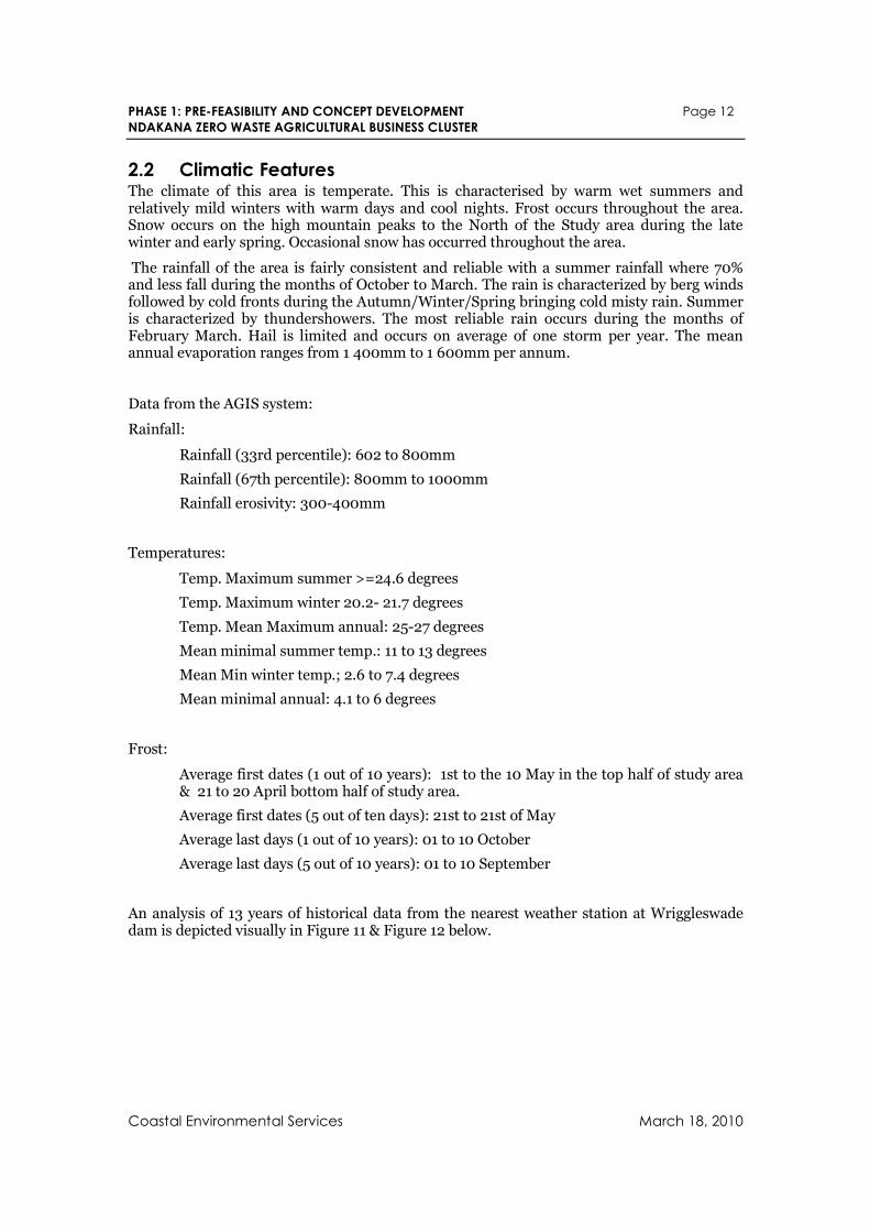
An analysis of 13 years of historical data from the nearest weather station at Wriggleswade dam is depicted visually in Figure 11 & Figure 12 below.
PHASE 1: PRE-FEASIBILITY AND CONCEPT DEVELOPMENT Page 13
NDAKANA ZERO WASTE AGRICULTURAL BUSINESS CLUSTER
Coastal Environmental Services March 18, 2010
Average Monthly Temperatures
0.0
5.0
10.0
15.0
20.0
25.0
30.0
Jan Feb Mar Apr May Jun Jul Aug Sep Oct Nov Dec
Tem
pera
ture
(C
elc
ius)
TEMPMax TEMPMin
Figure 11: Average monthly temperatures at Wriggleswade Dam
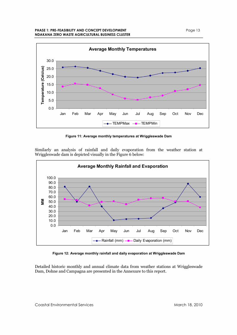
Similarly an analysis of rainfall and daily evaporation from the weather station at Wriggleswade dam is depicted visually in the Figure 6 below:
Average Monthly Rainfall and Evaporation
0.0
10.0
20.0
30.0
40.0
50.0
60.0
70.0
80.0
90.0
100.0
Jan Feb Mar Apr May Jun Jul Aug Sep Oct Nov Dec
MM
Rainfall (mm) Daily Evaporation (mm)
Figure 12: Average monthly rainfall and daily evaporation at Wriggleswade Dam
Detailed historic monthly and annual climate data from weather stations at Wriggleswade Dam, Dohne and Campagna are presented in the Annexure to this report.
PHASE 1: PRE-FEASIBILITY AND CONCEPT DEVELOPMENT Page 14
NDAKANA ZERO WASTE AGRICULTURAL BUSINESS CLUSTER
Coastal Environmental Services March 18, 2010
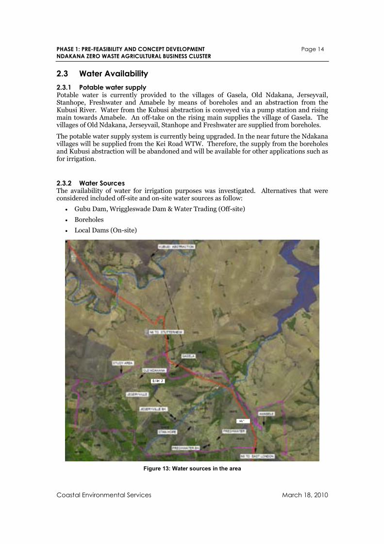
2.3 Water Availability
2.3.1 Potable water supply Potable water is currently provided to the villages of Gasela, Old Ndakana, Jerseyvail, Stanhope, Freshwater and Amabele by means of boreholes and an abstraction from the Kubusi River. Water from the Kubusi abstraction is conveyed via a pump station and rising main towards Amabele. An off-take on the rising main supplies the village of Gasela. The villages of Old Ndakana, Jerseyvail, Stanhope and Freshwater are supplied from boreholes.
The potable water supply system is currently being upgraded. In the near future the Ndakana villages will be supplied from the Kei Road WTW. Therefore, the supply from the boreholes and Kubusi abstraction will be abandoned and will be available for other applications such as for irrigation.
2.3.2 Water Sources The availability of water for irrigation purposes was investigated. Alternatives that were considered included off-site and on-site water sources as follow:
• Gubu Dam, Wriggleswade Dam & Water Trading (Off-site)
• Boreholes
• Local Dams (On-site)
•
Figure 13: Water sources in the area
PHASE 1: PRE-FEASIBILITY AND CONCEPT DEVELOPMENT Page 15
NDAKANA ZERO WASTE AGRICULTURAL BUSINESS CLUSTER
Coastal Environmental Services March 18, 2010
Supply from the Wriggleswade and Gubu dams for irrigation would be challenging and is therefore discarded as an option at this stage.
The trading of existing water abstraction rights along the Kubusi River should be investigated as a secondary supply mechanism in the event that the on-site sources would be insufficient to cater for the irrigation demand. The capacity of the Kubusi abstraction determined to be in the order of 1,000 kL/day and this can be fed into the large dam (Dam 2 in the Figure 13 above) located near the fertile lands between Nkululeko and Jerseyville.
The capacities and yields of the boreholes and local dams could not be verified, since these are not registered with DWA. It is however estimated that the Jerseyville, Freshwater and Frankfurt boreholes should be able to supply in combination in the order of 1,000 kL/day.
There are two fairly large dams within the study area. Dam No 1 is located adjacent to the N6 at Amabele, with an estimated storage capacity of 100,000 m3. Dam No 2 is located towards the north western part of the study area between Nkululeko (old Ndakana) and Jerseyville, which has an estimated storage capacity of 200,000 m3. Since these dams are not registered with DWA, the yields are not available and should be confirmed. From discussions with local and institutional representatives, it can be concluded that there should be considerable spare capacity available from these dams for irrigation purposes.
2.3.3 Irrigation potentials As rainfall is limited in winter a preliminary assessment was conducted with the aim of determining the water available for irrigation of household gardens arable plots and communal farm lands.
2.3.3.1 Existing water sources available for irrigation The existing on-site sources including the existing boreholes, dams and the Kubusi abstraction could form the primary source of water supply for irrigation, since they are no longer used to supply potable water to the household in the area. Since these water uses are not registered, very little information is available regarding the capacities and yields and these should be further investigated and confirmed in the feasibility study. With the information available, the maximum supply capacity from the existing water resources available in the area was determined as follows:
• Kubusi Abstraction 1000 kL/day.
• Existing Boreholes 1000kL/day
• Dam 1 (near Amabele) 375kL/day (winter abstraction)
• Dam 2 (South of Nkululeko) 700kL/day (winter abstraction)
It is likely that, as the old Kubusi abstraction is not registered and its use for irrigation will require water trading with other farms on the Kubusi. This should be feasible as a preliminary investigation shows that as farms on the Kubusi above Wriggleswade Dam are not fully utilising their water rights.
The existing borehole delivery capacities will need to be tested as there have been reports of boreholes supply reductions during the winter season.
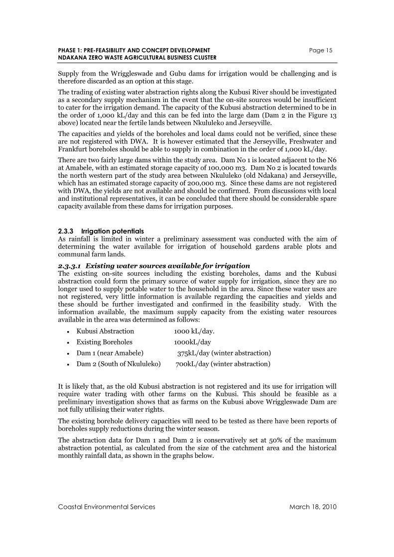
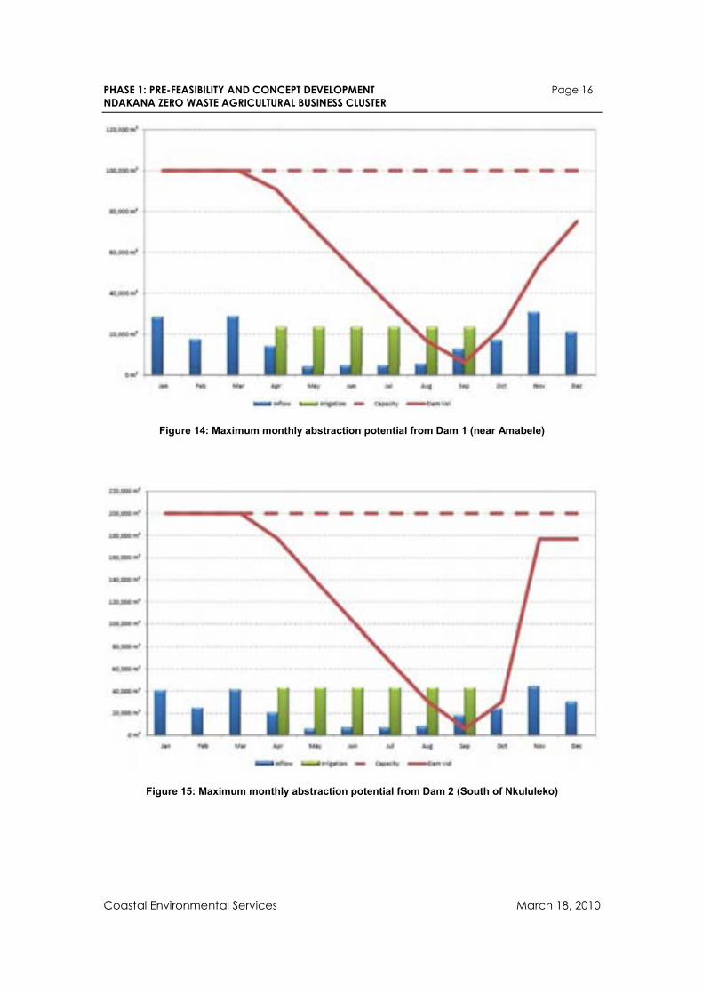
The abstraction data for Dam 1 and Dam 2 is conservatively set at 50% of the maximum abstraction potential, as calculated from the size of the catchment area and the historical monthly rainfall data, as shown in the graphs below.
PHASE 1: PRE-FEASIBILITY AND CONCEPT DEVELOPMENT Page 16
NDAKANA ZERO WASTE AGRICULTURAL BUSINESS CLUSTER
Coastal Environmental Services March 18, 2010
Figure 14: Maximum monthly abstraction potential from Dam 1 (near Amabele)
Figure 15: Maximum monthly abstraction potential from Dam 2 (South of Nkululeko)
PHASE 1: PRE-FEASIBILITY AND CONCEPT DEVELOPMENT Page 17
NDAKANA ZERO WASTE AGRICULTURAL BUSINESS CLUSTER
Coastal Environmental Services March 18, 2010
2.3.3.2 Potential future sources available for irrigation
Potential shortfalls in the capacities of the existing water sources for irrigation could be augment from new sources which include:
• Additional boreholes
• Small local dams (<50,000 m3) located next to point of use
• A large 120000kL dam in the valley between Jerseyville and Stanhope
• A large 200000kL dam in the valley North of Freshwater
Furthermore, a number of springs were identified during the soil sample survey, especially in the lands in the South West corner of the study area. These springs are presently being damaged by cattle and it would be best if they were protected from damage and used to feed drinking troughs for livestock and their surpluses fed to the potential large dams sites mentioned above.
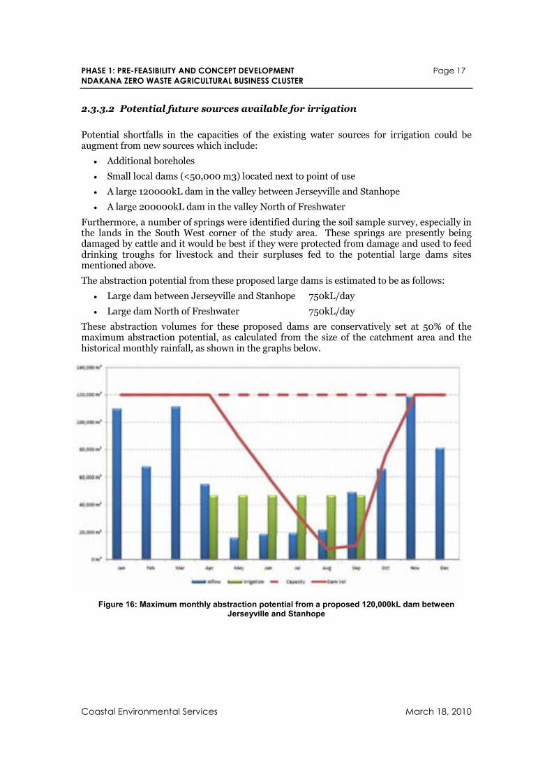
The abstraction potential from these proposed large dams is estimated to be as follows:
• Large dam between Jerseyville and Stanhope 750kL/day
• Large dam North of Freshwater 750kL/day
These abstraction volumes for these proposed dams are conservatively set at 50% of the maximum abstraction potential, as calculated from the size of the catchment area and the historical monthly rainfall, as shown in the graphs below.
Figure 16: Maximum monthly abstraction potential from a proposed 120,000kL dam between Jerseyville and Stanhope
PHASE 1: PRE-FEASIBILITY AND CONCEPT DEVELOPMENT Page 18
NDAKANA ZERO WASTE AGRICULTURAL BUSINESS CLUSTER
Coastal Environmental Services March 18, 2010
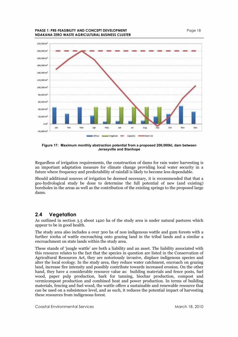
Figure 17: Maximum monthly abstraction potential from a proposed 200,000kL dam between Jerseyville and Stanhope
Regardless of irrigation requirements, the construction of dams for rain water harvesting is an important adaptation measure for climate change providing local water security in a future where frequency and predictability of rainfall is likely to become less dependable.
Should additional sources of irrigation be deemed necessary, it is recommended that that a geo-hydrological study be done to determine the full potential of new (and existing) boreholes in the areas as well as the contribution of the existing springs to the proposed large dams.
2.4 Vegetation As outlined in section 3.5 about 1420 ha of the study area is under natural pastures which appear to be in good health.
The study area also includes a over 300 ha of non indigenous wattle and gum forests with a further 100ha of wattle encroaching onto grazing land in the tribal lands and a similar a encroachment on state lands within the study area.
These stands of ‘jungle wattle’ are both a liability and an asset. The liability associated with this resource relates to the fact that the species in question are listed in the Conservation of Agricultural Resources Act, they are notoriously invasive, displace indigenous species and alter the local ecology. In the study area, they reduce water catchment, encroach on grazing land, increase fire intensity and possibly contribute towards increased erosion. On the other hand, they have a considerable resource value as: building materials and fence posts, fuel wood, paper pulp production, bark for tanning, biochar production, compost and vermicompost production and combined heat and power production. In terms of building materials, fencing and fuel wood, the wattle offers a sustainable and renewable resource that can be used on a subsistence level, and as such, it reduces the potential impact of harvesting these resources from indigenous forest.
PHASE 1: PRE-FEASIBILITY AND CONCEPT DEVELOPMENT Page 19
NDAKANA ZERO WASTE AGRICULTURAL BUSINESS CLUSTER
Coastal Environmental Services March 18, 2010
3. Land Tenure & Use
3.1 Types of Land Tenure Ward 9 encompasses parts of the former Ciskei homelands with informal forms of tenure, and between them, the former Border Corridor dominated by white commercial farms interspersed with small black settlements associated with old Mission stations such as Frankfort (under informal forms of tenure). The two main types of tenure found in the area are:
3.1.1 Private Tenure areas There are a number of farms which are private land used mostly for commercial farming, but also for residential and business purposes. Most of the existing privately owned are farms that were previously under the RSA government and not under Ciskei in the past era. A number of white farmers have left the area with some of them still owning these farms but leasing them to other people (Pers. Comm. Mr. Liwani, comm. Leader). Most of those private farms that were under the Ciskei government were given to ULIMOCO and emerging farmers.
3.1.2 Communal Land Tenure There are large areas of the Ward 9 that used to form part of the former Ciskei area and consequently are dominated by informal forms of land tenure. The most common form of land tenure in these areas is the communal land tenure system. According to custom, under this system the land belongs to the people (as a group) and has historically been held in trust by the Chief/Headman for them. In this case Chief Sandile of Amazibula Tribe is the custodian of the land which he inherited from his mother (Chieftainess Nolizwe Sandile)
The head of each household in the community has a right to an individual residential and arable site as well as access to communal grazing lands and other natural resources. When young people grow up and marry they can apply to the chief/Amazibula Tribal Authority for their own individual sites. Usually this process entailed identifying a piece of land, consulting with the neighbours and getting their approval, and then applying to the headman for permission. There may also be some kind of tribute or payment that is expected from the applicant. However, this customary tenure system was changed and reshaped over time by the State authorities and changing social conditions. During the colonial period the state attempted to control and adapt this system to enforce taxation regulations and control rural residents.
Betterment planning interventions during the apartheid era also attempted to control the size and location of residential and arable sites (and in the process reduced their size) and regulate and manage (according to a flawed rotational grazing model and a tax on each head of cattle) the use of communal grazing lands. This planning process reorganised the settlement pattern from scattered to more concentrated grid-type settlements, and consolidated blocks of arable land onto flat and gentle slopes.
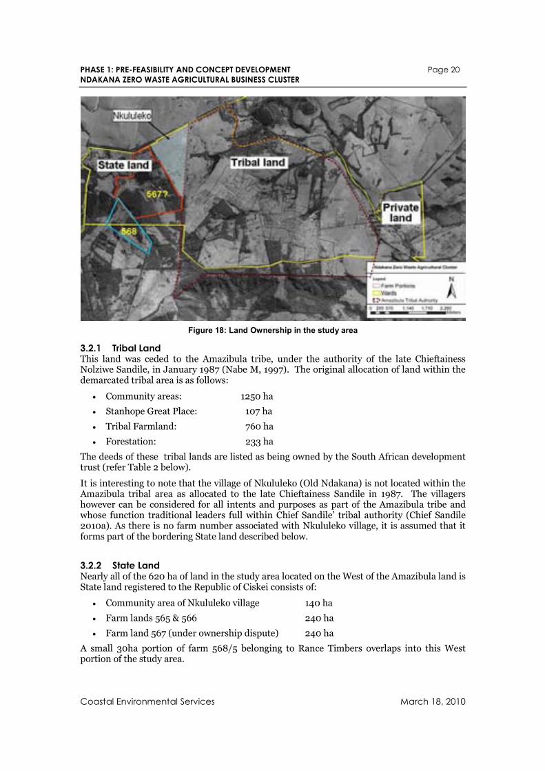
3.2 Land Ownership As indicated in Figure 18 below most of the land in the study belongs to the Amazibula tribe. The land to the west of the study area is state land apart from a small portion of land (farm 568) which belongs to Rance Timbers. The land to the East of the study area is considered to be private land. Farm no 567 is highlighted as it is listed as owned by the State but its ownership is in dispute as outlined in section 3.2.2 and 3.4 below.
PHASE 1: PRE-FEASIBILITY AND CONCEPT DEVELOPMENT Page 20
NDAKANA ZERO WASTE AGRICULTURAL BUSINESS CLUSTER
Coastal Environmental Services March 18, 2010
Figure 18: Land Ownership in the study area
3.2.1 Tribal Land This land was ceded to the Amazibula tribe, under the authority of the late Chieftainess Nolziwe Sandile, in January 1987 (Nabe M, 1997). The original allocation of land within the demarcated tribal area is as follows:
• Community areas: 1250 ha
• Stanhope Great Place: 107 ha
• Tribal Farmland: 760 ha
• Forestation: 233 ha
The deeds of these tribal lands are listed as being owned by the South African development trust (refer Table 2 below).
It is interesting to note that the village of Nkululeko (Old Ndakana) is not located within the Amazibula tribal area as allocated to the late Chieftainess Sandile in 1987. The villagers however can be considered for all intents and purposes as part of the Amazibula tribe and whose function traditional leaders full within Chief Sandile’ tribal authority (Chief Sandile 2010a). As there is no farm number associated with Nkululeko village, it is assumed that it forms part of the bordering State land described below.
3.2.2 State Land Nearly all of the 620 ha of land in the study area located on the West of the Amazibula land is State land registered to the Republic of Ciskei consists of:
• Community area of Nkululeko village 140 ha
• Farm lands 565 & 566 240 ha
• Farm land 567 (under ownership dispute) 240 ha
A small 30ha portion of farm 568/5 belonging to Rance Timbers overlaps into this West portion of the study area.
PHASE 1: PRE-FEASIBILITY AND CONCEPT DEVELOPMENT Page 21
NDAKANA ZERO WASTE AGRICULTURAL BUSINESS CLUSTER
Coastal Environmental Services March 18, 2010
The farms 567/1 and 567/2, which border Nkululeko is under ownership dispute. Its status is explored further in section 3.4 below.
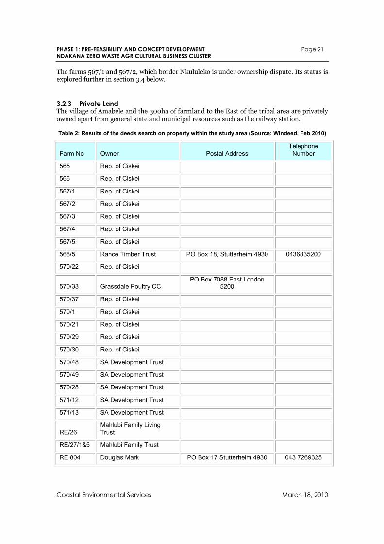
3.2.3 Private Land The village of Amabele and the 300ha of farmland to the East of the tribal area are privately owned apart from general state and municipal resources such as the railway station.
Table 2: Results of the deeds search on property within the study area (Source: Windeed, Feb 2010)
Farm No Owner Postal Address Telephone Number
565 Rep. of Ciskei
566 Rep. of Ciskei
567/1 Rep. of Ciskei
567/2 Rep. of Ciskei
567/3 Rep. of Ciskei
567/4 Rep. of Ciskei
567/5 Rep. of Ciskei
568/5 Rance Timber Trust PO Box 18, Stutterheim 4930 0436835200
570/22 Rep. of Ciskei
570/33 Grassdale Poultry CC PO Box 7088 East London
5200
570/37 Rep. of Ciskei
570/1 Rep. of Ciskei
570/21 Rep. of Ciskei
570/29 Rep. of Ciskei
570/30 Rep. of Ciskei
570/48 SA Development Trust
570/49 SA Development Trust
570/28 SA Development Trust
571/12 SA Development Trust
571/13 SA Development Trust
RE/26 Mahlubi Family Living Trust
RE/27/1&5 Mahlubi Family Trust
RE 804 Douglas Mark PO Box 17 Stutterheim 4930 043 7269325
PHASE 1: PRE-FEASIBILITY AND CONCEPT DEVELOPMENT Page 22
NDAKANA ZERO WASTE AGRICULTURAL BUSINESS CLUSTER
Coastal Environmental Services March 18, 2010
3.3 Tenure Reform in Communal Areas According to the government’s White Paper on South African land policy (1997), their ultimate intention in the communal areas is to transfer ownership of State land back to the occupiers. Unfortunately, the process of developing acceptable legislation and regulations to effect this change has taken a considerable amount of time and involved some heated debates. Consequently, the Communal Land Rights Act (No 11 of 2004) was only accepted and enacted in 2004 and has yet to be implemented. The regulations needed to implement the legislation are still in the process of being developed. According to reports from DLA staff in the Eastern Cape, it also seems that this legislation may not be implemented in the Eastern Cape for some time, largely due to capacity constraints in the DLA. When this legislation is implemented in the Eastern Cape, it will supposedly increase the tenure security of rural residents and give them an opportunity to take control of their own land administration and making their own decisions about land use. This may enable a much more flexible approach to land use and management that could facilitate development.
However, until such time as this Communal Land Rights Act can be implemented in the Eastern Cape, the State has taken measures to improve the security of tenure of those living under informal land rights systems such as the communal tenure systems (through the “Interim Protection of Informal Land Rights Act” – No 31 of 1996). These measures are aimed at preventing any development from removing or alienating any informal land rights holders from their land. At the same time however, empowerment and economic development that benefits the historically disadvantaged is a major political priority for the government. However, Government wants to ensure that the kind of development that occurs is more people friendly and provides more benefits and less social costs. There is also a strong push to ensure that the security and bargaining power of disadvantaged communities is protected and strengthened. To ensure therefore, that economic development in the former African reserves is not held back by the slow pace of land reform and the measures implemented to protect the rights of informal land rights holders, some ‘Interim Procedures’ will be used by the DLA to facilitate new land use developments in these areas.
According to these ‘Interim Procedures’ no land use development change can take place without the support of the community and the Minister of Land Affairs. This would require that a community resolution supporting the change is made and certified by a DLA official that the process of reaching that decision was democratic and transparent. If the development did not require any change in the land tenure system then this ‘community resolution’ is all that would be needed from DLA to proceed with the development. If however, the development does involve a change in the land tenure system (such as a lease on communal land) and/or an application for DLA’s Settlement and Land Acquisition Grants (SLAG), then such an agreement would have to be approved by the Minister of Land Affairs in addition to the community. In such a case, a back-to-back agreement (i.e. lease agreement) signed by both the community representatives and the Minister, would be required. Such lease agreements would be regulated under the State Land Disposal Act.
To secure such an agreement there would be a need to survey and value the land, determine a market based rental and set up a land holding entity such as a Trust or Communal Property Association (CPA). Depending on the nature of the land use change, there may also be permits etc that have to be secured from the relevant authorities (i.e. DWAF or Environmental Affairs). If this also involves a joint business venture between the land occupiers and the developers, then there would be an additional need to set up a company, Cooperative, Trust or Section 21 company to manage the project and determine how the benefits and responsibilities would be shared.
This is more so for Ndakana as most of the areas identified for agricultural projects fall within communal land and therefore some kind of a company or community trust will have to be setup to manage the projects. The agreement should clearly outline roles and responsibilities of the different parties and need a buy-in from the majority of the community
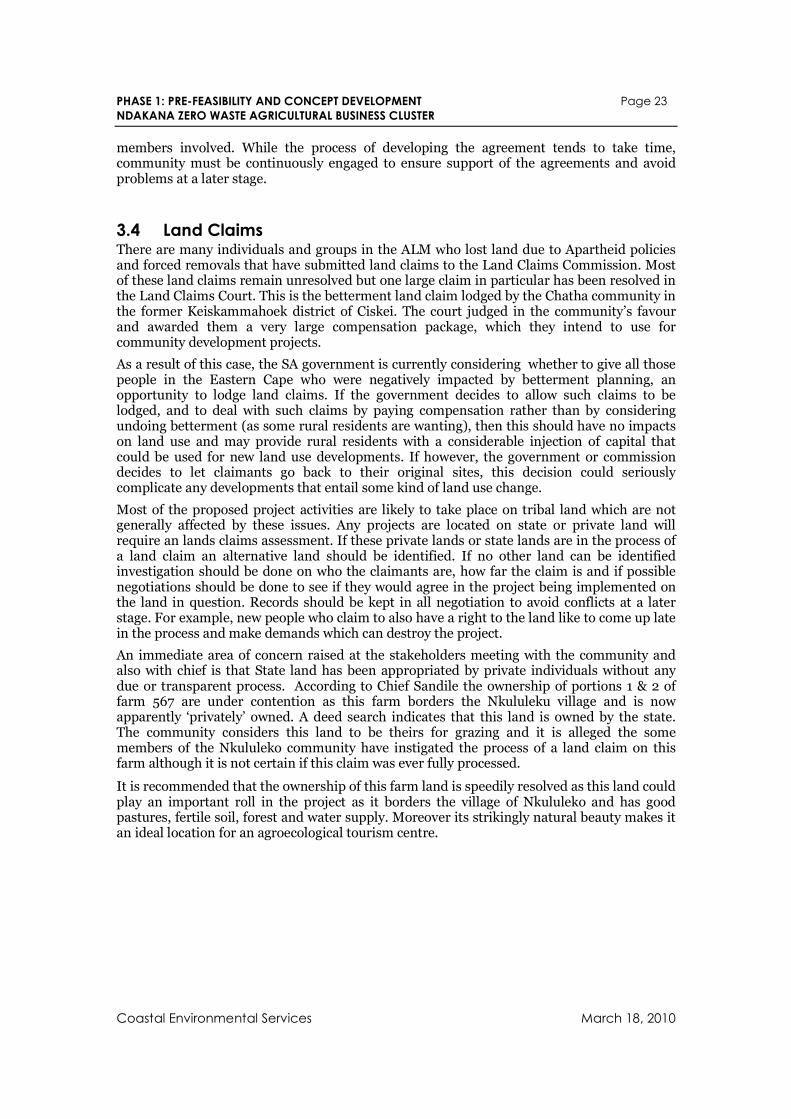
PHASE 1: PRE-FEASIBILITY AND CONCEPT DEVELOPMENT Page 23
NDAKANA ZERO WASTE AGRICULTURAL BUSINESS CLUSTER
Coastal Environmental Services March 18, 2010
members involved. While the process of developing the agreement tends to take time, community must be continuously engaged to ensure support of the agreements and avoid problems at a later stage.
3.4 Land Claims There are many individuals and groups in the ALM who lost land due to Apartheid policies and forced removals that have submitted land claims to the Land Claims Commission. Most of these land claims remain unresolved but one large claim in particular has been resolved in the Land Claims Court. This is the betterment land claim lodged by the Chatha community in the former Keiskammahoek district of Ciskei. The court judged in the community’s favour and awarded them a very large compensation package, which they intend to use for community development projects.
As a result of this case, the SA government is currently considering whether to give all those people in the Eastern Cape who were negatively impacted by betterment planning, an opportunity to lodge land claims. If the government decides to allow such claims to be lodged, and to deal with such claims by paying compensation rather than by considering undoing betterment (as some rural residents are wanting), then this should have no impacts on land use and may provide rural residents with a considerable injection of capital that could be used for new land use developments. If however, the government or commission decides to let claimants go back to their original sites, this decision could seriously complicate any developments that entail some kind of land use change.
Most of the proposed project activities are likely to take place on tribal land which are not generally affected by these issues. Any projects are located on state or private land will require an lands claims assessment. If these private lands or state lands are in the process of a land claim an alternative land should be identified. If no other land can be identified investigation should be done on who the claimants are, how far the claim is and if possible negotiations should be done to see if they would agree in the project being implemented on the land in question. Records should be kept in all negotiation to avoid conflicts at a later stage. For example, new people who claim to also have a right to the land like to come up late in the process and make demands which can destroy the project.
An immediate area of concern raised at the stakeholders meeting with the community and also with chief is that State land has been appropriated by private individuals without any due or transparent process. According to Chief Sandile the ownership of portions 1 & 2 of farm 567 are under contention as this farm borders the Nkululeku village and is now apparently ‘privately’ owned. A deed search indicates that this land is owned by the state. The community considers this land to be theirs for grazing and it is alleged the some members of the Nkululeko community have instigated the process of a land claim on this farm although it is not certain if this claim was ever fully processed.
It is recommended that the ownership of this farm land is speedily resolved as this land could play an important roll in the project as it borders the village of Nkululeko and has good pastures, fertile soil, forest and water supply. Moreover its strikingly natural beauty makes it an ideal location for an agroecological tourism centre.
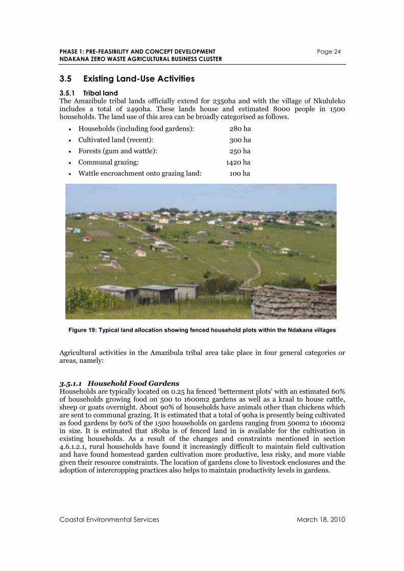
PHASE 1: PRE-FEASIBILITY AND CONCEPT DEVELOPMENT Page 24
NDAKANA ZERO WASTE AGRICULTURAL BUSINESS CLUSTER
Coastal Environmental Services March 18, 2010
3.5 Existing Land-Use Activities
3.5.1 Tribal land The Amazibule tribal lands officially extend for 2350ha and with the village of Nkululeko includes a total of 2490ha. These lands house and estimated 8000 people in 1500 households. The land use of this area can be broadly categorised as follows.
• Households (including food gardens): 280 ha
• Cultivated land (recent): 300 ha
• Forests (gum and wattle): 250 ha
• Communal grazing: 1420 ha
• Wattle encroachment onto grazing land: 100 ha
Figure 19: Typical land allocation showing fenced household plots within the Ndakana villages
Agricultural activities in the Amazibula tribal area take place in four general categories or areas, namely:
3.5.1.1 Household Food Gardens Households are typically located on 0.25 ha fenced ‘betterment plots’ with an estimated 60% of households growing food on 500 to 1600m2 gardens as well as a kraal to house cattle, sheep or goats overnight. About 90% of households have animals other than chickens which are sent to communal grazing. It is estimated that a total of 90ha is presently being cultivated as food gardens by 60% of the 1500 households on gardens ranging from 500m2 to 1600m2 in size. It is estimated that 180ha is of fenced land in is available for the cultivation in existing households. As a result of the changes and constraints mentioned in section 4.6.1.2.1, rural households have found it increasingly difficult to maintain field cultivation and have found homestead garden cultivation more productive, less risky, and more viable given their resource constraints. The location of gardens close to livestock enclosures and the adoption of intercropping practices also helps to maintain productivity levels in gardens.
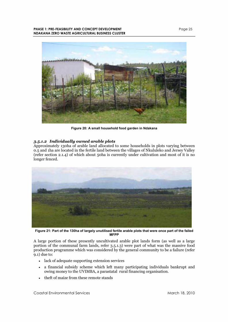
PHASE 1: PRE-FEASIBILITY AND CONCEPT DEVELOPMENT Page 25
NDAKANA ZERO WASTE AGRICULTURAL BUSINESS CLUSTER
Coastal Environmental Services March 18, 2010
Figure 20: A small household food garden in Ndakana
3.5.1.2 Individually owned arable plots Approximately 130ha of arable land allocated to some households in plots varying between 0.5 and 1ha are located in the fertile land between the villages of Nkululeko and Jersey Valley (refer section 2.1.4) of which about 50ha is currently under cultivation and most of it is no longer fenced.
Figure 21: Part of the 130ha of largely unutilised fertile arable plots that were once part of the failed MFPP
A large portion of these presently uncultivated arable plot lands form (as well as a large portion of the communal farm lands, refer 3.5.1.3) were part of what was the massive food production programme which was considered by the general community to be a failure (refer 9.1) due to:
• lack of adequate supporting extension services
• a financial subsidy scheme which left many participating individuals bankrupt and owing money to the UVIMBA, a parastatal rural financing organisation.
• theft of maize from these remote stands
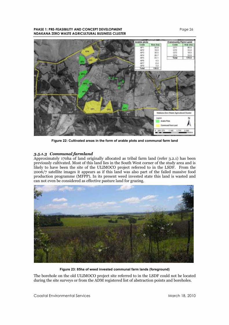
PHASE 1: PRE-FEASIBILITY AND CONCEPT DEVELOPMENT Page 26
NDAKANA ZERO WASTE AGRICULTURAL BUSINESS CLUSTER
Coastal Environmental Services March 18, 2010
Figure 22: Cultivated areas in the form of arable plots and communal farm land
3.5.1.3 Communal farmland Approximately 170ha of land originally allocated as tribal farm land (refer 3.2.1) has been previously cultivated. Most of this land lies in the South West corner of the study area and is likely to have been the site of the ULIMOCO project referred to in the LSDF. From the 2006/7 satellite images it appears as if this land was also part of the failed massive food production programme (MFPP). In its present weed invested state this land is wasted and can not even be considered as effective pasture land for grazing.
Figure 23: 85ha of weed invested communal farm lands (foreground)
The borehole on the old ULIMOCO project site referred to in the LSDF could not be located during the site surveys or from the ADM registered list of abstraction points and boreholes.
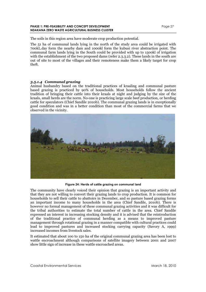
PHASE 1: PRE-FEASIBILITY AND CONCEPT DEVELOPMENT Page 27
NDAKANA ZERO WASTE AGRICULTURAL BUSINESS CLUSTER
Coastal Environmental Services March 18, 2010
The soils in this region area have moderate crop production potential.
The 51 ha of communal lands lying in the north of the study area could be irrigated with 700kL.day form the nearby dam and 1000kl form the kubusi river abstraction point. The communal farm lands lying in the South could be provided with up to 1500kl of irrigation with the establishment of the two proposed dams (refer 2.3.3.2). These lands in the south are out of site to most of the villages and their remoteness make them a likely target for crop theft.
3.5.1.4 Communal grazing Animal husbandry based on the traditional practices of kraaling and communal pasture based grazing is practiced by 90% of households. Most households follow the ancient tradition of bringing their cattle into their kraals at night and judging by the size of the kraals, small herds are the norm. No-one is practicing large scale beef production, or herding cattle for speculators (Chief Sandile 2010b). The communal grazing lands is in exceptionally good condition and was in a better condition than most of the commercial farms that we observed in the vicinity.
Figure 24: Herds of cattle grazing on communal land
The community have clearly voiced their opinion that grazing is an important activity and that they are not willing to convert their grazing lands to crop production. It is common for households to sell their cattle to abattoirs in December, and so pasture based grazing forms an important income to many households in the area (Chief Sandile, 2010b). There is however no formal management of these communal grazing activities and it was difficult for the tribal authorities to estimate the total number of cattle in the area. Chief Sandile expressed an interest in increasing stocking density and it is advised that the reintroduction of the traditional practice of communal herding as a means to improved pasture management through rotational grazing in a manner compatible with cultural practices could lead to improved pastures and increased stocking carrying capacity (Savory A, 1999) increased incomes from livestock sales.
It estimated that about 100 to 150 ha of the original communal grazing area has been lost to wattle encroachment although comparisons of satellite imagery between 2001 and 2007 show little sign of increase in these wattle encroached areas.
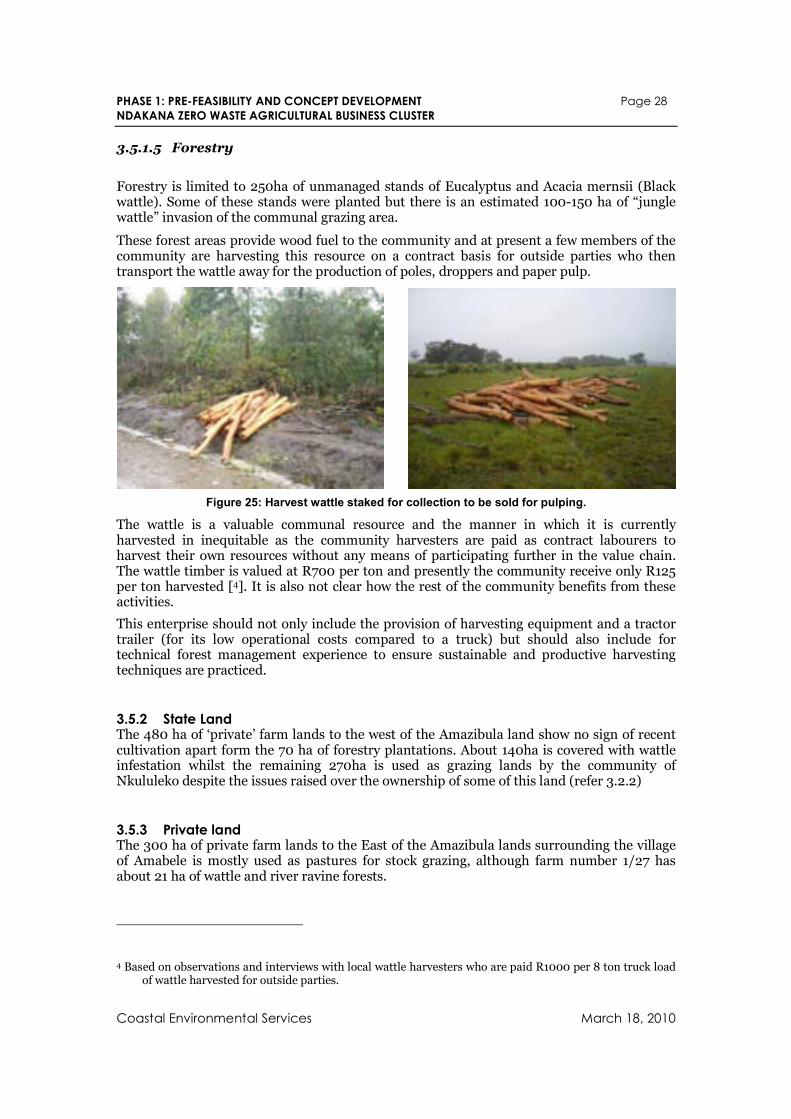
PHASE 1: PRE-FEASIBILITY AND CONCEPT DEVELOPMENT Page 28
NDAKANA ZERO WASTE AGRICULTURAL BUSINESS CLUSTER
Coastal Environmental Services March 18, 2010
3.5.1.5 Forestry
Forestry is limited to 250ha of unmanaged stands of Eucalyptus and Acacia mernsii (Black wattle). Some of these stands were planted but there is an estimated 100-150 ha of “jungle wattle” invasion of the communal grazing area.
These forest areas provide wood fuel to the community and at present a few members of the community are harvesting this resource on a contract basis for outside parties who then transport the wattle away for the production of poles, droppers and paper pulp.
Figure 25: Harvest wattle staked for collection to be sold for pulping.
The wattle is a valuable communal resource and the manner in which it is currently harvested in inequitable as the community harvesters are paid as contract labourers to harvest their own resources without any means of participating further in the value chain. The wattle timber is valued at R700 per ton and presently the community receive only R125 per ton harvested [4]. It is also not clear how the rest of the community benefits from these activities.
This enterprise should not only include the provision of harvesting equipment and a tractor trailer (for its low operational costs compared to a truck) but should also include for technical forest management experience to ensure sustainable and productive harvesting techniques are practiced.
3.5.2 State Land The 480 ha of ‘private’ farm lands to the west of the Amazibula land show no sign of recent cultivation apart form the 70 ha of forestry plantations. About 140ha is covered with wattle infestation whilst the remaining 270ha is used as grazing lands by the community of Nkululeko despite the issues raised over the ownership of some of this land (refer 3.2.2)
3.5.3 Private land The 300 ha of private farm lands to the East of the Amazibula lands surrounding the village of Amabele is mostly used as pastures for stock grazing, although farm number 1/27 has about 21 ha of wattle and river ravine forests.
4 Based on observations and interviews with local wattle harvesters who are paid R1000 per 8 ton truck load of wattle harvested for outside parties.
PHASE 1: PRE-FEASIBILITY AND CONCEPT DEVELOPMENT Page 29
NDAKANA ZERO WASTE AGRICULTURAL BUSINESS CLUSTER
Coastal Environmental Services March 18, 2010
4. Socio-Economic Assessment The bulk of the socio-economic data discussed below is derived from the 2001 Census data and supplemented by 1996 data to examine population growth. Livelihoods data derived from research in rural areas and IDP documents.
4.1 Background Population Size and Spatial Distribution
There were almost 7757 persons living in 1981 households in Ward 9 in 2001. Almost 99% of this population was categorised as ‘Black African’. As it is in the whole LM the numbers of other race groups tends to be small and concentrated in particular areas. Table 3 gives the number of people per ethnic group in Ward 9. This population distribution remains very similar to that inherited from the Apartheid era, except for the growth in urbanization which has occurred since the lifting of apartheid racial restrictions on the movement of the population.
Table 3: Number of people per ethnic group in Ward 9
Black African 7978
Coloured 12
Indian or Asian 0
White 282
4.2 Population Structure The gender composition of the population is very typical of rural and small town areas where significant numbers of men migrate to larger urban areas to find work. Consequently, there tends to be more women (52.9%) than men (47.1%) within the ward (Table 4). There do not appear to be any significant spatial variations in the gender composition of the population in the whole municipality (range is from 51.6-54.1% of females).
Table 4: Population structure
Ward Total No. % Male % Female
Ward 9 7757 47.1 52.9
Total Pop 139057 47.3 52.7
The population age structure of the population in ward 9 follows the typical trend for developing areas, in that the population is generally very young with 59% being under the age of twenty. However, the lower numbers of young children in other areas might indicate a high infant and child mortality rate probably related to poverty, poor nutrition, poor water
PHASE 1: PRE-FEASIBILITY AND CONCEPT DEVELOPMENT Page 30
NDAKANA ZERO WASTE AGRICULTURAL BUSINESS CLUSTER
Coastal Environmental Services March 18, 2010
and sanitation conditions and the prevalence of HIV/AIDS. The numbers for age groups 25-39 might be reduced as most young people leave these areas to search for employment in cities.
4.3 Population Movement A comparison of the 2001 census data for the ALM with the estimated population for 1996 indicates that the population has declined by about 10% (from 154 388 in 1996 to 139 059 in 2001). Much of this loss is likely to be due to urbanisation – people moving to larger urban centres outside the ALM, although some may be accounted for through higher mortality rates, or data errors.
The census 2001 data indicates that within the ALM 10 233 residents (7.43%) had moved to their current place of residence during the previous 5 years (Table 5 below). However, it is also clear from the far right hand column in this table that some areas (particularly peri-urban areas) have received more in-migrants than others. Ward 9 is one of these areas, along with Ward 6 adjacent to Keiskammahoek. However, it is not possible to find out from the census data where specifically these people came from. Many of them could have moved within the boundaries of the local municipality (i.e. from neighbouring farms) or the Eastern Cape Province. According to Chief Sandile most of the people living under tribal land in ward 9 come from Keiskammahoek (pers. Comm.) Table 5 also indicates that the number of people who live within the ALM but had moved place of residence in the five years prior to the 2001 census was steadily increasing. It is important to note however, that these numbers remain very small in comparison to the overall population.
Table 5: Population movement
Ward 1996 1997 1998 1999 2000 2001 Tot Moved
Total Pop
% Moved
Ward 9 43 116 96 101 137 117 610 7756 7.9
Total 359 1300 1870 2121 2475 2108 10233 139058
% total 0.3 0.9 1.3 1.5 1.8 1.5 7.4 100.0
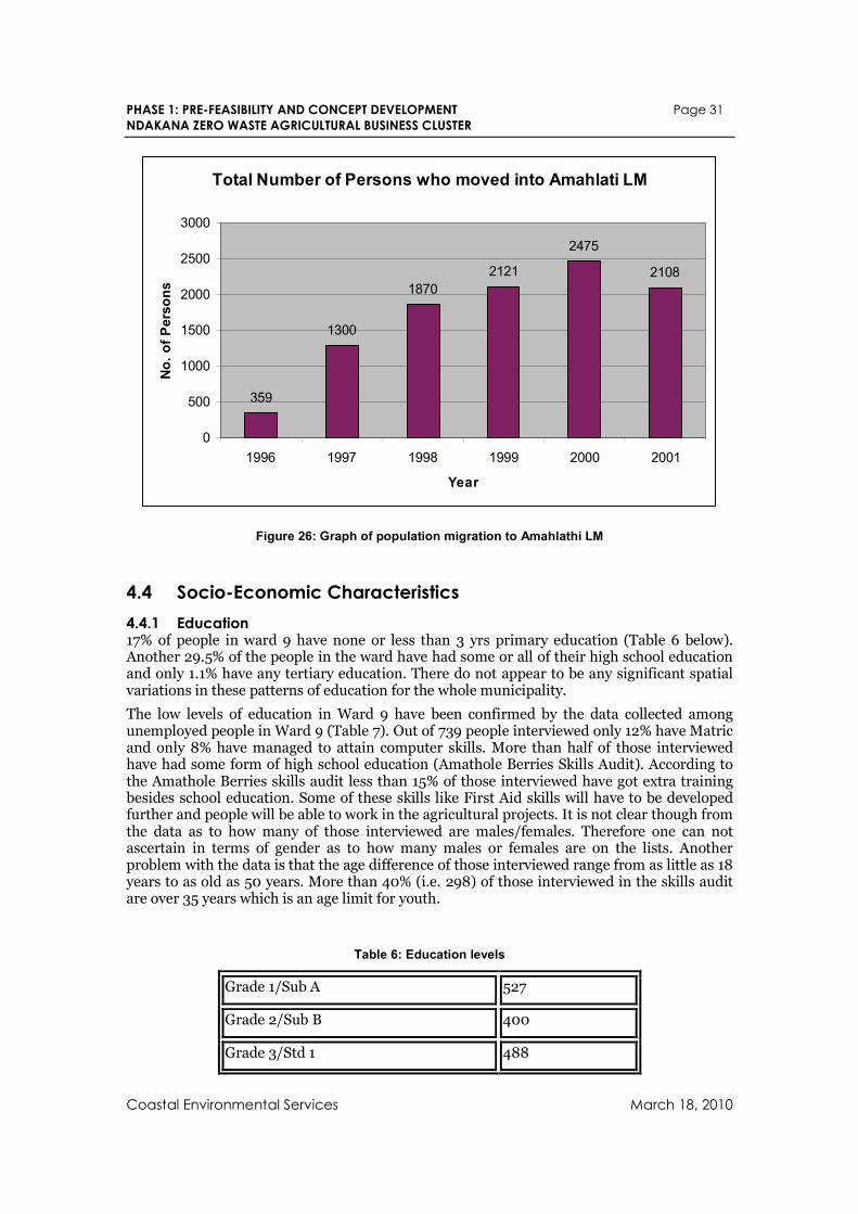
PHASE 1: PRE-FEASIBILITY AND CONCEPT DEVELOPMENT Page 31
NDAKANA ZERO WASTE AGRICULTURAL BUSINESS CLUSTER
Coastal Environmental Services March 18, 2010
Total Number of Persons who moved into Amahlati LM
359
1300
1870
2121
2475
2108
0
500
1000
1500
2000
2500
3000
1996 1997 1998 1999 2000 2001
Year
No. of P
ers
ons
Figure 26: Graph of population migration to Amahlathi LM
4.4 Socio-Economic Characteristics
4.4.1 Education 17% of people in ward 9 have none or less than 3 yrs primary education (Table 6 below). Another 29.5% of the people in the ward have had some or all of their high school education and only 1.1% have any tertiary education. There do not appear to be any significant spatial variations in these patterns of education for the whole municipality.
The low levels of education in Ward 9 have been confirmed by the data collected among unemployed people in Ward 9 (Table 7). Out of 739 people interviewed only 12% have Matric and only 8% have managed to attain computer skills. More than half of those interviewed have had some form of high school education (Amathole Berries Skills Audit). According to the Amathole Berries skills audit less than 15% of those interviewed have got extra training besides school education. Some of these skills like First Aid skills will have to be developed further and people will be able to work in the agricultural projects. It is not clear though from the data as to how many of those interviewed are males/females. Therefore one can not ascertain in terms of gender as to how many males or females are on the lists. Another problem with the data is that the age difference of those interviewed range from as little as 18 years to as old as 50 years. More than 40% (i.e. 298) of those interviewed in the skills audit are over 35 years which is an age limit for youth.
Table 6: Education levels
Grade 1/Sub A 527
Grade 2/Sub B 400
Grade 3/Std 1 488
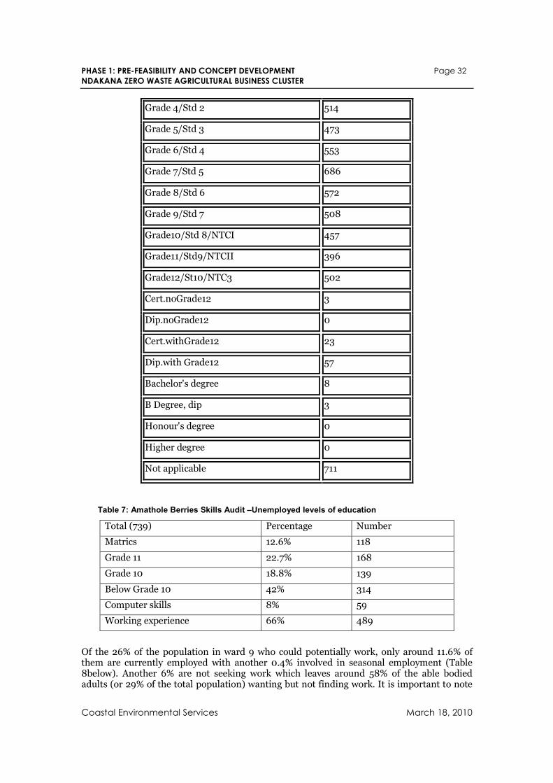
PHASE 1: PRE-FEASIBILITY AND CONCEPT DEVELOPMENT Page 32
NDAKANA ZERO WASTE AGRICULTURAL BUSINESS CLUSTER
Coastal Environmental Services March 18, 2010
Grade 4/Std 2 514
Grade 5/Std 3 473
Grade 6/Std 4 553
Grade 7/Std 5 686
Grade 8/Std 6 572
Grade 9/Std 7 508
Grade10/Std 8/NTCI 457
Grade11/Std9/NTCII 396
Grade12/St10/NTC3 502
Cert.noGrade12 3
Dip.noGrade12 0
Cert.withGrade12 23
Dip.with Grade12 57
Bachelor's degree 8
B Degree, dip 3
Honour's degree 0
Higher degree 0
Not applicable 711
Table 7: Amathole Berries Skills Audit –Unemployed levels of education
Total (739) Percentage Number
Matrics 12.6% 118
Grade 11 22.7% 168
Grade 10 18.8% 139
Below Grade 10 42% 314
Computer skills 8% 59
Working experience 66% 489
Of the 26% of the population in ward 9 who could potentially work, only around 11.6% of them are currently employed with another 0.4% involved in seasonal employment (Table 8below). Another 6% are not seeking work which leaves around 58% of the able bodied adults (or 29% of the total population) wanting but not finding work. It is important to note
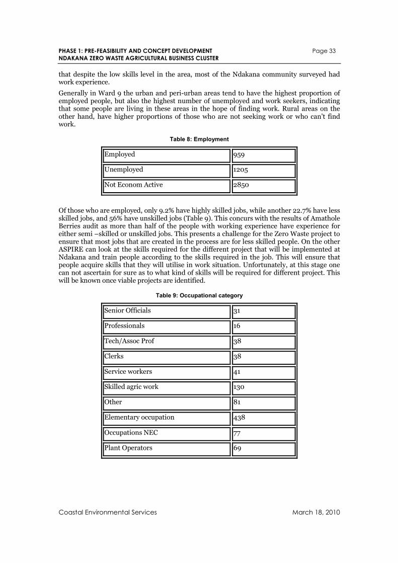
PHASE 1: PRE-FEASIBILITY AND CONCEPT DEVELOPMENT Page 33
NDAKANA ZERO WASTE AGRICULTURAL BUSINESS CLUSTER
Coastal Environmental Services March 18, 2010
that despite the low skills level in the area, most of the Ndakana community surveyed had work experience.
Generally in Ward 9 the urban and peri-urban areas tend to have the highest proportion of employed people, but also the highest number of unemployed and work seekers, indicating that some people are living in these areas in the hope of finding work. Rural areas on the other hand, have higher proportions of those who are not seeking work or who can’t find work.
Table 8: Employment
Employed 959
Unemployed 1205
Not Econom Active 2850
Of those who are employed, only 9.2% have highly skilled jobs, while another 22.7% have less skilled jobs, and 56% have unskilled jobs (Table 9). This concurs with the results of Amathole Berries audit as more than half of the people with working experience have experience for either semi –skilled or unskilled jobs. This presents a challenge for the Zero Waste project to ensure that most jobs that are created in the process are for less skilled people. On the other ASPIRE can look at the skills required for the different project that will be implemented at Ndakana and train people according to the skills required in the job. This will ensure that people acquire skills that they will utilise in work situation. Unfortunately, at this stage one can not ascertain for sure as to what kind of skills will be required for different project. This will be known once viable projects are identified.
Table 9: Occupational category
Senior Officials 31
Professionals 16
Tech/Assoc Prof 38
Clerks 38
Service workers 41
Skilled agric work 130
Other 81
Elementary occupation 438
Occupations NEC 77
Plant Operators 69
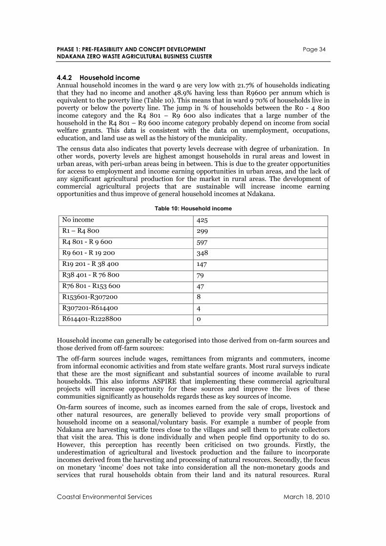
PHASE 1: PRE-FEASIBILITY AND CONCEPT DEVELOPMENT Page 34
NDAKANA ZERO WASTE AGRICULTURAL BUSINESS CLUSTER
Coastal Environmental Services March 18, 2010
4.4.2 Household income Annual household incomes in the ward 9 are very low with 21.7% of households indicating that they had no income and another 48.9% having less than R9600 per annum which is equivalent to the poverty line (Table 10). This means that in ward 9 70% of households live in poverty or below the poverty line. The jump in % of households between the R0 - 4 800 income category and the R4 801 – R9 600 also indicates that a large number of the household in the R4 801 – R9 600 income category probably depend on income from social welfare grants. This data is consistent with the data on unemployment, occupations, education, and land use as well as the history of the municipality.
The census data also indicates that poverty levels decrease with degree of urbanization. In other words, poverty levels are highest amongst households in rural areas and lowest in urban areas, with peri-urban areas being in between. This is due to the greater opportunities for access to employment and income earning opportunities in urban areas, and the lack of any significant agricultural production for the market in rural areas. The development of commercial agricultural projects that are sustainable will increase income earning opportunities and thus improve of general household incomes at Ndakana.
Table 10: Household income
No income 425
R1 – R4 800 299
R4 801 - R 9 600 597
R9 601 - R 19 200 348
R19 201 - R 38 400 147
R38 401 - R 76 800 79
R76 801 - R153 600 47
R153601-R307200 8
R307201-R614400 4
R614401-R1228800 0
Household income can generally be categorised into those derived from on-farm sources and those derived from off-farm sources:
The off-farm sources include wages, remittances from migrants and commuters, income from informal economic activities and from state welfare grants. Most rural surveys indicate that these are the most significant and substantial sources of income available to rural households. This also informs ASPIRE that implementing these commercial agricultural projects will increase opportunity for these sources and improve the lives of these communities significantly as households regards these as key sources of income.
On-farm sources of income, such as incomes earned from the sale of crops, livestock and other natural resources, are generally believed to provide very small proportions of household income on a seasonal/voluntary basis. For example a number of people from Ndakana are harvesting wattle trees close to the villages and sell them to private collectors that visit the area. This is done individually and when people find opportunity to do so. However, this perception has recently been criticised on two grounds. Firstly, the underestimation of agricultural and livestock production and the failure to incorporate incomes derived from the harvesting and processing of natural resources. Secondly, the focus on monetary ‘income’ does not take into consideration all the non-monetary goods and services that rural households obtain from their land and its natural resources. Rural
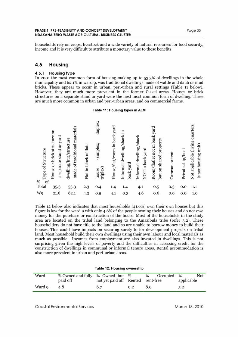
PHASE 1: PRE-FEASIBILITY AND CONCEPT DEVELOPMENT Page 35
NDAKANA ZERO WASTE AGRICULTURAL BUSINESS CLUSTER
Coastal Environmental Services March 18, 2010
households rely on crops, livestock and a wide variety of natural recourses for food security, income and it is very difficult to attribute a monetary value to these benefits.
4.5 Housing
4.5.1 Housing type In 2001 the most common form of housing making up to 53.3% of dwellings in the whole municipality and 62.1% in ward 9, was traditional dwellings made of wattle and daub or mud bricks. These appear to occur in urban, peri-urban and rural settings (Table 11 below). However, they are much more prevalent in the former Ciskei areas. Houses or brick structures on a separate stand or yard were the next most common form of dwelling. These are much more common in urban and peri-urban areas, and on commercial farms.
Table 11: Housing types in ALM
Type of Structure
House or brick structure on
a separate stand or yard
dwelling/hut/structure
made of traditional materials
Flat in block of flats
house
(simplex;
duplex;
triplex)
House/flat/room in back yard
Informal dwelling/shack in
back yard
Informal dwelling/shack
NOT in back yard
Room/flatlet not in back yard
but on shared property
Caravan or tent
Private ship/boat
Not applicable (living quarters
is not housing unit)
% of Total 35.3 53.3 2.3 0.4 1.4 1.4 4.1 0.5 0.3 0.0 1.1
W9 21.6 62.1 4.3 0.5 4.1 0.3 4.6 0.6 0.9 0.0 1.0
Table 12 below also indicates that most households (41.6%) own their own houses but this figure is low for the ward 9 with only 4.6% of the people owning their houses and do not owe money for the purchase or construction of the house. Most of the households in the study area are located on the tribal land belonging to the Amazibula tribe (refer 3.2). These householders do not have title to the land and so are unable to borrow money to build their houses. This could have impacts on securing surety to for development projects on tribal land. Most household build their own dwellings using their own labour and local materials as much as possible. Incomes from employment are also invested in dwellings. This is not surprising given the high levels of poverty and the difficulties in accessing credit for the construction of dwellings in communal or informal tenure areas. Rental accommodation is also more prevalent in urban and peri-urban areas.
Table 12: Housing ownership
Ward % Owned and fully paid off
% Owned but not yet paid off
% Rented
% Occupied rent-free
% Not applicable
Ward 9 4.8 6.7 0.2 8.0 5.2
PHASE 1: PRE-FEASIBILITY AND CONCEPT DEVELOPMENT Page 36
NDAKANA ZERO WASTE AGRICULTURAL BUSINESS CLUSTER
Coastal Environmental Services March 18, 2010
Ward % Owned and fully paid off
% Owned but not yet paid off
% Rented
% Occupied rent-free
% Not applicable
Total No. 14496 2312 3968 13724 388
% of Total 41.6 6.6 11.4 39.3 1.1
4.6 Rural Livelihoods There are two different kinds of rural areas in the ward. The first are the more densely settled rural areas that, prior to 1994, were part of the former Ciskei, where various forms of informal tenure dominate. The second, which affects less people, is the commercial farming areas, where most farms are owned by white farmers who employ farm workers to engage in commercial farming activities. The livelihoods practiced in these sectors are discussed below.
4.6.1 Agricultural livelihoods
4.6.1.1 Commercial farming sector This kind of land use and its associated livelihoods are prevalent in Wards 14, 15, and parts of 12 and 16. In these areas, there is a mixture of livestock farming and game farming. Game farming has been growing significantly in the last 20 years with farmers earning incomes from hunting, tourism and the sale of wildlife. In ward 9 there are a number of farms that fall under the land that was previously Ciskei and most of the owners of these farms left when ULIMOCO was initiated. Currently some these farms are not utilized due to a failure of ULIMOCO but some of them are given to emerging farmers. Community members have a serious problem with the way some of these farms were acquired. An example of this is the conflict between the apparent private owner of farm 567 and the Nkululeko community who believes they have a right to utilize the farm. One community leader mentioned that the problem is that communities are not informed of the process land acquisition while they are neighbouring these farms (Pers. Comm).
4.6.1.2 Traditional farming sector
4.6.1.2.1 Arable plots According to the traditions of land use and land administration practice, each rural household is entitled to a residential site and an arable field on which they can grow food crops. The residential sites are commonly used for dwellings, livestock enclosures and food gardens. The food gardens next to households are usually fenced and planted with maize intercropped with other vegetables such as beans, pumpkins, cabbage, sweet potatoes, potatoes, spinach, tomatoes, onions and other kinds of melons. The size of these residential sites and gardens vary depending on the history of the settlement. In areas that have undergone “betterment” planning the size of these residential plots would be around 0.25 ha, with the gardens taking up around two thirds of this space (0.16ha). In more traditional non-betterment areas the size of these gardens is likely to be larger.
In addition to these residential sites, some rural households have inheritable use rights over arable fields located some distance from the dwellings. These are traditionally located on the alluvial soils along the river banks and on the adjacent slopes. However, due to population growth and land administration policies (including betterment planning), the area of land cultivated by each household has decreased since the 1930s and some households have no access to arable fields. In Ndakana these remote arable plots are restricted mostly to the fertile arable land between the village of Nkululeko and Jersey Valley. Most of the arable land further from communities is currently not utilised and even the Massive Maize project initiated by the Department of Agriculture has collapsed.
The extent to which rural households cultivate these fields seems to vary from place to place, but there appears to be many settlements in the ward where the cultivation of arable fields has been widely abandoned. However, Andrew’s (1992, 2004) research provides some
PHASE 1: PRE-FEASIBILITY AND CONCEPT DEVELOPMENT Page 37
NDAKANA ZERO WASTE AGRICULTURAL BUSINESS CLUSTER
Coastal Environmental Services March 18, 2010
insights into historical changes in land use practices and indicates that there has been a considerable reduction in the area of arable land being cultivated since the 1940s due to a number of key factors. These include: population growth, declining per capital livestock holdings (and the negative impact this had on capacity to plough), loss of access to agricultural markets (for inputs and outputs), increasing involvement in migrant labour and consequent labour shortages at home, increasing impoverishment, declining soil infertility and increasing risks of crop theft and damage from livestock (due to the absence of herders).
Rural households encounter considerable constraints that undermine their ability to engage in cultivation. Firstly, very few households have access to labour saving draught ploughing resources due to low per/capita livestock numbers and considerable inequalities in access to oxen. Tractor hire services are also scarce.
This labour constraint, linked to the urbanisation, the migrant labour system, commuting and the increasing unavailability of child labour (due to schooling), has undermined agricultural production in the communal areas for over decades. Increasing poverty has made it more and more difficult for households to overcome these constraints by purchasing labour or labour saving technologies.
The only way people have managed to secure adequate amounts of labour at the right time is to participate in cooperative/reciprocal work parties and ploughing companies with their kin and neighbours. The implementation of agricultural projects will therefore be a good opportunity for people of Ndakana to engage in such initiatives and perhaps the formation of producer cooperatives will formalise this process.
4.6.1.2.2 Homestead gardens As a result of the changes and constraints mentioned above, rural households have found it increasingly difficult to maintain field cultivation and have found homestead garden cultivation more productive, less risky, and more viable given their resource constraints. They are better able to invest the necessary labour, time and physical inputs into garden cultivation than fields. The location of gardens close to livestock enclosures and the adoption of intercropping practices also helps to maintain productivity levels in gardens. Garden cultivation appears therefore to have become a more viable and sustainable cultivation option in this context. This is evident in Ndakana as most of the population have gardens and many households have abandoned the cultivation of distant fields to focus on the move intensive cultivation of smaller household garden plots that are closer and consequently more compatible with the heavy domestic responsibilities of adult women and mothers.
4.6.1.2.3 Livestock According to Andrew, Ainslie and Shackelton (2003), livestock have long been a key land based livelihood in the municipality dating back to pre-colonial political times. The range of livestock farmed includes: cattle, sheep, goats, horses, donkeys, pigs, chickens, geese, turkeys, pigeons, rabbits and ducks. Historically, the larger forms of livestock have traditionally been the property and responsibility of the men of the household, while the small livestock was tended by the women.
There are a wide range of reasons people have for holding different types of animals and these reasons also change over time. They include: cash from sales, employment, milk for home consumption, as a form of investment, slaughter for feasts/home consumption, for paying bride-wealth, for hides and skins (sale of), to help others, for cow dung and for draught/transport purposes. According to Andrew, Ainslie and Shackelton (2003), the relative ranking of these varies from place to place and between households.
The historical records of livestock numbers indicate that although absolute numbers have remained stable, but that the per capita numbers of cattle, sheep and goats have fallen by almost two thirds between 1924 and 1974 as the human population has grown. The
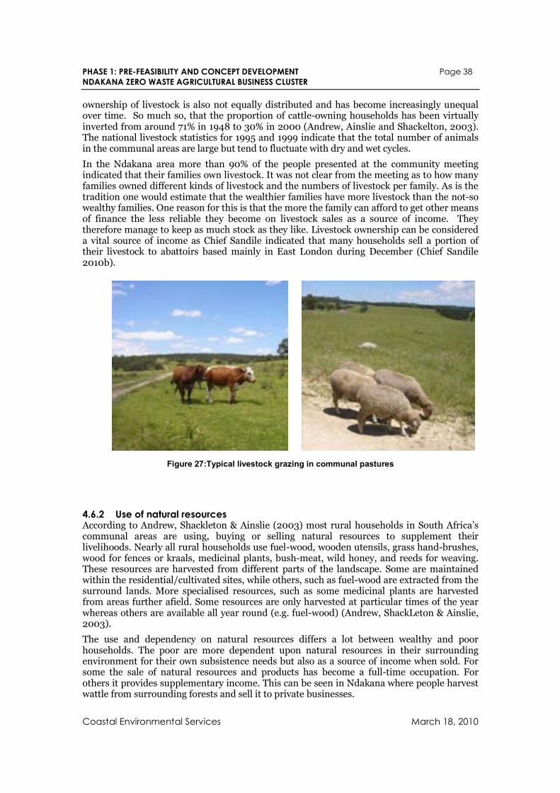
PHASE 1: PRE-FEASIBILITY AND CONCEPT DEVELOPMENT Page 38
NDAKANA ZERO WASTE AGRICULTURAL BUSINESS CLUSTER
Coastal Environmental Services March 18, 2010
ownership of livestock is also not equally distributed and has become increasingly unequal over time. So much so, that the proportion of cattle-owning households has been virtually inverted from around 71% in 1948 to 30% in 2000 (Andrew, Ainslie and Shackelton, 2003). The national livestock statistics for 1995 and 1999 indicate that the total number of animals in the communal areas are large but tend to fluctuate with dry and wet cycles.
In the Ndakana area more than 90% of the people presented at the community meeting indicated that their families own livestock. It was not clear from the meeting as to how many families owned different kinds of livestock and the numbers of livestock per family. As is the tradition one would estimate that the wealthier families have more livestock than the not-so wealthy families. One reason for this is that the more the family can afford to get other means of finance the less reliable they become on livestock sales as a source of income. They therefore manage to keep as much stock as they like. Livestock ownership can be considered a vital source of income as Chief Sandile indicated that many households sell a portion of their livestock to abattoirs based mainly in East London during December (Chief Sandile 2010b).
Figure 27:Typical livestock grazing in communal pastures
4.6.2 Use of natural resources According to Andrew, Shackleton & Ainslie (2003) most rural households in South Africa’s communal areas are using, buying or selling natural resources to supplement their livelihoods. Nearly all rural households use fuel-wood, wooden utensils, grass hand-brushes, wood for fences or kraals, medicinal plants, bush-meat, wild honey, and reeds for weaving. These resources are harvested from different parts of the landscape. Some are maintained within the residential/cultivated sites, while others, such as fuel-wood are extracted from the surround lands. More specialised resources, such as some medicinal plants are harvested from areas further afield. Some resources are only harvested at particular times of the year whereas others are available all year round (e.g. fuel-wood) (Andrew, ShackLeton & Ainslie, 2003).
The use and dependency on natural resources differs a lot between wealthy and poor households. The poor are more dependent upon natural resources in their surrounding environment for their own subsistence needs but also as a source of income when sold. For some the sale of natural resources and products has become a full-time occupation. For others it provides supplementary income. This can be seen in Ndakana where people harvest wattle from surrounding forests and sell it to private businesses.
PHASE 1: PRE-FEASIBILITY AND CONCEPT DEVELOPMENT Page 39
NDAKANA ZERO WASTE AGRICULTURAL BUSINESS CLUSTER
Coastal Environmental Services March 18, 2010
5. Resource Recovery and Recycling Potentials This section explores the existing and potential recovery and utilisation of ‘waste’ resources from or by existing or planned activities in the study area. It is based largely on an audit of organic resources in Ndakana and its surrounds that was conducted by the study team in February as well as the evaluation of planned activities described in the Amabele LSDF.
5.1 Local Ndakana Community
5.1.1 Household waste Observations: The local community generates a minimal amount of household waste which is either buried, burnt or informally recycled within the household.
Recommendations: The practice of backyard burning of waste should be discouraged as this is generates toxic emissions of dioxins and furans and is illegal under the international Stockholm Convention. Organic household waste could be composted and dry waste could ideally be separated recycled. It is recommended that the local school provides a collection point for the various dry waste streams. This will create environmental awareness in learners whilst providing additional income for the schools.
5.1.2 Sewage and waste water Observations: There appears to be water reticulation or treatment in the area and sanitation of sewage is practiced in the form of pit latrines and septic tanks.
Recommendations: Given the high levels of animal husbandry in the area, biogas digesters could be installed to provide effective sanitation as well as household energy and biofertilizer for the garden (refer 5.1.4 and 7.1.6) . Consideration should be given to the possible organic certification of household gardens, which will not be possible if biofertilizer originates from human sources.
5.1.3 Money Observations: A large portion of the total revenues coming into the community, .i.e. grants, salaries, wages, etc. is spent on goods and services that are sourced from outside of the community. Waste is not limited to product manufacture and design but it can be extended to money streams that leave the community unnecessarily. It is estimated that at 21% of the average householders income is spent on cell phone airtime [5] and a similar proportion of household income are spent on food staples as well as alcohol sourced from outside the area.
Recommendations: The cluster should include interventions that promote of recycling of money. This could include the development of local enterprises that help to ‘plug the leaks’ in the local economy revenue flows should form a vital component of the zerowaste cluster development as this focus has the ability to result in profound levels of regeneration of the local community and lead to social as well environmental benefits.
For example, a large monetary leak from the local economy is related to the purchase of fuel, food and alcohol from sources outside of the community. Many of these goods and services could be produced locally within the proposed cluster and distributed equitably though the use of local consumer cooperatives. The purchasing of maize meal, vegetables, chicken and eggs from a local consumer cooperative that sources its produce from local small scale farmers will help to keep the money circulating (recycling) within the local community and
5 Recent new economics foundation spending circle survey at the Sibaya project at the community of Waterloo, eThekwini Municipality, Tongaat Hulett Developments and BioRegional South Africa indicate that 30% of income is spent on communication costs of which 70% is to communicate with people in the local area.
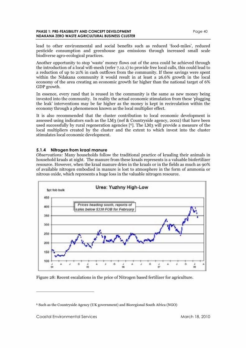
PHASE 1: PRE-FEASIBILITY AND CONCEPT DEVELOPMENT Page 40
NDAKANA ZERO WASTE AGRICULTURAL BUSINESS CLUSTER
Coastal Environmental Services March 18, 2010
lead to other environmental and social benefits such as reduced ‘food-miles’, reduced pesticide consumption and greenhouse gas emissions through increased small scale biodiverse agro-ecological practices.
Another opportunity to stop ‘waste’ money flows out of the area could be achieved through the introduction of a local wifi-mesh (refer 7.12.1) to provide free local calls, this could lead to a reduction of up to 21% in cash outflows from the community. If these savings were spent within the Ndakana community it would result in at least a 26.6% growth in the local economy of the area creating an economic growth far higher than the national target of 6% GDP growth.
In essence, every rand that is reused in the community is the same as new money being invested into the community. In reality the actual economic stimulation from these ‘plugging the leak’ interventions may be far higher as the money is kept in recirculation within the economy through a phenomenon known as the local multiplier effect.
It is also recommended that the cluster contribution to local economic development is assessed using indicators such as the LM3 (nef & Countryside agency, 2002) that have been used successfully by rural regeneration agencies [6]. The LM3 will provide a measure of the local multipliers created by the cluster and the extent to which invest into the cluster stimulates local economic development.
5.1.4 Nitrogen from kraal manure Observations: Many households follow the traditional practice of kraaling their animals in household kraals at night. The manure from these kraals represents is a valuable biofertilizer resource. However, when the kraal manure dries in the kraals or in the fields as much as 90% of available nitrogen embodied in manure is lost to atmosphere in the form of ammonia or nitrous oxide, which represents a huge loss in the valuable nitrogen resource.
Figure 28: Recent escalations in the price of Nitrogen based fertilizer for agriculture.
6 Such as the Countryside Agency (UK government) and Bioregional South Africa (NGO)
PHASE 1: PRE-FEASIBILITY AND CONCEPT DEVELOPMENT Page 41
NDAKANA ZERO WASTE AGRICULTURAL BUSINESS CLUSTER
Coastal Environmental Services March 18, 2010
Recommendations: The use of biogas digester (refer 7.1.6) can eliminate these significant nitrogen losses whilst providing householders with a local source of clean renewable energy. Households with two or more livestock units will find the installation of a biogas digester feasible simply in terms of energy savings alone (Austin & Blignaut 2007). Considering the recent escalations in the cost of nitrogen based synthetic fertilizers (refer Figure 28, the use of biogas digesters to maximise nitrogen recovery appears attractive to householders seeking to increase vegetable production.
5.2 Surrounding Areas
5.2.1 Rance Timbers Observations: Rance timbers produces large volumes of bark, chips and shavings. They sell most of their bark to Amathole Berries, and some as growing media to other commercial concerns. Chips are sold to the P G Bison plant in Ugie (320km away ) for chip board manufacture. Shavings are sold for horse bedding and to Anca for chicken bedding. A large amount of material and oils are burnt to produce heat for curing timber. Rance is considering a heat and power plant to meet their own requirements and to sell back into the grid.
Rance also produces trimmings in the plantations and are considering harvesting these for onsite chipping. Removing the material from the forest helps to eliminate fire risks but also reduces the nutrients and soil carbon on the forest floor.
Recommendations: It appears as if all byproduct resources are accounted for.
5.2.2 W P Timber Products Observations: W P Timber Products produce a range of timber products, and generate large quantities of wood shavings - 60 bulk bags (about 1m³ each) per day. These are sold to Philip Smith for R15 each, who trucks them out and sells it to tomato Growers as growing medium. Offcuts and chips are burnt in a kiln to produce heat for curing and lamination. Some of the shavings are also supplied to ANCA chickens as bedding.
Recommendations: It appears as if all byproduct resources are accounted for.
5.2.3 Stutt Poles Observations: Stutt Poles cut timber and de-bark it 30km toward KWT so no bark / shavings at yard. They have submitted a proposal for funding of biochar project using cleared wattle. They have built a biochar machine and have run production tests on it. It currently produces a lot of smoke - an issue with the neighbors but they are working on that. The machine could process 300 tons per month and they plan to have 5 machines. They purchase wattle trunks and stems (>100mm diam), cut and split them prior to processing. The wattle is currently harvested for pulp but bent stems are not suitale for efficient transportation (to Richard's Bay for paper production) and are processed into biochar. Stutt Poles require their suppliers to show landowner's / local headman's permission and provide a document for this purpose.
Recommendations: The harvesting process is not efficient in that the timber is “cherry picked” so branches and leaves are left behind. Ideal situation is to clearfell the wattle so that there is uniform re-growth. The stems are stripped of bark and left to dry for 6 weeks. This generates large quantities of branches and leaves that are not ideal for biochar production, but could be chipped for compost / mulch. Spreading wattle seed may be a problem unless thermophyllic composting involved.
PHASE 1: PRE-FEASIBILITY AND CONCEPT DEVELOPMENT Page 42
NDAKANA ZERO WASTE AGRICULTURAL BUSINESS CLUSTER
Coastal Environmental Services March 18, 2010
5.2.4 Amabele Poles Observations: Almost all their products are gum. Bark is removed in the plantations and there is very little in the way of shavings as most of the cutting is done in the plantations also.
Recommendations: The feasibility should assess assess the viability of transporting off-cuts from the plantations to Amabele for the use as fuel in the proposed CHP plant (refer 7.7).
5.2.5 Stutterheim landfill Observations: Open pit landfill disposal, with excavator and compactor trailer. Carboard and metal informally recovered by the numerous waste-pickers on the site. Garden waste is dumped separately and included thatch and some treated timber processing waste mixed. No evidence of chipping on site. The Ritlee compost turner in the municipal yard (tractor driven) is not being utilised.
Recommendations: Stutterheim should implement a separation at source programme where wet waste (OFMSW) is separated from dry waste. The resulting dry waste recovery could be managed by the waste pickers who have the necessary experience and who are essentially entrepreneurial by nature. OFMSW should be composted or digested. Care should be taken not to contaminate OFMSW with treated wood products.
5.2.6 Stutterheim waste water treatment Observations: The waste water treatment works have sludge drying beds that can be used as an effective biofertilizer provided that they are tested to be safe from heavy metals and pathogens. We were unable to ascertain how much sludge are produced by the works but a preliminary assessment indicates that at least 1.5 tons (dry weight) could be produced each day by the facility.
Recommendations: The waste water and biofertilizer could be used to produce biofuel crops on the buffer zone surrounding the waste water treatment works. It is not recommended that the biofertilizer is used in the Ndakan cluster as this may compromise the organic status of the project and also possibly lead to heavy metal contamination of the lands, given the large volumes of Arsenic treatment used in surrounding wood treatment industry.
5.2.7 Anca Chickens Observation: Anca has several chicken farms in the area that produce substantial amounts of litter. Sawdust bedding is spread to absorb the chicken manure. The chicken manure is sold to Amathole Berries, Eco-Logix and others. Apparently it is also mixed into cattle feed as a source of nitrogen. Anca operates a chicken abattoir that produces two 25m³ trucks of chicken feathers a week, offal and litter. They pay Enviroserve R25,000.00 a month to remove it. Some is sold to Eco-Logix who are doing compost trials.
Recommendations: Chicken feathers can be converted to feather meal using high temperature hydrolisation process which breaks down the Cystine bonds in the keratin and releases the feathers ubundant (90%) nitrogen content. Feather meal can be used as a an animal feed supplement or as a fertilizer (NPK 14:3:1.8).
Chicken carcasses and offal should be rendered into a high protein animal feed or hot rot composted.
Ndakana could be a suitable location for these processes to occur as it will have access to surplus process heat from the proposed heat and power cluster and it is also located outside of the 15km biosafety zone required by ANCA for the processing of its waste products.
PHASE 1: PRE-FEASIBILITY AND CONCEPT DEVELOPMENT Page 43
NDAKANA ZERO WASTE AGRICULTURAL BUSINESS CLUSTER
Coastal Environmental Services March 18, 2010
5.2.8 Eco-Logix Observations: Eco-Logix is doing trials on composting chicken feathers, litter and bark etc. Flies and smells are an issue but they can be controlled to some degree. Eco-Logix supplies a stacking box vermicomposting system to Amathole berries for leachate / vermin-tea production, as well as feather-based compost and vermicompost. Vermicompost done in a variety of large containers, including 5m³ timber box structure, mainly using cattle / horse manure. They are looking to establish a working relationship with Anca, Amathole berries and other parties to process chicken feather, litter, offal and bark material on a large scale.
Recommendations: Eco-logix could act as a local service provider to the cluster on composting and vermicomposting.
5.2.9 Amathole Berries Farm Observations: Amathole Berries slow / cold compost large quantities of pine bark for growing media onsite at Amathole Berries. They have a compost turner on site – Ritlee tractor drawn. They intend to compost all on-farm biomass onsite.
Amathole Berries also produce vermicompost and leachate “earthworm tea” for the berry operation. They have installed both convention a bin based earthworm farm as well as a large earthworm hammock supplied by closing the loop.
Amathole berries have also installed a biogas digester and algal ponds to process the waste water from thier main office block and ablution facilities. The digester is sized to codigest the onsite canteen food waste as well as the manure from the local Nguni cattle and other sources.
Recommendations: None, resource recovery and nutrient recycling are already a prime focus at the Amathole Berries Farm
5.2.10 Proposed berry handling and support facility Observation: This facility is proposed to be installed at Amabele to process the berries from the Amathola berries farm and its outgrowers. Its planned operations include the production of nutrients for the berry producers using high temperature composting and vermin-composting. The facility plans to utilise bark waste from Rance timbers, litter and other products from Anca Chickens and wattle chips from the envisaged working for water programme. A business plan for the nutrient supply facility has been submitted to funders.
In order to meet the nutrient demand of the berry producers indications are that at full production (2019+) the nutrient supply facility at Amabele will need to produce over 11,000m3 of compost per year and 7800 m3 of vermicompost per year. To produce this it is envisaged that the following quantities of resources will be required:
Pine bark and Wattle: 1500 tons per year
Broiler litter: 900 tons per year
Feathers: 3100 tons per year
Preliminary investigations indicate that there are sufficient sources of wattle resources in the area to satisfy the demand for both this facility and the proposed Combined Heat and power facility (refer 7.7).
Recommendations: The feasibility study should provide clarity on the sources of wattle resources that will be utilised by both the Amabele berry nutrient supply facility and proposed combined heat and power plant to ensure that both activities are not competing for the same wattle resources.
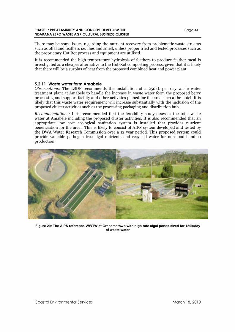
PHASE 1: PRE-FEASIBILITY AND CONCEPT DEVELOPMENT Page 44
NDAKANA ZERO WASTE AGRICULTURAL BUSINESS CLUSTER
Coastal Environmental Services March 18, 2010
There may be some issues regarding the nutrient recovery from problematic waste streams such as offal and feathers i.e. flies and smell, unless proper tried and tested processes such as the proprietary Hot Rot process and equipment are utilised.
It is recommended the high temperature hydrolysis of feathers to produce feather meal is investigated as a cheaper alternative to the Hot-Rot composting process, given that it is likely that there will be a surplus of heat from the proposed combined heat and power plant.
5.2.11 Waste water form Amabele Observations: The LSDF recommends the installation of a 250kL per day waste water treatment plant at Amabele to handle the increase in waste water form the proposed berry processing and support facility and other activities planed for the area such a the hotel. It is likely that this waste water requirement will increase substantially with the inclusion of the proposed cluster activities such as the processing packaging and distribution hub.
Recommendations: It is recommended that the feasibility study assesses the total waste water at Amabele including the proposed cluster activities. It is also recommended that an appropriate low cost ecological sanitation system is installed that provides nutrient beneficiation for the area. This is likely to consist of AIPS system developed and tested by the DWA Water Research Commission over a 12 year period. This proposed system could provide valuable pathogen free algal nutrients and recycled water for non-food bamboo production.
Figure 29: The AIPS reference WWTW at Grahamstown with high rate algal ponds sized for 150k/day of waste water
Related Documents