APPENDIX 4 Bushfire Management Plan

Welcome message from author
This document is posted to help you gain knowledge. Please leave a comment to let me know what you think about it! Share it to your friends and learn new things together.
Transcript

APPENDIX 4
Bushfire Management Plan
2016
FirePlan WA
June 2016
Bush Fire Management Plan
Lake Road Precinct A
Local Structure Plan
Champion Lakes
City of Armadale
BMP Lake Road Precinct A Champion Lakes June 2016 _____________________________________________________________________________________________
BMP 2139 Lake Road LSP Precinct A V3 07.06.16 FirePlan WA 2
Table of Contents 1.0 PURPOSE OF THE MANAGEMENT PLAN ............................................................................................................. 5
2.0 OBJECTIVES ......................................................................................................................................................... 8
3.0 DESCRIPTION OF THE SUBJECT AREA ................................................................................................................. 8
3.1 General ........................................................................................................................................................... 8
3.2 Topography ..................................................................................................................................................... 8
3.3 Bushfire Fuels ................................................................................................................................................. 9
3.4 Land Use ....................................................................................................................................................... 12
3.5 Assets ............................................................................................................................................................ 12
3.6 Access ........................................................................................................................................................... 12
3.7 Water Supplies .............................................................................................................................................. 12
3.7.1 Water for Fire Fighting .......................................................................................................................... 12
3.7.2 Domestic Water Supply ........................................................................................................................ 12
4.0 BUSHFIRE ASSESSMENT .................................................................................................................................... 12
4.1 Fire History .................................................................................................................................................... 12
5.0 BUSHFIRE RISK MANAGEMENT MEASURES...................................................................................................... 17
5.1 Element 1 – Development Location ............................................................................................................. 17
5.2 Element 2 – Siting and Design of Development ........................................................................................... 17
5.2.1 Setback from Classified Vegetation ...................................................................................................... 17
5.2.2 BAL RATINGS .............................................................................................................................................. 17
5.2.3 Wungong River Foreshore Management Plan ..................................................................................... 18
5.2.4 Area north of Poad Road ...................................................................................................................... 19
5.2.5 Asset Protection Zone ........................................................................................................................... 19
5.2.6 Installation of Evaporative Air conditioners ................................................................................................ 20
5.3 Element 3 – Access ....................................................................................................................................... 23
5.3.3 Road System ......................................................................................................................................... 23
5.3.4 Internal Firebreaks ................................................................................................................................ 23
5.4 Element 4 Water Supplies ............................................................................................................................ 24
5.5 Vulnerable Uses ............................................................................................................................................ 24
5.6 Hazard Reduction ......................................................................................................................................... 24
5.7 Restrictions on the Use of Machinery, Tools, Vehicles and Tractors ........................................................... 25
5.7.3 Total Fire Ban Days ............................................................................................................................... 25
Public Education Program..................................................................................................................................... 25
5.7.4 Fire Safer Areas ..................................................................................................................................... 25
6.0 IMPLEMENTATION OF BUSHFIRE MANAGEMENT PLAN .................................................................................. 26

BMP Lake Road Precinct A Champion Lakes June 2016 _____________________________________________________________________________________________
BMP 2139 Lake Road LSP Precinct A V3 07.06.16 FirePlan WA 3
6.1 Responsibilities ............................................................................................................................................. 26
6.1.1 Property Owners Responsibilities ......................................................................................................... 26
6.1.2 Developer’s Responsibilities ................................................................................................................. 26
6.1.3 City of Armadale ................................................................................................................................... 27
6.2 Assessment of Fire Management Strategies ................................................................................................ 27
6.3 Works Program ............................................................................................................................................. 28
7.0 APPENDICES ...................................................................................................................................................... 29
7.1 Glossary ........................................................................................................................................................ 29
8.0 COMPLIANCE CHECKLIST PERFORMANCE CRITERIA AND ACCEPTABLE SOLUTIONS ....................................... 31
9.0 PROPOSAL COMPLIANCE AND JUSTIFICATION ................................................................................................. 32
DISCLAIMER .................................................................................................................................................................. 32
Figure 1 Outline Development Plan Location…………………………………………………………….6
Figure 2 Outline Development Plan Rimmer Lane Precinct……………………………………… 7
Figure 3 Bushfire Hazard Assessment……………………………………………………………………… 15
Figure 4 Bush Fire Hazard Assessment North of Poad Rd…………………………………………. 16
Figure 5Relationship of APZ & HSZ to Development………………………………………………… 20
Figure 6 Concept Landscape Plan …..……………………………………………………………………….. 21
Figure 7 Indicative BAL Ratings………………………………………………………………………………….22
Figure 8 Turn around and Passing Bay Specifications…………………………………………………24
Table 1 Bushfire Risk Analysis ……………………………………………………………………………………13
Table 2 Bushfire Hazard Levels and Characteristics ……………………………………………………13
Table 3 Bushfire Attack Level Descriptions ……………………………………………………………… 14
Table 4 Summary of BAL Ratings ……………………………………………………………………………… 18
Table 5 Vehicle Access Technical Requirements ………………………………………………………. 23
Table 6 Works Program…………………………………………………………………………………………… 28
BMP Lake Road Precinct A Champion Lakes June 2016 _____________________________________________________________________________________________
BMP 2139 Lake Road LSP Precinct A V3 07.06.16 FirePlan WA 4
Local Structure Plan
Precinct A1-Lakes Rd, Champion Lakes
Document prepared for: Bluegold Corporation Pty Ltd
Document Status
Version Comment Reviewer Review Date
Version 1 BWH 10.03.2015
Version 2 Structure Plan Amended 18.4.2016
Version 3 LSP aMENDED 07.06.2016
Document prepared by: Bill Harris M: 0418 941 540 FirePlan WA Email: [email protected] 10 Bracken Road ABN: 44 116 937 762 THORNLIE WA 6108 FirePlan WA been in operation since 1998 and is a registered business with the Department of Trade and Commerce
(Commonwealth Gov’t). Mr Harris is the sole owner/operator of the Business During that time FirePlan WA has been providing
Bushfire Hazard Assessments (to Developers, Local Governments, State Government agencies and the Department for
Defence), preparation of Fire Management Plans/ Bushfire Management Plans (Developers and landowners), and Bushfire
Attack Level assessments (as part of FMP/BMP) for Landowners as part of the Building Permit Process.
Mr Harris has been involved in the Bushfire Planning, Fire Prevention and Hazard reduction burning programs, Response to
bush fires/wildfires, State Fire Coordinator when at the Bush Fires Board/FESA (1975-1998), Fire Ecology and fire behaviour
research in conjunction with CSIRO having worked in the Northern Territory (1971-1975) and Western Australia between
1965-1971 then 1975-1998.
Mr Harris has attended the BPAD Level 1 BAL Assessor short course and BPAD Level 2 Bushfire Planning Practitioner
(Prescriptive) workshop and is pursuing accreditation- not available until July 2016.
Disclaimer: The measures contained in this fire management plan are considered to be minimum standards and they do not
guarantee that a building will not be damaged in a bush fire. All surveys, forecasts, projections and recommendations made in
this report associated with the project are made in good faith on the basis of information available to FirePlan WA at the time; and
achievement of the level of implementation of fire precautions will depend among other things on the actions of the landowners or
occupiers over which FirePlan WA has no control. Notwithstanding anything contained therein, FirePlan WA will not, except as
the law may require, be liable for any loss or other consequences (whether or not due to the negligence of the consultants, their
servants or agents) arising out of the services rendered by the consultants.
In the Foreword of AS 3959- 2009 it states that “It should be borne in mind that the measures contained in this standard
cannot guarantee that a building will survive a bushfire event on every occasion. This is substantially due to the degree of
vegetation management, the unpredictable nature and behavior of fire and extreme weather conditions.”

BMP Lake Road Precinct A Champion Lakes June 2016 _____________________________________________________________________________________________
BMP 2139 Lake Road LSP Precinct A V3 07.06.16 FirePlan WA 5
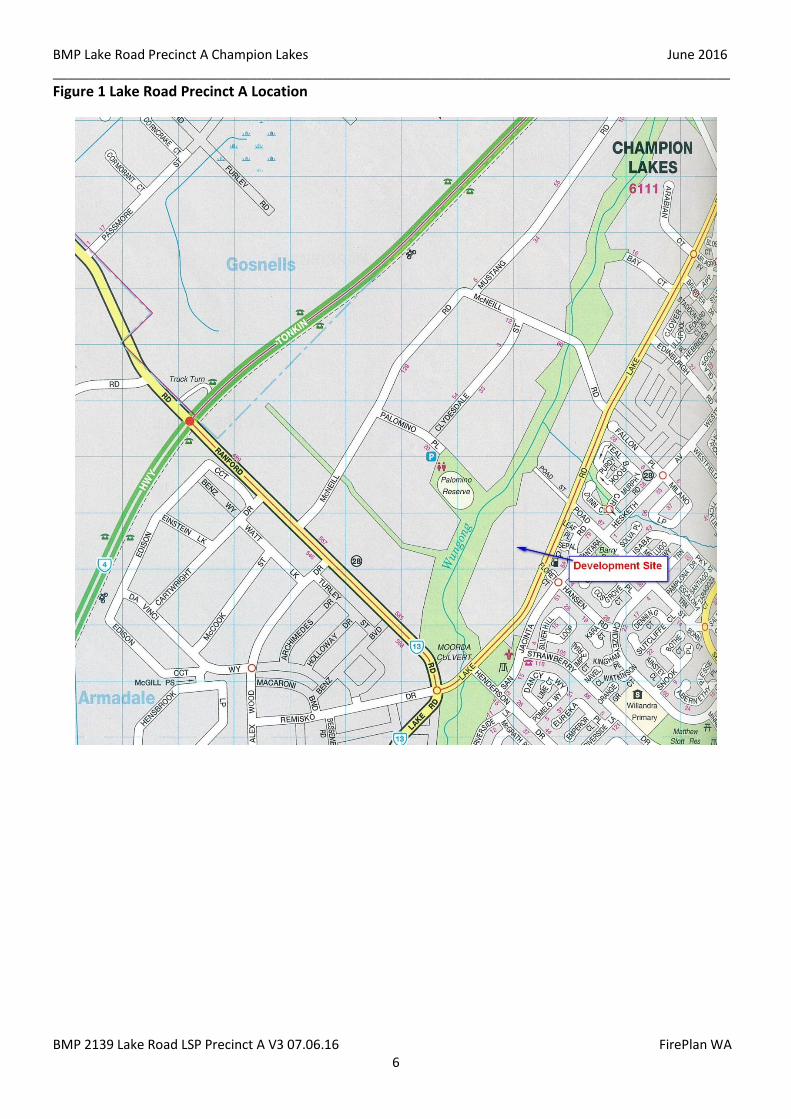
1.0 PURPOSE OF THE MANAGEMENT PLAN
The purpose of this Bushfire Management Plan is to detail the fire management methods and
requirements that will be implemented for the Lake Road Precinct A1 LSP. (Refer Figure 1: Location Plan).
This Bushfire Management Plan satisfies the requirements of the City of Armadale and the WAPC (via
WAPC and Department of Planning document, SPP 3.7 and Guidelines for Planning in Bushfire Prone
Areas December 2015 (See Compliance Table Section 9.0)
This Bushfire Management Plan will outline the responsibility and timing for implementing and
maintaining the fire protection measures and strategies contained within this Bushfire Management Plan,
allocating these responsibilities between individual land owners, the developers and the City of
Armadale.
As fire management strategies may require altering to meet changing weather, environment and land use
needs, it must be advised that the provisions of the Bush Fires Act 1954 may still be enforced, in addition
to this Bushfire Management Plan.
The City of Armadale will be responsible for initiating a review of this Bushfire Management Plan as it
may deem necessary to do so.
The Western Australian Planning Commission and the City of Armadale require the preparation of a
“Bushfire Management Plan” to support the proposed LSP. This document has been prepared to satisfy
that requirement and becomes operational as a condition of subdivision.
This Bushfire Management Plan complies with the acceptable solutions detailed in Appendix 4 of
Guidelines for Planning in Bushfire Prone Areas December 2015 and as summarised in ‘Compliance
Checklist for Performance Criteria and Acceptable Solutions’ at the end of this Bushfire Management Plan
(Section 8) and compliance with SPP 3.7 (Section 9).
BMP Lake Road Precinct A Champion Lakes June 2016 _____________________________________________________________________________________________
BMP 2139 Lake Road LSP Precinct A V3 07.06.16 FirePlan WA 6
Figure 1 Lake Road Precinct A Location
BMP Lake Road Precinct A Champion Lakes June 2016 _____________________________________________________________________________________________
BMP 2139 Lake Road LSP Precinct A V3 07.06.16 FirePlan WA 7
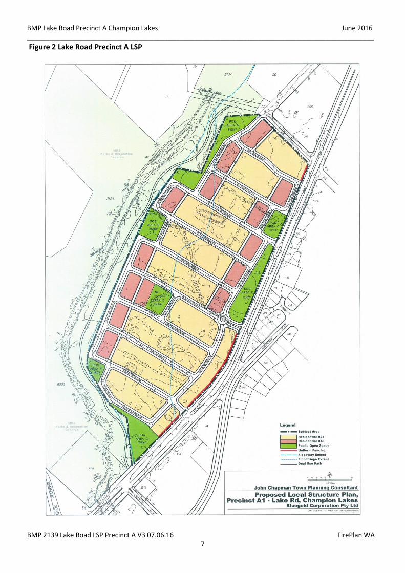
Figure 2 Lake Road Precinct A LSP
BMP Lake Road Precinct A Champion Lakes June 2016 _____________________________________________________________________________________________
BMP 2139 Lake Road LSP Precinct A V3 07.06.16 FirePlan WA 8
2.0 OBJECTIVES
The objectives of this Bushfire Management Plan are to:-
Achieve consistency with objectives and policy measures of SPP 3.7 and the Guidelines for
Planning in Bushfire Prone Areas December 2015, and any local planning scheme provisions
relating to bushfire.
Understand and document the extent of bushfire risk for the BMP area;
Prepare bushfire risk management measures for bushfire management and all land subject of the
Plan, with due regard for people, property, infrastructure and the environment;
Nominate individuals and organisation’s responsible for fire management and associated works
within the plan area (e.g. Local government for land vested in it and private property owners for
freehold land); and
Define an assessment procedure which will evaluate the effectiveness and impact of proposed, as
well as existing, bushfire risk management measures and strategies.
3.0 DESCRIPTION OF THE SUBJECT AREA
3.1 General
The subject land comprises Lake Road Precinct A LSP in the City of Armadale and is to be
developed into urban residential as shown in Figure 2.
The LSP “Site” is generally cleared with some trees retained as shade trees.
Lake Road is on the eastern boundary, Poad Road on the northern boundary and Wungong River
Reserve forms the southern and western boundary. There is a Wungong River Restoration Project
sponsored by the City of Armadale and the Department of Water which has been implemented at
the Lake Road end of Wungong River.
The Wungong River reserve varies in width from 105-144 metres. The reserve is predominantly
grassland with vegetation along the river varying in width from 15-40 metres wide.
The area along Lake Road from Ranford Road in the south and Champion Lakes Road in the north
and east of the Wungong River is all proposed to be urban residential.
3.2 Topography
The site slopes towards the Wungong River to the West at less than 1°. The slopes of Flat will be used
as a factor to determine the setbacks from vegetation and habitable building construction
standards within the site as detailed in Section 5.6.
BMP Lake Road Precinct A Champion Lakes June 2016 _____________________________________________________________________________________________
BMP 2139 Lake Road LSP Precinct A V3 07.06.16 FirePlan WA 9
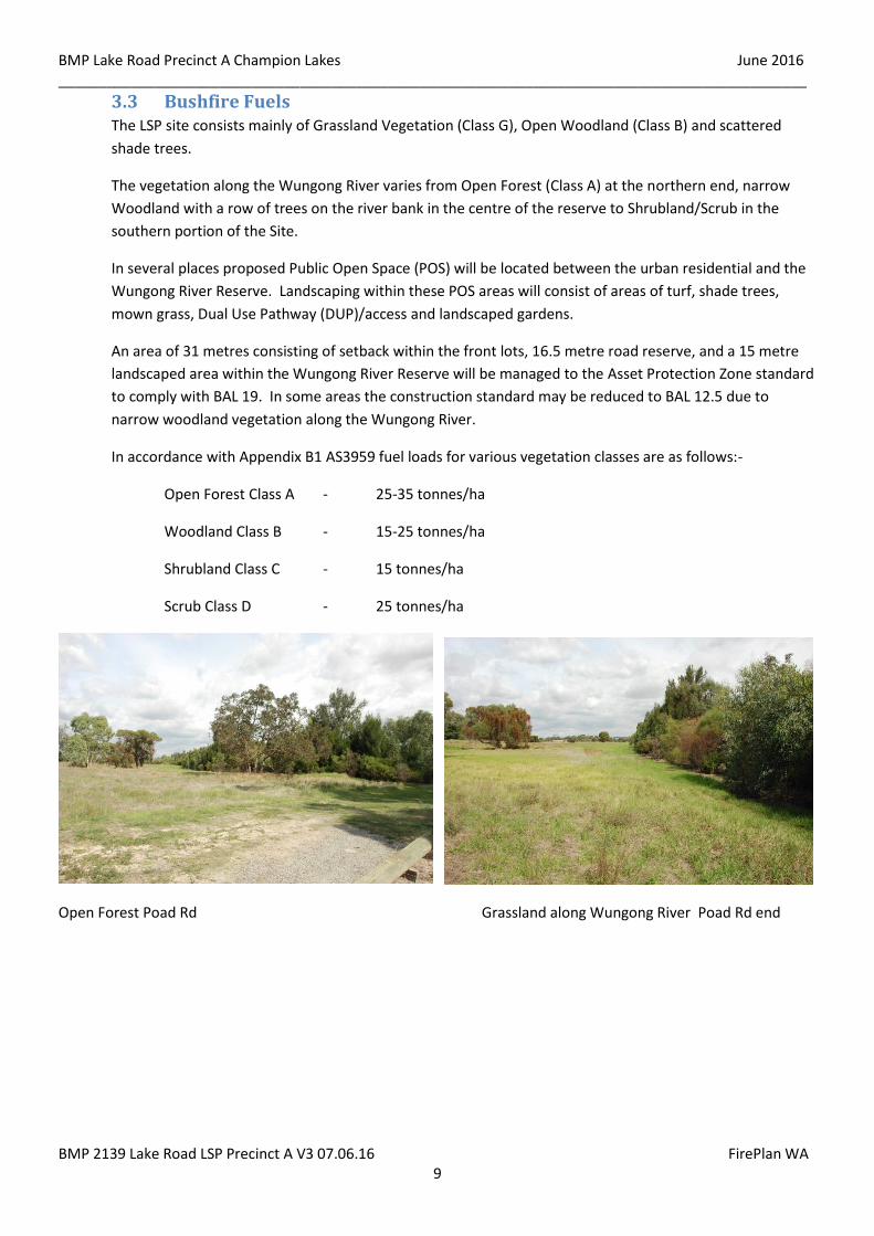
3.3 Bushfire Fuels The LSP site consists mainly of Grassland Vegetation (Class G), Open Woodland (Class B) and scattered
shade trees.
The vegetation along the Wungong River varies from Open Forest (Class A) at the northern end, narrow
Woodland with a row of trees on the river bank in the centre of the reserve to Shrubland/Scrub in the
southern portion of the Site.
In several places proposed Public Open Space (POS) will be located between the urban residential and the
Wungong River Reserve. Landscaping within these POS areas will consist of areas of turf, shade trees,
mown grass, Dual Use Pathway (DUP)/access and landscaped gardens.
An area of 31 metres consisting of setback within the front lots, 16.5 metre road reserve, and a 15 metre
landscaped area within the Wungong River Reserve will be managed to the Asset Protection Zone standard
to comply with BAL 19. In some areas the construction standard may be reduced to BAL 12.5 due to
narrow woodland vegetation along the Wungong River.
In accordance with Appendix B1 AS3959 fuel loads for various vegetation classes are as follows:-
Open Forest Class A - 25-35 tonnes/ha
Woodland Class B - 15-25 tonnes/ha
Shrubland Class C - 15 tonnes/ha
Scrub Class D - 25 tonnes/ha
Open Forest Poad Rd Grassland along Wungong River Poad Rd end

BMP Lake Road Precinct A Champion Lakes June 2016 _____________________________________________________________________________________________
BMP 2139 Lake Road LSP Precinct A V3 07.06.16 FirePlan WA 10
Wungong River & Forest vegetation Very little leaf litter under Forest vegetation
Grassland within proposed development area looking SE Very little leaf litter under Forest vegetation
Shrubland along Wungong River
BMP Lake Road Precinct A Champion Lakes June 2016 _____________________________________________________________________________________________
BMP 2139 Lake Road LSP Precinct A V3 07.06.16 FirePlan WA 11
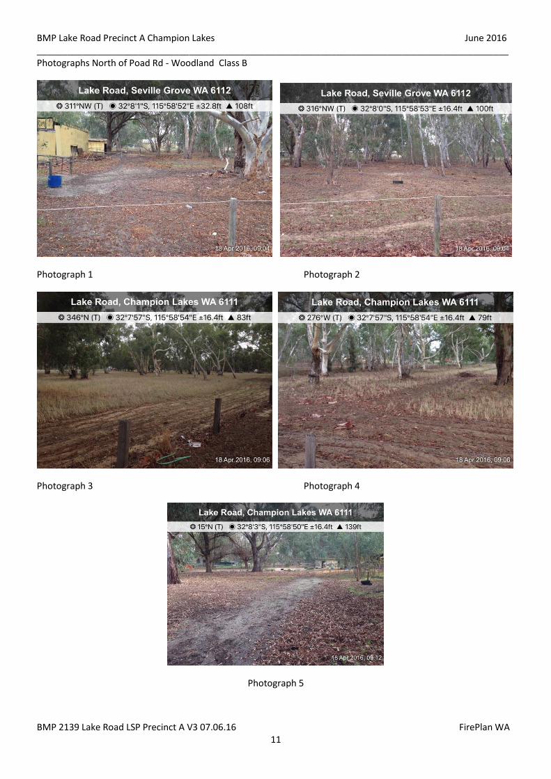
Photographs North of Poad Rd - Woodland Class B
Photograph 1 Photograph 2
Photograph 3 Photograph 4
Photograph 5

BMP Lake Road Precinct A Champion Lakes June 2016 _____________________________________________________________________________________________
BMP 2139 Lake Road LSP Precinct A V3 07.06.16 FirePlan WA 12
3.4 Land Use The LSP site will be used for residential R25 and R40.
The adjoining cleared land and Wungong River area will be partly landscaped and used as Public Open
Space and managed by the City.
The area adjoining the Wungong River and the west side is to remain as rural residential and may be
rezoned in the future.
The area to the east of Lake Road is urban residential.
3.5 Assets The rural area, dwellings, sheds, retained vegetation, Wungong River Reserve, proposed urban residential
area and Public Open Space.
3.6 Access Access to the LSP site is currently off Lake Road and Poad Road.
3.7 Water Supplies
3.7.1 Water for Fire Fighting
Fire Hydrants are to be installed by the Developer in accordance with Water Corporations No 63
Water Reticulation Standard.
3.7.2 Domestic Water Supply
Reticulated water will be supplied by the Developer to each Lot.
4.0 BUSHFIRE ASSESSMENT
4.1 Fire History There is no recorded Fire History for the “Site. Bushfires do occur in the general area of Forrestdale, Southern River
and Champion Lakes.
4.2 Bushfire Risk Assessment
Bushfire Risk is the chance of a bushfire starting that will have harmful consequences on life, property and the
environment. It is measured in terms of consequences and likelihood and arises from the interaction of
vegetation, communities and the environment expressed as a level of risk.
BMP Lake Road Precinct A Champion Lakes June 2016 _____________________________________________________________________________________________
BMP 2139 Lake Road LSP Precinct A V3 07.06.16 FirePlan WA 13
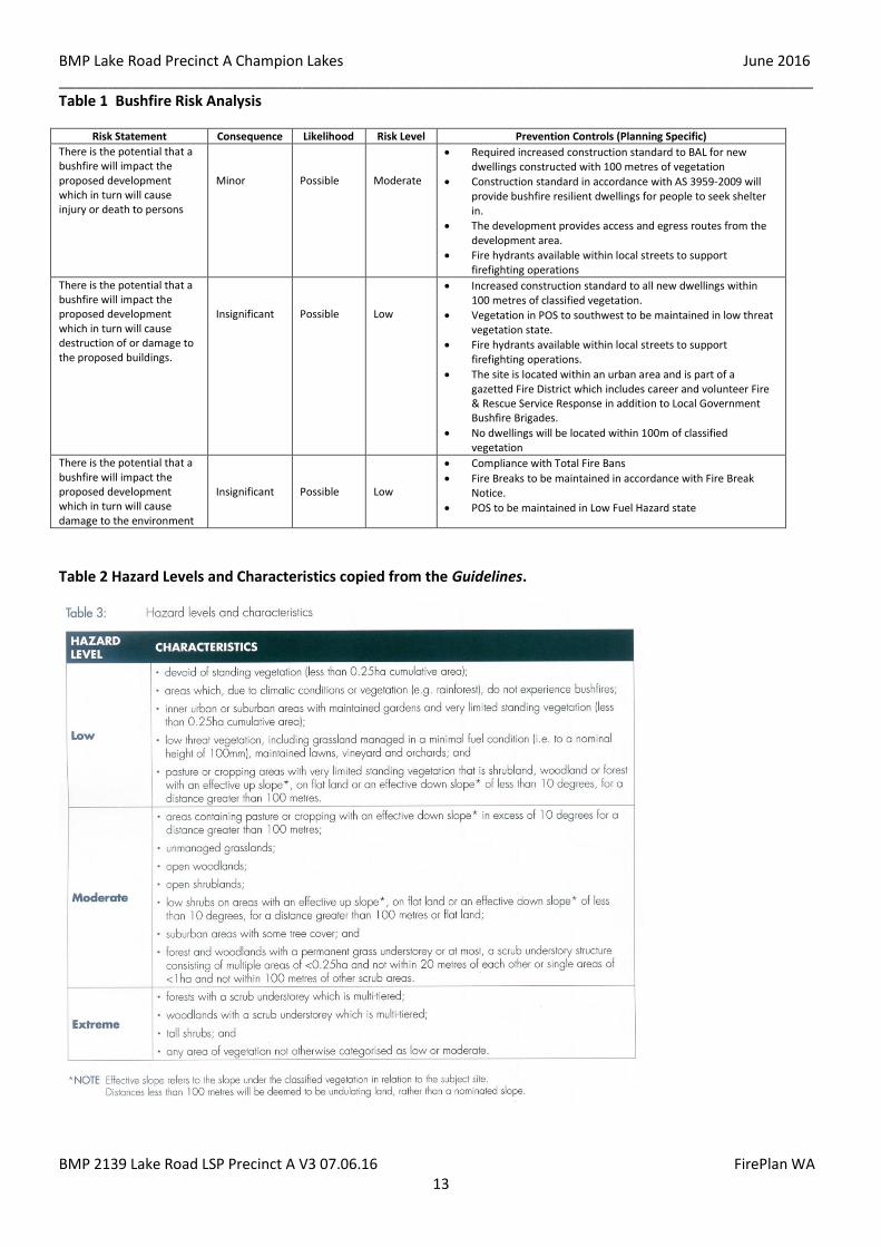
Table 1 Bushfire Risk Analysis
Risk Statement Consequence Likelihood Risk Level Prevention Controls (Planning Specific)
There is the potential that a bushfire will impact the proposed development which in turn will cause injury or death to persons
Minor
Possible
Moderate
Required increased construction standard to BAL for new dwellings constructed with 100 metres of vegetation
Construction standard in accordance with AS 3959-2009 will provide bushfire resilient dwellings for people to seek shelter in.
The development provides access and egress routes from the development area.
Fire hydrants available within local streets to support firefighting operations
There is the potential that a bushfire will impact the proposed development which in turn will cause destruction of or damage to the proposed buildings.
Insignificant
Possible
Low
Increased construction standard to all new dwellings within 100 metres of classified vegetation.
Vegetation in POS to southwest to be maintained in low threat vegetation state.
Fire hydrants available within local streets to support firefighting operations.
The site is located within an urban area and is part of a gazetted Fire District which includes career and volunteer Fire & Rescue Service Response in addition to Local Government Bushfire Brigades.
No dwellings will be located within 100m of classified vegetation
There is the potential that a bushfire will impact the proposed development which in turn will cause damage to the environment
Insignificant
Possible
Low
Compliance with Total Fire Bans
Fire Breaks to be maintained in accordance with Fire Break Notice.
POS to be maintained in Low Fuel Hazard state
Table 2 Hazard Levels and Characteristics copied from the Guidelines.
BMP Lake Road Precinct A Champion Lakes June 2016 _____________________________________________________________________________________________
BMP 2139 Lake Road LSP Precinct A V3 07.06.16 FirePlan WA 14
Residual bushfire related risk to identified assets within the proposed development following implementation of
risk management strategies detailed in Section 5.0 of this Bushfire Management Plan.
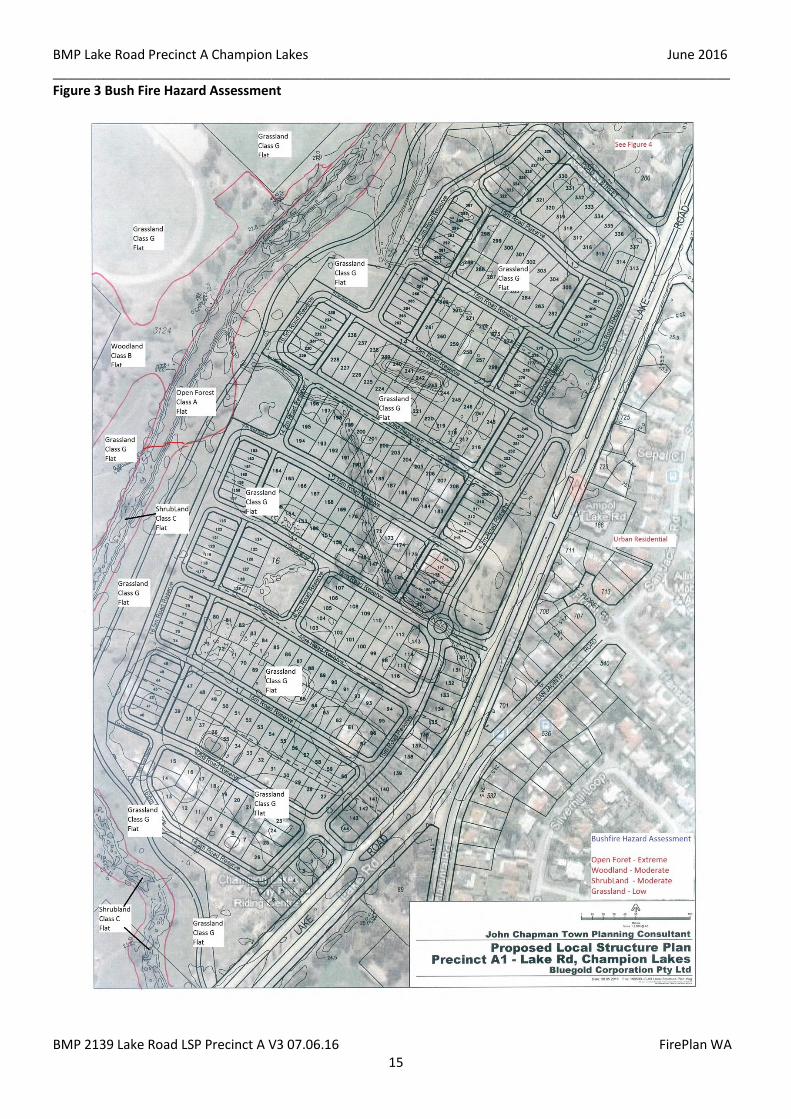
The bushfire hazard assessment for the site is:-
Grassland Class G - Low
Woodland Class B - Moderate
Open Forest Class A - Extreme
The Bushfire hazard assessment for the vegetation north of Poad Road is :-
Open Woodland Class B - Moderate - The open woodland vegetation lacks a shrubby middle layer and a deep surface litter layer.
See Figure 3
Bushfire Attack Level (BAL) assessment classifies land into 6 categories based on a combination of vegetation type
(fuel type, load and structure), effective slope of the land and the proposed distance from predominant vegetation.
BAL assessment for the proposed development is detailed in Section 5.0. See Table 3 for BAL categories
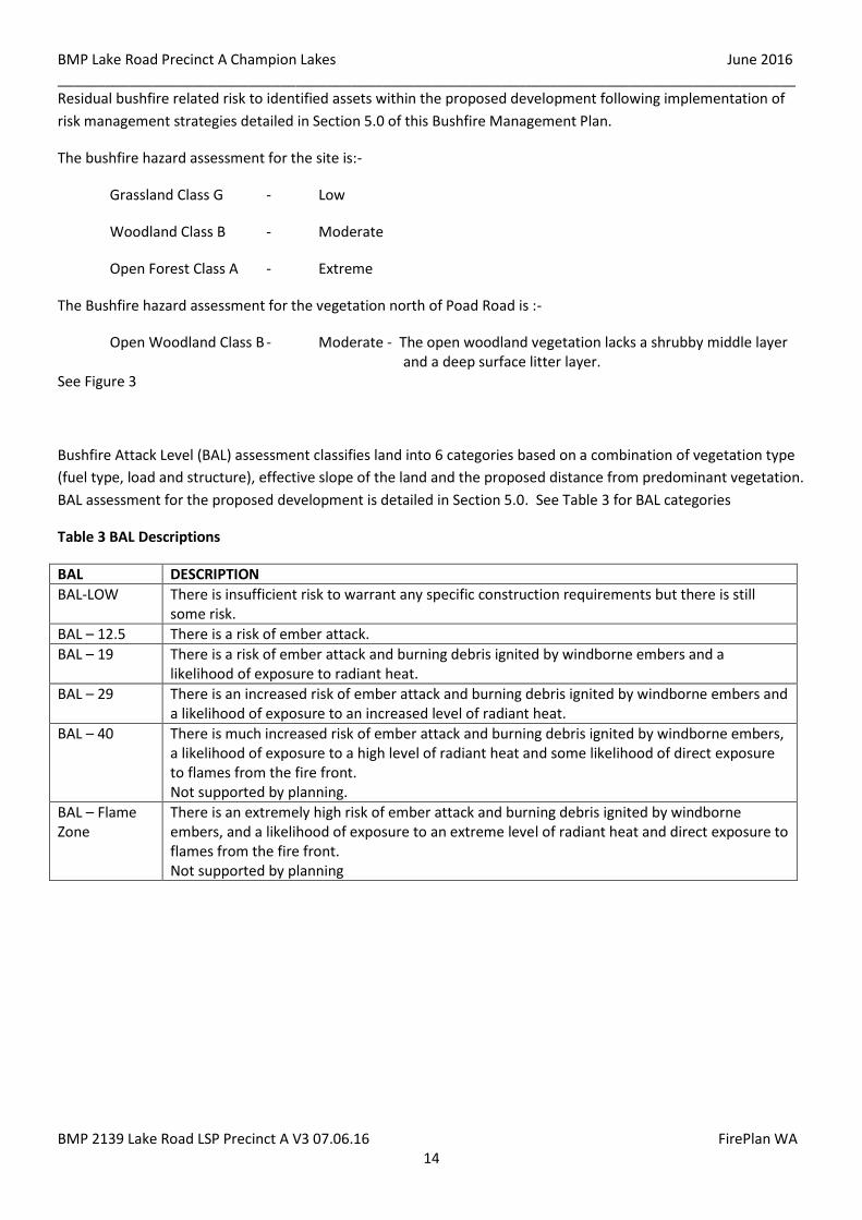
Table 3 BAL Descriptions
BAL DESCRIPTION
BAL-LOW There is insufficient risk to warrant any specific construction requirements but there is still some risk.
BAL – 12.5 There is a risk of ember attack.
BAL – 19 There is a risk of ember attack and burning debris ignited by windborne embers and a likelihood of exposure to radiant heat.
BAL – 29 There is an increased risk of ember attack and burning debris ignited by windborne embers and a likelihood of exposure to an increased level of radiant heat.
BAL – 40 There is much increased risk of ember attack and burning debris ignited by windborne embers, a likelihood of exposure to a high level of radiant heat and some likelihood of direct exposure to flames from the fire front. Not supported by planning.
BAL – Flame Zone
There is an extremely high risk of ember attack and burning debris ignited by windborne embers, and a likelihood of exposure to an extreme level of radiant heat and direct exposure to flames from the fire front. Not supported by planning
BMP Lake Road Precinct A Champion Lakes June 2016 _____________________________________________________________________________________________
BMP 2139 Lake Road LSP Precinct A V3 07.06.16 FirePlan WA 15
Figure 3 Bush Fire Hazard Assessment
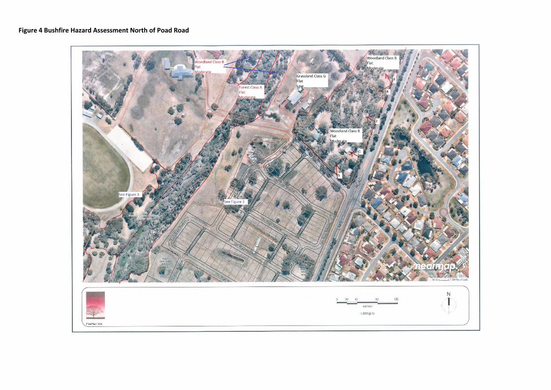
Figure 4 Bushfire Hazard Assessment North of Poad Road
5.0 BUSHFIRE RISK MANAGEMENT MEASURES The bushfire management strategies detailed in this BMP are designed to comply with the Performance Criteria
and Acceptable Solutions detailed in Draft Planning for Bushfire Risk Management Guidelines May 2014 and
Planning for Bushfire Protection Edition 2 2010.
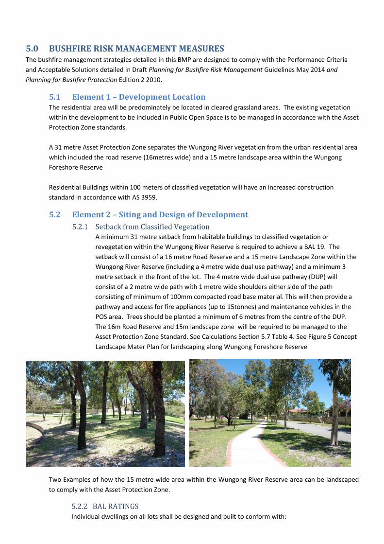
5.1 Element 1 – Development Location The residential area will be predominately be located in cleared grassland areas. The existing vegetation
within the development to be included in Public Open Space is to be managed in accordance with the Asset
Protection Zone standards.
A 31 metre Asset Protection Zone separates the Wungong River vegetation from the urban residential area
which included the road reserve (16metres wide) and a 15 metre landscape area within the Wungong
Foreshore Reserve
Residential Buildings within 100 meters of classified vegetation will have an increased construction
standard in accordance with AS 3959.
5.2 Element 2 – Siting and Design of Development
5.2.1 Setback from Classified Vegetation
A minimum 31 metre setback from habitable buildings to classified vegetation or
revegetation within the Wungong River Reserve is required to achieve a BAL 19. The
setback will consist of a 16 metre Road Reserve and a 15 metre Landscape Zone within the
Wungong River Reserve (including a 4 metre wide dual use pathway) and a minimum 3
metre setback in the front of the lot. The 4 metre wide dual use pathway (DUP) will
consist of a 2 metre wide path with 1 metre wide shoulders either side of the path
consisting of minimum of 100mm compacted road base material. This will then provide a
pathway and access for fire appliances (up to 15tonnes) and maintenance vehicles in the
POS area. Trees should be planted a minimum of 6 metres from the centre of the DUP.
The 16m Road Reserve and 15m landscape zone will be required to be managed to the
Asset Protection Zone Standard. See Calculations Section 5.7 Table 4. See Figure 5 Concept
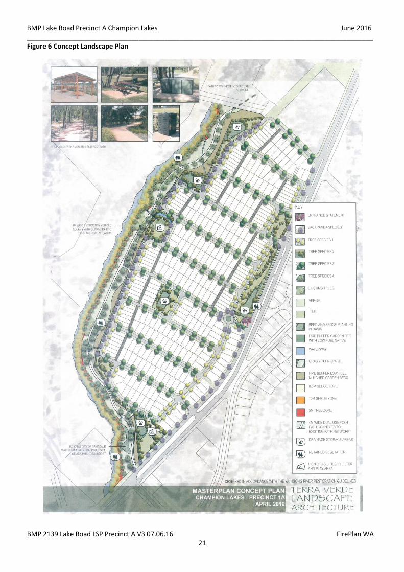
Landscape Mater Plan for landscaping along Wungong Foreshore Reserve
Two Examples of how the 15 metre wide area within the Wungong River Reserve area can be landscaped
to comply with the Asset Protection Zone.
5.2.2 BAL RATINGS
Individual dwellings on all lots shall be designed and built to conform with:
BMP Lake Road Precinct A Champion Lakes June 2016 _____________________________________________________________________________________________
BMP 2139 Lake Road LSP Precinct A V3 07.06.16 FirePlan WA 18
The Building Code of Australia; and
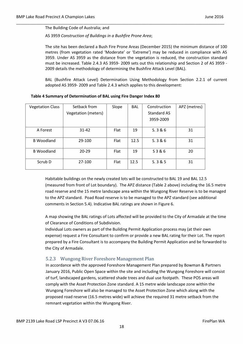
AS 3959 Construction of Buildings in a Bushfire Prone Area; The site has been declared a Bush Fire Prone Areas (December 2015) the minimum distance of 100 metres (from vegetation rated ‘Moderate’ or ‘Extreme’) may be reduced in compliance with AS 3959. Under AS 3959 as the distance from the vegetation is reduced, the construction standard must be increased. Table 2.4.3 AS 3959- 2009 sets out this relationship and Section 2 of AS 3959 - 2009 details the methodology of determining the Bushfire Attack Level (BAL). BAL (Bushfire Attack Level) Determination Using Methodology from Section 2.2.1 of current adopted AS 3959- 2009 and Table 2.4.3 which applies to this development:
Table 4 Summary of Determination of BAL using Fire Danger Index 80
Vegetation Class Setback from
Vegetation (meters)
Slope BAL Construction
Standard AS
3959-2009
APZ (metres)
A Forest 31-42 Flat 19 S. 3 & 6 31
B Woodland 29-100 Flat 12.5 S. 3 & 6 31
B Woodland 20-29 Flat 19 S 3 & 6 20
Scrub D 27-100 Flat 12.5 S. 3 & 5 31
Habitable buildings on the newly created lots will be constructed to BAL 19 and BAL 12.5
(measured from front of Lot boundary). The APZ distance (Table 2 above) including the 16.5 metre
road reserve and the 15 metre landscape area within the Wungong River Reserve is to be managed
to the APZ standard. Poad Road reserve is to be managed to the APZ standard (see additional
comments in Section 5.4). Indicative BAL ratings are shown in Figure 6.
A map showing the BAL ratings of Lots affected will be provided to the City of Armadale at the time
of Clearance of Conditions of Subdivision.
Individual Lots owners as part of the Building Permit Application process may (at their own
expense) request a Fire Consultant to confirm or provide a new BAL rating for their Lot. The report
prepared by a Fire Consultant is to accompany the Building Permit Application and be forwarded to
the City of Armadale.
5.2.3 Wungong River Foreshore Management Plan
In accordance with the approved Foreshore Management Plan prepared by Bowman & Partners
January 2016, Public Open Space within the site and including the Wungong Foreshore will consist
of turf, landscaped gardens, scattered shade trees and dual use footpath. These POS areas will
comply with the Asset Protection Zone standard. A 15 metre wide landscape zone within the
Wungong Foreshore will also be managed to the Asset Protection Zone which along with the
proposed road reserve (16.5 metres wide) will achieve the required 31 metre setback from the
remnant vegetation within the Wungong River.
BMP Lake Road Precinct A Champion Lakes June 2016 _____________________________________________________________________________________________
BMP 2139 Lake Road LSP Precinct A V3 07.06.16 FirePlan WA 19
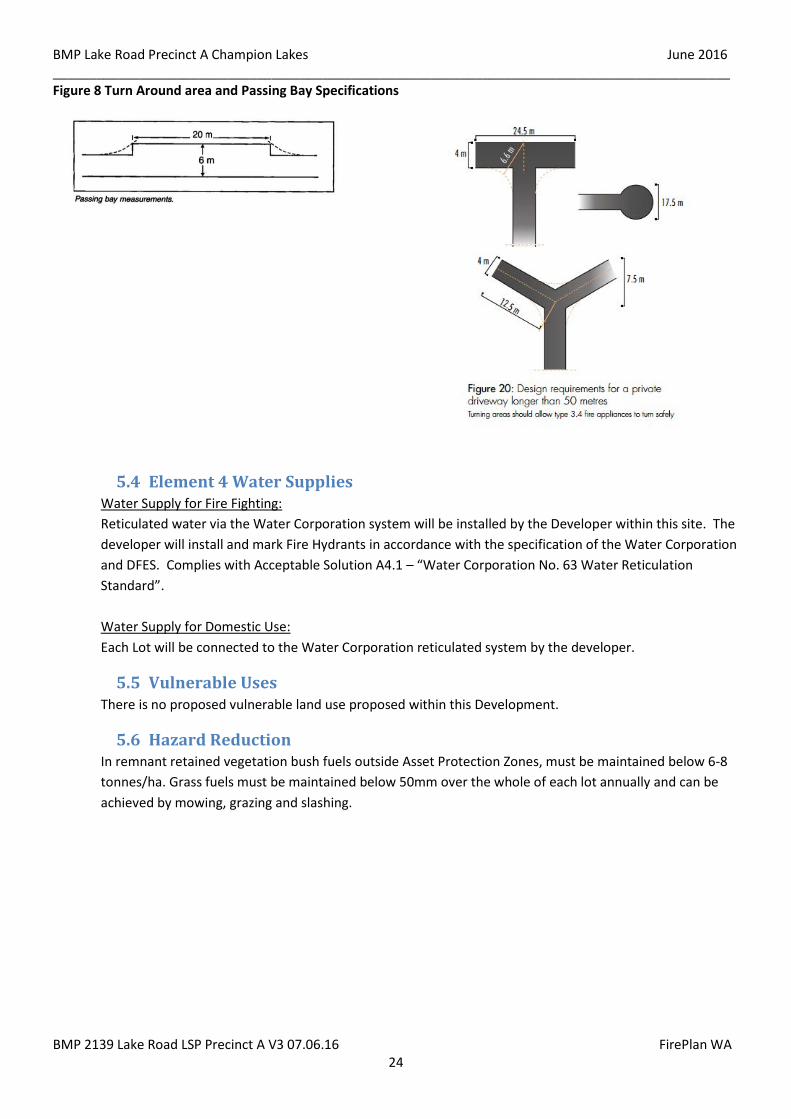
Turnaround areas are required every 500 metres and passing bays every 200 metres along the
dual use pathway as detailed in Figure 8.
See Figure 6 Concept Landscape Master Plan
5.2.4 Area north of Poad Road
The area adjoining the site to the north of Poad Rad between Lake Rd and the Wungong River is
subject to future development into Urban residential. However it is not known when this will occur.
Due to this the Lots adjoining Poad Road will be constructed to BAL 19AND Lots 29-100 metres
from the vegetation on the north side of Poad Road will be constructed to BAL 19. It is
recommended that all proposed habitable buildings within 100 metres of this vegetation have the
BAL re assessed as part of the Building Permit Application.
Lot 80 on the north side of Poad Road consists of Dwellings, sheds, horse stable and exercise yards.
Vegetation is open Woodland Class B See Section 4.2 and Figure 4.
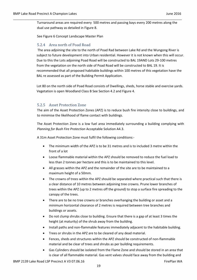
5.2.5 Asset Protection Zone
The aim of the Asset Protection Zones (APZ) is to reduce bush fire intensity close to buildings, and
to minimise the likelihood of flame contact with buildings.
The Asset Protection Zone is a low fuel area immediately surrounding a building complying with
Planning for Bush Fire Protection Acceptable Solution A4.3.
A 31m Asset Protection Zone must fulfil the following conditions:-
The minimum width of the APZ is to be 31 metres and is to included 3 metre within the
front of a lot
Loose flammable material within the APZ should be removed to reduce the fuel load to
less than 2 tonnes per hectare and this is to be maintained to this level.
All grasses within the APZ and the remainder of the site are to be maintained to a
maximum height of a 50mm.
The crowns of trees within the APZ should be separated where practical such that there is
a clear distance of 10 metres between adjoining tree crowns. Prune lower branches of
trees within the APZ (up to 2 metres off the ground) to stop a surface fire spreading to the
canopy of the trees.
There are to be no tree crowns or branches overhanging the building or asset and a
minimum horizontal clearance of 2 metres is required between tree branches and
buildings or assets.
Do not clump shrubs close to building. Ensure that there is a gap of at least 3 times the
height (at maturity) of the shrub away from the building.
Install paths and non-flammable features immediately adjacent to the habitable building.
Trees or shrubs in the APZ are to be cleared of any dead material.
Fences, sheds and structures within the APZ should be constructed of non-flammable
material and be clear of trees and shrubs as per building requirements.
Gas Cylinders should be isolated from the Flame Zone and should be stored in an area that
is clear of all flammable material. Gas vent valves should face away from the building and

BMP Lake Road Precinct A Champion Lakes June 2016 _____________________________________________________________________________________________
BMP 2139 Lake Road LSP Precinct A V3 07.06.16 FirePlan WA 20
anything flammable. Gas cylinders should be securely tethered with non-flammable
fastenings to prevent toppling over.
Roof gutters should be free of leaves and other combustible material.
Roof mounted evaporative air coolers should be fitted with ember proof screens to the
filter media to reduce the possibility of bushfire embers igniting the air cooler.
Figure 5 Relationship of APZ & HSZ to vegetation and habitable buildings
Source: Figure 15 of Appendix 4 of Guidelines for Planning for Bushfire Protection (December 2015) Separation distance required where no additional construction standards are proposed
Source: Figure 16 of Appendix 4 of Guidelines for Planning for Bushfire Protection (December 2015)
A reduced separation distance may necessitate increased construction standards
5.2.6 Installation of Evaporative Air conditioners
As a result of ember attack evaporative air conditioners can be the cause of a fire starting in a
building. It is a requirement that the roof unit of an evaporative air conditioner is enclosed in a
suitable external ember protection screen. More information is available at www.dfes.wa.gov.au
and in AS 3959.
BMP Lake Road Precinct A Champion Lakes June 2016 _____________________________________________________________________________________________
BMP 2139 Lake Road LSP Precinct A V3 07.06.16 FirePlan WA 21
Figure 6 Concept Landscape Plan

BMP Lake Road Precinct A Champion Lakes June 2016 _____________________________________________________________________________________________
BMP 2139 Lake Road LSP Precinct A V3 07.06.16 FirePlan WA 22
Figure 7 Indicative BAL Ratings.
BMP Lake Road Precinct A Champion Lakes June 2016 _____________________________________________________________________________________________
BMP 2139 Lake Road LSP Precinct A V3 07.06.16 FirePlan WA 23
5.3 Element 3 – Access
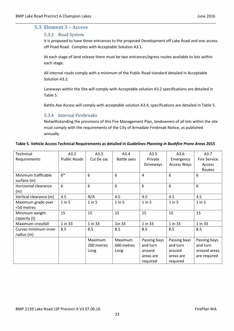
5.3.3 Road System
It is proposed to have three entrances to the proposed Development off Lake Road and one access
off Poad Road. Complies with Acceptable Solution A3.1.
At each stage of land release there must be two entrances/egress routes available to lots within
each stage.
All internal roads comply with a minimum of the Public Road standard detailed in Acceptable
Solution A3.2.
Laneways within the Site will comply with Acceptable solution A3.2 specifications are detailed in
Table 5.
Battle Axe Access will comply with acceptable solution A3.4, specifications are detailed in Table 5.
5.3.4 Internal Firebreaks
Notwithstanding the provisions of this Fire Management Plan, landowners of all lots within the site
must comply with the requirements of the City of Armadale Firebreak Notice, as published
annually.
Table 5. Vehicle Access Technical Requirements as detailed in Guidelines Planning in Bushfire Prone Areas 2015
Technical Requirements
A3.2 Public Roads
A3.3 Cul De sac
A3.4 Battle axes
A3.5 Private
Driveways
A3.6 Emergency
Access Ways
A3.7 Fire Service
Access Routes
Minimum trafficable surface (m)
6* 6 6 4 6 6
Horizontal clearance (m)
6 6 6 6 6 6
Vertical clearance (m) 4.5 N/A 4.5 4.5 4.5 4.5
Maximum grade over <50 metres
1 in 5 1 in 5 1 in 5 1 in 5 1 in 5 1 in 5
Minimum weight capacity (t)
15 15 15 15 15 15
Maximum crossfall 1 in 33 1 in 33 1in 33 1 in 33 1 in 33 1 in 33
Curves minimum inner radius (m)
8.5 8.5 8.5 8.5 8.5 8.5
Maximum 200 metres Long
Maximum 600 metres Long
Passing bays and turn around areas are required
Passing bays and turn around areas are required
Passing bays and turn around areas are required
BMP Lake Road Precinct A Champion Lakes June 2016 _____________________________________________________________________________________________
BMP 2139 Lake Road LSP Precinct A V3 07.06.16 FirePlan WA 24
Figure 8 Turn Around area and Passing Bay Specifications
5.4 Element 4 Water Supplies Water Supply for Fire Fighting:
Reticulated water via the Water Corporation system will be installed by the Developer within this site. The
developer will install and mark Fire Hydrants in accordance with the specification of the Water Corporation
and DFES. Complies with Acceptable Solution A4.1 – “Water Corporation No. 63 Water Reticulation
Standard”.
Water Supply for Domestic Use:
Each Lot will be connected to the Water Corporation reticulated system by the developer.
5.5 Vulnerable Uses There is no proposed vulnerable land use proposed within this Development.
5.6 Hazard Reduction In remnant retained vegetation bush fuels outside Asset Protection Zones, must be maintained below 6-8
tonnes/ha. Grass fuels must be maintained below 50mm over the whole of each lot annually and can be
achieved by mowing, grazing and slashing.
BMP Lake Road Precinct A Champion Lakes June 2016 _____________________________________________________________________________________________
BMP 2139 Lake Road LSP Precinct A V3 07.06.16 FirePlan WA 25
5.7 Restrictions on the Use of Machinery, Tools, Vehicles and Tractors
5.7.3 Total Fire Ban Days
A Total Fire Ban is declared because of the extreme weather conditions or when fires are seriously
stretching fire fighting resources. A Total Fire Ban is declared by DFES following consultation with
Local Governments.
When a Total Fire Ban is declared it prohibits the lighting of any fires in the open air and any
activities that might start a fire. The ban includes all open fires for the purpose of cooking or
camping. It also includes incinerators, welding, grinding soldering and gas cutting.
The Department of Fire and Emergency Services and the City of Armadale are to continue to
educate the public on what a Total Fire Ban means and what actions members of the public need
to take.
Public Education Program
The City of Armadale is to continue to provide the community with advice on bush fire prevention
and preparedness through brochures, newspaper articles, the Firebreak Notice issued to rate
payers and on their web site.
The developer is to provide a copy of the current City of Armadale Firebreak Notice, The
Homeowners Survival Manual and Prepare Act Survive brochure and this Bushfire Management
Plan at the time of sale of a Lot. It is essential that the Real Estate agent handling the sale of Lots
on behalf of the Developer advises potential landowners that a Fire Management Plan exists and
the modification of vegetation and ongoing fuel reduction will be required within this
development.
Other Public Safety and Community information on Bush Fires is available on the Department of
Fire and Emergency Services Authority web site www.dfes.wa.gov.au and the City of Armadale
website www.armadale.wa.gov.au.
5.7.4 Fire Safer Areas
In the event of a bush fire, the Incident Controller of Fire Fighting operations will advise if an
evacuation is necessary and, in conjunction with the City of Armadale Emergency Services, direct
residents to Safer Refuge Areas.
BMP Lake Road Precinct A Champion Lakes June 2016 _____________________________________________________________________________________________
BMP 2139 Lake Road LSP Precinct A V3 07.06.16 FirePlan WA 26
6.0 IMPLEMENTATION OF BUSHFIRE MANAGEMENT PLAN
This Bushfire Management Plan becomes operational as a condition of subdivision AND OR DEVELOPMENT
APPROVAL.
In implementing this Bushfire Management Plan, the following responsibilities have been determined.
6.1 Responsibilities
6.1.1 Property Owners Responsibilities
To maintain the reduced level of risk and threat of fire, the owners/occupiers of all lots created by
this proposal will be responsible for undertaking, complying and implementing measures
protecting their own assets from the threat and risk of bush fire:
• Maintaining the property in good order to minimize potential bushfire fuels to mitigate the
risk of fire on the property;
• Ensuring that the lot complies with the City of Armadale Firebreak Notice. To be carried
out annually;
• Ensuring that new dwellings are constructed to AS 3959 Table 4, Section 5.2 and Figure 7.
There will be a Section 70A notification on the Certificate of Title for each Lot requiring an
increased construction standard in accordance with AS3959;
• Complying with the instructions of DFES Fire Services, the City of Armadale and/or
volunteer fire services in maintaining the property or during the event of a bushfire;
• Ensuring that in the event an evaporative air conditioner is installed at the property,
suitable external ember screens are installed to roof mounted units and that they comply
with AS 3959, check annually. Detailed in Section 5.2.6
6.1.2 Developer’s Responsibilities
As a condition of subdivision the Developer shall be required to carry out works described in
Section 6 of this Fire Management Plan to the satisfaction of the City of Armadale and the Western
Australian Planning Commission:
• All driveway crossovers are to comply with the design requirements of the City of
Armadale;
• Each lot requiring an increased construction standard in accordance with AS 3959-2009 is
to have a 70A Notification placed on the land title advising the landowner of the existence
of this Bushfire Management Plan;
Install Road System and firebreaks as detailed in Section 5.3;
Install fire hydrants as detailed in Section 5.4
• Install and maintain the Asset Protection Zone within the Wungong River Reserve and
Public Open Space areas as detailed in Section 5.2 and maintain until Lot is sold;

BMP Lake Road Precinct A Champion Lakes June 2016 _____________________________________________________________________________________________
BMP 2139 Lake Road LSP Precinct A V3 07.06.16 FirePlan WA 27
• Each lot is to comply with the City of Armadale Firebreak Notice as published annually. This
is to be maintained until lots are sold;
• Supply a copy of this Bushfire Management Plan and The Homeowners Bush Fire Survival
Manual, Prepare Act Survive (or similar suitable documentation) and the City of Armadale
Firebreak Notice to each affected property purchaser on sale of the allotment;
Carryout landscaping as detailed in Section 5.2 in Wungong River Reserve and Public Open
Space;
6.1.3 City of Armadale
The responsibility for compliance with the law rests with individual property owners and occupiers
and the following conditions are not intended to unnecessarily transfer these responsibilities to
the City of Armadale.
The City of Armadale shall be responsible for:
• Ensuring compliance with the current adopted AS3959, of any new habitable structure,
renovation or extension to existing dwellings within each lot that is required to have an
increased construction standards, is undertaken at the time of Building Permit Application;
• Enforcing the City of Armadale Firebreak Notice;
• Maintain Road Systems (Section 5.3) and landscaped setback within the Wungong River
Reserve and Public Open Space as detailed in Section 5.2 in perpetuity.
6.2 Assessment of Fire Management Strategies All the actions and recommendations in this BMP, meet the Bushfires Act and Regulations 1954 compliant
with the acceptable solutions detailed in Guidelines for Planning in Bushfire Prone Areas December 2015
and are sound, measurable and practical having been used and proven over time. These recommendations
take into account the various costs, alternatives available, benefits for protection of residents and the
wider community, the environment and biodiversity protection.
This Bushfire Management Plan will be implemented as a condition of subdivision and or development
approval for the site.
It will be the responsibility of the developer to implement the provisions of this Bushfire Management Plan
in order to seek clearance of those conditions of subdivision.
Likewise it is the responsibility of the City of Armadale to ensure that all standards required in this Bushfire
Management Plan are met by the developer prior to clearing any conditions of subdivision relating to this
Bushfire Management Plan.
After any major fires that may occur during or once this development has been completed, the City of
Armadale may conduct a Post Incident Analysis of the fire, which may include identifying and implementing
any changes that may be needed to improve the performance of fire prevention strategies.
BMP Lake Road Precinct A Champion Lakes June 2016 _____________________________________________________________________________________________
BMP 2139 Lake Road LSP Precinct A V3 07.06.16 FirePlan WA 28
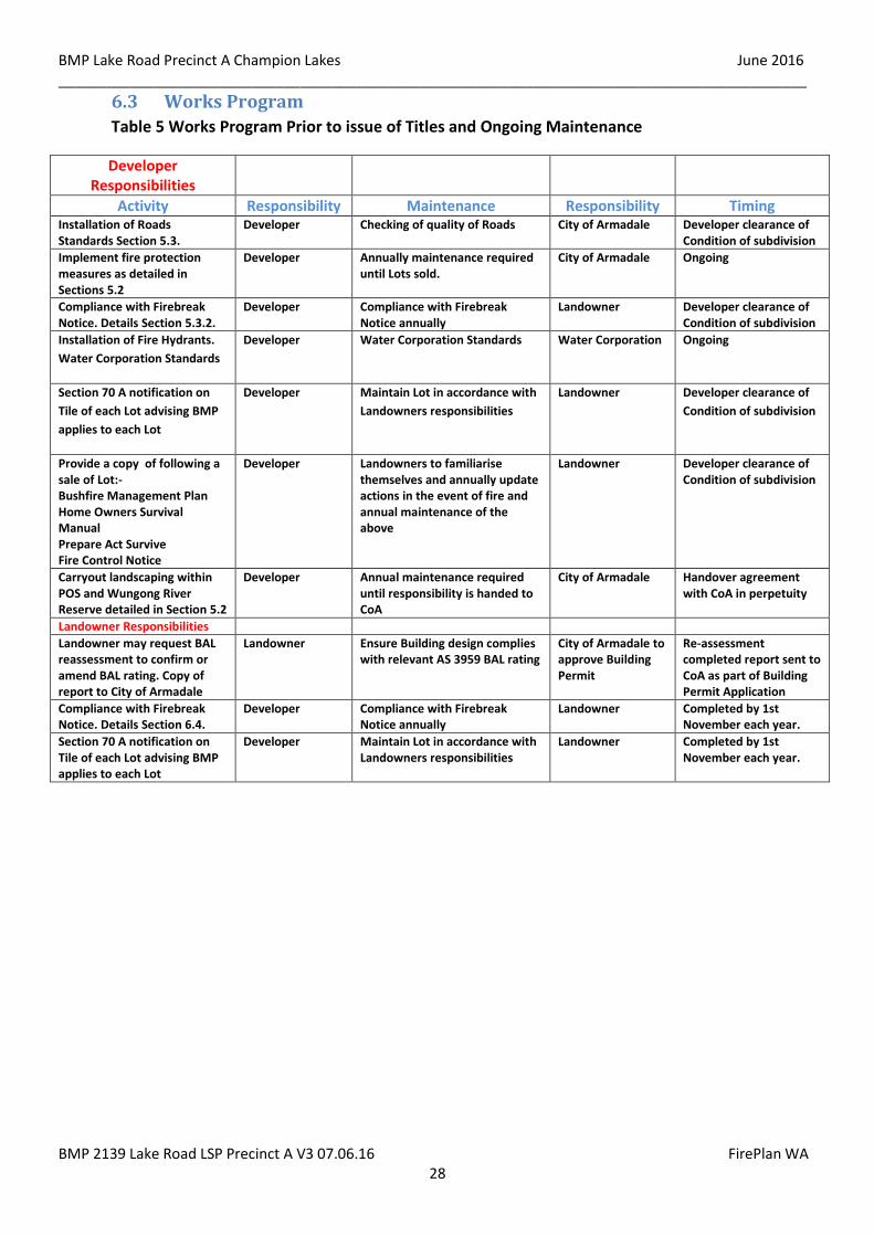
6.3 Works Program
Table 5 Works Program Prior to issue of Titles and Ongoing Maintenance
Developer Responsibilities
Activity Responsibility Maintenance Responsibility Timing Installation of Roads Standards Section 5.3.
Developer Checking of quality of Roads City of Armadale Developer clearance of Condition of subdivision
Implement fire protection measures as detailed in Sections 5.2
Developer Annually maintenance required until Lots sold.
City of Armadale Ongoing
Compliance with Firebreak Notice. Details Section 5.3.2.
Developer Compliance with Firebreak Notice annually
Landowner Developer clearance of Condition of subdivision
Installation of Fire Hydrants.
Water Corporation Standards
Developer Water Corporation Standards Water Corporation Ongoing
Section 70 A notification on
Tile of each Lot advising BMP
applies to each Lot
Developer Maintain Lot in accordance with
Landowners responsibilities
Landowner Developer clearance of
Condition of subdivision
Provide a copy of following a sale of Lot:- Bushfire Management Plan Home Owners Survival Manual Prepare Act Survive Fire Control Notice
Developer Landowners to familiarise themselves and annually update actions in the event of fire and annual maintenance of the above
Landowner Developer clearance of Condition of subdivision
Carryout landscaping within POS and Wungong River Reserve detailed in Section 5.2
Developer Annual maintenance required until responsibility is handed to CoA
City of Armadale Handover agreement with CoA in perpetuity
Landowner Responsibilities
Landowner may request BAL reassessment to confirm or amend BAL rating. Copy of report to City of Armadale
Landowner Ensure Building design complies with relevant AS 3959 BAL rating
City of Armadale to approve Building Permit
Re-assessment completed report sent to CoA as part of Building Permit Application
Compliance with Firebreak Notice. Details Section 6.4.
Developer Compliance with Firebreak Notice annually
Landowner Completed by 1st November each year.
Section 70 A notification on Tile of each Lot advising BMP applies to each Lot
Developer Maintain Lot in accordance with Landowners responsibilities
Landowner Completed by 1st November each year.

BMP Lake Road Precinct A Champion Lakes June 2016 _____________________________________________________________________________________________
BMP 2139 Lake Road LSP Precinct A V3 07.06.16 FirePlan WA 29
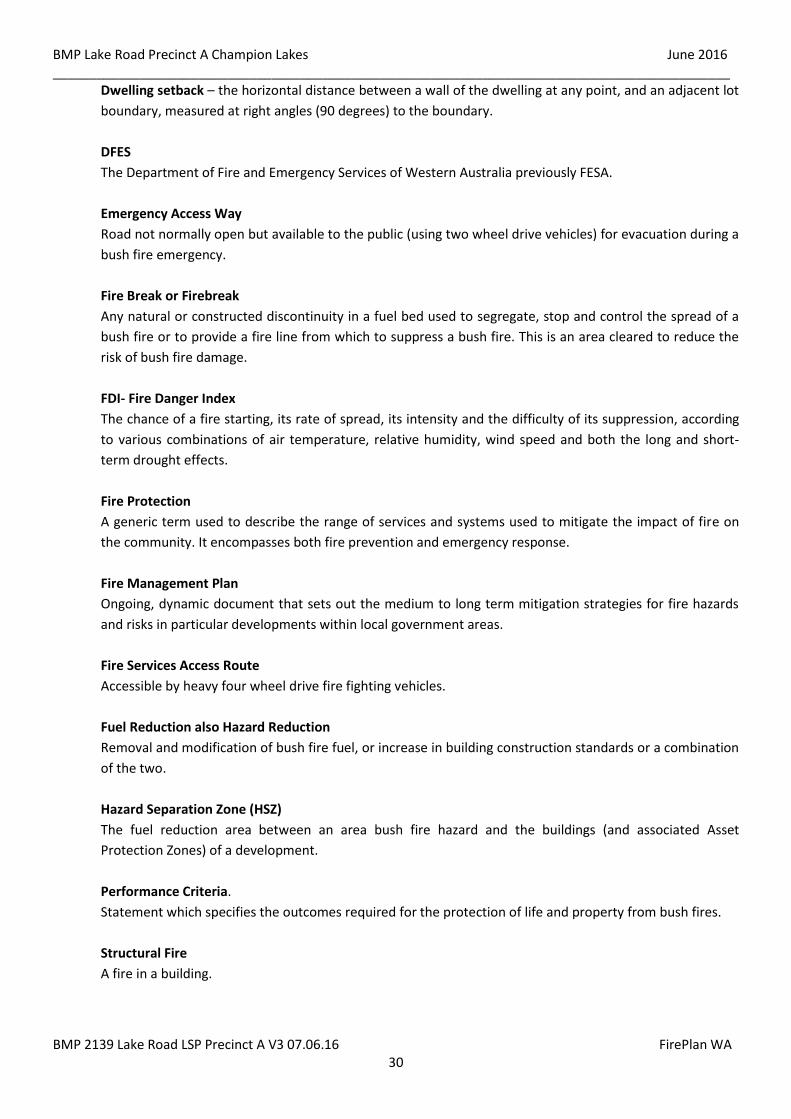
7.0 APPENDICES
7.1 Glossary Acceptable Solution
A statement describing an acceptable means of complying with the requirements of corresponding
performance criteria.
Appliance or Fire Appliance
A fire fighting appliance (vehicle) with structural, grass and bush fire fighting capabilities, with either a
2000 litres water capacity (2.4 appliance) or a 3000 litre water capacity (3.4 appliance) and four (4) wheel
drive.
Asset Protection Zone (APZ)
Low fuel area immediately surrounding buildings. Minimum width 20 metres, increasing with slope.
Maintained by the landowner
Bushfire Attack Level (BAL) – an assessed rating of a site’s risk to a bushfire, based on vegetation type,
slope of the land and its proximity to buildings.
Building Construction Standard Buffer - An area 100 metres wide Including a Asset Protection Zone in
which an increase in building construction standard in accordance with AS3959 will apply.
Bush
Under the Bush Fires Act 1954 the term bush is defined to include trees, bushes, plants, stubble, scrub and
undergrowth of a kind whatsoever whether dead or alive and whether standing or not standing.
Bush Fire or Wildfire
A general term used to describe fire in vegetation that is not under control.
Bush Fire Hazard.
The flammability, arrangement and quantity of vegetation, dead or alive, that can be burnt in a bush fire.
Development is to be avoided in extreme bush fire hazard designated areas.
Bush fire prone area - for the purposes of this fire management plan, a bush fire prone area is an area that
has been declared as such by the relevant local government responsible for an area. Once an area is
declared bush fire prone, then AS 3959 applies to new residential development in it.
Bush Fire Risk
The chance of a bush fire starting that will have harmful consequences on life and property. It is measured
in terms of consequences and likelihood and arises from the interaction of hazards, communities and the
environment.
Development Application
An application for approval to carry out a development under either a local planning scheme or regional
planning scheme.
BMP Lake Road Precinct A Champion Lakes June 2016 _____________________________________________________________________________________________
BMP 2139 Lake Road LSP Precinct A V3 07.06.16 FirePlan WA 30
Dwelling setback – the horizontal distance between a wall of the dwelling at any point, and an adjacent lot
boundary, measured at right angles (90 degrees) to the boundary.
DFES
The Department of Fire and Emergency Services of Western Australia previously FESA.
Emergency Access Way
Road not normally open but available to the public (using two wheel drive vehicles) for evacuation during a
bush fire emergency.
Fire Break or Firebreak
Any natural or constructed discontinuity in a fuel bed used to segregate, stop and control the spread of a
bush fire or to provide a fire line from which to suppress a bush fire. This is an area cleared to reduce the
risk of bush fire damage.
FDI- Fire Danger Index
The chance of a fire starting, its rate of spread, its intensity and the difficulty of its suppression, according
to various combinations of air temperature, relative humidity, wind speed and both the long and short-
term drought effects.
Fire Protection
A generic term used to describe the range of services and systems used to mitigate the impact of fire on
the community. It encompasses both fire prevention and emergency response.
Fire Management Plan
Ongoing, dynamic document that sets out the medium to long term mitigation strategies for fire hazards
and risks in particular developments within local government areas.
Fire Services Access Route
Accessible by heavy four wheel drive fire fighting vehicles.
Fuel Reduction also Hazard Reduction
Removal and modification of bush fire fuel, or increase in building construction standards or a combination
of the two.
Hazard Separation Zone (HSZ)
The fuel reduction area between an area bush fire hazard and the buildings (and associated Asset
Protection Zones) of a development.
Performance Criteria.
Statement which specifies the outcomes required for the protection of life and property from bush fires.
Structural Fire
A fire in a building.

BMP Lake Road Precinct A Champion Lakes June 2016 _____________________________________________________________________________________________
BMP 2139 Lake Road LSP Precinct A V3 07.06.16 FirePlan WA 31
8.0 COMPLIANCE CHECKLIST PERFORMANCE CRITERIA AND ACCEPTABLE
SOLUTIONS Property Details: Lot 59 McKenna Drive, Cardup
Local Government: Shire of Serpentine Jarrahdale
Element Compliance Comment
Element 1: Location
Yes No N/A
A1.1 The strategic planning proposal, subdivision and development application is located in an area that is or will, on completion, be subject to either a moderate or Low bushfire hazard level or BAL 29 or below.
Subdivision/development is located on land that is not subject to either an extreme bushfire hazard land classification or requires construction to BAL 40 or BAL FZ
Element 2: Siting and Design of Development
A2.1 Asset Protection Zone Landscape buffer Foreshore Man Plan
A2.2 Hazard Separation Zone
Element 3: Vehicular Access A3.1 Two different vehicular access routes,
both of which connect to the public Road network, provide safe access and egress to two different destinations and be available to residents/the public at all times and under all weather conditions
A3.2 Public Roads
A3.3 Cul-de-sacs
A3.4 Battle Axe Access
A3.5 Private driveways
A3.6 Emergency access ways
A3.7 Fire services access routes
A3.8 Firebreaks City of Armadale Firebreak Notice
Element 4: Water Supplies
A4.1 Reticulated areas As detailed to Water Corporation
Standard
A4.2 Non-reticulated areas
A4.3 Individual Lot non reticulated area
Applicant Declaration:
I declare that the information provided is true and correct to the best of my knowledge.
Name of Person Preparing the Fire Management Plan:
Full Name: for FirePlan WA Date: 7/06/2016
Developer:
Full Name: _______________ Signature: _____________________ Date:

BMP Lake Road Precinct A Champion Lakes June 2016 _____________________________________________________________________________________________
BMP 2139 Lake Road LSP Precinct A V3 07.06.16 FirePlan WA 32
9.0 PROPOSAL COMPLIANCE AND JUSTIFICATION This Bushfire Management Plan complies with the following Section of SPP-3.7 and the Guidelines.
Policy Measure. Compliance Comment
Yes No N/A 6.1 Higher order strategic Planning documents
6.2 Strategic Planning proposals, subdivision and development applications
TPS 4
6.3 Information to accompany strategic Planning proposals BAL 19 to BAL 12.5
6.4 Information to accompany subdivision application BMP prepared in accordance with Guidelines
6.5 Information to accompany Development Applications Indicative BAL for affected Lots
6.6 Vulnerable or High risk land uses No Vulnerable or high-risk land use in subdivision
6.7 Strategic Planning proposals, subdivision or development applications in areas with extreme BHL and /or areas where BAL -40 or BAL FZ applies
BAL 19 to BAL LOW applies Site
6.8 Advice from State/relevant authority/s for emergency services to be sought
City of Armadale
6.9 Advice from State/relevant agency/authorities for environmental protection sought
Foreshore Management Plan Approved by City of Armadale
6.10 Bushfire conditions may be imposed Notification on Land Title Section 6.1.2
6.11 Precautionary Principle Acceptable solutions complied with see Section 8.0
Statement against Relevant Documents Guidelines for Planning in Bushfire Prone Areas Performance Criteria and
acceptable solution checklist Section 8.0
Any Existing Bushfire Management Plan
Any existing BHL assessment or BAL assessment prepared over the Site
Nil
Local Planning Strategies references to bushfire risk management
Urban - MRPS
Local Planning Scheme Provisions relating to bushfire management
Precinct A1 – Campion Lakes
Any applicable structure Plans , Special control area provisions, previous planning approvals or similar referencing bushfire risk management applicable to the subject site
BMP to support LSP
Any relevant landscaping plans applicable to the subject Site
Firebreak Order applicable to subject site City of Armadale Firebreak Notice 4.3.2
AS 3959 Construction of Buildings in Bushfire Prone Areas Detailed in Section 4.2
BMP complies with Acceptable solutions Checklist Section 8.0
DISCLAIMER In the event of large bushfires it is essential that landowners understand that fire appliances may not be
available to protect each dwelling/building, landowners are responsible for the protection of their own
assets which may require additional protection above the minimum detailed in this Bushfire Management
Plan.
Related Documents