STEVEN A. WERNKE BUILDING TENSION. DILEMMAS OF THE BUILT ENVIRONMENT THROUGH INCA AND SPANISH RULE

Welcome message from author
This document is posted to help you gain knowledge. Please leave a comment to let me know what you think about it! Share it to your friends and learn new things together.
Transcript
164
S T E V E N A . W E R N K EB U I L D I N G T E N S I O N . D I L E M M A S O F T H E B U I LT E N V I R O N M E N T T H R O U G H I N C A A N D S PA N I S H R U L E

165S t e v e n A . W e r n k e B u i l d i n g Te n s i o n . D i l e m m a s o f t h e B u i l t E n v i r o n m e n t t h r o u g h I n c a a n d S p a n i s h R u l e
Over the last decade there has been a certain convergence of thinking regarding the local production of power and new social formations in Tawantinsuyu and the Viceroyalty of Peru. In both fields of study, scholars have come to understand colonial power as a manifold and relational process that can produce seemingly contradictory effects: how techniques of dominance do not necessarily produce stable systems of domination – and more than that – how power relations can be destabilized through the same policies and media intended to stabilize them. This paper takes soundings of the consolidation and destabilization of power through the built environment, focusing on the transition from Inca to Spanish colonial rule in a particular context: the Colca Valley of southern highland Peru. It focuses on the terminal era of Inca rule through the colonial mass resettlement known as the Reducción General de Indios (the General Resettlement of Indians) instituted by the Viceroy Francisco de Toledo in the 1570s.
Quite some time ago, Frank Salomon aptly characterized Inca imperial politics as “pseudo conservative” in nature. As he put it, “. . . at every stage . . . Inca administrators appear to have observed a norm demanding a superficial formal congruence between the imperial and aboriginal levels of government. Innovation was clothed in a conservative rhetoric” (Salomon 1986, p. 215). The Inca presented themselves as “a chiefdom over chiefdoms”, largely through the ritual forums and practices of commensalism, public ceremony, and mortuary cult. All were meant to reinforce a vision of the Incas as superordinate ancestors–a status that would trump obligations owed to local elites and numina. Local lords served as locally-recognized intermediaries, while state extraction was represented as an extension of traditional kin-based relations of reciprocity and redistribution. The form of imperial administration thus varied significantly as distinct orders were locally improvised. As a result, the form that the state actually manifested in daily life varied significantly as well.
This dynamic posed a dilemma to Inca imperial power relations: Incaic “dominance” depended on its antithesis, the communitarian logic and ethos of kinship (Silverblatt 1988, p. 86). As ancestors to all, the Incas obliged tribute of their subject peoples, but by incorporating these invaders as ancestors, local peoples also (at least potentially) obliged the Incas to return the gift (Gose 2008). Because this apparent paradox of Inca imperial power relations was never resolved–and because Spanish colonial rule was instituted through the remnants of Inca institutions–it also shaped relations between local communities and Spanish colonial agents and institutions.
166
But if the modus operandi of the Incas was pseudo conservative, that of the master architect of viceregal governance in Peru, Francisco de Toledo, was “pseudo radical”. At the level of official discourse, Toledo’s governmental reforms called for the reorganization of the Andean settlement and community life from the ground up through a general administrative survey of the entire viceroyalty (the Visita General) and an accompanying comprehensive resettlement, a regimented tribute and labor quota system, and a corps of provincial magistrates (corregidores de indios) to oversee it all. Toledo envisioned an omniscient government and rigidly hierarchical social order in which everyone had an ascribed place and role in the dynastic realm of the Catholic kings. But the realpolitik was much more improvisational, through Spanish co-optation of Incaic institutions, clientelism, and so on. This was also partly by design. As Jeremy Mumford puts it in his recent book Vertical Empire, “Toledo loudly called for transforming the Andean way of organizing space, in the broad outlines, while quietly preserving it in the details” (Mumford 2012, p. 116).
Although these more subtle ethnographic dimensions of the Toledan reforms are only obliquely accessible in written texts, this paper traces them out through the primary media of their enactment – the built environment. Here again is another parallel between the Incaic and Spanish colonial projects: in both, the built environment was seen as not just a reflection of a new civilizational order, it was manipulated to produce it. The built environment was seen as generative of policia–social order (Cummins 2002). Likewise, in the Inca empire we have come to appreciate imperial centers as elaborate stage sets for commensal ritual–as theaters for the production of political and economic obligation through the logics and ethos of communitarian reciprocity (Bauer 1996; Coben 2006; Morris 2013). Likewise, Spanish clerics, magistrates, and viceroys designed and built gridded towns around churches and plazas to inculcate Indian subjects to a new Christian social order (Cummins 2002). But such spatial ideologies could be sustained only so long as they resonated with the practices of subject peoples and thus made intelligible to them (Abercrombie 1998; Durston 1999; Mumford 2012; Wernke 2007).
In this paper I look at the local effects and processes involved in the transition from one imperial spatial order to the other under Inca and Spanish rule, as they articulated with, and were transformed by, local communities. Centered in the Colca Valley of southern Peru, I trace out how Inca administrative schemata were incompletely instituted and continued to be mediated by local elites, even as new imperial settlements and imperial installations

167
at existing settlements were constructed throughout the valley. This exploration of the Inca occupation contextualizes post-invasion dislocations within a longer trajectory of centripetal movement and migration. Within this trans-conquest context, the more subtle ethnographic dimensions (sensu Mumford 2012, pp. 2-3) of Toledo’s massive experiment in social engineering come into clearer focus. Even as the Reducción did violence to relationships between people, settlement, and their enveloping agro-pastoral landscapes, it also recycled some of the core aspects of settlement organization initiated during the Inca imperial occupation. More detailed exploration of a particular reducción–the now abandoned town of Santa Cruz de Tute–shows how even the internal organization of reducciones were deeply compromised and derivative of Inca spatial forms and practices. This perspective adds to a growing understanding of how the reducciones were not simply alien forms arbitrarily imposed, nor as totalizing in their transformation of Andean ways of organizing space as proclaimed in official correspondence. Such “building tension” was never resolved, as the built environment simultaneously produced and troubled new colonial subjectivities and economies of power.
Settlement Consolidation and Administration under Inca Rule
Although perhaps unique in the speed of its execution, Toledo’s Reducción was not the first state-ordered mass resettlement in the Andes. The Incas resettled as many as three million subjects over great distances in their empire to serve as mitmaqkuna (ethnic colonists), and large population segments were also resettled to state settlements on a more local scale. Thus, in the Colca Valley–as in many areas–the Reducción would have been experienced not so much as an unprecedented rupture as a punctuated event in a longer trajectory of settlement consolidation.
Inca administration in the Colca Valley does not fit neatly into the heuristic categories of “direct” or “indirect” strategies of governance. In general, documentary sources represent a situation of centralized imperial rule through the partial realignment of local communities to an administrative hierarchy based on bipartite, tripartite, and decimal structural elements. The relación of Juan de Ulloa Mogollón, written for the survey of the Relaciones geográficas de indias, describes the political structure of the province of the Collaguas. First, Ulloa describes the distinct mythic origins, territories, insignia,
S t e v e n A . W e r n k e B u i l d i n g Te n s i o n . D i l e m m a s o f t h e B u i l t E n v i r o n m e n t t h r o u g h I n c a a n d S p a n i s h R u l e
168
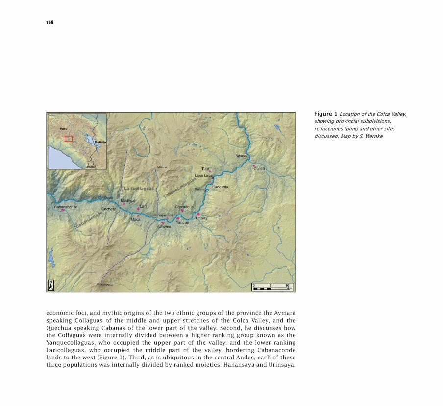
economic foci, and mythic origins of the two ethnic groups of the province the Aymara speaking Collaguas of the middle and upper stretches of the Colca Valley, and the Quechua speaking Cabanas of the lower part of the valley. Second, he discusses how the Collaguas were internally divided between a higher ranking group known as the Yanquecollaguas, who occupied the upper part of the valley, and the lower ranking Laricollaguas, who occupied the middle part of the valley, bordering Cabanaconde lands to the west (Figure 1). Third, as is ubiquitous in the central Andes, each of these three populations was internally divided by ranked moieties: Hanansaya and Urinsaya.
Figure 1 Location of the Colca Valley, showing provincial subdivisions, reducciones (pink) and other sites discussed. Map by S. Wernke
169
Fourth, Ulloa explains how each moiety was subdivided by a ranked, tripartite schema, with the names (in descending order of rank) Collana, Pahana, and Cayao. These are the same categories that governed the ordering of the ceque system in Cuzco. 1 Ulloa refers to them as ayllus, and it is evident within the relación that each of them was composed of a decimal administrative unit of 300 tributaries, which was divisible to three minimal ayllus of 100 tributaries, which were in turn classified by the same tripartite ranking.
The incomplete process of accommodating a standardized imperial program to the local context becomes evident when comparing the outline of the ideal structure to the deviations from it, as registered in a series of detailed administrative surveys (visitas) from the 1590s through the mid-17th century. In all three provincial subdivisions, the ayllus of Hanansaya tend to deviate more from the ideal, and these were primarily autochthonous, not migrant (mitmaq) ayllus. This is especially apparent in Yanquecollaguas and Laricollaguas, in which the names of the Hanansaya ayllus are predominantly Aymara, and point to an underlying dualistic organization. Tripartite and decimal administrative nomenclature sometimes appear tacked-on to the names of Hanansaya ayllus. These addenda probably index imperial efforts to restructure both moieties to the ideal schema. The functional workings of the system probably flowed from distinct policies between the two moieties: in Hanansaya, the Incas promoted the local elite and governed more or less indirectly through them, while in Urinsaya, the Incas resettled foreign ayllus and/or reorganized autochthonous ones according to the tripartite schema. Those Urinsaya ayllus were probably more directly overseen by imperial administrators.
If anything, the archaeological evidence points to a more pseudo-conservative form of Inca administration than might be expected from the written record. There is no dominant imperial administrative center in the Colca Valley. Instead, administration was apparently coordinated through three smaller imperial centers in each of the three provincial subdivisions. In Laricollaguas and Cabanaconde, the settlement pattern expands dramatically in terms of the number of sites and total area occupied between the Late Intermediate Period (hereafter LIP; AD 1000-1450) and the Late Horizon, administrative centers dominating the local settlement network in each. In Yanquecollaguas, existing settlements grew markedly and a new administrative center was built in the location of the future reducción of Yanque. Local administration there appears to have been more locally-mediated, as ceremonial complexes in the form of kallankas (great halls) and plazas were constructed prominently within the largest LIP settlements (Figure 2).
1 The ceque system was a network of shrines (huacas) that synchronized ritual activity in Cusco in calendar-like fashion. Shrines along the imaginary lines that radiated out from the Temple of the Sun were attended in sequential fashion on prescribed dates.
S t e v e n A . W e r n k e B u i l d i n g Te n s i o n . D i l e m m a s o f t h e B u i l t E n v i r o n m e n t t h r o u g h I n c a a n d S p a n i s h R u l e

170
171
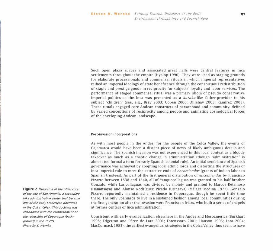
Such open plaza spaces and associated great halls were central features in Inca settlements throughout the empire (Hyslop 1990). They were used as staging grounds for elaborate processionals and commensal rituals in which imperial representatives reified an imperial ideology of state beneficence through the conspicuous redistribution of staple and prestige goods in reciprocity for subjects’ loyalty and labor services. The performance of staged commensal ritual was a primary idiom of pseudo conservative imperial politics–as the Inca was presented as a kuraka-like father-provider to his subject “children” (see, e.g., Bray 2003; Coben 2006; Dillehay 2003; Ramírez 2005). These rituals engaged core Andean constructs of personhood and community, defined by varied conceptions of reciprocity among people and animating cosmological forces of the enveloping Andean landscape.
Post-invasion incorporations
As with most people in the Andes, for the people of the Colca Valley, the events of Cajamarca would have been a distant piece of news of likely ambiguous details and significance. The Spanish invasion was not experienced in this local context as a bloody takeover as much as a chaotic change in administration (though “administration” is almost too formal a term for early Spanish colonial rule). An initial semblance of Spanish governance was achieved by coopting local ethnic lords and distorting the structures of Inca imperial rule to meet the extractive ends of encomiendas (grants of Indian labor to Spanish trustees). As part of the first general distribution of encomiendas by Francisco Pizarro between 1538 and 1540, all of Yanquecollaguas was granted to his half-brother Gonzalo, while Laricollaguas was divided by moiety and granted to Marcos Retamoso (Hanansaya) and Alonso Rodríguez Picado (Urinsaya) (Málaga Medina 1977). Gonzalo Pizarro reportedly maintained a residence in Coporaque, though he spent little time there. The only Spaniards to live in a sustained fashion among local communities during the first generation after the invasion were Franciscan friars, who built a series of chapels at former centers of Inca administration.
Consistent with early evangelization elsewhere in the Andes and Mesoamerica (Burkhart 1998; Edgerton and Pérez de Lara 2001; Estenssoro 2001; Hanson 1995; Lara 2004; MacCormack 1985), the earliest evangelical strategies in the Colca Valley thus seem to have
S t e v e n A . W e r n k e B u i l d i n g Te n s i o n . D i l e m m a s o f t h e B u i l t E n v i r o n m e n t t h r o u g h I n c a a n d S p a n i s h R u l e
Figure 2 Panorama of the ritual core of the site of San Antonio, a secondary Inka administrative center that became one of the early Franciscan doctrinas in the Colca Valley. This doctrina was abandoned with the establishment of the reducción of Coporaque (back-ground) in the 1570s. Photo by S. Wernke

172
resonated with prehispanic analogs by focusing on outdoor catechesis and pageantry in a performative pastoral approach. The close associations between the Franciscan chapels and Inca administrative architecture within these doctrinas suggest that the friars’ early pastoral efforts, in contrast to the pseudo radical view of eradication and replacement evident in the documentary record, produced spatial analogies that referenced Incaic ceremonial spaces and their associated practices for the inculcation of new Catholic rites (Wernke 2007).
Coeval documentation of their initial entry are lacking, but a Franciscan memorial written around 1585 recounts the arrival of a small group of friars headed by one Fray Juan de Monzón, along with Fray Juan de Chaves, about forty years previous–that is, sometime around 1545 (ASFCL registro 15, parte 5). About twenty years later, the Franciscans had expanded and began formalizing their mission in valley. By this time–the height of the Counter Reformation in Europe–Church institutions throughout the viceroyalty were struggling to move toward more uniform doctrine and methods of indoctrination (Durston 2007, p. 71; Estenssoro 2003, pp. 139-145). By the mid-1560s, the friars had constructed convents in Yanque in the central part of the valley and Callalli in the upper reaches of the valley (Córdoba y Salinas [1651] 1957, pp. 151-157), and a more formal system of doctrinas seems to have been in place (Cook 2002). The friars had by this time begun congregating households from surrounding settlements to the doctrinas (Eche verría y Morales [1804] 1952). We can explore these transformations in spatial order and practice in great detail at the doctrina of Malata, located in the upper reaches of the Colca Valley.
Malata: an Inca Provincial Outpost and Early Franciscan Doctrina
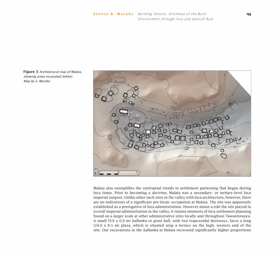
The site of Malata is located high in the Colca Valley at 3850 meters above sea level in a transitional ecozone between the agricultural core of the valley and the high altitude puna grasslands, where pastoralism is practiced. This small village, composed of 81 standing fieldstone structures in a 1.8 ha core habitation area, occupies a shallow draw in a broad alluvial terrace above the deep gorge of the Colca River (Figure 3). The site dates to the Inca and early post-invasion eras, and was abandoned with the establishment of the Toledan reducciones in the 1570s (Wernke 2007, 2012, 2013a, 2013b).
173
Malata also exemplifies the centripetal trends in settlement patterning that began during Inca times. Prior to becoming a doctrina, Malata was a secondary- or tertiary-level Inca imperial outpost. Unlike other such sites in the valley with Inca architecture, however, there are no indications of a significant pre-Incaic occupation at Malata. The site was apparently established as a prerogative of Inca administration. However minor a role the site played in overall imperial administration in the valley, it retains elements of Inca settlement planning found on a larger scale at other administrative sites locally and throughout Tawantinsuyu. A small (9.6 x 6.0 m) kallanka or great hall, with two trapezoidal doorways, faces a long (24.0 x 8.5 m) plaza, which is situated atop a terrace on the high, western end of the site. Our excavations in the kallanka at Malata recovered significantly higher proportions
S t e v e n A . W e r n k e B u i l d i n g Te n s i o n . D i l e m m a s o f t h e B u i l t E n v i r o n m e n t t h r o u g h I n c a a n d S p a n i s h R u l e
Figure 3 Architectural map of Malata, showing areas excavated (white). Map by S. Wernke

174
of finely-crafted Collagua Inca style serving vessels in floor level contexts than those of domestic structures (Wernke 2013a). The great hall and its associated plaza thus appear to have been the focal point of public ceremonial space during the Inca occupation.
Similar to the other doctrinas in the valley, a rustic chapel is situated close to this Inca era ceremonial complex (Figure 4). This proximity by Euclidean measures, however, obscures major spatial reordering of the settlement as it was transformed into a doctrina. The chapel was originally built on the natural hill slope and fronted by four entry steps, without the enclosing atrium or fronting plaza. The atrium, plaza, and steps leading from the plaza up to the atrium were all added during a subsequent
Figure 4 Panorama of the public and ritual center of Malata during excavations, including the Franciscan chapel (right), colonial plaza (in front of chapel) and Inka kallanka and its associated plaza (center, background). Photo by S. Wernke
175
remodeling event. The basic features of what became standard elements of Spanish urban planning in the Americas thus took form at Malata: church, atrium, plaza, cross, and civic building. They were not built at once, but fitted to an existing settlement, which was then significantly modified to fit a Spanish urban model (however rustically executed), perhaps with the expansion of the Franciscan mission in the valley during the 1560s (Wernke 2012, 2013b, pp 158-213).
Evidence from the residential area also points to significant growth and the addition of newly-configured domestic compounds during the colonial era occupation of Malata. The village is arranged around an older core area near the Inca complex, composed of domestic compounds of circular floor plan arranged irregularly around central patio areas. Around this old site core, rectilinear houses were added during the colonial era. At the eastern end of the site, these houses are arranged in linear fashion in the manner of streets. They were almost certainly built by households congregated to the doctrina under the direction of the friars. At the western end of the site, such colonial era houses are arranged singly with patio spaces. Because of their separation from the rest of the settlement, proximity to the chapel, and the unique character of their internal layouts and assemblages, these buildings were most likely the quarters of friars, who probably came for short stays during pastoral rounds (Wernke 2013a).
The Reducción General de Indios in the Colca Valley
The Franciscan doctrinas were short lived, however, as they were either forcibly abandoned or overbuilt during the Reducción General of the 1570s. Between 1572 and 1574, the corregidor Lope de Suazo, in his capacity as visitador, “reduced” the population of 33,900 inhabitants in the Collaguas Province to 24 towns (Gutiérrez et al. 1986; Málaga Medina 1974, 1977). The province was the most densely populated under the jurisdiction of Arequipa, constituting a third of its population, and 35% of its annual tribute (Guillet 1992; Manrique 1985). Considering the regional importance of the province, there were powerful incentives to maintain the productive capacity of its lands and population. In that sense, the interests of viceregal administration, the church, and local communities were broadly aligned. But that must have made the difficult compromises inherent to the resettlement much more evident: who would bear the brunt of the resettlement? Many of
S t e v e n A . W e r n k e B u i l d i n g Te n s i o n . D i l e m m a s o f t h e B u i l t E n v i r o n m e n t t h r o u g h I n c a a n d S p a n i s h R u l e
176
the important aspects of planning the resettlement must have been negotiated at a very local level when Suazo and his entourage met with the resident friars and community authorities.
So how did resettlement affect existing patterns of settlement and land use? A full discussion of these processes is beyond the scope of this paper, but as a rule, a pseudo radical policy is evident. Although the reducciones brought about an abrupt transformation of the settlement pattern, high ranking populations resident in the largest settlements were displaced the least. There is overall continuity of settlement between the principal Inca administrative centers and the principal reducciones of each of the three repartimientos of the colonial province. In the cases of Yanque and Lari–the capitals of their eponymous repartimientos–the reducciones are literally built on top of the old Inca centers. In the case of Cabanaconde, the reducción town is adjacent to the two principal Inca settlements in the lower part of the valley (the sites of Antisana and Kallimarka), which were situated on steep hilltops, and thus not amenable to the construction of a gridded town (de la Vera Cruz Chávez 1987; Doutriaux 2004).
In the upper reaches of the valley lie the ruins of a reducción that was apparently started, but never finished. This settlement, today known as Laiqa Laiqa, is also situated in the area of a significant Inca era settlement. During Inca times, it likely functioned as a secondary administrative center, sharing the same characteristics found at other other such centers in the valley, including two kallankas and their associated plazas. But what is especially intriguing about Laiqa Laiqa is the presence of a large church in ruins at the center of the settlement. This church is nearly three times the size of the chapels at the early Franciscan doctrinas, and is on the same scale as those of the other reducciones. Based several lines of evidence, Laiqa Laiqa was most likely the reducción referred to as the “Villanueva de Alcaudete de Coymo” (hereafter, “Coymo”) in the original listing of reducciones from the visita general. This being the case, Coymo would have been the nearest reducción to Malata, and was, therefore, the most likely town to which the inhabitants of Malata were resettled. However, Coymo was very short-lived. It was already abandoned by 1591–this is known because Coymo was not recorded in the visita from that year (the earliest known post-Toledan visita in the valley). It is, therefore, quite likely that the people of Malata were subjected to multiple resettlements over a few generations: 1) when it was established under Inca rule, 2) when new households were congregated there during its brief use life as a Franciscan doctrina, 3) when it was abandoned and the
177
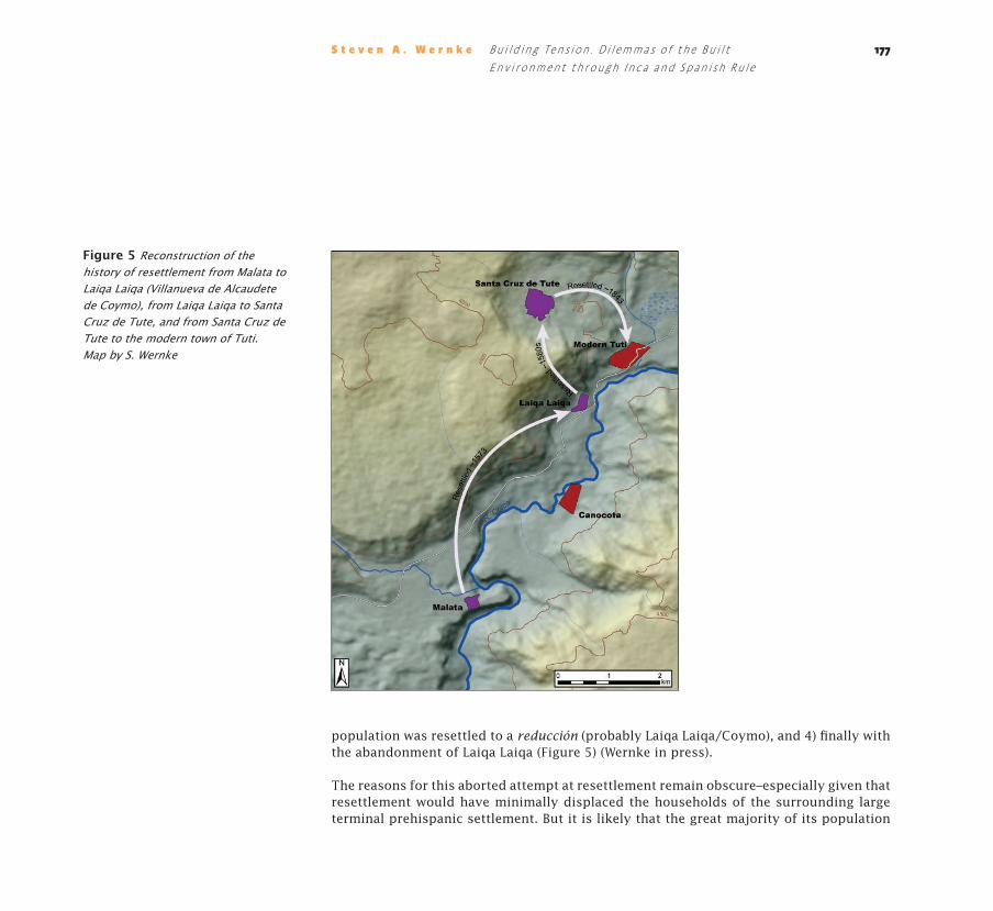
population was resettled to a reducción (probably Laiqa Laiqa/Coymo), and 4) finally with the abandonment of Laiqa Laiqa (Figure 5) (Wernke in press).
The reasons for this aborted attempt at resettlement remain obscure–especially given that resettlement would have minimally displaced the households of the surrounding large terminal prehispanic settlement. But it is likely that the great majority of its population
S t e v e n A . W e r n k e B u i l d i n g Te n s i o n . D i l e m m a s o f t h e B u i l t E n v i r o n m e n t t h r o u g h I n c a a n d S p a n i s h R u l e
Figure 5 Reconstruction of the history of resettlement from Malata to Laiqa Laiqa (Villanueva de Alcaudete de Coymo), from Laiqa Laiqa to Santa Cruz de Tute, and from Santa Cruz de Tute to the modern town of Tuti. Map by S. Wernke
178
would have been resettled to the neighboring reducción of Santa Cruz de Tute, the subject of the remainder of this paper.
Recycling and Recirculating Spaces at Santa Cruz de Tute
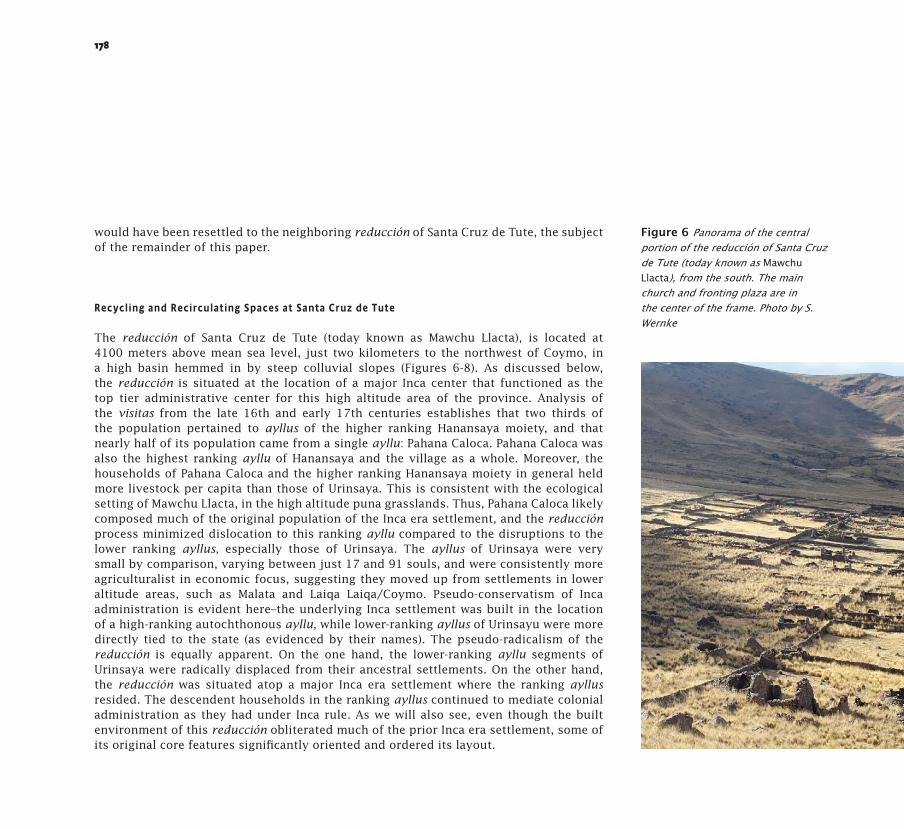
The reducción of Santa Cruz de Tute (today known as Mawchu Llacta), is located at 4100 meters above mean sea level, just two kilometers to the northwest of Coymo, in a high basin hemmed in by steep colluvial slopes (Figures 6-8). As discussed below, the reducción is situated at the location of a major Inca center that functioned as the top tier administrative center for this high altitude area of the province. Analysis of the visitas from the late 16th and early 17th centuries establishes that two thirds of the population pertained to ayllus of the higher ranking Hanansaya moiety, and that nearly half of its population came from a single ayllu: Pahana Caloca. Pahana Caloca was also the highest ranking ayllu of Hanansaya and the village as a whole. Moreover, the households of Pahana Caloca and the higher ranking Hanansaya moiety in general held more livestock per capita than those of Urinsaya. This is consistent with the ecological setting of Mawchu Llacta, in the high altitude puna grasslands. Thus, Pahana Caloca likely composed much of the original population of the Inca era settlement, and the reducción process minimized dislocation to this ranking ayllu compared to the disruptions to the lower ranking ayllus, especially those of Urinsaya. The ayllus of Urinsaya were very small by comparison, varying between just 17 and 91 souls, and were consistently more agriculturalist in economic focus, suggesting they moved up from settlements in lower altitude areas, such as Malata and Laiqa Laiqa/Coymo. Pseudo-conservatism of Inca administration is evident here–the underlying Inca settlement was built in the location of a high-ranking autochthonous ayllu, while lower-ranking ayllus of Urinsayu were more directly tied to the state (as evidenced by their names). The pseudo-radicalism of the reducción is equally apparent. On the one hand, the lower-ranking ayllu segments of Urinsaya were radically displaced from their ancestral settlements. On the other hand, the reducción was situated atop a major Inca era settlement where the ranking ayllus resided. The descendent households in the ranking ayllus continued to mediate colonial administration as they had under Inca rule. As we will also see, even though the built environment of this reducción obliterated much of the prior Inca era settlement, some of its original core features significantly oriented and ordered its layout.
Figure 6 Panorama of the central portion of the reducción of Santa Cruz de Tute (today known as Mawchu Llacta), from the south. The main church and fronting plaza are in the center of the frame. Photo by S. Wernke

179S t e v e n A . W e r n k e B u i l d i n g Te n s i o n . D i l e m m a s o f t h e B u i l t E n v i r o n m e n t t h r o u g h I n c a a n d S p a n i s h R u l e
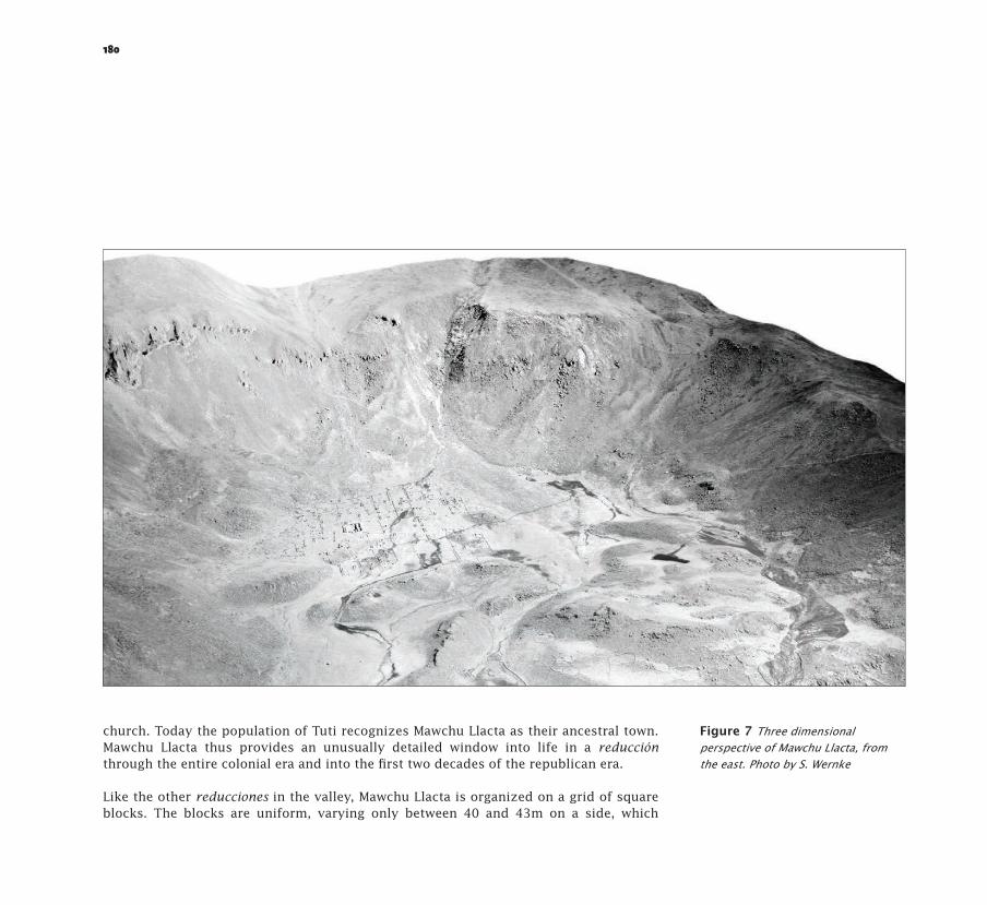
The excellent archaeological preservation at Mawchu Llacta enables a detailed view of the built environment and everyday life in a reduction town. It is located in the puna, with a large bofedal (high altitude marsh) running through the center of the settlement. Our archaeological survey of the town shows that it was built atop a major Inca center. We know from parish records that the town fell into a derelict state by the turn of the 19th century and was abandoned by 1843, when the population had moved 1.5 km downslope to the current village of Tuti, which is also built around a central square and
180
church. Today the population of Tuti recognizes Mawchu Llacta as their ancestral town. Mawchu Llacta thus provides an unusually detailed window into life in a reducción through the entire colonial era and into the first two decades of the republican era.
Like the other reducciones in the valley, Mawchu Llacta is organized on a grid of square blocks. The blocks are uniform, varying only between 40 and 43m on a side, which
Figure 7 Three dimensional perspective of Mawchu Llacta, from the east. Photo by S. Wernke

181
corresponds to 50 varas or one cordel (the size stipulated in Toledo’s ordenanzas). The construction of the urban grid was clearly the first step in construction of the reducción, given that several blocks were delineated but no buildings were built in them. In fact, the center part of the site was apparently never built up. This central area corresponds to the bofedal. It may seem odd to build a reducción on a marsh, but the bofedal undoubtedly provided pasturage for the large flocks of camelids kept by the population.
S t e v e n A . W e r n k e B u i l d i n g Te n s i o n . D i l e m m a s o f t h e B u i l t E n v i r o n m e n t t h r o u g h I n c a a n d S p a n i s h R u l e
Figure 8 Draft architectural plan of Mawchu Llacta. Plan by S. Wernke

182
It appears that the urban planning evident in the overall town layout did not extend to the interior organization of the blocks themselves or the forms of domestic structures within them. Colonial oversight apparently did not extend to the design of domestic structures, judging by the variability of their orientations and layouts within the blocks. In any case, it did not approach Toledo’s ideal model of surveillance, which called for each block to be divided into four domestic compounds, giving access only to the street and not internally to each other. Though a detailed analysis of domestic architecture is beyond the scope of this paper, in these high elevation areas of the province, late prehispanic domestic structures were predominantly circular in floor plan and were built around shared patios. As we saw at Malata, this arrangement was contested with the congregation of new households in the early doctrinas, as new domestic units were constructed with rectilinear houses fronted by patios. The domestic compounds at Mawchu Llacta generally follow this post-invasion model. That is to say, although state intervention is not evident in terms of the specific internal configuration of residential blocks, certain introduced architectural forms had apparently become normative.
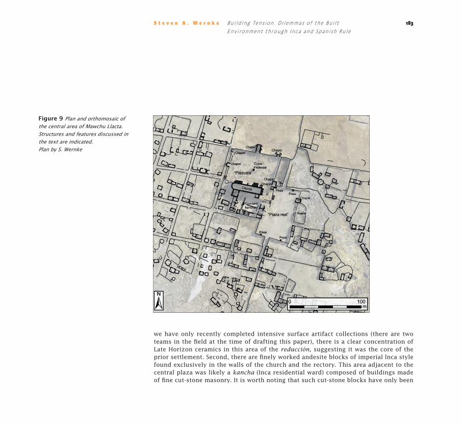
Moving out again to the scale of the reducción as a whole, the insistence on the regular orthogonal grid is especially impressive when considering the irregularity of the terrain, and the fact that this area was also the location of a major Inca era settlement. But the remains of this older Inca center were not entirely demolished by the reducción, and what was left in place is especially intriguing. In looking at the checkerboard grid of the site, one would expect to find the greatest regularity of layout in its center–that is, around the church and plaza. But in fact, this is where the orthogonal grid is least regular. A striking feature of this reducción compared to others in the valley is that its main church is flanked by not one, but two plazas: one situated off the north lateral portal of the church, and the other in front of the church (Figure 9). The plaza in front of the church does not fit the orthogonal grid in either its form or dimensions: it is trapezoidal, not rectangular, like the other plaza, and its placement does not conform to the rest of the grid. Large trapezoidal plazas are standard features in Inca settlements, especially provincial administrative centers. So this was almost certainly the central plaza of the original Inca era settlement. In short, the very core of the reducción was oriented around the central ceremonial complex of the Inca settlement.
Several other lines of evidence support the interpretation of the trapezoidal plaza as the original ceremonial space of the underlying Inca settlement. First, although
183
we have only recently completed intensive surface artifact collections (there are two teams in the field at the time of drafting this paper), there is a clear concentration of Late Horizon ceramics in this area of the reducción, suggesting it was the core of the prior settlement. Second, there are finely worked andesite blocks of imperial Inca style found exclusively in the walls of the church and the rectory. This area adjacent to the central plaza was likely a kancha (Inca residential ward) composed of buildings made of fine cut-stone masonry. It is worth noting that such cut-stone blocks have only been
S t e v e n A . W e r n k e B u i l d i n g Te n s i o n . D i l e m m a s o f t h e B u i l t E n v i r o n m e n t t h r o u g h I n c a a n d S p a n i s h R u l e
Figure 9 Plan and orthomosaic of the central area of Mawchu Llacta. Structures and features discussed in the text are indicated. Plan by S. Wernke

184
recorded in the three top level centers in the valley: in the reducciones of Yanque and Lari, and at the site of Kallimarka adjacent to Cabanaconde. So this was apparently a site of similar administrative importance for the high altitude reaches of the province where the large camelid herds of the Collaguas were concentrated. Third, opposite the church façade, across the trapezoidal plaza, is a small chapel, behind which is an enclosed hilltop strewn with rock outcrops and boulders. That area is also one of the zones of highest concentrations of diagnostic Late Horizon ceramics. This area appears to have been a locus of intense ritual activity (likely a huaca or ushnu). These lines of evidence combined establish that the core elements of the old Inca settlement were not obliterated, but instead were integrated and recycled as its core elements. The Inca plaza was reused as the main plaza of the reducción. It was flanked on one side by a huaca, and on the other side by an Inca administrative or palatial complex (kancha), which was converted to church and convent.
We also know from documents from the Tuti parish archive that this trapezoidal plaza was the primary plaza of the town. Church inventories from the late 18th and early 19th centuries refer to it as the plaza real (royal plaza), while the other plaza off the lateral portal of the church was called a plazuela (“small square”) (AAA 1792, fol. 17v-18r; AAA 1816). This is especially striking when considering that the so-called “plazuela” is a much more elaborate construction, with six chapels (all in ruins by 1792) and a central cross. It is the largest feature at the site, leveled with up to three meters of fill and massive retaining walls.
We can further specify how the plaza real was subtly altered to accommodate Catholic ritual practice through the construction of four platforms along the edges of the plaza. These were almost certainly platform bases for posa chapels. Posas–altars or chapels situated in quadrilateral form around the church atrium or fronting plaza–were standard features in the atria of Franciscan complexes since the earliest evangelical missions in Mesoamerica. In part this configuration accommodated open air worship in the form of processionals during holy days and other significant events (such as funerals), given that early churches were often too small to house the large crowds, and the unbaptized were not allowed into the sacred interior space of the church itself. In this case, what is especially interesting about the placement of the posa platforms is that they were not situated in the corners of the trapezoidal plaza but instead were aligned against its bounding walls in a manner that forms a rectangle between them (see Figure 9 above).
185
That is to say, the posas “squared the trapezoid” and demarcated a Catholic sacred space in orthodox form within the central ceremonial space of the Inca center.
Here we see another dimension of the pseudo radicalism of the reducciones in built form: the continued recycling of the central spaces of Inca imperial ritual in the heart of the reducción itself. Looking out beyond this core area, it seems likely that the orientation of the church to this plaza, and the alignment of the town grid as a whole, was set by the Inca plaza.
The rectangular plaza at the center of the reducción also points to a similar trajectory as we saw at Malata and the other doctrinas: the move from an accommodation of antecedent Inca spaces and their analogous use through ritual processions (in this case, in the plaza real), to a more eradicative spatial order with the construction of a new plaza with its more orthodox trappings (in the plazuela). Here at Mawchu Llacta, the rectangular plaza represents a major investment in “perfecting” Catholic practice and producing policía. The same elements are present as in the trapezoidal plaza, but in much more elaborated form. In place of four posa platforms, there were six posa chapels and a central cross. Five of them are still easily distinguishable: three are located in the southeast, northeast, and northwest corners of the plaza. The southwest corner, the usual location for the fourth chapel, was used as the main access to the plaza, and probably for this reason, the fourth “corner” posa chapel is located in the center of the west side of the plaza. The fifth chapel is more than double the size of the others. It is situated in the center of the north side of the plaza, aligned with the central cross platform and lateral portal of the church (as described above). It is referred to in church inventories as a miserere chapel (a feature found in other reducciones in the valley) (as in the case of the chapel of San Sebastian in Coporaque. See Tord 1983, pp. 87-89).
Paradoxes of Power and Place
By tracing out this local trans-conquest historical trajectory, we have explored how the built environment was implicated in the simultaneous production and perturbation of colonial power in the Andean region. Both Inca and Spanish colonial projects produced major changes in the most tangible, daily practices of social life, but they were also
S t e v e n A . W e r n k e B u i l d i n g Te n s i o n . D i l e m m a s o f t h e B u i l t E n v i r o n m e n t t h r o u g h I n c a a n d S p a n i s h R u l e
186
profoundly compromised in their local execution. For the indigenous communities of the Colca Valley, the ruptures of colonial resettlement–although indisputably disruptive–would have been understandable given how Inca colonial plans were also played out through the built environment and public ritual. These same media were also part of a continuous, trans-conquest negotiation of ritual space, as the central staging for commensal ritual (kallankas and plazas) became materia prima in the negotiation of religious transformation during the first evangelization. This early encounter– when the power lines between church, state, and community were not yet so clearly drawn–can be characterized as a dialogue that initially played on spatial analogies to provide entrée to both sides of the colonial encounter. At Malata, the implantation of a new model for the proper structuring of the spaces of a settlement can be appreciated, but the apperception, use, and significance of such spaces must have depended on their resonance with the cognate forms from the era of Inca rule. The construction of a space of religious indoctrination could thus also produce a new kind of local place of ambiguous and contested significance. In no small measure, it was such persistent heterodoxy that led to the more radical dislocations of the reducción program of the following decade.
The close-in perspective afforded by Mawchu Llacta illustrates these paradoxical aspects in detail: its construction was clearly a massive undertaking and investment of labor for its constituent population and its design significantly altered the many material and spatial dimensions of daily life. But just as clearly, its location, orientation, and organization were significantly shaped by a large and important Inca-era settlement in the same location.
Looking at the spatial organization of the reducción itself, it seems unlikely that the central dilemmas of colonial rule were resolved through the imposition of new built forms (as proclaimed by Toledo). If anything, the dilemmas of the built environment were intensified by the recycling of Incaic and autochthonous features and practices. Through such conflations, Catholicism and colonial conceptions of social order came to be apprehended and incorporated by the inhabitants of the reducción. That is to say, the process of reducción produced a new social order, but one that was both trans-local and irreducibly local. Here we can start to approach an understanding of the simultaneous production and destabilization of colonial dominance through the production of place. Ultimately, the Toledan move to recycle and mimic Incaic spatial forms and practices–plazas, processionals, commensal feasts, etc.–both produced and destabilized colonial
187
power. From a local point of view, both Incaic and Spanish colonial programs enabled the incorporation of the foreign within a local frame, even as that which typified “local” was transformed in the process.
An earlier generation of researchers pointed to the widespread dereliction and abandonment of reducciones as evidence of the project’s failure at colonial social engineering. We have seen in this local context that Santa Cruz de Tute was ultimately abandoned in 1843, seemingly proving the incompatibility of the reducción with local community forms and land use practices. However, such a conclusion ignores the legacy of the reducción: the founding of the present day village of Santa Cruz de Tuti–a town spontaneously organized on a grid around a church and plaza. “Spanish” forms had been incorporated to the point of becoming symbols of autochthony. The people of Santa Cruz de Tuti abandoned one reducción to build another. Their descendants continue to live there today.
S t e v e n A . W e r n k e B u i l d i n g Te n s i o n . D i l e m m a s o f t h e B u i l t E n v i r o n m e n t t h r o u g h I n c a a n d S p a n i s h R u l e

188
U n publ i sh e d documents
AAA (Archivo Arzobispal de Arequipa) (1792), Sección Catedral y Cabildo Eclesiástico, Inventario de la Yglesia de Tuti.
AAA (1816) Sección Catedral y Cabildo Eclesiástico, Inventario de la Yglesia de Tuti.
ASFL (Archivo del Convento de San Francisco de Lima) (1585), Parecer de los Collaguas. Registro 15, parte 5.
Publ i c at i on s
Abercrombie, Thomas A. (1998), Pathways of Memory and Power. Ethnography and History among an Andean People, Madison, WI: University of Wisconsin Press.
Bauer, Brian S. (1996), Legitimation of the State in Inca Myth and Ritual, in: American Anthropologist 98(2), pp. 327-337.
Bray, Tamara (2003), Inca Pottery as Culinary Equipment. Food, Feasting, and Gender in Imperial State Design, in: Latin American Antiquity 14(1), pp. 1-22.
Burkhart, Louise M. (1998), Pious Performances. Christian Pageantry and Native Identity in Early Colonial Mexico, in: Elizabeth H. Boone and
Tom Cummins (eds.), Native Traditions in the Postconquest World, Washington, DC: Dumbarton Oaks, pp. 361-381.
Coben, Lawrence S. (2006), Other Cuzcos. Replicated Theaters of Inka Power, in: Takeshi Inomata and Lawrence S. Coben (eds.), Archaeology of Performance. Theaters of Power, Community, and Politics, Berkeley, CA: Altamira Press, pp. 223-260.
Cook, Noble David (2002), “Tomando Posesión”. Luis Gerónimo de Oré y el retorno de los franciscanos a las doctrinas del Valle del Colca, in: Javier Flores Espinoza and Rafael Varón Gabai (eds.), El hombre y los Andes. Homenaje a Franklin Pease G.Y., Vol. 2, Lima: Pontificia Universidad Católica del Perú, pp. 889-903.
Córdoba y Salinas, Diego de ([1651] 1957), Chrónica franciscana de las provincias del Perú, Washington, DC: Academy of American Franciscan History.
Cummins, Tom (2002), Forms of Andean Colonial Towns, Free Will, and Marriage, in: Claire L. Lyons and John K. Papadopoulos (eds.), The Archaeology of Colonialism, Los Angeles, CA: Getty Publications, pp. 199-240.
de la Vera Cruz Chávez, Pablo (1987), Cambios en los patrones de asentamiento y el uso y abandono de los andenes en Cabanaconde, Valle del Colca, Perú, in: William M. Denevan, Kent Mathewson, and
Gregory W. Knapp (eds.), Pre-Hispanic Agricultural Fields in the Andean Region, Vol. 359 (i), Oxford: B.A.R. International Series, pp. 89-128.
Dillehay, Tom D. (2003), El colonialismo inka, el consumo de chicha y los festines desde una perspectiva de banquetes políticos, in: Boletín de Arqueología PUCP 7, pp. 355-363.
Doutriaux, Miriam (2004), Imperial Conquest in a Multi-ethnic setting. The Inka Occupation of the Collca Valley, Peru, Ph.D. dissertation, Berkeley, CA: University of California.
Durston, Alan (2007), Pastoral Quechua. The History of Christian Translation in Colonial Peru, 1550-1650, Notre Dame, IN: University of Notre Dame Press.
(1999), El processo reducional en el sur andino. Confrontación y síntesis de sistemas espaciales, in: Revista de Historia Indígena 4, pp. 75-101.
Echeverría y Morales, Francisco Xavier ([1804] 1952), Memoria de la Santa Iglesia de Arequipa, Arequipa: Imprenta Portugal.
Edgerton, Samuel Y. and Jorge Pérez de Lara (2001), Theaters of Conversion. Religious Architecture and Indian Artisans in Colonial Mexico, Albuquerque, NM: University of New Mexico Press.
Estenssoro, Juan Carlos (2001), El simio de Díos. Los indígenas y la iglesia frente a la evangelización del Perú, siglos XVI-XVII, in: Bulletin de l’Institut Français
Re f e re n c e s C i ted
189
d’Études Andines 30(3), pp. 455-474.(2003), Del paganismo a la santidad. La incorpo-
ración de los indios del Perú al catolicismo, 1532-1750, Lima: IFEA, Pontificia Universidad Católica del Perú, Instituto Riva-Agüero.
Gose, Peter (2008), Invaders as Ancestors. On the Intercultural Making and Unmaking of Spanish Colonialism in the Andes, Toronto: University of Toronto Press.
Guillet, David W. (1992), Covering Ground. Communal Water Management and the State in the Peruvian Highlands, Ann Arbor: University of Michigan Press.
Gutiérrez, Ramón, Cristina Esteras Martín, and Alejandro Málaga Medina (1986), El Valle del Colca (Arequipa): Cinco siglos de arquitectura y urbanismo, Buenos Aires: Libros de Hispanoamérica.
Hanson, Craig A. (1995), The Hispanic Horizon in Yucatan. A Model of Franciscan Missionization, in: Ancient Mesoamerica 6(1), pp. 15-28.
Hyslop, John (1990), Inka Settlement Planning, Austin, TX: University of Texas Press.
Lara, Jaime (2004), City, Temple, Stage. Eschato-logical Architecture and Liturgical Theatrics in New Spain, Notre Dame, IN: University of Notre Dame.
MacCormack, Sabine (1985), The Heart Has Its Reasons. Predicaments of Missionary Christianity in Early Colonial Peru, in: Hispanic American Historical Review 65(3), pp. 443-466.
Málaga Medina, Alejandro (1974), Las reducciones en el Perú (1532-1600), in: Historia y Cultura 8, pp. 141-172.
(1977), Los Collagua en la historia de Arequipa en el siglo XVI, in: Franklin Pease (ed.), Collaguas I, Lima: Pontificia Universidad Católica del Perú, pp. 93-130.
Manrique, Nelson (1985), Colonialismo y pobreza campesina. Caylloma y el Valle del Colca siglos XVI-XX, Lima: DESCO.
Morris, Craig (2013), El palacio, la plaza y la fiesta en el imperio inca, Lima: PUCP.
Mumford, Jeremy Ravi (2012), Vertical Empire. The General Resettlement of Indians in the Colonial Andes, Durham: Duke University Press.
Ramírez, Susan E. (2005), To Feed and Be Fed. The Cosmological Bases of Authority and Identity in the Andes, Stanford, CA: Stanford University Press.
Salomon, Frank (1986), Native Lords of Quito in the Age of the Incas. The Political Economy of North-Andean Chiefdoms, Cambridge: Cambridge University Press.
Silverblatt, Irene (1988), Imperial Dilemmas, the Politics of Kinship, and Inca Reconstructions of History, in Comparative Studies in Society and History 30(1), pp. 83-102.
Tord, Luis Enrique (1983), Templos coloniales del Colca–Arequipa, Lima: Atlas.
Wernke, Steven A. (2007), Analogy or Erasure? Dialectics of Religious Transformation in the Early Doctrinas of the Colca Valley, Peru, in: International Journal of Historical Archaeology 11(2), pp. 152-182.
(2012), Spatial Network Analysis of a Terminal Prehispanic and Early Colonial Settlement in Highland Peru, Journal of Archaeological Science 39(4), pp. 1111-1122.
(2013a), Households in Transition. Recon struc-ting Domestic Organization at an Early Colonial Mission in the Andean Highlands, in: Maxine Oland, Siobhan Hart, and Liam Frink (eds.), Decolonizing Indigenous Histories. Exploring Prehistoric/Colonial Transitions in Archaeology, Tucson: University of Arizona Press, pp. 77-101.
(2013b), Negotiated Settlements. Andean Communities and Landscapes Under Inka and Spanish Colonialism, Gainsville, FL: University Press of Florida.
(in press), La producción y desestabilización del dominio colonial en el proceso reduccional en el Valle del Colca, Perú, in, Las reducciones indígenas. Nuevas perspectivas de estudio, Akira Saito and Claudia Rosas Lauros (eds.), Lima: Pontificia Universidad Católica del Perú.
S t e v e n A . W e r n k e B u i l d i n g Te n s i o n . D i l e m m a s o f t h e B u i l t E n v i r o n m e n t t h r o u g h I n c a a n d S p a n i s h R u l e
Related Documents