•Building Earth’s Surface

Building Earth’s Surface. An aerial view from the south of the eruption of Mount St. Helens volcano on May 18, 1980.
Dec 16, 2015
Welcome message from author
This document is posted to help you gain knowledge. Please leave a comment to let me know what you think about it! Share it to your friends and learn new things together.
Transcript

•Building Earth’s Surface

• An aerial view from the south of the eruption of Mount St. Helens volcano on May 18, 1980.

• Interpreting Earth’s Surface

• Observations– Today we noticed all kinds of aspects of Earth that seem
to need an explanation.– Some have in the past thought that these aspects of the
Earth had always been there– Others thought that they were a result of some
catastrophic event in the Earths history, causing sudden change.

• Would you believe that this rock island has "always" existed where it is? Would you believe it was formed by a sudden, single event? What evidence would it take to convince you that the rock island formed ever so slowly, starting as a part of southern California and moving very slowly, at a rate of cm/yr, to its present location near the coast of Alaska?

• Principle of Uniformity.– This is the frame of reference that is used today to
understand changes in the Earth’s surface over time.– This principle helps us to understand what has shaped the
Earth through those processes that are still occurring today.

• Diastrophism
• Introduction– Diastrophism describes all of the movements of the
Earth’s plates.• Movement relative to other plates• Isostatic adjustment• Deforming and changing th Earth’s surface

• Stress and Strain– Four events associated with increased pressure
• As pressure begins to build up, the pressure is slight and nothing visible is happening to the surface.
• As the pressure increases, eventually the surface will begin to deform into a concave surface
• The concave shape builds up to the point where it is no longer able to return to its original shape.
• The surface will rupture and begin to break at the point of the increasing pressure, releasing the pressure.

– A stress is some force that can compress, pull apart, or deform a rock and there are 3 basic types• Compressive stress is caused when two plates move
together or when one moves and applies a force on another one that is not moving.
• Tensional stress occurs when one part of a plate moves away from another part of a plate.
• Shear stress occurs when two plates slide past one another

– The adjustment to stress is called strain and there are 3 basic types• Elastic strain occurs when rocks recover to their
original shape.• Plastic strain occurs when rocks are molded or bent
under the stress and do not return to their original shape.
• Fracture strain is when the rocks crack or break under the stress.

• Stress and deformation relationships for deeply buried, warm rocks under high pressure (A) and cooler rocks near the surface (B). Breaking occurs when stress exceeds rupture strength.

– How a rock responds to stress depends on 4 variables.• Nature of the rock• Temperature of the rock• The period of time ever which the stress is applied to
the rock• The confining pressure on the rock.

• Folding– Sedimentary rock is usually buried as layers of rocks.– Stress on these layers of rocks usually uplift the layer
together forming bends in the layer called folds.– Symmetrical up and down folds can be produced by
widespread horizontal stress on sedimentary rock layers.– A dome can be produced when a vertical upward stress
exerts on a rock layer– A basin can be produced when there is a dome produced– An arch shaped fold is called an anticline– A trough shaped fold is called a syncline
• A syncline of any great extent is called a geosyncline– When synclines and anticlines are not horizontal they are
called plunging folds

• (A)Rock bedding on a grand scale in the Grand Canyon. (B) A closer example of rock bedding can be seen in this roadcut.

• These folded rock layers are in the Calico Hills, California. Can you figure out what might have happened here to fold flat rock layers like this?

• Cross sections of some types of folds.

• (A)A sketch of an eroded structural dome where all the rock layers dip away from the center. (B) A photo of a dome named Little Sundance Mountain (Wyoming), showing the more resistant sedimentary layers that dip away from the center.

• An anticline, or arching fold, in layered sediments. Note that the oldest strata are at the center.

• A syncline, showing the reverse age pattern.

• (A)This sketch of a plunging fold shows an anticline on the left and right and a syncline in the center. (B) A photo of a plunging fold in Utah.

• Faulting– Cooler rocks near the surface of the earth do not always
react to pressure by folding.• This is due to the fact that they are cooler and
therefore more brittle.– These cooler more brittle rocks can react to pressure by
faulting.– A joint is when there is a break in the rock, but the rock
is not displaced on either side of the break– A fault is when there is a break in the rock and the rock
on either side of the break is displaced.

• Can you see the recumbent folds in this mountain in the Canadian Rockies?

• Columnar jointing forms at right angles to the surface as basalt cools. (A) Devil's Post Pile, San Joaquin River, California. (B) The Devil's Tower, Wyoming.

– The fault plane is the movement of the rocks on one side of the fault relative to rocks on the other side of the fault.
– We describe faults in terms of:• The steepness of the fault plane• Direction of the relative movement

– Three basic ways in which rocks can move
• Dip is the movement of rock up and down relative to the fault plane
• Strike is the horizontal or sideways movement of rock relative to the fault plane.
• Oblique is the movement of rock both up and down and sideways relative to the fault plane.

– When two rock planes move relative to one another one is called the footwall as it has dropped below and the other is called the hanging wall as it is above the plane
– In a normal fault the hanging wall has moved down relative to the footwall
– In a reverse fault the hanging wall has moved up relative to the footwall.
– A reverse fault with a low angle fault plane is called a thrust fault.

• (A)This sketch shows the relationship between the hanging wall, the footwall, and a fault. (B) A photo of a fault near Kingman, Arizona, showing how the footwall has moved relative to the hanging wall.

• How tensional stress could produce (A) a normal fault, (B) a graben, and (C) a horst.

• How compressive stress could produce (A) a reverse fault, and (B) a thrust fault.

• Earthquakes

• Causes of Earthquakes
– An earthquake is a quaking, shaking, vibrating, or upheaval of the ground.
• They occur as a result of the sudden release of energy due to stress on rock that occurs beneath the Earth’s surface.
– If the rock fractures as a result of the stress if produces waves or vibrations that move out from the source as seismic waves.
• Seismic waves are produced when a mass of rock breaks and slides into a different position.

• These lines show fault movement that has occurred along the San Andreas and other faults over the last 2 million years.

– Most earthquakes occur along a fault plane and near the Earth’s surface since this is where the rocks are coolest and the most brittle.
– Elastic rebound is when the stress causes the rock to break and snap into a new position.
• The rocks are displaced to new positions and the released energy causes an earthquake.

• The elastic rebound theory of the cause of earthquakes. (A) Rock with stress acting on it.

• (B) Stress has caused strain in the rock. Strain builds up over a long period of time.

• (C) Rock breaks suddenly, releasing energy, with rock movement along a fault. Horizontal motion is shown; rocks can also move vertically.

• (D) Horizontal offset of rows in a lettuce field, 1979, El Centro, California. (D) Photo by University of Colorado; courtesy National Geophysical Data Center, Boulder, Colorado.

• Locating and Measuring Earthquakes– Focus
• This is the place where the seismic waves originate below the surface of the Earth
– Epicenter• The point on the surface of the Earth directly above
the focus.– Seismograph
• An instrument used to measure the seismic waves.

• Simplified diagram of a fault, illustrating component parts and associated earthquake terminology.

• A schematic of a seismograph that records horizontal motion. The suspended mass remains motionless when the earth vibrates, and the motion detector moves with the seismic waves. The movements are recorded on a remote recording drum.

– P-wave• A compressional seismic wave that moves in a
longitudinal fashion– S-wave
• A shear seismic wave that moves in a transverse fashion.
– Surface wave• A seismic wave that moves in an up and down fashion
with crests and troughs.

• Use of seismic waves in locating earthquakes. (A) Difference in times of first arrivals of P-waves and S-waves is a function of the distance from the focus. (B) Triangulation using data from several seismograph stations allows location of the earthquake.

– Classification• Shallow-focus
– Occur within a depth of 70 km• Intermediate-focus
– Occur in the upper part of the Earth’s mantle• Deep-focus
– Occur in the lower part of the upper mantle– Most earthquakes are shallow-focus because:
• The rocks at the surface are cooler and more brittle• There is the most resistance to movement of the plates
at the surface of the Earth.
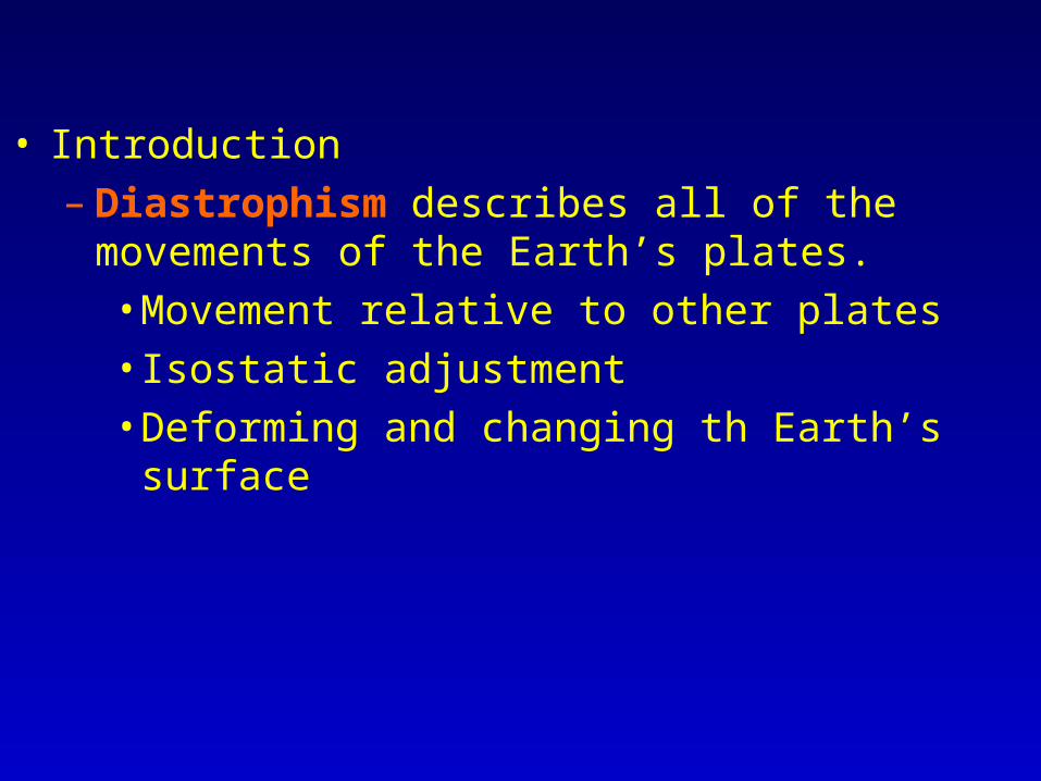
• Measuring Earthquake Strength– Mercalli scale
• Expresses relative intensities of earthquakes with intensities ranging from I to XII.
• Level I is not felt by humans• Level VI is felt by all• Levels V through VII are concerned with levels of
damage• Level XI means that few buildings are left standing• Level XII means total destruction with waves moving
across the ground being visible to the eye.

– Richter scale• Assigns numbers based on magnitude of the
earthquake• Describe the severity of the vibrations and the energy
released during the earthquake.

– Moment magnitude• A logarithmic scale based on the size of the fault and the
amount of movement along the fault.
– Surface-wave magnitude• Based on the displacement of the Earth’s surface.

• Origin of Mountains

• Folded and Faulted Mountains– The Earth’s surface is thickened in the areas where
mountains occur due to the compressional forces that produce tight almost vertical folds.
– The Appalachian Mountain range was produced by differential weathering which gives it its parallel features
– The Rocky Mountains have almost upright beds produced by folding of sedimentary rock layers.
– The Black Hills of South Dakota were produced by a broad folding arch called a dome.

• A domed mountain begins as a broad, upwarped fold, or dome. The overlying rock of the dome is eroded away, leaving more resistant underlying rock as hills and mountains in a somewhat circular shape. These mountains are surrounded by layers of the rock that formerly covered the dome.

• Fault block mountains are weathered and eroded as they are elevated, resulting in a rounded shape and sedimentation rather than sharply edged fault blocks.

• The folded structure of the Appalachian Mountains, revealed by weathering and erosion, is obvious in this Skylab photograph of the Virginia-Tennessee-Kentucky boundary area. The clouds are over the Blue Ridge Mountains.

• Volcanic Mountains– As volcanic material builds up on the surface of the
Earth, it can build to the point where it produces a mountain.
– A volcano is a hill or mountain produced by the extrusion of lava or rock fragments from the magma below the Earth’s surface.

• This is the top of Mount St. Helens several years after the
1980 explosive eruption.

– 3 major types of volcanoes• Shield volcanoes
– Broad, gently sloping cones made as magma solidifies at the surface of the Earth.
– These originate from low viscosity lava which spreads out quickly from the vent.
• Cinder cone volcano– Made of cinders.– These cinders are rock fragments that have solidified
from lava that cooled as it was thrown into the air.• Composite volcano
– Built of alternating layers of cinder, ash, and lava.

• (A)A schematic cross section of an idealized shield volcano. (B) A photo of a shield volcano, Mauna Loa in Hawaii.

• (A)A schematic cross section of an idealized composite volcano, which is built up of alternating layers of cinders, ash, and lava flows. (B) A photo of Mount Shasta, a composite volcano in California. You can still see the shapes of former lava flows from Mount Shasta.
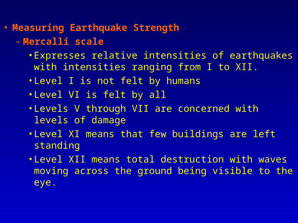
• The Juan de Fuca Plate, the Cascade volcanoes, and the Columbia Plateau Basalts.

– Batholith• A large amount of lave that has crystallized below the
surface.• If part of the batholith protrudes above the surface it is
called a stock.– Dike
• An intrusion that flows into a joint or fault that cuts across rock bodies.
– Sill• When the intrusion flowed into the plane of contact
between sedimentary rock layers.– Laccolith
• Similar to a sill, but with an arched top where the intrusion has raised the overlying rock into a blister-like uplift.

• Here are the basic intrusive igneous bodies that form from volcanic activity.
Related Documents