2021 1 Bridging the Urban-Rural Connectivity Gap through Intelligent Space, Air, and Ground Networks Fares Fourati, Saeed Hamood Alsamhi, and Mohamed-Slim Alouini Abstract—Connectivity in rural areas is one of the main chal- lenges of communication networks. To overcome this challenge, a variety of solutions for different situations are required. Optimiz- ing the current networking paradigms is therefore mandatory. The high costs of infrastructure and the low revenue of cell sites in rural areas compared with urban areas are especially unattractive for telecommunication operators. Therefore, space, air, and ground networks should all be optimized for achieving connectivity in rural areas. We highlight the latest works on rural connectivity, discuss the solutions for terrestrial networks, and study the potential benefits of nonterrestrial networks. Furthermore, we present an overview of artificial intelligence (AI) techniques for improving space, air, and ground networks, hence improving connectivity in rural areas. AI enables intelli- gent communications and can integrate space, air, and ground networks for rural connectivity. We discuss the rural connectivity challenges and highlight the latest projects and research and the empowerment of networks using AI. Finally, we discuss the potential positive impacts of providing connectivity to rural communities. Index Terms—Rural Connectivity, Hard-to-Reach Areas, Wire- less Communication, AI, Satellites, UAVs, Ground Networks I. I NTRODUCTION I N most of the remote, hard-to-reach, and rural areas worldwide, internet connectivity is possible only via mobile access [1]. Fortunately, a remarkable progress in providing worldwide internet connectivity has been made by the mobile industry [2]. For example, in 2018, 300 million new mobile internet subscribers joined the network [3]. Nevertheless, over 750 million people still lack mobile broadband coverage [3]. Coverage depends on various features such as demography, geography, and economy. Consequently, this lack of coverage is not uniformly distributed and is accentuated in remote and rural areas, especially in areas such as subSaharan Africa, where 31% of the population is deprived of access to con- nectivity (Fig. 1) [3]. Although the main purpose of connectivity is facilitating the communication between people, connectivity can provide a wide spectrum of applications that improve the quality of life of users by providing useful information and services as well as opportunities for enhancing economic growth [4]. If provided with a high-quality connection, people in rural areas can remain in their quiet villages while enjoying the advantages of the city, working from home, remote e-learning on advanced platforms, and other activities [5]. Fares Fourati and Mohamed-Slim Alouini are with King Abdullah Univer- sity of Science and Technology (KAUST), Thuwal, 23955-6900 Kingdom of Saudi Arabia, (e-mail: [email protected], [email protected]). S.H. Alsamhi is with the Athlone Institute of Technology, Ireland, and Ibb University, Ibb, Yemen. (e-mail: [email protected]). Besides connecting people, connectivity in rural areas can be extended to introduce smart frameworks by connecting devices, collecting data, preforming real time processing and monitoring, and using artificial intelligence (AI) in different scenarios. For instance, in agriculture, connectivity can im- prove the efficiency of production processes by connecting sensors, collecting different types of data, and using algorithms to help with decision making and early diagnosis of problems. Moreover, in deep rural areas, the Sahara, mountains, and forests, connectivity allows exploration and monitoring for security or scientific research purposes. To achieve rural con- nectivity and benefit from its advantages, several challenges must be overcome. A. Main Challenges In any business, an investment should offer a return. In rural and remote areas, however, the revenue is lower than that in urban areas; therefore, infrastructure costs can be prohibitive. In addition, the logistics are generally complex, especially for hard-to-reach areas. In fact, the revenue can be 10-times higher in urban sites than that in rural areas and the network infrastructure cost in urban areas is generally around half of that in rural areas [2]. The Global System for Mobile Communications Associa- tion (GSMA) has identified three main applications in which the infrastructure costs can be restrictive: mobile base stations (BSs), which supply coverage to an area; backhaul technology, which routes user-generated voice calls and data to the core network, including wireless and wired technologies; and the energy that enables both of these components to function [2]. Cabling is costly and long-distance data transmission through wireless technology requires the use of several receivers and transmitters that are also costly [2]. Although mobile opera- tors heavily invested in the deployment optimization of their networks, connecting the unconnected areas remains a major problem. B. Related Surveys and Contributions A detailed survey on rural connectivity has been published [6]. Fronthaul and backhaul solutions for Internet of Things (IoT) in rural areas are discussed in [5]. The use of AI for the optimization of communication systems has been reviewed in various papers, including the use of AI in satellite communications [7], and unmanned aerial vehicules (UAV) communications [8]. As the interest in rural connectivity continues to evolve, several solutions, ideas, and papers have been published lately discussing this subject. In this study, we mention the latest arXiv:2202.12683v1 [cs.CY] 25 Feb 2022

Welcome message from author
This document is posted to help you gain knowledge. Please leave a comment to let me know what you think about it! Share it to your friends and learn new things together.
Transcript

2021 1
Bridging the Urban-Rural Connectivity Gap throughIntelligent Space, Air, and Ground Networks
Fares Fourati, Saeed Hamood Alsamhi, and Mohamed-Slim Alouini
Abstract—Connectivity in rural areas is one of the main chal-lenges of communication networks. To overcome this challenge, avariety of solutions for different situations are required. Optimiz-ing the current networking paradigms is therefore mandatory.The high costs of infrastructure and the low revenue of cellsites in rural areas compared with urban areas are especiallyunattractive for telecommunication operators. Therefore, space,air, and ground networks should all be optimized for achievingconnectivity in rural areas. We highlight the latest works onrural connectivity, discuss the solutions for terrestrial networks,and study the potential benefits of nonterrestrial networks.Furthermore, we present an overview of artificial intelligence(AI) techniques for improving space, air, and ground networks,hence improving connectivity in rural areas. AI enables intelli-gent communications and can integrate space, air, and groundnetworks for rural connectivity. We discuss the rural connectivitychallenges and highlight the latest projects and research andthe empowerment of networks using AI. Finally, we discussthe potential positive impacts of providing connectivity to ruralcommunities.
Index Terms—Rural Connectivity, Hard-to-Reach Areas, Wire-less Communication, AI, Satellites, UAVs, Ground Networks
I. INTRODUCTION
IN most of the remote, hard-to-reach, and rural areasworldwide, internet connectivity is possible only via mobile
access [1]. Fortunately, a remarkable progress in providingworldwide internet connectivity has been made by the mobileindustry [2]. For example, in 2018, 300 million new mobileinternet subscribers joined the network [3]. Nevertheless, over750 million people still lack mobile broadband coverage [3].Coverage depends on various features such as demography,geography, and economy. Consequently, this lack of coverageis not uniformly distributed and is accentuated in remote andrural areas, especially in areas such as subSaharan Africa,where 31% of the population is deprived of access to con-nectivity (Fig. 1) [3].
Although the main purpose of connectivity is facilitatingthe communication between people, connectivity can providea wide spectrum of applications that improve the quality oflife of users by providing useful information and servicesas well as opportunities for enhancing economic growth [4].If provided with a high-quality connection, people in ruralareas can remain in their quiet villages while enjoying theadvantages of the city, working from home, remote e-learningon advanced platforms, and other activities [5].
Fares Fourati and Mohamed-Slim Alouini are with King Abdullah Univer-sity of Science and Technology (KAUST), Thuwal, 23955-6900 Kingdom ofSaudi Arabia, (e-mail: [email protected], [email protected]).S.H. Alsamhi is with the Athlone Institute of Technology, Ireland, and IbbUniversity, Ibb, Yemen. (e-mail: [email protected]).
Besides connecting people, connectivity in rural areas canbe extended to introduce smart frameworks by connectingdevices, collecting data, preforming real time processing andmonitoring, and using artificial intelligence (AI) in differentscenarios. For instance, in agriculture, connectivity can im-prove the efficiency of production processes by connectingsensors, collecting different types of data, and using algorithmsto help with decision making and early diagnosis of problems.Moreover, in deep rural areas, the Sahara, mountains, andforests, connectivity allows exploration and monitoring forsecurity or scientific research purposes. To achieve rural con-nectivity and benefit from its advantages, several challengesmust be overcome.
A. Main Challenges
In any business, an investment should offer a return. In ruraland remote areas, however, the revenue is lower than that inurban areas; therefore, infrastructure costs can be prohibitive.In addition, the logistics are generally complex, especiallyfor hard-to-reach areas. In fact, the revenue can be 10-timeshigher in urban sites than that in rural areas and the networkinfrastructure cost in urban areas is generally around half ofthat in rural areas [2].
The Global System for Mobile Communications Associa-tion (GSMA) has identified three main applications in whichthe infrastructure costs can be restrictive: mobile base stations(BSs), which supply coverage to an area; backhaul technology,which routes user-generated voice calls and data to the corenetwork, including wireless and wired technologies; and theenergy that enables both of these components to function [2].Cabling is costly and long-distance data transmission throughwireless technology requires the use of several receivers andtransmitters that are also costly [2]. Although mobile opera-tors heavily invested in the deployment optimization of theirnetworks, connecting the unconnected areas remains a majorproblem.
B. Related Surveys and Contributions
A detailed survey on rural connectivity has been published[6]. Fronthaul and backhaul solutions for Internet of Things(IoT) in rural areas are discussed in [5]. The use of AIfor the optimization of communication systems has beenreviewed in various papers, including the use of AI in satellitecommunications [7], and unmanned aerial vehicules (UAV)communications [8].
As the interest in rural connectivity continues to evolve,several solutions, ideas, and papers have been published latelydiscussing this subject. In this study, we mention the latest
arX
iv:2
202.
1268
3v1
[cs
.CY
] 2
5 Fe
b 20
22

2021 2
90%99% 96%
89%
69%
10%
1% 4%
11%
31%
Global North America &Western Europe
Eastern Europe &Asia Pacific
Mena & SouthAsia
Sub-Saharan Africa
Coverage Coverage Gap
Fig. 1. Coverage gaps in areas around the world [3].
works on rural connectivity, discuss the solutions for terrestrialnetworks, and study the potential applicability of nonterres-trial networks. Technologies for rural connectivity have beenthoroughly discussed elsewhere [5], [6]; thereofre, they areonly brifely overviewed here with focus on the latest works.Although AI-based optimization of communication systemshas been reported in previous studies [7], [8], we discuss therole of AI in empowering networks in rural areas. This discus-sion will emphasize the role of AI in future communicationsystems, especially in challenging contexts such as rural areas.Finally, we discuss the potential positive impacts of providingconnectivity to rural communities.
In this study, we view rural connectivity from differentperspectives, beginning with the latest works on terrestrial,aerial, and space networks, progressing to the discussion of thepotential role of AI in efficiently empowering and optimizingthese networks in rural areas, and concluding with the potentialimpacts of rural connectivity on rural communities.
C. Paper Organization
The remained of this paper is organized as follows. SectionII discusses the use of latest terrestrial, aerial, and space tech-nologies for rural connectivity and concludes with the com-bination of these networks for connectivity. Section III refersto the potential applications of AI in different communicationsectors. In this section, we discuss the further optimizationof each communication type and their intersection. SectionIV highlights the potential benefits of rural connectivity andthe use of AI in different sectors, including health, education,agriculture and economy sectors of rural areas.
II. SPACE, AIR, AND GROUND NETWORKS
A. Use of Terrestrial Technologies
The standard method of providing cellular coverage involvesthe use of macrocell sites. In challenging rural areas, severalmacrocell sites must be built to provide coverage, leading toa poor cost-to-coverage ratio. Meanwhile, the capacity must
sufficiently cover each user. To provide high capacity underthe cost-to-coverage constraints, Meta/Facebook proposed anovel connectivity solution called SuperCell, which has beenfield-validated for feasibility. SuperCell includes two essentialcomponents: a high-altitude tower with high-gain antennasfor wide coverage and high-order sectorization to offer highcapacity through heavy frequency reuse. A single SuperCellprocides 15-times to 65-times wider coverage than macrocells.More specifically, the coverage area of a 36-sector SuperCellBS mounted on a 250-m-high tower is up to 65-times thatof a standard 3-sector rural macrocell BS on a 30-m-hightower in an identical arrangement, implying that the singleSuperCell can replace multiple macrocells [9]. After some en-gineering investment, commercially-available antenna systemsmay enable a highly efficient SuperCell for wide-area ruralconnectivity [10].
Terrestrial microwave backhaul is primarily based on clearline-of-sight (CLOS) design. When a CLOS is unavailbe, net-work designers usually implement repeater design topologiesor intermediate site passive repeaters, which lead to prohibitivecosts. An altrenative solution nonline-of-sight (NLOS) links,which exploit the natural diffraction propagation effects thatscatter the radio signal around a blocking obstacle. The mainchallenges in this technique are accurately forecasting ofthe operation and performance of NLOS radio links at highfrequencies (6-8 GHz) and forecasting the availability perfor-mance of the NLOS radio links over time. After investigatingvarious design strategies, Meta/Facebook proposed a hybriddesign approach by combining NLOS and CLOS [1]. Whenboth links are used together, the number of repeaters canbe notably decreased, enabling more flexible choices of thetower positions and sizes, thereby improving coverage. Thishybrid design can attain a similar coverage objectives withremarkably lower cost than using CLOS designs [11]. Toprove this claim, Meta/Facebook collaborated with Mayuteland Internet para Todos of Peru to check this idea in a realworld application, which was successfully implemented inPeru [11].
B. Use of Aerial TechnologiesOver the past few years, the communication research com-
munity has used the emergence of UAVs to suggest theirintegration into communication networks. UAV BSs are intrin-sically, mobile, flexible, and height-adjustable [12]. Therefore,they can complement current cellular systems by offeringbroadband coverage in hard-to-reach rural areas. UAVs giveoperators more flexibility regarding site placement. As BSsbecome more miniaturized and UAVs become cheaper andmore refined, implementing BSs on UAVs has become feasiblein practice. As UAV BSs can be expeditiously fastened at idealpositions in three-dimensional space, they can provide higherspectral efficiency, coverage, load balancing, and user experi-ence compared with those using current terrestrial technologies[13].
With their competitively low cost, high mobility, and quickimplementation UAVs become suitable and efficient for cov-ering low-traffic large regions. Moreover, they are suitable forprecision agriculture [15] and delivery [16].

2021 3
UserUAV
UAV
Terrestrial BSUAV
Terrestrial BS
User
User
Fig. 2. Combined aerial and terrestrial networks for remarkably enhancingthe quality of service in rural and hard-to-reach areas [14].
In [14], the spatial variation of coverage among urban,suburban, and exurban areas was studied and a stochasticgeometry-based model was designed using inhomogeneousPoisson point processes, studying a scenario where groundBSs were gathered in the urban area while aerial BSs wereuniformly distributed outside of that urban area (see Fig. 2).The authors [14] showed that combining the terrestrial networkwith aerial BSs in the outer regions generally enhances thequality of service.
In [17], an optimization problem was designed for planninga set of assignments at different altitudes of a swarm of UAVs,offering rural area coverage while minimizing the energy con-sumption. The problem was solved using a genetic algorithmmodel and assessed over a realistic setting. Increasing thenumber of altitudes at which the UAVs can be positioned wasfound to increase coverage but require more energy than whenall UAVs occupied one altitude.
A popular solution is the use of Altaeros SuperTower [18],[19], an aerostatic helium-filled blimp tethered at 240 m thatprovides a wide area coverage of up to 10,000 km2. AltaerosSuperTower provides the coverage equivalent to those usingmore than 20 towers, but at a lower cost and with a simplerinstallation process. Each tether of the aerostat includes fiberoptics and a power conductor for providing electricity. Theaerostat is 5G-ready but does not support 2G and 3G, whichcan be a disadvantage in poor rural regions [2], [18].
C. Use of Space Technologies
Like UAVs, satellites provide an interesting solution toovercome geographic constraints and to skip installation de-lays, especially in the areas with no existing infrastructure.Previously, geostationary earth orbit (GEO) satellites werecommonly used for this purpose because they avoid the needfor quick movements between the terminals and the satellitetransceiver and permit for a wide coverage using a singlesatellite [20].
Anchored Base Station
Gateway
User
LEOSatellite
Fig. 3. Satellite networks can remarkably improve coverage for rural andhard-to-reach areas [21].
TABLE ICOMPARISON OF DIFFERENT TECHNOLOGIES [24], [25].
Technology Pros ConsGround Rich resources and rich
throughputLimited coverage, difficultmovement, and vulnerableto disasters
Aerial Wide coverage, low cost,and flexible deployment
Less capacity, unstable link,and high mobility
Space Large coverage and broad-cast/multicast
Long propagation latency,limited capacity, high cost,and high mobility
More recently, new communication technologies andcheaper launch costs have inspired the development of satelliteconstellations such low earth orbit (LEO) satellite constella-tions, which provide low latency, high-throughput broadbandservices [20].
The author of [21] studied the performance of LEO con-stellation, where the locations of the satellites were modeledas a binomial point process on a spherical surface (Fig. 3).Comparing the system performances of the LEO constellationand a fiber-connected BS at a relatively far distance, they foundthat the LEO constellation improved the coverage probabilityof rural regions.
As the locations of GEO satellite are fixed relative to theground, they admit inexpensive user equipment. LEO andmedium earth orbit (MEO) constellations reduce the latencybut need more complex antennas at the satellite and groundstations for satellite tracking [22], [6]. Several companies, suchas Amazon, SpaceX, and OneWeb are developing LEO solu-tions [20], whereas MEO constellations such as that suggestedby O3b [23] are expected to balance the constellation latency-size tradeoff [20].
D. Integration of Space-Air-Ground Technologies
As summarized in Table I, each of the discussed technolo-gies has its advantages and limitations. Terrestrial networkshave the lowest delay among the various communication
2021 4
Coverage
Line of Sight
Endurance
Mobility
Deployement
Low delay
Low cost
Rich resources
Link stability
Capacity
Space Aerial Ground
Fig. 4. Comparison of space, air, and ground technologies [19], [25], [30].
technologies but are exposed to natural disasters. Air networksprovide wide coverage with low latency but are limited byrestricted capacity and unstable links. Satellite networks offerglobal coverage but suffer from high latency (Fig.4) [24], [25].Recognizing that have different characteristics and can com-plement each other, researchers have proposed space, air, andground integrated networks (SAGINs) for optimized end-to-end services [24]. SAGINs include the GEO, MEO, and LEOsatellites in space; the balloons, airships, and drones in the air;and ground segments (see Fig. 5). The multilayered satellitecommunication system can inmprove the network capacityusing the multicast and broadcast methods [24]. However, SA-GINs are inherently time-variable and heterogeneous, whichcomplicates their design and optimization [24]. In decisionmaking, it is necessary to consider the high mobility of thespace and air segments, the diverse propagation mediums, thesharing of frequency bands, and the intrinsic heterogeneity be-tween the space, air, and ground segments. Although, SAGINoptimization is challenging, efficient techniques for integrationcould open opportunities for rural connectivity.
III. AI-EMPOWERED NETWORKS
A. AI for Space Networks
AI, especially machine learning [26], has been widely anddiversely applied in recent years. For the optimization ofdifferent communication aspects, several solutions have beensuggested using AI algorithms [27]–[29]. In fact, AI can beuseful to optimize each segment. For example, in satellitecommunication (the space segment) [7], AI has demonstratedpromise in behavior modeling, channel modeling, networktraffic forecasting, remote sensing, interference managing,ionospheric scintillation detection, telemetry mining, antijam-ming, beam-hopping, and energy management.
In the absence of solar energy, satellites become dependenton battery energy, which imposes a large load on the batteryand reduce the battery lifetime, thereby expanding the costsof space communication networks. To improve the power
allocation scheme and battery lifetime in in satellite-to-groundcommunications using LEO constellations, the authors of [31]employed reinforcement learning (RL) to divide the loadof overburdened satellites among close satellites with lowerload. A similar energy-efficient channel allocation in satel-lites, implemented using deep RL (DRL), reduced the energyby 67.86% when compared with that of prior model [32].Conventional modulation/coding modules can be replaced bydeep neural networks (DNNs) that can smartly adapt to theenvironment and hardware [33]. Moreover, DNNs are usefulfor power saving. For example, DNN-mediated compressionprior to data transmission has been suggested to improvelatency and save power [34]. In fact, AI-chips have remarkablydeveloped in recent years [33] and can now running DNNsat low power, which can help to optimize the power costs,and increase the practicality of communication networks,especially for rural areas. DNN autoencoders and a long short-term memory (LSTM) network [35] have been proposed in[36] for detecting and classifying interferences, respectively.
B. AI for Aerial Networks
AI is promisisng for optimizing UAVs communications (theaerial segment) [8], [37]. For example, the authors of [38]managed the connectivity and coverage of UAVs using energy-efficient DRL. The suggested technique optimizes the energyefficiency function while considering the fairness, coverage,connectivity, and energy consumption of the communications.Convolutional neural network (CNN), which are routinely usedin imaging and image analysis have been suggested for thedetection of UAVs, BSs, and ground users. The beamwidthtilt angle can then be adjusted to reduce the interference[39]. In [40], artificial neural networks (ANNs) have beensuggested for predicting the signal strength of a UAV in smartcities. ANNs are expected to predict the signal strength moreaccurately than experimental models and are more compu-tationally efficient than theoretical models. The same modelcould be extended to the rural communication context. Infact, accurately predicting the signal strength and its timeavailability is mandatory for intelligent decision making inboth urban and rural areas scenarios.
UAV communications require stringent energy constraints;imposing these constraints is especially challenging in ruralareas. To reduce the energy consumption in drones, the authorsof [41] optimally routed UAVs across a reduced number ofstrategic locations. They modeled the problem as a mixed-integer programming problem and evaluated different scenar-ios using simulations. They showed that clustering is importantfor reducing the number of strategic locations and saving theenergy in drones.
Furthermore, the continuously increasing computation andstorage power of newly developed machines has opened op-portunities for distributed learning via on-device local dataprocessing. Federated learning (FL) [42], used in applicationsrequiring data security and privacy, learns a shared globalmodel from distributed mobile devices while keeping thetraining data at each device. FL is a decentralized learningmethod because the training data are not shared to a central
2021 5
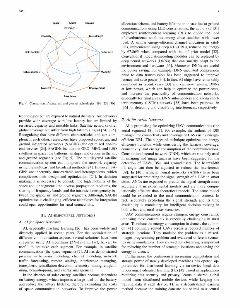
node. In the FL scheme, UAVs or satellites are not obliged toshare their data with a central node; instead, they transmit onlylocal updates, which reduce data traffic, thereby increasingthe security and reducing the latency of communications. Theauthors of [43] applied FL to a swarm of UAVs comprisingone leading UAV and numerous following UAVs. Each ofthe followers trains a local FL model using its gathered dataand then shares its local model with the leading UAV, whichaccumulates the received models, generates a global FL model,and shares it with the UAV network. Extending this concept torural areas, a swarm of UAVs could be randomly positioned(or smartly positioned using AI) and deep learning modelscould be trained for connectivity purposes or applications suchas agriculture or security. For example, the authors of [44]controlled the paths of a massive UAV population from thestart point to the end point, considering the possible randomwind perturbations, that could cause to disastrous collisionsamong the UAVs. The model weights of the ANNs among theUAVs were shared via FL.
C. AI for SAGINs
Further, AI can be used in space-air-ground integration[7]. However, wireless network optimization using classicaltechniques may not be practical for SAGINs, as the networksare highly complex and dynamic. Modeling such complexsystems is rendered challenging owing to the density, scale,and heterogeneity of the network. In wireless networks, prob-lems are conventionally solved by applying groups of rulesobtained from system analysis, which are based on previousexperience and domain understanding [33]. The authors of[45] proposed a CNN is proposed for routing to maximize thegeneral performance of a SAGIN based on the traffic patternsand the persistent buffer size of the satellites. Improving thesatellite choice and the UAV position by optimizing the datarate of the source, satellite, UAV, and destination commu-nication is complex because of the high number of movingsatellites and the time-varying network structure. To resolvethis problem, the authors of [46] jointly optimized the source,satellite, and UAV association and the UAV position usingDRL. The mean data rate of the proposed method was 5.74-times higher than that in a direct communication scenario withno UAV and satellite. Moreover, path planning can help theUAVs to optimize their movement when the rate requirementsof both aerial and ground equipment are given, which canimprove the overall performance of the network [47]. Theauthors of [48], resolved several emerging issues emerging incommunication, including wireless caching, data offloading,and adaptive modulation using a DRL approach. In [49], aSAGINs multidomain network resource was developed usingDRL. Moreover, RL can outperform the benchmark scheme inhandover management and resource allocation [50]. In air-to-ground communications, machine learning algorithms such asrandom forest and K-nearest neighbors have been suggestedfor pathloss and delay-spread predictions [51].
HAPs
Drones
Space Segment
Imaging
Early Fire Detection
Fig. 5. AI supporting the integration of space, air, and ground networks inrural areas areas.
IV. EMPOWERING RURAL COMMUNITIES
A. Healthcare
Connectivity and the use of AI technologies can improvethe quality of life of rural dwellers in different ways, forexample, improving the health sector in rural areas. In fact,the lack and low quality of healthcare in rural areas, es-pecially in developing countries, contributes largely to theinequality between rural and urban areas. The application ofAI technologies in a rural healthcare context can reduce thisgap assisting to physicians for better diagnosis and efficientdecision making and other well-trained healthcare workers tocompensate the absence of physicians [58]. After investigatingAI-powered clinical decision support systems in different ruralareas in China and interviewing clinicians on the subject, theauthors of [59], summarized the challenges and opportunitiesof integrating these systems in the rural context. AI (specifi-cally DNNs) and drones have also been proposed for use inscreening and detection in rural areas during severe pandemicssuch as Coronavirus disease, as they can be deployed withoutdirect human involvement [60].
B. Education
Connectivity enables communicties in rural areas to benefitfrom e-learning. Besides allowing children far from schoolsto access classes from the comfort of their homes, e-learningadmits adults to diverse specializations, whereby they candevelop skills in different areas to upgrade their occupationsand improve their economic situation. Moreover, people inrural areas can access online courses from top universitiesaround the world via massive open online courses and othereducational resources online. When people can learn newoccupations and improve their knowledge, they can change

2021 6
TABLE IIEXAMPLES OF AI APPLICATIONS.
Ref. Networks Highlight Applications AI Techniques[31] Space Energy Managing Efficient power control for LEO satellite-borne batteries RL[32] Space Energy Managing Energy-efficient channel allocation RL[52] Space Beam hopping Beam hopping algorithm in multibeam satellite systems RL[53] Space Prediction Pathloss forecasting Decision Tree[34] Space Processing Data compression DNN[36] Space Managing Interference Interference detection and classification even in high signal to interference ratio AEs/ LSTM[54] Space Remote Sensing Land cover and crop types classification CNN[55] Space Optimization Handoff strategy optimization CNN[38] Aerial Management UAV management for coverage DRL[56] Aerial Trajectory Efficient trajectory optimization of data collection from multiple IoT ground nodes DRL[57] Aerial Positioning Cooperative multiagent approach for optimal drone deployment RL[39] Aerial Detection UAVs, BSs, and ground users detection CNN[40] Aerial Prediction Prediction of UAV signal strengths ANN[44] Aerial Optimize Learning Shared learning among UAVs FL[45] SAGINs Routing Routing CNN[46] SAGINs Optimize Association Joint optimization of the source, satellite, and UAV association and the UAV position DRL[49] SAGINs Orchestration Multidomain network resource orchestration DRL[51] SAGINs Prediction Pathloss and delay spread prediction RF/ KNN
their jobs or launch a new business, which will benefit theentire community by creating new opportunities for the pop-ulation and causing economic growth [61]. Moreover, duringpandemics, shifting to online learning is necessary to preventthe spread of disease in schools, but this is impossible withoutconnectivity.
C. Agriculture
Under the constraints of the growing world population anddecreasing agricultural lands, the agricultural sector must besupported with more advanced tools and techniques to mitigateseveral constraints. In fact, smarter farms, healthier crops,and more efficient production are required more urgently thanat any previous time. Rural connectivity, IoT [62], and AI[63]–[65] can all play a major role in achieving this goal.Crop detection [66], [67], nutrition control, growth monitoring[68], health diagnosis [69], and disease forecasting [70],which assits farmers with their decision making, rely ondata collected from several sources, such as sensory systems,drone images, weather data and AI predictions. Moreover,collaboration between farmers, packagers, transporters, dis-tributors, warehouses, and end consumers can be enhancedvia connectivity and IoT [62]. The authors of [71], presentedan application called What2Grow Learning Box that helpsrural dwellers to access agricultural contents and learn aboutagriculture.
D. Disasters
Fire in forests, mountains, remote and rural areas thathappened in the last few years have caused major destructionin various regions of the world. Fire occurrence can bereduced by evaluating and communicating fire threats. IoTapproaches enable early fire detection. The authors of [72],presented a low-cost network that autonomously assesses thelevel of fire threat and the occurence of forest fires in ruralareas. The system comprises several sensors that estimatethe temperature, CO2, wind speed, and relative humidity of
BetterEconomy
BetterConnectivity
BetterHealthcare,Security,Education,Agriculture,
....
Fig. 6. Investing in rural connectivity will improve several sectors including,healthcare, security, education and agriculture, inevitably enhancing economicgrowth, which attracts more investment in connectivity in rural areas and leadsto better connectivity.
the area. The collected data are stored and processed in aserver. Additionally, UAV imaging can recognize fire risks andprevent fires in a timely manner [73].
E. Economy
Investing in connectivity in rural areas would markedlyimprove their healthcare, education, agriculture, and security.Improved healthcare and security systems will ensure a safeand comfortable life for rural dwellers. Furthermore, improvedagriculture will enhance the quality and quantity of production,thus increasing the revenue of farmers, while improved educa-tion will increase the learning potential of both the young andadult rural dwellers, expanding their knowledge and exposingthem to different self developing opportunities, for increasingtheir skills and thereby changing their occupations or creatingnew employment avenues. The abovementioned improvementswill certainly promote economic growth in rural regions. Inturn, a growing economy will the expansion and improvementof connectivity in rural regions, creating a positive feedbackeffect as summarized in Fig. 6.
2021 7
V. DISCUSSION
Solving the challenges of rural connectivity may requireseveral solutions depending different scenarios, including thegeography, demography, and more importantly, the resourcesof the place. When the only constraint is geographical, ter-restrial solutions, such as the discussed combined CLOS andNLOS terrestrial network designs, can be used. In morechallenging scenarios, for example hard-to-reach or poor ruralareas, aerial and satellite networks can play a major role inproviding the solutions. Meanwhile, AI can optimize differentaspects of communication, including improving the satellite,air, and ground communication networks and their integrationto achieve more efficient and practical strategies for ruralconnectivity.
CONCLUSION
As about half of the world’s population is unconnected [74],connectivity in rural areas remains a major obstacle in thecommunication field. This article briefly overviewed the chal-lenges regarding rural connectivity and discussed a diversityof potential solutions. Connectivity devices can be installedon the ground, flown at low altitudes, or launched in thespace. As individual technologies have their advantages andlimitations, they have been integrated as SAGINs. Despite theirpromise for improving rural connectivity, the optimizationand management of these technologies remain challenging. AIappears to be the key to space, air, and ground optimizationand integration for rural connectivity. Future work shouldtherefore focus on the use of AI techniques, especially RLand FL for optimal placement and movement of UAVs in ruralareas, and SAGIN optimization in different rural contexts.
REFERENCES
[1] J. Kusuma, E. Boch, and P. Liddell, “Diffractive NLOS microwavebackhaul for rural connectivity,” Telecom Infra Project, Massachusetts,2021.
[2] C. Handforth, “Closing the coverage gap: How innovation can driverural connectivity,” GSMA Connected Society (GSMA), 2019.
[3] K. Bahia and S. Suardi, “The state of mobile internet connectivity,” UK:Groupe Special Mobile Association (GSMA), 2019.
[4] R. Katz and F. Callorda, “The economic contribution of broadband, dig-itization and ICT regulation,” International Telecommunication Union,published in Switzerland, Geneva, 2018.
[5] E. Yaacoub and M.-S. Alouini, “Efficient fronthaul and backhaul connec-tivity for IoT traffic in rural areas,” IEEE Internet of Things Magazine,vol. 4, no. 1, pp. 60–66, 2021.
[6] ——, “A key 6G challenge and opportunity—Connecting the base ofthe pyramid: A survey on rural connectivity,” Proceedings of the IEEE,vol. 108, no. 4, pp. 533–582, 2020.
[7] F. Fourati and M.-S. Alouini, “Artificial intelligence for satellite commu-nication: A review,” Intelligent and Converged Networks, vol. 2, no. 3,pp. 213–243, 2021.
[8] M.-A. Lahmeri, M. A. Kishk, and M.-S. Alouini, “Artificial intelligencefor UAV-enabled wireless networks: A survey,” IEEE Open Journal ofthe Communications Society, vol. 2, pp. 1015–1040, 2021.
[9] (2021) Supercell: Reaching new heights for wider connectivity.[Online]. Available: https://engineering.fb.com/2020/12/03/connectivity/supercell-reaching-new-heights-for-wider-connectivity/
[10] P. Bondalapati, A. Tiwari, M. E. Sahin, Q. Tang, S. Saraswat,V. Suryakumar, A. Yazdan, J. Kusuma, and A. Dubey, “Supercell:A wide-area coverage solution using high-gain, high-order sectorizedantennas on tall towers,” arXiv preprint arXiv:2012.00161, 2020.
[11] J. Kusuma and E. Boch, “Improving rural connectivity coverage usingdiffractive non-line of sight (NLOS) wireless backhaul,” in WorldWireless Research Forum, vol. 45, 2021.
[12] M. Mozaffari, W. Saad, M. Bennis, Y.-H. Nam, and M. Debbah, “Atutorial on UAVs for wireless networks: Applications, challenges, andopen problems,” IEEE Communications Surveys Tutorials, vol. 21, no. 3,pp. 2334–2360, 2019.
[13] A. Fotouhi, H. Qiang, M. Ding, M. Hassan, L. G. Giordano, A. Garcia-Rodriguez, and J. Yuan, “Survey on UAV cellular communications:Practical aspects, standardization advancements, regulation, and securitychallenges,” IEEE Communications Surveys Tutorials, vol. 21, no. 4, pp.3417–3442, 2019.
[14] M. Matracia, M. A. Kishk, and M.-S. Alouini, “Coverage analysis forUAV-assisted cellular networks in rural areas,” IEEE Open Journal ofVehicular Technology, vol. 2, pp. 194–206, 2021.
[15] P. Daponte, L. De Vito, L. Glielmo, L. Iannelli, D. Liuzza, F. Picariello,and G. Silano, “A review on the use of drones for precision agriculture,”in IOP Conference Series: Earth and Environmental Science, vol. 275,no. 1. IOP Publishing, 2019, p. 012022.
[16] K. Dorling, J. Heinrichs, G. G. Messier, and S. Magierowski, “Vehiclerouting problems for drone delivery,” IEEE Transactions on Systems,Man, and Cybernetics: Systems, vol. 47, no. 1, pp. 70–85, 2017.
[17] J. Galan-Jimenez, E. Moguel, J. Garcıa-Alonso, and J. Berrocal,“Energy-efficient and solar powered mission planning of UAV swarms toreduce the coverage gap in rural areas: The 3d case,” Ad Hoc Networks,vol. 118, p. 102517, 2021.
[18] (2021) altaeros. [Online]. Available: https://www.altaeros.com/[19] B. E. Y. Belmekki and M.-S. Alouini, “Unleashing the potential of
networked tethered flying platforms for B5G/6G: Prospects, challenges,and applications,” arXiv preprint arXiv:2010.13509, 2020.
[20] O. Kodheli, E. Lagunas, N. Maturo, S. K. Sharma, B. Shankar, J. F. M.Montoya, J. C. M. Duncan, D. Spano, S. Chatzinotas, S. Kisseleff,J. Querol, L. Lei, T. X. Vu, and G. Goussetis, “Satellite communi-cations in the new space era: A survey and future challenges,” IEEECommunications Surveys Tutorials, vol. 23, no. 1, pp. 70–109, 2021.
[21] A. Talgat, M. A. Kishk, and M.-S. Alouini, “Stochastic geometry-basedanalysis of leo satellite communication systems,” IEEE CommunicationsLetters, pp. 1–1, 2020.
[22] R. L. Sturdivant and E. K. P. Chong, “Systems engineering of aterabit elliptic orbit satellite and phased array ground station for IoTconnectivity and consumer internet access,” IEEE Access, vol. 4, pp.9941–9957, 2016.
[23] (2021) O3b meo. [Online]. Available: https://www.ses.com/our-coverage/o3b-meo
[24] J. Liu, Y. Shi, Z. M. Fadlullah, and N. Kato, “Space-air-ground integratednetwork: A survey,” IEEE Communications Surveys Tutorials, vol. 20,no. 4, pp. 2714–2741, 2018.
[25] N. Zhang, S. Zhang, P. Yang, O. Alhussein, W. Zhuang, and X. S.Shen, “Software defined space-air-ground integrated vehicular networks:Challenges and solutions,” IEEE Communications Magazine, vol. 55,no. 7, pp. 101–109, 2017.
[26] C. M. Bishop, “Pattern recognition,” Machine Learning, vol. 128, no. 9,2006.
[27] G. Zhu, D. Liu, Y. Du, C. You, J. Zhang, and K. Huang, “Towardan intelligent edge: Wireless communication meets machine learning,”IEEE communications magazine, vol. 58, no. 1, pp. 19–25, 2020.
[28] Y. Sun, M. Peng, Y. Zhou, Y. Huang, and S. Mao, “Application ofmachine learning in wireless networks: Key techniques and open issues,”IEEE Communications Surveys & Tutorials, vol. 21, no. 4, pp. 3072–3108, 2019.
[29] M. E. Morocho-Cayamcela, H. Lee, and W. Lim, “Machine learning for5G/B5G mobile and wireless communications: Potential, limitations, andfuture directions,” IEEE Access, vol. 7, pp. 137 184–137 206, 2019.
[30] M. Kishk, A. Bader, and M.-S. Alouini, “Aerial base station deploymentin 6G cellular networks using tethered drones: The mobility and en-durance tradeoff,” IEEE Vehicular Technology Magazine, vol. 15, no. 4,pp. 103–111, 2020.
[31] H. Tsuchida, Y. Kawamoto, N. Kato, K. Kaneko, S. Tani, S. Uchida,and H. Aruga, “Efficient power control for satellite-borne batteries usingq-learning in low-earth-orbit satellite constellations,” IEEE WirelessCommunications Letters, vol. 9, no. 6, pp. 809–812, 2020.
[32] B. Zhao, J. Liu, Z. Wei, and I. You, “A deep reinforcement learningbased approach for energy-efficient channel allocation in satellite inter-net of things,” IEEE Access, vol. 8, pp. 62 197–62 206, 2020.
[33] K. B. Letaief, W. Chen, Y. Shi, J. Zhang, and Y.-J. A. Zhang, “Theroadmap to 6G: AI empowered wireless networks,” IEEE Communica-tions Magazine, vol. 57, no. 8, pp. 84–90, 2019.
[34] V. Kothari, E. Liberis, and N. D. Lane, “The final frontier: Deep learningin space,” in Proceedings of the 21st International Workshop on MobileComputing Systems and Applications, 2020, pp. 45–49.
2021 8
[35] I. Goodfellow, Y. Bengio, and A. Courville, Deep Learning. MIT press,2016.
[36] P. Henarejos, M. A. Vazquez, and A. I. Perez-Neira, “Deep learning forexperimental hybrid terrestrial and satellite interference management,” in2019 IEEE 20th International Workshop on Signal Processing Advancesin Wireless Communications (SPAWC), 2019, pp. 1–5.
[37] P. S. Bithas, E. T. Michailidis, N. Nomikos, D. Vouyioukas, and A. G.Kanatas, “A survey on machine-learning techniques for UAV-basedcommunications,” Sensors, vol. 19, no. 23, p. 5170, 2019.
[38] C. H. Liu, Z. Chen, J. Tang, J. Xu, and C. Piao, “Energy-efficientUAV control for effective and fair communication coverage: A deepreinforcement learning approach,” IEEE Journal on Selected Areas inCommunications, vol. 36, no. 9, pp. 2059–2070, 2018.
[39] U. Challita, A. Ferdowsi, M. Chen, and W. Saad, “Machine learning forwireless connectivity and security of cellular-connected UAVs,” IEEEWireless Communications, vol. 26, no. 1, pp. 28–35, 2019.
[40] S. H. Alsamhi, F. Almalki, O. Ma, M. S. Ansari, and B. Lee, “Predictiveestimation of optimal signal strength from drones over IoT frameworksin smart cities,” IEEE Transactions on Mobile Computing, pp. 1–1, 2021.
[41] H. Gedawy, A. Al-Ali, A. Mohamed, A. Erbad, and M. Guizani, “UAVssmart heuristics for target coverage and path planning through strategiclocations,” in 2021 International Wireless Communications and MobileComputing (IWCMC), 2021, pp. 278–284.
[42] B. McMahan, E. Moore, D. Ramage, S. Hampson, and B. A. y Arcas,“Communication-efficient learning of deep networks from decentralizeddata,” in Artificial Intelligence and Statistics. PMLR, 2017, pp. 1273–1282.
[43] T. Zeng, O. Semiari, M. Mozaffari, M. Chen, W. Saad, and M. Bennis,“Federated learning in the sky: Joint power allocation and schedulingwith UAV swarms,” in ICC 2020-2020 IEEE International Conferenceon Communications (ICC), 2020, pp. 1–6.
[44] H. Shiri, J. Park, and M. Bennis, “Communication-efficient massive UAVonline path control: Federated learning meets mean-field game theory,”IEEE Transactions on Communications, vol. 68, no. 11, pp. 6840–6857,2020.
[45] N. Kato, Z. M. Fadlullah, F. Tang, B. Mao, S. Tani, A. Okamura, andJ. Liu, “Optimizing space-air-ground integrated networks by artificialintelligence,” IEEE Wireless Communications, vol. 26, no. 4, pp. 140–147, 2019.
[46] J.-H. Lee, J. Park, M. Bennis, and Y.-C. Ko, “Integrating leo satellite andUAV relaying via reinforcement learning for non-terrestrial networks,”in GLOBECOM 2020-2020 IEEE Global Communications Conference,2020, pp. 1–6.
[47] U. Challita, W. Saad, and C. Bettstetter, “Cellular-connected UAVs over5G: Deep reinforcement learning for interference management,” arXivpreprint arXiv:1801.05500, 2018.
[48] N. C. Luong, D. T. Hoang, S. Gong, D. Niyato, P. Wang, Y.-C.Liang, and D. I. Kim, “Applications of deep reinforcement learningin communications and networking: A survey,” IEEE CommunicationsSurveys Tutorials, vol. 21, no. 4, pp. 3133–3174, 2019.
[49] P. Zhang, C. Wang, N. Kumar, and L. Liu, “Space-air-ground integratedmulti-domain network resource orchestration based on virtual networkarchitecture: A DRL method,” IEEE Transactions on Intelligent Trans-portation Systems, pp. 1–11, 2021.
[50] A. Azari, F. Ghavimi, M. Ozger, R. Jantti, and C. Cavdar, “Machinelearning assisted handover and resource management for cellular con-nected drones,” in 2020 IEEE 91st Vehicular Technology Conference(VTC2020-Spring), 2020, pp. 1–7.
[51] G. Yang, Y. Zhang, Z. He, J. Wen, Z. Ji, and Y. Li, “Machine-learning-based prediction methods for path loss and delay spread in air-to-groundmillimetre-wave channels,” IET Microwaves, Antennas & Propagation,vol. 13, no. 8, pp. 1113–1121, 2019.
[52] X. Hu, S. Liu, Y. Wang, L. Xu, Y. Zhang, C. Wang, and W. Wang, “Deepreinforcement learning-based beam hopping algorithm in multibeamsatellite systems,” IET Communications, vol. 13, no. 16, pp. 2485–2491,2019.
[53] C. A. Oroza, Z. Zhang, T. Watteyne, and S. D. Glaser, “A machine-learning-based connectivity model for complex terrain large-scale low-power wireless deployments,” IEEE Transactions on Cognitive Commu-nications and Networking, vol. 3, no. 4, pp. 576–584, 2017.
[54] N. Kussul, M. Lavreniuk, S. Skakun, and A. Shelestov, “Deep learningclassification of land cover and crop types using remote sensing data,”IEEE Geoscience and Remote Sensing Letters, vol. 14, no. 5, pp. 778–782, 2017.
[55] C. Zhang, N. Zhang, W. Cao, K. Tian, and Z. Yang, “An ai-basedoptimization of handover strategy in non-terrestrial networks,” in 2020
ITU Kaleidoscope: Industry-Driven Digital Transformation (ITU K),2020, pp. 1–6.
[56] Y. Wang, Z. Gao, J. Zhang, X. Cao, D. Zheng, Y. Gao, D. W. K. Ng,and M. Di Renzo, “Trajectory design for UAV-based internet-of-thingsdata collection: A deep reinforcement learning approach,” IEEE Internetof Things Journal, 2021.
[57] R. Acosta-Gonzalez, P. V. Klaine, S. Montejo-Sanchez, R. D. Souza,L. Zhang, and M. A. Imran, A Cooperative Multiagent Approach forOptimal Drone Deployment Using Reinforcement Learning, 2021, pp.47–72.
[58] J. Guo and B. Li, “The application of medical artificial intelligencetechnology in rural areas of developing countries,” Health Equity, vol. 2,no. 1, pp. 174–181, 2018.
[59] D. Wang, L. Wang, Z. Zhang, D. Wang, H. Zhu, Y. Gao, X. Fan,and F. Tian, “Brilliant AI Doctor” in Rural Clinics: Challenges inAI-Powered Clinical Decision Support System Deployment. New York,NY, USA: Association for Computing Machinery, 2021. [Online].Available: https://doi.org/10.1145/3411764.3445432
[60] N. Naren, V. Chamola, S. Baitragunta, A. Chintanpalli, P. Mishra,S. Yenuganti, and M. Guizani, “IoMT and DNN-enabled drone-assistedcovid-19 screening and detection framework for rural areas,” IEEEInternet of Things Magazine, vol. 4, no. 2, pp. 4–9, 2021.
[61] F. Burlacu, “Using e-learning to bring economic development to remoterural areas,” Journal of Information Systems & Operations Management,pp. 163–171, 2018.
[62] M. Raj, S. Gupta, V. Chamola, A. Elhence, T. Garg, M. Atiquzzaman,and D. Niyato, “A survey on the role of internet of things for adoptingand promoting agriculture 4.0,” Journal of Network and ComputerApplications, p. 103107, 2021.
[63] S. Y. Liu, “Artificial intelligence (ai) in agriculture,” IT Professional,vol. 22, no. 3, pp. 14–15, 2020.
[64] M. Karnawat, S. Trivedi, D. Nagar, and R. Nagar, “Future of AI inagriculture,” Biotica Research Today, vol. 2, no. 9, pp. 927–929, 2020.
[65] D. R. Vincent, N. Deepa, D. Elavarasan, K. Srinivasan, S. H. Chauhdary,and C. Iwendi, “Sensors driven ai-based agriculture recommendationmodel for assessing land suitability,” Sensors, vol. 19, no. 17, p. 3667,2019.
[66] F. Fourati, W. S. Mseddi, and R. Attia, “Wheat head detectionusing deep, semi-supervised and ensemble learning,” CanadianJournal of Remote Sensing, p. 1–13, Apr 2021. [Online]. Available:http://dx.doi.org/10.1080/07038992.2021.1906213
[67] H. Crisostomo de Castro Filho, O. Abılio de Carvalho Junior, O. L.Ferreira de Carvalho, P. Pozzobon de Bem, R. dos Santos de Moura,A. Olino de Albuquerque, C. Rosa Silva, P. H. Guimaraes Ferreira,R. Fontes Guimaraes, and R. A. Trancoso Gomes, “Rice crop detectionusing LSTM, Bi-LSTM, and machine learning models from sentinel-1time series,” Remote Sensing, vol. 12, no. 16, p. 2655, 2020.
[68] R. Hajare, C. Gowda, and M. Sanjaya, “Design and implementationof agricultural drone for areca nut farms,” Advances in VLSI, SignalProcessing, Power Electronics, IoT, Communication and EmbeddedSystems: Select Proceedings of VSPICE 2020, vol. 752, p. 251, 2021.
[69] A. Nidhis, C. N. V. Pardhu, K. C. Reddy, and K. Deepa, “Cluster basedpaddy leaf disease detection, classification and diagnosis in crop healthmonitoring unit,” in Computer Aided Intervention and Diagnostics inClinical and Medical Images. Springer, 2019, pp. 281–291.
[70] P. Skelsey, “Forecasting risk of crop disease with anomaly detectionalgorithms,” Phytopathology, vol. 111, no. 2, pp. 321–332, 2021.
[71] K. Punyaporn, P. Tummarattananont, S. Chunwijitra, and P. Khanti,“Portable hybrid e-learning box for agriculture to support farmer in ruralareas: What2grow learning box,” in 2021 18th International Conferenceon Electrical Engineering/Electronics, Computer, Telecommunicationsand Information Technology (ECTI-CON), 2021, pp. 443–446.
[72] S. Sendra, L. Garcıa, J. Lloret, I. Bosch, and R. Vega-Rodrıguez, “Lo-rawan network for fire monitoring in rural environments,” Electronics,vol. 9, no. 3, p. 531, 2020.
[73] S. S. Moumgiakmas, G. G. Samatas, and G. A. Papakostas, “Computervision for fire detection on UAVs—From software to hardware,” FutureInternet, vol. 13, no. 8, p. 200, 2021.
[74] G. Association et al., “The state of mobile internet connectivity report2021,” URL: https://www.gsma.com/r/wp-content/uploads/2021/09/The-State-of-Mobile-Internet-Connectivity-Report-2021.pdf [accessed 2021-12-05], 2021.
Related Documents