Bridging prehistory and history in the archaeology of cities David M. Carballo 1 , Brent Fortenberry 2 1 Department of Archaeology, Boston University, 2 Warren Lasch Conservation Center, Clemson University Archaeology is ideally suited for examining the deep roots of urbanism, its materialization and physicality, and the commonalities and variability in urban experiences cross-culturally and temporally. We propose that the significant advances archaeologists have made in situating the discipline within broader urban studies could be furthered through increased dialog between scholars working on urbanism during prehistoric and historical periods, as a means of bridging concerns in the study of the past and present. We review some major themes in urban studies by presenting archaeological cases from two areas of the Americas: central Mexico and Atlantic North America. Our cases span premodern and early modern periods, and three of the four covered in greatest depth live on as cities of today. Comparison of the cases highlights the complementarity of their primary datasets: the long developmental trajectories and relatively intact urban plans offered by many prehistoric cities, and the rich documentary sources offered by historic cities. Keywords: cities, urbanism, built environment, Mesoamerica, North America Introduction The rise and fall of cities has likely been of interest to humans since those urbanites of the second cycles of urbanization in different parts of the ancient world pondered the ruined cities near their own. V. Gordon Childe (1936, 1950) was, if not the first, certainly one of the earliest archaeologists to treat urbanism systematically and comparatively. Childe’s studies were framed more broadly than cities, how- ever, and touched on varied issues pertaining to cul- tural evolution, such as the economic, political, and other societal changes that transpired during the emergence of urban lifeways and institutions of state governance (Smith 2009). Better elucidation of the origins and developmental trajectories of urban- ism continue as one of the grand challenges in con- temporary archaeology (Kintigh et al. 2014). Today most archaeologists employ comparative perspectives to define urbanism functionally along a spectrum, rather than as a threshold phenomenon following a specific checklist of traits (e.g., Cowgill 2004; Marcus and Sabloff 2008a; M. E. Smith 2011; M. L. Smith 2003a; G. Storey 2006). Although significant variability is observable among cities, the possibilities of urban arrangements are not endless, and comparative, functional perspectives demonstrate how different societies developed analo- gous suites of solutions to related problems (Fletcher 1995; Smith 2003b). Consideration of the spectrum of urbanism illustrates that early urban ‘revolutions’ do not constitute an endpoint in archaeological study and reveals the ways in which certain settlements were more urban than others, as remains the case among contemporary cities and towns. Comparative analyses are capable of productively addressing broad research questions, including questions that address the past and present so as to consider the rel- evance of understanding premodern cities to life in modern ones—including topics such as urban scal- ing, sprawl, sustainability, and environmental impacts (Smith 2010a). As is often the case in archaeology, major ques- tions in research on urbanism include when in human history it first developed and what constitute the earliest cities in any particular world region. A promising venue for conceptualizing the trajec- tories of cities is developing through transdisciplinary research on urban scaling, which has documented systematic relationships between variables of popu- lation, infrastructure, and social relations in both modern and ancient contexts (Bettencourt 2013; Ortman et al. 2015). This work demonstrates that as population increases urban infrastructure and social relations grow at different rates; whereas infra- structure lags behind population consistent with economies-of-scale (sublinear scaling), novel social Correspondence to: David M. Carballo, Department of Archaeology, Boston University, 675 Commonwealth Avenue, Suite 347, Boston, Massachusetts 02215. Email: [email protected] ß Trustees of Boston University 2015 MORE OpenChoice articles are open access and distributed under the terms of the Creative Commons Attribution Non-Commercial License 3.0 DOI 10.1179/2042458215Y.00000000019 Journal of Field Archaeology 2015 VOL. 00 NO. 00 1

Welcome message from author
This document is posted to help you gain knowledge. Please leave a comment to let me know what you think about it! Share it to your friends and learn new things together.
Transcript

Bridging prehistory and history in thearchaeology of cities
David M. Carballo1, Brent Fortenberry2
1Department of Archaeology, Boston University, 2Warren Lasch Conservation Center, Clemson University
Archaeology is ideally suited for examining the deep roots of urbanism, its materialization and physicality,and the commonalities and variability in urban experiences cross-culturally and temporally. We proposethat the significant advances archaeologists have made in situating the discipline within broader urbanstudies could be furthered through increased dialog between scholars working on urbanism duringprehistoric and historical periods, as a means of bridging concerns in the study of the past and present.We review some major themes in urban studies by presenting archaeological cases from two areas of theAmericas: central Mexico and Atlantic North America. Our cases span premodern and early modernperiods, and three of the four covered in greatest depth live on as cities of today. Comparison of thecases highlights the complementarity of their primary datasets: the long developmental trajectories andrelatively intact urban plans offered by many prehistoric cities, and the rich documentary sources offeredby historic cities.
Keywords: cities, urbanism, built environment, Mesoamerica, North America
IntroductionThe rise and fall of cities has likely been of interest to
humans since those urbanites of the second cycles of
urbanization in different parts of the ancient world
pondered the ruined cities near their own.
V. Gordon Childe (1936, 1950) was, if not the first,
certainly one of the earliest archaeologists to treat
urbanism systematically and comparatively. Childe’s
studies were framed more broadly than cities, how-
ever, and touched on varied issues pertaining to cul-
tural evolution, such as the economic, political, and
other societal changes that transpired during the
emergence of urban lifeways and institutions of
state governance (Smith 2009). Better elucidation of
the origins and developmental trajectories of urban-
ism continue as one of the grand challenges in con-
temporary archaeology (Kintigh et al. 2014).
Today most archaeologists employ comparative
perspectives to define urbanism functionally along a
spectrum, rather than as a threshold phenomenon
following a specific checklist of traits (e.g., Cowgill
2004; Marcus and Sabloff 2008a; M. E. Smith
2011; M. L. Smith 2003a; G. Storey 2006). Although
significant variability is observable among cities,
the possibilities of urban arrangements are not
endless, and comparative, functional perspectives
demonstrate how different societies developed analo-
gous suites of solutions to related problems (Fletcher
1995; Smith 2003b). Consideration of the spectrum
of urbanism illustrates that early urban ‘revolutions’
do not constitute an endpoint in archaeological study
and reveals the ways in which certain settlements
were more urban than others, as remains the case
among contemporary cities and towns. Comparative
analyses are capable of productively addressing
broad research questions, including questions that
address the past and present so as to consider the rel-
evance of understanding premodern cities to life in
modern ones—including topics such as urban scal-
ing, sprawl, sustainability, and environmental
impacts (Smith 2010a).
As is often the case in archaeology, major ques-
tions in research on urbanism include when in
human history it first developed and what constitute
the earliest cities in any particular world region.
A promising venue for conceptualizing the trajec-
tories of cities is developing through transdisciplinary
research on urban scaling, which has documented
systematic relationships between variables of popu-
lation, infrastructure, and social relations in both
modern and ancient contexts (Bettencourt 2013;
Ortman et al. 2015). This work demonstrates that
as population increases urban infrastructure and
social relations grow at different rates; whereas infra-
structure lags behind population consistent with
economies-of-scale (sublinear scaling), novel social
Correspondence to: David M. Carballo, Department of Archaeology,Boston University, 675 Commonwealth Avenue, Suite 347, Boston,Massachusetts 02215. Email: [email protected]
� Trustees of Boston University 2015MORE OpenChoice articles are open access and distributed under the terms of theCreative Commons Attribution Non-Commercial License 3.0DOI 10.1179/2042458215Y.00000000019 Journal of Field Archaeology 2015 VOL. 00 NO. 00 1
relations exhibit increasing returns to scale relative to
population growth (superlinear scaling). In these
models infrastructure includes elements of the built
environment often used archaeologically in defining
cities (i.e. ceremonial precincts, walls, roads), which
appear cross-culturally to increase more incremen-
tally, shadowing population growth. In contrast,
social relations (i.e. division of labor, bureaucratiza-
tion) appear to increase more markedly, which
could allow for greater precision in the definition of
ordinal categories that identify why some settlements
are more analytically qualified than others to be
classified as cities. Particular examples are culturally
contingent, but the distinction could help reconcile
archaeological debate concerning the origins of
urbanism, since those favoring earlier dates may be
looking more to infrastructural developments,
whereas those favoring later dates may be looking
more to punctuated divisions of labor, anonymity,
and other social vectors that only developed later in
human history.
For this commemorative issue of the Journal of
Field Archaeology we are less interested in origins
and more so on the challenges and possibilities in
relating the archaeology of urbanism to urban
studies focused on the early-modern and contempor-
ary world. Some of the earliest contributions to this
journal include those by founding member James
Wiseman, who reported on collaborative research
at the Macedonian city of Stobi, Yugoslavia
(Wiseman and Mano-Zissi 1974, 1976); an interpret-
ation of the functions of urban architecture at the
massive adobe city of Chan Chan, Peru (Andrews
1974); and a regional perspective on cycles of urban
development in central Mexico (Parsons 1974). The
global scope of the journal has allowed for illuminat-
ing cross-cultural comparisons of early urbanization,
such as McIntosh’s (1991) provocative article draw-
ing from both Africa’s Middle Niger and China’s
Yellow River to question dominant models of des-
potic, centralized control in favor of more bottom-
up processes of urban affiliation.
Although the journal has showcased a wealth of
pre-modern cities, little has been published on
modern urban landscapes (following ca. A.D. 1500).
Two exceptions include Salwen’s (1978) appraisal of
the promise of research at urban historical sites,
and the work by Nassaney, Cremin, and Lynch
(2004) at Fort St. Joseph in Michigan. Salwen
admonished archaeologists working on historical
periods for failing to recognize the promise and
potential contribution of historic urban contexts,
and who mistakenly consider modern ‘intrusions’
and disturbances as compromising the integrity of
such sites. As a group, historical archaeologists
have seldom published in the journal (but see
Ryzewski and Cherry 2012; Siegal et. al 2013; Silli-
man 2005). We hope that in the future more will
look to the JFA as an outlet for their research and
find value in the journal’s emphasis on the publi-
cation of primary field data and its global coverage,
which allows for the engagement of broader themes
such as urban development from a comparative
perspective.
Our primary goals for this paper are twofold: to
engage a few prevalent themes in the archaeology
of cities and to encourage better dialogue between
archaeologists investigating prehistoric cities and
those investigating historical ones—particularly as a
means of bridging the intellectual divide between pre-
modern and modern studies. This second concern is
of greater interest to us and provides structure to
what themes are discussed for the first. We take
our lead from Kent Lightfoot (1995), who has
noted the impediments that subfield compartmentali-
zation of prehistoric and historical archaeology pose
to adequately addressing long-term processes of
change seen in the archaeological record, and of rel-
evance to life in the present. Being specialists in the
archaeology of pre-Columbian Mesoamerica and
the early modern Atlantic world, we tether our dis-
cussion to these two parts of the Americas in the
interest of presenting sequences that span prehistoric
to contemporary periods. Our perspectives are comp-
lementary to the generations of scholars in urban
studies who have included ancient cities into com-
parative histories of urbanism with significant time
depth (e.g., Kostof 1991; Scargill 1979), but from
our particular vantage as archaeologists. After intro-
ducing our four cases we discuss three groups of
paired themes in the archaeology of cities more com-
paratively. These are urban growth and planning,
functions and meaning of urban landscapes, and
neighborhoods and ethnicity. Many other themes
exist for productive comparison, but we have
chosen these groupings because of their applicability
to our cases and relevance for bridging prehistoric
and historical contexts.
Two Millennia of American CitiesOur two case areas are located in the Americas but
are otherwise vastly different (FIG. 1). Central
Mexico comprises a landscape of tropical, high-alti-
tude plains, lake basins, and river valleys, bisected
by active volcanoes and volcanic sierras beginning
some 2300 m above sea level and reaching over
5600 m (18,490 ft). Atlantic North America com-
prises a much larger area consisting primarily of tem-
perate coastal plains and forests and adjacent islands,
all at low elevations generally under 100 m. Whereas
central Mexico’s indigenous cultures such as the
Aztecs and Teotihuacanos created some of the largest
Carballo and Fortenberry Archaeology of Cities
2 Journal of Field Archaeology 2015 VOL. 00 NO. 00
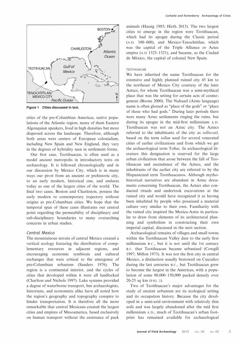
cities of the pre-Columbian Americas, native popu-
lations of the Atlantic region, many of them Eastern
Algonquian speakers, lived in high densities but more
dispersed across the landscape. Therefore, although
both areas were centers of European colonialism,
including New Spain and New England, they vary
in the degrees of hybridity seen in settlement forms.
Our first case, Teotihuacan, is often used as a
model ancient metropolis in introductory texts on
archaeology. It is followed chronologically and in
our discussion by Mexico City, which is in many
ways our pivot from an ancient or prehistoric city,
to an early modern, historical one, and endures
today as one of the largest cities of the world. The
final two cases, Boston and Charleston, possess the
early modern to contemporary trajectory without
origins as pre-Columbian cities. We hope that the
temporal span of these cases illustrates our central
point regarding the permeability of disciplinary and
sub-disciplinary boundaries to many overarching
concerns in urban studies.
Central MexicoThe mountainous terrain of central Mexico created a
vertical ecology featuring the distribution of comp-
lementary resources in adjacent regions, and
encouraging economic symbiosis and cultural
exchanges that were critical to the emergence of
pre-Columbian urbanism (Sanders 1976). The
region is a continental interior, and the cycles of
cities that developed within it were all landlocked
(Charlton and Nichols 1997). Lake systems provided
a degree of waterborne transport, but archaeologists,
historians, and economists alike have all noted how
the region’s geography and topography conspire to
hinder transportation. It is therefore all the more
remarkable that central Mexicans created the largest
cities and empires of Mesoamerica, based exclusively
on human transport without the assistance of pack
animals (Hassig 1985; Hirth 2013). The two largest
cities to emerge in the region were Teotihuacan,
which had its apogee during the Classic period
(A.D. 100–600), and Mexico-Tenochtitlan, which
was the capital of the Triple Alliance or Aztec
empire (A.D 1325–1521), and became, as the Ciudad
de Mexico, the capital of colonial New Spain.
TEOTIHUACAN
We have inherited the name Teotihuacan for the
extensive and highly planned ruined city 45 km to
the northeast of Mexico City courtesy of the later
Aztecs, for whom Teotihuacan was a semi-mythical
place that was the setting for certain acts of cosmo-
genesis (Boone 2000). The Nahuatl (Aztec language)
name is often glossed as ‘‘place of the gods’’ or ‘‘place
of those who had gods.’’ During later periods there
were many Aztec settlements ringing the ruins, but
during its apogee in the mid-first millennium A.D.
Teotihuacan was not an Aztec city. The Aztecs
referred to the inhabitants of the city as tolltecatl,
based on the term tollan used for several venerated
cities of earlier civilizations and from which we get
the archaeological term Toltec. In archaeological lit-
erature this designation is reserved for the large
urban civilization that arose between the fall of Teo-
tihuacan and ascendance of the Aztecs, and the
inhabitants of the earlier city are referred to by the
Hispanicized term Teotihuacanos. Although mytho-
historical narratives are abundant in Aztec docu-
ments concerning Teotihuacan, the Aztecs also con-
ducted rituals and undertook excavations at the
ruined city and would have recognized it as having
been inhabited by people who possessed a material
culture very similar to their own. Familiarity with
the ruined city inspired the Mexica-Aztec in particu-
lar to draw from elements of its architectural plan-
ning and symbolism in constructing their own
imperial capital, discussed in the next section.
Archaeological remains of villages and small towns
within the Teotihuacan Valley date to the early first
millennium B.C., but it is not until the 1st century
B.C. that Teotihuacan became urbanized (Cowgill
1997; Millon 1973). It was not the first city in central
Mexico, a distinction usually bestowed on Cuicuilco
during the last centuries B.C., but Teotihuacan grew
to become the largest in the Americas, with a popu-
lation of some 80,000–150,000 packed densely over
20-25 sq km (FIG. 2).
Two of Teotihuacan’s major advantages for the
study of ancient urbanism are its ecological setting
and its occupation history. Because the city devel-
oped in a semi-arid environment with relatively thin
soils and was largely abandoned after the mid first
millennium A.D., much of Teotihuacan’s urban foot-
print has remained available for archaeological
Figure 1 Cities discussed in text.
Carballo and Fortenberry Archaeology of Cities
Journal of Field Archaeology 2015 VOL. 00 NO. 00 3

research. Over four decades later, the most ambitious
study of urbanism at the city continues to be the Teo-
tihuacan Mapping Project directed by Millon (Millon
1973; Millon et al. 1973), which applied intensive site
mapping and surface collection and became a model
for the archaeological study of urbanism within
Mesoamerica and elsewhere. The city is known
almost exclusively through archaeology and the ico-
nographic study of a rich tradition of mural painting
and other forms of imagery. A writing system existed
at Teotihuacan, but it was highly pictographic, used
sparingly (at least on media that preserves archaeolo-
gically), and only provides glimpses of daily life in
the city and positions in the civic hierarchy.
The orderliness of Teotihuacan’s urban settlement,
the monumentality of its epicenter, and its large,
multi-family apartment compounds, are three of the
city’s attributes that stand out in global archaeology
(Cowgill 2007). The city’s economic base included the
following: a productive systemof springs that permitted
irrigation agriculture in an area to the southwest during
much of the year; adjacent positioning to the Basin of
Mexico lake system, its resources and transportation
possibilities; proximate access to a number of obsidian
sources that provided the primary cutting implements
of the period and an easily exchangeable commodity;
and a combination of intensive household craft pro-
duction, and market and interregional exchange
(Carballo 2013; Manzanilla 2009). The urban organiz-
ation of Teotihuacan included districts that served
civic and administrative functions and were themselves
composed of neighborhoods of frequently interacting
apartment compounds, often termed barrios (Cabrera
Castro and Gomez Chavez 2008; Manzanilla 2012).
Its central artery was a wide (ca. 40 m) and long (over
5 km) thoroughfare known as the Street of the Dead,
which runs from the northern Moon Pyramid to pass
the Sun Pyramid and other major civic, ceremonial,
and palatial structures of the urban epicenter.
Teotihuacan was a cosmopolitan city that saw sub-
stantial migration from other parts of Mesoamerica
and may have been home to speakers of five or more
languages (Spence et al. 2005). Early in its history,
migrants likely moved en masse to the city following
the major eruption of the Popocatepetl volcano,
which displaced large populations in the southern
Basin of Mexico and southern Puebla (Plunket and
Urunuela 2008). They apparently continued coming
throughout its primary occupation, likely because it
was the center of the most robust economic system in
Mesoamerica at the time, but also because, as was
the case with preindustrial cities of the Old World,
the city presented health hazards that created high
mortality rates, particularly later in its history (R.
Storey 2006). Teotihuacan’s size, cosmopolitanism,
migration, craft andmarket systems, and level of plan-
ning were therefore all remarkable for its place and
time, andmake it atypical for a pre-ColumbianMesoa-
merican city. These same characteristics, however, are
what make Teotihuacan more relatable to modern
Figure 2 Teotihuacan in the early 6th century, based on Millon (1973).
Carballo and Fortenberry Archaeology of Cities
4 Journal of Field Archaeology 2015 VOL. 00 NO. 00

cities, among cases from the ancient world. When the
state centered at Teotihuacan collapsed in the mid-
6th century A.D., an event that included the burning
of many of the structures in the urban epicenter and
the contraction of the transportation corridors once
under the swayof the state, the city’s population decen-
tralized and the urban organization of subsequent cen-
turies remains less clear. The city as a symbol lived on,
however–memorialized by other Mesoamerican cul-
tures up to and including the Aztecs.
TENOCHTITLAN-TLATELOLCO/MEXICO CITY
Mexico City’s direct predecessors were sister cities
founded on islands in Lake Texcoco by the Mexica-
Aztecs in the early to mid-14th century A.D.
(FIG. 3). The name of the Mexica ethnic group plus
the locative suffix -co designates the island of
Mexico as ‘‘place of the Mexica,’’ but the two
halves of what eventually became a twin city are dis-
tinguished as Mexico-Tenochtitlan and Mexico-Tla-
telolco, or just by the second parts of these
compound names. The cities are known through
both archaeology and early colonial texts recorded
by the Spanish with the assistance of Mexica infor-
mants who learned alphabetic script to then also
record their history in Spanish and Nahuatl (e.g.,
Calnek 2003; Dahlgren et al. 2009). Tenochtitlan
became the politically and militarily dominant city
of central Mexico during the 15th century A.D., and
was already the most influential capital of an imper-
ial confederation known as the Triple Alliance when
it conquered and annexed Tlatelolco in 1473. Never-
theless, the marketplace at Tlatelolco had grown
larger than the one at Tenochtitlan, and at the time
Figure 3 Tenochtitlan-Tlatelolco in the early 16th century, based on Calnek (2003) and Smith (2008).
Carballo and Fortenberry Archaeology of Cities
Journal of Field Archaeology 2015 VOL. 00 NO. 00 5

of the Spanish conquest of 1519-1521 it retained its
important economic functions as a northern sector
of the dual city.
Mexico City has been continuously occupied for
seven centuries, rendering the pre-Columbian urban
plan of Tenochtitlan-Tlatelolco—dismantled and
buried by the conquistadors—more poorly known
than Teotihuacan’s. Excavations have been under-
taken primarily in the two ceremonial precincts and
as salvage excavations associated with urban
construction projects outside of these epicenters
(Gonzalez Rul 2000; Matos Moctezuma 1988). Scho-
lars of the city attempt to reconcile Spanish accounts
of the number of households and the daily visitors to
the market at Tlatelolco with population density cal-
culations based on an estimated urban footprint of
some 12–14 sq km (Calnek 2003: 151), which included
more and less densely occupied areas of residential dis-
tricts, civic-ceremonial complexes, and zones bisected
by the intensively farmed lakeshore fields known as
chinampas. There exists general consensus for an
early 16th-century population of Tenochtitlan-Tlate-
lolco in the range of 100,000–200,000 inhabitants
(Calnek 2003; Sanders 2003; Smith 2008).
If accurate, the city would have been more populous
than any inWestern Europe at the time except perhaps
Paris (Barioch et al. 1988). It would have been
unmatched by cities in the United States until 19th-
century New York (Rothschild 2006).
The location of these cities in saline Lake Texcoco
has made water management a repeated nuisance for
urban planners. The Mexica and their Acolhua allies
from the city of Texcoco devised aqueducts to deliver
fresh water to the city from springs in the forested
hills of Chapultepec, located to the west; various
dykes to minimize flooding from the east; and net-
works of canals that provided canoe access to chi-
nampa and residential zones and led the Spanish to
compare the city to Venice. The filling of the lake
in order to expand the city and control against peri-
odic floods began prior to the conquest but acceler-
ated afterwards, particularly following several
devastating floods of the 17th century.
A series of maps presented by Calnek (2003) nicely
illustrates the incremental growth of Mexico City
through the late 18th century. An early example
named the Mapa de Alonzo de Santa Cruz or the
Uppsala Map (FIG. 4), likely produced by a native
scribe circa 1550, depicts the close correspondence
between the pre- and post-conquest city plan, with
the major difference being the construction of
churches and other buildings associated with the
importation of Christianity, often using the rubble
from dismantled Mexica structures. More streets
and landfill were also added to the early colonial
city, yet the cardinal orientation of Mexico City’s
plan, principal streets and causeways, location of
major civic-ceremonial precincts and markets, and
elements of the hydraulic infrastructure developed
from clear indigenous foundations.
The continued urbanization of Mexico City to its
present status as one of the largest megacities of
the modern world has interested numerous urban
scholars (e.g., Negrete et al. 1993; Pick and Butler
2000). The particular intersections of varied factors
and historical contingencies cannot be ignored, but
an enduring pattern to the city’s growth could be
said to be the weight of its balance as a production,
rather than consumption center. Based on his reading
of colonial texts, Calnek (2003: 151) argued that the
Mexica adaptation to sequential floods of 1382-1385
that devastated chinampa fields involved expanding
craft production and trade, which in turn stimulated
the growth of Tenochtitlan-Tlatelolco. This major
center of production, tax, and tribute then became
more of a consumer city in a colonial economy fea-
turing centrifugal characteristics of rural, hacienda-
based production and trans-Atlantic extraction by
the Spanish Crown. An example of its stagnation is
provided by a 1790 census in which Mexico City’s
113,000 inhabitants made it still the most populous
city of New Spain, but this represented little change
from the Aztec period, or even a decline, and was
only double the population of Puebla, the second lar-
gest city (Kemper and Royce 1979: 269). Kemper and
Royce (1979) noted that Mexico City’s primate status
within the country has oscillated with the urban
versus rural orientation of the national economy
since then, seeing fits of growth during the late 19th
century Porfirian era and again following post-1940
industrialization. It is during this earlier colonial
era that Mexico City can be compared most directly
to Atlantic English cities in North America.
Atlantic North AmericaThe river-pierced coastline of eastern North America
was the stage for waves of European colonial settle-
ment from the 16th century onwards. The earliest
colonial settlements were situated on the coast or
major waterways, and were bridges between Europe
and the New World (Earle 1977; Hornsby and Her-
mann 2005; Kornwolf 2002).
In 1584 English first arrived in North America and
settled Roanoke Island—an outpost that quickly
failed. Undeterred, English settlers occupied three
areas of the Western Hemisphere: New England,
the Mid-Atlantic, and the Lesser Antilles (Greene
1988). English cities and towns were designed as
administrative, social, and economic centers of colo-
nial society (Earle 1977: 36). Boston and Charleston
were two of the largest and most prosperous cities of
Britain’s Empire. Boston flourished as a shipping
Carballo and Fortenberry Archaeology of Cities
6 Journal of Field Archaeology 2015 VOL. 00 NO. 00

point between England to the east and colonies to the
south, whereas Charleston’s success was a product of
the indigo, rice, and cotton economies. On the eve of
the American Revolution, these were British North
America’s two largest and richest cities: Boston in
size and Charleston in per-capita wealth (Hudgins
1999: 102). While united by their affluence and influ-
ence, the inhabitants of these cities forged their own
socio-economic trajectories that demonstrate con-
trasting urbanization processes in the Americas.
BOSTON
Native Americans were living in the area that would
become the city of Boston beginning in the Early
Archaic period (9,500–8000 B.P.) Hunting and gath-
ering activities have been registered in the archaeolo-
gical record around the Shawmut peninsula, and
included the construction of a system of fish weirs
near modern day Boylston Street (Bagley 2007: 3–4;
Mrozowski 1985). Europeans first arrived in 1625,
and Boston was founded in 1630. By 1636 Boston
was designated the capitol of the Puritan Massachu-
setts Bay Colony. The city was situated on the penin-
sula with the Charles River to the north and west,
and Massachusetts Bay to the east and south (FIG. 5).
During its 18th-century apogee, Boston was both a
mercantile outpost and a major consumer center,
dominated by a wealthy elite. Its strategic location
and commercial maritime infrastructure made it a
powerhouse within the Atlantic economy, yet Bos-
ton’s economic and social fortunes were bound up
in the political events leading up the American Revo-
lution (Nash 1979: 45–46). By 1640 it had become the
largest city in North America and retained this status
until the expansions of New York and Philadelphia
in the 19th century (Kornwolf 2002: 959). Three
major features define early Boston’s urban landscape:
its emergence as a mercantile entrepot; the
Figure 4 Mexico City in the mid-16th century, based on map of Alonso de Santa Cruz published in Calnek (2003).
Carballo and Fortenberry Archaeology of Cities
Journal of Field Archaeology 2015 VOL. 00 NO. 00 7

development of strong, smaller social enclaves along
racial, ethnic, and economic lines; and ‘land-making’
practices (Seasholes 2003). All have parallels in the
cases from pre-Columbian central Mexico. Yet, in
contrast, early Bostonians did not concern them-
selves with a unified, ordered urban landscape. The
city grew in a piecemeal fashion over the 17th and
18th centuries.
Archaeological research of the city’s past has been
driven by urban development and executed by cul-
tural resource management firms, the most promi-
nent example of which was the Central Artery
Project, or Big Dig. In all, over 77 sites with Native
American components and 149 colonial sites have
been excavated in the city and its environs
(MACRIS 2014). Historical archaeological research
in Boston has focused on the ways that households
and neighborhoods, their occupants, and the
material trappings of daily life were indicative of
Boston’s broader urban experience. For example, at
the 27/29 Endicott Street, on the Mill Pond, archae-
ological data showed a 19th-century assemblage
associated with a brothel. Beaudry (2006: 263)
argues that fashionable ceramics were material
indexes of ‘‘aspirations to respectability if not to gen-
tility of some sort.’’ Thus the owners of the privy
sought to balance refined material tastes with the
social world of 19th-century prostitution. At the
community level, archaeological research has cen-
tered on the ways that social and ethnic groups
carved out their own neighborhoods and material
cultures within the urban landscape. For example,
histories of the experiences of Boston’s African popu-
lation (Pierson 1988; Bower 1991) have been enriched
by archaeological and architectural historical work
on the Black community that occupied the northern
slopes of Beacon Hill.
Land-making practices significantly altered Bos-
ton’s urban landscape (Seasholes 2003). Land along
the commercial wharves was frequently reclaimed in
the 17th century, to expand commercial spaces (Mro-
zowski 1985: 13–15, 1987: 1). The area of the Mill
Pond, created in the 17th century, was filled in
during the 18th and 19th centuries to extend the
bounds of the Shawmut peninsula in order to
develop a new residential neighborhood (Seasholes
1998). One of the most recent and ambitious land
reclamation schemes involved the creation of an
elite neighborhood west of Boston Common through
the filling of Boston’s Back Bay.
At the outset of the 19th century the city’s size and
influence was eclipsed by New York and Philadel-
phia, which had over 60,000 and 50,000 residents,
respectively, compared to Boston’s 25,000 (Nash
1979 cited in Hart 2009: 203). Boston remained at
the heart of the New England economy, but never
again achieved the level of economic and social influ-
ence of its colonial past.
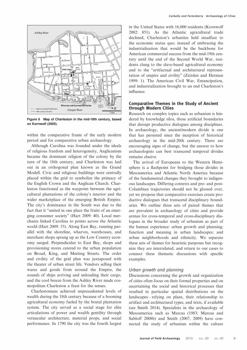
CHARLESTON
Arriving in 1773, New Englander Josiah Quincy
remarked on the magnificence of the Carolina capi-
tal: ‘‘I can only say in general, that in grandeur,
splendor of buildings, decorations, equipages, num-
bers...and indeed in almost everything, it [Charleston]
surpasses all I have ever saw or expected to see in
America’’ (Bushman 1993: 139, citing Quincy 1874).
Located 1,287 km south of Boston, Charleston was
founded 40 years after its northern cousin, as part
of the Carolina colony granted to eight proprietors
in 1663 by the English Monarch Charles II. The
colony was settled in 1670 and by 1680 the colony’s
primary settlement was moved to Oyster Point on a
peninsula flanked by the Ashley and Cooper Rivers
(FIG. 6). The city was situated at a strategic locale
that could be easily defended, and provided a gener-
ous harbor for the development of a robust colonial
port (Saunders 2001: 198–199).
Archaeological interpretations of Charleston have
emphasized the domestic lives of the city’s elite and
the contrasting experiences of enslaved Africans.
Beyond the household level, the study of Charles-
ton’s urban landscape is bolstered by rich archival
and cartographic evidence and the survival of over
200 structures dating to before 1900 (Kornwolf
2002: 852). Archaeologists have collaborated with
architectural historians and preservationists to
understand the relationships between the existing
built environment and archaeological resources situ-
ated underground. Charleston’s planned street pat-
tern and monumental walled domestic compounds
are two traits that define the southern capital
Figure 5 Map of Boston in the mid-18th century, based on
Kornwolf (2005).
Carballo and Fortenberry Archaeology of Cities
8 Journal of Field Archaeology 2015 VOL. 00 NO. 00
within the comparative frame of the early modern
period and for comparative urban archaeology.
Although Carolina was founded under the ideals
of religious freedom and heterogeneity, Anglicanism
became the dominant religion of the colony by the
turn of the 18th century, and Charleston was laid
out in an orthogonal plan known as the Grand
Modell. Civic and religious buildings were centrally
placed within the grid to symbolize the primacy of
the English Crown and the Anglican Church. Char-
leston functioned as the waypoint between the agri-
cultural plantations of the colony’s interior and the
wider marketplace of the emerging British Empire.
The city’s dominance in the South was due to the
fact that it ‘‘united in one place the fruits of an emer-
ging consumer society’’ (Hart 2009: 40). Local mer-
chants linked Carolina to points across the Atlantic
world (Hart 2009: 53). Along East Bay, running par-
allel with the shoreline, wharves, warehouses, and
merchant shops sprang up as the Low Country econ-
omy surged. Perpendicular to East Bay, shops and
provisioning stores catered to the urban population
on Broad, King, and Meeting Streets. The order
and civility of the grid plan was juxtaposed with
the theater of urban street life. Vendors selling their
wares and goods from around the Empire, the
sounds of ships arriving and unloading their cargo,
and the cool breeze from the Ashley River made cos-
mopolitan Charleston a feast for the senses.
Charlestonians achieved unprecedented levels of
wealth during the 18th century because of a booming
agricultural economy fueled by the brutal plantation
system. The city served as a social stage for elite
articulations of power and wealth gentility through
vernacular architecture, material props, and social
performance. In 1790 the city was the fourth largest
in the United States with 16,000 residents (Kornwolf
2002: 851). As the Atlantic agricultural trade
declined, Charleston’s urbanites held steadfast to
the economic status quo; instead of embracing the
industrialization that would be the backbone for
American commercial success from the mid-19th cen-
tury until the end of the Second World War, resi-
dents clung to the slave-based agricultural economy
and to the ‘‘artifactual and architectural represen-
tation of empire and civility’’ (Zeirden and Herman
1999: 1). The American Civil War, Emancipation,
and industrialization brought to an end Charleston’s
influence.
Comparative Themes in the Study of Ancientthrough Modern CitiesResearch on complex topics such as urbanism is hin-
dered by knowledge silos, those artificial boundaries
that disrupt productive dialogues among disciplines.
In archaeology, the ancient/modern divide is one
that has persisted since the inception of historical
archaeology in the mid-20th century. There are
encouraging signs of change, but the answer to how
archaeologists can best transcend temporal divides
remains elusive.
The arrival of Europeans to the Western Hemi-
sphere is a flashpoint for bridging those divides in
Mesoamerica and Atlantic North America because
of the fundamental changes they brought to indigen-
ous landscapes. Differing contexts and pre- and post-
Columbian trajectories should not be glossed over,
yet we propose that comparative exercises create pro-
ductive dialogues that transcend disciplinary bound-
aries. We outline three sets of paired themes that
are prevalent in archaeology of cities and provide
arenas for cross-temporal and cross-disciplinary dia-
logues in the broader study of urbanism as part of
the human experience: urban growth and planning;
function and meaning in urban landscapes; and
urban neighborhoods and ethnicity. We separate
these sets of themes for heuristic purposes but recog-
nize they are interrelated, and return to our cases to
connect these thematic discussions with specific
examples.
Urban growth and planningDiscussions concerning the growth and organization
of cities often focus on their formal properties and on
ascertaining the social and historical processes that
resulted in particular spatial distributions on the
landscapes—relying on plans, their relationship to
artifact and architectural types, and texts, if available
(see Smith 2014). Specialists in the archaeology of
Mesoamerica such as Marcus (1983; Marcus and
Sabloff 2008b) and Smith (2007, 2009) have con-
nected the study of urbanism within the culture
Figure 6 Map of Charleston in the mid-18th century, based
on Kornwolf (2005).
Carballo and Fortenberry Archaeology of Cities
Journal of Field Archaeology 2015 VOL. 00 NO. 00 9

area to the broader literature on historical and con-
temporary cities by evaluating evidence for different
types of planning and city form. Rather than apply-
ing dichotomies such as planned versus unplanned,
which often prioritize grids or orthogonal layouts
as evidence of planning, these authors note that
archaeologists can more productively consider inten-
tionality and potential conflicts in the construction of
historical and prehistoric urban spaces across seg-
ments of the population, from centralized institutions
to corporate groups and affiliated households.
Smith (2007) isolated several dimensions of coordi-
nation and standardization among buildings as
important variables in determining relative degrees
and centralization of planning in ancient cities lack-
ing detailed textual information on these processes.
His comparative analysis of early city plans demon-
strates the incongruence of debates over gridded
versus non-gridded urban landscapes for cities of
the modern era, the scholarship on which tends to
view the first as an index of sophistication and a
move from a ‘medieval’ to an ‘enlightened’ world-
view (see Bushman 1993: 139ff). Such perspectives
are short-sighted given the frequent use of grids
and orthogonality prior to the early modern period
(e.g., Scargill 1979: Chapter 6). More valuable
would be comparative studies of the development
of urban grid systems, their situated meaning and
usage in different regions, and how those meanings
changed over time. Grids might tell us less about
urban and civic order, and more about how urban
landscapes were tools of spatial constraint that
were adhered to in varying degrees within and
among cities.
Among our cases, the central Mexican cities offer
examples of non-Western, premodern orthogonality.
Teotihuacan and Tenochtitlan were more exceptions
than the rule for pre-Columbian cities given the
extensiveness of their orthogonal structures, which
radiated into residential sectors well beyond the
urban epicenter. Nevertheless, the plans of these cen-
tral Mexican capitals likely emerged through multifa-
ceted processes. As an example, recent investigations
at Teotihuacan’s southern Street of the Dead by Car-
ballo and colleagues (in press) verify the suggestion
made by Paddock (cited in Millon 1973: 38) that
this portion of the city’s central artery was cut into
the volcanic tuft substrate over two or more kilo-
meters, in what was apparently a centralized labor
effort. Yet it was also left relatively unelaborated in
comparison with the formally bounded northern
Street of the Dead running through the urban epicen-
ter, and residential compounds to the south were
constructed more haphazardly in relation to the
street than was the case to the north, although they
adhere closely to the overarching orthogonal plan.
The area is therefore consistent with a mix of central
and local planning.
The residential sectors of Tenochtitlan are buried
under Mexico City, leaving their organization more
speculative, but early colonial maps and opportunis-
tic excavations illustrate a pervasive orthogonal plan.
Although there is evidence that the layout of the
urban epicenter was centrally planned and astro-
nomically aligned (Aveni et al. 1988), there exists
little evidence that Mexica rulers mandated com-
moners to arrange their residences to the same
plan. Smith (2007: 38) suggests that the orthogonal
layout of residential sectors could have instead had
more to do with the organization of chinampa
fields than with centralized efforts to orient domestic
space. During the early colonial period the Spanish
continued the native organization in Mexico City’s
historical center but deviated from it in newer outly-
ing areas, only to readopt grid models that were in
fashion in Europe later in the colonial period.
Two different processes are evidenced in our North
American case studies. Boston’s early 17th-century
development occurred prior to broad adoption of
orthogonal plans. The town’s initial form was more
closely akin to its English cousins, such as Bristol
or Norwich, which developed out of medieval cities
organized around central marketplaces and churches.
The remnants of this informal plan can still be seen
today in the city’s North End and Beacon Hill
neighborhoods.
For Charleston, a Grand Modell in the form of an
orthogonal grid was outlined by the colony’s proprie-
tors as a beacon of European civility on the Carolina
peninsula. The city was the first major use of a grid
plan in the English colonies, and all major settle-
ments established thereafter employed some form of
a grid (Hornsby and Herman 2005: 181). The mid-
19th century growth of Boston’s Back Bay was influ-
enced by Parisian urban planning practices and con-
sisted of uniform streets lined with row houses in
order to materialize elite group identity. Urban
grids were ‘‘spatial representations’’ that materialized
early modern ideals of civic European order on the
foreign colonial environment (Upton 2005: 9).
Research on growth and planning also considers
the organization of citywide space as a whole.
Formal models proposed by early urban theorists
such as the concentric, sector, and multiple-nuclei
models (e.g., Burgess 1925; Hoyt 1939; Harris and
Ullman 1945) still possess analytical value after
being adapted to comparative archaeological and his-
torical cases (Marcus 1983; Marcus and Sabloff
2008b; Scargill 1979: Chapter 2; Smith 2010b).
In the first of these models, spatial organization
resembles an archery target with its epicenter as the
bullseye and concentric rings of industrial and
Carballo and Fortenberry Archaeology of Cities
10 Journal of Field Archaeology 2015 VOL. 00 NO. 00
residential space following gradations in production
activities and social status. In the second, the target
takes on some of the properties of a dartboard,
whereby residential or commercial sectors expand
outward from the center as the city grows, creating
additional pie-shaped wedges that cut across the
rings. Finally, in the multiple-nuclei model, urban
spatial organization resembles a flow chart with
bounded sectors of adjoining sectors represented as
cells that serve civic, industrial, and residential func-
tions. Rather than set models, comparative urban
studies show that cities possess variable overlap of
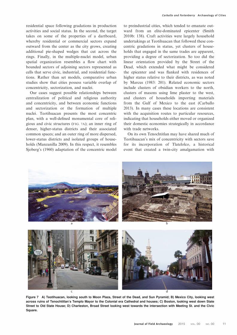
concentricity, sectorization, and nuclei.
Our cases suggest possible relationships between
centralization of political and religious authority
and concentricity, and between economic functions
and sectorization or the formation of multiple
nuclei. Teotihuacan presents the most concentric
plan, with a well-defined monumental core of reli-
gious and civic structures (FIG. 7A); an inner ring of
denser, higher-status districts and their associated
common spaces; and an outer ring of more dispersed,
lower-status districts and isolated groups of house-
holds (Manzanilla 2009). In this respect, it resembles
Sjoberg’s (1960) adaptation of the concentric model
to preindustrial cities, which tended to emanate out-
ward from an elite-dominated epicenter (Smith
2010b: 138). Craft activities were largely household
undertakings at Teotihuacan that followed these con-
centric gradations in status, yet clusters of house-
holds that engaged in the same trades are apparent,
providing a degree of sectorization. So too did the
linear orientation provided by the Street of the
Dead, which extended what might be considered
the epicenter and was flanked with residences of
higher status relative to their districts, as was noted
by Marcus (1983: 201). Related economic sectors
include clusters of obsidian workers to the north,
clusters of masons using lime plaster to the west,
and clusters of households importing materials
from the Gulf of Mexico to the east (Carballo
2013). In many cases these locations are consistent
with the acquisition routes to particular resources,
indicating that households either moved or organized
their domestic economies strategically in accordance
with trade networks.
On its own Tenochtitlan may have shared much of
Teotihuacan’s mix of concentricity with sectors save
for its incorporation of Tlatelolco, a historical
event that created a twin-city amalgamation with
Figure 7 A) Teotihuacan, looking south to Moon Plaza, Street of the Dead, and Sun Pyramid; B) Mexico City, looking west
across ruins of Tenochtitlan’s Templo Mayor to the Colonial era Cathedral and houses; C) Boston, looking west down State
Street to Old State House; D) Charleston, Broad Street looking west towards the intersection with Meeting St. and the Civic
Square.
Carballo and Fortenberry Archaeology of Cities
Journal of Field Archaeology 2015 VOL. 00 NO. 00 11

dual yet unequal nuclei, both with their own
epicenters (FIG. 7B), marketplaces, and canoe ports.
These factors encouraged greater sectorization, and
the plan of Tenochtitlan-Tlatelolco as a unified city
presents a hybrid with dual nuclei, a northern
sector associated with the larger Tlatelolco market-
place, and port sectors to the north and east. In the
early colonial period, the Spanish encouraged greater
centralization in market activities by housing three
within the Plaza Mayor or Zocalo, approximately
where Tenochtitlan’s had been located (Olvera
2007). For an interval the central market was relo-
cated to the west/southwest, where it is designated
in the Santa Cruz map, but it was brought back
close to its Tenochca location by the end of the
16th century (Martınez 1977; Rubial-Garcia 2012).
Pick and Butler (2000: 382) propose that combi-
nation of the concentric model plus sectors still
works for spatial characterization of today’s
Mexico City.
Among our Atlantic North American cases, the ‘T’
or ‘bell’ shaped plans of Boston and Charleston pre-
sent variants of city-sector models guided by their
port settings and strong maritime economies. This
form of development is premised on economic func-
tionality since the most desirable land was on the
harbor frontage for mercantile activities. While infor-
mal, it was produced from ‘‘shared principles of siting
and orientation’’ (Upton 2005: 21), namely the water-
front as the hub of commercial activity. T-shaped
development would be a hallmark of later urban
development in cities such as Philadelphia and New
Orleans (see Upton 2005).
In Boston and Charleston, land was reclaimed to
extend the shoreline and wharves into the harbors;
wetland reclamation and in-filling were also major
components in the growth of Tenochtitlan/Mexico
City. In Charleston, the area called ‘‘the Wharf’’
(later known as East Bay Street) was reclaimed as a
part of the city’s 17th- and 18th-century fortifica-
tions, while private wharves interrupted these shore-
line defenses. Following American independence,
the fortifications were dismantled, and commercial
wharves dominated Charleston’s primary shoreline.
At the center of Boston’s commercial frontage was
Long Wharf, one of the busiest in the western Atlan-
tic; the city was also defended by a series of fortifica-
tions (Bushman 1993: 159).
From the shoreline urban settlement in both cities
pulled back from the harbor, with intensive develop-
ment along central boulevards, King (later State)
Street in Boston (FIG. 7C) and Broad Street in Char-
leston (FIG. 7D). In both cases, the major artery cul-
minated in civic spaces. In Charleston, the
intersection of Meeting and Broad Streets was the
geographic and symbolic center of the Carolina
capital. There, officials designed the open spaces of
the Grand Modell with civic and religious struc-
tures—St. Michael’s Church, the State House, the
Grand House, and the Beef Market.
Boston’s earliest civic spaces were recessed from
the commercial docks to overlook the commerce of
the British Empire’s northwest cornerstone. Running
north from Long Wharf was King Street, with its ter-
minus at the Town House, the seat of colonial gov-
ernment—its first two wooden incarnations had
been lost to fires in 1657 and 1711 before a brick
structure was erected in 1713. Outside of the epicen-
ter, Boston acquired 45 acres of land in 1634 to
create Boston Common, used as grazing pasture
and for public gathering, and most notably as a
venue for hangings and militia musters (Fisher
2000: 124–143; Kornwolf 2002: 959–960).
Bowden and later Hornsby and Hermann (2005)
argued that these processes are indicative of a cat-
egory of urban development in port-capitals termed
the ‘‘mercantile triangle,’’ whereby triangular sectori-
zation characterizes the city plan. The model begins
with the commercial wharf frontage at the bottom
of the triangle for warehousing, wholesaling, ship-
ping, and commission. Moving away from the
water a financial and communication sector coordi-
nates mercantile movements and their monetary
infrastructure. Next are middle sections of personal,
retail, and professional services as well as hotels,
taverns, and theaters. At the tip of the triangle is a
concentrated legal, political, religious, and adminis-
trative sector. While this model is compelling in
Charleston (FIG. 8), Bowden (cited in Hornsby and
Hermann 2005: 186–187) argues that this economic
and administrative model could be applied to all
North American port cities, and we wonder whether
Figure 8 Mercantile Triangle model of Charleston after
Hornsby and Herman (2005).
Carballo and Fortenberry Archaeology of Cities
12 Journal of Field Archaeology 2015 VOL. 00 NO. 00

a modified version could be adapted for the canoe
ports, marketplaces, palace storage facilities, and
temple precincts of Tenochtitlan-Tlatelolco.
Comparative approaches to urban plans have not
gained widespread appeal in historical archaeology
(but see Rothschild 1992). Further diverse and creative
modeling of early modern cities might yield fruitful
comparisons to cases from the ancient world. For
example, do ancient port towns develop in similar
ways in other contexts? A similarly useful exercise
would be to chart the ways that sectors have changed
or remained the same over time, and what the stimuli
were for change.
Function and Meaning of Urban LandscapesThe plans and spatial distributions of cities relate
directly to how urban spaces were used and conceived
by their builders and occupants. In addressing these
dynamics, many archaeologists have found the built-
environment approach championed by Amos Rapo-
port (1977, 1988, 1990) to be of great utility. Rapoport
(1988) termed the symbolic encoding of religious or cos-
mological principles intocity layoutshigh-levelmeaning,
something that is perhaps more apparent among
societies without strong divisions between political
and religious organization, but can also characterize
more secular societies.Mid-level meanings involve inter-
personal relations of power and inequality, and are
marked in urban landscapes in differences such as
those present among residential architecture of variable
social statuses. Low-level meanings, in turn, are less
indexical, though no less important in providing cul-
tural cues for the habituation of lived experience. They
could include conventions such as the elevation of side-
walks or frames around doorways as cues from the built
environment for where to walk apart from traffic or exit
a room, specific to a particular culture and time.
These levels of meaning often crosscut. Whereas
scholars of central Mexico see directional and cosmo-
logical encoding as important high-level meaning,
they debate how centrally planned layouts were in
relation to practical concerns such as agricultural
strategies and low-level meanings generating orthog-
onal layouts such as at Tenochtitlan. Texts clearly
articulate how early modern urban landscapes of
North America were overtly indexed with high and
mid-level meanings. The grid was a materialization
of Georgian notions of imposed cultural order on
nature, while the siting of civic and religious edifices
on prominent locales within the urban landscape
further accentuated the rationality of colonial
power relations.
Convergence in levels of meaning can also be seen
in roadways and other thoroughfares, which could
serve more utilitarian purposes of daily circulation
while also fulfilling periodic status-enforcing
purposes of political spectacles or cosmically regen-
erative purposes of ritual procession. A key feature
of our cases is core boulevards. The Street of the
Dead at Teotihuacan, several causeways within
Tenochtitlan-Tlatelolco/Mexico City and linking the
island city to the mainland, King Street in Boston,
and Broad Street in Charleston all acted as central
arteries with multiple functions and meanings
through their use. As was the case in ancient cities,
elites in early modern ones used central avenues for
ritualized processions to reinforce power over the
city (Leech 1998). An example from colonial
Mexico City was the procession associated with
Corpus Christi from the cathedral through city
streets. It was the largest and most elaborate festival
in the city’s ritual calendar, and reflected Mexico
City’s hybrid nature in involving large native partici-
pation (Curcio-Nagy 1994).
Since meaning in the built environment is strongly
predicated on the use of space, we find utility in the
spectrum proposed by Cynthia Robin and Nan
Rothschild (2002) of public, semi-public, semi-pri-
vate, and private space. Urban public spaces are
often open, with parks, plazas, and wide boulevards.
Archaeologists working in transdisciplinary collabor-
ation have classified such spaces more completely
than the simple ‘gray’ versus ‘green’ space dichotomy
of architectural elaboration, for the purposes of com-
parative analysis (Stanley et al. 2012). Stark (2014)
has further parsed the green spaces of parks and gar-
dens for a globally and temporally comparative
sample of premodern urban societies, noting their
high-level meanings and symbolism as well as their
mid-level meanings including elite display.
As one of the first urban green spaces in North
America, Boston Common served multiple functions
including for public grazing of animals and overtly
political public executions. Boston also provides an
example of how grid plans might convey mid-level
meaning. Back Bay was designed to create a visual
distinction between the winding streets of the city’s
early core and the new, high-status zone expressing
norms of refinement. 19th-century Anglo-American
society championed ideas of holistic civic improve-
ment, yet new public urban projects in Boston such
as Commonwealth Avenue and Back Bay’s Copley
Square (which contained the Public Library) served
to insulate civic institutions inside of the bounds of
elite neighborhoods. These monuments to improve-
ment conflated private elite interests with civic better-
ment (Domosh 1992: 291).
In central Mexico, palaces of the pre-Columbian
elite served semi-private and semi-public functions,
with large interior courtyards often acting as focal
points that could accommodate large groups of spec-
tators or participants, but a number well below that
Carballo and Fortenberry Archaeology of Cities
Journal of Field Archaeology 2015 VOL. 00 NO. 00 13
which could fit in the plazas of ceremonial complexes
(Evans 2004). The status and political power of Aztec
rulers were expressed through urban botanical gar-
dens, zoos, and aviaries located within or in close
proximity to palaces, and exhibiting species acquired
from throughout the empire (Evans 2000).
Digital modeling techniques such as space syntax
offer methods of evaluating levels of meaning
within past built environments by elucidating how
open space, avenues, monuments, and residential sec-
tors were physically connected as parts of urban
landscapes. These approaches facilitate understand-
ing of the role of public and private space and how
they are connected into urban spatial networks, and
can provide cross-disciplinary opportunities for com-
parative analyses. While scholars of Mesoamerica
have been exploring the uses of space syntax in
urban contexts for some time (e.g., Morton et al.
2012; Robb 2007), historical archaeologists have yet
to fully engage this analytical tool and could profit-
ably build on the extensive work undertaken on
modern cities by urban planners and human geogra-
phers (e.g., Psarra and Kickert 2012; Hillier 2005).
Neighborhoods and EthnicityUrban spatial organization of neighborhoods is so
pervasive that Smith (2010b) considers it one of the
few universals of cities past and present. Being econ-
omic hubs, the cases we have assembled illustrate the
spectrum of variability in the ethnic composition of
neighborhoods, with migrant populations producing
ethnic enclaves within which their urban minority
group was a neighborhood majority, and other mul-
tiethnic neighborhoods where majority and different
minority populations were in close contact. Various
authors have considered the ways in which pre-
Columbian societies in central Mexico resembled pre-
capitalist world systems or world economies (Blanton
and Feinman 1984; Smith 2001), but it was in the
16th century that Mexico City became a global city
in the modern sense of the term, followed by the
cities of Atlantic North America. Mexico City’s glo-
balization is vividly illustrated by an entry from the
diary of Domingo Chimalpahin, in which he recounts
the arrival of Japanese emissaries in 1610 (Restall
et al. 2005:153–154). In this illustrative passage we
have an individual of indigenous ancestry writing in
Nahuatl regarding the dress and customs of east
Asians mulling about with western Europeans.
Another example is provided by Mexico City’s
Parian market, one of the three in operation in the
Plaza Mayor that specialized particularly in goods
originating across the Pacific via Manila. Cities of
Atlantic North America would not be so globally
connected for decades but they, and the pre-Colum-
bian cities that preceded Mexico City, saw migration,
forced and voluntary, that resulted in neighborhood
formation based on ethnicity among other factors.
The fact that ancient cities possessed neighbor-
hoods is not usually as surprising to non-archaeolo-
gists as is the fact that they could be multiethnic, a
characteristic presumed to characterize only cities
of the modern era and a few select cases from anti-
quity, such as Rome or other imperial capitals. The
waves of migration to larger premodern cities
demonstrates how research on neighborhood organ-
ization overlaps with research on the articulations
between cities and their broader economic networks.
Mesoamerican archaeologists have recently focused
intensely on neighborhoods, both comparatively
and within the culture area (Arnauld et al. 2012;
Smith 2010b). Although pre-Columbian cities were
not global in a modern sense, they could comprise
multiple ethnic groups speaking languages from com-
pletely distinct language families. Spence and col-
leagues (2005) provide a succinct overview of these
populations at Teotihuacan. Their work highlights
ethnic variability in neighborhood arrangements
such as the more nucleated enclave of Zapotecs
living in the Oaxaca Barrio and the more dispersed
west Mexican migrant populations living in places
such as the Tlajinga district. They also draw an inter-
esting cross-cultural analogy between the occupants
of the Merchant’s Barrio at Teotihuacan, whose
male members show foreign biomarkers but whose
female members show local biomarkers, and the mer-
chant wards of Southwest Asian cities where males
were the traders and migrants.
Ethnic and social boundaries are often inscribed
on the urban landscape, and this is clearly illustrated
by our North American cases. Whereas Charleston’s
urban plan was a communal platform for the display
of civic order, private residences were stages for the
aspirations of gentility and refinement away from
the central mercantile and commercial urban chan-
nels. The Charleston Single House was the preferred
genteel urban form, complete with a central passage
and entry piazza that was oriented with the gable
end to the street frontage (see Herman 1997, 2005;
McInnis 2005). These edifices of elite status were a
part of larger ‘‘urban plantations’’ that reproduced
the social, racial, and spatial relationships of 18th-
and 19th-century southern society, where slave-
owning Anglo-Americans created landscapes of sur-
veillance over enslaved Africans (Vlach 1999).
Archaeologists working in Charleston have been
fortunate to excavate within these urban compounds,
and their work has offered insights into the
material expression of elite group identity. Zierden
(1999: 76–78) has compiled archaeological data
from 20 urban households showing access to fashion-
able European markets and purchasing power at the
Carballo and Fortenberry Archaeology of Cities
14 Journal of Field Archaeology 2015 VOL. 00 NO. 00

height of the city’s social and economic influence.
At the same time, she has demonstrated the changing
tastes of single households over the rise, apogee, and
decline of Charleston, documenting the ways that
modes of gentility were modified in light of dynamic
economic conditions (Zeirden 1999: 79–82). In a
related vein, architectural historians have shown
how the built environment of these urban plantations
were indexes of racial and economic relations, and
the ways that space, slave housing, and outbuildings
were designed to be surveilled through lines of sight
(Herman 1999, 2005; Vlach 1999).
Neighborhood organization and urban form can
define social identity. For instance the co-steadying
sectors of Boston’s 18th-century Beacon Hill and
19th-century Back Bay illustrate contrasting urban
identities. As discussed above, the filling in of the
Back Bay was a deliberate creation of a landscape
for 19th-century elites to distinguish themselves
while simultaneously laying claim to improving the
city. This new ordered landscape contrasted with
the earlier patchwork enclaves of the city’s core.
For example, Black residents of Beacon Hill operated
with relative freedom in the irregularly developed
timber-framed neighborhood that became the center
of the Abolitionist movement in New England. The
streets were set within a built environment in which
the movement of bodies could be surveilled by its
inhabitants (Klee 2008: 53–55). Such surveillance
was crucial during the years leading up to Emancipa-
tion to ensure security and solidarity among the Free
Black population. Related archaeological work on
Beacon Hill has illustrated the everyday lives of
Black Bostonians in this landscape. At its center
was the African Meeting House (Bower and Rushing
1980). Here, excavations demonstrate the commu-
nity-building practices of the site such as communal
meals. In the adjoining apartments at 44 Joy Street,
a privy provided evidence for related meal prep-
aration and service (Landon et al. 2007). Beacon
Hill and Back Bay are deliberate spatial solutions
to the ways these two groups sought to forge their
place within Boston’s 18th and 19th century land-
scape, and show how urban group identity can be
linked to issues of visibility: to be seen or hidden,
to be conspicuous or tucked away.
ConclusionsTwo decades ago Lightfoot (1995: 210) noted: ‘‘The
study of long-term change in both prehistoric and
historic contexts is necessary to evaluate the full
implications of Columbian consequences (epidemics,
novel trade goods, alien fauna and flora), European
exploration, and the formation of multi-ethnic colo-
nial communities. Modern African American, Euro-
pean American, Hispanic, and Native American
cultures are rooted in the prehistory of the Americas
and the colonial policies involving massive move-
ments of ethnic laborers into indigenous homelands.’’
We hope that the comparative overview we have pre-
sented here will foster future collaborations on the
shared urban past of the Americas and elsewhere
that transcend compartmentalization into prehistoric
and historical camps. Historic and prehistoric cities
offer complementary data sets, as the first possess
the rich textual accounts that facilitate precise his-
torical sequences and glimpses into human motiv-
ations, while the second are often more accessible
for excavation, not being located under contempor-
ary cities, in order to chart diachronic change in
the material trappings of urban lifeways.
In this article we traced the development of four
urban centers of the Americas. Each case city was a
product of particular concerns of place, yet we have
shown how urban dwellers used similar solutions to
issues of urban planning and development in working
out the logic of city space. Bridging the concerns of
scholarship on cities across space and through time
requires moving beyond particular urban sequences
to forge comparative frameworks for dealing with
related sets of problems. We have considered just a
few in our attention to urban growth and planning,
functions and meaning of urban landscapes, and
neighborhoods and ethnicity. We emphasized points
of similarity but also noted variability in the reasons
for and degrees of centralized planning of urban
layout, the higher and lower levels of meanings con-
veyed by public and private spaces, and how neigh-
borhoods were shaped by local and immigrant
communities.
In central Mexico, the two pre-Columbian cities of
Teotihuacan and Tenochtitlan-Tlatelolco present
cases of non-Western orthogonal planning on large
scales, whereby the latter appears to have been par-
tially modeled on the former and provided the literal
foundations of Mexico City. How centrally planned
this orthogonality was is debatable in both cases,
however, and it seems likely to have been instantiated
in urban epicenters based on principles of high-level
meaning and on the peripheries of these cities
through more local processes. In Boston and Char-
leston we are presented with the contrast of the
first having been established prior to the importation
of European grid plans to Atlantic North America
and the second having been established following
the Grand Modell that conformed to this new con-
ceptual organization of urban space. In addition to
the variability in time and culture of our cases, they
differ in being either inland or port cities. Neverthe-
less, they, like other cities, served as economic hubs
that attracted goods and people from the broader
orbits of the day. Through the circulation of goods,
Carballo and Fortenberry Archaeology of Cities
Journal of Field Archaeology 2015 VOL. 00 NO. 00 15

the plans of these cities developed varying degrees of
concentricity based on socioeconomic status; sectori-
zation based on production and distribution (e.g.,
workshops, marketplaces, harbors); or the develop-
ment of multiple nuclei based on increased separ-
ation between mercantile and other civic space, or
the absorption of another, previously autonomous
urban epicenter. Through the circulation of people,
migrants created multi-ethnic urban populations
and ethnic enclaves with variable degrees of assimila-
tion into the local community.
As the world’s population continues to flood into
cities at unprecedented levels, a broader comparative
view of urban environments is capable of providing
insights and creative solutions to contemporary pro-
blems such as urban stressors and sustainability
(Smith 2010a). Overcrowding, development, sprawl,
competition for resources, and climate change all threa-
ten today’s cities as well as the urban archaeological
record. Archaeologists have a vital role to play in the
preservation of past urban environments through
mediation and working with local communities to
combat such threats to urban landscapes, both visible
and buried underground. We are also responsible for
making scholarly concerns regarding the archaeology
of cities of interest to this broader audience, and in
this regard less compartmentalization and more collab-
oration surely offer more appealing perspectives on
cities across space and time, with greater contemporary
relevance in highlighting both the patterns and unique-
ness of human urban experiences.
AcknowledgementsWe thank Christina Luke for the invitation to con-
tribute to this commemorative issue. David Carballo
is grateful for advice on certain parts of the text by
Ken Hirth and Susan Evans, and to the National
Science Foundation (BCS-1321247) for support of
the investigations at Teotihuacan. Brent Fortenberry
is grateful to Mary Beaudry and Joe Bagely, for their
thoughts and advice about synthesizing the archaeol-
ogy of Boston. We also thank Daniela Hernandez
Sarinana for her assistance in composing the maps.
David M. Carballo (Ph.D. 2005, UCLA) is an Assist-
ant Professor in the Department of Archaeology at
Boston University. His research focuses primarily on
pre-Columbian Mesoamerica and covers themes relat-
ing to urbanism, households, craft production, ritual,
and social organization.
Brent Fortenberry (Ph.D. 2013, Boston University) is
a Research Scientist at the Warren Lasch Conserva-
tion Center in the Clemson University Restoration
Institute in North Charleston South Carolina. His
research concerns the early modern Atlantic world
and explores issues of urbanism, vernacular architec-
ture, colonialism, and sociability.
ReferencesAndrews, A. P. 1974. ‘‘The U-Shaped Structures at Chan Chan,
Peru,’’ Journal of Field Archaeology 1(3/4): 241–264.Arnauld, M. C., L. R. Manzanilla, and M. E. Smith, eds. 2012.
The Neighborhood as a Social and Spatial Unit in Mesoameri-can Cities. Tucson: University of Arizona Press.
Aveni, A. F., E. E. Calnek, and H. Hartung. 1988. ‘‘Myth,Environment, and the Orientation of the Templo Mayor ofTenochtitlan,’’ American Antiquity 53(2): 287–309.
Bagley, J. M., 2007. ‘‘A Prehistory of Boston Common. Massachu-setts,’’ Archaeological Society Bulletin 68(1): 2–11.
Barioch, P., J. Batou, and P. Chevre. 1988. La population des villesEuropeenes de 800-1850. Geneva: Librairie Droz.
Beaudry, M. C. 2006. ‘‘Stories That Matter: Material Lives in19th-century Boston and Lowell, Massachusetts, USA,’’ inA. Green and R. Leech, eds., Cities in the World 1500–2000,Society for Post-Medieval Archaeology Monograph Series 3.London: Maney, 249–268.
Bettencourt, L. M. A. 2013. ‘‘The Origins of Scaling in Cities,’’Science 340: 1438–1441.
Blanton, R., and G. Feinman. 1984. ‘‘The Mesoamerican WorldSystem,’’ American Anthropologist 86(3): 673–682.
Boone, E. H. 2000. ‘‘Venerable Place of Beginnings: The AztecUnderstanding of Teotihuacan,’’ in D. Carrasco, L. Jonesand S. Sessions, eds., Mesoamerica’s Classic Heritage: FromTeotihuacan to the Aztecs. Boulder: University Press of Color-ado, 371–396.
Bower, B. A. 1991. ‘‘Material Culture in Boston: The BlackExperience,’’ in R. H. McGuire and R. Paynter, ed., TheArchaeology of Inequality. Oxford: Blackwell, 55–63.
Bower, B. A., and B. Rushing. 1980. ‘‘The African Meeting House:The Center for the 19th-Century Afro-American Communityin Boston,’’ in R. L. Schuyler, ed., Archaeological Perspectiveson Ethnicity in America. Farmingdale, NY: Baywood Press,69–75.
Burgess, E. W. 1925. ‘‘The Growth of the City: An Introduction toa Research Project,’’ in E. W. Burgess and R. D. McKenzie,eds., The City. Chicago: University of Chicago Press, 47–62.
Bushman, R. 1993. The Refinement of America: Persons, Houses,Cities. New York: Vintage Books.
Cabrera Castro, R., and S. Gomez Chavez. 2008. ‘‘La Ventilla:A Model for a Barrio in the Urban Structure of Teotihuacan, ’’in A. Guadalupe Mastache, R. H. Cobean, A. Garcıa Cookand K. G. Hirth, eds., Urbanism in Mesoamerica, Vol. II.Mexico City and University Park, PA: Instituto Nacional deAntropologıa e Historia, and Pennsylvania State University,37–84.
Calnek, E. 2003. ‘‘Tenochtitlan-Tlatelolco: The Natural History ofa City,’’ in W. T. Sanders, A. Guadalupe Mastache and R. H.Cobean, eds., Urbanism in Mesoamerica, Volume 1. MexicoCity and University Park, PA: Instituto Nacional de Antropo-logıa e Historia, and Pennsylvania State University, 149–202.
Carballo, D. M. 2013. ‘‘The Social Organization of Craft Pro-duction and Interregional Exchange at Teotihuacan,’’ inK. G. Hirth and J. Pillsbury, eds., Merchants, Markets, andExchange in the Pre-Columbian World. Washington, D.C.:Dumbarton Oaks Trustees for Harvard University, 113–140.
Carballo, D. M., K. G. Hirth, and D. Hernandez Sarinana. inpress. ‘‘Excavaciones del Proyecto Arqueologico Tlajinga,Teotihuacan, 2013-2014,’’ in V. Ortega, ed., Homanaje aRuben Cabrera. Insituto Nacional de Antropologıa e Historia,Mexico City.
Charlton, T. H., and D. L. Nichols. 1997. ‘‘Diachronic Studies ofCity-States: Permutations on a Theme. Central Mexico from1700 B.C. to A.D. 1600,’’ in D. L. Nichols and T. H. Charlton,eds., The Archaeology of City-States: Cross-CulturalApproaches. Washington, D.C.: Smithsonian InstitutionPress, 169–207.
Childe, V. G. 1936. Man Makes Himself. London: Watts andCompany.
Childe. V. G. 1950. ‘‘The Urban Revolution,’’ Town PlanningReview 21: 3–17.
Cowgill, G. L. 1997. ‘‘State and Society at Teotihuacan,’’ AnnualReview of Anthropology 26: 126–161.
Carballo and Fortenberry Archaeology of Cities
16 Journal of Field Archaeology 2015 VOL. 00 NO. 00

Cowgill, G. L. 2004. ‘‘Origins and Development of Urbanism:Archaeological Perspectives,’’ Annual Review of Anthropology33: 525–549.
Cowgill, G. L. 2007. ‘‘The Urban Organization of Teotihuacan,Mexico,’’ in E. L. Stone, ed., Settlement and Society: EssaysDedicated to Robert McCormick Adams. Los Angeles and Chi-cago: Cotsen Institute of Archaeology, University of Califor-nia, and Oriental Institute, University of Chicago, 261–295.
Curcio-Nagy, L. A. 1994. ‘‘Giants and Gypsies: Corpus Christi inColonial Mexico City,’’ in W. H. Beezley, C. English Martinand W. E. French, eds., Rituals of Rule, Rituals of Resistance:Public Celebrations and Popular Culture in Mexico. Wilming-ton, DE: Scholarly Resources Inc., 1–26.
Dahlgren, B., E. Perez-Rocha, L. Suarez Diez, and P. Valle. 2009.Corazon de Copil. Second edition. Mexico City: InstitutoNacional de Antropologıa e Historia.
Domosh,M. 1992. ‘‘Controlling urban form: the development ofBos-ton’s Back Bay,’’ Journal of Historical Geography 18(3): 288–306.
Earle, C. 1977. ‘‘The First English Towns of North America,’’ Geo-graphical Review 67(1): 34–50.
Evans, S. T. 2000. ‘‘Aztec Royal Pleasure Parks: ConspicuousConsumption and Elite Status Rivalry,’’ Studies in the Historyof Gardens and Designed Landscapes 20: 206–228.
Evans, S. T. 2004. ‘‘Aztec Palaces and Other Elite ResidentialArchitecture,’’ in S. T. Evans and J. Pillsbury, eds., Palacesof the Ancient New World. Washington, D.C.: DumbartonOaks Research Library and Collection, 7–58.
Fisher, D. H. 2000. ‘‘Boston Common,’’ in W. E. Leuchtenburg,ed., American Places: Encounters with History. Oxford:Oxford University press, 124–143.
Fletcher, R. 1995. The Limits of Settlement Growth: A TheoreticalOutline. Cambridge: Cambridge University Press.
Gonzalez Rul, F. 2000. Urbanismo y arquitectura enTlatelolco. Mexico City: Instituto Nacional de Antropologıae Historia.
Greene, J. P. 1988. Pursuits of Happiness: The Social Developmentof Early Modern British Colonies and the Formation of Ameri-can Culture. Chapel Hill: University of North Carolina Press.
Harris, C. D., and E. L. Ullman. 1945. ‘‘The Nature of Cities,’’Annals of the American Academy of Political and SocialSciences 242: 7–17.
Hart, E. 2009. Building Charleston: Town and Society in the Eigh-teen-Century British Atlantic World. Charlottesville: Univer-sity of Virginia Press.
Hassig, R. 1985. Trade, Tribute, and Transportation: The Sixteenth-Century Political Economy of the Valley of Mexico. Norman:University of Oklahoma Press.
Herman, B. L. 1997. ‘‘The Embedded Landscapes of the Charles-ton Single House, 1780-1820,’’ Perspectives in VernacularArchitecture: Exploring Everyday Landscapes 7: 41–57.
Herman, B. L. 1999. ‘‘Slave and Servant Housing in Charleston,1770-1820,’’ Historical Archaeology 33(3): 88–101.
Herman, B. L. 2005. Town House: Architecture and Material Lifein the Early American City. Chapel Hill: University ofNorth Carolina Press.
Hillier, B. 2005. ‘‘The Art of Place and the Science of Space,’’World Architecture 185: 96–102.
Hirth, K. G., 2013. ‘‘The Merchant’s World: Commercial Diversityand the Economics of Interregional Exchange in HighlandMesoamerica,’’ in K. G. Hirth and J. Pillsbury, eds.,Merchants, Markets, and Exchange in the Pre-ColumbianWorld. Washington D.C.: Dumbarton Oaks Trustees ofHarvard University, 85–112.
Hornsby, S., and M. Hermann. 2005. British Atlantic, AmericanFrontier: Spaces of Power in Early Modern British America.Lebanon, NH: University Press of New England.
Hoyt, H. 1939. The Structure and Growth of Residential Neighbour-hoods in American Cities. Washington, D.C.: U.S. GovernmentPrinting Office.
Hudgins, C. L. 1999. ‘‘Backcountry and Lowcountry: Perspectiveson Charleston in the Context of Trans-Atlantic Culture,’’ His-torical Archaeology 33(3): 102–107.
Kemper, R. V., and A. Peterson Royce. 1979. ‘‘Mexican Urbaniz-ation since 1821: A Macro-Historical Approach,’’ UrbanAnthropology 8(3/4): 267–289.
Kintigh, K. W., J. H. Altschul, M. C. Beaudry, R. D. Drennan,A. P. Kinzig, T. A. Kohler, W. F. Limp, H. D. G. Maschner,W. K. Michener, T. R. Pauketat, P. Peregrine, J. A. Sabloff,T. J. Wilkinson, H. T. Wright, and M. A. Zeder. 2014. ‘‘GrandChallenges for Archaeology,’’ American Antiquity 79(1): 5–24.
Klee, J. 2008. ‘‘Civic Order on Beacon Hill,’’ Buildings and Land-scapes 15: 43–57.
Kornwolf, J. D. 2002. Architecture and Town Planning in NorthAmerica, Volume 2. Baltimore: Johns Hopkins University Press.
Kostof, S., 1991. The City Shaped: Urban Patterns and MeaningsThrough History. London: Thames and Hudson.
Landon, D. B., T. Dujnic, K. Descoteaux, S. Jacobucci, D. Felix, M.Patalano, R. Kennedy, D. Gallagher, A. Peles, J. Patton, H.Trigg, A. Bain, and C. LaRoche. 2007. ‘‘Investigating the Heartof a Community: Archaeological Excavations at the AfricanMeeting House, Boston, Massachusetts,’’ Andrew Fiske Memor-ial Center for Archaeological Research Publications. Paper 2.
Leech, R.1998. ‘‘The Processional City: Some Issues for HistoricalArchaeology,’’ in S. Tarlow and S. West, eds., Familiar Past?Archaeologies of Later Historical Britain, London: Routledge,19–34.
Lightfoot, K. G. 1995. ‘‘Cultural Contact Studies: Redefining theRelationship between Prehistoric and Historical Archaeology,’’American Antiquity 60(2): 199–217.
McInnis, M. 2005. The Politics of Taste in Antebellum Charleston,South Carolina. Chapel Hill: University of North CarolinaPress.
McIntosh, R. J. 1991. ‘‘Early Urban Clusters in China and Africa:The Arbitration of Social Ambiguity,’’ Journal of FieldArchaeology 18(2): 199–212.
Massachusetts Historical Commission MACRIS ‘‘The Massachu-setts Cultural Resource Information System’’ Maps (database)Web. July 31, 2014.
Manzanilla, L. R. 2009. ‘‘Corporate Life in Apartment and BarrioCompounds at Teotihuacan, Central Mexico: Craft Specializ-ation, Hierarchy, and Ethnicity,’’ in L. R. Manzanilla and C.Chapdelaine, eds., Domestic Life in Prehispanic Capitals: AStudy of Specialization, Hierarchy, and Ethnicity. Ann Arbor:Museum of Anthropology, University of Michigan, 21–42.
Manzanilla, L. R. 2012. ‘‘Neighborhoods and Elite ‘‘Houses’’ atTeotihuacan, Central Mexico,’’ in M. C. Arnauld, L. R. Man-zanilla and M. E. Smith, eds., The Neighborhood as a Socialand Spatial Unit in Mesoamerican Cities. Tucson: Universityof Arizona Press, 55–73.
Marcus, J. 1983. ‘‘On the Nature of theMesoamerican City,’’ in E. Z.Vogt and R. M. Leventhal, eds., Prehistoric Settlement Patterns:Essays in Honor of Gordon R. Willey. Albuquerque and Cam-bridge: University of New Mexico Press and Peabody Museumof Archaeology and Ethnology, Harvard University, 195–242.
Marcus, J., and J. A. Sabloff, eds. 2008a. The Ancient City: NewPerspectives on Urbanism in the Old and New World. Santa Fe:School for Advanced Research.
Marcus, J., and J. A. Sabloff. 2008b. ‘‘Introduction,’’ in J. Marcusand J. A. Sabloff, eds., The Ancient City: New Perspectives onUrbanism in the Old and New World. Santa Fe: School forAdvanced Research, 3–26.
Martınez del Rıo de Redo, M. 1977. ‘‘Iconografıa del Zocalo,’’Dialogos: Artes, Letras, Ciencias Humanas 13(4): 24–27.
Matos Moctezuma, E. 1988. The Great Temple of the Aztecs:Treasures of Tenochtitlan. London: Thames and Hudson.
Millon, R. 1973. Urbanization at Teotihucan, Mexico, Vol. I, Part 1:The Teotihuacan Map: Text. Austin: University of Texas Press.
Millon, R., B. Drewitt, and G. L. Cowgill. 1973. Urbanization atTeotihuacan, Mexico, Vol. 1, Part 2: The Teotihuacan Map:Maps. Austin: University of Texas Press.
Morton, S. G., M. M. Peuramaki-Brown, P. C. Dawson, and J. D.Seibert. 2012. ‘‘Civic and Household Community Relation-ships at Teotihuacan Mexico: a Space Syntax Approach,’’Cambridge Archaeological Journal 22(3): 387–400.
Mrozowski, S. A. 1985. Boston’s Archaeological Legacy: The City’sPlanning and Policy Document. Boston: Boston LandmarksCommission, 1–20.
Mrozowski, S. A. 1987. ‘‘Exploring New England’s EvolvingUrban Landscape,’’ Historical Archaeology Special Publi-cations Number 5 ‘‘Living in Cities: Current Research inUrban Archaeology.’’ 1–9.
Nash, G. B. 1979. The Urban Crucible: Social Change, PoliticalConsciousness, and the Origins of the American RevolutionCambridge, U.K.: Harvard University Press.
Nassaney, M. S., W. Cremin, and D. P. Lynch. 2004. ‘‘The Identi-fication of Colonial Fort St. Joseph Michigan,’’ Journal ofField Archaeology 29(3/4): 309–321.
Negrete, M. E., B. Graizboard, and C. Ruiz, 1993. Poblacion, espa-cio, y medio ambiente en la Zona Metropolitana de la Ciudad deMexico. Mexico City: El Colegio de Mexico.
Carballo and Fortenberry Archaeology of Cities
Journal of Field Archaeology 2015 VOL. 00 NO. 00 17

Nelson, L. P. 2008. The Beauty of Holiness: Anglicanism and Archi-tecture in Colonial South Carolina. Chapel Hill: University ofNorth Carolina Press.
Olvera, J. 2007. Los mercados de la Plaza Mayor en la ciudad deMexico. Mexico City: Centro de Estudios Mexicanos y Cen-troamericanos.
Ortman, S. G., A. H. F. Cabaniss, J. O. Sturm, and L. M. A. Bet-tencourt. 2015. ‘‘Settlement Scaling and Increasing Returns inan Ancient Society,’’ Science Advances 1(1):e1400066.
Parsons, J. R. 1974. ‘‘The Development of a Prehistoric ComplexSociety: A Regional Perspective from the Valley of Mexico,’’Journal of Field Archaeology 1(1/2): 81–108.
Pierson, W. D. 1988. Black Yankees: The Development of an Afro-American Subculture in the North. Amherst: University ofMassachusetts Press.
Pick, J. B., and E. W. Butler. 2000. Mexico Megacity. Boulder,CO: Westview Press.
Plunket, P., and G. Urunuela. 2008. ‘‘Mountain of Sustenance,Mountain of Destruction: The Prehispanic Experience withPopocatepetl Volcano,’’ Journal of Volcanology and Geother-mal Research 170: 111–120.
Psarra, S., and C. Kickert. 2012. ‘‘Detroit—The Fall of the PublicRealm: The Street Network and its Social and EconomicDimensions from 1796 to the Present,’’ in M. Greene, J.Reyes, and A. Castro, eds., Proceedings: Eight InternationalSpace Syntax Symposium, Santiago: PUC, 1–23.
Rapoport, A. 1977. Human Aspects of Urban Form: Towards aMan-Environment Approach to Urban Form and Design.Oxford: Pergamon Press.
Rapoport, A. 1988. ‘‘Levels of Meaning in the Built Environ-ment,’’ in F. Poyatos, ed., Cross-Cultural Perspectives in Non-verbal Communication. Lewiston, NY: C.J. Hogrefe, 317–336.
Rapoport, A. 1990. The Meaning of the Built Environment:A Nonverbal Communication Approach. Revised edition.Tucson: University of Arizona Press.
Restall, M., L. Sousa, and K. Terraciano, eds., 2005.MesoamericanVoices: Native-Language Writings from Colonial Mexico,Oaxaca, Yucatan, and Guatemala. Cambridge: Cambridge Uni-versity Press.
Robb, M. H. 2007. ‘‘The Spatial Logic of Zacuala, Teotihuacan,’’Proceedings, 6th International Space Syntax Symposium, Istan-bul, Turkey, 1–23.
Robin, C., and N. A. Rothschild. 2002. ‘‘Archaeological Ethnogra-phies: Social Dynamics of Outdoor Space,’’ Journal of SocialArchaeology 2(2): 159–172.
Rothschild, N. 1992. ‘‘Spatial and social proximity in early NewYorkCity,’’ Journal of Anthropological Archaeology 11(2): 202–218.
Rothschild, N. 2006. ‘‘Colonial and Postcolonial New York: Issuesof Size, Scale, and Structure,’’ in G. R. Storey, ed., Urbanismin the Preindustrial World: Cross-Cultural Approaches. Tusca-loosa: University of Alabama, 121–136.
Rubial Garcıa, A. 2012. ‘‘La Plaza Mayor de la ciudad de Mexico enlos siglos XVI y XVII,’’ Arqueologıa Mexicana 19(116): 36–43.
Ryzewski, K., and J. F. Cherry. 2012. ‘‘Communities and archae-ology under the Soufriere Hills volcano on Montserrat, WestIndies,’’ Journal of Field Archaeology 37(4): 316–327.
Salwen, B. 1978. ‘‘Archaeology in Megalopolis: Updated Assess-ment,’’ Journal of Field Archaeology 5(4): 453–459.
Sanders, W. T. 1976. ‘‘The Natural Environment of the Basin ofMexico,’’ in E. R. Wolf, ed., The Valley of Mexico: Studiesin Pre-Hispanic Ecology and Society. Albuquerque: Universityof New Mexico, 59–68.
Sanders, W. T. 2003. ‘‘The Population of Tenochtitlan-Tlatelolco,’’in W. T. Sanders, A. Guadalupe Mastache, and R. H. Cobean,eds., Urbanism in Mesoamerica, Volume 1. Mexico City andUniversity Park, PA: Instituto Nacional de Antropologıa eHistoria and Pennsylavania State University, 203–216.
Saunders, K. A. 2001. ‘‘As Regular and fformidible as any suchwoorke in America: the Walled City of Charles Town,’’ inJ. Joseph and M. Zierden eds., Another’s Country: Archaeolo-gical and Historical Perspectives on Cultural Interactions in theSouthern Colonies, Tuscaloosa: University of Alabama Press,198–214.
Scargill, D. I. 1979. The Form of Cities. New York: St. Martin’sPress.
Seasholes, N. S. 1998. ‘‘Filling Boston’s Mill Pond,’’ HistoricalArchaeology 32(3):121–136.
Seasholes, N. S. 2003. Gaining Ground: A History of Landmaking inBoston. Cambridge: MIT Press.
Siegel, P. E., C. L. Hofman, B. Berard, R. Murphy, J. Ulloa Hung,R. Valcarcel Rojas, and C. White. 2013. ‘‘Confronting Carib-bean heritage in an archipelago of diversity: Politics, stake-holders, climate change, natural disasters, tourism, anddevelopment,’’ Journal of Field Archaeology 38(4): 376–390.
Silliman, S. W. 2005. ‘‘Obsidian studies and the archaeology of19th-century California,’’ Journal of Field Archaeology 30(1):75–94.
Sjoberg, G. 1960. The Preindustrial City: Past and Present. NewYork: The Free Press.
Smith, M. E. 2001. ‘‘The Aztec Empire and the MesoamericanWorld System,’’ in S. E. Alcock, T. N. D’Altroy, K. D. Mor-rison, and C. M. Sinopoli, eds., Empires. Cambridge: Cam-bridge University Press, 128–154.
Smith, M. E. 2007. ‘‘Form and Meaning in the Earliest Cities:A New Approach to Ancient Urban Planning,’’ Journal ofPlanning History 6(1): 3–47.
Smith, M. E. 2008. Aztec City-State Capitals. Gainesville: Univer-sity Press of Florida.
Smith, M. E. 2009. ‘‘V. Gordon Childe and the Urban Revolution:A Historical Perspective on a Revolution in Urban Studies,’’Town Planning Review 80(1): 3–29.
Smith, M. E. 2010a. ‘‘Sprawl, Squatters and Sustainable Cities:Can Archaeological Data Shed Light on Modern UrbanIssues?’’ Cambridge Archaeological Journal 20(2): 229–253.
Smith, M. E. 2010b. ‘‘The Archaeological Study of Neighborhoodsand Districts in Ancient Cities,’’ Journal of AnthropologicalArchaeology 29: 137–154.
Smith, M. E. 2011. ‘‘Empirical Urban Theory for Archaeologists,’’Journal of Archaeological Method and Theory 18: 167–192.
Smith, M. L., ed. 2003a. The Social Construction of Ancient Cities.Washington D.C.: Smithsonian Institution Press.
Smith, M. L. 2003b. ‘‘Introduction,’’ in M. L. Smith, ed., TheSocial Construction of Ancient Cities. Washington D.C.: Smith-sonian Institution Press, 1–36.
Smith, M. L. 2008. ‘‘Urban Empty Spaces. Contentious Places forConsensus-Building,’’ Archaeological Dialogues 15(2): 216–231.
Smith, M. L. 2014. ‘‘The Archaeology of Urban Landscapes,’’Annual Review of Anthropology 43: 307–324.
Spence, M. W., C. D. White, E. C. Rattray, and F. J. Longstaffe.2005. ‘‘Past Lives in Different Places: The Origins andRelationships of Teotihuacan’s Foreign Residents,’’ in R. E.Blanton, ed., Settlement, Subsistence, and Social Complexity:Essays Honoring the Legacy of Jeffrey R. Parsons. LosAngeles: Cotsen Institue of Archaeology Press, University ofCalifornia, 155–197.
Stanley, B. W., B. L. Stark, K. L. Johnston, and M. E. Smith.2012. ‘‘Urban Open Spaces in Historical Perspective:A Transdisciplinary Typology and Analysis,’’ Urban Geogra-phy 33(8): 1089–1117.
Stark, B. L. 2014. ‘‘Urban Gardens and Parks in Pre-ModernStates and Empires,’’ Cambridge Archaeological Journal24(1): 87–115.
Storey, G. R., ed. 2006. Urbanism in the Preindustrial World: Cross-Cultural Perspectives. Tuscaloosa: University of Alabama.
Storey, R. 2006. ‘‘Mortality through Time in an ImpoverishedResidence of the Precolumbian City of Teotihuacan:A Paleodemographic View,’’ in G. R. Storey, ed., Urbanismin the Preindustrial World: Cross-Cultural Perspectives. Tusca-loosa: University of Alabama, 277–294.
Upton, D. 2008. Another City: Urban Life and Urban Spaces in theNew American Republic. New Haven: Yale University Press.
Vlach, J. M. 1999. ‘‘The Plantation Tradition in an Urban Setting:The Case of the Aiken-Rhett House in Charleston, South Car-olina,’’ Southern Cultures 5(4): 52–69.
Wiseman, J., and D. Mano-Zissi. 1974. ‘‘Excavations at Stobi,1973-1974,’’ Journal of Field Archaeology 1(1/2): 81–108.
Wiseman, J., and D. Mano-Zissi. 1976. ‘‘Stobi: A City of AncientMacedonia,’’ Journal of Field Archaeology 3(3): 269–302.
Zierden, M. A. 1999. ‘‘A Trans-Atlantic Merchant’s House inCharleston: Archaeological Exploration of Refinement andSubsistence in an Urban Setting,’’ Historical Archaeology33(3): 73–87.
Zierden, M. A., and B. L. Herman. 1999. ‘‘Introduction,’’ Histori-cal Archaeology 33(3): 1–2.
Carballo and Fortenberry Archaeology of Cities
18 Journal of Field Archaeology 2015 VOL. 00 NO. 00
Related Documents