Missouri University of Science and Technology Missouri University of Science and Technology Scholars' Mine Scholars' Mine Civil, Architectural and Environmental Engineering Faculty Research & Creative Works Civil, Architectural and Environmental Engineering 01 Jan 2010 Bridge Lessons Learned from the Wenchuan China, Earthquake Bridge Lessons Learned from the Wenchuan China, Earthquake W. Phillip Yen Genda Chen Missouri University of Science and Technology, [email protected] Mark Yashinski Youssef M. A. Hashash et. al. For a complete list of authors, see https://scholarsmine.mst.edu/civarc_enveng_facwork/560 Follow this and additional works at: https://scholarsmine.mst.edu/civarc_enveng_facwork Part of the Civil Engineering Commons Recommended Citation Recommended Citation W. P. Yen et al., "Bridge Lessons Learned from the Wenchuan China, Earthquake," Transportation Research Record, no. 2202, pp. 102-108, National Research Council (U.S.), Jan 2010. The definitive version is available at https://doi.org/10.3141/2202-13 This Article - Journal is brought to you for free and open access by Scholars' Mine. It has been accepted for inclusion in Civil, Architectural and Environmental Engineering Faculty Research & Creative Works by an authorized administrator of Scholars' Mine. This work is protected by U. S. Copyright Law. Unauthorized use including reproduction for redistribution requires the permission of the copyright holder. For more information, please contact [email protected].

Welcome message from author
This document is posted to help you gain knowledge. Please leave a comment to let me know what you think about it! Share it to your friends and learn new things together.
Transcript
Missouri University of Science and Technology Missouri University of Science and Technology
Scholars' Mine Scholars' Mine
Civil, Architectural and Environmental Engineering Faculty Research & Creative Works
Civil, Architectural and Environmental Engineering
01 Jan 2010
Bridge Lessons Learned from the Wenchuan China, Earthquake Bridge Lessons Learned from the Wenchuan China, Earthquake
W. Phillip Yen
Genda Chen Missouri University of Science and Technology, [email protected]
Mark Yashinski
Youssef M. A. Hashash
et. al. For a complete list of authors, see https://scholarsmine.mst.edu/civarc_enveng_facwork/560
Follow this and additional works at: https://scholarsmine.mst.edu/civarc_enveng_facwork
Part of the Civil Engineering Commons
Recommended Citation Recommended Citation W. P. Yen et al., "Bridge Lessons Learned from the Wenchuan China, Earthquake," Transportation Research Record, no. 2202, pp. 102-108, National Research Council (U.S.), Jan 2010. The definitive version is available at https://doi.org/10.3141/2202-13
This Article - Journal is brought to you for free and open access by Scholars' Mine. It has been accepted for inclusion in Civil, Architectural and Environmental Engineering Faculty Research & Creative Works by an authorized administrator of Scholars' Mine. This work is protected by U. S. Copyright Law. Unauthorized use including reproduction for redistribution requires the permission of the copyright holder. For more information, please contact [email protected].
102
Transportation Research Record: Journal of the Transportation Research Board,No. 2202, Transportation Research Board of the National Academies, Washington,D.C., 2010, pp. 102–108.DOI: 10.3141/2202-13
or undermined the roads, making it difficult to bring in equipmentand supplies.
SURFACE RUPTURE NEAR EPICENTER
The Longmen-Shan thrust zone was formed by the Eastern TibetanPlateau pushing against the Sichuan Basin (1). The thrust zone hasthree faults: the front fault (Guanxian–Jiangyu–Guangyuan), the cen-ter fault (Yingxiu–Beichuan–Chaba–Linjueshi), and the back fault(Wenchuan–Maoxian–Qingchuan). On the basis of the distributionof aftershocks, approximately 300 km of the faults were estimatedto have ruptured, breaking the ground surface along the Yingxiu–Beichuan segment of the center fault (210 km) and the Guanxia–Jiangyu segment of the front fault (70 km). According to Xie et al.(F. R. Xie, Z. M. Wang, Y. Du, and X. L. Zhang, “Preliminary Obser-vations of the Faulting and Damage Pattern of M8.0 Wenchuan,China, Earthquake,” unpublished manuscript), the vertical faultdisplacements measured were more than 5 m.
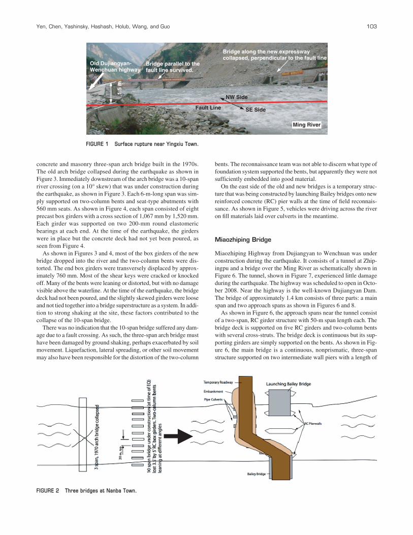
The surface rupture of the center fault in the Longmen–Shan thrustzone was observed in Yingxiu as illustrated in Figure 1. The thrustfault appeared to cross the Ming River at a right angle. As shown inFigure 1, the earthquake left behind a distinct dislocation on theriver bed. The northwest (NW) side of the fault on the upstream ofthe river moves upward against the southeast (SE) side of the fault.The fact that one deck panel along the new expressway elevatedbridge was still supported by one pier in Figure 1 indicated a suddenpush by a near-field pulsing effect. On the other side of the Ming Riverwas the old Dujiangyan–Wenchuan highway. Because of surface rup-ture, the vertical dislocation of the old highway was approximately1.5 m, as illustrated in Figure 1.
Figure 1 also shows that the bridge in parallel with the fault line suf-fered damage in one side span only due to landslides. The significantdifference in damage pattern between the two elevated structures atright angle suggests a strong directivity effect. The bridge perpendic-ular to the fault line experienced substantial motion in a longitudinaldirection due to the thrust fault movement, dropping off all spans.
OBSERVED DAMAGE TO BRIDGES
Although the performance of many bridges was evaluated in thefield, only the three most severely damaged and collapsed bridgesare discussed.
Bridges in Nanba Town
Three bridges crossed a river (the river’s name was not known)near Nanba Town as shown in Figure 2. The west structure was a
Bridge Lessons Learned from the Wenchuan, China, Earthquake
W. Phillip Yen, Genda Chen, Mark Yashinsky, Youssef Hashash, Curtis Holub, Kehai Wang, and Xiaodong Guo
A strong earthquake of M7.9 occurred in Wenchuan County in SichuanProvince, China, on May 12, 2008. This paper presents the field obser-vations on various types of bridge damages, including unseating of gird-ers, longitudinal and transverse offset of decks, pounding at expansionjoints, shear key failure, bearing displacement, column shear, and flex-ible cracks. Plausible causes of damages and collapses are discussed andthe lessons learned from this event are briefly summarized. Some of thepostearthquake temporary constructions are also reported.
The M7.9 Wenchuan earthquake occurred at 06:28:01 (UTC) onMay 12, 2008, in the Longmen-Shan thrust zone. Its epicenter waslocated at 30.989° N/103.329° E near a town called Yingxiu inWenchuan County, Sichuan Province, China. The focal depth of theearthquake was approximately 10 km. The highest recorded peakground acceleration was 0.65g (F. R. Xie, Z. M. Wang, Y. Du, andX. L. Zhang, “Preliminary Observations of the Faulting and DamagePattern of M8.0 Wenchuan, China, Earthquake,” unpublished man-uscript). At least 35 aftershocks with magnitudes equal to or greaterthan M5.0 were recorded within the first 3 months after the mainshock with the strongest aftershock of M6.4.
The M7.9 Wenchuan earthquake and several strong aftershocksresulted in massive landslides and rockfalls. These events causedapproximately 70,000 fatalities and economic loss of over $110 bil-lion. They damaged more than 1,000 bridges, approximately 20 ofwhich had to be replaced. The severity of bridge damage greatlyincreased with proximity to the fault, with the worst damage occur-ring in mountainous terrains. This made the recovery more difficult.Most mountain roads are switchbacks with steep grades over nar-row passes with little room for detour. Massive landslides covered
W. P. Yen, Turner–Fairbank Highway Research Center of FHWA, 6300 GeorgetownPike, T-111 FHWA, McLean, VA 20121. G. Chen, Center for Transportation Infra-structure and Safety, Missouri University of Science and Technology, 224 Engineer-ing Research Laboratory, 500 West 16th Street, Rolla, MO 65401. M. Yashinsky,California Department of Transportation and representing the Earthquake Engineer-ing Research Institute, Caltrans Office of Earthquake Engineering MS9, 1801 30thStreet, Sacramento, CA 95816. Y. Hashash, Department of Civil and Environmen-tal Engineering, Room 2230C, and representing Geo-Engineering EarthquakeReconnaissance (GEER), and C. Holub, Mid-America Earthquake Center (MAE),1110 Newmark Civil Engineering Laboratory, University of Illinois at Urbana–Champaign, 205 North Mathews Avenue, Urbana, IL 61801. K. Wang, ResearchInstitute of Highways, Ministry of Communications, 8 Xitucheng Road, 100088,Beijing, China. X. Guo, Sichuan Province Communications Department, Highway Plan-ning Survey, Design, and Research Institute, 1 Wuhouci Hengjie Street, 610041,ChengDu, China. Corresponding author: W. P. Yen, [email protected].
Yen, Chen, Yashinsky, Hashash, Holub, Wang, and Guo 103
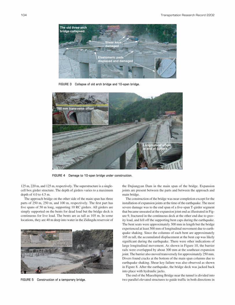
concrete and masonry three-span arch bridge built in the 1970s.The old arch bridge collapsed during the earthquake as shown inFigure 3. Immediately downstream of the arch bridge was a 10-spanriver crossing (on a 10° skew) that was under construction duringthe earthquake, as shown in Figure 3. Each 6-m-long span was sim-ply supported on two-column bents and seat-type abutments with560 mm seats. As shown in Figure 4, each span consisted of eightprecast box girders with a cross section of 1,067 mm by 1,520 mm.Each girder was supported on two 200-mm round elastomericbearings at each end. At the time of the earthquake, the girderswere in place but the concrete deck had not yet been poured, asseen from Figure 4.
As shown in Figures 3 and 4, most of the box girders of the newbridge dropped into the river and the two-column bents were dis-torted. The end box girders were transversely displaced by approx-imately 760 mm. Most of the shear keys were cracked or knockedoff. Many of the bents were leaning or distorted, but with no damagevisible above the waterline. At the time of the earthquake, the bridgedeck had not been poured, and the slightly skewed girders were looseand not tied together into a bridge superstructure as a system. In addi-tion to strong shaking at the site, these factors contributed to thecollapse of the 10-span bridge.
There was no indication that the 10-span bridge suffered any dam-age due to a fault crossing. As such, the three-span arch bridge musthave been damaged by ground shaking, perhaps exacerbated by soilmovement. Liquefaction, lateral spreading, or other soil movementmay also have been responsible for the distortion of the two-column
bents. The reconnaissance team was not able to discern what type offoundation system supported the bents, but apparently they were notsufficiently embedded into good material.
On the east side of the old and new bridges is a temporary struc-ture that was being constructed by launching Bailey bridges onto newreinforced concrete (RC) pier walls at the time of field reconnais-sance. As shown in Figure 5, vehicles were driving across the riveron fill materials laid over culverts in the meantime.
Miaozhiping Bridge
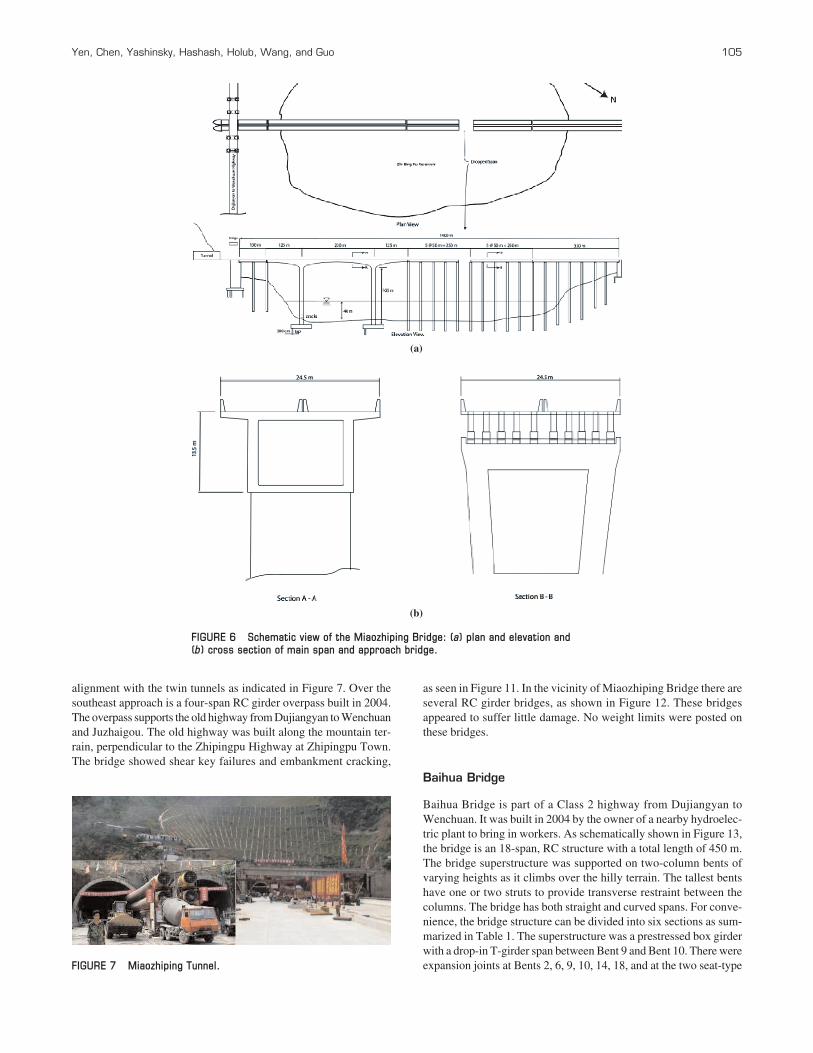
Miaozhiping Highway from Dujiangyan to Wenchuan was underconstruction during the earthquake. It consists of a tunnel at Zhip-ingpu and a bridge over the Ming River as schematically shown inFigure 6. The tunnel, shown in Figure 7, experienced little damageduring the earthquake. The highway was scheduled to open in Octo-ber 2008. Near the highway is the well-known Dujiangyan Dam.The bridge of approximately 1.4 km consists of three parts: a mainspan and two approach spans as shown in Figures 6 and 8.
As shown in Figure 6, the approach spans near the tunnel consistof a two-span, RC girder structure with 50-m span length each. Thebridge deck is supported on five RC girders and two-column bentswith several cross-struts. The bridge deck is continuous but its sup-porting girders are simply supported on the bents. As shown in Fig-ure 6, the main bridge is a continuous, nonprismatic, three-spanstructure supported on two intermediate wall piers with a length of
1.5
m
NW Side
SE SideFault Line
Bridge along the new expresswaycollapsed, perpendicular to the fault line.
Bridge parallel to thefault line survived.
Old Dujiangyan-Wenchuan highway
Ming River
FIGURE 1 Surface rupture near Yingxiu Town.
FIGURE 2 Three bridges at Nanba Town.
104 Transportation Research Record 2202
125 m, 220 m, and 125 m, respectively. The superstructure is a single-cell box girder structure. The depth of girders varies to a maximumdepth of 4.0 to 4.5 m.
The approach bridge on the other side of the main span has threeparts of 250 m, 250 m, and 100 m, respectively. The first part hasfive spans of 50 m long, supporting 10 RC girders. All girders aresimply supported on the bents for dead load but the bridge deck iscontinuous for live load. The bents are as tall as 105 m. In somelocations, they are 40 m deep into water in the Zidingdu reservoir of
the Dujiangyan Dam in the main span of the bridge. Expansionjoints are present between the parts and between the approach andmain bridge.
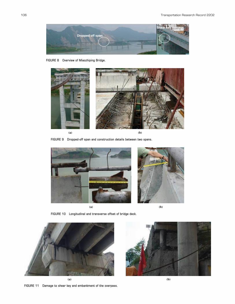
The construction of the bridge was near completion except for theinstallation of expansion joints at the time of the earthquake. The mostsevere damage was to the end span of a five-span T-girder segmentthat became unseated at the expansion joint end as illustrated in Fig-ure 9, fractured in the continuous deck at the other end due to grav-ity load, and fell off the supporting bent caps during the earthquake.The bent seats were approximately 300 mm in length but the bridgeexperienced at least 500 mm of longitudinal movement due to earth-quake shaking. Since the columns of each bent are approximately105 m tall, the accumulated displacement at the bent cap was likelysignificant during the earthquake. There were other indications oflarge longitudinal movement. As shown in Figure 10, the barrierrails were overlapped by about 300 mm at the southeast expansionjoint. The barrier also moved transversely for approximately 250 mm.Divers found cracks at the bottom of the main span columns due toearthquake shaking. Shear key failure was also observed as shownin Figure 8. After the earthquake, the bridge deck was jacked backinto place with hydraulic jacks.
The end of the Miaozhiping Bridge near the tunnel is divided intotwo parallel elevated structures to guide traffic in both directions in
The old three-arch bridge collapsed.
Shear keys damaged
Elastomeric pads displaced and damaged
760 mm transverse offset
Longitudinal offset at end of girders
FIGURE 3 Collapse of old arch bridge and 10-span bridge.
FIGURE 4 Damage to 10-span bridge under construction.
FIGURE 5 Construction of a temporary bridge.
alignment with the twin tunnels as indicated in Figure 7. Over thesoutheast approach is a four-span RC girder overpass built in 2004.The overpass supports the old highway from Dujiangyan to Wenchuanand Juzhaigou. The old highway was built along the mountain ter-rain, perpendicular to the Zhipingpu Highway at Zhipingpu Town.The bridge showed shear key failures and embankment cracking,
as seen in Figure 11. In the vicinity of Miaozhiping Bridge there areseveral RC girder bridges, as shown in Figure 12. These bridgesappeared to suffer little damage. No weight limits were posted onthese bridges.
Baihua Bridge
Baihua Bridge is part of a Class 2 highway from Dujiangyan toWenchuan. It was built in 2004 by the owner of a nearby hydroelec-tric plant to bring in workers. As schematically shown in Figure 13,the bridge is an 18-span, RC structure with a total length of 450 m.The bridge superstructure was supported on two-column bents ofvarying heights as it climbs over the hilly terrain. The tallest bentshave one or two struts to provide transverse restraint between thecolumns. The bridge has both straight and curved spans. For conve-nience, the bridge structure can be divided into six sections as sum-marized in Table 1. The superstructure was a prestressed box girderwith a drop-in T-girder span between Bent 9 and Bent 10. There wereexpansion joints at Bents 2, 6, 9, 10, 14, 18, and at the two seat-type
(a)
(b)
FIGURE 6 Schematic view of the Miaozhiping Bridge: (a) plan and elevation and (b) cross section of main span and approach bridge.
FIGURE 7 Miaozhiping Tunnel.
Yen, Chen, Yashinsky, Hashash, Holub, Wang, and Guo 105
106 Transportation Research Record 2202
Dropped off span
Shear key damage
(a) (b)
(a) (b)
(a) (b)
FIGURE 8 Overview of Miaozhiping Bridge.
FIGURE 9 Dropped-off span and construction details between two spans.
FIGURE 10 Longitudinal and transverse offset of bridge deck.
FIGURE 11 Damage to shear key and embankment of the overpass.
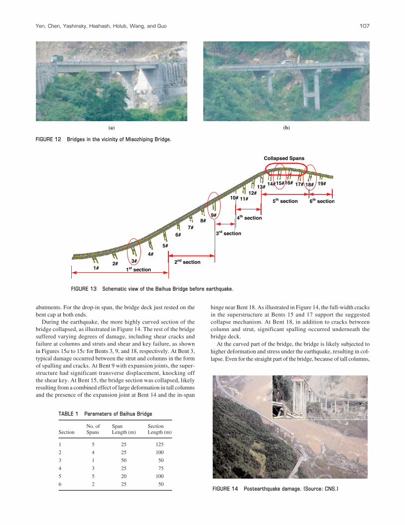
abutments. For the drop-in span, the bridge deck just rested on thebent cap at both ends.
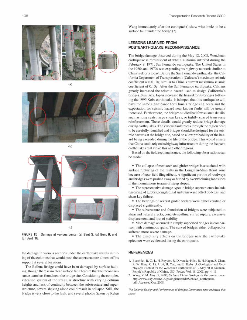
During the earthquake, the more highly curved section of thebridge collapsed, as illustrated in Figure 14. The rest of the bridgesuffered varying degrees of damage, including shear cracks andfailure at columns and struts and shear and key failure, as shownin Figures 15a to 15c for Bents 3, 9, and 18, respectively. At Bent 3,typical damage occurred between the strut and columns in the formof spalling and cracks. At Bent 9 with expansion joints, the super-structure had significant transverse displacement, knocking offthe shear key. At Bent 15, the bridge section was collapsed, likelyresulting from a combined effect of large deformation in tall columnsand the presence of the expansion joint at Bent 14 and the in-span
hinge near Bent 18. As illustrated in Figure 14, the full-width cracksin the superstructure at Bents 15 and 17 support the suggested collapse mechanism. At Bent 18, in addition to cracks betweencolumn and strut, significant spalling occurred underneath thebridge deck.
At the curved part of the bridge, the bridge is likely subjected tohigher deformation and stress under the earthquake, resulting in col-lapse. Even for the straight part of the bridge, because of tall columns,
(a) (b)
4th section
Collapsed Spans
1st section1#2# 3#
4#
5#
6#7#
8#9#
10# 11#12#
13# 14#15#16# 17# 18# 19#
2nd section
3rd section
5th section 6th section
FIGURE 12 Bridges in the vicinity of Miaozhiping Bridge.
FIGURE 13 Schematic view of the Baihua Bridge before earthquake.
Yen, Chen, Yashinsky, Hashash, Holub, Wang, and Guo 107
TABLE 1 Parameters of Baihua Bridge
No. of Span Section Section Spans Length (m) Length (m)
1 5 25 125
2 4 25 100
3 1 50 50
4 3 25 75
5 5 20 100
6 2 25 50FIGURE 14 Postearthquake damage. (Source: CNS.)
the damage in various sections under the earthquake results in tilt-ing of the columns that would push the superstructure almost off itssupport at several locations.
The Baihua Bridge could have been damaged by surface fault-ing, though there is no clear surface fault feature that the reconnais-sance team has found near the bridge site. Considering the complexvibration system of the irregular structure with varying columnheights and lack of continuity between the substructure and super-structure, severe shaking alone could result in collapse. Still, thebridge is very close to the fault, and several photos (taken by Kehai
108 Transportation Research Record 2202
Wang immediately after the earthquake) show what looks to be asurface fault under the bridge (2).
LESSONS LEARNED FROM POSTEARTHQUAKE RECONNAISSANCE
The bridge damage observed during the May 12, 2008, Wenchuanearthquake is reminiscent of what California suffered during theFebruary 9, 1971, San Fernando earthquake. The United States inthe 1960s and 1970s was expanding its highway network similar toChina’s efforts today. Before the San Fernando earthquake, the Cal-ifornia Department of Transportation’s (Caltrans’) maximum seismiccoefficient was 0.10g, similar to China’s current maximum seismiccoefficient of 0.10g. After the San Fernando earthquake, Caltransgreatly increased the seismic hazard used to design California’sbridges. Similarly, Japan increased the hazard for its bridges follow-ing the 1995 Kobe earthquake. It is hoped that this earthquake willhave the same significance for China’s bridge engineers and theexpectation for seismic hazard near known faults will be greatlyincreased. Furthermore, the bridges studied had few seismic details,such as long seats, large shear keys, or tightly spaced transversereinforcement. These details would greatly reduce bridge damageduring earthquakes. The various fault traces through the region needto be carefully identified and bridges should be designed for the seis-mic hazards at the bridge site, based on a low probability of the haz-ard being exceeded during the life of the bridge. This would ensurethat China could rely on its highway infrastructure during the frequentearthquakes that strike this and other regions.
Based on the field reconnaissance, the following observations canbe made:
• The collapse of most arch and girder bridges is associated withsurface rupturing of the faults in the Longmen-Shan thrust zonebecause of near-field fling effects. A significant portion of roadwaysand bridges were pushed away or buried by overwhelming landslidesin the mountainous terrain of steep slopes.
• The representative damage types in bridge superstructure includeunseating of girders, longitudinal and transverse offset of decks, andshear key failure.
• The bearings of several girder bridges were either crushed ordisplaced significantly.
• The substructure and foundation of bridges were subjected toshear and flexural cracks, concrete spalling, stirrup rupture, excessivedisplacement, and loss of stability.
• More damage occurred in simply supported bridges in compar-ison with continuous spans. The curved bridges either collapsed orsuffered more severe damage.
• The directivity effects on the bridges near the earthquakeepicenter were evidenced during the earthquake.
REFERENCES
1. Burchfiel, B. C., L. H. Royden, R. D. van der Hilst, B. H. Hager, Z. Chen,R. W. King, C. Li, J. Lü, H. Yao, and E. Kirby. A Geological and Geo-physical Context for the Wenchuan Earthquake of 12 May 2008, Sichuan,People’s Republic of China. GSA Today, Vol. 18, 2008, pp. 4–11.
2. Wang, Z. M. May 12, 2008, Sichuan China Earthquake Reconnaissance.http://www.uky.edu/KGS/geologichazards/Sichuan_Earthquake.pdf. Accessed Oct. 2008.
The Seismic Design and Performance of Bridges Committee peer-reviewed thispaper.
(a)
(b)
(c)
FIGURE 15 Damage at various bents: (a) Bent 3, (b) Bent 9, and(c) Bent 18.
Related Documents