M E M O R A N D U M TO: Joshua Ringel, Village Manager DATE: April 7, 2022 David Turiano, P.E., Village Engineer Village of Briarcliff Manor FROM: Ralph Peragine, P.E. RE: Mobility Enhancements Brian Dempsey, P.E., PTOE, RSP1 Briarcliff Manor Introduction As requested, RGR Landscape Architecture & Architecture and DTS Provident Design Engineering have been reviewing various alternatives for the Pleasantville Road Mobility Enhancements for the section of Pleasantville Road between North State Road south to past Village Hall. The purpose of the Mobility Enhancements is to improve the area as a “Complete Street” by making the CBD more pedestrian and bicycle-friendly. One comment we heard from various residents is that pedestrians do not feel safe crossing Pleasantville Road in the CBD. Thus, the sidewalk on the east side is proposed to be widened, a sidewalk is being provided on the west side, enhanced crosswalks are also provided and bicycle lanes are added. The roadway is designed to maintain lower speeds than currently occur, to keep the area more pedestrian-friendly. This Memorandum follows up on some of the questions/comments raised by residents, store owners and/or Village Officials/Board Members and provides additional information that has been requested including comparisons to other municipalities in Westchester. An Overall Combined Plan illustrating the Mobility Enhancements, the Cross Access Plan, and the potential modifications to 1050 Pleasantville Road (former Wells Fargo site) is provided, as well as a Concept Sketch of 1050 Pleasantville Road. Overall Public Parking Composite Plan DTS Provident has prepared an Overall Public Parking Composite Plan (attached) which contains the public parking to be provided in connection with the Mobility Enhancements, the Cross Access, and 1050 Pleasantville Road (former Wells Fargo site – enlargement also attached) including the loading zones as well as the ADA Parking Spaces to be provided. The following Table summarizes the public parking, loading zones and ADA parking in the Study Area, comparing the Existing Condition with the Parking to be provided with the Mobility Enhancements, the Cross Access, and 1050 Pleasantville Road:

Welcome message from author
This document is posted to help you gain knowledge. Please leave a comment to let me know what you think about it! Share it to your friends and learn new things together.
Transcript

M E M O R A N D U M
TO: Joshua Ringel, Village Manager DATE: April 7, 2022 David Turiano, P.E., Village Engineer Village of Briarcliff Manor FROM: Ralph Peragine, P.E. RE: Mobility Enhancements Brian Dempsey, P.E., PTOE, RSP1 Briarcliff Manor
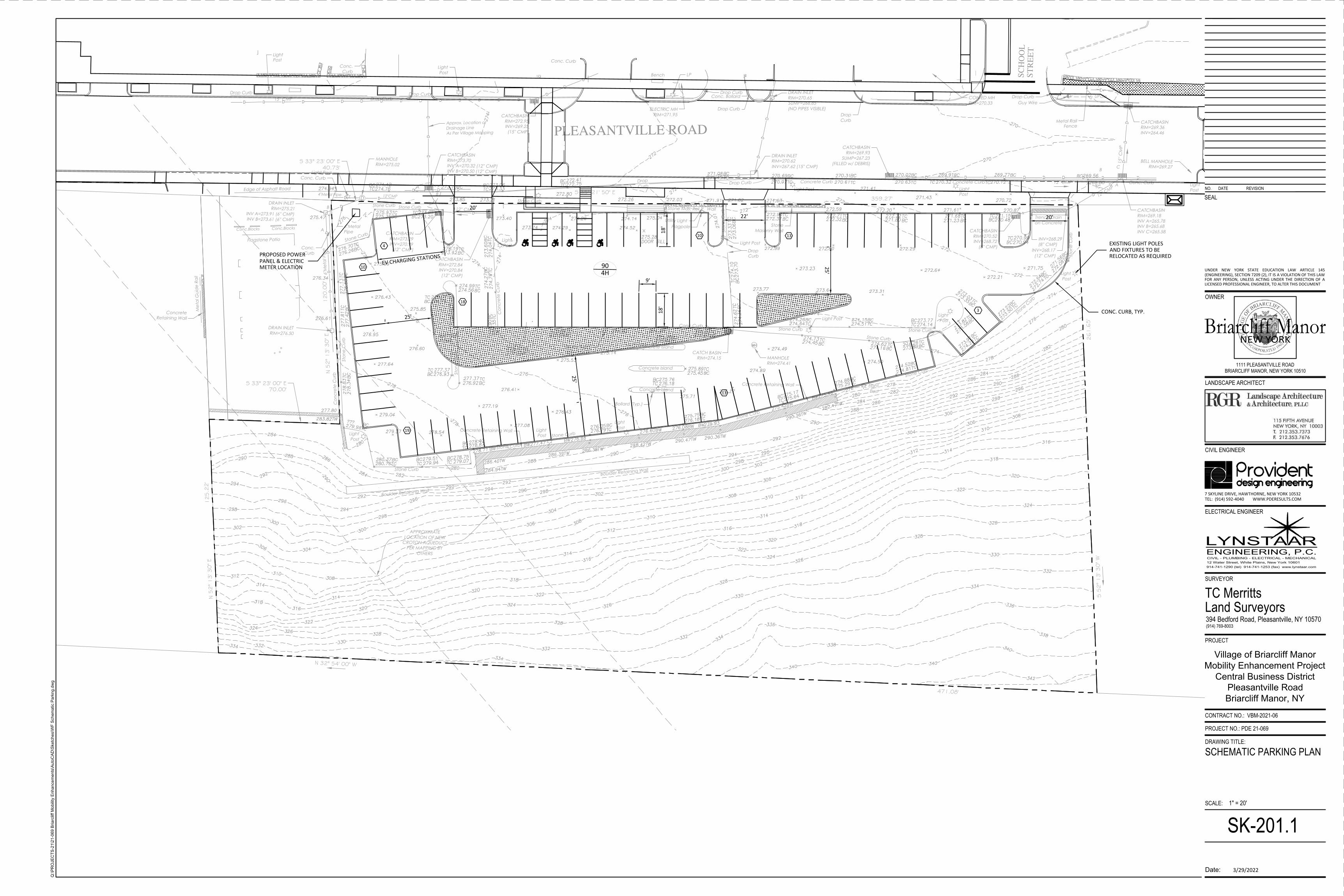
Introduction As requested, RGR Landscape Architecture & Architecture and DTS Provident Design Engineering have been reviewing various alternatives for the Pleasantville Road Mobility Enhancements for the section of Pleasantville Road between North State Road south to past Village Hall. The purpose of the Mobility Enhancements is to improve the area as a “Complete Street” by making the CBD more pedestrian and bicycle-friendly. One comment we heard from various residents is that pedestrians do not feel safe crossing Pleasantville Road in the CBD. Thus, the sidewalk on the east side is proposed to be widened, a sidewalk is being provided on the west side, enhanced crosswalks are also provided and bicycle lanes are added. The roadway is designed to maintain lower speeds than currently occur, to keep the area more pedestrian-friendly. This Memorandum follows up on some of the questions/comments raised by residents, store owners and/or Village Officials/Board Members and provides additional information that has been requested including comparisons to other municipalities in Westchester. An Overall Combined Plan illustrating the Mobility Enhancements, the Cross Access Plan, and the potential modifications to 1050 Pleasantville Road (former Wells Fargo site) is provided, as well as a Concept Sketch of 1050 Pleasantville Road. Overall Public Parking Composite Plan DTS Provident has prepared an Overall Public Parking Composite Plan (attached) which contains the public parking to be provided in connection with the Mobility Enhancements, the Cross Access, and 1050 Pleasantville Road (former Wells Fargo site – enlargement also attached) including the loading zones as well as the ADA Parking Spaces to be provided. The following Table summarizes the public parking, loading zones and ADA parking in the Study Area, comparing the Existing Condition with the Parking to be provided with the Mobility Enhancements, the Cross Access, and 1050 Pleasantville Road:
ma
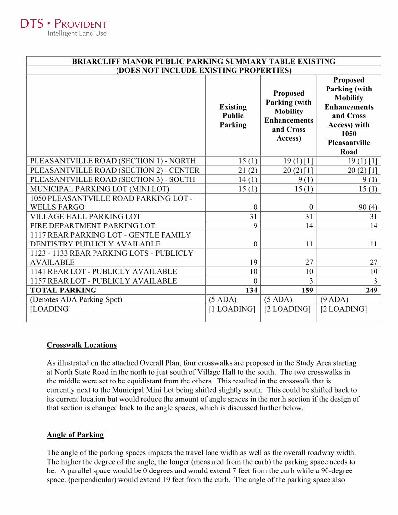
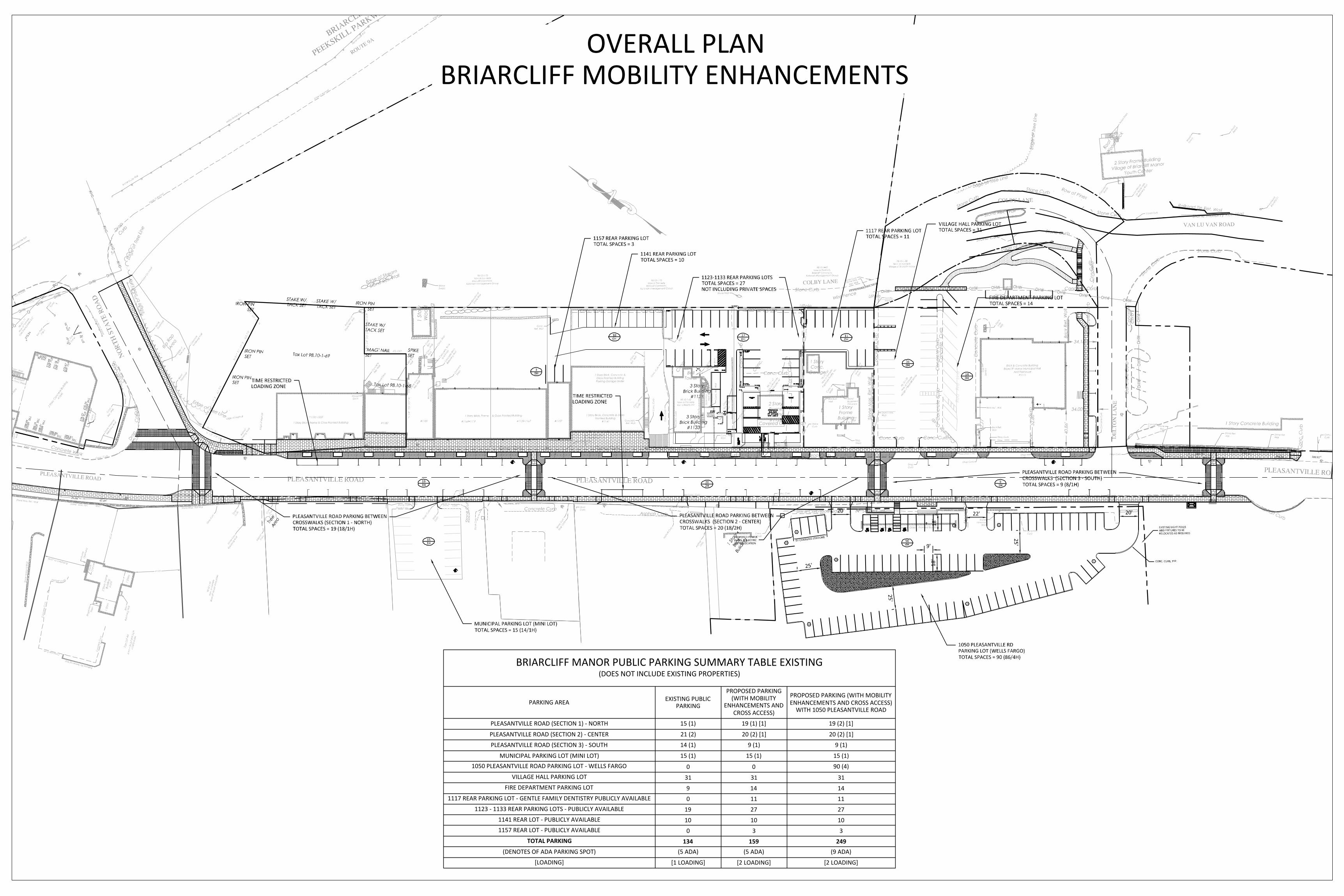
BRIARCLIFF MANOR PUBLIC PARKING SUMMARY TABLE EXISTING (DOES NOT INCLUDE EXISTING PROPERTIES)
Existing Public
Parking
Proposed Parking (with
Mobility Enhancements
and Cross Access)
Proposed Parking (with
Mobility Enhancements
and Cross Access) with
1050 Pleasantville
Road PLEASANTVILLE ROAD (SECTION 1) - NORTH 15 (1) 19 (1) [1] 19 (1) [1] PLEASANTVILLE ROAD (SECTION 2) - CENTER 21 (2) 20 (2) [1] 20 (2) [1] PLEASANTVILLE ROAD (SECTION 3) - SOUTH 14 (1) 9 (1) 9 (1) MUNICIPAL PARKING LOT (MINI LOT) 15 (1) 15 (1) 15 (1) 1050 PLEASANTVILLE ROAD PARKING LOT - WELLS FARGO 0 0 90 (4) VILLAGE HALL PARKING LOT 31 31 31 FIRE DEPARTMENT PARKING LOT 9 14 14 1117 REAR PARKING LOT - GENTLE FAMILY DENTISTRY PUBLICLY AVAILABLE 0 11 11 1123 - 1133 REAR PARKING LOTS - PUBLICLY AVAILABLE 19 27 27 1141 REAR LOT - PUBLICLY AVAILABLE 10 10 10 1157 REAR LOT - PUBLICLY AVAILABLE 0 3 3 TOTAL PARKING 134 159 249 (Denotes ADA Parking Spot) (5 ADA) (5 ADA) (9 ADA) [LOADING] [1 LOADING] [2 LOADING] [2 LOADING]
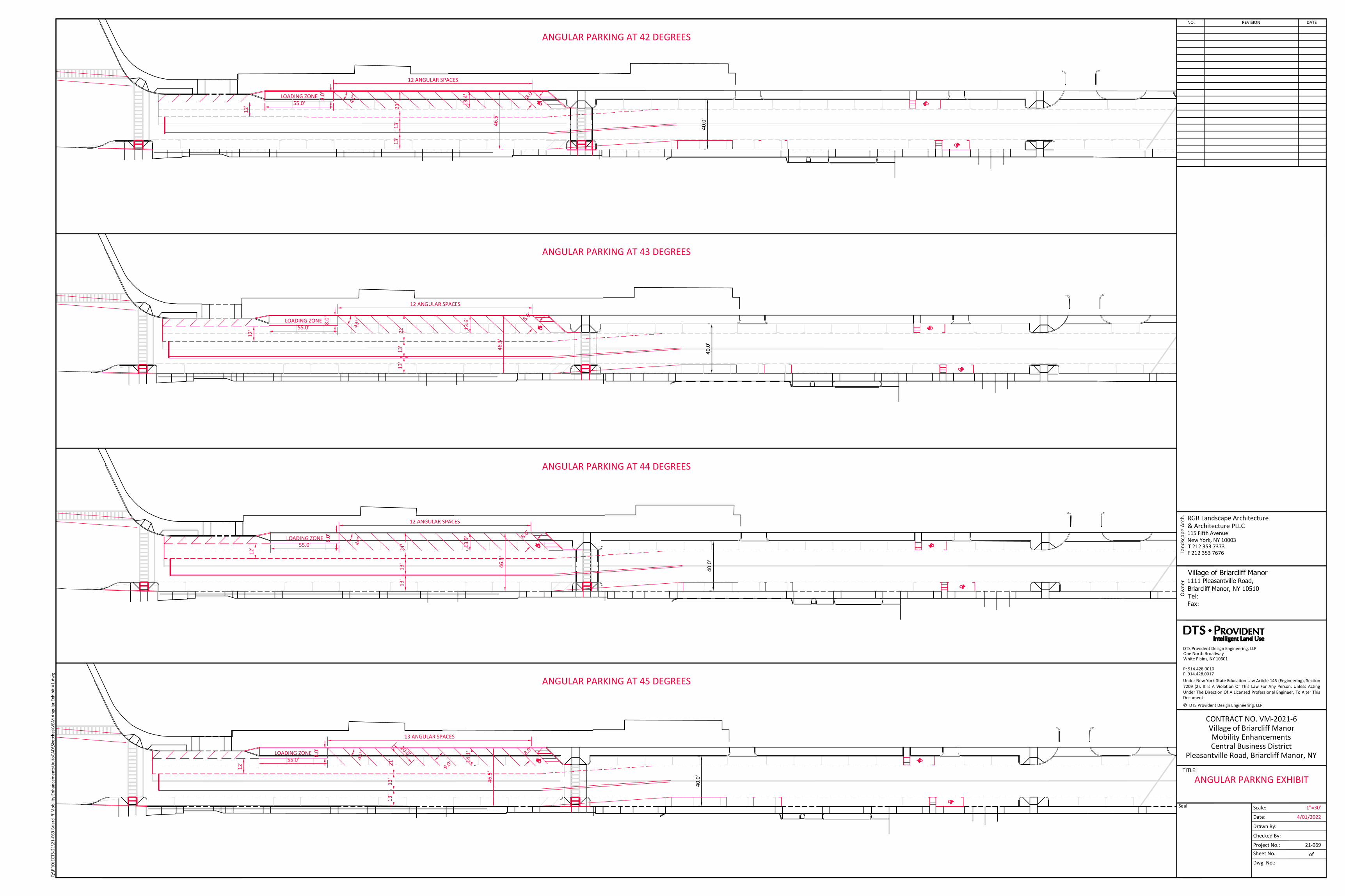
Crosswalk Locations As illustrated on the attached Overall Plan, four crosswalks are proposed in the Study Area starting at North State Road in the north to just south of Village Hall to the south. The two crosswalks in the middle were set to be equidistant from the others. This resulted in the crosswalk that is currently next to the Municipal Mini Lot being shifted slightly south. This could be shifted back to its current location but would reduce the amount of angle spaces in the north section if the design of that section is changed back to the angle spaces, which is discussed further below. Angle of Parking The angle of the parking spaces impacts the travel lane width as well as the overall roadway width. The higher the degree of the angle, the longer (measured from the curb) the parking space needs to be. A parallel space would be 0 degrees and would extend 7 feet from the curb while a 90-degree space. (perpendicular) would extend 19 feet from the curb. The angle of the parking space also
ma effects the width of the travel lane as the higher the degree of the parking space, the more width that is needed to back out of the parking space, as the vehicle needs to back up without crossing the double yellow centerline. Thus, changing the angle of the parking space impacts the overall roadway width and the travel lane width. The existing angle spaces along Pleasantville Road are at an angle between 45-50 degrees. The 44-foot curb to curb roadway width would be the preferred width. The 45-degree angle would work at that width and produce the most angle parking on the east side. The number of parking spaces to be provided would depend upon where the crosswalk is located. If the crosswalk is shifted from the proposed location back north to the existing location, there would be less angle parking in this area. With the angle parking, there would be no parking on the west side. Just dropping from 45-degree spaces to 44-degree spaces results in the loss of one parking space over 100 feet as illustrated in the attached figure. Another space would be lost dropping from 40-degrees to 35 degrees. The 35-degree parking would make it easier for a fire engine to go through as well as for a driver to enter and exit the parking spaces but would result in two less parking spaces than the 45-degree parking. Width of Parking Spaces The angle parking spaces are illustrated on the attached figure at 9 feet wide (measured perpendicular to the parking stripes, not along the curb which is 12.7 feet at 45 degrees and 15.7 feet at 35 degrees), as per Village Code. (The ADA space is 8 foot wide with an 8-foot striped area adjacent, as per State Law.) If the general angle spaces were reduced to 8’6”, an additional parking space would likely not be able to be obtained over a 100-foot section, the width would have to be reduced to 8 feet. This is tight for parking spaces in a high turnover area, leaving limited room to open doors. It also limits maneuverability, especially when backing out. Roadway Travel Lane Width As discussed above, the travel lane width would be dependent upon the type and angle of the parking to ensure sufficient room is provided for vehicles to back out of the parking spaces. The typical roadway lane standard width is 12 feet wide or 13 feet depending upon the activity or if bordered by a curb, but they can vary between 9 and 15 feet wide. The typical parallel parking space is generally 7 feet wide. Possible cross sections are attached. Loading Currently there are no loading zones in the Village, causing congestion and blocking vehicles that are trying to enter/exit parking spaces. As part of the Mobility Enhancements Plan, two official loading areas with time restrictions will be created. Additional enforcement is being discussed. Shifting the driveway forward may be able to get one additional space depending upon the angle and width but it then brings the loading area close to blocking the existing driveway (including blocking sight distance for vehicles exiting the driveway) as well as reducing the storage length for

ma the right turn queue at North State Road. A 55-foot loading zone is being illustrated here which is long for a typical loading zone in a CBD area like this. Also, the Cross Access will improve traffic flow and conditions behind some of the stores which will also help with loading and unloading. Directional wayfinding signs will alert/direct drivers to the parking and potential loading in the rear of the stores. Proposed Design The following is a list of some of the benefits of the proposed Mobility Enhancements Plan as previously presented by RGR:
• Provides only parallel parking, which is proven to be safer than diagonal parking • Provides more even distribution of parking spaces throughout the CBD - east and west • Discourages vehicle U-turns into diagonal parking spaces • Provides curb extensions and high visibility crosswalks for shorter and safer pedestrian
crossings • Provides a continuous furniture zone buffer between the sidewalk and the street • Space for trees, light poles, benches, trash receptacles, and signs, which allows through
pedestrian movement on the sidewalk free of obstructions and tripping hazards • Space for gathering, movable seating, and decorative plantings • Optimum growing environment for street trees – water, oxygen, space for root growth • Permeable surface for stormwater infiltration, reducing impacts on storm sewers • Meets Complete Streets criteria for grant funding from NYS DOT • Provides greater concentration of parking along the retail frontage at northeast quadrant
Changing the parking to angle spaces would likely reduce the sidewalk width which would limit the street trees that can be added. Walking Distance There is no official set walking distance for customers to retail stores but the generally accepted rules of thumb is between 300 and 600 feet, as per the National Parking Association, although it varies by various conditions including the patron age/health, the walking/sidewalk conditions, weather, safety, etc. The National Parking Association has established the following Level of Service Guidelines for outdoor walking in an uncovered area, not in a surface parking lot or parking garage: Level of Service A: Up to 400 feet Level of Service B: 401 Feet to 800 Feet Level of Service C: 801 Feet to 1,200 Feet Level of Service D: 1,201 Feet to 1,600 Feet Level of Service E: more than 1,600 Feet From the northern end of the buildings on the east side, 400 feet extends to just before The Patio, Level of Service A, and it is 800 feet to Village Hall, Level of Service B.

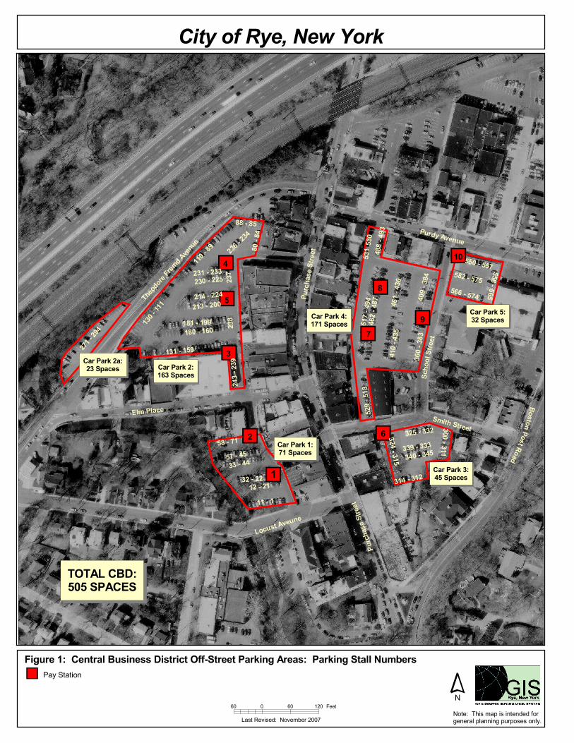
ma Comparison of CBD Parking Conditions The following table summarizes the CBD Road through some of the various municipalities in Westchester where the road has parallel parking. The Average Daily Traffic (ADT) and Roadway Width is also provided. The ADT for each roadway was obtained from the NYSDOT. A higher ADT volume for Pleasantville Road was mentioned at a previous meeting, which will need to be verified. An illustration of the Rye CBD is attached.
Comparison of CBD Parking Conditions Municipality CBD Road Parking Type ADT (Year of Traffic
Count) Road Width
Briarcliff Pleasantville Road -- 8,117 (2016) -- Chappaqua King Street Parallel 9,723 (2019) 46 feet Chappaqua Greeley Avenue Parallel 6,400 (2019) 36 feet Pleasantville Bedford Road Parallel 6,789 (2019) 40 feet Pleasantville Manville Road Parallel 5,460 (2019) 38 feet Mount Kisco Main Street Parallel 13,846 (2017) 38 feet Tarrytown Broadway Parallel 14,624 (2017) 40 feet Sleepy Hollow Broadway Parallel 15,065 (2017) 40 feet Valhalla Broadway Parallel 8,494 (2016) 40 feet Rye Purchase Street Parallel 6,624 (2014) 38 feet Port Chester Main Street Parallel 10,765 (2017) 43 feet Harrison Halstead Avenue Parallel 7,383 (2019) 47 feet Pelham Wolfs Lane Parallel 8,468 (2018) 40 feet
Parallel Parking Versus Angle Parking As previously documented, parallel parking is safer than angle parking, mainly due to the limited visibility of a vehicle backing out of an angled parking space. Some Design Manuals and articles that support this, which are summarized below. There were no other full recent studies aside from studies that quote the below sources.
• American Association of State Highway and Transportation Officials (AASHTO) – A Policy
on Geometric Design of Highways and Streets (The Green Book) – states “When a proposed roadway improvement is to include on-street parking, parallel parking should be considered. Under certain circumstances, angle parking is an allowable form of street parking. The type of on-street parking selected should be based on consideration of the specific functions and width of the street, the adjacent land use, and traffic volume, as well as existing and anticipated traffic operations. Angle parking presents special problems because of the varying lengths of vehicles and the sight distance problems associated with vans and recreational vehicles.”
• Transportation Research Record (TRR) 1270 – Safety Comparison of Types of Parking on Urban Streets in Nebraska: States that “when parking must be allowed, consideration should be given to using parallel parking instead of angle parking… Accident reduction factors

ma
from 19 to 71 percent were reported after a change from angle to parallel parking.” and “angle parking had a significantly higher percentage of parking accidents than parallel parking.” “The non-intersection accident rates for angle parking were significantly higher than those for the parallel parking.” The report concludes with “Parallel parking is the safest type of parking on urban sections on the state highway system in Nebraska. Parallel parking was consistently found to have lower accident rates and lower percentages of accidents than angle parking over the range of traffic, roadway, and land use conditions on these roadways. In many cases, the accident rates and parking accident percentages for angle parking were significantly higher than those for parallel parking. Therefore, when parking must be allowed on urban sections of the state highway system, parallel parking should be used instead of angle parking whenever feasible.”
• Oregon Department of Transportation – Safety Comparison of Angle and Parallel Parking – This document researched various studies and its Summary concludes with “Based upon the review of the research and in agreement with AASHTO A Policy on Design of Highways and Streets and the ODOT Highway Design Guide, parallel parking is preferable to angle parking whenever possible.”
As discussed further below, the parallel spaces will be an appropriate length to ease entrance and exit. It will be easier for drivers to exit their parking space. Several spaces will have an open end either in front of or behind the parking space, making it easier to parallel park. Most new cars have back up cameras and some have other technology such as “driver assist” which help with parallel parking. In addition, there will be a significant number of perpendicular public parking spaces in the Municipal Mini Lot, the main Municipal Lot, the new spaces created with the Cross Access, as well in the 1050 Pleasantville Road Lot. These will in conjunction with various pedestrian improvements including improved sidewalks and crosswalks, traffic calming and new pedestrian connections to Pleasantville Road. Many other municipalities in Westchester have parallel parking on similar roadway comparable to Pleasantville Road, as discussed in this memorandum. Summary of Pleasantville Road – Central Business District Alternatives As requested, RGR Landscape Architecture & Architecture and DTS Provident Design Engineering reviewed various alternatives for the Pleasantville Road Mobility Enhancements for the section of Pleasantville Road between North State Road south to the first crosswalk (in the vicinity of the Toy Shop). DTS Provident prepared various Alternative Plans which have previously been submitted including a Queueing Diagram as well as different scenarios of parallel parking and angle parking at 45 degrees and at 35 degrees with roadway widths of 40, 42 and 44 feet. These considered vehicles ability to exit the parking space with crossing the double yellow line, a WB-50 vehicle in the loading zone, and an aerial fire truck being able to bypass traffic in an emergency. A summary table comparing the various scenarios in terms of the angle of the parking, width of the roadway section, the amount of parking on each side of the road, the placement of a loading zone, and the ability of an aerial firetruck to travel through the section with a car pulled over on each side of the road, is provided below. The existing section of Pleasantville Road in this area ranges between 51 and 53 feet wide. With all of the angle parking scenarios, there would be no parking on the west side of the road. As 6 parallel parking spaces would be installed on the west side in the Grant Application Plan, the ability to add parking spaces with the angle spaces is limited as those 6 spaces are then lost. The bicycle areas are also lost as are the pedestrian crossing bumpouts on the west side of the road.

ma Briarcliff Manor Central Business District Scenarios Summary Table (North Section Only)
Scenario
Can Parked Vehicle Exit?1
Can Firetruck Maneuver between 2 Vehicles?2
Parking Supply on
West Side of Pleasantville
Road
Parking Supply on
East Side of Pleasantville
Road Total
Parking Additional Notes Existing Condition 51-53 Foot-Wide Roadway
No Yes 0 15 15
No Loading Zone or ADA space. At least one space backs out onto crosswalk
Proposed Conditions Parallel Parking 40-Foot-Wide Roadway
Yes Yes 6 8 14
35 Degree Angle Parking 44-Foot-Wide Roadway
Yes Yes 0 10 10
45 Degree Angle Parking 44-Foot-Wide Roadway
Yes Yes 0 12 12
35 Degree Angle Parking 42-Foot-Wide Roadway
Yes (tight
for larger
vehicle)
Yes 0 10 10
45 Degree Angle Parking 42-Foot-Wide Roadway
Yes (tight
for larger
vehicle)
Yes (very tight) 0 12 12
35 Degree Angle Parking 40-Foot-Wide Roadway
No (not
larger vehicle)
Yes (very tight) 0 10 10
45 Degree Angle Parking 40-Foot-Wide Roadway
No (not
larger vehicle)
No (not larger vehicle)
0 12 12
Notes: 1. This scenario refers to a vehicle exiting the parking space adjacent to the crosswalk and not crossing over the crosswalk or across the double yellow line to exit 2. This scenario refers to an Aerial Firetruck being able to maneuver northbound on Pleasantville Road with two vehicles pulled over on both sides of the road.

ma To provide for the proper room for a vehicle to back-out of an angle parking space, the 44-foot wide section would be recommended from a traffic standpoint if angle spaces are eventually required. This would result in the loss of sidewalk space and the proposed tree wells. Additional Comments/Solutions The following is a summary of some of the additional comments received and the responses/solutions to the comments: Comment: Not enough parking for the northeast stores Response: As illustrated on the Overall Public Parking Composite Plan, the public parking in the Study Area will be increased by 25% over existing conditions as a result of the Mobility Enhancements and Cross Access. With the addition of 1050 Pleasantville Road, the amount of public parking in the Study Area will be almost double the existing condition, with almost all of the parking spaces within 800 feet (Walking Level of Service B) of the northern end of the stores in the northeast corner. These walking distances are similar to other municipalities and at other facilities in the Village like the Pool and the train station. For the new spaces being added in conjunction with the Cross Access, new pedestrian connections to Pleasantville Road will be added. There will only be a few on-street parking spaces less in the northern section with the parallel parking than with the angle parking. However, with the Mobility Enhancements, including the improved sidewalk on the western side and the enhanced crosswalk in combination with the traffic calming, more patrons to the northeast stores will park on the west side including in the municipal mini lot. Several residents stated that did not want to park on the west side currently as they feel it is not safe to cross Pleasantville Road under the existing conditions but would do so with the pedestrian enhancements that will be provided. There are also ongoing discussions about more enforcement in the area, including requiring building owners and employees to park in the rear of the stores instead of taking spaces along Pleasantville Road. There could also be shortened time allotments for the spaces in this area, which will increase turnover and free-up spaces. Comment: Parallel parking is impossible Response: As previously discussed, parallel parking is safer than angle parking. The parallel spaces will be an appropriate length to ease entrance and exit. It will be easier for drivers to exit their parking space. Several spaces will have an open end either in front of or behind the parking space, making it easier to parallel park. Most new cars have back up cameras and other technology which assist with parallel parking. In addition, there will be a significant number of perpendicular public parking spaces in the Municipal Mini Lot, the main Municipal Lot, the new spaces created with the Cross Access, as well in the 1050 Pleasantville Road Lot. These will in conjunction with various pedestrian improvements including improved sidewalks and crosswalks, traffic calming and new pedestrian connections to Pleasantville Road. The Table above shows some of the other municipalities in Westchester that have parallel parking on similar roadway comparable to Pleasantville Road. Comment: Parallel parking will slow traffic Response: A driver parallel parking will slow some traffic but it would be safer and similar in time compared to a drive backing out of an angle space, especially if the vehicle backing out is next to a van or SUV and thus cannot see traffic travelling toward it. One of the goals of the Mobility Enhancements is to provide “complete streets” and maintain slower speeds through the business

ma district, not provide a raceway. Pedestrians trying to cross the street do not feel safe crossing. As illustrated in the Table above, many other municipalities in Westchester successfully have parallel parking on similar roadways. The parking spaces will be an appropriate length for vehicles to be able to enter and exit. Comment: One lane in each direction creates problem when trucks are unloading Response: Currently there are no loading zones in the Village, causing congestion and blocking vehicles that are trying to enter/exit parking spaces. As part of the Mobility Enhancements Plan, two official loading areas with time restrictions will be created. Additional enforcement is being discussed. Also, the Cross Access will improve traffic flow and conditions behind some of the stores which will also help with loading and unloading. Directional wayfinding signs will alert/direct drivers to the parking and potential loading in the rear of the stores. In addition, the second lane on northbound Pleasantville Road currently causes confusion among some drivers and pedestrians as well as results in drivers passing each other. Comment: “Residents will not walk extra distances to stores” (For example, Tom from liquor store reports his customers have insisted they will drive to Chappaqua rather than park and walk in Briarcliff.) Response: A comparison table has been provided illustrating some of the other Westchester municipalities that have parallel parking in their CBD. People in the Village currently walk to other facilities in Briarcliff such as the pool, Chilmark Village Park/Field, train station and library. Also, as previously mentioned, there will only be a few less parking spaces on the northern end and pedestrians will be able to cross the street with the improvements proposed as part of the Mobility Enhancements. Shorter time limits on the parking along Pleasantville Road will help patron parking turnover while parking in the rear of the stores and at 1050 Pleasantville Road would be for extended parking. Electric vehicles will park further away for charging stations. Comment: Emergency vehicles will be stuck in traffic Response: Analyses and engineered plans have been performed that indicate that sufficient room is provided so that vehicles can pull over to permit emergency vehicles to proceed on Pleasantville Road. Comment: No need for street parking on west side Response: Parking on the west side will be beneficial when combined with the pedestrian improvements as part of the Mobility Enhancements. The parking on the west could also be utilized for delivery vehicles. Comment: Merchants worry about disruption of business Response: A Construction Management and Phasing Plan and Schedule will be developed so that any disruption to businesses will be minimized. The Village will coordinate with the store owners before the project begins and as it proceeds. Comment: Everything is fine as is; this project is a waste of money Response: The Mobility Enhancement Project has been the result of comments from residents including requests to make the CBD more inviting and pedestrian friendly. A “complete streets” concept was developed for this portion of the Pleasantville Road corridor. Residents have stated that they are afraid to cross Pleasantville Road under the current conditions. There have also been accidents from drivers backing out of the angle parking spaces. Several positive comments have

ma been received as a result of the first phase of the Project, the section north of North State Road. The majority of the costs of the Project would be covered by the Grant that has been applied for. Comment: There’s never been any enforcement of parking times or trucks double-parking in village. Response: Discussions are occurring regarding additional enforcement and technology in the CBD. In addition, with the addition of the two loading zones and the redesign of Pleasantville Road, there will not be trucks double parking.

ma
ATTACHMENTS
Conc.Curb
Concrete CurbConcrete Curb
Stone Mas. Ret.Stone Mas. Ret.Wall
Stone Mas. Ret. WallWall
Conc.Curb
Met
al G
uide
Rai
l
Pole
Metal Guide Rail
Gas
Pum
p
Iron
Post
(Typ.
)
Gas
Pum
p
Conc. Wall
BasementConc.Steps
Con
c.A
pron
Con
c.W
all
2 Sto
ry Con
cret
e Bu
ilding
#1245
NO
RTH
STA
TE R
OA
D
Conc.Curb
1 Sto
ry
Paint Marks
in
Field by O
thers
Concr
ete
Reta
ining
Wal
l
Drop Cur
b
Con
cret
e C
urb
Con
cret
e C
urb
Concr
eteC
urb
Edge of Asphalt
Edge
of A
spha
lt
Aspha
ltPa
rking
Are
a
Conc. CurbEdge of Asphalt Conc.Curb
Dro
pC
urb
Stone CurbStone Curb
Concrete Curb Conc. Curb
1 Story Brick, Frame & Glass Fronted Building
PLEASANTVILLE ROAD
98.10
-1-7
1
Now o
r For
mer
ly
1245
Ple
asan
tville
LLC
Edge of Asphalt
Metal Guide Rail
Metal Guide Rail
Metal G
uide Rail
Edge of Asphalt
Edge of Asphalt
PEEKSKILL PARKWAY
ROUTE 9ABRIARCLIFF
Are
a =
36,2
67.8
09 S
q.Ft
.=
0.83
3 A
cres
98.1
0-1-
45N
ow o
r For
mel
yBr
iarc
liff H
ouse
Ass
ocia
tes
PLEASANTVILLE ROAD
Tax
Lot 4
4
Ston
e M
ason
ry W
all
AsphaltCurb
Fram
eO
verh
ang
Ston
eC
him
ney
Con
cret
e C
urb
Concrete Curb
Con
cret
e C
urb
Flags
tone
Step
s
Railroad Tie Retaining Wall
Bric
kRe
tain
ing
Wal
l
2 St
ory
Fram
eBu
ildin
g#
1210 1
Stor
y
1 St
ory
49.03'
60.5
4'
44.87' to Overhang
98.10
-1-5
9
Now o
r For
mer
ly
Villa
ge o
f Bria
rcliff
Man
or
98.10
-1-6
0
Now o
r For
mer
ly
Papa
Lou
Real
ty, In
c. Brick & Concrete BuildingBriarcliff Manor Municipal Hall
And Firehouse#1111
Stone Curb
Conc.Curb
Conc. Curb
Conc. Curb
Drop
Curb
Concrete Walk
Tree
Area
Con
c.C
urb
Drop
Cur
b
Asp
halt
Cur
b
Con
c. C
urb
Drop
CurbEd
ge o
f Tre
e Lin
eEd
ge o
f Tre
e Lin
e
Edge of Tree Line
Rip R
apAre
a
Ston
e C
urb
Concrete Curb
Drop CurbConc. Curb Conc. Curb
Asphalt Curb
1 Sto
ryBr
ick
Build
ing
1 Story Brick, Frame & Glass Fronted Building 1 Story Brick, Concrete & GlassFronted Building
#1141
Drop Curb Drop CurbDrop Curb
Stone Curb (both sides) Stone Curb
DropCurb
Ston
e C
urb Drop Curb
1 Story Brick, Frame & Glass Fronted Building
Concrete Curb Concrete Curb Conc. Curb
Con
c.
Cur
b
Conc. Curb Conc. Curb
PLEASANTVILLE ROAD
DE
LT
ON
LA
NE98.10-1-62
Now or FormerlyMatra Realty Inc
98.10
-1-6
1
Now o
r For
mer
ly
Mat
ra R
ealty
Inc
98-10-1-70Now or Formerly
Briarcliff Commons,Katonah Management Group
1 Story Concrete Building
34.16'
52.8
0'
52.7
7'
Stone CurbStone Curb
Stone CurbStone Curb
Edge of Tree Line
Edge
of T
ree
Line
Stone Mas.Ret. Wall
Row of PinesRailroad Tie Ret. Wall
Stone Masonry Ret. Wall
Roof
Ove
r
Woo
d Dec
k
Stone Curb
Stone Curb
Stone C
urbEdge of Tree Line
2 Story Frame Building
Village of Briarcliff Manor
Youth Center
VAN LU VAN ROAD
COLBY LANE
Conc. Curb
3 StoryBrick Building
#1133
1 Story Brick, Concrete &Glass Fronted BuildingParking Garage Under
Covered Conc. Porch
Con
c. C
urb 1 Story
Conc.Garage
2 StoryFrame
Building#1123
Con
cret
e C
urb
Ston
e M
as. R
et. W
all
UPole
UPoleWire FenceStone Curb
Concrete Curb
Conc. CurbConc.
Con
c. C
urb
Conc. Curb
40.8
6'
34.00'
Conc.
Concrete Curb
Con
cret
e C
urb
Con
cret
e C
urb
Con
cret
e C
urb
Concrete
Curb
Concrete Curb
Cur
bC
oncr
ete
Con
cret
e C
urb
Con
cret
e C
urb
Bric
k Re
t. W
all
Con
cret
e C
urb
Bell
1 St
ory
Woo
dBu
ildin
g
Stone Ret. Wall
Con
cret
e C
urb
Con
cret
eC
urb
1 StoryFrameBuilding#1117
98.10-1-58Now or Formerly
Village of Briarcliff Manor
98-10-1-70Now or Formerly
Briarcliff Commons,Katonah Management Group
98-10-1-70Now or Formerly
Briarcliff Commons,Katonah Management Group COLBY LANE
3 StoryBrick Building
#1133#1157#1159-1167#1169-1177#1181#1187
#1197-1207
Edge of Stream
BellTower
N 13° 26' 45" W 36.65'
N 13° 23' 05" W 23.72'
R=131.72
'L=11.28
'
N 81
° 31'
15"
E
62.
93'
N 81
° 31'
15"
E
68.
79' N
15° 0
5' 1
5" E
23.
05'
S 32° 39' 25" E 128.00'
S 5
4° 3
5' 3
5" W
50
.00
'
S 35° 24' 25" E 45.00'
S 5
4° 3
5' 3
5" W
10
0.0
0'
N 35° 24' 25" W 45.00'N 38° 48' 25" W 106.81'
IRON PINSET
IRON PINSET
IRON PINSET
STAKE W/TACK SET
STAKE W/TACK SET
IRON PINSET
STAKE W/TACK SET
"MAG" NAILSET
SPIKESETTax Lot 98.10-1-69
Tax Lot 98.10-1-68
Conc. Curb
Asphalt Curb
Conc. Curb Conc. Curb
PLEASANTVILLE ROAD
Con
c. C
urb
Drop
Curb
Stone
Mas
.
Reta
ining
Wal
l
Drop
Curb
Aspha
ltCur
bCon
c.Cur
b
Stone
Mas
onry
Reta
ining
Wal
l
Conc.
Ret.
Wal
l
Met
al G
uard
rail
Met
alG
uard
rail
Met
alG
uard
rail
Edge
of
Tree
Line
Drop
Curb
Drop Curb
Ston
e C
urb
Ston
e Cur
b
Drop
Curb
DropCurb
Aspha
lt Cur
b
ConcreteRet. Wall
Drop Curb
ELECTRIC MHRIM=277.61
Conc. Curb
Aspha
ltCur
b
Conc.Curb
Conc. Curb
Con
c. C
urbC
onc.
Cur
b
Conc. Ret.Wall
Conc. Curb
Conc.Curb
StoneCurb
Flag.Steps
StoneMasonry
Wall
ConcreteCurb
Drop CurbDropCurb
Drop Curb
Drop CurbDropCurb
Drop Curb
Stone Mas.Wall
MetalBasementEntrance
Conc.
Curb
Concr
ete
Curb
WindowWell
Conc.Wall
Fire
Esc
ape
Conc.
Step
s
Met
al St
eps
and
Woo
d
Deck
Con
c. C
urb
Stone Mas.
Ret. Wall
Conc.
Ret.
Wal
lCon
c. R
et. W
all
Conc.
Step
s
Con
c.W
alk
Flags
tone
Patio
Bric
kRe
t. W
all
Conc.
Ret
.
Wal
l
Stone Wall
Con
c. C
urb
Conc.
Cur
b
Conc.
Ret.
Wal
l
Brick Ret.Wall
Concr
ete
Block
Reta
ining
Wal
l
Concr
ete
Wal
k
and
Steps
Conc.
Step
Conc.
Ret.
Wal
l
Stone
Mas
.Re
t. W
all
Conc.
Pad
Woo
d Ste
ps
WoodDeck
RRT R
et.
Wal
l
Concr
ete
Ret.
Wal
l
Rem
ains
of
Stone
Ret
. Wal
l
Conc.Ret. Wall
Rem
ains
of
Stone
Wal
l
StoneSwale
Iron PinFound
Ston
eM
as.
BBQ
Gas
Serv
ice
Con
cret
e C
urb
ConcreteCurb
Ston
e M
as.
Wal
l &Pl
atfo
rm
Woo
dPl
atfo
rm
Concr
ete
Step
s
WoodShed
Stone Curb
Brick Ret. Wall
StoneRet.Wall
Stone Ret.Wall Stone Ret.
WallConc.Curb
Met
al Li
dRim
=237
.11
Woo
dFe
nce
Woo
dFe
nce
Woo
d St
eps
Iron
Fenc
e
on St
one
Mas
.
Reta
ining
Wal
l
Stone Curb
Concr
ete
Porc
h
4H90
4
10
18 3
19
10
13
9'
18'
18'
13
25'
25'
25'
20' 22' 20'
EV CHARGING STATIONS
CONC. CURB, TYP.
EXISTING LIGHT POLESAND FIXTURES TO BERELOCATED AS REQUIRED
PROPOSED POWERPANEL & ELECTRICMETER LOCATION
Red
Fi
re
Line
MUNICIPAL PARKING LOT (MINI LOT)TOTAL SPACES = 15 (14/1H)
1050 PLEASANTVILLE RDPARKING LOT (WELLS FARGO)TOTAL SPACES = 90 (86/4H)
FIRE DEPARTMENT PARKING LOTTOTAL SPACES = 14
1123-1133 REAR PARKING LOTSTOTAL SPACES = 27NOT INCLUDING PRIVATE SPACES
PLEASANTVILLE ROAD PARKING BETWEENCROSSWALKS (SECTION 1 - NORTH)TOTAL SPACES = 19 (18/1H)
PLEASANTVILLE ROAD PARKING BETWEENCROSSWALKS (SECTION 2 - CENTER)TOTAL SPACES = 20 (18/2H)
PLEASANTVILLE ROAD PARKING BETWEENCROSSWALKS (SECTION 3 - SOUTH)TOTAL SPACES = 9 (8/1H)
1117 REAR PARKING LOTTOTAL SPACES = 11
VILLAGE HALL PARKING LOTTOTAL SPACES = 31
1141 REAR PARKING LOTTOTAL SPACES = 10
1157 REAR PARKING LOTTOTAL SPACES = 3
TIME RESTRICTEDLOADING ZONE
TIME RESTRICTEDLOADING ZONE
1H15
1H19
2H20
1H9
0H14
0H31
0H27
0H11
0H10
0H3
OVERALL PLANBRIARCLIFF MOBILITY ENHANCEMENTS
BRIARCLIFF MANOR PUBLIC PARKING SUMMARY TABLE EXISTING(DOES NOT INCLUDE EXISTING PROPERTIES)
PARKING AREA EXISTING PUBLICPARKING
PROPOSED PARKING(WITH MOBILITY
ENHANCEMENTS ANDCROSS ACCESS)
PROPOSED PARKING (WITH MOBILITYENHANCEMENTS AND CROSS ACCESS)
WITH 1050 PLEASANTVILLE ROAD
PLEASANTVILLE ROAD (SECTION 1) - NORTH 15 (1) 19 (1) [1] 19 (2) [1]
PLEASANTVILLE ROAD (SECTION 2) - CENTER 21 (2) 20 (2) [1] 20 (2) [1]
PLEASANTVILLE ROAD (SECTION 3) - SOUTH 14 (1) 9 (1) 9 (1)
MUNICIPAL PARKING LOT (MINI LOT) 15 (1) 15 (1) 15 (1)1050 PLEASANTVILLE ROAD PARKING LOT - WELLS FARGO 0 0 90 (4)
VILLAGE HALL PARKING LOT 31 31 31FIRE DEPARTMENT PARKING LOT 9 14 14
1117 REAR PARKING LOT - GENTLE FAMILY DENTISTRY PUBLICLY AVAILABLE 0 11 111123 - 1133 REAR PARKING LOTS - PUBLICLY AVAILABLE 19 27 27
1141 REAR LOT - PUBLICLY AVAILABLE 10 10 101157 REAR LOT - PUBLICLY AVAILABLE 0 3 3
TOTAL PARKING 134 159 249(DENOTES OF ADA PARKING SPOT) (5 ADA) (5 ADA) (9 ADA)
[LOADING] [1 LOADING] [2 LOADING] [2 LOADING]
AutoCAD SHX Text
GV
AutoCAD SHX Text
GV
AutoCAD SHX Text
280
AutoCAD SHX Text
271.34
AutoCAD SHX Text
271.30
AutoCAD SHX Text
GAR FLR
AutoCAD SHX Text
272.97
AutoCAD SHX Text
GAR FLR
AutoCAD SHX Text
272.79
AutoCAD SHX Text
GAR FLR
AutoCAD SHX Text
272.96
AutoCAD SHX Text
DOOR SILL
AutoCAD SHX Text
273.29
AutoCAD SHX Text
273.54
AutoCAD SHX Text
271.91
AutoCAD SHX Text
GAR FLR
AutoCAD SHX Text
275.37
AutoCAD SHX Text
DOOR SILL
AutoCAD SHX Text
275.24
AutoCAD SHX Text
DOOR SILL
AutoCAD SHX Text
289.87
AutoCAD SHX Text
DOOR SILL
AutoCAD SHX Text
289.80
AutoCAD SHX Text
DOOR SILL
AutoCAD SHX Text
289.91
AutoCAD SHX Text
DOOR SILL
AutoCAD SHX Text
289.79
AutoCAD SHX Text
DOOR SILL
AutoCAD SHX Text
289.99
AutoCAD SHX Text
276.26
AutoCAD SHX Text
GV
AutoCAD SHX Text
GV
AutoCAD SHX Text
GV
AutoCAD SHX Text
GV
AutoCAD SHX Text
GV
AutoCAD SHX Text
GV
AutoCAD SHX Text
GV
AutoCAD SHX Text
GV
AutoCAD SHX Text
GV
AutoCAD SHX Text
GV
AutoCAD SHX Text
GV
AutoCAD SHX Text
GV
AutoCAD SHX Text
GV
AutoCAD SHX Text
GV
AutoCAD SHX Text
GV
AutoCAD SHX Text
GV
AutoCAD SHX Text
GV
AutoCAD SHX Text
269.92
AutoCAD SHX Text
269.82
AutoCAD SHX Text
269.75
AutoCAD SHX Text
269.75
AutoCAD SHX Text
GV
AutoCAD SHX Text
GV
AutoCAD SHX Text
PROPOSED BUILDING FF 277.0.0 GAR 266.0
AutoCAD SHX Text
266.00
AutoCAD SHX Text
275.00
AutoCAD SHX Text
275.00
AutoCAD SHX Text
273.00
AutoCAD SHX Text
273.00
AutoCAD SHX Text
274.50
AutoCAD SHX Text
276.80
AutoCAD SHX Text
276.80
AutoCAD SHX Text
BC 266.40
AutoCAD SHX Text
BC 266.30
AutoCAD SHX Text
TW 271.00
AutoCAD SHX Text
TC 266.80
AutoCAD SHX Text
TC 266.50
AutoCAD SHX Text
TW 270.00
AutoCAD SHX Text
BC 266.40
AutoCAD SHX Text
TC 266.90
AutoCAD SHX Text
TC 266.90
AutoCAD SHX Text
TW 266.00
AutoCAD SHX Text
TW 266.00
AutoCAD SHX Text
TW 266.00
AutoCAD SHX Text
TW 277.0
AutoCAD SHX Text
TW 277.0
AutoCAD SHX Text
TW 277.00
AutoCAD SHX Text
TW 277.0
AutoCAD SHX Text
BW 272.5
AutoCAD SHX Text
273.8
AutoCAD SHX Text
TW 275.00
AutoCAD SHX Text
TW 270.9
AutoCAD SHX Text
TW 270.9
AutoCAD SHX Text
TW 275.00
AutoCAD SHX Text
TC 267.00
AutoCAD SHX Text
TW 275.00
AutoCAD SHX Text
TW 275.00
AutoCAD SHX Text
268.74
AutoCAD SHX Text
268.80
AutoCAD SHX Text
267.93
AutoCAD SHX Text
268.17
AutoCAD SHX Text
268.07
AutoCAD SHX Text
267.86
AutoCAD SHX Text
267.96
AutoCAD SHX Text
268.20
AutoCAD SHX Text
268.57
AutoCAD SHX Text
267.2
AutoCAD SHX Text
(266.2)
AutoCAD SHX Text
(266.2)
AutoCAD SHX Text
(266.2)
AutoCAD SHX Text
ELEVATOR/ STAIRCASE
AutoCAD SHX Text
PROP. SEWER SERVICE
AutoCAD SHX Text
PROP. GAS SERVICE
AutoCAD SHX Text
PROP. WATER SERVICE
AutoCAD SHX Text
MECHANICAL ROOM
AutoCAD SHX Text
274.8
AutoCAD SHX Text
273.8
AutoCAD SHX Text
TW 277.0
AutoCAD SHX Text
274.3
AutoCAD SHX Text
267.62
Flagstone Patio
DRAIN INLETRIM=275.21
INV A=273.91 (6'' CMP)INV B=273.61 (6'' CMP)
Conc.Curb
Conc. Curb
Drop Curb
LightPost
Drop CurbDrop Curb
Conc.Curb
LightPost
CATCHBASINRIM=272.95INV=269.25(15'' CMP)
Light Post
Stone Curb
MANHOLERIM=275.02
CATCHBASINRIM=273.70INV A=270.32 (12'' CMP)INV B=270.50 (12'' CMP)
CATCHBASINRIM=273.29INV=270.99(12'' CMP)
Stone Curb
DropCurb
Stone Mas. Ret. Wall
Utility LightFlagpole
Ston
e C
urb
Drop Curb
StoneMasonry Wall
Concrete Curb
DRAIN INLETRIM=270.62INV=267.62 (15'' CMP)
Light Post
CATCHBASINRIM=269.93
SUMP=267.23(FILLED w/ DEBRIS)
LightPost
Concrete Curb
CATCHBASINRIM=270.52INV=268.72
(8'' CMP)
Trench Drainon Concrete
CATCHBASINRIM=269.18INV A=265.78INV B=265.68INV C=265.58
CATCHBASINRIM=269.36INV=264.46
UPoleGuy Wire
Conc. Curb
Drop CurbCON-ED MHRIM=270.33
DropCurb
Drop Curb
DRAIN INLETRIM=270.65SUMP=266.85(NO PIPES VISIBLE)
Conc. Bollard
Conc. Curb
Bench LP
ELECTRIC MHRIM=271.95
Drop Curb
CATCHBASINRIM=272.84INV=270.84(12'' CMP)
PLEASANTVILLE ROAD
SCH
OO
L
INV=268.29(8'' CMP)
INV=268.17(12'' CMP)
12'' CMP
15'' C
MP
A
CB
12'' CMP
15'' CMP
12'' CMP
AB
A
B
Approx. Location ofDrainage LineAs Per Village Mapping
BELL MANHOLERIM=269.27
LightPost
Metal RailFence
N 32° 54' 00" W
N 5
2° 13' 3
0" E
125.2
2'
471.08'
S 5
2° 13' 3
0" W
261.6
5'
120.0
0'
S 33° 23' 00" E70.00'
N 5
2° 13' 3
0" E
S 33° 23' 00" E40.73'
S 35° 21' 50" E359.27'
APPROXIMATELOCATION OF NEW
CROTON AQUEDUCTPER MAPPING BY
OTHERS
ConcreteRetaining Wall
Met
al G
uide
Rai
l
Conc.BlocksConc.Blocks
Edge of Asphalt Road
DRAIN INLETRIM=276.50
6"M
etal
Pip
e
6"MetalPipe
12"CMP4"Metal Pipe
LightPost
Stone C
urb
Ston
e C
urb
Stone Curb
Stone Curb
Stone Curb
LightPost
LightPostLight
Post
Stone Curb
Stone Curb
LightPost
Stone Curb
Light Post
DropCurb
Conc.Curb
CATCH BASINRIM=274.15 MANHOLE
RIM=274.41
Boulder Retaining Wall
Boulder Retaining Wall
Concrete Retaining Wall
Concrete Retaining Wall
Bollard (Typ.)
Concrete Island
Concrete Island
Concrete Island
DRAIN INLETRIM=274.59
Con
cret
e C
urb
LightPost
Ston
e C
urb
Ston
e C
urb
LightPost
Stone Curb
Stone Curb
LightPost
Ston
e C
urb
Con
cret
e C
urb
Stone Curb
Stone Curb
STR
EE
T
Light Post
4H90
4
10
18
3
19
10
13
9'
18'
18'
13
25'
25'
25'
20'22' 20'
EV CHARGING STATIONS
CONC. CURB, TYP.
EXISTING LIGHT POLESAND FIXTURES TO BERELOCATED AS REQUIREDPROPOSED POWER
PANEL & ELECTRICMETER LOCATION
SEALREVISIONNO. DATE
PROJECT NO.: PDE 21-069
DRAWING TITLE:
SCALE:
Date:
CONTRACT NO.: VBM-2021-06
ENGINEERING, P.C.CIVIL - PLUMBING - ELECTRICAL - MECHANICAL
LYNSTAAR12 Water Street, White Plains, New York 10601 914-741-1290 (tel) 914-741-1253 (fax) www.lynstaar.com
Village of Briarcliff ManorMobility Enhancement Project
Central Business DistrictPleasantville RoadBriarcliff Manor, NY
SURVEYOR
(914) 769-8003
TC Merritts394 Bedford Road, Pleasantville, NY 10570Land Surveyors
ELECTRICAL ENGINEER
CIVIL ENGINEER
LANDSCAPE ARCHITECT
OWNER
PROJECT
7 SKYLINE DRIVE, HAWTHORNE, NEW YORK 10532TEL: (914) 592-4040 WWW.PDERESULTS.COM
UNDER NEW YORK STATE EDUCATION LAW ARTICLE 145(ENGINEERING), SECTION 7209 (2), IT IS A VIOLATION OF THIS LAWFOR ANY PERSON, UNLESS ACTING UNDER THE DIRECTION OF ALICENSED PROFESSIONAL ENGINEER, TO ALTER THIS DOCUMENT
1111 PLEASANTVILLE ROADBRIARCLIFF MANOR, NEW YORK 10510
Briarcliff ManorNEW YORK
Q:\P
RO
JEC
TS-2
1\21
-069
Bria
rclif
f Mob
ility
Enha
ncem
ents
\Aut
oCAD
\Ske
tche
s\W
F Sc
hem
atic
Par
kng.
dwg
SCHEMATIC PARKING PLAN
1" = 20'
SK-201.1
3/29/2022
AutoCAD SHX Text
282.47TW
AutoCAD SHX Text
290.36TW
AutoCAD SHX Text
290.36TW
AutoCAD SHX Text
290.47TW
AutoCAD SHX Text
288.42TW
AutoCAD SHX Text
286.38TW
AutoCAD SHX Text
286.39TW
AutoCAD SHX Text
286.40TW
AutoCAD SHX Text
284.94TW
AutoCAD SHX Text
BW
AutoCAD SHX Text
BW
AutoCAD SHX Text
BW
AutoCAD SHX Text
BW
AutoCAD SHX Text
BW
AutoCAD SHX Text
BW
AutoCAD SHX Text
BW
AutoCAD SHX Text
BW
AutoCAD SHX Text
BC
AutoCAD SHX Text
TC
AutoCAD SHX Text
BC
AutoCAD SHX Text
TC
AutoCAD SHX Text
BC
AutoCAD SHX Text
TC
AutoCAD SHX Text
BC
AutoCAD SHX Text
TC
AutoCAD SHX Text
BC
AutoCAD SHX Text
TC
AutoCAD SHX Text
BC
AutoCAD SHX Text
TC
AutoCAD SHX Text
BC
AutoCAD SHX Text
TC
AutoCAD SHX Text
BC
AutoCAD SHX Text
TC
AutoCAD SHX Text
BC
AutoCAD SHX Text
TC
AutoCAD SHX Text
BC
AutoCAD SHX Text
TC
AutoCAD SHX Text
BC
AutoCAD SHX Text
TC
AutoCAD SHX Text
BC
AutoCAD SHX Text
TC
AutoCAD SHX Text
BC
AutoCAD SHX Text
TC
AutoCAD SHX Text
BC
AutoCAD SHX Text
TC
AutoCAD SHX Text
BC
AutoCAD SHX Text
TC
AutoCAD SHX Text
BC
AutoCAD SHX Text
TC
AutoCAD SHX Text
BC
AutoCAD SHX Text
TC
AutoCAD SHX Text
BC
AutoCAD SHX Text
TC
AutoCAD SHX Text
BC
AutoCAD SHX Text
TC
AutoCAD SHX Text
BC
AutoCAD SHX Text
TC
AutoCAD SHX Text
BC
AutoCAD SHX Text
TC
AutoCAD SHX Text
BC
AutoCAD SHX Text
TC
AutoCAD SHX Text
BC
AutoCAD SHX Text
TC
AutoCAD SHX Text
BC
AutoCAD SHX Text
TC
AutoCAD SHX Text
BC
AutoCAD SHX Text
TC
AutoCAD SHX Text
BC
AutoCAD SHX Text
TC
AutoCAD SHX Text
BC
AutoCAD SHX Text
TC
AutoCAD SHX Text
BC
AutoCAD SHX Text
TC
AutoCAD SHX Text
BC
AutoCAD SHX Text
TC
AutoCAD SHX Text
BC
AutoCAD SHX Text
TC
AutoCAD SHX Text
BC
AutoCAD SHX Text
TC
AutoCAD SHX Text
BC
AutoCAD SHX Text
TC
AutoCAD SHX Text
BC
AutoCAD SHX Text
TC
AutoCAD SHX Text
BC
AutoCAD SHX Text
TC
AutoCAD SHX Text
BC
AutoCAD SHX Text
TC
AutoCAD SHX Text
BC
AutoCAD SHX Text
TC
AutoCAD SHX Text
BC
AutoCAD SHX Text
TC
AutoCAD SHX Text
BC
AutoCAD SHX Text
TC
AutoCAD SHX Text
BC
AutoCAD SHX Text
TC
AutoCAD SHX Text
BC
AutoCAD SHX Text
TC
AutoCAD SHX Text
BC
AutoCAD SHX Text
TC
AutoCAD SHX Text
BC
AutoCAD SHX Text
TC
AutoCAD SHX Text
BC
AutoCAD SHX Text
TC
AutoCAD SHX Text
BC
AutoCAD SHX Text
TC
AutoCAD SHX Text
BC
AutoCAD SHX Text
TC
AutoCAD SHX Text
BC
AutoCAD SHX Text
TC
AutoCAD SHX Text
BC
AutoCAD SHX Text
TC
AutoCAD SHX Text
BC
AutoCAD SHX Text
TC
AutoCAD SHX Text
BC
AutoCAD SHX Text
TC
AutoCAD SHX Text
BC
AutoCAD SHX Text
TC
AutoCAD SHX Text
BC
AutoCAD SHX Text
TC
AutoCAD SHX Text
BC
AutoCAD SHX Text
TC
AutoCAD SHX Text
BC
AutoCAD SHX Text
TC
AutoCAD SHX Text
BC
AutoCAD SHX Text
BC
AutoCAD SHX Text
TC
AutoCAD SHX Text
BC
AutoCAD SHX Text
TC
AutoCAD SHX Text
BC
AutoCAD SHX Text
TC
AutoCAD SHX Text
BC
AutoCAD SHX Text
TC
AutoCAD SHX Text
BC
AutoCAD SHX Text
TC
AutoCAD SHX Text
TC
AutoCAD SHX Text
TC
AutoCAD SHX Text
BC
AutoCAD SHX Text
BC
AutoCAD SHX Text
283.82TW
AutoCAD SHX Text
BC
AutoCAD SHX Text
TC
40.0
'
13'
21'
12'
46.5
'
13'
45°'
14.1
'
9.0'
20.0'55.0'
8.0'LOADING ZONE
13 ANGULAR SPACES
8.0'
40.0
'
13'
21'
12'
46.5
'
13'
44°'
13.9
'
55.0'
8.0'LOADING ZONE
12 ANGULAR SPACES8.0'
40.0
'
13'
21'
12'
46.5
'
13'
43°'
13.6
'
55.0'8.
0'LOADING ZONE
12 ANGULAR SPACES
8.0'
40.0
'
13'
21'
12'
46.5
'
13'
42°'
13.4
'
55.0'
8.0'LOADING ZONE
12 ANGULAR SPACES
8.0'
TITLE:
NO. REVISION DATE
Q:\
PRO
JECT
S-21
\21-
069
Bria
rclif
f Mob
ility
Enh
ance
men
ts\A
utoC
AD\S
ketc
hes\
VBM
Ang
ular
Exh
ibit
V1.d
wg
21-069
Scale:
Sheet No.:
Date:
Drawn By:
Checked By:
Project No.:
Seal
Dwg. No.:of
RGR Landscape Architecture& Architecture PLLC115 Fifth AvenueNew York, NY 10003T 212 353 7373F 212 353 7676
Ow
ner
Village of Briarcliff Manor1111 Pleasantville Road,Briarcliff Manor, NY 10510Tel:Fax:
Land
scap
e Ar
ch.
CONTRACT NO. VM-2021-6Village of Briarcliff ManorMobility EnhancementsCentral Business District
Pleasantville Road, Briarcliff Manor, NY
Under New York State Education Law Article 145 (Engineering), Section7209 (2), It Is A Violation Of This Law For Any Person, Unless ActingUnder The Direction Of A Licensed Professional Engineer, To Alter ThisDocument
© DTS Provident Design Engineering, LLP
DTS Provident Design Engineering, LLPOne North BroadwayWhite Plains, NY 10601
P: 914.428.0010F: 914.428.0017
ANGULAR PARKING AT 45 DEGREES
ANGULAR PARKING AT 44 DEGREES
ANGULAR PARKING AT 43 DEGREES
ANGULAR PARKING AT 42 DEGREES
ANGULAR PARKNG EXHIBIT
1"=30'
4/01/2022

7' 14'
1.5%4.57%BC 278.97TC 279.47 279.15
(279.36)
(279.50)11' THRU LANE
7' PARALLELPARKING SPACE
(BC 278.70)(TC 278.91)
7' 10'
1.5%2.14%BC 278.86TC 279.36 279.21
(279.36)
(279.50)
12' THRU LANE 18' ANGLE PARKING AREA
(BC 278.70)(TC 278.91)
PROPOSEDFINISHED GRADE
APPROXIMATEEXISTING GRADE
PROPOSEDFINISHED GRADE
2' BUFFER
40'
11' THRU LANE7' PARALLEL
PARKING SPACE2' BUFFER
44'
13' THRU LANE1'
PROPOSED CONCEPT WITH PARALLEL PARKING(40' ROADWAY SECTION)
PROPOSED CONCEPT WITH ANGLE PARKING(44' ROADWAY SECTION)
℄
℄
⅊
⅊ ⅊
⅊
APPROXIMATEEXISTING GRADE
C:\U
sers
\jmor
gan\
AppD
ata\
Loca
l\Tem
p\Ac
Publ
ish_1
5372
\Str
eets
cape
Cro
ss S
ectio
ns.d
wg
Figure No. CS-1
Project No. 21-069Scale: 1"=5'
January 2022Pleasantville Road Cross SectionsVillage of Briarcliff Mobility Enhancements Project
Briarcliff Manor (V), Westchester County, NY
DTS Provident Design Engineering, LLPOne North BroadwayWhite Plains, NY 10601P: 914.428.0010F: 914.428.0017
���
���
������
����
���
������
��
������
�
��� ���
�
������
�
��� ���
�
������
�����
�������
�� ��
���
������
�������
�������
��������������
����������������������������
������
�����
�����
�������
������
����
��
���������
�����
������������
�����������
�������
�������
��������������
�������
������
�
������ �������
������������
�������
����������
��
�����������
��� !������
"��� ���#��� ������
$���������%��
������������
��
������������
��
&�����'�(��)����
&�����'�(����)����
&�����'��(���)����
&�����'�(���)����
&�����'�(���)����
&�����'�(���)����
����������
��
������������#�*����(&������$�������+�������,--����������'��*�����(���'��*�����.��/���
������ ������������������������������������������������
�������������� ���
���������������������������
� � � !�� "���
","��&$+(������& �
ckm
Callout
2 HC
ckm
Callout
2 HC
ckm
Callout
1 HC
ckm
Callout
1 HC
ckm
Callout
1 HC
ckm
Callout
1 HC
ckm
Callout
1 HC
ckm
Callout
1 HC
Related Documents