Brian Killough / NASA, CEOS SEO SDCG-8 Session #1, Agenda Item #6 Element 2: Country- specific Space Data Services SDCG-8 DLR, Bonn, Germany September 23 rd -25 th 2015

Brian Killough / NASA, CEOS SEO SDCG-8 Session #1, Agenda Item #6 Element 2: Country-specific Space Data Services SDCG-8 DLR, Bonn, Germany September 23.
Dec 30, 2015
Welcome message from author
This document is posted to help you gain knowledge. Please leave a comment to let me know what you think about it! Share it to your friends and learn new things together.
Transcript
Brian Killough / NASA, CEOS SEOSDCG-8 Session #1, Agenda Item #6
Element 2: Country-specific Space Data Services
SDCG-8DLR, Bonn, Germany
September 23rd-25th 2015

What is the SEO?
SEO = Systems Engineering OfficeFunded by NASA, 100% support to CEOS
Technical Functions• Systems Engineering Tool Development: COVE suite: Data Acquisition
Planning, Coverage Assessment (unique, free and open tools)• Space Data Coordination - GEOGLAM (Agriculture and Food Security) and
GFOI (Carbon/Deforestation)• Special Projects – Data Services Prototypes (SDMS and Data Cubes),
Data Policy Portal, Gap Analyses• MIM (Missions, Instruments, Measurements) Database ... with ESA• ECV Database (Essential Climate Variable) ... with NOAA, ESA, EUMETSAT
Management Functions• CEOS Websites, Mailing Lists, Document Management System, and
Deliverables Tracking Database • Education Outreach, Training and Capacity Building
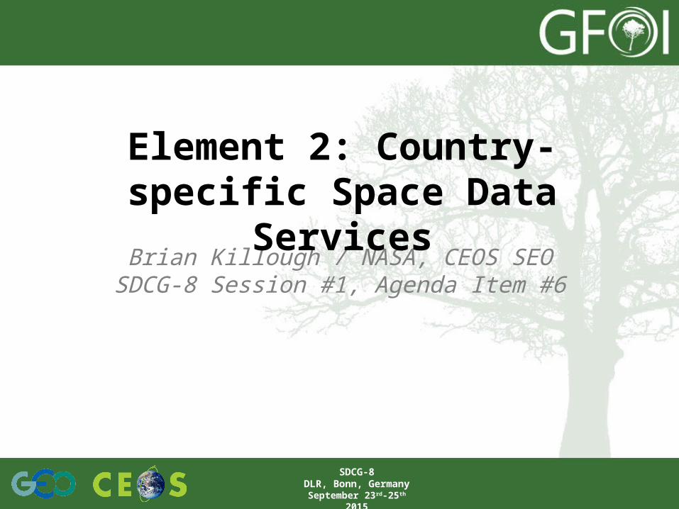
COVE Tool
Free and Open browser-based tool using Google-Earth to display satellite coverage swaths and calculate coincidence scene locations.
Automated daily satellite position data from CelesTrak.
Saved bookmarks and states, Google-Earth KML and Shapefile compatibility, collaborative sessions.
Output: position, UTC time, viewing angles, solar angles, EXCEL tables
Large mission database: 254 missions, 692 Mission-Instrument combinations
Data Archive Links: Landsat 7/8, SPOT 1-6, Pleaides, Radarsat-2, ALOS-1
www.ceos-cove.org
Calculate coincident satellite locations and past and future mission coverage.
>20,000 unique users in 2014.

SPOT and Pleaides in COVEJanuary 1-8, 2014 over Africa ... Data Acquisition Example
The BIG data problem ... • Developing nations do not have the infrastructure (computing storage and
processing) to handle large quantities of Earth observation satellite data. They need this data to support resource monitoring, agriculture, disasters and climate change studies.
• To date, countries are spending 90% of their time acquiring and processing satellite data, compared to 10% of their time analyzing this data and supporting applications.
• CEOS is developing a solution using Data Cubes. Pixel information will be extracted from scene-based files and stored in a large multi-dimensional data cube. This sustainable approach supports multiple datasets over broad spatial and temporal time scales and reduces the burden on countries for data access and processing.
• Data Cubes can be hosted locally or using cloud-based storage. Internet access for developing nations is an issue. Downloading scenes using traditional methods is not often feasible. Analyses “in the cloud” will minimize bandwidth constraints.

More about Data Cubes• Proven concept in Australia by
Geoscience Australia and the Australian science and research organisation (CSIRO).
• A multi-dimensional (space, time, data layers) Data Cube is an efficient and effective solution!
• Shift in Paradigm ... Pixels vs Scenes No scenes lost. All cloud-free pixels used.
• Analysis Ready” Data Products vs. Unprocessed Data (leave processing to the Space Agencies).
• Data Cube approach supports an infinite number of applications, makes it easier for users to access and use space-based data, and allows efficient time series analyses and data assimilation.
TIME
Data Layer #1
Data Layer #2
Data Layer #3
Data Layer #4
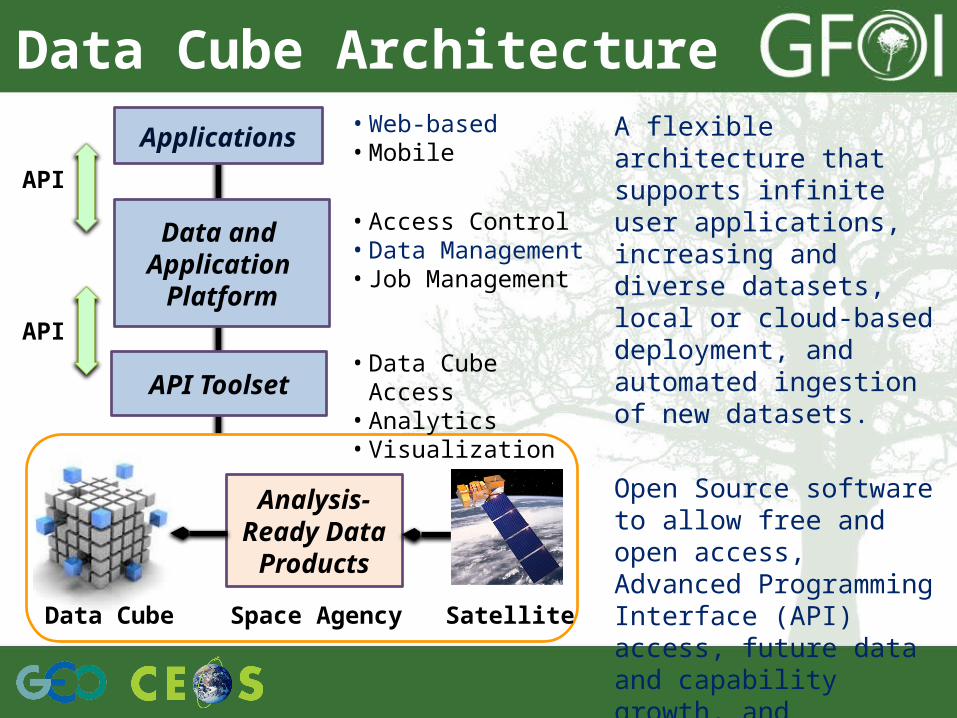
Data Cube ArchitectureA flexible architecture that supports infinite user applications, increasing and diverse datasets, local or cloud-based deployment, and automated ingestion of new datasets.
Open Source software to allow free and open access, Advanced Programming Interface (API) access, future data and capability growth, and commercial opportunities.
Applications • Web-based• Mobile
Data and Application
Platform
API Toolset
• Access Control• Data Management• Job Management
• Data Cube Access• Analytics• Visualization
API
API
Data Cube
Analysis-Ready Data
Products
SatelliteSpace Agency

Reference User Interface
Map Panel
Tool Panel
• Selectable data products
• Selectable time periods
• Selectable region• Selectable
product (mosaic or latest scene)
• Selectable output image (true color, false color)
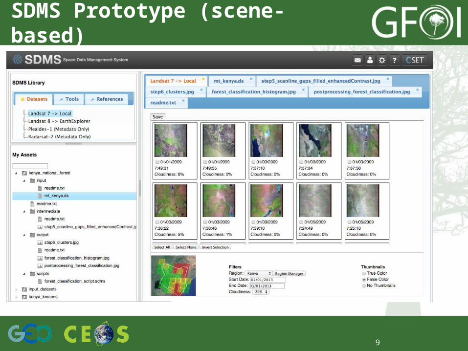
9
SDMS Prototype (scene-based)
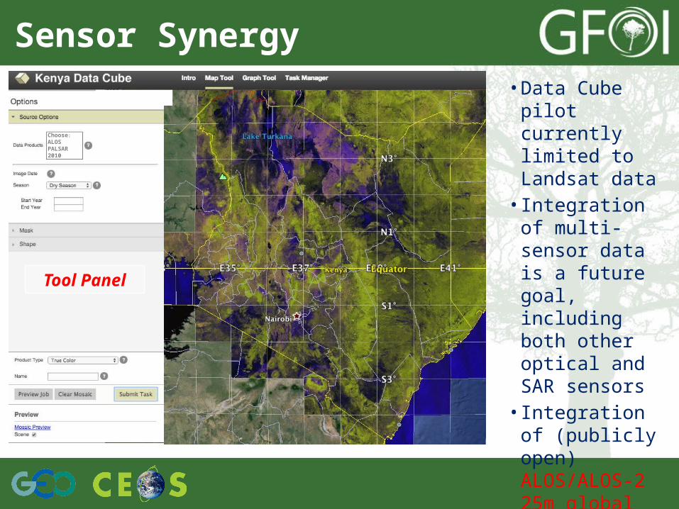
Sensor Synergy
Tool Panel
• Data Cube pilot currently limited to Landsat data
• Integration of multi-sensor data is a future goal, including both other optical and SAR sensors
• Integration of (publicly open) ALOS/ALOS-2 25m global PALSAR mosaic data currently in process.
AAa
New york was
Choose:ALOS PALSAR 2010
Hosting Commercial Data
• There are two options for hosting commercial data to support GFOI ... (1) Scene-based Space Data Management System (SDMS) and (2) Data Cubes, where pixels are extracted and added as data layers to the cube
• Both options could be deployed locally (data hub or computer) or via cloud-based servers (e.g. Amazon Web Service)
• It is strongly urged that commercial data providers make this data freely available for use and distribution among the GFOI test sites or country-based users. Hosting data with restrictions adds a very large administrative burden to the process and may prohibit having this data hosted and used by GFOI.
• CEOS has successfully worked with CSA/MDA to develop a broad user agreement for hosting restricted Radarsat-2 data. This Multi-User Request Form (MURF) allows the data to be shared across GEOGLAM (agriculture project) test sites to perform SAR studies with other datasets. A similar broad agreement may be possible for GFOI to support R&D or other in-country testing.
SDCG-8DLR, Bonn, Germany
September 23rd-25th 2015
11

Commercial Data Examples
Here are 4 examples of CEOS data services projects where we are hosting commercial and/or restricted data ...• Colombia: TanDEM-X digital elevation data from DLR.
16 scenes over 8 sites. Delivered in Dec 2014 via an Amazon Cloud data system. (top right image)
• Kenya: SPOT-5 Take-5 data (one location over central Kenya, 31 Images, April to Sept 2015) will be used for the Data Cube project. (bottom right image)
• Asia-RiCE project uses Radarsat-2 (CSA/MDA), RISAT-1 (ISRO) and ALOS-2 (JAXA) restricted data on a scene-based SDMS system provided by the CEOS-SEO via an Amazon Cloud.
• JECAM project (GEOGLAM R&D for agriculture) is planning to host restricted Radarsat-2 data on a scene-based SDMS. Working with Agri-Food Canada on Amazon cloud-hosting plans.
SDCG-8DLR, Bonn, Germany
September 23rd-25th 2015
12
Related Documents