BRENTWOOD REPLACEMENT LOCAL PLAN ADOPTED PLAN 25 August 2005 SAVED POLICIES 25 August 2008 Brentwood Borough Council, Town Hall, Ingrave Road, Brentwood, Essex CM15 8AY T: 01277 312500 | www.brentwood.gov.uk | [email protected]

Welcome message from author
This document is posted to help you gain knowledge. Please leave a comment to let me know what you think about it! Share it to your friends and learn new things together.
Transcript
BRENTWOOD REPLACEMENT
LOCAL PLAN
ADOPTED PLAN 25 August 2005
SAVED POLICIES 25 August 2008
Brentwood Borough Council, Town Hall, Ingrave Road, Brentwood, Essex CM15 8AY
T: 01277 312500 | www.brentwood.gov.uk | [email protected]

Brentwood Replacement Local Plan (Aug 2005) Saved Policies (Aug 2008) ii

Brentwood Replacement Local Plan (Aug 2005) Saved Policies (Aug 2008) iii
CONTENTS
Page
Brentwood Replacement Local Plan – Saved Policies iv
Index of Policies v
1. Introduction 1
POLICY CHAPTERS
2. Core Policies 12
3. Housing 20
4. Employment 40
5. Shopping 52
6. Transport 60
7. Green Belt and the Countryside 79
8. Sport & Leisure, Tourism and Community Services 106
9. Conservation and Protection of the Environment 125
10. Infrastructure and Resources 147
11. Pollution Control 156
12. Brentwood Town Centre 163
13. Implementation and Monitoring 181
APPENDICES
Appendix 1: Extracts from the Essex Design Guide for Residential and Mixed Use 192
Appendix 2: Vehicle Parking Standards 197
Appendix 3: Advertisements and Shop front Guidance: Additional Advice 198
Appendix 4: Access for Disabled Persons 204
Appendix 5: Miscellaneous Residential Design Guidance 208
Appendix 6: List of Abbreviations 210
Brentwood Replacement Local Plan (Aug 2005) Saved Policies (Aug 2008) iv
PLANNING & COMPULSORY PURCHASE ACT 2004 DIRECTION UNDER PARAGRAPH 1(3) OF SCHEDULE 8
BRENTWOOD REPLACEMENT LOCAL PLAN – SAVED POLICIES
25 AUGUST 2008
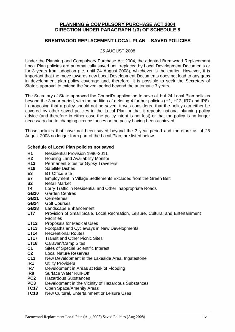
Under the Planning and Compulsory Purchase Act 2004, the adopted Brentwood Replacement Local Plan policies are automatically saved until replaced by Local Development Documents or for 3 years from adoption (i.e. until 24 August 2008), whichever is the earlier. However, it is important that the move towards new Local Development Documents does not lead to any gaps in development plan policy coverage and, therefore, it is possible to seek the Secretary of State’s approval to extend the ‘saved’ period beyond the automatic 3 years. The Secretary of State approved the Council’s application to save all but 24 Local Plan policies beyond the 3 year period, with the addition of deleting 4 further policies (H1, H13, IR7 and IR8). In proposing that a policy should not be saved, it was considered that the policy can either be covered by other saved policies in the Local Plan or that it repeats national planning policy advice (and therefore in either case the policy intent is not lost) or that the policy is no longer necessary due to changing circumstances or the policy having been achieved. Those policies that have not been saved beyond the 3 year period and therefore as of 25 August 2008 no longer form part of the Local Plan, are listed below.
Schedule of Local Plan policies not saved
H1 Residential Provision 1996-2011 H2 Housing Land Availability Monitor H13 Permanent Sites for Gypsy Travellers H18 Satellite Dishes E3 BT Office Site E7 Employment in Village Settlements Excluded from the Green Belt S2 Retail Market T4 Lorry Traffic in Residential and Other Inappropriate Roads GB20 Garden Centres GB21 Cemeteries GB24 Golf Courses GB28 Landscape Enhancement LT7 Provision of Small Scale, Local Recreation, Leisure, Cultural and Entertainment
Facilities LT12 Proposals for Medical Uses LT13 Footpaths and Cycleways in New Developments LT14 Recreational Routes LT17 Transit and Other Picnic Sites LT18 Caravan/Camp Sites C1 Sites of Special Scientific Interest C2 Local Nature Reserves C13 New Development in the Lakeside Area, Ingatestone IR1 Utility Providers IR7 Development in Areas at Risk of Flooding IR8 Surface Water Run-Off PC2 Hazardous Substances PC3 Development in the Vicinity of Hazardous Substances TC17 Open Space/Amenity Areas TC18 New Cultural, Entertainment or Leisure Uses

Brentwood Replacement Local Plan (Aug 2005) Saved Policies (Aug 2008) v
INDEX OF POLICIES
Policy Ref. Page
Core Policies
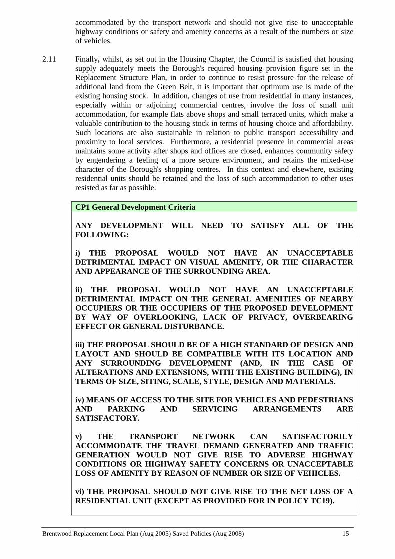
CP1 General Development Criteria 15
CP2 New Development & Sustainable Transport Choices 16
CP3 Transport Assessments 17
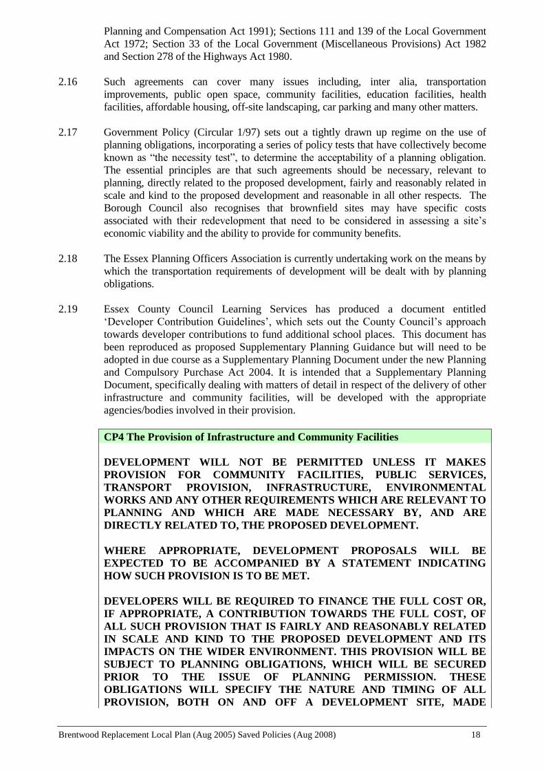
CP4 The Provision of Infrastructure and Community Facilities 18
Housing
H3 Community Uses in Residential Development 24
H4 Mixed Use Development 24
H5 Change of Use of Upper Floors 25
H6 Small Unit Accommodation 26
H7 Single Storey Dwellings 27
H8 Conversions 27
H9 Affordable Housing on Larger Sites 31
H10 Affordable Rural Housing 33
H11 Supported Accommodation 34
H12 Residential Homes 35
H14 Housing Density 36
H15 Hutton Mount 37
H16 Lifetime Homes 38
H17 Dormer Windows 38
Employment
E1 Areas Allocated for General Employment 45
E2 Areas Allocated for Office Purposes 46
E4 Sites for Additional Employment Land 48
E5 Land Adjacent to the Council Depot, Warley 48
E6 Childerditch Industrial Park, Warley 49
E8 Employment Development Criteria 51
Shopping
S1 New Major Retail Developments 55
S3 Petrol Filling Station Retail Facilities 56
S4 Non-Retail Uses within Local Shopping Centres and Parades 57
Transport
T1 Travel Plans 66
T2 New Development & Highway Considerations 66
T3 Traffic Management 67
T5 Parking - General 69
T6 Public Car Parking Strategy 69
T7 Off-Street Public Car Parking 70
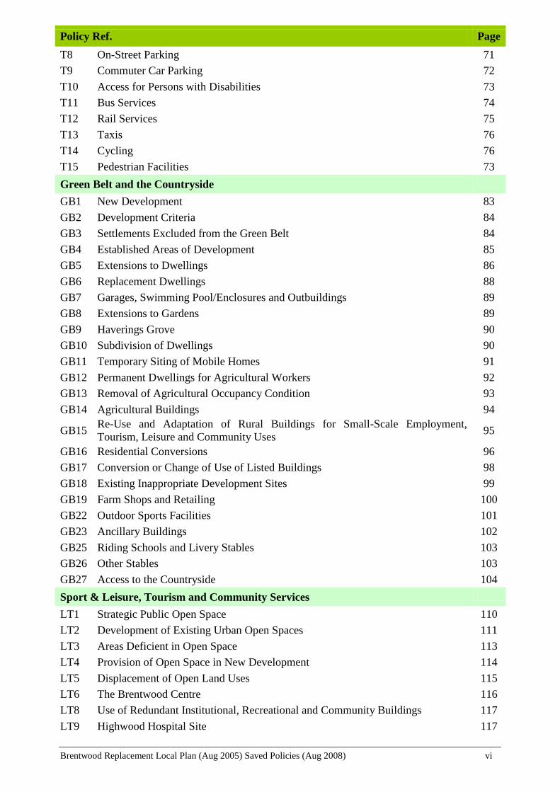
Brentwood Replacement Local Plan (Aug 2005) Saved Policies (Aug 2008) vi
Policy Ref. Page
T8 On-Street Parking 71
T9 Commuter Car Parking 72
T10 Access for Persons with Disabilities 73
T11 Bus Services 74
T12 Rail Services 75
T13 Taxis 76
T14 Cycling 76
T15 Pedestrian Facilities 73
Green Belt and the Countryside
GB1 New Development 83
GB2 Development Criteria 84
GB3 Settlements Excluded from the Green Belt 84
GB4 Established Areas of Development 85
GB5 Extensions to Dwellings 86
GB6 Replacement Dwellings 88
GB7 Garages, Swimming Pool/Enclosures and Outbuildings 89
GB8 Extensions to Gardens 89
GB9 Haverings Grove 90
GB10 Subdivision of Dwellings 90
GB11 Temporary Siting of Mobile Homes 91
GB12 Permanent Dwellings for Agricultural Workers 92
GB13 Removal of Agricultural Occupancy Condition 93
GB14 Agricultural Buildings 94
GB15 Re-Use and Adaptation of Rural Buildings for Small-Scale Employment,
Tourism, Leisure and Community Uses 95
GB16 Residential Conversions 96
GB17 Conversion or Change of Use of Listed Buildings 98
GB18 Existing Inappropriate Development Sites 99
GB19 Farm Shops and Retailing 100
GB22 Outdoor Sports Facilities 101
GB23 Ancillary Buildings 102
GB25 Riding Schools and Livery Stables 103
GB26 Other Stables 103
GB27 Access to the Countryside 104
Sport & Leisure, Tourism and Community Services
LT1 Strategic Public Open Space 110
LT2 Development of Existing Urban Open Spaces 111
LT3 Areas Deficient in Open Space 113
LT4 Provision of Open Space in New Development 114
LT5 Displacement of Open Land Uses 115
LT6 The Brentwood Centre 116
LT8 Use of Redundant Institutional, Recreational and Community Buildings 117
LT9 Highwood Hospital Site 117

Brentwood Replacement Local Plan (Aug 2005) Saved Policies (Aug 2008) vii
Policy Ref. Page
LT10 Changes of Use or New Buildings for Institutional Purposes 118
LT11 Retention of Existing Local Community Facilities 118
LT15 Hotel Accommodation in the Urban Area 121
LT16 Bed and Breakfast and Self-Catering Accommodation 121
LT19 Accessibility to Premises to which the Public are Admitted and to Employment
Generating Developments 123
Conservation and Protection of the Environment
C3 County Wildlife Sites, Local Nature Reserves and Other Habitats and Natural
Features of Local Value 129
C4 Management of Woodlands 130
C5 Retention and Provision of Landscaping and Natural Features in Development 131
C6 Tree Preservation Orders and Works to Preserved Trees 132
C7 Development Affecting Preserved Trees, Ancient Woodlands and Trees in
Conservation Areas 133
C8 Ancient Landscapes and Special Landscape Areas 134
C9 Historic Parks and Gardens 134
C10 Protected Lanes 135
C11 Thames Chase Community Forest 135
C12 Landscape Improvements 136
C14 Development Affecting Conservation Areas 138
C15 Listed Buildings - Demolition, Alterations or Extensions 139
C16 Development within the Vicinity of a Listed Building 139
C17 Change of Use of a Listed Building 140
C18 Ancient Monuments and Archaeological Sites 141
C19 Secured by Design 142
C20 Shop Fronts 143
C21 Illuminated Advertisements 143
C22 Signs within Conservation Areas and on Listed Buildings 144
C23 Externally Illuminated Hanging Signs 144
C24 Non-Illuminated Advertisements 145
C25 Floodlighting and Other Forms of Illumination 145
Infrastructure and Resources
IR2 Telecommunications 151
IR3 Protecting the Best and Most Versatile Agricultural Land 152
IR4 Recycling Facilities 153
IR5 Energy and Water Conservation and the Use of Renewable Sources of Energy in
New Development 153
IR6 Renewable Energy Schemes 154
Pollution Control
PC1 Land Contaminated by Hazardous Substances 159
PC4 Noise 160
PC5 Traffic Noise 161
PC6 Transport Pollution 161
PC7 Areas of Poor Air Quality 162

Brentwood Replacement Local Plan (Aug 2005) Saved Policies (Aug 2008) viii
Policy Ref. Page
Brentwood Town Centre
TC1 Vacant and Redevelopment Sites within Residential Allocated Areas 167
TC2 Residential Replacement 167
TC3 Mixed Use Development 167
TC4 Use of Upper Floors Above Commercial Premises 167
TC5 Type of Accommodation 168
TC6 Small-Scale Shops 171
TC7 Non-Retail Uses 172
TC8 Professional/Financial Office Uses 173
TC9 The Telephone Exchange 174
TC10 Site of the William Hunter Way Car Park 175
TC11 Traffic in the High Street 176
TC12 Landscaping in the Town Centre 177
TC13 Pedestrian Areas 177
TC14 Advertisements and Shop Fronts 178
TC15 Shops Fronts Facing William Hunter Way 179
TC16 Non-Illuminated Advertisements fronting William Hunter Way 180
TC19 Medical/Health Uses 180

Brentwood Replacement Local Plan (Aug 2005) Saved Policies (Aug 2008) 1
INTRODUCTION
Brentwood Replacement Local Plan (Aug 2005) Saved Policies (Aug 2008) 2
1. INTRODUCTION
BRENTWOOD – THE PLACE
Location and Transport Links
1.1 The Borough of Brentwood is situated in the south west of the county of Essex,
immediately to the east of the Greater London Metropolitan area, and is located
entirely within the Metropolitan Green Belt. This proximity to London means that the
Borough is well located in relation to the national and regional road and rail networks.
The town of Brentwood is separated from Greater London by a narrow gap of open
land through which passes the M25 Motorway. The other main route corridors tend
to focus on London, with the A12 running through the centre of the Borough between
Central London and East Anglia, and the A127 linking Central London to Southend
and South Essex. Similarly rail connections link Central London to Ipswich and
Norwich (with local stations at Brentwood, Shenfield and Ingatestone) and Southend
(with a local station at West Horndon).
1.2 This road and rail network also provides easy access to Stansted Airport (via the
M11), City airport and Southend Airport, as well as both Gatwick and Heathrow
airports via the M25. Connections can also be made with port facilities at Tilbury to
the south and the East Coast ports of Harwich and Felixstowe. The Thurrock/Dartford
Crossing also provides access to the south coast ports and the continent via the
Channel Tunnel
1.3 Such locational advantages has meant that Brentwood has been, and will continue to
be, an attractive choice for both businesses and housing, and the Borough is subject to
considerable pressure for development. The Green Belt, however, acts as a significant
constraint.
Housing
1.4 The Borough is a relatively affluent area with some 80% of Brentwood's housing
being owner-occupied (predominantly 3 bedrooms and over) with the majority having
been built since 1945. Much of the older housing has been renovated and there are
very few areas of poor quality housing within the Borough. House prices are also
relatively high and many cannot afford to buy or rent property within the Borough, as
there is a shortage of low-cost housing.
Employment
1.5 Employment is also influenced by the Borough’s proximity to London and the good
transport network. Local jobs are very much concentrated in the service sector, with
the town providing an attractive alternative office location to London, particularly in
the Town Centre, Brentwood Station Area and Warley Business Park. There are seven
employment estates, and numerous other smaller enterprises scattered throughout the
Borough. However, over 50% of the resident work force commutes out of the
Borough to work, particularly into London, and some 40% of jobs in the Borough are
filled by residents from outside the Borough.
Shopping
Brentwood Replacement Local Plan (Aug 2005) Saved Policies (Aug 2008) 3
1.6 The main shopping area is Brentwood Town Centre, with many multiples including
Marks and Spencer, Sainsbury, Boots and Somerfield represented. It is also the hub of
the Borough’s cultural and community activities. Shenfield and Ingatestone are
smaller, but nevertheless important, shopping centres, which together with a number
of smaller shopping parades and village centres provide for the local shopping needs
throughout the Borough.
Sport and Leisure
1.7 The main venue for sport and leisure is provided at the multi-functional Brentwood
Centre at Pilgrims Hatch, which hosts major concerts, conferences and sports
attractions. Additionally, there are other significant sports facilities, such as the
Clearview Tennis Centre and the Warley Leisure Park, and many local golf courses,
all catering for the increasing leisure needs of the area. There are 2 extensive country
parks, which have an attraction that extends well beyond the Borough, as does the
other main open space area at King George’s Playing Field.
Environmental Character
1.8 Brentwood’s attractive location is enhanced by the quality of the local environment.
Less than 20% of the Borough is built-up. Brentwood Town itself has a well-
landscaped character, which softens the impact of the built environment and enhances
the visual quality of the town. There are a number of important green wedges
reaching into the built-up area, two of which extend right to the centre of the town -
Hartswood/Shenfield Common, and the Brentwood School/former Anglia Polytechnic
University Playing Fields. Thriftwood is also an extensive area of woodland set
within the town. The remainder of the Borough is predominantly in agricultural use,
but much of the rural area is characterised by an attractive rolling landscape
incorporating small woodlands, hedgerows and trees.
1.9 The location and character of the Borough of Brentwood, summarised above, plays a
large part in determining the scope and detailed content of the policies set out in the
Local Plan.
THE BRENTWOOD LOCAL PLAN
What is a Local Plan?
1.10 The government requires a local planning authority to prepare and adopt a Local Plan
that covers the whole of the authority’s area and that sets out detailed policies to guide
development 1. It forms part of a hierarchy of Development Plans and policies and is
set within the context of national, regional and structure plan policy guidance. Once
adopted the Local Plan is also required to be monitored and reviewed.
1.11 The Brentwood Local Plan provides a comprehensive statement of land use policies
and proposals for the whole of Brentwood Borough and develops the policies and
general proposals of the Essex and Southend on Sea Replacement Structure Plan
(RSP) adopted in April 2001. It covers, therefore, the period up to 2011.
The Plan Format
1.12 The Plan consists of a Written Statement and Proposals Map. The Proposals Map
1 Part II of the Town and Country Planning Act 1990 (as amended by the Planning and Compensation
Act 1991) and the Town and Country Planning (Development Plan) Regulations 1999.

Brentwood Replacement Local Plan (Aug 2005) Saved Policies (Aug 2008) 4
incorporates a number of insets for Brentwood Town Centre, Shenfield Shopping
Area, Brentwood Station Area and the other main settlements excluded from the
Green Belt. These insets are identified on the Main Borough-Wide Proposals Map,
the Brentwood Urban Area Inset Map No. 1 or the Ingatestone Inset Map No. 3. The
insets form part of the Proposals Map.
1.13 The Written Statement sets out the Policies and Proposals of the Council by reference
to a number of chapters dealing with a set of “core policies” together with specific
subjects. Each chapter is prefaced by a summary of the relevant national planning
policy guidance, Replacement Structure Plan policies and Brentwood Community Plan
objectives, which set the context for the detailed policies and proposals. The
subsequent policies/proposals are accompanied by a written justification and
supporting background information. The policies and proposals are distinguished
from the rest of the text by the use of upper case (capital) lettering and bold type. The
policies in the Plan only apply in cases where planning permission is required. In the
event of any inconsistency between the written justification and the policy, the
policy takes precedence.
1.14 The Written Statement includes a number of appendices generally relating to guidance
that has previously been formally adopted by the Council as Supplementary Planning
Guidance (SPG). However, there is no provision in the Planning and Compulsory
Purchase Act 2004, or the associated guidance and regulations for existing SPG to be
formally saved, and new SPG can no longer be adopted. It still remains a material
consideration in the determination of planning applications, and is retained as
‘Informal Planning Guidance’ until adopted as ‘Supplementary Planning Documents’
under the new Act.
1.15 The Proposals Map illustrates the policies and proposals in the Written Statement on
an Ordnance Survey base. The Map identifies sites allocated for development and
defines areas where policies will apply. In the event of any inconsistency between
the written statement and the proposals Map, the Written Statement takes
precedence.
POLICY CONTEXT OF THE PLAN
1.16 The Local Plan forms part of a hierarchy of Development Plans and planning policy
guidance to which it must have regard and conform to unless local circumstances
justify otherwise. Summaries of the relevant policy context are set out in each chapter
of the Plan.
National Planning Policy Guidance
1.17 Central government produces a wide range of policy guidance in the form of primary
legislation, planning regulations, circulars, Planning Policy Guidance Notes (PPGs),
Planning Policy Statements (PPSs), and other statements. These sources of national
policy are the subject of review, amendment and replacement and the most recent
statements need to be reflected in the Local Plan.
Regional Planning Guidance
1.18 The government produces Regional Planning Guidance which provides a framework
for the preparation of development plans at the County and Local level. Regional
Planning Guidance for the South East (RPG9), published in 1994 set the basis for the
Replacement Structure Plan covering the period up to 2011, including the allocation

Brentwood Replacement Local Plan (Aug 2005) Saved Policies (Aug 2008) 5
for new housing to be accommodated within the County.
1.19 A revised version of RPG9 was published in March 2001, which seeks to achieve
amore sustainable pattern of development by way of four key development principles:
Urban Renaissance and Concentrating Development
Economy in the Use of land
Integrating Land Use and Transport
Rural Development
1.20 Following a review of regional boundaries, as from 1 April 2001, Essex is included
within the East of England Region, and work is currently progressing on new regional
guidance for the East of England area (RPG14). With the enactment of the Planning
and Compulsory Purchase Act 2004 in September 2004, RPG is to be replaced with
Regional Spatial Strategies (RSS). RPG14, therefore, is now referred to as RSS14 or
the ‘East of England Plan’ and was published for public consultation between
November 2004 and March 2005. An examination in public is proposed to commence
in November 2005, with final adoption towards the end of 2006/early 2007.
The County Structure Plan
1.21 The Brentwood Replacement Local Plan must conform generally to the Replacement
Structure Plan (RSP), which provides the broad strategic framework for land use
planning decisions within the Borough. The RSP, covering the period 1996 to 2011,
was adopted by both Essex County Council and Southend on Sea Borough Council,
the Joint Structure Plan Authorities (JSPAs), on 9 April 2001
1.22 The core policies of the RSP set out to address issues such as achieving urban
regeneration, promoting economic development and protecting key environmental
areas and features. In developing its core policies the RSP sets out specific levels of
new housing and employment land to be provided within each of the
Districts/Boroughs over the period 1 April 1996 to 31 March 2011. The figures for
Brentwood Borough are:
Housing: 1450 dwellings (net) - (RSP Policy H1)
Business/Industry/Warehousing Land: 1 hectare of additional land (net) - (RSP
Policy BIW1)
1.23 The RSP identifies Brentwood Town Centre as a “Principal Town Centre” in the
Strategic Hierarchy of Urban Centres (relating to the consideration of proposals and
the provision of retailing and other town centre uses – RSP Policy TCR1).
1.24 The RSP identifies priorities for transport investment in support of the regeneration of
Priority Areas for Economic Regeneration and other economic policy objectives. The
third priority is relevant to the Borough in that it includes:
Multi-Modal Improvements to the inter-urban transport network between
London and Ipswich to improve access to the Haven Ports and East Anglia and
between the main urban centres in this part of the Region
Local Transport Plan
1.25 The Local Plan must also conform to the Essex Local Transport Plan, which sets out
the transport strategy for the county, and incorporates local strategies for each of the

Brentwood Replacement Local Plan (Aug 2005) Saved Policies (Aug 2008) 6
Districts/Boroughs. Government advice seeks a much closer relationship between
land use planning and transport planning. In order to achieve this, the Local Transport
Plan and the Local Plan should take account of and complement one another.
The Brentwood Community Plan
1.26 It is clear that government is seeking a closer and clearer relationship between the
various plans and strategies produces by local authorities. This was made apparent in
the Green Paper ‘Planning: Delivering a Fundamental Change’ (DTLR December
2001) and subsequently incorporated into the guidance published with the 2004 Act
which introduced the new ‘Local Development Frameworks’; replacing the existing
land use Development Plan system (consisting of Structure Plans, Local Plans and
Unitary Development Plans).
1.27 Brentwood has produced a “Community Plan” for the period 2000 to 2005, “Facing
the Future”. This is a clear statement of the Council’s key ambitions and priorities
over the 5-year period. It endeavours to link the Council’s Mission and Core Values
with service area and work priorities through the new Best value Performance Plan
and individual Service Plans.
1.28 The Community Plan sets out the key strategic objectives under a number of thematic
headings. In order to clearly identify how the Replacement Local Plan relates to these
Council-wide corporate objectives, the policy context to each chapter of the Local
Plan sets out the relevant strategic objectives. (There are differences between the way
in which the Community Plan is divided in to thematic headings and the subject
headings in the Local Plan. However, positive user feedback on the format of the
current Local Plan suggests that the Local Plan headings are better understood by
those making development applications and those using the Local Plan and, therefore,
have been retained.)
1.29 The Council’s Mission Statement and core values are:
“The Council’s Mission is to serve the needs of local people and work in
partnership with the whole community in order to ensure that the Brentwood
Borough remains a pleasant and healthy place in which to live, work and relax
for the benefit of current and future generations
In this context, the Council will aim to ensure that quality services are delivered fairly
to all sections of the community, having regard to the core values of:
Putting the needs of the public first
Ensuring equality of opportunity
Countering poverty and inequality
Providing open, responsible and accountable government
Respecting and protecting the environment and ensuring local sustainable
development
Working in partnership with other organisations
Ensuring a safe community in which to live, work and relax
Ensuring a sound economic base for the Borough
Achieving best value in the delivery and procurement of services
Observing good employment practices

Brentwood Replacement Local Plan (Aug 2005) Saved Policies (Aug 2008) 7
SUSTAINABLE DEVELOPMENT
1.30 One of the key objectives running through all levels of policy advice is the need to
achieve sustainable development. Sustainable development is now at the very heart of
the planning system. Government planning guidance makes clear the government’s
commitment to the principles of sustainable development as set out in “Sustainable
Development: The UK strategy” (1994).
1.31 There are many definitions of “sustainable development” but the most widely used is
“Sustainable development is development that meets the needs of the present
population without compromising the ability of future generations to meet their own
needs”. The government’s approach to sustainable development is set out in its
strategy and is based on four broad objectives:
Maintenance of high and stable levels of economic growth and employment;
Social progress which recognises the needs of everyone;
Effective protection of the environment; and
Prudent use of natural resources
1.32 The government believes that the planning system, and development plans in
particular, can make a major contribution to the achievement of the government’s
objectives for sustainable development (as described further in PPS12). The Council
is equally committed to ensuring that the Replacement Local Plan provides for
development in a sustainable manner and, thus, linking with and reflecting its other
corporate strategies as set out in the Community Plan and the LA21 Strategy “A Better
Quality of Life for Brentwood” (February 2001).
The Overarching Aim of the Plan
1.33 The Council has adopted an overarching aim for the Replacement Local Plan that
integrates the Planning Service’s adopted “Mission Statement” with the Council’s
corporate objectives and the need for sustainable development as follows:
To protect, conserve and enhance the character and appearance of the Borough’s
natural and built environment whilst promoting the economic, social and cultural
well-being of the Borough and seeking to make provision for the development
and other needs of the Borough within the context of strategic planning
guidelines and the principles of sustainable development.
Sustainability Appraisal
1.34 Local Planning authorities are expected to carry out a full environmental appraisal of
their development plan at every stage of the development plan process. However,
sustainable development is not limited to environmental concerns, and the same
methodologies used for environmental appraisal can be applied to social and economic
issues. The process enables the environmental, social and economic consequences of
plan objectives and policies to be weighed and taken into account in formulating the
final plan and thus ensures that development is sustainable.
1.35 In order to undertake such an appraisal the Council adopted a set of “Sustainability
Principles” by which the Draft Plan policies have been assessed. These are set out in
regard to environmental, social and economic issues, as follows:
Brentwood Replacement Local Plan (Aug 2005) Saved Policies (Aug 2008) 8
Sustainability Principles
Environmental:
To Conserve and Protect Natural Resources
To Conserve and Protect the Built Heritage
To Make Best Use of Existing Urban Land and Buildings
To Minimise the Impact of Pollution on the Environment and upon Public Health
& Safety
To Enhance the Quality of the Urban and Rural Environment
To Minimise the Need to Travel and the use of Private Vehicles
To Promote Waste Minimisation and Maximise the Reuse and Recovery of Waste
To Minimise the Consumption of Energy
To Maximise Biodiversity
Social:
To Encourage Choice of Transport Mode, particularly Non-Car Modes
To Maximise the Choice of Housing
To Increase Accessibility to Employment, Services, Facilities etc.
To Increase Accessibility to Open Space
To Secure a More Accessible Environment for those with Disabilities
Economic:
To Provide for Local Economic Development
To Provide Local Employment Opportunities
To Locate Development in Areas Accessible by a Choice of Transport Modes,
particularly Public Transport, Cycling and Walking
To Improve Infrastructure Provision
To Enhance the Vitality and Viability of Existing Town Centres
1.36 The content and conclusions of the appraisal are set out and published in a separate
document “The Sustainability Appraisal of the Draft Replacement Local Plan”
THE REPLACEMENT LOCAL PLAN STRATEGY
1.37 The Community Plan set out a number of Core Values of which those relating to
Equality of Opportunity, Countering Poverty and Inequality, The Environment and
Sustainable Development, Community Safety and Economic Development are directly
relevant to and have been reflected in the Replacement Local Plan.
1.38 Furthermore, as previously stated, the Community Plan also sets out strategic
objectives for the Council in relation to specific areas of the Council’s work and the
interrelationship of these with the Replacement Local Plan is identified under each
Local Plan Chapter Heading.
1.39 The Replacement Local Plan will seek to implement an overall strategy for future
development of the Borough based on planning for sustainable development and
taking into account these Community Plan Core Values and Strategic Objectives
1.40 The strategic aims of the Plan are to:

Brentwood Replacement Local Plan (Aug 2005) Saved Policies (Aug 2008) 9
Direct development towards locations that provide the greatest opportunities
for the use of transport modes other than the private motorcar
Make best use of previously developed land within urban areas
Seek to improve the quality of public transport and facilities for pedestrians
and cyclists
Improve the relationship between where people live and their place of work
or their proximity to community facilities and shopping.
Enhance the economic prosperity of the area
Direct shopping development towards the town centre and other shopping
areas
Extend equality of opportunity and social integration
Protect the character and openness of the Borough’s countryside, together
with existing urban open spaces
Enhance the character and quality of the built environment
Help to create sustainable rural communities
Protect the environment and the amenities of those living, working and
visiting the area from the potential negative impacts of development
Enhance the quality of life, increase community safety and reduce the fear of
crime
1.41 Achievement of this strategy is not within the sole control of the Council. It will
require the Council to work in partnership with other authorities, agencies and bodies
as well as the private sector and/or influencing their programmes and investment
decisions.
THE LOCAL PLAN PROCESS
Background
1.42 This Plan follows from a comprehensive review of the existing Brentwood Local Plan,
which was adopted in March 1995 (and subsequently the subject of a First Alteration,
which was adopted in 1997).
1.43 The first stage of that review was the publication of a Key Issues Consultation Report
in July 2000. Whilst the response to the consultation was limited, it provided a wide
range of responses, with comments from a broad spectrum of groups and individuals,
representing individual local residents, government departments and agencies, parish
councils, local interest groups, and planning consultants and agents. Many of the key
issues gave rise to varied and, in some cases, conflicting comments with no clear view
necessarily taking prominence.
1.44 Whilst the numbers of comments were limited, the clearest view put forward was the
support for the Council’s commitment to protecting the Borough’s green belt
boundary and maximising the use of existing urban land. There was, however, less
support for achieving the latter by reducing car parking provision compared to
reducing garden sizes or increasing the numbers of small units. The issue of car
parking standards gave rise to differing comments, with no clear view as to whether
the government’s proposals for maximum rather than minimum levels of provision
enjoy general support. On the theme of car parking, there was more support for the
continuing use of the William Hunter Way car park for car parking purposes (possibly
with some development for other uses) than its redevelopment. Other comments were
received with regard to how local employment opportunities could be maximised, how
the town centre and existing shopping areas could be further protected and enhanced,
Brentwood Replacement Local Plan (Aug 2005) Saved Policies (Aug 2008) 10
and how the town centre shopping environment could be improved.
1.45 The comments received during the 6-week consultation period were considered by the
Council, and it was resolved that the Initial Deposit Consultation Draft of the
Replacement Local Plan should be prepared taking account of, inter alia, the views
received.
The Initial Deposit Draft Plan
1.46 The Initial Deposit Draft Plan was published for public consultation in September
2002. Just over 700 representations were duly made during the statutory 6-week
consultation period. Following consideration of all of the representations received, the
Council agreed to make a number of amendments to the Draft Plan, to meet, in full or
in part, the objections set out in some of those representations (objections that were
not resolved by the proposed amendments were carried forward to the Local Plan
Inquiry). Further changes were made in order to update the plan or correct
typographical errors. These amendments were incorporated into the Revised Deposit
Draft Plan.
The Revised Deposit Draft Plan
1.47 The Revised Deposit Draft Plan was the second statutory stage in the preparation of
the Replacement Local Plan. Amendments made to the Initial Deposit Draft Plan were
clearly shown with proposed additional wordings highlighted with a grey background
and proposed deletions shown crossed through with a horizontal line. Black and white
plans were also included to show amendments to notations on the Proposal Map. The
consultation document was published in November 2003 and some 125
representations were received. As a result of the Council’s consideration of these
representations, a ‘Proposed Changes’ document was published in March 2004.
The Local Plan Inquiry
1.48 A Local Plan Inquiry to consider all outstanding objections was held between 2 and 17
June 2004, and the Inspector’s report and recommendations were received in January
2005. Following consideration of the Inspector’s recommendations, proposed
modifications to the Revised Deposit Draft Plan were approved and published for
public consultation in May 2005.
Adoption of the Plan
1.49 Representations on the ‘Proposed Modifications’ were considered by the Council at its
meeting on 13 July 2005. As no further material modifications requiring public
consultation were made to the draft plan, the Council resolved its intention to adopt
the Replacement Local Plan at that meeting, and the Plan was formally adopted by
notice dated 31 August 2005. The various stages of the plan process are set out in
Figure 1.1 below
Brentwood Replacement Local Plan (Aug 2005) Saved Policies (Aug 2008) 11
Fig. 1.1 Brentwood Replacement Local Plan - Programme
Summer 2002 Publication of Initial Deposit Consultation Plan
Autumn 2003 Publication of Revised Deposit Consultation Plan
Summer 2004 Public Local Plan Inquiry
Winter 2004/05 Publication of Inspector’s Report
Spring 2005 Publication of Proposed Modifications
Summer 2005 Adoption of Replacement Local Plan
The Previous Adopted Local Plan
1.50 With adoption of the Replacement Local Plan, the former adopted Local Plan,
consisting of the following documents, is superseded as the statutory development
plan for the Borough and no longer has effect:
The Adopted Brentwood Local Plan (March 1995)
The Adopted Brentwood Local Plan First Alteration (July 1997)

Brentwood Replacement Local Plan (Aug 2005) Saved Policies (Aug 2008) 12
CORE POLICIES

Brentwood Replacement Local Plan (Aug 2005) Saved Policies (Aug 2008) 13
2. CORE POLICIES
POLICY BACKGROUND
National Policy Guidance
2.1 The Government’s Green Paper “Planning: Delivering a Fundamental Change”, which
was published for consultation in December 2001, set out proposals for the reform of
the development plans system. Following consideration of the responses to that
consultation, revised proposals were published in a Policy Statement “Sustainable
Communities: Delivering through Planning” in July 2002. Subsequently the Planning
and Compulsory Purchase Act 2004 enacted the Government’s proposals for the
abolition of Structure Plans, and the replacement of Unitary Development Plans
(UDPs) and Local Plans by Local Development Documents (LDDs).
2.2 It is the intention, amongst other things, that LDDs provide a clear strategic vision, are
written in a more succinct manner and cut out unnecessary or repetitive policies. To
facilitate the achievement of these aims it is intended that LDDs include a core
statement of general policies. Whilst the Council will not be moving to the
preparation of a LDD for Brentwood until after the adoption of the Replacement Local
Plan, the Government has strongly encouraged local authorities to adopt elements of
the LDD format within local plan reviews.
Introduction
2.3 In the light of the Government’s proposals for reform of the development plan system,
the opportunity has been taken to incorporate a new section into the Replacement
Local Plan setting out a number of “core policies”, which would be applicable to the
consideration of any proposed development. The policies cover general planning
considerations regarding environmental impacts, amenity and design, transportation
issues and the provision of infrastructure and community facilities.
2.4 Any development proposals will be assessed against the following core policies but, in
addition, there may be other specific policies set out in the subject chapters elsewhere
in this plan, which are relevant to a development proposal and that set out additional
requirements or criteria to be satisfied.
General Development Criteria
2.5 New development should make a positive contribution to the quality of the
environment. Good design and layout can help to achieve the Government’s
objectives of making best use of previously developed land and improving the quality
and attractiveness of both urban and rural areas. New development of whatever scale
should not be viewed in isolation but should have regard to both the immediately
neighbouring buildings and the townscape/landscape of the wider area. Proposals
should also not result in an unacceptable detrimental impact on the amenities of
adjacent occupiers or indeed of the occupiers of the proposed development. The
Borough Council will expect a development brief to be prepared for proposals for
development on major or sensitive sites.
2.6 When considering applications for residential development the Council will have
regard to the guidance contained in the Essex Design Guide for Residential and Mixed

Brentwood Replacement Local Plan (Aug 2005) Saved Policies (Aug 2008) 14
Use Developments. The key principles are set out in Appendix 1. Proposals will also
need to have regard to the principles set out in Appendices 2, 4 and 5. Brentwood
benefits from large areas of residential development containing significant natural
landscape features, much of which is contained within the private residential
curtilages. Such private open spaces are important as they contribute to the landscape
and ecological resources of the Borough and enhance the character and quality of the
urban area. There is, however, pressure for intensification through infill development,
redevelopment, etc. Government housing objectives emphasise making best use of
previously developed land and buildings within existing urban areas by, for example,
increasing densities and reviewing car-parking standards. Whilst the Council supports
these objectives, not least in reducing the pressure on the Green Belt, and has policies
elsewhere in this plan to achieve that end, it also recognises, as does government
guidance, the need to protect the quality and character of existing urban areas. The
Council will, therefore, seek to protect existing residential areas, such as Hutton
Mount and Tor Bryan, from development that would impact detrimentally on the
special character of an area. Control of development will take particular account of,
for example, the pattern of development, depth of gardens, disposition of trees,
ecological value and other important aspects that need to be conserved.
2.7 PPS23 and PPG24 set out the Government’s approach to pollution control and noise
respectively. Industrial or similar commercial uses may give rise to significant levels of
pollutants in the form of noise, fumes, vibration, smells, etc., which would be
detrimental to the amenities of nearby residents if such uses were allowed in residential
areas, and uncontrolled in terms of emissions. The Borough Council will expect
development to adopt environmental best practice and pollution prevention measures in
relation to groundwater, impacts on health, the environment and amenity to ensure the
prevention of adverse impacts. All development proposals should take into account the
environmental impact the proposed activities will have, and could have in the future, and
take account of this at the design stage and incorporate the necessary control measures.
Applications that include methods of sewage disposal other than connections to the
public foul sewer will require justification in accordance with Circular 3/99.
2.8 Proposals within or near to residential areas for uses which may give rise to
unacceptable levels of pollutants will need to be accompanied by an environmental
statement, together with details of suitable abatement measures, so that their likely
effects on residents can be assessed. If such effects are judged to be unacceptable and
cannot be reduced through more sensitive siting or the introduction of pollution
abatement technology then permission will not be granted.
2.9 The quality and character of the natural and historic environment, and its conservation
and enhancement are important factors to be considered in the long-term land use
planning of the Borough as they contribute to the amenity, attractiveness and safety of
the places in which people live, work and enjoy their leisure time. Despite its close
proximity to London, Brentwood retains a relatively rural character with small,
charming villages, attractive countryside, parks and woodlands. The Council will
endeavour to ensure the protection of the natural and man-made features of the
Borough’s rural areas and green spaces and the improvement of those areas where past
activities have caused environmental damage. Any development proposals must,
therefore, take account of the particular character, appearance, biodiversity, history
and archaeology of the area.
2.10 All development should make satisfactory arrangements for vehicular and pedestrian
access into the site and for parking and servicing within the site. In addition the level
of traffic generated by the development should be capable of being satisfactorily
Brentwood Replacement Local Plan (Aug 2005) Saved Policies (Aug 2008) 15
accommodated by the transport network and should not give rise to unacceptable
highway conditions or safety and amenity concerns as a result of the numbers or size
of vehicles.
2.11 Finally, whilst, as set out in the Housing Chapter, the Council is satisfied that housing
supply adequately meets the Borough's required housing provision figure set in the
Replacement Structure Plan, in order to continue to resist pressure for the release of
additional land from the Green Belt, it is important that optimum use is made of the
existing housing stock. In addition, changes of use from residential in many instances,
especially within or adjoining commercial centres, involve the loss of small unit
accommodation, for example flats above shops and small terraced units, which make a
valuable contribution to the housing stock in terms of housing choice and affordability.
Such locations are also sustainable in relation to public transport accessibility and
proximity to local services. Furthermore, a residential presence in commercial areas
maintains some activity after shops and offices are closed, enhances community safety
by engendering a feeling of a more secure environment, and retains the mixed-use
character of the Borough's shopping centres. In this context and elsewhere, existing
residential units should be retained and the loss of such accommodation to other uses
resisted as far as possible.
CP1 General Development Criteria
ANY DEVELOPMENT WILL NEED TO SATISFY ALL OF THE
FOLLOWING:
i) THE PROPOSAL WOULD NOT HAVE AN UNACCEPTABLE
DETRIMENTAL IMPACT ON VISUAL AMENITY, OR THE CHARACTER
AND APPEARANCE OF THE SURROUNDING AREA.
ii) THE PROPOSAL WOULD NOT HAVE AN UNACCEPTABLE
DETRIMENTAL IMPACT ON THE GENERAL AMENITIES OF NEARBY
OCCUPIERS OR THE OCCUPIERS OF THE PROPOSED DEVELOPMENT
BY WAY OF OVERLOOKING, LACK OF PRIVACY, OVERBEARING
EFFECT OR GENERAL DISTURBANCE.
iii) THE PROPOSAL SHOULD BE OF A HIGH STANDARD OF DESIGN AND
LAYOUT AND SHOULD BE COMPATIBLE WITH ITS LOCATION AND
ANY SURROUNDING DEVELOPMENT (AND, IN THE CASE OF
ALTERATIONS AND EXTENSIONS, WITH THE EXISTING BUILDING), IN
TERMS OF SIZE, SITING, SCALE, STYLE, DESIGN AND MATERIALS.
iv) MEANS OF ACCESS TO THE SITE FOR VEHICLES AND PEDESTRIANS
AND PARKING AND SERVICING ARRANGEMENTS ARE
SATISFACTORY.
v) THE TRANSPORT NETWORK CAN SATISFACTORILY
ACCOMMODATE THE TRAVEL DEMAND GENERATED AND TRAFFIC
GENERATION WOULD NOT GIVE RISE TO ADVERSE HIGHWAY
CONDITIONS OR HIGHWAY SAFETY CONCERNS OR UNACCEPTABLE
LOSS OF AMENITY BY REASON OF NUMBER OR SIZE OF VEHICLES.
vi) THE PROPOSAL SHOULD NOT GIVE RISE TO THE NET LOSS OF A
RESIDENTIAL UNIT (EXCEPT AS PROVIDED FOR IN POLICY TC19).

Brentwood Replacement Local Plan (Aug 2005) Saved Policies (Aug 2008) 16
vii) THE PROPOSAL WOULD NOT HAVE AN UNACCEPTABLE
DETRIMENTAL IMPACT ON HEALTH, THE ENVIRONMENT OR
AMENITY DUE TO THE RELEASE OF POLLUTANTS TO LAND, WATER
OR AIR (INCLUDING NOISE, FUMES, VIBRATION, SMELLS, SMOKE,
ASH, DUST AND GRIT).
viii) THE PROPOSAL WILL BE EXPECTED TO TAKE FULL ACCOUNT OF
THE NEED TO CONSERVE OR ENHANCE THE CHARACTER,
APPEARANCE, BIODIVERSITY AND HISTORICAL AND
ARCHAEOLOGICAL HERITAGE OF THE SITE AND THE SURROUNDING
AREA. WHERE IT IS CONSIDERED THAT THE HARM TO OR LOSS OF
THE ENVIRONMENTAL ASSET IS OUTWEIGHED BY THE NEED FOR
THE DEVELOPMENT, THE COUNCIL WILL REQUIRE APPROPRIATE
COMPENSATORY MEASURES, EITHER ON-SITE OR OFF-SITE.
A Target and Indicator for monitoring criterion (vi) of this policy is set out in
Chapter 13
New Development and Sustainable Transport Choices
2.12 A key objective of planning for sustainable development is to both reduce the need to
travel and maximise accessibility by public transport, cycling and walking. This will
not only have environmental benefits but will promote social inclusion. Local
authorities can help to achieve this by locating jobs, shopping, leisure facilities and
services in locations which are well served by accessible, reliable and convenient
public transport and/or are in reasonable walking and cycling distance from residential
areas. Major travel generators, therefore, should be located in central locations or
where public transport accessibility is greatest.
CP2 New Development and Sustainable Transport Choices
ALL PROPOSALS FOR DEVELOPMENT INCLUDING THE USE OF LAND
WILL BE CONSIDERED IN THE CONTEXT OF:
i) ITS IMPACT ON REDUCING THE NEED TO TRAVEL, PARTICULARLY
BY CAR
ii) ITS ACCESSIBILITY TO A CHOICE OF TRANSPORT MODES, AND
iii) THE CAPACITY OF THE EXISTING TRANSPORT NETWORK TO
ACCOMMODATE THE ADDITIONAL TRAVEL DEMAND GENERATED.
TO THIS END, MAJOR GENERATORS OF TRAVEL DEMAND SHOULD BE
LOCATED IN BRENTWOOD TOWN CENTRE AND DISTRICT CENTRES
AND NEAR TO PUBLIC TRANSPORT INTERCHANGES OR IN AREAS
WELL SERVED BY PUBLIC TRANSPORT ROUTES.
Transport Assessments
2.13 In order to consider the transport implications of development proposals, applications
for planning permission will need to be accompanied by a Transport Assessment. The
extent and content of such an assessment will be dependent on the size of development

Brentwood Replacement Local Plan (Aug 2005) Saved Policies (Aug 2008) 17
proposals, but for major proposals it should illustrate accessibility to the site by all
modes, demonstrate the likely modal split of journeys to or from the site, detail the
measures to improve accessibility by all modes and measures to mitigate transport
impacts. Applicants will be expected to enter into a legal agreement setting out how
such measures are to be achieved.
2.14 Where appropriate, development proposals should also include a Travel Plan (see
Policy T1 in the Transport Chapter).
CP3 Transport Assessments
ALL DEVELOPMENT PROPOSALS MUST INCLUDE SUFFICIENT
INFORMATION TO IDENTIFY THEIR IMPACT ON THE TRANSPORT
SYSTEM IN ORDER FOR AN ASSESSMENT TO BE MADE OF THE NEED
FOR MEASURES TO MITIGATE ANY DETRIMENTAL TRANSPORT
IMPACTS, SUCH AS IMPROVEMENTS TO ACCESS BY PUBLIC
TRANSPORT, WALKING AND CYCLING, AND TO REDUCE THE NEED
FOR PARKING. PLANNING APPLICATIONS WHICH ARE LIKELY TO
GIVE RISE (EITHER IN THEMSELVES OR CUMULATIVELY) TO
SIGNIFICANT TRANSPORT IMPLICATIONS WILL NEED TO BE
ACCOMPANIED BY A COMPREHENSIVE TRANSPORT ASSESSMENT
WHICH, INTER ALIA, WILL:
i) PROVIDE DETAILS OF THE LIKELY MODAL SPLIT OF JOURNEYS TO
AND FROM THE SITE
ii) PROVIDE A COMPARISON OF TRANSPORT GENERATION TO AND
FROM THE SITE BOTH BEFORE AND AFTER IMPLEMENTATION
iii) SET OUT HOW THE SURROUNDING TRANSPORT NETWORK WILL
ACCOMMODATE ALL MOVEMENTS LIKELY TO BE GENERATED BY
THE DEVELOPMENT WHILST MAINTAINING OR IMPROVING SAFETY
AND NOT GIVING RISE TO ANY SIGNIFICANT DETRIMENTAL IMPACT
ON THE AMENITIES OF THE SURROUNDING AREA.
iv) SET OUT DETAILS OF PROPOSED MEASURES TO IMPROVE ACCESS
BY PUBLIC TRANSPORT, WALKING AND CYCLING AND REDUCE THE
NUMBERS AND IMPACTS OF JOURNEYS BY PRIVATE CAR AND
LORRY.
APPLICANTS WILL BE EXPECTED TO ENTER INTO A LEGAL
AGREEMENT SETTING OUT HOW ANY MEASURES REFERRED TO IN
THIS POLICY ARE TO BE ACHIEVED.
The Provision of Infrastructure and Community Facilities
2.15 It is increasingly recognised that development should contribute to the cost and
provision of infrastructure and other facilities arising from it. Planning obligations are
negotiated in the context of a planning application and are the means by which to ensure
that a developer contributes towards the infrastructure and services that the local
authority considers necessary to facilitate the development. The legislation enabling
such agreements to be drawn up between the developer and the Local Authority is
various - Section 106 of the Town and Country Planning Act 1990; (as amended by the
Brentwood Replacement Local Plan (Aug 2005) Saved Policies (Aug 2008) 18
Planning and Compensation Act 1991); Sections 111 and 139 of the Local Government
Act 1972; Section 33 of the Local Government (Miscellaneous Provisions) Act 1982
and Section 278 of the Highways Act 1980.
2.16 Such agreements can cover many issues including, inter alia, transportation
improvements, public open space, community facilities, education facilities, health
facilities, affordable housing, off-site landscaping, car parking and many other matters.
2.17 Government Policy (Circular 1/97) sets out a tightly drawn up regime on the use of
planning obligations, incorporating a series of policy tests that have collectively become
known as “the necessity test”, to determine the acceptability of a planning obligation.
The essential principles are that such agreements should be necessary, relevant to
planning, directly related to the proposed development, fairly and reasonably related in
scale and kind to the proposed development and reasonable in all other respects. The
Borough Council also recognises that brownfield sites may have specific costs
associated with their redevelopment that need to be considered in assessing a site’s
economic viability and the ability to provide for community benefits.
2.18 The Essex Planning Officers Association is currently undertaking work on the means by
which the transportation requirements of development will be dealt with by planning
obligations.
2.19 Essex County Council Learning Services has produced a document entitled
‘Developer Contribution Guidelines’, which sets out the County Council’s approach
towards developer contributions to fund additional school places. This document has
been reproduced as proposed Supplementary Planning Guidance but will need to be
adopted in due course as a Supplementary Planning Document under the new Planning
and Compulsory Purchase Act 2004. It is intended that a Supplementary Planning
Document, specifically dealing with matters of detail in respect of the delivery of other
infrastructure and community facilities, will be developed with the appropriate
agencies/bodies involved in their provision.
CP4 The Provision of Infrastructure and Community Facilities
DEVELOPMENT WILL NOT BE PERMITTED UNLESS IT MAKES
PROVISION FOR COMMUNITY FACILITIES, PUBLIC SERVICES,
TRANSPORT PROVISION, INFRASTRUCTURE, ENVIRONMENTAL
WORKS AND ANY OTHER REQUIREMENTS WHICH ARE RELEVANT TO
PLANNING AND WHICH ARE MADE NECESSARY BY, AND ARE
DIRECTLY RELATED TO, THE PROPOSED DEVELOPMENT.
WHERE APPROPRIATE, DEVELOPMENT PROPOSALS WILL BE
EXPECTED TO BE ACCOMPANIED BY A STATEMENT INDICATING
HOW SUCH PROVISION IS TO BE MET.
DEVELOPERS WILL BE REQUIRED TO FINANCE THE FULL COST OR,
IF APPROPRIATE, A CONTRIBUTION TOWARDS THE FULL COST, OF
ALL SUCH PROVISION THAT IS FAIRLY AND REASONABLY RELATED
IN SCALE AND KIND TO THE PROPOSED DEVELOPMENT AND ITS
IMPACTS ON THE WIDER ENVIRONMENT. THIS PROVISION WILL BE
SUBJECT TO PLANNING OBLIGATIONS, WHICH WILL BE SECURED
PRIOR TO THE ISSUE OF PLANNING PERMISSION. THESE
OBLIGATIONS WILL SPECIFY THE NATURE AND TIMING OF ALL
PROVISION, BOTH ON AND OFF A DEVELOPMENT SITE, MADE

Brentwood Replacement Local Plan (Aug 2005) Saved Policies (Aug 2008) 19
NECESSARY BY THE DEVELOPMENT CONCERNED.
Brentwood Replacement Local Plan (Aug 2005) Saved Policies (Aug 2008) 20
HOUSING
Brentwood Replacement Local Plan (Aug 2005) Saved Policies (Aug 2008) 21
3. HOUSING
POLICY BACKGROUND
National Policy Guidance
3.1 Government policy guidance on housing is set out in Planning Policy Guidance (PPG)
Note 3 “Housing”, published May 2000. It emphasises a greater choice of housing and
better mix in terms of size, type and location, recognising the needs of all in the
community, including those in need of affordable or special housing, and creating mixed
communities. Sustainable patterns of development and the better use of previously
developed land, in preference to greenfield sites, are promoted, as is good design.
Replacement Structure Plan
3.2 The Replacement Structure Plan (RSP) recognises that sustainable development
supports making the best use of existing land and buildings. The provision of residential
development, therefore, is to be determined through a sequential approach to the choice
of location, with the emphasis being the use of previously developed land within
existing large urban areas, and mixed-use schemes.
3.3 Brentwood, together with the rest of South Essex, is identified in the Core Strategy, as a
heavily urbanised area close to London where strong emphasis will continue to be given
to safeguarding the stated purposes of the Metropolitan Green Belt and protecting the
area’s natural and built environment. Further long term housing provision up to 2011 is
to be strongly constrained. Brentwood’s housing provision figure for the period 1996-
2011 is a further 1450 additional dwellings, which the Structure Plan expects would be
capable of accommodation within existing built up areas without the requirement for
development of sites currently within the Green Belt. This figure is also significantly
more than the locally generated figure of 600 dwellings for the same period.
The Brentwood Community Plan
3.4 The Community Plan’s strategic objectives that are relevant to the Replacement Local
Plan’s Housing Policies are set out under the headings “Housing and Social Inclusion”,
which includes:
“To ensure that everyone in the Brentwood Borough has access to appropriate local
housing by:
Optimising the use of Council and privately owned land and property to produce
affordable social housing
Ensuring that sufficient land is available to meet foreseen local housing needs,
recognising the need for variety and environmental sensitivity”
THE AIM AND OBJECTIVES FOR THE PLAN’S HOUSING POLICIES:
The Overall Aim
To meet the housing needs of the Borough’s population

Brentwood Replacement Local Plan (Aug 2005) Saved Policies (Aug 2008) 22
Supporting Objectives:
To ensure that sufficient land is allocated and available to meet foreseen locally
generated housing needs
To encourage the provision of an appropriate range of house types, sizes and tenures
which best meet the housing needs of the population, particularly through increasing
the availability of low cost private housing and affordable rented housing
To encourage the retention, improvement and efficient usage of the existing housing
stock and, where appropriate, the reuse and conversion of existing buildings for
residential purposes
To make best use of previously developed land and buildings, particularly in
sustainable urban locations, whilst protecting the existing amenities and character of
the area and minimising the development of both urban and rural greenfield sites.
To ensure a high quality of design, layout and materials in new residential
development
To ensure that the accessibility needs of persons experiencing mobility difficulties
are met in new residential development
To maintain and improve the environmental quality of residential areas
INTRODUCTION
3.5 Brentwood’s location close to London, together with other factors such as its good
road and rail links and the quality of its urban and rural environment, has resulted in
the town and the surrounding villages being highly desirable places in which to live.
Demand for new housing has, and will continue to be high. However, the
Metropolitan Green Belt places a constraint on the availability of land for
development.
3.6 The existing housing stock is predominantly recent in construction, with some 70% of
private sector properties having been built since 1945 and only 15% pre-dating 1919.
The standard of housing is therefore good with only 2% of properties being estimated
as unfit (compared with the national average of 6.2%) with some 9% of properties
being in disrepair2. Detached and semi detached properties, comprising 3, 4 and 5
bedroom family houses, generally predominate. Property prices are generally high,
even for the smallest residential units.
3.7 All these factors, combined with the decline in the supply of rented accommodation,
mean that first-time buyers in particular, and those on lower incomes generally, find
difficulty in securing suitable accommodation within the Borough and may be forced
to move out. In the long-term an increasing imbalance between the demand for and
supply of housing could have wider implications e.g. the local economy may be
affected if firms are not able to obtain skilled labour or key workers are unable to find
accommodation. There is, therefore, a need to direct housing policies towards making
the best use of land that is available for housing and to ensure that an appropriate mix
of housing types, sizes and tenures is available within the Borough to meet all needs.
2 Brentwood Borough Council Housing Condition Survey 2000
Brentwood Replacement Local Plan (Aug 2005) Saved Policies (Aug 2008) 23
Residential Land Availability
3.8 In order to ascertain whether the RSP housing provision figure could be accommodated
through the development of previously developed land and buildings within existing
urban areas, the Council undertook an “Urban Capacity Study”3, which was published as
a separate technical document accompanying the Initial Deposit Draft Plan.
3.9 This study concluded that, at a base date of 1 April 2001, there was a discounted
capacity within existing urban areas of between 674 and 974 dwellings that would come
forward before 2011 (based on a discounted capacity figure derived from two separate
density assumptions – an “average” density based on existing average densities
throughout the Borough and a “high” density based on the success of new policies
aimed at increasing densities, and as achieved in the most recent housing developments).
However, these figures, together with the number of residential completions that
occurred between 1 April 1996 and 31 March 2001, and the number of residential units
on larger sites with unimplemented planning permission at 1 April 20014, were reviewed
further and agreed as part of the evidence at the Local Plan Inquiry. The amended
figures are set out in Table 3.1 and show that at April 2001 there was a potential supply
of between 1596 and 1868 additional dwellings between 1996 and 2011. In addition,
since April 2001 the capacity on large sites with and without planning permission has
increased by some 420 additional dwellings (i.e. sites at Heybridge Moat House Hotel;
St Raphaels Church, Warley Hospital; Farrell Ward, Warley Hospital; Hatch Road,
Pilgrims Hatch; Wharf Road, Brentwood; and Beckett House, Baytree Centre).
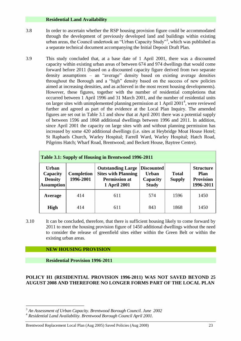
Table 3.1: Supply of Housing in Brentwood 1996-2011
Urban
Capacity
Density
Assumption
Completion
1996-2001
Outstanding Large
Sites with Planning
Permission at
1 April 2001
Discounted
Urban
Capacity
Study
Total
Supply
Structure
Plan
Provision
1996-2011
Average 414 611 574 1596 1450
High 414 611 843 1868 1450
3.10 It can be concluded, therefore, that there is sufficient housing likely to come forward by
2011 to meet the housing provision figure of 1450 additional dwellings without the need
to consider the release of greenfield sites either within the Green Belt or within the
existing urban areas.
NEW HOUSING PROVISION
Residential Provision 1996-2011
POLICY H1 (RESIDENTIAL PROVISION 1996-2011) WAS NOT SAVED BEYOND 25
AUGUST 2008 AND THEREFORE NO LONGER FORMS PART OF THE LOCAL PLAN
3 An Assessment of Urban Capacity. Brentwood Borough Council. June 2002
4 Residential Land Availability. Brentwood Borough Council April 2001.
Brentwood Replacement Local Plan (Aug 2005) Saved Policies (Aug 2008) 24
Housing Land Availability Monitor
POLICY H2 (HOUSING LAND AVAILABILITY MONITOR) WAS NOT SAVED
BEYOND 25 AUGUST 2008 AND THEREFORE NO LONGER FORMS PART OF THE
LOCAL PLAN
Community Uses in Residential Development
3.15 Residential development will give rise to the demand for additional community facilities
to meet the needs of new residents. The means by which developers provide for such
facilities, or contribute to their provision, either on site or through a legal agreement, is
dealt with in Policy CP4. However, where it has been identified that there is an existing
need for additional community facilities (such as a community hall, medical facilities,
shopping provision for example) within a particular area, the opportunity will be taken
by the Council to incorporate, through negotiation, such facilities within new residential
development proposals as part of a mixed use development. The intention will be,
therefore, to provide facilities in locations that are accessible to all surrounding
residents, reducing the need to travel and creating equality of opportunity.
H3 Community Uses in Residential Development
IN ADDITION TO THE REQUIREMENTS OF POLICY CP4, WHERE
APPROPRIATE, THE COUNCIL WILL SEEK TO INCORPORATE
THROUGH NEGOTIATION NEW COMMUNITY FACILITIES WITHIN
NEW RESIDENTIAL DEVELOPMENT, WHERE A LOCAL NEED HAS
BEEN IDENTIFIED.
Mixed Use Development
3.16 Whilst the opportunity will be taken to introduce community uses in to residential
development proposals, the Council will also seek to achieve further residential
provision as part of mixed use schemes in the Borough’s main district shopping areas
of Shenfield, Ingatestone High Street and Warley Hill, particularly within areas
allocated for residential and commercial uses, but also in any commercial
development, if considered appropriate (see also Policy TC3 for Brentwood Town
Centre). The introduction of residential development in such areas can provide much
needed small unit accommodation in areas well located to public transport and other
services and facilities. Residential accommodation can also benefit such areas by
providing activity outside normal business hours, both adding to commercial viability
and vitality and providing for a more secure feel to the commercial area.
H4 Mixed Use Development
WITHIN AREAS ALLOCATED FOR RESIDENTIAL/OFFICES/SHOPS OR
SHOPS/RESIDENTIAL AND IN OTHER APPLICATIONS INVOLVING
COMMERCIAL DEVELOPMENT WITHIN THE MAIN DISTRICT
SHOPPING AREAS OF SHENFIELD, INGATESTONE HIGH STREET OR
WARLEY HILL, THE OPPORTUNITY SHOULD BE TAKEN TO PROVIDE
NEW RESIDENTIAL ACCOMMODATION AS PART OF MIXED USE
DEVELOPMENT

Brentwood Replacement Local Plan (Aug 2005) Saved Policies (Aug 2008) 25
Changes of Use of Upper Floors
3.17 Upper floors above shops or other commercial premises frequently tend to be under-
utilised, being either used for storage or in many cases not used at all. This under-use of
space not only amounts to a waste of valuable resources but also tends to lead to neglect,
a negative impact on the street scene and, ultimately, the deterioration of buildings. The
Council, therefore, in line with government policy for making best use of existing urban
land and buildings, will seek to promote greater use of such resources.
3.18 The use of such accommodation for residential purposes will be encouraged as a means
of providing further affordable, small-unit accommodation. The Council is aware that it
may be difficult in some cases to achieve all the standards normally required for
residential use. Therefore, whilst it will be necessary to ensure that the amenities of
prospective occupiers are safeguarded, a more flexible attitude may be adopted in
respect of the Council's normal residential standards.
H5 Changes of Use of Upper Floors
THE CHANGE OF USE OF UPPER FLOORS ABOVE EXISTING
COMMERCIAL PREMISES TO RESIDENTIAL ACCOMMODATION WILL
BE ENCOURAGED, PARTICULARLY TO PROVIDE AFFORDABLE UNITS
OF ACCOMMODATION, PROVIDING THE FOLLOWING CRITERIA CAN
BE SATISFIED:
i) REASONABLE FACILITIES AND AMENITIES ARE PROVIDED FOR
PROSPECTIVE OCCUPIERS
ii) THE DEVELOPMENT DOES NOT RESULT IN DEMAND TO REPLACE
STORAGE SPACE LOST
A Target and Indicator for monitoring this policy is set out in Chapter 13
Small Unit Accommodation
3.19 The number of small households is increasing nationally due to extended life
expectancy, household break up and the increasing number of young people who choose
to live alone. The Replacement Structure Plan estimates that within Brentwood
Borough there will be 600 locally generated households over the period 1996 to 2011.
Generally, newly forming households will be small households requiring smaller units
of accommodation. This need can be met by the provision of small, i.e. 1 or 2 bedroom,
houses or flats, the conversion of existing large dwellings into smaller flat units or, in
the case of older or disabled people, specially adapted accommodation to meet their
specific needs.
3.20 However, only a small proportion of the existing dwelling stock comprises 1 and 2
bedroom units. Existing small unit accommodation can also be reduced through
extensions to provide additional bedrooms or amalgamation to form larger units. A lack
of small unit accommodation has and may continue to result in the loss of young
economically active sections of the population and lead to an imbalance in the
population structure in the longer-term. This is clearly an undesirable situation. New
housing development should make a significant contribution to meeting perceived
housing need within the Borough by providing for a mix of units. It is clear, therefore,
Brentwood Replacement Local Plan (Aug 2005) Saved Policies (Aug 2008) 26
that there will need to be an emphasis on small-unit provision, particularly on the larger
sites. In order that, once provided, smaller units remain available, in appropriate
circumstances permitted development rights to extend such properties will be removed
by condition on the permission.
3.21 In the case of Hutton Mount, however, the development of a mix of units is not
considered appropriate since it would be inconsistent with the character of existing
development in this area, which consists mainly of large detached houses in substantial
grounds.
H6 Small Unit Accommodation
IN A NEW HOUSING DEVELOPMENT THE COUNCIL WILL SEEK THE
PROVISION OF A MIX OF UNITS ON SUITABLE SITES OF 6 UNITS AND
ABOVE OR ON SUITABLE SITES OF 0.2 OF A HECTARE OR MORE,
WITH AT LEAST 50% OF TOTAL UNITS BEING 1 AND 2 BEDROOM
PROPERTIES, EXCEPT WHERE IT CAN BE DEMONSTRATED THAT
SUCH A MIX OF UNITS WILL BE INCONSISTENT WITH THE
CHARACTER OF EXISTING DEVELOPMENT IN THE AREA OR WHERE
SUCH PROVISION CANNOT BE ADEQUATELY ACCOMMODATED ON
THE DEVELOPMENT SITE.
WHERE:
a) APPLICATION IS MADE FOR PART DEVELOPMENT OF A LARGER
RESIDENTIAL SITE IDENTIFIED ON THE LOCAL PLAN PROPOSALS
MAP, OR
b) THE PROPOSED RESIDENTIAL DEVELOPMENT SITE IS
CONTIGUOUS WITH ONE OR MORE OTHER POTENTIAL
RESIDENTIAL DEVELOPMENT SITES,
THE AREA TO BE USED FOR DETERMINING THE APPLICABILITY OF
THIS POLICY WILL BE THE LARGER SITE IN RELATION TO (a)
ABOVE AND THE AGGREGATE AREA OF SUCH CONTIGUOUS SITES IN
RELATION TO (b) ABOVE.
IN APPROPRIATE CIRCUMSTANCES A CONDITION WILL BE IMPOSED
ON SUCH SMALLER UNITS TO PREVENT EXTENSIONS PROVIDING
ADDITIONAL HABITABLE FLOOR SPACE.
A Target and Indicator for monitoring this policy is set out in Chapter 13
Single Storey Dwellings
3.22 Further to the need for small unit accommodation, there is concern with the loss of
single storey dwellings in the Borough, many of which are small units of
accommodation. In addition, however, they provide for the needs of the elderly or other
less mobile residents. Brentwood’s population has a high proportion of elderly person’s,
compared to national statistics, and it is forecast that the numbers of elderly will
continue to increase, both in total numbers and as a proportion of the resident
population.
Brentwood Replacement Local Plan (Aug 2005) Saved Policies (Aug 2008) 27
3.23 Whilst it has to be acknowledged that single storey dwellings can be converted to two
storeys, through the provision of rooms in the roof without, in many instances, the need
for planning permission, the retention of such accommodation where permission is
required is considered justifiable in order to provide for the needs of all age groups and
personal circumstances.
H7 Single Storey Dwellings
EXTENSIONS OR OTHER ALTERATIONS TO AN EXISTING SINGLE
STOREY DWELLING (INCLUDING RE-ROOFING) WILL BE
RESTRICTED TO A SINGLE STOREY.
THE REDEVELOPMENT OF SITES OF EXISTING SINGLE STOREY
RESIDENTIAL PROPERTIES WILL ONLY BE PERMITTED WHERE
THERE IS NO NET LOSS IN THE NUMBER OF SINGLE STOREY
DWELLINGS ON THE SITE.
ALL NEW SINGLE STOREY DWELLINGS AND EXTENSIONS TO
EXISTING SINGLE STOREY DWELLINGS WILL HAVE A CONDITION
IMPOSED REMOVING PERMITTED DEVELOPMENT RIGHTS FOR
ADDITIONS OR ALTERATIONS TO THE ROOF.
Conversions
3.24 The conversion of larger units into two or more smaller ones is one way of addressing
the problems of under occupancy and the lack of small units of accommodation in
Brentwood. Such conversions can provide a valuable housing resource especially to
meet the needs of young first-time buyers.
3.25 The standard of conversions should be carefully controlled to ensure that adequate
facilities are provided to meet the needs of prospective occupiers, to protect the general
character of an area and to safeguard the amenities of surrounding residents. Proposals
will need to have regard to the principles set out in Appendix 2 (Vehicle Parking
Standards) and Appendix 5 (Miscellaneous Residential Design Guidance).
H8 Conversions
WITHIN THE BUILT UP AREA OF THE BOROUGH AS DEFINED ON THE
PROPOSALS MAP, CONVERSION OF DWELLING-HOUSES INTO TWO
OR MORE UNITS WILL BE ALLOWED WHERE ALL OF THE
FOLLOWING CRITERIA ARE MET:
i) THE NUMBER OF PROPERTIES WHICH HAVE BEEN SUB-DIVIDED
OR FOR WHICH PLANNING PERMISSION HAS BEEN GIVEN DOES NOT
GIVE RISE TO AN OVER CONCENTRATION OF FLATS WITHIN A
PARTICULAR STREET OR AREA RESULTING IN AN UNACCEPTABLE
LOSS OF AMENITY OR HARM TO RESIDENTIAL CHARACTER WITHIN
THAT LOCALITY
ii) THE CONVERSION DOES NOT GIVE RISE TO AN UNACCEPTABLE
EXTENSION OR UNACCEPTABLE EXTERNAL ALTERATION TO THE
PROPERTY

Brentwood Replacement Local Plan (Aug 2005) Saved Policies (Aug 2008) 28
iii) WHERE APPROPRIATE, LANDSCAPING SHALL BE PROVIDED AS
PART OF THE SCHEME FOR CONVERSION
iv) THE CONVERSION (INCLUDING THE PROVISION OF BALCONIES
OR EXTERNAL STAIRCASES) MUST NOT GIVE RISE TO UNDUE
OVERLOOKING OF ADJOINING PROPERTIES
See also Appendices 2 and 5.
AFFORDABLE HOUSING POLICY
Affordable Housing on Larger Sites
3.26 Affordable housing is a national issue and indeed the subject of government advice as
contained in PPG3, which states that affordable housing provision is a material
planning consideration when deciding planning applications involving housing. It
allows for Local Planning Authorities to include policies in Local Plans seeking an
element of affordable housing within larger areas of new housing development, where
there is a demonstrable lack of affordable housing to meet local needs. Government
advice on affordable housing provision is set out in Circular 6/98 “Planning and
Affordable Housing”. The Circular sets out the criteria for establishing the threshold
of sites on which it would be appropriate for the Local Planning Authority to negotiate
a proportion of affordable housing. In July 2003 the Government issued a consultation
paper on proposed changes to the guidance in PPG3 on affordable housing. The
affordable housing policies in this Plan are considered to be in general conformity
with that advice.
3.27 In order to assess the level of housing need in the Borough, the Council commissioned
Fordham Research Limited to undertake a housing needs survey in 1998 5. A further
revised study has been undertaken in 2004, again by Fordhams, but the results and
recommendations of this new study are yet to be formally considered by the Council
and will be used to inform an early review of the Council’s affordable housing policies
as set out in this Plan. All references to the Housing Needs Survey in this Plan refer,
therefore, to the 1998 Study.
3.28 Housing affordability is, perhaps, best defined by comparing house prices or rental
levels against income. The Housing Needs Survey assessed the cost of private
housing, both for sale and rent, and compared these figures with income levels for
different groups. The survey concluded that the discrepancy between average annual
gross incomes and the lowest house prices and rent levels highlighted the inability of
many households to afford market housing. In summary the Housing Needs Survey
identified that total housing need in the Borough was made up of the groups set out in
Table 3.2.
5 Housing Needs Survey. Fordham Research Ltd. December 1998

Brentwood Replacement Local Plan (Aug 2005) Saved Policies (Aug 2008) 29
Table 3.2: Total Housing Need in the Brentwood Borough 1998
Existing households in need 1,231
Homeless element 52
Concealed households in need 468
Total Current Need 1,751 households
3.29 Whilst the total need at 1998 was 1751 households, the number of households in need
will continue to increase, such that the Needs Survey estimated that by the end of the
Replacement Structure Plan period, 2011, a total of between 2,500 and 4,000
additional affordable dwellings might be required to meet the need in full. Clearly,
such levels of new build are unachievable, and indeed not all of the identified need
will require new build housing. The Council will continue to encourage the early re-
occupation of vacant properties and the conversion and re-use of suitable commercial
premises (including “Living over the Shop”) to provide affordable rented
accommodation. In addition, the Council will continue to implement a package of
other measures, as referred to in the Council’s Housing Strategy Statement, to attempt
to reduce needs to an acceptable level.
3.30 However, these measures will, at best, only provide for a small proportion of the
identified need of and new build will probably remain the most important element of
future provision. The degree to which reliance will need to be had on affordable
housing being achieved through new build on private housing developments can be
judged from the fact that over the last 5 years the Council has been able to provide
only 33 units through “purchase and repair” schemes or through “living over the
shop” (over the same period 181 units have been purchased through “Right to Buy”).
The total level of housing allocation for the Borough in the Replacement Structure
Plan for the period 1996-2011 is 1450 new units. Even if all of this new housing
were to be allocated for affordable housing, it still would not meet the existing
requirement for the Borough. Furthermore, much of the supply of housing
development land already has planning permission or consists of small sites, well
below the Circular thresholds. Thus the opportunities for further affordable housing
will be seriously constrained. In any event, the target for new build affordable
housing in the Local Plan must be realistic in order not to deter development coming
forward.
3.31 The normal threshold that the Circular advice considers appropriate for settlements
above 3,000 population is 25 dwellings and above or 1 hectare or more. In Inner
London the minimum threshold is 15 dwellings and above or 0.5 hectares or more.
Whilst it is accepted that no part of Brentwood equates to the housing situation
experienced in the area defined as Inner London in footnote 7 to the Circular, given
the significant level of housing need identified in the Housing Needs Survey, the lack
of any potential sites of any significant size within the Borough and the constraints of
the Metropolitan Green Belt, it is considered that a threshold of 20 dwellings and
above or 0.66 hectares or more is justified for the duration of this Local Plan.
3.32 The Circular also allows for a threshold below 15 units within settlements below 3,000
population. Whilst the Housing Needs Survey identified the greatest need for
affordable housing to be within the town of Brentwood it also showed that there is a
significant level of need beyond the urban area of Brentwood. Of the total housing
need of 1751 households, some 356 households (20%) were located outside of the
town. Housing sites within the villages are generally small scale and difficult to

Brentwood Replacement Local Plan (Aug 2005) Saved Policies (Aug 2008) 30
identify, generally coming forward as windfalls. Historical data on residential land
sites within the villages, together with the results of the “Urban Capacity Study”
would indicate that opportunities (albeit it still very limited) for achieving affordable
housing would only arise if a threshold of 5 dwellings and above or 0.16 hectares or
more were adopted.
3.33 Apart from the town of Brentwood itself, the only other settlement over 3,000
population is Ingatestone (approx. 4,000 population). However, in terms of settlement
size and character and housing site supply, Ingatestone clearly shares greater similarity
with the other smaller settlements in the Borough than with the town of Brentwood.
Notwithstanding Ingatestone being slightly above the Circular threshold of 3,000
population it is considered justifiable, therefore, to treat it in line with the smaller
settlements in the Borough.
3.34 The Housing Needs Survey recommended that the Council should seek to negotiate a
proportion of at least 30% affordable housing on new development sites. However,
the Revision of Regional Planning Guidance for the South East (RPG 9) sets out a
provisional indicator of between 18,000 and 19,000 affordable homes a year within the
Rest of the South East area (ROSE). This would equate to some 42-44% of the total
annual housing provision figure for ROSE (43,000 dwellings). PPG3 advises that
estimates for affordable housing set out in RPG should be regarded as indicative and
should not be presented as targets or quotas for local planning authorities to achieve.
Accepting that a significant proportion of new housing will be provided on sites below
the thresholds, to achieve this level of affordable housing provision would indicate the
need for a figure well above 40% on sites above the thresholds. However, too high a
figure will affect the economics of site development and could prevent sites coming
forward. This would be particularly true for brown field sites where development
costs would be higher than green field sites.
3.35 Taking account of the above and the 1998 Housing Needs Survey, a figure of 30%
affordable housing for subsidised rented housing is considered justifiable. Whilst the
1998 Study excluded low-cost market housing from its affordable housing definition,
the Council now accepts that increasing difficulties have been felt by key public sector
workers, such as health service employees, the police, teachers and local government
officers, in affording accommodation in the Borough. Such needs will vary in terms of
employment numbers and sectors over time, but they may benefit from the availability
of low-cost market housing in addition to subsidised rented accommodation. The
Housing Needs Study suggested that any target for shared ownership accommodation
should be some 5% and this can be added to the 30% for subsidised rented housing.
The Council will therefore seek to negotiate for 35% of the number of dwelling units
on suitable sites to be for affordable housing.
3.36 The government Circular definition of “affordable housing” encompasses both low-
cost market and subsidised housing (irrespective of tenure, ownership - whether
exclusive or shared - or financial arrangements). This definition was confirmed by
Appendix 2 of ‘Local Housing Needs Assessments: A Guide to Good Practice’, issued
by the Secretary of State in July 2000. Notwithstanding, therefore, that the 1998
Fordham research discounted the inclusion of low cost market housing, the
government’s wider definition of affordable housing is adopted for the purposes of this
Plan.
3.37 On all sites above the thresholds the Council will require the developer to complete a
legal agreement under Section 106 of the Town and Country Planning Act 1990
which, inter alia, will ensure that: the affordable homes are provided by a Registered

Brentwood Replacement Local Plan (Aug 2005) Saved Policies (Aug 2008) 31
Social Landlord (RSL) or other provider agreed by the Council; that the housing
remains affordable in perpetuity; and the proposals are financially viable for the
provider to implement and provide rents at affordable levels. The legal agreement will
also need to prescribe the mechanisms for providing affordable housing. This will
need to be determined in each case.
3.38 It is acknowledged that the circumstances on individual sites will differ and the aim
will be to achieve successful housing developments that take account, amongst other
things, of the economics of site development. It will be for the applicant to justify that
such issues lead to 35% affordable housing making a site unviable and, therefore,
warrant a reduction in the proportion of affordable housing on a site and/or the
unreasonableness of the developer funding the full cost of the affordable provision. In
such cases the Council will consider the appropriateness of using other sources of
funding, such as housing grant, Section 106 monies and RSL reserves for example, to
maximise the affordable housing provision on a site whilst, in all cases, seeking to
make the most effective use of the resources available to the Council.
3.39 The proportion of affordable housing will generally be provided on site as part of the
development and should be distributed in more than one location within larger
development sites providing 20 or more affordable units on site. Where circumstances
dictate that this would not be appropriate or possible, the Council will agree to the
affordable housing being provided part on-site and part off-site or, failing that, wholly
off-site, or, exceptionally, a financial sum being provided in lieu of, and to fund
affordable housing to be provided elsewhere in the Borough by the Council.
H9 Affordable Housing on Larger Sites
ON SUITABLE SITES FOR HOUSING DEVELOPMENT OF 20 UNITS AND
ABOVE OR ON SUITABLE RESIDENTIAL SITES OF 0.66 HECTARES OR
MORE WITHIN THE BRENTWOOD URBAN AREA, AND ON SITES OF 5
UNITS AND ABOVE OR ON SUITABLE SITES OF 0.16 HECTARES OR
MORE WITHIN THE DEFINED SETTLEMENTS ELSEWHERE IN THE
BOROUGH, THE COUNCIL WILL SEEK A PROPORTION OF 35% OF THE
NUMBER OF DWELLING UNITS TO PROVIDE FOR AFFORDABLE
HOUSING IN A MANNER TO BE AGREED WITH THE COUNCIL AND
SUBJECT TO:
i) THE DEFINITION OF “AFFORDABLE HOUSING” BEING BOTH
“SUBSIDISED RENTED ACCOMMODATION” AND “LOW COST MARKET
HOUSING”.
ii) SATISFACTORY SAFEGUARDS TO LIMIT OCCUPANCY TO LOCAL
NEEDS IN PERPETUITY
iii) SUCH ACCOMMODATION BEING PROVIDED TO THOSE
HOUSEHOLDS WITHIN THE BOROUGH NOT ABLE TO AFFORD ON THE
OPEN MARKET TO RENT OR BUY A DWELLING OF SUFFICIENT SIZE
IN THE BOROUGH
iv) THE ECONOMICS OF PROVISION, INCLUDING THE PARTICULAR
COSTS ASSOCIATED WITH DEVELOPMENT AND THE REALISATION
OF OTHER PLANNING OBJECTIVES
v) THE NEED TO ACHIEVE A SUCCESSFUL HOUSING DEVELOPMENT
Brentwood Replacement Local Plan (Aug 2005) Saved Policies (Aug 2008) 32
THIS POLICY WILL BE APPLIED TO BOTH IDENTIFIED SITES AND TO
UNIDENTIFIED WINDFALL SITES.
WHERE:
a) APPLICATION IS MADE FOR PART DEVELOPMENT OF A LARGER
RESIDENTIAL SITE IDENTIFIED ON THE LOCAL PLAN PROPOSALS
MAP, OR
b) THE PROPOSED RESIDENTIAL DEVELOPMENT SITE IS
CONTIGUOUS WITH ONE OR MORE OTHER POTENTIAL RESIDENTIAL
DEVELOPMENT SITES,
THE AREA TO BE USED FOR DETERMINING THE APPLICABILITY OF
THIS POLICY WILL BE THE LARGER SITE IN RELATION TO (a) ABOVE
AND THE AGGREGATE AREA OF SUCH CONTIGUOUS SITES IN
RELATION TO (b) ABOVE.
THE AFFORDABLE HOUSING WILL BE PROVIDED ON SITE AS PART OF
THE DEVELOPMENT. WHERE THIS WOULD NOT BE APPROPRIATE OR
POSSIBLE THE COUNCIL MAY ACCEPT THE AFFORDABLE HOUSING
TO BE PROVIDED EITHER IN PART OR IN WHOLE ON ANOTHER SITE.
A Target and Indicator for monitoring this policy is set out in Chapter 13
Affordable Rural Housing
3.40 Specific advice on providing for affordable housing in rural areas as an exception to
more general restraint policies is set out in Annex B to PPG 3 (as amended in January
2005). The advice states that the issue of affordable housing does not alter the general
presumption against inappropriate development in the Green Belt and that an
“exceptions policy” is not meant to apply in most Green Belt areas, which are by their
nature close to major conurbations where conditions are not typical of the generality of
rural areas. The Council, whilst supporting this general principle, is conscious of a
need for affordable rural housing within the Borough, and the limited opportunities
that will arise in many of the smaller village settlements.
3.41 The affordable rural housing policy has been drafted having regard to government
advice, and any sites released would be an exception to normal Green Belt policies.
General market housing or the inclusion of such in mixed developments used to cross
subsidise affordable housing on the same site, will not be appropriate. Any site would
have to be located within the confines of an existing settlement, or exceptionally,
consideration will be given to the redevelopment or re-use of an existing site where it
would have no greater impact than that existing on the openness of the Green Belt and
the purposes of including land in it.
3.42 It would need to be proven that the need for such housing was justifiable, socially and
economically, both in the short and longer term and that no reasonable alternative
accommodation already existed. In this regard, the Council will look to the Parish
Councils, together with other agencies such as the Rural Community Council, to
provide such evidence through, for example, specific local housing needs surveys or
wider village appraisals.
Brentwood Replacement Local Plan (Aug 2005) Saved Policies (Aug 2008) 33
3.43 It is expected that there will be few sites that satisfy this policy and therefore
prospective occupiers will be restricted to long-standing residents or their dependents
requiring separate accommodation or people permanently employed in an essential
local service. Steps would need to be taken, through legal agreements, to ensure that
such accommodation remained available for local needs, in perpetuity. Any potential
site for affordable housing will be judged against Policy H10 below.
H10 Affordable Rural Housing
IN VERY SPECIAL CIRCUMSTANCES THE DEVELOPMENT OF SMALL
SCALE LOW COST RURAL HOUSING MAY BE PERMITTED IN THE
GREEN BELT WHERE ALL THE FOLLOWING CRITERIA ARE MET:
i) THE SITE IS EITHER WITHIN THE CONFINES OF AN EXISTING
SETTLEMENT OR, EXCEPTIONALLY, OCCUPIED BY AN EXISTING USE
AND/OR BUILDING, THE REDEVELOPMENT OF WHICH WOULD HAVE
NO GREATER IMPACT THAN THAT EXISTING ON THE OPENNESS OF
THE GREEN BELT AND THE PURPOSES OF INCLUDING LAND IN IT
ii) THERE IS A DEMONSTRABLE LOCAL, SOCIAL AND ECONOMIC
NEED IN THE SHORT AND LONGER TERM
iii) NO OTHER SUITABLE ALTERNATIVE ACCOMMODATION IS
AVAILABLE WITHIN THE BUILT UP AREA
iv) SATISFACTORY SAFEGUARDS EXIST THROUGH A SECTION 106
AGREEMENT TO LIMIT OCCUPANCY TO LOCAL NEEDS IN
PERPETUITY
v) SUCH ACCOMMODATION BEING PROVIDED TO THOSE LOCAL
HOUSEHOLDS NOT ABLE TO AFFORD ON THE OPEN MARKET TO
RENT OR BUY A DWELLING OF SUFFICIENT SIZE IN THE BOROUGH
vi) SUCH ACCOMMODATION BEING RESTRICTED TO THE
FOLLOWING CATEGORIES OF PERSON:
1) EXISTING LOCAL RESIDENTS REQUIRING SEPARATE
ACCOMMODATION, OR
2) PEOPLE WHOSE WORK PROVIDES AN IMPORTANT AND
NECESSARY LOCAL SERVICE, OR
3) CLOSE RELATIVES OF EXISTING LOCAL RESIDENTS WHO HAVE A
DEMONSTRABLE NEED TO EITHER SUPPORT OR BE SUPPORTED BY
THEM
FURTHERMORE, ANY DEVELOPMENT WOULD NEED TO COMPLY
WITH THE FOLLOWING CRITERIA:
vii) THE PROPOSAL WOULD NOT HAVE AN UNACCEPTABLE
DETRIMENTAL IMPACT ON OTHER PERSONS ENJOYMENT OF THE
COUNTRYSIDE
Brentwood Replacement Local Plan (Aug 2005) Saved Policies (Aug 2008) 34
viii) THE PROPOSAL COMPLIES WITH POLICY H14
ix) APPLICATIONS WILL BE CONSIDERED AGAINST THE CRITERIA
SET OUT IN POLICY GB2
IN THE CONTEXT OF THIS POLICY "LOCAL" IS TAKEN TO REFER TO
A PARISH OR WARD, OR IN EXCEPTIONAL CIRCUMSTANCES
ADJACENT PARISHES/WARDS.
HOUSING FOR SPECIAL NEEDS GROUPS
3.44 National and local demographic changes have led to increased demands on social and
health care facilities. Central Government policy promotes increased provision of
accommodation within the community for the needs of older and disabled persons.
3.45 It is important to ensure that people living in elderly persons' homes and other
specialised accommodation become part of the community in which they live with
access to facilities, like shops, medical services, public transport, etc. However, an over
preponderance of such accommodation in a particular locality may have an adverse
effect on the character of the area and the balance of the community.
3.46 The type of accommodation special needs housing offers means that there is likely to be
a high incidence of disability and/or immobility among residents. Proposals need to
ensure that all residents and visitors are able to gain access to the building, communal
areas and the individual units. Appendix 4 sets out the Council's requirements for the
provision of facilities for people with a disability in new developments.
Supported Accommodation
3.47 The provision of supported accommodation allows for a degree of independence but
with the assurance of help being available should difficulties arise. It may also have the
advantage, particularly in regard to older people, of freeing up larger and frequently
under-occupied properties.
3.48 Provision of special needs housing for sale or rent within the Borough has, since the late
1980s, developed from providing sheltered housing for older people to encompass a
much wider client group in need of supported accommodation and more flexibility in
the manner in which the support is provided. In addition to providing for the very frail
elderly, there is a need to provide for the physically disabled, those with mental health
problems, a learning disability, the vulnerable young, and others with special needs.
H11 Supported Accommodation
PROPOSALS FOR SUPPORTED ACCOMMODATION SCHEMES WITHIN
THE BUILT UP AREA WILL ONLY BE PERMITTED WHERE THE
FOLLOWING CRITERIA ARE MET:
i) THE PROPOSAL IS IN CLOSE PROXIMITY TO FACILITIES E.G. SHOPS,
PUBLIC TRANSPORT, HEALTH AND LEISURE FACILITIES
ii) WHERE APPROPRIATE THE SCHEME SHALL PROVIDE SUFFICIENT
INTEGRATED ACCOMMODATION TO ALLOW FOR THE LEVEL OF
SUPPORT REQUIRED FOR THE CLIENT GROUP FOR WHOM THE

Brentwood Replacement Local Plan (Aug 2005) Saved Policies (Aug 2008) 35
SCHEME IS INTENDED
iii) THE PROPOSAL PROVIDES APPROPRIATE LANDSCAPING AND
AMENITY SPACE
WHERE APPROPRIATE, A CONDITION WILL BE IMPOSED
RESTRICTING OCCUPATION TO PERSONS REQUIRING SUPPORTED
ACCOMMODATION.
See also Appendices 1, 2 and 4.
Residential Homes
3.49 Current trends in the provision of medical and social services illustrate a movement
away from large public sector facilities and institutions, such as the former Warley
Hospital, to smaller units located in the community and increased private sector
provision. Residential homes have been central to the Government's philosophy of
“care in the community”, which aims to promote and foster community care particularly
for older people, those with mental health problems and those with learning and physical
disabilities.
3.50 Under the Town and Country Planning (Use Classes) Order 1987, Class C3 allows the
use of a dwelling house by not more than 6 residents living together as a "single
household" (including a household where care is provided for residents) without
requiring planning consent. Where planning permission is required, applications will be
considered in the light of the policy criteria set out below.
H12 Residential Homes
PROPOSALS INCLUDING NEW BUILDINGS OR A CHANGE OF USE FOR
RESIDENTIAL HOMES WITHIN THE BUILT UP AREA WILL ONLY BE
PERMITTED WHERE THE FOLLOWING CRITERIA ARE MET:
i) THE PROPOSAL WOULD NOT RESULT IN THE OVER
CONCENTRATION OF RESIDENTIAL HOMES IN ANY INDIVIDUAL
STREET
ii) THE PROPOSAL IS WITHIN AN ESTABLISHED RESIDENTIAL AREA
AND WITHIN CLOSE PROXIMITY TO FACILITIES SUCH AS SHOPS,
LEISURE AND HEALTH CARE FACILITIES AND, WHERE
APPROPRIATE, EMPLOYMENT AND DAY CENTRES
iii) APPLICANTS WILL BE EXPECTED TO DEMONSTRATE THE
SUITABILITY OF THE PREMISES TO MEET THE PARTICULAR NEEDS
OF THE GROUP TO BE HOUSED, IN PARTICULAR TO PROVIDE SOUND
INSULATION, MEANS OF ESCAPE AND ACCESS FOR PEOPLE WITH A
DISABILITY OR SIMILAR MOBILITY DIFFICULTIES
WHERE APPROPRIATE A CONDITION WILL BE IMPOSED
RESTRICTING OCCUPATION TO SPECIAL NEEDS GROUPS
FOR THE PURPOSES OF THIS POLICY RESIDENTIAL HOMES ARE:
Brentwood Replacement Local Plan (Aug 2005) Saved Policies (Aug 2008) 36
i) NURSING HOMES
ii) COMMUNAL HOUSING FOR PEOPLE WITH A DISABILITY OR
OTHER SPECIAL NEEDS GROUPS
See also Appendices 2 and 4.
Permanent Sites for Gypsy Travellers
POLICY H13 (PERMANENT SITES FOR GYPSIES AND TRAVELLERS) WAS NOT
SAVED BEYOND 25 AUGUST 2008 AND THEREFORE NO LONGER FORMS PART
OF THE LOCAL PLAN
NEW HOUSING DEVELOPMENT
Housing Density
3.54 Government advice is critical of historical levels of housing density as being
unsustainable and PPG3 sets out levels of density that should be encouraged. Good
design does not preclude high-density development. Imaginative design and layout
can achieve more efficient use of land without compromising the quality of the
environment.
3.55 Better use of existing urban land will clearly help to protect the Borough’s Green Belt.
The Council will, therefore, aim to avoid any development that makes an inefficient
use of land. Densities of at least 30 dwellings per hectare will generally be expected
unless deemed inappropriate due to the special character of the area (e.g. a well-
landscaped character, which may be considered ecologically and visually worthy of
conservation), transport impact or harm to residential amenities. Densities of at least
65 dwellings to the hectare will be expected in locations with good public transport
accessibility. These densities are considered to be reasonable minima, and
significantly higher densities have been achieved in more recent developments.
H14 Housing Density
THE COUNCIL WILL EXPECT ANY PROPOSAL FOR NEW
RESIDENTIAL DEVELOPMENT TO BE OF AN APPROPRIATE DENSITY
THAT MAKES EFFICIENT USE OF LAND.
RESIDENTIAL DENSITIES WILL BE EXPECTED TO BE NO LESS THAN
30 DWELLINGS PER HECTARE NET UNLESS THE SPECIAL
CHARACTER OF THE SURROUNDING AREA DETERMINES THAT
SUCH DENSITIES WOULD BE INAPPROPRIATE.
DENSITIES GREATER THAN 65 DWELLINGS PER HECTARE NET WILL
BE EXPECTED IN TOWN AND DISTRICT CENTRES OR OTHER
LOCATIONS WITH GOOD PUBLIC TRANSPORT ACCESSIBILITY.
See also Appendices 1, 2, and 5.

Brentwood Replacement Local Plan (Aug 2005) Saved Policies (Aug 2008) 37
A Target and Indicator for monitoring this policy is set out in Chapter 13
Hutton Mount
3.56 Hutton Mount is an attractive residential area of over 80 hectares that is characterised by
the number of large detached houses generally occupying spacious plots. The low
density-residential development is set within well-landscaped gardens served by
attractive tree-lined private roads. Generally the dwellings, which are of individual
styles, are set well apart, and it is the generous distance between buildings which is a
significant factor in contributing to the character of the area.
3.57 The low (pre-dating planning control) density of the estate stems from the original
building scheme which specified a 60ft. (18.3m) minimum plot frontage with a covenant
restricting development to one dwelling per quarter acre plot. In subsequently drafting a
policy for the area, the Council considered that it was important to retain these
standards, which had been adhered to over time and resulted in the attractive character
of the area.
3.58 Notwithstanding, therefore, the desire to increase densities generally to make best use of
previously developed land; this mature, well-landscaped and spacious residential area
has a distinctive character, which is worthy of retention. Over recent years there has
been increased pressure for infill development and there is a danger that this character
will be eroded if new development is allowed to proceed without careful regard being
paid to its compatibility with the existing properties in terms of plot size, frontage, etc.
Similarly, the minimum distance required between an extension and the boundary of the
property will be greater than elsewhere in the Borough and will apply to both single and
two-storey extensions (see Appendix 5).
H15 Hutton Mount
WITHIN HUTTON MOUNT ANY NEW DEVELOPMENT SHALL REFLECT
THE CHARACTER AND DENSITY OF THE SURROUNDING AREA AND
SHALL HAVE:
a) A MINIMUM NET PLOT SIZE OF 0.1 HECTARES PER DWELLING
b) BUILDING LINE FRONTAGES OF NOT LESS THAN 18.3M
c) NO PART OF ANY BUILDING SHALL BE CLOSER THAN 1.2M TO THE
PLOT BOUNDARY
IN THE CASE OF INFILL DEVELOPMENT INVOLVING THE SUB-
DIVISION OF EXISTING DWELLING PLOTS, THE PLOT REMAINING
WITH THE EXISTING DWELLING(S) WILL BE REQUIRED TO MEET THE
CRITERIA FOR NEW DWELLINGS.
Lifetime Homes
3.59 Factors such as increasing life expectancy and the government’s care in the
community policies will increase the need for adaptations to residential properties to
accommodate the needs of the frail and disabled. The Joseph Rowntree Foundation
document “Building Lifetime Homes” lists a set of design standards for new
residential properties that, if incorporated into the original design, help to ensure that
Brentwood Replacement Local Plan (Aug 2005) Saved Policies (Aug 2008) 38
the home is flexible, adaptable and accessible. The benefits of providing, for example,
level thresholds and wider doorways, however, are not restricted to the elderly and
those with mobility problems but also families with young children. Such properties
meet the varying needs of a household as they change over a lifetime and can
accommodate the majority of adaptations that may be necessary with maximum ease
and minimum cost.
H16 Lifetime Homes
THE DESIGN AND LAYOUT OF ALL NEW RESIDENTIAL PROPERTIES
SHOULD SEEK TO INCREASE THEIR FLEXIBILITY, CONVENIENCE,
SAFETY AND ACCESSIBILITY SUCH THAT THEY ARE ABLE TO
PROVIDE FOR, OR BE EASILY ADAPTED TO, THE CHANGING NEEDS
OF HOUSEHOLDS AND/OR AN OCCUPIER’S MOBILITY. TO THIS END,
THE “LIFETIME HOMES” DESIGN STANDARDS SET OUT IN APPENDIX
4 SHOULD, WHERE APPROPRIATE, BE INCORPORATED INTO ALL
PROPOSALS.
MINOR RESIDENTIAL DEVELOPMENT
3.60 As their family circumstances change, people's requirements in terms of housing will
also often change. In order to meet these requirements some will move house, whilst
others may choose to adapt their existing property to fit their changing circumstances
by, for example, extending the property or utilising the roof space or adjoining garage to
provide additional living accommodation.
3.61 The Council will consider such minor residential development proposals against the core
policies. However, additional and more specific policy considerations are set out below
for dormer windows and satellite dishes and further informal planning guidance is
provided in Appendix 5.
Dormer Windows
3.62 Conversion of the loft space to provide additional habitable accommodation normally
requires some facilities to provide natural light. This can be achieved through the
installation of windows in the gable end or flush to the roof pitch but more usually
through the installation of dormer windows which have the added advantage of
providing more space and head height. In certain circumstances, dormer windows can
be installed without planning consent being required. Where such consent is required,
however, careful consideration will be given to the scale and design of the dormer in
relation to the roof in which it is to be installed and the street scene generally. Poorly
designed dormer windows can appear incongruous and detract from the appearance and
profile of the property.
H17 Dormer Windows
DORMER WINDOWS WHICH ARE OUT OF SCALE AND POORLY
RELATED IN DESIGN TO THE ROOF IN WHICH THEY ARE TO BE
INSTALLED WILL NOT BE PERMITTED. THE DESIGN AND SCALE OF
A DORMER WINDOW SHOULD REMAIN A SUBSIDIARY RATHER THAN
DOMINANT FEATURE OF THE ROOF, BE SET IN FROM ANY WALL OF
THE PROPERTY AND BE BELOW THE RIDGE HEIGHT.

Brentwood Replacement Local Plan (Aug 2005) Saved Policies (Aug 2008) 39
Satellite Dishes
POLICY H18 (SATELLITE DISHES) WAS NOT SAVED BEYOND 25 AUGUST 2008
AND THEREFORE NO LONGER FORMS PART OF THE LOCAL PLAN

Brentwood Replacement Local Plan (Aug 2005) Saved Policies (Aug 2008) 40
EMPLOYMENT
Brentwood Replacement Local Plan (Aug 2005) Saved Policies (Aug 2008) 41
4. EMPLOYMENT
POLICY BACKGROUND
National Policy Guidance
4.1 PPG4 “Industrial and Commercial Development and Small Firms” advises that local
planning authorities, when allocating land for industry and commerce, should aim to
ensure that sufficient land is available that is readily capable of development and well
served by infrastructure. In addition, a variety of sites should be available to meet the
differing needs of business. Business locations should be identified that minimise the
length and number of trips, especially by motor vehicle, and encourage the use of
more energy efficient modes of transport.
4.2 The guidance note promotes mixed-use development through the location of acceptable
industry and commerce, particularly small-scale, within primarily residential areas, but
advises on the need to separate potentially polluting industry or other uses which may be
detrimental to amenity from sensitive land uses.
Replacement Structure Plan
4.3 The Replacement Structure Plan seeks to ensure that sufficient employment land is
available to meet the needs of business, industry and warehousing enterprises, both to
assist local businesses to expand and to attract inward investment. Key objectives of the
RSP are to promote urban areas as the main focus for economic development and to
redress economic disparities across the Structure plan area.
4.4 With particular respect to Brentwood, the RSP recognises that, despite the considerable
pressure for further economic development, the town’s established built-up character
and internal movement problems limit opportunities for developing new sites within the
built-up area, and that peripheral development of the town is strongly constrained by the
MGB and other significant environmental constraints.
4.5 Structure Plan Policy BIW1, therefore, makes provision for a net addition of only 1
hectare of employment land in the town between 1996 and 2011. This in effect is the
residual provision figure remaining from the previous Structure Plan period (1986 to
2001) and reflects the general restraint on development due to the Borough's Green Belt
location.
Brentwood Community Plan
4.6 The Community Plan’s strategic objectives that are relevant to the Replacement Local
Plan Employment Policies are set out under the heading “Economic Development and
the Local Economy” and includes:
“To facilitate the maintenance of a sound economic base for the Brentwood Borough,
by:
Providing where possible for the needs of existing local businesses in order for
them to remain viable and competitive
Facilitating the creation of new businesses
Brentwood Replacement Local Plan (Aug 2005) Saved Policies (Aug 2008) 42
Facilitating the development of existing and new businesses”
THE AIM AND OBJECTIVES OF THE PLAN’S EMPLOYMENT POLICIES
Overall Aim
To meet, as far as possible, the assessed employment needs of the Borough
Supporting Objectives
To maintain, encourage and provide, where possible, for a wide range of local
employment opportunities throughout the Borough in order to minimise the need
for long distance commuting to work
To respond to and provide for, where possible, the needs of commercial and
industrial enterprises to function efficiently, whilst protecting the character and the
amenities of the area
To seek to meet the service needs of the community
To ensure that any new industrial or commercial development shall have the
minimum possible detrimental impact on the environment and local amenities
To seek, where possible, to reduce any detrimental environmental impact of
existing industrial and commercial development
To resist employment-generating uses in areas where there is inadequate
infrastructure or where there is inadequate accessibility for non-car users
INTRODUCTION
4.7 Brentwood's location in relation to London and the strategic road network has enhanced
its attraction as a location for business. The M25, together with the A12 and the A127
provide good accessibility by road to London’s airports, and Stansted in particular, and
to the ports of Tilbury and Harwich. In addition, there are good rail links into London,
which has given rise to a large commuter population in the Borough. In 1991, the
number of residents working outside the Borough was 18,480 (55% of the 33,770
residents in work).
4.8 The reasons for out-commuting, however, are various, and whilst chiefly stemming from
the historic development of the town of Brentwood as a commuter satellite to London,
also results from the imbalance between local jobs and resident workforce. In 1991,
there were 28,040 local jobs and 35,914 residents of economically active age i.e. 78 jobs
per 100 workers (although this was the joint sixth highest ratio in Essex and the fourth
highest in terms of numerical difference). This imbalance, however, is compounded by
the take up of local jobs by workers from outside the Borough. In 1991, 15,290 local
jobs were filled by resident workers (55%) with 12,750 workers commuting into the
Borough for jobs. There is also some mismatch between local skills and local jobs.
Brentwood has a relatively highly skilled workforce with a large proportion, 46% in
1991, of the resident workforce being in the top five socio-economic groups [i.e.
employers, managers, professionals and intermediate non-manual workers (compared to
the Essex average of 35%)]. Many of these will be employed outside the Borough.
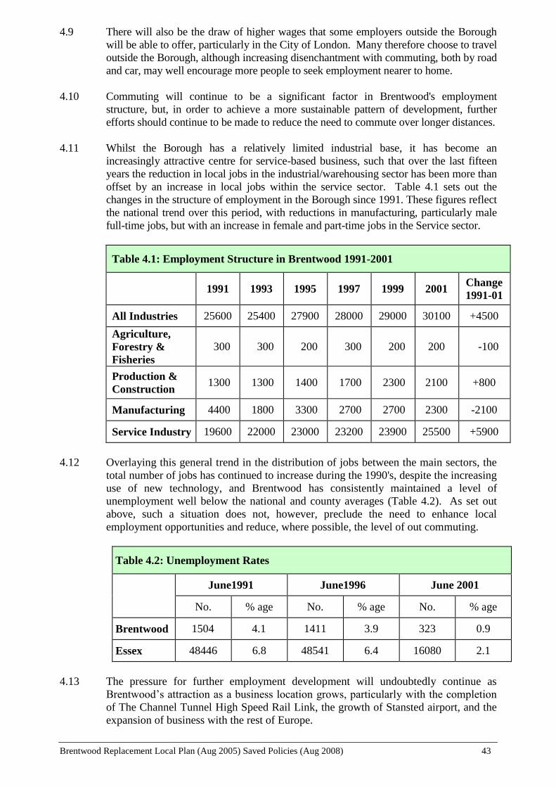
Brentwood Replacement Local Plan (Aug 2005) Saved Policies (Aug 2008) 43
4.9 There will also be the draw of higher wages that some employers outside the Borough
will be able to offer, particularly in the City of London. Many therefore choose to travel
outside the Borough, although increasing disenchantment with commuting, both by road
and car, may well encourage more people to seek employment nearer to home.
4.10 Commuting will continue to be a significant factor in Brentwood's employment
structure, but, in order to achieve a more sustainable pattern of development, further
efforts should continue to be made to reduce the need to commute over longer distances.
4.11 Whilst the Borough has a relatively limited industrial base, it has become an
increasingly attractive centre for service-based business, such that over the last fifteen
years the reduction in local jobs in the industrial/warehousing sector has been more than
offset by an increase in local jobs within the service sector. Table 4.1 sets out the
changes in the structure of employment in the Borough since 1991. These figures reflect
the national trend over this period, with reductions in manufacturing, particularly male
full-time jobs, but with an increase in female and part-time jobs in the Service sector.
Table 4.1: Employment Structure in Brentwood 1991-2001
1991 1993 1995 1997 1999 2001 Change
1991-01
All Industries 25600 25400 27900 28000 29000 30100 +4500
Agriculture,
Forestry &
Fisheries
300 300 200 300 200 200 -100
Production &
Construction 1300 1300 1400 1700 2300 2100 +800
Manufacturing 4400 1800 3300 2700 2700 2300 -2100
Service Industry 19600 22000 23000 23200 23900 25500 +5900
4.12 Overlaying this general trend in the distribution of jobs between the main sectors, the
total number of jobs has continued to increase during the 1990's, despite the increasing
use of new technology, and Brentwood has consistently maintained a level of
unemployment well below the national and county averages (Table 4.2). As set out
above, such a situation does not, however, preclude the need to enhance local
employment opportunities and reduce, where possible, the level of out commuting.
Table 4.2: Unemployment Rates
June1991 June1996 June 2001
No. % age No. % age No. % age
Brentwood 1504 4.1 1411 3.9 323 0.9
Essex 48446 6.8 48541 6.4 16080 2.1
4.13 The pressure for further employment development will undoubtedly continue as
Brentwood’s attraction as a business location grows, particularly with the completion
of The Channel Tunnel High Speed Rail Link, the growth of Stansted airport, and the
expansion of business with the rest of Europe.

Brentwood Replacement Local Plan (Aug 2005) Saved Policies (Aug 2008) 44
4.14 There will also continue to be a demand for further employment provision within the
Borough to respond to:
Expansion of Existing Firms. As existing firms expand and adapt to the changing
nature and space requirements of industry and commerce, they may move out of the
Borough, unless such demands for additional space can be met within the Borough.
Non-Conforming Uses. There are a number of local businesses that are located in
unsuitable locations within residential areas or the Green Belt. Additional
employment provision would be invaluable in opening up opportunities for the
permanent relocation of such non-conforming uses.
Demand for Small-Unit Accommodation. There is a continuing need within the
Borough to provide for small starter units. At present many of these small businesses
are either forced out of the Borough or locate on unauthorised sites in the Green Belt
or, for example, in lock-up garages in residential areas. The Council's policy for
allowing, in the right circumstances, commercial use of rural buildings (see Policy
GB15) may well provide for some of this need. However, many of these small
businesses would benefit from moving into purpose built units.
Increased Local Job Opportunities. Reference has been made to the disparity
between the number of local jobs and numbers of resident workers. Providing more
employment locally would have social as well as economic benefits. It would be
more efficient for industry and commerce, less time-consuming, stressful and costly
for employees and would relieve some pressure on the transport network. Improving
the relationship between place of residence and place of work is a fundamental
objective of sustainable development.
Future of the City of London. Relatively high levels of rental in the City,
congestion, problems of commuting into London and advances in communications
technology are all likely to encourage further businesses to look outside the City for
floor space.
4.15 However, the potential for further employment development is constrained by the
Borough's Green Belt location and the lack of available employment land. Whilst there
is limited provision for additional employment land in the Replacement Structure Plan,
additional employment opportunities have and can potentially continue to be provided
through better use of existing employment land and the change of use/redevelopment of
previously developed land. Significant numbers of new jobs have been provided as a
result of, for example, the new British Telecom office development on the former St.
Faith’s Hospital site in London Road, and will be provided on the Kings Road office
site.
GENERAL EMPLOYMENT STRATEGY
Areas Allocated for General Employment
4.16 Many applications for development on industrial estates are for mixed uses such as
manufacturing, storage and offices. Increased use of micro-technology is blurring the
definition of uses and furthermore, the Town and Country Planning (Use Classes) Order
1987, includes light industrial uses, research and development and offices within the
same Business Use Class (B1), allowing changes of use between each without requiring
permission and indeed the change of use from B2 (General Industry) to B1 and from B8

Brentwood Replacement Local Plan (Aug 2005) Saved Policies (Aug 2008) 45
(Storage and Distribution) to B1 (subject to certain limitations). For this reason, the
Plan allocates areas for “general employment” purposes, where mixed uses may be
acceptable subject to certain important provisos. Major office uses will be directed to
areas allocated specifically for offices uses, particularly in town centre locations with
good accessibility to public transport. Within the general employment areas, the
suitability of a site for either manufacturing or warehousing/distribution uses will be
determined, inter alia, by their particular location/transport requirements, and B1(a) use
will generally be acceptable where ancillary to other employment uses.
4.17 The Council will be seeking to retain the Borough's existing employment base and
where possible widen the range of local job opportunities to give resident workers a
greater choice locally. In addition, the Council will seek to provide for the expansion of
local firms and small "starter" units. New small businesses spring up regularly. For the
small firm, particularly those concerned with service activities such as car repair,
suitable premises are rarely, if ever, available in the Borough. At present, many small
enterprises wanting space less than 100 sq. m are either forced out of the Borough or use
redundant non-conforming sites or domestic properties as the only alternative.
4.18 Due to the limited provision for additional employment land it is important to retain
existing local employment opportunities and, therefore, existing employment areas and
sites will be retained for B1, B2 and B8 uses. However, there are other uses that can be
appropriately located within such areas, e.g. vehicle showrooms and vehicle repairs.
Such uses will be considered within such areas where it can be shown that they would
have no significantly detrimental impact on the existing provision of or the capacity for
additional B Class uses. In order to retain the viability and vitality of existing shopping
areas, A1 uses will continue to be resisted.
4.19 In addition, government policy guidance encourages the development of mixed-use
residential/commercial developments in order to promote more sustainable land use
patterns. It is considered that the introduction of residential uses within the Borough’s
main employment areas would not be appropriate, both in terms of retaining the level
of employment opportunities within such locations and in terms of residential amenity
issues. However, there may be scope on more “free-standing” employment sites for
the development of mixed residential/employment uses, if it can be shown that there is
no reasonable expectation of development solely for B Class uses going ahead and that
the existing level of employment opportunities is retained.
E1 Areas Allocated for General Employment
WITHIN THOSE AREAS ALLOCATED FOR GENERAL EMPLOYMENT
USES, THE COUNCIL WILL SEEK TO ACHIEVE AND RETAIN A WIDE
RANGE OF JOB OPPORTUNITIES. ACCORDINGLY, SUBJECT TO
MEETING THE CRITERIA SET OUT IN POLICY E8, PERMISSION WILL
BE GRANTED FOR PROPOSALS FOR B1, B2 AND B8 PURPOSES, WITH
ENCOURAGEMENT GIVEN TO SMALL "STARTER" UNITS (E.G. 20-100
SQ.M) AND PROVISION FOR LIGHT AND GENERAL INDUSTRIAL USE
(CLASSES B1(c) AND B2). WHERE IT CAN BE DEMONSTRATED THAT
THERE IS NO REASONABLE EXPECTATION OF B1, B2 OR B8 USES
BEING RETAINED AND THE PROPOSAL DOES NOT GIVE RISE TO A
CONCENTRATION OF NON-B1, B2 OR B8 USES, OTHER EMPLOYMENT
GENERATING USES, APPROPRIATE TO AN EMPLOYMENT AREA (AND
SPECIFICALLY EXCLUDING A1 USES) WILL BE PERMITTED.
WITHIN THE URBAN AREA, OTHER THAN WITHIN THE MAIN
Brentwood Replacement Local Plan (Aug 2005) Saved Policies (Aug 2008) 46
EMPLOYMENT AREAS LISTED BELOW, MIXED CLASS B AND
RESIDENTIAL USE DEVELOPMENT WILL BE PERMITTED WITHIN
AREAS ALLOCATED OR USED FOR EMPLOYMENT PURPOSES,
SUBJECT TO THERE BEING NO REDUCTION IN THE EXISTING LEVEL
OF EMPLOYMENT OPPORTUNITIES, IT BEING DEMONSTRATED THAT
THERE IS NO REASONABLE EXPECTATION OF DEVELOPMENT
SOLELY FOR B1, B2 OR B8 USES, AND CONFORMITY WITH POLICY E8.
CHILDERDITCH INDUSTRIAL ESTATE
HALLSFORD BRIDGE INDUSTRIAL ESTATE
HUBERT ROAD INDUSTRIAL ESTATE
HUTTON INDUSTRIAL ESTATE
UPMINSTER TRADING PARK
WATES WAY/ONGAR ROAD INDUSTRIAL ESTATE
WEST HORNDON INDUSTRIAL ESTATE
PROPOSALS FOR B1, B2 AND B8 PURPOSES WILL NOT BE PERMITTED
OUTSIDE THE AREAS ALLOCATED FOR GENERAL EMPLOYMENT
USES ON THE PROPOSALS MAP, EXCEPT AS MAY BE PERMITTED IN
POLICIES E2, E7, GB15, GB17 AND GB18.
A Target and Indicator for monitoring this policy is set out in Chapter 13
Areas Allocated for Office Purposes
4.20 Brentwood is a highly sought after office location and has been successful in attracting
major companies such as Ford, British Telecom, Amstrad, Standard Life and
International Financial Data Services. Brentwood is, however, not a major office
location within Essex. The Replacement Structure Plan identifies the sub-regional
centres of Basildon, Southend, Chelmsford, Colchester and Harlow as the appropriate
location for large-scale office development (more than 4,000 sq. m.). Further office
development, therefore, will continue to be restricted to those areas currently used or
allocated for offices.
4.21 In the town’s central areas (Brentwood Town Centre, Shenfield Shopping Area,
Brentwood Station Area) and Ingatestone High Street, offices are commonly found
occupying an area or buildings with other uses, such as shops, community uses and
residential. These other uses provide for essential local services in areas accessible by a
choice of means of transport and add to the attraction and activity in these central areas.
It is important that a mix of such uses continue to be provided in these central locations
and, in view of this, permission for further offices will be not be granted, within those
areas allocated for community/offices, shopping/offices, or residential/office/shopping
where the proposal would result in the loss of these other uses.
E2 Areas Allocated for Office Purposes
WITHIN AREAS ALLOCATED OR CURRENTLY LAWFULLY USED FOR
OFFICE PURPOSES, PERMISSION WILL ONLY BE GRANTED FOR
OFFICE DEVELOPMENT (INCLUDING EXTENSIONS AND CHANGES OF
USE TO OFFICES), SUBJECT TO MEETING THE CRITERIA SET OUT IN
POLICY E8.
ADDITIONALLY, WITHIN AREAS ALLOCATED FOR ‘SHOPPING/

Brentwood Replacement Local Plan (Aug 2005) Saved Policies (Aug 2008) 47
OFFICE’ OR ‘COMMUNITY/ OFFICE’ OR ‘RESIDENTIAL/ OFFICE/
SHOPPING’, OFFICES WILL ONLY BE PERMITTED IF IT DOES NOT
GIVE RISE TO THE LOSS OF RESIDENTIAL, SHOPPING (INCLUDING A1,
A2, A3, A4 AND A5) OR COMMUNITY USES.
WITHIN THE URBAN AREA, OTHER THAN WITHIN THE WARLEY
BUSINESS PARK, MIXED CLASS B1(a), B1(b) AND RESIDENTIAL USE
DEVELOPMENT WILL BE PERMITTED WITHIN AREAS ALLOCATED
OR USED FOR OFFICE PURPOSES, SUBJECT TO THERE BEING NO
REDUCTION IN THE EXISTING LEVEL OF OFFICE EMPLOYMENT
OPPORTUNITIES, IT BEING DEMONSTRATED THAT THERE IS NO
REASONABLE EXPECTATION OF DEVELOPMENT SOLELY FOR B1(a)
OR B1(b) USES, AND CONFORMITY WITH POLICY E8.
PROPOSALS FOR OFFICE DEVELOPMENT (INCLUDING EXTENSIONS
AND CHANGES OF USE TO OFFICES) WILL NOT BE PERMITTED
OUTSIDE THOSE AREAS ALLOCATED OR CURRENTLY LAWFULLY
USED FOR OFFICE PURPOSES, EXCEPT AS MAY BE ALLOWED IN
POLICIES E1, E7, GB15, GB17, AND GB18.
Note: For the purposes of Policy E2 "office" means any use falling within Classes
B1(a) and B1(b) of the Town and Country Planning (Use Classes) Order 1987.
BT Office Site
POLICY E3 (BT OFFICE SITE) WAS NOT SAVED BEYOND 25 AUGUST 2008 AND
THEREFORE NO LONGER FORMS PART OF THE LOCAL PLAN
EMPLOYMENT LAND SUPPLY
Additional Employment Land
4.23 The RSP provides for 1 hectare of additional employment land over the period 1996 to
2011. The available supply of land for additional employment purposes over this period
is as follows:
1) Land Adjacent the Council's Depot, Warley
Some 1 hectares of existing employment land remains undeveloped to the east
of the Council’s Highways Depot, The Drive, and north of the Marillac
Hospital. This land remains available to meet the RSP provision figure,
possibly in conjunction with the redevelopment of adjacent employment
allocated land (see Policy E5). The site’s location within the urban area of
Brentwood means that it is currently accessible by a variety of transport modes,
and with potential for improvements.
2) Hallsford Bridge Industrial Estate, Stondon Massey
The Council owns some 0.6 hectares of land to the southeast of the existing
industrial estate, which is currently being disposed of to an adjacent occupier.
Due to its remote location, the site has accessibility issues, but only has a small

Brentwood Replacement Local Plan (Aug 2005) Saved Policies (Aug 2008) 48
capacity for additional buildings and is likely to facilitate expansion of existing
occupiers.
3) Childerditch Industrial Park
Scope still exists for some limited new buildings within the area of this estate
allocated for general employment purposes (see Policy E6). However, due to its
remote location, the site has accessibility issues.
4) West Horndon Industrial Estate
Planning permission was granted in outline in 1989 for the refurbishment of
some 10 hectares of land within the area allocated for employment purposes of
which 1.4 hectares had previously been undeveloped, used for open storage
purposes, and remains available. Accessibility by different transport modes is
good. West Horndon has a rail station on the Southend to London (Fenchurch
Street) line and bus services into Brentwood.
E4 Sites for Additional Employment Land
ADDITIONAL EMPLOYMENT LAND IS ALLOCATED ON THE
PROPOSALS MAP AT THE FOLLOWING LOCATIONS:
i) LAND ADJACENT TO THE COUNCIL HIGHWAYS DEPOT, WARLEY
(SEE POLICY E5)
ii) HALLSFORD BRIDGE INDUSTRIAL ESTATE, STONDON MASSEY
iii) LAND AT CHILDERDITCH INDUSTRIAL PARK (SEE POLICY E6)
iv) LAND AT WEST HORNDON INDUSTRIAL ESTATE
A Target and Indicator for monitoring this policy is set out in Chapter 13
Land Adjacent the Council Depot, Warley
4.24 This site of approximately 1 hectare is owned by the Council and is located immediately
to the east of the Council's Highways Depot and consists largely of an area of scrubland
used for the deposit of road sweeping spoil. Access to the land is constrained and
development may be achieved in conjunction with the adjacent Council owned land,
also allocated for employment purposes. The land is located within the main urban area
and is easily accessible by a choice of transport modes.
4.25 Any development would clearly need to take into account both Barrack Wood, a County
Wildlife Site, along the eastern boundary, and the Marillac Hospital, immediately to the
south of the site, and in particular there would need to be a substantial planting screen
along this boundary. In this regard, development for Class B2 and B8 uses is considered
inappropriate.
E5 Land Adjacent the Council Depot, Warley
SOME 1 HECTARE OF LAND ADJACENT TO THE COUNCIL HIGHWAYS
DEPOT, WARLEY, IS ALLOCATED FOR EMPLOYMENT PURPOSES,
Brentwood Replacement Local Plan (Aug 2005) Saved Policies (Aug 2008) 49
SUBJECT TO THE FOLLOWING:
i) THE SITE SHALL PROVIDE FOR A MIX OF B1(a), B1(b) AND B1(c) USES
INCLUDING THE PROVISION OF SMALL STARTER UNITS (E.G. 20-100
SQ.M)
ii) SUBSTANTIAL SCREEN PLANTING AND EARTH MOUNDING SHALL
BE PROVIDED TO THE BOUNDARIES, PARTICULARLY ALONG THE
SOUTHERN SIDE OF THE SITE AND ANY DEVELOPMENT SHALL TAKE
ACCOUNT OF THE ADJACENT MARILLAC HOSPITAL AND THE
ECOLOGICAL VALUE OF BARRACK WOOD
iii) ANY PROPOSALS SHALL MEET THE CRITERIA SET OUT IN POLICY
E8
Childerditch Industrial Park, Warley
4.26 The Childerditch Industrial Park was formerly occupied by a concrete manufacturing
company, which commenced operation prior to the introduction of effective planning
control. The eastern part of the site has a number of industrial buildings, many of which
emanate from the origins of activity on the site, but have since been refurbished. The
western part of the site was an area used over many years for the disposal of concrete
waste and the storage and curing of concrete products. Planning permissions have been
granted over the years for either open storage uses or buildings, dependent generally
upon their location within the eastern or western parts of the site.
4.27 In the light of this planning history, the Plan allocates the eastern built-up part of the site
for employment purposes and the open western part of the site for open storage
purposes. There is pressure to extend the current built up part of the site onto the open
part, but this is to be resisted. This is the only area within the Borough allocated to
specifically meet the demand for open storage uses, and is a preferable alternative
location for such uses to other more sensitive Green Belt areas. Additional buildings
outside the areas allocated for industrial uses will, therefore, only be permitted if
ancillary to the open storage area.
4.28 The site is situated on a plateau in an elevated position on the rising ground forming part
of the Thames Valley. Although it is screened on the southern and western boundary by
existing agricultural buildings and landscaping, it can be seen from the surrounding
Green Belt area. It is also located within a Special Landscape Area and the Thames
Chase Community Forest. In order to lessen the visual impact of the open storage area,
a height restriction will be imposed on any new permission. In addition, new
permissions will require substantial re-enforcement to the landscaping bounding the site.
Although improvements have previously been undertaken to the A127 access, further
improvement may be required subject to the conclusions of a transport assessment that
may be required as part of any proposals.
E6 Childerditch Industrial Park, Warley
CHILDERDITCH INDUSTRIAL PARK IS ALLOCATED PARTLY FOR
OPEN STORAGE USES AND PARTLY FOR EMPLOYMENT PURPOSES AS
IDENTIFIED ON THE PROPOSALS MAP, SUBJECT TO THE FOLLOWING
ADDITIONAL REQUIREMENTS:
Brentwood Replacement Local Plan (Aug 2005) Saved Policies (Aug 2008) 50
i) WITHIN THE OPEN STORAGE AREA NO BUILDINGS WILL BE
PERMITTED EXCEPT FOR ANCILLARY BUILDINGS CONSIDERED
ESSENTIAL TO THE PROPER FUNCTIONING OF THE OPEN STORAGE
USE OF THE SITE
ii) WHERE PLANNING PERMISSION IS REQUIRED USE OF THE OPEN
STORAGE AREA WILL BE SUBJECT TO A HEIGHT RESTRICTION OF 6
METRES
iii) ANY DEVELOPMENT ABUTTING THE BOUNDARY OF THE SITE
WILL REQUIRE FURTHER SUBSTANTIAL SCREEN PLANTING TO THE
BOUNDARY
iv) IN ANY REDEVELOPMENT OF THE AREA ALLOCATED FOR
GENERAL EMPLOYMENT PURPOSES, THE COUNCIL WILL SEEK A MIX
OF USES IN ACCORDANCE WITH POLICY E1
v) ANY PROPOSALS SHALL MEET THE CRITERIA SET OUT IN POLICY
E8
CONTROL OF EMPLOYMENT USES
Employment in Village Settlements Excluded From the Green Belt
POLICY E7 (EMPLOYMENT IN VILLAGE SETTLEMENTS EXCLUDED FROM THE
GREEN BELT) WAS NOT SAVED BEYOND 25 AUGUST 2008 AND THEREFORE NO
LONGER FORMS PART OF THE LOCAL PLAN
Employment Development Criteria
4.31 All employment development needs to be controlled in a manner that will protect the
amenities of surrounding residents. The transport impacts of all proposals will need to
be assessed to ensure that the transport network can cope with the level of demand and
that traffic does not have a detrimental impact on surrounding residents. Parking and
servicing needs to be provided within the site in a manner that does not result in
problems on adjacent roads. Proposals that are likely to increase congestion or result in
unacceptable levels of traffic on to roads that were not designed for such purposes will
be refused. Employment development should be located in areas accessible by public
transport, walking and cycling.
4.32 Industrial and commercial buildings can be of significant size and bulk and can therefore
detract from the visual amenities of adjacent residents by being overbearing and
unsightly. Landscaping and screening will be required in appropriate circumstances.
4.33 Industrial or similar commercial uses may give rise to significant levels of pollutants in
the form of noise, fumes, vibration, smells, and other air-borne organic matter, which
not only affect immediate neighbours but can carry large distances. Proposals within or
near to residential areas for uses which may give rise to unacceptable levels of pollutants
will need to be accompanied by an environmental impact study so that their likely
effects on residents can be assessed. If such effects are judged to be unacceptable and
cannot be reduced by the introduction of pollution abatement technology then

Brentwood Replacement Local Plan (Aug 2005) Saved Policies (Aug 2008) 51
permission will not normally be granted.
4.34 These and other relevant factors (for example, hours of operation) will be taken into
account in determining applications for employment development both within and
outside allocated employment areas. Whilst the majority of these considerations are
covered in the core policies, a number of additional, more specific criteria are set out in
the following Policy E8.
4.35 In addition to the identified main employment areas, there are other
commercial/business uses located either within the built-up area or within the Green
Belt. Most of the uses are fairly innocuous and do not give rise to any particular
problems and, indeed, add to the supply of local employment opportunities. Where
problems do arise, in the majority of cases the use will have established itself over a
period of time and be immune from planning enforcement. Whilst the Council will
continue to seek ways of dealing with problem sites, it is not suggested that action
would normally be taken to force relocation. However, the Local Authority does have
control over the intensification and expansion of such sites. Pressure for further
development has been and will continue to be resisted and permission will not be
granted for proposals that fail to meet the criteria in the core policies or Policy E8. In
addition, sites in the Green Belt will be considered against Policy GB18.
E8 Employment Development Criteria
ANY DEVELOPMENT FOR EMPLOYMENT (BI, B2 OR B8) PURPOSES
WILL NEED TO SATISFY ALL THE FOLLOWING CRITERIA:
i) IT WILL BE OF A SCALE AND NATURE APPROPRIATE TO THE
LOCALITY
ii) IT IS ACCESSIBLE BY PUBLIC TRANSPORT, WALKING AND
CYCLING
iii) ROAD ACCESS WILL AVOID USING NARROW RESIDENTIAL
STREETS AND COUNTRY LANES AND AVOID SIGNIFICANT TRAFFIC
MOVEMENTS WITHIN RURAL AREAS
iv) APPROPRIATE LANDSCAPING AND SCREENING SHALL BE
PROVIDED.
See also Policies CP1, CP3 and T1 and Appendix 2

Brentwood Replacement Local Plan (Aug 2005) Saved Policies (Aug 2008) 52
SHOPPING
Brentwood Replacement Local Plan (Aug 2005) Saved Policies (Aug 2008) 53
5. SHOPPING
POLICY BACKGROUND
Government Policy Guidance
5.1 The main government policy guidance on new retail developments is set out in Planning
Policy Statement 6: ‘Planning for Town Centres’ (March 2005). In relation to retail
proposals the guidance sets out the government’s objectives to sustain and enhance the
vitality and viability of town centres, to maintain an efficient, competitive and
innovative retail sector and to ensure that such services and facilities are available and
have easy access by a choice of means of transport.
5.2 The sequential approach to retail development locations is emphasised, with town
centres the preferred location for developments that attract many trips. Policies should
enable town, district and local centres to meet the needs of residents, and safeguard and
strengthen existing local centres, which offer a range of everyday community, shopping
and employment opportunities.
Replacement Structure Plan
5.3 The RSP identifies a strategic hierarchy of shopping centres, comprising Sub-Regional
Town Centres, Principle Town Centres (including Brentwood Town Centre), Smaller
Town Centres, District Centres and Local Centres. Policy TCR1 of the RSP advises that
development must be appropriate to the function, size and character of the centre
concerned and reinforces this in Policy TCR2 by advocating a sequential approach to
the location of retail and other town centre developments, working down from the
higher order centres to the smallest local centre.
Brentwood Community Plan
5.4 The Community Plan’s strategic objectives that are relevant to the Replacement Local
Plan Shopping policies are set out under the heading “Economic Development and the
Local Economy” and includes:
“To facilitate the maintenance of a sound economic base for the Brentwood Borough,
by:
Providing where possible for the needs of existing local businesses in order for
them to remain viable and competitive
Facilitating the creation of new businesses
Facilitating the development of existing and new businesses”
THE AIM AND OBJECTIVES OF THE PLAN’S SHOPPING POLICIES
Overall Aim
To improve shopping provision in the Borough

Brentwood Replacement Local Plan (Aug 2005) Saved Policies (Aug 2008) 54
Supporting Objectives
To maintain and enhance the viability and vitality of existing shopping areas within
the Borough
To facilitate the provision and maintenance of, where possible, a range, quality and
amount of retail floor space to satisfy the needs of the local catchment area
To ensure that non-retail uses do not detract from the vitality and viability of the
shopping areas
To provide a safer and more attractive environment for the users of shopping areas
To encourage access to and within the shopping areas by alternative modes of
transport to the private car
To seek to achieve and retain adequate neighbourhood shopping facilities
INTRODUCTION
5.5 There is a wide range of shopping facilities within the Borough, encompassing
Brentwood Town Centre itself, the main shopping area serving a catchment population
of approximately 70,000; the important local centres of Hutton Road, Shenfield,
Ingatestone High Street and the Warley Hill Area around Brentwood Station; and the
many smaller parades and individual shops serving the local residential areas and
villages. Each has an important role to play in providing essential local services for
residents of the Borough.
5.6 However, retailing has an important function not only in providing local services and
facilities for residents, but in generating income and other economic benefits, and
offering further sources of local employment opportunities.
5.7 Retail patterns have changed significantly in recent years and shoppers' expectations of
their shopping environment have increased, with demands for improved shopping
facilities and new types of shopping e.g. food superstores and retail warehouse, easy
access and car parking in close proximity. There is also an increasing prevalence for
mixed-use trips, with leisure playing a greater part in shopping visits to main shopping
areas.
5.8 Brentwood is surrounded by four major sub-regional centres, within a 20-minute drive
time, i.e. Romford, Basildon and Chelmsford and the new Lakeside Centre in Thurrock.
Accessibility is also relatively easy to other shopping facilities in Central London and
the most recent development at Bluewater in Kent. Such centres are able to offer a
greater range, choice and quality of shopping to that in Brentwood. The success and
continued viability of the existing shopping facilities within the Borough is dependent in
the long-term on the Borough being able to withstand competition from these
surrounding centres and minimise the outflow of expenditure. As these nearby centres
continue to expand and improve the range of shops and other facilities offered, so
shopping facilities within the Borough must continue to develop in ways that will
maintain their attraction and encourage Brentwood residents to choose to shop within
the Borough.
5.9 The Council is committed, therefore, to ensuring that current shopping opportunities in
Brentwood are maintained and enhanced.

Brentwood Replacement Local Plan (Aug 2005) Saved Policies (Aug 2008) 55
ADDITIONAL SHOPPING PROVISION
New Major Retail Development
5.10 In line with national and strategic policies the Plan will continue to support the viability
and vitality of existing shopping centres within the Borough, and thus policies will seek
to enhance existing shopping centres by directing new retail provision to these areas and
by looking to achieve new investment and general improvements in the shopping
environment. The larger shopping centres (Brentwood Town Centre, Shenfield
Shopping Centre, The Brentwood Station Area and Ingatestone High Street) are
specifically identified for shopping purposes on the Proposals Map. Smaller local
shopping centres and individual shops are not so allocated, but are over-washed with the
residential notation. In order to implement a sequential approach to the location of new
retail provision and reflect the hierarchy of centres, any new major retail provision will
only be permitted within those areas allocated for shopping purposes or as may be
allowed in any future consideration of uses for the William Hunter Way Car Park in
Brentwood Town Centre (see Policy TC10). Other retail development will be permitted
provided it satisfies the sequential test set out in PPG6 and the proposal is of a size that
is appropriate to the scale and character of the centre or area within which it is to be
located.
5.11 Furthermore, new retail development will need to show that the associated travel
demand can be satisfactorily accommodated by the transport network, which it is of a
high standard of design and does not give rise to any detrimental impact on the
amenities of the surrounding area. Proposals will also need to show how travel by more
sustainable forms of transport than the private car is to be encouraged and facilitated.
5.12 For the above reasons, including the need to protect the viability and vitality of all
existing shopping centres, and due to the limited provision made for new employment
land, retail development will not be permitted within areas allocated or used for
employment purposes. Large new stores will, therefore, only be allowed in areas
allocated for shopping and where no adverse impact will result on existing centres, the
transport network, local environment, etc.
S1 New Major Retail Developments
MAJOR RETAIL DEVELOPMENT* WILL ONLY BE PERMITTED WITHIN
BRENTWOOD TOWN CENTRE AND THE BOROUGHS OTHER DISTRICT
CENTRES WHERE IT IS WITHIN AN AREA ALLOCATED FOR SHOPPING
PURPOSES OR WITHIN THE CONTEXT OF POLICY TC10. OTHER
RETAIL DEVELOPMENT WILL BE PERMITTED IF IT IS OF A SIZE
APPROPRIATE TO THE SCALE AND CHARACTER OF THE CENTRE OR
AREA IN WHICH IT IS TO BE LOCATED AND SATISFIES THE
SEQUENTIAL APPROACH IN PPG6. ALL RETAIL PROPOSALS SHOULD
SATISFY THE FOLLOWING:
i) THE PROPOSED DEVELOPMENT WILL NOT HAVE AN
UNACCEPTABLE DETRIMENTAL IMPACT ON THE VITALITY AND
VIABILITY OF BRENTWOOD TOWN CENTRE OR ANY OTHER LOCAL
DISTRICT SHOPPING CENTRE AS A WHOLE
ii) THE PROPOSED DEVELOPMENT IS EASILY ACCESSIBLE BY PUBLIC
TRANSPORT, FOOT AND CYCLE
Brentwood Replacement Local Plan (Aug 2005) Saved Policies (Aug 2008) 56
See also Policies CP3 and T1
*Proposals with a floor space of 2,500 sq.m. or more
Retail Market
POLICY S2 (RETAIL MARKET) WAS NOT SAVED BEYOND 25 AUGUST 2008 AND
THEREFORE NO LONGER FORMS PART OF THE LOCAL PLAN
Petrol Filling Station Retail Facilities
5.16 It is increasingly common for petrol filling stations to provide additional shop
facilities. Such facilities are also developing beyond the provision of car related
products, newspapers and sweets to a much wider range of grocery products, videos
etc., particularly with the emergence of some of the major food store operators now
becoming involved.
5.17 Whilst the principle of more widely available local shopping facilities is to be
supported, the activity associated with such expansion of uses should not give rise to a
loss of amenity to surrounding residents or unnecessarily add to the clutter of
advertisements or in any other way impact harmfully on the visual amenities of the
area.
5.18 The Council will also be concerned that the location of such development and the level
of provision are such that they would not have a detrimental impact on the viability of
established shopping centres or indeed on a more sustainably sited shopping facility.
S3 Petrol Filling Station Retail Facilities
RETAIL FLOOR SPACE ASSOCIATED WITH PETROL FILLING
STATIONS WILL ONLY BE PERMITTED WHERE THE PROPOSED
DEVELOPMENT WILL NOT HAVE AN UNACCEPTABLE DETRIMENTAL
IMPACT ON THE VIABILITY OF AN EXISTING SHOPPING CENTRE,
LOCAL SHOPPING PARADE OR A MORE SUSTAINABLY LOCATED
SHOPPING FACILITY
WHERE RETAIL PROPOSALS ARE NOT CONSIDERED ANCILLARY TO
THE MAIN USE AS A PETROL FILLING STATION, THE NEED FOR THE
RETAIL ELEMENT AND A SEQUENTIAL APPROACH WILL BE APPLIED.
CHANGE OF USE OF EXISTING SHOPS
5.19 Existing shopping within the Borough is provided within a hierarchy of centres.
Brentwood Town Centre is the principal shopping area, followed by the district centres
in the Brentwood Station Area, Shenfield Station Area and Ingatestone High Street, then
the other local parades, and lastly the individual shop units. Whilst it is imperative to
enhance the attractiveness and competitiveness of the Borough’s main town and district
shopping centres, it is equally important that a full range of shopping facilities is
maintained throughout the Borough in order to meet all local shopping needs. An
Brentwood Replacement Local Plan (Aug 2005) Saved Policies (Aug 2008) 57
important contribution to this is made by the small local parades and individual shops
within the villages and residential areas of the town providing for the day-to-day needs
of residents within the immediate locality. Such facilities provide for the needs of the
elderly and people without access to private transport who often rely on facilities being
available locally, but also provide all local residents and workers with a convenient and
sustainable choice of shopping facilities within walking distance.
Brentwood Town Centre
5.20 The change of use of shops within the town centre is dealt with in Paras.12.37 to 12.40
and Policy TC7 in the Town Centre Chapter.
Non-Retail Uses within Local Shopping Centres and Parades
5.21 Commercial pressure continues for the conversion of retail premises to non-retail uses,
usually Class A2, financial and professional services e.g. banks, estate agents; Class A3,
restaurants and cafes; Class A4, drinking establishments; and Class A5, hot food
takeaways (as defined in the Town and Country Planning Use Classes Order 1987).
Such uses are both appropriate and beneficial to local shopping centres by attracting
people to the area for services and entertainment. They can thereby play a positive role
in the function of such commercial areas.
5.22 Banks and building societies provide financial services that are often linked to a
shopping trip. Restaurants and fast food takeaways can provide a buoyant appearance,
contribute to the attractiveness and vitality of the area and provide variety and activity
outside normal business hours. Central Government advice underlines this and indicates
that planning policies should be sufficiently flexible to accommodate the variety that
these uses offer.
5.23 However, the over-concentration of groups of adjacent non-retail uses remains a concern
in terms of the appearance and character of the frontage and, most importantly, because
of the loss of retail floor space which may reduce the attractiveness of the centre and
thus affect its viability. There is a need, therefore, to strike a balance between these
potentially competing uses, by applying a policy that sets out defined criteria, which
offers clear guidance to developers and allows for consistency in decision-making.
5.24 Local shopping centres and parades will normally have residential accommodation
above the premises and/or in the immediate vicinity. A3, A4 and A5 uses may give rise
to possible problems of noise, smell, etc., for adjacent residents and permission will only
be granted where such potential problems can be overcome satisfactorily, e.g. by the
imposition of planning conditions.
5.25 The following policy deals with both individual parades as well as the Borough's
secondary district shopping centres. For ease of applying the criteria, the shopping
centres of the Brentwood Station Area, Shenfield and Ingatestone are divided into
specified blocks. The equivalent policy for Brentwood Town Centre is set out in Policy
TC7.
S4 Non-Retail Uses within Local Shopping Centres and Parades
WITHIN THE GROUND FLOOR OF PREMISES IN LOCAL SHOPPING
CENTRES AND PARADES (OTHER THAN THE TOWN CENTRE) A
FURTHER A2, A3, A4 OR A5 USE WILL BE PERMITTED ONLY WHERE:

Brentwood Replacement Local Plan (Aug 2005) Saved Policies (Aug 2008) 58
i) IT WOULD RESULT IN NO MORE THAN TWO ADJACENT NON-
RETAIL USES, AND
ii) IN THE CASE OF SHOPPING PARADES IT WOULD RESULT IN NO
MORE THAN 40% OF UNITS WITHIN ANY PARADE BEING USED FOR
NON-RETAIL USES OR, IN THE CASE OF THE FOLLOWING BLOCKS OF
SHOPS, IT WOULD RESULT IN NO MORE THAN 40% OF UNITS WITHIN
ANY BLOCK BEING USED FOR NON-RETAIL USES:
BRENTWOOD STATION AREA
a) 78-92 AND 93-99 KINGS ROAD
b) 104-130 AND 137-167 KINGS ROAD
c) 2-26 AND 1-33 WARLEY HILL, 2-10 VICTORIA ROAD AND 1-3
CRESCENT ROAD
SHENFIELD
d) 138-250 AND 65-105 HUTTON ROAD
INGATESTONE
e) 3-57 HIGH STREET (INCLUDING 1-5 SPREAD EAGLE PLACE) AND 26-
108 HIGH STREET (INCLUDING 1-7 MARKET PLACE)
f) 118A-122 AND THE CROWN - THE LIBRARY, HIGH STREET
WHERE A3, A4 OR A5 USES MEET THE ABOVE CRITERIA, PLANNING
PERMISSION WILL ONLY BE GRANTED WHERE THE IMPOSITION OF
CONDITIONS REGARDING, INTER ALIA, HOURS OF OPENING,
CONTROL OF NOISES AND SMELLS CAN PROTECT THE AMENITIES OF
ADJACENT RESIDENTS AND THE SURROUNDING AREA. APPLICANTS
WILL BE REQUIRED TO SUBMIT DETAILS OF EXTRACTION,
FILTRATION, REFRIGERATION OR AIR CONDITIONING UNITS WITH
THEIR APPLICATION.
APART FROM CHANGES OF USE TO A2, A3, A4 AND A5 IN
ACCORDANCE WITH THE POLICY SET OUT ABOVE, CHANGE OF USE
TO ANY OTHER NON-RETAIL USES WILL NOT BE PERMITTED.
Note:
(1)The identification of the above blocks does not in any way imply that a further
A2, A3, A4 or A5 use can be accommodated at the present time.
(2) For the purpose of calculating the above percentages, account will be taken of
any outstanding unimplemented planning permissions
For the Town Centre see Policy TC7.
Non-Retail Use of Local Individual Shops
5.26 Whilst the Council will seek to retain local shops, in exceptional cases, where the
Local Planning Authority can be reasonably satisfied that no demand for the retail unit
exists, consideration may be given to its conversion to a non-retail use, but only in
circumstances where it is not harmful to the amenities of nearby residents and where
the proposed use would serve other needs of the local community.
5.27 Proposals affecting local shops and similar important local community facilities will be

Brentwood Replacement Local Plan (Aug 2005) Saved Policies (Aug 2008) 59
considered against the criteria set out in Policy LT11.

Brentwood Replacement Local Plan (Aug 2005) Saved Policies (Aug 2008) 60
TRANSPORT
Brentwood Replacement Local Plan (Aug 2005) Saved Policies (Aug 2008) 61
6. TRANSPORT
POLICY BACKGROUND
National Policy Guidance
6.1 The Government’s strategy for sustainable development, “Sustainable Development:
The UK Strategy” (1994), sets out the role of the planning system to shape new
development patterns in a way which minimises the need to travel. Travel is,
however, often unavoidable and policies, therefore, need to ensure that the necessities
of travel and transportation to economic and social development are undertaken within
a choice of sustainable transport modes, that the environmental impacts are minimised
and that transport choice and the environment in general is accessible to all.
6.2 PPS1 sets out the Government’s basic objectives with regard to sustainable
development. Specifically in relation to land use and transportation it states local
authorities should integrate their transport programmes and land use policies to help:
To reduce growth in the length and number of motorised journeys
Encourage alternative means of travel which have less environmental impact; and
hence
Reduce reliance on the private car
6.3 These general objectives in relation to land use and transportation are repeated in
PPG3 “Housing”, PPS6 “Planning for Town Centres” and PPG13 “Transport”. In
addition and more specifically, these government advice notes also advise that LPAs
should:
Seek to reduce car dependence by facilitating more walking and cycling, by
improving linkages by public transport between housing, jobs, local services and
local amenity, and by planning for mixed use
Manage both access by car and parking as part of an overall strategy for town
centres;
Promote improvement in the quality and convenience of less environmentally-
harmful means of transport so that they provide a realistic alternative to the car;
and
Meet the access and mobility needs of disabled people.
Promote more sustainable transport choices for both people and for moving freight;
Promote accessibility to jobs, shopping, leisure facilities and services by public
transport, walking and cycling, and
Reduce the need to travel, especially by car
6.4 At a national/regional level there have been a number of multi-modal studies
undertaken or on-going on behalf of the Government, some of which are relevant and
have significant potential transportation and environmental impacts on the Borough.
6.5 Consultants undertaking the London to Ipswich Multi Modal Study (LOIS) have
recommended a balanced package of measures to address both rail and road
congestion within the London to Ipswich corridor over the next 30 years. The
Government has asked the Highways Authority to carry out further work to bring
forward proposals for improvements to the A12/M25 junction and for the upgrade of

Brentwood Replacement Local Plan (Aug 2005) Saved Policies (Aug 2008) 62
the A12 (M25 to Chelmsford) to dual 3 lanes, with completion by 2013. Other
proposals being appraised further include quality bus and coach corridors and priority
including the A12 between London and Colchester and Great Eastern Mainline
enhancements.
6.6 The M25 London Orbital Transport Study (ORBIT) has made recommendations to
tackle congestion and unreliable journeys on the M25. As a result the Government is
seeking to progress the widening of the M25 between junctions 27 (M11) and 31
(Dartford Crossing) to dual 4 lanes, again to be completed by 2013. Development of an
orbital coach system is also to be encouraged and the Government is considering the
ORBIT recommendation for further examination of the case for a multi-modal Lower
Thames Crossing.
6.7 In addition, the London to Southend Movement Study includes investigation of
improvements to the A127 and to the London (Liverpool Street) to Southend (Victoria)
rail line.
Replacement Structure Plan
6.8 The RSP Transport Strategy focuses on managing the demand for travel and
distribution, achieving integration with land use planning, and the implementation of
sustainable transport choices. Policies promote, therefore, investment priorities in
support of regeneration within designated areas, accessibility, public transport,
walking and cycling, and traffic management.
6.9 However, policies also identify the need to develop and maintain key road corridors as
identified by the County-wide road hierarchy in order to achieve economic prosperity,
optimise safety and capacity, and discourage the use of less suitable routes. At the
more local level, the road network will be managed, improved and maintained to
support access to the strategic roads, facilitate major development proposals, support
sustainable forms of transport, contribute to environmental improvements and allow
safe and efficient local trip making.
Local Transport Plan
6.10 In the Essex Local Transport Plan (LTP), the Essex-wide Transport Strategy is set out
in relation to urban areas, rural areas and inter-urban movement. In urban areas the
LTP advises that a balance needs to be struck between the need to manage car use and
the need to maintain the commercial viability of town centres. This will continue to be
achieved through the existing package approach applied to all large towns, including
Brentwood, whereby schemes and measures are implemented which encourage
alternative modes of travel to the car, especially at peak times i.e. provision of bus
priorities, footpaths and cycle-ways, car parking availability and pricing.
6.11 In rural areas the distances between settlements and the lack of both local employment
and a full range of community services means that the role that can practically be played
by public transport, walking and cycling is limited, and demand for car travel will
continue to grow. In some cases limited local highway improvements will be needed,
aimed mainly at improving safety and the environment, but public transport will be
maintained through conventional and innovative means for the social needs of rural
communities.
6.12 An increase in demand for inter urban travel by road, passenger transport and rail
freight is to be catered for, although the strategy states it may not be possible to cater
Brentwood Replacement Local Plan (Aug 2005) Saved Policies (Aug 2008) 63
for the full increase in demand for road based traffic.
6.13 The Borough and County Council have, in partnership, developed and prioritised a 10-
year programme of transport measures upon which the Brentwood element of the
LTP’s 5-year plan proposals is based.
6.14 The highest priority is the “High Street Area Study”. Proposals for High Street
Improvements have been agreed by Essex County Council, and work is to be
progressed on the design process.
6.15 The second priority is the decriminalisation of parking enforcement. Development
control policies to reduce car use, such as maximum parking standards, are unlikely to
be effective unless the Local Authority has sufficient control over on-street parking.
6.16 Finally, the Borough Council has also been able to negotiate significant amounts of
funding for transport measures through planning agreements, which will be directed
towards the projects with the highest priority in the agreed Strategy with the County
Council. The LTP sets out the agreed Capital Programme of Schemes for the County,
and an Integrated Transport Capital Programme for each Borough/District is updated
on an annual basis.
6.17 In support of the LTP, the Council has adopted a Transport Strategy that places
emphasis on the following core areas:
Overall reduction in the number, length and time of journeys
More travel by rail, bus, cycling or walking
Less dispersed development pattern
Rail and road networks more closely aligned to the emerging development pattern
Improved accessibility of town centres
More closely integrated public transport networks and services, with private
transport and with cycling and walking facilities
Less local, area-wide and global environmental damage caused by transport
provision
Reducing the dangers associated with travel
More socially and geographically equitable accessibility
Brentwood Community Plan
6.18 The Community Plan’s strategic objectives that are relevant to the Replacement Local
Plan Transport Policies are set out under the heading “Transportation” and includes:
“To encourage the use and development of transport facilities which have less reliance
on cars and less impact on the environment, by:
Reducing the number, length and time of journeys
Encouraging more travel by rail, bus, cycling and walking
Improving accessibility to local facilities and services, including health services
Achieving a better integration of public transport facilities with private transport
and cycling and walking facilities
Reducing the dangers associated with travel”

Brentwood Replacement Local Plan (Aug 2005) Saved Policies (Aug 2008) 64
THE AIM AND OBJECTIVES OF THE PLAN’S TRANSPORT POLICIES
Overall Aim
To encourage sustainable travel patterns and reduce the need to travel
Supporting Objectives
To assist in the provision of an integrated, energy efficient, safe and convenient
transport system for people and goods without unacceptable detrimental impact
upon people, the environment or the local economy
To integrate land use and transport in order to reduce the need to travel and
minimise the possible detrimental impact of traffic on the environment and local
amenities
To minimise conflict between different modes of travel
To encourage alternative forms of transport to the private motor car and lorry
INTRODUCTION
The Brentwood Road Network
6.19 Brentwood is well located in relation to both the regional and national transport
network. The M25 generally forms the western boundary of the Borough with the A12
Colchester/Ipswich Road passing through the centre and the A127 Southend Arterial
Road running through the south of the Borough. Both the M25 and the A12 are part of
the Trans European Highway Network.
6.20 However, by contrast the local road system is poor and has had no major expenditure at
all since the 1960s. This has meant that Brentwood faces considerable local transport
problems. High car ownership and the fact that Brentwood High Street is the main
through route and a Principle Urban Distributor as well as the main shopping centre give
rise to heavy congestion, particularly at peak times, in the town centre. These problems
in Brentwood Town Centre and on the principle roads leading in to the centre are further
exacerbated by a combination of employment and school traffic (there are a significant
numbers of schools on the periphery of the town centre).
6.21 In addition, traffic levels on the M25 at peak times have far exceeded the original
forecast flows. Greater use is also being made of the A12 (commuter and east coast port
traffic) and the A127 (commuter and South Essex industrial traffic) to link into the
national motorway network via the M25 and also to Central London. When these roads
become slow moving or stationary, due to some incident or simply the volume of traffic,
drivers (often including those of heavy goods vehicles) use alternative routes through
the centre of Brentwood and adjacent residential streets causing additional noise,
pollution and congestion in these areas.
The Rail Network
6.22 Brentwood has good rail links with the Liverpool Street to Norwich, Liverpool Street
to Southend Victoria, and the Fenchurch Street to Shoeburyness lines all passing
through the Borough. There are four stations within the Borough at Ingatestone,

Brentwood Replacement Local Plan (Aug 2005) Saved Policies (Aug 2008) 65
Shenfield, West Horndon and Brentwood.
6.23 The presence of these rail links encourages high levels of out-commuting and many of
the rail users arrive at the station interchanges by car during the morning peaks when
the numbers of trips being undertaken is already high.
Car Ownership and Car Usage
6.24 Brentwood is an area of high car ownership, with levels above the Essex average and
significantly higher than the National averages in 2001 (see Table 6.1). The level of
car usage is correspondingly high with the worst problems being experienced in the
a.m. peak. Journeys to work give rise to significant traffic movements, including trips
to rail stations, but journeys to school are also significant, with the average distance
increasing and with fewer children making their own way to school.
Table 6.1: Car Ownership (%) 2001 Census
Cars per Household Brentwood Essex England & Wales
No Car 15.97 19.31 26.79
One Car 43.85 43.30 43.80
Two Cars 31.26 28 78 23.53
Three or more Cars 8.92 8.61 5.89
Total 100.0 100.0 100.0
6.25 The result of these combined traffic movements is congestion, noise, pollution and
increased risk of accidents especially during the morning and evening peaks. Whilst,
however, the worst problems occur during the peak travel period, off peak is now also a
cause for concern1.
6.26 Such problems are anticipated to worsen in the future. Car ownership has continued to
increase since 1991 (Essex Travel Diary figures for 1999/2000), as has the associated
level of traffic flow. Traffic growth in Brentwood is forecast to increase by 6-18%
between1998 and 20116. Whilst this is the lowest forecast increase in Essex it is clearly
significant in terms of the existing high levels of car usage in the Borough.
NEW DEVELOPMENT AND TRANSPORT
Travel Plans
6.27 The Council will promote the widespread use of Travel Plans (Green Transport Plans,
Company Travel Plans, School Travel Plans) by businesses, schools, hospitals and
other organisations within the Borough. Such plans should set out how it is proposed
to reduce car usage, increase the use of public transport, cycling and walking and
provide for more environmentally friendly delivery and freight movements. Travel
Plans should be submitted alongside planning applications for major commercial and
leisure developments or smaller developments in sensitive locations, new or expanded
school facilities, and where they may address local traffic problems which would
otherwise have led to a refusal of permission. Such plans should have measurable
6 Essex Local Transport Plan – The Essex Approach to Transport. July 2000
Brentwood Replacement Local Plan (Aug 2005) Saved Policies (Aug 2008) 66
outputs, which relate to Local Transport Plan targets and arrangements for
enforcement, in the event that agreed targets are not met. Applicants will be expected
to enter into a legal agreement setting out how such measures are to be achieved.
T1 Travel Plans
THE COUNCIL WILL EXPECT BUSINESSES, SCHOOLS, HOSPITALS AND
OTHER USES TO ADOPT TRAVEL PLANS. ALL APPLICATIONS FOR
PROPOSALS WHICH ARE LIKELY TO GIVE RISE TO SIGNIFICANT
TRANSPORT IMPLICATIONS (EITHER OF THEMSELVES OR IN
CONJUNCTION WITH OTHER PROPOSALS) WILL BE REQUIRED TO
PROVIDE A TRAVEL PLAN INCORPORATING, FOR EXAMPLE,
MEASURES TO REDUCE TRAVEL TO AND FROM THE SITE BY CAR,
PROVISION OF ON SITE FACILITIES FOR CYCLISTS, CONTRIBUTIONS
TO THE IMPROVEMENT OR EXPANSION OF PUBLIC TRANSPORT
PROVISION, AND THE PROMOTION OF SAFE CYCLE AND PEDESTRIAN
ROUTES.
APPLICANTS WILL BE EXPECTED TO ENTER INTO A LEGAL
AGREEMENT SETTING OUT HOW ANY MEASURES REFERRED TO
ABOVE ARE TO BE ACHIEVED
A Target and Indicator for monitoring this policy is set out in Chapter 13.
Impact on the Transport Network
6.28 Whilst policies aimed at achieving sustainable development seek to change the
emphasis and priorities between different modes of transport, the car will continue to
be an important means of transport for many journeys, and may in rural areas continue
to be the only real option for travel. It will also be important to continue to invest in
the existing highway network to ensure that travel, whether by private car, public
transport, cycling or on foot, is safe and efficient.
6.29 Development proposals giving rise to levels of traffic that would have an adverse
effect on highway safety, prejudice the free flow of traffic, increase congestion to an
unacceptable extent or give rise to adverse environmental conditions, and which
cannot be overcome by mitigation measures, will not be granted permission.
T2 New Development and Highway Considerations
PLANNING PERMISSION WILL NOT BE GRANTED FOR PROPOSALS
WHERE:
i) AN ASSESSMENT OF THE PROPOSAL INDICATES AN UNACCEPTABLE
DETRIMENTAL IMPACT ON THE TRANSPORT SYSTEM WHICH CANNOT
BE RESOLVED BY AGREED MITIGATION MEASURES
ii) IT DOES NOT COMPLY WITH THE CURRENT COUNTY HIGHWAY
AUTHORITY'S GUIDANCE AS SET DOWN IN THE FOLLOWING
PUBLICATIONS:
a) “THE ESSEX DESIGN GUIDE FOR RESIDENTIAL AND MIXED USE
AREAS – SERVICE AND ACCESS”

Brentwood Replacement Local Plan (Aug 2005) Saved Policies (Aug 2008) 67
b) "THE HIGHWAY ASPECTS OF DEVELOPMENT CONTROL"
TRAFFIC MANAGEMENT
Traffic Management
6.30 The Council is committed to implementing traffic management measures as a means
of promoting more sustainable forms of travel, enhancing local amenity, reducing
congestion and improving road safety. The introduction of additional lanes on
approaches to junctions and the introduction of mini roundabouts, for example, have
been seen as particularly effective. Congestion on the main road network inevitably
leads to environmental problems in adjacent residential streets as drivers seek
alternative routes or "rat-runs" to avoid the delays. In order to control traffic
movement in residential areas and provide safer and more pleasant conditions, the
Council has, and will continue to, implement traffic calming measures to deter through
traffic, decrease vehicle speeds and provide greater pedestrian safety. The design and
layout of the Clements Park development on the Warley Hospital site has sought,
through road narrows, humps and other measures, to achieve a 20 mph zone.
6.31 The Transport Act 2000 makes provision for local traffic authorities to designate
“Home Zones” and “Quiet Lanes”. A home zone can consist of one or more
residential streets (or part of one) in which the living environment clearly
predominates over the provision for traffic. Through innovative street design,
landscaping and highway engineering, the intention is to control traffic flow speeds to
allow pedestrians to move about or children to play in safety, whilst still allowing for
vehicle access. Similarly, quiet lanes, which should have a rural character, would
incorporate measures to control vehicle speeds in order to encourage their use by
pedestrians, cyclists and horse riders.
6.32 The Council will seek to identify appropriate opportunities for the designation of home
zones and quiet lanes, subject to the agreement and funding by the local traffic
authority. The Council will ensure that Traffic Management proposals reflect the
needs and views of the local area through proper consultation with residents and local
businesses.
T3 Traffic Management
SUBJECT, WHERE APPROPRIATE, TO HIGHWAY AUTHORITY
AGREEMENT AND FUNDING, TRAFFIC MANAGEMENT MEASURES
WILL BE INTRODUCED WITHIN THE BOROUGH TO:
i) IMPROVE HIGHWAY SAFETY THROUGH TRAFFIC CALMING
(INCLUDING THE USE OF 20 MPH ZONES) PARTICULARLY IN MORE
SENSITIVE AREAS SUCH AS RESIDENTIAL AREAS, SHOPPING AREAS,
NEAR SCHOOLS AND RURAL LANES
ii) PROVIDE FOR THE CREATION OF “HOME ZONES” AND “QUIET
LANES”
iii) PROMOTE SAFE WALKING AND CYCLING
iv) GIVE PRIORITY TO PUBLIC TRANSPORT
Brentwood Replacement Local Plan (Aug 2005) Saved Policies (Aug 2008) 68
v) MANAGE ON-STREET PARKING IN A MANNER COMPATIBLE WITH
THE SUSTAINABLE CAR PARKING STRATEGY SET OUT IN POLICY T8
vi) IMPROVE THE QUALITY AND ATTRACTIVENESS OF THE URBAN
ENVIRONMENT
vii) HELP TO AVOID OR MANAGE TRAFFIC CONGESTION IN CENTRAL
AREAS
Lorry Traffic in Residential Streets
POLICY T4 (LORRY TRAFFIC IN RESIDENTIAL AND OTHER INAPPROPRIATE
ROADS) WAS NOT SAVED BEYOND 25 AUGUST 2008 AND THEREFORE NO
LONGER FORMS PART OF THE LOCAL PLAN
PARKING
General
6.34 Previous policies of the Local Plan required that any new development, including
extensions, etc, should be accompanied by adequate parking provision in order to
prevent additional traffic generated by such developments parking in nearby
residential streets, or within car parks intended for use by shoppers. In considering
whether provision for parking in connection with any proposal for development was
adequate, regard was had to the Council’s car parking standards, which set out the
level expected to be provided as a minimum. However, more recent Government
guidance, which seeks to achieve sustainable development, has fundamentally
changed the attitude to parking provision.
6.35 The availability of car parking is a major influence on the choices people make on the
means of transport for journeys. Reducing the amount of parking associated with
development proposals is seen by Government as a significant component of a
package of planning and transport measures aimed at promoting sustainable transport
choices.
6.36 PPG13 advises that parking policies should be coordinated with parking controls and
charging set out in the Local Transport Plan, and should complement land use policies
on the location of development.
6.37 As set out above, sustainability is at the heart of the planning and transport processes.
With regard to car parking, PPG3, PPS6 and PPG13, in particular, translate the thrust
of sustainability into a need to minimise the amount of car parking provision in order
to discourage the use of the car and encourage the use of more sustainable transport
modes. Government guidance requires local planning authorities to set out standards
for parking as maxima rather than minima, indeed, the guidance precludes minimum
standards other than for disabled parking.
6.38 This fundamental change in the way in which parking standards are expressed has
been incorporated into the recently revised vehicle parking standards for Essex
published by the Essex Planning Officers Association, and adopted by Essex County
Brentwood Replacement Local Plan (Aug 2005) Saved Policies (Aug 2008) 69
Council. These standards provide the basis for the standards to be adopted in this
Borough, as set out in Appendix 2.
T5 Parking – General
ANY PROVISION FOR VEHICLE PARKING WILL BE EXPECTED TO
COMPLY WITH THE PARKING STANDARDS SET OUT IN APPENDIX 2
Public Car Parking Strategy
6.39 The policies that are adopted by an authority for the provision of car parking for
private development proposals should also be compatible with the authority’s wider
car parking strategy.
6.40 In the light of the advice set out in PPG13, the Council’s revised car parking strategy
is, in broad terms, to:
i) Seek to maintain existing levels of short stay car parking in existing shopping areas
in order to maintain their commercial viability;
ii) Reduce the levels of long stay provision (other than existing commuter car parking
at the Borough’s rail stations); and
iii) Critically assess proposals for any additional car parking against the Plan’s overall
objective for achieving sustainable development.
6.41 It is important that the detailed policies of the car parking strategy are complemented by
a wider set of transport policies and proposals aimed at providing improvements to the
transport network that facilitate or at least encourage greater use of non-car modes of
transport. The Council does not have direct control over public transport provision and
will need to work with and encourage the public transport operators to undertake the
required improvements to infrastructure and services. However, the Council can seek to
facilitate such improvements through “Green Travel Plans” and traffic management
measures that promote walking, cycling and public transport.
T6 Public Car Parking Strategy
EXISTING AND FUTURE PROVISION OF PUBLIC CAR PARKING WILL
BE BASED ON THE FOLLOWING GENERAL STRATEGY:
i) EXISTING LEVELS OF SHORT TERM CAR PARKING IN THE
BOROUGH’S SHOPPING AREAS WILL BE MAINTAINED IN ORDER TO
RETAIN THEIR ECONOMIC VIABILITY.
ii) LONG STAY CAR PARKING PROVISION WILL BE CRITICALLY
ASSESSED AND, WHERE APPROPRIATE, REDUCED
iii) PROPOSALS FOR ANY ADDITIONAL CAR PARKING WILL BE
CRITICALLY ASSESSED AS PART OF POLICY OBJECTIVES TO
ENCOURAGE THE DEVELOPMENT AND USE OF ALTERNATIVE MODES
OF TRANSPORT TO THE PRIVATE CAR.

Brentwood Replacement Local Plan (Aug 2005) Saved Policies (Aug 2008) 70
Off-Street Public Car Parking
6.42 Good quality secure parking is important to maintain the vitality and viability of town
centres, and to enable retail and leisure to flourish. PPG13 warns that parking
strategies should not create perverse incentives for such development to locate away
from town centres, or threaten future levels of investment in town centres through the
application of car parking policies. The guidance states that, whilst there will be
greater opportunities for reducing levels of parking in areas with good accessibility to
non-car modes, local authorities should be cautious in prescribing different levels of
parking between town centres and peripheral locations.
6.43 Existing levels of short stay parking to retain commercial viability is, therefore, to be
retained in the Borough’s main shopping centres. PPG13 advises that local planning
authorities should ensure that the scale of parking is in keeping with the size of the
centre. Additional short stay parking should clearly, therefore, be assessed against the
objectives of sustainable development. Greater use of shared car parking is to be
encouraged where peak levels of use do not coincide.
6.44 The provision of additional long stay parking is clearly contrary to government
planning policy guidance and is to be discouraged. Existing long stay spaces may be
justified until improvements in alternative modes of transport have been achieved –
but consideration needs to be given to their replacement by other uses and/or their
transfer to short-term spaces where this can be justified.
6.45 There are also initiatives that the Council can use to limit the need for long-stay
parking and to encourage more sustainable travel, such as car sharing, through
promoting the adoption of Travel Plans by businesses, schools, etc. and through the
use of planning obligations, in appropriate cases, when granting permission for new
development. [These are considered further elsewhere in this Plan.]
6.46 Short-stay parking has been particularly limited within Ingatestone village centre. Some
additional parking was provided recently on land to the rear of the Bell Public House,
together with the development of a new doctors’ surgery. Additional land to the south
of the surgery had been allocated in the existing adopted Local Plan for further car
parking and is subject to an extant planning permission, but reappraisal of the use of this
land, taking account of the guidance on parking in PPG13 and the identified need for
affordable housing within the village, has led the Council to re-allocate this land for
housing purposes. If it is found that there is a continuing unmet demand for additional
public car parking provision in Ingatestone village centre, any proposal will need to
comply with the policies in this Plan.
T7 Off-Street Public Car Parking
THE COUNCIL WILL PRIORITISE THE USE OF PUBLIC CAR PARKS FOR
SHORT-STAY PARKING THROUGH ITS MANAGEMENT AND PRICING
POLICIES. EXISTING SHORT-STAY PUBLIC CAR PARKING LOCATED
IN BRENTWOOD TOWN CENTRE AND THE BOROUGH’S DISTRICT
SHOPPING CENTRES WILL BE RETAINED WHILST LONG-STAY PUBLIC
PARKING WILL BE CRITICALLY ASSESSED AND, WHERE
APPROPRIATE, REDUCED. ANY ADDITIONAL SHORT-STAY PUBLIC
PARKING PROVISION WILL BE CONSIDERED IN THE CONTEXT OF:
i) ITS IMPORTANCE IN ENHANCING THE VIABILITY AND VITALITY OF
EXISTING SHOPPING CENTRES

Brentwood Replacement Local Plan (Aug 2005) Saved Policies (Aug 2008) 71
ii) ITS POTENTIAL FOR PROVIDING FOR SHARED SHORT-STAY USE
iii) THE LEVEL OF EXISTING OR POTENTIAL CONGESTION
iv) ITS IMPACT ON ENCOURAGING SUSTAINABLE TRANSPORT
CHOICES
v) ITS IMPACT UPON THE AMENITIES OF THE SURROUNDING AREA
THE QUALITY OF SHORT-STAY PUBLIC CAR PARKING WILL BE
ENHANCED, WHERE POSSIBLE, THROUGH IMPROVED LANDSCAPING,
PEDESTRIAN ACCESS, SECURITY, LIGHTING, SIGNING AND
PUBLICITY, MANAGEMENT AND MAINTENANCE
On-Street Parking
6.47 The Council recognises the importance of short-term on-street parking facilities to both
local shopkeepers and shoppers by catering for passing trade and those customers
wishing to make short visits. However, on-street parking tends to hinder the circulation
of traffic within the immediate area and can give rise to safety concerns.
6.48 Outside the immediate shopping areas, on-street parking, which results from overspill
parking from local shops and other businesses or from the rail stations, can be a cause
of nuisance to local residents.
6.49 All day parking in residential streets by people who work nearby or who commute to
work elsewhere may prevent residents from gaining access to their property. Cars
continually parked along the street can also be a serious detriment to the visual amenity.
In an attempt to overcome these problems, residents' parking schemes have already been
introduced in some areas (mainly at present within the Town Centre and Brentwood
Station Area) and the possibility of extending such schemes to other areas will be
considered in appropriate circumstances.
6.50 Such problems may well increase as a consequence of the use of maximum parking
standards. PPG13 advises that local authorities should adopt on-street measures to
complement land use policies. The Council will be faced with the practical and
financial implications of dealing with this, although PPG13 advises that it would be
appropriate to negotiate contributions towards the costs of introducing on-street parking
controls from a developer in the vicinity of their site. On-street waiting restrictions,
parking enforcement and residential parking schemes will need to be considered in
appropriate locations to respond to problems of on-street parking
T8 On-Street Parking
SHORT-TERM ON-STREET PARKING WILL BE RETAINED IN CLOSE
PROXIMITY TO EXISTING LOCAL SHOPPING AREAS OUTSIDE
BRENTWOOD TOWN CENTRE TO ASSIST THE ECONOMIC VIABILITY
OF THE RETAIL UNITS IN THOSE AREAS. ELSEWHERE, RESTRICTIONS
UPON ON-STREET PARKING WILL BE INTRODUCED, WHERE
APPROPRIATE, TO IMPROVE HIGHWAY SAFETY, REDUCE TRAFFIC
CONGESTION, PROTECT THE AMENITIES OF ADJACENT RESIDENTS
AND ACHIEVE THE OBJECTIVES OF THE PARKING STRATEGY SET OUT
Brentwood Replacement Local Plan (Aug 2005) Saved Policies (Aug 2008) 72
IN POLICY T6.
WHERE APPROPRIATE, DEVELOPERS WILL BE EXPECTED TO ENTER
INTO A LEGAL AGREEMENT REGARDING THE MAKING OF A
CONTRIBUTION TOWARDS THE COST OF INTRODUCING ON-STREET
PARKING CONTROLS IN THE VICINITY OF THEIR SITE, AND, WHERE
APPROPRIATE, CLAUSES MAY BE INSERTED INTO THAT AGREEMENT
TO RESTRICT DEVELOPMENT UNTIL SUCH TIME AS A PARKING
CONTROL SCHEME HAS BEEN IMPLEMENTED.
THE INTRODUCTION OF RESIDENTS' PARKING SCHEMES OR
ALTERNATIVE PARKING RESTRICTIONS WILL BE CONSIDERED IN
APPROPRIATE STREETS.
Commuter Car Parking
6.51 The present level of commuting out of the Borough is high. It is important, therefore,
that adequate car parking is provided at the stations for commuters and that any parking
provided is retained as such. PPG13 advises that whilst parking provision at rail stations
can increase the potential catchment population for rail services, it can at the same time
exacerbate road congestion. The level of parking provision at railway stations is a
balance of these considerations. On the positive side, commuter parking may encourage
“park and ride” to longer distance destinations, thereby reducing the length of car
journeys and taking traffic off the roads. However, it may also have the negative impact
of discouraging travellers from using local bus services and increasing local road
congestion in the vicinity of the station. Lack of commuter parking, though, may
potentially increase “kiss and ride” and also have an unwanted impact on congestion.
6.52 Whilst retaining existing levels of commuter car parking, therefore, proposals for
additional parking will be carefully assessed in the context of the Council’s overall car
parking strategy and in particular the impact on promoting more sustainable transport
choices. Rail and bus operators will be encouraged to improve interchange facilities to
promote greater use of public transport, cycling and walking as a means of access to rail
stations. Opportunities for incorporating other appropriate uses on station car parks, as
part of a mixed-use development, will also not be precluded.
T9 Commuter Car Parking
THE EXISTING COMMUTER CAR PARKS AT BRENTWOOD,
SHENFIELD, INGATESTONE AND WEST HORNDON RAILWAY
STATIONS SHALL BE RETAINED. HOWEVER, CONSIDERATION WILL
BE GIVEN TO PROPOSALS FOR MIXED USE OF THE SITES FOR CAR
PARKING AND OTHER APPROPRIATE USES, SUBJECT TO NO
REDUCTION IN THE AMOUNT OF COMMUTER PARKING AND SUBJECT
TO OTHER APPROPRIATE POLICIES IN THIS PLAN. ANY PROPOSALS
FOR ADDITIONAL COMMUTER CAR PARKING WILL BE CONSIDERED
IN THE CONTEXT OF THE COUNCIL’S CAR PARKING STRATEGY AS
SET OUT IN POLICY T6, AND IN PARTICULAR TO ITS IMPACT ON
ENCOURAGING SUSTAINABLE TRANSPORT CHOICES.
NETWORK RAIL WILL BE ENCOURAGED TO IMPROVE STATION
FACILITIES FOR THOSE ARRIVING ON FOOT OR BY BICYCLE AND TO
WORK WITH PUBLIC TRANSPORT OPERATORS AND OTHERS TO

Brentwood Replacement Local Plan (Aug 2005) Saved Policies (Aug 2008) 73
IMPROVE TRANSPORT MODE INTEGRATION THROUGH SUCH
MEASURES AS IMPROVED INTERCHANGES, INTEGRATION OF
SERVICES, THROUGH TICKETING AND COMPREHENSIVE TRAVEL
INFORMATION.
Short Stay Parking Demands at School Sites
6.53 Schools generate (mainly short-stay) parking demands in local areas and in many
cases no provision is available for car parking on site. Because of the considerable
increase in second-car ownership, many local problems have been generated due to
parents dropping off and picking up children by car.
6.54 The proposed new car parking standards restrict even further the amount of on-site
parking to be provided on education sites. It will, therefore, be necessary to
encourage, and require where appropriate, schools and other such uses to adopt green
travel plans aimed at increasing travel to and from the site by means other than the
motorcar, e.g. “walking buses”, improved cycling facilities, etc.
Parking for Disabled Persons
6.55 The one area of parking standards where authorities are encouraged to increase the
provision (apart from cycle/motor cycle parking) is for the disabled persons. The
availability and accessibility of parking spaces is especially important for those persons
with mobility problems. The Council will be seeking to provide appropriate levels of
well-located, convenient, accessible and safe parking bays for people with disabilities.
T10 Access for Persons with Disabilities
THE COUNCIL WILL SEEK TO PROMOTE AN ENVIRONMENT WHICH IS
ACCESSIBLE TO ALL THROUGH:
i) THE PROVISION OF APPROPRIATE NUMBERS AND SUITABLY
DESIGNED CAR PARKING SPACES FOR DISABLED PERSONS WHICH
ARE EASILY ACCESSIBLE TO PEOPLE WITH LIMITED MOBILITY, AND
IN CLOSE PROXIMITY TO SHOPS AND OTHER FACILITIES.
ii) ENSURING THAT DEVELOPMENTS, INCLUDING TRANSPORT
INFRASTRUCTURE, ARE ACCESSIBLE TO AND FUNCTIONAL FOR
DISABLED PEOPLE, AND
iii) THE PEDESTRIAN ENVIRONMENT IS LAID OUT AND DESIGNED TO
FACILITATE SAFE ACCESS FOR DISABLED PEOPLE, PARTICULARLY
THOSE WHO ARE BLIND OR PARTIALLY SIGHTED OR HAVE LIMITED
MOBILITY.
See also Appendix 2
PUBLIC TRANSPORT
6.56 The deregulation of bus services and privatisation of the rail network has brought many
changes in the level of services offered. The Council is committed to increasing travel
by public transport by supporting measures to increase the quality and lower the cost

Brentwood Replacement Local Plan (Aug 2005) Saved Policies (Aug 2008) 74
of these services. The Borough Council has little direct influence over the provision of
services, but it will, in consultation with the County Council, Rail Track and the bus and
rail operators, continue to support the retention of existing services as a minimum level
of provision and, wherever possible, encourage the provision of additional services. The
need for improvements to inter-urban and rural passenger transport facilities is
particularly evident, and the Borough Council will continue to consider and support
community transport schemes in rural areas.
6.57 Substantial funding for public transport improvements has been negotiated as part of
major development proposals at Clements Park on the former Warley Hospital site,
Sainsbury food store and the BT office development on the former St. Faiths Hospital,
and the Council will continue to explore further opportunities for funding through
major development proposals.
Bus Services
6.58 The Council has in the past assisted bus services by the provision of, for example, bus
shelters, lay-bys and bus turnaround facilities. It will continue to assist in the provision
and improvement of these facilities for the bus operators and their passengers wherever
possible.
6.59 It will also seek to work with the bus companies to develop Quality Bus Partnerships
with the aim to provide service improvements such as lower vehicle floor heights to
improve accessibility, new bus stops, electronic information etc.
T11 Bus Services
THE COUNCIL, IN CONSULTATION WITH THE COUNTY COUNCIL AND
BUS OPERATORS, WILL CONTINUE TO SEEK, AS A MINIMUM, THE
RETENTION OF EXISTING SERVICES AND, WHERE POSSIBLE, TO
ENCOURAGE THE INTRODUCTION OF IMPROVED AND NEW
SERVICES THROUGH QUALITY BUS PARTNERSHIPS. THE COUNCIL
WILL ALSO SEEK TO ACHIEVE, WHEREVER POSSIBLE, THE
PROVISION OF TRANSPORT INTERCHANGE IMPROVEMENTS AND
OTHER ADDITIONAL FACILITIES, INCLUDING THE PROVISION OF BUS
SHELTERS, LAY-BYS AND BUS TURNAROUND FACILITIES.
WHERE APPROPRIATE, CONTRIBUTIONS WILL BE SOUGHT TOWARDS
THE IMPROVEMENT OF BUS SERVICES AND FACILITIES IN
ASSOCIATION WITH PLANNING PERMISSION FOR NEW
DEVELOPMENT
Rail Services
6.60 The Borough is served by two rail lines, London (Liverpool Street) to Norwich and
London (Fenchurch Street) to Southend, with four stations at Brentwood, Shenfield,
Ingatestone and West Horndon. Rail travel, particularly commuter travel into London,
is an important element of the Borough’s transport network. The Council will continue
to discuss with Rail Track the need for improvements to the rail stations within the
Borough, in order, for example, to increase accessibility, extend the range and quality of
passenger facilities and improve modal integration and interchange facilities. Such
proposals are often associated with further property development and whilst this would
not necessarily be precluded, account would need to be taken of the general constraints
on development close to congested railway station sites (see also Policy T9 regarding

Brentwood Replacement Local Plan (Aug 2005) Saved Policies (Aug 2008) 75
commuter parking).
6.61 For a number of years, proposals have been discussed for a new rail link between east
and west London, referred to as Crossrail, and previously involving both Brentwood and
Shenfield stations. Transport for London and the Strategic Rail Authority are working
in partnership through Cross London Rail Links Ltd, which has been allocated a budget
to carry out feasibility work, and to determine the optimum route, stations and service
pattern. In July 2003, the Government authorised work to proceed on a public
consultation prior to a draft hybrid Bill being put before Parliament for construction of
the rail link. The Secretary of State for Transport introduced the hybrid Bill into
Parliament in February 2005, and also issued Directions under the Town and Country
Planning (General Development Procedure) Order 1995 safeguarding the route and
associated works for the Crossrail project. These are not proposals of the local planning
authority and will not be determined though the development plan process, but will be
considered in Parliament under the hybrid Bill procedures, which provide opportunities
for petitions to be made by those directly affected by the scheme. The extent of the
‘Safeguarded Area’ is shown on the Proposals Map.
6.62 Whilst the Council is supportive of the principle of Crossrail, this must be subject to the
case being made for an overall improvement in rail services for the Borough and subject
to the Council being assured that there will be no detrimental environmental or transport
impacts, particularly in the vicinity of the rail stations, as a consequence.
T12 Rail Services
THE COUNCIL, IN CONSULTATION WITH NETWORK RAIL, THE TRAIN
OPERATORS AND OTHERS, WILL CONTINUE TO SEEK, AS A MINIMUM,
RETENTION OF EXISTING SERVICES AND, WHERE POSSIBLE,
ENCOURAGE THE INTRODUCTION OF IMPROVED AND NEW
SERVICES. SUPPORT AND ENCOURAGEMENT WILL BE GIVEN TO THE
REFURBISHMENT OF RAIL STATION BUILDINGS AND OTHER
IMPROVEMENTS IN FACILITIES FOR RAIL PASSENGERS INCLUDING
TRANSPORT INTERCHANGE IMPROVEMENTS.
THE COUNCIL WILL SUPPORT THE DEVELOPMENT OF CROSSRAIL,
SUBJECT TO THE CASE BEING MADE FOR AN OVERALL
IMPROVEMENT TO RAIL SERVICES FOR THE BOROUGH, AND
SUBJECT TO NO UNACCEPTABLE ENVIRONMENTAL OR TRANSPORT
IMPACTS AS A CONSEQUENCE OF THE PROPOSALS.
WHERE APPROPRIATE, CONTRIBUTIONS WILL BE SOUGHT TOWARDS
THE IMPROVEMENT OF RAIL SERVICES AND FACILITIES IN
ASSOCIATION WITH PLANNING PERMISSION FOR NEW
DEVELOPMENT
Taxis
6.63 Where bus services have been lost altogether or run less frequently, alternative forms of
transport have become more important for those people who have no access to private
transport. Taxis can assist in filling this need. The Council will, therefore, continue to
improve taxi facilities particularly in the shopping areas and at rail interchanges.

Brentwood Replacement Local Plan (Aug 2005) Saved Policies (Aug 2008) 76
T13 Taxis
THE COUNCIL WILL SEEK TO ACHIEVE ADDITIONAL TAXI
FACILITIES WITHIN THE BOROUGH, WHERE APPROPRIATE.
OTHER TRANSPORT MODES
Cycling
6.64 Encouragement and support for greater use of cycling as a mode of transport is an
important element of a more sustainable transport strategy. Cycles take up less road
space, reduce congestion and do not give rise to the pollutants associated with motor
vehicles. Cycling is not only environmentally friendly but has recreational and health
benefits. Brentwood currently has low cycle usage, with the number of cyclists in
Brentwood representing approximately a third of the national average, and few cycle
routes. Opportunities for encouraging cycling by improving facilities for cyclists at, for
example, rail stations and within shopping areas as well as through developing more
safe cycle routes will be pursued.
6.65 Although the Council first produced a Cycle Strategy in 1996, Essex County Council
was unable to fund any of the projects. In 1998 the Brentwood Cycle Strategy was
updated so as to be greatly more proactive in providing cycling facilities, and aims to
double the amount of cycling in Brentwood by 2002. During 2000/2001 the Council
allocated £40,000 towards cycle development. Additional funding has also been made
available in conjunction with major development proposals. In 1998 Sainsbury funded
a segregated cycle facility along the western side of the site between North Road and
William Hunter Way. British Telecom’s development of the St. Faith’s hospital site
provided funding for two new routes, a segregated on-road cycle lane between the site
and the London Road/Mascalls Lane junction and a shared cycle and pedestrian route
through St. Faith’s Park linking London Road to Weald Road. A new route is planned
through the open space at Warley Hospital, which would link Crescent Road (and the
Brentwood Rail station) with Mascalls Lane (and the Rural network), and connect
with the cycle network through the new residential development at Clements Park.
Proposals for redevelopment of the Transco site, off St. James Road, will also include
provision for cycle ways linking to London Road.
6.66 New routes, primarily bridleways, are being developed in conjunction with Essex
County Council and the Thames Chase Project team linking Warley to Tyler’s
Common and Cranham. These “Greenways” will primarily be recreational routes.
Modifications to routes through Donkey Lane Plantation, Hartswood and Little
Warley Common have recently been carried out.
6.67 These and other proposed improvements and additions to the cycle network are shown
on the Proposals Map and listed in Policy T14. Cycling will also be encouraged
wherever possible through other measures associated with development proposals, green
transport plans, initiatives such as “Safer Routes to School” and, with the agreement and
funding from the Highway Authority, implementation of rural traffic calming measures
and the creation of “Quiet Lanes”, and other traffic management proposals.
T14 Cycling
CYCLING WILL BE PROMOTED AS AN ALTERNATIVE MEANS OF
TRANSPORT TO THE PRIVATE CAR, IN CONJUNCTION WITH THE
Brentwood Replacement Local Plan (Aug 2005) Saved Policies (Aug 2008) 77
BRENTWOOD CYCLE STRATEGY, THROUGH:
i) THE PROVISION OF IMPROVED CYCLE PARKING AND OTHER
FACILITIES AND NEW CYCLE ROUTES AS PART OF HIGHWAY
INFRASTRUCTURE IMPROVEMENTS/TRAFFIC MANAGEMENT
MEASURES AND, WHERE APPROPRIATE, IN ASSOCIATION WITH
PLANNING PERMISSION FOR NEW DEVELOPMENT. PARTICULAR
ATTENTION WILL BE GIVEN TO THE FOLLOWING PROPOSED CYCLE
ROUTES AS INDICATED ON THE PROPOSALS MAP:
(a) LONDON ROAD, MASCALLS LANE TO BT OFFICE SITE
(b) BT OFFICE SITE, LONDON ROAD TO WEALD ROAD
(c) LA PLATA, LONDON ROAD TO ST JAMES ROAD/KAVANAGHS ROAD
(d) A129 ONGAR ROAD
(e) A1023 BROOK STREET TO CHELMSFORD ROAD
(f) B1002 ROMAN ROAD, MOUNTNESSING
(g) NORTH ROAD
(h) WESTERN ROAD/WESTERN AVENUE
(i) PARK ROAD/WEALD ROAD
(j) HART STREET/CROWN STREET /COPTFOLD ROAD
(k) KAVANAGHS ROAD/ CROMWELL ROAD/VICTORIA ROAD
(l) MIDDLETON HALL LANE
(m) CROSSWAYS
(n) ROSE VALLEY/KING EDWARD ROAD
(o) CRESCENT ROAD, THROUGH CLEMENTS, PARK TO MASCALLS
LANE
ii) THE IMPLEMENTATION, SUBJECT TO HIGHWAY AUTHORITY
AGREEMENT AND FUNDING, OF A PROGRAMME OF RURAL TRAFFIC
CALMING SCHEMES AND THE CREATION OF “QUIET LANES”
ii) THE ACHIEVEMENT OF A SAFER ENVIRONMENT BY INTRODUCING
ACCIDENT REMEDIAL SCHEMES, ROAD SAFETY INITIATIVES AND
MORE SECURE CYCLE PARKING
iii) THE PROVISION OF IMPROVED AND NEW CYCLE PARKING AND
OTHER FACILITIES FOR CYCLISTS IN THE MAIN SHOPPING AREAS, AT
PUBLIC RECREATION AND LEISURE FACILITIES, AT PUBLIC
BUILDINGS, SCHOOLS AND IN THE WORKPLACE.
iv) THE ENCOURAGEMENT OF IMPROVED CYCLE PARKING AND
FACILITIES AT PUBLIC TRANSPORT INTERCHANGES AND BETTER
ACCOMMODATION FOR CYCLES ON PUBLIC TRANSPORT.
See also Policies GB27, LT13 and LT14
A Target and Indicator for monitoring this policy is set out in Chapter 13.
Pedestrian Facilities
6.68 Walking, as a recreational activity, can be an end in itself but is generally a means to an
end i.e. getting from one place to another (home to work/shop) or as part of a multi
modal journey whether it be to or from the car or to the rail station or bus stop.
Invariably walking is only an alternative transport mode for the shortest journeys.
Brentwood Replacement Local Plan (Aug 2005) Saved Policies (Aug 2008) 78
However walking can be encouraged and facilitated through the design and layout of
developments, the location of services and facilities, and through mixed use and higher
density developments. Walking can also be encouraged through safe and securely
designed footpaths and through the use of surface treatments and detailing to help the
mobility impaired.
6.69 Promoting walking as a means of transport will increase social equality, improve
health and reduce pollution.
6.70 The opportunity will be taken, therefore, to improve facilities for pedestrians as part of
development proposals, through the use of traffic calming measures and pedestrian
priority at junctions, promoting “Safer Routes to School”, and, subject to Highway
Authority agreement and funding, the creation of “Homes Zones” and “Quiet Lanes”.
T15 Pedestrian Facilities
THE COUNCIL WILL PROMOTE WALKING AS AN ALTERNATIVE TO
THE USE OF THE CAR, PARTICULARLY FOR SHORTER TRIPS,
THROUGH:
i) THE PROVISION OF SAFE AND CONVENIENT PEDESTRIAN ROUTES
ii) IMPROVED CONDITIONS FOR PEDESTRIANS BY, FOR EXAMPLE,
INCREASING PEDESTRIAN PRIORITY, WIDENING FOOTPATHS,
IMPLEMENTING TRAFFIC CALMING MEASURES AND RESTRICTING
VEHICULAR ACCESS
iii) PROMOTING HIGH DENSITY AND MIXED USE DEVELOPMENTS IN
CENTRAL AREAS AND NEAR TO MAJOR TRANSPORT INTERCHANGES
iv) PROTECTING EXISTING LOCAL SHOPPING FACILITIES AND OTHER
SERVICES WITHIN EASY WALKING DISTANCE OF RESIDENTIAL
AREAS
v) PROMOTING THE SAFER JOURNEYS TO SCHOOL STRATEGY
vi) THE CREATION OF “HOME ZONES” AND “QUIET LANES”, SUBJECT
TO HIGHWAY AUTHORITY AGREEMENT AND FUNDING.
WHERE APPROPRIATE, CONTRIBUTIONS WILL BE SOUGHT TOWARDS
THE IMPROVEMENT OF PEDESTRIAN FACILITIES AND ROUTES IN
ASSOCIATION WITH PLANNING PERMISSION FOR NEW
DEVELOPMENT
See also Policy GB27, LT13 and LT14

Brentwood Replacement Local Plan (Aug 2005) Saved Policies (Aug 2008) 79
GREEN BELT AND THE COUNTRYSIDE

Brentwood Replacement Local Plan (Aug 2005) Saved Policies (Aug 2008) 80
7. GREEN BELT AND THE COUNTRYSIDE
POLICY BACKGROUND
National Policy Guidance
7.1 Government advice on Green Belts is contained in PPG2 “Green Belts” (Revised
January 1995). It sets out the purposes and objectives of the Green Belt and advises on
the definition of Green Belt boundaries, including taking account of the need to promote
sustainable patterns of development. Particular guidance is given on the categories of
appropriate development, including the re-use of rural buildings, and the future of major
existing developed sites.
7.2 The government’s policy guidance for the countryside in general is set out in PPS7
“Sustainable Development in Rural Areas” (August 2004). As the title indicates, the
guiding principle in the countryside is the achievement of sustainable development i.e.
the integration of development necessary to sustain economic and social activity in rural
communities with the protection of the countryside for the sake of its beauty, the
diversity of its landscape and historic character, the wealth of its natural resources and
its ecological, agricultural, recreational and archaeological value.
Replacement Structure Plan
7.3 RSP Policies C1 and C2 restate the guidance set out in PPG2 regarding the purposes of
the MGB and the presumption against inappropriate development other than in very
special circumstances. In South Essex, which includes Brentwood in the County
Strategy, the RSP regards the main strategic functions of the MGB as checking the
outward spread of London, protecting strategic gaps of open land to prevent the
coalescence of urban areas, protecting wider areas of countryside from urban
encroachment, preserving the special character and setting of historic towns such as
Brentwood, and encouraging urban regeneration.
7.4 RSP Policy C3 advises that boundaries around town and villages will be defined by
reference to the foreseen long term expansion of their built up areas acceptable in the
context of the stated purposes of the Green Belt and the provisions of the RSP, and
Policy C4 refers to a review of those inner Green Belt boundaries having regard to the
principles set out in Policy C3.
7.5 Policies in the RSP dealing with the rural economy provide for the development of rural
settlements (RE1), the re-use of rural buildings (RE2) and proposals for Major
Developed Sites in the countryside (RE3).
Essex Rural Strategy
7.6 Essex County Council, in partnership with the district authorities and other
organisations, has produced a Rural Strategy for Essex, which examines the problems
and issues of rural areas in more detail. The overall aim of the strategy is to work
towards “an environmentally and economically sustainable countryside which is both
beautiful, environmentally healthy, diverse, accessible and thriving”. An annual action
plan has been produced, which is to be updated as a result of continuous review.
Brentwood Replacement Local Plan (Aug 2005) Saved Policies (Aug 2008) 81
Brentwood Community Plan
7.7 The Community Plan’s strategic objectives that are relevant to the Replacement Local
Plan’s Green Belt Policies are set out under the heading “Sustainable Development and
the Local Environment” and includes:
“ To seek to make provision for appropriate housing, employment and other
development to meet the needs of the Borough, whilst conserving and maximising
resources and enhancing the character and environmental quality of the Borough for
the benefit of current and future generations, by:
Promoting the conservation and sustainable use of natural resources both inside
and outside the Council’s sphere of operation
Promoting the conservation and enhancement of the natural and built
environment”
THE AIM AND OBJECTIVES OF THE PLAN’S GREEN BELT AND
COUNTRYSIDE POLICIES
Overall Aim
To maintain the extent, character and openness of the Borough’s countryside
Supporting Objectives
To conserve and enhance the character, appearance and ecological value of the
countryside
To resist inappropriate development or that giving rise to unacceptable increases in
activity
To maximise public access to and enjoyment of the countryside for passive and
active recreation, compatible with the conservation of its character, appearance and
ecological value
To avoid the loss of the best and most versatile agricultural land
To promote opportunities for the development and enhancement of sustainable
rural communities and a sustainable rural economy
INTRODUCTION
7.8 The whole of the Borough lies within the Metropolitan Green Belt (MGB) and, for the
most part, has done so since the outer boundary was first defined in the County of
Essex Development Plan, approved in 1957. The Green Belt was extended to cover
the northern part of the Borough in the subsequent Review, approved in 1976.
7.9 The sensitive wedge of open countryside in which Brentwood is situated is a good
example of the Green Belt's success in halting the outward spread of London's built-up
area. Brentwood is subject to considerable pressure for new development being the first
urban settlement encountered along the main lines of communication running north
eastwards from London and being adjacent to the M25.

Brentwood Replacement Local Plan (Aug 2005) Saved Policies (Aug 2008) 82
7.10 Brentwood's countryside is predominantly in agricultural use, although in common with
rural areas elsewhere, agriculture is undergoing significant changes and there is pressure
for diversification of the rural economy and the need for alternative employment
opportunities to cater for the needs of the smaller village settlements and the dispersed
residential development. There are, however, scattered areas of commercial
development, which pre-date the designation of the Green Belt.
7.11 Opportunities for both informal and formal recreation are an important feature of the
Borough’s countryside, with two sizeable country parks, many open recreational areas,
and an extensive network of public rights of way.
7.12 The structure of the urban area of Brentwood is characterised by a number of
significant wedges of open land, included within the Green Belt, which dissect the
built up area, and in the case of Shenfield Common and the Merrymeade areas, extend
right into the heart of the town. These areas, including the open space associated with
the former Warley and St. Faiths Hospitals, provide a strategic function, giving easy
access from large areas of the town to both informal and formal recreation areas and
providing corridors of access to the wider countryside and the network of public rights
of way. These “green wedges” contain a number of sites of ecological value, which
should be protected, and also act as wildlife corridors. Within these areas the Council
has and will continue to seek to increase the provision of public open space and other
opportunities for enhancing informal recreation and public accessibility.
7.13 Large parts of the Borough's countryside are considered to be areas of special landscape
value and important in terms of nature conversation.
THE EXTENT OF THE GREEN BELT
Inner Green Belt Boundary Review
7.14 The inner Green Belt boundary around the town of Brentwood was first defined on the
Town Map of the 1957 County Development Plan. The 1976 Approved Review of the
County Development Plan (ARDP) significantly amended that boundary and also defined
boundaries around the other main settlements
7.15 The adopted 1995 Brentwood Local Plan defined first time boundaries around the smaller
built up areas of Blackmore, Hook End, Stondon Massey and Mountnessing. At the same
time, the ARDP boundary was reviewed in detail to ensure consistency and logic, and
minor amendments were made to reflect planning consents and to comply with specific
criteria.
7.16 PPG2 states that detailed Green Belt boundaries defined in adopted local plans or earlier
approved development plans should be altered only exceptionally. It further states that
where existing local plans are being revised and updated, existing Green Belt boundaries
should not be changed, unless alterations to the structure plan or other exceptional
circumstances exist, which necessitate such revision.
7.17 In undertaking a full review of the adopted Local Plan, and in compliance with the RSP
(see paragraph 7.4 above), the inner Green Belt boundaries have again been reviewed. As
a consequence of the conclusions of the “Urban Capacity Study” referred to Paragraphs
3.8 to 3.10 of the Housing Chapter, there is no requirement to undertake any significant
amendments to the Green Belt boundary to provide for the development provisions of the
Replacement Structure Plan up to 2011. The housing provision figure of 1450 new
dwellings can be comfortably accommodated within the existing urban areas identified in

Brentwood Replacement Local Plan (Aug 2005) Saved Policies (Aug 2008) 83
the earlier adopted plan.
Safeguarded Land
7.18 PPG2 also states that local planning authorities should satisfy themselves that Green
Belt boundaries will not need to be altered at the end of the plan period, and that they
will endure in the longer term. This will in some cases mean safeguarding land
between the urban area and the Green Belt, which may be required to meet longer-
term development needs. The PPG advises that the issues involved and any such
requirement should first be identified in the structure plan. The Replacement Structure
Plan makes no such statement. At present, there is no distribution of development
requirements by District/Borough for the post 2011 period on which to base any
assessment of the need or otherwise for “safeguarded land”. This is a matter to be
considered in an early review of the RSP. However, the Borough-wide Urban Capacity
Study does identify additional capacity to respond to needs beyond 2011. It is
considered, therefore, that the previously defined Green Belt boundaries have and will
continue to provide long term boundaries beyond the current plan period to 2011. In
the light of the above arguments it is not proposed as part of this plan review to
identify “safeguarded land” to provide for any post 2011 development requirements.
7.19 In addition to this “strategic” assessment of the Borough’s Green Belt boundaries a more
detailed review has again been undertaken to ensure that the alignment of the boundaries
is logical, that they conform to the Council’s criteria for detailed definition, and take
account of any changes in circumstances, for example the grant of planning permission,
since their last review. As a consequence, a number of amendments have been to the
boundaries, generally of a minor nature. However, more significant amendments have
been made to reflect the development of the former Warley and St. Faiths Hospital sites.
DEVELOPMENT IN THE GREEN BELT
New Development
7.20 In line with the guidance set out in PPG2 and as reiterated in RSP Policy C2,
inappropriate development within the Green Belt will only be allowed in very special
circumstances (Policy GB1). Policy GB2 is directed at development that is appropriate
in the Green Belt and provides the basis against which such appropriate development
will be considered. The criteria in Policy GB2 would also apply in cases of
inappropriate development where it was considered that very special circumstances
existed. The policy is not to be read as seeking to create exceptions to the general
Green Belt restraint policy. Policy GB2 should be read in conjunction with Policy GB1
and other policies in this Plan.
GB1 New Development
WITHIN THE GREEN BELT, AS DEFINED ON THE PROPOSALS MAP,
PLANNING PERMISSION WILL NOT BE GIVEN, EXCEPT IN VERY
SPECIAL CIRCUMSTANCES, FOR CHANGES OF USE OF LAND OR THE
CONSTRUCTION OF NEW BUILDINGS OR EXTENSION OF EXISTING
BUILDINGS, FOR PURPOSES OTHER THAN THOSE APPROPRIATE TO A
GREEN BELT, OR FOR THE RE-USE OF EXISTING BUILDINGS THAT DO
NOT COMPLY WITH THE CRITERIA SET OUT IN POLICIES GB15 AND
GB16.
ALL PROPOSALS WILL ADDITIONALLY, WHERE THEY APPLY, BE

Brentwood Replacement Local Plan (Aug 2005) Saved Policies (Aug 2008) 84
JUDGED AGAINST THE OTHER POLICIES IN THIS PLAN.
A Target and Indicator for monitoring this policy is set out in Chapter 13.
GB2 Development Criteria
WHEN CONSIDERING PROPOSALS FOR DEVELOPMENT IN THE GREEN
BELT, THE LOCAL PLANNING AUTHORITY WILL NEED TO BE
SATISFIED THAT THEY DO NOT CONFLICT WITH THE PURPOSES OF
INCLUDING LAND IN THE GREEN BELT AND DO NOT HARM THE
OPENNESS OF THE GREEN BELT. THE PRECEDENT CREATED BY
ALLOWING EVEN AN INDIVIDUALLY INNOCUOUS OR WELL-MERITED
PROPOSAL WHICH CUMULATIVELY WOULD UNDERMINE GREEN
BELT OBJECTIVES WILL BE TAKEN INTO ACCOUNT. ACCOUNT WILL
ALSO BE TAKEN OF THE FOLLOWING:
i) THE EFFECT OF PROPOSALS ON PUBLIC RIGHTS OF WAY
ii) THE NEED TO PRESERVE OR ENHANCE EXISTING LANDSCAPE
FEATURES
iii) ANY BUILDING MUST BE SATISFACTORILY LOCATED IN RESPECT
OF THE SURROUNDING LANDSCAPE AND ANY ADJOINING BUILDINGS.
Settlements Excluded from the Green Belt
7.21 In order to achieve sustainable patterns of development and to conserve and protect the
Green Belt, new residential development will be directed to those existing settlements
excluded from the Green Belt. [As referred to above, the boundaries around these
settlements have been defined by reference to a number of specific criteria and have
been the subject of a comprehensive review as part of the preparation of the
Replacement Local Plan.]
7.22 PPG3 refers to the national target that, by 2008, 60% of additional housing should be
provided on previously–developed land and through the conversion of existing buildings
(by definition this is generally, but not wholly, within existing urban areas). As a result
of the application of the Council’s Green Belt policies, Brentwood has been achieving
comparable figures of some 90% in recent years.
GB3 Settlements Excluded from the Green Belt
EXCEPT AS MAY BE ALLOWED FOR IN POLICIES H10, GB4-GB12, GB16
AND GB17 NEW RESIDENTIAL DEVELOPMENT WILL BE RESTRICTED
TO THE FOLLOWING SETTLEMENTS EXCLUDED FROM THE GREEN
BELT AS IDENTIFIED ON THE PROPOSALS MAP:
BLACKMORE, BRENTWOOD, DODDINGHURST, HERONGATE, HOOK
END, INGATESTONE, INGRAVE, KELVEDON HATCH, MOUNTNESSING,
STONDON MASSEY, WEST HORNDON AND WYATTS GREEN
A Target and Indicator for monitoring this policy is set out in Chapter 13.

Brentwood Replacement Local Plan (Aug 2005) Saved Policies (Aug 2008) 85
Sustainable Rural Communities
7.23 Sustainable development is the cornerstone of both the Government’s rural policies and
its planning policies. Sustainable development includes, amongst other things, seeking
to ensure the viability of existing rural communities. This can be achieved by reversing
the decline in rural services, promoting the rural economy through rural diversification
and other suitable local employment opportunities, the provision of affordable housing
and a mix of house types, the retention of local services and community facilities and
improvements in local public transport and other sustainable forms of travel. In this way
rural communities will be sustained through the achievement of an appropriate mix of
age, income and occupation and the provision of necessary viable local services.
7.24 The Council will seek to encourage and promote sustainable rural communities, directly
and indirectly, through the policies in this plan, its other corporate policies and plans and
through its partnership with other relevant bodies and agencies.
RESIDENTIAL DEVELOPMENT
Established Areas of Development
7.25 Within the Green Belt there are many established clusters of dwellings. There is a
continuing pressure for "infill" development to take place between existing dwellings in
such areas. If this pressure were acceded to, the character of the Green Belt within and
around these areas would be markedly altered over time. The Council will, therefore,
continue to resist strongly pressure to allow future new development in those
established clusters. However, there are a very few limited and well defined areas
within the Green Belt where tight knit frontage ribbon development already exists
which is sufficiently urban in character to allow some relaxation of Green Belt policy.
Outside these specifically defined areas residential development will only be allowed in
accordance with other policies in this Section.
GB4 Established Areas of Development
WITHIN THE ESTABLISHED AREAS OF FRONTAGE RIBBON
DEVELOPMENT INCLUDED WITHIN THE GREEN BELT LISTED BELOW
PLANNING PERMISSION FOR CHANGE OF USE TO RESIDENTIAL, NEW
RESIDENTIAL DEVELOPMENT ON GENUINE INFILL PLOTS,
REPLACEMENT OF EXISTING DWELLINGS, OR EXTENSIONS TO
EXISTING DWELLINGS WILL BE ALLOWED SUBJECT TO THE
CRITERIA SET DOWN IN POLICY GB2 AND CP1 BEING SATISFIED. THE
RELEVANT SETTLEMENTS ARE:
169-293 CHELMSFORD ROAD; 39-47, 51-109 COXTIE GREEN ROAD; 1-19
BELLHOUSE LANE; BETWEEN COPPERSFIELD AND GREENOAKS,
DODDINGHURST ROAD (PARKWOOD); 1-13 (EXCLUDING 2), 21-56
(EXCLUDING 24, 26) NAGS HEAD LANE; THE THORNS/THE BRIARS,
ONGAR ROAD; 54-88 BILLERICAY ROAD; 554-664 RAYLEIGH ROAD.
Extensions to Residential Properties
7.26 PPG2 states that the construction of new buildings inside a Green Belt is inappropriate
unless for one of a list of appropriate purposes. One of the appropriate purposes is the
Brentwood Replacement Local Plan (Aug 2005) Saved Policies (Aug 2008) 86
limited extension or alteration of existing dwellings, provided that it does not result in
disproportionate additions over and above the size of the original building. It is clearly
necessary to consider the effects of extensions to residential properties against the
purposes of the Green Belt. Extensions to properties can lead to urbanisation, increases
in population and activity in the Green Belt, and a loss of small dwellings. Policy GB5
below has been successfully implemented by the Council since 1982, and has been
supported many times on appeal. It is a policy that is clearly understood, that has been
consistently applied and is equitable. It has avoided previous inconsistencies and claims
of "unfairness" which inevitably result when different sized extensions are allowed in
what was often seen by the public as a haphazard and illogical way.
7.27 The policy defines a “limited” extension by allowing for an increase in floor space of up
to 37 sq.m. over and above the original dwelling house (this limitation is also applied to
conservatories). It is not intended that the policy should dictate the size of dwelling
families should occupy, rather it would allow a degree of flexibility to cater for
changing family needs. An extension of 37 sq.m could comprise a two-storey
extension, the upper floor providing two bedrooms approximately 3m x 3m each and
the ground floor providing a good size living room approximately 6m x 3m or being
divided to offer dining room and kitchen or similar. This policy should cover
reasonable requirements and should not need to be breached in any foreseeable
circumstances. The policy is intended to apply equally to residential buildings of
Special Architectural or Historic Interest (subject to proper consideration of the effect of
development upon the character and appearance of the building and its setting).
7.28 A condition will be imposed to prevent the 37 sq.m. limitation being exceeded through
the use of permitted development rights.
7.29 In order to limit the impact of buildings converted to residential use under the terms of
Policy GB16, extensions to dwellings formed under that policy will not be permitted.
GB5 Extensions to Dwellings
THE EXTENSION OF DWELLINGS WITHIN THE GREEN BELT (OTHER
THAN IN THOSE AREAS IDENTIFIED IN POLICY GB4) WILL BE
RESTRICTED IN SIZE. THE TOTAL SIZE OF THE DWELLING AS
EXTENDED (INCLUDING CONSERVATORIES) SHALL NOT EXCEED THE
ORIGINAL HABITABLE FLOOR SPACE BY MORE THAN 37 SQ.M.
IN THE CASE OF EXTENSIONS TO REPLACEMENT DWELLINGS, THESE
WILL ONLY BE PERMITTED WHERE THE HABITABLE FLOOR SPACE
OF THE REPLACEMENT DWELLING AND THE TOTAL HABITABLE
FLOOR SPACE OF ANY EXTENSIONS PERMITTED TOGETHER WITH
THAT APPLIED FOR WOULD NOT BE GREATER THAN 37 SQ.M. ABOVE
THE ORIGINAL HABITABLE FLOOR AREA OF THE PREVIOUS
DWELLING WHICH HAD BEEN REPLACED.
APPLICATIONS WILL BE CONSIDERED AGAINST THE CRITERIA SET
OUT IN POLICY GB2.
WHERE APPROPRIATE A CONDITION WILL BE IMPOSED WHICH WILL
PREVENT THIS HABITABLE FLOOR SPACE LIMITATION FROM BEING
EXCEEDED THROUGH THE PRIOR IMPLEMENTATION OF PERMITTED
DEVELOPMENT RIGHTS.

Brentwood Replacement Local Plan (Aug 2005) Saved Policies (Aug 2008) 87
EXTENSION OF A DWELLING RESULTING, UNDER POLICY GB16,
FROM THE CONVERSION OF A RURAL BUILDING WILL NOT BE
PERMITTED
As a matter of clarification, the “original habitable floor space” relates to the
floor space of the dwelling as it was first erected on the site, save for those
dwellings erected before the first appointed day of the Town and Country
Planning Act (i.e. 1st July 1948), in which case the original habitable floor space
will be the floor space as existed on that date. For the purposes of calculating
floor space, gross internal measurements are used in all cases. This means that
measurements are taken from the inside of the external walls and include the
area of the internal partitions, but exclude any stairwell area above the ground
floor.
A Target and Indicator for monitoring this policy is set out in Chapter 13.
Replacement Dwellings
7.30 The list of appropriate purposes for new buildings in the Green Belt also includes the
replacement of existing dwellings, provided that that the new dwelling is not
materially larger than the dwelling it replaces. A policy allowing for replacement
dwellings in the Borough’s Green Belt has been successfully operated and supported
on appeal since 1982. In the same way as the Council allows for the extension of
residential properties in the Green Belt (see Policy GB5), the floor space of
replacement dwellings may be up to 37sq.m. greater than the original habitable floor
space. Subsequent further extensions to a replacement dwelling will only be allowed
where this additional 37 sq.m. was not provided to the full at the time the replacement
dwelling was built. It is considered that this allowance provides the opportunity to
design a building that meets the aspirations for additional accommodation whilst
ensuring that its overall visual mass is no greater than that of the original dwelling.
7.31 The policy also sets out detailed criteria for replacement dwellings and substantial
rebuilds. These criteria are necessary to limit the amount of urbanisation that takes place
in the Green Belt through increased occupancy potential and the inevitable increase in
visual impact resulting from redevelopment and the use of modern building materials.
In the interests of amenity, certain permitted development rights will, where
appropriate, be removed by a condition attached to the permission. These include the
erection of walls/fences and outbuildings. When a (probably ageing, often low-key)
property is rebuilt, the investment involved is very likely to spread into the renewal of
boundary treatment, the provision of garages, etc. These, in turn, would have a strongly
urbanising effect if not controlled.
7.32 There are a number of buildings within the Borough that, although they may be, or may
have been, in use at some stage for residential purposes, would, if allowed to
consolidate through replacement and increased floor space, represent an unjustifiable
increase in activity and impact within the Green Belt. The footnote at the bottom of
Policy GB7 is intended to clarify the type of dwellings to which it refers.
7.33 In order to retain the integrity of the criteria applied to the re-use of rural buildings, the
replacement of a dwelling formed under Policy GB16 will not be permitted

Brentwood Replacement Local Plan (Aug 2005) Saved Policies (Aug 2008) 88
GB6 Replacement Dwellings
OUTSIDE THE SETTLEMENTS AND ESTABLISHED AREAS OF
DEVELOPMENT LISTED ABOVE IN POLICY GB3 AND GB4, THE
REPLACEMENT OR SUBSTANTIAL REBUILDING OF PERMANENTLY
OCCUPIED DWELLINGS WILL ONLY BE ALLOWED SUBJECT TO THE
FOLLOWING CRITERIA:
(i) WHERE THE EXISTING DWELLING HAS NOT BEEN PREVIOUSLY
EXTENDED OR WHERE IT HAS BEEN EXTENDED BY LESS THAN 37
SQ.M. ABOVE THE ORIGINAL HABITABLE FLOOR SPACE:
THE FLOOR SPACE OF THE REPLACEMENT DWELLING WILL BE NO
LARGER THAN 37 SQ.M. ABOVE THE ORIGINAL HABITABLE FLOOR
SPACE, OR
(ii) WHERE THE EXISTING DWELLING HAS BEEN EXTENDED BY MORE
THAN 37 SQ.M. ABOVE THE ORIGINAL HABITABLE FLOOR SPACE:
THE FLOOR SPACE OF THE REPLACEMENT DWELLING WILL BE NO
LARGER THAN THE EXISTING HABITABLE FLOOR SPACE
(iii) THE VISUAL MASS OF THE REPLACEMENT DWELLING SHOULD BE
NO GREATER THAN THAT OF THE EXISTING DWELLING. WHERE THE
EXISTING DWELLING IS A BUNGALOW IT SHOULD BE REPLACED BY A
BUNGALOW
(iv) ANY REPLACEMENT DWELLING WILL BE EXPECTED TO BE
LOCATED IN THE POSITION OF THE EXISTING DWELLING EXCEPT
WHERE THE LOCAL PLANNING AUTHORITY CONSIDER AN
ALTERNATIVE SITING TO BE MORE APPROPRIATE IN GREEN BELT OR
AMENITY TERMS
(v) APPLICATIONS WILL BE CONSIDERED AGAINST THE CRITERIA SET
OUT IN POLICY GB2
WHERE APPROPRIATE, A CONDITION WILL BE IMPOSED REMOVING
PERMITTED DEVELOPMENT RIGHTS TO EXTEND THE BUILDING, TO
USE THE ROOF SPACE FOR HABITABLE PURPOSES, TO ERECT
WALLS/FENCES AND TO ERECT FURTHER OUT-BUILDINGS
THE REPLACEMENT OF A DWELLING RESULTING, UNDER POLICY
GB16, FROM THE CONVERSION OF A RURAL BUILDING, WILL NOT BE
PERMITTED.
As a matter of clarification, in the case of the replacement of a dwelling erected
before the first appointed day of the Town and Country Planning Act (i.e. 1st July
1948), “the original habitable floor space” relates to the floor space as it existed on
that date. In the case of the replacement of a dwelling erected after 1st July 1948,
the “original habitable floor space” relates to the floor space as it was first erected
on the site. For the purposes of calculating floor space, gross internal
measurements are used in all cases. This means that measurements are taken from
the inside of the external walls and include the area of the internal partitions, but
exclude any stairwell area above the ground floor.

Brentwood Replacement Local Plan (Aug 2005) Saved Policies (Aug 2008) 89
This policy is not intended to apply to the replacement or substantial rebuilding of
"mobile homes", holiday chalets, or similar temporary or insubstantial buildings;
to unauthorised dwellings or unauthorised extensions erected since 1 July 1948; to
buildings which, because of their construction or condition, are not capable of
normally acceptable permanent occupation; to sites of previously demolished
dwellings.
A Target and Indicator for monitoring this policy is set out in Chapter 13.
Garages, Swimming Pools/Enclosures and Outbuildings
7.34 The erection of ancillary buildings within the curtilage of a dwelling, such as garages,
swimming pool enclosures, sheds and other outbuildings potentially have a significant
visual impact in rural areas. In many instances, these buildings may be erected as
permitted development, but where planning permission is required, it is important that
such structures are appropriately sited, designed and controlled. Where appropriate, a
condition will be imposed preventing the use of such buildings for habitable purposes,
and thus controlling the level of activity within the Green Belt.
GB7 Garages, Swimming Pools and Outbuildings
WHERE REQUIRED, PERMISSION FOR DETACHED GARAGES,
SWIMMING POOLS/ENCLOSURES AND OUTBUILDINGS WILL ONLY BE
GRANTED WHERE THE PROPOSALS ARE LOCATED WITHIN THE
DOMESTIC CURTILAGE. ALL APPLICATIONS WILL BE CONSIDERED
AGAINST POLICY GB2.
WHERE APPROPRIATE A CONDITION WILL BE IMPOSED TO PREVENT
THE CONVERSION OF ANY SUCH BUILDINGS TO HABITABLE USE.
See also Appendix 2
Extensions to Gardens
7.35 In addition to extending habitable floor space of dwellings in the Green Belt, there is
often a desire to enlarge gardens. The extension of domestic curtilages into the Green
Belt leads to further urbanisation through construction of hardstandings, walls, sheds,
etc., as well as increased general activity and change from rural to suburban character,
which are contrary to the aims of the Green Belt. Garden extensions will, therefore, not
be allowed in the Green Belt.
GB8 Extensions to Gardens
APPLICATIONS TO ALLOW EXTENSIONS OF A DOMESTIC CURTILAGE
INTO THE GREEN BELT WILL NOT BE ALLOWED.
Haverings Grove
7.36 This is the most "established" of the Borough's areas of former plotland. It is an area of
predominantly low-profile, single-storey, small-scale properties. However, prior to

Brentwood Replacement Local Plan (Aug 2005) Saved Policies (Aug 2008) 90
1974 ad hoc reconstruction and extensions had taken place including the formation of
some two-storey dwellings, and applications for new pitched roofs had also been
frequently made in an attempt to increase the size of habitable accommodation.
Together, these developments had tended to urbanise the area. In order to prevent these
few previously approved developments being used as a precedent, which, if accepted,
would have resulted in a full-scale change in the character of the area, a policy has been
adopted to make it clear that new developments must be single-storey and low in
profile. This established policy of the Council has helped to retain the more open
sporadic plotland character of the area and avoided further urbanisation.
GB9 Haverings Grove
EXCEPT FOR EXISTING TWO-STOREY PROPERTIES WITHIN HUNTER'S
CHASE, FOXES GROVE AND TALLY-HO DRIVE, THE DESIGN OF A
REPLACEMENT DWELLING OR EXTENSION (INCLUDING RE-ROOFING)
OF AN EXISTING DWELLING WILL BE RESTRICTED TO A SINGLE-
STOREY WITH A LOW RIDGE HEIGHT AND LOW PITCH WHICH WOULD
PHYSICALLY PRECLUDE THE FORMATION OF ROOMS IN THE ROOF.
APPLICATIONS WILL BE CONSIDERED AGAINST THE CRITERIA SET
OUT IN POLICY GB2 AND, AS APPROPRIATE, POLICIES GB5 AND GB6.
Subdivision of Dwellings
7.37 There continues to be a demand for small units of accommodation within the Borough.
Policies contained within the Housing Section encourage the provision of small units in
the urban area.
7.38 Where existing dwellings in the Green Belt are now too large for the accommodation of
one family, proposals to convert these buildings into small units of accommodation will
be permitted subject to other policies in the plan
GB10 Subdivision of Dwellings
WITHIN THE GREEN BELT THE SUB-DIVISION OF LARGE HOUSES
INTO UNITS SUITABLE FOR SMALL HOUSEHOLDS WILL BE
PERMITTED SUBJECT TO POLICY GB2 AND THE CRITERIA IN POLICY
H8 BEING SATISFIED, EXCEPT THAT ANY EXTENSION TO FACILITATE
THE CONVERSION OR ANY SUBSEQUENT APPLICATION TO EXTEND
THE NEWLY CREATED SMALL UNITS WILL NOT BE PERMITTED
DEVELOPMENT ASSOCIATED WITH AGRICULTURE
Accommodation For Agricultural Workers
7.39 Given the settlement pattern in Brentwood it would normally be expected that
agricultural workers live in nearby towns and villages. There may, however, be
circumstances where a full-time agricultural worker requires accommodation on an
agricultural holding. Green Belt policy allows for this, but in order to prevent the
proliferation of new residences, strict criteria will need to be satisfied. Annex A to
PPS7 “Sustainable Development in Rural Areas” (August 2004) sets out Government
advice on the issues involved.

Brentwood Replacement Local Plan (Aug 2005) Saved Policies (Aug 2008) 91
7.40 In considering any proposal, the existing stock of agricultural workers dwellings or other
dwellings nearby will be taken into account. A functional test will be necessary in all
cases to establish whether it is essential for the proper functioning of the enterprise for
one or more workers to be readily available at most times. Continuing viability of the
enterprise in the long-term will need to be established, and in this regard a business plan
will be required. All proposals will need to be considered in the light of Policy GB2.
Temporary Siting of Mobile Homes
7.41 In cases where a new farm business is being established the Council will not normally
grant planning permission for the erection of a permanent dwelling. In such cases,
temporary consent for a mobile home may be given where the Council is satisfied that
the functional test is fulfilled. It will also be necessary to establish that the stated
intentions for the development of the enterprise are genuine, are reasonably likely to
materialise, and that the need relates to a full-time agricultural worker, or one who is
primarily employed in agriculture, and does not relate to a part-time requirement.
Capital investment in the business should already have been made.
7.42 In relation to these matters, the Local Planning Authority will require from the
Applicant the submission of additional information to demonstrate his/her experience,
ability and intention, the proposed markets for the goods produced, together with
evidence of any existing capital investment and future investment intentions. Three
years is considered to be a reasonable period of time in which to assess whether or not a
viable enterprise is able to be established on a site. Accordingly, the period for such
temporary consents will not normally exceed 3 years.
7.43 An application for a mobile home will not be permitted where a dwelling or mobile
home, previously in the control of the applicant and with the potential to serve the
agricultural/horticultural enterprise, has been sold or let separately from agricultural
land in the previous four years,
7.44 Mobile homes will be expected to be sited in unobtrusive and well-screened locations,
close to any farm buildings on the site.
GB11 Temporary Siting of Mobile Homes
APPLICATIONS FOR TEMPORARY MOBILE HOMES REQUIRED IN THE
GREEN BELT FOR AGRICULTURAL OR ALLIED PURPOSES, WILL
NEED TO SATISFY THE CRITERIA SET OUT IN PPS7, ANNEX A, AND
THE CRITERIA SET OUT IN POLICY GB2
THE OCCUPATION OF THE MOBILE HOME SHALL BE RESTRICTED TO
THAT OF THE APPLICANT AND HIS/HER FAMILY.
Permanent Dwellings for Agricultural Workers
7.45 A permanent dwelling may be considered where all the criteria in Policy GB12 can be
satisfied. In order to limit the impact of development in the Green Belt, and to ensure
that the dwelling is no larger than that required to meet the functional requirements of
the business, the size of the dwelling will be restricted to a maximum of 167 sq.m, or
204 sq.m if the proposal incorporates the additional 37 sq.m allowed under Policy GB5
(in which case a condition will be attached to the permission removing permitted
development rights for further floor space).
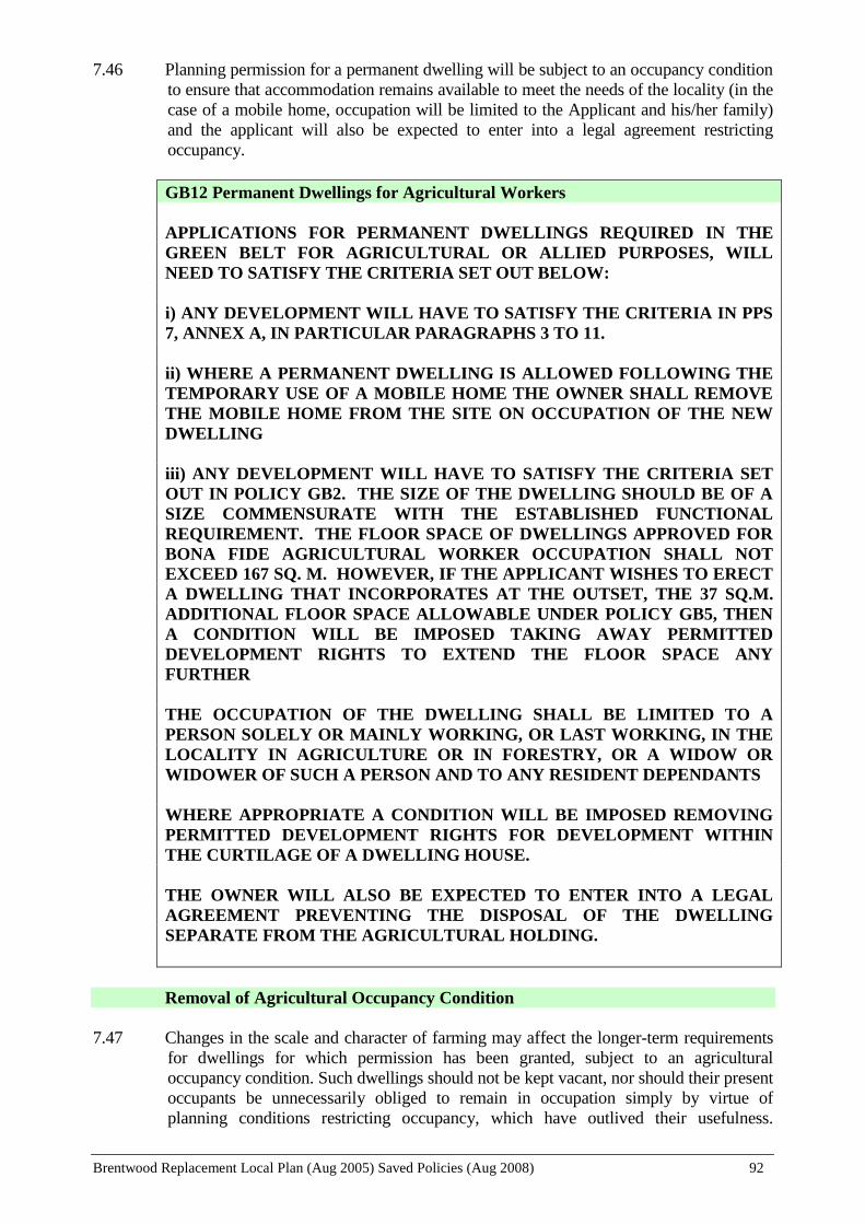
Brentwood Replacement Local Plan (Aug 2005) Saved Policies (Aug 2008) 92
7.46 Planning permission for a permanent dwelling will be subject to an occupancy condition
to ensure that accommodation remains available to meet the needs of the locality (in the
case of a mobile home, occupation will be limited to the Applicant and his/her family)
and the applicant will also be expected to enter into a legal agreement restricting
occupancy.
GB12 Permanent Dwellings for Agricultural Workers
APPLICATIONS FOR PERMANENT DWELLINGS REQUIRED IN THE
GREEN BELT FOR AGRICULTURAL OR ALLIED PURPOSES, WILL
NEED TO SATISFY THE CRITERIA SET OUT BELOW:
i) ANY DEVELOPMENT WILL HAVE TO SATISFY THE CRITERIA IN PPS
7, ANNEX A, IN PARTICULAR PARAGRAPHS 3 TO 11.
ii) WHERE A PERMANENT DWELLING IS ALLOWED FOLLOWING THE
TEMPORARY USE OF A MOBILE HOME THE OWNER SHALL REMOVE
THE MOBILE HOME FROM THE SITE ON OCCUPATION OF THE NEW
DWELLING
iii) ANY DEVELOPMENT WILL HAVE TO SATISFY THE CRITERIA SET
OUT IN POLICY GB2. THE SIZE OF THE DWELLING SHOULD BE OF A
SIZE COMMENSURATE WITH THE ESTABLISHED FUNCTIONAL
REQUIREMENT. THE FLOOR SPACE OF DWELLINGS APPROVED FOR
BONA FIDE AGRICULTURAL WORKER OCCUPATION SHALL NOT
EXCEED 167 SQ. M. HOWEVER, IF THE APPLICANT WISHES TO ERECT
A DWELLING THAT INCORPORATES AT THE OUTSET, THE 37 SQ.M.
ADDITIONAL FLOOR SPACE ALLOWABLE UNDER POLICY GB5, THEN
A CONDITION WILL BE IMPOSED TAKING AWAY PERMITTED
DEVELOPMENT RIGHTS TO EXTEND THE FLOOR SPACE ANY
FURTHER
THE OCCUPATION OF THE DWELLING SHALL BE LIMITED TO A
PERSON SOLELY OR MAINLY WORKING, OR LAST WORKING, IN THE
LOCALITY IN AGRICULTURE OR IN FORESTRY, OR A WIDOW OR
WIDOWER OF SUCH A PERSON AND TO ANY RESIDENT DEPENDANTS
WHERE APPROPRIATE A CONDITION WILL BE IMPOSED REMOVING
PERMITTED DEVELOPMENT RIGHTS FOR DEVELOPMENT WITHIN
THE CURTILAGE OF A DWELLING HOUSE.
THE OWNER WILL ALSO BE EXPECTED TO ENTER INTO A LEGAL
AGREEMENT PREVENTING THE DISPOSAL OF THE DWELLING
SEPARATE FROM THE AGRICULTURAL HOLDING.
Removal of Agricultural Occupancy Condition
7.47 Changes in the scale and character of farming may affect the longer-term requirements
for dwellings for which permission has been granted, subject to an agricultural
occupancy condition. Such dwellings should not be kept vacant, nor should their present
occupants be unnecessarily obliged to remain in occupation simply by virtue of
planning conditions restricting occupancy, which have outlived their usefulness.

Brentwood Replacement Local Plan (Aug 2005) Saved Policies (Aug 2008) 93
Paragraph 17 of Annex to PPS7 “Sustainable Development in Rural Areas” (August
2004) requires local planning authorities to set out in Local Plans their policy approach
to the retention or removal of agricultural occupancy conditions. Such a policy should
be based on an up-to-date assessment of the demand for farm dwellings in the area,
bearing in mind that it is the need for a dwelling for someone solely, mainly or last
working in agriculture in an area as a whole, and not just on a particular holding, that is
relevant in the case of farm workers’ dwellings. A policy satisfying these requirements
is set out below.
GB13 Removal of Agricultural Occupancy Condition
PERMISSION WILL ONLY BE GIVEN FOR THE REMOVAL OF A
CONDITION LIMITING OCCUPATION OF A DWELLING TO SOMEBODY
LOCALLY EMPLOYED IN AGRICULTURE WHERE IT IS PROVEN THAT
THERE IS NO LONGER A NEED FOR DWELLINGS FOR AGRICULTURAL
WORKERS ON THAT FARM OR IN THE LOCALITY, AND WHERE BOTH
OF THE FOLLOWING CRITERIA ARE MET:
i) THE PROPERTY HAS BEEN ON THE MARKET, AT A PRICE THAT
REFLECTS ITS OCCUPANCY CONDITION, FOR A SUFFICIENT PERIOD
(NOT LESS THAN 18 MONTHS) TO ASCERTAIN DEMAND. AS PART OF
THE MARKETING, THE PROPERTY SHALL BE ADVERTISED IN LOCAL
NEWSPAPERS AND AT LEAST TWO NATIONAL AND REGIONAL
PERIODICALS THAT SPECIALISE, AMONG OTHER THINGS, IN
ADVERTISING FARM PROPERTY FOR SALE.
ii) THE PROPERTY HAS BEEN OFFERED TO ALL FARMERS AND
HORTICULTURALISTS HAVING HOLDINGS WITHIN AT LEAST A 3
KILOMETRE RADIUS FROM THE BOUNDARY OF THE HOLDING ON
WHICH THE DWELLING IS SITUATED
Agricultural Buildings
7.48 Modern farm buildings are designed for economy and utility and, as a result, are less
attractive than the older timber/brick barns. Farming has traditionally been given a
wide exemption from planning control. Permitted development rights conferred by the
General Permitted Development Order have made many agricultural buildings and
operations exempt from planning control. However, there are no permitted
development rights for new buildings on holdings of less than 5 hectares or, inter alia,
above a certain size. In addition, in certain circumstances, permitted development
rights for agricultural or forestry buildings on holdings above 5 hectares can not be
exercised without first allowing the local planning authority to determine whether their
prior approval is required for certain details i.e. siting, design and external appearance.
Where permission or prior approval is required, the Authority will ensure that the
siting, design and materials of the building do not result in it being obtrusive and are
appropriate to its setting. In addition, further landscaping may be needed to soften the
impact of the proposed development. Where planning permission is required, the
Authority will additionally need to be satisfied that a building of the size proposed is
justified having regard to the agricultural holding on which it is situated.

Brentwood Replacement Local Plan (Aug 2005) Saved Policies (Aug 2008) 94
GB14 Agricultural Buildings
THE DESIGN, EXTERNAL APPEARANCE AND COLOUR OF NEW
BUILDINGS FOR USE IN CONNECTION WITH AGRICULTURE SHALL BE
APPROPRIATE WITHIN THEIR SETTING. ALL NEW DEVELOPMENT
SHALL BE SITED SO AS TO HAVE THE MINIMUM IMPACT AND MUST
TAKE ACCOUNT OF THE PROVISIONS OF GB2.
RE-USE AND ADAPTATION OF RURAL BUILDINGS
7.49 Government advice on the re-use and adaptation of existing rural buildings, as set out in
PPG2 and PPS7, takes a positive attitude to the re-use of rural buildings for business
uses, identifying an important role in meeting the commercial and employment needs of
rural areas, providing for tourism, sport and recreation, whilst reducing the demands for
new buildings.
7.50 In line with the guidance set out in these documents, the conversion of a rural building
will be acceptable in principle subject to other considerations such as the attractiveness,
construction and permanence of the building, it not requiring extensions or additional
buildings, it not requiring alterations detrimental to its character or appearance, and it
not having an adverse effect on its surroundings. However, particular care will be taken
in considering applications for the conversion of buildings erected under agricultural
permitted development rights and permission will not be granted for the change of use
of any such building within ten years of its substantial completion.
Small-Scale Employment, Tourism, Leisure and Community Uses
7.51 There are fewer opportunities for employment in rural areas and the conversion of
rural buildings can provide new job opportunities and boost the rural economy.
Furthermore, there is a lack of small commercial premises in the Borough as a whole
and the conversion of these buildings can offer an opportunity to provide for these
needs. Small-scale tourism and leisure facilities can also provide additional
opportunities for agricultural diversification. The Council will allow, therefore, the
conversion of rural buildings in the Green Belt to small-scale commercial enterprise,
tourism, leisure and community uses but subject to strict criteria.
7.52 When consideration is given to allowing exceptions to the general presumption against
development in the Green Belt care must be taken to protect local amenities and the
natural environment. It is, therefore, essential to have information on traffic
generation and precise details of the proposed use in order for an application to be
properly considered. Where appropriate, permissions initially may only be given for a
limited period to allow for the impact of the new use to be assessed.
7.53 The conversion of a rural building to accommodate some alternative use may
significantly affect the character of the building. It is important to ensure that the
building retains its rural character and remains an attractive feature in its rural setting
after it is converted. Where appropriate, a condition will be attached to a permission
removing permitted development rights allowing, for example, new buildings and
structures (including walls and fences) to be erected. (For consideration of retailing and
farm shops see Policy GB19).
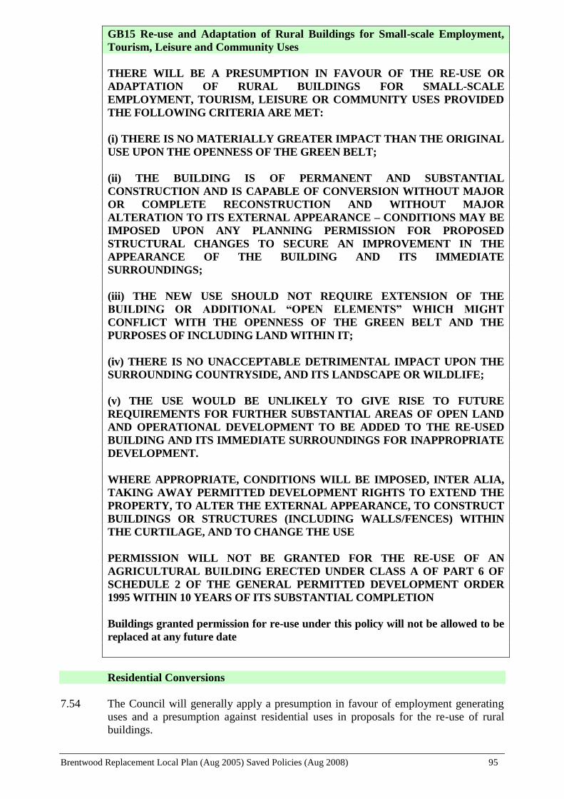
Brentwood Replacement Local Plan (Aug 2005) Saved Policies (Aug 2008) 95
GB15 Re-use and Adaptation of Rural Buildings for Small-scale Employment,
Tourism, Leisure and Community Uses
THERE WILL BE A PRESUMPTION IN FAVOUR OF THE RE-USE OR
ADAPTATION OF RURAL BUILDINGS FOR SMALL-SCALE
EMPLOYMENT, TOURISM, LEISURE OR COMMUNITY USES PROVIDED
THE FOLLOWING CRITERIA ARE MET:
(i) THERE IS NO MATERIALLY GREATER IMPACT THAN THE ORIGINAL
USE UPON THE OPENNESS OF THE GREEN BELT;
(ii) THE BUILDING IS OF PERMANENT AND SUBSTANTIAL
CONSTRUCTION AND IS CAPABLE OF CONVERSION WITHOUT MAJOR
OR COMPLETE RECONSTRUCTION AND WITHOUT MAJOR
ALTERATION TO ITS EXTERNAL APPEARANCE – CONDITIONS MAY BE
IMPOSED UPON ANY PLANNING PERMISSION FOR PROPOSED
STRUCTURAL CHANGES TO SECURE AN IMPROVEMENT IN THE
APPEARANCE OF THE BUILDING AND ITS IMMEDIATE
SURROUNDINGS;
(iii) THE NEW USE SHOULD NOT REQUIRE EXTENSION OF THE
BUILDING OR ADDITIONAL “OPEN ELEMENTS” WHICH MIGHT
CONFLICT WITH THE OPENNESS OF THE GREEN BELT AND THE
PURPOSES OF INCLUDING LAND WITHIN IT;
(iv) THERE IS NO UNACCEPTABLE DETRIMENTAL IMPACT UPON THE
SURROUNDING COUNTRYSIDE, AND ITS LANDSCAPE OR WILDLIFE;
(v) THE USE WOULD BE UNLIKELY TO GIVE RISE TO FUTURE
REQUIREMENTS FOR FURTHER SUBSTANTIAL AREAS OF OPEN LAND
AND OPERATIONAL DEVELOPMENT TO BE ADDED TO THE RE-USED
BUILDING AND ITS IMMEDIATE SURROUNDINGS FOR INAPPROPRIATE
DEVELOPMENT.
WHERE APPROPRIATE, CONDITIONS WILL BE IMPOSED, INTER ALIA,
TAKING AWAY PERMITTED DEVELOPMENT RIGHTS TO EXTEND THE
PROPERTY, TO ALTER THE EXTERNAL APPEARANCE, TO CONSTRUCT
BUILDINGS OR STRUCTURES (INCLUDING WALLS/FENCES) WITHIN
THE CURTILAGE, AND TO CHANGE THE USE
PERMISSION WILL NOT BE GRANTED FOR THE RE-USE OF AN
AGRICULTURAL BUILDING ERECTED UNDER CLASS A OF PART 6 OF
SCHEDULE 2 OF THE GENERAL PERMITTED DEVELOPMENT ORDER
1995 WITHIN 10 YEARS OF ITS SUBSTANTIAL COMPLETION
Buildings granted permission for re-use under this policy will not be allowed to be
replaced at any future date
Residential Conversions
7.54 The Council will generally apply a presumption in favour of employment generating
uses and a presumption against residential uses in proposals for the re-use of rural
buildings.

Brentwood Replacement Local Plan (Aug 2005) Saved Policies (Aug 2008) 96
7.55 The Borough's location on the fringe of London has resulted in a more intensive
scattering of rural buildings than other areas due to the fragmented size of farm holdings
and the variety of uses attracted to the edge of the Metropolitan Area. The main
settlements are also more closely spaced, resulting in the Green Belt areas between
settlements being more sensitive to development. Residential re-use is, therefore, a
matter of some concern due to the large number of potential properties involved and the
impact that could result on the rural character of the Green Belt.
7.56 Furthermore, in order to provide adequate habitable standards, a residential conversion
requires significantly greater alteration to the existing building than does a commercial
use. Residential conversions, therefore, can often have a detrimental effect on the
fabric and character of a rural building. The introduction of features such as new
windows and door openings and the need to meet building regulation requirements can
lead to changes unsympathetic to the character of the building. It is considered that
rarely can a rural building be converted to residential use without the character of the
site changing
7.57 For the foregoing reasons, a residential conversion will only be permitted where every
reasonable effort has been made to secure a suitable business use, or the residential
use is a subordinate part of a business re-use, or the use is required for an agricultural
or forestry worker.
7.58 Except in the case of agricultural or forestry worker accommodation, the re-use of
rural buildings, of no architectural or historic interest, for residential use will not be
permitted if those buildings occupy isolated sites in the Green Belt located away from
defined settlements.
7.59 Where a residential conversion is justified it will be essential to ensure that a
residentially converted rural building does not have the appearance of a new dwelling
and does not set a precedent for new residential development in the Green Belt. In
addition, the building must be capable of conversion without the creation of a residential
curtilage having a harmful effect on both the building and the surrounding countryside
due to the unacceptable intrusiveness of increased activity and various domestic
additions such as garaging, sheds, clothes lines, play equipment, walls and fences,
patios and hardstandings. Residential re-use, therefore, will be restricted to a building
within a group so as to enable the intrusiveness to be minimised by using, where
possible, the buildings to provide for such purposes or to screen such development.
7.60 A dwelling also enjoys substantial permitted development rights, in relation to both the
building and its curtilage. Where appropriate a condition will be attached to a planning
permission removing permitted development rights to extend, to alter the external
appearance of the premises and to construct buildings and structures within the curtilage
(including walls and fences).
GB16 Residential Conversions
THE CONVERSION OF RURAL BUILDINGS TO RESIDENTIAL USE WILL
ONLY BE PERMITTED WHERE THE PROPOSAL COMPLIES WITH ALL
THE APPROPRIATE CRITERIA OF POLICY GB15 AND ADDITIONALLY
ONLY WHERE THE FOLLOWING SPECIAL JUSTIFICATIONS APPLY:
i) THE APPLICANT IS ABLE TO DEMONSTRATE THAT EVERY
REASONABLE EFFORT HAS BEEN MADE TO SECURE A SUITABLE

Brentwood Replacement Local Plan (Aug 2005) Saved Policies (Aug 2008) 97
BUSINESS RE-USE; OR
ii) THE RESIDENTIAL USE IS A SUBORDINATE PART OF A SCHEME
FOR BUSINESS RE-USE; OR
iii) THE USE IS ESSENTIAL TO ENABLE A FARM OR FORESTRY
WORKER TO LIVE AT OR NEAR THEIR PLACE OF WORK;
IN THE CASE OF EITHER (i) OR (ii) ABOVE, THE FOLLOWING TWO
CRITERIA MUST ALSO BE MET:
a) THE BUILDING PROPOSED FOR CONVERSION MUST BE LOCATED
WITHIN OR DIRECTLY ADJOINING A SMALL GROUP OF BUILDINGS,
AND
b) THE BUILDING MUST BE CAPABLE OF CONVERSION WITHOUT
RESULTING IN UNACCEPTABLY INTRUSIVE DOMESTIC ELEMENTS
SUCH AS NEW CURTILAGES, GARAGING, SHEDS, WALLING/FENCES,
CLOTHES LINES, PLAY EQUIPMENT, DOMESTIC STORAGE AND
HARDSTANDINGS. FURTHERMORE, THE PROPOSED RE-USE SHOULD
NOT HAVE AN UNACCEPTABLE DETRIMENTAL IMPACT ON THE
FABRIC AND CHARACTER OF THE BUILDING DUE TO
UNSYMPATHETIC CHANGES TO, OR THE INTRODUCTION OF,
FEATURES SUCH AS WINDOWS, DOOR OPENINGS AND CHIMNEYS.
A Target and Indicator for monitoring this policy is set out in Chapter 13.
Conversion or Change of Use of Listed Buildings
7.61 It is accepted that where the preservation of a building of special historic or architectural
interest is essential, this may justify the relaxation of other planning policies. However,
the Local Planning Authority will need to be satisfied that any proposed change of use
will not give rise to an unduly increased level of activity within the Green Belt. It will
be expected, therefore, that possible conversion to uses generating a lower level of
activity will first be investigated before considering more intense uses for listed
buildings. For all applications involving changes of use, detailed plans will be required
in accordance with Policy C17.
7.62 In relation to the conversion of listed barns to dwellings, Essex County Council have
revised their supplementary planning guidance in the form of a document entitled
"Historic Barn Conversions - A Way Forward", which now emphasises the great
difficulties encountered when attempting such conversions and indeed presumes against
this type of development. In the process of conversion to residential use, the concerns
expressed in relation to residential conversions referred to above in Policy GB16 are all
the more critical i.e. new openings made into the walls and roofs to accommodate doors
and windows and unsuitable internal partitions. Suburbanisation in the form of fences,
drives and external lighting, for example, further detract from the setting of the original
listed barn as well as impacting on the Green Belt. Sensitive commercial conversions of
barns, however, can use the large open space to advantage and can achieve renovation
with relatively little alteration.
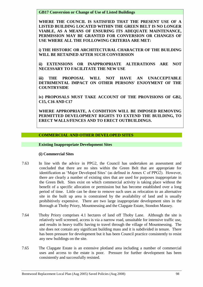
Brentwood Replacement Local Plan (Aug 2005) Saved Policies (Aug 2008) 98
GB17 Conversion or Change of Use of Listed Buildings
WHERE THE COUNCIL IS SATISFIED THAT THE PRESENT USE OF A
LISTED BUILDING LOCATED WITHIN THE GREEN BELT IS NO LONGER
VIABLE, AS A MEANS OF ENSURING ITS ADEQUATE MAINTENANCE,
PERMISSION MAY BE GRANTED FOR CONVERSION OR CHANGES OF
USE WHERE ALL THE FOLLOWING CRITERIA ARE MET:
i) THE HISTORIC OR ARCHITECTURAL CHARACTER OF THE BUILDING
WILL BE RETAINED AFTER SUCH CONVERSION
ii) EXTENSIONS OR INAPPROPRIATE ALTERATIONS ARE NOT
NECESSARY TO FACILITATE THE NEW USE
iii) THE PROPOSAL WILL NOT HAVE AN UNACCEPTABLE
DETRIMENTAL IMPACT ON OTHER PERSONS' ENJOYMENT OF THE
COUNTRYSIDE
iv) PROPOSALS MUST TAKE ACCOUNT OF THE PROVISIONS OF GB2,
C15, C16 AND C17
WHERE APPROPRIATE, A CONDITION WILL BE IMPOSED REMOVING
PERMITTED DEVELOPMENT RIGHTS TO EXTEND THE BUILDING, TO
ERECT WALLS/FENCES AND TO ERECT OUTBUILDINGS.
COMMERCIAL AND OTHER DEVELOPED SITES
Existing Inappropriate Development Sites
(i) Commercial Sites
7.63 In line with the advice in PPG2, the Council has undertaken an assessment and
concluded that there are no sites within the Green Belt that are appropriate for
identification as ‘Major Developed Sites’ (as defined in Annex C of PPG2). However,
there are clearly a number of existing sites that are used for purposes inappropriate in
the Green Belt. Sites exist on which commercial activity is taking place without the
benefit of a specific allocation or permission but has become established over a long
period of time. Little can be done to remove such uses as relocation to an alternative
site in the built up area is constrained by the availability of land and is usually
prohibitively expensive. There are two large inappropriate development sites in the
Borough at Thoby Priory, Mountnessing and the Clapgate Estate, Stondon Massey.
7.64 Thoby Priory comprises 4.1 hectares of land off Thoby Lane. Although the site is
relatively well screened, access is via a narrow road, unsuitable for intensive traffic use,
and results in heavy traffic having to travel through the village of Mountnessing. The
site does not contain any significant building mass and it is subdivided in tenure. There
has been pressure for development but it has been Council practice consistently to resist
any new buildings on the site.
7.65 The Clapgate Estate is an extensive plotland area including a number of commercial
uses and access to the estate is poor. Pressure for further development has been
consistently and successfully resisted.

Brentwood Replacement Local Plan (Aug 2005) Saved Policies (Aug 2008) 99
7.66 Any consolidation or extension of these sites would cause further problems and be
incompatible with the Council’s Green Belt Strategy.
7.67 Some commercial use sites provide small low cost premises for which a known demand
exists. In some cases businesses are being carried out in substandard accommodation
where the replacement of the existing buildings could be an improvement in Green Belt
terms. Expansion or intensification of commercial uses would, however, be
incompatible with Green Belt policy and will not be allowed, whilst the reasonable
replacement of existing buildings will be subject to exacting criteria. It is not intended,
however, that the policy allows for the redevelopment of an existing commercial site for
a completely new commercial use unrelated to the existing use, unless there are very
special circumstances, such as an improvement to the local environment. Neither is it
intended that this policy shall relate to rural buildings previously granted planning
permission for conversion to commercial use.
(ii) Institutional Sites
7.68 In addition to commercial sites, there are a number of existing institutions within the
Borough's Green Belt. PPG2 advice has deleted institutions from the list of appropriate
uses in the Green Belt (such uses include, inter alia, nursing homes or other similar
residential homes, hospitals and educational establishments). New institutional
development, therefore, is no longer acceptable in the Green Belt. Therefore, any
proposal for new institutional development, including extensions to an existing
institution will need to be justified by very special circumstances. Such circumstances
may arguably exist in the case of, for example, a school which is providing for a very
specific need in the immediate locality and which needs to cater for the demand for
school places or to make provision for improved facilities. In other instances, an
institution may be able to argue a requirement to provide additional "essential facilities"
to meet, for example, the needs for the disabled or works required to meet other specific
legislation. Where very special circumstances cannot be shown, extensions to existing
institutions will normally be refused.
7.69 Any development proposals for existing commercial sites, institutional sites or other
inappropriate development sites in the Green Belt will be considered against the criteria
set out in Policy GB18.
GB18 Existing Inappropriate Development Sites
THE EXPANSION OR INTENSIFICATION (INCLUDING EXTENSIONS) OF
EXISTING INAPPROPRIATE DEVELOPMENT WITHIN THE GREEN BELT
WILL BE REFUSED. HOWEVER, THE REASONABLE REPLACEMENT OF
EXISTING BUILDINGS MAY BE ALLOWED SUBJECT TO POLICY GB2
AND WHERE THE FOLLOWING CRITERIA ARE MET:
i) THE PROPOSAL WOULD NOT HAVE AN UNACCEPTABLE
DETRIMENTAL IMPACT ON PEOPLE’S ENJOYMENT OF THE
COUNTRYSIDE
ii) THE VISUAL MASS OF THE NEW BUILDING SHOULD BE NO GREATER
THAN THE MASS OF THE EXISTING BUILDINGS
iii) THE PROPOSAL WOULD NOT LEAD TO AN EXPANSION OR
INTENSIFICATION OF ACTIVITY ON THE SITE

Brentwood Replacement Local Plan (Aug 2005) Saved Policies (Aug 2008) 100
PROPOSALS FOR COMMERCIAL SITES MUST ALSO COMPLY WITH THE
CRITERIA IN POLICY E8.
N.B. This policy is not intended to relate to uses that have been created via the re-
use of rural buildings.
Farm Shops And Retailing
7.70 Demand for commercial outlets associated with agricultural/horticultural holdings is
high, particularly with the advent of agricultural diversification. When only produce
grown on the holding is being sold planning permission is not required. A very small
amount of other produce may also be sold without planning permission. However,
frequently farm shops not only retail produce grown on the holding but import
quantities of other produce to supplement their trade. The sale of produce not grown on
the holding will only be permitted where this supports the seasonality of “own grown”
produce. The sale of items from an existing farm business producing goods on the
premises may also be supported.
7.71 The Council recognises the support to a farm's income that a retail outlet can give but at
the same time would not want to see a proliferation of unrelated retail businesses in the
countryside or an undue increase in activity in the Green Belt. Council policy seeks to
protect and enhance the retail pattern in the Borough, including the safeguarding of
traditional village shops, in order to retain such rural services and in locations more
accessible to a choice of transport mode.
7.72 The construction of new buildings for the sale of farm produce will not be allowed.
Advertising associated with any farm shop will be controlled having regard to the
policies set out in the Conservation and Protection of the Environment Chapter. Due to
the sensitivity of advertising in the Green Belt, these policies will be strictly applied.
GB19 Farm Shops and Retailing
CHANGE OF USE OF EXISTING FARM BUILDINGS FOR THE SALE OF
FARM PRODUCE GROWN ON THE HOLDING OR PRODUCTS ARISING
FROM AN EXISTING FARM BUSINESS WILL BE SUPPORTED, SUBJECT
TO NO UNACCEPTABLE DETRIMENTAL IMPACT ON EXISTING
VILLAGE SHOPS, SALE OF PRODUCE NOT GROWN ON THE HOLDING
WILL ONLY BE PERMITTED WHERE THIS SUPPORTS THE
SEASONALITY OF PRODUCE GROWN ON THE HOLDING. PROPOSALS
INVOLVING THE CONSTRUCTION OF NEW BUILDINGS WILL NOT BE
ALLOWED.
Garden Centres
POLICY GB20 (GARDEN CENTRES) WAS NOT SAVED BEYOND 25 AUGUST 2008
AND THEREFORE NO LONGER FORMS PART OF THE LOCAL PLAN
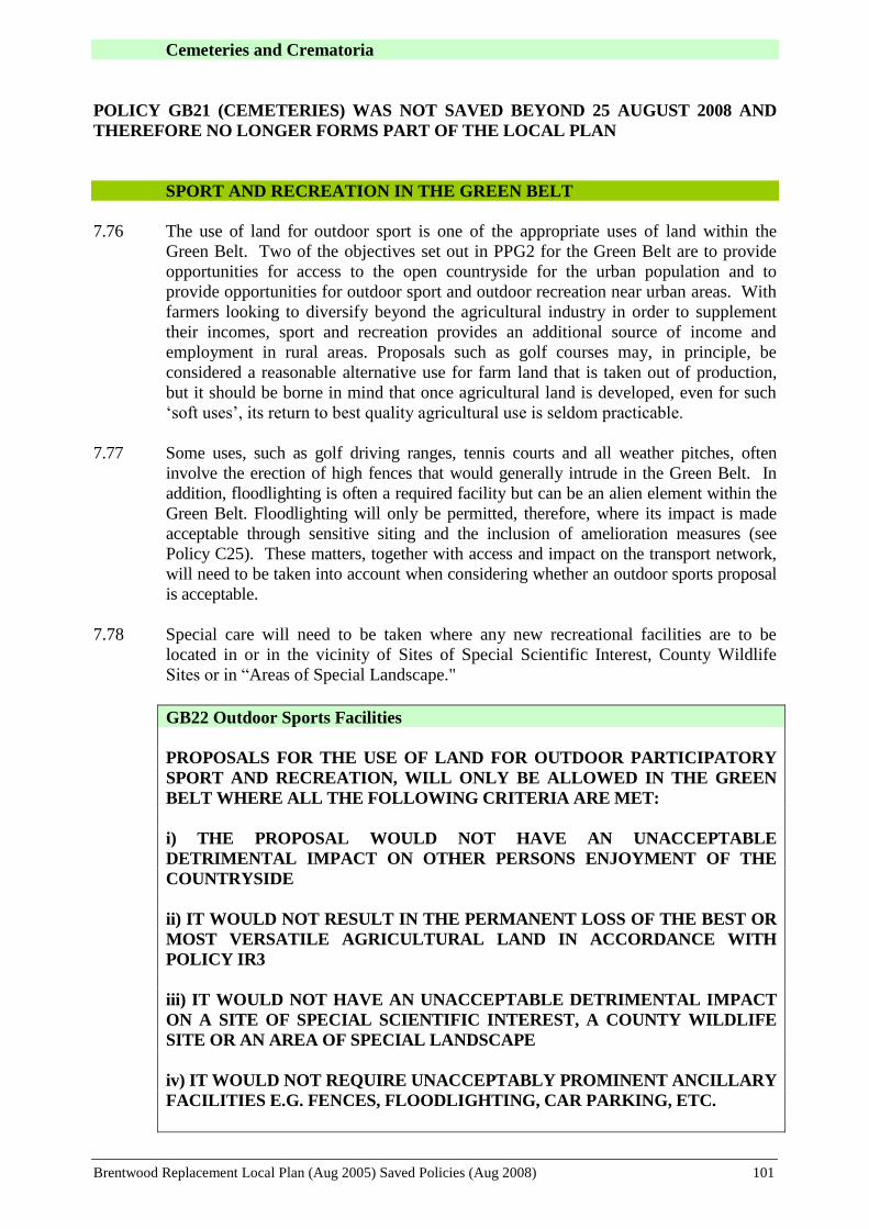
Brentwood Replacement Local Plan (Aug 2005) Saved Policies (Aug 2008) 101
Cemeteries and Crematoria
POLICY GB21 (CEMETERIES) WAS NOT SAVED BEYOND 25 AUGUST 2008 AND
THEREFORE NO LONGER FORMS PART OF THE LOCAL PLAN
SPORT AND RECREATION IN THE GREEN BELT
7.76 The use of land for outdoor sport is one of the appropriate uses of land within the
Green Belt. Two of the objectives set out in PPG2 for the Green Belt are to provide
opportunities for access to the open countryside for the urban population and to
provide opportunities for outdoor sport and outdoor recreation near urban areas. With
farmers looking to diversify beyond the agricultural industry in order to supplement
their incomes, sport and recreation provides an additional source of income and
employment in rural areas. Proposals such as golf courses may, in principle, be
considered a reasonable alternative use for farm land that is taken out of production,
but it should be borne in mind that once agricultural land is developed, even for such
‘soft uses’, its return to best quality agricultural use is seldom practicable.
7.77 Some uses, such as golf driving ranges, tennis courts and all weather pitches, often
involve the erection of high fences that would generally intrude in the Green Belt. In
addition, floodlighting is often a required facility but can be an alien element within the
Green Belt. Floodlighting will only be permitted, therefore, where its impact is made
acceptable through sensitive siting and the inclusion of amelioration measures (see
Policy C25). These matters, together with access and impact on the transport network,
will need to be taken into account when considering whether an outdoor sports proposal
is acceptable.
7.78 Special care will need to be taken where any new recreational facilities are to be
located in or in the vicinity of Sites of Special Scientific Interest, County Wildlife
Sites or in “Areas of Special Landscape."
GB22 Outdoor Sports Facilities
PROPOSALS FOR THE USE OF LAND FOR OUTDOOR PARTICIPATORY
SPORT AND RECREATION, WILL ONLY BE ALLOWED IN THE GREEN
BELT WHERE ALL THE FOLLOWING CRITERIA ARE MET:
i) THE PROPOSAL WOULD NOT HAVE AN UNACCEPTABLE
DETRIMENTAL IMPACT ON OTHER PERSONS ENJOYMENT OF THE
COUNTRYSIDE
ii) IT WOULD NOT RESULT IN THE PERMANENT LOSS OF THE BEST OR
MOST VERSATILE AGRICULTURAL LAND IN ACCORDANCE WITH
POLICY IR3
iii) IT WOULD NOT HAVE AN UNACCEPTABLE DETRIMENTAL IMPACT
ON A SITE OF SPECIAL SCIENTIFIC INTEREST, A COUNTY WILDLIFE
SITE OR AN AREA OF SPECIAL LANDSCAPE
iv) IT WOULD NOT REQUIRE UNACCEPTABLY PROMINENT ANCILLARY
FACILITIES E.G. FENCES, FLOODLIGHTING, CAR PARKING, ETC.

Brentwood Replacement Local Plan (Aug 2005) Saved Policies (Aug 2008) 102
APPLICATIONS WILL BE CONSIDERED AGAINST THE CRITERIA SET
OUT IN POLICY GB2
Ancillary Buildings
7.79 PPG2 allows the construction of new buildings for essential facilities for outdoor sport
and recreation and other uses which preserve the openness of the Green Belt and which
do not conflict with the purposes of including land within it. Whilst small changing
rooms, toilets, first aid facilities, etc., will often need to be provided, other non-essential
facilities will be refused. Any social facilities provided should be solely for those
participating in the recreational activities taking place on the site. The scale of the
proposed buildings will be considered in relation to environmental factors such as the
physical characteristics of the landscape, impact on the transport network, etc.
GB23 Ancillary Buildings
PROPOSALS FOR SMALL SCALE BUILDINGS AND FACILITIES
REQUIRED FOR OUTDOOR PARTICIPATORY SPORT AND RECREATION
WILL ONLY BE ALLOWED WHERE THERE IS A JUSTIFIABLE NEED FOR
SUCH BUILDINGS AND FACILITIES. ANY SOCIAL FACILITIES
INCIDENTAL TO THE PRIMARY USE OF THE SITE WILL BE
RESTRICTED IN SIZE AND WILL BE SOLELY FOR USE OF PERSONS
PARTICIPATING IN THE RECREATIONAL ACTIVITY ON THE SITE AND,
SHALL BE PERMANENTLY RETAINED AS SUCH. WHERE ANY
PROPOSAL IS ACCEPTABLE IN PRINCIPLE THE APPLICATION WILL BE
JUDGED AGAINST THE REQUIREMENTS SET OUT IN GB2.
Golf Courses
POLICY GB24 (GOLF COURSES) WAS NOT SAVED BEYOND 25 AUGUST 2008 AND
THEREFORE NO LONGER FORMS PART OF THE LOCAL PLAN
Riding Schools and Livery Stables
7.82 A problem frequently associated with the urban fringe is the growing demand for horse
keeping facilities. An advantage of this type of activity on farmland is that natural
features, hedgerows and trees are not “grubbed out” in order to promote greater
efficiency, thus a natural habitat survives and variety in the landscape is retained.
However, the paraphernalia that goes with riding schools, and conglomeration of
unneighbourly buildings and uses makes the siting of such establishments particularly
sensitive. Traffic generation associated with such uses also needs to be the subject of
careful consideration. The attraction of horseboxes, etc, to such sites is inevitable, and
these vehicles tend to dominate the landscape and create damage to verges, detracting
from the character of the Green Belt. The most satisfactory proposals are likely to be
those that are focused on groups of existing buildings, such as a former farm complex.
In considering the siting of such facilities regard will also need to be given to the
potential safety problems both to the horse and rider and other road users arising from
the possible necessity of exercising horses on narrow, winding rural lanes. In this
respect, proximity to the bridleway system would be advantageous and the creation of
new bridleways will be encouraged.
Brentwood Replacement Local Plan (Aug 2005) Saved Policies (Aug 2008) 103
7.83 Permission will not be granted for a new dwelling as part of any proposal.
Consideration may be given to the provision of overnight accommodation where this
can be justified.
GB25 Riding Schools and Livery Stables
DEVELOPMENT REQUIRED IN CONNECTION WITH RIDING SCHOOLS
AND LIVERY STABLES WILL ONLY BE PERMITTED WHERE ALL THE
FOLLOWING CRITERIA ARE MET:
i) ANY BUILDINGS REQUIRED SHOULD GENERALLY BE PROVIDED BY
THE RE-USE OF EXISTING BUILDINGS. ANY ADDITIONAL BUILDINGS
SHOULD BE SMALL IN SCALE
ii) THE PROPOSAL WILL NOT HAVE AN UNACCEPTABLE
DETRIMENTAL IMPACT ON OTHER PERSONS' ENJOYMENT OF THE
COUNTRYSIDE
iii) IT WOULD NOT RESULT IN THE PERMANENT LOSS OF THE BEST
OR MOST VERSATILE AGRICULTURAL LAND IN ACCORDANCE WITH
POLICY IR5
iv) PROPOSALS MUST TAKE ACCOUNT OF THE PROVISIONS OF GB2
v) THE DEVELOPMENT MUST NOT GIVE RISE TO ADVERSE HIGHWAY
SAFETY CONDITIONS INVOLVING HORSE TRAFFIC AND IN THIS
RESPECT CONSIDERATION WILL BE GIVEN TO THE PROXIMITY OF
THE PROPOSAL TO THE BRIDLEWAY NETWORK AND/OR THE
PROVISION OF NEW BRIDLEWAY LINKS.
PERMISSION WILL NOT BE GRANTED FOR A NEW DWELLING AS
PART OF ANY PROPOSAL.
Other Stables
7.84 There are frequent demands for the provision of private (i.e. non-livery) stables, usually
associated with an existing dwelling. Whilst the erection of such stables within or
immediately adjoining domestic curtilages is often acceptable, their siting in locations
unrelated to a residential curtilage gives rise to the proliferation of building activity in
the Green Belt.
GB26 Other Stables
OTHER THAN THOSE REFERRED TO IN POLICY GB25, PLANNING
PERMISSION WILL NOT BE GRANTED FOR THE ERECTION OF NEW
STABLES UNLESS SITED WITHIN OR, EXCEPTIONALLY, IMMEDIATELY
ADJOINING THE CURTILAGE OF A DWELLING.
Access To The Countryside
7.85 Brentwood is a Borough with most of its population concentrated in one urban area
Brentwood Replacement Local Plan (Aug 2005) Saved Policies (Aug 2008) 104
and several minor settlements surrounded by a substantial rural area maintained its
Green Belt designation. This is served by an extensive network of footways,
bridleways, byways and minor local roads providing access to, and informal
enjoyment of, the countryside. This proximity of the countryside to town dwellers also
provides an opportunity by recognising the importance of this relationship to those
who live or work there, and also in providing the nearest and most accessible
countryside to urban residents. Paragraph 26 of PPS7, “Sustainable Development in
Rural Areas” (August 2004) requires Local Plans to address the particular land use
issues and opportunities to be found in the countryside around all urban areas.
Planning authorities should aim to secure environmental improvements and maximise
a range of beneficial uses of this land, whilst reducing potential conflicts between
neighbouring land uses. This should include improvement of public access (e.g.
through support for the country parks and community forests) and facilitating the
provision of appropriate sport and recreation facilities.
7.86 The Council will undertake to safeguard the existence and the amenity of these rights of
way. Development proposals likely to have a detrimental effect on a footpath,
bridleway or byway will not be permitted. Before accepting diversions of any rights of
way, the Council will consider whether the intended diversion provides a suitable
alternative in terms of amenity and interest value and that it would not have an adverse
effect on the right of way network as a whole. Many footpaths have become overgrown
through under use. The Brentwood Countryside Management Service works to improve
the standard of these rights of way including the maintenance of stiles and bridges,
waymarking and clearance of vegetation. Furthermore, where a right of way has been
ploughed up or obstructed the appropriate action will be taken against the offenders, and
the right of way reinstated.
7.87 The local authority can also assist landowners in maintaining and improving their land
in the Green Belt by working together with them through the Brentwood Countryside
Management Service, with voluntary organisations and with the statutory bodies such as
the Countryside Agency and the Forestry Commission. The aim should be to enhance
especially those areas of land within the Green Belt that are suffering from disuse or
neglect, while possibly improving access to these areas by voluntary agreement. This is
particularly important in areas that are close to existing urban development, which can
be especially vulnerable to neglect or damage. Access to the countryside is also a core
objective of the Thames Chase Community Forest and the Council will continue to
work with and support the project team to improve access to the countryside within the
Forest area.
GB27 Access to the Countryside
THE COUNCIL WILL SAFEGUARD THE EXISTENCE AND AMENITY OF
RIGHTS OF WAY INCLUDING FOOTPATHS, BRIDLEWAYS, BYWAYS
AND MINOR RURAL ROADS AND WILL, THROUGH ITS COUNTRYSIDE
MANAGEMENT SERVICE AND ENCOURAGEMENT OF LOCAL LAND
OWNERS, SEEK TO IMPROVE ACCESS TO THE COUNTRYSIDE
THROUGH ESTABLISHMENT AND MAINTENANCE OF FOOTPATHS
AND BRIDLEWAYS AND THROUGH VOLUNTARY AGREEMENTS TO
MANAGE GREEN BELT LAND ON OR NEAR THE RURAL-URBAN
FRINGE.
See also Policies T15, LT13 and LT14
Brentwood Replacement Local Plan (Aug 2005) Saved Policies (Aug 2008) 105
A Target and Indicator for monitoring this policy is set out in Chapter 13.
Landscape Enhancement
POLICY GB28 (LANDSCAPE ENHANCEMENT) WAS NOT SAVED BEYOND 25
AUGUST 2008 AND THEREFORE NO LONGER FORMS PART OF THE LOCAL PLAN

Brentwood Replacement Local Plan (Aug 2005) Saved Policies (Aug 2008) 106
SPORT & LEISURE, TOURISM AND
COMMUNITY SERVICES

Brentwood Replacement Local Plan (Aug 2005) Saved Policies (Aug 2008) 107
8. SPORT & LEISURE, TOURISM AND COMMUNITY SERVICES
POLICY BACKGROUND
National Planning Guidance
8.1 Government guidance on sport and recreation is set out in PPG17 “Planning for Open
Space, Sport and Recreation” (July 2002). PPG17 sets out the Government’s main
objectives for sport and recreation as promoting sustainable patterns of development,
promoting social inclusion, health and well being, and supporting an urban renaissance
and a rural renewal. It significantly extends the scope of the previous guidance in regard
to open space. The guidance emphasises the importance of sport and recreational
facilities, advising planning authorities to adopt a strategic approach to the provision and
enhancement of facilities, based on a proper understanding of local needs and existing
provision.
8.2 The government wishes to see a strong protection of existing open space; accessible
sport and recreation facilities by a choice of modes; and the provision of good quality
facilities as an integral part of new communities.
8.3 Government guidance on tourism is set out in PPG21 “Tourism” (November 1992).
The guidance sets out the issues that development plans should consider. Tourism is a
major contributor to the national economy, both in urban and rural areas. Planning
policies should consider ways in which the economic and potential regeneration benefits
of tourism can be developed whilst dealing with the implications for the transport
system, the impact on the environment and the need to protect key tourism assets,
including characteristic landscapes, sites of biodiversity value, historic buildings and
townscapes etc.
Replacement Structure Plan
8.4 Policies in the RSP seek the retention of existing open space and preclude its
displacement into the adjacent countryside. Sports grounds and playing fields are to be
protected and joint use of local authority owned premises encouraged.
8.5 Policies also state that sites for sports and leisure centres should be located within or
adjoining urban areas identified in local plans; support the provision of outdoor
recreational facilities, landscape improvements and access within Thames Chase
(subject to Green Belt policies); advise on the location of large scale or intensively used
formal countryside recreation facilities; and advise that local plans should provide for
the creation of new or extended country parks and the safeguarding of existing informal
outdoor countryside recreation areas and the rights of way network.
8.6 Policies in the RSP direct large scale tourism development to within or adjoining the
main urban areas or seaside resort towns, and only elsewhere if open in character, but in
all cases subject to a number of criteria aimed at justifying the location in terms of need
and taking due account of the considerations set out above in PPG advice.
8.7 The RSP also advises on the provision of tourist accommodation, again directing new
accommodation to existing settlements and emphasising the need to have regard to
green belt policies and environmental and other designations outside the development
boundaries of settlements.

Brentwood Replacement Local Plan (Aug 2005) Saved Policies (Aug 2008) 108
Brentwood Community Plan
8.8 The Community Plan’s strategic objectives that are relevant to the Replacement Local
Plan’s Sport & Leisure, Tourism and Community Services Policies are set out under
the headings “Leisure and Culture”, “Sustainable development and the Local
Environment” and “Health and Welfare”, and include:
“To improve the availability of high quality and accessible leisure, recreational and
cultural opportunities by:
Ensuring that sport and leisure activities and facilities are accessible to everyone,
including people who are frail, elderly and those with disabilities.
Developing a wide and varied range of leisure activities and facilities in order to
provide the community with the opportunity to enjoy their leisure time”
“To seek to make provision for appropriate housing, employment and other
development to meet the needs of the Borough, whilst conserving and maximising
resources and enhancing the character and environmental quality of the Borough for
the benefit of current and future generations, by:
Preserving the environment and the amenity of the Borough through the
appropriate maintenance of parks, trees, verges and open spaces”
“To ensure that the people of the Borough have a healthy life and general environment
by:
Removing or controlling those adverse factors affecting the health and welfare of
local people in both the living and working environments, by educating, advising
and enforcing statutory duties and discretionary powers
Seeking to ensure that the fullest range of health services are available to meet the
needs of Brentwood’s residents”
Working in partnership with other organisations and agencies to promote and
improve health and social care in the borough, and to assist where possible the
needs of the frail, the elderly and people with disabilities.”
THE AIM AND OBJECTIVES OF THE PLAN’S SPORT & LEISURE.
TOURISM AND COMMUNITY SERVICES POLICIES
Overall Aim
To develop social, cultural, educational, health and recreational facilities in the
Borough
Supporting Objectives
To maintain and improve the range, quantity and quality of social, cultural,
educational, health and recreational facilities
To increase the Borough’s attraction to visitors whilst conserving and enhancing
the Borough’s natural and built heritage
Brentwood Replacement Local Plan (Aug 2005) Saved Policies (Aug 2008) 109
To protect and enhance public and private open space and other land of
recreational, conservation, wildlife, historical or amenity value
To facilitate the provision of a range of overnight accommodation within the
Borough
To encourage the joint use of educational buildings and sports facilities
To assist the Health Authorities, County Social Services and other relevant
Agencies in the provision of a desirable distribution and quality of health and
welfare facilities to meet the needs of the local population
To ensure that the accessibility needs of persons experiencing mobility difficulties
are met whether living, working, shopping or undertaking leisure or social
activities in the Borough
SPORT, LEISURE AND COMMUNITY FACILITIES
Introduction
8.9 The Council recognises the importance and value of sport and recreation and leisure
pursuits to the health and well-being of people and the contribution that open spaces can
make to the attractiveness of urban areas and their settings. Sports facilities and open
spaces can also contribute to achieving sustainable patterns of development, and
through the provision of a range of facilities in accessible locations can promote social
inclusion. However, land use planning is invariably concerned with seeking a balance
between the demands on land for a wide range of uses and interests. In the countryside
the demand for sport and recreation may need to be reconciled with the needs of
agriculture, nature conservation and the amenity of those living within the rural area. In
urban areas high land values and pressure for housing and commercial development
mitigate against open space and recreational uses. It is, therefore, particularly important
to safeguard existing open space and recreational facilities from such development and
provide additional facilities whenever the opportunity arises.
8.10 Brentwood as a whole is generally well provided with formal and informal recreational
and leisure facilities and open space. Being set entirely within the Metropolitan Green
Belt has the benefit of access, via the rights of way network, to extensive open areas for
informal recreation. In addition, the Borough has two extensive Country Parks in South
Weald and Thorndon, providing some 324 hectares of informal open space, together
with other publicly accessible playing fields, parks, and woodlands. The main public
indoor sports and recreation facilities are the Brentwood Centre, which caters for an
extensive range of recreational activities as well as providing a popular venue for major
cultural events such as concerts or sporting competitions, and the Shenfield Sports
Centre, a joint use school facility. There are also a number of privately run sport and
leisure facilities, such as the Clearview Tennis Centre, the Warley Leisure Park, and
many golf courses.
8.11 Smaller scale local facilities provide for multiple uses, catering for not only recreation
and leisure but also providing for other local community use such as play groups, local
clubs, social activities and public meeting space.
8.12 Facilities in the Borough are not only used by the local population but also by people
from surrounding districts and parts of London due to its accessibility by road and rail.

Brentwood Replacement Local Plan (Aug 2005) Saved Policies (Aug 2008) 110
Brentwood's location in relation to the motorway network, Central London, Stansted
Airport, City Airport and the east and south coast ports also make it attractive to
visitors, both in terms of tourism and business trips. It is very likely that such visitors
will also make use of the local sport and leisure facilities as well as other attractions
within and outside the Borough.
8.13 In setting out policies to retain and enhance the provision of sport, recreation, leisure,
community and tourism facilities in the Borough, regard will continue to be given to
other corporate plans and programmes such as the Community Strategy, the
Recreation and Cultural Strategy and the LA21 Strategy.
OPEN SPACE
8.14 Public open space can be broadly divided into two categories: informal open space and
formal open space. Informal open spaces are those sites where maintenance is
minimal and as a result have a natural or “wild” appearance. Formal open spaces are
those sites that have a high degree of maintenance and as a result have a “manicured”
appearance.
Strategic Public Open Space
8.15 The recent revision of PPG17 (July 2002) identifies the ability for informal open space
to perform multiple functions, one of which is a “strategic function”, defining and
separating urban areas; better linking town and country; and providing for recreational
needs over a wide area.
8.16 Within the wedges of open land referred to in paragraph 7.12 the Council has been able
to acquire significant areas of public open space to add to that previously held, thus
providing large areas of strategic public open space abutting the edge of the built up area
of the town.. These areas will be managed and improved to provide for greater public
access and further opportunities for informal recreation for the general benefit of
residents of the town and surrounding areas. As opportunities arise and funds are made
available, the quality of existing provision will be enhanced and additional open space
provided.
LT1 Strategic Public Open Space
AREAS OF STRATEGIC PUBLIC OPEN SPACE AT THE FORMER
WARLEY AND ST. FAITHS HOSPITAL SITES, MERRYMEADE PARK AND
HUTTON COUNTRY PARK SHALL BE MANAGED AND IMPROVED TO
PROVIDE FOR GREATER PUBLIC ACCESS AND FURTHER
OPPORTUNITIES FOR INFORMAL RECREATION
Development of Existing Open Spaces
8.17 Open spaces provide sports pitches and other formal sports facilities for active recreation
and opportunities for informal or passive recreation. In these respects they serve wide
catchment areas that may extend beyond the Borough’s boundaries. They also provide
local residents, particularly young children, with nearby recreation opportunities.
However, in addition to their recreation value, open space (both public and private
sites) also has value for amenity, pollution attenuation, moderation of the urban
microclimate, and supporting biodiversity. These contribute towards human well-
being and have positive economic effects.
Brentwood Replacement Local Plan (Aug 2005) Saved Policies (Aug 2008) 111
8.18 Open spaces, therefore, add considerably to the landscape character, visual amenity and
biodiversity value of the urban landscape. Together with the protection of other natural
features and landscaping within the urban area (see also Policies C3 and C5), the
retention of such areas will help to safeguard the well landscaped character of the town
as well as continuing to provide for the recreational needs of residents and encourage
ecological variety.
8.19 Development of existing urban open spaces will, therefore, not be permitted, although
proposals for buildings on existing open space related to the main open use of the land,
which do not involve major ground coverage, may be considered favourably.
LT2 Development of Existing Urban Open Spaces
WITHIN THE BUILT-UP AREAS OF THE BRENTWOOD BOROUGH,
PERMISSION WILL NOT BE GRANTED FOR DEVELOPMENT OF LAND
ALLOCATED ON THE PROPOSALS MAP AS PROTECTED URBAN OPEN
SPACE OR OTHER PREVIOUSLY UNDEVELOPED LAND.
A Target and Indicator for monitoring this policy is set out in Chapter 13.
Areas Deficient in Open Space
(1) Informal Open Space
8.20 In 1996 English Nature adopted the following standards for the provision of
Accessible Natural Greenspace: -
No person should live more than 300m from their nearest area of natural
greenspace with this normally being greater than 0.25 ha;
Provision should be made for at least 2 ha of Local Nature Reserves per 1000
population;
There should be at least one accessible 20 ha site within 2km from home;
There should be one accessible 100 ha site within 5km;
There should be one accessible 500 ha site within 10km.
8.21 As referred to earlier, within the Borough of Brentwood there is a good level of
provision of larger sites close to the edge of the urban centre. As well as established
sites such as Thorndon and Weald Country Parks (which are in excess of 100 ha.) and
Hartswood there are the new countryside sites such as Hutton Country Park Local
Nature Reserve, most of which are over 20ha. The Borough also contains a number of
small urban sites, primarily remnant ancient woodland. Further informal recreation
facilities are also expected to be provided through the continuing development of the
Thames Chase Community Forest, which covers a substantial part of the southern half
of the Borough (see Policy C11).
8.22 The clearest area of deficit in the Borough is the shortfall in Local Nature Reserve
(LNR) provision. The first site to be designated is Hutton Country Park LNR in 2001,
which has an area of 35 ha. To meet the recommended target approximately 100 ha.
of suitable sites need to be designated (this issue is discussed in Paras. 9.15 & 9.16 and
Policy C2).
8.23 Although there is good overall provision of larger sites on the urban fringes
Brentwood Replacement Local Plan (Aug 2005) Saved Policies (Aug 2008) 112
consideration will be given to providing additional areas within the urban area. These
should ideally be of at least 0.25 ha, and can comprise of a range of habitats, for
example, woodland, natural grassland or ponds.
(2) Formal Open Space
8.24 It has been a long standing recommendation of the National Playing Fields
Association (NPFA) that the minimum standard for outdoor playing space is 2.43
hectares per 1000 population (referred to as the "NPFA 6 acre standard"). Such space
is defined as “being safely accessible and available to the general public, and of a
suitable size and nature, for sport, active recreation or children’s play” e.g. pitches,
tracks, courts, playgrounds, etc. This definition does not include open space for
informal recreation, ornamental gardens, commons, woodlands, golf courses, etc. The
standard has recently been the subject of a review by the NPFA and considered to
continue to be relevant7. The standard is divided into two sub categories
Outdoor Sport – 1.6 ha. (including 1.2 ha. for pitch sports)
Children’s Playing Space – 0.8 ha.
8.25 At present, there is no comprehensive assessment of existing outdoor playing space in
the Borough to compare against the NPFA standards. It is intended that further work
be undertaken to assess current provision, but available information would indicate
that there is an under-provision and an uneven distribution over the Borough.
However, the NPFA recognises that the standard is not necessarily achievable in all
areas, but it can be used as a target for local provision and should be met in all new
developments.
8.26 Provision of formal open space, in general, is largely concentrated in the Pilgrims
Hatch, Warley, Hutton North and Ingatestone and Fryerning areas, with under
provision in central Brentwood and central and east Hutton areas.
8.27 Children’s Playing Space is sub-divided further in the NPFA standards into Local
Area for Play (LAP), Local Equipped Area for Play (LEAP) and Neighbourhood
Equipped Area for Play (NEAP), as set out in Table 8.1.
8.28 There is under provision across all three sub-categories in the Borough. In relation to
LAPs, in an area such as Brentwood, where minimum private garden areas are often
100 sq. m, it is considered that this form of provision may be suitably provided in this
manner. Small public play areas can, in reality, be a source of nuisance to adjoining
residents and be unpopular. However, the provision of further LAPs may be
appropriate in higher density flat and terraced areas (including, potentially, through
more innovative means such as “Home Zones”).
7 The Six Acre Standard: Minimum Standards for Outdoor Playing Spaces. NPFA 2001

Brentwood Replacement Local Plan (Aug 2005) Saved Policies (Aug 2008) 113
Table 8.1: Children’s Playing Spaces
Facility Walking
Distance
Minimu
m Size Characteristics
Local Area for Play
(LAP) 100m 100 sq.m Small, low-key games area
Local Equipped Area
for Play (LEAP) 400m 400 sq.m
5 types of play equipment, small
games area
Neighbourhood
Equipped Area for
Play (NEAP)
1000m 1000 sq.m
8 types of play equipment,
opportunities for ball games or
wheeled activities
8.29 An assessment of the provision of larger play areas (LEAPs and NEAPs) has been
undertaken. Whilst in terms of the NPFA standards there is an under provision across
the Borough, the distribution of sites provides most areas with reasonable access to a
site. The main areas lacking accessibility to play facilities (i.e. more than 400m from a
LEAP and 1000m from a NEAP) are parts of central Brentwood, Shenfield and central
Hutton, Ingrave and Herongate (south), Navestock and part of central Ingatestone.
However an analysis of the qualitive aspects of existing site provision show only a
minority of sites meeting the NPFA standards.
8.30 This under provision may, in the short term, be worsened by existing problems of lack
of funds for refurbishment, compounded by problems of maintenance and vandalism.
The Council is currently assessing these issues and may be forced to consider closing
existing sites until the problems can be overcome.
8.31 The Council is, therefore, concerned to achieve improvements to existing and additional
provision. The Council will continue to require residential development proposals to
provide for the open space requirements reasonably required as a consequence of the
increase population and explore other opportunities for open areas to be made accessible
to the public, particularly in areas identified as deficient in open space. The proposed
development of the Transco site on Wharf Road, for example, will provide an
opportunity for extending the provision of public open space, including play space, in
this area.
8.32 The Council will also continue to expand, wherever possible, the joint use of educational
facilities during the times when they are not required by the schools.
LT3 Areas Deficient in Open Space
IN AREAS DEFICIENT IN OPEN SPACE FACILITIES THE COUNCIL WILL
SEEK TO ACHIEVE ADDITIONAL PROVISION THROUGH, INTER ALIA,
ACQUISITION OF LAND, JOINT USE OF EXISTING FACILITIES AND
DEDICATION OF EXISTING PRIVATE OPEN SPACE FOR PUBLIC USE BY
NEGOTIATION WITH LANDOWNERS.
A Target and Indicator for monitoring this policy is set out in Chapter 13.
Provision of Open Space arising from New Developments
8.33 In proposals for new residential developments, the Council will normally require

Brentwood Replacement Local Plan (Aug 2005) Saved Policies (Aug 2008) 114
provision and/or a contribution towards public open space and play areas for small
children. Appendix 5 sets out the requirements for such provision and contributions.
The proportion of any site to be set aside (or the contribution to be made for off-site
provision) will be assessed with regard to the extent, nature and accessibility of existing
provision, the suitability of the site and the form of the proposed development. Where it
is accepted that on site provision would be inappropriate, a commuted payment will be
expected for provision in a more appropriate location (more accessible or otherwise
more sustainable) either through the enhancement of existing open space or through the
provision of a new site. On larger housing areas, the Council will normally require at
least 15% of the site to be set aside for public open space. In areas deficient in open
space the Council will wish to maximise the amount of open space that could be
reasonably required in a development. In addition, in developments where private open
space is limited, greater emphasis will be put upon the provision of public open space.
In new development providing specialised accommodation for the elderly such as
sheltered housing, the Council will only require the provision of private amenity space
as part of the scheme.
8.34 Where open space is provided as part of a development proposal the Council will also
expect the developer to make a contribution to the laying out and provision of play
equipment and to its future maintenance.
LT4 Provision of Open Space in New Development
PROPOSALS FOR RESIDENTIAL DEVELOPMENT OR
REDEVELOPMENT, SHALL MAKE PROVISION FOR PUBLIC OPEN
SPACE THAT IS MADE NECESSARY BY AND IS FAIR AND REASONABLY
RELATED TO THE PROPOSED DEVELOPMENT. SUCH PROVISION
SHOULD BE MADE ON SITE UNLESS THE PAYMENT OF A COMMUTED
SUM FOR PROVISION TO BE MADE IN A MORE APPROPRIATE
LOCATION IS CONSIDERED ACCEPTABLE, AS SET OUT IN APPENDIX 5.
THE PROPORTION OF THE SITE AREA TO BE SET ASIDE FOR PUBLIC
OPEN SPACE WILL BE ASSESSED WITH REGARD TO THE GUIDELINES
SET OUT IN APPENDIX 5, TO IDENTIFIED LOCAL NEEDS AND THE
SUITABILITY OF THE SITE IN TERMS OF SIZE, LOCATION AND
CHARACTER AND THE FORM OF THE PROPOSED DEVELOPMENT.
ALL OPEN SPACE SHOULD BE LAID OUT AND EQUIPPED, AS
APPROPRIATE, AT THE DEVELOPER’S EXPENSE AND, WHERE
PRINCIPALLY OF BENEFIT TO THE DEVELOPMENT ITSELF,
DEDICATED TO THE COUNCIL WITH A FINANCIAL CONTRIBUTION
TO ONGOING MAINTENANCE
See also Appendix 5.
Displacement of Open Space
8.35 Development of existing open space sometimes may be sought, by attempting to justify
its replacement elsewhere. Open space should, however, be located close to the
residential areas it is intended to serve. This, coupled with existing deficiencies in open
space provision, dictates that such displacements of open land uses into the green belt
will not be acceptable.

Brentwood Replacement Local Plan (Aug 2005) Saved Policies (Aug 2008) 115
LT5 Displacement of Open Space
DISPLACEMENT OF OPEN LAND USES FROM WITHIN BUILT-UP AREAS
INTO THE GREEN BELT TO PROVIDE FOR FURTHER BUILDING WILL
NOT BE PERMITTED.
Formal Outdoor Recreation Facilities
8.36 Formal private and publicly owned facilities for active recreation, such as golf courses,
sports pitches, horse riding establishments, etc., provide important recreational
opportunities not only for local residents but also for people from neighbouring districts
where there may be a shortfall of such provision. Wherever possible, encouragement
will be given to outdoor recreation being provided as close as possible to the population
it serves. The nature and land requirements of such activities often require them to be
located in the Borough’s green belt and Policies GB22-GB25 provide the criteria against
which such proposals will be judged.
INDOOR RECREATION, LEISURE, CULTURAL AND OTHER
COMMUNITY FACILITIES
The Brentwood Centre
8.37 The ideal distribution of recreation and leisure facilities is considered to be a large
centrally situated centre supported by a number of smaller facilities catering for local
requirements. The Brentwood Centre serves the central function for the Borough.
Although not in the town centre, it is located close to the main area of population and
provides for a wide range of sport, leisure and cultural activities. It provides a large
sports hall, enabling multi-functional use for sports or events such as concerts, major
competitions or exhibitions, and the Borough’s public swimming pool facilities. In
addition there are squash and tennis courts, weight training facilities, a health suite, bar
and restaurant.
8.38 The extensive open areas attached to the built complex include a football arena, which
is intended as the first step in the provision of facilities for a wider range of activities.
8.39 Whilst the sequential test set out in PPS6 states that the preferred preference for
additional leisure facilities should be the town centre, it does allow that wherever there
is a clearly defined need for major travel-generating uses that cannot be accommodated
in or on the edge of an existing centre, it may be appropriate to combine them with
existing out-of centre developments linked to improvements to public transport
accessibility. The compact and restricted nature of Brentwood Town Centre and the
significant leisure facilities already provided at the Brentwood Centre justify, it is
considered, further developments, which are needed, to be located at the Brentwood
Centre.
8.40 Various additional facilities have been considered for extending and improving the sport
and leisure provision at the Brentwood centre, but implementation will be dependent on
both planning permission and funding. Siting further uses at the Brentwood Centre
would have the considerable advantage of being linked to an existing facility with the
possibility of shared resources while not eroding too significantly the public open space
facility that the site provides.
8.41 Although the Brentwood Centre is located within the Green Belt, the Council recognises
Brentwood Replacement Local Plan (Aug 2005) Saved Policies (Aug 2008) 116
that it has served an important local and Borough-wide recreation function for many
years. Its location has also to be balanced against the desire to provide a wide range of
leisure facilities at a high standard for the local population. This is not only functionally
easier and better for the user but also more economical if such facilities are concentrated
on one site rather than dispersed throughout the Borough. Development is also more
“sustainable” if provided on a single site because of “multi-purpose” trips and the
viability of providing, in the longer term, public transport and improved
cycle/pedestrian facilities to the site.
8.42 In considering major proposals for extending the Brentwood Centre, traffic generation
and impact on the transport network will need to be taken into account as will access and
parking arrangements. To this end, where appropriate, development proposals will need
to be the subject of a Transport Assessment and include a Green Travel Plan. The
design of any extensions will need to be carefully considered along with appropriate
landscaping to reflect its Green Belt location. Proposals will need to have regard to the
principles set out in Appendix 2.
LT6 The Brentwood Centre
ANY EXTENSIONS TO THE BRENTWOOD CENTRE FOR
RECREATIONAL/LEISURE FACILITIES WILL ONLY BE PERMITTED
SUBJECT TO THE FOLLOWING CRITERIA BEING SATISFIED: -
i) ADDITIONAL AND APPROPRIATE LANDSCAPING BEING PROVIDED
ii) PROPOSALS MUST TAKE ACCOUNT OF THE PROVISIONS OF GB2
See also Appendix 2.
Provision of Small Scale, Local Recreation, Leisure, Cultural and Entertainment
Facilities
POLICY LT7 (PROVISION OF SMALL SCALE, LOCAL RECREATION, LEISURE,
CULTURAL AND ENTERTAINMENT FACILITIES) WAS NOT SAVED BEYOND 25
AUGUST 2008 AND THEREFORE NO LONGER FORMS PART OF THE LOCAL PLAN
Use of Redundant Institutional, Recreational and Community Buildings
8.48 In a Green Belt Borough such as Brentwood the availability of development land is
strictly limited. Institutional buildings such as schools, hospitals, and residential homes,
or recreational, leisure and community buildings are often of considerable size and set
within extensive grounds. Once lost, such uses would be difficult to replace within the
urban area because of high land values and pressure for residential and commercial
development, and are inappropriate in the Green Belt.
8.49 Therefore, whilst recognising that such buildings can become surplus to requirements or
no longer viable, and that owners will be seeking maximum value from their disposal,
unless the site has been identified as a major housing site, the Council will seek to retain
such buildings for alternative community use i.e. community halls, health facilities,
educational facilities, religious buildings etc and only where such needs are met, for
local housing needs. It is recognised, however, that some buildings may have particular
economic constraints on conversion or re-use that may necessitate a commercial use.

Brentwood Replacement Local Plan (Aug 2005) Saved Policies (Aug 2008) 117
Where the building itself is worthy of retention, although not necessarily listed, and it is
located within an accessible and otherwise sustainable location, a wider range of new
uses may be considered.
LT8 Use of Redundant Institutional, Recreational and Community Buildings
OTHER THAN THOSE SITES IDENTIFIED AS MAJOR HOUSING SITES
ON THE PROPOSALS MAP, PERMISSION FOR THE CHANGE OF USE OR
REDEVELOPMENT OF EXISTING SCHOOLS, HOSPITALS OR
BUILDINGS OF A SIMILAR INSTITUTIONAL CHARACTER, OR
EXISTING RECREATIONAL, CULTURAL, LEISURE OR OTHER
COMMUNITY FACILITIES, SHALL ONLY BE GRANTED WHERE THE
PROPOSED USE ADDRESSES LOCAL COMMUNITY NEEDS AND, WHERE
THESE NEEDS ARE MET OR WHERE THE EXISTING COMMUNITY USE
CAN BE SUITABLY ADEQUATELY RELOCATED ON AN APPROPRIATE
ALTERNATIVE SITE, HOUSING NEEDS.
WHERE THE BUILDING IS WORTHY OF RETENTION, AND IS SITUATED
IN A SUSTAINABLE LOCATION, OTHER USES MAY BE CONSIDERED.
ANY PROPOSALS MUST COMPLY WITH THE CRITERIA SET OUT IN
POLICY LT10
Highwood Hospital Site
8.50 A number of existing institutional sites are known to be redundant for their existing
purpose or will be declared to be during the plan period and have been specifically
allocated for residential development, including the provision of affordable housing.
One of the sites that is likely to be declared redundant, certainly in part, is the
Highwood Hospital site. It is understood that some medical facilities will continue to
be provided on this site, and this is to be encouraged and supported. However, the
larger part of the site is considered suitable for re-use for residential purposes,
although the opportunity should also be taken for assessing the need for additional
local community facilities that could be provided on this site.
8.51 The hospital site was recently designated as a conservation area, a reflection of its
original use and the particularly attractive layout of buildings and open spaces. Any
re-use should retain those buildings and spaces of value, whilst replacement of other
buildings or new buildings will need to be undertaken in a manner sensitive to the
site’s conservation area designation.
LT9 Highwood Hospital Site
THE SITE OF THE ORIGINAL HIGHWOOD HOSPITAL IS ALLOCATED
FOR A MIXED USE COMPRISING MEDICAL, COMMUNITY AND
RESIDENTIAL USES. ANY DEVELOPMENT PROPOSALS WILL NEED TO
RESPECT THE SITE’S CONSERVATION AREA DESIGNATION,
RETAINING THOSE BUILDINGS AND SPACES OF VALUE.
Changes of Use or New Buildings for Institutional Purposes
8.52 By their nature institutional uses can generate considerable traffic and other activity.

Brentwood Replacement Local Plan (Aug 2005) Saved Policies (Aug 2008) 118
The siting of such a facility, therefore, needs to be carefully considered in terms of
traffic generation and other impacts on the transport network, parking requirements
(see Appendix 2) and its impact on neighbouring properties. Any site should be easily
accessible, particularly by public transport, walking and cycling. The residents or users
of such buildings, whether they be elderly or infirm, students or patients and their
visitors, may benefit from them being located close to other social or community
facilities (e.g. shops, post office, medical facilities, and community halls).
8.53 As with other development or changes of use, there should be no loss of any existing
residential accommodation.
LT10 Changes of Use or New Buildings for Institutional Purposes
PROPOSALS INVOLVING THE CHANGE OF USE TO OR NEW BUILDINGS
FOR INSTITUTIONAL PURPOSES WITHIN THE BUILT-UP AREA WILL BE
PERMITTED ONLY WHERE BOTH OF THE FOLLOWING CRITERIA ARE
MET: -
i) THE PROPOSAL IS IN CLOSE PROXIMITY TO APPROPRIATE SOCIAL
FACILITIES
ii) THE SITE IS EASILY ACCESSIBLE BY PUBLIC TRANSPORT, WALKING
AND CYCLING.
See also Appendix 2.
Retention of Existing Local Community Facilities
8.54 There has been increasing public concern with the loss of small local community
facilities and services as a result of redevelopment proposals. Facilities such as local
shops, public houses, and community halls often provide essential local services and
leisure/social facilities that are easily accessible, especially by foot or cycle; particularly
important for the elderly or those without the use of a private car. The provision of such
facilities within residential neighbourhoods and smaller rural settlements help to create
sustainable communities, reduce the need for journeys by car, promote social inclusion
and enhance social interaction leading to safer, friendlier and more cohesive
communities. Every effort, therefore, shall be made to retain such uses, and any
proposed re-use will be critically assessed.
LT11 Retention of Existing Local Community Facilities
THE CHANGE OF USE OR REDEVELOPMENT OF LOCAL SERVICES,
INCLUDING SHOPS, PUBLIC HOUSES, COMMUNITY HALLS, PETROL
FILLING STATIONS, AND MEDICAL FACILITIES WILL NOT BE
PERMITTED UNLESS IT CAN BE CLEARLY DEMONSTRATED THAT
THE USE IS NOT VIABLE AND THAT THERE IS NO INTEREST FROM AN
ALTERNATIVE SIMILAR COMMUNITY USE OR IT IS TO BE REPLACED
BY MORE SUITABLE FACILITIES ELSEWHERE WITHIN THE LOCAL
AREA.
A Target and Indicator for monitoring this policy is set out in Chapter 13.

Brentwood Replacement Local Plan (Aug 2005) Saved Policies (Aug 2008) 119
Changes of Use from Residential to Medical Use
POLICY LT12 (PROPOSALS FOR MEDICAL USES) WAS NOT SAVED BEYOND 25
AUGUST 2008 AND THEREFORE NO LONGER FORMS PART OF THE LOCAL PLAN
PUBLIC RIGHTS OF WAY NETWORK
Footpaths and Cycleways in New Developments
POLICY LT13 (FOOTPATHS AND CYCLEWAYS IN NEW DEVELOPMENT) WAS
NOT SAVED BEYOND 25 AUGUST 2008 AND THEREFORE NO LONGER FORMS
PART OF THE LOCAL PLAN
Recreational Routes
POLICY LT14 (RECREATIONAL ROUTES) WAS NOT SAVED BEYOND 25 AUGUST
2008 AND THEREFORE NO LONGER FORMS PART OF THE LOCAL PLAN
TOURISM
8.64 Brentwood is only 30 minutes train journey from London and has good road/rail links
with the Channel and East Coast ports and airports at Southend, Stansted, City, Gatwick
and Heathrow. The comparatively high cost of hotel accommodation in the capital
makes the Borough an attractive location for holiday visitors.
8.65 In recent years Brentwood has experienced a significant increase in commercial and
office floor space. With many leading companies represented within the Borough, such
as Ford and British Telecom, with European and other international connections, there
is a continuing demand for conference facilities as well as business accommodation.
8.66 Brentwood also has much to offer in the way of local attractions and facilities. The
Brentwood Centre has become a nationally known venue for sports, concerts,
conferences and other forms of entertainment, and has recently become the home venue
for the London Leopards National Basketball Team. The Clearview Tennis Centre is
being privately developed as a major tennis-training venue. There are two country parks
and a number of internationally laid out golf courses (indeed Brentwood boasts the
longest par 5 hole in the world!). The extensive footpath network and the historic
interest represented by the many hundreds of buildings listed as being of Special
Architectural or Historic Interest and conservation areas gives rise to more informal
leisure and tourist interest.
8.67 The Borough needs, therefore, to be able to cater for the demands of holidaymakers and
business tourists, who wish to stay overnight as well as casual visitors. Tourist
accommodation is a source of local employment with economic benefits for related
services such as shopping and places to eat.

Brentwood Replacement Local Plan (Aug 2005) Saved Policies (Aug 2008) 120
Hotel Accommodation in the Urban Area
8.68 Over the last 10 years there has been a significant increase in the provision of hotel
accommodation within the Borough, responding to an under supply identified in the
previously adopted Local Plan. Most of the local hotels have, during that period,
extended their accommodation and, in some cases, other facilities (see Table 8.2). There
are also outstanding planning permissions for a 150-bed hotel on the site of the existing
car breakers yard and café at the Mountnessing Roundabout on the A12 and a 43-bed
hotel at the Halfway House on the A127.
8.69 Whilst occupancy rates continue to be high, indicating further pressure for additional
accommodation, particularly in the budget end of the market, it is now considered that
the supply of accommodation meets the Borough’s needs to the extent that it is no
longer considered to justify the flexible attitude to new hotel accommodation in the
green belt previously adopted by the Council.
Table 8.2: Hotel Accommodation in Brentwood
Hotel
No. of
Rooms
1990
No. of
Rooms
2001
Price
(Weekday
Single
Occupancy)
Conference
Facilities
Holiday Inn 117 145 £119-£150 8 Rooms
Marygreen Manor 38 54 £115-£170 3 Rooms
New World Hotel 43 39 £74-£84 4 Suites
Heybridge Hotel 23 22 £92-£129 4 Rooms
Forte Travelodge 20 32 £49.50
Brick House Hotel 10 £40-£45 Function
Room
Total (Existing) 241 302
Proposed Mountnessing 150
Proposed Halfway House 43
Total (Existing and
Proposed) 241 495
8.70 Any further demand for hotel accommodation should be directed towards existing or
new sites within the urban areas. New hotels may be permitted subject to a number of
criteria including the impact on the transport network and on the neighbourhood and
residents’ amenities. Redevelopment or change of use to a hotel will not be allowed if it
would result in the loss of existing residential units or an essential community facility or
service.

Brentwood Replacement Local Plan (Aug 2005) Saved Policies (Aug 2008) 121
LT15 Hotel Accommodation in the Urban Area.
PROPOSALS FOR NEW HOTELS, MOTELS OR GUEST HOUSES OR
EXTENSIONS TO EXISTING PREMISES WILL BE ALLOWED WITHIN
THE URBAN AREA OF BRENTWOOD AND OTHER DEFINED
SETTLEMENTS SUBJECT TO BOTH OF THE FOLLOWING CRITERIA
BEING SATISFIED: -
i) THEY DO NOT RESULT IN THE LOSS OF AN ESSENTIAL COMMUNITY
FACILITY OR SERVICE
ii) THE SITE IS EASILY ACCESSIBLE BY PUBLIC TRANSPORT
Bed and Breakfast and Self-Catering Accommodation
8.71 Visitors should be able to choose from a range of overnight accommodation types, and
particularly in terms of economy. Bed and Breakfast and self-catering accommodation
could go some way to meeting this demand.
8.72 The Council is aware of 16 addresses where bed and breakfast is provided (a total of
49 rooms), generally in private homes and consisting of small-scale facilities with up
to 3 rooms available. These are located primarily within the urban area.
8.73 Planning permission has been granted for 2 units of self-catering accommodation at the
Leather Bottle P.H. in Blackmore and there may be limited opportunities for the
development of further self-catering accommodation in the town or smaller settlements.
8.74 In 1996, 13 units of self-catering accommodation were granted planning permission at
the Weald Park Golf Club through the conversion and re-use of existing buildings. In
the green belt such development is inappropriate where it requires new buildings.
However, the change of use of existing buildings in the green belt for self-catering
accommodation may be acceptable, subject to strict criteria (see Policy GB15).
LT16 Bed & Breakfast and Self-Catering Accommodation.
WITHIN THE URBAN AREA OF BRENTWOOD AND OTHER DEFINED
SETTLEMENTS PROPOSALS FOR BED & BREAKFAST AND SELF
CATERING ACCOMMODATION MAY BE PERMITTED WHERE THE
NUMBER OF PROPERTIES WHICH ARE ALREADY IN USE FOR BED &
BREAKFAST AND SELF CATERING ACCOMMODATION OR FOR WHICH
PLANNING PERMISSION HAS ALREADY BEEN GIVEN DOES NOT GIVE
RISE TO AN OVER CONCENTRATION OF SUCH USES WITHIN A
PARTICULAR STREET OR AREA
PROPOSALS FOR CHANGE OF USE TO SMALL SCALE BED &
BREAKFAST AND SELF CATERING ACCOMMODATION IN THE GREEN
BELT MAY BE PERMITTED WHERE ALL THE CRITERIA OF POLICIES
GB2 AND GB15 ARE MET.
See also Appendix 2.
Brentwood Replacement Local Plan (Aug 2005) Saved Policies (Aug 2008) 122
Roadside Service Facilities
8.75 Within Brentwood Borough, the key locations for the provision of roadside service
facilities are (on the A127) at the Halfway House and (on the A12) at Brook Street,
where there is a petrol filling station and restaurant, and at the Mountnessing
roundabout (southern side), where there is an existing petrol filling station and
restaurant.
8.76 As previously mentioned there is an outstanding planning permission for a hotel on the
northern side of the Mountnessing roundabout, and this includes a restaurant. These
facilities, together with the proximity of comprehensive service facilities on the A12 at
Boreham, north-east of Chelmsford, and on the M25 at Thurrock and South Mimms,
has led the Council to the view that there is no justification for any further roadside
service facilities in the Borough, which would, of necessity, require a green field site in
the Green Belt.
Transit and Other Picnic Sites
POLICY LT17 (TRANSIT AND OTHER PICNIC SITES) WAS NOT SAVED BEYOND 25
AUGUST 2008 AND THEREFORE NO LONGER FORMS PART OF THE LOCAL PLAN
Caravan/Camp Sites
POLICY LT18 (CARAVAN/CAMP SITES) WAS NOT SAVED BEYOND 25 AUGUST
2008 AND THEREFORE NO LONGER FORMS PART OF THE LOCAL PLAN
ACCESS FOR PEOPLE WITH A DISABILITY
8.82 The Council considers it as an important function of this Plan to provide a policy
framework that pays full regard to the needs of people with a disability in the planning
of the environment. Equality of opportunity and the reduction of all forms of social
exclusion are important social aspects of sustainable development. Government statistics
estimate that around one household in seven in Great Britain includes someone who is
disabled in one or more ways. Over 2% of the population are confined to a wheelchair.
In Brentwood it is estimated that some 4000-5000 people are physically disabled in
addition to others with disabilities such as sensory impairments, walking difficulties, etc.
Such disabilities make it difficult to use an environment primarily designed for the able
bodied and those in good health. Indeed in many cases lack of appropriate access
effectively bars disabled people from using facilities most people take for granted e.g.
visiting shops, banks, leisure facilities or even just friends.
8.83 An accessible environment not only enables people with a disability to participate in
normal activities, it also benefits the public as a whole, for example parents with prams,
the elderly, people carrying heavy shopping, etc. It an important objective of sustainable
development to promote equal opportunities and social inclusion.
Brentwood Replacement Local Plan (Aug 2005) Saved Policies (Aug 2008) 123
Accessibility to Premises to which the Public are Admitted and to Employment
Generating Developments
8.84 It is the duty of the Council and developers to ensure proper provision people with a
disability, particularly for buildings to which the public are admitted. The requirements
of disabled people are generally controlled under the building regulations. However,
under the terms Circular 10/82 “Disabled Persons Act 1981” the Council can condition
a planning permission to make appropriate provision for disabled persons, or indeed can
refuse permission where essential provision has not been made. It is important therefore
to consider the needs of people with a disability early on in the design process and
applicants are encouraged to consult the Planning Authority on appropriate provision.
8.85 Guidelines to access provision are given in Appendix 4 and attention is also drawn to BS
8300:2001 and various design guidance notes published by the Centre on Environment
for the Handicapped and the Access Committee for England. Proposals will need to
have regard to accessible parking space standards set out in Appendix 2.
8.86 A change of use of a building frequently requires work to be undertaken to suit the
requirements of the new user. This clearly is an appropriate time to incorporate
modifications to make the premises accessible to disabled persons. In proposals for a
change of use to premises to which the public are to be admitted, the Council will
expect appropriate access arrangements to be made.
7.87 Shops, offices and factory premises are treated as public buildings to which Policy LT19
will apply. In addition, the Disabilities Discrimination Act requires all employers other
than the Armed Forces to provide reasonable facilities for their disabled employees. In
considering planning applications for employment generating developments the Council
will expect appropriate access and sanitary accommodation arrangements to be made
not only to public reception areas but also to working areas.
LT19 Accessibility to Premises to which the Public are Admitted and to
Employment Generating Developments
PROPOSALS FOR THE DEVELOPMENT OF, EXTENSION TO, OR CHANGE
OF USE, TO PREMISES TO WHICH THE PUBLIC ARE ADMITTED, (E.G.
OFFICES, SHOPS, COMMUNITY BUILDINGS, ETC.) WILL BE EXPECTED
TO INCLUDE PROPER EXTERNAL AND INTERNAL ACCESS
ARRANGEMENTS AND TOILET FACILITIES FOR PEOPLE WITH A
DISABILITY, INCLUDING MARKED CAR PARKING SPACES.
FURTHERMORE, THE COUNCIL WILL EXPECT ALL EMPLOYMENT
GENERATING DEVELOPMENTS TO MAKE SUCH PROVISION FOR
PEOPLE WITH A DISABILITY (BOTH EMPLOYEES AND VISITORS).
REGARD SHOULD BE HAD TO THE STANDARDS SET OUT IN
APPENDICES 2 AND 4.
Note: Where a building is being extended, the number of accessible parking spaces
will be calculated in relation to the total number of parking spaces for the building
as a whole, not just the extension. See also Appendix 2.
Housing
8.88 The internal layout of dwellings lies outside the sphere of planning control. However,
the Council is concerned to extend the range of housing opportunities available to
Brentwood Replacement Local Plan (Aug 2005) Saved Policies (Aug 2008) 124
disabled people and others with mobility difficulties.
8.89 As referred to earlier in Para. 8.82, it is estimated that one in fourteen persons in the
Borough is physically disabled in addition to others with disabilities such as sensory
impairments, walking difficulties etc. 19.4% of the population is over retirement age
with 7.5% over 75 years8. The likelihood of suffering some form of disability increases
with age and Brentwood's population is an ageing one with the proportion of elderly
people expected to continue to rise. Many individuals will also suffer some form of
temporary incapacity at some time in their lives. The Council wish to ensure that
adequate and appropriate housing provision is made for all and, therefore, encourages
the development of accommodation to “Lifetime Homes” standards (see Policy H16)
and Appendix 4.
8 Office for National Statistics: Resident Population Estimates Mid-2000
Brentwood Replacement Local Plan (Aug 2005) Saved Policies (Aug 2008) 125
CONSERVATION AND PROTECTION OF THE
ENVIRONMENT
Brentwood Replacement Local Plan (Aug 2005) Saved Policies (Aug 2008) 126
9. CONSERVATION AND PROTECTION OF THE ENVIRONMENT
POLICY BACKGROUND
National Policy Guidance
9.1 Government guidance on the policy issues pertinent to conservation and protection of
the environment are set out in a number of Planning Policy Guidance Notes. PPG9
“Nature Conservation” advises on conservation of the natural heritage and of the
diversity of wildlife. PPG15 “Planning and the Historic Environment” sets out
government policy guidance on the identification and protection of historic buildings,
conservation areas, and other elements of the historic environment. PPG16
“Archaeology and Planning” advises on policies for archaeological remains on land,
and how they should be preserved or recorded both in the urban setting and in the
countryside. Finally PPG19 “Outdoor Advertisement Control” provides guidance on
the how the display of outdoor advertisements can contribute positively to the
appearance of the environment.
9.2 All of these guidance notes embody the government’s commitment to sustainable
development.
Replacement Structure Plan
9.3 Core Strategy Policy CS2 of the RSP encompasses the generality of government
guidance in seeking to protect the natural and built environment. This policy is
supported by a range of more specific policies set out in the “Natural Resources”, and
“Heritage Conservation” sections of the RSP.
Brentwood Community Plan
9.4 The Community Plan’s strategic objectives that are relevant to the Replacement Local
Plan’s Conservation and Protection of the Natural and Built Environment Policies are
set out under the headings “Sustainable Development and the Local Environment” and
“Community Safety”, which include:
“ To seek to make provision for appropriate housing, employment and other
development to meet the needs of the Borough, whilst conserving and maximising
resources and enhancing the character and environmental quality of the Borough for
the benefit of current and future generations, by:
Promoting the conservation and sustainable use of natural resources both inside
and outside the Council’s sphere of operation
Promoting the conservation and enhancement of the natural and built environment
And
“ To keep Brentwood safe and make it an even safer place in which to live, work and
relax by reducing priority crime and disorder problems, by:
Working in partnership with all organisations that have a role in reducing crime
and disorder and their causes
Brentwood Replacement Local Plan (Aug 2005) Saved Policies (Aug 2008) 127
Continuing to involve the community and consult with it on Crime and Disorder
issues”
THE AIM AND OBJECTIVES OF THE PLAN’S CONSERVATION AND
PROTECTION OF THE ENVIRONMENT POLICIES
Overall Aim
To maintain the quality of the Borough’s natural and built environment
Supporting Objectives
To maintain and enhance the character, appearance and ecological value of the
Borough’s urban and rural areas
To maintain the historical, architectural and archaeological heritage of the
Borough
To seek a high quality of design and materials in new development
To promote the improvement of both the natural and built environment in the
Borough
To resist and, where possible, reduce the unnecessary proliferation of
advertisements and to improve the quality of advertisements and shop fronts
INTRODUCTION
9.5 The quality and character of the environment, and its conservation and enhancement are
important factors to be considered in the long-term land use planning of the Borough as
they contribute to the amenity, attractiveness and safety of the places in which people
live, work and enjoy their leisure time.
THE NATURAL ENVIRONMENT
Nature Conservation
9.6 Local Authorities have statutory powers as well as obligations to ensure effective
conservation of the landscape, its wildlife and natural resources while making adequate
provision for necessary development. The Conservation (Natural Habitats) Regulations
1994 (The Habitats Regulations) requires Planning Authorities to have regard to nature
conservation when determining planning applications.
9.7 Due to various, often conflicting demands in terms of housing, industry, commerce,
transport, farming etc., many natural features and wildlife habitats have already been
lost or have deteriorated due to neglect or misuse. Control is in many cases beyond the
scope of Local Planning Authorities. Nevertheless it is essential to preserve what
remains and indeed improve the countryside where damage has occurred and restore
natural features wherever possible.
9.8 For this reason many areas of nature conservation or landscape value have been
designated as Sites of Special Scientific Interest, County Wildlife Sites, Special
Landscape Areas (to be replaced in time with Landscape Character Assessment Areas)
Brentwood Replacement Local Plan (Aug 2005) Saved Policies (Aug 2008) 128
and Local Nature Reserves, or identified in Biodiversity Action Plans, where the
Council will endeavour to ensure their protection and enhancement. In addition to the
designated areas, it is also important to safeguard features such as trees, hedges, ponds,
watercourses, lanes and verges etc., within the wider countryside, as these provide the
necessary links between them. English Nature has published guidelines on the
availability of natural green space to centres of population. This Council will seek to
ensure that it meets these targets.
9.9 Conservation of the natural environment cannot be achieved solely by site protection. It
also depends on wise management of such features and land and water resources as a
whole. To achieve this requires communication and co-operation between those whose
activities change the character of the environment and those who seek to conserve its
most valuable elements. Brentwood Countryside Management Service was set up in
1988 to achieve this aim by managing existing features, carrying out new habitat
creation schemes and working with local landowners and voluntary organisations to
provide them with the necessary advice and support.
9.10 With continuing pressure for expansion of urban areas, changes in the agricultural
economy and the encouragement of diversification, along with greater demands for
access to the countryside for recreation, it is also necessary to have a better
understanding of its natural character. A Habitat Survey was completed in 1993, which
recorded those features considered to be of key importance locally. This has been an
important aid to objective and informed decision-making as well as to the appropriate
management of the environment.
Sites of Special Scientific Interest
POLICY C1 (SITES OF SPECIAL SCIENTIFIC INTEREST) WAS NOT SAVED
BEYOND 25 AUGUST 2008 AND THEREFORE NO LONGER FORMS PART OF THE
LOCAL PLAN
Local Nature Reserves
POLICY C2 (LOCAL NATURE RESERVES) WAS NOT SAVED BEYOND 25 AUGUST
2008 AND THEREFORE NO LONGER FORMS PART OF THE LOCAL PLAN
County Wildlife Sites, Other Habitats and Natural Features of Local Value
9.17 Following completion of the habitat survey referred to in paragraph 9.10, County
Wildlife Sites (formerly Sites of Importance for Nature Conservation) were identified.
County Wildlife Sites are those sites that are regarded as being the best example of
semi-natural habitats in the Borough and form an essential part of the area's natural
heritage. Some of these may be suitable for designation as LNRs. However, the
Borough is endowed with many other natural features of conservation interest,
including commons, public and private woodlands, tree belts, ponds and rivers,
hedgerows, and a number of protected lanes, all of which should be appropriately
managed and, wherever possible, enhanced.
9.18 Successful conservation of biodiversity relies on retention of natural and semi-natural
vegetation and the limitation of activities on land and water that are harmful to wildlife
Brentwood Replacement Local Plan (Aug 2005) Saved Policies (Aug 2008) 129
and its habitats. However, where possible, the Borough’s natural features should be
used as recreational resources for informal countryside activities where compatible
with the retention of their landscape value and biodiversity. Certain "recreational"
activities such as combat games are considered unsuitable in the more sensitive,
natural and quieter rural areas, and, where necessary and appropriate, the Council will
seek approval for Article 4 Directions to prevent such uses. The Council will have
regard to the detailed information available in the Habitat Survey and the County
Wildlife Sites that were identified in order to ensure their protection. When the Habitat
Survey is reviewed any amendments will be incorporated into the Local Plan.
9.19 Development (including changes of use) likely to have an adverse effect on a Local
Nature Reserve, County Wildlife Site, or other natural feature of major importance for
wild fauna or flora will not be permitted unless it can be shown that the reasons for the
development outweigh the need to retain the features.
9.20 Where appropriate the authority will consider the use of conditions and/or planning
obligations to provide appropriate compensatory measures.
9.21 Many species of plants and animals are protected by law and it is an offence to kill or
otherwise harm them. For some species, for example bats, badgers and water voles, it
is also an offence to damage their habitat. There is a duty on any developer to survey
the application site to ensure that the development proposals do not detrimentally
affect such species. In some cases it may be necessary to request an ecological survey
to be provided by the developer. The Borough Council will consult with English Nature
on issues relating to protected species. In 1999 the Essex Biodiversity Action Plan was
produced. This set out a range of species and habitats that were felt to be of special
significance in the County. For each species and habitat a number of actions are
detailed that need to be achieved to ensure its long-term survival.
9.22 In order to provide a more detailed plan at a local level, a Brentwood Biodiversity
Action Plan is currently being developed. This will identity those habitats and species
considered to be of primary importance within the Borough. This draws on the Essex
Biodiversity Action Plan and is being developed in co-operation with those
organisations with a role to play in enhancing biodiversity in the area.
C3 County Wildlife Sites, Local Nature Reserves and Other Habitats and Natural
Features of Local Value
DEVELOPMENT, INCLUDING CHANGES OF USE, THAT WOULD HAVE
AN UNACCEPTABLE DETRIMENTAL IMPACT, DIRECTLY OR
INDIRECTLY, UPON A COUNTY WILDLIFE SITE, LOCAL NATURE
RESERVE OR ANY OTHER SITE OR NATURAL FEATURE OF
CONSERVATION INTEREST (AND THEIR INTER-RELATIONSHIPS WITH
EACH OTHER) WILL NOT BE PERMITTED UNLESS IT CAN BE CLEARLY
DEMONSTRATED THAT THERE ARE REASONS FOR THE PROPOSAL
WHICH OUTWEIGH THE NEED TO SAFEGUARD THE SUBSTANTIVE
NATURE CONSERVATION VALUE OF THE SITE OR FEATURE. IN ALL
CASES WHERE DEVELOPMENT IS PERMITTED, SUCH DAMAGE WILL
BE KEPT TO A MINIMUM. WHERE APPROPRIATE, THE AUTHORITY
WILL REQUIRE APPROPRIATE MITIGATION AND COMPENSATORY
MEASURES TO BE PROVIDED. THE COUNCIL WILL ENCOURAGE THE
ENHANCEMENT AND MANAGEMENT OF SUCH SITES AND NATURAL
FEATURES, AND, WHERE DESIRABLE, THEIR USE FOR INFORMAL
Brentwood Replacement Local Plan (Aug 2005) Saved Policies (Aug 2008) 130
RECREATION.
DEVELOPMENT THAT WOULD AFFECT A HABITAT OR SPECIES
IDENTIFIED IN THE ESSEX BIODIVERSITY ACTION PLAN AND/OR
BRENTWOOD BIODIVERSITY ACTION PLAN WILL ONLY BE
PERMITTED WHERE THE COUNCIL IS SATISFIED THAT IT WOULD
HAVE NO UNACCEPTABLE IMPACT ON THAT HABITAT OR SPECIES.
A Target and Indicator for monitoring this policy is set out in Chapter 13.
Management of Woodlands
9.23 The Borough contains a large number of woodlands of various types, sizes and
functions. Most are important for their ecological value, some for their recreational
uses, timber production, historical significance or visual impact, or a combination of
these. It is essential to preserve woodlands for the benefit of present and future
generations, but to retain, and where possible enhance, their value they need to be
properly managed. The Borough Council will maintain a general presumption against
the conversion of woodland and trees to other uses and to protect ancient and semi-
natural woodlands.
9.24 Advice is available to woodland owners from the Essex Farming and Wildlife Advisory
Group, Essex County Council, Thames Chase Project Team or the Forestry Commission
as to the most appropriate management of their sites. Woodland management must
comply with the UK Forestry Standard and follow the practices laid down in the
Forestry Commission’s Environmental Guidelines. In any new woodland planting
scheme, the Council will seek the planting of tree and shrub species that are suited to the
sites and aims of the scheme. Where conservation is the primary objective, there will be
a presumption in favour of native species. The Forestry Commission is the Statutory
Authority with powers to provide grant aid and issue Felling Licences. The Forestry
Commission is also charged with the administration of the Environmental Impact
Assessment (Forestry) Regulations (1999).
9.25 Activities within woodlands that are likely to have a damaging effect on the flora and
fauna of such areas will be discouraged.
C4 Management of Woodlands
EXISTING WOODLANDS SHOULD BE RETAINED WITH MANAGEMENT
APPROPRIATE TO AGE, USE, LOCATION AND SCIENTIFIC INTEREST.
IN ANY MANAGEMENT SCHEME IT IS ESSENTIAL THAT THE VISUAL
AMENITY, HISTORICAL AND ECOLOGICAL VALUES OF THE
WOODLAND ARE SAFEGUARDED, AND, WHERE POSSIBLE, ENHANCED.
Retention and Provision of Landscaping and Natural Features in Development
9.26 The Council recognises that the retention of existing trees, woodlands and other natural
features may prevent the achievement of the maximum development value of a site.
However, appropriate site design can in many cases incorporate such features without
causing nuisance to future occupiers from loss of light or the spread of roots. Indeed
their retention helps to soften the built form and convey a more mature appearance to a

Brentwood Replacement Local Plan (Aug 2005) Saved Policies (Aug 2008) 131
new development as well as sustaining wildlife. The Environment Agency is in general
opposed to the culverting of watercourses because of the adverse ecological, flood
defence and other effects likely to arise. In addition, wherever practical, the
Environment Agency will seek to have culverted watercourses restored to open
channels.
9.27 Planning applications, therefore, should include a site survey, identifying the exact
position and size of existing trees, levels, other natural features etc. This information
should also show which of these features are to be retained. Appropriate steps must be
taken to protect these during construction works to prevent "accidental" damage. Regard
should be had to BS 5837:1991 “Guide for – Trees in relation to construction”.
9.28 Particular attention will need to be given to any trees protected by a Tree Preservation
Order (see Policies C6 and C7). Hedgerows may be covered by the Hedgerow
Regulations 1997, and a developer should ensure that their proposals comply with the
requirements.
9.29 In new development, the Council regards landscaping as an essential element of scheme
design. It should form an integrated part of the overall development proposal to ensure
that its future impact is maximised. All development applications must therefore, where
appropriate and practicable, be accompanied by a planting scheme. Any such planting
scheme should include the use of native plants rather than non-indigenous species,
where appropriate.
C5 Retention and Provision of Landscaping and Natural Features in
Development
IN PROPOSALS FOR DEVELOPMENT, EXISTING TREES, HEDGES,
WOODS, PONDS, WATERCOURSES AND OTHER NATURAL FEATURES
SHOULD BE RETAINED, WITH NEW LANDSCAPE WORKS REQUIRED
TO ENHANCE ANY NEW DEVELOPMENT.
SATISFACTORY MEASURES MUST BE TAKEN PRIOR TO THE START
OF ANY DEVELOPMENT TO PROTECT LANDSCAPE FEATURES
DURING DEVELOPMENT.
ALL DEVELOPMENT SCHEMES MUST BE ACCOMPANIED BY:
(i) A SITE SURVEY SHOWING EXISTING LANDSCAPE AND NATURAL
FEATURES AND EXISTING GROUND LEVELS
(ii) A PLAN SHOWING ALL THE EXISTING TREES AND LANDSCAPE
AND NATURAL FEATURES TO BE RETAINED AND ANY TREES OR
FEATURES PROPOSED TO BE FELLED OR OTHERWISE AFFECTED BY
THE DEVELOPMENT
(iii) A PLAN SHOWING PROPOSALS FOR ALL NEW TREE PLANTING OR
OTHER LANDSCAPING WORK, INCLUDING PROPOSED FINISHED
GROUND LEVELS
(iv) A METHOD STATEMENT FOR ARBORICULTURAL WORK ON SITE
DEVELOPMENT SCHEMES SHOULD ALSO CONSIDER OPPORTUNITIES
FOR ADDITIONAL HABITAT CREATION IN ANY PROPOSALS.
Brentwood Replacement Local Plan (Aug 2005) Saved Policies (Aug 2008) 132
Policy GB28 also applies.
Tree Preservation Orders and Works to Preserved Trees
9.30 Individual trees, groups of trees or woodlands, which are of amenity value, will be
protected by Tree Preservation Orders (TPO) to ensure their retention. Trees that are
within or affected by a development site will, as part of the consideration of the
development proposals, be considered for preservation. Where it is considered that the
tree or trees are healthy and of amenity value a TPO will be served. Similarly, where
the Council is made aware that a tree or trees are at risk of felling or damage,
consideration will be given to serving a TPO.
9.31 Permission is required to carry out works to a preserved tree unless it is dying, dead or
dangerous. Works to uproot, fell, lop or top a preserved tree will only be granted
consent where there is a specific arboricultural justification or other very special
circumstances. Applications for works to a preserved tree or trees that are based on
concern over the impact of the tree or trees on buildings or property will need to be
accompanied by detailed information to substantiate the extent to which damage has
been or will be caused by the tree(s), including the submission of a surveyors report.
C6 Tree Preservation Orders and Works to Preserved Trees
THE COUNCIL WILL SEEK TO PROTECT TREES AND WOODLANDS
THAT CONTRIBUTE TO THE AMENITY OF AN AREA BY SERVING TREE
PRESERVATION ORDERS, IN PARTICULAR WHERE IT IS CONSIDERED
THAT SUCH TREE(S) OR WOODLAND MAY BE AT RISK OF FELLING
OR DAMAGE. APPLICATIONS FOR WORKS TO, OR FOR THE
REMOVAL OF, PRESERVED TREES WILL ONLY BE GRANTED
CONSENT WHERE THERE IS A SPECIFIC ARBORICULTURAL
JUSTIFICATION OR OTHER VERY SPECIAL CIRCUMSTANCES.
Development Affecting Preserved Trees, Ancient Woodlands and Trees in
Conservation Areas
9.32 As with works to preserved trees, any development proposals that would require the
removal of a preserved tree will only be permitted where good arboricultural practice
or the development itself clearly outweighs the amenity value of the tree.
9.33 In addition to the visual and amenity value of urban and rural trees, consideration also
needs to be given to their historic value. Trees in conservation areas may be the
subject of tree preservation orders, but in view of the contribution that trees can make
to the character and appearance of conservation areas, the planning legislation
provides protection to non-preserved trees in conservation areas. Subject to certain
exceptions, 6 weeks notice is required to be given to the Council for works to any tree
within a conservation area. The Council is then able to assess whether the tree should
be made the subject of a TPO.
9.34 Ancient woodlands are a finite resource, the loss of which clearly cannot be replaced.
As such, the areas of ancient woodland within the Borough, which are relatively
scarce, have been identified as County Wildlife Sites, which, although having no
statutory protection, highlight the sites’ value to biodiversity. Any development

Brentwood Replacement Local Plan (Aug 2005) Saved Policies (Aug 2008) 133
proposals that would necessitate the removal of a tree or trees within an ancient
woodland will only be permitted in the interests of good silvicultural practice, or
where the development clearly outweighs the nature conservation value of the tree(s).
C7 Development Affecting Preserved Trees, Ancient Woodlands and Trees in
Conservation Areas
DEVELOPMENT THAT WOULD DAMAGE, DESTROY OR THREATEN
THE FUTURE SURVIVAL OF TREES PROTECTED BY A TREE
PRESERVATION ORDER, OR TREES WITHIN AN AREA IDENTIFIED AS
ANCIENT WOODLAND OR IN A CONSERVATION AREA WILL NOT BE
PERMITTED UNLESS THE REMOVAL OF THE TREE WOULD BE IN THE
INTERESTS OF GOOD ARBORICULTURAL/SILVICULTURAL PRACTICE
OR THE DEVELOPMENT CLEARLY OUTWEIGHS THE AMENITY
AND/OR NATURE CONSERVATION VALUE OF THE TREE.
A Target and Indicator for monitoring this policy is set out in Chapter 13.
Special Landscape Areas
9.35 The Countryside Conservation Plan (1986), published by Essex County Council,
described and identified “Special Landscape Areas” as valuable high quality landscapes
which are the result of a combination of natural features such as vegetation cover, relief
and presence of water. Substantial parts of the Borough are designated as Special
Landscape Areas, as shown on the Proposals Map:
Childerditch: Area South of Brentwood to the A127 including
Thorndon Park and an area East of the A128.
Weald: Weald Park area.
Highwood & Hanningfield: Area from Mountnessing eastwards.
Roding Valley: Area North and West of Kelvedon Hatch towards
Stondon Massey, Ongar and Stapleford Abbotts.
9.36 The conservation and/or restoration of these areas is important both to the particular
locality and to the County's natural heritage in terms of their special character and visual
quality. These areas, therefore, shall be protected from development that detracts from
their character. However, more recently, the Countryside Agency and English Heritage,
with the help of English Nature, have published “The Character of England - Landscape,
Wildlife and Natural features”. This has established a nationally consistent framework
for more detailed local analysis of landscape character, and PPS7 encourages LPAs to
carry out landscape character assessments for their areas. Brentwood Council, together
with other Essex Authorities, are committed to undertaking such an assessment, which
once completed will supersede the Special Landscape Area designations.
9.37 Until such a local landscape assessment for Brentwood has been completed, the Special
Landscape Areas, as defined in this Local Plan, will be taken to identify areas where the
conservation or restoration of existing landscape character will be given high priority.

Brentwood Replacement Local Plan (Aug 2005) Saved Policies (Aug 2008) 134
C8 Special Landscape Areas
A LANDSCAPE CHARACTER ASSESSMENT SHOULD BE PREPARED FOR
THE BRENTWOOD BOROUGH COUNCIL ADMINISTRATIVE AREA,
IDENTIFYING THE PARTICULAR CHARACTER OF DIFFERENT
LOCALITIES WITHIN THE COUNTRYSIDE. UNTIL SUCH AN
ASSESSMENT HAS BEEN COMPLETED, SPECIAL LANDSCAPE AREAS,
WHERE THEY ARE DEFINED IN THIS LOCAL PLAN, WILL BE TAKEN TO
IDENTIFY AREAS WHERE, IN THE INTERIM, CONSERVATION OR
RESTORATION OF EXISTING CHARACTER SHOULD BE GIVEN HIGH
PRIORITY.
Ancient Landscapes and Historic Parks and Gardens
9.38 Ancient landscapes are tracts of land containing a significant assemblage of visible
features. These can be man-made e.g., archaeological features or ornamental gardens
etc., or semi-natural e.g., woodland, but in either case these features should be of pre-
1600 origin. Essex is rich in such ancient landscapes and Essex County Council has
been undertaking their identification and designation. Any ancient landscapes that are
designated in the Brentwood Borough will need to be protected from development that
would adversely affect the nature or physical appearance of the landscape feature.
Currently the only designated ancient landscape within the Borough is a small part of
the Forest of Writtle in the Mill Green area to the north of Ingatestone and Fryerning.
9.39 A Register of Parks and Gardens of Special Historic Interest in England was compiled
by English Heritage and published in the mid-1980s. The entries are graded in the same
way as Listed Buildings but do not as yet carry any statutory protection.
9.40 Brentwood Borough has three registered parks and gardens, Warley Place and Weald
Park (both Grade II) and Thorndon Park which is Grade II*. In order to reflect their
importance and to conserve their character and appearance these sites have been
designated as Conservation Areas. Since 1991, the Woodland Trust, Essex County
Council and Thames Chase have been carrying out work at Thorndon Park (The Olde
Park and Old Thorndon Pastures) to begin restoring the landscape based on historic
designs for the area.
C9 Ancient Landscapes and Historic Parks and Gardens
THE COUNCIL WILL SEEK TO CONSERVE, ENHANCE AND MANAGE
ANCIENT LANDSCAPES AND DESIGNATED PARKS AND GARDENS OF
SPECIAL HISTORIC INTEREST. DEVELOPMENT WHICH WOULD
DAMAGE THE CHARACTER OR APPEARANCE OF AN ANCIENT
LANDSCAPE, OR OF A PARK OR GARDEN OF SPECIAL HISTORIC
INTEREST OR ITS SETTING WILL NOT BE PERMITTED.
Protected Lanes
9.41 Certain lanes have historic and landscape value and they are important to the character
of the county. It is the policy of Essex County Council to preserve their traditional
character by avoiding disturbance to the banks, ditches and verges wherever possible.
Some verges contain unusual plant species, which should be safeguarded and
Brentwood Replacement Local Plan (Aug 2005) Saved Policies (Aug 2008) 135
encouraged through appropriate management. The protection of lanes and verges,
including trees and hedges alongside them, will be pursued in co-operation with
adjoining landowners and the Highways Authority, using traffic management
measures where this is appropriate.
C10 Protected Lanes
DEVELOPMENT PROPOSALS THAT WOULD ADVERSELY AFFECT THE
PHYSICAL APPEARANCE OF THE PROTECTED LANES OF HISTORIC
OR LANDSCAPE VALUE OR GIVE RISE TO A MATERIAL INCREASE IN
THE AMOUNT OF TRAFFIC USING THESE LANES AND ROADS WILL
NOT BE PERMITTED.
Thames Chase Community Forest
9.42 The Council, in partnership with the Countryside Agency, the Forestry Commission,
Essex County Council, and neighbouring Local Councils, and together with the
Environment Agency, English Nature, the Sports Council, Interest Groups, the voluntary
sector and the private sector, has been developing the Thames Chase Community Forest,
which extends over the southern part of the Borough, since 1991. The area of the Forest
within the Borough was extended in 1999 to include Shenfield Common and the
previously excluded parts of Warley up to Brook Street and London Road. These areas
contain sites that are important for their amenity, wildlife and recreation value,
especially with regard to the public open space on the former Warley Hospital site.
9.43 The Community Forest concept involves enhancing the landscape and improving
recreational opportunities within its area through creating new woods and other habitats
and developing new recreational sites linked by improved Greenways. It involves
extensive tree planting and other improvement works on both publicly and privately
owned land, and provides opportunities for sport and recreation, wildlife conservation
and timber production, as well as agriculture.
9.44 Development proposals within the Community Forest area will be assessed against their
impact and contribution towards the successful implementation of the Thames Chase Plan.
Inclusion of works such as landscaping, provision/upgrading of footpaths or bridleways,
conservation works, etc., would, for example, be viewed as a positive contribution towards
achieving the objectives of Thames Chase. However, any such benefits would not be
considered as a justification for allowing development in the green belt that would
otherwise not be acceptable.
C11 Thames Chase Community Forest
THE COUNCIL SUPPORTS THE DEVELOPMENT OF THAMES CHASE
WITHIN THAT PART OF THE BOROUGH AS IDENTIFIED ON THE
PROPOSALS MAP. WITHIN THE AREA OF THE FOREST THE COUNCIL
WILL ENCOURAGE GREATER PUBLIC ACCESS AND RECREATION,
LANDSCAPE ENHANCEMENT, WILDLIFE CONSERVATION AND TIMBER
PRODUCTION AS APPROPRIATE.
IMPLEMENTATION WILL BE EFFECTED IN CONJUNCTION WITH THE
BRENTWOOD COUNTRYSIDE MANAGEMENT SERVICE AND THROUGH
THE CO-OPERATION OF LOCAL LANDOWNERS. ANY DEVELOPMENT
PROPOSALS WITHIN THE COMMUNITY FOREST AREA WILL BE
Brentwood Replacement Local Plan (Aug 2005) Saved Policies (Aug 2008) 136
EXPECTED TO MAKE A POSITIVE CONTRIBUTION TOWARDS ITS
IMPLEMENTATION AND COMPLY WITH THE POLICIES CONTAINED IN
THIS PLAN. WITHIN THE GREEN BELT PROPOSALS WILL ALSO NEED
TO COMPLY WITH THE CRITERIA SET OUT IN POLICY GB2.
Landscape Improvements
9.45 Despite the general attractiveness of the rural parts of the Borough there are also some
areas of poor landscape quality. Reasons for this are varied, and include industrial
activities, farming practices, loss of trees through development, Dutch Elm disease and
other natural events, or simply neglect, in some cases because owners hope that
unsightly parts of the Green Belt may then be released for development.
9.46 In particular, the area of the Borough south of the A127, as shown on the Proposals
Map, has been identified as a Landscape Improvement Area, primarily because of the
impact of urban intrusion into the countryside, coupled with the considerable loss of
trees as a result of Dutch Elm disease. For this reason this area has also been included
within Thames Chase. Woodland planting has made a positive enhancement to the
landscape within this area.
9.47 The Council through its Countryside Management Service is seeking, in co-operation
with landowners and voluntary organisations, to improve such rural as well as urban
areas by providing advice on developing landscape improvement schemes.
C12 Landscape Improvements
THE COUNCIL WILL, IN CONJUNCTION WITH ITS COUNTRYSIDE
MANAGEMENT SERVICE, SEEK TO ENCOURAGE LOCAL LAND
OWNERS TO IMPLEMENT SCHEMES TO IMPROVE THE ENVIRONMENT
THROUGH PLANTING, HABITAT CREATION, IMPROVED PUBLIC
ACCESS, MANAGEMENT AGREEMENTS AND OTHER MEASURES,
WHILST ALSO IMPLEMENTING ITS OWN PROGRAMME OF
ENVIRONMENTAL IMPROVEMENT SCHEMES THROUGHOUT BOTH
THE URBAN AND RURAL AREAS OF THE BOROUGH.
WITHIN THE LANDSCAPE IMPROVEMENT AREA, AS DEFINED ON THE
PROPOSALS MAP, ANY DEVELOPMENT PROPOSALS WILL BE
EXPECTED TO CONTRIBUTE POSITIVELY TOWARDS THE
RESTORATION OF ITS ORIGINAL CHARACTER.
Policies GB27, GB28 and C4 also apply.
Redhouse Lake, Ingatestone
POLICY C13 (NEW DEVELOPMENT IN THE LAKESIDE AREA, INGATESTONE)
WAS NOT SAVED BEYOND 25 AUGUST 2008 AND THEREFORE NO LONGER
FORMS PART OF THE LOCAL PLAN
Brentwood Replacement Local Plan (Aug 2005) Saved Policies (Aug 2008) 137
HERITAGE CONSERVATION
9.49 Sustainable development requires a commitment to the conservation and protection of
the historic environment, in order that future generations can benefit from the
maintenance of these elements from our past. They are fundamental to our sense of
place, the development of economic and social forms, and local identity. Many features
are of aesthetic and amenity importance, and provide opportunities for leisure, tourism
and education and should form part of the Borough’s economic prosperity.
9.50 However, such sites and buildings that make up the area’s historic heritage may be
fragile and sensitive to change and will require careful management to ensure that they
are not damaged or destroyed. New development and transport proposals can have a
significant impact on the historic environment and need to be to be controlled to avoid
or minimise any detrimental impacts.
CONSERVATION AREAS
Development Affecting Conservation Areas
9.51 Section 69 of the Planning (Listed Buildings and Conservation Areas) Act 1990,
imposes a duty on local planning authorities to designate as Conservation Areas any
“Areas of Special Architectural or Historic Interest the character or appearance of which
it is desirable to preserve or enhance”. Local planning authorities should also “review
their areas from time to time to consider whether further designation is called for”.
Such reviews should also consider cancellation of a designation where an area is no
longer considered to possess the special interest that led to its original designation.
9.52 Some parts of the Borough are of significant townscape value worthy of special
protection. These areas are usually characterised by groups of buildings of particular
architectural or historic interest (many of which have been listed), the spaces between
them and their general setting and character. Designation of such areas as Conservation
Areas provides additional statutory powers to control the demolition of buildings and
prevent the loss of trees. The design of new development will be carefully controlled to
protect and preserve the character of these areas.
9.53 A total of 13 Conservation Areas have been designated so far within the Borough:
Blackmore, Brentwood Town Centre, Fryerning, Great Warley, Herongate, Highwood
Hospital, Hutton Village, Ingatestone Village Centre, Ingatestone Station Area, South
Weald, South Weald Historic Park, Thorndon Historic Park and Warley Place.
9.54 The Council not only has greater power to control development within Conservation
Areas but also has a duty to devise schemes to preserve and enhance the character and
appearance of the area. The Council will, therefore, seek to carry out Conservation
Area character appraisals, in accordance with PPG15, in order to clearly assess and
define their character, allowing informed planning decisions and identification of what
should be preserved and enhanced.
9.55 Within Conservation Areas it is necessary to carefully assess the design and materials
of any new development proposals. This assessment plays an essential part in
determining whether or not a scheme is acceptable in principle. Therefore, in order to
ensure a high standard of design and materials, detailed schemes rather than outline
applications will normally be required.

Brentwood Replacement Local Plan (Aug 2005) Saved Policies (Aug 2008) 138
C14 Development Affecting Conservation Areas
WHEN CONSIDERING APPLICATIONS FOR DEVELOPMENT WITHIN
AND IN THE VICINITY OF CONSERVATION AREAS, SPECIAL
ATTENTION WILL BE GIVEN TO THE NEED TO PRESERVE OR
ENHANCE THEIR CHARACTER OR APPEARANCE. DEVELOPMENT
PROPOSALS WILL BE PERMITTED ONLY WHERE THE COUNCIL IS
SATISFIED THAT:
(i) THE PROPOSALS PRESERVE OR ENHANCE THE TOWNSCAPE
CHARACTER OF THE AREA
(ii) THE MATERIALS TO BE USED ARE SYMPATHETIC TO THE
SURROUNDING BUILDINGS AND APPROPRIATE TO THE AREA
(iii) THE MASS OF THE BUILDING IS IN SCALE AND HARMONY WITH
THE ADJOINING BUILDINGS AND THE AREA AS A WHOLE
(iv) THE DESIGN OF THE BUILDING IS SUCH THAT THE PROPORTIONS
OF THE PARTS RELATE SATISFACTORILY TO EACH OTHER AND TO
ADJOINING BUILDINGS
(v) THE PROPOSAL DOES NOT AFFECT ANY BUILDINGS, OPEN SPACES,
TREES, VIEWS OR OTHER ASPECTS WHICH CONTRIBUTE TO THE
SPECIAL CHARACTER OF THE AREA
(vi) WHERE DEMOLITION IS PROPOSED, THE STRUCTURE TO BE
DEMOLISHED MAKES NO MATERIAL CONTRIBUTION TO THE
CHARACTER OR APPEARANCE OF THE AREA, AND THERE ARE
SATISFACTORY PROPOSALS FOR THE RE-USE OF THE SITE
INCLUDING ANY REPLACEMENT BUILDING OR OTHER STRUCTURE
(vii) WHERE A CHANGE OF USE IS PROPOSED, THE NEW USE WILL
NOT REQUIRE ANY CHANGES IN THE APPEARANCE OR SETTING OF
THE BUILDING OTHER THAN THOSE WHICH WILL PRESERVE OR
ENHANCE ITS CONTRIBUTION TOWARDS THE CHARACTER OR
APPEARANCE OF THE AREA
(viii) WHERE AN ALTERATION IS PROPOSED, IT IS APPROPRIATE AND
SYMPATHETIC IN DESIGN, SCALE, MATERIALS AND COLOUR TO THE
REST OF THE BUILDING.
OUTLINE PLANNING PERMISSION WILL NOT BE GIVEN FOR NEW
BUILDINGS IN A CONSERVATION AREA.
LISTED BUILDINGS
9.56 Buildings of Special Architectural or Historic Interest (Listed Buildings) are included in
a list compiled by the Secretary of State. Following a comprehensive re-survey, a new
list (the fourteenth list of Buildings of Special Architectural and Historic Interest) was
published for the Borough in December 1994. The information contained within it
greatly aids the Council's ability to conserve the Borough's built heritage.
Brentwood Replacement Local Plan (Aug 2005) Saved Policies (Aug 2008) 139
9.57 There are other buildings within the Borough, which whilst not of sufficient national
value to warrant listing, are considered to be of local importance. The Council will seek
to compile a list of buildings of local or historic interest. Such buildings will be
assessed using defined criteria and are likely to be good examples of a particular design,
type of construction, the work of a noted local architect or a building associated with an
important local figure. The list will form the basis of a material consideration in
determining planning applications, in an effort to retain important original features and
fabric, and controlling alteration or extension to maintain the character of the building.
Demolition, Alterations or Extensions
9.58 It is essential that buildings that have been listed are preserved and safeguarded from
physical damage and unsympathetic change. Works such as demolition, alterations
(both internal and external) or extensions that would affect its character as a building of
special architectural or historic interest will require Listed Building Consent.
9.59 Proposals to alter, extend or convert a listed building must meet a high standard of
design, use appropriate materials and be in keeping with the character of the existing
building. Special care is also required in considering proposals affecting the setting of a
listed building, including development within its curtilage.
9.60 Owners have a legal responsibility to look after listed buildings properly. However, in
order to prevent deterioration and damage and maintain the stock of listed buildings in
good repair, the Council can and will, where appropriate, intervene using the powers
conferred to it in the Planning (Listed Buildings and Conservation Areas) Act 1990,
including the issuing of an “Urgent Works Notice” or a “Repairs Notice”.
C15 Demolition, Alterations or Extensions
THE DEMOLITION OR PARTIAL DEMOLITION OF A LISTED BUILDING
WILL ONLY BE ALLOWED IN THE MOST EXCEPTIONAL
CIRCUMSTANCES. ALTERATIONS OR EXTENSIONS WILL ONLY BE
PERMITTED SUBJECT TO THE FOLLOWING CRITERIA:
(i) THE PROPOSAL DOES NOT DETRACT FROM THE CHARACTER OR
SETTING OF THE LISTED BUILDING
(ii) THE PROPOSAL IS APPROPRIATE AND SYMPATHETIC IN TERMS
OF DESIGN, SCALE AND MATERIALS
(iii) THE PLANS SUBMITTED TAKE INTO ACCOUNT THE
REQUIREMENTS OF THE FIRE OFFICER, BUILDING CONTROL,
ENVIRONMENTAL HEALTH AND OTHER LEGISLATION, IN ORDER
THAT THE FULL IMPACT OF THE PROPOSAL MAY BE CONSIDERED
A Target and Indicator for monitoring this policy is set out in Chapter 13.
C16 Development within the Vicinity of a Listed Building
PROPOSALS FOR DEVELOPMENT IN THE VICINITY OF A LISTED
BUILDING WILL NOT BE PERMITTED WHERE THE PROPOSALS WOULD
BE LIKELY TO DETRACT FROM ITS CHARACTER OR SETTING.
Brentwood Replacement Local Plan (Aug 2005) Saved Policies (Aug 2008) 140
Change of Use of a Listed Building
9.61 Generally the best way of securing the upkeep of historic buildings is to retain them in
active use. Many listed buildings, however, are no longer required or suitable for the
purpose for which they were built. Alternative uses can in many cases secure the
continued maintenance of such buildings. It is essential, however, to ensure the
conversion or change of use does not detract from the architectural or historic interest of
the building.
C17 Change of Use of a Listed Building
CHANGES OF USE OF A PART, OR THE WHOLE OF A LISTED BUILDING
WILL ONLY BE PERMITTED IF IT RESULTS IN THE CHARACTER AND
FEATURES OF SPECIAL ARCHITECTURAL OR HISTORICAL INTEREST
BEING PRESERVED OR ENHANCED. PROPOSALS SHOULD
INCORPORATE DETAILS OF ALL THE INTENDED ALTERATIONS TO
THE BUILDING AND ITS CURTILAGE INCLUDING DETAILED PLANS
TAKING INTO ACCOUNT THE REQUIREMENTS OF THE FIRE OFFICER,
BUILDING CONTROL, ENVIRONMENTAL HEALTH AND OTHER
RELEVANT LEGISLATION.
For listed buildings in the Green Belt Policy GB17 also applies.
ANCIENT MONUMENTS AND ARCHAEOLOGICAL SITES
9.62 Archaeology is a finite and non-renewable resource. In many cases it is highly fragile
and vulnerable to damage or destruction. Archaeological evidence provides
information about our past. It is part of our sense of place and can play a valuable role
in education, leisure and tourism. As a result it is important to ensure that it is not
needlessly or thoughtlessly destroyed by future development.
9.63 The Essex Heritage Conservation Record (EHCR) maintained by Essex County
Council shows that there are 456 sites of known archaeological interest in the Borough
(December 2001). This includes isolated discoveries like Stone Age flint axes, below
ground evidence of prehistoric, Roman, Saxon and medieval occupation and
upstanding post medieval and modern structures like industrial buildings, landscaped
parks, cinemas and Cold War monuments. Of these, 12 are protected as Scheduled
Ancient Monuments under the Ancient Monuments and Archaeological Areas Act
1979 including St. Thomas-a-Becket Chapel, Mill Green Roman Villa and the
medieval moat at Brizes. It is important to remember that the archaeology recorded on
the EHCR represents only a small fraction of that which may survive but is still
undiscovered and unrecorded. For example, a recent assessment of historic settlements
in Brentwood (by Essex County Council on behalf of the Borough Council) has
revealed a wealth of new information through historic map research.
9.64 In order to ensure that archaeology is properly considered in the planning process, it is
recommended that applicants consult the local planning authority and, as appropriate,
Essex County Council’s Heritage Conservation Group at an early stage. When a
proposed development is likely to disturb known archaeological remains, the Council
will seek to ensure that it is fully informed about the nature of the archaeology and its
setting. Strategies for protecting and investigating the archaeology will be devised
using the procedures set out in PPG 16 “Archaeology and Planning” and as outlined in
Brentwood Replacement Local Plan (Aug 2005) Saved Policies (Aug 2008) 141
the following policy.
C18 Ancient Monuments and Archaeological Sites
WHERE IMPORTANT ARCHAEOLOGICAL SITES AND MONUMENTS,
WHETHER SCHEDULED OR NOT, AND THEIR SETTINGS ARE
AFFECTED BY A PROPOSED DEVELOPMENT, THERE WILL BE A
PRESUMPTION IN FAVOUR OF THEIR PRESERVATION IN SITU. IN
SITUATIONS WHERE THERE ARE GROUNDS FOR BELIEVING THAT
THE PROPOSED DEVELOPMENT WOULD AFFECT IMPORTANT
ARCHAEOLOGICAL SITES AND MONUMENTS, DEVELOPERS WILL BE
REQUIRED TO ARRANGE FOR AN ARCHAEOLOGICAL FIELD
ASSESSMENT TO BE CARRIED OUT BEFORE THE APPLICATION CAN
BE DETERMINED THUS ENABLING AN INFORMED AND REASONABLE
PLANNING DECISION TO BE MADE. IN CIRCUMSTANCES WHERE
PRESERVATION IS NOT POSSIBLE OR FEASIBLE, THEN
DEVELOPMENT WILL NOT BE PERMITTED UNTIL SATISFACTORY
PROVISION HAS BEEN MADE FOR A PROGRAMME OF
ARCHAEOLOGICAL INVESTIGATION AND RECORDING PRIOR TO THE
COMMENCEMENT OF THE DEVELOPMENT.
COMMUNITY SAFETY
9.65 Section 17 of the Crime and Disorder Act 1998 places a duty on a local authority “…to
exercise its various functions with due regard to the likely effect of the exercise of those
functions on, and the need to do all it reasonably can to prevent, crime and disorder in its
area”. The need to take account of community safety is, therefore, a material
consideration for the local planning authority in adopting policies for the use of land and
determining proposals for development.
9.66 The design and layout of proposed development can help to create a safer environment
and increase the quality of life for individuals and the community at large. This is
considered further in Policy C19 below. However, other policies in this plan will also
contribute to a safer environment. Policies aimed at retaining and providing residential
accommodation within central areas through, for example, mixed use development or by
encouraging the use of empty floor space above commercial properties for residential
use (Policies TC1-TC4), will increase activity in commercial areas, particularly outside
business hours, and provide better surveillance of public areas, which can reduce crime
and anti-social behaviour. Better lighting and design of foot and cycle ways (Policies
T14 and T15), pedestrian areas (Policy TC13) and car parks (Policy T7), can also reduce
people’s fear of crime and increase the feeling of security.
Secured by Design
9.67 Good design and layout should take account of public health, crime prevention and
community safety considerations and contribute to the achievement of an environment
that imparts a feeling of public safety and security. The Council will have regard,
therefore, to the advice and principles set out in the Association of Chief Police Officers
document “The Secured by Design Award Scheme”, and will consult with the Police
Architectural Liaison Officer on all appropriate applications for development. Whilst
the emphasis of the advice on “secured by design” is focused on residential
development, it is relevant, together with other aspects of community safety, to all
proposals for development

Brentwood Replacement Local Plan (Aug 2005) Saved Policies (Aug 2008) 142
C19 Secured by Design
ALL NEW DEVELOPMENT WILL BE EXPECTED TO ASSIST IN
ACHIEVING GREATER COMMUNITY SAFETY THROUGH THE
CREATION OF A MORE SAFE AND SECURE ENVIRONMENT. THE
LAYOUT AND DESIGN OF NEW DEVELOPMENTS SHOULD, INTER ALIA,
INCORPORATE:
i) A MIX OF DWELLINGS
ii) CLEAR, DIRECT AND ATTRACTIVE ROUTES FOR ALL FORMS OF
MOVEMENT WHICH BALANCE THE DESIRE FOR PERMEABILITY
WITH THE NEED FOR APPROPRIATE DEFENSIBILITY.
iii) SECURE VEHICLE PARKING
iv) ADEQUATE AND WELL DESIGNED LIGHTING OF COMMON AREAS
v) UNOBSTRUCTED VIEWS OF BOTH COMMUNAL AREAS AND
NEIGHBOURING PROPERTIES WHILST RETAINING THE NEED FOR
INDIVIDUAL PRIVACY
vi) APPROPRIATELY DESIGNED WALLS, FENCES AND HEDGES
BETWEEN PUBLIC AND PRIVATE AREAS
vii) LANDSCAPING THAT ALLOWS FOR NATURAL SURVEILLANCE
AND SAFETY
Further guidance is set out in the Association of Chief Police Officers’ document
“The Secured by Design Award Scheme”.
ADVERTISEMENTS AND SHOP FRONTS
Shop Fronts
9.68 Advertisements, shop fascias and shop front designs make a collective impact on the
visual quality of a shopping area, and are, therefore, an important part of the appearance
and character of commercial areas, contributing either positively or negatively to a
centre’s attraction. The main purpose of the shop front was to display the goods for sale
but has increasingly become a means by which a view of the interior of the shop can be
achieved. Large fascia boards and modern display windows are often out of keeping
with the architectural integrity of the building of which they form part, as well as the
scale and character of the surrounding area. This is particularly the case in
Conservation Areas that frequently contain a number of listed buildings, often small in
scale.
9.69 A good quality existing shop front that contributes positively to the character of the
building and its setting should be retained wherever possible rather than be replaced.
Often the cheapest solution is to retain and refurbish what already exists. However, in
some cases, the existing shop front may not be capable of retention or it might be
positively desirable to encourage the replacement of the existing shop front.

Brentwood Replacement Local Plan (Aug 2005) Saved Policies (Aug 2008) 143
9.70 Sometimes original features survive under later work and can be revealed, greatly
enhancing the appearance of the shop front. However, the fact that a shop front is not
contemporary with the building is not of itself a necessity for its removal. Buildings
evolve over time and successive additions can add character to a building
9.71 As a basic principle, the design of a shop front must relate to the architectural design
and proportions of the building into which it is to fit. It must be designed to achieve
uniformity between the ground and upper floors and should take account of the scale,
form, colour etc. of adjacent buildings. A number of existing shop fronts exhibit fascias
of excessive depth and are unrelated to adjacent properties; lack proportion and balance
and are out of scale with the building in which they are set or with adjacent shop fronts;
and exhibit inappropriate materials, colours etc.
9.72 Eighteenth and nineteenth century shop fronts were based, albeit sometimes loosely, on
classical principles that were successful in achieving satisfactory relationships between
shop fronts and the buildings. These principles still hold good. Within Conservation
Areas or on listed buildings it will generally be more appropriate to seek a more
traditional style of shop front.
9.73 In order to promote and encourage good shop front design, additional advice is set out at
Appendix 3. Whilst the design principles have been written to reflect the classical
design principles of historic shop fronts relevant to Conservation Areas and listed
buildings, regard should be had to the principles throughout the Borough.
C20 Shop Fronts
THE DESIGN OF NEW SHOP FRONTS, INCLUDING THE NEED FOR
SECURITY MEASURES, WILL BE EXPECTED TO TAKE ACCOUNT OF
THE GUIDANCE SET OUT IN APPENDIX 3.
Illuminated Advertisements
9.74 Control over advertisements is set out in the Town & Country Planning (Control of
Advertisements) Regulations 1992.
9.75 By virtue of the Regulations, certain advertisements and signs can be displayed with
deemed consent and thus do not require the consent of the Council. Where consent is
required, the Council will consider carefully the number, size, location and illumination
of such advertisements.
9.76 The degree of advertisement display granted deemed consent should satisfy the majority
of needs. However, some additional flexibility over and above the specific material
allowed by Regulation 4B (i.e. the business carried on or the name/qualifications of the
person carrying out the business and the goods sold or services provided on the
premises) is accepted. Thus, where an applicant wishes to display alternative or
additional material on a fascia or box sign, the Council will normally grant consent
where it would not be detrimental to the amenities of the area or the character or
appearance of the building on which it is to be displayed.
C21 Illuminated Advertisements
OTHER THAN THOSE ADVERTISEMENTS WITH DEEMED CONSENT,
ILLUMINATED ADVERTISEMENTS WILL NOT BE ALLOWED. THE

Brentwood Replacement Local Plan (Aug 2005) Saved Policies (Aug 2008) 144
DISPLAY OF ADDITIONAL ADVERTISEMENT MATERIAL ON A FASCIA
OR BOX SIGN ALLOWED BY THE REGULATIONS WILL BE PERMITTED,
PROVIDED THAT IT WOULD NOT BE UNACCEPTABLY DETRIMENTAL
TO PUBLIC SAFETY, THE AMENITIES OF THE AREA OR THE
CHARACTER OR APPEARANCE OF THE BUILDING ON WHICH IT IS TO
BE DISPLAYED.
ALL PROPOSALS WILL BE EXPECTED TO TAKE ACCOUNT OF THE
RELEVANT SECTIONS OF THE ADVERTISEMENT AND SHOP FRONT
DESIGN GUIDANCE SET OUT IN APPENDIX 3.
Conservation Areas and Listed Buildings
9.77 Particular control is to be exercised in Conservation Areas and on listed buildings, such
that internally illuminated advertisements will normally be resisted (exceptions to this
will be considered in the Brentwood Town Centre Conservation Area as set out in
Policy TC14). Traditional materials should be used for shop fronts and advertisements
within Conservation Areas or on listed buildings, and further detailed guidance is given
in Appendix 3.
C22 Signs within Conservation Areas and on Listed Buildings
WITHIN CONSERVATION AREAS (EXCEPT FOR BRENTWOOD TOWN
CENTRE) AND ON LISTED BUILDINGS, INTERNALLY ILLUMINATED
SIGNS WILL NOT BE ALLOWED.
SIGNS SHOULD BE PAINTED TIMBER AND OF A SIZE TO PRESERVE OR
ENHANCE THE CHARACTER OF THAT BUILDING AND THAT OF THE
CONSERVATION AREA AS A WHOLE.
ALL PROPOSALS WILL BE EXPECTED TO TAKE ACCOUNT OF THE
RELEVANT SECTIONS OF THE ADVERTISEMENT AND SHOP FRONT
DESIGN GUIDANCE SET OUT IN APPENDIX 3.
WHERE EXPRESSED CONSENT IS REQUIRED, PROJECTING BOX
SIGNS, WHETHER ILLUMINATED OR NOT, WILL NOT BE ALLOWED
ANYWHERE WITHIN A CONSERVATION AREA.
Externally Illuminated Hanging Signs
9.78 Advertisements above fascia level would not normally be acceptable but in some
instances exceptions may be made, for example hanging signs such as those on public
houses.
C23 Externally Illuminated Hanging Signs
EXTERNALLY ILLUMINATED HANGING SIGNS MAY BE ALLOWED IN
PLACE OF FASCIA SIGNS OR PROJECTING BOX SIGNS ABOVE FASCIA
LEVEL PROVIDED THEY ARE OF A SIZE, DESIGN AND MATERIALS TO
COMPLEMENT THE CHARACTER OF THE BUILDING.
Brentwood Replacement Local Plan (Aug 2005) Saved Policies (Aug 2008) 145
Non-illuminated Advertisements
9.79 Given the predominantly residential or rural character of the Borough, the Council's
policies and practice have generally sought to restrict the proliferation of advertisement
material. The Council is concerned to avoid a proliferation of advertising hoardings and
free-standing advertisements. As well as being detrimental to the appearance of an area,
they can distract motorists, thereby creating a highway hazard. The Council recognises
the particular needs of certain commercial premises, such as petrol filling stations.
There is no deemed consent for illuminated free-standing signs, such as pole
signs/gantries and other advertisements on such premises. Applications for such
advertisements will be considered having regard to the general provisions of the policies
in this Plan and their effect on amenity and public safety.
C24 Non-illuminated Advertisements
OTHER THAN THOSE ADVERTISEMENTS WITH DEEMED CONSENT,
NON-ILLUMINATED ADVERTISEMENTS, INCLUDING FREE STANDING
ADVERTISEMENTS AND ADVERTISEMENT HOARDINGS, WILL NOT BE
ALLOWED.
Floodlighting and Other Forms of Illumination
9.80 In addition to advertisements there will be various other proposals that involve
floodlighting or other forms of illumination that require planning permission.
Floodlighting of sports facilities such as golf driving ranges, tennis courts, sports
pitches, etc., enables their use to continue for longer periods of the day, or when
daylight is poor. Illumination of car parks or commercial premises, for example, may
require external lights for security purposes or for the convenience of people using
them. However, such lighting close to roads can dazzle and distract drivers and
therefore be a highway hazard. Within the built-up area floodlights can be an intrusion
upon surrounding properties, whilst in the countryside such illumination can, in
addition, be an alien and inappropriate feature. In many instances, such lights are
required to be mounted high above the ground, and this can lead to the structures
themselves giving rise to visual or other amenity problems.
9.81 The Council is, therefore, concerned to control carefully the location, form and level of
such illumination. Light sources should be screened and angled to avoid light spillage
in order to minimise amenity problems, and this should apply to both replacement
lighting as well as new proposals. In order to enable an informed assessment on the
appropriateness of any floodlighting or other illumination, planning applications will
need to include a full lighting scheme, giving details of the proposal.
C25 Floodlighting and Other Forms of Illumination
DEVELOPMENT PROPOSALS INVOLVING FLOODLIGHTING OR ANY
OTHER MEANS OF ILLUMINATION (OTHER THAN ADVERTISEMENTS)
WILL ONLY BE PERMITTED PROVIDED THAT:
THE PROPOSAL WILL NOT APPEAR UNACCEPTABLY INTRUSIVE
WITHIN THE LOCALITY IN TERMS OF THE LIGHT SOURCE, THE
DISTRIBUTION OF LIGHT, THE AURA CREATED BY THE OVERALL
ILLUMINATION AND BY THE APPEARANCE OF ANY STRUCTURES
UPON WHICH THE LIGHTS ARE MOUNTED

Brentwood Replacement Local Plan (Aug 2005) Saved Policies (Aug 2008) 146
APPLICANTS WILL NEED TO SUBMIT A FULL LIGHTING SCHEME
INCLUDING DETAILS OF THE LIGHTS, THEIR POWER AND TYPE, THE
OVERALL LEVEL AND DISTRIBUTION OF ILLUMINATION AND TIMES
OF OPERATION

Brentwood Replacement Local Plan (Aug 2005) Saved Policies (Aug 2008) 147
INFRASTRUCTURE AND RESOURCES

Brentwood Replacement Local Plan (Aug 2005) Saved Policies (Aug 2008) 148
10. INFRASTRUCTURE AND RESOURCES
POLICY BACKGROUND
National Policy Guidance
10.1 Government guidance on matters related to infrastructure and resources are set out in
various PPGs and circular advice.
10.2 PPG8 “Telecommunications” (Revised August 2001) sets out Government policy
advice aimed at facilitating the growth of new and existing telecommunications
systems whilst keeping the environmental impact to a minimum. Similarly PPG10
“Planning and Waste Management” (September 1999) sets out the objectives for
providing for waste management and the needs of business, whilst having regard to the
need to protect designated areas and minimise the environmental impacts. Decision-
making based on the principles of regional self-sufficiency, the proximity principle
and a waste hierarchy are highlighted.
10.3 PPS22 “Renewable Energy” (2004) sets out the Government’s advice on developing
renewable energy sources and the considerations that should apply, including the
environmental implications.
10.4 Finally PPG25 “Development and Flood Risk” (July 2001) explains how flood risk
should be considered at all stages of the planning and development process in order to
reduce future damage to property and loss of life. It sets out the importance that the
Government attaches to the management and reduction of flood risk in the land use
planning process, to acting on a precautionary basis and to take account of climate
change.
10.5 Advice on the use of planning obligations is contained in Circular 1/97.
Replacement Structure Plan
10.6 The RSP includes a number of policies aimed at conservation of resources and
infrastructure requirements, including ensuring the provision of infrastructure and
community facilities through planning obligations (Policy BE5), telecommunications
development (Policy BE8), Renewable energy schemes (Policy EG2), energy efficient
power schemes (Policy EG3), and energy conservation (Policy EG4).
Brentwood Community Plan
10.7 The Community Plan’s strategic objectives that are relevant to the Replacement Local
Plan’s Infrastructure and Resources Policies are set out under the heading “Sustainable
Development and the Local Environment” and includes:
“ To seek to make provision for appropriate housing, employment and other
development to meet the needs of the Borough, whilst conserving and maximising
resources and enhancing the character and environmental quality of the Borough for
the benefit of current and future generations, by:
Promoting the conservation and sustainable use of natural resources both inside
and outside the Council’s sphere of operation
Brentwood Replacement Local Plan (Aug 2005) Saved Policies (Aug 2008) 149
Promoting the minimisation, reuse and recycling of waste and the sustainable
disposal of waste from all sources”
THE AIM AND OBJECTIVES OF THE PLAN’S INFRASTRUCTURE AND
RESOURCES POLICIES
Overall Aim
To ensure that development is sustainable in its use of and impact on resources and
infrastructure
Supporting Objectives
To take account of the availability of resources when formulating proposals
To relate development to the capacity of the environment and infrastructure and to
resist any development for which there is inadequate capacity
To encourage and promote the efficient use of resources through energy
conservation and efficiency, investment in efficient and renewable energy supply
technology, the use of non-polluting materials, conservation of non-renewable
resources, minimisation of waste and maximisation of re-use and recovery of
waste
INTRODUCTION
10.8 One of the over-arching aims of modern land-use planning, as set out in government
policies and reflected in this Plan, is the need to achieve sustainable development. The
continuing availability of scarce and finite resources and the provision of sufficient
capacity in infrastructure to cope with the necessary essential needs of the population are
vitally important considerations in the achievement of sustainable development. New
development should provide for the reasonable needs of existing and potential occupiers
in a manner that does not compromise the quality of life of those already living in the
area or future generations of residents.
10.9 Wherever possible new development should seek to make the best use of land and other
resources. Every effort should be made to employ techniques and technologies that will
encourage energy and water efficiency, minimise waste and allow for recycling. The
resources of the Borough need to be used responsibly, and wherever possible, be
conserved and enhanced.
INFRASTRUCTURE
General
10.10 Government advice set out in PPG12 and PPS12 makes it clear that so far as is
practicable, the policies and proposals in local plans should be realistic with regard to
the likely availability of resources and states that "…plans should take account of
national economic policies, the financial policies of the various implementing agencies
and the likely availability for use of land, labour and other material resources."
10.11 One of the basic resources that the Plan should concern itself with is the provision and
capacity of infrastructure. Infrastructure includes services such as education and health
Brentwood Replacement Local Plan (Aug 2005) Saved Policies (Aug 2008) 150
and other community facilities as well as transport facilities, water supply and drainage,
and other utilities. In considering proposals for development the Council will, in
particular, need to be satisfied that adequate provision can be made for water supply and
waste water treatment.
10.12 It is important to co-ordinate new development with infrastructure demands.
Unfortunately, the pace of development can often outstrip the provision of
infrastructure. When the infrastructure is unable to cope with the demands made upon it,
development proposals will either have to be restricted until the additional capacity is
available or the developer is willing to advance infrastructure programmes by
undertaking or funding the necessary improvements to meet the needs of their
development (see also Policy CP4).
Utilities Providers
POLICY IR1 (UTILITY PROVIDERS) WAS NOT SAVED BEYOND 25 AUGUST 2008
AND THEREFORE NO LONGER FORMS PART OF THE LOCAL PLAN
Telecommunications
10.15 Modern telecommunications are seen as an essential and beneficial part of everyday life
as well as having importance for the national economy. Much of the telephone network
is long established, but new technology is fast expanding to meet the growing demand
for better communications in all aspects of life. The proliferation of masts within the
Borough is, however, of great concern to the Council and the public at large both in
terms of visual amenity and the continuing public concerns regarding the perceived
health risks from electromagnetic fields.
10.16 PPG8 sets out the Government's general policy on telecommunications, which is to
facilitate the growth of new and existing systems, whilst being fully committed to
environmental objectives and well-established policies for protecting the countryside
(including Green Belts), urban areas and public health.
10.17 In Green Belts telecommunications development is likely to be inappropriate unless it
maintains openness, and very special circumstances need to be demonstrated for
inappropriate development to proceed.
10.18 A good deal of new telecommunications equipment may be installed as "permitted
development". All masts over 15m in height, however, require planning permission and
some telecommunications development, including masts below 15m in height, are
subject to a procedure whereby the developer must apply to the local planning authority
for its determination as to whether prior approval will be required to the siting and
appearance of the proposed development.
10.19 As set out in PPG8, in making an application for planning permission or prior
approval, operators will be expected to provide adequate evidence to justify the need
for the proposed development. All new proposals for telecommunication equipment
should have regard to the sensitivity of the location and the visual and other impacts
upon the amenities of the area within which it is to be located. Planning permission or
prior approval will be refused where it is considered that the proposed development
would have a detrimental impact on visual amenities or on an environmentally
sensitive area or building.

Brentwood Replacement Local Plan (Aug 2005) Saved Policies (Aug 2008) 151
10.20 Wherever practical and where it represents the optimum environmental solution,
operators will be expected to investigate the possibility of sharing masts and sites or
installation on an existing building or structure. In all cases the proposals will be
expected to exhibit the use of sympathetic design and incorporate the provision of
appropriate landscaping and screening to minimise visual impact.
IR2 Telecommunications
APPLICATIONS FOR TELECOMMUNICATIONS DEVELOPMENT WILL
BE APPROVED PROVIDED THAT:
(i) ADEQUATE EVIDENCE HAS BEEN SUBMITTED WITH THE
APPLICATION TO JUSTIFY THE NEED FOR THE PROPOSED
DEVELOPMENT
(ii) WHERE APPROPRIATE, ADEQUATE EVIDENCE IS PROVIDED TO
SHOW THAT THERE IS NO REASONABLE POSSIBILITY OF UTILISING
EXISTING MASTS OR OTHER STRUCTURES OR BUILDINGS OR OTHER
TELECOMMUNICATION SITES
(iii) WHERE APPLICABLE, THERE IS NO UNACCEPTABLE
DETRIMENTAL IMPACT TO THE APPEARANCE OF THE BUILDING
UPON WHICH THE EQUIPMENT IS TO BE SITED
(iv) IT WOULD NOT HAVE AN UNACCEPTABLE DETRIMENTAL IMPACT
ON THE GREEN BELT, SITES OF SPECIAL SCIENTIFIC INTEREST,
COUNTY WILDLIFE SITES, SPECIAL LANDSCAPE AREAS, PARKS AND
GARDENS OF SPECIAL HISTORIC INTEREST, OR OTHER
ENVIRONMENTALLY SENSITIVE AREAS OR BUILDINGS
(v) WHERE APPROPRIATE A SCHEME OF PLANTING AND SCREENING
HAS BEEN AGREED
WHERE TELECOMMUNICATION EQUIPMENT HAS BEEN ERECTED
UNDER PERMITTED DEVELOPMENT, IN A MANNER THAT THE
COUNCIL CONSIDERS HAS NOT BEEN SITED SO AS TO MINIMISE ITS
EFFECT ON THE EXTERNAL APPEARANCE OF THE BUILDING ON
WHICH IT IS INSTALLED, THE COUNCIL MAY SERVE A BREACH OF
CONDITION NOTICE REQUIRING THE RE-SITING OF THE ANTENNAE.
ENVIRONMENTAL RESOURCES
10.21 The Council clearly recognises the importance of the prudent use and good
management of resources and the effective protection of the environment. The policies
contained elsewhere within this Plan aim to conserve and manage vulnerable elements
in the environment, including the protection of historic buildings and ancient
monuments, open spaces and important habitats, and minimise the impact of
environmental pollution. The Green Belt countryside is also a major resource, the
protection and enhancement of which this Plan addresses.
10.22 In addition to these matters, the Council will encourage and implement other measures
such as the recycling of waste, the conservation of resources through good design and
energy efficient means of transport. The policies below set out guidelines by which
Brentwood Replacement Local Plan (Aug 2005) Saved Policies (Aug 2008) 152
these aims can be pursued.
Protecting The Best and Most Versatile Agricultural Land
10.23 As part of the overall aim to achieve sustainable development it is important to protect
the best and most versatile agricultural land. Paragraphs 28 and 29 of PPS7 set out
government advice on the matter.
10.24 Agricultural land grades 1, 2 and 3a are the best and most versatile land. They are a
national resource and, like other non-renewable resources, need to be protected.
Brentwood contains areas of land in grades 2 and 3a. Where there is a choice between
sites of a different classification, development should be directed towards land of the
lowest possible classification, unless sustainability or other material issues suggest
otherwise. Once agricultural land is developed, even for "soft" uses such as golf
courses, it is seldom practicable to return the land to best quality agricultural use.
Development of the best and most versatile agricultural land will only be permitted,
therefore, where there is a need for the development that cannot be met within existing
settlement boundaries or on other previously developed land or on lower grade land or
where there are other over-riding considerations.
IR3 Protecting The Best and Most Versatile Agricultural Land
DEVELOPMENT OF THE BEST AND MOST VERSATILE
AGRICULTURAL LAND WILL ONLY BE PERMITTED WHERE IT CAN BE
SHOWN THAT NO ALTERNATIVE DEVELOPMENT SITE EXISTS
WITHIN EXISTING SETTLEMENT BOUNDARIES OR ON OTHER
PREVIOUSLY DEVELOPED LAND. WHERE DEVELOPMENT OF
AGRICULTURAL LAND IS REQUIRED, SUCH DEVELOPMENT SHOULD
SEEK TO USE AGRICULTURAL LAND OF THE LEAST VALUE UNLESS
SUSTAINABILITY OR OTHER CONSIDERATIONS SUGGEST
OTHERWISE.
A Target and Indicator for monitoring this policy is set out in Chapter 13
Recycling Facilities
10.25 Essex is rapidly running out of landfill sites for waste disposal, which has historically
been the method of dealing with the large amounts of waste produced by society.
Government and European Union targets require increasing levels of recycling and
waste minimisation and promote self-sufficiency in dealing with waste. The
Government Waste Strategy document (June 2000) defined the minimum targets as:
By 2006 recovery by recycling and/or composting of 25% of household waste
By 2010 recovering value from 30% of municipal waste and reducing
biodegradable municipal waste to landfill by 75% of the 1995 level
By 2015 recovering 2/3 of our municipal waste, at least half of which should be
recycling or composting
10.26 Brentwood Borough is achieving good domestic recycling rates, which in 2004/2005
is likely to reach 25%, which is 8% above the national average. There is clearly much
more that needs to be done. The Borough contains a number of sites that accept glass;
food and drink cans; textiles & shoes; newspapers & magazines; and cardboard. In
addition to these facilities the Council also operates a fortnightly kerbside collection
Brentwood Replacement Local Plan (Aug 2005) Saved Policies (Aug 2008) 153
scheme for newspapers and magazines and green waste and, from April 2005, a
dedicated kerbside glass collection. The Council is working towards a “three-stream”
strategy of separate kerbside collection of compostables, dry recyclables and residual
waste.
10.27 In order to achieve the Government targets, the Borough Council will need to work in
partnership with the County Council as the waste disposal authority. There is also a
need to increase information and education particularly in raising awareness of the
“Waste Hierarchy”, which identifies the first priority as waste minimisation, followed
by re-use or repair, and then recycling. Landfill should be the last resort.
IR4 Recycling Facilities
WHERE APPROPRIATE, THE COUNCIL WILL SEEK THE PROVISION OF
RECYCLING FACILITIES IN ASSOCIATION WITH DEVELOPMENT
PROPOSALS ON SITES CONVENIENT TO THE PUBLIC.
UNDER THE TERMS OF POLICY CP4, A DEVELOPER CONTRIBUTION
MAY BE SOUGHT TOWARDS SUCH PROVISION
Energy and Water Conservation in New Development
10.28 In view of the need to achieve sustainable forms of development, energy and water
conservation and efficiency of use are increasingly important considerations in the
design and layout of development. Achieving higher standards of thermal efficiency in
insulation and utilising passive solar gain can help conserve energy. In addition the
design and orientation of buildings, avoidance of overshadowing and the effective use of
landscaping and landform to reduce wind chill can aid greater energy conservation and
efficiency. The use of energy from renewable sources should also be promoted.
10.29 Water conservation can be achieved through increased recycling of used water (grey
water) and the use of on-site biological systems to treat used water and sewage. The
quality and quantity of surface water run off can also be enhanced by, for example,
minimising the amount of non-porous surfaces, providing balancing ponds, providing
for rainwater collection, and using reed beds to treat contaminated water. Such
features are promoted by the Environment Agency in a new approach to drainage
referred to as Sustainable Drainage Systems (SUDS), which aim to reduce water
pollution and flood risk relative to conventional urban drainage systems.
IR5 Energy and Water Conservation and the Use of Renewable Sources of Energy
in New Development
NEW DEVELOPMENT PROPOSALS, INCLUDING THE CONVERSION OR
RE-USE OF EXISTING BUILDINGS, SHOULD:
(i) INCORPORATE THE PRINCIPLES OF ENERGY CONSERVATION AND
EFFICIENCY IN THE DESIGN, MASSING, SITING, ORIENTATION,
LAYOUT AND USE OF MATERIALS
(ii) ENCOURAGE THE USE OF RENEWABLE SOURCES OF ENERGY
(iii) ENCOURAGE WATER CONSERVATION
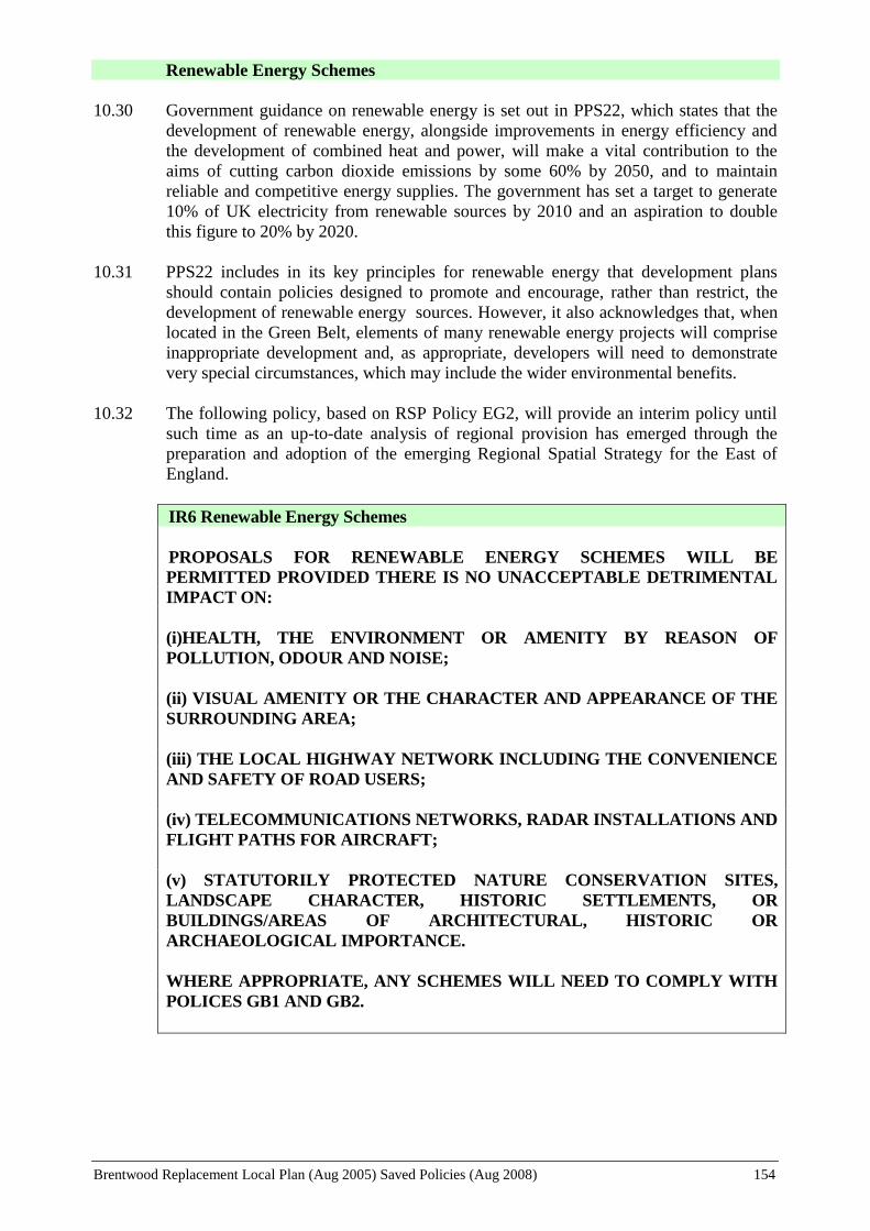
Brentwood Replacement Local Plan (Aug 2005) Saved Policies (Aug 2008) 154
Renewable Energy Schemes
10.30 Government guidance on renewable energy is set out in PPS22, which states that the
development of renewable energy, alongside improvements in energy efficiency and
the development of combined heat and power, will make a vital contribution to the
aims of cutting carbon dioxide emissions by some 60% by 2050, and to maintain
reliable and competitive energy supplies. The government has set a target to generate
10% of UK electricity from renewable sources by 2010 and an aspiration to double
this figure to 20% by 2020.
10.31 PPS22 includes in its key principles for renewable energy that development plans
should contain policies designed to promote and encourage, rather than restrict, the
development of renewable energy sources. However, it also acknowledges that, when
located in the Green Belt, elements of many renewable energy projects will comprise
inappropriate development and, as appropriate, developers will need to demonstrate
very special circumstances, which may include the wider environmental benefits.
10.32 The following policy, based on RSP Policy EG2, will provide an interim policy until
such time as an up-to-date analysis of regional provision has emerged through the
preparation and adoption of the emerging Regional Spatial Strategy for the East of
England.
IR6 Renewable Energy Schemes
PROPOSALS FOR RENEWABLE ENERGY SCHEMES WILL BE
PERMITTED PROVIDED THERE IS NO UNACCEPTABLE DETRIMENTAL
IMPACT ON:
(i)HEALTH, THE ENVIRONMENT OR AMENITY BY REASON OF
POLLUTION, ODOUR AND NOISE;
(ii) VISUAL AMENITY OR THE CHARACTER AND APPEARANCE OF THE
SURROUNDING AREA;
(iii) THE LOCAL HIGHWAY NETWORK INCLUDING THE CONVENIENCE
AND SAFETY OF ROAD USERS;
(iv) TELECOMMUNICATIONS NETWORKS, RADAR INSTALLATIONS AND
FLIGHT PATHS FOR AIRCRAFT;
(v) STATUTORILY PROTECTED NATURE CONSERVATION SITES,
LANDSCAPE CHARACTER, HISTORIC SETTLEMENTS, OR
BUILDINGS/AREAS OF ARCHITECTURAL, HISTORIC OR
ARCHAEOLOGICAL IMPORTANCE.
WHERE APPROPRIATE, ANY SCHEMES WILL NEED TO COMPLY WITH
POLICES GB1 AND GB2.
Brentwood Replacement Local Plan (Aug 2005) Saved Policies (Aug 2008) 155
Development in Areas at Risk of Flooding
POLICY IR7 (DEVELOPMENT IN AREAS AT RISK OF FLOODING) WAS NOT
SAVED BEYOND 25 AUGUST 2008 AND THEREFORE NO LONGER FORMS PART
OF THE LOCAL PLAN
Surface Water Run Off
POLICY IR8 (SURFACE WATER RUN-OFF) WAS NOT SAVED BEYOND 25 AUGUST
2008 AND THEREFORE NO LONGER FORMS PART OF THE LOCAL PLAN

Brentwood Replacement Local Plan (Aug 2005) Saved Policies (Aug 2008) 156
POLLUTION CONTROL

Brentwood Replacement Local Plan (Aug 2005) Saved Policies (Aug 2008) 157
11. POLLUTION CONTROL
POLICY BACKGROUND
National Policy Guidance
11.1 PPS23 “Planning and Pollution Control” (2004) gives advice on the relationship
between controls over development under planning law, on the one hand, and under
pollution control legislation on the other. Separate annexes deal, inter alia, with air
quality, water quality, waste management and contaminated land. More recent advice
on some of these aspects has been set out in Circular advice.
11.2 PPG24 “Planning and Noise” (September 1994) provides guidance to local planning
authorities on the use of planning powers to minimise the adverse impact of noise
Replacement Structure Plan
11.3 The RSP includes policies aimed at controlling polluting, hazardous and noisy
developments (Policy BE6) and minimising the impact of pollution (BE7).
The Brentwood Community Plan
11.4 The Community Plan’s strategic objectives that are relevant to the Replacement Local
Plan’s Pollution Control Policies are set out under the heading “Health and Welfare”
and includes:
“To ensure that the people of the Borough have a healthy life and general environment
by:
Removing or controlling those adverse factors affecting the health and welfare of
local people in both the living and working environments, by educating, advising
and enforcing statutory duties and discretionary powers”
THE AIM AND OBJECTIVES FOR THE PLAN’S POLLUTION CONTROL
POLICIES:
The Overall Aim
To minimise environmental pollution
Supporting Objectives:
To control development that involves potentially hazardous or polluting activities
To ensure that sensitive uses are not subject to unacceptable levels of noise, air or
other forms of pollution
To ensure adequate controls are exercised in the use of land known or suspected of
being contaminated by previous uses

Brentwood Replacement Local Plan (Aug 2005) Saved Policies (Aug 2008) 158
INTRODUCTION
11.5 Many aspects of pollution control in relation to air, water and land resources are
outside the formal control of the planning system and are the responsibilities of other
agencies, such as the Environment Agency. However, whilst separate, the planning
and pollution control systems are complementary. The planning system needs to
consider whether a proposed development is an acceptable use of land, and the
potential for pollution is a material consideration.
Environmental Assessment
11.6 The most effective way of achieving conservation and enhancement of the environment
is to prevent the creation of pollution or nuisances at source, rather than subsequently
trying to counteract their effects. It is essential, therefore, to take account of the effects
of development on the environment at the earliest possible stage.
11.7 The Town and Country Planning (Environmental Impact Assessment) (England and
Wales) Regulations 1999 sets out advice on the assessment of the effects of certain
development projects on the environment, in respect of projects which require planning
permission. The Regulations make the distinction between Schedule 1 projects which
require environmental assessment in every case and Schedule 2 projects which require
environmental assessment if they are "likely to have significant effects on the
environment by virtue of factors such as their nature, size or location."
11.8 The type of projects included within Schedule 1 cover major developments of national
importance such as crude-oil refineries; thermal power stations; the storage or disposal
of radioactive waste; integrated chemical installations; waste-disposal installations,
motorway construction; airports and long-distance railway lines; trading ports and
inland water ways and asbestos related processes.
11.9 Schedule 2 covers a much more extensive list of development as defined in the
legislation and Circular 2/999. Upon the submission of an application that falls within
Schedule 2, the Council will give a “screening opinion” as to whether or not it considers
an environmental assessment is required.
HAZARDOUS SUBSTANCES
Land Contaminated by Hazardous Substances
11.10 If it is known or strongly suspected that a development site is contaminated to an
extent which would adversely affect the proposed development or infringe statutory
requirements, an investigation of the hazards by the developer and proposals for any
necessary remedial measures required to deal with the hazards together with a
validation scheme normally will be required before the application can be determined.
If a developer believes that the land is contaminated then they are strongly advised to
consult the Council as early as possible before an application is submitted.
11.11 Suspicion of contamination will generally arise from information on previous land uses
provided as part of the application for development, or from the Council's own records.
Contaminated land also poses a significant threat to, inter alia, aquifers, ground water
and surface water. For the reasons set out above, before implementation of any
planning permission, the Council, in consultation with the Environment Agency will
9 Circular 2/99 – Environmental Impact Assessment

Brentwood Replacement Local Plan (Aug 2005) Saved Policies (Aug 2008) 159
need to be satisfied that appropriate measures have been or will be taken to deal with
any contamination.
PC1 Land Contaminated by Hazardous Substances
WHERE DEVELOPMENT IS PROPOSED ON LAND WHICH IS
SUSPECTED OF BEING CONTAMINATED BY HAZARDOUS SUBSTANCES
ARISING OUT OF PREVIOUS LAND USES SUCH AS INDUSTRY, GAS
WORKS, WASTE TIPS OR LANDFILL SITES, AN ENVIRONMENTAL
SURVEY ASSESSING THE NATURE AND EXTENT OF THE
CONTAMINATION WILL BE REQUIRED TO ACCOMPANY THE
APPLICATION. WHERE APPROPRIATE, DEVELOPMENT WILL ONLY
BE PERMITTED WHERE THE APPLICANT CAN ENSURE, TO THE
COUNCIL’S SATISFACTION, THAT THE LAND IS CAPABLE OF BEING
DECONTAMINATED AND RECLAIMED FOR BENEFICIAL USE IN
ACCORDANCE WITH AN AGREED REMEDIATION AND VALIDATION
SCHEME PRIOR TO THE GRANT OF PLANNING PERMISSION; AND
APPROPRIATE MEASURES TO DEAL WITH CONTAMINATION OF THE
DEVELOPMENT SITE ARE UNDERTAKEN BEFORE THE
IMPLEMENTATION OF ANY PLANNING PERMISSION.
Hazardous Substances and Notifiable Installations
POLICY PC2 (HAZARDOUS SUBSTANCES) WAS NOT SAVED BEYOND 25 AUGUST
2008 AND THEREFORE NO LONGER FORMS PART OF THE LOCAL PLAN
POLICY PC3 (DEVELOPMENT IN THE VICINITY OF HAZARDOUS SUBSTANCES)
WAS NOT SAVED BEYOND 25 AUGUST 2008 AND THEREFORE NO LONGER
FORMS PART OF THE LOCAL PLAN
POLLUTION
Noise
11.14 The impact of noise can be a material consideration in the determination of a planning
application. Noise sensitive developments such as housing, hospitals and schools should
be located away from existing sources of significant noise such as heavily trafficked
roads and railways. Conversely, potentially noisy developments should be located
away from existing or proposed noise-sensitive developments. When assessing a
proposal for residential development near a source of noise, the noise exposure category
(NEC), as defined by PPG24, will be determined and the appropriate guidance for a
particular NEC shall normally be followed
11.15 For development falling within NEC “A”, noise is unlikely to be a determining factor.
On sites likely to be in NEC “B” or “C”, applicants will need to ascertain which NEC
the site falls into and thus have regard to this when considering the layout and design of
the development. Regard should be had to BS 8233:1999 “Sound Insulation and Noise
Reduction for Buildings – Code of Practice”.
11.16 Residential development should be designed so as to achieve a good standard of indoor
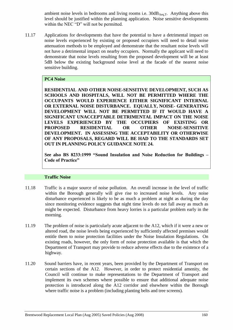
Brentwood Replacement Local Plan (Aug 2005) Saved Policies (Aug 2008) 160
ambient noise levels in bedrooms and living rooms i.e. 30dBAeq,T. Anything above this
level should be justified within the planning application. Noise sensitive developments
within the NEC “D” will not be permitted.
11.17 Applications for developments that have the potential to have a detrimental impact on
noise levels experienced by existing or proposed occupiers will need to detail noise
attenuation methods to be employed and demonstrate that the resultant noise levels will
not have a detrimental impact on nearby occupiers. Normally the applicant will need to
demonstrate that noise levels resulting from the proposed development will be at least
5dB below the existing background noise level at the facade of the nearest noise
sensitive building.
PC4 Noise
RESIDENTIAL AND OTHER NOISE-SENSITIVE DEVELOPMENT, SUCH AS
SCHOOLS AND HOSPITALS, WILL NOT BE PERMITTED WHERE THE
OCCUPANTS WOULD EXPERIENCE EITHER SIGNIFICANT INTERNAL
OR EXTERNAL NOISE DISTURBANCE. EQUALLY, NOISE- GENERATING
DEVELOPMENT WILL NOT BE PERMITTED IF IT WOULD HAVE A
SIGNIFICANT UNACCEPTABLE DETRIMENTAL IMPACT ON THE NOISE
LEVELS EXPERIENCED BY THE OCCUPIERS OF EXISTING OR
PROPOSED RESIDENTIAL OR OTHER NOISE-SENSITIVE
DEVELOPMENT. IN ASSESSING THE ACCEPTABILITY OR OTHERWISE
OF ANY PROPOSALS, REGARD WILL BE HAD TO THE STANDARDS SET
OUT IN PLANNING POLICY GUIDANCE NOTE 24.
See also BS 8233:1999 “Sound Insulation and Noise Reduction for Buildings –
Code of Practice”
Traffic Noise
11.18 Traffic is a major source of noise pollution. An overall increase in the level of traffic
within the Borough generally will give rise to increased noise levels. Any noise
disturbance experienced is likely to be as much a problem at night as during the day
since monitoring evidence suggests that night time levels do not fall away as much as
might be expected. Disturbance from heavy lorries is a particular problem early in the
morning.
11.19 The problem of noise is particularly acute adjacent to the A12, which if it were a new or
altered road, the noise levels being experienced by sufficiently affected premises would
entitle them to noise protection facilities under the Noise Insulation Regulations. On
existing roads, however, the only form of noise protection available is that which the
Department of Transport may provide to reduce adverse effects due to the existence of a
highway.
11.20 Sound barriers have, in recent years, been provided by the Department of Transport on
certain sections of the A12. However, in order to protect residential amenity, the
Council will continue to make representations to the Department of Transport and
implement its own schemes where possible to ensure that additional adequate noise
protection is introduced along the A12 corridor and elsewhere within the Borough
where traffic noise is a problem (including planting belts and tree screens).

Brentwood Replacement Local Plan (Aug 2005) Saved Policies (Aug 2008) 161
PC5 Traffic Noise
THE COUNCIL WILL CONTINUE TO MAKE REPRESENTATIONS TO
THE DEPARTMENT OF TRANSPORT AND IMPLEMENT ITS OWN
SCHEMES WHERE POSSIBLE TO ENSURE THAT ADEQUATE NOISE
PROTECTION (INCLUDING PLANTING BELTS AND TREE SCREENS) IS
INTRODUCED ALONG THE A12 CORRIDOR AND ELSEWHERE WITHIN
THE BOROUGH WHERE TRAFFIC NOISE IS A PROBLEM.
Transport Pollution
11.21 In addition to the disturbance from noise, traffic gives rise to air borne pollutants. The
Council’s Air Quality Review and Assessment has identified that there are no
significant non-traffic sources of specified pollutants within the Borough. The main
sources of relevant air pollutants are from heavily trafficked roads, in particular the
M25, A12, A127, A128 and the A1023 (See paras.10.25 to 10.28).
11.22 Lighting associated with the main road network can also give rise to visual pollution
as a result of light spillage, direct points of light and general glare. Such lighting
should be so designed as to minimise the detrimental impacts and incorporate
appropriate mitigation measures, including, for example, on-site and off-site planting
and screening.
PC6 Transport Pollution
ALL NEW TRANSPORT PROPOSALS AND IMPROVEMENTS TO
EXISTING TRANSPORT INFRASTRUCTURE AND SERVICES WILL BE
ASSESSED AGAINST THEIR IMPACT ON AIR QUALITY, NOISE LEVELS
AND VISUAL AMENITY, AND WILL NEED TO BE DESIGNED SO AS TO
MINIMISE ANY NEGATIVE IMPACTS AND, WHERE NECESSARY,
INCORPORATE REASONABLE AND APPROPRIATE MITIGATION
MEASURES
Areas of Poor Air Quality
11.23 Part IV of the Environment Act 1995 requires each local authority to periodically
review air quality. The Air Quality Regulations 2000 prescribe air quality objectives
and the dates for meeting them. The Government periodically reviews the air quality
objectives and they are therefore subject to change.
11.24 For each objective the local authority has to consider present and likely future air
quality and assess whether the objectives are likely to be achieved by the relevant
deadline. Where these objectives are not likely to be achieved, the authority must
designate those areas as Air Quality Management Areas (AQMA).
11.25 At present seven areas of the Borough have been designated as AQMAs. Further
detailed work is being undertaken and in due course it is intended that an action plan
will be produced with a strategy to improve air quality in these areas.
11.26 The areas affected are in close proximity to the M25 or the A12 and one area is in the
town centre around Wilson’s Corner (the junction of the A128 and A1023). The
appropriate maps can be viewed at the Town Hall (Environmental Health Services).

Brentwood Replacement Local Plan (Aug 2005) Saved Policies (Aug 2008) 162
11.27 It is not intended that these areas will remain sterile in development terms but
developers would be expected to minimise the effects of poor air quality as far as
possible and have regard to PPS23 “Planning and Pollution Control” and “Local Air
Quality Management Policy Guidance LAQM.PG(03) (defra). Large developments
within an AQMA or in such close proximity as to affect the air quality within an
AQMA would be expected to carry out an environmental assessment of the likely air
quality effects of the development.
11.28 It is highly recommended that developers arrange pre-application discussions with
Council Planning and Environmental Health Officers so that the implications of air
quality can be dealt with.
PC7 Areas of Poor Air Quality
IN IDENTIFIED AIR QUALITY MANAGEMENT AREAS DEVELOPMENT
FOR RESIDENTIAL OR OTHER SENSITIVE USES SHOULD HAVE
REGARD TO PPS23 ‘PLANNING AND POLLUTION CONTROL’ AND
‘LOCAL AIR QUALITY MANAGEMENT POLICY GUIDANCE
LAQM.PG(03)’. COMMERCIAL DEVELOPMENTS LIKELY TO HAVE
SIGNIFICANT DETRIMENTAL IMPACTS ON AIR QUALITY IN THESE
AREAS WILL NOT BE PERMITTED.

Brentwood Replacement Local Plan (Aug 2005) Saved Policies (Aug 2008) 163
BRENTWOOD TOWN CENTRE
Note:
The policies in this Section should be read in conjunction with the policies set out in the
Borough-Wide Sections of the Plan. In cases of conflict, site-specific policies take precedence
over the other policies in the Plan.
Brentwood Replacement Local Plan (Aug 2005) Saved Policies (Aug 2008) 164
12. BRENTWOOD TOWN CENTRE
POLICY BACKGROUND
National Planning Guidance
12.1 Government guidance is set out in PPS6 “Planning for Town Centres” (March 2005).
Emphasis is placed on the sequential approach to selecting sites for development, for
retail, employment, leisure and other key town centre uses. It also promotes mixed-use
development (particularly the incorporation of residential uses) and the retention of key
town centre uses. The importance of a coherent town centre parking strategy is
emphasised in order to maintain urban vitality and good design is promoted.
Replacement Structure Plan
12.2 The objectives of the RSP in respect of town centres are to promote their vitality as the
main focus for new retail, leisure, entertainment, cultural and other investment through
the sequential approach, diversity of activity and an attractive environment, and to
encourage access to and within shopping areas by alternative modes of transport to the
private car.
12.3 The RSP policies set out a hierarchy of urban centres within which retailing and other
uses attracting large numbers of people will be located and the sequential basis on
which such developments should be determined. Policies also set out how the viability
of town centres will be strengthened and maintained, through improving the range and
quality of facilities to encourage a vital and vibrant environment, increasing the
diversity and quality of facilities and employment opportunities to meet the needs of the
local population, increasing residential accommodation, improving access and the
transport network and facilities for all modes, and supporting the conservation and
enhancement of the historic character and townscape of town centres.
Brentwood Community Plan
12.4 The strategic objectives set out in the Community Plan are Borough-wide and, therefore,
there are no specific objectives pertaining to Brentwood Town Centre. The strategic
objectives referred to in the previous policy chapters are all, as appropriate, relevant to
the Replacement Local Plan’s Town Centre Policies.
THE AIM AND OBJECTIVES OF THE PLAN’S TOWN CENTRE POLICIES
Overall Aim
To develop the role of Brentwood Town Centre as the community focus for the
Borough, providing for shopping, cultural, leisure and commercial activities as well as
a place to live and work
Supporting Objectives
To safeguard and enhance the economic viability and vitality of the town centre
and protect its position in the shopping hierarchy
To facilitate the provision and maintenance of, where possible, a sufficient range,

Brentwood Replacement Local Plan (Aug 2005) Saved Policies (Aug 2008) 165
quality and amount of retail floor space to meet the needs of the local catchment
area
To ease pedestrian/vehicular conflict and achieve environmental improvements by
removing unnecessary through traffic from the High Street
To encourage access to the town centre by alternative modes of transport to the
private motor car
To retain and enhance the character and quality of the town centre environment
To ensure that non-retail uses do not detract from the viability and vitality of the
shopping area
To encourage the provision of cultural, entertainment and leisure facilities
To retain existing residential accommodation within the town centre and seek,
where possible, to provide additional residential accommodation, particularly
small unit accommodation
INTRODUCTION
12.5 Brentwood Town Centre is the social focus of the Borough. It is not only the major
shopping area, but also a centre for cultural, leisure and community facilities, attracting
visitors from both within and from outside the Borough itself. It is also a centre for
employment, particularly for service sector jobs (offices and retailing etc.), but also, on
the Wates Way Estate for example, in other areas of employment.
12.6 The town centre area is also an area where people live, immediately adjacent to, but also
within, the commercial core along the High Street and adjoining roads.
12.7 In addition, the centre is the hub of the town’s road network. The High Street (A1023)
is a Primary Distributor Road, providing an important east-west link through the town,
whilst the A128 (Ongar Road/Ingrave Road) provides a similar heavily used route
north-south. Both these roads become heavily congested, particularly when problems
are experienced on the A12 and the M25.
12.8 The mixed and relatively intensive nature of uses within the town centre gives rise to
benefits in terms of the wider choice of uses in close proximity to one another and
accessibility by choices of transport, but also disbenefits due to congestion,
pedestrian/traffic conflicts and conflicts between uses. There is clearly competition for
the use of land, and the Plan, therefore, seeks to achieve an appropriate balance of
mixed uses that meets the needs of residents living in the town centre, as well as the
needs of those working, shopping and visiting the town centre, in a manner that
safeguards the character of the centre.
Brentwood Town Centre Partnership
12.9 Following from one of the recommendations of the URBED Study 10
into the future of
Brentwood Town Centre, in January 2000 the Brentwood Town Centre Partnership held
its inaugural meeting. The Partnership Board is made up of representatives from the
business community, the Council and other local interest groups and individuals and has
10
“Brighter Brentwood: Strategy for Continued Success”. URBED January 1999

Brentwood Replacement Local Plan (Aug 2005) Saved Policies (Aug 2008) 166
adopted a mission statement as follows:
“Working in partnership, to co-ordinate, develop and implement town centre
management initiatives which will maintain and enhance the attractiveness, vitality and
economic viability of Brentwood for the benefit of retailers, residents, businesses,
workers and visitors.”
12.10 The Partnership has also adopted a set of objectives:
To ensure quality in every aspect of retailing by improving the shopping experience
To develop a distinctive programme which builds civic pride through strong
branding and promotes Brentwood Town centre as a focus for all the community,
and for people of all ages
To secure the appropriate, sustainable use of under-utilised land and buildings,
thereby diversifying the town’s attractions
To seek out new means of resourcing town centre initiatives including external funds
such as lottery, landfill tax and conservation grants
12.11 In seeking to achieve these objectives the Partnership has identified a set of key tasks,
and a 5-year plan and annual programme of projects. The Partnership has already, in its
short period of existence, been highly successful in securing additional funding,
sponsoring and encouraging a wide range of environmental, community safety and
promotional projects and raising the public profile of the town centre.
12.12 The Partnership Board is an important consultee in taking the Replacement Local Plan
through to adoption and will be a significant partner with the Council, in achieving the
Plan’s aims and objectives for the town centre.
HOUSING
New Residential Accommodation
12.13 It is necessary to make the best use of existing development land, not only to achieve
sustainable patterns of development but also to respond to the constraints on new
development imposed by the Borough’s Green Belt location. The town centre is an area
where higher density development would be appropriate and would meet the need for
smaller and relatively cheaper accommodation.
12.14 Furthermore, given current levels of traffic congestion in the town centre (particularly
during the morning and evening peak times) it is a desirable location for residential use,
with its lower level of traffic generation and limited need for parking (due to the
accessibility to non-car modes of transport and proximity to services and facilities).
12.15 In addition to the need to retain existing housing, therefore, it will also be an objective to
increase the number of housing units within the town centre when redevelopment takes
place (both in mixed-use schemes and solely residential proposals). There will be
opportunities to provide additional residential accommodation when existing non-
residential uses are redeveloped. In some instances, a mixed-use redevelopment may be
appropriate.
12.16 The following policies for new residential accommodation have regard to the existing

Brentwood Replacement Local Plan (Aug 2005) Saved Policies (Aug 2008) 167
mix of uses and other policy objectives of this Plan.
TC1 Vacant and Redevelopment Sites within Residential Allocated Areas
WITHIN THOSE AREAS ALLOCATED FOR RESIDENTIAL PURPOSES ON
THE TOWN CENTRE INSET PLAN ANY VACANT SITE OR SITE TO BE
REDEVELOPED WILL BE CONSIDERED ONLY FOR HOUSING
PURPOSES
TC2 Residential Replacement
ANY REDEVELOPMENT PROPOSALS FOR A SITE WHICH INCLUDES
EXISTING RESIDENTIAL UNITS WILL BE EXPECTED TO
INCORPORATE, AS A MINIMUM, THE REPLACEMENT OF THOSE UNITS
TC3 Mixed Use Development
WITHIN THE AREA ALLOCATED FOR RESIDENTIAL/OFFICES/ SHOPS
AND IN ANY OTHER REDEVELOPMENT PROPOSALS INVOLVING
COMMERCIAL DEVELOPMENT OUTSIDE THE
RESIDENTIAL/OFFICES/SHOPS ALLOCATION, THE OPPORTUNITY
SHOULD BE TAKEN TO PROVIDE NEW RESIDENTIAL
ACCOMMODATION AS PART OF A MIXED USE DEVELOPMENT.
Use of Upper Floors above Commercial Premises
12.17 For the reasons already stated in Paragraphs 12.13 and 12.14 above, the Council will
also look favourably upon the change of use to residential of upper floors above existing
commercial development. Residential may also provide a use for under-used or unused
floor space that can lead to neglect and deterioration of a building. Some residential
accommodation has previously been achieved through the “Living over the Shop”
scheme (LOTS) and the Council will wish to pursue further opportunities, particularly
for affordable housing in partnership with a registered social landlord.
12.18 The use of such accommodation for residential purposes will, therefore, be encouraged
as a means of providing further small unit accommodation. The Council is aware that it
may be difficult in some cases to achieve all the standards normally required for
residential uses. Therefore, whilst it will be necessary to ensure that the amenities of
prospective occupiers are safeguarded, a more flexible attitude may be adopted in
respect of the Council's normal residential standards for private amenity space.
However, there may well be occasions where residential uses are unsuitable and
therefore in such circumstances, other uses may be considered subject to compliance
with other policies in the Plan.
TC4 Use of Upper Floors above Commercial Properties
CHANGES OF USE OF UPPER FLOORS ABOVE EXISTING COMMERCIAL
PREMISES TO RESIDENTIAL ACCOMMODATION WILL BE
ENCOURAGED WITHIN THE TOWN CENTRE, PARTICULARLY TO
PROVIDE AFFORDABLE UNITS OF ACCOMMODATION, PROVIDING
THE FOLLOWING CRITERIA CAN BE SATISFIED:

Brentwood Replacement Local Plan (Aug 2005) Saved Policies (Aug 2008) 168
i) REASONABLE FACILITIES AND AMENITIES ARE PROVIDED FOR
PROSPECTIVE OCCUPIERS
ii) THE DEVELOPMENT DOES NOT RESULT IN DEMAND TO REPLACE
STORAGE SPACE THAT MAY BE LOST
WHERE THE COUNCIL IS SATISFIED THAT RESIDENTIAL USES ARE
UNSUITABLE, ALTERNATIVE USES MAY BE CONSIDERED
APPROPRIATE SUBJECT TO OTHER POLICIES IN THE PLAN.
A Target and Indicator for monitoring this policy is set out in Chapter 13
Type of Accommodation
12.19 The town centre is a particularly suitable location for higher density, smaller units and
lower cost housing. In the town centre, therefore, new housing should normally be one
or two person units catering for the need for small, low-cost accommodation for single
persons, starter homes, or people with limited mobility.
TC5 Type of Accommodation
ALL NEW HOUSING WITHIN THE TOWN CENTRE INSET PLAN AREA
SHOULD BE IN THE FORM OF ONE OR TWO PERSON UNITS
A Target and Indicator for monitoring this policy is set out in Chapter 13
SHOPPING
12.20 Brentwood is one of 21 “Principal Town Centres” identified in the RSP, which are
defined as “generally convenience shopping centres but also with a good range of
comparison goods shops as well as service trades, public and community facilities. As a
result they have more than a local role in the provision of shopping and retail services
across the Structure Plan area”. The catchment area of the town centre equates generally
to the Borough itself, a population of just over 70,000.
12.21 Brentwood Town Centre offers a wide range of shops and other facilities but faces
considerable competition from surrounding centres, particularly Chelmsford, Romford,
Basildon, Thurrock (Lakeside) and more recently the Bluewater development at
Dartford. These are all sub-regional centres which serve an extensive area, offering a
range of specialist shopping in comparison goods and a wide choice of retail outlets
including multiples and department stores as well as service trades, entertainment and
recreational facilities.
12.22 The proximity and attraction of these centres encourages people who live in Brentwood
to travel elsewhere to shop and has resulted in an outflow of expenditure, on both
convenience and comparison goods. It is necessary, therefore, to continue to enhance
the attraction of Brentwood Town Centre in order that it remains viable and retains as
much retail expenditure as possible within the Borough.
12.23 There are many factors that contribute to the attractiveness of the shopping area besides
the range and quality of shopping. The quality of the shopping environment plays an

Brentwood Replacement Local Plan (Aug 2005) Saved Policies (Aug 2008) 169
important role in encouraging people to shop in a particular centre and may have an
impact in the long-term on its viability. Brentwood High Street is a Conservation Area
and the Council continues to look to improve and enhance the character of the area in
partnership with other bodies such as the Chamber of Commerce and the Town Centre
Partnership. Previous large-scale environmental improvement schemes have improved
the surface treatment in the High Street and St Thomas’ Road, and provided improved
street furniture and signage and enhanced the planting.
The Prime Shopping Area
12.24 The prime shopping area is defined on the Proposals Map and covers the area of 25-73A
High Street, 14-54 High Street and The Baytree Centre shopping precinct. The area is
identified as the main focus of the Shopping Centre, where the major multiple retail
operators and services are located. The area is characterised by generally higher levels
of pedestrian activity and the high demand for sites in this location leads generally to
higher rental levels. (The new Sainsbury food store is a main retail attraction within the
town centre, but is divorced from the identified prime shopping area.)
12.25 The attractiveness of the area as a prime location may lead to demand from services like
banks, building societies, fast food restaurants, etc., which are in a position to afford the
higher rental levels to locate there. These uses may restrict the availability of prime
shopping floor space needed to attract retailers not presently represented and, therefore,
further non-retail uses will be resisted.
New Shopping Development
12.26 Brentwood Town Centre will need to continue to extend the range and quality of
shopping outlets in order to respond to and compete with the continuing development of
other retail centres. Consideration, therefore, needs to be given to what opportunities
exist for enhancing the provision of shopping.
12.27 Prior to the development of the Sainsbury food store on the former Thermos site to the
north of the High Street, Brentwood had no superstore or other large modern food store
either within or outside the town centre. There was, therefore, a large outflow of
expenditure on convenience goods. The new Sainsbury store has now significantly
added to convenience shopping provision in the town centre, both quantitively and
qualitively. However, the other main food shopping provision in the town centre is of
limited size i.e. the Somerfield store in The Baytree Centre, Iceland and the food
department of the Marks and Spencer store. There is evidence that the Sainsbury store
is over-trading and that there continues to be scope for further convenience food floor
space in the town centre.
12.28 Not unexpectedly in a centre the size of Brentwood, the range of comparison shops is
limited and a large outflow of expenditure is experienced. The land requirement for a
large comparison store would, however, be significant. An out of town centre location
for a large comparison store would be contrary to PPS6 and would require an
unacceptably large incursion into the Green Belt on a "green-field site", with undoubted
local transport implications and a detrimental effect on existing centres.
Proposed Retail Strategy
12.29 In assessing the potential for further retail provision within the town centre, there are
only two sites of any significant size that can be identified at the present time: The
Baytree Centre and the William Hunter Way Car Park.
Brentwood Replacement Local Plan (Aug 2005) Saved Policies (Aug 2008) 170
12.30 The Baytree Centre provides an important opportunity for improving shopping provision
in the town centre. The centre has long been criticised as unwelcoming, poorly designed
and in need of improvement. The study undertaken by URBED referred to the centre as
“the hole in the heart of Brentwood”. Proposals for the refurbishment of the centre,
which include some 2,500 sq.m. of new retail floor space, the re-use of Beckett House
for residential, and new leisure use are expected to be completed in 2005.
12.31 The William Hunter Way Car Park is the only large open site left within the town centre.
There are clearly a number of competing uses for the site, and it would be difficult, if
not impossible, to meet all the potential demands. At present though the surface car
parking provides an important function, contributing to in the attraction and viability of
the town centre.
12.32 The Council is of the view that, in strategic terms, the most appropriate location for
further retail improvements within the town centre, be it food or non-food, would be on
the south side of the High Street and that the priority should be for the development of
The Baytree Centre site as opposed to the William Hunter Way Car Park. The reasons
behind this view are:
The previous poor state of The Baytree Centre and the resulting negative impact
that this has on the centre as a whole.
The need to balance the effect that the Sainsbury store has had on the “centre of
gravity” of the shopping area, by developing retail provision on the southern side of
the High Street.
The existing major contribution that the William Hunter Way Car Park makes to the
viability of the centre through its role as the most important town centre surface car
park.
12.33 This view does not preclude the consideration of the William Hunter Way Car Park for
redevelopment, in whole or part, for a mix of uses (whether it be shopping or other uses)
should proposals come forward, or indeed the consideration of any proposal to enhance
shopping provision in the town centre.
The William Hunter Way Car Park
12.34 The policy for this site is set out under the “Transport” section later in this chapter (see
Policy TC10), as it is intended to retain the site for short stay parking, whilst, as stated
above, not precluding consideration of any proposals that may come forward for a
mixed use development in the future.
Small Scale Shops
12.35 Small shops on the periphery of the main shopping area are important to the town centre
since they provide a source of retail accommodation at relatively cheaper rents than a
prime High Street unit, and allow small independent retailers to set up in business
offering goods and services, often more diverse than those available in the High Street.
Such areas in Brentwood Town Centre are Hart Street, Crown Street, Ongar Road,
Kings Road and The Arcade. It is important for the continued viability of these areas
and to the overall attraction of the centre (due to the wider choice provided for
shoppers) that these small shops are maintained, as far as possible. In considering any
development proposals in these areas the Council will seek to maintain the size and
character of the existing shop units. The Council's control is, in practice limited, as, for
example, the amalgamation of adjoining shop units to provide for a single larger outlet
Brentwood Replacement Local Plan (Aug 2005) Saved Policies (Aug 2008) 171
would not normally require planning permission. Nevertheless, in any redevelopment
proposals the Council would wish to see small shop units retained.
12.36 The conversion of the existing residential units to retail use in Crown Street is to be
resisted in the light of the need to retain residential properties, particularly small units,
within the town centre area (as outlined in the Housing Chapter of this Plan).
TC6 Small Scale Shops
CROWN STREET, ONGAR ROAD, THE ARCADE AND KINGS ROAD ARE
ALLOCATED FOR SMALL-SCALE SHOPS AS DEFINED ON THE
PROPOSALS MAP. LARGER SHOP UNITS WILL NOT BE ALLOWED IN
THESE AREAS.
Non-Retail Uses
12.37 Retail uses compete with a range of other uses for a presence within the main
commercial frontages. Some of these other uses, e.g. building societies, banks, estate
agents, restaurants, takeaways etc, are both appropriate and beneficial to the centre by
attracting people into the area for services and entertainment. Banks and building
societies provide financial services that are often linked to a shopping trip. Restaurants,
takeaways and public houses can provide a buoyant appearance, contributing to the
attractiveness and vitality of the area, and providing variety and activity outside normal
business hours. However, too great a concentration of such uses can be detrimental to
the overall role of the town centre for retailing, leading to a reduction in the range and
choice of retail goods available within the centre, and may potentially isolate some retail
premises from the main shopper/pedestrian flows that will ultimately reduce their
viability. It is important that non-retail uses continue to make greater efforts to
incorporate window displays and overcome any potential problem for the creation of
“dead frontages”.
12.38 Uses such as public houses and takeaways can, however, have adverse effects on
neighbouring properties, particularly residential accommodation, due to noise, smells
and litter and other anti-social behaviour. This has been a particular problem with the
increase in public houses and restaurants/takeaways at the western end of the High
Street. Whilst there is a markedly more buoyant character to this end of the town
centre, the Council is working with the owners of premises and landlords, the police and
others to overcome the unfortunate anti-social, late night problems that have arisen.
The Council has also decided to rescind its more relaxed policy to A3 uses (as defined
prior to 21 April 2005) in this area and bring it in line, once again, with the rest of the
town centre.
12.39 To avoid an over-concentration of non-retail uses within the town centre and reduce
potential problems, Policy TC7 aims to strike a balance between these potentially
competing uses, ensure a broad range of shopping opportunities, provide for a
reasonable dispersal of uses throughout the centre and achieve the integration of non-
retail uses into the general shopping environment (the one exception to this policy is St.
Thomas Road - Policy TC8). As stated in paragraph 12.25, no further non-retail uses
will be allowed in the Prime Shopping Area.
12.40 The Arcade will also be subject to a greater restriction on the provision of A2, A3, A4
and A5 uses due to the particular character of this enclosed shopping area in terms of
the size of units and its perceived vulnerability to an over-concentration of non-retail
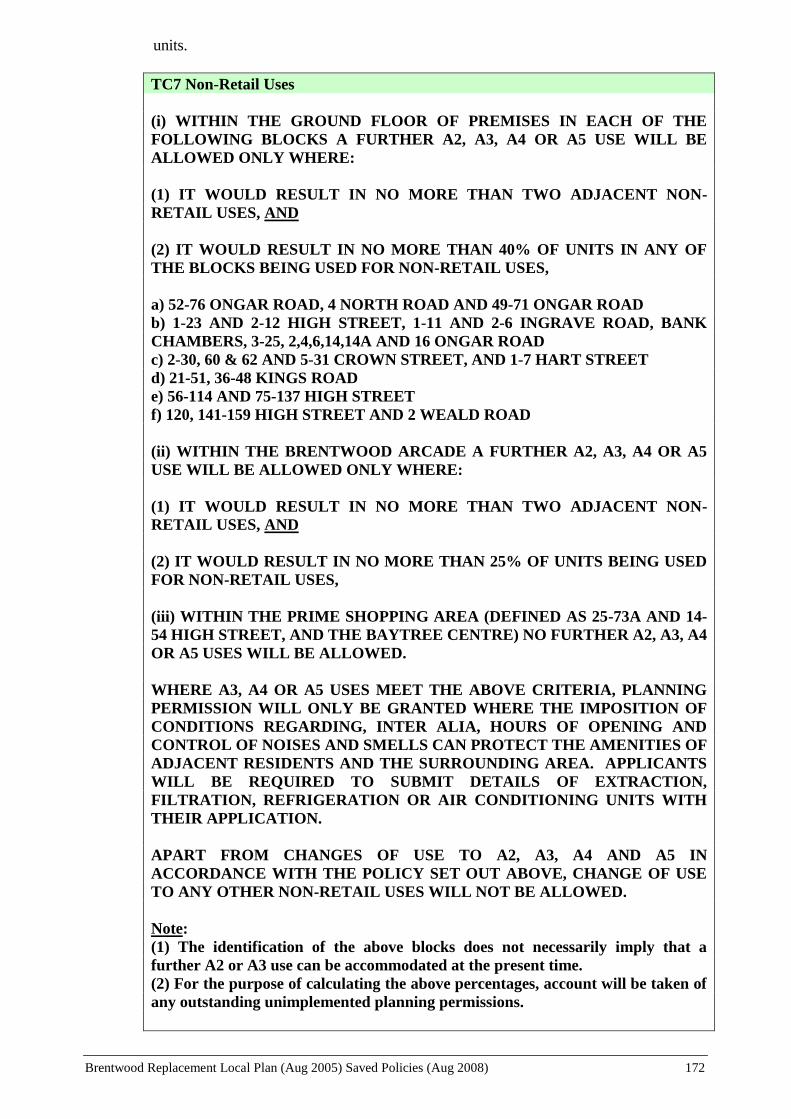
Brentwood Replacement Local Plan (Aug 2005) Saved Policies (Aug 2008) 172
units.
TC7 Non-Retail Uses
(i) WITHIN THE GROUND FLOOR OF PREMISES IN EACH OF THE
FOLLOWING BLOCKS A FURTHER A2, A3, A4 OR A5 USE WILL BE
ALLOWED ONLY WHERE:
(1) IT WOULD RESULT IN NO MORE THAN TWO ADJACENT NON-
RETAIL USES, AND
(2) IT WOULD RESULT IN NO MORE THAN 40% OF UNITS IN ANY OF
THE BLOCKS BEING USED FOR NON-RETAIL USES,
a) 52-76 ONGAR ROAD, 4 NORTH ROAD AND 49-71 ONGAR ROAD
b) 1-23 AND 2-12 HIGH STREET, 1-11 AND 2-6 INGRAVE ROAD, BANK
CHAMBERS, 3-25, 2,4,6,14,14A AND 16 ONGAR ROAD
c) 2-30, 60 & 62 AND 5-31 CROWN STREET, AND 1-7 HART STREET
d) 21-51, 36-48 KINGS ROAD
e) 56-114 AND 75-137 HIGH STREET
f) 120, 141-159 HIGH STREET AND 2 WEALD ROAD
(ii) WITHIN THE BRENTWOOD ARCADE A FURTHER A2, A3, A4 OR A5
USE WILL BE ALLOWED ONLY WHERE:
(1) IT WOULD RESULT IN NO MORE THAN TWO ADJACENT NON-
RETAIL USES, AND
(2) IT WOULD RESULT IN NO MORE THAN 25% OF UNITS BEING USED
FOR NON-RETAIL USES,
(iii) WITHIN THE PRIME SHOPPING AREA (DEFINED AS 25-73A AND 14-
54 HIGH STREET, AND THE BAYTREE CENTRE) NO FURTHER A2, A3, A4
OR A5 USES WILL BE ALLOWED.
WHERE A3, A4 OR A5 USES MEET THE ABOVE CRITERIA, PLANNING
PERMISSION WILL ONLY BE GRANTED WHERE THE IMPOSITION OF
CONDITIONS REGARDING, INTER ALIA, HOURS OF OPENING AND
CONTROL OF NOISES AND SMELLS CAN PROTECT THE AMENITIES OF
ADJACENT RESIDENTS AND THE SURROUNDING AREA. APPLICANTS
WILL BE REQUIRED TO SUBMIT DETAILS OF EXTRACTION,
FILTRATION, REFRIGERATION OR AIR CONDITIONING UNITS WITH
THEIR APPLICATION.
APART FROM CHANGES OF USE TO A2, A3, A4 AND A5 IN
ACCORDANCE WITH THE POLICY SET OUT ABOVE, CHANGE OF USE
TO ANY OTHER NON-RETAIL USES WILL NOT BE ALLOWED.
Note:
(1) The identification of the above blocks does not necessarily imply that a
further A2 or A3 use can be accommodated at the present time.
(2) For the purpose of calculating the above percentages, account will be taken of
any outstanding unimplemented planning permissions.
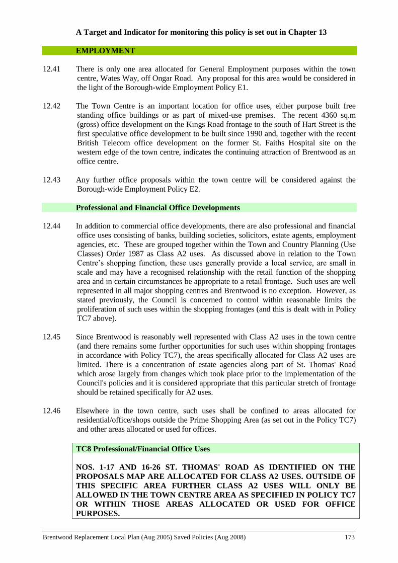
Brentwood Replacement Local Plan (Aug 2005) Saved Policies (Aug 2008) 173
A Target and Indicator for monitoring this policy is set out in Chapter 13
EMPLOYMENT
12.41 There is only one area allocated for General Employment purposes within the town
centre, Wates Way, off Ongar Road. Any proposal for this area would be considered in
the light of the Borough-wide Employment Policy E1.
12.42 The Town Centre is an important location for office uses, either purpose built free
standing office buildings or as part of mixed-use premises. The recent 4360 sq.m
(gross) office development on the Kings Road frontage to the south of Hart Street is the
first speculative office development to be built since 1990 and, together with the recent
British Telecom office development on the former St. Faiths Hospital site on the
western edge of the town centre, indicates the continuing attraction of Brentwood as an
office centre.
12.43 Any further office proposals within the town centre will be considered against the
Borough-wide Employment Policy E2.
Professional and Financial Office Developments
12.44 In addition to commercial office developments, there are also professional and financial
office uses consisting of banks, building societies, solicitors, estate agents, employment
agencies, etc. These are grouped together within the Town and Country Planning (Use
Classes) Order 1987 as Class A2 uses. As discussed above in relation to the Town
Centre’s shopping function, these uses generally provide a local service, are small in
scale and may have a recognised relationship with the retail function of the shopping
area and in certain circumstances be appropriate to a retail frontage. Such uses are well
represented in all major shopping centres and Brentwood is no exception. However, as
stated previously, the Council is concerned to control within reasonable limits the
proliferation of such uses within the shopping frontages (and this is dealt with in Policy
TC7 above).
12.45 Since Brentwood is reasonably well represented with Class A2 uses in the town centre
(and there remains some further opportunities for such uses within shopping frontages
in accordance with Policy TC7), the areas specifically allocated for Class A2 uses are
limited. There is a concentration of estate agencies along part of St. Thomas' Road
which arose largely from changes which took place prior to the implementation of the
Council's policies and it is considered appropriate that this particular stretch of frontage
should be retained specifically for A2 uses.
12.46 Elsewhere in the town centre, such uses shall be confined to areas allocated for
residential/office/shops outside the Prime Shopping Area (as set out in the Policy TC7)
and other areas allocated or used for offices.
TC8 Professional/Financial Office Uses
NOS. 1-17 AND 16-26 ST. THOMAS' ROAD AS IDENTIFIED ON THE
PROPOSALS MAP ARE ALLOCATED FOR CLASS A2 USES. OUTSIDE OF
THIS SPECIFIC AREA FURTHER CLASS A2 USES WILL ONLY BE
ALLOWED IN THE TOWN CENTRE AREA AS SPECIFIED IN POLICY TC7
OR WITHIN THOSE AREAS ALLOCATED OR USED FOR OFFICE
PURPOSES.

Brentwood Replacement Local Plan (Aug 2005) Saved Policies (Aug 2008) 174
The Telephone Exchange
12.47 The existing telephone exchange building is, due to its height, a very prominent but
visually unattractive building. It is also underused with a number of the floors
unoccupied. Should the site be redeveloped or re-used then it is considered that, given
its location, a mixed-use development including either residential uses or some form
of leisure or recreational use or commercial office use, would be appropriate. It is
considered that the potential for retail uses would be constrained by the site’s backland
location. Any non-residential use would need to consider the amenities of residents of
Brentwood Place and the problems of access and traffic generation
TC9 The Telephone Exchange
ANY PROPOSALS FOR REDEVELOPMENT/RE-USE OF THE TELEPHONE
EXCHANGE SHALL INCLUDE A MIX OF USES INCLUDING
RESIDENTIAL, LEISURE/ RECREATIONAL, AND B1 USES.
TRANSPORT
12.48 The town centre is an area of mixed uses, a place where people live, work, shop and
socialise. This mix of functions and uses give rise to heavy flows of traffic within the
town centre area and a high demand for parking spaces. Congestion is a particular
problem within the town centre, particularly at the peak periods when those travelling to
and from work are joined by large numbers of vehicle movements to and from the many
schools surrounding the central area. The High Street is also a Principal Distributor
Road and attracts large numbers of vehicles passing through the centre. Road
congestion is significantly worsened if problems occur on either the A12 or M25.
12.49 In addition to those visiting or passing through the centre in private cars there is clearly a
need to provide for larger vehicles visiting and servicing the commercial premises
within the town centre. If the situation continues unchecked, it could result in the town
centre becoming so congested and parking so difficult that people would be unwilling to
come into the centre to shop and use the other facilities, and its viability would suffer in
the long term. Similarly, the quality of environment for residents living in the town
centre area would deteriorate.
12.50 A High Street Transportation Study has been undertaken and Essex County Council has
agreed to proceed with improvements to the town centre highway network.
12.51 At the same time, as set out in the main Transport Chapter, the Council will seek to
reduce the levels of car usage and encourage more sustainable modes of transport,
critically assess new car parking proposals in the town centre and elsewhere, and
undertake measures to increase highway safety.
Parking
(i) Long-Stay
12.52 Government policy is to reduce the provision of long-stay car parking. The availability
of long-stay parking within the town centre at present is limited. Many of the existing
commercial uses do not have adequate staff parking on site and this causes problems

Brentwood Replacement Local Plan (Aug 2005) Saved Policies (Aug 2008) 175
when people who work in the town centre park all day in nearby residential streets. The
use of maximum car parking standards is likely to exacerbate this problem. Residents
parking schemes and on-street parking controls have been gradually implemented and
will continue to be examined in appropriate locations to help combat this problem (see
Policy T8).
(ii) Short-Stay
12.53 Whilst Government policy seeks to encourage greater use of public transport, cycling
and walking, it recognises that in order to maintain the viability of shopping centres
there will continue to be a justification for appropriate levels of short-stay shoppers’ car
parking. It is necessary to ensure that the economic viability of the town centre and its
ability to continue to compete with other shopping centre is not undermined by the
inability of shoppers being able to find a secure, safe, well laid out parking space in
reasonably close proximity to the shops.
12.54 Any proposals for car parking within the town centre will be considered against the
Council’s parking strategy and policies set out in the Transport Chapter and the parking
standards in Appendix 2.
Site of the William Hunter Way Car Park
12.55 Convenient surface car parking is considered to be very important to the continuing
viability of the centre and this car park is a very important asset within the town centre
for short-stay parking. It is proposed for the time being that this land continues to be
used for surface car parking with the number of spaces being maintained and its lay out
improved. The area also has a potential for the provision of other important town centre
uses and its retention for short stay parking does not preclude its consideration, in whole
or part for redevelopment for a mix of uses (whether it be shopping, residential or
leisure), should proposals come forward. However, it is felt that any decision on the
future of this important site should be taken in the context of proposals for The Baytree
Centre (see discussion on retail strategy in Paras.12.29 to 12.33).
TC10 Site of the William Hunter Way Car Park
WHILST NOT PRECLUDING CONSIDERATION OF ANY PROPOSALS
THAT MAY COME FORWARD FOR THE REDEVELOPMENT OF THE
LAND, IN WHOLE OR PART, FOR A MIXED USE DEVELOPMENT, THE
SITE OF THE WILLIAM HUNTER WAY CAR PARK IS TO BE RETAINED
AND IMPROVED FOR SHORT STAY SHOPPERS’ CAR PARKING IN LINE
WITH POLICY T6. EXISTING LONG STAY PARKING WILL BE
CRITICALLY ASSESSED AND, WHERE APPROPRIATE, REDUCED.
THE LONGER TERM FUTURE USE OF THE SITE WILL BE
RECONSIDERED IN THE LIGHT OF THE CONCLUSIONS OF THE HIGH
STREET AREA TRANSPORTATION STUDY AND AN ASSESSMENT OF
SHOPPING DEMAND FOLLOWING THE COMPLETION OF THE
REFURBISHMENT OR REDEVELOPMENT OF THE BAYTREE CENTRE
Traffic in the High Street
12.56 Proposals for High Street improvements have been agreed by Essex County Council,
and work is to be progressed on the design process. Whilst the Borough Council is

Brentwood Replacement Local Plan (Aug 2005) Saved Policies (Aug 2008) 176
generally supportive of the improvement measures it has formally resolved not to
support the proposal for a link road between Kings Road and the High Street as part of
the High Street Improvement Scheme but supports an alternative scheme incorporating
a double mini roundabout. The Borough Council would also wish to see the scheme
designed to retain bus routes through the High Street.
TC11 Traffic in the High Street
THE COUNCIL WILL SEEK THE IMPLEMENTATION OF PROPOSALS TO
REMOVE UNNECESSARY THROUGH TRAFFIC IN THE HIGH STREET
TOGETHER WITH OTHER AGREED PROPOSALS RESULTING FROM
THE CONCLUSIONS OF THE HIGH STREET AREA TRANSPORTATION
STUDY
TOWNSCAPE
Archaeology and Conservation
12.57 The historic core of the town (which comprises principally the High Street between
Ongar Road/Ingrave Road and Kings Road/Weald Road) is the subject of an
archaeological assessment as part of a study of historic towns in Essex by the County
Council11
, which has been adopted as Informal Planning Guidance. Any development
proposals within the town centre will be considered against the information and
assessment methodology set out in that document. Where appropriate, developers will
be required to fund an archaeological assessment of their development sites.
12.58 Because of its historic character and the presence of a number of Buildings of Special
Architectural and Historic Interest (Listed Buildings) the town centre has been
designated as a Conservation Area. The extent of this area is shown on the Proposals
Map and development proposals will be considered against the criteria set out in
Policies C14-C17 to protect and preserve the character of the Conservation Area and all
listed buildings.
Landscaping in the Town Centre
12.59 Because of high land values there is always pressure to develop every available space in
a town centre location and to extract maximum value from a site through high-density
development. Such forces can easily lead to the permanent loss of open spaces and
neglect of landscaping in developments. Collectively such tendencies inevitably result
in a stark and unattractive urban environment for residents and visitors alike. Whilst,
therefore, it follows sound sustainable principles to maximise the use of previously
developed land, it is equally important to retain and enhance the quality of the urban
environment through the provision of well maintained and laid out open spaces and
planting. (See Policy TC17).
12.60 In addition to protecting existing open space and amenity areas, the Council will seek to
encourage more tree planting and other landscaping works within the town centre area
whilst also carrying out planting schemes on publicly owned land themselves. Much
has been achieved recently through the Borough’s involvement in “Anglia in Bloom”
and its own “Brentwood in Bloom” competitions, and this and other initiatives will
continue to be progressed through the Council’s Countryside Management.
11
Essex Historic Towns. Essex County Council 1999

Brentwood Replacement Local Plan (Aug 2005) Saved Policies (Aug 2008) 177
TC12 Landscaping in the Town Centre
EXISTING LANDSCAPING AND PLANTED AMENITY AREAS WILL BE
RETAINED AND ENHANCED AND NEW PLANTING WILL BE
ENCOURAGED ON BOTH PRIVATELY AND PUBLICLY OWNED LAND,
PARTICULARLY WITHIN VISUALLY PROMINENT OR PUBLIC
LOCATIONS.
Borough-Wide Policies C5, C7 and C12 also apply.
Pedestrian Areas
12.61 Extensive improvement works have been carried out in the High Street in recent years,
including surface treatments in the High Street and St Thomas Road, the provision of
new street furniture and signage, an improved lighting and landscaping. Further
proposals will seek to build upon and further enhance the works already carried out. It is
the intention of the Council to undertake further improvement works in surrounding
areas to generally enhance the town centre environment and improve pedestrian routes
between residential, commercial and shopping areas. Particular attention will be given
to the Hart Street area and the pedestrian links to the northern side of the High Street
and to The Baytree Centre. (Borough-wide Policy LT13 also applies.)
TC13 Pedestrian Areas
EVERY OPPORTUNITY WILL BE TAKEN WITHIN THE TOWN CENTRE
TO ENHANCE THE ENVIRONMENTAL QUALITIES OF EXISTING PAVED
AND HARD SURFACED AREAS THROUGH THE USE OF APPROPRIATE
MATERIALS AND SURFACE TREATMENTS, DESIGN, STREET
FURNITURE AND PUBLIC ART. IMPROVEMENTS WILL BE
PARTICULARLY SOUGHT WITHIN HART STREET/CROWN STREET,
THE BAYTREE CENTRE REFURBISHMENT AND WITHIN THE
PEDESTRIAN LINKS TO THE NORTH OF THE HIGH STREET AS PART
OF ADJACENT DEVELOPMENT PROPOSALS OR THROUGH HIGHWAY
IMPROVEMENT SCHEMES.
Advertisements and Shop Fronts
12.62 All proposals for advertisements and shop fronts will be judged against the Borough-
wide policies set out in the Conservation and Protection of the Environment Chapter
(Policies C20-C24). Policy C22, however, specifically excludes the Town Centre
Conservation Area as the Council recognises that the commercial nature of this area
requires a more flexible attitude to advertisements than should apply in other
Conservation Areas.
12.63 Generally, the policy for Brentwood Town Centre seeks to discourage the use of plastic
fascias and box signs with internally illuminated advertisements. It is recognised that
there are examples of existing internally illuminated signs within the High Street. The
majority of these are within the prime shopping area in the central and eastern end of the
High Street. Most of these advertisements are illuminated letters only on a non-
illuminated background or freestanding letters, which are less harmful in their impact
than a fully illuminated fascia. However, most of the shop units still have either

Brentwood Replacement Local Plan (Aug 2005) Saved Policies (Aug 2008) 178
external illumination or no illumination. It has also been evident that recent occupiers
are choosing to install better quality shop front designs, with more traditional materials
and no internal illumination of advertisements.
12.64 The use of plastic fascias and projecting box signs associated with internally illuminated
advertisements are generally an unattractive feature and will normally be out of place in
historic shopping streets, and specifically on listed buildings. Painted timber fascias,
therefore, will normally be required throughout the town centre Conservation Area.
However, the design and materials of some of the more modern buildings (post 1950s)
would allow, in principle, for a fascia incorporating an internally illuminated
advertisement but only where it would not be detrimental to the character of that
building or its shop front design. In order to control their impact, in such cases the
fascia should have a matt finish, lettering should be flush with the fascia background
and internal illumination should be letters only. On pre-1950s buildings within the High
Street any illumination should be external only.
12.65 Elsewhere in the town centre Conservation Area, outside the High Street, internally
illuminated signs will not normally be allowed. These areas are of a different character
to the High Street, being narrower, the scale of development is generally smaller and
there are a greater variety of uses, including residential.
12.66 On more modern buildings within the town centre, the design and materials may make it
more difficult to create a shop front in keeping both with the more traditional design and
with the upper floor. In such cases, a compromise may well be necessary to achieve an
acceptable solution but, nevertheless, the design of such shop fronts should respect the
design principles of scale, proportion etc., which would be sought elsewhere.
TC14 Advertisements and Shop Fronts
WITHIN THE BRENTWOOD TOWN CENTRE CONSERVATION AREA
INTERNALLY ILLUMINATED ADVERTISEMENTS WILL ONLY BE
ALLOWED ON MODERN BUILDINGS* WITHIN THE HIGH STREET IN
CIRCUMSTANCES WHERE THE DESIGN AND MATERIALS OF SUCH
ADVERTISEMENTS WOULD NOT BE UNACCEPTABLY DETRIMENTAL
TO THE CHARACTER OF THAT BUILDING AND THE DESIGN OF THAT
SHOP FRONT. IN SUCH CASES, FASCIAS SHOULD:
(i) HAVE A MATT FINISH
(ii) INCORPORATE LETTERING AND SYMBOLS WHICH ARE FLUSH
WITH THE FASCIA BACKGROUND
(iii) HAVE INTERNALLY ILLUMINATED LETTERS ONLY ON AN
UNILLUMINATED NON-TRANSLUCENT BACKGROUND; AND
(iv) COMPLY WITH THE RELEVANT CONDITIONS AND LIMITATIONS
SET OUT IN CLASS 4B OF THE 1992 ADVERTISEMENT REGULATIONS1
ON ALL OTHER BUILDINGS IN THE HIGH STREET AND ON ALL
BUILDINGS BEYOND THE HIGH STREET INTERNAL ILLUMINATION
WILL NOT BE ALLOWED. ON THESE BUILDINGS SIGNS SHOULD BE
PAINTED TIMBER AND OF A SIZE TO PRESERVE OR ENHANCE THE
CHARACTER OF THAT BUILDING AND THAT OF THE CONSERVATION
AREA AS A WHOLE.
Brentwood Replacement Local Plan (Aug 2005) Saved Policies (Aug 2008) 179
ALL PROPOSALS IN THE CONSERVATION AREA WILL BE EXPECTED
TO TAKE ACCOUNT OF THE RELEVANT SECTIONS OF THE
ADVERTISEMENT AND SHOP FRONT DESIGN GUIDANCE SET OUT IN
APPENDIX 3.
WHERE EXPRESSED CONSENT IS REQUIRED, PROJECTING BOX
SIGNS, WHETHER ILLUMINATED OR NOT, WILL NOT BE ALLOWED
ANYWHERE WITHIN THE CONSERVATION AREA.
* Buildings generally post World War II
1 The Town and Country Planning (Control of Advertisements) Regulations 1992
Shop Fronts facing William Hunter Way
12.67 The Council is keen to attract users of the Sainsbury food store and the surface car
parks on William Hunter Way into the High Street commercial area with and to
encourage pedestrian flows between them. This can be enhanced not only by
improving the existing pedestrian links between the High Street and William Hunter
Way, but also by encouraging the provision of double fronted units, subject to due
regard to highway and pedestrian safety in William Hunter Way.
TC15 Shop Fronts facing William Hunter Way
ON PREMISES FRONTING THE NORTH SIDE OF THE HIGH STREET,
THE PROVISION OF AN ADDITIONAL SHOP FRONT ON TO WILLIAM
HUNTER WAY WILL BE ENCOURAGED, SUBJECT TO COMPLYING
WITH POLICY C20. IN ANY REDEVELOPMENT PROPOSALS
AFFECTING SUCH PREMISES, THE COUNCIL WILL SIMILARLY
ENCOURAGE THE PROVISION OF DOUBLE FRONTED SHOP UNITS.
Non-Illuminated Advertisements fronting William Hunter Way
12.68 Where a shop front is formed on to William Hunter Way, the property is able to take
advantage of the deemed consent allowed under the Advertisement Regulations to
display an illuminated sign. However, few shops have, to date, created a double
frontage on to William Hunter Way and many units are constrained from achieving this
due to the nature of the rear of the High Street, with many businesses having rear service
yards/parking areas, untidy single storey outbuildings or rear projections or indeed, in
some cases, no rear access at all. Many High Street properties, therefore, do not have
the ability to take advantage of deemed consent, which restricts advertisements to no
higher than 4.6 m above ground level (or the bottom of the first floor windows,
whichever is the lower).
12.69 In order to attract users of the Sainsbury store and the adjoining surface car parks into
the High Street, the Council will allow non-illuminated advertisements above 4.6 m on
the rear elevation of properties fronting the north side of the High Street, where it is
considered that it would not be detrimental to the amenities of the area or the character
and appearance of the building.
Brentwood Replacement Local Plan (Aug 2005) Saved Policies (Aug 2008) 180
TC16 Non-Illuminated Advertisements fronting William Hunter Way
A NON-ILLUMINATED ADVERTISEMENT WILL BE ALLOWED ON THE
REAR ELEVATION OF HIGH STREET PROPERTIES FACING WILLIAM
HUNTER WAY ABOVE 4.6 METRES FROM GROUND LEVEL, PROVIDED
THAT IT WOULD COMPLY WITH THE CRITERIA IN POLICY CP1
LEISURE, COMMUNITY AND HEALTH SERVICES
Public Open Space/Amenity Areas
POLICY TC17 (OPEN SPACE/AMENITY AREAS) WAS NOT SAVED BEYOND 25
AUGUST 2008 AND THEREFORE NO LONGER FORMS PART OF THE LOCAL PLAN
Cultural, Entertainment And Leisure Facilities
POLICY TC18 (NEW CULTURAL, ENTERTAINMENT OR LEISURE USES) WAS NOT
SAVED BEYOND 25 AUGUST 2008 AND THEREFORE NO LONGER FORMS PART
OF THE LOCAL PLAN
Medical/Health Uses
12.76 There are, typically, two options for the location of doctors' or dentists' surgeries, and
other medical/health uses. These are either within residential areas, close to the
population they serve, or in town or district centres, where they are accessible to a
greater number of people by a variety of transport modes.
12.77 Within the town centre area, the Council has for many years maintained a specific
allocation for medical and related uses at Nos. 17-31 Shenfield Road. This has provided
a useful and suitable location for these uses, but its capacity for further uses is limited.
Whilst the Council's policies seek to retain (and indeed increase) residential
accommodation within the town centre, it is recognised that the demand for a wider
range of medical-type uses will continue. As a balance between these potentially
conflicting requirements, changes of use from residential to medical and paramedical
use will be allowed within 17-33 Shenfield Road, but elsewhere proposals will need to
comply with all of the criteria in Policy CP1.
TC19 Medical/Health Uses
PROPOSALS FOR PRIMARY AND COMMUNITY BASED HEALTHCARE
USES (SUCH AS GENERAL PRACTITIONERS, DENTISTS,
CHIROPODISTS, PHYSIOTHERAPISTS AND SIMILAR
MEDICAL/HEALTH USES) WILL BE ALLOWED WITHIN 17-31
SHENFIELD ROAD. ELSEWHERE SUCH PROPOSALS WILL NEED TO
CONFORM TO THE CRITERIA IN POLICY CP1.

Brentwood Replacement Local Plan (Aug 2005) Saved Policies (Aug 2008) 181
IMPLEMENTATION AND MONITORING

Brentwood Replacement Local Plan (Aug 2005) Saved Policies (Aug 2008) 182
13. IMPLEMENTATION AND MONITORING
IMPLEMENTATION
13.1 The Local Plan sets out a framework for development within the Borough over the
period of the Plan i.e. to the year 2011. The levels of development and the particular
policies and proposals are very much a product of national, regional and Structure Plan
guidance being interpreted and defined at the local level. The Borough’s Green Belt
location and the continuing identification of the area as one of restraint on development
in the Replacement Structure Plan Countywide Strategy means that there are no major
developments, proposed or envisaged. The policies and proposals of the Brentwood
Replacement Local Plan are, in the main, directed at ensuring that the location, scale,
type and design of development is appropriate in order to protect and conserve the
character of the Borough and the amenities of those living, working and visiting the
Borough.
13.2 Effective implementation of the Plan’s policies is not wholly within the control or the
responsibility of the local planning authority, but requires the co-operation and input
from other public authorities and private organisations. The current financial limits
upon Local Government dictate that, in general, development will be reliant upon the
private sector and implementation will generally, therefore, be managed through the
development control process. Effective on-going consultation will be necessary with the
service and utility providers to ensure that as far as possible their investment
programmes provide for the development needs of the Borough.
13.3 Apart from the development control process, the Council will also implement the Local
Plan through its other corporate programmes and strategies, either existing or in the
course of preparation. These include:
The Community Plan
The Housing Strategy
The Local Agenda 21 Strategy
The Sports and Recreation Strategy
The Cultural Strategy
The Transportation Strategy (as part of the Local transport Plan)
The Road Safety Strategy
The Cycling Strategy
The Economic Development Strategy
The Crime and Disorder Reduction Strategy
The Community Safety Strategy
The Waste Management Strategy
The Recycling Strategy
13.4 In addition, during the course of the Plan, further work will be undertaken to bring
forward detailed programmes of works for consideration and prioritisation to achieve,
for example, environmental improvement and landscaping schemes and, subject to
Highway Authority agreement and funding, proposals in furtherance of the concepts of
“Home Zones” and “Quiet Lanes”.
13.5 The uncertainties of the economy, private investment and business confidence, site
availability and infrastructure capacity, together with Central Government restraints on

Brentwood Replacement Local Plan (Aug 2005) Saved Policies (Aug 2008) 183
public spending make it difficult to anticipate timing with any degree of confidence.
Where appropriate, the Council will endeavour to aid early implementation of proposals
through partnership with the private sector and other agencies. In general the Council
will seek to achieve through its own programmes, and through encouragement of the
private sector and other public bodies, a steady and managed implementation of
development to meet the needs of the Borough over the whole of the Plan period and
will monitor the Plan to ensure that this is achieved.
MONITORING
The Government Requirement for Plan Monitoring
13.6 The Government is committed to a plan-led system of development control. This is
given statutory force by section 38(6) of the Planning and Compulsory Purchase Act
2004. Where an adopted or approved development plan contains relevant policies,
Section 38(6) requires that an application for planning permission or an appeal shall be
determined in accordance with the plan, unless material planning considerations indicate
otherwise. Conversely, applications that are not in accordance with the relevant Plan
policies should not be allowed unless material planning considerations justify granting
planning permission.
13.7 These statutory requirements are repeated in PPS1 and PPS12, which also add that the
plan-led system can only be successful and command public confidence if plans are in
place and kept up to date. Part II of the 2004 Act requires local planning authorities to
keep all matters under review that are expected to affect the development of the area, or
the planning of its development. PPS12 also states that, as far as possible, policies and
proposals of all development should be expressed in a form that will facilitate
monitoring and review and that the reasoned justification should include an indication of
how monitoring and review are to be carried out, emphasising the critical features upon
which the plan is based.
13.8 Specific reference to the need for monitoring is set out in PPG3 “Housing”, which
encourages the “plan, monitor and manage approach” to the provision of future housing.
The guidance advises that housing requirements and the means by which they are met
need to be kept under constant review, and, as appropriate, policies and proposals
amended to reflect any changes in circumstances. This principle can be applied to other
policies and proposals in the plan.
13.9 Government advice provides further guidance on the approach to be taken to monitoring
and review and states that local planning authorities should publish regular monitoring
reports. The government publication “Development Plans – A Good Practice Guide”
(DETR 1992) provides examples of good practice.
Monitoring of the Replacement Local Plan
13.10 The Replacement Local Plan, therefore, must be part of a process that ensures that it is
responsive to change and continues to be up to date and thereby remains effective,
relevant and realistic.
13.11 The plan itself needs to show how the aims, objectives and policies are measured and
evaluated throughout the plan period in order to assess the successful achievement of the
intended outcomes. To this end, where considered appropriate, a set of output indicators
and targets are identified for the Plan’s policies. These targets and indicators are set out
in full at the end of this chapter and are all relevant to the assessment of the Plan’s

Brentwood Replacement Local Plan (Aug 2005) Saved Policies (Aug 2008) 184
progress in achieving Sustainable Development (and are set out in the Sustainability
Appraisal Report against the main sustainability principles appropriate to each target).
13.12 Whilst monitoring these “performance” targets and indicators is a continual process, it is
intended that the results of the monitoring will be published annually in a formal report.
This report will also enable the targets and indicators themselves to be monitored and
reviewed in relation to their usefulness and appropriateness, such that they, themselves,
may be amended over the period of the Plan. Many policies are not set targets either
because they are not appropriate or the means of effective monitoring is not available.
Greater development of information technology in the monitoring process may improve
on the Council’s ability to assess the performance of some of the Plan’s policies and,
therefore, future monitoring reports may add to the list of targets and indicators. As
with implementation, achievement of the plan’s targets requires a partnership of action
between all of the various organisations and bodies, public and private, involved in the
sustainable social, economic and environmental development of the Borough.
13.13 Monitoring the Replacement Local Plan will not only involve an assessment of the
plan’s policies and proposals but also changes to external factors affecting the Plan.
13.14 The Replacement Local Plan is set within the context of a hierarchy of Development
Plan policies as detailed in:
(i) National planning policy – Acts of Parliament, Statutory Regulations,
Government Circulars, Planning Policy Guidance Notes and Planning Policy
Statements,
(ii) Regional Planning Guidance, and
(iii) Structure Plan policies.
These documents are the subject of periodic review and update and, therefore, require
monitoring to ensure that the Local Plan remains up to date in terms of its conformity
with such plans and policy guidance. As set out in the Planning Green Paper “Planning
– Delivering a Fundamental Change” the government has undertaken a radical review of
the current Development Plan arrangements with the replacement of the Structure
Plan/UDP/Local Plan system with a new Local Development Framework and is
reviewing and replacing Planning Policy Guidance Notes with Planning Policy
Statements. Likewise new regional planning guidance, now to become the Regional
Spatial Strategy, is currently being prepared for the East of England (RSS14).
13.15 Other bodies and agencies responsible for the provision of public services, transport and
community services publish their own programmes for future investment, which may be
revised in relation to availability of funding, priorities, scale and timing. Such changes
may have implications for development proposals in the Replacement Local Plan.
13.16 There is much information available on future social and economic trends and forecasts
that are published by a variety of sources, including government departments and
agencies, charitable organisations and academic institutions. Information that will
become available with the publication of the 2001 Census on demographic and social
patterns will, in particular, need to be assessed. Such changes have a direct effect on
housing and public services. Shifts in employment, recreation and retail patterns lead to
demands for new facilities and others becoming redundant.
13.17 The Council will also continue to carry out its own surveys on, for example, urban
capacity, residential land availability, the occupiers on the main employment areas and
the availability of vacant industrial, warehousing, office and shop premises.
Brentwood Replacement Local Plan (Aug 2005) Saved Policies (Aug 2008) 185
13.18 In addition, policies may lose public or political support over time. It is important,
therefore, to continually involve the public in the on-going process of monitoring and
reviewing the Plan in order that it can take account of, and respond as necessary, to any
changes in the views of the public. Feedback from the public through elected
representatives and through questionnaires and the Best Value process will enable the
Council to monitor changing needs and attitudes.
13.19 Whilst it is not envisaged at this time that there will be any requirement for a
fundamental change to the adopted Replacement Local Plan during the period of the
Plan, the continuous monitoring of the Plan will be used to inform decisions on the need,
scope and timing of a Plan review. Such a review would be carried out in accordance
with the statutory procedures.
13.20 As referred to previously, an Annual Monitoring Report will be produced and the Local
Plan will be reviewed as deemed necessary, and a full review will be undertaken at least
every 5 years.
13.21 The Plan’s policies will be monitored in detail against the following Targets and
Indicators:
DETAILED POLICY TARGETS AND INDICATORS
Core Policies
Policy CP1(vi) Retention of Existing Residential
Accommodation
Target No overall net loss in the number of existing residential
units
Indicator Planning permissions for change of use/redevelopment
involving existing residential properties
Housing
Policy H5 Changes of Use of Upper Floors
Target
Year on year increase in the number of residential units
above commercial premises in the Borough’s main
shopping areas
Indicator Residential completions as a result of change of use
above commercial premises
Policy H6 Small Unit Accommodation
Target At least 50% of units on relevant sites being 1 or 2
bedroom properties
Indicator Mix of residential unit sizes in planning permissions for
residential development

Brentwood Replacement Local Plan (Aug 2005) Saved Policies (Aug 2008) 186
Policy H9 Affordable Housing on Larger Sites
Target At least 35% Affordable Housing on all suitable sites
Indicator Affordable Housing numbers granted planning
permission as a proportion of total site provision
Policy H14 Housing Density
Target
Densities of not less than 65 dwellings per hectare in
central areas or other location with good public
transport accessibility, and not less than 30 dwellings per
hectare elsewhere.
Indicator Percentage of planning permissions for residential
development meeting the target
Employment
Policy E1 Areas Allocated for General Employment
Target Wider choice of employment opportunities through the
provision of additional B1(c), B2 and B8 uses
Indicator
Net change in floor space for B1(a), B1(b), B1(c), B2 and
B8 as a result of Planning Permissions, including changes
of use.
Policy E4 Sites for Additional Employment Land
Target 1 hectare of net additional employment land being
achieved by 2011 within the Borough
Indicator Net change in employment land provision as a result of
Planning Permissions for B1, B2 and B8 purposes
Transport
Policy T1 Travel Plans
Target To promote the adoption of Travel Plans
Indicator Number of Travel Plans agreed each year

Brentwood Replacement Local Plan (Aug 2005) Saved Policies (Aug 2008) 187
Policy T14 Cycling
Target To improve cycle facilities
Indicator Length of additional cycle ways provided each year
Green Belt and the Countryside
Policy GB1 New Development
Target To restrict inappropriate development in the Green Belt
Indicator Number of permissions granted for development in the
Green Belt not in accordance with Green Belt policy
Policy GB3 Settlements Excluded from the Green Belt
Target
At least 90% of all new housing development to be
located on previously developed land or through the
conversion of existing buildings
Indicator Permissions for new housing on previously developed
land or through the conversion of existing buildings
Policy GB5 Extensions to Dwellings
Target To restrict the size of residential extensions in the Green
Belt to 37 sq.m above the original habitable floor space
Indicator The number of permissions for residential extensions
above the 37 sq.m limit
Policy GB6 Replacement Dwellings
Target To restrict the size of replacement dwellings in the Green
Belt to 37 sq.m above the original habitable floor space
Indicator The number of permissions for replacement dwellings
that exceed the 37 sq.m limit
Policy GB16 Residential Conversions
Target To restrict the re-use of rural buildings for residential
purposes
Indicator Number of planning permissions for residential re-use of
rural buildings

Brentwood Replacement Local Plan (Aug 2005) Saved Policies (Aug 2008) 188
Policy GB27 Access to the Countryside
Target To enhance and extend the Borough’s rural public rights
of way
Indicator Length of improved and new rural public rights of way
Sports & Leisure, Tourism and Community Services
Policy LT2 Development of Existing Urban Open Spaces
Target To restrict the loss of Urban Open Space
Indicator
Number of permissions for development involving the
loss Urban Open Space
Net amount of Urban Open Space lost as a result of
development
Policy LT3 Areas Deficient in Open Space
Target To reduce deficiencies in formal and informal open
space, play areas and play equipment
Indicator Net increase in formal and informal open space, play
areas and play equipment
Policy LT11 Retention of Existing Local Community Facilities
Target To restrict the loss of local community facilities
Indicator
Number of permissions for redevelopment or change of
use resulting in the loss of existing local community
facilities
Conservation and Protection of the Environment
Policy C3 County Wildlife Sites, Local Nature Reserves and
Other Habitats and Natural Features of Local Value
Target To prevent harm to protected flora, fauna and their
habitats and to sites of nature conservation value
Indicator
Number of permissions for development adversely
affecting species and habitats covered by the Essex or
Brentwood Biodiversity Action Plans
Number of permissions for development adversely
affecting a County Wildlife Site or Local Nature
Reserve
Brentwood Replacement Local Plan (Aug 2005) Saved Policies (Aug 2008) 189
Policy C7 Development Affecting Preserved Trees, Ancient
Woodlands and Trees in Conservation Areas
Target To prevent the loss of preserved trees
Indicator Number of preserved trees lost through development
proposals
Policy C15 Demolition, Alterations or Extensions
Target To maintain the Borough’s listed buildings
Indicator Number of consents for demolition of a listed building
Infrastructure and Resources
Policy IR3 Protecting The Best and Most Versatile Agricultural
Land
Target To restrict the loss of the Best and Most Versatile
Agricultural Land
Indicator Number of permissions for development on Grade 2
and 3a Agricultural Land
Town Centre
Policy TC4 Use of Upper Floors above Commercial Properties
Target To provide further residential accommodation above
commercial premises within the town centre
Indicator Number of permissions for residential accommodation
above commercial premises within the town centre
Policy TC5 Type of Accommodation
Target All new residential accommodation in the town centre
to be one or two person properties
Indicator
Percentage of permissions involving residential
accommodation within the town centre that are one or
two person properties
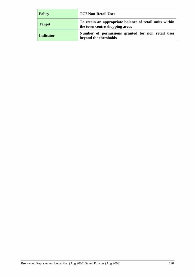
Brentwood Replacement Local Plan (Aug 2005) Saved Policies (Aug 2008) 190
Policy TC7 Non-Retail Uses
Target To retain an appropriate balance of retail units within
the town centre shopping areas
Indicator Number of permissions granted for non retail uses
beyond the thresholds

Brentwood Replacement Local Plan (Aug 2005) Saved Policies (Aug 2008) 191
APPENDICES
Informal Planning Guidance
Appendix 1: Extracts from the Essex Design Guide for Residential and Mixed Use Areas
[Appendix 2 (Vehicle Parking Standards) has been removed and is replaced by Essex County
Council Parking Standards: Design and Good Practice SPD (September 2009),
agreed at Policy Performance and Resources Board on 9 March 2011]
Appendix 3: Advertisements and Shop Front Guidance: Additional Advice to Applicants
[Also see Shopfront Guidance for Brentwood Town Centre SPD]
Appendix 4: Access for Disabled Persons
Appendix 5: Miscellaneous Residential Design Guidance
Additional Information
Appendix 6: List of Abbreviations

Brentwood Replacement Local Plan (Aug 2005) Saved Policies (Aug 2008) 192
APPENDIX 1: EXTRACTS FROM THE ESSEX DESIGN GUIDE FOR
RESIDENTIAL AND MIXED USE AREAS
The principles listed below are selected as key points to consider in design and layout, but should
not be considered as the only parts of the new Guide to which the Council refer, and should be
read in conjunction with the appropriate text, as indicated by page numbers in parentheses. This
guidance should also be read in the context of the Local Plan policies.
The Principles of Spatial Organisation (Page 5)
The aim of fitting in with the character of traditional towns and villages requires for its
fulfilment, the enclosure of space, whether by buildings or by landscape.
Traditionally there are two ways of organising space and buildings:
(i) Rural System - Buildings are set in landscape space
(ii) Urban System - Buildings containing the space
Site Appraisal (Page 6)
The applicant should carry out an appraisal of the site before designing the scheme. In the case
of sites larger than 1 hectare (2.5 acres) this site appraisal must precede or accompany the
planning application.
Sustainability (Page 9)
Sustainability requirements will need to be addressed in the following respects:
(i) The development should be located in proximity to a town centre or similar set of
facilities, and to public transport access. The suitability of location is a Local Plan
function.
(ii) The development has a mix of residential and employment uses, tenures and dwelling
sizes in order to reduce the need to travel. The Urban Villages concept is commended to
developers in this connection.
Any residential development larger then 500 dwellings must incorporate some mixed-use
development of an employment and/or retail nature.
(iii) The development is laid out in such a way as to maximise proximity to facilities and public
transport and to encourage walking and cycling instead of the use of cars.
(iv) The development is laid out in such a way as to safeguard the existing ecology, improve the
natural habitat and minimise heat loss from buildings.
Sustainability issues must be addressed for development sites larger than 1 hectare (2.5 acres).
Permeability and Legibility of the Layout (Page 10)
The layout structure on development sites larger than 1 hectare (2.5 acres) must be both
permeable and legible.
Brentwood Replacement Local Plan (Aug 2005) Saved Policies (Aug 2008) 193
A street layout that encourages walking and cycling is permeable, in that it is well connected and
offers a choice of direct routes to all destinations. It is also legible, in that it is structured by a
distribution of distinctive places and spaces so that it can be ‘read’ and is thus easy to find one’s
way round.
Public Open Space (Page 15)
All open space in a development should be obviously useful and visually pleasant.
Whilst parks should be the key open space provision, there is a role for additional, smaller, more
localised open space in order to create a more varied townscape.
Where there are a number of family dwellings with less than 100 sq. m. gardens, DOE Circular
79/72 recommended provision of play space on the basis of 3 sq. m. per child bed space would
result in 3-4 per cent of the site being given over to children’s play space.
Continuity of Frontage (Page 27)
In order to enclose spaces and create continuous pedestrian routes, as much continuity of built
frontage as possible should be achieved.
Relationship of House to Road (Page 28)
In order to enclose space effectively, buildings will normally be sited at the back edge of the
public footway. This will require car parking to be sited between houses, beneath upper storey
structures, or within garages to the rear. This has the advantage of reducing the visual impact of
on-site parked cars. It also has the advantage of increasing the amount of site area available for
private rear gardens.
Internal Privacy (Pages 29 and 31)
(i) Front Privacy
It is recommended that designers return to the traditional format of vertically proportioned
windows and houses set forward to the back edge of the footway, or, exceptionally, set back
behind eye level hedged or walled front gardens.
(ii) Rear Privacy
As a minimum every effort should be made to avoid overlooking of rear-facing living room
windows. This may be achieved (a) by remoteness or (b) by design, or by a combination of the
two.
Daylight and Sunlight (Page 30)
Housing layouts should be designed to maximise daylight and sunlight to dwellings as far as
possible but not to the exclusion of other considerations, such as privacy or the achievement of
an attractive streetscape.
Rear Privacy (Page 33)
As a minimum every effort should be made to avoid overlooking of rear-facing living room
windows. This may be achieved (a) by remoteness, or (b) by design, or by a combination of the
Brentwood Replacement Local Plan (Aug 2005) Saved Policies (Aug 2008) 194
two. Usually privacy achieved by design is more effective.
(The Council will normally require an “eye-to-eye” distance of at least 35 metres where a living
room is overlooked from an opposing dwelling, but this may be reduced where privacy can be
achieved by design).
Where new housing backs on to the rear of existing housing, existing residents are entitled to a
greater degree of privacy to their rear garden boundary, and therefore where the rear faces of the
new houses are approximately parallel to the existing, the rear of new houses may not encroach
any closer than 15 metres to an existing rear boundary, even though with a closer encroachment
35 metres between the backs of houses would still be achieved
Private Sitting Out Areas (Page 33)
All houses should have a private sitting out area not overlooked by adjacent or opposite living
rooms or sitting out areas. This area should extend at least 3 metres and be screened from
adjacent properties by walls or fences above eye level from a potential vantage point.
Garden Size (Page 33)
Most types of houses shall require a minimum private (i.e. rear) garden area of 100 sq.m.
Circumstances under which the insistence on a minimum 100 sq.m. garden area is inappropriate
are:
(a) Houses:
(i) Houses of one or two bedroom size
(ii) Walled patios or private courtyards - minimum garden areas of 50 sq. m. will be
acceptable provided a private sitting out area for each house can be achieved,
unoverlooked by any window either at ground or first floor.
(iii) Houses facing, backing onto, or adjacent to a substantial area of well landscaped
and properly maintained communal open space.
(iv) Houses performing a particular role in the layout e.g. houses which turn external
corners or perform a townscape role.
(In practice, the Council may accept garden sizes of 75 sq. m. in the case of two bedroom
properties and 50 sq. m. for one-bedroom dwellings.)
(b) Flats
(i) For two or more bed-roomed flats a communal residents’ garden area must be
provided on the basis of a minimum area of 25 sq. m. per flat, or
(ii) A balcony or terrace over 5 sq. m. will count towards the total garden provision
for the flats. In an urban situation such a balcony or terrace would be acceptable
as the outdoor amenity space for a flat.
Accessibility for Disabled People to Dwellings (Page 35)
It is good practice to design for all new dwellings to be able to be visited unassisted by disabled
Brentwood Replacement Local Plan (Aug 2005) Saved Policies (Aug 2008) 195
people as far as the entry to the dwelling at least.
Internal Space Provision (Page 40, Appendix A)
The range of dwelling sizes recommended in the Parker Morris report “Homes for Today and
Tomorrow”, is a good indication of desirable space standards.
Extendable Homes (Page 40)
For all two-bedroom and smaller houses, applicants must indicate whether or not the house is
extendable. If the house is not extendable the initial planning consent will be conditional on the
withdrawal of the householder’s right to extend within the limits of the General Permitted
Development Order. If the house is extendable the applicant must indicate, as part of the initial
planning application, how the house may in future be extended without problems to
neighbouring dwellings and curtilages or unacceptable loss of garden area.
Appropriate Use of Materials (Page 47)
Facing and roof materials should be selected from the range of regional materials characteristic
of Essex, or, of that part of Essex where the project is located.
Services to Dwellings (Page 51)
Supply and disposal services to dwellings are to be provided in a manner that is technically and
visually satisfactory i.e. both inconspicuously and accessibly.
Pedestrian and Cycle Movement (Page 53)
Within new residential areas pedestrian and cycle movement should be convenient, safe and
pleasant. Pedestrian routes should be mainly along residential roads, with occasional short links
to give pedestrians and cyclists a preferential direct route. Wherever possible pedestrian and
cycle routes should be overlooked by the front of dwellings.
Vehicular Movement (Page 54)
Within new residential areas, vehicular movement should be convenient, safe and pleasant, but
vehicular access is to be provided for in a way as to be consistent with the achievement of an
attractive environment and the needs of the pedestrian or cyclist who share the same space.
Through traffic is to be excluded from new residential areas, and the layout and attractiveness of
the environment should be such as to discourage the use of the car for local trips and encourage
walking and cycling.
All new residential areas should be divided up into elements not exceeding 700 dwellings. Each
of these elements, and any new developments less than 700 dwellings in size and containing a
road over 100 metres in length is to be served entirely by roads of a design speed of under 20
miles per hour (30 km per hour).
Car Parking (Page 74)
Car parking should be provided for both residents and visitors at an adequate level and in such
locations as to be reasonably convenient, visually inconspicuous and limit opportunities for car
related crime.
Brentwood Replacement Local Plan (Aug 2005) Saved Policies (Aug 2008) 196
Adoption and Maintenance of Roads, Footpaths and Open Space (Page 104)
The Local Authority may adopt and maintain those public areas essential to the functioning and
appearance of residential development.
Where public adoption is not practical, alternative arrangements shall be required to ensure the
proper maintenance of such areas.
Attention is also drawn to Appendix D of the Design Guide (page 106), which sets out a list
of planning conditions that the Council, together with other design conditions, would
normally attach to the grant of planning permission, as appropriate.

Brentwood Replacement Local Plan (Aug 2005) Saved Policies (Aug 2008) 197
APPENDIX 2: VEHICLE PARKING STANDARDS
This appendix has been removed and is replaced by Essex County
Council Parking Standards: Design and Good Practice SPD (Sep
2009), agreed at Policy Performance and Resources Board on 9
March 2011

Brentwood Replacement Local Plan (Aug 2005) Saved Policies (Aug 2008) 198
APPENDIX 3: ADVERTISEMENTS AND SHOP FRONT DESIGN:
ADDITIONAL ADVICE TO APPLICANTS
In addition to this guidance please also refer to Shopfront Guidance
for Brentwood Town Centre SPD, agreed at Policy Performance
and Resources Board on 9 March 2011
1. General
The aim of this advice is to promote and encourage good shopfront design. Whilst the design
principles have been written in the main for Conservation Areas and listed buildings, regard
should be had to the principles throughout the Borough.
The main purpose of the shopfront was to display the goods for sale but has increasingly become
a means by which a view of the interior of the shop can be achieved. However, in either case,
the shopfront projects an image of the shop. A poorly designed shopfront will project a poor
image and vice versa. Some modern shopfronts have been criticised because of their use of
inappropriate or garishly coloured materials; overly large fascias which have lead to the loss or
concealment of original detailing; and ignorance of the basic rules of scale and proportion.
Eighteenth and nineteenth century shopfront designs were based on principles that were
noticeably successful in achieving satisfactory relationships between the shopfronts and the
buildings. These principles still hold good. This guidance is intended to give an outline of the
principles of good shopfront design. However, it is not meant to be prescriptive or exhaustive.
Shopfronts should be of a size, design, scale and materials to satisfactorily relate to the
building in which the shopfront is to be installed and to adjacent premises.
The shopfront should satisfactorily relate to the upper floors of the building in structural
concept, proportion, scale and vertical alignment. However, within Conservation Areas, on
poorly designed buildings, the emphasis should be on achieving a shopfront that enhances
its Conservation Area setting.
Corporate house styles may need to be modified to suit the location and character of the
premises on which they are installed.
Large areas of unrelieved glass should be avoided. This can be achieved by introducing
vertical mullions and glazing bars, pilasters and stallrisers. (see Fig. 3.1)
2. Stallriser
The stallriser was a vital part of the historic shopfront, providing protection to the lower part of
the shop window and visual stability to the building. The stallriser will vary in height according
to the style adopted. A stallriser is also an advantage from the point of view of security in
physically strengthening the shopfront.
A stallriser will normally be required.
Suitable finish materials for a stallriser are painted panelled timber, render and, in some
cases, brick.

Brentwood Replacement Local Plan (Aug 2005) Saved Policies (Aug 2008) 199
A timber stallriser should sit on a stone or brick plinth to prevent rotting of the timber.
Entrance doors should be part glazed with a lower timber panel to reflect the height of the
stallriser.
3. Fascia
Most shopfronts incorporate a fascia to denote the name and/or type of shop. Additional
advertising is generally confusing and serves only to detract from the shopfront. The design of
the fascia should be appropriate to the character and period of the building, and in particular, to
the shopfront.
Excessively deep fascias should be avoided. The size and design should be in proportion to
the design of the shopfront and the height of the building. A fascia usually requires a visual
“cap” in the form of a projecting cornice. Most traditional fascias do not exceed 380 mm in
depth. As a guide, the fascia and cornice element of the shopfront should be less than one
quarter of the height of the whole shopfront (see Fig.3.1)
The construction of fascias of a common depth, which link two or more buildings that have
separate architectural identities, should be avoided even if internally they are all part of one
shop.
The fascia should not be applied over an existing one and must not obstruct other significant
elements of the building. The top of the fascia or the cornice should be clear of any first
floor window cills.
In Conservation Areas and on listed buildings the fascia should be made of hand painted
softwood timber.
4. Materials
The selection of materials for a shopfront should always take account of the style and design of
the proposed front, the building in which it is to be fitted and its setting. Generally, too many
different materials should be avoided.
Facing materials in Conservation Areas should be matt and non-reflective. Glossy surfaces
such as acrylic sheeting and perspex, aluminium or plastic will not normally be acceptable.
In the case of Listed Buildings, rustic stonework, ceramics, marble, plastic, anodised or
plastic coated metals will not normally be acceptable
Timber was the standard shop front material of historical shop fronts and is the most
appropriate material for all situations, but particularly in Conservation Areas and on Listed
Buildings. Painted timber will be generally preferred to stained hardwood. Non-sustainable
hardwoods are strongly discouraged as not only environmentally unsound but alien to the
historic street.
5. Lettering
The use of appropriate lettering can provide decorative interest and add to the character of the
shopfront. Considerable artistic effect can be achieved by using a competent signwriter.
Whilst the choice of lettering can reflect the use and character of both the shop and the

Brentwood Replacement Local Plan (Aug 2005) Saved Policies (Aug 2008) 200
building, in general, serif letters will be preferred.
Individual letters can be useful especially where there is no fascia but should neither be too
widely spaced or too close together. Where used with a fascia they should be well
proportioned to the length and depth of the fascia.
The actual size of lettering should be determined by the need to be legible, but not unduly
intrusive in relation to the building facade, and be integrated with other elements in the
street scene.
Colours are important; gilding or strong tones on a dark background reflect light and are
clearly visible at night.
6. Illumination
It is generally preferable to illuminate the window display rather than the shop front itself. Shop
signs do not need special illumination if the level of street lighting and light from shop windows
is adequate. The highlighting of significant buildings and pedestrian spaces is the key to a lively
and safe night-time environment.
Internally illuminated fascias will not be permitted in Conservation Areas (apart for the
exceptions in Brentwood High Street referred to in Policy TC14) and on listed buildings.
Elsewhere internal illumination should be restricted to letters only.
Normally, where lighting is appropriate, it should take the form of discreetly hidden external
illumination e.g. concealed behind a “false” cornice. The use of lanterns or fittings that are
obtrusive on the face of the building should be avoided.
External illumination of signs of a spot light type should not be located in any position
where they are likely to cause a traffic hazard.
It will not generally be appropriate to illuminate hanging signs unless they belong to public
houses, restaurants or similar late-opening premises.
7. Projecting Signs
There is a long tradition of hanging signs dating back through guild signs to Roman times. They
are an apt way of conveying information to the pedestrian, particularly in an enclosed situation
such as an arcade. Where a fascia is undesirable, a hanging sign might be a useful alternative.
Within Conservation Areas hanging signs are the most appropriate form of projecting sign
and should take the form of a free-swinging board hanging from a wrought iron bracket.
Hanging signs should, in all cases, be of a high quality of design and should relate to the size
and scale of the building and not be overly intrusive.
There should normally be no more than one hanging sign per building and it should usually
be located above and clear of the fascia and cornice and in any event at such a height and
overall projection that would not be liable to cause hazard to either vehicular or pedestrian
traffic. Positioning of the sign on or near to party walls will usually be preferable to central
positions
Where expressed consent is required, projecting box signs will not normally be permitted in
Conservation Areas or on listed buildings whether internally illuminated or not. In other
Brentwood Replacement Local Plan (Aug 2005) Saved Policies (Aug 2008) 201
areas, projecting box signs, where permitted, should be located no higher than the top of the
fascia or cornice.
8. Canopies and Blinds
Canopies and blinds have a practical purpose in that they provide shelter and protect the shop
display from damage due to direct sunshine. They should not be introduced as a form of
advertising space.
The use of plastic, wet-look or stretch fabrics, garish or fluorescent colours for blinds will
not normally be permitted.
Dutch blinds or “balloon” canopies are inappropriate since their open form and the shape of
the housing are unlikely to relate well to the shop front and they tend to obstruct the fascia.
Blinds should not normally be required on north facing elevations or in narrow streets.
Where fitted they should be retractable so that the fascia is not permanently obscured.
Careful thought needs to be given as to how the blind box can be integrated within the
overall shop front design. Incorporation within a fascia cornice was a traditional solution.
9. Residential Conversions
Early shops were incorporated into the ground floor of residential town houses. Where
conversion of the ground floor of an existing residential property is proposed the design of the
shopfront should be sympathetic to the original residential use.
Shop fronts should be of a scale and design to compliment such residential buildings and
retain the original features wherever possible, e.g. pilasters, transom lights.
The installation of additional or enlarged windows or other major alterations will not
normally be acceptable.
The use of external cladding or render should be avoided on buildings constructed in faced
brickwork.
10. Access
Shops, like all other buildings open to the public should be accessible to all. Detailed guidance
is set out in the Council’s “Access for the Disabled” supplementary planning guidance.
New shop fronts should accommodate the needs of disabled persons and others with
impaired mobility.
As a general principle, steps should be avoided and doors be made wide enough and capable
of being opened by people in wheel chairs.
Frameless glass doors within extensive areas of glazing should be avoided as they cause
difficulties for the partially sighted
11. Shop Front Security
External solid metal shutters will only be permitted in exceptional circumstances, having regard,
inter alia, to the types of goods sold/displayed, but equally having regard to the potentially

Brentwood Replacement Local Plan (Aug 2005) Saved Policies (Aug 2008) 202
detrimental and deadening effect of such shutters on the character and appearance of the area.
The following are recommended as alternatives in order of preference:
i) Laminated security glass – this will not change the appearance of the shop front.
ii) Internal grilles – these can be fitted discreetly behind the shop window, are
retractable or removable and would (in any event) not normally require consent, as is
the case of i) above.
iii) External mesh grilles – if storage is available, removable grilles preclude the
necessity for a box housing on the fascia and are preferable to roller grilles. This type
of protection should allow a window display to be viewed without the necessity for
internal lighting i.e. that the grille openings need to be of sufficient size, but it is
important that the fixings and materials used are integrated into the design of the shop
front. On Listed Buildings, permission will only be given if the grille does not detract
from the special interest of the building and its shop front. Similarly, in Conservation
Areas, planning permission will only be given where development will not detract
from the character or appearance of both the shop front and the area as a whole.
Either as an alteration or an addition to the above, appropriately designed and located
bollards which do not give rise to a highway obstruction should be considered.
Attention to the finishing details of a shutter or grille can soften their impact and prevent the
“raw” industrial image of galvanised steel.
The finish must be durable. Appropriate treatments include powder coating and coloured
anodised aluminium.
Wherever possible, shutter/grille boxes and tracks should be recessed behind the fascia of
the shop front or at least be removable during opening hours.
As a general rule, when designing a new shop front, a sufficiently high and solid stall-riser is
an efficient means of deterring or preventing ram raiders.
For further details see the Essex County Council booklet “Conservation in Essex No.5:
Shop Fronts” and the English Historic Towns Forum booklets “Shop Fronts and
Advertisements in Historic towns” and “Book of Details and Good Practice in Shop Front
Design”

Brentwood Replacement Local Plan (Aug 2005) Saved Policies (Aug 2008) 203
Brentwood Replacement Local Plan (Aug 2005) Saved Policies (Aug 2008) 204
APPENDIX 4: ACCESS FOR DISABLED PERSONS
1. ACCESS TO BUILDINGS TO WHICH THE PUBLIC ARE TO BE ADMITTED
(i) External Features
Car Parking
Car parking requirements are set out in Appendix 2.
Pavements and Paths
To be firm and even with a minimum width of 1.8m for intensive use, 1.5m for moderate
use, and 1.2m for rarely used routes.
A dropped and blistered textured surface at road crossing points helps wheelchair users as
well as blind or partially sighted people.
Ramps
Preferred ramp gradient to be between 1:20 and 1:12.
Non-slip handrails on both sides of ramps and steps between 900mm and 1.0m above pitch
line. These should extend for 300mm on the level at either end of the steps and ramps.
Level landing at least 1.2 sq.m outside entrance door.
External Doors
Doors should have a minimum clear opening width of 800mm, and should be easy to open
by people with limited strength. Automatic doors are desirable.
Glazed doors to be clearly identifiable as such.
Other doors should include a visibility panel.
All doors should be provided with a kicking plate.
Ironmongery should be about 1m above the ground, be easily usable and clearly identifiable.
Thresholds should be flush. If raised thresholds are necessary, maximum height 15mm.
(ii) Internal Features
Lobbies
Doors to be sited for easy, unobstructed approach.
Lobbies should be of adequate size to allow for wheelchair manoeuvre.

Brentwood Replacement Local Plan (Aug 2005) Saved Policies (Aug 2008) 205
Sanitary facilities should be located such that a wheelchair user should not have to travel
more than 1 storey.
Lifts
A well-lit clear space in front of lift doors to be a minimum of 1500 x 1500mm.
Lift doors to be a minimum clear width of 800mm.
Minimum internal lift dimension is 1400 x 1100mm.
Raised floor/level numerals, touch light controls with embossed digits and both illuminated
and audible systems inside lift and at landings.
Lift control buttons to be located between 900mm and 1.2 m above floor level.
Corridors
Corridors and circulation spaces to be unobstructed, with adequate turning space and a
minimum width 1200mm.
Projecting objects and surfaces hazardous to blind people to be avoided.
Internal Doors
Minimum clear opening width of each leaf to be 750mm.
Corridor doors require vision panels
Sited for easy, unobstructed approach.
Door handle height of 1.0m preferred.
Sanitary Accommodation
Male and female or a unisex sanitary accommodation would require minimum internal
dimensions 2000 x 1500mm and should be appropriately fitted out.
These notes are for general guidance only. For further, more detailed design guidance, the
following publications should be consulted:
British Standard Code of Practice for Design of Buildings and their Approaches to meet the needs
of Disabled People, BS 8300: 2001 British Standards Institution.
2. LIFETIME HOMES STANDARDS
New properties built to Lifetime Homes Standards incorporate 16 design standards, set out
below, which help to ensure that the home is flexible, adaptable and accessible, and add to
comfort, convenience and safety. Such properties meet the varying needs of a household as they
may change over a lifetime or can accommodate the majority of adaptations that may be
necessary with maximum ease and minimum cost.

Brentwood Replacement Local Plan (Aug 2005) Saved Policies (Aug 2008) 206
1. Access
Where car parking is adjacent to the home, it should be capable of enlargement to attain
3.3 metres width.
The distance from the car parking space to the home should be kept to a minimum and
should be level or gently sloping.
The approach to all entrances should be level or gently sloping. (Gradients for paths
should be the same as for public buildings in the Building Regulations).
All entrances should be illuminated and have level access over the threshold, and the main
entrance should be covered.
Where homes are reached by a lift, it should be wheelchair accessible.
2. Inside the Home
The width of the doorways and hallways should accord with the Access Committee for
England’s standards.
There should be space for the turning of wheelchairs in kitchens, dining areas and sitting
rooms and adequate circulation space for wheelchair users elsewhere.
The sitting room (or family room) should be at entrance level.
In houses of two or more storeys, there should be space on the ground floor that could be
used as a convenient bed space.
There should be a downstairs toilet, which should be wheelchair accessible, with drainage
and service provision enabling a shower to be fitted at any time.
Walls in bathrooms and toilets should be capable of taking adaptations such as handrails.
The design should incorporate provision for a future stairlift and a suitably identified space
for potential installation of a house lift (through-the-floor lift) from the ground floor to the
first floor, for example to a bedroom next to the bathroom.
The bathroom/bedroom ceiling should be strong enough, or capable of being made strong
enough, to support a hoist at a later date. Within the bathroom/bedroom wall provision
should be made for a future floor to ceiling door, to connect the two rooms by a hoist.
The bathroom layout should be designed to incorporate ease of access, probably from a
side approach, to the bath and WC. The washbasins should also be accessible.
3. Fixtures and Fittings
Living room window glazing should begin at 800mm or lower, and windows should be
easy to open/operate.
Switches, sockets and service controls should be at a height usable by all (i.e. between

Brentwood Replacement Local Plan (Aug 2005) Saved Policies (Aug 2008) 207
600mm and 1200mm from the floor)
Copies of the Joseph Rowntree Foundation leaflet “Building Lifetime Homes”, which sets
out further advice and information, is available from Planning Services.
Detailed Guidelines can be found in:
Building Lifetime Homes – Joseph Rowntree Foundation Feb. 1997
Part M of the Building Regulations
BS 8300: 2001 – Design of Buildings and their Approaches to meet the needs of Disabled People
– Code of Practice
Brentwood Replacement Local Plan (Aug 2005) Saved Policies (Aug 2008) 208
APPENDIX 5: MISCELLANEOUS RESIDENTIAL DESIGN GUIDANCE
In addition to the following guidance, attention is also drawn to Policy H17, and the
accompanying paragraph 3.62, dealing with ‘Dormer Windows’, and Policy H18, and the
accompanying paragraphs 3.63 and 3.64, dealing with ‘Satellite Dishes’, set out on pages 3.21
and 3.22 of this Local Plan Written Statement.
Proposals for residential development should have regard, where appropriate, to the
following:
New Build or Conversions to Flats and Apartments
Readily accessible private amenity space shall be provided at a standard of 50 sq.m for
each unit. Where provided communally a minimum of 100 sq.m private amenity space
shall be provided for up to 4 flats.
Each unit, excluding communal circulation areas, shall have a total floor area of not less than
40 sq. m. where one-bedroom units are provided and not less than 52 sq. m. where two-
bedroom units are provided.
The units should be self-contained, with full domestic facilities, and have individual room
sizes to at least accord with the recommendations of the environmental health officer. The
creation of houses in multiple-occupation, where amenities and facilities are shared by the
occupants, will not normally be allowed.
The internal layout of each unit of accommodation should generally allow each individual
bedroom to be entered independent of another bedroom. Furthermore, bedrooms should not
be placed next to or beneath kitchens, living rooms, bathrooms or heavily used circulation
spaces of adjoining dwellings unless a satisfactory soundproofing scheme is submitted.
Extensions
As a guide, single-storey front extensions should not normally project more than 1.3m in
front of the main front wall of the dwelling unless there are particular circumstances, such as
where properties are staggered.
Where the proposed extension is more than one-storey in height:
(a) The extension shall not be erected closer than 1m to the boundary of the property. (A
greater distance may be required where appropriate.) This criterion will also apply to
extensions over existing ground floor extensions that abut the boundary.
In Hutton Mount, a minimum distance of 1.2m shall apply to all extensions (including
single-storey).
(b) The extension should be restricted in size and siting such that the projection would not
form an angle greater than 45 from the nearest ground floor window to a habitable room
of the adjacent property. This rule will not be applied to a flank window or to a non-
habitable room (e.g. bathroom, hallway).
(Note – this restriction would also apply to the siting of a new dwelling and its relationship
to existing adjacent properties)
Brentwood Replacement Local Plan (Aug 2005) Saved Policies (Aug 2008) 209
Porches
The porch shall be compatible in size and design with the existing dwelling
The porch shall have a pitch roof
The porch where seen as part of the front elevation should be of such proportions as to
ensure it is an incidental feature of the overall appearance of the building. In order to
achieve this, the width and projection of porches will be restricted in size. As a guide, the
width should not normally exceed one-third of the width of the building or be no more than
3m wide, whichever is less, and should not normally project more than 1.3m in front of the
main front wall of the dwelling, unless there are particular circumstances, such as where
properties are staggered.
The porch shall not detract from the amenity of adjoining occupiers
Walls, Gates and Fences
Walls, gates, fences and other means of enclosure shall be of a design and scale
commensurate with the street scene and/or character of the area and shall be constructed of
materials and of a colour that are in keeping with the locality
Dustbin Enclosures
Dustbin enclosures, where necessary, should be provided at a distance of not more than 25m
from the carriageway
Open Space Provision
Developers of residential sites of less than 0.4 ha. (or 20 units) will normally be required to
make a financial contribution towards the provision of a Local Area of Play (LAP), a Local
Equipped Area of Play (LEAP) and a Neighbourhood Equipped Area of Play (NEAP)
Developers of residential sites of between 0.4 and 1.0 ha. (or 20 to 50 units) will normally be
required to provide a LAP with a minimum area of 100 sq.m (either on-site or off-site) and
make a financial contribution towards the provision of a LEAP and a NEAP.
Developers of residential sites greater than 1.0 ha. (or 50 units) will normally be required to
provide a LEAP with a minimum area of 400 sq.m and 5 types of play equipment (either on-
site or off-site) and at least 1 LAP on-site with a minimum area of 100 sq.m and make a
financial contribution towards the provision of a NEAP. [A NEAP should have a minimum
area of 1000 sq.m and 8 types of play equipment]
The precise amount of the contribution will depend on the nature and extent of existing
provision in the locality, the type and scale of development proposed and specific site
circumstances. In all appropriate cases the contribution will include the provision of
equipment and the ongoing future maintenance of the site.
Within larger housing areas (sites of 50 units and above) at least 15% of the site area should
be set aside for public open space, part of which should be suitably hard surfaced. In areas
deficient in open space or having higher densities and/or smaller gardens more open space
will be sought.

Brentwood Replacement Local Plan (Aug 2005) Saved Policies (Aug 2008) 210
APPENDIX 6: LIST OF ABBREVIATIONS
ALP Adopted Local Plan
AQMA Air Quality Management Area
ARDP Approved Review to the County Development Plan
BAP Biodiversity Action Plan
BCMS Brentwood Countryside Management Service
db Decibels
Dept. Department
DETR Department of the Environment, Transport and the Regions
DEFRA Department of the Environment, Food and Rural Affairs
DTLR Department of Transport, Local Government and the Regions
EA Environment Agency
ECC Essex County Council
EHCR Essex Heritage Conservation Record
EPOA Essex Planning Officers Association
ES Environmental Statement
EWT Essex Wildlife Trust
ft. Foot (length)
GO-East Government Office for the Eastern Region
GP General Practitioner
GPDO General Permitted Development Order
ha. Hectares
HSE Health and Safety Executive
JSPAs Joint Structure Plan Authorities
LAP Local Area of Play
LDD Local Development Document
LDF Local Development Framework
LEAP Local Equipped Area of Play
LNR Local Nature Reserve
LOIS London to Ipswich Multi Modal Study
LPA Local Planning Authority
LTP Local Transport Plan
m. Metre
mm. Millimetre

Brentwood Replacement Local Plan (Aug 2005) Saved Policies (Aug 2008) 211
MGB Metropolitan Green Belt
NEAP Neighbourhood Equipped Area of Play
NPFA National Playing Fields Association
ORBIT The M25 London Orbital Transport Study
PPG Planning Policy Guidance Note
PPS Planning Policy Statement
ROSE Rest of the South East
RPG Regional Planning Guidance
RSL Registered Social Landlord
RSP Replacement Structure Plan
RSS Regional Spatial Strategy
Sect. 106 Section 106 of the Town and Country Planning Act1990
SHG Social Housing Grant
SPD Supplementary Planning Document
SPG Supplementary Planning Guidance
sq.m Square Metres
SSSI Site of Special Scientific Interest
SuDS Sustainable Drainage System
TIA Traffic Impact Assessment
TPP Transport Policies and Programmes
TPO Tree Preservation Order
UDP Unitary Development Plan
Related Documents