28 Oilfield Review Brazil’s Presalt Play Brazil’s quest for energy self-sufficiency has driven exploration efforts throughout the vast nation, from its interior basins to its deep offshore waters. Expertise and techniques developed to exploit deepwater fields of the Campos basin have been adapted to wells in the Santos basin, some of which are targeting carbonate reservoirs sealed beneath a thick evaporite layer. Exploration models from the Santos basin presalt play, in turn, have led to significant discoveries in neighboring basins. Craig J. Beasley Joseph Carl Fiduk Houston, Texas, USA Emmanuel Bize Austin Boyd Marcelo Frydman Andrea Zerilli Rio de Janeiro, Brazil John R. Dribus New Orleans, Louisiana, USA Jobel L.P. Moreira Antonio C. Capeleiro Pinto Petrobras Rio de Janeiro, Brazil Oilfield Review Autumn 2010: 22, no. 3. Copyright © 2010 Schlumberger. For help in preparation of this article, thanks to Celso C.M. Branco and Breno Wolff, Petrobras, Rio de Janeiro, Brazil; Carolina Castro, Houston; and Joao Felix, Antonio P. Ferreira, Patricia Marçolla, Attilio Pisoni and Ana Zambelli, Rio de Janeiro. 1. The potential recoverable volume of 5 to 8 billion barrels of oil equivalent pertains to an area covered by the PA-RJS-628 evaluation plan, which encompasses both the Tupi and Iracema areas. Beltrão RLC, Sombra CL, Lage ACVM, Fagundes Netto JR and Heriques CCD: “Challenges and New Technologies for the Development of the Pre-Salt Cluster, Santos Basin, Brazil,” paper OTC 19880, presented at the Offshore Technology Conference, Houston, May 4–7, 2009. 2. Petrobras, BG Group and Partex were partners in the Parati well, with Petrobras serving as operator. 3. Parshall J: “Presalt Propels Brazil into Oil’s Front Ranks,” Journal of Petroleum Technology 62, no. 4 (April 2010): 40–44, http://www.spe.org/jpt/print/archives/2010/04/ 13Brazil.pdf (accessed August 6, 2010). 4. Parshall, reference 3. 5. “BG, Petrobras Announce Discovery of Oil Field in Santos Basin Offshore Brazil,” Drilling Contractor 62, no. 6 (November–December 2006): 8. Period Epoch Age Years, Ma Miocene Neogene Oligocene Eocene Paleogene Paleocene Tertiary Cretaceous Langhian Burdigalian Aquitanian Chattian Rupelian Lutetian Ypresian Thanetian Selandian Danian Campanian Santonian Coniacian Turonian Cenomanian Albian Aptian Barremian Hauterivian Valanginian Berriasian Piacenzian Zanclean Messinian Tortonian Serravallian Priabonian Bartonian Maastrichtian Late Early L M E L E L M E L M E Pliocene 2.6 5.3 23 33.9 55.8 65.5 99.6 145.5 Montevideo A m a zon R ive r

Welcome message from author
This document is posted to help you gain knowledge. Please leave a comment to let me know what you think about it! Share it to your friends and learn new things together.
Transcript

28 Oilfield Review
Brazil’s Presalt Play
Brazil’s quest for energy self-sufficiency has driven exploration efforts throughout
the vast nation, from its interior basins to its deep offshore waters. Expertise and
techniques developed to exploit deepwater fields of the Campos basin have been
adapted to wells in the Santos basin, some of which are targeting carbonate reservoirs
sealed beneath a thick evaporite layer. Exploration models from the Santos basin
presalt play, in turn, have led to significant discoveries in neighboring basins.
Craig J. BeasleyJoseph Carl FidukHouston, Texas, USA
Emmanuel Bize Austin BoydMarcelo Frydman Andrea Zerilli Rio de Janeiro, Brazil
John R. DribusNew Orleans, Louisiana, USA
Jobel L.P. MoreiraAntonio C. Capeleiro PintoPetrobrasRio de Janeiro, Brazil
Oilfield Review Autumn 2010: 22, no. 3. Copyright © 2010 Schlumberger.For help in preparation of this article, thanks to Celso C.M.Branco and Breno Wolff, Petrobras, Rio de Janeiro, Brazil; Carolina Castro, Houston; and Joao Felix, Antonio P. Ferreira, Patricia Marçolla, Attilio Pisoni and Ana Zambelli, Rio de Janeiro. 1. The potential recoverable volume of 5 to 8 billion barrels
of oil equivalent pertains to an area covered by the PA-RJS-628 evaluation plan, which encompasses both the Tupi and Iracema areas.Beltrão RLC, Sombra CL, Lage ACVM, Fagundes Netto JR and Heriques CCD: “Challenges and New Technologies for the Development of the Pre-Salt Cluster, Santos Basin, Brazil,” paper OTC 19880, presented at the Offshore Technology Conference, Houston, May 4–7, 2009.
2. Petrobras, BG Group and Partex were partners in the Parati well, with Petrobras serving as operator.
3. Parshall J: “Presalt Propels Brazil into Oil’s Front Ranks,” Journal of Petroleum Technology 62, no. 4 (April 2010): 40–44, http://www.spe.org/jpt/print/archives/2010/04/13Brazil.pdf (accessed August 6, 2010).
4. Parshall, reference 3.5. “BG, Petrobras Announce Discovery of Oil Field in Santos
Basin Offshore Brazil,” Drilling Contractor 62, no. 6 (November–December 2006): 8.
Period Epoch Age Years,Ma
Mio
cene
Neo
gene
Olig
ocen
eEo
cene
Pale
ogen
e
Pale
ocen
e
Terti
ary
Cret
aceo
us
Langhian
Burdigalian
Aquitanian
Chattian
Rupelian
Lutetian
Ypresian
Thanetian
Selandian
Danian
Campanian
Santonian
Coniacian
Turonian
Cenomanian
Albian
Aptian
Barremian
Hauterivian
Valanginian
Berriasian
Piacenzian
Zanclean
Messinian
Tortonian
Serravallian
Priabonian
Bartonian
Maastrichtian
Late
Early
L
M
E
L
E
L
M
E
L
M
E
Pliocene2.6
5.3
23
33.9
55.8
65.5
99.6
145.5
Montevideo
Amazon River
Autumn 2010 29
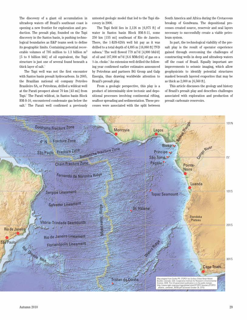
The discovery of a giant oil accumulation in ultradeep waters off Brazil’s southeast coast is opening a new frontier for exploration and pro-duction. The presalt play, founded on the Tupi discovery in the Santos basin, is pushing techno-logical boundaries as E&P teams seek to define its geographic limits. Containing potential recov-erable volumes of 795 million to 1.3 billion m3
[5 to 8 billion bbl] of oil equivalent, the Tupi structure is just one of several found beneath a thick layer of salt.1
The Tupi well was not the first encounter with Santos basin presalt hydrocarbons. In 2005, the Brazilian national oil company Petróleo Brasileiro SA, or Petrobras, drilled a wildcat well at the Parati prospect about 70 km [43 mi] from Tupi.2 The Parati wildcat, in Santos basin Block BM-S-10, encountered condensate gas below the salt.3 The Parati well confirmed a previously
untested geologic model that led to the Tupi dis-covery in 2006.
The Tupi field lies in 2,126 m [6,975 ft] of water in Santos basin Block BM-S-11, some 250 km [155 mi] southeast of Rio de Janeiro. There, the 1-RJS-628A well hit pay as it was drilled to a total depth of 4,895 m [16,060 ft] TVD subsea.4 The well flowed 779 m3/d [4,900 bbl/d] of oil and 187,000 m3/d [6.6 MMcf/d] of gas on a 5/8-in. choke.5 An extension well drilled the follow-ing year confirmed earlier estimates announced by Petrobras and partners BG Group and Galp Energia, thus drawing worldwide attention to Brazil’s presalt play.
From a geologic perspective, this play is a product of interminably slow tectonic and depo-sitional processes involving continental rifting, seafloor spreading and sedimentation. These pro-cesses were associated with the split between
South America and Africa during the Cretaceous breakup of Gondwana. The depositional pro-cesses created source, reservoir and seal layers necessary to successfully create a viable petro-leum system.
In part, the technological viability of the pre-salt play is the result of operator experience gained through overcoming the challenges of constructing wells in deep and ultradeep waters off the coast of Brazil. Equally important are improvements to seismic imaging, which allow geophysicists to identify potential structures masked beneath layered evaporites that may be as thick as 2,000 m [6,560 ft].
This article discusses the geology and history of Brazil’s presalt play and describes challenges associated with exploration and production of presalt carbonate reservoirs.
Doldrums Fracture Zone
Fracture Zone4° N
Fracture Zone
Romanche Fracture Zone
Chain Fracture Zone
Fernando de Noronha Ridge
Sergipe Lineament
Salvador Lineament
Rio de Janeiro Lineament
Rio Grande Rise
Mid
ocea
nic
Ridg
e
Sao Paulo
Pagalu
Bioko
Rio de Janeiro
Cape Town
Pointe-Noire
Monrovia
St. Helena
Tristan da Cunha
Benu
e Trou
gh
Walv
is Ridg
e
Topaz SeamountCo
ng
o River
0
10 N
10 S
20 S
30 S
Sao Paulo
Florianopolis Lineament
Vitoria-T ir ndade Seamounts
Sao Tome
Luanda
EtendekaPlateau
Lagos
Map adapted from Grothe PR: ETOPO1 Ice Surface Global Relief Model.Boulder, Colorado, USA: Cooperative Institute for Research in EnvironmentalScience, 2009. This US government publication is in the public domain:http://www.ngdc.noaa.gov/mgg/global/relief/ETOPO1/posters/ETOPO1–atlantic–centered–36x56.pdf (accessed October 28, 2010).

30 Oilfield Review
>Mantle plume. Upwelling mantle material rises from the asthenosphere on convective currents. Depending on the thickness and strength of the overlying lithosphere, the plume may punch through the crust as a volcano, or it may reside below the lithosphere, melting the base of the overlying layer and causing it to stretch and swell upward as a hot spot. As a lithospheric plate drifts above a stationary plume, it may leave a trail of volcanoes and seamounts that map the direction of drift.
Melting of lithosphereLithosphere
Asthenosphere
Mantle plume
Hot spot volcanoThermal upliftdue to hot spot
Conv
ectio
n cu
rrent
Postsalt to PresaltFrom an E&P standpoint, Brazil’s presalt play is a fairly new phenomenon. As recently as 2005, most offshore operators explored delta channel and deepwater turbidite prospects lying above the deep salt of the basins along Brazil’s southeastern coast. With the discovery of presalt reservoirs,
those targets in the strata above the salt are designated as postsalt, or suprasalt, prospects.
Brazil’s presalt trend differs significantly from the subsalt trend found in the Gulf of Mexico.6
Presalt wells are drilled into formations that were deposited prior to the emplacement of a layer of autochthonous salt—salt that remains at its
original stratigraphic level. This autochthonous salt lies above older rocks and is, in turn, overlain by younger strata. By contrast, subsalt wells are drilled into formations lying beneath mobile cano-pies of allochthonous salt—masses of salt, fed by the original autochthonous layer, that rise through overlying layers, then spread laterally (left). To be sure, salt diapirism is an active force in the basins of offshore Brazil, and suprasalt wells are still tap-ping into structural traps resulting from salt movement; however, this article will concentrate on more-recent presalt targets.
Although Brazil’s presalt exploration efforts focus heavily on the Santos, Campos and Espírito Santo basins, layers of salt have also been found elsewhere along Brazil’s coast—in the Cumuruxatiba, Jequitinhonha, Camamu-Almada and Sergipe-Alagoas basins.7 The thickness of the evaporite deposits is highly variable from one basin to the next. At its widest point, the salt basin extends to about 400 km [250 mi] in the Santos basin but tapers to the north, reaching a width of less than 100 km [62 mi] in the Sergipe-Alagoas basin.8
Tectonic FoundationsThe geology of the presalt play is linked to tec-tonic movements that led to the breakup of the Gondwanan supercontinent. The split, driven by heat from the Earth’s core, resulted from ther-mal uplift and rifting that ultimately culminated in seafloor spreading, which continues to this day. These processes set up a geologic frame-work that dates back some 150 million years, in which rapid events may have taken 2 to 3 mil-lion years and local occurrences may have spread over 1,000 km [620 mi] or greater, thus demanding a big-picture perspective.
Continental masses ride on lithospheric plates above a partially molten mantle. The mol-ten mantle slowly flows along convection cells that transfer heat from the Earth’s center to its surface. As they move, some plates drift over upwelling magma within the asthenosphere. This magma rises from the deep in a mantle plume that creates localized hot spots as it conducts heat upward (left).9 Today, volcanoes, seamounts and basalt flows can be used to track the ancient path of plate migration over a hot spot.
When a mantle plume rises beneath a conti-nental plate, it also can cause the overlying crust to swell. Thermal uplift, or doming of the conti-nental crust and upper mantle, is followed by faulting as the crust stretches, thins and weakens. Rifts develop at the crest of the uplift and radiate outward, at about 120° increments. These rifts
> Presalt versus subsalt. Mobile canopies of allochthonous salt detach from thick layers of autochthonous salt. Both types of salt are capable of forming traps and seals for migrating hydrocarbons. Presalt wells target reservoirs beneath the layer of autochthonous salt. Subsalt wells target reservoirs beneath the mobile allochthonous salt canopy. Postsalt wells target formations above the salt.
Presalt
Subsalt
Postsalt
Autochthonous salt
Seabed
Allochthonous salt

Autumn 2010 31
meet to form a triple junction; typically, two active rifts create a single accreting boundary where the plates begin to separate, while the third rift becomes inactive as a failed arm or aborted rift (above). The failed arm often becomes a locus of volcanism or other magmatic activity.10 Some failed arms become the sites of flood basalts, which are associated with the impingement of a mantle plume against the base of a lithospheric plate. As the plates continue to diverge, magma rises up to fill the expanding rifts.11
Thermal decay takes over once the plate drifts away from the hot spot, and the stretched crust begins to sag as cooling causes it to con-tract and become denser.12 The resulting basins gradually fill with potential source beds, reser-voir rock and evaporites. These sag basins would become the focus of presalt exploration on both sides of the South Atlantic.
Presalt GeologyBrazil’s presalt discoveries and a substantial por-tion of its postsalt fields are charged by hydrocar-bons generated from lacustrine source rocks. These organic-rich lake deposits formed through a series of events associated with the breakup of western Gondwana. The breakup took place dur-ing the Early Cretaceous; moving clockwise at 2 to 5 cm/yr [0.8 to 2 in./yr], it took nearly 40 million years—from Early Valanginian to Late Albian age—for South America to separate from Africa.13
The breakup began with rifting in the south-ernmost part of what is now South America. Two major mantle plumes—the St. Helena plume to the north and the Tristan da Cunha plume to the south—contributed to weakening of the conti-nental lithosphere (above right).14 Thermal uplift
6. For more on the Gulf of Mexico subsalt trend: Dribus JR, Jackson MPA, Kapoor J and Smith MF: “The Prize Beneath the Salt,” Oilfield Review 20, no. 3 (Autumn 2008): 4–17.
7. Karner GD and Gambôa LAP: “Timing and Origin of the South Atlantic Pre-Salt Sag Basins and Their Capping Evaporites,” in Schreiber BC, Lugli S and Babel M (eds):Evaporites Through Space and Time. London: Geological Society, Special Publication 285 (2007): 15–35.
8. Szatmari P: “Habitat of Petroleum Along the South Atlantic Margins,” in Mello MR and Katz BJ (eds): Petroleum Systems of South Atlantic Margins. Tulsa: The American Association of Petroleum Geologists, AAPG Memoir 73 (2000): 69–75.
9. The brittle lithosphere, which consists of the crust and upper mantle together, is thought to ride over a deeper, highly ductile asthenosphere, consisting of the lower mantle. The lower mantle, in turn, surrounds the Earth’s core.
10. Burke K and Dewey JF: “Plume-Generated Triple Junctions: Key Indicators in Applying Plate Tectonics to Old Rocks,” Journal of Geology 81, no. 4 (1973): 406–433.
> Triple junction in map view. Uplifts over mantle plumes develop crestal rifts that intersect at approximately 120° angles. Two active arms create an expanding rift that pulls away from the main body of a plate, leaving an inactive aborted rift, or failed arm, that is typically marked by volcanic activity.
> Hot spots in the southern Atlantic Ocean. Large-scale mantle plumes, presently located near the islands of Tristan da Cunha and St. Helena, played roles in weakening the crust during the initial stages of rifting between South America and Africa. The Tristan plume was responsible for the flood basalts of the Paraná basin. The St. Helena plume developed later and is associated with the aborted rift of the Benue Trough in Nigeria. (Adapted from Wilson, reference 14.)
St. Helenahot spot
Tristan da Cunhahot spot
EtendekaPlateau
Benue Trough
Ponta Grossa Arch
km
mi 1,000
0
0
1,000
Paranaflood
basalts
Basalts
11. For more on how plate movement affects the modern world: Bunting T, Chapman C, Christie P, Singh SC and Sledzik J: “The Science of Tsunamis,” Oilfield Review 19, no. 3 (Autumn 2007): 4–19.Coates R, Haldorsen JBU, Miller D, Malin P, Shalev E, Taylor ST, Stolte C and Verliac M: “Oilfield Technologies for Earthquake Science,” Oilfield Review 18, no. 2 (Summer 2006): 24–33.
12. Quinlan GM: “Models of Subsidence Mechanisms in Intracratonic Basins, and Their Applicability to North American Examples,” in Beaumont C and Tankard AJ (eds): Sedimentary Basins and Basin-Forming Mechanisms. Calgary: Canadian Society of Petroleum Geologists, Memoir 12 (1987): 463–481.
13. Szatmari, reference 8.14. Wilson M: “Magmatism and Continental Rifting During the
Opening of the South Atlantic Ocean: A Consequence of Lower Cretaceous Super-Plume Activity?” in Storey BC, Alabaster T and Pankhurst RJ (eds): Magmatism and the Causes of Continental Break-Up. London: Geological Society, Special Publication 68 (1992): 241–255.
VolcanicactivityAborted rift
Rift valley
Rift
valle
y
120
120
120

32 Oilfield Review
and thinning of the continental crust resulted in tensional fractures that later became conduits for magma, forming igneous dikes.15 Hundreds of these dikes cut through what is now the south-eastern coastline of Brazil, and their orientations are used to map an important triple junction (left). The coastal dike swarms mark the north-ern and southern arms of a plume-generated tri-ple junction system centered on Brazil’s Paraná State coast. These active arms helped to shape the present-day coastline, while the third arm, known as the Ponta Grossa Arch, failed and became the locus of basaltic activity.16
The extrusion of massive flood basalts into the onshore Paraná basin ensued, spreading from southern Brazil to Paraguay, Uruguay and northern Argentina, and covering an area of 1,200,000 km2
[463,320 mi2] (next page). Stacking of different magma types suggests that the main locus of mag-matism moved north over time, leading some researchers to conclude that the generation of the Paraná flood basalts is linked to the northward propagation of rifting in the South Atlantic.17
As continental crust ruptured along the rifts, adjacent rifts linked together, forming a ridge-transform boundary that heralded the separation of South America from Africa. This eventually created an opening for the nascent South Atlantic
> Paraná triple junction. Correlations between dike swarms in Brazil and those in Angola and Namibia are used to map the Paraná triple junction. Basalts similar in composition to the flood basalts of the Ponta Grossa Arch are found along the Namibian coast near Etendeka. (Adapted from Coutinho, reference 16.)
NAMIBIA
Basalts
km
mi 500
0
0
500
Sout
hern
arm
Sao Paulo
Ponta Grossa Arch
Northern arm
Rio de Janeiro
Montevideo
Florianopolis
B R A Z I L
ANGOLA
EtendekaPlateau
> From rift to drift. Salt basin development occurred gradually, as rifting between South America and West Africa gradually evolved into a full-fledged drift. About 150 million years ago, extensional faulting and subsidence were active in the Gondwanan supercontinent. Further stretching and extension during the Early Cretaceous led to the formation of large-scale rifts along the future western African and eastern Brazilian margins (left). By Aptian times, continued subsidence and a rise in global sea level permitted incursion by the sea (middle). At first, this was intermittent, with the sea alternately
entering and evaporating from the basins, creating thick evaporite deposits. The area later became completely submerged as continental breakup of Gondwana led to a separation, or drift, of South America from Africa. Whereas the basins had previously been linked on one continental plate, they became separated by a growing expanse of ocean, as injection of new oceanic crust at the midoceanic ridge caused the Atlantic to open (right).Marine sedimentation dominated, with thick deposits of limestone, sandstone and shale. (Adapted from Platt et al, reference 24.)
150 to 120 Million Years Ago
Western African Shield
Cong
o Rive
r
Amazon
Rive
r
120 to 110 Million Years Ago
Benu
e Trou
gh
WalvisRidge
Paranabasin
110 Million Years Ago
Walv
is Ri
dge
Rio GrandeRise
Midoceanic
Ridge
Autumn 2010 33
Ocean, as the protocontinents parted diachron-ously, starting at the south and moving north-ward.18 This zipper-like opening of the ocean would come to be reflected in thicker occur-rences of salt in the southerly basins.
While thermal energy drove the uplift, rift and drift processes, it also set the stage for creation of the presalt basins. Thermal contraction resulted in collapse and subsidence of crustal domes, which produced gentle sags in the crust. The fill of carbonates and clastics in these sag basins drives the current oil boom.
Three rifting episodes occurred between the Berriasian to Early Aptian ages of the Early Cretaceous (previous page, bottom). Each epi-sode resulted in a series of basins formed parallel to the plate margins near the present-day coast-line. Initially formed above sea level, these basins
became the sites of lakes as they filled with fresh water. They also filled with volcanic sediments and continental sediments—prime ingredients for hydrocarbon-generating source rocks.
As these lacustrine basins widened and sub-sided, ocean waters gradually encroached, and some lakes turned brackish because of increas-ing salinity. Conditions within these lakes led to high levels of organic productivity and became favorable for the preservation of organic mate-rial.19 Lacustrine sediments of this age form the principal source rock in much of Brazil.
Conditions in the rift-lake system were equally favorable for the deposition of reservoir rocks. Continental separation continued over time, as did episodes of seawater encroachment. The seawater intermittently filled the lakes, inundating low-lying regions of the slowly expanding rift valley.
15. Herz N: “Timing of Spreading in the South Atlantic: Information from Brazilian Alkalic Rocks,” GeologicalSociety of America Bulletin 88 (January 1977): 101–112.
16. Coutinho JMV: “Dyke Swarms of the Paraná Triple Junction, Southern Brazil (Enxame de Diques da Junção Tríplice do Paraná, Brasil Meridional),” Geologia USP, Série Científica 8, no. 2 (October 2008): 29–52.
17. Hawkesworth CJ, Gallagher K, Kelley S, Mantovani M, Peate DW, Regelous M and Rogers NW: “Paraná Magmatism and the Opening of the South Atlantic,” in Storey BC, Alabaster T and Pankhurst RJ (eds): Magmatism and the Causes of Continental Break-Up.London: Geological Society, Special Publication 68 (1992): 221–240.
18. Mohriak WU and Rosendahl BR: “Transform Zones in the South Atlantic Rifted Continental Margins,” in Storti F, Holdsworth RE and Salvini F (eds): Intraplate Strike-Slip Deformation Belts. London: Geological Society, Special Publication 210 (2003): 211–228.
19. Katz BJ and Mello MR: “Petroleum Systems of South Atlantic Marginal Basins—An Overview,” in Mello MR and Katz BJ (eds): Petroleum Systems of South Atlantic Margins. Tulsa: The American Association of Petroleum Geologists, AAPG Memoir 73 (2000): 1–13.
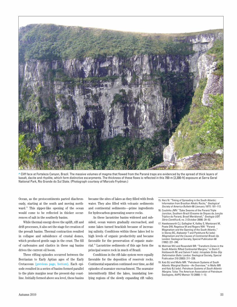
> Cliff face at Fortaleza Canyon, Brazil. The massive volumes of magma that flowed from the Paraná traps are evidenced by the spread of thick layers of basalt, dacite and rhyolite, which form distinctive escarpments. The thickness of these flows is reflected in this 700-m [2,300-ft] exposure at Serra Geral National Park, Rio Grande do Sul State. (Photograph courtesy of Marcelo Frydman.)

34 Oilfield Review
These conditions created a low-energy, high-salin-ity environment favorable to the growth of cyano-bacterial colonies.
The colonies of unicellular algae and other microbes produce exopolymers that are secreted as a biofilm.20 The biofilm traps and cements sedi-mentary grains into accretionary layers to form microbialite mats. Microbes in the upper part of the mat require sunlight for photosynthesis and spur upward growth into a laminar domal form known as a stromatolite. The distribution of these carbonate-producing microbes is affected by environmental factors such as sunlight, water temperature and turbidity, as well as predation by grazing organisms.21 These microbial growths lithify over time, later becoming reservoir rocks of the presalt play.
The marginal basins subsided as the conti-nental plates continued to pull apart. Plume-generated volcanic activity along crustal fractures of the Florianópolis Lineament on the South American tectonic plate, and the Walvis Ridge on the African plate, created barriers that restricted free marine circulation in the expand-ing South Atlantic Ocean.22
During the Early Cretaceous, marine waters sporadically spilled past these barriers and became trapped in the subsiding basins. Under arid climatic conditions of the Aptian age, these trapped waters evaporated and left thick salt
deposits in basins along the South American and African margins.23 The evaporite deposits covered sediments of the preceding rift sequence, form-ing an effective seal for the hydrocarbons that would ultimately migrate into the microbialite reservoir rock. The Aptian salt deposits mark the transitional evaporitic phase of continental mar-gin evolution, which preceded the drift phase in these basins.
By the Middle to Late Cretaceous, rifting was complete, and the continents of Africa and South America drifted farther apart as new oceanic crust was injected at the midoceanic ridge.24
Open-marine carbonate platforms developed along the Brazilian margin and grew along the opposite margin between Gabon and Angola dur-ing the Albian age.25 With continued subsidence, these platforms were drowned and were eventually covered by clastics during the Late Cretaceous and Tertiary periods.
Passo A PassoStep by step, Brazil’s exploration horizons have expanded in pursuit of new prospects—from onshore to offshore, and then from shallow to deep and ultradeep waters.26 The development of each play has prompted new ways of thinking about the local and regional geology, as well as new responses to drilling and production challenges.
As with many countries, oil seeps spurred early exploration. One of Brazil’s first wells, drilled in the 1890s near an oil seep in Bofete, São Paulo, reached a total depth of 488 m [1,601 ft].27 It yielded only two barrels of oil—a portent of explo-ration outcomes for the next four decades. By the late 1930s, more than 80 wells had been drilled by government agencies and private exploration com-panies—with consistently disappointing results.
However, in 1937, the National Department of Mineral Production (DNPM) began exploration in the Recôncavo basin—part of a failed rift in northeastern Bahia State. In 1939, an oil discov-ery in the DNPM 163 well at Lobato field launched the national petroleum industry in Brazil. Though noncommercial, this well prompted further exploration of the basin, and by 1941 the first commercial discovery was drilled near Candeias. More than 80 oil and gas fields have been found within the Recôncavo basin.
Exploration along the rift trend led Petrobras to the Sergipe basin. Here, the company discov-ered the nation’s first giant oil field at Carmópolis in 1963, spurring close examination of other onshore coastal basins. Since then, numerous plays have been uncovered throughout the onshore basins of Brazil. Expanded exploration activities within each basin, along with improved seismic technology, are helping geoscientists unlock more of the geologic history of the region—both onshore and offshore.
The 1960s also saw a concerted effort to explore the shallow waters of the Brazilian Continental Shelf. Following a program of gravi-metric and seismic acquisition in 1967, Petrobras began drilling deltaic sequences offshore Espírito Santo State.28 The company’s first well in the Espírito Santo basin proved to be a dry hole. Petrobras then moved north, to the Sergipe-Alagoas basin and, in 1968, drilled the first off-shore discovery off the São Francisco river delta at Guaricema field. Drilled in 30 m [98 ft] of water off the coast of Sergipe State, this well con-firmed the existence of oil beneath the Shelf.
By 1971, Petrobras had begun exploring the Campos basin, off Brazil’s southeastern coast (above left). Following a series of dry holes, the company made the first discovery within this basin in 1974. Drilling in 120 m [394 ft] of water, Petrobras’s ninth offshore wildcat found pay in Albian carbonates at Garoupa field. This find opened the way for intensive exploration of the Campos basin. Although initial exploration objec-tives were Albian carbonates limited mainly to the outer Shelf, larger discoveries were made in Tertiary sandstone reservoirs in water depths exceeding 500 m [1,640 ft].29
> The setting for a new play. Since the 1970s, the Campos basin has produced most of Brazil’s oil and gas. The advent of the presalt play is generating much interest in the Santos basin, though the Campos and Espírito Santo basins also host presalt prospects.
Santos basin
Campos basin
Vitoria
Rio de Janeiro
Rio de Janeiro
State
Jubarte
RoncadorAlbacora
BarracudaMarlim
Abrolhos High
Vitoria High
Cabo Frio High
Florianopolis High 0
0 km
200mi
200
Sao Paulo State
Sao Paulo
Minas GeraisState
B R A Z I L

Autumn 2010 35
The following year, a major discovery was drilled in 166 m [545 ft] of water. The 39.7 mil-lion-m3 [250 million-bbl] Namorado field was the first of several major clastic turbidite reservoirs to be drilled in the Campos basin. By expanding operating experience in the area, Petrobras was able to refine sedimentological and stratigraphic models of the continental margin, and by the mid-1980s the company was targeting prodelta deep-marine siliciclastic turbidite reservoirs.30
Four giant to supergiant turbidite fields were found in progressively deeper waters:31
of water
of water
of water
[6,079 ft] of water.By 2007, more than 1,100 wells had been
drilled in the Campos basin, resulting in the dis-covery of more than 50 fields. This is in stark con-trast to exploration efforts in the adjacent basin
to the south. By early 2007, only about 115 wells had been drilled in the Santos basin.
From these wells, a handful of fields had been established, including a number of significant discoveries. Petrobras drilled the first Santos basin wildcat in 1970, but it proved to be a dry hole. In 1984, Shell Oil affiliate Pecten Brazil became the first to discover a gas field while drill-ing in shallow waters of the basin. Following two dry holes, Pecten found turbidite pay at
In 1988, Petrobras drilled a discovery well at Tubarão field in 143 m [470 ft] of water. A third
32 This was followed by the Coral and Caravela fields, which produce from Albian oolitic limestones deposited above a layer of salt.33
In 2000, Petrobras shifted its Santos basin focus to deep and ultradeep waters. This resulted
Brazil’s largest natural gas field. Other gas fields at Tambaú and Pirapitanga and oil fields at Carapiá and Tambuatá were discovered in Late Cretaceous turbidites. Eocene turbidites also yielded heavy-oil strikes at Tambuatá field and at Shell-operated
Atlanta field.34 Turbidites at Uruguá field produced intermediate API-gravity oil.
At about this time, Petrobras acquired and processed a large 3D seismic dataset to help geo-scientists better understand the deep structures and stratigraphy of the Santos basin (above).35
Once seismic facies were defined, Petrobras was able to target the presalt section of the Santos basin’s São Paulo Plateau.36
In 2006, the giant presalt oil accumulation at Tupi was discovered by Petrobras and partners BG Group and Galp Energia, in a reservoir that averages 5,485 m [18,000 ft] below the ocean surface. The 28° API-gravity oil encountered in the presalt zones is lighter and sweeter than the heavy crude that dominates most of Brazil’s post-salt production.
In August 2007, Petrobras announced the extent of the latest exploration frontier defined by the presalt play. Based on evaluations of 15 presalt wells, this frontier covers an area 800 km [497 mi] long and 200 km [124 mi] wide spanning the Espírito Santo, Campos and Santos basins.37
Following Tupi, numerous presalt discoveries were
20. Microbes and bacteria thrive in a wide range of environments, and are responsible not only for creating reservoir rock, but also for creating production problems. For more: Bass C and Lappin-Scott H: “The Bad Guys and the Good Guys in Petroleum Microbiology,” Oilfield Review 9, no. 1 (Spring 1997): 17–25.
21. Modern stromatolites can be found in hypersaline lakes, marine lagoons and even freshwater lakes, provided that conditions do not favor grazing or burrowing organisms that adversely impact stromatolite preservation. Modern examples include Shark Bay, Western Australia, and Lagoa Salgada, Rio de Janeiro. Freshwater stromatolites are found at Lake Salda, Turkey, and Pavilion Lake, British Columbia, Canada.
22. Asmus HE and Baisch PR: “Geological Evolution of the Brazilian Continental Margin,” Episodes no. 4 (1983): 3–9, http://www.episodes.org/backissues/64/ARTICLES--3.pdf (accessed September 27, 2010).
23. Evaporation and restricted circulation are the keys to salt deposition. This is evidenced by highly saline bodies of water such as the Dead Sea and Great Salt Lake, which have no outlets. With no influx of seawater, their salinity is a product of evaporation, which serves to concentrate the salts that are brought in through
> Santos basin geology. Presalt source rocks and overlying carbonate reservoirs are being targeted beneath the thick layer of evaporites. (Adapted from Modica and Brush, reference 35.)
Two-
way
trav
eltim
e, s
Presalt formations
Basement
Continental ShelfContinental slope
Half-grabens
Evaporites
km
mi 25
0
0
25
NW SE0
2
4
6
8
10
Sao Paulo PlateauEvaporites
Postsalt formations
Late Oligocene-Neogene
Paleocene-Eocene
Late Campanian-MaastrichtianCenomanian-MiddleCampanian
Albian
Aptian
Neocomian-Barremian
Presalt formations
freshwater tributaries. Salt is deposited as the waters become supersaturated.
24. For an African perspective on the split: Platt N,Philip P and Walter S: “Going for the Play: Structural Interpretation in Offshore Congo,” Oilfield Review 5,no. 1 (January 1993): 14–27.
25. Liro LM and Dawson WC: “Reservoir Systems of Selected Basins of the South Atlantic,” in Mello MR and Katz BJ (eds): Petroleum Systems of South Atlantic Margins. Tulsa: The American Association of Petroleum Geologists, AAPG Memoir 73 (2000): 77–92.
26. The concept of deep water has evolved over the years. Deep water was originally defined as 200 m [656 ft]. This mark was later eclipsed by industry drilling trends, and now the deepwater standard is set at 1,000 ft [305 m]. Water depths greater than 5,000 ft [1,524 m] are deemed to be ultradeep.
27. de Luca JC: “Brazilian Petroleum Exploration and Production: From Monopoly to Free Market,” paperOTC 15051, presented at the Offshore Technology Conference, Houston, May 5–8, 2003.
28. de Luca, reference 27.29. Katz and Mello, reference 19.
30. Carminatti M, Dias JL and Wolff B: “From Turbidites to Carbonates: Breaking Paradigms in Deep Waters,” paper OTC 20124, presented at the Offshore Technology Conference, Houston, May 4–7, 2009.
31. A giant oil field is one whose reserves exceed one billion barrels; a supergiant exceeds five billion barrels.
32. “Petrobras Role in Brazil’s Economy Disputed,” Oil & Gas Journal 89, no. 2 (January 14, 1991), http://www.ogj.com/index/article-tools-template/_saveArticle/articles/oil-gas-journal/volume-89/issue-2/in-this-issue/general-interest/petrobras-role-in-brazil39s-economy-disputed.html (accessed July 16, 2010).
33. Carminatti et al, reference 30.34. Carminatti et al, reference 30.35. For more on Santos basin stratigraphy: Modica CJ
and Brush ER: “Postrift Sequence Stratigraphy, Paleogeography, and Fill History of the Deep-Water Santos Basin, Offshore Southeast Brazil,” AAPGBulletin 88, no. 7 (July 2004): 923–945.
36. Carminatti et al, reference 30.37. Petrobras News Agency: “Petrobras Discovers Brazil’s
Biggest Oil-Bearing Area,” (August 11, 2007), http:// www.agenciapetrobrasdenoticias.com.br/en_materia.asp?id_editoria=8&id_noticia=4042 (accessed September 27, 2010).

36 Oilfield Review
announced in the Santos basin, including Caramba, Carioca, Iara and Guará.38 In 2009, Petrobras also released its strategic plan for devel-oping the Tupi, Iara and Guará fields in three dis-crete phases, starting with extended well tests, followed by pilot projects, then large-scale produc-tion through floating production, storage and offloading (FPSO) facilities.39 The Santos basin presalt model has been adapted for exploration of other basins, and important discoveries have been made in the Caxaréu, Pirambu, Baleia Franca, Baleia Azul, Jubarte and Cachalote fields in the Campos basin. The presalt section of the Espírito Santo basin is also targeted for exploration.
Challenges AheadThe Santos basin, initial site of recent presalt dis-coveries in Brazil, presents numerous E&P chal-lenges implicit in a setting where ultradeep waters cover a deep carbonate reservoir masked by a thick layer of salt.40 The focus of exploration, the presalt cluster, lies in waters ranging from 1,900 to 2,400 m [6,200 to 7,870 ft] in depth (above). Located some 300 km [185 mi] from the coast, presalt cluster activities are driven by pre-cisely coordinated logistics that ensure equip-ment and crews arrive on location when needed.41
The problems associated with distance from shore can be exacerbated by metocean condi-tions, which can range from moderate to severe: Waves in the Santos basin can build to much greater heights than those experienced in the Campos basin to the north—up to 40% higher.42
This adds a significant dimension to every off-shore mission—from crew change to rig supply
and from anchor handling to pipe laying. The logistical role will become even more important as pipelines, platforms, FPSOs and associated infrastructure are installed to support production.
In these waters, exploration and production teams rely heavily on geophysical data to find promising structures and later, to aid in reservoir characterization. However, imaging beneath the salt can be problematic. To obtain the offsets required to successfully image beneath the salt, advanced acquisition strategies, employing methods such as wide-azimuth, rich-azimuth and multiazimuth techniques, are being used.43
Processing may also be complicated. The high contrast in seismic velocity between the salt and sediments causes problems for conventional time-migration methods, so depth-migration techniques are preferred. These imaging algo-rithms require accurate velocity models above, within and below the salt. With the adaptation of electromagnetic (EM) technology for deepwater environments, exploration teams are now inte-grating EM data with seismic data.44 Joint inver-sion of EM and seismic data is key for enhancing structural resolution and locating hydrocarbon reserves with an accuracy that would not other-wise be possible.
Among the more daunting challenges is well-bore construction. Immediately above the target reservoir lie as much as 2,000 m of evaporites. The varying composition of the evaporite interval can be especially difficult to drill. This section, composed primarily of halite [NaCl] and anhy-drite [CaSO4], also contains layers of carnallite [KMgCl3 6H2O] and tachyhydrite [CaMg2Cl6 12H2O]. Each layer is characterized by different creep
rates, which can vary by as much as two orders of magnitude between the various types of salt. Creep can lead to wellbore restrictions, stuck pipe and casing failure (above).45
Furthermore, the presalt reservoirs consist of heterogeneous, layered carbonates, which can adversely affect drilling progress. Drilling perfor-mance is always a major concern in ultradeep waters, where drilling rigs command high day rates. The ability to improve drilling performance will have an impact on extended-reach drilling projects that may be required to develop these reservoirs in the future.46
Geomechanics will play a big role in future development plans. Geomechanical studies aid in anticipating the potential for rock failure or salt deformation around the wellbore and can aid in selection of drill bits and drilling fluids. These studies will also be instrumental in devising mud, casing and cementing programs to extend well-bore longevity in such hostile conditions.
> Santos basin presalt cluster. The Tupi well, RJS-628A, ranks as the first major oil discovery of the presalt cluster and was followed by at least seven others in the cluster lease blocks.
0
0 km
200mi
200Santos basin
Rio de Janeiro
BM-S-9Carioca
BM-S-10Parati
BM-S-8Bem-Te-Vi
BM-S-21Caramba
BM-S-11Tupi
BM-S-11Iara
BM-S-24Jupiter
BM-S-9Guara
Sao Paulo
B R A Z I L
> Potential drilling problems. Drilling through salt requires special attention to drilling fluids. Potential problems include sections of borehole enlargement and weakened borehole walls as a result of salt leaching. Low mud weight may allow creep to impinge on the drillstring. Drilling fluids contaminated with salt from the formation can develop unfavorable rheological properties that reduce the mud’s ability to carry cuttings to the surface, causing the drillstring to become packed off above the bit. (From Perez et al, reference 45.)
Potential Drilling Problems
Salt
Radial-stress relaxationcan cause wellbore collapse.
Salt-creep ledgesimpinge on drillstring.
Borehole wall is weakenedby leaching water, gasand other mineralsout of salt.
Wellbore enlargementresults from saltdissolution.
Accumulated cuttingsjam drillstring.
Postsalt

Autumn 2010 37
A key to production ultimately lies in the pet-rophysical characterization of the presalt car-bonate reservoir. Although presalt discoveries have generated interest in lacustrine carbonate reservoirs, there are still significant gaps in industry knowledge regarding their depositional environments and subsequent diagenetic pro-cesses. Initial porosity in lacustrine deposits is highly variable. Worldwide, microbialite forma-tions often require porogenesis, or diagenetic enhancement, to form an adequate petroleum reservoir. In lacustrine reservoirs, faults and frac-ture networks are thought to provide pathways for delivering fluids that promote diagenetic pro-cesses, especially dissolution, which can improve reservoir quality by connecting vuggy porosity networks.47 In wildcat wells and appraisal wells, core analysis data, along with an extensive suite of logging measurements, are obtained to assess parameters such as wettability, hydraulic con-nectivity, pore structure and permeability.
Thorough reservoir characterization is neces-sary for defining the best well geometries and completion schemes. In most presalt wells, a thick oil column and reservoir heterogeneity indicate the need for selective completions. A carefully planned acid stimulation job is also desirable, to spread production more evenly across the pay zone.
Production or injection can cause stress and fluid changes within a field. Changes in effective pressure can also affect the responses seen dur-ing subsequent 4D seismic surveys. Because seis-mic 4D response can be subtle and difficult to detect in carbonates, highly accurate and sensi-tive seismic measurements are needed. Once the changes are accurately measured, geomechani-cal earth models will aid in predicting how these changes might influence seismic responses and reservoir performance in the future.
To meet these and other challenges, presalt ventures will call on the technical expertise and research capabilities of service companies and academia. In September of 2009, Schlumberger signed a joint cooperation agreement with the Universidade Federal do Rio de Janeiro to build an international research center on the university’s campus (above). The Schlumberger Brazil Research and Geoengineering Center (BRGC), as part of the larger Schlumberger global research and development network, has identified four areas of concentration: carbonate reservoir char-acterization, 4D geophysical imaging, well con-struction and geomechanics, and reservoir engineering. The BRGC will accommodate up to 350 people and will house state-of-the-art centers for 3D visualization, seismic data processing, soft-ware development and training. Three specially designed, fully integrated laboratories will provide
empirical input for models and simulations used to help operators develop a comprehensive charac-terization of the reservoir:
features cementing and stimulation equipment for research activities aimed at enhancing pro-duction from presalt formations.
core analysis for integration with geophysics, petrophysics and geomechanics studies.
fluid sampling and analysis under representa-tive downhole conditions, to reduce data uncertainty in complex development projects.
The lessons learned within the research cen-ter may carry over to other basins around the world. Already it is recognized that the predrift geology and tectonics of the basins along the southeast coast of South America are similar in many respects to those of the basins along the west coast of Africa. Each coast has sag basins containing organic-rich source rocks covered by thick layers of salt.
Although important differences exist between the basins on each side of the Atlantic, the experiences gained on one side are paving the way for exploration on the other, and some operators are establishing a presence along both coasts. Along the Brazilian coast, this experi-ence is paying off, as seen in excellent results obtained from extended testing in a Tupi Sul well. This well has produced—on choke—an average of 2,544 m3/d [16,000 bbl/d] for the past year and a half, proving the real potential of this new play in Brazil. —MV
38. US Energy Information Administration Country Analysis Briefs: “Brazil Energy Data, Statistics and Analysis,” (September 2009), http://www.eia.doe.gov/cabs/Brazil/Oil.html (accessed July 23, 2010).
39. US Energy Information Administration, reference 38.40. Beltrão et al, reference 1.41. Formigli Filho JM, Pinto ACC and de Almeida AS:
“Santos Basin’s Pre-Salt Reservoirs Development—The Way Ahead,” paper OTC 19953, presented at the Offshore Technology Conference, Houston, May 4–7, 2009.
42. Beltrão et al, reference 1.43. For more on these acquisition techniques: Buia M,
Flores PE, Hill D, Palmer E, Ross R, Walker R, Houbiers M, Thompson M, Laura S, Menlikli C, Moldoveanu N and Snyder E: “Shooting Seismic Surveys in Circles,” Oilfield Review 20, no. 3 (Autumn 2008): 18–31.
44. For more on EM technology: Brady J, Campbell T, Fenwick A, Ganz M, Sandberg SK, Buonora MPP, Rodrigues LP, Campbell C, Combee L, Ferster A, Umbach KE, Labruzzo T, Zerilli A, Nichols EA, Patmore S and Stilling J: “Electromagnetic Sounding
> Conceptual drawing of the Brazil Research and Geoengineering Center. The new facility, to be located in the Technology Park at the Universidade Federal do Rio de Janeiro, will focus on numerous projects pertaining to the deepwater presalt environment.
for Hydrocarbons,” Oilfield Review 21, no. 1 (Spring 2009): 4–19.
45. For more on drilling through salt: Perez MA, Clyde R, D’Ambrosio P, Israel R, Leavitt T, Nutt L, Johnson C and Williamson D: “Meeting the Subsalt Challenge,” Oilfield Review 20, no. 3 (Autumn 2008): 32–45.
46. Alves I, Aragão A, Bastos B, Falcão J and Fartes E: “Pre-Salt Santos Basin—Well Construction Learning Curve Acceleration,” paper OTC 20177, presented at the Offshore Technology Conference, Houston, May 4–7, 2009.For more on diagenesis: Ali SA, Clark WJ, Moore WR and Dribus JR: “Diagenesis and Reservoir Quality,” Oilfield Review 22, no. 2 (Summer 2010): 14–27.
47. Guidry SA, Trainor D, Helsing CE and Ritter AL: “Diagenetic Facies in Lacustrine Carbonates: Implications for Brazilian Pre-Salt Reservoirs,” (abstract) presented at the AAPG International Conference and Exhibition, Rio de Janeiro, November 15–18, 2009, http://www.searchanddiscovery.net/abstracts/html/2009/intl/abstracts/guidry.htm (accessed September 27, 2010).
Related Documents