1 Clockwise in the northern hemisphere and counter-clockwise in the southern hemisphere. difRcult to observe and model. Advancement of AABW research represents a signiRcant technolo- gical challenge to Reld and computer oceanogra- phers. Summary The ocean is cold. Its average temperature of 3.53C is far colder than the warm veneer capping much of the ocean. Waters warmer than 103C amount to only 10% of the total ocean volume; about 75% of the ocean is colder than 43C. Along the seaSoor the ocean temperature is near 03C. The cold bottom water is derived from Southern Ocean, the ocean belt surrounding Antarctica. Sea water at its freezing point of !1.93C is formed in winter over the continental shelf of Antarctica. Where the salt content of shelf water is high enough, roughly 34.61 (parts per thousand) the water is sufR- ciently dense to descend as convective plumes over the continental slope into the adjacent deep ocean. In so doing Antarctic Bottom Water is formed. It is estimated that on average between 10 and 1510 6 m 3 of Antarctic bottom water forms every second! Antarctic Bottom Water spreads away from Antarctica into the world oceans, chilling the deep ocean to temperatures near 03C. Bottom water warms en route on mixing with warmer overlying waters. Cold winter water also forms in the Green- land and Norwegian Seas of the northern North Atlantic. This water ponds up behind a submarine ridge spanning the distance from Greenland to Scot- land. This water overSows the ridge crest into the ocean to the south. As the overSow water mixes with warmer saltier water during descent into the deep ocean, it results in a warmer, more saline water mass than Antarctic Bottom water. The Greenland and Norwegian Sea overSow water forms the densest component of the water mass called North Atlantic Deep Water and is estimated to form at a rate of around 810 6 m 3 s 1 . The overSow water stays in contact with the seaSoor until the northern fringes of Antarctic Bottom Water encountered in the North Atlantic near 403N, lifts it to shallower levels. See also Antarctic Circumpolar Current. Polynyas. Rotating Gravity Currents. Sub Ice-shelf Circulation and Processes. Weddell Sea Circulation. Further Reading Fahrbach E, Rohardt G, Scheele N et al. (1995) Forma- tion and discharge of deep and bottom water in the northwestern Weddell Sea. Journal of Marine Research 53(4): 515}538. Foster TD and Carmack EC (1976) Frontal zone mixing and Antarctic Bottom Water formation in the southern Weddell Sea. Deep-Sea Research 23: 301}317. Gordon AL and Tchernia P (1972) Waters off Adelie Coast. Antarctic Research Series, vol. 19, pp. 59}69, Washington, DC: American Geophysical Union. Jacobs SS, Fairbanks R and Horibe Y (1985) Origin and evolution of water masses near the Antarctic continen- tal margin: Evidence from H 2 18 O/H 2 16 O ratio in sea- water. In: Jacobs SS (ed.) Oceanography of Antarctic Continental Margin, Antarctic Research Series vol. 43, pp. 59}85. Washington, DC: American Geophysical Union. Jacobs SS and Weiss R (eds) (1998) Ocean. Ice and Atmosphere: Interactions at the Antarctic Continental Margin, Antarctic Research Series, vol. 75. Washing- ton DC: American Geophysical Union. Nunes RA and Lennon GW (1996) Physical oceanography of the Prydz Bay region of Antarctic waters. Deep-Sea Research 43(5): 603}641. Orsi AH, Johnson GC and Bullister JL (1999) Circulation, mixing, and production of Antarctic Bottom Water. Progress in Oceanography 43: 55}109. Tomczak M and Godfrey JS (1994) Regional Oceanography: An Introduction. London: Pergamon Press. BRAZIL AND FALKLANDS (MALVINAS) CURRENTS A. R. Piola, Universidad de Buenos Aires, Buenos Aires, Argentina R. P. Matano, Oregon State University, Corvallis, OR, USA Copyright ^ 2001 Academic Press doi:10.1006/rwos.2001.0358 Introduction The zonal component of the mean prevailing winds, low latitude easterlies and mid-latitude westerlies induce anticyclonic 1 upper ocean circulation pat- 340 BRAZIL AND FALKLANDS (MALVINAS) CURRENTS

Welcome message from author
This document is posted to help you gain knowledge. Please leave a comment to let me know what you think about it! Share it to your friends and learn new things together.
Transcript
1 Clockwise in the northern hemisphere and counter-clockwisein the southern hemisphere.
difRcult to observe and model. Advancement ofAABW research represents a signiRcant technolo-gical challenge to Reld and computer oceanogra-phers.
Summary
The ocean is cold. Its average temperature of 3.53Cis far colder than the warm veneer capping much ofthe ocean. Waters warmer than 103C amount toonly 10% of the total ocean volume; about 75% ofthe ocean is colder than 43C. Along the seaSoor theocean temperature is near 03C. The cold bottomwater is derived from Southern Ocean, the oceanbelt surrounding Antarctica. Sea water at itsfreezing point of !1.93C is formed in winter overthe continental shelf of Antarctica. Where the saltcontent of shelf water is high enough, roughly34.61� (parts per thousand) the water is sufR-ciently dense to descend as convective plumes overthe continental slope into the adjacent deep ocean.In so doing Antarctic Bottom Water is formed. Itis estimated that on average between 10 and15�106 m3 of Antarctic bottom water forms everysecond! Antarctic Bottom Water spreads away fromAntarctica into the world oceans, chilling the deepocean to temperatures near 03C. Bottom waterwarms en route on mixing with warmer overlyingwaters. Cold winter water also forms in the Green-land and Norwegian Seas of the northern NorthAtlantic. This water ponds up behind a submarineridge spanning the distance from Greenland to Scot-land. This water overSows the ridge crest into theocean to the south. As the overSow water mixeswith warmer saltier water during descent into thedeep ocean, it results in a warmer, more salinewater mass than Antarctic Bottom water. TheGreenland and Norwegian Sea overSow waterforms the densest component of the water masscalled North Atlantic Deep Water and is estimatedto form at a rate of around 8�106 m3 s�1. The
overSow water stays in contact with the seaSooruntil the northern fringes of Antarctic Bottom Waterencountered in the North Atlantic near 403N, lifts itto shallower levels.
See also
Antarctic Circumpolar Current. Polynyas. RotatingGravity Currents. Sub Ice-shelf Circulation andProcesses. Weddell Sea Circulation.
Further ReadingFahrbach E, Rohardt G, Scheele N et al. (1995) Forma-
tion and discharge of deep and bottom water in thenorthwestern Weddell Sea. Journal of Marine Research53(4): 515}538.
Foster TD and Carmack EC (1976) Frontal zone mixingand Antarctic Bottom Water formation in the southernWeddell Sea. Deep-Sea Research 23: 301}317.
Gordon AL and Tchernia P (1972) Waters offAdelie Coast. Antarctic Research Series, vol. 19,pp. 59}69, Washington, DC: American GeophysicalUnion.
Jacobs SS, Fairbanks R and Horibe Y (1985) Origin andevolution of water masses near the Antarctic continen-tal margin: Evidence from H2
18O/H216O ratio in sea-
water. In: Jacobs SS (ed.) Oceanography of AntarcticContinental Margin, Antarctic Research Series vol. 43,pp. 59}85. Washington, DC: American GeophysicalUnion.
Jacobs SS and Weiss R (eds) (1998) Ocean. Ice andAtmosphere: Interactions at the Antarctic ContinentalMargin, Antarctic Research Series, vol. 75. Washing-ton DC: American Geophysical Union.
Nunes RA and Lennon GW (1996) Physical oceanographyof the Prydz Bay region of Antarctic waters. Deep-SeaResearch 43(5): 603}641.
Orsi AH, Johnson GC and Bullister JL (1999) Circulation,mixing, and production of Antarctic Bottom Water.Progress in Oceanography 43: 55}109.
Tomczak M and Godfrey JS (1994) RegionalOceanography: An Introduction. London: PergamonPress.
BRAZIL AND FALKLANDS (MALVINAS) CURRENTS
A. R. Piola, Universidad de Buenos Aires,Buenos Aires, ArgentinaR. P. Matano, Oregon State University, Corvallis,OR, USA
Copyright ^ 2001 Academic Press
doi:10.1006/rwos.2001.0358
Introduction
The zonal component of the mean prevailing winds,low latitude easterlies and mid-latitude westerliesinduce anticyclonic1 upper ocean circulation pat-
340 BRAZIL AND FALKLANDS (MALVINAS) CURRENTS
B urdwood B .
N. Scotia R idge
DrakePassage
Scotia
Sea
South Atlantic C.
Ma l
vina
sC.
Antarctic Circum
p olar
C.
Braz
il C.
34.2
>36.2
Ewing
Bank
>37
70 60 50 40 30
60
55
50
45
40
35
30
25
20
15
10
°S
°W
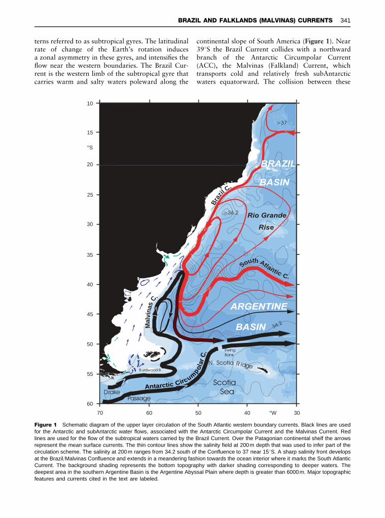
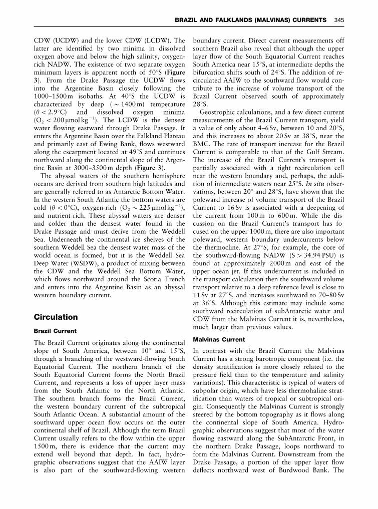
Figure 1 Schematic diagram of the upper layer circulation of the South Atlantic western boundary currents. Black lines are usedfor the Antarctic and subAntarctic water flows, associated with the Antarctic Circumpolar Current and the Malvinas Current. Redlines are used for the flow of the subtropical waters carried by the Brazil Current. Over the Patagonian continental shelf the arrowsrepresent the mean surface currents. The thin contour lines show the salinity field at 200m depth that was used to infer part of thecirculation scheme. The salinity at 200 m ranges from 34.2 south of the Confluence to 37 near 153S. A sharp salinity front developsat the Brazil/Malvinas Confluence and extends in a meandering fashion towards the ocean interior where it marks the South AtlanticCurrent. The background shading represents the bottom topography with darker shading corresponding to deeper waters. Thedeepest area in the southern Argentine Basin is the Argentine Abyssal Plain where depth is greater than 6000 m. Major topographicfeatures and currents cited in the text are labeled.
terns referred to as subtropical gyres. The latitudinalrate of change of the Earth’s rotation inducesa zonal asymmetry in these gyres, and intensiRes theSow near the western boundaries. The Brazil Cur-rent is the western limb of the subtropical gyre thatcarries warm and salty waters poleward along the
continental slope of South America (Figure 1). Near393S the Brazil Current collides with a northwardbranch of the Antarctic Circumpolar Current(ACC), the Malvinas (Falkland) Current, whichtransports cold and relatively fresh subAntarcticwaters equatorward. The collision between these
BRAZIL AND FALKLANDS (MALVINAS) CURRENTS 341
30
34
25
20
15
10
5
0
35 36 37
Salinity (PSU)
Pot
entia
l tem
pera
ture
(°C
)
Brazil /MalvinasConfluence
24
25
26
27
28
SACW
NADW
AAIWUCDW
55°S
50°S
40°S
35°S
30°S
TW
20°S
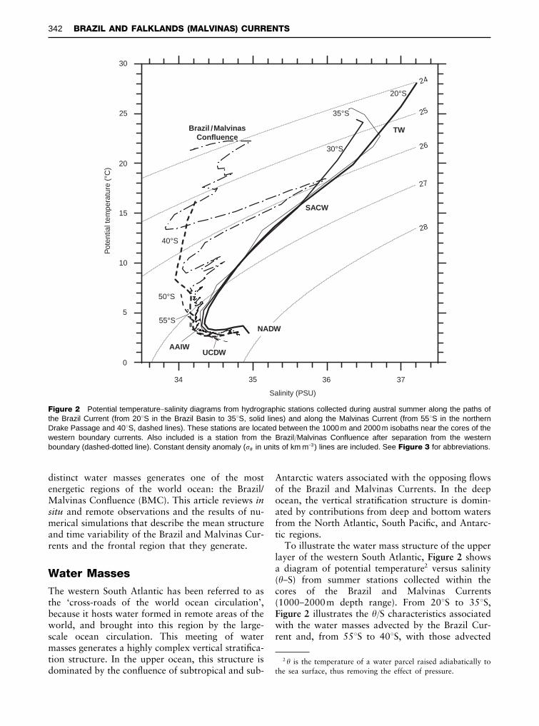
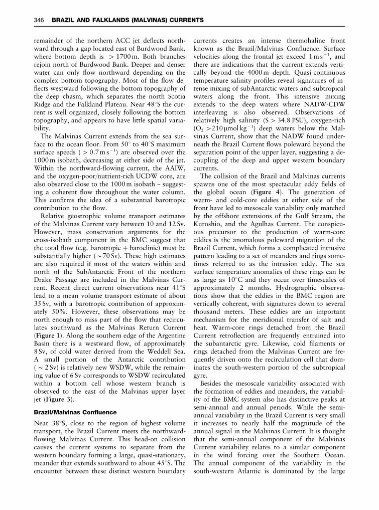
Figure 2 Potential temperature}salinity diagrams from hydrographic stations collected during austral summer along the paths ofthe Brazil Current (from 203S in the Brazil Basin to 353S, solid lines) and along the Malvinas Current (from 553S in the northernDrake Passage and 403S, dashed lines). These stations are located between the 1000 m and 2000 m isobaths near the cores of thewestern boundary currents. Also included is a station from the Brazil/Malvinas Confluence after separation from the westernboundary (dashed-dotted line). Constant density anomaly (�� in units of km m}3) lines are included. See Figure 3 for abbreviations.
2 � is the temperature of a water parcel raised adiabatically tothe sea surface, thus removing the effect of pressure.
distinct water masses generates one of the mostenergetic regions of the world ocean: the Brazil/Malvinas ConSuence (BMC). This article reviews insitu and remote observations and the results of nu-merical simulations that describe the mean structureand time variability of the Brazil and Malvinas Cur-rents and the frontal region that they generate.
Water Masses
The western South Atlantic has been referred to asthe ‘cross-roads of the world ocean circulation’,because it hosts water formed in remote areas of theworld, and brought into this region by the large-scale ocean circulation. This meeting of watermasses generates a highly complex vertical stratiRca-tion structure. In the upper ocean, this structure isdominated by the conSuence of subtropical and sub-
Antarctic waters associated with the opposing Sowsof the Brazil and Malvinas Currents. In the deepocean, the vertical stratiRcation structure is domin-ated by contributions from deep and bottom watersfrom the North Atlantic, South PaciRc, and Antarc-tic regions.
To illustrate the water mass structure of the upperlayer of the western South Atlantic, Figure 2 showsa diagram of potential temperature2 versus salinity(�}S) from summer stations collected within thecores of the Brazil and Malvinas Currents(1000}2000m depth range). From 203S to 353S,Figure 2 illustrates the �/S characteristics associatedwith the water masses advected by the Brazil Cur-rent and, from 553S to 403S, with those advected
342 BRAZIL AND FALKLANDS (MALVINAS) CURRENTS
by the Malvinas Current. In addition, Figure 2 alsoshows the �}S diagram of a hydrographic stationcollected downstream from the separation of bothboundary currents from the continental margin (e.g.within the core of the BMC).
Upper Ocean
The upper portion of the water mass carried pole-ward by the Brazil Current is referred to as TropicalWaters (TW), and is characterized by high potentialtemperature (�'203C) and salinity (S'36 PSU,Figure 2). The high temperatures of the TW are dueto heat gained from the atmosphere at low latitudes,while the high salinities are due to freshwater lossesat mid-latitudes. The upper portion of the BrazilCurrent is also characterized by the presence ofrelatively thin low salinity layers capping the TWstructure (e.g. the 353S curve in Figure 2). These lowsalinity layers are thought to be caused by mixingbetween TW and shelf and river waters. Belowthe TW, but still within the Brazil Current, thereis a sharp thermocline and halocline (see thequasilinear �}S relation in the 20}103C temperaturerange) that is referred to as South Atlantic CentralWater (SACW). The SACW shows a very stable�}S pattern with only minor variations induced bywinter sea}air interactions near the southern limitof the Brazil Current.
The upper layer of the Malvinas Current (i.e. thecurves corresponding to 403 and 503S in Figure 2)is substantially colder (�(153C) and fresher(S(34.2 PSU) than the corresponding layer of theBrazil Current. These properties reSect the sub-Antarctic origin of the Malvinas waters. In thenorthern portion of the Drake Passage, the sourcefor the Malvinas transport, the surface temperatureis close to 43C and increases northward up to 163Cat the latitude where the Malvinas separates fromthe continental boundary (&403S). Although thesub-Antarctic waters of the Malvinas Current andthe SACW of the Brazil Current thermocline occupythe same density range (��&25.5}27.0 kg m�3) theyhave very different thermohaline characteristics andthe convergence of these water masses, in the BMC,leads to the formation of alternate layers of sub-Antarctic and subtropical water. These intrusionsare referred to as interleaving or Rne-structure (seestation at BMC, Figure 2).
Antarctic Intermediate Water
The water mass structure of the Brazil Current atintermediate depths (700}1000m) is dominatedby the presence of Antarctic Intermediate Water(AAIW). The AAIW, characterized by a salinity
minimum (S(34.3 PSU), has contributions fromthe coldest and densest (��&27.3 kg m�3) memberof the southern hemisphere Subpolar Mode Wateror SubAntarctic Mode Water (SAMW), which orig-inates from deep winter convection along the Sub-Antarctic Zone. The Malvinas Current carries newlyformed AAIW and SAMW into the Argentine Basin.Data collected during the austral winter show that,as the AAIW/SAMW enter into the Argentine Basinfrom the south, they are exposed to the atmosphereand are subject to further modiRcation by localair}sea interactions. South of the BMC, theAAIW/SAMW are less salty (S(34.1 PSU) thanwithin the Brazil Current (Figure 2) and these lateralproperty gradients across the BMC induce interleav-ing. Similarly to the upper layer Sow, the temper-ature of the AAIW core increases from 33C, at theDrake Passage, to 3.53C at 403S.
It is interesting to note that although on averagethe AAIW must spread northward (away from theregion of formation), direct current observations at283S, and close to the continental margin indicatethat, in the subtropical basin, the AAIW follows theupper ocean anticyclonic gyre, and Sows southwardbelow the Brazil Current. After leaving the conti-nental boundary the AAIW turns into the subtropi-cal gyre, where vertical and lateral mixing increaseits salinity and decrease its dissolved oxygen concen-tration. The water mass resulting from this recir-culation process is known as recirculated AAIW.
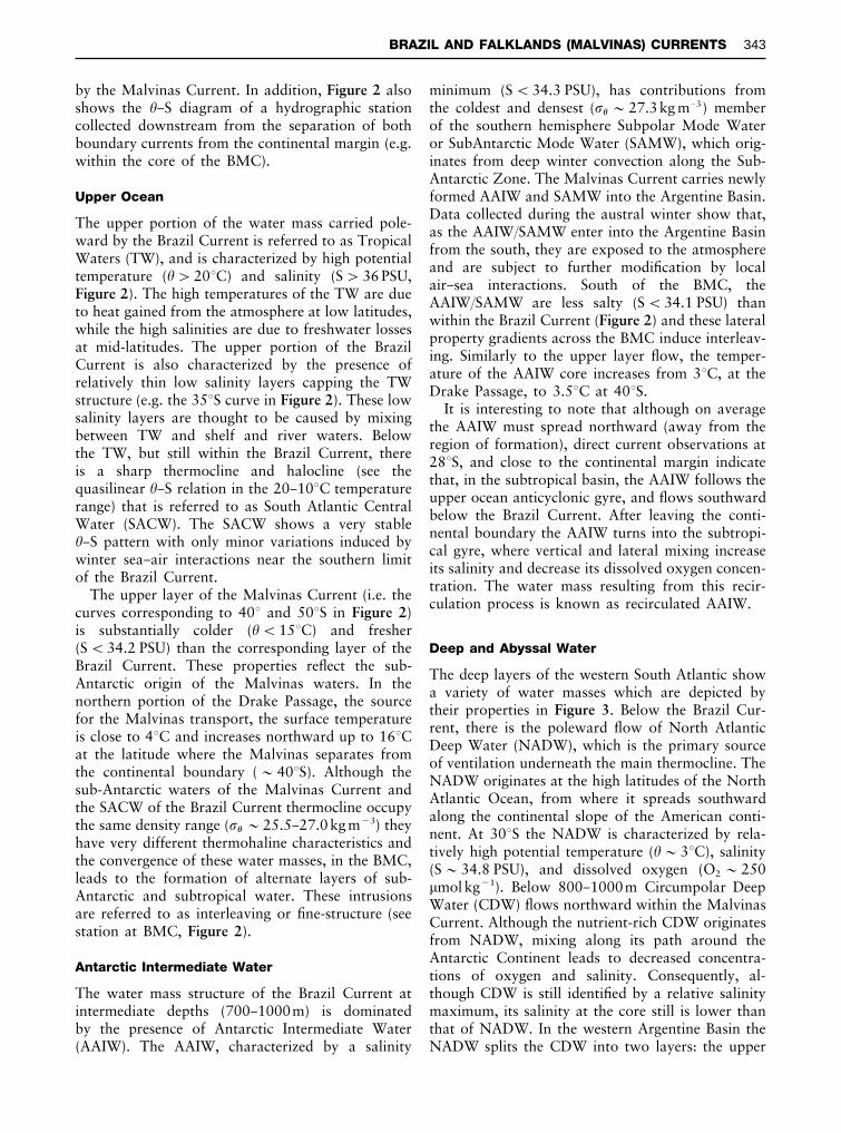
Deep and Abyssal Water
The deep layers of the western South Atlantic showa variety of water masses which are depicted bytheir properties in Figure 3. Below the Brazil Cur-rent, there is the poleward Sow of North AtlanticDeep Water (NADW), which is the primary sourceof ventilation underneath the main thermocline. TheNADW originates at the high latitudes of the NorthAtlantic Ocean, from where it spreads southwardalong the continental slope of the American conti-nent. At 303S the NADW is characterized by rela-tively high potential temperature (�&33C), salinity(S&34.8 PSU), and dissolved oxygen (O2&250�mol kg�1). Below 800}1000m Circumpolar DeepWater (CDW) Sows northward within the MalvinasCurrent. Although the nutrient-rich CDW originatesfrom NADW, mixing along its path around theAntarctic Continent leads to decreased concentra-tions of oxygen and salinity. Consequently, al-though CDW is still identiRed by a relative salinitymaximum, its salinity at the core still is lower thanthat of NADW. In the western Argentine Basin theNADW splits the CDW into two layers: the upper
BRAZIL AND FALKLANDS (MALVINAS) CURRENTS 343
Oxygen ( mol kg )µ_1SalinityPotential temperature (°C)
0.25
0 50 100 150 200
4000
3500
3000
2500
2000
1500
1000
500
0 50 100 150 200 0 50 100 150 200
>12 >16
>34.9
<_0.1
WSDW
Distance (km)
>240
UCDW
>35.6
AAIW
NADW
LCDW
NADW
Pre
ssur
e (d
bars
)
10.0 8.0 10.013.08.0
5.0
4.0
3.23.0
<2.82.8
3.03.2
2.8
2.5
2.0
1.0
34.20 34.20
34.20.20
34.50
34.70
34.8034.85
34.85
34.80
34.70
220
220
<220
230
220
<200
<200
220230
260280
300
32080
2.8Figure 3 Late winter vertical potential temperature (3C), salinity (PSU), and dissolved oxygen (�mol kg�1) sections from the Brazil/Malvinas Confluence near 383S. Watermasses identified by property extrema are labeled as follows: TW, Tropical Water; SACW, South Atlantic Central Water; AAIW, Antarctic Intermediate Water; UCDW, UpperCircumpolar Deep Water; NADW, North Atlantic Deep Water; LCDW, Lower Circumpolar Deep Water; WSDW, Weddell Sea Deep Water.
344B
RA
ZIL
AN
DFA
LK
LA
ND
S(M
ALV
INA
S)
CU
RR
EN
TS
CDW (UCDW) and the lower CDW (LCDW). Thelatter are identiRed by two minima in dissolvedoxygen above and below the high salinity, oxygen-rich NADW. The existence of two separate oxygenminimum layers is apparent north of 503S (Figure3). From the Drake Passage the UCDW Sowsinto the Argentine Basin closely following the1000}1500m isobaths. At 403S the UCDW ischaracterized by deep (&1400 m) temperature(�(2.93C) and dissolved oxygen minima(O2(200�mol kg�1). The LCDW is the densestwater Sowing eastward through Drake Passage. Itenters the Argentine Basin over the Falkland Plateauand primarily east of Ewing Bank, Sows westwardalong the escarpment located at 493S and continuesnorthward along the continental slope of the Argen-tine Basin at 3000}3500m depth (Figure 3).
The abyssal waters of the southern hemisphereoceans are derived from southern high latitudes andare generally referred to as Antarctic Bottom Water.In the western South Atlantic the bottom waters arecold (�(03C), oxygen-rich (O2&225 �mol kg�1),and nutrient-rich. These abyssal waters are denserand colder than the densest water found in theDrake Passage and must derive from the WeddellSea. Underneath the continental ice shelves of thesouthern Weddell Sea the densest water mass of theworld ocean is formed, but it is the Weddell SeaDeep Water (WSDW), a product of mixing betweenthe CDW and the Weddell Sea Bottom Water,which Sows northward around the Scotia Trenchand enters into the Argentine Basin as an abyssalwestern boundary current.
Circulation
Brazil Current
The Brazil Current originates along the continentalslope of South America, between 103 and 153S,through a branching of the westward-Sowing SouthEquatorial Current. The northern branch of theSouth Equatorial Current forms the North BrazilCurrent, and represents a loss of upper layer massfrom the South Atlantic to the North Atlantic.The southern branch forms the Brazil Current,the western boundary current of the subtropicalSouth Atlantic Ocean. A substantial amount of thesouthward upper ocean Sow occurs on the outercontinental shelf of Brazil. Although the term BrazilCurrent usually refers to the Sow within the upper1500 m, there is evidence that the current mayextend well beyond that depth. In fact, hydro-graphic observations suggest that the AAIW layeris also part of the southward-Sowing western
boundary current. Direct current measurements offsouthern Brazil also reveal that although the upperlayer Sow of the South Equatorial Current reachesSouth America near 153S, at intermediate depths thebifurcation shifts south of 243S. The addition of re-circulated AAIW to the southward Sow would con-tribute to the increase of volume transport of theBrazil Current observed south of approximately283S.
Geostrophic calculations, and a few direct currentmeasurements of the Brazil Current transport, yielda value of only about 4}6Sv, between 10 and 203S,and this increases to about 20 Sv at 383S, near theBMC. The rate of transport increase for the BrazilCurrent is comparable to that of the Gulf Stream.The increase of the Brazil Current’s transport ispartially associated with a tight recirculation cellnear the western boundary and, perhaps, the addi-tion of intermediate waters near 253S. In situ obser-vations, between 203 and 283S, have shown that thepoleward increase of volume transport of the BrazilCurrent to 16 Sv is associated with a deepening ofthe current from 100 m to 600 m. While the dis-cussion on the Brazil Current’s transport has fo-cused on the upper 1000 m, there are also importantpoleward, western boundary undercurrents belowthe thermocline. At 273S, for example, the core ofthe southward-Sowing NADW (S'34.94 PSU) isfound at approximately 2000m and east of theupper ocean jet. If this undercurrent is included inthe transport calculation then the southward volumetransport relative to a deep reference level is close to11 Sv at 273S, and increases southward to 70}80 Svat 363S. Although this estimate may include somesouthward recirculation of subAntarctic water andCDW from the Malvinas Current it is, nevertheless,much larger than previous values.
Malvinas Current
In contrast with the Brazil Current the MalvinasCurrent has a strong barotropic component (i.e. thedensity stratiRcation is more closely related to thepressure Reld than to the temperature and salinityvariations). This characteristic is typical of waters ofsubpolar origin, which have less thermohaline strat-iRcation than waters of tropical or subtropical ori-gin. Consequently the Malvinas Current is stronglysteered by the bottom topography as it Sows alongthe continental slope of South America. Hydro-graphic observations suggest that most of the waterSowing eastward along the SubAntarctic Front, inthe northern Drake Passage, loops northward toform the Malvinas Current. Downstream from theDrake Passage, a portion of the upper layer SowdeSects northward west of Burdwood Bank. The
BRAZIL AND FALKLANDS (MALVINAS) CURRENTS 345
remainder of the northern ACC jet deSects north-ward through a gap located east of Burdwood Bank,where bottom depth is '1700 m. Both branchesrejoin north of Burdwood Bank. Deeper and denserwater can only Sow northward depending on thecomplex bottom topography. Most of the Sow de-Sects westward following the bottom topography ofthe deep chasm, which separates the north ScotiaRidge and the Falkland Plateau. Near 483S the cur-rent is well organized, closely following the bottomtopography, and appears to have little spatial varia-bility.
The Malvinas Current extends from the sea sur-face to the ocean Soor. From 503 to 403S maximumsurface speeds ('0.7 m s�1) are observed over the1000 m isobath, decreasing at either side of the jet.Within the northward-Sowing current, the AAIW,and the oxygen-poor/nutrient-rich UCDW core, arealso observed close to the 1000m isobath } suggest-ing a coherent Sow throughout the water column.This conRrms the idea of a substantial barotropiccontribution to the Sow.
Relative geostrophic volume transport estimatesof the Malvinas Current vary between 10 and 12 Sv.However, mass conservation arguments for thecross-isobath component in the BMC suggest thatthe total Sow (e.g. barotropic#baroclinic) must besubstantially higher (&70 Sv). These high estimatesare also required if most of the waters within andnorth of the SubAntarctic Front of the northernDrake Passage are included in the Malvinas Cur-rent. Recent direct current observations near 413Slead to a mean volume transport estimate of about35 Sv, with a barotropic contribution of approxim-ately 50%. However, these observations may benorth enough to miss part of the Sow that recircu-lates southward as the Malvinas Return Current(Figure 1). Along the southern edge of the ArgentineBasin there is a westward Sow, of approximately8 Sv, of cold water derived from the Weddell Sea.A small portion of the Antarctic contribution(&2 Sv) is relatively new WSDW, while the remain-ing value of 6 Sv corresponds to WSDW recirculatedwithin a bottom cell whose western branch isobserved to the east of the Malvinas upper layerjet (Figure 3).
Brazil/Malvinas Con]uence
Near 383S, close to the region of highest volumetransport, the Brazil Current meets the northward-Sowing Malvinas Current. This head-on collisioncauses the current systems to separate from thewestern boundary forming a large, quasi-stationary,meander that extends southward to about 453S. Theencounter between these distinct western boundary
currents creates an intense thermohaline frontknown as the Brazil/Malvinas ConSuence. Surfacevelocities along the frontal jet exceed 1 m s�1, andthere are indications that the current extends verti-cally beyond the 4000 m depth. Quasi-continuoustemperature-salinity proRles reveal signatures of in-tense mixing of subAntarctic waters and subtropicalwaters along the front. This intensive mixingextends to the deep waters where NADW-CDWinterleaving is also observed. Observations ofrelatively high salinity (S'34.8 PSU), oxygen-rich(O2'210�mol kg�1) deep waters below the Mal-vinas Current, show that the NADW found under-neath the Brazil Current Sows poleward beyond theseparation point of the upper layer, suggesting a de-coupling of the deep and upper western boundarycurrents.
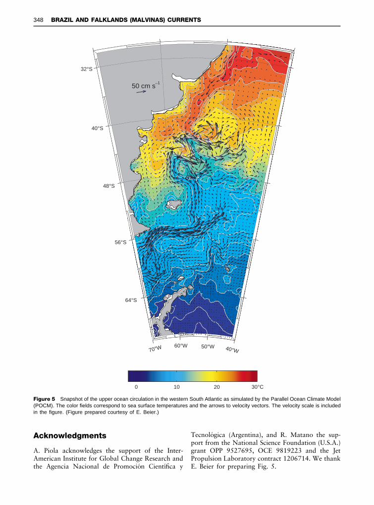
The collision of the Brazil and Malvinas currentsspawns one of the most spectacular eddy Relds ofthe global ocean (Figure 4). The generation ofwarm- and cold-core eddies at either side of thefront have led to mesoscale variability only matchedby the offshore extensions of the Gulf Stream, theKuroshio, and the Agulhas Current. The conspicu-ous precursor to the production of warm-coreeddies is the anomalous poleward migration of theBrazil Current, which forms a complicated intrusivepattern leading to a set of meanders and rings some-times referred to as the intrusion eddy. The seasurface temperature anomalies of these rings can beas large as 103C and they occur over timescales ofapproximately 2 months. Hydrographic observa-tions show that the eddies in the BMC region arevertically coherent, with signatures down to severalthousand meters. These eddies are an importantmechanism for the meridional transfer of salt andheat. Warm-core rings detached from the BrazilCurrent retroSection are frequently entrained intothe subantarctic gyre. Likewise, cold Rlaments orrings detached from the Malvinas Current are fre-quently driven onto the recirculation cell that dom-inates the south-western portion of the subtropicalgyre.
Besides the mesoscale variability associated withthe formation of eddies and meanders, the variabil-ity of the BMC system also has distinctive peaks atsemi-annual and annual periods. While the semi-annual variability in the Brazil Current is very smallit increases to nearly half the magnitude of theannual signal in the Malvinas Current. It is thoughtthat the semi-annual component of the MalvinasCurrent variability relates to a similar componentin the wind forcing over the Southern Ocean.The annual component of the variability in thesouth-western Atlantic is dominated by the large
346 BRAZIL AND FALKLANDS (MALVINAS) CURRENTS
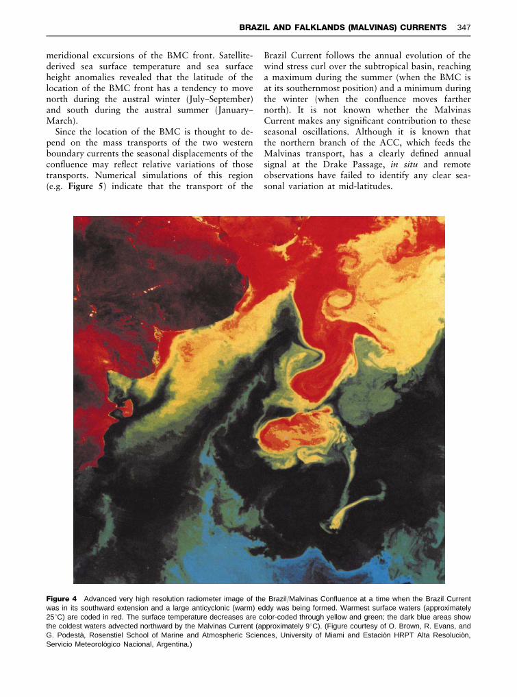
Figure 4 Advanced very high resolution radiometer image of the Brazil/Malvinas Confluence at a time when the Brazil Currentwas in its southward extension and a large anticyclonic (warm) eddy was being formed. Warmest surface waters (approximately253C) are coded in red. The surface temperature decreases are color-coded through yellow and green; the dark blue areas showthe coldest waters advected northward by the Malvinas Current (approximately 93C). (Figure courtesy of O. Brown, R. Evans, andG. PodestaH , Rosenstiel School of Marine and Atmospheric Sciences, University of Miami and EstacioH n HRPT Alta ResolucioH n,Servicio MeteoroloH gico Nacional, Argentina.)
meridional excursions of the BMC front. Satellite-derived sea surface temperature and sea surfaceheight anomalies revealed that the latitude of thelocation of the BMC front has a tendency to movenorth during the austral winter (July}September)and south during the austral summer (January}March).
Since the location of the BMC is thought to de-pend on the mass transports of the two westernboundary currents the seasonal displacements of theconSuence may reSect relative variations of thosetransports. Numerical simulations of this region(e.g. Figure 5) indicate that the transport of the
Brazil Current follows the annual evolution of thewind stress curl over the subtropical basin, reachinga maximum during the summer (when the BMC isat its southernmost position) and a minimum duringthe winter (when the conSuence moves farthernorth). It is not known whether the MalvinasCurrent makes any signiRcant contribution to theseseasonal oscillations. Although it is known thatthe northern branch of the ACC, which feeds theMalvinas transport, has a clearly deRned annualsignal at the Drake Passage, in situ and remoteobservations have failed to identify any clear sea-sonal variation at mid-latitudes.
BRAZIL AND FALKLANDS (MALVINAS) CURRENTS 347
50 cm s_1
30°C20100
70°W60°W 50°W 40°W
64°S
56°S
48°S
40°S
32°S
Figure 5 Snapshot of the upper ocean circulation in the western South Atlantic as simulated by the Parallel Ocean Climate Model(POCM). The color fields correspond to sea surface temperatures and the arrows to velocity vectors. The velocity scale is includedin the figure. (Figure prepared courtesy of E. Beier.)
Acknowledgments
A. Piola acknowledges the support of the Inter-American Institute for Global Change Research andthe Agencia Nacional de PromocioH n CientmHRca y
TecnoloH gica (Argentina), and R. Matano the sup-port from the National Science Foundation (U.S.A.)grant OPP 9527695, OCE 9819223 and the JetPropulsion Laboratory contract 1206714. We thankE. Beier for preparing Fig. 5.
348 BRAZIL AND FALKLANDS (MALVINAS) CURRENTS
See also
Abyssal Currents. Antarctic Circumpolar Current.Current Systems in the Atlantic Ocean. CurrentSystems in the Southern Ocean. Elemental Distri-bution: Overview. Intrusions. Mesoscale Eddies.Ocean Circulation. Regional and Shelf Sea Mod-els. Satellite Altimetry. Satellite Remote Sensingof Sea Surface Temperatures. Upper Ocean Timeand Space Variability. Water Types and WaterMasses.
Further ReadingGordon AL (1981) South Atlantic thermocline ventilation.
Deep-Sea Research 28A(11): 1239}1264.
Peterson RG and Stramma L (1991) Upper-level circula-tion in the South Atlantic Ocean. Progress in Oceano-graphy 26(1): 1}73.
Reid JL, Nowlin WD Jr and Patzert WC (1977) On thecharacteristics and circulation of the southwesternAtlantic Ocean. Journal of Physical Oceanography7(1): 62}91.
Reid JL (1989) On the total geostrophic transport of theSouth Atlantic Ocean: Sow patterns, tracers and trans-ports. Progress in Oceanography 23(3): 149}244.
Stramma L and England M (1999) On the water massesand mean circulation of the South Atlantic Ocean.Journal of Geophysical Research 104(C9): 20 863}20 883.
Tomczak M and Godfrey JS (1994) Regional Oceano-graphy: An Introduction. London: Pergamon.
BREAKING WAVES AND NEAR-SURFACETURBULENCE
S. A. Thorpe, School of Ocean and Earth Science,Southampton, UK
Copyright ^ 2001 Academic Press
doi:10.1006/rwos.2001.0071
Introduction
The breaking of waves on the sea surface createsturbulence in the water. This article is about wavebreaking in deep water where the waves and turbu-lence are not affected by the presence of the sea bed;it does not describe turbulence generated by wavesbreaking on beaches or by the bores within the surfzone at the edge of the sea (see Beaches, PhysicalProcesses Affecting).
The processes of wave breaking and turbulencegeneration are very important in the transfer ofmomentum and exchange of heat and gases betweenthe atmosphere and the oceans, in generating anddispersing bubbles, oil droplets or surface Rlms intothe body of the ‘mixed’ layer, and in renewing thesea surface with subsurface water; breakers disruptthe cold surface skin of the ocean (e.g. see IRRadiometers). Nevertheless, the state of knowledgeof wave breaking and its consequent turbulence isprofoundly unsatisfactory. The present incompleteknowledge of breaking and turbulence hinders pro-gress in understanding vitally important processes,such as those of gas transfer and the dispersion ofpollutants from the water surface. The subject is,however, presently one of some activity, made pos-sible only in the last two decades of the last century
by the development of suitable sensors and methodsof mounting them in the often violent and hostileenvironment of the sea surface, and future progresscan be expected.
The turbulence generated by breaking waves willcoexist with, and interact with turbulence generatedin other ways in the upper ocean, such as Langmuircirculation (which, in view of its instability, mayhave turbulent characteristics; see Langmuir Circu-lation and Instability) and that produced by shear orconvection in the mixed layer. These interactionsare not presently understood and will not be dis-cussed further in this article.
Breaking Waves
Three related kinds of wave breaking occur in deepwater and lead to turbulence in the water. These are:
1. a spilling breaker in which water near a wavecrest entrains air leading to a white cap on orslightly forward of a wave crest;
2. a plunging breaker, the more dramatic form ofbreaking observed commonly on the sea shore, inwhich a jet of water moves forward from nearthe top of a wave and falls, trapping and entrain-ing into the water a volume of air;
3. the formation of capillary ripples on the forwardface of a steep, short (typically 0.1 m wavelength)surface-gravity wave. In their most extreme formthe ripples may lead to entrainment of air intothe water. (see Surface, Gravity and CapillaryWaves).
BREAKING WAVES AND NEAR-SURFACE TURBULENCE 349
Related Documents