Branka Trčak Branka Trčak Center za kartografijo favne in flore Center za kartografijo favne in flore Monošter, 20. 9. 2012 Monošter, 20. 9. 2012 Stanje negozdnih habitatnih tipov Stanje negozdnih habitatnih tipov na vzhodnem delu Goričkega na vzhodnem delu Goričkega v letih 2010 v letih 2010–2012 2012 State of non State of non-forest habitat types forest habitat types in eastern part of Goričko in years 2010 in eastern part of Goričko in years 2010–2012 2012

Branka Trčak : Stanje negozdnih habitatnih tipov na vzhodnem delu Goričkega v letih 2010-2012
Mar 27, 2016
Â
Welcome message from author
This document is posted to help you gain knowledge. Please leave a comment to let me know what you think about it! Share it to your friends and learn new things together.
Transcript

Branka TrčakBranka Trčak
Center za kartografijo favne in floreCenter za kartografijo favne in flore
Monošter, 20. 9. 2012Monošter, 20. 9. 2012
Stanje negozdnih habitatnih tipovStanje negozdnih habitatnih tipovna vzhodnem delu Goričkega na vzhodnem delu Goričkega
v letih 2010v letih 2010––20122012
State of nonState of non--forest habitat types forest habitat types in eastern part of Goričko in years 2010in eastern part of Goričko in years 2010––20122012

State of non-forest habitat types in eastern part of Goričko in years 2010–2012
Branka Trčak, 20. 9. 2012
Goričko areaGoričko area
•• NE part of Slovenia, 460 kmNE part of Slovenia, 460 km22
•• border with Hungary and Austria, north of Pomurje border with Hungary and Austria, north of Pomurje plainplain
•• hilly landscape, average altitude 275 mhilly landscape, average altitude 275 m
•• highest peak (Sotinski breg) 419 mhighest peak (Sotinski breg) 419 m
•• population density: 47 perons per kmpopulation density: 47 perons per km2 2 (2001), ½ of (2001), ½ of Slovenian average Slovenian average
•• precipitation: dryest part of Slovenia, down to 800 precipitation: dryest part of Slovenia, down to 800 mm (dry years only 600 mm)mm (dry years only 600 mm)

State of non-forest habitat types in eastern part of Goričko in years 2010–2012
Branka Trčak, 20. 9. 2012
State of non-forest habitat types in eastern part of Goričko in years 2010–2012
Branka Trčak, 20. 9. 2012
Habitat type mappingHabitat type mapping
•• mapping of Goričko in 2002mapping of Goričko in 2002––2003 (Kaligarič et al. 2003 (Kaligarič et al. 2004)2004)
•• 20102010––2012: E part of Goričko2012: E part of Goričko
•• Aim: Aim: Guidelines for the management planGuidelines for the management plan
State of non-forest habitat types in eastern part of Goričko in years 2010–2012
Branka Trčak, 20. 9. 2012
Habitat typeHabitat type
•• characteristic community of plants and animals characteristic community of plants and animals closely linked with other environmental factors (light, closely linked with other environmental factors (light, warmth, humidity, light, soil type and structure)warmth, humidity, light, soil type and structure)
•• clearly separable from neighbouring habitat typesclearly separable from neighbouring habitat types
•• some examples: montane beech forest, riparian some examples: montane beech forest, riparian willow formation, common reed bed, highwillow formation, common reed bed, high--stem stem orchard, hay meadoworchard, hay meadow, stream, stream. .

State of non-forest habitat types in eastern part of Goričko in years 2010–2012
Branka Trčak, 20. 9. 2012
41.111 41.111 –– MedioMedio--European collinEuropean collinee woodrush beech forestswoodrush beech forests
State of non-forest habitat types in eastern part of Goričko in years 2010–2012
Branka Trčak, 20. 9. 2012
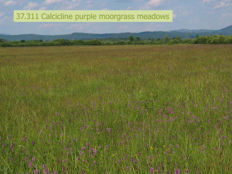
37.311 Calcicline purple moorgrass meadows37.311 Calcicline purple moorgrass meadows

State of non-forest habitat types in eastern part of Goričko in years 2010–2012
Branka Trčak, 20. 9. 2012
82.11 82.11 -- Field cropsField crops

State of non-forest habitat types in eastern part of Goričko in years 2010–2012
Branka Trčak, 20. 9. 2012
83.151 83.151 –– Northern fruit orchardsNorthern fruit orchards
State of non-forest habitat types in eastern part of Goričko in years 2010–2012
Branka Trčak, 20. 9. 2012
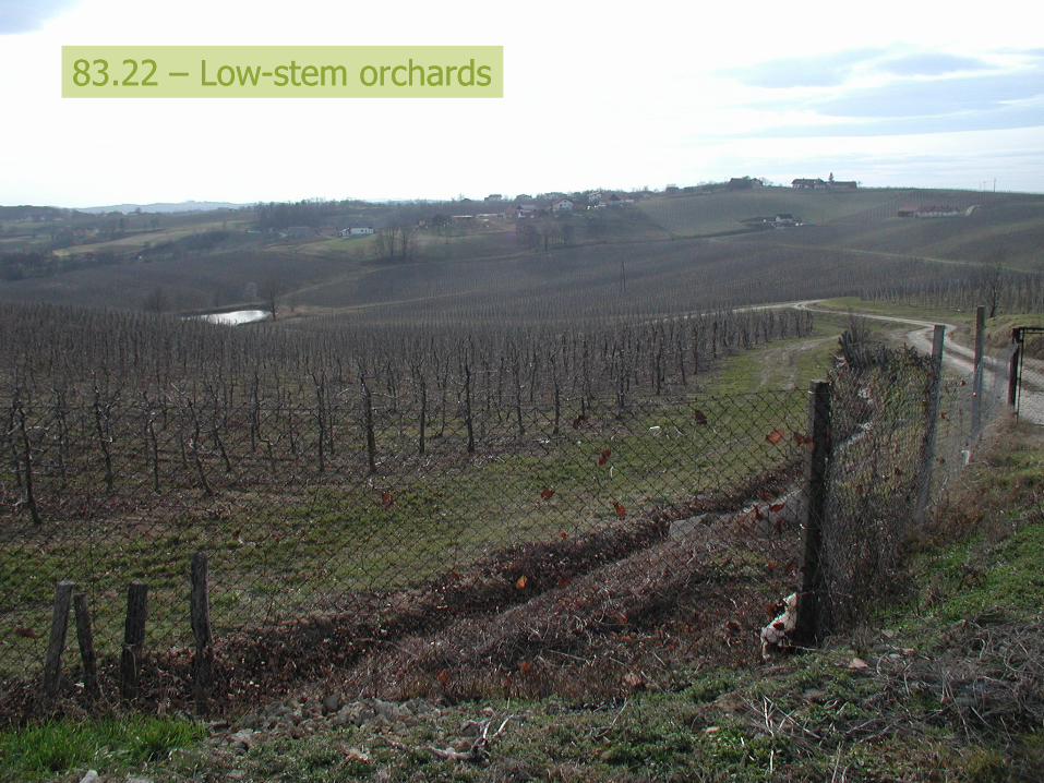
83.22 83.22 –– LowLow--stem orchardsstem orchards

State of non-forest habitat types in eastern part of Goričko in years 2010–2012
Branka Trčak, 20. 9. 2012
MethodologyMethodology
•• Tipology: HTS 2004, new version (2012) in Tipology: HTS 2004, new version (2012) in preparationpreparation
•• combinations of habitat types (hybrids)combinations of habitat types (hybrids)
•• state of overgrowingstate of overgrowing
•• state of preservation (state of preservation (--,+, certain combinations),+, certain combinations)
•• invasive speciesinvasive species
•• streams typesstreams types
•• small plots (important for some HTs)small plots (important for some HTs)
field work field work ––> digitization > digitization ––> nature conservation > nature conservation evaluation evaluation ––> analysis > analysis ––> > Guidelines Guidelines

State of non-forest habitat types in eastern part of Goričko in years 2010–2012
Branka Trčak, 20. 9. 2012

State of non-forest habitat types in eastern part of Goričko in years 2010–2012
Branka Trčak, 20. 9. 2012
TipologyTipology
hierarchical structure
modified palearctic classification
PHYSIS code (comparability)
combined habitat types (31.8121×38.221)

State of non-forest habitat types in eastern part of Goričko in years 2010–2012
Branka Trčak, 20. 9. 2012
AbbrevAbbrev.. PhysisPhysis Habitat typeHabitat type FFHFFH DecreeDecree HTHT BernBern NCENCE
TNTN 3535..1111 Mezofilna do kserofilna volkovja pod gozdno mejoMezofilna do kserofilna volkovja pod gozdno mejo 62306230** 33 BB 55
TVETVE 3737..22 Mokrotni mezotrofni in evtrofni travniki ali pašnikiMokrotni mezotrofni in evtrofni travniki ali pašniki 33 BB 44
TVTV11 3737..2121 Mezotrofni mokrotni travnikiMezotrofni mokrotni travniki 33 BB 55
DESDES 3737..2626 Vlažni travniki z rušnato masnicoVlažni travniki z rušnato masnico 33 BB 44
TVMTVM 3737..33 Oligotrofni mokrotni travnikiOligotrofni mokrotni travniki 33 BB 44
MOLMOL 3737..311311 Mokrotni travniki z modro stožkoMokrotni travniki z modro stožko 64106410 33 BB 55
MOLAMOLA 3737..313313 Mezofilni do vlažni travniki s trstikasto stožkoMezofilni do vlažni travniki s trstikasto stožko 64106410 33 BB 55
TT11 3838..221221 Srednjeevropski kseromezofilni nižinski travniki na Srednjeevropski kseromezofilni nižinski travniki na razmeroma suhih tleh in nagnjenih legah s prevladujočo razmeroma suhih tleh in nagnjenih legah s prevladujočo visoko pahovkovisoko pahovko
65106510 33 44
TT22 3838..222222 Srednjeevropski higromezofilni nižinski travniki na srednje Srednjeevropski higromezofilni nižinski travniki na srednje vlažnih tleh s prevladujočo visoko pahovkovlažnih tleh s prevladujočo visoko pahovko
65106510 33 44

State of non-forest habitat types in eastern part of Goričko in years 2010–2012
Branka Trčak, 20. 9. 2012
48,7551,25
forest
non-forest
ResultsResults
•• 257,5 km257,5 km2 2
•• ½ of area covered with forest½ of area covered with forest
•• average surface area of a polygon: 2.280average surface area of a polygon: 2.280 mm2 2 (0,22 ha)(0,22 ha)
•• 68 % of non68 % of non--forest area analyzed:forest area analyzed:
–– 54 % Field crops54 % Field crops
–– 5 % Xeromesophile medio5 % Xeromesophile medio--European lowland hay European lowland hay meadowsmeadows
–– 4 % Dry improved grasslands4 % Dry improved grasslands
–– 4 % Fallow fields4 % Fallow fields
0
10
20
30
40
50
60
N
T1
TSEJ1 ON
VAS
T1-
T21
N1
TSEJ2
SAD
1
T21-
INV2
MSK C
ZM ZL
SAD
G
VIN
2
VIN
TSB3
KO
L1
ALN
PxG
RO
B
MAK
ZLxIN
V2
ALN
P
ALN
TR
ZM
xIN
V2
GRO
B
SO
B1xALN
P
TV1
SAD
1/T
1 P1
T3
TP
TSB3-
MO
LA TK
Habitat type
Pe
rce
nt
of
are
a
State of non-forest habitat types in eastern part of Goričko in years 2010–2012
Branka Trčak, 20. 9. 2012
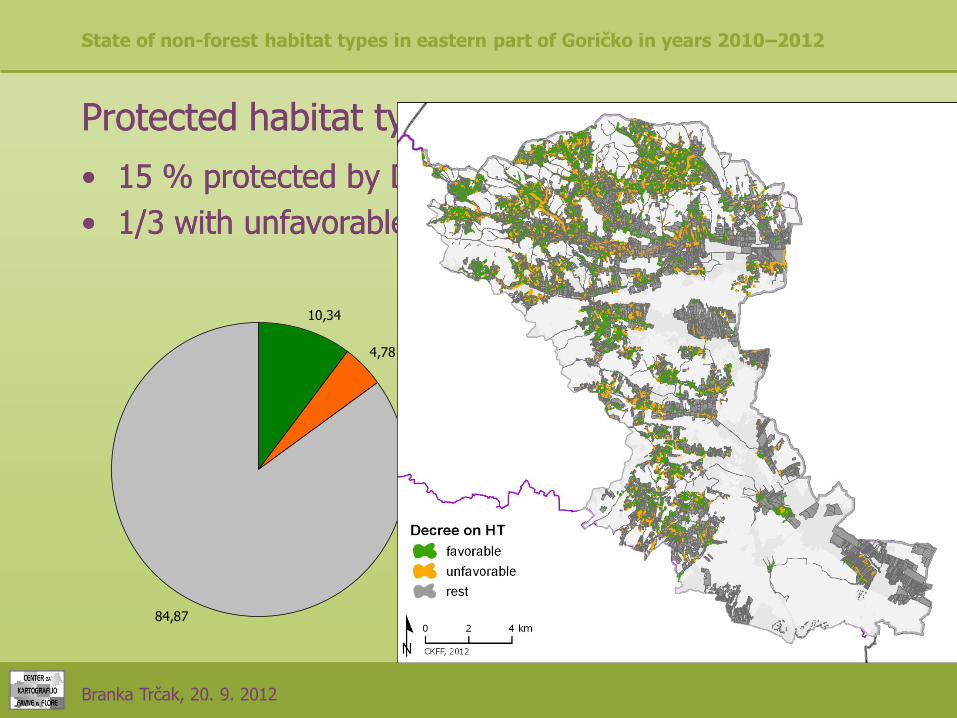
Protected habitat typesProtected habitat types
•• 15 % protected by Decree on habitat types15 % protected by Decree on habitat types
•• 1/3 with unfavorable status1/3 with unfavorable status
10,34
4,78
84,87
Decree HT - favorable
Decree HT - unfavorable
rest

State of non-forest habitat types in eastern part of Goričko in years 2010–2012
Branka Trčak, 20. 9. 2012
-6210
-6210(*)
-6210*
-6230*
-6410
-6430
-6510
-91E0*
3150
4030
6210(*)
6210(*), -6510
6210(*), 6230*
6210(*), 6510
6210*
6230*
6230*, -6510
6230*, 6210*
6230*, 6410
6230*, 6510
6410
6410, -6210
6430
6430, 6410
6510
91E0*
0,00 1,00 2,00 3,00 4,00 5,00 6,00

State of non-forest habitat types in eastern part of Goričko in years 2010–2012
Branka Trčak, 20. 9. 2012
Habitat directiveHabitat directive
•• 6510 Lowland hay meadows (6510 Lowland hay meadows (Alopecurus pratensis, Alopecurus pratensis, Sanguisorba officinalisSanguisorba officinalis) )

State of non-forest habitat types in eastern part of Goričko in years 2010–2012
Branka Trčak, 20. 9. 2012
Habitat directive Habitat directive
•• 6410 Molinia meadows on calcareous, peaty 6410 Molinia meadows on calcareous, peaty or clayeyor clayey--siltsilt--laden soils (Molinion laden soils (Molinion caeruleae) caeruleae)
–– 0,47 % of non0,47 % of non--forest areaforest area
–– 1/3 with unfavorable status1/3 with unfavorable status
67,21
32,79
favorable
unfavorable

State of non-forest habitat types in eastern part of Goričko in years 2010–2012
Branka Trčak, 20. 9. 2012

State of non-forest habitat types in eastern part of Goričko in years 2010–2012
Branka Trčak, 20. 9. 2012
Habitat directiveHabitat directive
•• 6210(*) 6210(*) SemiSemi--natural dry grasslands and natural dry grasslands and scrubland facies: on calcareous substrates scrubland facies: on calcareous substrates (Festuco(Festuco--Brometalia) Brometalia)
–– 1,32 % of non1,32 % of non--forest areaforest area
–– ca. 30 % with unfavorable statusca. 30 % with unfavorable status
70,51
29,49
favorable
unfavorable

State of non-forest habitat types in eastern part of Goričko in years 2010–2012
Branka Trčak, 20. 9. 2012
State of non-forest habitat types in eastern part of Goričko in years 2010–2012
Branka Trčak, 20. 9. 2012
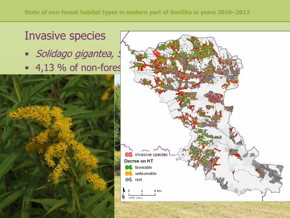
Invasive speciesInvasive species
•• Solidago gigantea, Solidago canadensisSolidago gigantea, Solidago canadensis
•• 4,13 % of non4,13 % of non--forest areaforest area

State of non-forest habitat types in eastern part of Goričko in years 2010–2012
Branka Trčak, 20. 9. 2012
Negative factors:Negative factors:
•• Abandonment, overgrowingAbandonment, overgrowing
•• Intensification of agriculture, disappearing of valuable Intensification of agriculture, disappearing of valuable habitat typeshabitat types
State of non-forest habitat types in eastern part of Goričko in years 2010–2012
Branka Trčak, 20. 9. 2012
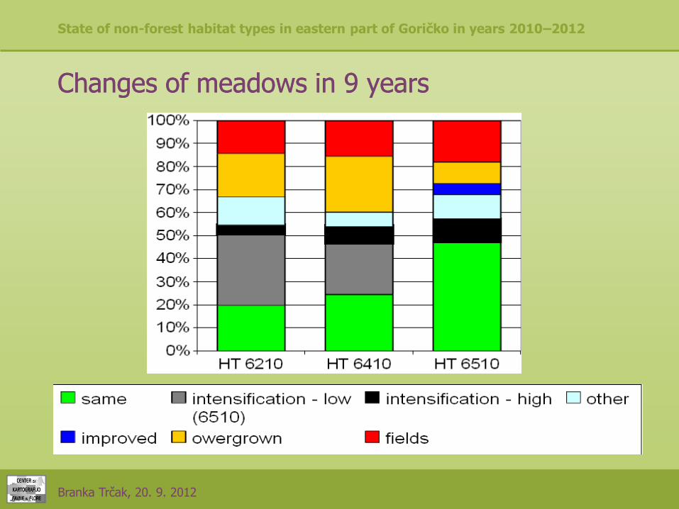
Changes of meadows in 9 yearsChanges of meadows in 9 years

State of non-forest habitat types in eastern part of Goričko in years 2010–2012
Branka Trčak, 20. 9. 2012
Conclusions:Conclusions:
•• What do we want? Preserved nature? Agriculture? What do we want? Preserved nature? Agriculture? Both? Both?
•• We need both.We need both.
•• Let's start with regular mowing...Let's start with regular mowing...

State of non-forest habitat types in eastern part of Goričko in years 2010–2012
Branka Trčak, 20. 9. 2012
Related Documents


