Braintree District Council Pre-Submission Site Allocation and Development Management Plan Sustainability Appraisal and Strategic Environmental Assessment Appraisal of Site Allocations – Annex D6: Hatfield Peverel to Wickham St Paul February 2014

Welcome message from author
This document is posted to help you gain knowledge. Please leave a comment to let me know what you think about it! Share it to your friends and learn new things together.
Transcript
Braintree District Council Pre-Submission Site Allocation and Development Management Plan
Sustainability Appraisal and Strategic Environmental Assessment
Appraisal of Site Allocations – Annex D6: Hatfield Peverel to Wickham St Paul
February 2014

SA/SEA Annex D6 – February 2014
Place Services at Essex County Council

SA/SEA Annex D6 – February 2014
Place Services at Essex County Council
Contents
1. Introduction ........................................................................................................................... 8 1.1. Background ..................................................................................................................... 8 1.2. Hatfield Peverel ............................................................................................................... 9
1.2.1. Site: HAT1 ............................................................................................................... 9 1.2.2. Site: HAT2 ............................................................................................................. 10 1.2.3. Site: HAT3 ............................................................................................................. 12 1.2.4. Site: HAT4MAlt ...................................................................................................... 14 1.2.5. Site: HAT5MAlt ...................................................................................................... 15 1.2.6. Site: HAT6 ............................................................................................................. 17 1.2.7. Site: HAT8 ............................................................................................................. 19 1.2.8. Site: HAT9 ............................................................................................................. 20 1.2.9. Site: HAT10A ......................................................................................................... 22 1.2.10. Site: HAT10B ......................................................................................................... 24 1.2.11. Site: HAT11 ........................................................................................................... 26 1.2.12. Site: HAT12 ........................................................................................................... 27 1.2.13. Site: HAT13CDAlt .................................................................................................. 29 1.2.14. Site: HAT14 ........................................................................................................... 31 1.2.15. Site: HAT15 ........................................................................................................... 32 1.2.16. Site: HAT17H ......................................................................................................... 34 1.2.17. Site: HAT18 ........................................................................................................... 36 1.2.18. Site: HAT18 ........................................................................................................... 37 1.2.19. Site: HAT19 ........................................................................................................... 39 1.2.20. Site: HAT20 ........................................................................................................... 40 1.2.21. Site: HAT21 ........................................................................................................... 42 1.2.22. Site: HAT22 ........................................................................................................... 44
1.3. Helions Bumpstead ....................................................................................................... 46 1.3.1. Site: HEL2E ........................................................................................................... 46 1.3.2. Site: HEL10X ......................................................................................................... 47
1.4. Kelvedon ....................................................................................................................... 50 1.4.1. Site: KEL1MAlt ....................................................................................................... 50 1.4.2. Site: KEL2A ........................................................................................................... 51 1.4.3. Site: KEL2CH......................................................................................................... 53 1.4.4. Site: KEL3MAlt ....................................................................................................... 54 1.4.5. Site: KEL4 .............................................................................................................. 56 1.4.6. Site: KEL5E ........................................................................................................... 58 1.4.7. Site: KEL6CD (inc. KEL6EAlt) ................................................................................ 59 1.4.8. Site: KEL7 .............................................................................................................. 61 1.4.9. Site: KEL8 .............................................................................................................. 63 1.4.10. Site: KEL11E ......................................................................................................... 64 1.4.11. Site: KEL12 ............................................................................................................ 66
1.5. Lamarsh ........................................................................................................................ 67 1.5.1. Site: LAM1 ............................................................................................................. 67 1.5.2. Site: LAM2 ............................................................................................................. 69
1.6. Little Maplestead ........................................................................................................... 71 1.6.1. Site: LIM1 .............................................................................................................. 71 1.6.2. Site: LIM2 .............................................................................................................. 72 1.6.3. Site: LIM3 .............................................................................................................. 74
1.7. Liston ............................................................................................................................. 75 1.7.1. Site: LIS1MAlt ........................................................................................................ 75
1.8. Little Yeldham ................................................................................................................ 77 1.8.1. Site: LTY1 .............................................................................................................. 77 1.8.2. Site: LTY2 .............................................................................................................. 79 1.8.3. Site: LTY3 .............................................................................................................. 80

SA/SEA Annex D6 – February 2014
Place Services at Essex County Council
1.8.4. Site: LTY4 .............................................................................................................. 82 1.8.5. Site: LTY5 .............................................................................................................. 83
1.9. Middleton ....................................................................................................................... 85 1.9.1. Site: MID1 .............................................................................................................. 85
1.10. Ovington ........................................................................................................................ 87 1.10.1. Site: OVI1 .............................................................................................................. 87 1.10.2. Site: OVI2 .............................................................................................................. 88 1.10.3. Site: OVI3 .............................................................................................................. 90
1.11. Panfield ......................................................................................................................... 92 1.11.1. Site: PAN1MAlt ...................................................................................................... 92 1.11.2. Site: PAN2 ............................................................................................................. 93 1.11.3. Site: PAN3 ............................................................................................................. 95
1.12. Pebmarsh ...................................................................................................................... 96 1.12.1. Site: PEB1 ............................................................................................................. 96 1.12.2. Site: PEB2 ............................................................................................................. 98 1.12.3. Site: PEB3 ........................................................................................................... 100 1.12.4. Site: PEB4 ........................................................................................................... 101 1.12.5. Site: PEB6 ........................................................................................................... 103 1.12.7. Site: PEB8 ........................................................................................................... 106
1.13. Rayne .......................................................................................................................... 107 1.13.1. Site: RAY1 ........................................................................................................... 107 1.13.2. Site: RAY2 ........................................................................................................... 109 1.13.3. Site: RAY3 ........................................................................................................... 111 1.13.4. Site: RAY4MAlt .................................................................................................... 112 1.13.5. Site: RAY5 ........................................................................................................... 114 1.13.6. Site: RAY6 ........................................................................................................... 115 1.13.7. Site: RAY7 ........................................................................................................... 117 1.13.8. Site: RAY8 ........................................................................................................... 119 1.13.9. Site: RAY9 ........................................................................................................... 120
1.14. Ridgewell ..................................................................................................................... 123 1.14.1. Site: RID1EH ....................................................................................................... 123 1.14.2. Site: RID2 ............................................................................................................ 124 1.14.3. Site: RID3 ............................................................................................................ 126 1.14.4. Site: RID4 ............................................................................................................ 127 1.14.5. Site: RID5 ............................................................................................................ 129 1.14.6. Site: RID6 ............................................................................................................ 130 1.14.7. Site: RID7 ............................................................................................................ 132
1.15. Rivenhall ..................................................................................................................... 134 1.15.1. Site: RIV1 ............................................................................................................ 134 1.15.2. Site: RIV2H .......................................................................................................... 135 1.15.3. Site: RIV3EAlt ...................................................................................................... 137 1.15.4. Site: RIV4 ............................................................................................................ 138 1.15.5. Site: RIV5EAlt ...................................................................................................... 140 1.15.6. Site: RIV6 ............................................................................................................ 142 1.15.7. Site: RIV7MAlt ..................................................................................................... 143 1.15.8. Site: RIV8 ............................................................................................................ 145
1.16. Shalford ....................................................................................................................... 147 1.16.1. Site: SHA1 ........................................................................................................... 147 1.16.2. Site: SHA2 ........................................................................................................... 148 1.16.3. Site: SHA3A ......................................................................................................... 150 1.16.4. Site: SHA3B ......................................................................................................... 151 1.16.5. Site: SHA4 ........................................................................................................... 153 1.16.6. Site: SHA5 ........................................................................................................... 154 1.16.7. Site: SHA6 ........................................................................................................... 156 1.16.8. Site: SHA7 ........................................................................................................... 157
1.17. Sible Hedingham ......................................................................................................... 160 1.17.1. Site: SIB1 ............................................................................................................. 160
SA/SEA Annex D6 – February 2014
Place Services at Essex County Council
1.17.2. Site: SIB2A .......................................................................................................... 161 1.17.3. Site: SIB2B .......................................................................................................... 163 1.17.4. Site: SIB2E .......................................................................................................... 164 1.17.5. Site: SIB2H .......................................................................................................... 166 1.17.6. Site: SIB3E .......................................................................................................... 168 1.17.7. Site: SIB4 ............................................................................................................. 169 1.17.8. Site: SIB5 ............................................................................................................. 171 1.17.9. Site: SIB6MAlt ...................................................................................................... 172 1.17.10. Site: SIB7H .......................................................................................................... 174 1.17.11. Site: SIB8 ............................................................................................................. 175 1.17.12. Site: SIB9 ............................................................................................................. 177 1.17.13. Site: SIB9X .......................................................................................................... 179 1.17.14. Site: SIB10 ........................................................................................................... 180 1.17.15. Site: SIB10 ........................................................................................................... 182
1.18. Silver End .................................................................................................................... 184 1.18.1. Site: SIL1 ............................................................................................................. 184 1.18.2. Site: SIL2 ............................................................................................................. 185 1.18.3. Site: SIL3 ............................................................................................................. 187 1.18.4. Site: SIL5 ............................................................................................................. 188 1.18.5. Site: SIL6RG ........................................................................................................ 190 1.18.6. Site: SIL7H .......................................................................................................... 191 1.18.7. Site: SIL8 ............................................................................................................. 193 1.18.8. Site: SIL9 ............................................................................................................. 195
1.19. Stambourne ................................................................................................................. 196 1.19.1. Site: STA1 ........................................................................................................... 196
1.20. Steeple Bumpstead ..................................................................................................... 199 1.20.1. Site: STE1H ......................................................................................................... 199 1.20.2. Site: STE2 ........................................................................................................... 200 1.20.3. Site: STE3 ........................................................................................................... 202 1.20.4. Site: STE4MAlt .................................................................................................... 203 1.20.5. Site: STE5 ........................................................................................................... 205 1.20.6. Site: STE6 ........................................................................................................... 206 1.20.7. Site: STE7 ........................................................................................................... 208 1.20.8. Site: STE8 ........................................................................................................... 209
1.21. Stisted ......................................................................................................................... 211 1.21.1. Site: STI1 ............................................................................................................. 211 1.21.2. Site: STI2 (Preferred Gypsy, Traveller and Travelling Showpersons Site) ............ 213
1.22. Sturmer ....................................................................................................................... 215 1.22.1. Site STU1 ............................................................................................................ 215 1.22.2. Site: STU2 ........................................................................................................... 216 1.22.3. Site: STU3E ......................................................................................................... 218 1.22.4. Site: STU3 ........................................................................................................... 219 1.22.5. Site: STU4E ......................................................................................................... 221
1.23. Terling ......................................................................................................................... 222 1.23.1. Site: TER1 ........................................................................................................... 222 1.23.2. Site: TER2 ........................................................................................................... 224
1.24. Toppesfield .................................................................................................................. 227 1.24.1. Site: TOP1 ........................................................................................................... 227 1.24.2. Site: TOP2 ........................................................................................................... 228
1.25. Wethersfield ................................................................................................................ 231 1.25.1. Site: WET1 .......................................................................................................... 231 1.25.2. Site: WET2 .......................................................................................................... 232 1.25.3. Site: WET3 .......................................................................................................... 234 1.25.4. Site: WET4 .......................................................................................................... 235 1.25.5. Site: WET5 .......................................................................................................... 237 1.25.6. Site: WET7X ........................................................................................................ 238 1.25.7. Site: WET8 .......................................................................................................... 240

SA/SEA Annex D6 – February 2014
Place Services at Essex County Council
1.26. White Colne ................................................................................................................. 242 1.26.1. Site: WHC1 .......................................................................................................... 242 1.26.2. Site: WHC2 .......................................................................................................... 243 1.26.3. Site: WHC3 .......................................................................................................... 245 1.26.4. Site: WHC4 .......................................................................................................... 246
1.27. White Notley ................................................................................................................ 248 1.27.1. Site: WHN1 .......................................................................................................... 248
1.28. Wickham St Paul ......................................................................................................... 250 1.28.1. Site: WIC1A ......................................................................................................... 250 1.28.2. Site: WIC1B ......................................................................................................... 251 1.28.3. Site: WIC2 ........................................................................................................... 253

SA/SEA Annex D6 – February 2014
Place Services at Essex County Council

SA/SEA Annex D6 – February 2014
8 Place Services at Essex County Council
1. Introduction
1.1. Background
The Pre-Submission Site Allocation and Development Management Plan identifies sites to meet the Council development requirements over the plan period, and to identify areas which should be protected from unsuitable development.
Sites have been subject to SA/SEA and appraised using a proforma developed taking into account consultation comments from Statutory Consultees at the Scoping Report stage, the findings of the LDF Stakeholder Workshop (Jan 2012), the key issues of the area, and all relevant available information across a range of sustainability criteria. The proforma can be found in Annex C – Sustainability Framework accompanying this report.
The sites have been appraised against social, environmental and economic criteria in the proforma subject to available information. This responds to a desire to assess each site for reasonable and relevant alternative land uses. As such, negative or positive impacts may have been highlighted that are not relevant to the proposed use put forward for the site and should be discounted when considering certain uses and proposals.
Please note that the information used in the appraisal of sites was correct at the time that they were undertaken, and was used as consistently as possible across all sites.
It is acknowledged that some negative and uncertain impacts arising from the appraisal of sites may be addressed and mitigated through Development Management Policies in the Plan. Similarly, no negative impacts identified in the SA/SEA should be taken as a restriction to development, or basis for the rejection of applications. Negative impacts identified in the SA/SEA process are for the purposes of awareness only and can be viewed as issues to be addressed through applications going forward from this point.
Some sites and proposals have come forward and/or have been received by Place Services for appraisal, with an insufficient level of detail to determine certain impacts or an intended use. Never-the-less, these sites have been appraised as consistently and with as much detail as possible within this Annex.

SA/SEA Annex D6 – February 2014
9 Place Services at Essex County Council
1.2. Hatfield Peverel
1.2.1. Site: HAT1
Address: Land East of Gleneagles Way, Hatfield Peverel
Other info: Greenfield, Residential, SHLAA – 60 dwellings
Sustainability Objective
Key Criteria / Impacts
1) Create safe environments which
improve quality of life and community
cohesion
Provision / suitability for community facilities
Crime incidents in past year Nearest Post Offices
0 /
106 incidences +
2) To provide everyone with the
opportunity to live in a decent home
Delivery of affordable housing Additional capacity in or of care homes
++ 0
3) To improve the health of the District’s
residents and mitigate/reduce potential health
inequalities
Distance to nearest GP
Distances to accessible natural
greenspace
Loss of recreation (formal / informal),
open space, allotments.
Contaminated land
+ - + 0
4) To promote the vitality and viability of
all service centres throughout the District
Increase in retail floorspace Distances to primary shopping area boundaries
0 /
5) To achieve sustainable levels of
prosperity and economic growth
Loss of high quality agricultural land (Grades 1 &
2)
Distances to employment sites (B1, B2, B8)
Broadband availability
- / ADSL, SDSL, WBC broadband enabled
6) To conserve and enhance the
biological and geological diversity of
the environment
Distance to SSSI (any condition)
Distance to NNR
Distance to LNR
Distance to LoWS
Distance to Ancient
Woodland
Presence of TPOs on
site?
0 0 0 0 0 0
7) To promote more sustainable transport choices and uptake
Cycleways Footpaths Distance to Bus Stops and Bus
Regularity
Distance to Railway Stations and Train
Regularity
0 0 ++ ++
8) Promote accessibility and
ensure the necessary transport
infrastructure to support new development
Accessible location? Rail links? Highways access
+ ++
+ Access could be gained from
Gleneagles Way and Woodham Drive.
9) To improve the education and skills
Distance to a primary school
Distance to a secondary school
Capacity in nearest primary school to
Capacity in nearest secondary school to
SA/SEA Annex D6 – February 2014
10 Place Services at Essex County Council
of the population support the size of development
support the size of development
+ +
- Hatfield Peverel Infant 0 places
Hatfield Peverel St Andrew’s Junior 12
places 18 places required
+ Maltings Academy
184 places 12 places required
10) To maintain and enhance cultural
heritage and assets within the District
Impact on Scheduled Monument / Listed Building / Conservation Area / Historic Park or
Garden / Archaeology
Protected Lanes (Grade 1 and 2)
0 0
11) To reduce contributions to climatic change
This issue is dealt with in Development Management and Core Strategy Policies which is applicable to all relevant development.
12) To improve water quality and address water scarcity and
sewerage
Groundwater protection zone. Capacities in sewage network
0 0
13) To reduce the risk of flooding
Flood Zone 2 / Flood Zone 3 (a/b) Flooding from other sources
0 /
14) To improve air quality
Distance to A12 or A120 Impact on potentially Significant Junction for Air Quality
- 0
15) To maintain and enhance the quality of
landscapes and townscapes
Sensitivity to change in the
LCA
Greenfield / PDL Visually Important Space
Country Parks Landscaping associated with
proposals
/ low to moderate
Boreham Farmland Plateau
- 0 0 /
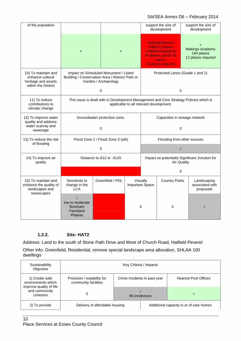
1.2.2. Site: HAT2
Address: Land to the south of Stone Path Drive and West of Church Road, Hatfield Peverel
Other info: Greenfield, Residential, remove special landscape area allocation, SHLAA 100 dwellings
Sustainability Objective
Key Criteria / Impacts
1) Create safe environments which
improve quality of life and community
cohesion
Provision / suitability for community facilities
Crime incidents in past year Nearest Post Offices
0 /
96 incidences +
2) To provide Delivery of affordable housing Additional capacity in or of care homes
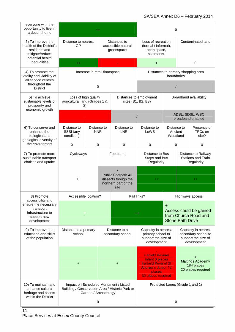
SA/SEA Annex D6 – February 2014
11 Place Services at Essex County Council
everyone with the opportunity to live in
a decent home ++ 0
3) To improve the health of the District’s
residents and mitigate/reduce potential health
inequalities
Distance to nearest GP
Distances to accessible natural
greenspace
Loss of recreation (formal / informal),
open space, allotments.
Contaminated land
++ - + 0
4) To promote the vitality and viability of
all service centres throughout the
District
Increase in retail floorspace Distances to primary shopping area boundaries
0 /
5) To achieve sustainable levels of
prosperity and economic growth
Loss of high quality agricultural land (Grades 1 &
2)
Distances to employment sites (B1, B2, B8)
Broadband availability
- / ADSL, SDSL, WBC broadband enabled
6) To conserve and enhance the
biological and geological diversity of
the environment
Distance to SSSI (any condition)
Distance to NNR
Distance to LNR
Distance to LoWS
Distance to Ancient
Woodland
Presence of TPOs on
site?
0 0 0 0 0 0
7) To promote more sustainable transport choices and uptake
Cycleways Footpaths Distance to Bus Stops and Bus
Regularity
Distance to Railway Stations and Train
Regularity
0
/ Public Footpath 43 dissects though the northern part of the
site
++ ++
8) Promote accessibility and
ensure the necessary transport
infrastructure to support new development
Accessible location? Rail links? Highways access
+ ++
+ Access could be gained from Church Road and Stone Path Drive
9) To improve the education and skills
of the population
Distance to a primary school
Distance to a secondary school
Capacity in nearest primary school to
support the size of development
Capacity in nearest secondary school to support the size of
development
+ +
- Hatfield Peverel Infant 0 places
Hatfield Peverel St Andrew’s Junior 12
places 30 places required
+ Maltings Academy
184 places 20 places required
10) To maintain and enhance cultural
heritage and assets within the District
Impact on Scheduled Monument / Listed Building / Conservation Area / Historic Park or
Garden / Archaeology
Protected Lanes (Grade 1 and 2)
0 0

SA/SEA Annex D6 – February 2014
12 Place Services at Essex County Council
11) To reduce contributions to climatic change
This issue is dealt with in Development Management and Core Strategy Policies which is applicable to all relevant development.
12) To improve water quality and address water scarcity and
sewerage
Groundwater protection zone. Capacities in sewage network
0 0
13) To reduce the risk of flooding
Flood Zone 2 / Flood Zone 3 (a/b) Flooding from other sources
0 /
14) To improve air quality
Distance to A12 or A120 Impact on potentially Significant Junction for Air Quality
0 0
15) To maintain and enhance the quality of landscapes and
townscapes
Sensitivity to change in the
LCA
Greenfield / PDL Visually Important Space
Country Parks Landscaping associated with
proposals
/ low to moderate
Boreham Farmland Plateau
- 0 0 /
1.2.3. Site: HAT3
Address: Land to west of Hatfield Peverel and East of Hatfield Place, Hatfield Peverel
Other info: Greenfield, Residential, SHLAA - 150 dwellings
Sustainability Objective
Key Criteria / Impacts
1) Create safe environments which
improve quality of life and community
cohesion
Provision / suitability for community facilities
Crime incidents in past year Nearest Post Offices
0 /
94 incidences +
2) To provide everyone with the
opportunity to live in a decent home
Delivery of affordable housing Additional capacity in or of care homes
++ 0
3) To improve the health of the District’s
residents and mitigate/reduce potential health
inequalities
Distance to nearest GP
Distances to accessible natural
greenspace
Loss of recreation (formal / informal),
open space, allotments.
Contaminated land
++ - + 0
4) To promote the vitality and viability of
all service centres throughout the
District
Increase in retail floorspace Distances to primary shopping area boundaries
0 /
5) To achieve sustainable levels of
Loss of high quality agricultural land (Grades 1 &
Distances to employment sites (B1, B2, B8)
Broadband availability

SA/SEA Annex D6 – February 2014
13 Place Services at Essex County Council
prosperity and economic growth
2)
- / ADSL, SDSL, WBC broadband enabled
6) To conserve and enhance the
biological and geological diversity of
the environment
Distance to SSSI (any condition)
Distance to NNR
Distance to LNR
Distance to LoWS
Distance to Ancient
Woodland
Presence of TPOs on
site?
0 0 0 0 0 0
7) To promote more sustainable transport choices and uptake
Cycleways Footpaths Distance to Bus Stops and Bus
Regularity
Distance to Railway Stations and Train
Regularity
0
/ Public Footpath 43
dissects through the centre of the proposed site
++ ++
8) Promote accessibility and
ensure the necessary transport
infrastructure to support new development
Accessible location? Rail links? Highways access
+ ++ +
Access could be gained from The Street
9) To improve the education and skills
of the population
Distance to a primary school
Distance to a secondary school
Capacity in nearest primary school to
support the size of development
Capacity in nearest secondary school to support the size of
development
- +
- Hatfield Peverel Infant 0 places
Hatfield Peverel St Andrew’s Junior 12
places 45 places required
+ Maltings Academy
184 places 30 places required
10) To maintain and enhance cultural
heritage and assets within the District
Impact on Scheduled Monument / Listed Building / Conservation Area / Historic Park or
Garden / Archaeology
Protected Lanes (Grade 1 and 2)
0 0
11) To reduce contributions to climatic change
This issue is dealt with in Development Management and Core Strategy Policies which is applicable to all relevant development.
12) To improve water quality and address water scarcity and
sewerage
Groundwater protection zone. Capacities in sewage network
0 0
13) To reduce the risk of flooding
Flood Zone 2 / Flood Zone 3 (a/b) Flooding from other sources
0 /
14) To improve air quality
Distance to A12 or A120 Impact on potentially Significant Junction for Air Quality
- 0

SA/SEA Annex D6 – February 2014
14 Place Services at Essex County Council
15) To maintain and enhance the quality of landscapes and
townscapes
Sensitivity to change in the
LCA
Greenfield / PDL Visually Important Space
Country Parks Landscaping associated with
proposals
/ low to moderate
Boreham Farmland Plateau
- 0 0 /
1.2.4. Site: HAT4MAlt
Address: Land at Woodend, Hatfield Road, Witham
Other info: Greenfield, Mixed Use, SHLAA - 600 dwellings
Sustainability Objective
Key Criteria / Impacts
1) Create safe environments which
improve quality of life and community
cohesion
Provision / suitability for community facilities
Crime incidents in past year Nearest Post Offices
/ /
204 incidences /
2) To provide everyone with the
opportunity to live in a decent home
Delivery of affordable housing Additional capacity in or of care homes
++ 0
3) To improve the health of the District’s
residents and mitigate/reduce potential health
inequalities
Distance to nearest GP
Distances to accessible natural
greenspace
Loss of recreation (formal / informal),
open space, allotments.
Contaminated land
-- + 0
4) To promote the vitality and viability of
all service centres throughout the
District
Increase in retail floorspace Distances to primary shopping area boundaries
/ /
5) To achieve sustainable levels of
prosperity and economic growth
Loss of high quality agricultural land (Grades 1 &
2)
Distances to employment sites (B1, B2, B8)
Broadband availability
- + ADSL, WBC, FTTC, some
LLU DSL broadband enabled
6) To conserve and enhance the
biological and geological diversity of
the environment
Distance to SSSI (any condition)
Distance to NNR
Distance to LNR
Distance to LoWS
Distance to Ancient
Woodland
Presence of TPOs on
site?
0 0 0 0 0 0
7) To promote more sustainable transport choices and uptake
Cycleways Footpaths Distance to Bus Stops and Bus
Regularity
Distance to Railway Stations and Train
Regularity
0 0 ++ -
8) Promote Accessible location? Rail links? Highways access

SA/SEA Annex D6 – February 2014
15 Place Services at Essex County Council
accessibility and ensure the necessary
transport infrastructure to
support new development
/
Site downgraded from positive (+) as suitably outside the village envelope, however close to Witham facilities and
the Maltings Lane development and associated
infrastructure.
++ +
Access could be gained off Hatfield Road
9) To improve the education and skills
of the population
Distance to a primary school
Distance to a secondary school
Capacity in nearest primary school to
support the size of development
Capacity in nearest secondary school to support the size of
development
- ++
- Howbridge Infant 0
places Howbridge CoE Junior 32 places
180 places required
+ Maltings Academy
184 places 120 places required
10) To maintain and enhance cultural
heritage and assets within the District
Impact on Scheduled Monument / Listed Building / Conservation Area / Historic Park or
Garden / Archaeology
Protected Lanes (Grade 1 and 2)
/ 0
11) To reduce contributions to climatic change
This issue is dealt with in Development Management and Core Strategy Policies which is applicable to all relevant development.
12) To improve water quality and address water scarcity and
sewerage
Groundwater protection zone. Capacities in sewage network
0 0
13) To reduce the risk of flooding
Flood Zone 2 / Flood Zone 3 (a/b) Flooding from other sources
0
/
identified potential risk from overland flow and/or surface water runoff
14) To improve air quality
Distance to A12 or A120 Impact on potentially Significant Junction for Air Quality
- 0
15) To maintain and enhance the quality of landscapes and
townscapes
Sensitivity to change in the
LCA
Greenfield / PDL Visually Important Space
Country Parks Landscaping associated with
proposals
/ low to moderate
Boreham Farmland Plateau
- 0 0 /
1.2.5. Site: HAT5MAlt
Address: Land at Graceland, The Street, Hatfield Peverel
Other info: Greenfield, Mixed Use, SHLAA - 100 dwellings

SA/SEA Annex D6 – February 2014
16 Place Services at Essex County Council
Sustainability Objective
Key Criteria / Impacts
1) Create safe environments which
improve quality of life and community
cohesion
Provision / suitability for community facilities
Crime incidents in past year Nearest Post Offices
/ /
106 incidences +
2) To provide everyone with the
opportunity to live in a decent home
Delivery of affordable housing Additional capacity in or of care homes
++ 0
3) To improve the health of the District’s
residents and mitigate/reduce potential health
inequalities
Distance to nearest GP
Distances to accessible natural
greenspace
Loss of recreation (formal / informal),
open space, allotments.
Contaminated land
+ - + 0
4) To promote the vitality and viability of
all service centres throughout the
District
Increase in retail floorspace Distances to primary shopping area boundaries
/ /
5) To achieve sustainable levels of
prosperity and economic growth
Loss of high quality agricultural land (Grades 1 &
2)
Distances to employment sites (B1, B2, B8)
Broadband availability
- / ADSL, SDSL, WBC broadband enabled
6) To conserve and enhance the
biological and geological diversity of
the environment
Distance to SSSI (any condition)
Distance to NNR
Distance to LNR
Distance to LoWS
Distance to Ancient
Woodland
Presence of TPOs on
site?
0 0 0 0 0 0
7) To promote more sustainable transport choices and uptake
Cycleways Footpaths Distance to Bus Stops and Bus
Regularity
Distance to Railway Stations and Train
Regularity
0 0 ++ ++
8) Promote accessibility and
ensure the necessary transport
infrastructure to support new development
Accessible location? Rail links? Highways access
+ ++
+ Access could be gained from
Gleneagles Way and Woodham Drive
9) To improve the education and skills
of the population
Distance to a primary school
Distance to a secondary school
Capacity in nearest primary school to
support the size of development
Capacity in nearest secondary school to support the size of
development
++ +
- Hatfield Peverel Infant 0 places
Hatfield Peverel St Andrew’s Junior 12
places
+ Maltings Academy
184 places 20 places required

SA/SEA Annex D6 – February 2014
17 Place Services at Essex County Council
30 places required
10) To maintain and enhance cultural
heritage and assets within the District
Impact on Scheduled Monument / Listed Building / Conservation Area / Historic Park or
Garden / Archaeology
Protected Lanes (Grade 1 and 2)
0 0
11) To reduce contributions to climatic change
This issue is dealt with in Development Management and Core Strategy Policies which is applicable to all relevant development.
12) To improve water quality and address water scarcity and
sewerage
Groundwater protection zone. Capacities in sewage network
0 0
13) To reduce the risk of flooding
Flood Zone 2 / Flood Zone 3 (a/b) Flooding from other sources
0 /
14) To improve air quality
Distance to A12 or A120 Impact on potentially Significant Junction for Air Quality
- 0
15) To maintain and enhance the quality of landscapes and
townscapes
Sensitivity to change in the
LCA
Greenfield / PDL Visually Important Space
Country Parks Landscaping associated with
proposals
/ low to moderate
Boreham Farmland Plateau
- 0 0 /
1.2.6. Site: HAT6
Address: Barn at Woodend Farm, Witham
Other info: Greenfield, Change of Use to B1/Occasional Accommodation
Sustainability Objective
Key Criteria / Impacts
1) Create safe environments which improve quality of life
and community cohesion
Provision / suitability for community facilities
Crime incidents in past year Nearest Post Offices
0 /
204 incidences /
2) To provide everyone with the
opportunity to live in a decent home
Delivery of affordable housing Additional capacity in or of care homes
0 0
3) To improve the health of the District’s
residents and mitigate/reduce potential health
inequalities
Distance to nearest GP
Distances to accessible natural
greenspace
Loss of recreation (formal / informal),
open space, allotments.
Contaminated land
0 -- + /

SA/SEA Annex D6 – February 2014
18 Place Services at Essex County Council
4) To promote the vitality and viability of
all service centres throughout the District
Increase in retail floorspace Distances to primary shopping area boundaries
+ /
5) To achieve sustainable levels of
prosperity and economic growth
Loss of high quality agricultural land (Grades 1 &
2)
Distances to employment sites (B1, B2, B8)
Broadband availability
- + ADSL, WBC, FTTC, some
LLU DSL broadband enabled
6) To conserve and enhance the
biological and geological diversity of
the environment
Distance to SSSI (any condition)
Distance to NNR
Distance to LNR
Distance to LoWS
Distance to Ancient
Woodland
Presence of TPOs on
site?
0 0 0 0 0 0
7) To promote more sustainable transport choices and uptake
Cycleways Footpaths Distance to Bus Stops and Bus
Regularity
Distance to Railway Stations and Train
Regularity
0 ++ -
8) Promote accessibility and
ensure the necessary transport
infrastructure to support new development
Accessible location? Rail links? Highways access
+ ++ /
9) To improve the education and skills
of the population
Distance to a primary school
Distance to a secondary school
Capacity in nearest primary school to
support the size of development
Capacity in nearest secondary school to support the size of
development
- ++ 0 0
10) To maintain and enhance cultural
heritage and assets within the District
Impact on Scheduled Monument / Listed Building / Conservation Area / Historic Park or
Garden / Archaeology
Protected Lanes (Grade 1 and 2)
0 0
11) To reduce contributions to climatic change
This issue is dealt with in Development Management and Core Strategy Policies which is applicable to all relevant development.
12) To improve water quality and address water scarcity and
sewerage
Groundwater protection zone. Capacities in sewage network
0 0
13) To reduce the risk of flooding
Flood Zone 2 / Flood Zone 3 (a/b) Flooding from other sources
0 /
14) To improve air quality
Distance to A12 or A120 Impact on potentially Significant Junction for Air Quality
- 0
15) To maintain and enhance the quality of
Sensitivity to change in the
Greenfield / PDL Visually Country Parks Landscaping associated with

SA/SEA Annex D6 – February 2014
19 Place Services at Essex County Council
landscapes and townscapes
LCA Important Space proposals
/ low to moderate
Boreham Farmland Plateau
- 0 0 /
1.2.7. Site: HAT8
Address: Peverel House, Maldon Road, Hatfield Peverel
Other info: PDL, Residential
Sustainability Objective
Key Criteria / Impacts
1) Create safe environments which
improve quality of life and community
cohesion
Provision / suitability for community facilities
Crime incidents in past year Nearest Post Offices
0 /
97 incidences +
2) To provide everyone with the
opportunity to live in a decent home
Delivery of affordable housing Additional capacity in or of care homes
/ /
3) To improve the health of the District’s
residents and mitigate/reduce potential health
inequalities
Distance to nearest GP
Distances to accessible natural
greenspace
Loss of recreation (formal / informal),
open space, allotments.
Contaminated land
/ - + /
4) To promote the vitality and viability of
all service centres throughout the
District
Increase in retail floorspace Distances to primary shopping area boundaries
/ /
5) To achieve sustainable levels of
prosperity and economic growth
Loss of high quality agricultural land (Grades 1 &
2)
Distances to employment sites (B1, B2, B8)
Broadband availability
- / ADSL, SDSL, WBC broadband enabled
6) To conserve and enhance the
biological and geological diversity of
the environment
Distance to SSSI (any condition)
Distance to NNR
Distance to LNR
Distance to LoWS
Distance to Ancient
Woodland
Presence of TPOs on
site?
0 0 0 0 0 0
7) To promote more sustainable transport choices and uptake
Cycleways Footpaths Distance to Bus Stops and Bus
Regularity
Distance to Railway Stations and Train
Regularity
0 / ++ -
8) Promote accessibility and
ensure the necessary transport
Accessible location? Rail links? Highways access
+ ++ /

SA/SEA Annex D6 – February 2014
20 Place Services at Essex County Council
infrastructure to support new development
9) To improve the education and skills
of the population
Distance to a primary school
Distance to a secondary school
Capacity in nearest primary school to
support the size of development
Capacity in nearest secondary school to support the size of
development
++ +
/ Hatfield Peverel Infant 0 places
Hatfield Peverel St Andrew’s Junior 12
places
/ Maltings Academy
184 places
10) To maintain and enhance cultural
heritage and assets within the District
Impact on Scheduled Monument / Listed Building / Conservation Area / Historic Park or
Garden / Archaeology
Protected Lanes (Grade 1 and 2)
0 0
11) To reduce contributions to climatic change
This issue is dealt with in Development Management and Core Strategy Policies which is applicable to all relevant development.
12) To improve water quality and address water scarcity and
sewerage
Groundwater protection zone. Capacities in sewage network
0 0
13) To reduce the risk of flooding
Flood Zone 2 / Flood Zone 3 (a/b) Flooding from other sources
0 /
14) To improve air quality
Distance to A12 or A120 Impact on potentially Significant Junction for Air Quality
0 0
15) To maintain and enhance the quality of landscapes and
townscapes
Sensitivity to change in the
LCA
Greenfield / PDL Visually Important Space
Country Parks Landscaping associated with
proposals
/ low to moderate
Boreham Farmland Plateau
+ 0 0 /
1.2.8. Site: HAT9
Address: Allotment Gardens, Off Church Road, Hatfield Peverel
Other info: Greenfield, Residential, SHLAA – 30 dwellings
Sustainability Objective
Key Criteria / Impacts
1) Create safe environments which
improve quality of life and community
Provision / suitability for community facilities
Crime incidents in past year Nearest Post Offices
0 / +

SA/SEA Annex D6 – February 2014
21 Place Services at Essex County Council
cohesion 97 incidences
2) To provide everyone with the
opportunity to live in a decent home
Delivery of affordable housing Additional capacity in or of care homes
++ 0
3) To improve the health of the District’s
residents and mitigate/reduce potential health
inequalities
Distance to nearest GP
Distances to accessible natural
greenspace
Loss of recreation (formal / informal),
open space, allotments.
Contaminated land
+ - - 0
4) To promote the vitality and viability of
all service centres throughout the
District
Increase in retail floorspace Distances to primary shopping area boundaries
0 -
5) To achieve sustainable levels of
prosperity and economic growth
Loss of high quality agricultural land (Grades 1 &
2)
Distances to employment sites (B1, B2, B8)
Broadband availability
- - ADSL, SDSL, WBC broadband enabled
6) To conserve and enhance the
biological and geological diversity of
the environment
Distance to SSSI (any condition)
Distance to NNR
Distance to LNR
Distance to LoWS
Distance to Ancient
Woodland
Presence of TPOs on
site?
0 0 0 0 0 /
7) To promote more sustainable transport choices and uptake
Cycleways Footpaths Distance to Bus Stops and Bus
Regularity
Distance to Railway Stations and Train
Regularity
0
/ Public Footpath 7
adjoins the eastern boundary of the site
++ -
8) Promote accessibility and
ensure the necessary transport
infrastructure to support new development
Accessible location? Rail links? Highways access
+ ++ +
Access could be gained from Church Road
9) To improve the education and skills
of the population
Distance to a primary school
Distance to a secondary school
Capacity in nearest primary school to
support the size of development
Capacity in nearest secondary school to support the size of
development
+ +
- Hatfield Peverel Infant 0 places
Hatfield Peverel St Andrew’s Junior 12
places 9 places required
+ Maltings Academy
184 places 6 places required
10) To maintain and enhance cultural
heritage and assets
Impact on Scheduled Monument / Listed Building / Conservation Area / Historic Park or
Garden / Archaeology
Protected Lanes (Grade 1 and 2)

SA/SEA Annex D6 – February 2014
22 Place Services at Essex County Council
within the District 0 0
11) To reduce contributions to climatic change
This issue is dealt with in Development Management and Core Strategy Policies which is applicable to all relevant development.
12) To improve water quality and address water scarcity and
sewerage
Groundwater protection zone. Capacities in sewage network
0 0
13) To reduce the risk of flooding
Flood Zone 2 / Flood Zone 3 (a/b) Flooding from other sources
0 /
14) To improve air quality
Distance to A12 or A120 Impact on potentially Significant Junction for Air Quality
0 0
15) To maintain and enhance the quality of landscapes and
townscapes
Sensitivity to change in the
LCA
Greenfield / PDL Visually Important Space
Country Parks Landscaping associated with
proposals
/ low to moderate
Boreham Farmland Plateau
- 0 0 /
1.2.9. Site: HAT10A
Address: Allotment Gardens, rear of Spinney House, Church Road, Hatfield Peverel
Other info: Greenfield, Residential, SHLAA – 10 dwellings
Sustainability Objective
Key Criteria / Impacts
1) Create safe environments which
improve quality of life and community
cohesion
Provision / suitability for community facilities
Crime incidents in past year Nearest Post Offices
0 /
97 incidences +
2) To provide everyone with the
opportunity to live in a decent home
Delivery of affordable housing Additional capacity in or of care homes
+ 0
3) To improve the health of the District’s
residents and mitigate/reduce potential health
inequalities
Distance to nearest GP
Distances to accessible natural
greenspace
Loss of recreation (formal / informal),
open space, allotments.
Contaminated land
/ - - 0
4) To promote the vitality and viability of
all service centres throughout the
District
Increase in retail floorspace Distances to primary shopping area boundaries
0 /

SA/SEA Annex D6 – February 2014
23 Place Services at Essex County Council
5) To achieve sustainable levels of
prosperity and economic growth
Loss of high quality agricultural land (Grades 1 &
2)
Distances to employment sites (B1, B2, B8)
Broadband availability
- / ADSL, SDSL, WBC broadband enabled
6) To conserve and enhance the
biological and geological diversity of
the environment
Distance to SSSI (any condition)
Distance to NNR
Distance to LNR
Distance to LoWS
Distance to Ancient
Woodland
Presence of TPOs on
site?
0 0 0 0 0 0
7) To promote more sustainable transport choices and uptake
Cycleways Footpaths Distance to Bus Stops and Bus
Regularity
Distance to Railway Stations and Train
Regularity
0
/ Public Footpath 19 & 20 is situated to the
north and west of the site
+ -
8) Promote accessibility and
ensure the necessary transport
infrastructure to support new development
Accessible location? Rail links? Highways access
+ ++
+
Access could be gained from Church Road
9) To improve the education and skills
of the population
Distance to a primary school
Distance to a secondary school
Capacity in nearest primary school to
support the size of development
Capacity in nearest secondary school to support the size of
development
++ +
- Hatfield Peverel Infant 0 places
Hatfield Peverel St Andrew’s Junior 12
places 3 places required
+ Maltings Academy
184 places 2 places required
10) To maintain and enhance cultural
heritage and assets within the District
Impact on Scheduled Monument / Listed Building / Conservation Area / Historic Park or
Garden / Archaeology
Protected Lanes (Grade 1 and 2)
-- 0
11) To reduce contributions to climatic change
This issue is dealt with in Development Management and Core Strategy Policies which is applicable to all relevant development.
12) To improve water quality and address water scarcity and
sewerage
Groundwater protection zone. Capacities in sewage network
0 0
13) To reduce the risk of flooding
Flood Zone 2 / Flood Zone 3 (a/b) Flooding from other sources
0 /
14) To improve air quality
Distance to A12 or A120 Impact on potentially Significant Junction for Air Quality

SA/SEA Annex D6 – February 2014
24 Place Services at Essex County Council
0 0
15) To maintain and enhance the quality of landscapes and
townscapes
Sensitivity to change in the
LCA
Greenfield / PDL Visually Important Space
Country Parks Landscaping associated with
proposals
/ low to moderate
Boreham Farmland Plateau
- 0 0 /
1.2.10. Site: HAT10B
Address: Allotment Gardens, rear of Spinney House (extending to rear of The Cross Keys P.H.), Church Road, Hatfield Peverel
Other info: Greenfield, Residential, SHLAA 30 dwellings
Sustainability Objective
Key Criteria / Impacts
1) Create safe environments which
improve quality of life and community
cohesion
Provision / suitability for community facilities
Crime incidents in past year Nearest Post Offices
0 /
97 incidences +
2) To provide everyone with the
opportunity to live in a decent home
Delivery of affordable housing Additional capacity in or of care homes
++ 0
3) To improve the health of the District’s
residents and mitigate/reduce potential health
inequalities
Distance to nearest GP
Distances to accessible natural
greenspace
Loss of recreation (formal / informal),
open space, allotments.
Contaminated land
/ - - 0
4) To promote the vitality and viability of
all service centres throughout the
District
Increase in retail floorspace Distances to primary shopping area boundaries
0 /
5) To achieve sustainable levels of
prosperity and economic growth
Loss of high quality agricultural land (Grades 1 &
2)
Distances to employment sites (B1, B2, B8)
Broadband availability
- / ADSL, SDSL, WBC broadband enabled
6) To conserve and enhance the
biological and geological diversity of
the environment
Distance to SSSI (any condition)
Distance to NNR
Distance to LNR
Distance to LoWS
Distance to Ancient
Woodland
Presence of TPOs on
site?
0 0 0 0 0 0
7) To promote more sustainable transport choices and uptake
Cycleways Footpaths Distance to Bus Stops and Bus
Regularity
Distance to Railway Stations and Train
Regularity

SA/SEA Annex D6 – February 2014
25 Place Services at Essex County Council
0
/ Public Footpath 19 & 20 is situated to the
north and west of the site
+ -
8) Promote accessibility and
ensure the necessary transport
infrastructure to support new development
Accessible location? Rail links? Highways access
+ ++ +
Access could be gained from Church Road and Utling Road
9) To improve the education and skills
of the population
Distance to a primary school
Distance to a secondary school
Capacity in nearest primary school to
support the size of development
Capacity in nearest secondary school to support the size of
development
++ +
- Hatfield Peverel Infant 0 places
Hatfield Peverel St Andrew’s Junior 12
places 9 places required
+ Maltings Academy
184 places 6 places required
10) To maintain and enhance cultural
heritage and assets within the District
Impact on Scheduled Monument / Listed Building / Conservation Area / Historic Park or
Garden / Archaeology
Protected Lanes (Grade 1 and 2)
-- 0
11) To reduce contributions to climatic change
This issue is dealt with in Development Management and Core Strategy Policies which is applicable to all relevant development.
12) To improve water quality and address water scarcity and
sewerage
Groundwater protection zone. Capacities in sewage network
0 0
13) To reduce the risk of flooding
Flood Zone 2 / Flood Zone 3 (a/b) Flooding from other sources
0 /
14) To improve air quality
Distance to A12 or A120 Impact on potentially Significant Junction for Air Quality
0 0
15) To maintain and enhance the quality of landscapes and
townscapes
Sensitivity to change in the
LCA
Greenfield / PDL Visually Important Space
Country Parks Landscaping associated with
proposals
/ low to moderate
Boreham Farmland Plateau
- 0 0 /

SA/SEA Annex D6 – February 2014
26 Place Services at Essex County Council
1.2.11. Site: HAT11
Address: Land to south-east of Sportsman's Arms P.H., Sportsmans Lane, Nounsley
Other info: Greenfield, Residential
Sustainability Objective
Key Criteria / Impacts
1) Create safe environments which
improve quality of life and community
cohesion
Provision / suitability for community facilities
Crime incidents in past year Nearest Post Offices
0 /
83 incidences /
2) To provide everyone with the
opportunity to live in a decent home
Delivery of affordable housing Additional capacity in or of care homes
/ /
3) To improve the health of the District’s
residents and mitigate/reduce potential health
inequalities
Distance to nearest GP
Distances to accessible natural
greenspace
Loss of recreation (formal / informal),
open space, allotments.
Contaminated land
/ - + /
4) To promote the vitality and viability of
all service centres throughout the
District
Increase in retail floorspace Distances to primary shopping area boundaries
0 -
5) To achieve sustainable levels of
prosperity and economic growth
Loss of high quality agricultural land (Grades 1 &
2)
Distances to employment sites (B1, B2, B8)
Broadband availability
0 - ADSL, SDSL, WBC broadband enabled
6) To conserve and enhance the
biological and geological diversity of
the environment
Distance to SSSI (any condition)
Distance to NNR
Distance to LNR
Distance to LoWS
Distance to Ancient
Woodland
Presence of TPOs on
site?
0 0 0 0 0 0
7) To promote more sustainable transport choices and uptake
Cycleways Footpaths Distance to Bus Stops and Bus
Regularity
Distance to Railway Stations and Train
Regularity
0 / + -
8) Promote accessibility and
ensure the necessary transport
infrastructure to support new development
Accessible location? Rail links? Highways access
+ ++ /
9) To improve the education and skills
of the population
Distance to a primary school
Distance to a secondary school
Capacity in nearest primary school to
support the size of development
Capacity in nearest secondary school to support the size of
development
- + / /

SA/SEA Annex D6 – February 2014
27 Place Services at Essex County Council
Hatfield Peverel Infant 0 places
Hatfield Peverel St Andrew’s Junior 12
places
Maltings Academy 184 places
10) To maintain and enhance cultural
heritage and assets within the District
Impact on Scheduled Monument / Listed Building / Conservation Area / Historic Park or
Garden / Archaeology
Protected Lanes (Grade 1 and 2)
0 0
11) To reduce contributions to climatic change
This issue is dealt with in Development Management and Core Strategy Policies which is applicable to all relevant development.
12) To improve water quality and address water scarcity and
sewerage
Groundwater protection zone. Capacities in sewage network
0 0
13) To reduce the risk of flooding
Flood Zone 2 / Flood Zone 3 (a/b) Flooding from other sources
0 /
14) To improve air quality
Distance to A12 or A120 Impact on potentially Significant Junction for Air Quality
0 0
15) To maintain and enhance the quality of landscapes and
townscapes
Sensitivity to change in the
LCA
Greenfield / PDL Visually Important Space
Country Parks Landscaping associated with
proposals
/ low to moderate
Boreham Farmland Plateau
- 0 0 /
1.2.12. Site: HAT12
Address: Land between Hatfield Peverel and Witham, South of the A12
Other info: Greenfield, Residential/ Public Open Space, SHLAA 2000 dwellings
Sustainability Objective
Key Criteria / Impacts
1) Create safe environments which
improve quality of life and community
cohesion
Provision / suitability for community facilities
Crime incidents in past year Nearest Post Offices
0 /
82 incidences /
2) To provide everyone with the
opportunity to live in a decent home
Delivery of affordable housing Additional capacity in or of care homes
++ 0
3) To improve the health of the District’s
residents and
Distance to nearest GP
Distances to accessible natural
greenspace
Loss of recreation (formal / informal),
open space,
Contaminated land

SA/SEA Annex D6 – February 2014
28 Place Services at Essex County Council
mitigate/reduce potential health
inequalities
allotments.
+ - + 0
4) To promote the vitality and viability of
all service centres throughout the
District
Increase in retail floorspace Distances to primary shopping area boundaries
0 /
5) To achieve sustainable levels of
prosperity and economic growth
Loss of high quality agricultural land (Grades 1 &
2)
Distances to employment sites (B1, B2, B8)
Broadband availability
- + ADSL, SDSL, WBC broadband enabled
6) To conserve and enhance the
biological and geological diversity of
the environment
Distance to SSSI (any condition)
Distance to NNR
Distance to LNR
Distance to LoWS
Distance to Ancient
Woodland
Presence of TPOs on
site?
0 0 0 / 0 0
7) To promote more sustainable transport choices and uptake
Cycleways Footpaths Distance to Bus Stops and Bus
Regularity
Distance to Railway Stations and Train
Regularity
/ 0 ++ ++
8) Promote accessibility and
ensure the necessary transport
infrastructure to support new development
Accessible location? Rail links? Highways access
/
Site downgraded from positive (+) to uncertain due
to large parts of the site being outside village envelope
++ +
Access could be gained by Maldon Road
9) To improve the education and skills
of the population
Distance to a primary school
Distance to a secondary school
Capacity in nearest primary school to
support the size of development
Capacity in nearest secondary school to support the size of
development
++ +
- Hatfield Peverel Infant 0 places
Hatfield Peverel St Andrew’s Junior 12
places 600 places required
- Maltings Academy
184 places 400 places required
10) To maintain and enhance cultural
heritage and assets within the District
Impact on Scheduled Monument / Listed Building / Conservation Area / Historic Park or
Garden / Archaeology
Protected Lanes (Grade 1 and 2)
0 0
11) To reduce contributions to climatic change
This issue is dealt with in Development Management and Core Strategy Policies which is applicable to all relevant development.
12) To improve water quality and address water scarcity and
sewerage
Groundwater protection zone. Capacities in sewage network
0 0

SA/SEA Annex D6 – February 2014
29 Place Services at Essex County Council
13) To reduce the risk of flooding
Flood Zone 2 / Flood Zone 3 (a/b) Flooding from other sources
0 /
14) To improve air quality
Distance to A12 or A120 Impact on potentially Significant Junction for Air Quality
- 0
15) To maintain and enhance the quality of landscapes and
townscapes
Sensitivity to change in the
LCA
Greenfield / PDL Visually Important Space
Country Parks Landscaping associated with
proposals
/ low to moderate
Boreham Farmland Plateau
- 0 0 /
1.2.13. Site: HAT13CDAlt
Address: Land south of the Street (rear of William Boosey P.H.), Hatfield Peverel
Other info: Greenfield, Comprehensive Development
Sustainability Objective
Key Criteria / Impacts
1) Create safe environments which
improve quality of life and community
cohesion
Provision / suitability for community facilities
Crime incidents in past year Nearest Post Offices
/ /
96 incidences +
2) To provide everyone with the
opportunity to live in a decent home
Delivery of affordable housing Additional capacity in or of care homes
/ /
3) To improve the health of the District’s
residents and mitigate/reduce potential health
inequalities
Distance to nearest GP
Distances to accessible natural
greenspace
Loss of recreation (formal / informal),
open space, allotments.
Contaminated land
++ - + /
4) To promote the vitality and viability of
all service centres throughout the
District
Increase in retail floorspace Distances to primary shopping area boundaries
/ /
5) To achieve sustainable levels of
prosperity and economic growth
Loss of high quality agricultural land (Grades 1 &
2)
Distances to employment sites (B1, B2, B8)
Broadband availability
- / ADSL, SDSL, WBC broadband enabled
6) To conserve and enhance the
biological and
Distance to SSSI (any condition)
Distance to NNR
Distance to LNR
Distance to LoWS
Distance to Ancient
Woodland
Presence of TPOs on
site?

SA/SEA Annex D6 – February 2014
30 Place Services at Essex County Council
geological diversity of the environment 0 0 0 0 0 0
7) To promote more sustainable transport choices and uptake
Cycleways Footpaths Distance to Bus Stops and Bus
Regularity
Distance to Railway Stations and Train
Regularity
0 / ++ ++
8) Promote accessibility and
ensure the necessary transport
infrastructure to support new development
Accessible location? Rail links? Highways access
+ ++ /
9) To improve the education and skills
of the population
Distance to a primary school
Distance to a secondary school
Capacity in nearest primary school to
support the size of development
Capacity in nearest secondary school to support the size of
development
+ +
/ Hatfield Peverel Infant 0 places
Hatfield Peverel St Andrew’s Junior 12
places
/ Maltings Academy
184 places
10) To maintain and enhance cultural
heritage and assets within the District
Impact on Scheduled Monument / Listed Building / Conservation Area / Historic Park or
Garden / Archaeology
Protected Lanes (Grade 1 and 2)
0 0
11) To reduce contributions to climatic change
This issue is dealt with in Development Management and Core Strategy Policies which is applicable to all relevant development.
12) To improve water quality and address water scarcity and
sewerage
Groundwater protection zone. Capacities in sewage network
0 0
13) To reduce the risk of flooding
Flood Zone 2 / Flood Zone 3 (a/b) Flooding from other sources
0 /
14) To improve air quality
Distance to A12 or A120 Impact on potentially Significant Junction for Air Quality
- 0
15) To maintain and enhance the quality of landscapes and
townscapes
Sensitivity to change in the
LCA
Greenfield / PDL Visually Important Space
Country Parks Landscaping associated with
proposals
/ low to moderate
Boreham Farmland Plateau
- 0 0 /

SA/SEA Annex D6 – February 2014
31 Place Services at Essex County Council
1.2.14. Site: HAT14
Address: Land at and adjoining Waycott, Hatfield Peverel
Other info: Greenfield, Residential
Sustainability Objective
Key Criteria / Impacts
1) Create safe environments which
improve quality of life and community
cohesion
Provision / suitability for community facilities
Crime incidents in past year Nearest Post Offices
0 /
102 incidences +
2) To provide everyone with the
opportunity to live in a decent home
Delivery of affordable housing Additional capacity in or of care homes
/ /
3) To improve the health of the District’s
residents and mitigate/reduce potential health
inequalities
Distance to nearest GP
Distances to accessible natural
greenspace
Loss of recreation (formal / informal),
open space, allotments.
Contaminated land
++ - + /
4) To promote the vitality and viability of
all service centres throughout the
District
Increase in retail floorspace Distances to primary shopping area boundaries
0 /
5) To achieve sustainable levels of
prosperity and economic growth
Loss of high quality agricultural land (Grades 1 &
2)
Distances to employment sites (B1, B2, B8)
Broadband availability
- / ADSL, SDSL, WBC broadband enabled
6) To conserve and enhance the
biological and geological diversity of
the environment
Distance to SSSI (any condition)
Distance to NNR
Distance to LNR
Distance to LoWS
Distance to Ancient
Woodland
Presence of TPOs on
site?
0 0 0 0 0 0
7) To promote more sustainable transport choices and uptake
Cycleways Footpaths Distance to Bus Stops and Bus
Regularity
Distance to Railway Stations and Train
Regularity
0 ++ ++
8) Promote accessibility and
ensure the necessary transport
infrastructure to support new development
Accessible location? Rail links? Highways access
+ ++ /
9) To improve the education and skills
of the population
Distance to a primary school
Distance to a secondary school
Capacity in nearest primary school to
support the size of development
Capacity in nearest secondary school to support the size of
development
+ + / /
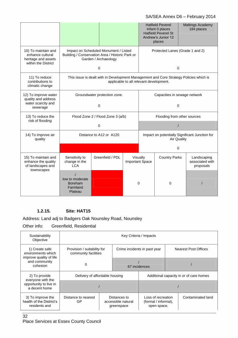
SA/SEA Annex D6 – February 2014
32 Place Services at Essex County Council
Hatfield Peverel Infant 0 places
Hatfield Peverel St Andrew’s Junior 12
places
Maltings Academy 184 places
10) To maintain and enhance cultural
heritage and assets within the District
Impact on Scheduled Monument / Listed Building / Conservation Area / Historic Park or
Garden / Archaeology
Protected Lanes (Grade 1 and 2)
0 0
11) To reduce contributions to climatic change
This issue is dealt with in Development Management and Core Strategy Policies which is applicable to all relevant development.
12) To improve water quality and address water scarcity and
sewerage
Groundwater protection zone. Capacities in sewage network
0 0
13) To reduce the risk of flooding
Flood Zone 2 / Flood Zone 3 (a/b) Flooding from other sources
0 /
14) To improve air quality
Distance to A12 or A120 Impact on potentially Significant Junction for Air Quality
- 0
15) To maintain and enhance the quality of landscapes and
townscapes
Sensitivity to change in the
LCA
Greenfield / PDL Visually Important Space
Country Parks Landscaping associated with
proposals
/ low to moderate
Boreham Farmland Plateau
- 0 0 /
1.2.15. Site: HAT15
Address: Land adj to Badgers Oak Nounsley Road, Nounsley
Other info: Greenfield, Residential
Sustainability Objective
Key Criteria / Impacts
1) Create safe environments which
improve quality of life and community
cohesion
Provision / suitability for community facilities
Crime incidents in past year Nearest Post Offices
0 /
67 incidences /
2) To provide everyone with the
opportunity to live in a decent home
Delivery of affordable housing Additional capacity in or of care homes
/ /
3) To improve the health of the District’s
residents and
Distance to nearest GP
Distances to accessible natural
greenspace
Loss of recreation (formal / informal),
open space,
Contaminated land

SA/SEA Annex D6 – February 2014
33 Place Services at Essex County Council
mitigate/reduce potential health
inequalities
allotments.
/ - + /
4) To promote the vitality and viability of
all service centres throughout the
District
Increase in retail floorspace Distances to primary shopping area boundaries
0 -
5) To achieve sustainable levels of
prosperity and economic growth
Loss of high quality agricultural land (Grades 1 &
2)
Distances to employment sites (B1, B2, B8)
Broadband availability
0 - ADSL, SDSL, WBC broadband enabled
6) To conserve and enhance the
biological and geological diversity of
the environment
Distance to SSSI (any condition)
Distance to NNR
Distance to LNR
Distance to LoWS
Distance to Ancient
Woodland
Presence of TPOs on
site?
0 0 0 0 0 0
7) To promote more sustainable transport choices and uptake
Cycleways Footpaths Distance to Bus Stops and Bus
Regularity
Distance to Railway Stations and Train
Regularity
0 / + -
8) Promote accessibility and
ensure the necessary transport
infrastructure to support new development
Accessible location? Rail links? Highways access
+ ++ /
9) To improve the education and skills
of the population
Distance to a primary school
Distance to a secondary school
Capacity in nearest primary school to
support the size of development
Capacity in nearest secondary school to support the size of
development
- +
/ Hatfield Peverel Infant 0 places
Hatfield Peverel St Andrew’s Junior 12
places
/
Maltings Academy 184 places
10) To maintain and enhance cultural
heritage and assets within the District
Impact on Scheduled Monument / Listed Building / Conservation Area / Historic Park or
Garden / Archaeology
Protected Lanes (Grade 1 and 2)
0 0
11) To reduce contributions to climatic change
This issue is dealt with in Development Management and Core Strategy Policies which is applicable to all relevant development.
12) To improve water quality and address water scarcity and
sewerage
Groundwater protection zone. Capacities in sewage network
0 0
13) To reduce the Flood Zone 2 / Flood Zone 3 (a/b) Flooding from other sources
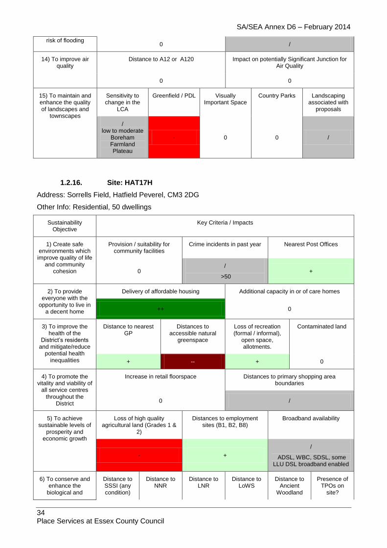
SA/SEA Annex D6 – February 2014
34 Place Services at Essex County Council
risk of flooding 0 /
14) To improve air quality
Distance to A12 or A120 Impact on potentially Significant Junction for Air Quality
0 0
15) To maintain and enhance the quality of landscapes and
townscapes
Sensitivity to change in the
LCA
Greenfield / PDL Visually Important Space
Country Parks Landscaping associated with
proposals
/ low to moderate
Boreham Farmland Plateau
- 0 0 /
1.2.16. Site: HAT17H
Address: Sorrells Field, Hatfield Peverel, CM3 2DG
Other Info: Residential, 50 dwellings
Sustainability Objective
Key Criteria / Impacts
1) Create safe environments which improve quality of life
and community cohesion
Provision / suitability for community facilities
Crime incidents in past year Nearest Post Offices
0 /
>50 +
2) To provide everyone with the
opportunity to live in a decent home
Delivery of affordable housing Additional capacity in or of care homes
++ 0
3) To improve the health of the
District’s residents and mitigate/reduce
potential health inequalities
Distance to nearest GP
Distances to accessible natural
greenspace
Loss of recreation (formal / informal),
open space, allotments.
Contaminated land
+ -- + 0
4) To promote the vitality and viability of
all service centres throughout the
District
Increase in retail floorspace Distances to primary shopping area boundaries
0 /
5) To achieve sustainable levels of
prosperity and economic growth
Loss of high quality agricultural land (Grades 1 &
2)
Distances to employment sites (B1, B2, B8)
Broadband availability
- +
/
ADSL, WBC, SDSL, some LLU DSL broadband enabled
6) To conserve and enhance the
biological and
Distance to SSSI (any condition)
Distance to NNR
Distance to LNR
Distance to LoWS
Distance to Ancient
Woodland
Presence of TPOs on
site?

SA/SEA Annex D6 – February 2014
35 Place Services at Essex County Council
geological diversity of the environment 0 0 0 0 0 0
7) To promote more sustainable transport choices and uptake
Cycleways Footpaths Distance to Bus Stops and Bus
Regularity
Distance to Railway Stations and Train
Regularity
0 0 ++ ++
8) Promote accessibility and
ensure the necessary transport
infrastructure to support new development
Accessible location? Rail links? Highways access
+ ++ /
9) To improve the education and skills
of the population
Distance to a primary school
Distance to a secondary school
Capacity in nearest primary school to
support the size of development
Capacity in nearest secondary school to support the size of
development
- +
- Hatfield Peverel Infant 0 places
Hatfield Peverel St Andrew’s Junior 12
places
+ Maltings Academy
184 places
10) To maintain and enhance cultural
heritage and assets within the District
Impact on Scheduled Monument / Listed Building / Conservation Area / Historic Park or
Garden / Archaeology
Protected Lanes (Grade 1 and 2)
0 0
11) To reduce contributions to climatic change
This issue is dealt with in Development Management and Core Strategy Policies which is applicable to all relevant development.
12) To improve water quality and address water scarcity and
sewerage
Groundwater protection zone. Capacities in sewage network
0 0
13) To reduce the risk of flooding
Flood Zone 2 / Flood Zone 3 (a/b) Flooding from other sources
0 /
14) To improve air quality
Distance to A12 or A120 Impact on potentially Significant Junction for Air Quality
- 0
15) To maintain and enhance the quality of landscapes and
townscapes
Sensitivity to change in the
LCA
Greenfield / PDL Visually Important Space
Country Parks Landscaping associated with
proposals
/ low to moderate Boreham Farmland Plateau
/ 0 0 0

SA/SEA Annex D6 – February 2014
36 Place Services at Essex County Council
1.2.17. Site: HAT18
Address: Arla Dairy, Hatfield Peverel, CM3 2DG
Other Info: B1, B2, B8
Sustainability Objective
Key Criteria / Impacts
1) Create safe environments which improve quality of life
and community cohesion
Provision / suitability for community facilities
Crime incidents in past year Nearest Post Offices
/ / - >50 +
2) To provide everyone with the
opportunity to live in a decent home
Delivery of affordable housing Additional capacity in or of care homes
0 0
3) To improve the health of the
District’s residents and mitigate/reduce
potential health inequalities
Distance to nearest GP
Distances to accessible natural
greenspace
Loss of recreation (formal / informal),
open space, allotments.
Contaminated land
+ 0 0 0
4) To promote the vitality and viability of
all service centres throughout the
District
Increase in retail floorspace Distances to primary shopping area boundaries
0 /
5) To achieve sustainable levels of
prosperity and economic growth
Loss of high quality agricultural land (Grades 1 &
2)
Distances to employment sites (B1, B2, B8)
Broadband availability
- + / - ADSL, WBC, SDSL, some LLU DSL broadband enabled
6) To conserve and enhance the
biological and geological diversity of the environment
Distance to SSSI (any condition)
Distance to NNR
Distance to LNR
Distance to LoWS
Distance to Ancient
Woodland
Presence of TPOs on
site?
0 0 0 0 0 0
7) To promote more sustainable transport choices and uptake
Cycleways Footpaths Distance to Bus Stops and Bus
Regularity
Distance to Railway Stations and Train
Regularity
0 0 ++ ++
8) Promote accessibility and
ensure the necessary transport
infrastructure to support new development
Accessible location? Rail links? Highways access
+ ++ /
9) To improve the education and skills
of the population
Distance to a primary school
Distance to a secondary school
Capacity in nearest primary school to
support the size of development
Capacity in nearest secondary school to support the size of
development
- + 0 0
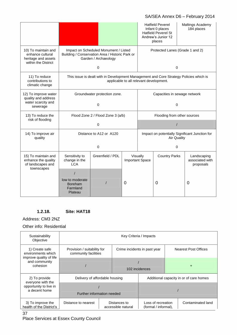
SA/SEA Annex D6 – February 2014
37 Place Services at Essex County Council
Hatfield Peverel Infant 0 places
Hatfield Peverel St Andrew’s Junior 12
places
Maltings Academy 184 places
10) To maintain and enhance cultural
heritage and assets within the District
Impact on Scheduled Monument / Listed Building / Conservation Area / Historic Park or
Garden / Archaeology
Protected Lanes (Grade 1 and 2)
0 0
11) To reduce contributions to climatic change
This issue is dealt with in Development Management and Core Strategy Policies which is applicable to all relevant development.
12) To improve water quality and address water scarcity and
sewerage
Groundwater protection zone. Capacities in sewage network
0 0
13) To reduce the risk of flooding
Flood Zone 2 / Flood Zone 3 (a/b) Flooding from other sources
0 /
14) To improve air quality
Distance to A12 or A120 Impact on potentially Significant Junction for Air Quality
0 0
15) To maintain and enhance the quality of landscapes and
townscapes
Sensitivity to change in the
LCA
Greenfield / PDL Visually Important Space
Country Parks Landscaping associated with
proposals
/
low to moderate Boreham Farmland Plateau
/ 0 0 0
1.2.18. Site: HAT18
Address: CM3 2NZ
Other info: Residential
Sustainability Objective
Key Criteria / Impacts
1) Create safe environments which improve quality of life
and community cohesion
Provision / suitability for community facilities
Crime incidents in past year Nearest Post Offices
/ /
102 incidences +
2) To provide everyone with the
opportunity to live in a decent home
Delivery of affordable housing Additional capacity in or of care homes
/
Further information needed /
3) To improve the health of the District’s
Distance to nearest Distances to accessible natural
Loss of recreation (formal / informal),
Contaminated land
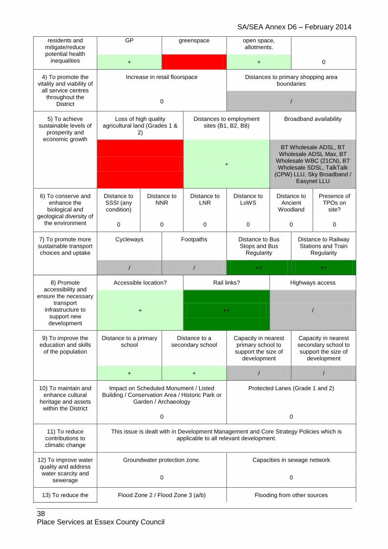
SA/SEA Annex D6 – February 2014
38 Place Services at Essex County Council
residents and mitigate/reduce potential health
inequalities
GP greenspace open space, allotments.
+ - + 0
4) To promote the vitality and viability of
all service centres throughout the
District
Increase in retail floorspace Distances to primary shopping area boundaries
0 /
5) To achieve sustainable levels of
prosperity and economic growth
Loss of high quality agricultural land (Grades 1 &
2)
Distances to employment sites (B1, B2, B8)
Broadband availability
- +
BT Wholesale ADSL, BT Wholesale ADSL Max, BT
Wholesale WBC (21CN), BT Wholesale SDSL, TalkTalk
(CPW) LLU, Sky Broadband / Easynet LLU
6) To conserve and enhance the
biological and geological diversity of
the environment
Distance to SSSI (any condition)
Distance to NNR
Distance to LNR
Distance to LoWS
Distance to Ancient
Woodland
Presence of TPOs on
site?
0 0 0 0 0 0
7) To promote more sustainable transport choices and uptake
Cycleways Footpaths Distance to Bus Stops and Bus
Regularity
Distance to Railway Stations and Train
Regularity
/ / ++ ++
8) Promote accessibility and
ensure the necessary transport
infrastructure to support new development
Accessible location? Rail links? Highways access
+ ++ /
9) To improve the education and skills
of the population
Distance to a primary school
Distance to a secondary school
Capacity in nearest primary school to
support the size of development
Capacity in nearest secondary school to support the size of
development
+ + / /
10) To maintain and enhance cultural
heritage and assets within the District
Impact on Scheduled Monument / Listed Building / Conservation Area / Historic Park or
Garden / Archaeology
Protected Lanes (Grade 1 and 2)
0 0
11) To reduce contributions to climatic change
This issue is dealt with in Development Management and Core Strategy Policies which is applicable to all relevant development.
12) To improve water quality and address water scarcity and
sewerage
Groundwater protection zone. Capacities in sewage network
0 0
13) To reduce the Flood Zone 2 / Flood Zone 3 (a/b) Flooding from other sources

SA/SEA Annex D6 – February 2014
39 Place Services at Essex County Council
risk of flooding 0 N/A
14) To improve air quality
Distance to A12 or A120 Impact on potentially Significant Junction for Air Quality
0 0
15) To maintain and enhance the quality of landscapes and
townscapes
Sensitivity to change in the
LCA
Greenfield / PDL Visually Important Space
Country Parks Landscaping associated with
proposals
/ - 0 0 /
1.2.19. Site: HAT19
Address: CM3 2NQ
Other info: Residential
Sustainability Objective
Key Criteria / Impacts
1) Create safe environments which improve quality of life
and community cohesion
Provision / suitability for community facilities
Crime incidents in past year Nearest Post Offices
/ /
90 incidences /
2) To provide everyone with the
opportunity to live in a decent home
Delivery of affordable housing Additional capacity in or of care homes
/
Further information needed /
3) To improve the health of the District’s
residents and mitigate/reduce potential health
inequalities
Distance to nearest GP
Distances to accessible natural
greenspace
Loss of recreation (formal / informal),
open space, allotments.
Contaminated land
/ - + 0
4) To promote the vitality and viability of
all service centres throughout the
District
Increase in retail floorspace Distances to primary shopping area boundaries
0 /
5) To achieve sustainable levels of
prosperity and economic growth
Loss of high quality agricultural land (Grades 1 &
2)
Distances to employment sites (B1, B2, B8)
Broadband availability
0 /
BT Wholesale ADSL, BT Wholesale ADSL Max, BT Wholesale WBC (21CN), BT Wholesale SDSL, TalkTalk (CPW) LLU, Sky Broadband / Easynet LLU
6) To conserve and enhance the
Distance to SSSI (any
Distance to NNR
Distance to LNR
Distance to LoWS
Distance to Ancient
Presence of TPOs on
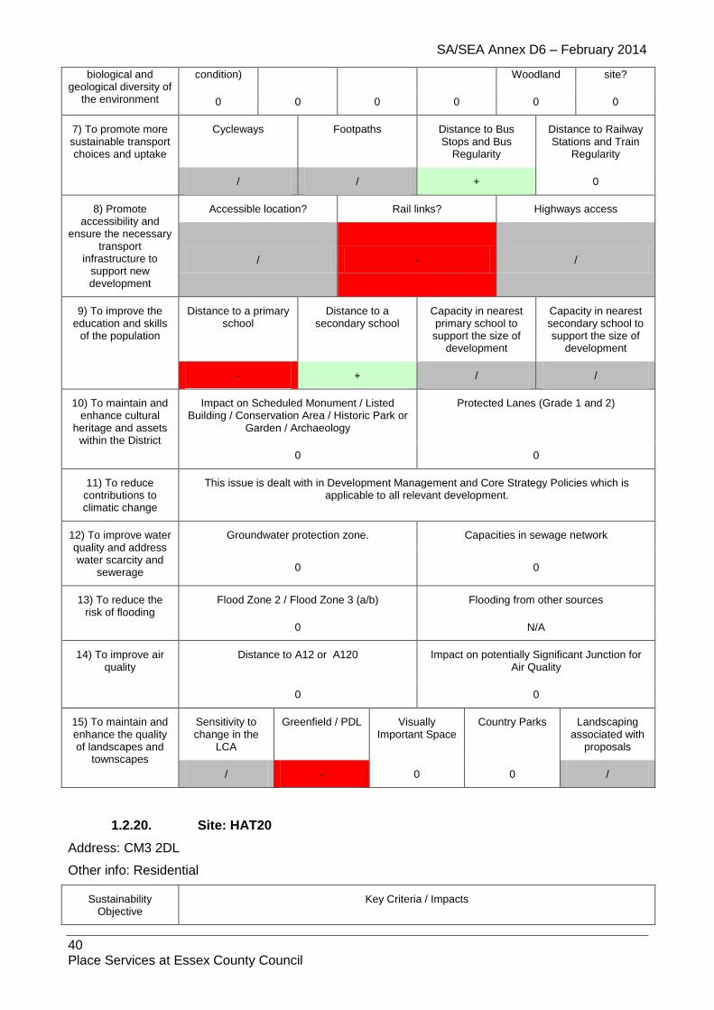
SA/SEA Annex D6 – February 2014
40 Place Services at Essex County Council
biological and geological diversity of
the environment
condition) Woodland site?
0 0 0 0 0 0
7) To promote more sustainable transport choices and uptake
Cycleways Footpaths Distance to Bus Stops and Bus
Regularity
Distance to Railway Stations and Train
Regularity
/ / + 0
8) Promote accessibility and
ensure the necessary transport
infrastructure to support new development
Accessible location? Rail links? Highways access
/ - /
9) To improve the education and skills
of the population
Distance to a primary school
Distance to a secondary school
Capacity in nearest primary school to
support the size of development
Capacity in nearest secondary school to support the size of
development
- + / /
10) To maintain and enhance cultural
heritage and assets within the District
Impact on Scheduled Monument / Listed Building / Conservation Area / Historic Park or
Garden / Archaeology
Protected Lanes (Grade 1 and 2)
0 0
11) To reduce contributions to climatic change
This issue is dealt with in Development Management and Core Strategy Policies which is applicable to all relevant development.
12) To improve water quality and address water scarcity and
sewerage
Groundwater protection zone. Capacities in sewage network
0 0
13) To reduce the risk of flooding
Flood Zone 2 / Flood Zone 3 (a/b) Flooding from other sources
0 N/A
14) To improve air quality
Distance to A12 or A120 Impact on potentially Significant Junction for Air Quality
0 0
15) To maintain and enhance the quality of landscapes and
townscapes
Sensitivity to change in the
LCA
Greenfield / PDL Visually Important Space
Country Parks Landscaping associated with
proposals
/ - 0 0 /
1.2.20. Site: HAT20
Address: CM3 2DL
Other info: Residential
Sustainability Objective
Key Criteria / Impacts

SA/SEA Annex D6 – February 2014
41 Place Services at Essex County Council
1) Create safe environments which improve quality of life
and community cohesion
Provision / suitability for community facilities
Crime incidents in past year Nearest Post Offices
/ /
93 incidences +
2) To provide everyone with the
opportunity to live in a decent home
Delivery of affordable housing Additional capacity in or of care homes
/
Further information needed /
3) To improve the health of the District’s
residents and mitigate/reduce potential health
inequalities
Distance to nearest GP
Distances to accessible natural
greenspace
Loss of recreation (formal / informal),
open space, allotments.
Contaminated land
++ - + 0
4) To promote the vitality and viability of
all service centres throughout the
District
Increase in retail floorspace Distances to primary shopping area boundaries
0 /
5) To achieve sustainable levels of
prosperity and economic growth
Loss of high quality agricultural land (Grades 1 &
2)
Distances to employment sites (B1, B2, B8)
Broadband availability
- +
BT Wholesale ADSL, BT Wholesale ADSL Max, BT Wholesale WBC (21CN), BT Wholesale SDSL, TalkTalk (CPW) LLU, Sky Broadband / Easynet LLU
6) To conserve and enhance the
biological and geological diversity of
the environment
Distance to SSSI (any condition)
Distance to NNR
Distance to LNR
Distance to LoWS
Distance to Ancient
Woodland
Presence of TPOs on
site?
0 0 0 0 0 0
7) To promote more sustainable transport choices and uptake
Cycleways Footpaths Distance to Bus Stops and Bus
Regularity
Distance to Railway Stations and Train
Regularity
/ / ++ ++
8) Promote accessibility and
ensure the necessary transport
infrastructure to support new development
Accessible location? Rail links? Highways access
+ ++ /
9) To improve the education and skills
of the population
Distance to a primary school
Distance to a secondary school
Capacity in nearest primary school to
support the size of development
Capacity in nearest secondary school to support the size of
development
- + / /

SA/SEA Annex D6 – February 2014
42 Place Services at Essex County Council
10) To maintain and enhance cultural
heritage and assets within the District
Impact on Scheduled Monument / Listed Building / Conservation Area / Historic Park or
Garden / Archaeology
Protected Lanes (Grade 1 and 2)
0 0
11) To reduce contributions to climatic change
This issue is dealt with in Development Management and Core Strategy Policies which is applicable to all relevant development.
12) To improve water quality and address water scarcity and
sewerage
Groundwater protection zone. Capacities in sewage network
0 0
13) To reduce the risk of flooding
Flood Zone 2 / Flood Zone 3 (a/b) Flooding from other sources
0 N/A
14) To improve air quality
Distance to A12 or A120 Impact on potentially Significant Junction for Air Quality
0 0
15) To maintain and enhance the quality of landscapes and
townscapes
Sensitivity to change in the
LCA
Greenfield / PDL Visually Important Space
Country Parks Landscaping associated with
proposals
/ /
Part PDL 0 0 /
1.2.21. Site: HAT21
Address: CM3 2NW
Other info: Residential
Sustainability Objective
Key Criteria / Impacts
1) Create safe environments which improve quality of life
and community cohesion
Provision / suitability for community facilities
Crime incidents in past year Nearest Post Offices
/ /
94 incidences /
2) To provide everyone with the
opportunity to live in a decent home
Delivery of affordable housing Additional capacity in or of care homes
/
Further information needed /
3) To improve the health of the District’s
residents and mitigate/reduce potential health
inequalities
Distance to nearest GP
Distances to accessible natural
greenspace
Loss of recreation (formal / informal),
open space, allotments.
Contaminated land
/ - + 0
4) To promote the vitality and viability of
Increase in retail floorspace Distances to primary shopping area boundaries

SA/SEA Annex D6 – February 2014
43 Place Services at Essex County Council
all service centres throughout the
District 0 /
5) To achieve sustainable levels of
prosperity and economic growth
Loss of high quality agricultural land (Grades 1 &
2)
Distances to employment sites (B1, B2, B8)
Broadband availability
0 /
BT Wholesale ADSL, BT Wholesale ADSL Max, BT Wholesale WBC (21CN), BT Wholesale SDSL, TalkTalk (CPW) LLU, Sky Broadband / Easynet LLU
6) To conserve and enhance the
biological and geological diversity of
the environment
Distance to SSSI (any condition)
Distance to NNR
Distance to LNR
Distance to LoWS
Distance to Ancient
Woodland
Presence of TPOs on
site?
0 0 0 0 0 0
7) To promote more sustainable transport choices and uptake
Cycleways Footpaths Distance to Bus Stops and Bus
Regularity
Distance to Railway Stations and Train
Regularity
/ / + 0
8) Promote accessibility and
ensure the necessary transport
infrastructure to support new development
Accessible location? Rail links? Highways access
/ - /
9) To improve the education and skills
of the population
Distance to a primary school
Distance to a secondary school
Capacity in nearest primary school to
support the size of development
Capacity in nearest secondary school to support the size of
development
- + / /
10) To maintain and enhance cultural
heritage and assets within the District
Impact on Scheduled Monument / Listed Building / Conservation Area / Historic Park or
Garden / Archaeology
Protected Lanes (Grade 1 and 2)
/ 0
11) To reduce contributions to climatic change
This issue is dealt with in Development Management and Core Strategy Policies which is applicable to all relevant development.
12) To improve water quality and address water scarcity and
sewerage
Groundwater protection zone. Capacities in sewage network
0 0
13) To reduce the risk of flooding
Flood Zone 2 / Flood Zone 3 (a/b) Flooding from other sources
0 N/A
14) To improve air quality
Distance to A12 or A120 Impact on potentially Significant Junction for Air Quality

SA/SEA Annex D6 – February 2014
44 Place Services at Essex County Council
0 0
15) To maintain and enhance the quality of landscapes and
townscapes
Sensitivity to change in the
LCA
Greenfield / PDL Visually Important Space
Country Parks Landscaping associated with
proposals
/ + 0 0 /
1.2.22. Site: HAT22
Address: CM8 1EH
Other info: Employment
Sustainability Objective
Key Criteria / Impacts
1) Create safe environments which improve quality of life
and community cohesion
Provision / suitability for community facilities
Crime incidents in past year Nearest Post Offices
/ /
232 incidences /
2) To provide everyone with the
opportunity to live in a decent home
Delivery of affordable housing Additional capacity in or of care homes
0 /
3) To improve the health of the District’s
residents and mitigate/reduce potential health
inequalities
Distance to nearest GP
Distances to accessible natural
greenspace
Loss of recreation (formal / informal),
open space, allotments.
Contaminated land
0 -- + 0
4) To promote the vitality and viability of
all service centres throughout the
District
Increase in retail floorspace Distances to primary shopping area boundaries
0 /
5) To achieve sustainable levels of
prosperity and economic growth
Loss of high quality agricultural land (Grades 1 &
2)
Distances to employment sites (B1, B2, B8)
Broadband availability
- +
BT Wholesale ADSL, BT Wholesale ADSL Max, BT Wholesale WBC (21CN), BT FTTC, AOL LLU, Bulldog LLU, TalkTalk (CPW) LLU, Sky Broadband / Easynet LLU, Tiscali LLU
6) To conserve and enhance the
biological and geological diversity of
the environment
Distance to SSSI (any condition)
Distance to NNR
Distance to LNR
Distance to LoWS
Distance to Ancient
Woodland
Presence of TPOs on
site?
0 0 0 0 0 0

SA/SEA Annex D6 – February 2014
45 Place Services at Essex County Council
7) To promote more sustainable transport choices and uptake
Cycleways Footpaths Distance to Bus Stops and Bus
Regularity
Distance to Railway Stations and Train
Regularity
/ / ++ -
8) Promote accessibility and
ensure the necessary transport
infrastructure to support new development
Accessible location? Rail links? Highways access
/ ++ /
9) To improve the education and skills
of the population
Distance to a primary school
Distance to a secondary school
Capacity in nearest primary school to
support the size of development
Capacity in nearest secondary school to support the size of
development
- ++ / /
10) To maintain and enhance cultural
heritage and assets within the District
Impact on Scheduled Monument / Listed Building / Conservation Area / Historic Park or
Garden / Archaeology
Protected Lanes (Grade 1 and 2)
0 0
11) To reduce contributions to climatic change
This issue is dealt with in Development Management and Core Strategy Policies which is applicable to all relevant development.
12) To improve water quality and address water scarcity and
sewerage
Groundwater protection zone. Capacities in sewage network
0 0
13) To reduce the risk of flooding
Flood Zone 2 / Flood Zone 3 (a/b) Flooding from other sources
0 N/A
14) To improve air quality
Distance to A12 or A120 Impact on potentially Significant Junction for Air Quality
- /
15) To maintain and enhance the quality of landscapes and
townscapes
Sensitivity to change in the
LCA
Greenfield / PDL Visually Important Space
Country Parks Landscaping associated with
proposals
/ + 0 0 -

SA/SEA Annex D6 – February 2014
46 Place Services at Essex County Council
1.3. Helions Bumpstead
1.3.1. Site: HEL2E
Address: Land North of Slate Hall, Pale Green, Helions Bumpstead
Other info: Employment
Sustainability Objective
Key Criteria / Impacts
1) Create safe environments which improve quality of life
and community cohesion
Provision / suitability for community facilities
Crime incidents in past year Nearest Post Offices
0 /
9 incidences +
2) To provide everyone with the
opportunity to live in a decent home
Delivery of affordable housing Additional capacity in or of care homes
/ /
3) To improve the health of the District’s
residents and mitigate/reduce potential health
inequalities
Distance to nearest GP
Distances to accessible natural
greenspace
Loss of recreation (formal / informal),
open space, allotments.
Contaminated land
/ -- + /
4) To promote the vitality and viability of
all service centres throughout the District
Increase in retail floorspace Distances to primary shopping area boundaries
0 /
5) To achieve sustainable levels of
prosperity and economic growth
Loss of high quality agricultural land (Grades 1 &
2)
Distances to employment sites (B1, B2, B8)
Broadband availability
- / ADSL broadband enabled
6) To conserve and enhance the
biological and geological diversity of
the environment
Distance to SSSI (any condition)
Distance to NNR
Distance to LNR
Distance to LoWS
Distance to Ancient
Woodland
Presence of TPOs on
site?
0 0 0 0 0 0
7) To promote more sustainable transport choices and uptake
Cycleways Footpaths Distance to Bus Stops and Bus
Regularity
Distance to Railway Stations and Train
Regularity
0 / + 0
8) Promote accessibility and
ensure the necessary transport
infrastructure to support new development
Accessible location? Rail links? Highways access
/ 0 /
9) To improve the education and skills
of the population
Distance to a primary school
Distance to a secondary school
Capacity in nearest primary school to
support the size of development
Capacity in nearest secondary school to support the size of
development

SA/SEA Annex D6 – February 2014
47 Place Services at Essex County Council
- - /
Stanley Drapkin Primary 35 places
/ Hedingham School
107 places
10) To maintain and enhance cultural
heritage and assets within the District
Impact on Scheduled Monument / Listed Building / Conservation Area / Historic Park or
Garden / Archaeology
Protected Lanes (Grade 1 and 2)
0 0
11) To reduce contributions to climatic change
This issue is dealt with in Development Management and Core Strategy Policies which is applicable to all relevant development.
12) To improve water quality and address water scarcity and
sewerage
Groundwater protection zone. Capacities in sewage network
/ SPZ3
0
13) To reduce the risk of flooding
Flood Zone 2 / Flood Zone 3 (a/b) Flooding from other sources
0 /
14) To improve air quality
Distance to A12 or A120 Impact on potentially Significant Junction for Air Quality
0 0
15) To maintain and enhance the quality of
landscapes and townscapes
Sensitivity to change in the
LCA
Greenfield / PDL Visually Important Space
Country Parks Landscaping associated with
proposals
- Bumpstead
Farmlnd Plateau - 0 0 /
1.3.2. Site: HEL10X
Address: CB9 7AF
Village Envelope Amendment:
Sustainability Objective
Key Criteria / Impacts
1) Create safe environments which improve quality of life
and community cohesion
Provision / suitability for community facilities
Crime incidents in past year Nearest Post Offices
/ /
7 incidences +
2) To provide everyone with the
opportunity to live in a decent home
Delivery of affordable housing Additional capacity in or of care homes
/
Further information needed /
3) To improve the health of the District’s
residents and mitigate/reduce potential health
inequalities
Distance to nearest GP
Distances to accessible natural
greenspace
Loss of recreation (formal / informal),
open space, allotments.
Contaminated land
/ -- + 0

SA/SEA Annex D6 – February 2014
48 Place Services at Essex County Council
4) To promote the vitality and viability of
all service centres throughout the
District
Increase in retail floorspace Distances to primary shopping area boundaries
0 /
5) To achieve sustainable levels of
prosperity and economic growth
Loss of high quality agricultural land (Grades 1 &
2)
Distances to employment sites (B1, B2, B8)
Broadband availability
- /
BT Wholesale ADSL,
BT Wholesale ADSL Max
6) To conserve and enhance the
biological and geological diversity of
the environment
Distance to SSSI (any condition)
Distance to NNR
Distance to LNR
Distance to LoWS
Distance to Ancient
Woodland
Presence of TPOs on
site?
0 0 0 0 0 0
7) To promote more sustainable transport choices and uptake
Cycleways Footpaths Distance to Bus Stops and Bus
Regularity
Distance to Railway Stations and Train
Regularity
/ / + 0
8) Promote accessibility and
ensure the necessary transport
infrastructure to support new development
Accessible location? Rail links? Highways access
/ - /
9) To improve the education and skills
of the population
Distance to a primary school
Distance to a secondary school
Capacity in nearest primary school to
support the size of development
Capacity in nearest secondary school to support the size of
development
- - / /
10) To maintain and enhance cultural
heritage and assets within the District
Impact on Scheduled Monument / Listed Building / Conservation Area / Historic Park or
Garden / Archaeology
Protected Lanes (Grade 1 and 2)
0 0
11) To reduce contributions to climatic change
This issue is dealt with in Development Management and Core Strategy Policies which is applicable to all relevant development.
12) To improve water quality and address water scarcity and
sewerage
Groundwater protection zone. Capacities in sewage network
/ 0
13) To reduce the risk of flooding
Flood Zone 2 / Flood Zone 3 (a/b) Flooding from other sources
0 N/A
14) To improve air quality
Distance to A12 or A120 Impact on potentially Significant Junction for Air Quality

SA/SEA Annex D6 – February 2014
49 Place Services at Essex County Council
0 0
15) To maintain and enhance the quality of landscapes and
townscapes
Sensitivity to change in the
LCA
Greenfield / PDL Visually Important Space
Country Parks Landscaping associated with
proposals
- + 0 0 /

SA/SEA Annex D6 – February 2014
50 Place Services at Essex County Council
1.4. Kelvedon
1.4.1. Site: KEL1MAlt
Address: Land between London Road and Railway Line, Kelvedon
Other info: Greenfield, Village extension - residential/employment area/public open space, SHLAA – 900 dwellings
Sustainability Objective
Key Criteria / Impacts
1) Create safe environments which
improve quality of life and community
cohesion
Provision / suitability for community facilities
Crime incidents in past year Nearest Post Offices
0 /
85 incidences +
2) To provide everyone with the
opportunity to live in a decent home
Delivery of affordable housing Additional capacity in or of care homes
++ 0
3) To improve the health of the District’s
residents and mitigate/reduce potential health
inequalities
Distance to nearest GP
Distances to accessible natural
greenspace
Loss of recreation (formal / informal),
open space, allotments.
Contaminated land
+ -- / 0
4) To promote the vitality and viability of
all service centres throughout the
District
Increase in retail floorspace Distances to primary shopping area boundaries
/ /
5) To achieve sustainable levels of
prosperity and economic growth
Loss of high quality agricultural land (Grades 1 &
2)
Distances to employment sites (B1, B2, B8)
Broadband availability
- / ADSL, WBC, FTTC, LLU DSL
broadband enabled
6) To conserve and enhance the
biological and geological diversity of
the environment
Distance to SSSI (any condition)
Distance to NNR
Distance to LNR
Distance to LoWS
Distance to Ancient
Woodland
Presence of TPOs on
site?
0 0 0 0 0 0
7) To promote more sustainable transport choices and uptake
Cycleways Footpaths Distance to Bus Stops and Bus
Regularity
Distance to Railway Stations and Train
Regularity
0 0 ++ -
8) Promote accessibility and
ensure the necessary transport
infrastructure to support new development
Accessible location? Rail links? Highways access
/
Although site is in a Key Service Village (+), some
parts of the site are suitably outside the village envelope
++ +
Access may be taken from London Road
9) To improve the Distance to a primary Distance to a Capacity in nearest Capacity in nearest

SA/SEA Annex D6 – February 2014
51 Place Services at Essex County Council
education and skills of the population
school secondary school primary school to support the size of
development
secondary school to support the size of
development
- + -
Kelvedon St Marys CoE 31 places
+ New Rickstones
Academy 403 places Thurstable School Sports College 94
places
10) To maintain and enhance cultural
heritage and assets within the District
Impact on Scheduled Monument / Listed Building / Conservation Area / Historic Park or
Garden / Archaeology
Protected Lanes (Grade 1 and 2)
-- 0
11) To reduce contributions to climatic change
This issue is dealt with in Development Management and Core Strategy Policies which is applicable to all relevant development.
12) To improve water quality and address water scarcity and
sewerage
Groundwater protection zone. Capacities in sewage network
0 0
13) To reduce the risk of flooding
Flood Zone 2 / Flood Zone 3 (a/b) Flooding from other sources
0 /
14) To improve air quality
Distance to A12 or A120 Impact on potentially Significant Junction for Air Quality
0 0
15) To maintain and enhance the quality of landscapes and
townscapes
Sensitivity to change in the
LCA
Greenfield / PDL Visually Important Space
Country Parks Landscaping associated with
proposals
/ Blackwater River
Valley - 0 0 /
1.4.2. Site: KEL2A
Address: Land to Rear of London Road/Church Street, Kelvedon
Other info: Greenfield/PDL, Sheltered Housing, SHLAA – KEL2 - 20 dwellings
Sustainability Objective
Key Criteria / Impacts
1) Create safe environments which
improve quality of life and community
cohesion
Provision / suitability for community facilities
Crime incidents in past year Nearest Post Offices
0 /
86 incidences +
2) To provide everyone with the
opportunity to live in a decent home
Delivery of affordable housing Additional capacity in or of care homes
/ 0

SA/SEA Annex D6 – February 2014
52 Place Services at Essex County Council
3) To improve the health of the District’s
residents and mitigate/reduce potential health
inequalities
Distance to nearest GP
Distances to accessible natural
greenspace
Loss of recreation (formal / informal),
open space, allotments.
Contaminated land
+ -- + /
4) To promote the vitality and viability of
all service centres throughout the
District
Increase in retail floorspace Distances to primary shopping area boundaries
0 /
5) To achieve sustainable levels of
prosperity and economic growth
Loss of high quality agricultural land (Grades 1 &
2)
Distances to employment sites (B1, B2, B8)
Broadband availability
0 / ADSL, WBC, FTTC, LLU DSL
broadband enabled
6) To conserve and enhance the
biological and geological diversity of
the environment
Distance to SSSI (any condition)
Distance to NNR
Distance to LNR
Distance to LoWS
Distance to Ancient
Woodland
Presence of TPOs on
site?
0 0 0 0 0 0
7) To promote more sustainable transport choices and uptake
Cycleways Footpaths Distance to Bus Stops and Bus
Regularity
Distance to Railway Stations and Train
Regularity
0 / ++ -
8) Promote accessibility and
ensure the necessary transport
infrastructure to support new development
Accessible location? Rail links? Highways access
+ ++ /
9) To improve the education and skills
of the population
Distance to a primary school
Distance to a secondary school
Capacity in nearest primary school to
support the size of development
Capacity in nearest secondary school to support the size of
development
+ + +
Kelvedon St Marys CoE 31 places
+ New Rickstones
Academy 403 places Thurstable School Sports College 94
places
10) To maintain and enhance cultural
heritage and assets within the District
Impact on Scheduled Monument / Listed Building / Conservation Area / Historic Park or
Garden / Archaeology
Protected Lanes (Grade 1 and 2)
0 0
11) To reduce contributions to climatic change
This issue is dealt with in Development Management and Core Strategy Policies which is applicable to all relevant development.
12) To improve water quality and address water scarcity and
Groundwater protection zone. Capacities in sewage network
0 0

SA/SEA Annex D6 – February 2014
53 Place Services at Essex County Council
sewerage
13) To reduce the risk of flooding
Flood Zone 2 / Flood Zone 3 (a/b) Flooding from other sources
0 /
14) To improve air quality
Distance to A12 or A120 Impact on potentially Significant Junction for Air Quality
0 0
15) To maintain and enhance the quality of landscapes and
townscapes
Sensitivity to change in the
LCA
Greenfield / PDL Visually Important Space
Country Parks Landscaping associated with
proposals
0 - 0 0 /
1.4.3. Site: KEL2CH
Address: Land at St Dominics Residential Care Home
Other info: Pallative Care/EMI Care
Sustainability Objective
Key Criteria / Impacts
1) Create safe environments which
improve quality of life and community
cohesion
Provision / suitability for community facilities
Crime incidents in past year Nearest Post Offices
0 /
86 incidences +
2) To provide everyone with the
opportunity to live in a decent home
Delivery of affordable housing Additional capacity in or of care homes
/ +
3) To improve the health of the District’s
residents and mitigate/reduce potential health
inequalities
Distance to nearest GP
Distances to accessible natural
greenspace
Loss of recreation (formal / informal),
open space, allotments.
Contaminated land
+ - + /
4) To promote the vitality and viability of
all service centres throughout the
District
Increase in retail floorspace Distances to primary shopping area boundaries
0 /
5) To achieve sustainable levels of
prosperity and economic growth
Loss of high quality agricultural land (Grades 1 &
2)
Distances to employment sites (B1, B2, B8)
Broadband availability
0 / ADSL, WBC, FTTC, LLU DSL
broadband enabled
6) To conserve and enhance the
biological and geological diversity of
the environment
Distance to SSSI (any condition)
Distance to NNR
Distance to LNR
Distance to LoWS
Distance to Ancient
Woodland
Presence of TPOs on
site?
0 0 0 0 0 0

SA/SEA Annex D6 – February 2014
54 Place Services at Essex County Council
7) To promote more sustainable transport choices and uptake
Cycleways Footpaths Distance to Bus Stops and Bus
Regularity
Distance to Railway Stations and Train
Regularity
0 / ++ -
8) Promote accessibility and
ensure the necessary transport
infrastructure to support new development
Accessible location? Rail links? Highways access
+ ++ /
9) To improve the education and skills
of the population
Distance to a primary school
Distance to a secondary school
Capacity in nearest primary school to
support the size of development
Capacity in nearest secondary school to support the size of
development
+ + 0 0
10) To maintain and enhance cultural
heritage and assets within the District
Impact on Scheduled Monument / Listed Building / Conservation Area / Historic Park or
Garden / Archaeology
Protected Lanes (Grade 1 and 2)
-- 0
11) To reduce contributions to climatic change
This issue is dealt with in Development Management and Core Strategy Policies which is applicable to all relevant development.
12) To improve water quality and address water scarcity and
sewerage
Groundwater protection zone. Capacities in sewage network
0 0
13) To reduce the risk of flooding
Flood Zone 2 / Flood Zone 3 (a/b) Flooding from other sources
0 /
14) To improve air quality
Distance to A12 or A120 Impact on potentially Significant Junction for Air Quality
0 0
15) To maintain and enhance the quality of landscapes and
townscapes
Sensitivity to change in the
LCA
Greenfield / PDL Visually Important Space
Country Parks Landscaping associated with
proposals
0 / 0 0 /
1.4.4. Site: KEL3MAlt
Address: Land at Coggeshall Road (south of Observer Way), Kelvedon
Other info: Greenfield, Mixed Use - Residential/Office/Retail, SHLAA - 300 dwellings
Sustainability Objective
Key Criteria / Impacts
1) Create safe environments
Provision / suitability for community facilities
Crime incidents in past year Nearest Post Offices

SA/SEA Annex D6 – February 2014
55 Place Services at Essex County Council
which improve quality of life
and community cohesion
0 /
98 incidences +
2) To provide everyone with the opportunity
to live in a decent home
Delivery of affordable housing Additional capacity in or of care homes
++ 0
3) To improve the health of the District’s
residents and mitigate/reduce potential health
inequalities
Distance to nearest GP Distances to accessible natural
greenspace
Loss of recreation (formal / informal),
open space, allotments.
Contaminated land
+ -- + 0
4) To promote the vitality and viability of all
service centres throughout the
District
Increase in retail floorspace Distances to primary shopping area boundaries
+ /
5) To achieve sustainable
levels of prosperity and
economic growth
Loss of high quality agricultural land (Grades 1 & 2)
Distances to employment sites (B1, B2, B8)
Broadband availability
- / ADSL, WBC, FTTC, LLU DSL
broadband enabled
6) To conserve and enhance the biological
and geological diversity of the environment
Distance to SSSI (any condition)
Distance to NNR
Distance to LNR
Distance to LoWS
Distance to Ancient
Woodland
Presence of TPOs on site?
0 0 0 0 0 0
7) To promote more
sustainable transport
choices and uptake
Cycleways Footpaths Distance to Bus Stops and Bus Regularity
Distance to Railway Stations and Train
Regularity
0
/ There are footpaths on
the western and eastern boundaries
++ ++
8) Promote accessibility
and ensure the necessary transport
infrastructure to support new development
Accessible location? Rail links? Highways access
/
Although site is in a Key Service Village (+), some parts of the site are suitably outside
the village envelope
++ +
Access may be possible onto Coggeshall Road
9) To improve the education and skills of
the population
Distance to a primary school
Distance to a secondary school
Capacity in nearest primary school to
support the size of development
Capacity in nearest secondary school to support the size of
development
+ + -
Kelvedon St Marys CoE 31 places
+ New Rickstones
Academy 403 places Thurstable School

SA/SEA Annex D6 – February 2014
56 Place Services at Essex County Council
Sports College 94 places
10) To maintain and
enhance cultural
heritage and assets within the District
Impact on Scheduled Monument / Listed Building / Conservation Area / Historic Park or Garden /
Archaeology
Protected Lanes (Grade 1 and 2)
0 0
11) To reduce contributions to
climatic change
This issue is dealt with in Development Management and Core Strategy Policies which is applicable to all relevant development.
12) To improve water quality and address
water scarcity and sewerage
Groundwater protection zone. Capacities in sewage network
0 0
13) To reduce the risk of flooding
Flood Zone 2 / Flood Zone 3 (a/b) Flooding from other sources
0
/
identified potential risk from overland flow and/or surface water runoff
14) To improve air quality
Distance to A12 or A120 Impact on potentially Significant Junction for Air Quality
0 0
15) To maintain and enhance the
quality of landscapes
and townscapes
Sensitivity to change in the
LCA
Greenfield / PDL Visually Important Space
Country Parks Landscaping associated with
proposals
/ Blackwater River
Valley - 0 0 /
1.4.5. Site: KEL4
Address: Land at Brockwell Lane, Kelvedon
Other info: Greenfield, Residential
Sustainability Objective
Key Criteria / Impacts
1) Create safe environments which
improve quality of life and community
cohesion
Provision / suitability for community facilities
Crime incidents in past year Nearest Post Offices
0 /
87 incidences +
2) To provide everyone with the
opportunity to live in a decent home
Delivery of affordable housing Additional capacity in or of care homes
/ /
3) To improve the health of the District’s
Distance to nearest GP
Distances to accessible natural
Loss of recreation (formal / informal),
Contaminated land
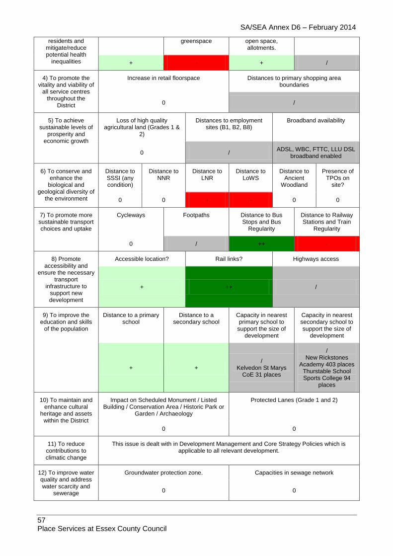
SA/SEA Annex D6 – February 2014
57 Place Services at Essex County Council
residents and mitigate/reduce potential health
inequalities
greenspace open space, allotments.
+ - + /
4) To promote the vitality and viability of
all service centres throughout the
District
Increase in retail floorspace Distances to primary shopping area boundaries
0 /
5) To achieve sustainable levels of
prosperity and economic growth
Loss of high quality agricultural land (Grades 1 &
2)
Distances to employment sites (B1, B2, B8)
Broadband availability
0 / ADSL, WBC, FTTC, LLU DSL
broadband enabled
6) To conserve and enhance the
biological and geological diversity of
the environment
Distance to SSSI (any condition)
Distance to NNR
Distance to LNR
Distance to LoWS
Distance to Ancient
Woodland
Presence of TPOs on
site?
0 0 - - 0 0
7) To promote more sustainable transport choices and uptake
Cycleways Footpaths Distance to Bus Stops and Bus
Regularity
Distance to Railway Stations and Train
Regularity
0 / ++ -
8) Promote accessibility and
ensure the necessary transport
infrastructure to support new development
Accessible location? Rail links? Highways access
+ ++ /
9) To improve the education and skills
of the population
Distance to a primary school
Distance to a secondary school
Capacity in nearest primary school to
support the size of development
Capacity in nearest secondary school to support the size of
development
+ + /
Kelvedon St Marys CoE 31 places
/ New Rickstones
Academy 403 places Thurstable School Sports College 94
places
10) To maintain and enhance cultural
heritage and assets within the District
Impact on Scheduled Monument / Listed Building / Conservation Area / Historic Park or
Garden / Archaeology
Protected Lanes (Grade 1 and 2)
0 0
11) To reduce contributions to climatic change
This issue is dealt with in Development Management and Core Strategy Policies which is applicable to all relevant development.
12) To improve water quality and address water scarcity and
sewerage
Groundwater protection zone. Capacities in sewage network
0 0

SA/SEA Annex D6 – February 2014
58 Place Services at Essex County Council
13) To reduce the risk of flooding
Flood Zone 2 / Flood Zone 3 (a/b) Flooding from other sources
0 /
14) To improve air quality
Distance to A12 or A120 Impact on potentially Significant Junction for Air Quality
0 0
15) To maintain and enhance the quality of landscapes and
townscapes
Sensitivity to change in the
LCA
Greenfield / PDL Visually Important Space
Country Parks Landscaping associated with
proposals
0 - 0 0 /
1.4.6. Site: KEL5E
Address: Polish Camp Site, Rivenhall Airfield
Other info: Employment Area
Sustainability Objective
Key Criteria / Impacts
1) Create safe environments which improve
quality of life and community cohesion
Provision / suitability for community facilities
Crime incidents in past year Nearest Post Offices
0 /
101 incidences +
2) To provide everyone with the opportunity to live in a decent home
Delivery of affordable housing Additional capacity in or of care homes
0 0
3) To improve the health of the
District’s residents and mitigate/reduce
potential health inequalities
Distance to nearest GP
Distances to accessible natural
greenspace
Loss of recreation (formal / informal),
open space, allotments.
Contaminated land
0 0 + /
4) To promote the vitality and viability
of all service centres throughout
the District
Increase in retail floorspace Distances to primary shopping area boundaries
/ -
5) To achieve sustainable levels of prosperity and economic growth
Loss of high quality agricultural land (Grades 1 &
2)
Distances to employment sites (B1, B2, B8)
Broadband availability
- + ADSL, WBC, FTTC, LLU DSL
broadband enabled
6) To conserve and enhance the
biological and geological diversity of the environment
Distance to SSSI (any condition)
Distance to NNR
Distance to LNR
Distance to LoWS
Distance to Ancient
Woodland
Presence of TPOs on
site?
Impact on potential
brownfield habitats
0 0 0 / - 0

SA/SEA Annex D6 – February 2014
59 Place Services at Essex County Council
7) To promote more sustainable transport choices
and uptake
Cycleways Footpaths Distance to Bus Stops and Bus Regularity
Distance to Railway Stations and Train
Regularity
0 / - -
8) Promote accessibility and
ensure the necessary transport
infrastructure to support new development
Accessible location? Rail links? Highways access
+ ++ /
9) To improve the education and skills
of the population
Distance to a primary school
Distance to a secondary school
Capacity in nearest primary school to
support the size of development
Capacity in nearest secondary school to support the size of
development
- + 0 0
10) To maintain and enhance
cultural heritage and assets within
the District
Impact on Scheduled Monument / Listed Building / Conservation Area / Historic Park or
Garden / Archaeology
Protected Lanes (Grade 1 and 2)
-- 0
11) To reduce contributions to climatic change
This issue is dealt with in Development Management and Core Strategy Policies which is applicable to all relevant development.
12) To improve water quality and
address water scarcity and sewerage
Groundwater protection zone. Capacities in sewage network
0 0
13) To reduce the risk of flooding
Flood Zone 2 / Flood Zone 3 (a/b) Flooding from other sources
0 /
14) To improve air quality
Distance to A12 or A120 Impact on potentially Significant Junction for Air Quality
0 0
15) To maintain and enhance the
quality of landscapes and
townscapes
Sensitivity to change in the
LCA
Greenfield / PDL Visually Important Space
Country Parks Landscaping associated with
proposals
- Silver End Farmland Plateau
/ 0 0 +
1.4.7. Site: KEL6CD (inc. KEL6EAlt)
Address: SHLAA large site
Other info: SHLAA – 32 dwellings, brownfield, mixed use development proposed
Sustainability Objective
Key Criteria / Impacts

SA/SEA Annex D6 – February 2014
60 Place Services at Essex County Council
1) Create safe environments which
improve quality of life and community
cohesion
Provision / suitability for community facilities
Crime incidents in past year Nearest Post Offices
0 /
101 incidences +
2) To provide everyone with the
opportunity to live in a decent home
Delivery of affordable housing Additional capacity in or of care homes
++ 0
3) To improve the health of the District’s
residents and mitigate/reduce potential health
inequalities
Distance to nearest GP
Distances to accessible natural
greenspace
Loss of recreation (formal / informal),
open space, allotments.
Contaminated land
+ -- + /
BTE722 Gasworks part of site
4) To promote the vitality and viability of
all service centres throughout the
District
Increase in retail floorspace Distances to primary shopping area boundaries
+ /
5) To achieve sustainable levels of
prosperity and economic growth
Loss of high quality agricultural land (Grades 1 &
2)
Distances to employment sites (B1, B2, B8)
Broadband availability
0 / ADSL, WBC, FTTC, LLU DSL
broadband enabled
6) To conserve and enhance the
biological and geological diversity of
the environment
Distance to SSSI (any condition)
Distance to NNR
Distance to LNR
Distance to LoWS
Distance to Ancient
Woodland
Presence of TPOs on
site?
0 0 0 0 0 0
7) To promote more sustainable transport choices and uptake
Cycleways Footpaths Distance to Bus Stops and Bus
Regularity
Distance to Railway Stations and Train
Regularity
0 0 ++ ++
8) Promote accessibility and
ensure the necessary transport
infrastructure to support new development
Accessible location? Rail links? Highways access
+ ++ +
Access off Station Road
9) To improve the education and skills
of the population
Distance to a primary school
Distance to a secondary school
Capacity in nearest primary school to
support the size of development
Capacity in nearest secondary school to support the size of
development
++ + +
Kelvedon St Marys CoE 31 places
+ Thurstable School Sports College 94
places
10) To maintain and enhance cultural
Impact on Scheduled Monument / Listed Building / Conservation Area / Historic Park or
Protected Lanes (Grade 1 and 2)

SA/SEA Annex D6 – February 2014
61 Place Services at Essex County Council
heritage and assets within the District
Garden / Archaeology
-- 0
11) To reduce contributions to climatic change
This issue is dealt with in Development Management and Core Strategy Policies which is applicable to all relevant development.
12) To improve water quality and address water scarcity and
sewerage
Groundwater protection zone. Capacities in sewage network
0 0
13) To reduce the risk of flooding
Flood Zone 2 / Flood Zone 3 (a/b) Flooding from other sources
0 /
14) To improve air quality
Distance to A12 or A120 Impact on potentially Significant Junction for Air Quality
0 0
15) To maintain and enhance the quality of landscapes and
townscapes
Sensitivity to change in the
LCA
Greenfield / PDL Visually Important Space
Country Parks Landscaping associated with
proposals
0 + 0 0 /
1.4.8. Site: KEL7
Address: SHLAA large site
Other info: residential
Sustainability Objective
Key Criteria / Impacts
1) Create safe environments which improve
quality of life and community cohesion
Provision / suitability for community facilities
Crime incidents in past year Nearest Post Offices
/ /
102 incidences +
2) To provide everyone with the opportunity to live in a decent home
Delivery of affordable housing Additional capacity in or of care homes
/ /
3) To improve the health of the
District’s residents and mitigate/reduce
potential health inequalities
Distance to nearest GP
Distances to accessible natural
greenspace
Loss of recreation (formal / informal),
open space, allotments.
Contaminated land
+ -- + /
4) To promote the vitality and viability
of all service centres throughout
the District
Increase in retail floorspace Distances to primary shopping area boundaries
/ /
5) To achieve sustainable levels
Loss of high quality agricultural land (Grades 1 &
Distances to employment sites Broadband availability
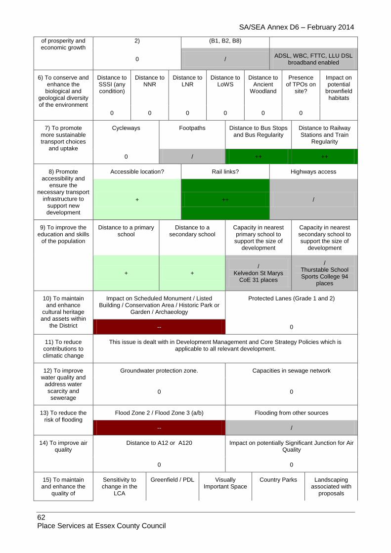
SA/SEA Annex D6 – February 2014
62 Place Services at Essex County Council
of prosperity and economic growth
2) (B1, B2, B8)
0 / ADSL, WBC, FTTC, LLU DSL
broadband enabled
6) To conserve and enhance the
biological and geological diversity of the environment
Distance to SSSI (any condition)
Distance to NNR
Distance to LNR
Distance to LoWS
Distance to Ancient
Woodland
Presence of TPOs on
site?
Impact on potential
brownfield habitats
0 0 0 0 0 0
7) To promote more sustainable transport choices
and uptake
Cycleways Footpaths Distance to Bus Stops and Bus Regularity
Distance to Railway Stations and Train
Regularity
0 / ++ ++
8) Promote accessibility and
ensure the necessary transport
infrastructure to support new development
Accessible location? Rail links? Highways access
+ ++ /
9) To improve the education and skills
of the population
Distance to a primary school
Distance to a secondary school
Capacity in nearest primary school to
support the size of development
Capacity in nearest secondary school to support the size of
development
+ + /
Kelvedon St Marys CoE 31 places
/ Thurstable School Sports College 94
places
10) To maintain and enhance
cultural heritage and assets within
the District
Impact on Scheduled Monument / Listed Building / Conservation Area / Historic Park or
Garden / Archaeology
Protected Lanes (Grade 1 and 2)
-- 0
11) To reduce contributions to climatic change
This issue is dealt with in Development Management and Core Strategy Policies which is applicable to all relevant development.
12) To improve water quality and
address water scarcity and sewerage
Groundwater protection zone. Capacities in sewage network
0 0
13) To reduce the risk of flooding
Flood Zone 2 / Flood Zone 3 (a/b) Flooding from other sources
-- /
14) To improve air quality
Distance to A12 or A120 Impact on potentially Significant Junction for Air Quality
0 0
15) To maintain and enhance the
quality of
Sensitivity to change in the
LCA
Greenfield / PDL Visually Important Space
Country Parks Landscaping associated with
proposals

SA/SEA Annex D6 – February 2014
63 Place Services at Essex County Council
landscapes and townscapes 0 / / 0 /
1.4.9. Site: KEL8
Address: SHLAA large site not inc in 15yr supply
Other info: residential – brownfield
Sustainability Objective
Key Criteria / Impacts
1) Create safe environments which
improve quality of life and community
cohesion
Provision / suitability for community facilities
Crime incidents in past year Nearest Post Offices
0 /
102 incidences +
2) To provide everyone with the
opportunity to live in a decent home
Delivery of affordable housing Additional capacity in or of care homes
/ /
3) To improve the health of the District’s
residents and mitigate/reduce potential health
inequalities
Distance to nearest GP
Distances to accessible natural
greenspace
Loss of recreation (formal / informal),
open space, allotments.
Contaminated land
+ - + /
BTE722 Gasworks, northern part of site
4) To promote the vitality and viability of
all service centres throughout the
District
Increase in retail floorspace Distances to primary shopping area boundaries
0 /
5) To achieve sustainable levels of
prosperity and economic growth
Loss of high quality agricultural land (Grades 1 &
2)
Distances to employment sites (B1, B2, B8)
Broadband availability
0 / ADSL, WBC, FTTC, LLU DSL
broadband enabled
6) To conserve and enhance the
biological and geological diversity of
the environment
Distance to SSSI (any condition)
Distance to NNR
Distance to LNR
Distance to LoWS
Distance to Ancient
Woodland
Presence of TPOs on
site?
0 0 0 0 0 0
7) To promote more sustainable transport choices and uptake
Cycleways Footpaths Distance to Bus Stops and Bus
Regularity
Distance to Railway Stations and Train
Regularity
0 0 ++ ++
8) Promote accessibility and
ensure the necessary transport
infrastructure to support new
Accessible location? Rail links? Highways access
+ ++ +

SA/SEA Annex D6 – February 2014
64 Place Services at Essex County Council
development
9) To improve the education and skills
of the population
Distance to a primary school
Distance to a secondary school
Capacity in nearest primary school to
support the size of development
Capacity in nearest secondary school to support the size of
development
++ + /
Kelvedon St Marys CoE 31 places
/ Thurstable School Sports College 94
places
10) To maintain and enhance cultural
heritage and assets within the District
Impact on Scheduled Monument / Listed Building / Conservation Area / Historic Park or
Garden / Archaeology
Protected Lanes (Grade 1 and 2)
-- 0
11) To reduce contributions to climatic change
This issue is dealt with in Development Management and Core Strategy Policies which is applicable to all relevant development.
12) To improve water quality and address water scarcity and
sewerage
Groundwater protection zone. Capacities in sewage network
0 0
13) To reduce the risk of flooding
Flood Zone 2 / Flood Zone 3 (a/b) Flooding from other sources
0 /
14) To improve air quality
Distance to A12 or A120 Impact on potentially Significant Junction for Air Quality
0 0
15) To maintain and enhance the quality of landscapes and
townscapes
Sensitivity to change in the
LCA
Greenfield / PDL Visually Important Space
Country Parks Landscaping associated with
proposals
0 + 0 0 /
1.4.10. Site: KEL11E
Address: CO5 9BU
Other Info: B1, B2, B8
Sustainability Objective
Key Criteria / Impacts
1) Create safe environments which improve quality of life
and community cohesion
Provision / suitability for community facilities
Crime incidents in past year Nearest Post Offices
/ / - >50 +
2) To provide everyone with the
opportunity to live in a decent home
Delivery of affordable housing Additional capacity in or of care homes
0 0
3) To improve the health of the
District’s residents
Distance to nearest GP
Distances to accessible natural
greenspace
Loss of recreation (formal / informal),
open space,
Contaminated land
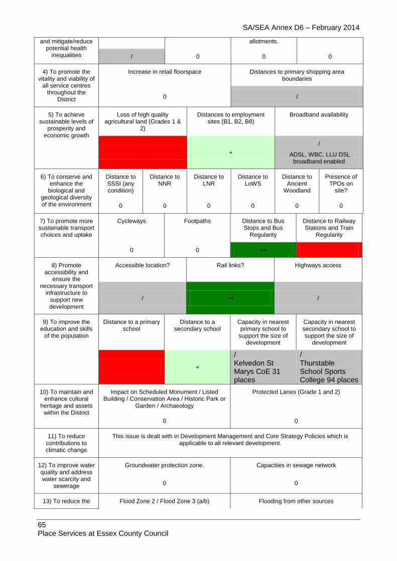
SA/SEA Annex D6 – February 2014
65 Place Services at Essex County Council
and mitigate/reduce potential health
inequalities
allotments.
/ 0 0 0
4) To promote the vitality and viability of
all service centres throughout the
District
Increase in retail floorspace Distances to primary shopping area boundaries
0 /
5) To achieve sustainable levels of
prosperity and economic growth
Loss of high quality agricultural land (Grades 1 &
2)
Distances to employment sites (B1, B2, B8)
Broadband availability
- +
/
ADSL, WBC, LLU DSL broadband enabled
6) To conserve and enhance the
biological and geological diversity of the environment
Distance to SSSI (any condition)
Distance to NNR
Distance to LNR
Distance to LoWS
Distance to Ancient
Woodland
Presence of TPOs on
site?
0 0 0 0 0 0
7) To promote more sustainable transport choices and uptake
Cycleways Footpaths Distance to Bus Stops and Bus
Regularity
Distance to Railway Stations and Train
Regularity
0 0 ++ -
8) Promote accessibility and
ensure the necessary transport
infrastructure to support new development
Accessible location? Rail links? Highways access
/ ++ /
9) To improve the education and skills
of the population
Distance to a primary school
Distance to a secondary school
Capacity in nearest primary school to
support the size of development
Capacity in nearest secondary school to support the size of
development
- +
/ Kelvedon St Marys CoE 31 places
/ Thurstable School Sports College 94 places
10) To maintain and enhance cultural
heritage and assets within the District
Impact on Scheduled Monument / Listed Building / Conservation Area / Historic Park or
Garden / Archaeology
Protected Lanes (Grade 1 and 2)
0 0
11) To reduce contributions to climatic change
This issue is dealt with in Development Management and Core Strategy Policies which is applicable to all relevant development.
12) To improve water quality and address water scarcity and
sewerage
Groundwater protection zone. Capacities in sewage network
0 0
13) To reduce the Flood Zone 2 / Flood Zone 3 (a/b) Flooding from other sources

SA/SEA Annex D6 – February 2014
66 Place Services at Essex County Council
risk of flooding 0 /
14) To improve air quality
Distance to A12 or A120 Impact on potentially Significant Junction for Air Quality
0 0
15) To maintain and enhance the quality of landscapes and
townscapes
Sensitivity to change in the
LCA
Greenfield / PDL Visually Important Space
Country Parks Landscaping associated with
proposals
/ Blackwater River
Valley / 0 0 0
1.4.11. Site: KEL12
Address: CO5 9PE
Other info: Residential
Sustainability Objective
Key Criteria / Impacts
1) Create safe environments which improve quality of life
and community cohesion
Provision / suitability for community facilities
Crime incidents in past year Nearest Post Offices
/ /
100 incidences +
2) To provide everyone with the
opportunity to live in a decent home
Delivery of affordable housing Additional capacity in or of care homes
/
Further information needed /
3) To improve the health of the District’s
residents and mitigate/reduce potential health
inequalities
Distance to nearest GP
Distances to accessible natural
greenspace
Loss of recreation (formal / informal),
open space, allotments.
Contaminated land
/ -- + 0
4) To promote the vitality and viability of
all service centres throughout the
District
Increase in retail floorspace Distances to primary shopping area boundaries
0 /
5) To achieve sustainable levels of
prosperity and economic growth
Loss of high quality agricultural land (Grades 1 &
2)
Distances to employment sites (B1, B2, B8)
Broadband availability
0 /
BT Wholesale ADSL, BT Wholesale ADSL Max, BT Wholesale WBC (21CN), TalkTalk (CPW) LLU, Sky Broadband / Easynet LLU
6) To conserve and enhance the
Distance to SSSI (any
Distance to NNR
Distance to LNR
Distance to LoWS
Distance to Ancient
Presence of TPOs on

SA/SEA Annex D6 – February 2014
67 Place Services at Essex County Council
biological and geological diversity of
the environment
condition) Woodland site?
0 0 0 / 0 0
7) To promote more sustainable transport choices and uptake
Cycleways Footpaths Distance to Bus Stops and Bus
Regularity
Distance to Railway Stations and Train
Regularity
/ / ++ ++
8) Promote accessibility and
ensure the necessary transport
infrastructure to support new development
Accessible location? Rail links? Highways access
+ ++ /
9) To improve the education and skills
of the population
Distance to a primary school
Distance to a secondary school
Capacity in nearest primary school to
support the size of development
Capacity in nearest secondary school to support the size of
development
- + / /
10) To maintain and enhance cultural
heritage and assets within the District
Impact on Scheduled Monument / Listed Building / Conservation Area / Historic Park or
Garden / Archaeology
Protected Lanes (Grade 1 and 2)
0 0
11) To reduce contributions to climatic change
This issue is dealt with in Development Management and Core Strategy Policies which is applicable to all relevant development.
12) To improve water quality and address water scarcity and
sewerage
Groundwater protection zone. Capacities in sewage network
0 0
13) To reduce the risk of flooding
Flood Zone 2 / Flood Zone 3 (a/b) Flooding from other sources
/ /
14) To improve air quality
Distance to A12 or A120 Impact on potentially Significant Junction for Air Quality
0 0
15) To maintain and enhance the quality of landscapes and
townscapes
Sensitivity to change in the
LCA
Greenfield / PDL Visually Important Space
Country Parks Landscaping associated with
proposals
/ + 0 0 /
1.5. Lamarsh
1.5.1. Site: LAM1
Address: Land between Oak House and Brookleigh House, Alphamstone Road
Other info: Greenfield, Residential
Sustainability Key Criteria / Impacts

SA/SEA Annex D6 – February 2014
68 Place Services at Essex County Council
Objective
1) Create safe environments which
improve quality of life and community
cohesion
Provision / suitability for community facilities
Crime incidents in past year Nearest Post Offices
0 /
9 incidences /
2) To provide everyone with the
opportunity to live in a decent home
Delivery of affordable housing Additional capacity in or of care homes
/ /
3) To improve the health of the District’s
residents and mitigate/reduce potential health
inequalities
Distance to nearest GP
Distances to accessible natural
greenspace
Loss of recreation (formal / informal),
open space, allotments.
Contaminated land
/ - + /
4) To promote the vitality and viability of
all service centres throughout the
District
Increase in retail floorspace Distances to primary shopping area boundaries
0 /
Bus Service less than 5 days a week
5) To achieve sustainable levels of
prosperity and economic growth
Loss of high quality agricultural land (Grades 1 &
2)
Distances to employment sites (B1, B2, B8)
Broadband availability
0
/
Bus Service less than 5 days a week
ADSL broadband enabled
6) To conserve and enhance the
biological and geological diversity of
the environment
Distance to SSSI (any condition)
Distance to NNR
Distance to LNR
Distance to LoWS
Distance to Ancient
Woodland
Presence of TPOs on
site?
0 0 0 0 0 0
7) To promote more sustainable transport choices and uptake
Cycleways Footpaths Distance to Bus Stops and Bus
Regularity
Distance to Railway Stations and Train
Regularity
0 / + 0
8) Promote accessibility and
ensure the necessary transport
infrastructure to support new development
Accessible location? Rail links? Highways access
/ 0 /
9) To improve the education and skills
of the population
Distance to a primary school
Distance to a secondary school
Capacity in nearest primary school to
support the size of development
Capacity in nearest secondary school to support the size of
development
- - /
St John Baptist CoE Primary 28 places
/ The Ramsey College
285 places
10) To maintain and enhance cultural
Impact on Scheduled Monument / Listed Building / Conservation Area / Historic Park or
Protected Lanes (Grade 1 and 2)

SA/SEA Annex D6 – February 2014
69 Place Services at Essex County Council
heritage and assets within the District
Garden / Archaeology
0 0
11) To reduce contributions to climatic change
This issue is dealt with in Development Management and Core Strategy Policies which is applicable to all relevant development.
12) To improve water quality and address water scarcity and
sewerage
Groundwater protection zone. Capacities in sewage network
0 0
13) To reduce the risk of flooding
Flood Zone 2 / Flood Zone 3 (a/b) Flooding from other sources
/ /
14) To improve air quality
Distance to A12 or A120 Impact on potentially Significant Junction for Air Quality
0 0
15) To maintain and enhance the quality of landscapes and
townscapes
Sensitivity to change in the
LCA
Greenfield / PDL Visually Important Space
Country Parks Landscaping associated with
proposals
- Stour River
Valley - 0 0 /
1.5.2. Site: LAM2
Address: Land between Brookleigh House and The Long Thatch, Alphamstone Road
Other info: Greenfield, Residential
Sustainability Objective
Key Criteria / Impacts
1) Create safe environments which
improve quality of life and community
cohesion
Provision / suitability for community facilities
Crime incidents in past year Nearest Post Offices
0 /
9 incidences /
2) To provide everyone with the
opportunity to live in a decent home
Delivery of affordable housing Additional capacity in or of care homes
/ /
3) To improve the health of the District’s
residents and mitigate/reduce potential health
inequalities
Distance to nearest GP
Distances to accessible natural
greenspace
Loss of recreation (formal / informal),
open space, allotments.
Contaminated land
/ - + /
4) To promote the vitality and viability of
all service centres throughout the
District
Increase in retail floorspace Distances to primary shopping area boundaries
0 /
Bus Service less than 5 days a week
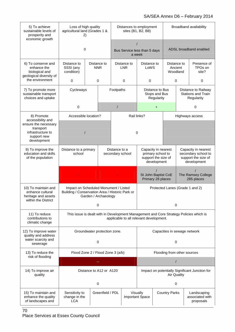
SA/SEA Annex D6 – February 2014
70 Place Services at Essex County Council
5) To achieve sustainable levels of
prosperity and economic growth
Loss of high quality agricultural land (Grades 1 &
2)
Distances to employment sites (B1, B2, B8)
Broadband availability
0
/
Bus Service less than 5 days a week
ADSL broadband enabled
6) To conserve and enhance the
biological and geological diversity of
the environment
Distance to SSSI (any condition)
Distance to NNR
Distance to LNR
Distance to LoWS
Distance to Ancient
Woodland
Presence of TPOs on
site?
0 0 0 0 0 0
7) To promote more sustainable transport choices and uptake
Cycleways Footpaths Distance to Bus Stops and Bus
Regularity
Distance to Railway Stations and Train
Regularity
0 / + 0
8) Promote accessibility and
ensure the necessary transport
infrastructure to support new development
Accessible location? Rail links? Highways access
/ 0
9) To improve the education and skills
of the population
Distance to a primary school
Distance to a secondary school
Capacity in nearest primary school to
support the size of development
Capacity in nearest secondary school to support the size of
development
- - /
St John Baptist CoE Primary 28 places
/ The Ramsey College
285 places
10) To maintain and enhance cultural
heritage and assets within the District
Impact on Scheduled Monument / Listed Building / Conservation Area / Historic Park or
Garden / Archaeology
Protected Lanes (Grade 1 and 2)
0 0
11) To reduce contributions to climatic change
This issue is dealt with in Development Management and Core Strategy Policies which is applicable to all relevant development.
12) To improve water quality and address water scarcity and
sewerage
Groundwater protection zone. Capacities in sewage network
0 0
13) To reduce the risk of flooding
Flood Zone 2 / Flood Zone 3 (a/b) Flooding from other sources
-- /
14) To improve air quality
Distance to A12 or A120 Impact on potentially Significant Junction for Air Quality
0 0
15) To maintain and enhance the quality of landscapes and
Sensitivity to change in the
LCA
Greenfield / PDL Visually Important Space
Country Parks Landscaping associated with
proposals

SA/SEA Annex D6 – February 2014
71 Place Services at Essex County Council
townscapes -
Stour River Valley
- 0 0 /
1.6. Little Maplestead
1.6.1. Site: LIM1 Address: Land at Cock Road Other info: Residential
Sustainability Objective
Key Criteria / Impacts
1) Create safe environments which
improve quality of life and community
cohesion
Provision / suitability for community facilities
Crime incidents in past year Nearest Post Offices
0 /
2 incidences /
2) To provide everyone with the
opportunity to live in a decent home
Delivery of affordable housing Additional capacity in or of care homes
/ /
3) To improve the health of the District’s
residents and mitigate/reduce potential health
inequalities
Distance to nearest GP
Distances to accessible natural
greenspace
Loss of recreation (formal / informal),
open space, allotments.
Contaminated land
/ -- + /
4) To promote the vitality and viability of
all service centres throughout the
District
Increase in retail floorspace Distances to primary shopping area boundaries
0 /
5) To achieve sustainable levels of
prosperity and economic growth
Loss of high quality agricultural land (Grades 1 &
2)
Distances to employment sites (B1, B2, B8)
Broadband availability
0 / ADSL, WBC, FTTC, some
LLU DSL broadband enabled
6) To conserve and enhance the
biological and geological diversity of
the environment
Distance to SSSI (any condition)
Distance to NNR
Distance to LNR
Distance to LoWS
Distance to Ancient
Woodland
Presence of TPOs on
site?
0 0 0 0 0 0
7) To promote more sustainable transport choices and uptake
Cycleways Footpaths Distance to Bus Stops and Bus
Regularity
Distance to Railway Stations and Train
Regularity
0 / ++ 0
8) Promote accessibility and
ensure the necessary transport
infrastructure to support new development
Accessible location? Rail links? Highways access
/ 0 /

SA/SEA Annex D6 – February 2014
72 Place Services at Essex County Council
9) To improve the education and skills
of the population
Distance to a primary school
Distance to a secondary school
Capacity in nearest primary school to
support the size of development
Capacity in nearest secondary school to support the size of
development
- + /
St Giles’ CoE Primary 30 places
/ The Ramsey College
285 places
10) To maintain and enhance cultural
heritage and assets within the District
Impact on Scheduled Monument / Listed Building / Conservation Area / Historic Park or
Garden / Archaeology
Protected Lanes (Grade 1 and 2)
0 0
11) To reduce contributions to climatic change
This issue is dealt with in Development Management and Core Strategy Policies which is applicable to all relevant development.
12) To improve water quality and address water scarcity and
sewerage
Groundwater protection zone. Capacities in sewage network
0 0
13) To reduce the risk of flooding
Flood Zone 2 / Flood Zone 3 (a/b) Flooding from other sources
0 /
14) To improve air quality
Distance to A12 or A120 Impact on potentially Significant Junction for Air Quality
0 0
15) To maintain and enhance the quality of landscapes and
townscapes
Sensitivity to change in the
LCA
Greenfield / PDL Visually Important Space
Country Parks Landscaping associated with
proposals
- Wickham Farmland Plateau
- 0 0 /
1.6.2. Site: LIM2 Address: Land between formerly The Cock PH and Anfield Cottage Other info: Greenfield, Residential
Sustainability Objective
Key Criteria / Impacts
1) Create safe environments which
improve quality of life and community
cohesion
Provision / suitability for community facilities
Crime incidents in past year Nearest Post Offices
0 /
2 incidences /
2) To provide everyone with the
opportunity to live in a decent home
Delivery of affordable housing Additional capacity in or of care homes
/ /
3) To improve the health of the District’s
residents and
Distance to nearest GP
Distances to accessible natural
greenspace
Loss of recreation (formal / informal),
open space,
Contaminated land

SA/SEA Annex D6 – February 2014
73 Place Services at Essex County Council
mitigate/reduce potential health
inequalities
allotments.
/ -- + /
4) To promote the vitality and viability of
all service centres throughout the District
Increase in retail floorspace Distances to primary shopping area boundaries
0 /
5) To achieve sustainable levels of
prosperity and economic growth
Loss of high quality agricultural land (Grades 1 &
2)
Distances to employment sites (B1, B2, B8)
Broadband availability
0 / ADSL, WBC, FTTC, some
LLU DSL broadband enabled
6) To conserve and enhance the
biological and geological diversity of
the environment
Distance to SSSI (any condition)
Distance to NNR
Distance to LNR
Distance to LoWS
Distance to Ancient
Woodland
Presence of TPOs on
site?
0 0 0 0 0 0
7) To promote more sustainable transport choices and uptake
Cycleways Footpaths Distance to Bus Stops and Bus
Regularity
Distance to Railway Stations and Train
Regularity
0 / ++ 0
8) Promote accessibility and
ensure the necessary transport
infrastructure to support new development
Accessible location? Rail links? Highways access
/ 0 /
9) To improve the education and skills
of the population
Distance to a primary school
Distance to a secondary school
Capacity in nearest primary school to
support the size of development
Capacity in nearest secondary school to support the size of
development
- +
/ St John The Baptist
CoE Primary 28 places
/ The Ramsey College
285 places
10) To maintain and enhance cultural
heritage and assets within the District
Impact on Scheduled Monument / Listed Building / Conservation Area / Historic Park or
Garden / Archaeology
Protected Lanes (Grade 1 and 2)
0 0
11) To reduce contributions to climatic change
This issue is dealt with in Development Management and Core Strategy Policies which is applicable to all relevant development.
12) To improve water quality and address water scarcity and
sewerage
Groundwater protection zone. Capacities in sewage network
0 0
13) To reduce the risk of flooding
Flood Zone 2 / Flood Zone 3 (a/b) Flooding from other sources
0 /

SA/SEA Annex D6 – February 2014
74 Place Services at Essex County Council
14) To improve air quality
Distance to A12 or A120 Impact on potentially Significant Junction for Air Quality
0 0
15) To maintain and enhance the quality of
landscapes and townscapes
Sensitivity to change in the
LCA
Greenfield / PDL Visually Important Space
Country Parks Landscaping associated with
proposals
- Wickham Farmland Plateau
- 0 0 /
1.6.3. Site: LIM3 Address: Land northeast of Reservoir off Cock Road Other info: Greenfield, Residential
Sustainability Objective
Key Criteria / Impacts
1) Create safe environments which
improve quality of life and community
cohesion
Provision / suitability for community facilities
Crime incidents in past year Nearest Post Offices
0 /
2 incidences /
2) To provide everyone with the
opportunity to live in a decent home
Delivery of affordable housing Additional capacity in or of care homes
/ /
3) To improve the health of the District’s
residents and mitigate/reduce potential health
inequalities
Distance to nearest GP
Distances to accessible natural
greenspace
Loss of recreation (formal / informal),
open space, allotments.
Contaminated land
/ -- + /
4) To promote the vitality and viability of
all service centres throughout the
District
Increase in retail floorspace Distances to primary shopping area boundaries
0 /
5) To achieve sustainable levels of
prosperity and economic growth
Loss of high quality agricultural land (Grades 1 &
2)
Distances to employment sites (B1, B2, B8)
Broadband availability
0 / ADSL, WBC, FTTC, some
LLU DSL broadband enabled
6) To conserve and enhance the
biological and geological diversity of
the environment
Distance to SSSI (any condition)
Distance to NNR
Distance to LNR
Distance to LoWS
Distance to Ancient
Woodland
Presence of TPOs on
site?
0 0 0 0 0 0
7) To promote more sustainable transport choices and uptake
Cycleways Footpaths Distance to Bus Stops and Bus
Regularity
Distance to Railway Stations and Train
Regularity
0 / ++ 0

SA/SEA Annex D6 – February 2014
75 Place Services at Essex County Council
8) Promote accessibility and
ensure the necessary transport
infrastructure to support new development
Accessible location? Rail links? Highways access
/ 0 /
9) To improve the education and skills
of the population
Distance to a primary school
Distance to a secondary school
Capacity in nearest primary school to
support the size of development
Capacity in nearest secondary school to support the size of
development
- + /
St Giles’ CoE Primary 30 places
/ The Ramsey College
285 places
10) To maintain and enhance cultural
heritage and assets within the District
Impact on Scheduled Monument / Listed Building / Conservation Area / Historic Park or
Garden / Archaeology
Protected Lanes (Grade 1 and 2)
0 0
11) To reduce contributions to climatic change
This issue is dealt with in Development Management and Core Strategy Policies which is applicable to all relevant development.
12) To improve water quality and address water scarcity and
sewerage
Groundwater protection zone. Capacities in sewage network
0 0
13) To reduce the risk of flooding
Flood Zone 2 / Flood Zone 3 (a/b) Flooding from other sources
0 /
14) To improve air quality
Distance to A12 or A120 Impact on potentially Significant Junction for Air Quality
0 0
15) To maintain and enhance the quality of landscapes and
townscapes
Sensitivity to change in the
LCA
Greenfield / PDL Visually Important Space
Country Parks Landscaping associated with
proposals
- Wickham Farmland Plateau
- 0 0 /
1.7. Liston
1.7.1. Site: LIS1MAlt Address: Former IFF Site, nr Long Melford Other info: Greenfield/PDL, 300 dwellings + Mixed-use
Sustainability Objective
Key Criteria / Impacts
1) Create safe environments which
Provision / suitability for community facilities
Crime incidents in past year Nearest Post Offices

SA/SEA Annex D6 – February 2014
76 Place Services at Essex County Council
improve quality of life and community
cohesion 0
/ 63 incidences
+
2) To provide everyone with the
opportunity to live in a decent home
Delivery of affordable housing Additional capacity in or of care homes
IMD2010 Affordability Indicator Ratio
++ 0
3) To improve the health of the District’s
residents and mitigate/reduce potential health
inequalities
Distance to nearest GP
Distances to accessible natural
greenspace
Loss of recreation (formal / informal),
open space, allotments.
Contaminated land
- + +
/ Significant levels of contamination Significant remediation of on site contamination is required, some of which is underway
4) To promote the vitality and viability of
all service centres throughout the
District
Increase in retail floorspace Distances to use classes A1, A2, A3 and A4 where
identified.
Distances to primary shopping area boundaries
0 -
5) To achieve sustainable levels of
prosperity and economic growth
Loss of high quality agricultural land (Grades 1 &
2)
Distances to employment sites (B1, B2, B8)
Broadband availability
/ / ADSL, WBC broadband
enabled
6) To conserve and enhance the
biological and geological diversity of
the environment
Distance to SSSI (any condition)
Distance to NNR
Distance to LNR
Distance to LoWS
Distance to Ancient
Woodland
Presence of TPOs on
site?
-- 0 0 - 0 0
7) To promote more sustainable transport choices and uptake
Cycleways Footpaths Distance to Bus Stops and Bus
Regularity
Distance to Railway Stations and Train
Regularity
0 /
Footpath 10 runs through part of site
- 0
8) Promote accessibility and
ensure the necessary transport
infrastructure to support new development
Accessible location? Rail links? Highways access
- 0 +
Liston Lane
9) To improve the education and skills
of the population
Distance to a primary school
Distance to a secondary school
Capacity in nearest primary school to
support the size of development
Capacity in nearest secondary school to support the size of
development

SA/SEA Annex D6 – February 2014
77 Place Services at Essex County Council
- -
- Belchamp St Paul’s
CoE Primary 7 places (does not include schools outside of
Essex) 90 places required
+ Hedingham School
107 places 60 places required
10) To maintain and enhance cultural
heritage and assets within the District
Impact on Scheduled Monument / Listed Building / Conservation Area / Historic Park or
Garden / Archaeology
Protected Lanes (Grade 1 and 2)
/ 0
11) To reduce contributions to climatic change
This issue is dealt with in Development Management and Core Strategy Policies which is applicable to all relevant development.
12) To improve water quality and address water scarcity and
sewerage
Groundwater protection zone. Capacities in sewage network
/ SPZ3
0
13) To reduce the risk of flooding
Flood Zone 2 / Flood Zone 3 (a/b) Flooding from other sources
/ /
14) To improve air quality
Distance to A12 or A120 Impact on potentially Significant Junction for Air Quality
0 0
15) To maintain and enhance the quality of landscapes and
townscapes
Sensitivity to change in the
LCA
Greenfield / PDL Visually Important Space
Country Parks Landscaping associated with
proposals
- Stour River
Valley - 0 0 /
1.8. Little Yeldham
1.8.1. Site: LTY1
Address: CO9 4QS
Other info: Residential
Sustainability Objective
Key Criteria / Impacts
1) Create safe environments which
improve quality of life and community
cohesion
Provision / suitability for community facilities
Crime incidents in past year Nearest Post Offices
/ /
53 incidences +
2) To provide everyone with the
opportunity to live in a decent home
Delivery of affordable housing Additional capacity in or of care homes
/
Further information needed /

SA/SEA Annex D6 – February 2014
78 Place Services at Essex County Council
3) To improve the health of the District’s
residents and mitigate/reduce potential health
inequalities
Distance to nearest GP
Distances to accessible natural
greenspace
Loss of recreation (formal / informal),
open space, allotments.
Contaminated land
+ -- + 0
4) To promote the vitality and viability of
all service centres throughout the
District
Increase in retail floorspace Distances to primary shopping area boundaries
0 /
5) To achieve sustainable levels of
prosperity and economic growth
Loss of high quality agricultural land (Grades 1 &
2)
Distances to employment sites (B1, B2, B8)
Broadband availability
- / BT Wholesale ADSL
BT Wholesale ADSL Max
6) To conserve and enhance the
biological and geological diversity of
the environment
Distance to SSSI (any condition)
Distance to NNR
Distance to LNR
Distance to LoWS
Distance to Ancient
Woodland
Presence of TPOs on
site?
0 0 0 0 0 0
7) To promote more sustainable transport choices and uptake
Cycleways Footpaths Distance to Bus Stops and Bus
Regularity
Distance to Railway Stations and Train
Regularity
/ / ++ 0
8) Promote accessibility and
ensure the necessary transport
infrastructure to support new development
Accessible location? Rail links? Highways access
- - /
9) To improve the education and skills
of the population
Distance to a primary school
Distance to a secondary school
Capacity in nearest primary school to
support the size of development
Capacity in nearest secondary school to support the size of
development
- + / /
10) To maintain and enhance cultural
heritage and assets within the District
Impact on Scheduled Monument / Listed Building / Conservation Area / Historic Park or
Garden / Archaeology
Protected Lanes (Grade 1 and 2)
0 0
11) To reduce contributions to climatic change
This issue is dealt with in Development Management and Core Strategy Policies which is applicable to all relevant development.
12) To improve water quality and address water scarcity and
sewerage
Groundwater protection zone. Capacities in sewage network
0 0
13) To reduce the Flood Zone 2 / Flood Zone 3 (a/b) Flooding from other sources

SA/SEA Annex D6 – February 2014
79 Place Services at Essex County Council
risk of flooding 0 N/A
14) To improve air quality
Distance to A12 or A120 Impact on potentially Significant Junction for Air Quality
0 0
15) To maintain and enhance the quality of landscapes and
townscapes
Sensitivity to change in the
LCA
Greenfield / PDL Visually Important Space
Country Parks Landscaping associated with
proposals
/ - 0 0 /
1.8.2. Site: LTY2
Address: CO9 4QX
Other info: Residential
Sustainability Objective
Key Criteria / Impacts
1) Create safe environments which improve quality of life
and community cohesion
Provision / suitability for community facilities
Crime incidents in past year Nearest Post Offices
/ /
46 incidences /
2) To provide everyone with the
opportunity to live in a decent home
Delivery of affordable housing Additional capacity in or of care homes
/
Further information needed /
3) To improve the health of the District’s
residents and mitigate/reduce potential health
inequalities
Distance to nearest GP
Distances to accessible natural
greenspace
Loss of recreation (formal / informal),
open space, allotments.
Contaminated land
- -- + 0
4) To promote the vitality and viability of
all service centres throughout the
District
Increase in retail floorspace Distances to primary shopping area boundaries
0 -
5) To achieve sustainable levels of
prosperity and economic growth
Loss of high quality agricultural land (Grades 1 &
2)
Distances to employment sites (B1, B2, B8)
Broadband availability
- / BT Wholesale ADSL
BT Wholesale ADSL Max
6) To conserve and enhance the
biological and geological diversity of
the environment
Distance to SSSI (any condition)
Distance to NNR
Distance to LNR
Distance to LoWS
Distance to Ancient
Woodland
Presence of TPOs on
site?
0 0 0 0 0 0
7) To promote more sustainable transport
Cycleways Footpaths Distance to Bus Stops and Bus
Distance to Railway Stations and Train

SA/SEA Annex D6 – February 2014
80 Place Services at Essex County Council
choices and uptake Regularity Regularity
/ / - 0
8) Promote accessibility and
ensure the necessary transport
infrastructure to support new development
Accessible location? Rail links? Highways access
- - /
9) To improve the education and skills
of the population
Distance to a primary school
Distance to a secondary school
Capacity in nearest primary school to
support the size of development
Capacity in nearest secondary school to support the size of
development
- + / /
10) To maintain and enhance cultural
heritage and assets within the District
Impact on Scheduled Monument / Listed Building / Conservation Area / Historic Park or
Garden / Archaeology
Protected Lanes (Grade 1 and 2)
0 0
11) To reduce contributions to climatic change
This issue is dealt with in Development Management and Core Strategy Policies which is applicable to all relevant development.
12) To improve water quality and address water scarcity and
sewerage
Groundwater protection zone. Capacities in sewage network
0 0
13) To reduce the risk of flooding
Flood Zone 2 / Flood Zone 3 (a/b) Flooding from other sources
0 N/A
14) To improve air quality
Distance to A12 or A120 Impact on potentially Significant Junction for Air Quality
0 0
15) To maintain and enhance the quality of landscapes and
townscapes
Sensitivity to change in the
LCA
Greenfield / PDL Visually Important Space
Country Parks Landscaping associated with
proposals
/ + 0 0 /
1.8.3. Site: LTY3
Address: CO9 4LN
Other info: Residential
Sustainability Objective
Key Criteria / Impacts
1) Create safe environments which improve quality of life
and community cohesion
Provision / suitability for community facilities
Crime incidents in past year Nearest Post Offices
/ /
38 incidences +
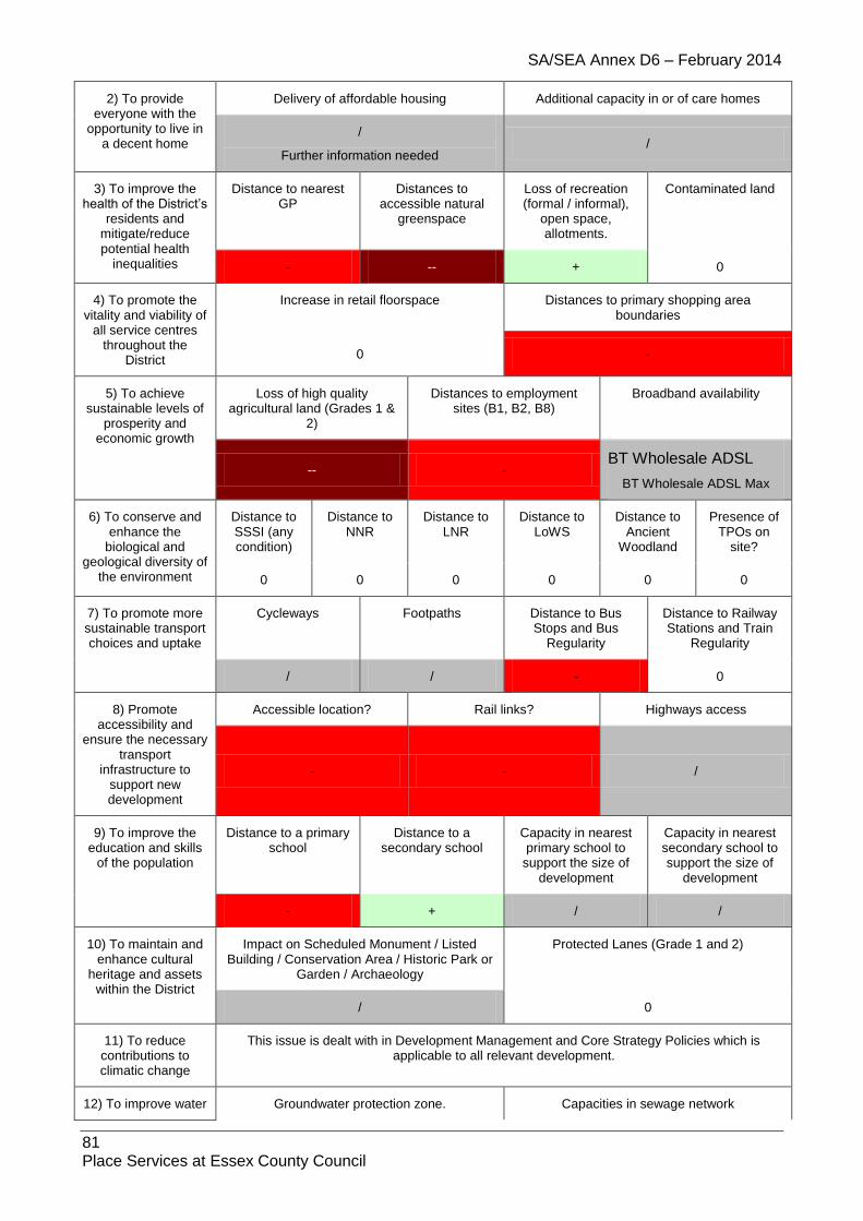
SA/SEA Annex D6 – February 2014
81 Place Services at Essex County Council
2) To provide everyone with the
opportunity to live in a decent home
Delivery of affordable housing Additional capacity in or of care homes
/
Further information needed /
3) To improve the health of the District’s
residents and mitigate/reduce potential health
inequalities
Distance to nearest GP
Distances to accessible natural
greenspace
Loss of recreation (formal / informal),
open space, allotments.
Contaminated land
- -- + 0
4) To promote the vitality and viability of
all service centres throughout the
District
Increase in retail floorspace Distances to primary shopping area boundaries
0 -
5) To achieve sustainable levels of
prosperity and economic growth
Loss of high quality agricultural land (Grades 1 &
2)
Distances to employment sites (B1, B2, B8)
Broadband availability
-- - BT Wholesale ADSL
BT Wholesale ADSL Max
6) To conserve and enhance the
biological and geological diversity of
the environment
Distance to SSSI (any condition)
Distance to NNR
Distance to LNR
Distance to LoWS
Distance to Ancient
Woodland
Presence of TPOs on
site?
0 0 0 0 0 0
7) To promote more sustainable transport choices and uptake
Cycleways Footpaths Distance to Bus Stops and Bus
Regularity
Distance to Railway Stations and Train
Regularity
/ / - 0
8) Promote accessibility and
ensure the necessary transport
infrastructure to support new development
Accessible location? Rail links? Highways access
- - /
9) To improve the education and skills
of the population
Distance to a primary school
Distance to a secondary school
Capacity in nearest primary school to
support the size of development
Capacity in nearest secondary school to support the size of
development
- + / /
10) To maintain and enhance cultural
heritage and assets within the District
Impact on Scheduled Monument / Listed Building / Conservation Area / Historic Park or
Garden / Archaeology
Protected Lanes (Grade 1 and 2)
/ 0
11) To reduce contributions to climatic change
This issue is dealt with in Development Management and Core Strategy Policies which is applicable to all relevant development.
12) To improve water Groundwater protection zone. Capacities in sewage network

SA/SEA Annex D6 – February 2014
82 Place Services at Essex County Council
quality and address water scarcity and
sewerage / 0
13) To reduce the risk of flooding
Flood Zone 2 / Flood Zone 3 (a/b) Flooding from other sources
0 N/A
14) To improve air quality
Distance to A12 or A120 Impact on potentially Significant Junction for Air Quality
0 0
15) To maintain and enhance the quality of landscapes and
townscapes
Sensitivity to change in the
LCA
Greenfield / PDL Visually Important Space
Country Parks Landscaping associated with
proposals
/ + 0 0 /
1.8.4. Site: LTY4
Address: CO9 4LN
Other info: Residential
Sustainability Objective
Key Criteria / Impacts
1) Create safe environments which improve quality of life
and community cohesion
Provision / suitability for community facilities
Crime incidents in past year Nearest Post Offices
/ /
38 incidences +
2) To provide everyone with the
opportunity to live in a decent home
Delivery of affordable housing Additional capacity in or of care homes
/
Further information needed /
3) To improve the health of the District’s
residents and mitigate/reduce potential health
inequalities
Distance to nearest GP
Distances to accessible natural
greenspace
Loss of recreation (formal / informal),
open space, allotments.
Contaminated land
/ -- + 0
4) To promote the vitality and viability of
all service centres throughout the
District
Increase in retail floorspace Distances to primary shopping area boundaries
0 /
5) To achieve sustainable levels of
prosperity and economic growth
Loss of high quality agricultural land (Grades 1 &
2)
Distances to employment sites (B1, B2, B8)
Broadband availability
- / BT Wholesale ADSL
BT Wholesale ADSL Max
6) To conserve and enhance the
Distance to SSSI (any
Distance to NNR
Distance to LNR
Distance to LoWS
Distance to Ancient
Presence of TPOs on

SA/SEA Annex D6 – February 2014
83 Place Services at Essex County Council
biological and geological diversity of
the environment
condition) Woodland site?
0 0 0 0 0 0
7) To promote more sustainable transport choices and uptake
Cycleways Footpaths Distance to Bus Stops and Bus
Regularity
Distance to Railway Stations and Train
Regularity
/ / ++ 0
8) Promote accessibility and
ensure the necessary transport
infrastructure to support new development
Accessible location? Rail links? Highways access
- - /
9) To improve the education and skills
of the population
Distance to a primary school
Distance to a secondary school
Capacity in nearest primary school to
support the size of development
Capacity in nearest secondary school to support the size of
development
- + / /
10) To maintain and enhance cultural
heritage and assets within the District
Impact on Scheduled Monument / Listed Building / Conservation Area / Historic Park or
Garden / Archaeology
Protected Lanes (Grade 1 and 2)
0 0
11) To reduce contributions to climatic change
This issue is dealt with in Development Management and Core Strategy Policies which is applicable to all relevant development.
12) To improve water quality and address water scarcity and
sewerage
Groundwater protection zone. Capacities in sewage network
/ 0
13) To reduce the risk of flooding
Flood Zone 2 / Flood Zone 3 (a/b) Flooding from other sources
0 N/A
14) To improve air quality
Distance to A12 or A120 Impact on potentially Significant Junction for Air Quality
0 0
15) To maintain and enhance the quality of landscapes and
townscapes
Sensitivity to change in the
LCA
Greenfield / PDL Visually Important Space
Country Parks Landscaping associated with
proposals
/ - 0 0 /
1.8.5. Site: LTY5
Address: CO9 4QT
Other info: Residential
Sustainability Objective
Key Criteria / Impacts

SA/SEA Annex D6 – February 2014
84 Place Services at Essex County Council
1) Create safe environments which improve quality of life
and community cohesion
Provision / suitability for community facilities
Crime incidents in past year Nearest Post Offices
/ /
51 incidences +
2) To provide everyone with the
opportunity to live in a decent home
Delivery of affordable housing Additional capacity in or of care homes
/
Further information needed /
3) To improve the health of the District’s
residents and mitigate/reduce potential health
inequalities
Distance to nearest GP
Distances to accessible natural
greenspace
Loss of recreation (formal / informal),
open space, allotments.
Contaminated land
- -- + 0
4) To promote the vitality and viability of
all service centres throughout the
District
Increase in retail floorspace Distances to primary shopping area boundaries
0 -
5) To achieve sustainable levels of
prosperity and economic growth
Loss of high quality agricultural land (Grades 1 &
2)
Distances to employment sites (B1, B2, B8)
Broadband availability
- - BT Wholesale ADSL
BT Wholesale ADSL Max
6) To conserve and enhance the
biological and geological diversity of
the environment
Distance to SSSI (any condition)
Distance to NNR
Distance to LNR
Distance to LoWS
Distance to Ancient
Woodland
Presence of TPOs on
site?
0 0 0 0 0 0
7) To promote more sustainable transport choices and uptake
Cycleways Footpaths Distance to Bus Stops and Bus
Regularity
Distance to Railway Stations and Train
Regularity
/ / - 0
8) Promote accessibility and
ensure the necessary transport
infrastructure to support new development
Accessible location? Rail links? Highways access
- - /
9) To improve the education and skills
of the population
Distance to a primary school
Distance to a secondary school
Capacity in nearest primary school to
support the size of development
Capacity in nearest secondary school to support the size of
development
- + / /
10) To maintain and enhance cultural
heritage and assets within the District
Impact on Scheduled Monument / Listed Building / Conservation Area / Historic Park or
Garden / Archaeology
Protected Lanes (Grade 1 and 2)
0 0

SA/SEA Annex D6 – February 2014
85 Place Services at Essex County Council
11) To reduce contributions to climatic change
This issue is dealt with in Development Management and Core Strategy Policies which is applicable to all relevant development.
12) To improve water quality and address water scarcity and
sewerage
Groundwater protection zone. Capacities in sewage network
/ 0
13) To reduce the risk of flooding
Flood Zone 2 / Flood Zone 3 (a/b) Flooding from other sources
0 N/A
14) To improve air quality
Distance to A12 or A120 Impact on potentially Significant Junction for Air Quality
0 0
15) To maintain and enhance the quality of landscapes and
townscapes
Sensitivity to change in the
LCA
Greenfield / PDL Visually Important Space
Country Parks Landscaping associated with
proposals
/ - 0 0 /
1.9. Middleton
1.9.1. Site: MID1 Address: Land on south side of Rectory Road, Middleton Other info: Greenfield, Residential/ Definition of a village envelope
Sustainability Objective
Key Criteria / Impacts
1) Create safe environments which
improve quality of life and community
cohesion
Provision / suitability for community facilities
Crime incidents in past year Nearest Post Offices
0 /
496 incidences /
2) To provide everyone with the
opportunity to live in a decent home
Delivery of affordable housing Additional capacity in or of care homes
/ /
3) To improve the health of the District’s
residents and mitigate/reduce potential health
inequalities
Distance to nearest GP
Distances to accessible natural
greenspace
Loss of recreation (formal / informal),
open space, allotments.
Contaminated land
- - + /
4) To promote the vitality and viability of
all service centres throughout the
District
Increase in retail floorspace Distances to primary shopping area boundaries
0 -
5) To achieve sustainable levels of
prosperity and
Loss of high quality agricultural land (Grades 1 &
2)
Distances to employment sites (B1, B2, B8)
Broadband availability

SA/SEA Annex D6 – February 2014
86 Place Services at Essex County Council
economic growth
0 - ADSL, WBC, LLU DSL
broadband enabled
6) To conserve and enhance the
biological and geological diversity of
the environment
Distance to SSSI (any condition)
Distance to NNR
Distance to LNR
Distance to LoWS
Distance to Ancient
Woodland
Presence of TPOs on
site?
0 0 0 0 0 0
7) To promote more sustainable transport choices and uptake
Cycleways Footpaths Distance to Bus Stops and Bus
Regularity
Distance to Railway Stations and Train
Regularity
0 / - 0
8) Promote accessibility and
ensure the necessary transport
infrastructure to support new development
Accessible location? Rail links? Highways access
- 0 /
9) To improve the education and skills
of the population
Distance to a primary school
Distance to a secondary school
Capacity in nearest primary school to
support the size of development
Capacity in nearest secondary school to support the size of
development
- -
/ Bulmer St Andrew’s
CoE Primary 75 places
/ Hedingham School
107places
10) To maintain and enhance cultural
heritage and assets within the District
Impact on Scheduled Monument / Listed Building / Conservation Area / Historic Park
or Garden / Archaeology
Protected Lanes (Grade 1 and 2)
0 0
11) To reduce contributions to climatic change
This issue is dealt with in Development Management and Core Strategy Policies which is applicable to all relevant development.
12) To improve water quality and address water scarcity and
sewerage
Groundwater protection zone. Capacities in sewage network
- SPZ2
0
13) To reduce the risk of flooding
Flood Zone 2 / Flood Zone 3 (a/b) Flooding from other sources
0 /
14) To improve air quality
Distance to A12 or A120 Impact on potentially Significant Junction for Air Quality
0 0
15) To maintain and enhance the quality of landscapes and
townscapes
Sensitivity to change in the
LCA
Greenfield / PDL Visually Important Space
Country Parks Landscaping associated with
proposals
- Stour River
Valley - 0 0 /

SA/SEA Annex D6 – February 2014
87 Place Services at Essex County Council
1.10. Ovington
1.10.1. Site: OVI1 Address: Land to north of Upper Farm, Ovington Other info: appraised for housing
Sustainability Objective
Key Criteria / Impacts
1) Create safe environments which
improve quality of life and community
cohesion
Provision / suitability for community facilities
Crime incidents in past year Nearest Post Offices
/ /
3 incidences /
2) To provide everyone with the
opportunity to live in a decent home
Delivery of affordable housing Additional capacity in or of care homes
/ /
3) To improve the health of the District’s
residents and mitigate/reduce potential health
inequalities
Distance to nearest GP
Distances to accessible natural
greenspace
Loss of recreation (formal / informal),
open space, allotments.
Contaminated land
- -- + /
4) To promote the vitality and viability of
all service centres throughout the District
Increase in retail floorspace Distances to primary shopping area boundaries
/ -
5) To achieve sustainable levels of
prosperity and economic growth
Loss of high quality agricultural land (Grades 1 &
2)
Distances to employment sites (B1, B2, B8)
Broadband availability
- - ADSL, WBC broadband
enabled
6) To conserve and enhance the
biological and geological diversity of
the environment
Distance to SSSI (any condition)
Distance to NNR
Distance to LNR
Distance to LoWS
Distance to Ancient
Woodland
Presence of TPOs on
site?
0 0 0 0 0 0
7) To promote more sustainable transport choices and uptake
Cycleways Footpaths Distance to Bus Stops and Bus
Regularity
Distance to Railway Stations and Train
Regularity
0 / - 0
8) Promote accessibility and
ensure the necessary transport
infrastructure to support new development
Accessible location? Rail links? Highways access
-
Ovington has refused the possibility of having a village envelope and becoming an ‘other village’ (/) as per the Core Strategy Settlement
Hierarchy
0 /
9) To improve the Distance to a primary Distance to a Capacity in nearest Capacity in nearest

SA/SEA Annex D6 – February 2014
88 Place Services at Essex County Council
education and skills of the population
school secondary school primary school to support the size of
development
secondary school to support the size of
development
- -
/ Belchamp St Paul’s
CoE Primary 75 places
/ Hedingham School
107 places
10) To maintain and enhance cultural
heritage and assets within the District
Impact on Scheduled Monument / Listed Building / Conservation Area / Historic Park or
Garden / Archaeology
Protected Lanes (Grade 1 and 2)
0 0
11) To reduce contributions to climatic change
This issue is dealt with in Development Management and Core Strategy Policies which is applicable to all relevant development.
12) To improve water quality and address water scarcity and
sewerage
Groundwater protection zone. Capacities in sewage network
/ SPZ3
0
13) To reduce the risk of flooding
Flood Zone 2 / Flood Zone 3 (a/b) Flooding from other sources
0 /
14) To improve air quality
Distance to A12 or A120 Impact on potentially Significant Junction for Air Quality
0 0
15) To maintain and enhance the quality of
landscapes and townscapes
Sensitivity to change in the
LCA
Greenfield / PDL Visually Important Space
Country Parks Landscaping associated with
proposals
- Belchamp Farmland Plateau
/ 0 0 /
1.10.2. Site: OVI2 Address: Land adjacent to Upper Farm, Ovington Other info: Residential
Sustainability Objective
Key Criteria / Impacts
1) Create safe environments which improve quality of life and community
cohesion
Provision / suitability for community facilities
Crime incidents in past year Nearest Post Offices
0 /
3 incidences /
2) To provide everyone with the
opportunity to live in a decent home
Delivery of affordable housing Additional capacity in or of care homes
/ /
3) To improve the health of the
Distance to nearest GP
Distances to accessible natural
Loss of recreation (formal / informal),
Contaminated land

SA/SEA Annex D6 – February 2014
89 Place Services at Essex County Council
District’s residents and mitigate/reduce
potential health inequalities
greenspace open space, allotments.
- -- + /
4) To promote the vitality and viability
of all service centres throughout the
District
Increase in retail floorspace Distances to primary shopping area boundaries
0 -
5) To achieve sustainable levels of
prosperity and economic growth
Loss of high quality agricultural land (Grades 1 &
2)
Distances to employment sites (B1, B2, B8)
Broadband availability
- - ADSL, WBC broadband
enabled
6) To conserve and enhance the
biological and geological diversity of the environment
Distance to SSSI (any condition)
Distance to NNR
Distance to LNR
Distance to LoWS
Distance to Ancient
Woodland
Presence of TPOs on
site?
0 0 0 - 0 0
7) To promote more sustainable transport choices and uptake
Cycleways Footpaths Distance to Bus Stops and Bus Regularity
Distance to Railway Stations and Train
Regularity
0 / - 0
8) Promote accessibility and
ensure the necessary transport
infrastructure to support new development
Accessible location? Rail links? Highways access
-
Ovington has refused the possibility of having a village envelope and becoming an ‘other village’ (/) as per the Core Strategy Settlement
Hierarchy
0 /
9) To improve the education and skills
of the population
Distance to a primary school
Distance to a secondary school
Capacity in nearest primary school to
support the size of development
Capacity in nearest secondary school to support the size of
development
- -
/ Belchamp St Paul’s
CoE Primary 75 places
/ Hedingham School
107 places
10) To maintain and enhance cultural
heritage and assets within the District
Impact on Scheduled Monument / Listed Building / Conservation Area / Historic Park or
Garden / Archaeology
Protected Lanes (Grade 1 and 2)
0 0
11) To reduce contributions to climatic change
This issue is dealt with in Development Management and Core Strategy Policies which is applicable to all relevant development.
12) To improve water quality and
address water scarcity and sewerage
Groundwater protection zone. Capacities in sewage network
/ SPZ3
0
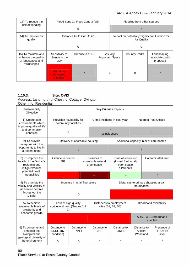
SA/SEA Annex D6 – February 2014
90 Place Services at Essex County Council
13) To reduce the risk of flooding
Flood Zone 2 / Flood Zone 3 (a/b) Flooding from other sources
0 /
14) To improve air quality
Distance to A12 or A120 Impact on potentially Significant Junction for Air Quality
0 0
15) To maintain and enhance the quality of landscapes and
townscapes
Sensitivity to change in the
LCA
Greenfield / PDL Visually Important Space
Country Parks Landscaping associated with
proposals
- Belchamp Farmland Plateau
/ 0 0 /
1.10.3. Site: OVI3 Address: Land north of Chestnut Cottage, Ovington Other info: Residential
Sustainability Objective
Key Criteria / Impacts
1) Create safe environments which
improve quality of life and community
cohesion
Provision / suitability for community facilities
Crime incidents in past year Nearest Post Offices
0 /
2 incidences /
2) To provide everyone with the
opportunity to live in a decent home
Delivery of affordable housing Additional capacity in or of care homes
/ /
3) To improve the health of the District’s
residents and mitigate/reduce potential health
inequalities
Distance to nearest GP
Distances to accessible natural
greenspace
Loss of recreation (formal / informal),
open space, allotments.
Contaminated land
- -- + /
4) To promote the vitality and viability of
all service centres throughout the
District
Increase in retail floorspace Distances to primary shopping area boundaries
0 -
5) To achieve sustainable levels of
prosperity and economic growth
Loss of high quality agricultural land (Grades 1 &
2)
Distances to employment sites (B1, B2, B8)
Broadband availability
- - ADSL, WBC broadband
enabled
6) To conserve and enhance the
biological and geological diversity of
the environment
Distance to SSSI (any condition)
Distance to NNR
Distance to LNR
Distance to LoWS
Distance to Ancient
Woodland
Presence of TPOs on
site?
0 0 0 0 0 0
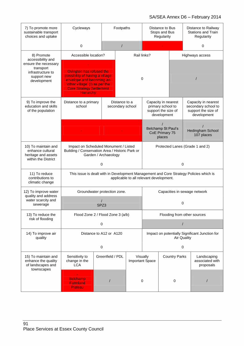
SA/SEA Annex D6 – February 2014
91 Place Services at Essex County Council
7) To promote more sustainable transport choices and uptake
Cycleways Footpaths Distance to Bus Stops and Bus
Regularity
Distance to Railway Stations and Train
Regularity
0 / - 0
8) Promote accessibility and
ensure the necessary transport
infrastructure to support new development
Accessible location? Rail links? Highways access
-
Ovington has refused the possibility of having a village envelope and becoming an ‘other village’ (/) as per the Core Strategy Settlement
Hierarchy
0 /
9) To improve the education and skills
of the population
Distance to a primary school
Distance to a secondary school
Capacity in nearest primary school to
support the size of development
Capacity in nearest secondary school to support the size of
development
- -
/ Belchamp St Paul’s
CoE Primary 75 places
/ Hedingham School
107 places
10) To maintain and enhance cultural
heritage and assets within the District
Impact on Scheduled Monument / Listed Building / Conservation Area / Historic Park or
Garden / Archaeology
Protected Lanes (Grade 1 and 2)
0 0
11) To reduce contributions to climatic change
This issue is dealt with in Development Management and Core Strategy Policies which is applicable to all relevant development.
12) To improve water quality and address water scarcity and
sewerage
Groundwater protection zone. Capacities in sewage network
/ SPZ3
0
13) To reduce the risk of flooding
Flood Zone 2 / Flood Zone 3 (a/b) Flooding from other sources
0 /
14) To improve air quality
Distance to A12 or A120 Impact on potentially Significant Junction for Air Quality
0 0
15) To maintain and enhance the quality of landscapes and
townscapes
Sensitivity to change in the
LCA
Greenfield / PDL Visually Important Space
Country Parks Landscaping associated with
proposals
- Belchamp Farmland Plateau
/ 0 0 /

SA/SEA Annex D6 – February 2014
92 Place Services at Essex County Council
1.11. Panfield
1.11.1. Site: PAN1MAlt Address: Land at Hall Road (southeast of Meadow Close), Panfield Other info: Greenfield, Mixed Use
Sustainability Objective
Key Criteria / Impacts
1) Create safe environments which
improve quality of life and community
cohesion
Provision / suitability for community facilities
Crime incidents in past year Nearest Post Offices
/ /
18 incidences /
2) To provide everyone with the
opportunity to live in a decent home
Delivery of affordable housing Additional capacity in or of care homes
/ /
3) To improve the health of the District’s
residents and mitigate/reduce potential health
inequalities
Distance to nearest GP
Distances to accessible natural
greenspace
Loss of recreation (formal / informal),
open space, allotments.
Contaminated land
/ -- + /
4) To promote the vitality and viability of
all service centres throughout the
District
Increase in retail floorspace Distances to primary shopping area boundaries
/ /
5) To achieve sustainable levels of
prosperity and economic growth
Loss of high quality agricultural land (Grades 1 &
2)
Distances to employment sites (B1, B2, B8)
Broadband availability
- / ADSL, WBC, FTTC, some
LLU DSL broadband enabled
6) To conserve and enhance the
biological and geological diversity of
the environment
Distance to SSSI (any condition)
Distance to NNR
Distance to LNR
Distance to LoWS
Distance to Ancient
Woodland
Presence of TPOs on
site?
0 0 0 0 0 /
7) To promote more sustainable transport choices and uptake
Cycleways Footpaths Distance to Bus Stops and Bus
Regularity
Distance to Railway Stations and Train
Regularity
0 / ++ 0
8) Promote accessibility and
ensure the necessary transport
infrastructure to support new development
Accessible location? Rail links? Highways access
/ 0 /
9) To improve the education and skills
of the population
Distance to a primary school
Distance to a secondary school
Capacity in nearest primary school to
support the size of development
Capacity in nearest secondary school to support the size of
development

SA/SEA Annex D6 – February 2014
93 Place Services at Essex County Council
- ++
- John Bunyan Infant -
60 places John Bunyan Junior 7
places
/ Tabor Science
College 2 places
10) To maintain and enhance cultural
heritage and assets within the District
Impact on Scheduled Monument / Listed Building / Conservation Area / Historic Park or
Garden / Archaeology
Protected Lanes (Grade 1 and 2)
0 0
11) To reduce contributions to climatic change
This issue is dealt with in Development Management and Core Strategy Policies which is applicable to all relevant development.
12) To improve water quality and address water scarcity and
sewerage
Groundwater protection zone. Capacities in sewage network
0 /
13) To reduce the risk of flooding
Flood Zone 2 / Flood Zone 3 (a/b) Flooding from other sources
0 /
14) To improve air quality
Distance to A12 or A120 Impact on potentially Significant Junction for Air Quality
0 0
15) To maintain and enhance the quality of landscapes and
townscapes
Sensitivity to change in the
LCA
Greenfield / PDL Visually Important Space
Country Parks Landscaping associated with
proposals
- Rayne Farmland
Plateau - 0 0 /
1.11.2. Site: PAN2 Address: Land at Ivy Hall, Panfield Other info: Greenfield, Residential
Sustainability Objective
Key Criteria / Impacts
1) Create safe environments which
improve quality of life and community
cohesion
Provision / suitability for community facilities
Crime incidents in past year Nearest Post Offices
0 /
13 incidences /
2) To provide everyone with the
opportunity to live in a decent home
Delivery of affordable housing Additional capacity in or of care homes
/ /
3) To improve the health of the District’s
residents and mitigate/reduce
Distance to nearest GP
Distances to accessible natural
greenspace
Loss of recreation (formal / informal),
open space, allotments.
Contaminated land

SA/SEA Annex D6 – February 2014
94 Place Services at Essex County Council
potential health inequalities / --/ + /
4) To promote the vitality and viability of
all service centres throughout the
District
Increase in retail floorspace Distances to primary shopping area boundaries
0 /
5) To achieve sustainable levels of
prosperity and economic growth
Loss of high quality agricultural land (Grades 1 &
2)
Distances to employment sites (B1, B2, B8)
Broadband availability
- / ADSL, WBC, FTTC, some
LLU DSL broadband enabled
6) To conserve and enhance the
biological and geological diversity of
the environment
Distance to SSSI (any condition)
Distance to NNR
Distance to LNR
Distance to LoWS
Distance to Ancient
Woodland
Presence of TPOs on
site?
0 0 0 / / 0
7) To promote more sustainable transport choices and uptake
Cycleways Footpaths Distance to Bus Stops and Bus
Regularity
Distance to Railway Stations and Train
Regularity
0 / ++ 0
8) Promote accessibility and
ensure the necessary transport
infrastructure to support new development
Accessible location? Rail links? Highways access
/ 0 /
9) To improve the education and skills
of the population
Distance to a primary school
Distance to a secondary school
Capacity in nearest primary school to
support the size of development
Capacity in nearest secondary school to support the size of
development
- +
- John Bunyan Infant -
60 places John Bunyan Junior 7
places
/ Tabor Science
College 2 places
10) To maintain and enhance cultural
heritage and assets within the District
Impact on Scheduled Monument / Listed Building / Conservation Area / Historic Park or
Garden / Archaeology
Protected Lanes (Grade 1 and 2)
0 0
11) To reduce contributions to climatic change
This issue is dealt with in Development Management and Core Strategy Policies which is applicable to all relevant development.
12) To improve water quality and address water scarcity and
sewerage
Groundwater protection zone. Capacities in sewage network
0 /
13) To reduce the risk of flooding
Flood Zone 2 / Flood Zone 3 (a/b) Flooding from other sources
0 /

SA/SEA Annex D6 – February 2014
95 Place Services at Essex County Council
14) To improve air quality
Distance to A12 or A120 Impact on potentially Significant Junction for Air Quality
0 0
15) To maintain and enhance the quality of landscapes and
townscapes
Sensitivity to change in the
LCA
Greenfield / PDL Visually Important Space
Country Parks Landscaping associated with
proposals
- Rayne Farmland
Plateau - 0 0 /
1.11.3. Site: PAN3 Address: CM7 5AJ Other info: Mixed Use Community open space residential
Sustainability Objective
Key Criteria / Impacts
1) Create safe environments which improve quality of life
and community cohesion
Provision / suitability for community facilities
Crime incidents in past year Nearest Post Offices
/ /
13 incidences /
2) To provide everyone with the
opportunity to live in a decent home
Delivery of affordable housing Additional capacity in or of care homes
/
Further information needed /
3) To improve the health of the District’s
residents and mitigate/reduce potential health
inequalities
Distance to nearest GP
Distances to accessible natural
greenspace
Loss of recreation (formal / informal),
open space, allotments.
Contaminated land
/ -- + 0
4) To promote the vitality and viability of
all service centres throughout the
District
Increase in retail floorspace Distances to primary shopping area boundaries
0 /
5) To achieve sustainable levels of
prosperity and economic growth
Loss of high quality agricultural land (Grades 1 &
2)
Distances to employment sites (B1, B2, B8)
Broadband availability
/ /
BT Wholesale ADSL, BT Wholesale ADSL Max, BT Wholesale WBC (21CN), BT FTTC, AOL LLU, O2 / Be LLU, Bulldog LLU, TalkTalk (CPW) LLU, Sky Broadband / Easynet LLU
6) To conserve and enhance the
biological and geological diversity of
the environment
Distance to SSSI (any condition)
Distance to NNR
Distance to LNR
Distance to LoWS
Distance to Ancient
Woodland
Presence of TPOs on
site?
0 0 0 0 0 0

SA/SEA Annex D6 – February 2014
96 Place Services at Essex County Council
7) To promote more sustainable transport choices and uptake
Cycleways Footpaths Distance to Bus Stops and Bus
Regularity
Distance to Railway Stations and Train
Regularity
/ / ++ 0
8) Promote accessibility and
ensure the necessary transport
infrastructure to support new development
Accessible location? Rail links? Highways access
/ - /
9) To improve the education and skills
of the population
Distance to a primary school
Distance to a secondary school
Capacity in nearest primary school to
support the size of development
Capacity in nearest secondary school to support the size of
development
- ++ / /
10) To maintain and enhance cultural
heritage and assets within the District
Impact on Scheduled Monument / Listed Building / Conservation Area / Historic Park or
Garden / Archaeology
Protected Lanes (Grade 1 and 2)
0 0
11) To reduce contributions to climatic change
This issue is dealt with in Development Management and Core Strategy Policies which is applicable to all relevant development.
12) To improve water quality and address water scarcity and
sewerage
Groundwater protection zone. Capacities in sewage network
0 0
13) To reduce the risk of flooding
Flood Zone 2 / Flood Zone 3 (a/b) Flooding from other sources
0 N/A
14) To improve air quality
Distance to A12 or A120 Impact on potentially Significant Junction for Air Quality
0 0
15) To maintain and enhance the quality of landscapes and
townscapes
Sensitivity to change in the
LCA
Greenfield / PDL Visually Important Space
Country Parks Landscaping associated with
proposals
- - 0 0 /
1.12. Pebmarsh
1.12.1. Site: PEB1 Address: Pebmarsh Glebe (Land between Pebmarsh Village Hall and St John the Baptist's Church), The Street, Pebmarsh Other info: PDL, Residential
Sustainability Objective
Key Criteria / Impacts

SA/SEA Annex D6 – February 2014
97 Place Services at Essex County Council
1) Create safe environments which improve quality of life and community
cohesion
Provision / suitability for community facilities
Crime incidents in past year Nearest Post Offices
0 /
7 incidences /
2) To provide everyone with the
opportunity to live in a decent home
Delivery of affordable housing Additional capacity in or of care homes
/ /
3) To improve the health of the
District’s residents and mitigate/reduce
potential health inequalities
Distance to nearest GP
Distances to accessible natural
greenspace
Loss of recreation (formal / informal),
open space, allotments.
Contaminated land
/ -- - /
4) To promote the vitality and viability
of all service centres throughout the
District
Increase in retail floorspace Distances to primary shopping area boundaries
0 /
5) To achieve sustainable levels of
prosperity and economic growth
Loss of high quality agricultural land (Grades 1 &
2)
Distances to employment sites (B1, B2, B8)
Broadband availability
0 / ADSL broadband enabled
6) To conserve and enhance the
biological and geological diversity of the environment
Distance to SSSI (any condition)
Distance to NNR
Distance to LNR
Distance to LoWS
Distance to Ancient
Woodland
Presence of TPOs on
site?
0 0 0 - 0 0
7) To promote more sustainable transport choices and uptake
Cycleways Footpaths Distance to Bus Stops and Bus Regularity
Distance to Railway Stations and Train
Regularity
0 / + 0
8) Promote accessibility and
ensure the necessary transport
infrastructure to support new development
Accessible location? Rail links? Highways access
/ 0 /
9) To improve the education and skills
of the population
Distance to a primary school
Distance to a secondary school
Capacity in nearest primary school to
support the size of development
Capacity in nearest secondary school to support the size of
development
++ +
/ St John The Baptist
CoE Primary 28 places
/ The Ramsey College
285 places
10) To maintain and enhance cultural
heritage and assets within the District
Impact on Scheduled Monument / Listed Building / Conservation Area / Historic Park or
Garden / Archaeology
Protected Lanes (Grade 1 and 2)
-- 0

SA/SEA Annex D6 – February 2014
98 Place Services at Essex County Council
11) To reduce contributions to climatic change
This issue is dealt with in Development Management and Core Strategy Policies which is applicable to all relevant development.
12) To improve water quality and
address water scarcity and sewerage
Groundwater protection zone. Capacities in sewage network
0 0
13) To reduce the risk of flooding
Flood Zone 2 / Flood Zone 3 (a/b) Flooding from other sources
0 /
14) To improve air quality
Distance to A12 or A120 Impact on potentially Significant Junction for Air Quality
0 0
15) To maintain and enhance the quality of landscapes and
townscapes
Sensitivity to change in the
LCA
Greenfield / PDL Visually Important Space
Country Parks Landscaping associated with
proposals
- Colne River
Valley + 0 0 /
1.12.2. Site: PEB2 Address: Land north of Hamsters Close, Pebmarsh Other info: Greenfield, Residential
Sustainability Objective
Key Criteria / Impacts
1) Create safe environments which
improve quality of life and community
cohesion
Provision / suitability for community facilities
Crime incidents in past year Nearest Post Offices
0 /
7 incidences /
2) To provide everyone with the
opportunity to live in a decent home
Delivery of affordable housing Additional capacity in or of care homes
/ /
3) To improve the health of the District’s
residents and mitigate/reduce potential health
inequalities
Distance to nearest GP
Distances to accessible natural
greenspace
Loss of recreation (formal / informal),
open space, allotments.
Contaminated land
/ -- + /
4) To promote the vitality and viability of
all service centres throughout the
District
Increase in retail floorspace Distances to primary shopping area boundaries
0 /
5) To achieve sustainable levels of
prosperity and
Loss of high quality agricultural land (Grades 1 &
2)
Distances to employment sites (B1, B2, B8)
Broadband availability

SA/SEA Annex D6 – February 2014
99 Place Services at Essex County Council
economic growth - / ADSL broadband enabled
6) To conserve and enhance the
biological and geological diversity of
the environment
Distance to SSSI (any condition)
Distance to NNR
Distance to LNR
Distance to LoWS
Distance to Ancient
Woodland
Presence of TPOs on
site?
0 0 0 0 0 0
7) To promote more sustainable transport choices and uptake
Cycleways Footpaths Distance to Bus Stops and Bus
Regularity
Distance to Railway Stations and Train
Regularity
0 / + 0
8) Promote accessibility and
ensure the necessary transport
infrastructure to support new development
Accessible location? Rail links? Highways access
/ 0 /
9) To improve the education and skills
of the population
Distance to a primary school
Distance to a secondary school
Capacity in nearest primary school to
support the size of development
Capacity in nearest secondary school to support the size of
development
- +
/ St John The Baptist
CoE Primary 28 places
/ The Ramsey College
285 places
10) To maintain and enhance cultural
heritage and assets within the District
Impact on Scheduled Monument / Listed Building / Conservation Area / Historic Park or
Garden / Archaeology
Protected Lanes (Grade 1 and 2)
0 0
11) To reduce contributions to climatic change
This issue is dealt with in Development Management and Core Strategy Policies which is applicable to all relevant development.
12) To improve water quality and address water scarcity and
sewerage
Groundwater protection zone. Capacities in sewage network
0 0
13) To reduce the risk of flooding
Flood Zone 2 / Flood Zone 3 (a/b) Flooding from other sources
0 /
14) To improve air quality
Distance to A12 or A120 Impact on potentially Significant Junction for Air Quality
0 0
15) To maintain and enhance the quality of landscapes and
townscapes
Sensitivity to change in the
LCA
Greenfield / PDL Visually Important Space
Country Parks Landscaping associated with
proposals
- Colne River
Valley - 0 0 /

SA/SEA Annex D6 – February 2014
100 Place Services at Essex County Council
1.12.3. Site: PEB3 Address: Land West of Kings Mead, Pebmarsh Other info: Greenfield, Residential
Sustainability Objective
Key Criteria / Impacts
1) Create safe environments which
improve quality of life and community
cohesion
Provision / suitability for community facilities
Crime incidents in past year Nearest Post Offices
0 /
7 incidences /
2) To provide everyone with the
opportunity to live in a decent home
Delivery of affordable housing Additional capacity in or of care homes
/ /
3) To improve the health of the District’s
residents and mitigate/reduce potential health
inequalities
Distance to nearest GP
Distances to accessible natural
greenspace
Loss of recreation (formal / informal),
open space, allotments.
Contaminated land
/ -- + /
4) To promote the vitality and viability of
all service centres throughout the
District
Increase in retail floorspace Distances to primary shopping area boundaries
0 /
5) To achieve sustainable levels of
prosperity and economic growth
Loss of high quality agricultural land (Grades 1 &
2)
Distances to employment sites (B1, B2, B8)
Broadband availability
0 / ADSL broadband enabled
6) To conserve and enhance the
biological and geological diversity of
the environment
Distance to SSSI (any condition)
Distance to NNR
Distance to LNR
Distance to LoWS
Distance to Ancient
Woodland
Presence of TPOs on
site?
0 0 0 0 0 0
7) To promote more sustainable transport choices and uptake
Cycleways Footpaths Distance to Bus Stops and Bus
Regularity
Distance to Railway Stations and Train
Regularity
0 / + 0
8) Promote accessibility and
ensure the necessary transport
infrastructure to support new development
Accessible location? Rail links? Highways access
/ 0
9) To improve the education and skills
of the population
Distance to a primary school
Distance to a secondary school
Capacity in nearest primary school to
support the size of development
Capacity in nearest secondary school to support the size of
development
++ + /
St John The Baptist CoE Primary 28
/ The Ramsey College
285 places

SA/SEA Annex D6 – February 2014
101 Place Services at Essex County Council
places
10) To maintain and enhance cultural
heritage and assets within the District
Impact on Scheduled Monument / Listed Building / Conservation Area / Historic Park or
Garden / Archaeology
Protected Lanes (Grade 1 and 2)
- 0
11) To reduce contributions to climatic change
This issue is dealt with in Development Management and Core Strategy Policies which is applicable to all relevant development.
12) To improve water quality and address water scarcity and
sewerage
Groundwater protection zone. Capacities in sewage network
0 0
13) To reduce the risk of flooding
Flood Zone 2 / Flood Zone 3 (a/b) Flooding from other sources
0 /
14) To improve air quality
Distance to A12 or A120 Impact on potentially Significant Junction for Air Quality
0 0
15) To maintain and enhance the quality of landscapes and
townscapes
Sensitivity to change in the
LCA
Greenfield / PDL Visually Important Space
Country Parks Landscaping associated with
proposals
- Colne River
Valley - 0 0 /
1.12.4. Site: PEB4 Address: Playing Field, North of The Street, Pebmarsh Other info: Greenfield, Residential
Sustainability Objective
Key Criteria / Impacts
1) Create safe environments which
improve quality of life and community
cohesion
Provision / suitability for community facilities
Crime incidents in past year Nearest Post Offices
0 /
7 incidences /
2) To provide everyone with the
opportunity to live in a decent home
Delivery of affordable housing Additional capacity in or of care homes
/ /
3) To improve the health of the District’s
residents and mitigate/reduce potential health
inequalities
Distance to nearest GP
Distances to accessible natural
greenspace
Loss of recreation (formal / informal),
open space, allotments.
Contaminated land
/ -- - /
4) To promote the vitality and viability of
Increase in retail floorspace Distances to primary shopping area boundaries

SA/SEA Annex D6 – February 2014
102 Place Services at Essex County Council
all service centres throughout the
District 0 /
5) To achieve sustainable levels of
prosperity and economic growth
Loss of high quality agricultural land (Grades 1 &
2)
Distances to employment sites (B1, B2, B8)
Broadband availability
- / ADSL broadband enabled
6) To conserve and enhance the
biological and geological diversity of
the environment
Distance to SSSI (any condition)
Distance to NNR
Distance to LNR
Distance to LoWS
Distance to Ancient
Woodland
Presence of TPOs on
site?
0 0 0 0 0 0
7) To promote more sustainable transport choices and uptake
Cycleways Footpaths Distance to Bus Stops and Bus
Regularity
Distance to Railway Stations and Train
Regularity
0 / + 0
8) Promote accessibility and
ensure the necessary transport
infrastructure to support new development
Accessible location? Rail links? Highways access
/ 0 /
9) To improve the education and skills
of the population
Distance to a primary school
Distance to a secondary school
Capacity in nearest primary school to
support the size of development
Capacity in nearest secondary school to support the size of
development
- +
/ St John The Baptist
CoE Primary 28 places
/ The Ramsey College
285 places
10) To maintain and enhance cultural
heritage and assets within the District
Impact on Scheduled Monument / Listed Building / Conservation Area / Historic Park or
Garden / Archaeology
Protected Lanes (Grade 1 and 2)
0 0
11) To reduce contributions to climatic change
This issue is dealt with in Development Management and Core Strategy Policies which is applicable to all relevant development.
12) To improve water quality and address water scarcity and
sewerage
Groundwater protection zone. Capacities in sewage network
0 0
13) To reduce the risk of flooding
Flood Zone 2 / Flood Zone 3 (a/b) Flooding from other sources
0 /
14) To improve air quality
Distance to A12 or A120 Impact on potentially Significant Junction for Air Quality
0 0
15) To maintain and enhance the quality
Sensitivity to change in the
Greenfield / PDL Visually Country Parks Landscaping associated with
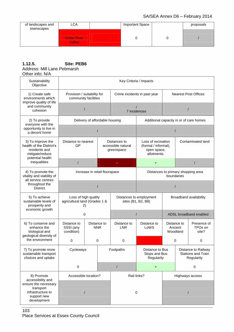
SA/SEA Annex D6 – February 2014
103 Place Services at Essex County Council
of landscapes and townscapes
LCA Important Space proposals
- Colne River
Valley - 0 0 /
1.12.5. Site: PEB6 Address: Mill Lane Pebmarsh Other info: N/A
Sustainability Objective
Key Criteria / Impacts
1) Create safe environments which
improve quality of life and community
cohesion
Provision / suitability for community facilities
Crime incidents in past year Nearest Post Offices
/ /
7 incidences /
2) To provide everyone with the
opportunity to live in a decent home
Delivery of affordable housing Additional capacity in or of care homes
/ /
3) To improve the health of the District’s
residents and mitigate/reduce potential health
inequalities
Distance to nearest GP
Distances to accessible natural
greenspace
Loss of recreation (formal / informal),
open space, allotments.
Contaminated land
/ -- + /
4) To promote the vitality and viability of
all service centres throughout the
District
Increase in retail floorspace Distances to primary shopping area boundaries
/ /
5) To achieve sustainable levels of
prosperity and economic growth
Loss of high quality agricultural land (Grades 1 &
2)
Distances to employment sites (B1, B2, B8)
Broadband availability
0 / ADSL broadband enabled
6) To conserve and enhance the
biological and geological diversity of
the environment
Distance to SSSI (any condition)
Distance to NNR
Distance to LNR
Distance to LoWS
Distance to Ancient
Woodland
Presence of TPOs on
site?
0 0 0 - 0 0
7) To promote more sustainable transport choices and uptake
Cycleways Footpaths Distance to Bus Stops and Bus
Regularity
Distance to Railway Stations and Train
Regularity
0 / + 0
8) Promote accessibility and
ensure the necessary transport
infrastructure to support new development
Accessible location? Rail links? Highways access
/ 0 /

SA/SEA Annex D6 – February 2014
104 Place Services at Essex County Council
9) To improve the education and skills
of the population
Distance to a primary school
Distance to a secondary school
Capacity in nearest primary school to
support the size of development
Capacity in nearest secondary school to support the size of
development
++ +
/ St John The Baptist
CoE Primary 28 places
/ The Ramsey College
285 places
10) To maintain and enhance cultural
heritage and assets within the District
Impact on Scheduled Monument / Listed Building / Conservation Area / Historic Park or
Garden / Archaeology
Protected Lanes (Grade 1 and 2)
-- 0
11) To reduce contributions to climatic change
This issue is dealt with in Development Management and Core Strategy Policies which is applicable to all relevant development.
12) To improve water quality and address water scarcity and
sewerage
Groundwater protection zone. Capacities in sewage network
0 0
13) To reduce the risk of flooding
Flood Zone 2 / Flood Zone 3 (a/b) Flooding from other sources
0 /
14) To improve air quality
Distance to A12 or A120 Impact on potentially Significant Junction for Air Quality
0 0
15) To maintain and enhance the quality of landscapes and
townscapes
Sensitivity to change in the
LCA
Greenfield / PDL Visually Important Space
Country Parks Landscaping associated with
proposals
- Colne River
Valley / 0 0 /
1.12.6. Site: PEB7 Address: North Of The Street Pebmarsh Other info: N/A
Sustainability Objective
Key Criteria / Impacts
1) Create safe environments which
improve quality of life and community
cohesion
Provision / suitability for community facilities
Crime incidents in past year Nearest Post Offices
/ /
7 incidences /
2) To provide everyone with the
opportunity to live in a decent home
Delivery of affordable housing Additional capacity in or of care homes
/ /
3) To improve the health of the District’s
residents and
Distance to nearest GP
Distances to accessible natural
Loss of recreation (formal / informal),
open space,
Contaminated land

SA/SEA Annex D6 – February 2014
105 Place Services at Essex County Council
mitigate/reduce potential health
inequalities
greenspace allotments.
/ -- + /
4) To promote the vitality and viability of
all service centres throughout the
District
Increase in retail floorspace Distances to primary shopping area boundaries
/ /
5) To achieve sustainable levels of
prosperity and economic growth
Loss of high quality agricultural land (Grades 1 &
2)
Distances to employment sites (B1, B2, B8)
Broadband availability
/ / ADSL broadband enabled
6) To conserve and enhance the
biological and geological diversity of
the environment
Distance to SSSI (any condition)
Distance to NNR
Distance to LNR
Distance to LoWS
Distance to Ancient
Woodland
Presence of TPOs on
site?
0 0 0 0 0 0
7) To promote more sustainable transport choices and uptake
Cycleways Footpaths Distance to Bus Stops and Bus
Regularity
Distance to Railway Stations and Train
Regularity
0 / + 0
8) Promote accessibility and
ensure the necessary transport
infrastructure to support new development
Accessible location? Rail links? Highways access
/ 0 /
9) To improve the education and skills
of the population
Distance to a primary school
Distance to a secondary school
Capacity in nearest primary school to
support the size of development
Capacity in nearest secondary school to support the size of
development
+ +
/ St John The Baptist
CoE Primary 28 places
/ The Ramsey College
285 places
10) To maintain and enhance cultural
heritage and assets within the District
Impact on Scheduled Monument / Listed Building / Conservation Area / Historic Park or
Garden / Archaeology
Protected Lanes (Grade 1 and 2)
0 0
11) To reduce contributions to climatic change
This issue is dealt with in Development Management and Core Strategy Policies which is applicable to all relevant development.
12) To improve water quality and address water scarcity and
sewerage
Groundwater protection zone. Capacities in sewage network
0 0
13) To reduce the risk of flooding
Flood Zone 2 / Flood Zone 3 (a/b) Flooding from other sources
0 /

SA/SEA Annex D6 – February 2014
106 Place Services at Essex County Council
14) To improve air quality
Distance to A12 or A120 Impact on potentially Significant Junction for Air Quality
0 0
15) To maintain and enhance the quality of landscapes and
townscapes
Sensitivity to change in the
LCA
Greenfield / PDL Visually Important Space
Country Parks Landscaping associated with
proposals
- Colne River
Valley / 0 0 /
1.12.7. Site: PEB8 Address: Land Rear of 'Charwin' The Street, Cross End, Pebmarsh Other info: N/A
Sustainability Objective
Key Criteria / Impacts
1) Create safe environments which
improve quality of life and community
cohesion
Provision / suitability for community facilities
Crime incidents in past year Nearest Post Offices
/ /
10 incidences /
2) To provide everyone with the
opportunity to live in a decent home
Delivery of affordable housing Additional capacity in or of care homes
/ /
3) To improve the health of the District’s
residents and mitigate/reduce potential health
inequalities
Distance to nearest GP
Distances to accessible natural
greenspace
Loss of recreation (formal / informal),
open space, allotments.
Contaminated land
/ -- + /
4) To promote the vitality and viability of
all service centres throughout the
District
Increase in retail floorspace Distances to primary shopping area boundaries
/ /
Bus Service less than 5 days a week
5) To achieve sustainable levels of
prosperity and economic growth
Loss of high quality agricultural land (Grades 1 &
2)
Distances to employment sites (B1, B2, B8)
Broadband availability
0
/
Bus Service less than 5 days a week
ADSL broadband enabled
6) To conserve and enhance the
biological and geological diversity of
the environment
Distance to SSSI (any condition)
Distance to NNR
Distance to LNR
Distance to LoWS
Distance to Ancient
Woodland
Presence of TPOs on
site?
0 0 0 0 0 0
7) To promote more sustainable transport
Cycleways Footpaths Distance to Bus Stops and Bus
Distance to Railway Stations and Train

SA/SEA Annex D6 – February 2014
107 Place Services at Essex County Council
choices and uptake Regularity Regularity
0 / + 0
8) Promote accessibility and
ensure the necessary transport
infrastructure to support new development
Accessible location? Rail links? Highways access
/ 0 /
9) To improve the education and skills
of the population
Distance to a primary school
Distance to a secondary school
Capacity in nearest primary school to
support the size of development
Capacity in nearest secondary school to support the size of
development
+ -
/ St John The Baptist
CoE Primary 28 places
/ The Ramsey College
285 places
10) To maintain and enhance cultural
heritage and assets within the District
Impact on Scheduled Monument / Listed Building / Conservation Area / Historic Park or
Garden / Archaeology
Protected Lanes (Grade 1 and 2)
0 0
11) To reduce contributions to climatic change
This issue is dealt with in Development Management and Core Strategy Policies which is applicable to all relevant development.
12) To improve water quality and address water scarcity and
sewerage
Groundwater protection zone. Capacities in sewage network
0 0
13) To reduce the risk of flooding
Flood Zone 2 / Flood Zone 3 (a/b) Flooding from other sources
0 /
14) To improve air quality
Distance to A12 or A120 Impact on potentially Significant Junction for Air Quality
0 0
15) To maintain and enhance the quality of landscapes and
townscapes
Sensitivity to change in the
LCA
Greenfield / PDL Visually Important Space
Country Parks Landscaping associated with
proposals
- Wickham Farmland Plateau
/ 0 0 /
1.13. Rayne
1.13.1. Site: RAY1 Address: Rayne Glebe (Land at Shalford Road), Rayne Other info: Greenfield, Residential
Sustainability Key Criteria / Impacts

SA/SEA Annex D6 – February 2014
108 Place Services at Essex County Council
Objective
1) Create safe environments which improve quality of life
and community cohesion
Provision / suitability for community facilities
Crime incidents in past year Nearest Post Offices
0 /
85 incidences +
2) To provide everyone with the
opportunity to live in a decent home
Delivery of affordable housing Additional capacity in or of care homes
/ /
3) To improve the health of the District’s
residents and mitigate/reduce potential health
inequalities
Distance to nearest GP
Distances to accessible natural
greenspace
Loss of recreation (formal / informal),
open space, allotments.
Contaminated land
/ - - /
4) To promote the vitality and viability of
all service centres throughout the District
Increase in retail floorspace Distances to primary shopping area boundaries
0 /
5) To achieve sustainable levels of
prosperity and economic growth
Loss of high quality agricultural land (Grades 1 &
2)
Distances to employment sites (B1, B2, B8)
Broadband availability
0 / ADSL, WBC, FTTC, some
LLU DSL broadband enabled
6) To conserve and enhance the
biological and geological diversity of
the environment
Distance to SSSI (any condition)
Distance to NNR
Distance to LNR
Distance to LoWS
Distance to Ancient
Woodland
Presence of TPOs on
site?
0 0 0 0 0 /
7) To promote more sustainable transport choices and uptake
Cycleways Footpaths Distance to Bus Stops and Bus
Regularity
Distance to Railway Stations and Train
Regularity
0 / ++ 0
8) Promote accessibility and
ensure the necessary transport
infrastructure to support new development
Accessible location? Rail links? Highways access
/ 0 /
9) To improve the education and skills
of the population
Distance to a primary school
Distance to a secondary school
Capacity in nearest primary school to
support the size of development
Capacity in nearest secondary school to support the size of
development
++ ++ -
Rayne Primary -5 places
/ Tabor Science
College 2 places
10) To maintain and enhance cultural
heritage and assets
Impact on Scheduled Monument / Listed Building / Conservation Area / Historic Park or
Garden / Archaeology
Protected Lanes (Grade 1 and 2)

SA/SEA Annex D6 – February 2014
109 Place Services at Essex County Council
within the District 0 0
11) To reduce contributions to climatic change
This issue is dealt with in Development Management and Core Strategy Policies which is applicable to all relevant development.
12) To improve water quality and address water scarcity and
sewerage
Groundwater protection zone. Capacities in sewage network
0 /
13) To reduce the risk of flooding
Flood Zone 2 / Flood Zone 3 (a/b) Flooding from other sources
0 /
14) To improve air quality
Distance to A12 or A120 Impact on potentially Significant Junction for Air Quality
0 Junctions in Braintree
15) To maintain and enhance the quality of
landscapes and townscapes
Sensitivity to change in the
LCA
Greenfield / PDL Visually Important Space
Country Parks Landscaping associated with
proposals
- Rayne Farmland
Plateau - 0 0 /
1.13.2. Site: RAY2 Address: Land between Rayne, Great Notley and Braintree Other info: Greenfield, Mixed residential/local employment/leisure/recreation, SHLAA – 2000 dwellings
Sustainability Objective
Key Criteria / Impacts
1) Create safe environments which
improve quality of life and community
cohesion
Provision / suitability for community facilities
Crime incidents in past year Nearest Post Offices
0 /
224 incidences +
2) To provide everyone with the
opportunity to live in a decent home
Delivery of affordable housing Additional capacity in or of care homes
++ 0
3) To improve the health of the District’s
residents and mitigate/reduce potential health
inequalities
Distance to nearest GP
Distances to accessible natural
greenspace
Loss of recreation (formal / informal),
open space, allotments.
Contaminated land
/ - / 0
4) To promote the vitality and viability of
all service centres throughout the
District
Increase in retail floorspace Distances to primary shopping area boundaries
/ /
5) To achieve sustainable levels of
Loss of high quality agricultural land (Grades 1 &
Distances to employment sites (B1, B2, B8)
Broadband availability

SA/SEA Annex D6 – February 2014
110 Place Services at Essex County Council
prosperity and economic growth
2)
0 / ADSL, WBC, FTTC, some
LLU DSL broadband enabled
6) To conserve and enhance the
biological and geological diversity of
the environment
Distance to SSSI (any condition)
Distance to NNR
Distance to LNR
Distance to LoWS
Distance to Ancient
Woodland
Presence of TPOs on
site?
0 0 0 - 0 /
7) To promote more sustainable transport choices and uptake
Cycleways Footpaths Distance to Bus Stops and Bus
Regularity
Distance to Railway Stations and Train
Regularity
0 /
Numerous footpaths cross the site
++ 0
8) Promote accessibility and
ensure the necessary transport
infrastructure to support new development
Accessible location? Rail links? Highways access
/
Parts of the site would warrant a negative (-) score as sufficiently outside the
village envelope
0
+ School Road, Queenborough Lane, A120 runs through site
and is also close to A131
9) To improve the education and skills
of the population
Distance to a primary school
Distance to a secondary school
Capacity in nearest primary school to
support the size of development
Capacity in nearest secondary school to support the size of
development
+ ++ -
Notley Green Primary 11 places
- Tabor Science
College 2 places
10) To maintain and enhance cultural
heritage and assets within the District
Impact on Scheduled Monument / Listed Building / Conservation Area / Historic Park or
Garden / Archaeology
Protected Lanes (Grade 1 and 2)
-- 0
11) To reduce contributions to climatic change
This issue is dealt with in Development Management and Core Strategy Policies which is applicable to all relevant development.
12) To improve water quality and address water scarcity and
sewerage
Groundwater protection zone. Capacities in sewage network
0 /
13) To reduce the risk of flooding
Flood Zone 2 / Flood Zone 3 (a/b) Flooding from other sources
0
/
identified potential risk from overland flow and/or surface water runoff
14) To improve air quality
Distance to A12 or A120 Impact on potentially Significant Junction for Air Quality
- Junctions in Braintree
15) To maintain and enhance the quality
Sensitivity to change in the
Greenfield / PDL Visually Important Space
Country Parks Landscaping associated with

SA/SEA Annex D6 – February 2014
111 Place Services at Essex County Council
of landscapes and townscapes
LCA proposals
- Pods Brook
River Valley (-) Rayne Farmland
Plateau (-) Felsted
Farmland Plateau
(unknown)
- 0 - /
1.13.3. Site: RAY3 Address: Land off Shalford Road, Rayne Other info: PDL
Sustainability Objective
Key Criteria / Impacts
1) Create safe environments which
improve quality of life and community
cohesion
Provision / suitability for community facilities
Crime incidents in past year Nearest Post Offices
/ /
56 incidences +
2) To provide everyone with the
opportunity to live in a decent home
Delivery of affordable housing Additional capacity in or of care homes
/ /
3) To improve the health of the District’s
residents and mitigate/reduce potential health
inequalities
Distance to nearest GP
Distances to accessible natural
greenspace
Loss of recreation (formal / informal),
open space, allotments.
Contaminated land
/ - + /
4) To promote the vitality and viability of
all service centres throughout the
District
Increase in retail floorspace Distances to primary shopping area boundaries
/ -
5) To achieve sustainable levels of
prosperity and economic growth
Loss of high quality agricultural land (Grades 1 &
2)
Distances to employment sites (B1, B2, B8)
Broadband availability
- - ADSL, WBC, FTTC, some
LLU DSL broadband enabled
6) To conserve and enhance the
biological and geological diversity of
the environment
Distance to SSSI (any condition)
Distance to NNR
Distance to LNR
Distance to LoWS
Distance to Ancient
Woodland
Presence of TPOs on
site?
0 0 0 0 0 0
7) To promote more sustainable transport choices and uptake
Cycleways Footpaths Distance to Bus Stops and Bus
Regularity
Distance to Railway Stations and Train
Regularity
0 / ++ 0
8) Promote Accessible location? Rail links? Highways access
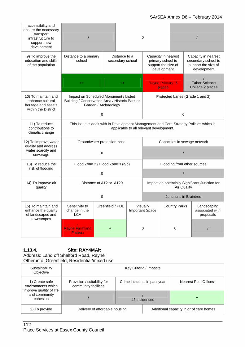
SA/SEA Annex D6 – February 2014
112 Place Services at Essex County Council
accessibility and ensure the necessary
transport infrastructure to
support new development
/ 0 /
9) To improve the education and skills
of the population
Distance to a primary school
Distance to a secondary school
Capacity in nearest primary school to
support the size of development
Capacity in nearest secondary school to support the size of
development
++ ++ -
Rayne Primary -5 places
/ Tabor Science
College 2 places
10) To maintain and enhance cultural
heritage and assets within the District
Impact on Scheduled Monument / Listed Building / Conservation Area / Historic Park or
Garden / Archaeology
Protected Lanes (Grade 1 and 2)
0 0
11) To reduce contributions to climatic change
This issue is dealt with in Development Management and Core Strategy Policies which is applicable to all relevant development.
12) To improve water quality and address water scarcity and
sewerage
Groundwater protection zone. Capacities in sewage network
0 /
13) To reduce the risk of flooding
Flood Zone 2 / Flood Zone 3 (a/b) Flooding from other sources
0 /
14) To improve air quality
Distance to A12 or A120 Impact on potentially Significant Junction for Air Quality
0 Junctions in Braintree
15) To maintain and enhance the quality of landscapes and
townscapes
Sensitivity to change in the
LCA
Greenfield / PDL Visually Important Space
Country Parks Landscaping associated with
proposals
- Rayne Farmland
Plateau + 0 0 /
1.13.4. Site: RAY4MAlt Address: Land off Shalford Road, Rayne Other info: Greenfield, Residential/mixed use
Sustainability Objective
Key Criteria / Impacts
1) Create safe environments which
improve quality of life and community
cohesion
Provision / suitability for community facilities
Crime incidents in past year Nearest Post Offices
/ /
43 incidences +
2) To provide Delivery of affordable housing Additional capacity in or of care homes

SA/SEA Annex D6 – February 2014
113 Place Services at Essex County Council
everyone with the opportunity to live in
a decent home / /
3) To improve the health of the District’s
residents and mitigate/reduce potential health
inequalities
Distance to nearest GP
Distances to accessible natural
greenspace
Loss of recreation (formal / informal),
open space, allotments.
Contaminated land
/ - + /
4) To promote the vitality and viability of
all service centres throughout the
District
Increase in retail floorspace Distances to primary shopping area boundaries
/ -
5) To achieve sustainable levels of
prosperity and economic growth
Loss of high quality agricultural land (Grades 1 &
2)
Distances to employment sites (B1, B2, B8)
Broadband availability
- - ADSL, WBC, FTTC, some
LLU DSL broadband enabled
6) To conserve and enhance the
biological and geological diversity of
the environment
Distance to SSSI (any condition)
Distance to NNR
Distance to LNR
Distance to LoWS
Distance to Ancient
Woodland
Presence of TPOs on
site?
0 0 0 0 0 0
7) To promote more sustainable transport choices and uptake
Cycleways Footpaths Distance to Bus Stops and Bus
Regularity
Distance to Railway Stations and Train
Regularity
0 / ++ 0
8) Promote accessibility and
ensure the necessary transport
infrastructure to support new development
Accessible location? Rail links? Highways access
/ 0 /
9) To improve the education and skills
of the population
Distance to a primary school
Distance to a secondary school
Capacity in nearest primary school to
support the size of development
Capacity in nearest secondary school to support the size of
development
++ + -
Rayne Primary -5 places
/ Tabor Science
College 2 places
10) To maintain and enhance cultural
heritage and assets within the District
Impact on Scheduled Monument / Listed Building / Conservation Area / Historic Park or
Garden / Archaeology
Protected Lanes (Grade 1 and 2)
0 0
11) To reduce contributions to climatic change
This issue is dealt with in Development Management and Core Strategy Policies which is applicable to all relevant development.
12) To improve water Groundwater protection zone. Capacities in sewage network

SA/SEA Annex D6 – February 2014
114 Place Services at Essex County Council
quality and address water scarcity and
sewerage 0 /
13) To reduce the risk of flooding
Flood Zone 2 / Flood Zone 3 (a/b) Flooding from other sources
0
/
identified potential risk from overland flow and/or surface water runoff
14) To improve air quality
Distance to A12 or A120 Impact on potentially Significant Junction for Air Quality
0 Junctions in Braintree
15) To maintain and enhance the quality of landscapes and
townscapes
Sensitivity to change in the
LCA
Greenfield / PDL Visually Important Space
Country Parks Landscaping associated with
proposals
- Rayne Farmland
Plateau - 0 0 /
1.13.5. Site: RAY5 Address: Oak Meadow, Gore Road, Rayne Other info: Greenfield, Residential
Sustainability Objective
Criteria / Impacts
1) Create safe environments which improve quality of life and community
cohesion
Provision / suitability for community facilities
Crime incidents in past year Nearest Post Offices
0 /
128 incidences +
2) To provide everyone with the
opportunity to live in a decent home
Delivery of affordable housing Additional capacity in or of care homes
/ /
3) To improve the health of the
District’s residents and mitigate/reduce
potential health inequalities
Distance to nearest GP
Distances to accessible natural
greenspace
Loss of recreation (formal / informal),
open space, allotments.
Contaminated land
/ - + /
4) To promote the vitality and viability
of all service centres throughout the
District
Increase in retail floorspace Distances to primary shopping area boundaries
0 /
5) To achieve sustainable levels of
prosperity and economic growth
Loss of high quality agricultural land (Grades 1 &
2)
Distances to employment sites (B1, B2, B8)
Broadband availability
0 / ADSL, WBC, FTTC, some
LLU DSL broadband enabled
6) To conserve and enhance the
Distance to SSSI (any
Distance to NNR
Distance to LNR
Distance to LoWS
Distance to Ancient
Presence of TPOs on

SA/SEA Annex D6 – February 2014
115 Place Services at Essex County Council
biological and geological diversity of the environment
condition) Woodland site?
0 0 0 - 0 0
7) To promote more sustainable transport choices and uptake
Cycleways Footpaths Distance to Bus Stops and Bus Regularity
Distance to Railway Stations and Train
Regularity
0 / ++ 0
8) Promote accessibility and
ensure the necessary transport
infrastructure to support new development
Accessible location? Rail links? Highways access
/ 0 /
9) To improve the education and skills
of the population
Distance to a primary school
Distance to a secondary school
Capacity in nearest primary school to
support the size of development
Capacity in nearest secondary school to support the size of
development
+ ++ -
Rayne Primary -5 places
/ Tabor Science
College 2 places
10) To maintain and enhance cultural
heritage and assets within the District
Impact on Scheduled Monument / Listed Building / Conservation Area / Historic Park or
Garden / Archaeology
Protected Lanes (Grade 1 and 2)
0 0
11) To reduce contributions to climatic change
This issue is dealt with in Development Management and Core Strategy Policies which is applicable to all relevant development.
12) To improve water quality and
address water scarcity and sewerage
Groundwater protection zone. Capacities in sewage network
0 /
WCS (red)
13) To reduce the risk of flooding
Flood Zone 2 / Flood Zone 3 (a/b) Flooding from other sources
0 /
14) To improve air quality
Distance to A12 or A120 Impact on potentially Significant Junction for Air Quality
0 Junctions in Braintree
15) To maintain and enhance the quality of landscapes and
townscapes
Sensitivity to change in the
LCA
Greenfield / PDL Visually Important Space
Country Parks Landscaping associated with
proposals
- Rayne Farmland
Plateau - 0 0 /
1.13.6. Site: RAY6 Address: Land south of Dunmow Road, Blake End Other info: Greenfield, Residential

SA/SEA Annex D6 – February 2014
116 Place Services at Essex County Council
Sustainability Objective
Key Criteria / Impacts
1) Create safe environments which
improve quality of life and community
cohesion
Provision / suitability for community facilities
Crime incidents in past year Nearest Post Offices
0 /
14 incidences /
2) To provide everyone with the
opportunity to live in a decent home
Delivery of affordable housing Additional capacity in or of care homes
/ /
3) To improve the health of the District’s
residents and mitigate/reduce potential health
inequalities
Distance to nearest GP
Distances to accessible natural
greenspace
Loss of recreation (formal / informal),
open space, allotments.
Contaminated land
/ -- + /
4) To promote the vitality and viability of
all service centres throughout the
District
Increase in retail floorspace Distances to primary shopping area boundaries
0 /
5) To achieve sustainable levels of
prosperity and economic growth
Loss of high quality agricultural land (Grades 1 &
2)
Distances to employment sites (B1, B2, B8)
Broadband availability
- / ADSL, WBC, FTTC, some
LLU DSL broadband enabled
6) To conserve and enhance the
biological and geological diversity of
the environment
Distance to SSSI (any condition)
Distance to NNR
Distance to LNR
Distance to LoWS
Distance to Ancient
Woodland
Presence of TPOs on
site?
0 0 0 0 0 0
7) To promote more sustainable transport choices and uptake
Cycleways Footpaths Distance to Bus Stops and Bus
Regularity
Distance to Railway Stations and Train
Regularity
0 / ++ 0
8) Promote accessibility and
ensure the necessary transport
infrastructure to support new development
Accessible location? Rail links? Highways access
-
Effectively in Blake End 0 /
9) To improve the education and skills
of the population
Distance to a primary school
Distance to a secondary school
Capacity in nearest primary school to
support the size of development
Capacity in nearest secondary school to support the size of
development
- ++
/ Felsted Primary 51
places (Uttlesford District)
/ Tabor Science
College 2 places
10) To maintain and Impact on Scheduled Monument / Listed Protected Lanes (Grade 1 and 2)

SA/SEA Annex D6 – February 2014
117 Place Services at Essex County Council
enhance cultural heritage and assets
within the District
Building / Conservation Area / Historic Park or Garden / Archaeology
0 0
11) To reduce contributions to climatic change
This issue is dealt with in Development Management and Core Strategy Policies which is applicable to all relevant development.
12) To improve water quality and address water scarcity and
sewerage
Groundwater protection zone. Capacities in sewage network
0 /
13) To reduce the risk of flooding
Flood Zone 2 / Flood Zone 3 (a/b) Flooding from other sources
-- /
14) To improve air quality
Distance to A12 or A120 Impact on potentially Significant Junction for Air Quality
0 Junctions in Braintree
15) To maintain and enhance the quality of landscapes and
townscapes
Sensitivity to change in the
LCA
Greenfield / PDL Visually Important Space
Country Parks Landscaping associated with
proposals
- Rayne Farmland
Plateau - 0 0 /
1.13.7. Site: RAY7 Address: Andrews field New Settlement Other info: Greenfield, New Settlement, SHLAA – dwelling no. not given but >15 dwellings
Sustainability Objective
Key Criteria / Impacts
1) Create safe environments which
improve quality of life and community
cohesion
Provision / suitability for community facilities
Crime incidents in past year Nearest Post Offices
/ /
52 incidences +
2) To provide everyone with the
opportunity to live in a decent home
Delivery of affordable housing Additional capacity in or of care homes
++ 0
3) To improve the health of the District’s
residents and mitigate/reduce potential health
inequalities
Distance to nearest GP
Distances to accessible natural
greenspace
Loss of recreation (formal / informal),
open space, allotments.
Contaminated land
/ - +
/ Bte413 – small
unknown infill, Bte826 – small unknown infill,
Bte831 – small unknown infill, Bte832 – small unknown infill,
Bte902 – small unknown infill
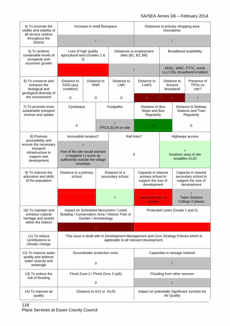
SA/SEA Annex D6 – February 2014
118 Place Services at Essex County Council
4) To promote the vitality and viability of
all service centres throughout the
District
Increase in retail floorspace Distances to primary shopping area boundaries
/ /
5) To achieve sustainable levels of
prosperity and economic growth
Loss of high quality agricultural land (Grades 1 &
2)
Distances to employment sites (B1, B2, B8)
Broadband availability
- / ADSL, WBC, FTTC, some
LLU DSL broadband enabled
6) To conserve and enhance the
biological and geological diversity of
the environment
Distance to SSSI (any condition)
Distance to NNR
Distance to LNR
Distance to LoWS
Distance to Ancient
Woodland
Presence of TPOs on
site?
0 0 0 -- -- /
7) To promote more sustainable transport choices and uptake
Cycleways Footpaths Distance to Bus Stops and Bus
Regularity
Distance to Railway Stations and Train
Regularity
0 /
FP3,5,33,34 on site ++ 0
8) Promote accessibility and
ensure the necessary transport
infrastructure to support new development
Accessible location? Rail links? Highways access
/
Part of the site would warrant a negative (-) score as
sufficiently outside the village envelope
0 +
Southern area of site straddles A120
9) To improve the education and skills
of the population
Distance to a primary school
Distance to a secondary school
Capacity in nearest primary school to
support the size of development
Capacity in nearest secondary school to support the size of
development
- + -
Rayne Primary -5 places
/ Tabor Science
College 2 places
10) To maintain and enhance cultural
heritage and assets within the District
Impact on Scheduled Monument / Listed Building / Conservation Area / Historic Park or
Garden / Archaeology
Protected Lanes (Grade 1 and 2)
-- -
11) To reduce contributions to climatic change
This issue is dealt with in Development Management and Core Strategy Policies which is applicable to all relevant development.
12) To improve water quality and address water scarcity and
sewerage
Groundwater protection zone. Capacities in sewage network
0 /
13) To reduce the risk of flooding
Flood Zone 2 / Flood Zone 3 (a/b) Flooding from other sources
0 /
14) To improve air quality
Distance to A12 or A120 Impact on potentially Significant Junction for Air Quality

SA/SEA Annex D6 – February 2014
119 Place Services at Essex County Council
- Junctions in Braintree
15) To maintain and enhance the quality of landscapes and
townscapes
Sensitivity to change in the
LCA
Greenfield / PDL Visually Important Space
Country Parks Landscaping associated with
proposals
- Pods Brook
River Valley (-) Rayne Farmland
Plateau (-) Felsted
Farmland Plateau
(unknown)
- 0 0 /
1.13.8. Site: RAY8
Address: CM77 6FG
Other info: Residential
Sustainability Objective
Key Criteria / Impacts
1) Create safe environments which improve quality of life
and community cohesion
Provision / suitability for community facilities
Crime incidents in past year Nearest Post Offices
/ /
127 incidences +
2) To provide everyone with the
opportunity to live in a decent home
Delivery of affordable housing Additional capacity in or of care homes
/
Further information needed /
3) To improve the health of the District’s
residents and mitigate/reduce potential health
inequalities
Distance to nearest GP
Distances to accessible natural
greenspace
Loss of recreation (formal / informal),
open space, allotments.
Contaminated land
/ - + 0
4) To promote the vitality and viability of
all service centres throughout the
District
Increase in retail floorspace Distances to primary shopping area boundaries
0 /
5) To achieve sustainable levels of
prosperity and economic growth
Loss of high quality agricultural land (Grades 1 &
2)
Distances to employment sites (B1, B2, B8)
Broadband availability
0 +
BT Wholesale ADSL, BT Wholesale ADSL Max, BT
Wholesale WBC (21CN), BT FTTC, AOL LLU, O2 / Be
LLU, Bulldog LLU, TalkTalk (CPW) LLU, Sky Broadband /
Easynet LLU
6) To conserve and enhance the
Distance to SSSI (any
Distance to Distance to Distance to Distance to Ancient
Presence of TPOs on

SA/SEA Annex D6 – February 2014
120 Place Services at Essex County Council
biological and geological diversity of
the environment
condition) NNR LNR LoWS Woodland site?
0 0 0 - 0 0
7) To promote more sustainable transport choices and uptake
Cycleways Footpaths Distance to Bus Stops and Bus
Regularity
Distance to Railway Stations and Train
Regularity
/ / ++ 0
8) Promote accessibility and
ensure the necessary transport
infrastructure to support new development
Accessible location? Rail links? Highways access
/ - /
9) To improve the education and skills
of the population
Distance to a primary school
Distance to a secondary school
Capacity in nearest primary school to
support the size of development
Capacity in nearest secondary school to support the size of
development
+ + / /
10) To maintain and enhance cultural
heritage and assets within the District
Impact on Scheduled Monument / Listed Building / Conservation Area / Historic Park or
Garden / Archaeology
Protected Lanes (Grade 1 and 2)
0 0
11) To reduce contributions to climatic change
This issue is dealt with in Development Management and Core Strategy Policies which is applicable to all relevant development.
12) To improve water quality and address water scarcity and
sewerage
Groundwater protection zone. Capacities in sewage network
0 0
13) To reduce the risk of flooding
Flood Zone 2 / Flood Zone 3 (a/b) Flooding from other sources
0 N/A
14) To improve air quality
Distance to A12 or A120 Impact on potentially Significant Junction for Air Quality
0 0
15) To maintain and enhance the quality of landscapes and
townscapes
Sensitivity to change in the
LCA
Greenfield / PDL Visually Important Space
Country Parks Landscaping associated with
proposals
- + 0 0 /
1.13.9. Site: RAY9
Address: CM77 6TA
Other info: Residential
Sustainability Objective
Key Criteria / Impacts

SA/SEA Annex D6 – February 2014
121 Place Services at Essex County Council
1) Create safe environments which improve quality of life
and community cohesion
Provision / suitability for community facilities
Crime incidents in past year Nearest Post Offices
/ /
163 incidences +
2) To provide everyone with the
opportunity to live in a decent home
Delivery of affordable housing Additional capacity in or of care homes
/
Further information needed /
3) To improve the health of the District’s
residents and mitigate/reduce potential health
inequalities
Distance to nearest GP
Distances to accessible natural
greenspace
Loss of recreation (formal / informal),
open space, allotments.
Contaminated land
/ - + 0
4) To promote the vitality and viability of
all service centres throughout the
District
Increase in retail floorspace Distances to primary shopping area boundaries
0 /
5) To achieve sustainable levels of
prosperity and economic growth
Loss of high quality agricultural land (Grades 1 &
2)
Distances to employment sites (B1, B2, B8)
Broadband availability
0 +
BT Wholesale ADSL, BT Wholesale ADSL Max, BT Wholesale WBC (21CN), BT FTTC, AOL LLU, O2 / Be LLU, Bulldog LLU, TalkTalk (CPW) LLU, Sky Broadband / Easynet LLU
6) To conserve and enhance the
biological and geological diversity of
the environment
Distance to SSSI (any condition)
Distance to NNR
Distance to LNR
Distance to LoWS
Distance to Ancient
Woodland
Presence of TPOs on
site?
0 0 0 / 0 0
7) To promote more sustainable transport choices and uptake
Cycleways Footpaths Distance to Bus Stops and Bus
Regularity
Distance to Railway Stations and Train
Regularity
/ / ++ 0
8) Promote accessibility and
ensure the necessary transport
infrastructure to support new development
Accessible location? Rail links? Highways access
/ - /
9) To improve the education and skills
of the population
Distance to a primary school
Distance to a secondary school
Capacity in nearest primary school to
support the size of development
Capacity in nearest secondary school to support the size of
development

SA/SEA Annex D6 – February 2014
122 Place Services at Essex County Council
+ + / /
10) To maintain and enhance cultural
heritage and assets within the District
Impact on Scheduled Monument / Listed Building / Conservation Area / Historic Park or
Garden / Archaeology
Protected Lanes (Grade 1 and 2)
0 0
11) To reduce contributions to climatic change
This issue is dealt with in Development Management and Core Strategy Policies which is applicable to all relevant development.
12) To improve water quality and address water scarcity and
sewerage
Groundwater protection zone. Capacities in sewage network
0 0
13) To reduce the risk of flooding
Flood Zone 2 / Flood Zone 3 (a/b) Flooding from other sources
0 N/A
14) To improve air quality
Distance to A12 or A120 Impact on potentially Significant Junction for Air Quality
0 0
15) To maintain and enhance the quality of landscapes and
townscapes
Sensitivity to change in the
LCA
Greenfield / PDL Visually Important Space
Country Parks Landscaping associated with
proposals
- + 0 0 /

SA/SEA Annex D6 – February 2014
123 Place Services at Essex County Council
1.14. Ridgewell
1.14.1. Site: RID1EH
Address: Land rear of Kings Head PH, Chapel Road, Ridgewell
Other info: PDL, Residential, employment
Sustainability Objective
Key Criteria / Impacts
1) Create safe environments which improve quality of life
and community cohesion
Provision / suitability for community facilities
Crime incidents in past year Nearest Post Offices
/ / - >1 /
2) To provide everyone with the
opportunity to live in a decent home
Delivery of affordable housing Additional capacity in or of care homes
+ 0
3) To improve the health of the
District’s residents and mitigate/reduce
potential health inequalities
Distance to nearest GP
Distances to accessible natural
greenspace
Loss of recreation (formal / informal),
open space, allotments.
Contaminated land
/ 0 0 0
4) To promote the vitality and viability of
all service centres throughout the
District
Increase in retail floorspace Distances to primary shopping area boundaries
0 /
5) To achieve sustainable levels of
prosperity and economic growth
Loss of high quality agricultural land (Grades 1 &
2)
Distances to employment sites (B1, B2, B8)
Broadband availability
- + /
ADSL broadband enabled
6) To conserve and enhance the
biological and geological diversity of the environment
Distance to SSSI (any condition)
Distance to NNR
Distance to LNR
Distance to LoWS
Distance to Ancient
Woodland
Presence of TPOs on
site?
0 0 0 / 0 0
7) To promote more sustainable transport choices and uptake
Cycleways Footpaths Distance to Bus Stops and Bus
Regularity
Distance to Railway Stations and Train
Regularity
0 0 + -
8) Promote accessibility and
ensure the necessary transport
infrastructure to support new development
Accessible location? Rail links? Highways access
/ 0 /
9) To improve the education and skills
Distance to a primary school
Distance to a secondary school
Capacity in nearest primary school to
Capacity in nearest secondary school to

SA/SEA Annex D6 – February 2014
124 Place Services at Essex County Council
of the population support the size of development
support the size of development
++ -
/ Ridgewell CoE Primary 38 places
/ Hedingham School 107 places
10) To maintain and enhance cultural
heritage and assets within the District
Impact on Scheduled Monument / Listed Building / Conservation Area / Historic Park or
Garden / Archaeology
Protected Lanes (Grade 1 and 2)
/ 0
11) To reduce contributions to climatic change
This issue is dealt with in Development Management and Core Strategy Policies which is applicable to all relevant development.
12) To improve water quality and address water scarcity and
sewerage
Groundwater protection zone. Capacities in sewage network
/ GPZ3 0
13) To reduce the risk of flooding
Flood Zone 2 / Flood Zone 3 (a/b) Flooding from other sources
0 /
14) To improve air quality
Distance to A12 or A120 Impact on potentially Significant Junction for Air Quality
0 0
15) To maintain and enhance the quality of landscapes and
townscapes
Sensitivity to change in the
LCA
Greenfield / PDL Visually Important Space
Country Parks Landscaping associated with
proposals
- Hempstead Farmland Plateau
/ / 0 0
1.14.2. Site: RID2 Address: Land at Meetings Lane, Ridgewell Other info: Greenfield, Residential
Sustainability Objective
Key Criteria / Impacts
1) Create safe environments which
improve quality of life and community
cohesion
Provision / suitability for community facilities
Crime incidents in past year Nearest Post Offices
0 /
4 incidences /
2) To provide everyone with the
opportunity to live in a decent home
Delivery of affordable housing Additional capacity in or of care homes
/ /
3) To improve the health of the District’s
residents and mitigate/reduce potential health
inequalities
Distance to nearest GP
Distances to accessible natural
greenspace
Loss of recreation (formal / informal),
open space, allotments.
Contaminated land
/ -- + /

SA/SEA Annex D6 – February 2014
125 Place Services at Essex County Council
4) To promote the vitality and viability of
all service centres throughout the
District
Increase in retail floorspace Distances to primary shopping area boundaries
0 /
5) To achieve sustainable levels of
prosperity and economic growth
Loss of high quality agricultural land (Grades 1 &
2)
Distances to employment sites (B1, B2, B8)
Broadband availability
- / ADSL broadband enabled
6) To conserve and enhance the
biological and geological diversity of
the environment
Distance to SSSI (any condition)
Distance to NNR
Distance to LNR
Distance to LoWS
Distance to Ancient
Woodland
Presence of TPOs on
site?
0 0 0 0 0 0
7) To promote more sustainable transport choices and uptake
Cycleways Footpaths Distance to Bus Stops and Bus
Regularity
Distance to Railway Stations and Train
Regularity
0 / +
(school bus) 0
8) Promote accessibility and
ensure the necessary transport
infrastructure to support new development
Accessible location? Rail links? Highways access
/ 0 /
9) To improve the education and skills
of the population
Distance to a primary school
Distance to a secondary school
Capacity in nearest primary school to
support the size of development
Capacity in nearest secondary school to support the size of
development
+ - /
Ridgewell CoE Primary 38 places
/ Hedingham School
107 places
10) To maintain and enhance cultural
heritage and assets within the District
Impact on Scheduled Monument / Listed Building / Conservation Area / Historic Park or
Garden / Archaeology
Protected Lanes (Grade 1 and 2)
0 0
11) To reduce contributions to climatic change
This issue is dealt with in Development Management and Core Strategy Policies which is applicable to all relevant development.
12) To improve water quality and address water scarcity and
sewerage
Groundwater protection zone. Capacities in sewage network
/ SPZ3
0
13) To reduce the risk of flooding
Flood Zone 2 / Flood Zone 3 (a/b) Flooding from other sources
0 /
14) To improve air quality
Distance to A12 or A120 Impact on potentially Significant Junction for Air Quality

SA/SEA Annex D6 – February 2014
126 Place Services at Essex County Council
0 0
15) To maintain and enhance the quality of landscapes and
townscapes
Sensitivity to change in the
LCA
Greenfield / PDL Visually Important Space
Country Parks Landscaping associated with
proposals
- Hempstead Farmland Plateau
- 0 0 /
1.14.3. Site: RID3 Address: Land southwest of Colne Springs, Ridgewell Other info: N/A
Sustainability Objective
Key Criteria / Impacts
1) Create safe environments which
improve quality of life and community
cohesion
Provision / suitability for community facilities
Crime incidents in past year Nearest Post Offices
0 /
4 incidences /
2) To provide everyone with the
opportunity to live in a decent home
Delivery of affordable housing Additional capacity in or of care homes
/ /
3) To improve the health of the District’s
residents and mitigate/reduce potential health
inequalities
Distance to nearest GP
Distances to accessible natural
greenspace
Loss of recreation (formal / informal),
open space, allotments.
Contaminated land
/ -- + /
4) To promote the vitality and viability of
all service centres throughout the
District
Increase in retail floorspace Distances to primary shopping area boundaries
0 /
5) To achieve sustainable levels of
prosperity and economic growth
Loss of high quality agricultural land (Grades 1 &
2)
Distances to employment sites (B1, B2, B8)
Broadband availability
- / ADSL broadband enabled
6) To conserve and enhance the
biological and geological diversity of
the environment
Distance to SSSI (any condition)
Distance to NNR
Distance to LNR
Distance to LoWS
Distance to Ancient
Woodland
Presence of TPOs on
site?
0 0 0 0 0 0
7) To promote more sustainable transport choices and uptake
Cycleways Footpaths Distance to Bus Stops and Bus
Regularity
Distance to Railway Stations and Train
Regularity
0 / +
(school bus) 0
8) Promote Accessible location? Rail links? Highways access

SA/SEA Annex D6 – February 2014
127 Place Services at Essex County Council
accessibility and ensure the necessary
transport infrastructure to
support new development
/ 0 /
9) To improve the education and skills
of the population
Distance to a primary school
Distance to a secondary school
Capacity in nearest primary school to
support the size of development
Capacity in nearest secondary school to support the size of
development
++ - /
Ridgewell CoE Primary 38 places
/ Hedingham School
107 places
10) To maintain and enhance cultural
heritage and assets within the District
Impact on Scheduled Monument / Listed Building / Conservation Area / Historic Park or
Garden / Archaeology
Protected Lanes (Grade 1 and 2)
0 0
11) To reduce contributions to climatic change
This issue is dealt with in Development Management and Core Strategy Policies which is applicable to all relevant development.
12) To improve water quality and address water scarcity and
sewerage
Groundwater protection zone. Capacities in sewage network
0 0
13) To reduce the risk of flooding
Flood Zone 2 / Flood Zone 3 (a/b) Flooding from other sources
0 /
14) To improve air quality
Distance to A12 or A120 Impact on potentially Significant Junction for Air Quality
0 0
15) To maintain and enhance the quality of landscapes and
townscapes
Sensitivity to change in the
LCA
Greenfield / PDL Visually Important Space
Country Parks Landscaping associated with
proposals
- Hempstead Farmland Plateau
/ 0 0 /
1.14.4. Site: RID4
Address: Land at Stanbourne Road (adj. The Cottage), Ridgewell
Other info: Greenfield, Residential/development boundary amendment
Sustainability Objective
Key Criteria / Impacts
1) Create safe environments which
improve quality of life and community
cohesion
Provision / suitability for community facilities
Crime incidents in past year Nearest Post Offices
0 /
3 incidences /
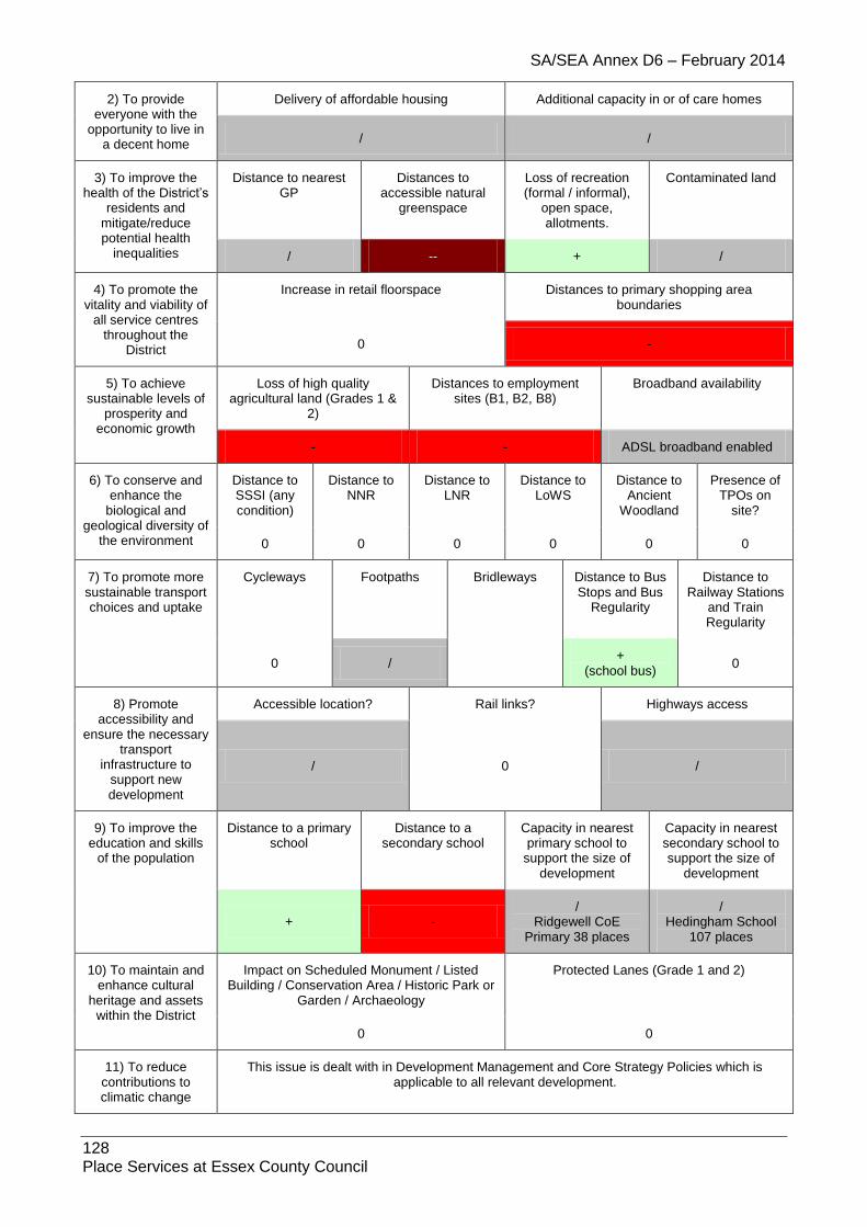
SA/SEA Annex D6 – February 2014
128 Place Services at Essex County Council
2) To provide everyone with the
opportunity to live in a decent home
Delivery of affordable housing Additional capacity in or of care homes
/ /
3) To improve the health of the District’s
residents and mitigate/reduce potential health
inequalities
Distance to nearest GP
Distances to accessible natural
greenspace
Loss of recreation (formal / informal),
open space, allotments.
Contaminated land
/ -- + /
4) To promote the vitality and viability of
all service centres throughout the
District
Increase in retail floorspace Distances to primary shopping area boundaries
0 -
5) To achieve sustainable levels of
prosperity and economic growth
Loss of high quality agricultural land (Grades 1 &
2)
Distances to employment sites (B1, B2, B8)
Broadband availability
- - ADSL broadband enabled
6) To conserve and enhance the
biological and geological diversity of
the environment
Distance to SSSI (any condition)
Distance to NNR
Distance to LNR
Distance to LoWS
Distance to Ancient
Woodland
Presence of TPOs on
site?
0 0 0 0 0 0
7) To promote more sustainable transport choices and uptake
Cycleways Footpaths Bridleways Distance to Bus Stops and Bus
Regularity
Distance to Railway Stations
and Train Regularity
0 / +
(school bus) 0
8) Promote accessibility and
ensure the necessary transport
infrastructure to support new development
Accessible location? Rail links? Highways access
/ 0 /
9) To improve the education and skills
of the population
Distance to a primary school
Distance to a secondary school
Capacity in nearest primary school to
support the size of development
Capacity in nearest secondary school to support the size of
development
+ - /
Ridgewell CoE Primary 38 places
/ Hedingham School
107 places
10) To maintain and enhance cultural
heritage and assets within the District
Impact on Scheduled Monument / Listed Building / Conservation Area / Historic Park or
Garden / Archaeology
Protected Lanes (Grade 1 and 2)
0 0
11) To reduce contributions to climatic change
This issue is dealt with in Development Management and Core Strategy Policies which is applicable to all relevant development.
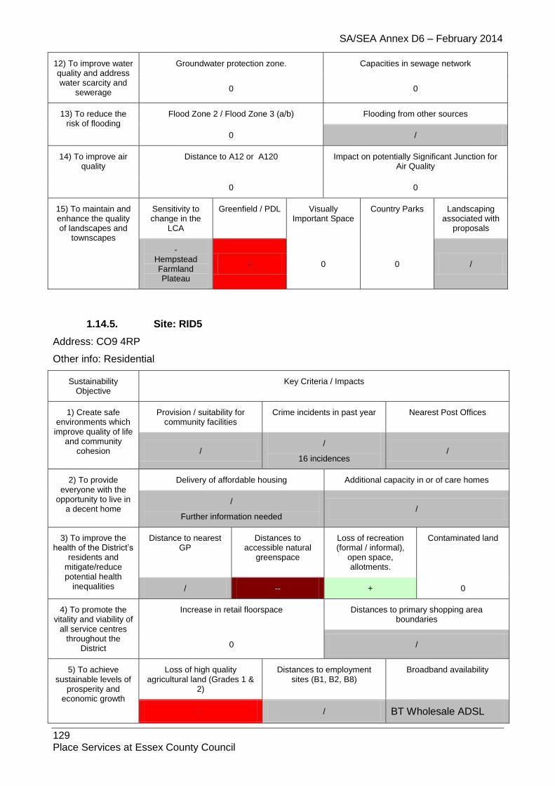
SA/SEA Annex D6 – February 2014
129 Place Services at Essex County Council
12) To improve water quality and address water scarcity and
sewerage
Groundwater protection zone. Capacities in sewage network
0 0
13) To reduce the risk of flooding
Flood Zone 2 / Flood Zone 3 (a/b) Flooding from other sources
0 /
14) To improve air quality
Distance to A12 or A120 Impact on potentially Significant Junction for Air Quality
0 0
15) To maintain and enhance the quality of landscapes and
townscapes
Sensitivity to change in the
LCA
Greenfield / PDL Visually Important Space
Country Parks Landscaping associated with
proposals
- Hempstead Farmland Plateau
- 0 0 /
1.14.5. Site: RID5
Address: CO9 4RP
Other info: Residential
Sustainability Objective
Key Criteria / Impacts
1) Create safe environments which improve quality of life
and community cohesion
Provision / suitability for community facilities
Crime incidents in past year Nearest Post Offices
/ /
16 incidences /
2) To provide everyone with the
opportunity to live in a decent home
Delivery of affordable housing Additional capacity in or of care homes
/
Further information needed /
3) To improve the health of the District’s
residents and mitigate/reduce potential health
inequalities
Distance to nearest GP
Distances to accessible natural
greenspace
Loss of recreation (formal / informal),
open space, allotments.
Contaminated land
/ -- + 0
4) To promote the vitality and viability of
all service centres throughout the
District
Increase in retail floorspace Distances to primary shopping area boundaries
0 /
5) To achieve sustainable levels of
prosperity and economic growth
Loss of high quality agricultural land (Grades 1 &
2)
Distances to employment sites (B1, B2, B8)
Broadband availability
- / BT Wholesale ADSL

SA/SEA Annex D6 – February 2014
130 Place Services at Essex County Council
BT Wholesale ADSL Max
6) To conserve and enhance the
biological and geological diversity of
the environment
Distance to SSSI (any condition)
Distance to NNR
Distance to LNR
Distance to LoWS
Distance to Ancient
Woodland
Presence of TPOs on
site?
0 0 0 0 0 0
7) To promote more sustainable transport choices and uptake
Cycleways Footpaths Distance to Bus Stops and Bus
Regularity
Distance to Railway Stations and Train
Regularity
/ / + 0
8) Promote accessibility and
ensure the necessary transport
infrastructure to support new development
Accessible location? Rail links? Highways access
/ - /
9) To improve the education and skills
of the population
Distance to a primary school
Distance to a secondary school
Capacity in nearest primary school to
support the size of development
Capacity in nearest secondary school to support the size of
development
++ - / /
10) To maintain and enhance cultural
heritage and assets within the District
Impact on Scheduled Monument / Listed Building / Conservation Area / Historic Park or
Garden / Archaeology
Protected Lanes (Grade 1 and 2)
0 0
11) To reduce contributions to climatic change
This issue is dealt with in Development Management and Core Strategy Policies which is applicable to all relevant development.
12) To improve water quality and address water scarcity and
sewerage
Groundwater protection zone. Capacities in sewage network
/ 0
13) To reduce the risk of flooding
Flood Zone 2 / Flood Zone 3 (a/b) Flooding from other sources
0 N/A
14) To improve air quality
Distance to A12 or A120 Impact on potentially Significant Junction for Air Quality
0 0
15) To maintain and enhance the quality of landscapes and
townscapes
Sensitivity to change in the
LCA
Greenfield / PDL Visually Important Space
Country Parks Landscaping associated with
proposals
- + 0 0 /
1.14.6. Site: RID6
Address: CO9 4SA
Other info: Residential
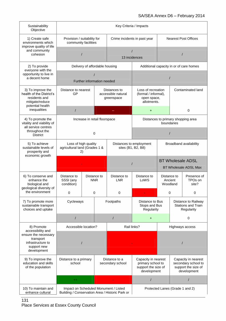
SA/SEA Annex D6 – February 2014
131 Place Services at Essex County Council
Sustainability Objective
Key Criteria / Impacts
1) Create safe environments which improve quality of life
and community cohesion
Provision / suitability for community facilities
Crime incidents in past year Nearest Post Offices
/ /
13 incidences /
2) To provide everyone with the
opportunity to live in a decent home
Delivery of affordable housing Additional capacity in or of care homes
/
Further information needed /
3) To improve the health of the District’s
residents and mitigate/reduce potential health
inequalities
Distance to nearest GP
Distances to accessible natural
greenspace
Loss of recreation (formal / informal),
open space, allotments.
Contaminated land
/ -- + 0
4) To promote the vitality and viability of
all service centres throughout the
District
Increase in retail floorspace Distances to primary shopping area boundaries
0 /
5) To achieve sustainable levels of
prosperity and economic growth
Loss of high quality agricultural land (Grades 1 &
2)
Distances to employment sites (B1, B2, B8)
Broadband availability
- / BT Wholesale ADSL
BT Wholesale ADSL Max
6) To conserve and enhance the
biological and geological diversity of
the environment
Distance to SSSI (any condition)
Distance to NNR
Distance to LNR
Distance to LoWS
Distance to Ancient
Woodland
Presence of TPOs on
site?
0 0 0 - 0 0
7) To promote more sustainable transport choices and uptake
Cycleways Footpaths Distance to Bus Stops and Bus
Regularity
Distance to Railway Stations and Train
Regularity
/ / + 0
8) Promote accessibility and
ensure the necessary transport
infrastructure to support new development
Accessible location? Rail links? Highways access
/ - /
9) To improve the education and skills
of the population
Distance to a primary school
Distance to a secondary school
Capacity in nearest primary school to
support the size of development
Capacity in nearest secondary school to support the size of
development
++ - / /
10) To maintain and enhance cultural
Impact on Scheduled Monument / Listed Building / Conservation Area / Historic Park or
Protected Lanes (Grade 1 and 2)

SA/SEA Annex D6 – February 2014
132 Place Services at Essex County Council
heritage and assets within the District
Garden / Archaeology
/ 0
11) To reduce contributions to climatic change
This issue is dealt with in Development Management and Core Strategy Policies which is applicable to all relevant development.
12) To improve water quality and address water scarcity and
sewerage
Groundwater protection zone. Capacities in sewage network
/ 0
13) To reduce the risk of flooding
Flood Zone 2 / Flood Zone 3 (a/b) Flooding from other sources
0 N/A
14) To improve air quality
Distance to A12 or A120 Impact on potentially Significant Junction for Air Quality
0 0
15) To maintain and enhance the quality of landscapes and
townscapes
Sensitivity to change in the
LCA
Greenfield / PDL Visually Important Space
Country Parks Landscaping associated with
proposals
- - 0 0 /
1.14.7. Site: RID7
Address: CO9 4RP
Other info: Residential
Sustainability Objective
Key Criteria / Impacts
1) Create safe environments which improve quality of life
and community cohesion
Provision / suitability for community facilities
Crime incidents in past year Nearest Post Offices
/ /
16 incidences /
2) To provide everyone with the
opportunity to live in a decent home
Delivery of affordable housing Additional capacity in or of care homes
/
Further information needed /
3) To improve the health of the District’s
residents and mitigate/reduce potential health
inequalities
Distance to nearest GP
Distances to accessible natural
greenspace
Loss of recreation (formal / informal),
open space, allotments.
Contaminated land
/ -- + 0
4) To promote the vitality and viability of
all service centres throughout the
District
Increase in retail floorspace Distances to primary shopping area boundaries
0 /
5) To achieve sustainable levels of
Loss of high quality agricultural land (Grades 1 &
Distances to employment Broadband availability

SA/SEA Annex D6 – February 2014
133 Place Services at Essex County Council
prosperity and economic growth
2) sites (B1, B2, B8)
- / BT Wholesale ADSL
BT Wholesale ADSL Max
6) To conserve and enhance the
biological and geological diversity of
the environment
Distance to SSSI (any condition)
Distance to NNR
Distance to LNR
Distance to LoWS
Distance to Ancient
Woodland
Presence of TPOs on
site?
0 0 0 / 0 0
7) To promote more sustainable transport choices and uptake
Cycleways Footpaths Distance to Bus Stops and Bus
Regularity
Distance to Railway Stations and Train
Regularity
/ / + 0
8) Promote accessibility and
ensure the necessary transport
infrastructure to support new development
Accessible location? Rail links? Highways access
/ - /
9) To improve the education and skills
of the population
Distance to a primary school
Distance to a secondary school
Capacity in nearest primary school to
support the size of development
Capacity in nearest secondary school to support the size of
development
++ - / /
10) To maintain and enhance cultural
heritage and assets within the District
Impact on Scheduled Monument / Listed Building / Conservation Area / Historic Park or
Garden / Archaeology
Protected Lanes (Grade 1 and 2)
0 0
11) To reduce contributions to climatic change
This issue is dealt with in Development Management and Core Strategy Policies which is applicable to all relevant development.
12) To improve water quality and address water scarcity and
sewerage
Groundwater protection zone. Capacities in sewage network
/ 0
13) To reduce the risk of flooding
Flood Zone 2 / Flood Zone 3 (a/b) Flooding from other sources
0 N/A
14) To improve air quality
Distance to A12 or A120 Impact on potentially Significant Junction for Air Quality
0 0
15) To maintain and enhance the quality of landscapes and
townscapes
Sensitivity to change in the
LCA
Greenfield / PDL Visually Important Space
Country Parks Landscaping associated with
proposals
- - 0 0 /
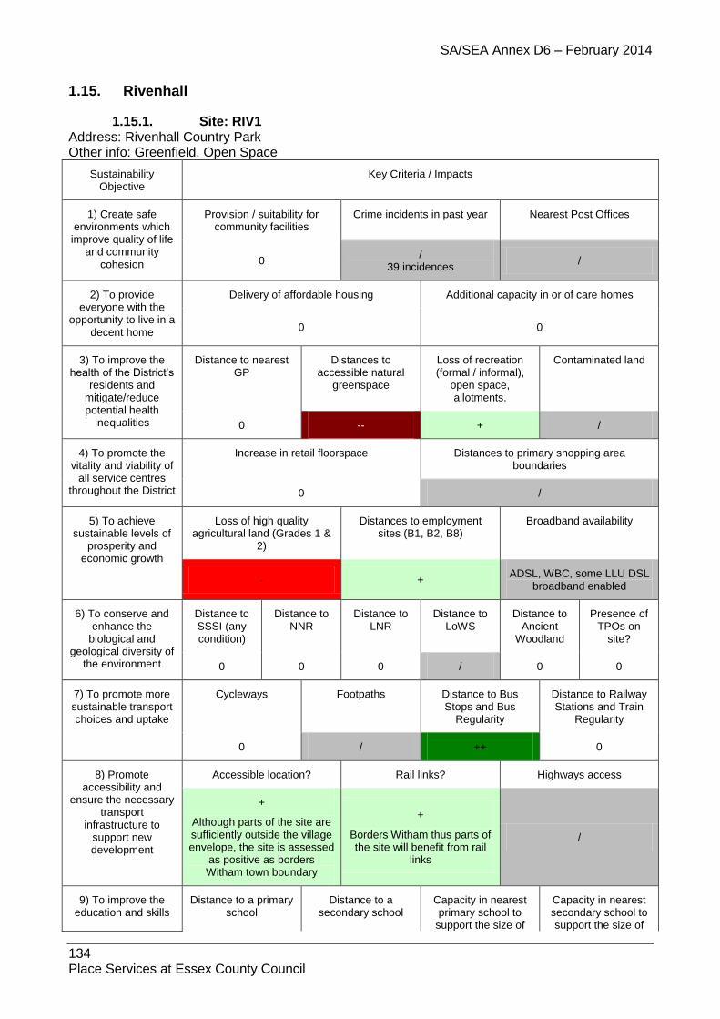
SA/SEA Annex D6 – February 2014
134 Place Services at Essex County Council
1.15. Rivenhall
1.15.1. Site: RIV1 Address: Rivenhall Country Park Other info: Greenfield, Open Space
Sustainability Objective
Key Criteria / Impacts
1) Create safe environments which improve quality of life
and community cohesion
Provision / suitability for community facilities
Crime incidents in past year Nearest Post Offices
0 /
39 incidences /
2) To provide everyone with the
opportunity to live in a decent home
Delivery of affordable housing Additional capacity in or of care homes
0 0
3) To improve the health of the District’s
residents and mitigate/reduce potential health
inequalities
Distance to nearest GP
Distances to accessible natural
greenspace
Loss of recreation (formal / informal),
open space, allotments.
Contaminated land
0 -- + /
4) To promote the vitality and viability of
all service centres throughout the District
Increase in retail floorspace Distances to primary shopping area boundaries
0 /
5) To achieve sustainable levels of
prosperity and economic growth
Loss of high quality agricultural land (Grades 1 &
2)
Distances to employment sites (B1, B2, B8)
Broadband availability
- + ADSL, WBC, some LLU DSL
broadband enabled
6) To conserve and enhance the
biological and geological diversity of
the environment
Distance to SSSI (any condition)
Distance to NNR
Distance to LNR
Distance to LoWS
Distance to Ancient
Woodland
Presence of TPOs on
site?
0 0 0 / 0 0
7) To promote more sustainable transport choices and uptake
Cycleways Footpaths Distance to Bus Stops and Bus
Regularity
Distance to Railway Stations and Train
Regularity
0 / ++ 0
8) Promote accessibility and
ensure the necessary transport
infrastructure to support new development
Accessible location? Rail links? Highways access
+
Although parts of the site are sufficiently outside the village envelope, the site is assessed
as positive as borders Witham town boundary
+
Borders Witham thus parts of the site will benefit from rail
links
/
9) To improve the education and skills
Distance to a primary school
Distance to a secondary school
Capacity in nearest primary school to
support the size of
Capacity in nearest secondary school to support the size of

SA/SEA Annex D6 – February 2014
135 Place Services at Essex County Council
of the population development development
- ++ 0 0
10) To maintain and enhance cultural
heritage and assets within the District
Impact on Scheduled Monument / Listed Building / Conservation Area / Historic Park or
Garden / Archaeology
Protected Lanes (Grade 1 and 2)
-- 0
11) To reduce contributions to climatic change
This issue is dealt with in Development Management and Core Strategy Policies which is applicable to all relevant development.
12) To improve water quality and address water scarcity and
sewerage
Groundwater protection zone. Capacities in sewage network
0 0
13) To reduce the risk of flooding
Flood Zone 2 / Flood Zone 3 (a/b) Flooding from other sources
/ /
14) To improve air quality
Distance to A12 or A120 Impact on potentially Significant Junction for Air Quality
- Junctions in Witham
15) To maintain and enhance the quality of
landscapes and townscapes
Sensitivity to change in the
LCA
Greenfield / PDL Visually Important Space
Country Parks Landscaping associated with
proposals
/ Blackwater River
Valley + 0 0 /
1.15.2. Site: RIV2H
Address: Land North East of Witham
Other info: Greenfield, Urban Extension, SHLAA – Housing, 300 dwellings
Sustainability Objective
Key Criteria / Impacts
1) Create safe environments which improve quality of life and community
cohesion
Provision / suitability for community facilities
Crime incidents in past year Nearest Post Offices
0 /
491 incidences /
2) To provide everyone with the
opportunity to live in a decent home
Delivery of affordable housing Additional capacity in or of care homes
++ 0
3) To improve the health of the
District’s residents and mitigate/reduce
potential health inequalities
Distance to nearest GP
Distances to accessible natural
greenspace
Loss of recreation (formal / informal),
open space, allotments.
Contaminated land
/ -- + /
Bte868 – small unknown infill

SA/SEA Annex D6 – February 2014
136 Place Services at Essex County Council
4) To promote the vitality and viability
of all service centres throughout the
District
Increase in retail floorspace Distances to primary shopping area boundaries
0 /
5) To achieve sustainable levels of
prosperity and economic growth
Loss of high quality agricultural land (Grades 1 &
2)
Distances to employment sites (B1, B2, B8)
Broadband availability
- + ADSL, WBC, some LLU DSL
broadband enabled
6) To conserve and enhance the
biological and geological diversity of the environment
Distance to SSSI (any condition)
Distance to NNR
Distance to LNR
Distance to LoWS
Distance to Ancient
Woodland
Presence of TPOs on
site?
0 0 0 - 0 0
7) To promote more sustainable transport choices and uptake
Cycleways Footpaths Distance to Bus Stops and Bus Regularity
Distance to Railway Stations and Train
Regularity
0 /
FP58 & FP60 cross the site
++ 0
8) Promote accessibility and
ensure the necessary transport
infrastructure to support new development
Accessible location? Rail links? Highways access
+
Although parts of the site are sufficiently outside the village envelope, the site is assessed as positive as borders Witham
town boundary
+
Borders Witham thus parts of the site will benefit from rail
links
/ Access from Forest Road. (Access from Rectory Lane must be avoided.) Traffic issues set out in Mouchel Transport Assessment Stage 1 and 2
9) To improve the education and skills
of the population
Distance to a primary school
Distance to a secondary school
Capacity in nearest primary school to
support the size of development
Capacity in nearest secondary school to support the size of
development
+ ++ -
Templars Primary 28 places
+ New Rickstones
Academy 403 places
10) To maintain and enhance cultural
heritage and assets within the District
Impact on Scheduled Monument / Listed Building / Conservation Area / Historic Park or
Garden / Archaeology
Protected Lanes (Grade 1 and 2)
/ 0
11) To reduce contributions to climatic change
This issue is dealt with in Development Management and Core Strategy Policies which is applicable to all relevant development.
12) To improve water quality and
address water scarcity and sewerage
Groundwater protection zone. Capacities in sewage network
0 / - WCS (yellow)
13) To reduce the Flood Zone 2 / Flood Zone 3 (a/b) Flooding from other sources
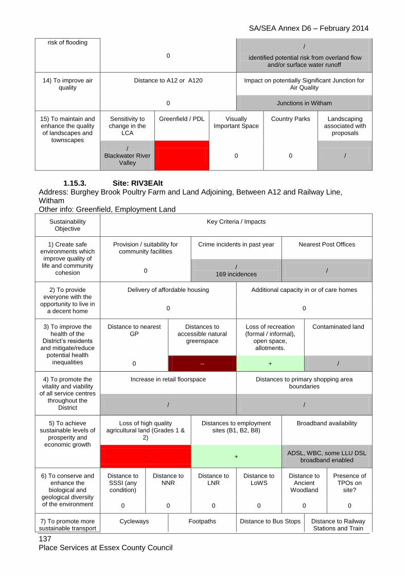
SA/SEA Annex D6 – February 2014
137 Place Services at Essex County Council
risk of flooding
0
/
identified potential risk from overland flow and/or surface water runoff
14) To improve air quality
Distance to A12 or A120 Impact on potentially Significant Junction for Air Quality
0 Junctions in Witham
15) To maintain and enhance the quality of landscapes and
townscapes
Sensitivity to change in the
LCA
Greenfield / PDL Visually Important Space
Country Parks Landscaping associated with
proposals
/ Blackwater River
Valley - 0 0 /
1.15.3. Site: RIV3EAlt Address: Burghey Brook Poultry Farm and Land Adjoining, Between A12 and Railway Line, Witham Other info: Greenfield, Employment Land
Sustainability Objective
Key Criteria / Impacts
1) Create safe environments which improve quality of life and community
cohesion
Provision / suitability for community facilities
Crime incidents in past year Nearest Post Offices
0 /
169 incidences /
2) To provide everyone with the
opportunity to live in a decent home
Delivery of affordable housing Additional capacity in or of care homes
0 0
3) To improve the health of the
District’s residents and mitigate/reduce
potential health inequalities
Distance to nearest GP
Distances to accessible natural
greenspace
Loss of recreation (formal / informal),
open space, allotments.
Contaminated land
0 -- + /
4) To promote the vitality and viability
of all service centres throughout the
District
Increase in retail floorspace Distances to primary shopping area boundaries
/ /
5) To achieve sustainable levels of
prosperity and economic growth
Loss of high quality agricultural land (Grades 1 &
2)
Distances to employment sites (B1, B2, B8)
Broadband availability
- + ADSL, WBC, some LLU DSL
broadband enabled
6) To conserve and enhance the
biological and geological diversity of the environment
Distance to SSSI (any condition)
Distance to NNR
Distance to LNR
Distance to LoWS
Distance to Ancient
Woodland
Presence of TPOs on
site?
0 0 0 0 0 0
7) To promote more sustainable transport
Cycleways Footpaths Distance to Bus Stops Distance to Railway Stations and Train

SA/SEA Annex D6 – February 2014
138 Place Services at Essex County Council
choices and uptake and Bus Regularity Regularity
0 / ++ 0
8) Promote accessibility and
ensure the necessary transport
infrastructure to support new development
Accessible location? Rail links? Highways access
+
Although parts of the site are sufficiently outside the village envelope, the site is assessed as positive as borders Witham
town boundary
+
Borders Witham thus parts of the site will benefit from rail
links
/
9) To improve the education and skills
of the population
Distance to a primary school
Distance to a secondary school
Capacity in nearest primary school to
support the size of development
Capacity in nearest secondary school to support the size of
development
- ++ 0 0
10) To maintain and enhance cultural
heritage and assets within the District
Impact on Scheduled Monument / Listed Building / Conservation Area / Historic Park or
Garden / Archaeology
Protected Lanes (Grade 1 and 2)
0 0
11) To reduce contributions to climatic change
This issue is dealt with in Development Management and Core Strategy Policies which is applicable to all relevant development.
12) To improve water quality and
address water scarcity and sewerage
Groundwater protection zone. Capacities in sewage network
0 /
13) To reduce the risk of flooding
Flood Zone 2 / Flood Zone 3 (a/b) Flooding from other sources
0 /
14) To improve air quality
Distance to A12 or A120 Impact on potentially Significant Junction for Air Quality
- Junctions in Witham
15) To maintain and enhance the quality of landscapes and
townscapes
Sensitivity to change in the
LCA
Greenfield / PDL Visually Important Space
Country Parks Landscaping associated with
proposals
/ Blackwater River
Valley - 0 0 /
1.15.4. Site: RIV4 Address: Rickstones Farm, Rivenhall Other info: Greenfield, Residential
Sustainability Objective
Key Criteria / Impacts
1) Create safe environments which
Provision / suitability for community facilities
Crime incidents in past year Nearest Post Offices

SA/SEA Annex D6 – February 2014
139 Place Services at Essex County Council
improve quality of life and community
cohesion 0
/ 236 incidences
/
2) To provide everyone with the
opportunity to live in a decent home
Delivery of affordable housing Additional capacity in or of care homes
/ /
3) To improve the health of the
District’s residents and mitigate/reduce
potential health inequalities
Distance to nearest GP
Distances to accessible natural
greenspace
Loss of recreation (formal / informal),
open space, allotments.
Contaminated land
/ -- + /
4) To promote the vitality and viability
of all service centres throughout the
District
Increase in retail floorspace Distances to primary shopping area boundaries
0 /
5) To achieve sustainable levels of
prosperity and economic growth
Loss of high quality agricultural land (Grades 1 &
2)
Distances to employment sites (B1, B2, B8)
Broadband availability
- / ADSL, WBC, some LLU DSL
broadband enabled
6) To conserve and enhance the
biological and geological diversity of the environment
Distance to SSSI (any condition)
Distance to NNR
Distance to LNR
Distance to LoWS
Distance to Ancient
Woodland
Presence of TPOs on
site?
0 0 0 / 0 0
7) To promote more sustainable transport choices and uptake
Cycleways Footpaths Distance to Bus Stops and Bus Regularity
Distance to Railway Stations and Train
Regularity
0 / ++ 0
8) Promote accessibility and
ensure the necessary transport
infrastructure to support new development
Accessible location? Rail links? Highways access
+
Although parts of the site are sufficiently outside the village envelope, the site is assessed
as positive as is near to Witham town boundary
+
Site is near to Witham thus parts of the site will benefit
from rail links
/
9) To improve the education and skills
of the population
Distance to a primary school
Distance to a secondary school
Capacity in nearest primary school to
support the size of development
Capacity in nearest secondary school to support the size of
development
+ ++ -
Elm Hall Primary -1 places
/ New Rickstones
Academy 403 places
10) To maintain and enhance cultural
heritage and assets within the District
Impact on Scheduled Monument / Listed Building / Conservation Area / Historic Park or
Garden / Archaeology
Protected Lanes (Grade 1 and 2)
0 0

SA/SEA Annex D6 – February 2014
140 Place Services at Essex County Council
11) To reduce contributions to climatic change
This issue is dealt with in Development Management and Core Strategy Policies which is applicable to all relevant development.
12) To improve water quality and
address water scarcity and sewerage
Groundwater protection zone. Capacities in sewage network
0 /
13) To reduce the risk of flooding
Flood Zone 2 / Flood Zone 3 (a/b) Flooding from other sources
0
/
identified potential risk from overland flow and/or surface water runoff
14) To improve air quality
Distance to A12 or A120 Impact on potentially Significant Junction for Air Quality
0 Junctions in Witham
15) To maintain and enhance the quality of landscapes and
townscapes
Sensitivity to change in the
LCA
Greenfield / PDL Visually Important Space
Country Parks Landscaping associated with
proposals
- Silver End Farmland Plateau
- 0 0 /
1.15.5. Site: RIV5EAlt Address: Parkgate Farm, Rivenhall Other info: Greenfield, Employment; Live/Work or Residential
Sustainability Objective
Key Criteria / Impacts
1) Create safe environments which improve quality of life
and community cohesion
Provision / suitability for community facilities
Crime incidents in past year Nearest Post Offices
0 /
55 incidences /
2) To provide everyone with the
opportunity to live in a decent home
Delivery of affordable housing Additional capacity in or of care homes
/ /
3) To improve the health of the
District’s residents and mitigate/reduce
potential health inequalities
Distance to nearest GP
Distances to accessible natural
greenspace
Loss of recreation (formal / informal),
open space, allotments.
Contaminated land
/ -- + /
4) To promote the vitality and viability of
all service centres throughout the
District
Increase in retail floorspace Distances to primary shopping area boundaries
/ /
5) To achieve sustainable levels of
Loss of high quality agricultural land (Grades 1 &
Distances to employment Broadband availability

SA/SEA Annex D6 – February 2014
141 Place Services at Essex County Council
prosperity and economic growth
2) sites (B1, B2, B8)
- / ADSL, WBC, LLU DSL
broadband enabled
6) To conserve and enhance the
biological and geological diversity of the environment
Distance to SSSI (any condition)
Distance to NNR
Distance to LNR
Distance to LoWS
Distance to Ancient
Woodland
Presence of TPOs on
site?
0 0 0 0 0 0
7) To promote more sustainable transport choices and uptake
Cycleways Footpaths Distance to Bus Stops and Bus
Regularity
Distance to Railway Stations and Train
Regularity
0 / ++
(from Silver End) 0
8) Promote accessibility and
ensure the necessary transport
infrastructure to support new development
Accessible location? Rail links? Highways access
- 0 /
9) To improve the education and skills
of the population
Distance to a primary school
Distance to a secondary school
Capacity in nearest primary school to
support the size of development
Capacity in nearest secondary school to support the size of
development
- + -
Silver End Primary -1 places
/ New Rickstones
Academy 403 places
10) To maintain and enhance cultural
heritage and assets within the District
Impact on Scheduled Monument / Listed Building / Conservation Area / Historic Park or
Garden / Archaeology
Protected Lanes (Grade 1 and 2)
/ 0
11) To reduce contributions to climatic change
This issue is dealt with in Development Management and Core Strategy Policies which is applicable to all relevant development.
12) To improve water quality and
address water scarcity and sewerage
Groundwater protection zone. Capacities in sewage network
0 0
13) To reduce the risk of flooding
Flood Zone 2 / Flood Zone 3 (a/b) Flooding from other sources
0 /
14) To improve air quality
Distance to A12 or A120 Impact on potentially Significant Junction for Air Quality
0 Junctions in Witham
15) To maintain and enhance the quality of landscapes and
townscapes
Sensitivity to change in the
LCA
Greenfield / PDL Visually Important Space
Country Parks Landscaping associated with
proposals
- Silver End
- 0 0 /
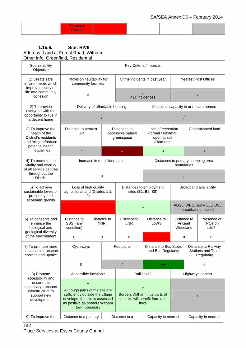
SA/SEA Annex D6 – February 2014
142 Place Services at Essex County Council
Farmland Plateau
1.15.6. Site: RIV6 Address: Land at Forest Road, Witham Other info: Greenfield, Residential
Sustainability Objective
Key Criteria / Impacts
1) Create safe environments which improve quality of life and community
cohesion
Provision / suitability for community facilities
Crime incidents in past year Nearest Post Offices
0 /
491 incidences /
2) To provide everyone with the
opportunity to live in a decent home
Delivery of affordable housing Additional capacity in or of care homes
/ /
3) To improve the health of the
District’s residents and mitigate/reduce
potential health inequalities
Distance to nearest GP
Distances to accessible natural
greenspace
Loss of recreation (formal / informal),
open space, allotments.
Contaminated land
/ -- + /
4) To promote the vitality and viability
of all service centres throughout the
District
Increase in retail floorspace Distances to primary shopping area boundaries
0 /
5) To achieve sustainable levels of
prosperity and economic growth
Loss of high quality agricultural land (Grades 1 &
2)
Distances to employment sites (B1, B2, B8)
Broadband availability
- + ADSL, WBC, some LLU DSL
broadband enabled
6) To conserve and enhance the
biological and geological diversity of the environment
Distance to SSSI (any condition)
Distance to NNR
Distance to LNR
Distance to LoWS
Distance to Ancient
Woodland
Presence of TPOs on
site?
0 0 0 - 0 0
7) To promote more sustainable transport choices and uptake
Cycleways Footpaths Distance to Bus Stops and Bus Regularity
Distance to Railway Stations and Train
Regularity
0 / ++ 0
8) Promote accessibility and
ensure the necessary transport
infrastructure to support new development
Accessible location? Rail links? Highways access
+
Although parts of the site are sufficiently outside the village envelope, the site is assessed as positive as borders Witham
town boundary
+
Borders Witham thus parts of the site will benefit from rail
links
/
9) To improve the Distance to a primary Distance to a Capacity in nearest Capacity in nearest
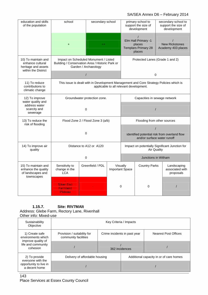
SA/SEA Annex D6 – February 2014
143 Place Services at Essex County Council
education and skills of the population
school secondary school primary school to support the size of
development
secondary school to support the size of
development
+ ++
/ Elm Hall Primary -1
places Templars Primary 28
places
/ New Rickstones
Academy 403 places
10) To maintain and enhance cultural
heritage and assets within the District
Impact on Scheduled Monument / Listed Building / Conservation Area / Historic Park or
Garden / Archaeology
Protected Lanes (Grade 1 and 2)
/ 0
11) To reduce contributions to climatic change
This issue is dealt with in Development Management and Core Strategy Policies which is applicable to all relevant development.
12) To improve water quality and
address water scarcity and sewerage
Groundwater protection zone. Capacities in sewage network
0 /
13) To reduce the risk of flooding
Flood Zone 2 / Flood Zone 3 (a/b) Flooding from other sources
0
/
identified potential risk from overland flow and/or surface water runoff
14) To improve air quality
Distance to A12 or A120 Impact on potentially Significant Junction for Air Quality
0 Junctions in Witham
15) To maintain and enhance the quality of landscapes and
townscapes
Sensitivity to change in the
LCA
Greenfield / PDL Visually Important Space
Country Parks Landscaping associated with
proposals
- Silver End Farmland Plateau
- 0 0 /
1.15.7. Site: RIV7MAlt Address: Glebe Farm, Rectory Lane, Rivenhall Other info: Mixed-use
Sustainability Objective
Key Criteria / Impacts
1) Create safe environments which improve quality of life and community
cohesion
Provision / suitability for community facilities
Crime incidents in past year Nearest Post Offices
/ /
362 incidences /
2) To provide everyone with the
opportunity to live in a decent home
Delivery of affordable housing Additional capacity in or of care homes
/ /

SA/SEA Annex D6 – February 2014
144 Place Services at Essex County Council
3) To improve the health of the
District’s residents and mitigate/reduce
potential health inequalities
Distance to nearest GP
Distances to accessible natural
greenspace
Loss of recreation (formal / informal),
open space, allotments.
Contaminated land
/ -- + /
4) To promote the vitality and viability
of all service centres throughout the
District
Increase in retail floorspace Distances to primary shopping area boundaries
/ /
5) To achieve sustainable levels of
prosperity and economic growth
Loss of high quality agricultural land (Grades 1 &
2)
Distances to employment sites (B1, B2, B8)
Broadband availability
- / ADSL, WBC, some LLU DSL
broadband enabled
6) To conserve and enhance the
biological and geological diversity of the environment
Distance to SSSI (any condition)
Distance to NNR
Distance to LNR
Distance to LoWS
Distance to Ancient
Woodland
Presence of TPOs on
site?
0 0 0 - 0 0
7) To promote more sustainable transport choices and uptake
Cycleways Footpaths Distance to Bus Stops and Bus Regularity
Distance to Railway Stations and Train
Regularity
0 / ++ 0
8) Promote accessibility and
ensure the necessary transport
infrastructure to support new development
Accessible location? Rail links? Highways access
+
Although parts of the site are sufficiently outside the village envelope, the site is assessed
as positive as is near to Witham town boundary
+
Site is near to Witham thus parts of the site will benefit
from rail links
/
9) To improve the education and skills
of the population
Distance to a primary school
Distance to a secondary school
Capacity in nearest primary school to
support the size of development
Capacity in nearest secondary school to support the size of
development
+ ++ -
Elm Hall Primary -1 places
/ New Rickstones
Academy 403 places
10) To maintain and enhance cultural
heritage and assets within the District
Impact on Scheduled Monument / Listed Building / Conservation Area / Historic Park or
Garden / Archaeology
Protected Lanes (Grade 1 and 2)
0 0
11) To reduce contributions to climatic change
This issue is dealt with in Development Management and Core Strategy Policies which is applicable to all relevant development.
12) To improve water quality and
address water scarcity and
Groundwater protection zone. Capacities in sewage network
0 /

SA/SEA Annex D6 – February 2014
145 Place Services at Essex County Council
sewerage
13) To reduce the risk of flooding
Flood Zone 2 / Flood Zone 3 (a/b) Flooding from other sources
0 / - identified potential risk from overland flow
and/or surface water runoff
14) To improve air quality
Distance to A12 or A120 Impact on potentially Significant Junction for Air Quality
0 Junctions in Witham
15) To maintain and enhance the quality of landscapes and
townscapes
Sensitivity to change in the
LCA
Greenfield / PDL Visually Important Space
Country Parks Landscaping associated with
proposals
- Silver End Farmland Plateau
/ 0 0 /
1.15.8. Site: RIV8
Address: CM8 3HJ
Other info: Residential
Sustainability Objective
Key Criteria / Impacts
1) Create safe environments which improve quality of life
and community cohesion
Provision / suitability for community facilities
Crime incidents in past year
Nearest Post Offices
/ /
409 incidences +
2) To provide everyone with the
opportunity to live in a decent home
Delivery of affordable housing Additional capacity in or of care homes
/
Further information needed /
3) To improve the health of the District’s
residents and mitigate/reduce potential health
inequalities
Distance to nearest GP
Distances to accessible natural
greenspace
Loss of recreation (formal / informal),
open space, allotments.
Contaminated land
/ -- + 0
4) To promote the vitality and viability of
all service centres throughout the
District
Increase in retail floorspace Distances to primary shopping area boundaries
0 /
5) To achieve sustainable levels of
prosperity and economic growth
Loss of high quality agricultural land (Grades 1 & 2)
Distances to employment sites (B1, B2, B8)
Broadband availability
/ +
BT Wholesale ADSL, BT Wholesale ADSL Max, BT Wholesale WBC
(21CN), BT FTTC, AOL LLU, Bulldog LLU, TalkTalk (CPW) LLU, Sky

SA/SEA Annex D6 – February 2014
146 Place Services at Essex County Council
Broadband / Easynet LLU, Tiscali LLU
6) To conserve and enhance the
biological and geological diversity of
the environment
Distance to SSSI
(any condition)
Distance to NNR
Distance to LNR
Distance to LoWS
Distance to Ancient
Woodland
Presence of TPOs on site?
0 0 0 -- 0 0
7) To promote more sustainable transport choices and uptake
Cycleways Footpaths Distance to Bus Stops and Bus
Regularity
Distance to Railway Stations and Train Regularity
/ / ++ -
8) Promote accessibility and
ensure the necessary transport
infrastructure to support new development
Accessible location? Rail links? Highways access
+ ++ /
9) To improve the education and skills
of the population
Distance to a primary school
Distance to a secondary school
Capacity in nearest primary school to
support the size of development
Capacity in nearest secondary school to support the size of
development
+ ++ / /
10) To maintain and enhance cultural
heritage and assets within the District
Impact on Scheduled Monument / Listed Building / Conservation Area /
Historic Park or Garden / Archaeology
Protected Lanes (Grade 1 and 2)
0 -
11) To reduce contributions to climatic change
This issue is dealt with in Development Management and Core Strategy Policies which is applicable to all relevant development.
12) To improve water quality and address water scarcity and
sewerage
Groundwater protection zone. Capacities in sewage network
0 /
13) To reduce the risk of flooding
Flood Zone 2 / Flood Zone 3 (a/b) Flooding from other sources
0 N/A
14) To improve air quality
Distance to A12 or A120 Impact on potentially Significant Junction for Air Quality
0 0
15) To maintain and enhance the quality of landscapes and
townscapes
Sensitivity to change in the LCA
Greenfield / PDL
Visually Important
Space
Country Parks Landscaping associated with proposals
- / 0 0 /

SA/SEA Annex D6 – February 2014
147 Place Services at Essex County Council
1.16. Shalford
1.16.1. Site: SHA1 Address: Land between Old Fox Cottage and Little Gables, Church End, Shalford Other info: Greenfield, Residential
Sustainability Objective
Key Criteria / Impacts
1) Create safe environments which
improve quality of life and community
cohesion
Provision / suitability for community facilities
Crime incidents in past year Nearest Post Offices
0 /
9 incidences /
2) To provide everyone with the
opportunity to live in a decent home
Delivery of affordable housing Additional capacity in or of care homes
/ /
3) To improve the health of the District’s
residents and mitigate/reduce potential health
inequalities
Distance to nearest GP
Distances to accessible natural
greenspace
Loss of recreation (formal / informal),
open space, allotments.
Contaminated land
/ - + /
4) To promote the vitality and viability of
all service centres throughout the
District
Increase in retail floorspace Distances to primary shopping area boundaries
0 /
5) To achieve sustainable levels of
prosperity and economic growth
Loss of high quality agricultural land (Grades 1 &
2)
Distances to employment sites (B1, B2, B8)
Broadband availability
- / ADSL broadband enabled
6) To conserve and enhance the
biological and geological diversity of
the environment
Distance to SSSI (any condition)
Distance to NNR
Distance to LNR
Distance to LoWS
Distance to Ancient
Woodland
Presence of TPOs on site?
0 0 0 / / 0
7) To promote more sustainable transport choices and uptake
Cycleways Footpaths Distance to Bus Stops and Bus
Regularity
Distance to Railway Stations and Train
Regularity
0 / ++ 0
8) Promote accessibility and
ensure the necessary transport
infrastructure to support new development
Accessible location? Rail links? Highways access
/ 0 /
9) To improve the education and skills
of the population
Distance to a primary school
Distance to a secondary school
Capacity in nearest primary school to
support the size of development
Capacity in nearest secondary school to support the size of
development

SA/SEA Annex D6 – February 2014
148 Place Services at Essex County Council
++ - /
Shalford Primary 16 places
/ Tabor Science College
2 places
10) To maintain and enhance cultural
heritage and assets within the District
Impact on Scheduled Monument / Listed Building / Conservation Area / Historic Park
or Garden / Archaeology
Protected Lanes (Grade 1 and 2)
0 0
11) To reduce contributions to climatic change
This issue is dealt with in Development Management and Core Strategy Policies which is applicable to all relevant development.
12) To improve water quality and address water scarcity and
sewerage
Groundwater protection zone. Capacities in sewage network
0 0
13) To reduce the risk of flooding
Flood Zone 2 / Flood Zone 3 (a/b) Flooding from other sources
0 /
14) To improve air quality
Distance to A12 or A120 Impact on potentially Significant Junction for Air Quality
0 0
15) To maintain and enhance the quality of landscapes and
townscapes
Sensitivity to change in the
LCA
Greenfield / PDL
Visually Important
Space
Country Parks Landscaping associated with
proposals
- Pant River
Valley - 0 0 /
1.16.2. Site: SHA2 Address: Land at The Penthouse, Shalford Other info: Greenfield, Amendment to Village Envelope/Residential
Sustainability Objective
Key Criteria / Impacts
1) Create safe environments which improve quality of life
and community cohesion
Provision / suitability for community facilities
Crime incidents in past year Nearest Post Offices
0 /
11 incidences /
2) To provide everyone with the
opportunity to live in a decent home
Delivery of affordable housing Additional capacity in or of care homes
/ /
3) To improve the health of the District’s
residents and mitigate/reduce potential health
inequalities
Distance to nearest GP
Distances to accessible natural
greenspace
Loss of recreation (formal / informal),
open space, allotments.
Contaminated land
/ -- + /
4) To promote the Increase in retail floorspace Distances to primary shopping area

SA/SEA Annex D6 – February 2014
149 Place Services at Essex County Council
vitality and viability of all service centres
throughout the District
boundaries
0 /
5) To achieve sustainable levels of
prosperity and economic growth
Loss of high quality agricultural land (Grades 1 &
2)
Distances to employment sites (B1, B2, B8)
Broadband availability
0 / ADSL broadband enabled
6) To conserve and enhance the
biological and geological diversity of
the environment
Distance to SSSI (any condition)
Distance to NNR
Distance to LNR
Distance to LoWS
Distance to Ancient
Woodland
Presence of TPOs on
site?
0 0 0 / / 0
7) To promote more sustainable transport choices and uptake
Cycleways Footpaths Distance to Bus Stops and Bus
Regularity
Distance to Railway Stations and Train
Regularity
0 / ++ 0
8) Promote accessibility and
ensure the necessary transport
infrastructure to support new development
Accessible location? Rail links? Highways access
/ 0 /
9) To improve the education and skills
of the population
Distance to a primary school
Distance to a secondary school
Capacity in nearest primary school to
support the size of development
Capacity in nearest secondary school to support the size of
development
- - /
Shalford Primary 16 places
/ Tabor Science
College 2 places
10) To maintain and enhance cultural
heritage and assets within the District
Impact on Scheduled Monument / Listed Building / Conservation Area / Historic Park or
Garden / Archaeology
Protected Lanes (Grade 1 and 2)
0 0
11) To reduce contributions to climatic change
This issue is dealt with in Development Management and Core Strategy Policies which is applicable to all relevant development.
12) To improve water quality and address water scarcity and
sewerage
Groundwater protection zone. Capacities in sewage network
0 0
13) To reduce the risk of flooding
Flood Zone 2 / Flood Zone 3 (a/b) Flooding from other sources
0 /
14) To improve air quality
Distance to A12 or A120 Impact on potentially Significant Junction for Air Quality
0 0
15) To maintain and enhance the quality of
Sensitivity to change in the
Greenfield / PDL Visually Important Space
Country Parks Landscaping associated with

SA/SEA Annex D6 – February 2014
150 Place Services at Essex County Council
landscapes and townscapes
LCA proposals
- Pant River
Valley - - 0 /
1.16.3. Site: SHA3A Address: Levelly, Church End Other info: Greenfield, Residential
Sustainability Objective
Key Criteria / Impacts
1) Create safe environments which
improve quality of life and community
cohesion
Provision / suitability for community facilities
Crime incidents in past year Nearest Post Offices
0 /
10 incidences /
2) To provide everyone with the
opportunity to live in a decent home
Delivery of affordable housing Additional capacity in or of care homes
/ /
3) To improve the health of the District’s
residents and mitigate/reduce potential health
inequalities
Distance to nearest GP
Distances to accessible natural
greenspace
Loss of recreation (formal / informal),
open space, allotments.
Contaminated land
/ - + /
4) To promote the vitality and viability of
all service centres throughout the
District
Increase in retail floorspace Distances to primary shopping area boundaries
0 /
5) To achieve sustainable levels of
prosperity and economic growth
Loss of high quality agricultural land (Grades 1 &
2)
Distances to employment sites (B1, B2, B8)
Broadband availability
0 / ADSL broadband enabled
6) To conserve and enhance the
biological and geological diversity of
the environment
Distance to SSSI (any condition)
Distance to NNR
Distance to LNR
Distance to LoWS
Distance to Ancient
Woodland
Presence of TPOs on site?
0 0 0 / - 0
7) To promote more sustainable transport choices and uptake
Cycleways Footpaths Distance to Bus Stops and Bus
Regularity
Distance to Railway Stations and Train
Regularity
0 / ++ 0
8) Promote accessibility and
ensure the necessary transport
infrastructure to support new development
Accessible location? Rail links? Highways access
/ 0 /
9) To improve the Distance to a primary Distance to a Capacity in nearest Capacity in nearest
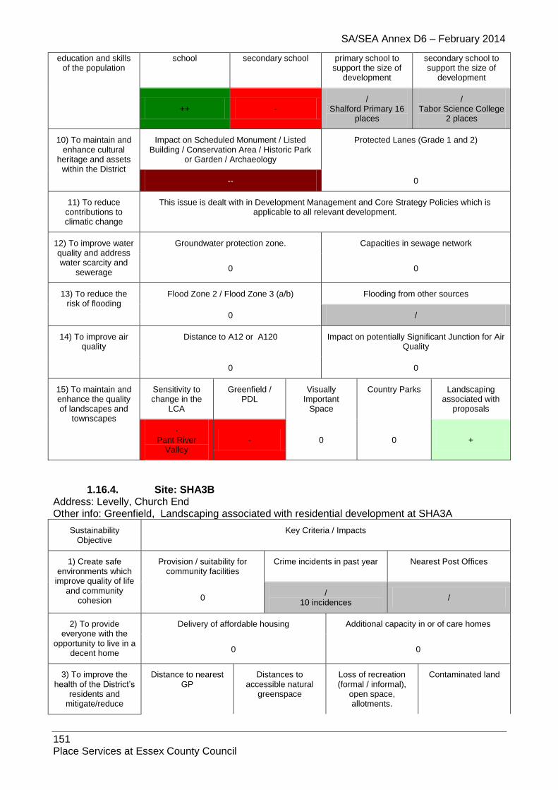
SA/SEA Annex D6 – February 2014
151 Place Services at Essex County Council
education and skills of the population
school secondary school primary school to support the size of
development
secondary school to support the size of
development
++ - /
Shalford Primary 16 places
/ Tabor Science College
2 places
10) To maintain and enhance cultural
heritage and assets within the District
Impact on Scheduled Monument / Listed Building / Conservation Area / Historic Park
or Garden / Archaeology
Protected Lanes (Grade 1 and 2)
-- 0
11) To reduce contributions to climatic change
This issue is dealt with in Development Management and Core Strategy Policies which is applicable to all relevant development.
12) To improve water quality and address water scarcity and
sewerage
Groundwater protection zone. Capacities in sewage network
0 0
13) To reduce the risk of flooding
Flood Zone 2 / Flood Zone 3 (a/b) Flooding from other sources
0 /
14) To improve air quality
Distance to A12 or A120 Impact on potentially Significant Junction for Air Quality
0 0
15) To maintain and enhance the quality of landscapes and
townscapes
Sensitivity to change in the
LCA
Greenfield / PDL
Visually Important
Space
Country Parks Landscaping associated with
proposals
- Pant River
Valley - 0 0 +
1.16.4. Site: SHA3B Address: Levelly, Church End Other info: Greenfield, Landscaping associated with residential development at SHA3A
Sustainability Objective
Key Criteria / Impacts
1) Create safe environments which
improve quality of life and community
cohesion
Provision / suitability for community facilities
Crime incidents in past year Nearest Post Offices
0 /
10 incidences /
2) To provide everyone with the
opportunity to live in a decent home
Delivery of affordable housing Additional capacity in or of care homes
0 0
3) To improve the health of the District’s
residents and mitigate/reduce
Distance to nearest GP
Distances to accessible natural
greenspace
Loss of recreation (formal / informal),
open space, allotments.
Contaminated land

SA/SEA Annex D6 – February 2014
152 Place Services at Essex County Council
potential health inequalities 0 - + /
4) To promote the vitality and viability of
all service centres throughout the District
Increase in retail floorspace Distances to primary shopping area boundaries
0 /
5) To achieve sustainable levels of
prosperity and economic growth
Loss of high quality agricultural land (Grades 1 &
2)
Distances to employment sites (B1, B2, B8)
Broadband availability
/ / ADSL broadband enabled
6) To conserve and enhance the
biological and geological diversity of
the environment
Distance to SSSI (any condition)
Distance to NNR
Distance to LNR
Distance to LoWS
Distance to Ancient
Woodland
Presence of TPOs on
site?
0 0 0 - - 0
7) To promote more sustainable transport choices and uptake
Cycleways Footpaths Distance to Bus Stops and Bus
Regularity
Distance to Railway Stations and Train
Regularity
0 / ++ 0
8) Promote accessibility and
ensure the necessary transport
infrastructure to support new development
Accessible location? Rail links? Highways access
/ 0 /
9) To improve the education and skills
of the population
Distance to a primary school
Distance to a secondary school
Capacity in nearest primary school to
support the size of development
Capacity in nearest secondary school to support the size of
development
++ - 0 0
10) To maintain and enhance cultural
heritage and assets within the District
Impact on Scheduled Monument / Listed Building / Conservation Area / Historic Park or
Garden / Archaeology
Protected Lanes (Grade 1 and 2)
-- 0
11) To reduce contributions to climatic change
This issue is dealt with in Development Management and Core Strategy Policies which is applicable to all relevant development.
12) To improve water quality and address water scarcity and
sewerage
Groundwater protection zone. Capacities in sewage network
0 0
13) To reduce the risk of flooding
Flood Zone 2 / Flood Zone 3 (a/b) Flooding from other sources
0 /
14) To improve air quality
Distance to A12 or A120 Impact on potentially Significant Junction for Air Quality
0
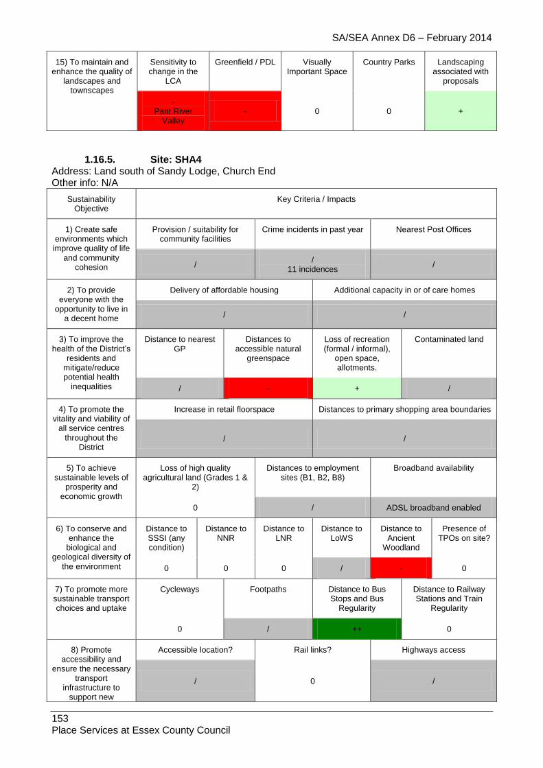
SA/SEA Annex D6 – February 2014
153 Place Services at Essex County Council
15) To maintain and enhance the quality of
landscapes and townscapes
Sensitivity to change in the
LCA
Greenfield / PDL Visually Important Space
Country Parks Landscaping associated with
proposals
- Pant River
Valley - 0 0 +
1.16.5. Site: SHA4 Address: Land south of Sandy Lodge, Church End Other info: N/A
Sustainability Objective
Key Criteria / Impacts
1) Create safe environments which
improve quality of life and community
cohesion
Provision / suitability for community facilities
Crime incidents in past year Nearest Post Offices
/ /
11 incidences /
2) To provide everyone with the
opportunity to live in a decent home
Delivery of affordable housing Additional capacity in or of care homes
/ /
3) To improve the health of the District’s
residents and mitigate/reduce potential health
inequalities
Distance to nearest GP
Distances to accessible natural
greenspace
Loss of recreation (formal / informal),
open space, allotments.
Contaminated land
/ - + /
4) To promote the vitality and viability of
all service centres throughout the
District
Increase in retail floorspace Distances to primary shopping area boundaries
/ /
5) To achieve sustainable levels of
prosperity and economic growth
Loss of high quality agricultural land (Grades 1 &
2)
Distances to employment sites (B1, B2, B8)
Broadband availability
0 / ADSL broadband enabled
6) To conserve and enhance the
biological and geological diversity of
the environment
Distance to SSSI (any condition)
Distance to NNR
Distance to LNR
Distance to LoWS
Distance to Ancient
Woodland
Presence of TPOs on site?
0 0 0 / - 0
7) To promote more sustainable transport choices and uptake
Cycleways Footpaths Distance to Bus Stops and Bus
Regularity
Distance to Railway Stations and Train
Regularity
0 / ++ 0
8) Promote accessibility and
ensure the necessary transport
infrastructure to support new
Accessible location? Rail links? Highways access
/ 0 /
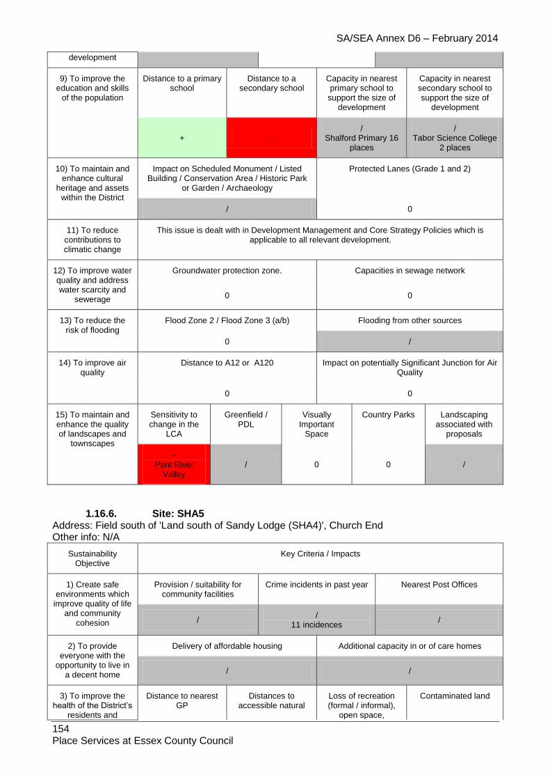
SA/SEA Annex D6 – February 2014
154 Place Services at Essex County Council
development
9) To improve the education and skills
of the population
Distance to a primary school
Distance to a secondary school
Capacity in nearest primary school to
support the size of development
Capacity in nearest secondary school to support the size of
development
+ - /
Shalford Primary 16 places
/ Tabor Science College
2 places
10) To maintain and enhance cultural
heritage and assets within the District
Impact on Scheduled Monument / Listed Building / Conservation Area / Historic Park
or Garden / Archaeology
Protected Lanes (Grade 1 and 2)
/ 0
11) To reduce contributions to climatic change
This issue is dealt with in Development Management and Core Strategy Policies which is applicable to all relevant development.
12) To improve water quality and address water scarcity and
sewerage
Groundwater protection zone. Capacities in sewage network
0 0
13) To reduce the risk of flooding
Flood Zone 2 / Flood Zone 3 (a/b) Flooding from other sources
0 /
14) To improve air quality
Distance to A12 or A120 Impact on potentially Significant Junction for Air Quality
0 0
15) To maintain and enhance the quality of landscapes and
townscapes
Sensitivity to change in the
LCA
Greenfield / PDL
Visually Important
Space
Country Parks Landscaping associated with
proposals
- Pant River
Valley / 0 0 /
1.16.6. Site: SHA5 Address: Field south of 'Land south of Sandy Lodge (SHA4)', Church End Other info: N/A
Sustainability Objective
Key Criteria / Impacts
1) Create safe environments which
improve quality of life and community
cohesion
Provision / suitability for community facilities
Crime incidents in past year Nearest Post Offices
/ /
11 incidences /
2) To provide everyone with the
opportunity to live in a decent home
Delivery of affordable housing Additional capacity in or of care homes
/ /
3) To improve the health of the District’s
residents and
Distance to nearest GP
Distances to accessible natural
Loss of recreation (formal / informal),
open space,
Contaminated land
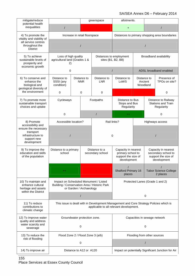
SA/SEA Annex D6 – February 2014
155 Place Services at Essex County Council
mitigate/reduce potential health
inequalities
greenspace allotments.
/ - + /
4) To promote the vitality and viability of
all service centres throughout the
District
Increase in retail floorspace Distances to primary shopping area boundaries
/ /
5) To achieve sustainable levels of
prosperity and economic growth
Loss of high quality agricultural land (Grades 1 &
2)
Distances to employment sites (B1, B2, B8)
Broadband availability
0 / ADSL broadband enabled
6) To conserve and enhance the
biological and geological diversity of
the environment
Distance to SSSI (any condition)
Distance to NNR
Distance to LNR
Distance to LoWS
Distance to Ancient
Woodland
Presence of TPOs on site?
0 0 0 - - 0
7) To promote more sustainable transport choices and uptake
Cycleways Footpaths Distance to Bus Stops and Bus
Regularity
Distance to Railway Stations and Train
Regularity
0 / ++ 0
8) Promote accessibility and
ensure the necessary transport
infrastructure to support new development
Accessible location? Rail links? Highways access
/ 0 /
9) To improve the education and skills
of the population
Distance to a primary school
Distance to a secondary school
Capacity in nearest primary school to
support the size of development
Capacity in nearest secondary school to support the size of
development
++ - /
Shalford Primary 16 places
/ Tabor Science College
2 places
10) To maintain and enhance cultural
heritage and assets within the District
Impact on Scheduled Monument / Listed Building / Conservation Area / Historic Park
or Garden / Archaeology
Protected Lanes (Grade 1 and 2)
/ 0
11) To reduce contributions to climatic change
This issue is dealt with in Development Management and Core Strategy Policies which is applicable to all relevant development.
12) To improve water quality and address water scarcity and
sewerage
Groundwater protection zone. Capacities in sewage network
0 0
13) To reduce the risk of flooding
Flood Zone 2 / Flood Zone 3 (a/b) Flooding from other sources
0 /
14) To improve air Distance to A12 or A120 Impact on potentially Significant Junction for Air

SA/SEA Annex D6 – February 2014
156 Place Services at Essex County Council
quality Quality
0 0
15) To maintain and enhance the quality of landscapes and
townscapes
Sensitivity to change in the
LCA
Greenfield / PDL
Visually Important
Space
Country Parks Landscaping associated with
proposals
- Pant River
Valley / 0 0 /
1.16.7. Site: SHA6 Address: Land R/O Grubbs Cottage Other info: Greenfield
Sustainability Objective
Key Criteria / Impacts
1) Create safe environments which
improve quality of life and community
cohesion
Provision / suitability for community facilities
Crime incidents in past year Nearest Post Offices
/ /
10 incidences /
2) To provide everyone with the
opportunity to live in a decent home
Delivery of affordable housing Additional capacity in or of care homes
/ /
3) To improve the health of the District’s
residents and mitigate/reduce potential health
inequalities
Distance to nearest GP
Distances to accessible natural
greenspace
Loss of recreation (formal / informal),
open space, allotments.
Contaminated land
/ - + /
4) To promote the vitality and viability of
all service centres throughout the
District
Increase in retail floorspace Distances to primary shopping area boundaries
/ /
5) To achieve sustainable levels of
prosperity and economic growth
Loss of high quality agricultural land (Grades 1 &
2)
Distances to employment sites (B1, B2, B8)
Broadband availability
- / ADSL broadband enabled
6) To conserve and enhance the
biological and geological diversity of
the environment
Distance to SSSI (any condition)
Distance to NNR
Distance to LNR
Distance to LoWS
Distance to Ancient
Woodland
Presence of TPOs on site?
0 0 0 0 / -
7) To promote more sustainable transport choices and uptake
Cycleways Footpaths Distance to Bus Stops and Bus
Regularity
Distance to Railway Stations and Train
Regularity
0 / ++ 0
8) Promote Accessible location? Rail links? Highways access

SA/SEA Annex D6 – February 2014
157 Place Services at Essex County Council
accessibility and ensure the necessary
transport infrastructure to
support new development
/ 0 /
9) To improve the education and skills
of the population
Distance to a primary school
Distance to a secondary school
Capacity in nearest primary school to
support the size of development
Capacity in nearest secondary school to support the size of
development
++ - /
Shalford Primary 16 places
/ Tabor Science College
2 places
10) To maintain and enhance cultural
heritage and assets within the District
Impact on Scheduled Monument / Listed Building / Conservation Area / Historic Park
or Garden / Archaeology
Protected Lanes (Grade 1 and 2)
-- 0
11) To reduce contributions to climatic change
This issue is dealt with in Development Management and Core Strategy Policies which is applicable to all relevant development.
12) To improve water quality and address water scarcity and
sewerage
Groundwater protection zone. Capacities in sewage network
0 0
13) To reduce the risk of flooding
Flood Zone 2 / Flood Zone 3 (a/b) Flooding from other sources
0 /
14) To improve air quality
Distance to A12 or A120 Impact on potentially Significant Junction for Air Quality
0 0
15) To maintain and enhance the quality of landscapes and
townscapes
Sensitivity to change in the
LCA
Greenfield / PDL
Visually Important
Space
Country Parks Landscaping associated with
proposals
- Pant River
Valley - 0 0 /
1.16.8. Site: SHA7 Address: Land south of White Court Other info: Greenfield, Residential and Open Space
Sustainability Objective
Key Criteria / Impacts
1) Create safe environments which improve quality of life
and community cohesion
Provision / suitability for community facilities
Crime incidents in past year Nearest Post Offices
0 /
10 incidences /
2) To provide Delivery of affordable housing Additional capacity in or of care homes

SA/SEA Annex D6 – February 2014
158 Place Services at Essex County Council
everyone with the opportunity to live in a
decent home / /
3) To improve the health of the District’s
residents and mitigate/reduce potential health
inequalities
Distance to nearest GP
Distances to accessible natural
greenspace
Loss of recreation (formal / informal),
open space, allotments.
Contaminated land
/ - + /
4) To promote the vitality and viability of
all service centres throughout the District
Increase in retail floorspace Distances to primary shopping area boundaries
0 /
5) To achieve sustainable levels of
prosperity and economic growth
Loss of high quality agricultural land (Grades 1 &
2)
Distances to employment sites (B1, B2, B8)
Broadband availability
0 / ADSL broadband enabled
6) To conserve and enhance the
biological and geological diversity of
the environment
Distance to SSSI (any condition)
Distance to NNR
Distance to LNR
Distance to LoWS
Distance to Ancient
Woodland
Presence of TPOs on
site?
0 0 0 0 0 0
7) To promote more sustainable transport choices and uptake
Cycleways Footpaths Distance to Bus Stops and Bus
Regularity
Distance to Railway Stations and Train
Regularity
0 / ++ 0
8) Promote accessibility and
ensure the necessary transport
infrastructure to support new development
Accessible location? Rail links? Highways access
/ 0
9) To improve the education and skills
of the population
Distance to a primary school
Distance to a secondary school
Capacity in nearest primary school to
support the size of development
Capacity in nearest secondary school to support the size of
development
++ - /
Shalford Primary 16 places
/ Tabor Science
College 2 places
10) To maintain and enhance cultural
heritage and assets within the District
Impact on Scheduled Monument / Listed Building / Conservation Area / Historic Park or
Garden / Archaeology
Protected Lanes (Grade 1 and 2)
0 0
11) To reduce contributions to climatic change
This issue is dealt with in Development Management and Core Strategy Policies which is applicable to all relevant development.
12) To improve water quality and address water scarcity and
sewerage
Groundwater protection zone. Capacities in sewage network
0 0

SA/SEA Annex D6 – February 2014
159 Place Services at Essex County Council
13) To reduce the risk of flooding
Flood Zone 2 / Flood Zone 3 (a/b) Flooding from other sources
0 /
14) To improve air quality
Distance to A12 or A120 Impact on potentially Significant Junction for Air Quality
0 0
15) To maintain and enhance the quality of
landscapes and townscapes
Sensitivity to change in the
LCA
Greenfield / PDL Visually Important Space
Country Parks Landscaping associated with
proposals
- Pant River
Valley - 0 0 /
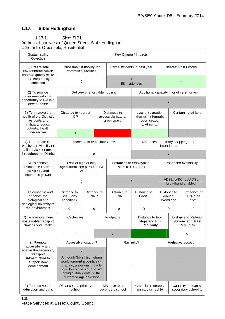
SA/SEA Annex D6 – February 2014
160 Place Services at Essex County Council
1.17. Sible Hedingham
1.17.1. Site: SIB1 Address: Land west of Queen Street, Sible Hedingham Other info: Greenfield, Residential
Sustainability Objective
Key Criteria / Impacts
1) Create safe environments which improve quality of life
and community cohesion
Provision / suitability for community facilities
Crime incidents in past year Nearest Post Offices
0 /
58 incidences +
2) To provide everyone with the
opportunity to live in a decent home
Delivery of affordable housing Additional capacity in or of care homes
/ /
3) To improve the health of the District’s
residents and mitigate/reduce potential health
inequalities
Distance to nearest GP
Distances to accessible natural
greenspace
Loss of recreation (formal / informal),
open space, allotments.
Contaminated land
+ - + /
4) To promote the vitality and viability of
all service centres throughout the District
Increase in retail floorspace Distances to primary shopping area boundaries
0 /
5) To achieve sustainable levels of
prosperity and economic growth
Loss of high quality agricultural land (Grades 1 &
2)
Distances to employment sites (B1, B2, B8)
Broadband availability
0 / ADSL, WBC, LLU DSL
broadband enabled
6) To conserve and enhance the
biological and geological diversity of
the environment
Distance to SSSI (any condition)
Distance to NNR
Distance to LNR
Distance to LoWS
Distance to Ancient
Woodland
Presence of TPOs on
site?
0 0 0 0 0 0
7) To promote more sustainable transport choices and uptake
Cycleways Footpaths Distance to Bus Stops and Bus
Regularity
Distance to Railway Stations and Train
Regularity
0 / ++ 0
8) Promote accessibility and
ensure the necessary transport
infrastructure to support new development
Accessible location? Rail links? Highways access
/
Although Sible Hedingham would warrant a positive (+) grading, uncertain impacts have been given due to site being suitably outside the current village envelope
0 /
9) To improve the education and skills
Distance to a primary school
Distance to a secondary school
Capacity in nearest primary school to
Capacity in nearest secondary school to

SA/SEA Annex D6 – February 2014
161 Place Services at Essex County Council
of the population support the size of development
support the size of development
- ++
/ St Peter’s Church CoE Primary 15
places
/ Hedingham School
107 places
10) To maintain and enhance cultural
heritage and assets within the District
Impact on Scheduled Monument / Listed Building / Conservation Area / Historic Park or
Garden / Archaeology
Protected Lanes (Grade 1 and 2)
-- 0
11) To reduce contributions to climatic change
This issue is dealt with in Development Management and Core Strategy Policies which is applicable to all relevant development.
12) To improve water quality and address water scarcity and
sewerage
Groundwater protection zone. Capacities in sewage network
0
13) To reduce the risk of flooding
Flood Zone 2 / Flood Zone 3 (a/b) Flooding from other sources
0 /
14) To improve air quality
Distance to A12 or A120 Impact on potentially Significant Junction for Air Quality
0 0
15) To maintain and enhance the quality of
landscapes and townscapes
Sensitivity to change in the
LCA
Greenfield / PDL Visually Important Space
Country Parks Landscaping associated with
proposals
- Colne River
Valley - 0 0 /
1.17.2. Site: SIB2A Address: CO9 3PY Other Info: Care Home
Sustainability Objective
Key Criteria / Impacts
1) Create safe environments which improve quality of life
and community cohesion
Provision / suitability for community facilities
Crime incidents in past year Nearest Post Offices
0 /
>100 +
2) To provide everyone with the
opportunity to live in a decent home
Delivery of affordable housing Additional capacity in or of care homes
/ +
3) To improve the health of the
District’s residents and mitigate/reduce
Distance to nearest GP
Distances to accessible natural
greenspace
Loss of recreation (formal / informal),
open space, allotments.
Contaminated land
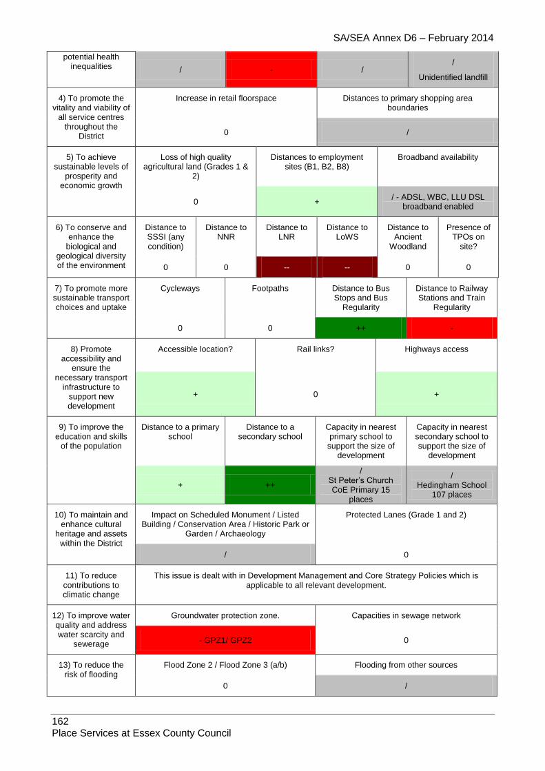
SA/SEA Annex D6 – February 2014
162 Place Services at Essex County Council
potential health inequalities / - /
/
Unidentified landfill
4) To promote the vitality and viability of
all service centres throughout the
District
Increase in retail floorspace Distances to primary shopping area boundaries
0 /
5) To achieve sustainable levels of
prosperity and economic growth
Loss of high quality agricultural land (Grades 1 &
2)
Distances to employment sites (B1, B2, B8)
Broadband availability
0 + / - ADSL, WBC, LLU DSL
broadband enabled
6) To conserve and enhance the
biological and geological diversity of the environment
Distance to SSSI (any condition)
Distance to NNR
Distance to LNR
Distance to LoWS
Distance to Ancient
Woodland
Presence of TPOs on
site?
0 0 -- -- 0 0
7) To promote more sustainable transport choices and uptake
Cycleways Footpaths Distance to Bus Stops and Bus
Regularity
Distance to Railway Stations and Train
Regularity
0 0 ++ -
8) Promote accessibility and
ensure the necessary transport
infrastructure to support new development
Accessible location? Rail links? Highways access
+ 0 +
9) To improve the education and skills
of the population
Distance to a primary school
Distance to a secondary school
Capacity in nearest primary school to
support the size of development
Capacity in nearest secondary school to support the size of
development
+ ++
/ St Peter’s Church CoE Primary 15
places
/ Hedingham School
107 places
10) To maintain and enhance cultural
heritage and assets within the District
Impact on Scheduled Monument / Listed Building / Conservation Area / Historic Park or
Garden / Archaeology
Protected Lanes (Grade 1 and 2)
/ 0
11) To reduce contributions to climatic change
This issue is dealt with in Development Management and Core Strategy Policies which is applicable to all relevant development.
12) To improve water quality and address water scarcity and
sewerage
Groundwater protection zone. Capacities in sewage network
- GPZ1/ GPZ2 0
13) To reduce the risk of flooding
Flood Zone 2 / Flood Zone 3 (a/b) Flooding from other sources
0 /

SA/SEA Annex D6 – February 2014
163 Place Services at Essex County Council
14) To improve air quality
Distance to A12 or A120 Impact on potentially Significant Junction for Air Quality
0 0
15) To maintain and enhance the quality of landscapes and
townscapes
Sensitivity to change in the
LCA
Greenfield / PDL Visually Important Space
Country Parks Landscaping associated with
proposals
- Colne River
Valley + / 0 0
1.17.3. Site: SIB2B Address: Premdor Site (northern), Sible Hedingham Other info: Greenfield, Residential
Sustainability Objective
Key Criteria / Impacts
1) Create safe environments which
improve quality of life and community
cohesion
Provision / suitability for community facilities
Crime incidents in past year Nearest Post Offices
0 /
112 incidences +
2) To provide everyone with the
opportunity to live in a decent home
Delivery of affordable housing Additional capacity in or of care homes
/ /
3) To improve the health of the District’s
residents and mitigate/reduce potential health
inequalities
Distance to nearest GP
Distances to accessible natural
greenspace
Loss of recreation (formal / informal),
open space, allotments.
Contaminated land
/ - + /
4) To promote the vitality and viability of
all service centres throughout the
District
Increase in retail floorspace Distances to primary shopping area boundaries
0 /
5) To achieve sustainable levels of
prosperity and economic growth
Loss of high quality agricultural land (Grades 1 &
2)
Distances to employment sites (B1, B2, B8)
Broadband availability
0 + ADSL, WBC, LLU DSL
broadband enabled
6) To conserve and enhance the
biological and geological diversity of
the environment
Distance to SSSI (any condition)
Distance to NNR
Distance to LNR
Distance to LoWS
Distance to Ancient
Woodland
Presence of TPOs on site?
0 0 - - 0 0
7) To promote more sustainable transport choices and uptake
Cycleways Footpaths Distance to Bus Stops and Bus
Regularity
Distance to Railway Stations and Train
Regularity
0 / ++ 0

SA/SEA Annex D6 – February 2014
164 Place Services at Essex County Council
8) Promote accessibility and
ensure the necessary transport
infrastructure to support new development
Accessible location? Rail links? Highways access
+ 0 /
9) To improve the education and skills
of the population
Distance to a primary school
Distance to a secondary school
Capacity in nearest primary school to
support the size of development
Capacity in nearest secondary school to support the size of
development
- ++
/ St Peter’s Church CoE Primary 15
places
/ Hedingham School
107 places
10) To maintain and enhance cultural
heritage and assets within the District
Impact on Scheduled Monument / Listed Building / Conservation Area / Historic Park
or Garden / Archaeology
Protected Lanes (Grade 1 and 2)
/ 0
11) To reduce contributions to climatic change
This issue is dealt with in Development Management and Core Strategy Policies which is applicable to all relevant development.
12) To improve water quality and address water scarcity and
sewerage
Groundwater protection zone. Capacities in sewage network
- SPZ1
0
13) To reduce the risk of flooding
Flood Zone 2 / Flood Zone 3 (a/b) Flooding from other sources
/ /
14) To improve air quality
Distance to A12 or A120 Impact on potentially Significant Junction for Air Quality
0 0
15) To maintain and enhance the quality of landscapes and
townscapes
Sensitivity to change in the
LCA
Greenfield / PDL
Visually Important
Space
Country Parks Landscaping associated with
proposals
- Colne River
Valley - 0 0 /
1.17.4. Site: SIB2E
Address: CO9 3PY
Other Info: B1
Sustainability Objective
Key Criteria / Impacts
1) Create safe environments which improve quality of life
and community
Provision / suitability for community facilities
Crime incidents in past year Nearest Post Offices
/ / - >100 +

SA/SEA Annex D6 – February 2014
165 Place Services at Essex County Council
cohesion
2) To provide everyone with the
opportunity to live in a decent home
Delivery of affordable housing Additional capacity in or of care homes
0 0
3) To improve the health of the
District’s residents and mitigate/reduce
potential health inequalities
Distance to nearest GP
Distances to accessible natural
greenspace
Loss of recreation (formal / informal),
open space, allotments.
Contaminated land
/ 0 0 0
4) To promote the vitality and viability of
all service centres throughout the
District
Increase in retail floorspace Distances to primary shopping area boundaries
0 /
5) To achieve sustainable levels of
prosperity and economic growth
Loss of high quality agricultural land (Grades 1 &
2)
Distances to employment sites (B1, B2, B8)
Broadband availability
0 + / - ADSL, WBC, LLU DSL
broadband enabled
6) To conserve and enhance the
biological and geological diversity of the environment
Distance to SSSI (any condition)
Distance to NNR
Distance to LNR
Distance to LoWS
Distance to Ancient
Woodland
Presence of TPOs on
site?
0 0 / / 0 0
7) To promote more sustainable transport choices and uptake
Cycleways Footpaths Distance to Bus Stops and Bus
Regularity
Distance to Railway Stations and Train
Regularity
0 0 ++ -
8) Promote accessibility and
ensure the necessary transport
infrastructure to support new development
Accessible location? Rail links? Highways access
+ 0 /
9) To improve the education and skills
of the population
Distance to a primary school
Distance to a secondary school
Capacity in nearest primary school to
support the size of development
Capacity in nearest secondary school to support the size of
development
- ++
/ St Peter’s Church CoE Primary 15 places
/ Hedingham School 107 places
10) To maintain and enhance cultural
heritage and assets within the District
Impact on Scheduled Monument / Listed Building / Conservation Area / Historic Park or
Garden / Archaeology
Protected Lanes (Grade 1 and 2)
0 0
11) To reduce contributions to climatic change
This issue is dealt with in Development Management and Core Strategy Policies which is applicable to all relevant development.
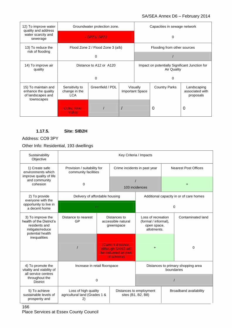
SA/SEA Annex D6 – February 2014
166 Place Services at Essex County Council
12) To improve water quality and address water scarcity and
sewerage
Groundwater protection zone. Capacities in sewage network
- GPZ1/ GPZ2 0
13) To reduce the risk of flooding
Flood Zone 2 / Flood Zone 3 (a/b) Flooding from other sources
0 /
14) To improve air quality
Distance to A12 or A120 Impact on potentially Significant Junction for Air Quality
0 0
15) To maintain and enhance the quality of landscapes and
townscapes
Sensitivity to change in the
LCA
Greenfield / PDL Visually Important Space
Country Parks Landscaping associated with
proposals
- Colne River
Valley / / 0 0
1.17.5. Site: SIB2H
Address: CO9 3PY
Other Info: Residential, 193 dwellings
Sustainability Objective
Key Criteria / Impacts
1) Create safe environments which improve quality of life
and community cohesion
Provision / suitability for community facilities
Crime incidents in past year Nearest Post Offices
0 /
103 incidences +
2) To provide everyone with the
opportunity to live in a decent home
Delivery of affordable housing Additional capacity in or of care homes
++ 0
3) To improve the health of the District’s
residents and mitigate/reduce potential health
inequalities
Distance to nearest GP
Distances to accessible natural
greenspace
Loss of recreation (formal / informal),
open space, allotments.
Contaminated land
/
-
(Current distance, although SANG will be delivered as part
of scheme)
+ 0
4) To promote the vitality and viability of
all service centres throughout the
District
Increase in retail floorspace Distances to primary shopping area boundaries
0 /
5) To achieve sustainable levels of
prosperity and
Loss of high quality agricultural land (Grades 1 &
2)
Distances to employment sites (B1, B2, B8)
Broadband availability
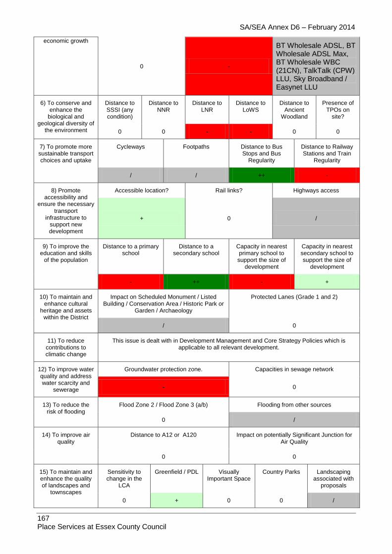
SA/SEA Annex D6 – February 2014
167 Place Services at Essex County Council
economic growth
0 -
BT Wholesale ADSL, BT Wholesale ADSL Max, BT Wholesale WBC (21CN), TalkTalk (CPW) LLU, Sky Broadband / Easynet LLU
6) To conserve and enhance the
biological and geological diversity of
the environment
Distance to SSSI (any condition)
Distance to NNR
Distance to LNR
Distance to LoWS
Distance to Ancient
Woodland
Presence of TPOs on
site?
0 0 - - 0 0
7) To promote more sustainable transport choices and uptake
Cycleways Footpaths Distance to Bus Stops and Bus
Regularity
Distance to Railway Stations and Train
Regularity
/ / ++ -
8) Promote accessibility and
ensure the necessary transport
infrastructure to support new development
Accessible location? Rail links? Highways access
+ 0 /
9) To improve the education and skills
of the population
Distance to a primary school
Distance to a secondary school
Capacity in nearest primary school to
support the size of development
Capacity in nearest secondary school to support the size of
development
- ++ - +
10) To maintain and enhance cultural
heritage and assets within the District
Impact on Scheduled Monument / Listed Building / Conservation Area / Historic Park or
Garden / Archaeology
Protected Lanes (Grade 1 and 2)
/ 0
11) To reduce contributions to climatic change
This issue is dealt with in Development Management and Core Strategy Policies which is applicable to all relevant development.
12) To improve water quality and address water scarcity and
sewerage
Groundwater protection zone. Capacities in sewage network
- 0
13) To reduce the risk of flooding
Flood Zone 2 / Flood Zone 3 (a/b) Flooding from other sources
0 /
14) To improve air quality
Distance to A12 or A120 Impact on potentially Significant Junction for Air Quality
0 0
15) To maintain and enhance the quality of landscapes and
townscapes
Sensitivity to change in the
LCA
Greenfield / PDL Visually Important Space
Country Parks Landscaping associated with
proposals
0 + 0 0 /

SA/SEA Annex D6 – February 2014
168 Place Services at Essex County Council
1.17.6. Site: SIB3E Address: Land at former Dairy, Oxford Land, Sible Hedingham Other info: Employment
Sustainability Objective
Key Criteria / Impacts
1) Create safe environments which
improve quality of life and community
cohesion
Provision / suitability for community facilities
Crime incidents in past year Nearest Post Offices
0 /
112 incidences +
2) To provide everyone with the
opportunity to live in a decent home
Delivery of affordable housing Additional capacity in or of care homes
++ 0
3) To improve the health of the District’s
residents and mitigate/reduce potential health
inequalities
Distance to nearest GP
Distances to accessible natural
greenspace
Loss of recreation (formal / informal),
open space, allotments.
Contaminated land
/ - + 0
4) To promote the vitality and viability of
all service centres throughout the
District
Increase in retail floorspace Distances to primary shopping area boundaries
0 -
5) To achieve sustainable levels of
prosperity and economic growth
Loss of high quality agricultural land (Grades 1 &
2)
Distances to employment sites (B1, B2, B8)
Broadband availability
0 + ADSL, WBC, LLU DSL
broadband enabled
6) To conserve and enhance the
biological and geological diversity of
the environment
Distance to SSSI (any condition)
Distance to NNR
Distance to LNR
Distance to LoWS
Distance to Ancient
Woodland
Presence of TPOs on site?
0 0 0 0 0 0
7) To promote more sustainable transport choices and uptake
Cycleways Footpaths Distance to Bus Stops and Bus
Regularity
Distance to Railway Stations and Train
Regularity
0 0 ++ 0
8) Promote accessibility and
ensure the necessary transport
infrastructure to support new development
Accessible location? Rail links? Highways access
+ 0 +
Current access exists onto Church Lane
9) To improve the education and skills
of the population
Distance to a primary school
Distance to a secondary school
Capacity in nearest primary school to
support the size of development
Capacity in nearest secondary school to support the size of
development
+ ++ +
St Peter’s Church CoE Primary 15
+ Hedingham School
107 places

SA/SEA Annex D6 – February 2014
169 Place Services at Essex County Council
places 12 places required
8 places required
10) To maintain and enhance cultural
heritage and assets within the District
Impact on Scheduled Monument / Listed Building / Conservation Area / Historic Park
or Garden / Archaeology
Protected Lanes (Grade 1 and 2)
0 0
11) To reduce contributions to climatic change
This issue is dealt with in Development Management and Core Strategy Policies which is applicable to all relevant development.
12) To improve water quality and address water scarcity and
sewerage
Groundwater protection zone. Capacities in sewage network
- SPZ1
0
13) To reduce the risk of flooding
Flood Zone 2 / Flood Zone 3 (a/b) Flooding from other sources
0 /
14) To improve air quality
Distance to A12 or A120 Impact on potentially Significant Junction for Air Quality
0 0
15) To maintain and enhance the quality of landscapes and
townscapes
Sensitivity to change in the
LCA
Greenfield / PDL
Visually Important
Space
Country Parks Landscaping associated with
proposals
- Colne River
Valley + 0 0 /
1.17.7. Site: SIB4 Address: Land adj. 14 Swan Street, Sible Hedingham Other info: Residential, SHLAA – greenfield, 10 dwellings
Sustainability Objective
Key Criteria / Impacts
1) Create safe environments which
improve quality of life and community
cohesion
Provision / suitability for community facilities
Crime incidents in past year Nearest Post Offices
0 /
90 incidences +
2) To provide everyone with the
opportunity to live in a decent home
Delivery of affordable housing Additional capacity in or of care homes
+ 0
3) To improve the health of the District’s
residents and mitigate/reduce potential health
inequalities
Distance to nearest GP
Distances to accessible natural
greenspace
Loss of recreation (formal / informal),
open space, allotments.
Contaminated land
++ - + 0
4) To promote the vitality and viability of
all service centres
Increase in retail floorspace Distances to primary shopping area boundaries
/ /
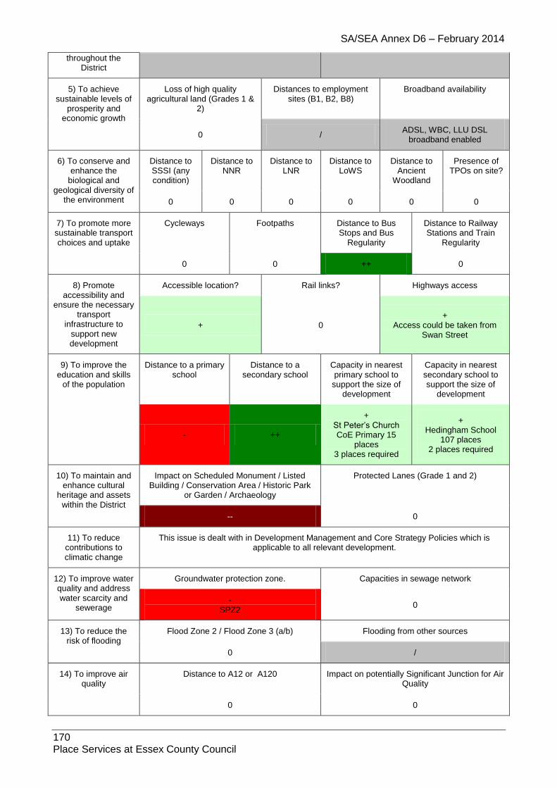
SA/SEA Annex D6 – February 2014
170 Place Services at Essex County Council
throughout the District
5) To achieve sustainable levels of
prosperity and economic growth
Loss of high quality agricultural land (Grades 1 &
2)
Distances to employment sites (B1, B2, B8)
Broadband availability
0 / ADSL, WBC, LLU DSL
broadband enabled
6) To conserve and enhance the
biological and geological diversity of
the environment
Distance to SSSI (any condition)
Distance to NNR
Distance to LNR
Distance to LoWS
Distance to Ancient
Woodland
Presence of TPOs on site?
0 0 0 0 0 0
7) To promote more sustainable transport choices and uptake
Cycleways Footpaths Distance to Bus Stops and Bus
Regularity
Distance to Railway Stations and Train
Regularity
0 0 ++ 0
8) Promote accessibility and
ensure the necessary transport
infrastructure to support new development
Accessible location? Rail links? Highways access
+ 0 +
Access could be taken from Swan Street
9) To improve the education and skills
of the population
Distance to a primary school
Distance to a secondary school
Capacity in nearest primary school to
support the size of development
Capacity in nearest secondary school to support the size of
development
- ++
+ St Peter’s Church CoE Primary 15
places 3 places required
+ Hedingham School
107 places 2 places required
10) To maintain and enhance cultural
heritage and assets within the District
Impact on Scheduled Monument / Listed Building / Conservation Area / Historic Park
or Garden / Archaeology
Protected Lanes (Grade 1 and 2)
-- 0
11) To reduce contributions to climatic change
This issue is dealt with in Development Management and Core Strategy Policies which is applicable to all relevant development.
12) To improve water quality and address water scarcity and
sewerage
Groundwater protection zone. Capacities in sewage network
- SPZ2
0
13) To reduce the risk of flooding
Flood Zone 2 / Flood Zone 3 (a/b) Flooding from other sources
0 /
14) To improve air quality
Distance to A12 or A120 Impact on potentially Significant Junction for Air Quality
0 0

SA/SEA Annex D6 – February 2014
171 Place Services at Essex County Council
15) To maintain and enhance the quality of landscapes and
townscapes
Sensitivity to change in the
LCA
Greenfield / PDL
Visually Important
Space
Country Parks Landscaping associated with
proposals
- Colne River
Valley - 0 0 /
1.17.8. Site: SIB5 Address: Land at Hovis Mill Lane/Halstead Road, Sible Hedingham Other info: Residential
Sustainability Objective
Key Criteria / Impacts
1) Create safe environments which
improve quality of life and community
cohesion
Provision / suitability for community facilities
Crime incidents in past year Nearest Post Offices
/ /
14 incidences /
2) To provide everyone with the
opportunity to live in a decent home
Delivery of affordable housing Additional capacity in or of care homes
/ /
3) To improve the health of the District’s
residents and mitigate/reduce potential health
inequalities
Distance to nearest GP
Distances to accessible natural
greenspace
Loss of recreation (formal / informal),
open space, allotments.
Contaminated land
/ - + /
4) To promote the vitality and viability of
all service centres throughout the
District
Increase in retail floorspace Distances to primary shopping area boundaries
/ /
5) To achieve sustainable levels of
prosperity and economic growth
Loss of high quality agricultural land (Grades 1 &
2)
Distances to employment sites (B1, B2, B8)
Broadband availability
0 / ADSL, WBC, LLU DSL
broadband enabled
6) To conserve and enhance the
biological and geological diversity of
the environment
Distance to SSSI (any condition)
Distance to NNR
Distance to LNR
Distance to LoWS
Distance to Ancient
Woodland
Presence of TPOs on site?
0 0 0 0 0 0
7) To promote more sustainable transport choices and uptake
Cycleways Footpaths Distance to Bus Stops and Bus
Regularity
Distance to Railway Stations and Train
Regularity
0 / ++ 0
8) Promote accessibility and
ensure the necessary transport
infrastructure to
Accessible location? Rail links? Highways access
+ 0 /

SA/SEA Annex D6 – February 2014
172 Place Services at Essex County Council
support new development
9) To improve the education and skills
of the population
Distance to a primary school
Distance to a secondary school
Capacity in nearest primary school to
support the size of development
Capacity in nearest secondary school to support the size of
development
- +
/ St Peter’s Church CoE Primary 15
places
/ Hedingham School
107 places
10) To maintain and enhance cultural
heritage and assets within the District
Impact on Scheduled Monument / Listed Building / Conservation Area / Historic Park
or Garden / Archaeology
Protected Lanes (Grade 1 and 2)
0 0
11) To reduce contributions to climatic change
This issue is dealt with in Development Management and Core Strategy Policies which is applicable to all relevant development.
12) To improve water quality and address water scarcity and
sewerage
Groundwater protection zone. Capacities in sewage network
0
13) To reduce the risk of flooding
Flood Zone 2 / Flood Zone 3 (a/b) Flooding from other sources
0 /
14) To improve air quality
Distance to A12 or A120 Impact on potentially Significant Junction for Air Quality
0 0
15) To maintain and enhance the quality of landscapes and
townscapes
Sensitivity to change in the
LCA
Greenfield / PDL
Visually Important
Space
Country Parks Landscaping associated with
proposals
- Colne River
Valley / 0 0 /
1.17.9. Site: SIB6MAlt Address: Land at Wethersfield Road (junction with Prayors Hill), Sible Hedingham Other info: Greenfield, Residential/live-work/employment/community
Sustainability Objective
Key Criteria / Impacts
1) Create safe environments which
improve quality of life and community
cohesion
Provision / suitability for community facilities
Crime incidents in past year Nearest Post Offices
/ /
90 incidences +
2) To provide everyone with the
opportunity to live in a decent home
Delivery of affordable housing Additional capacity in or of care homes
/ /

SA/SEA Annex D6 – February 2014
173 Place Services at Essex County Council
3) To improve the health of the District’s
residents and mitigate/reduce potential health
inequalities
Distance to nearest GP
Distances to accessible natural
greenspace
Loss of recreation (formal / informal),
open space, allotments.
Contaminated land
/ - + /
4) To promote the vitality and viability of
all service centres throughout the
District
Increase in retail floorspace Distances to primary shopping area boundaries
/ -
5) To achieve sustainable levels of
prosperity and economic growth
Loss of high quality agricultural land (Grades 1 &
2)
Distances to employment sites (B1, B2, B8)
Broadband availability
0 + ADSL, WBC, LLU DSL
broadband enabled
6) To conserve and enhance the
biological and geological diversity of
the environment
Distance to SSSI (any condition)
Distance to NNR
Distance to LNR
Distance to LoWS
Distance to Ancient
Woodland
Presence of TPOs on site?
0 0 0 0 0 0
7) To promote more sustainable transport choices and uptake
Cycleways Footpaths Distance to Bus Stops and Bus
Regularity
Distance to Railway Stations and Train
Regularity
0 / ++ 0
8) Promote accessibility and
ensure the necessary transport
infrastructure to support new development
Accessible location? Rail links? Highways access
+ 0 /
9) To improve the education and skills
of the population
Distance to a primary school
Distance to a secondary school
Capacity in nearest primary school to
support the size of development
Capacity in nearest secondary school to support the size of
development
++ ++
/ St Peter’s Church CoE Primary 15
places
/ Hedingham School
107 places
10) To maintain and enhance cultural
heritage and assets within the District
Impact on Scheduled Monument / Listed Building / Conservation Area / Historic Park
or Garden / Archaeology
Protected Lanes (Grade 1 and 2)
- 0
11) To reduce contributions to climatic change
This issue is dealt with in Development Management and Core Strategy Policies which is applicable to all relevant development.
12) To improve water quality and address water scarcity and
sewerage
Groundwater protection zone. Capacities in sewage network
- SPZ1
0

SA/SEA Annex D6 – February 2014
174 Place Services at Essex County Council
13) To reduce the risk of flooding
Flood Zone 2 / Flood Zone 3 (a/b) Flooding from other sources
0 /
14) To improve air quality
Distance to A12 or A120 Impact on potentially Significant Junction for Air Quality
0 0
15) To maintain and enhance the quality of landscapes and
townscapes
Sensitivity to change in the
LCA
Greenfield / PDL
Visually Important
Space
Country Parks Landscaping associated with
proposals
- Colne River
Valley - 0 0 /
1.17.10. Site: SIB7H
Address: Coopers Yard, Swan Street
Other info: SHLAA – PDL, 12 dwellings
Sustainability Objective
Key Criteria / Impacts
1) Create safe environments which
improve quality of life and community
cohesion
Provision / suitability for community facilities
Crime incidents in past year Nearest Post Offices
0 /
98 incidences +
2) To provide everyone with the
opportunity to live in a decent home
Delivery of affordable housing Additional capacity in or of care homes
+ 0
3) To improve the health of the District’s
residents and mitigate/reduce potential health
inequalities
Distance to nearest GP
Distances to accessible natural
greenspace
Loss of recreation (formal / informal),
open space, allotments.
Contaminated land
++ - + 0
4) To promote the vitality and viability of
all service centres throughout the
District
Increase in retail floorspace Distances to primary shopping area boundaries
0 /
5) To achieve sustainable levels of
prosperity and economic growth
Loss of high quality agricultural land (Grades 1 &
2)
Distances to employment sites (B1, B2, B8)
Broadband availability
0 / ADSL, WBC, LLU DSL
broadband enabled
6) To conserve and enhance the
biological and geological diversity of
the environment
Distance to SSSI (any condition)
Distance to NNR
Distance to LNR
Distance to LoWS
Distance to Ancient
Woodland
Presence of TPOs on site?
0 0 0 0 0 0

SA/SEA Annex D6 – February 2014
175 Place Services at Essex County Council
7) To promote more sustainable transport choices and uptake
Cycleways Footpaths Distance to Bus Stops and Bus
Regularity
Distance to Railway Stations and Train
Regularity
0 0 ++ -
8) Promote accessibility and
ensure the necessary transport
infrastructure to support new development
Accessible location? Rail links? Highways access
+ 0 +
Access from Swan Street
9) To improve the education and skills
of the population
Distance to a primary school
Distance to a secondary school
Capacity in nearest primary school to
support the size of development
Capacity in nearest secondary school to support the size of
development
+ ++
+ St Peter’s Church CoE Primary 15
places
+ Hedingham School
107 places
10) To maintain and enhance cultural
heritage and assets within the District
Impact on Scheduled Monument / Listed Building / Conservation Area / Historic Park
or Garden / Archaeology
Protected Lanes (Grade 1 and 2)
0 0
11) To reduce contributions to climatic change
This issue is dealt with in Development Management and Core Strategy Policies which is applicable to all relevant development.
12) To improve water quality and address water scarcity and
sewerage
Groundwater protection zone. Capacities in sewage network
- SPZ2
0
13) To reduce the risk of flooding
Flood Zone 2 / Flood Zone 3 (a/b) Flooding from other sources
0 /
14) To improve air quality
Distance to A12 or A120 Impact on potentially Significant Junction for Air Quality
0 0
15) To maintain and enhance the quality of landscapes and
townscapes
Sensitivity to change in the
LCA
Greenfield / PDL
Visually Important
Space
Country Parks Landscaping associated with
proposals
0 + 0 0 /
1.17.11. Site: SIB8 Address: SHLAA large site not inc in 15yr supply Other info: SHLAA – PDL, unknown potential yield
Sustainability Objective
Key Criteria / Impacts
1) Create safe environments which
Provision / suitability for community facilities
Crime incidents in past year Nearest Post Offices

SA/SEA Annex D6 – February 2014
176 Place Services at Essex County Council
improve quality of life and community
cohesion 0
/ 105 incidences
+
2) To provide everyone with the
opportunity to live in a decent home
Delivery of affordable housing Additional capacity in or of care homes
/ /
3) To improve the health of the District’s
residents and mitigate/reduce potential health
inequalities
Distance to nearest GP
Distances to accessible natural
greenspace
Loss of recreation (formal / informal),
open space, allotments.
Contaminated land
+ - + 0
4) To promote the vitality and viability of
all service centres throughout the District
Increase in retail floorspace Distances to primary shopping area boundaries
0 /
5) To achieve sustainable levels of
prosperity and economic growth
Loss of high quality agricultural land (Grades 1 &
2)
Distances to employment sites (B1, B2, B8)
Broadband availability
0 + ADSL, WBC, LLU DSL
broadband enabled
6) To conserve and enhance the
biological and geological diversity of
the environment
Distance to SSSI (any condition)
Distance to NNR
Distance to LNR
Distance to LoWS
Distance to Ancient
Woodland
Presence of TPOs on
site?
0 0 0 0 0 0
7) To promote more sustainable transport choices and uptake
Cycleways Footpaths Distance to Bus Stops and Bus
Regularity
Distance to Railway Stations and Train
Regularity
0
/ No footpaths on site, FP37 runs along site
boundary to north east.
++ 0
8) Promote accessibility and
ensure the necessary transport
infrastructure to support new development
Accessible location? Rail links? Highways access
+ 0 -
Access appears constrained
9) To improve the education and skills
of the population
Distance to a primary school
Distance to a secondary school
Capacity in nearest primary school to
support the size of development
Capacity in nearest secondary school to support the size of
development
+ ++
/ St Peter’s Church CoE Primary 15
places
/ Hedingham School
107 places
10) To maintain and enhance cultural
heritage and assets
Impact on Scheduled Monument / Listed Building / Conservation Area / Historic Park or
Garden / Archaeology
Protected Lanes (Grade 1 and 2)

SA/SEA Annex D6 – February 2014
177 Place Services at Essex County Council
within the District 0 0
11) To reduce contributions to climatic change
This issue is dealt with in Development Management and Core Strategy Policies which is applicable to all relevant development.
12) To improve water quality and address water scarcity and
sewerage
Groundwater protection zone. Capacities in sewage network
- SPZ1
0
13) To reduce the risk of flooding
Flood Zone 2 / Flood Zone 3 (a/b) Flooding from other sources
0 /
14) To improve air quality
Distance to A12 or A120 Impact on potentially Significant Junction for Air Quality
0 0
15) To maintain and enhance the quality of
landscapes and townscapes
Sensitivity to change in the
LCA
Greenfield / PDL Visually Important Space
Country Parks Landscaping associated with
proposals
- Colne River
Valley + 0 0 /
1.17.12. Site: SIB9 Address: Sible Hedingham, CO9 3PY Other Info: B1, B2, B8
Sustainability Objective
Key Criteria / Impacts
1) Create safe environments which improve quality of life
and community cohesion
Provision / suitability for community facilities
Crime incidents in past year Nearest Post Offices
/ / - >100 +
2) To provide everyone with the
opportunity to live in a decent home
Delivery of affordable housing Additional capacity in or of care homes
0 0
3) To improve the health of the
District’s residents and mitigate/reduce
potential health inequalities
Distance to nearest GP
Distances to accessible natural
greenspace
Loss of recreation (formal / informal),
open space, allotments.
Contaminated land
/ 0 0 0
4) To promote the vitality and viability of
all service centres throughout the
District
Increase in retail floorspace Distances to primary shopping area boundaries
0 /
5) To achieve sustainable levels of
prosperity and
Loss of high quality agricultural land (Grades 1 &
2)
Distances to employment sites (B1, B2, B8)
Broadband availability

SA/SEA Annex D6 – February 2014
178 Place Services at Essex County Council
economic growth
0 + / - ADSL, WBC, LLU DSL
broadband enabled
6) To conserve and enhance the
biological and geological diversity of the environment
Distance to SSSI (any condition)
Distance to NNR
Distance to LNR
Distance to LoWS
Distance to Ancient
Woodland
Presence of TPOs on
site?
0 0 - - 0 0
7) To promote more sustainable transport choices and uptake
Cycleways Footpaths Distance to Bus Stops and Bus Regularity
Distance to Railway Stations and Train
Regularity
0 0 ++ -
8) Promote accessibility and
ensure the necessary transport
infrastructure to support new development
Accessible location? Rail links? Highways access
+ 0 /
9) To improve the education and skills
of the population
Distance to a primary school
Distance to a secondary school
Capacity in nearest primary school to
support the size of development
Capacity in nearest secondary school to support the size of
development
- ++
/ St Peter’s Church CoE Primary 15
places
/ Hedingham School
107 places
10) To maintain and enhance cultural
heritage and assets within the District
Impact on Scheduled Monument / Listed Building / Conservation Area / Historic Park or
Garden / Archaeology
Protected Lanes (Grade 1 and 2)
0 0
11) To reduce contributions to climatic change
This issue is dealt with in Development Management and Core Strategy Policies which is applicable to all relevant development.
12) To improve water quality and address water scarcity and
sewerage
Groundwater protection zone. Capacities in sewage network
- GPZ1 0
13) To reduce the risk of flooding
Flood Zone 2 / Flood Zone 3 (a/b) Flooding from other sources
0 /
14) To improve air quality
Distance to A12 or A120 Impact on potentially Significant Junction for Air Quality
0 0
15) To maintain and enhance the quality of landscapes and
townscapes
Sensitivity to change in the
LCA
Greenfield / PDL Visually Important Space
Country Parks Landscaping associated with
proposals
- Colne River
Valley / 0 0 0

SA/SEA Annex D6 – February 2014
179 Place Services at Essex County Council
1.17.13. Site: SIB9X
Address: CO9 3RE
Other info: Boundary Amendment:
Sustainability Objective
Key Criteria / Impacts
1) Create safe environments which improve quality of life
and community cohesion
Provision / suitability for community facilities
Crime incidents in past year Nearest Post Offices
/ /
93 incidences +
2) To provide everyone with the
opportunity to live in a decent home
Delivery of affordable housing Additional capacity in or of care homes
/
Further information needed /
3) To improve the health of the District’s
residents and mitigate/reduce potential health
inequalities
Distance to nearest GP
Distances to accessible natural
greenspace
Loss of recreation (formal / informal),
open space, allotments.
Contaminated land
++ - + 0
4) To promote the vitality and viability of
all service centres throughout the
District
Increase in retail floorspace Distances to primary shopping area boundaries
0 /
5) To achieve sustainable levels of
prosperity and economic growth
Loss of high quality agricultural land (Grades 1 &
2)
Distances to employment sites (B1, B2, B8)
Broadband availability
0 /
BT Wholesale ADSL, BT Wholesale ADSL Max, BT Wholesale WBC (21CN), TalkTalk (CPW) LLU, Sky Broadband / Easynet LLU
6) To conserve and enhance the
biological and geological diversity of
the environment
Distance to SSSI (any condition)
Distance to NNR
Distance to LNR
Distance to LoWS
Distance to Ancient
Woodland
Presence of TPOs on
site?
0 0 0 0 0 0
7) To promote more sustainable transport choices and uptake
Cycleways Footpaths Distance to Bus Stops and Bus
Regularity
Distance to Railway Stations and Train
Regularity
/ / ++ 0
8) Promote accessibility and
ensure the necessary transport
infrastructure to support new development
Accessible location? Rail links? Highways access
+ - /

SA/SEA Annex D6 – February 2014
180 Place Services at Essex County Council
9) To improve the education and skills
of the population
Distance to a primary school
Distance to a secondary school
Capacity in nearest primary school to
support the size of development
Capacity in nearest secondary school to support the size of
development
+ ++ / /
10) To maintain and enhance cultural
heritage and assets within the District
Impact on Scheduled Monument / Listed Building / Conservation Area / Historic Park or
Garden / Archaeology
Protected Lanes (Grade 1 and 2)
/
Conservation Area 0
11) To reduce contributions to climatic change
This issue is dealt with in Development Management and Core Strategy Policies which is applicable to all relevant development.
12) To improve water quality and address water scarcity and
sewerage
Groundwater protection zone. Capacities in sewage network
- 0
13) To reduce the risk of flooding
Flood Zone 2 / Flood Zone 3 (a/b) Flooding from other sources
0 N/A
14) To improve air quality
Distance to A12 or A120 Impact on potentially Significant Junction for Air Quality
0 0
15) To maintain and enhance the quality of landscapes and
townscapes
Sensitivity to change in the
LCA
Greenfield / PDL Visually Important Space
Country Parks Landscaping associated with
proposals
- / 0 0 /
1.17.14. Site: SIB10
Address: CO9 3QA
Other Info: B1, B2, B8
Sustainability Objective
Key Criteria / Impacts
1) Create safe environments which improve quality of life
and community cohesion
Provision / suitability for community facilities
Crime incidents in past year Nearest Post Offices
/ / - >100 +
2) To provide everyone with the
opportunity to live in a decent home
Delivery of affordable housing Additional capacity in or of care homes
0 0
3) To improve the health of the
District’s residents and mitigate/reduce
Distance to nearest GP
Distances to accessible natural
greenspace
Loss of recreation (formal / informal),
open space, allotments.
Contaminated land

SA/SEA Annex D6 – February 2014
181 Place Services at Essex County Council
potential health inequalities / 0 0 0
4) To promote the vitality and viability of
all service centres throughout the
District
Increase in retail floorspace Distances to primary shopping area boundaries
0 /
5) To achieve sustainable levels of
prosperity and economic growth
Loss of high quality agricultural land (Grades 1 &
2)
Distances to employment sites (B1, B2, B8)
Broadband availability
0 + / - ADSL, WBC, LLU DSL
broadband enabled
6) To conserve and enhance the
biological and geological diversity of the environment
Distance to SSSI (any condition)
Distance to NNR
Distance to LNR
Distance to LoWS
Distance to Ancient
Woodland
Presence of TPOs on
site?
0 0 - - 0 0
7) To promote more sustainable transport choices and uptake
Cycleways Footpaths Distance to Bus Stops and Bus Regularity
Distance to Railway Stations and Train
Regularity
0 0 ++ -
8) Promote accessibility and
ensure the necessary transport
infrastructure to support new development
Accessible location? Rail links? Highways access
+ 0 /
9) To improve the education and skills
of the population
Distance to a primary school
Distance to a secondary school
Capacity in nearest primary school to
support the size of development
Capacity in nearest secondary school to support the size of
development
- ++
/ St Peter’s Church CoE Primary 15
places
/ Hedingham School
107 places
10) To maintain and enhance cultural
heritage and assets within the District
Impact on Scheduled Monument / Listed Building / Conservation Area / Historic Park or
Garden / Archaeology
Protected Lanes (Grade 1 and 2)
/ 0
11) To reduce contributions to climatic change
This issue is dealt with in Development Management and Core Strategy Policies which is applicable to all relevant development.
12) To improve water quality and address water scarcity and
sewerage
Groundwater protection zone. Capacities in sewage network
- GPZ1 0
13) To reduce the risk of flooding
Flood Zone 2 / Flood Zone 3 (a/b) Flooding from other sources
/ /

SA/SEA Annex D6 – February 2014
182 Place Services at Essex County Council
14) To improve air quality
Distance to A12 or A120 Impact on potentially Significant Junction for Air Quality
0 0
15) To maintain and enhance the quality of landscapes and
townscapes
Sensitivity to change in the
LCA
Greenfield / PDL Visually Important Space
Country Parks Landscaping associated with
proposals
- Colne River
Valley / 0 0 0
1.17.15. Site: SIB10
Address: CO9 35A
Other info: Residential
Sustainability Objective
Key Criteria / Impacts
1) Create safe environments which improve quality of life
and community cohesion
Provision / suitability for community facilities
Crime incidents in past year Nearest Post Offices
/ /
94 incidences +
2) To provide everyone with the
opportunity to live in a decent home
Delivery of affordable housing Additional capacity in or of care homes
/
Further information needed /
3) To improve the health of the District’s
residents and mitigate/reduce potential health
inequalities
Distance to nearest GP
Distances to accessible natural
greenspace
Loss of recreation (formal / informal),
open space, allotments.
Contaminated land
++ - + 0
4) To promote the vitality and viability of
all service centres throughout the
District
Increase in retail floorspace Distances to primary shopping area boundaries
0 /
5) To achieve sustainable levels of
prosperity and economic growth
Loss of high quality agricultural land (Grades 1 &
2)
Distances to employment sites (B1, B2, B8)
Broadband availability
0 /
BT Wholesale ADSL, BT Wholesale ADSL Max, BT Wholesale WBC (21CN), TalkTalk (CPW) LLU, Sky
Broadband / Easynet LLU
6) To conserve and enhance the
biological and geological diversity of
the environment
Distance to SSSI (any condition)
Distance to NNR
Distance to LNR
Distance to LoWS
Distance to Ancient
Woodland
Presence of TPOs on
site?
0 0 / / 0 0
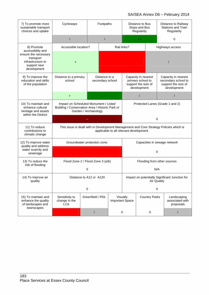
SA/SEA Annex D6 – February 2014
183 Place Services at Essex County Council
7) To promote more sustainable transport choices and uptake
Cycleways Footpaths Distance to Bus Stops and Bus
Regularity
Distance to Railway Stations and Train
Regularity
/ / ++ 0
8) Promote accessibility and
ensure the necessary transport
infrastructure to support new development
Accessible location? Rail links? Highways access
+ - /
9) To improve the education and skills
of the population
Distance to a primary school
Distance to a secondary school
Capacity in nearest primary school to
support the size of development
Capacity in nearest secondary school to support the size of
development
+ ++ / /
10) To maintain and enhance cultural
heritage and assets within the District
Impact on Scheduled Monument / Listed Building / Conservation Area / Historic Park or
Garden / Archaeology
Protected Lanes (Grade 1 and 2)
-- 0
11) To reduce contributions to climatic change
This issue is dealt with in Development Management and Core Strategy Policies which is applicable to all relevant development.
12) To improve water quality and address water scarcity and
sewerage
Groundwater protection zone. Capacities in sewage network
- 0
13) To reduce the risk of flooding
Flood Zone 2 / Flood Zone 3 (a/b) Flooding from other sources
0 N/A
14) To improve air quality
Distance to A12 or A120 Impact on potentially Significant Junction for Air Quality
0 0
15) To maintain and enhance the quality of landscapes and
townscapes
Sensitivity to change in the
LCA
Greenfield / PDL Visually Important Space
Country Parks Landscaping associated with
proposals
- / 0 0 /

SA/SEA Annex D6 – February 2014
184 Place Services at Essex County Council
1.18. Silver End
1.18.1. Site: SIL1 Address: Land adjacent to Works, Boars Tye Road, Silver End Other info: Greenfield, Residential
Sustainability Objective
Key Criteria / Impacts
1) Create safe environments which
improve quality of life and community
cohesion
Provision / suitability for community facilities
Crime incidents in past year Nearest Post Offices
0 /
86 incidences +
2) To provide everyone with the
opportunity to live in a decent home
Delivery of affordable housing Additional capacity in or of care homes
/ /
3) To improve the health of the District’s
residents and mitigate/reduce potential health
inequalities
Distance to nearest GP
Distances to accessible natural
greenspace
Loss of recreation (formal / informal),
open space, allotments.
Contaminated land
+ -- + /
4) To promote the vitality and viability of
all service centres throughout the
District
Increase in retail floorspace Distances to primary shopping area boundaries
0 /
5) To achieve sustainable levels of
prosperity and economic growth
Loss of high quality agricultural land (Grades 1 &
2)
Distances to employment sites (B1, B2, B8)
Broadband availability
- / ADSL, WBC, LLU DSL
broadband enabled
6) To conserve and enhance the
biological and geological diversity of
the environment
Distance to SSSI (any condition)
Distance to NNR
Distance to LNR
Distance to LoWS
Distance to Ancient
Woodland
Presence of TPOs on site?
0 0 0 0 0 0
7) To promote more sustainable transport choices and uptake
Cycleways Footpaths Distance to Bus Stops and Bus
Regularity
Distance to Railway Stations and Train
Regularity
0 / ++ 0
8) Promote accessibility and
ensure the necessary transport
infrastructure to support new development
Accessible location? Rail links? Highways access
+ 0 /
9) To improve the education and skills
of the population
Distance to a primary school
Distance to a secondary school
Capacity in nearest primary school to
support the size of development
Capacity in nearest secondary school to support the size of
development

SA/SEA Annex D6 – February 2014
185 Place Services at Essex County Council
- + -
Silver End Primary -2 places
/ New Rickstones
Academy 403 places
10) To maintain and enhance cultural
heritage and assets within the District
Impact on Scheduled Monument / Listed Building / Conservation Area / Historic Park
or Garden / Archaeology
Protected Lanes (Grade 1 and 2)
0 0
11) To reduce contributions to climatic change
This issue is dealt with in Development Management and Core Strategy Policies which is applicable to all relevant development.
12) To improve water quality and address water scarcity and
sewerage
Groundwater protection zone. Capacities in sewage network
0 0
13) To reduce the risk of flooding
Flood Zone 2 / Flood Zone 3 (a/b) Flooding from other sources
0 /
14) To improve air quality
Distance to A12 or A120 Impact on potentially Significant Junction for Air Quality
0 0
15) To maintain and enhance the quality of landscapes and
townscapes
Sensitivity to change in the
LCA
Greenfield / PDL
Visually Important
Space
Country Parks Landscaping associated with
proposals
- Silver End Farmland Plateau
- 0 0 /
1.18.2. Site: SIL2 Address: Land at Temple Lane (Site A), Silver End Other info: Greenfield, Residential
Sustainability Objective
Key Criteria / Impacts
1) Create safe environments which
improve quality of life and community
cohesion
Provision / suitability for community facilities
Crime incidents in past year Nearest Post Offices
0 /
87 incidences +
2) To provide everyone with the
opportunity to live in a decent home
Delivery of affordable housing Additional capacity in or of care homes
/ /
3) To improve the health of the District’s
residents and mitigate/reduce potential health
inequalities
Distance to nearest GP
Distances to accessible natural
greenspace
Loss of recreation (formal / informal),
open space, allotments.
Contaminated land
++ -- + /

SA/SEA Annex D6 – February 2014
186 Place Services at Essex County Council
4) To promote the vitality and viability of
all service centres throughout the
District
Increase in retail floorspace Distances to primary shopping area boundaries
0 /
5) To achieve sustainable levels of
prosperity and economic growth
Loss of high quality agricultural land (Grades 1 &
2)
Distances to employment sites (B1, B2, B8)
Broadband availability
- / ADSL, WBC, LLU DSL
broadband enabled
6) To conserve and enhance the
biological and geological diversity of
the environment
Distance to SSSI (any condition)
Distance to NNR
Distance to LNR
Distance to LoWS
Distance to Ancient
Woodland
Presence of TPOs on site?
0 0 0 0 0 0
7) To promote more sustainable transport choices and uptake
Cycleways Footpaths Distance to Bus Stops and Bus
Regularity
Distance to Railway Stations and Train
Regularity
0 / ++ 0
8) Promote accessibility and
ensure the necessary transport
infrastructure to support new development
Accessible location? Rail links? Highways access
+ 0 /
9) To improve the education and skills
of the population
Distance to a primary school
Distance to a secondary school
Capacity in nearest primary school to
support the size of development
Capacity in nearest secondary school to support the size of
development
++ + -
Silver End Primary -2 places
/ New Rickstones
Academy 403 places
10) To maintain and enhance cultural
heritage and assets within the District
Impact on Scheduled Monument / Listed Building / Conservation Area / Historic Park
or Garden / Archaeology
Protected Lanes (Grade 1 and 2)
- 0
11) To reduce contributions to climatic change
This issue is dealt with in Development Management and Core Strategy Policies which is applicable to all relevant development.
12) To improve water quality and address water scarcity and
sewerage
Groundwater protection zone. Capacities in sewage network
0 0
13) To reduce the risk of flooding
Flood Zone 2 / Flood Zone 3 (a/b) Flooding from other sources
/ /
14) To improve air quality
Distance to A12 or A120 Impact on potentially Significant Junction for Air Quality

SA/SEA Annex D6 – February 2014
187 Place Services at Essex County Council
0 0
15) To maintain and enhance the quality of landscapes and
townscapes
Sensitivity to change in the
LCA
Greenfield / PDL
Visually Important
Space
Country Parks Landscaping associated with
proposals
- Silver End Farmland Plateau
- 0 0 /
1.18.3. Site: SIL3 Address: Land at Temple Lane (Site B), Silver End Other info: Greenfield, Recreational
Sustainability Objective
Key Criteria / Impacts
1) Create safe environments which
improve quality of life and community
cohesion
Provision / suitability for community facilities
Crime incidents in past year Nearest Post Offices
0 /
90 incidences +
2) To provide everyone with the
opportunity to live in a decent home
Delivery of affordable housing Additional capacity in or of care homes
0 0
3) To improve the health of the District’s
residents and mitigate/reduce potential health
inequalities
Distance to nearest GP
Distances to accessible natural
greenspace
Loss of recreation (formal / informal),
open space, allotments.
Contaminated land
++ -- + /
4) To promote the vitality and viability of
all service centres throughout the
District
Increase in retail floorspace Distances to primary shopping area boundaries
0 /
5) To achieve sustainable levels of
prosperity and economic growth
Loss of high quality agricultural land (Grades 1 &
2)
Distances to employment sites (B1, B2, B8)
Broadband availability
- / ADSL, WBC, LLU DSL
broadband enabled
6) To conserve and enhance the
biological and geological diversity of
the environment
Distance to SSSI (any condition)
Distance to NNR
Distance to LNR
Distance to LoWS
Distance to Ancient
Woodland
Presence of TPOs on site?
0 0 0 0 0 0
7) To promote more sustainable transport choices and uptake
Cycleways Footpaths Distance to Bus Stops and Bus
Regularity
Distance to Railway Stations and Train
Regularity
0 / ++ 0
8) Promote Accessible location? Rail links? Highways access
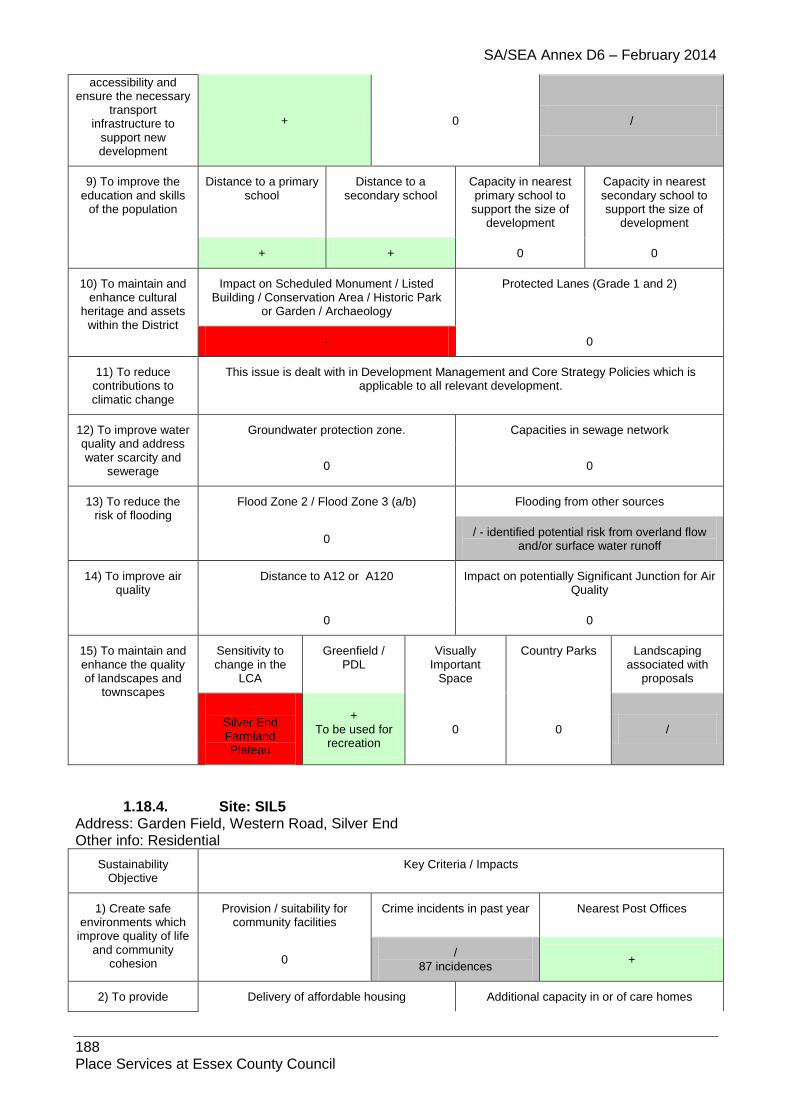
SA/SEA Annex D6 – February 2014
188 Place Services at Essex County Council
accessibility and ensure the necessary
transport infrastructure to
support new development
+ 0 /
9) To improve the education and skills
of the population
Distance to a primary school
Distance to a secondary school
Capacity in nearest primary school to
support the size of development
Capacity in nearest secondary school to support the size of
development
+ + 0 0
10) To maintain and enhance cultural
heritage and assets within the District
Impact on Scheduled Monument / Listed Building / Conservation Area / Historic Park
or Garden / Archaeology
Protected Lanes (Grade 1 and 2)
- 0
11) To reduce contributions to climatic change
This issue is dealt with in Development Management and Core Strategy Policies which is applicable to all relevant development.
12) To improve water quality and address water scarcity and
sewerage
Groundwater protection zone. Capacities in sewage network
0 0
13) To reduce the risk of flooding
Flood Zone 2 / Flood Zone 3 (a/b) Flooding from other sources
0 / - identified potential risk from overland flow
and/or surface water runoff
14) To improve air quality
Distance to A12 or A120 Impact on potentially Significant Junction for Air Quality
0 0
15) To maintain and enhance the quality of landscapes and
townscapes
Sensitivity to change in the
LCA
Greenfield / PDL
Visually Important
Space
Country Parks Landscaping associated with
proposals
- Silver End Farmland Plateau
+ To be used for
recreation 0 0 /
1.18.4. Site: SIL5 Address: Garden Field, Western Road, Silver End Other info: Residential
Sustainability Objective
Key Criteria / Impacts
1) Create safe environments which
improve quality of life and community
cohesion
Provision / suitability for community facilities
Crime incidents in past year Nearest Post Offices
0 /
87 incidences +
2) To provide Delivery of affordable housing Additional capacity in or of care homes

SA/SEA Annex D6 – February 2014
189 Place Services at Essex County Council
everyone with the opportunity to live in
a decent home / /
3) To improve the health of the District’s
residents and mitigate/reduce potential health
inequalities
Distance to nearest GP
Distances to accessible natural
greenspace
Loss of recreation (formal / informal),
open space, allotments.
Contaminated land
/ -- + /
4) To promote the vitality and viability of
all service centres throughout the
District
Increase in retail floorspace Distances to primary shopping area boundaries
0 /
5) To achieve sustainable levels of
prosperity and economic growth
Loss of high quality agricultural land (Grades 1 &
2)
Distances to employment sites (B1, B2, B8)
Broadband availability
- / ADSL, WBC, LLU DSL
broadband enabled
6) To conserve and enhance the
biological and geological diversity of
the environment
Distance to SSSI (any condition)
Distance to NNR
Distance to LNR
Distance to LoWS
Distance to Ancient
Woodland
Presence of TPOs on site?
0 0 0 0 0 0
7) To promote more sustainable transport choices and uptake
Cycleways Footpaths Distance to Bus Stops and Bus
Regularity
Distance to Railway Stations and Train
Regularity
0 / ++ 0
8) Promote accessibility and
ensure the necessary transport
infrastructure to support new development
Accessible location? Rail links? Highways access
+ 0 /
9) To improve the education and skills
of the population
Distance to a primary school
Distance to a secondary school
Capacity in nearest primary school to
support the size of development
Capacity in nearest secondary school to support the size of
development
++ + -
Silver End Primary -2 places
/ New Rickstones
Academy 403 places
10) To maintain and enhance cultural
heritage and assets within the District
Impact on Scheduled Monument / Listed Building / Conservation Area / Historic Park
or Garden / Archaeology
Protected Lanes (Grade 1 and 2)
0 0
11) To reduce contributions to climatic change
This issue is dealt with in Development Management and Core Strategy Policies which is applicable to all relevant development.
12) To improve water Groundwater protection zone. Capacities in sewage network
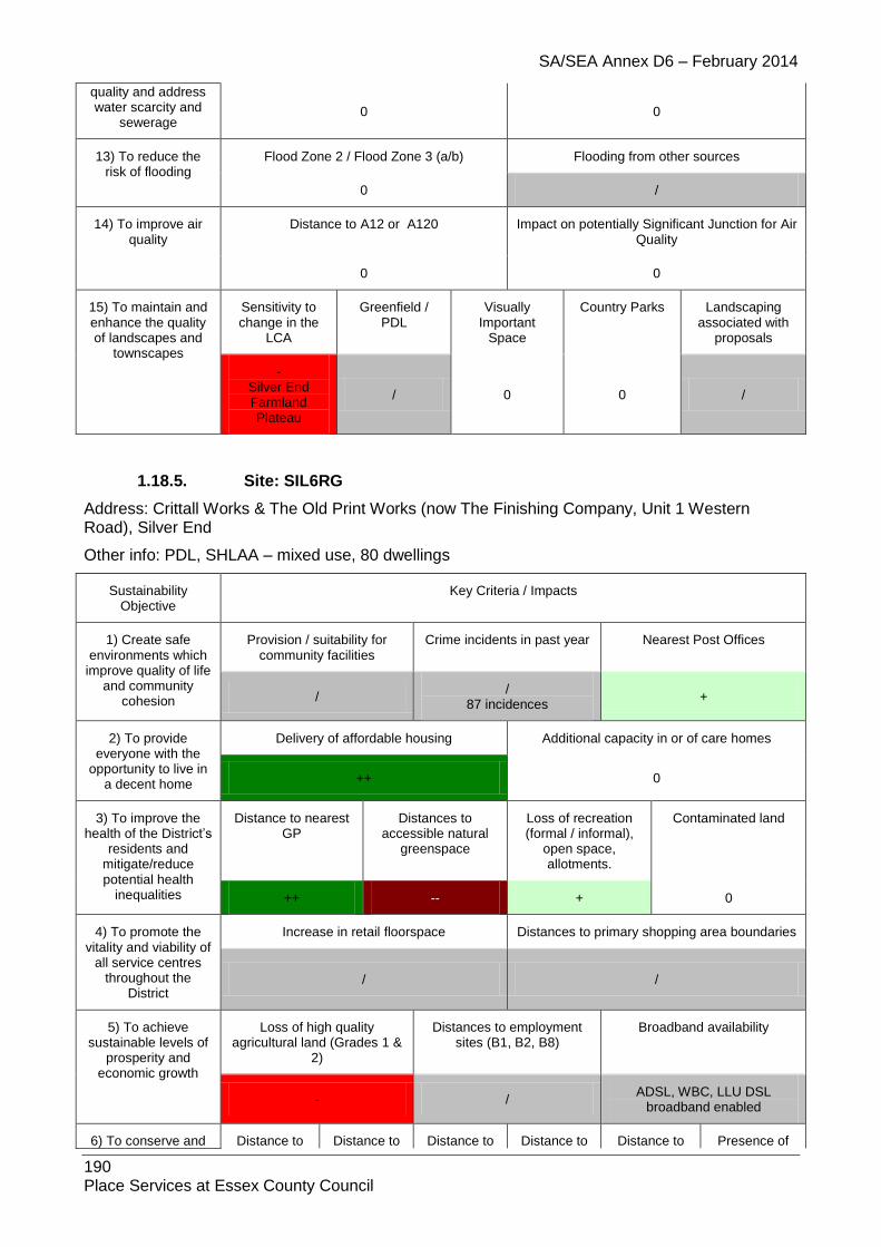
SA/SEA Annex D6 – February 2014
190 Place Services at Essex County Council
quality and address water scarcity and
sewerage 0 0
13) To reduce the risk of flooding
Flood Zone 2 / Flood Zone 3 (a/b) Flooding from other sources
0 /
14) To improve air quality
Distance to A12 or A120 Impact on potentially Significant Junction for Air Quality
0 0
15) To maintain and enhance the quality of landscapes and
townscapes
Sensitivity to change in the
LCA
Greenfield / PDL
Visually Important
Space
Country Parks Landscaping associated with
proposals
- Silver End Farmland Plateau
/ 0 0 /
1.18.5. Site: SIL6RG
Address: Crittall Works & The Old Print Works (now The Finishing Company, Unit 1 Western Road), Silver End
Other info: PDL, SHLAA – mixed use, 80 dwellings
Sustainability Objective
Key Criteria / Impacts
1) Create safe environments which
improve quality of life and community
cohesion
Provision / suitability for community facilities
Crime incidents in past year Nearest Post Offices
/ /
87 incidences +
2) To provide everyone with the
opportunity to live in a decent home
Delivery of affordable housing Additional capacity in or of care homes
++ 0
3) To improve the health of the District’s
residents and mitigate/reduce potential health
inequalities
Distance to nearest GP
Distances to accessible natural
greenspace
Loss of recreation (formal / informal),
open space, allotments.
Contaminated land
++ -- + 0
4) To promote the vitality and viability of
all service centres throughout the
District
Increase in retail floorspace Distances to primary shopping area boundaries
/ /
5) To achieve sustainable levels of
prosperity and economic growth
Loss of high quality agricultural land (Grades 1 &
2)
Distances to employment sites (B1, B2, B8)
Broadband availability
- / ADSL, WBC, LLU DSL
broadband enabled
6) To conserve and Distance to Distance to Distance to Distance to Distance to Presence of

SA/SEA Annex D6 – February 2014
191 Place Services at Essex County Council
enhance the biological and
geological diversity of the environment
SSSI (any condition)
NNR LNR LoWS Ancient Woodland
TPOs on site?
0 0 0 0 0 0
7) To promote more sustainable transport choices and uptake
Cycleways Footpaths Distance to Bus Stops and Bus
Regularity
Distance to Railway Stations and Train
Regularity
0 0 ++ -
8) Promote accessibility and
ensure the necessary transport
infrastructure to support new development
Accessible location? Rail links? Highways access
+ 0
+ Access off Boars Tye Road/ and or Temple Lane to entire
mixed use site
9) To improve the education and skills
of the population
Distance to a primary school
Distance to a secondary school
Capacity in nearest primary school to
support the size of development
Capacity in nearest secondary school to support the size of
development
++ + -
Silver End Primary -2 places
/ New Rickstones
Academy 403 places
10) To maintain and enhance cultural
heritage and assets within the District
Impact on Scheduled Monument / Listed Building / Conservation Area / Historic Park
or Garden / Archaeology
Protected Lanes (Grade 1 and 2)
-- 0
11) To reduce contributions to climatic change
This issue is dealt with in Development Management and Core Strategy Policies which is applicable to all relevant development.
12) To improve water quality and address water scarcity and
sewerage
Groundwater protection zone. Capacities in sewage network
0 0
13) To reduce the risk of flooding
Flood Zone 2 / Flood Zone 3 (a/b) Flooding from other sources
0 / - identified potential risk from overland flow
and/or surface water runoff
14) To improve air quality
Distance to A12 or A120 Impact on potentially Significant Junction for Air Quality
0 0
15) To maintain and enhance the quality of landscapes and
townscapes
Sensitivity to change in the
LCA
Greenfield / PDL
Visually Important
Space
Country Parks Landscaping associated with
proposals
0 + 0 0 /
1.18.6. Site: SIL7H
Address: SHLAA site

SA/SEA Annex D6 – February 2014
192 Place Services at Essex County Council
Other info: SHLAA – PDL, 12 dwellings
Sustainability Objective
Key Criteria / Impacts
1) Create safe environments which
improve quality of life and community
cohesion
Provision / suitability for community facilities
Crime incidents in past year Nearest Post Offices
0 /
87 incidences +
2) To provide everyone with the
opportunity to live in a decent home
Delivery of affordable housing Additional capacity in or of care homes
+ 0
3) To improve the health of the District’s
residents and mitigate/reduce potential health
inequalities
Distance to nearest GP
Distances to accessible natural
greenspace
Loss of recreation (formal / informal),
open space, allotments.
Contaminated land
++ -- + 0
4) To promote the vitality and viability of
all service centres throughout the
District
Increase in retail floorspace Distances to primary shopping area boundaries
0 /
5) To achieve sustainable levels of
prosperity and economic growth
Loss of high quality agricultural land (Grades 1 &
2)
Distances to employment sites (B1, B2, B8)
Broadband availability
0 / ADSL, WBC, LLU DSL
broadband enabled
6) To conserve and enhance the
biological and geological diversity of
the environment
Distance to SSSI (any condition)
Distance to NNR
Distance to LNR
Distance to LoWS
Distance to Ancient
Woodland
Presence of TPOs on site?
0 0 0 0 0 0
7) To promote more sustainable transport choices and uptake
Cycleways Footpaths Distance to Bus Stops and Bus
Regularity
Distance to Railway Stations and Train
Regularity
0 0 ++ -
8) Promote accessibility and
ensure the necessary transport
infrastructure to support new development
Accessible location? Rail links? Highways access
+ 0 +
Access off Sheepcotes Lane
9) To improve the education and skills
of the population
Distance to a primary school
Distance to a secondary school
Capacity in nearest primary school to
support the size of development
Capacity in nearest secondary school to support the size of
development
+ + -
Silver End Primary -2 places
+ New Rickstones
Academy 403 places

SA/SEA Annex D6 – February 2014
193 Place Services at Essex County Council
10) To maintain and enhance cultural
heritage and assets within the District
Impact on Scheduled Monument / Listed Building / Conservation Area / Historic Park
or Garden / Archaeology
Protected Lanes (Grade 1 and 2)
-- 0
11) To reduce contributions to climatic change
This issue is dealt with in Development Management and Core Strategy Policies which is applicable to all relevant development.
12) To improve water quality and address water scarcity and
sewerage
Groundwater protection zone. Capacities in sewage network
0 0
13) To reduce the risk of flooding
Flood Zone 2 / Flood Zone 3 (a/b) Flooding from other sources
0 /
14) To improve air quality
Distance to A12 or A120 Impact on potentially Significant Junction for Air Quality
0 0
15) To maintain and enhance the quality of landscapes and
townscapes
Sensitivity to change in the
LCA
Greenfield / PDL
Visually Important
Space
Country Parks Landscaping associated with
proposals
0 + 0 0 /
1.18.7. Site: SIL8 Address: SHLAA large site not inc in 15yr supply Other info: SHLAA – PDL, 58 dwellings
Sustainability Objective
Key Criteria / Impacts
1) Create safe environments which
improve quality of life and community
cohesion
Provision / suitability for community facilities
Crime incidents in past year Nearest Post Offices
0 /
86 incidences +
2) To provide everyone with the
opportunity to live in a decent home
Delivery of affordable housing Additional capacity in or of care homes
++ 0
3) To improve the health of the District’s
residents and mitigate/reduce potential health
inequalities
Distance to nearest GP
Distances to accessible natural
greenspace
Loss of recreation (formal / informal),
open space, allotments.
Contaminated land
++ -- + 0
4) To promote the vitality and viability of
all service centres throughout the
District
Increase in retail floorspace Distances to primary shopping area boundaries
/ /
5) To achieve sustainable levels of
prosperity and
Loss of high quality agricultural land (Grades 1 &
2)
Distances to employment sites (B1, B2, B8)
Broadband availability

SA/SEA Annex D6 – February 2014
194 Place Services at Essex County Council
economic growth
- / ADSL, WBC, LLU DSL
broadband enabled
6) To conserve and enhance the
biological and geological diversity of
the environment
Distance to SSSI (any condition)
Distance to NNR
Distance to LNR
Distance to LoWS
Distance to Ancient
Woodland
Presence of TPOs on site?
0 0 0 0 0 0
7) To promote more sustainable transport choices and uptake
Cycleways Footpaths Distance to Bus Stops and Bus
Regularity
Distance to Railway Stations and Train
Regularity
0 0 ++ 0
8) Promote accessibility and
ensure the necessary transport
infrastructure to support new development
Accessible location? Rail links? Highways access
+ 0 +
9) To improve the education and skills
of the population
Distance to a primary school
Distance to a secondary school
Capacity in nearest primary school to
support the size of development
Capacity in nearest secondary school to support the size of
development
- + -
Silver End Primary -2 places
/ New Rickstones
Academy 403 places
10) To maintain and enhance cultural
heritage and assets within the District
Impact on Scheduled Monument / Listed Building / Conservation Area / Historic Park
or Garden / Archaeology
Protected Lanes (Grade 1 and 2)
- 0
11) To reduce contributions to climatic change
This issue is dealt with in Development Management and Core Strategy Policies which is applicable to all relevant development.
12) To improve water quality and address water scarcity and
sewerage
Groundwater protection zone. Capacities in sewage network
0 0
13) To reduce the risk of flooding
Flood Zone 2 / Flood Zone 3 (a/b) Flooding from other sources
0 /
14) To improve air quality
Distance to A12 or A120 Impact on potentially Significant Junction for Air Quality
0 0
15) To maintain and enhance the quality of landscapes and
townscapes
Sensitivity to change in the
LCA
Greenfield / PDL
Visually Important
Space
Country Parks Landscaping associated with
proposals
- Silver End Farmland Plateau
+ 0 0 /

SA/SEA Annex D6 – February 2014
195 Place Services at Essex County Council
1.18.8. Site: SIL9 Address: SHLAA large site not inc in 15yr supply Other info: SHLAA – PDL, 12 dwellings
Sustainability Objective
Key Criteria / Impacts
1) Create safe environments which
improve quality of life and community
cohesion
Provision / suitability for community facilities
Crime incidents in past year Nearest Post Offices
0 /
86 incidences +
2) To provide everyone with the
opportunity to live in a decent home
Delivery of affordable housing Additional capacity in or of care homes
+ 0
3) To improve the health of the District’s
residents and mitigate/reduce potential health
inequalities
Distance to nearest GP
Distances to accessible natural
greenspace
Loss of recreation (formal / informal),
open space, allotments.
Contaminated land
++ -- +
/ BTE710 small
unknown infill on part of site
4) To promote the vitality and viability of
all service centres throughout the
District
Increase in retail floorspace Distances to primary shopping area boundaries
0 /
5) To achieve sustainable levels of
prosperity and economic growth
Loss of high quality agricultural land (Grades 1 &
2)
Distances to employment sites (B1, B2, B8)
Broadband availability
- / ADSL, WBC, LLU DSL
broadband enabled
6) To conserve and enhance the
biological and geological diversity of
the environment
Distance to SSSI (any condition)
Distance to NNR
Distance to LNR
Distance to LoWS
Distance to Ancient
Woodland
Presence of TPOs on site?
0 0 0 0 0 0
7) To promote more sustainable transport choices and uptake
Cycleways Footpaths Distance to Bus Stops and Bus
Regularity
Distance to Railway Stations and Train
Regularity
0 0 ++ 0
8) Promote accessibility and
ensure the necessary transport
infrastructure to support new development
Accessible location? Rail links? Highways access
+ 0 +
9) To improve the education and skills
Distance to a primary school
Distance to a secondary school
Capacity in nearest primary school to
support the size of
Capacity in nearest secondary school to support the size of

SA/SEA Annex D6 – February 2014
196 Place Services at Essex County Council
of the population development development
+ + -
Silver End Primary -2 places
/ New Rickstones
Academy 403 places
10) To maintain and enhance cultural
heritage and assets within the District
Impact on Scheduled Monument / Listed Building / Conservation Area / Historic Park
or Garden / Archaeology
Protected Lanes (Grade 1 and 2)
-- 0
11) To reduce contributions to climatic change
This issue is dealt with in Development Management and Core Strategy Policies which is applicable to all relevant development.
12) To improve water quality and address water scarcity and
sewerage
Groundwater protection zone. Capacities in sewage network
0 0
13) To reduce the risk of flooding
Flood Zone 2 / Flood Zone 3 (a/b) Flooding from other sources
0 /
14) To improve air quality
Distance to A12 or A120 Impact on potentially Significant Junction for Air Quality
0 0
15) To maintain and enhance the quality of landscapes and
townscapes
Sensitivity to change in the
LCA
Greenfield / PDL
Visually Important
Space
Country Parks Landscaping associated with
proposals
- Silver End Farmland Plateau
+ 0 0 /
1.19. Stambourne
1.19.1. Site: STA1 Address: Old House Farm, Chapel End Way, Stambourne Other info: Greenfield, Residential
Sustainability Objective
Key Criteria / Impacts
1) Create safe environments which improve quality of life
and community cohesion
Provision / suitability for community facilities
Crime incidents in past year Nearest Post Offices
0 /
2 incidences +
2) To provide everyone with the
opportunity to live in a decent home
Delivery of affordable housing Additional capacity in or of care homes
/ /
3) To improve the health of the District’s
residents and
Distance to nearest GP
Distances to accessible natural
greenspace
Loss of recreation (formal / informal),
open space,
Contaminated land
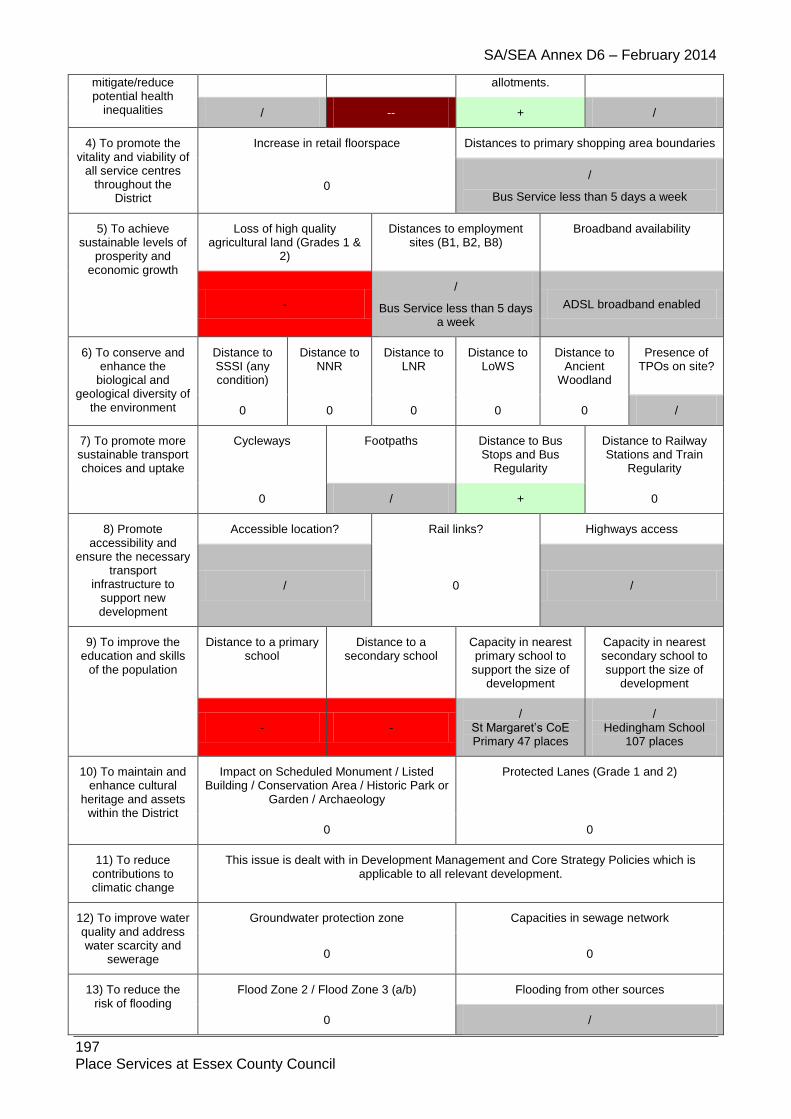
SA/SEA Annex D6 – February 2014
197 Place Services at Essex County Council
mitigate/reduce potential health
inequalities
allotments.
/ -- + /
4) To promote the vitality and viability of
all service centres throughout the
District
Increase in retail floorspace Distances to primary shopping area boundaries
0 /
Bus Service less than 5 days a week
5) To achieve sustainable levels of
prosperity and economic growth
Loss of high quality agricultural land (Grades 1 &
2)
Distances to employment sites (B1, B2, B8)
Broadband availability
-
/
Bus Service less than 5 days a week
ADSL broadband enabled
6) To conserve and enhance the
biological and geological diversity of
the environment
Distance to SSSI (any condition)
Distance to NNR
Distance to LNR
Distance to LoWS
Distance to Ancient
Woodland
Presence of TPOs on site?
0 0 0 0 0 /
7) To promote more sustainable transport choices and uptake
Cycleways Footpaths Distance to Bus Stops and Bus
Regularity
Distance to Railway Stations and Train
Regularity
0 / + 0
8) Promote accessibility and
ensure the necessary transport
infrastructure to support new development
Accessible location? Rail links? Highways access
/ 0 /
9) To improve the education and skills
of the population
Distance to a primary school
Distance to a secondary school
Capacity in nearest primary school to
support the size of development
Capacity in nearest secondary school to support the size of
development
- - /
St Margaret’s CoE Primary 47 places
/ Hedingham School
107 places
10) To maintain and enhance cultural
heritage and assets within the District
Impact on Scheduled Monument / Listed Building / Conservation Area / Historic Park or
Garden / Archaeology
Protected Lanes (Grade 1 and 2)
0 0
11) To reduce contributions to climatic change
This issue is dealt with in Development Management and Core Strategy Policies which is applicable to all relevant development.
12) To improve water quality and address water scarcity and
sewerage
Groundwater protection zone Capacities in sewage network
0 0
13) To reduce the risk of flooding
Flood Zone 2 / Flood Zone 3 (a/b) Flooding from other sources
0 /

SA/SEA Annex D6 – February 2014
198 Place Services at Essex County Council
14) To improve air quality
Distance to A12 or A120 Impact on potentially Significant Junction for Air Quality
0 0
15) To maintain and enhance the quality of landscapes and
townscapes
Sensitivity to change in the
LCA
Greenfield / PDL
Visually Important
Space
Country Parks Landscaping associated with
proposals
- Stambourne
Farmland Plateau
- 0 0 /
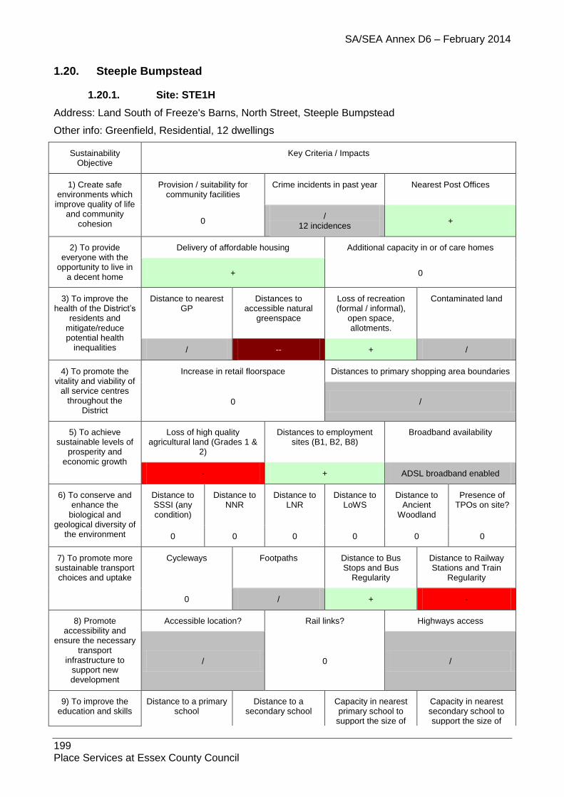
SA/SEA Annex D6 – February 2014
199 Place Services at Essex County Council
1.20. Steeple Bumpstead
1.20.1. Site: STE1H
Address: Land South of Freeze's Barns, North Street, Steeple Bumpstead
Other info: Greenfield, Residential, 12 dwellings
Sustainability Objective
Key Criteria / Impacts
1) Create safe environments which
improve quality of life and community
cohesion
Provision / suitability for community facilities
Crime incidents in past year Nearest Post Offices
0 /
12 incidences +
2) To provide everyone with the
opportunity to live in a decent home
Delivery of affordable housing Additional capacity in or of care homes
+ 0
3) To improve the health of the District’s
residents and mitigate/reduce potential health
inequalities
Distance to nearest GP
Distances to accessible natural
greenspace
Loss of recreation (formal / informal),
open space, allotments.
Contaminated land
/ -- + /
4) To promote the vitality and viability of
all service centres throughout the
District
Increase in retail floorspace Distances to primary shopping area boundaries
0 /
5) To achieve sustainable levels of
prosperity and economic growth
Loss of high quality agricultural land (Grades 1 &
2)
Distances to employment sites (B1, B2, B8)
Broadband availability
- + ADSL broadband enabled
6) To conserve and enhance the
biological and geological diversity of
the environment
Distance to SSSI (any condition)
Distance to NNR
Distance to LNR
Distance to LoWS
Distance to Ancient
Woodland
Presence of TPOs on site?
0 0 0 0 0 0
7) To promote more sustainable transport choices and uptake
Cycleways Footpaths Distance to Bus Stops and Bus
Regularity
Distance to Railway Stations and Train
Regularity
0 / + -
8) Promote accessibility and
ensure the necessary transport
infrastructure to support new development
Accessible location? Rail links? Highways access
/ 0 /
9) To improve the education and skills
Distance to a primary school
Distance to a secondary school
Capacity in nearest primary school to
support the size of
Capacity in nearest secondary school to support the size of

SA/SEA Annex D6 – February 2014
200 Place Services at Essex County Council
of the population development development
++ - +
Stanley Drapkin Primary 35 places
+ Hedingham School
107 places
10) To maintain and enhance cultural
heritage and assets within the District
Impact on Scheduled Monument / Listed Building / Conservation Area / Historic Park
or Garden / Archaeology
Protected Lanes (Grade 1 and 2)
-- 0
11) To reduce contributions to climatic change
This issue is dealt with in Development Management and Core Strategy Policies which is applicable to all relevant development.
12) To improve water quality and address water scarcity and
sewerage
Groundwater protection zone. Capacities in sewage network
/ SPZ3
0
13) To reduce the risk of flooding
Flood Zone 2 / Flood Zone 3 (a/b) Flooding from other sources
0 /
14) To improve air quality
Distance to A12 or A120 Impact on potentially Significant Junction for Air Quality
0 0
15) To maintain and enhance the quality of landscapes and
townscapes
Sensitivity to change in the
LCA
Greenfield / PDL
Visually Important
Space
Country Parks Landscaping associated with
proposals
- Bumpstead Farmland Plateau
- 0 0 /
1.20.2. Site: STE2 Address: Land Adjacent to Freeze's Barns, North Street, Steeple Bumpstead Other info: Greenfield, Residential
Sustainability Objective
Key Criteria / Impacts
1) Create safe environments which
improve quality of life and community
cohesion
Provision / suitability for community facilities
Crime incidents in past year Nearest Post Offices
0 /
12 incidences +
2) To provide everyone with the
opportunity to live in a decent home
Delivery of affordable housing Additional capacity in or of care homes
/ /
3) To improve the health of the District’s
residents and mitigate/reduce potential health
inequalities
Distance to nearest GP
Distances to accessible natural
greenspace
Loss of recreation (formal / informal),
open space, allotments.
Contaminated land
+ -- + /
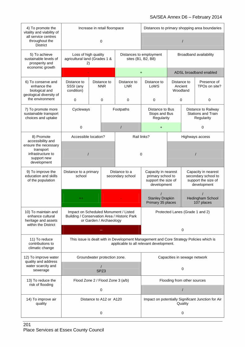
SA/SEA Annex D6 – February 2014
201 Place Services at Essex County Council
4) To promote the vitality and viability of
all service centres throughout the
District
Increase in retail floorspace Distances to primary shopping area boundaries
0 /
5) To achieve sustainable levels of
prosperity and economic growth
Loss of high quality agricultural land (Grades 1 &
2)
Distances to employment sites (B1, B2, B8)
Broadband availability
- + ADSL broadband enabled
6) To conserve and enhance the
biological and geological diversity of
the environment
Distance to SSSI (any condition)
Distance to NNR
Distance to LNR
Distance to LoWS
Distance to Ancient
Woodland
Presence of TPOs on site?
0 0 0 0 0 0
7) To promote more sustainable transport choices and uptake
Cycleways Footpaths Distance to Bus Stops and Bus
Regularity
Distance to Railway Stations and Train
Regularity
0 / + 0
8) Promote accessibility and
ensure the necessary transport
infrastructure to support new development
Accessible location? Rail links? Highways access
/ 0 /
9) To improve the education and skills
of the population
Distance to a primary school
Distance to a secondary school
Capacity in nearest primary school to
support the size of development
Capacity in nearest secondary school to support the size of
development
++ - /
Stanley Drapkin Primary 35 places
/ Hedingham School
107 places
10) To maintain and enhance cultural
heritage and assets within the District
Impact on Scheduled Monument / Listed Building / Conservation Area / Historic Park
or Garden / Archaeology
Protected Lanes (Grade 1 and 2)
-- 0
11) To reduce contributions to climatic change
This issue is dealt with in Development Management and Core Strategy Policies which is applicable to all relevant development.
12) To improve water quality and address water scarcity and
sewerage
Groundwater protection zone. Capacities in sewage network
/ SPZ3
0
13) To reduce the risk of flooding
Flood Zone 2 / Flood Zone 3 (a/b) Flooding from other sources
0 /
14) To improve air quality
Distance to A12 or A120 Impact on potentially Significant Junction for Air Quality
0 0

SA/SEA Annex D6 – February 2014
202 Place Services at Essex County Council
15) To maintain and enhance the quality of landscapes and
townscapes
Sensitivity to change in the
LCA
Greenfield / PDL
Visually Important
Space
Country Parks Landscaping associated with
proposals
- Bumpstead Farmland Plateau
- 0 0 /
1.20.3. Site: STE3 Address: Dares Yard, 2a Chapel Street, Steeple Bumpstead Other info: Greenfield, Residential
Sustainability Objective
Key Criteria / Impacts
1) Create safe environments which
improve quality of life and community
cohesion
Provision / suitability for community facilities
Crime incidents in past year Nearest Post Offices
0 /
12 incidences +
2) To provide everyone with the
opportunity to live in a decent home
Delivery of affordable housing Additional capacity in or of care homes
/ /
3) To improve the health of the District’s
residents and mitigate/reduce potential health
inequalities
Distance to nearest GP
Distances to accessible natural
greenspace
Loss of recreation (formal / informal),
open space, allotments.
Contaminated land
++ -- + /
4) To promote the vitality and viability of
all service centres throughout the
District
Increase in retail floorspace Distances to primary shopping area boundaries
0 /
5) To achieve sustainable levels of
prosperity and economic growth
Loss of high quality agricultural land (Grades 1 &
2)
Distances to employment sites (B1, B2, B8)
Broadband availability
0 + ADSL broadband enabled
6) To conserve and enhance the
biological and geological diversity of
the environment
Distance to SSSI (any condition)
Distance to NNR
Distance to LNR
Distance to LoWS
Distance to Ancient
Woodland
Presence of TPOs on site?
0 0 0 0 0 0
7) To promote more sustainable transport choices and uptake
Cycleways Footpaths Distance to Bus Stops and Bus
Regularity
Distance to Railway Stations and Train
Regularity
0 / + 0
8) Promote accessibility and
ensure the necessary transport
infrastructure to
Accessible location? Rail links? Highways access
/ 0 /

SA/SEA Annex D6 – February 2014
203 Place Services at Essex County Council
support new development
9) To improve the education and skills
of the population
Distance to a primary school
Distance to a secondary school
Capacity in nearest primary school to
support the size of development
Capacity in nearest secondary school to support the size of
development
++ - /
Stanley Drapkin Primary 35 places
/ Hedingham School
107 places
10) To maintain and enhance cultural
heritage and assets within the District
Impact on Scheduled Monument / Listed Building / Conservation Area / Historic Park
or Garden / Archaeology
Protected Lanes (Grade 1 and 2)
0 0
11) To reduce contributions to climatic change
This issue is dealt with in Development Management and Core Strategy Policies which is applicable to all relevant development.
12) To improve water quality and address water scarcity and
sewerage
Groundwater protection zone. Capacities in sewage network
/ SPZ3
0
13) To reduce the risk of flooding
Flood Zone 2 / Flood Zone 3 (a/b) Flooding from other sources
0 /
14) To improve air quality
Distance to A12 or A120 Impact on potentially Significant Junction for Air Quality
0 0
15) To maintain and enhance the quality of landscapes and
townscapes
Sensitivity to change in the
LCA
Greenfield / PDL
Visually Important
Space
Country Parks Landscaping associated with
proposals
- Stour River
Valley - 0 0 /
1.20.4. Site: STE4MAlt Address: Land East of Steeple Bumpstead Other info: Greenfield, Residential and Employment
Sustainability Objective
Key Criteria / Impacts
1) Create safe environments which
improve quality of life and community
cohesion
Provision / suitability for community facilities
Crime incidents in past year Nearest Post Offices
0 /
12 incidences +
2) To provide everyone with the
opportunity to live in a decent home
Delivery of affordable housing Additional capacity in or of care homes
/ /
3) To improve the Distance to nearest Distances to Loss of recreation Contaminated land

SA/SEA Annex D6 – February 2014
204 Place Services at Essex County Council
health of the District’s residents and
mitigate/reduce potential health
inequalities
GP accessible natural greenspace
(formal / informal), open space, allotments.
++ -- + /
4) To promote the vitality and viability of
all service centres throughout the
District
Increase in retail floorspace Distances to primary shopping area boundaries
/ /
5) To achieve sustainable levels of
prosperity and economic growth
Loss of high quality agricultural land (Grades 1 &
2)
Distances to employment sites (B1, B2, B8)
Broadband availability
- + ADSL broadband enabled
6) To conserve and enhance the
biological and geological diversity of
the environment
Distance to SSSI (any condition)
Distance to NNR
Distance to LNR
Distance to LoWS
Distance to Ancient
Woodland
Presence of TPOs on site?
0 0 0 0 0 /
7) To promote more sustainable transport choices and uptake
Cycleways Footpaths Distance to Bus Stops and Bus
Regularity
Distance to Railway Stations and Train
Regularity
0 / + 0
8) Promote accessibility and
ensure the necessary transport
infrastructure to support new development
Accessible location? Rail links? Highways access
/
Part of the is significantly outside the village envelope
which would warrant a negative score (-)
0 /
9) To improve the education and skills
of the population
Distance to a primary school
Distance to a secondary school
Capacity in nearest primary school to
support the size of development
Capacity in nearest secondary school to support the size of
development
++ - /
Stanley Drapkin Primary 35 places
/ Hedingham School
107 places
10) To maintain and enhance cultural
heritage and assets within the District
Impact on Scheduled Monument / Listed Building / Conservation Area / Historic Park
or Garden / Archaeology
Protected Lanes (Grade 1 and 2)
/ 0
11) To reduce contributions to climatic change
This issue is dealt with in Development Management and Core Strategy Policies which is applicable to all relevant development.
12) To improve water quality and address water scarcity and
sewerage
Groundwater protection zone. Capacities in sewage network
/ SPZ3
0
13) To reduce the Flood Zone 2 / Flood Zone 3 (a/b) Flooding from other sources
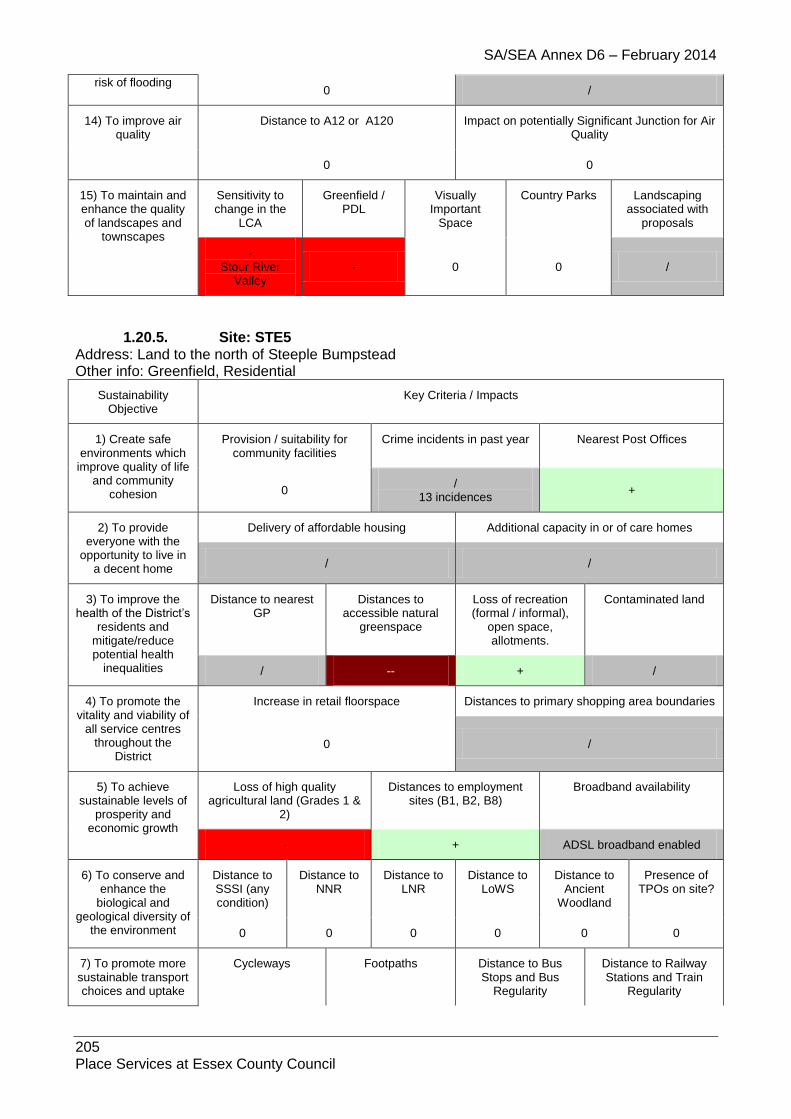
SA/SEA Annex D6 – February 2014
205 Place Services at Essex County Council
risk of flooding 0 /
14) To improve air quality
Distance to A12 or A120 Impact on potentially Significant Junction for Air Quality
0 0
15) To maintain and enhance the quality of landscapes and
townscapes
Sensitivity to change in the
LCA
Greenfield / PDL
Visually Important
Space
Country Parks Landscaping associated with
proposals
- Stour River
Valley - 0 0 /
1.20.5. Site: STE5 Address: Land to the north of Steeple Bumpstead Other info: Greenfield, Residential
Sustainability Objective
Key Criteria / Impacts
1) Create safe environments which
improve quality of life and community
cohesion
Provision / suitability for community facilities
Crime incidents in past year Nearest Post Offices
0 /
13 incidences +
2) To provide everyone with the
opportunity to live in a decent home
Delivery of affordable housing Additional capacity in or of care homes
/ /
3) To improve the health of the District’s
residents and mitigate/reduce potential health
inequalities
Distance to nearest GP
Distances to accessible natural
greenspace
Loss of recreation (formal / informal),
open space, allotments.
Contaminated land
/ -- + /
4) To promote the vitality and viability of
all service centres throughout the
District
Increase in retail floorspace Distances to primary shopping area boundaries
0 /
5) To achieve sustainable levels of
prosperity and economic growth
Loss of high quality agricultural land (Grades 1 &
2)
Distances to employment sites (B1, B2, B8)
Broadband availability
- + ADSL broadband enabled
6) To conserve and enhance the
biological and geological diversity of
the environment
Distance to SSSI (any condition)
Distance to NNR
Distance to LNR
Distance to LoWS
Distance to Ancient
Woodland
Presence of TPOs on site?
0 0 0 0 0 0
7) To promote more sustainable transport choices and uptake
Cycleways Footpaths Distance to Bus Stops and Bus
Regularity
Distance to Railway Stations and Train
Regularity
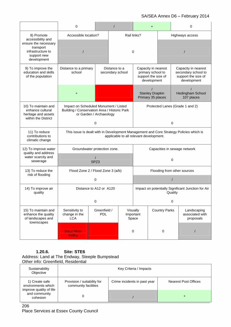
SA/SEA Annex D6 – February 2014
206 Place Services at Essex County Council
0 / + 0
8) Promote accessibility and
ensure the necessary transport
infrastructure to support new development
Accessible location? Rail links? Highways access
/ 0 /
9) To improve the education and skills
of the population
Distance to a primary school
Distance to a secondary school
Capacity in nearest primary school to
support the size of development
Capacity in nearest secondary school to support the size of
development
+ - /
Stanley Drapkin Primary 35 places
/ Hedingham School
107 places
10) To maintain and enhance cultural
heritage and assets within the District
Impact on Scheduled Monument / Listed Building / Conservation Area / Historic Park
or Garden / Archaeology
Protected Lanes (Grade 1 and 2)
0 0
11) To reduce contributions to climatic change
This issue is dealt with in Development Management and Core Strategy Policies which is applicable to all relevant development.
12) To improve water quality and address water scarcity and
sewerage
Groundwater protection zone. Capacities in sewage network
/ SPZ3
0
13) To reduce the risk of flooding
Flood Zone 2 / Flood Zone 3 (a/b) Flooding from other sources
0 /
14) To improve air quality
Distance to A12 or A120 Impact on potentially Significant Junction for Air Quality
0 0
15) To maintain and enhance the quality of landscapes and
townscapes
Sensitivity to change in the
LCA
Greenfield / PDL
Visually Important
Space
Country Parks Landscaping associated with
proposals
- Stour River
Valley - 0 0 /
1.20.6. Site: STE6 Address: Land at The Endway, Steeple Bumpstead Other info: Greenfield, Residential
Sustainability Objective
Key Criteria / Impacts
1) Create safe environments which
improve quality of life and community
cohesion
Provision / suitability for community facilities
Crime incidents in past year Nearest Post Offices
0 / +

SA/SEA Annex D6 – February 2014
207 Place Services at Essex County Council
13 incidences
2) To provide everyone with the
opportunity to live in a decent home
Delivery of affordable housing Additional capacity in or of care homes
/ /
3) To improve the health of the District’s
residents and mitigate/reduce potential health
inequalities
Distance to nearest GP
Distances to accessible natural
greenspace
Loss of recreation (formal / informal),
open space, allotments.
Contaminated land
/ -- + /
4) To promote the vitality and viability of
all service centres throughout the
District
Increase in retail floorspace Distances to primary shopping area boundaries
0 /
5) To achieve sustainable levels of
prosperity and economic growth
Loss of high quality agricultural land (Grades 1 &
2)
Distances to employment sites (B1, B2, B8)
Broadband availability
- + ADSL broadband enabled
6) To conserve and enhance the
biological and geological diversity of
the environment
Distance to SSSI (any condition)
Distance to NNR
Distance to LNR
Distance to LoWS
Distance to Ancient
Woodland
Presence of TPOs on site?
0 0 0 0 0 0
7) To promote more sustainable transport choices and uptake
Cycleways Footpaths Distance to Bus Stops and Bus
Regularity
Distance to Railway Stations and Train
Regularity
0 / + 0
8) Promote accessibility and
ensure the necessary transport
infrastructure to support new development
Accessible location? Rail links? Highways access
/ 0 /
9) To improve the education and skills
of the population
Distance to a primary school
Distance to a secondary school
Capacity in nearest primary school to
support the size of development
Capacity in nearest secondary school to support the size of
development
+ - /
Stanley Drapkin Primary 35 places
/ Hedingham School
107 places
10) To maintain and enhance cultural
heritage and assets within the District
Impact on Scheduled Monument / Listed Building / Conservation Area / Historic Park
or Garden / Archaeology
Protected Lanes (Grade 1 and 2)
0 0
11) To reduce contributions to climatic change
This issue is dealt with in Development Management and Core Strategy Policies which is applicable to all relevant development.

SA/SEA Annex D6 – February 2014
208 Place Services at Essex County Council
12) To improve water quality and address water scarcity and
sewerage
Groundwater protection zone. Capacities in sewage network
/ SPZ3
0
13) To reduce the risk of flooding
Flood Zone 2 / Flood Zone 3 (a/b) Flooding from other sources
/ /
14) To improve air quality
Distance to A12 or A120 Impact on potentially Significant Junction for Air Quality
0 0
15) To maintain and enhance the quality of landscapes and
townscapes
Sensitivity to change in the
LCA
Greenfield / PDL
Visually Important
Space
Country Parks Landscaping associated with
proposals
- Stour River
Valley - 0 0 /
1.20.7. Site: STE7 Address: Bower Croft, Finchingfield Road Other info: Greenfield, Include in village envelope
Sustainability Objective
Key Criteria / Impacts
1) Create safe environments which
improve quality of life and community
cohesion
Provision / suitability for community facilities
Crime incidents in past year Nearest Post Offices
/ /
12 incidences +
2) To provide everyone with the
opportunity to live in a decent home
Delivery of affordable housing Additional capacity in or of care homes
/ /
3) To improve the health of the District’s
residents and mitigate/reduce potential health
inequalities
Distance to nearest GP
Distances to accessible natural
greenspace
Loss of recreation (formal / informal),
open space, allotments.
Contaminated land
++ -- +
4) To promote the vitality and viability of
all service centres throughout the
District
Increase in retail floorspace Distances to primary shopping area boundaries
/ /
5) To achieve sustainable levels of
prosperity and economic growth
Loss of high quality agricultural land (Grades 1 &
2)
Distances to employment sites (B1, B2, B8)
Broadband availability
- + ADSL broadband enabled
6) To conserve and enhance the
biological and
Distance to SSSI (any condition)
Distance to NNR
Distance to LNR
Distance to LoWS
Distance to Ancient
Woodland
Presence of TPOs on site?

SA/SEA Annex D6 – February 2014
209 Place Services at Essex County Council
geological diversity of the environment 0 0 0 0 0 0
7) To promote more sustainable transport choices and uptake
Cycleways Footpaths Distance to Bus Stops and Bus
Regularity
Distance to Railway Stations and Train
Regularity
0 / + 0
8) Promote accessibility and
ensure the necessary transport
infrastructure to support new development
Accessible location? Rail links? Highways access
/ 0 /
9) To improve the education and skills
of the population
Distance to a primary school
Distance to a secondary school
Capacity in nearest primary school to
support the size of development
Capacity in nearest secondary school to support the size of
development
++ - /
Stanley Drapkin Primary 35 places
/ Hedingham School
107 places
10) To maintain and enhance cultural
heritage and assets within the District
Impact on Scheduled Monument / Listed Building / Conservation Area / Historic Park
or Garden / Archaeology
Protected Lanes (Grade 1 and 2)
0 0
11) To reduce contributions to climatic change
This issue is dealt with in Development Management and Core Strategy Policies which is applicable to all relevant development.
12) To improve water quality and address water scarcity and
sewerage
Groundwater protection zone. Capacities in sewage network
/ SPZ3
0
13) To reduce the risk of flooding
Flood Zone 2 / Flood Zone 3 (a/b) Flooding from other sources
0 /
14) To improve air quality
Distance to A12 or A120 Impact on potentially Significant Junction for Air Quality
0 0
15) To maintain and enhance the quality of landscapes and
townscapes
Sensitivity to change in the
LCA
Greenfield / PDL
Visually Important
Space
Country Parks Landscaping associated with
proposals
- Stour River
Valley - 0 0 /
1.20.8. Site: STE8
Address: Steeple Bumpstead, CB9 7BN
Other Info: B1
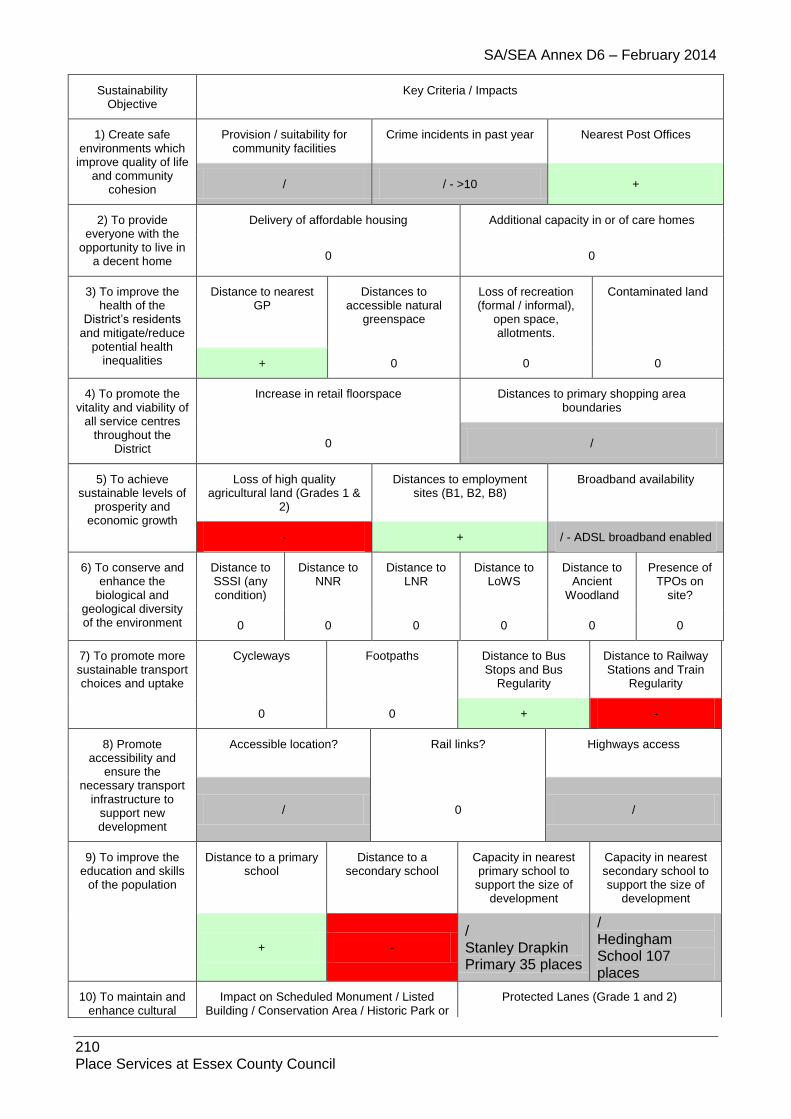
SA/SEA Annex D6 – February 2014
210 Place Services at Essex County Council
Sustainability Objective
Key Criteria / Impacts
1) Create safe environments which improve quality of life
and community cohesion
Provision / suitability for community facilities
Crime incidents in past year Nearest Post Offices
/ / - >10 +
2) To provide everyone with the
opportunity to live in a decent home
Delivery of affordable housing Additional capacity in or of care homes
0 0
3) To improve the health of the
District’s residents and mitigate/reduce
potential health inequalities
Distance to nearest GP
Distances to accessible natural
greenspace
Loss of recreation (formal / informal),
open space, allotments.
Contaminated land
+ 0 0 0
4) To promote the vitality and viability of
all service centres throughout the
District
Increase in retail floorspace Distances to primary shopping area boundaries
0 /
5) To achieve sustainable levels of
prosperity and economic growth
Loss of high quality agricultural land (Grades 1 &
2)
Distances to employment sites (B1, B2, B8)
Broadband availability
- + / - ADSL broadband enabled
6) To conserve and enhance the
biological and geological diversity of the environment
Distance to SSSI (any condition)
Distance to NNR
Distance to LNR
Distance to LoWS
Distance to Ancient
Woodland
Presence of TPOs on
site?
0 0 0 0 0 0
7) To promote more sustainable transport choices and uptake
Cycleways Footpaths Distance to Bus Stops and Bus
Regularity
Distance to Railway Stations and Train
Regularity
0 0 + -
8) Promote accessibility and
ensure the necessary transport
infrastructure to support new development
Accessible location? Rail links? Highways access
/ 0 /
9) To improve the education and skills
of the population
Distance to a primary school
Distance to a secondary school
Capacity in nearest primary school to
support the size of development
Capacity in nearest secondary school to support the size of
development
+ -
/ Stanley Drapkin Primary 35 places
/ Hedingham School 107 places
10) To maintain and enhance cultural
Impact on Scheduled Monument / Listed Building / Conservation Area / Historic Park or
Protected Lanes (Grade 1 and 2)

SA/SEA Annex D6 – February 2014
211 Place Services at Essex County Council
heritage and assets within the District
Garden / Archaeology
0 0
11) To reduce contributions to climatic change
This issue is dealt with in Development Management and Core Strategy Policies which is applicable to all relevant development.
12) To improve water quality and address water scarcity and
sewerage
Groundwater protection zone. Capacities in sewage network
/ GPZ3 0
13) To reduce the risk of flooding
Flood Zone 2 / Flood Zone 3 (a/b) Flooding from other sources
/ /
14) To improve air quality
Distance to A12 or A120 Impact on potentially Significant Junction for Air Quality
0 0
15) To maintain and enhance the quality of landscapes and
townscapes
Sensitivity to change in the
LCA
Greenfield / PDL Visually Important Space
Country Parks Landscaping associated with
proposals
- Stour River
Valley / 0 0 0
1.21. Stisted
1.21.1. Site: STI1 Address: Land fronting Rectory Lane (south of Stisted Lodge), Stisted Other info: Greenfield, Residential
Sustainability Objective
Key Criteria / Impacts
1) Create safe environments which
improve quality of life and community
cohesion
Provision / suitability for community facilities
Crime incidents in past year Nearest Post Offices
0 /
41 incidences +
2) To provide everyone with the
opportunity to live in a decent home
Delivery of affordable housing Additional capacity in or of care homes
/ /
3) To improve the health of the District’s
residents and mitigate/reduce potential health
inequalities
Distance to nearest GP
Distances to accessible natural
greenspace
Loss of recreation (formal / informal),
open space, allotments.
Contaminated land
- - + /
4) To promote the vitality and viability of
all service centres throughout the
District
Increase in retail floorspace Distances to primary shopping area boundaries
0 -
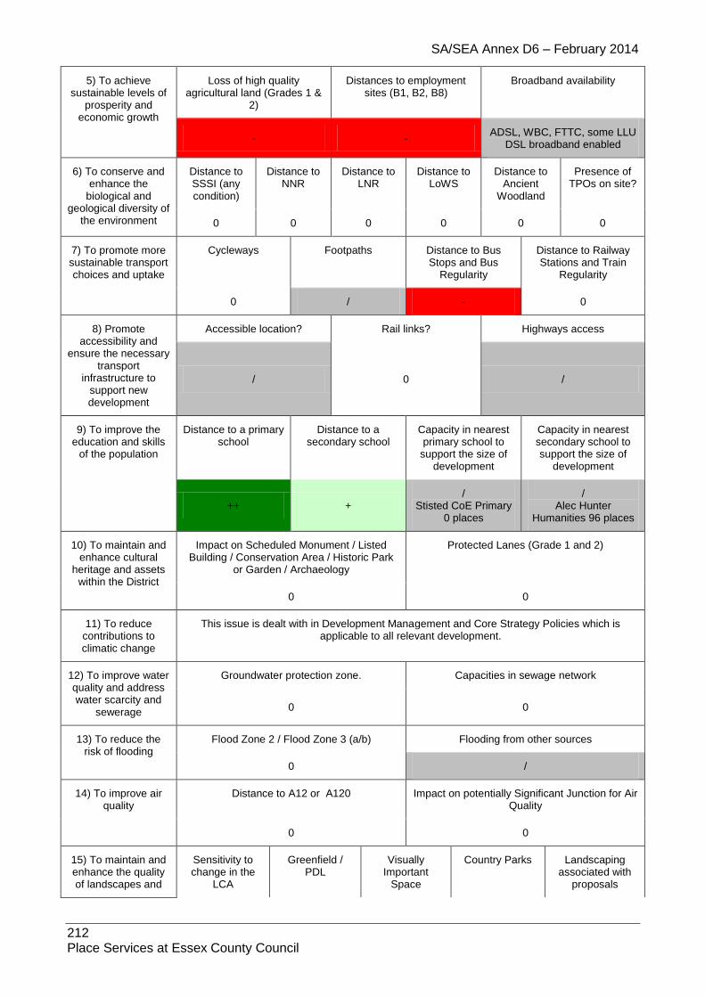
SA/SEA Annex D6 – February 2014
212 Place Services at Essex County Council
5) To achieve sustainable levels of
prosperity and economic growth
Loss of high quality agricultural land (Grades 1 &
2)
Distances to employment sites (B1, B2, B8)
Broadband availability
- - ADSL, WBC, FTTC, some LLU
DSL broadband enabled
6) To conserve and enhance the
biological and geological diversity of
the environment
Distance to SSSI (any condition)
Distance to NNR
Distance to LNR
Distance to LoWS
Distance to Ancient
Woodland
Presence of TPOs on site?
0 0 0 0 0 0
7) To promote more sustainable transport choices and uptake
Cycleways Footpaths Distance to Bus Stops and Bus
Regularity
Distance to Railway Stations and Train
Regularity
0 / - 0
8) Promote accessibility and
ensure the necessary transport
infrastructure to support new development
Accessible location? Rail links? Highways access
/ 0 /
9) To improve the education and skills
of the population
Distance to a primary school
Distance to a secondary school
Capacity in nearest primary school to
support the size of development
Capacity in nearest secondary school to support the size of
development
++ + /
Stisted CoE Primary 0 places
/ Alec Hunter
Humanities 96 places
10) To maintain and enhance cultural
heritage and assets within the District
Impact on Scheduled Monument / Listed Building / Conservation Area / Historic Park
or Garden / Archaeology
Protected Lanes (Grade 1 and 2)
0 0
11) To reduce contributions to climatic change
This issue is dealt with in Development Management and Core Strategy Policies which is applicable to all relevant development.
12) To improve water quality and address water scarcity and
sewerage
Groundwater protection zone. Capacities in sewage network
0 0
13) To reduce the risk of flooding
Flood Zone 2 / Flood Zone 3 (a/b) Flooding from other sources
0 /
14) To improve air quality
Distance to A12 or A120 Impact on potentially Significant Junction for Air Quality
0 0
15) To maintain and enhance the quality of landscapes and
Sensitivity to change in the
LCA
Greenfield / PDL
Visually Important
Space
Country Parks Landscaping associated with
proposals

SA/SEA Annex D6 – February 2014
213 Place Services at Essex County Council
townscapes /
Blackwater River Valley
- 0 0 /
1.21.2. Site: STI2 (Preferred Gypsy, Traveller and Travelling Showpersons Site)
Address: Twin Oaks, Land east and southeast of Braintree CM77 8DH Other info: Gypsy, Traveller and Travelling Showpersons Site (21 Pitches)
Sustainability Objective
Key Criteria / Impacts
1) Create safe environments which improve quality of life and community
cohesion
Provision / suitability for community facilities
Crime incidents in past year Nearest Post Offices
+ /
286 incidences +
2) To provide everyone with the
opportunity to live in a decent home
Delivery of affordable housing Additional capacity in or of care homes
++ /
3) To improve the health of the
District’s residents and mitigate/reduce
potential health inequalities
Distance to nearest GP
Distances to accessible natural
greenspace
Loss of recreation (formal / informal),
open space, allotments.
Contaminated land
/ - +
/ Bte463 – small
unknown infill, Bte561 – small unknown infill,
Bte963 – small unknown infill
4) To promote the vitality and viability
of all service centres throughout the
District
Increase in retail floorspace Distances to primary shopping area boundaries
/ +
5) To achieve sustainable levels of
prosperity and economic growth
Loss of high quality agricultural land (Grades 1 &
2)
Distances to employment sites (B1, B2, B8)
Broadband availability
- + ADSL, WBC, FTTC, some
LLU DSL broadband enabled
6) To conserve and enhance the
biological and geological diversity of the environment
Distance to SSSI (any condition)
Distance to NNR
Distance to LNR
Distance to LoWS
Distance to Ancient
Woodland
Presence of TPOs on
site?
0 0 0 -- -- /
7) To promote more sustainable transport choices and uptake
Cycleways Footpaths Distance to Bus Stops and Bus
Regularity
Distance to Railway Stations and Train
Regularity
0 /
Various footpaths on site
++ ++
8) Promote Accessible location? Rail links? Highways access

SA/SEA Annex D6 – February 2014
214 Place Services at Essex County Council
accessibility and ensure the
necessary transport infrastructure to
support new development
++
North eastern part of the site more isolated and warrants a
minor positive score (+)
++
- Land adjoining A120 trunk
road but further access junction on the A120 would
not be permitted
9) To improve the education and skills
of the population
Distance to a primary school
Distance to a secondary school
Capacity in nearest primary school to
support the size of development
Capacity in nearest secondary school to support the size of
development
++ ++
/ Education facilities
potentially created on-site (no details)
/ Education facilities
potentially created on-site (no details)
10) To maintain and enhance cultural
heritage and assets within the District
Impact on Scheduled Monument / Listed Building / Conservation Area / Historic Park or
Garden / Archaeology
Protected Lanes (Grade 1 and 2)
-- 0
11) To reduce contributions to climatic change
This issue is dealt with in Development Management and Core Strategy Policies which is applicable to all relevant development.
12) To improve water quality and
address water scarcity and sewerage
Groundwater protection zone. Capacities in sewage network
0 /
13) To reduce the risk of flooding
Flood Zone 2 / Flood Zone 3 (a/b) Flooding from other sources
0 /
14) To improve air quality
Distance to A12 or A120 Impact on potentially Significant Junction for Air Quality
- PSJs in Braintree
15) To maintain and enhance the quality of landscapes and
townscapes
Sensitivity to change in the
LCA
Greenfield / PDL Visually Important Space
Country Parks Landscaping associated with
proposals
- Silver End Farmland Plateau
- 0 0 /
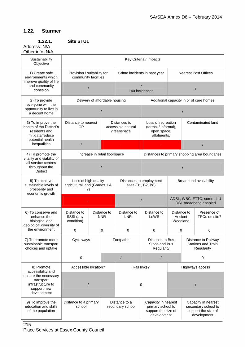
SA/SEA Annex D6 – February 2014
215 Place Services at Essex County Council
1.22. Sturmer
1.22.1. Site STU1 Address: N/A Other info: N/A
Sustainability Objective
Key Criteria / Impacts
1) Create safe environments which
improve quality of life and community
cohesion
Provision / suitability for community facilities
Crime incidents in past year Nearest Post Offices
/ /
140 incidences /
2) To provide everyone with the
opportunity to live in a decent home
Delivery of affordable housing Additional capacity in or of care homes
/ /
3) To improve the health of the District’s
residents and mitigate/reduce potential health
inequalities
Distance to nearest GP
Distances to accessible natural
greenspace
Loss of recreation (formal / informal),
open space, allotments.
Contaminated land
/ - - /
4) To promote the vitality and viability of
all service centres throughout the
District
Increase in retail floorspace Distances to primary shopping area boundaries
/ /
5) To achieve sustainable levels of
prosperity and economic growth
Loss of high quality agricultural land (Grades 1 &
2)
Distances to employment sites (B1, B2, B8)
Broadband availability
- / ADSL, WBC, FTTC, some LLU
DSL broadband enabled
6) To conserve and enhance the
biological and geological diversity of
the environment
Distance to SSSI (any condition)
Distance to NNR
Distance to LNR
Distance to LoWS
Distance to Ancient
Woodland
Presence of TPOs on site?
0 0 0 0 0 0
7) To promote more sustainable transport choices and uptake
Cycleways Footpaths Distance to Bus Stops and Bus
Regularity
Distance to Railway Stations and Train
Regularity
0 / / 0
8) Promote accessibility and
ensure the necessary transport
infrastructure to support new development
Accessible location? Rail links? Highways access
/ 0 /
9) To improve the education and skills
of the population
Distance to a primary school
Distance to a secondary school
Capacity in nearest primary school to
support the size of development
Capacity in nearest secondary school to support the size of
development

SA/SEA Annex D6 – February 2014
216 Place Services at Essex County Council
- -
/ Stanley Drapkin
Primary 35 places (note near Haverhill)
/ Hedingham School
107 places (Note near Haverhill)
10) To maintain and enhance cultural
heritage and assets within the District
Impact on Scheduled Monument / Listed Building / Conservation Area / Historic Park
or Garden / Archaeology
Protected Lanes (Grade 1 and 2)
0 0
11) To reduce contributions to climatic change
This issue is dealt with in Development Management and Core Strategy Policies which is applicable to all relevant development.
12) To improve water quality and address water scarcity and
sewerage
Groundwater protection zone. Capacities in sewage network
- SPZ2
0
13) To reduce the risk of flooding
Flood Zone 2 / Flood Zone 3 (a/b) Flooding from other sources
0 /
14) To improve air quality
Distance to A12 or A120 Impact on potentially Significant Junction for Air Quality
0 0
15) To maintain and enhance the quality of landscapes and
townscapes
Sensitivity to change in the
LCA
Greenfield / PDL
Visually Important
Space
Country Parks Landscaping associated with
proposals
- Stour River
Valley / 0 0 /
1.22.2. Site: STU2 Address: Land adjoining eastern end of Village Envelope, Sturmer Other info: Greenfield, Amendment to Village Envelope
Sustainability Objective
Key Criteria / Impacts
1) Create safe environments which
improve quality of life and community
cohesion
Provision / suitability for community facilities
Crime incidents in past year Nearest Post Offices
/ /
18 incidences /
2) To provide everyone with the
opportunity to live in a decent home
Delivery of affordable housing Additional capacity in or of care homes
/ /
3) To improve the health of the District’s
residents and mitigate/reduce potential health
inequalities
Distance to nearest GP
Distances to accessible natural
greenspace
Loss of recreation (formal / informal),
open space, allotments.
Contaminated land
/ -- + /

SA/SEA Annex D6 – February 2014
217 Place Services at Essex County Council
4) To promote the vitality and viability of
all service centres throughout the
District
Increase in retail floorspace Distances to primary shopping area boundaries
/
5) To achieve sustainable levels of
prosperity and economic growth
Loss of high quality agricultural land (Grades 1 &
2)
Distances to employment sites (B1, B2, B8)
Broadband availability
- / ADSL, WBC, FTTC, some LLU
DSL broadband enabled
6) To conserve and enhance the
biological and geological diversity of
the environment
Distance to SSSI (any condition)
Distance to NNR
Distance to LNR
Distance to LoWS
Distance to Ancient
Woodland
Presence of TPOs on site?
0 0 0 0 0 0
7) To promote more sustainable transport choices and uptake
Cycleways Footpaths Distance to Bus Stops and Bus
Regularity
Distance to Railway Stations and Train
Regularity
0 / / 0
8) Promote accessibility and
ensure the necessary transport
infrastructure to support new development
Accessible location? Rail links? Highways access
/ 0 /
9) To improve the education and skills
of the population
Distance to a primary school
Distance to a secondary school
Capacity in nearest primary school to
support the size of development
Capacity in nearest secondary school to support the size of
development
- -
/ Stanley Drapkin
Primary 35 places (note near Haverhill)
/ Hedingham School
107 places (Note near Haverhill)
10) To maintain and enhance cultural
heritage and assets within the District
Impact on Scheduled Monument / Listed Building / Conservation Area / Historic Park
or Garden / Archaeology
Protected Lanes (Grade 1 and 2)
0 0
11) To reduce contributions to climatic change
This issue is dealt with in Development Management and Core Strategy Policies which is applicable to all relevant development.
12) To improve water quality and address water scarcity and
sewerage
Groundwater protection zone. Capacities in sewage network
- SPZ2
0
13) To reduce the risk of flooding
Flood Zone 2 / Flood Zone 3 (a/b) Flooding from other sources
0 /
14) To improve air quality
Distance to A12 or A120 Impact on potentially Significant Junction for Air Quality

SA/SEA Annex D6 – February 2014
218 Place Services at Essex County Council
0 0
15) To maintain and enhance the quality of landscapes and
townscapes
Sensitivity to change in the
LCA
Greenfield / PDL
Visually Important
Space
Country Parks Landscaping associated with
proposals
- Stour River
Valley - 0 0 /
1.22.3. Site: STU3E
Address: Sturmer, CB9 7AE
Other Info: B1, B2, B8
Sustainability Objective
Key Criteria / Impacts
1) Create safe environments which improve quality of life
and community cohesion
Provision / suitability for community facilities
Crime incidents in past year Nearest Post Offices
/ / - >900 +
2) To provide everyone with the
opportunity to live in a decent home
Delivery of affordable housing Additional capacity in or of care homes
0 0
3) To improve the health of the
District’s residents and mitigate/reduce
potential health inequalities
Distance to nearest GP
Distances to accessible natural
greenspace
Loss of recreation (formal / informal),
open space, allotments.
Contaminated land
/ 0 0 0
4) To promote the vitality and viability of
all service centres throughout the
District
Increase in retail floorspace Distances to primary shopping area boundaries
0 /
5) To achieve sustainable levels of
prosperity and economic growth
Loss of high quality agricultural land (Grades 1 &
2)
Distances to employment sites (B1, B2, B8)
Broadband availability
- + / - ADSL, WBC, FTTC, some LLU DSL broadband enabled
6) To conserve and enhance the
biological and geological diversity of the environment
Distance to SSSI (any condition)
Distance to NNR
Distance to LNR
Distance to LoWS
Distance to Ancient
Woodland
Presence of TPOs on
site?
0 0 0 0 0 0
7) To promote more sustainable transport choices and uptake
Cycleways Footpaths Distance to Bus Stops and Bus
Regularity
Distance to Railway Stations and Train
Regularity
0 0 + -

SA/SEA Annex D6 – February 2014
219 Place Services at Essex County Council
8) Promote accessibility and
ensure the necessary transport
infrastructure to support new development
Accessible location? Rail links? Highways access
/ 0 /
9) To improve the education and skills
of the population
Distance to a primary school
Distance to a secondary school
Capacity in nearest primary school to
support the size of development
Capacity in nearest secondary school to support the size of
development
- - 0 0
10) To maintain and enhance cultural
heritage and assets within the District
Impact on Scheduled Monument / Listed Building / Conservation Area / Historic Park or
Garden / Archaeology
Protected Lanes (Grade 1 and 2)
/ 0
11) To reduce contributions to climatic change
This issue is dealt with in Development Management and Core Strategy Policies which is applicable to all relevant development.
12) To improve water quality and address water scarcity and
sewerage
Groundwater protection zone. Capacities in sewage network
0 0
13) To reduce the risk of flooding
Flood Zone 2 / Flood Zone 3 (a/b) Flooding from other sources
0 /
14) To improve air quality
Distance to A12 or A120 Impact on potentially Significant Junction for Air Quality
0 0
15) To maintain and enhance the quality of landscapes and
townscapes
Sensitivity to change in the
LCA
Greenfield / PDL Visually Important Space
Country Parks Landscaping associated with
proposals
/ / 0 0 0
1.22.4. Site: STU3
Address: CB9 7UW
Other info: Residential
Sustainability Objective
Key Criteria / Impacts
1) Create safe environments which improve quality of life
and community cohesion
Provision / suitability for community facilities
Crime incidents in past year Nearest Post Offices
/ /
277 incidences /
2) To provide Delivery of affordable housing Additional capacity in or of care homes
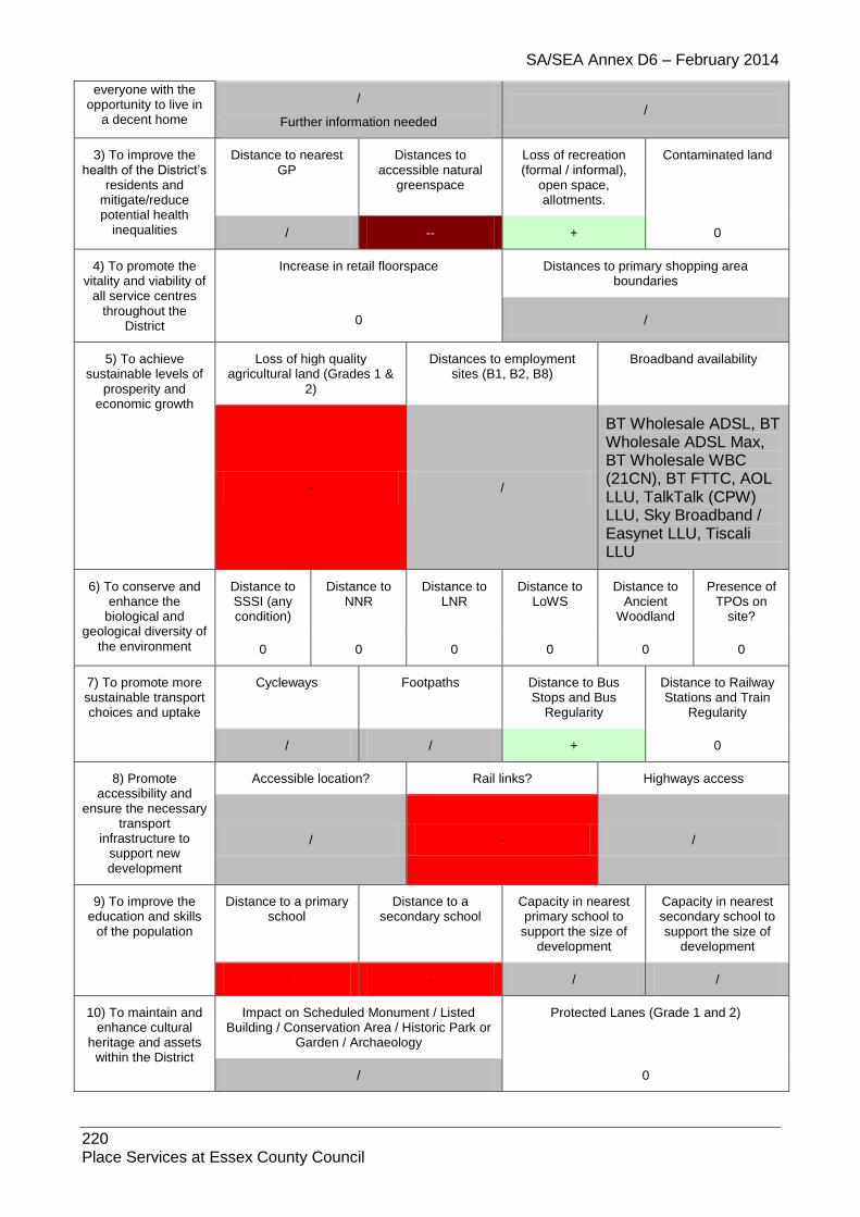
SA/SEA Annex D6 – February 2014
220 Place Services at Essex County Council
everyone with the opportunity to live in
a decent home
/
Further information needed /
3) To improve the health of the District’s
residents and mitigate/reduce potential health
inequalities
Distance to nearest GP
Distances to accessible natural
greenspace
Loss of recreation (formal / informal),
open space, allotments.
Contaminated land
/ -- + 0
4) To promote the vitality and viability of
all service centres throughout the
District
Increase in retail floorspace Distances to primary shopping area boundaries
0 /
5) To achieve sustainable levels of
prosperity and economic growth
Loss of high quality agricultural land (Grades 1 &
2)
Distances to employment sites (B1, B2, B8)
Broadband availability
- /
BT Wholesale ADSL, BT Wholesale ADSL Max, BT Wholesale WBC (21CN), BT FTTC, AOL LLU, TalkTalk (CPW) LLU, Sky Broadband / Easynet LLU, Tiscali LLU
6) To conserve and enhance the
biological and geological diversity of
the environment
Distance to SSSI (any condition)
Distance to NNR
Distance to LNR
Distance to LoWS
Distance to Ancient
Woodland
Presence of TPOs on
site?
0 0 0 0 0 0
7) To promote more sustainable transport choices and uptake
Cycleways Footpaths Distance to Bus Stops and Bus
Regularity
Distance to Railway Stations and Train
Regularity
/ / + 0
8) Promote accessibility and
ensure the necessary transport
infrastructure to support new development
Accessible location? Rail links? Highways access
/ - /
9) To improve the education and skills
of the population
Distance to a primary school
Distance to a secondary school
Capacity in nearest primary school to
support the size of development
Capacity in nearest secondary school to support the size of
development
- - / /
10) To maintain and enhance cultural
heritage and assets within the District
Impact on Scheduled Monument / Listed Building / Conservation Area / Historic Park or
Garden / Archaeology
Protected Lanes (Grade 1 and 2)
/ 0
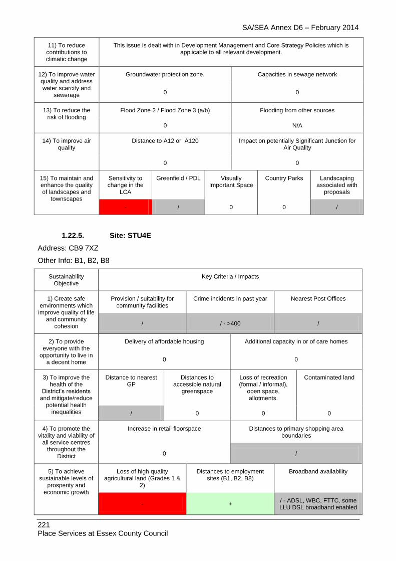
SA/SEA Annex D6 – February 2014
221 Place Services at Essex County Council
11) To reduce contributions to climatic change
This issue is dealt with in Development Management and Core Strategy Policies which is applicable to all relevant development.
12) To improve water quality and address water scarcity and
sewerage
Groundwater protection zone. Capacities in sewage network
0 0
13) To reduce the risk of flooding
Flood Zone 2 / Flood Zone 3 (a/b) Flooding from other sources
0 N/A
14) To improve air quality
Distance to A12 or A120 Impact on potentially Significant Junction for Air Quality
0 0
15) To maintain and enhance the quality of landscapes and
townscapes
Sensitivity to change in the
LCA
Greenfield / PDL Visually Important Space
Country Parks Landscaping associated with
proposals
- / 0 0 /
1.22.5. Site: STU4E
Address: CB9 7XZ
Other Info: B1, B2, B8
Sustainability Objective
Key Criteria / Impacts
1) Create safe environments which improve quality of life
and community cohesion
Provision / suitability for community facilities
Crime incidents in past year Nearest Post Offices
/ / - >400 /
2) To provide everyone with the
opportunity to live in a decent home
Delivery of affordable housing Additional capacity in or of care homes
0 0
3) To improve the health of the
District’s residents and mitigate/reduce
potential health inequalities
Distance to nearest GP
Distances to accessible natural
greenspace
Loss of recreation (formal / informal),
open space, allotments.
Contaminated land
/ 0 0 0
4) To promote the vitality and viability of
all service centres throughout the
District
Increase in retail floorspace Distances to primary shopping area boundaries
0 /
5) To achieve sustainable levels of
prosperity and economic growth
Loss of high quality agricultural land (Grades 1 &
2)
Distances to employment sites (B1, B2, B8)
Broadband availability
- + / - ADSL, WBC, FTTC, some LLU DSL broadband enabled

SA/SEA Annex D6 – February 2014
222 Place Services at Essex County Council
6) To conserve and enhance the
biological and geological diversity of the environment
Distance to SSSI (any condition)
Distance to NNR
Distance to LNR
Distance to LoWS
Distance to Ancient
Woodland
Presence of TPOs on
site?
0 0 0 0 0 0
7) To promote more sustainable transport choices and uptake
Cycleways Footpaths Distance to Bus Stops and Bus
Regularity
Distance to Railway Stations and Train
Regularity
0 0 + -
8) Promote accessibility and
ensure the necessary transport
infrastructure to support new development
Accessible location? Rail links? Highways access
/ 0 /
9) To improve the education and skills
of the population
Distance to a primary school
Distance to a secondary school
Capacity in nearest primary school to
support the size of development
Capacity in nearest secondary school to support the size of
development
- - 0 0
10) To maintain and enhance cultural
heritage and assets within the District
Impact on Scheduled Monument / Listed Building / Conservation Area / Historic Park or
Garden / Archaeology
Protected Lanes (Grade 1 and 2)
0 0
11) To reduce contributions to climatic change
This issue is dealt with in Development Management and Core Strategy Policies which is applicable to all relevant development.
12) To improve water quality and address water scarcity and
sewerage
Groundwater protection zone. Capacities in sewage network
/ GPZ3 0
13) To reduce the risk of flooding
Flood Zone 2 / Flood Zone 3 (a/b) Flooding from other sources
0 /
14) To improve air quality
Distance to A12 or A120 Impact on potentially Significant Junction for Air Quality
0 0
15) To maintain and enhance the quality of landscapes and
townscapes
Sensitivity to change in the
LCA
Greenfield / PDL Visually Important Space
Country Parks Landscaping associated with
proposals
/ / 0 0 0
1.23. Terling
1.23.1. Site: TER1 Address: Land at Medlars, Fairstead Road, Terling Other info: PDL, Residential

SA/SEA Annex D6 – February 2014
223 Place Services at Essex County Council
Sustainability Objective
Key Criteria / Impacts
1) Create safe environments which improve
quality of life and community cohesion
Provision / suitability for community facilities
Crime incidents in past year Nearest Post Offices
0 /
9 incidences +
2) To provide everyone with the opportunity to live in a decent home
Delivery of affordable housing Additional capacity in or of care homes
/ /
3) To improve the health of the
District’s residents and mitigate/reduce
potential health inequalities
Distance to nearest GP
Distances to accessible natural
greenspace
Loss of recreation (formal / informal),
open space, allotments.
Contaminated land
+ -- + /
4) To promote the vitality and viability
of all service centres throughout
the District
Increase in retail floorspace Distances to primary shopping area boundaries
0 /
Bus Service less than 5 days a week
5) To achieve sustainable levels of prosperity and economic growth
Loss of high quality agricultural land (Grades 1 &
2)
Distances to employment sites (B1, B2, B8)
Broadband availability
- /
Bus Service less than 5 days a week
ADSL broadband enabled
6) To conserve and enhance the
biological and geological diversity of the environment
Distance to SSSI (any condition)
Distance to NNR
Distance to LNR
Distance to LoWS
Distance to Ancient
Woodland
Presence of TPOs on
site?
Impact on potential
brownfield habitats
0 0 0 0 0 0
7) To promote more sustainable transport choices
and uptake
Cycleways Footpaths Distance to Bus Stops and Bus Regularity
Distance to Railway Stations and Train
Regularity
0 / + 0
8) Promote accessibility and
ensure the necessary transport
infrastructure to support new development
Accessible location? Rail links? Highways access
/ 0
9) To improve the education and skills
of the population
Distance to a primary school
Distance to a secondary school
Capacity in nearest primary school to
support the size of development
Capacity in nearest secondary school to support the size of
development
++ + /
Terling CoE Primary 0 places
/ Maltings Academy 184
places

SA/SEA Annex D6 – February 2014
224 Place Services at Essex County Council
10) To maintain and enhance
cultural heritage and assets within
the District
Impact on Scheduled Monument / Listed Building / Conservation Area / Historic Park or
Garden / Archaeology
Protected Lanes (Grade 1 and 2)
0 0
11) To reduce contributions to climatic change
This issue is dealt with in Development Management and Core Strategy Policies which is applicable to all relevant development.
12) To improve water quality and
address water scarcity and sewerage
Groundwater protection zone. Capacities in sewage network
0 0
13) To reduce the risk of flooding
Flood Zone 2 / Flood Zone 3 (a/b) Flooding from other sources
0 /
14) To improve air quality
Distance to A12 or A120 Impact on potentially Significant Junction for Air Quality
0 0
15) To maintain and enhance the
quality of landscapes and
townscapes
Sensitivity to change in the
LCA
Greenfield / PDL
Visually Important Space
Country Parks Landscaping associated with
proposals
/ Terling Farmland
Plateau + 0 0 /
1.23.2. Site: TER2 Address: Betws-y-Coed, Fairstead Road, Terling Other info: PDL, Residential
Sustainability Objective
Key Criteria / Impacts
1) Create safe environments which
improve quality of life and community
cohesion
Provision / suitability for community facilities
Crime incidents in past year Nearest Post Offices
0 /
9 incidences +
2) To provide everyone with the
opportunity to live in a decent home
Delivery of affordable housing Additional capacity in or of care homes
/ /
3) To improve the health of the District’s
residents and mitigate/reduce potential health
inequalities
Distance to nearest GP
Distances to accessible natural
greenspace
Loss of recreation (formal / informal),
open space, allotments.
Contaminated land
++ -- + /
4) To promote the vitality and viability of
all service centres throughout the District
Increase in retail floorspace Distances to primary shopping area boundaries
0 /

SA/SEA Annex D6 – February 2014
225 Place Services at Essex County Council
Bus Service less than 5 days a week
5) To achieve sustainable levels of
prosperity and economic growth
Loss of high quality agricultural land (Grades 1 &
2)
Distances to employment sites (B1, B2, B8)
Broadband availability
- /
Bus Service less than 5 days a week
ADSL broadband enabled
6) To conserve and enhance the
biological and geological diversity of
the environment
Distance to SSSI (any condition)
Distance to NNR
Distance to LNR
Distance to LoWS
Distance to Ancient
Woodland
Presence of TPOs on site?
Impact on potential
brownfield habitats
0 0 0 0 0 0
7) To promote more sustainable transport choices and uptake
Cycleways Footpaths Distance to Bus Stops and Bus
Regularity
Distance to Railway Stations and Train
Regularity
0 / + 0
8) Promote accessibility and
ensure the necessary transport
infrastructure to support new development
Accessible location? Rail links? Highways access
/ 0 /
9) To improve the education and skills
of the population
Distance to a primary school
Distance to a secondary school
Capacity in nearest primary school to
support the size of development
Capacity in nearest secondary school to support the size of
development
++ + /
Terling CoE Primary 0 places
/ Maltings Academy
184 places
10) To maintain and enhance cultural
heritage and assets within the District
Impact on Scheduled Monument / Listed Building / Conservation Area / Historic Park or
Garden / Archaeology
Protected Lanes (Grade 1 and 2)
0 0
11) To reduce contributions to climatic change
This issue is dealt with in Development Management and Core Strategy Policies which is applicable to all relevant development.
12) To improve water quality and address water scarcity and
sewerage
Groundwater protection zone. Capacities in sewage network
0 0
13) To reduce the risk of flooding
Flood Zone 2 / Flood Zone 3 (a/b) Flooding from other sources
0 /
14) To improve air quality
Distance to A12 or A120 Impact on potentially Significant Junction for Air Quality
0 0
15) To maintain and enhance the quality of
Sensitivity to change in the
Greenfield / PDL Visually Country Parks Landscaping associated with

SA/SEA Annex D6 – February 2014
226 Place Services at Essex County Council
landscapes and townscapes
LCA Important Space proposals
/ Terling
Farmland Plateau
+ 0 0 /

SA/SEA Annex D6 – February 2014
227 Place Services at Essex County Council
1.24. Toppesfield
1.24.1. Site: TOP1 Address: CO9 4DZ Other info: Residential plus open space
Sustainability Objective
Key Criteria / Impacts
1) Create safe environments which improve quality of life
and community cohesion
Provision / suitability for community facilities
Crime incidents in past year Nearest Post Offices
/ /
11 incidences +
2) To provide everyone with the
opportunity to live in a decent home
Delivery of affordable housing Additional capacity in or of care homes
/
Further information needed /
3) To improve the health of the District’s
residents and mitigate/reduce potential health
inequalities
Distance to nearest GP
Distances to accessible natural
greenspace
Loss of recreation (formal / informal),
open space, allotments.
Contaminated land
/ -- + 0
4) To promote the vitality and viability of
all service centres throughout the
District
Increase in retail floorspace Distances to primary shopping area boundaries
0 /
5) To achieve sustainable levels of
prosperity and economic growth
Loss of high quality agricultural land (Grades 1 &
2)
Distances to employment sites (B1, B2, B8)
Broadband availability
- / BT Wholesale ADSL
BT Wholesale ADSL Max
6) To conserve and enhance the
biological and geological diversity of
the environment
Distance to SSSI (any condition)
Distance to NNR
Distance to LNR
Distance to LoWS
Distance to Ancient
Woodland
Presence of TPOs on
site?
0 0 0 0 0 0
7) To promote more sustainable transport choices and uptake
Cycleways Footpaths Distance to Bus Stops and Bus
Regularity
Distance to Railway Stations and Train
Regularity
/ / / 0
8) Promote accessibility and
ensure the necessary transport
infrastructure to support new development
Accessible location? Rail links? Highways access
/ - /
9) To improve the education and skills
Distance to a primary school
Distance to a secondary school
Capacity in nearest primary school to
support the size of
Capacity in nearest secondary school to support the size of

SA/SEA Annex D6 – February 2014
228 Place Services at Essex County Council
of the population development development
++ + / /
10) To maintain and enhance cultural
heritage and assets within the District
Impact on Scheduled Monument / Listed Building / Conservation Area / Historic Park or
Garden / Archaeology
Protected Lanes (Grade 1 and 2)
0 0
11) To reduce contributions to climatic change
This issue is dealt with in Development Management and Core Strategy Policies which is applicable to all relevant development.
12) To improve water quality and address water scarcity and
sewerage
Groundwater protection zone. Capacities in sewage network
/ 0
13) To reduce the risk of flooding
Flood Zone 2 / Flood Zone 3 (a/b) Flooding from other sources
0 N/A
14) To improve air quality
Distance to A12 or A120 Impact on potentially Significant Junction for Air Quality
0 0
15) To maintain and enhance the quality of landscapes and
townscapes
Sensitivity to change in the
LCA
Greenfield / PDL Visually Important Space
Country Parks Landscaping associated with
proposals
- - 0 0 /
1.24.2. Site: TOP2
Address: CO9 4EB
Other info: Residential
Sustainability Objective
Key Criteria / Impacts
1) Create safe environments which improve quality of life
and community cohesion
Provision / suitability for community facilities
Crime incidents in past year Nearest Post Offices
/ /
12 incidences +
2) To provide everyone with the
opportunity to live in a decent home
Delivery of affordable housing Additional capacity in or of care homes
/
Further information needed /
3) To improve the health of the District’s
residents and mitigate/reduce potential health
inequalities
Distance to nearest GP
Distances to accessible natural
greenspace
Loss of recreation (formal / informal),
open space, allotments.
Contaminated land
/ -- + 0
4) To promote the Increase in retail floorspace Distances to primary shopping area

SA/SEA Annex D6 – February 2014
229 Place Services at Essex County Council
vitality and viability of all service centres
throughout the District
boundaries
0 /
5) To achieve sustainable levels of
prosperity and economic growth
Loss of high quality agricultural land (Grades 1 &
2)
Distances to employment sites (B1, B2, B8)
Broadband availability
- / BT Wholesale ADSL
BT Wholesale ADSL Max
6) To conserve and enhance the
biological and geological diversity of
the environment
Distance to SSSI (any condition)
Distance to NNR
Distance to LNR
Distance to LoWS
Distance to Ancient
Woodland
Presence of TPOs on
site?
0 0 0 0 0 0
7) To promote more sustainable transport choices and uptake
Cycleways Footpaths Distance to Bus Stops and Bus
Regularity
Distance to Railway Stations and Train
Regularity
/ / / 0
8) Promote accessibility and
ensure the necessary transport
infrastructure to support new development
Accessible location? Rail links? Highways access
/ - /
9) To improve the education and skills
of the population
Distance to a primary school
Distance to a secondary school
Capacity in nearest primary school to
support the size of development
Capacity in nearest secondary school to support the size of
development
+ + / /
10) To maintain and enhance cultural
heritage and assets within the District
Impact on Scheduled Monument / Listed Building / Conservation Area / Historic Park or
Garden / Archaeology
Protected Lanes (Grade 1 and 2)
0 0
11) To reduce contributions to climatic change
This issue is dealt with in Development Management and Core Strategy Policies which is applicable to all relevant development.
12) To improve water quality and address water scarcity and
sewerage
Groundwater protection zone. Capacities in sewage network
/ 0
13) To reduce the risk of flooding
Flood Zone 2 / Flood Zone 3 (a/b) Flooding from other sources
0 N/A
14) To improve air quality
Distance to A12 or A120 Impact on potentially Significant Junction for Air Quality
0 0
15) To maintain and enhance the quality
Sensitivity to change in the
Greenfield / PDL Visually Country Parks Landscaping associated with

SA/SEA Annex D6 – February 2014
230 Place Services at Essex County Council
of landscapes and townscapes
LCA Important Space proposals
- - 0 0 /

SA/SEA Annex D6 – February 2014
231 Place Services at Essex County Council
1.25. Wethersfield
1.25.1. Site: WET1 Address: Land between West Drive and Braintree Road, Wethersfield Other info: Greenfield, Residential
Sustainability Objective
Key Criteria / Impacts
1) Create safe environments which
improve quality of life and community
cohesion
Provision / suitability for community facilities
Crime incidents in past year Nearest Post Offices
0 /
17 incidences +
2) To provide everyone with the
opportunity to live in a decent home
Delivery of affordable housing Additional capacity in or of care homes
/ /
3) To improve the health of the District’s
residents and mitigate/reduce potential health
inequalities
Distance to nearest GP
Distances to accessible natural
greenspace
Loss of recreation (formal / informal),
open space, allotments.
Contaminated land
/ -- + /
4) To promote the vitality and viability of
all service centres throughout the
District
Increase in retail floorspace Distances to primary shopping area boundaries
0 /
5) To achieve sustainable levels of
prosperity and economic growth
Loss of high quality agricultural land (Grades 1 &
2)
Distances to employment sites (B1, B2, B8)
Broadband availability
- / ADSL broadband enabled
6) To conserve and enhance the
biological and geological diversity of
the environment
Distance to SSSI (any condition)
Distance to NNR
Distance to LNR
Distance to LoWS
Distance to Ancient
Woodland
Presence of TPOs on site?
0 0 0 0 0 0
7) To promote more sustainable transport choices and uptake
Cycleways Footpaths Distance to Bus Stops and Bus
Regularity
Distance to Railway Stations and Train
Regularity
0 / ++ 0
8) Promote accessibility and
ensure the necessary transport
infrastructure to support new development
Accessible location? Rail links? Highways access
/ 0 /
9) To improve the education and skills
of the population
Distance to a primary school
Distance to a secondary school
Capacity in nearest primary school to
support the size of development
Capacity in nearest secondary school to support the size of
development

SA/SEA Annex D6 – February 2014
232 Place Services at Essex County Council
++ - /
Wethersfield CoE Primary 3 places
/ Hedingham School
107 places
10) To maintain and enhance cultural
heritage and assets within the District
Impact on Scheduled Monument / Listed Building / Conservation Area / Historic Park
or Garden / Archaeology
Protected Lanes (Grade 1 and 2)
-- 0
11) To reduce contributions to climatic change
This issue is dealt with in Development Management and Core Strategy Policies which is applicable to all relevant development.
12) To improve water quality and address water scarcity and
sewerage
Groundwater protection zone. Capacities in sewage network
/ SPZ3
0
13) To reduce the risk of flooding
Flood Zone 2 / Flood Zone 3 (a/b) Flooding from other sources
0 /
14) To improve air quality
Distance to A12 or A120 Impact on potentially Significant Junction for Air Quality
0 0
15) To maintain and enhance the quality of landscapes and
townscapes
Sensitivity to change in the
LCA
Greenfield / PDL
Visually Important
Space
Country Parks Landscaping associated with
proposals
- Pant River
Valley - 0 0 /
1.25.2. Site: WET2 Address: Land between Playing Field and Parsonage Farm, High Street, Wethersfield Other info: Greenfield, Residential
Sustainability Objective
Key Criteria / Impacts
1) Create safe environments which improve quality of life
and community cohesion
Provision / suitability for community facilities
Crime incidents in past year Nearest Post Offices
0 /
5 incidences /
2) To provide everyone with the
opportunity to live in a decent home
Delivery of affordable housing Additional capacity in or of care homes
/ /
3) To improve the health of the District’s
residents and mitigate/reduce potential health
inequalities
Distance to nearest GP
Distances to accessible natural
greenspace
Loss of recreation (formal / informal),
open space, allotments.
Contaminated land
/ -- + /
4) To promote the Increase in retail floorspace Distances to primary shopping area boundaries

SA/SEA Annex D6 – February 2014
233 Place Services at Essex County Council
vitality and viability of all service centres
throughout the District
0 /
5) To achieve sustainable levels of
prosperity and economic growth
Loss of high quality agricultural land (Grades 1 &
2)
Distances to employment sites (B1, B2, B8)
Broadband availability
- / ADSL broadband enabled
6) To conserve and enhance the
biological and geological diversity of
the environment
Distance to SSSI (any condition)
Distance to NNR
Distance to LNR
Distance to LoWS
Distance to Ancient
Woodland
Presence of TPOs on site?
0 0 0 0 0 0
7) To promote more sustainable transport choices and uptake
Cycleways Footpaths Distance to Bus Stops and Bus
Regularity
Distance to Railway Stations and Train
Regularity
0 / ++ 0
8) Promote accessibility and
ensure the necessary transport
infrastructure to support new development
Accessible location? Rail links? Highways access
/ 0 /
9) To improve the education and skills
of the population
Distance to a primary school
Distance to a secondary school
Capacity in nearest primary school to
support the size of development
Capacity in nearest secondary school to support the size of
development
+ - /
Wethersfield CoE Primary 3 places
/ Hedingham School
107 places
10) To maintain and enhance cultural
heritage and assets within the District
Impact on Scheduled Monument / Listed Building / Conservation Area / Historic Park or
Garden / Archaeology
Protected Lanes (Grade 1 and 2)
-- 0
11) To reduce contributions to climatic change
This issue is dealt with in Development Management and Core Strategy Policies which is applicable to all relevant development.
12) To improve water quality and address water scarcity and
sewerage
Groundwater protection zone. Capacities in sewage network
/ SPZ3
0
13) To reduce the risk of flooding
Flood Zone 2 / Flood Zone 3 (a/b) Flooding from other sources
0 /
14) To improve air quality
Distance to A12 or A120 Impact on potentially Significant Junction for Air Quality
0 0
15) To maintain and Sensitivity to Greenfield / Visually Country Parks Landscaping

SA/SEA Annex D6 – February 2014
234 Place Services at Essex County Council
enhance the quality of landscapes and
townscapes
change in the LCA
PDL Important Space
associated with proposals
- Stambourne
Farmland Plateau
- 0 0 /
1.25.3. Site: WET3 Address: Land at Owls Hall, Blackmore End Other info: Greenfield
Sustainability Objective
Key Criteria / Impacts
1) Create safe environments which improve quality of life
and community cohesion
Provision / suitability for community facilities
Crime incidents in past year Nearest Post Offices
/ /
4 incidences /
2) To provide everyone with the
opportunity to live in a decent home
Delivery of affordable housing Additional capacity in or of care homes
/ /
3) To improve the health of the District’s
residents and mitigate/reduce potential health
inequalities
Distance to nearest GP
Distances to accessible natural
greenspace
Loss of recreation (formal / informal),
open space, allotments.
Contaminated land
/ -- + /
4) To promote the vitality and viability of
all service centres throughout the
District
Increase in retail floorspace Distances to primary shopping area boundaries
/ /
Bus Service less than 5 days a week
5) To achieve sustainable levels of
prosperity and economic growth
Loss of high quality agricultural land (Grades 1 &
2)
Distances to employment sites (B1, B2, B8)
Broadband availability
0
/
Bus Service less than 5 days a week
ADSL broadband enabled
6) To conserve and enhance the
biological and geological diversity of
the environment
Distance to SSSI (any condition)
Distance to NNR
Distance to LNR
Distance to LoWS
Distance to Ancient
Woodland
Presence of TPOs on site?
0 0 0 0 0 0
7) To promote more sustainable transport choices and uptake
Cycleways Footpaths Distance to Bus Stops and Bus
Regularity
Distance to Railway Stations and Train
Regularity
0 / + 0
8) Promote accessibility and
ensure the necessary transport
Accessible location? Rail links? Highways access
/ 0 /
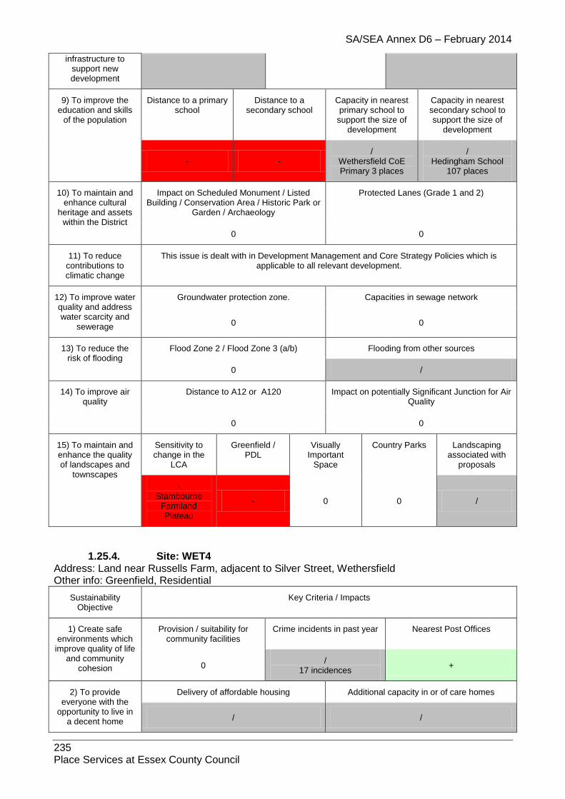
SA/SEA Annex D6 – February 2014
235 Place Services at Essex County Council
infrastructure to support new development
9) To improve the education and skills
of the population
Distance to a primary school
Distance to a secondary school
Capacity in nearest primary school to
support the size of development
Capacity in nearest secondary school to support the size of
development
- - /
Wethersfield CoE Primary 3 places
/ Hedingham School
107 places
10) To maintain and enhance cultural
heritage and assets within the District
Impact on Scheduled Monument / Listed Building / Conservation Area / Historic Park or
Garden / Archaeology
Protected Lanes (Grade 1 and 2)
0 0
11) To reduce contributions to climatic change
This issue is dealt with in Development Management and Core Strategy Policies which is applicable to all relevant development.
12) To improve water quality and address water scarcity and
sewerage
Groundwater protection zone. Capacities in sewage network
0 0
13) To reduce the risk of flooding
Flood Zone 2 / Flood Zone 3 (a/b) Flooding from other sources
0 /
14) To improve air quality
Distance to A12 or A120 Impact on potentially Significant Junction for Air Quality
0 0
15) To maintain and enhance the quality of landscapes and
townscapes
Sensitivity to change in the
LCA
Greenfield / PDL
Visually Important
Space
Country Parks Landscaping associated with
proposals
- Stambourne
Farmland Plateau
- 0 0 /
1.25.4. Site: WET4 Address: Land near Russells Farm, adjacent to Silver Street, Wethersfield Other info: Greenfield, Residential
Sustainability Objective
Key Criteria / Impacts
1) Create safe environments which
improve quality of life and community
cohesion
Provision / suitability for community facilities
Crime incidents in past year Nearest Post Offices
0 /
17 incidences +
2) To provide everyone with the
opportunity to live in a decent home
Delivery of affordable housing Additional capacity in or of care homes
/ /

SA/SEA Annex D6 – February 2014
236 Place Services at Essex County Council
3) To improve the health of the District’s
residents and mitigate/reduce potential health
inequalities
Distance to nearest GP
Distances to accessible natural
greenspace
Loss of recreation (formal / informal),
open space, allotments.
Contaminated land
/ -- + /
4) To promote the vitality and viability of
all service centres throughout the
District
Increase in retail floorspace Distances to primary shopping area boundaries
0 /
5) To achieve sustainable levels of
prosperity and economic growth
Loss of high quality agricultural land (Grades 1 &
2)
Distances to employment sites (B1, B2, B8)
Broadband availability
- / ADSL broadband enabled
6) To conserve and enhance the
biological and geological diversity of
the environment
Distance to SSSI (any condition)
Distance to NNR
Distance to LNR
Distance to LoWS
Distance to Ancient
Woodland
Presence of TPOs on site?
0 0 0 0 0 0
7) To promote more sustainable transport choices and uptake
Cycleways Footpaths Distance to Bus Stops and Bus
Regularity
Distance to Railway Stations and Train
Regularity
0 / ++ 0
8) Promote accessibility and
ensure the necessary transport
infrastructure to support new development
Accessible location? Rail links? Highways access
/ 0 /
9) To improve the education and skills
of the population
Distance to a primary school
Distance to a secondary school
Capacity in nearest primary school to
support the size of development
Capacity in nearest secondary school to support the size of
development
++ - /
Wethersfield CoE Primary 3 places
/ Hedingham School
107 places
10) To maintain and enhance cultural
heritage and assets within the District
Impact on Scheduled Monument / Listed Building / Conservation Area / Historic Park
or Garden / Archaeology
Protected Lanes (Grade 1 and 2)
0 0
11) To reduce contributions to climatic change
This issue is dealt with in Development Management and Core Strategy Policies which is applicable to all relevant development.
12) To improve water quality and address water scarcity and
sewerage
Groundwater protection zone. Capacities in sewage network
/ SPZ3
0
13) To reduce the Flood Zone 2 / Flood Zone 3 (a/b) Flooding from other sources

SA/SEA Annex D6 – February 2014
237 Place Services at Essex County Council
risk of flooding 0 /
14) To improve air quality
Distance to A12 or A120 Impact on potentially Significant Junction for Air Quality
0 0
15) To maintain and enhance the quality of landscapes and
townscapes
Sensitivity to change in the
LCA
Greenfield / PDL
Visually Important
Space
Country Parks Landscaping associated with
proposals
- Pant River
Valley - 0 0 /
1.25.5. Site: WET5 Address: Land at Silver Street, Wethersfield Other info: Greenfield, Amendment to Village Envelope
Sustainability Objective
Key Criteria / Impacts
1) Create safe environments which
improve quality of life and community
cohesion
Provision / suitability for community facilities
Crime incidents in past year Nearest Post Offices
/ /
17 incidences +
2) To provide everyone with the
opportunity to live in a decent home
Delivery of affordable housing Additional capacity in or of care homes
/ /
3) To improve the health of the District’s
residents and mitigate/reduce potential health
inequalities
Distance to nearest GP
Distances to accessible natural
greenspace
Loss of recreation (formal / informal),
open space, allotments.
Contaminated land
/ -- + /
4) To promote the vitality and viability of
all service centres throughout the
District
Increase in retail floorspace Distances to primary shopping area boundaries
/ /
5) To achieve sustainable levels of
prosperity and economic growth
Loss of high quality agricultural land (Grades 1 &
2)
Distances to employment sites (B1, B2, B8)
Broadband availability
- / ADSL broadband enabled
6) To conserve and enhance the
biological and geological diversity of
the environment
Distance to SSSI (any condition)
Distance to NNR
Distance to LNR
Distance to LoWS
Distance to Ancient
Woodland
Presence of TPOs on site?
0 0 0 0 0 0
7) To promote more sustainable transport choices and uptake
Cycleways Footpaths Distance to Bus Stops and Bus
Regularity
Distance to Railway Stations and Train
Regularity

SA/SEA Annex D6 – February 2014
238 Place Services at Essex County Council
0 / ++ 0
8) Promote accessibility and
ensure the necessary transport
infrastructure to support new development
Accessible location? Rail links? Highways access
/ 0 /
9) To improve the education and skills
of the population
Distance to a primary school
Distance to a secondary school
Capacity in nearest primary school to
support the size of development
Capacity in nearest secondary school to support the size of
development
++ - /
Wethersfield CoE Primary 3 places
/ Hedingham School
107 places
10) To maintain and enhance cultural
heritage and assets within the District
Impact on Scheduled Monument / Listed Building / Conservation Area / Historic Park
or Garden / Archaeology
Protected Lanes (Grade 1 and 2)
0 0
11) To reduce contributions to climatic change
This issue is dealt with in Development Management and Core Strategy Policies which is applicable to all relevant development.
12) To improve water quality and address water scarcity and
sewerage
Groundwater protection zone. Capacities in sewage network
/ SPZ3
0
13) To reduce the risk of flooding
Flood Zone 2 / Flood Zone 3 (a/b) Flooding from other sources
0 /
14) To improve air quality
Distance to A12 or A120 Impact on potentially Significant Junction for Air Quality
0 0
15) To maintain and enhance the quality of landscapes and
townscapes
Sensitivity to change in the
LCA
Greenfield / PDL
Visually Important
Space
Country Parks Landscaping associated with
proposals
- Pant River
Valley - 0 0 /
1.25.6. Site: WET7X
Address: CM7 4DL
Other info: Village Envelope Amendment
Sustainability Objective
Key Criteria / Impacts
1) Create safe environments which
Provision / suitability for community facilities
Crime incidents in past year Nearest Post Offices

SA/SEA Annex D6 – February 2014
239 Place Services at Essex County Council
improve quality of life and community
cohesion /
/
1 incidence /
2) To provide everyone with the
opportunity to live in a decent home
Delivery of affordable housing Additional capacity in or of care homes
/
Further information needed /
3) To improve the health of the District’s
residents and mitigate/reduce potential health
inequalities
Distance to nearest GP
Distances to accessible natural
greenspace
Loss of recreation (formal / informal),
open space, allotments.
Contaminated land
/ -- + 0
4) To promote the vitality and viability of
all service centres throughout the
District
Increase in retail floorspace Distances to primary shopping area boundaries
0 /
5) To achieve sustainable levels of
prosperity and economic growth
Loss of high quality agricultural land (Grades 1 &
2)
Distances to employment sites (B1, B2, B8)
Broadband availability
0 / BT Wholesale ADSL
BT Wholesale ADSL Max
6) To conserve and enhance the
biological and geological diversity of
the environment
Distance to SSSI (any condition)
Distance to NNR
Distance to LNR
Distance to LoWS
Distance to Ancient
Woodland
Presence of TPOs on
site?
0 0 0 0 0 0
7) To promote more sustainable transport choices and uptake
Cycleways Footpaths Distance to Bus Stops and Bus
Regularity
Distance to Railway Stations and Train
Regularity
/ / / 0
8) Promote accessibility and
ensure the necessary transport
infrastructure to support new development
Accessible location? Rail links? Highways access
/ - /
9) To improve the education and skills
of the population
Distance to a primary school
Distance to a secondary school
Capacity in nearest primary school to
support the size of development
Capacity in nearest secondary school to support the size of
development
- - / /
10) To maintain and enhance cultural
heritage and assets within the District
Impact on Scheduled Monument / Listed Building / Conservation Area / Historic Park or
Garden / Archaeology
Protected Lanes (Grade 1 and 2)
/
Listed Building 0

SA/SEA Annex D6 – February 2014
240 Place Services at Essex County Council
11) To reduce contributions to climatic change
This issue is dealt with in Development Management and Core Strategy Policies which is applicable to all relevant development.
12) To improve water quality and address water scarcity and
sewerage
Groundwater protection zone. Capacities in sewage network
0 0
13) To reduce the risk of flooding
Flood Zone 2 / Flood Zone 3 (a/b) Flooding from other sources
0 N/A
14) To improve air quality
Distance to A12 or A120 Impact on potentially Significant Junction for Air Quality
0 0
15) To maintain and enhance the quality of landscapes and
townscapes
Sensitivity to change in the
LCA
Greenfield / PDL Visually Important Space
Country Parks Landscaping associated with
proposals
- / - 0 /
1.25.7. Site: WET8
Address: CM7 4DD
Other info: Village Envelope Amendment
Sustainability Objective
Key Criteria / Impacts
1) Create safe environments which improve quality of life
and community cohesion
Provision / suitability for community facilities
Crime incidents in past year Nearest Post Offices
/ /
1 incidence /
2) To provide everyone with the
opportunity to live in a decent home
Delivery of affordable housing Additional capacity in or of care homes
/
Further information needed /
3) To improve the health of the District’s
residents and mitigate/reduce potential health
inequalities
Distance to nearest GP
Distances to accessible natural
greenspace
Loss of recreation (formal / informal),
open space, allotments.
Contaminated land
/ -- + 0
4) To promote the vitality and viability of
all service centres throughout the
District
Increase in retail floorspace Distances to primary shopping area boundaries
0 /
5) To achieve sustainable levels of
prosperity and
Loss of high quality agricultural land (Grades 1 &
2)
Distances to employment sites (B1, B2, B8)
Broadband availability

SA/SEA Annex D6 – February 2014
241 Place Services at Essex County Council
economic growth
0 / BT Wholesale ADSL
BT Wholesale ADSL Max
6) To conserve and enhance the
biological and geological diversity of
the environment
Distance to SSSI (any condition)
Distance to NNR
Distance to LNR
Distance to LoWS
Distance to Ancient
Woodland
Presence of TPOs on
site?
0 0 0 0 0 0
7) To promote more sustainable transport choices and uptake
Cycleways Footpaths Distance to Bus Stops and Bus
Regularity
Distance to Railway Stations and Train
Regularity
/ / / 0
8) Promote accessibility and
ensure the necessary transport
infrastructure to support new development
Accessible location? Rail links? Highways access
/ - /
9) To improve the education and skills
of the population
Distance to a primary school
Distance to a secondary school
Capacity in nearest primary school to
support the size of development
Capacity in nearest secondary school to support the size of
development
- - / /
10) To maintain and enhance cultural
heritage and assets within the District
Impact on Scheduled Monument / Listed Building / Conservation Area / Historic Park or
Garden / Archaeology
Protected Lanes (Grade 1 and 2)
/ 0
11) To reduce contributions to climatic change
This issue is dealt with in Development Management and Core Strategy Policies which is applicable to all relevant development.
12) To improve water quality and address water scarcity and
sewerage
Groundwater protection zone. Capacities in sewage network
0 0
13) To reduce the risk of flooding
Flood Zone 2 / Flood Zone 3 (a/b) Flooding from other sources
0 N/A
14) To improve air quality
Distance to A12 or A120 Impact on potentially Significant Junction for Air Quality
0 0
15) To maintain and enhance the quality of landscapes and
townscapes
Sensitivity to change in the
LCA
Greenfield / PDL Visually Important Space
Country Parks Landscaping associated with
proposals
- + 0 0 /

SA/SEA Annex D6 – February 2014
242 Place Services at Essex County Council
1.26. White Colne
1.26.1. Site: WHC1 Address: Colneford Hill, White Colne Other info: Greenfield, Amendment to Village Envelope
Sustainability Objective
Key Criteria / Impacts
1) Create safe environments which improve
quality of life and community cohesion
Provision / suitability for community facilities
Crime incidents in past year Nearest Post Offices
/ /
80 incidences +
2) To provide everyone with the opportunity to live in a decent home
Delivery of affordable housing Additional capacity in or of care homes
/ /
3) To improve the health of the
District’s residents and mitigate/reduce
potential health inequalities
Distance to nearest GP
Distances to accessible natural
greenspace
Loss of recreation (formal / informal),
open space, allotments.
Contaminated land
/ - + /
4) To promote the vitality and viability
of all service centres throughout
the District
Increase in retail floorspace Distances to primary shopping area boundaries
/ /
5) To achieve sustainable levels of prosperity and economic growth
Loss of high quality agricultural land (Grades 1 &
2)
Distances to employment sites (B1, B2, B8)
Broadband availability
0 / ADSL, WBC, LLU DSL
broadband enabled
6) To conserve and enhance the
biological and geological diversity of the environment
Distance to SSSI (any condition)
Distance to NNR
Distance to LNR
Distance to LoWS
Distance to Ancient
Woodland
Presence of TPOs on
site?
Impact on potential
brownfield habitats
0 0 - 0 0 0
7) To promote more sustainable transport choices
and uptake
Cycleways Footpaths Distance to Bus Stops and Bus Regularity
Distance to Railway Stations and Train
Regularity
0 / ++ 0
8) Promote accessibility and
ensure the necessary transport
infrastructure to support new development
Accessible location? Rail links? Highways access
/ 0 /
9) To improve the education and skills
Distance to a primary school
Distance to a secondary school
Capacity in nearest primary school to
support the size of
Capacity in nearest secondary school to support the size of

SA/SEA Annex D6 – February 2014
243 Place Services at Essex County Council
of the population development development
+ - /
Earls Colne Primary 128 places
/ Ramsey College 285
places
10) To maintain and enhance
cultural heritage and assets within
the District
Impact on Scheduled Monument / Listed Building / Conservation Area / Historic Park or
Garden / Archaeology
Protected Lanes (Grade 1 and 2)
-- 0
11) To reduce contributions to climatic change
This issue is dealt with in Development Management and Core Strategy Policies which is applicable to all relevant development.
12) To improve water quality and
address water scarcity and sewerage
Groundwater protection zone. Capacities in sewage network
0 0
13) To reduce the risk of flooding
Flood Zone 2 / Flood Zone 3 (a/b) Flooding from other sources
/ /
14) To improve air quality
Distance to A12 or A120 Impact on potentially Significant Junction for Air Quality
0 0
15) To maintain and enhance the
quality of landscapes and
townscapes
Sensitivity to change in the
LCA
Greenfield / PDL
Visually Important Space
Country Parks Landscaping associated with
proposals
- Colne River
Valley - 0 0 /
1.26.2. Site: WHC2 Address: Land north of Colchester Road, White Colne Other info: Greenfield, Residential
Sustainability Objective
Key Criteria / Impacts
1) Create safe environments which improve quality of life
and community cohesion
Provision / suitability for community facilities
Crime incidents in past year Nearest Post Offices
0 /
51 incidences /
2) To provide everyone with the
opportunity to live in a decent home
Delivery of affordable housing Additional capacity in or of care homes
/ /
3) To improve the health of the District’s
residents and mitigate/reduce potential health
inequalities
Distance to nearest GP
Distances to accessible natural
greenspace
Loss of recreation (formal / informal),
open space, allotments.
Contaminated land
/ - + /
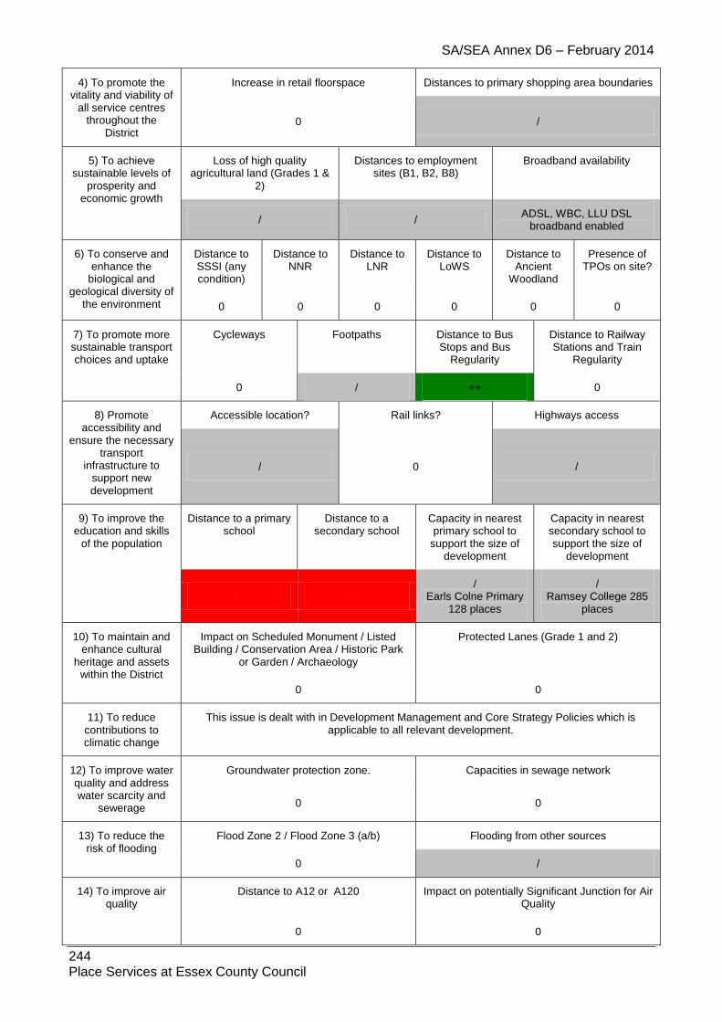
SA/SEA Annex D6 – February 2014
244 Place Services at Essex County Council
4) To promote the vitality and viability of
all service centres throughout the
District
Increase in retail floorspace Distances to primary shopping area boundaries
0 /
5) To achieve sustainable levels of
prosperity and economic growth
Loss of high quality agricultural land (Grades 1 &
2)
Distances to employment sites (B1, B2, B8)
Broadband availability
/ / ADSL, WBC, LLU DSL
broadband enabled
6) To conserve and enhance the
biological and geological diversity of
the environment
Distance to SSSI (any condition)
Distance to NNR
Distance to LNR
Distance to LoWS
Distance to Ancient
Woodland
Presence of TPOs on site?
0 0 0 0 0 0
7) To promote more sustainable transport choices and uptake
Cycleways Footpaths Distance to Bus Stops and Bus
Regularity
Distance to Railway Stations and Train
Regularity
0 / ++ 0
8) Promote accessibility and
ensure the necessary transport
infrastructure to support new development
Accessible location? Rail links? Highways access
/ 0 /
9) To improve the education and skills
of the population
Distance to a primary school
Distance to a secondary school
Capacity in nearest primary school to
support the size of development
Capacity in nearest secondary school to support the size of
development
- - /
Earls Colne Primary 128 places
/ Ramsey College 285
places
10) To maintain and enhance cultural
heritage and assets within the District
Impact on Scheduled Monument / Listed Building / Conservation Area / Historic Park
or Garden / Archaeology
Protected Lanes (Grade 1 and 2)
0 0
11) To reduce contributions to climatic change
This issue is dealt with in Development Management and Core Strategy Policies which is applicable to all relevant development.
12) To improve water quality and address water scarcity and
sewerage
Groundwater protection zone. Capacities in sewage network
0 0
13) To reduce the risk of flooding
Flood Zone 2 / Flood Zone 3 (a/b) Flooding from other sources
0 /
14) To improve air quality
Distance to A12 or A120 Impact on potentially Significant Junction for Air Quality
0 0

SA/SEA Annex D6 – February 2014
245 Place Services at Essex County Council
15) To maintain and enhance the quality of landscapes and
townscapes
Sensitivity to change in the
LCA
Greenfield / PDL
Visually Important
Space
Country Parks Landscaping associated with
proposals
- Colne River
Valley - 0 0 /
1.26.3. Site: WHC3
Address: Land south of Colchester Road, White Colne
Other info: Greenfield, Residential
Sustainability Objective
Key Criteria / Impacts
1) Create safe environments which
improve quality of life and community
cohesion
Provision / suitability for community facilities
Crime incidents in past year Nearest Post Offices
0 /
71 incidences +
2) To provide everyone with the
opportunity to live in a decent home
Delivery of affordable housing Additional capacity in or of care homes
/ /
3) To improve the health of the District’s
residents and mitigate/reduce potential health
inequalities
Distance to nearest GP
Distances to accessible natural
greenspace
Loss of recreation (formal / informal),
open space, allotments.
Contaminated land
/ - + /
4) To promote the vitality and viability of
all service centres throughout the
District
Increase in retail floorspace Distances to primary shopping area boundaries
0 /
5) To achieve sustainable levels of
prosperity and economic growth
Loss of high quality agricultural land (Grades 1 &
2)
Distances to employment sites (B1, B2, B8)
Broadband availability
0 / ADSL, WBC, LLU DSL
broadband enabled
6) To conserve and enhance the
biological and geological diversity of
the environment
Distance to SSSI (any condition)
Distance to NNR
Distance to LNR
Distance to LoWS
Distance to Ancient
Woodland
Presence of TPOs on site?
0 0 0 0 0 0
7) To promote more sustainable transport choices and uptake
Cycleways Footpaths Distance to Bus Stops and Bus
Regularity
Distance to Railway Stations and Train
Regularity
0 / ++ 0
8) Promote accessibility and
Accessible location? Rail links? Sensitivities to local roads
Highways access

SA/SEA Annex D6 – February 2014
246 Place Services at Essex County Council
ensure the necessary transport
infrastructure to support new development
/ 0 /
9) To improve the education and skills
of the population
Distance to a primary school
Distance to a secondary school
Capacity in nearest primary school to
support the size of development
Capacity in nearest secondary school to support the size of
development
- - /
Earls Colne Primary 128 places
/ Ramsey College 285
places
10) To maintain and enhance cultural
heritage and assets within the District
Impact on Scheduled Monument / Listed Building / Conservation Area / Historic Park
or Garden / Archaeology
Protected Lanes (Grade 1 and 2)
-- 0
11) To reduce contributions to climatic change
This issue is dealt with in Development Management and Core Strategy Policies which is applicable to all relevant development.
12) To improve water quality and address water scarcity and
sewerage
Groundwater protection zone. Capacities in sewage network
0 0
13) To reduce the risk of flooding
Flood Zone 2 / Flood Zone 3 (a/b) Flooding from other sources
0 /
14) To improve air quality
Distance to A12 or A120 Impact on potentially Significant Junction for Air Quality
0 0
15) To maintain and enhance the quality of landscapes and
townscapes
Sensitivity to change in the
LCA
Greenfield / PDL
Visually Important
Space
Country Parks Landscaping associated with
proposals
- Colne River
Valley - 0 0 /
1.26.4. Site: WHC4
Address: CO6 2PP
Other info: Residential
Sustainability Objective
Key Criteria / Impacts
1) Create safe environments which improve quality of life
and community cohesion
Provision / suitability for community facilities
Crime incidents in past year Nearest Post Offices
/ /
51 incidences /
2) To provide Delivery of affordable housing Additional capacity in or of care homes

SA/SEA Annex D6 – February 2014
247 Place Services at Essex County Council
everyone with the opportunity to live in
a decent home
/
Further information needed /
3) To improve the health of the District’s
residents and mitigate/reduce potential health
inequalities
Distance to nearest GP
Distances to accessible natural
greenspace
Loss of recreation (formal / informal),
open space, allotments.
Contaminated land
/ + + 0
4) To promote the vitality and viability of
all service centres throughout the
District
Increase in retail floorspace Distances to primary shopping area boundaries
0 /
5) To achieve sustainable levels of
prosperity and economic growth
Loss of high quality agricultural land (Grades 1 &
2)
Distances to employment sites (B1, B2, B8)
Broadband availability
0 /
BT Wholesale ADSL, BT Wholesale ADSL Max, BT Wholesale WBC (21CN), TalkTalk (CPW) LLU, Sky Broadband / Easynet LLU
6) To conserve and enhance the
biological and geological diversity of
the environment
Distance to SSSI (any condition)
Distance to NNR
Distance to LNR
Distance to LoWS
Distance to Ancient
Woodland
Presence of TPOs on
site?
0 0 0 0 0 0
7) To promote more sustainable transport choices and uptake
Cycleways Footpaths Distance to Bus Stops and Bus
Regularity
Distance to Railway Stations and Train
Regularity
/ / ++ 0
8) Promote accessibility and
ensure the necessary transport
infrastructure to support new development
Accessible location? Rail links? Highways access
/ - /
9) To improve the education and skills
of the population
Distance to a primary school
Distance to a secondary school
Capacity in nearest primary school to
support the size of development
Capacity in nearest secondary school to support the size of
development
- - / /
10) To maintain and enhance cultural
heritage and assets within the District
Impact on Scheduled Monument / Listed Building / Conservation Area / Historic Park or
Garden / Archaeology
Protected Lanes (Grade 1 and 2)
0 0
11) To reduce contributions to climatic change
This issue is dealt with in Development Management and Core Strategy Policies which is applicable to all relevant development.
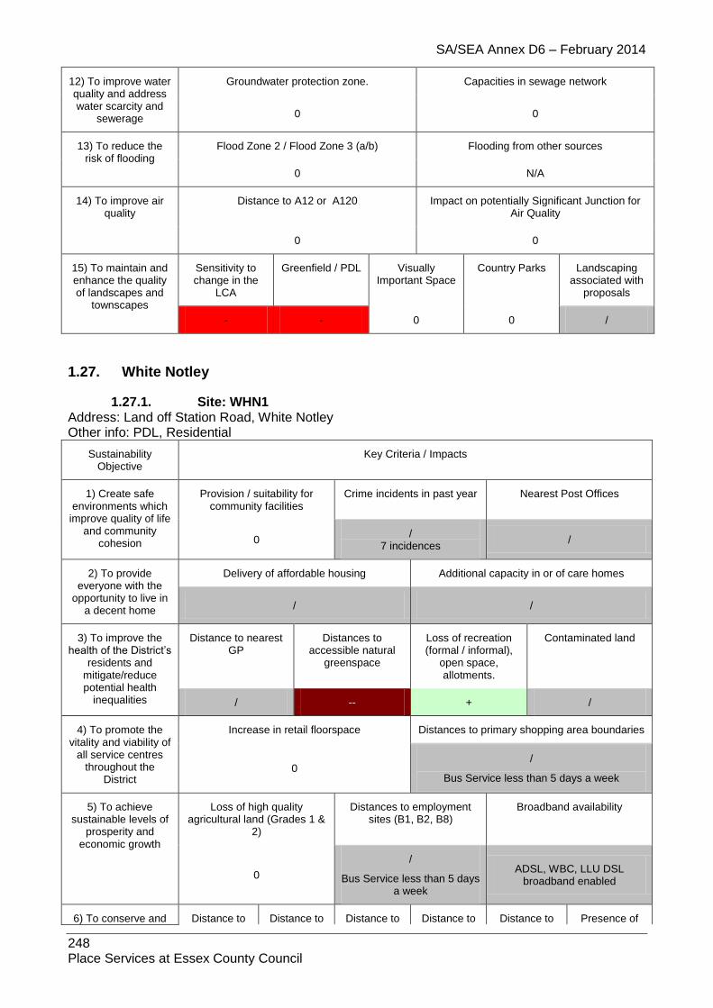
SA/SEA Annex D6 – February 2014
248 Place Services at Essex County Council
12) To improve water quality and address water scarcity and
sewerage
Groundwater protection zone. Capacities in sewage network
0 0
13) To reduce the risk of flooding
Flood Zone 2 / Flood Zone 3 (a/b) Flooding from other sources
0 N/A
14) To improve air quality
Distance to A12 or A120 Impact on potentially Significant Junction for Air Quality
0 0
15) To maintain and enhance the quality of landscapes and
townscapes
Sensitivity to change in the
LCA
Greenfield / PDL Visually Important Space
Country Parks Landscaping associated with
proposals
- - 0 0 /
1.27. White Notley
1.27.1. Site: WHN1 Address: Land off Station Road, White Notley Other info: PDL, Residential
Sustainability Objective
Key Criteria / Impacts
1) Create safe environments which
improve quality of life and community
cohesion
Provision / suitability for community facilities
Crime incidents in past year Nearest Post Offices
0 /
7 incidences /
2) To provide everyone with the
opportunity to live in a decent home
Delivery of affordable housing Additional capacity in or of care homes
/ /
3) To improve the health of the District’s
residents and mitigate/reduce potential health
inequalities
Distance to nearest GP
Distances to accessible natural
greenspace
Loss of recreation (formal / informal),
open space, allotments.
Contaminated land
/ -- + /
4) To promote the vitality and viability of
all service centres throughout the
District
Increase in retail floorspace Distances to primary shopping area boundaries
0 /
Bus Service less than 5 days a week
5) To achieve sustainable levels of
prosperity and economic growth
Loss of high quality agricultural land (Grades 1 &
2)
Distances to employment sites (B1, B2, B8)
Broadband availability
0
/
Bus Service less than 5 days a week
ADSL, WBC, LLU DSL broadband enabled
6) To conserve and Distance to Distance to Distance to Distance to Distance to Presence of

SA/SEA Annex D6 – February 2014
249 Place Services at Essex County Council
enhance the biological and
geological diversity of the environment
SSSI (any condition)
NNR LNR LoWS Ancient Woodland
TPOs on site?
0 0 0 0 0 0
7) To promote more sustainable transport choices and uptake
Cycleways Footpaths Distance to Bus Stops and Bus
Regularity
Distance to Railway Stations and Train
Regularity
0 / + ++
8) Promote accessibility and
ensure the necessary transport
infrastructure to support new development
Accessible location? Rail links? Highways access
/ ++ /
9) To improve the education and skills
of the population
Distance to a primary school
Distance to a secondary school
Capacity in nearest primary school to
support the size of development
Capacity in nearest secondary school to support the size of
development
++ + /
White Notley CoE 0 places
/ New Rickstones
Academy 403 places
10) To maintain and enhance cultural
heritage and assets within the District
Impact on Scheduled Monument / Listed Building / Conservation Area / Historic Park
or Garden / Archaeology
Protected Lanes (Grade 1 and 2)
-- 0
11) To reduce contributions to climatic change
This issue is dealt with in Development Management and Core Strategy Policies which is applicable to all relevant development.
12) To improve water quality and address water scarcity and
sewerage
Groundwater protection zone. Capacities in sewage network
0 0
13) To reduce the risk of flooding
Flood Zone 2 / Flood Zone 3 (a/b) Flooding from other sources
0 /
14) To improve air quality
Distance to A12 or A120 Impact on potentially Significant Junction for Air Quality
0 0
15) To maintain and enhance the quality of landscapes and
townscapes
Sensitivity to change in the
LCA
Greenfield / PDL
Visually Important
Space
Country Parks Landscaping associated with
proposals
- Brain River
Valley + 0 0 /

SA/SEA Annex D6 – February 2014
250 Place Services at Essex County Council
1.28. Wickham St Paul
1.28.1. Site: WIC1A Address: Land off Church Road (opposite Winton Cottage), Wickham St Paul Other info: PDL, Residential
Sustainability Objective
Key Criteria / Impacts
1) Create safe environments which
improve quality of life and community
cohesion
Provision / suitability for community facilities
Crime incidents in past year Nearest Post Offices
0 /
4 incidences +
2) To provide everyone with the
opportunity to live in a decent home
Delivery of affordable housing Additional capacity in or of care homes
/ /
3) To improve the health of the District’s
residents and mitigate/reduce potential health
inequalities
Distance to nearest GP
Distances to accessible natural
greenspace
Loss of recreation (formal / informal),
open space, allotments.
Contaminated land
/ -- + /
4) To promote the vitality and viability of
all service centres throughout the
District
Increase in retail floorspace Distances to primary shopping area boundaries
0 /
5) To achieve sustainable levels of
prosperity and economic growth
Loss of high quality agricultural land (Grades 1 &
2)
Distances to employment sites (B1, B2, B8)
Broadband availability
- / ADSL broadband enabled
6) To conserve and enhance the
biological and geological diversity of
the environment
Distance to SSSI (any condition)
Distance to NNR
Distance to LNR
Distance to LoWS
Distance to Ancient
Woodland
Presence of TPOs on site?
0 0 0 0 0 0
7) To promote more sustainable transport choices and uptake
Cycleways Footpaths Distance to Bus Stops and Bus
Regularity
Distance to Railway Stations and Train
Regularity
0 / ++ 0
8) Promote accessibility and
ensure the necessary transport
infrastructure to support new development
Accessible location? Rail links? Highways access
- 0 /
9) To improve the education and skills
of the population
Distance to a primary school
Distance to a secondary school
Capacity in nearest primary school to
support the size of development
Capacity in nearest secondary school to support the size of
development
- - / /

SA/SEA Annex D6 – February 2014
251 Place Services at Essex County Council
St Giles’ CoE Primary 30 places
Hedingham School 107 places
10) To maintain and enhance cultural
heritage and assets within the District
Impact on Scheduled Monument / Listed Building / Conservation Area / Historic Park
or Garden / Archaeology
Protected Lanes (Grade 1 and 2)
0 0
11) To reduce contributions to climatic change
This issue is dealt with in Development Management and Core Strategy Policies which is applicable to all relevant development.
12) To improve water quality and address water scarcity and
sewerage
Groundwater protection zone. Capacities in sewage network
0 0
13) To reduce the risk of flooding
Flood Zone 2 / Flood Zone 3 (a/b) Flooding from other sources
0 /
14) To improve air quality
Distance to A12 or A120 Impact on potentially Significant Junction for Air Quality
0 0
15) To maintain and enhance the quality of landscapes and
townscapes
Sensitivity to change in the
LCA
Greenfield / PDL
Visually Important
Space
Country Parks Landscaping associated with
proposals
- Wickham Farmland Plateau
+ 0 0 /
1.28.2. Site: WIC1B Address: Land off Church Road (opposite Winton Cottage/Beverleigh), Wickham St Paul Other info: Greenfield, Residential
Sustainability Objective
Key Criteria / Impacts
1) Create safe environments which
improve quality of life and community
cohesion
Provision / suitability for community facilities
Crime incidents in past year Nearest Post Offices
0 /
4 incidences +
2) To provide everyone with the
opportunity to live in a decent home
Delivery of affordable housing Additional capacity in or of care homes
/ /
3) To improve the health of the District’s
residents and mitigate/reduce potential health
inequalities
Distance to nearest GP
Distances to accessible natural
greenspace
Loss of recreation (formal / informal),
open space, allotments.
Contaminated land
/ -- + /
4) To promote the Increase in retail floorspace Distances to primary shopping area boundaries

SA/SEA Annex D6 – February 2014
252 Place Services at Essex County Council
vitality and viability of all service centres
throughout the District
0 /
5) To achieve sustainable levels of
prosperity and economic growth
Loss of high quality agricultural land (Grades 1 &
2)
Distances to employment sites (B1, B2, B8)
Broadband availability
- / ADSL broadband enabled
6) To conserve and enhance the
biological and geological diversity of
the environment
Distance to SSSI (any condition)
Distance to NNR
Distance to LNR
Distance to LoWS
Distance to Ancient
Woodland
Presence of TPOs on site?
0 0 0 0 0 0
7) To promote more sustainable transport choices and uptake
Cycleways Footpaths Distance to Bus Stops and Bus
Regularity
Distance to Railway Stations and Train
Regularity
0 / ++ 0
8) Promote accessibility and
ensure the necessary transport
infrastructure to support new development
Accessible location? Rail links? Highways access
- 0 /
9) To improve the education and skills
of the population
Distance to a primary school
Distance to a secondary school
Capacity in nearest primary school to
support the size of development
Capacity in nearest secondary school to support the size of
development
- - /
St Giles’ CoE Primary 30 places
/ Hedingham School
107 places
10) To maintain and enhance cultural
heritage and assets within the District
Impact on Scheduled Monument / Listed Building / Conservation Area / Historic Park
or Garden / Archaeology
Protected Lanes (Grade 1 and 2)
/ 0
11) To reduce contributions to climatic change
This issue is dealt with in Development Management and Core Strategy Policies which is applicable to all relevant development.
12) To improve water quality and address water scarcity and
sewerage
Groundwater protection zone. Capacities in sewage network
0 0
13) To reduce the risk of flooding
Flood Zone 2 / Flood Zone 3 (a/b) Flooding from other sources
0 /
14) To improve air quality
Distance to A12 or A120 Impact on potentially Significant Junction for Air Quality
0 0
15) To maintain and enhance the quality
Sensitivity to change in the
Greenfield / Visually Important
Country Parks Landscaping associated with

SA/SEA Annex D6 – February 2014
253 Place Services at Essex County Council
of landscapes and townscapes
LCA PDL Space proposals
- Wickham Farmland Plateau
- 0 0 /
1.28.3. Site: WIC2 Address: Land at Rectory Lane, Wickham St Paul Other info: Greenfield, Residential
Sustainability Objective
Key Criteria / Impacts
1) Create safe environments which
improve quality of life and community
cohesion
Provision / suitability for community facilities
Crime incidents in past year Nearest Post Offices
0 /
4 incidences +
2) To provide everyone with the
opportunity to live in a decent home
Delivery of affordable housing Additional capacity in or of care homes
/ /
3) To improve the health of the District’s
residents and mitigate/reduce potential health
inequalities
Distance to nearest GP
Distances to accessible natural
greenspace
Loss of recreation (formal / informal),
open space, allotments.
Contaminated land
/ -- + /
4) To promote the vitality and viability of
all service centres throughout the
District
Increase in retail floorspace Distances to primary shopping area boundaries
0 /
5) To achieve sustainable levels of
prosperity and economic growth
Loss of high quality agricultural land (Grades 1 &
2)
Distances to employment sites (B1, B2, B8)
Broadband availability
- / ADSL broadband enabled
6) To conserve and enhance the
biological and geological diversity of
the environment
Distance to SSSI (any condition)
Distance to NNR
Distance to LNR
Distance to LoWS
Distance to Ancient
Woodland
Presence of TPOs on site?
0 0 0 0 0 0
7) To promote more sustainable transport choices and uptake
Cycleways Footpaths Distance to Bus Stops and Bus
Regularity
Distance to Railway Stations and Train
Regularity
0 / ++ 0
8) Promote accessibility and
ensure the necessary transport
infrastructure to support new development
Accessible location? Rail links? Highways access
- 0 /

SA/SEA Annex D6 – February 2014
254 Place Services at Essex County Council
9) To improve the education and skills
of the population
Distance to a primary school
Distance to a secondary school
Capacity in nearest primary school to
support the size of development
Capacity in nearest secondary school to support the size of
development
- - /
St Giles’ CoE Primary 30 places
/ Hedingham School
107 places
10) To maintain and enhance cultural
heritage and assets within the District
Impact on Scheduled Monument / Listed Building / Conservation Area / Historic Park
or Garden / Archaeology
Protected Lanes (Grade 1 and 2)
0 0
11) To reduce contributions to climatic change
This issue is dealt with in Development Management and Core Strategy Policies which is applicable to all relevant development.
12) To improve water quality and address water scarcity and
sewerage
Groundwater protection zone. Capacities in sewage network
0 0
13) To reduce the risk of flooding
Flood Zone 2 / Flood Zone 3 (a/b) Flooding from other sources
0 /
14) To improve air quality
Distance to A12 or A120 Impact on potentially Significant Junction for Air Quality
0 0
15) To maintain and enhance the quality of landscapes and
townscapes
Sensitivity to change in the
LCA
Greenfield / PDL
Visually Important
Space
Country Parks Landscaping associated with
proposals
- Wickham Farmland Plateau
- 0 0 /

SA/SEA Annex D6 – February 2014
255 Place Services at Essex County Council

This information is issued by
Place Services Team at Essex County Council You can contact us in the following ways:
Visit our website:
essex.gov.uk
By telephone:
08456 430 430
By post:
Place Services, Essex County Council PO Box 11, County Hall, Chelmsford, Essex, CM1 1QH
Read our online magazine at essex.gov.uk/ew
Follow us on Essex_CC
Find us on facebook.com/essexcountycouncil
The information in this document can be translated, and/ or made available in alternative formats, on request.
Published February 2014
Related Documents