Bonobo Conservation Project – Maringa Lopori Wamba Final Project Report for People’s Trust for Endangered Species Bonobo conservation through improved ICCN and community scout bio-monitoring Alain Lushimba June 2014

Welcome message from author
This document is posted to help you gain knowledge. Please leave a comment to let me know what you think about it! Share it to your friends and learn new things together.
Transcript

Bonobo Conservation Project – Maringa Lopori Wamba
Final Project Report for People’s Trust for Endangered Species
Bonobo conservation through improved ICCN and community
scout bio-monitoring
Alain Lushimba
June 2014
1
Executive summary
The endangered bonobo is a little-known species of great ape endemic to the Democratic Republic of Congo (DRC) and is thought to occupy a range of approximately 500,000 km² of tropical lowland rainforest. Much of the species’ range remains poorly surveyed, monitored or protected from increasing threats such as land use change illegal logging and bushmeat hunting. Effective locally-managed monitoring and patrolling is urgently needed to improve the conservation status of the bonobo by securing vital protected areas and our understanding of the key threats the species faces. Simple improvements in the capacity of protected area authorities to understand, monitor and protect the bonobo can lead to immediate improvements in the effectiveness of protected areas in a region with poorly resourced and equipped monitoring teams. During the period June 2013 to May 2014 the People’s Trust for Endangered Species (PTES) provided support to the project to develop a monitoring system that will enable ICCN park rangers and community scouts to monitor and understand the key threats and population status of the bonobo within two protected areas (Lomako-Yokokala Faunal Reserve and Iyondji Community Bonobo Reserve). The project involved training and equipping ICCN rangers and community-field researchers in the use of the georeferenced CyberTracker® system as a means to improve understanding of the key threats and the ability of protected area managers to effectively target scarce monitoring resources.
2
Introduction This project aims to improve the longer-term conservation of bonobo through working with monitoring teams made up of Congolese wildlife authority park rangers (Institut Congolais pour la Conservation de la Nature - ICCN) and community scouts to develop a rigorous wildlife and human activity monitoring system that enables these groups to monitor and understand key threats and population status in and around two important protected areas in the Maringa Lopori Wamba region. In particular, the monitoring system will provide regular data collection that would enable the ICCN to develop an evidence-based management strategy for the Lomako-Yokokala Faunal Reserve. By having the protected area rangers collect data on specific wildlife and human activity observations while they are on patrol, AWF’s landscape ecologist Alain Lushimba and the DRC wildlife authority (ICCN) can gain an accurate picture of where the primary threats are within the reserve, and focus counter-poaching and community liaison efforts on those areas. This project involved providing rangers CyberTracker® technology and training rangers on its use (a durable hand held computer and software for recording geo-referenced data on particular observations). Over time data generated from this project will also assist in the development of evidence-based conservation strategies that will strengthen the management of these protected areas. Training provided to local scouts and ICCN rangers on the use of monitoring protocols and rugged, hand-held georeferenced CyberTracker® data systems will make a lasting impact on their capacity to monitor, document and analyse population trends and key threats. The specific aims of the project were to:
1. establish a rigorous ranger and community-led bonobo bio-monitoring programme that will provide an accurate description of trends affecting abundance and density, and insights on the extent, intensity and distribution of human activities and other major threats;
2. equip and train ICCN rangers, scouts and community-field researchers in the use of the georeferenced CyberTracker® system as a means to enable direct local participation in bonobo monitoring and conservation;
3. analyse monitoring data results from approximately 300-400km² of core bonobo habitat and across two protected areas in order to inform local conservation and planning strategies;
4. ensure effective integration of survey results from one ranger-led annual survey and regular community-field researcher biomonitoring patrols into the Max Planck Institute for Evolutionary Anthropology (MPI) A.P.E.S. database (Ape Populations, Environments, and Surveys).
The project successfully achieved all four of its aims. The following pages provides a full report of the project achievements towards these four aims over the last 12 months.
1. Establish a rigorous ranger and community-led bonobo bio-monitoring system that will provide an accurate description of trends affecting abundance and

3
The Wildlife and Human Activity Monitoring Program Positive Feedback Cycle
Project leader Alain Lushimba trains a visiting Nigerian researcher on the use of
CyberTracker.
density, and insights on the extent, intensity and distribution of human activities and other major threats
The endangered bonobo is a little-known species of great ape endemic to the Democratic Republic of Congo (DRC) and is thought to occupy a range of approximately 500,000 km² of
tropical lowland rainforest. Much of its range remains poorly monitored or protected, and the protected areas that have been established often do not have the resource to address increasing threats such as land use change, illegal logging, and bush-meat hunting. The African Wildlife Foundation helped establish two important protected areas for the bonobo within moist tropical forests of the Maringa Lopori Wamba region: the 3,625 km² Lomako-Yokokala Faunal Reserve (gazetted in 2006) and the 1,100 km² Iyondji Community Bonobo Reserve (gazetted in 2012). One of the first steps in ensuring these reserves are truly protected is to establish a procedure for monitoring and responding to
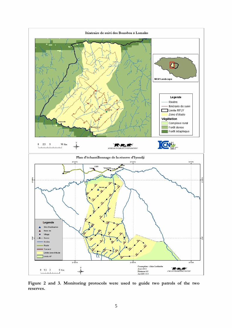
key threats. This is vital in order secure the area’s ongoing conservation and control ever-increasing levels of bushmeat hunting which at their worst can lead to “empty forest syndrome” where large areas of tropical forest become devoid of mammalian biodiversity. ICCN/community monitoring teams typically involve groups of about 25 rangers who have a significant challenge when attempting to patrol and secure a 3,625 km² area of dense tropical forest as large as the Lomako reserve. It is therefore essential that these conservation managers have the equipment and knowledge they need to be strategic about where they deploy rangers in order to maximize available resources. The project achieved its aim of establishing a new sampling plan for regular monitoring within the reserves. Over the year the project team helped ICCN first design and establish a monitoring system at the Lomako-Yokokala Faunal Reserve using the Distance 6.0 and ArcGIS 10.0 software. The sampling plan was first designed to particularly focus first on a priority area of 300 km² for monitoring bonobo and human activities. Later complete monitoring protocols were developed and used to guide two surveys of the entire parks (Figures 2 and 3). The Cybertracker® tool is fully compatible with this system and will be used for data collection. CyberTracker® units are simple to operate allowing field workers with limited formal education to record field observations and then upload and map their activities in real-time on satellite maps. CyberTracker is also useful for assessing patrol efforts (performance appraisal of rangers), evaluating management effectiveness, improving the coordination of patrols, motivating the rangers, reducing errors due to data entry, and developing a database to
4
track the spatial-temporal trends in populations of large mammals. Lastly, it greatly reduces the lag time between data collection, analysis, and reporting, thus enabling conservation managers to make more timely and well-targeted decisions that are able to respond almost immediately to changing threats.
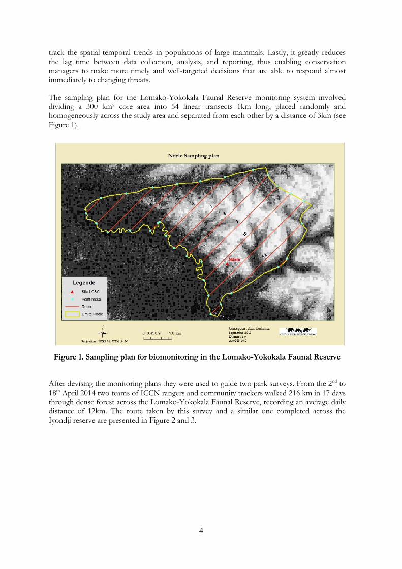
The sampling plan for the Lomako-Yokokala Faunal Reserve monitoring system involved dividing a 300 km² core area into 54 linear transects 1km long, placed randomly and homogeneously across the study area and separated from each other by a distance of 3km (see Figure 1).
Figure 1. Sampling plan for biomonitoring in the Lomako-Yokokala Faunal Reserve
After devising the monitoring plans they were used to guide two park surveys. From the 2nd to 18th April 2014 two teams of ICCN rangers and community trackers walked 216 km in 17 days through dense forest across the Lomako-Yokokala Faunal Reserve, recording an average daily distance of 12km. The route taken by this survey and a similar one completed across the Iyondji reserve are presented in Figure 2 and 3.
5
Figure 2 and 3. Monitoring protocols were used to guide two patrols of the two reserves.
6
2. Equip and train ICCN rangers, scouts and community-field researchers in the use of the georeferenced CyberTracker® system as a means to enable direct local participation in bonobo monitoring and conservation
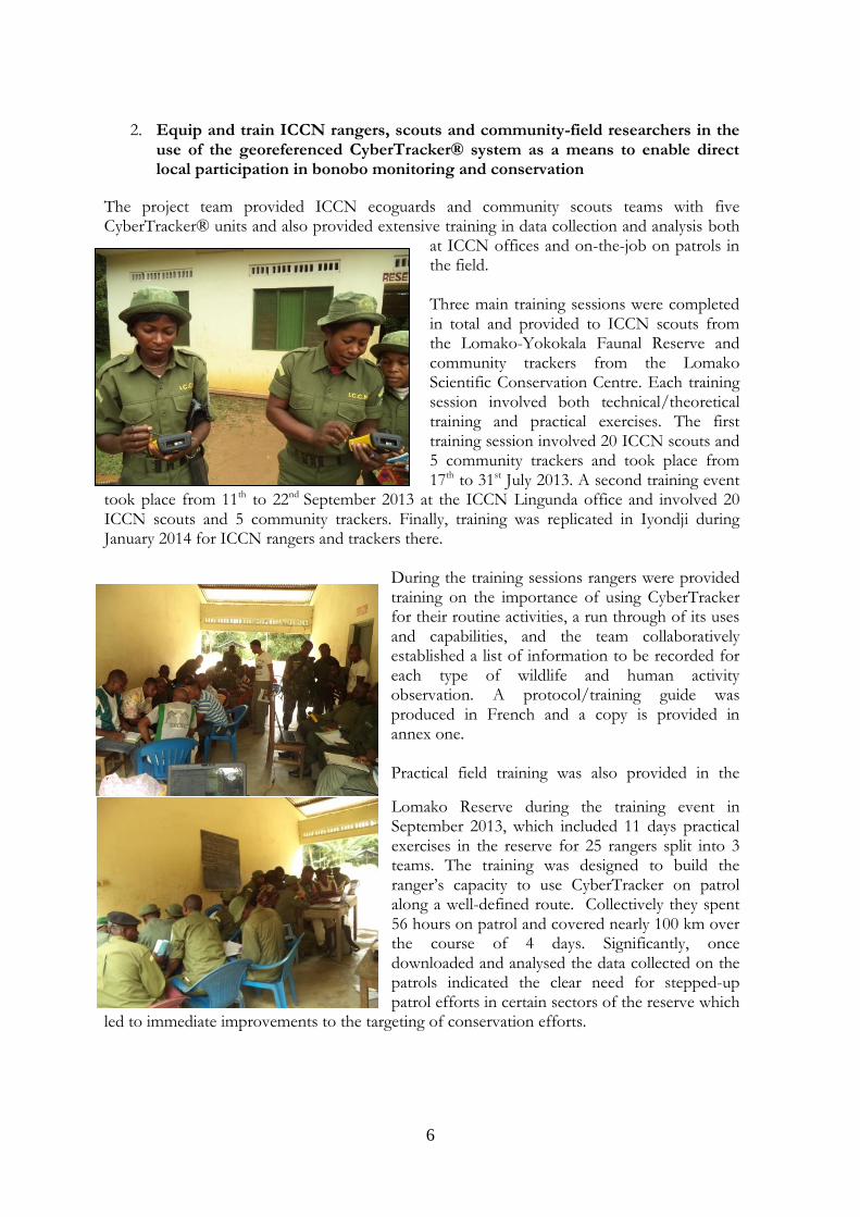
The project team provided ICCN ecoguards and community scouts teams with five CyberTracker® units and also provided extensive training in data collection and analysis both
at ICCN offices and on-the-job on patrols in the field. Three main training sessions were completed in total and provided to ICCN scouts from the Lomako-Yokokala Faunal Reserve and community trackers from the Lomako Scientific Conservation Centre. Each training session involved both technical/theoretical training and practical exercises. The first training session involved 20 ICCN scouts and 5 community trackers and took place from 17th to 31st July 2013. A second training event
took place from 11th to 22nd September 2013 at the ICCN Lingunda office and involved 20 ICCN scouts and 5 community trackers. Finally, training was replicated in Iyondji during January 2014 for ICCN rangers and trackers there.
During the training sessions rangers were provided training on the importance of using CyberTracker for their routine activities, a run through of its uses and capabilities, and the team collaboratively established a list of information to be recorded for each type of wildlife and human activity observation. A protocol/training guide was produced in French and a copy is provided in annex one. Practical field training was also provided in the
Lomako Reserve during the training event in September 2013, which included 11 days practical exercises in the reserve for 25 rangers split into 3 teams. The training was designed to build the ranger’s capacity to use CyberTracker on patrol along a well-defined route. Collectively they spent 56 hours on patrol and covered nearly 100 km over the course of 4 days. Significantly, once downloaded and analysed the data collected on the patrols indicated the clear need for stepped-up patrol efforts in certain sectors of the reserve which
led to immediate improvements to the targeting of conservation efforts.
7
3. Ensure effective integration of survey results from one ranger-led annual survey and regular community-field researcher biomonitoring patrols into the Max Planck Institute for Evolutionary Anthropology (MPI) A.P.E.S. database (Ape Populations, Environments, and Surveys)
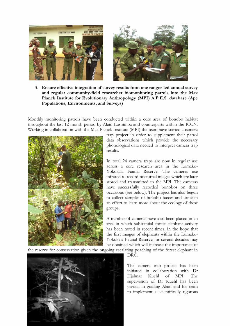
Monthly monitoring patrols have been conducted within a core area of bonobo habitat throughout the last 12 month period by Alain Lushimba and counterparts within the ICCN. Working in collaboration with the Max Planck Institute (MPI) the team have started a camera
trap project in order to supplement their patrol data observations which provide the necessary phonological data needed to interpret camera trap results. In total 24 camera traps are now in regular use across a core research area in the Lomako-Yokokala Faunal Reserve. The cameras use infrared to record nocturnal images which are later stored and transmitted to the MPI. The cameras have successfully recorded bonobos on three occasions (see below). The project has also begun to collect samples of bonobo faeces and urine in an effort to learn more about the ecology of these groups. A number of cameras have also been placed in an area in which substantial forest elephant activity has been noted in recent times, in the hope that the first images of elephants within the Lomako-Yokokala Faunal Reserve for several decades may be obtained which will increase the importance of
the reserve for conservation given the ongoing escalating poaching of the forest elephant in DRC. The camera trap project has been initiated in collaboration with Dr Hjalmar Kuehl of MPI. The supervision of Dr Kuehl has been pivotal in guiding Alain and his team to implement a scientifically rigorous
8
methodology that focuses analysis on the centre of the home range of one of the bonobo communities at either Iyema or Ndele. In this way the project will ensure sufficient photographic footage of bonobos is obtained to fulfil the requirements of the MPI great ape census protocol.
Adult male red river hog photographed using remote camera in Ndele forest inside the Lomako-Yokokala Faunal Reserve
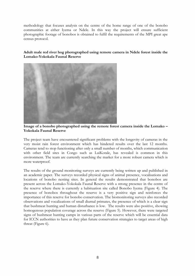
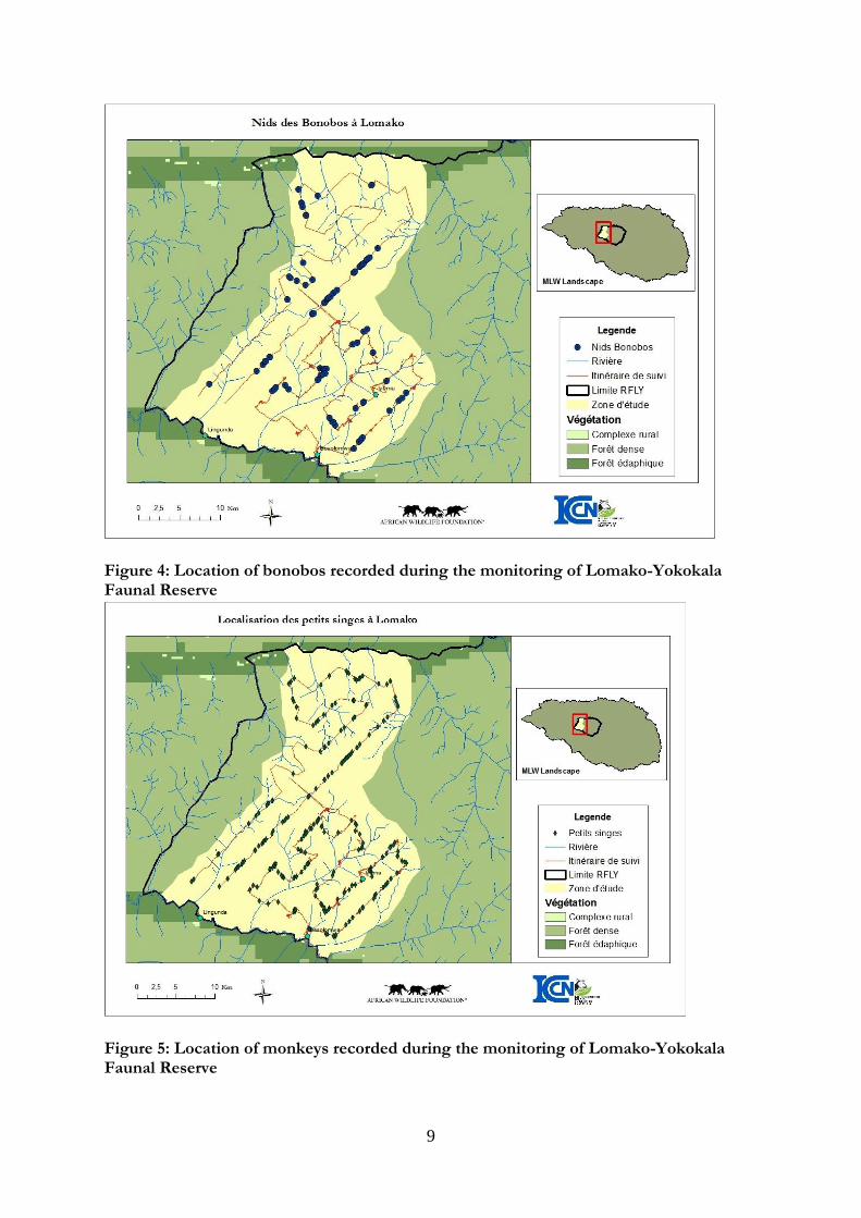
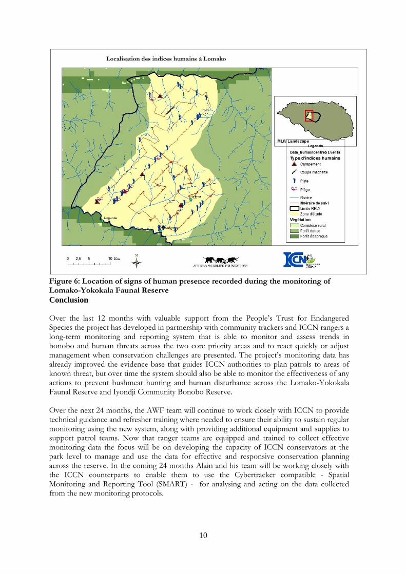
Image of a bonobo photographed using the remote forest camera inside the Lomako – Yokokala Faunal Reserve The project team have encountered significant problems with the longevity of cameras in the very moist rain forest environment which has hindered results over the last 12 months. Cameras tend to stop functioning after only a small number of months, which communication with other field sites in Congo such as LuiKotale, has revealed is common in this environment. The team are currently searching the market for a more robust camera which is more waterproof. The results of the ground monitoring surveys are currently being written up and published in an academic paper. The surveys recorded physical signs of animal presence, vocalisations and locations of bonobo nesting sites. In general the results demonstrated that bonobos are present across the Lomako-Yokokala Faunal Reserve with a strong presence in the centre of the reserve where there is currently a habituation site called Bonobo Iyema (Figure 4). The presence of bonobos throughout the reserve is a very positive sign and reinforces the importance of this reserve for bonobo conservation. The biomonitoring surveys also recorded observations and vocalizations of small diurnal primates, the presence of which is a clear sign that bushmeat hunting and human disturbance is low. The results were also positive, showing homogenous population coverage across the reserve (Figure 5). However, there were targeted signs of bushmeat hunting camps in various parts of the reserve which will be essential data for ICCN authorities to have as they plan future conservation strategies to target areas of high threat (Figure 6).
9
Figure 4: Location of bonobos recorded during the monitoring of Lomako-Yokokala Faunal Reserve
Figure 5: Location of monkeys recorded during the monitoring of Lomako-Yokokala Faunal Reserve
10
Figure 6: Location of signs of human presence recorded during the monitoring of Lomako-Yokokala Faunal Reserve
Conclusion Over the last 12 months with valuable support from the People’s Trust for Endangered Species the project has developed in partnership with community trackers and ICCN rangers a long-term monitoring and reporting system that is able to monitor and assess trends in bonobo and human threats across the two core priority areas and to react quickly or adjust management when conservation challenges are presented. The project’s monitoring data has already improved the evidence-base that guides ICCN authorities to plan patrols to areas of known threat, but over time the system should also be able to monitor the effectiveness of any actions to prevent bushmeat hunting and human disturbance across the Lomako-Yokokala Faunal Reserve and Iyondji Community Bonobo Reserve. Over the next 24 months, the AWF team will continue to work closely with ICCN to provide technical guidance and refresher training where needed to ensure their ability to sustain regular monitoring using the new system, along with providing additional equipment and supplies to support patrol teams. Now that ranger teams are equipped and trained to collect effective monitoring data the focus will be on developing the capacity of ICCN conservators at the park level to manage and use the data for effective and responsive conservation planning across the reserve. In the coming 24 months Alain and his team will be working closely with the ICCN counterparts to enable them to use the Cybertracker compatible - Spatial Monitoring and Reporting Tool (SMART) - for analysing and acting on the data collected from the new monitoring protocols.
11
SMART is an approach that combines software, training materials and implementation standards that provide community groups and protected area managers the ability to empower staff, boost motivation, increase efficiency and promote the transparent monitoring of the effectiveness of anti-poaching efforts. It has been developed in response to the recognition that traditional tools, technologies and resources are not stemming the illegal killing and trading of endangered species. SMART is known to motivate rangers and promote accountability by enabling data on poaching encounters or illegal activities to be recorded and analysed in situ. It empowers protected area managers by converting patrol data and intelligence into useful information about poaching and helping to plan a strategic response. The team will also collaborate with ICCN to ensure this system can be used in the biennial reserve wide faunal surveys that are scheduled to occur later in 2014.
Annex one: resulting protocol guidance note prepared by the project for ICCN rangers from Lomako and Iyondji
Conception et élaboration : Alain LUSHIMBA
Sous la supervision de Jef DUPAIN
PROTOCOLE d’utilisation pratique de l’application
C Y B E R T R A C K E R Suivi écologique et Patrouille anti-braconnage
Adaptée à : Réserve de faune de Lomako-Yokokala et à Réserve
d’Iyondji
12
Aperçu de l’arborescence suivie pour la structure des
écrans et terminologie associée :
Ecran d’accueil
Opérateur
GPS timer
Commencer
o Chef de mission
o Equipe mission
o Itinéraire mission
o Positionnement
o Type de contact
Humain
o Douille de cartouche
o Piste
o Campement
o Feu
o Piège
o Flèche
o Rencontre
o Ramassage/extraction PFNL
Animal
o Espèce animale
o Type d’indice
Crotte
Nid
Vocalisation
Trace
Observation directe
Carcasse
Piste de passage
Généralité
Le CyberTracker est un logiciel
développé dans MapObject
(ESRI). Ce logiciel a été pensé et
développé par Louis Liebenberg
et son équipe, projet
CyberTracker Conservation
(http://www.cybertracker.co.za).
Ce logiciel permet à la fois, de récolter des
données directement sur le terrain grâce à une
interface de saisie sur un ordinateur de poche
(PDA), et de visualiser géographiquement ces
données sur une plateforme PC, de stocker les
observations de terrain, d’établir des requêtes
simples et d’exporter ces données vers d’autres
plateformes tel ArcView, MS Access.
Les Quatre Eléments de base pour travailler avec
le CyberTracker sont un PC (L’ordinateur), un
PDA, le logiciel, et des cartes numériques.
Un PC (Personal Computer) configuré avec le logiciel Windows (Windows XP ou 7) où le logiciel CyberTracker sera installé ainsi que le projet personnalisé et les données de terrain.
Pourquoi Un ordinateur de poche/PDA
CyberTracker doit être synchronisé avec un
ordinateur de bureau ?
L'unité/PDA CyberTracker ne peut «parler» qu’à
un projet (et donc un ordinateur) à la fois. Il est
donc préférable d’avoir un ordinateur principal
dédié au CyberTracker. L’ordinateur de poche/PDA (Personal Digital Assistant) est un équipement électronique bureautique de poche utilisé principalement pour ses fonctions d'agenda, de répertoire téléphonique et de bloc-notes, mais les avancées technologiques ont permis de lui adjoindre des fonctionnalités
13
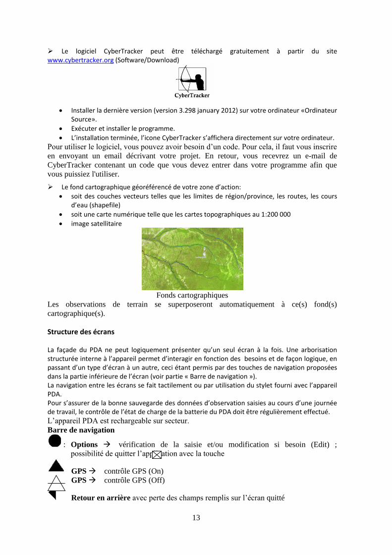
Le logiciel CyberTracker peut être téléchargé gratuitement à partir du site www.cybertracker.org (Software/Download)
Installer la dernière version (version 3.298 january 2012) sur votre ordinateur «Ordinateur Source».
Exécuter et installer le programme.
L’installation terminée, l’icone CyberTracker s’affichera directement sur votre ordinateur.
Pour utiliser le logiciel, vous pouvez avoir besoin d’un code. Pour cela, il faut vous inscrire
en envoyant un email décrivant votre projet. En retour, vous recevrez un e-mail de
CyberTracker contenant un code que vous devez entrer dans votre programme afin que
vous puissiez l'utiliser.
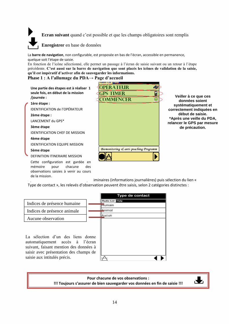
Le fond cartographique géoréférencé de votre zone d’action:
soit des couches vecteurs telles que les limites de région/province, les routes, les cours d’eau (shapefile)
soit une carte numérique telle que les cartes topographiques au 1:200 000
image satellitaire
Fonds cartographiques
Les observations de terrain se superposeront automatiquement à ce(s) fond(s)
cartographique(s).
Structure des écrans La façade du PDA ne peut logiquement présenter qu’un seul écran à la fois. Une arborisation structurée interne à l’appareil permet d’interagir en fonction des besoins et de façon logique, en passant d’un type d’écran à un autre, ceci étant permis par des touches de navigation proposées dans la partie inférieure de l’écran (voir partie « Barre de navigation »). La navigation entre les écrans se fait tactilement ou par utilisation du stylet fourni avec l’appareil PDA. Pour s’assurer de la bonne sauvegarde des données d’observation saisies au cours d’une journée de travail, le contrôle de l’état de charge de la batterie du PDA doit être régulièrement effectué.
L’appareil PDA est rechargeable sur secteur.
Barre de navigation
: Options vérification de la saisie et/ou modification si besoin (Edit) ;
possibilité de quitter l’application avec la touche
GPS contrôle GPS (On)
GPS contrôle GPS (Off)
Retour en arrière avec perte des champs remplis sur l’écran quitté
14
Ecran suivant quand c’est possible et que les champs obligatoires sont remplis
Enregistrer en base de données La barre de navigation, non configurable, est proposée en bas de l’écran, accessible en permanence, quelque soit l’étape de saisie. En fonction de l’icône sélectionné, elle permet un passage à l’écran de saisie suivant ou un retour à l’étape
précédente. C’est aussi sur la barre de navigation que sont placés les icônes de validation de la saisie,
qu’il est impératif d’activer afin de sauvegarder les informations.
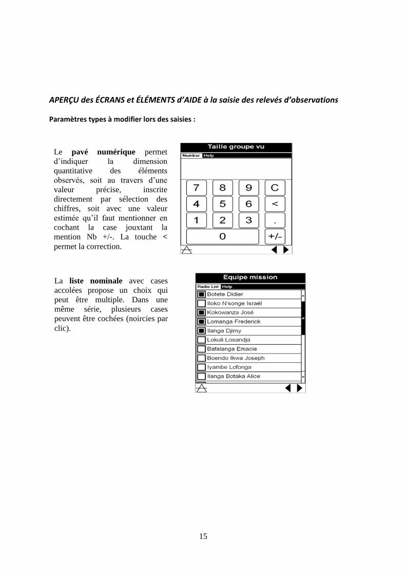
Phase 1 : A l’allumage du PDA→ Page d’accueil
Après indication des informations préliminaires (informations journalières) puis sélection du lien « Type de contact », les relevés d’observation peuvent être saisis, selon 2 catégories distinctes :
Une partie des étapes est à réaliser 1 seule fois, en début de la mission /journée :
1ère étape :
IDENTIFICATION de l’OPÉRATEUR
2ème étape :
LANCEMENT du GPS*
3ème étape
IDENTIFICATION CHEF DE MISSION
4ème étape
IDENTIFICATION EQUIPE MISSION
5ème étape
DEFINITION ITINERAIRE MISSION
Cette configuration est gardée en mémoire pour chacune des observations saisies à venir au cours de la mission.
Veiller à ce que ces données soient
systématiquement et correctement indiquées en
début de saisie. *Après une veille du PDA,
relancer le GPS par mesure
de précaution.
Indices de présence humaine
Indices de présence animale
Aucune observation
La sélection d’un des liens donne
automatiquement accès à l’écran
suivant, faisant mention des données à
saisir avec présentation des champs de
saisie aux intitulés précis.
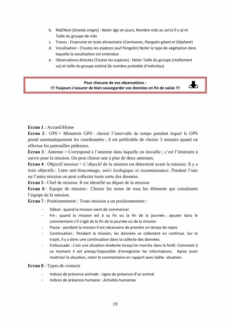
Pour chacune de vos observations : !!! Toujours s’assurer de bien sauvegarder vos données en fin de saisie !!!
15
APERÇU des ÉCRANS et ÉLÉMENTS d’AIDE à la saisie des relevés d’observations
Paramètres types à modifier lors des saisies :
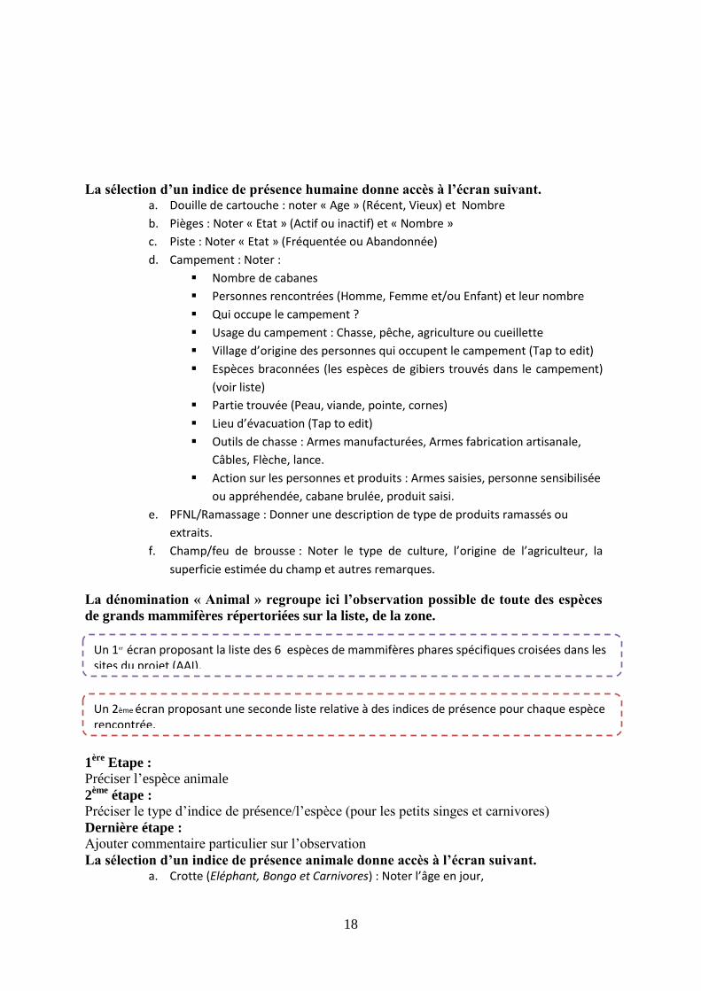
Le pavé numérique permet
d’indiquer la dimension
quantitative des éléments
observés, soit au travers d’une
valeur précise, inscrite
directement par sélection des
chiffres, soit avec une valeur
estimée qu’il faut mentionner en
cochant la case jouxtant la
mention Nb +/-. La touche <
permet la correction.
La liste nominale avec cases
accolées propose un choix qui
peut être multiple. Dans une
même série, plusieurs cases
peuvent être cochées (noircies par
clic).

16
CyberTracker Accueil Commencer Positionnement La dénomination « Positionnement » regroupe ici la position de l’équipe sur
l’itinéraire de la mission. - Début : quand la mission vient de commencer
- Fin : quand la mission est à sa fin ou la fin de la journée ; ajouter dans le commentaire s’il
s’agit de la fin de la journée ou de la mission
- Pause : pendant la mission il est nécessaire de prendre un temps de repos
- Continuation : Pendant la mission, les données se collectent en continue. Sur le trajet, il y
a donc une continuation dans la collecte des données.
- Embuscade : c’est une situation évidente lorsqu’on marche dans la forêt. Comme à ce
moment il est presqu’impossible d’enregistrer les informations, après avoir maitrisé la
situation, noter le commentaire en rapport avec ladite situation.
CyberTracker AccueilCommencerType de
contactHumain/Animal/Aucun La dénomination « Humain» regroupe ici les observations possibles des indices de
présence humaine ou d’individu, « croisés » en domaine réservée, dans un champ de
vision défini, pratiquant des activités variables.
Le champ Tap to edit permet
d’annoter un commentaire ou tout
autre indication alphabétique à partir
du clavier (apparaît en bas de l’écran
en cliquant sur Tap to edit).
La liste nominale sans cases
accolées propose un choix qui doit
être unique, et validé par une
surbrillance du nom.

17
1ère
Etape :
Préciser le type d’indice de présence
2ème
étape :
Préciser l’âge/état de l’indice
3ème
étape :
Préciser le nombre d’indices
4ème
étape :
Préciser le type de végétation dans laquelle l’indice est observé
5ème
étape :
Ajouter commentaire particulier sur l’observation
Pour chacune de vos observations : !!! Toujours s’assurer de bien sauvegarder vos données en fin de saisie !!!
18
La sélection d’un indice de présence humaine donne accès à l’écran suivant. a. Douille de cartouche : noter « Age » (Récent, Vieux) et Nombre
b. Pièges : Noter « Etat » (Actif ou inactif) et « Nombre »
c. Piste : Noter « Etat » (Fréquentée ou Abandonnée)
d. Campement : Noter :
Nombre de cabanes
Personnes rencontrées (Homme, Femme et/ou Enfant) et leur nombre
Qui occupe le campement ?
Usage du campement : Chasse, pêche, agriculture ou cueillette
Village d’origine des personnes qui occupent le campement (Tap to edit)
Espèces braconnées (les espèces de gibiers trouvés dans le campement)
(voir liste)
Partie trouvée (Peau, viande, pointe, cornes)
Lieu d’évacuation (Tap to edit)
Outils de chasse : Armes manufacturées, Armes fabrication artisanale,
Câbles, Flèche, lance.
Action sur les personnes et produits : Armes saisies, personne sensibilisée
ou appréhendée, cabane brulée, produit saisi.
e. PFNL/Ramassage : Donner une description de type de produits ramassés ou
extraits.
f. Champ/feu de brousse : Noter le type de culture, l’origine de l’agriculteur, la
superficie estimée du champ et autres remarques.
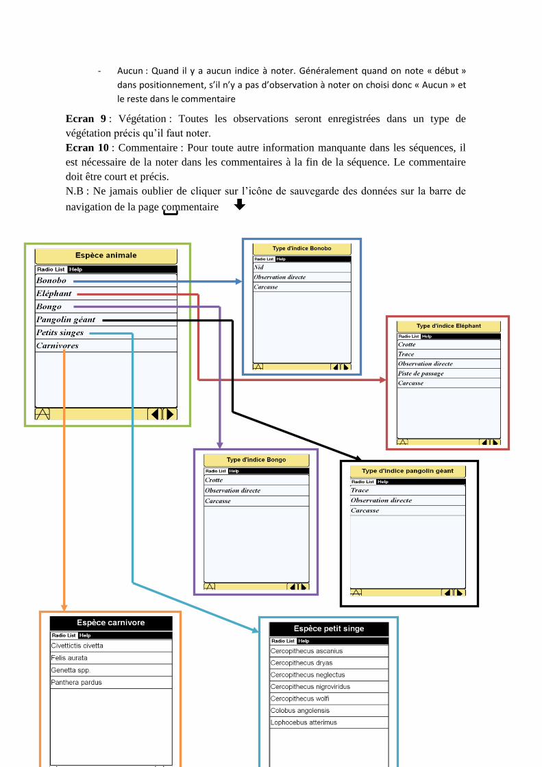
La dénomination « Animal » regroupe ici l’observation possible de toute des espèces
de grands mammifères répertoriées sur la liste, de la zone.
1ère
Etape :
Préciser l’espèce animale
2ème
étape :
Préciser le type d’indice de présence/l’espèce (pour les petits singes et carnivores)
Dernière étape :
Ajouter commentaire particulier sur l’observation
La sélection d’un indice de présence animale donne accès à l’écran suivant. a. Crotte (Eléphant, Bongo et Carnivores) : Noter l’âge en jour,
Un 1er écran proposant la liste des 6 espèces de mammifères phares spécifiques croisées dans les
sites du projet (AAI).
Un 2ème écran proposant une seconde liste relative à des indices de présence pour chaque espèce rencontrée.
19
b. Nid/Nest (Grands singes) : Noter âge en jours, Nombre nids au sol (s’il y a) et
Taille du groupe de nids
c. Traces : Emprunte et reste alimentaire (Carnivores, Pangolin géant et Eléphant)
d. Vocalisation : (Toutes les espèces sauf Pangolin) Noter le type de végétation dans
laquelle la vocalisation est entendue
e. Observations directes (Toutes les espèces) : Noter Taille du groupe (réellement
vu) et taille du groupe estimé (le nombre probable d’individus)
Ecran 1 : Accueil/Home
Ecran 2 : GPS > Minuterie GPS : choisir l’intervalle de temps pendant lequel le GPS
prend automatiquement les coordonnées ; il est préférable de choisir 3 minutes quand on
effectue les patrouilles pédestres.
Ecran 3 : Antenne > Correspond à l’antenne dans laquelle on travaille ; c’est l’itinéraire à
suivre pour la mission. On peut choisir une à plus de deux antennes.
Ecran 4 : Objectif mission > L’objectif de la mission est déterminé avant la mission. Il y a
trois objectifs : Lutte anti-braconnage, suivi écologique et reconnaissance. Pendant l’une
ou l’autre mission on peut collecter toute sorte des données.
Ecran 5 : Chef de mission. Il est identifié au départ de la mission
Ecran 6 : Equipe de mission : Choisir les noms de tous les éléments qui constituent
l’équipe de la mission.
Ecran 7 : Positionnement : Toute mission a un positionnement :
- Début : quand la mission vient de commencer
- Fin : quand la mission est à sa fin ou la fin de la journée ; ajouter dans le
commentaire s’il s’agit de la fin de la journée ou de la mission
- Pause : pendant la mission il est nécessaire de prendre un temps de repos
- Continuation : Pendant la mission, les données se collectent en continue. Sur le
trajet, il y a donc une continuation dans la collecte des données.
- Embuscade : c’est une situation évidente lorsqu’on marche dans la forêt. Comment à
ce moment il est presqu’impossible d’enregistrer les informations. Après avoir
maitriser la situation, noter le commentaire en rapport avec ladite situation.
Ecran 8 : Types de contacts
- Indices de présence animale : signe de présence d’un animal
- Indices de présence humaine : Activités humaines
Pour chacune de vos observations : !!! Toujours s’assurer de bien sauvegarder vos données en fin de saisie !!!
20
- Aucun : Quand il y a aucun indice à noter. Généralement quand on note « début »
dans positionnement, s’il n’y a pas d’observation à noter on choisi donc « Aucun » et
le reste dans le commentaire
Ecran 9 : Végétation : Toutes les observations seront enregistrées dans un type de
végétation précis qu’il faut noter.
Ecran 10 : Commentaire : Pour toute autre information manquante dans les séquences, il
est nécessaire de la noter dans les commentaires à la fin de la séquence. Le commentaire
doit être court et précis.
N.B : Ne jamais oublier de cliquer sur l’icône de sauvegarde des données sur la barre de
navigation de la page commentaire
Related Documents