i Bombing for Biodiversity – Integrating the Military Training and Environmental Values of Military Training Areas. by Rick Zentelis Submitted in fulfilment of the requirements for the degree of Doctor of Philosophy of the Australian National University November 2017

Welcome message from author
This document is posted to help you gain knowledge. Please leave a comment to let me know what you think about it! Share it to your friends and learn new things together.
Transcript
i
Bombing for Biodiversity –
Integrating the Military Training and
Environmental Values of Military
Training Areas.
by
Rick Zentelis
Submitted in fulfilment of the requirements for the degree of
Doctor of Philosophy
of the Australian National University
November 2017

ii
Preface
This thesis is structured as a series of connected papers that have been published,
submitted, or are in preparation for publication at the time of thesis submission. These papers
are listed at the end of this preface. All papers are intended as stand-alone pieces of work, as
such, there is some unavoidable repetition between chapters.
The formatting and content of this thesis complies with The Australian National
University’s College of Medicine, Biology and Environment guidelines for “Thesis by
Compilation”. In accordance with these guidelines, an extended context statement has been
provided at the beginning of the thesis. The context statement is not a literature review, but
rather a framework for understanding the relationships between all aspects of this research.
Relevant literature is reviewed and used, along with explanations of methods, in the
appropriate parts of the papers/chapters that deal with specific research questions.
I performed the great majority of the work for all papers that form this thesis. This
included the development of research questions, model development, data collection, data
analysis, and manuscript writing. My supervisors (David Lindenmayer, Steve Dovers and
Dale Roberts) and collaborators provided advice on conceptualization, experimental design,
data interpretation, and manuscript revisions. The addition of different co-authors to each
paper reflects contributions from collaborators. The author contribution statements (below)
have been agreed to in writing by all authors in the respective author lists. Other assistance
for each paper is acknowledged at the end of each paper.
Zentelis, R & Lindenmayer, D., (2014). Bombing for biodiversity – enhancing
conservation values of military training areas. Conservation Letters 8(4), 299-305.
Conceptualisation and design: RZ, DL; Data collection: RZ; Data analysis: RZ;
Manuscript drafting: RZ; Manuscript editing: RZ, DL, SD.
Zentelis, R & Lindenmayer, D (2014). Managing military land for the environment.
Nature 516, pp170.
Conceptualisation and design: RZ, DL; Data collection: RZ; Data analysis: RZ;
Manuscript drafting: RZ; Manuscript editing: RZ, DL.
iii
Zentelis, R., Lindenmayer, D., Roberts, J.D. & Dovers, S. (2016). Towards integrated
management of Australia’s ecologically significant military training areas. Australasian
Journal of Environmental Management. Re-submitted, minor revisions requested.
Conceptualisation and design: RZ, DL; Data collection: RZ; Data analysis: RZ, DL, DR;
Manuscript drafting: RZ; Manuscript editing: RZ, DL, DR, SD.
Zentelis, R., Lindenmayer, D., Roberts, D. & Dovers, S. (2017). Principles for
Integrated Environmental Management of Military Training Areas. Land Use Planning 63,
186-195.
Conceptualisation and design: RZ, DL, DR; Data collection: RZ; Data analysis: RZ, DL,
DR; Manuscript drafting: RZ; Manuscript editing: RZ, DL, DR, SD.
Zentelis, R., Hubbard, P., Roberts, D., Dovers, S. & Lindenmayer, D. More bang for
your buck: managing the military training and environmental values of military training
areas. Submitted.
Conceptualisation and design: RZ, DL, DR; Data collection: RZ; Data analysis: RZ, PH,
DL, DR; Manuscript drafting: RZ; Manuscript editing: RZ, DL, DR, SD.
Zentelis, R., Banks, S., , Roberts, D., Dovers, S. & Lindenmayer, D. (2017). Managing
military training-related environmental disturbance. (Submitted Journal of Environmental
Management).
Conceptualisation and design: RZ, DL, DR; Data collection: RZ; Data analysis: RZ, DL,
DR, SB; Manuscript drafting: RZ; Manuscript editing: RZ, DL, DR, SD, SB
.
iv
Candidate's Declaration
This thesis contains no material which has been accepted for the award of any other
degree or diploma in any university. To the best of the author’s knowledge, it contains no
material previously published or written by another person, except where due reference is
made in the text. This thesis is my own work, except where it is not (see preface and
acknowledgements).
Rick Zentelis Date:

v
Acknowledgements Thank you to my supervisors David Lindenmayer, Dale Roberts and Steve Dovers for
their guidance during my candidature. Their mentoring and support during my candidature,
including the ability to put up with my sense of “humour” was greatly appreciated. Without
the collective “Wisdom of Solomon” the thesis would be a vastly different beast.
Thank you to the Sir Roland Wilson Foundation and the Department of Defence for
funding my scholarship. Special thanks go to team SRW including the SRWF Board, Joan
Uhr, Melanie Fischer, Lauren Bartsch, and fellow scholars (class of 2014 rocks) for all their
support during my candidature. From Defence special thanks to Dennis Richardson, Steve
Grzeskowiak, Brendan Sargent, Mike Healy and John Owens initially supporting my
scholarship proposal, and then in terms of mentoring and development during the program.
There are many others who I also would like to thank including (in no particular order)
the German Bundeswehr for being so welcoming and hosting me, including Wilfried Grooten
Greta Neilsen, Stefan Wieder, Daniela Schuh, Karin Hahn-Becker, Hanspeter Mussler,
Mandy Douglas, Joerg Heimann and Rene Bolz. Lt Col Lloyd Chubbs and the NATO
Environment Protection Working Group – it was a privilege to attend the meeting in
Brussels. Nathaniel Whelan and Ryan Garber for hosting me at the US Army Europe training
facilities in Bavaria. Numerous academics/fellow researchers/randoms including Joern
Fischer and his research group, Werner Hardtl, Vicky Temperton, Sam Banks, Phil Gibbons,
Jonas Geldman, and Luke Costanzo for making me welcome and discussing my research at,
sometimes, short notice. Deutsche Bahn for getting me to meetings on time. Finally all the
people at the Fenner school who I interacted with including Clive Hilliker, the IT Crowd,
Little Pickle, the PhDers, other academics and visiting researchers. Finally a thank you to
everyone else who assisted throughout my candidature who I have not mentioned by name.
Biggest thanks goes to my wonderful family who put up with me during for the last three
years – I love you lots. Without their love and tolerance, I doubt that there would even be a
thesis, maybe just a cool picture and a half-baked idea collecting dust on a shelf somewhere
in the shed.

vi
Abstract Military training areas (MTAs) cover an estimated 2-3 percent of the Earth’s terrestrial
environment, occurring in all major biomes. These areas are important supplementary sites for
biodiversity conservation, with the potential to increase the global protected area network by
approximately 12-15 percent if recognised for their environmental values and managed appropriately.
Despite the significant area that MTAs occupy, and their potential contribution to biodiversity
protection globally, there is a paucity of research and understanding of their environmental values,
and how best to integrate management of military training and environmental values.
My research focussed on understanding and integrating management of the military training and
environmental values found on MTAs. The first part of my research focussed on understanding the
military training and environmental values of MTAs. This research highlighted that only limited
empirical data exist on the environmental values of these areas. An investigation of the Australian
MTA management framework revealed that management of military training and environmental
values are not integrated.
Second, I focussed on developing a set of management principles to guide the management of
MTAs. As MTAs are unique, with no other land management unit being subject to similar types of
impacts, the principles combine existing and novel approaches for the management of these areas.
Central to the design of the principles are two adaptive management loops that integrate military
training and environmental management outcomes. This is the first time that two adaptive
management loops have been used to manage the one land use activity.
The final part of my research focussed on 1. Developing a land management model and
management prescriptions for MTAs that integrate the management of the military training and
environmental values of these areas, allowing for improved management outcomes that are
transparent and accountable, and, 2. Providing guidance, in the absence of further detailed
environmental information, on how best to manage military training-related environmental
disturbance. The land management model consists of two management equations and a four-part
management condition test that, when appropriately applied, should result in improved management
outcomes for both the military training and environmental values of MTAs. The new approach allows
for the assessment of different MTA land management configurations prior to on-ground
implementation. The model also makes provision for the incorporation of management costs.
Guidance on how best to manage military training-related environmental disturbance was developed
by initially investigating the causes for military training-related disturbance and simulating military

vii
training-related environmental disturbance at different range usage rates under a typical range rotation
use strategies. These results were compared to estimated ecosystem recovery rates from training
activities. We found that even at relatively low usage rates, random allocation and random spatial use
of training ranges within an MTA resulted in environmental degradation. To avoid large scale
environmental degradation, we developed a decision-making tool that details the best method for
managing training-related disturbance by determining how training activities can be allocated to
training ranges.
Collectively, the research in this thesis has resulted in the development of a new approach to the
management of MTAs that allows for better integration of the military training and environmental
values.

viii
Knowledge Gaps Addressed This is the first time that:
• A literature review of the environmental values of MTAs has been conducted.
The review identifies that MTAs are a significant global conservation resource
that are likely to occur in all major terrestrial ecosystems globally (Chapter 1).
• The global terrestrial area of MTAs has been estimated. The significance of
these areas may warrant a separate IUCN category as they have the potential to
increase the global protected area network by 12 percent (Chapter 1).
• A MTA management framework has been analysed to determine whether
management is integrated. The findings allow for improved design of MTA
management frameworks globally (Chapter 2).
• MTA specific management principles have been developed. The management
principles are designed in response to the unique management challenges of
MTAs and combine traditional and novel approaches to land management
(Chapter 3)
• A land management approach has been developed that utilises two adaptive
management loops concurrently, allowing advance in complementary military
and environmental land management goals (Chapter 3).
• Military training activities that have a positive impact on the environment are
recognised and incorporated into management. (Chapter 3).
• A MTA land management model has been developed that integrates military
training, environmental and financial considerations. The model is based on
production frontier and trade-off theory, allowing managers to trade-off military
training, environmental and financial considerations to improve MTA
management. A case study of an existing MTA demonstrates how the model
may be implemented (Chapter 4).
• Military training disturbance has been simulated at differing usage rates and
contrasted to published ecosystem recovery rates. The simulations identify the
period of time between military training events as being the key issue in
achieving sustainable MTA management (Chapter 5).
ix
Further Research
During the course of the research it became clear that the following areas require further
consideration:
• The interactions between military training and the environment are poorly
understood.
• The potential for remote sensing at a landscape scale to contribute to better land
management needs to be explored.
• The ecosystem services potential of MTAs warrants further investigation.
• The viability of listing MTAs as a further, distinctive IUCN protected area land
management category should be explored.

x
Table of Contents Preface ii
Candidate’s Declaration iv
Acknowledgements v
Abstract vi
Knowledge Gaps Addressed viii
Table of Contents x
Context Statement xiii
Chapter 1 – Bombing for Biodiversity 1
Introduction 3
The extent of the global military training area estate 4
Conservation value of military training areas 7
Key policy changes 8
Better document the environmental values of military training areas 8
Develop integrated military training area land management 10
Financial resources 10
Leadership 11
Conclusion 12
Supplementary information 15
Chapter 2 – Towards Integrated Management of Australia’s Ecologically Significant Military Training Areas.
17
Abstract 18
Introduction 19
Integrated land management and the management of Australian MTAs 21
Results 27

xi
- Military management grouping 31
- Environmental management grouping 35
Discussion 40
Conclusion 42
Chapter 3 – Integrated principles for the management of military training areas
47
Abstract 48
Introduction 49
Methods 51
Results 52
- MTA land management principles 53
- MTAs and adaptive management 66
Discussion 68
Conclusion 69
Supplementary Information 70
Chapter 4 – More bang for your buck: managing the military training and environmental values of military training areas.
78
Abstract 79
Introduction 80
Methods 82
- MTA production frontier 82
- MTA management optimization equation 83
Results 88
Case Study 89
Discussion 96
Conclusion 98

xii
Chapter 5 – managing military training-related environmental disturbance 105
Abstract 106
Introduction 107
Methods 107
Results 111
Discussion 115
Conclusion 123
Appendix 1: Additional paper 1 – Manage military training land for the environment
134
Appendix 2: Additional paper 2 – Bombs, fire and biodiversity: vertebrate fauna occurrence in areas subject to military training.
136

xiii
Context Statement Military Training Areas cover at least 50 million hectares of the world’s terrestrial land
surface, occur in all major global biomes, and have the potential to act as a significant
supplementary conservation resource. Formal recognition of MTAs as supplementary
conservation resources would increase the global protected area network by 12-15 percent.
Despite the huge potential MTAs have to become a significant conservation resource
world-wide, there is a paucity of research and data on even the most fundamental aspects of
their environment and management (Zentelis and Lindenmayer 2014). Without a
fundamental understanding of the environmental values of MTAs and how they are
influenced by military training, it is difficult to effectively manage these areas. Integrating
military training and environmental values has the potential to save 5-15 percent of non-
integrated management costs (World Bank 2016). Global expenditure on military activities
(excluding war) is estimated at $USD1753 billion (SIPRI 2014), just one percent of this
figure would be sufficient to achieve global biodiversity protection (McCarthy et al. 2012).
The overall objective of my research was to improve the management of MTAs and
develop a land management model that better integrates both military training and
environmental objectives.
Paper 1 sets the scene, detailing the significant supplementary potential role MTAs can
play as a global conservation resource. The paper highlights, for the first time, deficiencies in
the current knowledge base related to MTA management and identifies four key policy
changes required to realise their potential as a global supplementary conservation resource.
These are: 1. Better document the environmental values of MTAs. 2. Develop integrated
MTA land management – “military land management policies are environmental policies”. 3.
Ensure dedicated financial resources for the management of MTAs. And, 4. Develop better
world leadership by governments around the world in the management of MTAs for both
their military training and environmental values.
This paper was published as: Zentelis, R & Lindenmayer (2014). Bombing for
biodiversity – enhancing conservation values of military training areas. Conservation Letters
8(4), 299-305.
xiv
Additionally, a letter highlighting key findings of this work was published in Nature:
Zentelis, R & Lindenmayer, D (2014). Managing military land for the environment. Nature
516, pp170. This paper is at Appendix 1.
Paper 2 investigates the management structure applied to Australian MTAs in order to
understand how management can be improved. The Australian MTA management
framework was selected for analysis as it is widely considered to be at the forefront of MTA
management globally. Analysis specifically investigated the level of integration between key
MTA management documentation, focusing on hierarchy and clarity. The research identified
that the Australia MTA management framework, contrary to widely held views, lacks clear
objectives and is not integrated, resulting in poor management outcomes. It is considered
likely that these problems also exist in the majority of MTA management frameworks
globally. Guidance is provide on how these issues can be addressed.
This paper is currently under review as: Zentelis, R., Lindenmayer, D., Roberts, D. &
Dovers, S. (2016). Towards integrated management of Australia’s ecologically significant
military training areas. Australasian Journal of Environmental Management. Re-submitted,
minor revisions requested.
Paper 3 furthers the research and findings of Paper 2, developing a set of MTA specific
management principles that are designed to accommodate the unique management challenges
presented by MTAs. This is the first time a set of unique MTA management principles has
been proposed globally. Unique to the development and implementation of the management
principles are two adaptive management loops that are designed to concurrently manage the
military training and environmental values of an MTA.
This paper was published as: Zentelis, R., Lindenmayer, D., Roberts, D. & Dovers, S.
(2017). Principles for Integrated Environmental Management of Military Training Areas.
Land Use Planning 63, 186-195.

xv
Paper 4 develops a series of equations based on trade-off and production frontier theory
that are designed to optimize the military training and environmental values of an MTA,
while reducing management costs. The equations are to be used in conjunction with the
MTA management principles. The equations are designed to allow for easy use and
implementation by MTA managers, inputs to the equation can vary from readily publicly
available data through to data that has been collected specifically for MTA management. A
case study of an Australian MTA demonstrates how the equations can be implemented in the
context of a specific MTA. This is the first time that a land management model for MTAs
using simple environmental and military training values has been developed that integrates
and optimizes their management. The model improves on-ground management outcomes and
reduces management costs.
This paper is currently under review as: Zentelis, R., Hubbard, P., Roberts, D., Dovers,
S. & Lindenmayer, D., (2017). More bang for your buck: managing the military training and
environmental values of military training areas. Submitted to Environmental Management.
Paper 5 provides guidance on how MTA managers can manage military training related
disturbance. Military training disturbance simulations are undertaken at different range usage
rates ranging from training activities occurring once every year to once every 20 years. Our
simulation, when compared to published ecosystem recovery rates the simulations highlight
that even at relatively low usage rates, randomly rotating training through an MTA will result
in widespread environmental degradation. Elements of common land management
approaches used in agriculture, forestry and nature conservation are applicable to the
management of MTAs provided that the ecosystem recovery rate is greater than the period
between military training events. A range management usage guide has been developed to
assist with the management of environmental disturbance caused by military training. Used in
conjunction with the MTA management principles and land management model this paper
shows how environmental disturbance and degradation on MTAs can be kept to a minimum.
Minimising the areas required for the maximum amount of environmentally degrading
training on an MTA will result in the most efficient use of an MTA for military training,
greater environmental protection and reduced management costs.

xvi
This paper is currently under review as: Zentelis, R., Banks, S., Roberts, D., Dovers, S.,
& Lindenmayer, D., (2017). Managing military training related environmental disturbance.
Submitted to Journal of Environmental Management.
Additional Papers
Additional paper 1 (Appendix 1) highlights the global area of MTAs is at least
50 million hectares, with the actual figure probably closer to 300 million hectares. These
areas encompass all major global ecosystems, including those poorly represented within
formal reserve systems. In the Western world, at least, their management is already funded
through existing military expenditure. Many examples highlight the environmental value of
such areas. They support the majority of Germany’s wolf packs, and in Australia they contain
some of the best remaining threatened coastal heathland. Regardless of one’s view of the
military, the armed forces manage a huge area of land that, until now, has not been
recognized as an important funded conservation resource. This paper was published as
Zentelis, R. & Lindenmayer, D (2014) Manage military training land for the environment.
Nature 516, pp 170.
Additional paper 2 investigates the impacts of military training on native biota. Despite
MTAs covering an estimated 6% of the earth’s terrestrial land surface little is known about
interactions between the environment and military training. We quantified the effects of
aspects of military training in a 5-year study of the response of vertebrates at Beecroft
Weapons Range MTA in south-eastern Australia. We contrasted the occurrence of birds,
mammals and reptiles on 24 sites within an “impact area” which has been subject to repeated
bombing and weapons use over the past century with a matched set of 16 “control” sites
located outside the impact area and not bombed in the past 25 years. We also measured fire
regime and vegetation structure attributes to investigate the system-wide impacts of
disturbance on vertebrate biota.
We found compelling evidence for marked differences in the vertebrate biota on sites
inside versus those outside the impact area, particularly for birds for which there were large
contrasts in species richness and individual species occurrence. These effects remained
present despite controlling for differences in time since fire and the number of fires that had

xvii
affected each survey location, suggesting a direct impact of weapons use (e.g. physical
impact or noise) or other associated (unmeasured) factors underpinned observed responses.
Conversely, neither mammal species richness nor reptile species richness was depressed
within versus outside the impact area, although there were highly variable responses to fire
and military training at the individual species level, including evidence for both early and late
successional responses.
Differences in the responses of distinct vertebrate classes to military training area
demand that managers of these locations make their management objectives explicit. This is
because the kinds of management targeted for a given area may be different if the
overarching aim is to maximize species richness versus securing populations of individual
species of conservation concern.
This paper was published as Lindenmayer, D., McGregor, C., Wood, J., Westgate, M.,
Ikin, K., Foster, C., Ford, F. and Zentelis, R., (2017). Bombs, fire and biodiversity:
Vertebrate fauna occurrence in areas subject to military training. Biological Conservation
204, 276-283.

Chapter 1 - Bombing for Biodiversity
1

Abstract
Global defense spending is $US1753 billion annually or approximately 2.5% of the
world GDP. Significant time and resources is spent in training 28 million defense personnel
worldwide. Much of this training on land takes place within specifically designated Military
Training Areas (MTAs). Globally, the size of the MTA estate is likely to be very large, but
just how large is unknown. Our preliminary analyses has identified that MTAs cover at least
1% of the Earth’s surface. This figure is believed to be closer to 5-6% as no verifiable data
exist for the majority of Africa, South America and Asia. MTAs occur in all major global
ecosystems and have the potential to increase the global protected area network by at least
25%. MTAs therefore have an important complementary role to play in global conservation.
However public policy makers, the scientific community, government agencies, and non-
government organizations have largely ignored MTAs as a conservation resource. To realize
the potential major contribution to conservation that MTAs can play we propose four key
policy changes: (A) better document the environmental values of MTAs, (B) develop
integrated MTA land management models, (C) increase dedicated financial resources for the
land management of MTAs, and (D) strengthened global leadership to manage MTAs as an
environmental resource.
2

Introduction
Global defense spending is $US1753 billion annually or 2.5% of the world’s GDP
(SIPRI 2014A). Massive industries develop, build and supply weaponry to support the
world’s militaries. Significant time and resources is then spent in training 28 million defense
personnel worldwide to use this weaponry. Much of this training on land takes place within
specifically designated Military Training Areas (MTAs). Globally, the size of the MTA estate
is very large, but just how extensive is unknown. Moreover, the environmental and
conservation values of this large estate are either unknown, poorly documented or both.
Here, for the first time, we present a global overview of the conservation value of the
world’s MTAs. We suggest that the MTA estate is likely to be representative of the world’s
ecosystems and have significant conservation value and implications for conservation
planning. We further suggest that, with appropriate integrated management, the MTA estate
has the potential to play critical complementary roles alongside the formal protected area
estate (e.g. International Union for the Conservation of Nature (IUCN) protected areas
categories I-IV). We propose four key policy changes to maintain or enhance the contribution
MTAs make to biodiversity conservation: (A) better document environmental values of
MTAs, (B) integrate military and conservation objectives in MTA management, (C) properly
resource integrated MTA management, and (D) strengthened political leadership to integrate
military training, conservation policy and planning.
3

Figure 1. Clockwise from top left: Shoalwater Bay Training Area, Australia; a tank
manoeuvring at a German military training area, German MTAs are proving to be refuges for
wolf packs in western Europe; live fire exercise; Makua Military Reserve, Hawaii; Tully
Field Training Area, Australia; military trainings areas contain varied landscapes including
escarpments and coastal heathland. (Images Courtesy of the Australian Department of
Defence, US Department of Defense).
The extent of the global MTA estate
We conducted a review of peer-reviewed and gray literature on MTAs. There was a
paucity of published papers (only 90 articles met our search terms) [see Supplementary
Materials] and no articles examined MTAs globally. As a comparison, we undertook a basic
search using Supersearch based on the terms “environmental conservation” that identified
1,856,762 references (Supersearch 2014). This paucity of studies, coupled with potential
security issues, mean that the total global area and distribution of MTAs is currently
unknown (Lee Jenni et al. 2012). Based on the articles we identified, together with mapping
information and official government internet sources [see Supplementary Materials], we
estimate the size of terrestrial military training area estate to be least 50 million hectares
globally, an area roughly the size of France (Table 1). However, this figure is likely to
significantly underestimate the actual area as only five of the world’s 20 largest nations detail
the area of their MTAs on their government websites; there are no verifiable data on MTAs
for Africa, Asia and South America. We note that the world’s 20 largest nations include nine
4

countries that are regarded as biodiversity hotspots (Australian Department of the
Environment 2014). These countries are Australia, Brazil, China, The Democratic Republic
of the Congo, India, Indonesia, Peru, the USA and Mexico. Seven of the world’s 20 largest
countries are in the top 15 countries for military expenditure in 2013 (SIPRI 2014). The
combined expenditure of the USA, China, Russia, Saudi Arabia, India, Brazil and Australia
accounts for approximately 62.8% of all global military expenditure.
Country Dedicated Military Training Area (hectares)
Reference
World’s 20 Largest Countries
Russia http://eng.mil.ru/en/index.htm
Canada 1.8M http://www.forces.gc.ca/en/index.page
USA 18M http://www.denix.osd.mil/sri/upload/SRR2013.pdf
http://www.globalfirepower.com/country-military-strength-detail.asp?country_id=United-States-of-America
China http://www.globalfirepower.com/country-military-strength-detail.asp?country_id=china
Brazil http://en.wikipedia.org/wiki/Brazilian_Army http://www.defesa.gov.br/
Australia 15.4M http://www.defence.gov.au
India http://www.bharat-rakshak.com/
Argentina http://www.mindef.gov.ar/
http://www.ejercito.mil.ar/sitio/index.asp
Kazakhstan 11M McDermott 2012 (McDermott 2012)
http://subweb.diis.dk/graphics/Publications/Reports2012/RP2012-15-Kazakhstan-Russia_web.pdf
Algeria Unable to access government website 26/3/14
Democratic Republic of the Congo
Unable to access government website 26/3/14
Mexico http://www.sedena.gob.mx/index.php/
Saudi Arabia http://www.moi.gov.sa/
Indonesia http://indonesia.go.id/en/ministries/ministers/ministry-of-
5

defense/1656-profile/185-kementerian-pertahanan
Sudan Unable to access government website 26/3/14
Libya Unable to access government website 26/3/14
Iran Unable to access government website 26/3/14
Mongolia http://zasag.mn/ (Unable to translate)
Peru http://www.indeci.gob.pe/
Chad Unable to access government website 26/3/14
Opportunistic searches
Germany 714,000 http://www.bmvg.de/
http://de.wikipedia.org/wiki/Truppen%C3%BCbungsplatz
France 103,000 http://fr.wikipedia.org/wiki/Liste_des_garnisons_de_l%2 Arm%C3%A9e_de_Terre#Tunisie
New Zealand 83,000 http://nzdf.mil.nz/corporate-documents/default.htm and http://nzdf.mil.nz/downloads/pdf/public-docs/2012/bim/bimbackgroudinfo.pdf
Czech Republic 129,600 O. Cizek et al. PLoS ONE 8, 1 (2013)
UK 160,000 https://www.gov.uk/defence-infrastructure-organisation-and-the-defence-training-estate
Poland 194,863 www.docstoc.com/docs/50608606/militray-training-area-in-poland
Latvia 108,509 S. Beneza and J. Balodis. European Integration and Baltic Sea Region: Diversity and Perspectives2011
Finland 107,000 Environmental Assessment Model for Military Training Areas in Finland Largest TA
Table 1. Area of MTAs Globally Identified
Our review revealed temporal changes in the size of the global MTA estate. The size of
the MTA estate is decreasing in some regions such as in Eastern Europe, where nations like
the Czech Republic and Latvia are divesting their holdings (Doyle & Havlick 2009;
Gazenbeek 2005). In contrast, data from the USA, Russia and Australia reveal an increase in
the area of MTAs over the last 15-20 years. The USA military has been increasing its training
estate by approximately 1200 hectares per year (Global Security 2014). Russia is currently
building four new large scale MTAs (Russian Department of Defense 2014) and Australia
has increased its MTA estate by approximately 1 million hectares since the early 1990s
(Australian Department of Defence 2014). Advances in technology, requiring larger training
6

and buffer areas, have driven this increase with modern army brigades requiring an average
area of 50 x100 km to train compared to just 8x10 km during World War II (Durant 2010).
Our review was unable to identify whether the global area of MTAs is increasing, decreasing
or remaining relatively static. Nevertheless, the area of MTAs globally is significant.
Conservation value of MTAs
Using the PRISMA protocol (Sato 2013) our review identified no articles providing a
global assessment of the conservation values of the MTA estate; three articles assessed the
conservation value of specific MTAs and 15 quantified MTA use by specific taxa. The dearth
of global literature suggests the majority of policy makers, environmental organizations, and
the scientific community remain largely unaware of the environmental values of MTAs.
Some studies indicate particular MTAs can have high conservation values. The European
Commission’s Natura 2000 program recognized the conservation value of MTAs for rare and
endangered species and threatened habitats (Gazenbeek 2005). Warren et al. (Warren et al.
2007) found unusually high biodiversity in current and former MTAs in Europe. The Lehnin
Military Training Area near Berlin, Germany is home to a wolf pack – the first seen in
Germany in nearly 100 years. The disciplines of both military geography, which is the study
of geographical topics from geopolitics to environmental conditions that may impact on
military operations and the study of military history touch tangentially on the environmental
values of military training areas (see Woodward 2004, Pearson et al. 2010 and Pearson 2012).
These works, however, do not investigate the biodiversity conservation values of MTAs in
great detail both locally or at a global scale.
While some work attempts to uncover the reasons for the environmental values of
MTAs, results to date are contradictory, thereby highlighting deficiencies in knowledge and
understanding. For example, Warren et al (Warren et al. 2007) speculates that high
biodiversity values of European MTAs are linked to heterogeneous landscapes created by
training activities, whereas Gazenbeek (Gazenbeek 2005) suggests the high conservation
values of MTAs result from them being undisturbed refuges for biota. In the USA the
“weapons to wildlife” initiative (Havlick 2011) has resulted in a number of MTAs being
transferred the US Fish and Wildlife Service as nature reserves. Understanding the drivers of
the conservation value of MTAs will better inform their future management.
7

Because military forces train in environments they may potentially operate in (Coulson
1995), MTAs are likely to be strongly representative of the world’s terrestrial biomes and
ecosystems. MTAs can encompass areas that might otherwise not be captured (or only poorly
represented) within formal reserve systems. Hence, MTAs may have an important
complementarity role (sensu Margules & Pressey 2000) to formally protected areas. For
example, Shoalwater Bay MTA in Queensland is the largest remaining area of sub-tropical
coastal heathland on the Australian east coast – an ecosystem type which is relatively poorly
protected in formal reserves on the continent and subject to major human modification
outside the reserve system (Keith et al. 2014).
Although some MTAs are degraded as a result of high-intensity training activities and
exercises, many remain in relatively good ecological condition. Fort Carson, Colorado, in the
USA is an example of a MTA that is heavily used but supports high quality natural prairie
(Herring 2004). MTAs can maintain high habitat value because they are not subject to
pressures like logging, land clearing, agriculture and urbanization which are degrading the
formal reserve systems of many nations (Mascia & Pailler 2011). This is, in part, because
they contain unexploded ordnance (Havlick 2011). Thus, for ecosystems already in reserve
systems but at risk of degradation, similar ecosystems within MTAs may play an “insurance”
role by maintaining the values and biodiversity of those environments.
Key policy changes
While the primary purpose of MTAs will always be military training, their large area,
global distribution and representativeness, means they are likely to have significant
environmental and conservation values. Indeed, if managed appropriately, MTAs have the
potential to augment the global terrestrial protected area network by a conservatively
estimated further 4 percent beyond the existing ~12% of the earth’s land surface. To realize
this potential major contribution, we suggest four key policy changes are required.
Better document the environmental values of MTAs
The current location, extent and environmental values of MTAs are poorly understood.
Our review indicated that only 49 articles have been published in environmental journals,
which is remarkable given the size of the estate. Our review also revealed that it has been
only in the last 30 years that countries such as Australia, USA, Canada, UK, Germany, 8

France, Finland, Portugal and the Czech Republic have become cognizant of the
environmental values of their MTAs and taken steps to protect them (e.g. Gazenbeek 2005).
Key knowledge gaps such as MTA location and area, coupled with fundamental
environmental data like species occurrence and ecosystem integrity, need to be addressed.
These data will allow for informed environmental management and improved understanding
of how MTAs complement existing reserve and protected areas.
Figure 2. Countries where the area of MTAs is known.
Security issues, risks associated with working on MTAs (e.g. the presence of unexploded
ordnance), and the treatment of MTAs as an environmental resource will necessitate the
development of novel approaches to data collection, monitoring and land management.
Secrecy issues relating to location of training facilities, types of training and the use of new
technology will require the development of novel data sharing models that do not
compromise national security. Risks associated with unexploded ordnance also will
necessitate the development of new ways to collect environmental data.
9
Develop integrated MTA land management – “Military Land Management Policies
are Environmental Policies”
Our review revealed there is currently no common global understanding of, nor the
ability to fully integrate environmental considerations into, the management of MTAs.
Attempts to integrate environmental considerations into MTA management are underway in
some nations. However, approaches to date have been ‘add-ons’ such as sustainability
monitoring and reporting plans (in Australia), but these are not part of a formal integrated
management regime. In the USA, environmentally important sites are excluded from training
activities. Nevertheless, the US military is still considered to have only a very limited
environmental focus (Durant 2010). We therefore argue there is a need for new models and
approaches to integrate military training and conservation in MTAs. The importance of
integrating conservation with other kinds of land use practices such as fisheries, forestry and
agriculture has long been recognized (e.g. Fischer et al. 2008; Gustafson & Loehle 2008), but
there are no equivalent models for MTAs. We suggest there is merit in adapting ideas,
principles and practices from fisheries, forestry and agriculture. However, due to the unique
nature of land use in MTAs, these principles and practices will need to be modified and
evolved to facilitate the achievement of environmental outcomes. Novel approaches in the
use of management zoning and training activity management coupled with approaches
currently not used in land management such as the establishment of sacrificial zones (where
use is high-intensity and frequent) will be important for promoting biodiversity conservation
in MTAs.
“Military Training Policy” should be “Environmental Policy” when it comes to
managing MTAs. Effective strategies for integrating conservation with military training will
demand applied research to quantify positive and negative environmental impacts. To do this
will require the military, scientists and public policy makers to collectively analyze key
baseline environmental, economic and military data to determine management regimes that
sustain military training utility, environmental values and economic efficiencies.
Financial resources.
In 2012, annual military expenditure by governments around the world was estimated at
$1753 billion and is increasing (SIPRI 2014A). This figure includes the management costs
for at least 50 million ha of MTAs. Mandating that a small proportion of defense expenditure
10

be refocused towards good environmental land stewardship would have a significant positive
impact on global biodiversity conservation. Based on the work of McCarthy et al. (McCarthy
et al. 2012), we estimate only 1% percent, (~ $17 billion annually), of the global defense
budget would be required to ensure all MTAs have fully integrated land management
practices in place [see Supplementary Materials]. As world militaries already spend a
proportion of their budget on the management of MTAs, we believe that the true cost of such
an initiative would be minimal as it would involve the redirection and reprioritization of
existing funds. However, the World Bank (World Bank 2014) conservatively estimates that
effective integrated land management can deliver budget savings of 5-10% compared to non-
integrated management costs. For MTAs, these savings would be achieved through more
efficient management practices resulting in less environmental degradation and, in turn,
reduced remediation and rehabilitation.
Leadership
Conflict between the “environmental agendas” of government and national security
considerations has resulted in MTAs being managed as a military resource with only limited
consideration of their environmental and conservation values (Coates et al. 2011; Lee Jenni et
al. 2012; Woodward 2001). Leadership, both nationally and internationally, at the highest
levels of government is required to bring together “environmental” and military
considerations and recognize MTA management policy as a form of environmental
conservation policy. Internationally, no central agency exists to lead and drive this change.
The IUCN could take a leadership role in three key ways. First, by explicitly recognizing the
conservation value of MTAs. Second, by assisting environmental data collection. Third, by
creating a new conservation classification that formally includes a new category of MTAs
with sub-categories reflecting quantified assessments of the condition, integrity and quality of
management of these areas. The neutrality of the IUCN, in terms of not being aligned to any
one country, would make it the ideal body to lead this work.
11

Conclusion
The total area and distribution of MTAs globally has not previously been assessed, nor
have the potential global environmental and conservation value of MTAs. Preliminary
analysis indicates that due to their sheer size, distribution and coverage of an array of
ecosystems, MTAs have the potential to make a significant formal contribution to
biodiversity conservation, being recognized as a global biodiversity resource in their own
right. Indeed, the conservation role of MTAs may ultimately be crucial given that more than
50% of the important sites for biodiversity conservation worldwide are not formally protected
(Butchart et al. 2012). Therefore, developing an integrated land management approach to
MTAs is both a significant opportunity and a challenge for the military, scientific and policy
communities but could result in important biodiversity conservation benefits at local,
regional, and global continental scales.
Acknowledgments:
We would like to thank Mr Clive Hilliker for assistance with graphics, Professor Dale
Roberts and Ms Claire Sheppard for comments on the draft manuscript. The primary author
is supported by a Sir Roland Wilson Foundation Scholarship.
References
Australian Department of Defence (2014). Retrieved 13 May 2014,
www.defence.gov.au
Australian Department of the Environment (2014). Retrieved 1 August 2014,
http://www.environment.gov.au/topics/biodiversity/biodiversity-conservation/biodiversity-
hotspots
Butchart, S. H. M., Scharlemann, J. P. W., Evans, M. I., Quader, S., Aricò, S.,
Arinaitwe, J. & Woodley, S. (2012). Protecting important sites for biodiversity contributes to
meeting global conservation targets. PloS one, 7(3). doi: 10.1371/journal.pone.0032529
Coates, P., Cole, T., Dudley, M. & Pearson, C. (2011). Defending nation, defending
nature? Militarized landscapes and military environmentalism in Britain, France, and the
United States. Environmental History, 16(3), 456-491.
12

Coulson, M. (1995). The geography of defence - developing themes of study.
GeoJournal, 36(4), 371-382. doi: 10.1007/BF00807953
Doyle, M. W. & Havlick, D. G. (2009). Infrastructure and the Environment. Annual
Review of Environment and Resources, 34(1), 349-373. doi:
doi:10.1146/annurev.environ.022108.180216
Durant, R. F. (2010). National Defense, Environmental Regulation, and Overhead
Democracy: A View from the "Greening" of the U.S. Military. Public Organization Review,
10(3), 223-244. doi: http://dx.doi.org/10.1007/s11115-010-0128-1
Fischer, J., Brosi, B., Daily, G. C., Ehrlich, P. R., Goldman, R., Goldstein, J. & Pejchar,
L. (2008). Should agricultural policies encourage land sparing or wildlife-friendly farming?
Frontiers in Ecology and the Environment, 6(7), 380-385.
Gazenbeek, A. (2005). LIFE, Natura 2000 and the military. Life Focus - Journal of the
European Commission, Environment Directorate General Life III Program (2000-2006).
Global Security (2014). Retrieved 13 May 2014, www.globalsecurity.com
Gustafson, E. J. & Loehle, C. (2008). How Will the Changing Industrial Forest
Landscape Affect Forest Sustainability? Journal of Forestry, 106(7), 380-387.
Havlick, D. G. (2011). Disarming Nature: Converting Military Lands to Wildlife
Refuges. Geographical Review, 101(2), 183-200.
Herring, H. (2004). Room to Maneuver. Nature Conservancy, 54(4), 1-11.
Keith, D., Lindenmayer, D., Lowe, A., Russell-Smith, J., Barrett, S., Enright, N. &
Yates, C. (2014). Heathlands. In D. Lindenmayer, E. Burns, N. Thurgate & A. Lowe (Eds.),
Biodiversity and Environmental Change (pp. 213-282). Melbourne: CSIRO Publishing.
Lee Jenni, G. D., Nils Peterson, M., Cubbage, F. W. & Jameson, J. K. (2012). Assessing
biodiversity conservation conflict on military installations. Biological Conservation, 153(0),
127-133. doi: http://dx.doi.org/10.1016/j.biocon.2012.05.010
Margules, C. R. & Pressey, R. L. (2000). Systematic conservation planning. Nature,
405(6783), 243-253.
Mascia, M. B. & Pailler, S. (2011). Protected area downgrading, downsizing, and
degazettement (PADDD) and its conservation implications. Conservation letters, 4(1), 9-20.
13

McCarthy, D. P., Donald, P. F., Scharlemann, J. P., Buchanan, G. M., Balmford, A.,
Green, J. M. & Garnett, S. T. (2012). Financial costs of meeting global biodiversity
conservation targets: current spending and unmet needs. Science, 338(6109), 946-949.
Pearson, C., Coates, P. and Cole, T. (2010). Militarized Landscapes: From Gettysburg
to Salisbury Plain. Bloomsbury Publishing.
Pearson, C. (2012). Researching militarized landscapes: A literature review on war and
the militarization of the environment. Landscape Research 37(1), 115-133.
Russian Department of Defence (2014). Retrieved 13 May 2014,
http://eng.mil.ru/en/index.htm
Sato, C., Wood, J & Lindenmayer, D. (2013). The effects of winter recreation on alpine
and subalpine fauna: a systematic review and meta-analysis. PloS one 8(5) e64282
SIPRI (2014A). Military Expenditure as GDP, 2012. Retrieved 28 February 2014,
http://data.worldbank.org/indicator/MS.MIL.XPND.GD.ZS/countries?display=graph
http://www.sipri.org/research/armaments/milex
SIPRI (2014B). Military Expenditure – World’s Top 15 Countries 2013.
http://www.sipri.org/research/armaments/milex/recent-trends
Supersearch (2014). http://anulib.anu.edu.au/search/supersearch/index.html
Warren, S. D., Holbrook, S. W., Dale, D. A., Whelan, N. L., Elyn, M., Grimm, W. &
Jentsch, A. (2007). Biodiversity and the heterogeneous disturbance regime on military
training lands. Restoration Ecology, 15(4), 606-612.
Web of Science (2014). Retrieved from Web of Science 11 April 2014,
http://apps.webofknowledge.com/Search.do?product=UA&SID=X1632TirdVHfGNKA5op&
search_mode=GeneralSearch&prID=9c38a682-a827-414f-8ddb-7a902cfbf3da
Woodward, R. (2001). Khaki conservation: an examination of military environmentalist
discourses in the British Army. Journal of Rural Studies, 17(2), 201-217.
Woodward, R (2004). Military Geographies. John Wiley & Sons.
World Bank (2014). Sustainable Development. World Bank. Retrieved 1 April 2014,
http://www.worldbank.org/en/topic/sustainabledevelopment
14

15

Supplementary Information: Literature Review
We used a combination of peer reviewed primary literature, official government
websites and opportunistic grey literature to source our data. A search using The Australian
National University’s “Supersearch” tool was conducted on 31 July 2014 using the following
search terms: endangered species military lands/training areas, biodiversity military
lands/training areas, military training area/s, wildlife military lands/training areas, defence
training area/s, environmental/conservation value military land, environmental/conservation
value defence land, land management defence, land management military, defence land area,
military land area, environment/conservation defence, environment/conservation military,
military training lands, defence training lands, military bases, defence bases, defence ranges
and military ranges (note the search used both defence and defense). Our search focused on
terrestrial sites only.
The Supersearch tool searches 438,169,764 indexed items
(http://www.serialssolutions.com/en/services/summon/content) and includes the following:
Databases:
(http://www.serialssolutions.com/assets/resources/Summon_Databases_Full_Text.pdf,
Participating Publishers:
http://www.serialssolutions.com/assets/resources/Report_Summon_Publishers.pdf, and
Journal titles: http://www.serialssolutions.com/assets/resources/Report_Summon_Titles.pdf
We used different combinations of search terms and no constraints were placed on year
of publication or language of publication. Opportunistic web searches using Google and
Google Scholar also were undertaken.
We followed the PRISMA protocol (Sato 2013) and identified 90 articles that met our
search terms. Of these, three were considered to assess the conservation value of MTAs, 15
assessed the conservation value of MTAs for specific taxa, 52 were related to either the
impacts of military activities or their management, 19 addressed policies pertaining to the
management of MTAs, and one provided an overview of MTA usage.
16

Global Area of MTAs
We assessed all papers detailing specific MTAs and totaled the area of MTAs recorded.
If a country’s official website stated the area of MTAs, this figure was used. We conducted
detailed cross referencing to ensure that duplicate data were not included in the assessment.
We completed web searches of the internet sites of the Defence Departments of the
world’s 20 largest countries (Table 1). Where information on the area of MTA holdings was
found, we included it in Table 1. We also conducted opportunistic searches using Google and
Google Scholar.
MTA Management Financial Costing
We crudely estimated the cost of integrating military training and conservation values
using the work of McCarthy et al. (2011). We took estimates for the cost of protecting
endangered species habitats by McCarthy et al. (2011), broke it down to a cost per unit area
and then extrapolated using the known 50 million hectares of MTAs that we identified.
17

Chapter 2 - Towards integrated management of Australia’s ecologically significant military
training areas.
18

Abstract
Military training areas (MTAs) are estimated to cover roughly two percent of the world’s
surface: in Australia this figure is 2.3 percent or 18M hectares. To determine whether the
management system contained the key features of integrated land management (ILM) we
completed two evaluations of the management framework of Australian MTAs. ILM is
defined as the assessment and balancing of competing demands to achieve optimal
management of an area of land. Phase one involved a desk top study of the management
system. We appraised whether: 1. There are clear management objectives for Australian
MTAs allowing for adaptive management. 2. The management framework is hierarchical
allowing for management cohesion and integration. 3. Elements of the hierarchy were
consistent and working towards a common objective, and, 4. There was dedicated funding.
Phase two consisted of a series of meetings with key Australian Department of Defence
officials discussing the operation of the MTA management framework. Our evaluation
suggests the Australian MTA management framework lacks key elements of ILM. The main
failings are twofold. First, a lack of clear, measurable management objectives negating the
ability to implement adaptive management. Second, the framework does not have a clear
hierarchy of documentation making coherent management impossible.
.
19

Introduction
Military Training Areas (MTAs) cover at least 50 million hectares of the Earth’s terrestrial
surface, occur in the majority of the world’s ecosystems, and are a potentially important
complementary biodiversity conservation resource to the global protected area system
(Zentelis and Lindenmayer 2014). Globally, MTAs host unique species and habitats (Jentsch
et al. 2009, Cizek et al. 2013), contain important vegetation and ecological communities
(Fiott, 2014; Gazenbeek, 2005; Havlick, 2011), contain areas that act as refuges for plants
and animals, including refuges in the face of climate change (European Commission 2000,
Gazenbeek, 2005Althoff et al. 2007), and act as stepping stones and wildlife movement
corridors (AyCrigg et al. 2015). The actual global area of MTAs may be closer to 200-300
million hectares (Zentelis and Lindenmayer 2014), making them an even more important
potential conservation resource. In Australia, MTAs cover an area of ~18 million hectares,
about 2.3% of Australia’s land-area (Figure 1). For perspective, there are ~21 million
hectares of IUCN Category 1 Reserves in Australia and 60 million hectares of combined
Category 1 and 2 IUCN Reserves (Department of the Environment 2014). Only a relatively
small proportion of Australian Interim Biogeographic Regionalisation (IBRA) bioregions are
comprehensively represented in public reserves (New South Wales Government 2014, p.47).
MTAs occur in all major IBRA regions and therefore have the potential to play a significant
role in conservation.
20
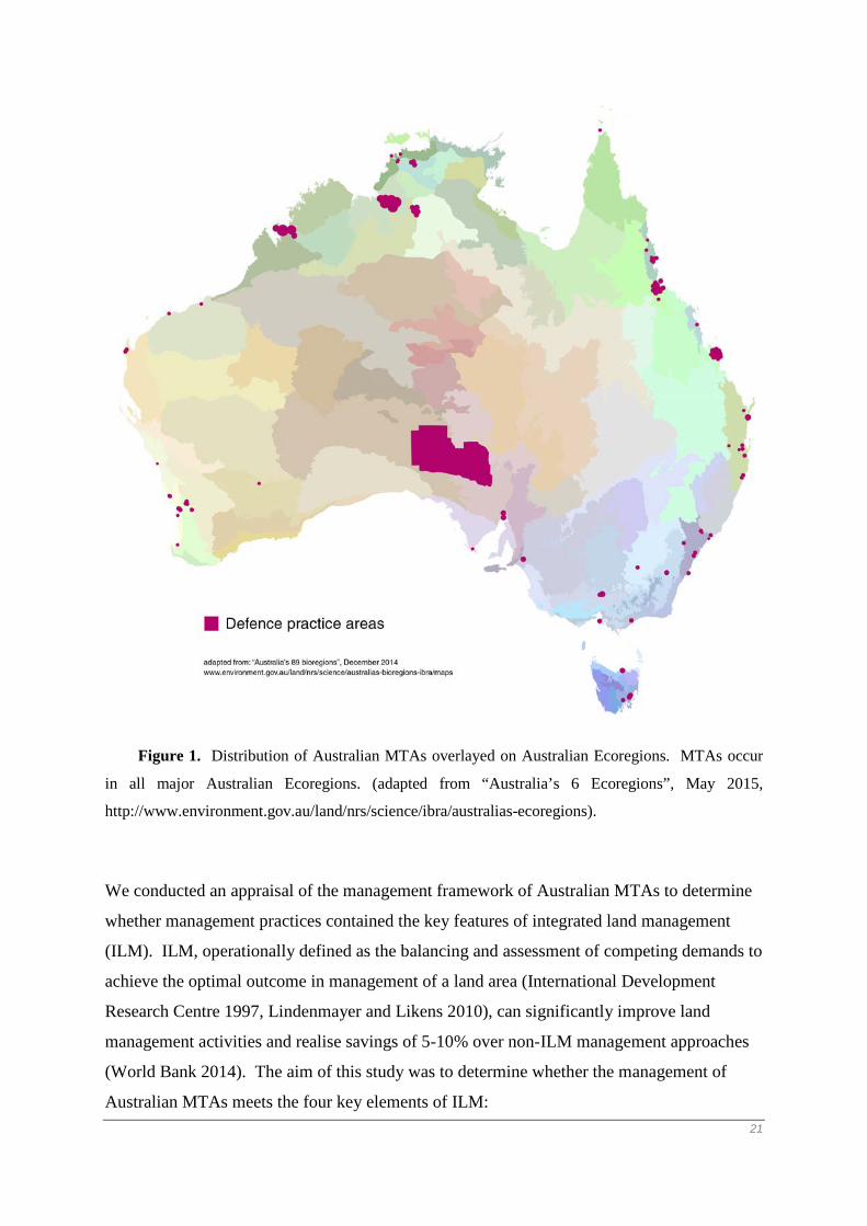
Figure 1. Distribution of Australian MTAs overlayed on Australian Ecoregions. MTAs occur
in all major Australian Ecoregions. (adapted from “Australia’s 6 Ecoregions”, May 2015,
http://www.environment.gov.au/land/nrs/science/ibra/australias-ecoregions).
We conducted an appraisal of the management framework of Australian MTAs to determine
whether management practices contained the key features of integrated land management
(ILM). ILM, operationally defined as the balancing and assessment of competing demands to
achieve the optimal outcome in management of a land area (International Development
Research Centre 1997, Lindenmayer and Likens 2010), can significantly improve land
management activities and realise savings of 5-10% over non-ILM management approaches
(World Bank 2014). The aim of this study was to determine whether the management of
Australian MTAs meets the four key elements of ILM: 21

1. Are there clear management objectives for Australian MTAs that allow for adaptive
management?
2. Is the management framework hierarchical?
3. Are the elements of the hierarchy consistent and cohesive and working towards a common
objective?
4. Does dedicated funding exist for the management of MTAs?
Our findings highlight improvements that can be made to the Australian MTA framework to
facilitate ILM. We also recommend changes to environmental management funding for
MTAs. These changes will: 1) enable Defence land managers to make informed management
decisions on the use of a MTA in terms of training needs, environmental impacts and cost,
and 2) allow for longer term environmental management initiatives.
ILM and the management of Australian MTAs
The environmental management approach for Australian MTAs is detailed in the Defence
Environmental Strategic Plan 2010-2014 (Department of Defence 2010), setting broad
strategic directions for implementation of the Defence Environment Policy, including the
development of issue-specific, individual, environmental policies. Implementation of the
Strategic Plan and Environmental Policy is achieved through an annual program of
environmental works given effect through the Defence Environmental Management System
(Department of Defence 2012). The Defence EMS is designed to manage environmental
risks to the Defence Estate. Environmental works are prioritised according to risks to
military capability, occupational health and safety, personnel, environment and heritage,
legislative compliance, financial effectiveness, and reputation (Department of Defence 2012).
Risks to capability, occupational health and safety issues, and personnel take precedence over
other risk factors. Priority works (eg. construction of new military ranges) are then funded
subject to budget availability. The legislative and policy construct of the Australian MTA
management framework is hierarchical, and is premised on all management elements
working in an integrated manner towards clear management objectives (Department of
Defence 2010). No assessment has ever been undertaken to determine whether the
framework operates in an integrated manner and in accordance with the principles of
22

integrated land management. The focus of this research is to determine whether the
Australian MTA management framework is integrated.
Sayer et al. (2013) argued that land management activities can be significantly improved by
having agreed objectives developed with key stakeholders to facilitate effective adaptive
management. Agreed management objectives and adaptive management allows for more
efficient land management, in terms of decision-making and cost reduction (Lindenmayer et
al. 2008, Knights et al. 2014). Knights et al. (2014) note that decision makers must consider
the environmental, social and economic costs and benefits in deciding whether to implement
management actions. Decisions taking these three issues into account have been found to
deliver better outcomes than decisions which are based on only one or two of these
considerations (Knights et al. 2014). There are some limitations associated with ILM. These
relate primarily to the provision of ongoing funding to ensure integration is achieved,
including funding for data collection to inform management; ensuring social, environmental
and economic considerations are adequately factored into the management system; and
ensuring research is (and can be) incorporated into the management framework (Chan et al.
2009, Sayer et al. 2013, Knights et al. 2014).
While different labels such as integrated management, integrated sustainable management,
and sustainable management have been used to describe the key elements of ILM (e.g. Sayer
et al. 2013; Knights et al. 2014), there is general consensus within the literature that effective
land management requires integration and cohesion of management documentation (see
Sayer et al. 2013; Knights et al. 2014). For MTAs, we defined the key components of ILM
as being:
1. Clear, measurable, evidence-based objectives that are interpreted consistently
through all levels of management documentation. Implicit in having clear, measureable
objectives is a hierarchy of documentation working towards a common objective or goal.
This hierarchical approach is necessary to ensure policy coherence, yet it is often overlooked
in the development of management frameworks (Stockdale and Barker 2009).
2. A commitment to monitoring and adaptive management. Effective adaptive
management requires a flexible management regime based on regular monitoring and
measuring against management objectives, including the ability to conduct and evaluate
management experiments (Westgate et al. 2012).
23

3. Stakeholder engagement. For ILM to be effective, Sayer et al. (2013) and many
others (e.g. Chan et al. 2007, Knights et al. 2014) argue that true stakeholder engagement is
required where stakeholders are involved in the entire management process from issue
identification through to objective setting, on-ground management, and evaluation.
4. Dedicated recurrent funding. The World Bank (2014), the OECD (2010), and the
Convention for Biological Diversity (see Holden 2014) all emphasize that dedicated funding
is required for effective ILM. Implemented correctly, the financial savings from ILM can be
reinvested to maintain the management regime (World Bank 2014).
Despite the size of the MTA estate globally, there are few studies on their management
regimes, and no studies investigating whether MTA management regimes are integrated
(Zentelis and Lindenmayer 2014). As integration of management documentation, combined
with clear management objectives is fundamental to good land management (Hitts et al.
2011), we focussed our research on determining whether MTA management is integrated.
Only when an integrated management framework exists can issues such as sustainability and
resilience be incorporated into management (see Worboys 2015). Zentelis and Lindenmayer
(2014) argue that integrated land management of MTAs should be implemented to achieve an
optimal balance of military training, environmental and financial outcomes. Combined with
targeted objectives for environmental and fiscal management, integrated land management
should reduce training-related environmental impacts and management costs.
Australian MTA management is governed by six levels of documentation (Table 1), which
form the management framework for all MTAs. The overarching purpose of this framework
is to ensure that military training can occur in the safest and most effective manner possible
for both members of the military and public.
MTA Management Documentation Purpose
Australian Defence Act 1903 and the Defence Training Area Management Manual
Sets the legal framework for the acquisition and management of MTAs.
Defence Environment Policy Details the Australian Department of Defence’s six strategic environmental policy objectives.
Defence Environmental Strategic Plan Details the Australian Department of Defence’s seven environmental priority areas of work.
24

Range Standing Orders The safety, coordinating and control orders and instructions that are required for the safe and efficient conduct of military training. Range Standing Orders are enforceable under military law.
Individual Environmental Policies/Guidelines/Strategies
Policies and guidelines for the management of specific environmental issues.
Sustainability Monitoring and Reporting Plans
Designed to integrate environmental management considerations into the management of MTAs.
Table 1. Australian MTA Management Documentation, combined these documents form the
MTA Management Framework.
Methods
Phase 1 – Desk-top review
In the first phase of our evaluation of ILM in MTAs, we asked Australian Department of
Defence environmental managers and policy officers to identify the key policy documents
which formed the core MTA Management documents (see Table 1).
We reviewed the management framework for Australian MTAs by examining the linkages
among, and relationships between, MTA management documentation to determine whether
there is a logical hierarchy. Each management framework document was read thoroughly
and reviewed, and scored using the method detailed below. The scope of Phase 1 of the
study consisted of a desk-top evaluation of the content of the documents reviewed. Our
analysis did not include an assessment of how a management regime is implemented. For
example, we did not undertake a full assessment of how stakeholder engagement occurred as
part of document development, implementation and evaluation (cf Sayer et al. 2013). Our
assessment focused on four key elements of ILM.
1. Are there clear, measurable management objectives that permit adaptive
management to occur? Management objectives were assessed to be present if the objectives
were clear, unambiguous and measurable. Statements such as “will be a leader in sustainable
environmental management” found in the Defence Environment Policy (Defence
Environment Policy 2010, p.7) were not considered valid as progress against that objective
could not be measured. Statements such as “to reduce the area of contaminated land”
25

(Defence Environment Policy 2010, p.7) were considered valid as they allowed progress to
be measured. Documents that had a measurable objective were scored a one, documents that
did not were scored a zero. Where scores differed between reviewers, a score of zero was
assigned.
We defined clear management objectives as occurring when a clear overarching statement of
the management objective for MTAs existed and constituent management documents referred
explicitly to, and contributed to, this objective. Documents that referred and contributed to
the broader management goal and had an objective that was measurable were scored a one;
documents that did not were scored a zero. Where scores differed between reviewers, a score
of zero was assigned.
Integration of management documents was assessed by scoring each document for explicit
references to other documents in the management framework. For example, if Range
Standing Orders made reference to all other documents reviewed (see Table 3 for complete
list of documents), it was considered to be fully integrated in the management framework.
Documents that did not explicitly refer to all other management framework documents were
considered not to be fully integrated in the management framework and scored zero.
2. Is there a clear hierarchy of documentation that allows for the establishment of
aligned, integrated management objectives, cohesiveness of documentation, and
adaptive management? A documentation hierarchy was found to be present when a clear
hierarchical structure of vision, aims and objectives existed for the management framework
(see United Kingdom Strategy Office 2004). Importantly, all documents in the framework
had to contribute towards the agreed vision. Document cohesiveness was deemed to occur if
there were no conflicting requirements between different elements of the document hierarchy.
Document hierarchy was determined by assessing whether clear guidance on the use and
interpretation of management documentation occurred, that is, which document has
precedence in the management framework. Documents were scored a one if their
relationship to all other documents in the management framework was clear. Documents
were scored zero if the relationship was unclear.
3. Did stakeholder engagement occur in the development of the documentation?
Stakeholder engagement was considered to occur if management documentation
acknowledged stakeholder involvement.
26

Stakeholder engagement was determined to occur if it was explicitly recognized in a
document and was scored one; if not recognized, it scored zero.
4. Is there dedicated funding for implementation of MTA management policies?
Dedicated funding was defined as money allocated solely for the environmental management
of MTAs.
Dedicated funding was determined to occur if it was identified in the Defence Annual
Report 2012-13, Chapter 9, pp 153-154 and scored a one. If we could not identify dedicated
funding, it was scored a zero.
Phase 2 – Meetings
We purposively sampled (Ritchie et al. 2014) expert informants who were employed by the
Department of Defence between January and July 2016. The inclusion criteria for the sample
were Department of Defence management and policy officers responsible for: developing
policy and operation guidelines for MTAs or the environment, or officers responsible for
management of MTA or other environment areas, who had greater than 12 months experience
in their respective roles. A total of 13 officers were identified who met the inclusion criteria.
Due to logistical reasons it was not possible to meet with 5 informants. Face-to-face
meetings were conducted with eight informants to explore their understanding of the
Australian MTA Management Framework and to identify how the policy framework operated
in practice. The meetings were structured so that participants responded to seven closed
questions focussed on the central concepts of ILM. The questions were asked to provide a
categorical response (yes/no) to the level of perceived integration within the MTA
management framework. The data gained from this set of respondents was sufficient to gain
understanding of practical implementation of MTA management policy, having captured the
full range of possible answers (Baker and Edwards 2012).
- Are there clear, measurable MTA management objectives that incorporate military
and environmental considerations?
- How does prioritisation of the objectives and elements of the MTA management
framework occur?
- Are management documents within the management framework cohesive and do they
refer to one another?
27

- Are conflicting interests of training and the environment traded-off in the decision
making process?
- Do guidelines for the use of the management framework exist?
- Do clear performance metrics for MTA management exist?
- Are stakeholders involved in the development of management and policy
documentation?
Answers to each of the questions were recorded during the meetings as either yes or no.
More detailed discussions held during meetings to gain deeper understanding of the
relationships between management documents and how the documents are used. At the end
of each meeting, answers to questions were validated by confirming answers with
respondents.
We considered that for the management framework for Australian MTAs to be fully
integrated individual responses to these questions would be similar, or consistent. Dissimilar,
or contradictory responses were an indication that the management system is not integrated.
Results
Phase 1
Five levels of documentation (excluding legislative) constitute the management framework
for Australian MTAs. Overall, we found that the framework demonstrated only one of four
elements of ILM. Stakeholder engagement was evident in all management documentation.
However, cohesiveness and dedicated funding were consistently absent and clear objectives
were evident in only one of five management documents and this was partial. Overall, this
demonstrates that the Defence MTA Management System is poorly integrated and lacks
cohesion (Table 2). The main failings of the system are twofold. The first is a lack of clear,
measurable MTA management objectives negating the ability to implement adaptive
management. The second is that the system does not have a clear hierarchy of documentation
making coherent management impossible.
28

Management Documentation
Clear, Measurable Aims and Objectives
allowing for AdaptiveManagement
Stakeholder Engagement
Cohesive with other elements of
the Hierarchy
Dedicated Funding
Defence Environment Policy
No Yes No No
Defence Environmental Strategic Plan
No Yes No No
Range Standing Orders
No Yes No No
Sustainability Monitoring and Reporting Plans
No Yes No No
Individual Environment Policies
Yes – but not complementary to other individual
environment policy objectives.
Yes No No
Table 2. Summary findings of Phase 1 and Phase 2 appraisal of the management framework
of MTAs highlighting that ILM does not occur.
We were unable to identify a hierarchy of environmental management documentation for
Australian MTAs. Nor were we able to identify any guiding material that assisted with the
interpretation of these documents and how they inter-related. For example, we were unable
to align the six strategic objectives of the Defence Environment Policy with the seven priority
work areas of the Defence Environmental Strategic Plan. Our analysis also was unable to
identify any hierarchical relationship between the development of individual environment
policies, the Defence Environment Policy, the Defence Environmental Strategic Plan, the
Defence Act 1903 and Defence Training Area Management Manual 2011, Sustainability
Monitoring and Reporting Plans and Range Standing Orders. 29

There are two distinct groupings of Australian MTA management documentation (Figure 2).
The first relates to the legal framework for creating and governing MTAs and contains the
Australian Government’s Defence Act 1903, Defence Training Area Management Manual
2011, and Range Standing Orders. All documents in this grouping are legally binding on
members of the Australian Defence Force and are the essential legal instruments for
establishing and managing MTAs. The second grouping relates to the implementation of the
Australian Government’s Environment Protection and Biodiversity Conservation Act 1999
(EPBC Act) and comprises the EPBC Act, Defence Environment Policy, Defence
Environmental Strategic Plan, and individual environmental policies. This grouping is a
relatively recent addition to MTA management reflecting the requirements of the EPBC Act .
Juxtaposed between the two groupings are Sustainability Monitoring and Reporting Plans.
30

Figure 2. The management framework for Australian MTAs. Solid lines represent explicit
linkages in the management framework. Dotted lines represent unclear document
relationships. No lines represent no document relationship.
The linkages between the two groupings in Figure 2 are unclear, with each grouping having
different goals and objectives. In relation to military training, the objective of the Defence
Act 1903 is the safe conduct of military training (Defence Training Area Management
Manual 2011) while the objective of the EPBC Act (s3(1)) is protection of the environment
from significant impact.
We also were unable to determine how the risk based prioritisation approach of the Defence
EMS (Defence Environmental Management System 2012) assists with interpretation and
implementation of Defence’s environmental policy and associated documents. For example,
it is unclear whether occupational health and safety and personnel issues can influence the
interpretation of environmental documents in the management framework. We were unable
to find any management guidance on how the EMS risk managed process applies to
environment policies and guidelines.
31
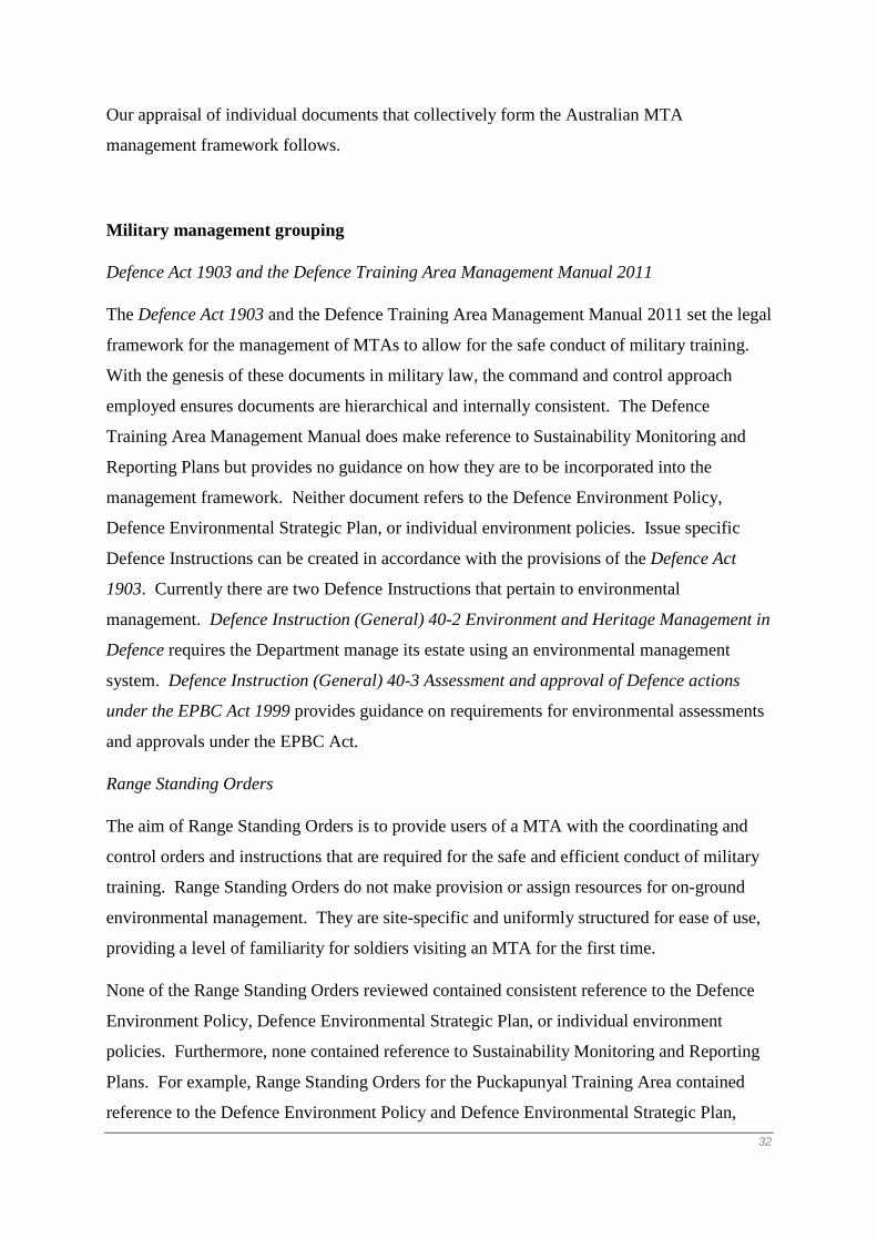
Our appraisal of individual documents that collectively form the Australian MTA
management framework follows.
Military management grouping
Defence Act 1903 and the Defence Training Area Management Manual 2011
The Defence Act 1903 and the Defence Training Area Management Manual 2011 set the legal
framework for the management of MTAs to allow for the safe conduct of military training.
With the genesis of these documents in military law, the command and control approach
employed ensures documents are hierarchical and internally consistent. The Defence
Training Area Management Manual does make reference to Sustainability Monitoring and
Reporting Plans but provides no guidance on how they are to be incorporated into the
management framework. Neither document refers to the Defence Environment Policy,
Defence Environmental Strategic Plan, or individual environment policies. Issue specific
Defence Instructions can be created in accordance with the provisions of the Defence Act
1903. Currently there are two Defence Instructions that pertain to environmental
management. Defence Instruction (General) 40-2 Environment and Heritage Management in
Defence requires the Department manage its estate using an environmental management
system. Defence Instruction (General) 40-3 Assessment and approval of Defence actions
under the EPBC Act 1999 provides guidance on requirements for environmental assessments
and approvals under the EPBC Act.
Range Standing Orders
The aim of Range Standing Orders is to provide users of a MTA with the coordinating and
control orders and instructions that are required for the safe and efficient conduct of military
training. Range Standing Orders do not make provision or assign resources for on-ground
environmental management. They are site-specific and uniformly structured for ease of use,
providing a level of familiarity for soldiers visiting an MTA for the first time.
None of the Range Standing Orders reviewed contained consistent reference to the Defence
Environment Policy, Defence Environmental Strategic Plan, or individual environment
policies. Furthermore, none contained reference to Sustainability Monitoring and Reporting
Plans. For example, Range Standing Orders for the Puckapunyal Training Area contained
reference to the Defence Environment Policy and Defence Environmental Strategic Plan, 32

whereas the Majura Training Area’s Range Standing Orders do not refer to the Defence
Environment Policy, Defence Environmental Strategic Plan or Defence Heritage Strategy but
do refer to the Department’s Biosecurity and Overabundant Native Species policy.
The management of similar environmental impacts associated with military training differed
between site specific Range Standing Orders. For example some, but not all, Range Standing
Orders require an Environmental Clearance Certificate to be issued for the construction of
defensive positions. No guidance is provided on the form and content of an Environmental
Clearance Certificate, or how it relates to military training and use of the training area.
Critically, there is no guidance on whether military training, or an Environmental Clearance
Certificate has precedence in terms of how the military training area is used and managed.
Stakeholder engagement is mandatory in the development of Range Standing Orders but
there is no dedicated funding for the implementation of Range Standing Orders (Defence
Annual Report 2012-13).
Overall, our desktop analysis in Phase 1 of this study determined that all documents within
the Military Management Grouping are fully integrated through referring to all other
documents (Table 3). However, the level of integration with the Environmental Management
Grouping is poor, with only the Defence Training Area Management Manual 2011
recognising all environmental policies. One issue that we identified is that no provision
exists for explicit management review and feedback loops, negating any ability for continual
improvement and adaptive management programs to be implemented.
33

Management Documentation Integration Integration with ILM Elements
Management Documentation (*acronym details below) A
DA
DT
AM
M
RSO
s
EPB
C A
ct
DE
P
DE
SP
BO
NS
Ero
sion
Bus
hfir
e
Her
itage
SMR
Ps
Hie
rarc
hy
Obj
ectiv
es
Stak
ehol
ders
Fund
ing
ADA - 1 1 0 0 0 0 0 0 0 0 1 1 - 1
DTAMM 1 - 1 1 0 0 0 0 0 0 0 1 1 1 0
RSOs 1 1 - 0 0 0 0 0 0 0 0 1 1 1 0
EPBC Act 0 0 0 - 1 1 0 0 1 1 0 0 1 - 1
DEP 0 0 0 0 - 1 1 1 1 1 1 1 1 1 0
DESP 0 0 0 0 1 - 0 0 0 0 1 1 1 1 0
BONS 0 0 0 0 0 0 - 0 0 0 0 0 0 1 0
Erosion 0 0 1 0 0 0 0 - 0 0 0 0 0 1 0
Bushfire 0 0 1 0 0 0 0 0 - 0 0 0 0 1 0
Heritage 0 0 0 0 0 0 0 0 0 - 0 0 0 1 0
SMRPs 0 1 0 1 1 1 0 0 1 0 - 0 0 1 0
Table 3. Assessment of the level of integration of the management framework for Australian MTAs. The Military Management grouping of
management documentation is fully integrated for three of the four key elements of ILM. The Military Management grouping is poorly
34

integrated with the Environmental Grouping (i.e. Defence Grouping documentation does not refer explicit to Environmental Grouping
documentation). The Environmental Grouping of documentation is poorly integrated within the grouping, with the Defence Grouping and with
the key ILM elements. None of the management framework documentation has dedicated funding.
* ADA Australian Defence Act 1903, DTAMM Defence Training Area Management Manual 2011, RSOs Range Standing Orders, EPBC Act
Environment Protection and Biodiversity Conservation Act 1999, DEP Defence Environment Policy 2014, DESP Defence Environmental
Strategic Plan 2010-2014, BONS Biosecurity and Over-abundant Native Species Guidelines , Erosion and Sediment Control Guidelines,
Bushfire National Guidelines for Bushfire Management and Mitigation on the Defence Estate 2007, Heritage Defence Heritage Strategy 2005,
SMRPs Sustainability Monitoring and Reporting Plans.
35

Funding arrangements
We found no evidence of dedicated funding for MTA environmental management. Rather,
funding for environmental management is included in the funding of the maintenance and
management of the Defence Estate which includes facilities and buildings (Defence Annual
Report 2012-13). The Defence Environment Management System, through a risk
management model, is used to allocate funding. The details of this process are not publicly
available.
Environmental management grouping
Environment Protection and Biodiversity Conservation Act 1999
The EPBC Act is the Australian Government’s primary environmental legislation. It details
environmental management obligations of Australian Government agencies such as the
Department of Defence. The Department’s environment management framework is designed
to demonstrate compliance with the EPBC Act (Department of Defence 2014).
Defence Environment Policy
The Defence Environment Policy details the Department’s broad environmental vision stating
that the Australian Department of Defence “will be a leader in sustainable environmental
management to support the ADF’s capability to defend Australia and its national interests”
(Defence Environment Policy 2010, p.7). The policy comprises six strategic policy
objectives that detail environmental areas of focus (Table 4).
1. To implement innovative best practice approaches to environmental management
that achieve Defence and stakeholder requirements.
2. To integrate sustainable environmental management, including resource efficiency
and pollution prevention, into Defence activities, business processes and decisions.
3. To establish clear lines of accountability for environmental outcomes.
4. To raise the environmental awareness of Defence personnel through education,
training and ready access to information.
5. To measure and report environmental performance as part of a process of continual
improvement.
6. To maintain transparency in decision making and establish strategic partnerships
36

with key environmental stakeholders.
Table 4. The Australian Department of Defence’s Six Strategic Environmental Policy
Objectives.
The Defence Environment Policy has objectives that set the strategic direction for
environmental management within the Department. These objectives are aspirational and
cannot be measured. For example, the objective “to integrate sustainable environmental
management, including resource efficiency and pollution prevention, into Defence activities,
business processes and decisions” (Defence Environment Policy 2010, p.7) containing no
detail on implementation. There is no direct link between this objective, the Defence
Environmental Strategic Plan, and individual environment policies to provide a coherent
management framework. The Chief of the Defence Force’s introduction to the Defence
Environment Policy indicates a commitment to stakeholder engagement (Defence
Environment Policy 2010, p.7). However, it is unclear who the stakeholders are and the level
of engagement with them. There is no dedicated funding for implementation of the Defence
Environment Plan (Defence Annual Report 2012-13).
Defence Environmental Strategic Plan 2010-2014
The Defence Environmental Strategic Plan details seven environmental priority areas of work
for the Department of Defence. These priority areas, which do not align with the six
objectives of the Defence Environment Policy, are divided into goals, commitments and
performance metrics (http://www.defence.gov.au/environment/strat_plan.pdf). The Plan does
not have clear management objectives for these priority areas of work. Both management
goals and work commitments lack clear objectives, with performance metrics being
qualitative and unable to be measured. For example, the Defence Estate management goal
“to minimise Defence’s environmental footprint through sustainable development and
operation of Defence facilities, bases and training areas in support of ADF capability”
(Defence Environment Policy 2010, p.23) contains no measurable objective. The
corresponding commitment stating that Defence will minimize its environmental footprint by
managing “land, air and sea across all sites to ensure it is fit for purpose, and maintains
habitats, landscapes and other cultural and heritage values” (Defence Environment Policy
2010, p.23 ) also lacks measurable objectives.
37

Stakeholders such as Army, Airforce and Navy were engaged in the development of the
Defence Environmental Strategic Plan and have committed to specific tasks. It is unclear,
however, who the key stakeholders are and whether they were all involved in the
development of the strategic plan (our appraisal was unable to identify a stakeholder list) and
what the level of stakeholder commitment is.
Due to the ambiguous wording of the Defence Environmental Strategic Plan, it is impossible
for a clear, cohesive management program to be developed. Further, it would be difficult to
monitor the implementation of any such program due to the lack of clear management goals
and objectives. The works detailed in the Defence Environmental Strategic Plan are
unfunded. In addition, the relationship of these works to the risk based funding construct of
the Defence EMS is unclear.
Overall, documents within the Environmental Management Grouping were not integrated
with other documents in this grouping or the Military Management Grouping (see Table 3).
Documents from this grouping did not contain the four key elements of ILM. As was the
case with the military management grouping, we were unable to find any evidence for
explicit management review and feedback loops, negating any ability for continual
improvement and adaptive management programs to be implemented.
Sustainability Monitoring and Reporting Plans
Sustainability Monitoring and Reporting Plans are site specific, designed to integrate
environmental management considerations into the management of MTAs via Range
Standing Orders. Their intent is to create training-area-specific objectives to protect
environmental values. The problem with their implementation is that they are not integrated,
or recognised in, key management documentation such as Range Standing Orders and
individual, local environment policies.
All Sustainability Monitoring and Reporting Plans lacked clear objectives, precluding
adaptive management. Further, we could not determine a funding source for the required
monitoring associated with plan implementation (Defence Annual Report 2013-14). The
Sustainability Monitoring and Reporting Plans reviewed were all developed in consultation
with key stakeholders. Implementation of Sustainability Monitoring and Reporting Plans is
unfunded (Defence Annual Report 2012-13).
Individual environment policies
38

Individual environment policies lack coherence with other environmental policies and do not
work towards a common MTA management objective. Some policies (e.g. Biosecurity and
Over-abundant Native Species Guidelines, Soil and Erosion Guidelines) have stated
objectives, although these do not recognise the objectives of the Defence Environment Policy
or the objectives of other individual environmental policies. For example, the Defence
Heritage Strategy makes no reference to the Biosecurity and Over-abundant Native Species
guidelines, yet the management of natural heritage areas and biosecurity issues often overlap.
All policies reviewed included stakeholder engagement as part of their development or
review. There is no dedicated funding for the implementation of individual environment
policies (Defence Annual Report 2012-13).
Phase two findings
The main findings of our desktop analysis in Phase 1 was that the Australian MTA
management framework lacks the key elements of ILM and these outcomes were supported
by the findings of Phase Two (Table 5).
39
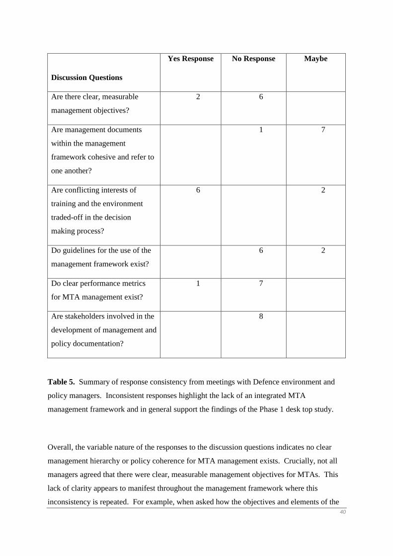
Table 5. Summary of response consistency from meetings with Defence environment and
policy managers. Inconsistent responses highlight the lack of an integrated MTA
management framework and in general support the findings of the Phase 1 desk top study.
Overall, the variable nature of the responses to the discussion questions indicates no clear
management hierarchy or policy coherence for MTA management exists. Crucially, not all
managers agreed that there were clear, measurable management objectives for MTAs. This
lack of clarity appears to manifest throughout the management framework where this
inconsistency is repeated. For example, when asked how the objectives and elements of the
Discussion Questions
Yes Response No Response Maybe
Are there clear, measurable
management objectives?
2 6
Are management documents
within the management
framework cohesive and refer to
one another?
1 7
Are conflicting interests of
training and the environment
traded-off in the decision
making process?
6 2
Do guidelines for the use of the
management framework exist?
6 2
Do clear performance metrics
for MTA management exist?
1 7
Are stakeholders involved in the
development of management and
policy documentation?
8
40
framework are prioritised, some respondents stated military training has precedence, some
stated they were of equal importance and needed to be balanced, with others stating that the
environmental considerations had precedence due to environmental issues being able to stop
training activities occurring. Clarification of these answers revealed that respondents thought
guidelines may exist for the MTA management framework and that they were uncertain if
management trade-offs between military training and environmental considerations occurred
for all decisions.
Discussion
Integrated land management and military training areas
ILM aims to balance competing demands to achieve the optimal outcome in the management
of an area of land. In the context of MTAs, issues and challenges identified by researchers
such as Chan et al. (2007) and Westgate et al. (2012) in implementing comprehensive ILM
systems do not exist, as management complexity is reduced to three elements: military
training, environmental protection and cost. The implementation of ILM should result in a 5-
10% saving over non-integrated approaches (World Bank 2014). In the context of MTA
management globally, this can result in a significant financial saving to governments
(Zentelis and Lindenmayer 2014).
Implementation
One of the major impediments to effective implementation of resource management
programs is a lack of clear program objectives (Hajkowizc 2009). The Australian National
Audit Office identified the lack of clear objectives as a significant problem in its evaluation
of the Australian Government’s Landcare, National Heritage Trust and National Action Plan
for Salinity and Water Quality natural resource management programs (Australian National
Audit Office 1997, 2008). Stockdale and Barker (2009) report similar challenges in the
management of Scottish national parks despite the existence of a dedicated park management
authority responsible for ensuring management cohesiveness. This is also the case for
management of Australian MTAs.
41

Objectives
In Australia, there have been attempts to address the problems associated with the lack of
clear objectives associated with the implementation of government programs by initiatives
such as the Australian Government Natural Resource Management Monitoring, Evaluation,
Reporting and Improvement Framework and Strategy (MERI) (Australian Government 2009,
2013). These initiatives provide a generic framework for monitoring, evaluating, reporting
on, and improving Australia’s approach to managing key assets, including natural resources.
It could be argued that following this framework and strategy should address many of the
problems identified with MTA management in Australia.
There are two issues, however, that limit the effectiveness of the Australian Government’s
MERI framework in achieving ILM for Australian MTAs. The first is that it is focussed on
program evaluation rather than on-ground environmental management, therefore not allowing
implementation of adaptive management. The second is that, to the best of our knowledge,
the framework has not been universally adopted by Commonwealth land management
agencies (e.g. the Department of Defence has not adopted the initiative). We were unable to
find data or studies assessing the effectiveness of the framework.
Despite the lack of clear management objectives, the Department of Defence is uniquely
positioned as the sole “owner-operator” to achieve ILM of MTAs. Being the sole “owner-
operator” allows the Department to internally resolve management challenges, and to set
objectives and monitoring regimes that can be implemented within a single land management
framework. Issues pertaining to administration (including the monitoring and reporting) of
large programs, competing land uses (e.g. agriculture vs farming), and differing social values
do not exist for MTAs due to their unique ownership and use.
42

Conclusion
Although the Australian MTA management framework is not integrated, all the necessary
documents for ILM already exist. The challenge for the Department is to create from its
existing policies a management framework that is consistent, cohesive and meets the
conditions of ILM, while also addressing some of the known shortcomings. We note that the
existing hierarchical structure of the Department’s management documentation does not, in
isolation, create a management framework that is consistent and cohesive. The management
framework does, however, provide a structure that can be modified to achieve ILM.
Implementing ILM within the Australian MTA management framework also will facilitate
adaptive management, allowing for experimental approaches to land management to be
trialed.
The way forward
To address the lack of ILM for Australian MTAs we recommend:
1. The Defence Environmental Strategic Plan and Defence Environmental Policy be
redrafted to create management objectives that recognise and integrate both military
training and environmental management.
2. The creation of explicit MTA management objectives integrating military and
environmental considerations.
3. That environmental policies be updated to reflect management objectives, containing
measurable metrics allowing for adaptive management.
4. A guidance document on the MTA management framework be prepared detailing how
military and environmental documentation are to be interpreted, what has precedence and
mechanisms to be used to achieve consensus on management objectives. This document
should also clarify the operation of the Defence EMS and how it relates to the
interpretation of environmental policies and guidelines.
5. Dedicated funding be made available to allow for the transition to ILM with ongoing
monitoring and true adaptive management (see Westgate et al. 2013).
There are a number of actions the Department of Defence can undertake immediately that
would create an integrated, hierarchical framework for ILM. The military’s command and
control approach could quickly help create a coherent, integrated management hierarchy.
43

Further, to allow for ILM of Australian MTAs, we recommend the development of a military
training area integrated land management model. This new model would assess and balance
military capability with financial and environmental considerations.
References
Australian Government 2009, NRM MERI framework: Australian Government natural
resource management monitoring, evaluation, reporting and improvement framework,
Commonwealth of Australia.
Australian Government 2013, Monitoring, evaluation, reporting and improvement strategy –
caring for our country and the biodiversity fund, Commonwealth of Australia.
Australian Government 2015, Australia’s 6 Ecoregions,
http://www.environment.gov.au/land/nrs/science/ibra/australias-ecoregions, Commonwealth
of Australia.
Australian National Audit Office 1997, Commonwealth natural resource management and
environmental programs, Audit Report No. 36 1996-97, Australian National Audit Office.
Canberra, Australia.
Australian National Audit Office 2008, Regional delivery model for the natural heritage trust
and the national action plan for salinity and waterquality, Audit Report No. 21 2007-08,
Australian National Audit Office, Canberra, Australia.
Baker, SE & Edwards, R 2012, How many qualitative interviews is enough? Expert voices
and early career reflections on sampling and cases in quantitative research, National Centre
for Research Methods Review Paper. Economic and Social Research Council.
Chan, KMA, Pringle, RM, Ranganathan, JAI, Boggs, CL, Chan, YL, Ehrlich, PR, Haff, PK,
Heller, NE, Al-Khafaji, K & Macmynowski, DP, 2007, ‘When agendas collide: human
welfare and biological conservation’, Conservation Biology 21, no.1, pp. 59-68.
Commonwealth of Australia Australian Defence Act 1903,
Commonwealth of Australia Environment Protection and Biodiversity Conservation Act 1999,
Commonwealth of Australia 2013, Defence Annual Report 2012-13. Australian Government,
Canberra, Australia. 44

Department of Defence 2005, Defence heritage strategy 2005, Australian Department of Defence.
Department of Defence 2007, National guidelines for bushfire management and mitigation on the Defence Estate 2007, Australian Department of Defence.
Department of Defence 2009, Biosecurity and over-abundant native species guidelines, Australian Department of Defence.
Department of Defence 2010, Defence environmental strategic plan 2010-2014, Australian Department of Defence.
Department of Defence 2011, Defence training area management manual 2011, Australian Department of Defence.
Department of Defence 2011, Erosion and sediment control guidelines, Australian Department of Defence.
Department of Defence 2012, Defence environment management system, Australian Department of Defence.
Department of Defence 2014, Defence environment policy 2014, Australian Department of Defence.
Department of Defence 2007 - 2013, Range standing orders (Majura Training Area 2007, Marangaroo Training Area 2007, Puckapunyal Training Area 2013), Australian Department of Defence.
Department of Defence 2011 - 2013, Sustainability monitoring and reporting plans (Bindoon Training Area 2011, Canungra Training Area 2013, Greenbank Training Area 2013, Kangaroo Flats Training Area 2013, Kapooka Training Area 2013). Australian Department of Defence.
Department of the Environment 2014, viewed 30 June 2016,
http://www.environment.gov.au/land/nrs/science/capad/2014
Franklin, J, 1997, ‘Ecosystem management: an overview’, In Boyce, M & Haney, A, (eds.),
Ecosystem management. Applications for sustainable forest and wildlife resources, Yale
University Press, pp. 21-52.
Fiott, D 2014, ‘Reducing the environmental bootprint? competition and regulation in the
greening of Europe’s defense sector’, Organization & Environment 2014, pp. 1-16.
German Ministry for Defence 2010, Annual military scientific research report,
Bundesministerium der Verteidigung, Bonn, Germany.
45

Hajkowicz, S 2009, ‘The evolution of Australia's natural resource management programs:
Towards improved targeting and evaluation of investments’, Land Use Policy 26, no. 2, pp.
471-78.
Havlick, D 2011, ‘Disarming nature: Converting military lands to wildlife refuges’,
Geographical Review 101 no. 2, pp.183-200.
Holden, E, Linnerud, K & Banister, D 2014, ‘Sustainable development: Our common future
revisted’, Global Environmental Change 26, no. 2014, pp. 130-39.
Hitt, MA, Black, JS & Porter, LM 2012, ‘Management – Third Edition’. Pearson education,
Upper Saddle River, New Jersey.
International Development Research Centre 1997, On solid ground - Science, technology,
and integrated land management, Panel on integrated land management of the United
Nations Commission on Science and Technology for Development.
Keith, DA, Lindenmayer, DB, Lowe,A, Russell-Smith, J, Barrett, S, Enright, N, Fox, B,
Guerin, G, Paton, D, Tozer, M & Yates, C 2014, ‘Heathlands’, in Lindenmayer, D, Burns, E,
Thurgate, N & Lowe, A (eds.), Biodiversity and environmental change, CSIRO Publishing,
Melbourne, Australia, pp. 213-82.
Knights, AM., Culhane, F, Hussain, SS, Papadopoulou, KN, Piet,GJ, Raakær, J, Rogers, SI &
Robinson, LA 2014, ‘A step-wise process of decision-making under uncertainty when
implementing environmental policy’, Environmental Science & Policy 39, pp. 56-64.
Lindenmayer, D 2003, ‘Integrating wildlife conservation and wood production in Victorian
montane ash forests’, In Lindenmayer, D & Franklin, J, Towards forest sustainability,
CSIRO Publishing, Collingwood, Victoria, pp. 47-72.
Lindenmayer, D, Hobbs, RJ, Montague-Drake, R, Alexandra, J, Bennett, A, Burgman, M,
Cale, P et al. 2008, ‘A checklist for ecological management of landscapes for conservation’,
Ecology Letters 11, no. 1, pp. 78-91.
Lindenmayer, D & Likens, G 2010, Effective ecological monitoring. CSIRO publishing.
McShane, TO, Hirsch, PD, Trung, TC, Songorwa, AN, Kinzig, A, Monteferri, B, Mutekanga,
D et al. 2011, ‘Hard choices: Making trade-offs between biodiversity conservation and
human well-being’, Biological Conservation 144, no. 3, pp. 966-72.
46

New South Wales Government 2014. A review of biodiversity legislation in NSW – Final
Report, Report of the Independent Biodiversity Legislation review Panel for the NSW Office
for Environment and Heritage Department.
Organisation for Economic Coorperation and Development 2014. Paying for biodiversity.
OECD Publishing.
Ritchie, J, Lewis, J, Ellam, G, Tennant, R & Rahim, N 2014, Designing and selecting
samples. In “Qualitative research practice”, Ritchie, J, Lewis, J, McNaughton-Nicholls, C &
Ormston, R (eds). SAGE Publishing, London, UK.
Sayer, J, Sunderland, T, Ghazoul, J, Pfund, JL, Sheil, D, Meijaard, E, Venter, M,
Boedhihartono, AK, Day, M & Garcia, C 2013, ‘Ten principles for a landscape approach to
reconciling agriculture, conservation, and other competing land uses’, Proceedings of the
National Academy of Sciences 110, no. 21, pp. 8349-56.
Stockdale, A & Barker, A 2009, ‘Sustainability and the multifunctional landscape: an
assessment of approaches to planning and management in the cairngorms national park’,
Land Use Policy 26, no. 2, pp. 479-92.
United Kingdom Cabinet Office 2004, Strategy Survival Guide - Version 2.1., Prime
Minister's Strategy Unit, United Kingdom Government, London.
Westgate, MJ, Likens, GE, & Lindenmayer, DB 2013, ‘Adaptive management of biological
systems: A review’. Biological Conservation 158, pp. 128-39.
Worboys, G 2015, Protected Area Governance and Management. In "Protected area
governance and management", Worboys, G., Lockwood, M., Kothari, A., Feary, S., and
Pulsford, I. (eds). ANU Press, Canberra, Australia.
World Bank 2014, Sustainable Development. World Bank,
http://www.worldbank.org/en/topic/sustainabledevelopment.
Zentelis, R & Lindenmayer, D 2014, ‘Bombing for biodiversity – enhancing conservation
values of military training areas’, Conservation Letters, December 2014, 00(0), pp. 1–7. doi:
10.1111/conl.12155
47

Chapter 3 - Integrated Principles for the Management of Military Training Areas
48

Abstract
Military Training Areas (MTAs) cover up to an estimated 200-250 million hectares globally,
occur in all major ecosystems, and are potentially significant conservation assets. In some
jurisdictions, MTAs may be the largest terrestrial land use category that is owned and
operated by a sovereign government. Despite this, MTAs are not recognised as either a
conservation or environment protection resource. Further, no MTAs are managed for their
environmental values, defined as aspects of the environment that are valued by society, nor is
there any specific MTA management guidance that details how both the military training and
environmental values of a MTA can be maintained.
We conducted a desktop review of Australian and German MTA management documentation
to determine whether they contained management principles that recognised both military
training and environmental values. Management documentation from these two countries
was chosen as they are considered to be among countries that are at the forefront of MTA
management globally. Our review determined that both the Australian and German
management regimes do not have specific management principles for these values. This is
likely to be the case for the majority of MTAs globally.
For the first time, we develop MTA management principles that integrate the management of
both military training objectives and environmental values. Key to achieving this integration
is an understanding of the intersection of the impacts of military training on the environment,
and the known, or potential, environmental values of a particular training area.
To assist with the implementation of the management principles, we developed a new
conceptual framework for the management of MTAs. The framework contains two adaptive
management loops. The first focuses on the management of environmental values of MTAs,
the second targets the military training values of MTAs. These two management loops
facilitate for the development of management practices that optimise MTA management for
both military training and biodiversity conservation.
49

Introduction
Globally, the size of the MTA estate is at least 50 million hectares, although the actual figure
may be closer to 200-250 million hectares (Zentelis and Lindenmayer 2014). Zentelis and
Lindenmayer (2014) suggested that MTAs are likely to occur in all major global ecosystems
and, if appropriately managed, have the potential to contribute significantly to biodiversity
conservation. Environmental values of MTAs, defined as those aspects of the environment
that are valued by society, occur on nearly all MTAs globally. Some important
environmental values found at MTAs are due to military training disturbance creating new
habitats (e.g. Jentsch et al. 2009, Cizek et al. 2013): the MTAs contain either remnant
vegetation and disturbance dependent communities no longer found in the surrounding
environment (e.g. Gazenbeek 2005), or a combination of both. For example, the
intensification of agricultural practices in Europe has resulted in the loss of many heathlands
that are now found only in MTAs due to military training-related disturbance (Natura 2000,
Gazenbeek 2005). The remnant coastal heathland found at the Shoalwater Bay MTA in
Australia is the largest remaining area of coastal heathland on the Australian east coast is a
direct result of the area being used solely for military training (Keith et al. 2014).
No MTAs are explicitly managed for their environmental values: they are managed to ensure
military training is not compromised by environmental issues (Havlick 2011, Fiott 2014,
Zentelis and Lindenmayer 2014). In a time when the environment is under unprecedented
levels of threat (Driscoll et al. 2012; Cardinale et al. 2012; Steffen et al. 2015), MTAs could
play a critical role in reducing the rate of biodiversity loss by providing environmental
refuges for species and ecosystems (Aycrigg et al. 2015).
MTAs are unique with no other land management uses having similar management
challenges. Outside of war itself, MTAs are the only place where military vehicles and
equipment, including munitions are used. Unlike war, this use occurs repeatedly in the same
locations and can result in increased, cumulative contamination and land degradation
(Doxford and Judd 2002). The nature of military training, including the use of modern day
weaponry such as long range artillery and missiles, high-calibre automatic weapons, high
explosives, and specialist military vehicles precludes most traditional approaches to
environmental management such as those employed in forestry and national park
management (Doxford and Judd 2002). The management risks during, and after, training
activities are significant (Doxford and Judd 2002). Conventional land management such as
wildlife monitoring, prescribed burning and land remediation/rehabilitation cannot occur 50

when military training is occurring due to the risk of death or injury. When military training
is not occurring, risks associated with the remnants of past training activities, such as
unexploded ordnance or contamination, significantly limit management options. For
example, traditional environmental survey techniques cannot be implemented in areas
contaminated with unexploded ordnance. These management challenges are unique to all
MTAs (Havlick 2011, 2014, Doxford and Judd 2002). MTAs are likely to be among the
largest land use category owned and operated by sovereign governments globally. Unlike
other large scale land management units that have specific management guidance, for
example, the IUCN’s guidance for global protected areas (IUCN 2013), no specific MTA
management guidance exists that integrates military and environmental considerations,
despite catering for other mixed land uses.
The successful management of MTAs requires consideration of both military training and
environmental values (Fiott 2014, Lawrence et al. 2015). One way of achieving this is
through the development of management principles that provide a framework for how
management objectives can be achieved. For example, a management principle may require
all habitat types within an area of land be adequately protected. Successful management
principles need to recognise management objectives and provide overarching guidance as to
how these objectives may be met (United Kingdom Cabinet Office 2004).
We assessed management documentation for Australian and German MTAs to determine
whether they contained management principles that provided guidance on how both military
training and environmental values of MTAs can be managed and maintained. German and
Australian documentation was selected as both countries are considered to be at the forefront
of MTA management globally. Our findings led to the development of a set of MTA-specific
management principles that address the unique management challenges presented by MTAs.
We integrate these management principles in a new conceptual model that is based on two
adaptive management loops, one for military training and a second for environmental
protection. Our management principles seek to provide strategic guidance on MTA
management, closing fundamental knowledge gaps, while understanding the impacts of
military training on the environment and biodiversity, and managing disturbance associated
with military training.
51

Methods
Key Australian and German MTA management documentation was identified in discussions
with environmental managers and policy officers from the Australian Department of Defence
and the German Bundeswehr (Table 1, Appendix 1).
MTA Management Documentation Purpose
Germany
Concept for the Utilization of the Training
Areas and the Air-to-Ground Firing Range
in Germany.
Details the management regime for German
MTAs with a primary focus on training.
Guideline for the sustainable use of
training areas in Germany.
Details the principles and environmental
related goals for the military use of an
MTA. Focus is on compliance with
European and German law.
Australia
Range Standing Orders The safety, coordinating and control orders
and instructions that are required for the
safe and efficient conduct of military
training. Range Standing Orders are
enforceable under military law.
Individual Environmental
Policies/Guidelines/Strategies
Policies and guidelines for the management
of specific environmental issues.
Sustainability Monitoring and Reporting
Plans
Designed to integrate environmental
management considerations into the
management of MTAs.
Table 1. Key German and Australian management documentation that guides the on-
ground management of MTAs.
We assessed management documents for Australian and German MTAs to determine whether
they contained management principles that address both military training and environmental
considerations. Importantly, management principles had to have a focus on management of
both military training and environmental values. Each management document was read 52

thoroughly and reviewed to assess whether management principles focused on both.
Documents were considered to meet these requirements if they:
1. Explicitly recognised military training and environmental management
considerations.
2. Provided on-ground management options for the use of a MTA that traded-off
military training and environmental considerations.
3. Contain measurable management actions that may be undertaken. For example,
requiring the protection of water bodies from training activities or pollution.
Management documentation that contained these elements were scored a one. Documents
that did not were scored a zero.
Results
Both the Australian and German MTA management regimes utilise a command and control
approach to management, focussing on military training requirements and the safety of the
soldiers undertaking the training. The Australian management regime comprises of a series
of environmental management guidelines and plans that are given effect through Range
Standing Orders. The German management regime is detailed in Concept for the Utilization
of the Training Areas and the Air-to-Ground Firing Range in Germany (Bundeswehr 2014)
which describes the management regime to be employed at each major training area. This
document also incorporates the German Military’s obligations under both German and
European Union environmental law.
Our review of the management documentation found that both Australian and German
management documentation 1. Did not contain management principles that explicitly
recognised military training and environmental protection objectives, 2. Did not identify, or
provide suggestions for, possible military training/environmental trade-offs that could
implemented in MTA management, and 3. Failed to have clear, measurable management
objectives that integrated military training and environmental considerations (Table 2).
Australian management documentation did not contain guidance for the protection of
biodiversity on MTAs. Both management regimes recognised there are environmental
considerations for MTAs that require management. However, management focus was on
53

minimising the impact of these considerations on military training. Neither regime focussed
on managing environmental values, for example, by increasing the area of a habitat type or
maintaining habitat connectivity through an MTA. Overall, the management documentation
we reviewed failed to integrate environmental considerations into the management of an
MTA, thereby failing to provide guidance on how the environmental values found on MTAs
can be achieved.
Management Document
Management
objectives that
recognise
military
training and
environmental
values
Trade-offs Measurable
outcomes
RSOs (Australian) Partially* No No
Environmental Guidelines
(Australian) Partially* No No
SMRPs (Australian) Partially* No No
CUTAAGF (German) Partially* No No
GSUTAG Partially* No No
Table 2. An assessment of key Australian and German MTA environmental
management documentation against MTA management principles. RSOs – Range Standing
Orders, SMRPs – Sustainability Monitoring and Reporting Plans, CUTAAGF - Concept for
the Utilization of Training Areas and the Air-to-Ground Firing Range in Germany, GSUTAG
- Guideline for the sustainable use of training areas in Germany. Partially* - all documents
recognised the existence of environmental issues but none contained explicit management
objectives for maintaining environmental values.
MTA Land Management Principles
Globally, management principles underpin many land management activities. Examples of
such principles are seen in the IUCN’s global protected area management framework (IUCN
2013), World Heritage Area management (UNESCO 2015), catchment management areas 54

(e.g. Victorian Government 2006), national park management (e.g. Australian Government
2015), and many others. Due to the potentially significant contribution MTAs can make to
global biodiversity conservation, we developed a set of explicit MTA management principles
that addresses the current lack of specific management guidance for these areas.
Effective MTA management needs to be underpinned by principles that recognise both
military training needs and environmental values. Such an underpinning will ensure that
military training and environmental management considerations are considered in all
management decisions. Importantly, the impacts of military training on the environment
need to be recognised and understood. While all MTAs are different, being located in
different environments, and catering for differing training needs, our management principles
can be applied to all MTAs. As with any land management principles, their implementation is
iterative requiring different levels and types of data to inform and improve them (Figure 1).
For example, setting management objectives requires a detailed understanding of the
military’s training requirements and the environmental values of an MTA, the interaction
between military training and the environment so that appropriate management can be
implemented, and on-going monitoring and adaptive management to ensure that objectives
are being met.
55

Figure 1. The iterative nature of MTA management activities and actions, highlighting the
interaction between management principles.
To address the deficiencies in MTA management, we have developed a set of management
principles that recognise the unique management challenges of these areas, integrating
military training and environmental protection objectives. We summarise our management
principles (Table 3), provide commentary on each one, and then discuss the importance of
adaptive management to MTA management.
56

Principle Aim How Example
1. Develop
clear
management
objectives
To set clear management
goals and objectives that
allow for adaptive
management
- Identify military training
requirements.
- Identify environmental management
objectives.
- Trade-off military training and
environmental considerations.
MTA management plan that incorporates
military training and environmental
management objectives.
2. Identify key
military
training and
environmental
data required
for
management
To gather sufficient data
and information on
military training and
environmental values to
allow for informed
management
- Collate data sources include surveys,
historical records, aerial photography,
satellite imagery, environmental impact
assessments, training records, local
government records.
- Detail military training requirements
in training curriculum
Detailed military training curricula for
individual MTAs (e.g. small arms training,
naval gunnery, armoured manoeuvres),
species and habitat lists (including listed),
habitat maps, water bodies, geodiversity
features, cultural sites, species
conservation plans.
3. Implement
adaptive
management
To have an effective
adaptive management
framework that achieves
management objectives.
- Design survey and monitoring
regimes that allow measurement of
management actions against MTA
management objectives.
Run military training activities as
experiments with different controls being
placed on how they are conducted. The
outcomes of the activities, from both a
military training perspective and an
environmental outcome are then assessed
against management objectives and refined
as required.
4. Maintain
habitat
heterogeneity
To optimise the
heterogeneity found on a
MTA.
- Map vegetation communities.
- Maintain existing levels of
heterogeneity.
- Maintain unique geological features
(e.g. escarpments) and exclude military
training from these areas.
Ensure that all habitat types within an
MTA are protected from degradation due
to military training. Understand habitat
types that are created by military training
and ensure the training regime maintains
these habitst. For example, the Luneberg
Heide in Germany.
5. Concentrate
high
disturbance
military
training
activities in
“sacrificial”
high impact
To minimise the area of a
MTA that is adversely
impacted by training
activities.
- Utilise the minimum number of
training facilities/ranges to achieve
training outcomes.
One dedicated high explosive target area
that can be used by multiple military
platforms such as tanks, artillery and
bombing.
57

zones
6. Protect
aquatic
habitats
To protect the water
quality of water bodies
found in a MTA
- Exclude training activities from
water bodies.
- Have appropriate erosion,
sediment and pollution controls to
protect water bodies.
Buffer areas created around sensitive
water bodies, range standing orders
prohibiting training and camping adjacent
to water bodies.
7. Adopt a
precautionary
approach to
management
To ensure the MTA
against unforeseen impacts
that may influence military
training and/or the
environment.
- Maintain sufficient,
representative areas of all ecosystem
types in good condition.
Manage training in a manner that
minimises environmental impacts. For
example, during periods of high fire
danger prohibit the use of live
ammunition..
8. Develop
and foster
good
stakeholder
relations with
surrounding
landholders
To ensure military training
and environmental
management activities are
communicated to and
informed by the broader
community.
- Create MTA stakeholder management
groups that input into all management
actions including objective setting.
Create, resource and empower
environmental advisory committees that
comprised key stakeholders including
representatives from the community.
Committees would have input and the
ability to influence key MTA management
decisions..
Table 3. Summary of MTA Management Principles with the aim of each principle and how
each principle may be implemented.
Principle 1. Clear, explicit MTA management goals and objectives
Successful land management requires explicit goals and objectives (Knights et al. 2014;
Sayer 2009; Lindenmayer and Likens 2010). For example, a land management objective may
be to limit clearing to 30 percent of a site, or to maintain habitat corridors. Agreed goals and
objectives allow for adaptive management (Walters and Holling 1990), and enable
measurement of management performance (Sayer 2009). MTAs, however, currently do not
have management goals or objectives that integrate military training and environmental
objectives (Havlick 2011, 2014, Fiott 2014). Rather, MTA management objectives are
designed to limit the impact of environmental considerations on training (Fiott 2014, Doxford
and Judd 2002). This can result in sub-optimal management decisions and an inability to
consistently reconcile military training and environmental issues (Havlick 2011, 2014, Fiott
2014).
58

Management objectives for an MTA require both the military training and environmental
outcomes to be identified and integrated into a management framework. Important to the
development of management objectives is the recognition and protection of all habitats found
on an MTA, including the unique environments created by military training disturbance (e.g.
the listed Lüneberg Heide vegetation community in Germany is highly dependent on
appropriate military training-related disturbance, see Freidrich et al. 2011), or created as a
result of an area being designated an MTA (e.g. patches of remnant vegetation).
Principle 2 – Identify the appropriate military and environmental data required for MTA
management.
Military Data
Crucial to the development of an effective MTA management regime is the ability to measure
management performance against management objectives. This requires a detailed
understanding of both the military training requirement and the environmental values of an
MTA. This includes a detailed understanding of any threats that may exist to either military
training or the environment. For example, military training may be impacted by urban
encroachment, the environment may be threatened by invasive species. For this to occur, an
assessment of existing data and data gaps is required. Data collection needs to close key gaps
and also be informed by management objectives. It is important to ensure that data collected
are linked to management objectives, and can be assessed to determine whether management
objectives are being met. For example, if a management objective is to train 1000 troops per
year, as a minimum, data needs to be collected on the number of troops trained per year.
A country’s military training curriculum (e.g. Bundeswehr 2014), or equivalent, details the
type of training required to be undertaken by a defence force to maintain sovereign security.
For example, land locked countries generally do not have a training curriculum that focuses
on naval activities, whereas island nations and countries with significant coastal areas do.
The level of training is set by, and reflects, the policy of the Government of the day (e.g.
Australian Government’s Defence White Paper 2016). For example, a Government may have
a policy that the military must be able to respond to natural disasters. This would be reflected
in the military training curriculum where specific training scenarios likely to be encountered
during natural disasters would be provided and training would be undertaken on MTAs.
Other essential data include the type, intensity, and location of military training that can be
undertaken at a MTA. In Germany, the Bundeswehr (2014) lists all permitted training 59
activities, including what type of military vehicles/equipment are to be used, the number of
soldiers, the ammunition type used, and any restrictions on use (e.g. limits to amount of
ammunition that can be discharged) for all of their twelve major MTAs. Although this
appears to be an obvious requirement for the management of MTAs, many of the world’s
militaries do not have data at this level of detail for activities permitted on an MTA. The
military training curriculum and list of permitted training activities needs to be linked to
specific training areas and ranges. This allows for site specific management approaches to be
developed. Without this information, it is difficult to develop management regimes that
integrate military training and environmental protection as the environmental impacts of
some training activities may be unknown.
Environmental Data
There is an enormous literature on what constitutes environmental data, including what it can
be used for, how it can be collected, and how it can be interpreted (see Margules and Pressey
2000, Margules et al. 2002, Weng 2013). Relevant environmental data are context-specific
and a crucial input to all land management frameworks (Weng 2013), and can include habitat
types, unique geological features, broader land forms, vegetation communities, biomes,
ecoregions, geodiversity, species lists, species distributions, fire regimes and soil type.
For MTAs, the type and level of detail of environmental data will vary spatially and
temporally, being influenced by factors such as location and context, climatic zone, landform
and how much field survey work has been done. Some MTAs have well documented
environmental values, whereas most have little or none. Data collected needs to be
determined on a case-by-case basis. As a starting point for the collection of new data, several
key questions need to be answered. These include:
- What are the military training objectives for the MTA?
- What are the key environmental values of the MTA?
- What are the key species, communities, and ecosystem processes of the MTA?
- What are the key population dynamics of the species, communities and ecosystems of
the MTA?
- Are any of these unique and found nowhere else?
- Are any rare, threatened or endangered?
60

- What are the unknown environmental values and what further research is required?
- What are the surrounding land uses?
- What are the current, both direct and indirect, to both the military training and
environmental values of the MTA?
- What relevant data are available?
Once environmental data are collected, they must be mapped to allow the identification of
sites where military training and environmental values co-occur. Having good, up-to-date
spatial information is a prerequisite for successful management (Santi et al. 2014), allowing
for detailed planning of the layout of an MTA to occur, including the identification of
training, sacrificial, buffer, and “no-go” areas. Despite being a relatively straightforward
step, far too often mapping is done poorly, not capturing all key environmental features that
need to be managed (Lindenmayer and Likens 2010). Further, data capture should be an
ongoing process to ensure data are up-to-date and representative of actual, on-ground
conditions. Recent advances in technology such as the miniaturisation of drones and
unmanned aerial vehicles allow the safe collection of some environmental data that
previously could not have been collected due to safety concerns.
Principle 3. Implement adaptive management.
Adaptive management (Walters 1986, Walters and Holling 1990), and active adaptive
management (Walters and Holling 1990), are ecosystem management approaches based on
the concept of running a land management project as an experiment (Westgate et al. 2014).
That is, different management approaches are implemented as experiments, and trialled to
achieve management objectives. Critically, adaptive management is based on explicit,
experimental tests of plausible management options that compare different management
approaches (Westgate et al. 2014). Monitoring and assessment of these approaches informs
and improves management actions, creating a continuous learning loop that is iterative and
cyclical (Figure 2). For example, a management objective may be to protect the water quality
of water bodies located on an MTA. Different approaches to protect water quality would be
assessed as a series of experiments. These experiments would be assessed to determine their
effectiveness in meeting management objectives. Management would be continually
modified and improved based on the findings of monitoring.
61

Figure 2. Adaptive management cycle. Modified from Kitching and Lindenmayer 2009 In
Steffen et al. 2009 Australia’s Biodiversity and Climate Change.
Although adaptive management is broadly seen as the benchmark of good land management,
allowing for experimentation to inform and improve land management, there are few
examples of where it has been successfully implemented (Simberloff 2007, Westgate et al.
2014). One of the key issues holding back its widespread implementation is the treatment of
land management as an experiment and the resultant uncertainty associated with this, both in
terms of outcomes and management cost (Possingham and Nicholson 2007, Westgate et al.
2014). Another problem is the delineation between when the experiment stops and
management starts. Similarly, problems exist for more traditional approaches to land
management where monitoring (including monitoring to ensure management objectives are
being met) is rarely done well (Nichols and Williams 2006; Lindenmayer and Likens 2010).
Many programs for management monitor the wrong things, with monitoring not linked to
management objectives, providing little useful information to inform adaptive management
(Hajkowicz 2009, Lindenmayer and Likens 2010). Monitoring programs which lack adaptive
management strategies, are significantly impacted if the management action fails to work as
there are little or no data on other potential management approaches that may be employed.
There is no capacity for learning such as to change management approach as there is no
62

information on what other management approaches may be implemented, this includes an
understanding of any possible limitations of these approaches.
MTAs are uniquely placed in relation to the implementation of adaptive management. The
risks associated with military training, both known and unknown, create a situation where
new “experimental” approaches to land management are required and can be trialled. For
example, the risks associated with unexploded ordnance are multi-faceted. Risks relating to
location (known and unknown), type of explosive, pollution, and erosion all need to be
managed. Globally, there are gaps and deficiencies in the techniques developed to manage
these risks. In some instances, there are no techniques that can be followed requiring the
development of new management approaches. For example, a comparison of training for
proficiency where soldiers are assessed continually until a level of competence is reached,
could be conducted against repetitive training where soldiers are required to undertake a
defined number of activities. The comparison would be used to determine which training
method delivers the better training and environmental outcomes, informing and improving
management.
Crucial to the implementation of adaptive management on MTAs is a commitment to
ongoing environmental monitoring against chosen objectives (Lindenmayer and Likens 2010)
and an acceptance that not all management approaches will work (Walters and Holling 1990).
We propose the use of two adaptive management loops that allow for the development of
management goals and objectives that integrate both military training and environmental
considerations (Figure 3). This integration occurs as a result of the two loops informing the
setting of management objectives. We believe that this approach will avoid the common
problem of environmental issues being an “after-thought” (see Durant 2010, Fiott 2014),
where military environmental initiatives are viewed as tokenistic, and are characteristic of
many current MTA management frameworks globally (Fiott 2014). This is achieved by
creating a management environment that allows for experimentation to achieve continual
improvements in both military training and environmental protection.
Principle 4. Maintain habitat heterogeneity.
Despite the limited number of studies on the environmental values of MTAs (Zentelis and
Lindenmayer 2014), there is a growing body of literature highlighting that MTAs have high
biodiversity values due, in part, to disturbance from military training (Gazenbeek 2005,
Warren et al. 2007, Jentsch et al. 2009, Cizek et al. 2013). The reasons for the high 63
biodiversity values observed at MTAs are not well understood. Limited studies in the
Northern Hemisphere on former MTAs have reported decreases in measures such as species
richness and diversity that are thought to be associated with habitats becoming more
homogenous due to the cessation of military training and the associated environmental
disturbance (e.g. Warren et al. 2007). By contrast, in Australia, high species diversity
measures are associated with large areas of undisturbed land within MTAs (Department of
Defence 2009). A well-managed MTA can assist in maintaining habitat heterogeneity by
ensuring military training activities are conducted in a manner that maintains a combination
of large contiguous areas of disturbed and undisturbed habitat associated with, and allowing
for, military training.
There are risks associated with land management approaches that solely focus on biodiversity
measures such as species richness and diversity (Lindenmayer and Hunter 2010). For
example, increased species richness measures may be due to invasive species. Carefully
targeted approaches and an understanding of the ecological processes that take into account
issues such as the establishment of invasive species, should avoid perverse outcomes such as
this.
Natural processes such as seasonal variation in temperature and rainfall, disturbances such as
cyclones, flooding, drought and wildfire can occur on MTAs. Designing a management
regime that facilitates ecosystem recovery after these events is key to good MTA
management.
Principle 5. Minimise environmental disturbance associated with high impact activities.
Military training creates environmental disturbance (Doxford and Judd 2002, Havlick 2011,
2014, Fiott 2014, Lawrence et al. 2015). The greatest environmental impacts associated with
military training are likely to be in areas that are subject to high levels of disturbance. For
example, tank battle runs or purpose-built facilities such rifle ranges which are heavily
engineered and modified compared to the surrounding environment (Havlick 2014). Military
training can also be rotated through the environment, spreading environmental impacts and
increasing the need for rehabilitation and remediation.
Concentrating training activities that result in high levels of environmental disturbance in
sacrificial zones has the potential to minimise the impact on the broader MTA environment.
Theoretically this should reduce management costs as there is a reduced need for ongoing
management. “Sacrificial zones” become areas with limited environmental value. Unless 64
there is a training need that necessitates otherwise, sacrificial areas should be located where
they have the least impact on the environment (for example, away from aquatic habitats or
environmentally-sensitive areas) and managed to constrain potential off-site environmental
impacts such as sediment run-off.
The size and area of sacrificial zones should be kept to the minimum required for the
maximum amount of military training to occur as identified in management objectives for a
MTA (see Principle 1). Such an approach, where the maximum amount of military training
is conducted in a MTA, is adopted by many European militaries where land is a limiting
resource. For example, the Bundeswehr’s 2014 “Concept for the Utilization of the Training
Areas and the Air-to-Ground Firing Range in Germany” specifies the level of training that
can occur on each German MTA. German MTAs are designed to cater for the maximum
training load in any given year, and is achieved by having dedicated high impact, highly
disturbed ranges dedicated solely to military training.
Principle 6. Protect aquatic habitats
Water bodies and ecosystems found on MTAs must be protected and carefully managed.
Aquatic areas are critically important for conserving biodiversity and ecosystem function
(European Environment Agency 2015). A large proportion of the biodiversity found in forest
ecosystems is associated with aquatic ecosystems (Woodley et al. 2015). This high
proportion of biodiversity is observed even when the area of the aquatic landscape is a small
part of the overall landscape (Lindenmayer et al. 2006). This is also likely to be the case for
MTAs. Adverse environmental impacts on water ways due to military training can occur
both at the source (e.g. damage to a wetland) and many kilometres downstream (e.g. pollution
due to oil spill).
The potential for military training to impact on aquatic habitats requires an understanding of
the hydrology and drainage of an MTA. For example, a training activity may occur away
from the immediate vicinity of a water body. The site’s drainage and topography, however,
may result in sediment due to erosion entering the water body at the next rainfall event.
Appropriate controls and monitoring are therefore important in protecting these habitats.
From a military perspective, impacts that occur outside of an MTA resulting from activities
inside the MTA, can result in bad publicity and future restrictions on military training
(Havlick 2011, 2014).
65

Principle 7. Adopting a Precautionary approach to MTA design.
A precautionary approach to the management of MTAs should be adopted. Much has been
written on the precautionary approach to environmental management (e.g. United Nations
1992, Dovers 2006, 2010). In simple terms, a precautionary approach to environmental
management should provide a “buffer” or “insurance” should something go wrong. Good
MTA design facilitates a precautionary approach to management. Yet there are few
examples of the approach being successfully implemented (Dovers 2006, 2010). MTAs are
subject to the same types of risks as protected areas: e.g. natural events such as cyclones and
wildfires, but also have increased and unique risks associated with training activities. The
impacts of natural events may be exacerbated due to military training. For example, if 50
percent of an MTA has been modelled as being potential habitat for a rare species, applying a
precautionary approach to management that takes into consideration uncertainty would mean
that an area greater than 50 percent of the MTA is protected from damaging disturbance.
Similarly, placing buffer areas next to sensitive environmental areas or locating high usage
training facilities away from sensitive areas can minimise risk.
Principle 8. Foster good stakeholder relations.
Good land management outcomes require good stakeholder relationships. Full stakeholder
involvement, which includes the development and setting of management objectives,
inputting to and making management decisions, being able to voice concerns, and receiving
feedback in a timely manner, are crucial to achieving good land management outcomes
(Knights et al. 2009). There is a need to manage stakeholder relationships with landholders
and communities abutting MTAs to communicate what military training activities are, what
this means in terms of impact on the local community, and to address concerns that may
exist. Communicating what military training actually involves is critical. This is because the
general public’s understanding of what constitutes military training is often poor (Havlick
2011, 2014, Fiott 2014). Having stakeholders involved throughout the management process
has been shown to improve management outcomes (Chan et al. 2007), with the depth of their
involvement shown to be closely related to good outcomes (Knights et al. 2014). That is,
stakeholders need to be truly involved in management for positive outcomes to be achieved.
In comparison, shallow, tokenistic “pseudo-consultation” where stakeholder consultation is
undertaken and feedback ignored can be detrimental (Dovers et al. 2014). This is not to say
that stakeholders make management decisions, rather, they are an important source of
66

information that contributes to making these decisions. Some decisions will be made that are
not acceptable to all stakeholders, the key to good stakeholder relations is providing feedback
on decisions including reasons for a decision (Knights et al. 2014 ).
MTAs and Adaptive Management
Two adaptive management cycles are at the core of the implementation of our new
management principles (see Figure 3). The first adaptive management cycle focuses on the
management of environmental values found at MTAs, the second corresponds to how
military training activities on MTAs are managed. Treating environmental and military
training considerations separately using two adaptive management cycles allows for the best
management options for each to be trialled and identified. The military training adaptive
management cycle investigates a number of different options for how military training can be
undertaken that are compatible with, for example, the requirements to maintain the habitat of
a particular species. This could involve an assessment of whether training is best delivered
using a competency-based model where soldiers achieve a certain level of competency (e.g.
accuracy using a rifle), or repetition-based (e.g. exiting a military vehicle), or both. The
outcome of these experiments would then influence the type of training and training facilities
that are required. The management of, for example, endangered species habitat and the
maintenance of military training are then integrated into the setting of management objectives
for an MTA. The adaptive management cycle then continues to refine the management
approach. Unexpected management outcomes such as military training being identified as
creating the disturbance required for the species can be identified using this approach.
Further, the disturbance regime can be tested to determine what approach is most beneficial.
Successful adaptive management requires flexibility in MTA management and a willingness
to “experiment” with different management approaches and training activities. For example,
different, or new types of military training should not be precluded from a MTA without an
assessment of whether the MTA can accommodate the training and running a series of
experiments investigating the best way to undertake this training.
67

Figure 3. MTA management conceptual framework. Two adaptive management cycles are
incorporated into the management framework. The first focusses on environmental values,
the second on military training, that occurs on an MTA. These two values are integrated in
the development of an MTA’s management objectives. Implementing an adaptive
management cycle for the military requires an assessment of the type and level of training
that can occur on an MTA.
68

Discussion
Two countries, Germany and Australia, both considered to be at the forefront of MTA
management globally (Gazenbeek 2005, Wu 2012), Australian Department of Defence
2016)), do not have MTA specific management principles that detail how military and
environmental values can be maintained. This is also likely to be the case for many of the
world’s militaries. Fiott (2014), Lawrence et al. (2015) and Havlick (2011, 2014) have
reported similar findings where MTA management is focussed on military training with the
environment being considered a management “after-thought”. The lack of such guidance for
what is thought to be the largest area of government controlled land globally, estimated at
250M hectares (Zentelis and Lindenmayer 2014) is surprising. The well documented benefits
to land management of having clear management objectives and principles (Hitt et al. 2011)
resulting in, among other things, co-ordinated management (Chan et al. 2007), better on-
ground outcomes (Knights et al. 2014), reduced management costs (World Bank 2014), and
greater levels of management integration (Chan et al. 2007) make this oversight almost
negligent.
Our principles have been designed to address the unique challenges that the management of
MTAs present, relying on an understanding of the military training values and the
environmental values of a MTA. Importantly, this understanding includes recognition of
both beneficial and detrimental impacts that military training can have on the environment
and how these impacts can be best managed. For example, highly degrading training
activities should be limited to the least amount of area in the least environmentally site to
achieve the maximum training requirement.
Not only are our management principles unique in terms of addressing the management of
MTAs, they are also unique in their approach to implementation. To the best of our
knowledge, this is the first time two adaptive management loops operating concurrently have
been proposed for land management. The military training and environmental management
adaptive management loops combine to set MTA management objectives.
Cummings et al. (2015) argued that effective environment protection can be achieved only if
management is able to respond to changing social and ecological conditions over time. The
two adaptive management loops allow for MTA management to become responsive to these
changes in a way that supports long-term persistence of populations, communities, and
ecosystems of conservation concern. Uniquely, both environment management outcomes and
69

changing technology, including methods of training, can be assessed simultaneously.
Further, with the rate of environmental change accelerating due to factors such as climate
change and associated extreme weather events (Egan and Mullin 2016), the flexibility of our
proposed management approach will provide the greatest protection for all species found on
MTAs. This includes species that may not have been identified through surveys, or species
that colonise MTAs as habitats change due to climate change.
Due to the command and control approach of military management, it should be relatively
easy to implement our management principles using existing environment management
frameworks. For example, giving effect to our principles within the Australian Department
of Defence can be achieved by issuing a Defence Instruction under the provisions of the
Commonwealth Defence Force Act 1903 and the Australian Public Service Act 1999. In
Germany, the “Concept for the Utilization of Training Areas and the Air-to-Ground Firing
Range in Germany” can be reviewed to incorporate these management principles.
Conclusion
MTA management documentation for both Germany and Australia fails to fully integrate
environmental considerations into the management documentation. This is also likely to be
the case for many of the world’s militaries. For the first time, MTA management principles
have been developed that integrate both military training and environmental considerations.
At the core of our management principles are two adaptive management loops designed to
integrate military training and environmental considerations in the setting of MTA
management objectives. To the best of our knowledge this is the first time that two adaptive
management loops have been proposed for large-scale land management.
70

Supplementary Information 1
Glossary of Terms
Term Definition
Buffer zone An area of land surrounding a MTA or
range that acts as a buffer between military
training and adjoining land-uses.
Bundeswehr The German Military.
Disturbance Environmental disturbance associated with
military training.
Geodiversity The variety of earth materials, forms and
processes that constitute and shape the
Earth, either the whole or a specific part of
it. Relevant materials include minerals,
rocks, sediments, fossils, soils and water.
Habitat heterogeneity The number of different habitats/ecosystems
found on a MTA.
Insurance
Having sufficient areas and replicates of
communities to prevent the loss of all of the
community due to an event.
Management baseline An agreed description of the military
training utility and environmental values of
an MTA that serves as a baseline for
management.
Military training area
An area of land dedicated to military
training.
Military training curriculum The training required by soldiers to gain
competence in military and war fighting
71

skills, e.g. the safe handling and shooting of
an automatic weapon.
No-go area Restricted area within a MTA that cannot be
accessed and used for training.
Resilience The capacity of an ecosystem to respond to
a perturbation or disturbance by resisting
damage and recovering quickly.
Sacrificial zone
Dedicated high impact area that has little
environmental value. For example, a rifle
range or a target area.
Succession
The sequence of ecological communities
that develops in an area from the initial
stages of colonisation until a stable
community is reached.
References
Australian Government 2015. Booderee National Park Management Plan 2015-2025. Office
of the Director of National Parks. Canberra, Australia.
Australian Government 2016. Defence White Paper. Canberra, Australia.
Bundeswehr 2014. Concept for the utilization of the training areas and the air-to-ground
firing range in Germany. Sprachmittelrdienst – Referat SMD 5. Auftragsnummer 2015U-
12422.
Aycrigg, J., Belote, R., Dietz, M., Aplet, G., Fischer R., 2015. Bombing for biodiversity in
the United States: response to Zentelis and Lindenmayer 2015. Conserv. Lett. 8: 306-307.
Cardinale, B. J., Duffy, J. E., Gonzalez, A., Hooper, D. U., Perrings, C., Venail, P., Narwani,
A., Mace, G. M., Tilman, D., Wardle, D. A., Kinzig, A. P., Daily, G. C., Loreau, M., Grace,
J. B., Larigauderie, A., Srivastava, D. S., Naeem, S., 2012. Biodiversity loss and its impact on
humanity. Nature 486 (7401): 59-67.
72
Chan, K. M. A., Pringle, R. M., Ranganathan, J. A. I., Boggs, C. L., Chan, Y. L., Ehrlich, P.
R., Haff, P. K., Heller, N. E., Al-Khafaji K., Macmynowski, D. P., 2007. When agendas
collide: human welfare and biological conservation. Conserv. Biol. 21 (1) 59-68.
Cizek, O., Vrba, P., Benes, J., Hrazsky, Z., Koptik, J., Kucera, T., Marhoul, P., Zamecnik, J.,
Konvicka, M., 2013. Conservation potential of abandoned military areas matches that of
established reserves: plants and butterflies in the Czech Republic. PLoS ONE 8(1): e53124.
Cumming, G. S., Allen, C. R., Ban, N. C., Biggs, D., Biggs, H. C., Cumming, D. H. M., De
Vos, A., Epstein, G., Etienne, M., Maciejewski, K., Mathevet, R., Moore, C., Nenadovic, M.,
Schoon, M. 2015. Understanding protected area resilience: a multi-scale, social-ecological
approach. Ecol. Applic. 25(2) 299-319.
Department of Defence 2009. State of the environment report for Shoalwater Bay Training
Area 2008. Commonwealth of Australia.
Dovers, S 2006. Precautionary policy assessment for sustainability. In: Fisher, E., Jones, J.
von Schomberg, R., (Eds.), Implementing the Precautionary Principle, Perspectives and
Prospects. pp. 88-109.
Dovers, S. 2009. Beyond the barbed wire fence is a foreign country: thinking and managing
across tenures. In Ostendorf, B., Baldock, P., Bruce, D., Burdett, M., Corcoran, P. (Eds.),
Proceedings of the surveying and spatial sciences institute biennial international conference.
Adelaide, Australia. pp. 956-967.
Dovers, S. Feary, S., Martin, A., McMillan, L., Morgan, D., Tollefson, M. 2014.
Engagement and participation in protected area mnanagement, who, why, how and when? In:
Worboys, G., Lockwood, M., Kothari, A., Feary, S., Pulsford, I., (Eds.), Protected area
governance and management. ANU Press, Canberra, Australia. pp. 413-440.
Doxford, D, Judd, A., 2002. Army training: The environmental gains resulting from the
adoption of alternatives to traditional training methods. J. of Env. Plan. and Manag. 45(2):
245-265.
Driscoll, D., Felton, A., Gibbons, P., Felton, A., Munro, N., Lindenmayer, D., 2012.
Priorities in policy and management when existing biodiversity stressors interact with
climate-change. Clim. Change 111(3-4): 533-557.
73

Durant, R., 2010. National Defense, Environmental regulation, and overhead democracy: A
view from the "greening" of the U.S. Military. Public Organ. Rev. 10(3) 223-244.
Egan, P, & Mullin, M. 2016. Recent improvement and projected worsening of weather in the
United States. Nature 532: 357-360.
European Environment Agency 2015. The European environment, state and outlook 2015.
European Union, Copenhagen.
Fiott, D., 2014. Reducing the environmental bootprint? Competition and regulation in the
greening of Europe’s defense sector. Org. and Env. 1086026614528807.
Friedrich, U., Falk, K., Bahlmann, E., Marquardt, T., Meyer, H., Niemeyer, T., Schemmel, S.,
Von Oheimb, G., Hardtle, W. 2011. Fate of airborne nitrogen in heathland ecosystems: a
15N tracer study. Glob. Change Biol. 17, 1549–1559.
Gazenbeek, A., 2005. LIFE, Natura 2000 and the military. Life Focus - Journal of the
European Commission, Environment Directorate General Life III Program (2000-2006).
Hajkowicz, S., 2009. The evolution of Australia's natural resource management programs:
towards improved targeting and evaluation of investments. Land Use Policy 26(2): 471-478.
Havlick, D. G., 2011. Disarming nature: converting military lands to wildlife refuges. Geog.
Rev. 101(2): 183-200.
Havlick, D. G., 2014. Opportunistic conservation at former military sites in the United
States. Phys. Geog. 38(3) 271-285.
Hitt, M. A., Black, S. and Porter, L. W. (2011). The nature of management. In:
Jayawardana, A., (Ed.), Management and Organisations, Pearson Australia, Sydney. pp. 4–
28.
IUCN 2013. Guidelines for applying protected area management categories. Gland,
Switzerland: IUCN. In: Stolton, S., Shadie, P., Dudley (Eds.), IUCN WCPA best practice
guidance on recognising protected areas and assigning management categories and
governance types, best practice protected area guidelines series No. 21, Gland, Switzerland:
IUCN. pp. x - 86.
74

Jentsch, A., Friedrich, S., Steinlein, T., Beyschlag, W., Nezadal W., 2009. Assessing
conservation action for substitution of missing dynamics on former military training areas in
Central Europe. Restor. Ecol. 17(1): 107-116.
Keith, D., Lindenmayer, D., Lowe, A., Russell-Smith, J., Barrett, S., Enright, N., Fox, B.,
Guerin, G., Paton, D., Tozer, Yates, C., 2014. In: Lindenmayer, D., Burns, E., Thurgate, N.,
Lowe, A. Heathlands. Biodiversity and environmental change. CSIRO Publishing,
Melbourne. pp. 213-282.
Knights, A. M., Culhane, F., Hussain, S. S., Papadopoulou, K. N., Piet, G. J., Raakær, J.,
Rogers, S. I., Robinson, L. A., 2014. A step-wise process of decision-making under
uncertainty when implementing environmental policy. Env. Sci. and Policy 39(0): 56-64.
Lawrence, M. J., Stemberger, H. L. J., Zolderdo, A. J., Struthers, D. P., Cooke, S. J., 2015.
The effects of modern war and military activities on biodiversity and the environment. Envir.
Rev. 23(4): 443-460
Likens, G. E., Lindenmayer, D. B., 2012. Integrating approaches leads to more effective
conservation of biodiversity. Biodivers. and Conserv. 21(13): 3323-3341.
Lindenmayer, D., Hunter, M., 2010. Some guiding concepts for conservation biology.
Conserv. Biol. 24(6): 1459-1468.
Lindenmayer, D., Likens, G., 2010. Effective ecological monitoring, CSIRO publishing.
Lindenmayer, D. B., Franklin, J. F., Fischer, J., 2006. General management principles and a
checklist of strategies to guide forest biodiversity conservation. Biol. Conserv. 131(3): 433-
445.
Margules, C. R., Pressey, R. L., 2000. Systematic conservation planning. Nature 405(6783):
243-253.
Margules, C. R., Pressey, R. L., Williams, P. H., 2002. Representing biodiversity: data and
procedures for identifying priority areas for conservation. J. of Biosci. 27(4): 309-326.
Natura 2000. http://ec.europa.eu/environment/nature/natura2000/index_en.htm European
Union. Accessed 25 May 2016.
Nichols, J. D., Williams, B. K. 2006. Monitoring for conservation. Trends in Ecol. and Evol.
21(12): 668-673.
75

Possingham, H., Nicholson, E., 2007. Principles of landscape design. In: Lindenmayer, D.,
Hobbs, R., (Eds.), Managing and designing landscapes for conservation, moving from
perspectives to principles. Oxford, Blackwell Publishing, pp. 546-560.
Santi, E., Tarantino, C., Amici, V., Bacaro, G., Blonda, P., Borselli, L., Rossi, M., Tozzi S.,
Torri, D., 2014. Fine-scale spatial distruibution of biomass using satellite images. J. of Ecol.
and the Nat. Env. 6(2): 75-86.
Sayer, J., 2009. Reconciling conservation and development: Are Landscapes the Answer?
Biotrop. 41(6): 649-652.
Simberloff, D., 2007. Individual species management, threatened taxa and invasive species.
In: Lindenmayer, D., Hobbs, R. (Eds.), Managing and designing landscapes for conservation,
moving from perspectives to principles. Oxford, Blackwell Publishing. pp. 295-310.
Steffen, W., Burbidge, A., Hughes, L., Kitching, R., Lindenmayer, D., Musgrave, W.,
Stafford Smith, M., Werner, P. 2009. Australia's biodiversity and climate change. CSIRO
Publishing, Collingwood, Victoria.
Steffen, W., Broadgate, W., Deutsch, L., Gaffney, O., Ludwig, C., 2015. The trajectory of
the Anthropocene: The Great Acceleration. The Anthropos. Rev. 2(1): 81-98.
UNESCO 2015. Operational Guidelines for the Implementation of the World Heritage
Convention United Nations Educational, Scientific and Cultural Organisation
United Kingdom Cabinet Office 2004, Strategy Survival Guide - Version 2.1. edited by
Cabinet Office - Prime Minister's Strategy Unit. London: UK Government.
United Nations. 1992. Convention on Biological Diversity 1992.
Victorian Government 2006. Statement of Obligations - Catchment Management Authority.
In accordance with the Victorian Government Water Act 1989.
Walters, C. J., 1986. Adaptive management of renewable resources. New York, USA,
McGraw Hill.
Walters, C. J., Holling, C. S., 1990. Large-scale management experiments and learning by
doing. Ecol. 71(6): 2060-2068.
76

Warren, S. D., Holbrook, S. W., Dale, D. A., Whelan, N. L., Elyn, M., Grimm, W., Jentsch,
A., 2007. Biodiversity and the heterogeneous disturbance regime on military training lands.
Restor. Ecol. 15(4): 606-612.
Weng, Q., 2013. An introduction to contemporary remote sensing. McGraw Hill Publishing.
Westgate, M. J., Likens, G. E., Lindenmayer, D.B., 2013. Adaptive management of
biological systems: a review. Biol. Cons. 158(0): 128-139.
World Bank 2014. Sustainable Development.
http://worldbank.org/en/topic/sustainabledevelopment.
Woodley, S., MacKinnon, K., McCanny, S., Pither, R., Prior, K., Salafsky, N., Lindenmayer,
D., 2015. Managing protected areas for biological diversity and ecosystem functions. In:
Worboys, G., Lockwood, M., Kothari, A., Feary, S., Pulsford, I., (Eds.), Protected area
governance and management. ANU Press, Canberra, Australia. pp. 650-684.
Wu, W (2012). Evaluating the Australian Defence Force Environmental Management
System: A Case Study of Shoalwater Bay Training Area, Queensland. PhD Thesis,
Australian Defence Force Academy, University of New South Wales.
Zentelis, R., Lindenmayer, D. 2014. Bombing for biodiversity—enhancing conservation
values of military training areas. Cons. Lett.: 00(0): 1-7, DOI 10.1111/concl.12155
77

Chapter 4 - More bang for your buck: managing the military training and environmental values
of military training areas.
78

Abstract
Military training areas (MTA) cover an estimated 250M hectares globally and have
environmental significance. Management approaches must address the complexity arising
from balancing military training values and local environmental values. Using production
possibility frontier and economic yield maximisation yield theory, we present a new
conceptual model of how improvements to the military training and environmental values of
a MTA can be achieved. Using this conceptual model, we developed two equations to
measure the combined military training and environmental values of MTAs. We also test a
set of management conditions which deliver improvements of values by comparing different
land management scenarios. We demonstrate the application of our model with a case study,
our empirical work showed it is possible to integrate these key land uses and values in ways
that lead to improvements in both.
79
Introduction
Land use management is complex, especially when there are competing demands and
values. Balancing, or trading-off, land use values in both space and time, is a huge
challenge (Chan et al. 2007; Hanley et al. 2013; Knights et al. 2014; Game et al. 2014).
Trade-off decisions are sometimes presented financially, often expressed as a monetary value
(Hanley et al. 2013; Medvecky 2014). However, environmental trade-offs are more difficult
and complex than a simple dollar value or cost-benefit analysis, in part due to difficulties in
valuing the environment (Hanley et al. 2013; Costanza et al. 2014; Game et al. 2014;
Medvecky 2014), and differing societal values placed on the environment (Chan et al. 2007).
Game et al. (2014) likened environmental trade-offs to wicked problems, where competing
demands are seen as intractable (Rittel and Webber 1973). For trade-offs to be effective,
clear objectives that direct desired management outcomes are required (Hanley et al. 2013;
Medvecky 2014).
Integrated management can optimise on-ground outcomes for values that are placed on
land and are subject to management (Knights et al. 2014). Integration is achieved by trading-
off management values to achieve stated management objectives. Trade-offs require
compromise, where one value benefits at the expense of another (Medvecky 2014; Game et
al. 2014). Done well, trade-offs allow for all management values to be accommodated within
management constraints (Hanley et al. 2013; Medvecky 2014). That is, the best possible
outcome (also referred to as yield maximisation) is achieved within management constraints
for each management variable.
Several approaches have been developed to manage environmental trade-offs in the
agricultural and forestry sectors, including wildlife friendly farming (Green et al. 2005), land
sparing (Fischer et al. 2008) and TRIAD in a forestry context (Messier et al. 2009). The
focus of these approaches is trading off the agricultural/forestry yield production against
environmental protection. One method of conceptualising this trade-off is the use of
production possibility frontier theory (Hanley et al. 2013; Fischer et al. 2014). Theoretically,
the optimum trade-off can be identified using a production possibility frontier approach,
where conflicts between land use values are settled by identifying the rate at which one value
benefits at the expense of the other (Hanley et al. 2013; Fischer et al. 2014). The approach
highlights efficient and inefficient allocation of resources, with optimum management
80

occurring where the resources intersect on the frontier curve. Due to multiple competing land
use values, the application of production possibility frontier theory in these situations is
difficult as different land use values are not directly comparable. For management activities
that do not occur on the frontier curve, management actions can be undertaken that do not
require complex management trade-offs to occur, with trade-offs necessary only when
decisions are on the production frontier curve.
While the primary land use value of a military training area (MTA) is military training
(Lawrence et al. 2015), these areas also have significant environmental values that require
management (Gazenbeek 2005; Havlick 2011, 2014; Zentelis & Lindenmayer 2014).
Trading off the balance between military training land use and environmental values (Zentelis
et al. 2016) presents a similar management challenge as those faced in forestry and
agriculture where social and productivity values compete. Internationally, there are no
approaches to MTA management which recognise both the military training and
environmental values of these areas and make principle driven trade-off decisions.
Consequently, there is no integration of the management of these values (Fiott 2014; Coates
et al. 2011; Zentelis et al. 2017). Furthermore, to the best of our collective knowledge,
integrated management of the military training and environmental values of MTAs has not
previously been attempted. It is considered unlikely that the management of the two values
occurs near the maximum gain for both values, thereby avoiding complex trade-off decisions.
Enhancing management outcomes initially could be achieved by relatively simple
management manipulations if guided by a concept like the production possibility curve.
The aim of the paper is to address how the management of military training and
environmental values found on MTAs can be better integrated. We develop a new
conceptual model which integrates the management of the military training and
environmental values found on MTAs, enhancing both outcomes. The model is informed by
MTA management practices and environmental economic theory, specifically yield
maximization and production possibility frontier modelling (Fischer et al. 2008, 2014;
Hanley et al. 2013; Medvecky 2014). Our approach allows MTA land managers to assess
different management scenarios prior to making land management decisions. We
demonstrate the broader applicability of the model using a detailed study of the Beecroft
Weapons Range MTA located on Australia’s east coast where there are important
environmental values which need to be traded-off against continued military training.
81

We propose two postulates which together integrate military training and environmental
values.
Postulate #1. The management of military training value, environmental value and
management costs of an MTA can be improved and integrated by locating management
outcomes within a production possibility frontier. This postulate is based on production
possibility frontier theory which suggest that two land use management variables can be
traded-off against one another, with outcomes for each variable optimised based on
management constraints. A lack of integration in managing these variables is likely to result
in inefficient management including the loss of military training capability, un-necessary
impacts on environment and increased management costs. For example, the military training
values of the Fort Bragg MTA in the USA is being restricted by an increase in the range of
the red cockaded woodpecker, Leuconotopicus borealis (Charles 1991, Delayney et al. 2011).
Theoretically, management costs can be reduced to become as efficient as possible.
Postulate #2. Management of the military training and environmental values of an MTA
can be improved by treating both these values equally. This postulate is based on yield
maximisation theory, where units of measure for yield maximisation are converted to be
comparable (Hanley et al. 2013, Medvecky 2014), avoiding problems associated with
comparing different measures or values.
Methods
Military Training Area Production Frontier
We have created a military training area production possibility frontier that demonstrates the
relationship between military training values and environmental values. The production
frontier highlights efficient and inefficient allocation of resources, with optimal management
occurring when military training value, environmental value and management cost intersect
on the frontier curve (Figure 1a). For illustrative purposes, we have represented the frontier
curve as being uniform. The reality is that the shape of the curve will vary depending on the
environment and the variables being measured. Resource allocations where less than the
desired management outcomes are achieved are deemed to be inefficient. Similarly, resource
allocations where more resources are used than required are also indicative of poor 82

management practices. The slope of the production possibility frontier gives the opportunity
cost of good X (military training value) in terms of good Y (environmental value).
Production possibility frontiers allow trade-offs to occur along the frontier curve. Done well,
trade-offs allow for management values to be optimised within management constraints. The
practical and theoretical difficulties of making optimal trade-offs along the frontier do not
provide a reason to ignore the environmental costs of military training activities within the
frontier. Given a particular military training requirement, and an environmental management
budget, land managers can still consider whether given military training demands can be met
with a reduced environmental costs (Figure 1b). Only when managed values approach the
production possibility frontier will detailed management trade-offs be required.
Figure 1a & 1b.
Figure 1a. The Military Training Area Production Possibility Frontier. The frontier shows
the efficient allocation of land for the production of two goods, military training and
environmental protection. The trade-off analysis assists in distinguishing between inefficient
(1A: within the curve), impossible (outside the curve), and efficient allocations (on the
curve), both in terms of area and cost. X1 = win-lose, environmental protection results in
limited military training value, X2, X3 = win/win where military training and environmental
protection are traded off to be optimised, X4 = lose/win where environmental protection is
diminished and military training maximised. Achieving exact optimisation of MTEV is
theoretically impossible as the measure will vary both spatially and temporally, and is also
contingent on the amount of resources available at any given time (Fischer et al. 2014). This
is illustrated by the MTA production possibility frontier where optimum management is
achieved somewhere along the production frontier curve at X2-X3.
83

Figure 1b illustrates desired management outcomes for military training and environmental
values that fall within the production possibility frontier curve. Improvements can occur to
the military training or environmental value either individually or simultaneously.
The MTA production possibility frontier is based on nine possible trade-off decisions for the
management of military training and environmental values found on MTAs. Factoring in
management cost increases the number of trade-off decisions to 27 (Appendix 1). Each
management decision can effect these values either: 1) positively, 2) negatively, or 3) have no
impact. These land management decisions are usually inter-related. For example, a decision
to increase the area of land available for military training may reduce the area of land
available for conservation activities. In this instance, the decision has a positive impact on
military training and an associated negative impact on environmental value.
MTA Management Optimisation Equation
To give effect to the MTA production possibility frontier model, we developed an equation
and approach that integrates and trades-off the military training and environmental value of
an MTA, while factoring in management cost.
Equation #1
MTEV = MTV + EV – C(EV, MTV), where
MTEV is the combined measure of the military training and environmental value of
an MTA, including cost of management.
MTV is the value of military training.
EV is the value of the environment.
C(EV, MTV) is the direct cost of managing the military training and environmental
values.
MTEV is a measure of the overall number of possible military training and environmental
values of an MTA. This measure is not comparable between MTAs, nor is a higher measure
indicative of greater value. It is simply a representation of the total number of possible
attribute values of a given area.
MTV is the number of military training attributes that occur on an MTA. That is, the military
training value is the number and types of military training activities that can occur on an
84

MTA. For the measure of military training value to be useful for management, the
description of military training attribute values should include both the training activity and
the maximum number of people that can undertake this activity, as this allows MTA
managers to manage both the type of training and the number of personnel trained. From a
management perspective, this measure can be linked to a military’s training requiremen
,allowing assessment of whether a given form of training activity can occur on an MTA.
EV is the number of environmental values that occur on a MTA. Environment attribute
values are a reflection of broader, normative, societal values that are placed on the
environment but can include elements of the environment considered important for military
training (e.g. topography). Environmental values can be monetary or non-monetary, and can
include species, habitats, ecosystems, ecosystem services, breeding sites and refuges.
Attribute values can vary both spatially and temporally, for example the presence of
seasonally migratory birds might give a site a high value during a breeding season but no
value outside that time. Monetary environmental attribute values such as ecosystem services
are treated in the same manner as non-monetary values, being recognised as one type of
environmental attribute. Figure 2 illustrates the relationship between the military training and
environment values of an MTA. An initial list of core military training and environmental
values of MTAs is provided at Appendix 2. Further values may be identified for particular
MTAs.
Figure 2. The inter-relationship between the military training values, the environmental
values, and the combined military training and environmental values of an MTA.
The cost of management is the amount of money or other resources required to manage the
military training and environmental values of an MTA. Cost of management does not
include the costs associated with undertaking a training activity.
Changes to the overall military training and environmental value of an MTA can be assessed
by the following equation:
Equation #2
85
MTEV (1) = (MTV + ∆MTV) + (EV + ∆EV) - (C(EV, MTV) + ∆C(EV, MTV))
Delta (∆) is the change in the military training or environmental value at the same point in
time due to different management scenarios. Manipulations of existing MTA configurations,
including location, size and number of training ranges, to assess their impact on military
training and/or environmental values can all occur prior to on-ground implementation.
Additional military training and environmental attribute values can easily be incorporated
into the equation. For example, the introduction of a new piece of military equipment or the
discovery of a new species would result in the respective measures of military training or
environmental value increasing by one.
A limitation of both trade-off and simple attribute count analyses is that they provides
insufficient information to judge which of the many possible efficient allocations is most
desirable. As the military training and environmental value is a measure of the combined
military training and environmental attribute values, it is impossible for an improvement in
the management of either military training and environmental value to be generated that
significantly reduces the value of the other as the overall military training and environmental
value of the MTA will be reduced.
Because existing MTA management does not integrate military training and environmental
values, it is unlikely that MTA management of these values occurs near the military training
area production possibility frontier. Consequently the management of these values can be
improved provided the following conditions are met:
∆MTV ≥ 0,
∆EV ≥ 0,
∆MTV + ∆EV > 0
∆C ≤ 0.
∆MTV is the change in the military training values of a MTA. An improvement to the
military training value of a MTA is achieved when this value is greater than zero, for
example the creation of a new range or inclusion of a new training activity adds another
military training attribute vale to the MTA.
86

∆EV is the change in the environmental values of an MTA. An improvement to the
environmental value of a MTA is achieved when this value is greater than zero. For example,
increased habitat protection or the identification of a new species.
∆MTV + ∆EV is the overall change to the military training and environmental value of an
MTA. This must be strictly positive to initiate a management change.
∆C is the change in the cost of management of an MTA. A reduction in management cost is
considered an improvement. Another example of improvement is the management costs
remaining the same, but with associated increases in military training and/or environmental
values.
Figure 3 details how the management conditions can be used to improve MTA management
outcomes.
Figure 3. Improving the management of the military training or environmental values of MTAs. Only when it is not possible to improve either/or the military training or environmental values found on an MTA will there be a need for more complex land management trade-offs.
Results
Applying the equation and management conditions to real world MTA management
Applying the equation to MTA management requires calculation of the potential, current and
preferred military training value and environmental value of an MTA. The potential military
training and environmental value is the total number of all military training and
environmental values that occur on an MTA. In these instances, all military training and
environmental values found on a MTA are considered to be individual attribute values. The 87

theoretical MTEV assumes that no interaction occurs between these values, that is they are
completely independent. Current military training and environmental value is the number of
military training attribute values and environmental attribute values that occur on a MTA
recognising the constraints imposed by the other value. For example, military training
activities may degrade the area of a listed vegetation community by 20 percent. Therefore,
the actual measure for this military training attribute value becomes 0.8 (original attribute
value of 1 reduced by 20%).
Once the potential and current military training and environmental value measures have been
established, manipulations of different management scenarios for the military training and
environmental values can occur to determine the preferred military training and
environmental value. Preferred military training and environmental value is the highest
possible measure of the combined military training and environmental values of an MTA,
recognising possible interactions between military training and environmental values, and
within management constraints such as the level of military training to be achieved. While
this does not guarantee that the preferred value is an optimal point on the production
possibility frontier, provided that neither the military training or environmental value has
been reduced, increased measures are closer to the production frontier. Different
management scenarios can be assessed to determine their impact on military training and
environmental values, including the overall military training and environmental value of an
MTA. The cost of management can be factored in for different manipulations of land use
configurations, with changes assessed against the current resourcing levels. Figure 4
illustrates how the military training and environmental value concept can be implemented.
88

Figure 4. Flowchart detailing how the MTA management equation can be implemented on
an MTA
Case Study – Improving the management of the Beecroft Weapons Range MTA.
We assessed the management of the military training and environmental values of the
Beecroft Weapons Range MTA, located on Australia’s east coast, to determine whether
improvements to management can be achieved. The primary purpose of the Beecroft
Weapons Range MTA is naval gunnery calibration, which ensures the accuracy of a ship’s
deck mounted guns. The range covers approximately 4200 hectares. Calibration targets are
located in a high impact zone of approximately 2000 hectares. Due to operational issues, it is
difficult to forecast when gunnery calibration is needed. Consequently, the range must be
available for naval gunnery at all times. Other training activities that occur on the range
include small arms and amphibious vehicle training. These activities can occur throughout
the year and have a lower priority than naval gunnery (Godden McKay Logan 2009). The
89

environmental values of the Beecroft Weapons Range MTA include Indigenous and
European cultural heritage sites, populations of endangered species and associated habitat,
and unique geological features (Godden McKay Logan 2009; Lindenmayer et al. 2016). The
main European cultural value of the site is the Point Perpendicular Lighthouse and associated
buildings, considered to be one of the best preserved original lighthouse precincts on the
Australian east-coast (Godden McKay Logan 2009). The Indigenous values of the site are
rock art and midden sites, and spiritual areas that are important to the local Indigenous nation
(Godden McKay Logan 2009). The environmental values of the site primarily relate to the
presence of the endangered Eastern Bristlebird (Dasyornis brachypterus) and associated
habitat, which is protected under Australian legislation, and the cliff line found along the
eastern and southern boundary of the MTA (Godden McKay Logan 2009; Lindenmayer et al.
2016). A number of other listed species including other birds, mammals and reptiles are also
found on Beecroft Weapons range (Lindenmayer et al. 2016). The site, however, is not
considered significant for these species.
Step 1. Calculate potential maximum MTEV using Equation #1. To illustrate how our
conceptual model may be used, we first determined the potential maximum military training
and environmental value of the Beecroft Weapons Range by scoring one for each military
training or environmental value. Management cost is scored zero. The MTEV for the training
area is 8 (Table 1).
Step 2. Calculate current MTEV using Equation #1. The original configuration of the
Beecroft Weapons Range has approximately 50 percent, or 2000 hectares, within the high
impact zone where gunnery and other training activities occur on a repeated basis. This
results in half the area of natural habitat being disturbed by naval gunnery. Due to the design
of the range and associated wildfire risks, the range is unavailable for naval gunnery
approximately 2 months of the year (Australian Department of Defence Beecroft Weapons
Range MTA Managers, unpublished data), approximately 15% of the time. The current
MTEV of the range is 7.35 (Table 1). The current military training and environmental value
of the range is less than the potential value. This indicates there is scope for management
improvement.
Step 3. Improving MTEV using Equation #2 and management conditions. An assessment of
the military training value of the MTA conducted by the Australian Department of Defence
concluded that naval gunnery calibration could be achieved using fewer targets in a smaller
90

high impact area (GHD 2016). No methodology existed, however, for assessing how this
could be achieved or differentiating between different options. The approach for improving
the management of the military training and environmental values of a MTA (Figure 3) was
then applied in an iterative manner, where existing management constraints and impacts
associated with the location and conduct of naval gunnery was factored into Equation #2.
These included the number of targets required to achieve calibration, the location of existing
infrastructure associated with gunnery calibration, existing environmental impacts associated
with naval gunnery, bushfire risk and safety templates surrounding the target zone. Once
these constraints were identified, manipulations of different land use configurations for the
MTA were undertaken to determine the preferred military training and environmental value.
Each land use manipulation also had to meet the management conditions. Land use
management manipulations that were assessed included having only one target, relocating
targets to another part of the range, and moving targets to the eastern edge of the impact zone.
These options were assessed as being unsatisfactory due to: i) Potentially reducing the
availability of the range due to only one target that may require maintenance. ii) The cost
associated with the construction of new supporting infrastructure without any additional
benefit to either the military training or environmental values. iii) Potentially increasing the
risk associated with naval gunnery to Indigenous cultural sites found along the eastern edge
of the impact zone.
The result of the management manipulations was that the area impacted by naval gunnery
was reduced from 2000 hectares to approximately 600 hectares. The reduction in area of
habitat impacted by naval gunnery increased the MTEV by 0.4 (Table 1), and include an
additional area of land no longer impacted by naval gunnery. The reconfiguration also
ensured naval gunnery can occur 365 days per year as the wildfire risk is reduced to
acceptable levels as the area around the targets is cleared of flammable materials (Department
of Defence 2007).
Step 4. Preferred management. Application of the preferred management outcome and its
on-going implementation would result in a reduction of approximately 1400 hectares in the
area of land required for naval gunnery, and an associated reduction in management
requirements due to the smaller impact area and lessened risk of fire. This improvement in
land management is reflected in management documentation for the site, including new
safety templates.
91

Step 5. Management and monitoring. Ongoing management and monitoring will determine
whether the predicted outcomes for both military training and environmental values of the
Beecroft Weapons Range MTA are being achieved. Importantly, ongoing monitoring will
allow for early identification of potential problems with the new MTA configuration,
allowing for the implementation of remedial action in a timely manner as necessary.
Score Potential MTEV
(no interaction
between MTV and EV)
Equation #1
Current MTEV
(interaction between MTV and
EV)
Equation #1
Preferred MTEV
(MTV and EV interactions
modified through management)
Equation #2
Management
condition assessment
Military Value Met
(∆MT = 0.15)
- Naval gunnery 1 0.85 (1-0.15)
1
- Small arms 1 1 1
- Amphibious landings
1 1 1
3 2.85 3
Environmental Value
Met
(∆EV = 0.25)
- Indigenous heritage
1 1 1
- European heritage
1 1 1
- Endangered species
1 1 1
- Endangered species habitat
1 0.5 (1-0.5) 0.75(due to a 70% reduction in the area of endangered
species habitat impacted by naval
gunnery)
- Unique geological features
1 1 1
5 4.5 4.75
92

Cost 0
(baseline)
0
(no change)
Likely improvement due to
less management requirement.
Met
∆C ≤ 0
MTEV 8 7.35 7.75 Met
(∆MTEV = 0.4)
Table 1. Potential, current and preferred military training and environmental values for the
Beecroft Weapons Range MTA. The improved MTEV does not reflect likely improvements
to management, including cost, associated with the reconfiguration of the MTA. The
reconfiguration of the Beecroft Weapons Range MTA results in the four management
conditions required for the improvement of the military training and environmental values
being met.
Changes in on-ground management associated with the implementation of our conceptual
model are presented in Figure 5. Range reconfiguration was limited by the location of
existing infrastructure, including the observation post control centre that requires direct line
of sight of targets, and existing environmental degradation. The new configuration
demonstrates the improved military training and environmental value that can be achieved for
the range within existing site layout restrictions.
93

Figure 5. Changes to the Beecroft Weapons Range MTA high impact area due to the
application of the MTEV concept. The impact area has been reduced from approximately
2000 hectares to 600 hectares.
The Beecroft Weapons Range MTA production possibility frontier
Figure 6 presents the military training and environmental values within the production
possibility frontier construct. Only when the military training and environmental values
approach the production possibility frontier will there be a need for detailed trade-off analysis
to occur for additional management improvements to be achieved.
Figure 6. Management improvements at the Beecroft Weapons Range MTA before and after
military improvement assessment. The modified management scenario for the range
represents an improvement over the current configuration, maintaining essential military
training capabilities while maximizing environmental value protection by increasing the area
of land not impacted by naval gunnery by approximately 1400 hectares. Ⓐ indicates
improved management, Ⓑ was the current management measure.
Discussion
We completed an investigation of whether the military training and environmental values of
MTAs can be managed and valued in an integrated manner. We postulated that production
possibility frontier and yield maximisation theory will allow for this integration to occur. We
found that by assigning unweighted numeric values to each military training or environmental
value, an MTA can facilitate improved management of each value. This allowed us to
develop a conceptual model, management equation and conditions that improve the
management of the military training and environmental values of MTAs.
94

More specifically we found:
- Integration of the management of MTA military training and environment values can
be achieved.
- Different approaches to MTA land use management can be trialled to identify the best
land use solution for managing military training and environmental values of MTAs
prior to changes to on-ground management occurring.
- The management model, equation and conditions allow militaries to demonstrate that
management practices can be cost effective and ecologically effective.
Integration
This is the first MTA management model that integrates military training and environmental
values. While it could be argued the reduction observed in the impact area of the case study
could be achieved through common sense management, the design of the management model,
equation and conditions allows for informed, evidence-based decision making. To the best of
our knowledge, this has never previously been undertaken in the management of MTAs
elsewhere around the world.
Our approach avoids many of the issues associated with financial trade-off decisions (such as
placing a monetary value on the environment) by assigning comparable, numeric measures to
each military training or environmental value. The military training and environmental values
reflect those values that society, culture and the economy place on an MTA at a point in time
and are context-dependent. That is, these values are a normative choice for each society or
community where an MTA is located, and can include values that are representative of
community expectations and those values that are important in policy and law.
Assessing Military Training and Environmental Value Trade-offs
One of the key challenges facing MTA managers is not being able to assess, in a holistic
manner, the likely impacts of management actions on either military training or
environmental values of a MTA prior to a management decision being implemented. Our
management model, equation and conditions quantify the military training and environmental
values of a MTA, allowing assessment of land use management decisions to occur, in an
explicit, transparent fashion.
95

The limiting factor for managing and trading off the military training and environmental
values of terrestrial MTAs is land (Fischer et al. 2014). In countries such as Australia, where
the pressure on land is not as great as more densely populated nations like Germany, this
limitation not as great. Australia, with a standing fulltime military of approximately 60,000
people (Global Firepower 2017a) has approximately 18m hectares of MTA (Zentelis and
Lindenmayer 2014). In comparison, Germany has approximately 500,000 hectares of MTA
(Zentelis and Lindenmayer 2014) that is used to train 180,000 (Global Firepower 2017b)
fulltime military personnel. This figure does not include training by NATO forces which
considerably increases the use of the German MTA estate. Due to global pollution growth
and issues such as climate change and biodiversity loss (Driscoll et al. 2010), MTAs will
come under increasing pressure from competing land uses. It is therefore important for world
militaries to be able to demonstrate the efficient use of these areas if they are to be
maintained for military purposes in the longer term. This can be achieved using our
management model.
Implementation
An important consideration in the development of our model and equation, and one
overlooked too often, are the practicalities surrounding implementation. We deliberately
designed the model and equation and conditions to not be too prescriptive, allowing for
flexibility in implementation, including the selection of management variables. The case
study demonstrates even simple data can be used to improve MTA management. Existing
data for the Beecroft Weapons Range MTA meant it was straight-forward to determine the
military training and environmental value of the site.
Monitoring allows for management to respond to changes in the military training or
environmental values that are observed. The large number of ways in which military and
environmental values can be influenced creates a management framework that is ideally
suited to adaptive management, where experiments can be run on different management
approaches (Westgate et al. 2013).
Future development/refinement of the model
Our management model, equation and conditions are a starting point for investigating further
the integration of military training and environmental value management of MTAs. In
particular we suggest there is a need for:
96

1. Trialling the model in a number of jurisdictions and measuring the long-term
effectiveness/utility of the model and equations.
2. Investigating the applicability of the model to MTA estate management at a national
level: trade-offs may be possible across the whole MTA estate.
3. Evolving the model, equation and management conditions to allow for more
sophisticated management approaches. For example, weighting different constituent
values to reflect their relative importance or having seasonally adjusted military
training and environmental values, or to accommodate seasonal species migrations or
breeding seasons.
4. Modifying the model and equation to assess management outcomes that are restricted
by resources. That is, conducting management manipulations of military training and
environmental outcomes based on different resource scenarios.
5. Developing a detailed, operational approach to trade-off military training and
environmental values of MTA when the utility of our approach is exhausted.
6. Seek broader use of our model in other trade-off situations. Theoretically the model,
equation and conditions may be applied to other land management activities by
simply identifying different competing land values that are managed and applying the
same conceptual approach. While this was not the focus of our research, we suggest
there is merit in exploring the approach we have developed for MTAs to other land
management sectors.
Limitations
Limiting out assessment of MTA management to just two factors has some limitations, as
land provides more valued goods than the two variables considered here. It is also unlikely
that the production frontier is a uniform curve as illustrated (Figure 1a). This is particularly
so in multicultural landscapes with rich cultures and histories. Unlike trade-offs in other land
management sectors, such as agriculture and forestry, where it is difficult to accommodate
multiple competing uses (e.g. Fischer et al. 2014), having only two competing land use values
on MTAs, is both valid and useful.
The relationship between a MTA’s military training and environmental values is not
independent, as training can have deleterious impacts on the environment. It is therefore
97

unlikely protection of all the military and environmental values of a military training area can
be achieved as some military training activities preclude environmental protection (Lawrence
et al. 2015). But, at times, the deleterious impact of military training may be offset by the
creation of new habitats (see Jentsch et al. 2009, Cizek et al. 2013).
Conclusion
MTA management can be improved using a production possibility frontier approach that
trades-off military training and environmental values. This conceptual approach to the
management of MTAs is demonstrated in a case study of an Australian MTA. We suggest
that MTA management with a focus on recognising and valuing the military training and the
environment values will provide a management approach that allows for significant
improvements over what is currently in existence.
References
Chan KMA, Pringle RM, Ranganathan JAI, Boggs CL, Chan YL, Ehrlich PR, Haff P, Heller
N, Al-Khafaji K, Macmynowski DP (2007) When agendas collide: human welfare and
biological conservation. Conserv. Biol. 21(1), 59-68.
Charles, D (1991). Wee woodpecker halts the tanks. New Scientist 1799.
Cizek O, Vrba P, Benes J, Hrazsky Z, Koptik J, Kucera T, Konvicka M (2013) Conservation
potential of abandoned military areas matches that of established reserves: plants and
butterflies in the Czech Republic. PloS One, 8(1), e53124.
Coates P, Cole T, Dudley M, Pearson C (2011) Defending nation, defending nature?
Militarized landscapes and military environmentalism in Britain, France, and the United
States, Environmental History 16(3), 456-491.
Costanza R, de Groot R, Sutton P, van der Ploeg S, Anderson SJ, Kubiszewski I, Turner RK
(2014) Changes in the global value of ecosystem services. Global Environ. Change 26(0),
152-158.
Department of Defence (2007). National guidelines for bushfire management and mitigation
on the Defence Estate 2007, Australian Department of Defence.
Delaney, DK, Pater, LL, Carlile, LD, Spadgenske, EW, Beaty, TA, Melton, RH (2011).
Response of red-cockaded woodpeckers to military training operations. Wildlife
Monographs Volume 177(1), 1-38. 98

Driscoll, DA, Lindenmayer, DB, Bennett AF, Bode M, Bradstock RA, Cary GJ, Friend G
(2010) Fire management for biodiversity conservation: key research questions and our
capacity to answer them. Biol. Conserv. 143(9), 1928-1939.
Fiott D (2014) Reducing the environmental bootprint? Competition and regulation in the
greening of Europe’s defense sector. Org. Environ. 1-16.
Fischer J, Brosi B, Daily GC, Ehrlich PR, Goldman R, Goldstein J, Pejchar L (2008). Should
agricultural policies encourage land sparing or wildlife-friendly farming? Fronts. Ecol.
Environ. 6(7), 380-385.
Fischer J, Abson DJ, Butsic V, Chappell MJ, Ekroos J, Hanspach J, Kuemmerle T, Smith
HG, Wehrden H (2014). Land sparing versus land sharing: moving forward. Conserv. Lett.
7(3), 149-157.
Game ET, Meijaard E, Sheil D, McDonald‐Madden E (2014) Conservation in a wicked
complex world; challenges and solutions. Conserv. Lett. 7(3), 271-277.
Gazenbeek, A (2005) LIFE, Natura 2000 and the military. Life Focus - Journal of the
European Commission, Environment Directorate General Life III Program (2000-2006).
GHD (2016) Site options study Beecroft Weapons Range. Report commissioned by the
Australian Department of Defence. GHD Pty Ltd, Brisbane, Australia.
Global Firepower (2017a) http://www.globalfirepower.com/country-military-strength-
detail.asp?country_id=australia. Accessed 2 January 2017.
Global Firepower (2017b) http://www.globalfirepower.com/country-military-strength-
detail.asp?country_id=germany. Accessed 2 January 2017.
Godden McKay Logan (2009) North Jervis Bay heritage management plan. Report prepared
for the Australian Department of Defence.
Green RE, Cornell SJ, Scharlemann JPW, Balmford, A (2005) Farming and the fate of wild
nature. Science 307, 550-555.
Hanley N, Shogren J, White B (2013) Introduction to environmental economics, second
edition. Oxford University Press, UK.
Havlick DG (2011) Disarming nature: converting military lands to wildlife refuges. Geog.
Rev. 101(2), 183-200. 99

Havlick DG (2014) Opportunistic conservation at former military sites in the United States.
Progress in Phys. Geog. 38(3), 271-285.
Jentsch A, Friedrich S, Steinlein T, Beyschlag W, Nezadal W (2009) Assessing conservation
action for substitution of missing dynamics on former military training areas in Central
Europe. Restor. Ecol. 17(1), 107-116.
Knights AM, Culhane F, Hussain SS, Papadopoulou KN, Piet GJ, Raakær J, Robinson LA
(2014) A step-wise process of decision-making under uncertainty when implementing
environmental policy. Environ. Sci. Pol. 39(0), 56-64.
Lawrence MJ, Stemberger HLJ, Zolderdo AJ, Struthers DP, Cooke SJ (2015) The effects of
modern war and military activities on biodiversity and the environment. Environ. Rev. 23(4),
443-460.
Lindenmayer DB, MacGregor C, Wood J, Westgate MJ, Ikin K, Foster C, Ford F, Zentelis R
(2016) Bombs, fire and biodiversity: vertebrate fauna occurrence in areas subject to military
training. Biol. Conserv. 204 (2016), 276-283
Medvecky, F (2014) Valuing the environment in conservation economics: conceptual and
structural barriers. Ethics and the Environment, 19(2), 39-55.
Messier C, Tittler R, Kneeshaw DD, Gélinas N, Paquette A, Berninger K, Rheault H, Meek
P, Beaulieu N (2009) TRIAD zoning in Quebec: Experiences and results after 5 years. The
Forestry Chronicle 6, 885-896.
Rittel HJ, Webber MM (1973) Dilemmas in a general theory of planning. Policy Science
4(2), 155-169.
Westgate MJ, Likens GE, Lindenmayer DB (2013) Adaptive management of biological
systems: a review. Biol. Conserv. 158(0), 128-139.
Zentelis R, Lindenmayer D (2014) Bombing for biodiversity—enhancing conservation values
of military training areas. Conserv. Lett. 00((0)), 1-7.
Zentelis R, Lindenmayer DB, Roberts JD, Dovers S (2017) Principles for integrated
environmental management of military training areas. Land Use Policy 63, 186-195.
Acknowledgments 100

We would like to thank Mr Clive Hilliker for assistance with graphics, the Australian and
German Departments of Defence for access to environmental data and for facilitating MTA
site visits, and three anonymous reviewers for comments on the draft manuscript. The
primary author is supported by a Sir Roland Wilson Foundation Scholarship.
101

Appendix 1.
Military Training Area Management Trade-offs.
Taking into account military training needs and environmental values, if each is categorized
into three options: improved outcomes (green in matrix below), no change (blue) and reduced
outcomes (red). Depending on the management decision and the consequential interactions
that occur between the MTA values and management costs (third category in matrix below),
cost can either increase (red), decrease (green) or not change (blue) giving a total of 27 trade-
off combinations. Depending on the management decision and the consequential interactions
that occur between the MTA values and management costs, values can either increase,
decrease or remain the same.
Military Training Value
Environmental Value Cost
102

The MTA trade-off matrix fails to illustrate the complexity of the inputs and trade-offs that
occur within, and between, the values that are being managed. There is no visibility of how
the management values are determined and assessed, nor how they are compared. For
example, no detail is provided on what the military training values are and what is considered
to be an improvement. The matrix also fails to demonstrate how management is progressing
against management targets.
Appendix 2 – Possible military training and environmental values of an MTA.
103

Military Training Value Environmental Value
Fixed range (e.g. 100m rifle range for 10
people)
Habitat type.
Manoeuvre corridor Ecosystem/biome.
Dedicated training facility (e.g. urban
operations training village)
Water bodies.
Landscape/environmental feature (e.g.
habitat type, topography)
Species/species habitat
Bivouac areas (e.g. camp site for 100
people)
Ecosystem service (e.g. contribution
to water quality)
Navigation/Exercise areas (e.g. 1000
hectares of woodland)
Species refuge
Amphibious landing site Vegetation community
Parachute drop zone (e.g. 2km x 3km
allowing 100 troops to jump simultaneously)
Value as listed by legislation (e.g.
listed species, geological feature)
Ability to use different types of munitions
(e.g. high explosive)
As valued by the community (e.g.
buffer area)
Secure (i.e. training cannot be observed
from surrounding areas)
Cultural heritage
Training infrastructure (e.g. command
centre)
Soil type/geology/geodiversity
104

Chapter 5 - Managing military training-related environmental disturbance.
105
Abstract
Military Training Areas (MTAs) cover at least 2 percent of the Earth’s terrestrial surface and
occur in all major biomes. These areas are potentially important for biodiversity
conservation. The greatest challenge in managing MTAs is balancing the disturbance
associated with military training and environmental values. These challenges are unique as
no other land use is managed for these types of anthropogenic disturbances in a natural
setting.
We investigated how military training-related disturbance is best managed on MTAs.
Specifically, we explored management options to maximise the amount of military training
that can be undertaken on a MTA while minimising the amount of environmental
disturbance.
MTAs comprise of a number of ranges designed to facilitate different types of military
training. We simulated military training-related environmental disturbance at different range
usage rates under a typical range rotation use strategy, and compared the results to estimated
ecosystem recovery rates from training activities. We found that even at relatively low
simulated usage rates, random allocation and random spatial use of training ranges within an
MTA resulted in environmental degradation under realistic ecological recovery rates. To
avoid large scale environmental degradation, we developed a decision-making tool that
details the best method for managing training-related disturbance by determining how
training activities can be allocated to training ranges.
106

Introduction
The primary focus of military training area (MTA) management is to facilitate military
training. In the late 1960s, militaries also became responsible for managing the
environmental values of their MTAs (Havlick 2011, 2014). Environmental values that can be
found on MTAs include: 1. providing habitat for threatened species, communities, and
ecosystems (Gazenbeek, 2005; Warren and Büttner, 2008; Jentsch et al. 2009; Cizek et al.
2013; Fiott, 2014; Havlick, 2011). 2. acting as buffers against biodiversity loss and the effects
of climate change (European Commission, 2000; Gazenbeek, 2005; Althoff et al. 2007) and
3. providing stepping stones and wildlife movement corridors (AyCrigg et al. 2015).
The main risk to the environmental values found on MTAs is from military training-related
disturbance that results in physical damage to the environment, such as erosion from tank
manoeuvres or vegetation loss due to high explosives (Doxford and Judd, 2002; Coates et al.
2011; Fiott, 2014; Lawrence et al. 2015). Not only can this disturbance be detrimental to
environmental values (Lawrence et al. 2015), it also can limit military training activities.
Certain instances of impacts from training activities can be substantial to a point where
further training can no longer occur due to changes in environmental features that are
required for training, such as places heavily contaminated with unexploded ordnance
(Department of Defence 2011). Conversely, the main limit to the military training values of a
MTA are the environmental values found on these areas (Doxford and Judd, 2002; Anderson
et al. 2005; Wang et al. 2007, 2014). Further complicating MTA management is that, in
some circumstances, military training can create unique habitat attributes and have beneficial
environmental values (Freidrich et al. 2011; Jentsch et al. 2009; Cizek et al. 2015).
A challenge in MTA management is balancing an activity that has been demonstrated as
being both detrimental and beneficial to the environment (Fiott, 2014; Lawrence et al. 2015),
to achieve both military training outcomes and environmental protection. Detrimental
impacts on the environment can include contamination and high levels of disturbance (Fiott
2014). Beneficial impacts include habitat for succession specialists and environmental
refuges created as a result of areas of land being designated as MTAs (Gazaenbeek 2005).
This can be achieved only by trading-off the amount of military training-related
environmental disturbance against the environmental values found on a MTA (Doxford and
Judd, 2002).
107

Military training is the instruction of defence personnel to enhance their capacity to perform
specific military tasks (e.g. to shoot a rifle, drive a tank, fire artillery). It includes exercising
one or more military units in a coordinated manner, such as the coordination of infantry
movements with tank and air support. Military training generally occurs on dedicated MTAs,
which are estimated to cover at least 2-3 percent of the Earth’s terrestrial surface (Zentelis
and Lindenmayer, 2014). MTAs comprise a number of training ranges designed for different
types of military training activity, such as rifle and grenade ranges through to ranges for tank
battle runs. Ranges can vary in size from approximately one hectare for a small rifle range
through to thousands of hectares for a tank battle run range. Ranges are designed and located
to reduce the risks associated with military training to military personnel and the public
(Fiott, 2014). Training activities can range from small groups of soldiers undertaking target
practice through to simulated wars and battles involving thousands of personnel (Doxford and
Judd, 2002).
Despite the vast area of land used for military training, few studies have investigated the
impacts of military training and associated disturbance on the environment (Zentelis and
Lindenmayer, 2014). Warren et al. (1989) developed an erosion-based classification system
for the impacts associated with military training, suggesting that levels of erosion risk could
inform when and where training could occur. McKee and Berrins (2001) found that military
training-related disturbance was limiting the US military’s ability to train due to impacts on
threatened species. They argue that compensatory habitat for threatened species affected
should be acquired to ensure training continuity. Doxford and Judd (2002) suggested virtual
reality technology for military training could be used to reduce environmental impacts and
disturbance from military training. They noted, however, that virtual reality is not a
replacement for military training as there is a need to undertake “real-life” training, where the
need to the manage military training-related disturbance remains. Wang et al. (2007, 2014)
categorised levels of environmental disturbance associated with types of military training,
finding that the level of disturbance observed is associated with both the level and type of
training activity. Rowland et al. (2004) developed a neural network approach to selecting
sustainability indicators for MTAs. However, none of these studies have addressed the
underlying problem of how to best manage military training disturbance on MTAs. In
contrast to the paucity of work investigating environmental disturbance associated with
military training, a large number of studies have examined the impacts of disturbance within
108

various vegetation types such as those associated with agriculture and forestry (see Worboys
et al. 2014).
We investigated recovery times of ecosystems from disturbance events to understand how to
best trade-off military training against protection of the environment. The applicability of
different land management approaches commonly used in agriculture and forestry to the
management of military training-related environmental disturbance was assessed by
simulating different military training usage rates.
Our research focussed on: 1. developing an understanding of the key issues relating to the
management of military training-related environmental disturbance, and 2. developing a
management approach that minimises the impacts of environmental disturbance while
maximising the ability to undertake military training. Specifically, we sought to answer two
key questions:
- What are the long-term impacts of repeated military training on the environment? We
conducted simulations trading off environmental disturbance against the level of
military training. We hypothesised that more frequent military training will reduce
the period of time for ecosystems to recover from training activities and that rotating
military training through the environment will protect the environment from
significant impacts and degradation. This hypothesis is based on agricultural
approaches to land management where land is rested from either grazing or harvesting
pressure, allowing for recovery to occur (Hirst, 2015).
- What are the best approaches to managing military training-related environmental
disturbance? We investigated the applicability of four commonly used disturbance
management approaches employed in agriculture, forestry and nature conservation to
MTA management. Approaches investigated were retention, rotation, mixed use and
intensive use. Our investigation was based on the assumption that the management of
environmental disturbance, regardless of causes, can be managed using existing
approaches (Jones and Schmitz, 2009).
The findings of this study lead to the development of specific guidance for MTA managers
that identifies the most appropriate approaches to manage different levels of military training-
related disturbance. We found the most effective approach to managing military training-
related environmental disturbance was dependent on the type and level of disturbance, the
period of time between disturbance events, and the ecosystem recovery rate. 109

Methods
Type of military training-related environmental disturbance.
As a starting point for our analysis, we sought to understand whether variability among
military training ranges in the severity of environmental disturbance was associated with the
type of training conducted. Military training-related environmental disturbance can be
categorised as having a high, medium or low levels of disturbance on the environment
(Warren et al. 1989; Wang et al. 2007, 2014). We investigated the relationship between the
level of environmental disturbance observed on MTAs and different types of military training
activity.
We assessed the environmental disturbance levels at the Bergen and Munster MTAs in
Germany, and the Majura and Beecroft Weapons Range MTAs in Australia. We observed
levels of environmental disturbance found on MTA ranges and cross-referenced them to the
types of military training untaken as recorded on the German and Australian range booking
systems (IMEX SK and TASMIS). Levels of environmental disturbance were determined as
high, medium and low and based on a modification of the methodology used by Wang et al.
(2007, 2014). An example field data sheet, including our description of environmental
disturbance, is shown in Appendix 1. All ranges at each MTA were assessed (Appendix 2).
Site assessments of German MTAs were conducted in October and November 2015, with
Australian MTAs assessed in April 2016. These sites were chosen to allow contrasting high
impact, high intensity concentrated training activities conducted in Germany against
Australia’s training regime which is of lower tempo and occurs over a much broader area.
The long-term impacts of repeated military training on the environment.
Our investigation of the causes of military training-related environmental disturbance
suggested that disturbance type did not differ between military training ranges with differing
degrees of environmental disturbance. Thus, we conducted a series of simulations to
understand the relationship between ecosystem recovery rate and the frequency of military
training-related environmental disturbance under a random range allocation approach to
range selection within a MTA. Specifically, we simulated rotation management at different
resting rates, representing time periods between training events. We completed simulations
to determine how effective rotation management is for the protection of environmental
values.
110

We conducted simulations using the Poptools add-in for Microsoft Excel (Hood, 2010). We
constructed a 100 x 100 matrix representing a MTA, with each cell within the matrix
representing a military training range. We selected cells using the Microsoft Excel Poptool
random number generator, with the simulation repeated until every cell in the matrix had
been used at least once. All cells in the matrix were available for military training. The
annual military training usage rates we modelled were 5, 10, 15, 20, 25, 50, 75 and 100
percent per cell, corresponding to a probability of 0.05, 0.1, 0.15, 0.2, 0.25, 0.5, 0.75 and 1,
respectively, that each cell would be used for military training each year. For each cell, we
used a random number generator to assign that cell to the ‘used for military training’ or ‘not
used for military training’ category each year. Thus, a usage rate of 25% indicated that any
cell within the matrix had a 25% chance of being used for military training each year. We
ran each simulation until all cells in the matrix were impacted by military training at each
usage rate. For each cell, we recorded the number of years since that cell was used for
military training and then quantified the proportion of cells in each ‘time since training’
category at the end of the simulations. We then compared these data to published ecosystem
recovery rates for terrestrial grassland and forest ecosystems (see Jones and Schmitz, 2009;
Gibbons et al. 2016).
Simulations assume military training activities occur randomly within the MTA matrix. The
occurrence of a training activity is best described in terms of probability, with the variation in
intervals between training activities described by probability distributions. Such distributions
indicate the likelihood of different training activities occurring. Our simulations assumed a
single training activity will result in a significant impact on the environment. Our
simulations did not differentiate between single and multiple impacts on a matrix cell. We
provide the mathematical derivation of our assumptions in Appendix 3.
Results
The causes of military training-related environmental disturbance.
We found the levels of environmental disturbance observed are associated with the amount of
training that occurs on a range, and not the type of training activity (Table 1, Figure 1). The
level of military training-related environmental disturbance was influenced by a combination
of the type of training, the intensity of training, and the number of repeat training events. For
example, four wheel drive training occurred at sites with high, medium and low levels of 111

environmental disturbance, indicating disturbance is associated with the level and intensity of
training activities and not the type of training.
Observed Range Disturbance Level Training Activity
High • tracked vehicle training • live firing • 4WD training • demolition training • engineering training • live fire high explosive • foot traffic and vehicle movements • manoeuvre corridors • small arms • small scale dismounted infantry
Medium • tracked vehicle training • live firing • 4WD training • live fire high explosive • foot traffic and vehicle movements • manoeuvre corridors • small arms • small scale dismounted infantry
Low • small scale dismounted infantry • small arms • no live fire • tracked vehicle training • 4WD training • foot traffic and vehicle movements • manoeuvre corridors • small arms • small scale dismounted infantry
None • not used for military training
Table 1. Broad categories of environmental disturbance associated with military training
activities. The levels of environmental disturbance observed cannot be associated with a
training type. For example, small arms training was recorded to occur at ranges assessed as
having low, medium and high levels of environmental disturbance.
112

Figure 1. Examples (left to right) of high, medium and low levels of environmental
disturbance found on Australian (top row) and German (bottom row) MTAs. Ranges
assessed as being highly disturbed contain only limited vegetation cover (A). Ranges with
medium disturbance levels have areas of relatively undisturbed vegetation occurring
throughout the training range (B). Ranges with low levels of disturbance are primarily
undisturbed with some evidence of military training such as roads or tracks (C).
The long-term impacts of repeated military training on the environment.
All simulations, except for 100 percent usage where all ranges are used each year, exhibited a
similar pattern (Figure 2). There was an approximate negative exponential distribution of
disturbance histories across simulated cells. Thus, most cells (ranges) were in a recently-
disturbed state. Excluding the 100 percent simulation, the period of time for all ranges to be
impacted by at least one training activity ranges from greater than 50 years at the five percent
usage rate through to three years at the 75% percent usage rate. This inter-training period
equalled the greatest period of time that can be achieved between training events occurring at
any particular range, and was the maximum recovery period where no military training
occurred on a range.
113

Figure 2. Simulation demonstrating the longest period of rest that can be achieved for a
military training range at different range usage rates. The higher the range usage rate, the
shorter the period of time between training events. For example, at the 75 percent usage rate
the longest period of time between training events occurring on a range is approximately
three years.
Comparing simulated ecosystem recovery periods to those reported in the literature
highlighted how, for the majority of military training range usage rates, the resting periods
required for ecosystem recovery to occur cannot be achieved. The review by Jones and
Schmitz (2009) of 240 studies investigating ecosystem recovery rates reported an average
terrestrial ecosystem recovery period of approximately 22 years. Further, the period required
for ecosystem recovery ranged from 10 years for grassland communities to 42 years for more
complex communities such as forests (Jones and Schmitz, 2009). Table 2 details the
proportion of cells that would be in a recovered state after 22 years, highlighting that even at
a range usage rate of once every five years, 99 percent of ranges would not recover to pre-
training environmental value condition. Gibbons et al. (2016) found the period of time for an
environmental offset to be achieved ranged from 59 to 231 years depending on community.
If multiple disturbance events occur or the disturbance event occurs in a complex and/or old
growth ecosystem, then the recovery period can be hundreds of years (Lawrence et al. 2015;
Lindenmayer et al. 2016). 114

Training
frequency
(percent)
Period (years)
between training
events
Proportion of cells in recovered
state
(>=22 years post-training) to 2
decimal places
0.05 1 in 20 0.34
0.1 1 in 10 0.11
0.15 3 in 20 0.03
0.2 1 in 5 0.01
0.25 1 in 4 0
0.5 1 in 2 0
0.75 3 in 4 0
1 1 in 1 0
Table 2. Simulation of the proportion of ranges that would be in a recovered state assuming
the ecosystem recovery period is 22 years. At range usage rates greater than 1 in 4 years no
ranges would be in a recovered state.
Discussion
We explored the relationships between military training and environmental disturbance. We
found the key issue MTA managers need to address is minimising the area of land on a MTA
that is impacted by military training. Simulations revealed random range selection and
allocation for training under realistic training rotation intervals will result in large-scale
environmental degradation of MTAs. We found the minimum interval between military
training activities occurring at the same location needs to be at least 10 years if environmental
degradation is to be avoided. This period of time is likely to be significantly longer, ranging
between 50 and 200-plus years, for more complex vegetation types or key attributes of some
vegetation types like large old trees which can have a lengthy growing period (Lindenmayer
and Laurence, 2017). The implication for MTA managers is that if landscape-scale
environmental degradation is to be avoided, decisions are needed that explicitly recognise
and manage environmental disturbance associated with military training. We derived four
broad approaches to disturbance management that attempt to integrate environmental
disturbance management into land management practices. The four broad approaches are
115

rotation, retention, mixed use (land sharing) and intensive use (land sparing/TRIAD (Table
3).
We found, in the correct circumstances, that retention, rotation, mixed and intensive use
approaches to disturbance management used in other land management sectors are all
applicable to MTA management (see Table 3). Key to their application is aligning the
management approach to the level of military training-related environmental disturbance.
The management approach to be employed will be influenced by the level of environmental
disturbance, the training type and frequency, and the ecosystem recovery rate. For example,
training that results in high levels of environmental disturbance, and is conducted in
ecosystems with a slow recovery rates, should occur on a dedicated sacrificial ranges.
116

Land
Management Approach
Land Management Description Applicability to MTA management Examples of
military training use
Rotation Rotation management traditionally has been used
to rest land from agricultural production to allow soil
nutrient replenishment (Hirst 2015). It is also used in
limited circumstances to manage environmental
disturbance associated with human visitation in
conservation settings (Worboys et al. 2014).
Applicable. A form of land rotation management
occurs on MTAs. To provide different challenges and
scenarios, some military training activities are
conducted at different sites within an MTA. For
example, patrolling and ambush exercises through
different terrain, training effectively being rotated
through the MTA’s environment. Areas not used for
training are “rested” from the impacts of military
training. Rotation management is also employed to rest
a range from military training to allow the environment
of a site to recover.
Unlike rotation management employed in
agriculture and nature conservation, the “resting” of
areas from military training does not result in recovery
of the environment to its pre-training condition. Many
MTAs are subject to rotation management that, despite
best intentions, will result in long-term environmental
degradation of a larger area than if the one site were
continually used and degraded.
Dismounted
infantry, navigation
exercises.
Retention The retention model of land management has its
origins in forestry, promoting retention of stands of
undisturbed forest within logging areas. Retaining
Applicable. MTAs generally contain significant
areas of undisturbed land, including safety buffer areas
and sites next to environmentally sensitive areas such
Buffer areas, no-go
zones, safety templates
117

important selected environmental features and
structures where forestry occurs allows for a continuity
of ecosystem structure, function and species
composition (Gustafson et al. 2012; Lindenmayer et al.
2012; Taylor et al. 2014).
as water bodies. These areas can include critical
habitat or breeding sites. A form of retention land
management is already employed on MTAs.
Land Sharing
(Mixed Use)
Mixed use land management strategies seek to
integrate conservation and production within more
heterogeneous landscapes, spreading a lower level of
impact more broadly through a greater area of the
environment. That is, farming and forestry activities
are “mixed” into the natural environment where,
theoretically, they sustainably co-exist. A common
mixed use land management strategy is land
sharing/wildlife friendly farming (Green 2005).
Applicable. A number of military training
activities, such as 4WD training where groups of
soldiers transit through the environment, and that do
not result in significant impacts on the environment,
can be considered analogous to land sharing. In these
instances, the level of military training “yield” is not
detrimental to the environmental values of these areas.
4WD training,
patrolling, ambush
activities.
Land
Sparing/TRIAD
(Intensive Use)
Intensive use land management approaches seek
to maximise yield through the intensive farming or
logging of an area while separate reserves are created
for biodiversity conservation (Fischer et al. 2008, 2014;
Messier et al. 2009; Phalan et al. 2011a, 2011b). For
example, farming and logging areas become production
zones that are managed exclusively to maximise
resource output/yield. Two common intensive use land
management activities are Land Sparing (Green, 2005;
Borlaug, 2007) in agricultural production and TRIAD
Applicable. Military training activities that occur
repeatedly in the one location/range are analogous to
intensive use agricultural and forestry production,
military training output being the “yield” derived from
the land. Consequently, both land sparing (Green
2005) and TRIAD (Messier et al. 2009) land
management approaches can be applied to MTA
management. Unlike agricultural and forestry yields
derived from land sparing and TRIAD land
management approaches, the military training yield of
Rifle and artillery
ranges, tank battle run
areas.
118

harvesting (Messier et al. 2009) in forestry an MTA will never be depleted or exhausted.
Table 3. The applicability of different land management approaches to the management of military training activities. Depending on the
training activities and associated levels of disturbance all land management approaches assessed can be employed for the management of MTAs.
119

Disturbance management options.
Typical MTAs have fewer training ranges than the 1000 used in our simulations. For
example, Australia’s busiest MTA, the Puckapunyal MTA located in Victoria, has 16 ranges
that hosted approximately 650 training events in 2016 (Australian Department of Defence
2017, pers. comm). The Bergen MTA, one of Germany’s busiest, has 25 ranges that are used
up to 48 weeks per year (Bundeswehr 2017, pers. comm.). The implication of the reduced
number of ranges is that they will be used more often and more heavily than we simulated.
Management of MTAs to maintain required military training outputs while minimising
environmental degradation can therefore be achieved by:
Option 1. Creating MTAs with a sufficient number of ranges to allow for rotation
management, allowing for ecosystem recovery to occur.
Option 2. Minimising the number and area of ranges required for military training by
intensifying the use of ranges. This would increase the amount of training that occurs on a
range while also reducing the area of a MTA impacted by military training. This approach
segregates military training and environmental management by having military training occur
in ranges that are intensively used and are not managed for environmental values.
Option 3. Combining rotation (Option 1) and intensive use (Option 2) management. This
may be achieved by rotating some training activities through the environment at periods that
allow for ecosystem recovery to occur.
Option 1 is not considered viable as the area of land that would be required to achieve full
rotation management, even at the shortest reported ecosystem recovery rates of 10 years
(Jones and Schmitz, 2009), is unattainable. This means for the Puckapuyal MTA in
Australia, assuming only ten percent of training activities result in a significant impact on the
environment, implementing rotation management would require 650 ranges and a far greater
area for training than what is available. If a linear relationship exists between range number
and area, the Puckapunyal MTA would need to be 43 times greater in area than it is today,
covering an area of approximately 1.72M hectares.
The creation of intensive use ranges (Option 2) for military training is easiest to implement.
Minimising environmental degradation can be achieved through the use of intensive use
ranges while maintaining required military training outcomes. The area of land required for
120

training would be the minimum required to allow the maximum amount of military training
to occur. Locating intensive use ranges in areas of low environmental value would further
reduce the overall impact (Lindenmayer and Fischer, 2006). Lindenmayer et al. (2016) found
that endangered bird species could co-exist with military training where sacrificial training
occurred. Sacrificial training occurs when military training occurs repeatedly on the same
location and environmental values may be lost in that area. The problem with this approach
is that semi-disturbed ecosystems, or ecosystems that are maintained by military training-
related disturbance (see Warren et al. 2007; Freidrich et al. 2011; Cizek et al. 2013; Jentsch
et al. 2009, 2013), would potentially be lost.
Combining intensive use and rotation management approaches (Option 3) for MTA
management would require a three-way trade-off, balancing intensive use ranges, areas
excluded from military training, and areas that are subject to some level of military training
disturbance. The benefit of this approach is it allows for unique habitats created by military
training to be maintained. For example, in Germany, the red listed Lüneberg Heide heathland
community requires military training disturbance to persist (Friedrich et al. 2011). Training
activities can potentially be rotated through the environment and undertaken in a manner that
is beneficial to succession specialists.
Due to the nature of military training, where different training activities can have varying
impacts on the environment, we suggest Option 3 is the most desirable as it 1. minimises
large scale environmental degradation by limiting disturbance to intensively used ranges, 2.
allows for low level disturbance military training to occur that has been shown to be
beneficial for succession specialists, and 3. theoretically reduces management costs by
minimising the area of land that requires management.
Managing military training-related environmental disturbance.
Based on our findings, we have developed an explicit decision-making tool for MTA
managers, to help identify the best land management approach to be employed to maintain
military training and minimise environmental degradation (Table 4).
Level of Military
Training-Related
Disturbance
Training Interval vs
Ecosystem Recovery Rate
Appropriate Land Management Approach
Sacrificial
(high
Land
Sharing
Rotation
121

disturbance) (some disturbance)
High <
> x
Medium < x
> x
Low <= n/a
>= n/a x
None na Retention
Table 4. Land management strategies for different levels of military training-related
environmental disturbance. Green indicates suitable land management approach, red
indicates unsuitable land management approach. For high and medium levels of
environmental disturbance where the period between training events is less than the
ecosystem recovery rate, sacrificial management approaches should be employed. For
instances where the interval between training events is greater than that required for
ecosystem recovery, land sharing and rotation approaches to management should be
employed. The implication for MTA managers is the majority of military training should
occur on dedicated ranges and not be rotated through the environment.
Implementation issues.
Concerns have been raised regarding the applicability of intensive use land management such
as land sparing and TRIAD land management approaches (Phalan et al. 2011a, 2011b;
Fischer et al. 2014; Ribeiro et al. 2016), due to the real-world temptation to maximise
production across the entire management area. These arguments also may be applied to
MTA management. In the case of MTAs, however, there are no financial incentives to
maximise profits by increasing the “yield” from these areas, negating these types of concerns.
Kremen (2015) argued, in an agricultural setting, both intensive use (e.g. land
sparing/TRIAD) and mixed use (e.g. land sharing) approaches to land management can be
detrimental to conservation outcomes by being too polarised. Kremen (2015) suggested this
deficiency can be addressed by a more integrated approach to their use, where both mixed
and intensive use land management are employed in the same geographic area. A similar
122

view is supported by Phalan et al. (2011a, 2011b) in an integrated agricultural land
management and conservation context. In the case of MTAs, we have demonstrated military
training can be managed by a combination of intensive (land sparing) and mixed use (land
sharing) approaches, achieving the conservation benefits associated with integration that
Kremen (2015) suggests can be gained.
Conclusion
MTA management has never before integrated military training and environmental values.
Here, for the first time, we develop a disturbance management decision-making tool that
provides guidance on the best way to manage environmental disturbance associated with
military training. The tool helps identify when sacrificial or rotation type land management
approaches to disturbance management should be employed. At the core of our decision-
making tool is the recognition that the primary purpose of MTAs is military training, and that
trade-offs between military training and the level of acceptable environmental degradation
associated with this training will need to be made. To the best of our collective knowledge
this is the first time that such guidance has been prepared.
References
Althoff, D., Althoff, P., Lambrecht, N., Gipson, P., Pontius, J., Woodford, P., 2007. Soil
properties and perceived disturbance of grasslands subjected to mechanized military training:
evaluation of an index. Land Degradation and Development 18(3), 269-288.
Anderson, A.B., Palazzo, A. J., Ayers, P.D., Fehmi, J.S., Shoop, S., Sullivan, P., 2005.
Assessing the impacts of military vehicle traffic on natural areas. Introduction to the special
issue and review of the relevant military vehicle impact literature. Journal of Terramechanics
42(3-4), 143-158.
Aycrigg, J., Belote, R., Dietz, M., Aplet, G., Fischer, R., 2015. Bombing for Biodiversity in
the United States: Response to Zentelis and Lindenmayer 2015. Conservation Letters 8, 306-
307.
Borlaug, N., 2007. Feeding a hungry world. Science 318, 359.
123

Cizek, O., Vrba, P., Benes, J., Hrazsky, Z., Koptik, J., Kucera, T., Konvicka, M., 2013.
Conservation potential of abandoned military areas matches that of established reserves:
plants and butterflies in the Czech Republic. PloS One, 8(1).
Coates, P., Cole, T., Dudley, M., Pearson, C., 2011. Defending nation, defending nature?
Militarized landscapes and military environmentalism in Britain, France, and the United
States. Environmental History 16(3), 456-491.
Department of Defence 2011, Erosion and sediment control guidelines, Australian Department of Defence.
Doxford, D., Judd, A., 2002. Army training: The environmental gains resulting from the
adoption of alternatives to traditional training methods. Journal of Environmental Planning
and Management 45(2), 245-265.
European Commission, 2000. Managing Natura 2000 sites. The provisions of article 6 of the
‘Habitats’ Directive 92/43/CEE. EU, Luxembourg.
Fiott, D., 2014. Reducing the environmental bootprint? Competition and regulation in the
greening of Europe’s defense sector. Organization and Environment 2014, 1-16.
Fischer, J., Brosi, B., Daily, G.C., Ehrlich, P.R., Goldman, R., Goldstein, J., Lindenmayer,
D.B., Manning, A. D., Mooney, H. A., Pejchar, L., 2008. Should agricultural policies
encourage land sparing or wildlife-friendly farming? Frontiers in Ecology and the
Environment 6(7), 380-385.
Fischer, J., Abson, D. J., Butsic, V., Chappell, M. J., Ekroos, J., Hanspach, J., Wehrden, H.,
2014. Land sparing versus land sharing: moving forward. Conservation Letters 7(3), 149-
157.
Franklin, J., Lindenmayer, D., MacMahon, J., McKee, A., Magnuson, J., Perry, D., Waide,
R., Foster, D., 2000. Threads of continuity. Conservation in Practice 1(1), 8-17.
Friedrich, U., Falk, K., Bahlmann, E., Marquardt, T., Meyer, H., Niemeyer, T., Schemmel, S.,
von Oheimb, G., Härdtle, W., 2011. Fate of airborne nitrogen in heathland ecosystems: a
15N tracer study. Global Change Biology, 17: 1549–1559.
Gazenbeek, A., 2005. LIFE, Natura 2000 and the military. Life Focus - Journal of the
European Commission, Environment Directorate General Life III Program (2000-2006).
124

Gibbons, P., Evans, Megan C., Maron, M., Gordon, A., Le Roux, D., von Hase, A.,
Lindenmayer, D., Possingham, H., 2016. A loss-gain calculator for biodiversity offsets and
the circumstances in which no net loss is feasible. Conservation Letters 9(4): 252-259.
Green, R., Cornell, S., Scharlemann, J., Balmford, A., 2005. Farming and the fate of wild
nature. Science 307, 550-555.
Gustafsson, L., Baker, S.C., Bauhus, J., Beese, W.J., Brodie, A., Kouki, J., Lindenmayer, D.,
Lohmus, A., Martinez Pastur, G., Messier, C., Neyland, M., Palik, B., Sverdrup-Thygeson,
A., Volney, W.J.A., Wayne, A., Franklin, J.F., 2012. Retention forestry to maintain
multifunctional forests: A world perspective. Bioscience 62, 633-645.
Havlick, D.G., 2011. Disarming Nature: Converting Military Lands to Wildlife Refuges.
Geographical Review 101(2), 183-200.
Havlick, D.G., 2014. Opportunistic conservation at former military sites in the United States.
Progress in Physical Geography 38(3), 271-285.
Hirst, J., 2015. The shortest history of Europe. Old Street Publishing, London, United
Kingdom.
Hood, G.M., 2010. PopTools version 3.2.5. http://www.poptools.org
Jentsch, A., Friedrich, S., Steinlein, T., Beyschlag, W., Nezadal, W., 2009. Assessing
conservation action for substitution of missing dynamics on former military training areas in
Central Europe. Restoration Ecology 17(1), 107-116.
Jones, H.P., Schmitz, O.J., 2009. Rapid Recovery of Damaged Ecosystems. PloS One, 4(5).
Kremen, C., 2015. Reframing the land sparing/land sharing debate for biodiversity
conservation. Annals of the New York Academy of Sciences, 1355(1) 52-76.
Lawrence, M.J., Stemberger, H.J., Zolderdo, A.J., Struthers, D.P., Cooke, S.J., 2015. The
effects of modern war and military activities on biodiversity and the environment.
Environmental Reviews 23(4), 443-460.
Lindenmayer, D., Fischer, J., 2006. Habitat fragmentation and landscape change, an
ecological and conservation synthesis. Washington, DC. USA: Island Press.
125

Lindenmayer, D.B., Franklin, J.F., Lõhmus, A., Baker, S.C., Bauhus, J., Beese, W.,
Gustafsson, L., 2012. A major shift to the retention approach for forestry can help resolve
some global forest sustainability issues. Conservation Letters, 5(6), 421-431.
Lindenmayer, D.B., Lane, P.W., Barton, P.S., Crane, M., Ikin, K., Michael, D., Okada, S.,
2016. Long-term bird colonisation and turnover in restored woodlands. Biodiversity and
Conservation 25(8), 1587-1603.
Lindenmayer, D.B., Laurence, W.F., 2017. The ecology, distribution, conservation and
management of large old trees. Biological Reviews 92, 1434-1458.
McKee, M., Berrens, R., 2001. Balancing army and endangered species concerns: Green vs.
green. Environmental Management 27(1), 123-133.
McIntyre, S., Stol, J., Harvey, J., Nicholls, A., Campbell, M., Reid, A., Lindenmayer, D.,
2010. Biomass and floristic patterns in the ground layer vegetation of box-gum grassy
eucalypt woodland in Goorooyarroo and Mulligans Flat Nature Reserves, Australian Capital
Territory. Cunninghamia 11(3), 319–357.
Messier, C., Tittler, R., Kneeshaw, D.D., Gélinas, N., Paquette, A., Berninger, K., Beaulieu,
N., 2009. TRIAD zoning in Quebec: Experiences and results after 5 years. The Forestry
Chronicle 85(6), 885-896.
Phalan, B., Balmford, A., Green, R.E., Scharlemann, J.P.W., 2011a. Minimising the harm to
biodiversity of producing more food globally. Food Policy, 36, Supplement 1, S62-S71.
Phalan, B., Onial, M., Balmford, A., Green, R.E., 2011b. Reconciling Food Production and
Biodiversity Conservation: Land Sharing and Land Sparing Compared. Science, 333(6047),
1289-1291.
Rowland, J. Andrews, W., Creber, K., 2004. A neural network approach to selecting
indicators for a sustainable ecosystem. Journal of Environmental Engineering and Science
3(S1), 129-136.
Ribeiro, P.F., Santos, J.L., Santana, J., Reino, L., Beja, P., Moreira, F., 2016. An applied
farming systems approach to infer conservation-relevant agricultural practices for agri-
environment policy design. Land Use Policy 58, 165-172.
Taylor, C., McCarthy, M.A., Lindenmayer, D.B., 2014. Nonlinear effects of stand age on fire
severity. Conservation Letters 7(4), 355-370. 126
Wang, G., Gertner, G., Anderson, A.B., Howard, H., Gebhart, D., Althoff, D., Davis, T.,
Woodford, P., 2007. Spatial variability and temporal dynamics analysis of soil erosion due to
military land use activities: uncertainty and implications for land management. Land
Degradation and Development 18(5), 519-542.
Wang, G., Murphy, D., Oller, A., Howard, H., Anderson, A. Rijal, S., Myers, N., Woodford,
P., 2014. Spatial and Temporal Assessment of Cumulative Disturbance Impacts Due to
Military Training, Burning, Haying, and Their Interactions on Land Condition of Fort Riley.
Environmental Management 54(1), 51-66.
Warren, S.D., Diersing, V.E., Thompson, P.J., Goran, W.D., 1989. An erosion-based land
classification system for military installations. Environmental Management 13(2), 251-257.
Warren, S.D., Holbrook, S.W., Dale, D.A., Whelan, N.L., Elyn, M., Grim, W., Jentsch, A.,
2007. Biodiversity and the Heterogeneous Disturbance Regime on Military Training Lands.
Restoration Ecology 15:4
Warren, S., Büttner, R., 2008. Active military training areas as refugia for disturbance-
dependent endangered insects. Journal of Insect Conservation 12(6), 671-676.
Worboys, G., Lockwood, M., Kothari, A., Feary, S., Pulsford, I., eds 2014. Protected area
governance. Australian National University Press, Canberra, Australia.
Zentelis, R., Lindenmayer, D., 2015. Bombing for biodiversity—enhancing conservation
values of military training areas. Conservation Letters 8(4), 299-305.
Acknowledgements
Clive Hilliker for assistance with graphics. The primary author is a Sir Roland Wilson
Scholar. The Bundeswehr and the Australian Department of Defence for access to sites and
data.
127

Appendix 1 – Methodology for the assessment of military training-related
environmental disturbance.
Sites were scored as exhibiting high, medium, low or no levels of military training-related
disturbance using the following scoring system. For sites to be included in a category they
had to exhibit all characteristics of a category.
High:
• An area that has had its topography substantially modified/engineered from
surrounding landscape.
• Clear delineation of where military training occurs.
• Landscape lacking key elements of surrounding habitat, for example, no tree cover,
understorey and highly disturbed ground cover.
• High levels of soil churn, compaction, little ground cover
Medium:
• All the major elements of surrounding landscape still present, however, in a reduced
state where impacts of military training where obvious.
• Delineation between training and non-training range unclear.
• Topography not modified
• Disturbance due to military training still easily observable.
Low:
• Landscape contains localised evidence of military training activities. For example,
defensive scrapes, walking trails.
• Majority of landscape undisturbed.
None:
• No difference to the surrounding landscape.
• Any localised disturbance observed cannot be attributed to military training.
128

Linear landscape features such as roads, fire trails and electrical easements not associated
with training ranges were excluded from the disturbance assessment. Offsite disturbance
created by military training such as erosion gullies and off-site pollution were also excluded
from the assessment.
Range managers assisted with the interpretation and provided guidance on areas where
military training activities occur. Both the Australian TASMIS and German IMEX SK range
management systems record the location and type of training that occur on MTAs. Some
sites, such as high impact zones where the risk of unexploded ordnance was considered too
great, were excluded from on-ground surveys. In these instances observations were made
using binoculars and photographs. Sites were then categorised as high, medium, low and no
disturbance. The type of training was recorded for each site based on TASMIS and IMEX
SK data.
129

Field Data Sheet
Date:
Training Area:
Range:
Level of disturbance (High, Medium , Low)
Notes/Photographs
Range Usage Data (TASMIS, IMEX SK)
130

131

Appendix 2 – MTA Range Numbers
Bergen MTA: 25 ranges
Munster MTA: 27 ranges
Beecroft Weapons Range MTA: 4 ranges
Majura MTA: 5 ranges.
132

Appendix 3. Mathematical derivation to usage simulations.
In continuous time, a relationship between military training and the probability distribution of
military training occurring at the same site exists, with one variable defining the other. This
relationship can be expressed as:
MT(t) = 1 – exp MTAI(t)
Where MT(t) is the cumulative probability function of military training activity intervals, and
MTAI(t) is the integral of the hazard function mtai(t), which describes the instantaneous probability of
military training activity impacts since the last training activity. The cumulative probability function
of a military training intervals MT(t) is the probability of a military training event occurring on the
same area of land before time t since the last military training event. The probability density function
of military training intervals mtai(t), is the derivative of MTAI(t).
133

Appendix 1: Additional paper 1 - Manage military training land for the environment
134

Zentelis, R. and Lindenmayer, D. (2014). Manage military land for the environment. Nature 516, 170.
Manage military land for the environment
A refocus on managing military training grounds for their value to the environment as
well as to the armed forces would drastically increase the global terrestrial ‘protected area’ at
minimal cost (see J. E. M. Watson et al. Nature 515, 67–73; 2014).
We estimate that training areas total at least 50 million hectares, with the actual figure
probably closer to 300 million hectares (R. Zentelis and D. Lindenmayer Conserv. Lett., in
the press). These areas encompass all major global ecosystems, including those poorly
represented within formal reserve systems. In the Western world, at least, their management
is already funded through military expenditure.
Many examples highlight the value of such areas. They support the majority of
Germany’s wolf packs, and in Australia they contain some of the best remaining threatened
coastal heathland. Regardless of one’s view of the military, the armed forces manage a huge
area of land that, until now, has not been recognized as an important funded conservation
resource.
Rick Zentelis,David Lindenmayer Australian National University, Canberra, Australia.
135

Appendix 2: Additional paper 2 - Manage military training land for the environment
136

Abstract
What are the impacts of military training on native biota? This question remains largely
unanswered, despite up to 6% of the earth’s terrestrial land surface being dedicated to military
training. We quantified the effects of aspects of military training in a 5-year study of the response of
vertebrates at Beecroft Weapons Range in south-eastern Australia. We contrasted the occurrence of
birds, mammals and reptiles on 24 sites within an “impact area” which has been subject to repeated
bombing and weapons use over the past century with a matched set of 16 “control” sites located
outside the impact area and not bombed in the past 25 years. We also measured fire regime and
vegetation structure attributes to investigate the system-wide impacts of disturbance on vertebrate
biota.
We found compelling evidence for marked differences in the vertebrate biota on sites inside
versus those outside the impact area, particularly for birds for which there were large contrasts in
species richness and individual species occurrence. These effects remained present despite controlling
for differences in time since fire and the number of fires that had affected each survey location,
suggesting a direct impact of weapons use (e.g. physical impact or noise) or other associated
(unmeasured) factors underpinned observed responses. Conversely, neither mammal species richness
nor reptile species richness was depressed within versus outside the impact area, although there were
highly variable responses to fire and military training at the individual species level, including
evidence for both early and late successional responses.
Differences in the responses of distinct vertebrate classes to military training area demand that
managers of these locations make their management objectives explicit. This is because the kinds of
management targeted for a given area may be different if the overarching aim is to maximize species
richness versus securing populations of individual species of conservation concern.
137

Introduction
An estimated 2.5% of the world’s GDP is allocated to defence spending (SIPRI 2014).
Training of an estimated 28 million defence personnel worldwide often takes place on specifically
designated areas, hereafter termed Military Training Areas (MTAs). A review by (Zentelis and
Lindenmayer 2015) calculated that MTAs cover at least 1% of the earth’s terrestrial land surface and
possibly as much as 5-6%. In Australia, MTAs cover an area of approximately 18 million ha, which is
approximately 2.3% of Australia’s land-area (Zentelis and Lindenmayer 2015). MTAs have the
potential to make a significant contribution to biodiversity conservation if they are managed in
environmentally-appropriate ways (Hills 1991) (Zentelis and Lindenmayer 2015) (see also (Stein et
al. 2008)). The conservation value of MTAs is potentially substantial, particularly given these areas
often encompass a wide range of ecosystem types because of requirements to train defense personnel
under different environmental conditions (Aycrigg et al. 2015).
Despite the potential for MTAs to contribute significantly to biodiversity conservation
(Zentelis and Lindenmayer 2015) (Aycrigg et al. 2015), empirical investigations of the conservation
value of such areas are rare (Jentsch et al. 2009). Moreover, few studies have quantified the impacts
of military training on biodiversity. This is despite the fact that the maintenance of biodiversity and
environmental integrity are among the primary objectives for the management of MTAs in many
jurisdictions globally (e.g., (Gazenbeek 2005) (Department of Defence 2014)). We sought to address
key knowledge gaps associated with the impacts of military training on biodiversity using a 5-year
empirical study of birds, mammals and reptiles at Beecroft Weapons Range in southern New South
Wales, south-eastern Australia. This area has been subject to military training for more than 150
years, much of it repeated bombing from naval ships.
Our overarching question was: What are the impacts of military training on vertebrate
fauna? Answering this apparently simple question is more complex than initially appears (Figure 1)
because, conceptually, the impacts of military training may manifest in several ways. First, there may
be direct impacts on animals such as being struck by ordinance or they may be stimulated to flee
through noise and nearby physical disturbance. Second, there may be indirect effects on animals such
as the occurrence of fires that are triggered by bombing and the use of other weapons. Fires can
directly kill animals (Bell et al. 2001) (Thonicke et al. 2001) (Keith et al. 2002) or indirectly affect
their occurrence by altering vegetation structure and habitat suitability (Whelan 1995) (Swan et al.
2015). Third, weapons use can physically modify vegetation structure (without fire occurring) and this
also can modify habitat suitability for fauna (Figure 1).
Figure 1. Conceptual model of the potential inter-relationships between military training, fire, vegetation structure, and vertebrate fauna.
138
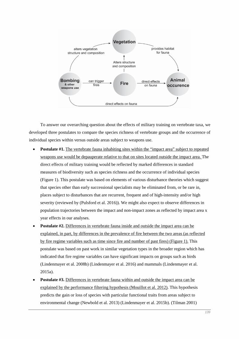
To answer our overarching question about the effects of military training on vertebrate taxa, we
developed three postulates to compare the species richness of vertebrate groups and the occurrence of
individual species within versus outside areas subject to weapons use.
• Postulate #1. The vertebrate fauna inhabiting sites within the “impact area” subject to repeated
weapons use would be depauperate relative to that on sites located outside the impact area. The
direct effects of military training would be reflected by marked differences in standard
measures of biodiversity such as species richness and the occurrence of individual species
(Figure 1). This postulate was based on elements of various disturbance theories which suggest
that species other than early successional specialists may be eliminated from, or be rare in,
places subject to disturbances that are recurrent, frequent and of high-intensity and/or high
severity (reviewed by (Pulsford et al. 2016)). We might also expect to observe differences in
population trajectories between the impact and non-impact zones as reflected by impact area x
year effects in our analyses.
• Postulate #2. Differences in vertebrate fauna inside and outside the impact area can be
explained, in part, by differences in the prevalence of fire between the two areas (as reflected
by fire regime variables such as time since fire and number of past fires) (Figure 1). This
postulate was based on past work in similar vegetation types in the broader region which has
indicated that fire regime variables can have significant impacts on groups such as birds
(Lindenmayer et al. 2008b) (Lindenmayer et al. 2016) and mammals (Lindenmayer et al.
2015a).
• Postulate #3. Differences in vertebrate fauna within and outside the impact area can be
explained by the performance filtering hypothesis (Mouillot et al. 2012). This hypothesis
predicts the gain or loss of species with particular functional traits from areas subject to
environmental change (Newbold et al. 2013) (Lindenmayer et al. 2015b). (Tilman 2001)
139

(Schleuter et al. 2010) (Hidasi-Neto et al. 2012). We tested this postulate only for birds, as it
was the only taxonomic group we studied with sufficient species richness and functional
diversity to test trait-based hypotheses. In particular, we explored relationships between
disturbance by military training and key life history attributes (see Figure 1) such as movement
patterns given that migratory taxa are known to be sensitive to perturbations (Runge et al.
2014). We also quantified relationships between disturbance and body size, diet and the
substrates used for foraging given well known links between some of these traits and extinction
proneness (Lindenmayer and Fischer 2006) and/or links with environmental change (Luck et al.
2012).
Given the four postulates outlined above, we completed detailed analyses of the three groups
of vertebrates at several levels of biological organization. First, we examined patterns of overall
species richness for the three groups of vertebrates targeted in this investigation. Second, we
quantified changes in occurrence of individual animal species to military training. Third, we explored
our data on bird occurrences for systematic differences in life history attributes of species within and
outside the impact area.
Understanding the factors which influence biodiversity within MTAs is important for the
development of best practice management of these globally extensive, and likely environmentally
important areas of land (Lawrence et al. 2015) (Zentelis and Lindenmayer 2015). This study therefore
makes a significant contribution toward the objectives of better quantifying the impacts of military
training within MTAs and assisting better management of environments subject to this kind of land
use.
140

Methods
1.1 Study area We conducted this study at the Beecroft Weapons Range (35°03’ S, 150°49’ E) which is a
~4200 ha area of Beecroft Peninsula located ~135 km south of Sydney on the south coast of New
South Wales, south-eastern Australia (Figure 2). Beecroft Weapons Range has a temperate maritime
climate with an average monthly rainfall of 103 mm (SD = 21 mm), and average minimum and
maximum air temperatures for January (summer) and July (winter) of 18–24°C and 9–15°C,
respectively (Bureau of Meteorology 2016).
Beecroft Weapons Range is managed by the Department of Defence and it contains a ~2000
ha area (see Figure 1), hereafter termed the “impact area”, that has been used regularly for weapons
training since the 1800s (Welbourne et al. 2015). This area is subject to testing of a wide range of
ordnance including ship-based naval gun fire, artillery, air to ground missiles, and small weapons. The
impact area is also used for demolition training. Use of weaponry occurs on a frequent basis, with the
Beecroft Weapons Range closed to public access for periods of several days to several weeks during
which repeated bombing, or the use of other kinds of ordnance occurs.
Spatial information gathered for the study area shows that the Beecroft Weapons Range has
been subject to a number of fires over the past 38 years (Figure 2). Sites (as defined below) have been
subject to up seven fires in the past four decades (see Figure 2).
Figure 2. Study area location and transect placement. Beecroft Weapons Range (shaded area) is located on Beecroft Peninsula on the south-east coast of Australia. Point colors show the number of fires at each transect.
141

1.2 Study design Our study comprised 40 sites, with a site defined as a 100 metre long transect. A total of 24
was located within the impact area (subject to military training) with the remaining 16 sites outside
the impact area (Figure 2). All sites were dominated by heathland comprising shrubs such as heath
banksia Banksia ericifolia, scrub she-oak Allocasuarina distyla, dagger hakea Hakea teretifolia, and
tea tree Leptospermum spp (Skelton and Adam 1994). An initial intent of this study was to quantify
the impacts of past fires and prescribed burning on biodiversity within and outside the impact area.
Our study design therefore involved assigning sites to one of four ‘time since fire’ classes crossed
against whether or not prescribed burning was proposed to take place in the five-year period between
2010 and 2014. There were five replicates within each of the eight cells in the experimental design.
We identified the appropriate location for each of our 40 sites by careful inspection of maps,
on-the-ground field reconnaissance, and consultation with staff from Beecroft Weapons Range. The
site locations were approved by the Officer in Charge at Beecroft Weapons Range and the Defence
Environment team. Each of the 24 sites within the impact area was cleared of unexploded ordinances
in January 2010 (see Appendix 1). Prescribed burning has not occurred per the timetable first planned
by the Department of Defence and analyses from the study have had to be adjusted accordingly.
1.3 Fauna surveys
1.3.1 Birds We surveyed birds by completing four five-minute point interval counts (sensu Pyke and
Recher 1983) in late September each year from 2010 to 2014 at the 20 m and 80 m permanent points
placed along the 100 metre transect established at each of our 40 sites. Each site was surveyed twice,
on a different day, by a different observer to reduce day effects on detection and overcome potential
observer heterogeneity problems (Cunningham et al. 1999, Field et al. 2002). We recorded all birds
seen or heard and assigned observations to different distance classes from a point – 0-25 m, 25-50 m,
50-100 m, and > 100 m.
Our survey protocol was specifically designed to quantify site occupancy and for our
statistical analyses (see below) we did not assume that individual counts at the two points on the same
site were independent. In addition, we limited our analyses to data gathered for those birds detected
within 50 m of a plot point on a given transect. We worked hard to account for known sources of
variation in our surveys in the most appropriate and feasible manner by: (i) using a large number of
sites and surveying multiple points per site (local spatial heterogeneity), (ii) surveying on multiple
days (temporal heterogeneity) and (iii) using multiple observers (observer heterogeneity)
(Cunningham et al. 1999, Lindenmayer et al. 2009b).
142

1.3.2 Mammals To facilitate surveys of mammals, we established markers at 0 m, 20 m, 40 m, 60 m, 80 m and
100 m points along the 100 metre transect at each of the 40 sites in our study. The trapping
infrastructure at each site was as follows:
• We placed an Elliott aluminium box trap (10 cm x 10cm x 30 cm; Elliott Scientific
Equipment, Upwey, Victoria) at 10 m intervals along the transect.
• We placed a small wire cage trap (20 x 20 x 50 cm) at 20 m intervals along the transect.
• We placed a large wire cage trap (30 x 30 x 60 cm) at the 0 m and 100 m points of the
transect.
Our trapping protocols involved opening Elliott traps and cage traps for three consecutive
days at each of our 40 sites in summer each year from 2010 to 2014. We baited all traps with a
mixture of peanut butter and rolled oats. Elliott traps and cage traps in which an animal had been
captured were wiped clean, re-baited, and re-positioned where the initial capture had taken place.
1.3.3 Reptiles To survey reptiles, we set out three kinds of artificial substrates at the 20m and 80m points
along the permanent transect established at each of the 40 sites in our experiment. These substrates
were four large wooden sleepers, four roof tiles, and two 2 m x 2 m sheets of corrugated iron. These
substrates were searched in spring and summer in each survey year.
1.4 Vegetation surveys Vegetation surveys were completed in 2014 by the same observer (CM). We measured
vegetation at the 20, 40, 60, 80 and 100m points along each transect to gather vegetation covariates
for use in modelling of the response of birds, mammals and reptiles to military training and fire. We
recorded the maximum height of the vegetation. We estimated the percentage cover of five height
classes of vegetation: 0-20cm, 20-40cm, 40-60cm, 60-80cm and 80-100cm. Due to the widespread
presence of unexploded ordinances throughout the impact area, we were restricted to measuring
vegetation within one metre of each of the 40 transects where bombs had been removed.
1.5 Collation of bird life history attributes We gathered data on bird species traits to address our third postulate (see Introduction) on
links between temporal changes in species’ identities within the impact area and particular kinds of
life-history attributes. We summarized data on morphological (body mass) and life history
(movement, diet, and foraging substrate) traits (Handbook of Australian and New Zealand Birds
1990-2007, BirdLife Australia 2014). These traits are thought to reflect the ability of species to
respond to environmental change (Luck et al. 2012).
143

1.6 Statistical Analysis Prior to analysis of faunal data, we tested for interactions between vegetation structure, fire,
and the impacts of military training, to understand covarying effects of different forms of disturbance
on vegetation structure. To achieve this, we fitted linear mixed models to vegetation height and
percentage vegetation cover data at various heights above the ground, using our three disturbance
variables (impact vs non-impact area, time since fire, and number of fires) as predictors. For our
percent cover response variables, we divided each value by 100 to form proportions, then logit-
transformed them prior to analysis to restrict our analysis to values between zero and one. We used a
square root transform on our ‘maximum vegetation height’ covariate. We ran a single model for each
response variable, with each model allowing linear combinations of all three predictors, but not
allowing interactions between them. We also included ‘site’ as a random effect to account for multiple
vegetation measures recorded at each site (i.e. at different points along a given transect).
We defined species richness for a given group of vertebrates as the sum of species observed
in a given site by year combination. We modelled these data by fitting Poisson generalized linear
mixed models (GLMMs) (Bates et al. 2014) to data on all observed species for each taxon; i.e. for 56
bird, 12 mammal, and seven reptile species. The predictors used were whether or not a site was in the
impact area, the number of years since the start of the study, the interaction between year and impact,
the logarithm of the number of years since the last fire, and the total number of fires on record for that
site. Other vegetation measures were investigated but discarded because of their very limited value in
explaining the observed results.
For our individual species models, we customized our statistical approach for each taxon, as
necessitated by the properties of our data. For reptile and mammal species, observations consisted of
abundance data (counts), which we modelled using hierarchical generalized linear models (HGLMs)
to account for potential non-Gaussian error structure of this kind of data (Lee et al. 2006). We used a
Poisson distribution with a log link for the fixed effects, and fitted ‘site’ as a random effect using
Gamma distribution with a log link. We ran these models for all mammals and reptiles for which 40
or more individuals were recorded and which were detected in more than 20 site-survey combinations
over the five-year duration of our study (Table S2.2). In contrast, our bird data recorded the ‘detection
frequency’ of each species; i.e. the proportion of surveys in which each species was detected per site
per year. We used GLMMs to fit a quasi-binomial model with a logit link to these data, again
including ‘site’ as a random effect, and weighting each observation by the number of visits each site
during that study year. We restricted our analyses to the 21 individual bird species (Table S2.1)
detected more than 25 times and in more than 17 site-survey combinations over the five-year duration
of our study.
In addition to analyses of species richness for all three taxa, our bird assemblage was
sufficiently large to allow functional analysis; i.e. to determine whether bird species responses to
144

environment were mediated by their traits. We used logistic mixed models to assess every two-way
interaction between impact, year, and each of our four trait variables (body mass, movement, diet and
substrate). Our model included site and species as random effects, and we also included survey effort
to account for the fact that sites that were more frequently surveyed during a given year were likely to
show higher bird occurrence. We omitted singletons and doubletons from this analysis, as well as any
raptors, leaving 48 species for analysis.
145

Results
1.7 Differences in fire and vegetation attributes inside and outside the impact area We uncovered a significant difference in the average number of fires per site over the past 38
years within versus outside the impact area (F1,38=11.12, P=0.002) (0.81 in non-impact area sites, 2.38
in impact area sites, standard error of difference, 0.47). In addition, the average time since fire was 16
years inside the impact area and 28 years outside (F1,38=12.02, P=0.001). We also found a significant
difference in vegetation height within versus outside the impact area, with significantly more
vegetation in frequently burned sites, and in areas that had not been recently burned (Fig. S2). There
were no significant differences in the percentage cover of any vegetation structural attributes between
the impact and non-impact areas. There were significant effects of time since fire and the number of
fires on overall vegetation height and the amount of vegetation (as reflected by values for percentage
cover) at all measured heights above the ground (Table S3).
1.8 Assemblage-wide responses to military training, fire and vegetation cover Overall bird species richness was significantly lower within vs outside the impact area
(coefficient = -0.32, S.E. = 0.09, P< 0.001; Fig. 3). Bird species richness also declined significantly
over time (coefficient = -0.11, P = 0.01), but there was no significant interaction between year and
impact (P=0.78). Conversely, there were no significant relationships between the species richness of
mammals or reptiles and impact area, time, or their interaction. Instead, both groups showed
significant variation in richness in response to time since fire, but in opposing directions – reptile
richness was highest in recently burned sites (coefficient = -0.11, P= 0.034), while mammal richness
was highest in long unburned vegetation (coefficient = 0.30, P < 0.001; see Table S4).
Figure 3. Change in estimated richness of three animal taxa over time, within and outside of the impact area
Analysis of trait-dependent responses to predictor variables were possible only for bird
species. These four models all showed lower bird occurrence within the impact zone than outside it,
and lower occurrence at the end of the study period than at the beginning (Table S5). However, each
trait showed distinct patterns of response to impact and time. Specifically, birds with larger body mass
were less common on average than small birds (coefficient = -0.52, P=0.027), but larger-bodied birds 146

also were less likely to be found within the impact area (coefficient of the interaction between impact
and body mass = -0.33, P<0.001; Fig. 4a). Similarly, there was no difference in the probability of
observing migratory versus sedentary birds outside the impact zone (P=0.4), but sedentary birds were
much more common within the impact zone than migratory birds (coefficient = 0.84, P<0.001; Fig
4b). Trait analyses exploring diet revealed that only nectarivores exhibited a significant response to
the impact zone (coefficient = -0.57, P=0.001; Fig 4c). Finally, understorey-dwelling birds were much
more common overall than ground- or canopy-dwelling species, but differences in occurrence
between the impact and non-impact areas were significant only for canopy-dwellers (Fig. 4d).
Figure 4. Change in probability of observation of bird species in relation to traits
1.9 Individual species responses to military training, fire and vegetation cover There were sufficient detections for 21 of the 56 species of birds we recorded for subsequent
data analysis. We captured 12 species of reptiles in our study and there were sufficient data to analyze
the responses of three species of skinks (Eastern She-Oak Skink Cyclodomorphus michaeli, Delicate
Skink Lampropholis delicata and Weasel Skink Saproscincus mustelinus) and one species of snake
(Black-bellied Swamp Snake Hemiaspis signata). There were sufficient data to conduct statistical
analyses of five of the seven species of mammals captured in this study; Brown Antechinus
(Antechinus stuartii), Bush Rat (Rattus fuscipes), Long-nosed Bandicoot (Parameles nasuta), House
Mouse (Mus musculus), and Black Rat (Rattus rattus). The last two species are exotic.
Of the 30 species with sufficient data for modelling, 16 exhibited significant differences in
detection frequency or abundance within versus outside the impact area. All of these species were
birds, with the detection frequency of 12 species being significantly lower within the impact area than
outside it (Fig. 5), and four significantly more common within the impact area. No mammal or reptile
species showed significant differences in abundance between the impact and non-impact areas.
Twelve species exhibited marked differences in detection frequency or abundance over time,
with only two of these being positive (Brown Antechinus and Long-nosed Bandicoot), meaning that
declines were more common than increases among the species that we studied. For seven of these
147

species, differences in detection frequency or abundance over time varied between the impact and
non-impact areas (Figure 5). For example, there was evidence of a significant negative interaction
effect between year and impact for the Southern Emu-wren Stipiturus malachurus, Variegated Fairy-
wren Malurus lamberti and Bush Rat, implying that declines in these species were restricted to the
impact area (see Table S6 for details). Notably, two species of exotic mammals – the Black Rat and
House Mouse, exhibited the opposite response and increased over time within the impact area (Figure
5).
In addition to effects of time and impact, three mammal species - Black Rat, Bush Rat and
Brown Antechinus - were more frequently captured in locations that were long unburnt with the last
of these species also being less common in frequently burned sites (Fig. 5). The House Mouse was the
only mammal species to respond positively to either fire variable, being most often captured in
frequently burned sites. We found that the Delicate Skink and the Weasel Skink were more common
in recently burned locations, although the Weasel Skink also was common in areas subject to fewer
fires.
Figure 5. Effect of predictor covariates on the detection frequency (birds) or abundance (mammals and reptiles) at Beecroft Weapons Range. Filled squares show those effects whose 95% confidence intervals (horizontal lines) do not overlap zero.
148

Discussion
We completed an empirical study of the impacts of military training on biodiversity. We
found compelling evidence for marked differences in the vertebrate biota on sites inside versus those
outside the impact area, particularly for birds for which there were large contrasts in species richness
and individual species occurrence. These effects remained present despite controlling for differences
in time since fire and the number of fires that had affected each survey location, suggesting a direct
impact of weapons use (e.g. physical impact or noise) or other associated (unmeasured) factors
underpinned observed responses. We further discuss these and other important findings in the
remainder of this section, particularly in relation to the four postulates outlined at the start of this
paper. We conclude with a brief commentary on the implications of our findings for the management
of military training areas.
1.10 Is the fauna inhabiting the impact area depauperate relative to that outside the impact area?
We postulated that the fauna inhabiting the impact area at Beecroft Weapons Range would be
depauperate relative to the non-impact area. This prediction was only partially upheld because of
marked inter-group and inter-specific responses (Figure 3, Figure 5). For example, overall bird
species richness was lower in the impact area, as were the detections of most individual species.
However, the detection frequencies of two bird species of conservation concern - the Eastern
Bristlebird and the Ground Parrot - were similar inside and outside the impact area. As evidence of
yet further contrast, neither mammal nor reptile species richness was depressed within the impact
zone.
Several inter-related factors may, in part, explain some of the differences in biota within
versus outside the impact area. First, sites within the impact area were subject to, on average, three
times more fires than sites outside the impact area and fire effects may have been reflected by the
responses of some taxa to time since fire effects – as discussed in the commentary in the following
section. Second, there were significant differences in vegetation structure and cover within versus
outside the impact area (Fig S2, Table S3). Such differences may have influenced habitat suitability.
Third, the extensive body of work on succession theory indicates that, over time, there can be marked
temporal changes in occurrence of species in perturbed areas associated with the time elapsed since
the last disturbance (Swanson et al. 2011) (reviewed by (Pulsford et al. 2016)).
Even after controlling for two key fire regime variables (viz: time since fire and the number
of fires), we found that marked effects of the impact zone continued to characterize our analysis. We
suggest that this outcome indicates: a direct effect of military training on vertebrate biota, other
associated (unmeasured) factors that affected the observed responses or a combination of both.
Physical impact or noise may be important factors underpinning differences in biota between the
149
impact and impact-free areas. However, we recognize there may be yet other indirect mechanisms that
were not examined in this study.
1.11 Can differences in the fire regime explain differences in the fauna inside and outside the impact area?
We found that time since fire effects were prominent for mammals and reptiles, but in
opposing ways. Mammal species richness and several individual species of mammals were most
likely to be recorded on sites characterized by a relatively long time since fire, whereas reptile species
richness exhibited the opposite effect as did individual species such as the Delicate and Weasel
Skinks. We suggest that relationships between fire, vegetation structure and habitat requirements of
animals is the likely driver of these results. Fire can have large impacts on vegetation structure and
plant species composition (Franklin et al. 2002, Haslem et al. 2011), which are major predictors of
habitat suitability for a wide range of animals (MacArthur and MacArthur 1961, Morrison et al. 2006)
(Woinarski 1999). For example, many studies have demonstrated the importance of vegetation cover
for small mammals (e.g. (Catling and Burt 1995) (Whelan et al. 2002) (Banks et al. 2011) and the
reduced levels of cover with recent fire (Table S2) is likely to erode habitat suitability for small
mammals. Conversely, high levels of cover can create unsuitable thermal microclimatic environments
for reptiles and this may, in turn, explain reduced level of species richness and the occurrence of
individual species for this group with increasing time since fire.
In contrast to our results for mammals and reptiles, we found no relationships between time
since fire and bird species richness. Moreover, only four of 21 individual bird species exhibited time
since fire effects (one negative and three positive; Figure 5). The relative paucity of time-since-fire
effects was unexpected given the well documented effects of this explanatory variable in many other
studies of birds (Smucker et al. 2005, Saab et al. 2007, Pons and Clavero 2009) including those in
similar (and nearby) ecosystems to the ones which featured in this investigation (e.g. (Lindenmayer et
al. 2008b) (Lindenmayer et al. 2016)). At least two possible reasons may explain the relative paucity
of time since fire effects for birds. First, there may be scale issues for birds because, unlike many
reptile and small mammal species, most bird species are mobile and can readily move between burned
and unburned areas. Second, work in similar ecosystems elsewhere in eastern Australia, has shown
that key aspects of the fire regime such as the severity of the last fire can have more substantial effects
on birds than time since fire (Lindenmayer et al. 2008b) (Lindenmayer et al. 2014). However, data on
fire severity were unavailable for this study.
Our fire-related results for the Ground Parrot were unexpected as earlier work at Beecroft
Weapons Range showed the species was mostly likely to occur in areas of long unburned heathland
(Baker et al. 2010). By contrast, the results of this study highlighted the prevalence of this species in
the impact area (Table S6) - where there has been significantly more fires relative to outside the
impact area (Fig. S2). There also was no significant effect of time since fire on the occurrence of the 150

species (Table S6). The reasons for the marked differences between the two studies remain unclear.
There has been a substantial body of work undertaken on this iconic parrot species (e.g. (Woinarski
1999) (Meredith et al. 1984) (Baker and Whelan 1994)) and together with the results of this study,
they suggest highly spatial variable responses to fire and other kinds of disturbance, ranging from
marked sensitivity to limited impacts.
Similar to our results for the Ground Parrot, detections of the Eastern Bristlebird did not differ
significantly between the impact and non-impact areas (Fig. 5), although the species was more likely
to be recorded on long unburned sites (Table S6). These findings are broadly consistent with recent
work on the species in nearby areas which show the species can readily recolonize burned areas but is
most abundant in long unburned locations (Lindenmayer et al. 2016). The persistence of this species
in fire-prone places like coastal heathland may be associated with bating for feral predators such as
the Red Fox (Vulpes vulpes), especially as work elsewhere suggests the existence of inter-
relationships between hunting efficiency of invasive predators and the removal of vegetation cover
following fire (McGregor et al. 2014).
1.12 Are differences in biodiversity inside and outside the impact area explained by differences in life history attributes?
An increasing number of studies is demonstrating associations between biotic responses to the
environment and traits or life history attributes (e.g. (Mouillot et al. 2012, Newbold et al. 2013)
(Lindenmayer et al. 2015b)). Our analyses were confined to data on birds and revealed several
interesting trait-based responses. First, larger-bodied bird species were less likely to occur in areas
subject to military training (Figure 4). One possible explanation for this result might be associated
with the amount of a bird’s territory that is disturbed by repeated bombing and the ability to tolerate
such kinds of recurrent perturbation. Larger bodied birds have larger territories than smaller species
(Gill 1995) (Handbook of Australian and New Zealand Birds 1990-2007) and repeated weapons use
may have a proportionately greater effect on effective territory size thereby influencing the ability of
such taxa to persist within the impact area.
A second key outcome from our work was that migratory species were less common in the
impact than outside it (Figure 4). These findings suggest that species that travel long distances to
breeding habitat may avoid places subject to repeated disturbance; in this case the use of weaponry.
The basis for such sensitivity remains unclear but our findings are broadly congruent with those of
other studies worldwide which suggest that highly mobile bird species can be sensitive to the effects
of disturbances (Runge et al. 2014). Other life history trait effects were uncovered for diet and
foraging substrate. It is possible these effects are associated with the effects on vegetation of repeated
disturbance leading to reduced vegetation height in the impact area, with subsequent influences on
canopy-foraging birds and those exploiting nectar as a food source.
151

Other effects
Our analyses revealed significant declines in detection frequency or abundance of ten species
over time, with only two species increasing over time (Figure 5). In addition, there was a significant
negative linear time trends for bird species richness. The reasons for these temporal effects remain
unclear, although for some species there appears to a link with military training as indicated by a
significant negative interaction between year and impact area, in which declines were confined to the
impact area (Figure 5). Two exotic small mammal species (the Black Rat and House Mouse) are often
associated with highly disturbed areas and they both exhibited a positive interaction between impact
area and year. We suggest that the observed temporal changes in some vertebrate taxa at Beecroft
Weapons Range (including increases of exotic species) warrant careful continued monitoring with a
plan for altered management action if trends continue.
Key caveats
Many factors make it virtually impossible to establish a perfect experiment in landscape-scale
ecological studies (Cunningham and Lindenmayer 2016). This investigation is no exception and we
acknowledge several limitations of our work at Beecroft Weapons Range. One of these limitations is
that there is only one impact area; that is weapons are used in one (2000 ha) place in the study region.
An ideal study design would be for many identical weapons ranges to be available, with several
replicates of those subject to repeated bombing and the remaining replicates free from training. This
option will never occur and the limitations imposed by having one impact area will be unavoidable in
almost all studies of the effects of military training on biodiversity.
Implications for management
The primary role of MTAs is training of defence personnel. However, important secondary
environmental benefits need to be explicitly incorporated into the management of such areas (e.g.
(Gazenbeek 2005) (Department of Defence 2014) (Lawrence et al. 2015)). A fundamental part of
integrating military training and environmental management objectives is to quantify the impacts of
military training on environmental values. However, the answer to the overarching question which
motivated this study: What are the impacts of military training on biodiversity? – was complex
because of the highly variable responses of different groups of biota and different species. Some
species responded positively, others negatively, and yet others exhibited largely neutral responses
(Figure 5). Nevertheless, our empirical investigation indicated that MTAs can be important
environments for a range of biota, including species of conservation significance (see also (Aycrigg et
al. 2015)). This was demonstrated in our study through the occurrence of high profile species of
conservation concern such as the Eastern Bristlebird and Ground Parrot. We note that other native
bird species were significantly less likely to be detected within the impact area versus outside it
(Figure 5). We therefore suggest that marked differences in biotic responses between species and
152

between vertebrate groups demands that managers of MTAs (in this case, the Australian Department
of Defence) explicitly state the objectives of management. This is because the kinds of management
targeted for a given area may be different if the overarching aim is to maximize overall species
richness versus if the aim is to secure populations of individual species of conservation concern.
Achieving secondary (environmental management) objectives on areas where military
training is the primary land use can be challenging and is complicated by inter-species and inter-group
differences in response to disturbance. One approach to maintaining biodiversity values in MTAs will
be to ensure that such areas are large enough to support patches of vegetation in different stages of
recovery following perturbation as well as some places that are exempt from weapons use or other
kinds of training that may alter vegetation cover or have other effects such as increasing the
prevalence of fire. This recommendation corresponds to the general land and resource management
principle of “don’t do the same thing everywhere” (see (Lindenmayer et al. 2008a)). This principle
therefore applies equally to land subject to military training as it does to other kinds of disturbance
regimes such as those subject to fire (including prescribed burning), livestock grazing and forestry.
153

Acknowledgements
We thank the Australian Research Council and the Department of Defence for financial and
logistical support in completing this study. We thank Dustin Wellbourne for collaborative research
efforts associated with the study reported here. Claire Shepherd and Tabitha Boyer assisted with a
range of key tasks associated with the writing of this manuscript.
154

Supplementary Information Table S1. List of bird species recorded at Beecroft Weapons Range, the number of
detections of each taxon, and the number of surveys at which it was detected over the 5-year duration of the study.
Common name Latin name No.
detections
No of
surveys
Asian Koel Eudynamys scolopaceus 1 1
Australasian Pipit Anthus novaeseelandiae 4 3
Australian King Parrot Alisterus scapularis 4 4
Australian Magpie Cracticus tibicen 5 5
Australian Raven Corvus coronoides 6 6
Bar-shouldered Dove Geopelia humeralis 14 11
Black-faced Cuckoo-
shrike
Coracina novaehollandiae 4 4
Brown-headed Honeyeater Melithreptus brevirostris 1 1
Brown Quail Coturnix ypsilophora 12 10
Brown Thornbill Acanthiza pusilla 69 39
Brush Bronzewing Phaps elegans 2 2
Crimson Rosella Platycercus elegans 51 36
Eastern Bristlebird Dasyornis brachypterus 337 152
Eastern Spinebill Acanthorhynchus tenuirostris 38 29
Eastern Whipbird Psophodes olivaceus 90 50
Eastern Yellow Robin Eopsaltria australis 30 21
Fan-tailed Cuckoo Cacomantis flabelliformis 29 24
Golden Whistler Pachycephala pectoralis 9 7
Grey Butcherbird Cracticus torquatus 13 11
Grey Fantail Rhipidura albiscapa 15 10
Grey Shrike-thrush Colluricincla harmonica 41 26
Ground Parrot Pezoporus wallicus 26 18
Horsfield’s Bronze
Cuckoo
Chalcites basalis 28 25
Laughing Kookaburra Dacelo novaeguineae 10 10
155

Lewin’s Honeyeater Meliphaga lewinii 16 9
Little Wattlebird Anthochaera chrysoptera 138 63
Masked Lapwing Vanellus miles 4 4
Nankeen Kestrel Falco cenchroides 1 1
New Holland Honeyeater Phylidonyris novaehollandiae 718 193
Noisy Friarbird Philemon corniculatus 8 7
Olive-backed Oriole Oriolus sagittatus 2 1
Pheasant Coucal Centropus phasianinus 1 1
Pied Currawong Strepera graculina 3 3
Rainbow Lorikeet Trichoglossus haematodus 9 9
Red-browed Finch Neochmia temporalis 5 5
Red Wattlebird Anthochaera carunculata 16 13
Rufous Whistler Pachycephala rufiventris 20 14
Satin Bowerbird Ptilonorhynchus violaceus 26 21
Scarlet Honeyeater Myzomela sanguinolenta 1 1
Shining Bronze Cuckoo Chalcites lucidus 20 17
Silvereye Zosterops lateralis 42 32
Southern Emu-wren Stipiturus malachurus 129 82
Spotted Pardalote Pardalotus punctatus 4 4
Superb Fairy-wren Malurus cyaneus 28 19
Swamp Harrier Circus approximans 7 6
Tawny-crowned
Honeyeater
Glyciphila melanops 169 90
Tawny Grassbird Megalurus timoriensis 49 31
Variegated Fairy-wren Malurus lamberti 134 83
Welcome Swallow Hirundo neoxena 88 59
Whistling Kite Haliastur sphenurus 1 1
White-browed Scrubwren Sericornis frontalis 120 73
White-cheeked
Honeyeater
Phylidonyris niger 3 3
White-naped Honeyeater Melithreptus lunatus 2 2
156

White-throated
Treecreeper
Cormobates leucophaea 2 1
157

Table S2. List of mammal and reptile species recorded at Beecroft Weapons Range, the number of individuals of each taxon, and the number of surveys at which it was detected over the 5-year duration of the study.
Common name Latin name No.
individuals
No
of
surveys
Brown Antechinus Antechinus stuartii 1182 300
Eastern Pygmy Possum Cercatetus nanus 6 6
House Mouse* Mus musculus 309 102
Long-nosed Bandicoot Parameles nasuta 132 81
Bush Rat Rattus fuscipes 480 189
Black Rat* Rattus rattus 234 126
Echidna Tachyglossus
aculaetus
9 9
Red-throated Skink Acritoscincus
platynotum
17 13
Jacky Dragon Amphibolurus
muricatus
3 3
Copper-tailed Skink Ctenotus
taeniolatus
29 23
Eastern She-Oak Skink Cyclomorphus
michaeli
50 35
White-lipped Snake Drysdalia
coronoides
1 1
Black-bellied Swamp
Snake
Hemiaspis signata 40 21
Delicate Skink Lampropholis
delicata
1278 208
Garden Skink Lampropholis
guichenoti
9 5
Red-bellied Black Snake Pseudechis
porphyriacus
7 7
Eastern Brown Snake Pseudonaja textilis 3 3
158

Weasel Skink Saproscincus
mustelinus
66 37
Blue-tongued Skink Tiliqua scincoides 4 3
159

Table S3. Coefficients of vegetation structure responses to impact and fire
Respons
e Variable
Predictor Variable Estimated
Coefficient
Stan
dard
Error
T
Value
0 - 20 cm Intercept -0.13 0.12 -1.05
Impact area = TRUE 0.24 0.17 1.46
Number of Fires 0.21 0.09 2.39
T. S. F. 0.75 0.08 9.61
20 - 40
cm
Intercept -0.01 0.15 -0.09
Impact area = TRUE 0.05 0.21 0.24
Number of Fires 0.26 0.11 2.32
T. S. F. 0.58 0.09 6.25
40 - 60
cm
Intercept 0.03 0.15 0.17
Impact area = TRUE -0.04 0.21 -0.19
Number of Fires 0.38 0.11 3.50
T. S. F. 0.61 0.09 6.60
60 - 80
cm
Intercept 0.15 0.17 0.90
Impact area = TRUE -0.25 0.23 -1.10
Number of Fires 0.33 0.12 2.77
T. S. F. 0.43 0.10 4.24
80 - 100
cm
Intercept 0.19 0.17 1.12
Impact area = TRUE -0.33 0.24 -1.40
Number of Fires 0.29 0.12 2.31
T. S. F. 0.35 0.10 3.29
Max.
Veg. Height
Intercept 0.43 0.12 3.70
Impact area = TRUE -0.72 0.16 -4.58
Number of Fires 0.19 0.08 2.27
T. S. F. 0.69 0.07 9.71
160

161

Table S4. Variable coefficients for species richness models
Respons
e Variable Predictor Variable
Estimat
ed
Coefficient
Std.
Error P Value
Bird
species
richness
(n=56)
Intercept 2.05 0.06 0.000
Year -0.11 0.04 0.011
Impact area = TRUE -0.32 0.09 0.000
Number of Visits 0.17 0.03 0.000
T.S.F. 0.00 0.03 0.973
Number of Fires 0.01 0.04 0.740
Year x Impact -0.02 0.06 0.779
Reptile
species
richness
(n=12)
Intercept 0.31 0.10 0.002
Year -0.04 0.09 0.647
Impact area = TRUE 0.15 0.13 0.250
Number of Visits 0.12 0.05 0.020
T.S.F. -0.11 0.05 0.034
Number of Fires 0.00 0.06 0.996
Year x Impact -0.03 0.11 0.771
Mammal
species
richness
(n=7)
Intercept 0.63 0.08 0.000
Year -0.06 0.06 0.290
Impact area = TRUE 0.06 0.10 0.557
Number of Visits -0.08 0.04 0.076
T.S.F. 0.30 0.06 0.000
Number of Fires 0.05 0.05 0.300
Year x Impact 0.14 0.08 0.067
162

Table 5. Coefficients for trait models
Trait Predictor Variable
Estimat
ed
Coefficient
Standa
rd Error P Value
Mass
(Continuou
s: log mass in
grams)
Intercept -2.30 0.25 0.000
Impact Zone = TRUE -0.65 0.14 0.000
Year -0.21 0.06 0.000
Mass (log) -0.52 0.24 0.027
Number of Visits 0.30 0.04 0.000
Impact x Year -0.01 0.08 0.880
Impact x Mass -0.33 0.09 0.000
Year x Mass -0.04 0.04 0.417
Movement
(Factorial:
Migratory or
Sedentary)
Intercept -2.57 0.40 0.000
Impact Zone = TRUE -1.10 0.17 0.000
Year -0.14 0.07 0.063
Movement = Sedentary 0.42 0.50 0.402
Number of Visits 0.30 0.04 0.000
Impact x Year 0.00 0.08 0.959
Imapct x Sedentary 0.84 0.16 0.000
Year x Sedentary -0.09 0.08 0.266
Diet
(Factorial:
Insectivore,
Granivore or
Nectarivore)
Intercept -2.32 0.34 0.000
Impact Zone = TRUE -0.37 0.14 0.010
Year -0.14 0.06 0.033
Diet = Nectar 0.51 0.58 0.380
Diet = Seeds -1.00 0.70 0.154
Number of Visits 0.31 0.04 0.000
Impact x Year 0.00 0.08 0.967
Impact x Nectar -0.57 0.17 0.001
Impact x Seeds 0.00 0.25 0.991
Year x Nectar -0.12 0.09 0.147
163

Year x Seeds -0.33 0.13 0.012
Substrate
(Factorial:
Ground,
Understorey or
Canopy)
Intercept -2.51 0.33 0.000
Impact Zone = TRUE -1.59 0.19 0.000
Year -0.15 0.07 0.031
Substrate = Ground -0.44 0.54 0.410
Substrate = Understorey 1.43 0.55 0.010
Number of Visits 0.32 0.04 0.000
Impact x Year -0.06 0.08 0.480
Impact x Ground 1.31 0.21 0.000
Impact x Understorey 1.54 0.18 0.000
Year x Ground -0.10 0.11 0.326
Year x Understorey -0.04 0.09 0.679
164

Table S6. Cells show variable coefficients for each species, followed by standard errors and P values in parentheses. Species Intercept Impact Year Impact x
Year
T.S.F. n. Fires Visits
Brown_Thornbill
-2.02
(0.34, P<0.01)
-2.36
(0.6, P<0.01)
-0.27
(0.17,
P=0.11)
-0.28
(0.39,
P=0.47)
-0.09
(0.19,
P=0.64)
0.04
(0.3, P=0.9)
Crimson_Rosella
-2.15
(0.28, P<0.01)
-2 (0.52,
P<0.01)
-0.43
(0.19,
P=0.03)
0.33
(0.36,
P=0.36)
-0.39
(0.16,
P=0.01)
0.15
(0.26,
P=0.56)
Eastern_Bristlebird
-0.5 (0.19,
P=0.01)
-0.03
(0.25,
P=0.91)
-0.06
(0.11,
P=0.61)
0.07
(0.15,
P=0.63)
0.47
(0.12,
P<0.01)
0.25
(0.13,
P=0.05)
Eastern_Spinebill
-2.96
(0.41, P<0.01)
-1.97
(0.66,
P<0.01)
-0.17
(0.2, P=0.41)
-0.21
(0.53,
P=0.69)
-0.09
(0.23, P=0.7)
-0.57
(0.41,
P=0.16)
Eastern_Whipbird
-1.66 (0.3,
P<0.01)
-2.37
(0.55,
P<0.01)
-0.83
(0.17,
P<0.01)
-0.18
(0.34,
P=0.58)
0.03
(0.23,
P=0.89)
0.49
(0.25,
P=0.04)
Eastern_Yellow_Robin
-3.08
(0.42, P<0.01)
-2.67
(0.94,
P<0.01)
-1.06
(0.3, P<0.01)
2.13
(0.76,
P=0.01)
-0.38
(0.22,
P=0.09)
0.07
(0.37,
P=0.85)
Fan_tailed_Cuckoo -3.25
-2.06
(0.92,
-0.64
(0.28,
1.74
(0.55,
-0.21
(0.27, 0.33
165

(0.49, P<0.01) P=0.02) P=0.02) P<0.01) P=0.44) (0.39, P=0.4)
Grey_Shrike_thrush
-3.1 (0.42,
P<0.01)
-0.93
(0.6, P=0.12)
-0.23
(0.22, P=0.3)
0.4
(0.36,
P=0.27)
0.17
(0.29,
P=0.57)
-0.14
(0.34,
P=0.69)
Ground_Parrot
-5.87
(0.93, P<0.01)
1.22
(1.05,
P=0.25)
-0.31
(0.77,
P=0.69)
-1.6
(0.87,
P=0.07)
-0.24
(0.31,
P=0.43)
-0.25
(0.35,
P=0.48)
Horsfield_s_Bronze_Cuckoo
-3.35
(0.34, P<0.01)
-0.58
(0.49,
P=0.24)
-0.35
(0.26,
P=0.18)
0.11
(0.43,
P=0.79)
0.15
(0.29, P=0.6)
-0.39
(0.32,
P=0.21)
Little_wattlebird
-0.63
(0.29, P=0.03)
-3.52
(0.57,
P<0.01)
-0.23
(0.13,
P=0.07)
-0.5
(0.31, P=0.1)
-0.07
(0.15,
P=0.62)
0.45
(0.26,
P=0.08)
New_Holland_Honeyeater
2.79
(0.36, P<0.01)
-1.21
(0.45,
P=0.01)
-0.41
(0.21,
P=0.05)
0.26
(0.25,
P=0.28)
0.62
(0.12,
P<0.01)
0.37
(0.21,
P=0.09)
Satin_Bowerbird
-3.04
(0.48, P<0.01)
-3.89
(1.5, P=0.01)
-0.34
(0.24,
P=0.15)
-0.47
(1.24,
P=0.71)
-0.02
(0.32,
P=0.96)
0.09
(0.56,
P=0.87)
Silvereye
-2.63
(0.34, P<0.01)
-2.19
(0.7, P<0.01)
-0.89
(0.25,
P<0.01)
-0.07
(0.48,
P=0.88)
0.39
(0.35,
P=0.28)
0.66
(0.28,
P=0.02)
166

Southern_Emu_wren
-2.47
(0.25, P<0.01)
0.84
(0.32,
P=0.01)
0.2
(0.19,
P=0.29)
-0.84
(0.23,
P<0.01)
0.33
(0.16,
P=0.03)
0.25
(0.14,
P=0.08)
Superb_Fairy_wren
-2.97
(0.38, P<0.01)
-1.67
(0.64,
P=0.01)
-0.49
(0.28,
P=0.08)
-0.33
(0.47,
P=0.48)
-0.33
(0.21,
P=0.11)
0.39
(0.28,
P=0.17)
Tawny_crowned_Honeyeater
-3.69
(0.39, P<0.01)
2.88
(0.44,
P<0.01)
-0.47
(0.32,
P=0.15)
0.38
(0.34,
P=0.26)
0.02
(0.13,
P=0.91)
-0.04
(0.16,
P=0.82)
Tawny_Grassbird
-4.87
(0.64, P<0.01)
2.02
(0.71,
P<0.01)
0.42
(0.48,
P=0.38)
-0.36
(0.51,
P=0.48)
0.19
(0.24,
P=0.42)
0.27
(0.28,
P=0.33)
Variegated_Fairy_wren
-1.69 (0.2,
P<0.01)
-0.15
(0.28, P=0.6)
0.16
(0.15,
P=0.26)
-0.4
(0.2, P=0.04)
0.11
(0.12,
P=0.39)
0.04
(0.14,
P=0.75)
Welcome_Swallow
-3.92
(0.44, P<0.01)
1.96
(0.5, P<0.01)
-0.27
(0.31,
P=0.38)
0.58
(0.34,
P=0.09)
-0.19
(0.16,
P=0.23)
-0.34
(0.23,
P=0.14)
White_browed_Scrubwren
-1.5 (0.21,
P<0.01)
-1.38
(0.35,
P<0.01)
-0.47
(0.14,
P<0.01)
-0.48
(0.26,
P=0.06)
0.19
(0.17,
P=0.26)
0.09
(0.17, P=0.6)
Antechinus_stuartii 1.02 -0.13 0.25 0.02 0.41 -0.24 -0.03
167

(0.18, P<0.01) (0.24,
P=0.58)
(0.06,
P<0.01)
(0.08,
P=0.77)
(0.09,
P<0.01)
(0.12,
P=0.04)
(0.05,
P=0.51)
Mus_musculus
-0.51
(0.64, P=0.42)
-0.3
(0.78,
P=0.71)
-0.94
(0.23,
P<0.01)
0.95
(0.24,
P<0.01)
0.06
(0.09,
P=0.54)
2.49
(0.3, P<0.01)
-0.91
(0.55,
P=0.1)
Perameles_nasuta
-1.48
(0.44, P<0.01)
0.44
(0.63,
P=0.48)
0.57
(0.15,
P<0.01)
-0.32
(0.18,
P=0.07)
0.1
(0.15,
P=0.52)
0.11
(0.23,
P=0.64)
0.19
(0.12,
P=0.11)
Rattus_fuscipes
-0.49
(0.28, P=0.08)
0.44
(0.37,
P=0.23)
0.13
(0.08,
P=0.09)
-0.37
(0.11,
P<0.01)
1.02
(0.21,
P<0.01)
-0.24
(0.19,
P=0.21)
-0.24
(0.07,
P<0.01)
Rattus_rattus
-0.19
(0.46, P=0.68)
-0.49
(0.64,
P=0.45)
-0.34
(0.08,
P<0.01)
0.63
(0.14,
P<0.01)
0.96
(0.22,
P<0.01)
-0.06
(0.42,
P=0.89)
-0.4
(0.09,
P<0.01)
Cyclodomorphus_michaeli
-2.52
(0.45, P<0.01)
1.17
(0.59,
P=0.05)
-0.63
(0.23,
P=0.01)
0.22
(0.26, P=0.4)
-0.25
(0.14,
P=0.08)
-0.48
(0.31,
P=0.13)
0.37
(0.1,
P<0.01)
Hemiaspis_signata
-1.39
(0.47, P<0.01)
-1.14
(0.65,
P=0.08)
-0.03
(0.17,
P=0.84)
-0.16
(0.26,
P=0.54)
0.17
(0.17,
P=0.35)
0.6
(0.32,
P=0.06)
0.54
(0.11,
P<0.01)
Lampropholis_delicata
1.19 (0.2,
P<0.01) 0.47
(0.26,
-0.11
(0.11,
0.09
(0.12,
-0.36
(0.06,
0.07
(0.12,
0.37
(0.04,
168

P=0.07) P=0.29) P=0.46) P<0.01) P=0.57) P<0.01)
Saproscincus_mustelinus
-1.46
(0.48, P<0.01)
-0.87
(0.66,
P=0.19)
0.1
(0.16,
P=0.52)
0.01
(0.21,
P=0.96)
-1.43
(0.18,
P<0.01)
-1.26
(0.39,
P<0.01)
0.25
(0.08,
P<0.01)
169
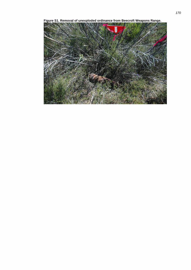
170
Figure S1. Removal of unexploded ordinance from Beecroft Weapons Range.

171
Fig. S2. Differences in vegetation in relation to three disturbance variables

172
References
Aycrigg, J. L., R. T. Belote, M. S. Dietz, G. H. Aplet, and R. A. Fischer. 2015. Bombing for biodiversity in the United States: Response to Zentilis and Lindenmayer 2015. Conservation Letters 8:306-307.
Baker, J. and R. Whelan. 1994. Ground Parrots and fire at Barren Grounds, New South Wales: a long-term study and an assessment of management implications. Emu 94:300-304.
Baker, J., R. Whelan, L. Evans, S. Moore, and M. Norton. 2010. Managing the Ground Parrot in its fiery habitat in south-eastern Australia. Emu: Austral Ornithology 110:279-284.
Banks, S. C., M. Dujardin, L. McBurney, D. Blair, M. Barker, and D. B. Lindenmayer. 2011. Starting points for small mammal population recovery after wildfire: recolonisation or residual populations? Oikos 120:26-37.
Bates, D., M. Maechler, B. Bolker, and S. Walker. 2014. lme4: Linear mixed-effects models using Eigen and S4. Pages R package version 1.1-6.
Bell, J. R., C. P. Wheater, and W. R. Cullen. 2001. The implications of grassland and heathland management for the conservation of spider communities: a review. . Journal of Zoology 255:377-387.
BirdLife Australia. 2014. Birds in Backyards Bird Finder. Available at http://www.birdsinbackyards.net/finder/all-species.
Catling, P. C. and R. J. Burt. 1995. Studies of the ground-dwelling mammals of the eucalypt forests in south-eastern New South Wales: the effect of habitat variables on distribution and abundance. Wildlife Research 22:271-288.
Department of Defence. 2014. Defence Environment Policy 2014. Franklin, J. F., T. A. Spies, R. van Pelt, A. B. Carey, D. A. Thornburgh, D. R. Berg, D. B.
Lindenmayer, M. E. Harmon, W. S. Keeton, D. C. Shaw, K. Bible, and J. Chen. 2002. Disturbances and the structural development of natural forest ecosystems with silvicultural implications, using Douglas-fir forests as an example. Forest Ecology and Management 155:399-423.
Gazenbeek, A. 2005. LIFE, Natura 2000 and the military. . Life Focus - Journal of the European Commission.
Gill, F. B. 1995. Ornithology. Second Edition edition. W.H. Freeman and Company, New York. Handbook of Australian and New Zealand Birds. 1990-2007. Handbook of Australian, New
Zealand and Antarctic birds, volumes 1-7. Oxford University Press, Melbourne. Haslem, A., L. T. Kelly, D. G. Nimmo, S. J. Watson, S. A. Kenny, R. S. Taylor, S. C. Avitabile, K. E.
Callister, L. M. Spence-Bailey, M. F. Clarke, and A. F. Bennett. 2011. Habitat or fuel? Implications of long-term, post-fire dynamics for the development of key resources for fauna and fire. Journal of Applied Ecology 48:247-256.
Hidasi-Neto, J., J. Barlow, and M. V. Cianciaruso. 2012. Bird functional diversity and wildfires in the Amazon: the role of forest structure. Animal Conservation 15:407-415.
Hills, A. 1991. A green ministry. Geographical Magazine 64:16-20. Jentsch, A., S. Friedrich, T. Steinlein, W. Beyschlag, and W. Nezadal. 2009. Assessing
Conservation Action for Substitution of Missing Dynamics on Former Military Training Areas in Central Europe. Restoration Ecology 17:107-116.
Keith, D., J. Williams, and J. Woinarski. 2002. Fire management and biodiversity conservation: key approaches and principles. Pages 401-425 in R. Bradstock, J. Williams, and A. M. Gill, editors. Flammable Australia. The Fire Regimes and Biodiversity of a Continent. Cambridge University Press, Cambridge.

173
Lawrence, M. J., H. I. Stemberger, A. J. Zolderdo, D. P. Struthers, and S. J. Cooke. 2015. The effects of modern war and military activities on biodiversity and the environment. Environmental Reviews 23:443-460.
Lee, Y., J. A. Nelder, and Y. Pawitan. 2006. Generalized Linear Models with Random Effects: Unified Analysis via H-Likelihood. Chapman & Hall/CRC, Boca Raton.
Lindenmayer, D. B., W. Blanchard, C. MacGregor, P. Barton, S. C. Banks, M. Crane, D. Michael, S. Okada, L. Berry, and A. M. Gill. 2015a. Temporal trends in mammal responses to fire reveal complex effects of fire regime attributes. Ecological Applications In press.
Lindenmayer, D. B., W. Blanchard, L. McBurney, D. Blair, S. C. Banks, D. A. Driscoll, A. Smith, and A. M. Gill. 2014. Complex responses of birds to landscape-level fire extent, fire severity and environmental drivers. Diversity and Distributions 20:467-477.
Lindenmayer, D. B., W. Blanchard, P. Tennant, P. Barton, K. Ikin, A. Mortelliti, S. Okada, M. Crane, and D. Michael. 2015b. Richness is not all: how changes in avian functional diversity reflect major landscape modification caused by pine plantations. . Diversity and Distributions 21:836-847.
Lindenmayer, D. B., S. Candy, S. Banks, M. Westgate, K. Ikin, J. Pierson, P. Tulloch, and P. Barton. 2016. Do temporal changes in vegetation structure predict changes in bird occurrence additional to time since fire? . Ecological Applications in press.
Lindenmayer, D. B. and J. Fischer. 2006. Habitat Fragmentation and Landscape Change. Island Press, Washington, D.C.
Lindenmayer, D. B., R. Hobbs, R. Montague-Drake, J. Alexandra, A. Bennett, M. Burgman, P. Cale, A. Calhoun, V. Cramer, P. Cullen, D. Driscoll, L. Fahrig, J. Fischer, J. Franklin, Y. Haila, M. Hunter, P. Gibbons, S. Lake, G. Luck, C. MacGregor, S. McIntyre, R. Mac Nally, A. Manning, J. Miller, H. Mooney, R. Noss, H. Possingham, D. Saunders, F. Schmiegelow, M. Scott, D. Simberloff, T. Sisk, G. Tablr, B. Walker, J. Wiens, J. Woinarski, and E. Zavaleta. 2008a. A checklist for ecological management of landscapes for conservation. Ecology Letters 11:78-91.
Lindenmayer, D. B., J. T. Wood, R. B. Cunningham, C. MacGregor, M. Crane, D. Michael, R. Montague-Drake, D. Brown, R. Muntz, and A. M. Gill. 2008b. Testing hypotheses associated with bird responses to wildfire. Ecological Applications 18:1967-1983.
Luck, G., S. Lavorel, S. McIntyre, and K. Lumb. 2012. Improving the application of vertebrate trait-based frameworks to the study of ecosystem services. Journal of Animal Ecology 81:1065-1076.
MacArthur, R. H. and J. W. MacArthur. 1961. On bird species diversity. Ecology 42:594-598. McGregor, H. W., S. Legge, M. E. Jones, and C. N. Johnson. 2014. Landscape Management of
Fire and Grazing Regimes Alters the Fine-Scale Habitat Utilisation by Feral Cats. . PLoS ONE
9:e109097. Meredith, C. W., A. M. Gilmore, and A. C. Isles. 1984. The Ground Parrot (Pezoporus wallicus
Kerr) in south-eastern Australia: a fire-adapted species? Australian Journal of Ecology 9:367-380.
Morrison, M. L., B. G. Marcot, and R. W. Mannan. 2006. Wildlife-Habitat Relationships. Concepts and Applications. Island Press, Washington, D.C.
Mouillot, D., N. A. Graham, S. Villeger, N. W. Mason, and D. R. Bellwood. 2012. A functional approach reveals community responses to disturbances. Trends in Ecology & Evolution 28:167-177.
Newbold, T., J. P. Scharlemann, S. H. Butchart, C. H. Sekerciouglu, R. Alkemade, H. Booth, and D. W. Purves. 2013. Ecological traits affect the response of tropical bird species to land-use intensity. Proceedings of the Royal Society B 280:805-810.
174
Pons, P. and M. Clavero. 2009. Bird responses to fire severity and time since fire in managed mountain rangelands. Animal Conservation 13:294-305.
Pulsford, S., D. B. Lindenmayer, and D. Driscoll. 2016. A succession of theories: A framework to purge redundancy in post-disturbance theory. Biological Reviews 91:148-167.
Runge, C. A., T. G. Martin, H. P. Possingham, S. G. Willis, and R. A. Fuller. 2014. Conserving mobile species. Frontiers in Ecology and the Environment 12:395-402.
Saab, V., R. E. Russell, and J. G. Dudley. 2007. Nest densities of cavity-nesting birds in relation to post-fire salvage logging and time since wildfire. The Condor 109:97-108.
Schleuter, D., M. Daufresne, F. Massol, and C. Argillier. 2010. A user's guide to functional diversity indices. Ecological Monographs 80:469-484.
SIPRI. 2014. Military expenditure - World's top 15 countries 2013. Skelton, N. J. and P. Adam. 1994. Beecroft Peninsula Vegetation Survey. . Australian Nature
Conservation Agency, Canberra, Australia. Smucker, K. M., R. L. Hutto, and B. M. Steele. 2005. Changes in bird abundance after wildfire:
importance of fire severity and time since fire. Ecological Applications 15:1535-1549. Stein, B. A., C. Scott, and N. Benton. 2008. Federal lands and endangered species: the role of
military and otehr federal land in sustainaing biodiversity. BioScience 58:339-347. Swan, M., F. J. Christie, H. Sitters, A. York, and J. Di Stefano. 2015. Predicting faunal fire
responses in heterogeneous landscapes: the role of habitat structure. . Ecological Applications.
Swanson, M. E., J. F. Franklin, R. L. Beschta, C. M. Crisafulli, D. A. DellaSala, R. L. Hutto, D. B. Lindenmayer, and F. J. Swanson. 2011. The forgotten stage of forest succession: early-successional ecosystems on forest sites. Frontiers in Ecology and the Environment 9:117-125.
Thonicke, K., S. Venevsky, S. Sitch, and W. Cramer. 2001. The role of fire disturbance for global vegetation dynamics: Coupling fire into a Dynamic Global Vegetation Model. . Global Ecology and Biogeography 10:661-667.
Tilman, D. 2001. Functional diversity. Pages 109–120 in S. A. Levin, editor. Encyclopedia of Biodiversity. Academic Press, San Diego, California.
Welbourne, D. J., C. MacGregor, D. Paull, and D. B. Lindenmayer. 2015. The effectiveness and cost of camera traps for surveying small reptiles and critical weight range mammals: a comparison with labour-intensive complementary methods. Wildlife Research 42:414–425.
Whelan, R., L. Rodgerson, C. R. Dickman, and E. F. Sutherland. 2002. Critical life cycles of plants and animals: developing a process-based understanding of population changes in fire-prone landscapes. Pages 94-124 in R. A. Bradstock, J. E. Williams, and A. M. Gill, editors. Flammable Australia. The Fire Regimes and Biodiversity of a Continent. Cambridge University Press, Melbourne.
Whelan, R. J. 1995. The Ecology of Fire. Cambridge University Press, Cambridge, England. Woinarski, J. C. Z. 1999. Fire and Australian birds: A review. Pages 55-112 in A. M. Gill, J. C. Z.
Woinarski, and A. York, editors. Australia's Biodiversity: Responses to Fire: Biodiversity. Environment Australia, Canberra.
Zentelis, R. and D. B. Lindenmayer. 2015. Bombing for biodiversity – enhancing conservation values of Military Training Areas. . Conservation Letters 8:299-305.
Related Documents