U.S. DEPARTMENT OF COMMERCE Economics and Statistics Administration U.S. Census Bureau Prepared by the Geography Division For general information, contact the Congressional Affairs Office at (301) 763-6100. For more information regarding congressional district plans as a result of the 2010 Census, redistricting, and voting rights data, contact the Census Redistricting and Voting Rights Data Office at (301) 763-4039 or www.census.gov/rdo. For information regarding other U.S. Census Bureau products, visit www.census.gov. Map Legend Congressional districts are those in effect for the 115th Congress of the United States (January 2017-2019); all other legal boundaries and names are as of January 1, 2010. The boundaries shown on this map are for Census Bureau statistical data collection and tabulation purposes only; their depiction and designation for statistical purposes does not constitute a determination of jurisdictional authority or rights of ownership or entitlement. Source: U.S. Census Bureau’s MAF/TIGER database (TAB10) Projection: State-based Alber’s Equal Area † Labels for entities located both inside and outside of Congressional District 18 include a ‘*’. DISTRICT 18 Florida Congressional District 18 DISTRICT 2 Other Florida Congressional District Poarch Creek American Indian Reservation / Off-Reservation Trust Land (Federal) † Pamunkey American Indian Reservation (State) † Fort Belvoir Military Installation Walton St Other Road or Ferry KANSAS OKLAHOMA State or Statistically Equivalent Entity ERIE County or Statistically Equivalent Entity Collinsville Incorporated Place (Inside of Congressional District 18) † Chelsea Incorporated Place (Outside of Congressional District 18) † Turley Census Designated Place (CDP) (Inside of Congressional District 18) † Justice Census Designated Place (Outside of Congressional District 18) † Water Body Bristol Hbr 44 Interstate 56 U.S. Highway State Highway or State Recognized Road 32 80.1% 13.1% 0.4% 2.6% 0.0% 2.0% 1.8% 15.3% Two or More Races: Hispanic or Latino (of any race): White: Black or African American: American Indian and Alaska Native: Asian: Native Hawaiian and Other Paciic Islander: Some Other Race: One Race Race & Hispanic Origin Ra c e & Hispanic Origin Renter Owner Vacant Occupied 63.0% 37.0% U.S. Split: 20.1% 79.9% 73.1% 26.9% 361,935 Total Housing Units: Percent Occupied: Percent Vacant: Owner Occupied: Renter Occupied: Housing 749,475 4.9% 16.3% 4.8% 10.7% 11.5% 13.4% 14.1% 24.5% 48.6% 51.4% 46.6 58,290 Age - Under 5: Age - 5 to 19: Age - 20 to 24: Age - 25 to 34: Age - 35 to 44: Age - 45 to 54: Age - 55 to 64: Age - 65+: Total Population: Percent Male: Percent Female: Median Age: Veterans 18 years and older: Population For more Congressional District data, visit census.gov/mycd. For more information on the American Community Survey, visit census.gov/acs. Data Source: 2015 American Community Survey 1-Year Estimates Note: Figures may not add to 100% due to rounding. Map Source: 2011-2015 American Community Survey 5-Year Estimates Note: Only the portions of the census tracts within the congressional district are shown for tracts that extend beyond the boundary of the district. Estimates and percentages may not sum due to rounding to protect conidentiality. Percentages may not be statistically different when compared to U.S. percentage. Population Density 91.0 378.0 495.3 United States: Florida: District 18: Persons per square mile Population Density Persons per Square Mile by Census Tract 3,500.0 to 8,663.3 2,500.0 to 3,499.9 1,450.0 to 2,499.9 400.0 to 1,449.9 Less than 400.0 water tract Congressional District 18 Profile 2 3 1 17 6 8 26 4 9 25 5 11 20 10 19 16 7 12 15 27 14 13 22 23 21 24 GEORGIA ALABAMA Gulf of Mexico DISTRICT 18 Atlantic Ocean 80°W 80°W 81°W 81°W 82°W 82°W 83°W 83°W 84°W 84°W 85°W 86°W 86°W 87°W 87°W 88°W 31°N 31°N 30°N 30°N 29°N 29°N 28°N 28°N 27°N 27°N 26°N 26°N 25°N 25°N Location of Florida's 18 th Congressional District - 27 Districts Total 95 91 95 95 91 91 441 27 1 98 98 441 441 98 1 98 441 1 700 80 710 60 807 704 91 70 91 809 714 76 710 710 Belvedere Rd Okeechobee Rd r D d n 2 6 1 N t S h t 0 8 1 d R l l i h r e v a H Fort Pierce Lake Okeechobee Indian River Atlantic Ocean Blue Cypress Lake St Lucie Inlet Lake Worth St Lucie River DISTRICT 18 DISTRICT 25 DISTRICT 8 DISTRICT 9 DISTRICT 17 DISTRICT 20 DISTRICT 21 DISTRICT 21 OSCEOLA MARTIN ST. LUCIE GLADES OKEECHOBEE INDIAN RIVER PALM BEACH HENDRY Jupiter Inlet Colony Jupiter Island Ocean Breeze Park St. Lucie Village Sewall’s Point Fort Pierce Juno Beach Jupiter North Palm Beach Palm Beach Gardens Port St. Lucie Stuart Tequesta Royal Palm Beach* West Palm Beach* Belle Glade Clewiston Haver- hill Lake Park Loxahatchee Groves Mangonia Park Pahokee Palm Beach Riviera Beach South Bay Wellington Royal Palm Beach* West Palm Beach* Palm Beach Shores Glen Ridge Cloud Lake Okeechobee The Acreage* Fort Pierce North Hobe Sound Indian River Estates Indiantown Jensen Beach Jupiter Farms Lakewood Park Palm City Port Salerno Rio River Park White City Cabana Colony Fort Pierce South Hutchinson Island South Juno Ridge Limestone Creek North River Shores Plantation Mobile Home Park Schall Circle Canal Point Cypress Quarters Florida Ridge Lake Harbor South Beach Taylor Creek Westgate Yeehaw Junction The Acreage* Buckhead Ridge Stacey Street Lake Belvedere Estates Gun Club Estates Royal Palm Estates CG Station Lake Worth Inlet CG Station Jupiter Inlet 1:167,000 Scale: 0 1 2 3 4 5 Miles 0 1 2 3 4 5 Kilometers 115 th Congress of the United States Florida - Congressional District 18 Representative Brian J. Mast

Welcome message from author
This document is posted to help you gain knowledge. Please leave a comment to let me know what you think about it! Share it to your friends and learn new things together.
Transcript
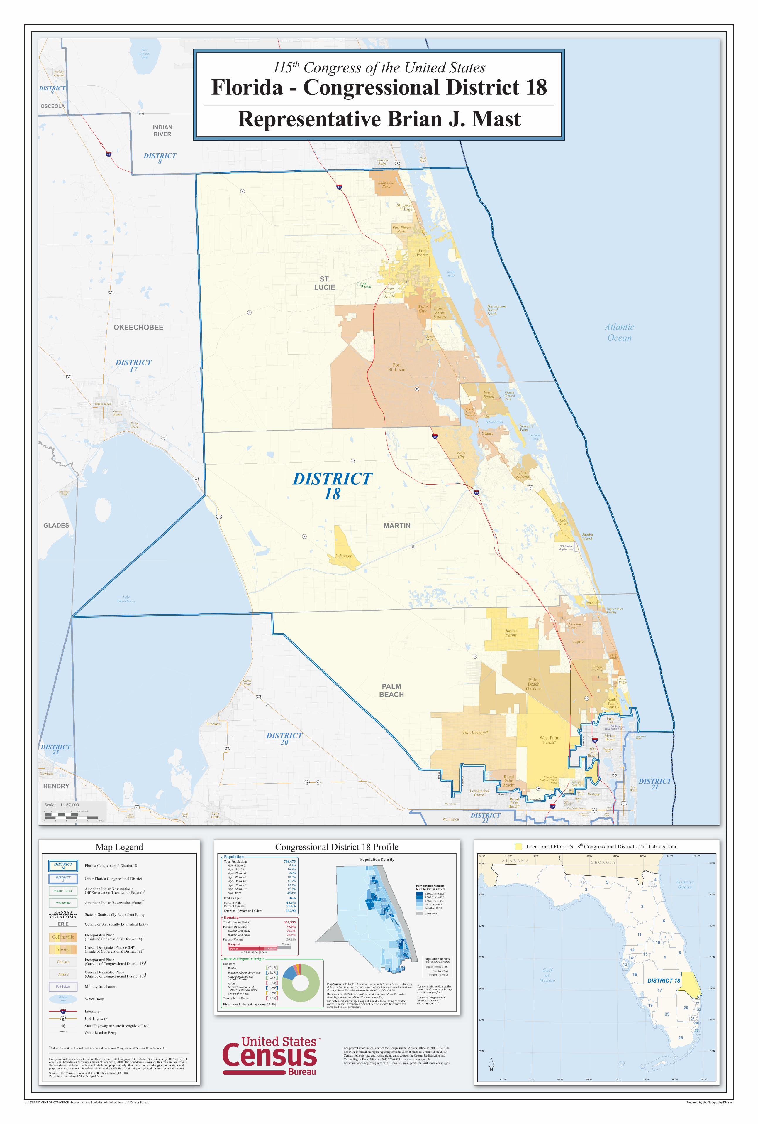
U.S. DEPARTMENT OF COMMERCE Economics and Statistics Administration U.S. Census Bureau Prepared by the Geography Division
For general information, contact the Congressional Affairs Office at (301) 763-6100.For more information regarding congressional district plans as a result of the 2010Census, redistricting, and voting rights data, contact the Census Redistricting andVoting Rights Data Office at (301) 763-4039 or www.census.gov/rdo.For information regarding other U.S. Census Bureau products, visit www.census.gov.
Map Legend
Congressional districts are those in effect for the 115th Congress of the United States (January 2017-2019); allother legal boundaries and names are as of January 1, 2010. The boundaries shown on this map are for CensusBureau statistical data collection and tabulation purposes only; their depiction and designation for statisticalpurposes does not constitute a determination of jurisdictional authority or rights of ownership or entitlement.Source: U.S. Census Bureau’s MAF/TIGER database (TAB10)Projection: State-based Alber’s Equal Area
†Labels for entities located both inside and outside of Congressional District 18 include a ‘*’.
DISTRICT18 Florida Congressional District 18
DISTRICT2 Other Florida Congressional District
Poarch Creek American Indian Reservation /Off-Reservation Trust Land (Federal)†
Pamunkey American Indian Reservation (State)†
Fort Belvoir Military Installation
Walton St Other Road or Ferry
KANSASOKLAHOMA State or Statistically Equivalent Entity
ERIE County or Statistically Equivalent Entity
Collinsville Incorporated Place(Inside of Congressional District 18)†
Chelsea Incorporated Place(Outside of Congressional District 18)†
Turley Census Designated Place (CDP)(Inside of Congressional District 18)†
Justice Census Designated Place(Outside of Congressional District 18)†
Water BodyBristolHbr
44 Interstate
56 U.S. Highway
State Highway or State Recognized Road32
80.1%13.1%
0.4%
2.6%0.0%2.0%1.8%
15.3%
Two or More Races:
Hispanic or Latino (of any race):
White:Black or African American:American Indian and Alaska Native:Asian:Native Hawaiian and Other Paci�ic Islander:Some Other Race:
One Race
Race & Hispanic OriginRace & Hispanic Origin
RenterOwner
VacantOccupied
63.0% 37.0%U.S. Split:
20.1%
79.9%73.1%26.9%
361,935Total Housing Units:
Percent Occupied:
Percent Vacant:
Owner Occupied:Renter Occupied:
Housing
749,4754.9%
16.3%4.8%
10.7%11.5%13.4%14.1%24.5%
48.6%51.4%
46.6
58,290
Age - Under 5:Age - 5 to 19:Age - 20 to 24:Age - 25 to 34:Age - 35 to 44:Age - 45 to 54:Age - 55 to 64:Age - 65+:
Total Population:
Percent Male:Percent Female:
Median Age:
Veterans 18 years and older:
Population
For more Congressional District data, visit census.gov/mycd.
For more information on the American Community Survey, visit census.gov/acs.
Data Source: 2015 American Community Survey 1-Year Estimates Note: Figures may not add to 100% due to rounding.
Map Source: 2011-2015 American Community Survey 5-Year Estimates Note: Only the portions of the census tracts within the congressional district are shown for tracts that extend beyond the boundary of the district.
Estimates and percentages may not sum due to rounding to protect con�identiality. Percentages may not be statistically different when compared to U.S. percentage.
Population Density
91.0
378.0
495.3
United States:
Florida:
District 18:
Persons per square mile
Population Density
Persons per SquareMile by Census Tract
3,500.0 to 8,663.3
2,500.0 to 3,499.9
1,450.0 to 2,499.9
400.0 to 1,449.9
Less than 400.0
water tract
Congressional District 18 Profile
2
3
1
17
6
8
26
4
9
25
5
11
20
10
19
16
7
1215
27
1413
22
23
21
24
G E O R G I AA L A B A M A
Gu lfo f
Me x i co DISTRICT 18
At l an t i cOc ea n
80°W
80°W
81°W
81°W
82°W
82°W
83°W
83°W
84°W
84°W
85°W86°W
86°W
87°W
87°W88°W
31°N 31°N
30°N 30°N
29°N 29°N
28°N 28°N
27°N 27°N
26°N 26°N
25°N 25°N
Location of Florida's 18th Congressional District - 27 Districts Total
95
91
95
95
91
91
441
27
1
98
98
441
441
98
1
98
441
1
700
80
9
710
60
807
704
91
70
91
809
714
76
710
710
Belvedere Rd
Okeechobee Rd
rD dn261
N
tS ht081
dR llihreva
H
FortPierce
LakeOkeechobee
IndianRiver
AtlanticOcean
BlueCypress
Lake
St LucieInlet
LakeWorth
St Lucie River
DISTRICT18
DISTRICT25
DISTRICT8
DISTRICT9
DISTRICT17
DISTRICT20
DISTRICT21
DISTRICT21
OSCEOLA
MARTIN
ST.LUCIE
GLADES
OKEECHOBEE
INDIANRIVER
PALMBEACH
HENDRY
Jupiter InletColony
JupiterIsland
OceanBreezePark
St. LucieVillage
Sewall’sPoint
FortPierce
JunoBeach
Jupiter
NorthPalmBeach
PalmBeach
Gardens
PortSt. Lucie
Stuart
Tequesta
RoyalPalm
Beach*
West PalmBeach*
BelleGlade
Clewiston
Fellsmere
Haver-hill
IndianRiver
Shores
LakePark
LoxahatcheeGroves
MangoniaPark
Pahokee
PalmBeach
RivieraBeach
SouthBay
Wellington
RoyalPalm
Beach*
VeroBeach
WestPalm
Beach*
Palm BeachShores
GlenRidge
CloudLake
Okeechobee
The Acreage*
Fort PierceNorth
HobeSound
IndianRiver
Estates
Indiantown
JensenBeach
JupiterFarms
LakewoodPark
PalmCity
PortSalerno
Rio
RiverPark
WhiteCity
CabanaColony
FortPierceSouth
HutchinsonIslandSouth
JunoRidge
LimestoneCreek
NorthRiver
Shores
PlantationMobile Home
Park SchallCircle
CanalPoint
CypressQuarters
FloridaRidge
Gifford
LakeHarbor
SouthBeach
TaylorCreek
VeroBeachSouth
Westgate
WestVero
Corridor
WinterBeach
YeehawJunction
The Acreage*
BuckheadRidge
StaceyStreet
LakeBelvedereEstates
Gun ClubEstates
Royal Palm Estates
CG StationLake Worth Inlet
CG StationJupiter Inlet
1:167,000Scale:
0 1 2 3 4 5 Miles
0 1 2 3 4 5 Kilometers
115th Congress of the United StatesFlorida - Congressional District 18
Representative Brian J. Mast
Related Documents