Procedia Engineering 64 (2013) 351 – 360 Available online at www.sciencedirect.com 1877-7058 © 2013 The Authors. Published by Elsevier Ltd. Selection and peer-review under responsibility of the organizing and review committee of IConDM 2013 doi:10.1016/j.proeng.2013.09.107 ScienceDirect International Conference on DESIGN AND MANUFACTURING, IConDM 2013 Blind Navigation Assistance for Visually Impaired Based on Local Depth Hypothesis from a Single Image R. Gnana Praveen*, Roy P Paily Dept of Electronics and Electrical Engineering, IIT Guwahati, Guwahati, Assam - 781039, India Abstract Assisting the visually impaired along their navigation path is a challenging task which drew the attention of several researchers. A lot of techniques based on RFID, GPS and computer vision modules are available for blind navigation assistance. In this paper, we proposed a depth estimation technique from a single image based on local depth hypothesis devoid of any user intervention and its application to assist the visually impaired people. The ambient space ahead of the user is captured by a camera and the captured image is resized for computational efficiency. The obstacles in the foreground of the image are segregated using edge detection followed by morphological operations. Then depth is estimated for each obstacle based on local depth hypothesis. The estimated depth map is then compared with the reference depth map of the corresponding depth hypothesis and the deviation of the estimated depth map from the reference depth map is used to retrieve the spatial information about the obstacles ahead of the user. Keywords: Canny Edge Detection; Vanishing Point Estimation; Obstacle Detection; Depth Hypothesis; Blind Navigation Assistance. 1. Introduction Over 285 million people in the world are visually impaired, out of which 39 million are blind and 246 million have low vision. About 90 per cent of the visually impaired people in the world live in developing countries. Visual system is an incredible feature in humans that enables the person to perceive the world around us. It is an imperative and inevitable necessity for all the humans to explore the ambient information in order to perform their daily activities and lead a comfortable life. Without this functionality, mankind has to face a lot of problems in their _________ * Corresponding author. Tel.: +91-7896360530. E-mail address: [email protected] © 2013 The Authors. Published by Elsevier Ltd. Selection and peer-review under responsibility of the organizing and review committee of IConDM 2013

Welcome message from author
This document is posted to help you gain knowledge. Please leave a comment to let me know what you think about it! Share it to your friends and learn new things together.
Transcript
Procedia Engineering 64 ( 2013 ) 351 – 360
Available online at www.sciencedirect.com
1877-7058 © 2013 The Authors. Published by Elsevier Ltd.Selection and peer-review under responsibility of the organizing and review committee of IConDM 2013doi: 10.1016/j.proeng.2013.09.107
ScienceDirect
International Conference on DESIGN AND MANUFACTURING, IConDM 2013
Blind Navigation Assistance for Visually Impaired Based on Local Depth Hypothesis from a Single Image
R. Gnana Praveen*, Roy P Paily Dept of Electronics and Electrical Engineering, IIT Guwahati, Guwahati, Assam - 781039, India
Abstract
Assisting the visually impaired along their navigation path is a challenging task which drew the attention of several researchers. A lot of techniques based on RFID, GPS and computer vision modules are available for blind navigation assistance. In this paper, we proposed a depth estimation technique from a single image based on local depth hypothesis devoid of any user intervention and its application to assist the visually impaired people. The ambient space ahead of the user is captured by a camera and the captured image is resized for computational efficiency. The obstacles in the foreground of the image are segregated using edge detection followed by morphological operations. Then depth is estimated for each obstacle based on local depth hypothesis. The estimated depth map is then compared with the reference depth map of the corresponding depth hypothesis and the deviation of the estimated depth map from the reference depth map is used to retrieve the spatial information about the obstacles ahead of the user. © 2013 The Authors. Published by Elsevier Ltd. Selection and peer-review under responsibility of the organizing and review committee of IConDM 2013.
Keywords: Canny Edge Detection; Vanishing Point Estimation; Obstacle Detection; Depth Hypothesis; Blind Navigation Assistance.
1. Introduction
Over 285 million people in the world are visually impaired, out of which 39 million are blind and 246 million have low vision. About 90 per cent of the visually impaired people in the world live in developing countries. Visual system is an incredible feature in humans that enables the person to perceive the world around us. It is an imperative and inevitable necessity for all the humans to explore the ambient information in order to perform their daily activities and lead a comfortable life. Without this functionality, mankind has to face a lot of problems in their _________ * Corresponding author. Tel.: +91-7896360530. E-mail address: [email protected]
© 2013 The Authors. Published by Elsevier Ltd. Selection and peer-review under responsibility of the organizing and review committee of IConDM 2013
352 R. Gnana Praveen and Roy P. Paily / Procedia Engineering 64 ( 2013 ) 351 – 360
day-to-day life. Hence there is a vital need to address this problem of the loss of human sight. The endeavor of restoring the vision to the visually impaired is the subject of intensive research in both engineering and medical professions. One of the major problems faced by the visually impaired is to navigate through the environment without colliding any obstacles. To overcome this problem, long canes and guide dogs have been used by the blind for several years. However these long canes and guide dogs will give only the information of the nearby obstacles within a short distance, failing to retrieve the information of the environment. With the advancement in technology, several wearable electronic travel aids (ETA) have been introduced to convey the information about the ambient space to the user. Ifukube et al. [1] modeled a travel aid for the visually impaired based on bat echo location system. They employed two ultrasonic sensors (US) in a conventional eye glass framework and the information of the environment is communicated to the user via audible tones. Depending on the direction and size of obstacles, the transmitted ultrasound waves will be reflected back enabling to retrieve the information of the ambient space. Navbelt is developed by Shoval et al. [2] for navigating the visually impaired using mobile robot obstacle avoidance system. It operates in two modes: guidance mode and image mode. The destination of the user is known a priori and with a recurring beep sound, the user is guided along the predestined path. Most of these travel aids deploy ultrasonic sensors (US) for obstacle detection, which is bulky and difficult to implement in real time scenarios. Dakopoulos et al. [3] investigated the performance of some of these widely accepted portable obstacle detection systems based on structural and operational features. They have showed that even though each system offers something special over the others, the best of all is still at prototype stage and the certainty of reliability, robustness and overall performance in real time scenarios is still dubious. Ding et al. [4] proposed a blind navigation assistance system based on RFID, where an RFID reader is incorporated in the cane and RFID tags are laid along the navigation path. The reader reads the information of the navigation path and sends it to the mobile phone by Bluetooth interface. Then the mobile phone translates the information into audio signals and communicated to the user through a centralized call center. Nevertheless, since the RFID tags have to be placed afore, the scheme works only in familiar environments for predefined destinations.
With the proliferation in the digital technology, the prospect of deploying the module of computer vision and image processing in blind navigation assistance are being explored. Fernandes et al. [5] proposed a navigation
modules, but it detects only specific landmarks in the environment using Hough Transform. Spatial information of the obstacles and its distance from the user is one of the important aspects in designing a collision avoidance navigation assistance system for the visually impaired. In an attempt to retrieve the spatial information of the environment, several researchers employed stereo disparity estimation techniques. Balakrishnan et al. [6] proposed an image processing based assistance system, where the obstacles in the environment are detected and the relative distance of the obstacles from the user are obtained based on the stereo disparity. However, it does not give the spatial information of the environment. Moreover, the distance of the different parts within the same obstacle from the user may vary and this information is lacking in their system. Vimal et al. [7] deployed stereo disparity estimation algorithm in order to retrieve the spatial information of the environment by considering the deviation of the estimated disparity of the captured image from that of an ideal system devoid of obstacles. Since the disparity estimated by the correlation between the left and right images is pixel based operations, they demand high computational complexity. Moreover bulky US sensors are used to predetermine the height of the user. This paper focuses on the estimation of depth map from a single image in order to retrieve the spatial information of the environment. A depth estimation technique based on local depth hypothesis is proposed and its application in assisting the visually impaired is examined. Since depth is estimated by performing a global operation on a single image, it is expected to be computationally efficient. The obstacle detection is performed using canny edge detection followed by morphological operations Balakrishnan et al. [6] and depth estimation is carried out using local depth hypothesis providing the spatial information of the entire environment from a single image. The obstacle detection from the captured images is presented in section II. The proposed approach for depth estimation and its applicability for assisting the visually impaired are presented in section III. The proposed system is examined for various images in section IV.
353 R. Gnana Praveen and Roy P. Paily / Procedia Engineering 64 ( 2013 ) 351 – 360
2. Obstacle Detection
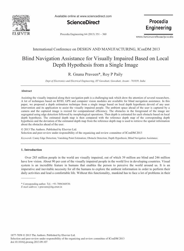
Detecting the obstacles in the ambient space of the environment is the primary step involved in designing a collision free autonomous navigation system. In order to assist the visually impaired along their navigation path, the obstacles ahead of the user have to be detected and segregated from the background. To perform this task, canny edge detection followed by morphological operations is employed to eliminate the back ground noise as well as spurious and insignificant edges. The detailed analysis of the obstacle detection system is explained with the help of a captured image. To reduce the computational complexity, the original image captured by the camera is resized and converted to grayscale. The captured color image and its resized grayscale version are shown in Fig. 1.
2.1. Edge Detection
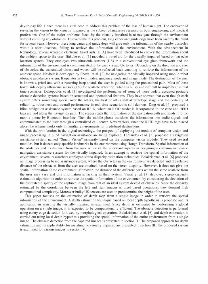
Detecting the edges in an image is a fundamental property of human visual system and it reveals the significant information of the image. Hence it is the first and foremost step to be performed in order to retrieve the significant information from the captured image. Although there are several edge detection techniques available in literature, canny edge detection is widely used and found to be an optimal edge detector. Therefore canny edge detection is performed on the resized gray scale version of the captured image. It is inevitable that all the real time images taken from the camera will contain some amount of noise. Hence it is very important for the removal of this noise, especially the white noise before processing the image for edge detection. Canny Edge Detection performs the removal of this noise by blurring the image using Gaussian filter. Then it performs the edge detection by estimating the magnitude of the gradient at each pixel. The blurred edges obtained from the previous step are converted into sharp edges by preserving all local maxima in the gradient image and deleting everything else. After this step, canny edge detection performs double threshold criteria in order to avoid the noise or color variations due to rough surfaces. It retains the weak edges only if it is connected to the strong edges and therefore it is less likely to be fooled by noise than others, and more likely to detect true weak edges. The edge map obtained by performing canny edge detection on the captured image is shown in Fig. 2a.
2.2. Edge Linking
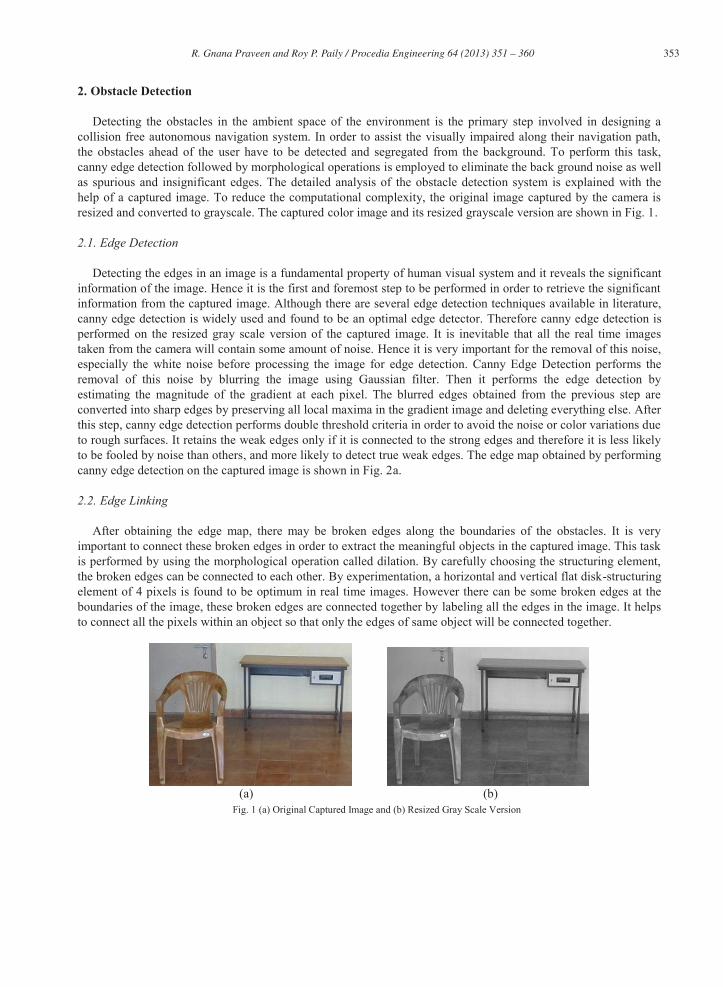
After obtaining the edge map, there may be broken edges along the boundaries of the obstacles. It is very important to connect these broken edges in order to extract the meaningful objects in the captured image. This task is performed by using the morphological operation called dilation. By carefully choosing the structuring element, the broken edges can be connected to each other. By experimentation, a horizontal and vertical flat disk-structuring element of 4 pixels is found to be optimum in real time images. However there can be some broken edges at the boundaries of the image, these broken edges are connected together by labeling all the edges in the image. It helps to connect all the pixels within an object so that only the edges of same object will be connected together.
(a) (b)
Fig. 1 (a) Original Captured Image and (b) Resized Gray Scale Version
354 R. Gnana Praveen and Roy P. Paily / Procedia Engineering 64 ( 2013 ) 351 – 360
(a) (b)
Fig. 2 (a) Edge Map of the captured image and (b) Obstacles extracted from the foreground
2.3. Noise Removal
Apart from the boundaries of the obstacles, still there can be other dilated edges due to some insignificant obstacles in the image. In order to merely extract the salient obstacles, it is necessary to avoid these insignificant dilated edges. To perform this task, the closed boundaries within the image are considered to be obstacles. This can be done by performing a combination of erosion and dilation operations on the image obtained in the previous step. By carefully choosing the same structuring element for both the operations, most of the insignificant edges can be eliminated retaining the edges of the obstacles. Now flood fill operation is performed on the resultant image so that all the regions within the closed boundaries of the obstacles can be filled with white pixels. But still there can be some insignificant obstacles in the image due to the existence of small closed boundaries. To eliminate these insignificant obstacles, the area within the closed boundaries of the obstacles is calculated. Based on a certain threshold, these insignificant obstacles can be removed and hence the obstacles are extracted from the background of the captured image, which can be seen in Fig. 2b.
3. Proposed Approach
Perception of depth from a certain environment is an important feature of human eye that helps in the discernment of the distance of various objects in the environment from the user. Hence depth estimation plays a pivotal role in autonomous navigation systems to know the relationship among the objects in the environment as well as from the user. Stereo Disparity Estimation is the widely used approach to obtain the depth information, which is also used in blind navigation assistance systems to assign the priorities of various objects in the environment Balakrishnan et al. [6]. Human visual system perceives depth from various heuristic monocular and stereo depth cues such as defocus, relative size, texture gradient, haze, structural feature from occlusion, geometry and so on. The performance of stereo disparity techniques is found to be deteriorated for small depth variations of objects that are far away. Depth Estimation from a monocular image is a challenging task and has been active area of research over several decades. Jung et al. [8] proposed a simple depth estimation framework for 2D to 3D media conversion based on relative height depth cue. They employed a line tracing algorithm for detecting strong edges and investigated the prospect of depth estimation from ramp depth hypothesis from bottom to top which works on the principle that closer objects in the real world are projected onto the lower part of the 2D image plane. However, single depth hypothesis from bottom to top will not be sufficient in estimating depth for all the complex obstacles of different orientations in the real world. Hence, Han et al. [9] proposed a similar approach by invoking two basic depth hypotheses where the depth hypothesis for a specific obstacle is determined by its corresponding vanishing point and depth is estimated by a combination of its corresponding hypothesis and bottom to top hypothesis. If there is no vanishing point for an obstacle, then the depth hypothesis of bottom to top will be considered as default. They employed vanishing points as geometric cue and super pixels as texture cue for initial depth estimation and depth refinement respectively. Yang et al. [10] performed depth estimation for a given image by using four basic
355 R. Gnana Praveen and Roy P. Paily / Procedia Engineering 64 ( 2013 ) 351 – 360
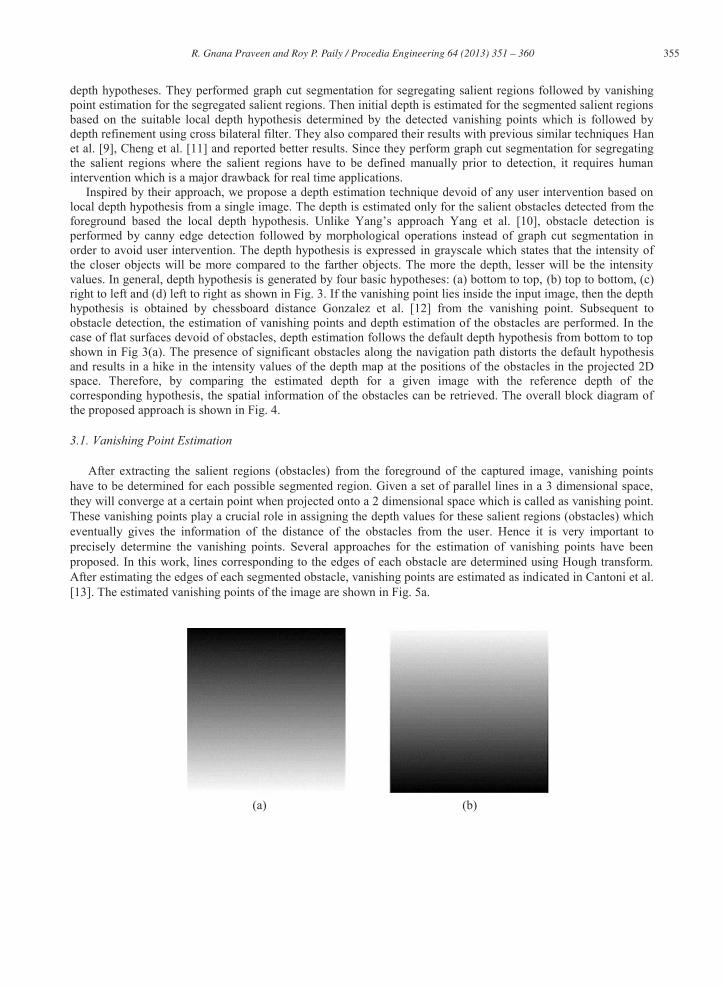
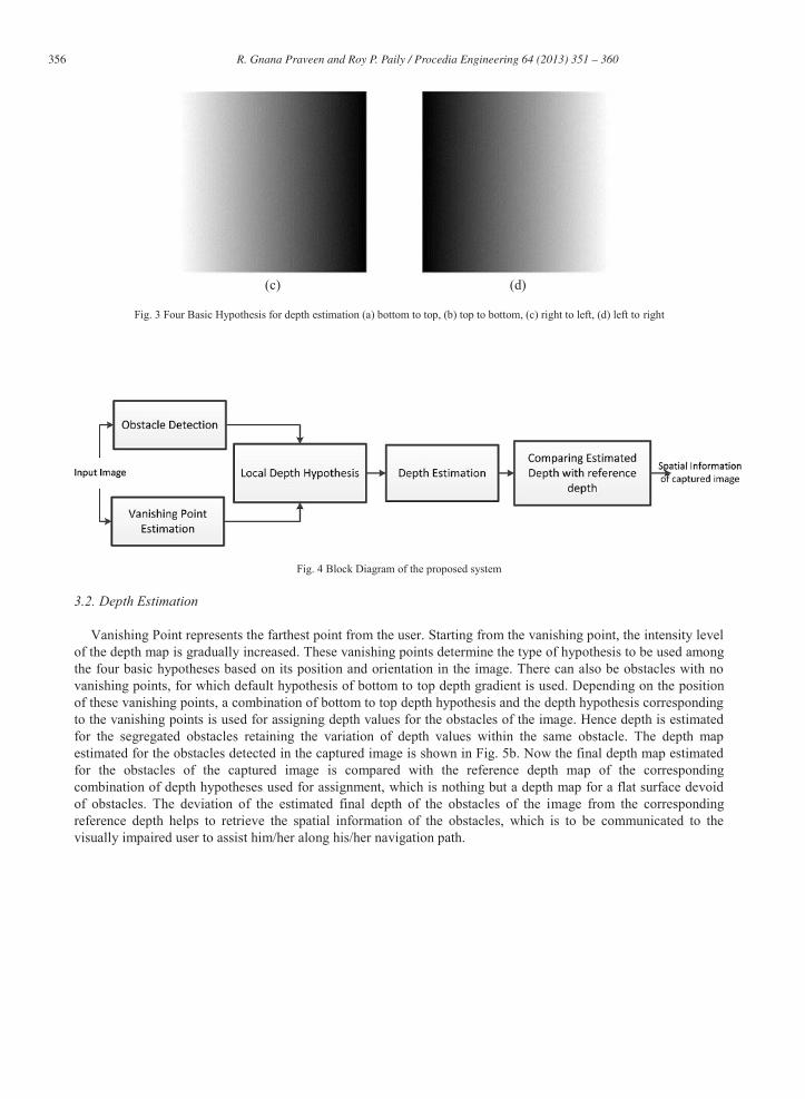
depth hypotheses. They performed graph cut segmentation for segregating salient regions followed by vanishing point estimation for the segregated salient regions. Then initial depth is estimated for the segmented salient regions based on the suitable local depth hypothesis determined by the detected vanishing points which is followed by depth refinement using cross bilateral filter. They also compared their results with previous similar techniques Han et al. [9], Cheng et al. [11] and reported better results. Since they perform graph cut segmentation for segregating the salient regions where the salient regions have to be defined manually prior to detection, it requires human intervention which is a major drawback for real time applications. Inspired by their approach, we propose a depth estimation technique devoid of any user intervention based on local depth hypothesis from a single image. The depth is estimated only for the salient obstacles detected from the foreground based the local d Yang et al. [10], obstacle detection is performed by canny edge detection followed by morphological operations instead of graph cut segmentation in order to avoid user intervention. The depth hypothesis is expressed in grayscale which states that the intensity of the closer objects will be more compared to the farther objects. The more the depth, lesser will be the intensity values. In general, depth hypothesis is generated by four basic hypotheses: (a) bottom to top, (b) top to bottom, (c) right to left and (d) left to right as shown in Fig. 3. If the vanishing point lies inside the input image, then the depth hypothesis is obtained by chessboard distance Gonzalez et al. [12] from the vanishing point. Subsequent to obstacle detection, the estimation of vanishing points and depth estimation of the obstacles are performed. In the case of flat surfaces devoid of obstacles, depth estimation follows the default depth hypothesis from bottom to top shown in Fig 3(a). The presence of significant obstacles along the navigation path distorts the default hypothesis and results in a hike in the intensity values of the depth map at the positions of the obstacles in the projected 2D space. Therefore, by comparing the estimated depth for a given image with the reference depth of the corresponding hypothesis, the spatial information of the obstacles can be retrieved. The overall block diagram of the proposed approach is shown in Fig. 4.
3.1. Vanishing Point Estimation
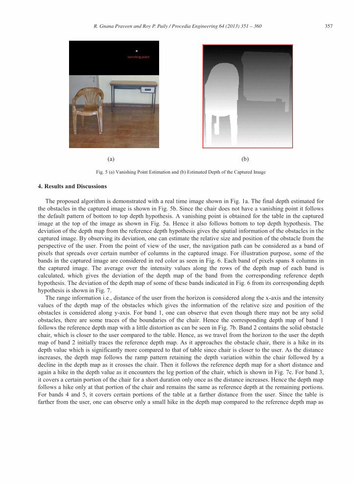
After extracting the salient regions (obstacles) from the foreground of the captured image, vanishing points have to be determined for each possible segmented region. Given a set of parallel lines in a 3 dimensional space, they will converge at a certain point when projected onto a 2 dimensional space which is called as vanishing point. These vanishing points play a crucial role in assigning the depth values for these salient regions (obstacles) which eventually gives the information of the distance of the obstacles from the user. Hence it is very important to precisely determine the vanishing points. Several approaches for the estimation of vanishing points have been proposed. In this work, lines corresponding to the edges of each obstacle are determined using Hough transform. After estimating the edges of each segmented obstacle, vanishing points are estimated as indicated in Cantoni et al. [13]. The estimated vanishing points of the image are shown in Fig. 5a.
(a) (b)
356 R. Gnana Praveen and Roy P. Paily / Procedia Engineering 64 ( 2013 ) 351 – 360
(c) (d)
Fig. 3 Four Basic Hypothesis for depth estimation (a) bottom to top, (b) top to bottom, (c) right to left, (d) left to right
Fig. 4 Block Diagram of the proposed system
3.2. Depth Estimation
Vanishing Point represents the farthest point from the user. Starting from the vanishing point, the intensity level of the depth map is gradually increased. These vanishing points determine the type of hypothesis to be used among the four basic hypotheses based on its position and orientation in the image. There can also be obstacles with no vanishing points, for which default hypothesis of bottom to top depth gradient is used. Depending on the position of these vanishing points, a combination of bottom to top depth hypothesis and the depth hypothesis corresponding to the vanishing points is used for assigning depth values for the obstacles of the image. Hence depth is estimated for the segregated obstacles retaining the variation of depth values within the same obstacle. The depth map estimated for the obstacles detected in the captured image is shown in Fig. 5b. Now the final depth map estimated for the obstacles of the captured image is compared with the reference depth map of the corresponding combination of depth hypotheses used for assignment, which is nothing but a depth map for a flat surface devoid of obstacles. The deviation of the estimated final depth of the obstacles of the image from the corresponding reference depth helps to retrieve the spatial information of the obstacles, which is to be communicated to the visually impaired user to assist him/her along his/her navigation path.
357 R. Gnana Praveen and Roy P. Paily / Procedia Engineering 64 ( 2013 ) 351 – 360
(a) (b)
Fig. 5 (a) Vanishing Point Estimation and (b) Estimated Depth of the Captured Image
4. Results and Discussions
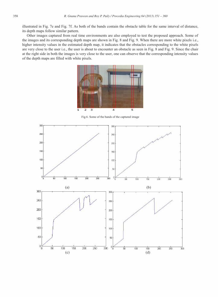
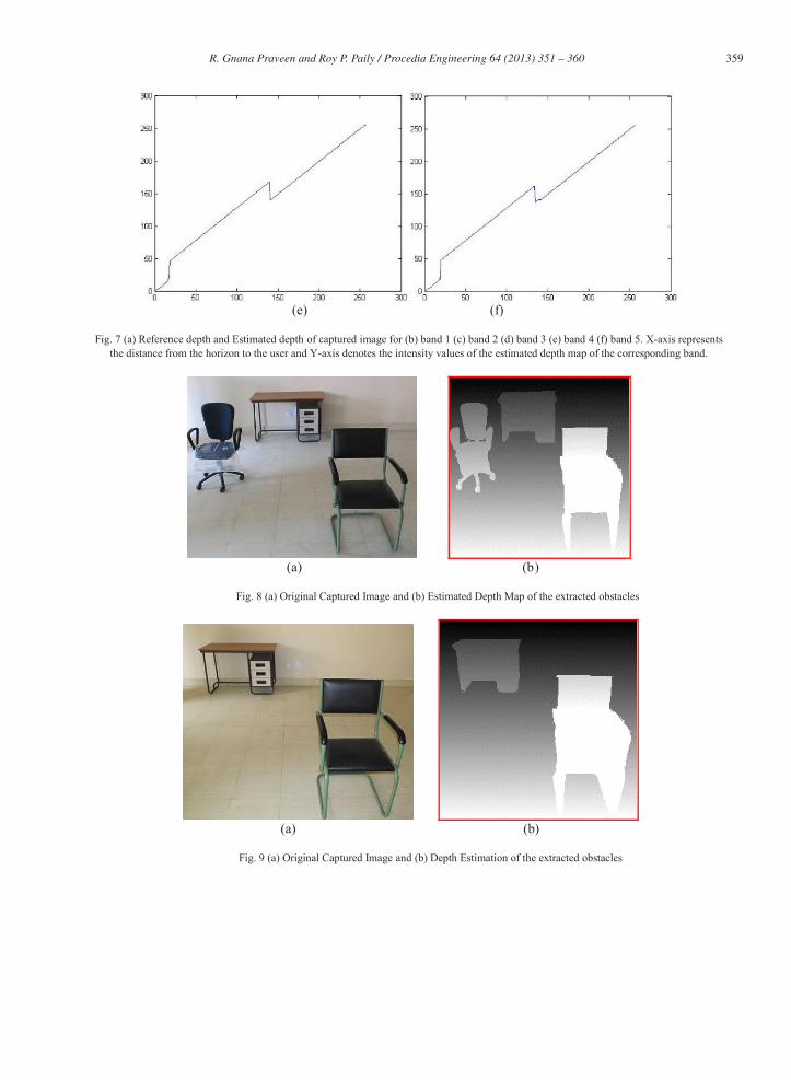
The proposed algorithm is demonstrated with a real time image shown in Fig. 1a. The final depth estimated for the obstacles in the captured image is shown in Fig. 5b. Since the chair does not have a vanishing point it follows the default pattern of bottom to top depth hypothesis. A vanishing point is obtained for the table in the captured image at the top of the image as shown in Fig. 5a. Hence it also follows bottom to top depth hypothesis. The deviation of the depth map from the reference depth hypothesis gives the spatial information of the obstacles in the captured image. By observing its deviation, one can estimate the relative size and position of the obstacle from the perspective of the user. From the point of view of the user, the navigation path can be considered as a band of pixels that spreads over certain number of columns in the captured image. For illustration purpose, some of the bands in the captured image are considered in red color as seen in Fig. 6. Each band of pixels spans 8 columns in the captured image. The average over the intensity values along the rows of the depth map of each band is calculated, which gives the deviation of the depth map of the band from the corresponding reference depth hypothesis. The deviation of the depth map of some of these bands indicated in Fig. 6 from its corresponding depth hypothesis is shown in Fig. 7.
The range information i.e., distance of the user from the horizon is considered along the x-axis and the intensity values of the depth map of the obstacles which gives the information of the relative size and position of the obstacles is considered along y-axis. For band 1, one can observe that even though there may not be any solid obstacles, there are some traces of the boundaries of the chair. Hence the corresponding depth map of band 1 follows the reference depth map with a little distortion as can be seen in Fig. 7b. Band 2 contains the solid obstacle chair, which is closer to the user compared to the table. Hence, as we travel from the horizon to the user the depth map of band 2 initially traces the reference depth map. As it approaches the obstacle chair, there is a hike in its depth value which is significantly more compared to that of table since chair is closer to the user. As the distance increases, the depth map follows the ramp pattern retaining the depth variation within the chair followed by a decline in the depth map as it crosses the chair. Then it follows the reference depth map for a short distance and again a hike in the depth value as it encounters the leg portion of the chair, which is shown in Fig. 7c. For band 3, it covers a certain portion of the chair for a short duration only once as the distance increases. Hence the depth map follows a hike only at that portion of the chair and remains the same as reference depth at the remaining portions. For bands 4 and 5, it covers certain portions of the table at a farther distance from the user. Since the table is farther from the user, one can observe only a small hike in the depth map compared to the reference depth map as
358 R. Gnana Praveen and Roy P. Paily / Procedia Engineering 64 ( 2013 ) 351 – 360
illustrated in Fig. 7e and Fig. 7f. As both of the bands contain the obstacle table for the same interval of distance, its depth maps follow similar pattern.
Other images captured from real time environments are also employed to test the proposed approach. Some of the images and its corresponding depth maps are shown in Fig. 8 and Fig. 9. When there are more white pixels i.e., higher intensity values in the estimated depth map, it indicates that the obstacles corresponding to the white pixels are very close to the user i.e., the user is about to encounter an obstacle as seen in Fig. 8 and Fig. 9. Since the chair at the right side in both the images is very close to the user, one can observe that the corresponding intensity values of the depth maps are filled with white pixels.
Fig.6. Some of the bands of the captured image
(a) (b)
(c) (d)
359 R. Gnana Praveen and Roy P. Paily / Procedia Engineering 64 ( 2013 ) 351 – 360
(e) (f)
Fig. 7 (a) Reference depth and Estimated depth of captured image for (b) band 1 (c) band 2 (d) band 3 (e) band 4 (f) band 5. X-axis represents the distance from the horizon to the user and Y-axis denotes the intensity values of the estimated depth map of the corresponding band.
(a) (b)
Fig. 8 (a) Original Captured Image and (b) Estimated Depth Map of the extracted obstacles
(a) (b)
Fig. 9 (a) Original Captured Image and (b) Depth Estimation of the extracted obstacles
360 R. Gnana Praveen and Roy P. Paily / Procedia Engineering 64 ( 2013 ) 351 – 360
5. Conclusion and Future Work
A depth estimation technique devoid of any user intervention from a single image was proposed and its application for assisting the visually impaired was investigated. The obstacles in the ambient space ahead of the user is segregated from the foreground without any user intervention and depth is estimated for each of these segregated obstacles based on local depth hypothesis determined by the orientation of vanishing point. This approach yielded the spatial information of the relative size and position of the obstacles from the user rather than mere preference of obstacles. Also it does not require any prior information of user or the ambient space such as height of the user for assisting the visually impaired. The proposed approach does not employ any learning process of the environment and thereby independent of the ambient space. Hence it can be used in familiar as well as unfamiliar environments. Moreover, the proposed approach is found to be compatible in real time application as it does not deploy US sensors. Even though the variation of the depth information within the same obstacle can be retrieved, the proposed system may fail to capture the depth discontinuity between the possible adjacent sub segments in the same obstacle touching each other. Hence graph-based segmentation can be invoked to differentiate the sub segments within the same obstacle.
References
[1] Ifukube, T., Sasaki, T., Peng, C., 1991. A blind mobility aid modelled after echolocation of bats, IEEE Transactions on Biomedical Engineering 38, pp. 461 - 465.
[2] Shoval, S., Borenstein, J., Koren, Y., 1998. The Navbelt - a computerized travel aid for the blind based on mobile robotics technology, IEEE Transactions on Biomedical Engineering 45, pp. 1376 1386.
[3] Dakopoulos, D., Bourbakis, N., 2010. Wearable Obstacle Avoidance electronic travel aids for the blind: A Survey, IEEE Transactions on Systems, Man and Cybernetics, Part C: Applications and Reviews 40, pp. 25 - 35.
[4] Ding, Bin., Yuan, Haitao., Jiang, Li., Zang, Xiaoning., 2007. The Research on Blind Navigation System Based on RFID, International Conference on Wireless Communications, Networking and Mobile Computing (WiCom).
[5] Fernandes, H., Costa, P., Filipe, V., Hadjileontiadis, L., Barroso, J.,2010. Stereo Vision in Blind Navigation Assistance, World Automation Congress (WAC).
[6] Balakrishnan, G. N. R. Y. S., Sainarayanan, G., 2006. A Stereo Image Processing System for Visually Impaired, International Journal of Information and Communication Engineering 2, pp. 136 145.
[7] Mohandas, Vimal., Paily, Roy., 2013. Stereo Disparity Estimation Algorithm for Blind Assisting System, CSI Transaction on ICT 1,pp.3- 8. [8] Jung, Y, J., Baik, A., Kim, J., Park, D.,2009. A novel 2d-to-3d conversion technique based on relative height depth cue, pp. 72371U-
72371U8. [9] Han, K., Hong,K., 2011. Geometric and Texture Cue based depth map estimation for 2d to 3d image conversion, IEEE International
Conference on Consumer Electronics (ICCE). [10] Yang, N, E., Lee, J, W., Park, R, H., 2012. Depth Map generation from a Single Image using Local Depth Hypothesis, IEEE International
Conference on Consumer Electronics (ICCE). [11] Cheng, Chao-chung., Li, Chung-Te., Chen, Liang-Gee., 2010. A Novel 2D-to-3D Conversion System Using Edge Information, IEEE
Transactions on Consumer Electronics 56, pp. 1739 1745. [12] Gonzalez, R. C., Woods, R. E., 2010. Digital Image Processing, Third Edition. Upper Saddle River, NJ.
[13] Cantoni, V., Lombardi, L., Porta, M., Sicard, N., 2001. Vanishing Point Detection: Representation Analysis and New Approaches, 11th International Conference on Image Analysis and Processsing.
Related Documents