Blekinge Institute of Technology European Spatial Planning and Regional Development International Master Programme European Spatial Planning and Regional Development 2007/2008 Thesis work European Spatial Planning Conditions for Development of Agriculture in the Municipality of Kline, Republic of Kosovo Supervisor: Professor Jan-Evert Nilsson E-mail: [email protected] ; [email protected] Author: Ferim Gashi E-mail: [email protected] ; [email protected] October 2008 Karlskrona - Sweden

Blekinge Institute of Technology - DiVA portal832849/FULLTEXT01.pdf · Supervisor: Professor Jan-Evert Nilsson E-mail: [email protected]; [email protected] Author: Ferim
Mar 21, 2020
Welcome message from author
This document is posted to help you gain knowledge. Please leave a comment to let me know what you think about it! Share it to your friends and learn new things together.
Transcript

Blekinge Institute of Technology European Spatial Planning and Regional Development
International Master Programme European Spatial Planning and Regional Development 2007/2008
Thesis work European Spatial Planning
Conditions for Development of Agriculture in the
Municipality of Kline, Republic of Kosovo
Supervisor: Professor Jan-Evert Nilsson E-mail: [email protected]; [email protected]
Author: Ferim Gashi
E-mail: [email protected]; [email protected]
October 2008 Karlskrona - Sweden

i
Introduction
In the thesis I decided to write about the Condition for Development of Agriculture in the Municipality
of Kline, Republic of Kosovo.
The reason is that the municipality of Klina in Republic of Kosovo has possibility to develop the
agriculture sector however it has not been developed as it could be due to the lack of financial support
from the Municipality level up to the Government level.
Agriculture is one of the most important branches of economical development in the
Municipality of Klina. The Municipality’s geographical position, climate and earth conditions, as well
as the manpower in the territory of enables cultivation of much agricultural cultivation and the growth
of high efficiency in the area.
Considering all the existing factors and the new factors (to be initiated) of the development
which will be based on long term socio-economic development of the municipality of Klina, most
important is the agriculture.
Making use of and harmonizing the available natural factors, agriculture will secure to the
municipality of Klina sufficient food, produce an important overflow of market, and a general growth
of the overall income and employment of the inhabitants.
Convenient fertile lands, the change of planting structure, adequate appliance of agro
technique and watering will create propitious possibilities for increasing agriculture production,
notably the development of farming.
Agriculture will for a long time be bearer of general socio-economic development in the
Municipality of Klina, all it is needed is to set and realize basic purpose, role and direction of
agriculture development.
This make possible orientation in development and creation of conditions for the
alteration of the structure of the fabrication, utilization of the existing possibilities, and finding new
ways of development, recommendation of the existing systems and building new watering systems,
arranging terrene, increasing land fertility, reorganization of the manufacture and reinforcement of the
private sector and execution of the more dynamic increase of trade products, intense urbanization of
rural places, fair governing, equipping lands with more qualitative roads for agrarian needs.
All this will contribute to more quality and quantity innovation of the existing state. In a direct
connection with this is the increase of plan efficiency and the increase of productivity, the plant
fabrication with organizing conditions for using more water for watering, larger mechanisms for

ii
productivity, the expansion of guanos and fertilizers and the application of contemporary agro
technical measures.
Except the efficiency increase and the assortment of agricultural production, it must be
reckoned that the farming should rapidly be developed through the specialization of private sector-
farms, individual mini farms for cultivation of cattle and poultry, milk and dairy products and egg
production. Buying stations and depot are necessary as well as the stations that sell cattle food, guanos,
agriculture tools and mechanisms, the service for mending these tools, agrarian stations, farming
pharmacy, and veterinary stations.
As my Master's thesis is an international work, I see it as a reasonable way to have given some
notes about the Republic of Kosovo which are introduced in the beginning of the thesis, and in the
end attached are some maps of the Republic of Kosovo where readers can be informed about the
country.
iii
Table of contents
1. The Geographical Position of Republic of Kosovo……………………………………..1
1.1 Climatic Conditions……………………………………………………………………………..3
1.2 Hydrology………………………………………………………………………………...……5
1.3 People……………………………………………………………………………...……….….7
1.4 Infrastructure………………………………………………………………………...……..….10
1.5 Agriculture sector……………………………………………………………………………....11
1.6 Economical Summary………………………………………………………………….…….....14
2. Geographic position of the municipality and centre of Klina………………………...17
2.1 Education……………………………………………………………………...…………..…20
2.2 Economic Development………………………………………………………………………....21
2.3 Natural Resource Exploitation…………………………………………………………………21
3. Non-agricultural rural development options - Tourism and recreational sites in the Municipality of Klina………………………………………………………..……...23
3.1 Mirusha Gorge………………………………………………………...……….……………..23
3.2 River Peja and Drini Bardhe......................................................................................................................24
3.3 Mining………………………………………………………………….…………….……...24
3.4 Lignite mining……………………………………………………………………...…..……...24
3.5 Bauxite Mining………………………………………………………………...……….…..…25
3.6 Sands and Gravel extraction………………………………………………..…………….….….26
3. Natural elements for agricultural development in the municipality of Klina...….…..27
4.1 Graphic relief as a condition of agricultural development…………………………………………......29
4.2 Climate and its role in agricultural development............................................................................................32
4.2.1 Relative air humidity..........................................................................................................34
4.2.2 Cloudiness..........................................................................................................................35
4.2.3. Rainfalls...........................................................................................................................36
4.2.4. Hoarfrost..........................................................................................................................38
4.2.5 Winds...............................................................................................................................39
4.2.6 Radiation……………………………………………………………………...40
4.3 The role of subterranean and above-ground waters in agricultural development………………………......41
4.3.1 Hydrogeology…………………………………………………………….……..47
4.3.2 Subterranean Waters……………………….…………………..…….………….47
4.4 The role of land in developing agriculture branches..................................................................................…...51
4.5 Flora and fauna and its importance in developing specific branches………………………………...…...55

iv
5 . Social factors in developing agriculture……………………………….…………57
5.1 Land reserves and its role on development of agriculture……………………………………...……....57
6. Agriculture branches in the territory of municipality of Klina………………….61
6.1 Land cultivation………………………………………………...……………………….….…61
6.2 Horticulture……………………………………………………………...………….………...61
6.3 Fruit growing……………………………………………………………………...…….…….62
6.4 Stock farming..............................................................................................................................................62
6.5 The forestry sector …………………………………………………..………….……………....66
6.5.1 Forest cover and land ownership ……………………………………….………………….67
6.5.2 Forest resource assessment ........................................................................................................…....67
7. Forestry Development and Action Plan…………………………………….……70
7.1 Forest on Private Land ………………………………………………….………………….….70
7.2 Forest on state owned land (KFA)……………………………………………………………….71
7.3 Forest on SOE land………………………………………………………………. …………..72
7.4 Constraints to forest sector development…………………………………………………………....74
7.5 Potential for community involvement in forest sector development...……….…………………………....74
7.6 Forestry Project Proposals………………………………………………………...……………..75
7.7 Forestry Action Plan……………………………………………………………………….…..75
8. Agricultural Action Plan……………………………………………….…..….…..76
8.1 On Farm Productivity…………………………………………………….……………….……76
8.2 On Marketing of Agricultural Produce…………………………………………….…………..….78
8.3 On Investment Capital………………………………………………………………………....79
8.4 On off-farm opportunities…………………………………………………………………….…79
8.5 On Farmers Organizations……………………………………………………………….......…80
8.6 On Irrigation……………………………………………………………….…………………80
9. Industry role in development of agriculture……………………………………..81
10. Institutional framework…………………………………….………………...…..82
11. List of planning rules and objectives………………………………...…………..83
Reference/ Literatures........................................................................... .............86

v
Appendices
1. Map of Klina Population by River Catchment………………………………………………….......…...98
2. Map of Klina Topography……………………………………………………….…………..….....…99
3. Map of Klina Land Management Plan……………………....…………………….….…….….…….100
4. Map of Klina: Rural Land Management – Spatial Plan………….…………………….…….….….…101
5. Map of Klina: Land at Risk from Erosion…………………………………………….………….…102
6. Map of Klina: Rural Land Management – Current Irrigated Area……………………………....……...103
7. Map of Klina: Catchment Hydrology and Irrigation……………………………………………….…..104
8. Map of Klina: Land structure in the Municipality of Klina……………………………………..……....105
9. Map of Klina: Arable land according to ownership in the Municipality of Klina………………….…......…106
10. Map of Klina: Gardens according to ownership in the Municipality of Klina………………………..….….107
11. Map of Klina: Grove according to ownership in the Municipality of Klina…………………………..….…108
12. Map of Klina: Vineyards according to ownership in the Municipality of Klina…………………….…..…..109
13. Map of Klina: Stock raising structure in the Municipality of Klina……………………………..….……110
14. Map of Klina: Meadows according to ownership in the Municipality of Klina…………………..…….…...111
15. Map of Klina: Paddocks according to ownership in the Municipality of Klina………………….….…...….112
16. Map of Klina: Forestry according to ownership in the Municipality of Klina………….…….…….………113

vi
List of maps, tables, diagrams, photos and illustrations
1. 1-Map. Location of Republic of Kosovo on the European continent…..……………………………...…………..1
2. Photo: 1 Republic of Kosovo landscape………...…………………………………………………………….2
3. Photo: 2 A valley in the mountain………………....…………………………………....…………………..3
4. 2-Map Schematic Overview of Climatic Zones of Kosovo……………………………………………………....4
5. 3-Map Hydrology in Republic of Kosovo……………………………………………………………………6
6. 4-Map Ethnic composition of Kosovo in 2005 according to the OSCE…………………………………………8
7. Chart 1. Population data…………………………………………………………………………………8
8. Chart 2: Population age during the years, percentage in total population Year 2000 2001 2002 2004…………….8
9. Figure 1: Population structure regarding age groups for Kosovo and EU 27...................................................................9
10. 5-Map Infrastructure of Republic of Kosovo……………………………………………………………. …10
11. Photo: 3 Agriculture sector in Kosovo…………………………………………………………………...…11
12. Figure 2: Land Distribution in Kosovo……………………………………………………………………11
13. Figure 3: Distribution of Agricultural Land……………………………………………………………….10
14. 6- Map Location of municipality of Kline on the Republic of Kosovo…………………………………………..16
15. 7-Map of Klina Local Administrations…………………………………………………………………...17
16. Chart 3: The population of the Municipality of Kline according to the registration years……………………….…18
17. 9-Map of Klina population …………………………………………………………………………..….20
18. Photo 4: Mirusha canyon………………………………………………………………………………22
19. Photo 5: Exhausted Bauxite Mine at Grebnik Mountain near Sferka…………………..……………….…..25
20. Chart 4: Agricultural land use statistics ………………………………………………………………….27
21. Chart 5: The expansion of the area according to the elevation in the Municipality of Kline ………………………28
22. Chart 6: The expansion of the area and the population in the Municipality of Kline in 1948-1981 according to the
elevation......................................................................................................................................................................29
23. 9-Map Municipality of Kline Elevations…………………………………………….…………………….30
24. Chart 7: The average month and year temperature 2004……………………………….……………………32
25. Figure 4: The temperature movement during the months of the year in Kline, 2004…………………….………..32
26. Chart 8: Yearly relative humidity in the Municipality of Peja 2007..........................................................................33
27. Chart 9: Annual cloudiness in the Municipality of Kline, 1984 (the latest data on cloudiness)....................................34
28. Chart 10: Average monthly rainfall view of for 2002-2007 in mm………………………………………….36
29. Figure 5: Average month expansion of rainfalls in mm during 2002-2007...............................................................36
30. Chart 11: The appearance of hoarfrost in the first and last days during the period 1956 – 1970 .............................37
31. Chart 12: The movement of winds in the Municipality of Peja, during 2002-2007.....................................................38
32. Figure 6: The movement of winds according to the months of the year 2007................................................................39
33. Figure 7: Insulation in Peja the number of hours, 1980 according to the months.........................................................40

vii
34. Chart 13: The concentration of metals, minerals and the amount of chemicals in rivers: Drini i Bardhe River,
Peja River and Mirusha River...................................................................................................................................42
35. Chart 14: Dams through the rivers of the Municipality of Kline……………………………………….....…...44
36. Chart 15: Areas of the main river catchments within Kline and the percentage of total municipal area..........................46
37. 10-Map of Klina Hydrology and River Catchments……………………………………………….. ……....48
38. 11-Map of Klina Hydro geological……………………………… …………………………..….……..…49
39. Chart 16: The lands of this territory are very heterogeneous and consist of many types and sub- types…..…….….…50
40. Chart 17: Fertility scale class………………………………………………………….…………….…..51
41. 10-Map of Klina 8 Class Soil Suitability………………………………………………………….….…...53
42. Figure 8: The structure of utilized lands in the territory of Klina and Republic of Kosovo.............................................56
43. Chart 18: Land Areas in the Municipality of Klina………………………………………………………..56
44. Chart 19: Land Areas in the Municipality of Klina, 2008……………………………………….....……...57
45. Figure 9: Inseminated areas in the private sector regarding 2008……………………………………….…….58
46. Chart 20: Sowing structure in hectares (2007/08).....................................................................................................60
47. Chart 21: Stock reserve in the Municipality of Klina in 2001....................................................................................62
48. Chart 22. Land use types in Kline (2001): land area (ha and percent) according to ownership and as a percentage of
total………………………………………………………………...………………………………...67
49. Chart 23: Ownership of forested………………………………………………………………………….69
50. Chart 24: Forestry components of RLMP on Private Land…………………………………………………69
51. Chart 25: Forestry components of the RLMP on KFA Land……………………………………………….70
52. Chart 26: Forestry components of the RLMP on KFA Land……………………………………………….70
53. Chart 27: .Areas Planned as Sustainably Managed Forest SOE…………………………………………….71
54. Chart 28: Planned enrichment planting of Forest on SOE Land ……………………………………………72
viii
Nomenclature list ALUP Agricultural Land Utilisation Project (of EAR)
ASPAUK Agricultural Statistics and Policy Advisory Unit Kosovo
CEFTA Central Europe Free Trade Area
EAR European Agency for Reconstruction and Development
FYR Former Yugoslav Republic
ICMM Independent Commission on Minerals and Mines
KCA Kosovo Cadastral Agency
KFA Kosovo Forest Agency
KTA Kosovo Trust Agency
MAFRD Ministry of Agriculture and Rural Development
MEM Ministry of Mines
MSP Ministry of Spatial Planning
RLMP Rural Land Management Plan
PKA Privatization Kosovo Agency
SMEs Small and medium-sized enterprises
SOEs Socially Owned Enterprises
OSCE Organization for Security and Cooperation in Europe
UNMIK United Nation Mission in Kosovo

ix
Acknowledgments
First of all, I would like to express my sincere apperception to my family, especially my wife Shehide
for supporting and encouraging me to go to Sweden to begin with the Master studies. I want to thank
my father and my mother as well as and my brothers, sisters, and my friends for providing me data
during my research. I also want to acknowledge my supervisor Professor Jan-Evert Nilsson who has
given me a lot of support and valuable comments on my thesis.
I also want to thanks Professor Lars Ememelin, for him valuable feedback and comments during my
thesis, Vicky Johnson Gatazouras, responsible for the course on Academic Writing in English, has
also provided help with my written English skills and writing techniques, Ann-Katrin Strand
responsible for the course on Swedish course.
I also want to acknowledge the help received from Eric Markus. He has offered much needed
assistance during my year as a student of European Spatial Planning at BTH – Blekinge Institute of
Technology.
Further, I want to thank the advocacies and financial supporters which enabled this achievement:
Swedish Institute. I would not have been able to experience the wonderful opportunity of studying at
Blekinge Institute of Technology and without the aid of Swedish Institute.
Conditions for Development of Agriculture in the Municipality of Kline, Republic of Kosovo
Supervisor: Jan-Evert Nilsson Author: Ferim Gashi 1
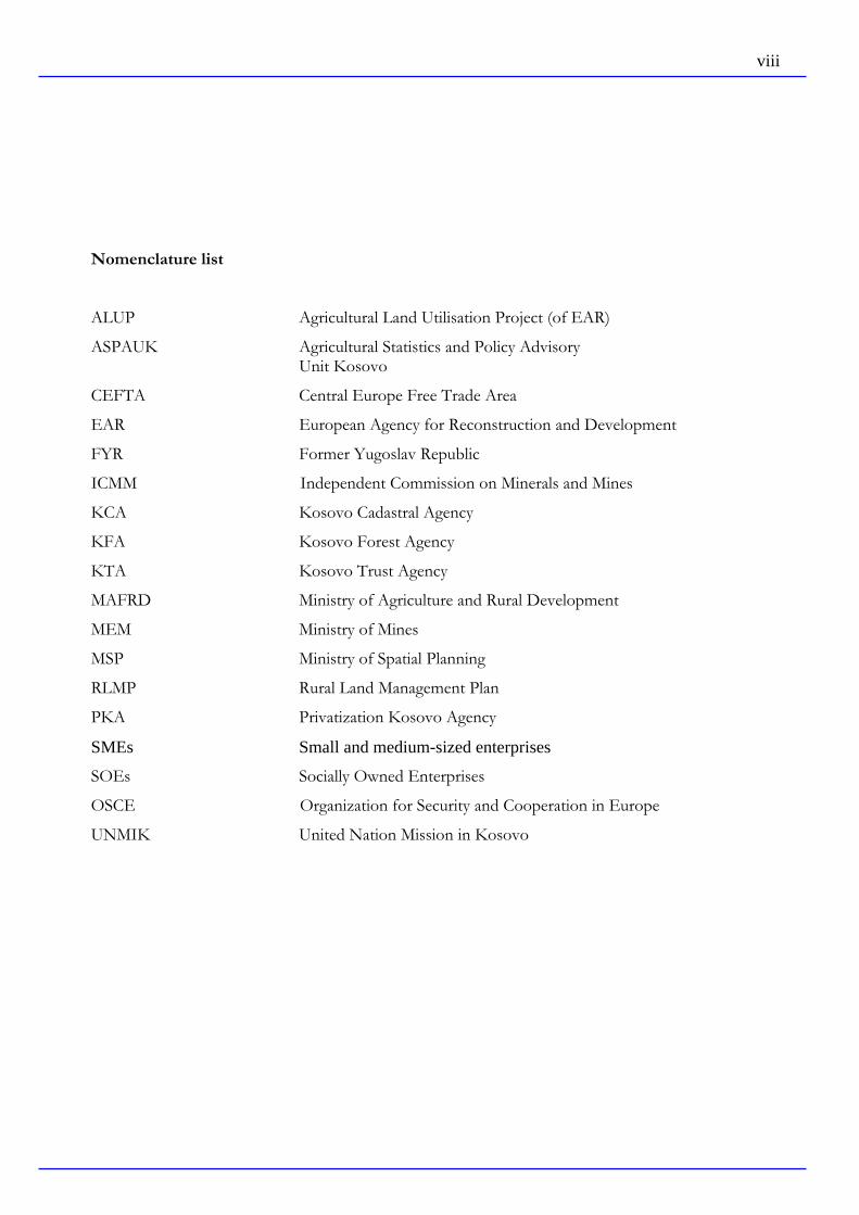
1. The Geographical Position of Republic of Kosovo
Republic of Kosovo is situated in the Southest of the Europe. In the North, it is
bordered by Serbia, in the East and Southeast by Macedonia, in the Southwest by Albania
and in the West by Montenegro.
1- Map. Location of Republic of Kosovo on the European continent
Republic of Kosovo covers a surface area of approx. 10,900 km² and is characterized
by an average altitude of 800 m above sea level, but showing vertical changes of relief and
morphology. These morphological changes are a consequence of the geological setting. The
lowest point of Republic of Kosovo is located at an elevation of 297 m (Drini i Bardhe, at
the border to Albania). The country rises up to the highest point in the South of Republic of
Kosovo – Djeravice at 2,565 m.
From the geographical point of view, Republic of Kosovo can be subdivided into
two large regional flat units, after Çavolli: The north-eastern part is referred to as "Kosovo
Plain ", the south-western part as "Dukagjini Plain". They are characterized by special
climatic-geographical conditions. For instance, several subunits like Drenica, Novoberdes
and Gollakut, Fusha e Kosoves, Fusha e Morave, Podujeve et al. are distinguished.
The border between Dukagjini Plain and Kosovo Plain forms the surface water
divide between the Adriatic Sea on the one side and the Black Sea and Aegean Sea on the
other side.
Republic of Kosovo is surrounded by several high mountain ranges. The northern
part is occupied by the Kopaonik mountains (above 2,000 m), which are characterized by

Conditions for Development of Agriculture in the Municipality of Kline, Republic of Kosovo
Supervisor: Jan-Evert Nilsson Author: Ferim Gashi 2
abrasive activity, both fluvial and glacial. In the southern and south-western part of Republic
of Kosovo, at the border to Macedonia, the Mali i Sharrit mountains are located (above
2,500 m). The western part of Republic of Kosovo (border to Albania) includes parts of the
Albanian Alps mountains and the Mali i Moknes mountains (border to Montenegro). These
areas are characterized by rocky material, high mountains and deep gorges.
Photo: 1 Republic of Kosovo landscape Photo: 2 A valley in the mountain
In the central part of Republic of Kosovo, western and north-western of Pristine, the
mountain ranges Bjeshket e Çiçavice and Golesh, Carraleve and Milanovc are located, which
are characterized by karstic forms, both fluvial and abrasive, rising to elevations of about
1,000 m.
The part of Republic of Kosovo, which is characterized by far flat areas, covers a
surface of approx. 36 % of the country territory. These basins are characterized by elevations
between 400 and 700 m above sea level.

Conditions for Development of Agriculture in the Municipality of Kline, Republic of Kosovo
Supervisor: Jan-Evert Nilsson Author: Ferim Gashi 3
1.1 Climatic Conditions
The climate of Republic of Kosovo is predominantly continental, resulting in warm
summers and cold winters with Mediterranean and Alpine influences (average temperature
within the country range from +30 °C (summer) to –10 °C (winter)). However, due to
unequal elevations in certain parts of the country, there are differences in temperature and
rainfall distribution. December and January are regarded as the coldest months, July and
August as the warmest months of the year. The maximum rainfall rate is reached between
October and December. Between November and March, snowfall can be expected in
Republic of Kosovo, even in the flat parts of the country. The highest snowfall rates can be
expected in the mountain regions of Republic of Kosovo.
The valley between Mitrovice and Kaçanik belongs to the dryer areas of the country.
In contrast, the plain of Dukagjini between Peje and Prizren is described as a very fertile area
with more precipitation between November and March.
Based on the climate conditions, Republic of Kosovo can be separated into three
climatic areas:
Climatic Area of Republic of Kosovo (Kosovo Plain ),
Climatic Area of Dukagjini (Dukagjini Plain) and
Climatic Area of mountains and forest parts.
The climatic area of Republic of Kosovo (Kosovo Plain), this includes the Ibar-
Valley, is influenced by continental air masses. For this reason, in this part of the country,
the winters are colder with medium temperatures above –10 °C, but sometimes down to –26
°C. The summers are very hot with average temperatures of 20 °C, sometimes up to 37 °C.
This area is characterized by a dry climate and a total annual precipitation of 600 mm per
year, approximately.
The climatic area of Dukagjini (Dukagjini Plain), which includes the watershed of
the Drini i Bardh river, is influenced very much by the hot air masses, which cross the
Adriatic Sea. Medium temperatures during winter range from 0.5 °C to sometimes –22.8 °C.
The average annual precipitation of this climatic area is about 700 mm per year. The winter
is characterized by heavy snowfalls.

Conditions for Development of Agriculture in the Municipality of Kline, Republic of Kosovo
Supervisor: Jan-Evert Nilsson Author: Ferim Gashi 4
The climatic area of the mountains and forest parts is characterized by a typical
forest clime, that is associated with heavy rainfalls (900 to 1,300 mm per year), and summers
that are very short and cold, and winters that are cold and with a lot of snow. Finally, it can
be stated that the Republic of Kosovo territory is characterized by a sunny climate with
variable temperature and humidity conditions.
Score: ICMM

Conditions for Development of Agriculture in the Municipality of Kline, Republic of Kosovo
Supervisor: Jan-Evert Nilsson Author: Ferim Gashi 5
1.2 Hydrology
There are many rivers in Republic of Kosovo, which flow toward the Adriatic Sea,
the Black Sea and the Aegean Sea. The main rivers in Republic of Kosovo are: Drini i
Bardhe (in the southern part of Republic of Kosovo – flows into the Adriatic Sea), Ibari
river (in the north-western part, flows into the Morava and Danube and further into the
Black Sea) and Lepence (in the south-eastern part, flows into the Vardar-River toward the
Aegean Sea). More interesting, the Black Sea is drained by water from a surface water
catchments area of 5,500 km², or 51 % of the Republic of Kosovo territory, the Adriatic Sea
is drained by an area of 4,500 km², or 43 %, and the Aegean Sea is drained by an area of only
900 km², or 6 %.
The watersheds of the three main drainages ( River Drini i Bardhe, Ibarit river and
Lepenc are touching each other approximately 16.5 km west of Ferizaj, in the cadastral zone
of Budakove (Municipality Suhareke). At this contact point of the three watersheds, the
mountain Drmanska is located, reaching an elevation of 1,359 m above sea level. From here,
the surface water flows towards the Adriatic Sea, the Black Sea or the Aegean Sea. Other
important rivers in Republic of Kosovo are: Sitnice, Morava e Bisneces, Bistrica e Pejes and
Bistrica e Deçanit. Republic of Kosovo also does have a large number of karst springs,
thermal and mineral water springs, glacial valleys and lakes and artificially made lakes.

Conditions for Development of Agriculture in the Municipality of Kline, Republic of Kosovo
Supervisor: Jan-Evert Nilsson Author: Ferim Gashi 6
3-Map Hydrology in Republic of Kosovo

Conditions for Development of Agriculture in the Municipality of Kline, Republic of Kosovo
Supervisor: Jan-Evert Nilsson Author: Ferim Gashi 7
1.3 People
About 1.9 million people are living in Republic of Kosovo (Statistical Office of
Republic of Kosovo). The predominant part of the population mainly lives in the areas of
the fertile lowlands. However, there are numerous settlements up in the difficult accessible
parts of the country, in the mountain ranges. Approximately 65 % of the population lives in
rural areas. Over 56 % of the population in the 27 Member States of the European Union
(EU) lives in rural areas.
More than 50 % of the people are less than 30 years old. Ethnic Albanians in
Kosovo have the largest population growth in Europe. The people’s growth rate in Kosovo
is 1.3%. Over an 82-year period (1921-2003) the population grew 4.6 times. If growth
continues at such a pace, based on some estimation, the population will be 4.5 million by
2050.
The majority of the populations are Albanians (approx. 92%). Beside them, there are
several minorities like the Serbs, Turks, Montenegrins, Bosnians and Ashkali people. The
beneficial geographical position of Republic of Kosovo is reflected in its multicultural
function.

Conditions for Development of Agriculture in the Municipality of Kline, Republic of Kosovo
Supervisor: Jan-Evert Nilsson Author: Ferim Gashi 8
4-Map Ethnic composition of Kosovo in 2005 according to the OSCE
Score: Wikipedia; http://en.wikipedia.org/wiki/Image:Kosovo_ethnic_2005.pngUU
Chart 1. Population data
Years Total population in millions Density (inhabitants in km²)
1961 1.0 88.4
1971 1.2 114
1981 1.6 145.3
1991 1.9 179.3
2001 1.8 169
2003 1.9 175
2004 1.9 175
2005 2.o 183 Source: Data from Former Republic of Yugoslavia (19611981), registration data 1991 (Federal Board for Statistics of FYR estimations) Kosovo data in 2004 Chart 2: Population age during the years, percentage in total population Year 2000 2001 2002 2004 Year 2000 2001 2002 20040-14 31.5 32.3 32.8 3315-64 63 61.2 61 61Over 64 5.5 6.5 6.2 6Total 100 100 100 100
Source: Various researches of ménage (HFS, HBS)

Conditions for Development of Agriculture in the Municipality of Kline, Republic of Kosovo
Supervisor: Jan-Evert Nilsson Author: Ferim Gashi 9
Figure 1: Population structure regarding age groups for Kosovo and EU 27
33
61
6
16.3
67.3
16.4
0
10
20
30
40
50
60
70
80
0-14 15-64 Over 64
Kosovo 2004
EU 2007
Source: For Kosovo, The Ministry of Agriculture, Forestry and Rural Development, Department of evelopment Policies in the mentioned ministry, statistical data on agriculture, Prishtine 2007, pp 2. For the EU 27, European Union, Regional Policy; Growing Regions, growing Europe: Fourth report on economic and social cohesion, May 2007, pp: 178.
On the chart we can clearly see that The Republic of Kosovo has a younger
population structure than 27 states of the EU.

Conditions for Development of Agriculture in the Municipality of Kline, Republic of Kosovo
Supervisor: Jan-Evert Nilsson Author: Ferim Gashi 10
1.4 Infrastructure
The country’s infrastructure is well developed. A fully developed road network does
exist and, in general, the roads are in good conditions. There are several main roads
connecting the large towns of Republic of Kosovo and its territory with the neighboring
countries. There are railway tracks to Macedonia and Serbia, but the railway system does not
operate regularly at the moment. Regular international air links are provided from across
Europe to Pristine, the capital of Republic of Kosovo.
5-Map Infrastructure of Republic of Kosovo
Conditions for Development of Agriculture in the Municipality of Kline, Republic of Kosovo
Supervisor: Jan-Evert Nilsson Author: Ferim Gashi 11
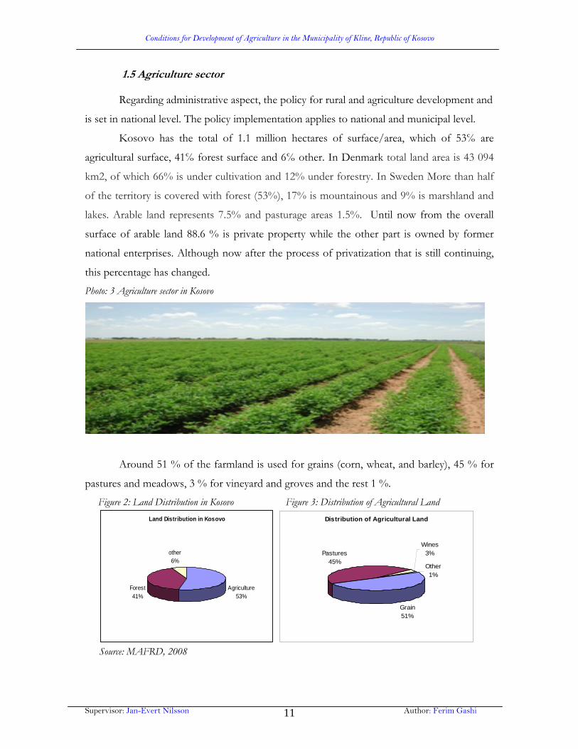
1.5 Agriculture sector Regarding administrative aspect, the policy for rural and agriculture development and
is set in national level. The policy implementation applies to national and municipal level.
Kosovo has the total of 1.1 million hectares of surface/area, which of 53℅ are
agricultural surface, 41℅ forest surface and 6℅ other. In Denmark total land area is 43 094
km2, of which 66% is under cultivation and 12% under forestry. In Sweden More than half
of the territory is covered with forest (53%), 17% is mountainous and 9% is marshland and
lakes. Arable land represents 7.5% and pasturage areas 1.5%. Until now from the overall
surface of arable land 88.6 % is private property while the other part is owned by former
national enterprises. Although now after the process of privatization that is still continuing,
this percentage has changed.
Photo: 3 Agriculture sector in Kosovo
Around 51 % of the farmland is used for grains (corn, wheat, and barley), 45 % for
pastures and meadows, 3 % for vineyard and groves and the rest 1 %.
Figure 2: Land Distribution in Kosovo Figure 3: Distribution of Agricultural Land
Land Distribution in Kosovo
Agriculture53%
Forest41%
other6%
Distribution of Agricultural Land
Grain51%
Pastures45%
Wines3%
Other1%
Source: MAFRD, 2008
Conditions for Development of Agriculture in the Municipality of Kline, Republic of Kosovo
Supervisor: Jan-Evert Nilsson Author: Ferim Gashi 12
The arable land is considered of good quality and the temperate climate make
agriculture a possibly strong economically sector that should at some point be able to assure
adequate food supply for the population and even enable the export of some food stuff.
Agriculture contributes to 30 % of the GDP of Kosovo while its supports 60% of
the population. Along with the forestry sector it contributes 35 % of GDP. Four major
challenges are currently being faced by the agricultural sector in Kosovo:
· Loss of farm land: each year some 1000 ha are being de facto transformed into
built area (some estimation, puts this number much higher).
· Parcel fragmentation; the amount of land available by farming Household is low
(0.5 –2 ha on average). Source: Statistics of Agriculture in Kosovo 2007
· Industrial pollution; agricultural land are under a constant threat from polluters
large and small -mainly through soil and water pollution.
· Landfills: a number of controlled and uncontrolled land fills in Kosovo are
situated in around near farming areas.
Republic of Kosovo can be divided in three agricultural regions regarding relief
characteristics, climates, hydrological, pedological and economics: agricultural region of
Kosovo, agricultural region of Dukagjini, and hilly-mountainous regions.
Agricultural region of Kosovo- includes Kosovo Plain, Drenica (Gllogoc), Llap
(Podujeva), and Anamorava (Gjilan). This agricultural region is disposable with plane area
and low shores, fertile lands, low watering possibilities, continental climate suitable for corn,
sunflowers, tobacco, vegetables near the rivers, and growing of some continental fruit like
pears, cherries, apricots etc. Main culture of this region is wheat; however there are other
white grains and corn. From the industrial cultures, sunflower is one of them that is planted
most in the plains of Ferizaj, Lipjan, Prishtina and Gllogoc, while tobacco is planted most in
the suburb of Gjilani, Vitia, Kamenica. When we talk about the vegetables, they are mostly
planted in the valley of Llapi and Sitnica (suburb of Podujeva and Vushtrri) where cabbage,
potatoes are grown. Orchard is less developed in this region. Fruit take small areas in the
yards and plantations in Ferizaj area. Pears are mostly grown, and then we have cherries,
quinces, and apricots. Grape is only cultivated in the private yards.

Conditions for Development of Agriculture in the Municipality of Kline, Republic of Kosovo
Supervisor: Jan-Evert Nilsson Author: Ferim Gashi 13
Farming is not developed very much in this region due to the lacking areas of
meadow and paddocks. Individual economies keep a certain number of cows that pasture in
the meadows. In the public sector exists cow farms for milk in Miradi e eperme, for fatting
up in Fushe Kosovo, while poultry farm is not far from Gllogoc (for eggs and meat) which
has been devastated during the war in Kosovo in 1998/99.
Agricultural region of Dukagjini- introduces a morphological integral consisting of
some valleys: Barani valley, Leshani valley, Drini valley, Ereniku valley, Kline valley,
Mirusha valley, Prizreni river etc. and plains between the valleys of the rivers. The soil is
better in the valleys and poorer in the plains and hills. The region of Dukagjini is watered in
many areas while the areas that remain unwatered are planted with autumn crops, fruit,
grape-vine and other plants. For a long time corn was the main agriculture, but now corn
and wheat is planted together in the areas with vegetables, fruit, vineyards and meads.
The watering possibility as well as the warm climate have influenced that Dukagjini
Plain is various in many developed agriculture and farming more than Kosovo Plain.
The corn area lessens while going from west towards north in these sides also we
have rainfalls that lessen up while areas with white grain grow. From the industrial plants
sugar-beet is cultivated in the north however sunflowers grow in the both sides of Dukagjini
while tobacco is grown in the central part (Gjakova plain and Rahovec). Vegetable areas are
to be found beside urban centres, near rivers where water is reachable. The most growing
vegetables are peppers, tomatoes, cabbage, potatoes, onions, water melon and melon.
In Dukagjini region there are vast areas filled with fruit and vineyard. Fruit is grown
in the garden near the houses and in plantations (Gjakova suburb). Apples, cherries, apricots,
plums, walnuts are mostly grown maybe more than any other. The vast fruit area covers west
side and the valleys where there is rainfall (near Gremniku - Kline and Bubaveci - Malisheve)
and cherry plantations are cultivated and now unfortunately they have been abandoned.
Dukagjini region has good natural conditions for fruit cultivation in much bigger areas.
In the south-east part of this region vineyards are expanded in two sectors. There
have been built wine-cellars in Krusha e Vogel, Rahovec, and Suhareka for grape refinement.
The north part of the region has meadows as well, that can be mowed 2-3 times per year
depending on watering possibilities.

Conditions for Development of Agriculture in the Municipality of Kline, Republic of Kosovo
Supervisor: Jan-Evert Nilsson Author: Ferim Gashi 14
In the farming development has influenced the presence of the meadows in the plains
and the agriculture in the mountain side. In Dukagjini there is occurrence of cattle climbing
in the forest from May until October and their down movement into the plains to spend the
winter time in animal dwellings.
The region of hilly-mountainous land includes peripheral territories that are above
700m elevation. This region has weaker soil, in which are forests bushes, crops 1000-1100m,
potatoes and barren land.
This small part of the area about 48% is less dwelled. This region offers many
possibilities for fruit cultivation, forests, and cattle keeping where there are pastures (in
Sharri Mountains, Bjeshket e Nemuna), beekeeping, development of forestry and tourism.
1.6 Economical Summary
The traditional economic driver of Republic of Kosovo has been primary industry
(agriculture and forestry, mining and energy generation), with manufacturing providing a
minor contribution to the generation of wealth. Some 30% of GDP is provided by
remittances from the Diaspora (mainly in Germany and Switzerland) who account for
20% of Republic of Kosovo’s pre-1999 war population.
Over 65% of the working population resident within Republic of Kosovo is
employed within the agricultural sector. Formerly a net exporter of foodstuffs, Republic
of Kosovo now has a large negative trade balance in this sector, with food products being
the largest single import segment, accounting for 30% of imports by value.
The Kosovo economy’s growth (at 3.8 % in 2006 after an increase by 0.6 % in 2005)
is almost exclusively driven by the private sector and by private consumption. Public
consumption showed e differentioned picture, as government wages grew in linne with
private household consumption, whereas growth in public consumption of goods and
services was flat.
Inflation is low (0.6% in 2006, partly as consequence of the Kosovo’s use of the
Euro.
The improved performance of the private sector in 2006 was refleted on the trad
balance: imports grew only modestly (5%) while exports marked a notable growth (54%),

Conditions for Development of Agriculture in the Municipality of Kline, Republic of Kosovo
Supervisor: Jan-Evert Nilsson Author: Ferim Gashi 15
albeit from a very low base.
In 2006, € 67.6 million in goods and services, were impoted and only € 10.4 million
exported, resulting in a deficit of the balance of goods and services that was dose to 60 %
GDP. Republic of Kosovo continues to suffer high external deficits and has one the lowest
export/import coverage in the world. The
imbalance is largely financed by foreign assistance (around 34 percent of GDP) and
Diasporas remittances (around 30 percent of GDP), leaving Kosovo highly dependent on
foreign inflows.
Notwithstandig a significant growth in 2006 in the exports of mining and processed
metal products, the export structure continues to be dominated by scrap metals. Exports are
almost to the EU and the SouthEast Europe region. In
2006, UNMIK signed its accession to the enlarged Central Europe Free Trade Area, which
should serve as a catalyst for continued expansion of exports to the region. As the
destination to 56 % of its Kosovo’s exports and the origin of 48% of its imports, CEFTA
members as a group are clearly the dominat trade partner.
A key instrument in the transition to a market economy is privatization. The KTA
(was under UNMIK until 15th June 2008, now is Privatization Kosovo Agency under the
Kosovo’s Government), is responsible for the management SOEs and publicly owned
enterprises (energy, waste, water, the airport, railways and the post and telecommunication
systems) and for privatizing formerly SOEs. By mind 2007, the privatization process had
yielded € 315 million (which is held in trust pending the adjudication of claims).
Continud problemes of the energy sector impede private sector development.
Kosovo’s power system is technically limited as a consequence of decades of under –
investement, and consequently has trouble providing stabile and reliable power supply which
meets Kosovo’s demand. The electricity untility is reliant a government subsidies. This is
only partly a consequence of widespred non-payment of bills and non-technical losses.
Kosovo’s private sector is mainly small scale, often micro-enterprises.
Agriculture productivity is extremely low as a result of small farm sizes, limited
capital stock and lack of technical expertise. Almost hall (47.8%) of all businesses were in
retail and wholesale, followed by food processing (9.3%), construction and other social
personal services (both 5.3%). The informal economy remains sezeable, affecting the

Conditions for Development of Agriculture in the Municipality of Kline, Republic of Kosovo
Supervisor: Jan-Evert Nilsson Author: Ferim Gashi 16
competitiveness of the economy.
The 2006 buget outcame recored a surplus of 3.6% GDP, instead of a budgete
deficit of 2.0%. This surplus was due; on the one hand, to revenue growth being higher than
planned, mainly as a result of more efficient tax collection, and on the other, to a capital
expenditure execution rate of only 70%, reflecting limited administrative, public
procurement and project management capacity (European Commission, 2008; Directorate-
General (DG) for Enlargement at: http://ec.europa.eu/enlargement/potential-candidate-
countries/kosovo/index_en.htm).
Conditions for Development of Agriculture in the Municipality of Kline, Republic of Kosovo
Supervisor: Jan-Evert Nilsson Author: Ferim Gashi 17
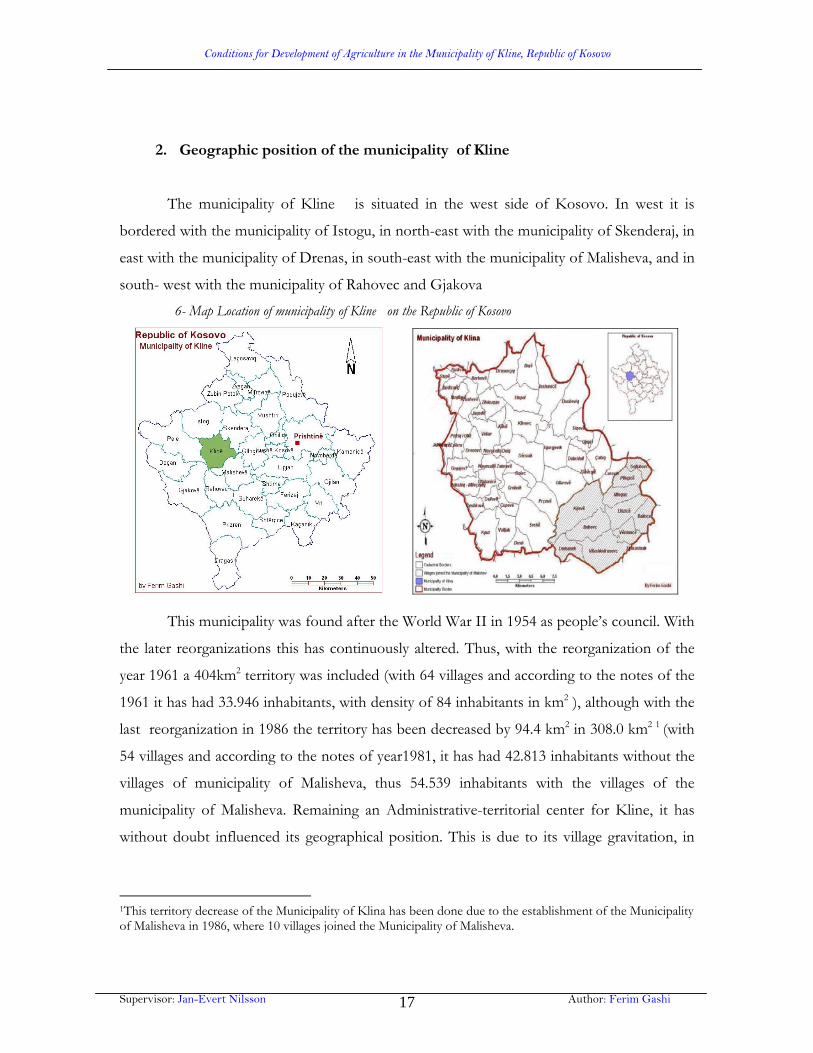
2. Geographic position of the municipality of Kline
The municipality of Kline is situated in the west side of Kosovo. In west it is
bordered with the municipality of Istogu, in north-east with the municipality of Skenderaj, in
east with the municipality of Drenas, in south-east with the municipality of Malisheva, and in
south- west with the municipality of Rahovec and Gjakova
6- Map Location of municipality of Kline on the Republic of Kosovo
This municipality was found after the World War II in 1954 as people’s council. With
the later reorganizations this has continuously altered. Thus, with the reorganization of the
year 1961 a 404km2 territory was included (with 64 villages and according to the notes of the
1961 it has had 33.946 inhabitants, with density of 84 inhabitants in km2 ), although with the
last reorganization in 1986 the territory has been decreased by 94.4 km2 in 308.0 km2 1 (with
54 villages and according to the notes of year1981, it has had 42.813 inhabitants without the
villages of municipality of Malisheva, thus 54.539 inhabitants with the villages of the
municipality of Malisheva. Remaining an Administrative-territorial center for Kline, it has
without doubt influenced its geographical position. This is due to its village gravitation, in
1This territory decrease of the Municipality of Klina has been done due to the establishment of the Municipality of Malisheva in 1986, where 10 villages joined the Municipality of Malisheva.

Conditions for Development of Agriculture in the Municipality of Kline, Republic of Kosovo
Supervisor: Jan-Evert Nilsson Author: Ferim Gashi 18
Kline’s territory there is the crossroad of the motorways and railways in many directions
through Dukagjini Plain.
Natural predispositions- configurative make the territory of Kline in having
exceptional infrastructure connection with the neighbor municipalities and other bigger
administrative centers in Kosovo. For instance through the river Kline runs the railway
Peje-Kline -Fushe Kosovo, which was circulation was released in 1936. Later was bild up the
part that was not finished Kline -Prizren. In the rapid development of Kline contributed
the building of the highways Peje-Kline -Prishtine; Kline -Gjakove; Kline -Burim; Kline -
Skenderaj-Mitrovice and many other regional roads, which we can say we noticed they are in
bad condition, because of the movement of Serbian army vehicles, and we can mention the
bridges that are entirely destructed, mentioning the bridge in Rakovine, Llazice, and the
bridge of Kline which is rebuilt.
The municipalty of Kline consists of 43 villages which contain 14 local communities
Budisalc, Jagode, Drenoc, Zllakuqan, Grabanice, Shtupel, Sferke, Dollc, Kline, Jashanice,
Ujmire, Gllareve, Cerovik, and Zajm.

Conditions for Development of Agriculture in the Municipality of Kline, Republic of Kosovo
Supervisor: Jan-Evert Nilsson Author: Ferim Gashi 19
7-Map Klina Local Administrations
The increase and dynamism of the population of the inhabitants according to the
registration of the inhabitants is given in the chart number 1.

Conditions for Development of Agriculture in the Municipality of Kline, Republic of Kosovo
Supervisor: Jan-Evert Nilsson Author: Ferim Gashi 20
Chart 3: The population of the Municipality of Kline according to the registration years
The population of the Municipalty of Kline according to
registration years INDEX
Population
growth
1948 1953 1961 1971 1981 1991 1948-1991
Are
a km
2
Pop
ulat
ion
num
ber
Den
sity
in k
m2
Pop
ulat
ion
num
ber
Den
sity
in k
m2
Pop
ulat
ion
num
ber
Den
sity
in k
m2
Pop
ulat
ion
num
ber
Den
sity
in k
m2
Pop
ulat
ion
num
ber
Den
sity
in k
m2
Pop
ulat
ion
num
ber
Den
sity
in k
m2
195
3 /
1948
196
1 /
1953
197
1 /
1961
198
1 /
1971
199
1 /
1981
The
gro
wth
of
abso
lute
popu
latio
n %
402 26.100 65 28.300 70 33.900 84 42.400 105 54.500 135 58.600 190 109 120 125 129 107 32.500 125
Source: The Data for the number of population according to the registration years 1948; 1953; 1961; 1971; 1981;
taken from Dr. Riza Çavolli, Gjeografia regjionale e Kosoves, Prishtine, 1997p. 338. In the meantime the estimation
for the year 2008 was taken from the Municipal assembly of Kline2.
According to the 1981 population registration, the national population structure has
been 83.6% Albanian; 12.5% Serbs and 3.9% other (Çavolli. R.1997). Now the national
structure is 97 % Albanian; while others can be estimated at 3%. According to the
Humanitarian Charity Association” Mother Teresa”, in 2000 the Municipality of Kline live
54. 709 inhabitants, while according to the OSCE for population registration the gender
structure includes 60% females, 40% males, whilst structure of the ages as in whole Kosovo
territory in the Municipality of Kline dominates a part of a young population. The
Municipality of Kline is dominated mostly by age-group of 0-18 years old 18-25 years old
which is 51-53% of the population. The estimated unemployment is approximately 32,135 or
55 -57 % (18-65 years old, Men: 14 150 or 44%, Women: 17 985 or 56%) of the population
who are capable to work and the percentage of unemployment is 5-7% higher comparing to
national unemployment average (Source: Department of Agriculture, Business Registration
Office Municipal Assembly of Kline. 2008). Employed people make up 43% of the
population capable of working, counting of course the employed people abroad and their
agricultural economies. The unemployment is more emphasized at youth and females.
2 In 2008 the area of Municipalty of Klina is 308 km2.

Conditions for Development of Agriculture in the Municipality of Kline, Republic of Kosovo
Supervisor: Jan-Evert Nilsson Author: Ferim Gashi 21
Due to the war of 1998-99 the Municipality of Kline has inherited a low economic
development as well as it has lacked investments and it has been neglected for many
years. The vast capacities inherited from the 1980-ties do not function, though with the
beginning of privatization (after the war of 1998/99) of state enterprises of the
Municipality of Kline it is expected appeasement of high percentage of unemployment.
The forceful administration of Serbs in all the enterprises and the municipality’s factories
in the 1990-ties, influenced on sacking Albanian workers from their places of work,
misuse of work tools like, money, technology etc, as in annexation of funds for Serbian
nationalist purposes, as well as the actions and settlement of different army and police
forces in the buildings of the enterprises. Thus, by Serbian retreat in 1999 they have
plundered, they have stolen and devastated the outmost inventory, technological
equipment, construction objects. With this heavy economical state even then face all the
economy enterprises, especially public sector which before was main element of the
economy of Kline Municipality and which also had a number of considerable workers.
The most vital and profitable sector in economy of Kline is the business sector which
until the end of 2006 the number of workers has reached 1.310. In these businesses
4.1000 workers have been employed (Source: Municipal Assembly of Klina, www.ks-
gov.net/Kline/). The majority of businesses is micro businesses and is addressed as trade
activities, construction, transport, hotel services, craftsmanship and repairing, as well as
health and social services, more or less in the fields of production, while public services
are offered by public companies.
2.1. Education,
The population has the following educational characteristics:
7,979 (39%) are currently attending elementary education in 14 elementary schools,
1,697 (21%) are attending high school in 2 secondary schools
3% are attending University (Source: Directorate for Education; Municipal Assembly of
Klina).

Conditions for Development of Agriculture in the Municipality of Kline, Republic of Kosovo
Supervisor: Jan-Evert Nilsson Author: Ferim Gashi 22
2.2. Economic Development,
The municipality is characterized by a low level of economic development. Most of the
existing industrial capacitiesSOEs function with a very low performance or do not function
at all. It is expected that the start of the privatization process will release the assets that are
currently under SOE management. Before the 1999 conflict, the economic activity in Klina
town was centered on the following SOEs that employed approximately 1,500 people.
Malishgani agricultural-industrial complex
The bauxite mine in Volljak
Mirusha Construction Company
At present, the seed factory from the Malishgani agricultural-industrial complexis
operating at a low capacity (less than 10 percent of full capacity), while theVolljak bauxite
mine is currently working at 5 percent of its capacity,respectively Mirusha Company at 10
percent of its capacity.
2.3 Natural Resource Exploitation,
On the mineral industry side, the bauxite mine in Volljak, the stone quarry, and the
construction materials factory, when fully operational, will cover the needs of the
construction industry of the municipality.
Municipality of Klina is rich with mineral and non-mineral resources that could
potentially attract foreign investment:
Reserves of lignite: 2 billion tons
Mineral of bauxite: 2 million tons
Clay: 6.5 million tons
Sand and gravel: 3.5 million tons (Source: Strategy for Economic Development 2003-2006;
Municipal Assembly of Klina)

Conditions for Development of Agriculture in the Municipality of Kline, Republic of Kosovo
Supervisor: Jan-Evert Nilsson Author: Ferim Gashi 23
8-Map Klina population
3. Non-agricultural rural development options - Tourism and recreational sites, in
the Municipality of Klina
3.1 Mirusha Gorge
Along the flow of river Mirusha, on the south and southwest side are waterfalls,
which are sites of rare natural beauty supporting rich flora and fauna. This complex, covering
200 hectares, is a protected nature reserve, with good potential for tourism development.
Currently there are discussions to declare the Mirusha waterfall as a national park. Once this
decision is taken the central budget will allocate more funds for the necessary investments
and adjustments.

Conditions for Development of Agriculture in the Municipality of Kline, Republic of Kosovo
Supervisor: Jan-Evert Nilsson Author: Ferim Gashi 24
This will boost the domestic and possibly international tourism in the Mirusha falls
and this is expected to provide excellent opportunities for SMEs involved in tourist-related
activities, as well as a potential income for the municipal budget (through a fee charged to
the visitors/tourists).
Mirisha Gorge, which is currently (Dec 2007) under consideration for registered legal
status as a national park, is the only significant environmental asset capable of generating any
revenue as a tourist site.
It is sure that the tourist potential of Mirusha only exists in the attraction of local
tourists to the Drini Bardhe end of the gorge (near the main Gjakova- Kline road) where
two large waterfalls exist. Although the tourist potential of Kline is limited, Mirusha has its
symbolic importance as the emblem of the municipality, and its careful management is
therefore important.
Photo 4: Mirusha canyon
3.2 River Peja and Drini Bardhe
The Kline, River Peja and Drini Bardhe Rivers all form central elements of Kline’s
rural landscape beauty, as well as functioning as recreational sites for fishing. Measures
proposed to limit the discharge of raw sewage directly into the river systems will also greatly
improve the recreational value by improving the quality of the water for fish.
Planting of trees at selected points will both improve the visual attraction of the river
corridor and stabilize the River Peja and Drini Bardhe banks to prevent erosion .Trees are of
course important along the river and streams due to the fact that their root system help the
river bank to resist erosion, the leaves from the trees provide organic matter for the system
of the river as well as providing food and cover for the area wildlife, the shades of the trees

Conditions for Development of Agriculture in the Municipality of Kline, Republic of Kosovo
Supervisor: Jan-Evert Nilsson Author: Ferim Gashi 25
would control temperature for the fish and they woul have as well a great impact for many
other species that have been on pressure due to the utilization of arable land.
3.3 Mining
There are 199 hectares of both the Volljak Bauxite mine and the stone quarry on the
Prishtina – Peja road which fall within the boundaries of KFA land. However this shows a
problem for KFA boundaries that should therefore either be changed (ie excising land) or
the land use should revert to forestry by enrichment planting.
The development of lignite extraction in Kline is excluded from the list of planned
development options, for operational reasons.
Other mining activities that are in less conflict with the environment remain more
successful options for sustainable development, including bauxite mining at Sferke, and
building stone extraction at the quarry on the main Kline - Prishtina road.
3.4 Lignite mining
The development of lignite mining and power generation in Kosovo is focused more
on the Obiliq region which is in northwest of Prishtina. The new lignite mine and power
plant there is scheduled to become operational between 2013 and 2015. Together with the
modernized existing power plants, this will be sufficient to supply the energy demand of all
Kosovo in addition for allowing the optional export of energy to neighboring states.
In the long term there are small reserves of lignite mining in Kline. If we compare
lignite reserves in Kline 5 square kilometers to that of Kosovo Plain around Prishtina which
is 20 square kilometers. Klina has a hilly terrain which is difficult to operate for lignite
mining, thus there is insuitable infrastructure neither staff that have necessary skills for
mining.
MEM does not have any plans to have a lignite mining in the region of Kline for
the next decades, while the Kosovo Bauxite Company whose exploration licence issued by
ICMM has been withdrawn by request of MEM does not share the same idea with MEM.

Conditions for Development of Agriculture in the Municipality of Kline, Republic of Kosovo
Supervisor: Jan-Evert Nilsson Author: Ferim Gashi 26
3.5 Bauxite Mining
Kline municipality is considered to contain medium to large bauxite reserves in a
North – South strip of land approximately ten kilometres long (north - south) and two to
three kilometers wide (west – east) in between Dollc (Kline) in the north and Llapceve /
Rudne (Malisheve) in the south. It also refers to the villages Gremnik, Cypeve, Voljake and
Dush. An exploration license for the bauxite resources was issued to the company
“Compania Boksitet e Kosoves” on 30 January 2006. The license has the registration
number 269 and the license number 517. It is registered under the name of two of the
villages in the area, “Gremnik Llapqev”.
The Volljak Bauxite mine has had a serious environmental impact on the local
landscape in terms of the indiscriminate disposal of mining spoil and crushed stone. Since
this and the open cast extraction site have a major visual impact on the landscape, in addition
to the noise and dust which are generated, there is a direct conflict with the proposal to
further develope the quality of the neighboring landscape and local facilities to encourage
and attract tourists to Mirusha gorge.
However, assuming that the environmental impact can be limited, and there are
adequate efforts to rehabilitate land that has been used through reforestation, bauxite mining
at the Sferke / Volljak site remains a feasible future activity, especially in a zone of high rural
population where the economic alternatives and quality of agricultural land are low.
If the Kosovo Bauxite Company is privatized successfully by Kosovo Privatisation
Agency bauxite mining in the southern central part of Kline will continues and may even be
extended. However if the privatization fails, the mine could be closed down completely.

Conditions for Development of Agriculture in the Municipality of Kline, Republic of Kosovo
Supervisor: Jan-Evert Nilsson Author: Ferim Gashi 27
Photo 5: Exhausted Bauxite Mine at Grebnik Mountain near Sferka
3.6 Sands and Gravel extraction
Extraction of sand, aggregates and building materials from alluvial deposits is a
widespread activity in which occurs in small local quarries, sand pits and gravel pits. Thus
sands and gravels are extracted directly from river beds, river banks or nearby floodplains.
However the environmental effects are highly damaging to the protective vegetation cover,
increasing soil loss and increasing vulnerability to the effects of future flooding events.
All such activity is prohibited by law and should be actively prevented except in
permitted locations. When it comes to places there is a large sands and gravel grading site
near the turn off from the main Kline road to Volljak, though it is unclear whether
extraction is from near or within the nearby Drini Bardhe, or from alluvial deposits that are a
safe distance away.
Conditions for Development of Agriculture in the Municipality of Kline, Republic of Kosovo
Supervisor: Jan-Evert Nilsson Author: Ferim Gashi 28
4. Natural elements for agricultural development in the municipality of Kline
Farming is one of the most important branches of economic development in the
Municipality of Kline, considering its geographical position, climate and soil conditions
which enable the growing of many agricultural cultivation as well as growth of high
efficiency.
The geographic position of Klina and its climate, especially in the region of the
Dukagjin valley, make it ideal for the development of agricultural activities. Particularly
promising activities include the cultivation of plants, vegetables, farming, and poultry. Klina
has a sufficient supply of water from its rivers to build an adequate irrigation system. The
construction of irrigation reservoirs with the water supplied by the four rivers that run
through the fields will enable the irrigation of up to 2,000 hectares of agricultural soil. Klina’s
agricultural sector includes the following firms:
5 agricultural cooperatives
1 seed factory
1 animal food factory
1 mushroom factory
1 cherry and hazel farm
Kline belongs to the intense area regarding its agricultural development
possibilities due to the 87.7% of the area that is 600 meters above the sea. 95% of overall
area of the Municipality of Kline is agricultural land, and 4.9% are barren land. In the
agriculture lands structure fields dominate with 12.734 hectares, forests with 12.735
hectares, meadows with 2.184 hectares and grass with 2.043 hectares etc (Source:
Kosovo Cadastral Agency, 2008).

Conditions for Development of Agriculture in the Municipality of Kline, Republic of Kosovo
Supervisor: Jan-Evert Nilsson Author: Ferim Gashi 29
Chart 4: Agricultural land use statistics
Kline 1 Kline 2 Kosove/Kosovo
Population 54,900 3 2.0 Mio Population/km2 178 183 Extension, total 30,849 ha 100% 31,807 ha 100% 1,089,500 ha 100 %Arable Land 12,782 ha 41 % 17,923 56% 311,538 ha 29 % Meadows 2,230 ha 7 % 87,470 ha 8 % Pastures 2,096 ha 7 % 474 1,5% 178,309 ha 16 % Forest and Scrub 11,566 ha 38 % 11,716 37% 466,000 ha4 43% Other 2,175 ha 7 % 1,692 5% 46,183 ha 4%
Sources: 1 ASPAUK, Land Use Summary Report, 2004; Agricultural land untilatization projekte of European Agency for Reconstration 2 interpretation of Satellite imagery 2001; 3 OSCE Municipal Profile, May 2006; 4 KFA
From table above, it can be seen that land cover information as given by the
ASPAUK Land Use Summary Report gives a similar area estimate to that from the satellite
image interpretation, the only difference being that the satellite image interpretation does not
differentiate between arable land, pastures and meadows. The similarity of land use
information implies long term land use stability. Taking into account that the ASPAUK
statistics are based on old data from the 1960’s from the KCA, this implies that land use in
the Municipality of Kline has been quite stable over the last 40 to 50 years.

Conditions for Development of Agriculture in the Municipality of Kline, Republic of Kosovo
Supervisor: Jan-Evert Nilsson Author: Ferim Gashi 30
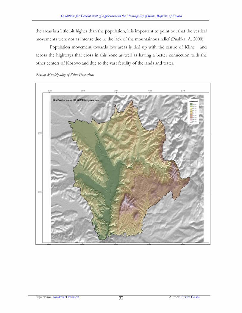
4.1. Relief as a condition for agriculture development
The relief together with its forms influences in a right and wrong way in expanding
agriculture and its efficiency, in man’s work, in tools, in movement while it lessens the hill-
mountainous effect. The pedological substratum becomes shallower with the height increase
thus the agriculture can not develop normally.
The territory of the Municipality of Kline has its many geomorphologic
characteristics. The Eastern part is characterized with its height while Western part is plain.
The Northern part and north-east of the Municipality consists of the part of Drenica
Mountains and the east and south-east part consists of hilly-mountainous region called
Lapusha. West side and central side supplement the flat of the Plain of Dukagjini.
The parts that belong to Dukagjini Plain are in the area of 500m above the sea level,
whereas hilly parts are mainly between 500m – 700m. In the south-east has a small part of
this territory has the height bigger than 700m.
The territory height is convenient enough for plant production, because 87.7% of the
area or 35.343 hectares is up to 600m of the sea level, hereupon whole the territory of the
municipality of Kline belongs to the intense area practical for agriculture and orchard in.
Chart 5: The expansion of the area according to the elevation in the Municipality of Kline
Elevation Area Cumulative
Hectare % Hectare %
Until 400 5.477 13.59 5.477 13.59
400 - 450 5.130 12.73 10.607 26.92
450 - 500 8.260 20.50 18.867 46.82
500 - 550 7.651 18.98 26.518 65.80
550 - 600 8.825 21.90 35.343 87.70
600 - 700 4.282 10.62 39.625 98.32
700 - 800 675 1.67 40.300 100.0
Source: Spatial Planning, Urban and Projects Board, Prishtina1984, p.13

Conditions for Development of Agriculture in the Municipality of Kline, Republic of Kosovo
Supervisor: Jan-Evert Nilsson Author: Ferim Gashi 31
The major characteristics are the following and there are three different agro-ecological
zones:
1. Mountains: low agricultural potential, extensive grazing agriculture, forest with low
productivity, but high potential.
2. Hilly zone: heterogeneous partly good soils, medium potential mainly used for
livestock production and rainfed crops.
3. Valleys: deep fertile soils, some irrigation, high potential for intensive high value
crops.
During 1948-1981 have occurred vertical movements of the population, however
they were not intense. The expansion of the areas and population in the Municipality of
Kline in 1948-1981 can be better seen in the chart below.
Chart 6: The expansion of the area and the population in the Municipality of Kline in 1948-1981 accordin to the elevation.
The area in frequencies
The number of
population in 1981
The population number
in frequencies
The number of
population in 1948 Elevation
Fr Fc
Fr
Fc
300-400m 13.0 13.0 12.207 22.4 22.4 17.3
400-500m 36.4 49.4 17.721 32.5 54.9 55.4
500-600m 43.5 92.9 20.511 37.7 92.6 93.1
600-700m 7.1 100.0 40.100 7.4 100.0 100.0
Source: Dr. Asllan Pushka, Aspektet Gjeopopullative ne Kosove dhe rreth saj. Prishtine 2000, p. 52 (Fr: Relative Frequency, Fc: Cumulative Frequency)
We can clearly see on the chart that there is an uptrend of the population in the
lowest part of the Municipality of Kline (300-400m) even though this area takes place of
just 13% of the Municipality area. To better resist this population movement, areas with
major heights should have a better connection with roads, economy and infrastructure
buildings should be constructed as well.
In 1948 in this part of the municipal area used to live 17.3% of the population
meanwhile in 1981, 22.4% of the population. In the other vertical areas the participation of
Conditions for Development of Agriculture in the Municipality of Kline, Republic of Kosovo
Supervisor: Jan-Evert Nilsson Author: Ferim Gashi 32
the areas is a little bit higher than the population, it is important to point out that the vertical
movements were not as intense due to the lack of the mountainous relief (Pushka. A. 2000).
Population movement towards low areas is tied up with the centre of Kline and
across the highways that cross in this zone as well as having a better connection with the
other centers of Kosovo and due to the vast fertility of the lands and water.
9-Map Municipality of Kline Elevations
Conditions for Development of Agriculture in the Municipality of Kline, Republic of Kosovo
Supervisor: Jan-Evert Nilsson Author: Ferim Gashi 33
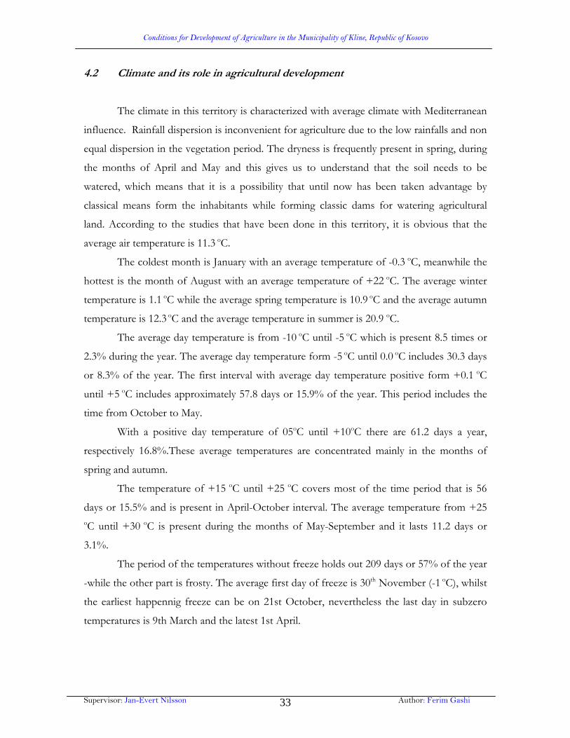
4.2 Climate and its role in agricultural development
The climate in this territory is characterized with average climate with Mediterranean
influence. Rainfall dispersion is inconvenient for agriculture due to the low rainfalls and non
equal dispersion in the vegetation period. The dryness is frequently present in spring, during
the months of April and May and this gives us to understand that the soil needs to be
watered, which means that it is a possibility that until now has been taken advantage by
classical means form the inhabitants while forming classic dams for watering agricultural
land. According to the studies that have been done in this territory, it is obvious that the
average air temperature is 11.3 oC.
The coldest month is January with an average temperature of -0.3 oC, meanwhile the
hottest is the month of August with an average temperature of +22 oC. The average winter
temperature is 1.1 oC while the average spring temperature is 10.9 oC and the average autumn
temperature is 12.3 oC and the average temperature in summer is 20.9 oC.
The average day temperature is from -10 oC until -5 oC which is present 8.5 times or
2.3% during the year. The average day temperature form -5 oC until 0.0 oC includes 30.3 days
or 8.3% of the year. The first interval with average day temperature positive form +0.1 oC
until +5 oC includes approximately 57.8 days or 15.9% of the year. This period includes the
time from October to May.
With a positive day temperature of 05oC until +10oC there are 61.2 days a year,
respectively 16.8%.These average temperatures are concentrated mainly in the months of
spring and autumn.
The temperature of +15 oC until +25 oC covers most of the time period that is 56
days or 15.5% and is present in April-October interval. The average temperature from +25
oC until +30 oC is present during the months of May-September and it lasts 11.2 days or
3.1%.
The period of the temperatures without freeze holds out 209 days or 57% of the year
-while the other part is frosty. The average first day of freeze is 30th November (-1 oC), whilst
the earliest happennig freeze can be on 21st October, nevertheless the last day in subzero
temperatures is 9th March and the latest 1st April.
Conditions for Development of Agriculture in the Municipality of Kline, Republic of Kosovo
Supervisor: Jan-Evert Nilsson Author: Ferim Gashi 34
The above mentioned average day and season temperatures show that the amplitude
is evident. This is more clearly shown in the chart were monthly and yearly average
temperatures are apparent:
Chart 7: The average month and year temperature 2004
Average temperature
Months Average MonthTemperature Max Min Amplitude
January 0.2 11.0 -11.0 22.0
February 1.7 14.5 -12.7 27.9
March 5.9 21.2 -6.7 27.9
April 12.4 25.5 -0.4 25.9
May 15.8 28.7 -4.4 24.3
June 19.4 21.7 8.4 23.4
July 21.0 33.9 10.6 23.3
August 21.0 34.0 8.5 25.5
September 18.0 30.0 5.0 25.5
October 12.3 25.2 1.0 24.2
November 6.9 18.6 -4.7 23.3
December 2.4 12.6 -10.6 2.0
Average Year Temperature 11.6 24.0 0.8 23.2
Figure 4: The temperature movement during the months of the year in Kline, 2004
According to these data of the climatic conditions, agriculturists confirm that these
temperatures make possible the cultivation of many plants in this territory. Through the
Valley of Drini Bardhe influence to some extend the Mediterranean climate.
Conditions for Development of Agriculture in the Municipality of Kline, Republic of Kosovo
Supervisor: Jan-Evert Nilsson Author: Ferim Gashi 35
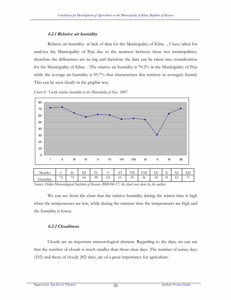
4.2.1 Relative air humidity
Relative air humidity- in lack of data for the Municipality of Kline , I have taken for
analyses the Municipality of Peja due to the nearness between these two municipalities,
therefore the differences are no big and therefore the data can be taken into consideration
for the Municipality of Kline . The relative air humidity is 70.2% in the Municipality of Peja
while the average air humidity is 59.7% that characterizes this territory as averagely humid.
This can be seen clearly in the graphic way.
Chart 8: Yearly relative humidity in the Municiplity of Peja 2007
0
10
20
30
40
50
60
70
80
I II III IV V VI VII VIII IX X XI XII
Months I II III IV V VI VII VIII IX X XI XII
Humidity 72 73 64 58 62 61 55 56 54 31 63 71
Source: Hidro Meteorological Institute of Kosovo 2008-06-17, the chart was done by the author.
We can see from the chart that the relative humidity during the winter time is high
when the temperatures are low, while during the summer time the temperatures are high and
the humidity is lower.
4.2.2 Cloudiness
Clouds are an important meteorological element. Regarding to the data, we can see
that the number of clouds is much smaller than those clear days. The number of sunny days
(103) and those of cloudy (82) days, are of a great importance for agriculture.

Conditions for Development of Agriculture in the Municipality of Kline, Republic of Kosovo
Supervisor: Jan-Evert Nilsson Author: Ferim Gashi 36
Chart 9: Annual cloudiness in the Municipality of Kline , 1984 (the latest data on cloudiness).
Cloudniness
0
1
2
3
4
5
6
7
8
I II III IV V VI VII VIII IX X XI XII Vje.
Months I II III IV V VI VII VIII IX X XI XII Annual
Cloudiness 5.9 5.1 5.6 5.1 6.1 5.8 4.7 5.3 2.9 5.5 7.6 6.2 5.5
Source: Propozim per perdorimin e masave agroteknike ne teritorin e komunes se Klines, 1984. fq.4. grafikonin e punoj autori i punimit.
The smallest average cloud for the Municipality of Kline is in the month of
September (2.9). The average annual cloud is 5.5 in ten parts of the sky in the Municipality of
Kline .
4.2.3 Rainfalls
Rainfialls are an important climate element. Rainfalls are of a vast importance in
extension and development of flora and fauna. According to the data for the rainfalls, there
is a difference in the monthly and yearly expansion. Due to the lack of the latest data for the
Municipality of Kline, I have taken for analyses the Municipality of Peja due to the closeness
between these two municipalities and the latest data 2002-2007, therefore there are no big
differences and can be taken into consideration for the Municipality of Kline.
The average annual rainfall is 68.4mm. Autumn has more rainfalls with 280mm, and
winter 271mm, that make these two seasons among the seasons with more rainfalls. On the

Conditions for Development of Agriculture in the Municipality of Kline, Republic of Kosovo
Supervisor: Jan-Evert Nilsson Author: Ferim Gashi 37
other hand spring has 193.9mm and summer at least 153.7mm of the rainfalls. The
difference between the most humid and the driest season is 126.9mm. Dispersion of the
rainfalls is inconvenient for agriculture, due to their appearance during the winter (October-
December) period. Despite this, during the vegetation period there is much less rainfall with
unequal dispersion.
If we consider the low air humidity and high temperatures during the summer
season, then this amount of rainfalls has les effect. Drought frequently is noticeable in
spring, notably during the months of April and May. This gives us to understand that this
territory is dry and must be watered. During the year averagely there are 85 snowy days or
23% yearly. The snow can be earliest seen on the 5th November and the latest snow can be
seen on 20th April.
Chart 10: Average monthly rainfall view of for 2002-2007 in mm. Months I II III IV V VI VII VIII IX X XI XII
Annual
Years
2002 16.5 62.4 26 93.6 81.3 8.6 39.6 139.3 11.8 20.1 14.1 111 52
2003 220 48.4 2.5 34.6 66.4 45.3 9.5 31.2 80.3159.
4 99.3 47.5 70.4
2004 77.8 117.
8 101.
2 86.7 140.4 92.3 61.1 24.9 110 61.5 112.4 95.8 90.9
2005 37.3 114.
5 66.2 57.9 63.6 38.2 23.8 53.2 45.7 47.2 96.5 212.2 71.4
2006 96.8 93.6 97.8 37.1 43.9 106.1 91.5 63.6 44.1 39.1 54.2 21.5 65.8
2007 70.1 37.6 103 18.6 51.8 49.8 1.0 18.5 71.1 131 159 12.9 60.4 Figure 5: Average month expansion of rainfalls in mm during 2002-2007.
Source: Hydro Meteorology Institute of Kosovo 2008-06-17, Charts were done by the author.
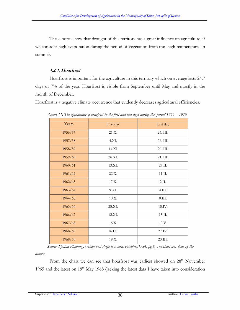
Conditions for Development of Agriculture in the Municipality of Kline, Republic of Kosovo
Supervisor: Jan-Evert Nilsson Author: Ferim Gashi 38
These notes show that drought of this territory has a great influence on agriculture, if
we consider high evaporation during the period of vegetation from the high temperatures in
summer.
4.2.4. Hoarfrost
Hoarfrost is important for the agriculture in this territory which on average lasts 24.7
days or 7% of the year. Hoarfrost is visible from September until May and mostly in the
month of December.
Hoarfrost is a negative climate occurrence that evidently decreases agricultural efficiencies.
Chart 11: The appearance of hoarfrost in the first and last days during the period 1956 – 1970
Years First day Last day
1956/57 21.X. 26. III.
1957/58 4.XI. 26. III.
1958/59 14.XI 20. III.
1959/60 26.XI. 21. III.
1960/61 13.XI. 27.II.
1961/62 22.X. 11.II.
1962/63 17.X. 2.II.
1963/64 9.XI. 4.III.
1964/65 10.X. 8.III.
1965/66 28.XI. 18.IV.
1966/67 12.XI. 15.II.
1967/68 16.X. 19.V.
1968/69 16.IX. 27.IV.
1969/70 18.X. 23.III.
Source: Spatial Planning, Urban and Projects Board, Prishtina1984, pg.8. The chart was done by the
author.
From the chart we can see that hoarfrost was earliest showed on 28th November
1965 and the latest on 19th May 1968 (lacking the latest data I have taken into consideration
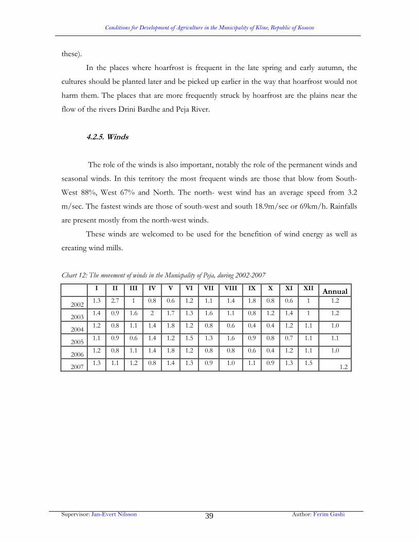
Conditions for Development of Agriculture in the Municipality of Kline, Republic of Kosovo
Supervisor: Jan-Evert Nilsson Author: Ferim Gashi 39
these).
In the places where hoarfrost is frequent in the late spring and early autumn, the
cultures should be planted later and be picked up earlier in the way that hoarfrost would not
harm them. The places that are more frequently struck by hoarfrost are the plains near the
flow of the rivers Drini Bardhe and Peja River.
4.2.5. Winds
The role of the winds is also important, notably the role of the permanent winds and
seasonal winds. In this territory the most frequent winds are those that blow from South-
West 88%, West 67% and North. The north- west wind has an average speed from 3.2
m/sec. The fastest winds are those of south-west and south 18.9m/sec or 69km/h. Rainfalls
are present mostly from the north-west winds.
These winds are welcomed to be used for the benefition of wind energy as well as
creating wind mills.
Chart 12: The movement of winds in the Municpality of Peja, during 2002-2007
I II III IV V VI VII VIII IX X XI XII Annual
2002 1.3 2.7 1 0.8 0.6 1.2 1.1 1.4 1.8 0.8 0.6 1 1.2
2003 1.4 0.9 1.6 2 1.7 1.3 1.6 1.1 0.8 1.2 1.4 1 1.2
2004 1.2 0.8 1.1 1.4 1.8 1.2 0.8 0.6 0.4 0.4 1.2 1.1 1.0
2005 1.1 0.9 0.6 1.4 1.2 1.5 1.3 1.6 0.9 0.8 0.7 1.1 1.1
2006 1.2 0.8 1.1 1.4 1.8 1.2 0.8 0.8 0.6 0.4 1.2 1.1 1.0
2007 1.3 1.1 1.2 0.8 1.4 1.3 0.9 1.0 1.1 0.9 1.3 1.5
1.2

Conditions for Development of Agriculture in the Municipality of Kline, Republic of Kosovo
Supervisor: Jan-Evert Nilsson Author: Ferim Gashi 40
Figure 6: The movement of winds according to the months of the year 2007
0
0.5
1
1.5I
II
III
IV
V
VI
VII
VIII
IX
X
XI
XII
Source: Hidro Meteorological Institute of Kosovo 2008-06-17, the chart was done by the author
4.2.6 Radiation
Radiation influences in the process of photosynthesis and in the establishment of
plant’s mass. The annual average sum of radiation in the Municipality of Kline has not been
measured and it is not given. Although, for directions datas for Peja can be taken due to the
nearness and mostly identical orientation of the land.
Figure 7: Insolation in Peja the number of hours, 1980 according to the months.
0 500 1000 1500 2000 2500
Vje.
III
IIIIV
VVIVIIVIIIIXX
XI
XII
Months I II III IV V VI VII VIII IX X XI XII
Annual
Radiation 105.9 129.4 144.5 206.1 176.4 204.8 257.2 213.6 255.0 143.1 55.0 84.0
1973.2
Source: Spatial Planning, Urban and Projects Board, Prishtina1984, pg.3. The chart was done by the author.

Conditions for Development of Agriculture in the Municipality of Kline, Republic of Kosovo
Supervisor: Jan-Evert Nilsson Author: Ferim Gashi 41
As we can see from the chart, the month with the longest radiation is July with 257.2
hours, while the shortest radiation is in the month of November with 55.0 hours. To sum up
1973.2 hours of annual rediation are very good conditions for application of solar energy
usage, as for instance in street lighting by using this kind of energy.
4.3 The role of subterranean and above-ground waters in agricultural
development
For agricultural economy of one place, waters play an important role. This role is
universal and diverse because most of the agricultural products require enough humidity
from which depends the development and its efficiency.
Drini Bardhe, Lumi i Pejes, Mirusha and Lumi i Istogut are the rivers that flow
through the territory of the Municipality of Kline.
From the above mentioned rivers, Drini is the longest river which has the direction of its
flow in the northwest-southeast, while here it makes a turn in the direction of south. The
river of Peja flows from west side in the direction of east until the village of Grabanica where
it joins Drini Bardhe.
Kline River flows from the north-east in the direction of south-west where it joins
Drini Bardhe near Deiq village below Kline dwelling.
Mirusha River flows from east in west direction where it pours in the Drini Bardhe at the
Mrasor village in the south of the territory of the Municipality of Kline.
The river of Istog, flows from the northwest in the direction of southeast and near the
village of Zllakuqan pours in the Drini Bardhe.
All these rivers in the territory of Kline are Field Rivers excluding Mirusha. Their
flow is slow and thus it creates meanders, due to this fact erosive side energy is pretty big,
notably at the river Peja and Drini Bardhe.
In spring and autumn when the rainfalls are heavy, respectively when the snow starts
to melt these two rivers flood the plains near the coast causing big damages to autumn or
Conditions for Development of Agriculture in the Municipality of Kline, Republic of Kosovo
Supervisor: Jan-Evert Nilsson Author: Ferim Gashi 42
spring cultures by taking with itself the most qualitative soil and leaving behind the sand and
rocks in the fertile lands.
This goes also for the river of Kline, Istog while the river Mirusha flows mostly
through lime stones where it has created its valley in the form of canyon (Mirusha canyon).
Regarding the amount of water, the most fulsome river with water is Drini and Peja
River, while during the summer Kline, Istogu and Mirusha have only a small amount of
water.
On the economical point of view, Drini and Peja river are of a great importance due
to the fact that these two rivers is evenly used for watering arable lands, meadows, orchards
etc. In general these rivers in the territory of Kline have the lowest level of water in August
and September, as a matter of fact that is the time when the rainfalls are minimal and their
evaporation is high due to the high level of temperatures, however the water level is high
during autumn especially in October and November.
The dwellers that have arable lands in the valleys of these rivers, rush to pick up their
fruit in the season of autumn, notably in the places where floods are expected, while in
spring frequently happens that the due to the high level of water the lands remain unplanted
and the crops do not reach their ripeness. In this case many land owners are caused material
damages because they do not succeed to harvest their crops.
In order to have a clearer view regarding watering as an important element in
agriculture, for the pros and cons water can cause to a region during artificial watering, we
should firstly look at the quality of watering water.
One of the most important scientific and research duties in the watering direction is
the study of the water quality that lands are watered with. The familiarity of the quality of
water is important notably in the regions where artificial watering is necessary, and where the
population of that place and their lives depends on this element.
The valuation of the quality of watering water and its classification is based mainly in
the amount and the sort of the minerals which waters bring with it, as well as what land they
come from (the pedology of terrain). The amount and the sort of the minerals waters bring
are important for the organic food of the plants and the physical-chemical fertilization of the
land.

Conditions for Development of Agriculture in the Municipality of Kline, Republic of Kosovo
Supervisor: Jan-Evert Nilsson Author: Ferim Gashi 43
Chemical analyses for watering water have been made in many different regions of
the world, from different authors and in different times, so it means that even the results and
the methods are different.
According to EILEAXU the chemical analyses of water shows better its quality.
Regarding this author the main water components are cations (Ca, Mg, and Na), anions
(above carbonates, sulfats, and clorids).
The methods for determining the quality of water for watering are based in the
amount of the harming minerals that water brings as well as their harm to the land and
plants.
The clasification of water for watering that was done Naigebeueri is based in the
amount of dried dregs and the presence of some elements in them. If the dried dregs are
smaller than the relationship between Mg, Ca and Na then the watering water is better for
watering.
However according Eolcaxu there are to be known three other characteristics in
order to determine the quality of water such as salt concentration, percentage of Na and the
dry dregs concentration. All this can be clearly seen on the chart
Chart 13: The concentration of metals, minerals and the amount of chemicals in rivers: Drini i Bardhe River, Peja River dhe Mirusha River.
Rivers Drini Bardhe River Peja River Mirusha River
Allowed
standards
Measure places Kepuz Peje Kepuz
Physical parameters
1 Time 11.3 14.2 13.3
2 Weather
3 Odour
4 Dry remains 354 313 458
Uninfiltration
5 Dry remains 349.3 310.2 455.2 500
Filtrated
6 Temperatures 14 15.6 15 8 up to 12
Chemical parameters
1 pH amount 7.43 7.35 7.48 6.5 - 8.5
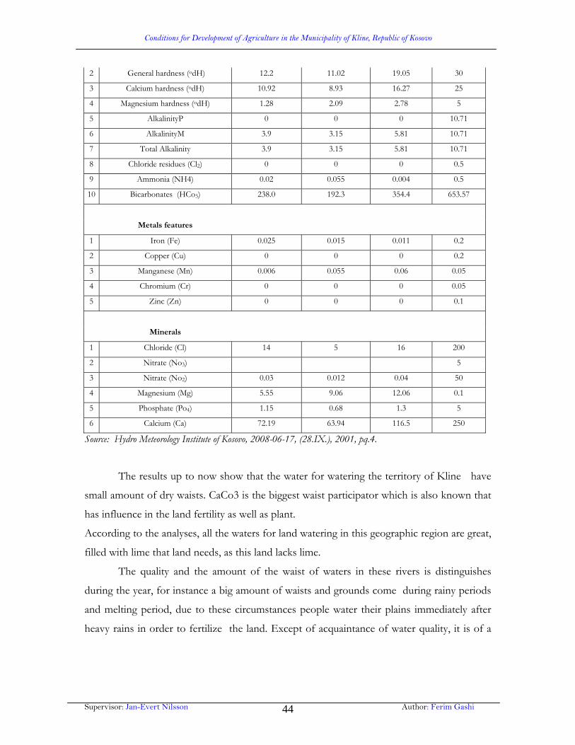
Conditions for Development of Agriculture in the Municipality of Kline, Republic of Kosovo
Supervisor: Jan-Evert Nilsson Author: Ferim Gashi 44
2 General hardness (odH) 12.2 11.02 19.05 30
3 Calcium hardness (odH) 10.92 8.93 16.27 25
4 Magnesium hardness (odH) 1.28 2.09 2.78 5
5 AlkalinityP 0 0 0 10.71
6 AlkalinityM 3.9 3.15 5.81 10.71
7 Total Alkalinity 3.9 3.15 5.81 10.71
8 Chloride residues (Cl2) 0 0 0 0.5
9 Ammonia (NH4) 0.02 0.055 0.004 0.5
10 Bicarbonates (HCo3) 238.0 192.3 354.4 653.57
Metals features
1 Iron (Fe) 0.025 0.015 0.011 0.2
2 Copper (Cu) 0 0 0 0.2
3 Manganese (Mn) 0.006 0.055 0.06 0.05
4 Chromium (Cr) 0 0 0 0.05
5 Zinc (Zn) 0 0 0 0.1
Minerals
1 Chloride (Cl) 14 5 16 200
2 Nitrate (No3) 5
3 Nitrate (No2) 0.03 0.012 0.04 50
4 Magnesium (Mg) 5.55 9.06 12.06 0.1
5 Phosphate (Po4) 1.15 0.68 1.3 5
6 Calcium (Ca) 72.19 63.94 116.5 250
Source: Hydro Meteorology Institute of Kosovo, 2008-06-17, (28.IX.), 2001, pq.4.
The results up to now show that the water for watering the territory of Kline have
small amount of dry waists. CaCo3 is the biggest waist participator which is also known that
has influence in the land fertility as well as plant.
According to the analyses, all the waters for land watering in this geographic region are great,
filled with lime that land needs, as this land lacks lime.
The quality and the amount of the waist of waters in these rivers is distinguishes
during the year, for instance a big amount of waists and grounds come during rainy periods
and melting period, due to these circumstances people water their plains immediately after
heavy rains in order to fertilize the land. Except of acquaintance of water quality, it is of a

Conditions for Development of Agriculture in the Municipality of Kline, Republic of Kosovo
Supervisor: Jan-Evert Nilsson Author: Ferim Gashi 45
great importance to get to know the way of usage, the way of usage considering technical
aspect of water supply in this terrain.
Klina has a sufficient supply of water from its rivers to build an adequate irrigation
system. The construction of irrigation reservoirs with the water supplied by the four rivers
that run through the fields will enable the irrigation of up to 2,000 hectares of agricultural
soil.
In general the people in this region use the watering water in a classical way, not only
in technical way but also in looking at its usage. Thanks to low elevation, where rivers flow
and the river bottom is not deep (2-5 m), the easy possibility is that this water was used early.
This means that the people have taken advantage on natural possibilities (hydrographical and
morphological) of watering and they have built canals that helped them turn the water flow
from the rivers and springs to their lands.
Even today the canals are narrow and not deep which people call”JAZ”. From”JAZ”
(water concentration- dams) every house has its small canal from which turn the water in
their lands.
Before in the territory of Kline have been watered 1800-2000 hectares of the
agricultural land, thanks to five rivers that go through this region, where were built some
dams, as well as canals for taking water to the watering areas.
Chart 14: Dams through the rivers of the Municipality of Kline .
Dams
Lands watered before the war in
hecteres Watered lands
in hectares year 2008
DRINI BARDHE RIVER
Balaj Dam 350 ha
Krusheve te Madhe Dam 160 ha
Zllakuqan Dam 380 ha
Videj Dam 180 ha
Zajm Dam 140 ha
PEJA RIVER
Poterç te Eperm Dam 100 ha
Dugujeve Dam 120 ha

Conditions for Development of Agriculture in the Municipality of Kline, Republic of Kosovo
Supervisor: Jan-Evert Nilsson Author: Ferim Gashi 46
Grabanice te Eperme Dam 130 ha
Grabanice te Poshtme Dam
Uke Sahiti Dam 70 ha
Dollova Dam 150 ha
KLINE RIVER
Dresnik Dam 160 ha
Total 1940 ha 130 ha
Source: The data are from the Directorate of Agriculture and Rural development and environment defense in Kline , 2001.
From all the dams in the territory of Kline, only three have been built of concrete
those of Balaj, Zllakuqani, and the dam of Dresnik, while all the other have been built in a
classical way by the villagers.
After the war all the dams are out of use, they have been destroyed as a result of
nonintervention of the maintenance in lack of instruments.
All the canals for directing the water to the watering areas have been in the ground,
except in the dam of Dresnik which has been built above the Kline River, and has been
approximately 1km of a concrete canal which has been destroyed pretty much.
The watering importance has caused confusion between families, however thanks to
standards that watering has these quarreling was avoid. Patriarchal standards were taken
from the “Kanuni i Leke Dukagjinit” (The canon of Leke Dukagjini) which has been used
until now. Every individual property has its watering schedule and this has to be respected
regardless crops change or the owners. If the canal goes past somebody else’s land, he has to
accept this due to the fact that it is a mutual interest.
These old rules are of a great importance even today because they interrupt quarrels,
and who does not hold in to these standards the village isolates the family from any
cooperation.
The turn of watering a.k.a. the time of watering is divided in hours according to the
size of the property, usually to 1 hectare of land there are 4 hours available for watering.
Before the turn for watering there is the pedological composition of the land that has to be
considered, concretely firstly the stony field should be watered before the sandy field due to
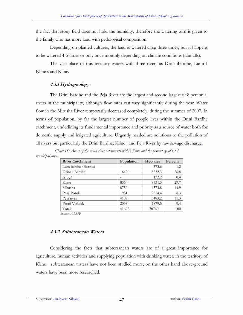
Conditions for Development of Agriculture in the Municipality of Kline, Republic of Kosovo
Supervisor: Jan-Evert Nilsson Author: Ferim Gashi 47
the fact that stony field does not hold the humidity, therefore the watering turn is given to
the family who has more land with pedological composition.
Depending on planted cultures, the land is watered circa three times, but it happens
to be watered 4-5 times or only once monthly depending on climate conditions (rainfalls).
The vast place of this territory waters with three rivers as Drini iBardhe, Lumi I
Kline s and Kline.
4.3.1 Hydrogeology
The Drini Bardhe and the Peja River are the largest and second largest of 8 perennial
rivers in the municipality, although flow rates can vary significantly during the year. Water
flow in the Mirusha River temporarily decreased completely, during the summer of 2007. In
terms of population, by far the largest number of people lives within the Drini Bardhe
catchment, underlining its fundamental importance and priority as a source of water both for
domestic supply and irrigated agriculture. Urgently needed are solutions to the pollution of
all rivers but particularly the Drini Bardhe, Kline and Peja River by raw sewage discharge.
Chart 15: Areas of the main river catchments within Kline and the percentage of total municipal area.
River Catchment Population Hectares Percent Lum bardhe/Bistrica - 373.6 1.2 Drina i Bardhe 16420 8232.3 26.8 Istog/ - 132.2 0.4 Kline 8364 8531.3 27.7 Mirusha 8750 4573.8 14.9 Pasji Potok 1931 2554.4 8.3 Peja river 4189 3483.2 11.3 Proni Volujak 2038 2879.5 9.4 Total 41692 30760 100
Source: ALUP
4.3.2. Subterranean Waters
Considering the facts that subterranean waters are of a great importance for
agriculture, human activities and supplying population with drinking water, in the territory of
Kline subterranean waters have not been studied more, on the other hand above-ground
waters have been more researched.

Conditions for Development of Agriculture in the Municipality of Kline, Republic of Kosovo
Supervisor: Jan-Evert Nilsson Author: Ferim Gashi 48
Surfaces with the most subterranean waters in the territory of the Municipality of
Kline are those past the river flows such as Drini Bardhe, Peja River, Kline, Istog, and
Mirusha. This welth is about to be seen clearly anyplace where the land is dug as well as the
vast number of the coulees which flow from the nature springs.
In the establishment of the subterranean water stratification/layer, mainly influence
these elements: atmospheric waters, ground waters and deep waters.
Two first elements are present notably in the alluvial plains, where average deepness
of the subterranean water is 3-5 meters, while the third element establishes the subterranean
level of water only in the lake plain in an average deepness of 15 meters.
Subterranean water of the terrain is free water. Free water with the influence of
above mentioned elements fulfills all the emptiness below a certain level, by establishing
spring water by which the population of the Municipality of Kline is supplied with drinking
water and less for watering.
As every other water the subterranean water has a sort of regime, it has its
movement that changes during the year and depends on some elements. So, the movement
of the subterranean water level depends on these elements. So, the movement of the
subterranean water level depends on these elements:
Atmospheric conditions (rainfalls)
River floods
Land watering
Relief
Starting from the first element (rainfalls), exactly during the rainfall period, the
subterranean water level rises at approximately 40cm, as the rainfalls fill every hallow
place up to the irrigation reservoir layer. During the dry weather, this level is about 1-1.5
cm, while in the rainfall weather the level rises at about 30-50 cm.
The level of subterranean water changes even due to the river influence, exactly during
its floods, mostly in the terrains where rivers flow. But this element is closely connected
with the first element (rainfalls) as the rainfalls raise the level of river water, which later
floods and saturates the land beside with water. The river floods increase the
subterranean water level in this area for approximately 10cm.

Conditions for Development of Agriculture in the Municipality of Kline, Republic of Kosovo
Supervisor: Jan-Evert Nilsson Author: Ferim Gashi 49
Another element that determines the increase of the subterranean water level is the
pedological composition.
In alluviums without carbonate the subterranean water is present in an average
deepness of 4m, which tells the level of spring water in wells.
A phenomenon which is present, and as an element influences in the movement of
subterranean water level, is the artificial land watering, which is mostly present in dry
seasons.
10-Map Klina Hydrology and River Catchments

Conditions for Development of Agriculture in the Municipality of Kline, Republic of Kosovo
Supervisor: Jan-Evert Nilsson Author: Ferim Gashi 50
9-Map Klina Hydrogeological

Conditions for Development of Agriculture in the Municipality of Kline, Republic of Kosovo
Supervisor: Jan-Evert Nilsson Author: Ferim Gashi 51
4.4 The role of land in developing agriculture branches
In land establishment except of the natural elements, social element has a great
influence too.
A miscellaneous land is a consequence of a different hipsometrical region, in which
the relief, geological construction and climatic elements make it diverse and specific in every
regional unit. We can add that the humans have interfered continuously for their needs in
improvement of lands in order to produce agricultural cultures. All this process of
pedogenesis has established a different land cover, which in fact resembles a mosaic.
Chart 16: The lands of this territory are very heterogeneous and consist of many types and sub- types:
Class Type Sub type Area
Ha %
Weak development Alluvial lands Alluvial clay 3.305 8.2
Of soils (A) C Carbonates
Colluvial soils Deluvial soils 191 0.5
Humus soils Non carbonated resins 1.529 3.8
Accumulating AC Resinous lands Eroded resins 2.409 6.0
Cultivated resins 4.533 11.2
Cambic soils Middle soils Non farmed soil used for pastures 6.273 15.6
(A) (B) C Grey non farmed soil used for pastures 1.835 4.5
Grey clay layers 382 0.9
Grey soils 1.947 5.0
Dry grey soils
Barren land 2.234 5.5
Grey soils 382 0.5
Copper soils
Red layer soils 3.495 8.7
Red soils Red soils 5.566 13.8
Clay soil Non real clay 306 0.7
Rocky lands
Fertile Barren land Barren land 1.543 4.0

Conditions for Development of Agriculture in the Municipality of Kline, Republic of Kosovo
Supervisor: Jan-Evert Nilsson Author: Ferim Gashi 52
Total 40.300* 100.0
Source: Spatial Planning, Urban and Projects Board, Prishtina1984, pg.13. The chart was done by the author. Territory was included 10 villages of the Municipality of Malisheva.
Chart 17: Fertility scale class
Class Area Cumulative
ha % Ha %
1,2 and 3 11.692 29.01 11.692 29.01
4 and5 10.420 25.96 22.112 54.97
6,7 and 8 18.188 45.13 40.300* 100.0
Total 40.300 100.0
Source: Spatial Planning, Urban and Projects Board, Prishtina1984, pg.14. The chart was done by the author. *Included is the area of the Klina Municipality before 1986. 1st, 2nd, and 3rd class of fertility scale lands have 29.0% from the farmed areas. These
are alluvial, clay, carbonated, non carbonated resin.
4th and 5th class of fertility scale lands enter the grey lands (red lands) which include
about 25.9% of arable areas.
4th and 5th class of fertility scale lands for the intensive usage require adequate rates
for their maintenance and methods.
The type of land which is called “rendezina” (a non arable land but they are used for
pastures) (6.273 hectares) is the most frequent and therefore they enter in the class 4-6 of
fertility scale which are lands with minerals-swamps and non real clay. There are
approximately 4 000 hectares of this kind of land.
Mineral-swamps and non real clay lands are expanded in the lowest parts of the
terrain which are now used as natural meadows from which due to the hydro plants
vegetation hay is produced. After the decrease of the subterranean water level and the
adjustment of the river bottom, respectively physical quality of water they can be easily
converted or transformed in arable lands.
The pedological consistence in the development of the agricultural products in the
territory of the Municipality of Klina has been studied according to the expansion of the
agricultural cooperatives. Thus for instance 80% of the land that Budisalc agriculture co-op
includes belongs to the alluvial type of the land. This land has been created by the
Conditions for Development of Agriculture in the Municipality of Kline, Republic of Kosovo
Supervisor: Jan-Evert Nilsson Author: Ferim Gashi 53
accumulation of different materials which has been carried by the river Drini Bardhe and
regarding the consistence and the aspect it is very heterogeneous.
Other characteristics of this kind of land are the layers that are more expressed in the
profile. In this surrounding mostly dominates sandy alluvial with a small water capacity
which briefly evaporates and the plants do not resist the dryness which means that during
the period of vegetation a frequent watering must be done. From chemical point of view this
land is very diverse. It has much less calcium carbonate and if it is present somewhere it is
mixed up with humus which is also a little and it is extended through all entire profile. It can
be found in big amounts in the deepness more than in the surface.
Regarding nourishing matter nutritionist matters for plants, this land is different, but
since it is fertilized with manure it does not cause many problems.
Regarding attributes that this soil has it is mostly convenient for cultivating sugar cane,
leguminous plants (a plant that has its seeds in a pod, such as the bean or pea) while for
wheat cultivation it takes the third place.
In the lands of Zllakuqan agricultural co-ops and in the shores of the Zllakuqani
village red land (smonica-Albanian word for red land) is dominant. These types of land are
important by using agricultural ways. Red land as it is in Zllakuqan village is degenerated
contains itself much less nourishing matter. In this land corn and sugar cane is mostly grown
while wheat and other plants are less grown. Some places are inconvenient for growing any
sort of plants because the water is very near the land. The land belonging to agriculture
cooperative of Ujmir some dominant types of lands are present like: Red land, which covers
the biggest part, eroded land etc.
Eroded land belongs to A-C category of land, which has a shallow horizon of
humus32 and fruit are grown mostly while the other plants are grown with difficulties. Red
land takes part in the land that is middle worth land for farming. Thus in these lands many
different agricultural products can be cultivated
In the south of Klina in the both sides of the river Drini Bardhe, are expanded lands
that belong to agriculture co-op Lavra from Klina. This is an alluvial land too and much
fertile as well as it is a land that is convenient for all kinds of plants.
In the west of Klina lands that belong to agriculture co-op Drenovc are situated. The
land that belongs to drenovs village is one of the weakest lands, as regarding physical and

Conditions for Development of Agriculture in the Municipality of Kline, Republic of Kosovo
Supervisor: Jan-Evert Nilsson Author: Ferim Gashi 54
chemical way, while the other part which is watered is convenient for growing all the sorts of
plants.
The most fertile land is the one that belongs to Grabanica village but however it has
one of the biggest disadvantages which are when river Peja frequently flows out of its flow
and it ebbs late so it causes agricultural damages.
In the 80ties in this territory used to start a vast planting of sugar cane, while in the
90ties there was a vast decrease of this product due to the exile of many people.
11-Map Klina 8 Class Soil Suitability

Conditions for Development of Agriculture in the Municipality of Kline, Republic of Kosovo
Supervisor: Jan-Evert Nilsson Author: Ferim Gashi 55
4.5 Flora and Fauna and its role in development of specific branches
The flora of the region of Kline is an expression of many elements that always
change in the land.
The vast part of the territory of the municipality of Kline consists of alluvial plains
and arable lands. A small part is under lime hills and woods. Average elevation is 300 meters.
It has a medium climate which is influenced by Mediterranean climate that comes through
river Drini Bardhe from the Mediterranean Sea. This territory is covered by rivers and the
most important of them is Drini Bardhe where all the other rivers (river Istog, Peja River,
and Mirusha) pour and cover this territory.
With its physical and geographical attributes the territory of Kline has convenient
conditions for development of flora and fauna. The differences of elevation from 300 to 800
meters make it possible to have a various flora and fauna.
Agricultural areas which at the same time are used as economical areas cover an area
of 30.832 hectares.
Arable land and gardens cover the biggest percentage of these areas of 12824.13
hectares or 41.6%. This land is cultivated by wheat, industrial plants, and animal’s plants.
540.07 hectares or 11.75% is orchard thus Kline is known for its quality fruit and
vegetables. From the fruit, apples and plums and from the vegetables is cabbage that is vastly
cultivated due to its quality.
In this territory, vineyards include an area of 94.21 hectares.
Paddocks and pastures cover 4308.81 hectares or13.7% of the land. As permanent
green covers paddocks and pastures, regarding biological aspect they indicate the most
endurable category of agriculture areas and they are a good natural regenerator of positive
land attributes and maintenance and balance of nature of course immediately after forests.
In the lowest area of the plain, the presence of great humidity and light, the thermal
convenience have joined in three main factors for developing vegetative cover. These are the
space of plains and lands around which are high willows and alders.
The importance of plants respectively of the products in this part is bigger
considering all the conditions for this land usage.

Conditions for Development of Agriculture in the Municipality of Kline, Republic of Kosovo
Supervisor: Jan-Evert Nilsson Author: Ferim Gashi 56
The potential possibility for orcharding development is of a great importance not
only for the areas but even for their sorts. It is worth mentioning apples, nuts, plums, pears
and cherries that are vastly grown and near the dwelling places sturgeons and poplars are
grown.
Hilly area has a miscellaneous vegetation of many types. Forests of oak are greatly
extended, and in the dwelling places hawthorn, gooseberries and briers.
With agriculture development, it is foreseen that arable lands will be extended in
drawback of orchards and paddocks and pastures, while with dwelling expansion arable
lands and orchards will decrease which will influence in instability of ecosystems.
Forests as unused economical areas are seen in the sunny sides and are grown by
ash-trees and black hornbeams.
These forests are mainly low and are very opulent. Mutual height of these trees is
very big therefore it makes possible the growth of bushes and the herbs.
The rivers and springs of this territory are populated with many kinds of creatures
due to the fact that there are optimal conditions for their development and their cultivation.
Fish are present in these waters and from them eel, trout and Danube trout are more present
which time to time they are present in the waters of Drini Bardhe. Except of fish frogs,
turtles and crabs are present.
The municipality of Kline has natural conditions for developing tourism and
hunting. Prosperous forests has influenced that this territory is luxuriant with boars. The
Mirusha and Drini Bardhe canyons with their vegetation are very attractive for developing
boar hunting.
Areas with meadows, pastures and bushes make great conditions for development of
hunting rabbits. In this territory there are also present wolves, foxes, squirrels and badgers.
From the wildfowl there are woodpeckers, nightingales, pheasants, owls, grouses. The
seasonal birds are cuckoo, hawk, bullfinch etc.

Conditions for Development of Agriculture in the Municipality of Kline, Republic of Kosovo
Supervisor: Jan-Evert Nilsson Author: Ferim Gashi 57
5. Social elements in the development of agriculture
Natural contidions pose the basis for localization of primary activities of the
agriculture of the farms and forest organizations, while the socio-economical elements
influence in its development and progress.
5.1. Land reserves and its role on development of agriculture
The way of usage of arable land areas is one of the elements which determine not
only agrarian density but agriculture profile too. In the category of arable lands dominate
gardens, paddocks, groves; vineyards with 50.7%, while in the category of barren lands
dominate forests with 37.5% of the area.
Figure 8: The structure of utilized lands in the territory of Klina Republic of Kosovo, 2008
The structure of utilized lands in the territory of Klina and Kosovo, 2008
0%
10%
20%
30%
40%
50%
60%
Arable Land Meadows Barren land Forests
Municipality of Klina
Republic of Kosovo
Chart 18: Land Areas in the Municipality of Klina and Republic of Kosovo, 2008 Municipality of Klina Republic of Kosovo Total area:
30849.85 ha 100 % 1,089,500 ha 100 %
Arable Land 15343.03 ha 50 % 311,538 ha 29 %
Meadows 2243.00 ha
7 % 87,470 ha 8 %
Barren land
1498.7 ha 5 % 178,309 ha 16 %
Forests 11765.12 ha
38 % 512,183 ha 47 %
Source: KCA, 2008. The chart is done by the author.
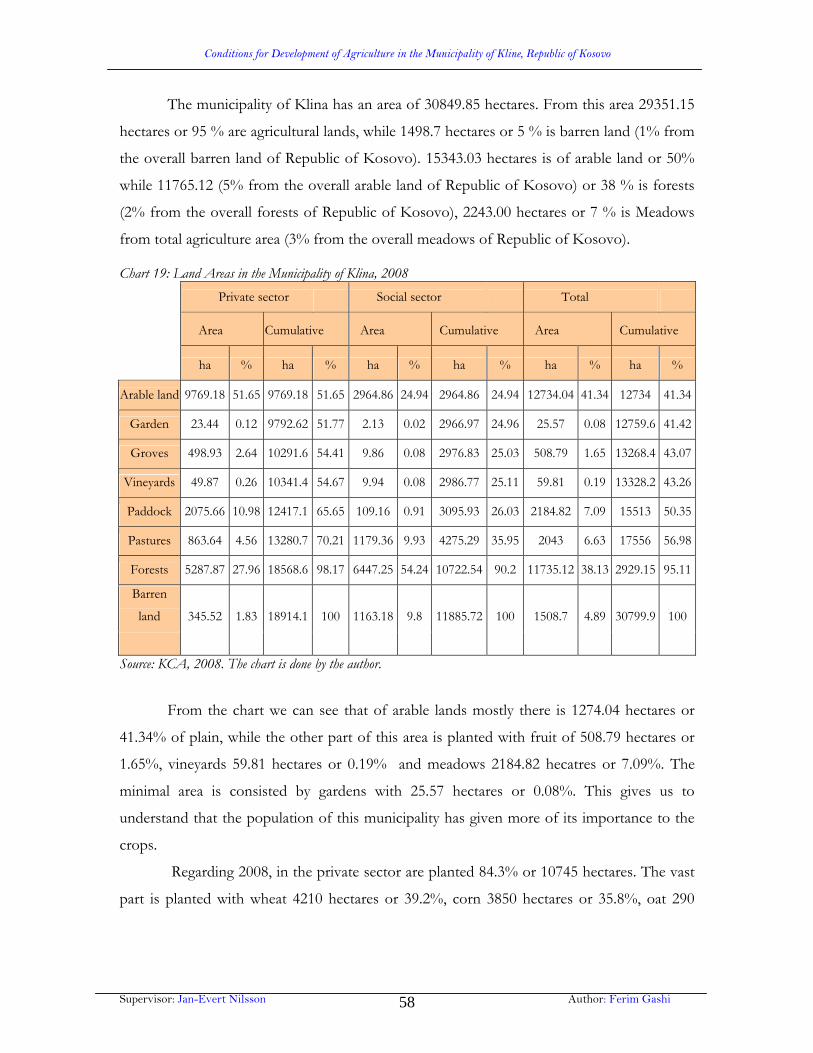
Conditions for Development of Agriculture in the Municipality of Kline, Republic of Kosovo
Supervisor: Jan-Evert Nilsson Author: Ferim Gashi 58
The municipality of Klina has an area of 30849.85 hectares. From this area 29351.15
hectares or 95 % are agricultural lands, while 1498.7 hectares or 5 % is barren land (1% from
the overall barren land of Republic of Kosovo). 15343.03 hectares is of arable land or 50%
while 11765.12 (5% from the overall arable land of Republic of Kosovo) or 38 % is forests
(2% from the overall forests of Republic of Kosovo), 2243.00 hectares or 7 % is Meadows
from total agriculture area (3% from the overall meadows of Republic of Kosovo).
Chart 19: Land Areas in the Municipality of Klina, 2008
Private sector Social sector Total
Area Cumulative Area Cumulative Area Cumulative
ha % ha % ha % ha % ha % ha %
Arable land 9769.18 51.65 9769.18 51.65 2964.86 24.94 2964.86 24.94 12734.04 41.34 12734 41.34
Garden 23.44 0.12 9792.62 51.77 2.13 0.02 2966.97 24.96 25.57 0.08 12759.6 41.42
Groves 498.93 2.64 10291.6 54.41 9.86 0.08 2976.83 25.03 508.79 1.65 13268.4 43.07
Vineyards 49.87 0.26 10341.4 54.67 9.94 0.08 2986.77 25.11 59.81 0.19 13328.2 43.26
Paddock 2075.66 10.98 12417.1 65.65 109.16 0.91 3095.93 26.03 2184.82 7.09 15513 50.35
Pastures 863.64 4.56 13280.7 70.21 1179.36 9.93 4275.29 35.95 2043 6.63 17556 56.98
Forests 5287.87 27.96 18568.6 98.17 6447.25 54.24 10722.54 90.2 11735.12 38.13 2929.15 95.11
Barren
land 345.52 1.83 18914.1 100 1163.18 9.8 11885.72 100 1508.7 4.89 30799.9 100
Source: KCA, 2008. The chart is done by the author.
From the chart we can see that of arable lands mostly there is 1274.04 hectares or
41.34% of plain, while the other part of this area is planted with fruit of 508.79 hectares or
1.65%, vineyards 59.81 hectares or 0.19% and meadows 2184.82 hecatres or 7.09%. The
minimal area is consisted by gardens with 25.57 hectares or 0.08%. This gives us to
understand that the population of this municipality has given more of its importance to the
crops.
Regarding 2008, in the private sector are planted 84.3% or 10745 hectares. The vast
part is planted with wheat 4210 hectares or 39.2%, corn 3850 hectares or 35.8%, oat 290

Conditions for Development of Agriculture in the Municipality of Kline, Republic of Kosovo
Supervisor: Jan-Evert Nilsson Author: Ferim Gashi 59
hectares and barley 915 hectares, fodder plants are of 480 hectares or 4.4%, vegetables 360
hectares or 3.3% and fruit 650 hectares or 6.10%.
Figure 9: Inseminated areas in the private sector regarding 2008
Source: Agriculture, rural and environmental development directorate, Kline, 15.09.2008. The chart was done by
the author.
In the public sector arable lands consist of 95.7% or 2964.86 hectares from the
infield. Fruit and vineyards are of 20 ha or 0.64%, paddocks 3.5%, gardens are less with
0.06%, respectively 213 ha.
Public sector as in forests, lands, vineyards atc is extremely on the edge as a
consequence of discriminating methods of the violent administration of Serbs and the war in
Kosovo. In 2001 most planted was wheat (200 ha) and barley (200 ha) altogether 400 ha or
13.5%.
In general, plants in the territory of Klina are insemined there where minimal
conditions exist in order for them to give their product, notably crops.
According to some studies that were done by the experts of agriculture in the
territory of this municipality, crops, industrial plants and those plants of animals can be
insemined and from them can be expected good fruits in the valley of Drini Bardhe and the
River of Peja. These valleys in fact are alluvial plains as well as the vast parts of them are
watered.

Conditions for Development of Agriculture in the Municipality of Kline, Republic of Kosovo
Supervisor: Jan-Evert Nilsson Author: Ferim Gashi 60
In the hilly side different plants are inseminated but their product depends on the
rainfall of summer. This kind of division is reasonable because these are main regions of this
municipality that differ from insemined areas with plants and products that they give within
one year.
Corn takes the first place from the plants which are insemined in this territory. This
is reasonable up to some extend due to the good conditions for its growth, then comes
wheat which is mainly planted in the hilly area.
Industrial plants are planted in the valleys of Drini Bardhe and the River Peja
however the characteristics is that they are not planted in vast areas except in the public
properties.
Also efforts are made for chosing more qualitative seeds of the crops that are planted
in this municipality. Thus until now this has been implemented successfully in the areas
planted with wheat.
The characteristic of this territory is that fruits are planted in smaller areas comparing
to good conditions that dominate. The reason is that there is no tradition for planting bigger
areas except for family needs.

Conditions for Development of Agriculture in the Municipality of Kline, Republic of Kosovo
Supervisor: Jan-Evert Nilsson Author: Ferim Gashi 61
6. Agriculture branches in the Municipality of Klina
6.1. Land cultivation
Land cultivation is the most important branch of agriculture in the Municipality of
Klina. Planting structure is represented most by grains, vegetables, industrial plants and
animal plants.
Despite problems like lack of agriculture mechanism, lubricant oils, and other factors of
different nature, it was achieved to be planted 6183 ha or 63.1% of the overeall arable
land in the private sector while in the public sector 350 hectares or 11.8%.
Chart 20: Sowing structure in hectares (2007/08) Planted area
Private sector Public sector
In hectares ha In hectares ha Corn 3850 Corn /
Wheat 4210 Wheat 200 Oat 290 Oat /
Lucerne 480 Lucerne / Barley 915 Barley 150
Vegetables 340 Fruit 660
Total 10745 350 Source: Agriculture, rural and environmental development directorate, Kline, 15.09.2008
From the chart we can see that there are 4210 hectares or 39.2 % planted with wheat,
corn with 3850 hectares or 35.8%, oat (290 ha) and barley (915 ha) 1205 hectares altogether
or 11.2%, fodder plants 480 hectares or 4.4%, vegetables 360 hectares or 3.3%, fruit 640
hectares or 6.10%.
6.2. Horticulture
Even though in the Municipality of Klina are very good conditions for planting
vegetables, this branch is not developed. It is more concentrated in the private sector. A vast
extend of this branch is more concentrated by the rivers of Drini Bardhe and River Peja.
This can be seen in the map of gardens due to the properties in the Municipality of Klina. In

Conditions for Development of Agriculture in the Municipality of Kline, Republic of Kosovo
Supervisor: Jan-Evert Nilsson Author: Ferim Gashi 62
2008 there were 360 hectares or 3.3% planted with peppers, tomatoes, cucumbers, potatoes,
onions, garlics, water melons, melons and cabbage.
All these products are planted mostly for family needs while for trade needs more are
planted cabbages (more in the village Gremnik which is very famous for cabbage quality not
only in this municipality but all over Kosovo) peppers and potatoes.
6.3. Fruit farming
Fruit farming in the Municipality of Klina is represented mainly in the private sector
and less in public sector where it takes 650 hectares or 6.10% from the overall areas of land.
According to the numbers of fruit, apples take the first place while tiny fruit like
cherries are not in vast numbers although there are good conditions for growing them.
Investigations have shown that this area has very convenient conditions for
development of fruit farming in contemporary plantations notably tiny fruits (berries) like
strawberry, raspberry, grapes etc. and stony fruits like cherries, peach, apricots etc ,and hard
shell fruit like hazelnuts, walnuts etc.
6.4. Stock farming
Stock farming in the municipality of Klina is in “stagnant time”, the race
composition of stock farming in inconvinient while product quantum and oscillations are
big. The reason for such condition is that except of the damages created during the war the
main reason stands in the socio-economic measure, respectivelly in material conditions of
agriculure. Stock farming conditions are convenient for its development where there are
2043.00 hectares of pasture and 2184.82 hectares of paddock which gives us to understand
that there are good conditions for development of stock growing.
From the stock farming reserve cows are spread with 47.7%, pigs 36.6%, sheep 9.5%, horses
2.9% and goats 3.3%. Poultry is represented with 8.6% in Dukagjini Plain (according to 1981
Dukagjini Plain had 453.190 fowl).

Conditions for Development of Agriculture in the Municipality of Kline, Republic of Kosovo
Supervisor: Jan-Evert Nilsson Author: Ferim Gashi 63
Chart 21: Stock reserve in the Municipality of Klina in 2001
Nr. Dwellings Cows Sheep Goats Pigs Hoarses Hens
1 Berkove 50 134 4 338
2 Bokshiq 169 14 1 28 731
3 Budisalc 288 21 1 622 6 2217
4 Cerovik 239 15 26 4 32 844
5 Dollove 145 55 7 605
6 Dugujev 104 226 11 957
7 Deiq (Novoselle) 191 1 2 316 5 1987
8 Dersnik 88 10 167 1 678
9 Duseviq-Dush 128 20 10 4 413
10 Dush 25 2 1 4 207
11 Derenovc 22 10 6 2 164
12 Gremnik 100 4 600
13 Gllareve 480 50 57 42 1794
14 Grabanice 137 2 8 12 765
15 Gjurgjevik i madh 297 55 23 30 1088
16 Çeskov 92 94 3 7 372
17 Çupeve 105 20 36 9 983
18 Kline 134 413 1 1514
19 Krusheve e Madhe 485 1265 10 2860
20 Kepuz 95 8 5 159
21 Zllakuqan 348 818 18 2724
22 Kline vc 95 224 2 340
23 Rudice 171 2 6 582
24 Poterq i Eperm 144 17 20 285
25 Poterq i Ulet 42 85 1 282
26 Vide 90 15 147 2 612
27 Siqeve 134 69 4 755
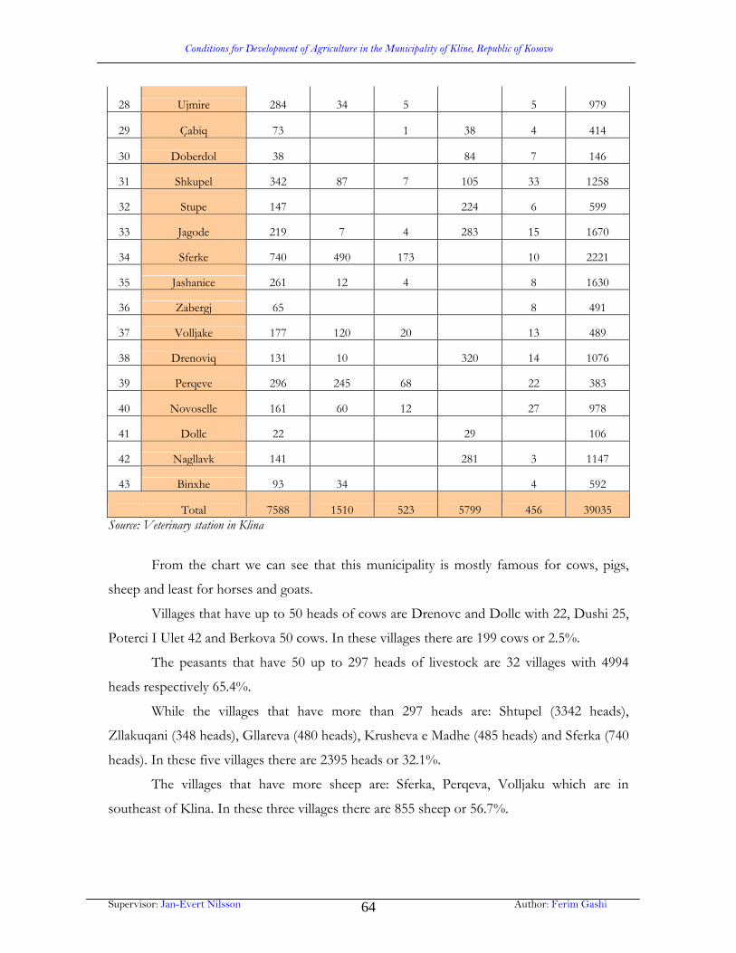
Conditions for Development of Agriculture in the Municipality of Kline, Republic of Kosovo
Supervisor: Jan-Evert Nilsson Author: Ferim Gashi 64
28 Ujmire 284 34 5 5 979
29 Çabiq 73 1 38 4 414
30 Doberdol 38 84 7 146
31 Shkupel 342 87 7 105 33 1258
32 Stupe 147 224 6 599
33 Jagode 219 7 4 283 15 1670
34 Sferke 740 490 173 10 2221
35 Jashanice 261 12 4 8 1630
36 Zabergj 65 8 491
37 Volljake 177 120 20 13 489
38 Drenoviq 131 10 320 14 1076
39 Perqeve 296 245 68 22 383
40 Novoselle 161 60 12 27 978
41 Dollc 22 29 106
42 Nagllavk 141 281 3 1147
43 Binxhe 93 34 4 592
Total 7588 1510 523 5799 456 39035 Source: Veterinary station in Klina
From the chart we can see that this municipality is mostly famous for cows, pigs,
sheep and least for horses and goats.
Villages that have up to 50 heads of cows are Drenovc and Dollc with 22, Dushi 25,
Poterci I Ulet 42 and Berkova 50 cows. In these villages there are 199 cows or 2.5%.
The peasants that have 50 up to 297 heads of livestock are 32 villages with 4994
heads respectively 65.4%.
While the villages that have more than 297 heads are: Shtupel (3342 heads),
Zllakuqani (348 heads), Gllareva (480 heads), Krusheva e Madhe (485 heads) and Sferka (740
heads). In these five villages there are 2395 heads or 32.1%.
The villages that have more sheep are: Sferka, Perqeva, Volljaku which are in
southeast of Klina. In these three villages there are 855 sheep or 56.7%.

Conditions for Development of Agriculture in the Municipality of Kline, Republic of Kosovo
Supervisor: Jan-Evert Nilsson Author: Ferim Gashi 65
In the villages where forests and pastures are dominant have influenced on
expansion of goats. Villages that have more goats are: Sferka, Cupeva, Perqeva, Gllareva and
Dollova where are grown 389 heads or 74.4%.
Pigs are expanded in those places where most of the population is Christian like:
Krusheva e Madhe (1265 heads of pigs), Zllakuqani (818 heads of pigs) Budisalci (622 heads
of pigs). In these villages the number of the pigs is 2705 or 46.6%.
There have been taken some steps towards building some farms in this territory, in
this way there have been given possibilities of taking loans form the banks, which besides are
very rarely taken and supported by the dwellers of this municipality mostly in the hilly-
mountainous villages.
6.5. The forestry sector
From the overall area of Municipality of Klina which is 30799.85 hectares, forests
include 11735.12 hectares or 38.2%.
Forests and forest lands in the Municiplity of Klina include central part of the region
of Dukagjini Plain. In these areas there are mainly forests with oaks and wild pomegranate.
The forests are very closely grown due to the orographic conditions, while forest
expansion through the villages has influenced illegal deforestation which has led to
degradation of the vast forests.
From the total area of forests 11735.12 hectares, there is a 6747.25 or 54.9% hectare
that belongs to public sector, while the other part of 5287.87 hectares or 45.1% belong to
private sector.
In the territory of the Municipality of Klina there is a high growth of forests, thus
their condition from economical point of view is unsatisfactory due to the overall economic
effects which impacts forestry on general economy of the municipality which are relatively
low.
The condition of forests in private sector is weak enough due to the non adequate
governing with them. The present conditions of forests and forest funds does not fulfill its
needs with woods neither can in general its functions be used.

Conditions for Development of Agriculture in the Municipality of Kline, Republic of Kosovo
Supervisor: Jan-Evert Nilsson Author: Ferim Gashi 66
Regarding forests experts’ estimations, forestry in the Municipality of Klina is much
damaged in about 70% of the area. The forests have been damaged in the pre war period,
respectively during the violent administration of Serbs, and in the post war period the forests
have been damaged by irresponsible people. Recently the forests are being destroyed mostly
by the fire, for instance in the villages of Dollove, Volljake and Perceve several hectares have
been destroyed by the fire.
A 2001 Forest Sector Study estimated that some 40% of public forests and 29% of
private forests in Kosovo have been subject of uncontrolled or illegal harvesting activities.
The inventory results also confirm expert opinions that coppice forest, especially
public owned, is exposed to heavy harvesting for firewood. The results also show that many
young and middle-aged forests are in urgent need of management interventions, ranging
from cleaning/pre-commercial thinning to commercial thinning. It is expected these general
observations are also valid in Kline.
6.5.1 Forest cover and land ownership
Although forest land accounts for nearly 10,000 hectares or more than 30% of Kline
municipality (36% - or more than 11,500Ha, if scrub land is included), its quality and
productive capacity is very low.
KFA confirms that there are not any timber resources of any commercial value in
Kline, although it is claimed that there are 1000 Ha of 13 good condition years old forests
(22 years remaining before harvest) still intact and in stands north of the Peja / Prishtina
road and the Adem Galica stone quarry areas. Most of the remaining forest covers stands of
coppiced oak which have very low timber volumes and suffer from neglect in thinning and
lack of a proper forest management regime.
6.5.2 Forest resource assessment
There is widespread reliance in rural Muncipality of Kline on coppiced trees as a
source of fuelwood for heating and cooking in the months of winter.

Conditions for Development of Agriculture in the Municipality of Kline, Republic of Kosovo
Supervisor: Jan-Evert Nilsson Author: Ferim Gashi 67
A brief visual assessment of forest quality in Muncipality of Kline shows that all
forest, especially that under KFA management is in a much degraded state, unlike private
owned forests which are in a better condition. Public forests, private and public land need
investment in forest management.
On Chart 21 are listed land cover types which are grouped by category of land
ownership. It shows that 22.199 Ha of land in the private sector more than 500 Ha or 22.9%
of this is forest.
Chart 22. Land use types in Kline (2001): land area (ha and percent) according to ownership and as a percentage of total
Source: ALUP
Due to the local economy there are many problems which face forestry, however the
most important according to local KFA staff is illegal extraction of timber which is widely
Land Use Type Ownership % Area (Ha)
% of land use type per ownership
% of total land use type in Kline per ownership.
* KFA Land 61.8 1.2 Agriculture KFA Land 511.1 10.3 2.9Forest KFA Land 3,537.7 71.2 38.6Grassland KFA Land 449.0 9.0 94.7Quarry KFA Land 199.0 4.0 92.7Scrub KFALand 197.5 4.0 10.2Urban KFA Land 15.4 0.3 1.0Subtotal 15.8 4,971.5 100 * SOE Land 85.8 2.0 Agriculture SOE Land 3,297.2 75.6 18.5Forest SOE Land 637.7 14.6 7.0Scrub SOE Land 428.6 9.8 22.0Urban SOE Land 0.3 0.0 0.0
Land Use Type Ownership % Area (Ha)
% of land use type per ownership
% of total land use type in Kline per ownership.
Subtotal 13.8 4,363.8 100 * Private Land 290.1 1.3 Agriculture Private Land 13,888.9 62.6 62.6Forest Private Land 5,082.9 22.9 22.9Grassland Private Land 25.1 0.1 0.1Quarry Private Land 15.5 0.1 0.1Scrub Private Land 1,442.8 6.5 6.5Urban Private Land 1,454.0 6.5 6.5Subtotal 70.4 22,199.3 100.0 Total Land Cover 100 31,534.6

Conditions for Development of Agriculture in the Municipality of Kline, Republic of Kosovo
Supervisor: Jan-Evert Nilsson Author: Ferim Gashi 68
spread and is used mostly for sale and as fuelwood thus KFA has some plans to prevent
these illegal activities by reforestation, however in 2001-2006 60Ha of land were reforested
with assistance form FAO.
Due to the lack of overall national forest policy and strategy, long term and
sustainable rural development is limited, thus it is seen that such policy is the only method to
succeed in protecting and managing the forest as a sustainable resource.
Under the current situation, regeneration of forest is impossible as long as the illegal
harvesting and sale of fuel wood provides for many citizens the only available source of
income in Kline municipality, who’s estimated rural unemployment rate runs as high as
80%.
- Coppiced forest as source of fuel wood
The very poor quality of forest and long period before timber wood harvesting can
take place minimizes short term economic rewards of forestry and stands against the
possibility of forestry gaining as a significant part of the economy apart from a source of fuel
wood and low income for the very poor.
One possibility of using forest in a way that does not impose a 25 year waiting
penalty involves the use of coppiced forest to produce energy for fuel woodl heating boilers.
For this to take place, a particular type of boiler (a fuel wood boiler) is required that
consumes the wood in an efficient manner. Installation of such a boiler in a part or parts of
the municipality would create a ready local market for coppiced timber with rotation as little
as 5 years.
- Local fuel wood market as a solution
The municipality should seek grant funding for at least one fuel wood boiler for
public premises in Kline municipality. Installation of this would immediately create a
permanent local market for low value short rotation fuel wood from coppiced land and
increase the economic value of preventing timber theft.
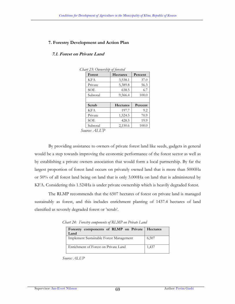
Conditions for Development of Agriculture in the Municipality of Kline, Republic of Kosovo
Supervisor: Jan-Evert Nilsson Author: Ferim Gashi 69
7. Forestry Development and Action Plan
7.1. Forest on Private Land Chart 23: Ownership of forested
Forest Hectares Percent KFA 3,538.1 37.0Private 5,389.8 56.3SOE 638.5 6.7Subtotal 9,566.4 100.0
Scrub Hectares PercentKFA 197.7 9.2Private 1,524.5 70.9SOE 428.5 19.9Subtotal 2,150.6 100.0
Source: ALUP
By providing assistance to owners of private forest land like seeds, gadgets in general
would be a step towards improving the economic performance of the forest sector as well as
by establishing a private owners association that would form a local partnership. By far the
largest proportion of forest land occurs on privately owned land that is more than 5000Ha
or 50% of all forest land being on land that is only 3.000Ha on land that is administered by
KFA. Considering this 1.524Ha is under private ownership which is heavily degraded forest.
The RLMP recommends that the 6507 hectares of forest on private land is managed
sustainably as forest, and this includes enrichment planting of 1437.4 hectares of land
classified as severely degraded forest or ’scrub’.
Chart 24: Forestry components of RLMP on Private Land
Forestry components of RLMP on Private Land
Hectares
Implement Sustainable Forest Management
6,507
Enrichment of Forest on Private Land
1,437
Source: ALUP
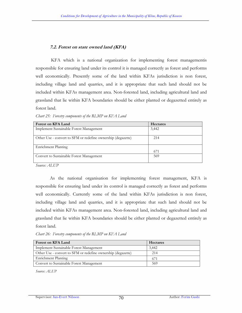
Conditions for Development of Agriculture in the Municipality of Kline, Republic of Kosovo
Supervisor: Jan-Evert Nilsson Author: Ferim Gashi 70
7.2. Forest on state owned land (KFA)
KFA which is a national organization for implementing forest managementis
responsible for ensuring land under its control it is managed correctly as forest and performs
well economically. Presently some of the land within KFAs jurisdiction is non forest,
including village land and quarries, and it is appropriate that such land should not be
included within KFAs management area. Non-forested land, including agricultural land and
grassland that lie within KFA boundaries should be either planted or degazetted entirely as
forest land.
Chart 25: Forestry components of the RLMP on KFA Land
Source: ALUP
As the national organisation for implementing forest management, KFA is
responsible for ensuring land under its control is managed correctly as forest and performs
well economically. Currently some of the land within KFAs jurisdiction is non forest,
including village land and quarries, and it is appropriate that such land should not be
included within KFAs management area. Non-forested land, including agricultural land and
grassland that lie within KFA boundaries should be either planted or degazetted entirely as
forest land.
Chart 26: Forestry components of the RLMP on KFA Land
Source: ALUP
Forest on KFA Land Hectares Implement Sustainable Forest Management
3,442
Other Use - convert to SFM or redefine ownership (degazette)
214
Enrichment Planting 671 Convert to Sustainable Forest Management
569
Forest on KFA Land Hectares Implement Sustainable Forest Management 3,442 Other Use - convert to SFM or redefine ownership (degazette) 214 Enrichment Planting 671 Convert to Sustainable Forest Management 569

Conditions for Development of Agriculture in the Municipality of Kline, Republic of Kosovo
Supervisor: Jan-Evert Nilsson Author: Ferim Gashi 71
7.3 Forest on SOE land The 308 Hectares of ‘low’ forest on SOE land should be managed according to SFM
principles to ensure its maximum economic productivity while the 425 Hectares of very
degraded forest on SOE land should be enriched to ensure its future viability as forest land.
Some of the forest areas are sufficiently large to justify significant investments in improving
the number and quality of growing stock, while some of the smaller sites would be more
effectively managed as wood lots for domestic consumption.
Chart 27: .Areas Planned as Sustainably Managed Forest SOE Socially Owned EnterprisesManaged Forest
Area / Ha
Dollova_Qeskova / Bujqesia_Peje 323.6Budisalc / Bujqesia_Peje 101.3Bingja / NPB_Malishgan 71.3Grabanica_Gllogjani / Bujqesia_Peje 30.1Drenovc / Bujqesia_Peje 29.2Zajmi / Bujqesia_Peje 18.1Parallova / NPB_Malishgan 12.5Joshanica / NPB_Malishgan 11.4Gremnik_vishnje1 / NPB_Malishgan 6.4Poterq_Jabllanice / Bujqesia_Peje 6.2Dushi1 / NPB_Malishgan 5.2Dushi_Resnik / NPB_Malishgan 3.9Dollova_Qeskova1 / Bujqesia_Peje 3.9Berkove_Kosh / NPB_Malishgan 2.7Zllakuqan_lajthija / NPB_Malishgan 2.1Gremnik_vishnje2 / NPB_Malishgan 1.9Private Land 1.4Renovc / NPB_Malishgan 0.9Total 308.5
Source: ALUP

Conditions for Development of Agriculture in the Municipality of Kline, Republic of Kosovo
Supervisor: Jan-Evert Nilsson Author: Ferim Gashi 72
Chart 28: Planned enrichment planting of Forest on SOE Land
7.4 Constraints to forest sector development
The problems that face the forest sector in Kline are common to all municipalities in
Kosovo, and can be summarised as follows:
Widespread illegal extraction of fuel wood and timber from KFA land
Inadequate protection of forests.
Absence of forest management plans.
Insufficient KFA manpower and resources
Small scale of forest landowners who are unable to benefit from forestry
The above problems are dealt with a very few local actions. For instance there is a
poor infrequent rural water supply that is very important for establishing successful forests.
In addition between 2001-2006 although KFA planted 60 Ha of land in the Mirusha Gorge
Enrichment Planting of Forest on Socially Owned Enterprises Land Dollova_Qeskova / Bujqesia_Peje 110.8Bingja / NPB_Malishgan 80.2Budisalc / Bujqesia_Peje 78.0Zajmi / Bujqesia_Peje 35.1Dushi_Resnik / NPB_Malishgan 27.3Drenovc / Bujqesia_Peje 28.6Dushi1 / NPB_Malishgan 20.6Zllakuqan_lajthija / NPB_Malishgan 17.7Joshanica / NPB_Malishgan 14.0Joshanica3 / NPB_Malishgan 3.5Joshanica2 / NPB_Malishgan 2.8Berkove_Kosh / NPB_Malishgan 2.1Poterq_Jabllanice / Bujqesia_Peje 1.5Dushi_Resnik2 / NPB_Malishgan 1.3Renovc / NPB_Malishgan 1.1Parallova / NPB_Malishgan 0.6Dushi / NPB_Malishgan 0.2Total 425.4Source:: ALUP

Conditions for Development of Agriculture in the Municipality of Kline, Republic of Kosovo
Supervisor: Jan-Evert Nilsson Author: Ferim Gashi 73
area, 60% of seedlings died due to lack of water.
The lack of forest management advice and support may negatively affect successful
establishment of new forest plantations especially on privately held and SOE land. Then the
absence of appropriate resources, professional forest management advice, access to
mechanized tools and the equipment for thinning, seeds etc, negatively influences the ability
of local communities to improve the quality of growing timber.
7.5 Potential for community involvement in forest sector development
Improving forest management on state owned land through the leasing of KFA land to private
owners.
From field observations in Kline it is typical that forest on private land is of much
higher quality than forest on state (KFA administered) land. Logically we can suggest that for
improvement of forest management in Kline municipality could be done by involving land
owners in management of KFA land.
Therefore the municipality should consider a proposal of a long term leasing
agreement that keeps the land under state control, but rewards the leaseholder (private
citizen) for maintaining the forest in a good condition by providing (limited) access to timber
and firewood at pre-harvesting thinning times.
The terms of the lease and setting up the forest leaseholders should be carefully
prepared with the participation of KFA these forest leaseholders would have to function as
local forest guards in order to prevent or minimise the ever-present risk and ongoing
extraction of timber by unauthorized individuals.
Private forest landowners would be able to access the resources of KFA in both
forest management planning and in the harvesting of timber, paying for this.
7.6 Forestry Project Proposals
Wood is a major source of renewable heat energy and burnt efficiently, it produces
virtually no smoke and no acid rain. Short rotation forestry and short rotation coppice trees
can be purpose-grown for energy. The large forest area grown as coppiced woodland in
Kline indicates potential to become a major supplier in woodfuel (renewable heat from

Conditions for Development of Agriculture in the Municipality of Kline, Republic of Kosovo
Supervisor: Jan-Evert Nilsson Author: Ferim Gashi 74
biomass). Forest plantations can be managed to produce woodfuel with short term rotations
from 11-13 years. Recycle wood from the parts of harvested timber trees that are not
suitable for saw timber also a potential source of energy.
The municipality of Kline will be eligible for structural funds when Kosovo enters
the EU pre accession phase using IPA (Instruments of Pre-Accession) funding under a
number of current programmes. The EAR funded Local Development Strategy (LDS)
project is currently preparing Kosovo municipalities for this. EU provides funding towards
the development and capital costs of renewable energy projects for communities, as well as
assisting technical assessments of project feasibility. Support may be allocated to wood-
fueled community projects, including district heating schemes such as those in schools
community centres and public buildings.
7.7 Forestry Action Plan
Initiatives are needed in order to encourage the establishment of small scale forestry
enterprises. Small forestry enterprises can influence the local economy only if the local
market conditions are sufficiently favorable. The action plan develops ideas on how to create
revenues for forest owners who want to restore degraded forests.
The municipality should prepare and submit a proposal to Kosovo Forest Agency
that would result in preparation of a draft agreement between rural landowners and Kosovo
Forest Agency. This proposal would describe how forest land that is presently legally
administered by Kosovo Forest Agency could be leased by rural landowners.
The municipality should seek capital grant funding for the acquisition of biomass
heating boilers for selected public centres or schools.
8 Agricultural Action Plan
Municipal Agicultural office presented the agricultural action plan for Kline in two
workshops. Its main focus is on the following factors:
How to improve the productivity of farming

Conditions for Development of Agriculture in the Municipality of Kline, Republic of Kosovo
Supervisor: Jan-Evert Nilsson Author: Ferim Gashi 75
How to deal with the pollution of water, land and soil
How to deal with the loss of agricultural land through construction
How to improve the marketing of agricultural produce
How to mobilize investment capital fort the agricultural sector
What off-farm income opportunities are available?
Farmers organizations
8.1 On Farm Productivity
For the future it can be expected that the subsistence farming sector will diminish, as
new off-farm employment and income opportunities arise. The small scale farming sector
will undergo a slow, but drastic changes. The challenge is to provide economic support to
this process so that farmers can benefit from it and a sound and sustainable new farming
sector can evolve.
Due to the fact that staple food products can be found on the local market. The farm
can specialize which will lead to intensification, for instance now one can observe a
preference of farmers for livestock production moreover for milk production.
The improved technology (e.g. high yielding cows, disease resistant varieties, more
efficient machinery etc.) is a process which increases productivity in farming, which would
follow the following 1) existing appropriate technologies have to be identified, 2) they have
to be validated under Kosovo conditions and 3) they have to be introduced in the farming
practice.
On external hazards
Several external hazards threaten agricultural production:
Irrigation water from rivers is contaminated by sewage and waste.
This means that farmers prefer to irrigate with ground water and
have to pump it with high costs. They should just get up pressure on
the political decision makers in order to improve the situation of
black waters in rivers.

Conditions for Development of Agriculture in the Municipality of Kline, Republic of Kosovo
Supervisor: Jan-Evert Nilsson Author: Ferim Gashi 76
Waste is often dumped in the country side. It spoils the landscape
and can contaminate the soil. The polluters have to be made
responsible to clean it up and farmers have to put pressure on
politicians to enforce the existing laws. A public awareness campaign
and public clean up are needed to be done accompany this. A
coordinated event between municipality, schools and farmers could
give the issue a push.
Soil fertility is endangered by certain agricultural practices (erosion,
drop in organic matter, wrong application of plant protection
products). The law on agricultural land requires regular control, to be
financed by the farmer. This provision is not widely known. An
awareness campaign needs to inform farms and later it has to be
enforced by the authorities.
Growing cities and villages and industrial cities are consuming agricultural land. This
is currently happening in an uncontrolled way. Although farmers in particular cases benefit
from selling agricultural land for high prices, it has also severe negative effects. Valuable
natural resources are destroyed and the landscape is spoilt due to the building of different
factories or houses, or blocks of flats on agricultural land.
8.2 On Marketing of Agricultural Produce
Marketing of agricultural produce is one of the most popular demands of farmers;
however people often mean the price level, while talking about better marketing
opportunities when it comes to planning future action. They do remember the “good old
(Yugoslav) times” when the local cooperative used to buy the produce at a guaranteed price.
The group working on the agricultural action plan milk collection is highest
prioritized due to the fact that milk production is typical product for small farmers. There
are already four milk collection centres in Kline, but two or three more would be needed.
Especially in the northern hilly areas, there are none and also in the mountain area of
Perceve not milk collection is available.
In order to deliver it and receive a better price, farmers need to secure the quality of
Conditions for Development of Agriculture in the Municipality of Kline, Republic of Kosovo
Supervisor: Jan-Evert Nilsson Author: Ferim Gashi 77
milk such as bacteria or contamination. The requirements need investments on the farm, as
well as technical advice, thus milk selling has to be guarantied accortding to quality.
Nevertheless we can not neglect the improvement of the local cattle market, as there
are many environmental threats through illegal slaughtering and waste disposal in the nearby
Drini River.
There are several good examples in Kosovo, where local cattle markets were
rehabilitated with relatively low investments, but with good results. The operators of the
market need to be trained and an effective veterinary control established. The market needs
to cover its running and capital costs through feeds charged to the customers.
In any case the market would need urgent improvements, especially a roof and better
hygienic conditions. Similar to the cattle market, besides financing and improving the
infrastructure, an efficient and effective management of the market needs to be established
at the same time: guarantee of hygienic conditions, cleaning, cost coverage and the
connection to a market information system would be objectives.
One cross-cutting issue, concerning all levels of the food chain is food safety. This is
a complex, but highly important topic for the long term viability of the Kosova food sector.
Action has to be started on all levels, lead by the public authorities and the agro-industry. If
the Kosovo food sector cannot meet them, it will not succeed. Local actors have to get
acquainted and start to do what is in their domain to meet these requirements. Cooperation
with national projects is essential to get access to know how and training.
8.3 On Investment Capital
Also for this issue, farmers have to abandon the old idea of Agro-Kosova, which had
supplied them with inputs and also with finance at often very favorable conditions. But also
the banks need to learn that farmers are also business men and can be good customers.
This approach cannot be developed on the level of Kline itself. But Kline farmers
and institutions can participate in activities and projects on national level. On the local level
farmers need to get acquainted with the credit lines and the requirements of banks. Advisory
help is needed to assist the municipality prepare investment projects so they can be easily
appraised by the local banks and other finiancial institutions. Bank officers are often not

Conditions for Development of Agriculture in the Municipality of Kline, Republic of Kosovo
Supervisor: Jan-Evert Nilsson Author: Ferim Gashi 78
acquainted with the agricultural sector and often results in underestimation of the true
business and investment potential. Two approaches are necessary to overcome this: firstly
banks should decide on special agricultural credit lines and train their employees specifically
to deal with this sector. Secondly the local farming sector and the banks should establish a
line of communication, which enables both parties to better understand the possibilities of
the other side. Regular meetings and events are necessary to establish trust and build up
confidence over time.
8.4 On off-farm opportunities
Off-farm job and income opportunities have been and are still essential for the
viability of small subsistence farms. Off-farm jobs are often providing the necessary cash
income, while the farm provides food and housing. However jobs in the industry are
currently very scarce in Kosovo. In rural areas these jobs are almost inexistent.
A potentially interesting field of rural off-farm occupation could be forestry.
However forestry in Municipalty of Kline is currently of very low productivity and needs
years to recover. In addition there is still of illegal cutting and selling of fire would. It is
unknown, but cannot be excluded that the rural population is involved in these activities.
This must be stopped and the protection of forests must be enforced.
Another off-farm income opportunity is rural tourism. In other countries this
provides jobs for many people, but in Kosovo it is still less developed. Some places have
started in this direction, like restaurants along the river bench or kiosks near Mirusha Gorge.
These attempts need to be carefully evaluated and brought into a concept, which combines
the protection of the beauties of the landscape with the economic interests of the rural
population.
8.5 On Farmers Organisations
The above mentioned priorities and projects will not be achievable, if farmers don’t
take the initiative and a leading role in this process. Public services, projects, donors or any
external assistance will fail, if farmers are not responding.

Conditions for Development of Agriculture in the Municipality of Kline, Republic of Kosovo
Supervisor: Jan-Evert Nilsson Author: Ferim Gashi 79
8.6 On Irrigation
In Yugoslav times there was intensive irrigated agriculture, and there are a number of
physical structures on the Drini Bardhe. These structures, built in the 1960s are at Rodice,
Bresnik, Zllakuqan, Grabanic e eperme and Grabanic e Ulet and provide take off points for
a network of distribution canals. Maintenance of both dams and distribution network has
now virtually collapsed and currently only 500 Ha of land is irrigated out of an area that was
formerly almost 2000 Ha in size. Absence of reliable irrigation water supplies and
dependence on rain fed supply is clearly a major constraint on farmers’ ability to respond to
the market and make decisions that maximise profitability.
The practical options for expanding the availability of irrigation water as a
development strategy needs to be reviewed carefully, taking the local market and farmers’
preferences into consideration. In practical terms as long as no improvement of irrigation
water quality is achieved, investments in the irrigation systems is not recommendable.A
systematic continued river and irrigation water quality monitoring programme is a necessity.
Since the maintenance of dams may indeed be difficult for a farmers group, this maintenance
may be contracted out to a contractor by the Irrigation Company. The Irrigation Company is
responsible for the quality of work. Canal O&M remains the responsibility of farmers. Dam
operation may be done by the farmers group supervised by the Irrigation Company or a (in
future to be expected) river basin authority.
9. Industry role in development of agriculture
Among all non developed municipalities in Kosovo is the Municipality of Kline. In
this municipality other economy activities are less developed. Until the end of 1980 Klina
was without important industrial objects even though industry development relatively has
good conditions.
In 1980 Klina had only two manufacturers which belong to inductrial activity which
were “Boks” mine and “Seperacioni”.
In the future industry should absorb the biggest part of investments, respectively it

Conditions for Development of Agriculture in the Municipality of Kline, Republic of Kosovo
Supervisor: Jan-Evert Nilsson Author: Ferim Gashi 80
should play its main role in development and backwardness which is present should be
exceeded.
Due to the existing natural resources explored in the Municipality of Klina, the
development of industry should be more intensive hence its further industrial development
will be based mainly on agricultural raw material and raw minerals.
Its propitious geographical position, traffic possibilities and infrastructure as well as
water supply will be a convenient element for setting future industrial capacities in the
Municipality of Klina.
An important economical potential of this municipality is the agricultural areas.
Farmed areas take more than 20. 000 Ha considering its convenient climatic conditions and
watering possibilities these areas are a vast potential for the development of Municipality of
Klina.
It is foreseen that the areas which are below industrial plants include circa 15% of
the farmed area (sugar cane, sunflower) which is a base for the development of capacities
regarding raw material with agricultural origin.
All these make it possible for the development of food industry in the Municipality
of Klina in the future.
10. Institutional framework
The Ministry of Agriculture, Forestry and Rural Development maintains a regional office in
Peje, which is also responsible for Municipality of Klina.
- Currently there are five people working: Officer for livestock production, rural
development and extension officer, two phyto-sanitary inspectors and one veterinary
inspector.
- The office is equipped with all necessary equipment and as well they have a car.
- Main responsibilities are to support municipal offices, organize workshops and field
days, collect data about the region and coordinate and support MAFRD in their field
work.
- Usually all activities are coordinated with MAFRD and they are serving to farmer as
an open field office where they can address their issues about agriculture and rural
development.

Conditions for Development of Agriculture in the Municipality of Kline, Republic of Kosovo
Supervisor: Jan-Evert Nilsson Author: Ferim Gashi 81
- There is no specific programme in Kline Municipality, partly due to lack of budget
but as well unclear role of regional office of MAFRD.
After the war in 1999 this system disappeared quickly and no cooperatives are active
anymore in Kline. New farmer’s organizations and self-help initiatives are only very slowly
evolving. They founded, if there are urgent needs, a strong interest or often, if there is the
possibility to profit from a project.
Selected farmers groups, projects and NGOs:
- Agro Ujmiri: association of dairy producers around the MCC in Ujmir village
“Blegtori 2005” in Dollova: Mercy Corps has supported the creation this farmer association
to start a new MCC, planned for September 2007.
- Intercooperation: Support to 1 ha strawberries in Grabanice region, 2 ha apples in
Zabergje, 0, 5 ha apples in Dersnik, seedling production in Vide, compost
production with Agro Kline.
- Articam/Italy: Support was given to MCC in Cerovik.
- Marketing Support Project (MSP): Support to Kline Dairy Producers Group and
Kline Honey Producers group.
- Rural Advisory Service: Two RAS advisers contracted from May 2006 until end of
2006. No continuation since then.
- LDSP, Local development Strategy Project (EU financed) started in May 2007. The
regional adviser is residing in Kline and supports Local Action Groups (LAG). These
groups are invited to develop projects in a participatory way. However finance for
the realization of these projects is not provided by LDSP.
Financing of agricultural investments are relying largely on private capital. In Kline no cases
of major institutional financing through banks or the Agricultural Business Unit or major
investment projects or proposals are known. Small credits from the local banks (Raiffeisen
and ProCredit Bank) are possible, but only at relatively high interest rates. There are no
advisors, who would be able to support farmers or investors in the elaboration of investment
projects. Banks don’t have special credit lines for farmers.
Conditions for Development of Agriculture in the Municipality of Kline, Republic of Kosovo
Supervisor: Jan-Evert Nilsson Author: Ferim Gashi 82
11. List of planning rules and objectives
For specific land uses such as forestry there are planning criteria that are
implemented at a much higher level of spatial detail, i.e. forest management plans, where the
principle of sustainable yield should prevail. Sustainability here is understood as the notion
that trees should not be harvested faster than they are replenished. For some forest land (i.e.
KFA land) there are changing or emerging planning principles such as that of multiple use,
that is land should be managed for a variety of simultaneous uses. Or example timber
harvest, grazing, hunting and wildlife conservation. Acknowledging that in some cases the
legal context of specific land uses has yet to be enshrined in a legal form, the following basic
principles are followed.
1) The RLMP should guide sustainable economic development in the municipality;
The RLMP should maximize the potential economic value of land use for rural
communities. This includes the notion that higher value agricultural land should be
consolidated to create viable holdings that represent larger functional economic units.
2) The quality and quantity of prime agricultural land should be preserved.
3) RLMP should guide environmental protection.
4) The RLMP should ensure that land is managed in a manner that preserves and protects it
from damage and degradation. Soil erosion should be minimized by restricting the
cultivation of arable crops on steep land, using this instead for forestry or grazing purposes.
5) Planning takes into account the protective functions of the water sheds and the potentially
negative downstream impact of effects of land use decisions such as deforestation of steep
land. Any existing forested, scrub, or grassland in the upper part of river basins should
remain under this cover. It is understood that this requires a regional rather than a municipal
approach and remains pending the installation and functioning of river basin authorities.
6) Any mineral extraction activity should return top soils and land covers to their original
condition, avoiding extractive methods that expose land surface to high levels of runoff and
sedimentation. Given the recognition by the Spatial Plan of Kosovo of Kline Municipality as

Conditions for Development of Agriculture in the Municipality of Kline, Republic of Kosovo
Supervisor: Jan-Evert Nilsson Author: Ferim Gashi 83
the ‘garden’ of Kosovo, lignite mining initiated in the area of greatest soil fertility would be
most detrimental to agricultural production. This is considered a most harmful development
scenario, illustrated by the fact that the Obiliq lignite mining near Prishtina remains extensive
and that the site is demonstrably accountable for heavy environmental impacts.
7) Construction of residential housing in rural areas should be planned and take place
according to defined criteria, avoiding as much as possible loss of high grade agricultural
land.
8) Land must be protected from the effects of soil erosion:
9) Intensive agricultural land use should be limited to flat areas or shallow sloping land.
10) Forest, shrub or permanent grass cover should be maintained on steeply sloping land,
defined as land over 15%.
11) Arable agriculture should not be practiced on those areas that are frequently flooded, in
order to reduce soil loss. These areas should be managed in manner that most effectively
reduces risks. Land adjacent to major rivers / watercourses (floodplains) should be
maintained under permanent grass / forest cover.
The assessment of landscape character is fundamental to the planning of rural areas.
This is because rural areas, if not carefully managed, will experience significant impact as a
result of future growth. It is therefore important to understand the sensitivity of these areas
to change, so that growth that takes place outside the larger urban centers can be directed to
locations which are least sensitive to change and contribute towards achieving a sustainable
pattern of development.

Conditions for Development of Agriculture in the Municipality of Kline, Republic of Kosovo
Supervisor: Jan-Evert Nilsson Author: Ferim Gashi 84
Reference/ Literatures:
1. European Union, Regional Policy (May2007); Growing Regions, growing Europe: Fourth report on
economic and social cohesion,
2. The Ministry of Agriculture, Forestry and Rural Development,2008
3. Independent Commission on Minerals and Mines; www.kosovo-mining.org ,2008
4. Kosovo Cadastral Agency (2008); www.ks-gov.net/kca ,
5. Local Development Strategy 2007-2010, (June 2008) ;Municipal Assembly of Klina;
6. Strategy for Economic Development 2003-2006; (2008) Municipal Assembly of Klina;
7. Dr. Asllan Pushka (2008), Aspekte Gjeopopullative ne Kosove dhe rreth saje, Prishtine,
8. Dr. Asllan Pushka (2000), Gjeografia agrare, Prishtine,
9. Dr. Riza Çavolli (1997), Gjeografia Regjionale e Kosoves, Prishtine,
10. Plani Hapsinor, Enti per urbanizem dhe projektime, Prishtine (1984), Instituti Ekonomik ne
Prishtine, Subregjioni i prekoruples (komunat: Istogu, Klina, Rahoveci, Suhareka), Prishtine,
11. Dr. Adem Salillari, Dr. Sami Hoxha dhe Dr. Hiqmet Demiri (1988), Fara dhe Teknologjia e saje,
Tirane,
12. Datas from Hidrometeorogical Institutions of Kosovo (2008), Prishtine,
13. Data form Municipal Cadastre of the Municipality of Klina (2008),
14. Datas form agriculture Directory, rual development and environment protection, Kline,
2008.
15. Datas form Veterinary station in Kline, 2008.
16. Agriculture and Rural Development Plan of Kosovo 2007-13; www.ampkosovo.com
17. European Agency for Reconstruction and Development
18. Kosovo Forestry Agency,2008
19. Kosovo Institute of Agriculture,2008
20. Kosovo Environmental Protection Agency,2008
21. Kosovo Trust Agency,2008
22. Kosova Our home: Kosova Spatial Plan: Ministry of Environment and Spatial planning working
paper prepared from The Institute of Spatial Planning Prishtina, April 2006.
23. The Ministry of Agriculture, Forestry and Rural Development, 2003, „Strategy of sustainable
rural and agricultural development in Kosova Green book, Prishtina, Kosova.
24. Towards an Action Plan for Sustainable Forest Management; The EU's impact on forests: A
practical guide; http://www.fern.org/

Conditions for Development of Agriculture in the Municipality of Kline, Republic of Kosovo
Supervisor: Jan-Evert Nilsson Author: Ferim Gashi 85
25. Local Development Strategies, An EU funded project managed by the European Agency for
Reconstruction, www.lds-ks.org
26. Rural Land management plan Klina/Kline,2006; Agricultural Land Utilisation Project (European
Agency for Reconstruction and Development)
27. Kosovo (Under UNSCR 1244/99) 2008 Progress Report, Commission of the European
Communities; Brussels, 2008
28. European Commission; Directorate-General (DG) for Enlargement at: http://ec.europa.eu/enlargement/potential-candidate-countries/kosovo/index_en.htm;
September, 2008
29. Direct views in the territory of the Municipality of Klina, 2008
8. Appendices

Conditions for Development of Agriculture in the Municipality of Kline, Republic of Kosovo
Supervisor: Jan-Evert Nilsson Author: Ferim Gashi 93
7 Map Klina Populations by River Catchment
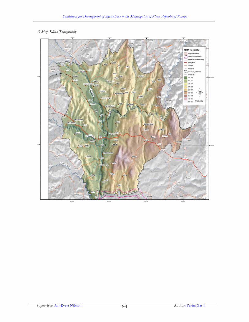
Conditions for Development of Agriculture in the Municipality of Kline, Republic of Kosovo
Supervisor: Jan-Evert Nilsson Author: Ferim Gashi 94
8 Map Klina Topography
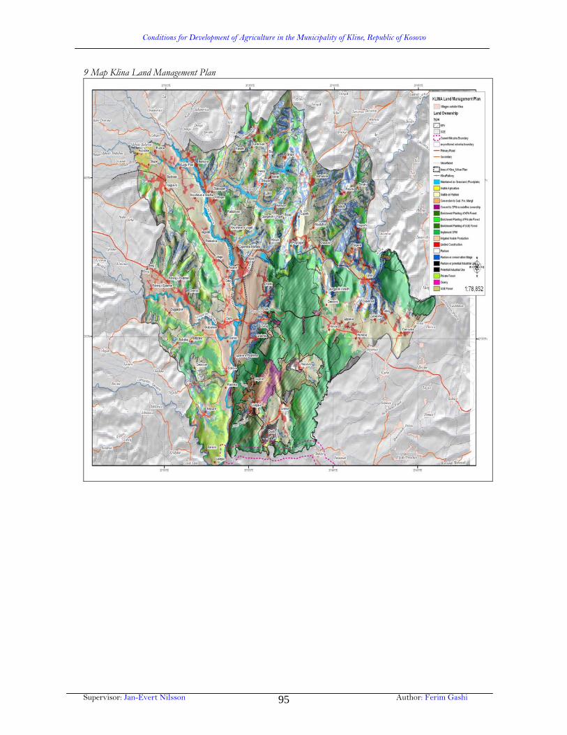
Conditions for Development of Agriculture in the Municipality of Kline, Republic of Kosovo
Supervisor: Jan-Evert Nilsson Author: Ferim Gashi 95
9 Map Klina Land Management Plan

Conditions for Development of Agriculture in the Municipality of Kline, Republic of Kosovo
Supervisor: Jan-Evert Nilsson Author: Ferim Gashi 96
10 Klina Agricultural Land Utilization Project of European Agency for Reconstruction Rural Land Management – Spatial Plan

Conditions for Development of Agriculture in the Municipality of Kline, Republic of Kosovo
Supervisor: Jan-Evert Nilsson Author: Ferim Gashi 97
11 Map Klina: Land at Risk from Erosion

Conditions for Development of Agriculture in the Municipality of Kline, Republic of Kosovo
Supervisor: Jan-Evert Nilsson Author: Ferim Gashi 98
12 Map Klina Agricultural Land Utilization Project of European Agency for Reconstruction Rural Land Management – Current Irrigated Area

Conditions for Development of Agriculture in the Municipality of Kline, Republic of Kosovo
Supervisor: Jan-Evert Nilsson Author: Ferim Gashi 99
13 Map of Klina: Catchment Hydrology and Irrigation

Conditions for Development of Agriculture in the Municipality of Kline, Republic of Kosovo
Supervisor: Jan-Evert Nilsson Author: Ferim Gashi 100
14 Map of Klina: Land structure in the Municipality of Klina

Conditions for Development of Agriculture in the Municipality of Kline, Republic of Kosovo
Supervisor: Jan-Evert Nilsson Author: Ferim Gashi 101
15 Map of Klina: Arable land according to ownership in the Municipality of Klina

Conditions for Development of Agriculture in the Municipality of Kline, Republic of Kosovo
Supervisor: Jan-Evert Nilsson Author: Ferim Gashi 102
16 Map of Klina: Gardens according to ownership in the Municipality of Klina

Conditions for Development of Agriculture in the Municipality of Kline, Republic of Kosovo
Supervisor: Jan-Evert Nilsson Author: Ferim Gashi 103
17 Map of Klina: Grove according to ownership in the Municipality of Klina

Conditions for Development of Agriculture in the Municipality of Kline, Republic of Kosovo
Supervisor: Jan-Evert Nilsson Author: Ferim Gashi 104
18 Map of Klina: Vineyards according to ownership in the Municipality of Klina

Conditions for Development of Agriculture in the Municipality of Kline, Republic of Kosovo
Supervisor: Jan-Evert Nilsson Author: Ferim Gashi 105
19 Map of Klina: Stock raising structure in the Municipality of Klina
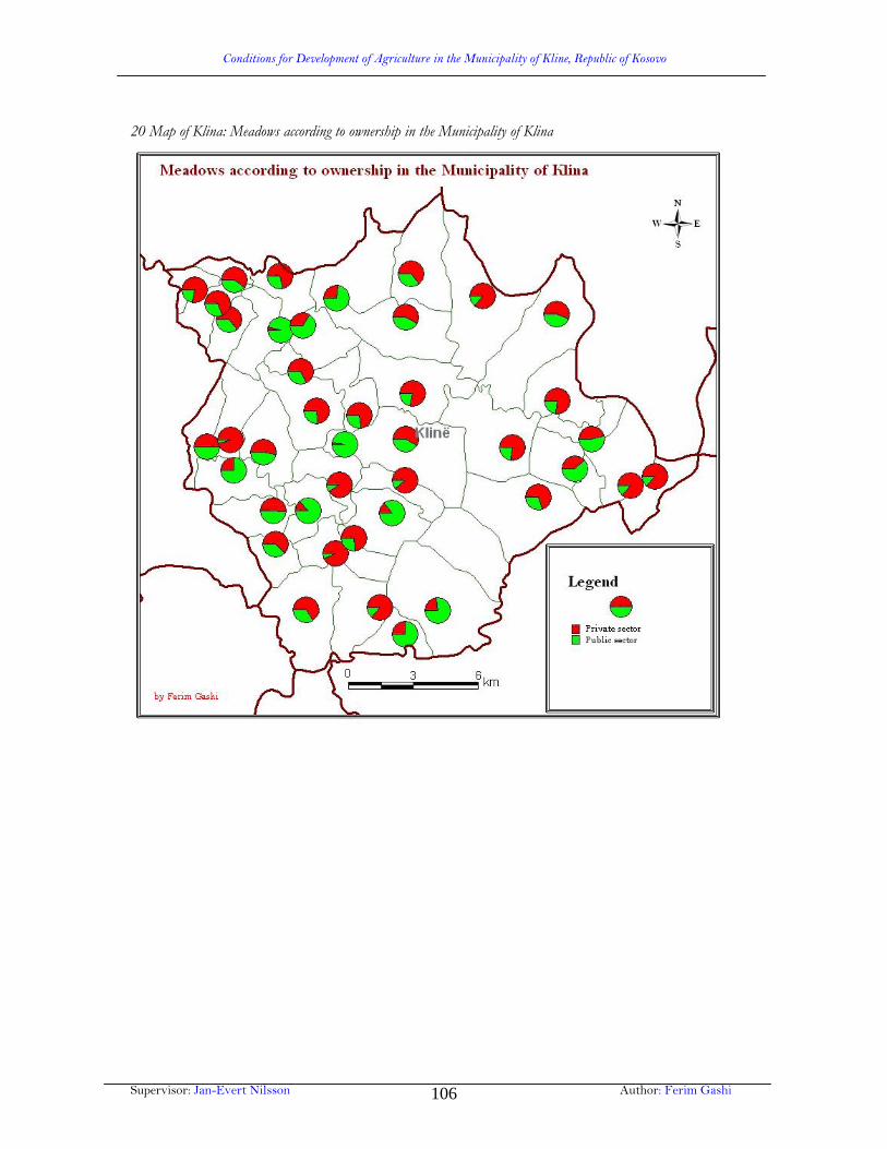
Conditions for Development of Agriculture in the Municipality of Kline, Republic of Kosovo
Supervisor: Jan-Evert Nilsson Author: Ferim Gashi 106
20 Map of Klina: Meadows according to ownership in the Municipality of Klina

Conditions for Development of Agriculture in the Municipality of Kline, Republic of Kosovo
Supervisor: Jan-Evert Nilsson Author: Ferim Gashi 107
21 Map of Klina: Paddocks according to ownership in the Municipality of Klina

Conditions for Development of Agriculture in the Municipality of Kline, Republic of Kosovo
Supervisor: Jan-Evert Nilsson Author: Ferim Gashi 108
22 Map of Klina: Forestry according to ownership in the Municipality of Klina
Related Documents