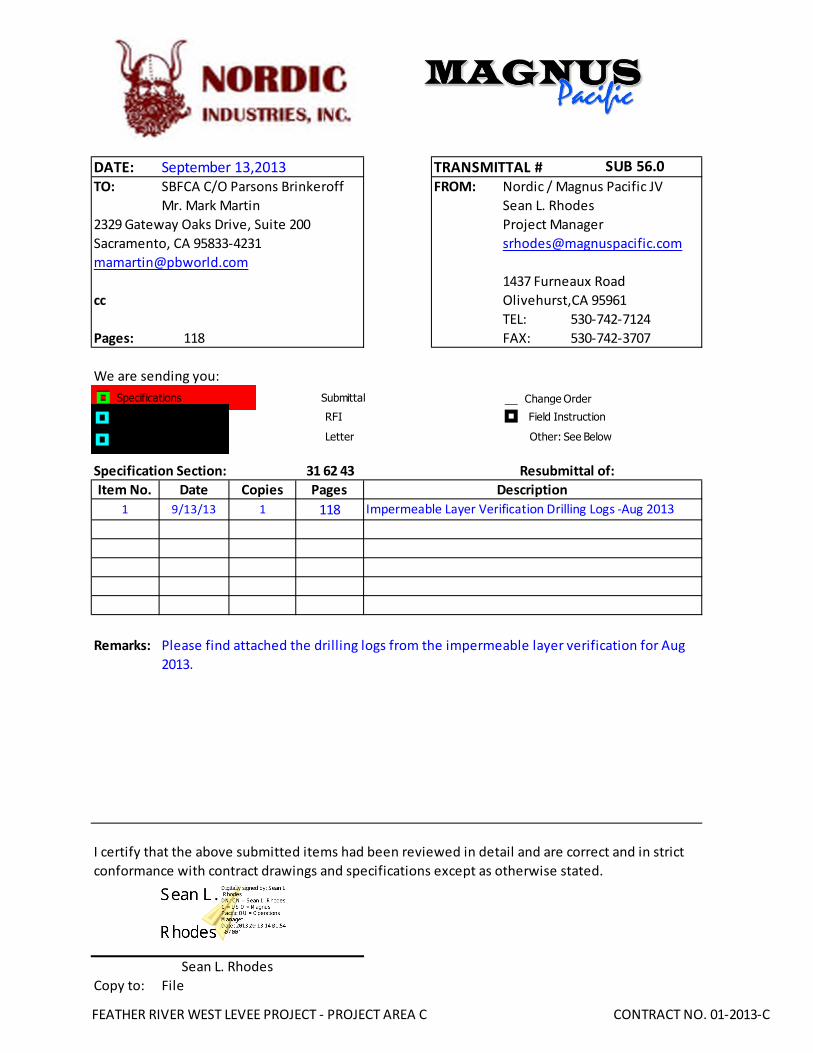
DATE: TO: SBFCA C/O Parsons Brinkeroff FROM: Nordic / Magnus Pacific JV Mr. Mark Martin Sean L. Rhodes Project Manager [email protected] [email protected] 1437 Furneaux Road cc Olivehurst,CA 95961 TEL: 530-742-7124 Pages: 118 FAX: 530-742-3707 We are sending you: Specification Section: Item No. Date Copies Pages 1 9/13/13 1 118 Remarks: Copy to: File September 13,2013 TRANSMITTAL # SUB 56.0 Description Impermeable Layer Verification Drilling Logs -Aug 2013 2329 Gateway Oaks Drive, Suite 200 Sacramento, CA 95833-4231 31 62 43 Resubmittal of: I certify that the above submitted items had been reviewed in detail and are correct and in strict conformance with contract drawings and specifications except as otherwise stated. Sean L. Rhodes Please find attached the drilling logs from the impermeable layer verification for Aug 2013. Change Order Submittal RFI Other: See Below Field Instruction Letter Specifications Plans Drawings FEATHER RIVER WEST LEVEE PROJECT - PROJECT AREA C CONTRACT NO. 01-2013-C

Welcome message from author
This document is posted to help you gain knowledge. Please leave a comment to let me know what you think about it! Share it to your friends and learn new things together.
Transcript
DATE:TO: SBFCA C/O Parsons Brinkeroff FROM: Nordic / Magnus Pacific JV
Mr. Mark Martin Sean L. Rhodes
Project Manager
1437 Furneaux Road
cc Olivehurst,CA 95961
TEL: 530-742-7124
Pages: 118 FAX: 530-742-3707
We are sending you:
Specification Section:
Item No. Date Copies Pages
1 9/13/13 1 118
Remarks:
Copy to: File
September 13,2013 TRANSMITTAL # SUB 56.0
Description
Impermeable Layer Verification Drilling Logs -Aug 2013
2329 Gateway Oaks Drive, Suite 200
Sacramento, CA 95833-4231
31 62 43 Resubmittal of:
I certify that the above submitted items had been reviewed in detail and are correct and in strict
conformance with contract drawings and specifications except as otherwise stated.
Sean L. Rhodes
Please find attached the drilling logs from the impermeable layer verification for Aug
2013.
Change OrderSubmittal
RFI
Other: See Below
Field Instruction
Letter
Specifications
Plans
Drawings
FEATHER RIVER WEST LEVEE PROJECT - PROJECT AREA C CONTRACT NO. 01-2013-C

6:30 am start drilling
AFTER DRILLING (DATE)DURING DRILLINGN/A N/A
SURFACE ELEVATION
82.0 ftDRILLING METHOD
Rotary WashDRILL RIG
CME 75SPT HAMMER TYPE
Automatic Trip, 140 lb, 30 inchBOREHOLE BACKFILL AND COMPLETION
Cement GroutGROUNDWATERREADINGS
BEGIN DATE
7-8-13COMPLETION DATE
8-12-13LOGGED BY
John WrightBOREHOLE LOCATION (Lat/Long or North/East and Datum) HOLE ID
13_84725_3B_RDRILLING CONTRACTOR
Geo-Ex, Driller Name: Tom Scott
HAMMER EFFICIENCY, ERiSAMPLER TYPE(S) AND SIZE(S) (ID)
Mod Cal (2"), HQ Core, SPT (1.4")TOTAL DEPTH OF BORING
124.0 ft
BOREHOLE DIAMETER
5 in
BOREHOLE LOCATION (Offset, Station, Line)
0.00' Rt Sta 847+25 Reach 13
.M
ater
ial
Gra
phi
cs
Sam
ple
Loca
tion
COUNTYYUB
DESCRIPTION
Rec
over
y (%
)
Dril
ling
Met
hod
Cas
ing
Dep
th
PREPARED BYJohn Wright
DATE
PROJECT OR BRIDGE NAMESBFCA
BRIDGE NUMBER
HOLE ID
13_84725_3B_R REA03-13-120.1
REPORT TITLEBORING RECORD
DIST.03
ROUTE POSTMILED
(continued)
SHEET1 of 6
RQ
D (
%)
Sam
ple
Num
ber
Moi
stur
eC
onte
nt (
%)
Remarks
Blo
ws
per
6 in
.
ELE
VA
TIO
N (
ft)
80.00
78.00
76.00
74.00
72.00
70.00
68.00
66.00
64.00
DE
PT
H (
ft)
Dry
Uni
t Wei
ght
(pcf
)
She
ar S
tren
gth
(tsf
)
Blo
ws
per
foot
0
1
2
3
4
5
6
7
8
9
10
11
12
13
14
15
16
17
18
19
20

Mat
eria
lG
rap
hics
Sam
ple
Loca
tion
COUNTYYUB
DESCRIPTION
Rec
over
y (%
)
Dril
ling
Met
hod
Cas
ing
Dep
th
PREPARED BYJohn Wright
DATE
PROJECT OR BRIDGE NAMESBFCA
BRIDGE NUMBER
HOLE ID
13_84725_3B_R REA03-13-120.1
REPORT TITLEBORING RECORD
DIST.03
ROUTE POSTMILED
(continued)
SHEET2 of 6
RQ
D (
%)
Sam
ple
Num
ber
Moi
stur
eC
onte
nt (
%)
Remarks
Blo
ws
per
6 in
.
ELE
VA
TIO
N (
ft)
60.00
58.00
56.00
54.00
52.00
50.00
48.00
46.00
44.00
42.00
40.00
DE
PT
H (
ft)
Dry
Uni
t Wei
ght
(pcf
)
She
ar S
tren
gth
(tsf
)
Blo
ws
per
foot
20
21
22
23
24
25
26
27
28
29
30
31
32
33
34
35
36
37
38
39
40
41
42
43
44
DavidCastro
Rectangle
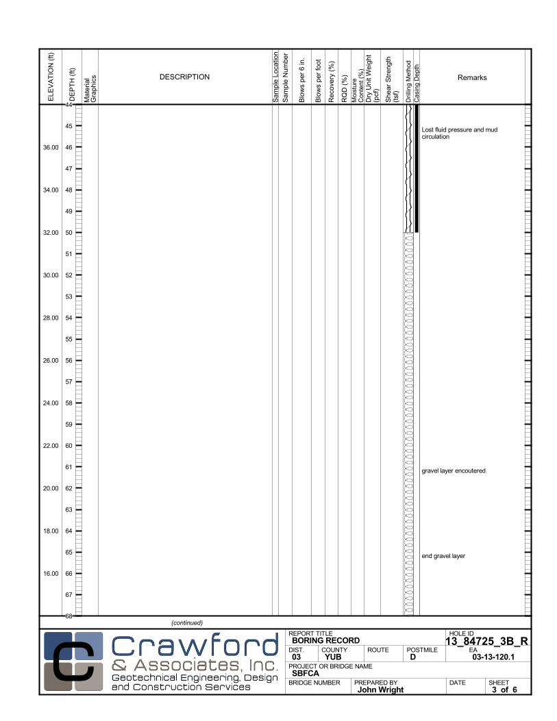
Lost fluid pressure and mudcirculation
gravel layer encoutered
end gravel layer
Mat
eria
lG
rap
hics
Sam
ple
Loca
tion
COUNTYYUB
DESCRIPTION
Rec
over
y (%
)
Dril
ling
Met
hod
Cas
ing
Dep
th
PREPARED BYJohn Wright
DATE
PROJECT OR BRIDGE NAMESBFCA
BRIDGE NUMBER
HOLE ID
13_84725_3B_R REA03-13-120.1
REPORT TITLEBORING RECORD
DIST.03
ROUTE POSTMILED
(continued)
SHEET3 of 6
RQ
D (
%)
Sam
ple
Num
ber
Moi
stur
eC
onte
nt (
%)
Remarks
Blo
ws
per
6 in
.
ELE
VA
TIO
N (
ft)
36.00
34.00
32.00
30.00
28.00
26.00
24.00
22.00
20.00
18.00
16.00
DE
PT
H (
ft)
Dry
Uni
t Wei
ght
(pcf
)
She
ar S
tren
gth
(tsf
)
Blo
ws
per
foot
44
45
46
47
48
49
50
51
52
53
54
55
56
57
58
59
60
61
62
63
64
65
66
67
68
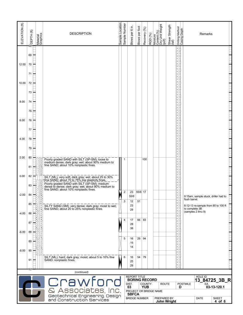
Poorly graded SAND with SILT (SP-SM); loose tomedium dense; dark gray; wet; about 90% medium tofine SAND; about 10% nonplastic fines.
SILT (ML); very soft; dark gray; wet; about 25 to 30%fine SAND; about 70 to 75% low plasticity fines.Poorly graded SAND with SILT (SP-SM); mediumdense to dense; dark gray; wet; about 90% medium tofine SAND; about 10% nonplastic fines.
SILTY SAND (SM); very dense; dark gray; moist to wet;fine SAND; about 20 to 25% nonplastic fines.
SILT (ML); hard; dark gray; moist; about 5 to 10% fineSAND; nonplastic fines.
100
17
83
94
79
1
2
3
4
5
6
9:15am, sample stuck, driller had toflush barrel.
8-12-13 re-sample from 85 to 100 ftto complete 3B(samples 2 thru 9)
23
55/6
12
23
28
17
28
38
16
15
14
16
25
29
Mat
eria
lG
rap
hics
Sam
ple
Loca
tion
COUNTYYUB
DESCRIPTION
Rec
over
y (%
)
Dril
ling
Met
hod
Cas
ing
Dep
th
PREPARED BYJohn Wright
DATE
PROJECT OR BRIDGE NAMESBFCA
BRIDGE NUMBER
HOLE ID
13_84725_3B_R REA03-13-120.1
REPORT TITLEBORING RECORD
DIST.03
ROUTE POSTMILED
(continued)
SHEET4 of 6
RQ
D (
%)
Sam
ple
Num
ber
Moi
stur
eC
onte
nt (
%)
Remarks
Blo
ws
per
6 in
.
ELE
VA
TIO
N (
ft)
12.00
10.00
8.00
6.00
4.00
2.00
0.00
-2.00
-4.00
-6.00
-8.00
DE
PT
H (
ft)
Dry
Uni
t Wei
ght
(pcf
)
She
ar S
tren
gth
(tsf
)
Blo
ws
per
foot
55/6
51
66
29
54
68
69
70
71
72
73
74
75
76
77
78
79
80
81
82
83
84
85
86
87
88
89
90
91
92
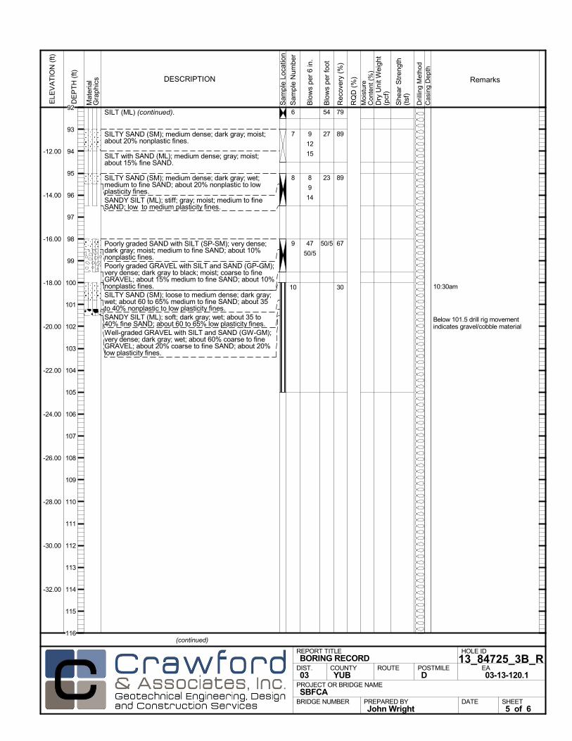
SILT (ML) (continued).
SILTY SAND (SM); medium dense; dark gray; moist;about 20% nonplastic fines.
SILT with SAND (ML); medium dense; gray; moist;about 15% fine SAND.
SILTY SAND (SM); medium dense; dark gray; wet;medium to fine SAND; about 20% nonplastic to lowplasticity fines.SANDY SILT (ML); stiff; gray; moist; medium to fineSAND; low to medium plasticity fines.
Poorly graded SAND with SILT (SP-SM); very dense;dark gray; moist; medium to fine SAND; about 10%nonplastic fines.Poorly graded GRAVEL with SILT and SAND (GP-GM);very dense; dark gray to black; moist; coarse to fineGRAVEL; about 15% medium to fine SAND; about 10%nonplastic fines.SILTY SAND (SM); loose to medium dense; dark gray;wet; about 60 to 65% medium to fine SAND; about 35to 40% nonplastic to low plasticity fines.SANDY SILT (ML); soft; dark gray; wet; about 35 to40% fine SAND; about 60 to 65% low plasticity fines.Well-graded GRAVEL with SILT and SAND (GW-GM);very dense; dark gray; wet; about 60% coarse to fineGRAVEL; about 20% coarse to fine SAND; about 20%low plasticity fines.
79
89
89
67
30
6
7
8
9
10 10:30am
Below 101.5 drill rig movementindicates gravel/cobble material
9
12
15
8
9
14
47
50/5
Mat
eria
lG
rap
hics
Sam
ple
Loca
tion
COUNTYYUB
DESCRIPTION
Rec
over
y (%
)
Dril
ling
Met
hod
Cas
ing
Dep
th
PREPARED BYJohn Wright
DATE
PROJECT OR BRIDGE NAMESBFCA
BRIDGE NUMBER
HOLE ID
13_84725_3B_R REA03-13-120.1
REPORT TITLEBORING RECORD
DIST.03
ROUTE POSTMILED
(continued)
SHEET5 of 6
RQ
D (
%)
Sam
ple
Num
ber
Moi
stur
eC
onte
nt (
%)
Remarks
Blo
ws
per
6 in
.
ELE
VA
TIO
N (
ft)
-12.00
-14.00
-16.00
-18.00
-20.00
-22.00
-24.00
-26.00
-28.00
-30.00
-32.00
DE
PT
H (
ft)
Dry
Uni
t Wei
ght
(pcf
)
She
ar S
tren
gth
(tsf
)
Blo
ws
per
foot
54
27
23
50/5
92
93
94
95
96
97
98
99
100
101
102
103
104
105
106
107
108
109
110
111
112
113
114
115
116
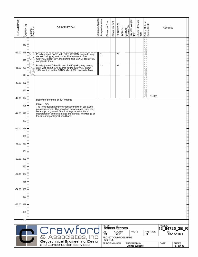
Poorly graded SAND with SILT (SP-SM); dense to verydense; dark gray; wet; about 10% coarse to fineGRAVEL; about 80% medium to fine SAND; about 10%nonplastic fines.
Poorly graded GRAVEL with SAND (GP); very dense;gray; wet; about 80% coarse to fine GRAVEL; about15% medium to fine SAND; about 5% nonplastic fines.
Bottom of borehole at 124.0 ft bgs
FINAL LOG:The lines designating the interface between soil typesare approximate. The transition between soil types maybe abrupt or gradual. Our final logs represent ourinterpretation of the field logs and general knowledge ofthe site and geological conditions.
78
67
11
12
1:00pm
Mat
eria
lG
rap
hics
Sam
ple
Loca
tion
COUNTYYUB
DESCRIPTION
Rec
over
y (%
)
Dril
ling
Met
hod
Cas
ing
Dep
th
PREPARED BYJohn Wright
DATE
PROJECT OR BRIDGE NAMESBFCA
BRIDGE NUMBER
HOLE ID
13_84725_3B_R REA03-13-120.1
REPORT TITLEBORING RECORD
DIST.03
ROUTE POSTMILED
SHEET6 of 6
RQ
D (
%)
Sam
ple
Num
ber
Moi
stur
eC
onte
nt (
%)
Remarks
Blo
ws
per
6 in
.
ELE
VA
TIO
N (
ft)
-36.00
-38.00
-40.00
-42.00
-44.00
-46.00
-48.00
-50.00
-52.00
-54.00
-56.00
DE
PT
H (
ft)
Dry
Uni
t Wei
ght
(pcf
)
She
ar S
tren
gth
(tsf
)
Blo
ws
per
foot
116
117
118
119
120
121
122
123
124
125
126
127
128
129
130
131
132
133
134
135
136
137
138
139
140
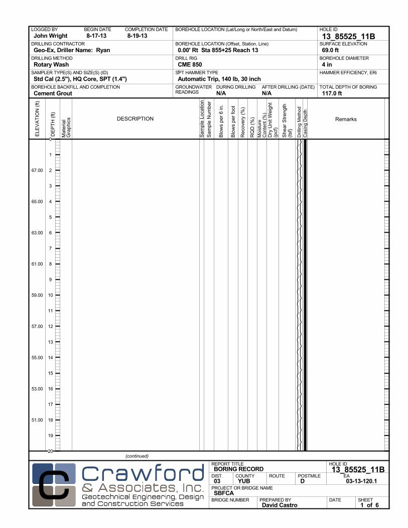
AFTER DRILLING (DATE)DURING DRILLINGN/A N/A
SURFACE ELEVATION
69.0 ftDRILLING METHOD
Rotary WashDRILL RIG
CME 850SPT HAMMER TYPE
Automatic Trip, 140 lb, 30 inchBOREHOLE BACKFILL AND COMPLETION
Cement GroutGROUNDWATERREADINGS
BEGIN DATE
8-17-13COMPLETION DATE
8-19-13LOGGED BY
John WrightBOREHOLE LOCATION (Lat/Long or North/East and Datum) HOLE ID
13_85525_11BDRILLING CONTRACTOR
Geo-Ex, Driller Name: Ryan
HAMMER EFFICIENCY, ERiSAMPLER TYPE(S) AND SIZE(S) (ID)
Std Cal (2.5"), HQ Core, SPT (1.4")TOTAL DEPTH OF BORING
117.0 ft
BOREHOLE DIAMETER
4 in
BOREHOLE LOCATION (Offset, Station, Line)
0.00' Rt Sta 855+25 Reach 13
.M
ater
ial
Gra
phi
cs
Sam
ple
Loca
tion
COUNTYYUB
DESCRIPTION
Rec
over
y (%
)
Dril
ling
Met
hod
Cas
ing
Dep
th
PREPARED BYDavid Castro
DATE
PROJECT OR BRIDGE NAMESBFCA
BRIDGE NUMBER
HOLE ID
13_85525_11BEA03-13-120.1
REPORT TITLEBORING RECORD
DIST.03
ROUTE POSTMILED
(continued)
SHEET1 of 6
RQ
D (
%)
Sam
ple
Num
ber
Moi
stur
eC
onte
nt (
%)
Remarks
Blo
ws
per
6 in
.
ELE
VA
TIO
N (
ft)
67.00
65.00
63.00
61.00
59.00
57.00
55.00
53.00
51.00
DE
PT
H (
ft)
Dry
Uni
t Wei
ght
(pcf
)
She
ar S
tren
gth
(tsf
)
Blo
ws
per
foot
0
1
2
3
4
5
6
7
8
9
10
11
12
13
14
15
16
17
18
19
20
11am
Mat
eria
lG
rap
hics
Sam
ple
Loca
tion
COUNTYYUB
DESCRIPTION
Rec
over
y (%
)
Dril
ling
Met
hod
Cas
ing
Dep
th
PREPARED BYDavid Castro
DATE
PROJECT OR BRIDGE NAMESBFCA
BRIDGE NUMBER
HOLE ID
13_85525_11BEA03-13-120.1
REPORT TITLEBORING RECORD
DIST.03
ROUTE POSTMILED
(continued)
SHEET2 of 6
RQ
D (
%)
Sam
ple
Num
ber
Moi
stur
eC
onte
nt (
%)
Remarks
Blo
ws
per
6 in
.
ELE
VA
TIO
N (
ft)
47.00
45.00
43.00
41.00
39.00
37.00
35.00
33.00
31.00
29.00
27.00
DE
PT
H (
ft)
Dry
Uni
t Wei
ght
(pcf
)
She
ar S
tren
gth
(tsf
)
Blo
ws
per
foot
20
21
22
23
24
25
26
27
28
29
30
31
32
33
34
35
36
37
38
39
40
41
42
43
44

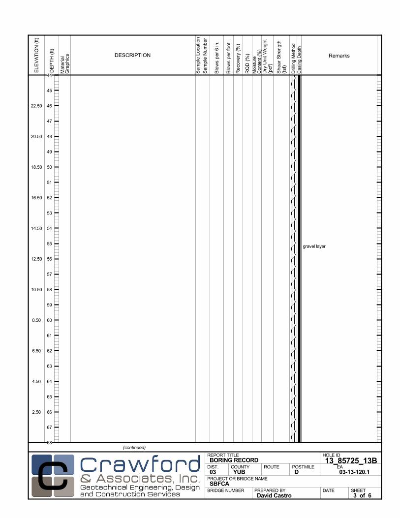
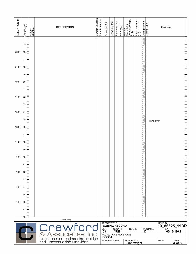
gravel layer
Mat
eria
lG
rap
hics
Sam
ple
Loca
tion
COUNTYYUB
DESCRIPTION
Rec
over
y (%
)
Dril
ling
Met
hod
Cas
ing
Dep
th
PREPARED BYDavid Castro
DATE
PROJECT OR BRIDGE NAMESBFCA
BRIDGE NUMBER
HOLE ID
13_85525_11BEA03-13-120.1
REPORT TITLEBORING RECORD
DIST.03
ROUTE POSTMILED
(continued)
SHEET3 of 6
RQ
D (
%)
Sam
ple
Num
ber
Moi
stur
eC
onte
nt (
%)
Remarks
Blo
ws
per
6 in
.
ELE
VA
TIO
N (
ft)
23.00
21.00
19.00
17.00
15.00
13.00
11.00
9.00
7.00
5.00
3.00
DE
PT
H (
ft)
Dry
Uni
t Wei
ght
(pcf
)
She
ar S
tren
gth
(tsf
)
Blo
ws
per
foot
44
45
46
47
48
49
50
51
52
53
54
55
56
57
58
59
60
61
62
63
64
65
66
67
68

lost circulation, 300 gal of water usedso far
Mat
eria
lG
rap
hics
Sam
ple
Loca
tion
COUNTYYUB
DESCRIPTION
Rec
over
y (%
)
Dril
ling
Met
hod
Cas
ing
Dep
th
PREPARED BYDavid Castro
DATE
PROJECT OR BRIDGE NAMESBFCA
BRIDGE NUMBER
HOLE ID
13_85525_11BEA03-13-120.1
REPORT TITLEBORING RECORD
DIST.03
ROUTE POSTMILED
(continued)
SHEET4 of 6
RQ
D (
%)
Sam
ple
Num
ber
Moi
stur
eC
onte
nt (
%)
Remarks
Blo
ws
per
6 in
.
ELE
VA
TIO
N (
ft)
-1.00
-3.00
-5.00
-7.00
-9.00
-11.00
-13.00
-15.00
-17.00
-19.00
-21.00
DE
PT
H (
ft)
Dry
Uni
t Wei
ght
(pcf
)
She
ar S
tren
gth
(tsf
)
Blo
ws
per
foot
68
69
70
71
72
73
74
75
76
77
78
79
80
81
82
83
84
85
86
87
88
89
90
91
92
Lean to fat CLAY (CL/CH); very stiff; greenish gray;moist; about 5 to 20% fine SAND; about 95 to 80%medium to high plasticity fines.
SANDY SILT (ML); hard; greenish gray; moist; about40% fine SAND; about 60% nonplastic to low plasticityfines.
SILTY SAND (SM); dense; dark gray; moist; about 65to 70% fine SAND; about 30 to 35% nonplastic fines;Interbedded layers of silt.
Lean CLAY (CL); hard; greenish gray; moist; about10% fine SAND; about 90% medium plasticity fines.
0
0
0
98
78
87
1
2
3
4
5
6
8/17/131:46pm end gravel layer
filled mud tank with 100 gal of water
20
25
30
10
12
12
30
34
PP =2.5
PP =>4.5
PP =>4.5
PP =>4.5
Mat
eria
lG
rap
hics
Sam
ple
Loca
tion
COUNTYYUB
DESCRIPTION
Rec
over
y (%
)
Dril
ling
Met
hod
Cas
ing
Dep
th
PREPARED BYDavid Castro
DATE
PROJECT OR BRIDGE NAMESBFCA
BRIDGE NUMBER
HOLE ID
13_85525_11BEA03-13-120.1
REPORT TITLEBORING RECORD
DIST.03
ROUTE POSTMILED
(continued)
SHEET5 of 6
RQ
D (
%)
Sam
ple
Num
ber
Moi
stur
eC
onte
nt (
%)
Remarks
Blo
ws
per
6 in
.
ELE
VA
TIO
N (
ft)
-25.00
-27.00
-29.00
-31.00
-33.00
-35.00
-37.00
-39.00
-41.00
-43.00
-45.00
DE
PT
H (
ft)
Dry
Uni
t Wei
ght
(pcf
)
She
ar S
tren
gth
(tsf
)
Blo
ws
per
foot
55
24
92
93
94
95
96
97
98
99
100
101
102
103
104
105
106
107
108
109
110
111
112
113
114
115
116

Lean CLAY (CL) (continued).
Bottom of borehole at 117.0 ft bgs
FINAL LOG:The lines designating the interface between soil typesare approximate. The transition between soil types maybe abrupt or gradual. Our final logs represent ourinterpretation of the field logs and general knowledge ofthe site and geological conditions.
876 PP =>4.5PP =>4.5
Mat
eria
lG
rap
hics
Sam
ple
Loca
tion
COUNTYYUB
DESCRIPTION
Rec
over
y (%
)
Dril
ling
Met
hod
Cas
ing
Dep
th
PREPARED BYDavid Castro
DATE
PROJECT OR BRIDGE NAMESBFCA
BRIDGE NUMBER
HOLE ID
13_85525_11BEA03-13-120.1
REPORT TITLEBORING RECORD
DIST.03
ROUTE POSTMILED
SHEET6 of 6
RQ
D (
%)
Sam
ple
Num
ber
Moi
stur
eC
onte
nt (
%)
Remarks
Blo
ws
per
6 in
.
ELE
VA
TIO
N (
ft)
-49.00
-51.00
-53.00
-55.00
-57.00
-59.00
-61.00
-63.00
-65.00
-67.00
-69.00
DE
PT
H (
ft)
Dry
Uni
t Wei
ght
(pcf
)
She
ar S
tren
gth
(tsf
)
Blo
ws
per
foot
116
117
118
119
120
121
122
123
124
125
126
127
128
129
130
131
132
133
134
135
136
137
138
139
140

AFTER DRILLING (DATE)DURING DRILLINGN/A N/A
SURFACE ELEVATION
69.0 ftDRILLING METHOD
Rotary WashDRILL RIG
CME 850SPT HAMMER TYPE
Automatic Trip, 140 lb, 30 inchBOREHOLE BACKFILL AND COMPLETION
Cement GroutGROUNDWATERREADINGS
BEGIN DATE
9-4-13COMPLETION DATE
9-4-13LOGGED BY
John WrightBOREHOLE LOCATION (Lat/Long or North/East and Datum) HOLE ID
13_85625_12BDRILLING CONTRACTOR
Geo-Ex, Driller Name: Ryan
HAMMER EFFICIENCY, ERiSAMPLER TYPE(S) AND SIZE(S) (ID)
HQ Core, SPT (1.4")TOTAL DEPTH OF BORING
120.0 ft
BOREHOLE DIAMETER
4 in
BOREHOLE LOCATION (Offset, Station, Line)
12.00' Rt Sta 856+25 Reach 13
.M
ater
ial
Gra
phi
cs
Sam
ple
Loca
tion
COUNTYYUB
DESCRIPTION
Rec
over
y (%
)
Dril
ling
Met
hod
Cas
ing
Dep
th
PREPARED BYJohn Wright
DATE
PROJECT OR BRIDGE NAMESBFCA
BRIDGE NUMBER
HOLE ID
13_85625_12BEA03-13-120.1
REPORT TITLEBORING RECORD
DIST.03
ROUTE POSTMILED
(continued)
SHEET1 of 6
RQ
D (
%)
Sam
ple
Num
ber
Moi
stur
eC
onte
nt (
%)
Remarks
Blo
ws
per
6 in
.
ELE
VA
TIO
N (
ft)
67.00
65.00
63.00
61.00
59.00
57.00
55.00
53.00
51.00
DE
PT
H (
ft)
Dry
Uni
t Wei
ght
(pcf
)
She
ar S
tren
gth
(tsf
)
Blo
ws
per
foot
0
1
2
3
4
5
6
7
8
9
10
11
12
13
14
15
16
17
18
19
20

Mat
eria
lG
rap
hics
Sam
ple
Loca
tion
COUNTYYUB
DESCRIPTION
Rec
over
y (%
)
Dril
ling
Met
hod
Cas
ing
Dep
th
PREPARED BYJohn Wright
DATE
PROJECT OR BRIDGE NAMESBFCA
BRIDGE NUMBER
HOLE ID
13_85625_12BEA03-13-120.1
REPORT TITLEBORING RECORD
DIST.03
ROUTE POSTMILED
(continued)
SHEET2 of 6
RQ
D (
%)
Sam
ple
Num
ber
Moi
stur
eC
onte
nt (
%)
Remarks
Blo
ws
per
6 in
.
ELE
VA
TIO
N (
ft)
47.00
45.00
43.00
41.00
39.00
37.00
35.00
33.00
31.00
29.00
27.00
DE
PT
H (
ft)
Dry
Uni
t Wei
ght
(pcf
)
She
ar S
tren
gth
(tsf
)
Blo
ws
per
foot
20
21
22
23
24
25
26
27
28
29
30
31
32
33
34
35
36
37
38
39
40
41
42
43
44

gravel layer
Mat
eria
lG
rap
hics
Sam
ple
Loca
tion
COUNTYYUB
DESCRIPTION
Rec
over
y (%
)
Dril
ling
Met
hod
Cas
ing
Dep
th
PREPARED BYJohn Wright
DATE
PROJECT OR BRIDGE NAMESBFCA
BRIDGE NUMBER
HOLE ID
13_85625_12BEA03-13-120.1
REPORT TITLEBORING RECORD
DIST.03
ROUTE POSTMILED
(continued)
SHEET3 of 6
RQ
D (
%)
Sam
ple
Num
ber
Moi
stur
eC
onte
nt (
%)
Remarks
Blo
ws
per
6 in
.
ELE
VA
TIO
N (
ft)
23.00
21.00
19.00
17.00
15.00
13.00
11.00
9.00
7.00
5.00
3.00
DE
PT
H (
ft)
Dry
Uni
t Wei
ght
(pcf
)
She
ar S
tren
gth
(tsf
)
Blo
ws
per
foot
44
45
46
47
48
49
50
51
52
53
54
55
56
57
58
59
60
61
62
63
64
65
66
67
68

end gravel layer
gravel layer
Mat
eria
lG
rap
hics
Sam
ple
Loca
tion
COUNTYYUB
DESCRIPTION
Rec
over
y (%
)
Dril
ling
Met
hod
Cas
ing
Dep
th
PREPARED BYJohn Wright
DATE
PROJECT OR BRIDGE NAMESBFCA
BRIDGE NUMBER
HOLE ID
13_85625_12BEA03-13-120.1
REPORT TITLEBORING RECORD
DIST.03
ROUTE POSTMILED
(continued)
SHEET4 of 6
RQ
D (
%)
Sam
ple
Num
ber
Moi
stur
eC
onte
nt (
%)
Remarks
Blo
ws
per
6 in
.
ELE
VA
TIO
N (
ft)
-1.00
-3.00
-5.00
-7.00
-9.00
-11.00
-13.00
-15.00
-17.00
-19.00
-21.00
DE
PT
H (
ft)
Dry
Uni
t Wei
ght
(pcf
)
She
ar S
tren
gth
(tsf
)
Blo
ws
per
foot
68
69
70
71
72
73
74
75
76
77
78
79
80
81
82
83
84
85
86
87
88
89
90
91
92
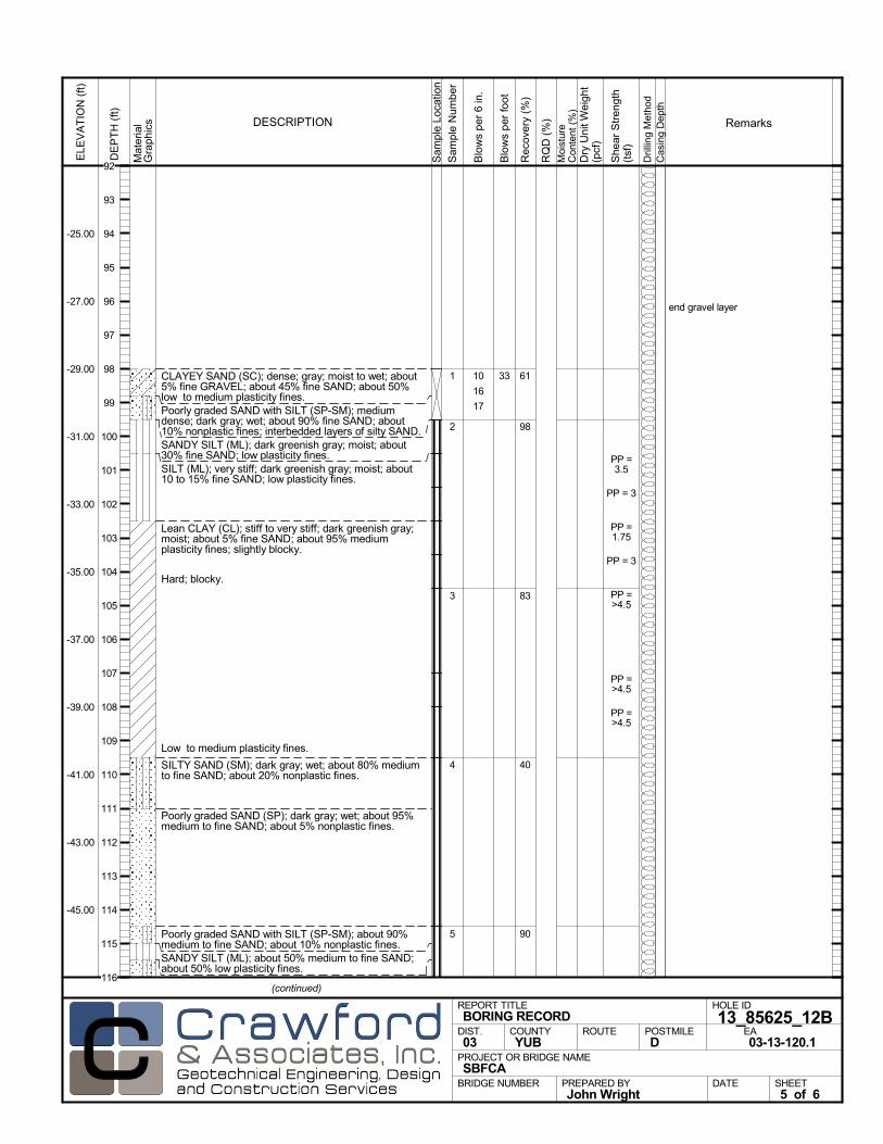
CLAYEY SAND (SC); dense; gray; moist to wet; about5% fine GRAVEL; about 45% fine SAND; about 50%low to medium plasticity fines.Poorly graded SAND with SILT (SP-SM); mediumdense; dark gray; wet; about 90% fine SAND; about10% nonplastic fines; interbedded layers of silty SAND.SANDY SILT (ML); dark greenish gray; moist; about30% fine SAND; low plasticity fines.SILT (ML); very stiff; dark greenish gray; moist; about10 to 15% fine SAND; low plasticity fines.
Lean CLAY (CL); stiff to very stiff; dark greenish gray;moist; about 5% fine SAND; about 95% mediumplasticity fines; slightly blocky.
Hard; blocky.
Low to medium plasticity fines.
SILTY SAND (SM); dark gray; wet; about 80% mediumto fine SAND; about 20% nonplastic fines.
Poorly graded SAND (SP); dark gray; wet; about 95%medium to fine SAND; about 5% nonplastic fines.
Poorly graded SAND with SILT (SP-SM); about 90%medium to fine SAND; about 10% nonplastic fines.SANDY SILT (ML); about 50% medium to fine SAND;about 50% low plasticity fines.
61
98
83
40
90
1
2
3
4
5
end gravel layer
10
16
17
PP =3.5
PP = 3
PP =1.75
PP = 3
PP =>4.5
PP =>4.5
PP =>4.5
Mat
eria
lG
rap
hics
Sam
ple
Loca
tion
COUNTYYUB
DESCRIPTION
Rec
over
y (%
)
Dril
ling
Met
hod
Cas
ing
Dep
th
PREPARED BYJohn Wright
DATE
PROJECT OR BRIDGE NAMESBFCA
BRIDGE NUMBER
HOLE ID
13_85625_12BEA03-13-120.1
REPORT TITLEBORING RECORD
DIST.03
ROUTE POSTMILED
(continued)
SHEET5 of 6
RQ
D (
%)
Sam
ple
Num
ber
Moi
stur
eC
onte
nt (
%)
Remarks
Blo
ws
per
6 in
.
ELE
VA
TIO
N (
ft)
-25.00
-27.00
-29.00
-31.00
-33.00
-35.00
-37.00
-39.00
-41.00
-43.00
-45.00
DE
PT
H (
ft)
Dry
Uni
t Wei
ght
(pcf
)
She
ar S
tren
gth
(tsf
)
Blo
ws
per
foot
33
92
93
94
95
96
97
98
99
100
101
102
103
104
105
106
107
108
109
110
111
112
113
114
115
116
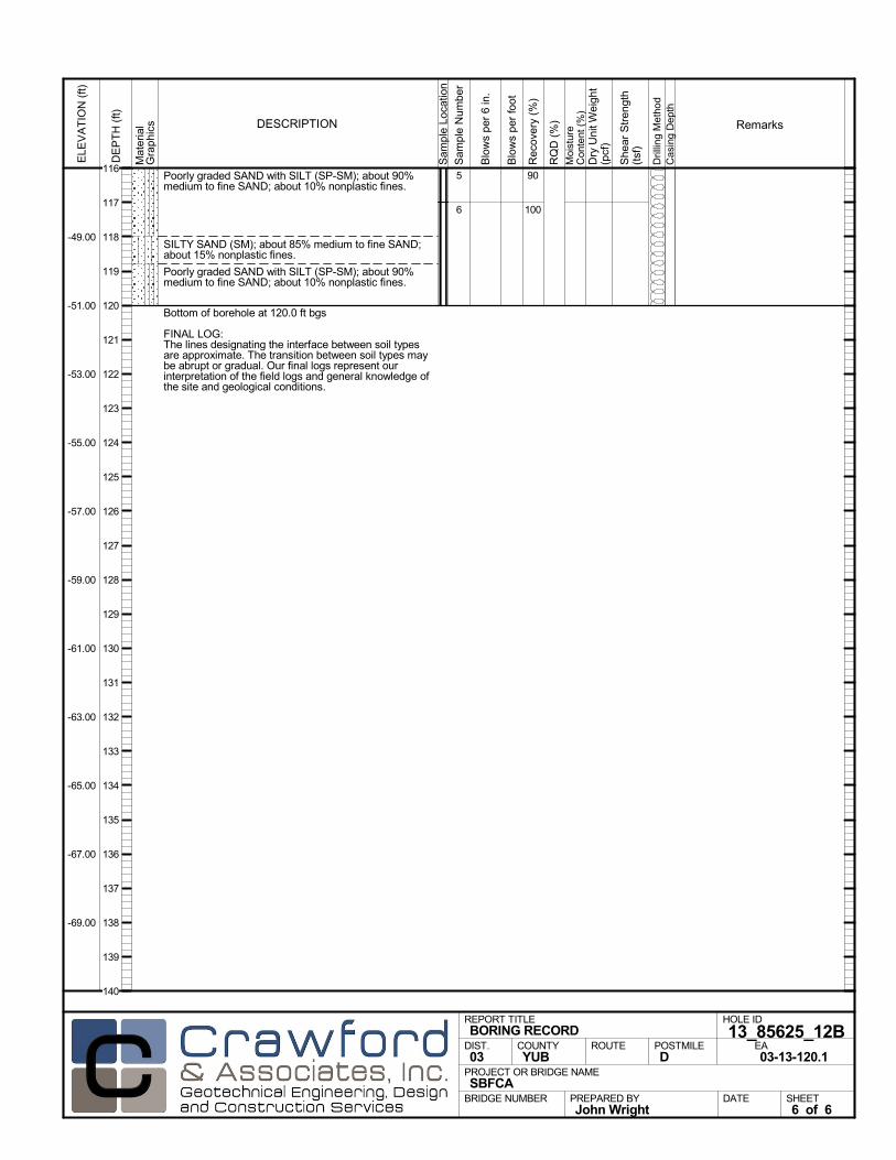
Poorly graded SAND with SILT (SP-SM); about 90%medium to fine SAND; about 10% nonplastic fines.
SILTY SAND (SM); about 85% medium to fine SAND;about 15% nonplastic fines.
Poorly graded SAND with SILT (SP-SM); about 90%medium to fine SAND; about 10% nonplastic fines.
Bottom of borehole at 120.0 ft bgs
FINAL LOG:The lines designating the interface between soil typesare approximate. The transition between soil types maybe abrupt or gradual. Our final logs represent ourinterpretation of the field logs and general knowledge ofthe site and geological conditions.
90
100
5
6
Mat
eria
lG
rap
hics
Sam
ple
Loca
tion
COUNTYYUB
DESCRIPTION
Rec
over
y (%
)
Dril
ling
Met
hod
Cas
ing
Dep
th
PREPARED BYJohn Wright
DATE
PROJECT OR BRIDGE NAMESBFCA
BRIDGE NUMBER
HOLE ID
13_85625_12BEA03-13-120.1
REPORT TITLEBORING RECORD
DIST.03
ROUTE POSTMILED
SHEET6 of 6
RQ
D (
%)
Sam
ple
Num
ber
Moi
stur
eC
onte
nt (
%)
Remarks
Blo
ws
per
6 in
.
ELE
VA
TIO
N (
ft)
-49.00
-51.00
-53.00
-55.00
-57.00
-59.00
-61.00
-63.00
-65.00
-67.00
-69.00
DE
PT
H (
ft)
Dry
Uni
t Wei
ght
(pcf
)
She
ar S
tren
gth
(tsf
)
Blo
ws
per
foot
116
117
118
119
120
121
122
123
124
125
126
127
128
129
130
131
132
133
134
135
136
137
138
139
140
AFTER DRILLING (DATE)DURING DRILLINGN/A N/A
SURFACE ELEVATION
68.5 ftDRILLING METHOD
Rotary WashDRILL RIG
CME 75SPT HAMMER TYPE
Automatic Trip, 140 lb, 30 inchBOREHOLE BACKFILL AND COMPLETION
Cement GroutGROUNDWATERREADINGS
BEGIN DATE
8-17-13COMPLETION DATE
8-19-13LOGGED BY
David CastroBOREHOLE LOCATION (Lat/Long or North/East and Datum) HOLE ID
13_85725_13BDRILLING CONTRACTOR
Gulf Shore, Driller Name: Carlos
HAMMER EFFICIENCY, ERiSAMPLER TYPE(S) AND SIZE(S) (ID)
Mod Cal (2"), SPT (1.4")TOTAL DEPTH OF BORING
118.0 ft
BOREHOLE DIAMETER
4 in
BOREHOLE LOCATION (Offset, Station, Line)
0.00' Rt Sta 857+25 Reach 13
.M
ater
ial
Gra
phi
cs
Sam
ple
Loca
tion
COUNTYYUB
DESCRIPTION
Rec
over
y (%
)
Dril
ling
Met
hod
Cas
ing
Dep
th
PREPARED BYDavid Castro
DATE
PROJECT OR BRIDGE NAMESBFCA
BRIDGE NUMBER
HOLE ID
13_85725_13BEA03-13-120.1
REPORT TITLEBORING RECORD
DIST.03
ROUTE POSTMILED
(continued)
SHEET1 of 6
RQ
D (
%)
Sam
ple
Num
ber
Moi
stur
eC
onte
nt (
%)
Remarks
Blo
ws
per
6 in
.
ELE
VA
TIO
N (
ft)
66.50
64.50
62.50
60.50
58.50
56.50
54.50
52.50
50.50
DE
PT
H (
ft)
Dry
Uni
t Wei
ght
(pcf
)
She
ar S
tren
gth
(tsf
)
Blo
ws
per
foot
0
1
2
3
4
5
6
7
8
9
10
11
12
13
14
15
16
17
18
19
20

Mat
eria
lG
rap
hics
Sam
ple
Loca
tion
COUNTYYUB
DESCRIPTION
Rec
over
y (%
)
Dril
ling
Met
hod
Cas
ing
Dep
th
PREPARED BYDavid Castro
DATE
PROJECT OR BRIDGE NAMESBFCA
BRIDGE NUMBER
HOLE ID
13_85725_13BEA03-13-120.1
REPORT TITLEBORING RECORD
DIST.03
ROUTE POSTMILED
(continued)
SHEET2 of 6
RQ
D (
%)
Sam
ple
Num
ber
Moi
stur
eC
onte
nt (
%)
Remarks
Blo
ws
per
6 in
.
ELE
VA
TIO
N (
ft)
46.50
44.50
42.50
40.50
38.50
36.50
34.50
32.50
30.50
28.50
26.50
DE
PT
H (
ft)
Dry
Uni
t Wei
ght
(pcf
)
She
ar S
tren
gth
(tsf
)
Blo
ws
per
foot
20
21
22
23
24
25
26
27
28
29
30
31
32
33
34
35
36
37
38
39
40
41
42
43
44
gravel layer
Mat
eria
lG
rap
hics
Sam
ple
Loca
tion
COUNTYYUB
DESCRIPTION
Rec
over
y (%
)
Dril
ling
Met
hod
Cas
ing
Dep
th
PREPARED BYDavid Castro
DATE
PROJECT OR BRIDGE NAMESBFCA
BRIDGE NUMBER
HOLE ID
13_85725_13BEA03-13-120.1
REPORT TITLEBORING RECORD
DIST.03
ROUTE POSTMILED
(continued)
SHEET3 of 6
RQ
D (
%)
Sam
ple
Num
ber
Moi
stur
eC
onte
nt (
%)
Remarks
Blo
ws
per
6 in
.
ELE
VA
TIO
N (
ft)
22.50
20.50
18.50
16.50
14.50
12.50
10.50
8.50
6.50
4.50
2.50
DE
PT
H (
ft)
Dry
Uni
t Wei
ght
(pcf
)
She
ar S
tren
gth
(tsf
)
Blo
ws
per
foot
44
45
46
47
48
49
50
51
52
53
54
55
56
57
58
59
60
61
62
63
64
65
66
67
68
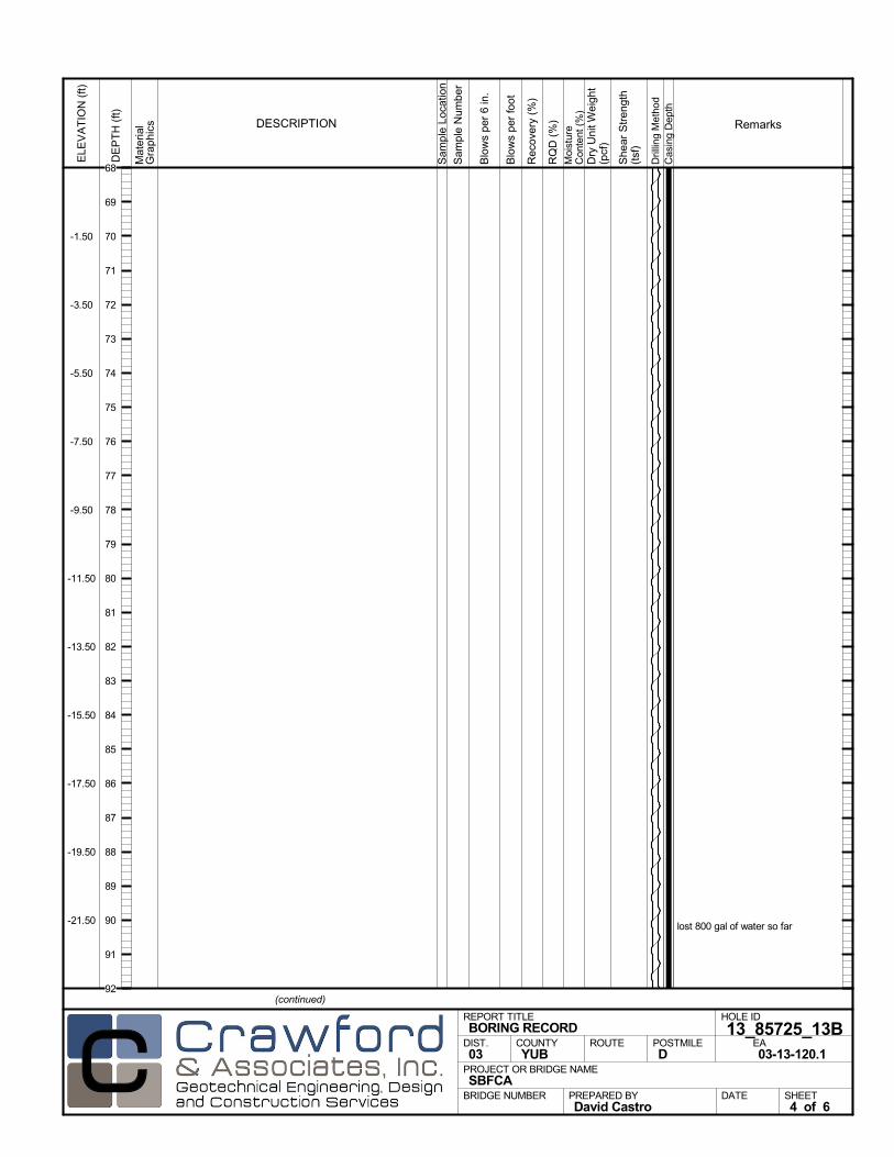
lost 800 gal of water so far
Mat
eria
lG
rap
hics
Sam
ple
Loca
tion
COUNTYYUB
DESCRIPTION
Rec
over
y (%
)
Dril
ling
Met
hod
Cas
ing
Dep
th
PREPARED BYDavid Castro
DATE
PROJECT OR BRIDGE NAMESBFCA
BRIDGE NUMBER
HOLE ID
13_85725_13BEA03-13-120.1
REPORT TITLEBORING RECORD
DIST.03
ROUTE POSTMILED
(continued)
SHEET4 of 6
RQ
D (
%)
Sam
ple
Num
ber
Moi
stur
eC
onte
nt (
%)
Remarks
Blo
ws
per
6 in
.
ELE
VA
TIO
N (
ft)
-1.50
-3.50
-5.50
-7.50
-9.50
-11.50
-13.50
-15.50
-17.50
-19.50
-21.50
DE
PT
H (
ft)
Dry
Uni
t Wei
ght
(pcf
)
She
ar S
tren
gth
(tsf
)
Blo
ws
per
foot
68
69
70
71
72
73
74
75
76
77
78
79
80
81
82
83
84
85
86
87
88
89
90
91
92
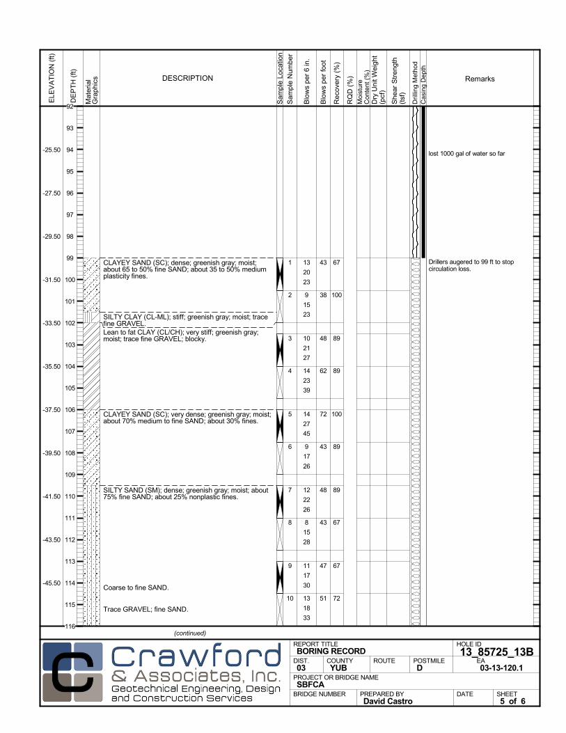
CLAYEY SAND (SC); dense; greenish gray; moist;about 65 to 50% fine SAND; about 35 to 50% mediumplasticity fines.
SILTY CLAY (CL-ML); stiff; greenish gray; moist; tracefine GRAVEL.Lean to fat CLAY (CL/CH); very stiff; greenish gray;moist; trace fine GRAVEL; blocky.
CLAYEY SAND (SC); very dense; greenish gray; moist;about 70% medium to fine SAND; about 30% fines.
SILTY SAND (SM); dense; greenish gray; moist; about75% fine SAND; about 25% nonplastic fines.
Coarse to fine SAND.
Trace GRAVEL; fine SAND.
67
100
89
89
100
89
89
67
67
72
1
2
3
4
5
6
7
8
9
10
lost 1000 gal of water so far
Drillers augered to 99 ft to stopcirculation loss.
13
20
23
9
15
23
10
21
27
14
23
39
14
27
45
9
17
26
12
22
26
8
15
28
11
17
30
13
18
33
Mat
eria
lG
rap
hics
Sam
ple
Loca
tion
COUNTYYUB
DESCRIPTION
Rec
over
y (%
)
Dril
ling
Met
hod
Cas
ing
Dep
th
PREPARED BYDavid Castro
DATE
PROJECT OR BRIDGE NAMESBFCA
BRIDGE NUMBER
HOLE ID
13_85725_13BEA03-13-120.1
REPORT TITLEBORING RECORD
DIST.03
ROUTE POSTMILED
(continued)
SHEET5 of 6
RQ
D (
%)
Sam
ple
Num
ber
Moi
stur
eC
onte
nt (
%)
Remarks
Blo
ws
per
6 in
.
ELE
VA
TIO
N (
ft)
-25.50
-27.50
-29.50
-31.50
-33.50
-35.50
-37.50
-39.50
-41.50
-43.50
-45.50
DE
PT
H (
ft)
Dry
Uni
t Wei
ght
(pcf
)
She
ar S
tren
gth
(tsf
)
Blo
ws
per
foot
43
38
48
62
72
43
48
43
47
51
92
93
94
95
96
97
98
99
100
101
102
103
104
105
106
107
108
109
110
111
112
113
114
115
116
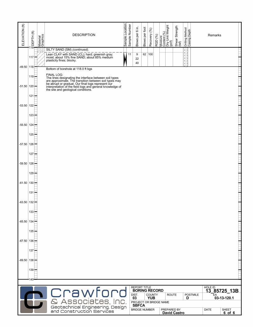
SILTY SAND (SM) (continued).
Lean CLAY with SAND (CL); hard; greenish gray;moist; about 15% fine SAND; about 85% mediumplasticity fines; blocky.
Bottom of borehole at 118.0 ft bgs
FINAL LOG:The lines designating the interface between soil typesare approximate. The transition between soil types maybe abrupt or gradual. Our final logs represent ourinterpretation of the field logs and general knowledge ofthe site and geological conditions.
10011 9
22
40
Mat
eria
lG
rap
hics
Sam
ple
Loca
tion
COUNTYYUB
DESCRIPTION
Rec
over
y (%
)
Dril
ling
Met
hod
Cas
ing
Dep
th
PREPARED BYDavid Castro
DATE
PROJECT OR BRIDGE NAMESBFCA
BRIDGE NUMBER
HOLE ID
13_85725_13BEA03-13-120.1
REPORT TITLEBORING RECORD
DIST.03
ROUTE POSTMILED
SHEET6 of 6
RQ
D (
%)
Sam
ple
Num
ber
Moi
stur
eC
onte
nt (
%)
Remarks
Blo
ws
per
6 in
.
ELE
VA
TIO
N (
ft)
-49.50
-51.50
-53.50
-55.50
-57.50
-59.50
-61.50
-63.50
-65.50
-67.50
-69.50
DE
PT
H (
ft)
Dry
Uni
t Wei
ght
(pcf
)
She
ar S
tren
gth
(tsf
)
Blo
ws
per
foot
62
116
117
118
119
120
121
122
123
124
125
126
127
128
129
130
131
132
133
134
135
136
137
138
139
140
AFTER DRILLING (DATE)DURING DRILLINGN/A N/A
SURFACE ELEVATION
69.0 ftDRILLING METHOD
Rotary WashDRILL RIG
CME 75SPT HAMMER TYPE
Automatic Trip, 140 lb, 30 inchBOREHOLE BACKFILL AND COMPLETION
Cement GroutGROUNDWATERREADINGS
BEGIN DATE
8-19-13COMPLETION DATE
8-20-13LOGGED BY
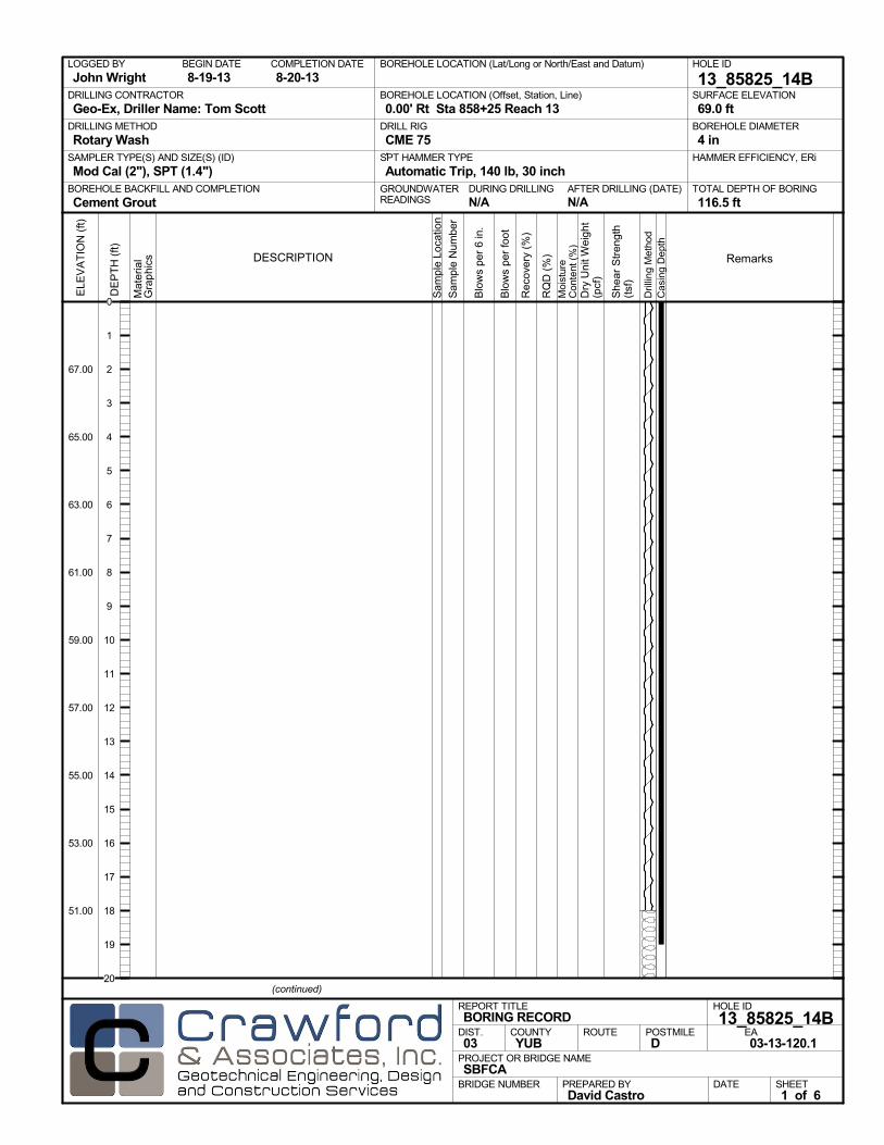
John WrightBOREHOLE LOCATION (Lat/Long or North/East and Datum) HOLE ID
13_85825_14BDRILLING CONTRACTOR
Geo-Ex, Driller Name: Tom Scott
HAMMER EFFICIENCY, ERiSAMPLER TYPE(S) AND SIZE(S) (ID)
Mod Cal (2"), SPT (1.4")TOTAL DEPTH OF BORING
116.5 ft
BOREHOLE DIAMETER
4 in
BOREHOLE LOCATION (Offset, Station, Line)
0.00' Rt Sta 858+25 Reach 13
.M
ater
ial
Gra
phi
cs
Sam
ple
Loca
tion
COUNTYYUB
DESCRIPTION
Rec
over
y (%
)
Dril
ling
Met
hod
Cas
ing
Dep
th
PREPARED BYDavid Castro
DATE
PROJECT OR BRIDGE NAMESBFCA
BRIDGE NUMBER
HOLE ID
13_85825_14BEA03-13-120.1
REPORT TITLEBORING RECORD
DIST.03
ROUTE POSTMILED
(continued)
SHEET1 of 6
RQ
D (
%)
Sam
ple
Num
ber
Moi
stur
eC
onte
nt (
%)
Remarks
Blo
ws
per
6 in
.
ELE
VA
TIO
N (
ft)
67.00
65.00
63.00
61.00
59.00
57.00
55.00
53.00
51.00
DE
PT
H (
ft)
Dry
Uni
t Wei
ght
(pcf
)
She
ar S
tren
gth
(tsf
)
Blo
ws
per
foot
0
1
2
3
4
5
6
7
8
9
10
11
12
13
14
15
16
17
18
19
20

Mat
eria
lG
rap
hics
Sam
ple
Loca
tion
COUNTYYUB
DESCRIPTION
Rec
over
y (%
)
Dril
ling
Met
hod
Cas
ing
Dep
th
PREPARED BYDavid Castro
DATE
PROJECT OR BRIDGE NAMESBFCA
BRIDGE NUMBER
HOLE ID
13_85825_14BEA03-13-120.1
REPORT TITLEBORING RECORD
DIST.03
ROUTE POSTMILED
(continued)
SHEET2 of 6
RQ
D (
%)
Sam
ple
Num
ber
Moi
stur
eC
onte
nt (
%)
Remarks
Blo
ws
per
6 in
.
ELE
VA
TIO
N (
ft)
47.00
45.00
43.00
41.00
39.00
37.00
35.00
33.00
31.00
29.00
27.00
DE
PT
H (
ft)
Dry
Uni
t Wei
ght
(pcf
)
She
ar S
tren
gth
(tsf
)
Blo
ws
per
foot
20
21
22
23
24
25
26
27
28
29
30
31
32
33
34
35
36
37
38
39
40
41
42
43
44
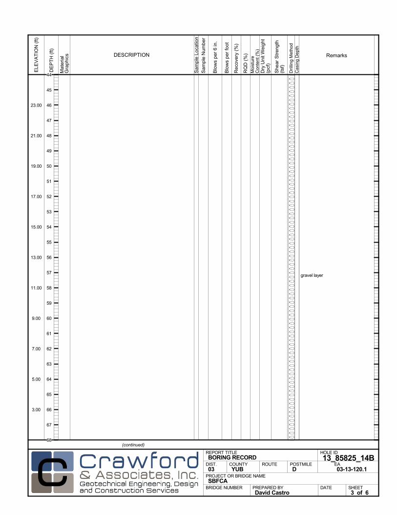
gravel layer
Mat
eria
lG
rap
hics
Sam
ple
Loca
tion
COUNTYYUB
DESCRIPTION
Rec
over
y (%
)
Dril
ling
Met
hod
Cas
ing
Dep
th
PREPARED BYDavid Castro
DATE
PROJECT OR BRIDGE NAMESBFCA
BRIDGE NUMBER
HOLE ID
13_85825_14BEA03-13-120.1
REPORT TITLEBORING RECORD
DIST.03
ROUTE POSTMILED
(continued)
SHEET3 of 6
RQ
D (
%)
Sam
ple
Num
ber
Moi
stur
eC
onte
nt (
%)
Remarks
Blo
ws
per
6 in
.
ELE
VA
TIO
N (
ft)
23.00
21.00
19.00
17.00
15.00
13.00
11.00
9.00
7.00
5.00
3.00
DE
PT
H (
ft)
Dry
Uni
t Wei
ght
(pcf
)
She
ar S
tren
gth
(tsf
)
Blo
ws
per
foot
44
45
46
47
48
49
50
51
52
53
54
55
56
57
58
59
60
61
62
63
64
65
66
67
68
gravel layer
Mat
eria
lG
rap
hics
Sam
ple
Loca
tion
COUNTYYUB
DESCRIPTION
Rec
over
y (%
)
Dril
ling
Met
hod
Cas
ing
Dep
th
PREPARED BYDavid Castro
DATE
PROJECT OR BRIDGE NAMESBFCA
BRIDGE NUMBER
HOLE ID
13_85825_14BEA03-13-120.1
REPORT TITLEBORING RECORD
DIST.03
ROUTE POSTMILED
(continued)
SHEET4 of 6
RQ
D (
%)
Sam
ple
Num
ber
Moi
stur
eC
onte
nt (
%)
Remarks
Blo
ws
per
6 in
.
ELE
VA
TIO
N (
ft)
-1.00
-3.00
-5.00
-7.00
-9.00
-11.00
-13.00
-15.00
-17.00
-19.00
-21.00
DE
PT
H (
ft)
Dry
Uni
t Wei
ght
(pcf
)
She
ar S
tren
gth
(tsf
)
Blo
ws
per
foot
68
69
70
71
72
73
74
75
76
77
78
79
80
81
82
83
84
85
86
87
88
89
90
91
92
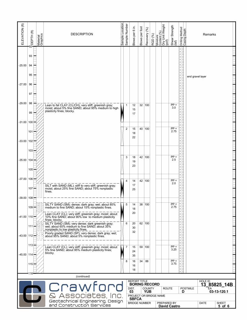
Lean to fat CLAY (CL/CH); very stiff; greenish gray;moist; about 5% fine SAND; about 95% medium to highplasticity fines; blocky.
SILT with SAND (ML); stiff to very stiff; greenish gray;moist; about 25% fine SAND; about 75% nonplasticfines.
SILTY SAND (SM); dense; dark gray; wet; about 85%medium to fine SAND; about 15% nonplastic fines.
Lean CLAY (CL); very stiff; greenish gray; moist; about10% fine SAND; about 90% low to medium plasticityfines; blocky.SILTY SAND (SM); very dense; dark greenish gray;wet; about 65% medium to fine SAND; about 35%nonplastic to low plasticity fines.Poorly graded SAND (SP); very dense; dark gray; wet;about 95% SAND; about 5% nonplastic fines.
Lean CLAY (CL); very stiff; greenish gray; moist; about5% fine SAND; about 95% medium plasticity fines;blocky.
100
100
100
100
100
100
100
88
1
2
3
4
5
6
7
8
end gravel layer
12
15
17
15
18
22
18
19
23
14
17
25
14
18
20
20
30
32
15
24
35
16
16
18
PP =3.0
PP =2.75
PP =2.5
PP =2.0
PP =2.75
PP =3.25
PP =3.75
Mat
eria
lG
rap
hics
Sam
ple
Loca
tion
COUNTYYUB
DESCRIPTION
Rec
over
y (%
)
Dril
ling
Met
hod
Cas
ing
Dep
th
PREPARED BYDavid Castro
DATE
PROJECT OR BRIDGE NAMESBFCA
BRIDGE NUMBER
HOLE ID
13_85825_14BEA03-13-120.1
REPORT TITLEBORING RECORD
DIST.03
ROUTE POSTMILED
(continued)
SHEET5 of 6
RQ
D (
%)
Sam
ple
Num
ber
Moi
stur
eC
onte
nt (
%)
Remarks
Blo
ws
per
6 in
.
ELE
VA
TIO
N (
ft)
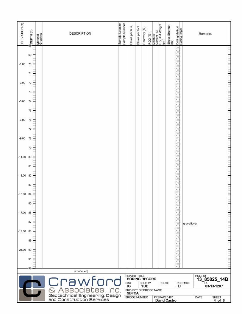
-25.00
-27.00
-29.00
-31.00
-33.00
-35.00
-37.00
-39.00
-41.00
-43.00
-45.00
DE
PT
H (
ft)
Dry
Uni
t Wei
ght
(pcf
)
She
ar S
tren
gth
(tsf
)
Blo
ws
per
foot
32
40
42
42
38
62
59
34
92
93
94
95
96
97
98
99
100
101
102
103
104
105
106
107
108
109
110
111
112
113
114
115
116

Lean CLAY (CL) (continued).
Bottom of borehole at 116.5 ft bgs
FINAL LOG:The lines designating the interface between soil typesare approximate. The transition between soil types maybe abrupt or gradual. Our final logs represent ourinterpretation of the field logs and general knowledge ofthe site and geological conditions.
888
Mat
eria
lG
rap
hics
Sam
ple
Loca
tion
COUNTYYUB
DESCRIPTION
Rec
over
y (%
)
Dril
ling
Met
hod
Cas
ing
Dep
th
PREPARED BYDavid Castro
DATE
PROJECT OR BRIDGE NAMESBFCA
BRIDGE NUMBER
HOLE ID
13_85825_14BEA03-13-120.1
REPORT TITLEBORING RECORD
DIST.03
ROUTE POSTMILED
SHEET6 of 6
RQ
D (
%)
Sam
ple
Num
ber
Moi
stur
eC
onte
nt (
%)
Remarks
Blo
ws
per
6 in
.
ELE
VA
TIO
N (
ft)
-49.00
-51.00
-53.00
-55.00
-57.00
-59.00
-61.00
-63.00
-65.00
-67.00
-69.00
DE
PT
H (
ft)
Dry
Uni
t Wei
ght
(pcf
)
She
ar S
tren
gth
(tsf
)
Blo
ws
per
foot
34116
117
118
119
120
121
122
123
124
125
126
127
128
129
130
131
132
133
134
135
136
137
138
139
140
AFTER DRILLING (DATE)DURING DRILLINGN/A N/A
SURFACE ELEVATION
69.0 ftDRILLING METHOD
Rotary WashDRILL RIG
CME 850SPT HAMMER TYPE
Automatic Trip, 140 lb, 30 inchBOREHOLE BACKFILL AND COMPLETION
Cement GroutGROUNDWATERREADINGS
BEGIN DATE
8-19-13COMPLETION DATE
8-20-13LOGGED BY
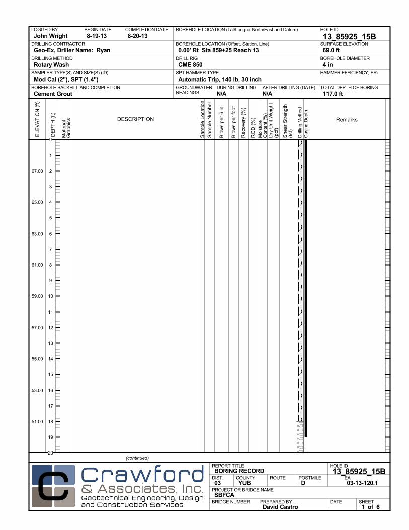
John WrightBOREHOLE LOCATION (Lat/Long or North/East and Datum) HOLE ID
13_85925_15BDRILLING CONTRACTOR
Geo-Ex, Driller Name: Ryan
HAMMER EFFICIENCY, ERiSAMPLER TYPE(S) AND SIZE(S) (ID)
Mod Cal (2"), SPT (1.4")TOTAL DEPTH OF BORING
117.0 ft
BOREHOLE DIAMETER
4 in
BOREHOLE LOCATION (Offset, Station, Line)
0.00' Rt Sta 859+25 Reach 13
.M
ater
ial
Gra
phi
cs
Sam
ple
Loca
tion
COUNTYYUB
DESCRIPTION
Rec
over
y (%
)
Dril
ling
Met
hod
Cas
ing
Dep
th
PREPARED BYDavid Castro
DATE
PROJECT OR BRIDGE NAMESBFCA
BRIDGE NUMBER
HOLE ID
13_85925_15BEA03-13-120.1
REPORT TITLEBORING RECORD
DIST.03
ROUTE POSTMILED
(continued)
SHEET1 of 6
RQ
D (
%)
Sam
ple
Num
ber
Moi
stur
eC
onte
nt (
%)
Remarks
Blo
ws
per
6 in
.
ELE
VA
TIO
N (
ft)
67.00
65.00
63.00
61.00
59.00
57.00
55.00
53.00
51.00
DE
PT
H (
ft)
Dry
Uni
t Wei
ght
(pcf
)
She
ar S
tren
gth
(tsf
)
Blo
ws
per
foot
0
1
2
3
4
5
6
7
8
9
10
11
12
13
14
15
16
17
18
19
20

Mat
eria
lG
rap
hics
Sam
ple
Loca
tion
COUNTYYUB
DESCRIPTION
Rec
over
y (%
)
Dril
ling
Met
hod
Cas
ing
Dep
th
PREPARED BYDavid Castro
DATE
PROJECT OR BRIDGE NAMESBFCA
BRIDGE NUMBER
HOLE ID
13_85925_15BEA03-13-120.1
REPORT TITLEBORING RECORD
DIST.03
ROUTE POSTMILED
(continued)
SHEET2 of 6
RQ
D (
%)
Sam
ple
Num
ber
Moi
stur
eC
onte
nt (
%)
Remarks
Blo
ws
per
6 in
.
ELE
VA
TIO
N (
ft)
47.00
45.00
43.00
41.00
39.00
37.00
35.00
33.00
31.00
29.00
27.00
DE
PT
H (
ft)
Dry
Uni
t Wei
ght
(pcf
)
She
ar S
tren
gth
(tsf
)
Blo
ws
per
foot
20
21
22
23
24
25
26
27
28
29
30
31
32
33
34
35
36
37
38
39
40
41
42
43
44

gravel layer
Mat
eria
lG
rap
hics
Sam
ple
Loca
tion
COUNTYYUB
DESCRIPTION
Rec
over
y (%
)
Dril
ling
Met
hod
Cas
ing
Dep
th
PREPARED BYDavid Castro
DATE
PROJECT OR BRIDGE NAMESBFCA
BRIDGE NUMBER
HOLE ID
13_85925_15BEA03-13-120.1
REPORT TITLEBORING RECORD
DIST.03
ROUTE POSTMILED
(continued)
SHEET3 of 6
RQ
D (
%)
Sam
ple
Num
ber
Moi
stur
eC
onte
nt (
%)
Remarks
Blo
ws
per
6 in
.
ELE
VA
TIO
N (
ft)
23.00
21.00
19.00
17.00
15.00
13.00
11.00
9.00
7.00
5.00
3.00
DE
PT
H (
ft)
Dry
Uni
t Wei
ght
(pcf
)
She
ar S
tren
gth
(tsf
)
Blo
ws
per
foot
44
45
46
47
48
49
50
51
52
53
54
55
56
57
58
59
60
61
62
63
64
65
66
67
68

add 50 gal of water
add 50 gal of water
Mat
eria
lG
rap
hics
Sam
ple
Loca
tion
COUNTYYUB
DESCRIPTION
Rec
over
y (%
)
Dril
ling
Met
hod
Cas
ing
Dep
th
PREPARED BYDavid Castro
DATE
PROJECT OR BRIDGE NAMESBFCA
BRIDGE NUMBER
HOLE ID
13_85925_15BEA03-13-120.1
REPORT TITLEBORING RECORD
DIST.03
ROUTE POSTMILED
(continued)
SHEET4 of 6
RQ
D (
%)
Sam
ple
Num
ber
Moi
stur
eC
onte
nt (
%)
Remarks
Blo
ws
per
6 in
.
ELE
VA
TIO
N (
ft)
-1.00
-3.00
-5.00
-7.00
-9.00
-11.00
-13.00
-15.00
-17.00
-19.00
-21.00
DE
PT
H (
ft)
Dry
Uni
t Wei
ght
(pcf
)
She
ar S
tren
gth
(tsf
)
Blo
ws
per
foot
68
69
70
71
72
73
74
75
76
77
78
79
80
81
82
83
84
85
86
87
88
89
90
91
92
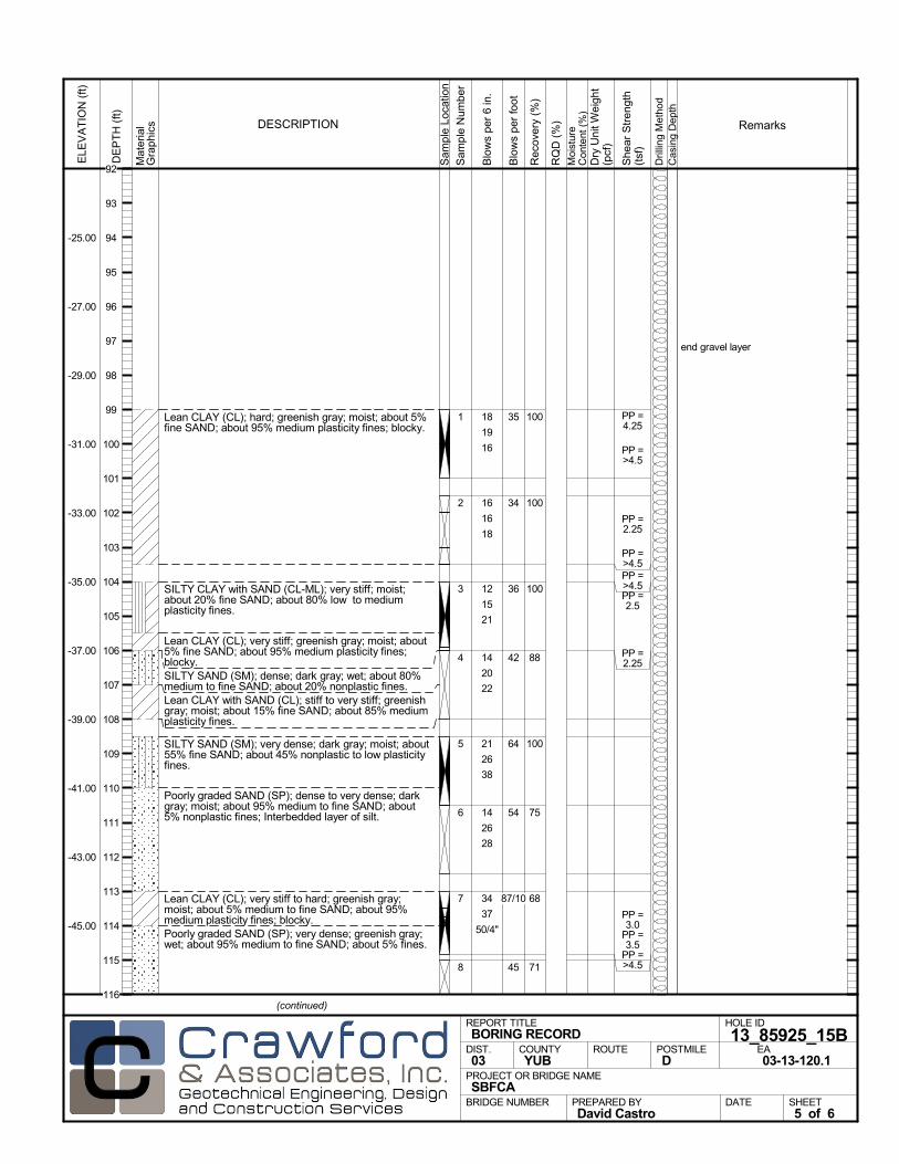
Lean CLAY (CL); hard; greenish gray; moist; about 5%fine SAND; about 95% medium plasticity fines; blocky.
SILTY CLAY with SAND (CL-ML); very stiff; moist;about 20% fine SAND; about 80% low to mediumplasticity fines.
Lean CLAY (CL); very stiff; greenish gray; moist; about5% fine SAND; about 95% medium plasticity fines;blocky.SILTY SAND (SM); dense; dark gray; wet; about 80%medium to fine SAND; about 20% nonplastic fines.Lean CLAY with SAND (CL); stiff to very stiff; greenishgray; moist; about 15% fine SAND; about 85% mediumplasticity fines.
SILTY SAND (SM); very dense; dark gray; moist; about55% fine SAND; about 45% nonplastic to low plasticityfines.
Poorly graded SAND (SP); dense to very dense; darkgray; moist; about 95% medium to fine SAND; about5% nonplastic fines; Interbedded layer of silt.
Lean CLAY (CL); very stiff to hard; greenish gray;moist; about 5% medium to fine SAND; about 95%medium plasticity fines; blocky.Poorly graded SAND (SP); very dense; greenish gray;wet; about 95% medium to fine SAND; about 5% fines.
100
100
100
88
100
75
68
71
1
2
3
4
5
6
7
8
end gravel layer
18
19
16
16
16
18
12
15
21
14
20
22
21
26
38
14
26
28
34
37
50/4"
PP =4.25
PP =>4.5
PP =2.25
PP =>4.5PP =>4.5PP =2.5
PP =2.25
PP =3.0
PP =3.5
PP =>4.5
Mat
eria
lG
rap
hics
Sam
ple
Loca
tion
COUNTYYUB
DESCRIPTION
Rec
over
y (%
)
Dril
ling
Met
hod
Cas
ing
Dep
th
PREPARED BYDavid Castro
DATE
PROJECT OR BRIDGE NAMESBFCA
BRIDGE NUMBER
HOLE ID
13_85925_15BEA03-13-120.1
REPORT TITLEBORING RECORD
DIST.03
ROUTE POSTMILED
(continued)
SHEET5 of 6
RQ
D (
%)
Sam
ple
Num
ber
Moi
stur
eC
onte
nt (
%)
Remarks
Blo
ws
per
6 in
.
ELE
VA
TIO
N (
ft)
-25.00
-27.00
-29.00
-31.00
-33.00
-35.00
-37.00
-39.00
-41.00
-43.00
-45.00
DE
PT
H (
ft)
Dry
Uni
t Wei
ght
(pcf
)
She
ar S
tren
gth
(tsf
)
Blo
ws
per
foot
35
34
36
42
64
54
87/10
45
92
93
94
95
96
97
98
99
100
101
102
103
104
105
106
107
108
109
110
111
112
113
114
115
116

Dark gray.Poorly graded SAND (SP) (continued).
Bottom of borehole at 117.0 ft bgs
FINAL LOG:The lines designating the interface between soil typesare approximate. The transition between soil types maybe abrupt or gradual. Our final logs represent ourinterpretation of the field logs and general knowledge ofthe site and geological conditions.
718 14
18
27
Mat
eria
lG
rap
hics
Sam
ple
Loca
tion
COUNTYYUB
DESCRIPTION
Rec
over
y (%
)
Dril
ling
Met
hod
Cas
ing
Dep
th
PREPARED BYDavid Castro
DATE
PROJECT OR BRIDGE NAMESBFCA
BRIDGE NUMBER
HOLE ID
13_85925_15BEA03-13-120.1
REPORT TITLEBORING RECORD
DIST.03
ROUTE POSTMILED
SHEET6 of 6
RQ
D (
%)
Sam
ple
Num
ber
Moi
stur
eC
onte
nt (
%)
Remarks
Blo
ws
per
6 in
.
ELE
VA
TIO
N (
ft)
-49.00
-51.00
-53.00
-55.00
-57.00
-59.00
-61.00
-63.00
-65.00
-67.00
-69.00
DE
PT
H (
ft)
Dry
Uni
t Wei
ght
(pcf
)
She
ar S
tren
gth
(tsf
)
Blo
ws
per
foot
45116
117
118
119
120
121
122
123
124
125
126
127
128
129
130
131
132
133
134
135
136
137
138
139
140

AFTER DRILLING (DATE)DURING DRILLINGN/A N/A
SURFACE ELEVATION
69.0 ftDRILLING METHOD
Rotary WashDRILL RIG
CME 850SPT HAMMER TYPE
Automatic Trip, 140 lb, 30 inchBOREHOLE BACKFILL AND COMPLETION
Cement GroutGROUNDWATERREADINGS
BEGIN DATE
8-23-13COMPLETION DATE
8-23-13LOGGED BY
John WrightBOREHOLE LOCATION (Lat/Long or North/East and Datum) HOLE ID
13_86325_19BRDRILLING CONTRACTOR
Geo-Ex, Driller Name: Ryan
HAMMER EFFICIENCY, ERiSAMPLER TYPE(S) AND SIZE(S) (ID)
HQ Core, SPT (1.4")TOTAL DEPTH OF BORING
117.0 ft
BOREHOLE DIAMETER
4 in
BOREHOLE LOCATION (Offset, Station, Line)
0.00' Rt Sta 863+25 Reach 13
.M
ater
ial
Gra
phi
cs
Sam
ple
Loca
tion
COUNTYYUB
DESCRIPTION
Rec
over
y (%
)
Dril
ling
Met
hod
Cas
ing
Dep
th
PREPARED BYJohn Wright
DATE
PROJECT OR BRIDGE NAMESBFCA
BRIDGE NUMBER
HOLE ID
13_86325_19BR REA03-13-120.1
REPORT TITLEBORING RECORD
DIST.03
ROUTE POSTMILED
(continued)
SHEET1 of 6
RQ
D (
%)
Sam
ple
Num
ber
Moi
stur
eC
onte
nt (
%)
Remarks
Blo
ws
per
6 in
.
ELE
VA
TIO
N (
ft)
67.00
65.00
63.00
61.00
59.00
57.00
55.00
53.00
51.00
DE
PT
H (
ft)
Dry
Uni
t Wei
ght
(pcf
)
She
ar S
tren
gth
(tsf
)
Blo
ws
per
foot
0
1
2
3
4
5
6
7
8
9
10
11
12
13
14
15
16
17
18
19
20

Mat
eria
lG
rap
hics
Sam
ple
Loca
tion
COUNTYYUB
DESCRIPTION
Rec
over
y (%
)
Dril
ling
Met
hod
Cas
ing
Dep
th
PREPARED BYJohn Wright
DATE
PROJECT OR BRIDGE NAMESBFCA
BRIDGE NUMBER
HOLE ID
13_86325_19BR REA03-13-120.1
REPORT TITLEBORING RECORD
DIST.03
ROUTE POSTMILED
(continued)
SHEET2 of 6
RQ
D (
%)
Sam
ple
Num
ber
Moi
stur
eC
onte
nt (
%)
Remarks
Blo
ws
per
6 in
.
ELE
VA
TIO
N (
ft)
47.00
45.00
43.00
41.00
39.00
37.00
35.00
33.00
31.00
29.00
27.00
DE
PT
H (
ft)
Dry
Uni
t Wei
ght
(pcf
)
She
ar S
tren
gth
(tsf
)
Blo
ws
per
foot
20
21
22
23
24
25
26
27
28
29
30
31
32
33
34
35
36
37
38
39
40
41
42
43
44
DavidCastro
Rectangle
gravel layer
Mat
eria
lG
rap
hics
Sam
ple
Loca
tion
COUNTYYUB
DESCRIPTION
Rec
over
y (%
)
Dril
ling
Met
hod
Cas
ing
Dep
th
PREPARED BYJohn Wright
DATE
PROJECT OR BRIDGE NAMESBFCA
BRIDGE NUMBER
HOLE ID
13_86325_19BR REA03-13-120.1
REPORT TITLEBORING RECORD
DIST.03
ROUTE POSTMILED
(continued)
SHEET3 of 6
RQ
D (
%)
Sam
ple
Num
ber
Moi
stur
eC
onte
nt (
%)
Remarks
Blo
ws
per
6 in
.
ELE
VA
TIO
N (
ft)
23.00
21.00
19.00
17.00
15.00
13.00
11.00
9.00
7.00
5.00
3.00
DE
PT
H (
ft)
Dry
Uni
t Wei
ght
(pcf
)
She
ar S
tren
gth
(tsf
)
Blo
ws
per
foot
44
45
46
47
48
49
50
51
52
53
54
55
56
57
58
59
60
61
62
63
64
65
66
67
68

end of gravel layer
gravel layer
Mat
eria
lG
rap
hics
Sam
ple
Loca
tion
COUNTYYUB
DESCRIPTION
Rec
over
y (%
)
Dril
ling
Met
hod
Cas
ing
Dep
th
PREPARED BYJohn Wright
DATE
PROJECT OR BRIDGE NAMESBFCA
BRIDGE NUMBER
HOLE ID
13_86325_19BR REA03-13-120.1
REPORT TITLEBORING RECORD
DIST.03
ROUTE POSTMILED
(continued)
SHEET4 of 6
RQ
D (
%)
Sam
ple
Num
ber
Moi
stur
eC
onte
nt (
%)
Remarks
Blo
ws
per
6 in
.
ELE
VA
TIO
N (
ft)
-1.00
-3.00
-5.00
-7.00
-9.00
-11.00
-13.00
-15.00
-17.00
-19.00
-21.00
DE
PT
H (
ft)
Dry
Uni
t Wei
ght
(pcf
)
She
ar S
tren
gth
(tsf
)
Blo
ws
per
foot
68
69
70
71
72
73
74
75
76
77
78
79
80
81
82
83
84
85
86
87
88
89
90
91
92
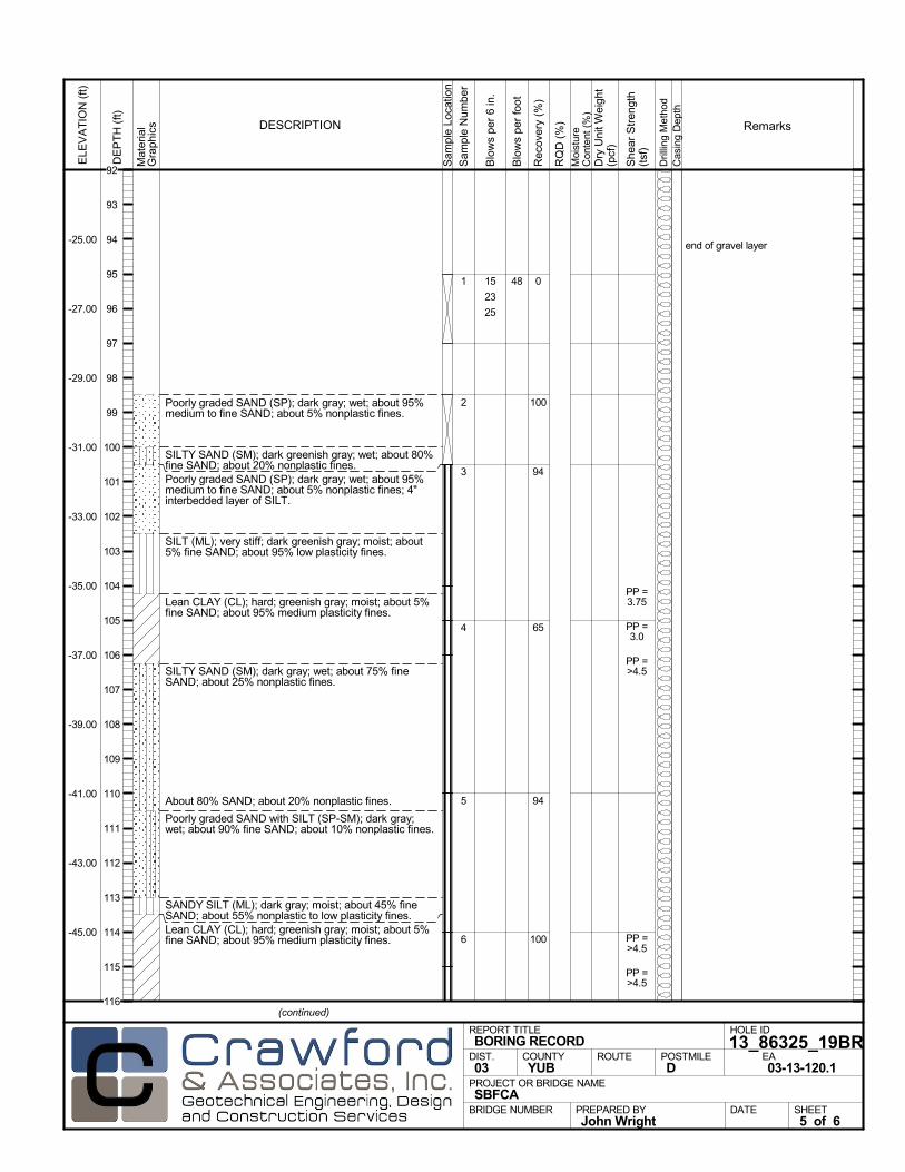
Poorly graded SAND (SP); dark gray; wet; about 95%medium to fine SAND; about 5% nonplastic fines.
SILTY SAND (SM); dark greenish gray; wet; about 80%fine SAND; about 20% nonplastic fines.Poorly graded SAND (SP); dark gray; wet; about 95%medium to fine SAND; about 5% nonplastic fines; 4"interbedded layer of SILT.
SILT (ML); very stiff; dark greenish gray; moist; about5% fine SAND; about 95% low plasticity fines.
Lean CLAY (CL); hard; greenish gray; moist; about 5%fine SAND; about 95% medium plasticity fines.
SILTY SAND (SM); dark gray; wet; about 75% fineSAND; about 25% nonplastic fines.
About 80% SAND; about 20% nonplastic fines.
Poorly graded SAND with SILT (SP-SM); dark gray;wet; about 90% fine SAND; about 10% nonplastic fines.
SANDY SILT (ML); dark gray; moist; about 45% fineSAND; about 55% nonplastic to low plasticity fines.Lean CLAY (CL); hard; greenish gray; moist; about 5%fine SAND; about 95% medium plasticity fines.
0
100
94
65
94
100
1
2
3
4
5
6
end of gravel layer
15
23
25
PP =3.75
PP =3.0
PP =>4.5
PP =>4.5
PP =>4.5
Mat
eria
lG
rap
hics
Sam
ple
Loca
tion
COUNTYYUB
DESCRIPTION
Rec
over
y (%
)
Dril
ling
Met
hod
Cas
ing
Dep
th
PREPARED BYJohn Wright
DATE
PROJECT OR BRIDGE NAMESBFCA
BRIDGE NUMBER
HOLE ID
13_86325_19BR REA03-13-120.1
REPORT TITLEBORING RECORD
DIST.03
ROUTE POSTMILED
(continued)
SHEET5 of 6
RQ
D (
%)
Sam
ple
Num
ber
Moi
stur
eC
onte
nt (
%)
Remarks
Blo
ws
per
6 in
.
ELE
VA
TIO
N (
ft)
-25.00
-27.00
-29.00
-31.00
-33.00
-35.00
-37.00
-39.00
-41.00
-43.00
-45.00
DE
PT
H (
ft)
Dry
Uni
t Wei
ght
(pcf
)
She
ar S
tren
gth
(tsf
)
Blo
ws
per
foot
48
92
93
94
95
96
97
98
99
100
101
102
103
104
105
106
107
108
109
110
111
112
113
114
115
116
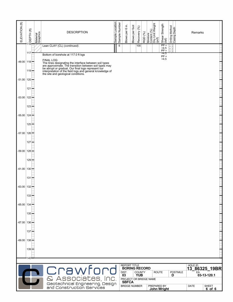
Lean CLAY (CL) (continued).
Bottom of borehole at 117.0 ft bgs
FINAL LOG:The lines designating the interface between soil typesare approximate. The transition between soil types maybe abrupt or gradual. Our final logs represent ourinterpretation of the field logs and general knowledge ofthe site and geological conditions.
1006 PP =>4.5PP =>4.5PP =>4.5
Mat
eria
lG
rap
hics
Sam
ple
Loca
tion
COUNTYYUB
DESCRIPTION
Rec
over
y (%
)
Dril
ling
Met
hod
Cas
ing
Dep
th
PREPARED BYJohn Wright
DATE
PROJECT OR BRIDGE NAMESBFCA
BRIDGE NUMBER
HOLE ID
13_86325_19BR REA03-13-120.1
REPORT TITLEBORING RECORD
DIST.03
ROUTE POSTMILED
SHEET6 of 6
RQ
D (
%)
Sam
ple
Num
ber
Moi
stur
eC
onte
nt (
%)
Remarks
Blo
ws
per
6 in
.
ELE
VA
TIO
N (
ft)
-49.00
-51.00
-53.00
-55.00
-57.00
-59.00
-61.00
-63.00
-65.00
-67.00
-69.00
DE
PT
H (
ft)
Dry
Uni
t Wei
ght
(pcf
)
She
ar S
tren
gth
(tsf
)
Blo
ws
per
foot
116
117
118
119
120
121
122
123
124
125
126
127
128
129
130
131
132
133
134
135
136
137
138
139
140
AFTER DRILLING (DATE)DURING DRILLINGN/A N/A
SURFACE ELEVATION
69.0 ftDRILLING METHOD
Rotary WashDRILL RIG
CME 850SPT HAMMER TYPE
Automatic Trip, 140 lb, 30 inchBOREHOLE BACKFILL AND COMPLETION
Cement GroutGROUNDWATERREADINGS
BEGIN DATE
8-19-13COMPLETION DATE
8-20-13LOGGED BY
John WrightBOREHOLE LOCATION (Lat/Long or North/East and Datum) HOLE ID
13_86425_20BDRILLING CONTRACTOR
Geo-Ex, Driller Name: Ryan
HAMMER EFFICIENCY, ERiSAMPLER TYPE(S) AND SIZE(S) (ID)
Mod Cal (2"), HQ Core, SPT (1.4")TOTAL DEPTH OF BORING
117.0 ft
BOREHOLE DIAMETER
4 in
BOREHOLE LOCATION (Offset, Station, Line)
0.00' Rt Sta 864+25 Reach 13
.M
ater
ial
Gra
phi
cs
Sam
ple
Loca
tion
COUNTYYUB
DESCRIPTION
Rec
over
y (%
)
Dril
ling
Met
hod
Cas
ing
Dep
th
PREPARED BYDavid Castro
DATE
PROJECT OR BRIDGE NAMESBFCA
BRIDGE NUMBER
HOLE ID
13_86425_20BEA03-13-120.1
REPORT TITLEBORING RECORD
DIST.03
ROUTE POSTMILED
(continued)
SHEET1 of 6
RQ
D (
%)
Sam
ple
Num
ber
Moi
stur
eC
onte
nt (
%)
Remarks
Blo
ws
per
6 in
.
ELE
VA
TIO
N (
ft)
67.00
65.00
63.00
61.00
59.00
57.00
55.00
53.00
51.00
DE
PT
H (
ft)
Dry
Uni
t Wei
ght
(pcf
)
She
ar S
tren
gth
(tsf
)
Blo
ws
per
foot
0
1
2
3
4
5
6
7
8
9
10
11
12
13
14
15
16
17
18
19
20

Mat
eria
lG
rap
hics
Sam
ple
Loca
tion
COUNTYYUB
DESCRIPTION
Rec
over
y (%
)
Dril
ling
Met
hod
Cas
ing
Dep
th
PREPARED BYDavid Castro
DATE
PROJECT OR BRIDGE NAMESBFCA
BRIDGE NUMBER
HOLE ID
13_86425_20BEA03-13-120.1
REPORT TITLEBORING RECORD
DIST.03
ROUTE POSTMILED
(continued)
SHEET2 of 6
RQ
D (
%)
Sam
ple
Num
ber
Moi
stur
eC
onte
nt (
%)
Remarks
Blo
ws
per
6 in
.
ELE
VA
TIO
N (
ft)
47.00
45.00
43.00
41.00
39.00
37.00
35.00
33.00
31.00
29.00
27.00
DE
PT
H (
ft)
Dry
Uni
t Wei
ght
(pcf
)
She
ar S
tren
gth
(tsf
)
Blo
ws
per
foot
20
21
22
23
24
25
26
27
28
29
30
31
32
33
34
35
36
37
38
39
40
41
42
43
44

gravel layer
gravel layer
Mat
eria
lG
rap
hics
Sam
ple
Loca
tion
COUNTYYUB
DESCRIPTION
Rec
over
y (%
)
Dril
ling
Met
hod
Cas
ing
Dep
th
PREPARED BYDavid Castro
DATE
PROJECT OR BRIDGE NAMESBFCA
BRIDGE NUMBER
HOLE ID
13_86425_20BEA03-13-120.1
REPORT TITLEBORING RECORD
DIST.03
ROUTE POSTMILED
(continued)
SHEET3 of 6
RQ
D (
%)
Sam
ple
Num
ber
Moi
stur
eC
onte
nt (
%)
Remarks
Blo
ws
per
6 in
.
ELE
VA
TIO
N (
ft)
23.00
21.00
19.00
17.00
15.00
13.00
11.00
9.00
7.00
5.00
3.00
DE
PT
H (
ft)
Dry
Uni
t Wei
ght
(pcf
)
She
ar S
tren
gth
(tsf
)
Blo
ws
per
foot
44
45
46
47
48
49
50
51
52
53
54
55
56
57
58
59
60
61
62
63
64
65
66
67
68

end gravel layer
fluid loss, add 100 gal of water
gravel layer
Mat
eria
lG
rap
hics
Sam
ple
Loca
tion
COUNTYYUB
DESCRIPTION
Rec
over
y (%
)
Dril
ling
Met
hod
Cas
ing
Dep
th
PREPARED BYDavid Castro
DATE
PROJECT OR BRIDGE NAMESBFCA
BRIDGE NUMBER
HOLE ID
13_86425_20BEA03-13-120.1
REPORT TITLEBORING RECORD
DIST.03
ROUTE POSTMILED
(continued)
SHEET4 of 6
RQ
D (
%)
Sam
ple
Num
ber
Moi
stur
eC
onte
nt (
%)
Remarks
Blo
ws
per
6 in
.
ELE
VA
TIO
N (
ft)
-1.00
-3.00
-5.00
-7.00
-9.00
-11.00
-13.00
-15.00
-17.00
-19.00
-21.00
DE
PT
H (
ft)
Dry
Uni
t Wei
ght
(pcf
)
She
ar S
tren
gth
(tsf
)
Blo
ws
per
foot
68
69
70
71
72
73
74
75
76
77
78
79
80
81
82
83
84
85
86
87
88
89
90
91
92
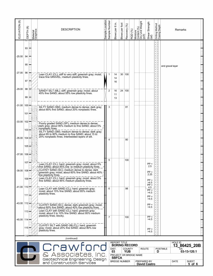
Lean CLAY (CL); stiff to very stiff; greenish gray; moist;trace fine GRAVEL; medium plasticity fines.
SANDY SILT (ML); stiff; greenish gray; moist; about45% fine SAND; about 55% low plasticity fines.
SILTY SAND (SM); medium dense to dense; dark gray;about 80% fine SAND; about 20% nonplastic fines.
Poorly graded SAND (SP); medium dense to dense;dark gray; about 95% medium to fine SAND; about 5%nonplastic fines.SILTY SAND (SM); medium dense to dense; dark gray;about 85 to 80% medium to fine SAND; about 15 to20% nonplastic fines; Interbedded layers of silt.
Lean CLAY (CL); hard; greenish gray; moist; about 5%fine SAND; about 95% low to medium plasticity fines.CLAYEY SAND (SC); medium dense to dense; darkgreenish gray; moist; about 60% fine SAND; about 40%low plasticity fines.Lean CLAY (CL); hard; greenish gray; moist; about 5%fine SAND; about 95% medium plasticity fines.
Lean CLAY with SAND (CL); hard; greenish gray;moist; about 15% fine SAND; about 85% mediumplasticity fines.
CLAYEY SAND (SC); dense; dark greenish gray; moist;about 60% fine SAND; about 40% low plasticity fines.Lean CLAY with SAND (CL); hard; greenish gray;moist; about 5 to 10% fine SAND; about 95% mediumplasticity fines; blocky.
CLAYEY SILT with SAND (ML/CL); hard; greenishgray; moist; about 20% fine SAND; about 80% lowplasticity fines.
100
100
81
80
100
98
100
1
2
3
4
5
6
7
end gravel layer
14
14
16
16
11
13
PP =2.5
PP =2.25
PP =>4.5PP =4.5
PP =>4.5
PP =>4.5
PP =>4.5
PP =>4.5
PP =>4.5
Mat
eria
lG
rap
hics
Sam
ple
Loca
tion
COUNTYYUB
DESCRIPTION
Rec
over
y (%
)
Dril
ling
Met
hod
Cas
ing
Dep
th
PREPARED BYDavid Castro
DATE
PROJECT OR BRIDGE NAMESBFCA
BRIDGE NUMBER
HOLE ID
13_86425_20BEA03-13-120.1
REPORT TITLEBORING RECORD
DIST.03
ROUTE POSTMILED
(continued)
SHEET5 of 6
RQ
D (
%)
Sam
ple
Num
ber
Moi
stur
eC
onte
nt (
%)
Remarks
Blo
ws
per
6 in
.
ELE
VA
TIO
N (
ft)
-25.00
-27.00
-29.00
-31.00
-33.00
-35.00
-37.00
-39.00
-41.00
-43.00
-45.00
DE
PT
H (
ft)
Dry
Uni
t Wei
ght
(pcf
)
She
ar S
tren
gth
(tsf
)
Blo
ws
per
foot
30
24
92
93
94
95
96
97
98
99
100
101
102
103
104
105
106
107
108
109
110
111
112
113
114
115
116
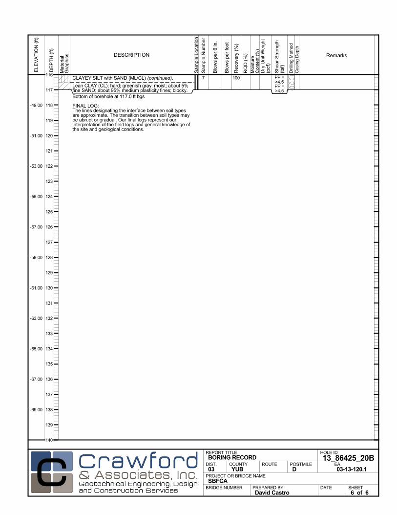
CLAYEY SILT with SAND (ML/CL) (continued).
Lean CLAY (CL); hard; greenish gray; moist; about 5%fine SAND; about 95% medium plasticity fines; blocky.Bottom of borehole at 117.0 ft bgs
FINAL LOG:The lines designating the interface between soil typesare approximate. The transition between soil types maybe abrupt or gradual. Our final logs represent ourinterpretation of the field logs and general knowledge ofthe site and geological conditions.
1007 PP =>4.5PP =>4.5
Mat
eria
lG
rap
hics
Sam
ple
Loca
tion
COUNTYYUB
DESCRIPTION
Rec
over
y (%
)
Dril
ling
Met
hod
Cas
ing
Dep
th
PREPARED BYDavid Castro
DATE
PROJECT OR BRIDGE NAMESBFCA
BRIDGE NUMBER
HOLE ID
13_86425_20BEA03-13-120.1
REPORT TITLEBORING RECORD
DIST.03
ROUTE POSTMILED
SHEET6 of 6
RQ
D (
%)
Sam
ple
Num
ber
Moi
stur
eC
onte
nt (
%)
Remarks
Blo
ws
per
6 in
.
ELE
VA
TIO
N (
ft)
-49.00
-51.00
-53.00
-55.00
-57.00
-59.00
-61.00
-63.00
-65.00
-67.00
-69.00
DE
PT
H (
ft)
Dry
Uni
t Wei
ght
(pcf
)
She
ar S
tren
gth
(tsf
)
Blo
ws
per
foot
116
117
118
119
120
121
122
123
124
125
126
127
128
129
130
131
132
133
134
135
136
137
138
139
140
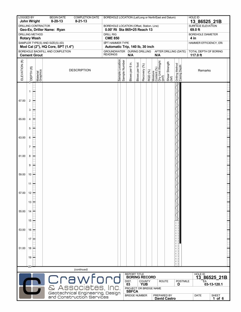
AFTER DRILLING (DATE)DURING DRILLINGN/A N/A
SURFACE ELEVATION
69.0 ftDRILLING METHOD
Rotary WashDRILL RIG
CME 850SPT HAMMER TYPE
Automatic Trip, 140 lb, 30 inchBOREHOLE BACKFILL AND COMPLETION
Cement GroutGROUNDWATERREADINGS
BEGIN DATE
8-20-13COMPLETION DATE
8-21-13LOGGED BY
John WrightBOREHOLE LOCATION (Lat/Long or North/East and Datum) HOLE ID
13_86525_21BDRILLING CONTRACTOR
Geo-Ex, Driller Name: Ryan
HAMMER EFFICIENCY, ERiSAMPLER TYPE(S) AND SIZE(S) (ID)
Mod Cal (2"), HQ Core, SPT (1.4")TOTAL DEPTH OF BORING
117.0 ft
BOREHOLE DIAMETER
4 in
BOREHOLE LOCATION (Offset, Station, Line)
0.00' Rt Sta 865+25 Reach 13
.M
ater
ial
Gra
phi
cs
Sam
ple
Loca
tion
COUNTYYUB
DESCRIPTION
Rec
over
y (%
)
Dril
ling
Met
hod
Cas
ing
Dep
th
PREPARED BYDavid Castro
DATE
PROJECT OR BRIDGE NAMESBFCA
BRIDGE NUMBER
HOLE ID
13_86525_21BEA03-13-120.1
REPORT TITLEBORING RECORD
DIST.03
ROUTE POSTMILED
(continued)
SHEET1 of 6
RQ
D (
%)
Sam
ple
Num
ber
Moi
stur
eC
onte
nt (
%)
Remarks
Blo
ws
per
6 in
.
ELE
VA
TIO
N (
ft)
67.00
65.00
63.00
61.00
59.00
57.00
55.00
53.00
51.00
DE
PT
H (
ft)
Dry
Uni
t Wei
ght
(pcf
)
She
ar S
tren
gth
(tsf
)
Blo
ws
per
foot
0
1
2
3
4
5
6
7
8
9
10
11
12
13
14
15
16
17
18
19
20

Mat
eria
lG
rap
hics
Sam
ple
Loca
tion
COUNTYYUB
DESCRIPTION
Rec
over
y (%
)
Dril
ling
Met
hod
Cas
ing
Dep
th
PREPARED BYDavid Castro
DATE
PROJECT OR BRIDGE NAMESBFCA
BRIDGE NUMBER
HOLE ID
13_86525_21BEA03-13-120.1
REPORT TITLEBORING RECORD
DIST.03
ROUTE POSTMILED
(continued)
SHEET2 of 6
RQ
D (
%)
Sam
ple
Num
ber
Moi
stur
eC
onte
nt (
%)
Remarks
Blo
ws
per
6 in
.
ELE
VA
TIO
N (
ft)
47.00
45.00
43.00
41.00
39.00
37.00
35.00
33.00
31.00
29.00
27.00
DE
PT
H (
ft)
Dry
Uni
t Wei
ght
(pcf
)
She
ar S
tren
gth
(tsf
)
Blo
ws
per
foot
20
21
22
23
24
25
26
27
28
29
30
31
32
33
34
35
36
37
38
39
40
41
42
43
44
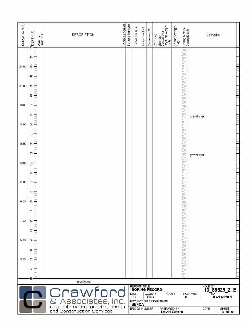
gravel layer
gravel layer
Mat
eria
lG
rap
hics
Sam
ple
Loca
tion
COUNTYYUB
DESCRIPTION
Rec
over
y (%
)
Dril
ling
Met
hod
Cas
ing
Dep
th
PREPARED BYDavid Castro
DATE
PROJECT OR BRIDGE NAMESBFCA
BRIDGE NUMBER
HOLE ID
13_86525_21BEA03-13-120.1
REPORT TITLEBORING RECORD
DIST.03
ROUTE POSTMILED
(continued)
SHEET3 of 6
RQ
D (
%)
Sam
ple
Num
ber
Moi
stur
eC
onte
nt (
%)
Remarks
Blo
ws
per
6 in
.
ELE
VA
TIO
N (
ft)
23.00
21.00
19.00
17.00
15.00
13.00
11.00
9.00
7.00
5.00
3.00
DE
PT
H (
ft)
Dry
Uni
t Wei
ght
(pcf
)
She
ar S
tren
gth
(tsf
)
Blo
ws
per
foot
44
45
46
47
48
49
50
51
52
53
54
55
56
57
58
59
60
61
62
63
64
65
66
67
68

end gravel layer
gravel layer
Mat
eria
lG
rap
hics
Sam
ple
Loca
tion
COUNTYYUB
DESCRIPTION
Rec
over
y (%
)
Dril
ling
Met
hod
Cas
ing
Dep
th
PREPARED BYDavid Castro
DATE
PROJECT OR BRIDGE NAMESBFCA
BRIDGE NUMBER
HOLE ID
13_86525_21BEA03-13-120.1
REPORT TITLEBORING RECORD
DIST.03
ROUTE POSTMILED
(continued)
SHEET4 of 6
RQ
D (
%)
Sam
ple
Num
ber
Moi
stur
eC
onte
nt (
%)
Remarks
Blo
ws
per
6 in
.
ELE
VA
TIO
N (
ft)
-1.00
-3.00
-5.00
-7.00
-9.00
-11.00
-13.00
-15.00
-17.00
-19.00
-21.00
DE
PT
H (
ft)
Dry
Uni
t Wei
ght
(pcf
)
She
ar S
tren
gth
(tsf
)
Blo
ws
per
foot
68
69
70
71
72
73
74
75
76
77
78
79
80
81
82
83
84
85
86
87
88
89
90
91
92
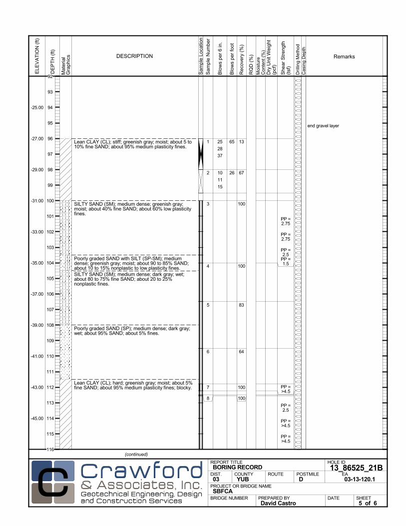
Lean CLAY (CL); stiff; greenish gray; moist; about 5 to10% fine SAND; about 95% medium plasticity fines.
SILTY SAND (SM); medium dense; greenish gray;moist; about 40% fine SAND; about 60% low plasticityfines.
Poorly graded SAND with SILT (SP-SM); mediumdense; greenish gray; moist; about 90 to 85% SAND;about 10 to 15% nonplastic to low plasticity fines.SILTY SAND (SM); medium dense; dark gray; wet;about 80 to 75% fine SAND; about 20 to 25%nonplastic fines.
Poorly graded SAND (SP); medium dense; dark gray;wet; about 95% SAND; about 5% fines.
Lean CLAY (CL); hard; greenish gray; moist; about 5%fine SAND; about 95% medium plasticity fines; blocky.
13
67
100
100
83
64
100
100
1
2
3
4
5
6
7
8
end gravel layer
25
28
37
10
11
15
PP =2.75
PP =2.75
PP =2.5
PP =1.5
PP =>4.5
PP =2.5
PP =>4.5
PP =>4.5
Mat
eria
lG
rap
hics
Sam
ple
Loca
tion
COUNTYYUB
DESCRIPTION
Rec
over
y (%
)
Dril
ling
Met
hod
Cas
ing
Dep
th
PREPARED BYDavid Castro
DATE
PROJECT OR BRIDGE NAMESBFCA
BRIDGE NUMBER
HOLE ID
13_86525_21BEA03-13-120.1
REPORT TITLEBORING RECORD
DIST.03
ROUTE POSTMILED
(continued)
SHEET5 of 6
RQ
D (
%)
Sam
ple
Num
ber
Moi
stur
eC
onte
nt (
%)
Remarks
Blo
ws
per
6 in
.
ELE
VA
TIO
N (
ft)
-25.00
-27.00
-29.00
-31.00
-33.00
-35.00
-37.00
-39.00
-41.00
-43.00
-45.00
DE
PT
H (
ft)
Dry
Uni
t Wei
ght
(pcf
)
She
ar S
tren
gth
(tsf
)
Blo
ws
per
foot
65
26
92
93
94
95
96
97
98
99
100
101
102
103
104
105
106
107
108
109
110
111
112
113
114
115
116
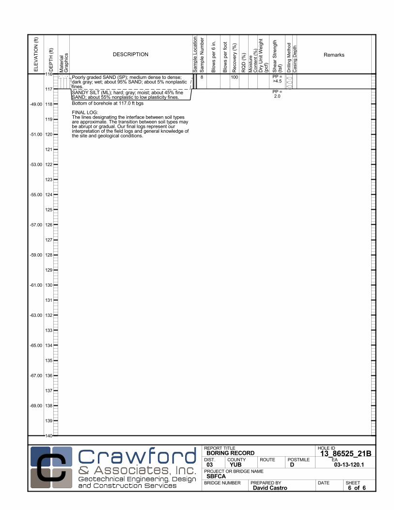
Poorly graded SAND (SP); medium dense to dense;dark gray; wet; about 95% SAND; about 5% nonplasticfines.SANDY SILT (ML); hard; gray; moist; about 45% fineSAND; about 55% nonplastic to low plasticity fines.Bottom of borehole at 117.0 ft bgs
FINAL LOG:The lines designating the interface between soil typesare approximate. The transition between soil types maybe abrupt or gradual. Our final logs represent ourinterpretation of the field logs and general knowledge ofthe site and geological conditions.
1008 PP =>4.5
PP =2.0
Mat
eria
lG
rap
hics
Sam
ple
Loca
tion
COUNTYYUB
DESCRIPTION
Rec
over
y (%
)
Dril
ling
Met
hod
Cas
ing
Dep
th
PREPARED BYDavid Castro
DATE
PROJECT OR BRIDGE NAMESBFCA
BRIDGE NUMBER
HOLE ID
13_86525_21BEA03-13-120.1
REPORT TITLEBORING RECORD
DIST.03
ROUTE POSTMILED
SHEET6 of 6
RQ
D (
%)
Sam
ple
Num
ber
Moi
stur
eC
onte
nt (
%)
Remarks
Blo
ws
per
6 in
.
ELE
VA
TIO
N (
ft)
-49.00
-51.00
-53.00
-55.00
-57.00
-59.00
-61.00
-63.00
-65.00
-67.00
-69.00
DE
PT
H (
ft)
Dry
Uni
t Wei
ght
(pcf
)
She
ar S
tren
gth
(tsf
)
Blo
ws
per
foot
116
117
118
119
120
121
122
123
124
125
126
127
128
129
130
131
132
133
134
135
136
137
138
139
140
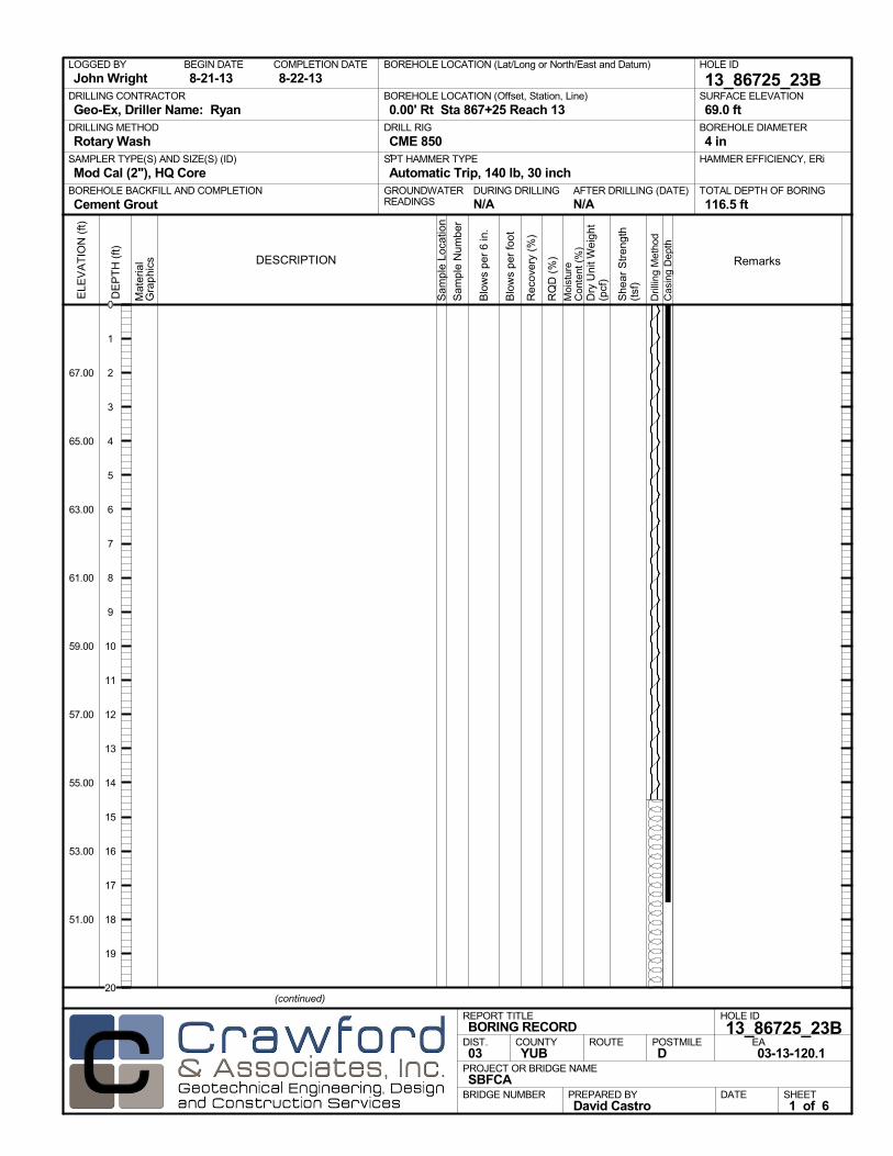
AFTER DRILLING (DATE)DURING DRILLINGN/A N/A
SURFACE ELEVATION
69.0 ftDRILLING METHOD
Rotary WashDRILL RIG
CME 850SPT HAMMER TYPE
Automatic Trip, 140 lb, 30 inchBOREHOLE BACKFILL AND COMPLETION
Cement GroutGROUNDWATERREADINGS
BEGIN DATE
8-21-13COMPLETION DATE
8-22-13LOGGED BY
John WrightBOREHOLE LOCATION (Lat/Long or North/East and Datum) HOLE ID
13_86725_23BDRILLING CONTRACTOR
Geo-Ex, Driller Name: Ryan
HAMMER EFFICIENCY, ERiSAMPLER TYPE(S) AND SIZE(S) (ID)
Mod Cal (2"), HQ CoreTOTAL DEPTH OF BORING
116.5 ft
BOREHOLE DIAMETER
4 in
BOREHOLE LOCATION (Offset, Station, Line)
0.00' Rt Sta 867+25 Reach 13
.M
ater
ial
Gra
phi
cs
Sam
ple
Loca
tion
COUNTYYUB
DESCRIPTION
Rec
over
y (%
)
Dril
ling
Met
hod
Cas
ing
Dep
th
PREPARED BYDavid Castro
DATE
PROJECT OR BRIDGE NAMESBFCA
BRIDGE NUMBER
HOLE ID
13_86725_23BEA03-13-120.1
REPORT TITLEBORING RECORD
DIST.03
ROUTE POSTMILED
(continued)
SHEET1 of 6
RQ
D (
%)
Sam
ple
Num
ber
Moi
stur
eC
onte
nt (
%)
Remarks
Blo
ws
per
6 in
.
ELE
VA
TIO
N (
ft)
67.00
65.00
63.00
61.00
59.00
57.00
55.00
53.00
51.00
DE
PT
H (
ft)
Dry
Uni
t Wei
ght
(pcf
)
She
ar S
tren
gth
(tsf
)
Blo
ws
per
foot
0
1
2
3
4
5
6
7
8
9
10
11
12
13
14
15
16
17
18
19
20

Mat
eria
lG
rap
hics
Sam
ple
Loca
tion
COUNTYYUB
DESCRIPTION
Rec
over
y (%
)
Dril
ling
Met
hod
Cas
ing
Dep
th
PREPARED BYDavid Castro
DATE
PROJECT OR BRIDGE NAMESBFCA
BRIDGE NUMBER
HOLE ID
13_86725_23BEA03-13-120.1
REPORT TITLEBORING RECORD
DIST.03
ROUTE POSTMILED
(continued)
SHEET2 of 6
RQ
D (
%)
Sam
ple
Num
ber
Moi
stur
eC
onte
nt (
%)
Remarks
Blo
ws
per
6 in
.
ELE
VA
TIO
N (
ft)
47.00
45.00
43.00
41.00
39.00
37.00
35.00
33.00
31.00
29.00
27.00
DE
PT
H (
ft)
Dry
Uni
t Wei
ght
(pcf
)
She
ar S
tren
gth
(tsf
)
Blo
ws
per
foot
20
21
22
23
24
25
26
27
28
29
30
31
32
33
34
35
36
37
38
39
40
41
42
43
44

gravel layer
Mat
eria
lG
rap
hics
Sam
ple
Loca
tion
COUNTYYUB
DESCRIPTION
Rec
over
y (%
)
Dril
ling
Met
hod
Cas
ing
Dep
th
PREPARED BYDavid Castro
DATE
PROJECT OR BRIDGE NAMESBFCA
BRIDGE NUMBER
HOLE ID
13_86725_23BEA03-13-120.1
REPORT TITLEBORING RECORD
DIST.03
ROUTE POSTMILED
(continued)
SHEET3 of 6
RQ
D (
%)
Sam
ple
Num
ber
Moi
stur
eC
onte
nt (
%)
Remarks
Blo
ws
per
6 in
.
ELE
VA
TIO
N (
ft)
23.00
21.00
19.00
17.00
15.00
13.00
11.00
9.00
7.00
5.00
3.00
DE
PT
H (
ft)
Dry
Uni
t Wei
ght
(pcf
)
She
ar S
tren
gth
(tsf
)
Blo
ws
per
foot
44
45
46
47
48
49
50
51
52
53
54
55
56
57
58
59
60
61
62
63
64
65
66
67
68

end gravel layer
Mat
eria
lG
rap
hics
Sam
ple
Loca
tion
COUNTYYUB
DESCRIPTION
Rec
over
y (%
)
Dril
ling
Met
hod
Cas
ing
Dep
th
PREPARED BYDavid Castro
DATE
PROJECT OR BRIDGE NAMESBFCA
BRIDGE NUMBER
HOLE ID
13_86725_23BEA03-13-120.1
REPORT TITLEBORING RECORD
DIST.03
ROUTE POSTMILED
(continued)
SHEET4 of 6
RQ
D (
%)
Sam
ple
Num
ber
Moi
stur
eC
onte
nt (
%)
Remarks
Blo
ws
per
6 in
.
ELE
VA
TIO
N (
ft)
-1.00
-3.00
-5.00
-7.00
-9.00
-11.00
-13.00
-15.00
-17.00
-19.00
-21.00
DE
PT
H (
ft)
Dry
Uni
t Wei
ght
(pcf
)
She
ar S
tren
gth
(tsf
)
Blo
ws
per
foot
68
69
70
71
72
73
74
75
76
77
78
79
80
81
82
83
84
85
86
87
88
89
90
91
92
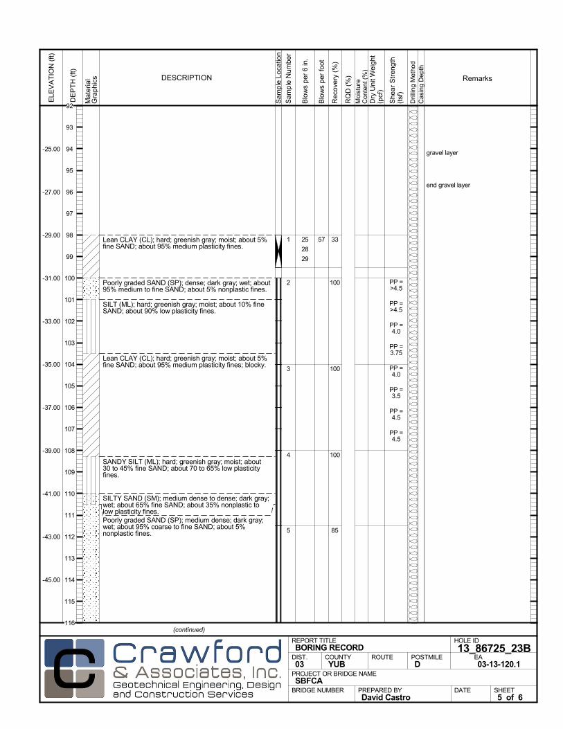
Lean CLAY (CL); hard; greenish gray; moist; about 5%fine SAND; about 95% medium plasticity fines.
Poorly graded SAND (SP); dense; dark gray; wet; about95% medium to fine SAND; about 5% nonplastic fines.
SILT (ML); hard; greenish gray; moist; about 10% fineSAND; about 90% low plasticity fines.
Lean CLAY (CL); hard; greenish gray; moist; about 5%fine SAND; about 95% medium plasticity fines; blocky.
SANDY SILT (ML); hard; greenish gray; moist; about30 to 45% fine SAND; about 70 to 65% low plasticityfines.
SILTY SAND (SM); medium dense to dense; dark gray;wet; about 65% fine SAND; about 35% nonplastic tolow plasticity fines.Poorly graded SAND (SP); medium dense; dark gray;wet; about 95% coarse to fine SAND; about 5%nonplastic fines.
33
100
100
100
85
1
2
3
4
5
gravel layer
end gravel layer
25
28
29
PP =>4.5
PP =>4.5
PP =4.0
PP =3.75
PP =4.0
PP =3.5
PP =4.5
PP =4.5
Mat
eria
lG
rap
hics
Sam
ple
Loca
tion
COUNTYYUB
DESCRIPTION
Rec
over
y (%
)
Dril
ling
Met
hod
Cas
ing
Dep
th
PREPARED BYDavid Castro
DATE
PROJECT OR BRIDGE NAMESBFCA
BRIDGE NUMBER
HOLE ID
13_86725_23BEA03-13-120.1
REPORT TITLEBORING RECORD
DIST.03
ROUTE POSTMILED
(continued)
SHEET5 of 6
RQ
D (
%)
Sam
ple
Num
ber
Moi
stur
eC
onte
nt (
%)
Remarks
Blo
ws
per
6 in
.
ELE
VA
TIO
N (
ft)
-25.00
-27.00
-29.00
-31.00
-33.00
-35.00
-37.00
-39.00
-41.00
-43.00
-45.00
DE
PT
H (
ft)
Dry
Uni
t Wei
ght
(pcf
)
She
ar S
tren
gth
(tsf
)
Blo
ws
per
foot
57
92
93
94
95
96
97
98
99
100
101
102
103
104
105
106
107
108
109
110
111
112
113
114
115
116
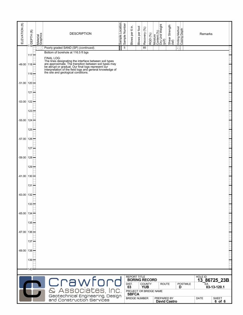
Poorly graded SAND (SP) (continued).
Bottom of borehole at 116.5 ft bgs
FINAL LOG:The lines designating the interface between soil typesare approximate. The transition between soil types maybe abrupt or gradual. Our final logs represent ourinterpretation of the field logs and general knowledge ofthe site and geological conditions.
855
Mat
eria
lG
rap
hics
Sam
ple
Loca
tion
COUNTYYUB
DESCRIPTION
Rec
over
y (%
)
Dril
ling
Met
hod
Cas
ing
Dep
th
PREPARED BYDavid Castro
DATE
PROJECT OR BRIDGE NAMESBFCA
BRIDGE NUMBER
HOLE ID
13_86725_23BEA03-13-120.1
REPORT TITLEBORING RECORD
DIST.03
ROUTE POSTMILED
SHEET6 of 6
RQ
D (
%)
Sam
ple
Num
ber
Moi
stur
eC
onte
nt (
%)
Remarks
Blo
ws
per
6 in
.
ELE
VA
TIO
N (
ft)
-49.00
-51.00
-53.00
-55.00
-57.00
-59.00
-61.00
-63.00
-65.00
-67.00
-69.00
DE
PT
H (
ft)
Dry
Uni
t Wei
ght
(pcf
)
She
ar S
tren
gth
(tsf
)
Blo
ws
per
foot
116
117
118
119
120
121
122
123
124
125
126
127
128
129
130
131
132
133
134
135
136
137
138
139
140
AFTER DRILLING (DATE)DURING DRILLINGN/A N/A
SURFACE ELEVATION
69.0 ftDRILLING METHOD
Rotary WashDRILL RIG
CME 75SPT HAMMER TYPE
Automatic Trip, 140 lb, 30 inchBOREHOLE BACKFILL AND COMPLETION
Cement GroutGROUNDWATERREADINGS
BEGIN DATE
8-21-13COMPLETION DATE
8-22-13LOGGED BY
John WrightBOREHOLE LOCATION (Lat/Long or North/East and Datum) HOLE ID
13_86825_24BDRILLING CONTRACTOR
Geo-Ex, Driller Name: Tom Scott
HAMMER EFFICIENCY, ERiSAMPLER TYPE(S) AND SIZE(S) (ID)
Std Cal (2.5"), Mod Cal (2"), SPT (1.4")TOTAL DEPTH OF BORING
116.5 ft
BOREHOLE DIAMETER
4 in
BOREHOLE LOCATION (Offset, Station, Line)
0.00' Rt Sta 868+25 Reach 13
.M
ater
ial
Gra
phi
cs
Sam
ple
Loca
tion
COUNTYYUB
DESCRIPTION
Rec
over
y (%
)
Dril
ling
Met
hod
Cas
ing
Dep
th
PREPARED BYDavid Castro
DATE
PROJECT OR BRIDGE NAMESBFCA
BRIDGE NUMBER
HOLE ID
13_86825_24BEA03-13-120.1
REPORT TITLEBORING RECORD
DIST.03
ROUTE POSTMILED
(continued)
SHEET1 of 6
RQ
D (
%)
Sam
ple
Num
ber
Moi
stur
eC
onte
nt (
%)
Remarks
Blo
ws
per
6 in
.
ELE
VA
TIO
N (
ft)
67.00
65.00
63.00
61.00
59.00
57.00
55.00
53.00
51.00
DE
PT
H (
ft)
Dry
Uni
t Wei
ght
(pcf
)
She
ar S
tren
gth
(tsf
)
Blo
ws
per
foot
0
1
2
3
4
5
6
7
8
9
10
11
12
13
14
15
16
17
18
19
20

Mat
eria
lG
rap
hics
Sam
ple
Loca
tion
COUNTYYUB
DESCRIPTION
Rec
over
y (%
)
Dril
ling
Met
hod
Cas
ing
Dep
th
PREPARED BYDavid Castro
DATE
PROJECT OR BRIDGE NAMESBFCA
BRIDGE NUMBER
HOLE ID
13_86825_24BEA03-13-120.1
REPORT TITLEBORING RECORD
DIST.03
ROUTE POSTMILED
(continued)
SHEET2 of 6
RQ
D (
%)
Sam
ple
Num
ber
Moi
stur
eC
onte
nt (
%)
Remarks
Blo
ws
per
6 in
.
ELE
VA
TIO
N (
ft)
47.00
45.00
43.00
41.00
39.00
37.00
35.00
33.00
31.00
29.00
27.00
DE
PT
H (
ft)
Dry
Uni
t Wei
ght
(pcf
)
She
ar S
tren
gth
(tsf
)
Blo
ws
per
foot
20
21
22
23
24
25
26
27
28
29
30
31
32
33
34
35
36
37
38
39
40
41
42
43
44

gravel layer
Mat
eria
lG
rap
hics
Sam
ple
Loca
tion
COUNTYYUB
DESCRIPTION
Rec
over
y (%
)
Dril
ling
Met
hod
Cas
ing
Dep
th
PREPARED BYDavid Castro
DATE
PROJECT OR BRIDGE NAMESBFCA
BRIDGE NUMBER
HOLE ID
13_86825_24BEA03-13-120.1
REPORT TITLEBORING RECORD
DIST.03
ROUTE POSTMILED
(continued)
SHEET3 of 6
RQ
D (
%)
Sam
ple
Num
ber
Moi
stur
eC
onte
nt (
%)
Remarks
Blo
ws
per
6 in
.
ELE
VA
TIO
N (
ft)
23.00
21.00
19.00
17.00
15.00
13.00
11.00
9.00
7.00
5.00
3.00
DE
PT
H (
ft)
Dry
Uni
t Wei
ght
(pcf
)
She
ar S
tren
gth
(tsf
)
Blo
ws
per
foot
44
45
46
47
48
49
50
51
52
53
54
55
56
57
58
59
60
61
62
63
64
65
66
67
68
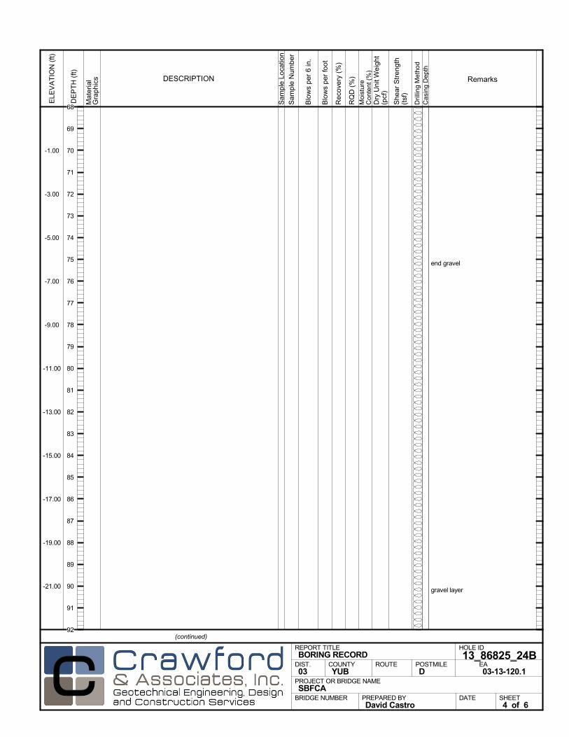
end gravel
gravel layer
Mat
eria
lG
rap
hics
Sam
ple
Loca
tion
COUNTYYUB
DESCRIPTION
Rec
over
y (%
)
Dril
ling
Met
hod
Cas
ing
Dep
th
PREPARED BYDavid Castro
DATE
PROJECT OR BRIDGE NAMESBFCA
BRIDGE NUMBER
HOLE ID
13_86825_24BEA03-13-120.1
REPORT TITLEBORING RECORD
DIST.03
ROUTE POSTMILED
(continued)
SHEET4 of 6
RQ
D (
%)
Sam
ple
Num
ber
Moi
stur
eC
onte
nt (
%)
Remarks
Blo
ws
per
6 in
.
ELE
VA
TIO
N (
ft)
-1.00
-3.00
-5.00
-7.00
-9.00
-11.00
-13.00
-15.00
-17.00
-19.00
-21.00
DE
PT
H (
ft)
Dry
Uni
t Wei
ght
(pcf
)
She
ar S
tren
gth
(tsf
)
Blo
ws
per
foot
68
69
70
71
72
73
74
75
76
77
78
79
80
81
82
83
84
85
86
87
88
89
90
91
92
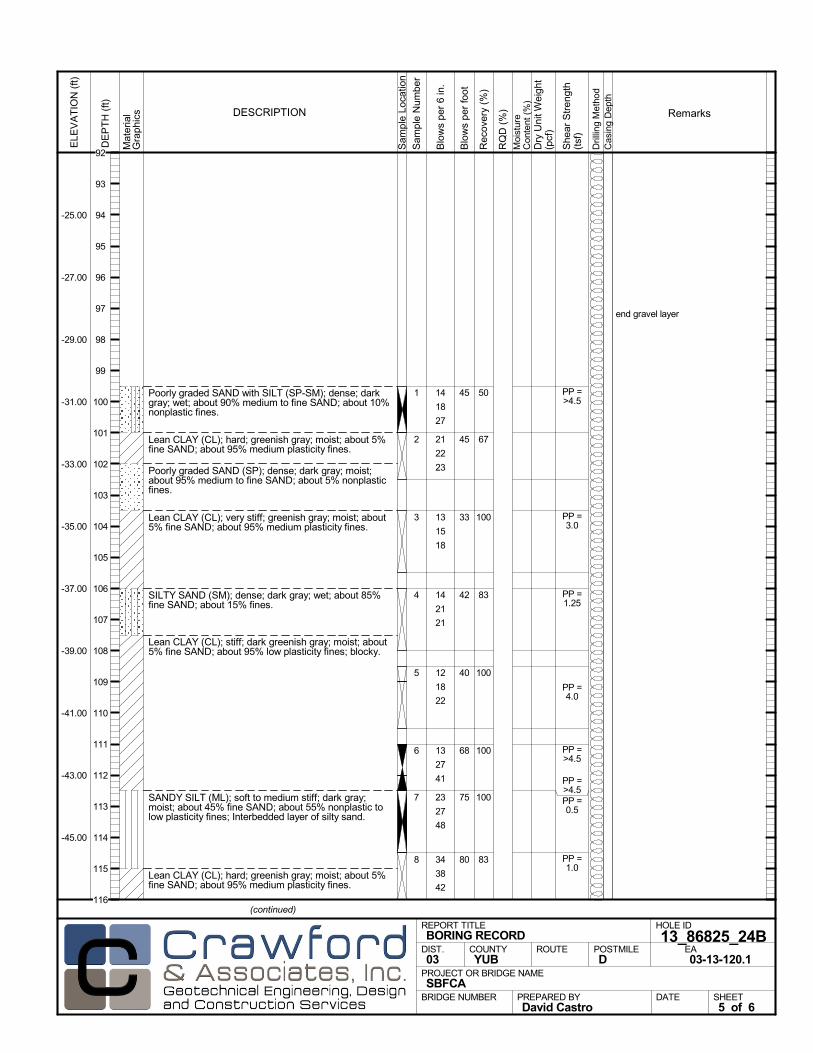
Poorly graded SAND with SILT (SP-SM); dense; darkgray; wet; about 90% medium to fine SAND; about 10%nonplastic fines.
Lean CLAY (CL); hard; greenish gray; moist; about 5%fine SAND; about 95% medium plasticity fines.
Poorly graded SAND (SP); dense; dark gray; moist;about 95% medium to fine SAND; about 5% nonplasticfines.
Lean CLAY (CL); very stiff; greenish gray; moist; about5% fine SAND; about 95% medium plasticity fines.
SILTY SAND (SM); dense; dark gray; wet; about 85%fine SAND; about 15% fines.
Lean CLAY (CL); stiff; dark greenish gray; moist; about5% fine SAND; about 95% low plasticity fines; blocky.
SANDY SILT (ML); soft to medium stiff; dark gray;moist; about 45% fine SAND; about 55% nonplastic tolow plasticity fines; Interbedded layer of silty sand.
Lean CLAY (CL); hard; greenish gray; moist; about 5%fine SAND; about 95% medium plasticity fines.
50
67
100
83
100
100
100
83
1
2
3
4
5
6
7
8
end gravel layer
14
18
27
21
22
23
13
15
18
14
21
21
12
18
22
13
27
41
23
27
48
34
38
42
PP =>4.5
PP =3.0
PP =1.25
PP =4.0
PP =>4.5
PP =>4.5PP =0.5
PP =1.0
Mat
eria
lG
rap
hics
Sam
ple
Loca
tion
COUNTYYUB
DESCRIPTION
Rec
over
y (%
)
Dril
ling
Met
hod
Cas
ing
Dep
th
PREPARED BYDavid Castro
DATE
PROJECT OR BRIDGE NAMESBFCA
BRIDGE NUMBER
HOLE ID
13_86825_24BEA03-13-120.1
REPORT TITLEBORING RECORD
DIST.03
ROUTE POSTMILED
(continued)
SHEET5 of 6
RQ
D (
%)
Sam
ple
Num
ber
Moi
stur
eC
onte
nt (
%)
Remarks
Blo
ws
per
6 in
.
ELE
VA
TIO
N (
ft)
-25.00
-27.00
-29.00
-31.00
-33.00
-35.00
-37.00
-39.00
-41.00
-43.00
-45.00
DE
PT
H (
ft)
Dry
Uni
t Wei
ght
(pcf
)
She
ar S
tren
gth
(tsf
)
Blo
ws
per
foot
45
45
33
42
40
68
75
80
92
93
94
95
96
97
98
99
100
101
102
103
104
105
106
107
108
109
110
111
112
113
114
115
116

Lean CLAY (CL) (continued).
Bottom of borehole at 116.5 ft bgs
FINAL LOG:The lines designating the interface between soil typesare approximate. The transition between soil types maybe abrupt or gradual. Our final logs represent ourinterpretation of the field logs and general knowledge ofthe site and geological conditions.
838 PP =>4.5
Mat
eria
lG
rap
hics
Sam
ple
Loca
tion
COUNTYYUB
DESCRIPTION
Rec
over
y (%
)
Dril
ling
Met
hod
Cas
ing
Dep
th
PREPARED BYDavid Castro
DATE
PROJECT OR BRIDGE NAMESBFCA
BRIDGE NUMBER
HOLE ID
13_86825_24BEA03-13-120.1
REPORT TITLEBORING RECORD
DIST.03
ROUTE POSTMILED
SHEET6 of 6
RQ
D (
%)
Sam
ple
Num
ber
Moi
stur
eC
onte
nt (
%)
Remarks
Blo
ws
per
6 in
.
ELE
VA
TIO
N (
ft)
-49.00
-51.00
-53.00
-55.00
-57.00
-59.00
-61.00
-63.00
-65.00
-67.00
-69.00
DE
PT
H (
ft)
Dry
Uni
t Wei
ght
(pcf
)
She
ar S
tren
gth
(tsf
)
Blo
ws
per
foot
80116
117
118
119
120
121
122
123
124
125
126
127
128
129
130
131
132
133
134
135
136
137
138
139
140
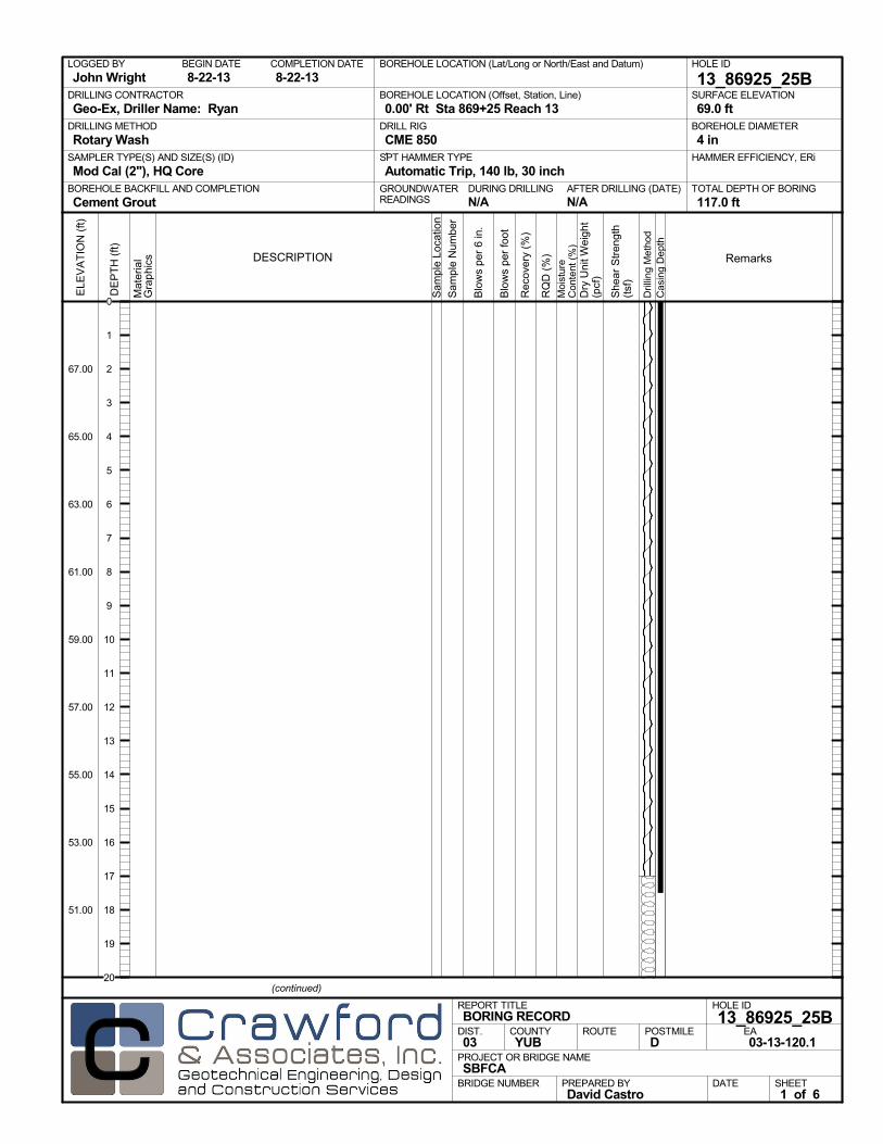
AFTER DRILLING (DATE)DURING DRILLINGN/A N/A
SURFACE ELEVATION
69.0 ftDRILLING METHOD
Rotary WashDRILL RIG
CME 850SPT HAMMER TYPE
Automatic Trip, 140 lb, 30 inchBOREHOLE BACKFILL AND COMPLETION
Cement GroutGROUNDWATERREADINGS
BEGIN DATE
8-22-13COMPLETION DATE
8-22-13LOGGED BY
John WrightBOREHOLE LOCATION (Lat/Long or North/East and Datum) HOLE ID
13_86925_25BDRILLING CONTRACTOR
Geo-Ex, Driller Name: Ryan
HAMMER EFFICIENCY, ERiSAMPLER TYPE(S) AND SIZE(S) (ID)
Mod Cal (2"), HQ CoreTOTAL DEPTH OF BORING
117.0 ft
BOREHOLE DIAMETER
4 in
BOREHOLE LOCATION (Offset, Station, Line)
0.00' Rt Sta 869+25 Reach 13
.M
ater
ial
Gra
phi
cs
Sam
ple
Loca
tion
COUNTYYUB
DESCRIPTION
Rec
over
y (%
)
Dril
ling
Met
hod
Cas
ing
Dep
th
PREPARED BYDavid Castro
DATE
PROJECT OR BRIDGE NAMESBFCA
BRIDGE NUMBER
HOLE ID
13_86925_25BEA03-13-120.1
REPORT TITLEBORING RECORD
DIST.03
ROUTE POSTMILED
(continued)
SHEET1 of 6
RQ
D (
%)
Sam
ple
Num
ber
Moi
stur
eC
onte
nt (
%)
Remarks
Blo
ws
per
6 in
.
ELE
VA
TIO
N (
ft)
67.00
65.00
63.00
61.00
59.00
57.00
55.00
53.00
51.00
DE
PT
H (
ft)
Dry
Uni
t Wei
ght
(pcf
)
She
ar S
tren
gth
(tsf
)
Blo
ws
per
foot
0
1
2
3
4
5
6
7
8
9
10
11
12
13
14
15
16
17
18
19
20

Mat
eria
lG
rap
hics
Sam
ple
Loca
tion
COUNTYYUB
DESCRIPTION
Rec
over
y (%
)
Dril
ling
Met
hod
Cas
ing
Dep
th
PREPARED BYDavid Castro
DATE
PROJECT OR BRIDGE NAMESBFCA
BRIDGE NUMBER
HOLE ID
13_86925_25BEA03-13-120.1
REPORT TITLEBORING RECORD
DIST.03
ROUTE POSTMILED
(continued)
SHEET2 of 6
RQ
D (
%)
Sam
ple
Num
ber
Moi
stur
eC
onte
nt (
%)
Remarks
Blo
ws
per
6 in
.
ELE
VA
TIO
N (
ft)
47.00
45.00
43.00
41.00
39.00
37.00
35.00
33.00
31.00
29.00
27.00
DE
PT
H (
ft)
Dry
Uni
t Wei
ght
(pcf
)
She
ar S
tren
gth
(tsf
)
Blo
ws
per
foot
20
21
22
23
24
25
26
27
28
29
30
31
32
33
34
35
36
37
38
39
40
41
42
43
44
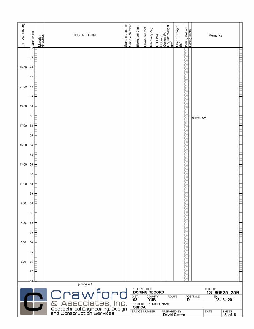
gravel layer
Mat
eria
lG
rap
hics
Sam
ple
Loca
tion
COUNTYYUB
DESCRIPTION
Rec
over
y (%
)
Dril
ling
Met
hod
Cas
ing
Dep
th
PREPARED BYDavid Castro
DATE
PROJECT OR BRIDGE NAMESBFCA
BRIDGE NUMBER
HOLE ID
13_86925_25BEA03-13-120.1
REPORT TITLEBORING RECORD
DIST.03
ROUTE POSTMILED
(continued)
SHEET3 of 6
RQ
D (
%)
Sam
ple
Num
ber
Moi
stur
eC
onte
nt (
%)
Remarks
Blo
ws
per
6 in
.
ELE
VA
TIO
N (
ft)
23.00
21.00
19.00
17.00
15.00
13.00
11.00
9.00
7.00
5.00
3.00
DE
PT
H (
ft)
Dry
Uni
t Wei
ght
(pcf
)
She
ar S
tren
gth
(tsf
)
Blo
ws
per
foot
44
45
46
47
48
49
50
51
52
53
54
55
56
57
58
59
60
61
62
63
64
65
66
67
68

end gravel layer
gravel layer
Mat
eria
lG
rap
hics
Sam
ple
Loca
tion
COUNTYYUB
DESCRIPTION
Rec
over
y (%
)
Dril
ling
Met
hod
Cas
ing
Dep
th
PREPARED BYDavid Castro
DATE
PROJECT OR BRIDGE NAMESBFCA
BRIDGE NUMBER
HOLE ID
13_86925_25BEA03-13-120.1
REPORT TITLEBORING RECORD
DIST.03
ROUTE POSTMILED
(continued)
SHEET4 of 6
RQ
D (
%)
Sam
ple
Num
ber
Moi
stur
eC
onte
nt (
%)
Remarks
Blo
ws
per
6 in
.
ELE
VA
TIO
N (
ft)
-1.00
-3.00
-5.00
-7.00
-9.00
-11.00
-13.00
-15.00
-17.00
-19.00
-21.00
DE
PT
H (
ft)
Dry
Uni
t Wei
ght
(pcf
)
She
ar S
tren
gth
(tsf
)
Blo
ws
per
foot
68
69
70
71
72
73
74
75
76
77
78
79
80
81
82
83
84
85
86
87
88
89
90
91
92
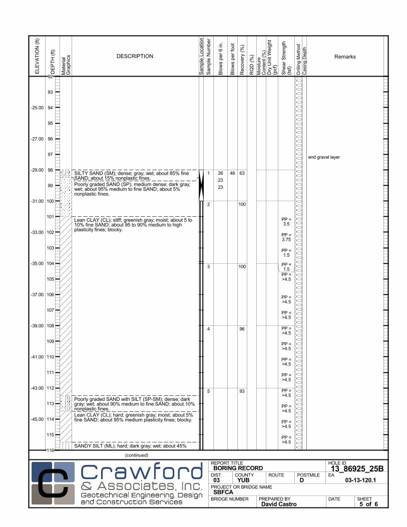
SILTY SAND (SM); dense; gray; wet; about 85% fineSAND; about 15% nonplastic fines.Poorly graded SAND (SP); medium dense; dark gray;wet; about 95% medium to fine SAND; about 5%nonplastic fines.
Lean CLAY (CL); stiff; greenish gray; moist; about 5 to10% fine SAND; about 95 to 90% medium to highplasticity fines; blocky.
Poorly graded SAND with SILT (SP-SM); dense; darkgray; wet; about 90% medium to fine SAND; about 10%nonplastic fines.Lean CLAY (CL); hard; greenish gray; moist; about 5%fine SAND; about 95% medium plasticity fines; blocky.
SANDY SILT (ML); hard; dark gray; wet; about 45%
63
100
100
96
93
1
2
3
4
5
end gravel layer
26
23
23
PP =3.5
PP =3.75
PP =1.5
PP =1.5
PP =>4.5
PP =>4.5
PP =>4.5
PP =>4.5
PP =>4.5
PP =>4.5
PP =>4.5
PP =>4.5
PP =>4.5
PP =>4.5
PP =>4.5
Mat
eria
lG
rap
hics
Sam
ple
Loca
tion
COUNTYYUB
DESCRIPTION
Rec
over
y (%
)
Dril
ling
Met
hod
Cas
ing
Dep
th
PREPARED BYDavid Castro
DATE
PROJECT OR BRIDGE NAMESBFCA
BRIDGE NUMBER
HOLE ID
13_86925_25BEA
03-13-120.1
REPORT TITLEBORING RECORD
DIST.03
ROUTE POSTMILED
(continued)
SHEET5 of 6
RQ
D (
%)
Sam
ple
Num
ber
Moi
stur
eC
onte
nt (
%)
Remarks
Blo
ws
per
6 in
.
ELE
VA
TIO
N (
ft)
-25.00
-27.00
-29.00
-31.00
-33.00
-35.00
-37.00
-39.00
-41.00
-43.00
-45.00
DE
PT
H (
ft)
Dry
Uni
t Wei
ght
(pcf
)
She
ar S
tren
gth
(tsf
)
Blo
ws
per
foot
46
92
93
94
95
96
97
98
99
100
101
102
103
104
105
106
107
108
109
110
111
112
113
114
115
116
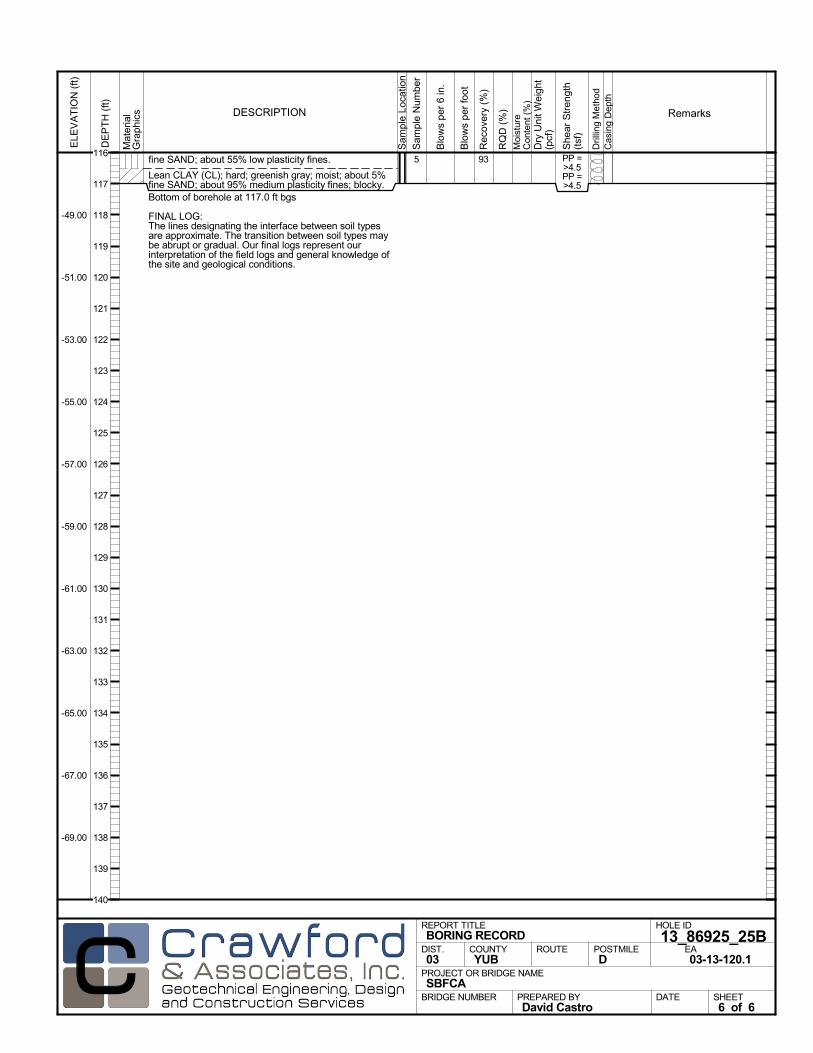
fine SAND; about 55% low plasticity fines.
Lean CLAY (CL); hard; greenish gray; moist; about 5%fine SAND; about 95% medium plasticity fines; blocky.Bottom of borehole at 117.0 ft bgs
FINAL LOG:The lines designating the interface between soil typesare approximate. The transition between soil types maybe abrupt or gradual. Our final logs represent ourinterpretation of the field logs and general knowledge ofthe site and geological conditions.
935 PP =>4.5PP =>4.5
Mat
eria
lG
rap
hics
Sam
ple
Loca
tion
COUNTYYUB
DESCRIPTION
Rec
over
y (%
)
Dril
ling
Met
hod
Cas
ing
Dep
th
PREPARED BYDavid Castro
DATE
PROJECT OR BRIDGE NAMESBFCA
BRIDGE NUMBER
HOLE ID
13_86925_25BEA03-13-120.1
REPORT TITLEBORING RECORD
DIST.03
ROUTE POSTMILED
SHEET6 of 6
RQ
D (
%)
Sam
ple
Num
ber
Moi
stur
eC
onte
nt (
%)
Remarks
Blo
ws
per
6 in
.
ELE
VA
TIO
N (
ft)
-49.00
-51.00
-53.00
-55.00
-57.00
-59.00
-61.00
-63.00
-65.00
-67.00
-69.00
DE
PT
H (
ft)
Dry
Uni
t Wei
ght
(pcf
)
She
ar S
tren
gth
(tsf
)
Blo
ws
per
foot
116
117
118
119
120
121
122
123
124
125
126
127
128
129
130
131
132
133
134
135
136
137
138
139
140
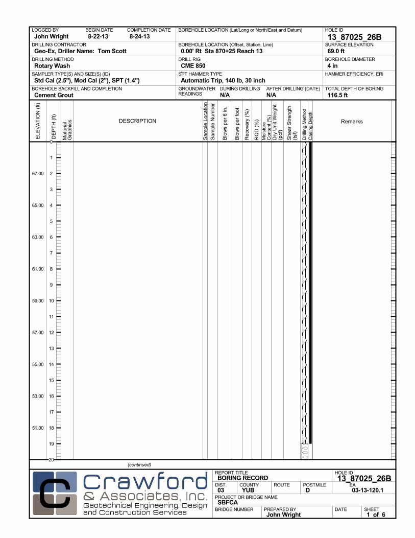
AFTER DRILLING (DATE)DURING DRILLINGN/A N/A
SURFACE ELEVATION
69.0 ftDRILLING METHOD
Rotary WashDRILL RIG
CME 850SPT HAMMER TYPE
Automatic Trip, 140 lb, 30 inchBOREHOLE BACKFILL AND COMPLETION
Cement GroutGROUNDWATERREADINGS
BEGIN DATE
8-22-13COMPLETION DATE
8-24-13LOGGED BY
John WrightBOREHOLE LOCATION (Lat/Long or North/East and Datum) HOLE ID
13_87025_26BDRILLING CONTRACTOR
Geo-Ex, Driller Name: Tom Scott
HAMMER EFFICIENCY, ERiSAMPLER TYPE(S) AND SIZE(S) (ID)
Std Cal (2.5"), Mod Cal (2"), SPT (1.4")TOTAL DEPTH OF BORING
116.5 ft
BOREHOLE DIAMETER
4 in
BOREHOLE LOCATION (Offset, Station, Line)
0.00' Rt Sta 870+25 Reach 13
.M
ater
ial
Gra
phi
cs
Sam
ple
Loca
tion
COUNTYYUB
DESCRIPTION
Rec
over
y (%
)
Dril
ling
Met
hod
Cas
ing
Dep
th
PREPARED BYJohn Wright
DATE
PROJECT OR BRIDGE NAMESBFCA
BRIDGE NUMBER
HOLE ID
13_87025_26BEA03-13-120.1
REPORT TITLEBORING RECORD
DIST.03
ROUTE POSTMILED
(continued)
SHEET1 of 6
RQ
D (
%)
Sam
ple
Num
ber
Moi
stur
eC
onte
nt (
%)
Remarks
Blo
ws
per
6 in
.
ELE
VA
TIO
N (
ft)
67.00
65.00
63.00
61.00
59.00
57.00
55.00
53.00
51.00
DE
PT
H (
ft)
Dry
Uni
t Wei
ght
(pcf
)
She
ar S
tren
gth
(tsf
)
Blo
ws
per
foot
0
1
2
3
4
5
6
7
8
9
10
11
12
13
14
15
16
17
18
19
20

Mat
eria
lG
rap
hics
Sam
ple
Loca
tion
COUNTYYUB
DESCRIPTION
Rec
over
y (%
)
Dril
ling
Met
hod
Cas
ing
Dep
th
PREPARED BYJohn Wright
DATE
PROJECT OR BRIDGE NAMESBFCA
BRIDGE NUMBER
HOLE ID
13_87025_26BEA03-13-120.1
REPORT TITLEBORING RECORD
DIST.03
ROUTE POSTMILED
(continued)
SHEET2 of 6
RQ
D (
%)
Sam
ple
Num
ber
Moi
stur
eC
onte
nt (
%)
Remarks
Blo
ws
per
6 in
.
ELE
VA
TIO
N (
ft)
47.00
45.00
43.00
41.00
39.00
37.00
35.00
33.00
31.00
29.00
27.00
DE
PT
H (
ft)
Dry
Uni
t Wei
ght
(pcf
)
She
ar S
tren
gth
(tsf
)
Blo
ws
per
foot
20
21
22
23
24
25
26
27
28
29
30
31
32
33
34
35
36
37
38
39
40
41
42
43
44
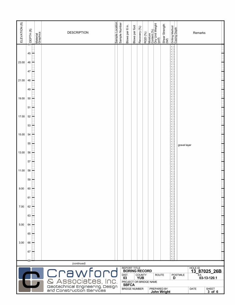
gravel layer
Mat
eria
lG
rap
hics
Sam
ple
Loca
tion
COUNTYYUB
DESCRIPTION
Rec
over
y (%
)
Dril
ling
Met
hod
Cas
ing
Dep
th
PREPARED BYJohn Wright
DATE
PROJECT OR BRIDGE NAMESBFCA
BRIDGE NUMBER
HOLE ID
13_87025_26BEA03-13-120.1
REPORT TITLEBORING RECORD
DIST.03
ROUTE POSTMILED
(continued)
SHEET3 of 6
RQ
D (
%)
Sam
ple
Num
ber
Moi
stur
eC
onte
nt (
%)
Remarks
Blo
ws
per
6 in
.
ELE
VA
TIO
N (
ft)
23.00
21.00
19.00
17.00
15.00
13.00
11.00
9.00
7.00
5.00
3.00
DE
PT
H (
ft)
Dry
Uni
t Wei
ght
(pcf
)
She
ar S
tren
gth
(tsf
)
Blo
ws
per
foot
44
45
46
47
48
49
50
51
52
53
54
55
56
57
58
59
60
61
62
63
64
65
66
67
68
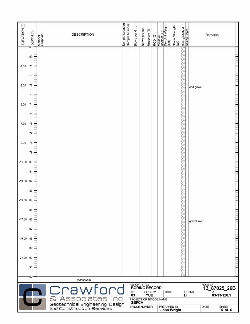
end gravel
gravel layer
Mat
eria
lG
rap
hics
Sam
ple
Loca
tion
COUNTYYUB
DESCRIPTION
Rec
over
y (%
)
Dril
ling
Met
hod
Cas
ing
Dep
th
PREPARED BYJohn Wright
DATE
PROJECT OR BRIDGE NAMESBFCA
BRIDGE NUMBER
HOLE ID
13_87025_26BEA03-13-120.1
REPORT TITLEBORING RECORD
DIST.03
ROUTE POSTMILED
(continued)
SHEET4 of 6
RQ
D (
%)
Sam
ple
Num
ber
Moi
stur
eC
onte
nt (
%)
Remarks
Blo
ws
per
6 in
.
ELE
VA
TIO
N (
ft)
-1.00
-3.00
-5.00
-7.00
-9.00
-11.00
-13.00
-15.00
-17.00
-19.00
-21.00
DE
PT
H (
ft)
Dry
Uni
t Wei
ght
(pcf
)
She
ar S
tren
gth
(tsf
)
Blo
ws
per
foot
68
69
70
71
72
73
74
75
76
77
78
79
80
81
82
83
84
85
86
87
88
89
90
91
92
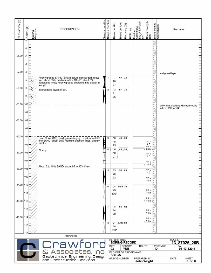
Poorly graded SAND (SP); medium dense; dark gray;wet; about 95% medium to fine SAND; about 5%nonplastic fines; Poorly graded coarse to fine gravel inslough.
Interbedded layers of silt.
Lean CLAY (CL); hard; greenish gray; moist; about 5%fine SAND; about 95% medium plasticity fines; slightlyblocky.
Blocky.
About 5 to 10% SAND; about 95 to 90% fines.
22
33
50
58
83
76
92
92
1
2
3
4
5
6
7
8
end gravel layer
driller had problems with hole cavingin from 100' to 104'
17
28
37
13
21
36
16
18
25
16
18
27
23
26
32
24
45
50/3"
18
24
29
21
30
50/4"
PP =4.5
PP =3.25
PP =4.0
PP =>4.5
PP =4.5
PP =>4.5
PP =>4.5
PP =>4.5
PP =>4.5
PP =>4.5
Mat
eria
lG
rap
hics
Sam
ple
Loca
tion
COUNTYYUB
DESCRIPTION
Rec
over
y (%
)
Dril
ling
Met
hod
Cas
ing
Dep
th
PREPARED BYJohn Wright
DATE
PROJECT OR BRIDGE NAMESBFCA
BRIDGE NUMBER
HOLE ID
13_87025_26BEA03-13-120.1
REPORT TITLEBORING RECORD
DIST.03
ROUTE POSTMILED
(continued)
SHEET5 of 6
RQ
D (
%)
Sam
ple
Num
ber
Moi
stur
eC
onte
nt (
%)
Remarks
Blo
ws
per
6 in
.
ELE
VA
TIO
N (
ft)
-25.00
-27.00
-29.00
-31.00
-33.00
-35.00
-37.00
-39.00
-41.00
-43.00
-45.00
DE
PT
H (
ft)
Dry
Uni
t Wei
ght
(pcf
)
She
ar S
tren
gth
(tsf
)
Blo
ws
per
foot
65
57
43
45
58
95/9
53
80/10
92
93
94
95
96
97
98
99
100
101
102
103
104
105
106
107
108
109
110
111
112
113
114
115
116
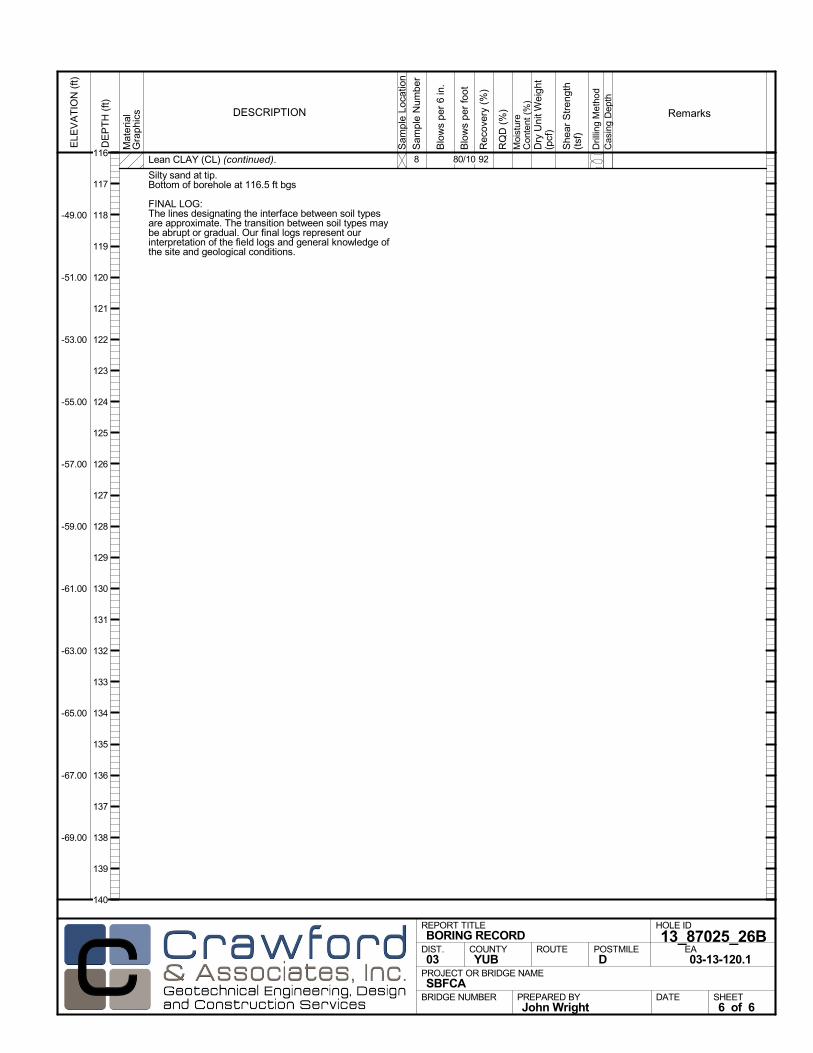
Lean CLAY (CL) (continued).
Silty sand at tip.Bottom of borehole at 116.5 ft bgs
FINAL LOG:The lines designating the interface between soil typesare approximate. The transition between soil types maybe abrupt or gradual. Our final logs represent ourinterpretation of the field logs and general knowledge ofthe site and geological conditions.
928
Mat
eria
lG
rap
hics
Sam
ple
Loca
tion
COUNTYYUB
DESCRIPTION
Rec
over
y (%
)
Dril
ling
Met
hod
Cas
ing
Dep
th
PREPARED BYJohn Wright
DATE
PROJECT OR BRIDGE NAMESBFCA
BRIDGE NUMBER
HOLE ID
13_87025_26BEA03-13-120.1
REPORT TITLEBORING RECORD
DIST.03
ROUTE POSTMILED
SHEET6 of 6
RQ
D (
%)
Sam
ple
Num
ber
Moi
stur
eC
onte
nt (
%)
Remarks
Blo
ws
per
6 in
.
ELE
VA
TIO
N (
ft)
-49.00
-51.00
-53.00
-55.00
-57.00
-59.00
-61.00
-63.00
-65.00
-67.00
-69.00
DE
PT
H (
ft)
Dry
Uni
t Wei
ght
(pcf
)
She
ar S
tren
gth
(tsf
)
Blo
ws
per
foot
80/10116
117
118
119
120
121
122
123
124
125
126
127
128
129
130
131
132
133
134
135
136
137
138
139
140
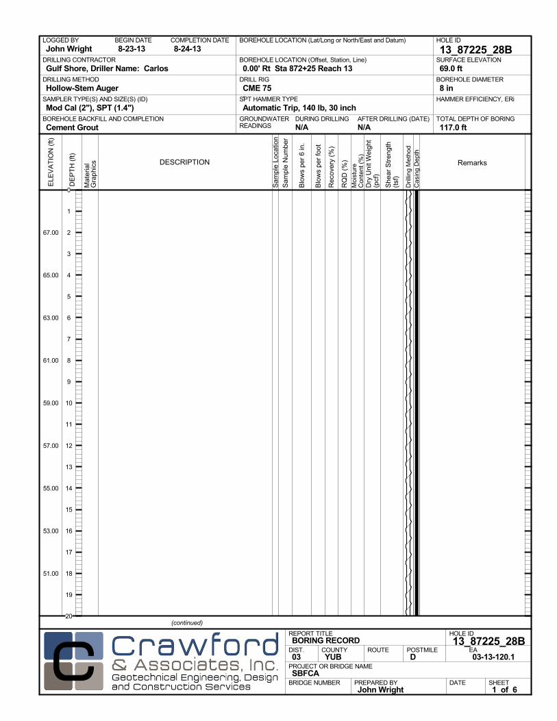
AFTER DRILLING (DATE)DURING DRILLINGN/A N/A
SURFACE ELEVATION
69.0 ftDRILLING METHOD
Hollow-Stem AugerDRILL RIG
CME 75SPT HAMMER TYPE
Automatic Trip, 140 lb, 30 inchBOREHOLE BACKFILL AND COMPLETION
Cement GroutGROUNDWATERREADINGS
BEGIN DATE
8-23-13COMPLETION DATE
8-24-13LOGGED BY
John WrightBOREHOLE LOCATION (Lat/Long or North/East and Datum) HOLE ID
13_87225_28BDRILLING CONTRACTOR
Gulf Shore, Driller Name: Carlos
HAMMER EFFICIENCY, ERiSAMPLER TYPE(S) AND SIZE(S) (ID)
Mod Cal (2"), SPT (1.4")TOTAL DEPTH OF BORING
117.0 ft
BOREHOLE DIAMETER
8 in
BOREHOLE LOCATION (Offset, Station, Line)
0.00' Rt Sta 872+25 Reach 13
.M
ater
ial
Gra
phi
cs
Sam
ple
Loca
tion
COUNTYYUB
DESCRIPTION
Rec
over
y (%
)
Dril
ling
Met
hod
Cas
ing
Dep
th
PREPARED BYJohn Wright
DATE
PROJECT OR BRIDGE NAMESBFCA
BRIDGE NUMBER
HOLE ID
13_87225_28BEA03-13-120.1
REPORT TITLEBORING RECORD
DIST.03
ROUTE POSTMILED
(continued)
SHEET1 of 6
RQ
D (
%)
Sam
ple
Num
ber
Moi
stur
eC
onte
nt (
%)
Remarks
Blo
ws
per
6 in
.
ELE
VA
TIO
N (
ft)
67.00
65.00
63.00
61.00
59.00
57.00
55.00
53.00
51.00
DE
PT
H (
ft)
Dry
Uni
t Wei
ght
(pcf
)
She
ar S
tren
gth
(tsf
)
Blo
ws
per
foot
0
1
2
3
4
5
6
7
8
9
10
11
12
13
14
15
16
17
18
19
20
Mat
eria
lG
rap
hics
Sam
ple
Loca
tion
COUNTYYUB
DESCRIPTION
Rec
over
y (%
)
Dril
ling
Met
hod
Cas
ing
Dep
th
PREPARED BYJohn Wright
DATE
PROJECT OR BRIDGE NAMESBFCA
BRIDGE NUMBER
HOLE ID
13_87225_28BEA03-13-120.1
REPORT TITLEBORING RECORD
DIST.03
ROUTE POSTMILED
(continued)
SHEET2 of 6
RQ
D (
%)
Sam
ple
Num
ber
Moi
stur
eC
onte
nt (
%)
Remarks
Blo
ws
per
6 in
.
ELE
VA
TIO
N (
ft)
47.00
45.00
43.00
41.00
39.00
37.00
35.00
33.00
31.00
29.00
27.00
DE
PT
H (
ft)
Dry
Uni
t Wei
ght
(pcf
)
She
ar S
tren
gth
(tsf
)
Blo
ws
per
foot
20
21
22
23
24
25
26
27
28
29
30
31
32
33
34
35
36
37
38
39
40
41
42
43
44
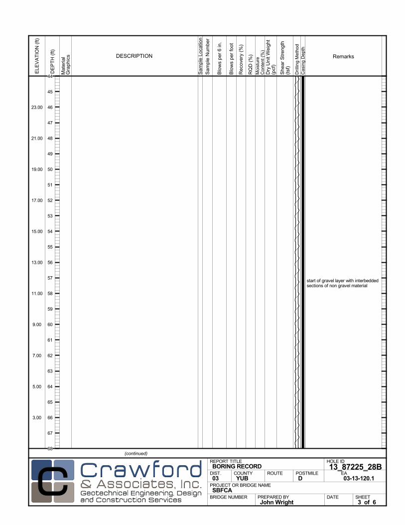
start of gravel layer with interbeddedsections of non gravel material
Mat
eria
lG
rap
hics
Sam
ple
Loca
tion
COUNTYYUB
DESCRIPTION
Rec
over
y (%
)
Dril
ling
Met
hod
Cas
ing
Dep
th
PREPARED BYJohn Wright
DATE
PROJECT OR BRIDGE NAMESBFCA
BRIDGE NUMBER
HOLE ID
13_87225_28BEA03-13-120.1
REPORT TITLEBORING RECORD
DIST.03
ROUTE POSTMILED
(continued)
SHEET3 of 6
RQ
D (
%)
Sam
ple
Num
ber
Moi
stur
eC
onte
nt (
%)
Remarks
Blo
ws
per
6 in
.
ELE
VA
TIO
N (
ft)
23.00
21.00
19.00
17.00
15.00
13.00
11.00
9.00
7.00
5.00
3.00
DE
PT
H (
ft)
Dry
Uni
t Wei
ght
(pcf
)
She
ar S
tren
gth
(tsf
)
Blo
ws
per
foot
44
45
46
47
48
49
50
51
52
53
54
55
56
57
58
59
60
61
62
63
64
65
66
67
68
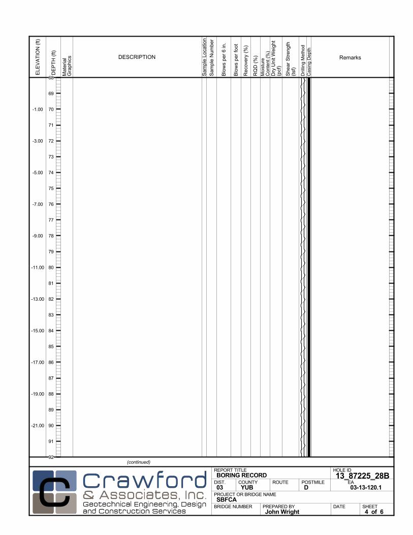
Mat
eria
lG
rap
hics
Sam
ple
Loca
tion
COUNTYYUB
DESCRIPTION
Rec
over
y (%
)
Dril
ling
Met
hod
Cas
ing
Dep
th
PREPARED BYJohn Wright
DATE
PROJECT OR BRIDGE NAMESBFCA
BRIDGE NUMBER
HOLE ID
13_87225_28BEA03-13-120.1
REPORT TITLEBORING RECORD
DIST.03
ROUTE POSTMILED
(continued)
SHEET4 of 6
RQ
D (
%)
Sam
ple
Num
ber
Moi
stur
eC
onte
nt (
%)
Remarks
Blo
ws
per
6 in
.
ELE
VA
TIO
N (
ft)
-1.00
-3.00
-5.00
-7.00
-9.00
-11.00
-13.00
-15.00
-17.00
-19.00
-21.00
DE
PT
H (
ft)
Dry
Uni
t Wei
ght
(pcf
)
She
ar S
tren
gth
(tsf
)
Blo
ws
per
foot
68
69
70
71
72
73
74
75
76
77
78
79
80
81
82
83
84
85
86
87
88
89
90
91
92
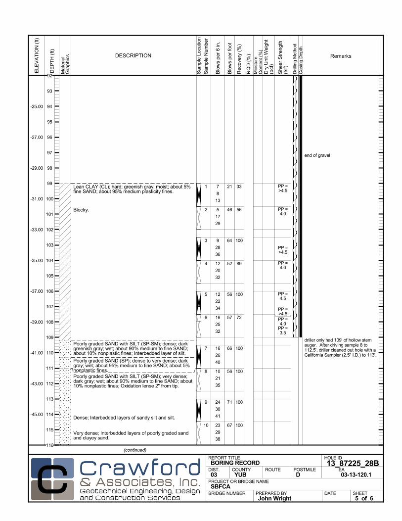
Lean CLAY (CL); hard; greenish gray; moist; about 5%fine SAND; about 95% medium plasticity fines.
Blocky.
Poorly graded SAND with SILT (SP-SM); dense; darkgreenish gray; wet; about 90% medium to fine SAND;about 10% nonplastic fines; Interbedded layer of silt.
Poorly graded SAND (SP); dense to very dense; darkgray; wet; about 95% medium to fine SAND; about 5%nonplastic fines.Poorly graded SAND with SILT (SP-SM); very dense;dark gray; wet; about 90% medium to fine SAND; about10% nonplastic fines; Oxidation lense 2" from tip.
Dense; Interbedded layers of sandy silt and silt.
Very dense; Interbedded layers of poorly graded sandand clayey sand.
33
56
100
89
100
72
100
100
100
100
1
2
3
4
5
6
7
8
9
10
end of gravel
driller only had 109' of hollow stemauger. After driving sample 8 to112.5', driller cleaned out hole with aCalifornia Sampler (2.5" I.D.) to 113'.
7
8
13
5
17
29
9
28
36
12
20
32
12
22
34
16
25
32
16
26
40
10
21
35
24
30
41
23
29
38
PP =>4.5
PP =4.0
PP =>4.5
PP =4.0
PP =4.5
PP =>4.5PP =4.0
PP =3.5
Mat
eria
lG
rap
hics
Sam
ple
Loca
tion
COUNTYYUB
DESCRIPTION
Rec
over
y (%
)
Dril
ling
Met
hod
Cas
ing
Dep
th
PREPARED BYJohn Wright
DATE
PROJECT OR BRIDGE NAMESBFCA
BRIDGE NUMBER
HOLE ID
13_87225_28BEA03-13-120.1
REPORT TITLEBORING RECORD
DIST.03
ROUTE POSTMILED
(continued)
SHEET5 of 6
RQ
D (
%)
Sam
ple
Num
ber
Moi
stur
eC
onte
nt (
%)
Remarks
Blo
ws
per
6 in
.
ELE
VA
TIO
N (
ft)
-25.00
-27.00
-29.00
-31.00
-33.00
-35.00
-37.00
-39.00
-41.00
-43.00
-45.00
DE
PT
H (
ft)
Dry
Uni
t Wei
ght
(pcf
)
She
ar S
tren
gth
(tsf
)
Blo
ws
per
foot
21
46
64
52
56
57
66
56
71
67
92
93
94
95
96
97
98
99
100
101
102
103
104
105
106
107
108
109
110
111
112
113
114
115
116
Poorly graded SAND (SP); very dense; dark gray; wet;about 95% medium to fine SAND; about 5% nonplasticfines.Bottom of borehole at 117.0 ft bgs
FINAL LOG:The lines designating the interface between soil typesare approximate. The transition between soil types maybe abrupt or gradual. Our final logs represent ourinterpretation of the field logs and general knowledge ofthe site and geological conditions.
10011 driller cleaned out hole to 116'multiple times due to hole caving in
35
32
20/2"
Mat
eria
lG
rap
hics
Sam
ple
Loca
tion
COUNTYYUB
DESCRIPTION
Rec
over
y (%
)
Dril
ling
Met
hod
Cas
ing
Dep
th
PREPARED BYJohn Wright
DATE
PROJECT OR BRIDGE NAMESBFCA
BRIDGE NUMBER
HOLE ID
13_87225_28BEA03-13-120.1
REPORT TITLEBORING RECORD
DIST.03
ROUTE POSTMILED
SHEET6 of 6
RQ
D (
%)
Sam
ple
Num
ber
Moi
stur
eC
onte
nt (
%)
Remarks
Blo
ws
per
6 in
.
ELE
VA
TIO
N (
ft)
-49.00
-51.00
-53.00
-55.00
-57.00
-59.00
-61.00
-63.00
-65.00
-67.00
-69.00
DE
PT
H (
ft)
Dry
Uni
t Wei
ght
(pcf
)
She
ar S
tren
gth
(tsf
)
Blo
ws
per
foot
52/8116
117
118
119
120
121
122
123
124
125
126
127
128
129
130
131
132
133
134
135
136
137
138
139
140
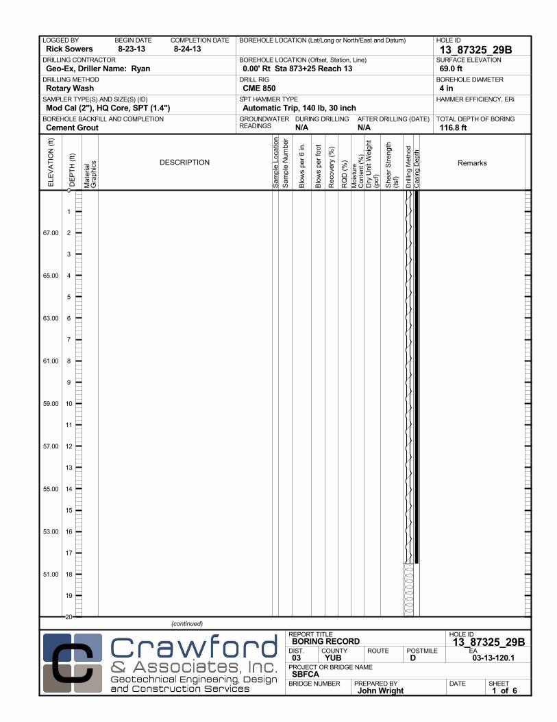
AFTER DRILLING (DATE)DURING DRILLINGN/A N/A
SURFACE ELEVATION
69.0 ftDRILLING METHOD
Rotary WashDRILL RIG
CME 850SPT HAMMER TYPE
Automatic Trip, 140 lb, 30 inchBOREHOLE BACKFILL AND COMPLETION
Cement GroutGROUNDWATERREADINGS
BEGIN DATE
8-23-13COMPLETION DATE
8-24-13LOGGED BY
Rick SowersBOREHOLE LOCATION (Lat/Long or North/East and Datum) HOLE ID
13_87325_29BDRILLING CONTRACTOR
Geo-Ex, Driller Name: Ryan
HAMMER EFFICIENCY, ERiSAMPLER TYPE(S) AND SIZE(S) (ID)
Mod Cal (2"), HQ Core, SPT (1.4")TOTAL DEPTH OF BORING
116.8 ft
BOREHOLE DIAMETER
4 in
BOREHOLE LOCATION (Offset, Station, Line)
0.00' Rt Sta 873+25 Reach 13
.M
ater
ial
Gra
phi
cs
Sam
ple
Loca
tion
COUNTYYUB
DESCRIPTION
Rec
over
y (%
)
Dril
ling
Met
hod
Cas
ing
Dep
th
PREPARED BYJohn Wright
DATE
PROJECT OR BRIDGE NAMESBFCA
BRIDGE NUMBER
HOLE ID
13_87325_29BEA03-13-120.1
REPORT TITLEBORING RECORD
DIST.03
ROUTE POSTMILED
(continued)
SHEET1 of 6
RQ
D (
%)
Sam
ple
Num
ber
Moi
stur
eC
onte
nt (
%)
Remarks
Blo
ws
per
6 in
.
ELE
VA
TIO
N (
ft)
67.00
65.00
63.00
61.00
59.00
57.00
55.00
53.00
51.00
DE
PT
H (
ft)
Dry
Uni
t Wei
ght
(pcf
)
She
ar S
tren
gth
(tsf
)
Blo
ws
per
foot
0
1
2
3
4
5
6
7
8
9
10
11
12
13
14
15
16
17
18
19
20

Mat
eria
lG
rap
hics
Sam
ple
Loca
tion
COUNTYYUB
DESCRIPTION
Rec
over
y (%
)
Dril
ling
Met
hod
Cas
ing
Dep
th
PREPARED BYJohn Wright
DATE
PROJECT OR BRIDGE NAMESBFCA
BRIDGE NUMBER
HOLE ID
13_87325_29BEA03-13-120.1
REPORT TITLEBORING RECORD
DIST.03
ROUTE POSTMILED
(continued)
SHEET2 of 6
RQ
D (
%)
Sam
ple
Num
ber
Moi
stur
eC
onte
nt (
%)
Remarks
Blo
ws
per
6 in
.
ELE
VA
TIO
N (
ft)
47.00
45.00
43.00
41.00
39.00
37.00
35.00
33.00
31.00
29.00
27.00
DE
PT
H (
ft)
Dry
Uni
t Wei
ght
(pcf
)
She
ar S
tren
gth
(tsf
)
Blo
ws
per
foot
20
21
22
23
24
25
26
27
28
29
30
31
32
33
34
35
36
37
38
39
40
41
42
43
44
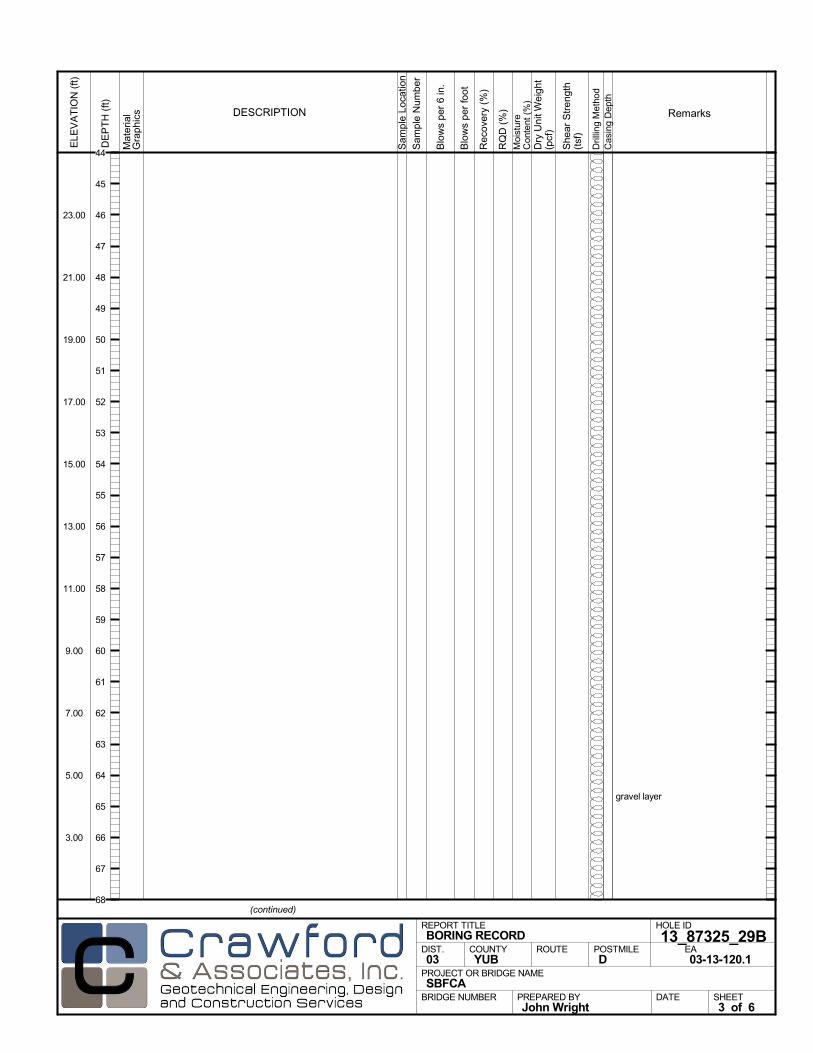
gravel layer
Mat
eria
lG
rap
hics
Sam
ple
Loca
tion
COUNTYYUB
DESCRIPTION
Rec
over
y (%
)
Dril
ling
Met
hod
Cas
ing
Dep
th
PREPARED BYJohn Wright
DATE
PROJECT OR BRIDGE NAMESBFCA
BRIDGE NUMBER
HOLE ID
13_87325_29BEA03-13-120.1
REPORT TITLEBORING RECORD
DIST.03
ROUTE POSTMILED
(continued)
SHEET3 of 6
RQ
D (
%)
Sam
ple
Num
ber
Moi
stur
eC
onte
nt (
%)
Remarks
Blo
ws
per
6 in
.
ELE
VA
TIO
N (
ft)
23.00
21.00
19.00
17.00
15.00
13.00
11.00
9.00
7.00
5.00
3.00
DE
PT
H (
ft)
Dry
Uni
t Wei
ght
(pcf
)
She
ar S
tren
gth
(tsf
)
Blo
ws
per
foot
44
45
46
47
48
49
50
51
52
53
54
55
56
57
58
59
60
61
62
63
64
65
66
67
68

end gravel
gravel layer
Mat
eria
lG
rap
hics
Sam
ple
Loca
tion
COUNTYYUB
DESCRIPTION
Rec
over
y (%
)
Dril
ling
Met
hod
Cas
ing
Dep
th
PREPARED BYJohn Wright
DATE
PROJECT OR BRIDGE NAMESBFCA
BRIDGE NUMBER
HOLE ID
13_87325_29BEA03-13-120.1
REPORT TITLEBORING RECORD
DIST.03
ROUTE POSTMILED
(continued)
SHEET4 of 6
RQ
D (
%)
Sam
ple
Num
ber
Moi
stur
eC
onte
nt (
%)
Remarks
Blo
ws
per
6 in
.
ELE
VA
TIO
N (
ft)
-1.00
-3.00
-5.00
-7.00
-9.00
-11.00
-13.00
-15.00
-17.00
-19.00
-21.00
DE
PT
H (
ft)
Dry
Uni
t Wei
ght
(pcf
)
She
ar S
tren
gth
(tsf
)
Blo
ws
per
foot
68
69
70
71
72
73
74
75
76
77
78
79
80
81
82
83
84
85
86
87
88
89
90
91
92
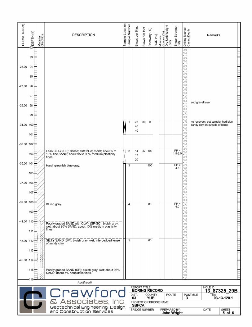
Lean CLAY (CL); dense; stiff; blue; moist; about 5 to10% fine SAND; about 95 to 90% medium plasticityfines.
Hard; greenish blue gray.
Bluish gray.
Poorly graded SAND with CLAY (SP-SC); bluish gray;wet; about 90% SAND; about 10% medium plasticityfines.
SILTY SAND (SM); bluish gray; wet; Interbedded lenseof sandy clay.
Poorly graded SAND (SP); bluish gray; wet; about 95%SAND; about 5% nonplastic fines.
0
100
100
80
60
1
2
3
4
5
end gravel layer
no recovery, but sampler had bluesandy clay on outside of barrel
25
40
40
14
17
20
PP =1.5-2.0
PP =4.5
PP =4.0
Mat
eria
lG
rap
hics
Sam
ple
Loca
tion
COUNTYYUB
DESCRIPTION
Rec
over
y (%
)
Dril
ling
Met
hod
Cas
ing
Dep
th
PREPARED BYJohn Wright
DATE
PROJECT OR BRIDGE NAMESBFCA
BRIDGE NUMBER
HOLE ID
13_87325_29BEA03-13-120.1
REPORT TITLEBORING RECORD
DIST.03
ROUTE POSTMILED
(continued)
SHEET5 of 6
RQ
D (
%)
Sam
ple
Num
ber
Moi
stur
eC
onte
nt (
%)
Remarks
Blo
ws
per
6 in
.
ELE
VA
TIO
N (
ft)
-25.00
-27.00
-29.00
-31.00
-33.00
-35.00
-37.00
-39.00
-41.00
-43.00
-45.00
DE
PT
H (
ft)
Dry
Uni
t Wei
ght
(pcf
)
She
ar S
tren
gth
(tsf
)
Blo
ws
per
foot
80
37
92
93
94
95
96
97
98
99
100
101
102
103
104
105
106
107
108
109
110
111
112
113
114
115
116
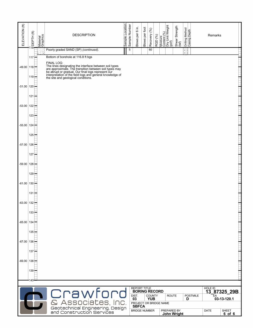
Poorly graded SAND (SP) (continued).
Bottom of borehole at 116.8 ft bgs
FINAL LOG:The lines designating the interface between soil typesare approximate. The transition between soil types maybe abrupt or gradual. Our final logs represent ourinterpretation of the field logs and general knowledge ofthe site and geological conditions.
605
Mat
eria
lG
rap
hics
Sam
ple
Loca
tion
COUNTYYUB
DESCRIPTION
Rec
over
y (%
)
Dril
ling
Met
hod
Cas
ing
Dep
th
PREPARED BYJohn Wright
DATE
PROJECT OR BRIDGE NAMESBFCA
BRIDGE NUMBER
HOLE ID
13_87325_29BEA03-13-120.1
REPORT TITLEBORING RECORD
DIST.03
ROUTE POSTMILED
SHEET6 of 6
RQ
D (
%)
Sam
ple
Num
ber
Moi
stur
eC
onte
nt (
%)
Remarks
Blo
ws
per
6 in
.
ELE
VA
TIO
N (
ft)
-49.00
-51.00
-53.00
-55.00
-57.00
-59.00
-61.00
-63.00
-65.00
-67.00
-69.00
DE
PT
H (
ft)
Dry
Uni
t Wei
ght
(pcf
)
She
ar S
tren
gth
(tsf
)
Blo
ws
per
foot
116
117
118
119
120
121
122
123
124
125
126
127
128
129
130
131
132
133
134
135
136
137
138
139
140
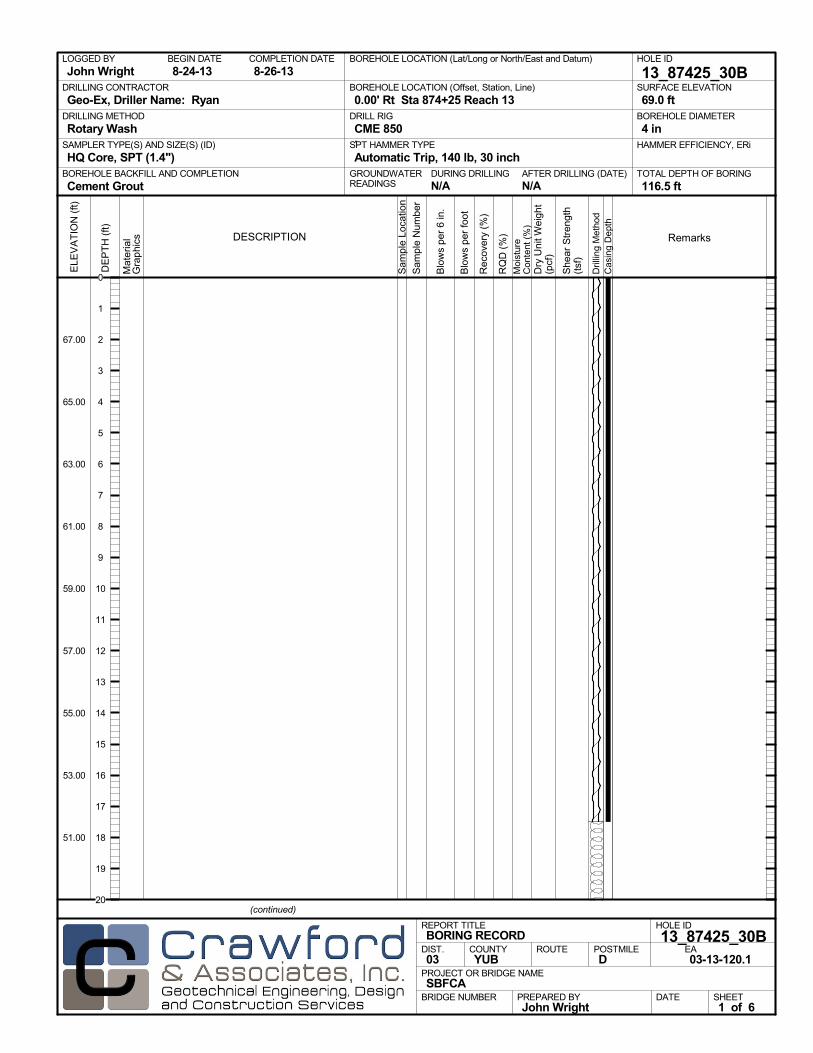
AFTER DRILLING (DATE)DURING DRILLINGN/A N/A
SURFACE ELEVATION
69.0 ftDRILLING METHOD
Rotary WashDRILL RIG
CME 850SPT HAMMER TYPE
Automatic Trip, 140 lb, 30 inchBOREHOLE BACKFILL AND COMPLETION
Cement GroutGROUNDWATERREADINGS
BEGIN DATE
8-24-13COMPLETION DATE
8-26-13LOGGED BY
John WrightBOREHOLE LOCATION (Lat/Long or North/East and Datum) HOLE ID
13_87425_30BDRILLING CONTRACTOR
Geo-Ex, Driller Name: Ryan
HAMMER EFFICIENCY, ERiSAMPLER TYPE(S) AND SIZE(S) (ID)
HQ Core, SPT (1.4")TOTAL DEPTH OF BORING
116.5 ft
BOREHOLE DIAMETER
4 in
BOREHOLE LOCATION (Offset, Station, Line)
0.00' Rt Sta 874+25 Reach 13
.M
ater
ial
Gra
phi
cs
Sam
ple
Loca
tion
COUNTYYUB
DESCRIPTION
Rec
over
y (%
)
Dril
ling
Met
hod
Cas
ing
Dep
th
PREPARED BYJohn Wright
DATE
PROJECT OR BRIDGE NAMESBFCA
BRIDGE NUMBER
HOLE ID
13_87425_30BEA03-13-120.1
REPORT TITLEBORING RECORD
DIST.03
ROUTE POSTMILED
(continued)
SHEET1 of 6
RQ
D (
%)
Sam
ple
Num
ber
Moi
stur
eC
onte
nt (
%)
Remarks
Blo
ws
per
6 in
.
ELE
VA
TIO
N (
ft)
67.00
65.00
63.00
61.00
59.00
57.00
55.00
53.00
51.00
DE
PT
H (
ft)
Dry
Uni
t Wei
ght
(pcf
)
She
ar S
tren
gth
(tsf
)
Blo
ws
per
foot
0
1
2
3
4
5
6
7
8
9
10
11
12
13
14
15
16
17
18
19
20

Mat
eria
lG
rap
hics
Sam
ple
Loca
tion
COUNTYYUB
DESCRIPTION
Rec
over
y (%
)
Dril
ling
Met
hod
Cas
ing
Dep
th
PREPARED BYJohn Wright
DATE
PROJECT OR BRIDGE NAMESBFCA
BRIDGE NUMBER
HOLE ID
13_87425_30BEA03-13-120.1
REPORT TITLEBORING RECORD
DIST.03
ROUTE POSTMILED
(continued)
SHEET2 of 6
RQ
D (
%)
Sam
ple
Num
ber
Moi
stur
eC
onte
nt (
%)
Remarks
Blo
ws
per
6 in
.
ELE
VA
TIO
N (
ft)
47.00
45.00
43.00
41.00
39.00
37.00
35.00
33.00
31.00
29.00
27.00
DE
PT
H (
ft)
Dry
Uni
t Wei
ght
(pcf
)
She
ar S
tren
gth
(tsf
)
Blo
ws
per
foot
20
21
22
23
24
25
26
27
28
29
30
31
32
33
34
35
36
37
38
39
40
41
42
43
44

gravel layer
Mat
eria
lG
rap
hics
Sam
ple
Loca
tion
COUNTYYUB
DESCRIPTION
Rec
over
y (%
)
Dril
ling
Met
hod
Cas
ing
Dep
th
PREPARED BYJohn Wright
DATE
PROJECT OR BRIDGE NAMESBFCA
BRIDGE NUMBER
HOLE ID
13_87425_30BEA03-13-120.1
REPORT TITLEBORING RECORD
DIST.03
ROUTE POSTMILED
(continued)
SHEET3 of 6
RQ
D (
%)
Sam
ple
Num
ber
Moi
stur
eC
onte
nt (
%)
Remarks
Blo
ws
per
6 in
.
ELE
VA
TIO
N (
ft)
23.00
21.00
19.00
17.00
15.00
13.00
11.00
9.00
7.00
5.00
3.00
DE
PT
H (
ft)
Dry
Uni
t Wei
ght
(pcf
)
She
ar S
tren
gth
(tsf
)
Blo
ws
per
foot
44
45
46
47
48
49
50
51
52
53
54
55
56
57
58
59
60
61
62
63
64
65
66
67
68
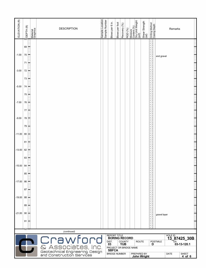
end gravel
gravel layer
Mat
eria
lG
rap
hics
Sam
ple
Loca
tion
COUNTYYUB
DESCRIPTION
Rec
over
y (%
)
Dril
ling
Met
hod
Cas
ing
Dep
th
PREPARED BYJohn Wright
DATE
PROJECT OR BRIDGE NAMESBFCA
BRIDGE NUMBER
HOLE ID
13_87425_30BEA03-13-120.1
REPORT TITLEBORING RECORD
DIST.03
ROUTE POSTMILED
(continued)
SHEET4 of 6
RQ
D (
%)
Sam
ple
Num
ber
Moi
stur
eC
onte
nt (
%)
Remarks
Blo
ws
per
6 in
.
ELE
VA
TIO
N (
ft)
-1.00
-3.00
-5.00
-7.00
-9.00
-11.00
-13.00
-15.00
-17.00
-19.00
-21.00
DE
PT
H (
ft)
Dry
Uni
t Wei
ght
(pcf
)
She
ar S
tren
gth
(tsf
)
Blo
ws
per
foot
68
69
70
71
72
73
74
75
76
77
78
79
80
81
82
83
84
85
86
87
88
89
90
91
92
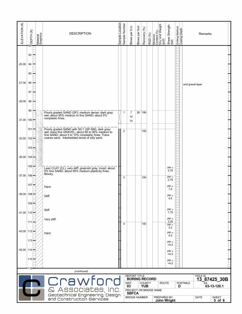
Poorly graded SAND (SP); medium dense; dark gray;wet; about 95% medium to fine SAND; about 5%nonplastic fines.
Poorly graded SAND with SILT (SP-SM); dark gray;wet; trace fine GRAVEL; about 95 to 90% medium tofine SAND; about 5 to 10% nonplastic fines; Tracecoarse sand. Interbedded lense of silty sand.
Lean CLAY (CL); very stiff; greenish gray; moist; about5% fine SAND; about 95% medium plasticity fines;Blocky.
Hard.
Stiff.
Stiff.
Very stiff.
Hard.
106
100
100
100
1
2
3
4
end gravel layer
7
14
14
PP =3.75
PP =2.75
PP =1.5
PP =4.5
PP =1.75
PP =3.25PP =3.5
PP =4.5
PP =>4.5
PP =>4.5
PP =>4.5
Mat
eria
lG
rap
hics
Sam
ple
Loca
tion
COUNTYYUB
DESCRIPTION
Rec
over
y (%
)
Dril
ling
Met
hod
Cas
ing
Dep
th
PREPARED BYJohn Wright
DATE
PROJECT OR BRIDGE NAMESBFCA
BRIDGE NUMBER
HOLE ID
13_87425_30BEA03-13-120.1
REPORT TITLEBORING RECORD
DIST.03
ROUTE POSTMILED
(continued)
SHEET5 of 6
RQ
D (
%)
Sam
ple
Num
ber
Moi
stur
eC
onte
nt (
%)
Remarks
Blo
ws
per
6 in
.
ELE
VA
TIO
N (
ft)
-25.00
-27.00
-29.00
-31.00
-33.00
-35.00
-37.00
-39.00
-41.00
-43.00
-45.00
DE
PT
H (
ft)
Dry
Uni
t Wei
ght
(pcf
)
She
ar S
tren
gth
(tsf
)
Blo
ws
per
foot
28
92
93
94
95
96
97
98
99
100
101
102
103
104
105
106
107
108
109
110
111
112
113
114
115
116

Lean CLAY (CL) (continued).
Bottom of borehole at 116.5 ft bgs
FINAL LOG:The lines designating the interface between soil typesare approximate. The transition between soil types maybe abrupt or gradual. Our final logs represent ourinterpretation of the field logs and general knowledge ofthe site and geological conditions.
1004 PP =>4.5
Mat
eria
lG
rap
hics
Sam
ple
Loca
tion
COUNTYYUB
DESCRIPTION
Rec
over
y (%
)
Dril
ling
Met
hod
Cas
ing
Dep
th
PREPARED BYJohn Wright
DATE
PROJECT OR BRIDGE NAMESBFCA
BRIDGE NUMBER
HOLE ID
13_87425_30BEA03-13-120.1
REPORT TITLEBORING RECORD
DIST.03
ROUTE POSTMILED
SHEET6 of 6
RQ
D (
%)
Sam
ple
Num
ber
Moi
stur
eC
onte
nt (
%)
Remarks
Blo
ws
per
6 in
.
ELE
VA
TIO
N (
ft)
-49.00
-51.00
-53.00
-55.00
-57.00
-59.00
-61.00
-63.00
-65.00
-67.00
-69.00
DE
PT
H (
ft)
Dry
Uni
t Wei
ght
(pcf
)
She
ar S
tren
gth
(tsf
)
Blo
ws
per
foot
116
117
118
119
120
121
122
123
124
125
126
127
128
129
130
131
132
133
134
135
136
137
138
139
140
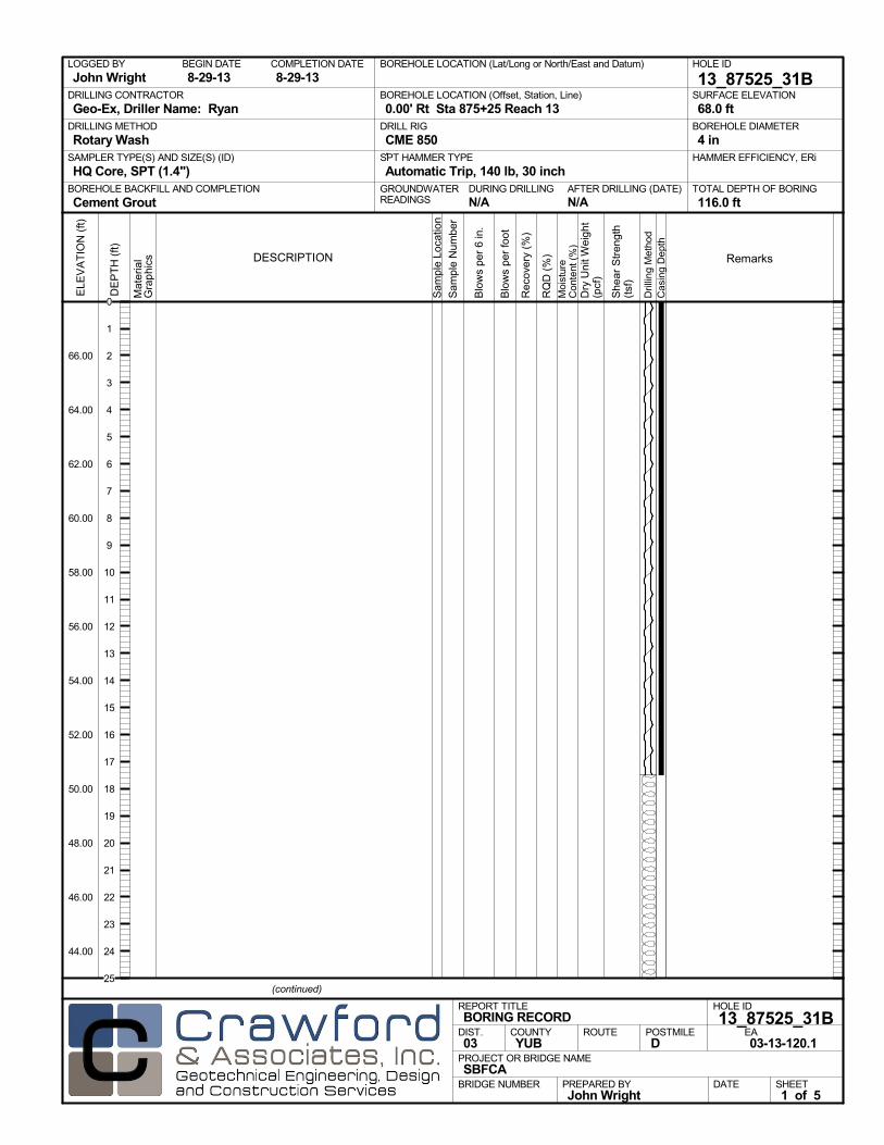
AFTER DRILLING (DATE)DURING DRILLINGN/A N/A
SURFACE ELEVATION
68.0 ftDRILLING METHOD
Rotary WashDRILL RIG
CME 850SPT HAMMER TYPE
Automatic Trip, 140 lb, 30 inchBOREHOLE BACKFILL AND COMPLETION
Cement GroutGROUNDWATERREADINGS
BEGIN DATE
8-29-13COMPLETION DATE
8-29-13LOGGED BY
John WrightBOREHOLE LOCATION (Lat/Long or North/East and Datum) HOLE ID
13_87525_31BDRILLING CONTRACTOR
Geo-Ex, Driller Name: Ryan
HAMMER EFFICIENCY, ERiSAMPLER TYPE(S) AND SIZE(S) (ID)
HQ Core, SPT (1.4")TOTAL DEPTH OF BORING
116.0 ft
BOREHOLE DIAMETER
4 in
BOREHOLE LOCATION (Offset, Station, Line)
0.00' Rt Sta 875+25 Reach 13
.M
ater
ial
Gra
phi
cs
Sam
ple
Loca
tion
COUNTYYUB
DESCRIPTION
Rec
over
y (%
)
Dril
ling
Met
hod
Cas
ing
Dep
th
PREPARED BYJohn Wright
DATE
PROJECT OR BRIDGE NAMESBFCA
BRIDGE NUMBER
HOLE ID
13_87525_31BEA03-13-120.1
REPORT TITLEBORING RECORD
DIST.03
ROUTE POSTMILED
(continued)
SHEET1 of 5
RQ
D (
%)
Sam
ple
Num
ber
Moi
stur
eC
onte
nt (
%)
Remarks
Blo
ws
per
6 in
.
ELE
VA
TIO
N (
ft)
66.00
64.00
62.00
60.00
58.00
56.00
54.00
52.00
50.00
48.00
46.00
44.00
DE
PT
H (
ft)
Dry
Uni
t Wei
ght
(pcf
)
She
ar S
tren
gth
(tsf
)
Blo
ws
per
foot
0
1
2
3
4
5
6
7
8
9
10
11
12
13
14
15
16
17
18
19
20
21
22
23
24
25

gravel layer
Mat
eria
lG
rap
hics
Sam
ple
Loca
tion
COUNTYYUB
DESCRIPTION
Rec
over
y (%
)
Dril
ling
Met
hod
Cas
ing
Dep
th
PREPARED BYJohn Wright
DATE
PROJECT OR BRIDGE NAMESBFCA
BRIDGE NUMBER
HOLE ID
13_87525_31BEA03-13-120.1
REPORT TITLEBORING RECORD
DIST.03
ROUTE POSTMILED
(continued)
SHEET2 of 5
RQ
D (
%)
Sam
ple
Num
ber
Moi
stur
eC
onte
nt (
%)
Remarks
Blo
ws
per
6 in
.
ELE
VA
TIO
N (
ft)
42.00
40.00
38.00
36.00
34.00
32.00
30.00
28.00
26.00
24.00
22.00
20.00
18.00
16.00
14.00
DE
PT
H (
ft)
Dry
Uni
t Wei
ght
(pcf
)
She
ar S
tren
gth
(tsf
)
Blo
ws
per
foot
25
26
27
28
29
30
31
32
33
34
35
36
37
38
39
40
41
42
43
44
45
46
47
48
49
50
51
52
53
54
55
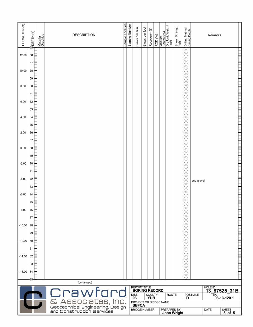
end gravel
Mat
eria
lG
rap
hics
Sam
ple
Loca
tion
COUNTYYUB
DESCRIPTION
Rec
over
y (%
)
Dril
ling
Met
hod
Cas
ing
Dep
th
PREPARED BYJohn Wright
DATE
PROJECT OR BRIDGE NAMESBFCA
BRIDGE NUMBER
HOLE ID
13_87525_31BEA03-13-120.1
REPORT TITLEBORING RECORD
DIST.03
ROUTE POSTMILED
(continued)
SHEET3 of 5
RQ
D (
%)
Sam
ple
Num
ber
Moi
stur
eC
onte
nt (
%)
Remarks
Blo
ws
per
6 in
.
ELE
VA
TIO
N (
ft)
12.00
10.00
8.00
6.00
4.00
2.00
0.00
-2.00
-4.00
-6.00
-8.00
-10.00
-12.00
-14.00
-16.00
DE
PT
H (
ft)
Dry
Uni
t Wei
ght
(pcf
)
She
ar S
tren
gth
(tsf
)
Blo
ws
per
foot
55
56
57
58
59
60
61
62
63
64
65
66
67
68
69
70
71
72
73
74
75
76
77
78
79
80
81
82
83
84
85
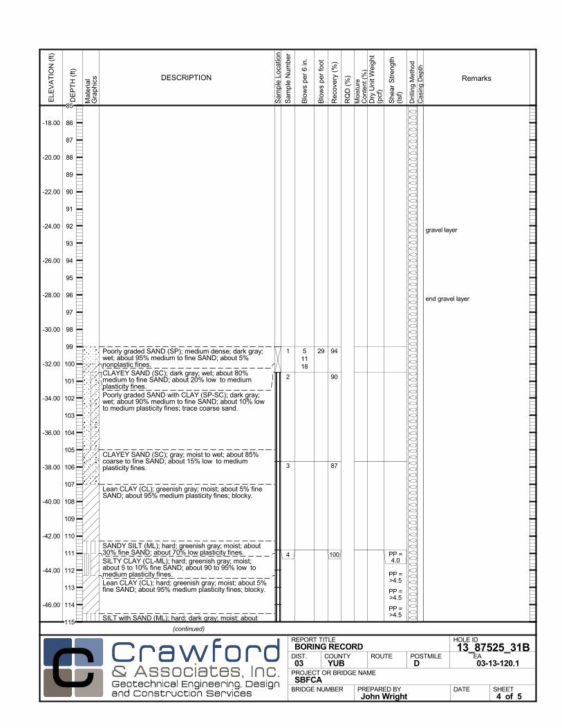
Poorly graded SAND (SP); medium dense; dark gray;wet; about 95% medium to fine SAND; about 5%nonplastic fines.CLAYEY SAND (SC); dark gray; wet; about 80%medium to fine SAND; about 20% low to mediumplasticity fines.Poorly graded SAND with CLAY (SP-SC); dark gray;wet; about 90% medium to fine SAND; about 10% lowto medium plasticity fines; trace coarse sand.
CLAYEY SAND (SC); gray; moist to wet; about 85%coarse to fine SAND; about 15% low to mediumplasticity fines.
Lean CLAY (CL); greenish gray; moist; about 5% fineSAND; about 95% medium plasticity fines; blocky.
SANDY SILT (ML); hard; greenish gray; moist; about30% fine SAND; about 70% low plasticity fines.SILTY CLAY (CL-ML); hard; greenish gray; moist;about 5 to 10% fine SAND; about 90 to 95% low tomedium plasticity fines.Lean CLAY (CL); hard; greenish gray; moist; about 5%fine SAND; about 95% medium plasticity fines; blocky.
SILT with SAND (ML); hard; dark gray; moist; about
94
90
87
100
1
2
3
4
gravel layer
end gravel layer
51118
PP =4.0
PP =>4.5
PP =>4.5
PP =>4.5
Mat
eria
lG
rap
hics
Sam
ple
Loca
tion
COUNTYYUB
DESCRIPTION
Rec
over
y (%
)
Dril
ling
Met
hod
Cas
ing
Dep
th
PREPARED BYJohn Wright
DATE
PROJECT OR BRIDGE NAMESBFCA
BRIDGE NUMBER
HOLE ID
13_87525_31BEA03-13-120.1
REPORT TITLEBORING RECORD
DIST.03
ROUTE POSTMILED
(continued)
SHEET4 of 5
RQ
D (
%)
Sam
ple
Num
ber
Moi
stur
eC
onte
nt (
%)
Remarks
Blo
ws
per
6 in
.
ELE
VA
TIO
N (
ft)
-18.00
-20.00
-22.00
-24.00
-26.00
-28.00
-30.00
-32.00
-34.00
-36.00
-38.00
-40.00
-42.00
-44.00
-46.00
DE
PT
H (
ft)
Dry
Uni
t Wei
ght
(pcf
)
She
ar S
tren
gth
(tsf
)
Blo
ws
per
foot
29
85
86
87
88
89
90
91
92
93
94
95
96
97
98
99
100
101
102
103
104
105
106
107
108
109
110
111
112
113
114
115

15% fine SAND; about 85% low plasticity fines; slightlyblocky.
Bottom of borehole at 116.0 ft bgs
FINAL LOG:The lines designating the interface between soil typesare approximate. The transition between soil types maybe abrupt or gradual. Our final logs represent ourinterpretation of the field logs and general knowledge ofthe site and geological conditions.
1004 PP =4.0
PP =>4.5
Mat
eria
lG
rap
hics
Sam
ple
Loca
tion
COUNTYYUB
DESCRIPTION
Rec
over
y (%
)
Dril
ling
Met
hod
Cas
ing
Dep
th
PREPARED BYJohn Wright
DATE
PROJECT OR BRIDGE NAMESBFCA
BRIDGE NUMBER
HOLE ID
13_87525_31BEA03-13-120.1
REPORT TITLEBORING RECORD
DIST.03
ROUTE POSTMILED
SHEET5 of 5
RQ
D (
%)
Sam
ple
Num
ber
Moi
stur
eC
onte
nt (
%)
Remarks
Blo
ws
per
6 in
.
ELE
VA
TIO
N (
ft)
-48.00
-50.00
-52.00
-54.00
-56.00
-58.00
-60.00
-62.00
-64.00
-66.00
-68.00
-70.00
-72.00
-74.00
-76.00
DE
PT
H (
ft)
Dry
Uni
t Wei
ght
(pcf
)
She
ar S
tren
gth
(tsf
)
Blo
ws
per
foot
115
116
117
118
119
120
121
122
123
124
125
126
127
128
129
130
131
132
133
134
135
136
137
138
139
140
141
142
143
144
145
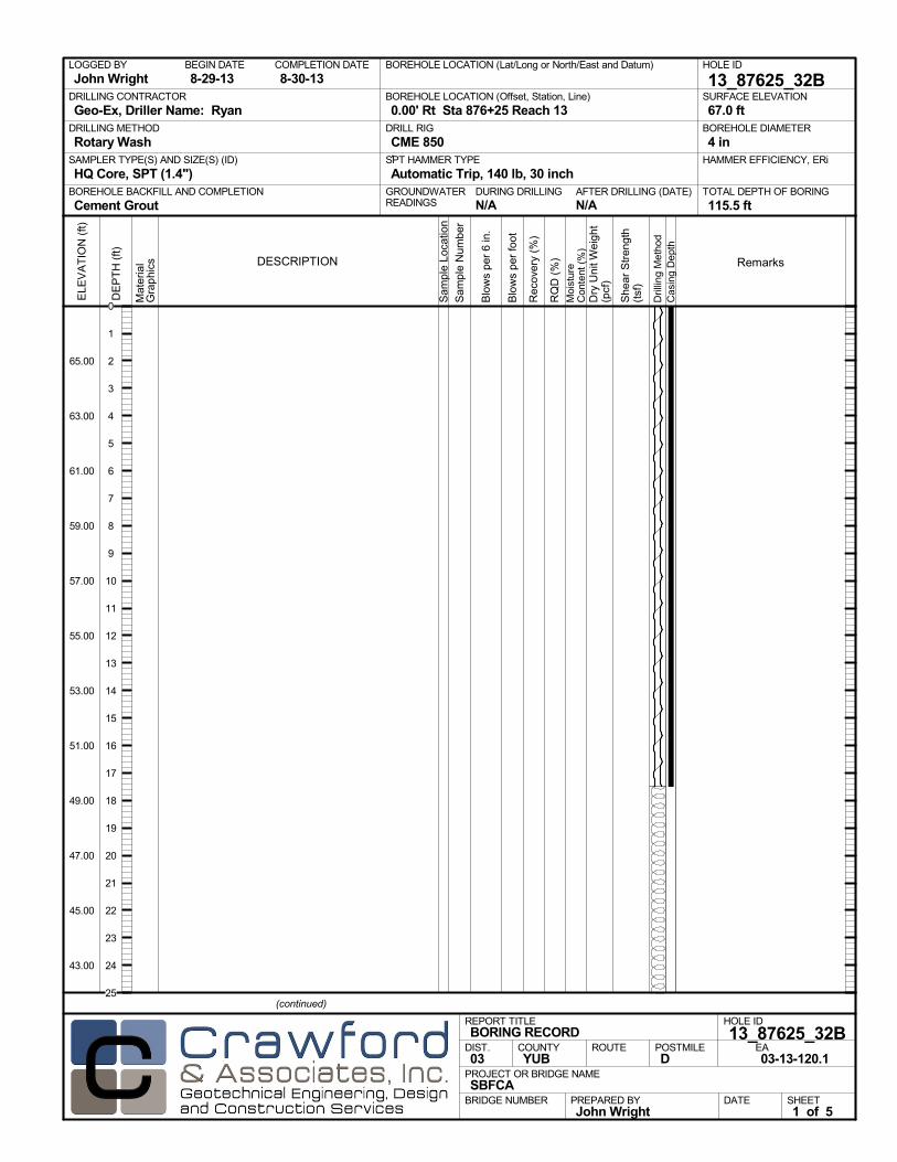
AFTER DRILLING (DATE)DURING DRILLINGN/A N/A
SURFACE ELEVATION
67.0 ftDRILLING METHOD
Rotary WashDRILL RIG
CME 850SPT HAMMER TYPE
Automatic Trip, 140 lb, 30 inchBOREHOLE BACKFILL AND COMPLETION
Cement GroutGROUNDWATERREADINGS
BEGIN DATE
8-29-13COMPLETION DATE
8-30-13LOGGED BY
John WrightBOREHOLE LOCATION (Lat/Long or North/East and Datum) HOLE ID
13_87625_32BDRILLING CONTRACTOR
Geo-Ex, Driller Name: Ryan
HAMMER EFFICIENCY, ERiSAMPLER TYPE(S) AND SIZE(S) (ID)
HQ Core, SPT (1.4")TOTAL DEPTH OF BORING
115.5 ft
BOREHOLE DIAMETER
4 in
BOREHOLE LOCATION (Offset, Station, Line)
0.00' Rt Sta 876+25 Reach 13
.M
ater
ial
Gra
phi
cs
Sam
ple
Loca
tion
COUNTYYUB
DESCRIPTION
Rec
over
y (%
)
Dril
ling
Met
hod
Cas
ing
Dep
th
PREPARED BYJohn Wright
DATE
PROJECT OR BRIDGE NAMESBFCA
BRIDGE NUMBER
HOLE ID
13_87625_32BEA03-13-120.1
REPORT TITLEBORING RECORD
DIST.03
ROUTE POSTMILED
(continued)
SHEET1 of 5
RQ
D (
%)
Sam
ple
Num
ber
Moi
stur
eC
onte
nt (
%)
Remarks
Blo
ws
per
6 in
.
ELE
VA
TIO
N (
ft)
65.00
63.00
61.00
59.00
57.00
55.00
53.00
51.00
49.00
47.00
45.00
43.00
DE
PT
H (
ft)
Dry
Uni
t Wei
ght
(pcf
)
She
ar S
tren
gth
(tsf
)
Blo
ws
per
foot
0
1
2
3
4
5
6
7
8
9
10
11
12
13
14
15
16
17
18
19
20
21
22
23
24
25

gravel layer
Mat
eria
lG
rap
hics
Sam
ple
Loca
tion
COUNTYYUB
DESCRIPTION
Rec
over
y (%
)
Dril
ling
Met
hod
Cas
ing
Dep
th
PREPARED BYJohn Wright
DATE
PROJECT OR BRIDGE NAMESBFCA
BRIDGE NUMBER
HOLE ID
13_87625_32BEA03-13-120.1
REPORT TITLEBORING RECORD
DIST.03
ROUTE POSTMILED
(continued)
SHEET2 of 5
RQ
D (
%)
Sam
ple
Num
ber
Moi
stur
eC
onte
nt (
%)
Remarks
Blo
ws
per
6 in
.
ELE
VA
TIO
N (
ft)
41.00
39.00
37.00
35.00
33.00
31.00
29.00
27.00
25.00
23.00
21.00
19.00
17.00
15.00
13.00
DE
PT
H (
ft)
Dry
Uni
t Wei
ght
(pcf
)
She
ar S
tren
gth
(tsf
)
Blo
ws
per
foot
25
26
27
28
29
30
31
32
33
34
35
36
37
38
39
40
41
42
43
44
45
46
47
48
49
50
51
52
53
54
55

end gravel
Mat
eria
lG
rap
hics
Sam
ple
Loca
tion
COUNTYYUB
DESCRIPTION
Rec
over
y (%
)
Dril
ling
Met
hod
Cas
ing
Dep
th
PREPARED BYJohn Wright
DATE
PROJECT OR BRIDGE NAMESBFCA
BRIDGE NUMBER
HOLE ID
13_87625_32BEA03-13-120.1
REPORT TITLEBORING RECORD
DIST.03
ROUTE POSTMILED
(continued)
SHEET3 of 5
RQ
D (
%)
Sam
ple
Num
ber
Moi
stur
eC
onte
nt (
%)
Remarks
Blo
ws
per
6 in
.
ELE
VA
TIO
N (
ft)
11.00
9.00
7.00
5.00
3.00
1.00
-1.00
-3.00
-5.00
-7.00
-9.00
-11.00
-13.00
-15.00
-17.00
DE
PT
H (
ft)
Dry
Uni
t Wei
ght
(pcf
)
She
ar S
tren
gth
(tsf
)
Blo
ws
per
foot
55
56
57
58
59
60
61
62
63
64
65
66
67
68
69
70
71
72
73
74
75
76
77
78
79
80
81
82
83
84
85
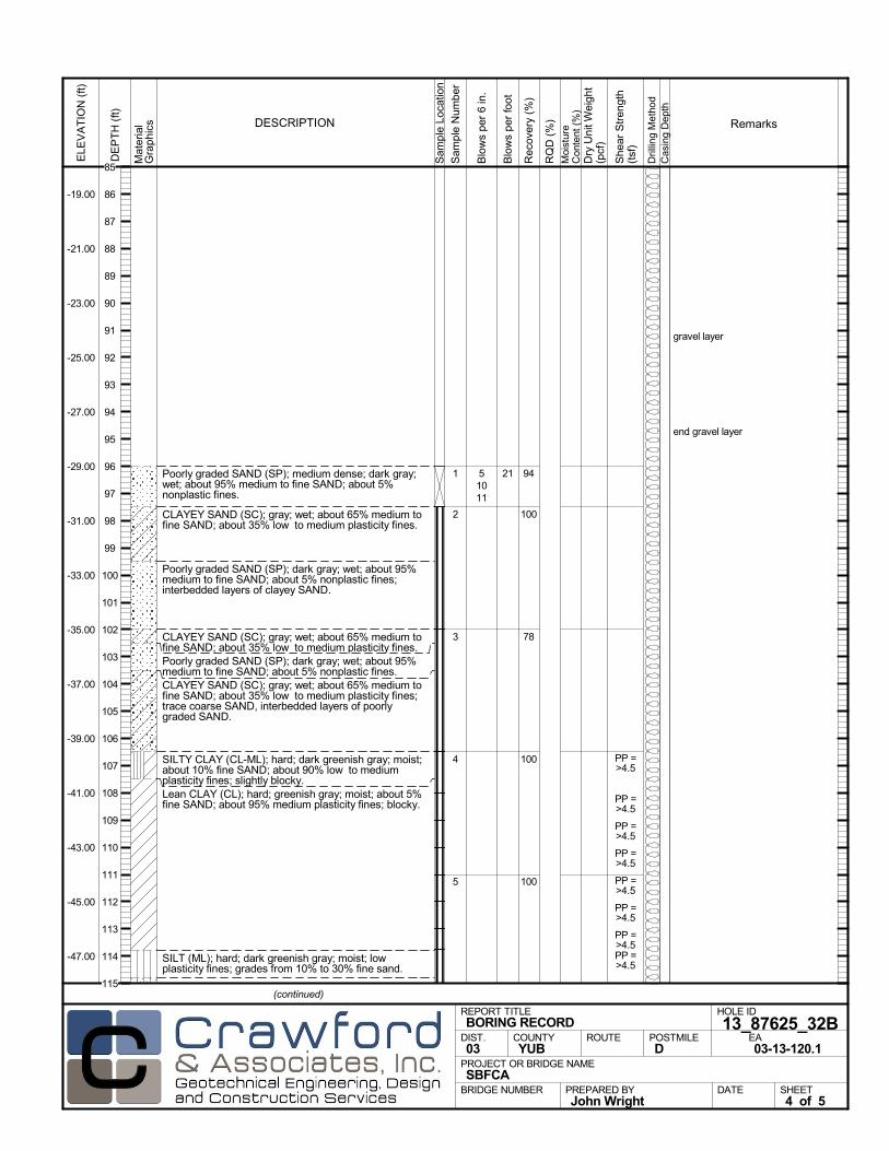
Poorly graded SAND (SP); medium dense; dark gray;wet; about 95% medium to fine SAND; about 5%nonplastic fines.
CLAYEY SAND (SC); gray; wet; about 65% medium tofine SAND; about 35% low to medium plasticity fines.
Poorly graded SAND (SP); dark gray; wet; about 95%medium to fine SAND; about 5% nonplastic fines;interbedded layers of clayey SAND.
CLAYEY SAND (SC); gray; wet; about 65% medium tofine SAND; about 35% low to medium plasticity fines.Poorly graded SAND (SP); dark gray; wet; about 95%medium to fine SAND; about 5% nonplastic fines.CLAYEY SAND (SC); gray; wet; about 65% medium tofine SAND; about 35% low to medium plasticity fines;trace coarse SAND, interbedded layers of poorlygraded SAND.
SILTY CLAY (CL-ML); hard; dark greenish gray; moist;about 10% fine SAND; about 90% low to mediumplasticity fines; slightly blocky.Lean CLAY (CL); hard; greenish gray; moist; about 5%fine SAND; about 95% medium plasticity fines; blocky.
SILT (ML); hard; dark greenish gray; moist; lowplasticity fines; grades from 10% to 30% fine sand.
94
100
78
100
100
1
2
3
4
5
gravel layer
end gravel layer
51011
PP =>4.5
PP =>4.5
PP =>4.5
PP =>4.5
PP =>4.5
PP =>4.5
PP =>4.5PP =>4.5
Mat
eria
lG
rap
hics
Sam
ple
Loca
tion
COUNTYYUB
DESCRIPTION
Rec
over
y (%
)
Dril
ling
Met
hod
Cas
ing
Dep
th
PREPARED BYJohn Wright
DATE
PROJECT OR BRIDGE NAMESBFCA
BRIDGE NUMBER
HOLE ID
13_87625_32BEA03-13-120.1
REPORT TITLEBORING RECORD
DIST.03
ROUTE POSTMILED
(continued)
SHEET4 of 5
RQ
D (
%)
Sam
ple
Num
ber
Moi
stur
eC
onte
nt (
%)
Remarks
Blo
ws
per
6 in
.
ELE
VA
TIO
N (
ft)
-19.00
-21.00
-23.00
-25.00
-27.00
-29.00
-31.00
-33.00
-35.00
-37.00
-39.00
-41.00
-43.00
-45.00
-47.00
DE
PT
H (
ft)
Dry
Uni
t Wei
ght
(pcf
)
She
ar S
tren
gth
(tsf
)
Blo
ws
per
foot
21
85
86
87
88
89
90
91
92
93
94
95
96
97
98
99
100
101
102
103
104
105
106
107
108
109
110
111
112
113
114
115

SILTY SAND (SM); dark gray; moist to wet; about 80 to85% medium to fine SAND; about 15 to 20% nonplasticfines.Bottom of borehole at 115.5 ft bgs
FINAL LOG:The lines designating the interface between soil typesare approximate. The transition between soil types maybe abrupt or gradual. Our final logs represent ourinterpretation of the field logs and general knowledge ofthe site and geological conditions.
Mat
eria
lG
rap
hics
Sam
ple
Loca
tion
COUNTYYUB
DESCRIPTION
Rec
over
y (%
)
Dril
ling
Met
hod
Cas
ing
Dep
th
PREPARED BYJohn Wright
DATE
PROJECT OR BRIDGE NAMESBFCA
BRIDGE NUMBER
HOLE ID
13_87625_32BEA03-13-120.1
REPORT TITLEBORING RECORD
DIST.03
ROUTE POSTMILED
SHEET5 of 5
RQ
D (
%)
Sam
ple
Num
ber
Moi
stur
eC
onte
nt (
%)
Remarks
Blo
ws
per
6 in
.
ELE
VA
TIO
N (
ft)
-49.00
-51.00
-53.00
-55.00
-57.00
-59.00
-61.00
-63.00
-65.00
-67.00
-69.00
-71.00
-73.00
-75.00
-77.00
DE
PT
H (
ft)
Dry
Uni
t Wei
ght
(pcf
)
She
ar S
tren
gth
(tsf
)
Blo
ws
per
foot
115
116
117
118
119
120
121
122
123
124
125
126
127
128
129
130
131
132
133
134
135
136
137
138
139
140
141
142
143
144
145

AFTER DRILLING (DATE)DURING DRILLINGN/A N/A
SURFACE ELEVATION
69.0 ftDRILLING METHOD
Rotary WashDRILL RIG
CME 850SPT HAMMER TYPE
Automatic Trip, 140 lb, 30 inchBOREHOLE BACKFILL AND COMPLETION
Cement GroutGROUNDWATERREADINGS
BEGIN DATE
9-3-13COMPLETION DATE
9-3-13LOGGED BY
John WrightBOREHOLE LOCATION (Lat/Long or North/East and Datum) HOLE ID
13_88930_45BDRILLING CONTRACTOR
Geo-Ex, Driller Name: Ryan
HAMMER EFFICIENCY, ERiSAMPLER TYPE(S) AND SIZE(S) (ID)
HQ Core, SPT (1.4")TOTAL DEPTH OF BORING
117.0 ft
BOREHOLE DIAMETER
4 in
BOREHOLE LOCATION (Offset, Station, Line)
0.00' Rt Sta 889+30 Reach 13
.M
ater
ial
Gra
phi
cs
Sam
ple
Loca
tion
COUNTYYUB
DESCRIPTION
Rec
over
y (%
)
Dril
ling
Met
hod
Cas
ing
Dep
th
PREPARED BYJohn Wright
DATE
PROJECT OR BRIDGE NAMESBFCA
BRIDGE NUMBER
HOLE ID
13_88930_45BEA03-13-120.1
REPORT TITLEBORING RECORD
DIST.03
ROUTE POSTMILED
(continued)
SHEET1 of 6
RQ
D (
%)
Sam
ple
Num
ber
Moi
stur
eC
onte
nt (
%)
Remarks
Blo
ws
per
6 in
.
ELE
VA
TIO
N (
ft)
67.00
65.00
63.00
61.00
59.00
57.00
55.00
53.00
51.00
DE
PT
H (
ft)
Dry
Uni
t Wei
ght
(pcf
)
She
ar S
tren
gth
(tsf
)
Blo
ws
per
foot
0
1
2
3
4
5
6
7
8
9
10
11
12
13
14
15
16
17
18
19
20
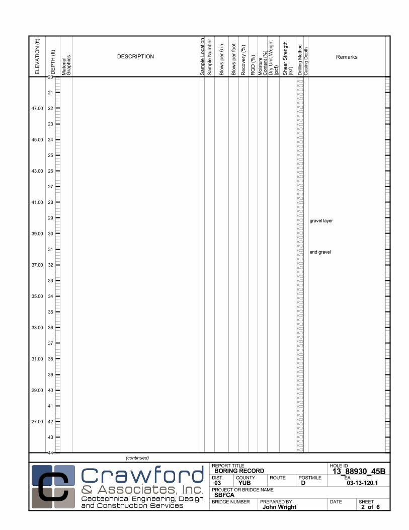
gravel layer
end gravel
Mat
eria
lG
rap
hics
Sam
ple
Loca
tion
COUNTYYUB
DESCRIPTION
Rec
over
y (%
)
Dril
ling
Met
hod
Cas
ing
Dep
th
PREPARED BYJohn Wright
DATE
PROJECT OR BRIDGE NAMESBFCA
BRIDGE NUMBER
HOLE ID
13_88930_45BEA03-13-120.1
REPORT TITLEBORING RECORD
DIST.03
ROUTE POSTMILED
(continued)
SHEET2 of 6
RQ
D (
%)
Sam
ple
Num
ber
Moi
stur
eC
onte
nt (
%)
Remarks
Blo
ws
per
6 in
.
ELE
VA
TIO
N (
ft)
47.00
45.00
43.00
41.00
39.00
37.00
35.00
33.00
31.00
29.00
27.00
DE
PT
H (
ft)
Dry
Uni
t Wei
ght
(pcf
)
She
ar S
tren
gth
(tsf
)
Blo
ws
per
foot
20
21
22
23
24
25
26
27
28
29
30
31
32
33
34
35
36
37
38
39
40
41
42
43
44
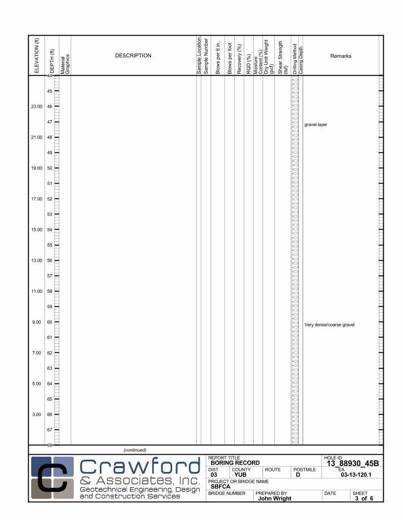
gravel layer
Very dense/coarse gravel
Mat
eria
lG
rap
hics
Sam
ple
Loca
tion
COUNTYYUB
DESCRIPTION
Rec
over
y (%
)
Dril
ling
Met
hod
Cas
ing
Dep
th
PREPARED BYJohn Wright
DATE
PROJECT OR BRIDGE NAMESBFCA
BRIDGE NUMBER
HOLE ID
13_88930_45BEA03-13-120.1
REPORT TITLEBORING RECORD
DIST.03
ROUTE POSTMILED
(continued)
SHEET3 of 6
RQ
D (
%)
Sam
ple
Num
ber
Moi
stur
eC
onte
nt (
%)
Remarks
Blo
ws
per
6 in
.
ELE
VA
TIO
N (
ft)
23.00
21.00
19.00
17.00
15.00
13.00
11.00
9.00
7.00
5.00
3.00
DE
PT
H (
ft)
Dry
Uni
t Wei
ght
(pcf
)
She
ar S
tren
gth
(tsf
)
Blo
ws
per
foot
44
45
46
47
48
49
50
51
52
53
54
55
56
57
58
59
60
61
62
63
64
65
66
67
68

end gravel
gravel layer
end gravel
gravel layer
Mat
eria
lG
rap
hics
Sam
ple
Loca
tion
COUNTYYUB
DESCRIPTION
Rec
over
y (%
)
Dril
ling
Met
hod
Cas
ing
Dep
th
PREPARED BYJohn Wright
DATE
PROJECT OR BRIDGE NAMESBFCA
BRIDGE NUMBER
HOLE ID
13_88930_45BEA03-13-120.1
REPORT TITLEBORING RECORD
DIST.03
ROUTE POSTMILED
(continued)
SHEET4 of 6
RQ
D (
%)
Sam
ple
Num
ber
Moi
stur
eC
onte
nt (
%)
Remarks
Blo
ws
per
6 in
.
ELE
VA
TIO
N (
ft)
-1.00
-3.00
-5.00
-7.00
-9.00
-11.00
-13.00
-15.00
-17.00
-19.00
-21.00
DE
PT
H (
ft)
Dry
Uni
t Wei
ght
(pcf
)
She
ar S
tren
gth
(tsf
)
Blo
ws
per
foot
68
69
70
71
72
73
74
75
76
77
78
79
80
81
82
83
84
85
86
87
88
89
90
91
92
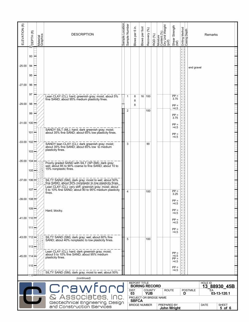
Lean CLAY (CL); hard; greenish gray; moist; about 5%fine SAND; about 95% medium plasticity fines.
SANDY SILT (ML); hard; dark greenish gray; moist;about 35% fine SAND; about 65% low plasticity fines.
SANDY lean CLAY (CL); dark greenish gray; moist;about 35% fine SAND; about 65% low to mediumplasticity fines.
Poorly graded SAND with SILT (SP-SM); dark gray;wet; about 85 to 90% coarse to fine SAND; about 10 to15% nonplastic fines.
SILTY SAND (SM); dark gray; moist to wet; about 50%fine SAND; about 50% nonplastic to low plasticity fines.Lean CLAY (CL); very stiff; greenish gray; moist; about5 to 10% fine SAND; about 90 to 95% medium plasticityfines.
Hard; blocky.
SILTY SAND (SM); dark gray; wet; about 60% fineSAND; about 40% nonplastic to low plasticity fines.
Lean CLAY (CL); hard; dark greenish gray; moist;about 5 to 10% fine SAND; about 95% mediumplasticity fines.
SILTY SAND (SM); dark gray; moist to wet; about 50%
100
100
90
100
100
1
2
3
4
5
end gravel
8
8
8
PP =3.75
PP =>4.5
PP =3.75
PP =>4.5
PP =>4.5
PP =3.25
PP =>4.5
PP =>4.5
PP =>4.5
PP =>4.5
PP =>4.5PP =>4.5
PP =>4.5
Mat
eria
lG
rap
hics
Sam
ple
Loca
tion
COUNTYYUB
DESCRIPTION
Rec
over
y (%
)
Dril
ling
Met
hod
Cas
ing
Dep
th
PREPARED BYJohn Wright
DATE
PROJECT OR BRIDGE NAMESBFCA
BRIDGE NUMBER
HOLE ID
13_88930_45BEA03-13-120.1
REPORT TITLEBORING RECORD
DIST.03
ROUTE POSTMILED
(continued)
SHEET5 of 6
RQ
D (
%)
Sam
ple
Num
ber
Moi
stur
eC
onte
nt (
%)
Remarks
Blo
ws
per
6 in
.
ELE
VA
TIO
N (
ft)
-25.00
-27.00
-29.00
-31.00
-33.00
-35.00
-37.00
-39.00
-41.00
-43.00
-45.00
DE
PT
H (
ft)
Dry
Uni
t Wei
ght
(pcf
)
She
ar S
tren
gth
(tsf
)
Blo
ws
per
foot
16
92
93
94
95
96
97
98
99
100
101
102
103
104
105
106
107
108
109
110
111
112
113
114
115
116
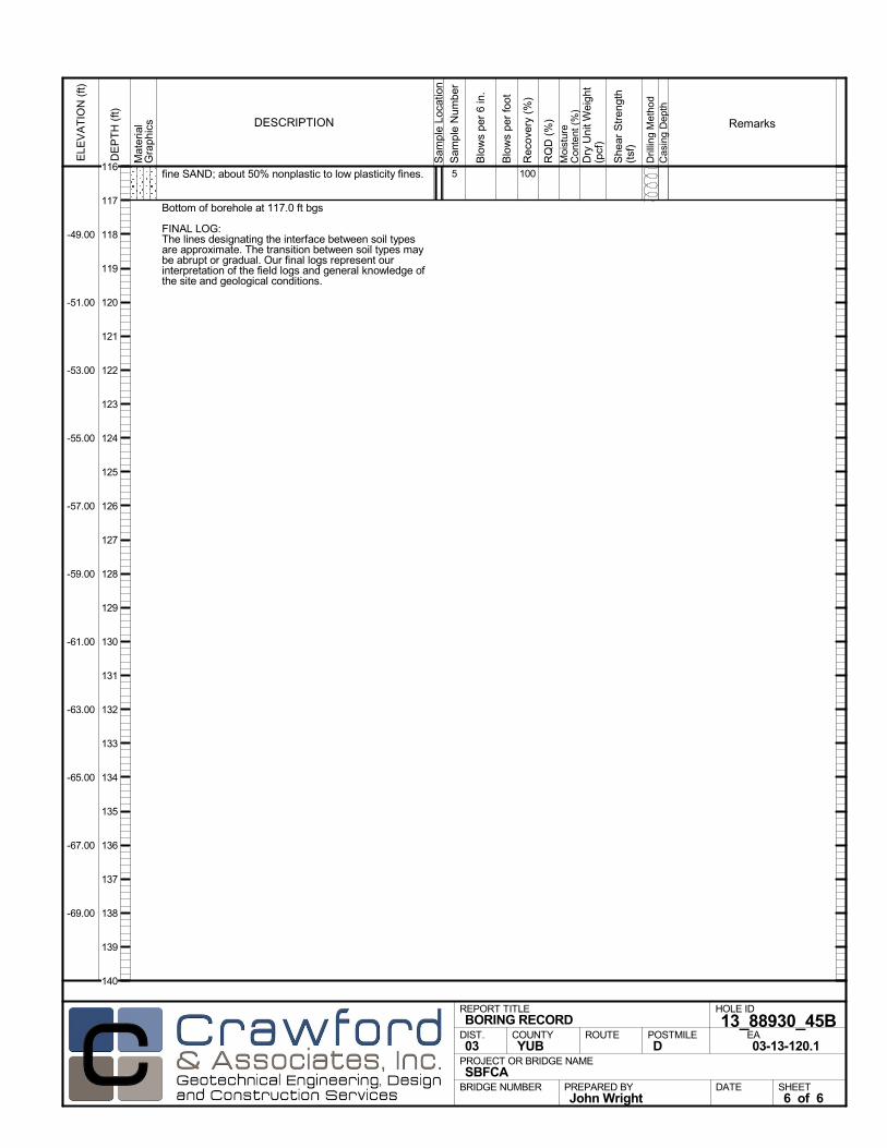
fine SAND; about 50% nonplastic to low plasticity fines.
Bottom of borehole at 117.0 ft bgs
FINAL LOG:The lines designating the interface between soil typesare approximate. The transition between soil types maybe abrupt or gradual. Our final logs represent ourinterpretation of the field logs and general knowledge ofthe site and geological conditions.
1005
Mat
eria
lG
rap
hics
Sam
ple
Loca
tion
COUNTYYUB
DESCRIPTION
Rec
over
y (%
)
Dril
ling
Met
hod
Cas
ing
Dep
th
PREPARED BYJohn Wright
DATE
PROJECT OR BRIDGE NAMESBFCA
BRIDGE NUMBER
HOLE ID
13_88930_45BEA03-13-120.1
REPORT TITLEBORING RECORD
DIST.03
ROUTE POSTMILED
SHEET6 of 6
RQ
D (
%)
Sam
ple
Num
ber
Moi
stur
eC
onte
nt (
%)
Remarks
Blo
ws
per
6 in
.
ELE
VA
TIO
N (
ft)
-49.00
-51.00
-53.00
-55.00
-57.00
-59.00
-61.00
-63.00
-65.00
-67.00
-69.00
DE
PT
H (
ft)
Dry
Uni
t Wei
ght
(pcf
)
She
ar S
tren
gth
(tsf
)
Blo
ws
per
foot
116
117
118
119
120
121
122
123
124
125
126
127
128
129
130
131
132
133
134
135
136
137
138
139
140
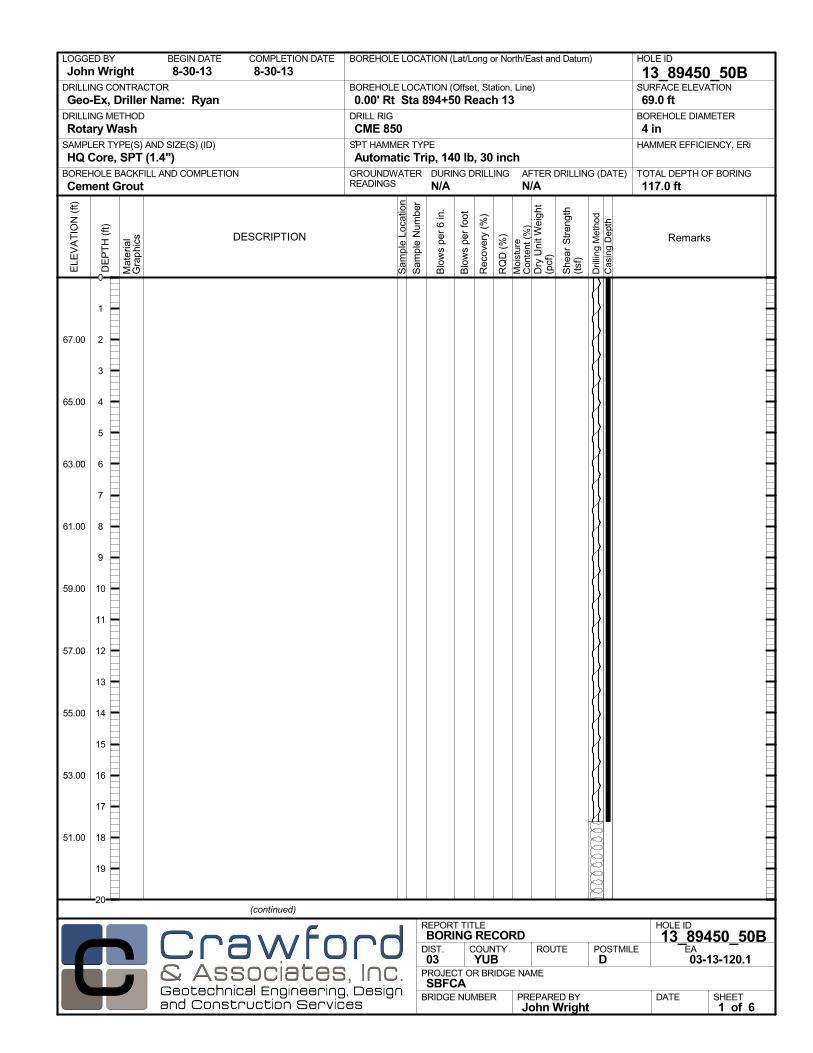
AFTER DRILLING (DATE)DURING DRILLINGN/A N/A
SURFACE ELEVATION
69.0 ftDRILLING METHOD
Rotary WashDRILL RIG
CME 850SPT HAMMER TYPE
Automatic Trip, 140 lb, 30 inchBOREHOLE BACKFILL AND COMPLETION
Cement GroutGROUNDWATERREADINGS
BEGIN DATE
8-30-13COMPLETION DATE
8-30-13LOGGED BY
John WrightBOREHOLE LOCATION (Lat/Long or North/East and Datum) HOLE ID
13_89450_50BDRILLING CONTRACTOR
Geo-Ex, Driller Name: Ryan
HAMMER EFFICIENCY, ERiSAMPLER TYPE(S) AND SIZE(S) (ID)
HQ Core, SPT (1.4")TOTAL DEPTH OF BORING
117.0 ft
BOREHOLE DIAMETER
4 in
BOREHOLE LOCATION (Offset, Station, Line)
0.00' Rt Sta 894+50 Reach 13
.M
ater
ial
Gra
phi
cs
Sam
ple
Loca
tion
COUNTYYUB
DESCRIPTION
Rec
over
y (%
)
Dril
ling
Met
hod
Cas
ing
Dep
th
PREPARED BYJohn Wright
DATE
PROJECT OR BRIDGE NAMESBFCA
BRIDGE NUMBER
HOLE ID
13_89450_50BEA03-13-120.1
REPORT TITLEBORING RECORD
DIST.03
ROUTE POSTMILED
(continued)
SHEET1 of 6
RQ
D (
%)
Sam
ple
Num
ber
Moi
stur
eC
onte
nt (
%)
Remarks
Blo
ws
per
6 in
.
ELE
VA
TIO
N (
ft)
67.00
65.00
63.00
61.00
59.00
57.00
55.00
53.00
51.00
DE
PT
H (
ft)
Dry
Uni
t Wei
ght
(pcf
)
She
ar S
tren
gth
(tsf
)
Blo
ws
per
foot
0
1
2
3
4
5
6
7
8
9
10
11
12
13
14
15
16
17
18
19
20

Mat
eria
lG
rap
hics
Sam
ple
Loca
tion
COUNTYYUB
DESCRIPTION
Rec
over
y (%
)
Dril
ling
Met
hod
Cas
ing
Dep
th
PREPARED BYJohn Wright
DATE
PROJECT OR BRIDGE NAMESBFCA
BRIDGE NUMBER
HOLE ID
13_89450_50BEA03-13-120.1
REPORT TITLEBORING RECORD
DIST.03
ROUTE POSTMILED
(continued)
SHEET2 of 6
RQ
D (
%)
Sam
ple
Num
ber
Moi
stur
eC
onte
nt (
%)
Remarks
Blo
ws
per
6 in
.
ELE
VA
TIO
N (
ft)
47.00
45.00
43.00
41.00
39.00
37.00
35.00
33.00
31.00
29.00
27.00
DE
PT
H (
ft)
Dry
Uni
t Wei
ght
(pcf
)
She
ar S
tren
gth
(tsf
)
Blo
ws
per
foot
20
21
22
23
24
25
26
27
28
29
30
31
32
33
34
35
36
37
38
39
40
41
42
43
44

gravel layer
Mat
eria
lG
rap
hics
Sam
ple
Loca
tion
COUNTYYUB
DESCRIPTION
Rec
over
y (%
)
Dril
ling
Met
hod
Cas
ing
Dep
th
PREPARED BYJohn Wright
DATE
PROJECT OR BRIDGE NAMESBFCA
BRIDGE NUMBER
HOLE ID
13_89450_50BEA03-13-120.1
REPORT TITLEBORING RECORD
DIST.03
ROUTE POSTMILED
(continued)
SHEET3 of 6
RQ
D (
%)
Sam
ple
Num
ber
Moi
stur
eC
onte
nt (
%)
Remarks
Blo
ws
per
6 in
.
ELE
VA
TIO
N (
ft)
23.00
21.00
19.00
17.00
15.00
13.00
11.00
9.00
7.00
5.00
3.00
DE
PT
H (
ft)
Dry
Uni
t Wei
ght
(pcf
)
She
ar S
tren
gth
(tsf
)
Blo
ws
per
foot
44
45
46
47
48
49
50
51
52
53
54
55
56
57
58
59
60
61
62
63
64
65
66
67
68

end gravel
gravel layer
Mat
eria
lG
rap
hics
Sam
ple
Loca
tion
COUNTYYUB
DESCRIPTION
Rec
over
y (%
)
Dril
ling
Met
hod
Cas
ing
Dep
th
PREPARED BYJohn Wright
DATE
PROJECT OR BRIDGE NAMESBFCA
BRIDGE NUMBER
HOLE ID
13_89450_50BEA03-13-120.1
REPORT TITLEBORING RECORD
DIST.03
ROUTE POSTMILED
(continued)
SHEET4 of 6
RQ
D (
%)
Sam
ple
Num
ber
Moi
stur
eC
onte
nt (
%)
Remarks
Blo
ws
per
6 in
.
ELE
VA
TIO
N (
ft)
-1.00
-3.00
-5.00
-7.00
-9.00
-11.00
-13.00
-15.00
-17.00
-19.00
-21.00
DE
PT
H (
ft)
Dry
Uni
t Wei
ght
(pcf
)
She
ar S
tren
gth
(tsf
)
Blo
ws
per
foot
68
69
70
71
72
73
74
75
76
77
78
79
80
81
82
83
84
85
86
87
88
89
90
91
92
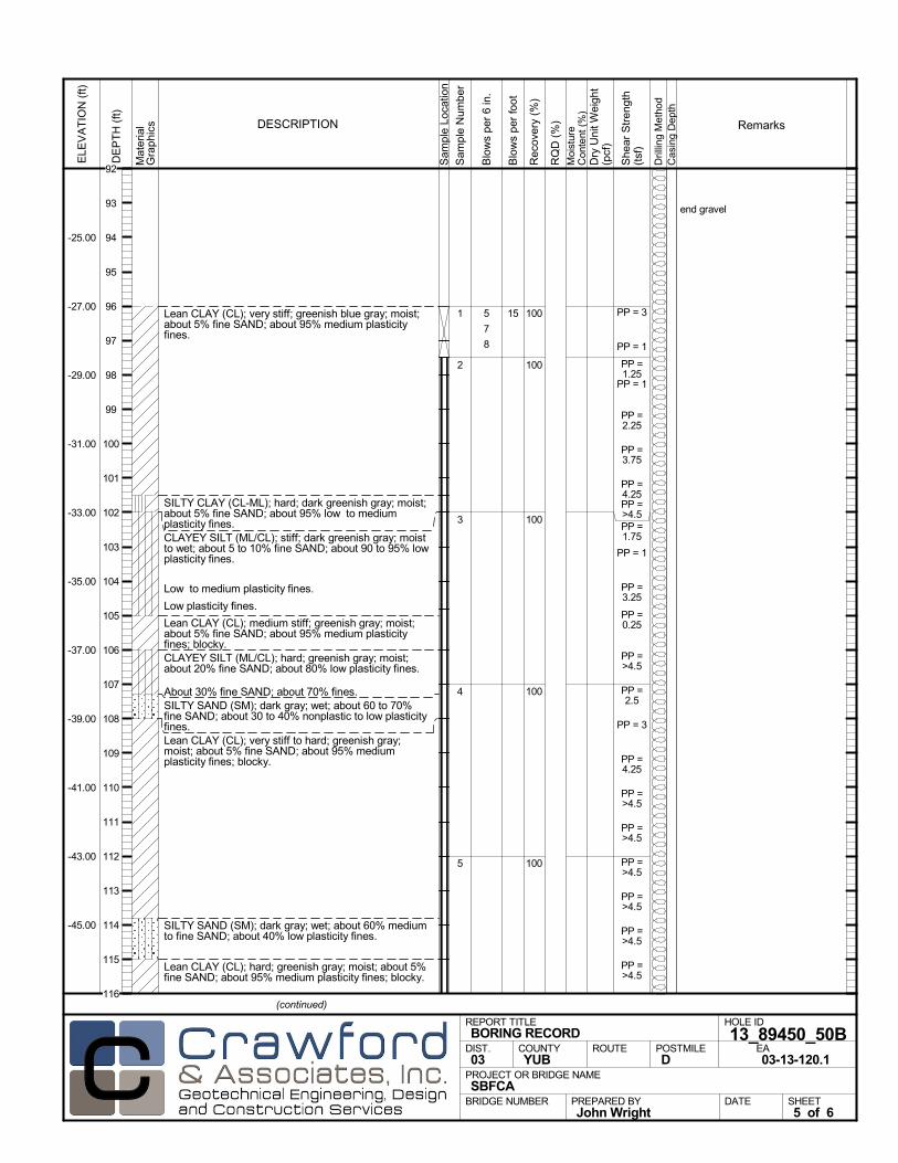
Lean CLAY (CL); very stiff; greenish blue gray; moist;about 5% fine SAND; about 95% medium plasticityfines.
SILTY CLAY (CL-ML); hard; dark greenish gray; moist;about 5% fine SAND; about 95% low to mediumplasticity fines.CLAYEY SILT (ML/CL); stiff; dark greenish gray; moistto wet; about 5 to 10% fine SAND; about 90 to 95% lowplasticity fines.
Low to medium plasticity fines.
Low plasticity fines.
Lean CLAY (CL); medium stiff; greenish gray; moist;about 5% fine SAND; about 95% medium plasticityfines; blocky.CLAYEY SILT (ML/CL); hard; greenish gray; moist;about 20% fine SAND; about 80% low plasticity fines.
About 30% fine SAND; about 70% fines.SILTY SAND (SM); dark gray; wet; about 60 to 70%fine SAND; about 30 to 40% nonplastic to low plasticityfines.Lean CLAY (CL); very stiff to hard; greenish gray;moist; about 5% fine SAND; about 95% mediumplasticity fines; blocky.
SILTY SAND (SM); dark gray; wet; about 60% mediumto fine SAND; about 40% low plasticity fines.
Lean CLAY (CL); hard; greenish gray; moist; about 5%fine SAND; about 95% medium plasticity fines; blocky.
100
100
100
100
100
1
2
3
4
5
end gravel
5
7
8
PP = 3
PP = 1
PP =1.25
PP = 1
PP =2.25
PP =3.75
PP =4.25PP =>4.5PP =1.75
PP = 1
PP =3.25
PP =0.25
PP =>4.5
PP =2.5
PP = 3
PP =4.25
PP =>4.5
PP =>4.5
PP =>4.5
PP =>4.5
PP =>4.5
PP =>4.5
Mat
eria
lG
rap
hics
Sam
ple
Loca
tion
COUNTYYUB
DESCRIPTION
Rec
over
y (%
)
Dril
ling
Met
hod
Cas
ing
Dep
th
PREPARED BYJohn Wright
DATE
PROJECT OR BRIDGE NAMESBFCA
BRIDGE NUMBER
HOLE ID
13_89450_50BEA03-13-120.1
REPORT TITLEBORING RECORD
DIST.03
ROUTE POSTMILED
(continued)
SHEET5 of 6
RQ
D (
%)
Sam
ple
Num
ber
Moi
stur
eC
onte
nt (
%)
Remarks
Blo
ws
per
6 in
.
ELE
VA
TIO
N (
ft)
-25.00
-27.00
-29.00
-31.00
-33.00
-35.00
-37.00
-39.00
-41.00
-43.00
-45.00
DE
PT
H (
ft)
Dry
Uni
t Wei
ght
(pcf
)
She
ar S
tren
gth
(tsf
)
Blo
ws
per
foot
15
92
93
94
95
96
97
98
99
100
101
102
103
104
105
106
107
108
109
110
111
112
113
114
115
116

Lean CLAY (CL) (continued).
Bottom of borehole at 117.0 ft bgs
FINAL LOG:The lines designating the interface between soil typesare approximate. The transition between soil types maybe abrupt or gradual. Our final logs represent ourinterpretation of the field logs and general knowledge ofthe site and geological conditions.
1005 PP =>4.5PP =>4.5
Mat
eria
lG
rap
hics
Sam
ple
Loca
tion
COUNTYYUB
DESCRIPTION
Rec
over
y (%
)
Dril
ling
Met
hod
Cas
ing
Dep
th
PREPARED BYJohn Wright
DATE
PROJECT OR BRIDGE NAMESBFCA
BRIDGE NUMBER
HOLE ID
13_89450_50BEA03-13-120.1
REPORT TITLEBORING RECORD
DIST.03
ROUTE POSTMILED
SHEET6 of 6
RQ
D (
%)
Sam
ple
Num
ber
Moi
stur
eC
onte
nt (
%)
Remarks
Blo
ws
per
6 in
.
ELE
VA
TIO
N (
ft)
-49.00
-51.00
-53.00
-55.00
-57.00
-59.00
-61.00
-63.00
-65.00
-67.00
-69.00
DE
PT
H (
ft)
Dry
Uni
t Wei
ght
(pcf
)
She
ar S
tren
gth
(tsf
)
Blo
ws
per
foot
116
117
118
119
120
121
122
123
124
125
126
127
128
129
130
131
132
133
134
135
136
137
138
139
140
Related Documents