Black Sea ECOOP system G.K. KOROTAEV MARINE HYDROPHYSICAL INSTITUTE SEVASTOPOL, UKRAINE

Black Sea ECOOP system G.K. KOROTAEV MARINE HYDROPHYSICAL INSTITUTE SEVASTOPOL, UKRAINE.
Dec 18, 2015
Welcome message from author
This document is posted to help you gain knowledge. Please leave a comment to let me know what you think about it! Share it to your friends and learn new things together.
Transcript

Black Sea ECOOP system
G.K. KOROTAEVMARINE HYDROPHYSICAL
INSTITUTESEVASTOPOL, UKRAINE

T5.6 - Regional Black Sea integrated systemKorotaev Gennady (MHI) - IMS-METU, IO-BAS, MHI, NIMRDObjectives: to build the baseline integrated Black Sea GOOS system made up of a regional and 3 coastal systems: the North Western shelf system, the Bosphorus and Western shelf system and the South coast of Crimea and North East Black sea system, enhance this integrated system by upgrading individual parts of it and provide connections to EuroMISS and demonstration in a target perational period TOP.S5.6.1 - Regional system capacity and TOP experimentKorotaev Gennady (MHI) - IMS-METU, MHIObjectives: Integrate the Black Sea regional system to the ECOOP environmentS5.6.2 - Downscaling and upgrades of targeted demonstration coastal areas (North Western shelf system)Nicolaev Simion (NIMRD) - MHI, NIMRDObjectives: Integrate the Black Sea N-W shelf sub-system to the ECOOP environmentS5.6.3 - Downscaling and upgrades of targeted demonstration coastal areas (Bosphorus and Western shelf system)Temel Oguz (IMS-METU) - IMS-METU, IO-BASObjectives: Integrate the Black Sea Bosphorus and Western shelf sub-system to the ECOOP environmentS5.6.4 - Downscaling and upgrades of targeted demonstration coastal areas (South coast of Crimea, North East Black Sea)Korotaev Gennady (MHI) - MHIObjectives: Integrate the South coast of Crimea, N-E Black sea sub-system to the ECOOP Environment

TECHNOLOGICAL REALIZATIONOF THE SYSTEM
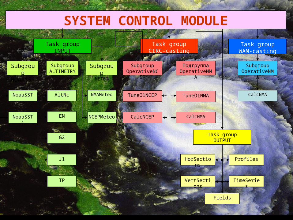
SYSTEM CONTROL MODULE
SubgroupALTIMETR
Y
Subgroup
NOAASST
Subgroup
METEO
AltNc
Task groupINPUT
NoaaSST
NoaaSSTC
NMAMeteo
NCEPMeteo
Task groupWAM-casting
Task groupCIRC-casting
CalcNMA
SubgroupOperativeNM
A
EN
G2
J1
TP
SubgroupOperativeNC
EP
CalcNCEP
TuneO1NCEP
ПодгруппаOperativeNM
A
TuneO1NMA
CalcNMA
HorSections
VertSections
Profiles
TimeSeries
Task groupOUTPUT
Fields

NStep=NStep+1 Temperature & salinity calculation
NOAA-satellite SST assimilation
Advective & diffusive terms of thecurrent velocities calculation
Sea level, current velocities horisontalcomponents & energy calculations
NStep=NStepF
Atmospheric heat and water fluxes
NOAA-satellite SST
Wind stress
S T O P
Calculations results output Temperature, salinity, velocity and sea level
Management datainput
Model parameters and climatic data input
Current velocity vertical componentcalculation
Altimetric data assimilation Satellite altimetry
Model initialization
CIRCULATION MODEL FLOW CHART

METEODATA SUBSYSTEM FLOW CHART
Wind speed according toNCEP reanalysis data
Wind stress calculation
Data interpolation onmodel horizontal grid
Wind speed according toQuikSCAT-satellite
Meteorological data according to NMA & MHI
nowcasting/forecasting
Instantaneous fluxes calculations
Data units conversions
Climatic heat & waterfluxes
Wind stress
Heat & water fluxes
Data unpacking and formatconversion
Wind
velo
city
Hea
t & w
ater
flux
es
Data unpacking and formatconversion
Data unpacking and formatconversion

Anomaly errors
28 30 32 34 36 38 40 4240
41
42
43
44
45
46
47
48
Longitude (E)
Lat
itu
de
(N)
Anomally error points disposition
1
5
CoastDepth 200 m4<=Tm-Td<53<=Tm-Td<42<=Tm-Td<3-3<=Tm-Td<-2-4<=Tm-Td<-3-5<=Tm-Td<-4 Tm-Td<-5
VALIDATION OF THE SYSTEM PRODUCTS
-6 -4 -2 0 2 4 60
20
40
60
80
100
120
140
Sst difference (AVHRR-Buoy).
N
Sst difference. Dt= 1.0, Ntot= 470, mean= 0.06, std= 0.84
New assimilation =0.06, =0.84
Old assimilation =-0.04, =0.99

VALIDATION OF TEMPERATURE PROFILESVALIDATION OF TEMPERATURE PROFILES
COASTAL FORECASTING

ECOOP Meeting on
the Black Sea Coastal Forecasting SystemIstanbul
15-18 JulyGoals of the meeting:to describe the V0 of ECOOP coastal forecasting system;to arrange what will be the V1 system; to arrange how to develop the V1 systemwhat can be the validation data base for on-line and off-line validation of the Black Sea coastal system products

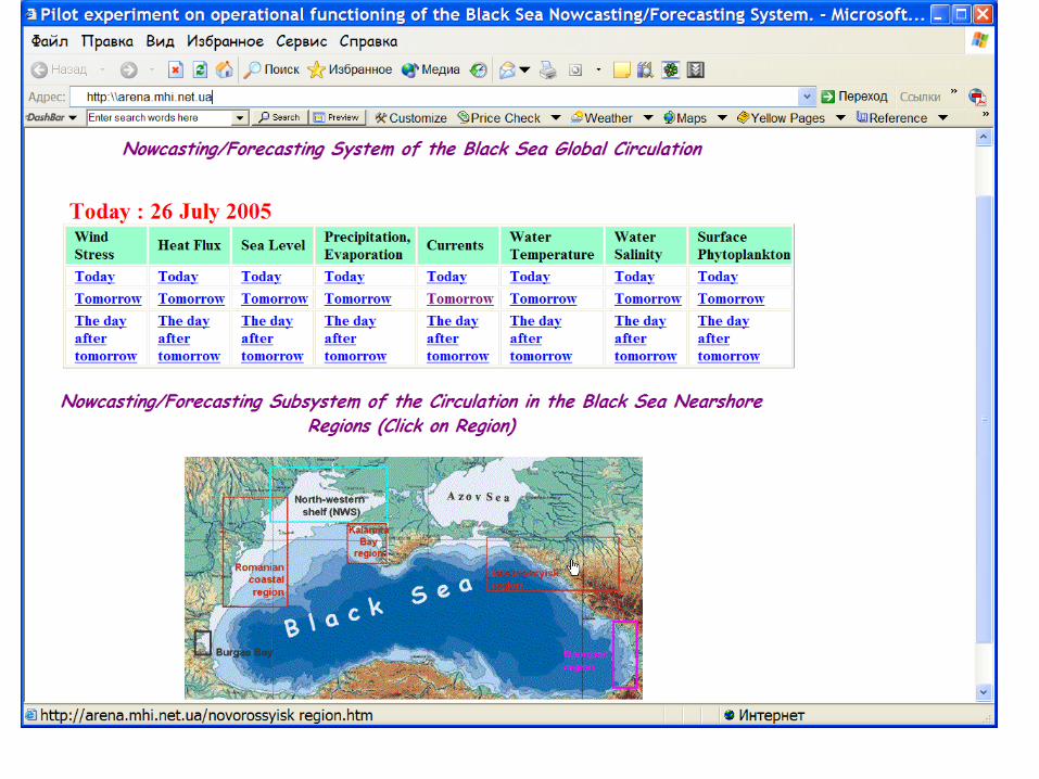
V0 coastal forecasting (near-operational)
Romaniancoastalregion
Kalamita Bayregion
Novorossyiskregion
Georgianregion
Burgas Bay
NWS
POM-model in σ-coordinates
Like POM-model in σ-coordinates
Bulgarian domestic model in z-coordinates
Georgian domestic model in z-coordinates
A z o v
S e a
Marmara Sea
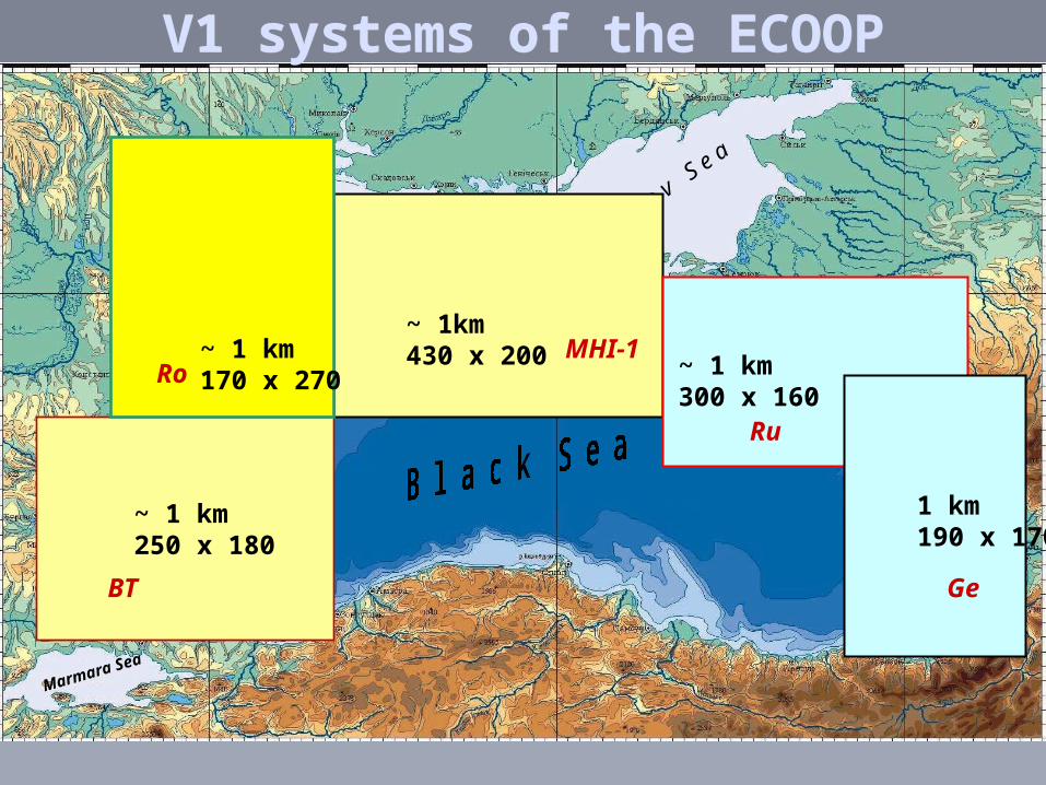
V1 systems of the ECOOPV1 systems of the ECOOP
Ro
BT Ge
Ru
MHI-1
~ 1 km250 x 180
~ 1 km170 x 270
~ 1 km300 x 160
~ 1km430 x 200
1 km190 x 170
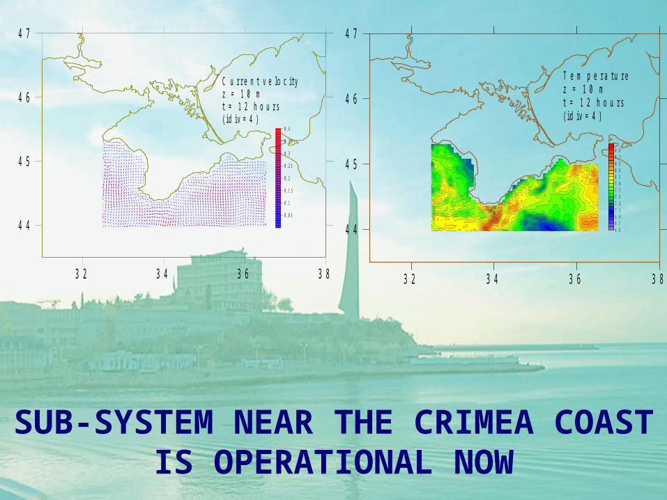
32 34 36 38
44
45
46
47
0.05
0.1
0.15
0.2
0.25
0.3
0.35
0.4
C urrent ve locityz = 10 mt = 12 hours(id iv=4)
32 34 36 38
44
45
46
47
6.56.76.97.17.37.57.77.98.18.38.58.78.9
Tem peraturez = 10 mt = 12 hours(id iv=4)
SUB-SYSTEM NEAR THE CRIMEA COAST IS OPERATIONAL NOW

Archive hydrography
Real time data
Bottom topography
Meteo
Space SST
Space altimetry
Parameter selection
Initialization
Basin-scale model Nested model
Basi-scale model
Visualisation
Nested model
Download of boundary conditions
Visualisation
1D ecomodel Visualisation
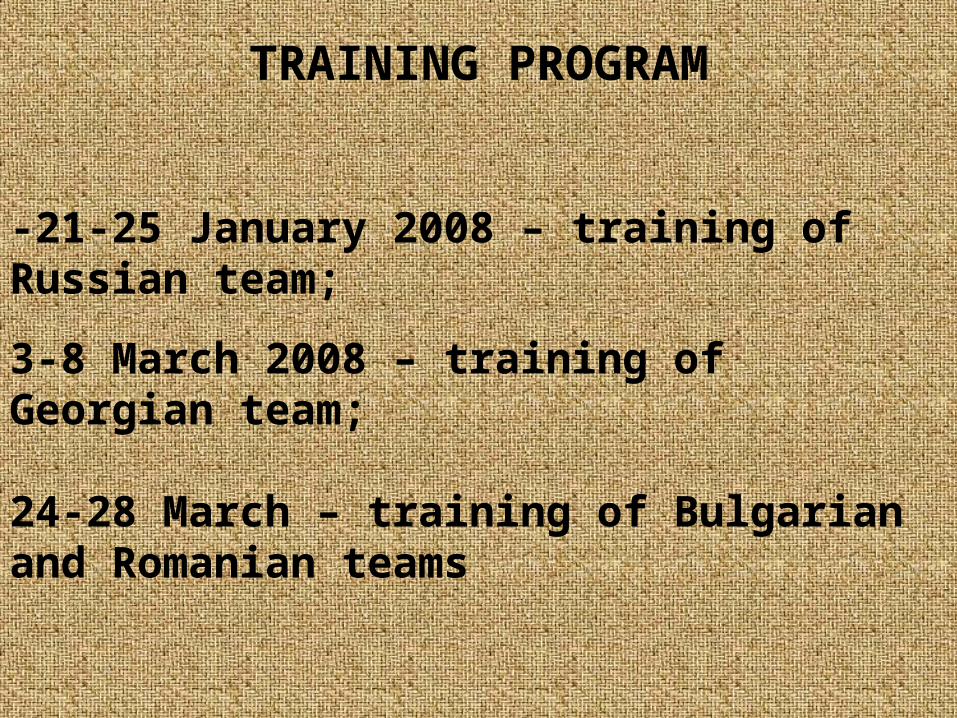
TRAINING PROGRAM
-21-25 January 2008 – training of Russian team;
3-8 March 2008 – training of Georgian team;
24-28 March – training of Bulgarian and Romanian teams

V1 SYSTEM
-OFF-LINE VALIDATION ACCORDING TO WP4 SCHEDULE
-OPERATIONAL AT THE BEGINNING OF TOP
-SIMPLE ON-LINE VALIDATION PROCEDURE
-DEMONSTRATION DURING SIX MONTH OF TOP
Related Documents


