Portland State University Portland State University PDXScholar PDXScholar Occasional Papers in Geography Geography 3-1-1971 Biogeography Field Guide to Cascade Mountains : Biogeography Field Guide to Cascade Mountains : Transect along U.S. Highway 26 in Oregon Transect along U.S. Highway 26 in Oregon Larry W. Price Portland State University Follow this and additional works at: https://pdxscholar.library.pdx.edu/geog_occasionalpaper Part of the Physical and Environmental Geography Commons Let us know how access to this document benefits you. Recommended Citation Recommended Citation Price, Larry W., "Biogeography Field Guide to Cascade Mountains : Transect along U.S. Highway 26 in Oregon" (1971). Occasional Papers in Geography No. 1. This Book is brought to you for free and open access. It has been accepted for inclusion in Occasional Papers in Geography by an authorized administrator of PDXScholar. Please contact us if we can make this document more accessible: [email protected].

Welcome message from author
This document is posted to help you gain knowledge. Please leave a comment to let me know what you think about it! Share it to your friends and learn new things together.
Transcript

Portland State University Portland State University
PDXScholar PDXScholar
Occasional Papers in Geography Geography
3-1-1971
Biogeography Field Guide to Cascade Mountains : Biogeography Field Guide to Cascade Mountains :
Transect along U.S. Highway 26 in Oregon Transect along U.S. Highway 26 in Oregon
Larry W. Price Portland State University
Follow this and additional works at: https://pdxscholar.library.pdx.edu/geog_occasionalpaper
Part of the Physical and Environmental Geography Commons
Let us know how access to this document benefits you.
Recommended Citation Recommended Citation Price, Larry W., "Biogeography Field Guide to Cascade Mountains : Transect along U.S. Highway 26 in Oregon" (1971). Occasional Papers in Geography No. 1.
This Book is brought to you for free and open access. It has been accepted for inclusion in Occasional Papers in Geography by an authorized administrator of PDXScholar. Please contact us if we can make this document more accessible: [email protected].

00 ~ CQI!er.tion ?SO Library ....

BIOGEOGRAPHY FIELD GUIDE TO CASCADE MOUNTAINS
Transect along U.S. Highway 26 in Oregon
by Larry W. Price
CONTENTS
I Introduction .... . ...... . ... . ......... . ...... p. 3
II Field Trip ........................ ... ... . ... p. 5
III Old Timberline Highway Loop ... . ... . .......... p. 17
IV New Timberline Highway ...................... p. 20
V Glossary ................................... p. 34
VI References Cited ............................ p. 36
,-- --'-"'

,
3
I INTRODUCTION
This guide is an outgrowth of field trips I have made with students in biogeography classes at Portland State University. When I first began these field trips I was surprised that such a guide was not available. It seemed such a natural thing to have, given the spectacular laboratory of the Cascades where is displayed one of the most dramatic sequences of contrasting environments on earth. Within less than 100 miles you pass from a cloudy marine climate to a semi-llrid continental climate, from a lush green land with towering trees to desert shrub.
The field trip is essentially from Portland to Maupin. Specifically it follows U. S. Highway 26 from Gresham to Government Camp, where it takes the loop road up to Timberline Lodge and back, then continues on U. S. 26 to the junction with State Highway 216 which cuts directly east to Maupin (Centerplate). This route is ideal for such a trip in that most of the major vegetation types of the Cascades are displayed along the way. In addition, the highway passes very near Mount Hood and affords an opportunity to observe the ecotone between treeline and a tundra-like environment. The major weakness of the route is that it does not run directly east-west so the rapidity of changing environments is reduced. Nevertheless, next to the Columbia River Gorge, this is the most heavily used pass in the Oregon Cascades, and it is hoped that more people will take advantage of the field trip as a result.
The basic approach of the field guide is tied to the zonal concept of vegetation, i.e ., climax zones, which are in part real and in part theoretical. As a result it is constantly necessary to rationalize what actually occurs as opposed to wha t theoretically should occur. Although this may sound confusing, it is a valuable approach because it aids in understanding the processes that give rise to vegetational patterns. For example, the first major timbered zone after leaving the Willamette Valley is considered to be the Western hemlock zone, but this area is largely dominated by the Douglas fir. The reasons why the Douglas fir dominates rather than the Western hemlock give insight into the processes that have resulted in this distribution. In most vegetation zones, however, the climax species does dominate, although the boundaries are never so sharp as shown on most maps (Fig. 1). The boundary between two vegetation types is usually a transition zone where interdigitation of spe'cies occurs. For example, between two vegetation zones the more mesic species may occur in the drier zone on moist sites, i.e., valleys, while the more xeric species may occur in the moist zone on drier sites, i.e., ridges.
Another fact that should be held firmly in mind is that we are dealing with an environment that has been greatly affected by man, particularly along a highway such as this. Admittedly the Pacific Northwest has not been altered to the extent of long-habitated regions like the Mediterranean or eastern China, but the vegetation has not completely escaped man's influence. Climax vegetation zones are based on "natural" vegetation but in reality the vegetation composition in a given area may be very "unnatural" due to logging, fires started by man, clearing, and construction.
In general, the climax vegetation zones in the Cascades run north-south with the orientation of the mountains (Fig. 1). They largely correspond to climatic differences (as controlled by altitude) but there are obviously a great many important local factors such as slope, drainage, and soil. Within the Western hemlock zone, for example, the species composition is often quite different between a north and south facing slope. A coarse purnic~ surface or an ash flow may support Lodgepole pine rather than the climax species, and a poorly drained lowland may support grasses and sedges rather than trees. Such situations are natural but are controlled by local conditions within the larger framework of climate.
Finally this guide is not meant to be a comprehensive listing of species or a detailed account of vegetation composition at any particular site. It is, rather, a guide whereby the major aspects of vegetation distribution across the Cascades are discussed. A glossary of technical terms is included and detailed accounts are mentioned where appropriate so the interested student. may follow up certain aspects. If unfamiliar with the trees and shrubs of Oregon, it is recommended that you purchase one of the several identification manuals available. Although the field guide was written primarily for classes in biogeography, it is hoped that students in botany and ecology, as well as other interested persons, will find it of value.

4
-
I am indebted to a great many people, both students and staff, for help and encouragement while writing this guide, but I would especially like to thank Mr. Jerry Marshall of Portland for introducing me to the area, and professors John E. Allen, Willert Rhynsburger, and Earl R. Rosenwinkel, Portland State University, for critically reading the manuscript.
The field guide is organized on the basis of mileage beginning at Gresham with individual distances between sites indicated. There are essentially four qualities of sites. The length of time required for each stop serves as a measure of its importance.
(1) Comment-Stop or drive slowly and observe in passing. (2) Brief stop-Leave car but for less than five minutes. (3) Stop-Leave car for 5-10 minutes. (4) MAJOR STOP-Plan at least 10 minutes or more. If you wish to make all stops, you should plan an entire day for the trip, so pack a lunch and wear
field gear including leather boots. Other recommended articles include: hunting knife, hand lens, camera, binoculars, and identification guides. If you have less than a day but still want to make the trip it is advised that you limit yourself to the MAJOR STOPS.
"
5·
II FIELD TRIP
The field trip begins at Gresham. Whatever route you take from Portland, you pass through an area greatly disturbed by man, but in your mind's eye you may reconstruct the past The nature of the original vegetation of the Willamette Valley is a controversial subject, but it is generally thought to have been grasslands interspersed with groves of the Oregon white oak (Quercus garryana) (Habeck 1961; Sprague and Hansen 1946). This is the most important oak in the Pacific Northwest and is largely restricted to the Willamette Valley and Puget Sound Lowlands. Like most oaks it prefers the drier sites, and with increasing precipitation in the foothills it is replaced with more mesic species (see Glossary for defmition of technical terms) such as Douglas fir (Pseudotsuga menziesii), or Western hemlock (Tsuga heterophylla).
0.0 At Gresham, set your odometer or check your speedometer at the major junction on the east edge of town. The elevation here is 350 feet and you are essentially out of the Willamette Valley and in the foothills. For the next several miles the highway passes through an agricultural area dominated by dairies, nurseries, and berry farms. The area's cool green appearance is reminiscent of Wisconsin (even the barn styles are Similar). It was originally forested, of course, and largely dominated by the Douglas fu (Pseudotsuga menZies;;) and Western hemlock (Tsuga heterophylla). Although much of the land is cultivated today, some of the valleys and poorly drained areas are still forested. Major species in these areas include the Red alder (Alnus rubra) , Bigleaf maple (Acer macrophyl/um), Black cottonwood (Populus trichocarpa), as well as conifers like the Western red cedar (Thuja plicata) and Western hemlock (Tsuga heterophylla). The higher hills on either side of the highway are largely forested, but they too have been disturbed since the turn of the century, as reflected by large areas of broadleaf deciduous species, Le., Bigleaf maple (Acer macrophyl/um) and Red alder (Alnus rubra), which are successional to conifers. Areas of broadleaf deciduous forests can easily be distinguished from conifers by their crown outline and foliage (a lighter green in summer and absent in winter).
An important fact to realize at the outset is that the Western hemlock (Tsuga heterophylla) is considered to be the climax species in the Cascade foothills region (Cooper 1957; Franklin and Dyrness 1969) (Fig. 1). By far the dominant tree, however, is the Douglas fir (Pseudotsuga menziesii), particular
. lyon the uplands. The Douglas fu (Pseudotsuga menziesii) cannot be considered the climax species since it will not reproduce in its own shade. The Western hemlock (Tsuga heterophylla) and Western red cedar (Thuja plicata) do well in the shade so in a Douglas fu forest you will invariably fmd that the saplings (which represent the future forest composition) are mainly Western hemlock (Tsuga heterophylla) and Western red cedar (Thuja plicata). Therefore, the very fact that the Douglas fir (Pseudotsuga menziesii) dominates large areas attests to frequent past disturbances such as fire, logging, and clearing (which allow sunlight to reach the ground and Douglas fu (Pseudotsuga menzies;;) to germinate). Many old growth stands of 400-600 years contain huge Douglas fu (Pseudotsuga menziesii) trees. Once these individuals die, however, they will be replaced by Western hemlock(Tsuga heterophylla)and Western red cedar (Thuja plicata) unless there is another fue or similar disturbance.
(0.8)
0.8 On the south side of the highway is a small second growth forest dominated by Red alder (Alnus rubra) with scattered Douglas fir (Pseudotsuga menzies;;) individuals. The average age of the Red alder (Alnus rubra) is 20-35 years while the Douglas fir (Pseudotsuga menzies;;) is 50-60 years old. It appears as if this area was clear cut and the present forest has resulted. Ample sunlight reaches the forest floor in places so that Douglas fir (Pseudotsuga menziesii) saplings are present and the understory vegetation is quite dense. It is. interesting to note that immediately to the west of the woods, a mobile home park is under construction (October, 1970). Until now the vegetation has always rebounded after disturbance, but this last wave of disturbance may well be irreversible.

~~~
0'\
Generalized Climax Vegetation Types of Oregon
o--D lid
--~ Li2J--D
Source: Fronklin, J.F. and c.r. Dyrneu, 1969. 'Vege'ation of Oregon and Wosf,ingfon; U.S.D.A. Foresf Service Reseorc" Paper, t"NW.80, pp. 38-39.
FORESTED REGIONS
Sitlta spruce Zone
West.rn hemlock lone
Mixed Conifer and Mixed Evergr•• n Zone-,
Interior Valley Zone
Pond.rola pine lone
Grondfir and Douglas fir lone,
Subalpine for.stl (including Pacific Iilve, fir, 'Subalpine fir , Sholto red fir, and Moutain hemlock) Zone,
STEPPE REGIONS
STEPPE (without shrubs)
SHRUB-STEPPE (Sagebrush dominated)
DESERT SHRUB
We.te,n Juniper Zone
TIMBERLINE AND ALPINE AREAS

7
1.4
6.5
(5.1) Stop
(0.6)
The road curves broadly to the left and then heads east. through a saddle between two hills (Fig. 2). These hills are small shield volcanos composed of Boring Lavas (personal communication, John E. Allen), capped with 25-50 feet of Portland Hills Silt (Lowry and Baldwin 1952, p. 10). The southern hill has a communications relay tower on it and is directly ahead as you enter the curve. Here you can see the assorted crowns of deciduous and coniferous trees with the latter being particularly apparent along the skyline where the sharper pinnacles stand above the rounded deciduous crowns (Fig. 2).
Fig. 2. Mile 1.4. These hills through which the highway passes east of Gresham are shield volcanos composed of Boring Lavas. The vegetation has been greatly disturbed as indicated by areas of broadleaf deciduous trees which are successional to conifers. You can see the sharper pinnacles of the conifers sticking above the rounded deciduous crowns on the skyline.
The road crosses two small timbered ridge~ separated by a valley ,_N ote the change in species composition from ridge to valley (Fig. 3). Douglas fir (Pseudotsuga menziesii) and Western hemlock (Thuja plicata) dominate the ridges while deciduous species, 'mainly Red alder (Alnus rubra) and Vine maple (Acer circinatum) dominate in the valley. Tills pattern occurs throughout the area and is usually due to local environmental differences although man's activities must also be taken into consideration. Stop on the eastern most of the two ridges and walk into the forest on the south (Fig. 3). These Douglas fir (Pseudotsuga menziesii) and Western hemlock (Tsuga heferophylla) trees average 40-60 feet in height, haye a d.b.h. of 12-20 inches, and average about 30 years in age. Everywhere about you are the large stumps of the former forest. Now walk downslope and watch the forest composition change. Tills lower area may have been Cleared more recently th'an the.. ridge. It is dominated by deciduo~s species, but Western hemlock (Tsuga heterophylla) saplings are abundant in the dense understory willch suggests that
Fig. 3. Mile 6.5. Observe the change in vegetation composition between ridge to valley. The valley is occupied by deciduous species of Red alder (Alnus rubra) , Black cottonwood (Populus trichocarpa), Vine maple and Bigleaf maple (Acer circinatum; A. macrophyllum) , while the ridges are occupied by coniferous species, largely Douglas fir (Pseudotsuga menziesii) and Western hemlock (Tsuga heterophylla). This is a characteristic pattern in the foothills region and is probably due to the valleys being more shaded and damp although man's past interference may also be important.
the now dominant Red alder (Alnus rubra) and Vine maple (Acer circinatum) will eventually be replaced by this conifer(Fig. 3).
(3.9)
The first major town you pass through after leaving Gresham is Sandy, which received its name from its proximity to the Sandy River (McArthur 1965, p. 533). Sandy was on the historic Barlow Road
10.4

8
across the Cascades (which U. S. 26 roughly follows up to Government Camp) and was established in the late 1850's. The town is now a service community for the surrounding area but the highway is still an important factor in its livelihood.
(2.4)
12.8 Brief stop
A valley with a lumber mill on the 'north 'side of the road and timbered area to the south. This is an excellent spot to observe vegetation growing in a shaded and poorly drained lowland situation. Park at
L/J}J the small road along the eastern edge of these woods and walk a few hundred feet into the woods. The m;f'-DV dominant tree is the Red alder (Alnus rubra), with abundant Vine maple (Acer circinatum) anc\ Bigleaf-y"V_r- . maple (A. macrophyllum). The Western red cedar (Thuja plicata) and Western hemlock (Tsuga hetero-Cf phylla) are important, and a few older Douglas fir (Pseudotsuga menziesii) are present. The understory is
dominated by the Bracken fern (Ptflridium aquilinum), Sword fern (Polystichum munitum), Thimbleberry (Rubus parvi/lorus), Salmonberry (R. spectabilis), Cascara (Rhamnus purshiana),Eiderberry (Sambucus spp.), and Huckleberries (Vaccinium spp.). When you return to the highway, notice the saplings lining the north side of the road. They are almost entirely Douglas fir (Pseudotsuga menziesii) and Red alder (Alnus rubra), both species that require high sunlight for germination.
(2.Q) 14.8 "interestingly, along this stretch of highway for the next three miles before descending into the Sandy
valley, the Western hemlock (Tsuga heterophylla) becomes much more prevalent. The reason for its increased importance is uncertain but the answer may lie in the fact that the dense understory and deciduous species did not allow enough light for Douglas fi.( (Pseudotsuga menziesii) seeds to germinate so the Western hemlock (Tsuga heterophylla) is succeeding directly without the usual intermediate step of Douglas fu (Pseudotsuga menziesii) as is often the case. The Western hemlock (Tsuga heterophylla) is easily distinguished from the Douglas fu (Pseudotsuoa menziesii) at a distance by its whip-like top, its upward-tilting straighter limbs, and its leaves that hang down like the fringes on the sleeve of a buckskin coat (Fig. 4).
Fig. 4. Mile 15.9. Young Western hemlock (Tsuga heterophylla) (in center) succeeding Red alder (Alnus robra). The Western hemlock (Tsuga heterophylla) is easy to distinguish from the Douglas fir (Pseudotsuga menziesii) by its whip-like top. its upwardtilting straighter limbs, and its leaves that hang down like fringes on the sleeve of a buckskin coat. The tree on the extreme left is a Douglas fir (Pseudotsuga menziesii).
P' S?'"'iJ
,i!~ORSTOP ..... l
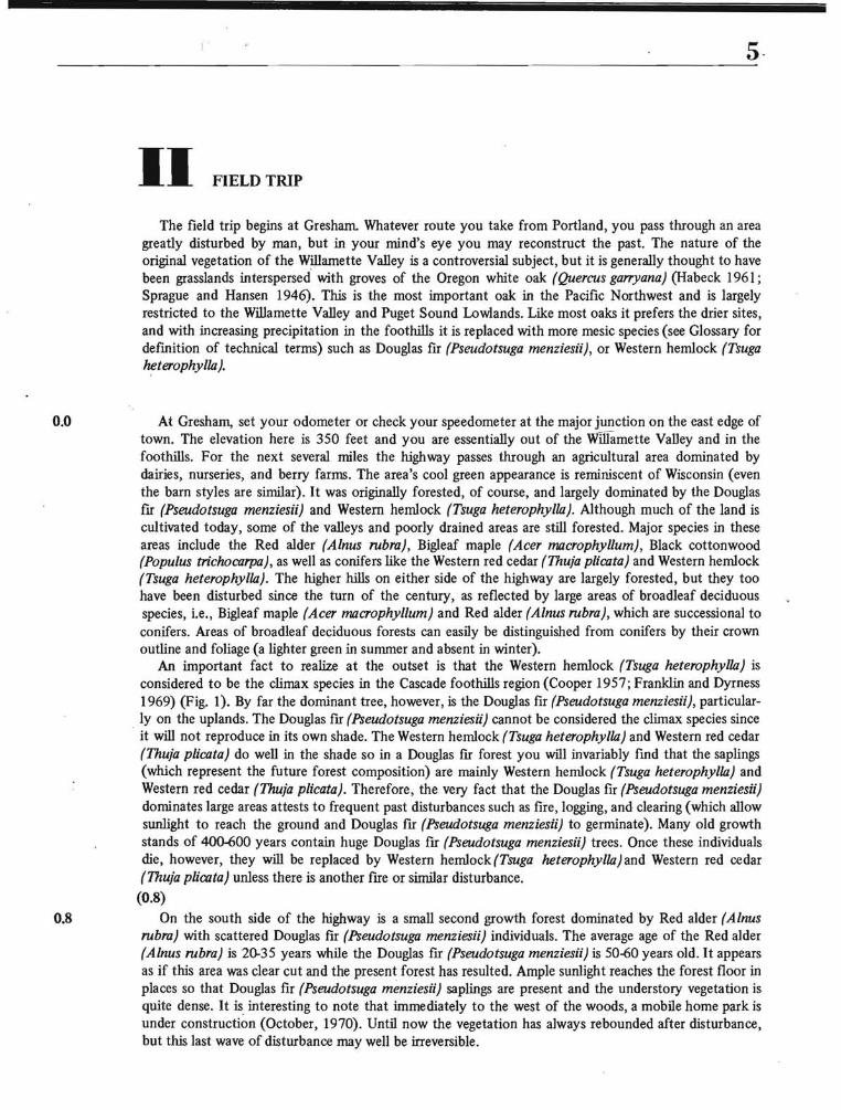
The road comes very close to the Sandy River at this point (Fig. 5). After crossing Wildcat Creek ~O ( (Centerplate), park and walk down to the river where several things may be observed.
(l) River bar succession. On the flood plain are small saplings of Black cottonwood (Populus trichocarpa), Red alder (Alnus rubra), and the alien but ubiquitous Scotch broom (Cytisus scoparius). The trees are 6-10 years old and have grown since 1964 when a major flood occurred on the Sandy and its channel was changed. Subsequently, levees were bulldozed along the channel to contain the river. The boulders on the flood plain are mainly composed of andesites and basalts transported from the slopes of Mount Hood by a Pleistocene glacier.
(2) A well displayed cross section of glacio-fluvial material can be seen in the cut-bank slope across the river. Observe the unsorted nature of the lower and larger boulder material as opposed to the stratified finer material near the top (Fig. 6). The unsorted material was probably deposited directly by
9
the ice while the stratified material was deposited by water. Notice the depth of organic material in the soil profIle (Fig. 6), which provides a gross indication of the age of the surface.
Upon returning to the road level, walk west to where the highway crosses Wildcat Creek. From this vantage point, looking north across the river, you can see two or three terraces reflecting former stream levels (Fig. 5). The glaCier that occupied the Sandy River valley extended several miles downstream from here but its exact extent has not been determined. There are many interesting geomorphic problems associated with this valley that would make excellent research topics!
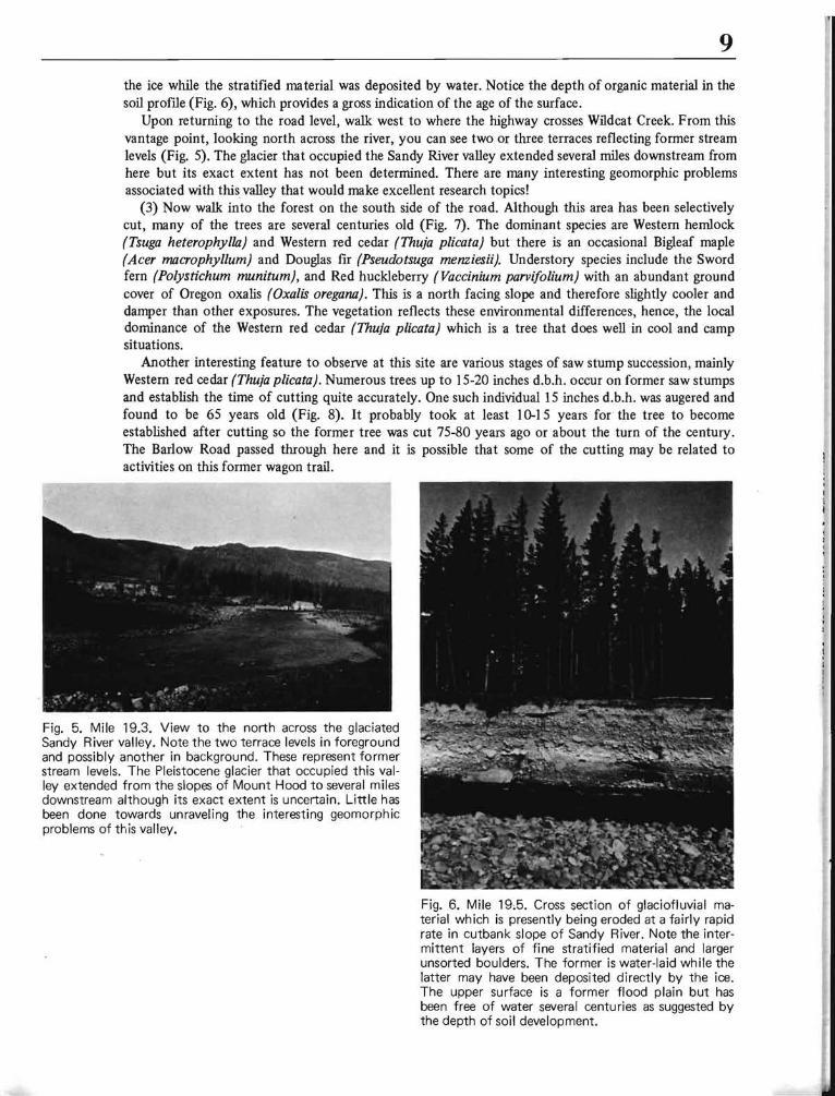
(3) Now walk into the forest on the south side of the road. Although this area has been selectively cut, many of the trees are several centuries old (Fig. 7). The dominant species are Western hemlock (Tsuga heterophylla) and Western red cedar (Thuja plicata) but there is an occasional Bigleaf maple (Acer macrophyl/um) and Douglas fir (Pseudotsuga menziesU). Understory species include the Sword fern (Polystichum munitum), and Red huckleberry (Vaccinium parvi[olium) with an abundant ground cover of Oregon oxalis (Oxalis oregana). This is a north facing slope and therefore slightly cooler and damper than other exposures. The vegetation reflects these environmental differences, hence, the local dominance of the Western red cedar (Thuja plicata) which is a tree that does well in cool and camp situations.
Another interesting feature to observe at this site are various stages of saw stump succe.ssion, mainly Western red cedar (Thuja plicata). Numerous trees up to 15-20 inches d.b.h. occur on former saw stumps and establish the time of cutting quite accurately. One such individual 15 inches d.b.h. was augered and found to be 65 years old (Fig. 8). It probably took at least 10-15 years for the tree to become established after cutting so the former tree was cut 75-80 years ago or about the turn of the century. The Barlow Road passed through here and it is possible that some of the cutting may be related to activities on this former wagon trail.
Fig. 5. Mile 19.3. View to the north across the glaciated Sandy River valley. Note the two terrace levels in foreground and possibly another in background. These represent former stream levels. The Pleistocene glacier that occupied this valley extended from the slopes of Mount Hood to several miles downstream although its exact extent is uncertain. Little has been done towards unraveling the interesting geomorphic problems of this valley.
Fig. 6. Mile 19,5. Cross section of glaciofluvial material which is presently being eroded at a fairly rapid rate in cutbank slope of Sandy River. Note the intermittent layers of fine stratified material and larger unsorted boulders. The former is water-laid while the latter may have been deposited directly by the ice. The upper surface is a former flood plain but has been free of water several centuries as suggested by the depth of soil development.

10
Fig. 7. Mile 19.5. Mature stand of Western red cedar (Thuja plicata) on cool and damp north-facing slope. Associated species are Western hemlock (Tsuga hererophylla) and an occasional large Douglas fir (Pseudotsuga menziesii).
Fig. 8. Mile 19.5. Example of saw stump succession. The Western red cedar (Thuja plicata) growing on saw stump is 65 years old. It probably took 10-15 years for germination so this provides a crude approximation for date of cutting. Interestingly,
(1.4) the tree on left that man is boring is also 65 years old.
20.9 Chapel of the Hills. The valley of the upper Sandy River is a glacier trough and you are now well into this feature (Van Atta 1963, p. 3). It is not a textbook example, but if you look carefully you will be able to see its U-shaped form
(1.7) 22.6 Bridge over Salmon River, which joins the Sandy River just a few hundred feet to the left (north).
(0.2)
22.8 Brightwood, a beautiful village nested in a riparian setting, so named, " ... because of the pleasing effect of the sun shining on the cottonwood trees in spring." (McArthur 1965, p. 70).
(2.0)
24.8 MAJOR STOP Tum right at the Wildwood Recreation Area sign. It is 0.8 miles back to the picnic area, an excellent
spot to observe forest succession taking place. Park and follow the first asphalt trail (about 200 yards) back to the Salmon River. You will notice many large stumps of the former Western hemlock (Tsuga heterophylla), Western red cedar (Thuja plicata), and Douglas fir (Pseudotsuga menziesii) forest. The vegetation about you is all second growth. The Red alder (Alnus rubra), Vine and Bigleaf maple (Acer circinatum; A. macrophyl/um) dominate, with a few medium sized Douglas fu (Pseudotsuga menziesii). The forest canopy is too thick to allow enough sunlight through for Douglas fir (Pseudotsuga menziesii) to reproduce, so the major conifer saplings are Western hemlock (Tsuga heterophylla), Western red cedar (Thuja plicata), and Grand fir (Abies grandis). These are the species of the future forest.
Of the present forest composition, the Red alder (Alnus rubra) with its whitish bark (which is really gray bark covered with light-colored lichens) is by far the dominant tree (Fig. 9). The Red alder (Alnus rubra) is the largest species of the genus, and the most important hardwood of the Pacific Northwest,

11 Fig. 9. Mile 26.2. The Red alder (Alnus rubra) is a major successional species after fire or other disturbance on the western side of the Cascades. The former forest here was cleared 40-50 years ago (note stumps) and the Red alder (Alnus rubra) was the first tree species to occupy the site. The conifer saplings now coming in-Western hemlock (Tsuga heterophylla) and Western red cedar (Thuja plicata)-will eventually replace the Red alder (Alnus rubra) since the alder only lives about 150 years and cannot reproduce in its own shade.
occurring along the coast from southeastern Alaska to central California (Fowells 1965, p. 83). It usually grows in damp and shaded sites (up to 2,500 feet elevation) and is an important successionary species (maximum age is about 150 years). Its litter decomposes rapidly, improving soil structure by adding humus content, and soil fertility is increased through symbiotic nitrogen fIxation by organisms contained in the root nodules. The mean annual accumulation rate for nitrogen in Red alder (Alnus rubra) plantings is about 35 pounds per acre (Franklin and others 1968).
When you reach the Salmon River, observe the thick lenses of unsorted boulders in the cliff across the stream This is the Rhododendron formation (Hodge 1938) consisting of basaltic breccias, tuffs, and flows (Fig. 10). It is of upper Miocene Age (I3-25 million years old) and is supposed to have been deposited as mud flows during an explosive phase of volcanism in the Cascade Range (Trimble 1963). Afterward followed a period of quieter volcanic activity during which the Cascade andesites and basalts were extruded. These overlie the Rhododendron formation at this site.
(1.6)
26.4 U. S. Highway 26. The road here is built on glacial till (Van Atta 1963, p. 3).
(1.4)
27.8 Wemme. This small town was named for E. Henry Wemme of Portland, who was instrumental in purchasing the Barlow Road for the State of Oregon. It was a toll road for many years until Wemme bought it in 1912 for $5 ,400 and eventually bequeathed it to the state (McArthur 1965, p. 642).
On the east side of Wemme to the south of the highway is a sign advertising "Good Hood Wood," where the forest has been selectively cut leaving scattered trees. The trees are small owing to competition and the foliage occurs only at the top due to self pruning, a natural process in closed stands (Fig. 11). Self pruning is of great economic importance to the forest industry since it gives rise to cIear-grained lumber with few knots. If a tree is allowed to grow in the open it will have continuous branches and leaves. You can often tell the relative age of highway cuts through timbered areas by the presence or absence of low branches.

--
12 Fig.l0. r--
Generalized Geologic Map of Study Area
o 10 20 Mil•• I
Alluvium Pliocene bOloltB iii Doll •• formation (Pllacene wat.rlaid
Non-marine Terrace deposita volcanic rockl)~ Rhododendron formation (Upper Miocene
PI.istocene and Recent and•• it. ande.ite and ba.altl!::::::I:r~:~ ::·::1 Pliocene and PI.I"acen. balolt Columbia River BOlolt (Lower Miocene)
Oligocene and Miacene I.dim.nlaryI Tmap I and pyroclastic rocks
Source: G~'ogic Mop of Oregon West of 12", Meric/ion, F.G. Wells ancl D.l. Ped, 1961.
(1.0)
28.8 Zigzag. The forest service has a district ranger station here in charge of the Mount Hood National Forest. They have several free maps and pamphlets for distribution and are always glad to answer questions.
(1.8)
30.6 Rhododendron, so named because of the local abundance of the Pacific rhododendron (Rhododendron macrophyllum). Rhododendron is a popular dormitory town for skiers and is probably destined to become more so.
(0.6)
31.2 Mter leaving Rhododendron the road passes through a tall and dense Douglas fir (Pseudotsuga menziesii) and Western red cedar (Thuja plicata) forest. Saplings coming in are Western red cedar (Thuja plicata) and Western hemlock (Tsuga heterophylla).

13
(0.6)
31.8 Stop
Fig. 11. Mile 27.S. An area of Douglas fi r (PseudOf};uga menziesii) that has been selectively cut, leaving the spindly indivi duals to mature. They will do much better now that competition for nutrients has been reduced. Note the absence of lower limbs due to self pruning in the former very close stand. This is a natural process which is of great value to the forest industry since it gives rise to clear-grained lumber.
At this point the vegetation abruptly changes composition to Lodgepole pine (Pinus contorta) (Fig. 12). You can easily identify the Lodgepole by its sparse and scraggly appearance compared to the Douglas fir (Pseudotsuga menziesii). Pines bear their needles in clusters rather than singly on the branch and the Lodgepole is the only two-needle pine native to Oregon. It should be mentioned, however, that two types of Lodgepole pine (Pinus contorta) grow in Oregon. One occurs along the coast (called the Coast pine-Pinus contorta) and is often deformed by strong winds, drifting sand, and salt spray. The mountain variety (Pinus contorta var. murryayana) is very similar, but grows much taller and straighter (peck 1961, p. 62). The Lodgepole pine (Pinus contorta) is usually a successional species and is often the rust to invade poor sites after disturbances. When you see it in the Cascades it invariably means poor
Fig. 12. Mile 33.7. Lodgepole pine (Pinus contorta) growing on a coarse and well drained debris flow three miles east of Rhododendron. The Lodgepole pine (Pinus contorta) is a successional species and is often the first tree to occupy disturbed or otherwise unfavorable sites in the Cascades.
edaphic conditions. At this site the Lodgepole pine (Pinus contorta) occurs on a recent volcanic debris flow which is very porous and well drained (Fig. 12). If you scrape the soil surface, you will see that the entire soil proflie is only 1-3 inches thick with nothing but volcanic ash below. Nevertheless, the Douglas fir (Pseudotsuga menziesii) and Western hemlock (Tsuga heterophylla) are now beginning to invade the area and will eventually replace the Lodgeple pine (Pinus contorta) since the latter needs sun to reproduce. Understory species about you include the Golden chinquapin (Castanopsis chrysophylla), Pacific

14 rhododendron (Rhododendron macrophyllum) , and Manzanita (Arctostaphylos spp.) all of which are broadleaf evergreen shrubs.
The forest floor in this Lodgepole pine (Pinus contorta) area is striking in that it is covered with an extensive blanket of mosses and lichens. Such a development is absent from the forest floor of other forest types nearby and the reasons for its pervasive development here are not clear. The answer may be as simple as lack of competition from other species or as complex as involving the chemical composition of the surface material. In any case it would be an interesting problem to investigate.
(0.4)
32.2 At the Zigzag River you pass from pure Lodgepole pine (Pinus contorta) into Douglas frr (Pseudotsuga menziesii) and Western hemlock (Tsuga heterophylla), although the Lodgepole continues intermittently. The reason for this change is probably due to better moisture-retaining ability of the soil, so that succession has gone on at a faster rate.
(1.1)
33.3 By this point you are once again in predominantly Lodgepole pine (Pinus contorta). The sporadic occurrence of this tree illustrates the importance of local differences in soil since climate is not a major factor on such a small scale.
(1.3) 34.6 Pinus contorta is important only to the edge of the debris flow at the base of Laurel Hill where it is
replaced by Douglas fir (Pseudotsuga menziesii) and Western hemlock (Tsuga heterophylla). The road becomes steeper and winding now as you leave the more settled areas projecting like a corridor into the Mount Hood National Forest along Highway 26 (Centerplate). (0.8)
35.4 Brief stop
There is a turn-out on the south side of the road here with a sign documenting the 1952 Zigzag Forest Fire. This is a U-shaped valley of a Pleistocene glacier and on the far side you can observe the fire's extent and how succession is taking place. The forest is essentially coming back directly into Douglas fir (Pseudotsuga menzies;;). The elevation of the valley floor is about 2,500 feet (Centerplate) and near the upper limits for the Red alder (Alnus rubra), but it is still an important successional species at this site. Note how it follows the outline of the alluvial cones up the slope where water relationships are better. The treeless strips running up the slope are areas of frequent snow avalanche. On the ridge above you can see at least two incipient glaCial cirques.
As you leave this site, 500 yards upslope on your left are two dikes about five feet wide in the rock wall (Fig. 13). A dike is caused by magma being forced into vertical cracks in the rock. Notice the horizontal colwnnar structure of the dikes indicating that cooling occurred inward from the two confIDing walls. The dikes are composed of basalt whereas the surrounding rock type is a fine-grained quartz diorite (personal communication, John E. Allen) (Fig. 13).
Fig. 13. Mile 35.6. Two basaltic dikes surrounded by fine-grained slightly metamorphosed quartzd i 0 r ite. These featu res were formed by molten magma being forced into vertical cracks in the rock. Note the horizontal columnar structure in dikes indicating that cooling occurred inward from the edges.

15 The Cascade Range in Oregon is divided into two major physiographic regions, the Western and High
Cascades (Fig. 14). You are still in the Western Cascades at this point but only about one mile from the High Cascades boundary. The old or Western Cascades consist of Tertiary lava flows , tuffs, and dioritic intrusions, while the young or High Cascades are composed of Pliocene and Pleistocene Lava flows (Baldwin 1964, p. 59) (Fig. 10). The major Cascade peaks such as Rainier, Hood, Jefferson, and Three Sisters, are in the High Cascade section, while the Western section is limited to maximum elevations of about 5,000 feet and there is a marked accordance of summits (Fig. 14). This has been interpreted as a peneplain surface (FeJUleman 1931, pp. 436441). You will be able to observe the apparent uniformity of the Western Cascade surface from Timberline Lodge (Fig. 21).
(1.0)
36.4 A well-developed talus slope occurs to the south of the highway here. The talus is formed from Mount Hood Andesite (Wise 1968, p. 83) which is part of the High Cascades (Fig. 10).
(0.2)
36.6 Laurel Hill historic marker. Looking north about 1/2 mile from this site you can see another talus slope (also in Mount Hood Andesite). The forest is encroaching and farthest inward is a zone of Vine maple (Acer circinatum), a sIuubby tree that often grows in rocky areas where others cannot grow.
Fig. 14. Idealized geologic cross section of Cascades (looking south).
DESCHUTES WlllAMEnE VAllEY
w
HIGH CASCADES WESTERN CASCADES
Source: Baldwin, Ewart M., 1974. Geology of Oregon, 2nd. ed. Edwards (0.9) Brothers, Inc.; Ann Arbor, Michigan p . 59
37.5 Stop
Mirror Lake Trail No. 664. Cross the small foot bridge over Camp Creek and follow this trail for 200-300 yards observing the species composition. You are now in the ecotone between the Western hemlock (Tsuga heterophylla) and Pacific silver fir (Abies amabilis) zones (Franklin and Dyrness 1969, pp. 68-73) (Fig. 1). As you walk along the trail you will see a variety of species including: Pacific silver fir (Abies amabilis), Douglas fir (Pseudotsuga menziesii), Western hemlock (Tsuga heterophylla), Noble fir (Abies procera), and Western red cedar (Thuja plicata).
(1.7)
39.2 MAJOR STOP Just before you reach Multorpor bridge which crosses Highway 26, stop at the alpine meadow on
your right (south) (Fig. 15). Note the yellowish drooping cedar on either side of the road. This is the Alaska yellow cedar (Chamaecyparis nootkatensis) (Fig. 16) which grows from the Kenai Peninsula southward to the Central Oregon Cascades. It is a coastal tree in Alaska but a high altitude tree in the Cascades and Mount Hood is near its southern limits (Fowells 1965, p. 147).
As you walk into the marshy meadow to the south of the highway, the brushy deciduous trees you first pass tIuough are Sitka alder (Alnus sinuata), which occur in the higher Cascades in wet and/or unstable sites (Fig. 15). Other trees you will notice in the meadow are Alaska yellow cedar Chamaecyparis nootkatensis}, Engelmann spruce (Picea engelmannii), Mountain hemlock (Tsuga mertensiana), Pacific silver fir (Abies amabi/is), and Lodgepole pine (Pinus contorta). Note that here the Lodgepole grows under conditions of excessive soil moisture whereas before it grew under conditions of excessive drainage.
After having walked in the meadow about 100 yards you might ask yourself, "Why isn't this area forested?" Although this is not a good example of a quaking bog (it doesn't really quake when you jump on it), it does provide a good example of hydrarch succession, where the water area is gradually being encroached upon by vegetation and soil (Fig. 15). This entire area is a former lake that has been slowly

16 filled due to natural successional processes. In these cases of succession, wet areas become drier through time (as is happening here) while dry areas become more moist (as is happening on the talus slope north of Laurel Hill historic marker). The principal reason for absence of trees is probably due to the excessive moisture, but as you can see a few seedlings are now beginning to come in along the forest margin (Fig. 15).
Fig. 15. Mile 39.2. Multorpor Meadow. This area was formerly a lake that has been slowly filled by siltation and hydrarch succession. It is still poorly drained, supporting mainly sedges and grasses although a few more tolerant shrubs and trees occur in slightly higher areas. Saplings are now beginning to invade along the edge of the meadow and with time, as the site becomes drier, the entire area will be forested.
39.8 (0.6) Turn off to Government Camp. This resort town is of historic interest since its name dates back to
the days of the Barlow Trail when in 1849 a government wagon train enroute from The Dalles to Oregon City was stranded here by an early snowfall (McArthur 1964, p. 267).
40.2 (0.4) Junction with Timberline Lodge highway (Fig. 17 and Centerplate). If you are making the trip in
summer take the fust road to the left after turning off U. S. 26 and follow the section of the guidebook labeled "Old Timberline highway loop trip." If you are making the trip from late fall to early summer the old highway will probably be snowed in so follow the "New Timberline Highway Trip." You will have to readjust for the differences in mileage.
Fig. 16. Mile 39.2. The Alaska yellow cedar (Chamaecyparis nootkatensis) (in foreground) occurring in a poorly drained situation along U. S. 26 at Multorpor Meadow. Associated species include Western hemlock (Tsuga he terophylla) , Mountain hemlock (T. metensiana) , and Pacific silver fir (Abies amabilis).

17
40.7
42.5
44.4
45.6
46.1
46.6
III OLD TIMBERLINE HIGHWAY LOOP (SUMMER ONLY)
(0.5)
A large area of Lodgepole pine (Pinus contorta) occurs here, probably due to the coarse and well-drained substratum formed by a debris flow originating from Crater Rock near the summit of Mount Hood about 2,000 years ago (Wise 1968, p. 83 and 85). Other species occur sporadically, however, and you should particularly notice the Mountain ash (Sorb us spp.) with its red berries in the fall. It is one of the only deciduous tree species growing at this altitude (4,600 feet) on Mount Hood.
(1.8)
At this point you pass from Lodgepole pine (Pinus contorta) into a mixed community of Pacific silver fir (Abies amabilis), Noble fir (A. procera), Sub-alpine fir (A. lasiocarpa), Mountain hemlock (Tsuga mertensiana), Lodgepole pine (Pinus contorta), and Mountain ash (Sorbus spp.). Understory vegetation consists of Common beargrass (Xerophyllum teTUlX), Bracken fern (Pteridium aquilinum), and Huckleberries (Vacdnium spp.) . Note that the huckleberries are more abundant and better developed in the areas where true frrs occur as opposed to areas of Lodgepole pine (Pinus contorta). The reason, of course, is due to better moisture retaining ability of the soil in the former.
(1.9)
The road passes through a mature stand of Mountain hemlock (Tsuga mertensiana), Pacific silver fir (Abies amabilis), and Subalpine fir (Abies lasiocarpa). All of these species are represented by saplings in the understory, so it is difficult to say which will ultimately dominate. It will probably be the Mountain hemlock (Tsuga mertensiana), however, since this member becomes increasingly dominant here with elevation.
(1.2)
Just before you get to the Phlox Point Campground sign, the Whitebark pine (Pinus albicaulis) makes its appearance along the road, particularly in the more exposed sites. This is one of the treeline forming species in the Cascades growing only at the highest elevations.
(0.5)
Timberline Highway.
(0.5)
Timberline Lodge (turn to discussion under mile 45.9 in "New Timberline Highway". On your return to Highway 26 you should follow the new section in reverse.


20
IV NEW TIMBERLINE HIGHWAY
(0.4)
40.2 Brief stop Junction with Highway 26 (elevation 3,980 feet) (Fig. 17 and Centerplate). You are still in the Pacific
silver fir zone here (Franklin and Dyrness 1969, pp. 68-73), although the area is ecotonal, with many 'species occurring including the Pacific silver fir (Abies amabilis), Noble fir (A. procera), Western hemlock (Tsuga heterophylla), Mountain hemlock (T. mertensiana), Western red cedar (Thuja pUcata), Alaska yellow cedar (Chamaecyparis nootkatensis) , Lodgepole pine (Pinus contorta), Western white pine (P. monticola), and Englemann spruce (Picea englemannii) (Fig. 17). The understory is composed of Huckleberries (Vaccinium spp.) and Common beargrass (Xerophyllum tenax).
(0.8)
41.0 There is a small waterfall here where Still Creek crosses the highway. The road cut is damp and shaded through much of the year and the major species are Sitka alder (Alnus sinuata) and Alaska yellow cedar (Chamaecyparis nootkatensis), both of which can withstand high moisture content and instability (Fig. 18).
(0.6)
41.6 Second growth timber in the Subalpine Forest Zone (Fig. 1). The older trees are Mountain hemlock (Tsuga mertensiana) and Pacific silver fir (Abies amabilis) (Fig. 19). The saplings beyond the road cut are mainly Pacific silver fir (Abies amabiUs) while those in the cleared area near the road are largely Mountain hemlock (Tsuga mertensiana) (Fig. 19) (a similar development is discussed further at mile (43.5)
Fig. 17. Junction of U. S. 26 and Timberline road. This is in the Pacific silver zone (Abies amabi/is), but many species occur (see discussion for Mile 40.2).
(0.4)
42.0 Brief stop There is a turn-out here on the right side of the road. The elevation is 4,800 feet and several species
occur, perhaps more than you would normally expect, but once an area is cleared (as it has been along the road) it is open to adventitious species. Nevertheless, this is near the upper limits for many of them. See how many species you can find. There are at least the following : Mountain hemlock (Tsuga mertensiana), Pacific silver fir (Abies amabilis), Subalpine fir (A. Iasiocarpa), Noble fir (A. procera), Western white pine (Pinus monticola), Lodgepole pine (Pinus contorta), and Douglas fir (Pseudotsuga menziesii).
21
43.1
Fig. 18. Mile 41.0. Damp and Fig. 19. Mile 41.6. Second growth timber shaded road cut along Tim- in the Subalpine Forest Zone along Timberline road supports Sitka al- berline highway. The larger trees are der (Alnus sinuata) and Alas- mainly Mountain hemlock (Tsuga ka red cedar (Chamaecyparis mertensiana) but the center tree is Pacific nootkatensis). These species silver fir (Abies amabi/is) as are most of often occupy wet and un- the saplings (see discussion). stable sites in the high Cascades.
(1.1) Geologic contact zone in road cut on right (Fig. 20). Tills is an andesite flow overlying an unbedded
breccia (Wise 1968, pp. 84 and 90) and illustrates how a composite volcanic cone like Mount Hood is built up by successive flows (Fig. 20). The elevation here is 5,000 feet and near the extreme upper limits for the Douglas fir (Pseudotsuga menziesii) but there are several seedlings in the cleared area on the opposite side of the highway where ample sUnlight reaches the surface.
(0.4)
Fig. 20. Mile 43.1. Geologic contact zone on Mount Hood with an andesite flow overlying an unbedded breccia. Such featu res nicely illustrate how composite cones are built up from successive lava and debris flows.
43.5 Stop
Here is a good stand of mature Mountain hemlock (Tsuga mertensiana) and Pacific silver fIr (Abies amabilis). Walk into the timber on the left side of the road and note the saplings. They are almost entirely PacifIc silver fir (Abies amabilis). Now walk into the timber on the right side of the road. Notice that along the road cut there are abundant Mountain hemlock (Tsuga mertensiana) saplings, but as you walk into the woods the saplings become almost entirely PacifIc silver fIr (Abies amabi/is). What does tills tell you about the ecology of these two species in this environment? Apparently, it indicates that the Mountain hemlock (Tsuga mertensiana) needs higher light conditions for germination than the PacifIc silver fir (Abies amabilis). This fact may be very important to the future forest composition.

22
(0.8)
44.3 There is a large expos~d road cut on the left side of the road consisting of unsorted material with an occasional huge boulder. This is probably part of an andesite debris flow which originated at Crater Rock on the southwest side of the summit (Wise 1968, pp. 82-83).
(1.6)
45.9 Stop
Timberline Lodge is located on the south slope of Mount Hood at an elevation of 6,000 feet, essentially at "timberline." The lodge was built by the Works Progress Administration in 1935 and was officially dedicated in 1937 by President Franklin D. Roosevelt. It is built entirely of native Oregon materials and is quite an impressive structure. Three genera) themes were used throughout: pioneer motifs, Indian motifs, and the use of local plant and wild life. Since this was a make-work project, many different hand crafts were utilized in decorating the structure and the result is a pleasing array of artwork on a rustic theme. It is certainly worthwhile visiting this interesting building if you have not been here before.
Before leaving the lodge, take advantage of this excellent place to observe the Western and High Cascades (Fig. 14). To the south-southwest are the older Western Cascades with their accordant summits (Fig. 21), while to the south are Mount Jefferson and the Three Sisters, which together with Mount Hood and other major peaks in the range, form the younger High Cascades (Fig. 14).
(0.4)
46.3 MAJOR STOP
Park on the downslope (S. E.) side of the parking lot farthest away from the lodge and walk up on the small ridge there. You are very near treeline and the species consist principally of Subalpine fir (Abies /asiocarpa), Mountain hemlock (Tsuga mertensiana), and Whitebark pine (Pinus albicau/is) (Fig. 22). These are the species that dominate the highest timbered areas in the Cascades. Generally, Mountain hemlock (Tsuga mertensiana) prefers the western side where there is more precipitation, while the Subalpine fir (Abies lasiocarpa) is better developed on the leeward side of the Cascade crest (Franklin and Dyrness 1969, p. 73). Although all of these species form the treeline and may occur sporadically as individuals or in small clumps above the area of solid timber, the Whitebark pine (Pinus albicau/is) often goes the highest (Fig. 23). This species cannot migrate by itself since its seeds are wingless; its chief method of dissemination is through the Clark's Nutcracker (Nucifraga columbiana), which eats its seeds. This large jay-like bird caches some of the seeds for future use but invariably forgets a few hoards and these may eventually germinate and grow into trees. Therefore, the relationship is a useful one for both species (Franklin and Dymess 1969, p. 165).
Fig. 21. Mile 45.9. View to the south-southwest from Timberline Lodge of the Western (older) Cas· cades. Note the accordance of summits which has been interpreted as a peneplain surface. Mount Jefferson is immediately to the left of the picture and represents the beginning of the younger High Cascades, as does Mount Hood itself.

23 Fig. 22. Mile 46.3. The three major treeline forming species of the Oregon Cascades. From left to right: Mountain hemlock (Tsuga mertensiana) , Subalpine fir (Abies lasiocarpa) and Whitebark pine (Pinus albicaulis).
Fig. 23. The Whitebark pine (Pinus albicaulis) often grows higher than any other tree in the High Cascades. Here it is stunted and deformed into krummholz by the extreme wind, snow, and cold.
Looking up at the mountain from where you stand you can observe the form and pattern of the local treeline. Note how the trees are best developed on the ridges rather than valleys, and how they become increasingly stunted and deformed into krummholz with elevation until they disappear altogether. Treeline is a major ecological zone and reasons accounting for its occurrence are not clearly understood. Obviously, temperature is a major factor but other considerations such as wind, snow accumulation, and instability of the surface, to name but a few, are also important. The reason trees go higher up the ridges , however, is probably due to greater snow accumulation in the valleys resulting in a shorter growing season there which inhibits germination.
It may be interesting at this point to consider treeline for the entire Cascades. Treeline does not occur throughout most of the Cascades south of Mount Rainier since only seven or eight major peaks provide enough elevation for its occurrence. In general the level of treeline decreases with increasing latitude. Daubenmire (1954, p. 132) observed that treeline on the average decreases about 400 feet for every degree of latitude under a given climatic regime. This holds fairly true for the major Cascade peaks as shown by the following listing:
Treeline Latitude
Mount Baker 4,600 feet 48° 45' Mount Rainier 5,200 feet 47° 10' Mount Hood 5,500 feet 45° 20' Three Sisters 6,500 feet 44° 10'
(Franklin and Dyrness 1969, p. 163) An exception is Mount St. Helens (Latitude 46° 15') which has a remarkably low treeline (about4,400 feet) but this is probably more due to the recency of its last eruptions (less than 2,000 years ago), and the extreme instability and porosity of the coarse pumice surface, than to climatic factors (Lawrence 1938).
Treeline also varies with exposure. For example in the Cascades, trees occur higher on south facing slopes than north facing slopes and they go much higher on the eastern side of the range than on the west due to dominance of the maritime climate on the west (Franklin and Dyrness 1969, pp. 162-163).
NOTE: If you drove up the old timberline highway, please turn to Mile 44.3 on the new timberline highway section and follow it in reverse order to U. S. 26.
(5.2)
51.5 Junction with U. S. 26.
(1.2)
52.7 As you come around the bend (at Trillium Lake Junction sign), there is an abrupt break into
24
Fig. 24. Mile 55.4. An abrupt break from Lodgepole pine (Pinus contorta) to Western hemlock (Tsuga heterophylla) and Douglas fir (Pseudotsuga menzies;;) forest. The Lodgepole pine (Pinus contorta) is confined to a poorly drained area.
Lodgepole pine (Pinus contorta), particularly on the south side of the road. From the car this may look like a large stand of Lodgepole but in reality it is a thin corridor along the highway where the forest has been cleared, providing enough sunlight for the Lodgepole pine (Pinus contorta) to germinate. One of the larger trees (6 inches d.b.h.) was cored and found to be only 29 years old. The forest composition beyond 100 feet from the road is very similar to that at Timberline junction.
(0.5)
53.2 As you enter this curve to the left (east), there is a good stand of Lodgepole pine (Pinus contorta) on your right extending about 100 yards back from the road. This, too, is a relatively young stand as revealed by one of the larger trees cored (11 inches d.b.h. and only 39 years old). Pine saplings are not represented on the forest floor due to low light conditions; saplings are largely Western red cedar (Thuja plicata) and Western hemlock (Tsuga heterophylla). The understory consists ofHuckleberries (Vaccinium spp.) and Conunon beargrass (Xerophyllum tenax). For the next 0.5 mile to the junction with State Highway 35, Pinus contorta occurs in a thin band along the road where clearing has taken place. (0.5)
53.7 Brief stop Junction with State Highway 35 (elevation 3,620 feet) (Centerplate). To the right (south) of the
highway is an area of Lodgepole pine (Pinus contorta) 40-60 years old (13 inches d.b.h.) with a fairly advanced level of succession taking place. Saplings are abundant with Western hemlock (Tsuga heterophylla) dominating although many others are important, e.g., Pacific silver fir (Abies amabilis), Subalpine fir (A. lasiocarpa), and an occasional Noble fir (A. procera). Other species include the Western red cedar (Thuja plicata), Engelmann spruce (Picea engelmannii), and Mountain hemlock (Tsuga mertensiana). Although Lodgepole pine (Pinus contorta) seedlings are absent in the forest, they are plentiful in the cleared area adjacent to the road where the sun reaches the ground.
There are some suggestions that the presence of this 40-60 year old stand of Lodge pole (Pinus contorta) may be due to poorly drained conditions (Fig. 24). Note for example, the major trees in the triangUlar center divide. This area has been severely thinned, but is nevertheless dominated by Western hemlock (Tsuga heterophylla) except for a few Lodgepole pine (Pinus contorta) in the western corner_ Beyond the highway to the northwest the forest is composed largely of Western hemlock (Tsuga heterophylla) with other associated species, including a few large Douglas fir (Pseudotsuga menziesii). This area appears to be somewhat higher and better drained, a fact that may account for the local differences in forest composition (Fig. 24). (0.9)
54.6 The Salmon River Meadows begin on your right (Fig. 25). There is not much room to park along the road, so just pull over and observe from the car. This poorly drained bog extends for over 10 miles in a broad valley flat where the Salmon River wanders slowly due to the low gradient. The meadow is largely treeless with a few willows (Salix spp.), Alders (Alnus spp,), and isolated conifers, e.g., Pacific silver fir (Abies amabilis), Engelmann spruce (Picea engelmannii), Western red cedar (Thuja plicata), and Lodgepole pine (Pinus contorta), all of which can live under conditions of poor drainage (Fig. 25). There are several large standing dead trees in the swamp. The cause of death is uncertain but a good guess would be a recent rise in the water table. This could be due to natural causes, e.g., short term climatic fluctuation or a beaver dam downstream, or to man-made causes such as road construction.
i!!!!!
25
(0.3)
54.9 Brief stop
Fig. 25. Mile 54.7. The Salmon River Meadows occur in this poorly drained valley flat for over 10 miles along the river. As you can see, the meadow is largely treeless except for the Sitka alder (Alnus sinuata) and an occasional conifer individual that can stand poor drainage.
If you feel adventuresome you might walk out into the swampy area here. You will pass through a low swampy area, then onto a ridge, beyond which is the stream. It appears as if the stream has changed channels, formerly occupying the first swampy area you pass through. Notice that trees are well developed on the small ridge where adequate drainage is provided. (0.8)
55.7 The road passes through the meadow. Observe the community of Western red cedar (Thuja plicata) along the edge of the meadow on the left (east).
(l.5) 57.2 At mile post 61, the dominant species is the Douglas fir (Pseudotsuga menziesii), but others occur
such as Lodgepole pine (Pinus contona), Western hemlock (Tsuga heterophylla), and Noble fir (A. procera). Understory species consist of the Pacific rhododendron (Rhododendron macrophyllum), and the Bracken fern (Pteridium aguilinum).
(0.5)
57.7 As soon as you come around the bend to the left you first start seeing the Western larch (Larix occidentalis) (also known as Tamarack) (Fig. 26). This tree occurs only in the Pacific Northwest and is the only deciduous conifer in Oregon (the Subalpine larch-Larix lyallii-occurs in the Northern Cascades). The larch is easy to recognize by its new coat of needles every spring which present a fresh green color in contrast to the darker green of the surrounding conifers, and in the fall its needles turn golden and drop to the ground (Fig. 26). Upon closer inspection the Western larch (Larix occidentalis) has
Fig. 26. Mile 66.6. The lightcolored trees are the Western larch (Larix occidentalis) , a deciduous conifer which occurs only in the Pacific Northwest, chiefly on the eastern side of the Cascades. This photo was taken in late fall when the leaves had turned golden and were beginning to drop.

26 star-like clusters of very delicate needles giving it a slightly oriental appearance. In Oregon the Western larch (Larix occidentalis) grows on the eastern slopes of the Cascades and in the Wallowa and Blue Mountains. It occurs in areas of lower precipitation (18-20 inches) (Fig. 27), but prefers valley bottoms and north facing slopes (Fowells 1965, p. 235).
Fig. 27.
Oregon Average Annual Precipitation (in inches)
1930 - 1957
o 10 20 30 Mil•• I iii Source, Isohyet map, Soil Conservation
Service, U.5.DA, July, 1964.
(0.6)
58.3 MAJOR STOP
Stop at the Frog Lake Campground sign and walk into the forest on your right (west). This is a mature forest dominated by Western hemlock (Tsuga heterophylla) with scattered Douglas fir (Pseudotsuga menziesii) and Pacific silver fir (Abies amabilis) (Fig. 28). Understory species consist of Huckleberries (Vaccinium spp.) and Pacific rhododendron (Rhododendron macrophyl/um). Even though the forest is predominately Western hemlock (Tsuga heterophylla), however, there are very few Western hemlock seedlings. Most of the saplings are Pacific silver frr (Abies amabi/is) and they occur in large and very dense clumps (Fig. 29). As a result they are stagnated and growing very slowly since they are all competing for limited nutrients. You may be surprised to discover that the average age of these saplings 3-5 feet high and 1/2 to one inch in diameter at the base is 40-50 years (Fig. 30)! Nevertheless it appears that the Pacific silver frr (Abies amabilis) will eventually replace the Western hemlock (Tsuga heterophylla) at this site.
Both the Western hemlock (Tsuga heterophylla) and Pacific silver frr (Abies amabi/is) are shade tolerant, but at the upper limits of their distribution the hemlock seedlings are apparently less able to survive winter snow accumulations than are the fir seedlings (Thornburgh 1969, in Franklin and Dyrness 1968,p. 71). Why the present old growth forest should be predominately Western hemlock (Tsuga heterophylla) poses an interesting question (the answer may involve short term climatic fluctuations). At the lower altitudinallirnits of their distribution these relationships are reversed and the Western hemlock (Tsuga heterophylla) will replace the Pacific silver fir (Abies amabi/is). This fact is nicely illustrated by the vegetation composition at the next two sites.

27 (1.3)
59.6 Brief stop
Pull off to the right on Forest Service Road S478. The same basic pattern exists at this site as that just described. The dominant canopy tree is Western hemlock (Tsuga heterophylla), but at the sapling level the Pacific silver fir (Abies amabilis) dominates. In a clearing along the road a clump of Pacific silver fu (Abies amabilis) saplings have grown 10-20 feet high and 1-3 inches in diameter. The larger of these is
Fig. 28. Mile 58.3. Mature Western hemlock (Tsuga heterophylla) forest with occasional Pacific silver fir (Abies amabilis) and Douglas fir (Pseudot:>uga menzies;;). Understory species include Huckleberries (Vaccinium spp.) and the Pacific rhododendron (Rhododendron macrophyllum).
Fig. 29. Mile 58.3. Pacific silver fir (Abies amabilis) saplings coming up under a canopy of mature Western hemlock (Tsuga heterophylla). Curiously, there are very few hemlock seedlings present, wh ich suggests that the Pacific silver fir (Abies amabilis) will eventually replace the Western hemlock (Tsuga heterophylla) at this site. The fir saplings in photo are growing very slowly, however, due to severe competition for nutrients. You may be surprised to learn that they are 40-50 years old!
Fig. 30. Cross section of a Pacific silver fir (Abies amabilis) sapling, one inch in diameter at the base and four feet high, found growing in a dense clump of fir saplings (Fig. 29). This individual is 49 years old as revealed by the growth rings.

28 only 20-30 years old, however. The reason for their much greater size than the saplings at the previous site is probably due to increased exposure to sunlight. (0.2)
59.8 Sunnnit-Blue Box Pass. (elevation 4,024 feet). There are several old-age Douglas fIr (Pseudotsuga menziesii) here as well as Western hemlock (Tsuga heterophylla), Western white pine (Pinus nwnticola), and PacifIc silver fIr (Abies amabilis).
(1.1)
60.9 Stop
Just past the road to the Clear Lake Campground, stop at the wide turn-out on the right (southwest). In the short distance (2.6 miles) from Frog Lake Campground sign, you have passed from an area dominated by Pacillc silver fIr (Abies amabilis) sapling growth to an area where Western hemlock (Tsuga heterophylla) forest will indeed be replaced by its own kind. Walk into the forest and observe the saplings. They are almost purely Western hemlock (Tsuga heterophylla).
As mentioned, the reason for the difference in sapling dominance between the Frog Lake area and this site may be due to contrasting snow accumulation. This may be explained by Frog Lake's higher elevation (4,000 feet) and location between Wapinitia and Blue Box passes (Centerplate). The Clear Lake stop is slightly in the lee of these features and 500 feet lower. Although this could account for a difference in snow accumulation (if indeed this is acritical factor), it is nevertheless conjecture. Here is an inviting ecological research project for some conscientious student.
Associated understory species at this site are Oregon Grape (Berberis aquilfolium), Golden chinquapin (Castanopsis chrysophylla) and Common beargrass (Xerophyllum tenox). Be sure to note the three Western larch (Larix occidentalis) directly across the highway to the east before leaving.
(6.6) 67.5 Stop
Junction with State Highway 216 (elevation 3,460 feet). Stop car on right (southwest) where road divides for junction and walk into the forest. You are now in the Grand fIr (Abies grandis) zone (Franklin and Dyrness 1969, pp. 129-133) (Fig. 1). The Grand fIr (also known as Lowland fIr) is the only true fIr in Oregon which grows naturally below 1,500 feet but in this area it is best developed between 3,000-3,500 feet. It is easy to identify by its needles, which are arranged in two flattened horizontal rows. The Grand fif (Abies grandis) seldom forms solid stands, but occurs in association with other trees such as the Douglas fif (Pseudotsuga menziesii), Western hemlock (Tsuga heterophylla), Ponderosa pine (Pinus ponderosa), and Western larch (Larix occidentalis). At this particular site Douglas fIr (Pseudotsuga menziesii) and Western hemlock (Tsuga heterophylla) occur in association with the Grand fif (Abies grandis) (Fig. 31). Understory species include the Golden chinquapin (Castanopsis chrysophylla), Bracken fern (Pteridium aquilinum), and Oregon grape (Berberis aquilfolium).
Fig. 31. Junction of Oregon 216 and U. S. 26 (elevation 3,460 feet) (Centerplatel. near the upper limits of the Grand fir (Abies grandis) zone. The large tree at left is Douglas fir (Pseudotsuga menziesii). the one in middle is Grand fir (Abies grandis) and the smaller tree on right is Western hemlock (Tsuga heterophylla). Most of the saplings are Grand fir (Abies grandis).
29
68.4
70.3
(0.9) The fIrst signifIcant occurrence of Ponderosa pine (Pinus ponderosa) along the highway can be noted
here (Fig. 33). This tree (formerly called Western yellow pine) is easily identified by its long needles in clusters of three and its reddish, polygonally-patterned bark. You are still in the Grand fIr (Abies grandis) zone but the Ponderosa pine (Pinus ponderosa) becomes more prevalent with decreasing elevation and precipitation for the next few miles (Fig. 27). In this vicinity, according to Franklin and Dyrness (1969, p. 127) the sequence of forest zones passes from Grand fIr (Abies grandis) through a conjectural Douglas fIr (Pseudotsuga menziesiij zone to Ponderosa pine (Pinus ponderosa) (Fig. 1). The Douglas fIr (Pseudotsuga menziesiij zone on the eastern side of the Cascades is much better developed in Washington and British Columbia than in Oregon. Although it is an important associated tree with the Grand fIr (Abies grandis) and Ponderosa pine (Pinus ponderosa) in this area, its climax status here is questionable.
(1.9)
Brief stop
On the south side of the highway is a small area of Quaking aspen (Populus tremu/oides) (Fig. 32). This tree gets its name from its leaves which quake or tremble with the slightest breeze. The Quaking aspen (Populus tremu/Oides) is the most widely-spread tree species in North America, occurring from coast to coast and from Mexico to Alaska (Fowells 1965, pp. 523-524). It is important as a successionary species after fIre or other disturbances. In the Pacillc Northwest, Populus tremu/oides is much more prevalent east of the Cascades than to the west, although it prefers the moister sites in this drier climate. Here it occurs in a poorly drained area and associated species are the Black cottonwood (Populus trichocarpa), and White alder (Alnus rhombi/olia). The major conifer nearby is Douglas fIr (Pseudotsuga menziesii), but Grand fIr (Abies grandis) and Ponderosa pine (Pinus ponderosa) are also important (Fig. 32).
Fig. 32. Mile 70.3. A small area of Quaking aspen (Populus tremuloides) occurring in a poorly drained stream valley on the eastern side of Cascades. Surrounding conifers are Ponderosa pine (Pinus ponderosa). Douglas fir (Pseudotsuga menziesii), and Grand fir (Abies grandis).
MAJOR STOP
Tum off on Bear Springs Campground road and stop. Now look back across the highway to the north and you will see a small area of Ponderosa pine (Pinus ponderosa). The Ponderosa pine (Pinus ponderosa) is the most-widely distributed pine in North America and occurs from the Rockies to the Pacillc Ocean and from Mexico to British Columbia (Fowells 1965, pp. 417-418). It grows best under conditions of high sunlight and low rainfall (lO-30 inches) (Figs. 1 and 27), and as such is the most important timber tree in eastern Oregon. Unfortunately, Ponderosa pine (Pinus ponderosa) is not as well developed in this area as it is a few miles farther south (Fig. 1). Nevertheless, you can get a general idea about the appearance of such a forest. For example, the trees are usually widely spaced and the undergrowth is sparse (Fig. 33). The reasons for wide spacing are several-fold: (l) the seeds need high light conditions to germinate; (2) in a dry climate the roots need space for extensive development, and (3) fue is, or at least
(1.3)
71.6
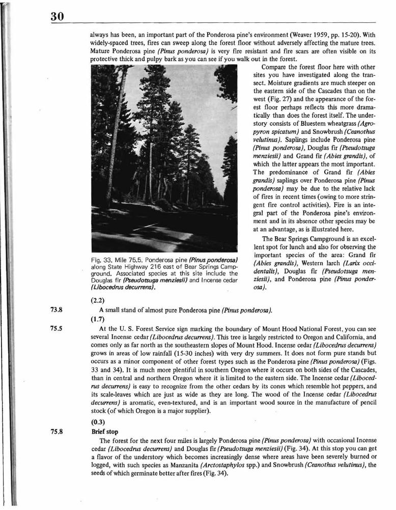
30 always has been, an important part of the Ponderosa pine's environment (Weaver 1959, pp. 15-20). With widely-spaced trees, fIres can sweep along the forest floor without adversely affecting the mature trees. Mature Ponderosa pine (Pinus ponderosa) is very fIre resistant and fIre scars are often visible on its protective thick and pulpy bark as you can see if you walk out in the forest.
----- ---:--Ir_ Compare the forest floor here with other sites you have investigated along the transect. Moisture gradients are much steeper on the eastern side of the Cascades than on the west (Fig. 27) and the appearance of the for
;/ est floor perhaps reflects this more dramatically than does the forest itself. The understory consists of Bluestem wheatgrass (Agropyron spicatum) and Snowbrush (Ceanothus velutinus). Saplings include Ponderosa pine (Pinus ponderosa), Douglas fIr (Pseudotsuga menzies;;) and Grand fIr (Abies grandis), of which the latter appears the most important. The predominance of Grand fIr (Abies grandis) saplings over Ponderosa pine (Pinus ponderosa) may be due to the relative lack of fIres in recent times (owing to more stringent fIre control activities). Fire is an integral part of the Ponderosa pine's environment and in its absence other species may be at an advantage, as is illustrated here.
The Bear Springs Campground is an excellent spot for lunch and also for observing the important species of the area: Grand fIr
Fig. 33. Mile 75.5. Ponderosa pine (Pinus ponderosa) (Abies grandis), Western larch (Larix occialong State Highway 216 east of Bear Springs Campden talis) , Douglas fIr (Pseudotsuga menground. Associated species at this site include the
Douglas fir (Pseudotsuga menzies;;) and Incense cedar zies;;), and Ponderosa pine (Pinus ponder(Libocedrus decurrens). osa).
(2.2)
73.8 A small stand of almost pure Ponderosa pine (Pinus ponderosa).
(1.7)
75.5 At the U. S. Forest Service sign marking the boundary of Mount Hood National Forest, you can see several Incense cedar (Libocedrus decu"ens). This tree is largely restricted to Oregon and California, and comes only as far north as the southeastern slopes of Mount Hood. Incense cedar (Libocedrus decu"ens) grows in areas of low rainfall (15-30 inches) with very dry summers. It does not form pure stands but occurs as a minor component of other forest types such as the Ponderosa pine (Pinus ponderosa) (Figs. 33 and 34). It is much more plentiful in southern Oregon where it occurs on both sides of the Cascades, than in central and northern Oregon where it is limited to the eastern side. The Incense cedar (Libocedrus decu"ens) is easy to recognize from the other cedars by its cones which resemble hot peppers, and its scale-leaves which are just as wide as they are long. The wood of the Incense cedar (Libocedrus decurrens) is aromatic, even-textured, and is an important wood source in the manufacture of pencil stock (of which Oregon is a major supplier).
(0.3)
75.8 Brief stop The forest for the next four miles is largely Ponderosa pine (Pinus ponderosa) with occasional Incense
cedar (Libocedrus decurrens) and Douglas fIr (Pseudotsuga menzies;;) (Fig. 34). At this stop you can get a flavor of the understory which becomes increasingly dense where areas have been severely burned or logged, with such species as Manzanita (Arctostaphylos spp.) and Snowbrush (Ceanothus velutinus), the seeds of which germinate better after fIres (Fig. 34).

31
(3.8)
Fig. 34. Mile 78.9. Several small Incense cedar (Libocedrus decurrens) are in center of photo, with Ponderosa pine (Pinus ponderosa) saplings to the left and larger Douglas fir (Pseudotsuga menziesii) behind and to the right. Understory species are mainly Manzanita (Arctostaphylos sPP.) and Snowbrush (Ceanothus velutinus). This is near the eastern edge of the Cascades and precipitation is about 15 inches per year. The Deschutes-Umatilla Plateau surface can be seen in the distance beyond the road.
79.6 Look eastward into the distance as you are driving and you can see the plateau surface ahead (Fig. 34). Precipitation is only about 15 inches per year (Fig. 27) and trees soon disappear, being replaced by steppe vegetation. Just as you enter the bend of the road here (to the southeast) the Oregon white oak (Quercus garryana) begins rather suddenly. This oak reaches its highest development in the Willamette Valley and the Puget Sound Lowlands and is largely limited to these areas. At some time in the past, however, probably during a more favorable (pluvial) climatic period, it migrated to the eastern side of the Cascades through the Columbia Gorge. Its present distribution on the eastern side of the Cascades extends 40-50 miles north and south of the Columbia River in a thin band at the foot of the Cascades. On the south, for example, it goes no farther than the Warm Springs Indian Reservation. Although the Oregon whiteoak (Quercus garryana) may reach huge sizes in the Willamette Valley, it is usually a small tree east of the Cascades (Fig. 35). As you might expect in this drier climate, it is best developed in valleys and on north facing slopes.
At the base of the Cascades (which end abruptly here) is the village of Pine Grove. You are now on the Deschutes-Umatilla Plateau at an elevation of about 2,200 feet (Centerplate). This landform is part of the Columbia Plateau, formed by basaltic lava flows of Pliocene Age (1-13 million years ago) (Fig. 10).
(1.1)
80.7 Public telephone booth on left (north) side of road in Pine Grove. Notice the development of Oregon white oak (Quercus garryana) on the ridge forming the backdrop for this hamlet (Fig. 35).
The relatively level area ahead of you is called Juniper Flats. The Western juniper (Juniperus occidenta/is) for which it was named, has largely been cleared for agricultural purposes. This area is irrigated by water from Clear Lake (Stop 60.9), a man-made lake in the Cascades. On some of the ridges that have not been irrigated, however, the juniper still remains (Fig. 37). The Western juniper (Juniperus occidenta/is) is the most xeric of the tree-dominated zones in the Pacific Northwest and serves as an ecotone between Ponderosa pine (Pinus ponderosa) and shrub-steppe vegetation (Franklin and Dyrness 1969, pp.
Fig. 35. Mile 80.5. Oregon white oak (Quercus garryana) occurring with Ponderosa pine (Pinus ponderosa) (sharper crowns) in the village of Pine Grove. The Oregon white oak (Quercus garryana) normally occurs in the Willamette Valley but at some time in the past it migrated through the Columbia Gorge to the eastern side of the Cascades where it now occurs in a thin band 40-50 miles north and south of the Columbia River.

32
81.8
105-110) (Fig. 1). It grows in areas receiving only 10-15 inches of precipitation (Fig. 27), much of which comes in winter; summers are almost completely dry. (1.1)
There are small mounds 10-30 feet across and 1-3 feet high on either side of the road here just before you reach the farmhouse on the right (south) (Fig. 36). These peculiar looking mounds with rocky areas in between occur sporadically for over 1,000 square miles throughout the Columbia Plateau. Their origin has been the source of much debate and is still a controversial subject. There are more and better developed mounds ahead where they will be discussed in greater detail (Fig. 37).
Fig. 36. Mile 81.8. Small mounds such as these cover many areas on the Columbia Plateau and their origin is very controversial. The mounds are composed largely of silt while the intermound areas consist of angular basaltic blocks. This area is now a pasture but the natural vegetation was Western juniper (Juniperus occidentalis). Sagebrush (Artemisia tridentata) and Bu nchgrass (Agropyron spicatum).
Notice the old abandoned barns and farmsteads along the road. Such features are characteristic tluoughout much of central Oregon. They are remnants of the original settlement under the Homestead Aci where people were alloted only 160 acres. It was with bitter disappointment and suffering that the settlers discovered they could not make a living on so little land under such marginal environmental conditions.
(1.4)
83.2 Wapinitia Junction. Wapinitia is a Warm Springs Indian word meaning "near the edge of something" (McArthur 1965, p. 634). The country store at the junction is surprisingly well stocked and one of the few places where you can still see old style pumps where gasoline is pumped by hand into a glass container overhead.
(0.4)
83.6 MAJOR STOP
Several things may be seen at this site. The vegetation is a grass-shrub-tree community with the Western juniper (Juniperus occidentalis) occurring at widely spaced intervals (Fig. 37). The shrub community is dominated by Bitterbrush (Purshia tridentata) and Rabbitbrush (Chrysothamnus nauseosus; C. viscidij1orus). Surprisingly, Sagebrush (Artemisia tridentata) is not important. The reason for its absence is probably due to fire since it is easily killed and does not sprout from its roots, while Bitterbrush and Rabbitbrush can regenerate from subterranean organs (Franklin and Dyrness 1969, p. 146). The Western juniper (Juniperus occidentalis) is usually so widely spaced that ground flIes do not affect it seriously.
Two native grasses are important in this vegetation type: Bluebunch wheatgrass (Agropyron spicatum) and Idaho fescue (Festuca idahoensis). These are perennial bunchgrasses that are nutritious but cannot withstand heavy grazing since they grow from their bases rather than from their shoots as most sodgrasses do. The area has been heavily grazed, however, since the introduction of cattle in the 1850's, and much of the former luxuriant native grasses have been destroyed.
As a result of both fires and heavy grazing, Cheatgrass (Bromus tectorum), an introduced species from Eurasia, has invaded much of the steppe in Oregon as well as the entire Great Basin, and is now a major dominant. Although this grass has been considered a pest, it provides a good ground cover and has prevented substantial erosion (personal communication, Will A. Rockie). Cheatgrass (Bromus tectorum) germinates in the fall and while green provides good food, but after drying up in early summer, its awns irritate and cause sores in animal mouths.
Perhaps the most striking thing about this site is the mounds that occur everywhere about you.

33 Fig. 37. Mile 83.6. Shrub-juniper community dominated by the Western juniper (Juniperus occidentalis) , Rabbitbrush (Chrysothamnus nauseosus; C. visidiflorus) (the lighter colored shrub in ri ght foreground). Bitterbrush (Purshia tridentata) (darker colored shrub in left foreground), as well as Bluebunch wheatgrass (Agropyron spicatum) and Cheatgrass (Bromus tectorum). This is an area of well developed mounds (as discussed in text) and the Juniper usually grows in the intermound area while the shrubs and grasses occur on the mounds.
Joseph Le Conte (1874) was one of the fust to document these curious features which he described as " ... viewed from an eminence the whole face of the country seems broken out with measles" (Le Conte 1877, p. 530). Many theories for their origin have been advanced, but the enigma remains. Some of the more important theories categorize the mounds as: (l) pocket gopher mounds, (2) wind formed features, (3) the result of erosion due to a network of rivulets, and (4) frozen ground phenomena dating from the Pleistocene. Some of the more "far out" postulations include: (l) nests made by huge fish in a shallow sea, (2) giant ripple marks in a shallow sea, and (3) Indian mounds. Perhaps the leading theory at the present time is that they were caused by frost action during the Pleistocene, but this is not universally accepted. The final answer will await detailed investigation on a systematic basis to establish facts upon which a theory can be based, rather than simply looking at the mounds and saying, "I think ..." Research papers written specifically on these mounds include: Kaatz 1959; Le Conte 1874, 1877; Malde 1964; and Waters and Flagler 1929.
This marks the end of the field trip. Think about what you have seen. You have passed from a lush green timbered area to an arid land with sparse vegetation. These greatly contrasted landscapes are due largely to differences in precipitation and temperature "in response to the Cascade Mountains. There are few places on earth that afford so great a change in so little distance.

34
v GLOSSARY
Alluvium: Stream deposited material.
Andesite : A fme-grained, light to dark gray igneous rock usually extruded as a lava flow. It contains no quartz or orthoclase but is composed largely of feldspar.
Basalt: A fme-grained, dark igneous rock usually extruded as a lava flow, and composed largely offerromagnesian silicates and plagioclase.
Breccia: A rock composed of coarse angular fragments, as opposed to conglomerates with rounded particles.
Cirque: An amphitheater-like valley in the side of a mountain caused by erosion associated with the head of a glacier.
Climax: The highest type of vegetation that can develop under a given climate and the end product of succession. If a vegetation type is at climax it is able to maintain itself in dynamic equilibrium with the climate.
Cutbank A characteristic feature associated with river meanders where one bank is steeper due to erosion while slope: the opposite bank (slipoff slope) is more gentle with deposition occurring.
D.B.H.: Diameter at breast height.
Dominant: A species that occupies the major position in a community.
Ecotone: A transition area between two vegetation zones or plant communities.
Edaphic: Pertaining to the soil and its relationship with plants and animals.
Glacial A V-shaped valley formerly occupied by a glacier. trough:
Glaciofluvial: Pertaining to streams flowing from glaciers or to deposits made by such streams.
Hydrarch The process of vegetation encroaching on a lake or wet area resulting in more mesic conditions. succession:
Krummho1z: The stunted and gnarled growth form of trees that occur at treeline.
Lava: Molten volcanic material which reaches the earth's surface through a volcano or a fissure.
Magma: Molten volcanic rock under the earth's surface.
Mesic: Average moisture conditions; neither too dry not too wet.
Peneplain: A theoretical concept whereby a land surface is worn down by erosion to a nearly flat plain. Such a surface could be uplifted and erosion renewed, then the accordant residuals of the former surface would represent the peneplain surface.
Pliocene: Geologic time period immediately preceding the Pleistocene, 1-13 million years ago.
Pleistocene: The most recent major geologic period, beginning about I million years ago and ending about 15,000 years ago. It is often called the Glacial epoch or the Ice Age since this was a period of major continental glaciation.
Pluvial Refers to a rainy period, particularly during the Pleistocene. period:
Pumice: A glassy volcanic rock containing many cavities. Some pumice is light enough to float.
Soil proflle: The entire soil cross section is called a profile; individual layers are regarded as horizons.
Steppe: A somewhat discontinuous grassland usually harboring scattered small shrubs.
Succession: The orderly replacement of a species by other species as environmental changes make such replacement possible. For example, a cleared area may typically fIrst support weeds, then shrubs, saplings, and eventually, a forest.

35
Talus: An accumulation · of rocks (usually angular) that has collected at the base of a steep slope due to weathering and mass wasting.
Till: Unsorted glacial material deposited directly by the ice .
Treeline: Transition zone between forest and low-lying herbaceous plants. In alpine areas this would include the ecotone between upright contiguous trees, krummholz , and tundra.
Tuffs: Deposits of ash and pumice that have become compacted into rock.
U-shaped A valley with a U-shaped cross section characteristic of glacial erosion as opposed to a V-shaped valley valley: characteristic of stream erosion.
Understory: The plants or the area intermediate between the ground cover and the forest canopy.
Unsorted : A condition in which large and small boulders are mixed indiscriminately through the material rather than being stratified.
Xeric: Dry.

36
VI REFERENCES CITED
Baldwin, Ewart M., 1964. Geology ofOregon, 2nd. ed. Edwards Brothers, Inc.; Ann Arbor, Michigan, 165 pages.
Cooper, William S., 1957. "Vegetation of the Northwest-American Province," Proceedings Eighth Pacific Science Congress, Vol. 8, No.4, pp. 133-138.
Daubenmire, R., 1954. "Alpine Timberlines in the Americas and Their Interpretation," Butler University Botanical Studies, Vol. 11, pp. 119-136 .
. - Fenneman, Nevin M., 1931. Physiography of Western United States, McGraw-Hill Book Company, Inc.; New York, 534 pages.
Fowells, H. A., 1965. Silvics of Forest Trees of the United States, U. S. Department of Agriculture, Agriculture Handbook No. 271, 762 pages.
Franklin, Jerry F., and Dyrness, C. T., 1969. "Vegetation of Oregon and Washington," U.S.D.A. Forest Service Research Paper 80, Pacific Northwest Forest and Range Experiment Station, Portland, Oregon, 216 pages.
Franklin, J. F., Dyrness, C. T., Moore, D. G. and Tarrant, R. F., 1968. "Chemical Soil Properties Under Coastal Oregon Stands of Alder and Conifers," In: Biology of Alder, J. M. Trappe, J. F. Franklin, R. F. Tarrant, and G. M. Hansen (eds.) Northwest Science Association, 49th Annual Meeting Symposium Proceedings, 1967, pp. 157-172.
Habeck, James R., 1961. "The Original Vegetation of the mid-Willamette Valley, Oregon," Northwest Science, Vol. 35, No.2, pp. 65-77.
Hodge, E. T., 1938. "Geology of the Lower Columbia River," Geological Society America Bulletin, Vol. 49, pp. 145-15 831-930.
Kaatz, M. R., 1959. "Patterned Ground in Central Washington; a preliminary report," Northwest Science, Vol. 33, 145:l56.
Lawrence, Donald B., 1938. "Trees on the March," Mazama, Vol. 20, No. 12, pp. 49-54.
Le Conte, Joseph, 1874. "On the Great Lava-flood of the Northwest; and on the Structure and Age of the Mountains," American Journal SCience, 3rd series 7, pp. 167-180,259-261,362-367.
Le Conte, Joseph, 1877. "Hog Wallows or Prairie Mounds (of California and Oregon)," Nature, Vol. 15, pp. 530-53
Lowry, W. D. and Baldwin, E. M., 1952. "Late Cenozoic Geology of the Lower Columbia River Valley, Oregon Washington," Geological Society ofAmerica Bulletin, Vol. 75, No.3, pp. 191-207.
McArthur, Lewis A., 1965. Oregon Geographic Names, 3rd. ed., Binfords and Mort Publishing Co.; Portland, 682 pages.
Peck, Morton E., 1951. A Manual of the Higher Plants ofOregon, 2nd. ed., Binfords and Mort Publishing Co.; Oregon, 936 pages.
Sprague, F. L. and Hansen, H. P., 1946. "Forest Succession in the McDonald Forest, Willamette Valley, Northwest Science, Vol. 20 pp. 89-98.
Thornburgh, Dale Alden, 1969. Dynamics of the True Fir-Hemlock Forests of Western Washington, (Unpublished Thesis on me University of Washington, Seattle), 217 pages.
Trimble, D. E., 1963. "Geology of Portland, Oregon and Adjacent Areas," U. S. Geological Survey Bulletin 1119.
Van Atta, · Robert 0., 1963. "Geology Field Guide of Mt. Hood Loop Road," Unpublished mimeographed handout, Earth Science department, Portland State University, 10 pages.
Waters, A. C. and C. W. Flagler, 1929. "Origin of the Small Mounds on the Columbia River Plateau," American Science , Vol. 18, pp. 209-224.
Weaver, H., 1959. "Ecological Changes in the Ponderosa Pine Forest of the Warm Springs Reservation in Journal Forestry, Vol. 57, pp. 15-20.
Wise, William S., 1968. "Geology of the Mount Hood Volcano" in: Andesite Conference Guidebook, Hollis M. (ed.), Oregon Department of Geology and Mineral Industries Bulletin 62, pp. 81-98 .

Related Documents