BIKECONNECT HOI HEART OF ILLINOIS REGIONAL BICYCLE PLAN PREPARED FOR THE PEORIA-PEKIN URBANIZED AREA TRANSPORTATION STUDY BY TRI-COUNTY REGIONAL PLANNING COMMISSION STAFF

Welcome message from author
This document is posted to help you gain knowledge. Please leave a comment to let me know what you think about it! Share it to your friends and learn new things together.
Transcript
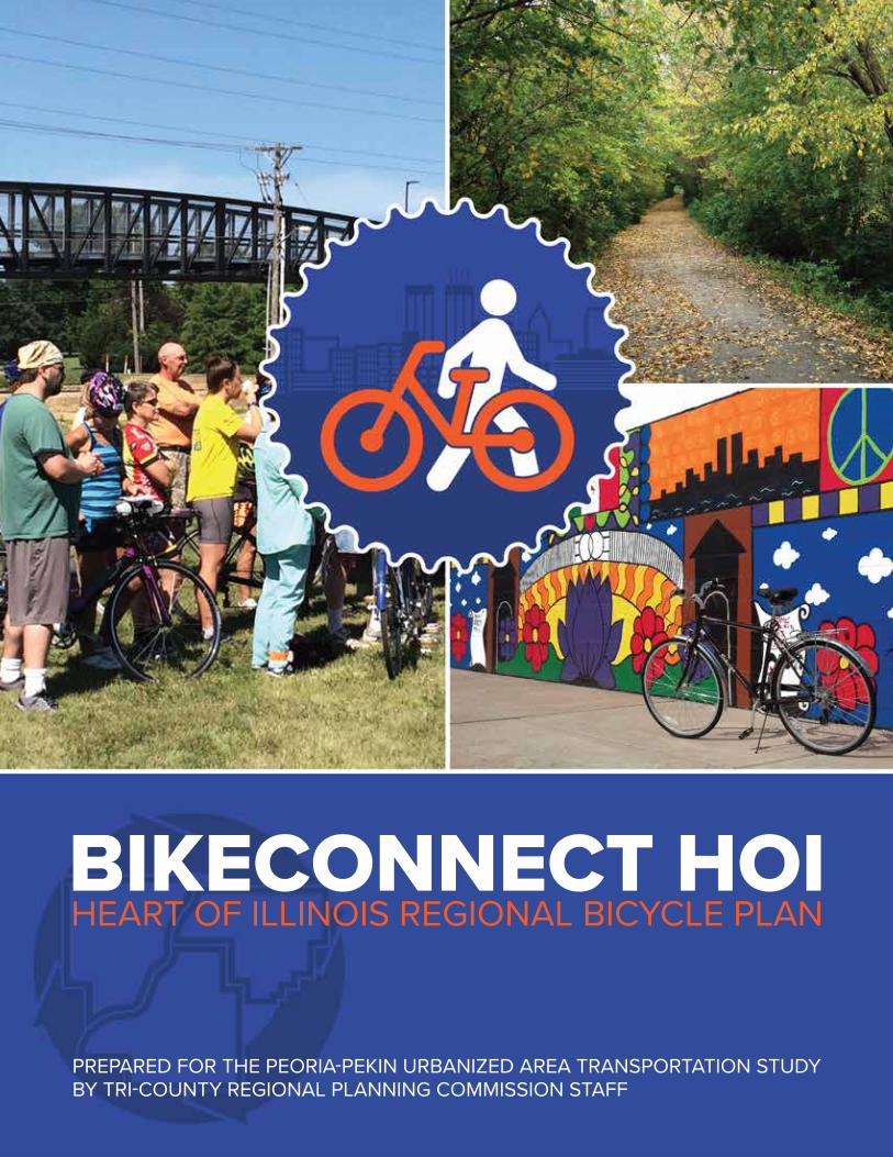
BIKECONNECT HOIHEART OF ILLINOIS REGIONAL BICYCLE PLAN
PREPARED FOR THE PEORIA-PEKIN URBANIZED AREA TRANSPORTATION STUDYBY TRI-COUNTY REGIONAL PLANNING COMMISSION STAFF
ACKNOWLEDGEMENTSTri-County Regional Planning Commission would like to thank the local residents, community leaders, bicycle advocates, and government representatives that participated in the development of BikeConnect HOI. From the kick-off open house through to plan review, hundreds of people have made possible this roadmap to a more bicycle-friendly Greater Peoria. Special thanks to members of the BikeConnect HOI Steering Committee, whose time, talents, and passion are greatly appreciated.
BIKECONNECT HOI STEERING COMMITTEECody Wilson, Peoria Heights PoliceJohn McCabe, PPUATS Policy CommitteeNick Stoffer, PPUATS Technical CommitteeDavid Pinaire, Tri-County Regional Planning
CommissionDoug Damery, Washington Park DistrictAndrew Dwyer, Greater Peoria Mass Transit
District (CityLink)Gary Brown, Friends of the Rock Island TrailFai Mok, Illinois Valley Wheelm’nAaron Coffeen, Bike PeoriaDan Mair, Germantown Hills School DistrictMark Wertz, General PublicEric Yosick, Russells Bike ShopLenora Fisher, Pekin Chamber of CommerceBrent Baker, Greater Peoria Economic
Development CouncilJamie Sammis, OSF Saint FrancisAdam Hamilton, CaterpillarChris Maushard, Illinois Dept. of
TransportationGeorge Bellovics, Illinois Dept. of Natural
ResourcesBetsy Tracy, Federal Highway AdministrationJeff McSweeney, South Side MissionDiana Scott, Peoria City/County Health Dept.Mike Staub, General PublicMatt Ryan, Caterpillar Inc.Greg Piland, Federal Highway
AdministrationTy Livingston and Glen Wetterow, City of
East Peoria
PROJECT MANAGERSNick Hayward, AICP
Senior Planner Tri-County Regional Planning Commission
Ryan Harms Planner III Tri-County Regional Planning Commission 309-673-9330 ▪ [email protected]
TCRPC STAFFEric Miller, Executive DirectorRay Lees, Planning Program ManagerHannah Martin, Planner IIAndrew Hendon, GIS Analyst IIMichael Bruner, Planner IDebbie Ulrich, Office ManagerCindy Fletcher, Staff Accountant
This planning effort was funded byUS Department of Transportation Illinois Department of TransportationPeoria-Pekin Urbanized Area Transportation Study
This plan was proudly prepared byTri-County Regional Planning Commission Staff
Cover, bottom right: image credit Bike Peoria
BIKECONNECT HOI ▪ HEART OF ILLINOIS REGIONAL BICYCLE PLAN
CHAPTER 1: INTRODUCTION ▪ 3
BIKECONNECT HOI ▪ HEART OF ILLINOIS REGIONAL BICYCLE PLAN
CHAPTER 1: INTRODUCTION ▪ 3
CHAPTER 5: RECOMMENDED NETWORK IMPROVEMENTSDeveloping a Recommended Network ........ 51Recommended Future Network .................... 53Results of Review Open House Activity ...... 73
CHAPTER 6: RECOMMENDED ACTION ITEMSAction Item Categories .................................... 75Action Items ...................................................... 75
CHAPTER 7: IMPLEMENTATIONPerformance Measures .................................... 87Plan Monitoring and Reporting ..................... 89Funding Sources ............................................... 90
APPENDIX A: RESULTS OF REVIEW OPEN HOUSE VOTING
TABLE OF CONTENTS
CHAPTER 1: INTRODUCTIONWhat is TCRPC? ................................................. 5How Was the Plan Developed? ........................ 7What Are the Goals This Plan Seeks to Accomplish? ........................................................ 9Benefits of Bicycling ......................................... 10
CHAPTER 2: BICYCLE FACILITIESOn-Road Facilities ............................................ 13Off-Road Facilities ............................................ 20
CHAPTER 3: DATA REVIEWBicycle Use ........................................................ 23Bicyclist Characteristics ................................... 25Crash Data ......................................................... 26Bicycling and Transit ....................................... 31Public Input ....................................................... 32Future Data Needs ........................................... 37
CHAPTER 4: EXISTING CONDITIONSExisting Network ............................................. 39Existing Plans and Policies ............................. 44Existing Programs ............................................ 48
BikeConnect HOI was approved by the PPUATS Policy Committee on May 3, 2017.
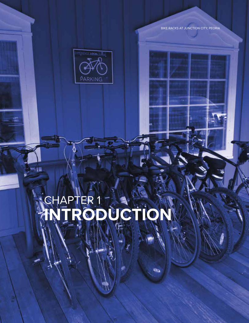
CHAPTER 1INTRODUCTION
BIKE RACKS AT JUNCTION CITY, PEORIA
BIKECONNECT HOI ▪ HEART OF ILLINOIS REGIONAL BICYCLE PLAN
CHAPTER 1: INTRODUCTION ▪ 5
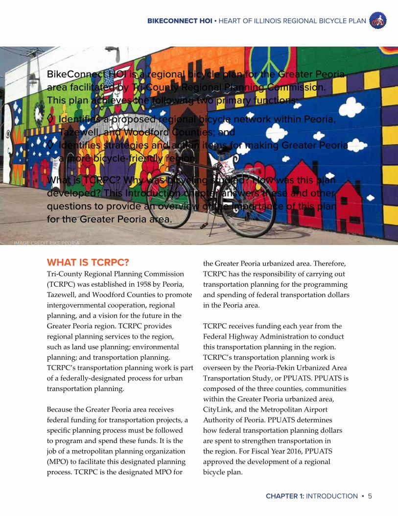
BikeConnect HOI is a regional bicycle plan for the Greater Peoria area facilitated by Tri-County Regional Planning Commission. This plan achieves the following two primary functions:
◊ Identifies a proposed regional bicycle network within Peoria, Tazewell, and Woodford Counties; and
◊ Identifies strategies and action items for making Greater Peoria a more bicycle-friendly region.
What is TCRPC? Why was bicycling studied? How was this plan developed? This Introduction chapter answers these and other questions to provide an overview of the importance of this plan for the Greater Peoria area.
WHAT IS TCRPC?Tri-County Regional Planning Commission (TCRPC) was established in 1958 by Peoria, Tazewell, and Woodford Counties to promote intergovernmental cooperation, regional planning, and a vision for the future in the Greater Peoria region. TCRPC provides regional planning services to the region, such as land use planning; environmental planning; and transportation planning. TCRPC’s transportation planning work is part of a federally-designated process for urban transportation planning.
Because the Greater Peoria area receives federal funding for transportation projects, a specific planning process must be followed to program and spend these funds. It is the job of a metropolitan planning organization (MPO) to facilitate this designated planning process. TCRPC is the designated MPO for
the Greater Peoria urbanized area. Therefore, TCRPC has the responsibility of carrying out transportation planning for the programming and spending of federal transportation dollars in the Peoria area.
TCRPC receives funding each year from the Federal Highway Administration to conduct this transportation planning in the region. TCRPC’s transportation planning work is overseen by the Peoria-Pekin Urbanized Area Transportation Study, or PPUATS. PPUATS is composed of the three counties, communities within the Greater Peoria urbanized area, CityLink, and the Metropolitan Airport Authority of Peoria. PPUATS determines how federal transportation planning dollars are spent to strengthen transportation in the region. For Fiscal Year 2016, PPUATS approved the development of a regional bicycle plan.
IMAGE CREDIT BIKE PEORIA
BIKECONNECT HOI ▪ HEART OF ILLINOIS REGIONAL BICYCLE PLAN
6 ▪ CHAPTER 1: INTRODUCTION
of the BikeConnect HOI is to establish a foundation from which regional coordination on bicycle transportation can occur to further strengthen bicycle transportation in the future. This plan presents a proposed regional bicycle network that connects communities and puts forth recommendations on how Greater Peoria can become a more bicycle-friendly region. With the foundation laid, public and private stakeholders will be able to coordinate implementation of the plan’s recommendations and make cycling in the Greater Peoria Region stronger and safer.
Ultimately, PPUATS seeks to steward a regional transportation system that is safe and provides choices for system users. BikeConnect HOI helps achieve these outcomes by identifying how bicycle use can be expanded in the region in a manner that is safe for both bicyclists and users of all transportation modes that may interact with bicyclists. Thus, BikeConnect HOI was developed for the larger purpose of strengthening quality of life for all in the Greater Peoria area.
WHY A REGIONAL BICYCLE PLAN?Interest in bicycle transportation is increasing in the Greater Peoria region. During development of the region’s Long-Range Transportation Plan in 2015, more projects with bicycle accomodations were proposed than ever before. In addition to the presence of local bicycle advocacy groups, Friends of the Rock Island Trail and the Illinois Valley Wheelm’n, a new group called Bike Peoria was established in 2013. The City of Peoria recently adopted its first ever bicycle master plan while communities such as Pekin, East Peoria, Washington, and Morton are working to strengthen bicycle transportation in their jurisdictions. Never before has there been greater interest in bicycle transportation in the Greater Peoria area.
While improvements in bicycle transportation are occurring across the region, they are largely occurring in the absence of formal regional coordination on the issue. No entity has performed a large-scale, regional examination of bicycle transportation in the Greater Peoria area. A broader purpose
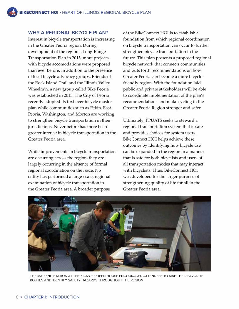
THE MAPPING STATION AT THE KICK-OFF OPEN HOUSE ENCOURAGED ATTENDEES TO MAP THEIR FAVORITE ROUTES AND IDENTIFY SAFETY HAZARDS THROUGHOUT THE REGION
BIKECONNECT HOI ▪ HEART OF ILLINOIS REGIONAL BICYCLE PLAN
CHAPTER 1: INTRODUCTION ▪ 7
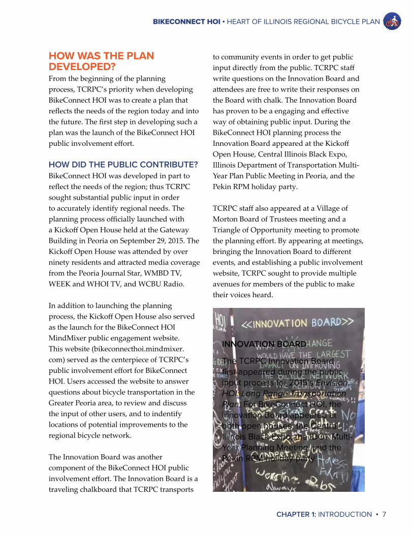
to community events in order to get public input directly from the public. TCRPC staff write questions on the Innovation Board and attendees are free to write their responses on the Board with chalk. The Innovation Board has proven to be a engaging and effective way of obtaining public input. During the BikeConnect HOI planning process the Innovation Board appeared at the Kickoff Open House, Central Illinois Black Expo, Illinois Department of Transportation Multi-Year Plan Public Meeting in Peoria, and the Pekin RPM holiday party.
TCRPC staff also appeared at a Village of Morton Board of Trustees meeting and a Triangle of Opportunity meeting to promote the planning effort. By appearing at meetings, bringing the Innovation Board to different events, and establishing a public involvement website, TCRPC sought to provide multiple avenues for members of the public to make their voices heard.
HOW WAS THE PLAN DEVELOPED?From the beginning of the planning process, TCRPC’s priority when developing BikeConnect HOI was to create a plan that reflects the needs of the region today and into the future. The first step in developing such a plan was the launch of the BikeConnect HOI public involvement effort.
HOW DID THE PUBLIC CONTRIBUTE?BikeConnect HOI was developed in part to reflect the needs of the region; thus TCRPC sought substantial public input in order to accurately identify regional needs. The planning process officially launched with a Kickoff Open House held at the Gateway Building in Peoria on September 29, 2015. The Kickoff Open House was attended by over ninety residents and attracted media coverage from the Peoria Journal Star, WMBD TV, WEEK and WHOI TV, and WCBU Radio.
In addition to launching the planning process, the Kickoff Open House also served as the launch for the BikeConnect HOI MindMixer public engagement website. This website (bikeconnecthoi.mindmixer.com) served as the centerpiece of TCRPC’s public involvement effort for BikeConnect HOI. Users accessed the website to answer questions about bicycle transportation in the Greater Peoria area, to review and discuss the input of other users, and to indentify locations of potential improvements to the regional bicycle network.
The Innovation Board was another component of the BikeConnect HOI public involvement effort. The Innovation Board is a traveling chalkboard that TCRPC transports
INNOVATION BOARD
The TCRPC Innovation Board first appeared during the public input process for 2015’s Envision HOI: Long Range Transportation Plan. For BikeConnect HOI, the Innovation Board appeared at both open houses, the Central Illinois Black Expo, the IDOT Multi-Year Planning Meeting, and the Pekin RPM holiday party.
BIKECONNECT HOI ▪ HEART OF ILLINOIS REGIONAL BICYCLE PLAN
8 ▪ CHAPTER 1: INTRODUCTION
The stakeholder groups represented on the steering committee were:
◊ Bike Peoria◊ Local Chambers of Commerce◊ Federal Highway Administration◊ Friends of the Rock Island Trail◊ General public◊ Greater Peoria Economic Development
Council◊ Healthcare◊ Illinois Department of Natural Resources◊ Illinois Department of Transportation◊ Illinois Valley Wheelm’n◊ Large businesses◊ Law enforcement◊ Local bicycle shops◊ Mass transit providers◊ Park districts◊ Public health advocates◊ PPUATS◊ Schools◊ Underserved populations◊ TCRPC
TCRPC staff also compiled a map of the existing regional bicycle network. The Steering Committee used this map to identify the network’s gaps and recommend improvements to fill those gaps.
TCRPC worked with the steering committee to finalize goals, action items, and a proposed regional bicycle network map. These elements serve as the recommendations for how the Greater Peoria area can become more bicycle-friendly moving forward.
WHAT OTHER STEPS WERE INVOLVED IN THE PROCESS?As public input was being gathered, TCRPC staff retrieved published regional bicycle data and distributed a questionnaire to local communities, the three counties, local park districts, and local bicycle advocacy groups. The questionnaire was designed to supplement the collection of published data by gathering information about current bicycle use, existing bicycle policies and programs, and desired connections in the regional bicycle network.
TCRPC also established a steering committee to guide this planning process. The steering committee first met in December 2015 and met monthly for the duration of the planning process to review information, guide the work of TCRPC staff, and make decisions as to what the content of the final plan should be. The steering committee comprised representatives of a variety of different stakeholder groups in order to obtain a variety of ideas and opinions regarding bicycle transportation in the region.
“”
Always connect and collaborate with the bike advocacy groups on education initiatives, and seek their input on policy matters.
– Public Comment,Oct 2016
BIKECONNECT HOI ▪ HEART OF ILLINOIS REGIONAL BICYCLE PLAN
CHAPTER 1: INTRODUCTION ▪ 9
than transportation, given the distance and geographical boundaries between some places in the region. However, this plan seeks to improve the region’s bicycle network for all users.
The scope of BikeConnectHOI includes consideration for both on-road and off-road bicycling facilities and accommodations. Because this planning process aims to identify bicycle connections between communities, the facilities and accommodations identified in this plan are those that may complete a regional bicycle network.
There are two important bicycle transportation issues that this plan does not address. Firstly, BikeConnect HOI does not address community-specific network improvements. Individual communities are in the best position to decide how best to develop their own bicycle networks, which is why this plan focuses on connections between communities. Secondly, BikeConnect HOI does not address the relationship between bicycle facilities and pedestrian facilities. While biking and walking often go hand-in-hand, this plan is was developed on a regional scale. Walking typically occurs at a community level rather than a regional level.
Overall, BikeConnect HOI focuses on identifying a regional bicycle network and identifying other ways by which our region can become more bicycle-friendly. As a result, BikeConnect HOI seeks to establish a foundation upon which regional coordination on bicycle transportation can occur, further strengthening bicycle transportation for the Greater Peoria area in the future.
WHAT ARE THE GOALS THIS PLAN SEEKS TO ACCOMPLISH?One of the stated primary goals of BikeConnect HOI is to identify a proposed regional bicycle network that connects communities in the region. Because communities throughout the region are already engaging in bicycle planning, TCRPC felt that a regional bicycle plan could best serve the region by identifying a regional network that connects communities. This plan identifies proposed network improvements that would establish or strengthen bicycle connections between communities.
The other primary goal of BikeConnect HOI is to identify other ways in which the Greater Peoria area can become a more bicycle-friendly region. This statement was intentionally broad in order to promote examining a wide range of issues and generate many different ideas for addressing the most important issues impacting bicycle transportation in the region. For example, policies promoting bicycle use that could be enacted by communities, educational programs promoting bicycle safety or bicycling to work, and establishing a large bicycle ride in the region would all fall under this category. TCRPC staff worked with the steering committee to review information, identify pertinent issues, and define actions to address the issues.
BikeConnect HOI seeks to strengthen bicycling in the region for both transportation, such as commuting to work or school and shopping for goods, and recreation. It is most likely that bicycling between communities will occur more often for recreation rather
BIKECONNECT HOI ▪ HEART OF ILLINOIS REGIONAL BICYCLE PLAN
10 ▪ CHAPTER 1: INTRODUCTION
number of automobile trips being converted to bicycle trips. However, this plan also focuses on making the Greater Peoria region more bicycle-friendly. Actions recommended in this plan may result in fewer barriers to bicycle transportation, and in turn lead to an increase in the number of bicycle trips in the future.
TRANSPORTATION CHOICEBicycling is an alternative mode of transportation that can provide multiple personal benefits. As discussed above, bicycling can provide health benefits and can reduce household transportation costs compared to using an automobile. Bicycling also can be used in tandem with other transportation modes, such as mass transit. A safe, efficient bicycle network is an important component of a complete transportation system. A complete transportation system offers choices for its users, enabling them to make transportation decisions that fit best with their own lives.
ECONOMIC DEVELOPMENTChanging demographics show that young professionals and baby boomers alike have a greater interest in living in dense, walkable neighborhoods that are bike-friendly and accessible to many transportation options.
BENEFITS OF BICYCLINGAs stated previously, the larger purpose of BikeConnect HOI is to strengthen quality of life in the Greater Peoria area. Improving bicycle transportation in the region can lead to outcomes that significantly strengthen quality of life. Consider the following improvements in which bicycle transportation can play a role.
AIR QUALITYThe Greater Peoria area needs to remain vigilant to ensure that the region’s air quality continues to meet acceptable standards. While the region has never been in violation of the Environmental Protection Agency’s air quality standard for ground-level ozone, the standard was tightened in October 2015 from 75 parts per billion (ppb) to 70 ppb, which means that urban areas across the country will be held to a higher air quality standard.
Reducing vehicle emissions can help reduce ground-level ozone. One way to reduce vehicle emissions is by converting automobile trips to bicycle trips. The most likely trips to be converted to bicycle trips are short automobile trips. BikeConnect HOI is focused on improving connections to the regional network, and the specific improvements proposed by this plan may not result in a high
“Improving bicycle transportation in the region can lead to outcomes that significantly strengthen quality of life.
”
BIKECONNECT HOI ▪ HEART OF ILLINOIS REGIONAL BICYCLE PLAN
CHAPTER 1: INTRODUCTION ▪ 11
includes five goals with related strategies to make it easier for people to walk, ride a bike, and be active in other ways. The Call to Action underscores the increasing emphasis being placed on being active – such as riding a bike – to improve public health.
SAFETYSafety is of paramount importance when making improvements to a transportation network. Improving bicycle transportation in the region involves both improving the bicycle network and pursuing policy and education initiatives, both of which have safety at their core. A safer bicycle network leads to safer conditions for cyclists and users of all modes of transportation that may interact with them.
As the Greater Peoria area becomes more bicycle-friendly, it will become more attractive to residents who seek to live in this type of environment. Not only that, the Greater Peoria area will become more attractive to businesses and entrepreneurs seeking to start businesses who want to be located in an area that, by offering a high quality of life, can attract top talent.
HEALTHIn September 2015, the Surgeon General issued a Call to Action to promote walking and walkable communities. The call states that one out of every two adults in the United States is living with a chronic disease. Increasing physical activity levels significantly reduce the risk of chronic disease. The Surgeon General’s Call to Action
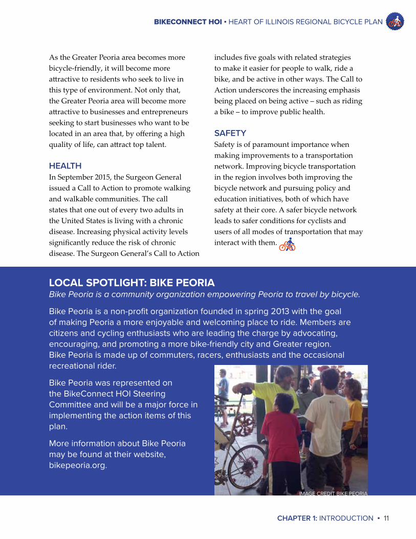
LOCAL SPOTLIGHT: BIKE PEORIABike Peoria is a community organization empowering Peoria to travel by bicycle.
Bike Peoria is a non-profit organization founded in spring 2013 with the goal of making Peoria a more enjoyable and welcoming place to ride. Members are citizens and cycling enthusiasts who are leading the charge by advocating, encouraging, and promoting a more bike-friendly city and Greater region. Bike Peoria is made up of commuters, racers, enthusiasts and the occasional recreational rider.
Bike Peoria was represented on the BikeConnect HOI Steering Committee and will be a major force in implementing the action items of this plan.
More information about Bike Peoria may be found at their website, bikepeoria.org.
IMAGE CREDIT BIKE PEORIA
BIKE RACKS AT JUNCTION CITY, PEORIA
CHAPTER 2BICYCLE FACILITIES
ROCK ISLAND TRAIL KNOXVILLE BRIDGE GRAND OPENINGIMAGE CREDIT DAVID SMESRUD
BIKECONNECT HOI ▪ HEART OF ILLINOIS REGIONAL BICYCLE PLAN
CHAPTER 2: BICYCLE FACILITIES ▪ 13
guidelines for shared lanes, features such as pavement quality; adequate sight distances; traffic calming; and bicycle-compatible drainage grates may make a roadway appropriate for cyclists.
In general, low-traffic and low-speed roadways are most suitable for cyclists in the absence of bicycle infrastructure. A rural roadway with good visibility and traffic speeds of 55 mph or less may be suitable for shared lanes with no modifications. In the Greater Peoria region, many such roads are used by cyclists for traveling between communities, typically by more experienced and confident riders. Not all riders will feel comfortable sharing lanes with automobile traffic, but identifying safe on-road connections is still an essential component of a complete bicycle network.
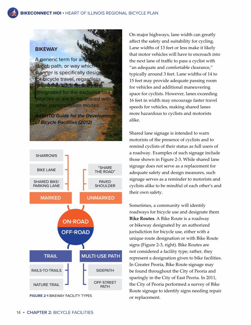
ON-ROAD FACILITIESBicyclists’ access and mobility needs are often similar to those of people driving automobiles. Therefore, it is natural for cyclists to use roads and streets to access their work, shopping, and recreation destinations. A complete transportation system is one that is built to accomodate automobiles, pedestians, and cyclists. Examples of on-road bicycle accomodations include shared lane markings, paved shoulders, and bicycle lanes.
SHARED LANESUnless prohibited by law, bicycles may be operated legally on any roadway. Cyclists and automobiles are expected to share the same lanes of travel, even in the absence of paint or signage stating so. This expectation applies to quiet, local streets as well as dense, busy highways. While there are no uniform
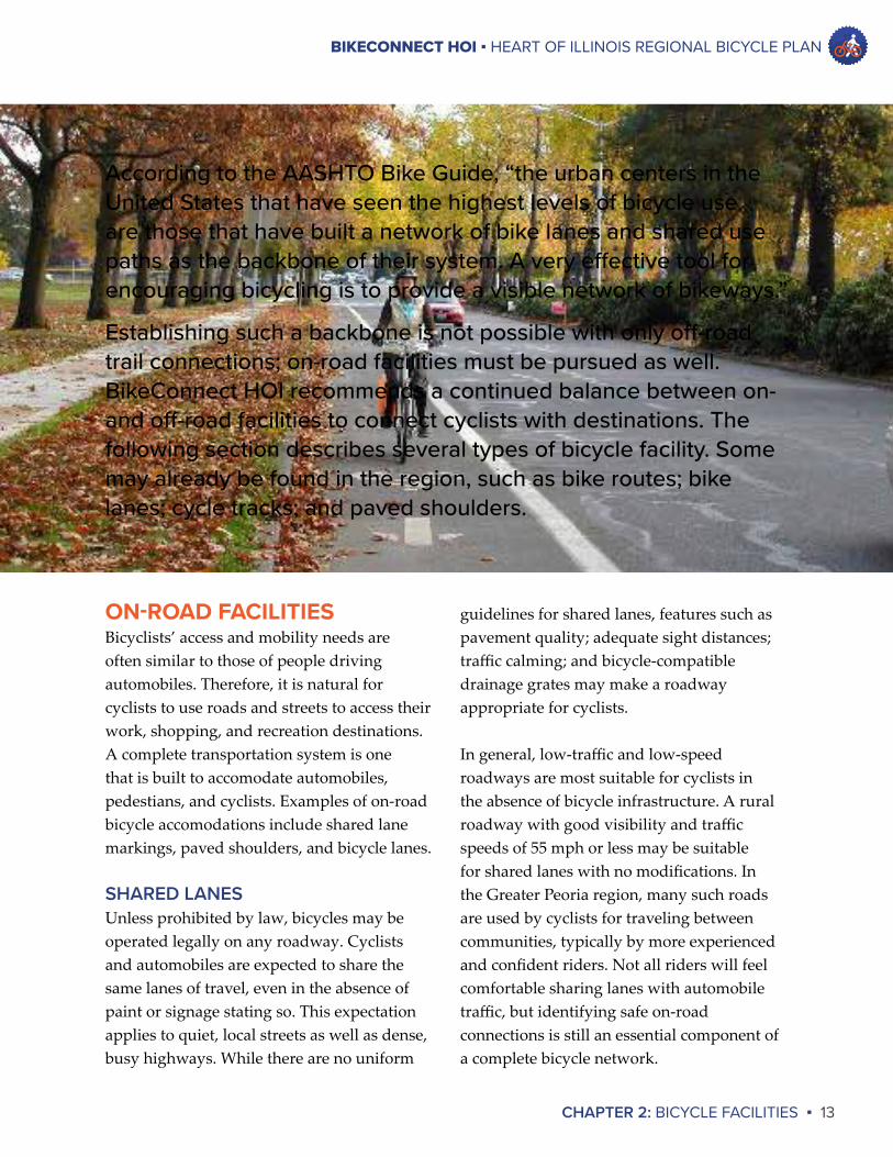
According to the AASHTO Bike Guide, “the urban centers in the United States that have seen the highest levels of bicycle use are those that have built a network of bike lanes and shared use paths as the backbone of their system. A very effective tool for encouraging bicycling is to provide a visible network of bikeways.”
Establishing such a backbone is not possible with only off-road trail connections; on-road facilities must be pursued as well. BikeConnect HOI recommends a continued balance between on- and off-road facilities to connect cyclists with destinations. The following section describes several types of bicycle facility. Some may already be found in the region, such as bike routes; bike lanes; cycle tracks; and paved shoulders.
BIKECONNECT HOI ▪ HEART OF ILLINOIS REGIONAL BICYCLE PLAN
14 ▪ CHAPTER 2: BICYCLE FACILITIES
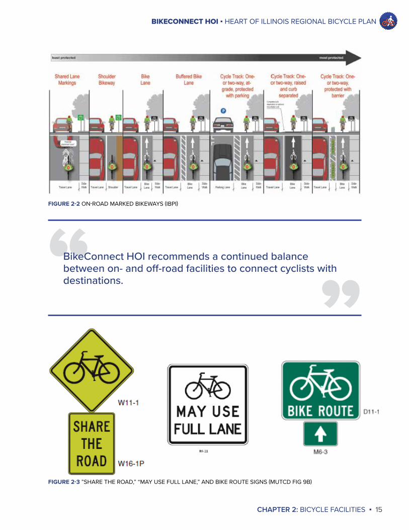
On major highways, lane width can greatly affect the safety and suitability for cycling. Lane widths of 13 feet or less make it likely that motor vehicles will have to encroach into the next lane of traffic to pass a cyclist with “an adequate and comfortable clearance,” typically around 3 feet. Lane widths of 14 to 15 feet may provide adequate passing room for vehicles and additional maneuvering space for cyclists. However, lanes exceeding 16 feet in width may encourage faster travel speeds for vehicles, making shared lanes more hazardous to cyclists and motorists alike.
Shared lane signage is intended to warn motorists of the presence of cyclists and to remind cyclists of their status as full users of a roadway. Examples of such signage include those shown in Figure 2-3. While shared lane signage does not serve as a replacement for adequate safety and design measures, such signage serves as a reminder to motorists and cyclists alike to be mindful of each other’s and their own safety.
Sometimes, a community will identify roadways for bicycle use and designate them BikeRoutes. A Bike Route is a roadway or bikeway designated by an authorized jurisdiction for bicycle use, either with a unique route designation or with Bike Route signs (Figure 2-3, right). Bike Routes are not considered a facility type; rather, they represent a designation given to bike facilities. In Greater Peoria, Bike Route signage may be found throughout the City of Peoria and sparingly in the City of East Peoria. In 2011, the City of Peoria performed a survey of Bike Route signage to identify signs needing repair or replacement.
PAVEDSHOULDER
SHARED BIKE/PARKING LANE
SHARROWS
BIKE LANE
ON-ROAD
OFF-ROAD
UNMARKED
“SHARETHE ROAD”
MARKED
MULTI-USE PATHTRAIL
OFF-STREETPATH
SIDEPATHRAILS-TO-TRAILS
NATURE TRAIL
BIKEWAY
A generic term for any road, street, path, or way which in some manner is specifically designated for bicycle travel, regardless of whether such facilities are designated for the exclusive use of bicycles or are to be shared with other transportation modes.
AASHTO Guide for the Development of Bicycle Facilities (2012)
FIGURE 2-1 BIKEWAY FACILITY TYPES
BIKECONNECT HOI ▪ HEART OF ILLINOIS REGIONAL BICYCLE PLAN
CHAPTER 2: BICYCLE FACILITIES ▪ 15
”FIGURE 2-2 ON-ROAD MARKED BIKEWAYS (IBPI)
“BikeConnect HOI recommends a continued balance between on- and off-road facilities to connect cyclists with destinations.
FIGURE 2-3 ”SHARE THE ROAD,” “MAY USE FULL LANE,” AND BIKE ROUTE SIGNS (MUTCD FIG 9B)
BIKECONNECT HOI ▪ HEART OF ILLINOIS REGIONAL BICYCLE PLAN
16 ▪ CHAPTER 2: BICYCLE FACILITIES
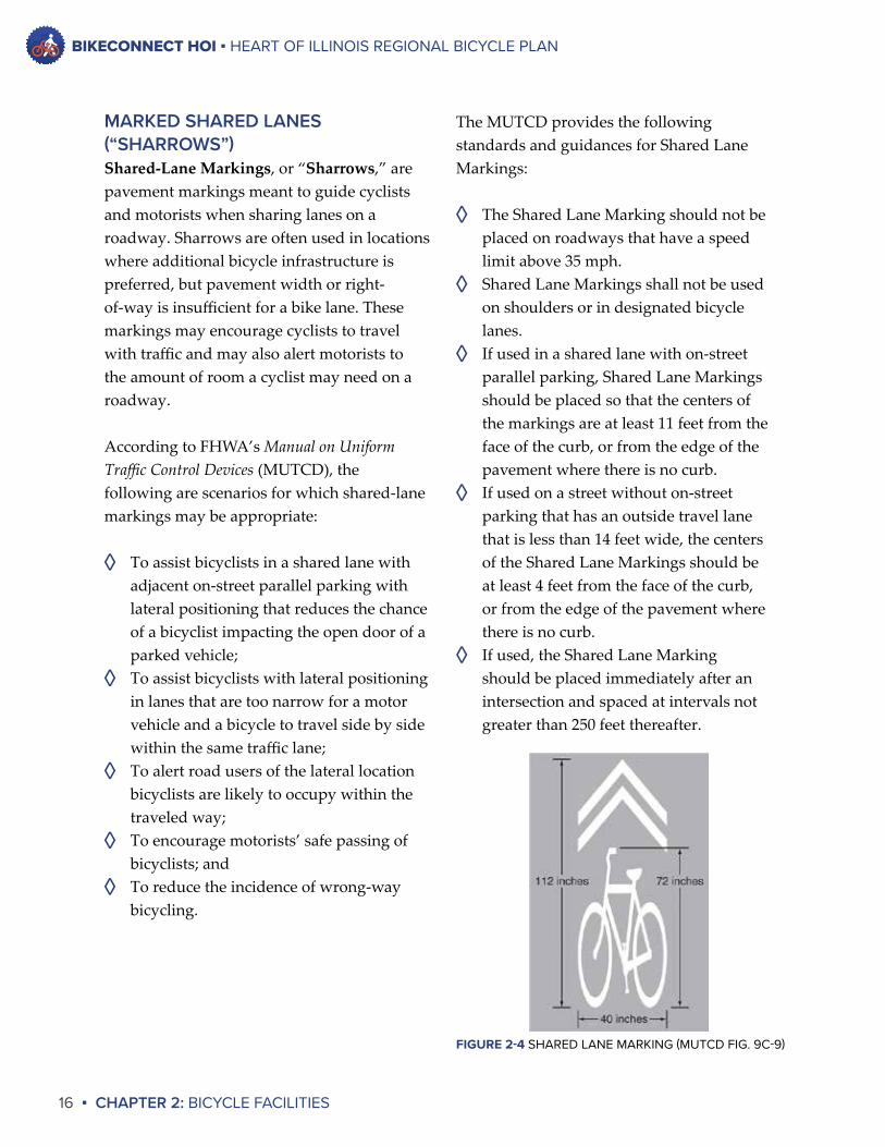
The MUTCD provides the following standards and guidances for Shared Lane Markings:
◊ The Shared Lane Marking should not be placed on roadways that have a speed limit above 35 mph.
◊ Shared Lane Markings shall not be used on shoulders or in designated bicycle lanes.
◊ If used in a shared lane with on-street parallel parking, Shared Lane Markings should be placed so that the centers of the markings are at least 11 feet from the face of the curb, or from the edge of the pavement where there is no curb.
◊ If used on a street without on-street parking that has an outside travel lane that is less than 14 feet wide, the centers of the Shared Lane Markings should be at least 4 feet from the face of the curb, or from the edge of the pavement where there is no curb.
◊ If used, the Shared Lane Marking should be placed immediately after an intersection and spaced at intervals not greater than 250 feet thereafter.
MARKED SHARED LANES (“SHARROWS”)Shared-LaneMarkings, or “Sharrows,” are pavement markings meant to guide cyclists and motorists when sharing lanes on a roadway. Sharrows are often used in locations where additional bicycle infrastructure is preferred, but pavement width or right-of-way is insufficient for a bike lane. These markings may encourage cyclists to travel with traffic and may also alert motorists to the amount of room a cyclist may need on a roadway.
According to FHWA’s Manual on Uniform Traffic Control Devices (MUTCD), the following are scenarios for which shared-lane markings may be appropriate:
◊ To assist bicyclists in a shared lane with adjacent on-street parallel parking with lateral positioning that reduces the chance of a bicyclist impacting the open door of a parked vehicle;
◊ To assist bicyclists with lateral positioning in lanes that are too narrow for a motor vehicle and a bicycle to travel side by side within the same traffic lane;
◊ To alert road users of the lateral location bicyclists are likely to occupy within the traveled way;
◊ To encourage motorists’ safe passing of bicyclists; and
◊ To reduce the incidence of wrong-way bicycling.
FIGURE 2-4 SHARED LANE MARKING (MUTCD FIG. 9C-9)
BIKECONNECT HOI ▪ HEART OF ILLINOIS REGIONAL BICYCLE PLAN
CHAPTER 2: BICYCLE FACILITIES ▪ 17
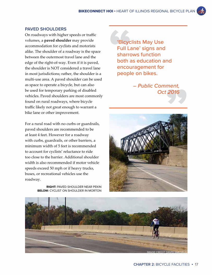
PAVED SHOULDERSOn roadways with higher speeds or traffic volumes, a pavedshoulder may provide accommodation for cyclists and motorists alike. The shoulder of a roadway is the space between the outermost travel lane and the edge of the right-of-way. Even if it is paved, the shoulder is NOT considered a travel lane in most jurisdictions; rather, the shoulder is a multi-use area. A paved shoulder can be used as space to operate a bicycle, but can also be used for temporary parking of disabled vehicles. Paved shoulders are most commonly found on rural roadways, where bicycle traffic likely not great enough to warrant a bike lane or other improvement.
For a rural road with no curbs or guardrails, paved shoulders are recommended to be at least 4 feet. However for a roadway with curbs, guardrails, or other barriers, a minimum width of 5 feet is recommended to account for cyclists’ reluctance to ride too close to the barrier. Additional shoulder width is also recommended if motor vehicle speeds exceed 50 mph or if heavy trucks, buses, or recreational vehicles use the roadway.
“”
‘Bicyclists May Use Full Lane’ signs and sharrows function both as education and encouragement for people on bikes.
– Public Comment,Oct 2016
RIGHT: PAVED SHOULDER NEAR PEKINBELOW: CYCLIST ON SHOULDER IN MORTON
IMAGE CREDIT DAVID SMESRUD
BIKECONNECT HOI ▪ HEART OF ILLINOIS REGIONAL BICYCLE PLAN
18 ▪ CHAPTER 2: BICYCLE FACILITIES
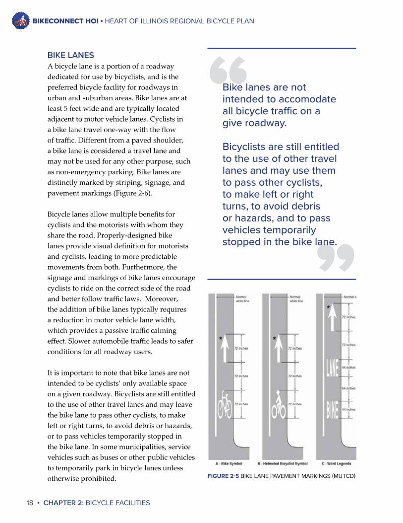
BIKE LANESA bicycle lane is a portion of a roadway dedicated for use by bicyclists, and is the preferred bicycle facility for roadways in urban and suburban areas. Bike lanes are at least 5 feet wide and are typically located adjacent to motor vehicle lanes. Cyclists in a bike lane travel one-way with the flow of traffic. Different from a paved shoulder, a bike lane is considered a travel lane and may not be used for any other purpose, such as non-emergency parking. Bike lanes are distinctly marked by striping, signage, and pavement markings (Figure 2-6).
Bicycle lanes allow multiple benefits for cyclists and the motorists with whom they share the road. Properly-designed bike lanes provide visual definition for motorists and cyclists, leading to more predictable movements from both. Furthermore, the signage and markings of bike lanes encourage cyclists to ride on the correct side of the road and better follow traffic laws. Moreover, the addition of bike lanes typically requires a reduction in motor vehicle lane width, which provides a passive traffic calming effect. Slower automobile traffic leads to safer conditions for all roadway users.
It is important to note that bike lanes are not intended to be cyclists’ only available space on a given roadway. Bicyclists are still entitled to the use of other travel lanes and may leave the bike lane to pass other cyclists, to make left or right turns, to avoid debris or hazards, or to pass vehicles temporarily stopped in the bike lane. In some municipalities, service vehicles such as buses or other public vehicles to temporarily park in bicycle lanes unless otherwise prohibited.
”
“Bike lanes are not intended to accomodate all bicycle traffic on a give roadway.
Bicyclists are still entitled to the use of other travel lanes and may use them to pass other cyclists, to make left or right turns, to avoid debris or hazards, and to pass vehicles temporarily stopped in the bike lane.
FIGURE 2-5 BIKE LANE PAVEMENT MARKINGS (MUTCD)
BIKECONNECT HOI ▪ HEART OF ILLINOIS REGIONAL BICYCLE PLAN
CHAPTER 2: BICYCLE FACILITIES ▪ 19
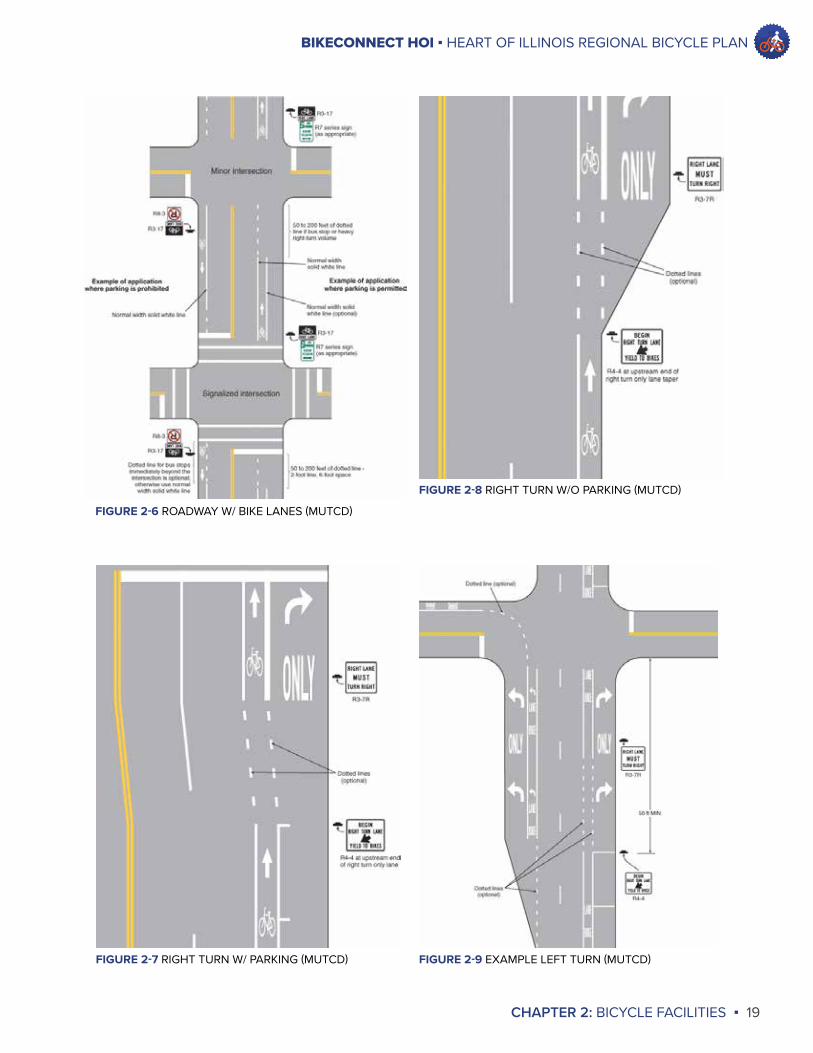
FIGURE 2-6 ROADWAY W/ BIKE LANES (MUTCD)
FIGURE 2-7 RIGHT TURN W/ PARKING (MUTCD)
FIGURE 2-8 RIGHT TURN W/O PARKING (MUTCD)
FIGURE 2-9 EXAMPLE LEFT TURN (MUTCD)
BIKECONNECT HOI ▪ HEART OF ILLINOIS REGIONAL BICYCLE PLAN
20 ▪ CHAPTER 2: BICYCLE FACILITIES
Trail or Greenway because of the trees and plants surrounding it. Various Sidepaths and Off-Street Paths have been constructed along major roads in the region, such as the Northmoor Road in Peoria and Cruger Road in Washington.
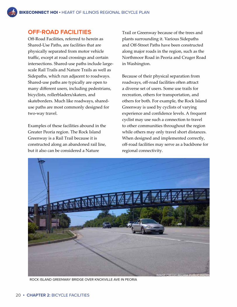
Because of their physical separation from roadways, off-road facilities often attract a diverse set of users. Some use trails for recreation, others for transportation, and others for both. For example, the Rock Island Greenway is used by cyclists of varying experience and confidence levels. A frequent cyclist may use such a connection to travel to other communities throughout the region while others may only travel short distances. When designed and implemented correctly, off-road facilities may serve as a backbone for regional connectivity.
OFF-ROAD FACILITIESOff-Road Facilities, referred to herein as Shared-Use Paths, are facilities that are physically separated from motor vehicle traffic, except at road crossings and certain intersections. Shared-use paths include large-scale Rail Trails and Nature Trails as well as Sidepaths, which run adjacent to roadways. Shared-use paths are typically are open to many different users, including pedestrians, bicyclists, rollerbladers/skaters, and skateborders. Much like roadways, shared-use paths are most commonly designed for two-way travel.
Examples of these facilities abound in the Greater Peoria region. The Rock Island Greenway is a Rail Trail because it is constructed along an abandoned rail line, but it also can be considered a Nature
ROCK ISLAND GREENWAY BRIDGE OVER KNOXVILLE AVE IN PEORIAIMAGE CREDIT PEORIA PUBLIC RADIO
BIKECONNECT HOI ▪ HEART OF ILLINOIS REGIONAL BICYCLE PLAN
CHAPTER 2: BICYCLE FACILITIES ▪ 21
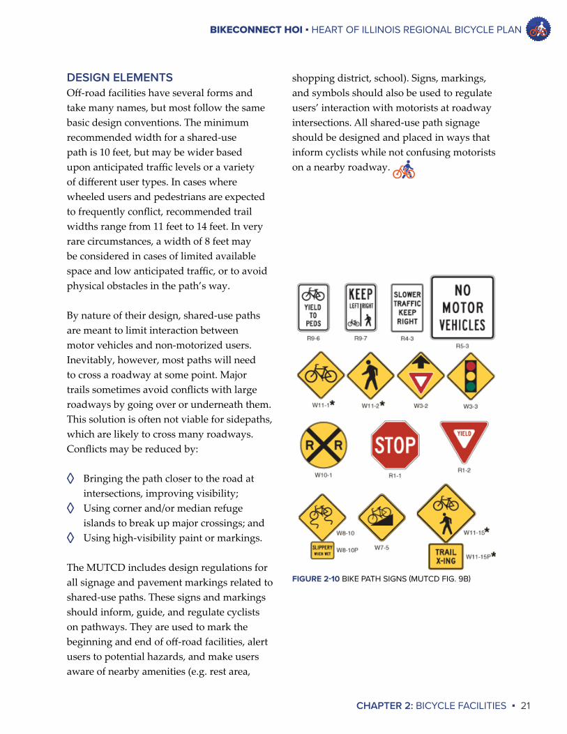
shopping district, school). Signs, markings, and symbols should also be used to regulate users’ interaction with motorists at roadway intersections. All shared-use path signage should be designed and placed in ways that inform cyclists while not confusing motorists on a nearby roadway.
DESIGN ELEMENTSOff-road facilities have several forms and take many names, but most follow the same basic design conventions. The minimum recommended width for a shared-use path is 10 feet, but may be wider based upon anticipated traffic levels or a variety of different user types. In cases where wheeled users and pedestrians are expected to frequently conflict, recommended trail widths range from 11 feet to 14 feet. In very rare circumstances, a width of 8 feet may be considered in cases of limited available space and low anticipated traffic, or to avoid physical obstacles in the path’s way.
By nature of their design, shared-use paths are meant to limit interaction between motor vehicles and non-motorized users. Inevitably, however, most paths will need to cross a roadway at some point. Major trails sometimes avoid conflicts with large roadways by going over or underneath them. This solution is often not viable for sidepaths, which are likely to cross many roadways. Conflicts may be reduced by:
◊ Bringing the path closer to the road at intersections, improving visibility;
◊ Using corner and/or median refuge islands to break up major crossings; and
◊ Using high-visibility paint or markings.
The MUTCD includes design regulations for all signage and pavement markings related to shared-use paths. These signs and markings should inform, guide, and regulate cyclists on pathways. They are used to mark the beginning and end of off-road facilities, alert users to potential hazards, and make users aware of nearby amenities (e.g. rest area,
FIGURE 2-10 BIKE PATH SIGNS (MUTCD FIG. 9B)
BIKE RACKS AT JUNCTION CITY, PEORIABICYCLE PARKING IN DOWNTOWN GALESBURG
IMAGE CREDIT BIKE PEORIA
CHAPTER 3DATA REVIEW
BIKECONNECT HOI ▪ HEART OF ILLINOIS REGIONAL BICYCLE PLAN
CHAPTER 3: DATA REVIEW ▪ 23
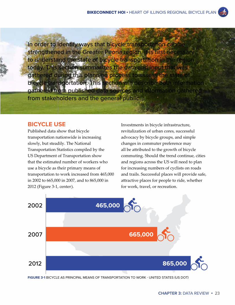
Investments in bicycle infrastructure, revitalization of urban cores, successful advocacy by bicycle groups, and simple changes in commuter preference may all be attributed to the growth of bicycle commuting. Should the trend continue, cities and regions across the US will need to plan for increasing numbers of cyclists on roads and trails. Successful places will provide safe, attractive places for people to ride, whether for work, travel, or recreation.
BICYCLE USEPublished data show that bicycle transportation nationwide is increasing slowly, but steadily. The National Transportation Statistics compiled by the US Department of Transportation show that the estimated number of workers who use a bicycle as their primary means of transportation to work increased from 465,000 in 2002 to 665,000 in 2007, and to 865,000 in 2012 (Figure 3-1, center).
In order to identify ways that bicycle transportation can be strengthened in the Greater Peoria region, it is first necessary to understand the state of bicycle transportation in the region today. This section summarizes the data and input that was gathered during this planning process to assess the state of bicycle transportation. This section will describe both information gathered from published data sources and information gathered from stakeholders and the general public.
2002
2007
2012
465,000
665,000
865,000
FIGURE 3-1 BICYCLE AS PRINCIPAL MEANS OF TRANSPORTATION TO WORK - UNITED STATES (US DOT)
BIKECONNECT HOI ▪ HEART OF ILLINOIS REGIONAL BICYCLE PLAN
24 ▪ CHAPTER 3: DATA REVIEW
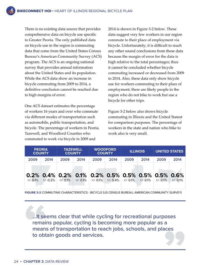
There is no existing data source that provides comprehensive data on bicycle use specific to Greater Peoria. The only published data on bicycle use in the region is commuting data that come from the United States Census Bureau’s American Community Survey (ACS) program. The ACS is an ongoing national survey that provides annual information about the United States and its population. While the ACS data show an increase in bicycle commuting from 2009 to 2014, a definitive conclusion cannot be reached due to high margins of error.
One ACS dataset estimates the percentage of workers 16 years and over who commute via different modes of transportation such as automobile, public transportation, and bicycle. The percentage of workers in Peoria, Tazewell, and Woodford Counties who commuted to work via bicycle in 2009 and
2014 is shown in Figure 3-2 below. These data suggest very few workers in our region commute to their place of employment via bicycle. Unfortunately, it is difficult to reach any other sound conclusions from these data because the margin of error for the data is high relative to the total percentages; thus it cannot be concluded whether bicycle commuting increased or decreased from 2009 to 2014. Also, these data only show bicycle use for workers commuting to their place of employment; there are likely people in the region who do not bike to work but use a bicycle for other trips.
Figure 3-2 below also shows bicycle commuting in Illinois and the United Statest for comparison purposes. The percentage of workers in the state and nation who bike to work also is very small.
PEORIACOUNTY
TAZEWELLCOUNTY
WOODFORD COUNTY ILLINOIS UNITED STATES
2009 2014 2009 2014 2009 2014 2009 2014 2009 2014
0.2% 0.4% 0.2% 0.1% 0.2% 0.5% 0.5% 0.5% 0.5% 0.6%+/- 0.1% +/- 0.2% +/- 0.1% +/- 0.1% +/- 0.1% +/- 0.4% +/- 0.1% +/- 0.1% +/- 0.1% +/- 0.1%
FIGURE 3-2 COMMUTING CHARACTERISTICS - BICYCLE (US CENSUS BUREAU, AMERICAN COMMUNITY SURVEY)
”“...It seems clear that while cycling for recreational purposes remains popular, cycling is becoming more popular as a means of transportation to reach jobs, schools, and places to obtain goods and services.
BIKECONNECT HOI ▪ HEART OF ILLINOIS REGIONAL BICYCLE PLAN
CHAPTER 3: DATA REVIEW ▪ 25
counting program in the region prevents definitive conclusions from being made. Implementing a bicycle counting program would enable TCRPC and other organizations to accurately track and analyze ridership in the region.
BICYCLIST CHARACTERISTICSJust as there are no precise data on the number of cyclists in the Greater Peoria area, there are no precise data on who is riding, why they are riding, and to where they are riding. In order to gather anecdotal information about cyclists in the region, a questionnaire was distributed to PPUATS member jurisdictions – the communities in the densely-populated area immediately surrounding Peoria, as well as and Peoria, Tazewell, and Woodford Counties.
Local communities report that while the majority of cyclists they see in their communities are riding for recreational purposes, some cyclists are commuting to work and school, while other cyclists are riding to grocery stores and shopping areas. While most cyclists appear to be using off-road facilities, some use roadways as well. The most popular destinations for cyclists appear to be parks and recreational facilities, but the City of Pekin reports that more cyclists are riding to the bus stop in downtown Pekin in order to ride CityLink to Peoria. The City of Peoria reports that some people use bikes to travel to public meetings. While it is difficult to draw definitive conclusions from these observations, it seems clear that while cycling for recreational purposes remains popular, cycling is becoming more popular as a means of transportation to reach jobs, schools, and places to obtain goods and services.
There is no bicycle counting program in place in the Tri-County region, so no data exist on the number of cyclists on individual roadways or at specific locations. User counts on the Rock Island Trail were conducted in 2012 by Trails for Illinois in partnership with Rails-to-Trails Conservancy. This effort counted all users of the Trail – cyclists, runners, and walkers. This study estimated that annual users of the trail to number 36,525 in Peoria and 10,598 in Princeville1.
Also, the Strava social networking application provides relative information about the use of local roadways and trails. Strava allows cyclists and runners to record their routes on a GPS device and upload route data so that users can track their activity on the website or app. Strava has used this data to develop a heat map that shows roadways and trails that are most often used by Strava users. The heat map is only a visual representation of the data; it does not provide specific user counts for individual roadways and trails. For example, the Strava heat map for the Peoria area shows the Rock Island Greenway, the River Trail of Illinois, and the Griffin Trail in Pekin as among the most popular cycling and running routes. The Strava heat map can be accessed at http://labs.strava.com/heatmap.
Anecdotal evidence suggests that bicycle use is increasing in the region. Two Steering Committee members said they see more cyclists today in the region than in the past, while another Steering Committee member said he now sees residents ride bikes to public meetings, something that he has not seen in the past. However, the lack of a bicycle
1 Trails for Illinois (2013). Making Trails Count in Illinois.
BIKECONNECT HOI ▪ HEART OF ILLINOIS REGIONAL BICYCLE PLAN
26 ▪ CHAPTER 3: DATA REVIEW
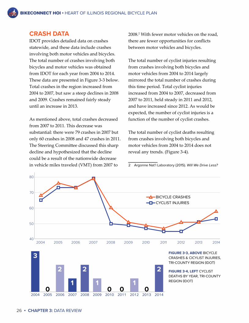
CRASH DATAIDOT provides detailed data on crashes statewide, and these data include crashes involving both motor vehicles and bicycles. The total number of crashes involving both bicycles and motor vehicles was obtained from IDOT for each year from 2004 to 2014. These data are presented in Figure 3-3 below. Total crashes in the region increased from 2004 to 2007, but saw a steep declines in 2008 and 2009. Crashes remained fairly steady until an increase in 2013.
As mentioned above, total crashes decreased from 2007 to 2011. This decrease was substantial: there were 79 crashes in 2007 but only 60 crashes in 2008 and 47 crashes in 2011. The Steering Committee discussed this sharp decline and hypothesized that the decline could be a result of the nationwide decrease in vehicle miles traveled (VMT) from 2007 to
2008.2 With fewer motor vehicles on the road, there are fewer opportunities for conflicts between motor vehicles and bicycles.
The total number of cyclist injuries resulting from crashes involving both bicycles and motor vehicles from 2004 to 2014 largely mirrored the total number of crashes during this time period. Total cyclist injuries increased from 2004 to 2007, decreased from 2007 to 2011, held steady in 2011 and 2012, and have increased since 2012. As would be expected, the number of cyclist injuries is a function of the number of cyclist crashes.
The total number of cyclist deaths resulting from crashes involving both bicycles and motor vehicles from 2004 to 2014 does not reveal any trends. (Figure 3-4).
2 Argonne Nat’l Laboratory (2015). Will We Drive Less?
40
50
60
70
80
20142013201220112010200920082007200620052004
BICYCLE CRASHESCYCLIST INJURIES
FIGURE 3-3, ABOVE BICYCLE CRASHES & CICYLIST INJURIES, TRI-COUNTY REGION (IDOT)
FIGURE 3-4, LEFT CYCLIST DEATHS BY YEAR, TRI-COUNTY REGION (IDOT)
20142013201220112010200920082007200620052004
2
01
001
2
1
2
0
3
BIKECONNECT HOI ▪ HEART OF ILLINOIS REGIONAL BICYCLE PLAN
CHAPTER 3: DATA REVIEW ▪ 27
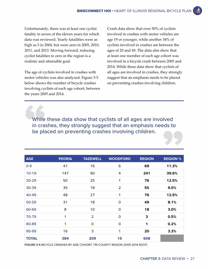
Crash data show that over 50% of cyclists involved in crashes with motor vehicles are age 19 or younger, while another 34% of cyclists involved in crashes are between the ages of 20 and 49. The data also show that at least one member of each age cohort was involved in a bicycle crash between 2005 and 2014. While these data show that cyclists of all ages are involved in crashes, they strongly suggest that an emphasis needs to be placed on preventing crashes involving children.
Unfortunately, there was at least one cyclist fatality in seven of the eleven years for which data was reviewed. Yearly fatailities were as high as 3 in 2004, but were zero in 2005, 2010, 2011, and 2013. Moving forward, reducing cyclist fatalities to zero in the region is a realistic and attainable goal.
The age of cyclists involved in crashes with motor vehicles was also analyzed. Figure 3-5 below shows the number of bicycle crashes involving cyclists of each age cohort, between the years 2005 and 2014.
AGE PEORIA TAZEWELL WOODFORD REGION REGION %
0-9 47 16 6 69 11.3%
10-19 147 90 4 241 39.6%
20-29 50 25 1 76 12.5%
30-39 35 18 2 55 9.0%
40-49 48 27 1 76 12.5%
50-59 31 18 0 49 8.1%
60-69 8 10 0 18 3.0%
70-79 1 2 0 3 0.5%
80-89 1 0 0 1 0.2%
90-99 16 3 1 20 3.3%
TOTAL 384 209 15 608
FIGURE 3-5 BICYCLE CRASHES BY AGE COHORT, TRI-COUNTY REGION 2005-2014 (IDOT)
”“While these data show that cyclists of all ages are involved in crashes, they strongly suggest that an emphasis needs to be placed on preventing crashes involving children.
BIKECONNECT HOI ▪ HEART OF ILLINOIS REGIONAL BICYCLE PLAN
28 ▪ CHAPTER 3: DATA REVIEW
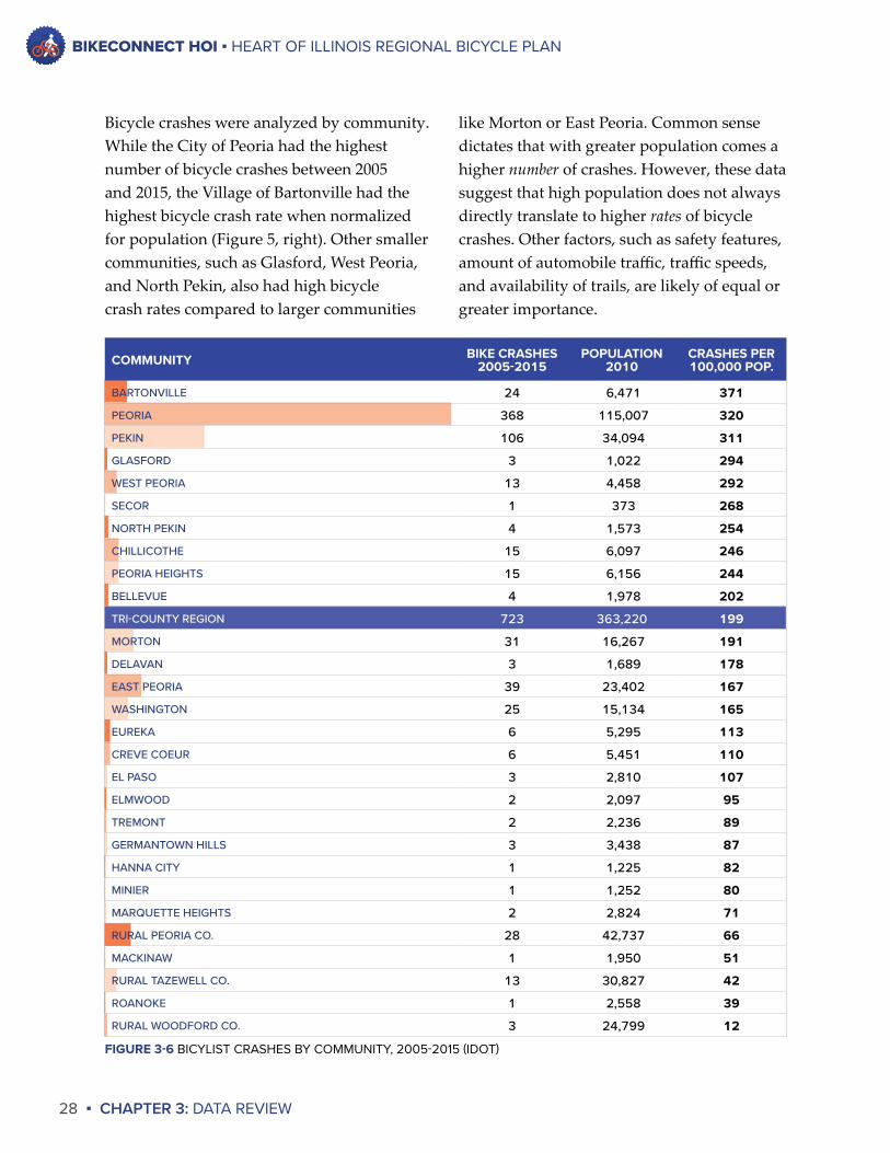
Bicycle crashes were analyzed by community. While the City of Peoria had the highest number of bicycle crashes between 2005 and 2015, the Village of Bartonville had the highest bicycle crash rate when normalized for population (Figure 5, right). Other smaller communities, such as Glasford, West Peoria, and North Pekin, also had high bicycle crash rates compared to larger communities
like Morton or East Peoria. Common sense dictates that with greater population comes a higher number of crashes. However, these data suggest that high population does not always directly translate to higher rates of bicycle crashes. Other factors, such as safety features, amount of automobile traffic, traffic speeds, and availability of trails, are likely of equal or greater importance.
COMMUNITY BIKE CRASHES 2005-2015
POPULATION 2010
CRASHES PER 100,000 POP.
BARTONVILLE 24 6,471 371
PEORIA 368 115,007 320
PEKIN 106 34,094 311
GLASFORD 3 1,022 294
WEST PEORIA 13 4,458 292
SECOR 1 373 268
NORTH PEKIN 4 1,573 254
CHILLICOTHE 15 6,097 246
PEORIA HEIGHTS 15 6,156 244
BELLEVUE 4 1,978 202
TRI-COUNTY REGION 723 363,220 199
MORTON 31 16,267 191
DELAVAN 3 1,689 178
EAST PEORIA 39 23,402 167
WASHINGTON 25 15,134 165
EUREKA 6 5,295 113
CREVE COEUR 6 5,451 110
EL PASO 3 2,810 107
ELMWOOD 2 2,097 95
TREMONT 2 2,236 89
GERMANTOWN HILLS 3 3,438 87
HANNA CITY 1 1,225 82
MINIER 1 1,252 80
MARQUETTE HEIGHTS 2 2,824 71
RURAL PEORIA CO. 28 42,737 66
MACKINAW 1 1,950 51
RURAL TAZEWELL CO. 13 30,827 42
ROANOKE 1 2,558 39
RURAL WOODFORD CO. 3 24,799 12
FIGURE 3-6 BICYLIST CRASHES BY COMMUNITY, 2005-2015 (IDOT)
BIKECONNECT HOI ▪ HEART OF ILLINOIS REGIONAL BICYCLE PLAN
CHAPTER 3: DATA REVIEW ▪ 29
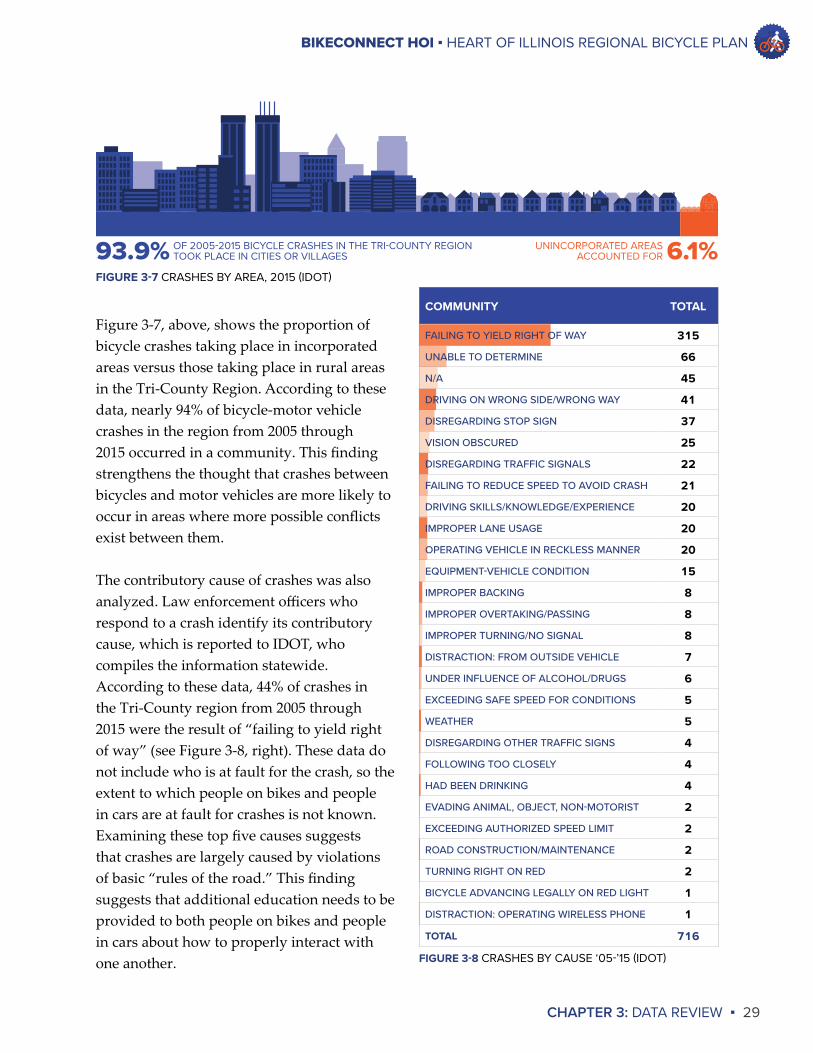
Figure 3-7, above, shows the proportion of bicycle crashes taking place in incorporated areas versus those taking place in rural areas in the Tri-County Region. According to these data, nearly 94% of bicycle-motor vehicle crashes in the region from 2005 through 2015 occurred in a community. This finding strengthens the thought that crashes between bicycles and motor vehicles are more likely to occur in areas where more possible conflicts exist between them.
The contributory cause of crashes was also analyzed. Law enforcement officers who respond to a crash identify its contributory cause, which is reported to IDOT, who compiles the information statewide. According to these data, 44% of crashes in the Tri-County region from 2005 through 2015 were the result of “failing to yield right of way” (see Figure 3-8, right). These data do not include who is at fault for the crash, so the extent to which people on bikes and people in cars are at fault for crashes is not known. Examining these top five causes suggests that crashes are largely caused by violations of basic “rules of the road.” This finding suggests that additional education needs to be provided to both people on bikes and people in cars about how to properly interact with one another.
93.9% OF 2005-2015 BICYCLE CRASHES IN THE TRI-COUNTY REGIONTOOK PLACE IN CITIES OR VILLAGES 6.1%UNINCORPORATED AREAS
ACCOUNTED FOR
FIGURE 3-7 CRASHES BY AREA, 2015 (IDOT)
COMMUNITY TOTAL
FAILING TO YIELD RIGHT OF WAY 315
UNABLE TO DETERMINE 66
N/A 45
DRIVING ON WRONG SIDE/WRONG WAY 41
DISREGARDING STOP SIGN 37
VISION OBSCURED 25
DISREGARDING TRAFFIC SIGNALS 22
FAILING TO REDUCE SPEED TO AVOID CRASH 21
DRIVING SKILLS/KNOWLEDGE/EXPERIENCE 20
IMPROPER LANE USAGE 20
OPERATING VEHICLE IN RECKLESS MANNER 20
EQUIPMENT-VEHICLE CONDITION 15
IMPROPER BACKING 8
IMPROPER OVERTAKING/PASSING 8
IMPROPER TURNING/NO SIGNAL 8
DISTRACTION: FROM OUTSIDE VEHICLE 7
UNDER INFLUENCE OF ALCOHOL/DRUGS 6
EXCEEDING SAFE SPEED FOR CONDITIONS 5
WEATHER 5
DISREGARDING OTHER TRAFFIC SIGNS 4
FOLLOWING TOO CLOSELY 4
HAD BEEN DRINKING 4
EVADING ANIMAL, OBJECT, NON-MOTORIST 2
EXCEEDING AUTHORIZED SPEED LIMIT 2
ROAD CONSTRUCTION/MAINTENANCE 2
TURNING RIGHT ON RED 2
BICYCLE ADVANCING LEGALLY ON RED LIGHT 1
DISTRACTION: OPERATING WIRELESS PHONE 1
TOTAL 716
FIGURE 3-8 CRASHES BY CAUSE ‘05-’15 (IDOT)
BIKECONNECT HOI ▪ HEART OF ILLINOIS REGIONAL BICYCLE PLAN
30 ▪ CHAPTER 3: DATA REVIEW
Two different IDOT datasets were used to compile these crash data, and there is a difference between the total number of crashes reported by these datasets. For example, Figure 3-5 states that 608 crashes occurred in the Tri-County region from 2005 through 2014. These are the total number of IDOT-reportable crashes. An IDOT-reportable crash is a crash that results in an injury or death, meets a minimum dollar amount threshold for property damage or bodily harm, and does not occur on private property. The numbers of total crashes listed in Figure 3-6 and Figure 3-8 are higher. These crash data come from IDOT’s Safety Portal, an online crash data portal that reports all crashes submitted by law enforcement agencies to IDOT. While none of the crash data are uniform, they still provide valuable information from which conclusions can be drawn about bicycle crashes and bicycle safety in the Greater Peoria region.
LOCAL SPOTLIGHT:ILLINOIS VALLEY WHEELM’NThe purpose of the Illinois Valley Wheelm’n is to foster an environment in which people can enjoy bicycling.
The IVW was formed in 1971 and includes more than 250 member households in the Peoria area. The Wheelm’n organize cycling events across the Greater Peoria region for riders of all experience and comfort levels. Events range from casual rides suitable for beginners to double centuries for seasoned riders.
A representative of the IVW served on the BikeConnect HOI Steering Committee. The Wheelm’n are a key partner in implementing the recommended action items in this plan and in strengthening bicycle connections throughout the region.
More information about the Illinois Valley Wheelm’n is accessible at ivwheelmn.org or their Facebook page.
“BICYCLING AT WILDWOOD RECREATION SITE, WELCHES” BY MTHOODTERRITORY.COM IS LICENSED UNDER CC BY 2.0
BIKECONNECT HOI ▪ HEART OF ILLINOIS REGIONAL BICYCLE PLAN
CHAPTER 3: DATA REVIEW ▪ 31
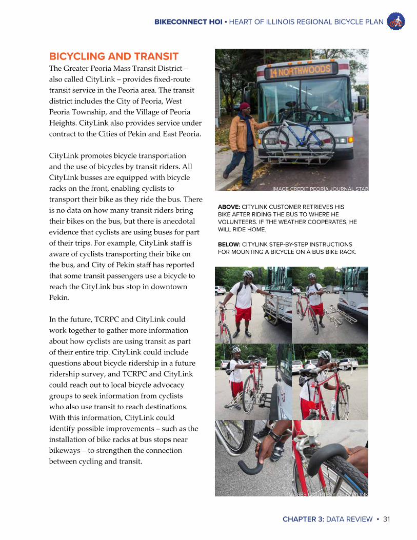
BICYCLING AND TRANSITThe Greater Peoria Mass Transit District – also called CityLink – provides fixed-route transit service in the Peoria area. The transit district includes the City of Peoria, West Peoria Township, and the Village of Peoria Heights. CityLink also provides service under contract to the Cities of Pekin and East Peoria.
CityLink promotes bicycle transportation and the use of bicycles by transit riders. All CityLink busses are equipped with bicycle racks on the front, enabling cyclists to transport their bike as they ride the bus. There is no data on how many transit riders bring their bikes on the bus, but there is anecdotal evidence that cyclists are using buses for part of their trips. For example, CityLink staff is aware of cyclists transporting their bike on the bus, and City of Pekin staff has reported that some transit passengers use a bicycle to reach the CityLink bus stop in downtown Pekin.
In the future, TCRPC and CityLink could work together to gather more information about how cyclists are using transit as part of their entire trip. CityLink could include questions about bicycle ridership in a future ridership survey, and TCRPC and CityLink could reach out to local bicycle advocacy groups to seek information from cyclists who also use transit to reach destinations. With this information, CityLink could identify possible improvements – such as the installation of bike racks at bus stops near bikeways – to strengthen the connection between cycling and transit.
ABOVE: CITYLINK CUSTOMER RETRIEVES HIS BIKE AFTER RIDING THE BUS TO WHERE HE VOLUNTEERS. IF THE WEATHER COOPERATES, HE WILL RIDE HOME.
BELOW: CITYLINK STEP-BY-STEP INSTRUCTIONS FOR MOUNTING A BICYCLE ON A BUS BIKE RACK.
IMAGE CREDIT PEORIA JOURNAL STAR
IMAGES COURTESY OF CITYLINK
BIKECONNECT HOI ▪ HEART OF ILLINOIS REGIONAL BICYCLE PLAN
32 ▪ CHAPTER 3: DATA REVIEW
far received the most responses to multiple-choice questions posed via the survey available at the Kickoff Open House and the MindMixer public engagement website.
The questions pertaining to barriers were open-ended, so TCRPC compiled all of the responses to these questions and identified the number of questions for which each barrier was provided as an answer. The questions pertaining to barriers were presented via the advocacy group questionnaire and the questionnaire distributed to local communities and counties. Figure 3-9 on Page 33 presents a summary of the barriers and concerns that were identified during the public input process.
PUBLIC INPUTAs discussed in the Introduction, TCRPC staff used a variety of methods to gather input from the general public during this planning process. Methods included:
◊ Hosting a Kickoff Open House event;◊ Administering a MindMixer website for
public input and engagement; ◊ Bringing the TCRPC Innovation Board to
community meetings and events;◊ Speaking at meetings; and◊ Distributing a questionnaire to local
communities, the three counties, local park districts and local bicycle advocacy groups.
TCRPC staff compiled the input received from the general public and organized it into two categories: 1) Barriers to bicycle transportation in the region; and 2) Primary Issues that should be addressed to strengthen bicycle transportation in the region.
BARRIERSThe barriers were identified from public input activities that asked respondents to identify the barriers to bicycling in our region and the concerns they have when riding a bicycle in our region. Questions about barriers and concerns were put forth in a survey available at the Kickoff Open House, the MindMixer public engagement website, the questionnaire distributed to advocacy groups, and the questionnaire distributed to local communities and the counties.
TCRPC identified two primary concerns that were made clear during this process: Being hit by a motor vehicle/physical harm and motorist harassment. These concerns by
“
”
I know this would be ambitious, but a pedestrian/bike bridge crossing War Memorial at Bigelow would keep cyclists on smaller roads and out of the main arteries when traveling north-south across town.
– Public Comment,Oct 2016
BIKECONNECT HOI ▪ HEART OF ILLINOIS REGIONAL BICYCLE PLAN
CHAPTER 3: DATA REVIEW ▪ 33
BARRIERS TO BICYCLING IN THE PEORIA REGION
LACK OF INFRASTRUCTURE
MOTORIST BEHAVIOR
COLD/WINTER WEATER
HILLY TERRAIN LACK OF FUNDING
NO COMPREHENSIVE
PLANNING FOR CONNECTIVITY
POOR MAINTENANCE OF INFRASTRUCTURE
NO END-OF-TRIP FACILITIES
LACK OF WILL FROM GOV’T LEADERS
LAND DEVELOPMENT
PATTERNS
NO REGIONAL AUTHORITY
NO COMPLETE STREETS
ENFORCEMENT
AUTO-CENTRIC WORKFORCE
DISJOINTED ROCK ISLAND GREENWAY
NOT ENOUGH SIGNAGE
MAJOR, BUSY ROADWAYS
BICYCLIST BEHAVIOR
LIMITEDRIGHT-OF-WAY
TRAFFIC MCCLUGAGE BRIDGE ACCESS
POOR ACCESS TO CAT MOSSVILLE
FIGURE 3-9 BARRIERS TO BICYCLE TRANSPORTATION IN THE PEORIA REGION
BIKECONNECT HOI ▪ HEART OF ILLINOIS REGIONAL BICYCLE PLAN
34 ▪ CHAPTER 3: DATA REVIEW
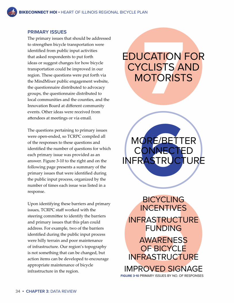
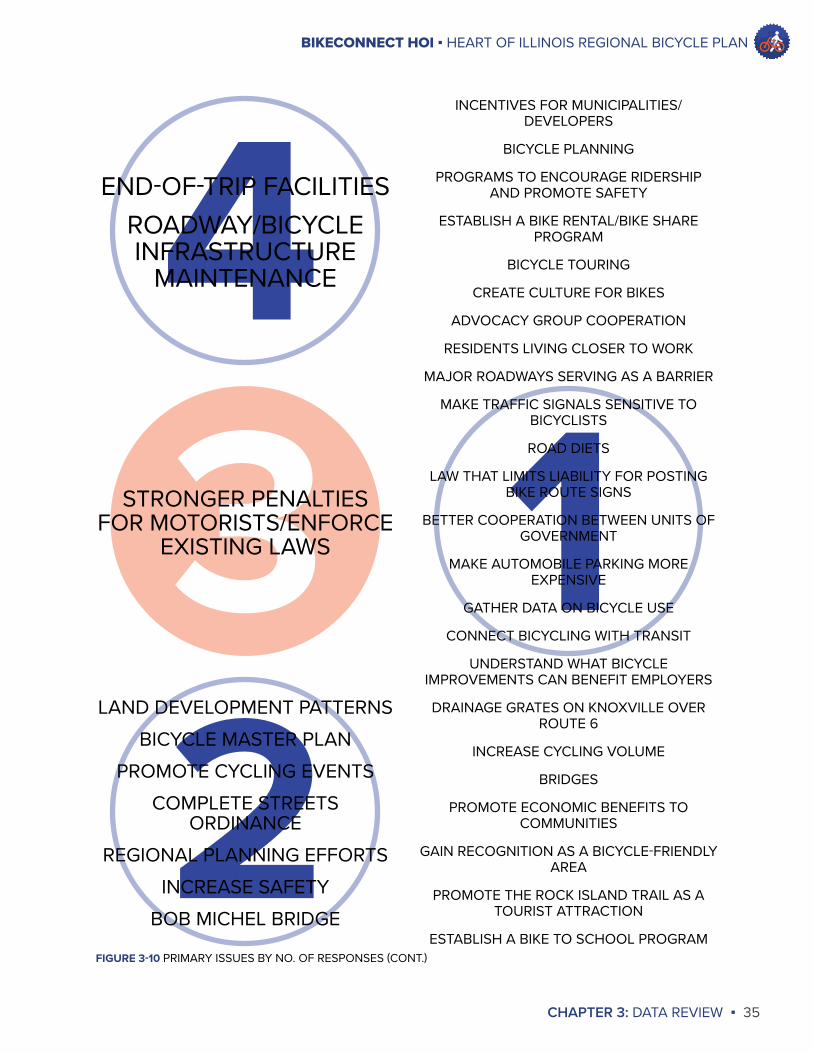
PRIMARY ISSUESThe primary issues that should be addressed to strengthen bicycle transportation were identified from public input activities that asked respondents to put forth ideas or suggest changes for how bicycle transportation could be improved in our region. These questions were put forth via the MindMixer public engagement website, the questionnaire distributed to advocacy groups, the questionnaire distributed to local communities and the counties, and the Innovation Board at different community events. Other ideas were received from attendees at meetings or via email.
The questions pertaining to primary issues were open-ended, so TCRPC compiled all of the responses to these questions and identified the number of questions for which each primary issue was provided as an answer. Figure 3-10 to the right and on the following page presents a summary of the primary issues that were identified during the public input process, organized by the number of times each issue was listed in a response.
Upon identifying these barriers and primary issues, TCRPC staff worked with the steering committee to identify the barriers and primary issues that this plan could address. For example, two of the barriers identified during the public input process were hilly terrain and poor maintenance of infrastructure. Our region’s topography is not something that can be changed, but action items can be developed to encourage appropriate maintenance of bicycle infrastructure in the region.
76
EDUCATION FOR CYCLISTS AND
MOTORISTS
5BICYCLING
INCENTIVESINFRASTRUCTURE
FUNDINGAWARENESS OF BICYCLE
INFRASTRUCTUREIMPROVED SIGNAGE
FIGURE 3-10 PRIMARY ISSUES BY NO. OF RESPONSES
MORE/BETTER CONNECTED
INFRASTRUCTURE
BIKECONNECT HOI ▪ HEART OF ILLINOIS REGIONAL BICYCLE PLAN
CHAPTER 3: DATA REVIEW ▪ 35
4
FIGURE 3-10 PRIMARY ISSUES BY NO. OF RESPONSES (CONT.)
3STRONGER PENALTIES FOR MOTORISTS/ENFORCE
EXISTING LAWS
21
END-OF-TRIP FACILITIESROADWAY/BICYCLE INFRASTRUCTURE
MAINTENANCE
LAND DEVELOPMENT PATTERNSBICYCLE MASTER PLAN
PROMOTE CYCLING EVENTSCOMPLETE STREETS
ORDINANCEREGIONAL PLANNING EFFORTS
INCREASE SAFETYBOB MICHEL BRIDGE
INCENTIVES FOR MUNICIPALITIES/DEVELOPERS
BICYCLE PLANNING
PROGRAMS TO ENCOURAGE RIDERSHIP AND PROMOTE SAFETY
ESTABLISH A BIKE RENTAL/BIKE SHARE PROGRAM
BICYCLE TOURING
CREATE CULTURE FOR BIKES
ADVOCACY GROUP COOPERATION
RESIDENTS LIVING CLOSER TO WORK
MAJOR ROADWAYS SERVING AS A BARRIER
MAKE TRAFFIC SIGNALS SENSITIVE TO BICYCLISTS
ROAD DIETS
LAW THAT LIMITS LIABILITY FOR POSTING BIKE ROUTE SIGNS
BETTER COOPERATION BETWEEN UNITS OF GOVERNMENT
MAKE AUTOMOBILE PARKING MORE EXPENSIVE
GATHER DATA ON BICYCLE USE
CONNECT BICYCLING WITH TRANSIT
UNDERSTAND WHAT BICYCLE IMPROVEMENTS CAN BENEFIT EMPLOYERS
DRAINAGE GRATES ON KNOXVILLE OVER ROUTE 6
INCREASE CYCLING VOLUME
BRIDGES
PROMOTE ECONOMIC BENEFITS TO COMMUNITIES
GAIN RECOGNITION AS A BICYCLE-FRIENDLY AREA
PROMOTE THE ROCK ISLAND TRAIL AS A TOURIST ATTRACTION
ESTABLISH A BIKE TO SCHOOL PROGRAM
BIKECONNECT HOI ▪ HEART OF ILLINOIS REGIONAL BICYCLE PLAN
36 ▪ CHAPTER 3: DATA REVIEW
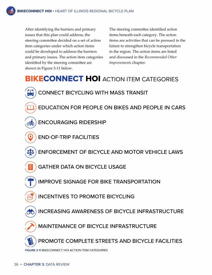
The steering committee identified action items beneath each category. The action items are activities that can be pursued in the future to strengthen bicycle transportation in the region. The action items are listed and discussed in the Recommended Other Improvements chapter.
After identifying the barriers and primary issues that this plan could address, the steering committee decided on a set of action item categories under which action items could be developed to address the barriers and primary issues. The action item categories identified by the steering committee are shown in Figure 3-11 below.
!
CONNECT BICYCLING WITH MASS TRANSIT
EDUCATION FOR PEOPLE ON BIKES AND PEOPLE IN CARS
ENCOURAGING RIDERSHIP
END-OF-TRIP FACILITIES
ENFORCEMENT OF BICYCLE AND MOTOR VEHICLE LAWS
GATHER DATA ON BICYCLE USAGE
IMPROVE SIGNAGE FOR BIKE TRANSPORTATION
INCENTIVES TO PROMOTE BICYCLING
INCREASING AWARENESS OF BICYCLE INFRASTRUCTURE
MAINTENANCE OF BICYCLE INFRASTRUCTURE
PROMOTE COMPLETE STREETS AND BICYCLE FACILITIES
BIKECONNECT HOI ACTION ITEM CATEGORIES
FIGURE 3-11 BIKECONNECT HOI ACTION ITEM CATEGORIES
BIKECONNECT HOI ▪ HEART OF ILLINOIS REGIONAL BICYCLE PLAN
CHAPTER 3: DATA REVIEW ▪ 37
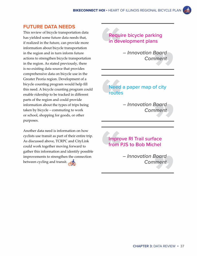
FUTURE DATA NEEDSThis review of bicycle transportation data has yielded some future data needs that, if realized in the future, can provide more information about bicycle transportation in the region and in turn inform future actions to strengthen bicycle transportation in the region. As stated previously, there is no existing data source that provides comprehensive data on bicycle use in the Greater Peoria region. Development of a bicycle counting program would help fill this need. A bicycle counting program could enable ridership to be tracked in different parts of the region and could provide information about the types of trips being taken by bicycle – commuting to work or school, shopping for goods, or other purposes.
Another data need is information on how cyclists use transit as part of their entire trip. As discussed above, TCRPC and CityLink could work together moving forward to gather this information and identify possible improvements to strengthen the connection between cycling and transit.
“ ”Require bicycle parking in development plans
– Innovation Board Comment
“ ”Need a paper map of city routes
– Innovation Board Comment
“ ”Improve RI Trail surface from PJS to Bob Michel
– Innovation Board Comment
CHAPTER 4EXISTING CONDITIONS
WASHINGTON RECREATION TRAIL
BIKECONNECT HOI ▪ HEART OF ILLINOIS REGIONAL BICYCLE PLAN
CHAPTER 4: EXISTING CONDITIONS ▪ 39
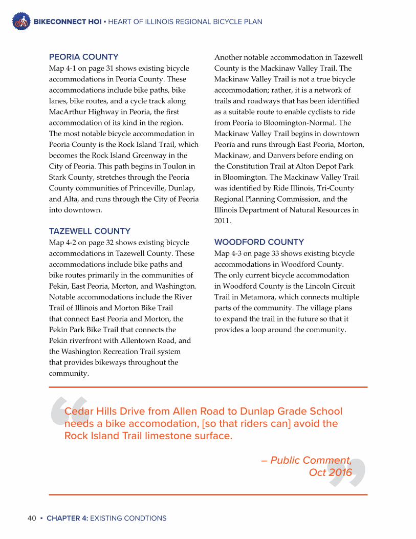
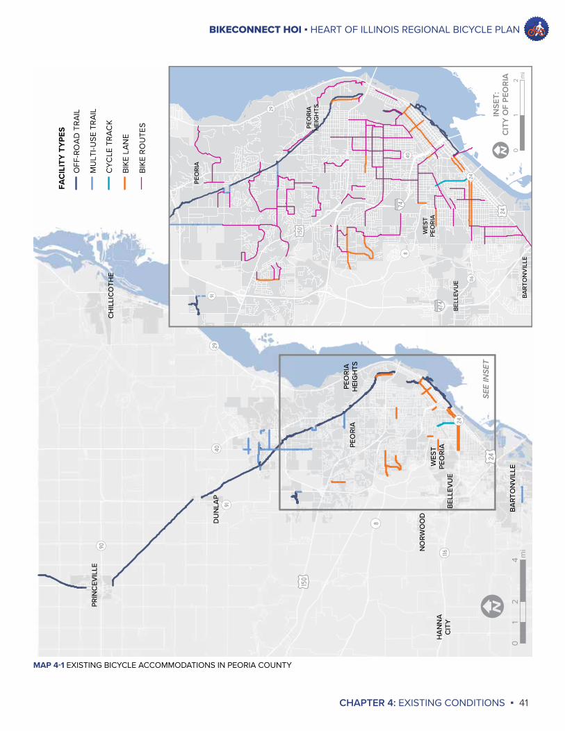
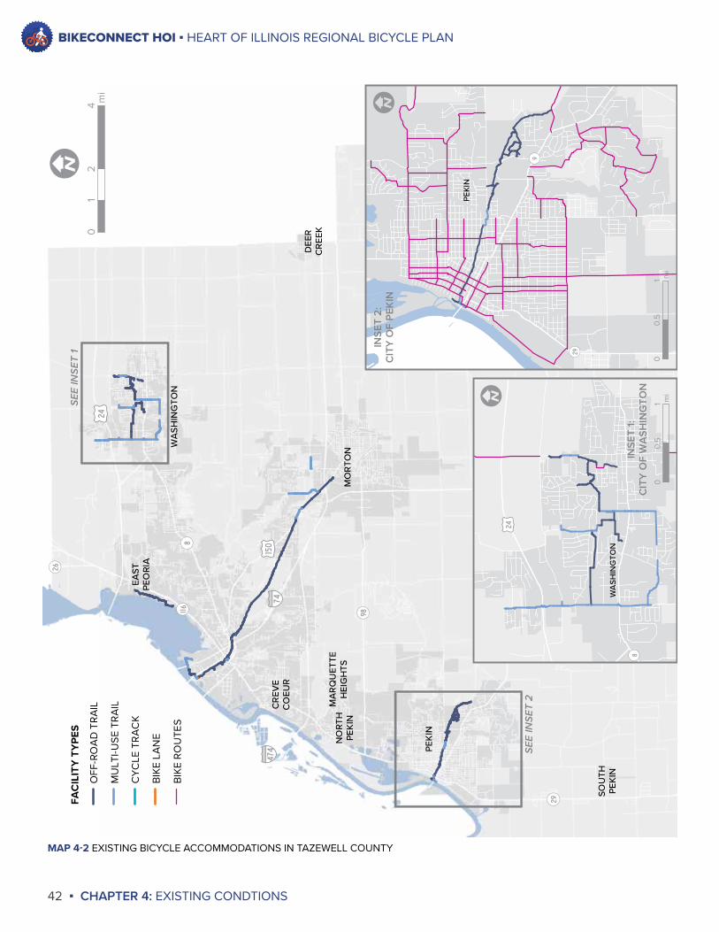
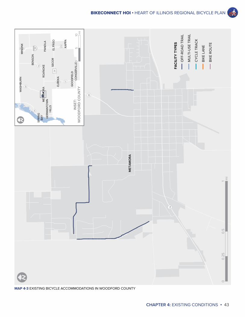
EXISTING NETWORKThe existing bicycle network in the Greater Peoria area consists of dedicated bicycle paths, on-road accommodations such as bicycle lanes, roadways designated as bicycle routes, and – because bicyclists are granted the same rights as drivers of motor vehicles in Illinois – all non-interstate roadways in the Greater Peoria area. Although bicycles are legally authorized users of roadways, the degree of bicyclist safety and comfort varies by roadway due to such factors as roadway speed limit, traffic volume, and lane width. As a result, the construction of dedicated bicycle accommodations such as bike paths, bike lanes, and other accommodations is necessary to develop a transportation network that maximizes safety and offers choices for system users.
The existing bicycle accommodations in the Greater Peoria area are presented in the maps on the following pages. While this plan is focused on the regional bicycle network, these maps show existing bicycle accommodations by individual county so that these accommodations can be clearly represented visually. These accommodations include dedicated bicycle paths, on-road accommodations such as bike lanes, and roadways designated as bicycle routes.
This section summarizes the data and input that were gathered during this planning process to assess the state of bicycle transportation. This section will describe both information gathered from published data sources and information gathered from stakeholders and the general public.
The data from published sources and input gathered from stakeholders and the general public presented in the previous chapter are not the only sets of information available to understand the state of bicycling in the region. The existing bicycle network, existing bicycle plans and policies, and existing bicycle programs also need to be reviewed in order to identify future bicycle network improvements and identify appropriate action items for strengthening bicycle transportation in the future.
“ILLINOIS 116 COLORED BIKE LANE AND ROAD DIET - PEORIA” BY ERIC FREDERICKS IS LICENSED UNDER CC BY-SA 2.0
BIKECONNECT HOI ▪ HEART OF ILLINOIS REGIONAL BICYCLE PLAN
40 ▪ CHAPTER 4: EXISTING CONDTIONS
Another notable accommodation in Tazewell County is the Mackinaw Valley Trail. The Mackinaw Valley Trail is not a true bicycle accommodation; rather, it is a network of trails and roadways that has been identified as a suitable route to enable cyclists to ride from Peoria to Bloomington-Normal. The Mackinaw Valley Trail begins in downtown Peoria and runs through East Peoria, Morton, Mackinaw, and Danvers before ending on the Constitution Trail at Alton Depot Park in Bloomington. The Mackinaw Valley Trail was identified by Ride Illinois, Tri-County Regional Planning Commission, and the Illinois Department of Natural Resources in 2011.
WOODFORD COUNTYMap 4-3 on page 33 shows existing bicycle accommodations in Woodford County. The only current bicycle accommodation in Woodford County is the Lincoln Circuit Trail in Metamora, which connects multiple parts of the community. The village plans to expand the trail in the future so that it provides a loop around the community.
PEORIA COUNTYMap 4-1 on page 31 shows existing bicycle accommodations in Peoria County. These accommodations include bike paths, bike lanes, bike routes, and a cycle track along MacArthur Highway in Peoria, the first accommodation of its kind in the region. The most notable bicycle accommodation in Peoria County is the Rock Island Trail, which becomes the Rock Island Greenway in the City of Peoria. This path begins in Toulon in Stark County, stretches through the Peoria County communities of Princeville, Dunlap, and Alta, and runs through the City of Peoria into downtown.
TAZEWELL COUNTYMap 4-2 on page 32 shows existing bicycle accommodations in Tazewell County. These accommodations include bike paths and bike routes primarily in the communities of Pekin, East Peoria, Morton, and Washington. Notable accommodations include the River Trail of Illinois and Morton Bike Trail that connect East Peoria and Morton, the Pekin Park Bike Trail that connects the Pekin riverfront with Allentown Road, and the Washington Recreation Trail system that provides bikeways throughout the community.
“”
Cedar Hills Drive from Allen Road to Dunlap Grade School needs a bike accomodation, [so that riders can] avoid the Rock Island Trail limestone surface.
– Public Comment,Oct 2016
BIKECONNECT HOI ▪ HEART OF ILLINOIS REGIONAL BICYCLE PLAN
CHAPTER 4: EXISTING CONDITIONS ▪ 41
NORW
OOD
PEORIA
HEIGHTS
WES
TPE
ORIA
PRINCEV
ILLE
CHILLICOTH
E
BEL
LEVUE
BART
ONVILLE
PEORIA
HANNA
CITY
DUNLA
P
¬ «8
¬ «116
¬ «24
¬ «90
¬ «40¬ «29
¬ «91
£ ¤24
£ ¤150
¬ «8
¬ «91
¬ «116¬ «24
¬ «29
¬ «40§̈ ¦74
§̈ ¦474
£ ¤24
£ ¤150
PEORIA
HEIGHTS
WES
TPE
ORIA
BEL
LEVUE
BARTO
NVILLE
PEORIA
02
41
mi
I0
21
mi
ISE
E IN
SET
INSE
T:C
ITY
OF
PEO
RIA
FAC
ILIT
Y T
YPE
S
OFF
-RO
AD
TR
AIL
MU
LTI-U
SE T
RA
IL
CY
CLE
TR
AC
K
BIK
E LA
NE
BIK
E R
OU
TES
MAP 4-1 EXISTING BICYCLE ACCOMMODATIONS IN PEORIA COUNTY
BIKECONNECT HOI ▪ HEART OF ILLINOIS REGIONAL BICYCLE PLAN
42 ▪ CHAPTER 4: EXISTING CONDTIONS
MAP 4-2 EXISTING BICYCLE ACCOMMODATIONS IN TAZEWELL COUNTY
SOUTH
PEKIN
MACKINAW
TREM
ONT
PEKIN
MORTO
N
CREV
ECOEU
R
MARQUET
TEHEIGHTS
EAST
PEORIA
WASH
INGTO
N
NORT
HPE
KIN
DEE
RCREE
K
¬ «26
¬ «98
¬ «9¬ «29
¬ «8¬ «116
§̈ ¦74
§̈ ¦155
§̈ ¦474
£ ¤150
£ ¤24
¬ «29
¬ «9
PEKIN
¬ «8
£ ¤24
WASH
INGTO
N
02
41
mi
I
I
SEE
INSE
T 1 IN
SET
2:C
ITY
OF
PEK
IN
01
0.5
miI
INSE
T 1:
CIT
Y O
F W
ASH
ING
TON
SEE
INSE
T 2
01
0.5
mi
FAC
ILIT
Y T
YPE
S
OFF
-RO
AD
TR
AIL
MU
LTI-U
SE T
RA
IL
CY
CLE
TR
AC
K
BIK
E LA
NE
BIK
E R
OU
TES
BIKECONNECT HOI ▪ HEART OF ILLINOIS REGIONAL BICYCLE PLAN
CHAPTER 4: EXISTING CONDITIONS ▪ 43
MAP 4-3 EXISTING BICYCLE ACCOMMODATIONS IN WOODFORD COUNTY
¬ «116
¬ «89
MET
AM
OR
A
¬ «251
¬ «89
¬ «116
¬ «117
¬ «26§̈ ¦39
£ ¤24
SPRI
NG
BA
Y
GER
MA
NTO
WN
HIL
LS
MET
AM
OR
A
WA
SHB
UR
N
BEN
SON
MIN
ON
K
PAN
OLA
EL P
ASO
SEC
OR
KAPP
A
CO
NG
ERV
ILLE
ROA
NO
KE
EUR
EKA
GO
OD
FIEL
D
FAC
ILIT
Y T
YPE
S
OFF
-RO
AD
TR
AIL
MU
LTI-U
SE T
RA
IL
CY
CLE
TR
AC
K
BIK
E LA
NE
BIK
E R
OU
TE
00.
51
0.25
mi
II
INSE
T:W
OO
DFO
RD C
OU
NTY
010
5m
i
BIKECONNECT HOI ▪ HEART OF ILLINOIS REGIONAL BICYCLE PLAN
44 ▪ CHAPTER 4: EXISTING CONDTIONS
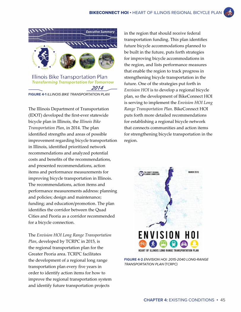
EXISTING PLANS AND POLICIESWhile past planning processes at the county and regional levels have addressed bicycle transportation, there has never been a true regional bicycle plan developed for the Greater Peoria area. BikeConnect HOI is occurring at a time when local communities are engaging in more focused bicycle planning and developing policies to promote bicycle transportation. This section will summarize past bicycle planning work in the region; this work has established a foundation for the development of BikeConnect HOI.
STATEWIDE, REGIONAL, AND COUNTY PLANSThe first plan to address bicycling on a regional scale was the Peoria Metro Area Greenways and Trails Plan developed by TCRPC in 1997. The purpose of this plan was to create a vision for a regional greenway network that would connect the region. A greenway was defined as a corridor of open space that is managed for recreation or preservation. This plan identified existing trails, existing greenways, and possible future bicycle trails and accommodations in the communities of Morton, East Peoria, Washington, Pekin, and Peoria. The plan also put forth recommendations for how greenways and bicycle accommodations could be developed in the future. Because this plan focused on greenways in addition to bicycle accommodations, its treatment of bicycle transportation overall was limited.
Following the 1997 effort, TCRPC developed the Unurbanized Greenways and Trails Plan for Peoria and Tazewell Counties in 2002. This plan went further than the 1997 plan by identifying additional greenway and trail opportunities in Peoria and Tazewell Counties. Similar to the 1997 plan, its treatment of bicycle transportation overall was limited due to its emphasis on greenways and trail opportunities.
The Unurbanized Greenways and Trails Plan for Woodford and McLean Counties, also developed by TCRPC in 2002, was similar to its counterpart for Peoria and Tazewell Counties. It built upon the 1997 plan by identifying additional greenway and trail opportunities in Woodford and McLean Counties. Its treatment of bicycle transportation overall also was limited.
In 2005 TCRPC developed the Peoria County Recreational Trail System Connection Study. The purpose of this study was to provide detailed recommendations for developing five different trail connections in the County: 1) A connection between the proposed Hanna City Trail and Downtown Peoria; 2) A connection along Kickapoo Creek Road from Bartonville to Illinois Route 116; 3) A Kickapoo Creek Canoe Trail from Wildlife Prairie Park to Bartonville; 4) A connection along Taylor Road from the proposed Hanna City Trail to Wildlife Prairie Park; and 5) The proposed Hanna City Trail from Bellevue in Peoria County to Middle Grove in Fulton County. None of these connections have been implemented, and some of these connections are addressed in BikeConnect HOI.
BIKECONNECT HOI ▪ HEART OF ILLINOIS REGIONAL BICYCLE PLAN
CHAPTER 4: EXISTING CONDITIONS ▪ 45
in the region that should receive federal transportation funding. This plan identifies future bicycle accommodations planned to be built in the future, puts forth strategies for improving bicycle accommodations in the region, and lists performance measures that enable the region to track progress in strengthening bicycle transportation in the future. One of the strategies put forth in Envision HOI is to develop a regional bicycle plan, so the development of BikeConnect HOI is serving to implement the Envision HOI Long Range Transportation Plan. BikeConnect HOI puts forth more detailed recommendations for establishing a regional bicycle network that connects communities and action items for strengthening bicycle transportation in the region.
The Illinois Department of Transportation (IDOT) developed the first-ever statewide bicycle plan in Illinois, the Illinois Bike Transportation Plan, in 2014. The plan identified strengths and areas of possible improvement regarding bicycle transportation in Illinois, identified prioritized network recommendations and analyzed potential costs and benefits of the recommendations, and presented recommendations, action items and performance measurements for improving bicycle transportation in Illinois. The recommendations, action items and performance measurements address: planning and policies; design and maintenance; funding; and education/promotion. The plan identifies the corridor between the Quad Cities and Peoria as a corridor recommended for a bicycle connection.
The Envision HOI Long Range Transportation Plan, developed by TCRPC in 2015, is the regional transportation plan for the Greater Peoria area. TCRPC facilitates the development of a regional long range transportation plan every five years in order to identify action items for how to improve the regional transportation system and identify future transportation projects
2014
Executive Summary
FIGURE 4-1 ILLINOIS BIKE TRANSPORTATION PLAN
FIGURE 4-2 ENVISION HOI: 2015-2040 LONG-RANGE TRANSPORTATION PLAN (TCRPC)
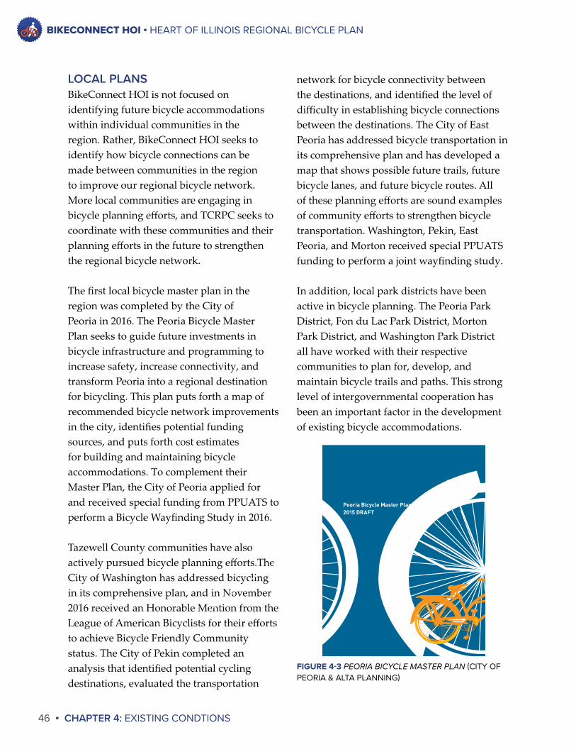
BIKECONNECT HOI ▪ HEART OF ILLINOIS REGIONAL BICYCLE PLAN
46 ▪ CHAPTER 4: EXISTING CONDTIONS
LOCAL PLANSBikeConnect HOI is not focused on identifying future bicycle accommodations within individual communities in the region. Rather, BikeConnect HOI seeks to identify how bicycle connections can be made between communities in the region to improve our regional bicycle network. More local communities are engaging in bicycle planning efforts, and TCRPC seeks to coordinate with these communities and their planning efforts in the future to strengthen the regional bicycle network.
The first local bicycle master plan in the region was completed by the City of Peoria in 2016. The Peoria Bicycle Master Plan seeks to guide future investments in bicycle infrastructure and programming to increase safety, increase connectivity, and transform Peoria into a regional destination for bicycling. This plan puts forth a map of recommended bicycle network improvements in the city, identifies potential funding sources, and puts forth cost estimates for building and maintaining bicycle accommodations. To complement their Master Plan, the City of Peoria applied for and received special funding from PPUATS to perform a Bicycle Wayfinding Study in 2016.
Tazewell County communities have also actively pursued bicycle planning efforts.The City of Washington has addressed bicycling in its comprehensive plan, and in November 2016 received an Honorable Mention from the League of American Bicyclists for their efforts to achieve Bicycle Friendly Community status. The City of Pekin completed an analysis that identified potential cycling destinations, evaluated the transportation
network for bicycle connectivity between the destinations, and identified the level of difficulty in establishing bicycle connections between the destinations. The City of East Peoria has addressed bicycle transportation in its comprehensive plan and has developed a map that shows possible future trails, future bicycle lanes, and future bicycle routes. All of these planning efforts are sound examples of community efforts to strengthen bicycle transportation. Washington, Pekin, East Peoria, and Morton received special PPUATS funding to perform a joint wayfinding study.
In addition, local park districts have been active in bicycle planning. The Peoria Park District, Fon du Lac Park District, Morton Park District, and Washington Park District all have worked with their respective communities to plan for, develop, and maintain bicycle trails and paths. This strong level of intergovernmental cooperation has been an important factor in the development of existing bicycle accommodations.
Peoria Bicycle Master Plan2015 DRAFT
FIGURE 4-3 PEORIA BICYCLE MASTER PLAN (CITY OF PEORIA & ALTA PLANNING)

BIKECONNECT HOI ▪ HEART OF ILLINOIS REGIONAL BICYCLE PLAN
CHAPTER 4: EXISTING CONDITIONS ▪ 47
LOCAL POLICIESMore local communities are also developing policies that seek to promote bicycling and strengthen bicycle transportation. The City of Peoria adopted the first Complete Streets policy in the region in 2015. A complete street is a street that is “designed and operated to enable safe access for all users, including pedestrians, bicyclists, motorists and transit riders of all ages and abilities.”The City of Peoria’s Complete Streets policy states that the City “shall develop a … transportation system that will promote access, mobility and health for all users, and will provide for the safety and convenience of all users of the transportation system, including pedestrians, bicyclists, users of mass transit, people of all ages and abilities, motorists, emergency responders, freight providers and adjacent land users.” More than 500 communities nationwide have adopted Complete Streets policies. Adoption and implementation of Complete Streets policies should result in better bicycle accommodations in the future.
Additional policies to strengthen bicycle transportation have been put in place by other local communities. The City of Washington has increased the width of new sidewalks to recreation trail widths in certain locations to expand the City’s trail network. The City of East Peoria has an overlay zoning district for the Levee District that has certain landscaping requirements, and the installation of bike racks can count toward meeting the landscaping requirements. Peoria County evaluates all proposed construction projects for potential connectivity with other bikeways. All of these practices are beneficial for promoting bicycle transportation in communities.
IDOT POLICIESIDOT is striving to develop a statewide transportation system that supports and enables bicycle transportation. As discussed above, IDOT developed the first statewide bicycle plan in Illinois in 2014. But even before that plan was developed, the State of Illinois enacted policies to promote bicycle transportation statewide.
The most prominent policy is known as the Illinois Complete Streets Law. This policy, which is within Section 4-220 of the Illinois Highway Code, states that “bicycle and pedestrian ways shall be given full consideration in the planning and development of transportation facilities, including the incorporation of such ways into state plans and programs.” This policy has been put into practice; IDOT evaluates all roadway construction and reconstruction projects to determine whether the inclusion of bicycle accommodations is warranted.
Detailed bicycle policies are presented in IDOT’s Bureau of Design and Environment (BDE) Manual. The purpose of the BDE Manual is to provide uniform practices for IDOT to follow when roadway construction projects are being studied. Chapter 17 of the BDE Manual addresses bicycle and pedestrian accommodations. This document describes in detail the process IDOT follows for evaluating a roadway project for possible bicycle accommodations. This document also presents the design criteria for bicycle accommodations developed by IDOT.
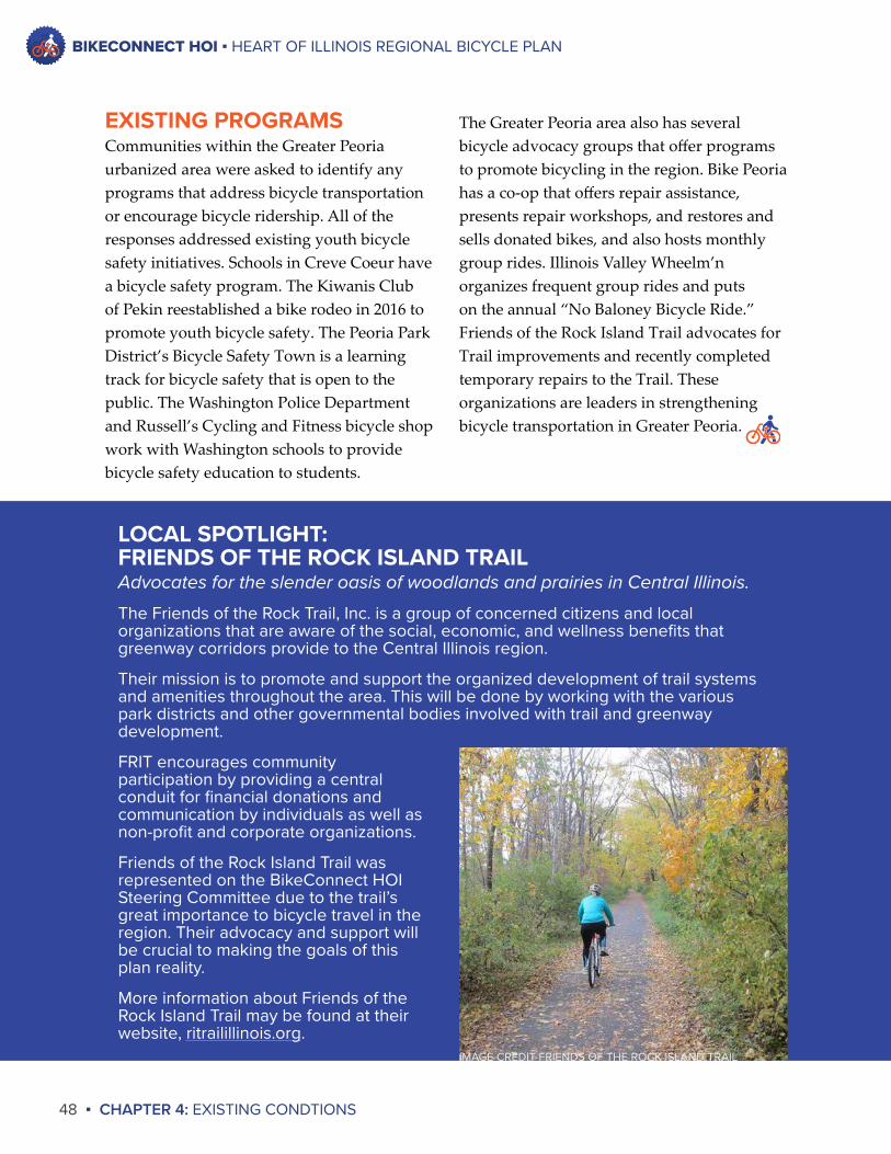
BIKECONNECT HOI ▪ HEART OF ILLINOIS REGIONAL BICYCLE PLAN
48 ▪ CHAPTER 4: EXISTING CONDTIONS
The Greater Peoria area also has several bicycle advocacy groups that offer programs to promote bicycling in the region. Bike Peoria has a co-op that offers repair assistance, presents repair workshops, and restores and sells donated bikes, and also hosts monthly group rides. Illinois Valley Wheelm’n organizes frequent group rides and puts on the annual “No Baloney Bicycle Ride.” Friends of the Rock Island Trail advocates for Trail improvements and recently completed temporary repairs to the Trail. These organizations are leaders in strengthening bicycle transportation in Greater Peoria.
EXISTING PROGRAMSCommunities within the Greater Peoria urbanized area were asked to identify any programs that address bicycle transportation or encourage bicycle ridership. All of the responses addressed existing youth bicycle safety initiatives. Schools in Creve Coeur have a bicycle safety program. The Kiwanis Club of Pekin reestablished a bike rodeo in 2016 to promote youth bicycle safety. The Peoria Park District’s Bicycle Safety Town is a learning track for bicycle safety that is open to the public. The Washington Police Department and Russell’s Cycling and Fitness bicycle shop work with Washington schools to provide bicycle safety education to students.
LOCAL SPOTLIGHT:FRIENDS OF THE ROCK ISLAND TRAILAdvocates for the slender oasis of woodlands and prairies in Central Illinois.
The Friends of the Rock Trail, Inc. is a group of concerned citizens and local organizations that are aware of the social, economic, and wellness benefits that greenway corridors provide to the Central Illinois region.
Their mission is to promote and support the organized development of trail systems and amenities throughout the area. This will be done by working with the various park districts and other governmental bodies involved with trail and greenway development.
FRIT encourages community participation by providing a central conduit for financial donations and communication by individuals as well as non-profit and corporate organizations.
Friends of the Rock Island Trail was represented on the BikeConnect HOI Steering Committee due to the trail’s great importance to bicycle travel in the region. Their advocacy and support will be crucial to making the goals of this plan reality.
More information about Friends of the Rock Island Trail may be found at their website, ritrailillinois.org.
IMAGE CREDIT FRIENDS OF THE ROCK ISLAND TRAIL
BIKECONNECT HOI ▪ HEART OF ILLINOIS REGIONAL BICYCLE PLAN
CHAPTER 4: EXISTING CONDITIONS ▪ 49
“”
NEED MORE BIKE RACKS AROUND DOWNTOWN PEORIA!!!
– Innovation Board Comment
“”
Downloadable electronic map/apps of the network for phone/GPS
– Innovation Board Comment
“ ”¡CICLOVÍA!
– Innovation Board Comment
“ ”REPAIR ROCK ISLAND TRAIL WASHOUTS
– Innovation Board Comment
“”
• Connectivity• Fix cracks/holes• Sharrows
– Innovation Board Comment
“”
Bike connection from Northwoods Mall (US150) to Allen Rd intersection
– Innovation Board Comment
“ ”CONTINUE BIKE LANES WEST ON FORREST HILL
– Innovation Board Comment
“”
Close 1-2 major streets to cars on weekends — bikes only!
– Innovation Board Comment
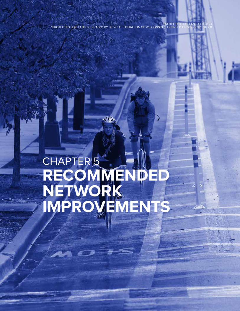
PROTECTED BIKE LANE, CHICAGO“PROTECTED BIKE LANES CHICAGO” BY BICYCLE FEDERATION OF WISCONSIN IS LICENSED UNDER CC BY-SA 2.0
CHAPTER 5RECOMMENDED NETWORK IMPROVEMENTS
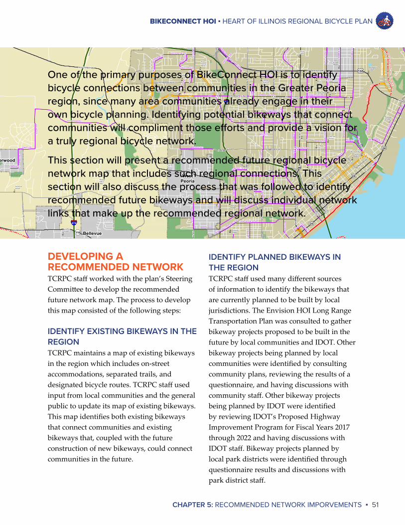
BIKECONNECT HOI ▪ HEART OF ILLINOIS REGIONAL BICYCLE PLAN
CHAPTER 5: RECOMMENDED NETWORK IMPORVEMENTS ▪ 51
))) ) )
)
)
)
)
)
)
)
)
)
)
)
))
)
)
)
)
)
))
)
)
))))
)))
) ))
) ))
))
))
))))
)
)
)
))
))
!
!
!
!
!
!
nn
nn
nn
nn
nn
nn
nn
nn
nn
nn
nn
nn
nn
nn
nn
nn
nn
nn
nn
nn
nn
nn
nn
nn
nnnn
nn
nn
nnnn
nn
nn
nn
nn
nn
nn
nn
nn
nn
nn
nn
nn
nnnn
nn
nn
nn
nn
nn
nn
nn
nn
nn
nn
nn
nn
nn
nn
nn
nn
nn
nn
nn
nn
nn
nn
nn
nn
nn
nn
LAKE AVE
WREN AVE
ADAMS ST
WESTAIR
E AV
E
STER
L IN
G AV
E
GRANDVIEW DR
PARK AVE
WIL
LOW
KNOLLS RD
ADAM
S ST
GLEN
OAK
PARK
RO
NALD
RD
WINDOM ST
MIDDLE RD
POTTSTOWN RD
LIN
N ST
PROSPECT RD
ALTOR
FER D
R
N H
ALE
AVE
PRO
SPEC
T R
D
MARIETTA AVE
LOU
ISA
ST
GAR
FIELD AVE
MIL
LER
AVE
ROCK
WO
OD
DR
MONTANA ST
BIG HOLLOW
RD
PEO
RIA
AVE
LIN
N ST
HICKORY GROVE RD
GLEN AVE
CONLEY RD
NO
RTH
S T
FORREST HILL AVE
DANA DR
WESLEY RD
PAR
K AV
E
FRYE AVE
ILLINOIS AVE
FLORENCE AVE
MARIETTA AVE
PARKSIDE DR
CHAR
TER
OAK RD
WILLHELM RD
MAX
WEL
L R
D
GARDNER LN
GLE
NW
OO
D AV
E
BIG
ELO
W ST
GRANGE HALL RD
CEN
TRAL
AVE
MO
NR
OE
AVE
W AMERICAN PRAIRIE DR
CO
L UM
B IN
E D
R
DR MARTIN LUTHER KING JR DR
MAXWELL
RD
FOREST PARK DR
GARDEN ST
HIG
HTO
WE R
RD
E LLO
RY
RD
BRANDYW
INE DR
LAR
AMIE
ST
BIG HOLLOW
RD
IL ROUTE 174
MIDDLE RD
CAM
ERO
N LN
HEI
NZ
LN
RAD
NO
R R
D
FORREST HILL AVE
HEADING AVE
GALE AVE
East Peoria River Trail
East
Peor
ia R
iver T
rail
US 150
ALLE
N R
D
US 150
East Peoria River TrailRiv
er T
rail
Con
nect
or
KNO
XVIL
E AV
E
N. Main
St.
RO
CK ISLAN
D TR
AIL - KELLAR BR
ANC
H
ALLE
N R
D
IL R
OU
TE 9
1
Challacomb
Ora
nge
Prai
rie
ALTA RD
Hanna City Rail-Trail
THIRD AVE
JOHN GWYNN JR AVESTER
LIN
G AV
E
BRONS ST
ROSEMEAD
DR
WES
TER
N AV
E
B ELL
EVU
E PL
GILES LN
LAKE AVE
KRAUSE AVE
WILCOX AVE
TETON DR
HOLLYR
IDG
E CIR
BARR
I NG
TON
RD
ADAMS ST
CORRINGTON AVE
DR MARTIN LUTHER KING JR DR
BRAD
FOR
D
HANNSLER PL
WILSHIRE DR
MONTCLAIR AVE
CIMARRON DR
WIS
CO
NSI
N AV
E
NORT
H ST
GRE
EN
MONT RD
GRANDVIEW
DR
BOO
TZ AV
E
WAR
RE N
ST
WESTBROOK DR
SAIN
T M
ARYS
RD
PERRY AVE
SAYMORE LN
CREIGHTON TERR
LAMOINE ST
MO
LLE C
K D
R
HARRISON ST
FRYE AVE
FORREST HILL AVE
PLAZ
A D
R
SOM
MER
ST
NE
PER
RY AV
E
P EO
RIA
AVE
WAR
REN
ST
RESERVOIR BLVD
COLUMBIA TERR
CLAREWOOD AVE
SHER
WO
OD
AVE
EXT
PRO
SPEC
T R
D
MAD
ISO
N AV
E
WIS
CO
NSI
N AV
E
PARTRIDGE
ISAB
ELL
AVE
AUSTIN DR
NEBRASKA AVE
OR
EGO
N ST
UN
IVER
SITY
ST
INST
ITUT
E PL
BRENWICK DR
N H
ALE
A VE
BRIGHTON AVE
RO
CKW
OO
D R
D
ATLA
NTI
C AV
E
ISAB
ELL
AVE
GALE AVE
BRO
A DW
AY ST
DETWEILLER
AUSTIN DR
BROOKSID
E D
R
STONEGATE RD
CHARTWELL RD
BRIA
RWO
OD LN
ELM
CRO
FT TE
RR
US HWY 24
BUTLER ST
COURTLAND ST
MEADOWBROOK RD
US HWY 24
BRADLEY AVE
DAYTONA DR
HUMBOLDT AVE
MCCLURE AVE
PARKWOOD
EMBERT PL
MARLENE AVE
IL ROUTE 116
ALTORFER DR
SHER
IDAN
RD
CANDLETREE DR
WEB
STER
ST
SMITHVILLE RD
BRO
A DW
AY ST
GR
ISW
OLD
ST
CAMERON LN
NE GLEN OAK AVE
IMPE
RIA
L D
R
LEH
MAN
RD
WES
TER
N AV
E
GARDEN ST
BOU
LEVA
RD
AVE
LIN
N S T
MCCLURE AVE
MANOR PKWY
DR
IES
LN
MOSS AVE
NORTHMOOR
HUMBOLDT AVE
WESTPORT RD
NEBRASKA AVE
FOLK
ERS
AVE
CHARTER OAK TR
AIL
ALLE
N R
D
MO
UNT HAW
LEY RD
HAR
VAR
D AV
E
F RO
S TW
OO
D PK
WY
HAMILTON BLVD
MO
LLEC
K D
RABINGTON ST
MONROE ST
ROHMANN AVE
SPRING ST
W RESERVOIR BLV
D
FORREST HILL AV
E
LINCOLN AV
HOWETT
ROCK ISLAND
TRAIL
Bartonville trail
RIVERFRONT TRAIL
SOM
MER
ST
RIVERFR
ONT TRAIL
NORTHMOOR RD
ROCK ISLAND
TRAIL - KELLAR BRANCH
ALLE
N R
D
HICKORY GROVE RD
ROCK
ISLAND TRAIL
- KELLAR
BRANCH
ROCK ISLAND TRAIL - ALTA
ALLE
N R
DAL
LEN
RD
Fond
ulac
Park
Rive
r Tra
il
SPRI
NGDA
LE CE
MET
ERY
SpringBay
Peoria
PeoriaHeights
Norwood
WestPeoria
Bellevue
Bartonville
EastPeoria
CreveCoeur
Our LadyCovent
Blaine-Sumner
BrightFutures
CatholicDiocese
Charles A.Lindberg
CharterOak
PeoriaChristian
ColumbiaMiddle
Concordia Lutheran
Children's Home
El VistaBaptist
EdisonFranklin
GarfieldPrimary
Glen OakPrimary
HarrisonPrimary
HinesPrimary
HolyFamilyParish
MossvilleElem
KellarCentral
KingmanPrimary
LincolnMiddle
LoucksEdison
MethodistCollege
RooseveltMagnet
MonroeGrade
ManualHigh
Montessori
Northmoor-Edison
LimestoneWalters
NorwoodPrimary
NorwoodSchool
PalS
PeoriaHeightsHigh
Peoria Alt. High
PeoriaHebrew
Peoria Hebrew
PeoriaChristian
Middle
PeoriaHeights
Grade
NotreDameHigh
PeoriaHigh
VonSteubenPeoria Public
PeoriaSDA
PleasantValley
IrvingPrimary
Mark W.Bills
Robert AJamieson
KellarEast
WashingtonGifted
WhittierPrimary
WoodrowWilson
Woodruff High
PleasantHill
PleasantVallyMiddle
PleasantValleyMain
RidgeviewElem
RichwoodsHigh
RollingAcres-Edison Junior
St. MarkGrade
St.Philomena
St.Thomas
St.Vincent
SterlingMiddle
ThomasJefferson
TrewynMiddle
TyngMiddle
WhiteMiddle
Wilder-Waite
W US HIGHWAY 150
RIVER
RD
N KNO
XVILLE AVE
W NORTHMOOR RD
W NEBRASKA AVE
AIR
PORT
RD
AIRPORT R
D
E MOSSVILLE RD
NE PERRY AVE
NE JEFFERSON AVE
STAT
E ST
CATERPILLAR TRL
MEADOW AVE
W W
AR MEMORIAL DR
FAYETTE ST
W PIONEER PKY
N U
NIV
ERSI
TY S
T
W WAR MEMORIAL DR
W FORREST HILL AVE
W MAIN ST
E WASHINGTON ST
S W
ESTE
RN
AVE
E CAMP ST
CATERPILL
AR TR
L
W FARMINGTON RD
SW ADAMS ST
N M
ACARTHUR H
WY
NE MADISON AVE
N M
AXWELL R
D
W LINCOLN AVE
E WASHINGTON ST
W LAKE AVE
E GLEN AVE
W CEDAR HILLS DR
W NEBRASKA AVE
W GLEN AVE
W STARR ST
S
ADAMS
ST
W HOWETT ST
NE ADAMS ST
SW WASHINGTON ST
N
FARMING
TON
RD
MAIN ST
W HARMON HWY
S M
ACAR
THU
R H
WY
MAXWELL CONN
ALTA LN
SPALDING AVE
E WAR MEMORIAL DR
CR
-R58
E WAR MEMORIAL DR
W GLEN AVE
W FORREST HILL AVE
E WAR MEMORIAL DR
W SOUTHPORT RD
W PLANK RD
AIRPORT
RD
NE GLE
NDALE AVE
BRYAN AVE
SPRINGFIELD RD
MARY ST
HAMILTON
BLVD
W CAM
P ST
W ALTA RD
S G
ARFI
ELD
BLV
D
W LINCOLN AVE
S AIRPORT R
D
CR
-R54
W ALTA LN
W HOWETT ST
ROOSEVELT ST
W MOSSVILLE RD
MCCLUGAGE BRG
N S
HER
IDAN
RD
N G
ALEN
A R
D
N G
ALEN
A R
D
N MAIN STEDMOND
ST
N K
NO
XVIL
LE A
VE
S G
RIS
WO
LD S
T
N U
NIV
ERSI
TY S
T
N KNO
XVILLE AVE
N W
ISC
ON
SIN
AVE
N AT
LAN
TIC
ST
CR
-R51
KICKAPOO
CREEK RD
S LA
RAM
IE S
T
S C
AMER
ON
LN
N W
ILLI
A M KU
MP F
BLVD
W RICHWOODS BLVD
N A
LLEN
RD
N A
LLEN
RD
W W
ASH
ING
TON
ST
EAT O
N ST
S KI
CKA
POO
CREE
K R
D
OLD
GAL
ENA
RD
S ST
ERLI
NG
AVE
N U
NIV
ERSI
TY S
T
N GALENA RD
N G
ALEN
A RD
N MAIN ST
N A
LLEN
RD
N KICKAPO
O CREEK
RD
A
£¤150
£¤24
£¤150
£¤24
£¤24
£¤150
£¤24
£¤24
£¤24
£¤150
£¤150
£¤24
§̈¦74
§̈¦474
¬«29
¬«116
¬«8
¬«116
¬«29
¬«8
¬«8
¬«116
¬«40
¬«116
¬«40
¬«40
¬«40
¬«8
¬«91
¬«29
¬«6
Illinois River
nn School
0 1 20.5Miles
Greater Peoria Preferred Bicycle Routes & Trails
Legend
"Updated by Tri-County Regional Planning Commission November 2011
nn School
Major Road
Municipalities
Peoria Park District
Bike Trails, Lanes, & Routes
Unmarked/Proposed Trail
Off-Road Trail
Marked Bike Lane
Bike RouteBicycle Guide Signs
Route Marker
Direction Marker
* Bike route signs and stripes will conform to the Manual on Uniform Traffic Control Devices
Interstate
! Deep Grates
)Missing / Wrong Arrow Sign
DEVELOPING A RECOMMENDED NETWORKTCRPC staff worked with the plan’s Steering Committee to develop the recommended future network map. The process to develop this map consisted of the following steps:
IDENTIFY EXISTING BIKEWAYS IN THE REGIONTCRPC maintains a map of existing bikeways in the region which includes on-street accommodations, separated trails, and designated bicycle routes. TCRPC staff used input from local communities and the general public to update its map of existing bikeways. This map identifies both existing bikeways that connect communities and existing bikeways that, coupled with the future construction of new bikeways, could connect communities in the future.
IDENTIFY PLANNED BIKEWAYS IN THE REGIONTCRPC staff used many different sources of information to identify the bikeways that are currently planned to be built by local jurisdictions. The Envision HOI Long Range Transportation Plan was consulted to gather bikeway projects proposed to be built in the future by local communities and IDOT. Other bikeway projects being planned by local communities were identified by consulting community plans, reviewing the results of a questionnaire, and having discussions with community staff. Other bikeway projects being planned by IDOT were identified by reviewing IDOT’s Proposed Highway Improvement Program for Fiscal Years 2017 through 2022 and having discussions with IDOT staff. Bikeway projects planned by local park districts were identified through questionnaire results and discussions with park district staff.
One of the primary purposes of BikeConnect HOI is to identify bicycle connections between communities in the Greater Peoria region, since many area communities already engage in their own bicycle planning. Identifying potential bikeways that connect communities will compliment those efforts and provide a vision for a truly regional bicycle network.
This section will present a recommended future regional bicycle network map that includes such regional connections. This section will also discuss the process that was followed to identify recommended future bikeways and will discuss individual network links that make up the recommended regional network.
BIKECONNECT HOI ▪ HEART OF ILLINOIS REGIONAL BICYCLE PLAN
52 ▪ CHAPTER 5: RECOMMENDED NETWORK IMPROVEMENTS
The future community connections that were identified as the most important to establish are:
◊ Between Morton, Washington, Eureka, Metamora, and Germantown Hills;
◊ Between Peoria and Chillicothe;◊ Between the Hanna City Trail and
Downtown Peoria;◊ Between the McClugage Bridge bikeway,
Centennial Drive trail, and River Trail of Illinois;
◊ From Peoria to Caterpillar’s Mossville facility;
◊ Between Peoria and Pekin;◊ Between Pekin and East Peoria;◊ Between Pekin and Morton; and◊ Improvements to Sheridan Road in
Peoria so that it serves as a north-south connection.
EXAMINE EACH CONNECTION AREA TO IDENTIFY FEASIBLE NETWORK SEGMENTSAfter the desired community connections were identified, TCRPC staff and the Steering Committee examined each connection area to identify what feasible bikeways could be established in the future. They identified existing bikeways, planned bikeways, and potential future bikeways, adding the latter to the map. The result was a future bicycle network map consisting of existing bikeways, planned bikeways, and potential bikeways that are not currently planned to be built but that would help connect communities in the future.
IDENTIFY DESIRED FUTURE REGIONAL CONNECTIONSThe Steering Committee provided input on what regional connections are the most important to establish in the future. At a Steering Committee meeting early in the process the Committee divided into small groups. Each small group was asked the following questions:
1. Of the bikeways that are currently planned to connect communities, which do you feel are the most important?
2. What future community connections do you think are most important to make in the future?
The answers of each small group were compiled. The bikeways that are currently planned to connect communities that were identified as the most important are as follows:
◊ McClugage Bridge bikeway;◊ Centennial Drive trail;◊ Rock Island Greenway bridge over War
Memorial Drive/US 150;◊ RI Greenway extension to the Peoria
Riverfront;◊ Hanna City Trail;◊ Bikeway between Pekin and Morton along
IL 98;◊ Bikeways in central Peoria that provide
access from north Peoria to south Peoria, such as Sheridan Road improvements; and
◊ Bikeways that provide access from north Peoria to south Peoria on the west side of Peoria
BIKECONNECT HOI ▪ HEART OF ILLINOIS REGIONAL BICYCLE PLAN
CHAPTER 5: RECOMMENDED NETWORK IMPROVEMENTS ▪ 53
RECOMMENDED FUTURE NETWORKThe map of the recommended regional bicycle network is presented on the following page. This map shows four types of bikeways.An existingbikeway is a bike lane, bike trail, or cycle track that already exists in the region. A planned bikeway is a bikeway that is currently planned to be built by a jurisdiction in the future. A concept bikeway is a possible bikeway that is not currently planned to be built by a jurisdiction. A roadway preferred by cyclistsis self-explanatory.
Following the recommended regional network map are pages describing the recommended bikeways to connect pairs of communities and/or destinations. These descriptions follow the path that a potential cyclist may take to reach a destination, and are coded by bikeway type.
It is important to note that BikeConnect HOI is a guidance document. This plan does not oblige any jurisdiction to build any bikeway.This plan aims to help prioritize funding for bicycle projects in the region, help foster coordination between entities when bicycle accommodations are being considered, and provide information to entities regarding how potential bicycle accommodations fit within an overall regional network.
It is also important to note that concept bikeways are not planned to be built by a jurisdiction at this time. Rather, the inclusion of a concept bikeway in this plan may be used by advocates as evidence of its importance, and perhaps may be used to justify its construction in the future.
The roadway concepts identified on the map are roadways that are preferred for cyclist use in areas where the construction of other bikeways is not likely in the future. For example, Allentown Road is identified as a roadway concept to help make a connection between Pekin and Morton. The Pekin Park Bike Trail terminates at Allentown Road, and Allentown Road is currently a popular roadway for cyclists. While the ideal scenario would be to extend the Pekin Park Bike Trail along the former railroad right-of-way to Tremont, this outcome does not seem likely. Thus Allentown Road is identified in this plan as a roadway concept to establish a bicycle connection between Pekin and Morton.
TCRPC consulted the IDOT Bicycle Level of Service (BLOS) map when identifying roadway concepts. BLOS is a measure of the suitability of a roadway for cycling. IDOT’s BLOS takes into account traffic volumes; speed of traffic; percentage of truck traffic; pavement condition; lane and shoulder widths and number of lanes; and on-street parking. The BLOS ratings were developed in 2011. All roadway concepts identified in this plan are in the upper to middle range of IDOT’s BLOS scale, indicating that the roadways are the most suitable for biking or that caution is advised when cycling.
Another important note about this recommended network map is that not all bikeways planned to be built in the future are shown. Because this map is focused on identifying a regional bicycle network that connects communities, planned bikeways within communities that will not necessarily serve to connect communities are not shown.
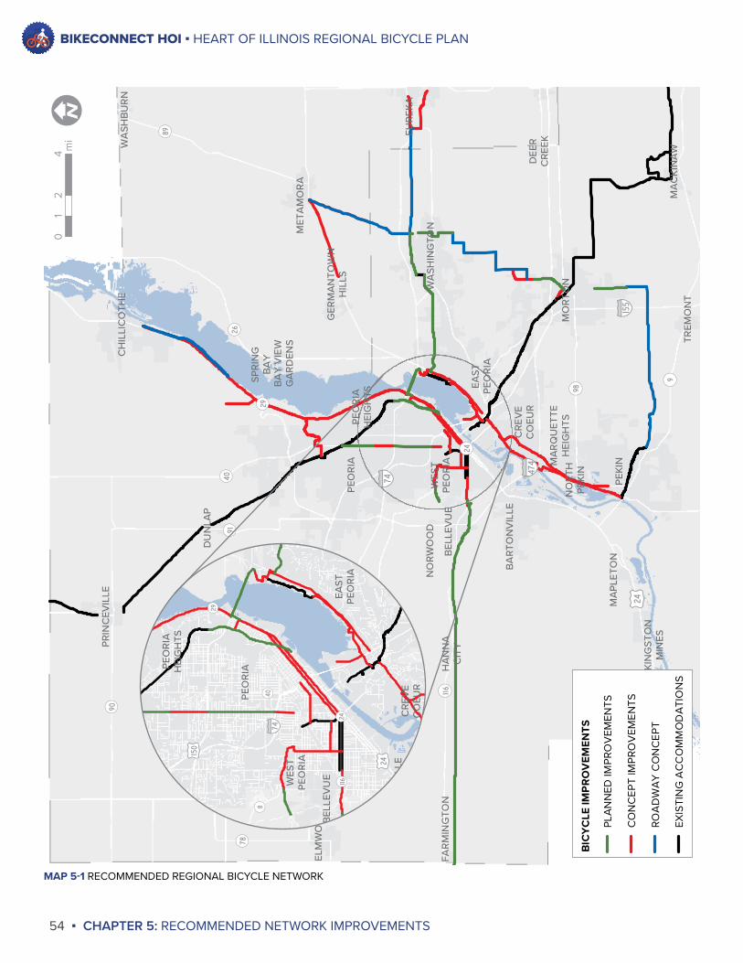
BIKECONNECT HOI ▪ HEART OF ILLINOIS REGIONAL BICYCLE PLAN
54 ▪ CHAPTER 5: RECOMMENDED NETWORK IMPROVEMENTS
KIN
GST
ON
MIN
ES
FAR
MIN
GTO
NN
OR
WO
OD
PEO
RIA
HEI
GH
TS
ELM
WO
OD
BR
IMFI
ELD
WES
TPE
OR
IA
PRIN
CEV
ILLE
CH
ILLI
CO
THE
BEL
LEV
UE
BA
RTO
NV
ILLE
MA
PLET
ON
PEO
RIA
HA
NN
AC
ITY
DU
NLA
P
MA
CK
INA
WTR
EMO
NT
PEKI
N
MO
RTO
N
CRE
VE
CO
EUR
MA
RQ
UET
TEH
EIG
HTS
DEE
RC
REEK
EAST
PEO
RIA
WA
SHIN
GTO
N
NO
RTH
PEKI
N
SPR
ING
BA
YB
AY
VIE
WG
AR
DEN
SM
ETA
MO
RA
WA
SHB
UR
N
GER
MA
NTO
WN
HIL
LS
EUR
EKA
¬ «8
¬ «98
¬ «9
¬ «116
¬ «90
¬ «24
¬ «89
¬ «78¬ «40
¬ «29
¬ «91¬ «26
§̈ ¦155
§̈ ¦474
§̈ ¦74
£ ¤24
£ ¤150
02
41
miI
BIC
YC
LE IM
PR
OV
EMEN
TS
PLA
NN
ED IM
PRO
VEM
ENTS
CO
NC
EPT
IMPR
OV
EMEN
TS
ROA
DW
AY
CO
NC
EPT
EXIS
TIN
G A
CC
OM
MO
DA
TIO
NS
PEO
RIA
HEI
GH
TS
WES
TPE
OR
IA
BEL
LEV
UE
BA
RTO
NV
ILLE
PEO
RIA
CRE
VE
CO
EUR
EAST
PEO
RIA
¬ «8
¬ «116¬ «24
¬ «29
¬ «40
§̈ ¦474
§̈ ¦74
£ ¤24£ ¤15
0
MAP 5-1 RECOMMENDED REGIONAL BICYCLE NETWORK
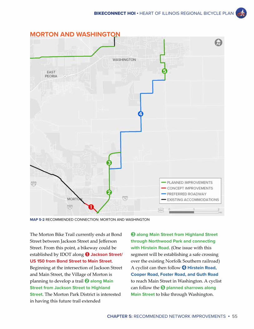
BIKECONNECT HOI ▪ HEART OF ILLINOIS REGIONAL BICYCLE PLAN
CHAPTER 5: RECOMMENDED NETWORK IMPROVEMENTS ▪ 55
➌ along Main Street from Highland Street through Northwood Park and connecting with Hirstein Road. (One issue with this segment will be establishing a safe crossing over the existing Norfolk Southern railroad) A cyclist can then follow ➍ Hirstein Road, Cooper Road, Foster Road, and Guth Road to reach Main Street in Washington. A cyclist can follow the ➎ planned sharrows along Main Street to bike through Washington.
The Morton Bike Trail currently ends at Bond Street between Jackson Street and Jefferson Street. From this point, a bikeway could be established by IDOT along ➊ Jackson Street/US 150 from Bond Street to Main Street. Beginning at the intersection of Jackson Street and Main Street, the Village of Morton is planning to develop a trail ➋ along Main Street from Jackson Street to Highland Street. The Morton Park District is interested in having this future trail extended
MORTON AND WASHINGTON
MAP 5-2 RECOMMENDED CONNECTION: MORTON AND WASHINGTON
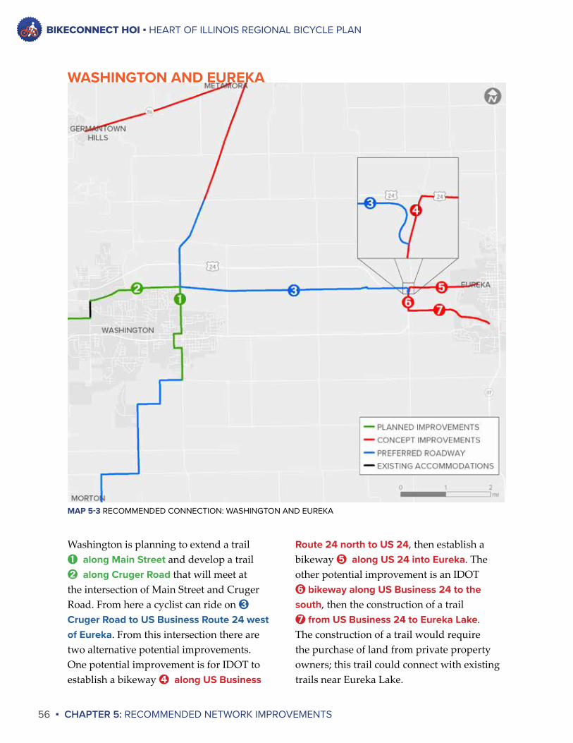
BIKECONNECT HOI ▪ HEART OF ILLINOIS REGIONAL BICYCLE PLAN
56 ▪ CHAPTER 5: RECOMMENDED NETWORK IMPROVEMENTS
Route 24 north to US 24, then establish a bikeway ➎ along US 24 into Eureka. The other potential improvement is an IDOT ➏ bikeway along US Business 24 to the south, then the construction of a trail ➐ from US Business 24 to Eureka Lake. The construction of a trail would require the purchase of land from private property owners; this trail could connect with existing trails near Eureka Lake.
Washington is planning to extend a trail ➊ along Main Street and develop a trail ➋ along Cruger Road that will meet at the intersection of Main Street and Cruger Road. From here a cyclist can ride on ➌
Cruger Road to US Business Route 24 west of Eureka. From this intersection there are two alternative potential improvements. One potential improvement is for IDOT to establish a bikeway ➍ along US Business
WASHINGTON AND EUREKA
MAP 5-3 RECOMMENDED CONNECTION: WASHINGTON AND EUREKA
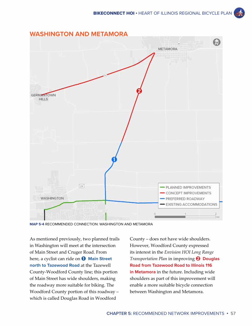
BIKECONNECT HOI ▪ HEART OF ILLINOIS REGIONAL BICYCLE PLAN
CHAPTER 5: RECOMMENDED NETWORK IMPROVEMENTS ▪ 57
County – does not have wide shoulders. However, Woodford County expressed its interest in the Envision HOI Long Range Transportation Plan in improving ➋ Douglas Road from Tazewood Road to Illinois 116 in Metamora in the future. Including wide shoulders as part of this improvement will enable a more suitable bicycle connection between Washington and Metamora.
As mentioned previously, two planned trails in Washington will meet at the intersection of Main Street and Cruger Road. From here, a cyclist can ride on ➊ Main Street north to Tazewood Road at the Tazewell County-Woodford County line; this portion of Main Street has wide shoulders, making the roadway more suitable for biking. The Woodford County portion of this roadway – which is called Douglas Road in Woodford
WASHINGTON AND METAMORA
MAP 5-4 RECOMMENDED CONNECTION: WASHINGTON AND METAMORA
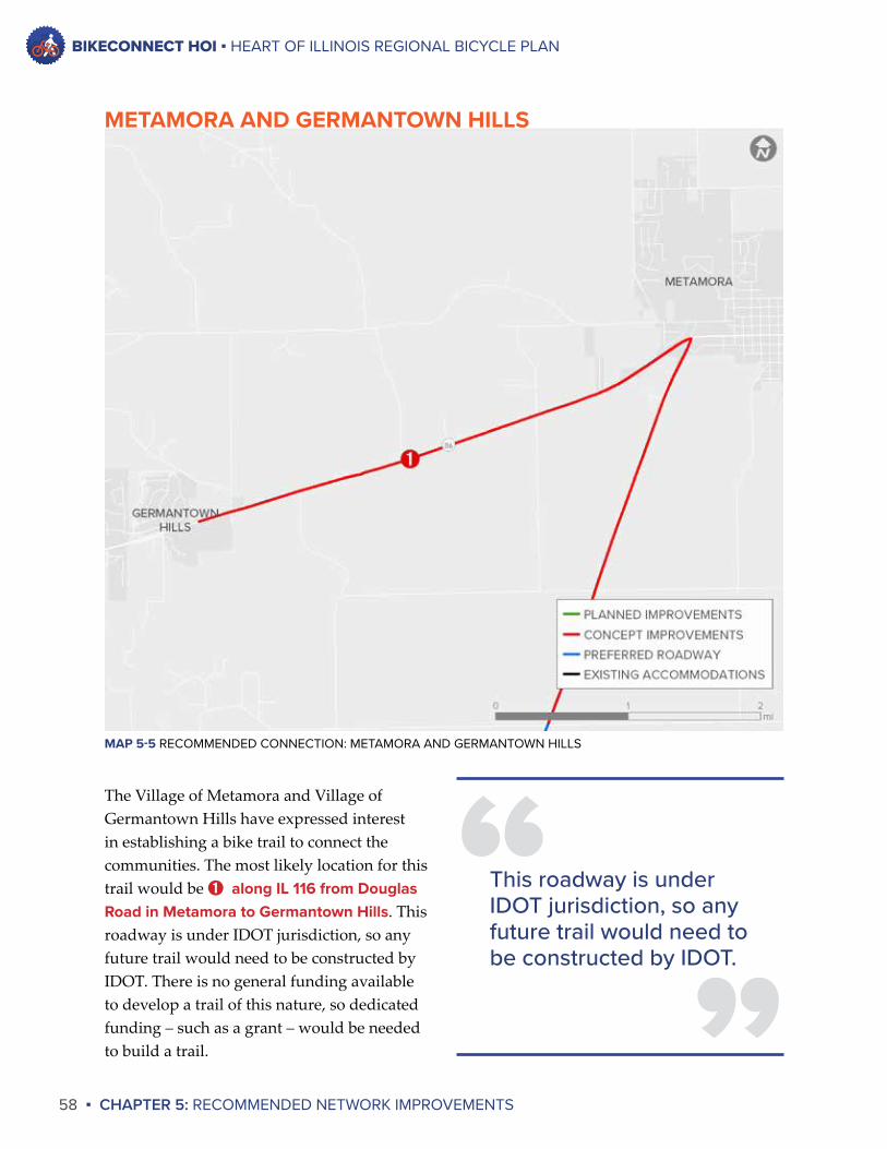
BIKECONNECT HOI ▪ HEART OF ILLINOIS REGIONAL BICYCLE PLAN
58 ▪ CHAPTER 5: RECOMMENDED NETWORK IMPROVEMENTS
The Village of Metamora and Village of Germantown Hills have expressed interest in establishing a bike trail to connect the communities. The most likely location for this trail would be ➊ along IL 116 from Douglas Road in Metamora to Germantown Hills. This roadway is under IDOT jurisdiction, so any future trail would need to be constructed by IDOT. There is no general funding available to develop a trail of this nature, so dedicated funding – such as a grant – would be needed to build a trail.
METAMORA AND GERMANTOWN HILLS
MAP 5-5 RECOMMENDED CONNECTION: METAMORA AND GERMANTOWN HILLS
”“This roadway is under
IDOT jurisdiction, so any future trail would need to be constructed by IDOT.
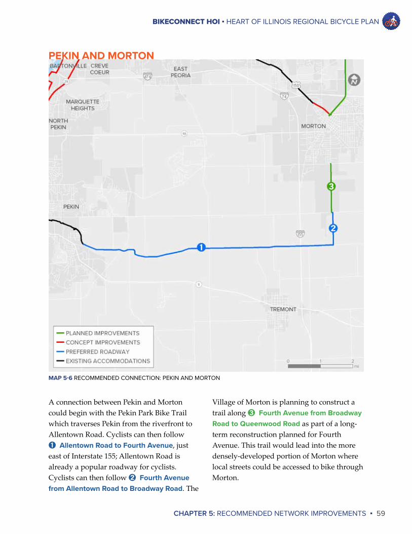
BIKECONNECT HOI ▪ HEART OF ILLINOIS REGIONAL BICYCLE PLAN
CHAPTER 5: RECOMMENDED NETWORK IMPROVEMENTS ▪ 59
Village of Morton is planning to construct a trail along ➌ Fourth Avenue from Broadway Road to Queenwood Road as part of a long-term reconstruction planned for Fourth Avenue. This trail would lead into the more densely-developed portion of Morton where local streets could be accessed to bike through Morton.
A connection between Pekin and Morton could begin with the Pekin Park Bike Trail which traverses Pekin from the riverfront to Allentown Road. Cyclists can then follow ➊ Allentown Road to Fourth Avenue, just east of Interstate 155; Allentown Road is already a popular roadway for cyclists. Cyclists can then follow ➋ Fourth Avenue from Allentown Road to Broadway Road. The
PEKIN AND MORTON
MAP 5-6 RECOMMENDED CONNECTION: PEKIN AND MORTON
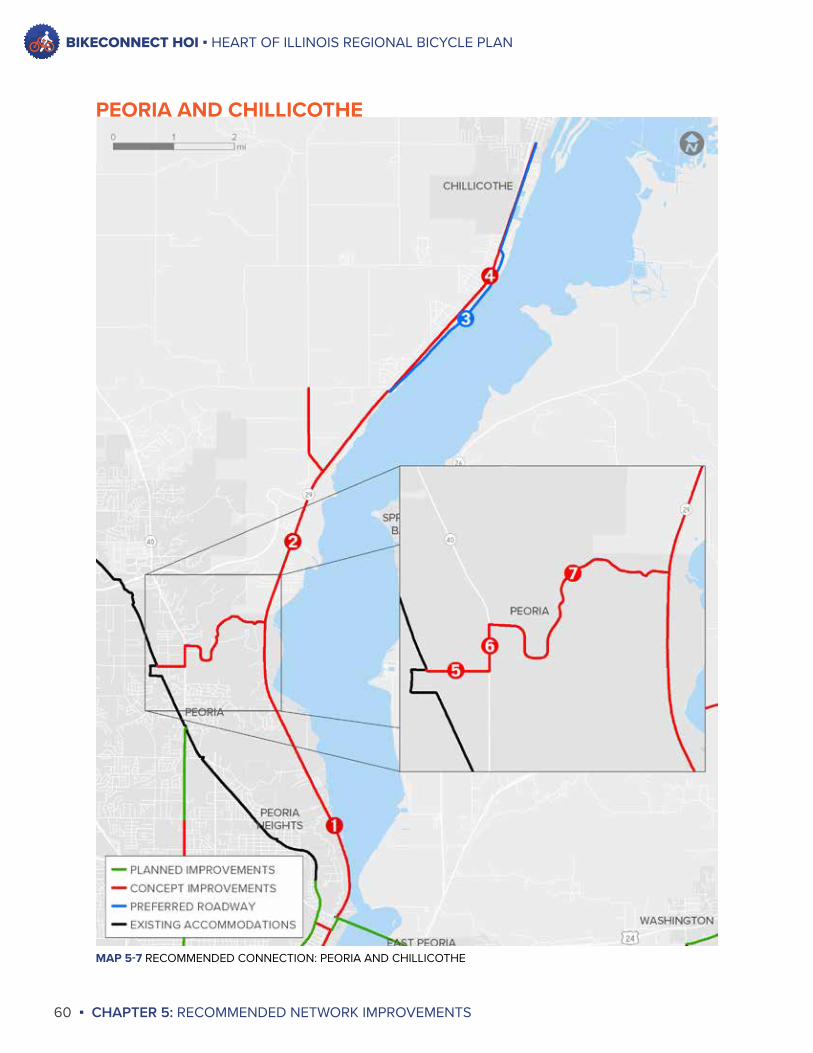
BIKECONNECT HOI ▪ HEART OF ILLINOIS REGIONAL BICYCLE PLAN
60 ▪ CHAPTER 5: RECOMMENDED NETWORK IMPROVEMENTS
MAP 5-7 RECOMMENDED CONNECTION: PEORIA AND CHILLICOTHE
PEORIA AND CHILLICOTHE
BIKECONNECT HOI ▪ HEART OF ILLINOIS REGIONAL BICYCLE PLAN
CHAPTER 5: RECOMMENDED NETWORK IMPROVEMENTS ▪ 61
The narrow corridor through which IL 29 passes north of the McClugage Bridge could make development of a bicycle accommodation difficult, so a second alternative for establishing a connection between Peoria and Chillicothe was identified. Beginning in Peoria, a cyclist could ride along the Rock Island Greenway to Pioneer Parkway. Then, a bikeway could be established ➎ along Pioneer Parkway from the Rock Island Greenway to Knoxville Avenue. Next, a bikeway could be established ➏ along Knoxville Avenue (IL 40) from Pioneer Parkway to Detweiller Drive. From there, a bikeway could be established ➐ along Detweiller Drive from Knoxville Avenue to IL 29. From this point an accommodation would be needed along Illinois 29 to reach River Beach Drive or a possible Chillicothe Park District trail. IDOT does not have plans at this time to establish a bicycle accommodation along this portion of Knoxville Avenue, but the City of Peoria has identified bikeways along these portions of Pioneer Parkway and Detweiller Drive in its Bicycle Master Plan.
It should be noted that ➏ Knoxville Avenue (IL 40) in its current state may prove particularly unsafe for many riders. The roadway sees high automobile traffic volumes and high traffic speeds for several hours each day. However, the addition of adequate bicycle accomodations, in accordance with the City of Peoria’s Complete Streets Policy, should make Knoxville a suitable route for many cyclists in the future.
Two possible connections between Peoria and Chillicothe have been identified during this planning process. The first alternative would follow IL 29 near the Illinois River. IDOT plans to rehabilitate ➊ IL 29 from the McClugage Bridge to north of Gardner Lane in seven to ten years, as stated in the Envision HOI Long Range Transportation Plan; a bicycle accommodation will be considered as part of this project. Should a bicycle accommodation be provided along that stretch of roadway, the next necessary project for establishing a connection would be a bicycle accommodation along ➋ IL 29 from north of Gardner Lane to the southern end of River Beach Drive (near Cedar Hills Drive); IDOT at this time does not have plans to rehabilitate this portion of IL 29. There are two possibilities for the final steps of this connection. One possibility is for cyclists to ride along ➌ River Beach Drive, a historic and scenic roadway along the Illinois River; River Beach Drive leads to Second Street, which runs through downtown Chillicothe.
The second possibility is for the ➍ establishment of a trail along the railroad from Chillicothe to the southern end of River Beach Drive. The Chillicothe Park District has communicated with Iowa Interstate Railroad, Ltd. about the possibility of establishing a trail along the existing railroad. While there is no trail currently planned, this possibility should not be completely ruled out.
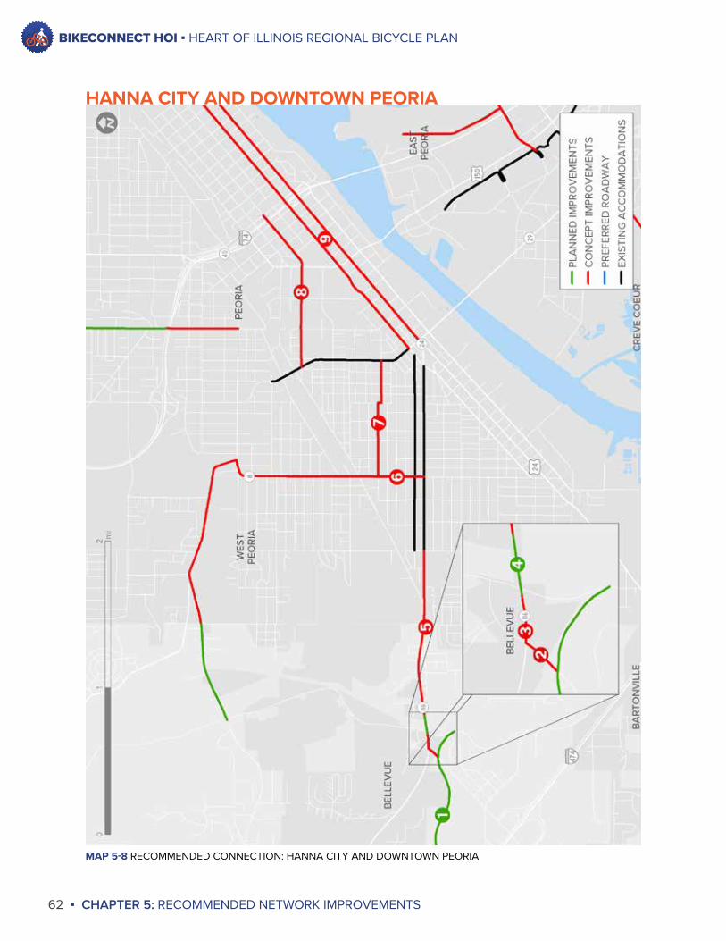
BIKECONNECT HOI ▪ HEART OF ILLINOIS REGIONAL BICYCLE PLAN
62 ▪ CHAPTER 5: RECOMMENDED NETWORK IMPROVEMENTS
MAP 5-8 RECOMMENDED CONNECTION: HANNA CITY AND DOWNTOWN PEORIA
HANNA CITY AND DOWNTOWN PEORIA
BIKECONNECT HOI ▪ HEART OF ILLINOIS REGIONAL BICYCLE PLAN
CHAPTER 5: RECOMMENDED NETWORK IMPROVEMENTS ▪ 63
HOI Long Range Transportation Plan; a bicycle accommodation will be considered as part of this project. A bikeway along this stretch of Western Avenue would enable cyclists to reach West Peoria and Bradley University. To reach Downtown Peoria, cyclists could follow a bikeway ➐ along Martin and McBean Streets from Western Avenue to MacArthur Highway. (This segment is identified as a bikeway in the City of Peoria’s Bicycle Master Plan) MacArthur Highway has an existing cycle track. A cyclist could use the cycle track to reach two potential entries into Downtown Peoria.
One potential entry is ➑ along Romeo B. Garrett Avenue and Monroe Street into Downtown Peoria; the other potential entry is ➒ along Adams Street and Jefferson Street into Downtown Peoria. Both of these potential bikeways are recommendations in the City of Peoria’s Bicycle Master Plan. In addition, IDOT plans to rehabilitate Jefferson and Adams Street from Interstate 74 to Eureka Street in seven to ten years, as stated in the Envision HOI Long Range Transportation Plan; a bicycle accommodation will be considered as part of this project.
The Hanna City Trail is a proposed trail that would follow an unused rail corridor owned by Union Pacific Railroad from its western endpoint near the community of Middle Grove in Fulton County to its eastern endpoint at Kickapoo Creek Road south of Illinois 116 near Bellevue. A connection between the Hanna City Trail and Downtown Peoria would enable cyclists to access the Rock Island Greenway, the River Trail of Illinois, and planned bikeways such as the McClugage Bridge Bikeway. These connections would form a true regional bicycle network that would provide access to communities across the region.
The ➊ Hanna City Trail would pass under Airport Road, which is under IDOT jurisdiction. A ➋ bikeway along Airport Road from the Hanna City Trail to IL 116 and a bikeway ➌ along Illinois 116 from Airport Road to the Kickapoo Creek bridge could be the first steps of this connection; IDOT does not have plans at this time to improve these roadways. IDOT is planning to replace the Kickapoo Creek bridge along Illinois 116 within the next six years, and the current plans include the addition of ➍ bike lanes on the Kickapoo Creek bridge. The next step would be an accommodation ➎ along IL 116 (Harmon Highway and Lincoln Avenue) from the Kickapoo Creek bridge bike lanes to Griswold Street in Peoria. (IDOT has no current plans to improve this roadway). From this point, a cyclist could follow existing bike lanes along Lincoln Avenue and Howett Street to Western Avenue. IDOT plans to rehabilitate ➏ Western Avenue from Lincoln Avenue to Farmington Road in seven to ten years, as stated in the Envision
BIKECONNECT HOI ▪ HEART OF ILLINOIS REGIONAL BICYCLE PLAN
64 ▪ CHAPTER 5: RECOMMENDED NETWORK IMPROVEMENTS
From Spindler Marina, a cyclist could follow ➋ Marina Lane across Illinois 116 using a pedestrian crossing signal and reach Access Road 6; this improvement is planned to be made by the City of East Peoria in the future.
Cyclists could then travel along ➌ Access Road 6 to Centennial Drive. The City of East Peoria is planning to establish a bicycle accommodation ➍ along Centennial Drive past Illinois Central College to the Washington city limits, and the City of Washington is planning to continue this trail ➎ along Centennial Drive to McClugage Road (US Business 24). Washington is also planning to continue this trail ➏ along the planned extension of Freedom Parkway from McClugage Road to Cummings Lane, which would connect with Washington’s recreation trail system. This possible connection between the City of Peoria and City of Washington would be a tremendous asset for the Greater Peoria region.
IDOT is planning to remove and replace the eastbound span of the McClugage Bridge over the next six years. IDOT’s plans include the construction of a multi-use path as part of this bridge replacement. The proposed endpoints of this multi-use path are a trailhead near the foot of Eureka Street in Peoria and a trailhead at Fairlane Drive near the Ufrting Automall in East Peoria. The construction of this bikeway will be an extremely important improvement in establishing a regional bicycle network that connects communities.
Connecting the McClugage Bridge Bikeway with the proposed Centennial Drive Trail will enable a bicycle connection between Peoria and Washington. To establish this connection a trail would be needed ➊ from the McClugage Bridge Bikeway’s East Peoria trailhead to the Fondulac Park River Trail at Spindler Marina; the City of East Peoria and Fondulac Park District are in communication with IDOT about this possible improvement.
MAP 5-9 RECOMMENDED CONNECTION: MCCLUGAGE BRIDGE BIKEWAY AND CENTENNIAL DRIVE TRAIL
MCCLUGAGE BRIDGE BIKEWAY AND CENTENNIAL DR TRAIL
BIKECONNECT HOI ▪ HEART OF ILLINOIS REGIONAL BICYCLE PLAN
CHAPTER 5: RECOMMENDED NETWORK IMPROVEMENTS ▪ 65
This potential trail could then be extended ➌ from near Par-A-Dice to Bass Pro Shops where it could connect with the existing East Peoria Riverfront Trail. (This project is also included in the City’s conceptual plans) From this trail an accommodation could be provided along Altorfer Lane to connect with the River Trail of Illinois at Spinder Drive.
The second option would be the addition of a bicycle accommodation to ➍ IL 116 from Marina Lane to East Flora Lane. This roadway is under the jurisdiction of IDOT. IDOT plans to reconstruct a portion of this roadway – from north of Highview Road to Ten Mile Creek – in 11 to 25 years, as stated in the Envision HOI Long Range Transportation Plan, so it is possible that a bicycle accommodation could be added in the long-term future.
A connection between the McClugage Bridge Bikeway and the River Trail of Illinois would provide an alternative connection between Peoria and Morton. This connection would establish a general loop trail around Lower Peoria Lake. BikeConnectHOI has identified two alternatives for making this connection.
The first alternative would begin with the project discussed previously to connect the ➊ McClugage Bridge Bikeway’s East Peoria trailhead to the Fondulac Park River Trail at Spindler Marina. From this point cyclists could follow the Fondulac Park River Trail to its southern endpoint near EastPort Marina. A portion of this trail is boardwalk and is not suitable for cyclists, so improvements would need to be made in the future to render this trail fully bicycle-accessible. The trail would need to be extended ➋ along the riverfront near Par-A-Dice. (This project is included in the City of East Peoria’s conceptual plans)
MAP 5-10 RECOMMENDED CONNECTION: MCCLUGAGE BRIDGE BIKEWAY AND RIVER TRAIL OF ILLINOIS
MCCLUGAGE BRIDGE BIKEWAY AND ILLINOIS RIVER TRAIL
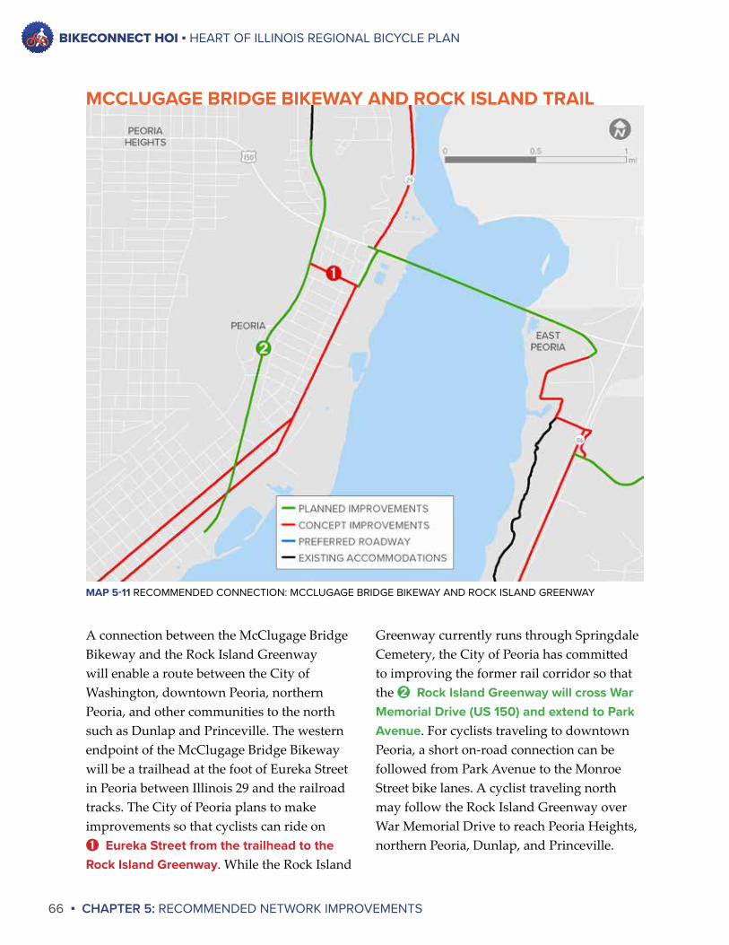
BIKECONNECT HOI ▪ HEART OF ILLINOIS REGIONAL BICYCLE PLAN
66 ▪ CHAPTER 5: RECOMMENDED NETWORK IMPROVEMENTS
Greenway currently runs through Springdale Cemetery, the City of Peoria has committed to improving the former rail corridor so that the ➋ Rock Island Greenway will cross War Memorial Drive (US 150) and extend to Park Avenue. For cyclists traveling to downtown Peoria, a short on-road connection can be followed from Park Avenue to the Monroe Street bike lanes. A cyclist traveling north may follow the Rock Island Greenway over War Memorial Drive to reach Peoria Heights, northern Peoria, Dunlap, and Princeville.
A connection between the McClugage Bridge Bikeway and the Rock Island Greenway will enable a route between the City of Washington, downtown Peoria, northern Peoria, and other communities to the north such as Dunlap and Princeville. The western endpoint of the McClugage Bridge Bikeway will be a trailhead at the foot of Eureka Street in Peoria between Illinois 29 and the railroad tracks. The City of Peoria plans to make improvements so that cyclists can ride on ➊ Eureka Street from the trailhead to the Rock Island Greenway. While the Rock Island
MAP 5-11 RECOMMENDED CONNECTION: MCCLUGAGE BRIDGE BIKEWAY AND ROCK ISLAND GREENWAY
MCCLUGAGE BRIDGE BIKEWAY AND ROCK ISLAND TRAIL
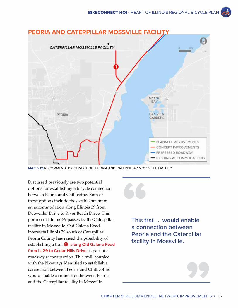
BIKECONNECT HOI ▪ HEART OF ILLINOIS REGIONAL BICYCLE PLAN
CHAPTER 5: RECOMMENDED NETWORK IMPROVEMENTS ▪ 67
Discussed previously are two potential options for establishing a bicycle connection between Peoria and Chillicothe. Both of these options include the establishment of an accommodation along Illinois 29 from Detweiller Drive to River Beach Drive. This portion of Illinois 29 passes by the Caterpillar facility in Mossville. Old Galena Road intersects Illinois 29 south of Caterpillar. Peoria County has raised the possibility of establishing a trail ➊ along Old Galena Road from IL 29 to Cedar Hills Drive as part of a roadway reconstruction. This trail, coupled with the bikeways identified to establish a connection between Peoria and Chillicothe, would enable a connection between Peoria and the Caterpillar facility in Mossville.
MAP 5-12 RECOMMENDED CONNECTION: PEORIA AND CATERPILLAR MOSSVILLE FACILITY
PEORIA AND CATERPILLAR MOSSVILLE FACILITY
”
“This trail ... would enable a connection between Peoria and the Caterpillar facility in Mossville.
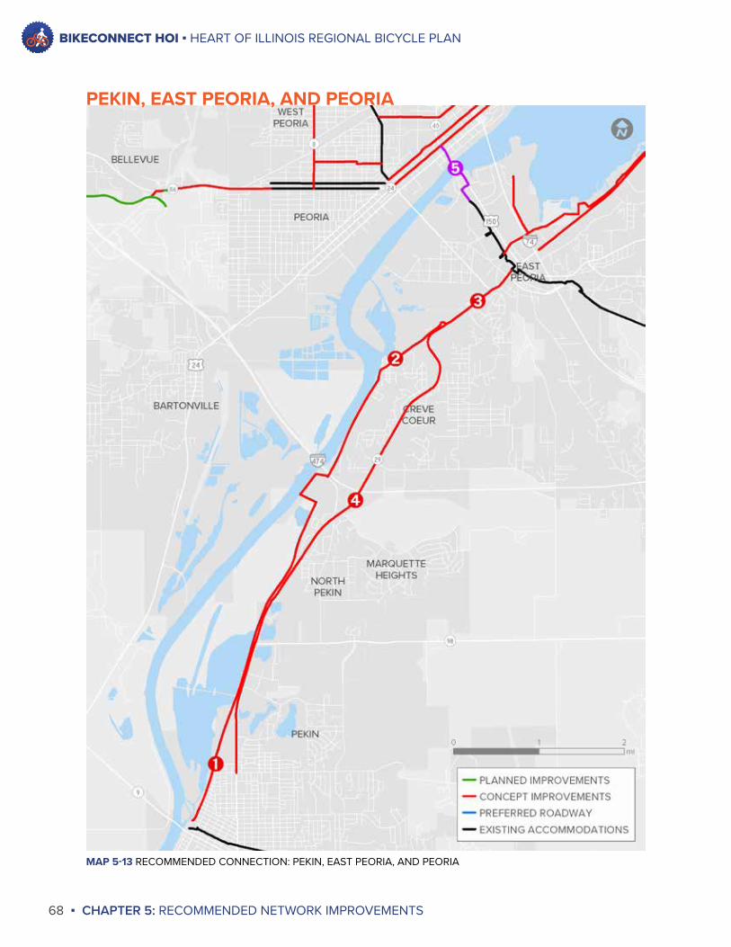
BIKECONNECT HOI ▪ HEART OF ILLINOIS REGIONAL BICYCLE PLAN
68 ▪ CHAPTER 5: RECOMMENDED NETWORK IMPROVEMENTS
MAP 5-13 RECOMMENDED CONNECTION: PEKIN, EAST PEORIA, AND PEORIA
PEKIN, EAST PEORIA, AND PEORIA
BIKECONNECT HOI ▪ HEART OF ILLINOIS REGIONAL BICYCLE PLAN
CHAPTER 5: RECOMMENDED NETWORK IMPROVEMENTS ▪ 69
is under IDOT jurisdiction, and IDOT is planning improvements to some portions of this roadway in the future. In addition to the potential reconstruction of Illinois 29 in East Peoria discussed above, IDOT is planning a rehabilitation of a portion of this roadway in Creve Coeur in 7 to 10 years, as stated in the Envision HOI Long Range Transportation Plan. Bicycle accommodations will be considered as part of the rehabilitation work in Creve Coeur. This alternative was identified should a trail along Pekin Lake or Wesley Road improvements not be feasible. The most likely situation is that some accommodations along IL 29 and other bikeway improvements will be needed to establish a connection between Pekin and East Peoria.
A bicycle connection from Pekin to Peoria would build upon the connection between River Trail of Illinois in East Peoria. A cyclist can take the River Trail of Illinois to the ➎ Bob Michel Bridge and use the bridge to reach Downtown Peoria and the Rock Island Greenway.
It should be noted that while the Bob Michel Bridge is considered to be a bikeway, there is no dedicated bicycle accommodation on the bridge. The bridge has only a sidewalk and a five-foot shoulder. Bicycle traffic was not considered when the bridge was built. As a result, the shoulder was designed to be a clear zone between vehicular traffic and the sidewalk. This does not meet IDOT policy for a bicycle accommodation given the traffic volume and speed limit on the bridge. While the Bob Michel Bridge is used as an important link in the regional bicycle network, it should be used with caution.
Pekin is the second-largest community in the Greater Peoria area yet it has no bicycle connection with any other community in the region. Connections between Pekin, East Peoria, and Pekin will be of great importance in the future. Two potential alternatives were identified to establish these connections.
One alternative would consist of the extension of the existing ➊ Pekin Park Trail along Pekin Lake to Wesley Road. This idea has been raised in the past, and the majority of the property on which the trail would be extended is currently under public ownership, which is beneficial. However, there are no specific plans at this time to develop this trail. A cyclist could then follow ➋ Wesley Road from beneath Interstate 474 to its northern endpoint at IL 29 in East Peoria. Wesley Road currently is in disrepair, so improvements would be needed to make it suitable for bicycle use. An accommodation would need to be added ➌ along IL 29 from Wesley Road to the River Trail of Illinois in East Peoria (the intersection of Main Street and Springfield Road) to complete this connection. This roadway is under IDOT jurisdiction, and IDOT is planning a reconstruction of IL 29 from the Cedar Street Bridge extension to Camp Street in 11 to 25 years, as stated in the Envision HOI Long Range Transportation Plan. A bicycle accommodation could be provided as part of this possible reconstruction.
The second alternative would consist of a bicycle accommodation ➍ along IL 29 from Sheridan Road in Pekin to the River Trail of Illinois in East Peoria (the intersection of Main Street and Springfield Road). This roadway
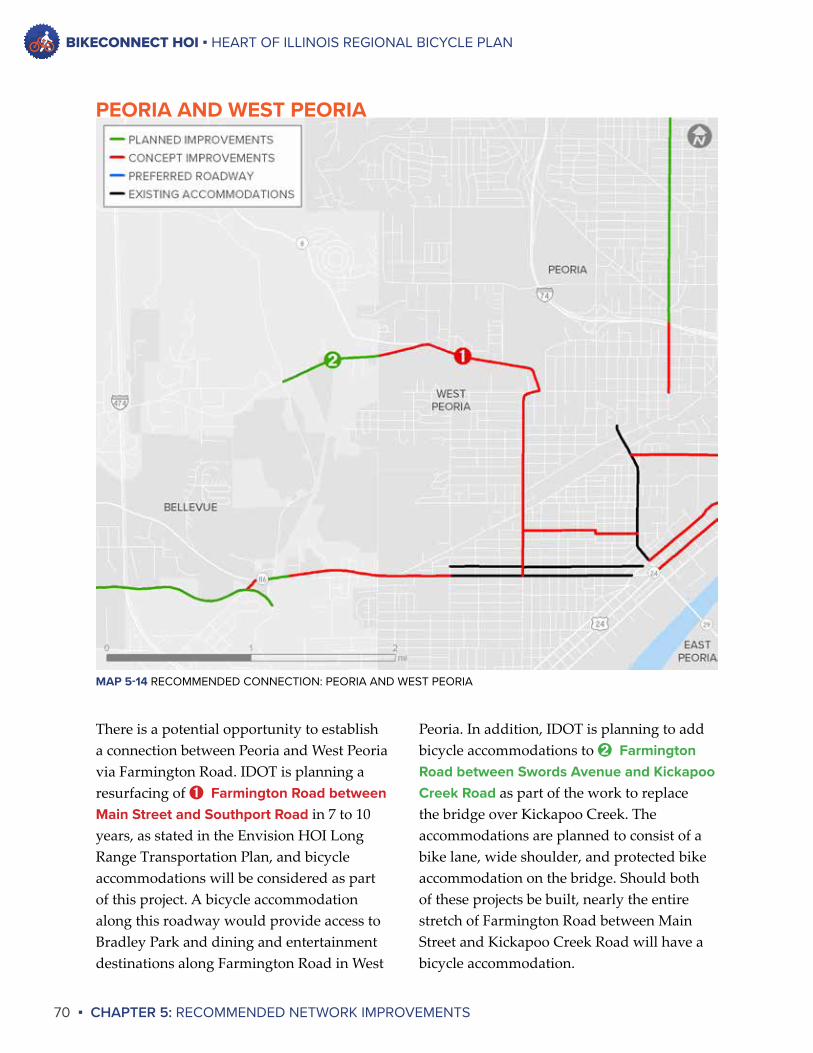
BIKECONNECT HOI ▪ HEART OF ILLINOIS REGIONAL BICYCLE PLAN
70 ▪ CHAPTER 5: RECOMMENDED NETWORK IMPROVEMENTS
Peoria. In addition, IDOT is planning to add bicycle accommodations to ➋ Farmington Road between Swords Avenue and Kickapoo Creek Road as part of the work to replace the bridge over Kickapoo Creek. The accommodations are planned to consist of a bike lane, wide shoulder, and protected bike accommodation on the bridge. Should both of these projects be built, nearly the entire stretch of Farmington Road between Main Street and Kickapoo Creek Road will have a bicycle accommodation.
There is a potential opportunity to establish a connection between Peoria and West Peoria via Farmington Road. IDOT is planning a resurfacing of ➊ Farmington Road between Main Street and Southport Road in 7 to 10 years, as stated in the Envision HOI Long Range Transportation Plan, and bicycle accommodations will be considered as part of this project. A bicycle accommodation along this roadway would provide access to Bradley Park and dining and entertainment destinations along Farmington Road in West
MAP 5-14 RECOMMENDED CONNECTION: PEORIA AND WEST PEORIA
PEORIA AND WEST PEORIA
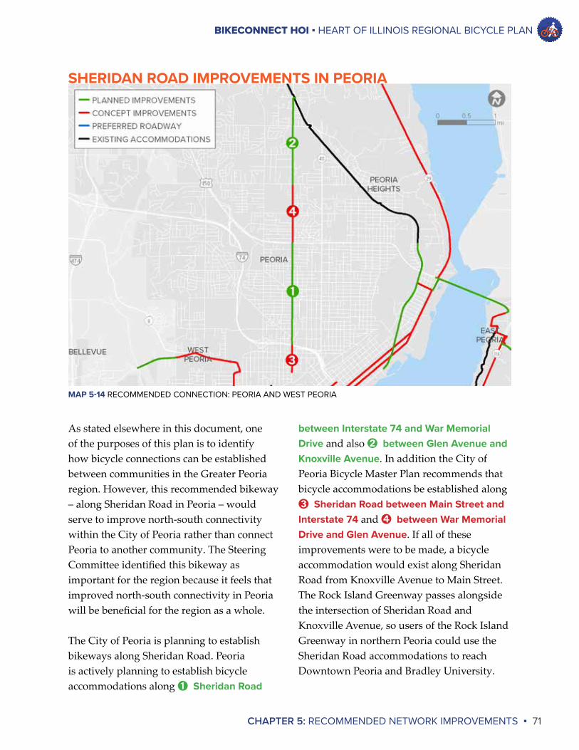
BIKECONNECT HOI ▪ HEART OF ILLINOIS REGIONAL BICYCLE PLAN
CHAPTER 5: RECOMMENDED NETWORK IMPROVEMENTS ▪ 71
between Interstate 74 and War Memorial Drive and also ➋ between Glen Avenue and Knoxville Avenue. In addition the City of Peoria Bicycle Master Plan recommends that bicycle accommodations be established along ➌ Sheridan Road between Main Street and Interstate 74 and ➍ between War Memorial Drive and Glen Avenue. If all of these improvements were to be made, a bicycle accommodation would exist along Sheridan Road from Knoxville Avenue to Main Street. The Rock Island Greenway passes alongside the intersection of Sheridan Road and Knoxville Avenue, so users of the Rock Island Greenway in northern Peoria could use the Sheridan Road accommodations to reach Downtown Peoria and Bradley University.
As stated elsewhere in this document, one of the purposes of this plan is to identify how bicycle connections can be established between communities in the Greater Peoria region. However, this recommended bikeway – along Sheridan Road in Peoria – would serve to improve north-south connectivity within the City of Peoria rather than connect Peoria to another community. The Steering Committee identified this bikeway as important for the region because it feels that improved north-south connectivity in Peoria will be beneficial for the region as a whole.
The City of Peoria is planning to establish bikeways along Sheridan Road. Peoria is actively planning to establish bicycle accommodations along ➊ Sheridan Road
MAP 5-14 RECOMMENDED CONNECTION: PEORIA AND WEST PEORIA
SHERIDAN ROAD IMPROVEMENTS IN PEORIA
BIKECONNECT HOI ▪ HEART OF ILLINOIS REGIONAL BICYCLE PLAN
72 ▪ CHAPTER 5: RECOMMENDED NETWORK IMPROVEMENTS
A bicycle accommodation along KickapooCreekRoad south of Farmington Road could provide access to Rocky Glen Park. The existing roadway is not suitable for cyclists due to its curving nature, and addition of an accommodation is challenging due to the lack of space to expand the roadway. Should an alternative solution be identified in the future, bicycle access along Kickapoo Creek Road would be beneficial.
A bicycle accommodation along TaylorRoad between IL 116 and IL 8 would provide access to Wildlife Prairie Park. While an accommodation along Taylor Road is more feasible than an accommodation along Kickapoo Creek Road, a Taylor Road accommodation would require right-of-way acquisition and a culvert replacement, so the cost is prohibitive at this time. However, should a sufficient funding source be identified in the future, bicycle access along Taylor Road would be beneficial.
OTHER BIKEWAYSThere are other desired bikeways in the region that are not included on the map that deserve mention:
The EasternBypass is a proposed highway that will pass through Tazewell and Woodford Counties to connect Interstate 74 east of Peoria with Illinois 6 and Illinois 29 north of Peoria. The planning process for the Eastern Bypass is in the corridor phase, meaning that the general corridor along which the highway will be built is being identified. No funding has been allocated for future phases to identify the specific highway alignment, acquire right-of-way, and build the highway. There is no specific design for the highway yet, as that will be developed in future study phases. However, establishment of a bicycle accommodation along the Eastern Bypass would serve as a significant regional connection, potentially providing bicycle access between Morton, Washington, Germantown Hills, Metamora, Bay View Gardens, Spring Bay, Mossville, and Caterpillar’s Mossville facility.
A bicycle accommodation along IL116betweentheMcClugageBridgeandGermantownHills would connect Germantown Hills with East Peoria and points west of the Illinois River after construction of the McClugage Bridge Bikeway. However, this bikeway was not included on the future network map because it is unlikely that IDOT would reconstruct this roadway for many years and there is a lack of space for a separated bike path. However, should an unexpected reconstruction occur on this roadway in the future, a bicycle accommodation should be considered.
359 STICKERS WERE PLACED AT THE BIKECONNECT HOI REVIEWOPEN HOUSE
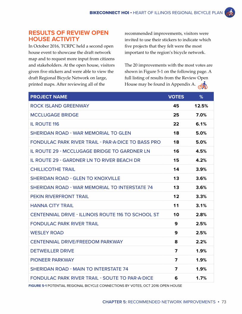
BIKECONNECT HOI ▪ HEART OF ILLINOIS REGIONAL BICYCLE PLAN
CHAPTER 5: RECOMMENDED NETWORK IMPROVEMENTS ▪ 73
recommended improvements, visitors were invited to use their stickers to indicate which five projects that they felt were the most important to the region’s bicycle network.
The 20 improvements with the most votes are shown in Figure 5-1 on the following page. A full listing of results from the Review Open House may be found in Appendix A.
RESULTS OF REVIEW OPEN HOUSE ACTIVITYIn October 2016, TCRPC held a second open house event to showcase the draft network map and to request more input from citizens and stakeholders. At the open house, visitors given five stickers and were able to view the draft Regional Bicycle Network on large, printed maps. After reviewing all of the
PROJECT NAME VOTES %
ROCK ISLAND GREENWAY 45 12.5%
MCCLUGAGE BRIDGE 25 7.0%
IL ROUTE 116 22 6.1%
SHERIDAN ROAD - WAR MEMORIAL TO GLEN 18 5.0%
FONDULAC PARK RIVER TRAIL - PAR-A-DICE TO BASS PRO 18 5.0%
IL ROUTE 29 - MCCLUGAGE BRIDGE TO GARDNER LN 16 4.5%
IL ROUTE 29 - GARDNER LN TO RIVER BEACH DR 15 4.2%
CHILLICOTHE TRAIL 14 3.9%
SHERIDAN ROAD - GLEN TO KNOXVILLE 13 3.6%
SHERIDAN ROAD - WAR MEMORIAL TO INTERSTATE 74 13 3.6%
PEKIN RIVERFRONT TRAIL 12 3.3%
HANNA CITY TRAIL 11 3.1%
CENTENNIAL DRIVE - ILLINOIS ROUTE 116 TO SCHOOL ST 10 2.8%
FONDULAC PARK RIVER TRAIL 9 2.5%
WESLEY ROAD 9 2.5%
CENTENNIAL DRIVE/FREEDOM PARKWAY 8 2.2%
DETWEILLER DRIVE 7 1.9%
PIONEER PARKWAY 7 1.9%
SHERIDAN ROAD - MAIN TO INTERSTATE 74 7 1.9%
FONDULAC PARK RIVER TRAIL - SOUTE TO PAR-A-DICE 6 1.7%FIGURE 5-1 POTENTIAL REGIONAL BICYCLE CONNECTIONS BY VOTES, OCT 2016 OPEN HOUSE
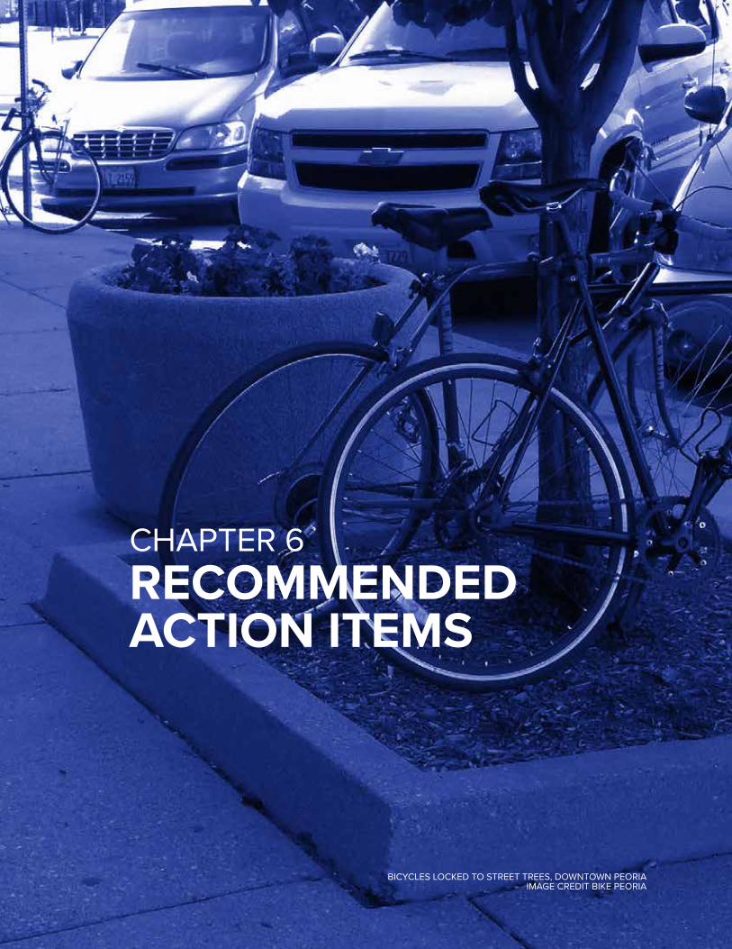
BICYCLES LOCKED TO STREET TREES, DOWNTOWN PEORIAIMAGE CREDIT BIKE PEORIA
CHAPTER 6RECOMMENDED ACTION ITEMS
BIKECONNECT HOI ▪ HEART OF ILLINOIS REGIONAL BICYCLE PLAN
CHAPTER 6: RECOMMENDED ACTION ITEMS ▪ 75
ACTION ITEM CATEGORIESAs discussed in Chapter 3: Data Review, the Steering Committee identified barriers and primary issues that this plan could address based on the information that was gathered and the public input that was received about bicycle transportation in the region. After identifying barriers and primary issues, the Steering Committee identified action item categories under which action items could be developed to address them.
ACTION ITEMSThe recommended action items presented on the following pages were identified by the Steering Committee to make the Greater Peoria region more bicycle-friendly. The action items, responsible entity, and timeframe for completion will be presented in a table by category. Below each table is presented additional pertinent information about each item.
The other primary purpose of this planning process is to identify other ways in which the Greater Peoria area can become a more bicycle-friendly region. In order to become a more bicycle-friendly region, actions beyond making the network improvements identified in the previous chapter must be completed.
This chapter will present the recommended action items that, when completed, will help make Greater Peoria more bicycle-friendly. Action items are organized by category. Each action item lists a responsible entity and a timeframe in order to guide the implementation of each. Additional pertinent information about each category is provided after the list of action items.
◊ Connect bicycling with mass transit◊ Education for people on bikes and
people in cars◊ Encouraging ridership◊ End-of-trip facilities◊ Enforcement of bicycle and motor
vehicle laws◊ Gather data on bicycle usage
◊ Improve signage for bicycle transportation
◊ Incentives to promote bicycling◊ Increasing awareness of bicycle
infrastructure◊ Maintenance of bicycle infrastructure◊ Promote complete streets and bicycle
facilities
BIKECONNECT HOI ACTION ITEM CATEGORIES
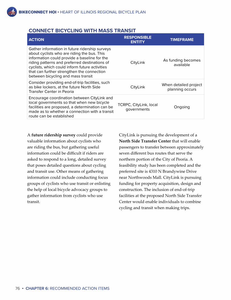
BIKECONNECT HOI ▪ HEART OF ILLINOIS REGIONAL BICYCLE PLAN
76 ▪ CHAPTER 6: RECOMMENDED ACTION ITEMS
A futureridershipsurvey could provide valuable information about cyclists who are riding the bus, but gathering useful information could be difficult if riders are asked to respond to a long, detailed survey that poses detailed questions about cycling and transit use. Other means of gathering information could include conducting focus groups of cyclists who use transit or enlisting the help of local bicycle advocacy groups to gather information from cyclists who use transit.
CityLink is pursuing the development of a NorthSideTransferCenterthat will enable passengers to transfer between approximately seven different bus routes that serve the northern portion of the City of Peoria. A feasibility study has been completed and the preferred site is 4310 N Brandywine Drive near Northwoods Mall. CityLink is pursuing funding for property acquisition, design and construction. The inclusion of end-of-trip facilities at the proposed North Side Transfer Center would enable individuals to combine cycling and transit when making trips.
ACTION RESPONSIBLE ENTITY TIMEFRAME
Gather information in future ridership surveys about cyclists who are riding the bus. This information could provide a baseline for the riding patterns and preferred destinations of cyclists, which could inform future activities that can further strengthen the connection between bicycling and mass transit
CityLink As funding becomes available
Consider providing end-of-trip facilities, such as bike lockers, at the future North Side Transfer Center in Peoria
CityLink When detailed project planning occurs
Encourage coordination between CityLink and local governments so that when new bicycle facilities are proposed, a determination can be made as to whether a connection with a transit route can be established
TCRPC, CityLink, local governments Ongoing
CONNECT BICYCLING WITH MASS TRANSIT
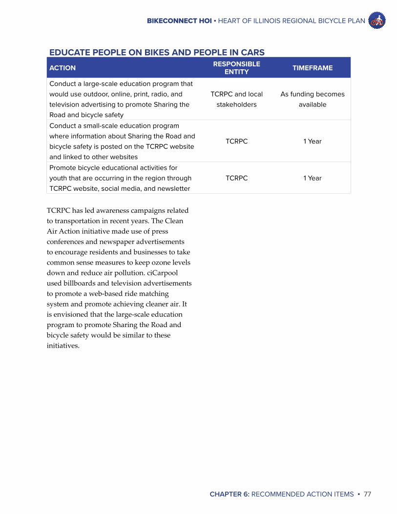
BIKECONNECT HOI ▪ HEART OF ILLINOIS REGIONAL BICYCLE PLAN
CHAPTER 6: RECOMMENDED ACTION ITEMS ▪ 77
TCRPC has led awareness campaigns related to transportation in recent years. The Clean Air Action initiative made use of press conferences and newspaper advertisements to encourage residents and businesses to take common sense measures to keep ozone levels down and reduce air pollution. ciCarpool used billboards and television advertisements to promote a web-based ride matching system and promote achieving cleaner air. It is envisioned that the large-scale education program to promote Sharing the Road and bicycle safety would be similar to these initiatives.
ACTION RESPONSIBLE ENTITY TIMEFRAME
Conduct a large-scale education program that would use outdoor, online, print, radio, and television advertising to promote Sharing the Road and bicycle safety
TCRPC and local stakeholders
As funding becomes available
Conduct a small-scale education program where information about Sharing the Road and bicycle safety is posted on the TCRPC website and linked to other websites
TCRPC 1 Year
Promote bicycle educational activities for youth that are occurring in the region through TCRPC website, social media, and newsletter
TCRPC 1 Year
EDUCATE PEOPLE ON BIKES AND PEOPLE IN CARS
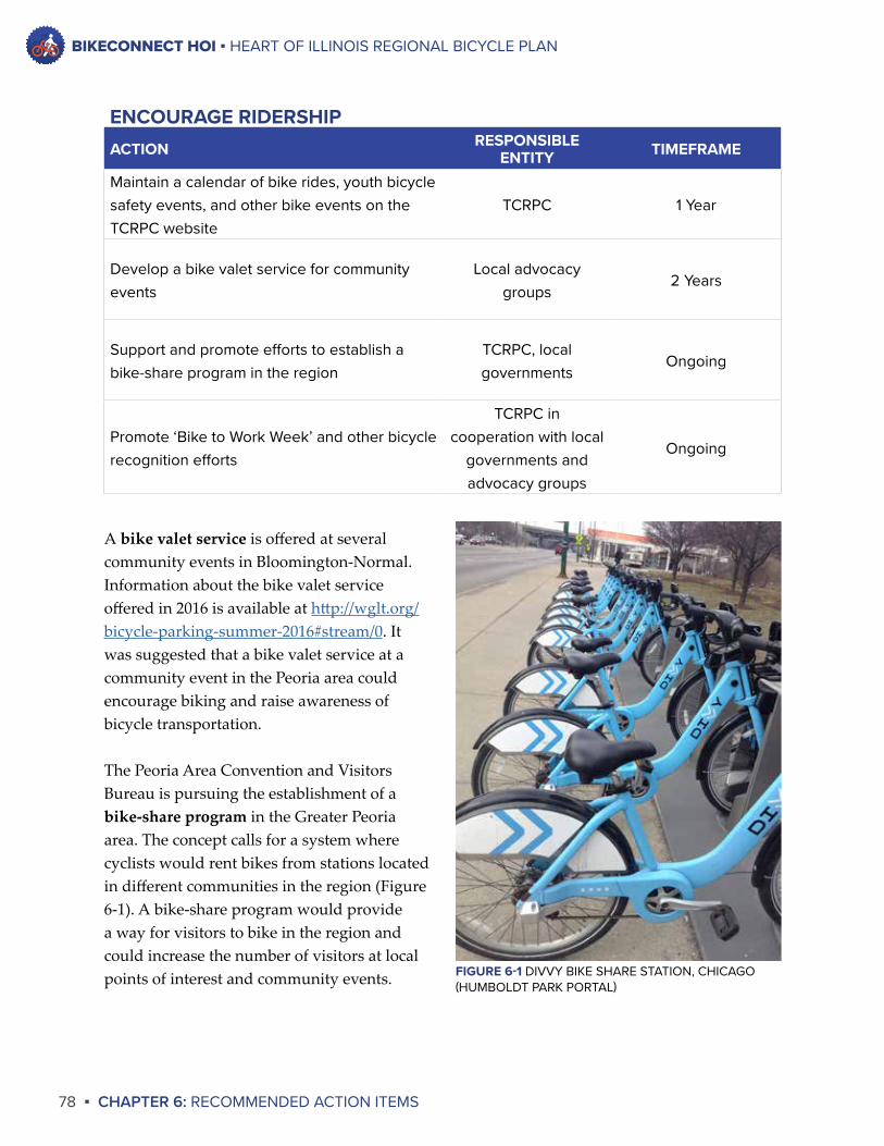
BIKECONNECT HOI ▪ HEART OF ILLINOIS REGIONAL BICYCLE PLAN
78 ▪ CHAPTER 6: RECOMMENDED ACTION ITEMS
A bikevaletservice is offered at several community events in Bloomington-Normal. Information about the bike valet service offered in 2016 is available at http://wglt.org/bicycle-parking-summer-2016#stream/0. It was suggested that a bike valet service at a community event in the Peoria area could encourage biking and raise awareness of bicycle transportation.
The Peoria Area Convention and Visitors Bureau is pursuing the establishment of a bike-shareprogram in the Greater Peoria area. The concept calls for a system where cyclists would rent bikes from stations located in different communities in the region (Figure 6-1). A bike-share program would provide a way for visitors to bike in the region and could increase the number of visitors at local points of interest and community events.
ACTION RESPONSIBLE ENTITY TIMEFRAME
Maintain a calendar of bike rides, youth bicycle safety events, and other bike events on the TCRPC website
TCRPC 1 Year
Develop a bike valet service for community events
Local advocacy groups
2 Years
Support and promote efforts to establish a bike-share program in the region
TCRPC, local governments
Ongoing
Promote ‘Bike to Work Week’ and other bicycle recognition efforts
TCRPC in cooperation with local
governments and advocacy groups
Ongoing
ENCOURAGE RIDERSHIP
FIGURE 6-1 DIVVY BIKE SHARE STATION, CHICAGO (HUMBOLDT PARK PORTAL)
BIKECONNECT HOI ▪ HEART OF ILLINOIS REGIONAL BICYCLE PLAN
CHAPTER 6: RECOMMENDED ACTION ITEMS ▪ 79
Cost-shareprograms for assisting businesses with purchasing bike racks have been established elsewhere in the United States. For example, the regional planning agency for the Boston area provides funding to assist communities in eastern Massachusetts with purchasing bicycle racks. TCRPC can explore funding opportunities for a similar program in the Greater Peoria area moving forward.
A bikeparkingmap for the Peoria area called Where’s the Rack, Peoria was started by local bicycle advocates in 2012. The map is located at https://sites.google.com/site/wherestherack/. This is a valuable resource for the Greater Peoria area, and this plan supports the continued maintenance of this map to provide cyclists with up-to-date bicycle parking information.
ACTION RESPONSIBLE ENTITY TIMEFRAME
Develop an informational handout for businesses that provides information about appropriate short-term parking at businesses
TCRPC 1 Year
Develop an informational handout for businesses that provides information about appropriate long-term parking and facilities for employees who bike to work
TCRPC 1 Year
Promote informational handouts among local businesses and area chambers of commerce
TCRPC 1 Year
Maintain a bike parking map for the Peoria area
Local advocacy groups or TCRPC
Ongoing
Investigate cost-share programs for assisting businesses with purchasing bike racks
TCRPC 2 Years
Promote partnerships between local governments and businesses to establish end-of-trip facilities
TCRPC Ongoing
END-OF-TRIP FACILITIES
BIKECONNECT HOI ▪ HEART OF ILLINOIS REGIONAL BICYCLE PLAN
80 ▪ CHAPTER 6: RECOMMENDED ACTION ITEMS
There is no program that provides location-specificbikecountdata for the Greater Peoria area. This plan proposes that TCRPC work with local governments and advocacy groups to establish such a program in the future. The Federal Highway Administration recently oversaw a Bicycle-Pedestrian Count Technology Pilot Project to develop case studies, training materials and other resources that regional planning agencies across the nation can use to establish their own bicycle count programs. TCRPC seeks to use these resources in the future.
ACTION RESPONSIBLE ENTITY TIMEFRAME
Establish a bike counting program to provide ongoing data about bicycle usage in the region. The program could be established through the use of volunteers, interns, or bicycle counting equipment
TCRPC in cooperation with local
governments and advocacy groups
3 Years
GATHER DATA ON BICYCLE USAGE
“”
[You could] have plastic, weatherproof pamphlet holders (like on for-sale signs for homes) to have at bicycle park areas. These could contain maps, riding information, and instructions.
– Public Comment,Oct 2016
“”
Can you use a counter like they use for cars when they try to determine how much traffic is on a street? A counter that will count everytime it is run over [by a bicycle].
– Public Comment,Oct 2016
BIKECONNECT HOI ▪ HEART OF ILLINOIS REGIONAL BICYCLE PLAN
CHAPTER 6: RECOMMENDED ACTION ITEMS ▪ 81
Ride Illinois is the statewide bicycle advocacy group in Illinois, and it completed a technical brief in 2015 addressing motorist-directedsignage for sharing the road with bicycles. The purpose of the brief was to identify preferred signage that could be recommended for consistent use in Illinois. The table directly above includes the recommendations from this technical brief. The brief is available online at http://rideillinois.org/wp-content/uploads/2015/12/safersignagetechnicalbrief.pdf.
Wayfinding is an emerging issue in the Greater Peoria area. In 2016 there were two separate wayfinding studies underway: one for the City of Peoria and one for the Tazewell County communities of Pekin, East Peoria, Morton and Washington. As the studies are completed and the implementation of wayfinding systems begin, TCRPC will look to work with these communities and others throughout the region to develop a wayfinding system that is regionally coherent.
ACTION RESPONSIBLE ENTITY TIMEFRAME
Promote regional collaboration on developing wayfinding systems in the region
TCRPC, local governments
Ongoing
Establish wayfinding systems that are compatible throughout the region
TCRPC, local governments
Ongoing
Promote the installation of signage notifying motorists of bicycle use on roadways that have or are planned to have appreciable cyclist use
TCRPC, local governments
Ongoing
Establish “BIKES MAY USE FULL LANE” signs in places where cyclists logically would be riding near the center of the lane.
TCRPC, local governments
Ongoing
For roads having appreciable cyclist use, a history of car-bike conflicts, and lane widths of 14 feet or more, use the word-only “STATE LAW – 3 FEET MIN TO PASS BICYCLES” sign.
TCRPC, local governments
Ongoing
For roads having appreciable cyclist use, a history of car-bike conflicts, and lane widths less than 14 feet, use the word-only “STATE LAW – 3 FEET MIN TO PASS BICYCLES” sign or the “CHANGE LANES TO PASS BICYCLES” sign.
TCRPC, local governments
Ongoing
IMPROVE SIGNAGE FOR BICYCLE TRANSPORTATION
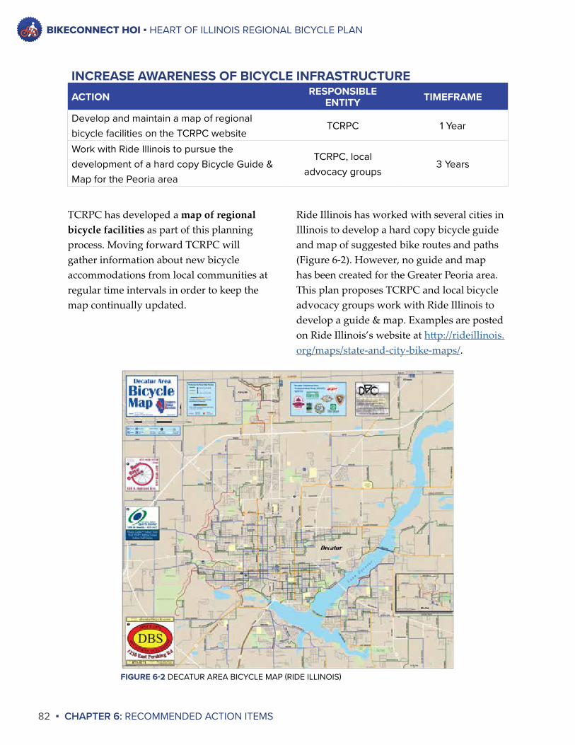
BIKECONNECT HOI ▪ HEART OF ILLINOIS REGIONAL BICYCLE PLAN
82 ▪ CHAPTER 6: RECOMMENDED ACTION ITEMS
Ride Illinois has worked with several cities in Illinois to develop a hard copy bicycle guide and map of suggested bike routes and paths (Figure 6-2). However, no guide and map has been created for the Greater Peoria area. This plan proposes TCRPC and local bicycle advocacy groups work with Ride Illinois to develop a guide & map. Examples are posted on Ride Illinois’s website at http://rideillinois.org/maps/state-and-city-bike-maps/.
TCRPC has developed a mapofregionalbicyclefacilities as part of this planning process. Moving forward TCRPC will gather information about new bicycle accommodations from local communities at regular time intervals in order to keep the map continually updated.
ACTION RESPONSIBLE ENTITY TIMEFRAME
Develop and maintain a map of regional bicycle facilities on the TCRPC website
TCRPC 1 Year
Work with Ride Illinois to pursue the development of a hard copy Bicycle Guide & Map for the Peoria area
TCRPC, local advocacy groups
3 Years
INCREASE AWARENESS OF BICYCLE INFRASTRUCTURE
FIGURE 6-2 DECATUR AREA BICYCLE MAP (RIDE ILLINOIS)
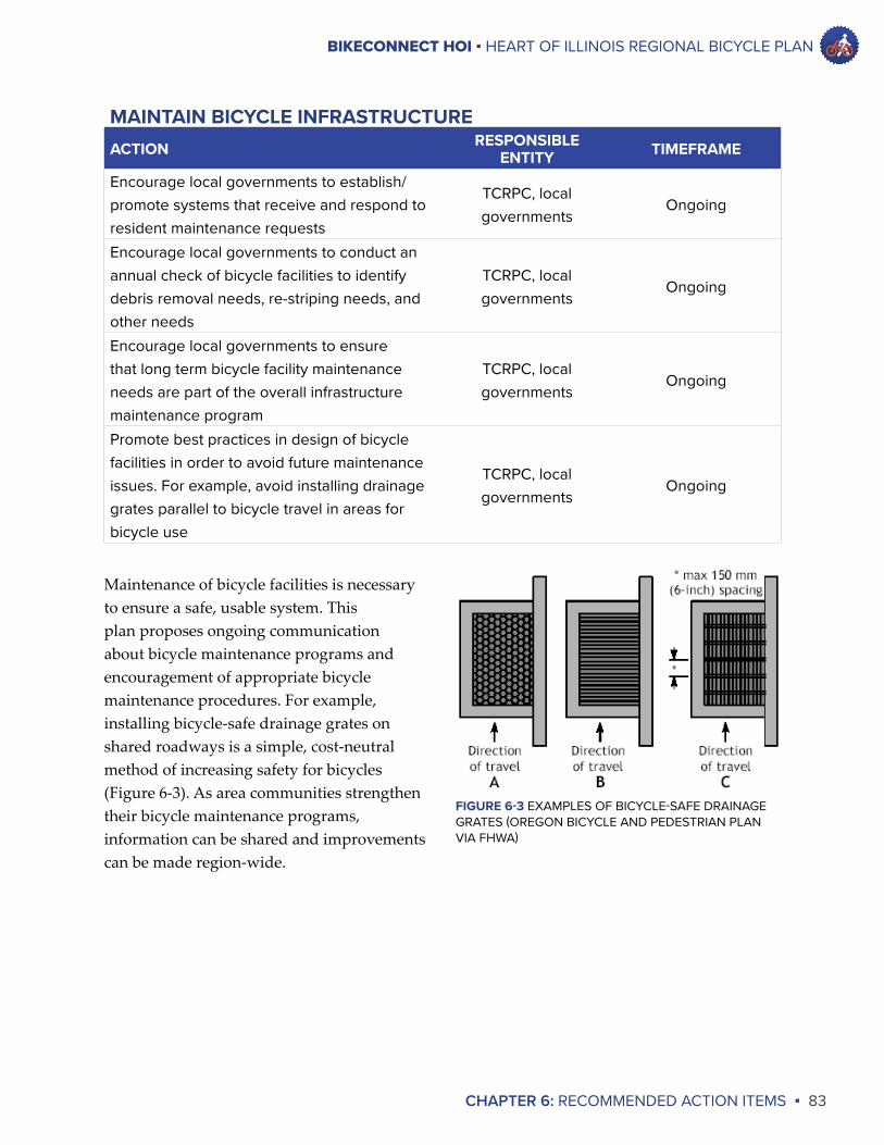
BIKECONNECT HOI ▪ HEART OF ILLINOIS REGIONAL BICYCLE PLAN
CHAPTER 6: RECOMMENDED ACTION ITEMS ▪ 83
Maintenance of bicycle facilities is necessary to ensure a safe, usable system. This plan proposes ongoing communication about bicycle maintenance programs and encouragement of appropriate bicycle maintenance procedures. For example, installing bicycle-safe drainage grates on shared roadways is a simple, cost-neutral method of increasing safety for bicycles (Figure 6-3). As area communities strengthen their bicycle maintenance programs, information can be shared and improvements can be made region-wide.
ACTION RESPONSIBLE ENTITY TIMEFRAME
Encourage local governments to establish/promote systems that receive and respond to resident maintenance requests
TCRPC, local governments
Ongoing
Encourage local governments to conduct an annual check of bicycle facilities to identify debris removal needs, re-striping needs, and other needs
TCRPC, local governments
Ongoing
Encourage local governments to ensure that long term bicycle facility maintenance needs are part of the overall infrastructure maintenance program
TCRPC, local governments
Ongoing
Promote best practices in design of bicycle facilities in order to avoid future maintenance issues. For example, avoid installing drainage grates parallel to bicycle travel in areas for bicycle use
TCRPC, local governments
Ongoing
MAINTAIN BICYCLE INFRASTRUCTURE
FIGURE 6-3 EXAMPLES OF BICYCLE-SAFE DRAINAGE GRATES (OREGON BICYCLE AND PEDESTRIAN PLAN VIA FHWA)
BIKECONNECT HOI ▪ HEART OF ILLINOIS REGIONAL BICYCLE PLAN
84 ▪ CHAPTER 6: RECOMMENDED ACTION ITEMS
The City of Washington recently received an Honorable Mention for its work toward designation as a Bicycle Friendly Community. A concerted community effort is necessary to achieve this designation, so as Washington pursues this designation, TCRPC can work with Washington to document lessons learned and share this information with other communities who are interested in pursuing this designation.
According to The Innovative MPO, a guidebook that discusses best practices for regional transportation planning agencies to follow, one best practice is to adopt and implement complete streets regionally. While TCRPC promotes complete streets through some of its initiatives, the agency does not have an overarching policy that defines how complete streets are promoted and how complete streets impact regional transportation planning policy. This plan proposes TCRPC develop a complete streets policy to define these items.
ACTION RESPONSIBLE ENTITY TIMEFRAME
Develop a Complete Streets policy that identifies how TCRPC can best promote Complete Streets in the future
TCRPC 2 Years
Develop a model Complete Streets ordinance/policy to be promoted for adoption by local jurisdictions
TCRPC Ongoing
Proactively work with IDOT and local communities to encourage the development of bicycle facilities
TCRPC Ongoing
Promote the economic benefits of bicycling and bicycle infrastructure to local communities
TCRPC, local advocacy groups
Ongoing
Encourage communities to plan for bicycle accommodations during community planning processes and redevelopment projects
TCRPC Ongoing
Promote the efforts of Washington and other communities to become a designated Bicycle Friendly Community from the League of American Bicyclists so that other communities could pursue this effort
TCRPC Ongoing
Coordinate with IDOT on the development of bicycle facilities on roadways under IDOT jurisdiction, both as part of roadway reconstruction projects and as stand-alone projects
TCRPC, local governments
Ongoing
PROMOTE COMPLETE STREETS AND BICYCLE FACILITIES
BIKECONNECT HOI ▪ HEART OF ILLINOIS REGIONAL BICYCLE PLAN
CHAPTER 6: RECOMMENDED ACTION ITEMS ▪ 85
There were two other action item categories identified by the Steering Committee: Incentives to Promote Bicycling and Enforcement of Bicycle and Motor Vehicle Laws. These action item categories were chosen based on public input that was received pertaining to the need for incentives to promote bicycling and suggestions for stronger penalties when motorists strike cyclists.
However, no action items were identified for these categories because of the complexity of these topic areas. Moving forward, TCRPC can work with local chambers of commerce to gather information about and promote how workplaces can incentivize bicycling to work. TCRPC also can work with local bicycle advocacy groups and local law enforcement officials to establish and facilitate a dialogue about the enforcement of bicycle and motor vehicle laws and issues pertaining to enforcement.
“
”
The action items appear to be comprehensive and realistic. But there are quite a few, so [I] wonder if TCRPC has the capacity to take a leadership role on more than a few of these. I suppose reach out for help, delegate, collaborate.
– Public Comment,Oct 2016
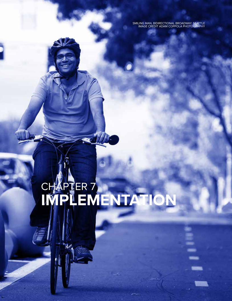
BIKE RACKS AT JUNCTION CITY, PEORIA
CHAPTER 7IMPLEMENTATION
SMILING MAN, BIDIRECTIONAL BROADWAY, SEATTLEIMAGE CREDIT ADAM COPPOLA PHOTOGRAPHY
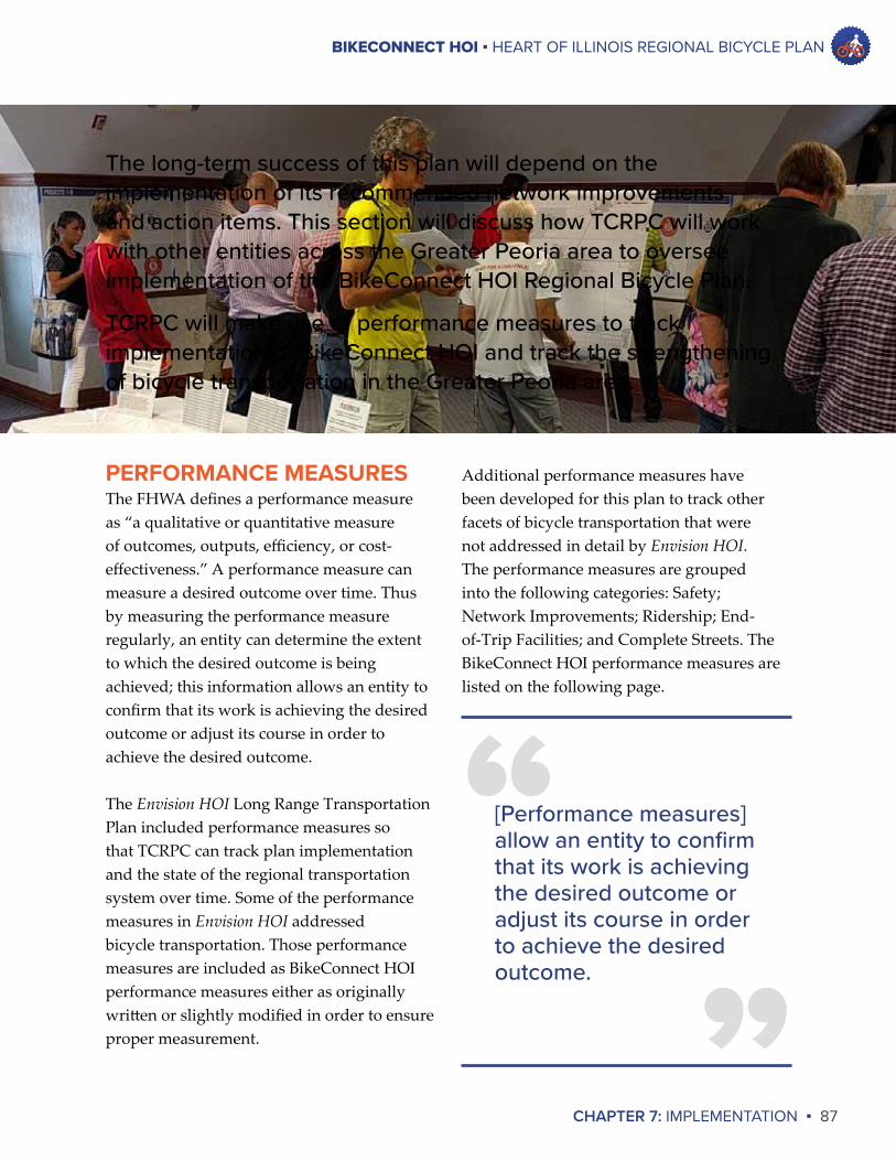
BIKECONNECT HOI ▪ HEART OF ILLINOIS REGIONAL BICYCLE PLAN
CHAPTER 7: IMPLEMENTATION ▪ 87
The long-term success of this plan will depend on the implementation of its recommended network improvements and action items. This section will discuss how TCRPC will work with other entities across the Greater Peoria area to oversee implementation of the BikeConnect HOI Regional Bicycle Plan.
TCRPC will make use of performance measures to track implementation of BikeConnect HOI and track the strengthening of bicycle transportation in the Greater Peoria area.
Additional performance measures have been developed for this plan to track other facets of bicycle transportation that were not addressed in detail by Envision HOI. The performance measures are grouped into the following categories: Safety; Network Improvements; Ridership; End-of-Trip Facilities; and Complete Streets. The BikeConnect HOI performance measures are listed on the following page.
PERFORMANCE MEASURESThe FHWA defines a performance measure as “a qualitative or quantitative measure of outcomes, outputs, efficiency, or cost-effectiveness.” A performance measure can measure a desired outcome over time. Thus by measuring the performance measure regularly, an entity can determine the extent to which the desired outcome is being achieved; this information allows an entity to confirm that its work is achieving the desired outcome or adjust its course in order to achieve the desired outcome.
The Envision HOI Long Range Transportation Plan included performance measures so that TCRPC can track plan implementation and the state of the regional transportation system over time. Some of the performance measures in Envision HOI addressed bicycle transportation. Those performance measures are included as BikeConnect HOI performance measures either as originally written or slightly modified in order to ensure proper measurement. ”
“[Performance measures] allow an entity to confirm that its work is achieving the desired outcome or adjust its course in order to achieve the desired outcome.

BIKECONNECT HOI ▪ HEART OF ILLINOIS REGIONAL BICYCLE PLAN
88 ▪ CHAPTER 7: IMPLEMENTATION
PERFORMANCE MEASURE DATA SOURCE GOAL
Increase the percentage of workers who bicycle to work.
US Census
RIDERSHIP
PERFORMANCE MEASURE DATA SOURCE GOAL
Increase the number of bike parking facilities in the Tri-County region.
Not yet identified
END-OF-TRIP FACILITIES
PERFORMANCE MEASURE DATA SOURCE GOALIncrease the number of communities in the Tri-County region that adopt Complete Streets policies.
TCRPC
COMPLETE STREETS
PERFORMANCE MEASURE DATA SOURCE GOAL
Reduce the total number of traffic crashes involving bicyclists in the Tri-County region.
IDOT
Reduce the number of cyclist injuries in the Tri-County region.
IDOT
Reduce the number of cyclist fatalities in the Tri-County region to zero.
IDOT
SAFETY
PERFORMANCE MEASURE DATA SOURCE GOAL
Increase the number and percent of obligated TIP projects with bicycle accommodations.
TCRPC
Increase mileage of bicycle accommodations (such as trails, bike lanes, and signed bike routes) in the Tri-County region.
TCRPC
Increase the percentage of the population within a half-mile of a bicycle accommodation.
TCRPC
NETWORK IMPROVEMENTS
BIKECONNECT HOI ▪ HEART OF ILLINOIS REGIONAL BICYCLE PLAN
CHAPTER 7: IMPLEMENTATION ▪ 89
It is important to note that not all of these performance measures are directly linked to action items. There are many action items that pertain to establishing new programs. For these action items the measurement of their success will be the establishment of the program. TCRPC will monitor and track the establishment of these programs. It is also important to note that the data source for assessing whether bike parking facilities are increasing in the region is to be determined.
The management status of the existing bike parking map for the Greater Peoria area is not known at this time. This plan proposes TCRPC work with local bike advocates to determine the management status of the map and then to determine how to actively manage the map. When the map resumes being actively managed, data about the number of bike parking facilities in the region can be provided.
PLAN MONITORING AND REPORTINGThe monitoring of plan implementation will go beyond the tracking of performance measures. The following steps are proposed for monitoring plan implementation.
BikeConnectHOISteeringCommittee. TCRPC will convene bi-annual meetings of the BikeConnect HOI Steering Committee, likely in the spring and fall of each year. These meetings will enable TCRPC staff to report to the committee on progress of plan implementation and allow committee members to share information about bicycle events and programs occurring in the region.
Local units of government can also be invited to these meetings to present information and gather input. These meetings should allow for continued coordination among different entities involved in strengthening bicycle transportation in the region.
TrackingofPerformanceMeasuresandActionItems.Progress regarding the performance measures and action items listed in BikeConnect HOI will be tracked each year by TCRPC staff.
TrackingofNetworkImprovements.Improvements to the regional bicycle network will be tracked each year by TCRPC staff so that the regional bike map can be updated and so that improvements can be reported to stakeholders.
Annualreporting.At the beginning of each year TCRPC staff will prepare a BikeConnect HOI implementation report that will present the tracking of performance measures, the progress achieved on implementing action items, and the network improvements that were built during the previous year. This report can be presented to the PPUATS committees, the TCRPC board, the BikeConnect HOI Steering Committee at its spring meeting, and the general public and stakeholder groups.
BIKECONNECT HOI ▪ HEART OF ILLINOIS REGIONAL BICYCLE PLAN
90 ▪ CHAPTER 7: IMPLEMENTATION
the past to promote actions to promote clean air and strengthen air quality in the Greater Peoria area. It is possible that TCRPC could use this funding in the future to conduct an education program to promote sharing the road and bicycle safety.
CompetitiveGrants.There are national bicycle advocacy groups that provide competitive funding for bike-related projects. For example, People for Bikes provides community grants that fund bicycle advocacy initiatives and network improvements; more information is available at http://www.peopleforbikes.org/pages/community-grants. People for Bikes also recently announced available funding for bicycle infrastructure and community outreach through an initiative called The Big Jump. More information about this program is available at http://www.peopleforbikes.org/pages/the-big-jump-project-application.
NETWORK IMPROVEMENTSSurfaceTransportation-UrbanFunding. One of TCRPC’s responsibilities as the designated MPO for the Greater Peoria area is to work with local communities to allocate Surface Transportation-Urban (STU) funding. STU funding is federal funding for transportation infrastructure that is made available every year to the Greater Peoria area; communities within the Peoria urbanized area are eligible to apply for these funds. The PPUATS Policy and Technical Committees allocate this competitive funding for transportation infrastructure improvements. Communities within the Peoria urbanized area can apply for this funding to build or improve roadways that include bicycle accommodations or to build separated bicycle paths.
FUNDING SOURCESThere are sources of funding outside of standard local government revenues that can be used for the construction of bikeways and the implementation of action items listed in this plan. This section will highlight some of these funding sources that can be used to implement this plan.
ACTION ITEMSMetropolitanTransportationPlanningFunds.TCRPC receives federal funding each year for planning activities that strengthen the transportation system in the Greater Peoria area. These funds can be used to implement action items that consist of planning-related activities. For example, TCRPC can use metropolitan planning funds to develop a model complete streets ordinance that could be adopted by local communities. This BikeConnect HOI planning process was funded using these planning funds.
StateTransportationPlanningFunds.IDOT provides additional funding to TCRPC for regional transportation planning activities. These funds can be used for the same type of planning activities that are eligible to be funded by the Metropolitan Transportation Planning Funds discussed above. Again, these funds can be used to implement action items that consist of planning-related activities. For example, establishment of a bike counting program can be funded by either Metropolitan Transportation Planning Funds or State Transportation Planning Funds.
StatePlanningandResearchFunds.IDOT also provides limited funding for additional transportation planning and research activities. TCRPC has received this funding in
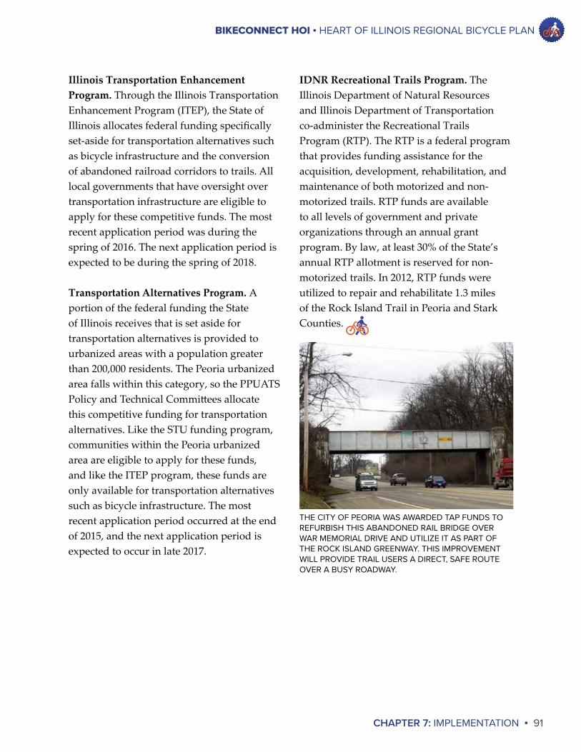
BIKECONNECT HOI ▪ HEART OF ILLINOIS REGIONAL BICYCLE PLAN
CHAPTER 7: IMPLEMENTATION ▪ 91
IDNRRecreationalTrailsProgram. The Illinois Department of Natural Resources and Illinois Department of Transportation co-administer the Recreational Trails Program (RTP). The RTP is a federal program that provides funding assistance for the acquisition, development, rehabilitation, and maintenance of both motorized and non-motorized trails. RTP funds are available to all levels of government and private organizations through an annual grant program. By law, at least 30% of the State’s annual RTP allotment is reserved for non-motorized trails. In 2012, RTP funds were utilized to repair and rehabilitate 1.3 miles of the Rock Island Trail in Peoria and Stark Counties.
IllinoisTransportationEnhancementProgram.Through the Illinois Transportation Enhancement Program (ITEP), the State of Illinois allocates federal funding specifically set-aside for transportation alternatives such as bicycle infrastructure and the conversion of abandoned railroad corridors to trails. All local governments that have oversight over transportation infrastructure are eligible to apply for these competitive funds. The most recent application period was during the spring of 2016. The next application period is expected to be during the spring of 2018.
TransportationAlternativesProgram.A portion of the federal funding the State of Illinois receives that is set aside for transportation alternatives is provided to urbanized areas with a population greater than 200,000 residents. The Peoria urbanized area falls within this category, so the PPUATS Policy and Technical Committees allocate this competitive funding for transportation alternatives. Like the STU funding program, communities within the Peoria urbanized area are eligible to apply for these funds, and like the ITEP program, these funds are only available for transportation alternatives such as bicycle infrastructure. The most recent application period occurred at the end of 2015, and the next application period is expected to occur in late 2017.
THE CITY OF PEORIA WAS AWARDED TAP FUNDS TO REFURBISH THIS ABANDONED RAIL BRIDGE OVER WAR MEMORIAL DRIVE AND UTILIZE IT AS PART OF THE ROCK ISLAND GREENWAY. THIS IMPROVEMENT WILL PROVIDE TRAIL USERS A DIRECT, SAFE ROUTE OVER A BUSY ROADWAY.

BIKE RACKS AT JUNCTION CITY, PEORIA
APPENDIX ARESULTS OF REVIEW OPEN HOUSE VOTING
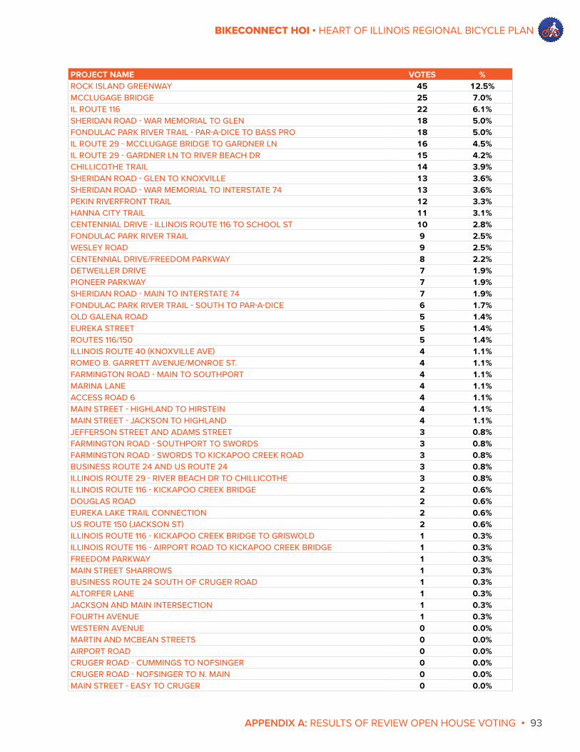
APPENDIX A: RESULTS OF REVIEW OPEN HOUSE VOTING ▪ 93
BIKECONNECT HOI ▪ HEART OF ILLINOIS REGIONAL BICYCLE PLAN
PROJECT NAME VOTES %ROCK ISLAND GREENWAY 45 12.5%MCCLUGAGE BRIDGE 25 7.0%IL ROUTE 116 22 6.1%SHERIDAN ROAD - WAR MEMORIAL TO GLEN 18 5.0%FONDULAC PARK RIVER TRAIL - PAR-A-DICE TO BASS PRO 18 5.0%IL ROUTE 29 - MCCLUGAGE BRIDGE TO GARDNER LN 16 4.5%IL ROUTE 29 - GARDNER LN TO RIVER BEACH DR 15 4.2%CHILLICOTHE TRAIL 14 3.9%SHERIDAN ROAD - GLEN TO KNOXVILLE 13 3.6%SHERIDAN ROAD - WAR MEMORIAL TO INTERSTATE 74 13 3.6%PEKIN RIVERFRONT TRAIL 12 3.3%HANNA CITY TRAIL 11 3.1%CENTENNIAL DRIVE - ILLINOIS ROUTE 116 TO SCHOOL ST 10 2.8%FONDULAC PARK RIVER TRAIL 9 2.5%WESLEY ROAD 9 2.5%CENTENNIAL DRIVE/FREEDOM PARKWAY 8 2.2%DETWEILLER DRIVE 7 1.9%PIONEER PARKWAY 7 1.9%SHERIDAN ROAD - MAIN TO INTERSTATE 74 7 1.9%FONDULAC PARK RIVER TRAIL - SOUTH TO PAR-A-DICE 6 1.7%OLD GALENA ROAD 5 1.4%EUREKA STREET 5 1.4%ROUTES 116/150 5 1.4%ILLINOIS ROUTE 40 (KNOXVILLE AVE) 4 1.1%ROMEO B. GARRETT AVENUE/MONROE ST. 4 1.1%FARMINGTON ROAD - MAIN TO SOUTHPORT 4 1.1%MARINA LANE 4 1.1%ACCESS ROAD 6 4 1.1%MAIN STREET - HIGHLAND TO HIRSTEIN 4 1.1%MAIN STREET - JACKSON TO HIGHLAND 4 1.1%JEFFERSON STREET AND ADAMS STREET 3 0.8%FARMINGTON ROAD - SOUTHPORT TO SWORDS 3 0.8%FARMINGTON ROAD - SWORDS TO KICKAPOO CREEK ROAD 3 0.8%BUSINESS ROUTE 24 AND US ROUTE 24 3 0.8%ILLINOIS ROUTE 29 - RIVER BEACH DR TO CHILLICOTHE 3 0.8%ILLINOIS ROUTE 116 - KICKAPOO CREEK BRIDGE 2 0.6%DOUGLAS ROAD 2 0.6%EUREKA LAKE TRAIL CONNECTION 2 0.6%US ROUTE 150 (JACKSON ST) 2 0.6%ILLINOIS ROUTE 116 - KICKAPOO CREEK BRIDGE TO GRISWOLD 1 0.3%ILLINOIS ROUTE 116 - AIRPORT ROAD TO KICKAPOO CREEK BRIDGE 1 0.3%FREEDOM PARKWAY 1 0.3%MAIN STREET SHARROWS 1 0.3%BUSINESS ROUTE 24 SOUTH OF CRUGER ROAD 1 0.3%ALTORFER LANE 1 0.3%JACKSON AND MAIN INTERSECTION 1 0.3%FOURTH AVENUE 1 0.3%WESTERN AVENUE 0 0.0%MARTIN AND MCBEAN STREETS 0 0.0%AIRPORT ROAD 0 0.0%CRUGER ROAD - CUMMINGS TO NOFSINGER 0 0.0%CRUGER ROAD - NOFSINGER TO N. MAIN 0 0.0%MAIN STREET - EASY TO CRUGER 0 0.0%
Related Documents


