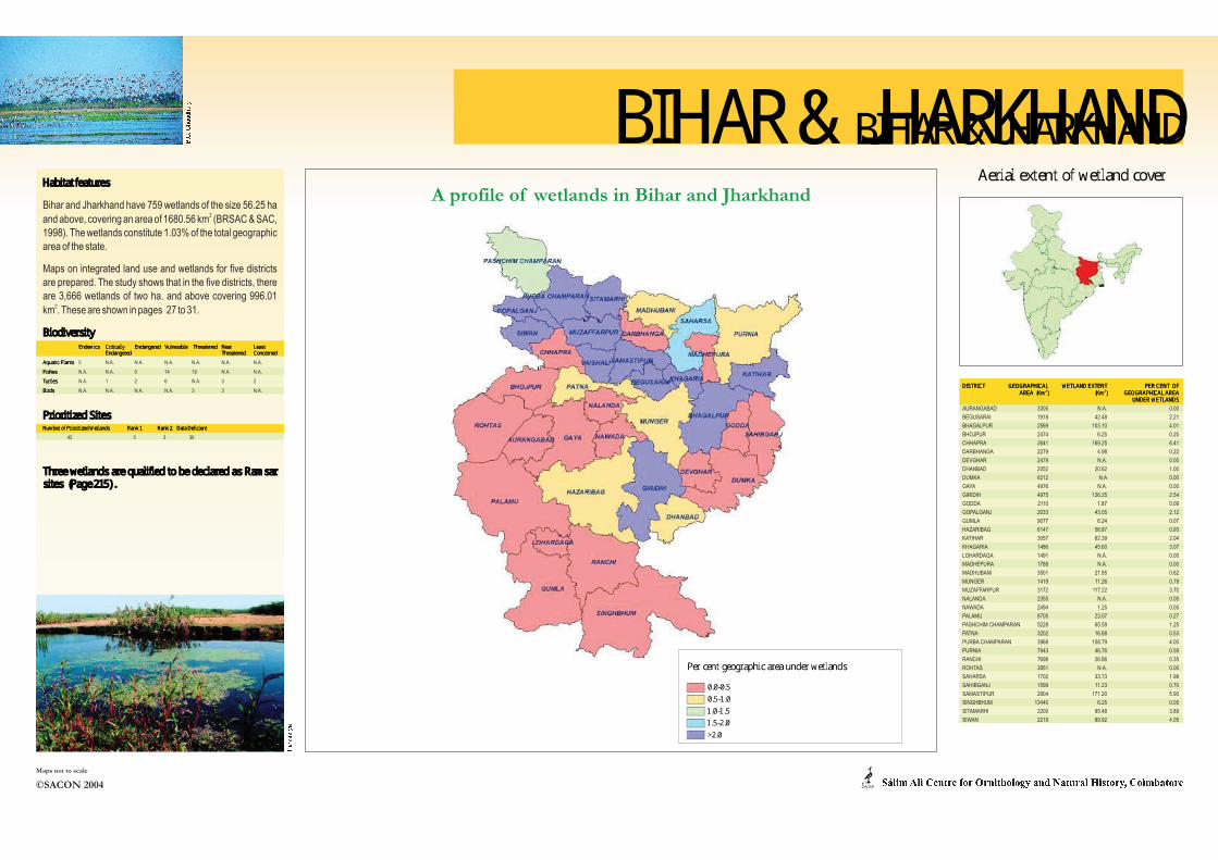
A profile of wetlands in Bihar and Jharkhand AURANGABAD 3305 N.A. 0.00 BEGUSARAI 1918 42.48 2.21 BHAGALPUR 2569 103.10 4.01 BHOJPUR 2474 6.25 0.25 CHHAPRA 2641 169.25 6.41 DARBHANGA 2279 4.98 0.22 DEVGHAR 2479 N.A. 0.00 DHANBAD 2052 20.62 1.00 DUMKA 6212 N.A 0.00 GAYA 4976 N.A. 0.00 GIRIDIH 4975 126.25 2.54 GODDA 2110 1.87 0.09 GOPALGANJ 2033 43.05 2.12 GUMLA 9077 6.24 0.07 HAZARIBAG 6147 56.87 0.93 KATIHAR 3057 62.39 2.04 KHAGARIA 1486 45.60 3.07 LOHARDAGA 1491 N.A. 0.00 MADHEPURA 1788 N.A. 0.00 MADHUBANI 3501 21.85 0.62 MUNGER 1419 11.26 0.79 MUZAFFARPUR 3172 117.22 3.70 NALANDA 2355 N.A. 0.00 NAWADA 2494 1.25 0.05 PALAMU 8705 23.07 0.27 PASHCHIM CHAMPARAN 5228 65.59 1.25 PATNA 3202 16.88 0.53 PURBA CHAMPARAN 3968 158.79 4.00 PURNIA 7943 46.76 0.59 RANCHI 7698 26.86 0.35 ROHTAS 3851 N.A. 0.00 SAHARSA 1702 33.73 1.98 SAHIBGANJ 1599 11.23 0.70 SAMASTIPUR 2904 171.20 5.90 SINGHBHUM 13440 6.25 0.05 SITAMARHI 2200 85.48 3.89 SIWAN 2219 89.92 4.05 Bihar and Jharkhand have 759 wetlands of the size 56.25 ha 2 and above, covering an area of 1680.56 km (BRSAC & SAC, 1998). The wetlands constitute 1.03% of the total geographic area of the state. Maps on integrated land use and wetlands for five districts are prepared. The study shows that in the five districts, there are 3,666 wetlands of two ha. and above covering 996.01 2 km . These are shown in pages 27 to 31. 5 N.A. N.A. N.A. N.A. N.A. N.A. N.A. N.A. 5 14 19 N.A. N.A. N.A. 1 2 6 N.A. 3 2 N.A. N.A. N.A. N.A. 3 3 N.A. 42 3 3 36 ©SACON 2004 Maps not to scale

Welcome message from author
This document is posted to help you gain knowledge. Please leave a comment to let me know what you think about it! Share it to your friends and learn new things together.
Transcript
������������ � BIHAR & JHARKHANDBIHAR & JHARKHAND
0.0-0.50.5-1.01.0-1.51.5-2.0>2.0
A profile of wetlands in Bihar and Jharkhand
DISTRICT GEOGRAPHICAL WETLAND EXTENT PER CENT OF2 2AREA (Km ) (Km ) GEOGRAPHICAL AREA
UNDER WETLANDS
AURANGABAD 3305 N.A. 0.00
BEGUSARAI 1918 42.48 2.21
BHAGALPUR 2569 103.10 4.01
BHOJPUR 2474 6.25 0.25
CHHAPRA 2641 169.25 6.41
DARBHANGA 2279 4.98 0.22
DEVGHAR 2479 N.A. 0.00
DHANBAD 2052 20.62 1.00
DUMKA 6212 N.A 0.00
GAYA 4976 N.A. 0.00
GIRIDIH 4975 126.25 2.54
GODDA 2110 1.87 0.09
GOPALGANJ 2033 43.05 2.12
GUMLA 9077 6.24 0.07
HAZARIBAG 6147 56.87 0.93
KATIHAR 3057 62.39 2.04
KHAGARIA 1486 45.60 3.07
LOHARDAGA 1491 N.A. 0.00
MADHEPURA 1788 N.A. 0.00
MADHUBANI 3501 21.85 0.62
MUNGER 1419 11.26 0.79
MUZAFFARPUR 3172 117.22 3.70
NALANDA 2355 N.A. 0.00
NAWADA 2494 1.25 0.05
PALAMU 8705 23.07 0.27
PASHCHIM CHAMPARAN 5228 65.59 1.25
PATNA 3202 16.88 0.53
PURBA CHAMPARAN 3968 158.79 4.00
PURNIA 7943 46.76 0.59
RANCHI 7698 26.86 0.35
ROHTAS 3851 N.A. 0.00
SAHARSA 1702 33.73 1.98
SAHIBGANJ 1599 11.23 0.70
SAMASTIPUR 2904 171.20 5.90
SINGHBHUM 13440 6.25 0.05
SITAMARHI 2200 85.48 3.89
SIWAN 2219 89.92 4.05
Habitat features
Bihar and Jharkhand have 759 wetlands of the size 56.25 ha 2
and above, covering an area of 1680.56 km (BRSAC & SAC,
1998). The wetlands constitute 1.03% of the total geographic
area of the state.
Maps on integrated land use and wetlands for five districts
are prepared. The study shows that in the five districts, there
are 3,666 wetlands of two ha. and above covering 996.01 2
km . These are shown in pages 27 to 31.
BiodiversityEndemics Critically Endangered Vulnerable Threatened Near Least
Endangered Threatened Concerned
Aquatic Plants 5 N.A. N.A. N.A. N.A. N.A. N.A.
Fishes N.A. N.A. 5 14 19 N.A. N.A.
Turtles N.A. 1 2 6 N.A. 3 2
Birds N.A. N.A. N.A. N.A. 3 3 N.A.
Prioritized SitesNumber of Prioritized Wetlands Rank 1 Rank 2
42 3 3 36
Three wetlands are qualified to be declared as Ramsar sites (Page 215) .
Data Deficient
©SACON 2004
Maps not to scale
ACON
� � � � � �� � �� � �� � � � � � � � � � � � � � � � � � �� � � � � �� � � � � � � � ! � � � � �Aerial extent of wetland cover
Per cent geographic area under wetlands"#$#%#$ &#
Dense Forest
Open Forest
Arable Land
Waste Land
River
Township
Pond/Tank
Reservoir
Oxbow Lake/Cut-off
Railways
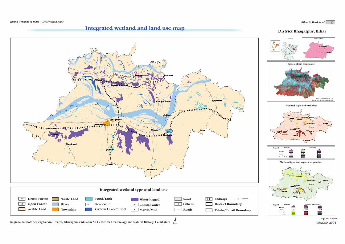
District Bhagalpur, Bihar
Band Combination: 3, 2, 1IRS ID LISS III (December 2000)
District Boundary
Integrated wetland and land use map
Regional Remote Sensing Service Centre, Kharagpur and Sálim Ali Centre for Ornithology and Natural History, Coimbatore ©SACON 2004
Maps not to scale
Integrated wetland type and land use
ACON
Location
Wetland type and aquatic vegetation
Wetland Aquatic VegetationLegend
Taluks/Tehsils
Wetland type and turbidity
False colour composite
TurbidityLegend Wetland
* Not Present
27Inland Wetlands of India - Conservation Atlas Bihar & Jharkhand
Taluks/Tehsil Boundary
Water-logged
Coastal-water
Marsh/Mud
Sand
Others
Roads
Dense Forest
Open Forest
Arable Land
Waste Land
River
Township
Pond/Tank
Reservoir
Oxbow Lake/Cut-off
Water-logged
Coastal-water
Marsh/Mud
Sand
Orchard
Roads
Railways
Tehsil Boundary
District Boundary
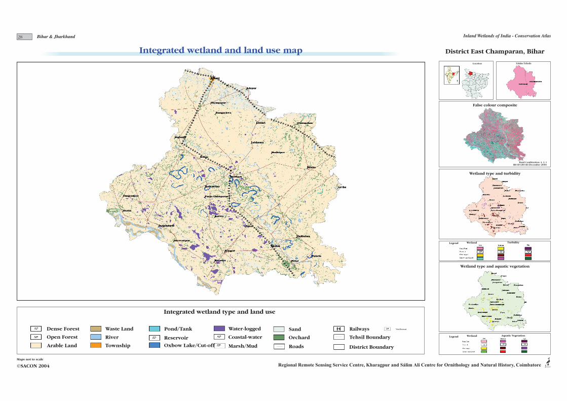
District East Champaran, Bihar
Band Combination: 3, 2, 1IRS ID LISS III (December 2000)
Integrated wetland type and land use
ACONRegional Remote Sensing Service Centre, Kharagpur and Sálim Ali Centre for Ornithology and Natural History, Coimbatore©SACON 2004
Maps not to scale
Integrated wetland and land use mapLocation
Wetland type and aquatic vegetation
Wetland Aquatic VegetationLegend
Taluks/Tehsils
Wetland type and turbidity
False colour composite
Legend Wetland
* Not Present
Turbidity
28 Inland Wetlands of India - Conservation AtlasBihar & Jharkhand
Dense Forest
Open Forest
Arable Land
Pond/Tank
Reservoir
Oxbow Lake/Cut-off
Water-logged
Coastal-water
Marsh/Mud
Sand
Roads
Railways
* Not Present
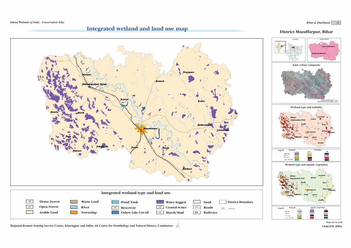
District Muzaffarpur, Bihar
Band Combination: 3, 2, 1IRS ID LISS III November, 2000)
River
Waste Land
Township
Integrated wetland and land use map
Regional Remote Sensing Service Centre, Kharagpur and Sálim Ali Centre for Ornithology and Natural History, Coimbatore ©SACON 2004
Maps not to scale
Integrated wetland type and land use
ACON
Location
Wetland type and aquatic vegetation
Wetland Aquatic VegetationLegend
Taluks/Tehsils
Wetland type and turbidity
False colour composite
Legend Wetland Turbidity
29Inland Wetlands of India - Conservation Atlas Bihar & Jharkhand
District Boundary
Dense Forest
Open Forest
Arable Land
Waste Land
River
Township
Pond/Tank
Reservoir
Oxbow Lake/Cut-off
Water-logged
Coastal-water
Marsh/Mud
Sand
Roads
Railways
District Boundary
* Not Present
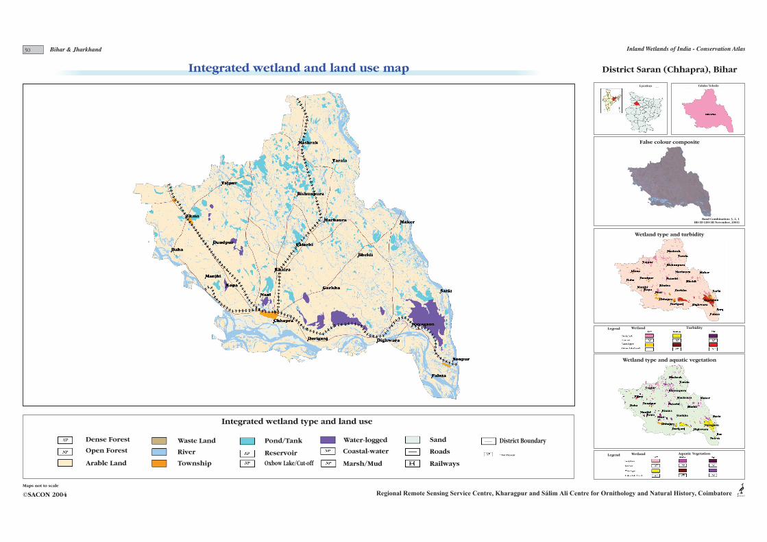
District Saran (Chhapra), Bihar
Band Combination: 3, 2, 1IRS ID LISS III November, 2000)
Integrated wetland type and land use
ACONRegional Remote Sensing Service Centre, Kharagpur and Sálim Ali Centre for Ornithology and Natural History, Coimbatore©SACON 2004
Maps not to scale
Integrated wetland and land use mapLocation
Wetland type and aquatic vegetation
Wetland Aquatic VegetationLegend
Taluks/Tehsils
Wetland type and turbidity
False colour composite
Legend Wetland Turbidity
30 Inland Wetlands of India - Conservation AtlasBihar & Jharkhand
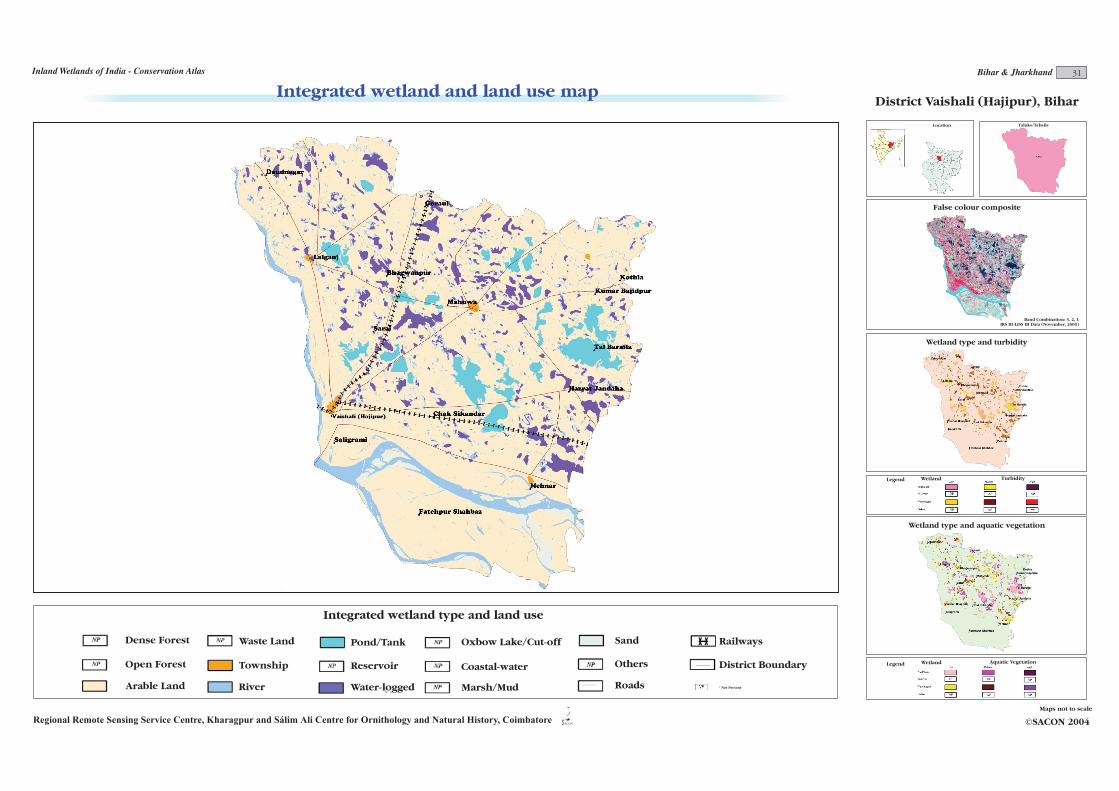
District Vaishali (Hajipur), Bihar
Dense Forest
Open Forest
Arable Land
Waste Land
River
Township
Pond/Tank
Reservoir
Oxbow Lake/Cut-off
Water-logged
Coastal-water
Marsh/Mud
Sand
Others
Roads
District Boundary
* Not Present
Band Combination: 3, 2, 1 IRS ID-LISS III Data (November, 2000)
Railways
Integrated wetland and land use map
Regional Remote Sensing Service Centre, Kharagpur and Sálim Ali Centre for Ornithology and Natural History, Coimbatore ©SACON 2004
Maps not to scale
Integrated wetland type and land use
ACON
Location
Wetland type and aquatic vegetation
Wetland Aquatic VegetationLegend
Taluks/Tehsils
Wetland type and turbidity
False colour composite
Legend Wetland Turbidity
31Bihar & JharkhandInland Wetlands of India - Conservation Atlas
'( ) * + , - ) ( . ) / 0 * , - 1 , 2 ) 0 ) 3 / - 1 2 /( 1 3 / 24 5 6 7 6 8 9 : ; < 6 = > ? 5 6 @ 9 6 ; 6 A B : C 6 D D 6 ; 9 : ; E 6 ; 6 A F 6 G = 5 6 8 GH IJ KL IM KJNOPQRS NS O T U ; V U A > 7 U W 7 ; 6 9 5 G V 6 8 6 ; U 64 5 6 7 6 8 9 : ; < 6 = > ? 5 6 @ 9 6 ; 6 A B : C 6 D D 6 ; 9 : ; E 6 ; 6 A F 6 G = 5 6 8 GH IJ KL IM KJNOPQRS NS O T U ; V U A > 7 U W 7 ; 6 9 5 G V 6 8 6 ; U 6
' ( ) * + , - ) ( - 1 X X ) ( ) , / . ) / 0 * , - 3 0 * 2 2 ) 2 1 , 2 ) 0 ) 3 / - 1 2 /( 1 3 / 2Y Z [\ [ ] _ a [ b c d Z [ e [ ` [ f g_ h [ i i [ ` ^_ j [ ` [ f k [ l b Z [ ] lm n o p q n r p ostuvwx s y z ` { z f c | i c | c [ ] \ z |\ [ Z l { [ ] [ ` z [}~ �� � �� � � � � �� �� � �~ �� � �� � � � � �~ �� �
Y Z [\ [ ] _ a [ b c d Z [ e [ ` [ f g_ h [ i i [ ` ^_ j [ ` [ f k [ l b Z [ ] lm n o p q n r p ostuvwx s y z ` { z f c | i c | c [ ] \ z |\ [ Z l { [ ] [ ` z [}~ �� � �� � � � � �� �� � �~ �� � �� � � � � �~ �� �
� �� � � �� � � � � � �� � �� � �� � � � � � �� � � � � � � � � � � � � � � � � � � � �¡ ¢ ¢ ¢£ ¢ ¢¤ ¢ ¢¥ ¢ ¢¦ ¢ ¢ § © ª« ¬ ® « ° ±² ³ ´µ
¶ ·² ² ±¹ ¬ º² µ ° » ·² ©¹ ² ¬² ³ ¼ ½² ® ®² ¬¹ ¬ ¾² ¬² ³ ¿² Àµ ·² ± ÀÁ Âà ÄÅ ÂÆ ÄÃÇ È ÉÊ Ë É · ² ÌÍ È ÉÊ Ë ÉÎ Ï Ð Ð ·² Ì Í Ï Ð ÐÎ Ë Ð Ð ·²ÌÍ Ë Ð ÐÎ Ñ Ð Ð ·² ÌÍ Ñ Ð ÐÎ Ò Ð Ð ·² Ì Í Ò Ð ÐÎ È Ð Ð ·²ÌÍ È Ð Ð ·²¡ ¢ ¢ ¢£ ¢ ¢¤ ¢ ¢¥ ¢ ¢¦ ¢ ¢ § © ª« ¬ ® « ° ±² ³ ´µ
¶ ·² ² ±¹ ¬ º² µ ° » ·² ©¹ ² ¬² ³ ¼ ½² ® ®² ¬¹ ¬ ¾² ¬² ³ ¿² Àµ ·² ± ÀÁ Âà ÄÅ ÂÆ ÄÃÇ È ÉÊ Ë É · ² ÌÍ È ÉÊ Ë ÉÎ Ï Ð Ð ·² Ì Í Ï Ð ÐÎ Ë Ð Ð ·²ÌÍ Ë Ð ÐÎ Ñ Ð Ð ·² ÌÍ Ñ Ð ÐÎ Ò Ð Ð ·² Ì Í Ò Ð ÐÎ È Ð Ð ·²ÌÍ È Ð Ð ·²Ç È ÉÊ Ë É · ² ÌÍ È ÉÊ Ë ÉÎ Ï Ð Ð ·² Ì Í Ï Ð ÐÎ Ë Ð Ð ·²ÌÍ Ë Ð ÐÎ Ñ Ð Ð ·² ÌÍ Ñ Ð ÐÎ Ò Ð Ð ·² Ì Í Ò Ð ÐÎ È Ð Ð ·²ÌÍ È Ð Ð ·²
ÓÔ Õ Ö × Ø × ÙÚ Û Ü Ù ÙÝ Õ Þ × Þ ß Ý à Ý á Ù Ø × ß Ù Õ × á Ù ßâ ã ã
ä åæ çæ èé ê ë ìæ í î ï åæ ðé æ ëæ ñ ò ê óæ ô ôæ ëé ê ë õæ ëæ ñ öæ ÷ í åæ è ÷ø ùú ûü ùý ûúãþ ãÿ ã� ã� ã �� ë �� ñ î � ô �� î èæ ñ � æ ë� æ � �� �� � � �� �â ã ãä åæ çæ èé ê ë ìæ í î ï åæ ðé æ ëæ ñ ò ê óæ ô ôæ ëé ê ë õæ ëæ ñ öæ ÷ í åæ è ÷ø ùú ûü ùý ûúãþ ãÿ ã� ã� ã �� ë �� ñ î � ô �� î èæ ñ � æ ë� æ � �� �� � � �� �
�� � � � �� � � � � � � � �� � � � � � ! � � "# � � # � ! �� � " �# �$ � � �#% &' (' )* + , -' . / 0 &' 1* ' ,' 2 3 + 4' 5 5' ,* + , 6' ,' 2 7' 8 . &' ) 89 :; <= :> <;?@ ?A ?B ?C ? DE = > E F <G HI E < JK F L K = E K DG G = MG LE = K <E N :O P% &' (' )* + , -' . / 0 &' 1* ' ,' 2 3 + 4' 5 5' ,* + , 6' ,' 2 7' 8 . &' ) 89 :; <= :> <;?@ ?A ?B ?C ? DE = > E F <G HI E < JK F L K = E K DG G = MG LE = K <E N :O P
QR S T U V S W X Y Y S T T S Z S W W [\ ] [ ] W S ^ S Z _ [ W _ T [ Z _ Wa bc dc ef g h ij k l m nj o pj qj r s g tc u uc hf g h vc hc w xc yz bc e y{| {} {~ {� { � h �� � � wz � � w h � �z z y � w � � �� �� �� �� ��a bc dc ef g h ij k l m nj o pj qj r s g tc u uc hf g h vc hc w xc yz bc e y{| {} {~ {� {� �� �� �� ��
Attributes of wetlands and environmental contamination
©SACON 2004
Maps not to scale
ACON
� � � � � � � � �� � �� � �� � � � � � � � � � � � � � � ¡ � �¢ � � � £ �¤ � � � �¥ � � � � ¦ � � � � �32
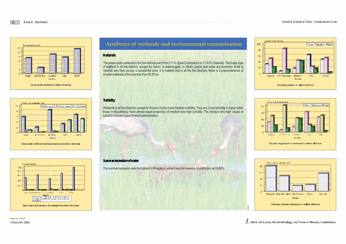
Wetlands
The areas under wetlands in the five districts vary from 2.71% (East Champaran) to 11.43% (Vaishali). The major type of wetland in all the districts, except for Saran, is waterlogged. In Saran, ponds and lakes are dominant while in Vaishali also they occupy a substantial area. It is notable that in all the five districts, there is a preponderance of smaller wetlands of the size less than 56.25 ha.
Turbidity
Wetlands in all the districts, except for those in Saran have medium turbidity. They are of low turbidity in Saran while those in Muzaffarpur have almost equal proportion of medium and high turbidity. The medium and high values of turbidity indicate higher level of sedimentation.
Summer recession of water
The summer recession was the highest in Bhagalpur, while it was the lowest in Muzaffarpur, at 16.86%.
Bihar & Jharkhand
Ach
arya
Inland Wetlands of India - Conservation Atlas
Ach
arya
B.S
inha
33
§ © ª © « ª¬ ® ® ¬ «¬ « ° © ° ± « ± « ² ³ ¬ °´ ° ³ © « ª ²µ ¶ · ¸ · ¹ º · »¼ · ½ ¾ · ¸ ¿ À ÁÂ Ã Ä Ä Å ÆÇ È É Å¾ · ¶ Ê Â ¾ Ë ¸ À Ì ·¼ · ¸ À Ì · ¸ Í Î ¸ º À » ¶ · Á · Ï ËÐ Ñ ½ · ¿ Ë Ë ÁÒ· Ó · ¸ À ¿ · ½ Ô · Ï ËÕ · À Ö ¾ Ñ ¶ Ê · » Õ · Á · Ì º · »×· ¶ Ø ¾ Ë Ö Ê · »ÙÀ Ö · ¸ · » Í Î ¸ Á · Ï ËÙÎ Ï ¾ · Á Ê · ¸ À º · »Ú À ÀÁ · Ì · Ê · »ÛÜÝÞßà Û á â ã ä å ã æ ç è æ é â ã é ã ê ê ë ìí î ï ðñ ò òí óµ ¶ · ¸ · ¹ º · »¼ · ½ ¾ · ¸ ¿ À ÁÁ  ¾ Ë ¸ ÀÀ Ì ·¼ · ¸ À Ì · ¸ Í Î ¸ º À » ¶ · Á · Ï ËÐ Ñ ½ · ¿ Ë Ë ÁÒ· Ó · ¸ À ¿ · ½ Ô · Ï ËÕ · À Ö ¾ Ñ ¶ Ê · » Õ · Á · Ì º · »×· ¶ Ø ¾ Ë Ö Ê · »ÙÀ Ö · ¸ · » Í Î ¸ Á · Ï ËÙÎ Ï ¾ · Á Ê · ¸ À º · » Ì · Ê · »ÛÜÝÞßà Û á â ã ä å ã æ ç è æ é â ã é ã ê ê ë ìí î ï ðñ ò òí óôõ ö ÷ ø ù ú û ü ù õ ý ø þ õ þ ÿ ý �� þ ÿ ý ø � ÷ õ ý ù� ÿ � þ � ü ÷ ø � ÿ� � � � � � � � � � � � � � � � � � � � � � � � � � � � � �� � � � � � � � � �� � � � � � � ��� � � � �� � � � � ! � �"� � � � �# � � � � � � � � � � � �� � � � � � � � �$$% &$% '$% ($% )$% *+,- ./- 012 03 ,-3- 445
� � � � � � � � � � � � � � � � � � � � � � � � � � � � � �� � � � � � � � � �� � � � � � � ��� � � � �� � � � � ! � � # � � � � � � � � � � � �� � � � � � � � �$$% &$% '$% ($% )$% *+,- ./- 012 03 ,-3- 44567 8 9 9: ; : < = : 8 < >? >@ A B : > A @ < C @ ; : @ D EF G 8 < H : A : = > C 8 H > ; 8 = > HI J K L K M N O P Q K R S T J K U N K P K V W O X K Y Y K P N O P Z K P K V [ K \ R J K M \] _ `a ^b `_cd ce c ce d cf c cf d cg c c hi j k lm no pqh r s e t t e uqh r v w s f c c e uI J K L K M N O P Q K R S T J K U N K P K V W O X K Y Y K P N O P Z K P K V [ K \ R J K M \] _ `a ^b `_cd ce c ce d cf c cf d cg c c hi j k lm no pqh r s e t t e uqh r v w s f c c e u
xy z{ | y } ~ { � y � � | y } � � � } � � � �� � � { � y � ~ � { } � y � � � � � � � � � y � � � � � � �� � � � � � � � � � � � � � �� � � � � � � � � � �� � � � � � � � � � � � � �� � � � � � � � � � � � � � � � �� � � � � � � � � � � � � �� � � � � � � � � � � � � � � �� � � � � � � � � � � � � � � � � � � � � � ¡ � � � � ¡ � � � �¢ � � � � � � � � � � � � � � � � � � �£ � � � � � � � � � � � � � �£ � � � � � � � � � � � � �¤ � � � � � � � � � � � � � ¥ � � � � � � �¦¦§ ¨¦§ ©¦§ ª¦§ «¬®¯°®±²³±´®´® µµ¶� � � � � � � � � � � � � � �� � � � � � � � � � �� � � � � � � � � � � � � �� � � � � � � � � � � � � � � � �� � � � � � � � � � � � � �� � � � � � � � � � � � � � � �� � � � � � � � � � � � � � � � � � � � � � ¡ � � � � ¡ � � � �¢ � � � � � � � � � � � � � � � � � � �£ � � � � � � � � � � � � � �£ � � � � � � � � � � � � �¤ � � � � � � � � � � � � � ¥ � � � � � � �¦¦§ ¨¦§ ©¦§ ª¦§ «¬®¯°®±²³±´®´® µµ¶
Attributes of wetlands and environmental contamination
©SACON 2004
Maps not to scale
ACON
· ¹ º » ¼ ¹ º ½¾ ¿ ÀÁ ¾ Âà Á Ä Á ¿ º À Å Ã ¹ Ã Æ Ç È ¿ É Ê È ÀË Á È ¹ Ì ºÍ À à Á ÇÎ ½ à º » Ï È À à Á ¾
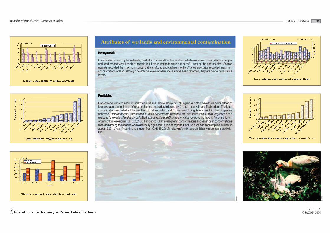
Pesticides
Fishes from Sukhaldari dam of Garhwa district and Cheriya Bariyarpur of Begusarai district have the maximum load of total average concentration of organochlorine pesticides followed by Chandil reservoir and Tilaiya dam. The least concentrations recorded in Bhaghar beel of Katihar district and Dimna lake of Singbhum district. Of the 12 species analyzed, Heteropneustes fossilis and Puntius sophore are recorded the maximum load of total organochlorine residues followed by Puntius dorsalis. Both Labeo rohita and Channa punctatus recorded the lowest. Among differentorganochlorine residues, BHC, p,p'-DDT and endosulfan are higher in concentrations and variation in concentrationsrecorded among the species was statistically significant. It is also reported that the pesticide consumption in Bihar is about 1322 mt/year.According to a report from ICAR 19.2% of the bovine's milk tested in Bihar was contaminated with DDT.
Heavy metals
On an average, among the wetlands, Sukhaldari dam and Baghar beel recorded maximum concentrations of copper and lead respectively. Levels of metals in all other wetlands were not harmful. Among the fish species, Puntiusdorsalis recorded the maximum concentrations of zinc and cadmium while Channa punctatus recorded maximum concentrations of lead. Although detectable levels of other metals have been recorded, they are below permissible levels.
Inland Wetlands of India - Conservation Atlas Bihar & Jharkhand
Ð Ñ Ò Ó Ô Õ ÔÒ Ö ×Ø Ù Ú Û ÜÝ
Þß à á â ãß ä à åæ ç è ä à ã é è à ä é ç è é è êß åß æ ä ê ëß æ éß ê ç ì ì é ê íß êî ï ð ñ ð ò ó ô ò ó õ ö ÷ ï ô õ òø ù ð ï ï ð ú û ÷ ô ï ó ð ü ÷ òø ù ð ï ï ð ý õ ï þ ó ð ó õ òø ù ð ï ï ð ò ó û ÷ ð ó õ òø ü ð û ÷ ð ò ñ ð ó û ð þ ù õ òÿ ô ó ô û ú ý ï ô õ ò ó ô ò � ú ò ò ÷ ü ÷ ò� ð ñ ô ú û ú ù ÷ ó ð� � ò ó õ ò � ÷ ó ó ð ó õ ò� ú ó ú ý ó ô û õ ò ï ú ó ú ý ó ô û õ ò� õ ï ó ÷ õ ò ö ú û ò ð ü ÷ ò� õ ï ó ÷ õ ò ò ú ý ù ú û ô���� � � � � � � �� � � � � � � � � � � �� �� �� � �� � � � � � � �� � � � � � � � � � ��� �� �� � ! � � " �# $î ï ð ñ ð ò ó ô ò ó õ ö ÷ ï ô õ òø ù ð ï ï ð ú û ÷ ô ï ó ð ü ÷ òø ù ð ï ï ð ý õ ï þ ó ð ó õ òø ù ð ï ï ð ò ó û ÷ ð ó õ òø ü ð û ÷ ð ò ñ ð ó û ð þ ù õ òÿ ô ó ô û ú ý ï ô õ ò ó ô ò � ú ò ò ÷ ü ÷ ò� ð ñ ô ú û ú ù ÷ ó ð� � ò ó õ ò � ÷ ó ó ð ó õ ò� ú ó ú ý ó ô û õ ò ï ú ó ú ý ó ô û õ ò� õ ï ó ÷ õ ò ö ú û ò ð ü ÷ ò� õ ï ó ÷ õ ò ò ú ý ù ú û ô���� � � � � � � �� � � � � � � � � � � �� �� �� � �� � � � � � � �� � � � � � � � � � ��� �� �� � ! � � " �# $
%& ' ( ) * + , ) - . / - ) / / - 0 . * 1 /
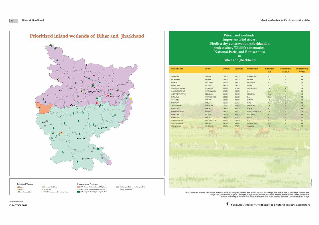
Prioritized inland wetlands of Bihar and Jharkhand
Prioritized Wetland Biogeographic Provinces
Rank 1
Rank 2
Data Not Available
Important Bird Areas
BCPP Sites
Wildlife Sanctuaries & National Parks
6A, Deccan Peninsula-Central Highlands
6B, Deccan Peninsula-Chotta Nagpur
7A, Gangetic Plain-Upper Gangetic Plain
7B, Gangetic Plain-Lower Gangetic Plain
District Boundaries
Prioritized wetlands, Important Bird Areas,
Biodiversity conservation prioritizationproject sites, Wildlife sanctuaries,National Parks and Ramsar sites
inBihar and Jharkhand
PRIORITIZED SITE DISTRICT LATITUDE LONGITUDE NEAREST TOWN BIODIVERSITY SOCIO-ECONOMIC BIO-GEOGRAPHIC
RANK USE GRADE PROVINCE
ANRAJ DAM GARHWA 235900 834700 RANKA TOWN N.A. M 6B
BAGHAR BEEL KATIHAR 234000 843300 KATHIAR 2 M 6B
BARAUNI BEGUSARAI 252400 855500 BEGUSARAI N.A. H 7B
BATANE DAM PALAMAU 245100 841900 DHURKI N.A. H 7B
CHAND SHAHAR LAKE SAHIBGANJ 250330 875330 CHAND SAGAR 2 L 7B
CHANDIL RESERVOIR WEST SINGBHUM 225800 860300 N.A. N.A. M 6B
CHERIYA BARIYARPUR BEGUSARAI 253000 854000 BEGUSARAI N.A. H 7B
DIMNA DAM WEST SINGBHUM 224930 855730 N.A. N.A. M 6B
GOGA BEEL KATIHAR 234030 843330 KATHIAR 1 M 6B
HATIYA DAM RANCHI 225500 851000 RANCHI N.A. L 6B
JAGATPUR LAKE BHAGALPUR 251500 802000 BHAGALPUR 1 L 7B
KANKE DAM RANCHI 235500 861000 RANCHI N.A. L 6B
KHARAGPUR JHEEL MUNGER 245500 861500 HAWELI KHARAGPUR 1 H 7B
MALAY DAM PALAMAU 240200 840400 DALTONGANJ N.A. L 6B
RUKKA DAM RANCHI 245500 871000 RANCHI N.A. L 7B
SITARAMPUR DAM EAST SINGBHUM 223200 862630 N.A. N.A. L 6B
SUKHALDARI DAM GARHWA 241100 835300 GARHWA TOWN N.A. L 6B
UDHUWA NALA SAHIBGANJ 250300 875300 RAJMAHAL 2 H 7B
Note:- In Fatua Chandan, Hanumana, Indrapuri, Mora tal, Moti jheel, Mawda dam, Birpur-Sipaul-Kosi barrage, Kosi east & west, Kajra Ararja, Maithon dam, Tilaiya dam, Disha-Patha, Rajauli, Darong tal, Surya Pokhar, Mehdar, Khemaith, Kesaria, Brahmaputra, Hardia, Bhimbandh,
Kursela and Amarpur information is not available; N.A.-Not Available/Data deficient; L-Low,M-Medium, H-High.
34
©SACON 2004
Maps not to scale
ACONSálim Ali Centre for Ornithology and Natural History, Coimbatore
Inland Wetlands of India - Conservation AtlasBihar & Jharkhand
S. A
. H
ussain
Related Documents