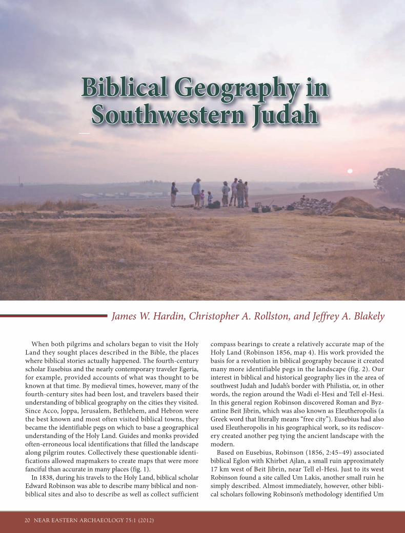
20 NEAR EASTERN ARCHAEOLOGY 75:1 (2012) When both pilgrims and scholars began to visit the Holy Land they sought places described in the Bible, the places where biblical stories actually happened. The fourth-century scholar Eusebius and the nearly contemporary traveler Egeria, for example, provided accounts of what was thought to be known at that time. By medieval times, however, many of the fourth-century sites had been lost, and travelers based their understanding of biblical geography on the cities they visited. Since Acco, Joppa, Jerusalem, Bethlehem, and Hebron were the best known and most often visited biblical towns, they became the identifiable pegs on which to base a geographical understanding of the Holy Land. Guides and monks provided often-erroneous local identifications that filled the landscape along pilgrim routes. Collectively these questionable identi- fications allowed mapmakers to create maps that were more fanciful than accurate in many places (fig. 1). In 1838, during his travels to the Holy Land, biblical scholar Edward Robinson was able to describe many biblical and non- biblical sites and also to describe as well as collect sufficient compass bearings to create a relatively accurate map of the Holy Land (Robinson 1856, map 4). His work provided the basis for a revolution in biblical geography because it created many more identifiable pegs in the landscape (fig. 2). Our interest in biblical and historical geography lies in the area of southwest Judah and Judah’s border with Philistia, or, in other words, the region around the Wadi el-Hesi and Tell el-Hesi. In this general region Robinson discovered Roman and Byz- antine Beit Jibrin, which was also known as Eleutheropolis (a Greek word that literally means “free city”). Eusebius had also used Eleutheropolis in his geographical work, so its rediscov- ery created another peg tying the ancient landscape with the modern. Based on Eusebius, Robinson (1856, 2:45–49) associated biblical Eglon with Khirbet Ajlan, a small ruin approximately 17 km west of Beit Jibrin, near Tell el-Hesi. Just to its west Robinson found a site called Um Lakis, another small ruin he simply described. Almost immediately, however, other bibli- cal scholars following Robinson’s methodology identified Um James W. Hardin, Christopher A. Rollston, and Jeffrey A. Blakely Biblical Geography in Biblical Geography in Southwestern Judah Southwestern Judah

Welcome message from author
This document is posted to help you gain knowledge. Please leave a comment to let me know what you think about it! Share it to your friends and learn new things together.
Transcript
20 NEAR EASTERN ARCHAEOLOGY 75:1 (2012)
When both pilgrims and scholars began to visit the Holy Land they sought places described in the Bible, the places where biblical stories actually happened. The fourth-century scholar Eusebius and the nearly contemporary traveler Egeria, for example, provided accounts of what was thought to be known at that time. By medieval times, however, many of the fourth-century sites had been lost, and travelers based their understanding of biblical geography on the cities they visited. Since Acco, Joppa, Jerusalem, Bethlehem, and Hebron were the best known and most often visited biblical towns, they became the identifiable pegs on which to base a geographical understanding of the Holy Land. Guides and monks provided often-erroneous local identifications that filled the landscape along pilgrim routes. Collectively these questionable identi-fications allowed mapmakers to create maps that were more fanciful than accurate in many places (fig. 1).
In 1838, during his travels to the Holy Land, biblical scholar Edward Robinson was able to describe many biblical and non-biblical sites and also to describe as well as collect sufficient
compass bearings to create a relatively accurate map of the Holy Land (Robinson 1856, map 4). His work provided the basis for a revolution in biblical geography because it created many more identifiable pegs in the landscape (fig. 2). Our interest in biblical and historical geography lies in the area of southwest Judah and Judah’s border with Philistia, or, in other words, the region around the Wadi el-Hesi and Tell el-Hesi. In this general region Robinson discovered Roman and Byz-antine Beit Jibrin, which was also known as Eleutheropolis (a Greek word that literally means “free city”). Eusebius had also used Eleutheropolis in his geographical work, so its rediscov-ery created another peg tying the ancient landscape with the modern.
Based on Eusebius, Robinson (1856, 2:45–49) associated biblical Eglon with Khirbet Ajlan, a small ruin approximately 17 km west of Beit Jibrin, near Tell el-Hesi. Just to its west Robinson found a site called Um Lakis, another small ruin he simply described. Almost immediately, however, other bibli-cal scholars following Robinson’s methodology identified Um
James W. Hardin, Christopher A. Rollston, and Jeffrey A. Blakely
Biblical Geography in Biblical Geography in Southwestern JudahSouthwestern Judah
NEAR EASTERN ARCHAEOLOGY 75:1 (2012) 21
F igure 2 . Edward Robinson’s rather basic map of the sites and physical features of the Hesi region. This map shows his path of travel. It is the first moderately accurate map of the reg ion (Rob inson 1856, map 4).
Figure 1. Tobias Con-rad Lotter’s Mappa Geograph i ca was published in 1759. It was a very good map for the period, but it illustrates both the lack of good geo-graphical informa-tion and the fanciful nature of maps even in the e ighteenth century.
22 NEAR EASTERN ARCHAEOLOGY 75:1 (2012)
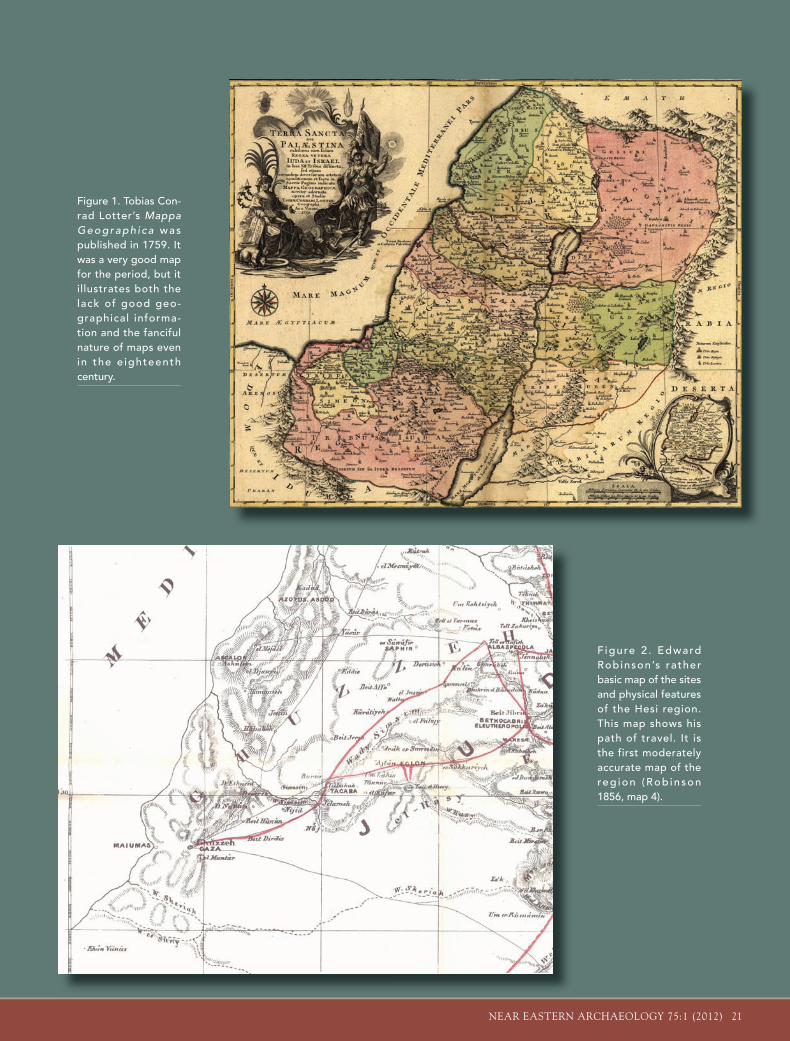
Lakis as biblical Lachish. By pegging Lachish and Eglon in the Hesi region, scholars had identified key biblical sites in south-west Judah. Maps were printed and biblical geographies writ-ten showing the Hesi region as Judah (fig. 3). In 1890, however, William Matthew Flinders Petrie proved that Um Lakis was only Byzantine and Islamic in date and could not be Lachish. In its stead, he suggested neighboring Tell el-Hesi. This identification was accepted until the 1920s, when William F. Albright identified Tell ed-Duweir as Lachish, not Tell el-Hesi (e.g., Albright 1929, 3 n. 2). To Albright, Tell el-Hesi was biblical Eglon, since Khirbet Ajlan was simply too small and its pottery too late (fig. 5).
As long as Tell el-Hesi was identi-fied as either biblical Lachish or Eglon, maps of Iron Age Judah identified the Hesi region as the southwestern bor-der region of Judah. In the late 1970s, however, many scholars abandoned the idea that Tell el-Hesi was Eglon, opting instead to associate Eglon with Khirbet Aitun (Tel Etun) farther to the east. Now that the Hesi environs lacked both Lachish and Eglon, most investi-gators ceased to identify the area with Judah, since all geographical pegs to Judah had been removed. Most bib-
Figure 3. George Adam Smith’s map of the biblical geography of the Hesi region as it was understood at the end of the nineteenth century, from Smith’s The Historical Geography of the Holy Land (1894, plate 4).
Nineteenth-Century Site Identification
The method of site identification developed by Robinson and followed by two generations of scholars is best understood as a paradigm: the biblical landscape is to be found in the then-modern place names of Palestine; collect these, and the biblical landscape is available for modern study when one recognizes that the ancient
Hebrew, Greek, and Latin place names are preserved in the modern Arabic place names. Examples using this paradigm include the following:
▶ Khulasah = Elusa ▶ El-Gib = Gibeon▶ Bir es-Seba’ = Beersheba ▶ Idhna = Jedna▶ ‘Anata = Anathoth ▶ Lejjun = Legio▶ Khirbet Ajlan = Eglon
When Petrie and Bliss excavated at Um Lakis and Tell el-Hesi between 1890 and 1892, they overthrew this thought process and replaced it with a time-sensitive one: the history of ancient sites can be determined through excavation when the various layers are separated stratigraphically and then the layers are dated by the artifacts found within, pri-marily ceramics; comparison of the archaeological history with the textual history can be used to support or reject site identifications made through nonarchaeological means. It was recognized immediately by Petrie that Um Lakis could not be biblical Lachish and Khirbet Ajlan could not be biblical Eglon because neither were occupied before the Roman period.
NEAR EASTERN ARCHAEOLOGY 75:1 (2012) 23
Excavations at Tell el-Hesi
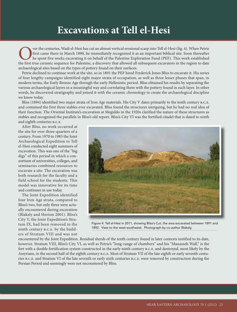
Over the centuries, Wadi el-Hesi has cut an almost vertical erosional scarp into Tell el-Hesi (fig. 4). When Petrie first came there in March 1890, he immediately recognized it as an important biblical site. Soon thereafter he spent five weeks excavating it on behalf of the Palestine Exploration Fund (PEF). This work established
the first true ceramic sequence for Palestine, a discovery that allowed all subsequent excavators in the region to date archaeological sites based on the types of pottery found on their surfaces.
Petrie declined to continue work at the site, so in 1891 the PEF hired Frederick Jones Bliss to excavate it. His series of four lengthy campaigns identified eight major strata of occupation, as well as three lesser phases that span, in modern terms, the Early Bronze Age through the early Hellenistic period. Bliss obtained his results by separating the various archaeological layers in a meaningful way and correlating them with the pottery found in each layer. In other words, he discovered stratigraphy and joined it with the ceramic chronology to create the archaeological discipline we know today.
Bliss (1894) identified two major strata of Iron Age materials. His City V dates primarily to the tenth century b.c.e. and contained the first three stables ever excavated. Bliss found the structures intriguing, but he had no real idea of their function. The Oriental Institute’s excavation at Megiddo in the 1920s clarified the nature of these structures as stables and recognized the parallels in Bliss’s old report. Bliss’s City VI was the fortified citadel that is dated to ninth and eighth centuries b.c.e.
After Bliss, no work occurred at the site for over three-quarters of a century. From 1970 to 1983 the Joint Archaeological Expedition to Tell el-Hesi conducted eight summers of excavation. This was one of the “big digs” of this period in which a con-sortium of universities, colleges, and seminaries combined resources to excavate a site. The excavation was both research for the faculty and a field school for the students. This model was innovative for its time and continues in use today.
The Joint Expedition identified four Iron Age strata, compared to Bliss’s two, but only three were actu-ally encountered during excavation (Blakely and Horton 2001). Bliss’s City V, the Joint Expedition’s Stra-tum IX, had been removed in the ninth century b.c.e. by the build-ers of Stratum VIII and was not encountered by the Joint Expedition. Residual sherds of the tenth century found in later contexts testified to its date, however. Stratum VIII, Bliss’s City VI, as well as Petrie’s “long-range of chambers” and his “Manasseh Wall,” is the fort with a double fortification system constructed in the early ninth century b.c.e. and destroyed, most likely by the Assyrians, in the second half of the eighth century b.c.e. Most of Stratum VII of the late eighth or early seventh centu-ries b.c.e. and Stratum VI of the late seventh or early sixth centuries b.c.e. were removed by construction during the Persian Period and seemingly were not encountered by Bliss.
Figure 4. Tell el-Hesi in 2011, showing Bliss’s Cut, the area excavated between 1891 and 1892. View to the west-southwest. Photograph by co-author Blakely.
24 NEAR EASTERN ARCHAEOLOGY 75:1 (2012)
lical scholars, historians, and archaeologists began to place the western borders of Judah along the western edge of the Shephelah where the limestone hills give way to loessic plains (for a sample map, see Rainey 1980, 1983). Hence, almost by default, most scholars saw the Hesi region as Philistia.
Excavations at Tell el-Hesi and Their Consequences
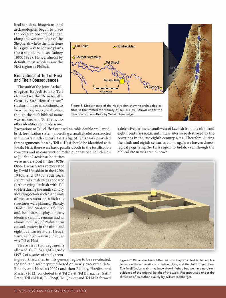
The staff of the Joint Archae-ological Expedition to Tell el-Hesi (see the “Nineteenth-Century Site Identification” sidebar), however, continued to view the region as Judah, even though the site’s biblical name was unknown. To them, no other identification made sense. Excavations at Tell el-Hesi exposed a sizable double-wall, mud-brick fortification system protecting a small citadel constructed in the early ninth century b.c.e. (fig. 6). This work provided three arguments for why Tell el-Hesi should be identified with Judah. First, there were basic parallels both in the fortification concepts and in construction technique that tied Tell el-Hesi to Judahite Lachish as both sites were understood in the 1970s. Once Lachish was reexcavated by David Ussishkin in the 1970s, 1980s, and 1990s, additional structural similarities appeared further tying Lachish with Tell el-Hesi during the ninth century, including details such as the units of measurement on which the structures were planned (Blakely, Hardin, and Master 2012). Sec-ond, both sites displayed nearly identical ceramic remains and an almost total lack of Philistine, or coastal, pottery in the ninth and eighth centuries b.c.e. Hence, since Lachish was in Judah, so was Tell el-Hesi.
These first two arguments allowed G. E. Wright’s study (1971) of a series of small, seem-ingly fortified sites in this general region to be reevaluated, redated, and reinterpreted based on newly excavated data. Blakely and Hardin (2002) and then Blakely, Hardin, and Master (2012) concluded that Tel Zayit, Tel Burna, Tel Gath/Erani, Tell el-Hesi, Tel Sheqf, Tel Qeshet, and Tel Milh formed
a defensive perimeter southwest of Lachish from the ninth and eighth centuries b.c.e. until these sites were destroyed by the Assyrians in the late eighth century b.c.e. Therefore, during the ninth and eighth centuries b.c.e., again we have archaeo-logical pegs tying the Hesi region to Judah, even though the biblical site names are unknown.
s .
d , l
d l , s e , -y n r d ,
o
s y
Figure 5. Modern map of the Hesi region showing archaeological sites in the immediate vicinity of Tell el-Hesi. Drawn under the direction of the authors by William Isenberger.
Figure 6. Reconstruction of the ninth-century B.C.E. fort at Tell el-Hesi based on the excavations of Petrie, Bliss, and the Joint Expedition. The fortification walls may have stood higher, but we have no direct evidence of the original height of the walls. Reconstructed under the direction of co-author Blakely by William Isenberger.
NEAR EASTERN ARCHAEOLOGY 75:1 (2012) 25
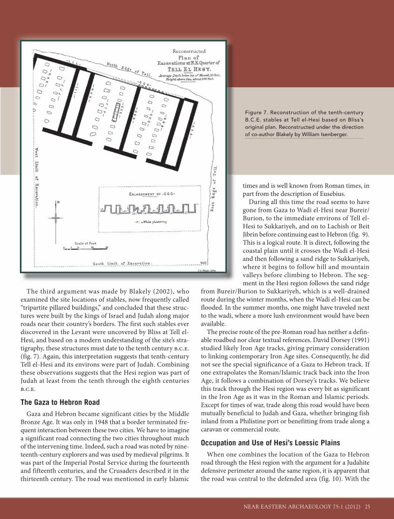
The third argument was made by Blakely (2002), who examined the site locations of stables, now frequently called “tripartite pillared buildings,” and concluded that these struc-tures were built by the kings of Israel and Judah along major roads near their country’s borders. The first such stables ever discovered in the Levant were uncovered by Bliss at Tell el-Hesi, and based on a modern understanding of the site’s stra-tigraphy, these structures must date to the tenth century b.c.e. (fig. 7). Again, this interpretation suggests that tenth-century Tell el-Hesi and its environs were part of Judah. Combining these observations suggests that the Hesi region was part of Judah at least from the tenth through the eighth centuries b.c.e.
The Gaza to Hebron RoadGaza and Hebron became significant cities by the Middle
Bronze Age. It was only in 1948 that a border terminated fre-quent interaction between these two cities. We have to imagine a significant road connecting the two cities throughout much of the intervening time. Indeed, such a road was noted by nine-teenth-century explorers and was used by medieval pilgrims. It was part of the Imperial Postal Service during the fourteenth and fifteenth centuries, and the Crusaders described it in the thirteenth century. The road was mentioned in early Islamic
times and is well known from Roman times, in part from the description of Eusebius.
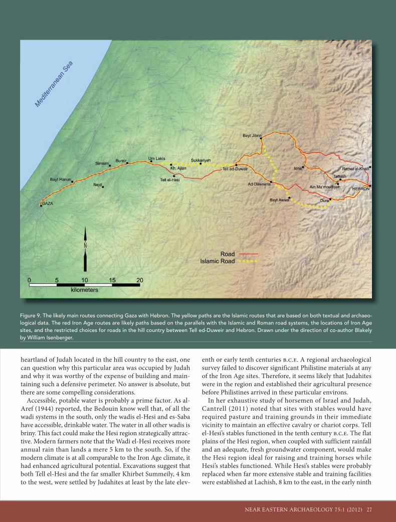
During all this time the road seems to have gone from Gaza to Wadi el-Hesi near Bureir/Burion, to the immediate environs of Tell el-Hesi to Sukkariyeh, and on to Lachish or Beit Jibrin before continuing east to Hebron (fig. 9). This is a logical route. It is direct, following the coastal plain until it crosses the Wadi el-Hesi and then following a sand ridge to Sukkariyeh, where it begins to follow hill and mountain valleys before climbing to Hebron. The seg-ment in the Hesi region follows the sand ridge
from Bureir/Burion to Sukkariyeh, which is a well-drained route during the winter months, when the Wadi el-Hesi can be flooded. In the summer months, one might have traveled next to the wadi, where a more lush environment would have been available.
The precise route of the pre-Roman road has neither a defin-able roadbed nor clear textual references. David Dorsey (1991) studied likely Iron Age tracks, giving primary consideration to linking contemporary Iron Age sites. Consequently, he did not see the special significance of a Gaza to Hebron track. If one extrapolates the Roman/Islamic track back into the Iron Age, it follows a combination of Dorsey’s tracks. We believe this track through the Hesi region was every bit as significant in the Iron Age as it was in the Roman and Islamic periods. Except for times of war, trade along this road would have been mutually beneficial to Judah and Gaza, whether bringing fish inland from a Philistine port or benefitting from trade along a caravan or commercial route.
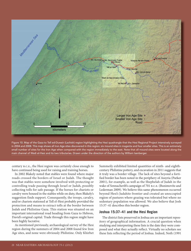
Occupation and Use of Hesi’s Loessic PlainsWhen one combines the location of the Gaza to Hebron
road through the Hesi region with the argument for a Judahite defensive perimeter around the same region, it is apparent that the road was central to the defended area (fig. 10). With the
Figure 7. Reconstruction of the tenth-century B.C.E. stables at Tell el-Hesi based on Bliss’s original plan. Reconstructed under the direction of co-author Blakely by William Isenberger.
26 NEAR EASTERN ARCHAEOLOGY 75:1 (2012)
Hesi’s Inscriptions
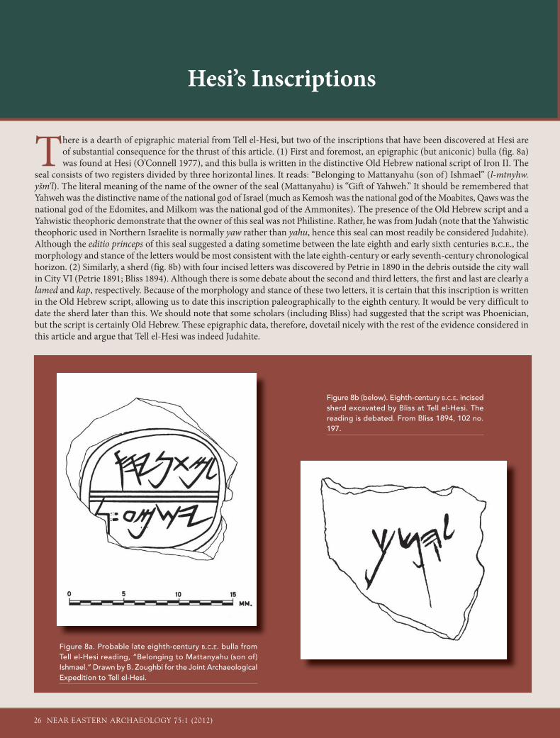
There is a dearth of epigraphic material from Tell el-Hesi, but two of the inscriptions that have been discovered at Hesi are of substantial consequence for the thrust of this article. (1) First and foremost, an epigraphic (but aniconic) bulla (fig. 8a) was found at Hesi (O’Connell 1977), and this bulla is written in the distinctive Old Hebrew national script of Iron II. The
seal consists of two registers divided by three horizontal lines. It reads: “Belonging to Mattanyahu (son of) Ishmael” (l-mtnyhw. yšm‘l). The literal meaning of the name of the owner of the seal (Mattanyahu) is “Gift of Yahweh.” It should be remembered that Yahweh was the distinctive name of the national god of Israel (much as Kemosh was the national god of the Moabites, Qaws was the national god of the Edomites, and Milkom was the national god of the Ammonites). The presence of the Old Hebrew script and a Yahwistic theophoric demonstrate that the owner of this seal was not Philistine. Rather, he was from Judah (note that the Yahwistic theophoric used in Northern Israelite is normally yaw rather than yahu, hence this seal can most readily be considered Judahite). Although the editio princeps of this seal suggested a dating sometime between the late eighth and early sixth centuries b.c.e., the morphology and stance of the letters would be most consistent with the late eighth-century or early seventh-century chronological horizon. (2) Similarly, a sherd (fig. 8b) with four incised letters was discovered by Petrie in 1890 in the debris outside the city wall in City VI (Petrie 1891; Bliss 1894). Although there is some debate about the second and third letters, the first and last are clearly a lamed and kap, respectively. Because of the morphology and stance of these two letters, it is certain that this inscription is written in the Old Hebrew script, allowing us to date this inscription paleographically to the eighth century. It would be very difficult to date the sherd later than this. We should note that some scholars (including Bliss) had suggested that the script was Phoenician, but the script is certainly Old Hebrew. These epigraphic data, therefore, dovetail nicely with the rest of the evidence considered in this article and argue that Tell el-Hesi was indeed Judahite.
Figure 8b (below). Eighth-century B.C.E. incised sherd excavated by Bliss at Tell el-Hesi. The reading is debated. From Bliss 1894, 102 no. 197.
Figure 8a. Probable late eighth-century B.C.E. bulla from Tell el-Hesi reading, “Belonging to Mattanyahu (son of) Ishmael.” Drawn by B. Zoughbi for the Joint Archaeological Expedition to Tell el-Hesi.
NEAR EASTERN ARCHAEOLOGY 75:1 (2012) 27
heartland of Judah located in the hill country to the east, one can question why this particular area was occupied by Judah and why it was worthy of the expense of building and main-taining such a defensive perimeter. No answer is absolute, but there are some compelling considerations.
Accessible, potable water is probably a prime factor. As al-Aref (1944) reported, the Bedouin know well that, of all the wadi systems in the south, only the wadis el-Hesi and es-Saba have accessible, drinkable water. The water in all other wadis is briny. This fact could make the Hesi region strategically attrac-tive. Modern farmers note that the Wadi el-Hesi receives more annual rain than lands a mere 5 km to the south. So, if the modern climate is at all comparable to the Iron Age climate, it had enhanced agricultural potential. Excavations suggest that both Tell el-Hesi and the far smaller Khirbet Summeily, 4 km to the west, were settled by Judahites at least by the late elev-
enth or early tenth centuries b.c.e. A regional archaeological survey failed to discover significant Philistine materials at any of the Iron Age sites. Therefore, it seems likely that Judahites were in the region and established their agricultural presence before Philistines arrived in these particular environs.
In her exhaustive study of horsemen of Israel and Judah, Cantrell (2011) noted that sites with stables would have required pasture and training grounds in their immediate vicinity to maintain an effective cavalry or chariot corps. Tell el-Hesi’s stables functioned in the tenth century b.c.e. The flat plains of the Hesi region, when coupled with sufficient rainfall and an adequate, fresh groundwater component, would make the Hesi region ideal for raising and training horses while Hesi’s stables functioned. While Hesi’s stables were probably replaced when far more extensive stable and training facilities were established at Lachish, 8 km to the east, in the early ninth
Figure 9. The likely main routes connecting Gaza with Hebron. The yellow paths are the Islamic routes that are based on both textual and archaeo-logical data. The red Iron Age routes are likely paths based on the parallels with the Islamic and Roman road systems, the locations of Iron Age sites, and the restricted choices for roads in the hill country between Tell ed-Duweir and Hebron. Drawn under the direction of co-author Blakely by William Isenberger.
28 NEAR EASTERN ARCHAEOLOGY 75:1 (2012)
century b.c.e., the Hesi region was certainly close enough to have continued being used for raising and training horses.
In 2002 Blakely noted that stables were found where major roads crossed the borders of Israel or Judah. The thought was that stables were somehow involved with protecting or controlling trade passing through Israel or Judah, possibly collecting tolls for safe passage. If the horses for chariots or cavalry were housed in the stables while on duty, then Blakely’s suggestion finds support. Consequently, the troops, cavalry, and/or chariots stationed at Tell el-Hesi probably provided the protection and means to extract tolls at the border between Judah and Philistine Gaza. This station was situated on an important international road heading from Gaza to Hebron, David’s original capital. Trade through this region might have been highly lucrative.
As mentioned previously, archaeological survey of the Hesi region during the summers of 2004 and 2008 found few Iron Age sites, and none were obviously Philistine. Only Khirbet
Summeily exhibited limited quantities of ninth- and eighth-century Philistine pottery, and excavation in 2011 suggests that it truly was a border village. The lack of sites beyond a forti-fied border has been noted in the periphery of Assyria (Parker 2001), for example, as well as the Shephelah of Judah in the wake of Sennacherib’s campaign of 701 b.c.e. (Bunimovitz and Lederman 2009). We believe this same phenomenon occurred beyond Hesi’s Judahite frontier and created an unoccupied region of pastures where grazing was tolerated but where no sedentary population was allowed. We also believe that Josh 15:37–41 describes this border region.
Joshua 15:37–41 and the Hesi RegionThe district lists preserved in Joshua are an important repos-
itory of geographical information. A crucial question when studying and interpreting these lists is the date they were com-posed and what they actually reflect. Virtually no scholars see these lists reflecting the period of Joshua. Indeed, Noth (1991
Figure 10. Map of the Gaza to Tell ed-Duweir (Lachish) region highlighting the Hesi quadrangle that the Hesi Regional Project intensively surveyed in 2004 and 2008. This map shows all Iron Age sites discovered in this region: six mound sites in magenta and four smaller sites. This is an extremely small number of sites for the Iron Age when compared with the region immediately to the east. Note that all mound sites were located along the main channel of Wadi el-Hesi and its two tributaries. Drawn under the direction of the authors by William Isenberger.
NEAR EASTERN ARCHAEOLOGY 75:1 (2012) 29
[1957]) argued that Deuteronomistic History (i.e., Joshua, Judges, Samuel, Kings) took its final form in the “middle of the sixth century.” Cross (1973, 287–89) later built on Noth’s arguments, contending that there were two editions of the Deuteronomistic History, with the first edition written dur-ing the reign of King Josiah (r. 640–609 b.c.e.) and the second edition finalized around 550 b.c.e. Nevertheless, both Noth and Cross argued that the Deuteronomist had access to, and employed, historical “sources” that had been produced prior to the seventh and sixth centuries. Of substantial importance for this article is the fact that the district lists are among those components (“sources”) of the Deuteronomistic History that are often believed to antedate the sixth and seventh centuries. For example, Wright wrote that the district lists “of the cities of the kingdom of Judah [hail from] a period after the death of Solomon when Benjamin belonged originally to the south-ern kingdom, as did also the territory of Bethel” (Boling and Wright 1982, 70). To be sure, many scholars today would be disinclined to date these district lists this early (i.e., shortly after the death of Solomon), but many still consider them to antedate the Deuteronomistic Historian, and many believe them to contain fairly accurate geographical details and thus to be an important repository of information.
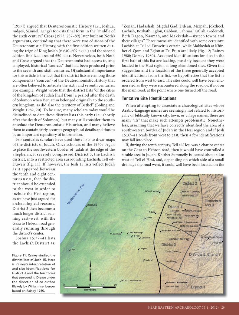
For centuries scholars have used these lists to draw maps of the districts of Judah. Once scholars of the 1970s began to place the southwestern border of Judah at the edge of the Shephelah, it severely compressed District 3, the Lachish district, into a restricted area surrounding Lachish/Tell ed-Duweir (fig. 11). If, however, the Josh 15 lists reflect Judah as it appeared between the tenth and eight cen-turies b.c.e., then the dis-trict should be extended to the west in order to include the Hesi region, as we have just argued for archaeological reasons. District 3 then becomes a much longer district run-ning east–west, with the Gaza to Hebron road gen-erally running through the district’s center.
Joshua 15:37–41 lists the Lachish District as:
“Zenan, Hadashah, Migdal Gad, Dilean, Mizpah, Joktheel, Lachish, Bozkath, Eglon, Cabbon, Lahmas, Kitlish, Gederoth, Beth Dagon, Naamah, and Makkedah—sixteen towns and their villages.” Three towns are identified with some certainty: Lachish at Tell ed-Duweir is certain, while Makkedah at Khir-bet el-Qom and Eglon at Tel Etun are likely (fig. 12; Rainey 1980; Dorsey 1980). Accepted identifications for sites in the first half of this list are lacking, possibly because they were located in the Hesi region at long-abandoned sites. Given this suggestion and the location of the three generally accepted identifications from the list, we hypothesize that the list is ordered from west to east. The sites could well have been enu-merated as they were encountered along the road or, if not on the main road, at the point where one turned off the road.
Tentative Site IdentificationsWhen attempting to associate archaeological sites whose
Arabic-language names are seemingly not related to histori-cally or biblically known city, town, or village names, there are many “ifs” that make such attempts problematic. Nonethe-less, assuming that we have correctly identified the area of a southwestern border of Judah in the Hesi region and if Josh 15:37–41 reads from west to east, then a few identifications may fall into place.
If, during the tenth century, Tell el-Hesi was a chariot center on the Gaza to Hebron road, then it would have controlled a sizable area in Judah. Khirbet Summeily is located about 4 km west of Tell el-Hesi, and, depending on which side of a small drainage the road went, it could well have been located on the
Figure 11. Rainey studied the district lists of Josh 15. Here is Rainey’s interpretation of and site identifications for District 3 and the territories that surround it. Drawn under the direction of co-author Blakely by William Isenberger based on Rainey 1980.
30 NEAR EASTERN ARCHAEOLOGY 75:1 (2012)
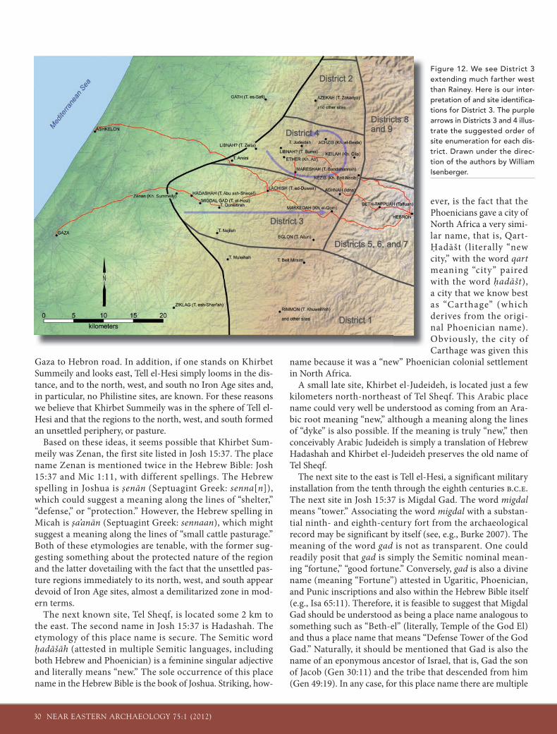
Gaza to Hebron road. In addition, if one stands on Khirbet Summeily and looks east, Tell el-Hesi simply looms in the dis-tance, and to the north, west, and south no Iron Age sites and, in particular, no Philistine sites, are known. For these reasons we believe that Khirbet Summeily was in the sphere of Tell el-Hesi and that the regions to the north, west, and south formed an unsettled periphery, or pasture.
Based on these ideas, it seems possible that Khirbet Sum-meily was Zenan, the first site listed in Josh 15:37. The place name Zenan is mentioned twice in the Hebrew Bible: Josh 15:37 and Mic 1:11, with different spellings. The Hebrew spelling in Joshua is senān (Septuagint Greek: senna[n]), which could suggest a meaning along the lines of “shelter,” “defense,” or “protection.” However, the Hebrew spelling in Micah is sa’anān (Septuagint Greek: sennaan), which might suggest a meaning along the lines of “small cattle pasturage.” Both of these etymologies are tenable, with the former sug-gesting something about the protected nature of the region and the latter dovetailing with the fact that the unsettled pas-ture regions immediately to its north, west, and south appear devoid of Iron Age sites, almost a demilitarized zone in mod-ern terms.
The next known site, Tel Sheqf, is located some 2 km to the east. The second name in Josh 15:37 is Hadashah. The etymology of this place name is secure. The Semitic word hadāšāh (attested in multiple Semitic languages, including both Hebrew and Phoenician) is a feminine singular adjective and literally means “new.” The sole occurrence of this place name in the Hebrew Bible is the book of Joshua. Striking, how-
ever, is the fact that the Phoenicians gave a city of North Africa a very simi-lar name, that is, Qart-Hadāšt (literally “new city,” with the word qartmeaning “city” paired with the word hadāšt), a city that we know best as “Carthage” (which derives from the origi-nal Phoenician name). Obviously, the city of Carthage was given this
name because it was a “new” Phoenician colonial settlement in North Africa.
A small late site, Khirbet el-Judeideh, is located just a few kilometers north-northeast of Tel Sheqf. This Arabic place name could very well be understood as coming from an Ara-bic root meaning “new,” although a meaning along the lines of “dyke” is also possible. If the meaning is truly “new,” then conceivably Arabic Judeideh is simply a translation of Hebrew Hadashah and Khirbet el-Judeideh preserves the old name of Tel Sheqf.
The next site to the east is Tell el-Hesi, a significant military installation from the tenth through the eighth centuries b.c.e.The next site in Josh 15:37 is Migdal Gad. The word migdalmeans “tower.” Associating the word migdal with a substan-tial ninth- and eighth-century fort from the archaeological record may be significant by itself (see, e.g., Burke 2007). The meaning of the word gad is not as transparent. One could readily posit that gad is simply the Semitic nominal mean-ing “fortune,” “good fortune.” Conversely, gad is also a divine name (meaning “Fortune”) attested in Ugaritic, Phoenician, and Punic inscriptions and also within the Hebrew Bible itself (e.g., Isa 65:11). Therefore, it is feasible to suggest that Migdal Gad should be understood as being a place name analogous to something such as “Beth-el” (literally, Temple of the God El) and thus a place name that means “Defense Tower of the God Gad.” Naturally, it should be mentioned that Gad is also the name of an eponymous ancestor of Israel, that is, Gad the son of Jacob (Gen 30:11) and the tribe that descended from him (Gen 49:19). In any case, for this place name there are multiple
Figure 12. We see District 3 extending much farther west than Rainey. Here is our inter-pretation of and site identifica-tions for District 3. The purple arrows in Districts 3 and 4 illus-trate the suggested order of site enumeration for each dis-trict. Drawn under the direc-tion of the authors by William Isenberger.
NEAR EASTERN ARCHAEOLOGY 75:1 (2012) 31
plausible meanings but none that should be considered to be absolutely decisive.
The archaeology of Tell el-Hesi places a military garrison and stable complex there in the tenth century b.c.e. (fig. 6). The site was significantly altered, possibly after being destroyed, to create a far more imposing, but smaller, fort (fig. 5) occupied
in the ninth and eighth centuries. The Hebrew term migdal fits well with the later fort, less so with the garrison/stable com-plex. The account of the Palestinian campaign of Shoshenq I (biblical Shishak) recorded at Karnak (see “The Evidence of Shoshenq I” sidebar) lists a site, “Enclosure of el-Gad,” that could also be el-Gad, but here about the year 925 b.c.e. This
Excavations at Khirbet Summeily
Khirbet Summeily is a small village site located 4 km west of Tell el-Hesi in the border region between Judah and Philistia. Petrie simply described it as
pre-Roman. Khirbet Summeily received little attention until the Hesi Regional Survey visited this site between 2008 and 2010, carefully mapping it and collecting sherds from its surface. Based on this work, the never-before-excavated Summeily seemed the perfect site to answer regional Iron Age questions that arose during the analysis of data from both the survey and the excavations of Tell el-Hesi.
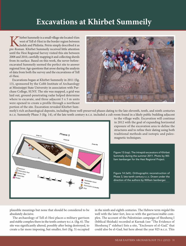
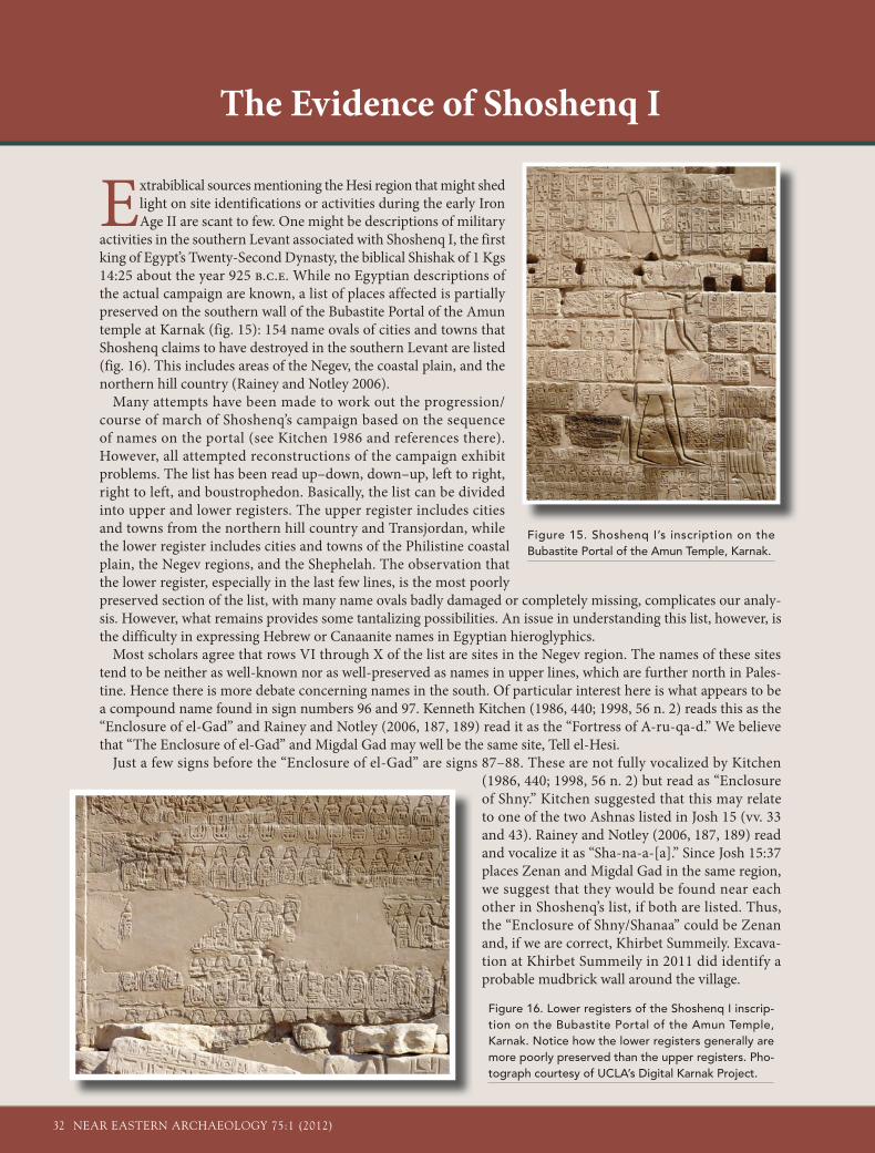
Excavations began at Khirbet Summeily in 2011 (fig. 13), sponsored by the Cobb Institute of Archaeology at Mississippi State University in association with Pur-chase College, SUNY. The site was mapped, a grid was laid out, ground-penetrating radar helped determine where to excavate, and three adjacent 5 x 5 m units were opened to create a profile through a northeast portion of the site. Excavation revealed Khirbet Sum-meily’s rich archaeological deposits, including three well-preserved phases dating to the late eleventh, tenth, and ninth centuries b.c.e. Summeily Phase 3 (fig. 14), of the late tenth century b.c.e. included a cult room found in a likely public building adjacent
to the village walls. Excavation will continue in 2012 with the goal of expanding horizontal exposure of the excavation area to define the structures and to refine their dating using both traditional methods and isotopic and paleo-magnetic techniques.
Figure 13 (top). The intrepid excavators of Khirbet Summeily during the summer 2011. Photo by Wil-liam Isenberger for the Hesi Regional Project.
Figure 14 (left). Orthographic reconstruction of Phase 3, late tenth century B.C.E. Drawn under the direction of the authors by William Isenberger.
32 NEAR EASTERN ARCHAEOLOGY 75:1 (2012)
The Evidence of Shoshenq I
Extrabiblical sources mentioning the Hesi region that might shed light on site identifications or activities during the early Iron Age II are scant to few. One might be descriptions of military
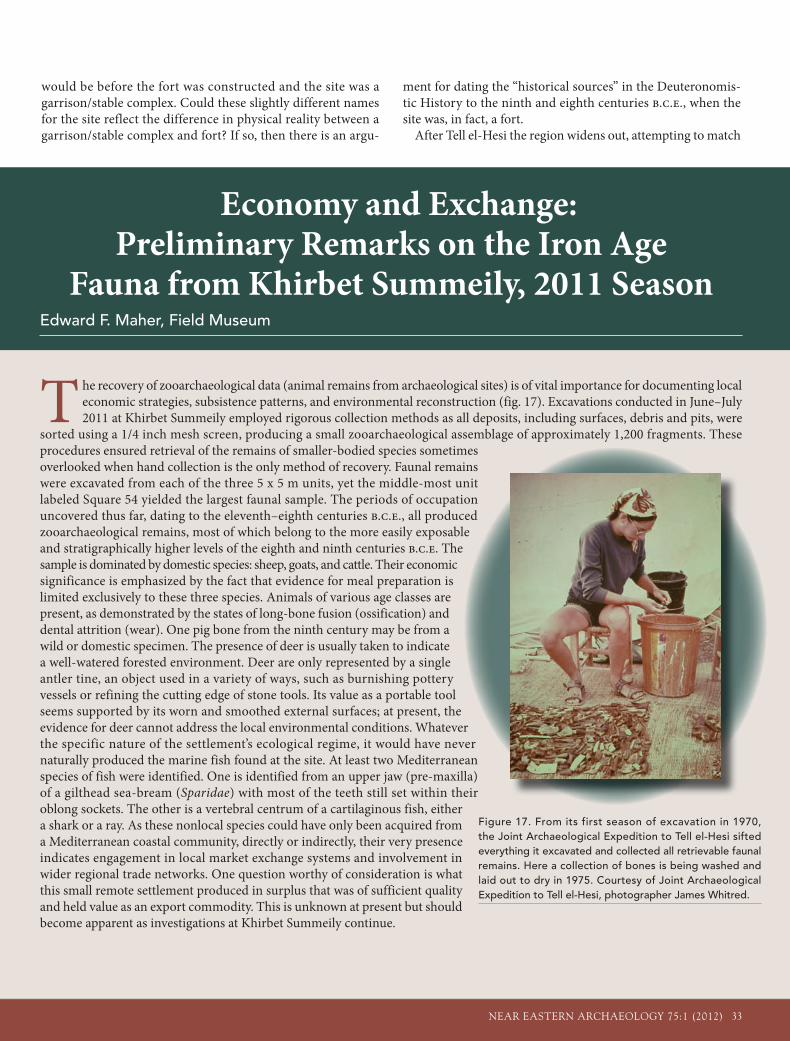
activities in the southern Levant associated with Shoshenq I, the first king of Egypt’s Twenty-Second Dynasty, the biblical Shishak of 1 Kgs 14:25 about the year 925 b.c.e. While no Egyptian descriptions of the actual campaign are known, a list of places affected is partially preserved on the southern wall of the Bubastite Portal of the Amun temple at Karnak (fig. 15): 154 name ovals of cities and towns that Shoshenq claims to have destroyed in the southern Levant are listed (fig. 16). This includes areas of the Negev, the coastal plain, and the northern hill country (Rainey and Notley 2006).
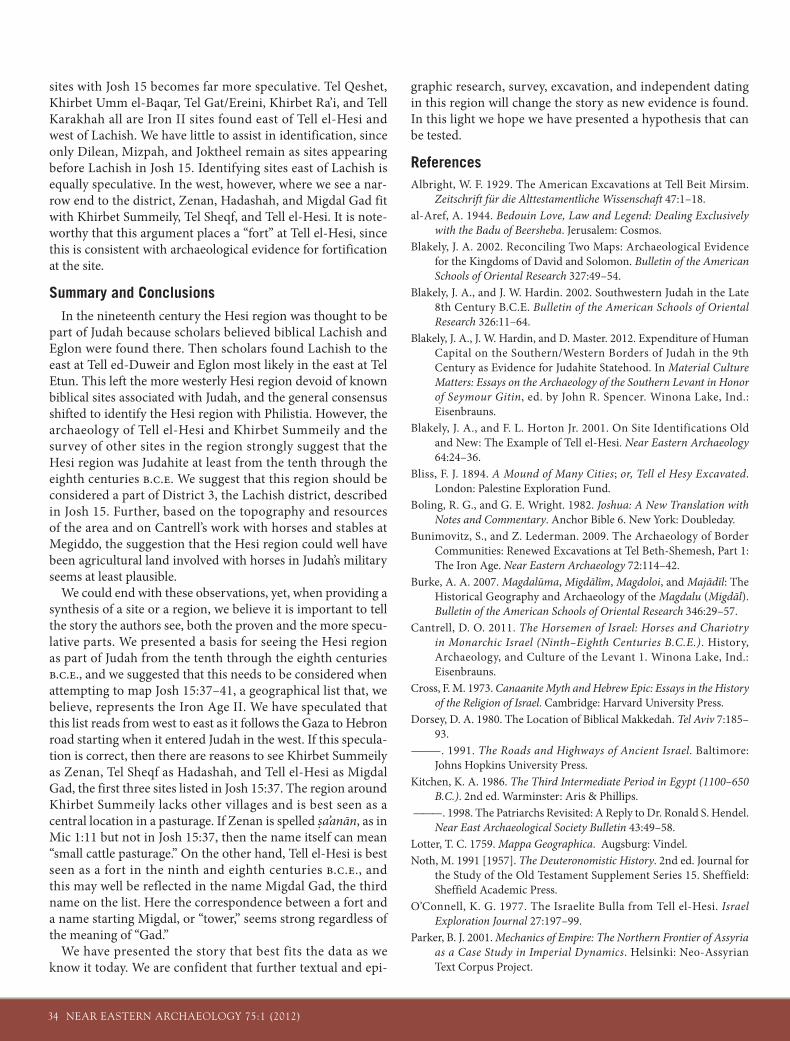
Many attempts have been made to work out the progression/course of march of Shoshenq’s campaign based on the sequence of names on the portal (see Kitchen 1986 and references there). However, all attempted reconstructions of the campaign exhibit problems. The list has been read up–down, down–up, left to right, right to left, and boustrophedon. Basically, the list can be divided into upper and lower registers. The upper register includes cities and towns from the northern hill country and Transjordan, while the lower register includes cities and towns of the Philistine coastal plain, the Negev regions, and the Shephelah. The observation that the lower register, especially in the last few lines, is the most poorly preserved section of the list, with many name ovals badly damaged or completely missing, complicates our analy-sis. However, what remains provides some tantalizing possibilities. An issue in understanding this list, however, is the difficulty in expressing Hebrew or Canaanite names in Egyptian hieroglyphics.
Most scholars agree that rows VI through X of the list are sites in the Negev region. The names of these sites tend to be neither as well-known nor as well-preserved as names in upper lines, which are further north in Pales-tine. Hence there is more debate concerning names in the south. Of particular interest here is what appears to be a compound name found in sign numbers 96 and 97. Kenneth Kitchen (1986, 440; 1998, 56 n. 2) reads this as the “Enclosure of el-Gad” and Rainey and Notley (2006, 187, 189) read it as the “Fortress of A-ru-qa-d.” We believe that “The Enclosure of el-Gad” and Migdal Gad may well be the same site, Tell el-Hesi.
Just a few signs before the “Enclosure of el-Gad” are signs 87–88. These are not fully vocalized by Kitchen (1986, 440; 1998, 56 n. 2) but read as “Enclosure of Shny.” Kitchen suggested that this may relate to one of the two Ashnas listed in Josh 15 (vv. 33 and 43). Rainey and Notley (2006, 187, 189) read and vocalize it as “Sha-na-a-[a].” Since Josh 15:37 places Zenan and Migdal Gad in the same region, we suggest that they would be found near each other in Shoshenq’s list, if both are listed. Thus, the “Enclosure of Shny/Shanaa” could be Zenan and, if we are correct, Khirbet Summeily. Excava-tion at Khirbet Summeily in 2011 did identify a probable mudbrick wall around the village.
Figure 15. Shoshenq I’s inscription on the Bubastite Portal of the Amun Temple, Karnak.
Figure 16. Lower registers of the Shoshenq I inscrip-tion on the Bubastite Portal of the Amun Temple, Karnak. Notice how the lower registers generally are more poorly preserved than the upper registers. Pho-tograph courtesy of UCLA’s Digital Karnak Project.
NEAR EASTERN ARCHAEOLOGY 75:1 (2012) 33
would be before the fort was constructed and the site was a garrison/stable complex. Could these slightly different names for the site reflect the difference in physical reality between a garrison/stable complex and fort? If so, then there is an argu-
ment for dating the “historical sources” in the Deuteronomis-tic History to the ninth and eighth centuries b.c.e., when the site was, in fact, a fort.
After Tell el-Hesi the region widens out, attempting to match
Economy and Exchange: Preliminary Remarks on the Iron Age
Fauna from Khirbet Summeily, 2011 SeasonEdward F. Maher, Field Museum
The recovery of zooarchaeological data (animal remains from archaeological sites) is of vital importance for documenting local economic strategies, subsistence patterns, and environmental reconstruction (fig. 17). Excavations conducted in June–July 2011 at Khirbet Summeily employed rigorous collection methods as all deposits, including surfaces, debris and pits, were
sorted using a 1/4 inch mesh screen, producing a small zooarchaeological assemblage of approximately 1,200 fragments. These procedures ensured retrieval of the remains of smaller-bodied species sometimes overlooked when hand collection is the only method of recovery. Faunal remains were excavated from each of the three 5 x 5 m units, yet the middle-most unit labeled Square 54 yielded the largest faunal sample. The periods of occupation uncovered thus far, dating to the eleventh–eighth centuries b.c.e., all produced zooarchaeological remains, most of which belong to the more easily exposable and stratigraphically higher levels of the eighth and ninth centuries b.c.e. The sample is dominated by domestic species: sheep, goats, and cattle. Their economic significance is emphasized by the fact that evidence for meal preparation is limited exclusively to these three species. Animals of various age classes are present, as demonstrated by the states of long-bone fusion (ossification) and dental attrition (wear). One pig bone from the ninth century may be from a wild or domestic specimen. The presence of deer is usually taken to indicate a well-watered forested environment. Deer are only represented by a single antler tine, an object used in a variety of ways, such as burnishing pottery vessels or refining the cutting edge of stone tools. Its value as a portable tool seems supported by its worn and smoothed external surfaces; at present, the evidence for deer cannot address the local environmental conditions. Whatever the specific nature of the settlement’s ecological regime, it would have never naturally produced the marine fish found at the site. At least two Mediterranean species of fish were identified. One is identified from an upper jaw (pre-maxilla) of a gilthead sea-bream (Sparidae) with most of the teeth still set within their oblong sockets. The other is a vertebral centrum of a cartilaginous fish, either a shark or a ray. As these nonlocal species could have only been acquired from a Mediterranean coastal community, directly or indirectly, their very presence indicates engagement in local market exchange systems and involvement in wider regional trade networks. One question worthy of consideration is what this small remote settlement produced in surplus that was of sufficient quality and held value as an export commodity. This is unknown at present but should become apparent as investigations at Khirbet Summeily continue.
Figure 17. From its first season of excavation in 1970, the Joint Archaeological Expedition to Tell el-Hesi sifted everything it excavated and collected all retrievable faunal remains. Here a collection of bones is being washed and laid out to dry in 1975. Courtesy of Joint Archaeological Expedition to Tell el-Hesi, photographer James Whitred.
34 NEAR EASTERN ARCHAEOLOGY 75:1 (2012)
sites with Josh 15 becomes far more speculative. Tel Qeshet, Khirbet Umm el-Baqar, Tel Gat/Ereini, Khirbet Ra’i, and Tell Karakhah all are Iron II sites found east of Tell el-Hesi and west of Lachish. We have little to assist in identification, since only Dilean, Mizpah, and Joktheel remain as sites appearing before Lachish in Josh 15. Identifying sites east of Lachish is equally speculative. In the west, however, where we see a nar-row end to the district, Zenan, Hadashah, and Migdal Gad fit with Khirbet Summeily, Tel Sheqf, and Tell el-Hesi. It is note-worthy that this argument places a “fort” at Tell el-Hesi, since this is consistent with archaeological evidence for fortification at the site.
Summary and ConclusionsIn the nineteenth century the Hesi region was thought to be
part of Judah because scholars believed biblical Lachish and Eglon were found there. Then scholars found Lachish to the east at Tell ed-Duweir and Eglon most likely in the east at Tel Etun. This left the more westerly Hesi region devoid of known biblical sites associated with Judah, and the general consensus shifted to identify the Hesi region with Philistia. However, the archaeology of Tell el-Hesi and Khirbet Summeily and the survey of other sites in the region strongly suggest that the Hesi region was Judahite at least from the tenth through the eighth centuries b.c.e. We suggest that this region should be considered a part of District 3, the Lachish district, described in Josh 15. Further, based on the topography and resources of the area and on Cantrell’s work with horses and stables at Megiddo, the suggestion that the Hesi region could well have been agricultural land involved with horses in Judah’s military seems at least plausible.
We could end with these observations, yet, when providing a synthesis of a site or a region, we believe it is important to tell the story the authors see, both the proven and the more specu-lative parts. We presented a basis for seeing the Hesi region as part of Judah from the tenth through the eighth centuries b.c.e., and we suggested that this needs to be considered when attempting to map Josh 15:37–41, a geographical list that, we believe, represents the Iron Age II. We have speculated that this list reads from west to east as it follows the Gaza to Hebron road starting when it entered Judah in the west. If this specula-tion is correct, then there are reasons to see Khirbet Summeily as Zenan, Tel Sheqf as Hadashah, and Tell el-Hesi as Migdal Gad, the first three sites listed in Josh 15:37. The region around Khirbet Summeily lacks other villages and is best seen as a central location in a pasturage. If Zenan is spelled sa’anān, as in Mic 1:11 but not in Josh 15:37, then the name itself can mean “small cattle pasturage.” On the other hand, Tell el-Hesi is best seen as a fort in the ninth and eighth centuries b.c.e., and this may well be reflected in the name Migdal Gad, the third name on the list. Here the correspondence between a fort and a name starting Migdal, or “tower,” seems strong regardless of the meaning of “Gad.”
We have presented the story that best fits the data as we know it today. We are confident that further textual and epi-
graphic research, survey, excavation, and independent dating in this region will change the story as new evidence is found. In this light we hope we have presented a hypothesis that can be tested.
ReferencesAlbright, W. F. 1929. The American Excavations at Tell Beit Mirsim.
Zeitschrift für die Alttestamentliche Wissenschaft 47:1–18.al-Aref, A. 1944. Bedouin Love, Law and Legend: Dealing Exclusively
with the Badu of Beersheba. Jerusalem: Cosmos.Blakely, J. A. 2002. Reconciling Two Maps: Archaeological Evidence
for the Kingdoms of David and Solomon. Bulletin of the American Schools of Oriental Research 327:49–54.
Blakely, J. A., and J. W. Hardin. 2002. Southwestern Judah in the Late 8th Century B.C.E. Bulletin of the American Schools of Oriental Research 326:11–64.
Blakely, J. A., J. W. Hardin, and D. Master. 2012. Expenditure of Human Capital on the Southern/Western Borders of Judah in the 9th Century as Evidence for Judahite Statehood. In Material Culture Matters: Essays on the Archaeology of the Southern Levant in Honor of Seymour Gitin, ed. by John R. Spencer. Winona Lake, Ind.: Eisenbrauns.
Blakely, J. A., and F. L. Horton Jr. 2001. On Site Identifications Old and New: The Example of Tell el-Hesi. Near Eastern Archaeology 64:24–36.
Bliss, F. J. 1894. A Mound of Many Cities; or, Tell el Hesy Excavated. London: Palestine Exploration Fund.
Boling, R. G., and G. E. Wright. 1982. Joshua: A New Translation with Notes and Commentary. Anchor Bible 6. New York: Doubleday.
Bunimovitz, S., and Z. Lederman. 2009. The Archaeology of Border Communities: Renewed Excavations at Tel Beth-Shemesh, Part 1: The Iron Age. Near Eastern Archaeology 72:114–42.
Burke, A. A. 2007. Magdalūma, Migdālîm, Magdoloi, and Majādīl: The Historical Geography and Archaeology of the Magdalu (Migdāl). Bulletin of the American Schools of Oriental Research 346:29–57.
Cantrell, D. O. 2011. The Horsemen of Israel: Horses and Chariotry in Monarchic Israel (Ninth–Eighth Centuries B.C.E.). History, Archaeology, and Culture of the Levant 1. Winona Lake, Ind.: Eisenbrauns.
Cross, F. M. 1973. Canaanite Myth and Hebrew Epic: Essays in the History of the Religion of Israel. Cambridge: Harvard University Press.
Dorsey, D. A. 1980. The Location of Biblical Makkedah. Tel Aviv 7:185–93.
———. 1991. The Roads and Highways of Ancient Israel. Baltimore: Johns Hopkins University Press.
Kitchen, K. A. 1986. The Third Intermediate Period in Egypt (1100–650 B.C.). 2nd ed. Warminster: Aris & Phillips.
———. 1998. The Patriarchs Revisited: A Reply to Dr. Ronald S. Hendel. Near East Archaeological Society Bulletin 43:49–58.
Lotter, T. C. 1759. Mappa Geographica. Augsburg: Vindel.Noth, M. 1991 [1957]. The Deuteronomistic History. 2nd ed. Journal for
the Study of the Old Testament Supplement Series 15. Sheffield: Sheffield Academic Press.
O’Connell, K. G. 1977. The Israelite Bulla from Tell el-Hesi. Israel Exploration Journal 27:197–99.
Parker, B. J. 2001. Mechanics of Empire: The Northern Frontier of Assyria as a Case Study in Imperial Dynamics. Helsinki: Neo-Assyrian Text Corpus Project.
NEAR EASTERN ARCHAEOLOGY 75:1 (2012) 35
Rainey, A. F. 1980. The Administrative Division of the Shephelah. Tel Aviv 7:194–202.
———. 1983. The Biblical Shephelah of Judah. Bulletin of the American Schools of Oriental Research 251:1–22.
Rainey, A. F., and R. S. Notley. 2006. The Sacred Bridge: Carta’s Atlas of the Biblical World. Jerusalem: Carta.
Robinson, E. 1856. Biblical Researches in Palestine and the Adjacent Regions. 3 vols. Boston: Crocker & Brewster.
Smith, G. A. 1894. The Historical Geography of the Holy Land. London: Hodder & Stoughton.
Wright, G. E. 1971. A Problem of Ancient Topography: Lachish and Eglon. Harvard Theological Review 64:437–50.
ABOUT THE AUTHORS
James W. (Jimmy) Hardin was trained by the Lahav Research Project, starting in 1986, and recently published a volume on Iron II houses at Tel Halif. His academic home is in the Department of Anthropol-ogy and Middle Eastern Cul-tures and the Cobb Institute of Archaeology, Mississippi State University. Jimmy co-directed the Hesi Regional Survey from 2004 through 2010 and now co-directs the new excavations at Khirbet Summeily, a part of the Hesi Regional Project.
Jeffrey A. Blakely has studied the Hesi region for forty years, first as part of the Joint Archaeological Expedition to Tell el-Hesi, next as part of the Hesi Regional Survey, and most recently as co-director of the Hesi Regional Proj-ect with Jimmy Hardin. Madison, Wisconsin, is his home. Jeff has written on a wide variety of subjects relating to the Hesi region, most recently on Amr bin al-As’s estate at Ajlan in a recent issue of NEA.
Christopher A. Rollston is an epigrapher who was trained at Johns Hopkins University. He teaches at Emmanuel Chris-tian Seminary in Johnson City, Tennessee. Chris is editor of
M A A R AV , a n d h i s most recent book is Writing and Literacy in the World of Ancient Israel: Epigraphic Evi-dence f rom the Iron Age (Society of Biblical Literature). He is the epigrapher of the Hesi Regional Project as well as epigrapher for other projects in the region.
A Note on DigitizationAll academic publishing enterprises are struggling with the challenges of moving from an exclusively paper-based paradigm of publication into the increasingly digital and interactive (and often disarmingly uncertain) future. ASOR’s commitment at the beginning of 2012 to serve all the current and retrospective content of all of its periodicals on the JSTOR platform (http://www.jstor.org/action/showPublisher? publisherCode=asor), accessible to both insti-tutional and individual subscribers, is an important step in that direction. I urge all readers to investigate these digital versions (if you are not already doing so) and to recommend them to your colleagues, friends, students, and—most especially—your librarians.
Related Documents