Best Management Practices Best Management Practices Best Management Practices Best Management Practices Best Management Practices For Erosion Control For Erosion Control For Erosion Control For Erosion Control For Erosion Control During Trail Maintenance and Construction During Trail Maintenance and Construction During Trail Maintenance and Construction During Trail Maintenance and Construction During Trail Maintenance and Construction STATE OF NEW HAMPSHIRE Department of Resources and Economic Development Division of Parks and Recreation Bureau of Trails

Welcome message from author
This document is posted to help you gain knowledge. Please leave a comment to let me know what you think about it! Share it to your friends and learn new things together.
Transcript
Best Management PracticesBest Management PracticesBest Management PracticesBest Management PracticesBest Management Practices
For Erosion ControlFor Erosion ControlFor Erosion ControlFor Erosion ControlFor Erosion Control
During Trail Maintenance and ConstructionDuring Trail Maintenance and ConstructionDuring Trail Maintenance and ConstructionDuring Trail Maintenance and ConstructionDuring Trail Maintenance and Construction
STATE OF NEW HAMPSHIREDepartment of Resources and Economic Development
Division of Parks and RecreationBureau of Trails
Copyright 1994Updated 2004 by
State of New HampshireDepartment of Resources and Economic Development
Division of Parks and RecreationBureau of Trails
State of New HampshireDepartment of Resources and Economic Development
Division of Parks and RecreationBureau of Trails
172 Pembroke Road, PO Box 1856Concord, New Hampshire 03302-1856
(603)271-3254www.nhtrails.org
All rights reserved.Printed in the United States of America
i
TABLE OF CONTENTS
I. ACKNOWLEDGMENTS ...................................................................................................................... iiiII. PURPOSE............................................................................................................................................... iii
III. DEFINITIONS........................................................................................................................................ iv
1. Wetlands and Water Quality.............................................................................................. 1
Wetlands.......................................................................................................................................... 1
Wetlands Regulatory Situation ................................................................................................. 2CLASSIFICATION OF PROJECTS ................................................................................................. 2Water Quality ................................................................................................................................. 3SOIL EROSION AND SEDIMENTATION CONTROL .................................................................. 3SLOPES AND SOIL .......................................................................................................................... 3
2. Trail Planning and Design .................................................................................................. 4
Trail Planning Guidelines........................................................................................................... 4TRAIL DESIGN ................................................................................................................................ 4RECOMMENDED TRAIL GRADES .............................................................................................. 5Planning and Design Resources ............................................................................................... 6
3. Trail Construction and Maintenance .......................................................................... 7
General Guidelines....................................................................................................................... 7
Erosion and Sedimentation Control Techniques .................................................................. 8SEDIMENT BARRIERS .................................................................................................................. 8
Bales ............................................................................................................................................. 8Silt fencing .................................................................................................................................... 8
RETAINING WALLS (REVETMENTS)/CRIBBING...................................................................... 9FILTER STRIP .................................................................................................................................. 9STABILIZATION ............................................................................................................................ 10Drainage .........................................................................................................................................11OUTSLOPING/ INSLOPING ..........................................................................................................11SWALES/DIPS/BERMS ................................................................................................................. 12WATER BARS ................................................................................................................................ 12REVERSE GRADE ........................................................................................................................ 13DEFLECTORS ................................................................................................................................ 14
ii
CULVERTS ..................................................................................................................................... 14Open-top culvert ......................................................................................................................... 15Box culvert .................................................................................................................................. 15
Water Crossings .......................................................................................................................... 16STEPPING STONES ...................................................................................................................... 16FORDS ............................................................................................................................................ 16BRIDGES ........................................................................................................................................ 17
Culvert bridge ............................................................................................................................. 17Constructed bridge ...................................................................................................................... 18
Wet Soil Crossings ..................................................................................................................... 18STEPPING STONES ...................................................................................................................... 19CORDUROY .................................................................................................................................. 19PUNCHEON ................................................................................................................................... 20BOARDWALKS ............................................................................................................................. 20
Floating boardwalks .................................................................................................................... 21TURNPIKING, CROWNS, AND DITCHES ................................................................................. 21
Assistance and References ............................................................................................................. 22
Technical Assistance Available ..................................................................................................... 22
Bibliography ...................................................................................................................................... 23
Appendix I. - Other Resources (Publications) .............................................................................. 24
Appendix II. - Seeding Mixtures for Temporary Seedings .................................................... 25
Appendix III. - Communities with Designated Prime Wetlands .......................................... 25
Appendix IV. - Clues to Identifying Forested Wetlands ........................................................ 26
iii
I. ACKNOWLEDGMENTS
The following state agencies contributed technical assistance in the revision and update of this document:Department of Resources and Economic Development - Bureau of TrailsDepartment of Resources and Economic Development - Division of Forests and LandsDepartment of Environmental Services - Wetlands Bureau
A number of agencies contributed technical assistance in the development of the original document:Alaska Department of Environmental ConservationFederal Energy Management AgencyNew England Sled Dog ClubNew Hampshire Department of TransportationNew Hampshire Division of Forests and LandsNew Hampshire Division of Parks and RecreationNew Hampshire Statewide Trails Advisory CommitteeOffice of State PlanningTrailworksU.S.D.A. Forest ServiceU.S.D.A. Soil Conservation ServiceVirginia Department of Conservation and RecreationWater Supply and Pollution Control Division
II. PURPOSE
In addition to providing recreation, trails foster an appreciation and respect of nature. Trail construction and maintenancemay involve impacts to wetlands and other natural resources. This publication attempts to create an understanding ofthese impacts and provide the methods necessary to minimize them. It has been developed as a reference tool to helppublic land managers, trail clubs, landowners and recreational trail users work together to protect our state’s naturalresources. It is necessary to develop erosion control plans for trail projects to minimize erosion, sedimentation andresulting water degradation prior to the initiation of construction and maintenance activities.
Impacts to wetlands, rivers, and stream areas are regulated by the State of New Hampshire’s Department ofEnvironmental Services (DES) Wetlands Bureau. It is necessary to file an application and receive a permit fromthe Wetlands Bureau prior to beginning trail maintenance and construction which may impact wetlands. Thispublication outlines the various classifications relative to the potential wetlands impact and can serve as a resourcefor the best management practices in accordance with wetlands regulations.
NOTE: Compliance with these BMPs is a criterion for Minimum Impact Projects per DES AdministrativeRule: PART Wt 303.04 Minimum Impact Projects. Minimum Impact Projects shall be those projects thatmeet any of the following criteria:
(y) Construction of trails in accordance with the “Best Management Practices for Erosion Control During Trail Maintenanceand Construction,” 1996 that involve less than 3000 square feet of impact to wetlands per crossing, and that cross streamchannels less than 10 feet wide.
This document does not specifically address trail standards as they relate to the Americans with Disabilities Act(ADA). Full accessibility should be strived for wherever it is possible to do so, but such standards may be impossibleto meet in many backcountry settings.

iv
III. DEFINITIONS
Bedrock. The solid rock that lies under the soil or that is exposed at the surface as trail ledges.
Best Management Practices (BMP’s). Best management practices are those practices that are currently believedto provide the most effective, practicable means of preventing or reducing the likelihood for soil erosion andsedimentation problems. NOTE: for the DES Trails Notification process, the use of these BMPs is mandatory.
Geotextile. Water permeable textile material (fabrics, etc) used as an underlay to conserve gravel on trails and stabilizeerodible surfaces. Textile allows for water to pass through it but keeps soil layers from mixing and breaking down.
Hardpan. A hardened or cemented soil layer that contains soil consisting of sand, loam, or clay and can be cementedby iron oxide, silica, calcium carbonate, or other substances. A hardpan layer prevents precipitation from drainingthrough the soil layers.
Hydric Soil. Soil that is saturated or flooded during a sufficient portion of the growing season to develop anaerobicconditions in the upper soil layers.
Hydrologic soil groups. Refers to soils grouped according to their runoff-producing characteristics. The chiefconsideration is the inherent capacity of soil bare of vegetation to permit infiltration.
Hydrology. The science dealing with the properties, distribution, and circulation of water on the surface of the land,in the soil, and below the ground surface in the underlying rocks, and in the atmosphere. Commonly used to describethe distribution and circulation of water in a particular area.
Hydrophytic vegetation. Plants which are adapted to growing in saturated, poorly, or very poorly drained soils.
Peat. Unconsolidated material, largely undecomposed organic matter, mostly sphagnum mosses, that haveaccumulated due to continued saturation.
Rill. A steep-sided channel resulting from accelerated erosion in unstable soils.
Sheet erosion. The removal of a fairly uniform layer of soil material from the land surface by the action of rainfalland runoff.
Vernal pool. A seasonal pool, usually occurring as a result of spring rains or snow melts, which provides crucialbreeding habitat to some species of wildlife, such as wood frogs, spotted salamanders, fairy shrimp, and fingernailclams. Vernal pools dry up in the summer, but may still be identified as small topographical depressions with orwithout vegetation.
Channel. A waterway that contains moving water either periodically or continuously. A channel has a definite bedand banks that confine the water.
Riprap. A layer of large, durable materials (usually rocks) used to protect a stream bank or lake shore from erosion;may also refer to the materials used.
Runoff. The part of precipitation and snowmelt that reaches streams by flowing over the ground.
Sediment. Fragments of rock, soil, and organic material transported and deposited by water, wind, or other naturalphenomena. The term can refer to any size of particles but often refers to fragments smaller than 6mm.
Angle of Repose. The maximum slope or angle at which a material, such as soil or loose rock, remains stable.
Berm. A low earth ledge constructed at the side of a road or trail to divert the direction of flowing water.
1
1. Wetlands and Water Quality
WetlandsIn 1967, the N.H. State Legislature enacted a law relative to projects located in tidal surface water bodies andwetlands. In 1969, the law was amended to protect freshwater, non-tidal wetlands, and surface waters. Currently thepermit and enforcement authority for this law is delegated to the Department of Environmental Services (DES)Wetlands Bureau.
The purpose of the law is to protect surface waters, freshwater, and tidal wetlands from unregulated activities. Thedetermination was made that wetlands areas were of value as fishery and wildlife habitat, potential habitat forendangered and threatened plants and animals, storm-water control, nutrient/sediment/toxicant filtering, groundwaterdischarge and recharge, and for aesthetics and recreation.
The DES Wetlands Bureau regulates two general categories of resources: 1) Flowing and standing surface waterbodies. Rivers, perennial, and intermittent streams can be categorized as flowing. Lakes (natural and man-made),ponds (natural, man-made, or beaver constructed), and oceans are standing. Jurisdiction also includes the banks ofthose water bodies (sloped land above them). 2) Freshwater and tidal wetlands. The state defines a wetland areaas being saturated with ground or surface water for a sufficient duration to support vegetation adapted to wet soilconditions. Therefore, in order to identify whether an area is a wetland it must exhibit three characteristics:hydric soil, hydrophytic vegetation, and presence of water. Some common indications of wetland areas:
* water present at or near the ground surface (small test pit shows pooling water within 20" below soil surface).* change in vegetation types or increase in density.* saturated or wet leaf litter visible during dry conditions.* ponding water during wet conditions.* change in topography from slope to level areas.* presence of surface water with adjacent low-lying level area.
The DES Wetlands Bureau regulates activities such as excavation, dredging, filling, and construction of any structuresin the surface waters, wetlands, and certain other protected resources (such as upland tidal buffer zones and landsadjacent to Prime Wetlands). Any person (includes individual, company, association, corporation, municipality orgovernment) proposing a project is required by law to file an application with the DES Wetlands Bureau andreceive a permit prior to conducting that activity. Each application is reviewed according to specific criteria andevaluated on degree of impact a project has to the wetland or water resource and whether the applicant has avoidedor minimized their activities in relation to the wetland or waterbody.
2
Wetlands Regulatory Situation
CLASSIFICATION OF PROJECTSBefore trail maintenance and/or construction operations may be done in wetlands, a permit must be obtained from,or a notification sent to, the DES Wetlands Bureau. Depending on the size of the projects and the type of wetlandarea to be affected, the Wetlands Bureau has developed the following project classifications. The Wetlands Bureaustaff should be contacted at 603-271-2147 if there is a question concerning project classification. Projects whichavoid wetlands or have minimized the proposed impact are subject to a more expedient review, provided theapplications have been filed with a set of complete supporting information and the project and wetlands have beenclearly delineated. Projects which have been designated to meet the minimum impact classification can file a simplenotification form, with the appropriate documentation.
Projects in jurisdiction that do not require a permit• Mowing or cutting of vegetation in a wet meadow, swamp, or forested wetland, provided roots of vegetation
are not disturbed, and the ground is frozen or sufficiently dry to avoid making ruts, and the area is stabilizedonce thawed and the project is not located in a bog or adjacent to a prime wetland.
• Installation of a culvert in an area where waters flow during runoff to such a limited extent as not to create adefined, scoured channel nor maintain wetlands vegetation or wetlands soils.
Minimum Impact Projects (Trails Notification Form)• Projects, which involve impacts of less than 3,000 square feet in swamps or wet meadows that are not in or
adjacent to municipality-designated prime wetlands.• Installation of a bridge provided no work is done in the water or wetland; fill does not exceed 3,000 square feet
on the banks or bed of a river, and is not located in bogs and marshes or adjacent to or in prime wetlands.• Maintenance dredging of nontidal drainage ditches and plugged culverts within the bounds of a constructed project.• Projects that disturb less than 50 linear feet of a seasonal stream during periods of non-flow.• Repair in-kind of culverts, bridges, riprap slopes, and retaining walls.
Minor Impact Projects (Permit)• Projects involving less than 20,000 square feet of alteration in the aggregate in nontidal wetlands, nontidal
surface waters, or banks adjacent to nontidal surface waters.• Projects that disturb less than 200 linear feet of a stream, riverbanks, or channel.• Construction of boardwalks in a marsh or swamp.• Those projects located in jurisdiction that do not meet the definition of minimum or major.
Major Impact Projects• Projects in or adjacent to municipality-designated prime wetlands, sand dunes, tidal wetlands, upland tidal
buffer zones, or bogs.• Projects within 100 linear feet of the highest observable tide line that alter any bank, flat, wetland, surface
water, or undeveloped upland tidal buffer zone.• Projects that involve alteration of nontidal wetlands, nontidal surface waters, and banks adjacent to nontidal
surface waters in excess of 20,000 square feet in the aggregate.• Projects that disturb more than 200 linear feet of an intermittent or perennial stream, river, lake, or pond.• Projects in a wetland that has been identified by the Natural Heritage Bureau (DRED) as an exemplary natural
community, or that has documented occurrence of state or federally listed Endangered or Threatened species.• Projects classified as major require a field inspection by DES Wetlands staff. Projects that propose to impact
areas adjacent to or in prime wetlands require a public hearing.
3
Water Quality
SOIL EROSION AND SEDIMENTATION CONTROLSoil erosion is defined as the loss of soil by the actions of water, ice, gravity, or wind, and includes both thedetachment and transportation of soil particles. Soils which contain high proportions of silt and fine sands are morevulnerable to erosion. The potential for soil erosion decreases as the percentages of organic matter increases. Themost important factors which affect the potential for soil erosion include: soil particle size, soil structure, soilpermeability, and percentage of organic content. Vegetation, slope, and climate are also important considerationswhich affect the potential erodibility of soil.
Vegetation acts as a natural buffer to protect wetlands from erosion and sedimentation. The maintenance of existingvegetation on stream banks is a fundamental principle of erosion and sedimentation control. Vegetation filters runoffand provides a protective cover to the soil from the impact of rain and flowing water.
Soil erosion control practices will help to protect water quality, maintain recreational trails, and reduce the costs ofmaintenance. Such measures include mulching with hay, vegetative restoration, and scheduling trail construction tobe done in phases to keep the amount of unstabilized areas at a minimum. In order to maximize effectiveness, erosioncontrol measures must be properly chosen, located, and implemented in a timely manner. Many erosion controlpractices will not only protect water quality, but also maintain trail integrity and improve usability.
Sedimentation is the end-product of erosion. Sedimentation refers to the settling out of soil particles which have beendetached and transported, usually by water, in the process of erosion. Sedimentation is minimized by erosion control.The first step in planning for sedimentation control is to control erosion. The second step is to trap sediments whichare transported by runoff before they reach streams or wetlands.
Sedimentation occurs when moving water in which the soil particles are suspended is slowed to a degree whichallows the soil particles to settle out of suspension. Larger, heavier particles, such as sand and gravel, settle out morequickly than smaller, lighter particles, such as clay and silt. This can be seen at the base of slopes on the flatter areasof a trail where small sandy patches or deltas develop.
SLOPES AND SOILSoil which has eroded contributes to both onsite and offsite damages, usually to wetlands and surface waters. Thedepth, structure, and composition of the soil, as well as the soil’s permeability, texture, and drainage capacity, areall significant in the soil’s ability to withstand erosion. Soil compaction occurring on recreational trails restricts thenatural absorption of water. Churning of the soil loosens surface soil particles, which then can be carried away bywind or water.
Slopes are especially susceptible to erosion due to the relationship between the grade of the slope and the potentialfor increased water velocity. Trail construction or maintenance work that is to be performed on hillsides should becarefully planned so as to minimize the trail grade and to incorporate proper cross-drainage.
The most effective way to decrease erosion is to avoid modifying slopes. Trails in areas with long, steep slopes shouldbe designed to follow the contours to minimize accelerated soil churning and erosion. Modifying a slope by clearingexisting vegetative cover also increases its vulnerability to erosion. Vegetation helps filter runoff water and holdssoil particles in place. Vegetation also maintains the soil’s capacity to absorb precipitation.
During trail planning and construction, the most desirable slope grade is less than or equal to 5%. This will minimizepotential erosion and sedimentation problems. Slope grades in excess of 10% increase the need for maintenance andthe potential for erosion.
4
2. Trail Planning and Design
Trail Planning GuidelinesThe ideal recreational trail is one that requires minimal maintenance. When planning a trail and its construction,you should take advantage of the natural features of the environment rather than transforming the landscape tomeet the proposed project’s needs. The materials that will be used, the construction and maintenance techniques,and the size of the trail project will help identify the scale of the environmental impact to soils and wetlands. Thebest wetlands protection is avoidance. Should modification to the landscape be required, it is imperative tominimize soil disturbance near wetlands. The first step in trail planning is to visually inspect the area. In general,look for routes that are dry, of moderate grade, and in need of little terrain modifications in order to minimizepotential erosion and sedimentation problems. Survey the trail during wet months!
In addition to concern for protecting wetlands and preserving water quality when performing trail work, considerationfor potential impact to rare flora and fauna is recommended. The New Hampshire Natural Heritage Bureau must becontacted if a permit is required or a trail notification is filed. The New Hampshire Heritage Bureau can be contactedat the Department of Resources and Economic Development (603-271-3623).
TRAIL DESIGNPoorly designed, located, constructed, and maintained trails can cause significant erosion and sedimentationproblems. The first rule of trail design is to avoid crossing wetlands, or other sensitive areas, such as vernal pools.This may mean planning a longer route that minimizes the impact to environmentally sensitive areas, as well asreducing the need for future remedial actions.
Where wetlands crossings are unavoidable, crossings should be properly designed and placed at the narrowestwetland location. Trail design should always ensure that runoff water and drainage from the trail is collected in astabilized area or sediment basin. Natural drainage patterns should not be disrupted or moved, as the runoff waterand surface water may be providing moisture to wetlands downslope or downstream. The design of thesedrainageways ensures that runoff volume and velocity is handled without risk of erosion or sedimentation. Surveyingthe trail during wet months will help determine drainage patterns and the location of wetlands and saturated soils.Water is a powerful attractant to people. Typically, many trails have been built too close to the water, with resultingenvironmental and maintenance problems. Good trail design can balance the desire to be near water withenvironmental protection by incorporating scenic viewpoints, vegetative buffer zones, and by minimizing thenumber of wetland crossings.
General Guidelines• Know the type of trail being constructed. Design for all potential uses.• Good planning and design of recommended trail work should prevent many potential erosion problems.• Whenever possible, use vegetative means of erosion control, such as seeding or planting small trees or other
ground cover.• Avoid using heavy equipment whenever possible, thus reducing the amount of disturbances to the natural resources.• Certain forms of recreational trail use can create serious erosion and sedimentation problems. It is essential to
integrate erosion control measures when planning, constructing, and maintaining trails, and to assure the measuresare appropriate for the type of recreational use the trail receives.
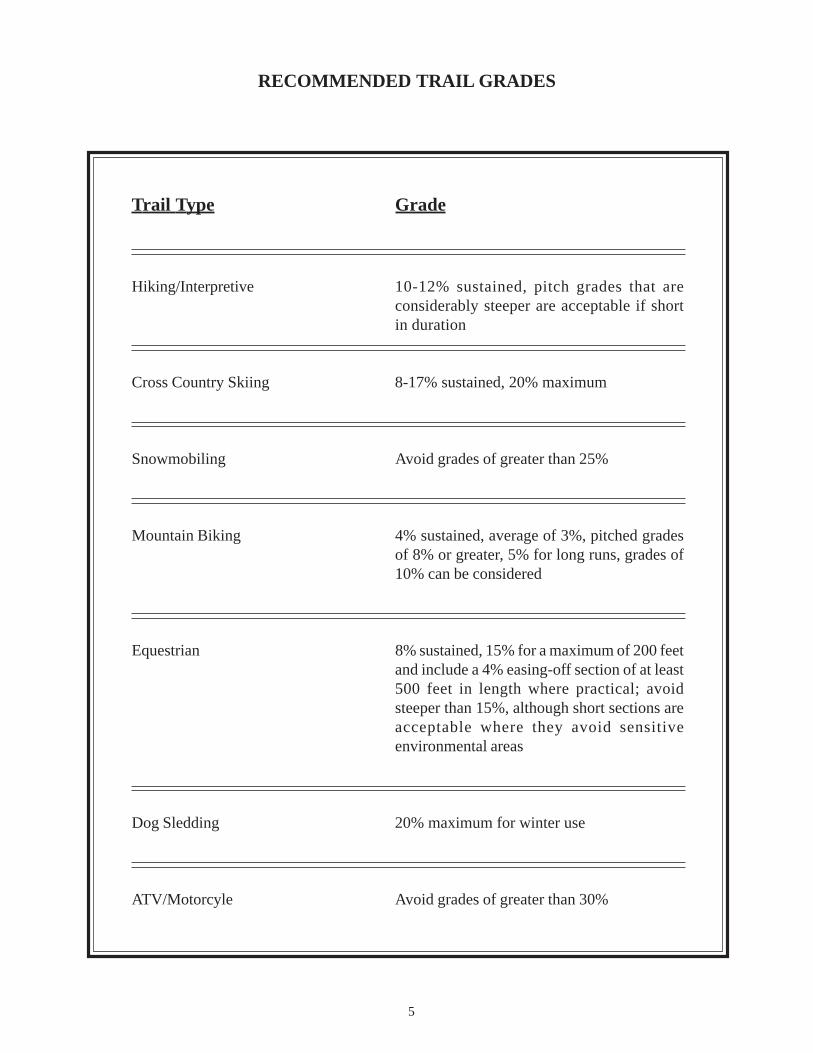
• The steeper the slope, the greater the potential for problems.• Multiple-use trails should be designed to the most limiting standard. For example, a snowmobile and cross
country ski trail design should not exceed 20% slope, the maximum grade guideline for cross country ski trails.• The following chart consists of guidelines for recommended grades for recreational trail use which should be
considered during the planning and design process.
5
RECOMMENDED TRAIL GRADES
Trail Type Grade
Hiking/Interpretive 10-12% sustained, pitch grades that areconsiderably steeper are acceptable if shortin duration
Cross Country Skiing 8-17% sustained, 20% maximum
Snowmobiling Avoid grades of greater than 25%
Mountain Biking 4% sustained, average of 3%, pitched gradesof 8% or greater, 5% for long runs, grades of10% can be considered
Equestrian 8% sustained, 15% for a maximum of 200 feetand include a 4% easing-off section of at least500 feet in length where practical; avoidsteeper than 15%, although short sections areacceptable where they avoid sensitiveenvironmental areas
Dog Sledding 20% maximum for winter use
ATV/Motorcyle Avoid grades of greater than 30%
6
Planning and Design Resources
Soil information, hydrologic data, and topographic and soil survey maps are valuable tools which should be usedto plan trail construction and maintenance. Soil maps developed by the Natural Resources Conservation Serviceusing the National Cooperative Soil Survey procedures help to identify an area’s predominant soil. These maps canbe useful when attempting to identify appropriate areas to locate the trail. Due to the scale on which the maps areproduced and the accuracy of soil boundaries, soil maps are useful for planning but not for site-specific purposes.Actual onsite review is the only way to identify whether the location is capable of supporting a trail. Soil maps areavailable through the NRCS in each county.
Prime wetlands have been designated and adopted in many N.H. communities, under RSA 482-A:15. Maps havebeen prepared for these communities as part of a comprehensive wetlands evaluation. These maps are used to identifyprime wetlands. If an area is designated as a prime wetland, a proposed trail project would be considered a majorimpact project. There is no size limitation for regulated wetlands. Not all wetlands can be located on a map, at whichcase an onsite review would be required while planning trail work. For information on whether a particular wetlandsis designated as a prime wetlands, contact the local conservation commission. For more information on primewetlands, contact the Department of Environmental Services Wetlands Bureau (603-271-2147) or www.des.state.nh.us/wetlands.
Topographical maps developed by the United States Geological Survey are one of the most useful and comprehensivereference tools when planning trail construction or maintenance. They provide valuable data regarding elevation,contour, large wetlands areas, and existing trails. Typically, these maps are scaled so that 1 inch = 2000 feet.Topographical maps are available at many bookstores and outdoor sporting good stores.
7
3. Trail Construction and Maintenance
General Guidelines
Obtain permits or notifications first.
• Before beginning any trail construction, install necessary measures to minimize and prevent erosion.
• Stabilizing slopes, creating natural vegetation buffers, diverting runoff from exposed areas, controllingthe volume and velocity of runoff, and conveying that runoff away from the construction area all serve toreduce erosion.
• Careful trail planning and design will create a stable trail that will result in fewer problems with soil erosionand sedimentation.
• During trail construction, minimize the amount of soil disturbance at stream crossings.
• Trail construction is best done during the dry months when soil saturation and water levels are at their lowest.
• The three most important factors to consider during trail construction are the character of the land itself (soil,slope, and vegetative cover), the type of expected use, and the volume of that expected use.
• Some trail construction areas may need to be stabilized if heavy traffic is expected on the trail.
• Install temporary erosion control measures such as hay bales before construction begins. Keep them in placeand maintained during construction and remove them only after the site has been stabilized.
• Trails through wet areas may have to be closed during the spring or other wet periods. Plan an alternate route,if possible.

8
Erosion and Sedimentation Control Techniques
SEDIMENT BARRIERSDefinitionAn erosion control device installed across and at the toe of a slope, usually consisting of hay, straw bales, or geotextilematerials, to prevent sediment from entering wetlands or open water.
Conditions where appropriate• When the erosion which would likely occur is in the form of sheet or rill erosion.• Where temporary sediment retention is necessary until permanent vegetation is firmly established.
BalesGuidelines for bale installation• Bales shall be placed in a single row on the
contour with the ends tightly adjoining, not toexceed 600 feet in length. Turn up the ends andbegin a new row, if needed.
• The bales should be embedded into the groundat least 4" deep.
• After placing bales, they should be anchored inplace with two stakes per bale driven throughthe bale and into the ground.
• Bales should be used where the area below thebarrier has exposed soils and would be impactedby water flowing through a barrier.
• Inspections should be frequent. Repair orreplacement should be done promptly, as needed.
Silt FencingGuidelines for silt fencing• If wooden stakes are utilized for silt fence construction, they must have a diameter of 2" when oak is used and
4" when pine is used.• The filter fabric should be purchased in a continuous roll and cut
to the length of the barrier to avoid the use of joints. When jointsare unavoidable, filter cloth should be spliced together only at asupport post, with a minimum of a six-inch overlap, and sealed.
• When wire support is used, a standard-strength filter cloth maybe used. When wire support is not being used, extra-strength clothshould be used.
• The fabric should be stapled or wired to the fence and a minimumof 4" of the fabric should be extended into the trench.
• The trench should be backfilled and the soil compacted over the filter fabric.
Additional considerations• Inspect bales and barriers after heavy rains.• Sediment deposits should be removed when the level of deposits reaches one-half of the height of the bale or
the silt fencing.• Barriers should be removed when the area has revegetated and the barriers are no longer needed. The sediment
should be removed or graded out before removal.
9
• Straw and hay bale barriers require more maintenance than geotextiles due to the permeability of the balesbeing less than that of silt fencing.
• Silt fences should be removed when they have served their useful purpose, but not before the upslope area hasbeen permanently stabilized.
• For specific information regarding the different types of geotextile materials and their construction andmaintenance guidelines, contact the Department of Environmental Services, county conservation district, or alocal industrial supplier.
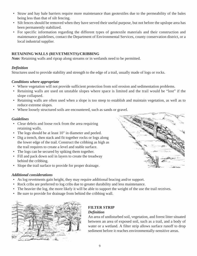
RETAINING WALLS (REVETMENTS)/CRIBBINGNote: Retaining walls and riprap along streams or in wetlands need to be permitted.
DefinitionStructures used to provide stability and strength to the edge of a trail, usually made of logs or rocks.
Conditions where appropriate• Where vegetation will not provide sufficient protection from soil erosion and sedimentation problems.• Retaining walls are used on unstable slopes where space is limited and the trail would be “lost” if the
slope collapsed.• Retaining walls are often used when a slope is too steep to establish and maintain vegetation, as well as to
reduce extreme slopes.• Where loosely structured soils are encountered, such as sands or gravel.
Guidelines• Clear debris and loose rock from the area requiring
retaining walls.• The logs should be at least 10" in diameter and peeled.• Dig a trench, then stack and fit together rocks or logs along
the lower edge of the trail. Construct the cribbing as high asthe trail requires to create a level and stable surface.
• The logs can be secured by spiking them together.• Fill and pack down soil in layers to create the treadway
behind the cribbing.• Slope the trail surface to provide for proper drainage.
Additional considerations• As log revetments gain height, they may require additional bracing and/or support.• Rock cribs are preferred to log cribs due to greater durability and less maintenance.• The heavier the log, the more likely it will be able to support the weight of the use the trail receives.• Be sure to provide for drainage from behind the cribbing wall.
FILTER STRIPDefinitionAn area of undisturbed soil, vegetation, and forest litter situatedbetween an area of exposed soil, such as a trail, and a body ofwater or a wetland. A filter strip allows surface runoff to dropsediment before it reaches environmentally-sensitive areas.
10
Conditions where appropriate• Maintaining a filter strip at the base of a slope retains sediment on site and is considered to be the preferred
method for erosion control.• In areas adjacent to any body of water or wetlands.• At the outlet of drainage structures such as culverts, waterbars, and ditches after the water passes through an
energy dissipater or spreader ditch.
Guidelines• If slope is 0-10%, filter strip width should be 50 feet.• If slope is 11-20%, filter strip width should be 70 feet.• When planting a new filter strip a temporary diversion should be used to divert water flow away from the filter
strip until dense vegetation is established.
Additional considerations• Dense vegetative cover of forest litter is necessary for a well-functioning filter strip. If this is not available,
seeding, planting, or other erosion-control measures can be substituted.• Filter strips are less effective as the slope increases.
STABILIZATIONDefinitionEstablishing vegetation on highly erodible or disturbed areas by sowing seed and other plants and/or mulching.
Conditions where appropriate• In areas where permanent vegetative cover is necessary to stabilize the soil.• In areas of trail where the soil is badly eroded and requires stabilization in order to continue potential trail use.• Generally applicable where bankfull flow velocity does not exceed five feet/second and soils are erosion-resistant.
Guidelines• An analysis of the soil may be necessary to decide how much and what kind of seed is appropriate.• It is necessary to first drain existing water when preparing the seedbed in water-diversion structures.• Guidelines for proper seeding can be found on the seed bag, or information can be obtained from the dealer
where the seed is purchased. (See seeding chart in Appendix III.)• Lime and fertilizer may be applied prior to or at the time of seeding and incorporated into the soil.
Application rates will be determined by conditions at the specific site. No fertilizer should be applied if nearsurface water or wetlands.
• Seed mix should consist of native materials, if possible.
Additional considerations• Once an area has been seeded, it should be covered with hay or straw for protection from sun and rain and anchored.• Mulching is recommended as a good practice for protecting exposed areas even if seeding is not expected to be
done. Mulch must be anchored to prevent wind or water from moving it.• The most commonly used materials for mulching are hay and wood chips. When these materials are not available,
brush can be substituted.• Grass and legumes are the most commonly used plant materials for seeding.• Native seed mixes are desirable but may be difficult to obtain.• This practice does not apply where tidal conditions exist.
11
• Disadvantages of seeding include the potential for erosion during the establishment stage, the need to reseedareas which fail to establish vegetation, and limited periods of time during the year which are conducive tosuccessful seeding.
• Grass seeding has limited success in preventing surface erosion from slopes exceeding the angle of repose, orthat angle at which a particular slope is stabilized. Some grass has limited success due to shallow root systems.
Drainage
General Guidelines• Proper drainage will carry the water either over the trail, under the trail, or will intercept the water before it
crosses the trail.• Surface runoff which is intercepted by erosion-control measures must be collected by drainageways and
discharged in stabilized areas or sediment basins.• The drier the terrain, the more stable the trail, which keeps potential erosion problems at a minimum.• Examine topography, surface flow patterns, soils, and the water table to help determine the area’s potential
wetness, preferably during the wettest months of the year, to help prevent future erosion problems.• The ideal trail would be located on soil which has a seasonal high water table of two to four feet below the surface.• Poor drainage is the primary cause of a majority of trail maintenance problems which can be avoided with
proper planning.• Cross-drainage techniques, such as swales, culverts, and water bars, should be utilized to divert water off of the
trail as soon as possible.• Attempts should always be made to maintain natural drainage patterns.
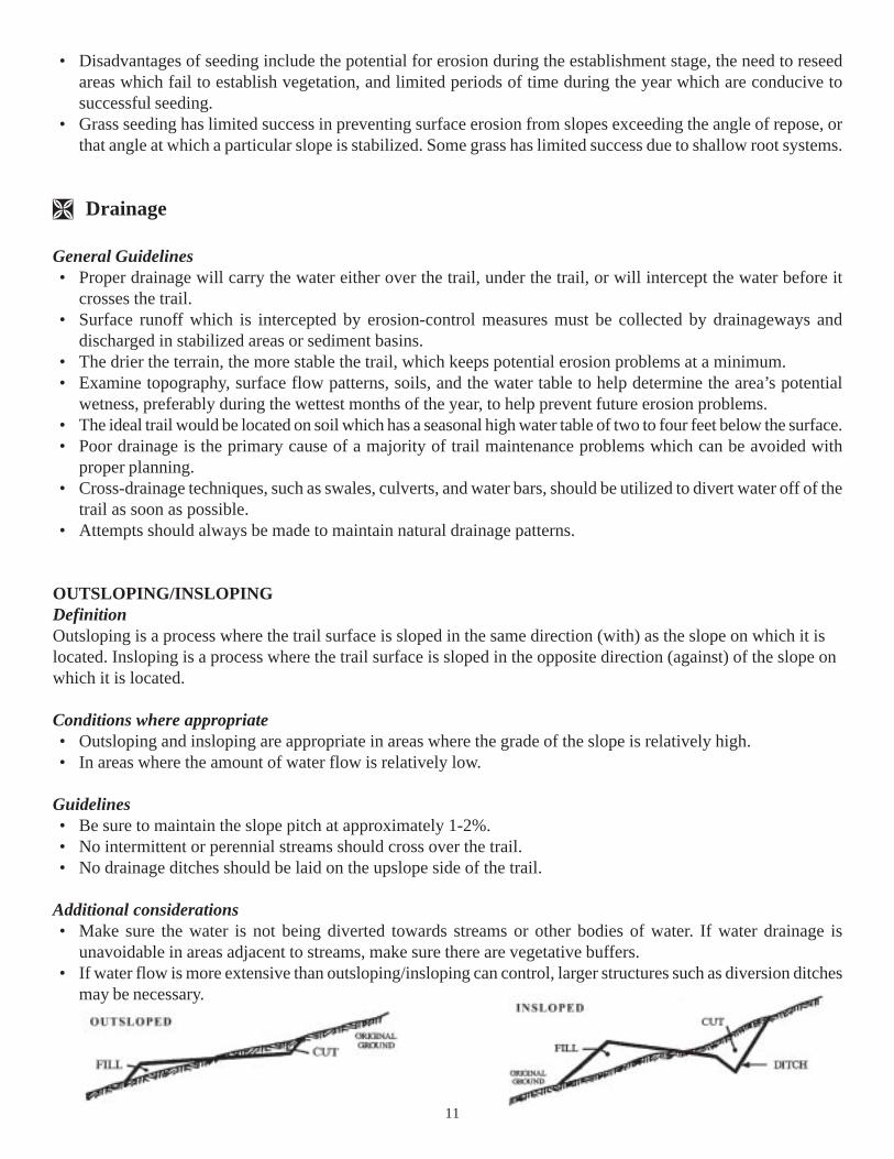
OUTSLOPING/INSLOPINGDefinitionOutsloping is a process where the trail surface is sloped in the same direction (with) as the slope on which it islocated. Insloping is a process where the trail surface is sloped in the opposite direction (against) of the slope onwhich it is located.
Conditions where appropriate• Outsloping and insloping are appropriate in areas where the grade of the slope is relatively high.• In areas where the amount of water flow is relatively low.
Guidelines• Be sure to maintain the slope pitch at approximately 1-2%.• No intermittent or perennial streams should cross over the trail.• No drainage ditches should be laid on the upslope side of the trail.
Additional considerations• Make sure the water is not being diverted towards streams or other bodies of water. If water drainage is
unavoidable in areas adjacent to streams, make sure there are vegetative buffers.• If water flow is more extensive than outsloping/insloping can control, larger structures such as diversion ditches
may be necessary.
12
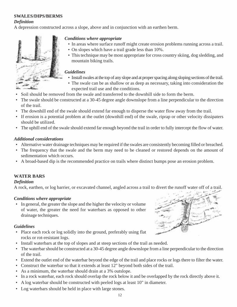
SWALES/DIPS/BERMSDefinitionA depression constructed across a slope, above and in conjunction with an earthen berm.
Conditions where appropriate• In areas where surface runoff might create erosion problems running across a trail.• On slopes which have a trail grade less than 10%.• This technique may be most appropriate for cross country skiing, dog sledding, and
mountain biking trails.
Guidelines• Install swales at the top of any slope and at proper spacing along sloping sections of the trail.• The swale can be as shallow or as deep as necessary, taking into consideration the
expected trail use and the conditions.• Soil should be removed from the swale and transferred to the downhill side to form the berm.• The swale should be constructed at a 30-45 degree angle downslope from a line perpendicular to the direction
of the trail.• The downhill end of the swale should extend far enough to disperse the water flow away from the trail.• If erosion is a potential problem at the outlet (downhill end) of the swale, riprap or other velocity dissipaters
should be utilized.• The uphill end of the swale should extend far enough beyond the trail in order to fully intercept the flow of water.
Additional considerations• Alternative water drainage techniques may be required if the swales are consistently becoming filled or breached.• The frequency that the swale and the berm may need to be cleaned or restored depends on the amount of
sedimentation which occurs.• A broad-based dip is the recommended practice on trails where distinct bumps pose an erosion problem.
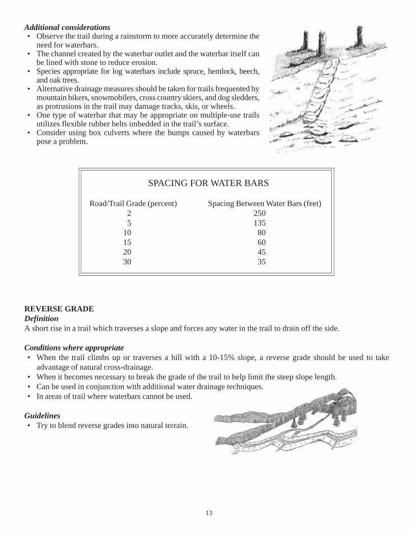
WATER BARSDefinitionA rock, earthen, or log barrier, or excavated channel, angled across a trail to divert the runoff water off of a trail.
Conditions where appropriate• In general, the greater the slope and the higher the velocity or volume
of water, the greater the need for waterbars as opposed to otherdrainage techniques.
Guidelines• Place each rock or log solidly into the ground, preferably using flat
rocks or rot-resistant logs.• Install waterbars at the top of slopes and at steep sections of the trail as needed.• The waterbar should be constructed at a 30-45 degree angle downslope from a line perpendicular to the direction
of the trail.• Extend the outlet end of the waterbar beyond the edge of the trail and place rocks or logs there to filter the water.• Construct the waterbar so that it extends at least 12" beyond both sides of the trail.• As a minimum, the waterbar should drain at a 3% outslope.• In a rock waterbar, each rock should overlap the rock below it and be overlapped by the rock directly above it.• A log waterbar should be constructed with peeled logs at least 10" in diameter.• Log waterbars should be held in place with large stones.
13
Additional considerations• Observe the trail during a rainstorm to more accurately determine the
need for waterbars.• The channel created by the waterbar outlet and the waterbar itself can
be lined with stone to reduce erosion.• Species appropriate for log waterbars include spruce, hemlock, beech,
and oak trees.• Alternative drainage measures should be taken for trails frequented by
mountain bikers, snowmobilers, cross country skiers, and dog sledders,as protrusions in the trail may damage tracks, skis, or wheels.
• One type of waterbar that may be appropriate on multiple-use trailsutilizes flexible rubber belts imbedded in the trail’s surface.
• Consider using box culverts where the bumps caused by waterbarspose a problem.
REVERSE GRADEDefinitionA short rise in a trail which traverses a slope and forces any water in the trail to drain off the side.
Conditions where appropriate• When the trail climbs up or traverses a hill with a 10-15% slope, a reverse grade should be used to take
advantage of natural cross-drainage.• When it becomes necessary to break the grade of the trail to help limit the steep slope length.• Can be used in conjunction with additional water drainage techniques.• In areas of trail where waterbars cannot be used.
Guidelines• Try to blend reverse grades into natural terrain.
SPACING FOR WATER BARS
Road/Trail Grade (percent) Spacing Between Water Bars (feet)2 2505 135
10 8015 6020 4530 35
14
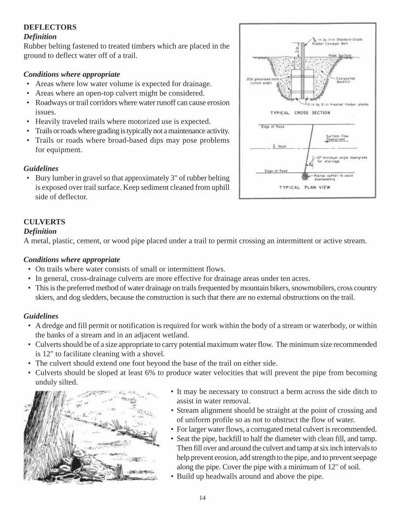
DEFLECTORSDefinitionRubber belting fastened to treated timbers which are placed in theground to deflect water off of a trail.
Conditions where appropriate• Areas where low water volume is expected for drainage.• Areas where an open-top culvert might be considered.• Roadways or trail corridors where water runoff can cause erosion
issues.• Heavily traveled trails where motorized use is expected.• Trails or roads where grading is typically not a maintenance activity.• Trails or roads where broad-based dips may pose problems
for equipment.
Guidelines• Bury lumber in gravel so that approximately 3" of rubber belting
is exposed over trail surface. Keep sediment cleaned from uphillside of deflector.
CULVERTSDefinitionA metal, plastic, cement, or wood pipe placed under a trail to permit crossing an intermittent or active stream.
Conditions where appropriate• On trails where water consists of small or intermittent flows.• In general, cross-drainage culverts are more effective for drainage areas under ten acres.• This is the preferred method of water drainage on trails frequented by mountain bikers, snowmobilers, cross country
skiers, and dog sledders, because the construction is such that there are no external obstructions on the trail.
Guidelines• A dredge and fill permit or notification is required for work within the body of a stream or waterbody, or within
the banks of a stream and in an adjacent wetland.• Culverts should be of a size appropriate to carry potential maximum water flow. The minimum size recommended
is 12" to facilitate cleaning with a shovel.• The culvert should extend one foot beyond the base of the trail on either side.• Culverts should be sloped at least 6% to produce water velocities that will prevent the pipe from becoming
unduly silted.• It may be necessary to construct a berm across the side ditch to
assist in water removal.• Stream alignment should be straight at the point of crossing and
of uniform profile so as not to obstruct the flow of water.• For larger water flows, a corrugated metal culvert is recommended.• Seat the pipe, backfill to half the diameter with clean fill, and tamp.
Then fill over and around the culvert and tamp at six inch intervals tohelp prevent erosion, add strength to the pipe, and to prevent seepagealong the pipe. Cover the pipe with a minimum of 12" of soil.
• Build up headwalls around and above the pipe.

15
Additional considerations
Open-top culvertGuidelines
• Can be constructed of either stone or sawn timber, depending on theavailability of materials.
• Log culverts may be constructed with two 6-10" logs set into the trailand pinned to prevent movement.
• Line the base of the culvert with riprap and install spreaders if necessary.• Sawn timber open-top culverts are usually constructed of two 3" x
8" planks set on a 3" x 12" plank, spiked at the bottom. This wouldcreate a water flow area 8" deep x 6" wide.
• Open-top culverts are most appropriate when water runoff is light.• Caution if an equestrian or bike trail.
Box culvertGuidelines
• The top of the culvert should be flush with the surface of the trail to provide for an uninterrupted tread.• Can be constructed of wood or stone.• If stones are used, align them so that there are no protruding edges which will catch debris, and cap the culvert
with flat stone. Pack the sides with gravel up to the top of the culvert and cover with native materials or flat stones.• For log culverts, set two 6" or 8" diameter logs 30 degrees across the trail about 4" apart. Cap the logs with a
3" x 8" plank which has a 3" x 4" piece of wood nailed down the middle to act as a spreader.
SIZING PIPE CULVERTS FOR STREAM CROSSINGS
Acres of Drainage
Shallow and High Normal Forest Recommended Pipe CulvertElevation Soils Soils Diameter in Inches
2 9 124 16 157 25 18
12 40 2116 55 2427 84 3047 130 3664 190 4290 260 48
120 335 54160 400 60205 550 66250 640 72
16
Water Crossings
General Guidelines• Water crossings are a major concern in the construction and use of trails because of the potential for large
amounts of sediment to enter a stream.• Avoid water crossings if at all possible. Rerouting the trail away from water crossings will save construction
time and money, as well as create less of an impact to the environment.• When needed, crossing sites should be selected at right angles to the stream and should not interfere with
natural water flow.• Erosion and sedimentation-control devices should be utilized whenever trail construction occurs in or near a
wetland, stream, or water body.• Before constructing any type of water crossing on trails, a permit or notification from the Wetlands Bureau
is required.
STEPPING STONES• When trails lie in low wet areas and the surrounding soil surface
is plagued with destruction due to users attempting to avoidthese areas.
• Stepping stones are the option of least environmental impactthat accomplishes the objective of protecting the environmentand providing dry passage.
• The ideal location for placing stepping stones is in shallowstreams with light to moderate water flows and should beavoided where dangerous stream flooding may occur.
• Stepping stones minimize silting of water by decreasing stream bed and bank disturbance.
Guidelines• When placing stepping stones, set stones approximately one and a half feet apart with the flat surface facing up.• Stepping stones must begin before or at the edge of the stream to allow for dry passage that does not create
stream bank erosion from use and minimizes water undercutting into the bank.• If the stepping stones are unsteady, they may not be set correctly or be large enough. Replace with larger stones.
Additional considerations• Stepping stones are generally appropriate for hiking and walking trails.• Stagger stones to reduce potential damming of debris between the stones.• Stepping stones are not universally accessible.• The distance between stepping stones can be adjusted to accommodate the majority of users.• Stepping stone surface area should be a minimum of one square foot in size.• Wet areas or streams with soft mucky bottoms may not adequately support stepping stones.
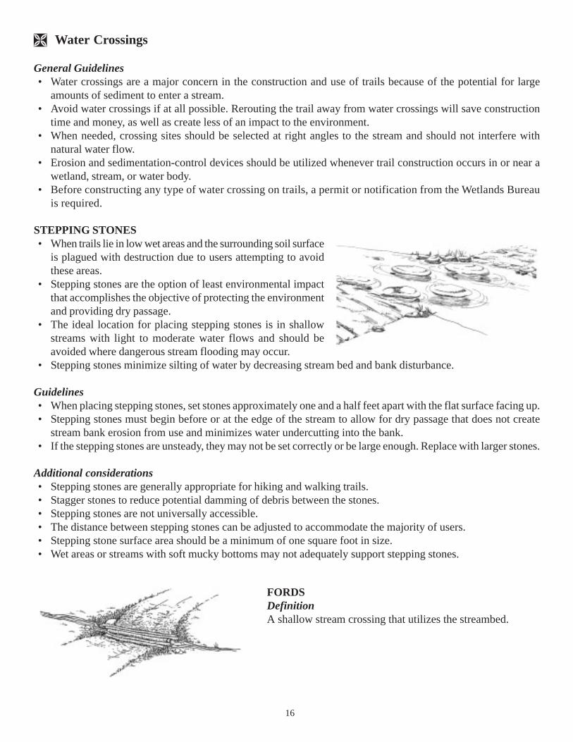
FORDSDefinitionA shallow stream crossing that utilizes the streambed.
17
Conditions where appropriate• Use only on perennial streams having intermittent flow.• Fording should be a last resort due to the potential impacts on water quality.• Where the streambed is hard or easily hardened.• Where recreational use in non-motorized.• When no other stream crossing alternative is viable or permitted.
Guidelines• Attempt to minimize extensive work within the streambed.• Provide for a hardened stream bank to prevent bank erosion.
Additional considerations• Fording can generate bank erosion, disturb aquatic life, may be potentially dangerous for the user, and is illegal
for motorized use, if water turbidity is increased.• Fording may create water quality problems due to the disturbing of the natural stability of the streambed.• Pad made of large stone (stone ford) can allow water to pass through stones while hikers cross without coming
into contact with water.
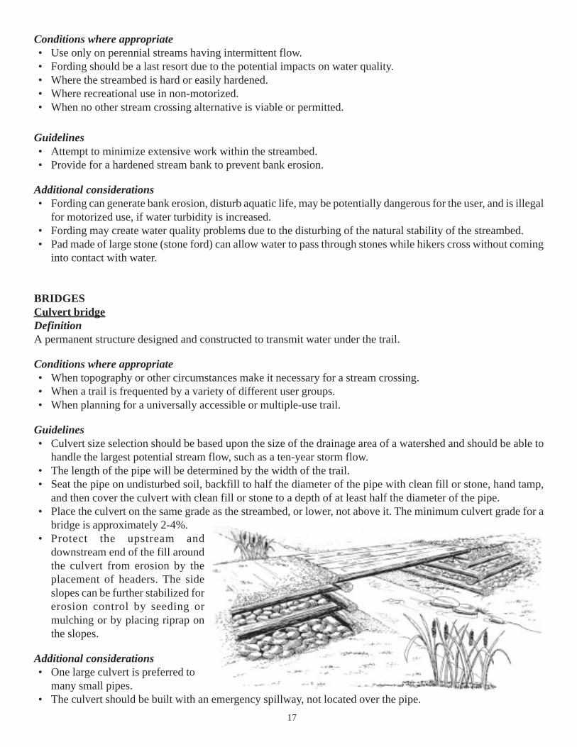
BRIDGESCulvert bridgeDefinitionA permanent structure designed and constructed to transmit water under the trail.
Conditions where appropriate• When topography or other circumstances make it necessary for a stream crossing.• When a trail is frequented by a variety of different user groups.• When planning for a universally accessible or multiple-use trail.
Guidelines• Culvert size selection should be based upon the size of the drainage area of a watershed and should be able to
handle the largest potential stream flow, such as a ten-year storm flow.• The length of the pipe will be determined by the width of the trail.• Seat the pipe on undisturbed soil, backfill to half the diameter of the pipe with clean fill or stone, hand tamp,
and then cover the culvert with clean fill or stone to a depth of at least half the diameter of the pipe.• Place the culvert on the same grade as the streambed, or lower, not above it. The minimum culvert grade for a
bridge is approximately 2-4%.• Protect the upstream and
downstream end of the fill aroundthe culvert from erosion by theplacement of headers. The sideslopes can be further stabilized forerosion control by seeding ormulching or by placing riprap onthe slopes.
Additional considerations• One large culvert is preferred to
many small pipes.• The culvert should be built with an emergency spillway, not located over the pipe.
18
• Culverts should be at least 12" in diameter so that hand tools can be used to clean accumulated debris.• Bridges can be a maintenance liability, whereas culverts are not as expensive and are easier to maintain.
NOTE: Culverts do require regular maintenance and cleaning to keep debris clear.
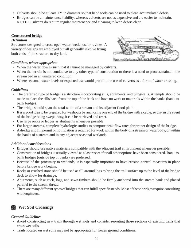
Constructed bridgeDefinitionStructures designed to cross open water, wetlands, or ravines. Avariety of designs are employed but all generally involve fixingboth ends of the structure to dry land.
Conditions where appropriate• When the water flow is such that it cannot be managed by culverts.• When the terrain is not conducive to any other type of construction or there is a need to protect/maintain the
stream bed in an unaltered condition.• Where seasonal water levels or expected use would prohibit the use of culverts as a form of water crossing.
Guidelines• The preferred type of bridge is a structure incorporating sills, abutments, and wingwalls. Attempts should be
made to place the sills back from the top of the bank and have no work or materials within the banks (bank-to-bank bridge).
• The bridge should span the total width of a stream and its adjacent flood plain.• It is a good idea to be prepared for washouts by anchoring one end of the bridge with a cable, so that in the event
of the bridge being swept away, it can be retrieved and reset.• Use large rocks or ledges as abutments whenever possible.• For larger streams, complete hydrologic studies to compute peak flow rates for proper design of the bridge.• A dredge and fill permit or notification is required for work within the body of a stream or waterbody, or within
the banks of a stream and in any adjacent seasonal wetlands.
Additional considerations• Bridges should use native materials compatible with the adjacent trail environment whenever possible.• Construction of bridges is usually viewed as a last resort after all other options have been considered. Bank-to-
bank bridges (outside top of banks) are preferred.• Because of the proximity to wetlands, it is especially important to have erosion-control measures in place
before bridge work begins.• Rocks or crushed stone should be used as fill around logs to bring the trail surface up to the level of the bridge
deck to allow for drainage.• Abutments, such as rock, logs, and sawn timbers should be firmly anchored into the stream bank and placed
parallel to the stream thread.• There are many different types of bridges that can fulfill specific needs. Most of these bridges require consulting
with engineers.
Wet Soil Crossings
General Guidelines• Avoid constructing new trails through wet soils and consider rerouting those sections of existing trails that
cross wet soils.• Trails located on wet soils may not be appropriate for frozen ground conditions.
19
• When designing trails, attempt to provide alternative routes during wet seasons.• Wet soil crossings require a permit or notification from the DES Wetlands Bureau.
STEPPING STONESRefer to guidelines for stepping stones under “water crossings.”DefinitionRefers to any material which is laid down on a trail which lessens compaction of soil, provides a dry surface forusers, and prevents potential erosion and abrasion.
Conditions where appropriate• It is necessary due to the natural surface being either damaged or destroyed.• When the existing material is unstable and needs protecting and strengthening.• When an environmentally sensitive area needs protection and the trail cannot be rerouted.
Guidelines• The surface material to be used will depend on the kind and amount of use the trail receives.• Ideally, native materials should be used as the surfacing material.• When native materials cannot be acquired, materials which blend with and preserve the natural environment
should be used.• In some cases, a single layer of surfacing will be sufficient. In other cases, a sub-base may be required, such as
in areas of wet ground and peat or on trails which flood easily. In these cases, the base is the load-bearing partof the trail and will comprise the bulk of the material to be used and should have adequate drainage to keep thesurface dry.
Additional considerations• Each situation which requires surfacing will be unique. How the trail will be hardened will depend on the soil
type, slope, depth of the water saturation, the sensitivity of the environment, the trail’s expected use, and theavailability of native materials.
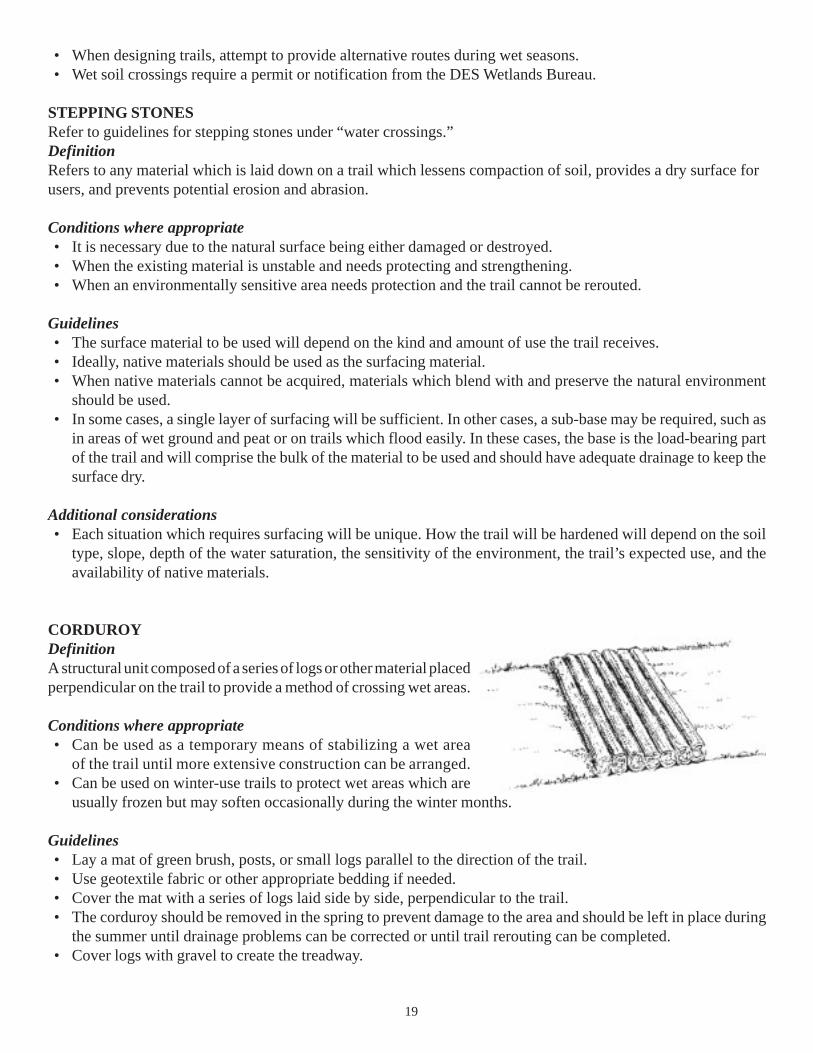
CORDUROYDefinitionA structural unit composed of a series of logs or other material placedperpendicular on the trail to provide a method of crossing wet areas.
Conditions where appropriate• Can be used as a temporary means of stabilizing a wet area
of the trail until more extensive construction can be arranged.• Can be used on winter-use trails to protect wet areas which are
usually frozen but may soften occasionally during the winter months.
Guidelines• Lay a mat of green brush, posts, or small logs parallel to the direction of the trail.• Use geotextile fabric or other appropriate bedding if needed.• Cover the mat with a series of logs laid side by side, perpendicular to the trail.• The corduroy should be removed in the spring to prevent damage to the area and should be left in place during
the summer until drainage problems can be corrected or until trail rerouting can be completed.• Cover logs with gravel to create the treadway.
20
Additional considerations• An alternative to constructing corduroy is geotextiles with gravel cover.• The construction of corduroy is a time-consuming construction which requires a large quantity of wood
and maintenance.
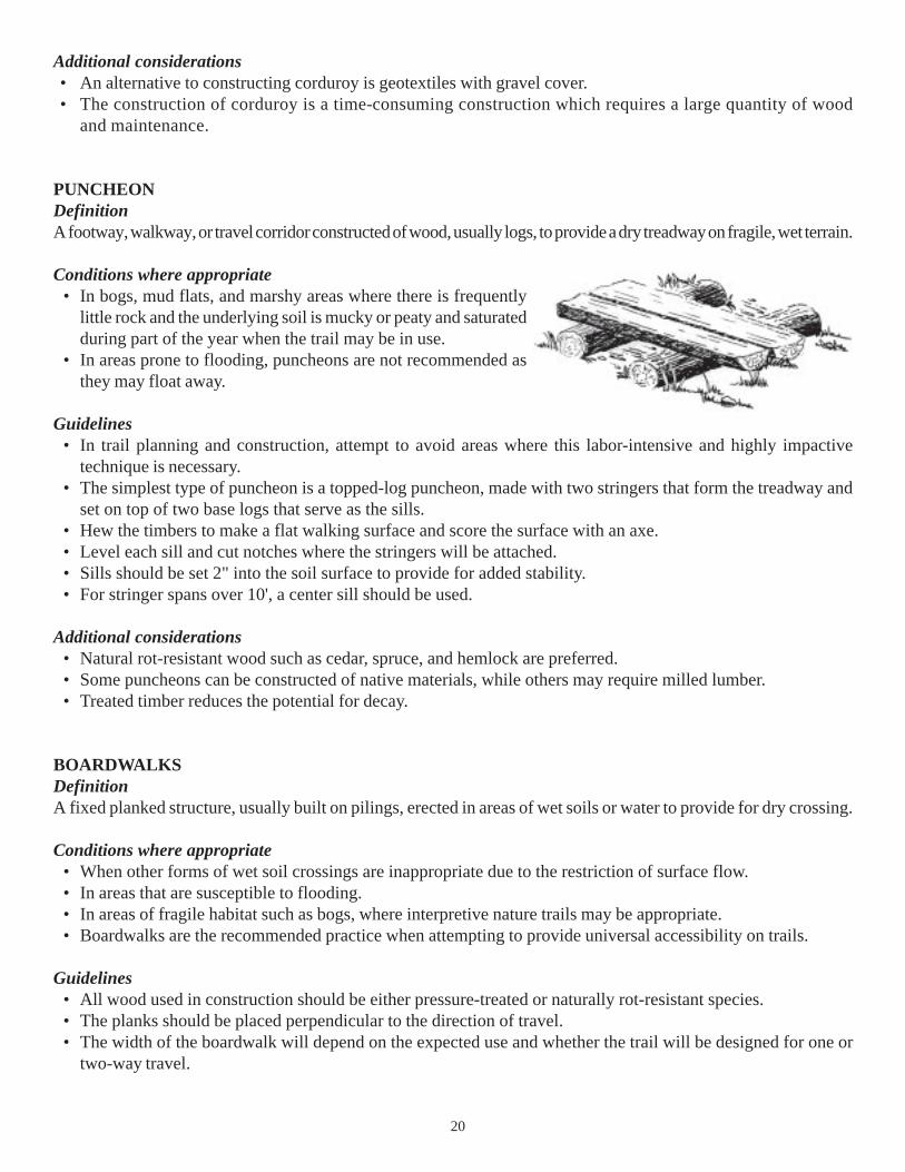
PUNCHEONDefinitionA footway, walkway, or travel corridor constructed of wood, usually logs, to provide a dry treadway on fragile, wet terrain.
Conditions where appropriate• In bogs, mud flats, and marshy areas where there is frequently
little rock and the underlying soil is mucky or peaty and saturatedduring part of the year when the trail may be in use.
• In areas prone to flooding, puncheons are not recommended asthey may float away.
Guidelines• In trail planning and construction, attempt to avoid areas where this labor-intensive and highly impactive
technique is necessary.• The simplest type of puncheon is a topped-log puncheon, made with two stringers that form the treadway and
set on top of two base logs that serve as the sills.• Hew the timbers to make a flat walking surface and score the surface with an axe.• Level each sill and cut notches where the stringers will be attached.• Sills should be set 2" into the soil surface to provide for added stability.• For stringer spans over 10', a center sill should be used.
Additional considerations• Natural rot-resistant wood such as cedar, spruce, and hemlock are preferred.• Some puncheons can be constructed of native materials, while others may require milled lumber.• Treated timber reduces the potential for decay.
BOARDWALKSDefinitionA fixed planked structure, usually built on pilings, erected in areas of wet soils or water to provide for dry crossing.
Conditions where appropriate• When other forms of wet soil crossings are inappropriate due to the restriction of surface flow.• In areas that are susceptible to flooding.• In areas of fragile habitat such as bogs, where interpretive nature trails may be appropriate.• Boardwalks are the recommended practice when attempting to provide universal accessibility on trails.
Guidelines• All wood used in construction should be either pressure-treated or naturally rot-resistant species.• The planks should be placed perpendicular to the direction of travel.• The width of the boardwalk will depend on the expected use and whether the trail will be designed for one or
two-way travel.
21
Additional considerations• Handrails may be added as a safety feature, depending on the expected use of the trail.• Treated timber reduces potential for decay.• Design standards are available for universally accessible boardwalks.
Floating boardwalksDefinitionA floating planked structure constructed on areas of wet soil to provide for dry crossing.
Conditions where appropriate• In wet areas where the depth below the surface of which hardpan is found is such that it would be easier to build
a floating structure.• In areas which are susceptible to flooding.• In areas which may be used only seasonally and the structures will be removed.
Guidelines• Floating boardwalks can be constructed of styrofoam, wood, or plastic barrels.• See boardwalk guidelines.
Additional considerations• Side railing may be constructed, depending on boardwalk location and usage.
TURNPIKING, CROWNS, AND DITCHESDefinitionA raised section of the trail which usually consists of trenches on one or both sides to improve drainage on wet areasof trail.
Conditions where appropriate• In flat wet areas where soils are easily saturated or highly erodible.• Where subsurface water is recurrent and the trail needs to be raised.
Guidelines• Dig a drainage ditch on one or both sides of the causeway using the material removed to construct a crown or
turnpike to provide for dry trail surface.• Crowns should be sloped 2-4% from the center line to the outside edges of the trail.
Additional considerations• The raised surface should consist of native materials.• If necessary, reinforce the causeway with logs or rocks to provide extra stability.• The topography of the land will generally dictate the types of soil that exist on the trail.• The material removed from the ditches may not be appropriate for use in the construction of the turnpike,
crown, or ditch, and it may be necessary to bring in material from somewhere else.• To improve water passage, use riprap as the base material underneath a geotextile mat with soil or sand placed
on top and use culverts where needed to provide proper cross-drainage.
22
Assistance and References
Department of Resources and Economic Development Department of Environmental ServicesDivision of Parks and Recreation Water DivisionBureau of Trails Wetlands BureauP.O. Box 1856 P.O. Box 95, 29 Hazen DriveConcord, NH 03302-1856 Concord, NH 03302-0095(603) 271-3254 (603) 271-2147www.nhtrails.org www.des.state.nh.us/wetlands
Department of Resources and Economic DevelopmentDivision of Forests & LandsNatural Heritage BureauP.O. Box 1856Concord, NH 03302-1856(603) 271-3623www.nhdfl.org
Technical Assistance AvailableAssistance in using this manual may be obtained at the following locations from the local conservation districtserving each county throughout the state.
Belknap County Conservation District Carroll County Conservation DistrictFederal Building, Room 203 44 Main Street719 No. Main Street P.O. Box 533Laconia, NH 03246 Conway, NH 03818(603) 527-5880 (603) 447-2771
Cheshire County Conservation District Merrimack County Conservation District11 Industrial Park Drive The Concord CenterWalpole, NH 03608 10 Ferry Street, Box 312(603) 756-2988 X116 Concord, NH 03301
(603) 225-6401
Coos County Conservation District Rockingham County Conservation DistrictBox 235, RFD #2 110 North RoadLancaster, NH 03584 Brentwood, NH 03042(603) 788-4651 (603) 679-2790
Grafton County Conservation District Strafford County Conservation DistrictSwiftwater Road 259 County Farm RoadRR2, Box 148B Unit 3Woodsville, NH 03785 Dover, NH 03820(603) 747-2001 (603) 749-3037
Hillsborough County Conservation District Sullivan County Conservation DistrictChappell Professional Center 24 Main Street468 Route 13, South Newport, NH 03773-1500Milford, NH 03055 (603) 863-4297(603) 673-2409 X9

23
Bibliography
Agate, Elizabeth. Footpaths, 1983, British Trust for Conservation Volunteers, Wallingford, Oxfordshire, England.
Bureau of State Parks, Division of Outdoor Recreation, Virginia Department of Conservation and Recreation,Virginia Erosion and Sediment Control Handbook, 1992, Richmond, VA.
Cullen, J.B., 2000 Department of Resources and Economic Development, State of New Hampshire, BestManagement Practices for Erosion Control on Timber Harvesting Operation, Concord, NH.
Department of Ecology, State of Washington, Stormwater Management Manual for the Puget Sound Basin,February, 1992, Olympia, WA.
Department of Environmental Services, State of New Hampshire, Best Management Practices to Control NonpointSource Pollution: A Guide for Citizens and Town Officials, 1993, Concord, NH.
Division of Engineering and Operations Standards, Department of Transportation, State of Alaska, ContractorGuidance for Preparing and Executing Storm Water Pollution Prevention Plans, 1992, Juneau, AK.
Division of Soil and Water Conservation, Department of Conservation and Recreation, State of Virginia, VirginiaErosion and Sediment Control Handbook, 1992, Richmond, VA.
Hartung, Robert and Kress, James, Soil Conservation Service, United States Department of Agriculture, Woodlandsof the Northeast: Erosion and Sediment Control Guides, 1977, Broomall, PA.
Forest Service, United States Department of Agriculture, Snowmobile Trails Manual, Laconia, NH.
Forest Service, United States Department of Agriculture, Soil and Water Conservation Handbook, 1993, Juneau, AK.
Forest Service, United States Department of Agriculture, Standard Specifications for Construction of Trails, June,1984, Washington, D.C.
McCoy, Michael and Stoner, MaryAlice., Mountain Bike Trails: Techniques for Design, Construction andMaintenance, BikeCentennial, Missoula, MT.
Rockingham County Conservation District, Soil Conservation Service, United States Department of Agriculture,Stormwater Management and Erosion and Sediment Control Handbook for Urban and Developing Areas in NewHampshire, 1992, Exeter, NH.
Soil Conservation Service, United States Department of Agriculture, Engineering Field Handbook, October, 1992,Washington, D.C.

24
Appendix I.Other Resources
RESOURCES (Publications)
Soil Stabilizers on Universally Accessible TrailsUSDA Forest Service for USDOT, Federal Highway Administration. 2300 Recreation Management, September2000. 0023-1202-SDTDC
Managing Degraded Off-Highway Vehicle Trails in Wet, Unstable, and Sensitive EnvironmentsUSDA Forest Service. 2300 Publication, October 2002. 0223-2821-MTDC
Geosynthetics for Trails in Wet AreasUSDA Forest Service. 2300 Recreation, August 2000. 0023-2838-MTDC
Wetland Trail Design and ConstructionUSDA Forest Service. 2300 Recreation, September 2001. 0123-2833-MTDC
Floating Trail Bridges and DocksUSDA Forest Service. 2300 Recreation, July 2002. 0223-2812-MTDC
BMP for Erosion Control on Timber Harvesting Operations in New HampshireUNH Cooperative Extension and N.H. Division of Forests & Lands
Trail Construction and Maintenance Notebook, 2000 edition.USDA Forest Service. 2300 Recreation, August 2000. 0023-2839-MTDC-P

25
Appendix II.Seeding Mixtures for Temporary Seedings1
For Excessively Well to Somewhat Poorly Drained Soils
Area/Purpose Soil pH Shade AppropriateMixture2 (lbs./Ac.)____________________________________________________________________________________
Roads 4.5-7.5 Heavy to None Creeping Red Fescue 40TrailsLandings Redtop 2Burned Over
Roads 5.5-7.5 Heavy to None Annual Ryegrass 40TrailsLandings
Roads 5.5-7.5 Moderate to None Winter Rye 112TrailsLandingsWildlife
1Seeding Dates. Seed disturbed areas as soon as possible. Seed as early in the spring as the ground can beworked and in the late summer/early fall based on local recommendations.
2On critical areas or droughty sites, apply hay or straw mulch at the of 90 lbs./1000 sq. ft. Anchor mulch on steepslopes or where subjected to concentrated flow.
Appendix III.Communities with Designated Prime Wetlands (as of December 2002):
Andover, Barrington, Bow, Brookline, Derry, Enfield, Exeter, Frement, Gilford, Holderness, Hooksett,Meredith, Nashua, New London, Northwood, Pelham, Salem, Sanbornton, Sandwich, Tamworth, Weareand Wolfeboro.
Prime wetlands are designated by a municipality according to the requirements of RSA 482-A:15 and Chapter Wt700 of the DES administrative rules.
Typically, the evaluation method used is the “Method for Comparative Evaluation of Nontidal Wetlands in NewHampshire” (1991) or “Method for the Evaluation and Inventory of Vegetated Tidal Marshes in New Hampshire”(Coastal Method) (1993).
All projects that are in or adjacent to a prime wetland are classified as major projects. All major projects require afiled inspection by DES and all prime wetland projects require a public hearing to be conducted by DES.
26
Appendix IV.Clues to Identifying Forested Wetlands
Wetlands perform many functions that are important to the health of our environment — they protect water quality inour lakes and for drinking, help ensure adequate water supplies, and provide wildlife habitat, flood control, andnurseries for finfish and shellfish. It is for these reasons that wetlands are protected under New Hampshire state law.
There are several types of wetlands in New Hampshire. Some wetlands have herbaceous plants – such as marshes,wet meadows, and bogs. Wetlands that have woody plants or trees are forested wetlands or swamps, scrub-shrubwetlands, bogs, and vernal pools. Since the state of New Hampshire is more than 80 per cent forested, and about 6to 10 percent of the state is considered wetlands, there are a lot of forested wetlands in New Hampshire!
Wetlands are identified based upon three criteria; the presence of plants adapted to survive in wet soil conditions,the presence of water at or near the surface for more than two weeks during the growing season, and the presenceof hydric soils. Although wetland identification may require a trained professional such as a wetland scientist, ifyou have some knowledge of plants or a field guide, and good observation skills, you may be able to get an idea ofwhere wetlands are located.
The following questions are provided to guide you in observing some characteristics of forested wetlands. You willneed to know how to identify some plants to answer some of these questions. If you answer “yes” to one or more ofthe following questions about a site, a forested wetland may be present on the property.
· Do you see natural drainage routes, which are defined by a small channel or scouring?· Is the ground soggy or spongy under foot at any time during the growing season (May to September)?· Is Sphagnum moss present?· Do you see low spots or depressions where water lies or pools for more than seven days during the growing
season?· Does the ground have areas of depressions and mounds (also called pit and mound topography)?· Do you see springs or seeps? (Water may be trickling out of the ground.)· Do you see areas that cannot be crossed by vehicle, tractor, or other machinery because it might get stuck in
the soft, wet ground?· Do you see any water-stained leaves on the ground? (These look blacker than plain dry leaves.)· Do you see trees blown down (“windthrows”), which expose shallow but extensive root systems?· Do you see fine silt or sediment deposits on leaves on the ground or on stems or tree trunks?· Do you see drift lines where sticks, leaves and other water-carried debris have lodged against the base of
vegetation (especially on one side)?· Do you see any of these herbaceous plants: jewelweed, sensitive fern, cinnamon fern, royal fern, skunk
cabbage, jack-in-the-pulpit, goldthread?

27
· Do you see any of these shrubs present: highbush blueberry, winterberry holly, speckled alder, northernarrowwood, silky or red-osier dogwood?
· Do you see any of these deciduous trees present: black or green ash, American elm, black willow, swampwhite oak, red maple, silver maple, black gum, yellow or grey birch?
· Do you see any of these evergreen or needle-bearing trees present: balsam fir, black spruce, larch or tamarack,northern white cedar, or Atlantic white cedar?
· Do you see a black organic layer (may look like decomposing leaves and roots) below the surface that is atleast 4 inches thick? (You will need to clear away some of the leaves and surface materials to observe thischaracteristic.)
· If you dig to a depth of 18 inches, is the soil color grayish or marked with rust-colored spots, streaks, orlines of different color. (In agricultural fields, these characteristics are observed below the depth that a plowcan reach.)
· If you dig a pit to a depth of 18 inches, does it fill with water or does water trickle down the inside? (Youmay need to wait 20 minutes or so after you have dug the pit to observe this.)
If you answer “yes” to any of these questions about a site, a forested wetland may be present.
Most projects that propose impacts (of any size) to wetlands require a “dredge and fill” permit from the NewHampshire Department of Environmental Services - Wetlands Bureau. Contact the Wetlands Bureau for moreinformation:
NH DES Wetlands Bureau29 Hazen Drive
PO Box 95Concord NH 03302
Phone: (603) 271-2147Fax: (603) 271-6588
www.des.state.nh.us/wetlandsemail: [email protected]
Related Documents