Benthic Macroinvertebrate survey 2018-2019 report Coorong, Lower Lakes and Murray Mouth Icon Site Report for the Department for Environment and Water and the Murray-Darling Basin Authority Sabine Dittmann, Orlando Lam Gordillo & Ryan Baring Flinders University, College of Science and Engineering GPO Box 2100, Adelaide, SA 5001

Welcome message from author
This document is posted to help you gain knowledge. Please leave a comment to let me know what you think about it! Share it to your friends and learn new things together.
Transcript

Benthic Macroinvertebrate survey
2018-2019 report
Coorong, Lower Lakes and Murray Mouth Icon Site
Report for the
Department for Environment and Water
and the Murray-Darling Basin Authority
Sabine Dittmann, Orlando Lam Gordillo & Ryan Baring
Flinders University, College of Science and Engineering
GPO Box 2100, Adelaide, SA 5001

© Flinders University and The Department for Environment and Water (DEW)
With the exception of the Commonwealth Coat of Arms, the Murray-Darling Basin Authority logo,
photographs, graphics and trademarks, all material presented in this document is provided under a
Creative Commons Attribution 4.0 International Licence.
(https://creativecommons.org/licenses/by/4.0/).
For the avoidance of any doubt, this licence only applies to the material set out in this document.
The details of the licence are available on the Creative Commons website (accessible using the links
provided) as is the full legal code for the CC BY 4.0 licence
((https://creativecommons.org/licences/by/4.0/legal code).
MDBA’s preference is that this publication be attributed (and any material sourced from it) using the
following:
Publication title (cite as): Dittmann, S., Lam Gordillo, O. & Baring R. 2019. Benthic macroinvertebrate
survey 2018-2019 report. Coorong, Lower Lakes and Murray Mouth Icon Site. Report for the
Department for Environment and Water and the Murray-Darling Basin Authority. Flinders University,
Adelaide.
Source: Licensed from The Department for Environment and Water under a Creative Commons
Attribution 4.0 International Licence.
Disclaimer
The contents of this publication do not purport to represent the position of the Commonwealth of
Australia or the MDBA in any way and are presented for the purpose of informing and stimulating
discussion for improved management of Basin's natural resources.
To the extent permitted by law, the copyright holders (including its employees and consultants)
exclude all liability to any person for any consequences, including but not limited to all losses,
damages, costs, expenses and any other compensation, arising directly or indirectly from using this
report (in part or in whole) and any information or material contained in it.
Contact us
Enquiries regarding the licence and any use of the document are welcome to: Adrienne Rumbelow
LLCMM Icon Site Coordinator [email protected]
TLM Funding acknowledgement
This project was funded by The Living Murray initiative. The Living Murray is a joint initiative funded by the New South Wales, Victorian, South Australian, Australian Capital Territory and Commonwealth governments, coordinated by the Murray–Darling Basin Authority.
Cover photo: Scavenging polychaetes (Phyllodoce novaehollandiae) at the sediment surface at Ewe
Island. The species had been rarely seen in previous years.

i
Contents
1. Executive summary ......................................................................................................................1
2. Introduction ..................................................................................................................................3
3. Materials and Methods .................................................................................................................5
3.1 Sampling sites and dates .....................................................................................................5
3.2 Environmental parameters ...................................................................................................6
3.3 Macrofauna .........................................................................................................................7
3.4 Data analysis .......................................................................................................................8
4. Results – Murray Mouth and Coorong ........................................................................................ 11
4.1 Mudflat habitats in the Murray Mouth and Coorong ............................................................ 11
4.1.1 Water quality .................................................................................................................. 11
4.1.1.1 Salinity ................................................................................................................... 11
4.1.1.2 Dissolved oxygen and temperature......................................................................... 12
4.1.1.3 pH in water and sediment ....................................................................................... 14
4.1.2 Sediment characteristics ................................................................................................ 15
4.1.2.1 Grain size composition ........................................................................................... 15
4.1.2.2 Sediment organic matter and chlorophyll-a ............................................................. 17
4.2 Macroinvertebrate populations ........................................................................................... 21
4.2.1 Macroinvertebrate species richness, diversity and distribution ........................................ 21
4.2.2 Macroinvertebrate occurrence and abundance ............................................................... 26
4.2.2.1 Macroinvertebrate occurrence and distribution ranges ............................................ 26
4.2.2.2 Macroinvertebrate abundances .............................................................................. 28
4.2.2.3 Long term changes in macroinvertebrate abundances ............................................ 30
4.2.3 Macroinvertebrate biomass ............................................................................................ 33
4.2.3.1 Biomass 2018 ........................................................................................................ 33
4.2.3.2 Long term changes in macroinvertebrate biomass .................................................. 34
4.2.4 Macroinvertebrate communities ..................................................................................... 36
4.2.4.1 Community compositions ....................................................................................... 36
4.2.4.2 Environmental conditions as predictor variables for macroinvertebrate communities ........................................................................................................... 40
5. Discussion ................................................................................................................................. 43
5.1 Macroinvertebrate populations ........................................................................................... 43
5.2 Habitat conditions .............................................................................................................. 44
5.3 Monument Road alternative site assessment ..................................................................... 45
5.4 Conclusion......................................................................................................................... 45
6. Acknowledgements .................................................................................................................... 47
7. References ................................................................................................................................ 48

1
1. Executive summary
As part of The Living Murray (TLM) Condition Monitoring Plan (revised), macroinvertebrates and
mudflats are annually monitored in the Lower Lakes, Coorong and Murray Mouth Icon site. This report
presents the findings from the monitoring carried out in spring/early summer of 2018/19. Data are
compared against long-term records from this monitoring, which is now in its 14th year.
The monitoring occurred in December 2018 after drier weather conditions and reduced flows into the
Coorong compared to several years with strong flood peaks. The typical gradient of increasing
salinities from the Murray Mouth to the southern end of the Coorong persisted, with more
brackish/marine salinities near the Murray Mouth, and hypersaline conditions in the South Coorong,
which were not as extreme as in earlier monitoring years. Water quality in terms of dissolved oxygen
saturation and concentration was good throughout the system.
To deliver on the TLM condition monitoring targets, this report assessed the current condition against
the objectives and specific targets for macroinvertebrates and mudflats. The condition of mudflat
invertebrate communities has been maintained, but not improved further in the recent monitoring year.
Several signs in the analyses indicated a development towards communities present during the
drought in the last decade.
Macroinvertebrate species richness increases throughout the Murray Mouth and Coorong
This target has been partially met. The species richness in the North Coorong remained above a long-
term reference but decreased in the South Coorong.
Macroinvertebrate occurrence extends along the Coorong into the South Lagoon
This target has not been met. The distribution range of key macroinvertebrate species contracted in
2018 and their occurrence throughout the North and South Coorong was lower than in previous years.
The area of occupation for typical estuarine and marine macroinvertebrate species exceeds 60% of
the sites sampled
This target has been partially met. The constancy index for several key macroinvertebrate species
was >60% and classified as very common. The area of occupation was contracted towards the Murray
Mouth, and few species occurred at Noonameena and in the South Coorong.
Macroinvertebrate abundance is maintained at, or increases above, reference levels
This target has been partially met. Total abundance was maintained, as were abundances of several
key macroinvertebrate species which were similar to the long-term reference. Only Arthritica helmsi
had a significant increase in abundance above the reference.
Macroinvertebrate biomass is maintained at, or increases above, reference levels
This target has been partially met. Biomass was maintained as no significant difference to the long-
term reference was detected. No significant increases occurred.
Macroinvertebrate communities are similar to those occurring under intermediate continuous flows
This target has been met. For the North Coorong, the macroinvertebrate community was similar to
previous years with intermediate continuous flows, although on a trajectory towards earlier drought

2
years. For the South Coorong, no significant differences in communities were found across any of the
monitoring years.
The clear distinction between macroinvertebrate communities in the North and South Coorong could
be explained by a persistent salinity threshold of 64 ppt, as in previous monitoring years.
Habitat conditions were mostly maintained, but no improved sediment conditions were found. In the
South Coorong, some of the sediment conditions had deteriorated. Mudflats in the Murray Mouth and
Coorong provided habitat for macroinvertebrates, but not all targets were fully met:
Habitable sediments are occurring along the Coorong into the South Lagoon
This target has been partially met. Habitable sediment conditions occurred at most of the sites in the
December 2018 survey, in particular throughout the North Coorong.
Sediments are maintained as fine to medium sands and are mostly moderately well sorted
This target has been partially met. The sediment was characterised as fine to medium sand and
moderately sorted for most sites, but as coarse or silt at a few sites, and poorly sorted. There was a
significant deviation from the long-term reference for the median grain size, but not for the sorting
coefficient.
Sediment organic matter is maintained
This target has not been met and 2018 was the second consecutive year with a significant change
from the reference value, indicating increasing eutrophication. High values of sediment organic matter
indicate eutrophic conditions, in particular at Villa de Yumpa in the South Lagoon. The pollution
indicator species Capitella capitata was ‘very common’ in occurrence in the Coorong.
Sediments provide microphytobenthic food for the benthic food web
This target has been met as chlorophyll-a concentrations were higher and more similar to the long-
term reference value.
Reference values for macroinvertebrates and mudflats were recalculated to include years with more
typical estuarine conditions for future benchmark. It is recommended that the revised reference values
presented in this report to 2017 are used in the future as they represent a better estuarine reference
condition.
As site access issues had occurred for site 1 (Monument Road) in recent years, an alternative site
(Tarni Warra) nearby was also sampled, and found to be a potentially suitable substitute site.
Monitoring for macroinvertebrates and mudflat habitats in 2018 showed some maintained conditions,
little improvements, and indications for decreases in condition. In most of the North Coorong
conditions were favourable, and macroinvertebrate communities similar to previous years. The South
Lagoon remained in a degraded state and no improvements were recorded. The salinity threshold
separating the macroinvertebrate communities between the North and South Coorong has persisted.
Unless salinities in the South Coorong are lowered below this threshold, recolonisation by
macroinvertebrates is unlikely to occur.

3
2. Introduction
Coastal wetlands have high ecosystem service values but are also vulnerable to environmental
changes due to drought, floods and man-made interventions (Boulton et al. 2016; Valiela 2006). In
hypersaline estuaries and lagoons, drought induced reductions in freshwater inflow can have drastic
effects on the ecosystem functions and services (Tweedley et al. 2019). The Coorong, Lower Lakes
and Murray Mouth is a Ramsar listed wetland of international significance for migratory shorebirds,
where the provision of food can be affected by flow conditions (Kingsford et al. 2011). The region has
experienced extreme environmental fluctuations over the past decades with the Millennium Drought
and subsequent flood events since the summer of 2010/11, affecting the ecology including
abundances of waders and waterbirds (Mosley et al. 2018; Wainwright and Christie 2008; Paton et al.
2009; Kingsford et al. 2011). Recent years have seen moderate to high, but continuous flows through
the barrages into the Murray Mouth and North Lagoon where recovery from drought has been
observed, yet there are little signs of recovery in the South Lagoon (Dittmann et al. 2017; Baring et al.
2019). With the possibility of a new drought, inflow of water from the Murray River system has been
reduced in 2018-19 (Figure 1).
Figure 1: Monthly flow through the barrages from the Lower Lakes into the Murray Mouth and Coorong from 2000 to end of mid 2019, covering the years of macroinvertebrate and mudflat monitoring. Based on modelled monthly barrage outflow data from the MDBA and measured barrage flow data since 2017.
A strong salinity gradient characterises the Coorong, from brackish to marine conditions near the
Murray Mouth to extreme hypersalinity in the South Lagoon. Plankton, macroinvertebrate and fish
community structures have been found to align with this gradient (Dittmann et al. 2015; Hemraj et al
2017; Hossain et al. 2017). The intensity of the salinity gradient varies subject to inflow of water into
the Coorong, and with it the ecology of the estuary and lagoon.
20
00
20
01
20
02
20
03
20
04
20
05
20
06
20
07
20
08
20
09
20
10
20
11
20
12
20
13
20
14
20
15
20
16
20
17
20
18
20
19
0
500
1000
1500
2000
2500
Flo
w G
L m
on
th

4
Condition monitoring of icon sites of The Living Murray (TLM) initiative provides information on
changes in the ecology of the Lower Lakes, Coorong and Murray Mouth (LLCMM) Icon Site, and
whether objectives and targets have been met in particular monitoring years (DEWNR 2017). For
macroinvertebrates and mudflats, the objectives set out in the LLCMM Condition Monitoring Plan
(Revised) (DEWNR 2017) are as follows:
a) Maintain or improve mudflat invertebrate communities that are of high condition relative to
southern Australian estuarine ecosystems
b) Maintain or improve habitable sediment conditions in mudflats
Data from this monitoring are also informing the objective
c) Support aquatic habitat by establishing and maintaining variable salinity regimes in the Murray
Mouth Estuary, North Lagoon and South Lagoon.
To deliver on the TLM condition monitoring objectives, this report assessed the following targets for
macroinvertebrates and mudflats:
1. Macroinvertebrate species richness increases throughout the Murray Mouth and Coorong.
2. Macroinvertebrate occurrence extends along the Coorong into the South Lagoon.
3. The area of occupation for typical estuarine and marine macroinvertebrate species exceeds 60% of the sites sampled.
4. Macroinvertebrate abundance is maintained at, or increases above, reference levels.
5. Macroinvertebrate biomass is maintained at, or increases above, reference levels.
6. Macroinvertebrate communities are similar to those occurring under intermediate continuous flows.
7. Habitable sediments are occurring along the Coorong into the South Lagoon.
8. Sediments are maintained as fine to medium sands and are mostly moderately well sorted.
9. Sediment organic matter is maintained.
10. Sediments provide microphytobenthic food for the benthic food web.
This report presents findings from condition monitoring carried out in December 2018, the 14th year of
monitoring for macroinvertebrates and mudflats. To evaluate findings of the recent survey against the
targets, data are compared against long-term (2004-2017) monitoring data for reference condition and
Indices of Relative Change (Dittmann 2017).
Data are supplied electronically, and test outcomes and additional detailed figures or tables provided
as supplementary material (referred to with a prefix SM-).

5
3. Materials and Methods
3.1 Sampling sites and dates
Macroinvertebrate monitoring occurred at the same eleven sites used in previous monitoring and
identified in the TLM Lower Lakes, Coorong and Murray Mouth Icon Site Condition Monitoring Plan
(Maunsell 2009). The sites cover the region from the Goolwa Barrage to the southern end of the
Coorong, with five sites located in the Murray Mouth region, and three sites each in the North and
South Lagoons of the Coorong (Figure 2, Table 1). Because of repeated access problems to the
Monument Road site (site 1) in recent years, a new site nearby (Tarni Warra, site (1)) within the same
bay was also sampled for macroinvertebrates, sediment conditions and water quality to assess its
suitability as an alternative site (Figure 2, Table 1). As an ecological distinction occurs in the southern
North Lagoon (between Noonameena (site 7) and Parnka Point (site 8)), a new regional differentiation
of North and South Coorong was proposed for the refinement of the condition monitoring plan
(Dittmann 2017) and both regional terminologies are used in this report.
Figure 2: Location of study area and sampling sites for macroinvertebrate monitoring in the Murray Mouth and Coorong. See Table 1 for the site names. Note new alternative to Site 1 as (1), Tarni Warra.
During the 2018 monitoring survey, mudflats from Noonameena (site 7) through to Loop Road had
decaying filamentous green algal mats along shorelines. Shorebirds were observed feeding at most of
the sites in the North Coorong and included avocets, sandpipers and terns. Waterbirds were also
observed in large abundances in the North Coorong, particularly around the outlets of open barrages.
All sites were accessed by foot as in most previous monitoring years. Samples were taken at several
distances from shore to the water edge and into knee deep water, between 10 to 200 m from shore.

6
Table 1: Sampling sites and dates for macroinvertebrate monitoring in December 2018. Both old and new regional terminologies and site numbering are included in the table. See SM-Table 1 for coordinates and daytime of sampling. Note potential replacement site for Monument Road (site 1): Tarni Warra (1).
Region Site Sampling
dates
Old New Old New Name
Murray Mouth
North Coorong
1 1 Monument Road 5/12/18
(1) Tarni Warra 5/12/18
HC 2 Hunters Creek 5/12/18
4 3 Mundoo Channel 5/12/18
6 4 Ewe Island 5/12/18
20 5 Pelican Point 4/12/18
North Lagoon
22 6 Mulbin Yerrok 4/12/18
26 7 Noonameena 4/12/18
South Coorong
24 8 Parnka Point 3/12/18
South Lagoon
19 9 Villa de Yumpa 3/12/18
16 10 Jack Point 3/12/18
14 11 Loop Road 3/12/18
3.2 Environmental parameters
To characterise the environmental conditions of the sediment and water that can influence the
macroinvertebrate communities at the study sites, measurements of water quality were taken in the
field at the time of sampling, and sediment samples taken. Assessing these environmental parameters
informs the evaluation for the condition monitoring objective ‘Maintain or improve habitable sediment
conditions in mudflats’.
Water Quality
Various water quality characteristics were obtained; temperature, dissolved oxygen (DO)
concentration and saturation, salinity (ppt) and pH, at all of the sites during sampling in December
2018. Three replicate measurements for each parameter were taken at each site. For long term
comparability and measurements in extreme hypersaline waters, salinity was measured with a
refractometer from the water column and additionally from the residual pore water of the core
sampling. Salinity data presented in this report are all based on the refractometer readings. To
measure temperature, DO concentration and saturation, pH, and salinity (PSU), a Hannah HI98194
Multiparameter Meter was used. For the pH of sediment, pH indicator strips were used (Acilit 0-14).
Pore water was collected from the holes created by core sampling for macroinvertebrates and
measured for all parameters stated above using the Hannah HI98194 Multiparameter probe.

7
Sediment analyses
Sediment samples were obtained from each site for the analysis of grain size, organic matter content
and chlorophyll-a (as a proxy for microphytobenthic biomass). To account for spatial variation, three
replicate samples of each sediment parameter were taken per site and analysed separately. All
sediment samples were stored in a portable freezer (-4°C) in the field and frozen (-20°C) upon return
to the laboratory until further analysis.
For sediment organic matter, samples were extracted using a cut off 10 mL syringe (surface area
1.8 cm2). To obtain a bulk parameter of organic matter as % dry weight (d.w.), sediment samples were
dried to constant weight using an Ohaus MB45 Moisture Balance. Sediment samples were
homogenously distributed onto aluminium trays and dried using a standard drying protocol (controlling
the temperature profile at 80 ºC). The profile burn was automatically completed after all moisture
content was dried and remained stabilised for 10 seconds of drying time. Samples were then burnt in
a muffle furnace at 450 ºC for 5 hrs.
For sediment grain size, samples were taken using a cut-off 60 mL syringe (surface area 6.6 cm2).
Grain size was determined by laser diffraction using a particle size analyser (Malvern Mastersizer
Model: 2000). After frozen samples were thawed, the fraction >1 mm was sieved off manually to avoid
blockage in the machine. To correct for this procedure, the weight of this fraction and of the remaining
sediment were determined and normalised (emulated) in the data set. Average values for grain size
fractions for each site were entered into the Gradistat program v8 (Blott and Pye 2001), to obtain the
median (D50) and sorting. For the sorting coefficient, the geometric (modified) Folk and Ward graphical
measures method and verbal descriptors were used as per Blott and Pye (2001) (see Supplementary
Material 2).
For chlorophyll-a, the sediment surface was sampled with a 5 mL plastic vial inserted 1 cm into the
sediment. Subsequently, 5 mL of methanol was added to extract the chlorophyll, and the vial was
vigorously shaken before being wrapped in aluminium foil (Seuront and Leterme 2006). Samples were
later analysed with a fluorometer (Turner 450). After the initial reading for total chlorophyll, drops of 0.1
M HCl were added to the samples to correct for phaeophorbides.
3.3 Macrofauna
All mudflats were exposed and accessible from shore during the survey in December 2018. Samples
for macroinvertebrates were taken using handheld PVC corers (83.32 cm2 surface area) with ten
replicate samples haphazardly taken per site, which were then sieved through 500 µm mesh size in
the field.
Where possible, samples were sorted live within a few days of collection, but due to the very high
abundances encountered at some sites, many samples had to be preserved in 70% ethanol until
further processing. Out of 120 core samples, 40 % of the samples were sorted live. Previous validation
has shown that the preservation process has no effect on macroinvertebrate counts (see Dittmann et
al. 2017).

8
After sorting, specimens were identified to the lowest possible taxonomic level and the numbers of
individuals of each species were counted. Amphipods and chironomid larvae were not differentiated to
species, as shorebirds are unlikely to be selective towards particular species of these taxa as prey.
While identification was to the lowest taxonomic unit possible and reasonable for the objectives of the
monitoring, the terminology ‘species’ or ‘taxa’ is used throughout the report. All polychaete specimens
with a complete anterior region (prostomium) were included in abundance counts, but polychaete
fragments were included with the complete specimens for biomass determination. The larval and
pupae stages of insects were recorded, while all adult winged life stages were excluded as they are
highly motile and not part of the benthic macrofauna. All macroinvertebrates were further preserved in
70 % ethanol until biomass determination.
Biomass was analysed for all macroinvertebrates per replicate sample and not differentiated per
phyla. Each sample was dried to constant weight (d.w.) using an Ohaus MB45 Moisture Balance.
Specimens were homogenously distributed onto aluminium trays and dried using a standard drying
protocol (controlling the temperature profile at 80 ºC). The profile burn was automatically completed
after all moisture content was dried and remained stabilised for 10 seconds of drying time. Samples
were then placed in a muffle furnace at 450 ºC for 5 hours. Samples were removed from the furnace
and cooled in a desiccator before final weighing. The weight after burning was subtracted from the dry
weight to obtain the biomass measurement as grams of ash free dry weight (g AFDW).
3.4 Data analysis
The analysis follows procedures used in previous monitoring reports (e.g. Dittmann & Baring 2016,
Dittmann et al. 2017), and adopts approaches outlined in the TLM Condition Monitoring Plan for
macroinvertebrates and mudflats (Dittmann 2017). The new regional groupings of the North and South
Coorong (Table 1) are used, with the old regional grouping represented for some comparisons of
environmental and multiple-year datasets. For long-term comparisons, data from previous monitoring
since 2004 were included, yet no TLM spring/early summer monitoring occurred in 2014.
In this report, all reference conditions for mudflat and macroinvertebrates were recalculated to cover
more estuarine conditions from recent years, whereas the TLM refinement was based on monitoring
over the extreme drought and flood event (2004-2013). This recalculation was recommended in the
TLM Condition Monitoring Plan. Tables for updated reference values and effect sizes for the Index of
Relative Change are provided in the report and supplementary material. The calculations followed
methods used for the TLM refinement process (Dittmann 2017). The most recent monitoring year
(2018) was not included in setting reference values against which data from this monitoring were
evaluated.
Diversity data are reported as species richness (number of species S), and several indices, Shannon-
Wiener diversity (H’) using loge, Margalef’s Index (d) for species richness and Pielou’s Index (J’) for
equitability. For comparison over time, a tolerance range is included for species numbers based on the
TLM refinement on data from 2004-2017.

9
The Index of Occurrence was calculated based on the number of sites where a species was found
across all sites sampled in the survey. Converted to percent, this index equates to the Constancy
Index, used here with a finer breakdown for the index classifications following Rabaoui et al. (2009).
Both measures are depicted for long term changes since 2004. The reference values for the Index of
Occurrence were updated to include monitoring years under flow conditions, as recommended in the
TLM Condition Monitoring Plan (Revised) (DEWNR 2017). When considering records of species
presence across all monitoring years from 2004 to 2017, the reference value was 1 for Capitella
capitata, Amphipoda, Chironomidae and Arthritica helmsi (increased form 0.73). The reference also
increased slightly for Simplisetia aequisetis (from 0.82 to 0.91), and for Salinator fragilis and
Boccardiella limnicola (from 0.55 to 0.64).
Due to the large spread in some environmental conditions and macroinvertebrate abundances in the
samples within and between sites, data were mostly treated as non-parametric and are displayed as
box and whisker plots, showing the median, the 25th and 75th percentiles, and outliers (1.5 IQR =
interquartile range). All boxplots were constructed in Origin Pro 2018.
Prior to statistical tests and further multivariate community analyses in PRIMER Version
7/PERMANOVA+ add-on, environmental data were transformed as needed (square root
transformation for sediment median grain size, organic matter and chlorophyll-a). All
macroinvertebrate data were log-transformed (log(x+1) and because of the large number of 0 values,
the Bray-Curtis similarity was calculated with a dummy value of 1 added.
Tests for significant differences between environmental data, abundances and also between
communities were carried out using permutational analysis of variance (PERMANOVA).
PERMANOVA were run with 9999 permutations. Pairwise tests were carried out in several cases
where the interaction terms were significant. In tests for the December 2018 survey, the factors were
region (fixed) and site nested in region (random). For tests over the long-term monitoring, the factors
were year (fixed), region (fixed) and site nested in region (random). For testing long term differences
of environmental data, the factors were year (fixed) and region (fixed), and the number of years was
adjusted if some parameters were included later in the monitoring. For region, the new regional
grouping for the revised condition monitoring plan (North Coorong, South Coorong) was used, but the
region classification as in previous reports was also applied (Murray Mouth, North Lagoon, South
Lagoon) when it was important for longer term comparisons.
Benthic community analysis for 2018 included all species and was carried out for the 11 sampling
sites of the TLM monitoring, and also with inclusion of Tarni Warra as a potential replacement site for
Monument Road. For comparisons of macroinvertebrate communities over long-term datasets, rare
species were excluded when they met the combined criteria of being present in one of the monitoring
years only, occurring in <1% of all samples taken, and contributing <0.005% to the total count of
individuals found. Twelve species were thus excluded from community analyses over time: nine
species of insect larvae, an unidentified juvenile bivalve, the crab species Helograpsus haswelllianus,
and a nemertean. Unknown insect pupae and unidentified Diptera (mostly pupae) recorded from

10
various sites over the years and in low numbers (<0.005% of all individuals) were excluded as well, as
they could have been from different species. The six species of Hydrobiidae (small gastropod snails of
~2-4 mm size) were combined to family level for long-term comparisons of communities, as they were
not evenly differentiated in all years.
To detect different benthic communities, data were analysed through PERMANOVA with a priori
defined sites and regions (and years for long term data), and also through multivariate cluster analysis
with a posteriori testing for significant differences between sites using SIMPROF tests. Community
configurations are displayed as nMDS plots with overlays of significantly different clusters as identified
by SIMPROF tests. To illustrate community patterns further, shade plots were used in combination
with cluster analysis. Using Matrix display under the Wizard function in PRIMER v7, shade plots were
created in combination with a cluster analysis on species utilising Whittaker’s Index of Association
(Clarke et al. 2014). The grouping of samples in the shade plot was constrained by a cluster analysis
on samples with Type 1 SIMPROF tests. Dendrograms for species and samples were rotated to
maximise the illustration of community differences. The average similarity of communities within each
region and monitoring year was obtained from SIMPER analysis. The RELATE analysis in PRIMERv7
was used for comparisons between two similarity matrices and Spearman’s rank correlation coefficient
δ plotted to test relatedness of community patterns between years.
To explore relationships between macroinvertebrate communities and predictor variables from
environmental data (water quality and sediment), distance-based linear models (DISTLM) were carried
out using the forward selection procedure and displayed with distance-based redundancy analysis
dbRDA) plots (Anderson et al. 2008). DISTLM was carried out for the years from 2005, when sediment
grain size analysis occurred with laser diffraction. LINKTREE analyses gave dendrograms by divisive
clustering showing splits in macroinvertebrate community data explained by environmental data.
LINKTREE was used with SIMPROF tests to show significantly different groupings.

11
4. Results – Murray Mouth and Coorong
4.1 Mudflat habitats in the Murray Mouth and Coorong
4.1.1 Water quality
With reduced barrage releases, salinities increased again to more marine conditions for most of the
North Coorong in December 2018, but were still brackish at the sites in Mundoo Channel. Hypersaline
(60 to 80 ppt) conditions persisted throughout the South Coorong, but were lower than the high
salinities recorded in many previous years, possibly because of freshwater influx from the South-east
drainage scheme at Salt Creek. A variable salinity regime still persisted in 2018 along the Murray
Mouth and Coorong lagoons, yet not as extreme as during the Millennium drought.
Dissolved oxygen concentration and saturation was higher compared to previous monitoring years
throughout all sites in the North and South Coorong, which could be an indication of higher primary
productivity during the monitoring period.
4.1.1.1 Salinity
Salinities across the two regions followed a gradient of brackish to marine in the North Coorong and
hypersaline conditions from Parnka Point (site 8) to the southernmost site (Loop Road, site 11) in the
South Coorong (Figure 3). Porewater salinities followed similar patterns to salinities in the water
column but were higher (e.g. > 100 ppt) than the overlying water at Parnka Point (site 8) (Figure 3).
Salinities were significantly different between regions and sites within regions in 2018 (SM-Table 2).
Salinities at the South Coorong sites were lower than salinities recorded during previous monitoring
years since 2004 (Figure 4). Across all monitoring years, salinities were significantly different between
regions and sites within regions (SM-Table 2).
Figure 3: Salinity (average of three measurements per site taken with a refractometer) in the water overlying the mudflats at the 11 sampling sites in the Murray Mouth (MM), North (NL) and South (SL) Lagoon of the Coorong during the survey in December 2018 (black symbols) and porewater (white symbols).
0
20
40
60
80
100
120
1 (1) 2 3 4 5 6 7 8 9 10 11
North Coorong South Coorong
Sa
lin
ity (
pp
t)
Water column
Porewater

12
Figure 4: Diamond box plots for long-term salinities at the study sites from 2004 to 2017, and salinities from the recent survey year in December 2018 as red symbols (average ±SE).
4.1.1.2 Dissolved oxygen and temperature
The dissolved oxygen saturation and concentration values from the water column above mudflats
were well above the trigger values of the ANZECC Guidelines across all regions and sites (Figure 5).
Dissolved oxygen saturation and concentration values were significantly different between sites within
regions in the 2018 survey (SM-Table 2).
In sediment pore water, the dissolved oxygen saturation and concentration values were very low and
hypoxic at Monument Road, Hunters Creek and Mundoo Channel (sites 1 to 3) (Figure 5).
Figure 5: Dissolved oxygen (DO) at the study sites during the December 2018 survey. DO was measured in the water above the mudflats, and also in pore water from the sediment. a) DO saturation, red line indicates the 90% trigger value of the ANZECC Guidelines; b) DO concentration, the dotted red line indicates low DO (<4 mg/L), and the solid red line demarcates hypoxic concentrations (<2 mg/L).
1 2 3 4 5 6 7 8 9 10 11
0
50
100
150
200
0
50
100
150
200
Avera
ge p
pt
2018
South Coorong
Sites
ppt
2004-2
017
(25 % - 75 %)
Range within 1.5IQR
Median Line
North Coorong
0
30
60
90
120
150
180
1 (1) 2 3 4 5 6 7 8 9 10 11
North Coorong South Coorong
DO
%
(a)Water column
Porewater
0
2
4
6
8
10
12
14
1 (1) 2 3 4 5 6 7 8 9 10 11
North Coorong South Coorong
DO
mg
L-1
(b)Water column
Porewater

13
Compared to previous years, dissolved oxygen saturation and concentration in 2018 were within the
range or higher than the annual median values from 2004 to 2017 (Figure 6). The annual variation
differed significantly between years, which was subject to regions for oxygen saturation (significant
interaction between years and region, SM-Table 2).
Figure 6: Long term comparisons of dissolved oxygen (DO), with diamond box plots based of DO measurements from 2004 to 2017, and red symbols showing values (average ± SE) from the survey in December 2018. a) DO saturation; b) DO concentration.
The water temperature in water overlying the mudflats was on average 24 °C in December 2018, and
slightly cooler in the porewater with temperatures of 22 °C on average.
1 2 3 4 5 6 7 8 9 10 11
0
50
100
150
200
250
0
50
100
150
200
250
O2 %
20
18
South Coorong
Sites
O2 %
20
04
-20
17
(25 % - 75 %)
Range within 1.5IQR
Median Line
North Coorong
(a)
1 2 3 4 5 6 7 8 9 10 11
2
4
6
8
10
12
14
2
4
6
8
10
12
14
O2 m
g/L
2018
South CoorongNorth Coorong
Sites
O2 m
g/L
2004-2
017
(25 % - 75 %)
Range within 1.5IQR
Median Line
(b)

14
4.1.1.3 pH in water and sediment
The pH values for water overlying mudflats, porewater from the sediment, and the sediment did not
vary across the study sites over the lengths of the Coorong (Figure 7a. SM-Table 2). The pH in the
water above the mudflats was 8.3 on average, lower in porewater, and lowest in sediments. In a long-
term comparison, pH in the overlying water was more alkaline in the December 2018 monitoring than
in most other years (Figure 7b).
Figure 7: a) pH in sediment, porewater and water above the mudflats at the study sites in December 2018. b) Diamond box plots of long term comparison of pH in water overlying the mudflats measured since 2009 to 2017 at the study sites, and values from the recent survey in December 2018 shown in red symbols (average ± SE).
1 2 3 4 5 6 7 8 9 10 110
2
4
6
8
10
12
South CoorongNorth Coorong
pH
Site
pH Water
pH Porewater
pH Sediment
(a)
1 2 3 4 5 6 7 8 9 10 11
4
6
8
10
4
6
8
10
pH
20
18
South CoorongSites
pH
20
08
-20
17
(25 % - 75 %)
Range within 1.5IQR
Median Line
North Coorong
(b)

15
4.1.2 Sediment characteristics
Habitable sediment conditions occurred at most of the sites in the December 2018 survey, in particular
throughout the North Coorong, but not all targets were fully met. The target ‘Sediments are maintained
as fine to medium sands and are mostly moderately well sorted’ has been met partially as sediments
at most of the sites were fine to medium sands and moderately sorted, but the sediment at other sites
was either coarse or silt, and in one case (Villa de Yumpa) also extremely poorly sorted.
The target that ‘Sediment organic matter is maintained’ has not been met and indicated increasing
eutrophication, as values were above the long term reference and had increased substantially for a
second year in a row, especially at Villa de Yumpa in the South Lagoon.
The chlorophyll-a values were closer to the long-term reference values again in an improvement to
previous years, and the target ‘Sediments provide microphytobenthic food for the benthic food web’
has been met.
As the monitoring period considered for the TLM refinement process (2005 to 2013) coincided with
extreme drought and flood events, the revised Condition Monitoring Plan (DEWNR 2017)
recommended to recalculate reference values for mudflats over further years to reflect more typical
estuarine conditions. Table 2 presents an overview of the original and recalculated reference values.
The table also presents the reference values for the sorting coefficient recommended to be used in the
monitoring. The reference values over the different time periods show only subtle differences. For
example, the median grain size values all classify the sediment as fine sand, with the upper bound of
the confidence interval close to medium sand, and the sorting as very poorly sorted in all cases with
the lower bound classified as poorly sorted. For the assessments of change over time in 2018, values
were compared to reference values for 2005-2017. Monitoring data from 2019 can be assessed
against the reference values from 2005-2018 given in Table 2.
Table 2: Reference values and 90% confidence intervals (lower and upper bound) for sediment characteristics based on the TLM refinement for all sites of the mudflat monitoring, and recalculated including recent years. For sediment sorting, the geometric Folk and Ward classification is now used for better consistency, see Supplementary Material 2. Median and sorting coefficient as obtained through the Gradistat program are also displayed for the TLM refinement period (2005-2013).
4.1.2.1 Grain size composition
Sediments consisted of fine to medium sands at most of the study sites, but were coarser at Mulbin
Yerrok (site 6) Jack Point (site 10), and very muddy at Villa de Yumpa (site 9). (Table 3, Figure 8). For
the 2018 monitoring, the site-specific sediment conditions caused a significant difference for sites
within regions (SM-Table 3). Such site-specific variation in grain size has been found in previous years
2005-2013 from
TLM refinement
2005-2013
Gradistat2005 - 2017 2005-2018
Median grain size (µm) 235 (214 - 256) 223 (207 - 240) 221 (208 - 234) 231 (214 - 248)
Sorting coefficient 4.68 (3.92 - 5.44) 4.24 (3.59 - 4.89) 4.15 (3.36 - 4.94)
Organic matter (%dry weight) 1.69 (1.52 - 1.86) 1.94 (1.66 - 2.22) 2.21 (1.76 - 2.66)
Chlorophyll-a (mg m-2
) 2.05 (1.64 - 2.45) 1.59 (1.28 - 1.89) 1.58 (1.30 - 1.87)

16
as well. The grain size composition for single sites shows consistency over time, but also changes in
some years (SM-Figure 1). Because of the coarser sediment found in 2018 at several Coorong sites, a
significant change in the Index of Relative Change occurred compared to the long-term reference
(Figure 9 a, b). Across the years, the median grain size also differed significantly between regions
(SM-Table 3). The target for sediment to be maintained as fine to medium sands is thus only partially
met.
Table 3: Sediment characteristics (median grain size, sorting coefficient So and organic matter content in percent dry weight) from the survey carried out in spring (December) 2018 at the eleven sites in the Murray Mouth and Coorong. Site (1) is Tarni Warra as a potential alternative to Monument Road. Values are averages from three replicate samples per site at each survey.
Figure 8: Grain size composition of sediments at the study sites in the Murray Mouth, North and South Lagoon of the Coorong. The grain size fractions are %: Mud <63 μm, VFS (very fine sand) 63-125 μm, FS (fine sand) 125-250 μm, MS (medium sand) 250-500 μm, CS (coarse sand) 500- 000 μm, VC (very coarse) > 000 μm. Site (1) is Tarni Warra as potential alternative to Monument Road.
Sediments were moderately sorted at most sites, but extremely poorly sorted at Villa de Yumpa (Table
3). Despite this disparity, the Index of Relative Change did not detect any significant change in the
sediment sorting compared to a reference from the longer-term monitoring (Figure 9d). For the Murray
Region Site Organic Matter Grain size Sorting
(% DW) (µm) σG
1 2.66 179 Fine sand 1.62 Moderately Well Sorted
(1) 1.04 175 Fine sand 1.63 Moderately Sorted
2 2.13 173 Fine sand 1.54 Moderately Well Sorted
3 1.92 198 Fine sand 1.72 Moderately Sorted
4 2.06 185 Fine sand 1.70 Moderately Sorted
5 1.86 346 Medium sand 2.35 Poorly Sorted
6 2.67 892 Coarse sand 1.84 Moderately Sorted
7 3.00 246 Fine sand 1.62 Moderately Well Sorted
8 2.63 302 Medium sand 1.64 Moderately Sorted
9 29.07 20 Silt 36.47 Extremely Poorly Sorted
10 2.90 534 Coarse sand 1.77 Moderately Sorted
11 2.84 279 Medium sand 1.65 Moderately Sorted
Grain size
descriptionSorting description
South
Coorong
North
Coorong
0
10
20
30
40
50
60
70
80
90
100
1 (1) 2 3 4 5 6 7 8 9 10 11
Murray Mouth North Lagoon South Lagoon
%
VCS
CS
MS
FS
VFS
Mud

17
Mouth and North Lagoon, the sorting coefficient was on average classified as ‘moderately sorted’
since 2015 (Figure 9c).
Figure 9: Long term changes in median grain size (a, b) and sorting coefficient (c, d) in mudflats over the monitoring years since 2005 (no TLM monitoring in 2014). Average of a) median grain sizes and c) sorting coefficient (geometric Folk and Ward measure) for the Murray Mouth (MM), North (NL) and South Lagoon (SL) of the Coorong. The horizontal black and dotted lines indicate a reference, based on the monitoring years from 2005-2017, with 90 % confidence intervals (see Table 2). Index of Relative Change for the b) median grain size and d) sorting coefficient for all monitoring sites (irrespective of region). Index values are plotted as a ratio of observed values (averages per year tx) to reference data (tr) obtained from the monitoring 2005-2017. The black line at 0 marks where observed values equal the reference values. The effect size (rho) for median grain size is 0.06, and for the sorting coefficient 0.21. Red symbols indicate significant change of values > or < the respective effect size.
4.1.2.2 Sediment organic matter and chlorophyll-a
The organic matter content of sediments was homogenous throughout most of the study area (on
average 2.34 % dry weight, range from 1.04 at Tarni Warra (site (1)) to 3.0 at Noonameena (site 7)),
apart from an exceptionally high value at Villa de Yumpa (site 9) (Figure 10a). The organic matter
content was significantly different across sites within regions in the 2018 survey and varied also
significantly over the monitoring years and regions (SM-Table 3). Villa de Yumpa had the highest
sediment organic matter content over several monitoring years, yet the value recorded in December
2018 was several times higher than those recorded previously (Figure 10b).
0
100
200
300
400
500
Med
ian
gra
in s
ize (μ
m)
(a)MM
NL
SL
-0.50
0.00
0.50
Rela
tive c
han
ge (
log
tx/t
r)
(b)
0.0
2.0
4.0
6.0
8.0
10.0
12.0
14.0
So
rtin
g c
oeff
icie
nt
(c) MM
NL
SL
-0.50
0.00
0.50R
ela
tive c
han
ge (
log
tx/t
r)(d)

18
Figure 10: a) Sediment organic matter content at the study sites in December 2018. b) box plots for long term (2004-2017) comparison of sediment organic matter per site and values from the recent survey in December 2018 shown in red symbols (average ± SE).
The organic matter content in the South Lagoon far exceeded the upper confidence interval of the
long-term reference (Figure 11a). The Index of Relative Change further shows that 2018 was the
second consecutive year with a significant change from the reference value (Figure 11b), which was
also the case for each of the regions (SM-Figure 2). With these increasingly eutrophic conditions, the
target that ‘Sediment organic matter is maintained’ has not been met.
0
5
10
15
20
25
30
35
40
45
1 (1) 2 3 4 5 6 7 8 9 10 11
North Coorong South Coorong
Org
anic
matt
er
(% d
ry w
eig
ht) (a)
1 2 3 4 5 6 7 8 9 10 11
0
5
20
25
30
35
40
45
0
5
20
25
30
35
40
45
Org
an
ic m
att
er
(% d
ry w
eig
ht)
20
18
South CoorongSites
Org
an
ic m
att
er
(% d
ry w
eig
ht)
20
04
-20
17
(25 % - 75 %)
Range within 1.5IQR
Median Line
North Coorong
(b)

19
Figure 11: Long term changes in sediment organic matter since 2005 (no TLM monitoring in 2014). a) average of organic matter across the study sites in each of the regions Murray Mouth (MM), North (NL) and South Lagoon (SL) of the Coorong. The horizontal black and dotted lines indicate a reference, based on the monitoring years from 2004-2017, with 90 % confidence intervals. b) Index of Relative Change for sediment organic matter for all monitoring sites (irrespective of region). Index values are plotted as a ratio of observed values (averages per year tx) to reference data (tr) obtained from the monitoring 2005-2017. The black line at 0 marks where observed values equal the reference values. The effect size (rho) for sediment organic matter is 0.16, and red symbols indicate significant change of values > rho.
The biomass of microphytobenthos in sediments was higher in the North Coorong than in the South
Coorong, as indicated by the Chlorophyll-a values and a significant difference between regions in
2018 (Figure 12a, SM-Table 3). At all sites, the values for chlorophyll-a fell within the range of values
from previous years, which were highly variable (Figure 12b) and significantly different for the years
and regions (SM-Table 3). Compared to the previous year, the chlorophyll-a values increased and
were closer to or above the long-term reference for the North Lagoon and Murray Mouth respectively
(Figure 13a). The Index of Relative Change also reflected this improvement (Figure 13b, and see SM-
Figure 4 for each region) and no significant change was detected.
0
2
4
6
8
10
12
14O
rgan
ic m
att
er
(% d
.w.)
(a)MM
NL
SL
-0.50
0.00
0.50
Rela
tive
change (
log t
x/t
r)
(b)

20
Figure 12: a) Sediment chlorophyll-a content at the study sites in December 2018. b) diamond box plots for long term (2004-2017) comparison of sediment chlorophyll-a per site and values from the recent survey in December 2018 shown in red symbols (average ± SE).
Figure 13: Long term changes in sediment chlorophyll-a (chl-a) content measured since 2007 (no TLM monitoring in 2014). a) average of chl-a across the study sites in each of the regions Murray Mouth (MM), North (NL) and South Lagoon (SL) of the Coorong. The horizontal black and dotted lines indicate a reference, based on the monitoring years from 2004-2017, with 90 % confidence intervals. b) Index of Relative Change for chl-a for all monitoring sites (irrespective of region). Index values are plotted as a ratio of observed values (averages per year tx) to reference data (tr) obtained from the monitoring 2005-2017. The black line at 0 marks where observed values equal the reference values. The effect size (rho) for sediment chl-a is 0.61, and red symbols indicate significant change of values < rho.
0
1
2
3
4
1 (1) 2 3 4 5 6 7 8 9 10 11
North Coorong South Coorong
Chl-a (
mg m
-2)
a)
1 2 3 4 5 6 7 8 9 10 11
0
1
2
3
4
5
6
7
8
9
10
0
1
2
3
4
5
6
7
8
9
10
Ch
l-a
(m
g m
-2)
20
18
South CoorongSites
Ch
l-a
(m
g m
-2)
20
07
-20
17
(25 % - 75 %)
Range within 1.5IQR
Median Line
North Coorong
(b)
0.00
1.00
2.00
3.00
4.00
5.00
6.00
Sed
imen
t ch
l-a (
mg
m-2)
(a)MM
NL
SL
-1.50
-1.00
-0.50
0.00
0.50
1.00
Rela
tive
change (
log t
x/t
r)
(b)

21
4.2 Macroinvertebrate populations
Macroinvertebrate species numbers were comparable to records from previous years, but lower again
for the South Coorong. The composition in the North Coorong was mainly composed of polychaetes,
molluscs, crustaceans and insect larvae, and abundance and diversity decreased towards the South
Coorong. Several key species had a more contracted distribution with a lower occurrence index.
Abundances for most macroinvertebrates were lower than in the previous year but did not constitute a
significant deviation from the reference values. Only the small bivalve Arthritica helmsi was more
abundant. The biomass pattern followed the pattern of abundance and remained above the long-term
reference value. The community pattern showed the regional split found in previous years, and salinity
(>64 ppt) was the determining factor for the distinct macroinvertebrate communities in the North and
South Coorong.
4.2.1 Macroinvertebrate species richness, diversity and distribution
The macroinvertebrate species recorded in the monitoring in December 2018 were similar to those
found in previous years of monitoring. A total of 24 macroinvertebrate species were found, 22 thereof
were present in the North Coorong, while only five species occurred in the South Coorong (Table 4).
Macroinvertebrate taxa were composed of molluscs (eight species), polychaetes (seven species),
crustaceans (six species) and insect larvae (three species), whereby molluscs and polychaetes were
confined to the North Coorong, apart from one polychaete (Capitella sp.) found in the South Coorong
(Table 4, Figure 14). This species count includes macroinvertebrates observed in the field but not
obtained in the sediment core samples, such as the tubeworm Ficopomatus enigmaticus, some
brachyuran crabs, and a specimen of the bivalve Spisula trigonella at Parnka Point.
Figure 14: Number of species of major phyla contributing to the species number at the study sites based on macroinvertebrate sampling in December 2018.
The number of species per site and taxonomic composition were comparable throughout the North
Coorong (on average 12 ± 4) but dropped at Noonameena (site 7) to just five species (Table 4). In the
South Coorong, few species (on average 3 ± 2) were found and no macroinvertebrates were recorded
1 (1) 2 3 4 5 6 7 8 9 10 11
0
2
4
6
8
10
12
14
16
Sp
ecie
s n
um
be
r
Site
Hexapoda
Crustacea
Mollusca
Annelida
North Coorong South Coorong

22
from samples at the southernmost site Loop Road (site 11). Ostracoda and larvae of Dolichopodidae
were only detected in the South Lagoon.
Table 4: Species list of macroinvertebrates recorded at the study sites through sampling √ and field observations (#) during the survey in the 2018 monitoring. The total number of taxa per site based on samples and observations is also given, as well as the number of taxa for the two main regions. The number of taxa is also indicated per site and region. Sampling sites were: Site 1 = Monument Road; Site (1) = Tarni Warra, possible replacement site for Site 1; 2 = Hunters Creek; Site 3 = Mundoo Channel; Site 4 = Ewe Island; Site 5 = Pelican Point; Site 6 = Mulbin Yerrok; Site 7 = Noonameena; Site 8 = Parnka Point; Site 9 = Villa de Yumpa; Site 10 = Jack Point and Site 11 = Loop Road. See Figure 2 for site locations.
The decrease in diversity from the North to the South Coorong was apparent from the total number of
species, the Shannon-Wiener diversity index and Margalef’s dominance Index (Figure 15 a, b, c). As
the few species present accounted equally to the individuals of macroinvertebrates found at some of
the South Lagoon sites, evenness was higher (Figure 15 d).
Compared to the previous two monitoring years, macroinvertebrate species numbers in the North
Coorong increased again to values seen in 2013 and 2015, and were thus among the highest species
numbers found over the monitoring since 2004 (Figure 16). The opposite was found for the South
Coorong, where macroinvertebrate species numbers had decreased following a slight increase over
the last two years.
Phyla/Class/Order Family/Genus/Species 1 (1) 2 3 4 5 6 7 8 9 10 11
Annelida Polychaeta Capitella spp.
Simplisetia aequisetis
Australonereis ehlersi #
Nephtys australiensis
Boccardiella limnicola
Phyllodoce novaehollandiae
Ficopomatus enigmaticus # # # #
Crustacea Amphipoda
Ostracoda
Mysidacea
Brachyura Helograpsus haswellianus #
Macropthalmus (Tasmanoplax) latifrons #
Paragrapsus gaimardii #
Mollusca Bivalvia Arthritica helmsi
Soletellina alba
Spisula trigonella #
Gastropoda Hydrobiidae sp. 2
Hydrobiidae sp. 4
Hydrobiidae sp. 5
Hydrobiidae sp. 6
Salinator fragilis
Hexapoda Diptera Chironomidae
Dolichopodidae
Ceratopogonidae
Total species number per site 12 15 13 9 16 13 11 5 2 4 4 0
Species number per region 22 5
North Coorong South Coorong

23
Figure 15: Diversity measure for macroinvertebrates from mudflats in the Murray Mouth, North and South Lagoon of the Coorong in December 2018, showing a) the total number of species, b) Shannon-Wiener diversity H’, c evenness J’ and d Margalef’s index for dominance d. Sites Monument Road – 7 (Noonameena) are located in the North Coorong, and sites 8 (Parnka Point) – 11 (Loop Road) in the South Coorong. See Figure 2 for site locations and Table 1 for the old and new regional groupings. The circle indicates diversity values for site (1) Tarni Warra as a possible alternative site for site 1.
Figure 16: Total number of macroinvertebrate species by region in the North and South Coorong in all monitoring years since 2004, based on surveys in spring/early summer. − indicates that no TLM survey for macroinvertebrates was carried out in 2014.
2004
2005
2006
2007
2008
2009
2010
2011
2012
2013
2014
2015
2016
2017
2018
0
5
10
15
20
25
Sp
ecie
s n
um
be
r
NC
SC

24
For species richness, a reference condition had been calculated for the refinement of the TLM
condition monitoring plan (Dittmann 2017), based on monitoring years from 2004 to 2013 which
covered a long period of drought and a flood event. As recommended in the refinement, the reference
condition was updated including data to 2017, following the same approach to calculate the tolerance
as for the TLM refinement. Based on this updated reference, the North Coorong is in good condition
when the annual average species number is ± 1.6 of the average species richness (seven species).
For the South Coorong, these values are ± 1.5 of the average species richness (three species). The
species richness in the North Coorong remained above the tolerance range for a good condition, while
species richness in the South Coorong fell, but stayed within the tolerance range (Figure 17).
For the North Coorong, further diversity indices such as Margalef’s index and the Shannon-Wiener
diversity index were similar to previous years and higher than values during the drought (Figure 17).
The respective index values for the South Coorong show a decrease in recent years.

25
Figure 17: Changes in diversity measures over time for sites located in the North and South Coorong (7 and 4 sites respectively), over the monitoring years since 2004. The plots show the average index value for each year with standard error. No TLM survey was carried out in 2014. For species numbers, average (black line) and upper and lower tolerance ranges (dotted lines) are indicated based on the TLM refinement using data 2004-2017.

26
4.2.2 Macroinvertebrate occurrence and abundance
4.2.2.1 Macroinvertebrate occurrence and distribution ranges
The key macroinvertebrate species in the Murray Mouth and Coorong were very common in their
occurrence across the study sites in 2018, and chironomid larvae continued to be found at all sites,
leading to be classified as ‘constant’, as in all monitoring years since 2010 (Figure 18). The pollution
indicator species Capitella capitata was very common again. Amphipoda contracted in their
distribution and were ‘very common’ instead of ‘constant’ as in the previous two years. The polychaete
Nepthys (Aglaophamus) australiensis was still rare. This general pattern for constancy index ranges
for key macroinvertebrate species was similar to recent years (Figure 18).
Figure 18: Constancy index for the presence of the most common macroinvertebrate species across the study sites in the Murray Mouth and Coorong over the monitoring years since 2004. The darker the colour, the more widespread a species is in occurrence. The constancy index ranges follow Rabaoui et al. (2009). No TLM monitoring occurred in 2014.
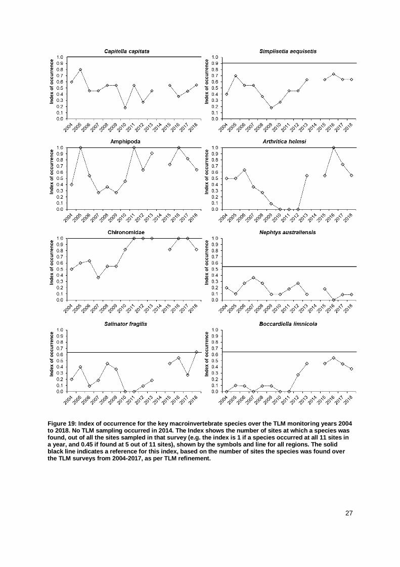
Looking in more detail at the Index of Occurrence indicated that almost all key macroinvertebrate
species had a contracted distribution range in 2018 compared to a long-term reference (2004-2017)
(Figure 19). The Index of Occurrence had dropped for the second consecutive year for amphipods and
Arthritica helmsi. A similar pattern of contracted distribution was found for the polychaete Boccardiella
limnicola, which prefers brackish conditions. The polychaete Simplisetia aequisetis had a more steady
occurrence range over recent years. For C. capitata the index increased, reflecting a wider distribution
of this pollution indicator species. The grazing snail Salinator fragilis was also found at further sites,
yet not throughout the entire system. For the predatory polychaete N. australiensis, occurrence has
not increased. The distribution range of most macroinvertebrate species was thus below their potential
distribution range, indicated by the reference line (Figure 19). Spatially, the distributions contracted to
the Murray Mouth and northern sections of the North Lagoon, where most species were found (Table
4) and present in higher individual densities.
2004 2005 2006 2007 2008 2009 2010 2011 2012 2013 2014 2015 2016 2017 2018
Capitella capitata
Simplisetia aequisetis
Nephtys australiensis
Amphipoda
Arthritica helmsi
Chironomidae
Oligochaeta
Salinator fragilis
Hydrobiidae sp. 2
Boccardiella limnicola
<12% rare
13-24% not very common
25-49% common
50-74% very common
75-100% constant
27
Figure 19: Index of occurrence for the key macroinvertebrate species over the TLM monitoring years 2004 to 2018. No TLM sampling occurred in 2014. The Index shows the number of sites at which a species was found, out of all the sites sampled in that survey (e.g. the index is 1 if a species occurred at all 11 sites in a year, and 0.45 if found at 5 out of 11 sites), shown by the symbols and line for all regions. The solid black line indicates a reference for this index, based on the number of sites the species was found over the TLM surveys from 2004-2017, as per TLM refinement.

28
4.2.2.2 Macroinvertebrate abundances
Abundances of macroinvertebrates were significantly higher in the North Coorong (63,634 ± 56,238
individuals m-2, average ± SD) than in the South Coorong, where numbers of macroinvertebrates were
very low (576 ± 1,316 individuals m-2) (Figure 20; SM-Table 5). No individuals of macroinvertebrate
were found at the southernmost site Loop Road (site 11). In the North Lagoon, individual densities
differed significantly between sites in this region (SM-Table 5), and patchiness within sites was high,
indicated by the large spread of the box plots (Figure 20).
Figure 20: Box plots of individual densities for total macroinvertebrates at the study sites from the North and South Coorong in the spring survey (December 2018). Site (1) = Tarni Warra, possible replacement site for Site 1.
Different macroinvertebrate taxa contributed to the individual densities at the sites in the North
Coorong (Figures 21, 22). Annelida were abundant at Monument Road (site 1), and between Pelican
Point and Noonameena (sites 5 to 7), whereby Simplisetia aequisetis was most numerous at
Monument Road and Pelican Point, and Capitella capitata at Mulbin Yerrok (site 6) and Noonameena.
The high abundance of Crustacea was almost completely due to amphipods, which occurred in high
numbers at most of the North Coorong sites (Figure 22). The small bivalve Arthritica helmsi was highly
abundant at sites 1 - 6 in the North Coorong, and Salinator fragilis and hydrobiid snails added little to
the pattern of mollusc abundance across sites. The abundance of Hexapoda (insects) was made up of
chironomid larvae, which accounted mostly for the macroinvertebrates found in the South Coorong.
The abundances varied significantly between regions for most phyla and taxa, and also between sites
within regions (SM-Table 5). No significant difference in abundance between the North and South
Coorong regions was found for chironomid larvae, Hexapoda, and C. capitata (SM-Tables 5 and 6).

29
Figure 21: Box plots of individual densities for the four major phyla represented in the macroinvertebrate samples at the study sites from the Murray Mouth and Coorong in December 2018 surveys. Site (1) = Tarni Warra, possible replacement site for Site 1.

30
Figure 22: Box plots of individual densities for the most abundant species/taxa in the survey from spring2018 at sites in the North (sites 1 to 7) and South Coorong (sites 8 to 11)). Note the different y-axes scales.
4.2.2.3 Long term changes in macroinvertebrate abundances
Individual densities of macroinvertebrates were significantly different between years (SM-Tables 5 and
6) and lower in 2018 than in previous years (Figure 23). Decreased abundances occurred both in the
North and South Coorong.

31
Figure 23: Box plots of individual densities for total macroinvertebrates (all species) for a) the North Coorong (sites 1 – 7) and b) the South Coorong (sites 8-11) for each of the monitoring years. No TLM monitoring occurred in 2014. Note the different y-axes scales for a) and b).
Figure 24: Index of Relative Change showing long-term changes in the abundance of macroinvertebrates (all species) for the North Coorong (NC, 7 sites) and South Coorong (SC, 4 sites). Index values plotted are a ratio of observed (tx, any particular year) to reference data (tr based on monitoring from 2004-2017), based on average values per region and year. No TLM monitoring occurred in 2014. The black line at 0 marks where observed values equal reference values. Red symbols indicate significant change of values > or < the effect size.
-2.00
-1.50
-1.00
-0.50
0.00
0.50
1.00
Re
lative
cha
ng
e (
log
tx/t
r)
Years
NCSC

32
The Index of Relative Change did, however, not detect a significant deviation from the long-term
average for the macroinvertebrate abundances in the North and South Coorong (Figure 24). The
reference values were recalculated as recommended in the revised Condition Monitoring Plan
(DEWNR 2017), to encompass years with more estuarine conditions. For the period from 2004 to
2017, the recalculated average abundance for the North Coorong is 59,787 individuals m-2 (previously
43,825 for 2004-2013) and for the South Coorong 1,569 individuals m-2 (previously 1,495 for 2004-
2013) (see SM-Table 8, also for effect size).
Figure 25: Index of Relative Change showing long-term changes in the abundance of several key macroinvertebrates species for the North Coorong (NC, 7 sites) and South Coorong (SC, 4 sites). Index values plotted are a ratio of observed (tx, any particular year) to reference data (tr based on monitoring from 2004-2017), based on average values per region and year. No TLM monitoring occurred in 2014. The black line at 0 marks where observed values equal reference values. Red symbols indicate significant change of values > or < the effect size.
-2.5
-2.0
-1.5
-1.0
-0.5
0.0
0.5
1.0
1.5
2004
2005
2006
2007
2008
2009
2010
2011
2012
2013
2015
2016
2017
2018
Rela
tive
change (
log t
x/t
i)
Amphipoda
NCSC
-2.5
-2.0
-1.5
-1.0
-0.5
0.0
0.5
1.0
1.5
2004
2005
2006
2007
2008
2009
2010
2011
2012
2013
2015
2016
2017
2018
Rela
tive
change (
log t
x/t
i)
Chironomid larvae
NCSC
-2.5
-2.0
-1.5
-1.0
-0.5
0.0
0.5
1.0
1.5
2004
2005
2006
2007
2008
2009
2010
2011
2012
2013
2015
2016
2017
2018
Rela
tive
change (
log t
x/t
i)
Simplisetia aequisetis
NCSC
-2.5
-2.0
-1.5
-1.0
-0.5
0.0
0.5
1.0
1.5
2004
2005
2006
2007
2008
2009
2010
2011
2012
2013
2015
2016
2017
2018
Rela
tive
change (
log t
x/t
i)
Arthritica helmsi
NCSC
-2.5
-2.0
-1.5
-1.0
-0.5
0.0
0.5
1.0
1.5
2004
2005
2006
2007
2008
2009
2010
2011
2012
2013
2015
2016
2017
2018
Rela
tive
change (
log t
x/t
i)
Oligochaeta
NCSC
-3.0
-2.5
-2.0
-1.5
-1.0
-0.5
0.0
0.5
1.0
1.5
2004
2005
2006
2007
2008
2009
2010
2011
2012
2013
2015
2016
2017
2018
Rela
tive
change (
log t
x/t
i)
Capitella capitata
NCSC

33
While no significant deviation was detected for abundances of total macroinvertebrates (irrespective of
species), abundances of single species did show a significant change from the long-term average
(Figures 25 and 26). For the North Coorong, the Index revealed a negative change from the reference
for two polychaete species, Nepthys australiensis and Boccardiella limnicola (Figure 26). The small
bivalve Arthritica helmsi increased further in abundances in the North Coorong and the Index showed
a positive deviation from the reference value (Figure 25). For the South Coorong, no deviations from
the long-term average were detected for the few species present in the monitoring in 2018 (Figure 25).
Figure 26: Index of Relative Change showing long-term changes in the abundance of further macroinvertebrates species for the North Coorong (NC, 7 sites) and, for hydrobiid snails, also for the South Coorong (SC, 4 sites). Index values plotted are a ratio of observed (tx, any particular year) to reference data (tr based on monitoring from 2004-2017), based on average values per region and year. No TLM monitoring occurred in 2014. The black line at 0 marks where observed values equal reference values. Red symbols indicate significant change of values > or < the effect size.
4.2.3 Macroinvertebrate biomass
4.2.3.1 Biomass 2018
The biomass of macroinvertebrates in the North Coorong was high (on average 17.98 ± 14.49 g
AFDW m-2 ± SD), and particularly high at Monument Road (site 1) (Figure 27). In the South Coorong,
biomass of macroinvertebrates was very low (2.53 ± 3.74 g AFDW m-2). The biomass was also highly
variable within and between sites and significantly different between regions (SM-Table 10). This
pattern followed the distribution of macroinvertebrate abundance (see 4.2.2.2). At Tarni Warra, the
-3.0
-2.5
-2.0
-1.5
-1.0
-0.5
0.0
0.5
1.0
1.5
2004
2005
2006
2007
2008
2009
2010
2011
2012
2013
2015
2016
2017
2018
Rela
tive
change (
log t
x/t
i)
Boccardiella limnicola
-2.5
-2.0
-1.5
-1.0
-0.5
0.0
0.5
1.0
1.5
2004
2005
2006
2007
2008
2009
2010
2011
2012
2013
2015
2016
2017
2018
Rela
tive
change (
log t
x/t
i)
Salinator fragilis
-2.5
-2.0
-1.5
-1.0
-0.5
0.0
0.5
1.0
1.5
2004
2005
2006
2007
2008
2009
2010
2011
2012
2013
2015
2016
2017
2018
Rela
tive
change (
log t
x/t
i)
Nephtys australiensis
-2.5
-2.0
-1.5
-1.0
-0.5
0.0
0.5
1.0
1.5
2004
2005
2006
2007
2008
2009
2010
2011
2012
2013
2015
2016
2017
2018
Rela
tive
change (
log t
x/t
i)
Hydrobiidae
NCSC

34
potential alternative site for Monument Road, biomass was lower than at Monument Road but
comparable to biomass found at other sites in the North Coorong (Figure 27).
Figure 27: Box plots of total macroinvertebrate biomass at the study sites from the North and South Coorong in the spring 2018 survey. Regions are indicated with the old and new differentiation. Site (1) = Tarni Warra, possible replacement site for Site 1.
4.2.3.2 Long term changes in macroinvertebrate biomass
Across all monitoring years since 2004, biomass of macroinvertebrates varied significantly within and
between regions and years (SM-Table 10). In the North Coorong, biomass was within the range of
values from recent years since flows were restored (Figure 28), although individual densities had
declined (see Figure 23 in comparison). In the South Coorong, biomass was also lower, but highly
variable with an outlier overlapping with previous years (Figure 28).
The Index of Relative Change showed that biomass in 2018 did not deviate significantly from a long-
term average for either the North or South Coorong (Figure 29). As for abundances, the reference
value for biomass was recalculated as recommended in the revised Condition Monitoring Plan
(DEWNR 2017), to encompass years with more estuarine conditions. For the period from 2004 to
2017, the recalculated average biomass for the North Coorong is 9.7 g AFDW m-2 (previously 6.56 for
2004-2013) and for the South Coorong 0.62 g AFDW m-2 (previously 0.25 for 2004-2013) (see SM-
Table 11, also for effect size). Several more of the Millennium Drought years were thus emerging as
significant deviations with very low biomass for both the North and South Coorong. The lowest
deviation for the South Coorong was found for 2015. Since 2012, the Index of Relative Change
showed a positive deviation with higher biomass than the long-term reference for the North Coorong in
2016, and for the South Coorong in 2017 (Figure 29).

35
Figure 28: Box plots of macroinvertebrate biomass for a) the North Coorong (sites 1 – 7) and b) the South Coorong (sites 8-11) for each of the monitoring years. No TLM monitoring occurred in 2014, indicated by a /. Note the different y-axes scales for a) and b).
Figure 29: Index of Relative Change showing long-term changes in the biomass of macroinvertebrates for the North Coorong (NC, 7 sites) and South Coorong (SC, 4 sites). Index values plotted are a ratio of observed (tx, any particular year) to reference data (tr based on monitoring from 2004-2017), based on average values per region and year. No TLM monitoring occurred in 2014. The black line at 0 marks where observed values equal reference values. Red symbols indicate significant change of values > or < the effect size.
-2.00
-1.50
-1.00
-0.50
0.00
0.50
1.00
Rela
tive
change (
log t
x/t
r)
Years
NC
SC

36
4.2.4 Macroinvertebrate communities
4.2.4.1 Community compositions
Community compositions in 2018
Macroinvertebrate communities were significantly different between regions, and also between sites
within regions in the December 2018 survey (SM-Table 12). Within the North Coorong,
macroinvertebrate communities in the vicinity of the Murray Mouth (sites 1 to 4, and 6) shared greater
similarity and clustering (Figure 30). The benthic community at Pelican Point (site 5) was more distinct,
as was the one at Noonameena (Site 7). Macroinvertebrate communities in the South Coorong were
clearly different from those in the North Coorong (Figure 30 a). The macroinvertebrate community at
Tarni Warra (site 1b) was very similar to the community present at other sites in the Murray Mouth
area (Figure 30b) and could be a replacement for Monument Road (site 1) from a macroinvertebrate
community perspective.
The macroinvertebrate communities present in the North Coorong from sites 1 (Monument Road) to 6
(Mulbin Yerrok) were composed of several species of polychaetes, Arthritica helmsi, several species
of snails, amphipods and chironomid larvae (SM-Figure 5). The difference in the macroinvertebrate
community at Noonameena (site 7) compared to the other sites from the North Coorong was a
sparsity of species and the higher abundance of Capitella capitata. In the South Coorong, the
community was characterised by chironomid larvae, several other insect larvae, ostracods (Villa de
Yumpa, site 9), and C. capitata at Jack Point (Site 10) (SM-Figure 5).
Long term changes in macroinvertebrate communities
Macroinvertebrate communities in the North Coorong have been changing over time, with significantly
different clusters emerging for the monitoring years in the early 2000’s, a deviation after several years
of drought (2009), and the flood event in 2010 (Figure 31a). The early years of recovery in 2011 and
2012 were distinct as not all species had recolonised again. Since 2013, the macroinvertebrate
community in the North Coorong has been similar, and 2018 falls into the same cluster. The trajectory
is, however, revealing a commencing deviation and a change in the direction of the early drought
years (Figure 31a). Changes in the macroinvertebrate communities over these time periods are mainly
due to changes in the presence and abundance of the key species (SM-Figure 6a).
For the South Coorong, no significantly different groupings of macroinvertebrate were detected for any
of the monitoring years, indicating that regardless of drought or flow, the species and individually poor
community of macroinvertebrates remained unchanged (Figure 31b). The composition of the South
Coorong community is dominated by chironomid larvae, and in recent years also Capitella capitata
and ostracods (SM-Figure 6b).
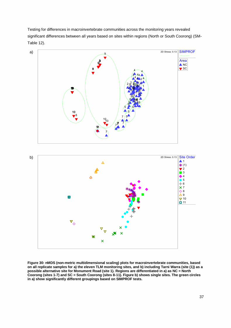
37
Testing for differences in macroinvertebrate communities across the monitoring years revealed
significant differences between all years based on sites within regions (North or South Coorong) (SM-
Table 12).
a)
b)
Figure 30: nMDS (non-metric multidimensional scaling) plots for macroinvertebrate communities, based on all replicate samples for a) the eleven TLM monitoring sites, and b) including Tarni Warra (site (1)) as a possible alternative site for Monument Road (site 1). Regions are differentiated in a) as NC = North Coorong (sites 1-7) and SC = South Coorong (sites 8-11). Figure b) shows single sites. The green circles in a) show significantly different groupings based on SIMPROF tests.

38
Figure 31: nMDS (non-metric multidimensional scaling) plots for macroinvertebrate communities in a) the North Coorong, and b) the South Coorong, based on averages per year and region. The green circles show significantly different groupings based on SIMPROF tests. No significant groupings over the years were found for the South Coorong. The direction of the connecting black lines shows a trajectory over consecutive monitoring years. No TLM monitoring occurred in 2014.
For each region, the average Bray Curtis similarity was plotted for all monitoring years and compared
to a reference, set from two years as per TLM refinement. In 2018, the similarity dropped slightly
below the reference for the North Coorong (Figure 32). For the South Coorong, the similarity was well
below the reference set from two years with good flows, and more comparable to other significant
a) North CoorongSIMPROF
Year2004
2005
2006
2007
2008
2009
2010
2011
2012
2013
2015
2016
2017
2018
2004
2005
2006
2007
20082009
2010
2011
2012
2013 2015
20162017
2018
2D Stress: 0.05
b) South CoorongYear
2004
2005
2006
2007
2008
2009
2010
2011
2012
2013
2015
2016
2017
2018
2004
2005
2006
2007
2008
2009
2010
2011
2012
2013
2015
2016
20172018
2D Stress: 0.16

39
deviations from the reference found for years during the drought and 2015 (SM-Table 13). For
macroinvertebrate communities from both the North and South Coorong, the Bray-Curtis index
declined for two consecutive years (Figure 32).
The relatedness of the macroinvertebrate community in 2018 compared to each of the previous
monitoring years shows similarity for all sites and the North Coorong for comparisons since 2011, and
with 2006 (Figure 33, SM-Table 14). Values for the Spearman rank correlation coefficient (rho σ) were
>0.5 for these years, indicating similarity of the macroinvertebrate community in 2018 with those
occurring under intermediate continuous flow. This was not the case for the South Coorong, where the
Spearman’s rank correlation coefficient was very low (Figure 33).
Figure 32: Average Bray-Curtis similarity index for similarity within macroinvertebrate communities in the North (NC, sites 1-7) and South (SC, sites 8-11) Coorong across each of the monitoring years. No TLM monitoring occurred in 2014. The horizontal lines indicate reference similarities for each region, taking selected years as reference (2005 and 2013 for the NC, 2006 and 2010 for SC). A higher index shows greater similarity between the sites in each region for the respective year.
Figure 33: Spearman’s rank correlation coefficient rho δ comparing the similarity matrices of macroinvertebrate communities from 2018 to previous years. Comparisons are not made to 2004 and 2005 as one sampling site was missing in each of these years. The coefficient δ was calculated using data from all 11 sites (light blue), the North Coorong (NC, sites 1-7), and the South Coorong (SC, sites 8- . Low values for δ indicate that communities in the two years are unrelated.
0
10
20
30
40
50
60
70
80
90
100
2004
2005
2006
2007
2008
2009
2010
2011
2012
2013
2014
2015
2016
2017
2018
Bra
y-C
urt
is S
imila
rity
Index
NCSC

40
4.2.4.2 Environmental conditions as predictor variables for macroinvertebrate communities
Environmental conditions as predictor for communities in 2018
The pattern of macroinvertebrate communities in the Murray Mouth and Coorong in December 2018
could be explained by the salinity, which separated communities from the North and South Coorong
along the existing gradient in the system (Figure 34). Sediment characteristics could explain the
distinct macroinvertebrate communities found at Villa de Yumpa (site 9), which was the only site with
predominantly silt and extremely poorly sorted. Microphytobenthos (Chlorophyll-a) played a further
role in explaining the distribution pattern of macroinvertebrate communities, as the concentrations
were decreasing from the North to the South Coorong (see Figure 12a, SM-Table 15).
Figure 34: Plots from distance-based redundancy analysis (dbRDA) for the survey in 2018. The plot shows a constrained ordination of macroinvertebrate communities subject to the environmental predictor variables displayed in the vector overlays.
Environmental conditions as predictor for long term changes in communities
Salinity explained the macroinvertebrate community pattern throughout the Murray Mouth and
Coorong across all monitoring years (Figure 35, SM-Table 16). The distinct macroinvertebrate
community in the South Coorong is defined by salinities > 64 ppt (Figure 36). This threshold has also
emerged in Linktree analysis from previous years, highlighting that salinities >64 ppt are a consistent
inhibitor for more diverse and abundant macroinvertebrate communities.
The analysis further showed that Villa de Yumpa (site 9) had a distinct macroinvertebrate community
in the last two years, which could be explained by the high organic matter load in the sediment and the
poor sediment sorting (Figure 35).

41
a)
b)
Figure 35: Plots from distance-based redundancy analysis (dbRDA) for all of the monitoring years since 2005 (with consistent grain size analysis using laser diffraction). Environmental variables recorded in each monitoring were included here (except for chlorophyll-a which was only measured since 2007). The same plot is shown with a) site differentiation, whereby sites in the North Coorong are coded blue, and sites in the South Coorong coded in red, and b) year differentiation. The plots show a constrained ordination of macroinvertebrate communities subject to the environmental predictor variables displayed in the vector overlays.

42
Figure 36: LINKTREE of macroinvertebrate community data from monitoring since 2005 (as different method for grain size analysis in 2004), based on average values per region (North Coorong (NC) and South Coorong (SC)) and year. Black lines are separating significantly different groups based on SIMPROF tests. The splits are explained by environmental variables; A: Salinity<49.9(>64.3) P=0.001, B: DO%<80.4(>91) P=0.001, C: Sqr(OM)<0.923(>0.996) P=0.1, D: Salinity<25.5(>33.7) P=0.18, I: DO%>128(<107) or Sqr(OM)>1.28(<1.22) or Salinity<33.7(>37.6) P=0.32, J: Sorting>7.8(<2.74) or Sqr(Grain size)<12.6(>13.9) or Salinity<37.6(>47.9) P=0.16, K: Salinity<86.9(>120) P=0.18. Red lines indicate groups that are not significantly different. The B% scale splits groups using original rank dissimilarities.

43
5. Discussion
The findings from this monitoring in December 2018 are evaluated in this discussion against the
objectives and targets of the revised TLM Condition Monitoring Plan (DEWNR 2017).
5.1 Macroinvertebrate populations
The condition of mudflat invertebrate communities has been maintained, but not improved further in
the recent monitoring year. Several signs in the analyses indicated a development towards
communities present during the drought in the last decade.
Macroinvertebrate species richness increases throughout the Murray Mouth and Coorong
This target has been partially met. The species richness in the North Coorong remained above a long-
term reference but decreased in the South Coorong. The recovery which commenced since return of
the flows in 2010 led to the recolonisation of mudflats by macroinvertebrates in the North Coorong
since about 2013. The South Coorong has not been recolonised as salinity remains above a threshold
tolerable for most macroinvertebrates.
Recent subtidal sampling for the ‘Healthy Coorong-Healthy Basin’ urgent investigations yielded
records of macroinvertebrate species from subtidal sediments and mudflats on the shores of the
Younghusband peninsula, which have not or rarely been found in the TLM mudflat monitoring.
Macroinvertebrate occurrence extends along the Coorong into the South Lagoon
This target has not been met. The distribution range of key macroinvertebrate species contracted in
2018 and their occurrence throughout the North and South Coorong was lower than in previous years.
For some key macroinvertebrate species this was the second consecutive year of lower occurrence.
This contraction could be due to the persistent salinity gradient, and the increasingly high organic
matter content in sediments of the South Coorong. A further sign that nutrient load and organic matter
in sediment increased in the Coorong was the classification of Capitella capitata as ‘very common’ in
occurrence. This species is an indicator for eutrophication and anoxic sediment conditions (Grassle &
Grassle 1976; Ramskov & Forbes 2008).
The area of occupation for typical estuarine and marine macroinvertebrate species exceeds 60% of
the sites sampled
This target has been partially met. The constancy index for several key macroinvertebrate species
was >60% and classified as very common. The polychaete Nephtys australiensis and Oligochaeta
were still rare. For hydrobiid snails and the polychaete Boccardiella limnicola, area of occupation as
measured in the constancy index was below 60%. The area of occupation was contracted towards the
Murray Mouth, and few species occurred at Noonameena and in the South Coorong.
Macroinvertebrate abundance is maintained at, or increases above, reference levels
This target has been partially met. Total abundance was maintained, as were abundances of several
key macroinvertebrate species which were similar to the long-term reference. Only Arthritica helmsi

44
had a significant increase above the reference in abundance. There were no other increases in
abundance above the reference value.
Macroinvertebrate biomass is maintained at, or increases above, reference levels
This target has been partially met. Biomass was maintained as no significant difference to the long-
term reference was detected. No significant increases occurred.
Macroinvertebrate communities are similar to those occurring under intermediate continuous flows
This target has been met. For the North Coorong, the macroinvertebrate community was similar to the
previous years with intermediate continuous flows, although on a trajectory towards earlier drought
years. For the South Coorong, no significant differences in communities were found across any of the
monitoring years.
As recommended in the revised TLM Condition Monitoring Plan (DEWNR 2017), reference values
were recalculated, as the reference developed for the TLM refinement was based on years of extreme
drought and flood events. The revised reference values presented in this report encompass further
years of continuous flow with varying flow volumes, and thus represent a better estuarine reference
condition. If drought conditions develop in coming years, further re-calculation could be a shifting
baseline. It is thus recommended to use the reference values over the long-term timeframe to 2017, or
possibly to 2018, for future evaluations.
Linking macroinvertebrate data with environmental data identified drivers for the community pattern
seen over the monitoring years. The clear distinction between the communities in the North and South
Coorong could be explained by salinity. The exact same salinity threshold value as in previous
monitoring years persisted, highlighting its relevance for macroinvertebrate communities, which can be
explained by salinity tolerances of macroinvertebrate species (Remaili et al 2018).
5.2 Habitat conditions
Habitat conditions were mostly maintained, but no improved sediment conditions were found. In the
South Coorong, some of the sediment conditions had deteriorated. Mudflats in the Murray Mouth and
Coorong provided habitat for macroinvertebrates, but not all targets were fully met:
Habitable sediments are occurring along the Coorong into the South Lagoon
This target has been partially met. Habitable sediment conditions occurred at most of the sites in the
December 2018 survey, in particular throughout the North Coorong.
Sediments are maintained as fine to medium sands and are mostly moderately well sorted
This target has been partially met. The sediment was characterised as fine to medium sand and
moderately sorted for most sites, but as coarse or silt at a few sites, and poorly sorted. There was a
significant deviation from the long-term reference for the median grain size, but not for the sorting
coefficient.

45
This report introduced the use of a new sorting coefficient, which is easier and more consistent to use,
ensuring data quality. The analysis of sediment compositions in past monitoring years with the new
index showed that more poorly sorted sediments occurred during the Millennium Drought and
following flood events. The sorting coefficient shows that the target to have more moderately sorted
sediments was achieved.
Sediment organic matter is maintained
This target has not been met and 2018 was the second consecutive year with a significant change
from the reference value, indicating increasing eutrophication, especially at Villa de Yumpa in the
South Lagoon. High values of sediment organic matter found in the 2018 survey indicate eutrophic
conditions, in particular at Villa de Yumpa. The local source of nutrient influx at Villa de Yumpa is not
known, but has persisted over several years and led to sediment conditions resembling a slimy anoxic
ooze (SM-Figure 2), which affects biogeochemical processes and macroinvertebrate colonisation
(Lautenschläger et al. 2014; Norkko et al. 2015; le Moal et al. 2019). Such organic enrichment can
have lasting effects on macroinvertebrate communities (Rakocinski 2012; Leite et al. 2014).
Sediments provide microphytobenthic food for the benthic food web
This target has been met as chlorophyll-a concentrations were higher and more similar to the long-
term reference value.
5.3 Monument Road alternative site assessment
Site access issues at Monument Road initiated the exploration of a potential alternative site nearby, at
Tarni Warra. The analyses of the 2018 monitoring showed that environmental conditions in water and
sediment at Tarni Warra were comparable and characteristic for the Murray Mouth sites. The species
number was slightly higher and individual densities and biomass were slightly lower than at Monument
Road but within the range of values for the Murray Mouth sites. The macroinvertebrate community
was the same as at other sites in the Murray Mouth. Should Monument Road become impossible to
access in the future, Tarni Warra could be a substitution.
5.4 Conclusion
Monitoring of macroinvertebrates and mudflat habitats in 2018 has shown some maintained
conditions, little improvements, and indications for decreases in condition compared to previous
monitoring years (Table 5). In most of the North Coorong conditions were favourable, and
macroinvertebrate communities similar to previous years. The South Lagoon has remained in a
degraded state and no improvements were recorded. The salinity threshold separating the
macroinvertebrate communities between the North and South Coorong has persisted. Unless salinities
in the South Coorong are lowered below this threshold, recolonisation by macroinvertebrates is
unlikely to occur.

46
Table 5: Summary table of how monitoring targets have been met over time in recent monitoring years.
Monitoring target 2016 2017 2018
Flow year Flowing Dry-
moderate Dry
Macroinvertebrates
Species richness increases throughout the Murray Mouth and Coorong.
Partially met Partially met Partially met
Occurrence extends along the Coorong into the South Lagoon.
Partially met Not met Not met
Area of occupation exceeds 60% of the sites sampled.
Met Partially met Partially met
Abundance is maintained at, or increases above, reference levels.
Met Partially met Partially met
Biomass is maintained at, or increases above, reference levels.
Met Met Partially met
Communities are similar to those occurring under intermediate continuous flows.
Met Met Met
Habitat condition
Habitable sediments are occurring along the Coorong into the South Lagoon.
Partially met Partially met Partially met
Sediments are maintained as fine to medium sands and are mostly moderately well sorted.
Met Partially met Partially met
Sediment organic matter is maintained. Met Partially met Not met
Sediments provide microphytobenthic food for the benthic food web.
Not met Met Met

47
6. Acknowledgements
This project was funded by The Living Murray initiative. The Living Murray is a joint initiative funded by
the New South Wales, Victorian, South Australian, Australian Capital Territory and Commonwealth
Governments, coordinated by the Murray–Darling Basin Authority. The project has been managed by
the South Australian Department for Environment and Water through the Lower Lakes, Coorong and
Murray Mouth Icon Site staff, Adrienne Rumbelow, Kirsty Wedge and Rebecca Turner. We
acknowledge the ongoing support for this monitoring and the discussions with the icon site staff.
Jordan Kent, Laura Schroder, Anthony Newbery, Sam Butterworth, Abbie Hay and Misty McGill
assisted with lab work and their help in sorting and identifying samples is greatly appreciated.

48
7. References
Anderson, M.J., Gorley, R.N. & Clarke, K.R. (2008) PERMANOVA+ for PRIMER: Guide to Software and Statistical Methods. PRIMER-E, Plymouth, UK
Blott SJ, Pye K (2001) GRADISTAT: a grain size distribution and statistics package for the analysis of unconsolidated sediments. Earth Surface Processes and Landforms 26:1237-1248
Boulton AJ, Ekebom J, Gíslason GM (2016) Integrating ecosystem services into conservation strategies for freshwater and marine habitats: a review. Aquatic Conservation: Marine and Freshwater Ecosystems 26:963-985
Clarke, K.R., Gorley, R.N., Somerfield, P.J. & Warwick, R.M. (2014) Change in Marine Communities: An Approach to Statistical Analysis and Interpretation, 3rd edition edn. PRIMER-E Ltd, Plymouth, UK
DEWNR (2017) Department of Environment Water and Natural Resources: Condition Monitoring Plan (Revised) 2017. The Living Murray - Lower Lakes, Coorong and Murray Mouth Icon Site., DEWNR Technical report 2016–17. Government of South Australia, through Department of Environment, Water and Natural Resources, Adelaide
Dittmann S (2017) Invertebrates. In: Condition Monitoring Plan (Revised) 2017. The Living Murray – Lower Lakes, Coorong and Murray Mouth Icon Site. DEWNR Technical report 2016–17. Adelaide: Government of South Australia, through Department of Environment, Water and Natural Resources, p. 52-58
Dittmann, S. & Baring, R. (2016) Benthic macroinvertebrate survey 2015-16: Coorong and Murray Mouth Icon Site. Report for the Department of Environment, Water and Natural Resources and the Murray-Darling Basin Authority
Dittmann, S., Baring, R., Baggalley, S., Cantin, A., Earl, J., Gannon, R., Keuning, J., Mayo, A., Navong, N., Nelson, M., Noble, W. & Ramsdale, T. (2015) Drought and flood effects on macrobenthic communities in the estuary of Australia’s largest river system. Estuarine, Coastal and Shelf Science, 165, 36-51
Dittmann, S. Jessup-Case, H., Lam Gordillo, O. & Baring R. (2017). Benthic macroinvertebrate survey 2016-2017: Coorong and Murray Mouth Icon Site. Report for the Department of Environment, Water and Natural Resources and the Murray-Darling Basin Authority. Flinders University, Adelaide
Grassle JF, Grassle JP (1976) Sibling species in the marine pollution indicator Capitella (Polychaeta). Science 192:567-569
Hemraj, D.A., Hossain, M.A., Ye, Q.F., Qin, J.G. & Leterme, S.C. (2017) Plankton bioindicators of environmental conditions in coastal lagoons. Estuarine Coastal and Shelf Science, 184, 102-114
Hossain MA, Ye Q, Leterme SC, Qin JG (2017) Spatial and temporal changes of three prey-fish assemblage structure in a hypersaline lagoon: the Coorong, South Australia. Marine and Freshwater Research 68:282-292
Kingsford RT, Walker KF, Lester RE, Young WJ, Fairweather PG, Sammut J, Geddes MC (2011) A Ramsar wetland in crisis - the Coorong, Lower Lakes and Murray Mouth, Australia. Marine and Freshwater Research 62:255-265
Lautenschläger AD, Matthews TG, Quinn GP (2014) Utilization of organic matter by invertebrates along an estuarine gradient in an intermittently open estuary. Estuarine, Coastal and Shelf Science 149:232-243
Le Moal M, Gascuel-Odoux C, Ménesguen A, Souchon Y and others (2019) Eutrophication: A new wine in an old bottle? Science of The Total Environment 651:1-11
Leite N, Guerra A, Almeida A, Marques JC, Martins I (2014) Long term variation of an amphipod species' population secondary production as indicator of incomplete resilience in a temperate estuary. Ecological Indicators 36:324-333
Maunsell (2009) Lower Lakes, Coorong and Murray Mouth Icon Site Condition Monitoring Plan, South Australian Murray-Darling Basin Natural Resources Management Board, Adelaide
Mosley L, Ye Q, Shepherd S, Hemming S, Fitzpatrick R (2018) Natural History of the Coorong, Lower Lakes, and Murray Mouth Region (Yarluwar-Ruwe), Vol. Royal Society of South Australia Inc.; University of Adelaide Press, Adelaide

49
Norkko J, Gammal J, Hewitt JE, Josefson AB, Carstensen J, Norkko A (2015) Seafloor Ecosystem Function Relationships: In Situ Patterns of Change Across Gradients of Increasing Hypoxic Stress. Ecosystems 18:1424-1439
Paton DC, Rogers DJ, Hill BM, Bailey CP, Ziembicki M (2009) Temporal changes to spatially stratified waterbird communities of the Coorong, South Australia: implications for the management of heterogenous wetlands. Animal Conservation 12:408-417
Rabaoui L, Tlig-Zouari S, Cosentino A, Hassine OKB (2009) Associated fauna of the fan shell Pinna nobilis (Mollusca: Bivalvia) in the northern and eastern Tunisian coasts. Scientia Marina 73:129-141
Rakocinski CF (2012) Evaluating macrobenthic process indicators in relation to organic enrichment and hypoxia. Ecological Indicators 13:1-12
Ramskov T, Forbes VE (2008) Life history and population dynamics of the opportunistic polychaete Capitella sp. I in relation to sediment organic matter. Marine Ecology Progress Series 369:181-1192
Remaili T, Simpson SL, Bennett WW, King JJ, Mosley LM, Welsh DT, Jolley DF (2018) Assisted natural recovery of hypersaline sediments: salinity thresholds for the establishment of a community of bioturbating organisms. Environmental Science: Processes and Impacts 20:1244-1253
Seuront L, Leterme C (2006) Microscale patchiness in microphytobenthos distributions: evidence for a critical state. In: Kronkamp JC, de Brouwer JFC, Blanchard GF, Forster RM, Creach V (eds) Functioning of Microphytobenthos in Estuaries. The Academy of Arts and Sciences, Amsterdam/The University of Chicago Press, Chicago, p 165-183
Tweedley JR, Dittmann SR, Whitfield AK, Withers K, Hoeksma SD, Potter IC (2019) Hypersalinity: Global distribution, causes, and present and future effects on the biota of estuaries and lagoons. In: Wolanski E, Day J, Elliot M, Ramachandran R (eds) Coasts and Estuaries The Future. Elsevier, Amsterdam, p 523-546
Valiela I (2006) Global Coastal Change, Blackwell Publishing
Wainwright P, Christie M (2008) Wader surveys at the Coorong and S.E. coastal lakes, South Australia, February 2008. The Stilt 54:31-47
Related Documents